Galena Creek Regional Visitor Center Interpretive Plan 100% completion, submitted 8/30/2006 .

Welcome message from author
This document is posted to help you gain knowledge. Please leave a comment to let me know what you think about it! Share it to your friends and learn new things together.
Transcript
Galena Creek Regional Visitor Center Interpretive Plan
100% completion, submitted 8/30/2006
.
Galena Creek Regional Visitor Center Interpretive Plan 6/15/06
Table of Contents
I. Introduction......................................................................................................................... 1 Purpose............................................................................................................................................................ 1
Mission Statement .................................................................................................................................................... 1 Goals of the Galena Creek Regional Visitor Center .............................................................................................. 1
Existing Situation and Background .............................................................................................................. 2 II. Interpretive Planning Summary........................................................................................ 7
Market and Audience Analysis...................................................................................................................... 7 Market Position of the Proposed Facility ................................................................................................... 10
Inventory of Existing Interpretive and Informal Learning Facilities................................................................... 11 Market Position Summary ..................................................................................................................................... 11 Additional Sites for Interpretation at Galena Creek Regional Park.................................................................... 11
Statements of Significance & Interpretive Themes................................................................................... 12 Recommendations for Exhibits and Programs ......................................................................................... 13
III. Facility Summary............................................................................................................ 17 Exhibit Design Criteria ................................................................................................................................. 17 Determination of Building Size.................................................................................................................... 17
Table 5: Space Allocation in the Visitor Center Building ................................................................................... 18 Site Plan ......................................................................................................................................................... 19 Floor Plan & Elevations................................................................................................................................ 20
IV. Accessibility ................................................................................................................... 23
V. Acquisition of Exhibits ................................................................................................... 24
VI. Project Team................................................................................................................... 25
VII. Schedule ........................................................................................................................ 27
VIII. Budget........................................................................................................................... 29 Budget for Facility Planning, Design and Construction ........................................................................... 29
Table 6: Planning, Design and Construction Budget ......................................................................................... 29 Budget for Exhibit Design, Fabrication and Installation........................................................................... 32 Budget for Operations and Maintenance ................................................................................................... 32
Table 7: Estimated Startup Costs ........................................................................................................................ 32 Table 8: Estimated Expenditures and Revenues ................................................................................................ 32
Exhibit Funding Strategy ............................................................................................................................. 33 IX. Appendices.................................................................................................................... 34
Appendix A: Goals & Objectives................................................................................................................ 34 Agency Missions, Goals, Objectives & Strategies .............................................................................................. 34 Linkage of Goals to Regional and National Priorities ......................................................................................... 39
Appendix B: Audience Analysis................................................................................................................. 41 Profile of the American Tourist ............................................................................................................................. 41
Galena Creek Regional Visitor Center Interpretive Plan 6/15/06
Strategic Implications of National Tourism and Recreation Trends .................................................................. 43 Tourism and Recreation Trends in Nevada.......................................................................................................... 43 Strategic Implications of Statewide Tourism and Recreation Trends ............................................................... 47 Reno-Tahoe Area Visitors...................................................................................................................................... 47 Internet Use............................................................................................................................................................. 49 Strategic Implications of Local Tourism and Recreation Trends....................................................................... 49 Reno and Washoe County Area Residents .......................................................................................................... 49 Strategic Implications of Local Demographics.................................................................................................... 52
Appendix C: Supplemental Background/Local History ........................................................................... 53 Appendix D: Interpretive Theme Development......................................................................................... 54
Flowchart of Interpretive Planning Process......................................................................................................... 55 Theme Concept Flow ............................................................................................................................................. 56 Cultural/Historical Theme Development............................................................................................................... 56 Management Theme Development........................................................................................................................ 57 Biological Theme Development ............................................................................................................................ 58 Travel Corridor Theme Development.................................................................................................................... 59
Appendix E: Exhibit and Program Concept Development ...................................................................... 60 Flowchart of Exhibit Concept Development Process.......................................................................................... 61 High-Priority Exhibit Concepts.............................................................................................................................. 62
Concept #1: Branding ............................................................................................................................................................ 62 Concept #2: Safe Travels Weather Station .......................................................................................................................... 63 Concept #3: Forces of Change (“Keeping Trees on the Hill”) ........................................................................................... 64 Concept #4: Lost Dogs/Animal Waste Control.................................................................................................................... 65 Concept #5: Appropriate Resource Use .............................................................................................................................. 66 Concept #6: Rare Plants on the Edge of the Great Basin .................................................................................................. 67 Concept #7: Rock Art & Native Cultures.............................................................................................................................. 68 Concept #8: Life and Times of Dr. James Edward Church ................................................................................................ 69 Concept #9: Economic Transition from Comstock Era to Present ................................................................................... 70 Concept #10: Sustainable Building Techniques ................................................................................................................. 71 Concept #11: Mount Rose Scenic Byway ............................................................................................................................ 72
Secondary Priority Exhibit Concepts ................................................................................................................... 73 Concept #12: Interactive Raised-Relief Map........................................................................................................................ 73 Concept #13: Website ............................................................................................................................................................ 74 Concept #14: School Outreach & Children’s Exhibits........................................................................................................ 75 Concept #15: Summary CD/DVD and/or Brochure ............................................................................................................. 76 Concept #16: Water Diversion and Ranching History ........................................................................................................ 77 Concept #17: Geology & Migration Corridor ....................................................................................................................... 78 Concept #18: Ecological Effects of Logging ....................................................................................................................... 79 Concept #20: Water & Watersheds....................................................................................................................................... 80 Concept #20: Ecosystem Services....................................................................................................................................... 81 Concept #20: Water & Watersheds....................................................................................................................................... 81
Appendix F: Marketing & Retail Discussion ............................................................................................. 82 Appendix G: Partnerships .......................................................................................................................... 85 Appendix H: Monitoring & Evaluation ....................................................................................................... 89 Appendix I: Overview of Recreational Learning....................................................................................... 93

Galena Creek Regional Visitor Center Interpretive Plan 6/15/06
Appendix J: References .............................................................................................................................. 95 Appendix K: Memorandum of Understanding I ........................................................................................ 97 Appendix L: Memorandum of Understanding II ..................................................................................... 102
Galena Creek Regional Visitor Center Interpretive Plan 6/15/06
I. Introduction
1
I. Introduction Purpose and Need The purpose of this plan is to guide the development of interpretive exhibits and programs at the proposed Galena Creek Regional Visitor Center (GCRVC), a cooperative project between the Carson Ranger District of the Humboldt-Toiyabe National Forest, USDA Forest Service Intermountain Region and the Washoe County Department of Regional Parks and Open Space. The visitor center will be located between Reno, Nevada, and Lake Tahoe on State Route 431, which has been designated by the State of Nevada as the Mount Rose Scenic Byway. The facility will be built on USDA Forest Service property that adjoins Galena Creek Regional Park, which is owned by Washoe County. Use of this plan to guide the development of interpretive exhibits and programs will help ensure that the messages delivered at the facility (and through off-site programs) are thematically-driven, reach the intended audience and advance the missions of the cooperating agencies. At present there is no Corridor Management Plan (CMP) or Interpretive Master Plan (IMP) in place for the Mount Rose Scenic Byway. This plan partially fills the need for a conceptual framework within which to develop exhibits, programs and literature targeted at Byway travelers. But a master plan with a broader perspective would be a valuable tool to integrate the interpretive and educational efforts of the District, County and other agencies and organizations with a stake in the conservation of Byway resources. Seeking funding for the development of a CMP and IMP will be a priority for both the District and the County. Mission Statement The primary purpose of the visitor center is to provide natural and cultural resource information and visitor information for park users and travelers on the Mount Rose Scenic Byway. The park and byway offer access to some of the most outstanding scenic and recreational areas in the Eastern Sierra and Lake Tahoe region. The following mission statement is intended to guide the development of a variety of interpretive experiences that will meet the diverse needs, wants and expectations of both local residents and Reno-Tahoe area visitors:
“The mission of the Galena Creek Regional Visitor Center is to encourage understanding, appreciation and appropriate use of the natural, cultural and historical resources of the Galena Canyon Area and the Mount Rose Scenic Byway.”
Goals of the Galena Creek Regional Visitor Center
1. Welcome and orient visitors to the facilities, services and recreational/interpretive opportunities in the area of Galena Creek and the Mount Rose Scenic Byway.
2. Promote visitor understanding of, and support for the missions of the USDA Forest Service and Washoe County Regional Parks and Open Space.
3. Promote visitor appreciation and understanding of the natural, recreational and cultural resources of the area.
4. Create a unique brand identity that distinguishes the visitor center. 5. Develop and maintain productive, cordial, mutually-beneficial partnerships with a variety of agencies
and organizations. 6. Educate and inform visitors about appropriate resource use and encourage appropriate use. 7. Nurture and strengthen existing ties with the community through continued educational outreach in the
local school system. 8. Encourage safe travel and recreation. 9. Educate and inform visitors and local residents about issues related to fire and fuels. 10. Become self-supporting through sales in the retail store and funds generated by an interpretive
association and/or friends’ group. 11. Achieve a Leadership in Energy and Environmental Design (LEED) Silver Designation from the United
States Green Building Council (USGBC) for facility construction and interpret the principles of sustainable building to visitors.
12. Interpret the concept of ecosystem services to visitors, and be a leader in introducing the emerging concept to the public.
Galena Creek Regional Visitor Center Interpretive Plan 6/15/06
I. Introduction
2
Scope The main elements presented in this plan include:
A statement of goals for the visitor center A description of how the planning process aligned visitor center goals with Forest Service goals,
objectives and strategies on the national and regional levels An analysis of demographic trends in tourism and recreation that have shaped and defined the visitor
center audience A division of the visitor center audience into target market segments so that informational and
interpretive messages will be customer-oriented and efficiently delivered A conceptual framework for exhibit design consisting of a structure of goals, statements of significance
and interpretive themes developed in workshops attended by the cooperating agencies and local and regional stakeholders
Broadstroke suggestions for exhibit designs, interpretive programs and educational/informational media Interpretive objectives Strategies for marketing, revenue generation, partnerships and monitoring/evaluation Site plans, floor plans and building elevations.
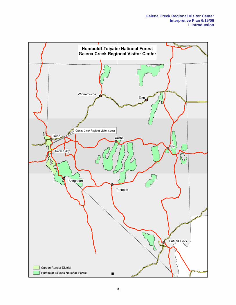
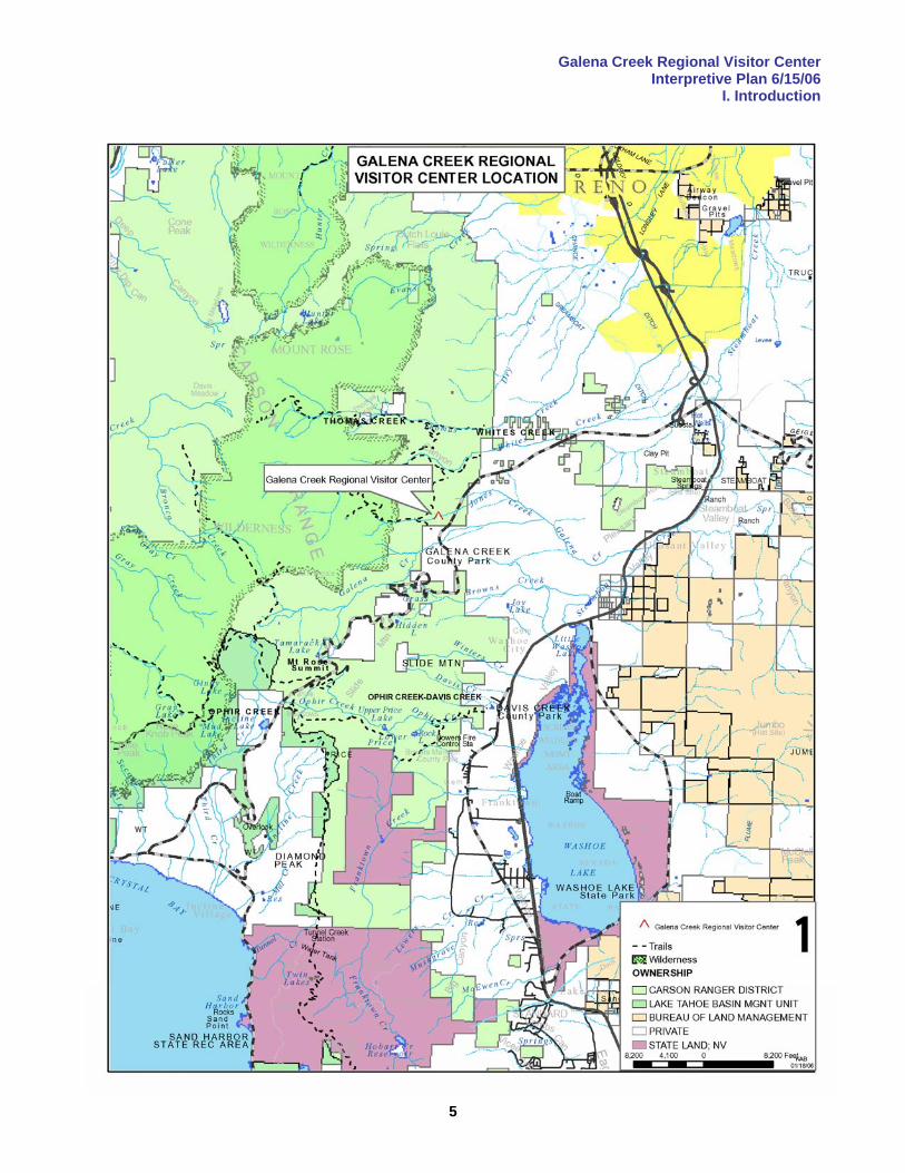
Existing Situation and Background Galena Creek Regional Park, which is owned and managed by the Washoe County Department of Regional Parks and Open Space, lies about fifteen miles southwest of Reno, Nevada, on SR431. This road, commonly referred to as the Mount Rose Highway, is the primary route between Reno and the eastern shore of Lake Tahoe. It is heavily-traveled in both summer and winter. The average number of daily trips on SR431 increased 4% annually in the decade leading up to 2001 (the year in which an access analysis for an additional entrance to the park was conducted) and is currently estimated at 6,000 cars/day. Although stringent limitations on growth in the Tahoe Basin may limit the rate of increase in traffic volume somewhat, there is no obvious reason to assume that traffic volume will not continue to increase, given the rapid population growth in the Reno-Sparks-Carson City area and steady increases in visitor numbers. The Galena Creek Regional Visitor Center will be the first major interpretive facility on any of the primary gateways to Lake Tahoe, and the first visitor center to be built and operated by the partner agencies. Galena Creek Regional Park is a popular and highly-valued recreational asset among Washoe County residents, with more than 130,000 visits annually. There is a history of family use that spans several generations in some cases. The site is an ideal location to serve not only the local population, but to reach significant numbers of visitors to the Reno-Tahoe area as well. The park’s approved 1990 management plan calls for construction of a visitor center in partnership with the Forest Service. Funding for the interpretive plan has been provided by the Forest Service. Planning, design and construction of the visitor center and associated amenities is a cooperative venture jointly funded by the Forest Service and Washoe County. Operations and maintenance of the visitor center will be the responsibility of Washoe County through a special use permit, as the building and associated infrastructure will be located on Forest Service land. Planning, design, construction and operations of the visitor center will be governed by a Memorandum of Understanding (MOU) between the Forest Service and Washoe County (see Appendix K). An additional, separate MOU will be drafted to define the roles and responsibilities of each agency for the planning and design of interpretive exhibits (see Appendix L). In addition to defining roles and responsibilities, it will designate the lead agent for grant funding, development of the collection agreement, establish the process for exhibit procurement and so forth. Humboldt-Toiyabe National Forest, Carson Ranger District Galena Creek Park is adjoined on three sides by Forest Service land that provides a buffer between the park and encroaching high-end residential development. Trail users can access lands in the Carson Ranger District of Humboldt-Toiyabe National Forest, including the Mount Rose Wilderness Area, from trailheads located on county land within the park.
Galena Creek Regional Visitor Center Interpretive Plan 6/15/06
I. Introduction
3
Galena Creek Regional Visitor Center Interpretive Plan 6/15/06
I. Introduction
4
The Carson Ranger District is one of ten districts in the Humboldt-Toiyabe National Forest, the largest national forest in the Lower 48 states. The District lies east and north of Lake Tahoe, straddling the Nevada-California border. Its 368,000 acres are divided roughly equally between the two states. The terrain of the Carson Ranger District is mountainous and highly scenic, with elevations ranging from around 4750’ on the valley floors to 11,462’ at the summit of Sonora Peak. Vegetation is typical of the eastern Sierra, ranging from sagebrush-dominated plant communities in the hotter, drier valleys to several types of mixed-conifer forest as the elevation increases toward timberline. Relatively small expanses of alpine tundra are found in the district’s highest reaches. The climate is semi-arid, typical of northern Nevada, with dramatic temperature swings from day to night. The spectrum of recreation opportunities includes most activities usually pursued in America’s western mountains. Hiking, camping, fishing, nature photography, wildlife-viewing, mountain-biking, rafting, rock-climbing and OHV-riding are popular warm weather pursuits. Higher elevations offer opportunities for a full range of snow sports (both motorized and non-motorized) in winter. The lands adjoining Galena Creek Regional Park are part of the Carson Front Management Area (about 90,000 acres), which includes all national forest land south of the Truckee River Canyon and north of the West Fork of the Carson River. The management prescription for 74,000 acres of the unit’s land is “intensive wildlife and dispersed recreation,” while the remaining 16,000 acres is managed as wilderness. Extractive activities such as grazing, mineral extraction and timber harvesting are limited, and their economic importance in relation to recreation and tourism has been steadily declining since the mid-20th Century. The watershed, wildlife, scenic and recreational resources of the Carson Front Management Area are vital components of the quality of life in nearby communities, and make an important contribution to the experience of many Reno-Tahoe area visitors. The Carson Ranger District is an urban/wildland interface forest. It is adjacent to one of the fastest-growing metropolitan areas in the country (Reno) and a premier international tourist destination (Lake Tahoe). The issues faced by its managers epitomize western national forests next to large population centers. Fire protection, maintaining access to public lands in the face of encroaching development, resource degradation due to increasing recreational pressure and conflicts between user groups are among the key management challenges. Washoe County Department of Regional Parks and Open Space Washoe County Department of Regional Parks and Open Space manages over 50 facilities on more than 6,000 acres of parks and open space with an annual budget (2005-06) of nearly $8.4 million. Facilities range from urban and suburban-based amenities such as tennis courts, golf courses and swimming pools to sites such as Galena Creek Park that offer more nature-based recreation opportunities. The agency is also responsible for about 20 trailheads and over 100 miles of multi-use trails. Galena Creek Regional Park Galena Creek Park encompasses about 420 acres situated on the Mount Rose Highway along the base of the Carson Mountain Range. Vegetative cover is primarily second-growth Jeffrey, Ponderosa and Washoe pine forest, with a dense understory (due to fire suppression in the last century) dominated by manzanita, bitterbrush and mountain mahogany. The mixed-conifer forest cover is broken by occasional small clearings and aspen forest associated with riparian vegetation (alder, willow, etc.) along watercourses. Topography is fairly gentle near the Mount Rose Highway, becoming steeper in the southern and western portions of the park on the lower flanks of the Carson Mountains. Galena Creek, which transects the park from west to east, is a perennial stream that drains the northern slopes of Mount Rose. It is subject to flooding throughout the year, usually during summer thunderstorms. Floods have had a significant effect on the park’s landscape and human history.
Galena Creek Regional Visitor Center Interpretive Plan 6/15/06
I. Introduction
5

Galena Creek Regional Visitor Center Interpretive Plan 6/15/06
I. Introduction
6
The built environment at the park includes: Camp We-Ch-Me, a former Girl Scout camp that features a lodge (available for overnight group rental)
able to accommodate up to 94 overnight guests with a kitchen and dining room. the historic Fish Hatchery, which was restored in 2005, is available for special events the Stone House, an historic structure dating to the CCC era, formerly used as a ranger residence and
warming hut for the adjoining snowplay area and ski-jumping hill, currently used as an interpretive center
Marilyn’s Pond, a fully-accessible fishing pond several group picnic areas and more than 60 individual picnic tables a grassy area used as an impromptu amphitheatre for interpretive programs restrooms horseshoe pits and volleyball courts.
Mount Rose Scenic Byway The Mount Rose Highway was successfully nominated for state scenic byway status in 1995 by the Incline Village/Crystal Bay Convention and Visitors Bureau and the Washoe County Department of Comprehensive Planning. The nomination was supported by several citizens’ advisory boards and the Tahoe Regional Planning Agency. The byway designation covers the entire Mount Rose Highway (Nevada SR431) from its intersection with U.S. 395 outside Reno to its terminus at Nevada SR28 in the community of Incline Village on the east shore of Lake Tahoe, a total of 24.5 miles. The proportions of land ownership within the road corridor viewshed are:
private 55% USDA Forest Service 40% Washoe County 4% State of Nevada 1%.
The byway nomination emphasized the route’s exceptional scenic beauty as it passes through several ecosystems ranging from high desert to subalpine. Also noted were several sites of geological interest, a number of important cultural and historic sites as well as biological resources that include both rare and endangered plant and animal species. Improvements recommended in the nomination include more trailhead parking and public restrooms (two needs that the Galena Creek Regional Visitor Center will address), more roadside pullouts, more interpretive signage at various points of interest and bicycle-only lanes along the roadway. Creating a strong linkage between the Galena Creek Regional Visitor Center and the Mount Rose Scenic Byway is an exceptional opportunity to integrate the interpretive experience of customers at the visitor center with their byway experience, offering a comprehensive, multi-faceted overview of the region through a variety of media. Local History The local history that places the interpretive plan in context can be found in Appendix D.
Galena Creek Regional Visitor Center Interpretive Plan 6/15/06
II. Interpretive Planning Summary
7
II. Interpretive Planning Summary Market and Audience Analysis The Galena Creek Visitor Creek needs to communicate with a diverse and changing local audience as well as visitors to the Reno-Tahoe area. The needs, wants, expectations and recreational preferences of local residents can be assumed to be at least marginally different from those of visitors, and there are significant differences within each population. A market and audience analysis (based on secondary data) was one of the first tasks undertaken by the project team. This section presents a summary of that analysis and the strategic implications developed from it. The full text of the analysis, with sources and references, can be found in Appendix C. National Trends in Tourism and Recreation
Nearly half of American tourists are between 36 and 54 years of age. Most trips are taken without children, by car, between April and August to a destination within 300 miles of the travelers’ home.
America’s population is aging, and the average age of tourists will increase as baby-boomers retire in ever-greater numbers.
Visiting natural areas, taking part in outdoor recreation and visiting cultural/historical sites are activities in which well over half (62%) of domestic travelers participate.
Public participation in learning about nature and culture (“recreational learning”) is increasing (an overview of recreational learning can be found in Appendix D).
Emergence of new activities (i.e. snowboarding, mountain biking) and increasing participation in other activities (i.e. OHV-riding) over the last several decades are placing increased pressure on public land and creating greater potential for user conflicts.
Americans place a high value on wilderness areas and their benefits, but do not possess a thorough knowledge of exactly what constitutes an “official” wilderness area or understand what types of uses are allowed.
Americans trust the National Park Service and National Forest Service more than any other sources for information about outdoor recreation opportunities. The internet is the least-trusted source.
Statewide Trends in Tourism and Recreation
The high proportion of public land in Nevada (87% federally-owned) and the amount of money available to protect environmentally sensitive areas, cultural resources and improve outdoor recreation facilities (because of the 1998 Southern Nevada Public Lands Management Act) have created a unique situation in which significant funding has come together with a rich, diverse resource base and strong public support.
Nevada has been the fastest-growing state in the nation for the last 17 years. Nevadans tend to be concerned about and supportive of natural resource conservation and protection
of cultural resources. Nevadans are concerned about maintaining access to public lands for diverse user groups, and
perceive urban development as a major threat to recreational access. Nevada’s population is overwhelmingly urban. A significant proportion of visitors to Humboldt-Toiyabe National Forest rated the availability of
information on recreation to be fair or poor. Local Trends in Tourism and Recreation
Nearly half of Reno-Tahoe area visitors are married empty-nesters, with single persons representing only a small proportion of total visitation.
More Reno-Tahoe area visitors come from California than any other state. The proportion of Hispanic visitors to the Reno-Tahoe is increasing. Gambling is not the primary reason for most trips, but most visitors gamble. Participation by Reno-Tahoe area visitors in outdoor recreation and recreational learning (measured by
visits to historical/cultural sites) is increasing. The proportion of visitors who use the internet to book lodging is increasing rapidly.
Galena Creek Regional Visitor Center Interpretive Plan 6/15/06
II. Interpretive Planning Summary
8
Reno and Washoe County Demographics Washoe County is the second fastest-growing county in Nevada, with 16% of the state’s total
population. Income levels in Washoe County are higher than the national average. Educational levels in Washoe County are roughly similar to the national average. Poverty levels in Washoe County are lower then the national average. The proportion of Spanish-speaking households in Washoe County is increasing rapidly. Hispanics have a low rate of participation in outdoor recreation compared to other ethnic groups. Based on anecdotal evidence and continuing high local attendance at campfire programs, a high
proportion of visitor center users will be local residents. Summary of Strategic Implications from Audience Analysis
Priority should be given to development of a raised-relief map (or other map product) and/or touch-screen computer that will offer visitors easily-accessible, well-organized, comprehensive information on regional recreation opportunities.
To maintain the appeal of the visitor center to local park users (who represent the majority of park users), a high degree of changeability in exhibits should be a primary design criteria.
The overall mix of exhibits and programs should have a strong historical/cultural component (interpreting local culture from both before and after Euro-American settlement) to address the trend (evident on both the national and local levels) of increasing interest in recreational learning associated with historical and cultural resources.
Levels of use at Galena Creek Park and adjoining Forest Service are increasing as the local population increases, and the evolution of new types of activities can expected. A high degree of changeability in interpretive media is indicated to achieve the capacity to adjust to changing situations. The creative use of interpretative media to encourage appropriate use, courtesy toward other users and mitigate users conflicts should be given a high priority in exhibit design.
To the greatest possible extent, the exhibits and information at the visitor center should be available to internet users on a website with a network of links to related sites. A well-designed website (essentially a virtual visitor center) is probably the most potent and robust communication tool available to exhibit planners and resource managers. The market segment of Reno-Tahoe area visitors who use the internet to book lodging is only one of many that could be reached via a website. This segment alone represents nearly a million people.
To improve the low degree of trust people place in the internet in general (as a source for information about recreation opportunities), and to take advantage of the high degree of trust placed in the Forest Service, the Forest Service logo and shield should appear prominently on all web-based material (and other media as well).
To take advantage of the high value Americans place on wilderness, partner agencies should be positioned as “friends and protectors of wilderness,” whether or not the lands they manage have an official wilderness designation. Most Americans do not understand which uses are allowed in wilderness areas, and it may be a good assumption that many visitors will perceive any relatively-undisturbed natural area as “wilderness.”
Nevadans have a high degree of concern about maintaining recreational access to public lands for diverse users, so the visitor center should position itself as a facilitator and champion of improved trail access in the face of encroaching urban development.
Exhibits and programming should be developed that meet the curriculum requirements of the State of Nevada regarding the natural and historical/cultural heritage of the state. Outreach to local schoolchildren through personal interpretation (both at the visitor center and in the schools) should be an ongoing budget priority: connecting with children builds strong community ties and continuing local support. Access to web-based programs that satisfy Nevada curriculum requirements on a fee basis may be a source of ongoing revenue if offered to other school districts in the state.
All interpretive materials should be offered in English and Spanish to the greatest possible extent. Engaging, interesting exhibits and programs that educate visitors about management issues (fire and
fuels, domestic animal waste) should be a high priority. Gaining public support for management activities and regulations will be facilitated if visitors’ understanding of the issues is increased through interaction with an exhibit (i.e. an exhibit in which visitors learn about water quality and how to identify wild animal scat might serve as a segue to the delivery of information about the rules regarding cleanup up dog waste).
Galena Creek Regional Visitor Center Interpretive Plan 6/15/06
II. Interpretive Planning Summary
9
Since many visitors will be seeking an informal learning experience that adds value to their trip (as opposed to “map and a bathroom” visitors who are merely seeking information), exhibits should engage visitors on multiple levels, provide opportunities for in-depth exploration, make allowance for different learning styles (touching instead of reading, doing rather than seeing) and have a high degree of interactivity.
Audience Segmentation The purpose of audience segmentation is communication efficiency. In a heterogeneous and highly-diverse society, there is simply no such thing as “the general public.” Interpretive, educational and informational messages should be crafted with the needs, expectations and recreational preferences of a specific audience segment (or segments) in mind. The Galena Creek Regional Visitor Center audience (or any audience, anywhere, for that matter) can be divided into four categories:
1) local, special-interest customers 2) local, general-interest customers 3) non-local, special-interest customers 4) non-local, general-interest customers.
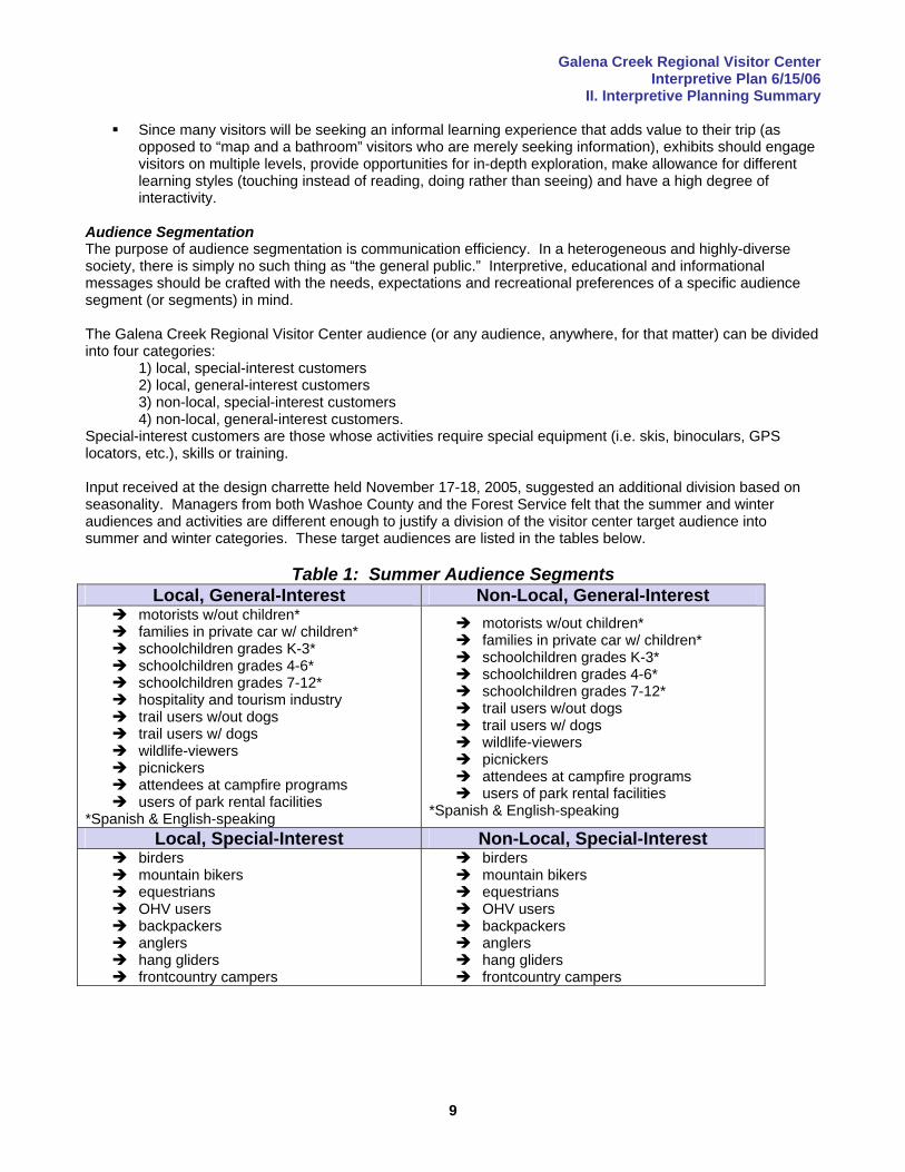
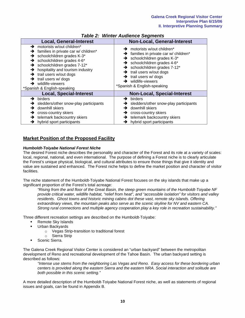
Special-interest customers are those whose activities require special equipment (i.e. skis, binoculars, GPS locators, etc.), skills or training. Input received at the design charrette held November 17-18, 2005, suggested an additional division based on seasonality. Managers from both Washoe County and the Forest Service felt that the summer and winter audiences and activities are different enough to justify a division of the visitor center target audience into summer and winter categories. These target audiences are listed in the tables below.
Table 1: Summer Audience Segments Local, General-Interest Non-Local, General-Interest
motorists w/out children* families in private car w/ children* schoolchildren grades K-3* schoolchildren grades 4-6* schoolchildren grades 7-12* hospitality and tourism industry trail users w/out dogs trail users w/ dogs wildlife-viewers picnickers attendees at campfire programs users of park rental facilities
*Spanish & English-speaking
motorists w/out children* families in private car w/ children* schoolchildren grades K-3* schoolchildren grades 4-6* schoolchildren grades 7-12* trail users w/out dogs trail users w/ dogs wildlife-viewers picnickers attendees at campfire programs users of park rental facilities
*Spanish & English-speaking
Local, Special-Interest Non-Local, Special-Interest birders mountain bikers equestrians OHV users backpackers anglers hang gliders frontcountry campers
birders mountain bikers equestrians OHV users backpackers anglers hang gliders frontcountry campers
Galena Creek Regional Visitor Center Interpretive Plan 6/15/06
II. Interpretive Planning Summary
10
Table 2: Winter Audience Segments Local, General-Interest Non-Local, General-Interest
motorists w/out children* families in private car w/ children* schoolchildren grades K-3* schoolchildren grades 4-6* schoolchildren grades 7-12* hospitality and tourism industry trail users w/out dogs trail users w/ dogs wildlife-viewers
*Spanish & English-speaking
motorists w/out children* families in private car w/ children* schoolchildren grades K-3* schoolchildren grades 4-6* schoolchildren grades 7-12* trail users w/out dogs trail users w/ dogs wildlife-viewers
*Spanish & English-speaking
Local, Special-Interest Non-Local, Special-Interest birders sledders/other snow-play participants downhill skiers cross-country skiers telemark backcountry skiers hybrid sport participants
birders sledders/other snow-play participants downhill skiers cross-country skiers telemark backcountry skiers hybrid sport participants
Market Position of the Proposed Facility Humboldt-Toiyabe National Forest Niche The desired Forest niche describes the personality and character of the Forest and its role at a variety of scales: local, regional, national, and even international. The purpose of defining a Forest niche is to clearly articulate the Forest’s unique physical, biological, and cultural attributes to ensure those things that give it identity and value are sustained and enhanced. The Forest niche helps to define the market position and character of visitor facilities. The niche statement of the Humboldt-Toiyabe National Forest focuses on the sky islands that make up a significant proportion of the Forest’s total acreage:
“Rising from the arid floor of the Great Basin, the steep green mountains of the Humboldt-Toiyabe NF provide critical water, wildlife habitat, “relief from heat”, and “accessible isolation” for visitors and valley residents. Ghost towns and historic mining cabins dot these vast, remote sky islands. Offering extraordinary views, the mountain peaks also serve as the scenic skyline for NV and eastern CA. Strong rural connections and multiple agency cooperation play a key role in recreation sustainability.”
Three different recreation settings are described on the Humboldt-Toiyabe:
Remote Sky Islands Urban Backyards
o Vegas Strip-transition to traditional forest o Sierra Strip
Scenic Sierra. The Galena Creek Regional Visitor Center is considered an “urban backyard” between the metropolitan development of Reno and recreational development of the Tahoe Basin. The urban backyard setting is described as follows:
“Intense use stems from the neighboring Las Vegas and Reno. Easy access for these bordering urban centers is provided along the eastern Sierra and the eastern NRA. Social interaction and solitude are both possible in this scenic setting.”
A more detailed description of the Humboldt-Toiyabe National Forest niche, as well as statements of regional issues and goals, can be found in Appendix B.
Galena Creek Regional Visitor Center Interpretive Plan 6/15/06
II. Interpretive Planning Summary
11
Inventory of Existing Interpretive and Informal Learning Facilities There appears to be a wide-open market niche in the Reno-Tahoe area for a visitor center offering interpretation of the unique transition ecology of the Sierra Front and a comprehensive overview of regional recreation opportunities. While there are a number of small, Chamber of Commerce-style information outlets at various locations around Lake Tahoe (and a proposal to build an expanded visitor facility at Incline Village, less than thirty minutes from Galena Creek Regional Park), the only major nature center in the region is the Taylor Creek Visitor Center. This facility (on the opposite end of the lake from the park) is operated by the Forest Service (Lake Tahoe Basin Management Unit) in cooperation with the Tahoe Heritage Foundation. Its premier attraction is a stream profile chamber that offers visitors an underwater view of Taylor Creek. Several self-guided trails interpret wetlands and other site-specific natural history, including the Washoe pine and other forest ecology. One of the four interpretive trails connects the visitor center to the Tallac Historic Sites, a group of restored vacation mansions that includes a small museum. Guided tours, hikes, slideshows and other interpretive activities are offered at both sites during the summer season. The situation in the regional museum market seems to be at the opposite end of the spectrum, and might even be considered to be approaching saturation. The Fleischmann Planetarium and Science Center, Nevada Museum of Art and National Automobile Museum are major attractions in Reno proper, but there appears to be little potential for overlap or duplication of interpretive themes between those facilities and the Galena Creek Regional Visitor Center. The Nevada Historical Society Museum in Reno offers a broad overview of area cultural history, while the W.M. Keck Museum at the University of Nevada at Reno focuses on mining history and minerals. Washoe County operates the Wilbur D. May Center at Rancho San Rafael Regional Park. It houses memorabilia from the life and times of Wilbur May, a Reno-area rancher and world traveler. There is also an arboretum/demonstration garden at the park. There are more than twenty museums in the vicinity of Virginia City and Carson City, focused on topics ranging from railroading to Native American culture, gambling, Mormon settlement and mining. Two major rock art sites on BLM land, Grimes Point and Hickison Petroglyph Recreation Area, are located within a few hour’s drive from Reno. Market Position Summary The existing inventory of interpretive and informal learning facilities in the Reno-Tahoe area suggests that a somewhat stronger emphasis be placed on ecological themes as opposed to focusing on cultural/historic themes that are unique to the area. With the exception of the Taylor Creek Visitor Center, the natural history thematic areas are wide open. A thorough analysis of exhibits and programs at Taylor Creek should precede exhibit development, but positioning the Galena as the leader in interpretation of local and Great Basin ecology appears to be an appropriate marketing strategy. Several regional museums interpret mining, so interpretation of mining themes must be approached with a reasonable degree of caution. However, the history of the Galena Creek area cannot be told without telling the mining story. Exhibit concept design should be preceded by a thorough inventory and analysis of the exhibits and displays in regional museums so that complementary, rather than duplicative exhibits are developed. Maintaining a tight focus on site-specific themes should facilitate this effort. A similar approach is dictated for interpretation of the Washoe and Paiute cultures, particularly if the decision is made to encourage/enable viewing of the petroglyphs that have been found on the site. There is a wealth of anthropological material already out there, but a conscientious effort to avoid content overlap, combined with a site-specific perspective, should allow the exhibit design team to create complementary interpretive materials that could, in fact, leverage themselves by taking advantage of linkages and handoffs to other facilities. Additional Sites for Interpretation at Galena Creek Regional Park At least five sites at Galena Creek Regional Park are potential locations for the installation of interpretive media:
Stone House (former ranger residence converted to public meeting space and displays)
Galena Creek Regional Visitor Center Interpretive Plan 6/15/06
II. Interpretive Planning Summary
12
Fish Hatchery Camp We-Ch-Me Lodge Jones-White Creek Loop Trail trailhead Bitterbrush Nature Trail.
At present, there are temporary exhibits on loan from the Nevada State Museum in the Stone House, and a number of taxidermy specimens in the common room at the Camp We-Ch-Me Lodge. Since the Stone House, Fish Hatchery and Camp We-Ch-Me Lodge all have historical significance, they are logical choices for the interpretation of topics relevant to their pasts, i.e. recreation topics in the Stone House (it was a warming hut for ski-related activities), flooding in the Fish Hatchery (it was damaged by a flood), etc. The scope of this interpretive plan is specific to the visitor center building, but it has become evident that these sites should be considered in the plan. Each is a potential location for the graphic panels currently in development that will be placed temporarily in or near the visitor center building. Statements of Significance & Interpretive Themes Four statements of significance were developed on the first day the design charrette held in Reno on November 17-18, 2005. The charrette was conducted using the interpretive planning process outlined in Appendix D. Cultural/Historical Statement of Significance
The Galena Creek region has a history of human occupation extending over at least 6000 years. Management Statement of Significance
Galena Creek is a regionally-significant natural area being impacted by its proximity to one of the fastest-growing metropolitan regions in the nation.
Biological Statement of Significance
The Galena Creek region is part of a unique ecotone between the Great Basin and the Sierra Nevada. Travel Corridor Statement of Significance
The Galena Creek region is an important contemporary and historic travel corridor from Truckee Meadows to Mount Rose, Slide Mountain and Lake Tahoe.
Interpretive themes based on the statements of significance were developed on the second day of the charrette. The central theme statement for the Galena Creek Regional Visitor Center is the unified, overarching message of the facility. It strives to pull together the statements of significance and primary themes in a single message. Central Theme
The abundant natural resources of Galena Canyon, which is located on a natural travel corridor from the Washoe Valley to Lake Tahoe, have attracted humans for millennia, and protecting the region’s special values in the face of rapidly-encroaching urban development is a challenge that must be shared by local residents and visitors as well as the agencies responsible for its management.
Primary themes define the broad topic areas within which exhibit concepts are developed. Cultural/Historical Theme
Exploitation of natural resources following Euro-American settlement altered the local environment, and, although the region’s economic base has been transformed since the mining boom and much of the ecological integrity of land has been restored, the rapid pace of modern development makes us wonder what environmental changes the future may hold, and what lessons might be learned from early cultures that had a more sustainable relationship with the land.
Management Theme
Resource management issues are made more complicated, and user conflicts are intensified in natural areas on the urban/wildland interface, increasing the stewardship responsibilities of visitors, and
Galena Creek Regional Visitor Center Interpretive Plan 6/15/06
II. Interpretive Planning Summary
13
necessitating a reliance on well-informed, well-oriented users to help the management agencies achieve their goal of providing safe, enjoyable recreational experiences.
Biological Theme
The location of Galena Canyon in a transition zone between arid, sagebrush-dotted valleys and moister, forested mountains has resulted in an uncommon ecosystem where several rare or unique plant species occur and where, as elsewhere in the eastern Sierra, water is scarce, streamflows unreliable, and flora and fauna must adapt to climatic extremes if they are to survive.
Travel Corridor Theme
The Galena Creek Regional Visitor Center, one of the gateways to Lake Tahoe, is located in mountainous terrain on a travel corridor used by both humans and wildlife, and the construction and maintenance of the highway now designated as the Mount Rose Scenic Byway is a story of people and machinery being taxed to their limits.
Two secondary themes were added subsequent to the charrette during the review process for this plan. The first was added to create a conceptual framework for the interpretation of LEED (Leadership in Energy and Environmental Design) certification standards and sustainable building design/construction (the building is designed to the Silver LEED standard). Sustainable Building Theme
The Forest Service stays true to its mission of resource conservation by specifying that agency buildings be built to Leadership in Energy and Environmental Design (LEED) standards established by the U.S. Green Building Council, and by interpreting those building techniques to visitors.
The second additional secondary theme was added to provide the basis for interpretation of the concept of ecosystem services that has become an important national goal for the Forest Service. Creative communication of this emerging concept will place the Galena facility on the cutting edge of the effort to educate the public about the sociopolitical and economic complexities of ecosystem services marketing, and may provide avenues for funding. Ecosystem Services Theme
Healthy ecosystems provide a wide range of economic, environmental and aesthetic goods and services that are traditionally considered free, but placing a monetary value on these services helps people appreciate their true worth, while helping to define the structure of the emerging marketplace where the exchange of ecosystem services takes place.
The flow of ideas from statements of significance to primary theme, subtheme and storyline is shown in detail in Appendix D. Recommendations for Exhibits and Programs Detailed media recommendations, including suggestions on which themes might be appropriately delivered via personal interpretive programming in addition to (or in lieu of) exhibits and/or literature, can be found in Appendix E. That section also offers suggestions on which concepts might be considered for delivery in locations other than the visitor center, such as the Stone House, Fish Hatchery and trailheads. Below are two tables of exhibit concepts developed by the local project team. They are grouped into two lists: “must do priority” and “secondary priority.” The concepts within each table are not in any particular order of priority.
Galena Creek Regional Visitor Center Interpretive Plan 6/15/06
II. Interpretive Planning Summary
14
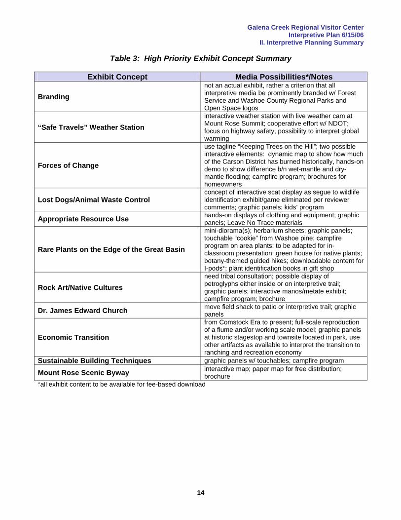
Table 3: High Priority Exhibit Concept Summary
Exhibit Concept Media Possibilities*/Notes
Branding not an actual exhibit, rather a criterion that all interpretive media be prominently branded w/ Forest Service and Washoe County Regional Parks and Open Space logos
“Safe Travels” Weather Station interactive weather station with live weather cam at Mount Rose Summit; cooperative effort w/ NDOT; focus on highway safety, possibility to interpret global warming
Forces of Change
use tagline “Keeping Trees on the Hill”; two possible interactive elements: dynamic map to show how much of the Carson District has burned historically, hands-on demo to show difference b/n wet-mantle and dry-mantle flooding; campfire program; brochures for homeowners
Lost Dogs/Animal Waste Control concept of interactive scat display as segue to wildlife identification exhibit/game eliminated per reviewer comments; graphic panels; kids’ program
Appropriate Resource Use hands-on displays of clothing and equipment; graphic panels; Leave No Trace materials
Rare Plants on the Edge of the Great Basin
mini-diorama(s); herbarium sheets; graphic panels; touchable “cookie” from Washoe pine; campfire program on area plants; to be adapted for in-classroom presentation; green house for native plants; botany-themed guided hikes; downloadable content for I-pods*; plant identification books in gift shop
Rock Art/Native Cultures need tribal consultation; possible display of petroglyphs either inside or on interpretive trail; graphic panels; interactive manos/metate exhibit; campfire program; brochure
Dr. James Edward Church move field shack to patio or interpretive trail; graphic panels
Economic Transition
from Comstock Era to present; full-scale reproduction of a flume and/or working scale model; graphic panels at historic stagestop and townsite located in park, use other artifacts as available to interpret the transition to ranching and recreation economy
Sustainable Building Techniques graphic panels w/ touchables; campfire program
Mount Rose Scenic Byway interactive map; paper map for free distribution; brochure
*all exhibit content to be available for fee-based download
Galena Creek Regional Visitor Center Interpretive Plan 6/15/06
II. Interpretive Planning Summary
15
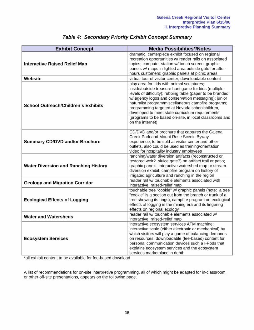
Table 4: Secondary Priority Exhibit Concept Summary
Exhibit Concept Media Possibilities*/Notes
Interactive Raised Relief Map
dramatic, centerpiece exhibit focused on regional recreation opportunities w/ reader rails on associated topics; computer station w/ touch screen; graphic panels w/ maps in lighted area outside gate for after-hours customers; graphic panels at picnic areas
Website virtual tour of visitor center; downloadable content
School Outreach/Children’s Exhibits
play area for kids with animal sculptures; inside/outside treasure hunt game for kids (multiple levels of difficulty); rubbing table (paper to be branded w/ agency logos and conservation messaging); junior naturalist program/miscellaneous campfire programs; programming targeted at Nevada schoolchildren, developed to meet state curriculum requirements (programs to be based on-site, in local classrooms and on the internet)
Summary CD/DVD and/or Brochure
CD/DVD and/or brochure that captures the Galena Creek Park and Mount Rose Scenic Byway experience; to be sold at visitor center and other outlets, also could be used as training/orientation video for hospitality industry employees
Water Diversion and Ranching History
ranching/water diversion artifacts (reconstructed or restored weir? sluice gate?) on artifact trail or patio; graphic panels; interactive watershed map or stream-diversion exhibit; campfire program on history of irrigated agriculture and ranching in the region
Geology and Migration Corridor reader rail w/ touchable elements associated with interactive, raised-relief map
Ecological Effects of Logging
touchable tree “cookie” w/ graphic panels (note: a tree “cookie” is a section cut from the branch or trunk of a tree showing its rings); campfire program on ecological effects of logging in the mining era and its lingering effects on regional ecology
Water and Watersheds reader rail w/ touchable elements associated w/ interactive, raised-relief map
Ecosystem Services
interactive ecosystem services ATM machine; interactive scale (either electronic or mechanical) by which visitors will play a game of balancing demands on resources; downloadable (fee-based) content for personal communication devices such a I-Pods that explains ecosystem services and the ecosystem services marketplace in depth
*all exhibit content to be available for fee-based download A list of recommendations for on-site interpretive programming, all of which might be adapted for in-classroom or other off-site presentations, appears on the following page.
Galena Creek Regional Visitor Center Interpretive Plan 6/15/06
II. Interpretive Planning Summary
16
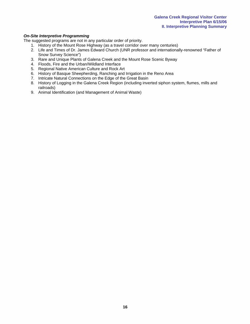
On-Site Interpretive Programming The suggested programs are not in any particular order of priority.
1. History of the Mount Rose Highway (as a travel corridor over many centuries) 2. Life and Times of Dr. James Edward Church (UNR professor and internationally-renowned “Father of
Snow Survey Science”) 3. Rare and Unique Plants of Galena Creek and the Mount Rose Scenic Byway 4. Floods, Fire and the Urban/Wildland Interface 5. Regional Native American Culture and Rock Art 6. History of Basque Sheepherding, Ranching and Irrigation in the Reno Area 7. Intricate Natural Connections on the Edge of the Great Basin 8. History of Logging in the Galena Creek Region (including inverted siphon system, flumes, mills and
railroads) 9. Animal Identification (and Management of Animal Waste)
Galena Creek Regional Visitor Center Interpretive Plan 6/15/06
III. Facility Summary
17
III. Facility Summary Neither the Carson Ranger District or Washoe County have a visitor facility. The need for the Galena Creek Regional Visitor Center is justified by several factors, including (but not limited to):
the existing venue for outdoor programming at the park is at capacity special event and community facilities both in Reno and on the North Shore of Lake Tahoe are also at
capacity (Tahoe marketing and convention professionals have expressed an interest in a Galena-based facility to supplement existing meeting and conference space
local residents have expressed strong support for the development of the facility gift shop revenues supplemented by County funds will support the ongoing operations and maintenance
of the facility, thereby meeting the Forest Service criteria that the visitor center be self-supporting (e.g. no Federal funds will be needed for O&M)
the location is exceptional, being on a scenic byway between two major tourist destinations with international reputations (Reno and Lake Tahoe)
the location offers access to a trail complex that can meet the needs of a variety of users.
Exhibit Design Criteria Exhibits at the Galena Creek Regional Visitor Center will be designed to meet the following standards.
To the greatest possible extent, all exhibits, programs and literature will be accessible to all persons regardless of their abilities. This will include, but not be limited to, the development of an audio tour for sight-impaired persons and provision of alternative media that meet the needs of the full spectrum of users in cases where full-accessibility cannot be reasonably achieved.
The creation of a strong linkage with the Mount Rose Scenic Byway will be given priority consideration in the development of exhibit, program and literature content.
The highest priority will be given to providing accurate, comprehensive information on recreation opportunities and addressing management issues such as fire and fuels management.
Messages will be goal-driven, theme-based and targeted at a specific audience segment or segments. A high degree of changeability will be a primary design criteria. Interpretive media will be prominently branded with Forest Service and Washoe County logos, and a
logo unique to the visitor center and byway will be developed for gift items such as t-shirts and coffee mugs.
The Forest Service, Washoe County and a friends’ group or interpretive association to be formed later will be positioned as friends and protectors of wildlands, and champions of access to public lands in the face of encroaching urban development.
Continued outreach to local schools, and development of content meeting the curriculum requirements of the State of Nevada will be given priority in program development.
Exhibit and program content will be offered in both English and Spanish to the greatest possible extent. Exhibit content will be available to internet users on a website with links to related websites, and will be
available for download to personal communication devices on a fee basis. Elders of the Washoe and Paiute tribes will be consulted during the exhibit design process to develop
messages based on their interpretation of their culture, not the designers. Exhibits will have a high degree of interactivity and be designed to accommodate different styles of
learning and levels of interest. Determination of Building Size Two different planning models were used to estimate visitation in 2016 at the proposed facility.
1. Washoe County staff estimate that about 150,000 people visit Galena Creek Regional Park each year. If it is assumed that the rapid population growth in the Reno-Tahoe area will continue, visitation in 2016 might increase by slightly more than 50% over the current level to 230,000/year. If 45% of park users actually enter the visitor center, the total number of people entering the building will be 103,500.
2. The most recent (2002) civil engineering study conducted on traffic on the Mount Rose Highway estimated traffic volume at 6,000 cars/day, or 2,190,000 cars/year. If a 50% increase in traffic is assumed to occur between 2002 and 2016, the traffic volume will increase to 3,285,000 cars/year. If 3% of those cars enter the park, vehicle traffic entering the park will be 98,500 cars/year. If there are 2 persons/vehicle, park visitation will be 197,100, and if 45% of those persons enter the visitor center, usage will be 88,695. If the proportion of vehicles entering the park is estimated at 4% of total traffic, vehicle traffic entering the park will be 131,400 vehicles. If there are 2 persons/vehicle, park visitation
Galena Creek Regional Visitor Center Interpretive Plan 6/15/06
III. Facility Summary
18
will be 262,800, and if 45% of those persons enter the visitor center, usage will be 118,260. The mean of the two visitation estimates is 103,477.5.
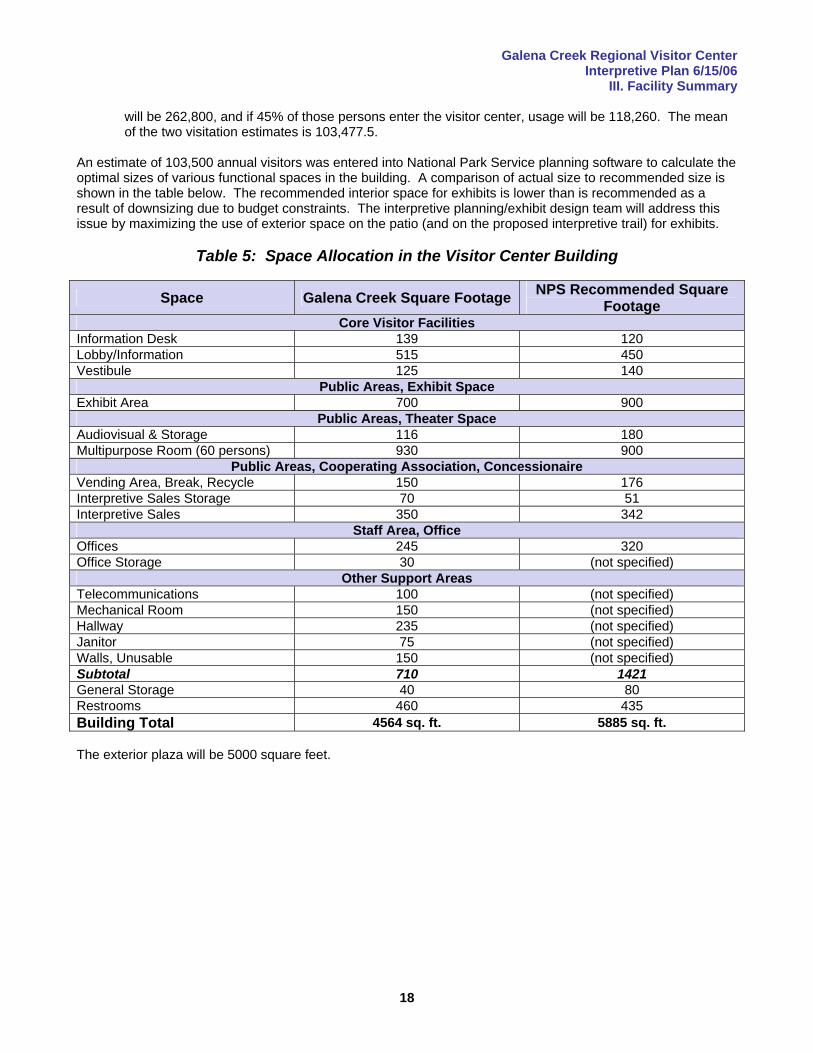
An estimate of 103,500 annual visitors was entered into National Park Service planning software to calculate the optimal sizes of various functional spaces in the building. A comparison of actual size to recommended size is shown in the table below. The recommended interior space for exhibits is lower than is recommended as a result of downsizing due to budget constraints. The interpretive planning/exhibit design team will address this issue by maximizing the use of exterior space on the patio (and on the proposed interpretive trail) for exhibits.
Table 5: Space Allocation in the Visitor Center Building
Space Galena Creek Square Footage NPS Recommended Square Footage
Core Visitor Facilities Information Desk 139 120 Lobby/Information 515 450 Vestibule 125 140
Public Areas, Exhibit Space Exhibit Area 700 900
Public Areas, Theater Space Audiovisual & Storage 116 180 Multipurpose Room (60 persons) 930 900
Public Areas, Cooperating Association, Concessionaire Vending Area, Break, Recycle 150 176 Interpretive Sales Storage 70 51 Interpretive Sales 350 342
Staff Area, Office Offices 245 320 Office Storage 30 (not specified)
Other Support Areas Telecommunications 100 (not specified) Mechanical Room 150 (not specified) Hallway 235 (not specified) Janitor 75 (not specified) Walls, Unusable 150 (not specified) Subtotal 710 1421 General Storage 40 80 Restrooms 460 435 Building Total 4564 sq. ft. 5885 sq. ft. The exterior plaza will be 5000 square feet.
Galena Creek Regional Visitor Center Interpretive Plan 6/15/06
III. Facility Summary
19
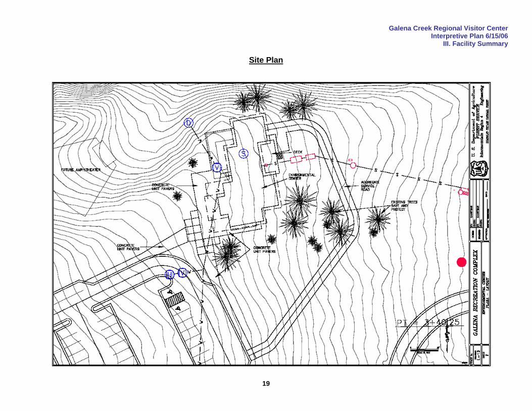
Site Plan
Galena Creek Regional Visitor Center Interpretive Plan 6/15/06
III. Facility Summary
20
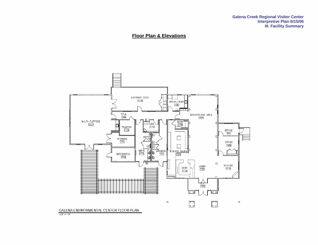
Floor Plan & Elevations
Galena Creek Regional Visitor Center Interpretive Plan 6/15/06
III. Facility Summary
21
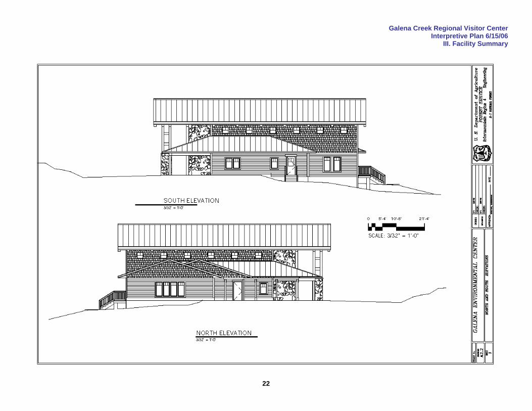
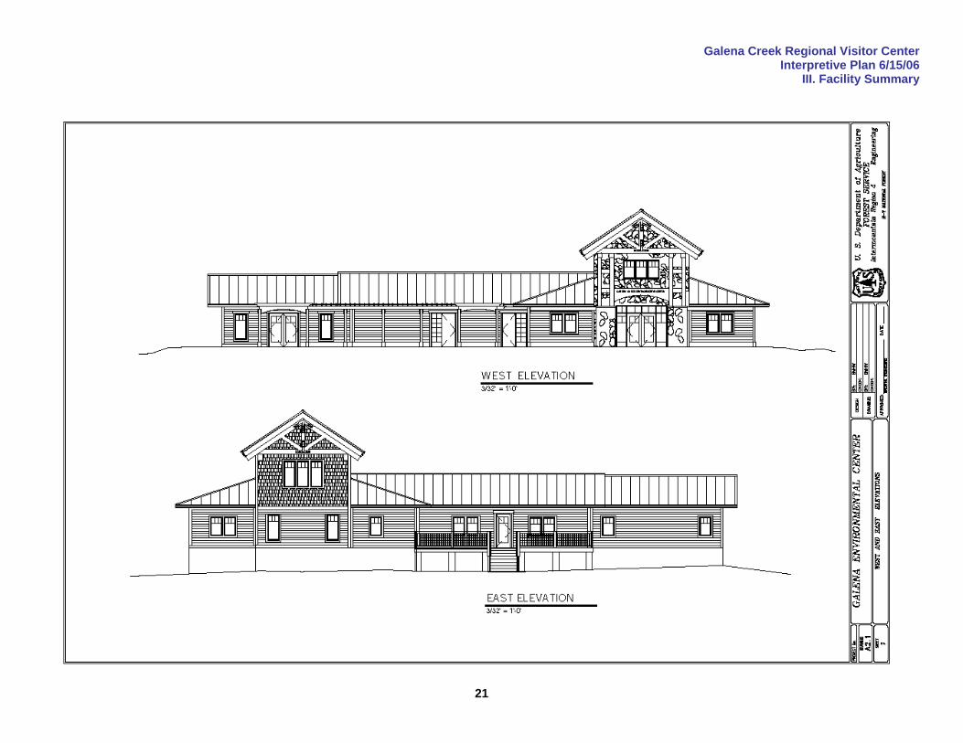
Galena Creek Regional Visitor Center Interpretive Plan 6/15/06
III. Facility Summary
22
Galena Creek Regional Visitor Center Interpretive Plan 6/15/06
IV. Accessibility
23
IV. Accessibility The Galena Creek Regional Visitor Center building is being designed by the Intermountain Region Facilities Design Group with support in interpretive planning from the firm of Exhibit Design Associates. The entire project team is committed to, and will follow the recommended standards stipulated under Federal and State design guidelines. The Carson Ranger District of the Humboldt-Toiyabe National Forest is committed to meeting facility, programming and exhibit universal access design requirements in accordance with the Americans with Disabilities Act (ADA), the Architectural Barriers Act Accessibility Guidelines (ABAAG), the Forest Service Accessibility Checklist (FSAC) and the Forest Service Trail Accessibility Guidelines (FSTAG). The facility and exhibits will be designed to meet the following criteria.
The route to the entrance of the exhibit space will be level to the parking lot and no ramps will be required.
The path to the center of the patio will be a minimum of 36 inches wide Most of the exhibit content will be offered for exploration at audio, tactile and visual levels. Each of these
exhibit elements will be designed to meet the above mentioned accessibility standards. An audio summary with associated captions for all exhibits will be available in two languages for both
Spanish-speaking visitors and the hearing impaired. The handset for this device will have a single hand control and will be free from potential pinching, grasping, or twisting.
Content will be accessible to persons at all levels of learning ability and comprehension. Major exhibit components will be available for tactile examination, and no more than 5 pounds of force
or the need for grasping or twisting will be needed to manipulate any device. There will be 70% light reflectance value contrast between the colors of the wall, floor and ceiling. There will be no overall patterns created by the color and other visual attributes of the flooring that might
create optical illusions, and the lighting in general will enable easy navigation of the entire facility. Special consideration will be given to the exhibit lighting. Focused track lights will be provided for all
exhibit areas, including temporary exhibit spaces. At least ten candle power light will be provided for all exhibit text. Light will be even, shadow-free, and focused in a manner that prevents light pooling and glare.
All exhibit cases and walls will be positioned so that the traffic flow pattern is clear and distinct. There will be at least 36" access both between and around all exhibit spaces.
Interactive exhibits will have radius corners. All information counters and brochure racks will meet the accessibility standards mentioned above. All exhibit text copy will be in san-serif typeface with a minimum point size of 6.5 mm. There will be
enough space between letters to create an open appearance. All type will be flush left and label text of more than three lines will not be centered. There will be enough color contrast between letter and background to enable easy reading of the text.
When ghosted backgrounds are utilized to create a sense of context, they will not be difficult to read. Labeling will always be consistent and concise. The interpretive language will be short and simple and the message will be personalized whenever possible.
In all cases the accessibility standard for wheelchair users will be exceeded. All reader rails will have 30" clearance from the lower edge to the floor with a 19" clearance for the knees.
All interactive elements will have reachable controls and will be positioned no higher than 48" above the ground, without barriers. All button-activated interactive elements will have buttons with a minimum width of 3/4".
All interactive exhibits will be captioned with clear instructions for all user groups. All audio presentations will have volume controls to accommodate all users. All audio presentations will be accessible at the site with instructions available at the reception desk.
Emergency routes out of the exhibition area will be accessible and free of significant changes in level. The emergency exit will be clearly marked and egress information will be available in Braille.
All trails will conform to the standards specified in the Forest Service Trails Accessibility Guidelines.
Galena Creek Regional Visitor Center Interpretive Plan 6/15/06
V. Acquisition of Exhibits
24
V. Acquisition of Exhibits An exhibit concept plan based on the goals, objectives, themes and priorities established in this interpretive plan will be completed as soon as possible after approval of this document (requests for funding are in process). The concept plan will:
establish design guidelines for Galena Creek Regional Visitor Center prioritize the order in which exhibits are designed, fabricated and installed provide firm cost estimates for exhibit design, fabrication and installation provide concept sketches of the exhibit space and 4-6 exhibits describe the process necessary to complete exhibit acquisition.
An exhibit “concept” plan differs from an exhibit “design” plan in level of detail. The design plan is the final document to be produced before fabrication. It will contain final interpretive text, finished artwork, construction (scale) drawings, materials specifications and everything else necessary to complete fabrication. The concept plan will not provide text, finished art or construction drawings. Washoe County Regional Parks and Open Space and the Carson Ranger District of Humboldt-Toiyabe National Forest have successfully partnered to build recreation facilities and interpretive signage (at the Stone House, Mount Rose Welcome Plaza and other locations), as well as to deliver interpretive programming. The partners intend to continue to cooperate in the acquisition of exhibits, and have agreed in principle to be governed by a Memorandum of Understanding (MOU) that will define their respective roles and responsibilities in the process. That MOU was being drafted at the time this document was submitted for final review, and will be included in Appendix L when it is completed and signed. Several grant requests for exhibit design and fabrication were also pending (see the Budget section on p.27), but the amount of the grants is not adequate to meet projected exhibit costs (based on a per-square-foot estimate). A plan to make up the budget shortfall for exhibits will be completed by the Forest, Region and County. It will be included in this plan in the Budget section.
Galena Creek Regional Visitor Center Interpretive Plan 6/15/06
VI. Project Team
25
VI. Project Team This planning process has been a cooperative effort among the staffs of Washoe County Regional Parks and Open Space, USDA Forest Service and Exhibit Design Associates. Those who have contributed to the process include: Exhibit Design Associates
William (Biff) Baird, Interpretive Planner Thom Buchanan, Exhibit Designer Russ Peterson, Principal/Project Manager
Nevada Department of Transportation
Thor Dyson, District Engineer Jeff Fontaine, Director Michelle Gardner-Lilley, Scenic Byways Coordinator
USDA Forest Service, Humboldt-Toiyabe National Forest
Kathy Branton, GIS Specialist Jean Burt, Grants and Agreements Specialist Terry DeTullio, Administrative Specialist Linda Guy, North Zone Engineer Steve Hale, Recreation Specialist Christie Kalkowski, Public Affairs Officer Scott Lamoreux, Forest Recreation Program Manager Franklin Pemberton, Community Affairs Officer Larry Randall, Recreation Program Staff Officer David Reis, Landscape Architect Gary Schiff, Carson District Ranger Kevin Wilmot, Forest Engineer Staff Officer
USDA Forest Service, Intermountain Regional Office
John Beckley, Special Uses Coordinator Chris Hartman, Regional Landscape Architect David Jeppsen, Regional Engineer Gordon Williams, Interpretive and Tourism Services Leader (retired) Shelley Hill-Worthen, Architect
USDA Forest Service, Rocky Mountain Regional Office
Terry Wong, Center for Design and Interpretation Manager USDA Forest Service, Washington Office
Kristen Nelson, Interpretive Services Program Manager Washoe County Regional Parks and Open Space
Jennifer Budge, Park Planner/Project Manager Kristine Bunnell, Park Planner Doug Doolittle, Director of Parks Jeff Glavor, Galena Creek Regional Park Ranger Bob Harmon, Public Information Officer John Keesee, Assistant District Ranger Karen Mullen-Ehly, Director of Parks (retired) Lynda Nelson, Natural Resource Manager Carolyn Poissant, Project Coordinator Colleen Wallace-Barnum, Mount Rose District Ranger
Galena Creek Regional Visitor Center Interpretive Plan 6/15/06
VI. Project Team
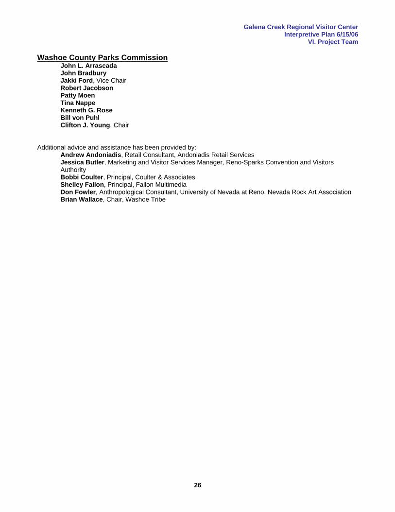
26
Washoe County Parks Commission John L. Arrascada John Bradbury Jakki Ford, Vice Chair Robert Jacobson Patty Moen Tina Nappe Kenneth G. Rose Bill von Puhl Clifton J. Young, Chair
Additional advice and assistance has been provided by:
Andrew Andoniadis, Retail Consultant, Andoniadis Retail Services Jessica Butler, Marketing and Visitor Services Manager, Reno-Sparks Convention and Visitors Authority Bobbi Coulter, Principal, Coulter & Associates Shelley Fallon, Principal, Fallon Multimedia Don Fowler, Anthropological Consultant, University of Nevada at Reno, Nevada Rock Art Association Brian Wallace, Chair, Washoe Tribe
Galena Creek Regional Visitor Center Interpretive Plan 6/15/06
VII. Schedule
27
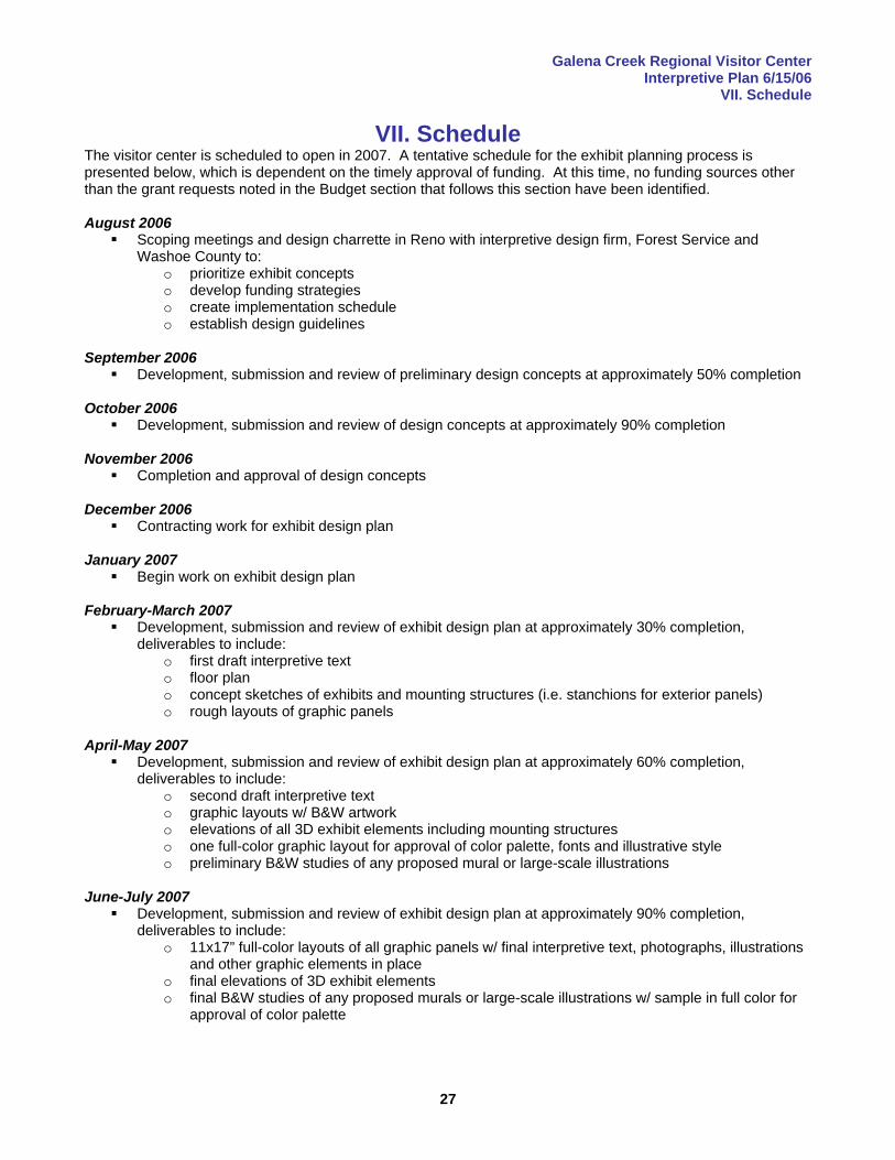
VII. Schedule The visitor center is scheduled to open in 2007. A tentative schedule for the exhibit planning process is presented below, which is dependent on the timely approval of funding. At this time, no funding sources other than the grant requests noted in the Budget section that follows this section have been identified. August 2006
Scoping meetings and design charrette in Reno with interpretive design firm, Forest Service and Washoe County to:
o prioritize exhibit concepts o develop funding strategies o create implementation schedule o establish design guidelines
September 2006
Development, submission and review of preliminary design concepts at approximately 50% completion October 2006
Development, submission and review of design concepts at approximately 90% completion November 2006
Completion and approval of design concepts December 2006
Contracting work for exhibit design plan January 2007
Begin work on exhibit design plan February-March 2007
Development, submission and review of exhibit design plan at approximately 30% completion, deliverables to include:
o first draft interpretive text o floor plan o concept sketches of exhibits and mounting structures (i.e. stanchions for exterior panels) o rough layouts of graphic panels
April-May 2007
Development, submission and review of exhibit design plan at approximately 60% completion, deliverables to include:
o second draft interpretive text o graphic layouts w/ B&W artwork o elevations of all 3D exhibit elements including mounting structures o one full-color graphic layout for approval of color palette, fonts and illustrative style o preliminary B&W studies of any proposed mural or large-scale illustrations
June-July 2007
Development, submission and review of exhibit design plan at approximately 90% completion, deliverables to include:
o 11x17” full-color layouts of all graphic panels w/ final interpretive text, photographs, illustrations and other graphic elements in place
o final elevations of 3D exhibit elements o final B&W studies of any proposed murals or large-scale illustrations w/ sample in full color for
approval of color palette
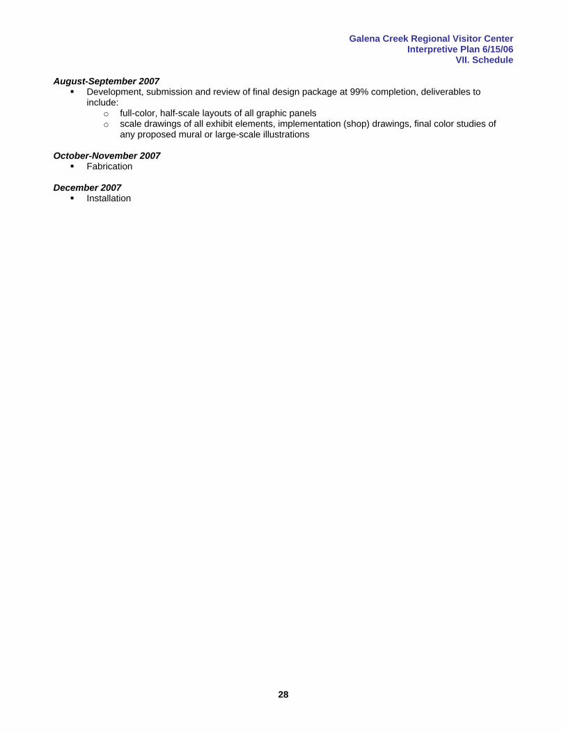
Galena Creek Regional Visitor Center Interpretive Plan 6/15/06
VII. Schedule
28
August-September 2007 Development, submission and review of final design package at 99% completion, deliverables to
include: o full-color, half-scale layouts of all graphic panels o scale drawings of all exhibit elements, implementation (shop) drawings, final color studies of
any proposed mural or large-scale illustrations October-November 2007
Fabrication December 2007
Installation
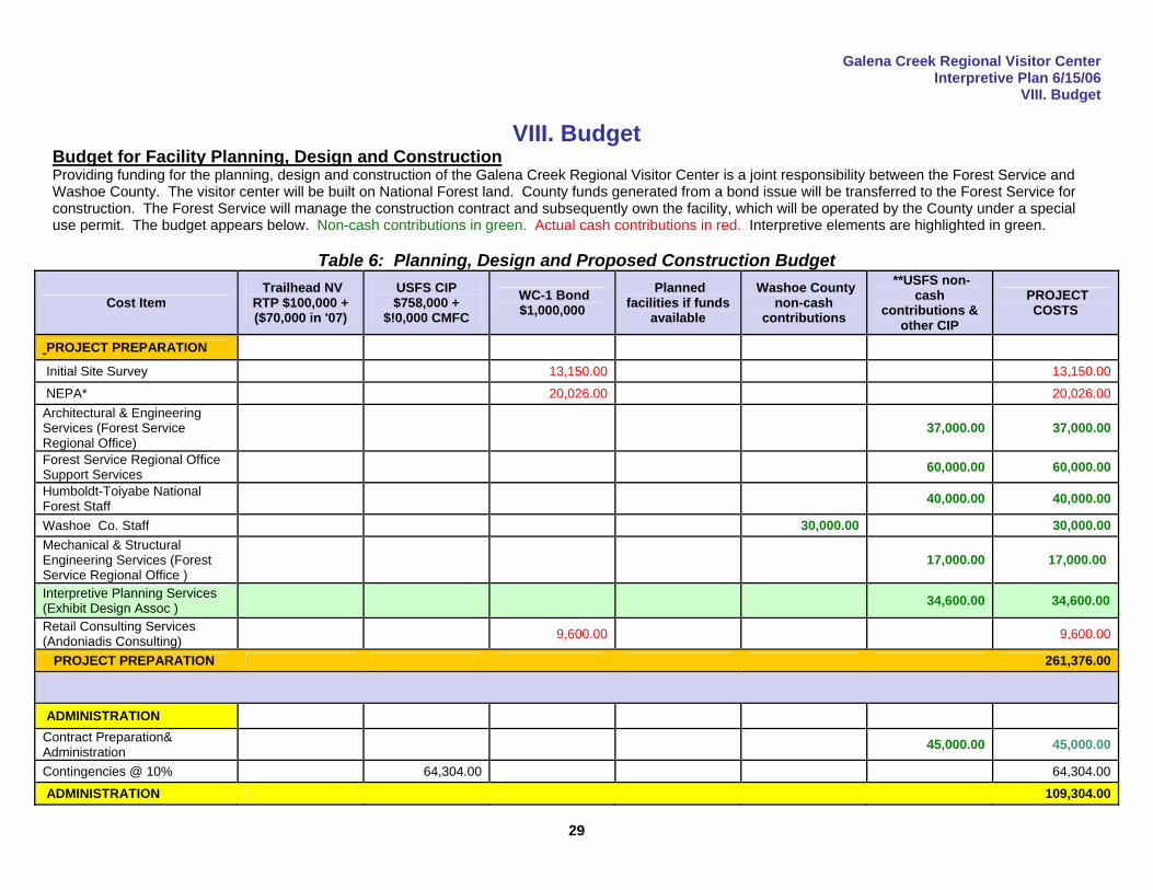
Galena Creek Regional Visitor Center Interpretive Plan 6/15/06
VIII. Budget
29
VIII. Budget Budget for Facility Planning, Design and Construction Providing funding for the planning, design and construction of the Galena Creek Regional Visitor Center is a joint responsibility between the Forest Service and Washoe County. The visitor center will be built on National Forest land. County funds generated from a bond issue will be transferred to the Forest Service for construction. The Forest Service will manage the construction contract and subsequently own the facility, which will be operated by the County under a special use permit. The budget appears below. Non-cash contributions in green. Actual cash contributions in red. Interpretive elements are highlighted in green.
Table 6: Planning, Design and Proposed Construction Budget
Cost Item Trailhead NV
RTP $100,000 + ($70,000 in '07)
USFS CIP $758,000 +
$!0,000 CMFC WC-1 Bond $1,000,000
Planned facilities if funds
available
Washoe County non-cash
contributions
**USFS non-cash
contributions & other CIP
PROJECT COSTS
PROJECT PREPARATION
Initial Site Survey 13,150.00 13,150.00
NEPA* 20,026.00 20,026.00 Architectural & Engineering Services (Forest Service Regional Office)
37,000.00 37,000.00
Forest Service Regional Office Support Services 60,000.00 60,000.00
Humboldt-Toiyabe National Forest Staff 40,000.00 40,000.00
Washoe Co. Staff 30,000.00 30,000.00 Mechanical & Structural Engineering Services (Forest Service Regional Office )
17,000.00 17,000.00
Interpretive Planning Services (Exhibit Design Assoc ) 34,600.00 34,600.00
Retail Consulting Services (Andoniadis Consulting) 9,600.00 9,600.00
PROJECT PREPARATION 261,376.00
ADMINISTRATION Contract Preparation& Administration 45,000.00 45,000.00
Contingencies @ 10% 64,304.00 64,304.00
ADMINISTRATION 109,304.00
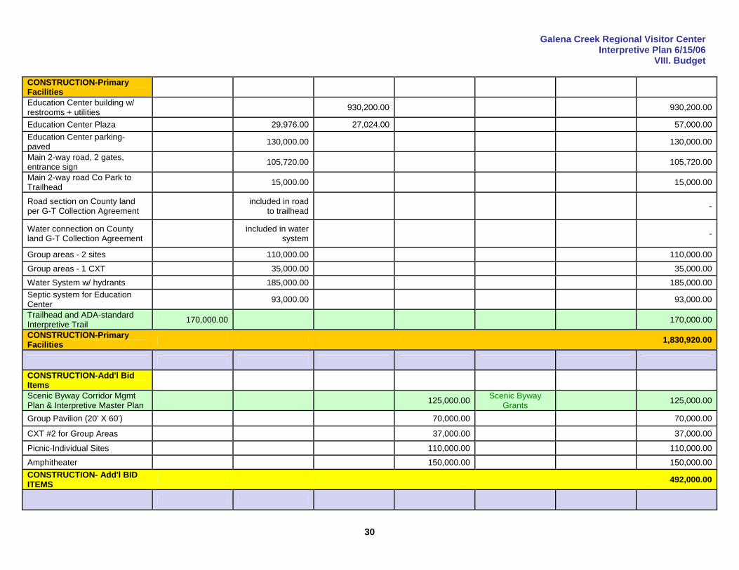
Galena Creek Regional Visitor Center Interpretive Plan 6/15/06
VIII. Budget
30
CONSTRUCTION-Primary Facilities
Education Center building w/ restrooms + utilities 930,200.00 930,200.00
Education Center Plaza 29,976.00 27,024.00 57,000.00 Education Center parking- paved 130,000.00 130,000.00
Main 2-way road, 2 gates, entrance sign 105,720.00 105,720.00
Main 2-way road Co Park to Trailhead 15,000.00 15,000.00
Road section on County land per G-T Collection Agreement included in road
to trailhead -
Water connection on County land G-T Collection Agreement included in water
system -
Group areas - 2 sites 110,000.00 110,000.00
Group areas - 1 CXT 35,000.00 35,000.00 Water System w/ hydrants 185,000.00 185,000.00 Septic system for Education Center 93,000.00 93,000.00
Trailhead and ADA-standard Interpretive Trail 170,000.00 170,000.00
CONSTRUCTION-Primary Facilities 1,830,920.00
CONSTRUCTION-Add'l Bid Items
Scenic Byway Corridor Mgmt Plan & Interpretive Master Plan 125,000.00 Scenic Byway
Grants 125,000.00
Group Pavilion (20' X 60') 70,000.00 70,000.00
CXT #2 for Group Areas 37,000.00 37,000.00
Picnic-Individual Sites 110,000.00 110,000.00
Amphitheater 150,000.00 150,000.00 CONSTRUCTION- Add'l BID ITEMS 492,000.00
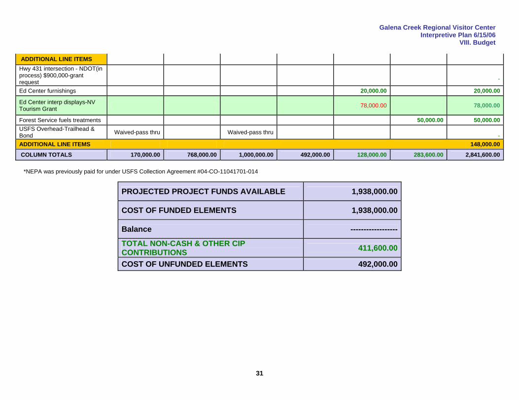
Galena Creek Regional Visitor Center Interpretive Plan 6/15/06
VIII. Budget
31
ADDITIONAL LINE ITEMS Hwy 431 intersection - NDOT(in process) $900,000-grant request
-
Ed Center furnishings 20,000.00 20,000.00
Ed Center interp displays-NV Tourism Grant 78,000.00 78,000.00
Forest Service fuels treatments 50,000.00 50,000.00 USFS Overhead-Trailhead & Bond Waived-pass thru Waived-pass thru
- ADDITIONAL LINE ITEMS 148,000.00
COLUMN TOTALS 170,000.00 768,000.00 1,000,000.00 492,000.00 128,000.00 283,600.00 2,841,600.00 *NEPA was previously paid for under USFS Collection Agreement #04-CO-11041701-014
PROJECTED PROJECT FUNDS AVAILABLE 1,938,000.00
COST OF FUNDED ELEMENTS 1,938,000.00
Balance ------------------
TOTAL NON-CASH & OTHER CIP CONTRIBUTIONS 411,600.00
COST OF UNFUNDED ELEMENTS 492,000.00
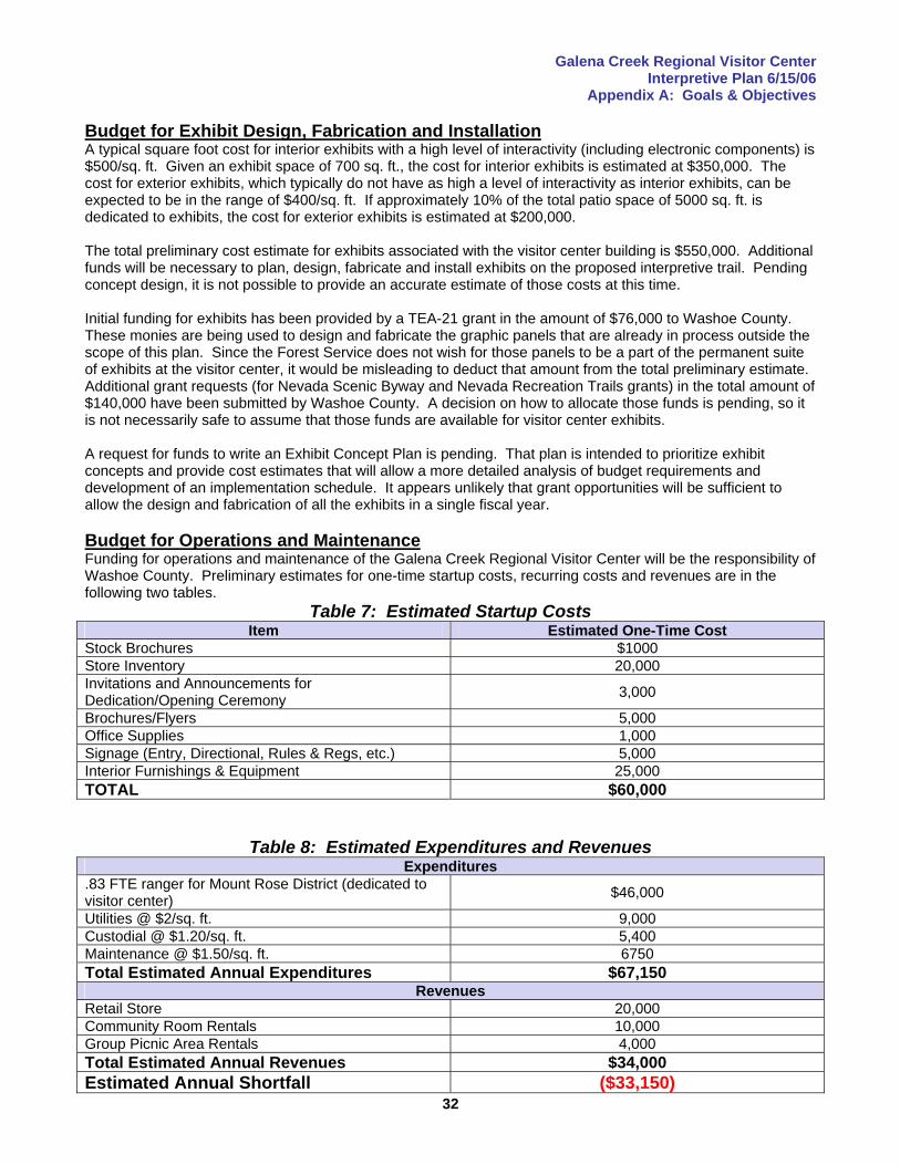
Galena Creek Regional Visitor Center Interpretive Plan 6/15/06
Appendix A: Goals & Objectives
32
Budget for Exhibit Design, Fabrication and Installation A typical square foot cost for interior exhibits with a high level of interactivity (including electronic components) is $500/sq. ft. Given an exhibit space of 700 sq. ft., the cost for interior exhibits is estimated at $350,000. The cost for exterior exhibits, which typically do not have as high a level of interactivity as interior exhibits, can be expected to be in the range of $400/sq. ft. If approximately 10% of the total patio space of 5000 sq. ft. is dedicated to exhibits, the cost for exterior exhibits is estimated at $200,000. The total preliminary cost estimate for exhibits associated with the visitor center building is $550,000. Additional funds will be necessary to plan, design, fabricate and install exhibits on the proposed interpretive trail. Pending concept design, it is not possible to provide an accurate estimate of those costs at this time. Initial funding for exhibits has been provided by a TEA-21 grant in the amount of $76,000 to Washoe County. These monies are being used to design and fabricate the graphic panels that are already in process outside the scope of this plan. Since the Forest Service does not wish for those panels to be a part of the permanent suite of exhibits at the visitor center, it would be misleading to deduct that amount from the total preliminary estimate. Additional grant requests (for Nevada Scenic Byway and Nevada Recreation Trails grants) in the total amount of $140,000 have been submitted by Washoe County. A decision on how to allocate those funds is pending, so it is not necessarily safe to assume that those funds are available for visitor center exhibits. A request for funds to write an Exhibit Concept Plan is pending. That plan is intended to prioritize exhibit concepts and provide cost estimates that will allow a more detailed analysis of budget requirements and development of an implementation schedule. It appears unlikely that grant opportunities will be sufficient to allow the design and fabrication of all the exhibits in a single fiscal year. Budget for Operations and Maintenance Funding for operations and maintenance of the Galena Creek Regional Visitor Center will be the responsibility of Washoe County. Preliminary estimates for one-time startup costs, recurring costs and revenues are in the following two tables.
Table 7: Estimated Startup Costs Item Estimated One-Time Cost
Stock Brochures $1000 Store Inventory 20,000 Invitations and Announcements for Dedication/Opening Ceremony 3,000
Brochures/Flyers 5,000 Office Supplies 1,000 Signage (Entry, Directional, Rules & Regs, etc.) 5,000 Interior Furnishings & Equipment 25,000 TOTAL $60,000
Table 8: Estimated Expenditures and Revenues
Expenditures .83 FTE ranger for Mount Rose District (dedicated to visitor center) $46,000
Utilities @ $2/sq. ft. 9,000 Custodial @ $1.20/sq. ft. 5,400 Maintenance @ $1.50/sq. ft. 6750 Total Estimated Annual Expenditures $67,150
Revenues Retail Store 20,000 Community Room Rentals 10,000 Group Picnic Area Rentals 4,000 Total Estimated Annual Revenues $34,000 Estimated Annual Shortfall ($33,150)
Galena Creek Regional Visitor Center Interpretive Plan 6/15/06
Appendix A: Goals & Objectives
33
The estimated annual shortfall will be made up by Washoe County, which will operate the facility under a Special Use Permit requiring the County to pay for all operations and maintenance expenses. <<<Specific language detailing the O&M funding source (i.e. General Fund?) to be inserted here by Washoe County sources>>> Exhibit Funding Strategy <<<Language detailing how the Carson District, H-T Forest, Intermountain Region and Washoe County will seek and obtain funding to acquire exhibits to be inserted here>>>
Galena Creek Regional Visitor Center Interpretive Plan 6/15/06
Appendix A: Goals & Objectives
34
IX. Appendices
Appendix A: Goals & Objectives This section provides a comprehensive overview of the missions of the agencies involved in the planning effort, and describes how this plan has responded to the goals, objectives and strategies of the Forest Service at both the national and regional levels. Agency Missions, Goals, Objectives & Strategies “We create intellectual and emotional connections between people and their natural and cultural heritage, thereby instilling respect and appreciation for America’s public lands and fostering their protection and stewardship through time.” -USDA Forest Service Interpretive Services Strategy, 2003
The mission of the USDA Forest Service (often summed up as “caring for the land and serving people”) is:
“To sustain the health, diversity and productivity of the Nation’s forests and grasslands to meet the needs of present and future generations.”
The mission of Washoe County Regional Parks and Open Space is:
“To provide recreation, park, trail and open space opportunities for the citizens of, and visitors to Washoe County, including recreational activities, historical, cultural and environmental preservation.”
The mission of the Forest Service has evolved in response to changes in society, and a gradual shift in emphasis from producing commodities to providing customer services has been ongoing since World War II. The agency is the largest provider of outdoor recreation opportunities in the world. Forest Service Strategic Plan The USDA Forest Service Strategic Plan for Fiscal Years 2004-08 lists six primary goals:
1. Reduce the risk from catastrophic wildland fire. 2. Reduce the impacts from invasive species. 3. Provide outdoor recreational opportunities. 4. Help meet energy resource needs. 5. Improve watershed conditions. 6. Conduct mission-related work in addition to that which supports the agency goals.
National Recreation Agenda and Interpretive Services Strategy The National Recreation Agenda and complementary Interpretive Services Strategy guide the implementation of the recreation component of the agency’s strategic plan. An emphasis on customer service and working with partners to leverage federal dollars is common to both. The Recreation Agenda identifies five key challenges:
1. Improve the settings for outdoor recreation. 2. Improve visitor satisfaction with facilities and services. 3. Improve educational opportunities for the public about the values of conservation, land stewardship and
responsible recreation. 4. Strengthen relationships with private entities and volunteer-based and non-profit organizations. 5. Establish professionally-managed partnership and intergovernmental cooperative efforts.
The Interpretive Services Strategy aims to help achieve the outcomes in the Recreation Agenda by:
1. Improving customer satisfaction, as indicated by measurable improvement in customer satisfaction with services and facilities;
2. Improving outreach to youth and urban communities—both on and off the forest-as indicated by an increase in the number of high quality products delivered to these populations.
3. Sustaining outdoor recreation setting as indicated by reduced property damage, rehabilitation, and human injury; and

Galena Creek Regional Visitor Center Interpretive Plan 6/15/06
Appendix A: Goals & Objectives
35
4. Enhancing benefits to forest dependent communities, by increasing the number of strategic business partnerships delivering interpretation, recreation, and tourism.
Intermountain Region Recreation Strategy The Intermountain Regional Office of the USDA Forest Service developed a Recreation Strategy in 2004 for the entire Region (which includes the Humboldt-Toiyabe National Forest, Carson Ranger District and the Galena Creek/Mt. Rose Scenic Byway area). The following direction is provided in the Strategy for the Interpretive and Tourism programs:
Regional Interpretive and Tourism Program Issues 1. The Region’s Interpretive Services/Conservation Education efforts are not adequately integrated
with Recreation, Wilderness, Heritage and Natural Resource Programs. 2. Current program delivery is inconsistent with many “competing messages”. Key messages are not
being conveyed to the public. 3. Current interpretive and tourism budget targets are not well defined and not reflective of needed
improvements. 4. The Region has a lack of trained professionals (internal and external) to develop and deliver quality
interpretation and conservation education. 5. Information and interpretive offerings have not kept pace with our increasingly information-based
public. We miss many opportunities to communicate resource objectives or enhance the visitor’s experience.
Regional Interpretive and Tourism Goals
1. Interpretive/Visitor Information facilities are consistent with Recreation Opportunity Spectrum (ROS) setting and utilize Built Environment Image Guide (BEIG) concepts.
2. Interpretive and Education facilities meet all current national quality standards. 3. Facilities are efficiently and effectively operated and maintained. 4. New facilities are constructed only when long-term operation and maintenance funds are identified
and secured. 5. Interpretive opportunities are integrated with facilities to enhance visitor experiences and assist the
Region in meeting management objectives. 6. Facilities contribute to meeting community goals and complement adjacent private and public
services. 7. Partnerships are pursued that best maintain/enhance the Regional and Forest niches.
Humboldt-Toiyabe National Forest Niche What is a Forest niche? A niche, as defined in Websters Dictionary, is “a place or position particularly suitable for the person or thing in it.” The desired Forest niche describes the personality and character of the Forest and its role at a variety of scales: local community, Regional, National, and even international. The purpose of defining a Forest niche is to clearly articulate the Forest’s unique physical, biological, and cultural attributes to ensure those things that give it identity and value are sustained and enhanced. Once defined, the niche will:
Serve as a vision for future management direction and actions. Provide the context from which program-specific goals and actions are developed. Focus programs on outcomes and benefits (the why), as opposed to outputs and activities (the what). Provide context for Forest Plan development, monitoring, and implementation. Provide context for program-specific assessments. Help determine priorities for allocations of money, attention and expertise. Provide rationale and support in determining what will NOT get done.
Enhance relationships both internally and externally. Compliment and link Forest Interpretation/Conservation Education programs with community goals. Coordinate with other agencies and partners to ensure the delivery of needed visitor
information/interpretation/education opportunities, of which, the Forest Service provides the appropriate piece(s).
Foster integration between social needs and desires with biophysical needs and limitations.
Galena Creek Regional Visitor Center Interpretive Plan 6/15/06
Appendix A: Goals & Objectives
36
The components of a niche include: Background and context: location interface - surrounding lands (rural/urban, public/private, etc.) physical and biophysical features (geology, landforms, vegetation, water features, wildlife, etc.) history and heritage
Settings and experiences (Supply side): Landscape character/Scenic resources Recreation Opportunity Spectrum mix Infrastructure / built environment Flows (highways, Forest roads, trails, rivers, etc.) Destinations (CUAs, marketed attractions, Special area designations and other special places, etc.) Services – Outfitters & Guides, etc.
Users and Uses (Demand side): #s of visitors, National Visitor Use Monitoring (NVUM) process where visitors are coming from (NVUM) demographic information about visitors - now and predicted future (NSRE, census data) what visitors are doing and where - ACTIVITIES (SCORPs, NVUM and NSRE) future trends in participation (SCORPs, NSRE)
o change in #s/where o change in density/where o who - demographic characteristics (ethnicity, age, gender)
satisfaction levels of visitors (NVUM) - may indicate needed change (to be built into desired niche) length of stay
The steps used to define a Forest niche are:
Describe existing condition A foundation or baseline is needed prior to determining a desired condition. The information will serve
as a starting point (existing condition) from which our desired future will be charted. Assess existing conditions, anticipate future trends The focus of the assessment is to identify current issues, representing some of the challenges the
Forest currently faces while anticipating challenges the Forest will be facing in the future. Define the desired visitor services/interpretation niche Define what characteristics, opportunities and experiences the Forest should provide in the future. The
desired niche will serve as the umbrella under which specific goals objectives are formulated. Existing Condition of Humboldt-Toiyabe National Forest (from the Intermountain Region Recreation
Strategy, November 2004) The Humboldt-Toiyabe encompasses 6.3 million acres that span from the rugged east-side Sierras, across the central and eastern Nevada mountain ranges, to the southern island in the sky, Mt. Charleston. Nearly all the high elevation mountain ranges in Nevada are located within National Forests. Las Vegas is the dominant urban core for the southern portion of this sub-Region. Additional residents from the Reno-Sparks-Carson City corridor and communities such as Elko and Ely also contribute to significant use on this Forest. Many small communities are locally dependent on the National Forests for outdoor recreation opportunities including, Tonopah, Austin, Winnemucca, and Wells. This sub-Region has an extreme mix of landscapes from the urban dominated hillsides near Reno, Sparks, and Las Vegas, to the pristine remote wilderness of 18 areas including: Hoover, Mt. Rose, Carson -Iceberg, Mokelumne, Alta Toquima, Arc Dome, Table Mountain, Grant Range, Quinn Canyon, Jarbidge, Santa Rosa -
Galena Creek Regional Visitor Center Interpretive Plan 6/15/06
Appendix A: Goals & Objectives
37
Paradise Peak, East Humboldts, Mt. Moriah, Current Mountain, Rainbow Mountain, La Madre Mountain and Ruby Mountains Wilderness. The majority of Wilderness acreage is in a pristine condition. The rugged and remote character of the basin ranges provides unique recreation settings that attract those looking for challenge and often solitude. Backcountry settings accommodate such activities as: technical climbing, mountain biking, backpacking, and backcountry skiing. The acreage in these primitive and semi-primitive ROS classes represents the majority of the acreage on the Forest. The Forest also includes congressionally designated Historic, Scenic, and Recreational trails. The Forest’s vast acreage and extensive road system provides OHV opportunities for both day and destination overnight experiences. There is a need to develop and manage motorized recreation opportunities that are compatible with resources and developed with a “boundary-less”, interagency approach (since so much of the Humboldt-Toiyabe is accessed through public lands managed by BLM). Dispersed Use – Overnight camping is an important component of the current and future use of the Forest. There is a need to retain the quality of the natural settings that are the primary attraction for this use and to also address the public health, sanitation, and safety issues that can arise as “dispersed” use increasing becomes more concentrated. In many cases, the Forest Service is the only provider of developed recreation facilities. While management of many of these sites is not particularly cost-effective (relative to the amount of use they receive), they are often still important to local and traditional visitors, local community relations, and containment and management of resourceimpacts. Nonetheless, to gain more efficient use of developed recreation budget allocations, there is a need to evaluate what sites should stays open, what sites should be closed, what sites should be converted to dispersed camping. The Forest must explore and pursue more efficient management alternatives for those sites that are retained (e.g. Fee Demo). These areas provide the niche for urban centers and byway travelers, while providing a mechanism to expand tourism in rural areas. Developed day use sites, especially with group facilities, are popular in locations near urban centers and smaller rural communities as well. As with overnight sites, where these facilities provide an effective and valued public service, the Forest must identify the most efficient means for their operation. Designated Scenic and Forest Byways and Forest Routes are focal points that are heavily traveled by both Forest visitors and passers-by. As such, they can potentially serve as effective Forest gateways providing interpretation, conservation education, and a strengthened Forest identity. They could provide a means to promote rural tourism and economic development. This potential has barely been tapped on the Humboldt-Toiyabe. With the exception of adjacent Region 5 forests in the Sierra Nevada, the Forest provides winter recreation opportunities that no other agency within the sub-region can. In addition to offering the entire range of winter opportunities and settings, the Forest has the potential to offer extreme sport in sharp contrast to the Nevada “desert” stereotype. There is an opportunity to provide for experiences while managing and reducing the motorized/ non-motorized user conflicts. Winter sports opportunities are generally enjoyed by local populations; the Forest does not possess renown destination resorts. There are two ski resorts; Mt. Rose outside of Reno and a small area, Las Vegas Ski and Snowboard Area, outside of Las Vegas. The Forest provides settings that link it to its Nevada and California communities. The Forest must proactively participate as many local communities seek to broaden their traditional economic bases to include tourism. Education and interpretation will become the keystone to effectively manage all uses within the Forest niche. Needs Related to the Forest Niche
Wilderness Area Management including boundary enforcement Urban Interface area management Coordination with Washoe Country, Sparks/Reno governments Community connections/partnerships OHV and Access Management Stronger dispersed recreation management Enhanced efficiencies in developed recreation management
Galena Creek Regional Visitor Center Interpretive Plan 6/15/06
Appendix A: Goals & Objectives
38
All Interpretive/Education programs should contain messages about the “Four Threats”
Fuel buildups and catastrophic fires, plus problems with insects and disease—all symptoms of poor forest health;
The spread of invasive species of all kinds, including invasive weeds and insects;
Resource damage from unmanaged recreational use; and Loss of biodiversity and open space due to ecosystem fragmentation.
The Niche Statement for Humboldt-Toiyabe National Forest for 2005-2015 is:
Islands in the Sky
Rising from the arid floor of the Great Basin, the steep green mountains of the Humboldt-Toiyabe NF provide critical water, wildlife habitat, “relief from heat”, and “accessible isolation” for visitors and valley residents. Ghost towns and historic mining cabins dot these vast, remote sky islands. Offering extraordinary views, the mountain peaks also serve as the scenic skyline for NV and eastern CA. Strong rural connections and multiple agency
cooperation play a key role in recreation sustainability. Settings, Special Places, and Values The sub-alpine & alpine Forest is a vital piece of the huge state and federally managed land base of Nevada. Roads and trails provide critical linkages between the high elevations of the H-T and surrounding, public lands and communities. There is “accessible isolation” for rural as well as urban populations. Two-thirds of the forest has an open, undeveloped, and primitive character, portions of which are designated wilderness. Within Nevada only these high elevation landscapes have winter-long snow and cool summers. In contrast to the stark expanses of the basins, the lush green Forest lands are traversed by miles of trout streams, an attraction for many visitors. The communities place a high value on “their” Forest.
Remote Sky Islands – Ranging from accessible to nearly inaccessible, these largely undiscovered, vast, isolated and often hidden areas offer freedom, solitude, and a sense of discovery and adventure for self-reliant visitors. The historic ghost towns, cabins and ongoing ranching are reminders of early times, modern tans-Nevada travelers continue to retrace the historic routes of early pioneers & settlers. The lure of the H-T today is flavored by the images of its past. Urban Backyard – Intense use stems from the neighboring Las Vegas and Reno. Easy access for these bordering urban centers is provided along the eastern Sierra and the eastern NRA. Social interaction and solitude are both possible in this scenic setting.
Vegas Strip – Transition to traditional forest, home to many sensitive species, some endemic to the area Sierra Strip – A trip to the mountains, overnight on or off forest, Tahoe Basin Interface
Scenic Sierra - Wilderness values, high alpine setting, National Park and Region 5 Forest connections. Activities/Opportunities The Forest’s four-season recreation opportunities, particularly snow-based, are unique within the State of Nevada. The extensive trail system provides short day hikes from urban areas as well as remote long distance “through” hikes. Scenic loop drives provide viewing of wildlife, wildflowers, natural landscapes and sweeping vistas.
Remote Sky Islands – Cowboy dude ranches, hunting, OHV, dispersed camping, horseback riding, snowmobiling, helicopter & hike-in skiing, hiking, mountain biking, wildlife viewing, fishing. Urban Backyard - Respite from urban life offering picnicking, alpine skiing, group day use, destination camping Vegas Strip –dispersed snow-play, day use picnicking, driving for pleasure/scenery, group day use, a
visitor center focusing on forest-wide interpretation and education Sierra Strip - Sport specific winter activities, backpacking, day use – hiking, mountain biking, group
tourism Scenic Sierra – Strongly influenced by wilderness; destination family camping, backpacking, hiking, fishing
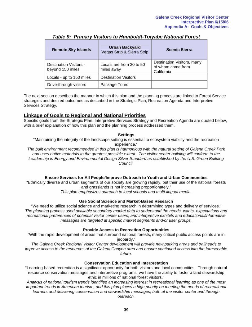
Galena Creek Regional Visitor Center Interpretive Plan 6/15/06
Appendix A: Goals & Objectives
39
Table 9: Primary Visitors to Humboldt-Toiyabe National Forest
Remote Sky Islands Urban Backyard Vegas Strip & Sierra Strip Scenic Sierra
Destination Visitors - beyond 150 miles
Locals are from 30 to 50 miles away
Destination Visitors, many of whom come from California
Locals - up to 150 miles Destination Visitors
Drive-through visitors Package Tours The next section describes the manner in which this plan and the planning process are linked to Forest Service strategies and desired outcomes as described in the Strategic Plan, Recreation Agenda and Interpretive Services Strategy. Linkage of Goals to Regional and National Priorities Specific goals from the Strategic Plan, Interpretive Services Strategy and Recreation Agenda are quoted below, with a brief explanation of how this plan and the planning process addressed them.
Settings “Maintaining the integrity of the landscape setting is essential to ecosystem viability and the recreation
experience.” The built environment recommended in this plan is harmonious with the natural setting of Galena Creek Park
and uses native materials to the greatest possible extent. The visitor center building will conform to the Leadership in Energy and Environmental Design Silver Standard as established by the U.S. Green Building
Council.
Ensure Services for All People/Improve Outreach to Youth and Urban Communities “Ethnically diverse and urban segments of our society are growing rapidly, but their use of the national forests
and grasslands is not increasing proportionately.” This plan emphasizes outreach to local schools and multi-lingual media.
Use Social Science and Market-Based Research
“We need to utilize social science and marketing research in determining types and delivery of services.” The planning process used available secondary market data to understand the needs, wants, expectations and recreational preferences of potential visitor center users, and interpretive exhibits and educational/informative
messages are targeted at specific market segments and/or user groups.
Provide Access to Recreation Opportunities “With the rapid development of areas that surround national forests, many critical public access points are in
jeopardy.” The Galena Creek Regional Visitor Center development will provide new parking areas and trailheads to
improve access to the resources of the Galena Canyon area and ensure continued access into the foreseeable future.
Conservation Education and Interpretation
“Learning-based recreation is a significant opportunity for both visitors and local communities. Through natural resource conservation messages and interpretive programs, we have the ability to foster a land stewardship
ethic in millions of national forest visitors.” Analysis of national tourism trends identified an increasing interest in recreational learning as one of the most important trends in American tourism, and this plan places a high priority on meeting the needs of recreational
learners and delivering conservation and stewardship messages, both at the visitor center and through outreach.
Galena Creek Regional Visitor Center Interpretive Plan 6/15/06
Appendix A: Goals & Objectives
40
Target Specific Audiences “We will focus on the following groups. Youth: providing educational and interpretive experiences in a variety of environments. Urban Communities: providing a connection to the land to those who are becoming increasingly disconnected from it. Visitors: enhancing the recreation experience, influencing visitor behavior, and providing
information to protect the resource.” This plan emphasizes outreach to local communities through schools, a high degree of changeability in exhibits to maintain interest in repeat local visitors and places a high priority on recreation information and conservation
and stewardship messages. Messages will be targeted at specific market segments and/or user groups.
Promote Connections “Making connections with new constituencies, including urban populations, as well as minorities, persons with
disabilities, and other under-served people, is critical….” In addition to multi-lingual messaging to reach the local Hispanic community and Spanish-speaking visitors, all
built environment, exhibits and other media recommended in this plan will comply to the greatest possible extent with the applicable provisions of the Americans with Disabilities Act.
Improve Customer Satisfaction
“Social science and marketing research will be used to manage and protect resources and shape the services we provide for people.”
This plan includes a section dedicated to monitoring and evaluation that suggests several techniques that can be used to better understand visitors and measure whether their needs and expectations are being met.
Reduce the Risk from Catastrophic Wildland Fire
“Restore the health of the Nation’s forest and grasslands to increase resilience to the effects of wildland fire.” Mitigating the risk of wildland fire is the #1 strategic priority, both nationally and on the Carson Ranger District, and this plan recommends media to inform and educate the public about fire risks, management activities such
as prescribed burning, and mitigation measures that homeowners can take to reduce risk to their property.
Create Partnerships to Enhance and Improve Visitor Services/Promote Federal, Tribal, State and Local Government Cooperation
“We will work more closely with other agencies, the private sector and non-profit partners to improve visitor information and services, both inside and outside forest boundaries.”
The Galena Creek Regional Visitor Center project is an outstanding example of an effective and productive partnership between a federal and county agency. Other potential partners such as the Nevada Department of Transportation, the Reno-Sparks Convention and Visitor Authority and representatives of user groups such as equestrians were involved in the planning process and their continued involvement will continue to be actively
sought
Improve the Availability of Information “We need to improve the availability of information so visitors can select settings to match the experiences they
desire and know what to expect before they arrive.” Analysis of visitors to Toiyabe National Forest identified a significant degree of visitor dissatisfaction with availability of recreation information, and this plan places a high priority on delivery of that information.

Galena Creek Regional Visitor Center Interpretive Plan 6/15/06
Appendix B: Audience Analysis
41
Appendix B: Audience Analysis This appendix presents an overview of tourism and recreation trends on the national level, discusses recreation, tourism and conservation issues specific to Nevada, and takes a look at resident and visitor populations in the Reno-Tahoe area. Profile of the American Tourist The average American tourist is middle-aged (nearly half are between 36 and 54 years of age), traveling without children, by car, between April and August, to a destination within 300 miles of their home. The American population is aging, and as the baby-boom generation begins to retire, the age of the typical tourist can be expected to continue to increase (locally, the median age of Reno-Tahoe visitors increased from 50 to 55 years in the decade1994-2003). Recreation Preferences The activities favored by domestic travelers appear in the table below.
Table 10: Top Ten Activities for Domestic Travelers Activity % of Travelers
1. Shopping 34% 2. Outdoor Recreation 17 3. Historical Places/Museums 14 4. Beaches 11 5. Cultural Events 10 6. National/State Parks 10 7. Theme/Amusement Parks 9 8. Gambling 8 9. Nightlife/Dancing 8 10. Sports Events 6 source: Travel Industry Association of America (TIAA), 2001 More than one in every four leisure trips taken in 2001 included outdoor recreation or visiting a national/state park, and 65 million Americans took at least one trip of 50 miles or more (one-way) away from home to visit a national/state park (or forest) in 2001. Another important trend apparent in the above table is the popularity of cultural and historic tourism (“recreational” or “informal” learning), with nearly one in four trips including either a visit to an historical place/museum or attending a cultural event. The increasing popularity of trips that include recreational or informal learning is one of the most robust trends in modern American tourism. 81% of U.S. adults who traveled in the past year (2003 data) are considered historic/cultural travelers (TIAA, 2003). This percentage represents 118 million people who took part in historical or cultural activities during a total of almost 217 million person-trips, an increase of 13% from 1996-2001. This trend reflects a growing public interest in learning about culture and nature: about 60% of Americans visit a nature center, nature trail or zoo every year, and there has been a strong up-trend in participation in wildlife-viewing. The number of sites supporting recreational and informal learning experiences has increased significantly in the last two decades. Terms such as ecotourism, free-choice learning,” and heritage tourism are no longer used exclusively by interpreters and museum educators, but have become part of the standard lexicon of the travel industry. Affluent, well-educated baby-boomers entering retirement can be expected to swell the ranks of recreational learners in the immediate future (an expanded discussion of recreational learning can be found in Appendix D). More than 97% of Americans report that they participate in outdoor recreation activities, and annual national forest visits totaled over 137 million at the turn of the century. Rising population and demand for outdoor recreation is leading to a decline in per-capita acres of forest land available for recreation. Increased competition for limited resources will probably lead to increased conflict between user groups, particularly as new forms of recreation create new demands on public lands.
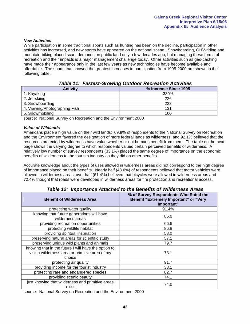
Galena Creek Regional Visitor Center Interpretive Plan 6/15/06
Appendix B: Audience Analysis
42
New Activities While participation in some traditional sports such as hunting has been on the decline, participation in other activities has increased, and new sports have appeared on the national scene. Snowboarding, OHV-riding and mountain-biking placed scant demands on public land only a few decades ago, but managing these forms of recreation and their impacts is a major management challenge today. Other activities such as geo-caching have made their appearance only in the last few years as new technologies have become available and affordable. The sports that showed the greatest increases in participation from 1995-2000 are shown in the following table.
Table 11: Fastest-Growing Outdoor Recreation Activities Activity % Increase Since 1995
1. Kayaking 330% 2. Jet-skiing 226 3. Snowboarding 223 4. Viewing/Photographing Fish 131 5. Snowmobiling 100 source: National Survey on Recreation and the Environment 2000 Value of Wildlands Americans place a high value on their wild lands: 69.8% of respondents to the National Survey on Recreation and the Environment favored the designation of more federal lands as wilderness, and 92.1% believed that the resources protected by wilderness have value whether or not humans benefit from them. The table on the next page shows the varying degree to which respondents valued certain perceived benefits of wilderness. A relatively low number of survey respondents (33.1%) placed the same degree of importance on the economic benefits of wilderness to the tourism industry as they did on other benefits. Accurate knowledge about the types of uses allowed in wilderness areas did not correspond to the high degree of importance placed on their benefits. Nearly half (43.6%) of respondents believed that motor vehicles were allowed in wilderness areas, over half (61.4%) believed that bicycles were allowed in wilderness areas and 72.4% thought that roads were developed in wilderness areas for fire protection and recreational access.
Table 12: Importance Attached to the Benefits of Wilderness Areas
Benefit of Wilderness Area % of Survey Respondents Who Rated the Benefit “Extremely Important” or “Very
Important” protecting water quality 91.4%
knowing that future generations will have wilderness areas 85.0
providing recreation opportunities 66.6 protecting wildlife habitat 86.8
providing spiritual inspiration 58.0 preserving natural areas for scientific study 57.1 preserving unique wild plants and animals 79.7
knowing that in the future I will have the option to visit a wilderness area or primitive area of my
choice 73.1
protecting air quality 91.7 providing income for the tourist industry 33.1 protecting rare and endangered species 82.7
providing scenic beauty 74.1 just knowing that wilderness and primitive areas
exist 74.0
source: National Survey on Recreation and the Environment 2000
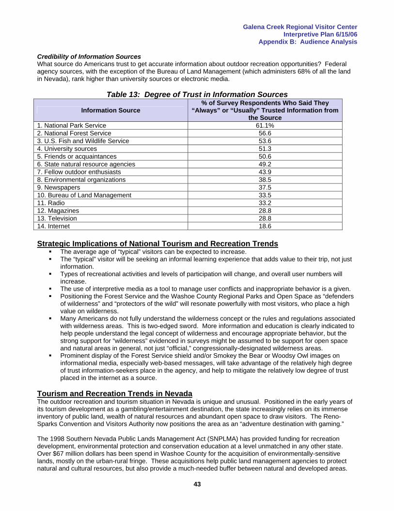
Galena Creek Regional Visitor Center Interpretive Plan 6/15/06
Appendix B: Audience Analysis
43
Credibility of Information Sources What source do Americans trust to get accurate information about outdoor recreation opportunities? Federal agency sources, with the exception of the Bureau of Land Management (which administers 68% of all the land in Nevada), rank higher than university sources or electronic media.
Table 13: Degree of Trust in Information Sources
Information Source % of Survey Respondents Who Said They
“Always” or “Usually” Trusted Information from the Source
1. National Park Service 61.1% 2. National Forest Service 56.6 3. U.S. Fish and Wildlife Service 53.6 4. University sources 51.3 5. Friends or acquaintances 50.6 6. State natural resource agencies 49.2 7. Fellow outdoor enthusiasts 43.9 8. Environmental organizations 38.5 9. Newspapers 37.5 10. Bureau of Land Management 33.5 11. Radio 33.2 12. Magazines 28.8 13. Television 28.8 14. Internet 18.6 Strategic Implications of National Tourism and Recreation Trends
The average age of “typical” visitors can be expected to increase. The “typical” visitor will be seeking an informal learning experience that adds value to their trip, not just
information. Types of recreational activities and levels of participation will change, and overall user numbers will
increase. The use of interpretive media as a tool to manage user conflicts and inappropriate behavior is a given. Positioning the Forest Service and the Washoe County Regional Parks and Open Space as “defenders
of wilderness” and “protectors of the wild” will resonate powerfully with most visitors, who place a high value on wilderness.
Many Americans do not fully understand the wilderness concept or the rules and regulations associated with wilderness areas. This is two-edged sword. More information and education is clearly indicated to help people understand the legal concept of wilderness and encourage appropriate behavior, but the strong support for “wilderness” evidenced in surveys might be assumed to be support for open space and natural areas in general, not just “official,” congressionally-designated wilderness areas.
Prominent display of the Forest Service shield and/or Smokey the Bear or Woodsy Owl images on informational media, especially web-based messages, will take advantage of the relatively high degree of trust information-seekers place in the agency, and help to mitigate the relatively low degree of trust placed in the internet as a source.
Tourism and Recreation Trends in Nevada The outdoor recreation and tourism situation in Nevada is unique and unusual. Positioned in the early years of its tourism development as a gambling/entertainment destination, the state increasingly relies on its immense inventory of public land, wealth of natural resources and abundant open space to draw visitors. The Reno-Sparks Convention and Visitors Authority now positions the area as an “adventure destination with gaming.” The 1998 Southern Nevada Public Lands Management Act (SNPLMA) has provided funding for recreation development, environmental protection and conservation education at a level unmatched in any other state. Over $67 million dollars has been spend in Washoe County for the acquisition of environmentally-sensitive lands, mostly on the urban-rural fringe. These acquisitions help public land management agencies to protect natural and cultural resources, but also provide a much-needed buffer between natural and developed areas.
Galena Creek Regional Visitor Center Interpretive Plan 6/15/06
Appendix B: Audience Analysis
44
Nevada’s Public Lands and Natural Resource Base The federal government owns 87% of the land in Nevada, and maintaining access to public lands was the single most important issue identified (through a public input process) in Nevada’s 2003 Statewide Comprehensive Outdoor Recreation Plan (SCORP):
“There is a growing need to protect, maintain and increase public access to public lands for the greatest diversity of outdoor recreational users.”
There is strong sentiment statewide to return at least some federal lands to state or local control, and this is one of the action items the plan identified. The other two high-priority issues identified in the 2003 SCORP were “funding parks and recreation” and “recreational trails and pathways.” Nevada has more mountain ranges than any other state in the Lower 48. The state’s mountains offer both residents and visitors a wide variety of recreational opportunities and escape from the heat of summer. Even remote ranges are generally accessible to the well-equipped hiker or backpacker since the desert climate is such that most areas are free of snow and ice most of the year, and do not require technical mountaineering skills or equipment for travel. Several ranges are high enough to offer snow-based winter sports, and these are a vital component of the state’s recreation opportunity spectrum. Water resources in Nevada, the driest state in the nation, are strained by increasing human consumption, and three of its rivers are listed among the twenty most-threatened rivers in the nation (American Rivers, 2001). Perennial streams are the exception rather than the rule. Seasonally-intermittent and ephemeral streams are much more common, but there are 684 fishable rivers and streams in the state. Several large lakes and manmade reservoirs offer a surprising abundance (for an arid state) of opportunities for boating and other water-based recreation. Population Trends and Attitudes Toward Conservation Nevada is the fastest-growing state in the nation. The population grew from 1.2 million in 1990 to 2.0 million in 2000, a 66% increase. On average, the state added 6,600 new residents each month during the ten-year period. Nevadans are concerned about and supportive of natural resource conservation and the protection of historic/cultural resources. In November 2002, state voters approved a ballot proposal to issue $200 million in bonds to fund the preservation of water quality, the protection of open space, lakes, rivers, wetlands and wildlife habitat, and the restoration and improvement of parks, recreation areas and historic and cultural resources. In a 1997 study, 100% of urban residents and 99% of rural residents said that management of the state’s public lands was “very important” or “important” to them. A 2001 survey found that 67% of Nevada residents “strongly agreed” or “somewhat agreed” with designating more wilderness areas in the state. The same survey found that 92% of Nevadans felt it was “very important” or “somewhat important” to maintain unique or unusual areas in a natural state, while 93% felt it was “very important” or “somewhat important” to set aside Nevada’s historic areas, ghost towns and other examples of its cultural heritage. Nevada was, however, the birthplace of the Sagebrush Rebellion, and many citizens are concerned that resource protection will come at the cost of access. The fourth-most important issue identified through public input in the 2003 SCORP was:
“Protection of natural, cultural and scenic resources needs to be put in balance with users. Create opportunities for users to participate in the protection, i.e. as site stewards. Mandate that a majority of fees paid in a recreation area stay in that area for improvements and maintenance. Citizens acknowledge this as an investment and a way to participate in the conservation of these resources.”
Maintaining access for diverse user groups to public lands was the highest-rated issue in the 2003 SCORP, and this is obviously a priority concern for many Nevadans. But the issue statement above indicates that Nevadans realize user groups must bear at least some of the responsibility for avoiding and mitigating resource degradation because of recreational use. A campaign to educate and inform the public about natural and cultural resource issues was recommended as one of the action items to address this issue.

Galena Creek Regional Visitor Center Interpretive Plan 6/15/06
Appendix B: Audience Analysis
45
The sixth-most important issue identified in the 2003 SCORP was: “Encourage, fund and provide environmental, cultural and heritage interpretation and educational programs and opportunities, especially outdoor opportunities, throughout Nevada.”
One recommended action was to develop public education programs both within and outside the state (to dispel the myth that Nevada is all about gambling/adult entertainment). Another recommendation suggested working with public land management agencies to develop statewide curricula regarding Nevada’s cultural and natural heritage. Some Nevada residents view development as one of the major threats to recreational access:
“We are allowing/encouraging development…at all costs, restricting use of public land in surrounding rural towns as the exchange, and then watching as urban residents misuse outlying public land, shutting down its use by all, even those living in the rural areas. Education and expanded use need to be the answers before restricting access.”
Recreation Preferences Nevadans are enthusiastic users of their public lands. In the year 2000, 84% of state residents (age 16 or older) participated in at least one outdoor recreational activity. Preferred activities for residents recreating within the state are shown in the table below.
Table 14: Top Ten Outdoor Activities for Nevadans Recreating in Nevada Activity % of Nevadans Participating
1. driving for pleasure 44% 2. picnicking 37 3. swimming in a pool 32 4. walking without a dog 32 5. wildlife viewing 31 6. swimming in a lake or stream 30 7. hiking 28 8. walking with a dog 28 9. motorboating 27 10. lake fishing 26 source: 2003 Nevada Statewide Comprehensive Outdoor Recreation Plan The Galena Creek Regional Visitor Center will be located in a tourist area, so it is appropriate to consider the preferred activities within the broader Nevada Market Region, which consists of Nevada, California, Oregon, Idaho, Utah and Arizona. These preferences are shown in the table below.
Table 15: Top Ten Outdoor Activities for the Nevada Market Region Activity % of Persons in Nevada Market Region
Participating 1. walking for pleasure 79% 2. family gathering 73 3. view/photograph natural scenery 62 4. visit nature centers, etc. 57 5. gardening or landscaping for pleasure 56 6. picnicking 56 7. sightseeing 49 8. driving for pleasure 47 9. view/photograph wildflowers, trees, etc. 45 10. visit historic site 43 source: 2003 Nevada Statewide Comprehensive Outdoor Recreation Plan
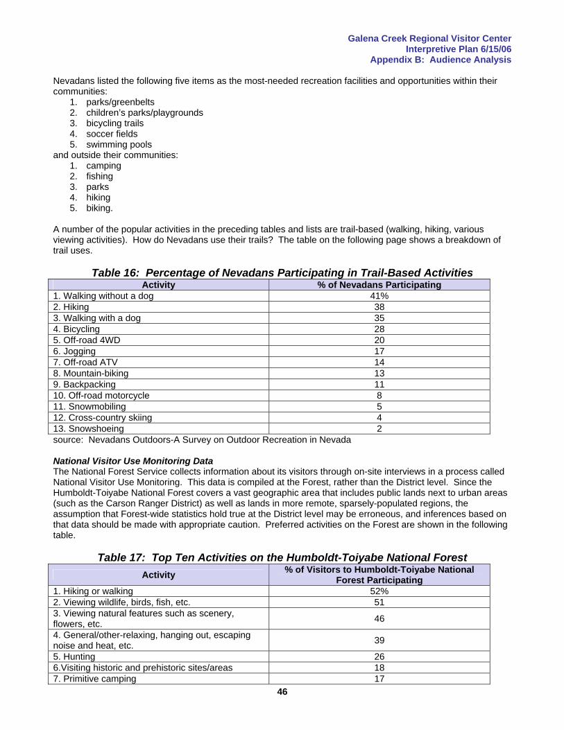
Galena Creek Regional Visitor Center Interpretive Plan 6/15/06
Appendix B: Audience Analysis
46
Nevadans listed the following five items as the most-needed recreation facilities and opportunities within their communities:
1. parks/greenbelts 2. children’s parks/playgrounds 3. bicycling trails 4. soccer fields 5. swimming pools
and outside their communities: 1. camping 2. fishing 3. parks 4. hiking 5. biking.
A number of the popular activities in the preceding tables and lists are trail-based (walking, hiking, various viewing activities). How do Nevadans use their trails? The table on the following page shows a breakdown of trail uses.
Table 16: Percentage of Nevadans Participating in Trail-Based Activities Activity % of Nevadans Participating
1. Walking without a dog 41% 2. Hiking 38 3. Walking with a dog 35 4. Bicycling 28 5. Off-road 4WD 20 6. Jogging 17 7. Off-road ATV 14 8. Mountain-biking 13 9. Backpacking 11 10. Off-road motorcycle 8 11. Snowmobiling 5 12. Cross-country skiing 4 13. Snowshoeing 2 source: Nevadans Outdoors-A Survey on Outdoor Recreation in Nevada National Visitor Use Monitoring Data The National Forest Service collects information about its visitors through on-site interviews in a process called National Visitor Use Monitoring. This data is compiled at the Forest, rather than the District level. Since the Humboldt-Toiyabe National Forest covers a vast geographic area that includes public lands next to urban areas (such as the Carson Ranger District) as well as lands in more remote, sparsely-populated regions, the assumption that Forest-wide statistics hold true at the District level may be erroneous, and inferences based on that data should be made with appropriate caution. Preferred activities on the Forest are shown in the following table.
Table 17: Top Ten Activities on the Humboldt-Toiyabe National Forest
Activity % of Visitors to Humboldt-Toiyabe National Forest Participating
1. Hiking or walking 52% 2. Viewing wildlife, birds, fish, etc. 51 3. Viewing natural features such as scenery, flowers, etc. 46
4. General/other-relaxing, hanging out, escaping noise and heat, etc. 39
5. Hunting 26 6.Visiting historic and prehistoric sites/areas 18 7. Primitive camping 17
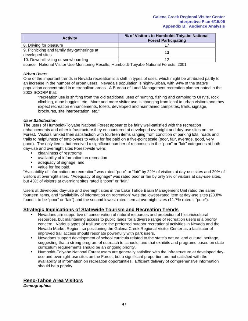
Galena Creek Regional Visitor Center Interpretive Plan 6/15/06
Appendix B: Audience Analysis
47
Activity % of Visitors to Humboldt-Toiyabe National Forest Participating
8. Driving for pleasure 17 9. Picnicking and family day-gatherings at developed sites 13
10. Downhill skiing or snowboarding 12 source: National Visitor Use Monitoring Results, Humboldt-Toiyabe National Forests, 2001 Urban Users One of the important trends in Nevada recreation is a shift in types of uses, which might be attributed partly to an increase in the number of urban users. Nevada’s population is highly-urban, with 94% of the state’s population concentrated in metropolitan areas. A Bureau of Land Management recreation planner noted in the 2003 SCORP that:
“recreation use is shifting from the old traditional uses of hunting, fishing and camping to OHV’s, rock climbing, dune buggies, etc. More and more visitor use is changing from local to urban visitors and they expect recreation enhancements, toilets, developed and maintained campsites, trails, signage, brochures, site interpretation, etc.”
User Satisfaction The users of Humboldt-Toiyabe National Forest appear to be fairly well-satisfied with the recreation enhancements and other infrastructure they encountered at developed overnight and day-use sites on the Forest. Visitors ranked their satisfaction with fourteen items ranging from condition of parking lots, roads and trails to helpfulness of employees to value for fee paid on a five-point scale (poor, fair, average, good, very good). The only items that received a significant number of responses in the “poor” or “fair” categories at both day-use and overnight sites Forest-wide were:
cleanliness of restrooms availability of information on recreation adequacy of signage, and value for fee paid.
“Availability of information on recreation” was rated “poor” or “fair” by 22% of visitors at day-use sites and 29% of visitors at overnight sites. “Adequacy of signage” was rated poor or fair by only 3% of visitors at day-use sites, but 43% of visitors at overnight sites rated it “poor” or “fair.” Users at developed day-use and overnight sites in the Lake Tahoe Basin Management Unit rated the same fourteen items, and “availability of information on recreation” was the lowest-rated item at day-use sites (23.8% found it to be “poor” or “fair”) and the second lowest-rated item at overnight sites (11.7% rated it “poor”). Strategic Implications of Statewide Tourism and Recreation Trends
Nevadans are supportive of conservation of natural resources and protection of historic/cultural resources, but maintaining access to public lands for a diverse range of recreation users is a priority concern. Various types of trail use are the preferred outdoor recreational activities in Nevada and the Nevada Market Region, so positioning the Galena Creek Regional Visitor Center as a facilitator of improved trail access should resonate powerfully with park users.
Nevadans support development of school curricula related to the state’s natural and cultural heritage, suggesting that a strong program of outreach to schools, and that exhibits and programs based on state curriculum requirements should be an ongoing priority.
Humboldt-Toiyabe National Forest users are generally satisfied with the infrastructure at developed day-use and overnight-use sites on the Forest, but a significant proportion are not satisfied with the availability of information on recreation opportunities. Efficient delivery of comprehensive information should be a priority.
Reno-Tahoe Area Visitors Demographics
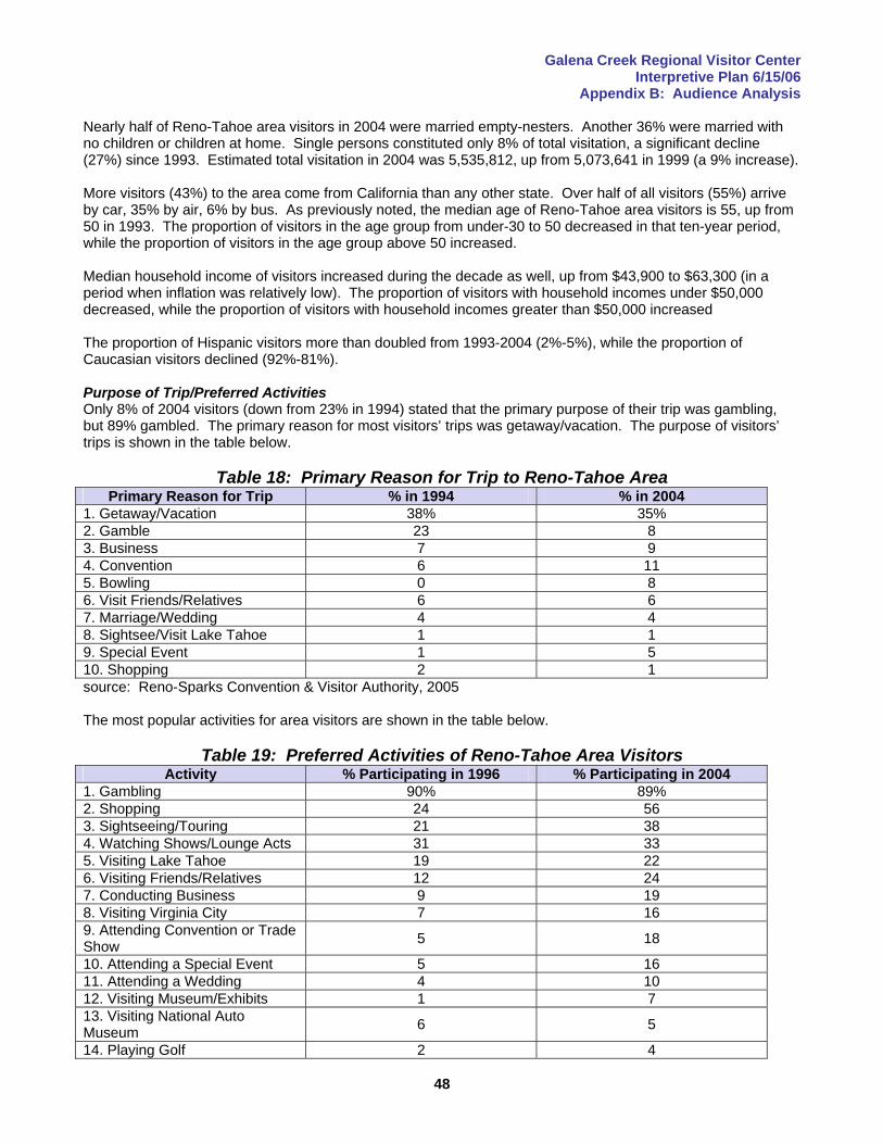
Galena Creek Regional Visitor Center Interpretive Plan 6/15/06
Appendix B: Audience Analysis
48
Nearly half of Reno-Tahoe area visitors in 2004 were married empty-nesters. Another 36% were married with no children or children at home. Single persons constituted only 8% of total visitation, a significant decline (27%) since 1993. Estimated total visitation in 2004 was 5,535,812, up from 5,073,641 in 1999 (a 9% increase). More visitors (43%) to the area come from California than any other state. Over half of all visitors (55%) arrive by car, 35% by air, 6% by bus. As previously noted, the median age of Reno-Tahoe area visitors is 55, up from 50 in 1993. The proportion of visitors in the age group from under-30 to 50 decreased in that ten-year period, while the proportion of visitors in the age group above 50 increased. Median household income of visitors increased during the decade as well, up from $43,900 to $63,300 (in a period when inflation was relatively low). The proportion of visitors with household incomes under $50,000 decreased, while the proportion of visitors with household incomes greater than $50,000 increased The proportion of Hispanic visitors more than doubled from 1993-2004 (2%-5%), while the proportion of Caucasian visitors declined (92%-81%). Purpose of Trip/Preferred Activities Only 8% of 2004 visitors (down from 23% in 1994) stated that the primary purpose of their trip was gambling, but 89% gambled. The primary reason for most visitors’ trips was getaway/vacation. The purpose of visitors’ trips is shown in the table below.
Table 18: Primary Reason for Trip to Reno-Tahoe Area Primary Reason for Trip % in 1994 % in 2004
1. Getaway/Vacation 38% 35% 2. Gamble 23 8 3. Business 7 9 4. Convention 6 11 5. Bowling 0 8 6. Visit Friends/Relatives 6 6 7. Marriage/Wedding 4 4 8. Sightsee/Visit Lake Tahoe 1 1 9. Special Event 1 5 10. Shopping 2 1 source: Reno-Sparks Convention & Visitor Authority, 2005 The most popular activities for area visitors are shown in the table below.
Table 19: Preferred Activities of Reno-Tahoe Area Visitors Activity % Participating in 1996 % Participating in 2004
1. Gambling 90% 89% 2. Shopping 24 56 3. Sightseeing/Touring 21 38 4. Watching Shows/Lounge Acts 31 33 5. Visiting Lake Tahoe 19 22 6. Visiting Friends/Relatives 12 24 7. Conducting Business 9 19 8. Visiting Virginia City 7 16 9. Attending Convention or Trade Show 5 18
10. Attending a Special Event 5 16 11. Attending a Wedding 4 10 12. Visiting Museum/Exhibits 1 7 13. Visiting National Auto Museum 6 5
14. Playing Golf 2 4
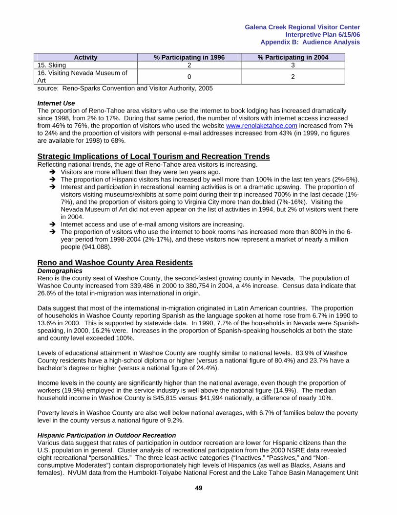
Galena Creek Regional Visitor Center Interpretive Plan 6/15/06
Appendix B: Audience Analysis
49
Activity % Participating in 1996 % Participating in 2004 15. Skiing 2 3 16. Visiting Nevada Museum of Art 0 2
source: Reno-Sparks Convention and Visitor Authority, 2005 Internet Use The proportion of Reno-Tahoe area visitors who use the internet to book lodging has increased dramatically since 1998, from 2% to 17%. During that same period, the number of visitors with internet access increased from 46% to 76%, the proportion of visitors who used the website www.renolaketahoe.com increased from 7% to 24% and the proportion of visitors with personal e-mail addresses increased from 43% (in 1999, no figures are available for 1998) to 68%. Strategic Implications of Local Tourism and Recreation Trends Reflecting national trends, the age of Reno-Tahoe area visitors is increasing.
Visitors are more affluent than they were ten years ago. The proportion of Hispanic visitors has increased by well more than 100% in the last ten years (2%-5%). Interest and participation in recreational learning activities is on a dramatic upswing. The proportion of
visitors visiting museums/exhibits at some point during their trip increased 700% in the last decade (1%-7%), and the proportion of visitors going to Virginia City more than doubled (7%-16%). Visiting the Nevada Museum of Art did not even appear on the list of activities in 1994, but 2% of visitors went there in 2004.
Internet access and use of e-mail among visitors are increasing. The proportion of visitors who use the internet to book rooms has increased more than 800% in the 6-
year period from 1998-2004 (2%-17%), and these visitors now represent a market of nearly a million people (941,088).
Reno and Washoe County Area Residents Demographics Reno is the county seat of Washoe County, the second-fastest growing county in Nevada. The population of Washoe County increased from 339,486 in 2000 to 380,754 in 2004, a 4% increase. Census data indicate that 26.6% of the total in-migration was international in origin. Data suggest that most of the international in-migration originated in Latin American countries. The proportion of households in Washoe County reporting Spanish as the language spoken at home rose from 6.7% in 1990 to 13.6% in 2000. This is supported by statewide data. In 1990, 7.7% of the households in Nevada were Spanish-speaking, in 2000, 16.2% were. Increases in the proportion of Spanish-speaking households at both the state and county level exceeded 100%. Levels of educational attainment in Washoe County are roughly similar to national levels. 83.9% of Washoe County residents have a high-school diploma or higher (versus a national figure of 80.4%) and 23.7% have a bachelor’s degree or higher (versus a national figure of 24.4%). Income levels in the county are significantly higher than the national average, even though the proportion of workers (19.9%) employed in the service industry is well above the national figure (14.9%). The median household income in Washoe County is $45,815 versus $41,994 nationally, a difference of nearly 10%. Poverty levels in Washoe County are also well below national averages, with 6.7% of families below the poverty level in the county versus a national figure of 9.2%. Hispanic Participation in Outdoor Recreation Various data suggest that rates of participation in outdoor recreation are lower for Hispanic citizens than the U.S. population in general. Cluster analysis of recreational participation from the 2000 NSRE data revealed eight recreational “personalities.” The three least-active categories (“Inactives,” “Passives,” and “Non-consumptive Moderates”) contain disproportionately high levels of Hispanics (as well as Blacks, Asians and females). NVUM data from the Humboldt-Toiyabe National Forest and the Lake Tahoe Basin Management Unit
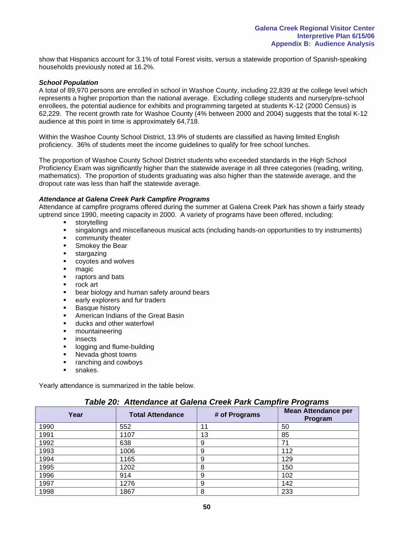
Galena Creek Regional Visitor Center Interpretive Plan 6/15/06
Appendix B: Audience Analysis
50
show that Hispanics account for 3.1% of total Forest visits, versus a statewide proportion of Spanish-speaking households previously noted at 16.2%. School Population A total of 89,970 persons are enrolled in school in Washoe County, including 22,839 at the college level which represents a higher proportion than the national average. Excluding college students and nursery/pre-school enrollees, the potential audience for exhibits and programming targeted at students K-12 (2000 Census) is 62,229. The recent growth rate for Washoe County (4% between 2000 and 2004) suggests that the total K-12 audience at this point in time is approximately 64,718. Within the Washoe County School District, 13.9% of students are classified as having limited English proficiency. 36% of students meet the income guidelines to qualify for free school lunches. The proportion of Washoe County School District students who exceeded standards in the High School Proficiency Exam was significantly higher than the statewide average in all three categories (reading, writing, mathematics). The proportion of students graduating was also higher than the statewide average, and the dropout rate was less than half the statewide average. Attendance at Galena Creek Park Campfire Programs Attendance at campfire programs offered during the summer at Galena Creek Park has shown a fairly steady uptrend since 1990, meeting capacity in 2000. A variety of programs have been offered, including:
storytelling singalongs and miscellaneous musical acts (including hands-on opportunities to try instruments) community theater Smokey the Bear stargazing coyotes and wolves magic raptors and bats rock art bear biology and human safety around bears early explorers and fur traders Basque history American Indians of the Great Basin ducks and other waterfowl mountaineering insects logging and flume-building Nevada ghost towns ranching and cowboys snakes.
Yearly attendance is summarized in the table below.
Table 20: Attendance at Galena Creek Park Campfire Programs Year Total Attendance # of Programs Mean Attendance per
Program 1990 552 11 50 1991 1107 13 85 1992 638 9 71 1993 1006 9 112 1994 1165 9 129 1995 1202 8 150 1996 914 9 102 1997 1276 9 142 1998 1867 8 233
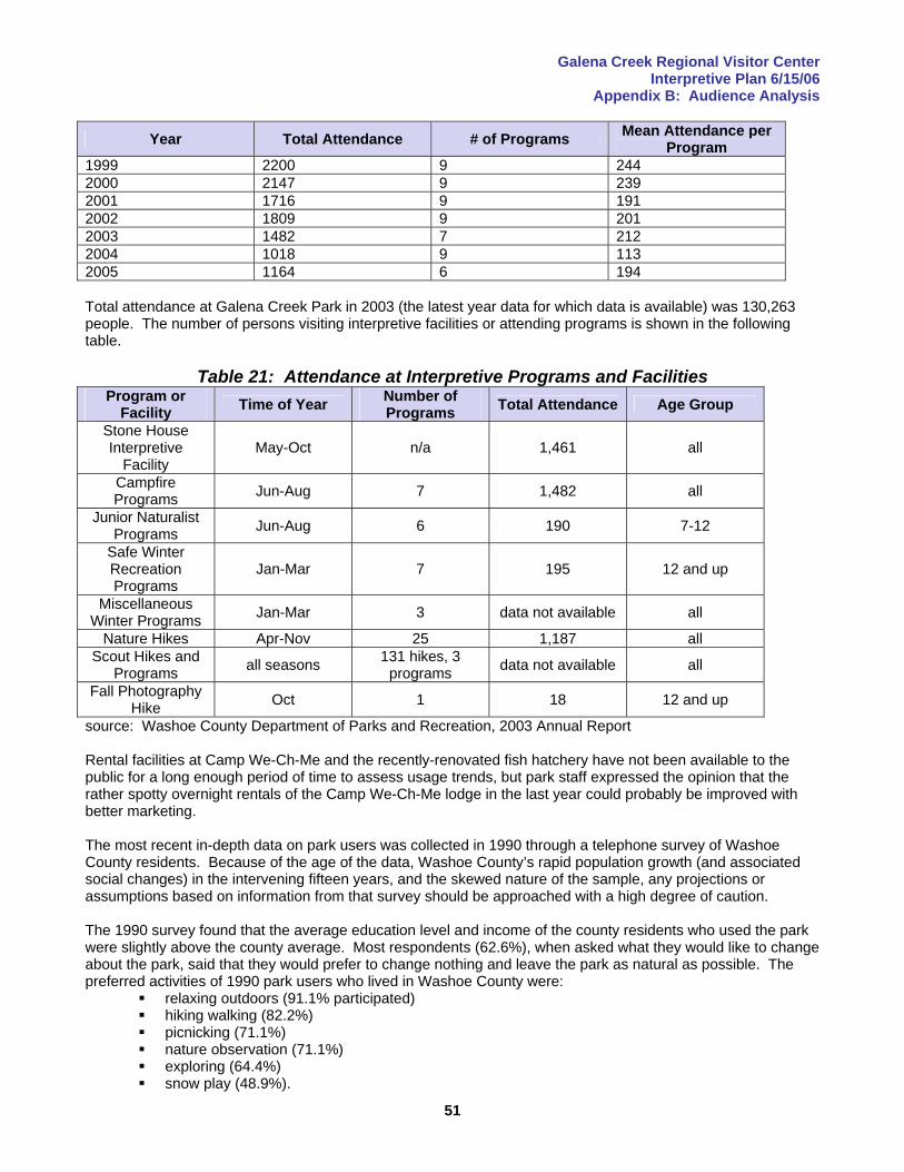
Galena Creek Regional Visitor Center Interpretive Plan 6/15/06
Appendix B: Audience Analysis
51
Year Total Attendance # of Programs Mean Attendance per Program
1999 2200 9 244 2000 2147 9 239 2001 1716 9 191 2002 1809 9 201 2003 1482 7 212 2004 1018 9 113 2005 1164 6 194 Total attendance at Galena Creek Park in 2003 (the latest year data for which data is available) was 130,263 people. The number of persons visiting interpretive facilities or attending programs is shown in the following table.
Table 21: Attendance at Interpretive Programs and Facilities Program or
Facility Time of Year Number of Programs Total Attendance Age Group
Stone House Interpretive
Facility May-Oct n/a 1,461 all
Campfire Programs Jun-Aug 7 1,482 all
Junior Naturalist Programs Jun-Aug 6 190 7-12
Safe Winter Recreation Programs
Jan-Mar 7 195 12 and up
Miscellaneous Winter Programs Jan-Mar 3 data not available all
Nature Hikes Apr-Nov 25 1,187 all Scout Hikes and
Programs all seasons 131 hikes, 3 programs data not available all
Fall Photography Hike Oct 1 18 12 and up
source: Washoe County Department of Parks and Recreation, 2003 Annual Report Rental facilities at Camp We-Ch-Me and the recently-renovated fish hatchery have not been available to the public for a long enough period of time to assess usage trends, but park staff expressed the opinion that the rather spotty overnight rentals of the Camp We-Ch-Me lodge in the last year could probably be improved with better marketing. The most recent in-depth data on park users was collected in 1990 through a telephone survey of Washoe County residents. Because of the age of the data, Washoe County’s rapid population growth (and associated social changes) in the intervening fifteen years, and the skewed nature of the sample, any projections or assumptions based on information from that survey should be approached with a high degree of caution. The 1990 survey found that the average education level and income of the county residents who used the park were slightly above the county average. Most respondents (62.6%), when asked what they would like to change about the park, said that they would prefer to change nothing and leave the park as natural as possible. The preferred activities of 1990 park users who lived in Washoe County were:
relaxing outdoors (91.1% participated) hiking walking (82.2%) picnicking (71.1%) nature observation (71.1%) exploring (64.4%) snow play (48.9%).

Galena Creek Regional Visitor Center Interpretive Plan 6/15/06
Appendix B: Audience Analysis
52
Strategic Implications of Local Demographics The proportion of Spanish-speakers in the local audience is significant and can be expected to continue to increase.
The rapidly-growing Hispanic population segment in the Reno area may have a significantly lower rate of participation in outdoor recreation than the population in general. This might be taken to indicate a lack of knowledge of opportunities and, by extension, a lack of knowledge about appropriate resource use. Managers may want to consider bi-lingual interpretive opportunities at the visitor center as well as some sort of bi-lingual outreach in public schools.
The relatively high proportion of local users at the park (an assertion based on anecdotal evidence, bolstered by the continuing popularity of campfire programs) suggests that exhibits should have a high degree of changeability to maintain local interest.
Galena Creek Regional Visitor Center Interpretive Plan 6/15/06
Appendix C: Supplemental Background/Local History
53
Appendix C: Supplemental Background/Local History There have been no recent systematic archaeological surveys of the region, but sites from both before and after Euro-American settlement were excavated and studied during the mid-late 20th Century. The Galena Creek Park area is the traditional territory of the Washoe Indians, a Hokan-speaking people. There is some territorial overlap with the Numic-speaking Northern Paiute tribe. It is not clear whether the region was first occupied on a seasonal basis by semi-nomadic people who originated in the central valleys of California or the eastern Great Basin, or whether the Washoe culture developed independently in the Sierra. In any case, a distinct culture had emerged by about 4500 years ago. The Galena Creek/Mount Rose region was a migration corridor and transitional range for the Washoe, who moved from the valleys of the Truckee River and its tributaries to the shores of Lake Tahoe in response to the seasonal availability of resources. Fishing in Lake Tahoe was an important summer subsistence activity, but some scholars have argued that seasonal movements were more tuned to the availability of certain grass seeds (i.e. wild rye) and the movement of deer herds than the availability of fish. This suggests that widespread grazing during the mining boom (which depleted a resource needed by both the Washoe and the deer they hunted) may have been even more damaging to the indigenous people’s lifestyle than other resource exploitation such as the timber harvesting which radically altered the environment (destroying habitat for wild game as well as food sources such as pinon nuts). The first major influx of Euro-Americans occurred during the 1849 California Gold Rush, primarily travelers passing through on their way to the gold fields. The discovery of the Comstock Lode in 1859 brought many of those fortune-seekers back along the same route (as well as a steady stream of miners from the east). Some of the first known buildings in the area were transportation-related structures on the Galena-Huffaker wagon road that served these travelers. The demand for food brought about by the Comstock boom, coupled with the successful cultivation of alfalfa in Truckee Meadows (made possible by an extensive system of irrigation ditches) led to the birth of a thriving ranching industry. Both sheep and cattle were raised. The town of Galena was laid out in 1860, following the discovery of a silver-bearing lead sulfite ore (galena) from which the mining camp took its name. A mill and smelter were constructed, among the first on the Sierra’s eastern slope. Although the ore from Galena’s mining district never proved particularly profitable to process, the town thrived. Profits were made processing ore from the Comstock Lode, freighting goods and foodstuffs, and harvesting trees to meet the near-insatiable demand for support timbers needed for the mines. Logging and milling continued to support Galena even after the mines played out, but the town died in the late 1800’s when the forests had been turned into fields of stumps. The area was economically depressed during the first part of the 20th Century, but ranching remained marginally viable even as the demand for agricultural products generated by the mining boom waned. Recovery began in the middle part of the century as gambling and quickie divorces built the basis for a tourism industry. Tourism has continued to grow, with a steadily-increasing reliance on the region’s exceptional array of outdoor recreation opportunities, outstanding scenery and cultural/historical attractions. Important cultural/historical resources in the area include:
Galena townsite Mackay-Fair flume Steamboat quarries Mount Rose/Slide Mountain weather station portions of the old Mount Rose Highway North Water flume Tahoe Meadows (Basque sheepherding) miscellaneous irrigation structures field cabin used by Dr. James Edward Church during extended periods while making field observations petroglyphs of Washoe origin archaeological sites dating back to as far as 4,500 years before present, including sites from the mining
era.
Galena Creek Regional Visitor Center Interpretive Plan 6/15/06
Appendix E: Exhibit, Program and Literature Concept Development
54
Appendix D: Interpretive Theme Development An interpretive design charrette was held on November 17-18, 2005, in Reno. The charrette included site visits to the proposed facility location, Galena Creek Regional Park, Bartley Ranch and Lake Tahoe. Resource managers and stakeholders began the theme development process by introducing themselves and explaining why the Galena Creek region is special to them. These introductions, and the discussions that led from them, laid the foundation for this plan by beginning the exploration of the human connection to the region’s resources. Four statements of significance were developed during the course of the charrette’s first day. These guided the creation of interpretive themes on the second day. The theme development process was driven by the goals and objectives of the participating agencies (see Appendix A). Various stakeholders (such as representatives of special-interest groups) who were not familiar with the agencies’ missions had the opportunity to become more acquainted with the challenges faced by managers, and to develop a better understanding of the purpose of the visitor center and how national and regional objectives and goals play a role in shaping policy on the local level. The charrette process included consideration and discussion of existing exhibits and programming, segmentation of the target audience, various issues involving communication with residents in adjoining residential developments, the Mount Rose Scenic Byway, sensitive plants and animals, management issues such as dog waste, appropriate interpretation of native cultures, fire and fuels, highway safety, formation of a friends’ organization or interpretive association, accessibility, retail marketing and merchandising, flooding, public meeting space, inventory of resources, media possibilities and exhibit concepts. The essence of interpretation is discovering a sense of place. Statements of significance describe why a place is unique, special or important. The job of the interpreter is to facilitate visitors’ intellectual and emotional connections to a place by telling stories. Storylines are based on themes that link a place’s tangible elements to the ideas, meaning, beliefs and values that are its intangible elements. Statements of significance are broad statements-of-fact from which primary themes are derived. The central theme statement for the Galena Creek Regional Visitor Center is the unified, overarching message of the facility. It strives to pull together the statements of significance and primary themes in a single message. Primary interpretive themes were used to direct the development of concepts for the exhibits and programs that will connect visitors with the resources of the Galena Creek area by helping them explore the place’s inherent meanings from their own unique perspective. Primary themes add the human element to each factual statement of significance. In the case of Galena Creek Regional Visitor Center, each primary theme was derived directly from one of the statements of significance, although this one-to-one correspondence does not always occur in the planning process. Four primary themes were developed in this planning process. The full text of the statements of significance, central theme, primary themes and secondary themes can be found on p.12 in the main body of this plan. A flowchart of the process used to develop the statements of significance and interpretive themes appears on the following page.

Galena Creek Regional Visitor Center Interpretive Plan 6/15/06
Appendix E: Exhibit, Program and Literature Concept Development
55
Flowchart of Interpretive Planning Process
Statements of Significance
Central Theme
Primary Theme
Primary Theme
Primary Theme
Subtheme/ Storyline
Subtheme/ Storyline
Subtheme/ Storyline
Subtheme/ Storyline
Subtheme/ Storyline
Subtheme/ Storyline
Galena Creek Regional Visitor Center Interpretive Plan 6/15/06
Appendix E: Exhibit, Program and Literature Concept Development
56
Theme Concept Flow The flow of concepts from statement of significance to primary theme to subtheme to storyline is shown in outline form below. This progression from goal to exhibit concept will be displayed in schematic diagrams in the next appendix.
Statement of Significance o Primary Theme
Subtheme • Storyline
Cultural/Historical Theme Development
The Galena Creek region has a history of human occupation extending over at least 6000 years.
o Exploitation of natural resources following Euro-American settlement altered the local environment, and, although the region’s economic base has been transformed since the mining boom, and much of the ecological integrity of land has been restored, the rapid pace of modern development makes us wonder what environmental changes the future may hold, and what lessons might be learned from early cultures that had a more sustainable relationship with the land.
Artifacts and rock art from indigenous cultures indicate that the abundant resources of the region supported sustainable societies for millennia before Euro-American settlement.
• rock art • evidence of seed-processing/metates/use of native plants/humans and animals
both practiced seed-caching • loss of artifacts to development/loss of opportunities for knowledge • pinon pine • overlap of cultures: Washoe/Paiute • others to be determined on consultation w/ tribal elders
Clearcutting to meet the needs of mining operations had a profound effect on forest ecology, water and animal populations that is evident even today.
• restoration and reclamation techniques, how done? • during the mining boom, more timber underground than above • secondary impacts of mining (i.e. tailings piles affecting water quality) • changes in composition of forest insect species • even-aged vs. old-growth forests • effects of fire suppression/history of recent fires • others to be determined (w/ input from reviewers and additional research)
The economy of the region after Euro-American settlement was based on resource extraction that shifted focus from minerals and timber to ranching and eventually to recreation.
• ranching history • Basque culture and influences • advent of the recreation economy/skiing • others to be determined
The changing economic base of the Galena Creek area is reflected in various historic sites that include stagestops and townsites from the mining era, irrigation ditches still in use for ranching and other structures used for recreation and other purposes.
• Galena townsite/others? • transportation history • flumes • lift tower
Cultural/Historical Theme
Development
Galena Creek Regional Visitor Center Interpretive Plan 6/15/06
Appendix E: Exhibit, Program and Literature Concept Development
57
• fish hatchery • stone house • historic Forest Service campgrounds • other remnants of post-settlement culture? • others to be determined
The possibility of catastrophic property damage from wildfire on the contemporary interface between human development and natural areas, and the historical devastation of mining camps by floods suggests that history does, in fact, repeat itself.
• historic floods • dry mantle versus wet mantle flooding • others to be determined
Historic and contemporary diversion of water for economic development reflects the extraordinary value of water in the arid West, and the near-certainty that conflict over this vital resource will continue.
• historic water rights conflicts • wildlife needs for water/diversions affecting fish populations/interests of anglers • impact of noxious weeds on water resources • quiqui? threatened? endangered? • water needs for modern development • others to be determined
Advances in snow measurement made by Dr. James Edward Church were made more significant because over-exploitation of timber resources led to fears of flooding.
• Church’s shack • Mount Rose snow sampler • Church’s pond
Management Theme Development
Galena Creek is a regionally-significant natural area being impacted by its proximity to one of the largest, fastest-growing metroplexes in the nation.
o Resource management issues are complicated, and user conflicts are intensified in natural areas on the urban/wildland interface, increasing the stewardship responsibilities of visitors, and necessitating a reliance on well-informed, well-oriented users to help the management agencies achieve their goal of providing safe, enjoyable recreational experiences.
Wildfire prevention through fuels management and public education is critical in forests adjoining urban areas to reduce the possibility of loss of life and/or property in a fire event.
• public need for real-time information about ongoing management activities such as prescribed burning and thinning as well as ongoing fires
• management priorities and techniques • ecological role of fire/impacts on flora and fauna • wildfire behavior/defensible space and other mitigation techniques • forest restoration techniques/rehabilitation of watersheds • problem of cheatgrass as flash fuel • importance of public/private partnership in mitigation efforts • impacts of fire on scenery, recreation, tourism • contrast of forest next to urban area and remote forest
Visitors need accurate information on recreational opportunities, safety and appropriate resource use in order to have enjoyable experiences with minimal impact on the land.
• trip-planning information
Cultural/Historical Theme
Development
Management Theme
Development
Galena Creek Regional Visitor Center Interpretive Plan 6/15/06
Appendix E: Exhibit, Program and Literature Concept Development
58
• Leave No Trace information Local citizens highly value the park because they can quickly escape the stress
of modern urban life through nature-based recreation, which is also popular with many Reno/Lake Tahoe area visitors.
• popularity of hiking • beginner snowplay opportunities and safety
User conflicts and environmental impacts arising from large numbers of dogs exemplify problems associated with increasing usage.
• off-leash alternatives in Reno area • impacts on water quality from dog waste/management of dogs • double standard for dogs versus horses • partnership w/ equestrian groups to clean up horse dung
Conflicts between non-motorized user groups (hikers, cyclists, horseback riders, dog-walkers) demonstrate higher levels of tension on the urban/wildland interface.
• trail etiquette The park is a valued asset because it contributes to quality of life, good health
and family traditions. • multi-generational family traditions • community connections and involvement • sense of ownership • long-term management and vision for the future
Biological Theme Development
The Galena Creek region is part of a unique ecotone between the Great Basin and the Sierra Nevada.
o The location of Galena Canyon in a transition zone between arid, sagebrush-dotted valleys and moister, forested mountains has resulted in an uncommon ecosystem where several rare or unique plant species occur and where, as elsewhere in the eastern Sierra, water is scarce, streamflows unreliable, and flora and fauna must adapt to climatic extremes if they are to survive.
Several species of rare or unique plants occur in the area, creating both intrinsic and scientific value that increase its importance to society.
• Galena Creek rock-cress • Tahoe star draba • steamboat buckwheat • moss sp. • Washoe pine • Washoe County rockcress
The geologic forces that created Lake Tahoe and the Galena Canyon watershed also shaped biotic communities, movement of wildlife and patterns of human settlement.
• impact of development on deer population and migration patterns • Sierra rainshadow • dealing with bears • nocturnal, rarely-seen animals • local extinctions of animals
The existence of mutually-dependent, co-evolutionary relationships among certain area plants and animals reminds us of the intricate connections among living organisms, including humans, and their environment.
• research in progress to identify storylines
Management Theme
Development
Biological Theme
Development
Galena Creek Regional Visitor Center Interpretive Plan 6/15/06
Appendix E: Exhibit, Program and Literature Concept Development
59
The presence or absence of water in microclimates such as the Jones Creek drainage ultimately determines the composition and distribution of natural communities.
• watershed concept/Great Basin • contrast between Jones Creek and Galena Creek watersheds • seasonal and ephemeral nature of Nevada streams • importance of riparian areas
Travel Corridor Theme Development 1) The Galena Creek region is an important contemporary and historic travel corridor
from Truckee Meadows to Mount Rose, Slide Mountain and Lake Tahoe. a) The Galena Creek Regional Visitor Center, one of the gateways to Lake Tahoe, is
located in mountainous terrain on a travel corridor used by both humans and wildlife, and the construction and maintenance of the highway is a story of people and machinery being taxed to their limits. i) American Indian peoples traveled the Galena Canyon region during their seasonal
migrations from the Washoe Valley to Lake Tahoe, a route now used mainly to access the many recreational opportunities at the lake. (1) human and animal migrations keyed to seasonally-available foods and climate (2) overlap of Washoe and Paiute cultures due to richness of resource base and seasonal mobility
of tribes ii) Maintaining access to Lake Tahoe over Mount Rose Summit, the highest year-round pass in
the Sierra Nevada, requires an extraordinary commitment of manpower and machinery. (1) construction history/engineering challenges (2) safety education and traffic management (3) situational closures/black ice (4) problems w/ parking on rights-of-way/encourage use of pullouts and interpretive waysides to
enjoy views (5) challenges of avalanche control/avalanche science (6) impact of 1960 Winter Olympics
iii) Human development along the Mount Rose Scenic Byway has impacted wildlife populations that have used the natural travel corridor for millennia. (1) impacts of development on deer herds and other wildlife
Galena Creek Regional Visitor Center Interpretive Plan 6/15/06
Appendix G: Partnerships
60
Appendix E: Exhibit and Program Concept Development This section describes exhibit and program concepts that have been derived from the visitor center goals and theme statements, the audience segment that will be targeted with each exhibit, what media are recommended, and the desired outcome of the interpretive experience. The desired outcome of an exhibit or program, which is referred to in this plan as an “interpretive objective” (the phrase “teaching point” is also used by some planners), describes what visitors will know (cognitive/intellectual outcome), feel (emotional/affective outcome) and do (behavioral outcome) as a result of the interpretive experience. Interpretive objectives should be measurable. To the greatest possible extent, (given that this document is a plan that does not have the level of detail of an exhibit design document), a measurable objective and evaluation technique will be recommended for each exhibit concept in this section. For instance, the objective of an interactive map showing recreational opportunities might be stated as “Visitors will be able to name one site and one alternative site in the Carson Ranger District, Washoe County Park system or Lake Tahoe Basin Management Unit where they can pursue a preferred activity.” The measurement technique, in this case, might be a mail-back survey instrument or an in-person exit interview. A flowchart appears on the following page that shows the process used to derive exhibit concepts from the goals, themes and audience segmentation that are described in the previous sections of this plan.
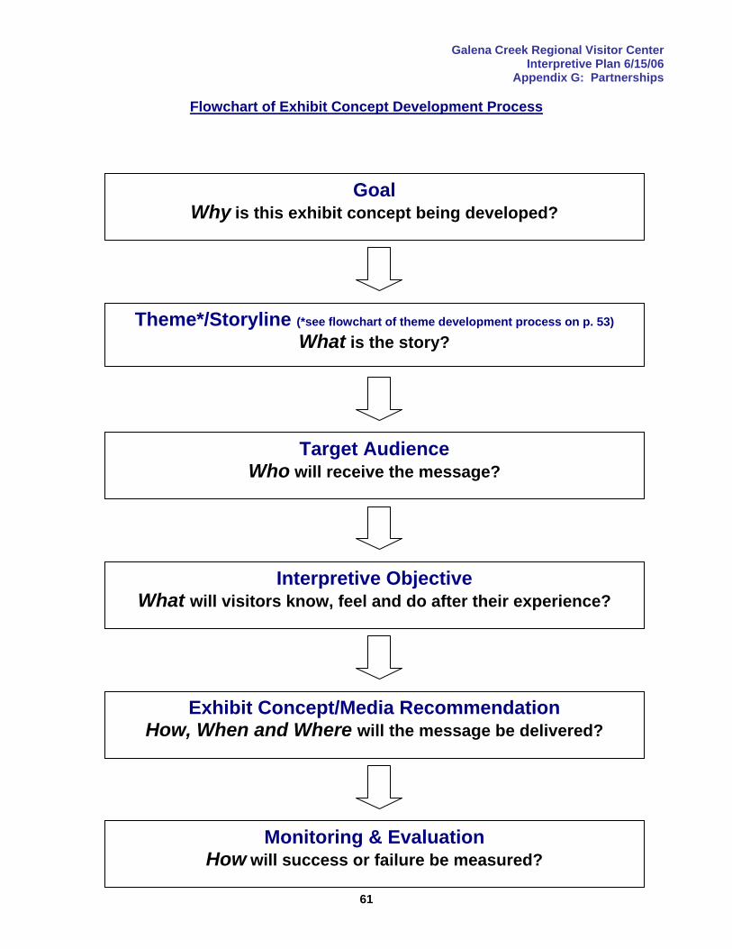
Galena Creek Regional Visitor Center Interpretive Plan 6/15/06
Appendix G: Partnerships
61
Flowchart of Exhibit Concept Development Process
Goal Why is this exhibit concept being developed?
Theme*/Storyline (*see flowchart of theme development process on p. 53) What is the story?
Target Audience Who will receive the message?
Interpretive Objective What will visitors know, feel and do after their experience?
Exhibit Concept/Media Recommendation How, When and Where will the message be delivered?
Monitoring & Evaluation How will success or failure be measured?
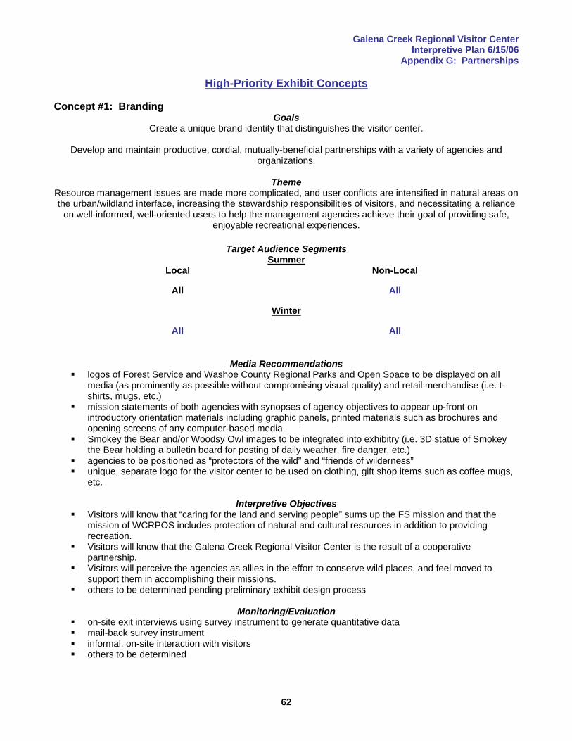
Galena Creek Regional Visitor Center Interpretive Plan 6/15/06
Appendix G: Partnerships
62
High-Priority Exhibit Concepts Concept #1: Branding
Goals Create a unique brand identity that distinguishes the visitor center.
Develop and maintain productive, cordial, mutually-beneficial partnerships with a variety of agencies and
organizations.
Theme Resource management issues are made more complicated, and user conflicts are intensified in natural areas on the urban/wildland interface, increasing the stewardship responsibilities of visitors, and necessitating a reliance
on well-informed, well-oriented users to help the management agencies achieve their goal of providing safe, enjoyable recreational experiences.
Target Audience Segments
Summer Local Non-Local
All All
Winter
All All
Media Recommendations
logos of Forest Service and Washoe County Regional Parks and Open Space to be displayed on all media (as prominently as possible without compromising visual quality) and retail merchandise (i.e. t-shirts, mugs, etc.)
mission statements of both agencies with synopses of agency objectives to appear up-front on introductory orientation materials including graphic panels, printed materials such as brochures and opening screens of any computer-based media
Smokey the Bear and/or Woodsy Owl images to be integrated into exhibitry (i.e. 3D statue of Smokey the Bear holding a bulletin board for posting of daily weather, fire danger, etc.)
agencies to be positioned as “protectors of the wild” and “friends of wilderness” unique, separate logo for the visitor center to be used on clothing, gift shop items such as coffee mugs,
etc.
Interpretive Objectives Visitors will know that “caring for the land and serving people” sums up the FS mission and that the
mission of WCRPOS includes protection of natural and cultural resources in addition to providing recreation.
Visitors will know that the Galena Creek Regional Visitor Center is the result of a cooperative partnership.
Visitors will perceive the agencies as allies in the effort to conserve wild places, and feel moved to support them in accomplishing their missions.
others to be determined pending preliminary exhibit design process
Monitoring/Evaluation on-site exit interviews using survey instrument to generate quantitative data mail-back survey instrument informal, on-site interaction with visitors others to be determined
Galena Creek Regional Visitor Center Interpretive Plan 6/15/06
Appendix G: Partnerships
63
Concept #2: Safe Travels Weather Station Goal
Encourage safe travel and recreation.
Theme(s) Maintaining access to Lake Tahoe over Mount Rose Summit, the highest year-round pass in the Sierra Nevada,
requires an extraordinary commitment of manpower and machinery.
Target Audience Segments Summer
Local Non-Local
motorists w/out children* families in private car w/ children*
motorists w/out children* families in private car w/ children*
Winter motorists w/out children* families in private car w/ children* birders sledders/other snow-play participants downhill skiers cross-country skiers telemark backcountry skiers hybrid sport participants
*Spanish & English-speaking
motorists w/out children* families in private car w/ children* tour bus users birders sledders/other snow-play participants downhill skiers cross-country skiers telemark backcountry skiers hybrid sport participants
*Spanish & English-speaking
Media Recommendations kiosk-style weather station integrated w/ park entrance gate offering real-time weather information from
Mount Rose Summit graphic panels in lighted area w/ adequate parking and turnaround space for after-hours campfire program on the history of the road and maintenance challenges; to be adapted for in-
classroom presentation
Interpretive Objectives Visitors will be aware of weather and road conditions from the visitor center entrance gate to Mount
Rose Summit. Visitors will know that keeping the road open during severe winter storms challenges men and
machinery. Visitors will know that the road corridor is important to wildlife, and was used by American Indian
cultures for their seasonal migrations. Visitors will be familiar with the history of the highway and its construction. Visitors will be able to describe at least one technique used for avalanche control and know that
avalanche forecasting is an inexact science. Visitors will be encouraged to drive safely, including using designated pullouts and parking areas to
view scenery and wildlife, or to park for snowplay and other winter activities.
Monitoring/Evaluation monitor number of accidents on SR#431between Galena Creek Park and Mount Rose Summit before
and after installation
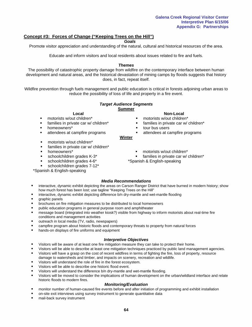
Galena Creek Regional Visitor Center Interpretive Plan 6/15/06
Appendix G: Partnerships
64
Concept #3: Forces of Change (“Keeping Trees on the Hill”) Goals
Promote visitor appreciation and understanding of the natural, cultural and historical resources of the area.
Educate and inform visitors and local residents about issues related to fire and fuels.
Themes The possibility of catastrophic property damage from wildfire on the contemporary interface between human
development and natural areas, and the historical devastation of mining camps by floods suggests that history does, in fact, repeat itself.
Wildfire prevention through fuels management and public education is critical in forests adjoining urban areas to
reduce the possibility of loss of life and property in a fire event.
Target Audience Segments Summer
Local Non-Local motorists w/out children* families in private car w/ children* homeowners* attendees at campfire programs
motorists w/out children* families in private car w/ children* tour bus users attendees at campfire programs
Winter motorists w/out children* families in private car w/ children* homeowners* schoolchildren grades K-3* schoolchildren grades 4-6* schoolchildren grades 7-12*
*Spanish & English-speaking
motorists w/out children* families in private car w/ children*
*Spanish & English-speaking
Media Recommendations
interactive, dynamic exhibit depicting the areas on Carson Ranger District that have burned in modern history; show how much forest has been lost; use tagline “Keeping Trees on the Hill”
interactive, dynamic exhibit depicting difference b/n dry-mantle and wet-mantle flooding graphic panels brochures on fire mitigation measures to be distributed to local homeowners public education programs in general purpose room and amphitheater message board (integrated into weather kiosk?) visible from highway to inform motorists about real-time fire
conditions and management activities outreach in local media (TV, radio, newspapers) campfire program about historic floods and contemporary threats to property from natural forces hands-on displays of fire uniforms and equipment
Interpretive Objectives
Visitors will be aware of at least one fire mitigation measure they can take to protect their home. Visitors will be able to describe at least one mitigation techniques practiced by public land management agencies. Visitors will have a grasp on the cost of recent wildfires in terms of fighting the fire, loss of property, resource
damage to watersheds and timber, and impacts on scenery, recreation and wildlife. Visitors will understand the role of fire in the forest ecosystem. Visitors will be able to describe one historic flood event. Visitors will understand the difference b/n dry-mantle and wet-mantle flooding. Visitors will be moved to consider the implications of human development on the urban/wildland interface and relate
historic floods to modern fires. Monitoring/Evaluation
monitor number of human-caused fire events before and after initiation of programming and exhibit installation on-site exit interviews using survey instrument to generate quantitative data mail-back survey instrument
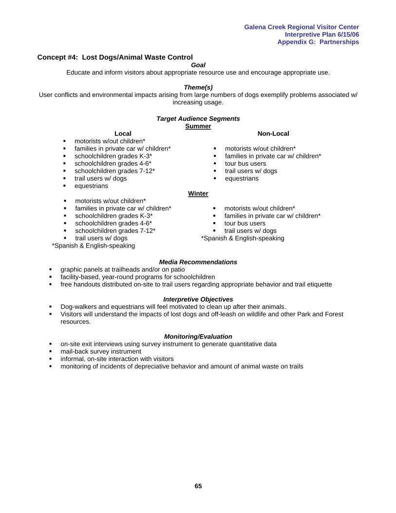
Galena Creek Regional Visitor Center Interpretive Plan 6/15/06
Appendix G: Partnerships
65
Concept #4: Lost Dogs/Animal Waste Control Goal
Educate and inform visitors about appropriate resource use and encourage appropriate use.
Theme(s) User conflicts and environmental impacts arising from large numbers of dogs exemplify problems associated w/
increasing usage.
Target Audience Segments Summer
Local Non-Local motorists w/out children* families in private car w/ children* schoolchildren grades K-3* schoolchildren grades 4-6* schoolchildren grades 7-12* trail users w/ dogs equestrians
motorists w/out children* families in private car w/ children* tour bus users trail users w/ dogs equestrians
Winter motorists w/out children* families in private car w/ children* schoolchildren grades K-3* schoolchildren grades 4-6* schoolchildren grades 7-12* trail users w/ dogs
*Spanish & English-speaking
motorists w/out children* families in private car w/ children* tour bus users trail users w/ dogs
*Spanish & English-speaking
Media Recommendations
graphic panels at trailheads and/or on patio facility-based, year-round programs for schoolchildren free handouts distributed on-site to trail users regarding appropriate behavior and trail etiquette
Interpretive Objectives
Dog-walkers and equestrians will feel motivated to clean up after their animals. Visitors will understand the impacts of lost dogs and off-leash on wildlife and other Park and Forest
resources.
Monitoring/Evaluation on-site exit interviews using survey instrument to generate quantitative data mail-back survey instrument informal, on-site interaction with visitors monitoring of incidents of depreciative behavior and amount of animal waste on trails
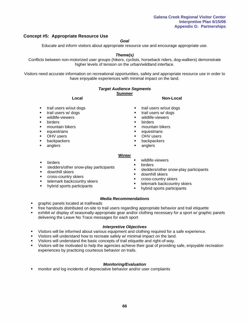
Galena Creek Regional Visitor Center Interpretive Plan 6/15/06
Appendix G: Partnerships
66
Concept #5: Appropriate Resource Use Goal
Educate and inform visitors about appropriate resource use and encourage appropriate use.
Theme(s) Conflicts between non-motorized user groups (hikers, cyclists, horseback riders, dog-walkers) demonstrate
higher levels of tension on the urban/wildland interface.
Visitors need accurate information on recreational opportunities, safety and appropriate resource use in order to have enjoyable experiences with minimal impact on the land.
Target Audience Segments
Summer Local Non-Local
trail users w/out dogs trail users w/ dogs wildlife-viewers birders mountain bikers equestrians OHV users backpackers anglers
trail users w/out dogs trail users w/ dogs wildlife-viewers birders mountain bikers equestrians OHV users backpackers anglers
Winter birders sledders/other snow-play participants downhill skiers cross-country skiers telemark backcountry skiers hybrid sports participants
wildlife-viewers birders sledders/other snow-play participants downhill skiers cross-country skiers telemark backcountry skiers hybrid sports participants
Media Recommendations
graphic panels located at trailheads free handouts distributed on-site to trail users regarding appropriate behavior and trail etiquette exhibit w/ display of seasonally-appropriate gear and/or clothing necessary for a sport w/ graphic panels
delivering the Leave No Trace messages for each sport
Interpretive Objectives Visitors will be informed about various equipment and clothing required for a safe experience. Visitors will understand how to recreate safely w/ minimal impact on the land. Visitors will understand the basic concepts of trail etiquette and right-of-way. Visitors will be motivated to help the agencies achieve their goal of providing safe, enjoyable recreation
experiences by practicing courteous behavior on trails.
Monitoring/Evaluation
monitor and log incidents of depreciative behavior and/or user complaints
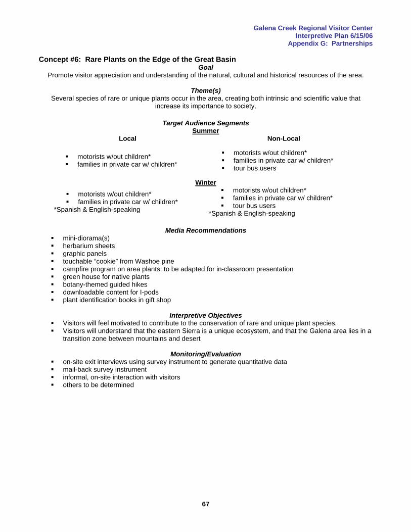
Galena Creek Regional Visitor Center Interpretive Plan 6/15/06
Appendix G: Partnerships
67
Concept #6: Rare Plants on the Edge of the Great Basin Goal
Promote visitor appreciation and understanding of the natural, cultural and historical resources of the area.
Theme(s) Several species of rare or unique plants occur in the area, creating both intrinsic and scientific value that
increase its importance to society.
Target Audience Segments Summer
Local Non-Local
motorists w/out children* families in private car w/ children*
motorists w/out children* families in private car w/ children* tour bus users
Winter motorists w/out children* families in private car w/ children*
*Spanish & English-speaking
motorists w/out children* families in private car w/ children* tour bus users
*Spanish & English-speaking
Media Recommendations mini-diorama(s) herbarium sheets graphic panels touchable “cookie” from Washoe pine campfire program on area plants; to be adapted for in-classroom presentation green house for native plants botany-themed guided hikes downloadable content for I-pods plant identification books in gift shop
Interpretive Objectives
Visitors will feel motivated to contribute to the conservation of rare and unique plant species. Visitors will understand that the eastern Sierra is a unique ecosystem, and that the Galena area lies in a
transition zone between mountains and desert
Monitoring/Evaluation on-site exit interviews using survey instrument to generate quantitative data mail-back survey instrument informal, on-site interaction with visitors others to be determined
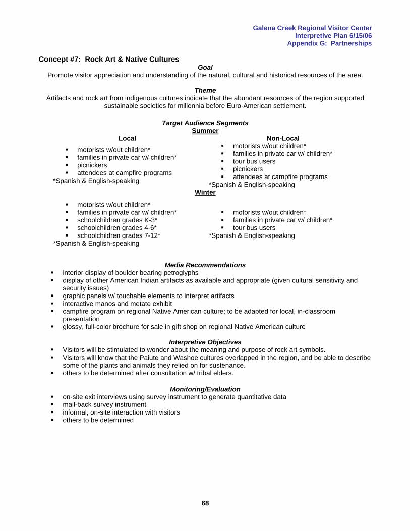
Galena Creek Regional Visitor Center Interpretive Plan 6/15/06
Appendix G: Partnerships
68
Concept #7: Rock Art & Native Cultures Goal
Promote visitor appreciation and understanding of the natural, cultural and historical resources of the area.
Theme Artifacts and rock art from indigenous cultures indicate that the abundant resources of the region supported
sustainable societies for millennia before Euro-American settlement.
Target Audience Segments Summer
Local Non-Local motorists w/out children* families in private car w/ children* picnickers attendees at campfire programs
*Spanish & English-speaking
motorists w/out children* families in private car w/ children* tour bus users picnickers attendees at campfire programs
*Spanish & English-speaking Winter
motorists w/out children* families in private car w/ children* schoolchildren grades K-3* schoolchildren grades 4-6* schoolchildren grades 7-12*
*Spanish & English-speaking
motorists w/out children* families in private car w/ children* tour bus users
*Spanish & English-speaking
Media Recommendations
interior display of boulder bearing petroglyphs display of other American Indian artifacts as available and appropriate (given cultural sensitivity and
security issues) graphic panels w/ touchable elements to interpret artifacts interactive manos and metate exhibit campfire program on regional Native American culture; to be adapted for local, in-classroom
presentation glossy, full-color brochure for sale in gift shop on regional Native American culture
Interpretive Objectives
Visitors will be stimulated to wonder about the meaning and purpose of rock art symbols. Visitors will know that the Paiute and Washoe cultures overlapped in the region, and be able to describe
some of the plants and animals they relied on for sustenance. others to be determined after consultation w/ tribal elders.
Monitoring/Evaluation
on-site exit interviews using survey instrument to generate quantitative data mail-back survey instrument informal, on-site interaction with visitors others to be determined
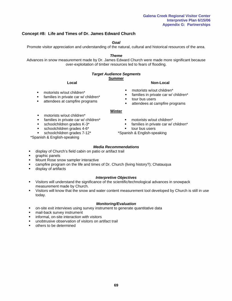
Galena Creek Regional Visitor Center Interpretive Plan 6/15/06
Appendix G: Partnerships
69
Concept #8: Life and Times of Dr. James Edward Church
Goal Promote visitor appreciation and understanding of the natural, cultural and historical resources of the area.
Theme
Advances in snow measurement made by Dr. James Edward Church were made more significant because over-exploitation of timber resources led to fears of flooding.
Target Audience Segments
Summer Local Non-Local
motorists w/out children* families in private car w/ children* attendees at campfire programs
motorists w/out children* families in private car w/ children* tour bus users attendees at campfire programs
Winter motorists w/out children* families in private car w/ children* schoolchildren grades K-3* schoolchildren grades 4-6* schoolchildren grades 7-12*
*Spanish & English-speaking
motorists w/out children* families in private car w/ children* tour bus users
*Spanish & English-speaking
Media Recommendations
display of Church’s field cabin on patio or artifact trail graphic panels Mount Rose snow sampler interactive campfire program on the life and times of Dr. Church (living history?); Chatauqua display of artifacts
Interpretive Objectives
Visitors will understand the significance of the scientific/technological advances in snowpack measurement made by Church.
Visitors will know that the snow and water content measurement tool developed by Church is still in use today.
Monitoring/Evaluation
on-site exit interviews using survey instrument to generate quantitative data mail-back survey instrument informal, on-site interaction with visitors unobtrusive observation of visitors on artifact trail others to be determined
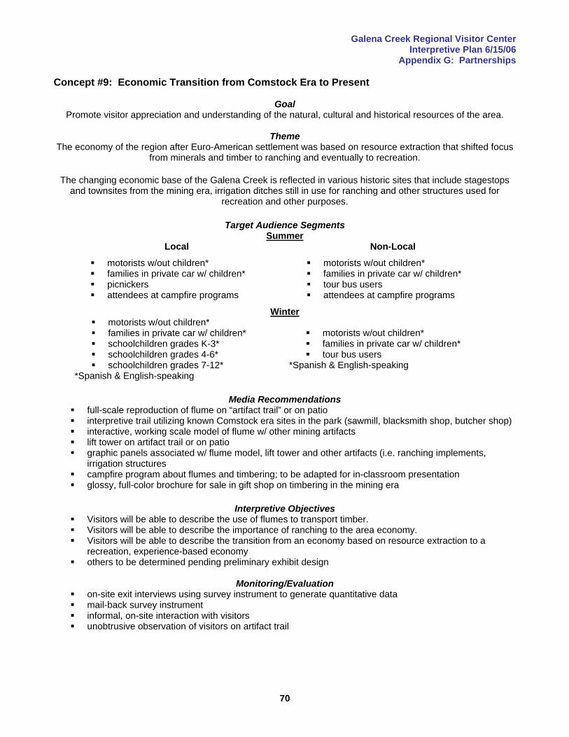
Galena Creek Regional Visitor Center Interpretive Plan 6/15/06
Appendix G: Partnerships
70
Concept #9: Economic Transition from Comstock Era to Present
Goal Promote visitor appreciation and understanding of the natural, cultural and historical resources of the area.
Theme
The economy of the region after Euro-American settlement was based on resource extraction that shifted focus from minerals and timber to ranching and eventually to recreation.
The changing economic base of the Galena Creek is reflected in various historic sites that include stagestops
and townsites from the mining era, irrigation ditches still in use for ranching and other structures used for recreation and other purposes.
Target Audience Segments
Summer Local Non-Local
motorists w/out children* families in private car w/ children* picnickers attendees at campfire programs
motorists w/out children* families in private car w/ children* tour bus users attendees at campfire programs
Winter motorists w/out children* families in private car w/ children* schoolchildren grades K-3* schoolchildren grades 4-6* schoolchildren grades 7-12*
*Spanish & English-speaking
motorists w/out children* families in private car w/ children* tour bus users
*Spanish & English-speaking
Media Recommendations
full-scale reproduction of flume on “artifact trail” or on patio interpretive trail utilizing known Comstock era sites in the park (sawmill, blacksmith shop, butcher shop) interactive, working scale model of flume w/ other mining artifacts lift tower on artifact trail or on patio graphic panels associated w/ flume model, lift tower and other artifacts (i.e. ranching implements,
irrigation structures campfire program about flumes and timbering; to be adapted for in-classroom presentation glossy, full-color brochure for sale in gift shop on timbering in the mining era
Interpretive Objectives
Visitors will be able to describe the use of flumes to transport timber. Visitors will be able to describe the importance of ranching to the area economy. Visitors will be able to describe the transition from an economy based on resource extraction to a
recreation, experience-based economy others to be determined pending preliminary exhibit design
Monitoring/Evaluation
on-site exit interviews using survey instrument to generate quantitative data mail-back survey instrument informal, on-site interaction with visitors unobtrusive observation of visitors on artifact trail
Galena Creek Regional Visitor Center Interpretive Plan 6/15/06
Appendix G: Partnerships
71
Concept #10: Sustainable Building Techniques Goal
Achieve a Leadership in Energy and Environmental Design (LEED) Silver Designation from the United States Green Building Council (USGBC) for facility construction and interpret the principles of sustainable building for
visitors.
Theme(s) The Forest Service stays true to its mission of resource conservation by specifying that agency buildings be built
to Leadership in Energy and Environmental Design (LEED) standards established by the U.S. Green Building Council, and by interpreting those building techniques to visitors.
Target Audience Segments
Summer Local Non-Local
motorists w/out children* families in private car w/ children*
motorists w/out children* families in private car w/ children* tour bus users
Winter motorists w/out children* families in private car w/ children*
*Spanish & English-speaking
motorists w/out children* families in private car w/ children* tour bus users
*Spanish & English-speaking
Media Recommendations graphic panel and reader rail w/ touchable recycled/alternative building materials campfire program on sustainable building techniques
Interpretive Objectives
Visitors will be able to describe a few of the alternative/sustainable building techniques and materials used to construct the visitor center.
Visitors will appreciate the fact that the Forest Service and Washoe County strived to achieve a LEED silver certification.
Visitors will be able to define LEED (Leadership in Energy and Environmental Design) and know what the mission of the United States Green Building Council (USBGC) is.
Visitors will be able to describe the difference between the Jones Creek and Galena Creek watersheds.
Monitoring/Evaluation informal, on-site interaction w/ visitors
Galena Creek Regional Visitor Center Interpretive Plan 6/15/06
Appendix G: Partnerships
72
Concept #11: Mount Rose Scenic Byway Goal
Welcome and orient visitors to the facilities, services and recreational/interpretive opportunities in the area of Galena Creek and the Mount Rose Scenic Byway.
Themes
The Galena Creek Regional Visitor Center, one of the gateways to Lake Tahoe, is located in mountainous terrain on a travel corridor used by both humans and wildlife, and the construction and maintenance of the
highway now designated as the Mount Rose Scenic Byway is a story of people and machinery being taxed to their limits.
American Indian peoples traveled the Galena Canyon region during their seasonal migrations from the Washoe
Valley to Lake Tahoe, a route now used mainly to access the many recreational opportunities at the lake.
Maintaining access to Lake Tahoe over Mount Rose Summit, the highest year-round pass in the Sierra Nevada, requires an extraordinary commitment of manpower and machinery.
Human development along the Mount Rose Scenic Byway has impacted wildlife populations that have used the
natural travel corridor for millennia.
Target Audience Segments Summer
Local Non-Local
motorists w/out children* families in private car w/ children*
motorists w/out children* families in private car w/ children* tour bus users
Winter motorists w/out children* families in private car w/ children*
*Spanish & English-speaking
motorists w/out children* families in private car w/ children* tour bus users
*Spanish & English-speaking
Media Recommendations prominent display of Mount Rose Scenic Byway on raised-relief map paper map of Mount Rose Scenic Byway (with points of interest identified) for free distribution CD/DVD featuring the byway for sale in gift shop glossy, full-color brochure/booklet for sale in gift shop
Interpretive Objectives
Visitors will be able to identify at least two points of interest on the byway between the visitor center and Mount Rose Summit.
Visitors will understand that the weather can change drastically between Galena Creek Regional Park and Mount Rose Summit.
Visitors will understand the scope of the effort necessary to keep the highway open in winter. Visitors will be familiar with the history of the construction of the highway.
Monitoring/Evaluation
monitor sales of Byway-related materials in gift shop
Galena Creek Regional Visitor Center Interpretive Plan 6/15/06
Appendix G: Partnerships
73
Secondary Priority Exhibit Concepts Concept #12: Interactive Raised-Relief Map
Goal Welcome and orient visitors to the facilities, services and recreational and interpretive opportunities in the area
of Galena Creek and the Mount Rose Scenic Byway.
Theme Visitors need accurate information on recreational opportunities, safety and appropriate resource use in order to
have enjoyable experiences with minimal impact on the land.
Target Audience Segments Summer
Local Non-Local
motorists w/out children* families in private car w/ children* hospitality and tourism industry wildlife-viewers birders mountain bikers equestrians OHV users backpackers anglers hang gliders
motorists w/out children* families in private car w/ children* wildlife-viewers picnickers birders mountain bikers equestrians OHV users backpackers anglers hang gliders frontcountry campers
Winter
motorists w/out children* families in private car w/ children* hospitality and tourism industry birders sledders/other snow-play participants downhill skiers cross-country skiers telemark backcountry skiers hybrid sport participants *Spanish & English-speaking
motorists w/out children* families in private car w/ children* trail users w/out dogs trail users w/ dogs wildlife-viewers birders sledders/other snow-play participants downhill skiers cross-country skiers telemark backcountry skiers hybrid sport participants *Spanish & English-speaking
Media Recommendations
interactive, raised-relief map displaying full range of recreational and interpretive opportunities computer station w/ touch screen graphic panels w/ maps in lighted area outside gate for after-hours customers graphic panels at picnic areas brochure and handout note: concepts #17 and #20 describe reader rails to be associated w/ this map
Interpretive Objectives
Visitors will be able to name one site and one alternative site in the Carson Ranger District, Washoe County Park system or Lake Tahoe Basin Management Unit where they can pursue a preferred activity.
others to be determined pending preliminary exhibit design process
Monitoring/Evaluation on-site exit interviews using survey instrument to generate quantitative data mail-back survey instrument informal, on-site interaction with visitors
Galena Creek Regional Visitor Center Interpretive Plan 6/15/06
Appendix G: Partnerships
74
Concept #13: Website
Goal The website concept is intended to advance the achievement of all the goals of the visitor center.
Theme(s)
The abundant natural resources of Galena Canyon, which is located on a natural travel corridor from the Washoe Valley to Lake Tahoe, have attracted humans for millennia, and protecting the region’s special values in the face of rapidly-encroaching urban development is a challenge that must be shared by local residents and
visitors as well as the agencies responsible for its management. (This is the central theme statement for the visitor center, implying that this concept has the capacity to deliver
any theme or subtheme put forth in this plan).
Target Audience Segments Summer
Local Non-Local All All
Winter All All
Media Recommendations
website with virtual tour of the Galena Creek facility featuring expanded treatment (e.g. more in-depth text and visual content) of visitor center exhibits, on-demand video of campfire programs and other personal interpretive services such as classroom-based school outreach, links to related websites that offer interpretation on related topics and information on recreation, lodging, dining, tour services, etc.
web content to be formatted for fee-based download to personal communication devices such as I-Pods
Interpretive Objectives Internet users will be able to access the full spectrum of informational and interpretive programming
available at the Galena Creek Regional Visitor Center through a website.
Monitoring/Evaluation monitor number of hits collect feedback through e-mail comments web-based user survey others to be determined
Galena Creek Regional Visitor Center Interpretive Plan 6/15/06
Appendix G: Partnerships
75
Concept #14: School Outreach & Children’s Exhibits
Goal(s) Nurture and strengthen existing ties with the community through continued educational outreach in the local school system.
Promote visitor appreciation and understanding of the natural, cultural and historical resources of the area.
Theme(s)
The abundant natural resources of Galena Canyon, which is located on a natural travel corridor from the Washoe Valley to Lake Tahoe, have attracted humans for millennia, and protecting the region’s special values in the face of rapidly-encroaching urban development is a challenge that must be shared by local residents and
visitors as well as the agencies responsible for its management. (This is the central theme statement for the visitor center, implying that this concept has the capacity to deliver
any theme or subtheme put forth in this plan).
Target Audience Segments Summer
Local Non-Local families in private car w/ children* schoolchildren grades K-3* schoolchildren grades 4-6* schoolchildren grades 7-12*
families in private car w/ children* schoolchildren grades K-3* schoolchildren grades 4-6* schoolchildren grades 7-12*
Winter families in private car w/ children* schoolchildren grades K-3* schoolchildren grades 4-6* schoolchildren grades 7-12*
*Spanish & English-speaking
families in private car w/ children* schoolchildren grades K-3* schoolchildren grades 4-6* schoolchildren grades 7-12*
*Spanish & English-speaking
Media Recommendations play area for kids with animal sculptures inside/outside treasure hunt game for kids (multiple levels of difficulty) rubbing table (paper to be branded w/ agency logos and conservation messaging) junior naturalist program/miscellaneous campfire programs programming targeted at Nevada schoolchildren, developed to meet state curriculum requirements (as
appropriate within the stated goals of the visitor center, e.g. focused on interpretation of resources in the area of Galena Creek Park and the Mount Rose Scenic Byway); programs to be based on-site, in local classrooms and on the internet
Interpretive Objectives
Young visitors of school age will become actively involved in all aspects of the on-site visitor center recreational learning experience.
to be determined, pending analysis of Nevada curriculum requirements
Monitoring/Evaluation informal feedback and/or formal survey of kids and parents informal feedback and/or formal survey of educators
Galena Creek Regional Visitor Center Interpretive Plan 6/15/06
Appendix G: Partnerships
76
Concept #15: Summary CD/DVD and/or Brochure
Goal Promote visitor appreciation and understanding of the natural, cultural and historical resources of the area.
Theme
The abundant natural resources of Galena Canyon, which is located on a natural travel corridor from the Washoe Valley to Lake Tahoe, have attracted humans for millennia, and protecting the region’s special values in the face of rapidly-encroaching urban development is a challenge that must be shared by local residents and
visitors as well as the agencies responsible for its management. (This is the central theme statement for the visitor center, implying that this concept has the capacity to deliver
any theme or subtheme put forth in this plan).
Target Audience Segments Summer
Local Non-Local
All All Winter
All All
Media Recommendations CD/DVD and/or brochure that captures the Galena Creek Park and Mount Rose Scenic Byway
experience
Interpretive Objectives Visitors will receive a comprehensive overview of area resources and recreational opportunities. Workers and managers in the hospitality industry will receive a comprehensive overview of area
resources and recreational opportunities to facilitate their role as area ambassadors and information dispensers.
Monitoring/Evaluation
monitor sales feedback from local businesses who use video for training others to be determined

Galena Creek Regional Visitor Center Interpretive Plan 6/15/06
Appendix G: Partnerships
77
Concept #16: Water Diversion and Ranching History
Goal Promote visitor appreciation and understanding of the natural, cultural and historical resources of the area.
Theme(s)
Historic and contemporary diversion of water for economic development reflects the extraordinary value of water in the arid West, and the near-certainty that conflict over this vital resource will continue.
Target Audience Segments
Summer Local Non-Local
motorists w/out children* families in private car w/ children*
motorists w/out children* families in private car w/ children* tour bus users
Winter motorists w/out children* families in private car w/ children* schoolchildren grades K-3* schoolchildren grades 4-6* schoolchildren grades 7-12*
*Spanish & English-speaking
motorists w/out children* families in private car w/ children* tour bus users
*Spanish & English-speaking
Media Recommendations
ranching/water diversion artifacts (reconstructed or restored weir? sluice gate?) on artifact trail or patio graphic panels interactive watershed map or stream-diversion exhibit campfire program on history of irrigated agriculture and ranching in the region; to be adapted for in-
classroom presentation
Interpretive Objectives Visitors will feel an appreciation for the value of water resources in the Great Basin. Visitors will have a basic grasp of the historic role of ranching in the regional economy Visitors will understand that competition for water resources is a key factor in the future of the American
West. Visitors will feel empathy for wildlife, including fish, who rely on water resources strained by human
demands. Visitors will understand the impact of noxious weeds on water and other important natural resources.
Monitoring/Evaluation
on-site exit interviews using survey instrument to generate quantitative data mail-back survey instrument informal, on-site interaction with visitors unobtrusive observation of visitors on artifact trail others to be determined

Galena Creek Regional Visitor Center Interpretive Plan 6/15/06
Appendix G: Partnerships
78
Concept #17: Geology & Migration Corridor
Goal Promote visitor appreciation and understanding of the natural, cultural and historical resources of the area.
Theme(s)
The geological forces that created Lake Tahoe and the Galena Canyon watershed also shaped biotic communities, movement of wildlife and patterns of human settlement.
American Indian peoples traveled the Galena Canyon region during their seasonal migrations from the Washoe
Valley to Lake Tahoe, a route now used mainly to access the many recreational opportunities at the lake.
Target Audience Segments Summer
Local Non-Local
motorists w/out children* families in private car w/ children*
motorists w/out children* families in private car w/ children* tour bus users
Winter motorists w/out children* families in private car w/ children*
*Spanish & English-speaking
motorists w/out children* families in private car w/ children* tour bus users
*Spanish & English-speaking
Media Recommendations reader rail w/ touchable elements associated with interactive, raised-relief map
Interpretive Objectives
Visitors will understand that the movements of both human and animal populations are dictated by topography, climate, availability of food resources and, above all, water.
Visitors will be able to define the concept of rainshadow. Visitors will know that the Galena Creek Regional Visitor Center lies at about the same elevation as the
surface of Lake Tahoe. Visitors will be able to name at least two species of animals that went extinct after Euro-American
settlement. Visitors will feel empathy for wildlife and native plant populations impacted by human development and
be motivated to support efforts to conserve native wildlife and plant species.
Monitoring/Evaluation on-site exit interviews using survey instrument to generate quantitative data mail-back survey instrument informal, on-site interaction with visitors others to be determined
Galena Creek Regional Visitor Center Interpretive Plan 6/15/06
Appendix G: Partnerships
79
Concept #18: Ecological Effects of Logging
Goal Promote visitor appreciation and understanding of the natural, cultural and historical resources of the area.
Theme
Clearcutting to meet the needs of mining operations had a profound effect on forest ecology, water quality and animal populations that is evident even today.
Target Audience Segments
Summer Local Non-Local
motorists w/out children* families in private car w/ children* picnickers attendees at campfire programs
*Spanish & English-speaking
motorists w/out children* families in private car w/ children* tour bus users picnickers attendees at campfire programs
*Spanish & English-speaking
Winter motorists w/out children* families in private car w/ children* schoolchildren grades K-3* schoolchildren grades 4-6* schoolchildren grades 7-12*
*Spanish & English-speaking
motorists w/out children* families in private car w/ children* tour bus users
*Spanish & English-speaking
Media Recommendations
touchable tree “cookie” w/ graphic panels (note: a tree “cookie” is a section cut from the branch or trunk of a tree showing its rings)
campfire program on ecological effects of logging in the mining era and its lingering effects on regional ecology; to be adapted for in-classroom presentation, aspects to be integrated into brochure proposed for #13
Interpretive Objectives
Visitors will be able to describe the environmental affects of the mining era timber harvest. Visitors will know why there are no large trees in the Mount Rose/Lake Tahoe area, and be able to
explain the difference between an old growth forest and an even-aged forest. Visitors will be able to describe how the region’s forests were restored, and how watersheds were
rehabilitated following the mining boom. Visitors will understand the role of fire in a forest ecosystem. others to be determined pending preliminary exhibit design
Monitoring/Evaluation
on-site exit interviews using survey instrument to generate quantitative data mail-back survey instrument informal, on-site interaction with visitors others to be determined
Galena Creek Regional Visitor Center Interpretive Plan 6/15/06
Appendix G: Partnerships
80
Concept #19: Water & Watersheds
Goal Promote visitor appreciation and understanding of the natural, cultural and historical resources of the area.
Theme(s)
The presence or absence of water in microclimates such as the Jones Creek drainage ultimately determines the composition and distribution of natural communities.
Target Audience Segments
Summer Local Non-Local
motorists w/out children* families in private car w/ children*
motorists w/out children* families in private car w/ children* tour bus users
Winter motorists w/out children* families in private car w/ children*
*Spanish & English-speaking
motorists w/out children* families in private car w/ children* tour bus users
*Spanish & English-speaking
Media Recommendations reader rail w/ touchable elements associated w/ interactive, raised-relief map
Interpretive Objectives
Visitors will know that the streams of the Great Basin do not reach the sea. Visitors will appreciate the importance of riparian areas to wildlife. Visitors will be able to define “ephemeral” and “seasonal” streams. Visitors will be able to describe the difference between the Jones Creek and Galena Creek watersheds.
Monitoring/Evaluation
on-site exit interviews using survey instrument to generate quantitative data mail-back survey instrument informal, on-site interaction with visitors others to be determined

Galena Creek Regional Visitor Center Interpretive Plan 6/15/06
Appendix G: Partnerships
81
Concept #20: Ecosystem Services Goal
Interpret the concept of ecosystem services to visitors, and be a leader in introducing the emerging concept to the public.
Theme(s)
Healthy ecosystems provide a wide range of economic, environmental and aesthetic goods and services that are traditionally considered free, but placing a monetary value on these services helps people appreciate their
true worth, while helping to define the structure of the emerging marketplace where the exchange of ecosystem services takes place.
Target Audience Segments
Summer Local Non-Local
motorists w/out children* families in private car w/ children*
motorists w/out children* families in private car w/ children* tour bus users
Winter motorists w/out children* families in private car w/ children*
*Spanish & English-speaking
motorists w/out children* families in private car w/ children* tour bus users
*Spanish & English-speaking
Media Recommendations interactive ecosystem services ATM machine designed so that visitors will be able to make trades in the
ecosystem services marketplace and see the consequences of certain decisions interactive scale (either electronic or mechanical) by which visitors will play a game of balancing
demands on resources (i.e. economic benefits of logging versus need to protect watersheds or recreational development versus need to protect wildlife, etc.)
downloadable (fee-based) content for personal communication devices such a I-Pods that explains ecosystem services and the ecosystem services marketplace in depth
Interpretive Objectives
Visitors will be able to define the concept of “ecosystem services” and understand the concept of the ecosystem services marketplace.
Visitors will understand that wise use of resources is a balancing act between competing demands.
Monitoring/Evaluation on-site exit interviews using survey instrument to generate quantitative data mail-back survey instrument informal, on-site interaction with visitors others to be determined
Galena Creek Regional Visitor Center Interpretive Plan 6/15/06
Appendix F: Marketing & Retail Discussion
82
Appendix F: Marketing & Retail Discussion This section focuses on two marketing strategies:
Promoting awareness of the Mount Rose Scenic Byway and the Galena Creek Regional Visitor Center Maximizing the sales revenue from the gift shop to help achieve the goal of a self-supporting facility.
Several components that will help carve out a well-differentiated market niche for the visitor center and byway include:
1. a unique logo to distinguish a line of clothing, hard goods such as coffee mugs and other items for sale in the gift shop
2. books, brochures, CD’s, DVD’s and other items specific to the Galena Creek area (also featuring the facility/byway logo)
3. a well-designed, information-rich website featuring a virtual tour of the visitor center and downloadable content for personal communication devices such as I-Pods.
Programs involving the community have good potential to increase public awareness of the visitor center and byway as well. These might include environmental education events of various kinds to supplement the existing slate of campfire programs, trail-building/cleanup days, public involvement in surveys for T&E plants and animals, bird counts, etc. Marketing the Mount Rose Scenic Byway The importance of linking the Mount Rose Scenic Byway and the Galena Creek Regional Visitor Center has been stressed again and again in this plan. Byway travelers will inevitably become aware of the visitor center, so marketing the byway amounts to de facto marketing of the visitor center. The byway designation is a potentially robust source of funding for exhibit, program and literature development, and it may also serve as the basis for the formation of a friends group or interpretive association. Gaining support for byway marketing from an array of different partners (tourism promotion agencies, casino resorts, ski areas, etc.) should be an easy sell. It enhances the positioning of Reno-Tahoe as “America’s Adventure Place” and offers an alternative to gambling that is attractive to even those visitors not necessarily inclined toward outdoor activities but interested in “seeing the sights.” Although information on the economic impacts of byways is spotty (no data exists for Nevada of which the project team is aware), research conducted in New Mexico found that about 20% of all non-local byway travelers had been influenced to visit the region as a direct result of the existence of a byway. It is strongly recommended that efforts begin immediately to submit grant applications for the development of a corridor management plan. This process typically involves public meetings, a resource inventory, identification of constraints and a feasibility analysis of various improvements such as pullouts, wayside interpretation, etc. The Scenic Byways Coordinator for the Nevada Department of Transportation may be willing to advise and assist this effort. Inquiries into the possibility of achieving a national scenic byway designation should also be initiated. It might be possible to avoid some duplication of effort (and save money) if some of the federal requirements could be piggybacked onto a state-funded corridor management plan. Development of an interpretive master plan usually follows the development of the corridor management plan (although these tasks can occur concurrently) to develop a thematic framework, establish design guidelines and identify specific projects. The byway and visitor center can be effectively marketed through existing media at relatively low expense. Potential internet communication channels include:
Reno-Sparks Convention and Authority website (also its literature) Nevada Department of Transportation website (a section on the Mount Rose Scenic Byway is in place, it
will need updating when the visitor center opens) Nevada Commission on Tourism website websites of automobile clubs (i.e. American Automobile Association) and recreational vehicle clubs (i.e.
Good Sam Club) websites of Lake Tahoe ski areas and local casino-resorts
Galena Creek Regional Visitor Center Interpretive Plan 6/15/06
Appendix F: Marketing & Retail Discussion
83
America’s Byways website (a section on the Mount Rose Scenic Byway is in place, it will need updating when the visitor center opens)
Humboldt-Toiyabe National Forest website other travel-related websites (i.e. www.wildernet.com) that promote travel to destinations with outdoor
recreation opportunities. The byway and visitor center could also be promoted through fliers and posters placed at area lodging facilities, sporting goods stores, restaurants and other tourism-related businesses, as well as Forest Service information/contact stations such as the Taylor Creek Visitor Center and the information outlets of other land management agencies such as the Bureau of Land Management. Marketing visitor center programs to the local population can be achieved through traditional media such as newspaper and radio, as well as fliers at the outlets noted above, and on the proposed visitor center website. Programs can also be marketed on-site by using a bulletin board or posting fliers. Gift Shop Marketing Strategies The project team had the opportunity to meet with consultant Andrew Andoniadis of Andoniadis Retail Consulting, a firm that specializes in museum and visitor center retail merchandising. Most of the strategies recommended in this section are derived from those discussions. A solid consensus was reached that customers should be aware of the fact that all the profits generated in the gift shop will stay at the site, to be used to defray operating expenses and fund capital improvements. This will be accomplished by the placement of small signs at the checkout counter and/or a printed message on each cash register receipt. The message will be something along the lines of “Your purchase helps to support the continuing operation of the Galena Creek Regional Visitor Center.” The project team also agreed that retail goods should be branded with the Forest Service and Washoe County logos to the greatest extent possible. This strategy is directly aligned with the strategic recommendation to brand all interpretive media in order to position the county and the Forest Service as “defenders of wilderness” to take advantage of strong public support for wilderness protection and trust in the Forest Service as an information source. The development of branded, site-specific products related to the interpretive themes of the visitor center (such as brochures, trail guides and maps, books, pictures, t-shirts and mugs) is strongly recommended, and might be part of the mission of a friends group or interpretive association. The project team was also in agreement that there would be no café-style food service. The only food items available will be packaged items such as bottled water, energy bars and possibly locally-produced food products (to emphasize the heritage-preservation function of the visitor center) such as jams or jellies that do no require refrigeration or preparation. The design and placement of the checkout counter received considerable attention and discussion. Attendance at the park declines during the spring and fall shoulder seasons, and Washoe County managers hope to be able to staff the facility with a single person during those periods. This is contrary to conventional retail wisdom, which dictates that sales tend to suffer if a salesperson has responsibility for information duties as well. Nonetheless, the interpretive and sales areas have been designed so that a single person can handle both functions (see the floor plan on p.xx), which allows facility managers to have more flexibility and economy in scheduling staff. The goals of retail store design include:
Encourage customers to linger (this is considered the single most important factor in a successful operation).
Increase incremental sales (most shoppers are one-time shoppers, and there is only one chance to make a sale).
Encourage movement throughout the store, even if it is a small space. Create sight lines that improve customer service and discourage shoplifting (lines of sight from the
clerk’s position should be open to all areas of the store).
Galena Creek Regional Visitor Center Interpretive Plan 6/15/06
Appendix F: Marketing & Retail Discussion
84
Enhance the image of the visitor facility and advance its mission. There are several multipliers used to estimate the optimal size of a retail space in a visitor facility. Based on projected annual visitation of 200,000 people/year, the size of the retail space in the Galena Creek facility should be in the neighborhood of 700 sq. ft. The best location for retail operations is on visitors’ right when exiting, and the latest floor plan reflects these criteria. Additional design factors that will serve to maximize sales in the retail space include:
Composition of perimeter walls should be a mixture of glass and solid surfaces. There should be a balance between allowing light into the store (and permitting visitors to see into the store) and the use of vertical space for merchandising.
Identification signs on SR#431 should indicate the presence of the shop to increase pull-in traffic. A typical customer does not reach, bend or ask questions. Merchandise displays should be designed
based on this assumption. Visitors tend to buy more audio than video in museum and nature center retail outlets. Audio should be
used to create a welcoming, warm ambience and increase product sales. Specialized fixtures are rarely needed, and high-end fixtures may be a waste of money as they do not
necessarily boost sales. Fixtures should be adaptable, easily-moved, have storage space where possible and be of simple, basic design so that they don’t draw attention from merchandise. The product is the star, not the fixture.
If possible, a children’s exhibit or “distraction area” should be placed where it is visible from inside the store so that parents can watch their children and continue to shop.
The height of fixtures and density of merchandise displays should increase away from the entrance. People interested in book purchases will find the book display. It does not need to be prominent. Flexible track-lighting is the best choice to create distinctive product areas and provide extra task-
lighting over the checkout area. Floor covering should be carpet (smooth, quiet, soft). The checkout counter area should be integrated with a product display for customer-inaccessible items
(i.e. jewelry). Application of the basic retail merchandising strategies noted above will increase sales and help achieve the goal of a self-supporting facility.
Galena Creek Regional Visitor Center Interpretive Plan 6/15/06
Appendix G: Partnerships
85
Appendix G: Partnerships Interagency partnerships such as the one between the Forest Service and Washoe County to build the Galena Creek Regional Visitor Center benefit both the agencies and the community by leveraging limited staff and financial resources. There are a number of other types of partnerships that can benefit parks and visitor facilities. These include partnerships with private individuals, corporations, non-profit organizations and friends groups (interpretive associations). Galena Creek Park already has a number of effective partnerships in place, and the planning process that led to the production of this document included several partners who have made, and will continue to make significant contributions to the success of the project. The purpose of this section is to inventory and describe existing partnerships and suggest possibilities for the creation of new ones. Friends Group/Interpretive Association Friends groups tend to be the most dedicated and effective of organizational partners because their mission is focused on a specific park or facility. It is strongly recommended that a friends group be established to support Galena Creek Park and the proposed visitor center. Since Federal agencies can not sell products, many friends groups or interpretive associations are born out of a need to create an organization that can conduct retail sales to raise funds. The situation with the Galena Creek Regional Visitor Center is unusual (for a facility on Forest Service land) in that retail operations do not need to fall within the purview of a friends group since this will be the responsibility of Washoe County. This situation may be viewed as a positive circumstance, given that the efforts of a friends group could be directed toward other areas (i.e. trail maintenance). The role of a friends group could include:
trail maintenance fundraising for development of various publications, audiovisual media or other interpretive products fundraising for facilities improvements lobbying (i.e. for a trail connection between Reno and the Tahoe Rim Trail in partnership with the Sierra
Front Recreation Coalition) promotion of the Mount Rose Scenic Byway and the visitor center other functions to be determined by the organization when it is established.
The impetus for a friends group must come from the local, grassroots level. Initial support might be found in local service organizations (i.e Rotary, Kiwanis), homeowners’ associations in residential developments close to the park, trail organizations, Chambers of Commerce and/or activity-focused organizations such as hiking clubs or equestrian clubs that have a stake in the park’s recreational resources. There is a active nationwide organization that supports friends groups:
Association for Partners of Public Lands 2401 Blueridge Avenue, Suite 303 Wheaton, MD 20902 301.946.9475 or 877.647.2775 http://www.appl.org/.
APPL helps potential organizations get underway by providing organizational strategies and other resources. Representatives of the Forest Service, Washoe County or both might benefit from attendance at their annual conference in the near future.
Consultation with the existing friends group located closest to the visitor center might be helpful as well. The Tahoe Heritage Foundation, founded in 1996, exists to “preserve and protect the cultural heritage and natural history of the Tahoe Basin through restoration, education, and interpretation.” The foundation has a Memorandum of Understanding with the Forest Service (Lake Tahoe Basin Management Unit), and it operates retail outlets at several Forest Service sites, including the Taylor Creek Visitor Center.
Tahoe Heritage Foundation POB 8586 South Lake Tahoe, CA 96158 530.544.7383 http://www.tahoeheritage.org/html/.
Galena Creek Regional Visitor Center Interpretive Plan 6/15/06
Appendix G: Partnerships
86
Organizers of a friends group might also wish to consult with persons having broad experience in managing parks and forming partnerships. One such authority is:
Dr. Will LaPage 5 Chickasaw Place, H.I. Eureka Springs, AR 72631 479.253.7496 [email protected]
Dr. LaPage’s handbook on park partnerships is listed in the reference section. The effort to establish a friends group might benefit from an expansion of its geographical focus by creating a “Friends of Mount Rose Scenic Byway” organization (as opposed to a “Friends of Galena Creek Park” organization) in order to draw membership support from sources closer to (or in) Reno on one end of the byway and Incline Village on the other. Existing and Potential Partners Partners who were active participants in the interpretive charrette included:
Reno-Sparks Convention and Visitor Authority POB 837 Reno, NV 89504 800.367.7366 www.visitrenotahoe.com.
Jessica Butler, Marketing and Visitor Services Administrator, represented RSCVA at the charrette. She noted that her organization was likely to support exhibits at the visitor center that focused on recreation information (see Concept#1: Raised-Relief Map, see p.xx) and expressed a willingness to link the RSCVA website with a visitor center website. A continuing partnership between RSCVA and the Galena Creek Regional Visitor Center has excellent potential to serve the interests of both parties. Michelle Gardner-Lilley, Scenic Byways Coordinator, represented the Nevada Department of Transportation at the charrette.
Nevada Department of Transportation 1263 S. Stewart St.
Carson City, NV 89712 775-888-7448 www.nevadadot.com.
Thor Dyson, District Engineer, also attended planning meetings. Michelle expressed a willingness to work with the Forest Service and Washoe County to promote the Mount Rose Scenic Byway and facilitate the writing of grant applications to develop exhibits. Thor noted that NDOT might be willing to provide funding for a weather station of some sort (see Concept#6: Weather Station) if the station provides timely information to motorists and contributes to improved highway safety. A previously noted, creating a strong linkage with the Mount Rose Scenic Byway and working with partners to promote the byway in conjunction with the visitor center has tremendous potential to open avenues for funding and add significant value to the visitor experience. Dr. Don Fowler, Mamie Kleberg Professor of Historic Preservation and Anthropology at the University of Nevada at Reno, also attended the charrette. His many contributions to the process included the recommendation to consult with elders of the Washoe and Paiute tribes to develop exhibit and program content about Native American cultures (see Concept#11: Rock Art and Native Cultures on p. xx). Funding to pursue this consultation has not been available as part of the planning process, but it is strongly recommended that it take place as part of the exhibit design process. Dr. Fowler may be willing serve as a link to the resources of the university and another potential partner, which is:
Nevada Rock Art Foundation 226 California Ave. Reno, NV 89509-1621 775.323.6723 www.nevadarockart.org/index.htm.
Galena Creek Regional Visitor Center Interpretive Plan 6/15/06
Appendix G: Partnerships
87
Representatives of a local equestrian organization attended the charrette and their continued involvement and support will be important to management efforts to manage waste from domestic animals on the trails:
NNGHorse Club Gaited Horse Club Mae Franco, President 7620 Yorkshire Dr. Reno, NV 89506 775.972.8092
Support for the interpretation of cultural resources might also be found in the state archaeological organization:
Nevada Archaeological Association PO Box 73145 Las Vegas, NV 89170-3145 phone??? http://www.nvarch.org/.
or the state’s historic preservation office:
Nevada State Historic Preservation Office 100 North Stewart Street Carson City, NV 89701-4285 775.684.3448 http://dmla.clan.lib.nv.us/docs/shpo/
The importance of maintaining a strong linkage to the local public school system cannot be over-emphasized. There is no stronger connection to a community than a connection made through its children:
Washoe County School District 3600 Butch Cassidy Way Reno, NV 89511 775.851.5630 www.washoe.,12.nv.us.
Several organizations have a history of contributing to the maintenance and operations of Galena Creek Park. The Nevada Division of Forestry has helped manage resources by thinning overgrown timber stands.
Nevada Division of Forestry 2525 S. Carson St. Carson City, Nevada 89701 775.684.2500 http://dcnr.nv.gov/.
Other divisions within the state’s Department of Conservation and Natural Resources have strong potential to be partners as well, particularly working under the scenic byway umbrella. These include the Division of State Parks and the Natural Heritage Program. One local business with a strong tradition of supporting conservation of natural resources and open space is REI-Reno, which built the trail connecting the children’s camp to Marilyn’s Pond and planted 350 native plants around the pond in 2003:
REI-Reno 2225 Harvard Way Reno, NV 89502 775.828.9090 http://www.rei.com/stores/reno/.
Galena Creek Regional Visitor Center Interpretive Plan 6/15/06
Appendix G: Partnerships
88
Boy Scouts are avid users of the park and its programs, and among its greatest contributors of volunteer time. The Nevada Area Council of the Boy Scouts of America is located in Reno:
Nevada Area Council Boy Scouts of America 1745 S Wells Ave Reno NV 89502 775.787.1111 http://www.scouter.org/index.cfm.
Other local organizations and businesses that have supported campfire programs at Galena Creek Park by contributing time and goods include the Great Harvest Bread Co. and Madeline’s Cookies, Northern Nevada Bluegrass Association, Reno Little Theater and the Astronomical Society of Nevada. Two trail associations have strong ties to the resources of the Galena Creek area because their areas of interest are linked by trail to Galena Creek Park. They are:
Tahoe Rim Trail Association DWR Community Non Profit Center 948 Incline Way Incline Village, NV 89451 775.298.0012 http://www.tahoerimtrail.org/index.htm Truckee Meadows Trail Association POB 265 Reno, NV 89504 phone? web address or e-mail?
A regional coalition of federal, state, and local agencies, trails organizations, nonprofit organizations, community groups, recreation providers, businesses, and individuals known as the Sierra Front Recreation Coalition works to plan, manage and care for the network of trails in the region. SFRC is spearheading the effort to build a trail connection linking Reno with the Tahoe Rim Trail, an effort with obvious implications for Galena Creek Park.
Sierra Front Recreation Coalition c/o Tahoe Rim Trail Association DWR Community Nonprofit Center 948 Incline Way Incline Village, NV 89451-9527 530.587.3625 http://www.sierrafront.org/index.html.
The possibilities for productive partnerships are virtually unlimited. Additional possibilities for partnerships might be found with local resort casinos, Lake Tahoe ski areas, the National Association for Interpretation, the Desert Research Institute, local Chambers of Commerce…the list goes on. Partnerships represent the future of self-sustaining visitor center operations. The designation of a staff member with specific responsibilities for developing partnerships, functioning as a liaison with existing partners and working with interested local citizens to establish a friends group is strongly recommended.
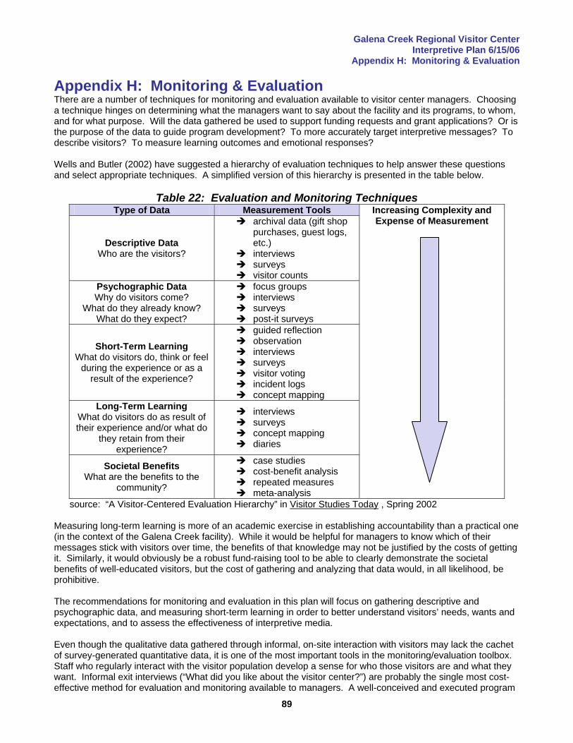
Galena Creek Regional Visitor Center Interpretive Plan 6/15/06
Appendix H: Monitoring & Evaluation
89
Appendix H: Monitoring & Evaluation There are a number of techniques for monitoring and evaluation available to visitor center managers. Choosing a technique hinges on determining what the managers want to say about the facility and its programs, to whom, and for what purpose. Will the data gathered be used to support funding requests and grant applications? Or is the purpose of the data to guide program development? To more accurately target interpretive messages? To describe visitors? To measure learning outcomes and emotional responses? Wells and Butler (2002) have suggested a hierarchy of evaluation techniques to help answer these questions and select appropriate techniques. A simplified version of this hierarchy is presented in the table below.
Table 22: Evaluation and Monitoring Techniques
Type of Data Measurement Tools
Descriptive Data Who are the visitors?
archival data (gift shop purchases, guest logs, etc.)
interviews surveys visitor counts
Psychographic Data Why do visitors come?
What do they already know? What do they expect?
focus groups interviews surveys post-it surveys
Short-Term Learning What do visitors do, think or feel
during the experience or as a result of the experience?
guided reflection observation interviews surveys visitor voting incident logs concept mapping
Long-Term Learning What do visitors do as result of their experience and/or what do
they retain from their experience?
interviews surveys concept mapping diaries
Societal Benefits What are the benefits to the
community?
case studies cost-benefit analysis repeated measures meta-analysis
Increasing Complexity and Expense of Measurement
source: “A Visitor-Centered Evaluation Hierarchy” in Visitor Studies Today , Spring 2002 Measuring long-term learning is more of an academic exercise in establishing accountability than a practical one (in the context of the Galena Creek facility). While it would be helpful for managers to know which of their messages stick with visitors over time, the benefits of that knowledge may not be justified by the costs of getting it. Similarly, it would obviously be a robust fund-raising tool to be able to clearly demonstrate the societal benefits of well-educated visitors, but the cost of gathering and analyzing that data would, in all likelihood, be prohibitive. The recommendations for monitoring and evaluation in this plan will focus on gathering descriptive and psychographic data, and measuring short-term learning in order to better understand visitors’ needs, wants and expectations, and to assess the effectiveness of interpretive media. Even though the qualitative data gathered through informal, on-site interaction with visitors may lack the cachet of survey-generated quantitative data, it is one of the most important tools in the monitoring/evaluation toolbox. Staff who regularly interact with the visitor population develop a sense for who those visitors are and what they want. Informal exit interviews (“What did you like about the visitor center?”) are probably the single most cost-effective method for evaluation and monitoring available to managers. A well-conceived and executed program
Galena Creek Regional Visitor Center Interpretive Plan 6/15/06
Appendix H: Monitoring & Evaluation
90
of more structured techniques should never exclude the anecdotal information for which front-line staff will develop an intuitive feel. A log of comments made to staff in an informal setting will be a valuable asset to facility managers. That said, the following monitoring and evaluation techniques are among those that might be considered for use at the Galena Creek Regional Visitor Center. Mail-back Questionnaire This survey instrument should be funded and developed as part of the exhibit design process so that it will be ready for distribution on the visitor center’s opening day. Establishing baseline data so that changes in the visitor population can be tracked over time is essential to an effective monitoring strategy, especially in a setting such as the Reno-Tahoe area where rapid population growth and social change are factors. The survey will be distributed to a random sample of visitors with a postage-paid envelope so that it can be completed at their convenience. The instrument should be crafted to measure basic visitor demographics as well as psychographics. It should measure short-term learning (and the effectiveness of interpretive and informational materials) by measuring visitors’ cognitive outcomes (i.e. awareness of a hiking opportunity or ability to answer a question about Washoe Indian culture). Visitors’ affective (emotional) responses to their experience should also be measured (i.e. whether they feel positively toward the partner agencies and motivated to support their missions) as well as behavioral outcomes (i.e. express an intention to clean up after their dog). Development costs can be expected to be significant, given that consultation from social scientists and the purchase of data-processing and storage software will be required. But subsequent costs for distribution will be small (envelopes, postage), and data entry can probably be accomplished with existing staff. Once the instrument is created and the computer system for storing, processing and analyzing the data is in place, it should be an affordable source of valuable information for many years. Data management software purchased for the purpose of this survey should have the capacity to process and integrate data from other sources (i.e. visitor counts). Guestbook/Post-It Surveys A guestbook located near the entry, or in another high-visibility location, is recommended. Visitors will be encouraged to enter their names, place of residence and comments. The most expensive aspect of managing this data will be staff time to process and catalog the written comments. The guestbook might be associated with a bulletin board for the delivery of time-sensitive information (i.e. weather). Wall space adjoining the bulletin board could be used for Post-It surveys. Post-It surveys are voluntary exercises in which visitors write a response to a question or statement on a Post-It note and stick it on a designated space on the wall. This communication is not strictly one-way, as dialogue can occur when one visitor comments on the opinion of another. Questions that could be asked range from management issues (Should horseback riders be required to clean up after their animals?) to programming (Should the visitor center offer a program about mountain lions?) to exhibits (Did you get the information you needed from the map?) to visitor services (How can we improve the visitor center?). Here again, staff time to compile and catalog the inputs is the major expense. Visitor Counts Visitor attendance can be measured with a click counter. Data entry should not take more than a few minutes each day, and could be integrated into the program to be developed for storage and analysis of the data generated by the mail-back questionnaire. Gift Shop Tracking Another simple, cost-effective way to gather demographic data is to record the zipcode of each visitor who makes a purchase in the gift shop. The clerk asks the buyer their zipcode and enters it into the cash register memory with the purchase record. The cash register will be programmed to produce a summary print-out at the end of the day. This information might be a valuable marketing tool as well.
Galena Creek Regional Visitor Center Interpretive Plan 6/15/06
Appendix H: Monitoring & Evaluation
91
Computer Tracking A touch-screen computer has been recommended to augment the recreation information available on the raised-relief map. There a number of ways that this hardware can also be used to gather information about visitors. Visitors can be asked to enter their zipcode, age, gender, etc., as part of a log-in process that would generate demographic data. Q-and-A (or other format) computer games based on exhibit content are not only enjoyed by many visitors (especially the young), but can provide solid measures of short-term learning and the effectiveness of various media. The proposed mail-back questionnaire could be computer-based as well (although there are obvious implications for skewing of the sample). Structured Interviews/Guided Reflection Structured interviews and guided reflection are techniques in which a visitor takes the time to talk one-on-one with a staff person, answering a set of open-ended questions and being encouraged to reflect on their experience and its meaning. Guided reflection (which asks a series of questions such as “What happened? Why did it happen? What might it mean?” and “What are its implications?”) and structured interviews are expensive not only to conduct but also in terms of processing and compiling the input. Nonetheless, if budgetary allowance can be made for design, staff training and at least several weeks of staff time per year, these techniques are one of the most effective ways to understand visitors’ non-quantifiable, emotional responses to their experience. Measuring a visitor’s emotional response should not be dismissed as touchy-feely New Age fluff: visitors who experience positive emotions are likely to be the most enthusiastic supporters of the missions of the partner agencies. A number of major corporations, particularly in Europe, have adopted guided reflection as a learning and motivational tool for executives. Focus Groups Focus groups are the tried-and-true method of gathering information about a group of people without resorting to large-scale random sampling of a population. It is recommended that a visitor center staff member be trained to conduct focus groups and hold sessions several times annually. Different segments of the visitor center audience should be studied: attendees at campfire programs, educators who have experience with outreach programs in their classrooms and schoolchildren who have participated in one of the outreach programs (or attended an on-site program). As with several of the other recommended techniques, processing, compiling and analyzing the non-numerical data is time-consuming and expensive. Focus group participants are also typically given some sort of reward, whether a souvenir t-shirt, free pizza during the session or other gift, and this is another cost that needs to be considered. Unobtrusive Observation There are some ethical consideration regarding unobtrusive observation, in which a staff person observes a visitor without their awareness and makes notes about their behavior. Watching someone without their knowledge is considered inappropriate by some people and organizations, and there may be legal implications as well, particularly in a Federal facility. Careful consideration of these issues, and consultation with an expert in the field should precede the implementation of any such program. Nonetheless, very valuable information on the effectiveness of exhibits, especially interactives, can be obtained simply by watching visitor behavior and recording it in a pre-arranged format (so that it can be cataloged and analyzed easily). Incident Logs One of the most pressing management issues identified in the interpretive design charrette was dealing with animal waste (and the owners of the animals producing the waste). It is suggested that a staff member walk a designated section of trail twice per week (on a weekday and a weekend) and record the occurrences of dog owners failing to clean up after their pets. Taken over time, and considered in the context of attendance levels, this would provide a fairly reliable indicator of whether interpretation targeted at dog owners was having the desired effect. A log of incidents of other inappropriate or illegal behavior should be kept as well.
Galena Creek Regional Visitor Center Interpretive Plan 6/15/06
Appendix H: Monitoring & Evaluation
92
Recommendations for Monitoring & Evaluation The integration of an evaluation and monitoring strategy into the design process represents an exceptional opportunity for the partner agencies to facilitate ongoing, affordable and efficient data collection (and a cutting-edge customer-orientation) into the future operations of the Galena Creek Regional Visitor Center. The preliminary recommendations for affordable evaluation and monitoring techniques follow, in order of priority.
1. Visitor Counts 2. Mail-back Questionnaire 3. Guestbook 4. Bulletin Board (for Post-It survey comments in addition to information function)
Other techniques may be desirable, but involve considerable investments of staff time, expense or both. The integration of information-gathering software into any computer-based exhibits is probably the first technique that might be considered in addition to the four priority techniques.

Galena Creek Regional Visitor Center Interpretive Plan 6/15/06
Appendix I: Overview of Recreational Learning
93
Appendix I: Overview of Recreational Learning This plan uses a customer-focused approach. An understanding of the reasons why people choose informal learning experiences, and how those experiences are structured leads to a better understanding of the customer, and ultimately a better chance of creating successful exhibits that meet customer needs. Following are a some broad generalizations about customers who seek out recreational learning experiences. These inferences are drawn from hundreds of studies of visitors to museums, science centers, zoos, parks, and other venues. People seek out recreational learning for “real” experiences.
Visitors come to see real objects (cultural or historic artifacts, living things, etc.) that aren’t typically encountered in everyday life, or to experience real phenomenon or processes such as light, color and sound, or to try out new technology.
Typical visits will average about two hours. The duration of visits to museums, nature centers, or similar facilities visits will vary widely, from less than an hour to a half-day or more. The median visit will average from about an hour to about 2 hours. Venues with several distinctly different modes of experience (e.g., a museum with an IMAX theater, a visitor center within a national park, etc.) will hold visitors for greater lengths of time.
Visitors will invest travel time in relative proportion to the amount of time they will spend at their destination.
Visitors generally expect to spend more time at their intended destination than the amount of time it takes to travel to and from the destination. A small museum that supports a one-hour visit will not, in and of itself, attract visitors who have to travel an hour or more to get there. Visitors may package or bundle several experiences together in cases where they feel a single attraction doesn’t warrant the travel time, or be attracted to a “heritage tour” or other prepackaged set of experiences.
Visitors choose how to spend their time.
Median stop times at interactive exhibits are under 3 minutes; stop times at static displays may be even shorter. Many visitors sample exhibits and activities, spending a few seconds at some exhibits, returning to favorite interactives to spend longer periods of time. A significant proportion of visitor time will be spent in activities not directly associated with exhibits, such as getting oriented, going to the restroom, visiting the gift shop, or talking about subjects unrelated to the visit.
Informal learning experiences are educational, social, and recreational. While frequent museum-visitors seek educational experiences as a high priority in their visits, infrequent museum-visitors may place a higher priority on the recreational and social aspects of visits to museums. Most museum visits are highly social (and are valued as such), with frequent interactions between peers, family members, and friends.
Visitors’ knowledge and interests influence what they do during a visit. Visitors come to a museum, visitor center, park or other informal educational setting with individual interests, preconceptions (sometimes erroneous), and individual learning styles.
The physical environment influences the visitor experience. Colors, weather, seating, the ergonomics of interactive exhibits, the environmental context, ease of movement from one space to another, and other physical dimensions of the learning environment significantly affect how much time visitors choose to spend and what they do.
Most visitors develop awareness, not knowledge, during a visit. In most cases, visitors leave with experiential memories, but not with a large body of new knowledge or information. These experiences can provide an important base for motivating further exploration and study of a topic (because the physical or aesthetic dimensions have been directly experienced).
Galena Creek Regional Visitor Center Interpretive Plan 6/15/06
Appendix I: Overview of Recreational Learning
94
Icon exhibits can make a visit memorable. “Icon” experiences (e.g., a spectacular vista, unusual or charismatic wildlife, a walk through the Franklin Institute’s walk-through heart, etc.) are often the most memorable aspects of a recreational learning experience.
Volunteers and staff can make a visit more significant. Customer service is important. Visitors like clean restrooms, easy way-finding, courteous and helpful staff, convenient amenities (a good place to eat, availability of strollers and changing rooms, etc.) and exhibits that are in good repair and that work. Visitor interactions with staff and volunteers can also make a lasting impressions.
Recreational learners tend to be better educated and more affluent than average. The demographics of visitors to museums, wineries, nature centers, and similar venues show that these visitors have higher incomes and higher levels of education than average.
Potential customers for recreational learning experiences are free agents. It is crucial to understand the customers’ needs, interests, skills, and preferred experiential modes to create effective interpretive exhibits that are a catalyst for vibrant, memorable experiences.
Galena Creek Regional Visitor Center Interpretive Plan 6/15/06 Appendix J: References
95
Appendix J: References Printed Materials Beck, L., & Cable, T., Interpretation for the 21st Century: Fifteen Guiding Principles for Interpreting Nature and Culture (Champaign, IL: Sagamore Publishing, 2002). Blackwell, L., Wildflowers of the Eastern Sierra and Adjoining Mojave Desert and Great Basin (Renton, WA: Lone Pine Publishing, 2002). Cordell, H.K., Outdoor Recreation for 21st Century America, (State College, PA: Venture Publishing, Inc., 2003). d’Azevedo, W.L., Straight with the Medicine: Narratives of Washoe Followers of the Tipi Way (Berkeley, CA: Heyday Books, 1978). d’Azevedo, W.L., ed., Handbook of North American Indians, Volume 11: Great Basin (Washingon, D.C.: Smithsonian Institution, 1986). DeLoney, James A., Nevadans Outdoors-A Survey on Outdoor Recreation in Nevada (Carson City, NV: Planning and Development Section, Nevada Division of State Parks, 2003). Ham, Sam, Environmental Interpretation: A Practical Guide for People with Big Ideas and Small Budgets (Golden, CO: Fulcrum Publishing, 1992). James, R., The Roar and the Silence: A History of Virginia City and the Comstock Lode (Reno, NV: University of Nevada Press, 1998). Knudson, D., et al., Interpretation of Cultural and Natural Resources (State College, PA: Venture Publishing, 2003). Lanner, R., Conifers of California (Los Olivos, CA: Cachuma Press, 1999). LaPage, W., Partnerships for Parks: A Handbook for Building and Guiding Park Partnerships (Tallahassee, FL: National Association of State Park Directors, 1994). Lukas, D. Watchable Birds of the Great Basin (Missoula, MT: Mountain Press Publishing Company, 1999). __________, National Survey on Recreation and the Environment (NSRE): 2000-2002 (Athens, GA: USDA Forest Service, Outdoor Recreation, Wilderness and Demographics Trends Research Group and Knoxville, TN: Human Dimensions Research Laboratory, University of Tennessee, Knoxville, 2005). Paruk, J., Sierra Nevada Tree Identifier (Yosemite National Park, CA: Yosemite Association, 1997). Shinn, Charles Howard, The Story of the Mine As Illustrated by the Great Comstock Lode of Nevada (Reno, NV: University of Nevada Press, 1980). Smith, Grant H., The History of the Comstock Lode (Reno, NV: Nevada Bureau of Mines and Geology in cooperation with the University of Nevada Press: 1943). Tilden, F., Interpreting Our Heritage (Chapel Hill, NC: University of North Carolina Press, 1957, 1967, 1977). __________, USDA Forest Service Interpretive Services Strategy (Washington, D.C.: United States Department of Agriculture, 2003). __________, USDA Forest Service Strategic Plan for Fiscal Years 2004-08 (Washington, D.C.: United States Department of Agriculture, 2004). Veverka, J., Interpretive Master Planning (Helena, MT: Falcon Press Publishing, 1994).
Galena Creek Regional Visitor Center Interpretive Plan 6/15/06 Appendix J: References
96
Wells, M., & Butler, B. “A Visitor-Centered Evaluation Hierarchy” in Visitor Studies Today! Spring 2002 (Arvada, CO: Visitor Studies Association, 2002). Internet-Based Resources National Survey on Recreation and the Environment
http://www.srs.fs.usda.gov/trends/Nsre/nsre2.html
USDA Forest Service Recreation Agenda http://www.fs.fed.us/recreation/programs/strategy/rec_agenda_ht.html
United States Census
http://www.census.gov/ Nevada Commission on Tourism
http://www.travelnevada.com/facts.asp Washoe County Regional Parks and Open Space
http://www.washoecountyparks.com/index.php Humboldt-Toiyabe National Forest
http://www.fs.fed.us/r4/htnf/ Travel Industry Association of America
http://www.tia.org/index.html Reno-Sparks Convention and Visitor Authority
http://www.visitrenotahoe.com/ American Fact Finder (U.S. Census Bureau)
http://factfinder.census.gov/home/saff/main.html?_lang=en USDA Forest Service Strategic Plan
http://www.fs.fed.us/publications/strategic/fs-sp-fy04-08.pdf#xml=http://www.fs.fed.us/cgi-bin/texis/searchallsites/search.allsites/xml.txt?query=%22USDA+Objective+5.1%22&db=allsites&id=42481c0c0
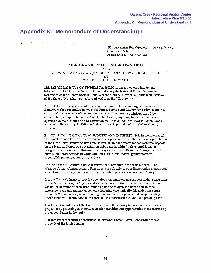
Galena Creek Regional Visitor Center Interpretive Plan 6/15/06
Appendix K: Memorandum of Understanding I
97
Appendix K: Memorandum of Understanding I
Galena Creek Regional Visitor Center Interpretive Plan 6/15/06
Appendix K: Memorandum of Understanding I
98
Galena Creek Regional Visitor Center Interpretive Plan 6/15/06
Appendix K: Memorandum of Understanding I
99
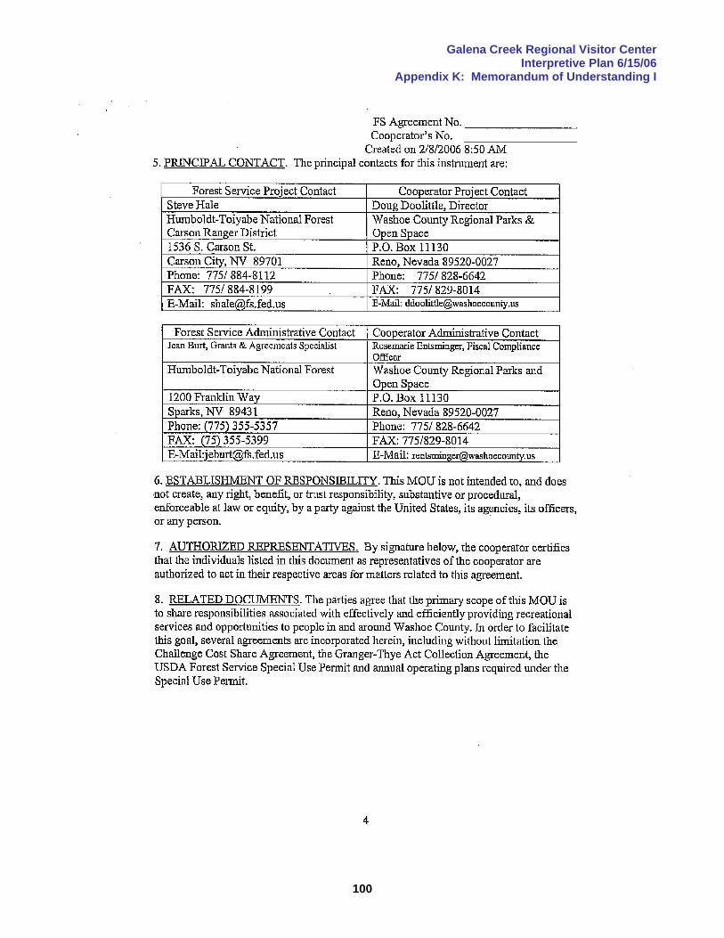
Galena Creek Regional Visitor Center Interpretive Plan 6/15/06
Appendix K: Memorandum of Understanding I
100

Galena Creek Regional Visitor Center Interpretive Plan 6/15/06
Appendix K: Memorandum of Understanding I
101

Galena Creek Regional Visitor Center Interpretive Plan 6/15/06
Appendix L: Memorandum of Understanding II
102
Appendix L: Memorandum of Understanding II <<<Insert copy of signed MOU here>>>
Related Documents