Gabriola Island Local Trust Committee Regular Meeting Agenda Date: November 28, 2019 Time: 10:30 am Location: Gabriola Arts & Heritage Centre 476 South Road, Gabriola Island, BC Pages 1. CALL TO ORDER 10:30 AM - 10:35 AM “Please note, the order of agenda items may be modified during the meeting. Times are provided for convenience only and are subject to change.” 2. APPROVAL OF AGENDA 3. REPORTS 10:35 AM - 10:55 AM 3.1 Trustee Reports 3.2 Chair's Report 3.3 Electoral Area Director's Report 4 - 4 3.4 First Nations Report 4. TOWN HALL 10:55 AM - 11:05 AM 5. MINUTES 11:05 AM - 11:10 AM 5.1 Local Trust Committee Minutes dated October 24, 2019 – for adoption 5 - 12 5.2 Section 26 Resolutions-Without-Meeting - none 5.3 Advisory Planning Commission Minutes - none 5.4 Housing Advisory Planning Commission Minutes dated October 10, 2019 - for receipt 13 - 15 6. BUSINESS ARISING FROM MINUTES 11:10 AM - 11:40 AM 6.1 Follow-up Action List dated November 20, 2019 16 - 18 7. APPLICATIONS AND REFERRALS 11:40 AM - 12:30 PM 7.1 GB-DVP-2017.1 and GB-DP-2017.2 (Weston - Acorn Island) - Staff Report 19 - 76 7.2 Telus Cell Tower Proposal - Staff Report 77 - 84 islandsTrust

Welcome message from author
This document is posted to help you gain knowledge. Please leave a comment to let me know what you think about it! Share it to your friends and learn new things together.
Transcript
Gabriola Island Local Trust CommitteeRegular Meeting Agenda
Date: November 28, 2019
Time: 10:30 am
Location: Gabriola Arts & Heritage Centre
476 South Road, Gabriola Island, BC
Pages
1. CALL TO ORDER 10:30 AM - 10:35 AM
“Please note, the order of agenda items may be modified during the meeting. Times areprovided for convenience only and are subject to change.”
2. APPROVAL OF AGENDA
3. REPORTS 10:35 AM - 10:55 AM
3.1 Trustee Reports
3.2 Chair's Report
3.3 Electoral Area Director's Report 4 - 4
3.4 First Nations Report
4. TOWN HALL 10:55 AM - 11:05 AM
5. MINUTES 11:05 AM - 11:10 AM
5.1 Local Trust Committee Minutes dated October 24, 2019 – for adoption 5 - 12
5.2 Section 26 Resolutions-Without-Meeting - none
5.3 Advisory Planning Commission Minutes - none
5.4 Housing Advisory Planning Commission Minutes dated October 10, 2019 - for receipt 13 - 15
6. BUSINESS ARISING FROM MINUTES 11:10 AM - 11:40 AM
6.1 Follow-up Action List dated November 20, 2019 16 - 18
7. APPLICATIONS AND REFERRALS 11:40 AM - 12:30 PM
7.1 GB-DVP-2017.1 and GB-DP-2017.2 (Weston - Acorn Island) - Staff Report 19 - 76
7.2 Telus Cell Tower Proposal - Staff Report 77 - 84
islandsTrust

8. LOCAL TRUST COMMITTEE PROJECTS 12:30 PM - 1:10 PM
8.1 Gabriola Housing Options and Impacts Review Project - verbal update
8.2 Ecological Protection Zone - Staff Report 85 - 100
9. DELEGATIONS
------- BREAK 1:10 PM to 1:30 PM -------
10. CORRESPONDENCE 1:30 PM - 1:35 PM
(Correspondence received concerning current applications or projects isposted to the LTC webpage)
10.1 Letter dated October 21, 2019 from Bruce Thomson regarding Bylaw No. 177 (HomeOccupations)
101 - 101
11. NEW BUSINESS
12. REPORTS 1:35 PM - 2:00 PM
12.1 Climate Change Action Update
12.2 First Nations Relationship Building
12.3 Trust Conservancy Report dated October, 2019 102 - 104
12.4 Applications Report dated November 20, 2019 105 - 112
12.5 Trustee and Local Expense Report dated September, 2019 113 - 113
12.6 Adopted Policies and Standing Resolutions 114 - 117
12.7 Local Trust Committee Webpage
13. WORK PROGRAM 2:00 PM - 2:20 PM
13.1 Top Priorities Report dated November 20, 2019 118 - 118
13.2 Projects List Report dated November 20, 2019 119 - 123
2

14. CLOSED MEETING 2:20 PM - 2:35 PM
14.1 Motion to Close the Meeting
That the meeting be closed to the public in accordance with the Community Charter,Part 4, Division 3, s.90(1) (d) and (i) for the purpose of considering Adoption of In-Camera Meeting Minutes dated October 24, 2019 and Legal Advice/BylawEnforcement and that the recorder and staff attend the meeting.
14.2 Recall to Order
14.3 Rise and Report
15. UPCOMING MEETINGS
15.1 Next Regular Meeting Scheduled for Thursday, January 16, 2020 at 10:30 AM at TheGabriola Arts and Heritage Centre, 476 South Road, Gabriola Island, BC
16. ADJOURNMENT 2:35 PM - 2:35 PM
3

Date: November 20 2019 To: Gabriola Island Trust Committee From: Vanessa Craig, RDN Director Area B Subject: Electoral Area Director’s Report
The Regional Parks and Trails Select Committee received a staff report with draft updated bylaws
that will apply to all community and regional parks in the RDN. The bylaw is updated to address
homeless camping, smoking and the use of cannabis, off-road vehicle use, and e-bike use in parks;
and updating the schedule of fees. The report was deferred until the February 2020 committee in
order to allow staff to consult with electoral area Directors on the section of the draft bylaws on
Homeless Camping Regulations.
The Community Grants Committee awarded over $19,000 in grants to Gabriola community groups.
This represented a relatively large amount relative to the funds available for the electoral areas,
and reflects the efforts of many committed groups in our area.
The RDN is currently undertaking a review of economic delivery models for the region, which is
influenced by a parallel review currently underway in the City of Nanaimo. The report
recommending an economic development model is expected in 2020. To ensure that economic
development activities continue here, the Board entered into a 1-year agreement to continue
funding support to the Gabriola Island Chamber of Commerce and the continued activities of the
Community Economic Development Officer.
A major item in the Board’s new strategic plan is addressing climate change. As a step in
implementing the Board’s strategic plan, the Board approved funding to develop a Corporate
Carbon Neutral 2032 Plan. In addition, the Board approved the creation of a Climate Action
Technical Advisory Committee.
As reported earlier, the RDN was the lead applicant on a CleanBC grant application to support the
installation of electric vehicle charging stations. If the grant is received, Gabriola will receive one of
the stations. Because the provision of electric vehicle charging stations is not currently an RDN
service, the RDN will proceed with an alternative approval process for the establishment of this
new service.
The Board will be proceeding with a full Regional Growth Strategy (RGS) review instead of
conducting a targeted growth strategy first as was originally the plan. Although Area B is not
included in the RGS, regional interests such as water quality, housing affordability, climate change,
and waste reduction are of interest to all residents of the RDN.
Some other activities that might be of interest:
o I was elected as Vice Chair of the RDN Board at the inaugural Board meeting for the coming
year.
Upcoming:
The Electoral Area Service Committee and the Committee of the Whole meetings are upcoming on
November 26th. The last Board meeting for the year is on December 10th.
I will be holding office hours at the Islands Trust office between 2-4 pm on December 2nd and
December 16th. Thank you to IT staff for allowing me to use this space.
Respectfully submitted,
Vanessa Craig
4

DRAFT
Gabriola Island DRAFT 1 Local Trust Committee Minutes October 23, 2019
Gabriola Island Local Trust Committee Minutes of Regular Meeting
Date: Location:
October 24, 2019 Rollo Seniors Centre 685 North Road Gabriola Island, BC
Members Present: Dan Rogers, Chair
Kees Langereis, Local Trustee Scott Colbourne, Local Trustee
Staff Present: Heather Kauer, Regional Planning Manager
Sonja Zupanec, Island Planner Jaime Dubyna, Planner 2 Nadine Mourao, Recorder
Others Present:
There were approximately three (3) members of the public and one (1) member of the media in attendance
1. CALL TO ORDER
“Please note, the order of agenda items may be modified during the meeting. Times are provided for convenience only and are subject to change.”
Chair Rogers called the meeting to order at 3:01 pm. He acknowledged that the meeting was being held in territory of the Coast Salish First Nations, welcomed the public and introduced Trustees, Staff and Recorder.
2. APPROVAL OF AGENDA
The following addition to the agenda was presented for consideration:
4.3 Electoral Area Director’s Report.
By general consent the agenda was approved as amended.
3. TOWN HALL
A member of the public asked the Local Trust Committee (LTC) to prioritize ecological zone development.
4. REPORTS
4.1 Trustee Reports
Trustee Colbourne reported his attendance at the following meetings and events:
Trust Council (TC);
Gabriola Talks;
5
®3IslandsTrust
DRAFT
Gabriola Island DRAFT 2 Local Trust Committee Minutes October 23, 2019
Island Trust 2050 Policy Talks;
A tour of Burren’s Acres with Margaret Taylor;
Gabriola Community Bus Foundation Annual General Meeting;
Ferry Advisory Committee meeting;
Ministry of Transportation and Infrastructure (MoTI) meeting October 30, 2019;
Panelist on Climate Action event at Vancouver Island Economic Summit; and
Meetings regarding secondary access points for emergency planning.
Trustee Langereis reported his attendance at the following meetings and events:
TC;
Local Planning Committee (LPC);
Housing Advisory Planning Commission (HAPC);
Islands Trust 2050 Policy Talks:
Gabriola Talks; and
Noted that milling of lumber on properties needs to be revisited.
4.2 Chair's Report
Chair Rogers reported the following:
Attended TC;
Attended Union of British Columbia Municipalities (UBCM) conference;
Met with the Minister of Indigenous Relations regarding the United Nations Declaration on the Rights of Indigenous Peoples (UNDRIP);
Attended Financial Planning Committee (FPC); and
Attending Howe Sound Community with Clare Frater, Director Trust Area Services.
4.3 Electoral Area Director's Report
Chair Rogers summarized the report and noted the following:
Village Way negotiations with MoTI continue;
Funding has been delayed for Huxley Park Phase 2;
Roll out of the new automated waste collection program has begun;
Regional District of Nanaimo (RDN) participating in the BC Agriculture and Food Climate Action Initiative (CAI);
RDN conducting community and stakeholder consultation on the Official Community Plan (OCP) and bylaw amendments for Nanaimo Airport lands;
Replaced beach access stairs at Blue Whale and Hummingbird Community parks; and
Attending meeting with Trustees and MoTI regarding Barrett/North road.
GB-2019-106 It was MOVED and SECONDED that the Gabriola Island Local Trust Committee request Staff to initiate protocol meetings with the Regional District of Nanaimo.
CARRIED
5. MINUTES
5.1 Local Trust Committee Minutes dated September 12, 2019 – for adoption
6

DRAFT
Gabriola Island DRAFT 3 Local Trust Committee Minutes October 23, 2019
The following amendments to the meeting minutes of September 12, 2019 were presented for consideration:
Page 3, 7.1 GB-DVP-2019.2, second bullet, change “would require another Development Variance Permit (DVP)” to “would require another DP.”
By general consent the Local Trust Committee meeting minutes of September 12, 2019 were adopted as amended.
5.2 Housing Advisory Planning Commission Minutes dated September 26, 2019 - for receipt
Received.
6. BUSINESS ARISING FROM MINUTES
6.1 Follow-up Action List dated September 17, 2019 –
Planner Zupanec provided an overview of items.
6.2 Climate Change Adaptation and Mitigation Strategies - Memorandum - for information only
Received for information.
Trustees requested further future discussion around priorities and actions around climate change.
7. APPLICATIONS, BYLAWS AND REFERRALS
7.1 GB-RZ-2019.1 (BC Ferries - Gabriola Ferry Terminal) - Staff Report
Planner Dubyna summarized the report which documented progress on a number of deliverables requested by Trustees and noted the following:
Staff have received a copy of the Archeological Impact Assessment (AIA); and
Snuneymuxw First Nations to submit a written response, not received to date.
Discussion ensued and the following was noted by Trustees:
Interested in whether the AIA is shared with local First Nations;
Would like to hear if there are any concerns from Local First Nations;
Expressed concern with the zoning line down the middle of North Road and who will be responsible for line up issues;
Enquired whether the emergency dock and access will remain;
Requested that the word “pedestrian” be referenced as people who walk, bike, e-bike etc.;
Enquired about water lease; and
Requested draft bylaws for LTC meeting in November.
John Steil (Stantec) on behalf of BC Transportation Financing Authority and BC Ferry Services Inc. noted:
Would like to move forward with project and requested LTC expedite wherever possible;
7
DRAFT
Gabriola Island DRAFT 4 Local Trust Committee Minutes October 23, 2019
BC Ferries has a separate First Nations consultation process and will submit contact log;
Will preserve emergency dock and formalize access; and
Have submitted water license.
GB-2019-107 It was MOVED and SECONDED that the Gabriola Island Local Trust Committee direct Staff to prepare a draft bylaw to amend Gabriola Island Official Community Plan Bylaw No. 166, 1997, consistent with draft bylaw language presented in Attachment 1, Table 1 of the Staff Report dated October 24, 2019 for GB-RZ-2019.1 (BC Ferries).
CARRIED GB-2019-108 It was MOVED and SECONDED that the Gabriola Island Local Trust Committee direct Staff to prepare a draft bylaw to amend Gabriola Island Land Use Bylaw No. 177, 1999, consistent with draft bylaw language presented in Attachment 1, Table 2 of the Staff Report dated October 24, 2019, for GB-RZ-2019.1 (BC Ferries).
CARRIED
By general consent the meeting was recessed at 4:35 pm and reconvened at 4:39 pm.
7.2 GB-DVP-2018.6 (Durrance - 538 Wildwood Crescent) - Staff Report
Planner Zupanec provided an overview of the report which asked the LTC to re-consider application GB-DVP-2018.6 for a Development Variance Permit (DVP) to authorize the siting of an existing sewage disposal system, rock wall and stair case, which currently contravene Gabriola Island Land Use Bylaw No. 177, 1999 (LUB) setback regulations and noted the following:
There is a notice on file; and
All conditions have been met.
GB-2019-109 It was MOVED and SECONDED that the Gabriola Island Local Trust Committee issue Development Variance Permit GB-DVP-2018.6.
CARRIED
7.3 Telus Cell Tower Proposal – Deferred to November 28th LTC meeting
8. LOCAL TRUST COMMITTEE PROJECTS
8.1 Cannabis Regulations Project (Bylaw No. 303) - Staff Report
Planner Zupanec summarized the report which asked the LTC to consider a minor amendment to the proposed Bylaw No. 303 at second reading and recommended the bylaw be advanced to a Community Information Meeting (CIM) and public hearing.
Discussion ensued and the following key points were noted by Trustees:
Suggested usage of floor area as a unit of measurement instead of surface area;
8

DRAFT
Gabriola Island DRAFT 5 Local Trust Committee Minutes October 23, 2019
Definition number 3, definition of cannabis products, add “topicals”, and add to the end of the sentence “personal use”;
Definition number 5, define that height only implies to cannabis production and not mixed-use buildings, interested in limited micro cultivation; and
Requested Staff prepare track changes document for LTC consideration before CIM.
GB-2019-110 It was MOVED and SECONDED that the Gabriola Island Local Trust Committee request Staff to prepare draft amendments for proposed Bylaw 303, taking into account input from the October 24, 2019 Gabriola Island Local Trust Committee meeting and provide a “track changes” version of the existing Bylaw for the Community Information Meeting.
CARRIED
9. DELEGATIONS - none
10. CORRESPONDENCE
(Correspondence received concerning current applications or projects is posted to the LTC webpage)
10.1 Petition regarding Proposed Model Strategy for Antenna Systems
Received.
11. NEW BUSINESS
11.1 2020 Local Trust Committee Meeting Schedule – Memorandum
GB-2019-111 It was MOVED and SECONDED that the Gabriola Island Local Trust Committee schedule its regular business meetings on the following dates in 2020: January 16, February 27, April 2, May 14, June 25, July 30, September 10, October 22, and November 26.
CARRIED
11.2 Gabriola Sounder Calendar - for discussion
GB-2019-112 It was MOVED and SECONDED that the Gabriola Local Trust Committee authorize the expenditure of $315.00 plus Goods and Services Tax for publication of Gabriola Island Local Trust Committee meeting dates in the Gabriola Sounder calendar.
CARRIED
11.3 Grant Opportunity – 2020 Poverty Reduction Planning & Action Programs – for discussion
Trustee Colbourne asked the LTC to consider a grant opportunity for a Poverty Reduction Strategy through the UBCM and noted the following points:
LTC to work collaboratively with Angela Pounds, Gabriola Social Worker, local agencies and community groups to apply for grant;
Internal expression of interest due December 30, 2019;
9
DRAFT
Gabriola Island DRAFT 6 Local Trust Committee Minutes October 23, 2019
Grant application deadline February 28, 2020;
Grant will help identify gaps in why community needs housing and inform the HAPC;
UBCM will only consider one application from local government; and
Grant may potentially address Gabriola’s high child poverty rate.
GB-2019-113 It was MOVED and SECONDED that the Gabriola Island Local Trust Committee request Staff to create a project to draft an application for Poverty Reduction Strategy grant through the Union of British Columbia Municipalities.
CARRIED
11.4 Response from Minister of Transportation regarding Gabriola Island Active Transportation Plan
Trustees noted the following key points:
Felt the response from the Minister of Transportation was unsatisfactory;
Requested that Executive Committee are given copy of correspondence from the Minister of Transportation and write a letter in response; and
Requested updates regarding meeting with MoTI attended by David Marlor, Director of Local Planning Services.
12. REPORTS
12.1 Trustee and Local Expense Report dated August, 2019
Received.
12.2 Adopted Policies and Standing Resolutions
Received.
12.3 Climate Change Action Update
Received.
12.4 First Nation Relationship Building
Discussion ensued and the following points were noted by Trustees:
Expressed interest in having “First Nations Report” in “Reports” section of agenda; Interested in continuing to develop an authentic dialogue with Snuneymuxw First
Nations;
Requested Lisa Wilcox, Senior Intergovernmental Policy Advisor, to do presentation and/or outreach; and
Trustee Langereis to do some exploratory research and budget analysis.
GB-2019-114 It was MOVED and SECONDED that the Gabriola Island Local Trust Committee request Staff to add a standing item to the Agenda for “First Nations Reports” in section 4.4 under Reports.
CARRIED
10

DRAFT
Gabriola Island DRAFT 7 Local Trust Committee Minutes October 23, 2019
12.5 Trust Conservancy Report - none
12.6 Local Trust Committee Webpage
No updates requested.
13. WORK PROGRAM
13.1 Top Priorities Report dated October 17. 2019 - none
13.2 Projects List Report dated October 17, 2019 – none
Trustees requested that they would like to go through the projects list at the next meeting and prioritize.
14. CLOSED MEETING
14.1 Motion to Close the Meeting
GB-2019-115 It was MOVED and SECONDED that the meeting be closed to the public in accordance with the Community Charter, Part 4, Division 3, s.90(1) (a), (c) and (d) for the purpose of considering Advisory Planning Commission Appointments, Labour Relations or other Employee Relations and Adoption of In-Camera Meeting Minutes dated September 12, 2019 and that the recorder and staff attend the meeting.
CARRIED
Chair Rogers closed the meeting to the public at 6:06 pm.
14.2 Recall to Order
By general consent the meeting was recalled to order 6:22 pm.
14.3 Rise and Report
Angela Pounds, Jeff Malmgren, Susan Yates, Robert Plowright, Don Elkington, Deb Ferens, Peter Maidstone, Jennefer Laidley and Lisa Webster-Gibson were appointed to the Advisory Planning Commission and that the minutes from September 12, 2019 In-Camera meeting were adopted.
15. UPCOMING MEETINGS
15.1 Next Regular Meeting Scheduled at 10:30 am, Thursday, November 28, 2019 at The Gabriola Arts and Heritage Centre, 476 South Road, Gabriola Island, BC
16. ADJOURNMENT
By general consent the meeting was adjourned at 6:23 pm.
11

DRAFT
Gabriola Island DRAFT 8 Local Trust Committee Minutes October 23, 2019
_________________________ Dan Rogers, Chair Certified Correct: _________________________ Nadine Mourao, Recorder
12

DRAFT
Gabriola Island DRAFT 1 Housing Advisory Planning Commission Minutes October 10, 2019
Minutes of the Gabriola Island Housing Advisory Planning Commission
Date of Meeting: Thursday, October 10, 2019 Location:
Islands Trust Office 700 North Road, Gabriola, BC
HAPC Members Present:
Steven Earle, Chair Tobi Elliot, Secretary Dyan Dunsmoor-Farley Angela Pounds John Woods Dave Neads
Regrets: Staff Present:
Howard Houle Heather Cameron Sonja Zupanec, Island Planner Margot Thomaidis, VIU Nadine Mourao, Recorder
Others Present: There was one (1) member of the public in attendance 1. CALL TO ORDER AND WELCOME
Chair Earle called the meeting to order at 7:00 pm. He acknowledged that the meeting was being held in territory of the Coast Salish First Nations, welcomed the public and introduced Commission Members, Staff and Recorder.
2. APPROVAL OF AGENDA
By general consent the agenda was approved.
The following amendments/additions to the agenda were presented for consideration:
Add 4.3 Promotion for Fall Event; and
Add 6. First Nation Engagement Consideration with Lisa Wilcox, Senior Intergovernmental Policy Advisor.
By general consent the agenda was approved as amended.
3. MINUTES - Gabriola Island Housing Advisory Planning Commission Draft Minutes dated September 26, 2019 – for Adoption
The following amendments/additions to the Housing Advisory Planning Commission meeting minutes of September 26, 2019 were presented for consideration:
Page 1, remove “John Woods” from “HAPC Members Present:”.
13
@11isIcmdsTmst

DRAFT
Gabriola Island DRAFT 2 Housing Advisory Planning Commission Minutes October 10, 2019
By general consent the Housing Advisory Planning Commission meeting minutes of September 26, 2019 were approved as amended.
4. DESIGN PUBLIC ENGAGEMENT LAUNCH
4.1 Margot Thomaidis presentation for Fall event, the purpose of which is to describe the overall objectives of this project, and to ask for ideas on how to get the community involved.
Margot Thomaidis summarized the memo regarding November 4th Engagement Strategy Event and noted the following:
Intention of the event is to introduce the Housing Advisory Planning Commission (HAPC), briefly explain their goals, and to further engage the community;
Staff to prepare script parameters to send out to possible presenters framing a common theme and limiting scope; and
Margot will manage logistic contact with presenters.
Discussion ensued and the following key points were noted by members:
Interested in including reconciliation and indigenous perspectives in event;
Requested a representative from the business community as a presenter;
Suggested recorded persons at risk presentation, Tobi Elliot may be able to assist with this;
Interested in a musician or spoken word artist such as Lisa Webster-Gibson; and
Suggested event name “Stories About Home: Exploring Key Themes to Address Gabriola’s Housing Needs While Protecting the Environment.”
4.2 List potential participants and point person to secure their participation.
Introduction and opening: o Snuneymuxw Elder Geraldine Manson (C’tasi:a); o Dave Bodaly; o Trustees Scott Colbourne or Kees Langereis;
Master of Ceremonies: HAPC member, possibly Dyan Dunsmoor-Farley;
Theme 1 – Housing Diversity and Affordability: o Pat Maloney; o Councillor Erin Hemmens, Health & Housing Taskforce; o Martha Taylor, Salt Spring Community Health Society; o Warren Fraleigh, The Haven;
Theme 2 – People at Risk: o Person at Risk, Tobi Elliot to source; o Brenda Fowler, People for a Healthy Community (PHC); o Tracey Thorne, Gabriola General Practitioner; o Patty Evans, Royal Canadian Mounted Police (RCMP);
Theme 3 – Environment and Cultural Heritage: People in the Context of Place:
14

DRAFT
Gabriola Island DRAFT 3 Housing Advisory Planning Commission Minutes October 10, 2019
o Melanie Mamoser; o Kate Emmings, Islands Trust Conservancy; o Lisa Wilcox, Senior Intergovernmental Policy Advisor;
Conclusions: o Dotmocracy; and o Commentary stations with HAPC members.
4.3 Promotion of Fall Event
Staff to create summary sheet for presenters, email alert to Islands Trust (IT) subscribers list, distribute poster for event (print and pdf version), and put ad in the Gabriola Sounder newspaper. Asked members to email pdf poster to their organizational contacts.
5. WEBSITE DESIGN
5.1 Discuss development of website as engagement portal for the public.
Defer to next meeting
6. First Nations Engagement Consideration with Lisa Wilcox, Senior Intergovernmental Policy Advisor
Staff suggested an online meeting for First Nations Engagement orientation, will send out Doodle Poll to members.
7. ADJOURNMENT
Tobi Elliot to send out Doodle Poll for next meeting to be held prior to November 4th Event. By general consent, the meeting was adjourned at 8:41 pm.
_________________________ Steven Earle, Chair Certified Correct: _________________________ Nadine Mourao, Recorder
15

Print Date: November 20, 2019
Follow Up Action Report
Gabriola Island
Responsibility Dates Activity
24-Jan-2019
Status
In ProgressLisa Wilcox
Sonja Zupanec
1 Staff to prepare a draft letter under the signature of the LTC chair to
advise the First Nations with an interest in the Gabriola LTA of the LTC's
Top 3 Priority Projects currently underway.
Responsibility Dates Activity
16-May-2019
Status
In ProgressBecky McErlean
Bronwyn Sawyer
1 GB-DVP-2019.1 (Huxley Park) - LTC waived requirement for BCLS survey;
issued DVP subject to receipt of a planting plan to mitigate tree
loss/reduction in area for tree removal and reduction in parking area
(see resolution from minutes). Staff to follow up with RDN on submission
requirements and issuance of DVP.
Responsibility Dates Activity
11-Jul-2019
Status
In ProgressIan Cox 1 Staff to prepare draft bylaws for the ecological protection zone with site
specific provisions for Coats Marsh and B. Acres.
Responsibility Dates Activity
12-Sep-2019
Status
Page 1 of 3 16
IslandsTrust

Print Date: November 20, 2019
Follow Up Action Report
Gabriola Island
Responsibility Dates Activity
12-Sep-2019
Status
In ProgressBronwyn Sawyer
Sonja Zupanec
1 Housing Options and Impacts Review Project: notify HAPC to proceed
with referral as per recommendation. Expenditures approved for HAPC
workplan session; community engagement activity; VIU intern and
website development for project. Target Oct 24 for petcha kutcha style
engagement activity in the evening.
In ProgressBecky McErlean
Ian Cox
2 GB-DP-2017.1 and DVP-2017.1 - amend covenant as per LTC minutes;
accept covenant as amended and staff to consult with Lisa Wilcox and
First Nations.
Responsibility Dates Activity
24-Oct-2019
Status
CompletedBecky McErlean
Heather Kauer
1 Add to the November 28th agenda under business arising from minutes -
climate action next steps - for discussion.
In ProgressJaime Dubyna 2 GB-RZ-2019.1 (BC Ferries) - Staff be directed to prepare draft bylaws to
amend the OCP and LUB consistent with draft bylaw language presented
in Oct 24 staff report.
CompletedBecky McErlean
Sonja Zupanec
3 GB-DVP-2018.6 issued by LTC
Issued and registered on Title
Page 2 of 3 17
IslandsTrust

Print Date: November 20, 2019
Follow Up Action Report
Gabriola Island
Responsibility Dates Activity
24-Oct-2019
Status
In ProgressHeather Kauer 4 Proposed BL 303 - staff be requested to prepare draft amendments
consistent with Trustee input and prepare a track-changes version of the
proposed bylaw for consideration.
In ProgressSonja Zupanec 5 Add to the Project List a new project "Draft Application for a Poverty
Reduction Strategy from UBCM"
Target: 24-Oct-2019
CompletedWil Cottingham 6 GB LTC meeting schedule for 2020 accepted as presented and
expenditure for advertising in the Sounder calendar.
CompletedBecky McErlean 7 Staff to add 'First Nations report" under 4.4 for all future LTC agendas.
CompletedPenny Hawley 8 GB LTC appointed all nine expressions of interest to the APC. Staff to
notify the members and organize a date for orientation.
Page 3 of 3 18
IslandsTrust

STAFF REPORT
Staff Report
Islands Trust GB-DVP-2017.1 & GB-DP-2017.2 (WESTON) 1 of 6
File No.: GB-DVP-2017.1 and GB-DP-2017.2 (WESTON)
DATE OF MEETING: November 28, 2019
TO: Gabriola Island Local Trust Committee
FROM: Ian Cox, Planner 1 Northern Team
SUBJECT: Staff Report for GB-DVP-2017.1 and GB-DP-2017.2 (WESTON)
Applicant: Judith Weston
Location: Acorn Island PID 009-796-045; District Lot 19 (Flat Top Islands), Nanaimo District
RECOMMENDATIONS:
1. THAT the Gabriola Island Local Trust Committee approve issuance of Development Variance Permit GB-DVP-2017.1 conditional upon confirmation of registration of the restrictive environmental covenant as amended by the LTC on September 12, 2019 and of the registration of a notice on the subject property land title pursuant to Section 32 of the Heritage Conservation Act for the protection of archaeological resources;
AND
2. That the Gabriola Island Local Trust Committee approve issuance of Development Permit GB-DP-2017.2 following the issuance of GB-DVP-2017.1.
REPORT SUMMARY
The Gabriola Island Local Trust Committee (LTC) is asked to consider Development Variance Permit (DVP) application GB-DVP-2017.1 and Development Permit (DP) application GB-DP-2017.2 arising out of bylaw enforcement GB-BE-2007.8 for unauthorized development on Acorn Island. The main discussion points in support of the above recommendations are:
1. Prior to the issuance of GB-DVP-2017.1, the property owner be required to grant and register the restrictive environmental covenant in favour of the Gabriola Island Local Trust Committee (LTC) as amended by the LTC on September 12, 2019, that mitigates and compensates for estimated habitat losses;
2. Issuance of GB-DP-2017.2 should be subject to the issuance of GB-DVP-2017.1 and conditions included as part of the permit, which are reflective of the Development Permit Area Guidelines (Attachment 1);
3. In lieu of the archaeological covenant that was developed originally to accompany the environmental protection instrument, a notice under Section 32 of the Heritage Conservation Act should be placed on the land title to protect the archaeological and heritage resources on the island from disturbance or destruction resulting from future development. This course of action is pursuant to staff communication with the provincial Archaeological Branch.
19
islandsTmst

Staff Report
Islands Trust GB-DVP-2017.1 & GB-DP-2017.2 (WESTON) 2 of 8
In summary, the restrictive environmental covenant and the HCA notice should be registered to the property title prior to issuance of the DVP and DP, as recommended by staff in this report. The HCA notice is voluntary and at the discretion of the property owner and not a requirement by LTC resolution - hence the need for confirmation of registration be received before issuance of the DVP and DP. In this way, archaeological and heritage resources would be protected prior to any work commencing via issuance of the permits or for future development on the property. For additional information on the history of development on the island from the perspective of the property owner and their family, please refer to Attachment 6 – Letter of Support by Dr Darlene Weston (November 13, 2019).
BACKGROUND
LTC Resolutions
Both the DVP and DP applications have been open for more than two years. At its regular business meeting on September 12, 2019, the LTC discussed a staff report that included an update on the applications and passed the following resolutions after consideration of the draft environmental covenant, as well as matters related to First Nations referrals and engagement in light of the Reconciliation Declaration made by Trust Council earlier this year:
GB-2019-091
It was MOVED and SECONDED
that the Gabriola Island Local Trust Committee amend the covenant under Section 219 of the Land Title
Act from the registered owners of District Lot 19 (Flat Top Islands), Nanaimo District, PID 009-796-045, add
to Section 9 “with the exception of 3 (d)” as it is an ongoing provision.
CARRIED
GB-2019-092
It was MOVED and SECONDED
that the Gabriola Island Local Trust Committee accept a covenant, as amended, under Section 219 of the Land Title Act from the registered owners of District Lot 19 (Flat Top Islands), Nanaimo District, PID 009-796-045, and authorize the Chair and one other member of the Local Trust Committee as signatories to the covenant (GB-DP-2017.2, GB-DVP-2017.1). CARRIED GB-2019-093
It was MOVED and SECONDED
that GBLTC request Staff to consult with Lisa Wilcox, Senior Intergovernmental Policy Advisor and do subsequent follow up with Snuneymuxw and other First Nations with interest in Gabriola Island. CARRIED
Following the September 12 meeting, staff spoke with the applicant’s legal counsel regarding next steps and to
clarify points that were not clearly understood due to phone-in logistics during the meeting when the LTC was
discussing matters related to the restrictive covenant. The lawyer was made aware of LTC resolution GB-2019-093
and staff was able to provide clarity on how this might impact the timeline for consideration of the permits.
First Nations Referrals
Following the above conversation with the applicant’s lawyer, staff contacted Snuneymuxw First Nation in order
to re-establish contact and discussion which had commenced in 2017 when staff had originally referred and
discussed the DVP and DP applications with the Nation’s representative. At that time, Snuneymuxw indicated
20

Staff Report
Islands Trust GB-DVP-2017.1 & GB-DP-2017.2 (WESTON) 3 of 8
that they had general concerns regarding cultural heritage. No written comment was provided at that time and
staff has not received any formal written comment since then. However, understanding that Snuneymuxw did
have concerns and following the LTC direction provided at its regular business meeting on September 12, 2019,
the applications were re-referred to Snuneymuxw First Nation and to First Nations with interest in the area on
October 8th. Staff attempted to follow up with the Snuneymuxw referral via telephone and email - the most
recent on November 13. No further comments have been received at the time of writing this report.
In addition, a referral letter explaining the LTC receipt and intent of the DVP and DP applications (see
Attachment 2) was sent on October 8, 2019 to the following First Nations with interest in the area as identified
using the provincial Consultative Areas Database:
Snuneymuxw First Nation
Stz'uminus First Nation
Lake Cowichan First Nation
Halalt First Nation
Lyackson First Nation
Penelakut Tribe
Cowichan Tribes
At the time of writing this report, the following Nations have provided written comment on the referral
material:
Community Date of response Comments
Cowichan Tribes October 9, 2019 No comment on permit applications.
shíshálh Nation October 8, 2019
Please do not make a decision regarding this application prior to receiving the shíshálh Nation response. Note: Area of application not within stated Territory identified in the “shíshálh Nation Lands and Resources Decision-Making Policy”1
On November 14, staff sent an email letter to the referrals coordinator for shíshálh First Nation stating the
November 28 date, time, and place the LTC would be considering the permits and that both staff and the LTC
would welcome any concerns and comments received prior. At the time of writing this report, no further
comments have been received.
Protection for Archaeological and Heritage Resources
On May 25, 2018, the provincial Archaeology Branch (the Branch) noted the following via email to staff, referring
to a proposed covenant for the protection of archaeological resources:
1 https://shishalh.com/wp-content/uploads/2018/10/Decision-Making-Policy.pdf
21

Staff Report
Islands Trust GB-DVP-2017.1 & GB-DP-2017.2 (WESTON) 4 of 8
To complete this kind of covenant (under Section 219 of the Land Title Act), an Archaeologist needs to
conduct subsurface testing, working with a BC surveyor, to accurately map the boundaries of the
archaeological site on the subject property…. An alternative is to use HCA Section 32 and place a notice on
title, which encompasses the entire property and would require an AIA prior to any development or land
altering activities, including removals of any existing structures.
Subsequently, a draft covenant was developed by Islands Trust legal counsel for the protection of archeological
resources. However, since the covenant would require an Archaeological Impact Assessment (AIA) for the entire
property per Branch recommendation, the property owner has indicated they would prefer to register a notice
on title.
The following was provided as part of the staff report dated September 12, 2019 pertaining to the applications:
“On March 14, 2019, Trust Council adopted a Reconciliation Declaration2 intended to inform all consideration and decisions made by Islands Trust elected officials and staff in regard to reconciliation and First Nations relations.
Archaeological sites are protected by The Heritage Conservation Act (HCA), whether on Provincial Crown or private land. They are non-renewable, very susceptible to disturbance and are finite in number. Archaeological sites are an important resource that are protected for their historical, cultural, scientific and educational value to the general public, local communities and First Nations. Impacts to archaeological sites must be avoided or managed by development proponents.3
The removal of certain unlawful structures is required by conditions of the DVP and it has
therefore been necessary for the applicant to consult with the Branch since there are identified
and potential sites on the island. It is recommended that the property owner continue the dialog
begun with the Branch regarding any and all development plans in order to ascertain the need for
additional permitting that may be required under the Heritage Conservation Act. The registration
of the HCA Section 32 notice on title will help to ensure this under current and future ownership
of the property.”
Given that there is no further development proposed by the applications save the removal of those structures
identified by the DVP and the mitigation and remediation measures stipulated by the covenant and DP, staff would
recommend moving forward with the second option that the Archaeology Branch has recommended and the
property owner has agreed to accord.
Environmental Protection Covenant
On September 10, 2019, the applicant’s lawyer indicated to staff via email that they had received the amended
version of the draft environmental covenant which included the all terrain vehicle (ATV) access trail and that they
were willing to grant and sign the covenant. The covenant was then amended by LTC resolution on September 12,
2019 to add to Section 9 the exemption of 3(b). The property owner has since accepted and signed the amended
covenant in preparation for registration with the Land Titles Office.
2 http://www.islandstrust.bc.ca/media/347494/reconciliation-declaration.pdf 3 http://www.frontcounterbc.ca/pdf/ArchaeologicalChanceFindProcedure.pdf
22

Staff Report
Islands Trust GB-DVP-2017.1 & GB-DP-2017.2 (WESTON) 5 of 8
Issues and Opportunities
Eagle’s Nest Cabin | LUB Setback to Nesting Trees
Although no formal resolution was made on this matter, the LTC expressed concern with the siting of the existing
structure called “Eagle’s Nest Cabin” as described on the DVP site plan. The LTC directed staff to provide more
information in relation to provincial and Land Use Bylaw (LUB) requirements for setbacks to the existing eagle’s
nest in the immediate vicinity - more specifically, whether there was adequate rational to allow the building to
remain and be legally sited by way of issuance of the DVP. Further, that there would likely be the need to vary
Section B.2.1.3 of the LUB that requires a 7.5 metre setback to nesting trees. It is staff’s understanding that the
existing cabin was constructed prior to the LUB provision and that further disturbance to the nest could be caused
by its removal. Caurinus Environmental Ltd. has provided a letter stating professional opinion and rationale,
including mitigation measures to ensure the least disturbance to the nest if the existing cabin were permitted to
remain in place (see Attachment 3). The 0 metre setback variance request has been added to the draft DVP for
LTC consideration (See Attachment 4) and the mitigation measures recommended by Caurinus Environmental
added as conditions to the DP (see Attachment 5).
Timeline for Works required by DP and DVP
As identified by their legal counsel, of particular concern to the owner is that the work which the DVP and DP
require is time-sensitive, partly related to logistics around securing consultants and contractors to perform the
work required by the environmental covenant and the permits themselves, and partly in the interest of timely
compliance with the LUB and provincial guidelines and best practices for raptor conservation4, optimal planting
times for the revegetation and remediation work and so on. Should the LTC pass resolution to require further
information prior to consideration of the DP or to deny either permit altogether, specific reasons for the decision
should be stated since the information required by the DP guidelines have been met.
Section 32 HCA Notice
Further to the conclusions of the Archaeology Overview Assessment report by Aquilla Archaeology (2017)
recommending that prior to further ground disturbance, an Archaeological Impact Assessment be conducted
under a Heritage Conservation Act (HCA) permit, staff believe that issuing the requested variances would be the
least intrusive solution given the particular situation, as removing and/or moving the buildings and structures near
the known archaeological sites could adversely impact the archaeological resources. However, any future ground
disturbance or alteration, including the removal of the buildings and structures not slated for removal in the draft
DVP, may require an HCA Section 32 permit. Identified and potential archaeological sites on Acorn Island would
then be protected under the notice on title, which would trigger Archaeological Branch approvals and oversight
in the case of future development. Given that there is no further development proposed by the DVP and DP other
than as authorized by the permits, staff is recommending the property owner move forward with the notice on
title option.
The present situation is such that the archaeological and heritage values on the property remain unprotected in
any way from future ground disturbance aside from what might arise through an Islands Trust or provincial
4 https://www2.gov.bc.ca/assets/gov/environment/natural-resource-stewardship/best-management-practices/raptor_conservation_guidelines_2013.pdf
23

Staff Report
Islands Trust GB-DVP-2017.1 & GB-DP-2017.2 (WESTON) 6 of 8
Archaeological Branch bylaw enforcement process, both of which rely primarily on formal public complaint in
order to generate investigation into possible bylaw or statute infractions.
Consultation
Statutory Requirements
Statutory Notice was distributed to neighbouring property owners on November 13, 2019 in accordance with Local Government Act requirements (See Attachment 6). At the time of preparing this report, the Islands Trust has received no public correspondence from settler property owners in relation to the application as a result of the notification. The area of notification set out in the "Gabriola Island Trust Committee Development Procedure Bylaw No. 114, 1992, is described as within 100 metres of the subject property. In this case, no other properties are within 100 metres of Acorn Island and therefore it was the sole property to receive the notification.
See above sections of this report relating to formal referrals and communication with First nations regarding the applications. Further comments may be received from any member of the public before or during the LTC meeting on November 28th, 2019. All correspondence received on or before that meeting will form part of the public record and will be considered by the LTC. Correspondence may be sent to [email protected].
Protocols
Islands Trust and the Gabriola Island Local Trust Committee have an existing Protocol Agreement with the Snuneymuxw First Nation. Planning Staff initially referred the DP and DVP applications to Snuneymuxw in 2017 for comment and again referred the applications at the direction of the LTC as described in the First Nations Referrals section of this report.
See the ‘First Nations Referrals’ section of this report for specific information related to communication with Snuneymuxw First Nation and the formal referral letter sent to communities with interest in Acorn Island as determined using the provincial Consultative Areas Database system.
Rationale for Recommendations
The property owner is willing to register and grant to the LTC the voluntary covenant intended to mitigate and compensate for estimated habitat losses from previously unauthorised development, as amended by the LTC on September 12, 2019. Given the potential for negative impact to archaeological sites should further ground disturbance or land alteration occur (including moving or removing the buildings and structures requested to remain by way of the DVP application), staff are recommending approval of the requested variances and the conditions imposed by the permit, subject to the registration of the covenant and notice on title and the subsequent issuance of the DP that authorizes the remediation and compensation work. Staff reiterate the importance that the DP only be issued following the issuance of the DVP, ultimately first requiring registration of the covenant and HCA notice on title. The approach to registration and permitting was originally recommended by staff in 2017 when the applications were first brought before the LTC. The reason for this order of operation is to ensure that both the archaeological resources and sensitive environmental areas and habitat receive protection that runs with the land before permits are issued to carry out the work related to each. Formal staff recommendations are found on page 1 of this report.
24

Staff Report
Islands Trust GB-DVP-2017.1 & GB-DP-2017.2 (WESTON) 7 of 8
Alternatives
1. APPLICATION DEFERRAL
A resolution to defer an application is not necessary. A deferral statement to review a given application
can simply be summarized and noted in the meeting minutes.
2. Request more information
The LTC may delay consideration of the application(s) until more information has been received from First Nations with interest in the area. Recommended resolution:
That the Gabriola Island Local Trust Committee delay consideration of (GB-DVP-2017.1 or GB-DP-2017.2) until receipt of further comment from First Nations with interest in the area of application as identified using the provincial Consultative Areas Database.
3. Amend the DP and/or DVP
The LTC may wish to amend either the DP or DVP before issuance. Recommended wording for the resolution is as follows:
That the Gabriola Island Local Trust Committee amend application (GB-DVP-2017.1 or GB-DP-2017.2) to include the following conditions [insert conditions].
4. Deny the application(s)
The LTC may deny the application(s). If this alternative is selected, the LTC should state the reasons for denial. Note: if the decision is to deny the development permit application, the decision MUST be accompanied by reasons. Recommended wording for the resolution is as follows:
That the Gabriola Island Local Trust Committee deny application (GB-DVP-2017.1 or GB-DP-2017.2) for the following reasons [insert reasons].
Staff would draw attention to the effect that denying either permit may result in the matters which they seek to remedy being referred back to Islands Trust Bylaw Enforcement for contraventions to LUB regulations such as setbacks to the natural boundary of the sea, floor area, unlawful structures, the use of those structures, and so on. This would prolong the path to compliance with LTC bylaws at a time when staff, the Archaeological Branch, and the current land owner appear to have reached an agreeable path to resolution of the long standing issues with the property.
NEXT STEPS
Should the LTC concur with the recommendations of staff, the property owner and their agent would first register the restrictive covenant and HCA notice on the land title. Upon receipt of confirmation of those registrations, staff would then issue GB-DVP-2017.1 and subsequently GB-DP-2017.2. Additionally, the onus lies with the property owner to pursue compliance with the BC Building Code through any necessary Regional District of Nanaimo building inspection and permit requirements. Similarly, the property owner should consult with the Archaeology Branch regarding their obligation to obtain any additional permitting needed in relation to the removal of buildings and structures as required by the DVP. On this matter, the owner and their legal counsel are aware of their responsibility under the HCA to obtain the necessary permitting and to follow provincial procedure for chance finds5 as part of any development, whether in relation to the DVP or for future ground alteration and disturbance.
5 http://www.frontcounterbc.ca/pdf/ArchaeologicalChanceFindProcedure.pdf
25

Staff Report
Islands Trust GB-DVP-2017.1 & GB-DP-2017.2 (WESTON) 8 of 8
Submitted By: Ian Cox, Planner 1 Northern Region
November 18, 2019
Concurrence: Heather Kauer, RPP, MCIP, AICP Regional Planning Manager
November 19, 2019
ATTACHMENTS
1. Development Permit Area Guidelines (DPA 4 – Flat Top Islands Area) 2. Referral Letter to First Nations 3. Caurinus Environmental Letter 4. DRAFT Development Variance Permit 5. DRAFT Development Permit 6. Letter of Support by Dr. Darlene Weston (November 13, 2019).
26
Attachment 3 – Development Permit Area Guidelines
Islands Trust GB-DVP-2017.1 & GB-DP-2017.2 Staff Report 1 of 1
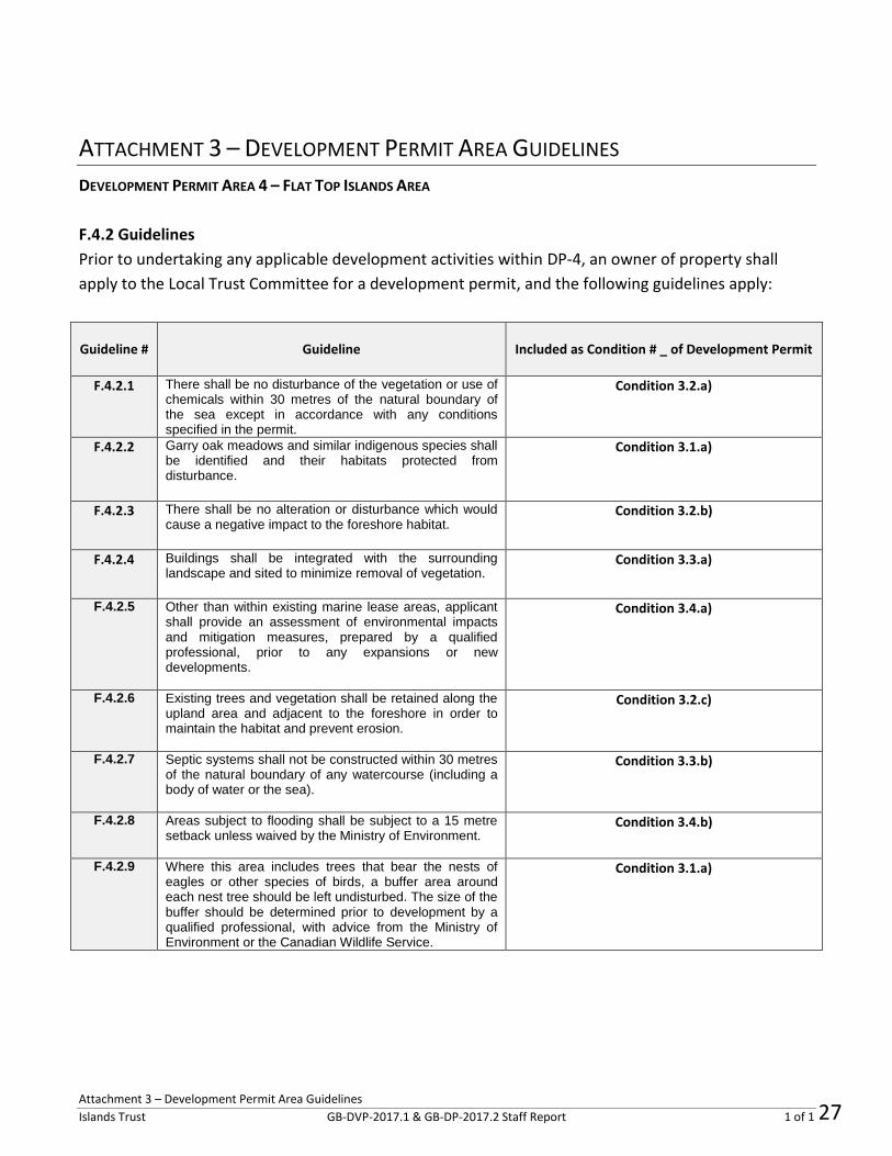
ATTACHMENT 3 – DEVELOPMENT PERMIT AREA GUIDELINES
DEVELOPMENT PERMIT AREA 4 – FLAT TOP ISLANDS AREA
F.4.2 Guidelines
Prior to undertaking any applicable development activities within DP-4, an owner of property shall
apply to the Local Trust Committee for a development permit, and the following guidelines apply:
Guideline # Guideline Included as Condition # _ of Development Permit
F.4.2.1 There shall be no disturbance of the vegetation or use of chemicals within 30 metres of the natural boundary of the sea except in accordance with any conditions specified in the permit.
Condition 3.2.a)
F.4.2.2 Garry oak meadows and similar indigenous species shall be identified and their habitats protected from disturbance.
Condition 3.1.a)
F.4.2.3 There shall be no alteration or disturbance which would cause a negative impact to the foreshore habitat.
Condition 3.2.b)
F.4.2.4 Buildings shall be integrated with the surrounding landscape and sited to minimize removal of vegetation.
Condition 3.3.a)
F.4.2.5 Other than within existing marine lease areas, applicant shall provide an assessment of environmental impacts and mitigation measures, prepared by a qualified professional, prior to any expansions or new developments.
Condition 3.4.a)
F.4.2.6 Existing trees and vegetation shall be retained along the upland area and adjacent to the foreshore in order to maintain the habitat and prevent erosion.
Condition 3.2.c)
F.4.2.7 Septic systems shall not be constructed within 30 metres of the natural boundary of any watercourse (including a body of water or the sea).
Condition 3.3.b)
F.4.2.8 Areas subject to flooding shall be subject to a 15 metre setback unless waived by the Ministry of Environment.
Condition 3.4.b)
F.4.2.9 Where this area includes trees that bear the nests of eagles or other species of birds, a buffer area around each nest tree should be left undisturbed. The size of the buffer should be determined prior to development by a qualified professional, with advice from the Ministry of Environment or the Canadian Wildlife Service.
Condition 3.1.a)
27

200-1627 Fort Street, Victoria BC V8R 1H8 Telephone (250) 405-5151 Fax (250) 405-5155
Toll Free via Enquiry BC in Vancouver 660-2421. Elsewhere in BC 1.800.663.7867
Email [email protected]
Web www.islandstrust.bc.ca
Bowen Denman Hornby Gabriola Galiano Gambier Lasqueti Mayne North Pender Salt Spring Saturna South Pender Thetis
October 7, 2019
XX First NationContact Information
File No.: GB-RZ-2019.1 (3650-25)
Dear Referrals Coordinator/Assistant: Re: Gabriola Island Local Trust Committee Development Permit 2017.2 and Development Variance
Permit 2017.1 for Acorn Island, Silva Bay area. Please accept this notification that the Gabriola Island Local Trust Committee (LTC) has received an application for a Development Permit (DP) and a Development Variance Permit (DVP) for Acorn Island in the vicinity of Silva Bay. The permits will be considered by the LTC at its regular business meeting on October 24, 2019.
BACKGROUND
The subject property (Acorn Island) is currently a privately owned single property off the south coast of Gabriola Island near Silva Bay, as shown in the location map below.
Both the DP and DVP applications are proceeding as a result of a Bylaw Enforcement file from 2008, when Islands Trust became aware of construction happening on the island without a Development Permit. The islands in Silva Bay, often referred to as the “Flat Top Islands”, are within an Islands Trust Development
28Preserving Island communities, culture and environment

Page 2
Permit Area (DPA) for the protection of the natural environment. Any development within the DPA first requires a Development Permit so that the construction of buildings or alteration of land may be evaluated and any potential impact to the natural environment can be mitigated through conditions of the permit - such as requirements for remediation, revegetation, establishing setbacks to nesting trees, or other habitat compensation and mitigation measures.
THE PERMITS
GB-DVP-2017.1: This application is proceeding to address a number of existing non-conforming buildings and structures on the subject property, namely the house, retaining wall, an accessory building, and the accessory cottage. The construction and development that was carried out in 2007/2008 was completed at that time and no new construction is proposed to take place or is authorised by the permits, except the removal of three small accessory buildings without permanent foundations that are unlawful under the Gabriola Island Land Use Bylaw No. 177 for number of buildings per lot.
GB-DP-2017.2: This application is proceeding because the subject property is within Gabriola’s Development Permit Area 4 (DPA-4) – Flat Top Islands Area, and previous development was done without a Development Permit. The work to be carried out as part of the DP application involves environmental and foreshore habitat restoration and remediation measures.
See Attachments 1 and 2 - Proposed DP and Proposed DVP.
ARCHAEOLOGY
Acorn Island has at least 4 recorded archaeological sites according to the province of BC Remote Access to Archaeological Data (RAAD) system. In the process of considering and preparing the DP and DVP, Islands Trust staff contacted the provincial Archaeology Branch with concern over the identified sites. An option for protection of the sites proposed by Branch staff, is to have the property owner register a notice on title under Section 32 of the Heritage Conservation Act that would run with the land. The notice would ensure that any future development by the current owner or their predecessors must be conducted under the necessary permitting, supervision, and permission from the Branch. The applicant has agreed to register a notice on title and Island Trust staff would make this a requirement prior to the issuance of either the DP or the DVP. In this way, the HCA notice would be registered on the property title prior to LTC issuance of the permits in order to ensure compliance with the Heritage Conservation Act. The property owner/applicant is aware of their responsibility under the Act to obtain any permitting that may be necessary in conjunction with any development or land altering activities in the future, or as part of the work to be done as part of the DP and DVP.
FURTHER INFORMATION Planning staff are able to provide reports, mapping, and documents applicable to the proposed applications at any time and can assist with facilitating any inter-agency contacts if required. The Gabriola Local Trust Committee is comprised of Scott Colbourne (Trustee), Kees Langereis (Trustee), and Dan Rogers (Chair).
29

Page 3
If you foresee any impacts or have any concerns about these applications related to treaty, traditional territory, cultural heritage and archaeological sites, Aboriginal Rights and Title, etc., we look forward to hearing from you. Do not hesitate to contact myself, Ian Cox, Planner 1 at [email protected] or Lisa Wilcox, Senior Intergovernmental Policy Advisor at [email protected]. With great respect, and also on behalf of the Gabriola Local Trust Committee, comprised of Scott Colbourne (Trustee), Kees Langereis (Trustee), and Dan Rogers (Chair),
Ian Cox Planner I, Northern Team Islands Trust Phone: 250-247-2204 (office) Enquiry BC Toll-free call 1-800-663-7867 or from the lower mainland 604-660-2421
30
c.

Box 8 Pender Island BC Canada V0N 2M1 250-222-0370; 250-222-4571 [email protected]
01 October 2019
Dear Mr. Cox: Re: Acorn Island Accessory Building #3 within 7.5 m of eagle nest tree We are assisting the owners of the property at Acorn Island with various measures to address permitting requirements and to bring the property into bylaw compliance. A question has been raised regarding the Development Variance Permit application, which allows for certain structures to remain on the property; one structure which would fall under that allowance is the building closest to the existing eagle nest tree on the property (labelled “Accessory Building #3” on the site plan). This structure is located within the 7.5 m setback from eagle nest trees required by the Gabriola Island Land Use Bylaw. We wish to suggest that removal of this building is not necessary from the perspective of disturbance to future eagle nesting activity, and in fact may be detrimental at this point. It is our understanding that the building in question was constructed in approximately 1968, and hence very likely preceded the use of the adjacent tree for nesting by eagles. This suggests that the presence of the building, and historical levels of use by the property owners, do not in themselves constitute a disturbance to eagles that would deter nesting activity. A second concern is that demolition of the building would constitute a considerable disturbance immediately adjacent to the nest tree. Even assuming demolitions were conducted outside of the breeding season, ground disturbance associated with building removal could result in damage to the tree or its roots, which could compromise the integrity and structural stability of the nest tree itself. This would then increase the probability of blow down during extreme weather events, rendering the tree entirely unusable by eagles in the future. There are few large, veteran Douglas-fir on the property that are suitable nest trees for bald eagles, and so it is important that ground disturbance be avoided within the canopy area of those trees that are present. We therefore suggest that it would be prudent to allow the building nearest the eagle nest tree to remain on the property for the above reasons, and instead suggest that the property owners follow the below mitigation measures to ensure no disturbance to nesting eagles in future years:
• No excavation work shall be conducted within the canopy area of the Douglas-fir housing the eagle nest, located within 7.5 m of the structure labelled as Accessory Building #3 on the DVP Site Plan.
31
Caurinus Environmental

• Human activity and auditory disturbances will be avoided within 50 m of the nest tree during the bald eagle nesting season, from February to July.
Note that these provisions shall remain in place even in the event of the nest material falling from the tree, and for the duration of the life of the tree, because the nest may be repaired and reused in future years.
Erin O’Brien (PhD) Dan Baxter (BSc, RPBio #1999)
32
Caurinus Environmental
Page 1 of 3
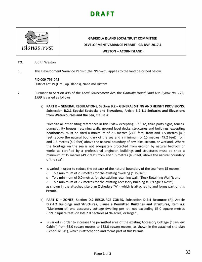
D R A F T
TO:
Judith Weston
1. This Development Variance Permit (the “Permit”) applies to the land described below:
PID 009-796-045 District Lot 19 (Flat Top Islands), Nanaimo District
2. Pursuant to Section 498 of the Local Government Act, the Gabriola Island Land Use Bylaw No. 177, 1999 is varied as follows:
a) PART B – GENERAL REGULATIONS, Section B.2 – GENERAL SITING AND HEIGHT PROVISIONS, Subsection B.2.1 Special Setbacks and Elevations, Article B.2.1.1 Setbacks and Elevations from Watercourses and the Sea, Clause a: “Despite all other siting references in this Bylaw excepting B.2.1.4c, third party signs, fences, pump/utility houses, retaining walls, ground level decks, structures and buildings, excepting boathouses, must be sited a minimum of 7.5 metres (24.6 feet) from and 1.5 metres (4.9 feet) above the natural boundary of the sea and a minimum of 15 metres (49.2 feet) from and 1.5 metres (4.9 feet) above the natural boundary of any lake, stream, or wetland. Where the frontage on the sea is not adequately protected from erosion by natural bedrock or works as certified by a professional engineer, buildings and structures must be sited a minimum of 15 metres (49.2 feet) from and 1.5 metres (4.9 feet) above the natural boundary of the sea”;
Is varied in order to reduce the setback of the natural boundary of the sea from 15 metres: o To a minimum of 2.9 metres for the existing dwelling (“House”); o To a minimum of 0.0 metres for the existing retaining wall (“Rock Retaining Wall”); and o To a minimum of 7.7 metres for the existing Accessory Building #3 (“Eagle’s Nest”). as shown in the attached site plan (Schedule “A”), which is attached to and forms part of this Permit.
b) PART D – ZONES, Section D.2 RESOURCE ZONES, Subsection D.2.4 Resource (R), Article D.2.4.2 Buildings and Structures, Clause a Permitted Buildings and Structures, Item a.i: “Maximum of: one accessory cottage dwelling per lot, not exceeding 65.0 square metres (699.7 square feet) on lots 2.0 hectares (4.94 acres) or larger”;
Is varied in order to increase the permitted area of the existing Accessory Cottage (“Bayview Cabin”) from 65.0 square metres to 133.0 square metres, as shown in the attached site plan (Schedule “A”), which is attached to and forms part of this Permit.
GABRIOLA ISLAND LOCAL TRUST COMMITTEE
DEVELOPMENT VARIANCE PERMIT - GB-DVP-2017.1
(WESTON – ACORN ISLAND)
33
D R A F T
IslandsTrust

Page 2 of 3
c) PART B – GENERAL REGULATIONS, Section B.2 GENERAL SITING AND HEIGHT PROVISION, Subsection B.2.1.3 Setbacks and Screening from Nesting Trees, Article a. “A protective screen of natural vegetation must be retained within a 7.5 metres (24.6 feet) radius of the trunk of a tree bearing nests of herons, eagles, ospreys, vultures, falcons, hawks and owls. ”;
Is varied in order to reduce the setback from 7.5 metres to a minimum of 0.0 metres for “Accessory Building #3” only, as shown on the Site Plan attached as Schedule “A” to this permit.
3. All buildings and structures shall be consistent with Schedule “A” which is attached to and forms part
of this Permit. This Permit is not a Building Permit, and does not remove any obligation on the part of the permittee to comply with all other requirements of the Gabriola Island Land Use Bylaw No. 177, 1999 including use and density, and to obtain other appropriate approvals necessary for completion of the development.
AUTHORIZING RESOLUTION PASSED BY THE GABRIOLA ISLAND LOCAL TRUST COMMITTEE THIS ___ DAY OF _________________, 2019.
_____________________________________ Deputy Secretary, Islands Trust
___________________________________________ Date of Issuance
IF THE DEVELOPMENT DESCRIBED HEREIN IS NOT COMMENCED BY THE ____ DAY OF _________, 2021, THIS PERMIT AUTOMATICALLY LAPSES.
34
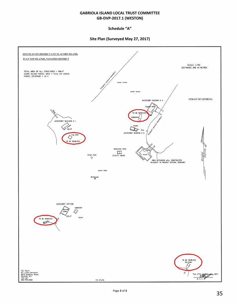
Page 3 of 3
GABRIOLA ISLAND LOCAL TRUST COMMITTEE GB-DVP-2017.1 (WESTON)
Schedule “A”
Site Plan (Surveyed May 27, 2017)
35

Page 1 of 38
DRAFT
GABRIOLA ISLAND LOCAL TRUST COMMITTEE
DEVELOPMENT PERMIT GB-DP-2017.2 (WESTON)
TO:
Christopher Weston and Judith Weston
1. This Development Permit (the “Permit”) applies to the land described below, and all buildings, structures, and other developments therein:
PID 009-796-045 District Lot 19 (Flat Top Islands), Nanaimo District
2. This Permit is authorized in accordance with the following schedules attached to and forming part of this Permit as signed and dated by the Deputy Secretary of Islands Trust: Schedule “A” – Existing Site Plan (as surveyed May 27, 2017)
Schedule “B” – Acorn Island Biophysical Survey – May, 2017. Prepared by Kayt Chambers, R.P.Bio., Baynes Sound Environmental Schedule “C” – Baynes Sound Environmental Supplemental Letter dated June 26, 2017. RE: Recommended Mitigation & Compensation Measures for the Riprap Wall and House Installed in the Backshore on Acorn Island Schedule “D” – Caurinus Environmental Letter RE: professional opinion and mitigation measures associated with eagle’s nest and Accessory Building #3 as shown on Schedule “A” (Existing Site Plan).
3. The Permit is subject to the following conditions:
3.1 Restrictive Covenant A restrictive covenant shall be granted to the Gabriola Island Local Trust Committee and registered on title: In order to mitigate and compensate for estimated habitat losses, and shall ensure, as per Schedule “C”, the:
a) Remediation of riparian vegetation and habitat along the marine shoreline, including the protection of identified Garry Oak trees and their habitats from disturbance, and the establishment of 100-metre buffer distances around each identified eagle nest tree to protect them from disturbance. b) Protection of the marine shoreline from erosion, which includes a soft-engineered approach. A baseline erosion and sediment control study will be established in the present and monitored in the future to determine if the riprap wall is having long-term cumulative negative impacts on the surrounding shoreline. If it is found that there is a net-negative impact, then the owner must hire a bioengineering specialist with experience in shoreline stabilization for specific design and installation requirements for this site; and
c) Protection of the following sensitive habitats to restrict future development and motorized vehicle access, and to provide maximum protection for any sensitive Species at Risk that possibly reside in these areas: the two seasonal wetlands should receive a 15 metre riparian buffer setback; the year-round freshwater pond should receive a 15
36
D R A F T
islandsTrust

Page 2 of 38
metre riparian buffer setback; and all marine shorelines should receive a 15 metre riparian buffer setback.
3.2 Natural Boundary of the Sea
a) There shall be no disturbance of the vegetation or use of chemicals within 30 metres of the natural boundary of the sea.
b) There shall be no alteration or disturbance which would cause a negative impact to the foreshore habitat.
c) Existing trees and vegetation shall be retained along the upland area and adjacent to the foreshore in order to maintain the habitat and prevent erosion.
3.3 Buildings & Septic
a) Buildings shall be integrated with the surrounding landscape and sited to minimize removal of vegetation.
b) Septic systems shall not be constructed within 30 metres of the natural boundary of any watercourse (including a body of water or the sea).
3.5 Eagles Nest & “Accessory Building #3
a) No excavation work shall be conducted within the canopy area of the Douglas-fir housing the eagle nest, located within 7.5 metres of the structure labelled as Accessory Building #3 on the Existing Site Plan.
b) Human activity and auditory disturbances will be avoided within 50 metres of the nest tree during the bald eagle nesting season, from February to July.
3.4 Other
a) Prior to any expansions or new developments, other than within existing marine lease areas, the owner/applicant shall provide an assessment of environmental impacts and mitigation measures, prepared by a qualified professional; and
b) Areas subject to flooding shall be subject to a 15 metre setback unless waived by the Ministry of Environment.
4. Any alterations requiring a Development Permit and not specifically authorized in this Permit may require a new Development Permit or a Development Permit Amendment.
5. This Permit is not a Building Permit, and does not remove any obligation on the part of the permittee to comply with all other requirements of the Gabriola Island Land Use Bylaw No. 177, 1999 including use and density, and to obtain other appropriate approvals necessary for the lawful completion of the development.
6. The land described herein shall be developed in accordance with the terms, conditions, and provisions of this Permit, and any schedules, plans, and specifications attached to this Permit, which shall form a part thereof.
AUTHORIZING RESOLUTION PASSED BY THE GABRIOLA ISLAND LOCAL TRUST COMMITTEE
THIS _____ DAY OF ____________, 2019.
__________________________ ________________________
Deputy Secretary, Islands Trust Date Issued
IF THE DEVELOPMENT DESCRIBED HEREIN IS NOT SUBSTANTIALLY COMMENCED BY
THE ______ DAY OF ___________, 2021, THIS PERMIT AUTOMATICALLY LAPSES.
37

Page 3 of 38
GABRIOLA ISLAND LOCAL TRUST COMMITTEE DEVELOPMENT PERMIT GB-DP-2017.2 (WESTON)
Schedule “A” Existing Site Plan (as surveyed May 27, 2017)
38

Page 4 of 38
GABRIOLA ISLAND LOCAL TRUST COMMITTEE DEVELOPMENT PERMIT GB-DP-2017.2 (WESTON)
Schedule “B” – Biophysical Survey
39
Acorn Island Biophysical Survey - May, 2017For The Gabriola Island Local Trust Committee (Islands Trust) on
behalf of Chris and Judy Weston
By Kayt Chambers, R.P.Bio., Baynes Sound Environmental

Page 5 of 38
40
Statement of Qualifications
Kayt Chambers is a professional biologist (R.P.Bio. #1967) with over two decadesof fieldbiology experience. She has worked as a field technician in marine,freshwater, and terrestrial environments in a range of habitats within the PacificNorthwest region. Specifically, Kayt has conducted site inventories for marineintertidal areas, riparian areas (marine and freshwater), and constructed (andnatural) wetlands. Her work with species-at -risk includes sampling for fish,mollusks, and amphibians.
2
Page 6 of 38
41
TABLE OF CONTENTS:1.0 INTRODUCTION 4
1 * 1 Site Background Analysis:1.1.1 5AR and Sensitive Ecosystem Occurrences1.1.2 Site Description1.1.3 Raptor and Heron Nests1.1.4 Fish-bearing Watercourses
56799
2.0 METHODS2.1 Survey Targets:2.2 Field Survey:
91010
3.0 RESULTS 11Preliminary Site Inventory
3.1.1. Plant Community31.2. Marine Habitat31.3. Topography and Terrestrial Habitat31.4. Land-uses31.5. Hydrology31.6. Slope Stability
Photos:
3.1 11111112
.13• •• •••• •••• •• •••••••••••• a ••••••••••••••••••••••••••••••••••••••• ••••i•• •• •• ••••••••••
1314• ••••• • • ••••• ••••• • a
3.2 IS
4.0 DISCUSSION4.1 Marine Intertidal Habitat:4.2 Upland Habitat;4.3 Garry Oak Ecosystems:....4.4 Species-at-Risk;
5.0 CONCLUSIONS
1818192021
226.0 RECOMMENDATIONS 23
6.1 Habitat Restoration....6.2 Habitat Enhancement
2323
APPENDIX A: Gabriola Island DP 4 for the Flat Top Islands
APPENDIX B: SEI Atlas Mapsheet 92G012
25. 26
3

Page 7 of 38
42
1.0 INTRODUCTION
The owners of Acorn Island have built a house and deck on the footprint of aresidential building adjacent to the backshore of a narrow marine inlet on thenortheast side of the island (refer to the Site Survey Plan). As part of theconstruction of the house and deck, shoreline protection was installed along thebackshore in the form of a riprap rock wall (Figures 1 and 2).
This report is a summary of a Site Background Analysis and Preliminary SiteInventory as per the requirements of the Gabriola Island Local Trust Committee,
Development Permit (DP) area for the Flat Top Islands (refer to map in AppendixA).
Figure 1. Subject house built on beachfront.
Figure 2. Riprap wall constructed on backshore habitat of shoreline.
4

Page 8 of 38
43
1.1 Site Background Analysis:
Acorn Island is a 24-acre island located in the Georgia Strait off the southeastend of Gabriola Island (Figure 3). It is one of a dozen islets called the Flat TopIslands that are located at the entrance to Silva Bay, and one of the only in thisgroup that is designated as Wood/end Habj'tetbythe provincial SensitiveEcosystem Inventory (SEl)1 (refer to Appendix B for SEI Atlas Mapsheet 92G012).
Figure 3. Acorn Island in the Flat Top Island group, Strait of Georgia.LEGEND
Oporal ion.a I layer*Map Title
D.-.lkv"*-'' rS_l III' AilKM
Dv AIKMIKK,!<-III
LKI «:J*.Cif!; i >: icrA < J'K <.£K'XI $'<.»n-.nixFijt "IK-H9':i <.lri. Jri M
Carlos I. Gaviola I
Vance I
Lily I.
Tugboat I
•: nr.CI> TP:Tff? r -.f.b friyrMjJrwrv.' A >tt:. PMs Ar.w|V|t t> fTfi T M.t f t M. l f i ;lv.t>
Tnrl r»« r*.rr<etctflj4rr0 hiilioM r.l klMlIivMT-VJAV ti r M, h v l'J I H!»«.’’ (i f .« r>v1h iIvir A. iMmw.'Nirh
V.VTVAV h h*frarAfc1 fM' l ^ ili* >fiIfb r x*
TI fik>r si-OTT«;ri.SRNRCRMV«T»
•:Kf. ‘./ft, >it-wr.- r.rt**»* ?!* *> Tnei
O Km Xi X*‘~
SEI Woodland Habitats are dry, open ecosystems consisting of between 10-25%tree cover with mixed stands of Garry oak/Arbutus, Garry oak/Douglas-fir and/orArbutus/DougI as-fir. The open forest cover can be an indicator of shallow soilsand bedrock outcroppings, creating a diversity of habitats that attract a widerange of species.
1Ministry of Environment EcoCat: The Ecological Reports Catalogue. Sensitive EcosystemInventory Maps (http://a100. gov.bc.ca/pub/acat/public/viewReport .do7reportld-2124) asretrieved on 29 May 17.
5

Page 9 of 38
44
This report is a summary of a biophysical assessment of the habitat surroundingthe subject house, deck and riprap wall recently built by the owners of AcornIsland. Recommendations for habitat restoration and enhancement are given inSection 6.0.
1.1.1 SAR and Sensitive Ecosystem Occurrences
Numerous organisms with species-at-risk (SAR) status are associated with GarryOak Ecosystems on islands within this region. For example, according to theGarry Oak Ecosystem Recovery Team (GOERT), the SAR that inhabitthesethreatened ecosystems include nearly 70 plant species, 20 invertebrates (insectsand other species), 1 5 birds, 3 mammals, and 2 reptiles2. The distribution ofthese ecosystems is limited to the southeast coast of Vancouver Island andnearby Gulf Islands in British Columbia, as well as a small area in the lowermainland (refer to Figure 4).
Figure 4. Garry Oak Ecosystem Distribution
2 Garry Oak Ecosystem Recovery Team, Species at Risk list(http://www.goert.ca/publications_resources/species_at_risk.php) as retrieved on 16 May 17.
6

Page 10 of 38
45
As part of the regulatory requirements under the Islands Trust OfficialCommunity Plan for Gabriola Island (and the Flat Top Islands), a DevelopmentPermit is required for land development priorto construction. As well, sensitiveecosystems such as those associated with Garry oaks require field assessmentprior to a proposed development under the federal Species-at-Risk Act (SARA)and/orthe provincial Wildlife Act to allow for adequate mitigation planning.
The Garry Oak Ecosystem Recovery Team (GOERT) is a provincial organizationwith a mandate to protect and recover the threatened Garry oak and associatedecosystems3.
According to GOERT, Garry oak ecosystems found in this region include "acomplex of closely related coastal bluff [ maritime meadow,vernal poofgrasslandI, rock outcrop and transitional forest ecosystems" . A multi-speciesapproach is employed under GOERT to maximize the protection of as manythreatened species with common biological characteristics and/or habitatrequirements as possible.
1.1.2 Site Description
As previously described, the house is adjacent to the shoreline of a narrow inleton the northeast side of Acorn lsland (Photo 1). The iniet is defined by sandstoneshelf on the northwest side (Photo 2) and sandstone bluff on the southeast side(Photo 3). The narrow bay at the foot of the inlet (adjacent to the house) containsa small pocket of fine sediments (sand/gravel/shell) covered in coarse woodydebris (CWD).
A deck extends from the northeast side of the house to the shoreline, and ariprap rock wall was built in the backshore between the deck and the beach(Photo 4). The riparian area surrounding the house is landscaped with lawn andsome ornamental conifer bushes and grasses (Photos 5 and 6).
Refer to Section 3.1 for a detailed description of the beach and propertysurrounding the house.
2 Garry Oak Ecosystem Recovery Team (http://www.goert.ca/about/index.php} as retrieved on 16May 17.
7

Page 11 of 38
46
Site Survey Plan:
Note: Garry oaks.Eagles nest, and water feature locations are approximate only.
3

Page 12 of 38
47
1.1.3 Raptor and Heron Nests
The provincial Best Management Practices (BMPs) for development activity nearestablished Bald eagle (Ha/jaeetus leucocephalus) nests4 and Great-blue heron(Ardea H&rodias) nestss were reviewed prior to this field survey.
1.1.4 Fish-bearing Watercourses
The provincial Fish Inventories Data Queries (FIDO) resource^ was checked priorto this field survey. FIDQ provides easy access to BC lake, stream and fish datafrom the provincial BC Geographic Data Warehouse (BCGW).
2.0 METHODS
Priorto the field survey, a background review of environmental information forAcorn Island and the surrounding region included reference to:
i. The provincial Conservation Data Centre (CDC) Species and Ecosystemdatabase7,
ii. The Ministry of Environment Ecological Reports Catalogue (EcoCat)Sensitive Ecosystem Inventory,
iii. The Best Management Practices for Garry Oak and AssociatedEcosystems8,
iv. The Environmental Guidelines for Urban and Rural Land Development inBritish Columbia (Develop With Care: Section 4, Environmentally Valuable
4 The Environmental Guidelines for Urban and Rural Land Development in British Columbia: FactSheet #10 Bald Eagles and Ospreys (http://www.wildlifetree.ca/docs/Fact Sheet 10 eaglesosprey.pdf) as retrieved on 30 May 17.5 The Environmental Guidelines for Urban and Rural Land Development in British Columbia: FactSheet #11 Great blue herons (http://www.env.qov.bc.ca/wld/documents/bmp/devwithcare/FactSheet 11 herons.pdf) as retrieved on 30 May 17.6 Ministry of Environment Fish Inventories Data Queries(http://a100.gov.bc.ca/pub/fidq/searchWatershedDictionary.do) as retrieved on 16 May 17.7 Conservation Data Centre BC Species and Ecosystems Explorer(http://www2. gov.bc.ca/gov/content/environment/plants animals ecosystems/consen/ation datacentre/explore cdc data/species and ecosystems explorer) as retrieved on 01 May 17.fc; Best Management Practices for Garry Oak and Associated Ecosystems(http://www.goert.ca/documents/GOERT BMPs.pdf) as retrieved on 16 May 17.
9

Page 13 of 38
48
Resources)9, andv. The Stewardship Series Coastal Shore Stewardship: A Guide for Planners,
Builders, and Developers on Canada's Pacific Coast10.
2.1 Survey Targets:
A property designated as Woodland Habitat (i.e.,mixed stands of Garryoak/Arbutus, Garry oak/Douglas-fir and/or Arbutus/Douglas-fir) in the GeorgiaStrait by the SEI Atlas has the potential to have numerous species-at-risk (someof which can be difficult to locate in the field). As such, the target species for thispreliminary site survey included any plants or animals that are known to have SARstatus or are unusual in this bioregion.
2.2 Field Survey:
The field survey of Acorn Island was designed with reference to the provincialDevelop With Care (2014) Bio-Inventory Terms of Reference document11.
Assessment of the main house site involved a detailed search forEnvironmentally Valuable Resources (EVRs) withinthe marine intertidal andriparian habitats surrounding the subject house on May 17th, 2017.
9 Develop With Care: Section 4, Environmentally Valuable Resources(http://www.env.gov.bc. ca/wld/clocuments/bmp/devwithcare/DWC Section 4.pdf) as retrievedon 16 May 17.10 Provincial Stewardship Series. Coastal Shore Stewardship: A Guide for Planners, Builders andDevelopers (http://www. llbc.leg.bc.ca/public/pubdocs/bcdocs/36B207/part1.pdf) as retrieved on16 May 17.
11 Develop With Care, Appendix B : B io Inventory Terms of Reference(http://www.env.gov.bc. ca/wld/documents/bmp/devwithcare/DWC Appendices A F.pdfi asretrieved on 16 May 17.
10
Page 14 of 38
49
3.0 RESULTS
3.1 Preliminary Site Inventory
3.1.1. Plant Community
The plant species assemblage and predominant forest cover on Acorn Islanddosely resemble the Coastal Douglas-fir Moist Maritime (CDFmm/02) sub-variantDouglas-fir/Arbutus plant community. Garry oak trees are present but widelydispersed (refer to the Site Survey Plan) and the majority of the forest cover onthe island exceeds the 10-25% that defines an SEl Woodland Habitat (see Photos7 and 8).
The tree species observed (in approximate order of higher to lower dominance)includes Douglas-fir (Rseudotsuga menziesjj), Arbutus (Arbutus menzjesjj), Shorepine (Finus contorts var. contorts), Trembling aspen (Popuius tremuioj'des), Garryoak (Quercus garryana), Bigleaf maple (Acer macrophyllum), Saskatoon(Amelanchier alnifolia), and Red alder (Ainus rubrs).
The shrub species observed are Salal (Gaulth&ria sbsiion). Common snowberry(Symphoricarpos sibus),Oceanspray (Hoiodiscus discolor ), and the invasiveEnglish Holly ( {lex aquifolium).
The forb species observed are Broad-leaved stonecrop (Sedum spstbui/fo/ium),Scouring-rush (Equj'setum hyemale). Dull Oregon-grape (MAHONJS nervosa).Sword fern ( Polystichum munj
'tum), Bracken fern (Pteridium aquilinum), Commonrush (Juncus effusus), Csrexsp., and various grass and moss species.
None of the SAR plant species commonly associated with Garry Oak Ecosystemswere observed.This lack of observation does not verify the absence of these rareorganisms,however.
3.1.2. Marine Habitat
The shoreline of Acorn Island is characterized by a series of sandstone shelves,low elevation rocky bluffe, and pocket bays with cobble/gravel/shell sedimentaccumulations.
11

Page 15 of 38
50
The marine biota observed on the intertidal beach in front of the subject houseincludes Rockweed ( Fucus distichus), Bull kelp (Nereocystis leutkeana), Seacauliflower (Loathesia dittormis), the invasive Wireweed (Sargassum muricurn).Sea lettuce (Ulva lactuca), Hairy shore crabs (Hamj'grapsus oregonensjs), Purpleshore crabs ( f-femjgrepsus nuofus), a Red rock crab (Cancer productus), Pacificoysters (Crassostrea gigas), Little-brown barnacles (Chthamaius dalli), Sitkaperiwinkles (L/ttor/na sitkana), Checkered periwinkles (fjttor/na scutulata), Pacificblue mussels (Mytilus trossulus) and Aggregating anemones { Anthopieuraelegantissima).
A number of unidentified marine birds were also observed.
3.1.3. Topography and Terrestrial Habitat
Acorn Island is characterized as a low relief and composed of the relativelyyoung Gabriola formation sandstone bedrock12.
The forest displays evidence of shallow topsoil with the relatively small stature ofthe Douglas-firs and other tree species. The stunted growth of this forest couldalso be attributed to the wind and saline conditions resulting from exposure tothe Georgia Strait.
Terrestrial vertebrate species observed include Mule deer (Odocoj/eus/lemj'onus), Canadian geese ( Branta canadensis), and a variety of songbirds.
The provincial Wildlife Tree Atlas13 has documented two Bald eagle nests on theeastern side of Acorn Island. A third nest was observed above the small cabincalled the Eagles Nest Cabin (Photo 9) near the main house,but no eagles wereobserved in the nest.
The provincial Best Management Practices (BMPs) for development activity nearestablished Bald eagle (Ha/ jeeetus leucocephalus) nests14 in rural areas
u Gabriola Land & Trails Trust Gabriola's Geology (http://vww. gaItt .ca/geoIogy.htmasretrieved on 27 May 17.12 BC Wildlife Tree Atlas (http://www.wildlifetree.ca/atlas.html) as retrieved on 16 May 17.w The Environmental Guidelines for Urban and Rural Land Development in British Columbia: FactSheet #10 Bald Eagles and Ospreys (http://www.wildlifetree.ca/docs/Fact Sheet 10 eaglesosprey.pdf) as retrieved on 30 May 17.
12

Page 16 of 38
51
recommends a minimum of a 100-m buffer distance from nest tree to proposedconstruction. For Great-blue heron (Arc/ee Heroc/ias) nests15, the minimum bufferdistance is 200-m. No Great-blue heron nests (i.e., rookeries) were observed,however.
The provincial Fish Inventories Data Queries (FIDO) resource1* was checked priorto the site survey. No fish-bearing watercourses were documented for AcornIsland and no drainages suitable as anadromous fish habitat were observed.
3.1.4. Land-uses
A variety of small residential and storage buildings exist on the island (refer tothe Site Plan).The land-uses are apparently limited to seasonal residency andrecreation.There was no observed evidence of resource extraction or other newdevelopment on the island.
3.1.5. Flydrology
The observed freshwater features indude a couple of seasonal, rain-fed swamps(Photos 10 and 11), and a man-made shallow pond (Photo 12) that provides year-round drinking water.There were no freshwater streams or other drainagefeatures observed.
Drainage off the main house is directed into a perimeter drain17 while the deckappears to be constructed to allow some infiltration between slats.
The septicfield is built to receive both the sewage and grey water dischargefrom the main house13.
15 The Environmental Guidelines for Urban and Rural Land Development in British Columbia: FactSheet #11 Great blue herons (http://www.env.gov.bc.ca/wld/documents/brnp/deywithcare/FactSheet 11 herons.pdf) as retrieved on 30 May 17.16 Ministry of Environment Fish Inventories Data Queries(http://a100.gov.bc.ca/pub/fidq/searchWatershedDictionary.do) as retrieved on 16 May 17.17 Personal communication with Michael Zane on 27 May 17.ie Personal communication with Michael Zane on 17 May 17.
13
Page 17 of 38
52
3.1.6. Slope Stability
The riprap rockwall is located at the interface of the backshore and the uplandterrestrial habitat. A small amount of shoreline erosion is evident adjacent to theriprap rockwall (Photo 13), and shoreline stability concerns like this are probablyprompted the installation of the riprap wall in front of the main house by theowners.
The subject shoreline is best categorized as a Rocky Shore habitat type asdescribed in the provincial Coastal Shore Stewardship document :̂
A rocky shore typically consists of a solid rock bench across the intertidal zone,that may or may not extend up to the high tide line. Thin gravel and boulderveneer deposits are often found on these benches, but usually cover less than 10percent of the intertidal area. This type of shore can also be a near vertical rockcliff that may extend above and beiow the j
'ntertj'dai zone. Sand, gravel andcobble sediment deposits often form small beaches near the high tide line.
Rocky shores are resistant to erosion and do not provide a significant supply ofunconsolidated sediment to the coast.
19 Provincial Stewardship Series. Coastal Shore Stewardship: A Guide for Planners, Builders andDevelopers on Canada's Pacific Coast(http://www.llbc.leg.bc.ca/public/pubdocs/bcdocs/36B207/part1.pdf) as retrieved on 16 May 17.
14

Page 18 of 38
53
Photos:
Photo 4. Riprap rock wall built onbackshore between the deck andbeach.Photo 1. Narrow bay in front of
subject house.
/&K-Igjgp
Photo 5- Backside of houseshowing lawn area.Photo 2. Sandstone shelf bedrock
is on northwest side of inlet.
Photo 6. Landscaped area behindsubject house.
Photo 3. Sandstone bluff inbackground is on the southeast sideof inlet.

Page 19 of 38
54
Photo 7, Dominant forest typefound on Acorn Island.
Photo 10. Seasonal wetland in
thicket behind the subject house.
-A: TV- -I* * 'Trfr: •;
Photo 8 . Garry oak tree found inthe Douglas-fir dominant forest inthe middle of Acorn Island.
Photo 11. Seasonal wetland behindthe Old Cabin on south side ofisland.
Photo 12. Year round pond locatedbetween Old Cabin and BayviewCabin on south side of island.
Photo 9. Bald eagles nest aboveEagels Nest Cabin.
16

Page 20 of 38
55
Photo 13. Minor erosion is evidenton the backshore adjacent to theriprap wall.
Photo 16. Garry oak tree on shoreof inlet in front of subject house.
Photo 14. Invasive Japanesewireweed washed up on subjectbeach. Photo 17. Single Garry oak tree on
headland to northeast of subjecthouse.
Photo 15 . The subject beach isdogged with driftwood.
Photo 1 Garry oak tree on southshoreline of island near Old Cabin
17

Page 21 of 38
56
4.0 DISCUSSION
Marine Intertidal Habitat:4.1
As stated in the provincial Develop With Care: Environmentally ValuableResources document20:
The "coastal zone" is the area where j'nteractj'on of the sea and land processes
occurs; where terrestrial ecosystems meet marine ecosystems and wherefreshwater mj
'ng/es with saltwater. It is an area of high biological values used byshorebirds,otter, crab, young salmon,heron, and many,many more spedes. Tomaintain these biologically rich and productive places, the coasta/ zone needs:fa) natural erosion and deposition patterns for continued longshore drift, wh/chkeeps the beaches and spits intact; (b) natural vegetation along the badcshorefor bank stability, she/ter and shade fe.g., forage fish eggs);and fc) drift logs,rocks, vegetation and other naturai components washed up by the tides anddeposj’ted by streams.
The subject beach is a small pocket beach with fine sediment protected by anarrow, rocky inlet. The inlet has a northeast aspect and is probably impacted bywaves from northerly winter storms. Storm surge waves occur when the wind andpressure generated by a storm act on a large body of shallow, coastal water,creating waves one-metre on average above the normal high tide.2*. Fortunately,in this case, the coastline is extremely deep off the prevailing wind sides of AcornIsland (i.e., north and east), and the inlet is narrow which acts to diffuse much of•the oncoming wave energy. As such, shoreline erosion is less of an issue than ifthe house fronted on an open beach.
The shoreline bio-inventory revealed that the invasive brown seaweed Japanesewireweed (Sargassum muticum) inhabits the inlet. Japanese Wireweed (Photo 14)is a large, fast growing brown seaweed that forms dense monocultures. It
20 Provincial Develop With Care: Environmentally Valuable Resources document(http://www.env.gov.bc.ca/wld/documents/bmp/devwithcare/DWC Section 4.pdf) as retrievedon 31 May 17.21 Provincial Stewardship Series. Coastal Shore Stewardship: A Guidefor Planners, Builders andDevelopers (http://www. llbc.leg.bc.ca/public/pubdocs/bcdocs/36B207/part1.pdf) as retrieved on31 May 17.

Page 22 of 38
57
impedes boat traffic and swimmers, and reproduces via floating fragments andcan be spread easily22
. Otherwise, no marine SAR or other invasive species wereobserved.
The fine sediment types (sand/gravel/shell) in the pocket bay adjacent to thesubject development are favourable for forage fish spawning, but the site is veryisolated and clogged with driftwood (CWD) which impedes access by these fish(Photo 15). The lack of accessibility and small habitat area make it very unlikelythat this site serves as valuable forage fish spawning habitat.
4.2 Upland Habitat:
The SEI Woodland Ecosystem designation for Acorn Island can be refined to theDouglas-fir/Shore pine/Arbutus (CDFmm/02) plant community23 based onestimates of the tree canopy coverage (%) andspecies assemblage. It isimportant to note that this forest type can include Garry oaks as a sub-dominantspecies as found on the subject property (see Photos 8 and 16-18).
The CDFmm/02 plant communities are typically:
i. The driest of the forested communities in the CDFmm subzone.\ \ . Small patch communities (5-50 ha) with a tree layer dominated by
Douglas-fir and Arbutus.ifi. With a canopy cover ranging from 40 to 90%.
iv. With a minor component of Shore pine and/or Garry oak present.v. With a shrub layer including Oceanspray,Dull oregon-grape, Common
snowberry, tall Oregon-grape, baldhip rose, and Saskatoon berry.vi. With a herb layer including a number of graminoids (e.g., Western fescue,
Aaska oniongrass, Blue wildrye, California brome, Long-stoloned sedge,
and Many-flowered wood-rush), as well as Pacificsanicle, Big-leaved
22 Invasive Species Council of British Columbia, Aquatic Invasive Plants(http://bcinvasives.ca/documents/Aquatic_lnvasive_Plants PIant_Notes.pdf) as retrieved on 31May 17.22 BC's Coast Region: Species & Ecosystems of Conservation , Plant Community: Douglasfir/Arbutus(http://ibis. geog.ubc.ca/biodiversity/factsheets/pdf/plant%20communities/douglasfir arbutus cdfmmQ2.pdfi as retrieved on 29 May 17.
19

Page 23 of 38
58
sandwort. Purple peavine, White fawn lily. Trailing blackberry, and brackenfern.The moss layer is variable within the plant community (1 -40% cover) and ismost prevalent on outcrop bedrock areas where trees and shrubs areunable to establish.The moss layer features Electrified cat's-tail moss,Oregon beaked-moss. Step moss and various Clad lichens.
VII.
As previously mentioned, two seasonal wetlands were also observed on AcornIsland. These freshwater habitats require further investigation to determine if rareor sensitive plants are present. One of these wetlands is situated within 100-m ofthe subject house (refer to the Site Survey Plan).
It is noteworthy that there were no invasive, non-native plants observed otherthan the occasional English holly bush on the island (although furtherinvestigation may reveal other invasive species present).
4.3 Garry Oak Ecosystems:
As stated in the Sensitive Ecosystem Inventory (East Vancouver Island and GulfIsland 1993-1997) document24:
Historically, frequent lightning- induced wildfires, aboriginal burning, and elk enddeer grazing prevented coniferous forests from crowding out the oakwoodlands. Fires thinned out competing coniferous species,recycled nutrientsinto the soil, released and scarified seeds, and maintained the open woodlandcanopy for sunlight to enter. All of these processes are critical to maintainingwoodland health and the natural cycles in the ecosystem.
On Acorn Island, it is likely that the forest has become conifer dominatedthrough a lack of these processes at work in recent history. The observedDouglas-fir/Shore pine/Arbutus (CDFmm/02) plant community does not excludeGarry oak trees and is an ecosystem that is associated with Garry OakEcosystems (i.e., it may contain some of the rare SAR associated with them).
21 SEI East Vancouver Island and Gulf Islands 1993 1997: Volume 1: Methodology, EcologicalDescriptions, and Results(http://a100.gov.bc.ca/appsdata/acat/documents/r2124/SEI_4206_rpt1_1111625239116_Bbe42252200c4f02B3b1Bcac66eed366.pdf) as retrieved on 31 May 17.
20
Page 24 of 38
59
Species-at-Risk:4.4
There is a possibility that rare SAR exist on Acorn Island. The Bald eagles nestsand the occasional Garry oak tree were the only observed sign of SAR present in
this preliminary field survey. Both the forest understory and the wetland habitatsrequire a more detailed field investigation to determine SAR presence orabsence.
21
Page 25 of 38
60
5.0 CONCLUSIONS
This assessment has revealed several important ecological aspects of AcornIsland. The time available for the field investigation was limited and thereforedoes not meet the scope requirements of a complete bio-inventory. It has,however, pointed at habitat conditions that do not support the presence of aGarry Oak Ecosystem, but rather an undisturbed coniferous forest. The absenceof fire on Acorn Island has probably allowed the Douglas-fir/Shore pine/Arbutus(CDFmm/02) plant community to become the dominant forest type while Garryoak trees remain scarce.
The target species for this preliminary site survey included any plants or animalsthat are known to have $AR status or unusual in this bioregion. Garry oak treesand Bald eagles nests were encountered (both species are provincially yellow-listed), and require stewardship on Acorn Island. Although other SAR were notencountered in this field investigation, they may be present. A more detailedfield investigation is required to confirm the presence or absence of SAR on thisproperty.
Two seasonal wetlands were identified by an abundance of Carexspp. growthand visible standing surface water. These habitats, along with the man-madepond, may reveal rare species assemblages upon further investigation. Nofreshwater drainage or other feature was observed that would be favourablehabitat for anadromous salmonids.
The marine foreshore habitat (including the intertidal beach area) in front of thesubject house may be negatively impacted by the riprap rockwall installation.Hard, vertical structures such as this remove riparian vegetation from thebackshore environment, eliminate natural habitat complexity along the shoreline,and simplify intertidal habitats. Without baseline information about the formercondition of these habitats priorto the shoreline hardening, it is difficulttomeasure the extent of the impacts.
22

Page 26 of 38
61
6.0 RECOMMENDATIONS
41 Habitat Restoration
The voluntary efforts of landowners and c'
\t \z&r\s are essential to the conservationand enhancement of sensitive and other important ecosystems such as marineshorelines. Restoration of the riparian backshore habitat on a site whereshoreline hardening has occurred requires spedficlocalized actions:
i. Install natural vegetation along the backshore for bank stability, shelterand shade;
ii. Use a 'soft' option such as a soil bio-engineering solution to addressfurther shoreline erosion;
iii. Avoid constructing retaining walls—they often transfer wave energy toneighbouring shorelines and restrict wildlife access to the waterfront;
iv. Avoid clearing the backshore of native vegetation—it can encourage theestablishment of nuisance or non-native species, which can grow quicklyand eliminate native species;
v. Remove non-native, invasive plant species in backshore and riparianhabitats (including landscaped areas) and allow (or plant) natural, nativeplants to grow there.
42 Habitat Enhancement
If the Islands Trust determines that the subject riprap wall has had a net negativeimpact on the shoreline at the house site and requires compensation on AcornIsland, habitat enhancements involving -the maintenance or creation of thefollowing could be employed:
• Low gradient, natural shorelines;• Riparian areas free of migratory barriers such as walls or other structures;• Intact riparian forests free from invasive species that provide shade to the
shoreline.
Private landowners are encouraged by local governments and conservationorganizations to become active stewards of rare or threatened species and/or
23

Page 27 of 38
62
ecosystems if they possibly inhabit their lands25:
Federal policy for identification and protection of critical habitat emphasizes" cooperation and stewardship first" - recognizing that while "SARA contains strong
mechanisms and powers for the federal government to directly and unilaterallyregulate the protection of residence and critical habitat in Canada, cooperative,voluntary measures must be viewed as the first option to securing the protectionrequired for these crucial elements to species recovery." This approach is reiteratedin the 2005 Canada-British Columbia Agreement on Species at Risk which affirms as
principles that: " stewardship by land and water owners and users is fundamental to
preventing species from becoming at risk and in protecting and recovering speciesthat are at risk" ; "cooperative, voluntary measures are the first approach to securingthe protection and recovery of species at risk"; and "Canada and British Columbiaare committed to carrying out consultations with those who may be directly affectedby protection and recovery of species at risk."
25 GOERT Questions and Answers: Legislation and Policy for the Protection of Garry OakEcosystems (http://www.goert. ca/documents/QandA_Legislation_and_Policy.pdf) as retrieved on16 May 17.
24

Page 28 of 38
63
APPENDIX A: Gabriola Island DP 4 for the Flat Top Islands

Page 29 of 38
64
APPENDIX B: 5EI Atlas Mapsheet 92G012

Page 30 of 38
GABRIOLA ISLAND LOCAL TRUST COMMITTEE DEVELOPMENT PERMIT GB-DP-2017.2 (WESTON)
Schedule “C” – Baynes Sound Environmental, Supplemental Letter
65
Baynes Sound EnvironmentalPO Box 1017Cumberland, B .C.VOR 1S0
June 26th, 2017
Attn: Local Trust Committee, Gabriola Island, Islands Trust
RE: Recommended Mitigation and Compensation Measures for the RiprapWall and House Installed in the Backshore on Acorn Island
1. Introduction:
This is letter is an addendum to the Acorn Island Biophysical Survey Report (submittedMay, 2017) to provide detailed recommendations for mitigation and compensation of thebackshore habitat impacted by the installation of a riprap rock wall and house on thisproperty. Specifically, the estimated impacts to riparian vegetation, shoreline stability, andrare or threatened species habitats on Acorn Island are addressed.
The field survey for this assessment was conducted in the post-construction phase whichmeans that the baseline habitat conditions are not known for the site. It is important tomention that the original habitat conditions are estimates from observations of adjacentshoreline and riparian habitat areas near the site. It's also importantto keep in mind thatan older house existed in the same location before this development occurred.
For an overview of the site and -the subject development, refer to Section 1.0 of the surveyreport.
2. Methods:
Baynes Sound Environmental: http://baynessoundenvironmental.com/

Page 31 of 38
66
Refer to the Acorn Island Biophysical Survey Report (May, 2017), Section 2.0 for a summaryof the methods used for this habitat assessment
3, Results:
Refer to the Acorn Island Biophysical Survey Report, Section 3.0 for a summary of theresults found by this habitat assessment.
4 Discussion
As stated in the biophysical report for this property, the foresttype on Acorn Islandresembles a Coastal Douglas-fir Moist Maritime (CDFmm/02) sub-variant Douglas-fir/Arbutus plant community.
Garry oak trees are widely dispersed on the island along with other confirmed sensitivehabitat features including: two seasonal wetlands, a year -round pond, Bald eagle nest(s),and pocket beaches along the marine shoreline that appear suitable for forage fishspawning.
For the purposes of this study, these features have been grouped into the following threecategories based habitat type and ecosystem function.
4.1 Riparian Vegetation
4.1.1. Ecosystem Function and Estimated Impacts
Riparian vegetation is important for the proper functioning condition of all aquatichabitats. It serves to provide shade, water retention, erosion control and wildlife habitat.
In the case of the subject house and riprap wall, most of the riparian vegetation has beenremoved along the marine shoreline and requires remediation. The riparain areas aroundthe two seasonal wetlands and the year -round freshwater pond on the island appearsintactand welldunctioning.
ft 2Baynes Sound Environmental: http://baynessoundenvironmental .com/
Page 32 of 38
67
4.1.1.1 Marine Shoreline
The riparian zone extends approximately 15 m from the high-high-t'de line in a marineenvironment. This zone is where shoreline stability is formed (or lost), and where a uniqueassemblage of riparian plants with salinity tolerance become established.
Adjacent to -the subject site, the undisturbed marine riparian zone is composed of a mix ofDougIas-fir (Pseudotsuga menzi&sii), Arbutus (Arbutus menziesii), Shore pine (F/nuscontorta var. contorts), Garry oak (Quorcus garryana), and Bigleaf maple (Acermacrophylium).Shrubs include Salal (Gaulth&ria shalion), Common snowberry(Sympborjcarpos a/bus), and Oceanspray (Ho/odj'scus discoior).
The riprap rockwall and house have eliminated most of the riparian vegetation within thefootprint of this development, while replacing some of this area with non-native plantspecies.
4,2 Marine Shoreline Stability
4.2.1. Ecosystem Function and Estimated Impacts
The shoreline of Acorn Island is characterized by a series of sandstone shelves, lowelevation rocky bluffs, and pocket bays with cobbIe/graveI/shell sediment accumulations.The subject house and riprap wall are located adjacent to a small pocket bay at the headof a narrow inlet that is naturally confined by sandstone bedrock and bluff.
in general, localized shoreline stability is enhanced by hard shoreline structures (such asbedrock) and well-rooted riparian vegetation (see Section 4.1 above). These featuresfunction to prevent sediments from eroding from the immediate shoreline (as a result oftidal action or storm surge events), but often transfer wave energy to adjacent shorelinescausing erosion nearby.
Shoreline sediment accumulations that resultfrom shoreline erosion can negatively impactintertidal habitat areas by infilling interstitial spaces importantfor invertebrates (and otherspecies), and/or changing the beach sediment composition completely.
3Baynes Sound Environmental: http://baynessoundenvironmental .com/

Page 33 of 38
68
There is a small amount of shoreline erosion evident adjacentto the subject riprap rockwall that appears to be adding a small volume of fine sediment and organic matter to theadjacent pocket beach.
The subject riprap rock wall is located along a soft sediment (i.e.,non-bedrock) interfacealong the backshore and the upland terrestrial habitat,but does not span the entire lengthof the fine sediment shoreline of this inlet.Although the wall is likely preventing anincrease in shoreline erosion by protecting the softer ground at the head of the inlet, it isalso likely transferring wave energy outward to the shoreline segments not protected bybedrock (as evidenced by erosion mentioned above).
Shoreline stability concerns like the erosion described above are what prompted thelandowners to install the riprap wall in front of their new house, as well as concern forbeach wood accumulation under the new deck It's important to note that similar shorelineprotections are in place naturally at this site by way of the sandstone bedrock lining mostof the inlet.
4.3 Rare or Threatened Species
4.3.1 Ecosystem Function and Estimated Impacts
Maintaining biodiversity and unique habitats for rare or threatened species on privateproperty like this is importantfor maintaining functional ecosystemfs) across widerlandscapes. It is importantto remember that a lack of observation of a rare or threatenedspecies in an area does not confirm its absence unless the field investigation has targetteda particular species.
Garry Oak trees were observed on the subject property but do not represent a Garry OakEcosystem in this location. Bald Eagle presence on Acorn Island was also evident by theconfirmed nest within 100-m of the subject house (refer to Section 2.2.3 of the biophysicalreport for more detail).
5. Conclusions:
For the shoreline and riparian area impacted by the construction of the subject house andriprap wall, the following measures are recommendations to mitigate and compensate for
4Baynes Sound Environmental: http://baynessoundenvironmental .com/

Page 34 of 38
69
estimated habitat losses, and should be written into a conservation covenant(s) or otherprotection measures by the Islands Trust for this property.
5.1 Riparian Vegetation Loss:
In the case of the subject development,most of the native riparian vegetation wasremoved along the marine shoreline and this habitat loss requires localized remediation.
The riparian zone extends from the high tide line to 1 5-m inland and requires a naturaldensity of native trees and shrubs to provide required shade, erosion control and wildlifehabitat along the shoreline.
A variety of seedling trees and shrubs should be transplanted into the riparian zonearound riprap wall and house (see Section 4.1.1.1. of this report for a list of suggestedspecies). The owners should hire a professional Landscaper with expertise in Native PlantLandscaping to produce a plan designed to restore or compensate for losses in shorelinevegetation function around the development site.
5.1.1. Garry Oak Trees:
It is unclear whether any Garry oak trees were removed during the subject development,but for future construction it is recommended that a Protected Root Zone is establishedfor each individual Garry oak tree nearby by installing a circle of protective fencing aroundthe dripline of each tree1. Lateral roots of Garry Oak trees can extend beyond the driplineby as much as twice the crown radius, so it is important to protect as large an area aspossible around the tree with fencing prior to the start of construction.
5.1.2. Bald Eagle's Nest Trees:
The provincial Best Management Practices (BMPs) for development activity nearestablished Bald eagle (Ha/ jaeetus leucocephalus) nests2 in rural areas recommends a
1 The Best Management Practices for Garry Oak and Associated Ecosystems(http://www.goert. ca/documents/GOERT BMPs.pdf) as retrieved on 16 May 17.2 The Environmental Guidelines for Urban and Rural Land Development in British Columbia: Fact Sheet #10Bald Eagles and Ospreys (http://www.wildlifetree. ca/docs/Fact Sheet 10 eagles osprey.pdf) as retrieved on30 May 17.
ft 5Baynes Sound Environmental: http://baynessoundenvironmental .com/

Page 35 of 38
70
minimum of a 100-m buffer distance from nest tree to proposed construction and thesesetbacks must be established prior to approval of any proposed future development
5.2 Marine Shoreline Erosion
5.2.1. Shoreline Stability
There is little evidence that the subject shoreline has been de-stabilized as a result of theinstallation of the riprap wall aside from a little erosion adjacent to the wall on one end.The gaps between the wall ends and the beginning of the sandstone bedrockthatconstrains the shoreline on either side of the wall could be protected with a soft-engineered approach such as a log-crib structure if the erosion becomes morepronounced.A baseline erosion and sediment control study should be established in thepresent and monitored in the future to determine if the riprap wall is having long-term,
cumulative negative impact on the surrounding shoreline.
ff it is found that there is a net-negative impact, then the owner will need to hire abioengineering specialist with experience in shoreline stabilization forspedfic design andinstallation requirements for this site.
5.2.2. Forage Fish Spawning Habitat:
The loss of -fine sediment recruitment from the shoreline by the wall for forage fishspawning habitat is not a large concern given the small area of this pocket beach and thehigh volume of beach log accumulation in the high intertidal area which likely acts toprevent spawning. It is important to mention that forage fish spawning activity has notbeen confirmed on Acorn Island and that compensatory measures will not berecommended unless spawning is confirmed.
5,3 Impacts to Species-at-Risk Habitat
No Species-at-Risk (SAR) habitat aside from Garry Oak trees and Bald Eagles nests wereidentified in this preliminary biophysical assessment. A more detailed field investigationmay reveal SAR on Acorn Island although it will not be possible to confirm whether or notSAR were directly impacted by the subject development. As such, it is recommended thatthe following sensitive habitats be protected in the future by the following buffers (with
ft 6Baynes Sound Environmental: http://baynessoundenvironmental .com/

Page 36 of 38
71
conservation covenant(s) or other protection measures developed by the Islands Trust onthis property):
• The two seasonal wetlands should receive a 15-m riparian buffer setback.• The year-round freshwater pond should receive a 15-m riparian buffer setback.• All marine shorelines should receive a 15-m riparian buffer setback.
The setback areas for all three habitat types should restrict future development andmotorized vehicle access, and be designed to provide maximum protection for sensitiveSAR possibly residing in these areas.
Please do not hesitate to contact me if you have any questions.
Sincerely,
Kayt Chambers, R [email protected](250) 650-5143
7Baynes Sound Environmental: http://baynessoundenvironmental .com/

Page 37 of 38
GABRIOLA ISLAND LOCAL TRUST COMMITTEE DEVELOPMENT PERMIT GB-DP-2017.2 (WESTON)
Schedule “D” – Caurinus Environmental Letter
72
Caurinus EnvironmentalBox 8Pender Island BC CanadaVON 2M1250-222-0370; 250- 222-4571caurinusenvironmentalsgmail.com
01October 2019
Dear Mr. Cox:
Re: Acorn Island Accessory Building #3 within 7.5 m of eagle nest tree
We are assisting the owners of the property at Acorn Island with various measures to address permittingrequirements and to bring theproperty into bylaw compliance. A question has been raised regardingtheDevelopment Variance Permit application,which allows for certain structures to remain on theproperty; one structure which would fall underthat allowance is the building closest to the existingeagle nest tree on the property (labelled ''Accessory Building #3" on the site pi an).This structure islocated within the 7.5 m setback from eagle nest trees required by the Gabriola Island Land Use Bylaw.We wish to suggest that removal of this building is not necessary from the perspective of disturbance tofuture eagle nesting activity,and in fact may be detrimental at this point.It is our understanding thatthe building in question was constructed in approximately 1963,and hence very likely preceded the useof the adjacent tree for nesting by eagles.This suggests that the presence of the building,and historicallevels of use by the property owners,do not in themselves constitute a disturbance to eagl es that woulddeter nesting activity.A second concern is that demolition of the buildingwould constitute a considerable disturbanceimmediately adjacent to the nest tree.Even assuming demolitions were conducted outside of thebreeding season,ground disturbance associated with building removal could result in damage to thetree or its roots,which could compromise the integrity and structural stability of the nest tree itself. Thiswould then increase the probability of blow down during extreme weather events,rendering the treeentirely unusable by eagles in the future.There are few large,veteran Douglas-fir on the property thatare suitable nest trees for bald eagles,and so it is important that ground disturbance be avoided withinthe canopy area of those trees that are present.We therefore suggest that it would be prudent to allow the building nearest the eagle nest tree toremain on the property for the above reasons,and instead suggest that the property owners follow thebelow mitigation measures to ensure no disturbance to nesting eagles in future years:
• No excavation work shall be conducted within the canopy area of the Douglas-fir housing theeagl e nest,located within 7.5 m of tine structure labelled as Accessory Building #3 on the DVPSite Plan.
Page 38 of 38
73
• Human activity and auditory disturbances will be avoided within 50 m of the nest tree duringthe bald eagle nesting season,from February to July.
Note that these provisions shall remain in place even in the event of the nest material falling from thetree, and for the duration of the life of the tree, because thenest may be repaired and reused in futureyears.
Erin O'Brien (PhD} Dan Baxter (BSc,RPBio #1999)
Caurinus Environmental

November 13, 2019
Mr Ian Cox Planner 1, Northern Team Islands Trust Gabriola Island Local Trust Committee The Island Trust 700 North Road Gabriola Island, BC V0R 1X3
Dear Mr Cox:
Re: Gabriola Island Local Trust Committee Development Variance Permit – GB-DVP-2017.1 (Weston-Acorn Island)
My name is Darlene Weston, and I am writing to you as the daughter of the applicant (Judith Weston), to provide you with some additional background information on Acorn Island, my family’s history with the island, and the circumstances that led to the development variance permit.
First, a bit about my background – I am an Associate Professor of Anthropology at the University of British Columbia, where I have worked since 2010. I specialize in biological anthropology, which entails researching the health and demography of past peoples. I hold a BA (Hons) in Archaeology from Simon Fraser University, an MSc in Osteology, Paleopathology, and Funerary Archaeology from the University of Bradford (UK), and a PhD in Archaeology from University College London (UK). In my capacity as a professor at UBC, I work and have worked with a number of First Nations communities as a consultant osteologist. This means that when ancestral remains are uncovered, usually accidentally in the course of construction, I identify the bones as ancestral remains and provide any biographical details as requested by the First Nation(s) so that the ancestor(s) can be reburied in the right way. I currently do this work with the Musqueam and the Sto:lo and have worked with Dr Colin Greer at Dionisio Point on Galiano Island (Penelekut territory) and provided funding to the Stz’uminus Origins Project to facilitate research on the ancestral remains, ultimately resulting in the repatriation and reburial of many ancestors from Kulleet Bay and Shell Beach.
My parents, Chris and Jude Weston, purchased Acorn Island in 1996 from the Taylor family. The Taylors had owned the island for many years, but had left the island in a state of neglect. From what I understand, ownership had been split among several of the Taylor siblings who had not visited the island for many years. When my parents first took possession of the island they encountered rotting buildings filled with garbage and debris. Strewn around the island was rusting machinery – broken tractors and
74

logging/sawmill equipment. It appears that the previous owners had been treating the island as a resource and had a small industrial operation that involved cutting trees and sawing logs. My parents cleaned up the island, removing all the industrial waste, garbage and debris (this required several barges!). Their clean up enabled the natural vegetation on the island to regenerate and return largely to its natural state, which in turn provided suitable habitats for the island’s wildlife – deer, otters, racoons, sea lions, and eagles, among others.
The change in the island from what it was like 25 years ago to what it is today is astounding – not in terms of buildings, but in the regeneration of the environment. My parents were devoted to being stewards of the island - they were committed to keeping the island in its natural state. My father devoted himself to cleaning the foreshore and keeping it free from debris harmful to sea life. Ever mindful of the island’s history with forest fires, camp fires were forbidden and he made sure that the island’s forest beds were clear of dead branches, so that if a lightning strike did occur or a careless cigarette was tossed, the island wouldn’t go up in flames.
My parents, my siblings and I, and our families have spent nearly 25 summers on Acorn Island. My parents would also often spend New Year’s there, and before his death in 2017, and after his retirement, my father would come in the late spring to fish and just relax and enjoy the island - Acorn Island was his place of refuge. My parents owned the island for over 10 years before they decided they wished to improve upon one of the cabins. My father took charge of the rebuilding of the cabin, which occurred directly on the site of the older cabin. The footprints of the rebuilt cabin and the old cabin were essentially the same, the only significant difference being the addition of a deck and some alternations to an existing retaining wall.
Now, my father was a stubborn man (to put it mildly), with a definite libertarian streak. Because he believed he was only rebuilding an existing structure, he believed that it was not necessary to obtain planning permission from the Island Trust. Obviously we know that this is not the case, that planning permission was most certainly required and that many factors needed to be taken into consideration with regards to building on Acorn Island. But as I mentioned, my father was stubborn and he didn’t take advice well – he was a man who thought he always knew best. This attitude had served him well as in his career as a successful businessman and entrepreneur, so he thought it should apply to all aspects of his life. I mentioned to him that there were many things that should be taken into consideration when building on Acorn Island, not least the impact that building might have on any archaeological sites. But as I mentioned, my father would always insist that because he was rebuilding on the same site, my concerns did not apply. Despite my experience as an archaeologist, he still knew best! So because of my father’s stubbornness, we are in the pickle that we are now.
One of the concerns that the Trust has with regards to the buildings on Acorn Island must certainly be the impact that they have on the archaeological sites situated therein. When my parents purchased the island in 1996, the previous owners made no mention of archaeological sites, so it wasn’t something that was ever at the forefront of my parents’ minds. When I visited Acorn Island, over time as an archaeologist I became aware of the small sites that were present on the island. I pointed them out to my father
75

and told him of the importance in not disturbing them. I believe that my father adhered to my warnings, for the most part, though there was some slight disturbance to a corner of one of the sites when the existing retaining wall was altered. Since then and brought to the forefront with the submission of this variance permit, is the issue of the archaeological sites on Acorn Island. I have discussed this matter extensively with my mother and emphasized the importance of not causing any disturbance to the sites. She understands this completely and is sensitive to the issues surrounding First Nations heritage and its importance.
My mother is 77 years old and unfortunately suffers from Parkinson’s disease. Due to her age and the state of her health, with regards to Acorn Island she is only interested in enjoying the property as it exists in its current state. All she wants to do is to be able to go there for a week or two in the summer with her children and grandchildren. She has no interest in adding anything to the property with all the disruption that that would cause. I can also attest that if my mother passes and my siblings and I inherit the property, we would never engage in any improvement to the property without applying to the Island Trust first. We would seek approval for any alternations and adhere to any restrictions with regards to the archaeological sites on the island. But as I mentioned, there are no plans or even contemplation of future plans to make any alterations to Acorn Island. My mother only wishes to maintain the buildings currently on the island and continue with the ‘light touch’ approach to maintaining the natural areas. In this vein, my mother supports the premise of a note being attached to the title of the property that clearly advises any subsequent owners that nothing can be done to the property unless all the planning rules are adhered to, including an archaeological assessment of the island before any work is permitted to occur.
Due to my father’s stubbornness, mistakes were certainly made and with my father’s death, these mistakes have unfortunately fallen in my mother’s lap. However, my mother is working very hard to mitigate these mistakes and put things right. In light of all that I have written here, I would respectfully ask that you approve my mother’s applications that are before the Trust. Please do not hesitate to get in contact with me if you require any clarification of the statements I have outlined in this letter.
Sincerely,
Darlene Weston, BA (Hons), MSc, PhD Associate Professor of Biological Anthropology, Department of Anthropology, University of British Columbia [email protected]
76

STAFF REPORT
Z:\08 Governance\3029 GB LTC\20 Meetings - Open (P)\06 Agenda Items\2019\2019-11-28\GB-LTC_2019-10-24_TELUS_RPTv2.docx
Islands Trust Staff Report 1
File No.: TELUS Tower Enquiry
DATE OF MEETING: October 24, 2019
TO: Gabriola Island Local Trust Committee
FROM: Sonja Zupanec, Island Planner Local Planning Services
COPY: Heather Kauer, Regional Planning Manager
SUBJECT: TELUS Communication Inc. Telecommunications Tower Enquiry
RECOMMENDATION
1. That the Gabriola Island Local Trust Committee request staff to prepare an analysis and recommendations to amend Local Trust Committee standing resolution GB-025-2010 “Communication Towers and Antennae”, in order to clarify consultation requirements for equipment upgrades to a tower; potential cost recovery options and guidelines for applicant-led public consultation.
REPORT SUMMARY
The purpose of this report is to request that the Gabriola Island Local Trust Committee (LTC) consider a review of the 2010 LTC standing resolution on communication towers, in order to clarify process, application and consultation requirements that would apply to a potential tower proposal from TELUS on Gabriola Island.
BACKGROUND
The Proposal
TELUS has recently contacted Islands Trust planning staff to explore the siting of a new communication tower on Gabriola Island and has requested clarification on the process implications of standing resolution GB-025-2010 (Attachment 1).
The tower proposal (Attachment 2), if advanced, is intended to provide new cellular coverage and wireless high-speed internet access throughout southern Gabriola Island, northern Valdes, De Courcy and Ruxton Islands. Local residents, property owners and emergency service agencies initiated the request to TELUS for enhanced service. TELUS is currently exploring the business case for the siting a new tower on a provincial crown land parcel in proximity to the South Road fire hall. TELUS is seeking clarity from the LTC on the requirements of the standing resolution, prior to proceeding any further with their application
Standing Resolution Wording
77
G5>
islandsTrust

Islands Trust Staff Report 2
In 2010 the LTC passed a standing resolution on “Communication Towers and Antennae” (Attachment 1). In July 2019 the current LTC considered a Model Strategy for Antenna Systems for adoption of the recommended public process, policy and regulatory changes within the strategy. The LTC did not adopt the strategy and instead decided to defer to the standing resolution as a guide for consultation for new towers or expansions to existing towers.
The standing resolution currently states: “Proposals for any new or expanded communication towers and antennae require an application to the Gabriola Island Local Trust Committee.” TELUS is requesting clarity whether this wording implies that any equipment upgrades to an existing tower or installation of new equipment on a tower in the Gabriola Local Trust Area (LTA) would be subject to a new public consultation/local government approval process. Staff have advised TELUS that currently there is no formal referral or application fee associated with such a request.
“The public consultation process shall be determined by the Local Trust Committee after initial review of the proposal.” Staff are requesting clarity on whether this wording implies that the consultation process is intended to be led by the LTC and staff, and to what degree it may vary from the federal Ministry of Innovation, Science and Economic Development Canada (ISED) (formerly Industry Canada) default consultation process.
“…the proponent may be required to enter into a cost recovery agreement with the Islands Trust, in order to offset application processing costs incurred.” Currently there does not appear to be any mechanism for a local government to charge fees for considering a land use concurrence for a tower application. Trust Council passed a resolution in 2018 requesting this be part of suggested amendments to provincial legislation. At the time of report writing is unclear whether the LTC can even enter into a cost recovery agreement with a proponent to recover costs associated with staff time, advertising, consultation etc... Recent LTC reviews of tower proposals in other LTA’s appear to have required significant planning and administrative staff time, at no cost to the proponent as it is considered a referral for which no fees currently apply.
Rationale for Recommendation
An application for a communications tower on Gabriola may be pending in the near future. The current LTC standing resolution guiding the consultation process appears to be unclear and may result in the need for local government approvals for equipment upgrades and significant staff resources to manage an effective public consultation process. Staff recommend the LTC review the process and consultation requirements contained within standing resolution GB-025-2010, and consider alternatives to provide clear direction to potential applicants. See staff recommendations on Page 1 of the report.
ALTERNATIVES
The LTC may consider the following alternatives to the staff recommendation:
1. Receive for information
The LTC may receive the report for information. If this option is selected, staff will advise TELUS that the LTC is not amenable to reviewing the 2010 standing resolution parameters at this time and that a request for land use concurrence for a tower application will be subject to the criteria as stated in the resolution.
NEXT STEPS
Staff will inform TELUS of the LTC’s resolution(s).
Submitted By: Sonja Zupanec, RPP, MCIP Island Planner
October 11, 2019
78

Islands Trust Staff Report 3
Concurrence: Heather Kauer, ACIP Regional Planning Manager
October 11, 2019
ATTACHMENTS
1. Standing Resolution 2. TELUS Tower Proposal Slides, October 2019
79

Island
s Trust
Staff Rep
ort
4
ATTA
CH
MEN
T 1
80
Gabriola Island Local Trust Committee Policies & Standing Resolutions
Resolution No. Policy and DescriptionMeeting DateNo Issue1. January 29, 2010 GB-025-2010 Communication Towers
and AntennaeIt was MOVED and SECONDEDthat the Gabriola Island Local Trust Committee adopt the following standingresolution:
• Proposals for any new or expanded communication towers and antennaerequire an application to the Gabriola Islands Local Trust Committee.
• The application process shall comprise a public consultation component,which includes at least one notification to neighbours, one public meetingand one advertisement in the local newspaper.
• The public consultation process shall be determined by the Local TrustCommittee after initial review of the proposal; however, as a minimum,the proponent shall give written notice to Islands Trust Northern Officestaff and the Snuneymuxw First Nation, all owners and residents ofproperties within a 2 kilometre radius of the subject property where thefacility is proposed. The required notice shall include the followinginformation:
the proposed location of the tower on the subject sitea description of the predicted power density level of theantenna/towermethods to mitigate any aesthetic or visual impactdescription of the natural environment, any sensitive ecosystems orother important habitat areas within 120 metres of the subjectproperty and mitigation of impacts to such areasphysical details and example illustrations of the tower including itsheight, colour, type and designthe time and location of a public meeting and advertisingthe name and contact information of the contact person employed bythe proponentthe name and all contact information of the Islands Trust planningstaff available for public comments and questions regarding theproposal; andthe proponent may be required to enter into a cost recoveryagreement with the Islands Trust, in order to offset applicationprocessing costs incurred.
oo
oo
o
oo
o
o

TELUS Wireless TechnologyBest In-Class Wireless Communications
ATTACHMENT 2
81
^T E L U S
2 | TELUS Communications Inc. | April 27, 2018
TELUS’ Proposal
• Respond to a request for service from residents for reliable wireless service
• Provide new cellular coverage and wireless high-speed internet access (TELUS Smart Hub) throughout southern Gabriola Island, northern Valdes, De Courcy and Ruxton Islands
• Respect the character of Gabriola Island by proposing a low-impact tower in an existing gravel pit located away from residences
82
T E L U S

3 | TELUS Communications Inc. | April 27, 2018
Proposed location
83
© 2018 Google Google Earth

4 | TELUS Communications Inc. | April 27, 2018
Next Steps
Gabriola Island LTC
• Amend the 2010 standing resolution regarding communication towers to clarify future consultation requirements for equipment upgrades to the tower
TELUS
• Complete detailed designs for the proposed site including a Crown land application
• Work with Islands Trust on a tailored public consultation approach
• Following public consultation, request land use concurrence from the LTC in order to proceed with construction
84
T E L U S

STAFF REPORT
Islands Trust Staff Report 1
File No.: Ecological Protection Zone X-ref. 5690-20 (RDN Parks)
DATE OF MEETING: November 28, 2019
TO: Gabriola Island Local Trust Committee
FROM: Ian Cox, Planner 1 Northern Team
SUBJECT: Development of Ecological Protection Zone
RECOMMENDATIONS
1. That the Gabriola Island Local Trust Committee amend the Ecological Protection Zone Project Charter V.3 to include the rezoning of Elder Cedar Nature Reserve;
2. That the Gabriola Island Local Trust Committee request staff to prepare draft amendments to the Gabriola Island Official Community Plan that will:
a) Establish a new Ecological Protection (EP) Land Use Designation for the purposes of protection of the natural environment, its ecosystems and biological diversity;
b) Designate the Burren’s Acres Nature Reserve parcel as Ecological Protection (EP); c) Designate the Elder Cedar Nature Reserve parcel as Ecological Protection (EP);
3. That the Gabriola Island Local Trust Committee request staff to draft amendments to the Gabriola Island Land Use Bylaw that will:
a) Create a new zoning designation entitled Ecological Protection (EP) which will regulate permitted uses, buildings and structures, height, siting requirements including setbacks and lot coverage, parking, and subdivision;
b) Rezone LOT 3, SECTION 12, GABRIOLA ISLAND, NANAIMO DISTRICT, PLAN 26561 (PID:002-803-925) to Ecological Protection (EP);
c) Rezone BLOCK A SECTION 16 GABRIOLA ISLAND NANAIMO DISTRICT (PID:026-664-453) to Ecological Protection (EP).
REPORT SUMMARY
The purpose of this report is to provide the Gabriola Island Trust Committee (LTC) with updated information concerning the Ecological Protection Zone project in accordance with the Project Charter V.3 as amended August 15, 2019. After direction form the Regional District of Nanaimo (RDN) Parks Planning staff and The Nature Trust of BC (TNT), it appears at this time that the project scope should no longer include the rezoning of Coats Marsh Regional Park due to concerns from both bodies. Rezoning of the park to a designation acceptable to the RDN could be accomplished through a separate LTC project. It is the opinion of staff that the Ecological Protection Zone project should still include the creation of the EP zone itself, as well as the rezoning of the Islands Trust Conservancy owned properties Burren’s Acres Nature Reserve and Elder Cedar Nature Reserve (S'ul-hween
85
islandsTrust

Island
s Trust
Ecolo
gical Pro
tection
Zon
e Staff Rep
ort - N
ovem
ber 2
8, 2
01
9
2
X'p
ey) via app
rop
riate am
end
men
ts to th
e Gab
riola O
fficial Co
mm
un
ity Plan
(OC
P) an
d Lan
d U
se Bylaw
(LUB
). Staff is reco
mm
end
ing th
at the LTC
direct staff acco
rdin
gly thro
ugh
the reso
lutio
ns p
rovid
ed in
this rep
ort.
Figu
re 1 – Lo
catio
n, B
urren
's Acres N
atu
re Reserve Fig
ure 2
– Locatio
n, Eld
er Ced
ar N
atu
re Reserve
BA
CK
GR
OU
ND
The Eco
logical P
rotectio
n Zo
ne item
was p
laced o
n th
e Top
Prio
rities List on
No
vemb
er 22, 2
01
8. M
ore recen
tly, th
e LTC p
assed th
e follo
win
g reso
lutio
ns at th
eir meetin
g on
July 1
1, 2
01
9:
that th
e Gab
riola Islan
d Lo
cal Trust C
om
mitte
e d
irect Staff to p
repare d
raft bylaw
s to am
end
Gab
riola Islan
d Lan
d U
se Bylaw
No
. 17
7 to
establish
an Eco
logical P
rote
ction
Zon
e, with
site
specific p
rovisio
ns fo
r Co
ats Marsh
Regio
nal P
ark and
Bu
rren's A
cres Natu
re Reserve, in
accord
ance w
ith th
e "Ecolo
gical Pro
tection
Zon
e" pro
ject charte
r v 1.0
date
d Jan
uary 2
4, 2
01
9.
that th
e Gab
riola Islan
d Lo
cal Trust C
om
mitte
e req
uest th
at the "Eco
logical P
roject Zo
ne"
pro
ject charter v 1
.0 d
ated Jan
uary 2
4, 2
01
9 b
e amen
ded
to in
clud
e an in
vestigation
of w
heth
er
it is po
ssible to
inclu
de th
e 70
7 p
arkland
add
ition
into
the Eco
logical P
rote
ction
Zon
e.
Co
ats M
arsh
Reg
ion
al P
ark
To d
ate, the versio
ns 1
-3 o
f the P
roject C
harte
r have in
clud
ed th
e rezon
ing o
f Co
ats Marsh
. For b
ackgrou
nd
regard
ing in
itial Island
s Trust staff d
iscussio
n w
ith staff fro
m Th
e Natu
re Trust o
f BC
and
the R
egion
al District o
f N
anaim
o (R
DN
) on
the m
atter of rezo
nin
g the p
ark, please refe
r to th
e staff Mem
oran
du
m d
ated Ju
ly 13, 2
017
fro
m A
nn
Kje
rulf, R
egion
al Plan
nin
g Man
ager. At th
at time, staff w
ere o
f the o
pin
ion
that th
e region
al park
sho
uld
be rezo
ned
to a co
nservatio
n typ
e zon
e, suggestin
g that th
e existing LU
B P
ark 1 d
esignatio
n o
r similar
wo
uld
be ap
pro
priate fo
r con
sistency w
ith th
e inte
nt o
f the Eco
logical G
ifts Pro
gram, to
ensu
re that “…
the la
nd
’s b
iod
iversity an
d en
viron
men
tal h
eritag
e are co
nserved
in p
erpetu
ity.”1 P
er the M
emo
rand
um
, it seems lo
gical th
at the n
atural co
nd
ition
of th
e ecolo
gical gift be p
rotecte
d th
rou
gh ap
pro
priate
zon
ing w
hich
the Eco
logical
Pro
tectio
n Zo
ne P
roject C
harter V
.1 aim
ed to
achieve.
1 http
s://ww
w.can
ada.ca/en
/en
viron
men
t-climate-ch
ange/service
s/enviro
nm
ental-fu
nd
ing/eco
logical-gifts-
pro
gram/o
verview
.htm
l
86

Islands Trust Ecological Protection Zone Staff Report - November 28, 2019 3
However, the park is jointly managed by the RDN in partnership with TNT utilizing the Coats Marsh Regional Park Management Plan developed in 2010 by the RDN with stakeholder and public consultation, including a study of the park’s ecological features.
Following a staff-to-staff meeting involving the RDN and TNT on September 10, 2019, it became clear to Islands Trust staff that the RDN does not have an interest at this time in seeing the park rezoned to a designation that would be potentially more restrictive than what would be permitted by a community park type zoning, for example. RDN staff recognize the need to amend the zoning to better reflect the intended and current uses of the park which is currently R – Resource, under the LUB.
Both the RDN and TNT feel that adequate protection for the park exists under the auspices of their joint management agreement, particularly through the level of federal government oversight and monitoring required by the terms of the Ecological Gifts program. This includes annual audits for compliance with baseline reports developed as part of the Eco-Gift process.
Should the LTC wish to pursue rezoning the park in future, RDN staff suggestion is to rezone the property using the existing Gabriola LUB Parks 1 (P1) designation which allows for both recreational and conservation uses in equal measure, as opposed to an ecological protection type zone where the focus is conservation rather than recreation. The rationale for this is that the park was intended for use by the community and not solely for the protection of the natural environment. The RDN management plan does consider the protection of important natural features, such as the marsh itself, through the plan’s Goals and Policies in Section 3.2 and 3.3:
ENVIRONMENTAL PROTECTION AND ENHANCEMENT: To ensure the long-term development of healthy forest and wetland ecosystems by minimizing recreatonal impact, restoring disturbed areas as necessary, and establishing a system of regular monitoring and stewardship.
PUBLIC ACCESS AND CIRCULATION: To provide park access for the purpose of nature appreciaton, educaton and low-impact recreaton by developing delineated trails, installing maps and amenites in designated areas, and discouraging access to sensitve areas easily disturbed by human presence.
EDUCATION AND INTERPRETATION: To facilitate ecological and cultural educaton related to the park’s unique history and environment by restoring original park structures, creating educatonal facilites, installing interpretve signage and engaging local educatonal insttutons and programs on research and enhancement.
Burren’s Acres Nature Reserve
Islands Trust Conservancy (ITC) staff consider Burren’s Acres Nature Reserve to be an ideal candidate for rezoning using a newly created Ecological protection zone. The 2.023 hectare property was acquired by the ITC, also through the Ecological Gifts Program. The Burren’s Acres Nature Reserve Property Management Plan was developed and is used by the ITC for annual monitoring, with additional assistance from community volunteer members and the property donor. As the Management Plan states, at the “…earliest opportunity the zoning [should] be changed to better reflect the permitted uses of the Trust Fund Board” (now Trust Conservancy Board). Staff have referred preliminary zoning language to the ITC and have received favourable comment, some suggested edits, and indication that the draft zone would accomplish the goals of the management plan.
87
Islands Trust Ecological Protection Zone Staff Report - November 28, 2019 4
Elder Cedar (S'ul-hween X'pey) Nature Reserve
Islands Trust Conservancy staff has indicated that they would be in support of including Elder Cedar Nature Reserve in the Ecological protection Zone project. This presents an excellent opportunity to further protect two Conservancy owned properties (Burren’s Acres and Elder Cedar) utilizing the newly created Ecological Protection Zone. The management plan for Elder Cedar provides background on its creation and states the following Islands Trust Conservancy objectives which are commensurate with the intent of the Ecological Protection Zone, providing obvious rationale for including the property in the project as a candidate for rezoning:
To preserve the natural features and functioning of the site;
To allow for continued low impact recreational use and enjoyment of the site;
To ensure that permitted uses do not harm the ecological attributes of the site;
To protect, and enhance where necessary, the natural succession of the plant and animal communities at the site; and
To provide for educational and research opportunities where deemed appropriate.
The opportunity to rezone the Elder Cedar property was not previously identified or in scope in previous versions of the Project Charter. Staff are now recommending that the charter be amended to include it, per resolutions found on page one of this report.
ANALYSIS
POLICY/REGULATORY
Islands Trust Policy Statement:
A preliminary review of the ITPS is provided for consideration in Attachment 1 – ITPS Directives Only Checklist. Staff would undertake a full review of the Islands Trust Policy Statement (ITPS) before second reading of draft bylaws.
Official Community Plan:
Development of an Ecological Protection Zone is consistent with the objectives and policies of the Gabriola Official Community Plan (OCP). Polices relevant to both the development of conservation/protection type zoning and to the subsequent re-zoning of the two subject properties is presented in Attachment 2 - Site Context. Staff have identified that an amendment to the OCP is needed in order to create the new EP – Environmental Protection Land Use Designation text portion of the bylaw, and to amend the corresponding map Schedule B showing the designation.
Land Use Bylaw:
Burren’s Acres Nature Reserve retains the same LRR – Large Rural Residential zoning that was in place when the property was acquired by the ITC in 2013 and is not consistent with the intent of the Ecological Gifts program or the current uses of the ITC. The newly created Ecological Protection (EP) Zone would be used to remedy this by rezoning the parcel through LUB text zoning regulations and by amending the appropriate map schedules.
88

Islands Trust Ecological Protection Zone Staff Report - November 28, 2019 5
Issues and Opportunities
Islands Trust Conservancy
Development of the EP Zone with Burren’s Acres Nature Reserve and Elder Cedar nature Reserve as the inaugural parcels to receive the EP zoning, presents an opportunity to directly further the conservation Goals and Objectives of the Islands Trust Conservancy Regional Conservation Plan (see pages 35-37 of the Regional Conservation Plan).
1. Identify, investigate and communicate about important natural areas to generate action on conservation priorities.
2. Strengthen relationships with First Nations to identify and collaborate on shared conservation goals. 3. Continue to secure and manage Trust Fund Board [now Trust Conservancy Board] lands and
conservation covenants to maximize ecological integrity. 4. Continue to build internal and shared organizational strength and resilience to ensure long-term
nature conservation in the Islands Trust Area.
Consultation
Statutory Requirements
As the creation of the EP Zone and the rezoning of both properties involves amendment to the OCP, the LTC is required by the Local Government Act to consider opportunities for consultation with First Nations and persons, organizations and authorities it considers will be affected. The statutory process for bylaw amendments is prescribed by the Local Government Act and Island Trust Act. In addition, Islands Trust Council policy requires that the LTC to consider consulting with adjacent local trust committees.
Further, since the project is of significant interest and concern to Gabriola Local Trust Area constituents, a Community Information Meeting (CIM) should be held at the direction of the LTC prior to second reading of any proposed bylaws for the creation of the zone.
Protocols
The following protocol agreements exist and are relevant to the draft project:
There is a Protocol Agreement and Letter of Understanding between the Islands Trust and the Regional District of Nanaimo (RDN) regarding each local government’s jurisdictions and responsibilities, and coordination between the Islands Trust and the RDN. Staff will refer draft bylaws accordingly.
There is a Protocol Agreement between the Snuneymuxw First Nation and the Islands Trust Council (on behalf of the Gabriola Island LTC) that identifies matters in which the LTC will consult with Snuneymuxw First Nation. Staff will make every effort to discuss the project and its intended goals as early as possible with Snuneymuxw and refer draft bylaws accordingly once first reading has taken place.
First Nations
Burren’s Acres Nature Reserve is within the asserted territory of the Snuneymuxw First Nation as well as seven other FirstNations and one Treaty Group according to the BC Provincial Consultative Areas Database2:
2 The Province of BC Consultative Areas Database contains a current inventory of local First Nations with interests in specific geographic areas.
89

Islands Trust Ecological Protection Zone Staff Report - November 28, 2019 6
Cowichan Tribes
Halalt First Nation
Lake Cowichan First Nation
Lyackson First Nation
Penelakut Tribe
Semiahmoo First Nation
Snuneymuxw First Nation
Stz'uminus First Nation (Chemainus)
Hul'qumi'num Treaty Group
In accordance with the Trust Council First Nations Engagement Principles and recent Reconciliation Declaration3, staff recommends that the LTC provide local First Nations with an early and ongoing opportunity to comment on any draft bylaw amendments. This would entail providing referrals to First Nations before or immediately following first reading of draft OCP and LUB amendments.
Rationale for Recommendation
Staff have identified steps to prepare draft OCP and LUB amending bylaws to enable the creation of an Ecological Protection Zone and the subsequent rezoning of the Burren’s Acres Nature Reserve and Elder Cedar properties. Staff recommendations are found on page 1 of this report.
ALTERNATIVES
1. Proceed no further
The LTC may choose not to proceed with this project at this time. Recommended wording for the resolution is as follows:
That the Gabriola Island Local Trust Committee request staff to remove “Development of an Ecological Protection Zone” from the Top Priorities List and place it on the LTC Projects List.
NEXT STEPS
Should the LTC concur with staff recommendations, staff will work to prepare draft bylaw amendments for subsequent LTC consideration. Early referrals may be considered at that time.
Submitted By: Ian Cox, Planner 1 Northern Team
November 18, 2019
Concurrence: Heather Kauer, RPP, MCIP, AICP Regional Planning Manager
November 19, 2019
ATTACHMENTS
1. ITPS Directives Only Checklist 2. Site Context
3 http://www.islandstrust.bc.ca/media/347494/reconciliation-declaration.pdf
90

A t t a c h m e n t 1 – I T P S D i r e c t i v e s O n l y C h e c k l i s t
ISLANDS TRUST POLICY STATEMENT DIRECTIVES ONLY CHECKLIST
File No.: Not assigned File Name: Ecological Protection Zone
PURPOSE
To provide staff with the Directives Only Checklist to highlight issues addressed in staff reports and as a means to ensure Local Trust Committees address certain matters in their official community plans and regulatory bylaws, Island Municipalities address certain matters in their official community plans, and to reference any relevant sections of the Policy Statement.
POLICY STATEMENT
The Policy Statement is comprised of several parts. Parts I and II outline the purpose, the Islands Trust object, and Council’s guiding principles. Parts III, IV and V contain the goals and policies relevant to ecosystem preservation and protection, stewardship of resources and sustainable communities.
There are three different kinds of policies within the Policy Statement as follows:
Commitments of Trust Council which are statements about Council’s position or philosophy on various matters;
Recommendations of Council to other government agencies, non-government organizations, property owners, residents and visitors; and
Directive Policies which direct Local Trust Committees and Island Municipalities to address certain matters.
DIRECTIVES ONLY CHECKLIST
The Policy Statement Directives Only Checklist is based on the directive policies from the Policy Statement (Consolidated April 2003) which require Local Trust Committees to address certain matters in their official community plans and regulatory bylaws and Island Municipalities to address certain a matters in their official community plans in a way that implements the policy of Trust Council.
Staff will use the Policy Statement Checklist (Directives Only) to review Local Trust Committee and Island Municipality bylaw amendment applications and proposals to ensure consistency with the Policy Statement. Staff will add the appropriate symbol to the table as follows:
if the bylaw is consistent with the policy from the Policy Statement, or if the bylaw is inconsistent (contrary or at variance) with a policy from the Policy Statement, or N/A if the policy is not applicable.
91
v<>
IslandsTrust
icox
Rectangle

Islands Trust Policy Statement Directives Only Checklist 2
PART III: POLICIES FOR ECOSYSTEM PRESERVATION AND PROTECTION
CONSISTENT NO. DIRECTIVE POLICY 3.1 Ecosystems
3.1.3 Local Trust Committees and Island Municipalities shall, in their official community plans and regulatory bylaws, address the identification and protection of the environmentally sensitive areas and significant natural sites, features and landforms in their planning area.
3.1.4 Local Trust Committees and Island Municipalities shall, in their official community plans and regulatory bylaws, address the planning, establishment, and maintenance of a network of protected areas that preserve the representative ecosystems of their planning area and maintain their ecological integrity.
N/A 3.1.5 Local Trust Committees and Island Municipalities shall, in their official community plans and regulatory bylaws, address the regulation of land use and development to restrict emissions to land, air and water to levels not harmful to humans or other species.
3.2 Forest Ecosystems
3.2.2 Local Trust Committees and Island Municipalities shall, in their official community plans and regulatory bylaws, address the protection of unfragmented forest ecosystems within their local planning areas from potentially adverse impacts of growth, development, and land-use.
3.3 Freshwater and Wetland Ecosystems and Riparian Zones
3.3.2 Local Trust Committees and Island Municipalities shall, in their official community plans and regulatory bylaws, address means to prevent further loss or degradation of freshwater bodies or watercourses, wetlands and riparian zones and to protect aquatic wildlife.
3.4 Coastal and Marine Ecosystems
N/A 3.4.4 Local Trust Committees and Island Municipalities shall, in their official community plans and regulatory bylaws, address the protection of sensitive coastal areas.
N/A 3.4.5 Local Trust Committees and Island Municipalities shall, in their official community plans and regulatory bylaws, address the planning for and regulation of development in coastal regions to protect natural coastal processes.
PART IV: POLICIES FOR THE STEWARDSHIP OF RESOURCES
CONSISTENT NO. DIRECTIVE POLICY 4.1 Agricultural Land
N/A 4.1.4 Local Trust Committees and Island Municipalities shall, in their official community plans and regulatory bylaws, address the identification and preservation of agricultural land for current and future use.
N/A 4.1.5 Local Trust Committees and Island Municipalities shall, in their official community plans and regulatory bylaws, address the preservation, protection, and encouragement of farming, the sustainability of farming, and the relationship of farming to other land uses.
N/A 4.1.6 Local Trust Committees and Island Municipalities shall, in their official community plans and regulatory bylaws, address the use of adjacent properties to minimize any adverse affects on agricultural land.
CONSISTENT NO. DIRECTIVE POLICY
N/A 4.1.7
Local Trust Committees and Island Municipalities shall, in their official community plans and regulatory bylaws, address the design of road systems and servicing corridors to avoid agricultural lands unless the need for roads outweighs agricultural considerations, in which case appropriate mitigation measures shall be required to derive a net benefit to agriculture.
N/A 4.1.8 Local Trust Committees and Island Municipalities shall, in their official community plans and regulatory bylaws, address land uses and activities that support the economic viability of farms without compromising the agriculture capability of agricultural land.
N/A 4.1.9 Local Trust Committees and Island Municipalities shall, in their official community plans and regulatory bylaws, address the use of Crown lands for agricultural leases.
4.2 Forests
4.2.6 Local Trust Committees and Island Municipalities shall, in their official community plans and regulatory bylaws, address the need to protect the ecological integrity on a scale of forest stands and landscapes.
N/A 4.2.7
Local Trust Committees and Island Municipalities shall, in their official community plans and regulatory bylaws, address the retention of large land holdings and parcel sizes for sustainable forestry use, and the location and construction of roads, and utility and communication corridors to minimize the fragmentation of forests.
4.2.8 Local Trust Committees and Island Municipalities shall, in their official community plans and regulatory bylaws, address the designation of forest ecosystem reserves where no extraction will take place to
92

Islands Trust Policy Statement Directives Only Checklist 3
ensure the preservation of native biological diversity.
CONSISTENT NO. DIRECTIVE POLICY 4.3 Wildlife and Vegetation
4.4 Freshwater Resources
N/A 4.4.2
Local Trust Committees and Island Municipalities shall, in their official community plans and regulatory bylaws, address measures that ensure neither the density nor intensity of land use is increased in areas which are known to have a problem with the quality or quantity of the supply of freshwater, water quality is maintained, and existing, anticipated and seasonal demands for water are considered and allowed for.
N/A 4.4.3 Local Trust Committees and Island Municipalities shall, in their official community plans and regulatory bylaws, address measures that ensure water use is not to the detriment of in-stream uses
4.5 Coastal Areas and Marine Shorelands
N/A 4.5.8 Local Trust Committees and Island Municipalities shall, in their official community plans and regulatory bylaws, address the needs and locations for marine dependent land uses.
N/A 4.5.9 Local Trust Committees and Island Municipalities shall, in their official community plans and regulatory bylaws, address the compatibility of the location, size and nature of marinas with the ecosystems and character of their local planning areas.
N/A 4.5.10 Local Trust Committees and Island Municipalities shall, in their official community plans and regulatory bylaws, address the location of buildings and structures so as to protect public access to, from and along the marine shoreline and minimize impacts on sensitive coastal environments.
N/A 4.5.11 Local Trust Committees and Island Municipalities shall, in their official community plans and regulatory bylaws, address opportunities for the sharing of facilities such as docks, wharves, floats, jetties, boat houses, board walks and causeways.
4.6 Soils and Other Resources
N/A 4.6.3 Local Trust Committees and Island Municipalities shall, in their official community plans and regulatory bylaws, address the protection of productive soils.
PART V: POLICIES FOR SUSTAINABLE COMMUNITIES
CONSISTENT NO. DIRECTIVE POLICY 5.1 Aesthetic Qualities
5.1 3 Local Trust Committees and Island Municipalities shall, in their official community plans and regulatory bylaws, address the protection of views, scenic areas and distinctive features contributing to the overall visual quality and scenic value of the Trust Area.
5.2 Growth and Development
5.2.3 Local Trust Committees and Island Municipalities shall, in their official community plans and regulatory bylaws, address policies related to the aesthetic, environmental and social impacts of development.
5.2.4
Local Trust Committees and Island Municipalities shall, in their official community plans and regulatory bylaws, address any potential growth rate and strategies for growth management that ensure that land use is compatible with preservation and protection of the environment, natural amenities, resources and community character.
N/A 5.2.5 Local Trust Committees and Island Municipalities shall, in their official community plans and regulatory bylaws, address means for achieving efficient use of the land base without exceeding any density limits defined in their official community plans.
N/A 5.2.6 Local Trust Committees and Island Municipalities shall, in their official community plans and regulatory bylaws, address the identification of areas hazardous to development, including areas subject to flooding, erosion or slope instability, and strategies to direct development away from such hazards.
5.3 Transportation and Utilities
N/A 5.3.4 Local Trust Committees and Island Municipalities shall, in their official community plans and regulatory bylaws, address the development of a classification system of rural roadways, including scenic or heritage road designations, in recognition of the object of the Islands Trust.
N/A 5.3.5 Local Trust Committees and Island Municipalities shall, in their official community plans and regulatory bylaws, address the impacts of road location, design, construction and systems.
N/A 5.3.6 Local Trust Committees and Island Municipalities shall, in their official community plans and regulatory bylaws, address the designation of areas for the landing of emergency helicopters.
N/A 5.3.7
Local Trust Committees and Island Municipalities shall, in their official community plans and regulatory bylaws, address the development of land use patterns that encourage establishment of bicycle paths and other local and inter-community transportation systems that reduce dependency on private automobile use.
5.4 Disposal of Waste
93

Islands Trust Policy Statement Directives Only Checklist 4
N/A 5.4.4 Local Trust Committees and Island Municipalities shall, in their official community plans and regulatory bylaws, address the identification of acceptable locations for the disposal of solid waste.
CONSISTENT NO. DIRECTIVE POLICY 5.5 Recreation
N/A 5.5.3 Local Trust Committees and Island Municipalities shall, in their official community plans and regulatory bylaws, address the prohibition of destination gaming facilities such as casinos and commercial bingo halls.
5.5.4
Local Trust Committees and Island Municipalities shall, in their official community plans and regulatory bylaws, address the location and type of recreational facilities so as not to degrade environmentally sensitive areas, and the designation of locations for marinas, boat launches, docks and anchorages so as not to degrade sensitive marine or coastal areas.
N/A 5.5.5
Local Trust Committees and Island Municipalities shall, in their official community plans and regulatory bylaws, address the identification of sites providing safe public access to beaches, the identification and designation of areas of recreational significance, and the designation of locations for community and public boat launches, docks and anchorages.
5.5.6 Local Trust Committees and Island Municipalities shall, in their official community plans and regulatory bylaws, address the identification and designation of areas for low impact recreational activities and discourage facilities and opportunities for high impact recreational activities.
N/A 5.5.7 Local Trust Committees and Island Municipalities shall, in their official community plans and regulatory bylaws, address the planning for bicycle, pedestrian and equestrian trail systems.
5.6 Cultural and Natural Heritage
N/A 5.6.2 Local Trust Committees and Island Municipalities shall, in their official community plans and regulatory bylaws, address the identification, protection, preservation and enhancement of local heritage.
N/A 5.6.3 Local Trust Committees and Island Municipalities shall, in their official community plans and regulatory bylaws, address the preservation and protection of the heritage value and character of historic coastal settlement patterns and remains.
5.7 Economic Opportunities
N/A 5.7.2 Local Trust Committees and Island Municipalities shall, in their official community plans and regulatory bylaws, address economic opportunities that are compatible with conservation of resources and protection of community character.
5.8 Health and Well-being
N/A 5.8.6
Local Trust Committees and Island Municipalities shall, in their official community plans and regulatory bylaws, address their community’s current and projected housing requirements and the long-term needs for educational, institutional, community and health-related facilities and services, as well as the cultural and recreational facilities and services.
POLICY STATEMENT COMPLIANCE
Development of and Ecological Protection Zone and the proposed rezoning of Coats Marsh Regional Park and Burren’s Acres Nature Reserve are substantially in compliance with the Islands Trust Policy Statement.
94
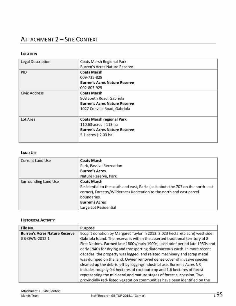
Attachment 1 – Site Context
Islands Trust Staff Report – GB-TUP-2018.1 (Garner) 1
ATTACHMENT 2 – SITE CONTEXT
LOCATION
Legal Description Coats Marsh Regional Park Burren’s Acres Nature Reserve
PID Coats Marsh 009-735-828 Burren’s Acres Nature Reserve 002‐803‐925
Civic Address Coats Marsh 908 South Road, Gabriola Burren’s Acres Nature Reserve 1027 Conville Road, Gabriola
Lot Area Coats Marsh regional Park 110.63 acres | 113 ha Burren’s Acres Nature Reserve 5.1 acres | 2.03 ha
LAND USE
Current Land Use Coats Marsh Park, Passive Recreation Burren’s Acres Nature Reserve, Park
Surrounding Land Use Coats Marsh Residential to the south and east, Parks (as it abuts the 707 on the north-east corner), Forestry/Wilderness Recreation to the north and east parcel boundaries. Burren’s Acres Large Lot Residential
HISTORICAL ACTIVITY
File No. Purpose
Burren’s Acres Nature Reserve GB-OWN-2012.1
Ecogift donation by Margaret Taylor in 2013. 2.023 hectare(5 acre) west side Gabriola Island. The reserve is within the asserted traditional territory of 8 First Nations. Farmed late 1800s/early 1900s, used brief period late 1930s and early 1940s for drying and transporting diatomaceous earth. In more recent decades, the property was logged, and related machinery and scrap metal was dumped on the land. Owner removed dense cover of invasive species cleaned up the debris left by logging/industrial use. Burren’s Acres NR includes roughly 0.4 hectares of rock outcrop and 1.6 hectares of forest representing the mid-seral and mature stages of forest succession. Two provincially red- listed vegetation communities have been identified on the
95

Islands Trust Staff Report – GB-TUP-2018.1 (Garner) 2
Coats Marsh regional Park GB-RZ-2006.2
reserve and there are sensitive herbaceous–rock outcrop ecosystems that are sensitive to disturbance. Wetland and mature second-growth forest area to be dedicated to the Gabriola Land Conservancy in exchange for density transfer of NW 1/4 of Section 10 to West 1/2 of NW 1/4 of Section 11. This application was withdrawn and closed in July 2007.
POLICY/REGULATORY
Official Community Plan No. 166, 1997
ENVIRONMENTAL GOALS
1. To preserve the unique natural environment of land, water and air and the life it supports.
2. To preserve the natural beauty of the Gabriola Planning Area and recognize that areas of sensitivity or unique value require special protective measures.
PARKS AND OUTDOOR RECREATION OBJECTIVES
The objectives of this section are: 1. To work co-operatively with provincial ministries and agencies in acquiring and managing provincial parkland on Gabriola; 2. To acquire parkland that is representative of the bioregion (i.e. wetlands, first growth forest); 3. To involve the community in parks planning; 5. To work in cooperation with the Regional District of Nanaimo in acquiring and managing community parks.
PARKS AND OUTDOOR RECREATION POLICIES
l) The Trust Committee shall work with the Regional District of Nanaimo ensuring a smooth coordination of efforts between the two agencies respecting the securing, use, development and planning for park and outdoor recreational space on Gabriola.
PARKS AND OUTDOOR RECREATION ADVOCACY POLICIES
n) The Regional District of Nanaimo shall be strongly encouraged to establish additional regional park sites on Gabriola. Such sites should be:
i. either a regionally significant waterfront site or an upland woodland site of substantial size; ii. retained predominantly in a natural state, except for a small
96

Islands Trust Staff Report – GB-TUP-2018.1 (Garner) 3
parking area, a public trail network, and interpretative signs.
ENVIRONMENTALLY SENSITIVE AREA OBJECTIVES
1. To ensure the protection of environmentally sensitive areas on Gabriola; 2. To protect important habitat and water resources areas through vegetation retention and building setbacks; 3. To encourage retention of the natural tree cover along the shoreline and to discourage tree removal to minimal selective cutting; and 4. To encourage owners of property which is environmentally sensitive to work co-operatively with conservation-based groups in defining means of providing for the protection of important sites; and 5. To consider the goals and objectives of the Regional Conservation Plan when making land-use decisions.
ENVIRONMENTALLY SENSITIVE AREA POLICIES
d) In order to protect area watercourses, rezoning adjacent to a watercourse shall be conditional upon the establishment of a protective setback area. The Ministry of Environment - Federal Fisheries report titled: Stream Stewardship - A Guide for Planners & Developers and Land Development Guidelines for the Aquatic Habitat shall be used as a guideline in determining how land is to be developed adjacent a watercourse (including a lake and wetland).
g) Trees bearing the nests of great blue heron, bald eagle, osprey and other raptors shall not be cut in accordance with provincial legislation. The zoning bylaw shall set standards and regulate the provision of screening for preserving and protecting trees bearing such nests. Such condition shall be applicable with respect to the rezoning of any site containing such a feature.
h) Fresh water features which have special biological significance to the local environment, such as Hoggan Lake, shall be protected through zoning and shall be designated as a development permit area
ENVIRONMENTALLY SENSITIVE AREA ADVOCACY POLICIES
j) Where environmentally sensitive areas are located on Crown land, Ministry of Environment is strongly encouraged to ensure these areas are placed in protective reserve, ecological reserve or natural state park or dedicated to the Islands Trust Fund for protection. Furthermore, public access should be limited to an appropriate level consistent with
97
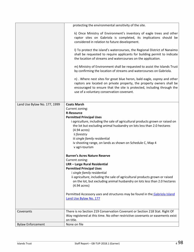
Islands Trust Staff Report – GB-TUP-2018.1 (Garner) 4
protecting the environmental sensitivity of the site.
k) Once Ministry of Environment’s inventory of eagle trees and other raptor sites on Gabriola is completed, its implications should be considered in relation to future development.
l) To protect the island’s watercourses, the Regional District of Nanaimo shall be requested to require applicants for building permit to indicate the location of streams and watercourses on the application.
m) Ministry of Environment shall be requested to assist the Islands Trust by confirming the location of streams and watercourses on Gabriola.
n) . Where nest sites for great blue heron, bald eagle, osprey and other raptors are located on private property, the property owners shall be encouraged to ensure that the site is protected, including through the use of a voluntary conservation covenant.
Land Use Bylaw No. 177, 1999 Coats Marsh Current zoning: R-Resource Permitted Principal Uses
i agriculture, including the sale of agricultural products grown or raised on the lot but excluding animal husbandry on lots less than 2.0 hectares (4.94 acres) ii forestry iii single family residential iv shooting range, on lands as shown on Schedule C, Map 4 v agri-tourism
Burren’s Acres Nature Reserve Current zoning: LRR – Large Rural Residential Permitted Principal Uses
i single family residential ii agriculture, including the sale of agricultural products grown or raised on the lot, but excluding animal husbandry on lots less than 2.0 hectares (4.94 acres)
Permitted Accessory uses and structures may be found in the Gabriola Island Land Use Bylaw No. 177
Covenants There is no Section 219 Conservation Covenant or Section 218 Stat. Right Of Way registered at this time. No other restrictive covenants or easements exist on title.
Bylaw Enforcement None on file
98

Islands Trust Staff Report – GB-TUP-2018.1 (Garner) 5
SITE INFLUENCES
Islands Trust Conservancy The Islands Trust Conservancy (Formerly Islands Trust Fund) currently owns the Burren’s Acres Nature Reserve property. It was gifted to the ITC through the Ecological Gifts Program as described in the staff Memorandum dated July 13, 2017. Coats Marsh Regional Park is jointly owned and managed by the Regional District of Nanaimo and the Nature Trust of BC. See Goals and Objectives found on page 35-37 of the ITC Regional Conservation Plan.
Regional Conservation Strategy Although Coats Marsh Regional Park is already listed as protected in the Regional Conservation Plan, both Burren’s Acres and Coats Marsh are within areas identified as having Medium to High conservation priority in the Islands Trust Area.
Species at Risk See TCB Burren’s Acres Nature Reserve Management Plan and the RDN Coats Marsh Regional Park Management Plan for species and ecosystems inventories, habitat values, conservation goals, etc.
Sensitive Ecosystems See TCB Burren’s Acres Nature Reserve Management Plan and the RDN Coats Marsh Regional Park Management Plan for species and ecosystems inventories, habitat values, conservation goals, etc.
Archaeological Sites Remote Access to Archaeological Data (RAAD) mapping indicates that while no identified and recorded sites currently exist on either property, there is potential within, and adjacent to, the boundaries of each.
Climate Change Adaptation and Mitigation
Rezoning the subject properties using a conservation/ecological protection zoning type would ensure that no further human activity associated with direct GHG emissions or climate change would occur. Further, the protection of ecological biodiversity and biomass/cover would increase CO2 uptake capacity for the lands.
Groundwater Vulnerability Burren’s Acres Moderate, to Moderately Low
99

Islands Trust Staff Report – GB-TUP-2018.1 (Garner) 6
Coats Marsh Low to Moderately Low vulnerability
While neither parcel is in an area of particularly severe local groundwater stress, restrictions on uses and structures as part of the rezoning would further reduce any possible stress on groundwater for the surrounding area by prohibiting future development that required the use of water, and rather protected natural ecosystems that aid in the protection and recharge of aquifer and groundwater networks. This could be considered to have a cumulative positive impact on groundwater in general for the immediate areas surround the parks and the island as a whole.
100

101
LTC 2019-01October 21. 2019
Gabriola Island Local Trust Committee700 North RoadGabriola Island, BC V0R 1X3
Registered Mail
Re: Local Trust Committee Meeting October 24, 2019
Now is a great opportunity to show the Snuneymuxw Elders, and the children of Gabriola (as well asmyself) that you are not "empty words", but actually delivering/implementing existing policies thatactually "preserve and protect" the environment.I dedicate this action to Dave Barrett and Greta Thunberg.
When the Islands Trust Act was passed in 1974, the main provision was to protect the islands fromfurther subdivision and over-development.
In November 1999 "pro-business" Gabriola Trustees, with the suppport of "pro-business" Trust Councilchair, violated the Islands Trust Act here on Gabriola, with the passage of Bylaw 177 (HomeOccupations) by encouraging/allowing any person buying any lot to operate two home-based businesseson that lot. This anywhere on the island, regardless of zoning.
I have have actively and continuously opposed this since at least July of 1999 (my many registeredletters are on the public record for reference). I now carry on this fight, as this has always been for realactions (such as natural plantings on the lots, rather than overdevelopment of "business uses") toactually PERSERVE AND PROTECT THE NATURAL ENVIRONMENT on Gabriola Island.
The remedy I seek is repeal of this overdevelopment/business use bylaw, and in its place a bylaw thatpromotes a small, environmentally-friendly footprint, with a promotion of "Naturescape BC" (and itsProvincial Guide, S. Campbell & S.Pincott 1995, Province of BC, Wildlife Habitat Canada, etc.).
I ask for the courtesy of a written reply to this letter.
Yours truly,
F icmvebBruce ThomsonOCT 2 2 2019
ISLAND TRUSTNORTHERN OFFICE
Gabriola BC V0R 1X6
1

Islands Trust Conservancy Report to Local Trust Committees
and Bowen Island Municipality October 2019
Regional Conservation Plan Updates The science-based and community-informed Regional Conservation Plan guides the work the Islands Trust Conservancy (ITC). The ITC continues to work towards four long-term goals and 25 objectives that further conservation in the entire Trust Area. For more information, visit www.islandstrustconservancy.ca/media/84821/itc_2018-11_rcp-2018-2027-web_final.pdf. Goal 1 – Science-based Conservation Planning
The ITC Board held a special meeting to discuss the Climate Change Emergency and forwarded it recommendations to Trust Council.
Goal 2 – Strong relationships with First Nations
The ITC Board adopted a reconciliation declaration at its July meeting and wrote to First Nations to share the Reconciliation Declaration which is available at www.islandstrustconservancy.ca/about-us/first-nations-and-reconciliation.
Goal 3 – Protection of core conservation areas Property Management
The ITC has completed management plans three Nature Reserves (Thetis and Gambier) and is working on the completion of five more (Denman, Gambier, Lasqueti and Thetis).
Property monitoring for all conservation covenants (including NAPTEP – Natural Area Protection Tax Exemption Program covenants) and nature reserves was completed.
Land Acquisition and Covenants
The ITC successfully completed the transfer of the Salish View Nature Reserve on Lasqueti Island in partnership with the Lasqueti Island Nature Conservancy. See http://www.islandstrustconservancy.ca/protected-places/places-protected-in-the-islands/all/lasqueti-island/salish-view-nature-reserve/ for more information.
Goal 4 – A strong voice for nature conservation
The ITC Board gave final reading to Bylaw No. 2, the “Islands Trust Conservancy Meeting Procedures Bylaw, 2019.” The new bylaw reflects the ITC name change, allows for the election of a Vice Chair and adds reference to committee meetings. The Board also amended Policy 1.2 Islands Trust Conservancy Board and Committee Elections.
The ITC Board elected Sue-Ellen Fast to serve as Vice-Chair for the ITC Board.
The ITC Board approved the Audited Financial Statements for the 2018-2019 fiscal year at its July meeting. See www.islandstrustconservancy.ca/about-us/our-financials.
The ITC Board and the Islands Trust Executive Committee met in July to discuss items of mutual interest
102
ISLANDS TRUST CONSERVANCYProtecting Canada's Islands in the Salish Sea

Please feel free to contact the Islands Trust Conservancy for more details. Kate-Louise Stamford, Chair [email protected]
Islands Trust Conservancy [email protected]
Activities by Local Trust Area/Island Municipality Ballenas-Winchelsea Property monitoring on South Winchelsea Island has been completed for 2019. Bowen Property monitoring on Bowen has been completed for 2019. Denman Management planning for three nature reserves, including the Inner Island, Lindsay Dickson and Valens Brook Nature Reserves, is under way and an open house for community feedback was held in September. Property monitoring on Denman has been completed for 2019. Invasive species management activities continue at Inner Island, Lindsay Dickson, and Morrison Marsh nature reserves. Gabriola Expansion of the boardwalk over wet areas and exposed roots on the west side of the loop trail in Elder Cedar Nature Reserve has been completed and construction of a 93-ft boardwalk across a seasonally flooded section of trail in the northeast corner is planned for 2019. Property monitoring on Gabriola has been completed for 2019. The ITC hosted a celebration event for the Swift Family Link Island NAPTEP Covenant at the Islands Trust Victoria Office. The event was attended by Islands Trust staff and ITC Board members and trustees and other staff were invited to attend remotely by GoTo Meeting. Galiano Trail maintenance is being planned for Vanilla Leaf Land Nature Reserve in partnership with the Galiano Conservancy Association. Invasive species removal and annual cormorant nest monitoring are being planned for Trincomali Nature Sanctuary in partnership with the Habitat Acquisition Trust. Property monitoring on Galiano has been completed for 2019. Gambier Management plans for Brigade Bay Bluffs and Long Bay Wetland nature reserves has been completed and the Management Plan for the Mount Artaban Nature Reserve is nearing completion. Completed management plans are available on the ITC website at http://www.islandstrustconservancy.ca/protected-places/places-protected-in-the-islands/full-list/. ITC is
concurrently working on a parallel management planning process for areas of cultural heritage and sacred significance within its nature reserves.
Property monitoring on Gambier has been completed for 2019.
103

Please feel free to contact the Islands Trust Conservancy for more details. Kate-Louise Stamford, Chair [email protected]
Islands Trust Conservancy [email protected]
Hornby Property monitoring on Hornby has been completed for 2019. Lasqueti The ITC and the Lasqueti Island Nature Conservancy (LINC) completed the campaign for the Salish View Nature Reserve and the land has been transferred to the ITC. The ITC held a celebration event in July and an open house to inform management planning. Management planning continues and is anticipated to complete in early 2020. Property monitoring on Lasqueti has been completed for 2019. North Pender Property monitoring on North Pender has been completed for 2019. Salt Spring The ITC Board considered and approved a conservation proposal for 200 Collins Road. ITC staff are working with the applicant to develop a conservation covenant for the property and will return to the ITC Board for final approval once the covenant language is finalized. Development of management plans for the Lower Mt. Erskine and Deep Ridge nature reserves is underway and public
consultation will begin soon. ITC staff also participated in recent meeting for the Mount Tuam Special Management Area Resource Team. Property monitoring on Salt Spring has been completed for 2019. Saturna Property monitoring on Saturna has been completed for 2019. South Pender Property monitoring on South Pender has been completed for 2019. Thetis Trail building on the Fairyslipper Forest Nature Reserve has begun and will continue into the new year. Property monitoring on Thetis has been completed for 2019.
104

Print Date: November 20, 2019
Applications
Development Permit
GB-DP-2017.2 PID: 009-796-045 To bring property into bylaw compliance
Civic: Acorn Island
03-Aug-2017Fenton, Rob
File Number Purpose Date Received Applicant Name
Planner: Ian Cox
Planning Status
09-Oct-2019
DP and DVP not on October 24th agenda in order to provide adequate time for responses to First Nations referrals. Staff will
bring forward the concurrent applications for consideration at the November 28, 2019 regular business meeting.
Status Date:
17-Sep-2019
September 12 LTC meeting resolution to direct to staff to amend covenant as per LTC minutes; accept covenant as amended
and staff to consult with Lisa Wilcox and\nFirst Nations before consideration of DP and DVP applications.
Status Date:
14-Aug-2019
ATV access route modification to covenant in legal review.
Status Date:
GB-DP-2019.4 PID: 003-347-516 DP required for driveway and culvert. Civic address: 788
Roxanne Blvd, Gabriola Island, BC.
16-Aug-2019Ritchie, Dominique
File Number Purpose Date Received Applicant Name
Planner: Jaime Dubyna
Planning Status
11-Sep-2019
Planner reviewing application.
Status Date:
Page 1 of 8105
IslandsTrust

Print Date: November 20, 2019
Applications
Development Variance Permit
GB-DVP-2016.3 PID: 003-422-852 539 Wildwood Crescent, Gabriola Island. DVP to bring
property into compliance.
24-Aug-2016Van Herwaarden, Lynn
File Number Purpose Date Received Applicant Name
Planner: Ian Cox
Planning Status
15-Aug-2018
Awaiting further information/ exploring options
Status Date:
18-Aug-2017
Sent letter to the property owner and requested her (or her surveyor) to forward the completed survey / site plan to planning
staff.
Status Date:
17-Aug-2017
Planning staff met with the owner on site, reiterated the need for a survey / site plan. The owner committed to providing a
survey / site plan as per the Land Use Bylaw.
Status Date:
GB-DVP-2017.1 PID: 009-796-045 To bring property into bylaw compliance. Civic address: Acorn
Island
03-Aug-2017Fenton, Rob
File Number Purpose Date Received Applicant Name
Planner: Ian Cox
Planning Status
17-Sep-2019
September 12 LTC meeting resolution to direct to staff to amend covenant as per LTC minutes; accept covenant as amended
and staff to consult with Lisa Wilcox and\nFirst Nations before consideration of DP and DVP applications.
Status Date:
14-Aug-2019
ATV access route modification to covenant in legal review. DP and DVP will be brought to LTC for consideration after
registration of covenants on title.
Status Date:
25-Jun-2019
Applicant and Staff working to complete covenants.
Status Date:
Page 2 of 8106
IslandsTrust

Print Date: November 20, 2019
Applications
Development Variance Permit
GB-DVP-2019.1 PID: 016-001-826 Setback variance. Civic address: 585 North Road, Gabriola
Island, BC.
22-Jan-2019Regional District of
Nanaimo (Huxley
Community Park)
File Number Purpose Date Received Applicant Name
Planner: Bronwyn Sawyer
Planning Status
16-Oct-2019
Spoke with applicant - no change in application status
Status Date:
16-May-2019
Report to LTC
Status Date:
16-May-2019
GB-DVP-2019.1 to be issued subject to conditions - in progress
Status Date:
Rezoning
GB-RZ-2019.1 PIDs: 025-798-090 and 025-798-103 Rezoning for improved ferry terminal -
future marine and upland improvements.
Civic address: Descanso Bay, Gabriola
05-Apr-2019BC Transportation
Financing Authority/BC
Ferry Services Inc.
File Number Purpose Date Received Applicant Name
Planner: Jaime Dubyna
Planning Status
11-Jul-2019
Preliminary staff report considered by LTC.\n
Status Date:
11-Jul-2019
LTC endorsed staff recommendations from staff report dated July 11, 2019.
Status Date:
06-May-2019
Applicant submitted copy of AOA by Golder Associates, to planner.
Status Date:
Page 3 of 8107
IslandsTrust

Print Date: November 20, 2019
Applications
Subdivision
GB-SUB-2008.3 To create 6 parcels btwn McCollum & Tait Roads. (PARCEL C (DD 51803I) OF
THE NORTH 1/2 OF THE NORTH EAST 1/4 OF SECTION 9, GABRIOLA
ISLAND, NANAIMO DISTRICT)
06-Oct-2008C.O. Smythies &
Associates Ltd.
File Number Purpose Date Received Applicant Name
Planner: Ian Cox
Planning Status
24-Oct-2018
Update email sent to MOTI to notify that Planner TR is leaving IT and to correspond through general email until another Planner
is assigned.
Status Date:
05-Jul-2018
Received confirmation from MOTI that PLA has been extended to June 28 2019
Status Date:
18-Jan-2018
Planner re-sent the revised referral report to MOTI. Will await a response from MOTI.
Status Date:
GB-SUB-2011.1 To create 2 parcels on Daniel Way (THE NORTHWEST 1/4 OF THE
SOUTHEAST 1/4 OF SECTION 22, GABRIOLA ISLAND, NANAIMO DISTRICT,
EXCEPT PARTS IN PLANS 22029, 30038, 32376 AND VIP54644)
23-Dec-2010Williamson &
Associates
Professional Surveyors
File Number Purpose Date Received Applicant Name
Planner: Marnie Eggen
Planning Status
03-Nov-2017
No change
Status Date:
08-Jan-2016
No change
Status Date:
13-Jan-2015
Applicant working to satisfy conditions
Status Date:
Page 4 of 8108
IslandsTrust
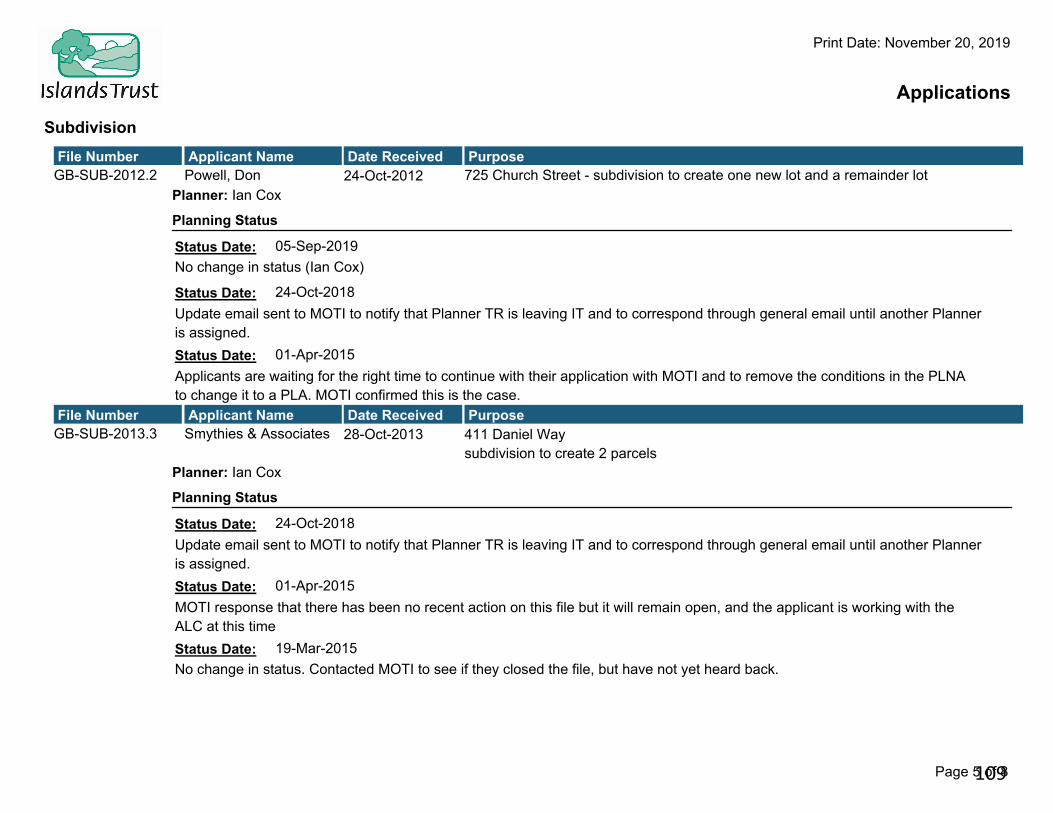
Print Date: November 20, 2019
Applications
Subdivision
GB-SUB-2012.2 725 Church Street - subdivision to create one new lot and a remainder lot24-Oct-2012Powell, Don
File Number Purpose Date Received Applicant Name
Planner: Ian Cox
Planning Status
05-Sep-2019
No change in status (Ian Cox)
Status Date:
24-Oct-2018
Update email sent to MOTI to notify that Planner TR is leaving IT and to correspond through general email until another Planner
is assigned.
Status Date:
01-Apr-2015
Applicants are waiting for the right time to continue with their application with MOTI and to remove the conditions in the PLNA
to change it to a PLA. MOTI confirmed this is the case.
Status Date:
GB-SUB-2013.3 411 Daniel Way
subdivision to create 2 parcels
28-Oct-2013Smythies & Associates
File Number Purpose Date Received Applicant Name
Planner: Ian Cox
Planning Status
24-Oct-2018
Update email sent to MOTI to notify that Planner TR is leaving IT and to correspond through general email until another Planner
is assigned.
Status Date:
01-Apr-2015
MOTI response that there has been no recent action on this file but it will remain open, and the applicant is working with the
ALC at this time
Status Date:
19-Mar-2015
No change in status. Contacted MOTI to see if they closed the file, but have not yet heard back.
Status Date:
Page 5 of 8109
IslandsTrust

Print Date: November 20, 2019
Applications
Subdivision
GB-SUB-2016.2 PIDs: 004-857-119 and 004-614-771 Lot Boundary Adjustment23-Feb-2016MACKAY, IKE
File Number Purpose Date Received Applicant Name
Planner: Ian Cox
Planning Status
05-Sep-2019
Awaiting fulfillment of conditions by applicant.
Status Date:
24-Oct-2018
Update email sent to MOTI to notify that Planner TR is leaving IT and to correspond through general email until another Planner
is assigned.
Status Date:
05-May-2016
Awaiting response from MOTI to issue PLA or PLNA.
Status Date:
GB-SUB-2016.4 PIDs: 001-271-806 and 009-735-755 Boundary adjustment. Civic
address:1610 Hess Road, Gabriola Island.
20-May-2016C.O. Smythies &
Associates
File Number Purpose Date Received Applicant Name
Planner: Sonja Zupanec
Planning Status
08-Jun-2016
Referral response sent to MOTI and copied to applicant and LTC.
Status Date:
Page 6 of 8110
IslandsTrust

Print Date: November 20, 2019
Applications
Subdivision
GB-SUB-2016.6 PID: 000-305-120 215 Easthom Road, Gabriola Island. 3 lot subdivision.08-Sep-2016C.O. Smythies &
Associates
File Number Purpose Date Received Applicant Name
Planner: Ian Cox
Planning Status
30-Aug-2019
Awaiting Archaeology Branch confirmation letter in order to complete Islands Trust sign-off for conditions.
Status Date:
25-Jun-2019
Second PLA extension issued February 22, 2019 by the MOTI. Applicant working to satify PAO and Islands Trust conditions.
Status Date:
10-Jan-2019
Re-review by Planner Cox - 'No change to referral response' emailed to MOTI district development tech. Awaiting PLR
Status Date:
GB-SUB-2017.2 PIDs: 009-739-602 and 000-105-287. Lot line adjustment. Civic 831 Chelwood
Road, Gabriola Island, BC
19-Jan-2017Williamson &
Associates
File Number Purpose Date Received Applicant Name
Planner: Marnie Eggen
Planning Status
23-Jul-2018
PLA issued
Status Date:
01-Jun-2017
Referral response sent
Status Date:
GB-SUB-2018.1 PIDs:027-939-791, 027-939-804, 003-010-431, 006-635-121 27 lot subdivision
Civic address: Taylor Bay Road/Church Street
26-Jun-2018Williamson &
Associates/Potlatch
Properties Ltd.
File Number Purpose Date Received Applicant Name
Planner: Sonja Zupanec
Planning Status
12-Jul-2018
Referral response sent to MOTI, applicant and LTC.
Status Date:
Page 7 of 8111
IslandsTrust

Print Date: November 20, 2019
Applications
Subdivision
GB-SUB-2019.1 PID: 004-549-023 Subdivision at 369 Berry Point Road, Gabriola Island, BC11-Jun-2019Williamson &
Associates (B&K
Shopping Centre)
File Number Purpose Date Received Applicant Name
Planner: Ian Cox
Planning Status
18-Oct-2019
Revised referral response sent to MOTI based on updated proposed plan received October 16, 2019.
Status Date:
20-Aug-2019
Referral response sent to the MOTI - see file email. Awaiting MOTI decision.
Status Date:
25-Jun-2019
Under review by staff. Referral response pending.
Status Date:
Page 8 of 8112
IslandsTrust

113
Islands TrustLTC EXP SUMMARY REPORT F2020
Invoices posted to Month ending September 2019
620 Gabriola Invoices posted to Month ending September 2019 SpentBudget Balance
65000-620 LTC "Trustee Expenses" 1,355.00 0.00 1,355.00
LTC Local65200-62065210-620
65220-620
65230-620TOTAL LTC Local Expense
LTC - Local Exp - LTC Meeting ExpensesLTC - Local Exp - APC Meeting ExpensesLTC - Local Exp - Communications
LTC - Local Exp - Special Projects
4,578.00493.00
1,000.00
588.00
1,597.011,128.88
435.00
2,980.99-635.88
565.00
588.000.00
6,659.00 3,160.89 3,498.11
Projects73001-620-4097 Gabriola Housing Options & Impacts73001-620-4104 Gabriola Cannabis Regulations73001-620-4105 Gabriola Ecological Protection ZoneTOTAL Project Expenses
7,000.002,600.007,000.00
519.88 6,480.122,600.007,000.00
0.000.00
16,600.00 519.88 16,080.12

Updated: April 11, 2019
Gabriola Island Local Trust Committee Policies & Standing Resolutions
No Meeting Date Resolution No. Issue Policy and Description 1. January 29, 2010 GB-025-2010 Communication Towers
and Antennae It was MOVED and SECONDED that the Gabriola Island Local Trust Committee adopt the following standing resolution:
Proposals for any new or expanded communication towers and antennae require an application to the Gabriola Islands Local Trust Committee.
The application process shall comprise a public consultation component, which includes at least one notification to neighbours, one public meeting and one advertisement in the local newspaper.
The public consultation process shall be determined by the Local Trust Committee after initial review of the proposal; however, as a minimum, the proponent shall give written notice to Islands Trust Northern Office staff and the Snunéymuxw First Nation, all owners and residents of properties within a 2 kilometre radius of the subject property where the facility is proposed. The required notice shall include the following information: o the proposed location of the tower on the subject site o a description of the predicted power density level of the
antenna/tower o methods to mitigate any aesthetic or visual impact o description of the natural environment, any sensitive ecosystems or
other important habitat areas within 120 metres of the subject property and mitigation of impacts to such areas
o physical details and example illustrations of the tower including its height, colour, type and design
o the time and location of a public meeting and advertising o the name and contact information of the contact person employed by
the proponent o the name and all contact information of the Islands Trust planning
staff available for public comments and questions regarding the proposal; and
o the proponent may be required to enter into a cost recovery agreement with the Islands Trust, in order to offset application processing costs incurred.
114

Updated: April 11, 2019
2. June 14, 2018 GB-2018-040 Processing non-medical
cannabis retail license applications
It was MOVED and SECONDED that the Gabriola Island Local Trust Committee adopt the following standing resolution with respect to the processing of non-medical cannabis retail license applications:
Proposed or amended licenses for non-medical cannabis retail establishments require an application to the Local Trust Committee;
The application process shall comprise a public consultation component, which includes at least one notification to neighbours, one public meeting, posting of public notices and one advertisement in a local periodical;
The public consultation process shall be determined by the Local Trust Committee after initial review of the proposal; and
However, as a minimum, the Local Trust Committee will mail or otherwise deliver a notice to all owners and residents of properties within a 500 metre radius of the subject property where the establishment is proposed at least 10 days before adoption of a resolution providing comment on the application. The required notice shall include the following information: Name of the applicant and a description of the proposal in general terms;
The location of the proposed establishment and the subject site; The place where, and date and time when, both a public meeting will be
held and a resolution of the local trust committee considered; The name and contact information of the Islands Trust planning staff
member who can provide copies of the proposed or amended license application; and
How public comments may be submitted to the Local Trust Committee. 3. November 22, 2018 GB-2018-122 Applications for Federal
Cannabis License It was MOVED and SECONDED that the Gabriola Island Local Trust Committee requests that Notices of Intention to Apply for a Federal Cannabis License be forwarded to the Local Trust Committee upon receipt by the Islands Trust.
4. February 28, 2019 GB-2019-031 First Nations - Community Reconciliation
It was MOVED and SECONDED that the Gabriola Island Local Trust Committee adopt the following standing resolution: Whereas the Local Trust Committee seeks to engage in Reconciliation with local First Nations, governments and the island community by honouring the Truth and Reconciliation Commission (TRC) Calls to Action, United Nations Declaration on
115

Updated: April 11, 2019
the Rights of Indigenous Peoples (UNDRIP), Draft Principles that Guide the Province of British Columbia’s Relationship with Indigenous Peoples, and Islands Trust First Nations Engagement Principles, the Local Trust Committee endeavours to:
a) Annually, write a letter to First Nations, (re)introducing Trustees and Staff and provide a schedule of known Local Trust Committee meetings for the upcoming year, as well as provide an update of current projects and advocacy activities;
b) For various Local Trust Committee meetings, invite elders from local First Nations to attend and provide a traditional welcome to the territory;
c) Work with First Nation governments on cooperative initiatives, including and not limited to, language, place names, territorial acknowledgements, and community education on Coast Salish and local First Nations’ cultural heritage and history;
d) Work with First Nation governments on engagement principles for inclusive land use, marine use and climate change planning; advocacy, protection and stewardship; and knowledge and information sharing protocols; and
e) Establish and maintain government to government dialogue with First Nations, now and into the future, based on respect and recognition of Aboriginal rights and title, treaty rights, and First Nations’ traditional territories within the Islands Trust Area.
5. April 11, 2019 GB-2019-038 Limited Public Markets Enforcement
It was MOVED and SECONDED that the Gabriola Island Local Trust Committee adopt the following standing resolution with respect to limited public markets: a) Islands Trust Bylaw Enforcement Staff are directed to not enforce Section
B.6.2 of Gabriola Island Land Use Bylaw No. 177, 1999 when limited public markets are operated indoors, but rather to inform the operators of the applicable land use regulations;
b) This enforcement policy does not permit violation of the Land Use Bylaw and the Gabriola Island Local Trust Committee may at any time, by resolution, modify or rescind this policy or give direction to expand enforcement activities.
116

Updated: April 11, 2019
6. April 11, 2019 GB-2019-040 S219 Covenant Signatories
It was MOVED and SECONDED that the Gabriola Island Local Trust Committee adopt the following standing resolution:
that the Gabriola Island Local Trust Committee is authorized to enter into section 219 covenants, in the form of the ‘Model Covenant for Secondary Suites’ attached and in satisfaction of subsection B.6.6.8 of the Gabriola Island Land Use Bylaw No. 177, provided that such covenants must be executed on behalf of the Local Trust Committee by two members of the Local Trust Committee.
117

Print Date: November 20, 2019
Top Priorities Report
Gabriola Island
Housing Options and Impacts Review Project
Sonja Zupanec
1.
Develop an Engagement and Communication Strategy;
Strengthen relationships with Snuneymuxw First Nation and incorporate First Nation
perspectives into policy/regulatory options;
Explore opportunities to foster affordable, rental, special needs and seniors housing and
associated services;
Develop a strategy to address all housing continuum gaps;
Ensure policy/regulatory changes are consistent with the Object of the Islands Trust, the
ITPS, with focus on water protection/conservation and ecological footprints.
Rec'd: 22-Nov-2018
Responsible Dates
Cannabis Production and Retail Sales2.
Proposed Bylaw 303 introduced to amend the Gabriola Land Use Bylaw provisions
pertaining to cannabis regulations, definitions, lot setbacks and building size.
Rec'd: 22-Nov-2018
Responsible Dates
Develop an Ecological Protection Zone
Ian Cox
3.
Research and develop a new ecological protection zone as part of the Parks (P) OCP
designation. Update zoning of Coats Marsh and Burren's Acres Nature Reserve
properties.
Rec'd: 22-Nov-2018
Responsible Dates
Page 1 of 1 118
IslandsTrust

Print Date: November 20, 2019
Projects Report
Gabriola Island
DeCourcy Island OCP and Bylaw Review1.
Review DeCourcy Island Official Community Plan and Regulatory bylaws; establish an
Advisory Planning Commission. Topics include: park areas without park zoning, DAI
Bylaw, subdivision polices and regulations (added March 2017).
21-Apr-2011
Responsible Date Received
Hazardous areas/Steep Slopes DPA2.
Consider hazardous areas and steep slopes development permit area designation;
consider how to address areas of potentially problematic soils, shoreline erosion, and
localized areas of steep terrain
21-Feb-2013
Responsible Date Received
Forage Fish Mapping Workshop3.
March, 2013 resolution 05-Sep-2013
Responsible Date Received
Land Based Aquaculture4.
Review most recent provincial direction on land based aquaculture and develop
appropriate policies and regulations.
16-Jan-2014
Responsible Date Received
Biodiversity Protection5.
Identify measures to protect biodiversity 19-Jan-2012
Responsible Date Received
Coastal areas protection6.
Review OCP and LUB to improve protection of coastal areas; development of a
comprehensive DPA for shorelines in the Gabriola Island Local Trust Area
19-Jan-2012
Responsible Date Received
Page 1 of 5 119
IslandsTrust

Print Date: November 20, 2019
Projects Report
Gabriola Island
Water Protection7.
Review OCP and LUB to protect water quality and quantity. 19-Jan-2012
Responsible Date Received
First Nations cultural references8.
Consider First Nations cultural references in land use planning; Work with Snuneymuxw
First Nation (SFN) to seek funding for archaeological mapping and host and invite SFN
Councillor Geraldine Manson to make a storytelling presentation on Gabriola.
27-Jan-2011
Responsible Date Received
Eelgrass protection9.
Consider implementing Eelgrass protection regulations (see February 19, 2014
memorandum).
14-May-2014
Responsible Date Received
Snuneymuxw Protocol Agreement10.
Implementation of Snuneymuxw First Nation Protocol Agreement 22-Jan-2015
Responsible Date Received
Gabriola Village Plan11.
Undertake a comprehensive review of policies and regulations with respect to the
Gabriola Village Core
02-Apr-2015
Responsible Date Received
Snuneymuxw Relationship Building12.
Strengthen relationship with Snuneymuxw First Nation 02-Apr-2015
Responsible Date Received
Page 2 of 5 120
IslandsTrust
Print Date: November 20, 2019
Projects Report
Gabriola Island
Food Trucks13.
Review land use bylaw regulations with respect to food trucks 02-Apr-2015
Responsible Date Received
Eagle Nest Mapping14.
Incorporate eagle nest mapping into the OCP 02-Apr-2015
Responsible Date Received
Green Energy15.
Consider policy and regulatory mechanisms to encourage green and renewable energy 02-Apr-2015
Responsible Date Received
Commercial Vacation Rental Review16.
Review bylaws with respect to temporary use permits for commercial vacation rentals 07-May-2015
Responsible Date Received
LUB Amendments17. Responsible Date Received
Page 3 of 5 121
IslandsTrust

Print Date: November 20, 2019
Projects Report
Gabriola Island
- Review of temporary sawmill regulations
- Definition of personal use of animals for SRR zoned lots
- Review of how cisterns, solar panels and parking are regulated as structures subject to
lot coverage calculations
-Review of section B.2.1.1 for variances within DP3
-Review minimum average parcel size calculations in LUB and OCP to ensure consistent
and supportive of more than 5% dedication of parkland
-IN1 zoning to ensure consistent with existing Arts Council use.
-definition and regulations for limited public market, and INI zone uses pertaining to
market sales
-correction to WC3 mapped location to coincide with Green Wharf
08-Sep-2016
Water Resource Planning18.
Review of water requirements at the time of subdivision 14-Jun-2018
Responsible Date Received
Water Taxi Feasibility19.
Follow up items emerging out of water taxi feasibility (completed fall 2018) 22-Nov-2018
Responsible Date Received
Protection of the Coastal Douglas-fir and Associated Ecosystems: An Islands Trust Tool Kit (2018)20.
Implementation of the report recommendations into OCP policy and LUB regulations. 24-Jan-2019
Responsible Date Received
Page 4 of 5 122
IslandsTrust

Print Date: November 20, 2019
Projects Report
Gabriola Island
GB LUB Accessory Buildings21.
Review of regulations pertaining to the order of construction of accessory buildings on
lots.
12-Sep-2019
Responsible Date Received
Draft an application for a UBCM grant to develop a poverty reduction strategy22.
24-Oct-2019
Responsible Date Received
Page 5 of 5 123
IslandsTrust
Related Documents