Preliminary national-scale lead isotope maps of Australia GEOSCIENCE AUSTRALIA RECORD 2019/01 D. L. Huston 1 , D. C. Champion 1 , B. Ware 2 , G. Carr 3 , R. Maas 4 and S. Tessalina 2 1. Geoscience Australia. 2. John de Laeter Centre, Curtin University. 3. Commonwealth Scientific and Industrial Research Organisation. 4. School of Earth Sciences, University of Melbourne.

Welcome message from author
This document is posted to help you gain knowledge. Please leave a comment to let me know what you think about it! Share it to your friends and learn new things together.
Transcript

Preliminary national-scale lead isotope maps of Australia
GEOSCIENCE AUSTRALIARECORD 2019/01
D. L. Huston1, D. C. Champion1, B. Ware2, G. Carr3, R. Maas4 and S. Tessalina2
1. Geoscience Australia.2. John de Laeter Centre, Curtin University.3. Commonwealth Scientific and Industrial Research Organisation.4. School of Earth Sciences, University of Melbourne.

Department of Industry, Innovation and ScienceMinister for Resources and Northern Australia: Senator the Hon Matthew CanavanSecretary: Dr Heather Smith PSM
Geoscience AustraliaChief Executive Officer: Dr James JohnsonThis paper is published with the permission of the CEO, Geoscience Australia
Geoscience Australia acknowledges the traditional custodians of the country where this work was undertaken. We also acknowledge the support provided by individuals and communities to access the country, especially in remote and rural Australia.
© Commonwealth of Australia (Geoscience Australia) 2019
With the exception of the Commonwealth Coat of Arms and where otherwise noted, this product is provided under a Creative Commons Attribution 4.0 International Licence. (http://creativecommons.org/licenses/by/4.0/legalcode)
Geoscience Australia has tried to make the information in this product as accurate as possible. However, it does not guarantee that the information is totally accurate or complete. Therefore, you should not solely rely on this information when making a commercial decision.
This paper is published with the permission of the CEO, Geoscience Australia.
Geoscience Australia is committed to providing web accessible content wherever possible. If you are having difficulties with accessing this document please email [email protected].
ISSN 2201-702X (PDF)ISBN 978-1-925848-32-8 (PDF)eCat 127263
Bibliographic reference: Huston, D. L., Champion, D. C., Ware, B., Carr, G., Maas, R., Tessalina, S. 2019. Preliminary national-scale lead isotope maps of Australia. Record 2019/01. Geoscience Australia, Canberra. http://dx.doi.org/10.11636/Record.2019.001
Version: 1901

Contents
1 Introduction..........................................................................................................................................
2 Pb isotope systematics........................................................................................................................
3 Selection of Pb isotope analyses.........................................................................................................
4 Construction of interpolated isotopic images.......................................................................................
5 Results.................................................................................................................................................
6 Interpretation........................................................................................................................................
References...........................................................................................................................................
Preliminary national-scale lead isotope maps of Australia iii

1 Introduction
Following encouraging initial results in the Yilgarn Craton (Champion and Cassidy, 2008), Geoscience Australia undertook a national campaign to map variations in Nd model ages calculated from Sm-Nd isotopic data from granites, resulting in the first continental-scale isotopic map (Champion, 2013) in the world. This map and the original Yilgarn map indicated that gradients in isotopic data commonly overlap the locations of major crustal boundaries identified using independent geological and/or geophysical data, and, more importantly, the isotopic data could be used at the province-scale to target prospective regions for a range of mineral deposit types.
Following the initial results from Nd isotopes, Pb isotope data from ore minerals in deposits of the Eastern Goldfields Superterrane in the Yilgarn Craton were compiled and maps were made showing variations in parameters derived from the Pb isotope data. These maps showed similarities to the pre-existing Nd model age maps (Huston et al., 2014), so a second campaign of isotopic mapping was initiated. This resulted in the production of Pb-based isotopic maps initially of southeastern Australia (Huston et al., 2016) and then for the entire Tasman Element (Huston et al., 2017).
As part of the Exploring for the Future program, Geoscience Australia is currently extending the Pb isotope maps to cover the entire Australian continent with a focus on northern Australia. This process involves collation of existing data from the literature and other sources coupled with collection and analysis of new samples. The maps that accompany this report are based on data from the literature and initial analyses acquired as part of this study; additional samples are currently being analysed and will be included in the maps in future updates. These maps can be used to infer isotopic and geochemical characteristics of crust from which the Pb was derived during mineralisation, as discussed below.
Preliminary national-scale lead isotope maps of Australia 1

2 Pb isotope systematics
The abundances of radiogenic isotopes of Pb increase over time due to the decay of 238U (to 206Pb), 235U (to 207Pb) and 232U (to 208Pb). Lead isotopes range in mass number from 178 to 218; of these mass numbers, only four are stable, the two uranogenic isotopes (206Pb, 207Pb), the thorogenic isotope (208Pb) and 204Pb (e.g., Faure, 1986). To chart the changes in abundances of the radiogenic isotopes, Pb isotope data are generally reported as ratios of the radiogenic isotope to primordial, non-radiogenic 204Pb.
As the abundances of the radiogenic isotopes, and the 204Pb-normalised ratios, increase with time, raw 206Pb/204Pb, 207Pb/204Pb, and 208Pb/204Pb values cannot easily be directly compared for samples/deposits with significantly different ages. To resolve this problem, we have used the parameters μ, κ and ω which simply reflect the 238U/204Pb (μ), 232Th/238U (κ) and 232Th/204Pb (ω) ratios of the Pb source at the time of Pb extraction and mineralisation. To successfully calculate these parameters an initial Pb composition, at some fixed time in the past, must be assumed for all samples, typically based on one of a number of global Pb isotope evolution curves (e.g. Stacey and Kramers, 1975; Cumming and Richards, 1975). The calculated μ, κ and ω then provide a model representation of the Pb isotope characteristics of the upper crust in the region of the deposit. Unless subsequently modified these parameters can be assumed to represent modern day values. This allows direct comparison between deposits of different ages and makes possible the construction of interpolated grids, based on the μ, κ and ω parameters. It must be stressed that both different evolution models and different starting points in these models will give different values of μ, κ and ω, therefore, evolution models should not be mixed when calculating these parameters.
2 Preliminary national-scale lead isotope maps of Australia

3 Selection of Pb isotope analyses
Many mineral deposits have multiple (in some cases well over a hundred) Pb isotope analyses. However, to construct the images in this record, we have used one analysis per deposit/locality. Selection of this analysis for each deposit was based upon three preferences: (1) for initial Pb isotope ratios, (2) for least radiogenic analyses, and (3) for high-precision analyses.
Initial ratios are those that characterise the deposit and source region at the time of mineralisation. If an analysed sample contained significant uranium and thorium relative to Pb at the time of mineralisation, radiogenic decay of these elements following mineralisation (i.e. ingrowth) will increase the concentrations of 206Pb, 207Pb and 208Pb and modify initial ratios, that is, the measured ratios do not reflect the initial ratios. For best estimates of initial ratios, therefore, it is simplest to analyse samples with low concentrations of uranium and thorium relative to Pb, for example galena, where measured ratios are effectively the initial ratios. Empirically (and conservatively) we have found, as a general rule, that samples with over 1000 ppm Pb generally preserve the initial ratios. Initial ratios can also be estimated by subtracting ingrown Pb if the Pb, uranium and thorium concentrations and the age of the sample are known. Additionally, if a deposit is very young (i.e. <100 Ma), ingrowth is generally not significant and the measured ratios approximate the initial ratios. This does not apply in Australia as virtually all deposits are older than 100 Ma.
As post-ore geological processes can introduce more radiogenic Pb, uranium and/or thorium or disturb isotopic values, the least radiogenic analyses (i.e., those with the lowest 206Pb/204Pb and 207Pb/204Pb) best reflect the characteristics of the ores and source rocks at the time of mineralisation. Hence, for deposits with multiple Pb isotope measurements, the least radiogenic values were chosen as the most representative of initial ratios at the time of mineralisation.
The third criterion used to select analyses was the precision of the analysis. Ore Pb isotope data has been collected in Australia for over fifty years with concomitant changes in analytical techniques and increased analytical precision. All analyses were identified as having high or low precision, based upon reported precision.
In most cases Pb-rich samples took precedence over all other analyses because in most cases these reflect initial ratios. If Pb-rich samples were not available, the least radiogenic Pb-poor analysis was used, particularly if U, Th and Pb concentrations and an age estimate allowed removal of ingrown Pb. For Pb-rich analyses, the least radiogenic analysis was chosen as later mineralising events can introduce new Pb or disturb ratios in existing samples. If low and high precision analyses were within error of each other, the high precision analysis was chosen.
The least-radiogenic Pb isotope dataset used to construct Pb isotope maps is presented in electronic Appendix A and is available as an Excel workbook. The dataset includes identification and location information as well as descriptions of samples, the mineral analysed, measured isotopic ratios and U, Th and Pb abundances and derived parameters (see below). Metadata describing information in the dataset are presented in Table 1. The full dataset will be released upon the completion of this study in mid-2020.
Preliminary national-scale lead isotope maps of Australia 3

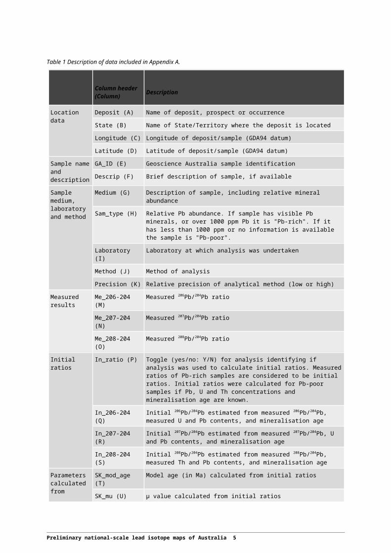
Table 1 Description of data included in Appendix A.
Column header (Column) Description
Location data Deposit (A) Name of deposit, prospect or occurrence
State (B) Name of State/Territory where the deposit is located
Longitude (C) Longitude of deposit/sample (GDA94 datum)
Latitude (D) Latitude of deposit/sample (GDA94 datum)
Sample name and description
GA_ID (E) Geoscience Australia sample identification
Descrip (F) Brief description of sample, if available
Sample medium, laboratory and method
Medium (G) Description of sample, including relative mineral abundance
Sam_type (H) Relative Pb abundance. If sample has visible Pb minerals, or over 1000 ppm Pb it is "Pb-rich". If it has less than 1000 ppm or no information is available the sample is "Pb-poor".
Laboratory (I) Laboratory at which analysis was undertaken
Method (J) Method of analysis
Precision (K) Relative precision of analytical method (low or high)
Measured results
Me_206-204 (M) Measured 206Pb/204Pb ratio
Me_207-204 (N) Measured 207Pb/204Pb ratio
Me_208-204 (O) Measured 208Pb/204Pb ratio
Initial ratios In_ratio (P) Toggle (yes/no: Y/N) for analysis identifying if analysis was used to calculate initial ratios. Measured ratios of Pb-rich samples are considered to be initial ratios. Initial ratios were calculated for Pb-poor samples if Pb, U and Th concentrations and mineralisation age are known.
In_206-204 (Q) Initial 206Pb/204Pb estimated from measured 206Pb/204Pb, measured U and Pb contents, and mineralisation age
In_207-204 (R) Initial 207Pb/204Pb estimated from measured 207Pb/204Pb, U and Pb contents, and mineralisation age
In_208-204 (S) Initial 208Pb/204Pb estimated from measured 208Pb/204Pb, measured Th and Pb contents, and mineralisation age
Parameters calculated from initial ratios (using Stacey and Kramer (1975) model)
SK_mod_age (T) Model age (in Ma) calculated from initial ratios
SK_mu (U) μ value calculated from initial ratios
SK_kappa (V) κ value calculated from initial ratios
SK_omega (W) ω value calculated from initial ratios
Comments Comments (X) Comments relevant to each analysis.
Source of data Source (Y) The source of the analysis is indicated in this column. Most analyses are from three datasets containing CSIRO data: CSIRO southeast Australia, CSIRO north Queensland and ISOTAS. Other sources are cited according to presentation in the literature. The citations are included as a separate worksheet in the workbook.
4 Preliminary national-scale lead isotope maps of Australia
4 Construction of interpolated isotopic images
Once the representative least-radiogenic analyses were determined, three parameters – μ (238U/204Pb), κ (232Th/238U) and ω (232Th/204Pb) – were calculated iteratively for each deposit or occurrence using the Stacey and Kramers (1975) Pb evolution model and using a starting point of 3.7 Ga. This evolution model was chosen as it is the most widely used internationally. Although the values of the parameters will change if other models are used (e.g. Cumming and Richard, 1975), the relative differences in the parameters are preserved (i.e. if sample A has a higher μ than sample B using the Stacey and Kramers (1975) model, it will also have a higher μ using the Cumming and Richards (1975) model or any other evolution model). It is important that only one evolution model is used to determine μ, κ, ω and other parameters as mixing of models will produce spurious results. This allows direct comparison of samples independent of age, something not possible using the simple ratios.
Once μ, κ and ω were calculated, we used the interpolation approach of Champion (2013). Gridding was performed in ArcMap™ using Natural Neighbour Interpolation, displayed with intervals based on Natural Breaks (Jenks), that is, display intervals determined by the software. A ten-fold classification was used fro display. The natural breaks techniques used by that software follows the Jenks optimisation method, also known as the goodness of variance fit, which identifies thresholds (identified intervals) which optimise (i.e., minimise) the sum of squared deviations of interval means. Slocum et al. (2009) have discussed the relative merits of different data classification procedures. ASCII grids for μ, κ and ω interpolations are available as separate downloads.
Preliminary national-scale lead isotope maps of Australia 5

5 Results
Images showing variations in μ, κ and ω are shown in Figures 1, 2 and 3, respectively. These images should be considered preliminary as additional analyses from recently collected samples (over the last year) will be added once available. These additional samples were collected to infill gaps in the existing coverage (see maps), although it was not possible to obtain samples for all data gaps. Final release of new images and data, along with a discussion of their geological significance, will be in mid-2020.
Figure 1 Preliminary map showing variations in μ (238U/204Pb: mu) in Australia. A semi-transparent mask is shown over regions with no data (regions with muted colours). Boundaries of tectonic provinces are from Champion (2013). NAE = North Australian Element; SAE = South Australian Element; WAE = West Australian Element; CAE = Central Australian Element.
6 Preliminary national-scale lead isotope maps of Australia

Figure 2 Preliminary map showing variations in κ (232Th/238U: kappa) in Australia. A semi-transparent mask is shown over regions with no data (regions with muted colours). Boundaries of tectonic provinces are from Champion (2013). NAE = North Australian Element; SAE = South Australian Element; WAE = West Australian Element; CAE = Central Australian Element.
Preliminary national-scale lead isotope maps of Australia 7

Figure 3 Preliminary map showing variations in ω (232Th/204Pb: omega) in Australia. A semi-transparent mask is shown over regions with no data (regions with muted colours). Boundaries of tectonic provinces are from Champion (2013). NAE = North Australian Element; SAE = South Australian Element; WAE = West Australian Element; CAE = Central Australian Element.
8 Preliminary national-scale lead isotope maps of Australia

6 Interpretation
A full interpretation of the new Pb isotope maps will be provided once all data is available (anticipated mid-2020). For guides on interpreting the current preliminary images the reader is referred to Huston et al. (2016, 2017).
Preliminary national-scale lead isotope maps of Australia 9

References
Champion, D.C., 2013. Neodymium depleted mantle model age map of Australia: explanatory notes and user guide. Geoscience Australia Record 2013/044. http://dx.doi.org/10.11636/Record.2013.044.
Champion, D. C., Cassidy, K. C. 2008.Using geochemistry and isotopic signatures of granites to aid mineral systems studies: an example from the Yilgarn Craton. Geoscience Australia Record 2008/09, 7–16. https://ecat.ga.gov.au/geonetwork/srv/eng/catalog.search#/metadata/65830
Cumming, G. L., Richards, J. R. 1975. Ore lead isotope ratios in a continuously changing Earth. Earth and Planetary Science Letters 28, 155–171.
Faure, G. 1986. Principles of Isotope Geology, 2nd edition. New York, Chichester, Brisbane, Toronto, Singapore: John Wiley & Sons.
Huston, D. L., Champion, D. C., Cassidy, K. F. 2014. Tectonic controls on the endowment of Neoarchean cratons in volcanic-hosted massive sulfide deposits: evidence from lead and neodymium isotopes. Economic Geology 109, 11–26.
Huston, D. L., Champion, D. C., Mernagh, T. P., Downes, P. M., Jones, P., Carr, G., Forster, D., David, V. 2016a. Metallogenesis and geodynamics of the Lachlan Orogen: New (and old) insights from spatial and temporal variations in lead isotopes. Ore Geology Reviews 76, 257–267.
Huston, D. L., Champion, D. C., Morrison, G., Maas, R., Thorne, J. P., Carr, G., Beams, S., Bottrill, R., Chang, Z.-S., Dhnaram, C., Downes, P. M., Forster, D. B., Gemmell, J. B., Lisitsin, V., McNeill, A. and Vicary, M. 2017. Spatial variations in lead isotopes, Tasman Element, eastern Australia. Record 2017/09. Geoscience Australia, Canberra. http://dx.doi.org/10.11636/Record.2017.009
Slocum, T. A., McMaster, R. B., Kessler, F. C., Howard, H. H., 2009. Thematic Cartography and Geovisualization. Third Edition. Pearson Prentice Hall, New Jersey, 561 p.
Stacey, J. S.; Kramers, J. D. 1975. Approximation of terrestrial lead isotope evolution by a two-stage model. Earth and Planetary Science Letters 26, 207–221.
10 Preliminary national-scale lead isotope maps of Australia
Related Documents