GeoArabia, Vol. 4, No. 4, 1999 Gulf PetroLink, Bahrain 503 Lithostratigraphy and Depositional History of Part of the Midyan Region, Northwestern Saudi Arabia G. Wyn Hughes, Saudi Aramco Dogan Perincek, King Fahd University of Petroleum and Minerals David J. Grainger, Gulf PetroLink Abdul-Jaleel Abu-Bshait, Saudi Aramco and Abdul-Rahman M. Jarad, King Fahd University of Petroleum and Minerals ABSTRACT The Midyan region provides a unique opportunity in which to examine exposures of the Upper Cretaceous and Neogene sedimentary succession. Recent investigations have yielded new interpretations of its depositional environments, stratigraphic relationships, and structure. In this paper, all the lithostratigraphic units of the Midyan succession are considered to be informal in advance of an on-going process of formalization. The region is bounded to the north and northeast by mountains of Proterozoic rocks and to the west and south by the Gulf of Aqaba and the Red Sea, respectively. The Wadi Ifal plain occupies most of the eastern half of the region, beneath which is a thick sedimentary succession within the Ifal basin. The oldest sedimentary rocks are the fluviatile Upper Cretaceous Adaffa formation and marine siliciclastics and carbonates of the lower Miocene Tayran group, unconformable on the Proterozoic basement. The Tayran group is unconformably overlain by the deep-marine lower Miocene Burqan formation that, in turn, is overlain by marine mudstones, carbonates, and evaporites of the middle Miocene Maqna group. The poorly exposed middle Miocene Mansiyah and middle to upper Miocene Ghawwas formations consist of marine evaporites and shallow to marginal marine sediments, respectively. The youngest rocks are alluvial sands and gravels of the Pliocene Lisan formation. A complex structural history is due to Red Sea Oligocene-Miocene extension tectonics, and Pliocene-Recent anti-clockwise rotation of the Arabian Plate relative to Africa on the Dead Sea Transform Fault. The Upper Cretaceous succession is a probable pre-rift unit. The Oligocene?-Miocene syn-rift 1 phase of continental extension caused slow subsidence (Tayran group). Syn-rift 2 was an early Miocene phase of rapid subsidence (Burqan formation) whereas syn-rift 3 (early to middle Miocene) was another phase of slow deposition (Maqna group). The middle to late Miocene syn-rift 4 phase coincided with the deposition of the Mansiyah and Ghawwas formations. The Lower Pliocene to Recent succession is related to the drift (post-rift) phase during which about 45 kilometers of sinistral movement occurred on the Dead Sea Fault. The structural control on sedimentation is evident: the Ifal basin was formed by east- west lithospheric extension; pull-apart basins occur along major left-lateral faults on the eastern coast of the Gulf of Aqaba; and basin-bounding faults controlled deposition of the Burqan, Ghawwas, and Lisan formations. Pliocene to Recent earth movements may be responsible for activating salt diapirism in the Ifal basin. Extensive Quaternary faulting and regional uplift caused the uplift of coral reefs to at least 6 to 8 meters above sea level. INTRODUCTION The Midyan Peninsula lies within the angle formed by the Gulf of Aqaba and the Red Sea (Figures 1 and 2). The Gulf of Aqaba is the surface expression of the southern segment of the Dead Sea Transform Fault that connects the Red Sea rift zone with the Bitlis-Zagros subduction zone of southern Turkey. Offset magnetic anomalies (Hatcher et al., 1981) and sedimentary contacts (Quennell, 1958; Hagras et al., 1988) indicate between 100 and 105 kilometers (km) of left-lateral offset since the Cretaceous. Downloaded from http://pubs.geoscienceworld.org/geoarabia/article-pdf/4/4/503/5439267/hughes.pdf by guest on 26 August 2022

Welcome message from author
This document is posted to help you gain knowledge. Please leave a comment to let me know what you think about it! Share it to your friends and learn new things together.
Transcript
GeoArabia, Vol. 4, No. 4, 1999Gulf PetroLink, Bahrain
503
Lithostratigraphy and Depositional History of Part of theMidyan Region, Northwestern Saudi Arabia
G. Wyn Hughes, Saudi AramcoDogan Perincek, King Fahd University of Petroleum and Minerals
David J. Grainger, Gulf PetroLinkAbdul-Jaleel Abu-Bshait, Saudi Aramco and
Abdul-Rahman M. Jarad, King Fahd University of Petroleum and Minerals
ABSTRACT
The Midyan region provides a unique opportunity in which to examine exposures of theUpper Cretaceous and Neogene sedimentary succession. Recent investigations haveyielded new interpretations of its depositional environments, stratigraphic relationships,and structure. In this paper, all the lithostratigraphic units of the Midyan succession areconsidered to be informal in advance of an on-going process of formalization.
The region is bounded to the north and northeast by mountains of Proterozoic rocks andto the west and south by the Gulf of Aqaba and the Red Sea, respectively. The Wadi Ifalplain occupies most of the eastern half of the region, beneath which is a thick sedimentarysuccession within the Ifal basin. The oldest sedimentary rocks are the fluviatile UpperCretaceous Adaffa formation and marine siliciclastics and carbonates of the lower MioceneTayran group, unconformable on the Proterozoic basement. The Tayran group isunconformably overlain by the deep-marine lower Miocene Burqan formation that, inturn, is overlain by marine mudstones, carbonates, and evaporites of the middle MioceneMaqna group. The poorly exposed middle Miocene Mansiyah and middle to upperMiocene Ghawwas formations consist of marine evaporites and shallow to marginalmarine sediments, respectively. The youngest rocks are alluvial sands and gravels of thePliocene Lisan formation.
A complex structural history is due to Red Sea Oligocene-Miocene extension tectonics,and Pliocene-Recent anti-clockwise rotation of the Arabian Plate relative to Africa on theDead Sea Transform Fault. The Upper Cretaceous succession is a probable pre-rift unit.The Oligocene?-Miocene syn-rift 1 phase of continental extension caused slow subsidence(Tayran group). Syn-rift 2 was an early Miocene phase of rapid subsidence (Burqanformation) whereas syn-rift 3 (early to middle Miocene) was another phase of slowdeposition (Maqna group). The middle to late Miocene syn-rift 4 phase coincided withthe deposition of the Mansiyah and Ghawwas formations. The Lower Pliocene to Recentsuccession is related to the drift (post-rift) phase during which about 45 kilometers ofsinistral movement occurred on the Dead Sea Fault.
The structural control on sedimentation is evident: the Ifal basin was formed by east-west lithospheric extension; pull-apart basins occur along major left-lateral faults on theeastern coast of the Gulf of Aqaba; and basin-bounding faults controlled deposition ofthe Burqan, Ghawwas, and Lisan formations. Pliocene to Recent earth movements maybe responsible for activating salt diapirism in the Ifal basin. Extensive Quaternary faultingand regional uplift caused the uplift of coral reefs to at least 6 to 8 meters above sea level.
INTRODUCTION
The Midyan Peninsula lies within the angle formed by the Gulf of Aqaba and the Red Sea (Figures 1and 2). The Gulf of Aqaba is the surface expression of the southern segment of the Dead Sea TransformFault that connects the Red Sea rift zone with the Bitlis-Zagros subduction zone of southern Turkey.Offset magnetic anomalies (Hatcher et al., 1981) and sedimentary contacts (Quennell, 1958; Hagras etal., 1988) indicate between 100 and 105 kilometers (km) of left-lateral offset since the Cretaceous.
Downloaded from http://pubs.geoscienceworld.org/geoarabia/article-pdf/4/4/503/5439267/hughes.pdfby gueston 26 August 2022

Hughes et al.
504
J a b a l
Ru
gh
am
a
J a b a l
Ru
gh
am
a
Jabal as Sabil Jabal as Safra
Ad Dubaybah
Wadial Kils
Jabal Tayran
Maqna
JabalMundassah
Jabal ar Risha
Maqna massif
34°45'E 35°00'E
28°30'N
28°15'N
Figure 4
Jabal as Sabil Jabal as Safra
Ad DubaybahAl Bad'
Wadial Kils
Jabal Tayran
Maqna
JabalMundassah
Jabal ar Risha
Maqna massif
Jabal Kibrit
Wadi Waqb
Wadi Ifal
MIDYAN EASTTERRACE
Aynunah
Ifal plain
Ra's SheikhHumaid
Km0 10
IFAL
FAULT
IFAL
CE
NTR
AL
FAU
LT
Wadi al Hamd
IFAL EASTFA
ULT
JabalMusayr
Kial
LS1
LS2
Al Khuraybah
Road
Al Bad'
Wadi al Hamd
Gulf of Suez
SinaiPeninsula Midyan
Peninsula
Red Sea
Gu
lf o
f Aq
aba
N
Figure 1: Oblique satellite image of the Midyan Peninsularelating it to its regional setting.
Figure 2: Satellite image of the Midyan region showing localities and geologicalfeatures mentioned in the text. In this image, outcrops of anhydrite show up turquoise;
LS1/LS2, major left-stepping faults (see p. 530).
Downloaded from http://pubs.geoscienceworld.org/geoarabia/article-pdf/4/4/503/5439267/hughes.pdfby gueston 26 August 2022
Lithostratigraphy, Midyan Region, Saudi Arabia
505
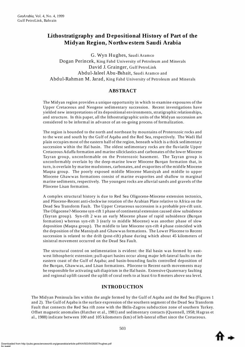
Within the Peninsula is exposed a Cretaceous to Neogene lithostratigraphic succession (Figure 3) thatcan be directly related to the one described from the Red Sea by Hughes and Beydoun (1992) and tothe stratigraphic scheme established informally by Saudi Aramco (Hughes and Filatoff, 1995; Johnsonet al., 1995). High, rugged mountains of Proterozoic basement rocks form the northern and easternboundary to the region and also the core of the Maqna massif in the west. Wadi Ifal supplies basement-derived sediments that are transported onto the Ifal plain and mask the underlying Cretaceous toNeogene deposits of the Ifal basin. The sedimentary rocks are exposed around the margins of the Ifalplain and on the flanks of the Maqna massif.
Recent interest in the geology of the Midyan region follows from hydrocarbon exploration along theSaudi Arabian Red Sea coast. It was recognized that the region offers a unique opportunity to examinethe lithofacies and biofacies that would otherwise be accessible only by drilling. Seismic and drillingactivities by Saudi Aramco in the 1990s proved the existence of hydrocarbon-bearing carbonatereservoirs in the Midyan region (Kamal and Hughes, 1995). Fieldwork and satellite image interpretationin 1997 and 1998 concentrated on the structural relationships, lithofacies and biofacies variations ofthe exposed limestones in order to improve the understanding of the reservoir facies framework withinthe carbonate sequences.
AGE
Pleistocene Ifal
Lisan Pos
t-rif
t /D
rift
Syn
-rift
4S
yn-r
ift 3
Syn
-rift
2S
yn-r
ift 1
Pre
-rift
Ghawwas
Mansiyah
Kial
Pliocene
(Una
ssig
ned)
(Una
ssig
ned)
late Miocene
Maq
na
JabalKibrit
Wadi Waqbmember
Nutayshmember
Subaytimember
(Umm Lujmember)
Burqan
Tayr
an
Musayr
Al Wajh
(Yanbu)
Suq
ah
Adaffa
middle Miocene
early Miocene
LateCretaceous
Indeterminate Proterozoicbasement
GP FORMATION LITHO-LOGY
TECTONICEPISODES
Pol
len
Din
ofla
gella
tes
Mar
ine
Dia
tom
s
Pla
nkto
nic
For
amin
ifera
N19
-N23
NN
2N
N3
NN
4N
N5
N9A
N9B
N8
N7
N6
N5
Tf
Tg/
Th
NN
12-1
8N
N20
-21
Larg
er F
oram
inife
ra
Cal
c. N
anno
foss
ils
MICROFLORA ANDMICROFAUNA
2
3
3
4
5
6
7
11
12
1
Sup
ra-t
idal
Inte
r-tid
al
Sha
llow
Mar
ine
Dee
p M
arin
e
ENVIRONMENT
?
?
?
Wardan
Shagara
South Gharib
Zeit
Belayim
Kareem
Rudeis
Nukhul
Various
Hammam Faraun
Baba Member
Feiran MemberSirdi Member
Shagar Member
Markha Member
Ghara Member
Shoab Ali Member
Gharamul Member
Basement
RED SEA ANDGULF OF SUEZ
Figure 3: Lithostratigraphy of the Midyan region and correlation with the Red Sea and Gulf ofSuez. All Midyan units are informal. GP = group; brackets ( ) indicate units absent from theregion but part of the designated group or formation.
Downloaded from http://pubs.geoscienceworld.org/geoarabia/article-pdf/4/4/503/5439267/hughes.pdfby gueston 26 August 2022

Hughes et al.
506
Figure 4: Geological map of the western part of the Midyan region.
Nmd
PL-Q Ghawwas and Lisan formationsupper Miocene-Pliocene-Quaternary
Mansiyah formationmiddle Miocene
Dolomite
Kial formation-evaporite middle Miocene
Sandstone-mudstone
Wadi Waqb member (Jabal Kibrit fm.)middle-lower Miocene
Burqan formationlower Miocene
Musayr formationlower Miocene
Al Wajh formationlower Miocene
Proterozoic basement
Primary fault
Secondary fault
Third-grade fault
Lineament (bedding)
Left-lateral, right-lateralfaults (see text)
Anticline
Direction of fault slip
Up-thrown fault block /down-thrown fault block
Exploration wells
(Original map prepared by Research Institute KFUPM, Dhahran, Saudi Arabia)MAQNA GROUP
L E G E N D
TAYRAN GROUP
Nmn
Nmd
Nmk
Nmw
Nb
Ntm
Ntw
Pcz
PL-Q
Midyan-1
Midyan-2
Ntm
0 5
Km
Midyan-4
Midyan-3
Nmk
Nmk
Ntm
Ntm
Pcz
Pcz
NmkNtm
Nb
Pcz
Pcz
Nb
Nmk
Nmd
NmwPcz
Pcz
Nmk
Nmn
Nmk
Ntw
Nb
NbNtm
Ntm
PL-Q
PL-Q
PL-Q
PL-Q
PL-Q
PL-Q
PL-Q
PL-Q
Nb
NbUD
UD
U
D
UD
UD
UD
UD
UD
UD
Nmd
Nb
PL-QPcz
Gulf of Aqaba
28 20
28 15
28 10
34 45 34 50 34 55 35 00
L1R1
L1, R1, R2
R1
R2
PL-Q
Pcz
N
Downloaded from http://pubs.geoscienceworld.org/geoarabia/article-pdf/4/4/503/5439267/hughes.pdfby gueston 26 August 2022

Lithostratigraphy, Midyan Region, Saudi Arabia
507
The 1:250,000-scale geologic map of the Al Bad’ quadrangle (Clark, 1986) provided the mostcomprehensive description of the geology of the Midyan region prior to the Saudi Aramcoinvestigations. Combining the results of the recent ground investigations and the interpretation ofsatellite imagery produced a revised geologic map of part of the Midyan Peninsula (Figure 4). Thelithological descriptions of exposures are based on recent work by Saudi Aramco geologists,supplemented by the Explanatory Notes that accompany Clark’s map. As the Proterozoic basement isof limited reservoir significance, it was not considered in any detail in the present study.
The Ifal basin is one of several Oligocene-Pliocene half-grabens on the western margin of the ArabianPlate that developed in response to two episodes of rifting and drifting. Sedimentation in the basinprobably began with deposition of the Late Oligocene to early Miocene Tayran group (Figure 3) andwas followed by deposition of the early Miocene Burqan formation and the early middle MioceneMaqna group (Jabal Kibrit and Kial formations). A marked angular unconformity is present at thebase of the Jabal Kibrit formation in outcrop and in the subsurface. Evaporites characterize the Kialformation and the overlying late middle Miocene Mansiyah formation. Faulting was active duringearly and middle Miocene times and became a controlling influence of sedimentation during thedeposition of the middle to late Miocene Ghawwas formation. Uplift of the Pliocene and PleistoceneLisan and Ifal formations, together with fault reactivation, indicate a significant tectonic event in theIfal basin in response to movement on the Dead Sea Fault system.
Previous Work
The geology of the Midyan region has attracted attention since the 19th century (Burton, 1878) whenexploration for gold was the incentive. Bogue (1953) and Philby (1956) investigated the mineralresources of the region. Although numerous geological investigations had been made of thesedimentary rocks in the adjacent Egyptian Red Sea and Gulf of Suez areas, the first examination ofthe sedimentary succession in Midyan was by Richter-Bernburg and Schott (1954) followed by Kahrand Agocs (1962) and Agocs and Keller (1962). Regional investigations, including the compilation ofgeological maps, were by Bramkamp et al. (1963), Powers et al. (1966), and Drysdall (1978). A renewedinterest in the region’s mineral deposits resulted in studies by the Japanese Geological Survey andBritish Steel Corporation. The Midyan Peninsula was mapped by Clark (1986) at 1:250,000-scale. Helists the many studies made of the Proterozoic basement.
Stratigraphic studies, including a concentration of interest in the extensive evaporite deposits, havebeen made by Croisille (1967), Skipwith (1973), Bigot and Alabouvette (1976), Shearman (1979),Boardman (1980), Brosset (1980), Remond and Teixido (1980), Motti et al. (1980, 1982), Le Nindre (1981),and Vial et al. (1983). Detailed stratigraphic investigations include those by Dullo et al. (1983), Clark(1986), Jado et al. (1990), and Taj (1991) together with unpublished reports by Saudi Aramco geologists.Structurally focussed investigations are few, but include Bayer et al. (1987, 1988), Montanet et al. (1988),Salah and Alsharhan (1996), and Gardner et al. (1996).
Between 1967 and 1976, ten deep exploratory wells were drilled to investigate the petroleum geologyof the Saudi Arabian Red Sea (Figure 5) and a further six wells were drilled between 1982 and 1984 inthe Yanbu region. The rocks penetrated by these wells were readily equated with the standardlithostratigraphy of the well-explored Gulf of Suez, but no serious attempt was made at the time toestablish a formal stratigraphic succession.
Recent Work
Saudi Aramco made the most recent and intensive investigation into the petroleum geology of the RedSea between 1992 and 1993. Fourteen exploratory wells were drilled and detailed field observationsmade in the Midyan region and in the Al Wajh, Yanbu, Jiddah, Ghawwas, and Jizan areas (see Figure 5).The results of the Saudi Aramco work have been documented either as Saudi Aramco internal reports(Hughes and Kamal, 1993 a-c; Kamal and Hughes, 1993 a, b; Johnson et al., 1995) or published byHughes and Filatoff (1995), Kamal and Hughes (1995), Filatoff and Hughes (1996), and Hughes et al.(1998a, b). Most of the fieldwork was in the Midyan region (wholly within the area of the Al Bad’
Downloaded from http://pubs.geoscienceworld.org/geoarabia/article-pdf/4/4/503/5439267/hughes.pdfby gueston 26 August 2022
Hughes et al.
508
1:250,000-scale quadrangle mapped by Clark (1986)) as it has the most comprehensive exposures onthe Red Sea coast of Saudi Arabia (Figure 2). This work led to the establishment of the informallithostratigraphic scheme shown as Figure 3.
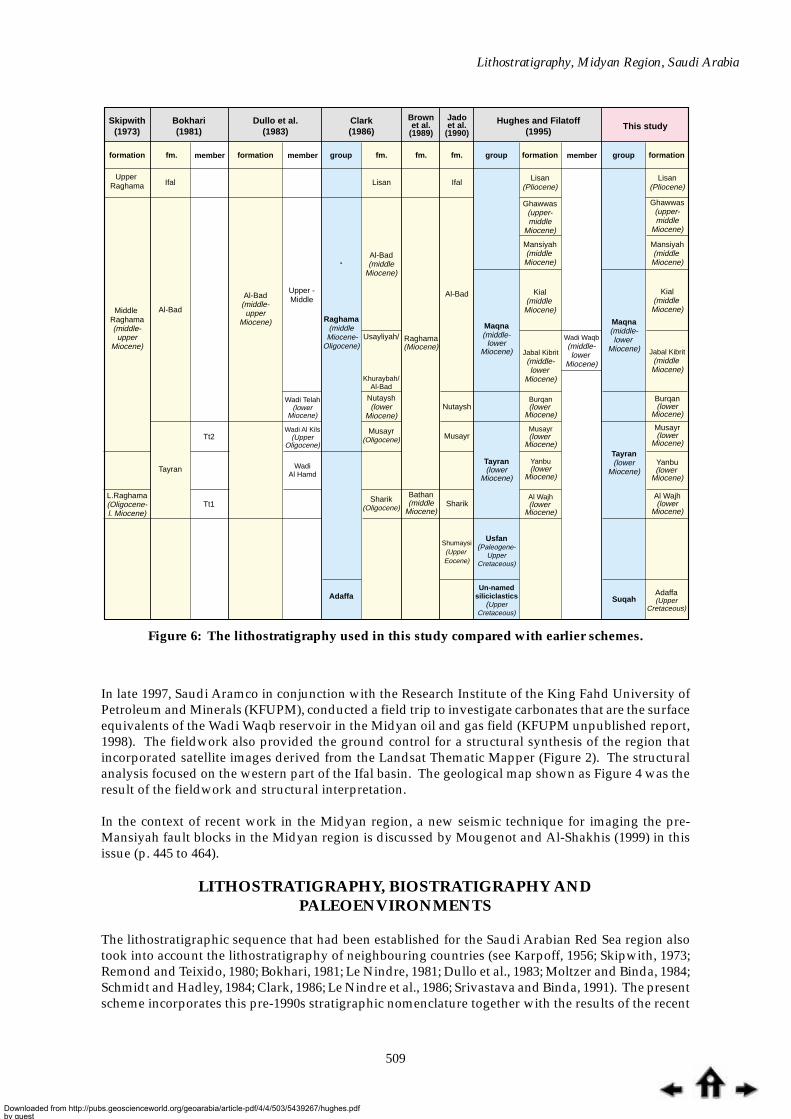
The nomenclature of the lithostratigraphic succession is varied, but Hughes and Beydoun (1992)suggested a regional scheme based on the similarity of the succession to the well-studied Gulf of Suezand the successions drilled or exposed in the Red Sea region. An informal scheme was later suggestedfor use by Saudi Aramco (Hughes and Filatoff, 1995; Johnson et al., 1995) that has been followed in thepresent work. Figure 6 compares earlier Saudi Arabian Red Sea lithostratigraphic schemes with thecurrent scheme.
The aims of the present study have been to establish a lithostratigraphic scheme and depositionalhistory for the Midyan region. A stratigraphic lexicon has been constructed that takes into accountinformation from the wells drilled elsewhere in the Saudi Arabian Red Sea and its onshore margins(see Figure 3). In this, it builds on the work of Hughes and Filatoff (1995).
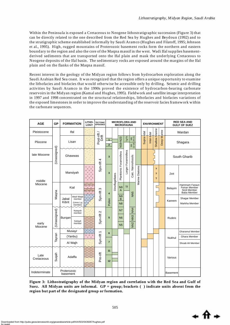
Figure 5: Exploration wells in the Saudi Arabian Red Sea area.
28
26
24
22
20
18
16
14 36 38 40 42 44
0 200
Km
46
Midyan
Al Wajh
Yanbu
Red Sea
Jiddah
Ghawwas
SAUDI ARABIAEGYPT
IRAQ
SUDAN
ERITREA
ETHIOPIA
Jizan
TABUK
AL MADINAH
JIDDAHMAKKAH
TAIF
JIZANNAJRANMansiyah-1
Non-Aramco wells
( See Figure 4 for location of Saudi Aramco wells Midyan-1 to 4)
Saudi Aramcoexploration areas
Ghawwas-1
Al-Khurmah-1
Yuba-1
Rayaman-1
Burquan-1,2,3
An Numan-1
YANBU
N
Downloaded from http://pubs.geoscienceworld.org/geoarabia/article-pdf/4/4/503/5439267/hughes.pdfby gueston 26 August 2022
Lithostratigraphy, Midyan Region, Saudi Arabia
509
Skipwith(1973)
formation formation formation formationfm.fm. fm. fm.
Upper Raghama
Middle Raghama(middle-upper
Miocene)
L.Raghama(Oligocene-l. Miocene)
Al-Bad(middle-upper
Miocene)
Al-Bad(middle
Miocene)
Nutaysh(lower
Miocene)
Shumaysi(Upper Eocene)
Bathan(middle
Miocene)
Raghama(Miocene)
Maqna(middle-
lowerMiocene)
Tayran(lower
Miocene)
Usfan(Paleogene-
UpperCretaceous)
Un-namedsiliciclastics
(UpperCretaceous)
Musayr(Oligocene)
Sharik(Oligocene) Sharik
Usayliyah/
Khuraybah/Al-Bad
Lisan(Pliocene)
Lisan(Pliocene)
Ghawwas(upper-middle
Miocene)
Ghawwas(upper-middle
Miocene)
Mansiyah(middle Miocene)
Kial(middle
Miocene)
Jabal Kibrit(middle-lower
Miocene)
Wadi Waqb(middle-lower
Miocene)
Burqan(lower
Miocene)
Musayr(lower
Miocene)
Yanbu(lower
Miocene)
Al Wajh(lower
Miocene)
Mansiyah(middle Miocene)
Kial(middle Miocene)
Jabal Kibrit(middle
Miocene)
Burqan(lower
Miocene)
Musayr(lower
Miocene)
Yanbu(lower
Miocene)
Al Wajh(lower
Miocene)
Adaffa(Upper
Cretaceous)
Maqna(middle-lower
Miocene)
Tayran(lower
Miocene)
Suqah
Lisan Ifal
Al-Bad
Nutaysh
Musayr
Ifal
Al-Bad
Upper -Middle
Raghama(middle
Miocene-Oligocene)
Adaffa
Wadi Telah
WadiAl Hamd
(lowerMiocene)
Wadi Al Kils(Upper
Oligocene)
Tayran
Tt2
Tt1
group group groupmember member member
Bokhari(1981)
Dullo et al.(1983)
Clark(1986)
Jadoet al.
(1990)
Brownet al.
(1989)Hughes and Filatoff
(1995)This study
In late 1997, Saudi Aramco in conjunction with the Research Institute of the King Fahd University ofPetroleum and Minerals (KFUPM), conducted a field trip to investigate carbonates that are the surfaceequivalents of the Wadi Waqb reservoir in the Midyan oil and gas field (KFUPM unpublished report,1998). The fieldwork also provided the ground control for a structural synthesis of the region thatincorporated satellite images derived from the Landsat Thematic Mapper (Figure 2). The structuralanalysis focused on the western part of the Ifal basin. The geological map shown as Figure 4 was theresult of the fieldwork and structural interpretation.
In the context of recent work in the Midyan region, a new seismic technique for imaging the pre-Mansiyah fault blocks in the Midyan region is discussed by Mougenot and Al-Shakhis (1999) in thisissue (p. 445 to 464).
LITHOSTRATIGRAPHY, BIOSTRATIGRAPHY ANDPALEOENVIRONMENTS
The lithostratigraphic sequence that had been established for the Saudi Arabian Red Sea region alsotook into account the lithostratigraphy of neighbouring countries (see Karpoff, 1956; Skipwith, 1973;Remond and Teixido, 1980; Bokhari, 1981; Le Nindre, 1981; Dullo et al., 1983; Moltzer and Binda, 1984;Schmidt and Hadley, 1984; Clark, 1986; Le Nindre et al., 1986; Srivastava and Binda, 1991). The presentscheme incorporates this pre-1990s stratigraphic nomenclature together with the results of the recent
Figure 6: The lithostratigraphy used in this study compared with earlier schemes.
Downloaded from http://pubs.geoscienceworld.org/geoarabia/article-pdf/4/4/503/5439267/hughes.pdfby gueston 26 August 2022

Hughes et al.
510
Saudi Aramco studies of outcrop and subsurface data (Hughes and Filatoff, 1995; Johnson et al., 1995).However, according to the rules of stratigraphic nomenclature (Hedburg, 1961), the lithostratigraphicscheme remains informal as neither the publications by Hughes and Filatoff (1995) nor by Johnson etal. (1995), despite their detailed information, provided the comprehensive details of the designatedtype sections. G.W. Hughes and R.S. Johnson are in the process of formalizing the lithostratigraphicnomenclature adopted by Saudi Aramco and used informally in this present study. Therefore, thelithostratigraphic units of the entire Midyan succession, irrespective of authorship, are identified as(lower case) ‘group’, ‘formation’, and ‘member’ in order to indicate their present informal status.
In the following discussion (and in order to improve clarity of regional similarities), reference is madeto the well-documented equivalent lithostratigraphic units of the Gulf of Suez (Figure 3), as suggestedby Hughes and Beydoun (1992). The terms ‘early’ and ‘late’ are restricted to indicate relative timedesignation whereas ‘lower’ and ‘upper’ are applied to equivalent time-stratigraphic units (Bates andJackson, 1980; Haile, 1987). As none of these designations are formalized for the Miocene (Barron etal., 1985), lower case lettering is used.
Basement
The Proterozoic basement borders the Midyan region to the north and northeast and also crops out inthe core of the Maqna massif to the west of the Ifal plain. It consists of ultramafic, metavolcanic, andmetasedimentary rocks and granitic plutons, that have been intruded by basalt, rhyolite, and doleritedikes (Figure 7). The basement has been dated at about 600 to 700 million years old (Gardner et al.,1996) and is considered to have been formed along an accreting Proterozoic volcanic arc. Explorationdrilling in the Ifal basin shows that the basement rocks are fractured and leached. The granitic characterof the basement indicates a continental rift origin for the proto-Red Sea, rather than spreading and thegeneration of oceanic crust (Bosworth, 1993; Sultan et al., 1993).
Figure 7: Late Proterozoic granitic basement intruded by dark mafic dikes on the northeasternmargin of the Ifal plain.
Downloaded from http://pubs.geoscienceworld.org/geoarabia/article-pdf/4/4/503/5439267/hughes.pdfby gueston 26 August 2022
Lithostratigraphy, Midyan Region, Saudi Arabia
511
Suqah group
The Suqah group consists of the Adaffa, Usfan, and Matiyah formations of which only the Adaffaformation is recognized in the Midyan region. The group includes essentially all the pre-rift UpperCretaceous to Paleogene successions exposed in the Saudi Arabian Red Sea area (Figure 3). Johnson etal. (1995) named the group after Wadi as Suqah near Jiddah.
Adaffa formationThe oldest sedimentary sequence exposed in the Midyan area has a Late Cretaceous age based onmacrofossils.
Name: Clark (1986) named his Adaffa formation after Al Adaffa village in Wadi ash-Sharmah in theAynunah area of southeast Midyan. The formation now described corresponds to the lower part ofClark’s formation as much of his outcrop, including the fossiliferous calcarenite, has been reassignedto the Miocene Maqna group. Prior to the recent study, the sequence was assigned to the ‘Un-namedClastic Unit’ unit by Hughes and Filatoff (1995) (Figure 6).
Regional Equivalent: The group is the siliciclastic age equivalent of various carbonate units in the Gulfof Suez, such as the Duwi (Lower Campanian) and Sudr (Upper Campanian-Maastrichtian) formations.
Type Section: Aynunah graben in southeast Midyan (28°05'45"N; 35°16'3.4"E) (Clark, 1986).
Lithology: Clark estimated the Adaffa to be possibly 200 meters (m) thick (see Figure 8). The section ismade up of a thin basal conglomerate overlain by approximately 300 feet (ft) of yellow to reddish-brown cross-bedded sandstone and gray-green shale. The conglomerate contains granite cobbles andpebbles, phosphatic nodules, dinosaur and turtle bones, and petrified wood fragments. The sandstoneis a well-sorted quartz arenite (Afifi et al., 1993; Milner et al., 1993).
Distribution: The distribution of the formation is not known in detail but it is present in outcrop inMidyan and at depth in the Jiddah area. Similar rocks crop out in the Wadi Azlam basin on the RedSea coast between Duba and Al Wajh.
Contact Relationships: Clark stated that the siliciclastics in the lower part of his Adaffa formation had afaulted contact with the Proterozoic basement and, although the upper contact was not clearly defined,suggested that it was conformably overlain by the Oligocene Sharik formation. In the present study,neither the lower nor the upper contacts of the Adaffa were visible due to sand and gravel coveringmuch of the low-relief exposures. Preservation of the Adaffa in the southeast corner of the region mayresult from its location in an area of post-depositional faulting and graben development, as suggestedby a Saudi Aramco unpublished seismic interpretation by G.S. Ferguson. There is no evidence for theUsfan and Shumaysi formations that have been described only from the Jiddah region (Karpoff, 1956;Al Shanti, 1966).
Age: Clark (1986) cites microfossil evidence of Andrieff (Le Nindre et al., 1981; Redmond and Teixido,1980) to support a Late Cretaceous to Eocene age. In addition, in the Aynunah region, a thin bed oflimonitic sandstone at the top of the sandstone succession contains bones of a sauropod (Titanosaurid)dinosaur and turtle plates (Ref: 28°05'45"N; 35°16'3.4"E) (Milner et al., 1993). The co-existence of Albian-Maastrichtian dinosaur bones and Cretaceous to Recent turtle plates provides an Albian to Maastrichtianage for the Adaffa formation. A similar assemblage of dinosaur and turtle remains, together withcrocodiles, lungfishes and theropods, has been found in Sudan and given a Late Cretaceous age(Buffetaut et al., 1990). A Late Cretaceous microflora has been found in similar rocks approximately290 km to the south at Wadi Azlam (Clark, 1986; Giot et al., 1980).
Paleoenvironment: A fluvial depositional environment has been suggested for the formation by Afifi etal. (1993). In Sudan, the fossil assemblages similar to those of the Adaffa formation have beeninterpreted as indicative of a lacustrine to braided-river environment (Buffetaut et al., 1990).
Downloaded from http://pubs.geoscienceworld.org/geoarabia/article-pdf/4/4/503/5439267/hughes.pdfby gueston 26 August 2022

Hughes et al.
512
Tayran group
The group consists of the Al Wajh, Musayr, and Yanbu formations and is associated with the earlyperiod of Red Sea rifting. Recent studies of surface and subsurface data have clarified previouslyinconsistent classification schemes.
Name: Bokhari (1981) first assigned the name (after Jabal Tayran; Figure 2) to his Tayran formation.
Regional Equivalents: Correlation with the Nukhul Formation of the Gulf of Suez and the Red Sea isbased on the lithological and paleontological similarities (Sellwood and Netherwood, 1984; Hughes etal., 1992; Hughes and Beydoun, 1992; Hughes and Filatoff; 1995; Ravnas and Steel, 1998).
Lithology: The group consists of conglomerates, sandstones, shallow-marine carbonates and, in thesubsurface, anhydrite. Bokhari (1981) divided his formation into three members: the lower Wadi alHamd member of red, siliciclastics; the upper Wadi al Kils member, a shallow-marine carbonate unit;and the Wadi Telah member, a laterally equivalent mixed siliciclastic-carbonate unit. Bokhari’sformation formed part of the Raghama group (Richter-Bernburg and Schott, 1954) that included theentire ‘Oligocene-Miocene’ succession (Skipwith, 1973; Brown et al., 1989) (Figure 5). In the subsurface,it is made up of anhydrite and was referred to as the Sharik formation by Clark (1986).
The Tayran group, as currently defined, displays lateral and vertical lithological variations. Thesiliciclastic Al Wajh formation makes up the entire group at certain subsurface localities but, as exposedin the Midyan, is overlain by carbonates of the Musayr formation. In the subsurface of the Midyanregion and elsewhere in the Saudi Arabian Red Sea area, the Al Wajh siliciclastics are overlain byanhydrite of the Yanbu formation.
Figure 8: Sandstones and shales of the Upper Cretaceous Adaffa formation as exposed in theAynunah graben (28°05'45"N; 35°16'3.4"E).
Downloaded from http://pubs.geoscienceworld.org/geoarabia/article-pdf/4/4/503/5439267/hughes.pdfby gueston 26 August 2022
Lithostratigraphy, Midyan Region, Saudi Arabia
513
Distribution: In the Midyan region, the group is exposed along the northeastern margin of the Ifalplain and in the Jabal ar Risha area. Regionally, the Al Wajh and Yanbu formations are present in theAl Wajh and Yanbu basins.
Contact Relationships: The group is unconformable on Proterozoic basement rocks both onshore andoffshore.
Age: Recent biostratigraphic studies (Hughes and Filatoff, 1995; Filatoff and Hughes, 1996) suggest anearly Miocene age for most of the group with definite evidence of an early Miocene age for the Musayrformation. However, Jado et al. (1990), provide Late Eocene macropaleontological evidence for pre-rift siliciclastics at a small exposure 10 km north of the coastal town of Maqna. If correct, this mayprovide evidence for the presence of the Shumaysi formation, or time-equivalent sediments, within asuccession currently attributed to the Al Wajh formation in the Midyan region.
Paleoenvironment. The group represents the early syn-rift stages in the evolution of the Red Sea, andthe progression from a siliciclastic to carbonate depositional regime results from the progressive regionalincrease of marine influences.
Al Wajh formationThe formation represents the oldest unit of the Tayran group exposed in the Midyan region, with theexception of the rocks described by Jado et al. (1990). The formation consists of red siliciclastics thatare barren of fossils, although microfossils have been recovered from its subsurface equivalent. Themineralogical and lithological components of the siliciclastic rocks and their proximity to underlyingand adjacent exposures of the Proterozoic granitic basement indicate a direct derivation from thebasement. Clark (1986) provisionally assigned the succession to the Sharik formation of Remond andTeixido (1980).
Name: Hughes and Filatoff (1995) published the name ‘Al Wajh formation’ following its use by SaudiAramco in detailed lithological and biostratigraphic studies on samples from several shallow boreholesin the Al Wajh basin. The formation was previously named the Wadi al Hamd member of the Tayranformation by Dullo et al. (1983) (Figure 6).
Regional Equivalents: Probably equivalent to the Bathan formation described from the Jiddah region byBrown et al. (1989). When Hughes and Filatoff (1996) named the formation, the regional equivalent ofthe Al Wajh formation in the Midyan region was not defined, although its similarity to the Shoab AliMember of the Nukhul Formation (Saoudi and Khalil, 1984) of the Gulf of Suez was noted.
Type section: Al Wajh South-1 (AWSO-1) Saudi Aramco exploration well, coastal Saudi Arabian RedSea.
Lithology: The formation consists of poorly sorted sandstone and conglomerate. The basal conglomeraticsandstone unconformably overlies the Proterozoic basement (Johnson et al., 1995). It contains severalrock types, notably of granitic composition, but chert pebbles are also present in the subsurface. Dulloet al. (1983) recognized a maximum thickness of 114 m (350 ft) for what is now the Al Wajh formation,whereas in the subsurface of the Saudi Arabian Red Sea as much as 600 m (1,900 ft) has been measured(Johnson et al., 1995). At Ad Dubaybah (28°27'09.9"N; 35°05'19.8"E) a total thickness of 93 ft is exposedbeneath limestone of the Musayr formation.
Distribution: Widespread in the Red Sea coastal basins, though largely displaced by the Jizan Volcanicsin the south. The formation is well exposed in Midyan at several localities in the northern part of theIfal plain and in the Jabal as Safra region. North of Al Bad’, sandstone and conglomerate (Figure 9) arewell exposed in a roadcut at 28°35'27.7"N; long 35°03'07"E. At some localities (e.g. 38°32'30.8"N;35°0.0'37.5"E), oyster shells are preserved within thin beds of poorly sorted and bedded reddish brownsandstone. At Ad Dubaybah, (28°27'09.9"N; 35°05'19.8"E) well-bedded sands, with large-scale cross-bedding are exposed beneath carbonates of the Maqna group. Cross-bedded, very friable sandstonesare 18 ft thick in Wadi Waqb (28°11'19.3"N; 34°44'07.8"E), where they rest directly on the basement.
Downloaded from http://pubs.geoscienceworld.org/geoarabia/article-pdf/4/4/503/5439267/hughes.pdfby gueston 26 August 2022

Hughes et al.
514
They are overlain at this locality by oyster-bearing, blocky packstones and grainstones of the Musayrformation.
Contact Relationships: The Al Wajh formation is the lowermost unit of the Tayran group and overliesthe Proterozoic basement. It is conformably overlain by carbonates of the Musayr formation in Wadial Hamd (28°23'55.9"N; long 34°54'4.2"E).
Age: No palynological evidence has been obtained for the age of the formation in the Midyan region.However, an early Miocene age (Hughes and Filatoff, 1995) was established in the type section basedon the presence of Acanthaceae-type pollen (evolution at base Miocene), Fenestrites spinosus (evolutionat base Miocene), and the absence of charred Gramineae (not recorded in basal Miocene). Echinoidsrecently found within the siliciclastics at Ad Dubaybah are related to those considered typical of Miocenerocks in the Gulf of Suez (D. Hamama, Cairo University, personal communication, 1998). Similarechinoids found north of Maqna in the extreme northwest of the Midyan region have been assigned aLate Eocene age based on their similarity to species from the upper Shumaysi formation of the Jiddahregion (Jado et al., 1990). Further sampling is necessary to prove or refute the Paleogene age, as suchan age would prove the existence of an additional pre-rift lithostratigraphic unit in northern Midyan.
Paleoenvironment: Fluvio-lacustrine with marginal marine (possibly estuarine) pulses. A brackish tofreshwater paleoenvironment in Midyan is indicated by the presence of the freshwater alga Pediastrumspp. and the benthonic foraminifera Ammonia beccarii, together with charophytes and unornamentedostracods in the subsurface. Le Nindre et al. (1986) concluded that the sediments are of fluvial toalluvial fan origin, and Johnson et al. (1996) similarly categorized the basal conglomeratic sandstone.
Figure 9: Poorly sorted conglomerate and sandstone of the lower Miocene Al Wajh formation in aroadside exposure north of Al Bad’ (28°35'27.7"N; 35°03'07"E).
Downloaded from http://pubs.geoscienceworld.org/geoarabia/article-pdf/4/4/503/5439267/hughes.pdfby gueston 26 August 2022

Lithostratigraphy, Midyan Region, Saudi Arabia
515
The formation was deposited during the early stages of slow subsidence and the first effects of agradual marine transgression.
Yanbu formationName: Hughes and Filatoff (1995) named the formation for a subsurface succession of evaporites in theYanbu region of western Saudi Arabia.
Regional Equivalents: Ghara Member of the Nukhul Formation (Saoudi and Khalil, 1984) in the Gulf ofSuez and Egyptian Red Sea; and subsurface in the Yemeni and Somali Gulf of Aden (Hughes andBeydoun, 1992).
Type Section: Saudi Aramco exploration wells near Yanbu, central Saudi Arabian Red Sea.
Lithology: Halite and anhydrite
Distribution: The formation is not exposed along the Red Sea coast but halite and anhydrite have beenintersected in exploration wells in the Yanbu basin and north to Midyan (Cocker and Hughes, 1993).However, only one of the wells (both shallow and deep) drilled in the Midyan region contains anhydrite(20 ft thick) in the expected stratigraphic position (Johnson et al., 1995). Scattered exposures of anhydrite,considered to represent the Yanbu formation by Ferguson et al. (1993), are probably evaporites of themiddle Miocene Maqna group or Mansiyah formation. They display an identical satellite imagesignature to those of the Maqna group. Excavations in the vicinity of the anhydrite exposures revealedProterozoic basement and proved their superficial position and Mansiyah identity.
Contact Relationships: In the subsurface, the formation consists of anhydrite and halite that overlie theAl Wajh siliciclastics and in places are interbedded with them. It is typically overlain by the Burqanformation.
Age: An early Miocene age is assigned to the formation based on its stratigraphic position subsurfaceand a palynoflora similar to that of the Al Wajh formation. Strontium isotope dating of anhydritelaminae and crystals in a thick halite sequence gave an absolute age of 22 to 23 million years (Cockerand Hughes, 1993).
Paleoenvironment: The deposition of the formation is probably related to the early stage in the openingof the Red Sea. The purity of the evaporites argues against a sabkha origin and they probably formedin localized hypersaline ponds in a salina setting. Palynofloras from the intra-evaporitic sedimentsinclude the halophytic pollen Retiperiporites spp. but lack marine indicators; no microfauna are present.Orszag-Sperber et al. (1992) suggested that the formation of the evaporites was related to the beginningof Red Sea rifting and the tectonic control of restricted marine conditions, and not to a fall in sea-level.
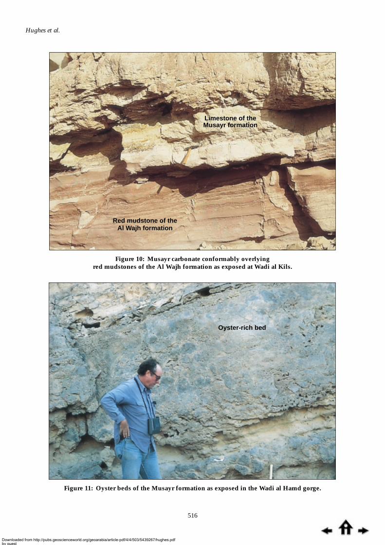
Musayr formationName: Clark (1986) informally named the carbonates in the Jabal Musayr region as the Musayr formation.They had previously been considered as the Wadi al Kils member of the Tayran formation by Dullo etal. (1983) (Figure 6).
Regional equivalents: The Gharamul Member of the Nukhul Formation in the Gulf of Suez (Saoudi andKhalil, 1983).
Type section: An almost complete section of well-bedded carbonates dip at 33° to the northeast (N35°E)in a 323 ft section in Wadi al Hamd.
Lithology: Basal calcareous sandstone overlain by skeletal grainstone and packstone carbonates; rich inboth macro- and micro-fauna.
Distribution: The formation is restricted to the Midyan region. A distinctive carbonate succession cropsout on the flanks of Jabal Musayr, where its contacts with the underlying Al Wajh formation are well
Downloaded from http://pubs.geoscienceworld.org/geoarabia/article-pdf/4/4/503/5439267/hughes.pdfby gueston 26 August 2022
Hughes et al.
516
Limestone of theMusayr formation
Red mudstone of theAl Wajh formation
Figure 10: Musayr carbonate conformably overlyingred mudstones of the Al Wajh formation as exposed at Wadi al Kils.
Oyster-rich bed
Figure 11: Oyster beds of the Musayr formation as exposed in the Wadi al Hamd gorge.
Downloaded from http://pubs.geoscienceworld.org/geoarabia/article-pdf/4/4/503/5439267/hughes.pdfby gueston 26 August 2022

Lithostratigraphy, Midyan Region, Saudi Arabia
517
exposed (Figure 10). The Musayrlimestone forms distinctiveescarpments on the northern flankof Jabal Tayran. The carbonates areparticularly well exposed andaccessible in Wadi al Hamd(28°23'55.9"N; 34°54'04.2"E) and also inWadi al Kils. At Wadi al Hamd, theformation directly overlies thebasement, and the transitional basalbeds consist of calcareous sandstonethat grade vertically into a sequenceof skeletal grainstones and packstones.At this locality, the gorge wall ischaracterized by recessive oyster bedsthat alternate with more resistantmassive beds (Figure 11) (Kamal andHughes, 1993a). At the Jabal Musayrlocality, large compound coralsderived from the Musayr formationare scattered along the foot of themountain.
Contact Relationships: The formation conformably overlies the Al Wajh formation and is unconformableon the Proterozoic basement. It is unconformably overlain by the Burqan formation. There is noevidence that the Musayr formation overlies evaporites of the Yanbu formation.
Age: The presence of the benthonic foraminiferal genera Miogypsinoides and Miogypsina (Figure 12),including Miogypsina tani, within the carbonates indicate an early Miocene age, equivalent to the TertiaryUpper Te Letter Stage (Adams, 1970; Boudagher-Fadel and Banner, 1999). The Late Oligocene agesuggested by Dullo et al. (1983) is based on larger benthonic foraminiferal specimens misidentified asNummulites fichteli, but their illustrated thin sections (Dullo et al., 1983; Figures 1 to 4) are assigned toOperculinella venosa in this study.
Paleoenvironment: The basal calcareous sandstones were deposited in an intertidal environment. Theoyster beds, corals, and miogypsinid assemblages in the overlying carbonate rocks indicate a warm,shallow-marine depositional environment, such as a shallow-marine carbonate platform or lagoon.In contrast to the other formations of the Tayran group, dinoflagellate cysts are prominent in thepalynofloras, and are typical species of Systmatophora and Polysphaeridium.
Burqan formation
The Burqan formation is a thick succession of deep-marine calcareous mudstones with thick sandinterbeds. It is well exposed in the Midyan region west of Jabal Rughama flanking the Maqna massifand along the Gulf of Aqaba coast (see Figure 4). It has not been assigned to a group.
Name: From the Burqan (offshore Midyan) exploration wells. The formation was informally called the‘globigerina marls’ in unpublished (non-Saudi Aramco) oil company reports (see also Figure 6 forprevious naming of the Burqan formation). The intensive investigation by Saudi Aramco has justifiedclarification of the previous informal lithostratigraphic assignment. The term Nutaysh (Clark, 1986) isretained as the sand-dominated Nutaysh member of the Burqan formation, and is readily distinguishedfrom the equivalent mudstone-dominated lithology of the Subayti member (Johnson et al., 1995).
Regional Equivalents: The formation is time-equivalent (based on biostratigraphic evidence) to the lowerpart of the Rudeis Formation of the Gulf of Suez and Egyptian Red Sea (Abdine, 1979; Hughes andBeydoun, 1992; Hughes et al., 1992).
Miogypsina sp.Miogypsina sp.
Figure 12: Miogypsina sp. in carbonates of the Musayrformation from the Wadi al Hamd gorge (maximum lengthof Miogypsina 2.5 mm).
Downloaded from http://pubs.geoscienceworld.org/geoarabia/article-pdf/4/4/503/5439267/hughes.pdfby gueston 26 August 2022

Hughes et al.
518
Type section: The type section was established by Saudi Aramco using the subsurface succession in theBurqan-3 well, situated offshore Midyan (Johnson et al., 1995).
Lithology: Turbidites, conglomerates, and sandstones of the Nutaysh member characterize the basalpart of the sequence, especially in the west. Elsewhere, the upper part of the exposed section and mostof the southeastern outcrops are composed of calcareous mudstones (Figure 13) of the Subayti member.Clark (1986) estimated a total thickness of 400 m for the entire formation. The sandstone forms thick,massive, poorly consolidated beds as much as 5 m thick (Figure 14). The calcareous mudstones aretypically soft and ramified by veinlets of anhydrite. Sandstone is particularly well exposed in thewestern area of the region in road-cuts along the ‘old Maqna road’ (from 28°20'53.8"N; 34°46'38.5"E to28°20'04.6"N; 34°45'26.5"E). The thickness of the Burqan formation is variable in the north-central partof the study area but generally thins southward due to extensive erosion that occurred after thedeposition of the formation.
Distribution: The Burqan formation is well exposed north of the Al Bad’ to Maqna road, on the Gulf ofAqaba coast south of Maqna, and along the western and eastern boundaries of the Proterozoic basementthat forms the core of the Maqna massif (Figure 4).
Contact Relationships: The deep-water turbidites of the Burqan formation lie with apparent disconformityon the Tayran group but are unconformable on the Proterozoic basement. At Jabal ar Risha (28°17'00"N;34°45'21"E) (see Figure 2), sandstones of the Nutaysh member conformably overlie oyster-bearingcarbonates of the Musayr formation. At this and other localities within the region, the Burqan formationis overlain by anhydrite of the Kial formation of the Maqna group. Such contacts are also well exposedsouth of the Maqna road, on the western slope of Jabal Rughama (28°26'01.5"N; 34°56'45.9"E). Theformation is well-bedded, and dips radially away from the exposed Proterozoic basement core of theMaqna massif. It is apparent that during deposition of the Burqan formation, localized basementhighs were exposed, and sites of non-deposition continued until late early Miocene times when thecarbonates of the Wadi Waqb member (Jabal Kibrit formation, Maqna group) were deposited. In Wadi
Figure 13: Deep-marine, foraminiferal mudstones of the Burqan formation in the region south ofthe new Al Bad’-Maqna road.
Proterozoicbasement
Burqan formation
Downloaded from http://pubs.geoscienceworld.org/geoarabia/article-pdf/4/4/503/5439267/hughes.pdfby gueston 26 August 2022

Lithostratigraphy, Midyan Region, Saudi Arabia
519
Waqb (28°11'19"N; 34°44'07.8"E), carbonates of the Musayr formation are overlain by 105 ft ofinterbedded soft marl and hard calcareous sandstone of the Burqan formation.
Age: An early Miocene age has been assigned, based on the presence of age-diagnostic planktonicforaminifera and calcareous nannofossils (Hughes et al., 1992; Hughes and Filatoff, 1995). They are:Planktonic Foraminifera Zone N7, Globigerina ciperoensis forma atypica; Zone N6, Globquadrinapraedehiscens; Zone N5 Globigerinoides primordius, and Calcareous Nannofossil Zone NN4, Helicosphaeraampliaperta; NN3, Sphenolithus belemnos; and NN2, Triquetrorhabdulus carinatus. Although of limitedage significance, numerous echinoids are present within shale exposed at 28°17'13.5"N; 34°48'11.1"E.
Paleoenvironment: The presence ofcertain benthonic foraminifera,including Bathysiphon taurinensis,hispid Uvigerina spp. and Nodosariaspp., and the generally high diversityplanktonic and deep-marine benthonicforaminiferal assemblages, indicate apredominantly bathyal depositionalenvironment for the mud-dominatedsuccession of the Nutaysh member.Well-developed trails as trace fossilsoccur at the base of many of thebeds (Figure 15). The sandstonesinterbedded with the mudstonestypically contain allochthonouspenecontemporaneously transportedshallow-marine microfossils.
Anhydrite(? Mansiyahformation)
Sandstone
Burqan formationmudstones
Figure 14: Mudstones of the Burqan formation enclosing a 5-m-thick bed of sandstone as exposedwest of Wadi Waqb.
Figure 15: Organic trails preserved on the underside of amudstone bed within the Burqan formation.
Downloaded from http://pubs.geoscienceworld.org/geoarabia/article-pdf/4/4/503/5439267/hughes.pdfby gueston 26 August 2022

Hughes et al.
520
Sequences of the Burqan formation in the belt of northwestern outcrops in Midyan were interpretedas deep submarine-fan deposits (Ferguson and Senalp, 1993). Several sediment sources are suggested.In the northwest, proximal turbidites display decreasing grain size towards the southeast where theybecome distal fan turbidites. However, in the southeastern outcrop, flute marks on the base of bedsexposed at the head of Wadi Waqb (28°12'58.4"N; 34°44'40.6"E) indicate transport of sediment fromthe southeast. At this locality, the beds dip northwest (N35°W) at 32°. Near here is exposed a15-ft-thick bed of massive sandstone.
Maqna group
A distinctive feature of the Midyan area is the extensive blanket of gypsum and anhydrite that coversmuch of the central part. The evaporite-bearing succession has been named the Maqna group. Itconsists of the Jabal Kibrit formation (and Wadi Waqb member) of early to middle Miocene age, andthe middle Miocene Kial formation (Hughes and Filatoff, 1995; Johnson et al., 1995). In the subsurface,the carbonate and siliciclastic facies Umm Luj member (Johnson et al., 1995) underlies the Wadi Waqbmember of the Jabal Kibrit formation.
Name: The first published use of the name (after the town of Maqna on the Gulf of Aqaba) was byHughes and Filatoff (1995) following in-house usage by Saudi Aramco since 1992. (See Figure 6 forprevious naming of the group in the Midyan area.)
Regional Equivalents: The group is regionally equivalent to the combined Belayim and Kareem formationsof the Gulf of Suez and other areas of the Red Sea (Hughes et al., 1992; Hughes and Beydoun, 1992).
Type Area: Although well exposed in the Midyan region, the definition of the group has been basedupon the better-understood subsurface stratigraphic relationship. The subsurface succession consistsof relatively thin units of interbedded anhydrite or halite and calcareous mudstones.
Mudstones of theBurqan formation
Anhydrites and mudstones of theKial formation (Maqna group)
Figure 16: Contact between the Burqan mudstones and overlying anhydrites and mudstones of theMaqna group as exposed on the west flank of Jabal Rughama.
Downloaded from http://pubs.geoscienceworld.org/geoarabia/article-pdf/4/4/503/5439267/hughes.pdfby gueston 26 August 2022

Lithostratigraphy, Midyan Region, Saudi Arabia
521
Lithology: The group consists of exposed deep-marine carbonates, shallow-marine carbonates, andanhydrite and, in the subsurface, deep-marine mudstones and anhydrite. At Jabal Rughama, anhydriteis interbedded with soft, calcareous mudstones (Figure 16) that overlie Burqan mudstones. Thethickness of the interbedded mudstones varies along the length of the exposure, most probably due toslumping of the anhydrite cap. A.A. Laboun (Saudi Aramco, personal communication, 1998) hasconfirmed that some of the repeated mudstone-anhydrite sections are the result of a series of gravityslides of the poorly consolidated mudstones. However, there are also undisturbed alternations betweensiliciclastics and interbedded anhydrite of the Kial formation (Figure 17).
West
member 4member 3
member 2
East
50m
100m
member 1
Mansiyah formation
Kia
l for
mat
ion
Figure 17: Sketch cross-section of the outcrop of theKial formation north ofJabal Kibrit to show thefour members of theformation and the overlyingMansiyah formation.
Distribution: The group is exposed along the eastern and western margins of the Ifal plain in the Midyanregion, and is present in the subsurface along much of the Saudi Arabian Red Sea.
Age: The group was dated as early to middle Miocene, based on the presence of age-diagnosticplanktonic foraminifera and calcareous nannofossils (Hughes and Filatoff, 1995). Samples collectedduring the present investigation and from the subsurface confirm this age. The occurrence of charredGramineae cuticle in the palynological assemblages (the richest and most diverse in the Neogenesuccession) has served to differentiate the Maqna group from underlying units.
Jabal Kibrit formationThe Jabal Kibrit formation is represented in outcrop within the Midyan region only by the carbonatefacies Wadi Waqb member (see below) but, elsewhere, the siliciclastic Umm Luj member (Johnson etal., 1995) occurs beneath the Wadi Waqb member (Figure 3). The equivalent Miocene carbonates ofthe Egyptian Red Sea adjacent to Midyan have received considerable attention in recent years (Aissaouiet al., 1986; James et al., 1988; Shaaban et al., 1997; Youssef, 1997).
Name: Hughes and Filatoff (1995) first published the name (after Jabal Kibrit, Figure 2) following in-house usage by Saudi Aramco since 1992. In the present understanding of the stratigraphy of theMidyan region, the carbonates of the Khuraybah formation and the siliciclastics of the Usayliyahformation, as defined by Clark (1986) in the Aynunah area, are assigned to the Jabal Kibrit formation.Clark’s Usayliyah formation is exposed to the west of the main outcrop of the Adaffa formation(28°07'43"N; 35°12'01"E) and overlies the Khuraybah formation.
Type Section: Midyan-1 (MDYN-1) Saudi Aramco exploration well (see Figure 4 for location).
Regional Equivalents: The Jabal Kibrit formation is equivalent to the Kareem Formation of the Gulf ofSuez and other areas of the Red Sea (Hughes et al., 1992; Hughes and Beydoun, 1992). The siliciclasticsassigned to the Usayliyah formation by Clark (1986) are considered to be possibly equivalent to theUmm Luj formation of Johnson et al. (1995).
Downloaded from http://pubs.geoscienceworld.org/geoarabia/article-pdf/4/4/503/5439267/hughes.pdfby gueston 26 August 2022

Hughes et al.
522
Lithology: The Jabal Kibrit formation consists of calcarenite, marl, sandstone, siltstone, and shale. Thecalcarenite and marl in these sections could be a distal equivalent of the Wadi Waqb member.
Distribution: The formation (represented by the Wadi Waqb member) crops out in Midyan in the WadiWaqb, Ad Dubaybah, and Al Khuraybah areas. The formation is widely distributed subsurface inMidyan and elsewhere along the Saudi Arabian Red Sea.
Contact Relationships: Unconformably overlies the Burqan formation.
Age: An early to middle Miocene age was interpreted from the subsurface presence of planktonicforaminifera belonging to Zones N9 and N8 (see Figure 3) in the upper unit of shales and claystones(Hughes and Filatoff, 1995). Planktonic Foraminiferal Zone N9 (earliest middle Miocene) was basedon the first downhole occurrence of Praeorbulina glomerosa, P. transitoria, and Globigerinoides sicanus, inthe presence of Orbulina suturalis and Orbulina bilobata. Zone N8 (latest early Miocene), was based onthe first downhole occurrence of P. glomerosa curva in the absence of Orbulina species. Calcareousnannofossils Sphenolithus heteromorphus, in the absence of Helicosphaera ampliaperta indicated Zone NN5(Hughes and Filatoff, 1995). The analysis of samples collected during the present investigation confirmsthe age.
Paleoenvironment: From subsurface evidence, the Jabal Kibrit sediments are considered to have beendeposited under deep-marine outer neritic to possible upper bathyal conditions, as indicated by therich and diverse assemblages of planktonic and benthonic foraminifera (Hughes and Filatoff, 1995).However, coarse-grained facies may be the products of penecontemporaneous downslope transportfrom a shallow-marine source (see Wadi Waqb member).
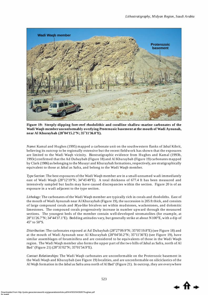
Wadi Waqb memberThe Wadi Waqb member of the Jabal Kibrit formation is a carbonate unit that is an importanthydrocarbon reservoir in the Midyan region and also occurs in outcrop. Kamal and Hughes (1995)investigated the unit briefly. The carbonates were previously included in the Al Bad formation byDullo et al. (1983). Several exposures mapped by Clark (1986) as being equivalent to limestones of theMusayr formation have now been identified as belonging to the Wadi Waqb member. In particular,the assemblages of planktonic and benthonic foraminifera in the Musayr formation limestones andthe Wadi Waqb member differ greatly both in terms of biostratigraphy and environmental indicators.
Figure 18: Rhodolithic shallow-marine carbonates of the Wadi Waqb member at Ad Dubaybah.Looking southeast toward the Proterozoic basement along the Ifal East Fault (28°27'09.9"N;35°05'19.8"E). Note the well-bedded succession at the top of the exposure.
Ifal East FaultProterozoic basement
Wadi Waqb member
Downloaded from http://pubs.geoscienceworld.org/geoarabia/article-pdf/4/4/503/5439267/hughes.pdfby gueston 26 August 2022
Lithostratigraphy, Midyan Region, Saudi Arabia
523
Wadi Waqb member
Proterozoicbasement
Figure 19: Steeply-dipping fore-reef rhodolithic and coralline shallow-marine carbonates of theWadi Waqb member unconformably overlying Proterozoic basement at the mouth of Wadi Aynunah,near Al Khuraybah (28°04'15.2"N; 35°11'36.0"E).
Name: Kamal and Hughes (1995) mapped a carbonate unit on the southwestern flanks of Jabal Kibrit,believing its outcrop to be regionally extensive but the recent fieldwork has shown that the exposuresare limited to the Wadi Waqb vicinity. Biostratigraphic evidence from Hughes and Kamal (1993b,1993c) confirmed that the Ad Dubaybah (Figure 18) and Al Khuraybah (Figure 19) carbonates mappedby Clark (1986) as belonging to the Musayr and Khuraybah formations, respectively, are stratigraphicallyequivalent to those at Jabal as Safra, and belong to the Wadi Waqb member.
Type Section: The best exposures of the Wadi Waqb member are in a small-unnamed wadi immediatelyeast of Wadi Waqb (28°12'19"N; 34°45'49"E). A total thickness of 677.4 ft has been measured andintensively sampled but faults may have caused discrepancies within the section. Figure 20 is of anexposure in a wadi adjacent to the type section.
Lithology: The carbonates of the Wadi Waqb member are typically rich in corals and rhodoliths. East ofthe mouth of Wadi Aynunah near Al Khuraybah (Figure 19), the succession is 205 ft thick, and consistsof large compound corals and Mya-like bivalves set within mudstones, wackestones, and dolomiticlimestones. The compound corals progressively increase in number upward through the measuredsections. The youngest beds of the member contain well-developed stromatolites (for example, at28°11'26.7"N; 34°44'37.1"E). Bedding attitudes vary, but generally strike at about N100°E, with a dip of45° to 50°S.
Distribution: The carbonates exposed at Ad Dubaybah (28°27'09.9"N; 35°05'19.8"E) (see Figure 18) andat the mouth of Wadi Aynunah near Al Khuraybah (28°04'50.2"N; 35°11'36"E) (see Figure 19), havesimilar assemblages of foraminifera and are considered to be equivalents of those in the Wadi Waqbregion. The Wadi Waqb member also forms the upper part of the two hills of Jabal as Safra, north of AlBad’ (Figure 21) (28°31'02"N; 35°01'54.9"E).
Contact Relationships: The Wadi Waqb carbonates are unconformable on the Proterozoic basement inthe Wadi Waqb and Khuraybah (see Figure 19) localities, and are unconformable on siliciclastics of theAl Wajh formation in the Jabal as Safra area north of Al Bad’ (Figure 21). In outcrop, they are everywhere
Downloaded from http://pubs.geoscienceworld.org/geoarabia/article-pdf/4/4/503/5439267/hughes.pdfby gueston 26 August 2022

Hughes et al.
524
directly overlain by anhydrite assigned to the Kial formation (Figure 20). However, subsurface in theMidyan region, the Wadi Waqb carbonates overlie basinal mudstones of the Burqan formation withapparent conformity and are overlain by basinal mudstones of the upper part of the Jabal Kibritformation. The difference between surface exposures and subsurface intersections suggests a significantvariation in the post-depositional paleoenvironment.
Age: The presence of the benthic foraminifera Borelis melo (Dullo et al., 1983) indicates a middle Mioceneage. The well-preserved specimens of B. melo (Figure 22a) were discovered in carbonates collectedfrom the small wadi east of Wadi Waqb in the recent investigation (Hughes, in preparation). Carbonatesat Ad Dubaybah and Khuraybah also contain B. melo (Kamal and Hughes, 1993c; Hughes and Kamal,1993c). The matrix of the deep-marine carbonates at Wadi Waqb contains planktonic foraminiferaassigned to Praeorbulina spp. (Figure 22b), and is therefore of late early Miocene to early middle Mioceneage (Zones N8-N9).
Figure 20: Deep-marine carbonates of the Wadi Waqb member as exposed east of Wadi Waqb(28°12'58.4"N; 34°44'40.6"E). The carbonates are overlain by anhydrite (dark brown) of the Kialformation.
Wadi Waqb member
AnhydriteKial formation
AnhydriteKial formation
Downloaded from http://pubs.geoscienceworld.org/geoarabia/article-pdf/4/4/503/5439267/hughes.pdfby gueston 26 August 2022

Lithostratigraphy, Midyan Region, Saudi Arabia
525
Paleoenvironment: The Wadi Waqb member subsurface in the Midyan field and at the Wadi Waqboutcrops, consists of a deep-marine, planktonic foraminiferal-bearing wackestone matrix containingtransported allochthonous bioclasts (Figures 22c and 22d) derived from a shallow-marine carbonatesetting (Kamal and Hughes, 1995). Possible sources for the shallow-marine components are consideredto be similar to the shallow-marine, coral- and rhodolith-dominated carbonates that are now exposedalong the eastern margin of the Ifal plain at Ad Dubaybah and Khuraybah (Figure 2) (Kamal andHughes, 1993a; and Hughes and Kamal, 1993b, 1993c). At Ad Dubaybah, the carbonates rest directlyupon moderately well-bedded sandstones that resemble distal facies of the Al Wajh formation.However, the sandstones may represent a proximal shallow to marginal marine facies of the JabalKibrit formation as the Proterozoic granitic basement lies within a short distance to the east. Thecarbonates in the Khuraybah-Aynunah region rest directly upon basement rocks, and contain largecorals in growth positions.
Kial formationName: The formation was informally named by R. Kamal (Saudi Aramco) after Kial village adjacent tothe Midyan oil and gas field where the formation is well developed. The name was first published byHughes and Filatoff (1995).
Regional Equivalents: The formation is equivalent to the Hammam Faraun, Feiran, Sidri, and Babamembers of the Belayim Formation of the Gulf of Suez and the Red Sea (Hughes et al., 1992; Hughesand Beydoun, 1992).
Type Section: Midyan-1 (MDYN-1) Saudi Aramco exploration well (Figure 4).
Distribution: The Kial formation is widely distributed along the Saudi Arabia Red Sea but is best exposedalong the escarpment on the western flank of Jabal Rughama in Midyan. At a locality south of theroad to Maqna (28°26'01.5"N; 34"56'45.9"E), the Burqan formation is overlain by at least four well-defined ‘benches’ of anhydrite belonging to the Kial formation (Figure 16). Resistant anhydrite formsthe tops of the benches whereas the underlying soft, friable calcareous mudstone beds are recessive.The thickness of the anhydrite beds is apparently uniform but that of the mudstones varies and it may
Wadi Waqb member
Al Wajh formation
Figure 21: Rhodolithic and coralline shallow-marine carbonates of the Wadi Waqb memberunconformable on sandstones of the Al Wajh formation at Jabal as Safra, north of Al Bad’ (28°31'02"N;35°01'54.9"E).
Downloaded from http://pubs.geoscienceworld.org/geoarabia/article-pdf/4/4/503/5439267/hughes.pdfby gueston 26 August 2022

Hughes et al.
526
Figure 22: (a) The shallow-marine benthonic foraminifera Borelis melo is diagnostic of the WadiWaqb member; maximum diameter 2 mm. (b) Deep-marine planktonic foraminifera Praeorbulinaspp. from the deep-marine carbonate facies of the Wadi Waqb member; maximum diameter0.8 mm. (c) Admixture of autochthonous deep-marine planktonic foraminifera with allochthonousshallow-marine bivalve debris within the deep-marine facies of the Wadi Waqb member; averagesize of grains 1 mm. (d) Shallow-marine benthonic foraminifera Operculinella venosa andHeterostegina spp. as allochthonous, transported grains within the deep-marine facies of the WadiWaqb member; maximum size of grains 5 mm.
Downloaded from http://pubs.geoscienceworld.org/geoarabia/article-pdf/4/4/503/5439267/hughes.pdfby gueston 26 August 2022

Lithostratigraphy, Midyan Region, Saudi Arabia
527
be that the appearance of multiple beds is the result of repeated gravity sliding of a single anhydritebed and its underlying mudstone. This may explain some, but not all, of the repeated exposures alongthe west flank of Jabal Rughama, as interbedded siliciclastics and anhydrite are confirmed in the JabalKibrit (Figure 17) and Jabal Musayr areas.
Lithology: The formation consists at the surface and in the subsurface of four members (Hughes andFilatoff, 1995; Johnson et al., 1995). From top to bottom they are: member 1, siliciclastics and minorcarbonate, sandstone, and mudstone; members 2 and 4 (equivalent to the Feiran and Baba members ofthe Belayim Formation), evaporites (anhydrite with local halite), and thin beds of mudstone andsiltstone; member 3, generally calcareous mudstone, with minor carbonate and sandstone (Figure 17).Some members pinch out along strike and it is difficult to distinguish them from each other or fromthe overlying Mansiyah formation.
Contact Relationships: Conformable on the Jabal Kibrit formation of the Maqna group (Hughes andFilatoff, 1995) and unconformable on the Burqan formation.
Age: A middle Miocene age is based on planktonic foraminifera and calcareous nannofossils incalcareous mudstones in the subsurface. Orbulina suturalis, Praeorbulina glomerosa circularis and P.glomerosa glomerosa (Hughes and Filatoff, 1995) belong to Planktonic Foraminifera Zone N9, and thecalcareous nannofossil Sphenolithus heteromorphus (but without Helicosphaera ampliaperta) is indicativeof Zone NN5 (Figure 3).
Paleoenvironment: Moderately deep marine, with shallow-carbonate platform facies locally developed.The interbedded relationship of evaporites with planktonic foraminifera-bearing mudstones in thesubsurface suggests deposition in a deep episodically hypersaline submarine environment.
Mansiyah formation
The Red Sea Miocene subsurface succession in Saudi Arabia is characterized by a thick deposit ofgypsum, anhydrite, and halite named the Mansiyah formation.
Name: The formation is named after the Mansiyah-1 (MNSY-1) exploration well north of Jizan. TheMansiyah formation in the Midyan area has, at various times, been considered as part of the middleRaghama formation of Skipwith (1973), the upper part of the Al Bad formation (Dullo et al., 1983), partof the Bad formation of the Raghama group of Clark (1986), the Raghama formation of Brown et al.(1989), and within the Bad formation of Jado et al. (1990).
Regional Equivalents: The formation is equivalent and lithologically comparable to the South Gharib Formationof the Gulf of Suez and other areas of the Red Sea (Hughes et al., 1992; Hughes and Beydoun, 1992).
Type Section: In the Mansiyah-1 Auxerap exploration well (Hughes and Filatoff, 1995; Johnson et al.,1995) drilled at a coastal location 40 km north of Jizan (Figure 5).
Distribution: The eastern dip slope of Jabal Rughama is characterized by a blanket of white anhydritethat may be part of the Mansiyah formation, but could also represent part of the Kial formation. Asimilar extensive exposure of anhydrite blankets the western and southern flanks of Jabal Mundassah(Figure 23). The Mansiyah formation is well represented in the subsurface but it is difficult to distinguishin outcrop from the underlying Kial formation. On the geological map (Figure 4) it is differentiatedfrom the Kial formation only in the Jabal Kibrit area of the extreme southwest.
Lithology: The Mansiyah formation consists of massive halite, gypsum, and anhydrite, with thininterbeds of calcareous shale and mudstone, and subordinate sandstone and siltstone.
Contact Relationships: It overlies the Kial formation of the Maqna group with apparent conformity,although some faulted unconformable contact relationships are present in areas adjacent to halokineticglide planes. It is overlain by the Ghawwas formation with probable conformity.
Downloaded from http://pubs.geoscienceworld.org/geoarabia/article-pdf/4/4/503/5439267/hughes.pdfby gueston 26 August 2022

Hughes et al.
528
Age: The formation has been dated as middle Miocene based on its stratigraphic position (in the absenceof age-diagnostic biostratigraphic evidence) above the biostratigraphically constrained basal middleMiocene Kial formation, and beneath the middle to upper Miocene Ghawwas formation. In the Gulfof Suez, marine diatoms indicate the presence of middle Miocene sediments within the overlying ZeitFormation. Palynological age criteria in the inter-evaporitic siliciclastics are as for the Jabal Kibritformation but supplemented by the presence of the dinoflagellate cyst species Systematophora ancyrya/placacanatha (extinction at top middle Miocene); Pentadinium laticinctum (extinction near top middleMiocene) (Hughes and Filatoff, 1995).
Paleoenvironment: The depositional environment was moderate to very deep marine and conditions ofextremely hypersalinity led to the precipitation of evaporites. A marine environment is indicated bythe presence of dinoflagellate cysts in inter-evaporitic shales; anoxic conditions are suggested by anabundance of pyrite-impregnated amorphous kerogen (Hughes and Filatoff, 1995). The hypersalineepisode was probably regional in extent and, based on the traditional silled deep-basin model, resultedfrom the isolation of the Red Sea from the Gulf of Aden and/or the Mediterranean (Hughes andBeydoun, 1992; Crossley et al., 1992).
Ghawwas formation
The Ghawwas formation is a thick succession of interbedded fine and coarse-grained siliciclastics, andthin beds of anhydrite, which have been intensively studied by Saudi Aramco. The Ghawwas andoverlying Lisan formations and Quaternary sediments are combined on the geological map (Figure 4).
Name: Hughes and Filatoff (1995) named the Ghawwas formation. In Midyan, it was previouslyincluded within the middle Raghama formation (Skipwith, 1973), the upper part of the Al Bad formation(Dullo et al., 1983), the Bad formation of the Raghama group (Clark, 1986), the Raghama formation(Brown et al., 1989), and the Bad formation (Jado et al., 1990).
Anhydrite and gypsum ofMansiyah or Kial formations
Proterozoic basement
Figure 23: View from the head of Wadi Waqb looking northwest toward the uplifted Proterozoicbasement (gray). The light-colored middle ground is occupied by anhydrite of the Kial or Mansiyahformations.
Downloaded from http://pubs.geoscienceworld.org/geoarabia/article-pdf/4/4/503/5439267/hughes.pdfby gueston 26 August 2022
Lithostratigraphy, Midyan Region, Saudi Arabia
529
Type Section: The type section was established by Saudi Aramco using the subsurface succession inGhawwas-1 (GHWS-1) exploration well (Figure 5) in the southern part of the Saudi Arabian Red Sea(Johnson et al., 1995).
Regional Equivalents: The formation is equivalent to the Zeit Formation of the Gulf of Suez and otherareas of the Red Sea (Hughes et al., 1992; Hughes and Beydoun, 1992).
Lithology: The Ghawwas formation consists of conglomerate, sandstone, minor claystone, carbonates,and local evaporites.
Distribution: The formation is distributed widely along the Saudi Arabian Red Sea.
Contact Relationships: It overlies the Mansiyah formation with probable conformity and is unconformablyoverlain by the Pliocene-Pleistocene Lisan formation (Johnson et al., 1995).
Age: A middle to late Miocene age is based on diatom evidence within the region together with thestratigraphic position of the formation above rocks regionally dated as middle Miocene (Hughes etal., 1992; Hughes and Filatoff, 1995). A Late Neogene age is suggested by the relatively commonoccurrences of Plumbaginaceae-, Papilionaceae- and Nyctaginaceae-type pollen.
Paleoenvironment: Regional studies indicate that the Ghawwas formation was deposited under a varietyof shallow-marine to marginal-marine environments, perhaps with the periodic development of sabkhaconditions. Marine microfauna, for example, are scarce (Hughes and Filatoff, 1995; Filatoff and Hughes,1996) but freshwater Pediastrum spp. and Anthoceros-type spores are common.
Lisan formation
The Lisan formation is a fluviatile succession that was deposited during the opening of the Gulf ofAqaba during the Early Pliocene. It is not distinguished from the Ghawwas formation on the geologicalmap (Figure 4).
Name: The formation was named by Clark (1986) to replace the term ‘Ifal formation’ of Bokhari (1981),and by Jado et al. (1990).
Regional Equivalents: Warden (siliciclastic) and Shagara (carbonate) formations of the Gulf of Suez.
Type Section: Western edge of the Ifal plain (Clark, 1986). In the subsurface, the reference section is inMidyan-1 (MDYN-1) Saudi Aramco Red Sea exploration well.
Distribution: Crops out on the eastern margin of Jabal Rughama and underlies much of the Ifal plain.Present elsewhere in the subsurface along the Saudi Arabian Red Sea.
Lithology: The formation consists of rhythmic, poorly consolidated fluviatile sandstones andconglomerates. Clark (1986) described thin beds of gypsum in the southern part of the Midyan area.Concentric ridges that emerge from the Ifal plain may represent part of the general Ghawwas-Lisan-Quaternary succession (Clark, 1986), and be due to the deep-seated diapiric movement of evaporites.In the Midyan subsurface, the formation consists of coarse- and fine-grained siliciclastics and carbonates.
Contact Relationships: The formation is disconformable, probably unconformable, on the Ghawwasformation. Clark (1986) described an unconformity between the Lisan formation and the Mansiyahformation on the east side of Jabal Rughama.
Age: A Pliocene age is related to the stratigraphic position of the outcropping formation above the lateMiocene Ghawwas formation. In the subsurface, a Pliocene to Pleistocene age is based on planktonicforaminifera and calcareous nanofossils (Hughes and Filatoff, 1995). The fossil evidence is as follows:
Downloaded from http://pubs.geoscienceworld.org/geoarabia/article-pdf/4/4/503/5439267/hughes.pdfby gueston 26 August 2022
Hughes et al.
530
Planktonic Zone N21 (Late Pliocene) based on the first downhole occurrence of Globigerinoides extremus;Nannofossil Zone NN17 (Late Pliocene) based on the first downhole occurrence of Dicoasterpentaradiatus; Nannofossil Zone ?NN16–15 (Late to Early Pliocene) based on the first downholeoccurrence of Reticulofenestra pseudoumbilica and of Sphenolithus moriformis. The ‘clastic’ unit is typicallynear-barren of both palynmorphs and kerogen. The ‘carbonate’ unit has yielded sparse dinocystassemblages typified by Tuberculodinium vancampoae.
Paleoenvironment: In outcrop, the formation consists mostly of fluviatile and delta-plain deposits. Alongthe southern flank of Jabal Kibrit, gypsum beds and limestones contain echinoids and bivalves thatindicate shallow-marine depositional conditions. Subsurface indications are of sedimentaryenvironments ranging from supratidal, through intertidal and shallow-marine carbonate to upperbathyal, based on the variable character of the foraminiferal populations.
Pleistocene sediments
The Ifal plain and extensive areas between the hills west of Jabal Rughama are covered withundifferentiated sands and gravels, and locally with sand dunes. Seven uplifted carbonate reef terracesare exposed along the coast south of Maqna village and are similar to ones on the western coast of theGulf of Aqaba and the southern shore of the Midyan region. Similar terraces have been described byAl-Rifaiy and Cherif (1988) from Al-Aqaba in Jordan where they were attributed to four major cyclesof reef development caused by eustatic changes in sea level. However, in the Midyan region, tectonismis considered to have provided an additional control on the development and present distribution ofthe terraces. The highest terrace is 120 ft above sea level and may correspond to those in the area ofRa’s Sheikh Humaid at the southern extremity of the Midyan Peninsula.
STRUCTURAL HISTORY OF THE IFAL BASIN
A structural interpretation of the Landsat Thematic Mapper image that covers part of the onshore Ifalbasin was made during the recent investigations. The geological map (Figure 4) shows the distributionof anticlines; primary, secondary, and third-grade faults; and lineaments related to bedding. Most ofthe Landsat image interpretation has been verified by ground-control surveys.
The Arabian Plate has rotated anti-clockwise away from Africa, resulting in the opening of the RedSea. The Gulf of Suez was formed by the northward propagation of the Red Sea opening in LateOligocene to early Miocene times by rifting and the formation of pull-apart basins (Courtillot et al.,1987). Makris and Henke (1992) suggest that the thinned continental crust underlying the eastern sideof the Red Sea is the result of continental stretching between the mobile Arabian Plate and the stableAfrican Plate. They attribute the entire Red Sea as a response to wrench faulting that eventuallyculminated in the Dead Sea strike-slip fault.
In middle to late Miocene times, left-lateral fault movements began in the Gulf of Aqaba and along theDead Sea rift. Left-stepping along the major left-lateral strike-slip faults was observed at two locations(LS1 and LS2, Figure 2) on the eastern coast of the Gulf of Aqaba and suggests the formation of areleasing bend and additional extension. The northeast-trending en echelon anticlines in the studyarea are consistent with the major left-lateral strike-slip fault system in the Gulf of Aqaba. West towest–northwest-trending right-slip (synthetic) shear faults (R1, R2 in Figure 4) and north–northwest-trending left-slip (antithetic) shear faults (L1 in Figure 4) in the southwestern part of the study area arethe products of a simple shear-stress field. An offset in the drainage along the R1 and R2 faults indicateright-slip movement. Slickensides on the fault surface (L1) that brings the Burqan formation againstthe Musayr formation (Figure 24) indicate normal left-lateral oblique movement. These observationsindicate a regional left-lateral strike-slip event. Numerous faults and overturned anticlines along theline of the major left-lateral strike-slip faults were observed on the eastern coast of the Gulf of Aqaba(Figures 25 and 26). The Dead Sea Fault system caused extensive fracturing in the Miocene-Quaternarysection (Figures 27 and 28) including the reservoir rock of the Jabal Kibrit formation.
Downloaded from http://pubs.geoscienceworld.org/geoarabia/article-pdf/4/4/503/5439267/hughes.pdfby gueston 26 August 2022

Lithostratigraphy, Midyan Region, Saudi Arabia
531
Burqanformation
Musayrformation
Figure 24: (a) Northwest-trending fault, Musayr formation (right) facing Burqan formation (left);(b) Close-up view of the fault surface: slickensides indicate normal left-lateral oblique movementon the fault.
Anhydrite and gypsum ofMansiyah or Kial formations
Burqan formation
Figure 25: Extensive faulting in the Burqan formation. Photograph (taken on the coast of the Gulfof Aqaba) is from the eastern block of a left-lateral strike-slip fault.
Downloaded from http://pubs.geoscienceworld.org/geoarabia/article-pdf/4/4/503/5439267/hughes.pdfby gueston 26 August 2022

Hughes et al.
532
Road to Ra’sSheikh Humaid
Figure 26: Overturned anticline along a major, left-lateral strike-slip fault located southwest of thestudy area.
Figure 27: Dolomite interlayered in a conglomerate-sandstone-claystone sequence of the Ghawwasformation. Note the fracture systems trending N57°W and N65°E.
Downloaded from http://pubs.geoscienceworld.org/geoarabia/article-pdf/4/4/503/5439267/hughes.pdfby gueston 26 August 2022

Lithostratigraphy, Midyan Region, Saudi Arabia
533
Purser et al. (1990) and Filatoff and Hughes (1996) divided the Red Sea succession into discrete regionaldepositional events. Several related tectonic episodes have been suggested for the Red Sea region,ranging from the informal scheme of Filatoff and Hughes (1996) to the structurally based schemes ofGirdler and Southern (1987), Guennoc et al. (1988), and Girdler (1990). In the present scheme, thegeological history of the Midyan region is summarized as pre-rift and syn-rift events. They representa simple subdivision of interpretative events that are directly linked with the natural subdivision ofthe lithostratigraphic succession, in a style similar to the ‘M’, ‘P’ and ‘Q’ grouping suggested by Jadoet al. (1990).
Pre-rift
The pre-rift episode refers to the time interval before activation of the Red Sea rift, as defined byPurser et al. (1990) in the northwestern part of the Red Sea. It includes the entire pre-Neogene, possiblypre-Upper Oligocene, succession. During the pre-rift episode, Arabia remained part of the AfricanPlate but evidence of a topographic depression along the proto-Red Sea exists within the UpperCretaceous and lower Tertiary successions as far south as Jiddah. This southerly embayment isattributed by Basahel et al. (1982) to the depression caused by the reaction between the Nubian Shieldto the west and the Hail Arch to the east. Purser and Hotzl (1988) also noted the sedimentologicalsimilarity of Cretaceous and Paleogene sediments between the northeastern and northwestern marginsof the Red Sea.
In the Midyan area, the pre-rift succession is represented by the Upper Cretaceous Adaffa formation.Montenat et al. (1988) commented that the paleogeographic features of the pre-rift succession trendeast-west and northeast. They do not, therefore, have the N140° Clysmic orientation of the Gulf ofSuez and cannot be used to imply the existence of a proto-rift as suggested by Sellwood and Netherwood(1984). The present interpretation is consistent with that of Purser et al. (1990) who restrict the use of‘protorift’ to the early stage of rifting.
Figure 28: E-W and N35°W-trending fracture systems in sandstone of the Magna group. Note thecalcite filling and mineralization along the fractures, and alteration of the sandstone.
Downloaded from http://pubs.geoscienceworld.org/geoarabia/article-pdf/4/4/503/5439267/hughes.pdfby gueston 26 August 2022

Hughes et al.
534
Syn-rift succession
The onset of the syn-rift episode is here defined as the event that separated pre-rift sedimentationfrom deposition in response to the rifting of the Red Sea. This succession consists of the Tayran group,Burqan formation, Maqna group, and the Mansiyah and Ghawwas formations. Four subdivisions ofthe syn-rift succession are defined and can be traced throughout the Red Sea region and equate withRift Stage I of Bayer et al. (1988). Filatoff and Hughes (1996) suggested that the Tayran group, theBurqan formation, and the Magna group sediments are the product of the early syn-rift phase, as thepost-Maqna evaporites of the Mansiyah formation are in marked contrast to any of the earlier sediments.In the present study, the arbitrary use of ‘early’ and ‘late’ syn-rift is abandoned in favor of numberedepisodes that can be recognized regionally.
Syn-rift 1This early phase of Oligocene?-Miocene rifting caused slow subsidence. Sedimentation in the Ifal basinbegan in the early Miocene with the deposition of the marginal and shallow-marine sediments of theTayran group. Slow subsidence rates characterize this episode that was termed the ‘protorift’ by Purseret al. (1990). Girdler and Southern (1987), Guennoc et al. (1988), and Girdler (1990) related it to continentalextension.
Syn-rift 2The Burqan formation was deposited in response to rapid subsidence and the creation of a deep,steep-sided marine basin. From northwest to southeast, a proximal fan grades into mid-fan and distal-fan depositional environments (Ferguson and Senalp, 1993). The distribution of the sediments andtheir increase in thickness towards the northwest in Midyan suggest asymmetric graben-type faultcontrol. Bounding faults are located on the northern margin (at Jabal as Sabil in Figure 2) and alongthe northwestern edge of the basin. Major faults dip to the east, southeast and south, and the basin istilted towards the northwest.
Syn-rift 3The onset of restricted marine conditions, as indicated by the regional deposition of evaporites of theMaqna group, suggests a possible decrease in the subsidence rate. This event has been used to markthe lower boundary of the syn-rift 3 episode. In the Midyan area, however, carbonates characterizethe base of the episode as the basal Maqna marine evaporites are not developed. Steeply dippingsurfaces related to reactivated faults controlled the distribution of the reef carbonates of the WadiWaqb member. Basement highs and islands probably existed within the area during and after thedeposition of the Burqan formation. Penecontemporaneous downslope transport from localizedshallow-marine sources created different depositional settings adjacent to the deep-marine facies ofthe Wadi Waqb member. The fault-controlled Wadi Waqb carbonates preferentially accumulated inthe Midyan field and the Jabal Kibrit area. Rift-associated major extensions took place in the Red Searegion during the syn-rift 2 and 3 episodes, and was followed by the onset of drifting as a result ofearly sinistral shear movement on the Dead Sea Transform Fault (Girdler and Southern, 1987; Guennocet al., 1988; and Girdler, 1990).
Syn-rift 4The base of the thick succession of anhydrite of the Mansiyah formation is a well-defined regionalevent that is taken to define the base of the syn-rift 4 episode. It includes the terminal hypersalineenvironment that gradually developed during the deposition of the Maqna group. A moderatelydeep to very deep-marine environment is suggested for the Mansiyah formation at the beginning ofthis phase, previously considered as a late syn-rift phase by Filatoff and Hughes (1996). The depositionof shallow-marine mixed siliciclastics and evaporites of the Ghawwas formation resulted from basininfilling during the late Miocene. This onset of shallow and marginal marine sedimentation may berelated either to the global eustatic sea-level fall during the late Miocene, or to a decrease in the rate ofvertical subsidence of the Red Sea region. This decrease in the subsidence rate would conform to theconcept of a contemporary tectonic hiatus as proposed by Girdler and Southern (1987), Girdler (1990),and Guennoc et al. (1988).
Downloaded from http://pubs.geoscienceworld.org/geoarabia/article-pdf/4/4/503/5439267/hughes.pdfby gueston 26 August 2022

Lithostratigraphy, Midyan Region, Saudi Arabia
535
Post-rift (drift)
This episode is an Early Pliocene event that coincides with the post-rift stage of Purser et al. (1990) andwith the Rift Stage II of Bayer et al. (1988), and which has been considered as a transitional phasebetween continental and oceanic rifting by Cochran and Martinez (1988). It is believed to be responsiblefor the triangular shape of the Midyan region that lies within the zone bounded by the Red Sea riftmargin and the new plate boundary between Sinai and Arabia. The tectonic episode coincides withthe cessation of Red Sea rifting and the onset of Aqaba-related transtensional subsidence. There is noevidence for the rifting of the Pliocene succession within the Midyan area, and Bayer et al. (1988)explain the continued subsidence during this phase to rotation, or oblique drift of the Arabian Plate inresponse to the movement on the Dead Sea Fault zone. This episode is considered by Girdler andSouthern (1987), Guennoc et al. (1988), and Girdler (1990) to represent a phase of rejuvenated sinistralshear movement along the Aqaba transform, and renewed drift.
It is noteworthy that Girdler and Southern (1987), Guennoc et al. (1988), and Girdler (1990) considerthe 107 km of total shear movement to be composed of an early to middle Miocene displacement of 62km and an Early Pliocene to Recent displacement of 45 km.
STRUCTURAL SYNTHESIS
Three major fault systems are present within the Ifal basin (Figure 2). The Ifal East Fault and Ifal Faultsystems bound the triangular-shaped basin on its northeastern and southwestern sides, respectively.Within the Basin, the Ifal Central Fault trends approximately north-south. The area between the IfalCentral and Ifal East faults is known as the Midyan East Terrace.
The Ifal Central Fault has been active since the middle Miocene. Available seismic data indicate thatthis west-facing fault was active during deposition of the Ghawwas formation (KFUPM, 1998) andprobably the Lisan formation as well, but this observation needs further investigation. Initiation ofthe Ifal East Fault is considered to have begun later and the fault was active during much of the
Ghawwas formation
Pliocene-Quaternary alluvial terraces
Figure 29: Left-dipping Ghawwas formation overlain by alluvial terrace sediments of Pliocene-Quaternary age. Note the amount of recent uplift and related erosion.
Downloaded from http://pubs.geoscienceworld.org/geoarabia/article-pdf/4/4/503/5439267/hughes.pdfby gueston 26 August 2022

Hughes et al.
536
Pliocene-Quaternary. At least four alluvial fans are related to this fault system. They channel intoeach other and onlap the eastern foothills of the Ifal basin beyond the study area, and indicate continuousuplift. Landsat imagery indicates recent movement on the Ifal East Fault system. Non-deposition,uplift, and subsequent erosion reduced the thickness of the Miocene section on the Midyan East Terrace.
The Ifal Fault is a northeast-trending major down-to-the-southeast normal fault located along theeastern margin of the Maqna massif between Al Bad’ and Jabal Kibrit. The fault was active or reactivatedafter the deposition of the Lisan formation. A northeast-trending fold, truncated by this fault, mayindicate that the fault also had a lateral strike-slip component (KFUPM, 1998). Active faulting anduplifting continued into recent times. Small-scale, pull-apart sub-basins are present along the rightand left strike-slip faults to the south and west of Jabal Kibrit, and southwest of Al Bad’, respectively(KFUPM, 1998). Alluvial terraces indicate an extensive amount of uplift (Figure 29). Pliocene-Quaternary beach rock and reef build-ups along the coast of the Gulf of Aqaba (Figure 30) andconglomerates along drainage channels in the region, were elevated 6 to 8 m during this time.
CONCLUSIONS
The Midyan region provides a unique view of the Saudi Arabian Red Sea subsurface stratigraphy.The various outcropping lithostratigraphic units relate to the succession established in the subsurface.
The Al Wajh formation compares well with the subsurface, but the overlying Yanbu evaporites areabsent in the Midyan exposures. The Musayr carbonates are, on available evidence, restricted to theMidyan area. The exposures of the Burqan formation provide critical information for determining theassociated sedimentary processes, especially those that were responsible for the deposition of theextensive, thick sandstone beds that have reservoir significance.
Figure 30: Quaternary coral reef elevated at least 6 to 8 m as a result of regional uplift related tostrike-slip faulting in the Gulf of Aqaba region.
Downloaded from http://pubs.geoscienceworld.org/geoarabia/article-pdf/4/4/503/5439267/hughes.pdfby gueston 26 August 2022
Lithostratigraphy, Midyan Region, Saudi Arabia
537
The previously problematical Wadi Waqb carbonate is now considered to be a member of the JabalKibrit formation (latest early to earliest middle Miocene), and to have unconformable contacts withthe Proterozoic basement and the Al Wajh formation. These stratigraphic relationships are not presentin the subsurface where the carbonate overlies siliciclastics of the Burqan formation. The carbonatesexposed along the eastern flank of the Ifal plain are now considered to represent the shallow-marineequivalents of the deep-marine carbonates that form the reservoir rock within the Midyan region, andare not part of the lower Miocene succession as previously mapped. The exposures of this unit in theWadi Waqb area contain an admixture of autochthonous planktonic foraminifera-bearing deep-marinecarbonates with allochthonous shallow-marine bioclasts. Although there is evidence that gravity slidingis responsible for duplication of interbedded siliciclastic-anhydrite beds at some localities, certainexposures display undisturbed alternations of siliciclastics and interbedded anhydrite. Anhydrite is adistinctive feature of the Midyan region. It is present in the Kial and Mansiyah formations.
Several tectonic phases are defined that fall into the categories of pre-rift, syn-rift, and post-rift (ordrift). The pre-rift succession displays lineaments that are not in accordance with the Red Sea tectonictrend, and are considered to pre-date the formation of the Red Sea rift. The rift and drift-associatedsuccessions extend from the early Miocene (possibly Late Oligocene) to approximately the top of theMiocene succession. Field evidence has confirmed that the Jabal as Sabil basin-bounding fault controlledthe deposition of the Burqan formation and that the Ifal Central Fault controlled the deposition of theGhawwas formation.
The Pliocene-Pleistocene post-rift episode is considered to represent drift in response to thetranstensional tectonic controls exerted on this region by the Dead Sea Transform Fault. The easternmargin of the Ifal basin is bounded by the Ifal East Fault that controlled the deposition of the Lisanformation. The Ifal Fault, which is related to the Dead Sea Fault zone, was synchronous or possiblyyounger than the Ifal East Fault and is responsible for the uplift of the western part of the Midyanregion. During this time, the reactivation of older faults caused diapiric movement of the evaporitesof the Mansiyah formation.
Quaternary uplift is indicated by the emergence of coral-reef limestone to at least 6 to 8 m above sealevel along the Gulf of Aqaba coast and southern onshore flanks of the Midyan region. Deeply dissectedalluvial terraces also testify to the recent and continued uplift of the region.
ACKNOWLEDGEMENTS
The authors express their thanks to Saudi Aramco for permission to publish this paper. The results ofa joint investigation by Saudi Aramco and the Research Institute of the King Fahd University forPetroleum and Minerals (KFUPM) have been made accessible for incorporation into this paper. Inaddition, we thank R.S. Johnson and the following geologists from Saudi Aramco whose comments,reports and discussion helped to improve our understanding of the geology of the Midyan region:T.C. Connally, R. Kamal, M. Senalp, A.M. Afifi and A.A. Al-Laboun. The co-operation and kindassistance of K. Al-Hinai, N.A. Al-Honaid and M.A. Khan of the Remote Sensing Unit of the ResearchInstitute of KFUPM provided new insights into the geological interpretation of the region.Dr. O. Varol (Varol Research, U.K.) was responsible for all calcareous nannofossil age determinations.We also thank the staff of Gulf PetroLink for expert help particularly with the graphics.
REFERENCES
Abdine, A.S. 1979. A Review of Recent Discoveries in Egypt. ‘Exploration Update, 1979’ Symposium,Calgary, Alberta, Canada, June 1979.
Adams, C.G. 1970. A Reconsideration of the East Indian Letter Classification of the Tertiary. Bulletin of theBritish Natural History Museum (Geology), v. 19, p. 85–137.
Afifi, A.M., T.C. Connally, M. Senalp and G.W. Hughes 1993. Preliminary Report on a Geologic Field Tripto Midyan, December 11–19, 1992. Saudi Aramco Geological Research and Development Division,Miscellaneous Report 995, 14 p.
Downloaded from http://pubs.geoscienceworld.org/geoarabia/article-pdf/4/4/503/5439267/hughes.pdfby gueston 26 August 2022
Hughes et al.
538
Agocs, W.B. and F. Keller 1962. Airborne Magnetometer-Scintillation-Counter Surveys, Preliminary Report.Saudi Arabian Directorate General of Mineral Resources Open-File Report DGMR-141, 13 p.
Aissaoui, D.M., M. Coniglio, N.P. James and B.H. Purser 1986. Diagenesis of a Miocene Reef-Platform:Jebel Abu Shaar, Gulf of Suez, Egypt. In J.H. Schroeder and B.H. Purser (Eds.), Reef Diagenesis: Springer-Verlag, Berlin, p. 112–131.
Al-Rifaiy, I.A. and O.H. Cherif 1988. The Fossil Coral Reefs of Al-Aqaba, Jordan. Facies, v. 18, p. 219–230.Al Shanti, A.M.S. 1966. Oolitic Iron Ore Deposits in Wadi Fatima between Jeddah and Mecca, Saudi Arabia.
Saudi Arabian Directorate General of Mineral Resources Bulletin 2, 51 p.Barron, J.A., G. Keller and D.A. Dunn 1985. A Multiple Microfossil Biochronology for the Miocene. In
J.P. Kennell (Ed.), The Miocene Ocean. Geological Society of America Memoir 163, p. 21–36.Basahel, A.N., A. Bahafzallah, U. Jux and S. Omara 1982. Age and Structural Setting of a Proto-Red Sea
Embayment. Neues Jarbuch Geologishes Palantologisches Abhandlung, v. 8, p. 456–468.Bates, R.L. and J.A. Jackson 1980. Glossary of Geology. American Geological Institute, Virginia, second
edition, 751 p.Bayer, H.J., H. Hotzl, A.R. Jado, and F. Quiel 1987. Elements of Young Tectonics in the Midyan Region,
Northwestern Saudi Arabia. Arabian Journal for Science and Engineering, v. 12, no. 1, p. 3–17.Bayer, H.J., H. Hotzl, A.R. Jado, B. Roscher and W. Voggenreitter 1988. Sedimentary and Structural
Evolution of the Northwest Arabian Red Sea Margin. Tectonophysics, v. 153, p. 137–151.Bigot, M. and B. Alabouvette 1976. Geology and Mineralization of the Tertiary Red Sea Coast of Northern
Saudi Arabia: Provisional Synthesis and Work Program. Bureau de Recherches Géologiques et MinièresTechnical Record 76-JED-5, 84 p.
Boardman, R.C. 1980. The Evaporite Sequence of the Yanbu-Al Wajh Coastal Plain: the Results of a Drilling Program.Saudi Arabian Directorate General of Mineral Resources Open-File Report DGMR-675, 44 p.
Bogue, R.G. 1953. Geologic Reconnaissance of Northwestern Saudi Arabia. Saudi Arabian Directorate Generalof Mineral Resources Open-File Report DGMR-OF-01-15, 31 p.
Bokhari, M.M.A. 1981. Explanatory Notes to the Reconnaissance Geologic Map of the Maqna Quadrangle,Sheet 28/34 D, Kingdom of Saudi Arabia. Saudi Arabian Directorate General of Mineral ResourcesOpen File Report DGMR-OF-01-16, 32 p.
Bosworth, W. 1993. Nature of the Red Sea Crust: a Controversy Revisited. Geology, v. 21, p. 574–575.Boudagher-Fadel, M. and F.T. Banner 1999. Revision of the Stratigraphic Significance of the Oligocene-
Miocene ‘Letter-Stages’. Revue de Micropalaeontologie, v. 42, no. 2, p. 93–97.Bramkamp, R.A., G.F. Brown, D.A. Holme and N.M. Layne 1963. Geologic Map of the Wadi as Sirhan
Quadrangle. Kingdom of Saudi Arabia. U.S. Geological Survey Miscellaneous Geological InvestigationsMap I-200 A, scale 1:500,000.
Brosset, R. 1980. Muzubia Prospect Synthesis. Bureau de Recherches Géologiques et Minières TechnicalRecord JED-OR-80-5, 84 p.
Brown, G.F., D.L. Schmidt and A.C. Huffman 1989. Geology of the Arabian Peninsula, Shield Area of WesternSaudi Arabia. U.S. Geological Survey Professional Paper 560-A.
Buffetaut, E., R. Bussert and W. Brinkmann 1990. A Non-Marine Vertebrate Fauna in the Upper Cretaceousof Northern Sudan. Berliner Geowiss Abhandlung, 120.1, p. 183–202.
Burton, R.F. 1878. The Gold Mines of Midyan and the Ruined Midianite Cities. Keegan Paul, London, 392 p.Clark, M.D. 1986. Explanatory Notes to the Geologic Map of the Al Bad’ Quadrangle, sheet 28A, Kingdom of
Saudi Arabia. Saudi Arabian Deputy Ministry for Mineral Resources Geoscience Map Series GM-81A, C, scale 1:250,000, with text, 46 p.
Cochran, J.R. and F. Martinez 1988. Evidence from the Northern Red Sea on the Transition from Continent toOceanic Rifting. Tectonophysics, v. 153, p. 25–54.
Cocker, J.D. and G.W. Hughes 1993. Seawater Strontium Stratigraphy Applied to Anhydrites; Tertiary basinsof the Saudi Arabian Red Sea. Abstract of paper presented at The Geological Society of London meeting25–26 May 1993, Dating and Correlating Biostratigraphically Barren Strata.
Courtillot, V.R., R. Armijo, and P. Tapponier 1987. The Sinai Triple Junction Revisited. Tectonophysics, v.141, p. 181–190.
Croisille, M. 1967. Etude Géologique de Terrain Entre les Regions Derabigh et du Golfe d’Aqabah. AUXERAPunpublished report, 35 p.
Crossley, R., C. Watkins, M. Raven, D. Cripps, A. Carnell and D. Williams 1992. The Sedimentary Evolutionof the Red Sea and Gulf of Aden. Journal of Petroleum Geology, v. 15, no. 2, p. 157–172.
Downloaded from http://pubs.geoscienceworld.org/geoarabia/article-pdf/4/4/503/5439267/hughes.pdfby gueston 26 August 2022

Lithostratigraphy, Midyan Region, Saudi Arabia
539
Drysdall, A.R. 1978. Geology and Mineral Potential of the Basal Formation of the Cover Rock SuccessionNorthwest of Tabuk and in the Al Ula and Ishash Areas. Saudi Arabian Directorate General of MineralResources Open-File Report DGMR-634, 110 p.
Dullo, W.C., H. Hotzl and A.R. Jado 1983. New Stratigraphical Results from the Tertiary Sequence of theMidyan Area, NW Saudi Arabia. Newsletter Stratigraphy, v. 12 (2), p. 75–83.
Ferguson, G.S. and M. Senalp 1993. Sedimentology of the Nutaysh Formation (Burqan Group), and OtherStratigraphic Insights; Evidence from a Field Trip to the Midyan Area. Saudi Aramco MiscellaneousReport 1001, 22 p.
Ferguson, G.S., M. Senalp and A.M. Afifi 1993. Evidence for a Pre-Burqan Evaporite in the Midyan Basin.Saudi Aramco Sedimentology Memorandum 099.
Filatoff, J. and G.W. Hughes 1996. Late Cretaceous to Recent Palaeoenvironments of the Saudi Arabian RedSea. Journal of African Earth Sciences, v. 22, no. 4, p. 535–548.
Gardner, W.C., M.A. Khan and K.G. Al-Hinai 1996. Interpretation of Midyan and Sinai Geology from aLandsat TM image. Arabian Journal for Science and Engineering, v. 21, no. 4A, p. 571–586.
Giot, D., C. Moncidadini and C. Fauconnier 1980. Etude Litho et Chronostratigraphique du Sondage AZTA(Azlam Arabia). Bureau de Recherches Géologiques et Minières, Resultats Etude No. ES (01) OA, 80,2 p.
Girdler, R.W. 1990. The Dead Sea Transform Fault System. Tectonophysics, v. 180, p. 1–13.Girdler, R.W. and T.C. Southern, 1987. Structure and Evolution of the Northern Red Sea. Nature, v. 330, p.
716–721.Guennoc, P., G. Pautot and A. Coutelle 1988. Surficial Structures of the Northern Red Sea Axial Valley from
23 Degrees N to 28 Degrees N: Time and Space Evolution of Neo-Tectonic Structures. Tectonophysics, v.153, p. 1–23.
Hagras, M., M. Khalil and T.L. Thompson 1988. Structural Styles and Tectonics of the Sinai Peninsula,Egypt. Handbook to Accompany a Field Trip for the American Association of Petroleum GeologistsMediterranean Basins Conference, September, 1988, 155 p.
Haile, N.S. 1987. Time and Age in Geology: the Use of Upper/Lower, Late/Early in Stratigraphic Nomenclature.Marine and Petroleum Geology, v. 4, p. 255–257.
Hatcher, R.D., I. Zietz, R.D. Regan and M. Abu-Ajamieh 1981. Sinistral Strike-Slip Motion on the DeadSea Rift: Confirmation from New Magnetic Data. Geology, v. 9, p. 458–462.
Hedburg, H.D. 1961. Stratigraphic Classification and Terminology. In, International Geological Congress,Report of the 21st Session Norden, Part 25, Det Berlingske Bogtrykkeri, Copenhagen, 38 p.
Hughes, G.W., in preparation. Biostratigraphy and Depositional Environment of the Wadi Waqb ReservoirCarbonates from the Midyan Field, Northwest Saudi Arabia.
Hughes, G.W. and Z.R. Beydoun 1992. The Red Sea-Gulf of Aden: Biostratigraphy, Lithostratigraphy andPalaeoenvironments. Journal of Petroleum Geology, v. 15, no. 2, p. 135–156.
Hughes, G.W. and J. Filatoff 1995. New Biostratigraphic Constraints on Saudi Arabian Red Sea Pre- andSyn-Rift Sequences. In M.I. Al-Husseini (Ed.), Middle East Petroleum Geosciences, Geo ’94, GulfPetroLink, Bahrain, v. 2, p. 517–528.
Hughes, G.W. and R.A. Kamal 1993a. Midyan Area Fieldtrip. Saudi Aramco Miscellaneous Report 1002,11 p.
Hughes, G.W. and R.A. Kamal 1993b. The Dolomite at Wadi Waqb, Near Jabal Kibrit, Midyan Area, NWSaudi Arabia. Saudi Aramco Miscellaneous Report 1008, 8 p.
Hughes, G.W. and R.A. Kamal 1993c. The Khuraybah Reef Complex (with notes on Jabal As Safra) MidyanArea, NW Saudi Arabia. Saudi Aramco Miscellaneous Report 1011, 5 p.
Hughes, G.W., S. Abdine and M.H. Girgis 1992. Miocene Biofacies Development and Geological History ofthe Gulf of Suez, Egypt. Marine and Petroleum Geology, v. 9, no. 1, p. 2–28.
Hughes, G.W., D. Perincek, A-J. Abu-Bshait and A-R. Jarad 1998a. Midyan Geology, Saudi Arabia.Abstracts, 5th Meeting of the Saudi Society for Earth Sciences, Dhahran, October 26–29, 1998.
Hughes, G.W., D. Perincek, A-J. Abu-Bshait and A-R. Jarad 1998b. New Geological Aspects of the MidyanRegion, Saudi Arabia. Abstracts, 4th International Conference on the Geology of the Middle East,Beirut, Lebanon, November 9–12, 1998.
Jado, R., H. Hotzl and B. Roscher 1990. Development of Sedimentation Along the Saudi Arabian Red SeaCoast. Journal of King Abdulaziz University, v. 3, Special Issue: 1st Symposium on Earth Science,Jeddah, 1989, p. 47–62.
Downloaded from http://pubs.geoscienceworld.org/geoarabia/article-pdf/4/4/503/5439267/hughes.pdfby gueston 26 August 2022
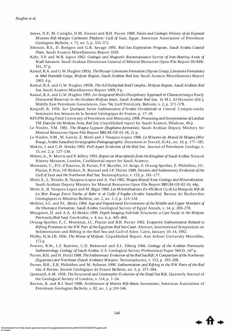
Hughes et al.
540
James, N.P., M. Coniglio, D.M. Aissoui and B.H. Purser 1988. Facies and Geologic History of an ExposedMiocene Rift-Margin Carbonate Platform: Gulf of Suez, Egypt. American Association of PetroleumGeologists Bulletin, v. 72, no. 5, p. 555–572.
Johnson, R.S., D. Rodgers and G.R. Savage 1995. Red Sea Exploration Program, Saudi Arabia CoastalPlain. Saudi Aramco Miscellaneous Report 1029.
Kahr, V.P. and W.B. Agocs 1962. Geologic and Magnetic Reconnaissance Survey of Iron-Bearing Areas ofWadi Sawawin. Saudi Arabian Directorate General of Mineral Resources Open-File Report DGMR-161, 37 p.
Kamal, R.A. and G.W. Hughes 1993a. The Musayr Limestone Formation (Tayran Group, Limestone Formation)at Jebel Hamdah Gorge, Midyan Region, Saudi Arabian Red Sea. Saudi Aramco Miscellaneous Report1003, 4 p.
Kamal, R.A. and G.W. Hughes 1993b. The Ad Dubaybah Reef Complex, Midyan Region, Saudi Arabian RedSea. Saudi Aramco Miscellaneous Report 1009, 9 p.
Kamal, R.A. and G.W. Hughes 1995. An Integrated Multi-Disciplinary Approach in Characterising a NewlyDiscovered Reservoir in the Onshore Midyan basin, Saudi Arabian Red Sea. In M.I. Al-Husseini (Ed.),Middle East Petroleum Geosciences, Geo ’94, Gulf PetroLink, Bahrain, v. 2, p. 571–578.
Karpoff, R. 1956. Sur Quelques Series Sedimentaires d’Arabie Occidentale et Central. Compte-renduSommaire des Séances de la Societé Géologique de France, p. 17–18.
KFUPM (King Fahd University of Petroleum and Minerals), 1998. Processing and Interpretation of LandsatTM Data for the Midyan Area, Red Sea. Unpublished report for Saudi Aramco, Dhahran, 49 p.
Le Nindre, Y.M. 1981. The Maqna Gypsum (Raghama formation). Saudi Arabian Deputy Ministry forMineral Resources Open-File Report BRGM-OF-01-18, 21 p.
Le Nindre, Y-M., M. Garcin, E. Motti and J. Vasquez-Lopez 1986. Le Miocene du Massif de Maqna (MerRouge, Arabie Saoudite) Stratigraphie-Paleogeographie. Document et Travail, IGAL, no. 10, p. 177–185.
Makris, J. and C.H. Henke 1992. Pull-Apart Evolution of the Red Sea. Journal of Petroleum Geology, v.15, no. 2, p. 127–134.
Milner, A., N. Morris and P. Jeffery 1993. Report on Macrofossils from the Kingdom of Saudi Arabia. NaturalHistory Museum, London, Confidential report for Saudi Aramco.
Montanet, C., P.O. d’Estevou, B. Purser, P-F. Burollet, J-J. Jarige, F. Orszag-Sperber, E. Philobbos, J-C.Plaziat, P. Prat, J-P. Richert, N. Roussel and J-P. Thiriet 1988. Tectonic and Sedimentary Evolution of theGulf of Suez and the Northwest Red Sea. Tectonophysics, v. 153, p. 161–177.
Motti, E., L. Teixido, R. Vazques-Lopez and A. Vial 1982. Maqna Massif Area: Geology and Mineralization.Saudi Arabian Deputy Ministry for Mineral Resources Open File Report BRGM-OF-02-16, 44p.
Motti, E., R. Vazques-Lopez and M. Bigot 1980. Les Mineralisations Zn-Pb-Ba et Cu de La Marge du Rift deLa Mer Rouge Entre Yanbu al Bahr et al Golfe d’Aqaba (Arabie Saoudite). Bureau de RecherchesGéologiques et Minières Bulletin, ser. 2, no. 1–2, p. 113–134.
Moltzer, J.G. and P.L. Binda 1984. Age and Depositional Environment of the Middle and Upper Members ofthe Shumaysi Formation, Saudi Arabia. Geological Survey of Egypt Annals, v. 14, p. 269–278.
Mougenot, D. and A.A. Al-Shakis 1999. Depth Imaging Sub-Salt Structures: a Case Study in the MidyanPeninsula (Red Sea). GeoArabia, v. 4, no. 4, p. 445–464.
Orszag-Sperber, F., C. Montenat, J.C. Plaziat and B.H. Purser 1992. Evaporitic Sedimentation Related toRifting Processes in the NW Part of the Egyptian Red Sea Coast. Abstract, International Symposium onSedimentation and Rifting in the Red Sea and Gulf of Aden. Cairo, January 10–14, 1992.
Philby, H.St.J.B. 1956. The Mines of Midyan. Unpublished Report. Ann Arbour University Microfilm,172 p.
Powers, R.W., L.F. Ramirez, C.D. Redmond and E.L. Elberg 1966. Geology of the Arabian Peninsula:Sedimentology Geology of Saudi Arabia. U.S. Geological Survey Professional Paper 560-D, 147 p.
Purser, B.H. and H. Hotzl 1988. The Sedimentary Evolution of the Red Sea Rift: A Comparison of the Northwest(Egyptian) and Northeast (Saudi Arabian) Margins. Tectonophysics, v. 153, p. 193–208.
Purser, B.H., E.R. Philobbos and M. Soliman 1990. Sedimentation and Rifting in the NW Parts of the RedSea: A Review. Societé Géologique de France Bulletin, no. 3, p. 371–384.
Quennell, A.M. 1958. The Structural and Geomorphic Evolution of the Dead Sea Rift. Quarterly Journal ofthe Geological Society of London, v. 114, p. 1–24.
Ravnas, R. and R.J. Steel 1998. Architecture of Marine Rift-Basin Successions. American Association ofPetroleum Geologists Bulletin, v. 82, no. 1, p.110-146.
Downloaded from http://pubs.geoscienceworld.org/geoarabia/article-pdf/4/4/503/5439267/hughes.pdfby gueston 26 August 2022
Lithostratigraphy, Midyan Region, Saudi Arabia
541
Geriant Wyn Hughes is a Consultant Geologist with the Research andDevelopment Division of Saudi Aramco. He received his BSc, MSc, and PhD degreesfrom Prifysgol Cymru (University of Wales), Aberystwyth, UK. His nearly 30years of experience in biostratigraphy include 10 years as a field geologist/biostratigrapher with the Solomon Islands Geological Survey and 10 as abiostratigraphic consultant and unit head of the Middle East-India region withRobertson Research based in Singapore and Wales. Professional activities arefocussed on the integration of micropaleontology with sedimentology to enhancesequence stratigraphic interpretations of Saudi Arabian carbonate rocks. Wynmaintains links with academic research through his activities as an externalexaminer for the University of Wales and as an Adjunct Professor of the KingFahd University of Petroleum and Minerals. He is a reviewer for GeoArabia, amember of the British Micropaleontological Society and of the Dhahran GeoscienceSociety and a Fellow of the Cushman Foundation for Foraminiferal Research.
ABOUT THE AUTHORS
Remond, C. and L. Teixido 1980. Geological and Mineral Exploration of the Sedimentary Cover Between AlBad and Al Muwaylih (28/35 A-C and 27/35 A-B). Bureau de Recherches Géologiques et MinèresOpen-File Report JED-OR 80–26, 79 p.
Richter-Bernburg, G. and W. Schott 1954. Geologic Researches in Western Saudi Arabia. Saudi ArabianDirectorate General of Mineral Resources Open File Report DGMR-38, 69 p.
Salah, M.G. and A.S. Alsharhan 1996. Structural Influence on Hydrocarbon Entrapment in the NorthwesternRed Sea, Egypt. American Association of Petroleum Geologists Bulletin, v. 80, no. 1, p. 101–118.
Saoudi, A. and B. Khalil 1984. Distribution and Hydrocarbon Potential of Nukhul Sediments in the Gulf ofSuez. Proceedings of the Seventh Exploration Seminar, Cairo, p. 75–96.
Schmidt, D.L. and D.G. Hadley 1984. Stratigraphy of the Miocene Baid Formation, Southern Red Sea CoastalPlain, Kingdom of Saudi Arabia. Saudi Arabian Deputy Ministry for Mineral Resources TechnicalRecord, USGS-TR-04-23, 46 p.
Sellwood, B.W. and R.E. Netherwood 1984. Facies Evolution in the Gulf of Suez Area: Sedimentation Historyas an Indication of Rift Initiation and Development. Modern Geology, v. 9, p. 43–69.
Shaban, M.N., H.M. Holail and M.A. Rashed 1997. Dolomitization of Middle Miocene Buildups, Um GheigArea, Red Sea Coast, Egypt. Carbonates and Evaporites, v. 12, no. 2, p. 264–275.
Shearman, D.J. 1979. Gypsum and Anhydrite Resources of the Coastal Plain of the Red Sea: Yanbu to the Gulfof Aqaba, Kingdom of Saudi Arabia. Saudi Arabian Directorate General of Mineral Resources OpenFile Report DGMR-701, 39 p.
Skipwith, P. 1973. The Red Sea and Coastal Plain of the Kingdom of Saudi Arabia. Saudi Arabian DirectorateGeneral of Mineral Resources Technical Record TR-1973-1, 149 p.
Spencer, C.H. 1987. Provisional Stratigraphy and Correlation of the Tertiary Rocks in the Jiddah Region.Saudi Arabian Deputy Ministry for Mineral Resources Open-File Report BRGM-OF-06-17, 37 p.
Srivastava, S.K. and P.L. Binda 1991. Depositional History of the Early Eocene Shumaysi Formation, SaudiArabia. Palynology, v. 15, p. 47–61.
Sultan, M., R.J. Stern, R.E. Arvidson, P. Shore and R. Becker 1993. Nature of the Red Sea Crust: A ControversyRevisited: Reply. Geology, v. 21, p. 575–576.
Taj, R.J. 1991. Stratigraphy and Sedimentology of the Cover Rocks of the Maqna Area, Saudi Arabia. UnpublishedPh.D. thesis, University of Glasgow, United Kingdom, 256 p.
Vial A., C. Clintzboeckel and R. Al Sati 1983. Phosphate Prospecting in the Upper Cretaceous, Eocene andMiocene of the Red Sea Coastal Zone (1980-1981). Saudi Arabian Deputy Ministry for Mineral ResourcesOpen-File Report BRGM-OF-03-32, 41 p.
Youssef, E-S.A.A. 1997. Dolomitization and Dedolomitization of Miocene Carbonates at Gabal El-Safra, ShermEl Sheikh Area, Sinai, Egypt. Carbonates and Evaporites, v. 12, no. 2, p. 185-191.
Downloaded from http://pubs.geoscienceworld.org/geoarabia/article-pdf/4/4/503/5439267/hughes.pdfby gueston 26 August 2022

Hughes et al.
542
Manuscript Received June 22, 1999
Revised September 12, 1999
Accepted October 3, 1999
Dogan Perincek received his MSc in Geology and PhD in Petroleum Geology from theUniversity of Istanbul in 1972 and 1978, respectively. He worked with the TurkishPetroleum Corporation as a Structural Geologist and Petroleum Explorationist between1975 and 1989. Dogan also worked with King Fahd University of Petroleum and Minerals(KFUPM) as a Research Scientist, as an Explorationist with Mobil Exploration and HuffcoTurkey Incorporated, as a Geophysicist with the Geological Survey of Victoria (1992),Geological Survey of Western Australia (1995) and World Geoscience Co. Ltd. (1997).Dogan rejoined KFUPM in late 1997. He is a member of the American Association ofPetroleum Geologists, the Australian Society of Exploration Geophysicists, the PetroleumExploration Society of Australia, and the Dhahran Geoscience Society.
David Grainger has recently joined GeoArabia as Geoscience Editor. From 1978 he wasSenior Geological Editor at the Saudi Arabian Deputy Ministry for Mineral Resources.Before his career change to geological editing, he worked as a regional mapping and mineralexploration geologist in East and North Africa, Canada, Iran, Australia, Papua NewGuinea, and Antarctica. He also lectured at Sunderland Polytechnic, UK. David obtainedhis BSc in Geology from Nottingham University, UK in 1962 and an MSc in MineralExploration from Imperial College, London in 1966. He is a member of the Institution ofMining and Metallurgy, a fellow of the Geological Society on London, and a member ofthe European Association of Science Editors.
Abdul-Jaleel Abu-Bshait is employed by the Geological Research and DevelopmentDivision of Saudi Aramco. He received his BSc in Geology from the University of SouthernCalifornia. His main areas of interest are the characterization of carbonate reservoirs andFMI image interpretations. He is a member of the American Association of PetroleumGeologists and of the Dhahran Geoscience Society.
Abdul-Rahman Mohammed Jarad is a Lecturer in the Earth Sciences Department ofthe King Fahd University of Petroleum and Minerals (KFUPM). He was employed in theGeology and Minerals Division of KFUPM’s Research Institute from 1991 to 1998. Hereceived a BSc in Geology from KFUPM in 1991 and an MSc in 1996. Abdul-Rahman’sprofessional interests include the application of geostatistics to ore deposit evaluation andreservoir characterization. He is a member of the Saudi Society for Earth Sciences, theDhahran Geoscience Society, and the American Association of Petroleum Geologists.
An earlier version of this paper was presented at the 5th Meeting of the Saudi Society for EarthSciences held in Dhahran, Saudi Arabia in October 1998 and at the 4th International Conference on
the Geology of the Middle East in Beirut, Lebanon in November 1998.
Downloaded from http://pubs.geoscienceworld.org/geoarabia/article-pdf/4/4/503/5439267/hughes.pdfby gueston 26 August 2022
Related Documents