G G lobal lobal O O cean cean O O bserving bserving S S ystem ystem Some call it the WOW Some call it the WOW

G lobal O cean O bserving S ystem
Dec 31, 2015
G lobal O cean O bserving S ystem. Some call it the WOW. GOOS Objectives. Specify (space, time, quality) the ocean data needed on a continuing basis Implement an internationally coordinated strategy for ocean data gathering and exchange - PowerPoint PPT Presentation
Welcome message from author
This document is posted to help you gain knowledge. Please leave a comment to let me know what you think about it! Share it to your friends and learn new things together.
Transcript

GGlobal lobal OOcean cean OObserving bserving SSystemystem
Some call it the WOWSome call it the WOW

GOOS ObjectivesGOOS Objectives
►Specify (space, time, quality) the ocean Specify (space, time, quality) the ocean data needed on a continuing basisdata needed on a continuing basis
► Implement an internationally Implement an internationally coordinated strategy for ocean data coordinated strategy for ocean data gathering and exchange gathering and exchange
►Facilitate the development of uses and Facilitate the development of uses and products of these data and encourage products of these data and encourage their application for the protection of their application for the protection of the environmentthe environment

Global Observing SystemsGlobal Observing Systems
►Climate - GCOSClimate - GCOS►Terrestrial - GTOS Terrestrial - GTOS ►Ocean – GOOSOcean – GOOS
►WWW and GAW (chemical)WWW and GAW (chemical)
Global Observing Systems Information Global Observing Systems Information Center Center www.gosic.orgwww.gosic.org

GOOS BackgroundGOOS BackgroundOn-going activities (IGOSS from the early 70s, GLOSS from the On-going activities (IGOSS from the early 70s, GLOSS from the
early 80s, CPR since the 40s, and many more)early 80s, CPR since the 40s, and many more)
POMS – Pilot Ocean Monitoring Study 1979 (SCOR, IOC, JOC for POMS – Pilot Ocean Monitoring Study 1979 (SCOR, IOC, JOC for GARP)GARP)
WOW suggested at the IOC from mid 1980s to early 1990s WOW suggested at the IOC from mid 1980s to early 1990s
TOGA, WOCE, IGBP – 1980s and 1990s TOGA, WOCE, IGBP – 1980s and 1990s
CCCO’s Ocean Observing System Development Program CCCO’s Ocean Observing System Development Program (OOSDP) in the 1980s (first action plan 1984) (OOSDP) in the 1980s (first action plan 1984)
A special OOSD-PA special OOSD-Panelanel then produced a plan for An Ocean then produced a plan for An Ocean Observing System for Climate (1995) which formed the basis Observing System for Climate (1995) which formed the basis for initial GOOS activities for initial GOOS activities
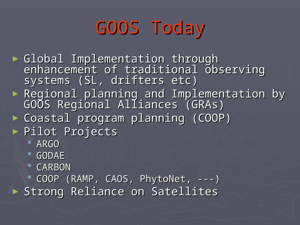
GOOS TodayGOOS Today
► Global Implementation through Global Implementation through enhancement of traditional observing enhancement of traditional observing systems (SL, drifters etc)systems (SL, drifters etc)
► Regional planning and Implementation by Regional planning and Implementation by GOOS Regional Alliances (GRAs) GOOS Regional Alliances (GRAs)
► Coastal program planning (COOP)Coastal program planning (COOP)► Pilot ProjectsPilot Projects
ARGOARGO GODAEGODAE CARBONCARBON COOP (RAMP, CAOS, PhytoNet, ---)COOP (RAMP, CAOS, PhytoNet, ---)
► Strong Reliance on SatellitesStrong Reliance on Satellites

GOOS Regional AlliancesGOOS Regional Alliances
NEAR GOOS
SEA GOOS
GRASP
PI-GOOS
IOCARIBE GOOS
IOGOOS
GOOS-AFRICA
EuroGOOS
Black Sea GOOS
Med GOOS
EuroGOOS
AFRICA
US GOOS
WA GOOS
TropSouthAtlanGOOS

Data DeliveryData Delivery
►Surface Drifters (SVP/GTS) – 95%Surface Drifters (SVP/GTS) – 95%►Sea Level - Fast 86%, MSL 76%Sea Level - Fast 86%, MSL 76%►XBTs (GTS) – roughly 70%XBTs (GTS) – roughly 70%►ARGO – 95%ARGO – 95%►Moorings (GTS) - GoodMoorings (GTS) - Good

Observation TrendsObservation Trends
► Drifters (SVP) - up 15% 2001-2003Drifters (SVP) - up 15% 2001-2003► Sea Level Sea Level
FAST - 10 stations added 2003FAST - 10 stations added 2003 MSL - stable since 1998 MSL - stable since 1998
► XBT- Down 27% 1999-2003 0verallXBT- Down 27% 1999-2003 0verall but HDX growing steadily but HDX growing steadily
► ARGO - Up, up and awayARGO - Up, up and away► Moorings – primary arrays - Moorings – primary arrays -
encouragingencouraging Others - erratic Others - erratic

Upper Ocean Profiles
0
50000
100000
150000
200000
250000
1990 1991 1992 1993 1994 1995 1996 1997 1998 1999 2000 2001 2002 2003
Other Buoys
Triton
PIRATA
TAO
Argo
XBT

Surface Drifter ProgramSurface Drifter Program(Requirement -1250 by 2005)(Requirement -1250 by 2005)
► Jan 2002: 1207 overall, 652 SVP/GTSJan 2002: 1207 overall, 652 SVP/GTS► Jan 2003: 1249 “ 714 “Jan 2003: 1249 “ 714 “► Jan 2004: 1459 “Jan 2004: 1459 “ 908 “ 908 “
15981598 905 905 ► Measurements (SVP) – Jan 2004Measurements (SVP) – Jan 2004
SST-837/SST-837/835835 SLP-336/SLP-336/326326 (May 2004)(May 2004) Wind-40/Wind-40/2727

XBT ProgramXBT Program
►High Density lines (HDX)High Density lines (HDX) 4 transects/yr/50km spacing4 transects/yr/50km spacing
►Frequently Repeated Lines (FRX)Frequently Repeated Lines (FRX) 18 transects/yr/150km spacing18 transects/yr/150km spacing
►Low Density lines (LDX)Low Density lines (LDX) 12 transects/yr/150km spacing12 transects/yr/150km spacing

HDX XBTs
0
2000
4000
6000
8000
10000
12000
1990 1991 1992 1993 1994 1995 1996 1997 1998 1999 2000 2001 2002 20030
5
10
15
20
drops
lines

High Density XBT ProgramHigh Density XBT Program
► Overall Program - 27 lines plus MedOverall Program - 27 lines plus Med
2002 -19 lines/73 transects - 96% 2002 -19 lines/73 transects - 96% 2003 -19 lines/64 transects - 84%2003 -19 lines/64 transects - 84% 2002/3 8 of 27 not done at all2002/3 8 of 27 not done at all Med underway since 1999Med underway since 1999
8 lines operated early on, presently 28 lines operated early on, presently 2
New Brazilian Line starting June 2004New Brazilian Line starting June 2004►Victoria –Trinidade, 6 transects/yrVictoria –Trinidade, 6 transects/yr

2003 FRX and LDX XBTS2003 FRX and LDX XBTS
FRX operated at the 25% levelFRX operated at the 25% level 3 of 30 lines done well, 11 partially3 of 30 lines done well, 11 partially
LDX operated at 10%LDX operated at 10%

Sea Level - GLOSSSea Level - GLOSS
Core Network - 290 MSL stationsCore Network - 290 MSL stations Subsets Subsets
►Ocean Circulation (OC)Ocean Circulation (OC)►Long Term Trends Long Term Trends ►Altimeter calibration Altimeter calibration
Fast Delivery - 142 stationsFast Delivery - 142 stations

OC Sea level SubsetOC Sea level Subset
Pairs of stations Pairs of stations ►Across narrow straits not suitable for altimetryAcross narrow straits not suitable for altimetry►Across wider straits, choke points and basin-Across wider straits, choke points and basin-
sections to measure transport variability of sections to measure transport variability of particular interestparticular interest
►Along polar coastlines, especially Antarctica, Along polar coastlines, especially Antarctica, where winter ice precludes altimetrywhere winter ice precludes altimetry
19 locations (68 possible sites) identified 19 locations (68 possible sites) identified

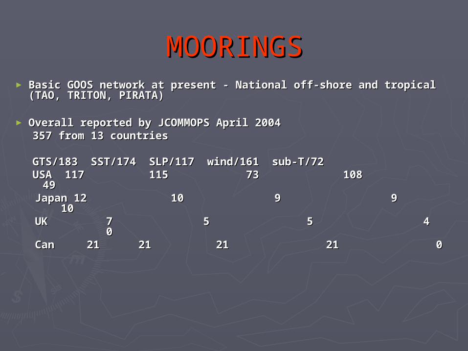
MOORINGSMOORINGS► Basic GOOS network at present - National off-shore Basic GOOS network at present - National off-shore
and tropical (TAO, TRITON, PIRATA)and tropical (TAO, TRITON, PIRATA)
► Overall reported by JCOMMOPS April 2004Overall reported by JCOMMOPS April 2004357 from 13 countries357 from 13 countries
GTS/183 SST/174 SLP/117 wind/161 sub-T/72GTS/183 SST/174 SLP/117 wind/161 sub-T/72USA 117 115 73 108 49USA 117 115 73 108 49
Japan 12 10 9 9 10Japan 12 10 9 9 10 UK 7 5 5 4 0UK 7 5 5 4 0 Can 21Can 21 21 21 21 21 0 21 21 0


Final statement - summaryFinal statement - summary
►world_map_geo.jpgworld_map_geo.jpg

ARGO+ARGO+
►1240 Active May 20041240 Active May 2004►895 funded for 2004895 funded for 2004►2405 funded 2005-20072405 funded 2005-2007►Few others aroundFew others around
Med, Black SeaMed, Black Sea►Target: 04-1800, 05-2500, Target: 04-1800, 05-2500, 06-300006-3000►Expected life of an ARGO float is 4 Expected life of an ARGO float is 4
yearsyears 140 profiles, one every 10 days140 profiles, one every 10 days

ARGO Network May 2004ARGO Network May 2004

GOOS Coastal ProgramGOOS Coastal Program
► Integrated* strategic design plan Integrated* strategic design plan completed and issued 2003 with completed and issued 2003 with subsystems for subsystems for Monitoring Monitoring Data acquisition, management, disseminationData acquisition, management, dissemination Assimilation and analysisAssimilation and analysis
► Implementation plan finalized June 2004 Implementation plan finalized June 2004 and issued December 2004and issued December 2004
**CC--GOOS, LMR and HOTOGOOS, LMR and HOTO

Initial Subsystem for Coastal Initial Subsystem for Coastal Observations Observations
Physical:Physical: SL, temp, sal, currents, waves, SL, temp, sal, currents, waves, bathymetry, shoreline position, sediment bathymetry, shoreline position, sediment grain size, attenuation of solar radiationgrain size, attenuation of solar radiation
Chemical:Chemical: sediment organic content, sediment organic content, dissolved inorganic N, P and S, dissolved dissolved inorganic N, P and S, dissolved oxygenoxygen
Biological:Biological: benthic biomass, phytoplankton benthic biomass, phytoplankton biomass, faecal indicators biomass, faecal indicators
Some Others: seabirds, oil, metals, pesticidesSome Others: seabirds, oil, metals, pesticides

Pre 2000 Coastal MonitoringPre 2000 Coastal Monitoring Meteorology OceanographyMeteorology Oceanography

Global Ocean Data Assimilation Global Ocean Data Assimilation Experiment (GODAE)Experiment (GODAE)
1st Objective1st Objective
Apply state of the art ocean models andApply state of the art ocean models and
assimilation methods to produce:assimilation methods to produce: Short -range open ocean forecasts,Short -range open ocean forecasts, boundary conditions to extend boundary conditions to extend
predictability of coastal and regional predictability of coastal and regional subsystems, and subsystems, and
initial conditions for climate forecast initial conditions for climate forecast models models

GODAE GODAE
22ndnd Objective Objective
Provide global ocean analyses for: Provide global ocean analyses for:
developing improveddeveloping improved Understanding of the of the oceansUnderstanding of the of the oceans Assessments of the predictability of ocean Assessments of the predictability of ocean
variability,variability,
a basis for improving the design and a basis for improving the design and effectiveness of GOOSeffectiveness of GOOS

GODAE PhasesGODAE Phases
►Development 2000-2002Development 2000-2002►Demonstration 2003-2005Demonstration 2003-2005►Consolidation and establishment of Consolidation and establishment of
permanent systems. Transition to permanent systems. Transition to operational systems. 2006-2007operational systems. 2006-2007
Related Documents