FY 2005 FY 2005 - - 2009 2009 HUD CONSOLIDATED PLAN HUD CONSOLIDATED PLAN ‘ ‘ ‘ ‘ CLARK COUNTY CLARK COUNTY LAS VEGAS LAS VEGAS NORTH LAS VEGAS NORTH LAS VEGAS BOULDER CITY BOULDER CITY MESQUITE MESQUITE

Welcome message from author
This document is posted to help you gain knowledge. Please leave a comment to let me know what you think about it! Share it to your friends and learn new things together.
Transcript

FY 2005FY 2005--20092009HUD CONSOLIDATED PLANHUD CONSOLIDATED PLAN
‘‘
‘‘
CLARK COUNTYCLARK COUNTYLAS VEGASLAS VEGAS
NORTH LAS VEGASNORTH LAS VEGASBOULDER CITYBOULDER CITY
MESQUITEMESQUITE

FY 2005 FY 2005 ACTION PLANACTION PLAN
‘‘‘ ‘
CLARK COUNTYCLARK COUNTYLAS VEGASLAS VEGAS
NORTH LAS VEGASNORTH LAS VEGASBOULDER CITYBOULDER CITY
MESQUITEMESQUITE

City of Henderson Comprehensive Plan Adoption Draft January 2006
AAcckknnoowwlleeddggeemmeennttss
City Council James B. Gibson, Mayor Amanda M. Cyphers, Councilman, Ward I Andy A. Hafen, Councilman, Ward II Jack K. Clark, Councilman, Ward III Steven D. Kirk, Councilman, Ward IV
Planning Commission Dan Shaw, Chairman Paul Bunker, Vice Chairman George Bochanis Craig Burr
Dale Lay Debra March Gerri Schroder
Comprehensive Plan Steering Committee Tom Hennessy Mike Levin Jennifer Lewis Robert Lewis James Petrizzo Raja Puthoor Len Rutherford
Richard Serfas Jacob Snow Vicky VanMeetren Robert Woods Dean Walker Chris Yergensen
City Managers Phil D. Speight, City Manager Mark T. Calhoun, P.E., Assistant City Manager Mary Kay Peck, AICP, Assistant City Manager
City Staff Working Group Mary Baer, SR/WA, Real
Property Agent Liza Conroy, Assistant City
Attorney II Bob Cooper, CEcD,
Economic Development Manager
Brad Fuller, Deputy Fire Chief Michael Garner, Police
Captain
Robert Herr, P.E., Assistant Director of Public Works
Tedie Jackson, Minutes Clerk Christine Kidd, P.E., Project
Engineer II Michael Kidd, Utility Services
Engineer I Doug Kuntz, Affordable
Housing Coordinator Jeff Leake, Economic
Development Officer

City of Henderson Comprehensive Plan Adoption Draft January 2006
April Parra, Minutes Clerk Shital K. Patel, P.E., Project
Engineer II Dirk Richwine, Assistant
Director of Parks and Recreation
Rod Streets, Senior Financial Analyst
Carol Turner, Accountant-Special Projects
Anthony Ventimiglia, P.E., Utility Services Engineer II
Cody Walker, Redevelopment Project Coordinator
Bob Woodson, P.E., Utility Services Engineer II
Mark Zalaoras, Assistant City Attorney
Community Development Staff Bristol Ellington, AICP,
Director of Community Development
Tracy Foutz, AICP, Assistant Director of Community Development
Stephanie Garcia-Vause, AICP, Deputy Director of Long Range Planning and Special Projects
Shelly Labay, AICP, Principal Planner
Deborah Reardon, AICP, Senior Planner
Sean Robertson, AICP, Senior Planner
Jared Gerber, Planner Tracie Wheaton, Planner Debora Taylor, GIS
Technician Carla Miguel, Office Assistant
II
Clarion Associates, Planning Consultants Benjamin A. Herman, AICP, Vice President Lesli Ellis, AICP, Senior Associate Molly Mowery, Associate

City of Henderson Comprehensive Plan Adoption Draft January 2006
TTaabbllee ooff CCoonntteennttss
Chapter 1: Introduction and Plan Themes Introduction .....................................................................................................................................1-1 Henderson’s Growth .....................................................................................................................1-1 Plan Themes....................................................................................................................................1-3
Chapter 2: Balanced Land Use Principle 1: Our city will contain a balanced mix of land uses ........................................2-2 Principle 2: Redevelopment and infill will provide new opportunities in Henderson and provide for efficient use of land...................................2-3 Principle 3: Our community will include a diverse mix of housing types and neighborhood choices to support the needs of all residents .................................................................................................................................2-3 Principle 4: Henderson will continue to be economically vital by maintaining its non-residential land base .........................................................................2-5 Principle 5: The Henderson airport will continue to be viable for commercial air service............................................................................................................2-5
Chapter 3: Quality Development Principle 1: Each of our neighborhoods will have unique characteristics and will be designed to promote variety.....................................................3-2 Principle 2: Our neighborhoods will include accessible common spaces and amenities ..................................................................................................3-3 Principle 3: Commercial areas will be vibrant and attractive places .................................................................................................................................................3-4 Principle 4: Infill projects will seamlessly integrate with existing areas and improve property values............................................................................................3-5 Principle 5: Mixed-use areas will be thoughtfully designed and of high quality .................................................................................................................................3-5 Principle 6: Transit-Oriented Development will be encouraged in appropriate locations................................................................................................................3-7 Principle 7: Our public spaces will be attractive and designed to accommodate people ....................................................................................................................3-8
Chapter 4: Integrated Desert Environment Principle 1: Our community will integrate open spaces and natural features within built places ...........................................................................................4-2 Principle 2: Landscaping in new developments will reflect the desert environment ........................................................................................................................4-4 Principle 3: Buildings will be designed to provide comfort and energy efficiency in the desert environment ..........................................................................4-4

City of Henderson Comprehensive Plan Adoption Draft January 2006
Principle 4: Henderson will manage its natural resources ................................................ 4-5
Chapter 5: Connected Places Principle 1: Our neighborhoods will be connected through local streets, sidewalks, and trails...................................................................................................................... 5-2 Principle 2: Our arterial street system will foster connectivity to destinations around the community................................................................................................................. 5-4 Principle 3: Community destinations will be linked by transit and a balanced transportation system ................................................................................................................... 5-4
Chapter 6: Arts and Culture Principle 1: Our community will promote, encourage, and stimulate community art and cultural development ..................................................................................................... 6-2 Principle 2: Our community will support development of public spaces that promote participation in local gathering and cultural events .......................................... 6-3 Principle 3: Parks will provide access to arts and culture.................................................. 6-3
Chapter 7: Land Use Plan Introduction .................................................................................................................................... 7-1 Residential Categories ................................................................................................................. 7-1 Non-Residential Categories ....................................................................................................... 7-8 Other Categories.......................................................................................................................... 7-13 Summary of Land Use Categories .......................................................................................... 7-15
Chapter 8: Action Plan Types of Implementation Actions ............................................................................................ 8-1 Summary of Priority Actions ...................................................................................................... 8-1

Chapter 1: Introduction and Plan Themes
City of Henderson Comprehensive Plan Page 1-1 Adoption Draft January 2006
CChhaapptteerr 11:: IInnttrroodduuccttiioonn aanndd PPllaann TThheemmeess
Introduction The City of Henderson, Nevada is located at the southern edge of the Las Vegas Valley and serves as a gateway to one of the fastest growing metropolitan areas in the country. Beyond the mountains to the east is Lake Mead, one of the largest man-made lakes in the United States. Just a short distance to the northwest is the world famous tourist Mecca known as the Las Vegas Strip. Incorporated in 1953, the city actually has its roots a few years earlier in the wave of industrial expansion necessitated by World War II. The original town site was created to house the workers of the new Basic Magnesium Plant. At the time of incorporation, Henderson comprised about 13 square miles and was home to 7,410 people. From these humble beginnings the city has blossomed into a diverse community of over 240,000 residents and is the second largest city in Nevada. In the midst of the tremendous growth taking place throughout the valley, Henderson has been a leader in providing high quality master-planned communities in which its residents can live, work, and play. The intent of this Plan is to provide the guidance necessary to ensure that continued growth occurs with the same attention paid to preserving that quality of life.
Henderson’s Growth The City of Henderson has been among the fastest growing cities in the nation, averaging nearly 12,000 new residents per year since 1990. Forecasts predict that this trend will continue for at least the next several years based on the availability of vacant land and the uses planned for that land. Since July 1, 2002, there have been on average 400 new dwelling units a month built to support this growth. Population, which is currently just over 247,000 as of October 1, 2005, is likely to reach the 400,000 person mark around the year 2018. If the average of 2.5 persons per household continues, about 64,000 additional dwelling units will be needed at that time. Total build out, which is not expected to be reached until well after the last forecasted year of 2035, will exceed 500,000 people. These forecasts do not take into account the potential for annexation of additional

Chapter 1: Introduction and Plan Themes
Page 1-2 City of Henderson Comprehensive Plan Adoption Draft January 2006
land into the city or a trend toward increased residential density, which could accelerate current growth patterns. Population estimates are formally updated every September using a housing unit methodology shared through interlocal agreement by each entity in the valley. Housing units are multiplied by an occupancy rate provided by the United States Postal Service. Occupied housing units are then multiplied by the rate of persons per household, taken from the United States Census. The City of Henderson’s population forecast is based on the same rates of occupancy and persons per household, as well as the future land use plan to predict development of vacant areas. It is anticipated that the current level of growth will be sustained at least through 2015, with a gradual tapering off valley wide as the area reaches maturity. The portion of the valley’s population residing in Henderson is predicted to remain close to the current level of 14.5%. The City of Henderson is truly a “Place to Call Home,” with residents agreeing that the sense of community is strong here, which is important to our quality of life. Today, Henderson provides for an exceptional quality of life for people who live and work here—with exemplary master planned communities, parks, public safety, educational opportunities, and business and job recruitment.

Chapter 1: Introduction and Plan Themes
City of Henderson Comprehensive Plan Page 1-3 Adoption Draft January 2006
Plan Themes The themes in this Comprehensive Plan highlight areas where Henderson aims to do better—to make this a stronger community than it is today. As our city continues to grow and change, different needs will emerge and we must continually chart a new direction to successfully adapt and continue to thrive. For instance, in our desert environment, it is important to evaluate water use and service areas and establish policies to ensure that citizens have adequate resources to keep pace with demand. In addition, as Henderson begins to reach its limits on available land, new emphasis will be placed on mixed-use development as well as infill and redevelopment.
This chapter highlights the five major themes of the Comprehensive Plan.
Henderson aims to build community through…
1. Balanced Land Uses, 2. Quality Development, 3. Integrated Desert Environment, 4. Connected Places, and 5. Arts and Culture.
These themes tie in with our community’s Vision Statement:
Henderson’s Vision Statement We envision our city as a fully integrated, progressive, and engaged community of citizens and neighborhoods enjoying premier amenities, services, and opportunities.
Theme 1: Balanced Land Uses Henderson will build community through a pattern of Balanced Land Uses.
A community with a balance of land uses has long-term economic stability. Residents need to have employment opportunities as well as a diverse choice of housing and retail services to maintain the city as a vital community. Henderson aims to ensure that an adequate inventory of lands is available so that the city is able to continue to recruit new businesses and provide space for locally expanding companies.

Chapter 1: Introduction and Plan Themes
Page 1-4 City of Henderson Comprehensive Plan Adoption Draft January 2006
Theme 2: Quality Development Henderson will build community through Quality Development.
The City of Henderson is well known for its high quality master-planned communities, exemplary parks, and first-rate civic facilities and services. The city works with developers to provide well-designed and long lasting projects throughout the community. Overall, Henderson residents care a great deal about the appearance and cleanliness of our city. This theme to build community aims to raise the bar higher on the quality of new design and development. By emphasizing quality development, the city will foster creativity and variety in development projects, promote stable neighborhoods that retain their quality over time, create beautiful public places within our city, and create variety rather than “sameness.” Good design also adds economic value to neighborhoods and commercial areas and contributes to reinvestment.
Theme 3: Integrated Desert Environment Henderson will build community by integrating the Desert Environment.
The Mojave Desert is home to many unique desert animals and plants. Especially notable in the desert are its lush washes---the lifelines for the animals and plants. Unfortunately, much of the natural environment has been paved or lost as the Las Vegas Valley has developed. The city wants to curb this trend and find ways to integrate the desert such that natural landscapes weave through the built environment to add beauty, provide wildlife corridors and habitat for birds, and to give our community a unique image and closer identity with our desert environment. Natural and open areas can also provide relief for citizens from the busy, built up areas. To conserve its natural resources for today and tomorrow and to provide beauty and access to the desert landscape, Henderson aims to protect, restore, and conserve these resources. We also recognize in an age of drought and energy shortages, we can ill-afford to waste precious resources if Henderson is to continue to thrive.

Chapter 1: Introduction and Plan Themes
City of Henderson Comprehensive Plan Page 1-5 Adoption Draft January 2006
Theme 4: Connected Places Henderson will build community through Connected Places.
A connected community brings us together through a local and citywide system of pedestrian walkways, bike trails, equestrian trails, public transit opportunities, and functional streets for vehicles. In a connected community, the transportation system is designed in such a way that alternatives to automobile use are possible, and vehicular congestion throughout the community is minimized. Public transit is designed so citizens find it convenient and feel safe and comfortable using it. Connectivity also provides a means of linking neighborhoods and places to one another, and to open spaces, bike trails, to other desirable recreational/outdoor places, and to transit. When our neighborhoods and places are well-connected, this encourages social interaction and cultural events, allows outdoor experiences to be more spontaneous and accessible, decreases pollution by encouraging alternative transportation modes, and allows for healthier lifestyles by allowing walking and bicycling.
Theme 5: Arts and Culture Henderson will build community through Arts and Culture.
Henderson’s arts and culture are important aspects of the quality of life in the community. Serving as a basic part of educational and recreational offerings, arts and culture has the ability to strengthen neighborhoods and community involvement. Community art and culture also helps to foster new perspectives and appreciation while making the city a more attractive and appealing environment. For example, this can be as simple as an artistic sign or fence post, a statue, or a public art expression built into the everyday surroundings of the city. Community art and culture should be accessible to the public and have aesthetic, educational, or community-enriching qualities. Artistic enrichment and cultural opportunity are vital to our community values, quality of life, and economic and social well-being and makes our community a unique and attractive place to live and for visitors to recreate. To build a stronger community, all citizens should have new opportunities for creative involvement, play, and cultural exchange.

Chapter 1: Introduction and Plan Themes
Page 1-6 City of Henderson Comprehensive Plan Adoption Draft January 2006

Chapter 2: Balanced Land Use
City of Henderson Comprehensive Plan Page 2-1 Adoption Draft January 2006
CChhaapptteerr 22:: BBaallaanncceedd LLaanndd UUssee A community with a balance of land uses has long-term economic stability. Continuing to make job opportunities, as well as a variety of housing types, available is a top quality of life issue in our community. Henderson aims to ensure that an adequate inventory of lands is available so that the city is able to continue to recruit businesses that provide jobs for residents. Residents need to have employment opportunities as well as a diverse choice of housing and retail services to maintain the city as a vital community.
Principles for Building Community through Balanced Land Uses The Balanced Land Use principles focus on:
Providing a citywide mix of land uses to accommodate future housing, jobs, recreation, preservation areas, and other needs;
Promoting economic vitality of the city by targeting and reserving industrial and office land uses;
Promoting a diverse mix of housing types and neighborhood experiences;
Promoting infill and redevelopment; and
Supporting a viable airport.

Chapter 2: Balanced Land Use
Page 2-2 City of Henderson Comprehensive Plan Adoption Draft January 2006
Principle 1: Our city will contain a balanced mix of land uses. Henderson should contain a diverse mix of residential and non-residential land uses to provide opportunities for employment and retail services within or near neighborhoods in our city.
Policy 1.a. Citywide Mix of Uses The city should use the Future Land Use Plan and Comprehensive Plan policies as the main tools for guiding decisions about development and growth. The Future Land Use Plan provides for a diverse and integrated mix of uses throughout the entire city, including a balance of residential and non-residential areas. The city will continue to actively monitor the levels of new development and reserve lands for future commercial, industrial, and residential areas, as necessary.
Policy 1.b. Services and Amenities for Master Planned Communities Master Planned Communities should contain a balanced mix of homes, services, and amenities. These services should include fire, police, emergency and medical/ health-care facilities, religious facilities, day-care and schools. Additionally, community-fostering amenities such as multi-use playing fields, connective sidewalks, clubhouses, transit, parks, trails, and open spaces should be incorporated into the design of such places.
Policy 1.c. Designated Activity Centers Activity centers serve as important destinations within the city, and are characterized by their location along major travel corridors, high levels of activity, and a high standard of design quality. These places should be designated by the city on the Future Land Use Map, in accordance with the criteria described in the sidebar on this page. The development of designated activity centers as rich, vibrant mixed-use areas should be encouraged by the city through a combination of design guidelines and standards, and possibly incentives such as increased density provisions and streamlined approvals. These centers should be strongly pedestrian oriented, provide ample shade, and use architecture that is at a human scale to make them more inviting and comfortable to our residents.
Activity Center Development Criteria
The development of designated Activity Centers should meet the following criteria:
Location o Well served by roadway networks
with many connections such as freeway and major arterial intersections
o Future transit station o Must represent a destination or stop
along bicycle paths and multi-use trails
Design o Strong pedestrian orientation and
connections to adjoining areas o High quality urban environment o Shade structures, plazas, open spaces,
and other amenities that encourage people to gather and spend time
Activity o Mix of uses o High-density employment and
residential uses o Public entertainment and interaction
Activity Center Designation
Activity Centers should be designated on the city’s Future Land Use plan, including existing Activity Centers (such as The District) and proposed Activity Centers (such as Southedge Town Center). New Activity Centers may only be designated by a city-initiated Comprehensive Plan amendment.

Chapter 2: Balanced Land Use
City of Henderson Comprehensive Plan Page 2-3 Adoption Draft January 2006
Principle 2: Redevelopment and infill will provide new opportunities in Henderson and provide for efficient use of land. Henderson should encourage the redevelopment of underutilized areas in the city for new housing, retail, employment, and mixed-use opportunities.
Policy 2.a. Vibrant Downtown City Center Henderson should continue to promote downtown redevelopment to make the downtown an active and vibrant center for the community. The city should initiate business incentive programs to encourage retention and investments by businesses in the downtown area. The city will also bring vibrancy into the downtown area by actively encouraging tourism opportunities as well as arts and culture in downtown public settings and events.
Policy 2.b. Plan Future Redevelopment Areas The city should identify future redevelopment areas based on land values and areas in need of reinvestment and provide incentives to develop these areas. The city should monitor economic vitality at key commercial areas and prepare plans for future redevelopment if needed to assist specific projects and encourage redevelopment.
Policy 2.c. Promote Mixed-Use Infill Henderson should identify opportunities for mixed-use infill projects throughout the downtown and existing neighborhoods. The city will encourage new infill development to consider and be sensitive to the character of existing stable neighborhoods. Considerations shall include building scale, placement, size, height transitions, landscape, streetscape, access, and other design measures.
Principle 3: Our community will include a diverse mix of housing types and neighborhood choices to support the needs of all residents. Henderson should offer a variety of well-designed and maintained housing options in different settings—rural, suburban, and more mixed-use and “urban” parts of our community. Residents will have
Infill development will be identified and guided by compatibility standards.
A vibrant downtown center includes elements of art, pedestrian-friendly design, and active businesses.

Chapter 2: Balanced Land Use
Page 2-4 City of Henderson Comprehensive Plan Adoption Draft January 2006
a choice of housing types ranging from large-lot rural homes, single-family neighborhoods, to apartments and lofts in mixed-use districts. In addition, housing will range in price from “affordable” to “high end.”
Policy 3.a. Protect Existing Rural Neighborhoods The integrity and character of the city’s existing rural neighborhoods should be protected by establishing density transition guidelines for new development near established rural neighborhoods. These design guidelines may include: placing transitions between neighborhoods, such as privately maintained open space, trails, landscaped buffers, and existing natural features; incorporating rural design elements within neighborhoods that are developed at similar rural densities (e.g., fencing, lighting, natural landscaping that are consistent with neighboring rural communities); and ensuring that major arterial or collector streets are located on the perimeter of rural neighborhoods rather than bisecting them with new roads.
Policy 3.b. Balance Single and Multi-Family Housing Stock Henderson should continue to monitor its housing stock in order to provide a range of single-family and multi-family types of housing that are safe and well-serviced for all age groups and special-needs groups. This includes a balance of single-family attached and detached, duplex, town homes, and other varieties of higher-density housing such as apartments and condominiums.
Policy 3.c. High Density Housing Location and Amenities High-density housing, including mid- to high-rise apartments, condominiums, and town homes, should be located near transit, activity and commercial centers, and mixed-use developments as well as being located near arterial and collector streets for optimal accessibility. High-density residential developments should also include features, such as a central courtyard, recreational facilities, or other outdoor community gathering spaces, to enhance its attractiveness and livability.
Policy 3.d. Community Workforce Housing as a Viable Option Workforce housing is essential to the strength of any community and the city should ensure that this is available in various locations throughout the community. In order to encourage the private sector to provide a mixture of housing types with varied price ranges and
The city is surrounded by desert areas that will need to be designed carefully as growth extends.
Housing located above commercial centers increases activity within these areas.

Chapter 2: Balanced Land Use
City of Henderson Comprehensive Plan Page 2-5 Adoption Draft January 2006
amenities, the city should initiate incentive programs such as density bonuses, streamlined development permit processes, inclusionary programs, allowances for “granny flats”, and administrative approvals. The city should also implement programs that protect the quality and availability of the existing workforce housing supply.
Principle 4: Henderson will continue to be economically vital by maintaining its non-residential land base. Henderson is highly successful in efforts to recruit new businesses, strengthen existing businesses, diversify our local economy, and maintain a pro-business climate. To continue to be economically sustainable, the city will work to maintain a supply of land for primary employment uses, despite market pressures to convert industrial and employment land to other uses.
Policy 4.a. Employment-Oriented Uses The city will seek to maintain an adequate supply of land for uses that provide primary employment by identifying and reserving lands on the Future Land Use Plan map. The city should develop a systematic approach to monitor inventory of suitable lands for employment-oriented uses, in line with the city’s Strategic Plan priority to expand the city's economic and employment opportunities by focusing its efforts on recruiting new businesses, strengthening existing businesses, and diversifying our local economy. Additionally, future land use plans should include components to attract target markets as defined by the needs of the city at the time.
Policy 4.b. West Henderson The city will utilize opportunities in the West Henderson area created by the proximity of major thoroughfares and the Henderson Executive Airport to designate lands for primary employment uses. Appropriate locations will give consideration to existing residential uses and the Sloan Canyon National Conservation Area.
Principle 5: The Henderson airport will continue to be viable for commercial air service. As growth continues around the Henderson Airport, the city will continue to work with the airport to plan for compatible adjacent development to ensure long-term viability of the airport. The city will identify compatible and incompatible land uses around the airport,
What is Workforce Housing? Community workforce housing is defined as housing suitable for working families and individuals for households earning between 80% and 120% of an area’s median income. For Henderson, that means between $46,400 and $69,500 for a typical household.
Non-residential uses such as this office complex contribute to the overall stability of the city.

Page 2-6 City of Henderson Comprehensive Plan Adoption Draft January 2006
particularly within safety zones (i.e. roadway/aviation noise, over flight traffic).
Policy 5.a. Maintaining Economic Diversity New development around the airport should provide an economic base for the long-term benefit of the residents of Henderson, reflecting the fiscal responsibility of all stakeholders involved. The marketability of the land and planned uses surrounding the airport should reflect compatibility with the uses associated with an airport and the existing non-residential uses. This is an ideal area for the city to provide for an additional tax base that will diversify our economy.
Policy 5.b. Transitional Land Uses The city should identify a development plan for an appropriate transition between the airport and industrial uses to the surrounding residential areas. This plan should reflect the best interests, not just of the individual property owners, but of the city as a whole.
Policy 5.c. Residential Growth With the amount of growth taking place in the Las Vegas Valley in the late 20th century and continuing into the 21st century, it is vital that the city prevent additional residentially-planned areas beneath heavily-used flight tracks. These areas should be reserved for compatible land uses that will not hinder the existing and planned operations of the airport.
A well-functioning airport contributes to healthy economic growth and stability.
Future growth will reflect the interests of all citizens of Henderson.

Chapter 3: Quality Development
City of Henderson Comprehensive Plan Page 3- 1 Adoption Draft January 2006
CChhaapptteerr 33:: QQuuaalliittyy DDeevveellooppmmeenntt The City of Henderson is well known for its high-quality master-planned communities, exemplary parks, and first-rate civic facilities and services. The city works with developers to provide well-designed and long-lasting projects throughout the community. Overall, Henderson residents care a great deal about the appearance and cleanliness of our city.
This theme to build community aims to raise the bar further on the quality of new design and development. By emphasizing quality development, the city can foster creativity and variety in development projects, promote stable neighborhoods that retain their quality over time, create beautiful public places within our city, and create variety rather than “sameness.” Good design also adds economic value to neighborhoods or commercial areas and contributes to reinvestment. By continuing to collaborate with the development and business community, as well as our residents, and striving for high quality development, Henderson will continue to be recognized for its livable neighborhoods, diversity of housing opportunities, and vital commercial and business areas.
Principles for Building Community through Quality Development The Quality Development principles focus on:
Achieving unique and long-lasting neighborhoods; Promoting superior business districts and commercial
centers (including the downtown); Integrating new infill and redevelopment projects with
older districts in a seamless fashion; Promoting vibrant and attractive mixed-use
developments; Taking advantage of transit-related opportunities by
promoting Transit-Oriented Design in appropriate locations; and
Making lively, welcoming public spaces throughout our community.

Chapter 3: Quality Development
Page 3-2 City of Henderson Comprehensive Plan Adoption Draft January 2006
Principle 1: Each of our neighborhoods will have unique characteristics and will be designed to promote variety. Neighborhoods should include unique characteristics that make them distinctly identifiable. These may include design features such as architectural design, variety in housing types, common areas, and other features. Aspects of the natural environment should be incorporated within neighborhoods and developed areas where appropriate (see also Theme 3: Desert Environment).
Policy 1.a. Variety in Neighborhood Design New neighborhoods should be varied in design through standards and regulations. These may include such criteria as a variety of lot sizes, building styles and colors; orientation of buildings and garages, roof pitches, and other unique architectural features on homes; and design of neighborhood streets to create variety and aesthetic interest.
Policy 1.b. Variety in Housing Types New neighborhoods should include a variety of housing types including single-family detached, attached homes, town homes, stacked dwellings (condominiums and/or apartments), and dwellings located in mixed-use buildings.
Policy 1.c. Distinct Design of Neighborhood Common Areas Neighborhood common areas should include distinct right-of-way landscaping and materials, lights, signage, and other such design elements to distinguish a neighborhood from others (i.e., the areas shared by residents or the “semi-public” streets and amenities).
Policy 1.d. Integrated Desert Landscape in Neighborhoods New neighborhoods should integrate aspects of the natural desert environment as part of the subdivision design, including drainage channels that can serve multiple purposes; for example, recreation, habitat protection, and flood control. Landscape materials in new neighborhoods should be drought tolerant (Xeriscape) and appropriate for a hot, dry climate (see also Theme 3: Integrated Desert Environment). This signage clearly indicates the entrance to
a neighborhood.
A variety of architectural features (including colors and styles) contributes to the overall aesthetic quality of a neighborhood.

Chapter 3: Quality Development
City of Henderson Comprehensive Plan Page 3-3 Adoption Draft January 2006
Policy 1.e. Enhancement & Stabilization of Established and Older Neighborhoods The city should utilize existing programs, (enforcement of Home Owner’s Association maintenance requirements, etc.) as well as undertake programs targeted towards enhancement and stabilization of established neighborhoods, such as upkeep and preservation of older housing stock, design standards and guidelines for infill and redevelopment projects to encourage housing diversity, rehabilitation and upkeep of city infrastructure, and assistance for improvements to physical infrastructure.
Principle 2: Our neighborhoods will include accessible common spaces and amenities. Neighborhoods should contain amenities for residents of all ages, including parks and recreation areas. These common areas should be clearly marked, accessible, and conveniently located within neighborhoods. In addition, residential developments with small lot sizes or higher densities should contain adequate common outdoor space for residents.
Policy 2.a. Accessible Parks and Recreation Areas Neighborhoods should contain neighborhood parks, recreation areas, playgrounds, tot lots, sidewalks on both sides of streets and roadways, off-street trails, and other amenities. These amenities should be clearly marked, accessible, and conveniently located within neighborhoods so that all residents are able to access and enjoy these amenities. In general, regional, community, and neighborhood parks should be developed and maintained as public facilities (to serve the immediate and adjoining neighborhoods), and pocket parks should be developed and maintained as private facilities (to serve the immediate neighborhood area). Policy 2.b. Amenities in Higher Density Neighborhoods Provide centralized neighborhood-gathering spaces and pocket parks in neighborhoods large enough for residents to congregate, especially where lot sizes are small. These shall include landscaped areas that are suitable for children’s play areas, including appropriately-sized turf areas. These facilities should also be designed with safety in mind, following principles of “defensible space” such as appropriately located and designed lighting, fencing, and landscaping. Placing parks in open areas that are easily monitored and accessible will not only promote more use, but also provide a sense of security to their users.
Well-designed public spaces and parks promote opportunities for play.
This children’s park has been designed to be accessible, in close proximity to homes, and away from traffic.

Chapter 3: Quality Development
Page 3-4 City of Henderson Comprehensive Plan Adoption Draft January 2006
Principle 3: Commercial areas will be vibrant and attractive places. The city is flexible to accommodate the mix of uses that the market demands to make commercial areas economically viable. Commercial areas should be designed to be compatible and integrated with surrounding developments, and they should incorporate design features to provide for the comfort and safety of people.
Policy 3.a. Commercial Areas Integrated with Surrounding Developments Commercial areas should provide transitions for surrounding developments through proper scale of buildings, architectural character, and function and uses. Commercial developments should also include sidewalks and walkways for pedestrians to connect through parking areas to adjacent neighborhoods, commercial areas, and street rights-of-way.
Policy 3.b. Attractive Appearance of Commercial Areas Henderson has a number of attractive commercial developments. The focus for future commercial areas is to develop a site design approach that is oriented toward local streets and public right-of-way, rather than being dominated by parking lots. Commercial developments should include innovative designs with extensive architectural features and building articulation. The design should include extensive features to promote comfort for patrons, with overhangs and walkways for shade.
Policy 3.c. Transit-Supportive Design New development should include transit-supportive design features, including buildings that are located close to the street frontage with entries located close to transit stops; incorporation of transit stops where appropriate; streetscape amenities to enhance the pedestrian environment; and clearly marked pedestrian routes between buildings, transit facilities, and stops.
Policy 3.d. Commercial Areas Safe and Comfortable for Pedestrians Commercial sites should incorporate pedestrian-friendly design, including uninterrupted sidewalks, shade trees, shade structures, landscaping, outdoor seating areas, benches, and other site furnishings. Walkways in commercial areas should be clearly defined and separated from vehicles with safe crosswalks and should be shaded (to the extent possible) and adequately lit for nighttime use.
Commercial areas that separate sidewalks from vehicles increase pedestrian safety.
Commercial areas that are well-designed for pedestrians will have features including sidewalks, benches, and crosswalks.

Chapter 3: Quality Development
City of Henderson Comprehensive Plan Page 3-5 Adoption Draft January 2006
Policy 3.e. Desert Landscape in Commercial Areas Commercial developments should integrate natural features such as drainages into site designs, and new landscaping should be desert suitable and drought tolerant.
Policy 3.f. Energy Efficient Commercial Developments Commercial developments should incorporate green building techniques and energy-efficient elements in their design (see also Theme 3: Desert Environment).
Principle 4: Infill projects will seamlessly integrate with existing areas and improve property values. Infill should be compatible in scale and use with existing stable areas, and should enhance and improve upon the value of the area. By developing compatibility standards or guidelines for infill development, citizens and the city can work together to promote growth that efficiently uses land.
Policy 4.a. Compatible Infill for Stable Areas In stable areas of Henderson, infill development should be compatible with surrounding neighborhoods. The city will work with neighborhoods to define appropriate projects and compatibility. Key considerations should include the identification of appropriate transitions between land uses and developments of varying intensities, and incorporation of roadway, park, open space, and trail/pedestrian connections.
Principle 5: Mixed-use areas will be thoughtfully designed and of high quality. Mixed-use developments offer opportunities for residents to work, live, and play all within one neighborhood or district. To be successful, mixed-use projects should contain a mix of complementary and connected uses (such as retail, offices, and residential), with a variety of densities, as well as lively public spaces. Furthermore, the design of mixed-use areas should emphasize pedestrian comfort and safety and should include and support connections to other parts of the community. Mixed-use development can occur in two primary configurations: Vertical Mixed-Use or Horizontal Mixed-Use.
Enhancement projects for stable neighborhoods may include incorporating parks, open spaces, or trail connections.

Chapter 3: Quality Development
Page 3-6 City of Henderson Comprehensive Plan Adoption Draft January 2006
Vertical mixed-use refers to the integration of two or more land-use types within a building, occurring on different floors, one of which is residential. A typical example of a vertical mixed-use building would incorporate active uses such as stores, offices, and restaurants, at the street level, and residential or office uses on the upper floors. Horizontal mixed-use refers to a pattern where several types of uses or buildings, together with residential, are included, as part of a cohesive development in proximity to each other, with each building containing its own separate use. An example would be a development site that might include an area for residential uses, an office building, and a retail center. They would be designed as a set of coordinated uses, with common parking areas, strong pedestrian connections, and similar design features, but would contain separate uses in each building.
Policy 5.a. Complementary Uses New mixed-use developments should contain complementary and connected uses that are mutually supportive such as lofts and retail uses, residential with commercial and/or office, or hotel and restaurant uses.
Policy 5.b. Variety of Density Mixed-use developments should provide a variety of high-density residential uses that create a distinct community where people of diverse ages and incomes interact on a daily basis. This will allow residents and visitors to take advantage of the pedestrian-oriented environment, and accommodate varying needs within our community.
Policy 5.c. Variety of Sizes Mixed-use developments may occur at a variety of sizes and scales appropriate to the market they are designed to serve and the context of the area in which they are located.
Policy 5.d. Transportation Options Mixed-use developments should be designed to offer a variety of transportation options, including transit, walking, and bicycling as well as cars.
Policy 5.e. Public Spaces Designed for Pedestrians Mixed-use developments should be designed for pedestrians and should include wide sidewalks, shade trees and structures, benches, lighting, public art, landscaped public spaces such as plazas, ground level retail (with outdoor restaurant seating), appropriately scaled parking lots or garages, and other design features to make them vibrant and inviting places.
Vertical mixed-use projects can include high-density residential uses that create a distinct community.
Design features such as sidewalks, benches, and landscaping promote pedestrian use.

Chapter 3: Quality Development
City of Henderson Comprehensive Plan Page 3-7 Adoption Draft January 2006
Policy 5.f. Pedestrian Connectivity Mixed-use developments should be designed to allow for a continuous pedestrian system. Pedestrian safety as well as links to mass transit should be an integral part of the design of mixed-use developments within the city.
Principle 6: Transit-Oriented Development will be encouraged in appropriate locations. Transit-oriented development (TOD) is a pedestrian-friendly form of development that is typically focused around a major transit access point such as a light rail or bus rapid transit station. TOD areas should be pedestrian-oriented, provide opportunities for local services and connections to regional and local transit systems, and function as a gathering place for area workers, residents, and visitors. Elements of TOD areas usually include compact, mixed-use development; incorporated transit station (or close proximity to one); and facilities and design that enhance the environment for pedestrians.
Policy 6.a. Areas Surrounding Transit Stations Designed as Distinctive, Pedestrian-friendly Places To become great places for people, TOD areas should:
o Be compactly designed with short blocks (e.g., 400
feet or less is preferred) with buildings that relate to the streets and walkways;
o Be focused around at least one distinctive and attractive public space (e.g., a mini-park or plazas) near the transit station; and
o Include pedestrian facilities and amenities such as wide sidewalks (generous enough in width to allow at least two people to pass each other in opposite directions), attractive and inviting streetscapes, seating, designated crosswalks, trees and landscaping, ground- level retail, park-and-ride opportunities, and other features that help foster a unique identity and encourage walking.
The city should consider developing special streetscape design standards for TOD areas that are compatible with a transit environment.
Policy 6.b. Link TOD Areas to the Larger Community Provide connected and convenient streets, sidewalks, bicycle lanes, and trail linkages from the TOD area to surrounding areas to allow nearby residents to take
Trails have the ability to connectneighborhoods while enhancing the overall image of the city.
Distinctive, pedestrian-friendly places such as this development are one of the goals that TOD areas should exemplify. (Arlington, Virginia)
TOD areas should provide signage, pedestrian connections, and transit shelters.

Chapter 3: Quality Development
Page 3-8 City of Henderson Comprehensive Plan Adoption Draft January 2006
advantage of TOD areas without requiring the use of an automobile.
Policy 6.c. Residential and Employment Density in TOD Areas Sufficient to Support Transit To provide a critical mass of people to support transit, TOD areas should contain enough residential units that are of sufficient density and close proximity to allow the residents to walk to the transit station, and contain employment densities sufficient to generate demand for transit service from walkable locations.
Policy 6.d. Identify Transit Corridors in Future Growth Areas As the city continues to grow, potential transit corridors and stops should be identified within new developments that can support them. These corridors should be designed and planned in such a way that they connect to existing routes or corridors already in place.
Principle 7: Our public spaces will be attractive and designed to accommodate people. Public spaces are the building blocks of a thriving city. Successful public spaces support many activities and uses, are comfortable and attractive, and are accessible. Henderson recognizes the benefits of creating good public spaces. They support the local economy, attract business, promote tourism and cultural activity, decrease crime, promote public health (through walking), and give identity to our city.
Policy 7.a. Public Spaces to Accommodate Social Events and Interaction Outdoor public spaces such as plazas and civic centers, should encourage social interaction and foster a distinct sense of place. They should also include amenities that provide comfort and relaxation in all seasons. Above all, Henderson’s public spaces should be interesting, memorable, and reinforce our sense of community.
Policy 7.b. Connected Public Spaces Trails and walkways should connect public spaces as destinations for bicyclists and pedestrians (see also Theme 4: Connected Places).
Nearby housing helps generate enough activity to support transit.
Public trails designed to connect with destinations such as this picnic shelter provide added opportunity for social gathering.

Chapter 3: Quality Development
City of Henderson Comprehensive Plan Page 3-9 Adoption Draft January 2006
Policy 7.c. Attractive Public Realm to Enhance City’s Image The city will continue to enhance its image through high quality design of the public realm, including creating attractive city gateways, preserving views, and providing attractive public right-of-way landscaping.
Chapter 3: Quality Development
Page 3-10 City of Henderson Comprehensive Plan Adoption Draft January 2006

Chapter 4: Integrated Desert Environment
City of Henderson Comprehensive Plan Page 4-1 Adoption Draft January 2006
CChhaapptteerr 44:: IInntteeggrraatteedd DDeesseerrtt EEnnvviirroonnmmeenntt The Mojave Desert is home to many unique desert animals and plants. Especially notable in the desert are its lush washes—the lifelines for the animals and plants. Unfortunately, many of the natural environments have been paved or lost as the Las Vegas Valley has developed. The city wants to curb this trend and instead seek to find ways to respect nature and integrate the desert environment into our community as it grows. The city aims to integrate the desert environment such that natural landscapes weave through the built environment to add beauty, provide recreational access to open space, provide wildlife corridors and habitats for birds, and to give our community a unique image and sense of place. Natural and open areas can also provide relief for citizens from the busy, built up areas. To conserve its natural resources for today and tomorrow, and to provide beauty and access to the desert landscape, Henderson aims to protect, restore, and conserve these resources. We also recognize in an age of drought and energy shortages, we can ill-afford to waste precious resources if Henderson will continue to thrive.
Principles for Building Community by Integrating the Desert Environment The Integrated Desert Environment principles focus on:
Weaving open space and natural areas within the city’s built areas;
Using beautiful desert-inspired and drought-tolerant landscaping;
Designing environmentally-sensitive buildings that provide comfort and energy efficiency in the desert environment; and
Conserving energy and water resources and improving air quality.

Chapter 4: Integrated Desert Environment
Page 4-2 City of Henderson Comprehensive Plan Adoption Draft January 2006
Principle 1: Our community will integrate open spaces and natural features within built places. Drainage corridors, trails, open space corridors, and other desert landscape features will weave through neighborhoods and other parts of our city and create a connected network of natural features.
Policy 1.a. Enhance and Integrate the Open Space System Henderson’s open space system will conserve resources, provide relief from the urban setting, and provide both recreational and educational opportunities. Henderson will integrate a system of drainage corridors, utility corridors, trails, open space preservation, and special resources into our neighborhoods and the urban environment.
Policy 1.b. Long-term Environmental Stewardship Environmental stewardship is part of Henderson’s civic responsibility and is vital for the long-term protection and preservation of open space resources and environmentally sensitive areas, including wildlife habitat, significant watercourses, historic or cultural features, and hillsides. The city will preserve and manage such areas through a variety of applicable approaches, including the establishment of management plans, obtaining necessary funding, fostering volunteerism and education, developing partnerships with non-profits, and appropriate enforcement measures.
Policy 1.c. Provide A Connected Trails System The city will provide an uninterrupted trail system that links natural areas and special places within the community to parks, schools, neighborhoods and employment areas. Trails should meet the needs of a wide variety of user groups in Henderson, including cyclists, hikers, and equestrians. Henderson should continue to identify landmark trails, which link regionally significant recreational destinations, to provide unique user experiences.
Policy 1.d. Well-Designed Storm Drainage Areas Storm drainage areas should be integrated into future land use planning to act as “Desert Shorelines” within the built environment. In order to promote the protection of native habitat areas and provide natural community separators, drainage areas in future growth areas should remain natural to the greatest extent possible, and be restored to more natural conditions in existing areas
Integration of trails, proper drainage, and desert landscaping conserves resources and offers aesthetic value.
Multi-use areas serve as both a natural drainage system and a park for equestrian use.
A well-designed storm drainage area will protect other areas of the city.

Chapter 4: Integrated Desert Environment
City of Henderson Comprehensive Plan Page 4-3 Adoption Draft January 2006
where feasible. Adequate easements should be provided adjacent to storm-drainage systems and at intersections with roadways. In addition, the design of storm drainage basins should consider joint use with parks and recreation facilities, as well as provisions for emergency and utility maintenance equipment. Design of flood control facilities should involve public participation.
Policy 1.e. Appropriate Transitions at the “Desert Edge” The city will encourage development patterns and design standards at the Desert Edge through provisions for transitions at the desert-urban interface to preserve scenic resources, allow for public access to natural areas, and provide more gradual transitions between developed areas and the desert landscape.
Policy 1.f. Mojave Desert Education In an effort to encourage residents to learn more about, appreciate, and respect the Mojave Desert, the city should increase efforts to promote public education about this unique desert environment through interpretation and programming.
Policy 1.g. Locate and Design Future Development to Avoid Natural Resources In order to more effectively protect hillsides, drainage ways, habitat areas, and other sensitive lands, future developments should be located and designed to avoid natural resources such as streams, floodplains, and steep slopes.. In addition, the City of Henderson should actively take part in the Bureau of Land Management auction process to ensure the proper management of these resources.
Policy 1.h. Continue implementation of Regional Open Space Plan “Via Verde” Vision for Southern Nevada Through the development of the Southern Nevada Regional Policy Plan, local agencies and partners have identified a vision of providing an open space system surrounding the entire urban area, which would offer protection of the Valley’s surrounding hillsides and a buffer between these visually significant ridgelines and the urban area. The City of Henderson should continue to collaborate with local agencies, the development community, and others to implement this initiative known as the “Via Verde” vision.
The transition between the desert edge and urban development must be respected and carefully managed.
Wildlife preserves offer the public opportunities for education and recreation.
Open space and surrounding views are valuable resources for all citizens.

Chapter 4: Integrated Desert Environment
Page 4-4 City of Henderson Comprehensive Plan Adoption Draft January 2006
Note: Please see the Henderson Open Space Plan for more detailed policies related to the integration of natural areas within built places.
Principle 2: Landscaping in new developments will reflect the desert environment. The desert landscape provides inspiration with variety and texture of plants that are also designed to conserve water. Our city will continue to promote the use of regionally appropriate landscape materials.
Policy 2.a. Encourage Drought Tolerant Plants To help ensure the efficient use of our water resources, landscaping in new or converted developments should emphasize drought-tolerant plants. The use of turf should be limited to functional purposes only and not applied as decorative landscaping.
Policy 2.b. Efficient Watering Techniques In public spaces or recreational common areas deemed appropriate, turf, sub-surface irrigation, or other high efficiency systems should be used to provide for more efficient watering.
Principle 3: Buildings will be designed to provide comfort and energy efficiency in the desert environment. Through the application of smart and environmentally-friendly building techniques that are especially designed for unique desert environments, the city can look forward to a future of sustainable structures and healthy communities.
Policy 3.a. Utilize Green Building Techniques Developments within the City of Henderson are encouraged to incorporate green building techniques into their design. These may include solar-based building orientation, use of energy-efficient and/or recycled building materials, use of recycled non-potable water for landscape irrigation, and proper indoor air ventilation systems.
Policy 3.b. Encourage Energy Efficient Development Energy efficient building design and the achievement of Leadership in Energy and Environmental Design (LEED) standards are encouraged within city developments.
This local community garden features native plants that naturally thrive in a desert environment.
Houses in Civano, Arizona are designed to use less than 50% of the energy of a conventionally built home and utilize solar water heaters.

Chapter 4: Integrated Desert Environment
City of Henderson Comprehensive Plan Page 4-5 Adoption Draft January 2006
Policy 3.c. Protect Water Quality Developments should be designed to minimize negative impacts on water quality caused by soil erosion and run-off.
Policy 3.d. Integrate Natural Desert Environment in Design All developments within the City of Henderson are encouraged to incorporate the natural environment in their site plans and design. Projects should minimize the amount of necessary grading by trying to match topography, thus reducing the need for retaining walls and structures.
Principle 4: Henderson will manage its natural resources. Henderson will protect and conserve our natural resources for future generations of residents.
Policy 4.a. Conserve and Reduce Water Consumption The City of Henderson has implemented the “Water Watchers” initiative to increase public awareness of the current drought and the need to conserve water resources. Building upon this effort, the city should encourage homeowners and commercial property owners who redesign landscaping with drought-tolerant plants to reduce their demand for water. As we grow in a manner that recognizes our desert environment, parks will become even more important and will be the “green oasis” in the community.
Policy 4.b. Match Water and Wastewater Resources with Growth As Henderson continues to grow through infill and development, our demand for water resources will also continue to grow at a rate that may outpace current supplies. The city should continue to identify additional resources and promote conservation to ensure that water needs for future residents and business owners are met.
Policy 4.c. Improve Air Quality through Use of Alternative Transportation Modes Alternative transportation modes, including walking, bicycling, buses, light rail, and other mass transit such as car and van pooling, should be promoted throughout the city in order to reduce vehicle miles traveled and the resulting emissions. By promoting public awareness and
Protecting common water resources will ensure future supply of water for drinking, recreation, and industry.

Page 4-6 City of Henderson Comprehensive Plan Adoption Draft January 2006
through the proper design and location of streets, buildings (exterior, as well as interior features such as shower facilities for bicyclists, etc.), sidewalks, and trails, present and future communities will have more opportunities for reducing the reliance on motorized vehicles and heightening the safety and comfort levels of pedestrians and bicyclists.
A system of sidewalks and trails throughout the city provides ozone-friendly travel options.

Chapter 5: Connected Places
City of Henderson Comprehensive Plan Page 5- 1 Adoption Draft January 2006
CChhaapptteerr 55:: CCoonnnneecctteedd PPllaacceess A connected community brings us together through a local and citywide system of pedestrian walkways, bike trails, equestrian trails, public transit opportunities, and functional streets for vehicles. In a connected community, the transportation system is designed in such a way that alternatives to automobile use are possible, and vehicular congestion throughout the community is minimized. Public transit is designed in a way that citizens find it convenient and feel safe and comfortable using it. Connectivity also provides a means of linking neighborhoods and places to one another, and to open spaces, bike trails, to other desirable recreational/outdoor places, and to transit. When our neighborhoods and places are well-connected, this encourages social interaction and cultural events, allows outdoor experiences to be more spontaneous and accessible, decreases pollution (through alternative transportation modes including walking), and allows for healthier lifestyles by allowing walking and bicycling.
Principles for Building Community through Connected Places The Connected Places principles focus on:
Ensuring connections at the local and regional levels through local streets and sidewalks that link neighborhoods together; and
Promoting development of public transportation and land uses to support it.

Chapter 5: Connected Places
Page 5-2 City of Henderson Comprehensive Plan Adoption Draft January 2006
Principle 1: Our neighborhoods will be connected through local streets, sidewalks, and trails. New developments should provide local street, pedestrian, and bicycle connections between neighborhoods and to services, parks, and transit.
Policy 1.a. New Developments Provide Multiple Options for Travel Future development will be planned to accommodate pedestrians and bicycles along all streets via an enhanced network of connected sidewalks (on both sides of the street) that includes crosswalks, benches, signs, and shelters. Streets should be as narrow as possible to reduce vehicle speeds and improve the pedestrian environment and increase pedestrian safety, but still allow for emergency vehicle access requirements and accommodate multiple utility uses (i.e. water, sewer, storm, etc.). Narrower streets will provide space to develop routes for other modes of transportation, such as bicycle lanes and wider sidewalks with landscape buffers. Whenever possible, sidewalks and bikeways should be detached and wide enough to accommodate various pedestrian and bicycle uses, as well as multiple directions of travel.
Policy 1.b. Neighborhood Streets Kept as Local Streets Local streets are an integral part of a larger network of routes and Henderson should ensure that they be designed to provide access to neighborhoods, shops, and businesses. While neighborhood streets will be extensively interconnected to foster movement, they should also be designed to protect neighborhoods from high-speed, cut-through traffic.
Policy 1.c. Pedestrian and Bicyclist Activity Promoted Henderson’s downtown, activity centers, shopping areas, and transit stations will give equal consideration to the pedestrian and bicyclist during the design of such places. By minimizing the width of local streets (while still allowing for emergency vehicles); adding pedestrian amenities (such as sidewalks, crosswalks, and clearly marked signs); shortening block lengths and adding through-block connections; the city will provide direct walkway and bicycle routes to schools, parks, and community facilities.
This development shows multiple travel options (path, sidewalk, street).
Local streets allow residents to have a safer pedestrian experience.
This automobile-free area of Lake Las Vegas allows a unique pedestrian experience.

Chapter 5: Connected Places
City of Henderson Comprehensive Plan Page 5-3 Adoption Draft January 2006
Policy 1.d. Connected Community Design The city should promote neighborhood designs that foster multiple connections instead of restricting them. By limiting the future development of cul-de-sacs, gated developments, or other designs that restrict connectivity, more neighborhoods will be networked through a system of trails, sidewalks, local streets, and other direct multi-modal linkages.
Policy 1.e. Clearly Marked Destination Trails The city should ensure that it has a well-distributed system of local trails and that these trails are an adequate width with ample, clear connections to open space and parks. Additionally, trails should be designed as destination facilities for recreation, and should be primarily located within drainage ways or other corridors that provide a safe and uninterrupted experience.
Policy 1.f. Recreational and Equestrian Trails The city will pursue opportunities for recreational trails on surrounding public lands. The city will also include trails with equestrian opportunities in appropriately designated places, such as rural areas and public lands.
Policy 1.g. Connected Trail System The city shall ensure that the development of its various trail systems (i.e., recreational trails, destination trails, and sidewalks) is integrated so that we have a connected system that is viable for both travel and recreation.
Policy 1.h. Compatible Infill Includes Pedestrian Linkages to Existing Networks When the development of new housing or other buildings on scattered vacant sites in a built-up area occurs, it is important that this infill be sensitive not only to the established character of the surrounding area, but also to the established network of sidewalks and trails. New developments should continue to promote pedestrian activity through smaller block sizes. When longer blocks are already in place, mid-way pedestrian walkways will be inserted.
Trails can serve the city both as a recreational facility and a means of travel by walking or bicycling.
This trail marker is both clear and reflectsthe desert environment.

Chapter 5: Connected Places
Page 5-4 City of Henderson Comprehensive Plan Adoption Draft January 2006
Principle 2: Our arterial street system will foster connectivity to destinations around the community. Arterial streets will serve as primary connectors between areas of the city and to the larger region.
Policy 2.a. Efficient Arterial Streets The city should continue to utilize its arterial streets for efficiently moving vehicles throughout the city. Where necessary, the city should construct arterial street connections to reduce cut-through traffic in neighborhoods and provide better traffic flow to all areas of the city. Other considerations regarding arterial streets should include street widening, additional turn lanes, traffic signal timing and progression projects, and intersection improvements. The Regional Transportation Commission of Southern Nevada provides alternative street standards for use by developers.
Policy 2.b. Amenities for Arterial Streets Arterial streets should include detached sidewalks with a significant separation between the curb and sidewalk and safe crosswalks to provide an attractive and safe environment for pedestrians and bicyclists. These sidewalks should be linked throughout the city to ensure a seamless network for alternative modes of transportation, recreation, and outdoor fitness. They should clearly communicate interactivity with vehicles through use of signage, pavement materials, grade separations, and other means.
Principle 3: Community destinations will be linked by transit and a balanced transportation system. Our transportation network will include a balanced system of roadways, regional transit, and bicycle and pedestrian facilities.
Policy 3.a. Transit Linkages Development of future transit linkages will continue to promote the bus system and regional rail transit as efficient and viable alternatives to automobile transportation. The city will continue to work with the Regional Transportation Commission of Southern Nevada (RTC) to identify appropriate transit technologies for the Las Vegas Valley and be part of the planning for the Regional Fixed Guideway System.
A well-developed bus system allows alternative modes of travel throughout the city.
Arterials with bike lanes and traffic signals create a safer environment for pedestrians and cyclists.

Chapter 5: Connected Places
City of Henderson Comprehensive Plan Page 5-5 Adoption Draft January 2006
Policy 3.b. Public Transit Accessibility & Connectivity Pedestrian access to public transit should be consistent and clearly marked throughout the city in order to promote awareness and use. Particular emphasis shall be placed on neighborhood pedestrian access and walkability to transit stops. Shelters for pedestrians and bicyclists should be added to all mass-transit stations.

Chapter 5: Connected Places
Page 5-6 City of Henderson Comprehensive Plan Adoption Draft January 2006

Chapter 6: Arts and Culture
City of Henderson Comprehensive Plan Page 6-1 Adoption Draft January 2006
CChhaapptteerr 66:: AArrttss aanndd CCuullttuurree Henderson’s arts and culture are important aspects of quality of life in the community. Serving as a basic part of educational and recreational offerings, arts and culture has the ability to strengthen neighborhoods and community involvement. Community art and culture also helps to foster new perspectives and appreciation while making the city a more attractive and appealing environment. For example, this can be as simple as an artistic sign or fence post, a statue, or a public art expression built-in into the everyday surroundings of the city. Community art and culture should be accessible to the public and have aesthetic, educational, or community-enriching qualities. Artistic enrichment and cultural opportunity are vital to our community values, quality of life, and economic and social well- being and makes our community a unique and attractive place to live and for visitors to recreate. To build a stronger community, all citizens should have new opportunities for creative involvement, play, and cultural exchange.
Principles for Building Community through Arts and Culture The Arts and Culture principles focus on:
Encouraging community art and culture by strengthening support of public programs;
Creating public spaces for arts and cultural events to take place; and
Bringing arts and culture to everyday settings in our city, making it an enriching and vital place to live and work.

Chapter 6: Arts and Culture
Page 6-2 City of Henderson Comprehensive Plan Adoption Draft January 2006
Principle 1: Our community will promote, encourage, and stimulate community art and cultural development. Henderson recognizes that arts and culture are important elements in our vision for the community, and we will work as a city to promote opportunities for participation in art and cultural activities throughout our community. We will seek to develop “marquee features” that create a distinct sense of place, including such features as gateways, community squares and performance places, and other active areas.
Policy 1.a. Increased Arts & Culture Availability Educational and recreational opportunities for all ages will be provided in both citywide and neighborhood settings through various means, such as public art displays, classes, special events, and cultural activities. The city will work with public and private partners to identify areas that may be underserved or neglected and provide plans to make these programs available and affordable to all citizens.
Policy 1.b. Maximizing Public Involvement Programs should be coordinated in such a way that activities coincide with appropriate holidays, special events, or other public events. Aligning these programs will help to maximize benefits to the public by increasing accessibility and visibility.
Policy 1.c. Neighborhood Revitalization Where appropriate, the city should use art in efforts to revitalize neighborhoods by providing aesthetic improvements and economic stimuli, such as retail attractions or employment opportunities. Special neighborhood events should be organized in such a way that there are benefits for the residents in the neighborhood. Arts and cultural events should promote a sense of pride and ownership of the residents.
Outdoor activities connected with holiday events add festivity and foster community interactions.
Community theatre or other programs for children allow art and cultural experiences.
Chapter 6: Arts and Culture
City of Henderson Comprehensive Plan Page 6-3 Adoption Draft January 2006
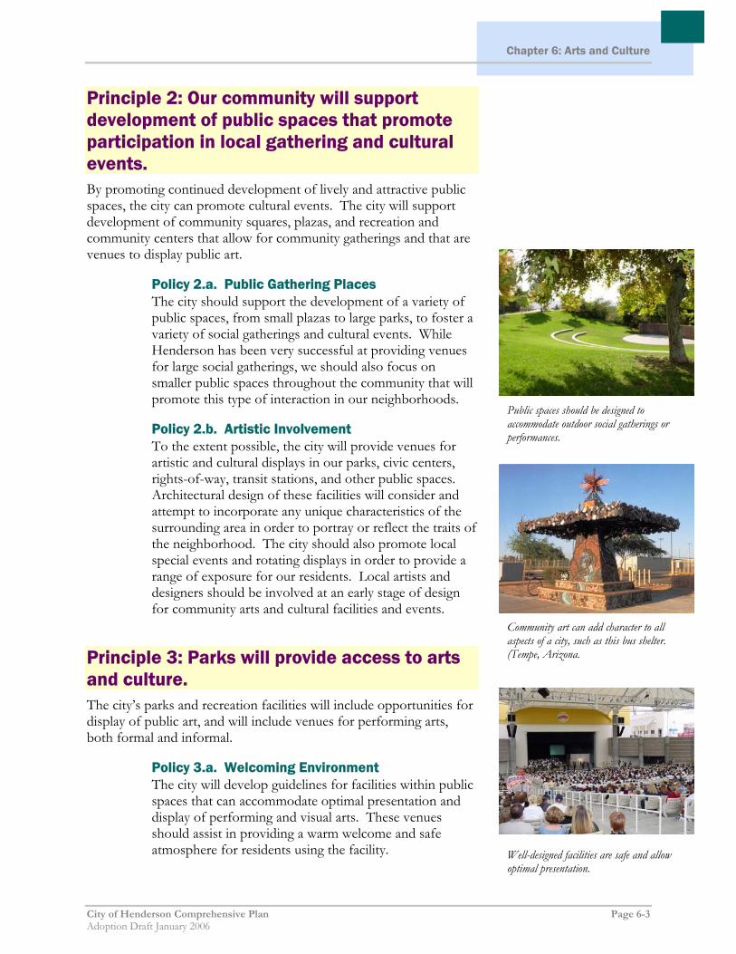
Principle 2: Our community will support development of public spaces that promote participation in local gathering and cultural events. By promoting continued development of lively and attractive public spaces, the city can promote cultural events. The city will support development of community squares, plazas, and recreation and community centers that allow for community gatherings and that are venues to display public art.
Policy 2.a. Public Gathering Places The city should support the development of a variety of public spaces, from small plazas to large parks, to foster a variety of social gatherings and cultural events. While Henderson has been very successful at providing venues for large social gatherings, we should also focus on smaller public spaces throughout the community that will promote this type of interaction in our neighborhoods.
Policy 2.b. Artistic Involvement To the extent possible, the city will provide venues for artistic and cultural displays in our parks, civic centers, rights-of-way, transit stations, and other public spaces. Architectural design of these facilities will consider and attempt to incorporate any unique characteristics of the surrounding area in order to portray or reflect the traits of the neighborhood. The city should also promote local special events and rotating displays in order to provide a range of exposure for our residents. Local artists and designers should be involved at an early stage of design for community arts and cultural facilities and events.
Principle 3: Parks will provide access to arts and culture. The city’s parks and recreation facilities will include opportunities for display of public art, and will include venues for performing arts, both formal and informal.
Policy 3.a. Welcoming Environment The city will develop guidelines for facilities within public spaces that can accommodate optimal presentation and display of performing and visual arts. These venues should assist in providing a warm welcome and safe atmosphere for residents using the facility.
Community art can add character to all aspects of a city, such as this bus shelter. (Tempe, Arizona.
Public spaces should be designed to accommodate outdoor social gatherings or performances.
Well-designed facilities are safe and allow optimal presentation.
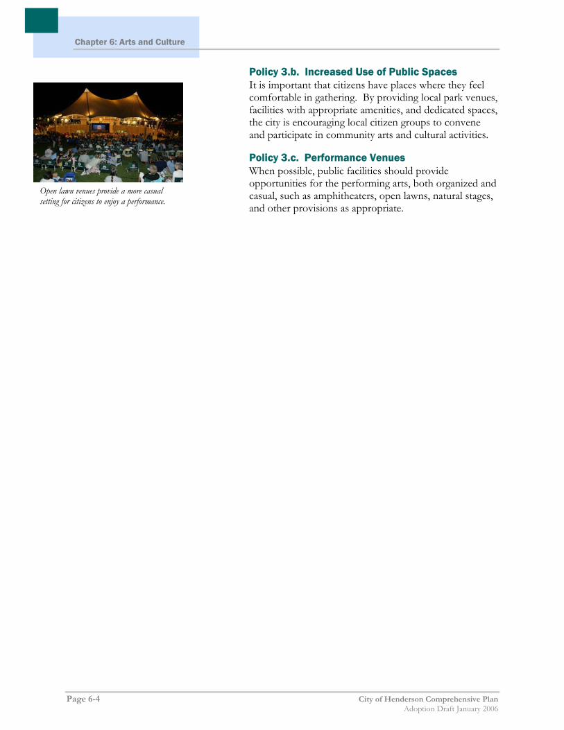
Chapter 6: Arts and Culture
Page 6-4 City of Henderson Comprehensive Plan Adoption Draft January 2006
Policy 3.b. Increased Use of Public Spaces It is important that citizens have places where they feel comfortable in gathering. By providing local park venues, facilities with appropriate amenities, and dedicated spaces, the city is encouraging local citizen groups to convene and participate in community arts and cultural activities.
Policy 3.c. Performance Venues When possible, public facilities should provide opportunities for the performing arts, both organized and casual, such as amphitheaters, open lawns, natural stages, and other provisions as appropriate.
Open lawn venues provide a more casual setting for citizens to enjoy a performance.

Chapter 7:
Land Use Plan Residential Categories
City of Henderson Comprehensive Plan Page 7-1 Adoption Draft January 2006
CChhaapptteerr 77:: LLaanndd UUssee PPllaann
Land Use Plan Introduction The City of Henderson’s Land Use Plan consists of a Future Land Use Map and Land Use Category descriptions for Residential, Non-Residential, and Other (which includes Public and Semi-Public Uses and Planned Community). This chapter details each land use category and includes a listing of primary and secondary uses, a description of the general characteristics and location of each land use type, and the range of allowable densities (when applicable). At the end of this chapter, a summary table of the various land use categories serves as a quick reference guide.
Residential Categories Henderson’s residential areas have a variety of characteristics and densities. The locations of residential areas are designed to be compatible with existing and proposed development and site constraints; however, in some cases the densities listed may not be achievable given unique conditions. The City will determine appropriate density during the development review process, taking into consideration site constraints and adjacent development. The Plan represents a shift towards a more flexible, neighborhood-oriented approach to residential development than is typical of more recent development patterns in the community. The intent, where appropriate, is to encourage new neighborhoods to incorporate a diversity of housing (both in terms of housing type and density) and an array of services, such as shopping, schools, and parks that can meet many residents’ day-to-day needs within a close proximity.
Very Low Density Residential (VLDR) Primary Uses: Single-family detached residences.
Secondary Uses: Open space, trails, schools, places of worship, and other public facilities. Appropriate for residents interested in a more open-space lifestyle, custom-built homes, equestrian uses, fewer public street Very Low Density Residential (example)

Chapter 7: Land Use Plan Residential Categories
Page 7-2 City of Henderson Comprehensive Plan Adoption Draft January 2006
lights and sidewalks, and no mandatory Conditions, Covenants, and Restrictions (CC&Rs) or homeowner’s associations.
Characteristics and Location: Generally located in areas near trail access and the mountainous regions around the city, these areas will offer the preservation and development of rural neighborhoods. Modified street sections and a reduction in light pollution (by reducing adjacent nighttime activities and street and house lighting) may be offered to allow for a less urban environment conducive to the pastoral setting citizens residing here desire.
Density: Up to 2 units per gross acre.
VLDR ZONING DISTRICTS DENSITY
DH (Development Holding) 1 unit per 5 gross acres RS-1A (Single-Family Residential) 1 unit per gross acre RS-2 (Single-Family Residential) 2 units per gross acre PS (Public and Semipublic) ----
Low Density Residential (LDR) Primary Uses: Single-family detached residences, single-family attached residences, mobile home estates.
Secondary Uses: Open space, trails, schools, places of worship, and other public facilities. This is the broadest category in terms of both land area and allowable density, providing for typical suburban development with considerations for adjacent land uses.
Characteristics and Location: This designation will be located throughout the city in appropriate areas. Sites adjacent to rural neighborhoods are expected to properly buffer those neighborhoods with lower densities. Projects located around commercial or industrial areas should be properly buffered to protect both the interests of the residents and the business owners.
Density: Up to 6 units per gross acre.
Low Density Residential (example)

Chapter 7:
Land Use Plan Residential Categories
City of Henderson Comprehensive Plan Page 7-3 Adoption Draft January 2006
LDR ZONING DISTRICTS DENSITY
DH (Development Holding) 1 unit per 5 gross acres RS-1A (Single-Family Residential) 1 unit per gross acre RS-2 (Single-Family Residential) 2 units per gross acre RS-4 (Single-Family Residential) 4 units per gross acre RS-6 (Single-Family Residential) 6 units per gross acre RX-5 (Mobile Home Estates) 5 units per gross acre PS (Public and Semipublic) --
Medium Density Residential (MDR) Primary Uses: Single-family detached efficiency lot residences, single-family attached residences, mobile homes, cluster housing, duplexes, townhouses, condominiums, apartments, and other multi-family residences.
Secondary Uses: Open space, trails, schools, places of worship, and other public facilities.
Characteristics and Location: Appropriate locations for this type of development can be found near more urban areas with activity centers. Landscaped open space should be provided for residents.
Density: Up to 16 units per gross acre.
MDR ZONING DISTRICTS DENSITY
DH (Development Holding) 1 unit per 5 gross acres RT (Residential Transitional) 8 units per gross acre RM-10 (Medium-Density Residential) 10 units per gross acre RM-16 (Medium-Density Residential) 16 units per gross acre RX-8 (Mobile Home Park) 8 units per gross acre PS (Public and Semipublic) --
Medium Density Residential (example)

Chapter 7: Land Use Plan Residential Categories
Page 7-4 City of Henderson Comprehensive Plan Adoption Draft January 2006
High Density Residential (HDR) Primary Uses: Cluster Housing, duplexes, townhouses, condominiums, apartments, and other multi-family residences.
Secondary Uses: Open space, trails, schools, places of worship, and other public facilities.
Characteristics and Location: High Density Residential should be located in and around urban settings that provide non-residential services to the residents. They are generally found in areas that offer mobility, including along collector or arterial streets or near transit centers. Private recreational facilities should be provided in the project, such as: swimming pools, tot lots, and landscaped open space.
Density: Up to 36 units per gross acre.
HDR ZONING DISTRICTS DENSITY
RH-20 (High-Density Residential) 20 units per gross acre RH-24 (High-Density Residential) 24 units per gross acre RH-30 (High-Density Residential) 30 units per gross acre RH-36 (High-Density Residential) 36 units per gross acre PS (Public and Semipublic) --
Downtown Low-Density Residential (DRL) Primary Uses: Single-family detached residences.
Secondary Uses: Open space, trails, places of worship, and other public facilities.
Characteristics and Location: Located in the downtown area, the purpose of this category is to improve the quality and visual appearance of the area while providing opportunities for low-density residential development on smaller lots. The category is intended to preserve the general character of existing residential development in downtown neighborhoods, while encouraging compatible infill development and redevelopment.
Insert photo of DRL example
High- Density Residential (example)
Downtown Low-Density Residential (example)

Chapter 7:
Land Use Plan Residential Categories
City of Henderson Comprehensive Plan Page 7-5 Adoption Draft January 2006
Density: Based on specific criteria – see the City of Henderson Development Code.
DRL ZONING DISTRICTS DENSITY
DRL (Downtown Low-Density Residential)
--
Downtown Medium-Density Residential (DRM) Primary Uses: Single-family attached residences, townhouses, condominiums, and other multi-family residences.
Secondary Uses: Open space, trails, places of worship, and other public facilities.
Characteristics and Location: Located in the downtown area, the purpose of this category is to encourage a greater mix of housing types by allowing single-family attached homes on individual small lots. A greater number of housing opportunities results in more people to support and invigorate the downtown area at all hours of the day and night.
Density: Based on specific criteria – see the City of Henderson Development Code.
DRM ZONING DISTRICTS DENSITY
DRM (Downtown Medium-Density Residential)
--
Downtown High-Density Residential (DRH) Primary Uses: Single-family attached residences, townhouses, condominiums, apartments, and other types of multi-family residences.
Secondary Uses: Open space, trails, places of worship, and other public facilities.
Insert photo of DRM example
Insert photo of DRH example
Downtown Medium-Density Residential (example)
Downtown High- Density Residential (example)

Chapter 7: Land Use Plan Residential Categories
Page 7-6 City of Henderson Comprehensive Plan Adoption Draft January 2006
Characteristics and Location: Located in the downtown area, the purpose of this category is to encourage a greater mix of housing types and to increase the number of residents by providing opportunities for high-density residential uses.
Density: Based on specific criteria – see the City of Henderson Development Code.
DRH ZONING DISTRICTS DENSITY
DRH (Downtown High-Density Residential)
--
Rural Neighborhood Preservation 1 (RNP-1) Primary Uses: Single-family detached residences.
Secondary Uses: Open space, trails, schools, places of worship, and other public facilities. Appropriate for residents interested in a more open-space lifestyle, custom-built homes, equestrian uses, fewer public street lights and sidewalks, and no mandatory Conditions, Covenants, and Restrictions (CC&Rs) or homeowner’s associations.
Characteristics and Location: Generally located in areas populated with residents that have a common interest in more open-space lifestyles than experienced in urban neighborhoods. The intent of this district is to preserve the rural character of the neighborhood by identifying and maintaining the density unique to each of these rural neighborhoods. This is accomplished by adhering to the criteria set forth in the City of Henderson’s Rural Neighborhood Overlay District found in the Development Code.
Density: 1-5 acres per dwelling
RNP-1 ZONING DISTRICTS DENSITY
DH (Development Holding) 1 unit per 5 gross acres RS-1A (Single-Family Residential) 1 unit per gross acre PS (Public and Semipublic) --
Rural Neighborhood Preservation (examples)
Rural Neighborhood Preservation (examples)

Chapter 7:
Land Use Plan Residential Categories
City of Henderson Comprehensive Plan Page 7-7 Adoption Draft January 2006
Rural Neighborhood Preservation 2 (RNP-2) Primary Uses: Single-family detached residences.
Secondary Uses: Open space, trails, schools, places of worship, and other public facilities. Appropriate for residents interested in a more open-space lifestyle, custom-built homes, equestrian uses, fewer public street lights and sidewalks, and no mandatory Conditions, Covenants, and Restrictions (CC&Rs) or homeowner’s associations.
Characteristics and Location: Generally located in areas populated with residents that have a common interest in more open-space lifestyles than experienced in urban neighborhoods. The intent of this district is to preserve the rural character of the neighborhood by identifying and maintaining the density unique to each of these rural neighborhoods. This is accomplished by adhering to the criteria set forth in the City of Henderson’s Rural Neighborhood Overlay District found in the Development Code.
Density: 0.5-5 acres per dwelling
RNP-2 ZONING DISTRICTS DENSITY
DH (Development Holding) 1 unit per 5 gross acres RS-1A (Single-Family Residential) 1 unit per gross acre RS-2 (Single-Family Residential) 2 units per gross acre PS (Public and Semipublic) --

Chapter 7: Land Use Plan Non-Residential Categories
Page 7-8 City of Henderson Comprehensive Plan Adoption Draft January 2006
Non-Residential Categories The non-residential categories on the Land Use Plan have a variety of uses, development intensities, and characteristics. The development and uses are designed to be compatible with existing and proposed development, site constraints, and market demand. The commercial and industrial categories are described below. The following sections describe the various non-residential land use categories contained in the Plan.
Commercial (COM) Primary Uses: Commercial services such as banks, restaurants, grocery stores, office complexes, theaters, and repair services. The Commercial designation is intended to provide a location for more intense commercial uses that will serve a broader population than the immediate neighborhood.
Secondary Uses: Open space, recreational amenities, trails, and other public facilities.
Characteristics and Location: The Commercial designation should be located at major intersections such as a highway and an arterial street or two arterial streets. They may also be located along major arterial streets.
COM ZONING DISTRICTS DENSITY
CC (Community Commercial) -- CO (Commercial Office) --
CN (Neighborhood Commercial) -- CH (Highway Commercial) -- CA (Auto Mall Commercial) -- CM (Mixed-Use Commercial) --
Commercial use example

Chapter 7:
Land Use Plan Non-Residential Categories
City of Henderson Comprehensive Plan Page 7- 9 Adoption Draft January 2006
Tourist Commercial (TC) Primary Uses: Hotels, resorts, and mixed-use residential/commercial developments.
Secondary Uses: Open space, trails, recreational amenities, trails, places of worship, and other public facilities.
Characteristics and Location: Located in areas that will serve the local community as well as tourists, convention attendees, and other visitors to Henderson. This district should be found in the regions of the city that foster tourist activities, including gateways and major attractions.
TC ZONING DISTRICTS DENSITY
CT (Tourist Commercial) -- CC (Community Commercial) -- CM (Mixed-Use Commercial) --
Transit Oriented Development (TOD) Primary Uses: Multi-family residential and mixed-use residential/commercial developments.
Secondary Uses: Trails, parks, and other public facilities.
Characteristics and Location: Generally located within ½ mile of major transit corridors and stops, these areas promote medium to high-density development that will support mass transit. These designations should include pedestrian friendly environments and commercial enterprises that are supported by the densities and the increased traffic that are cultivated around transit stops. This area requires a minimum of 30 units per acre and may offer reduced parking requirements and other appropriate waivers due to its proximity to mass transit.
TOD ZONING DISTRICTS DENSITY
CC (Community Commercial) -- CM (Mixed-Use Commercial) --
RH-36 (High-Density Residential) 36 du (max.) per gross acre
Tourist Commercial use (example)
Transit-Oriented Development (example)

Chapter 7: Land Use Plan Non-Residential Categories
Page 7-10 City of Henderson Comprehensive Plan Adoption Draft January 2006
Neighborhood Commercial (NC) Primary Uses: High quality office (low rise), neighborhood retail, and neighborhood services.
Secondary Uses: Open space, trails, recreational amenities, places of worship, and other public facilities.
Characteristics and Location: Generally located at the intersection of two arterial streets or an arterial street and a collector street, the Neighborhood Commercial category includes retail centers that provide shopping and services to the surrounding neighborhoods and areas.
NC ZONING DISTRICTS DENSITY
CN (Neighborhood Commercial) -- CO (Commercial Office) --
CM (Mixed-Use Commercial) --
Downtown Highway Commercial (DHC) Primary Uses: Commercial, retail, government and private offices, and visitor accommodations.
Secondary Uses: Places of worship, schools, parks, trails, and other public facilities.
Characteristics and Location: Located in the downtown area, the purpose of this category is to create an inviting gateway to the downtown that transitions from auto-oriented uses on Lake Mead Parkway and Boulder Highway to the more pedestrian-oriented Downtown Core Commercial category by consolidating smaller lots and providing access from arterial streets.
DHC ZONING DISTRICTS DENSITY
DHC (Downtown Highway Commercial)
--
Insert photo of DHC example
Neighborhood Commercial (example)

Chapter 7:
Land Use Plan Non-Residential Categories
City of Henderson Comprehensive Plan Page 7- 11 Adoption Draft January 2006
Downtown Core Commercial (DCC) Primary Uses: Pedestrian friendly commercial, retail, office, arts, and entertainment.
Secondary Uses: Places of worship, schools, parks, trails, and other public facilities.
Characteristics and Location: Located in the downtown area, the purpose of this category is to create an attractive, pedestrian-oriented environment that functions as the shopping, office, arts and entertainment center of downtown.
DCC ZONING DISTRICTS DENSITY
DCC (Downtown Core Commercial) --
Business Industrial (BI) Primary Uses: Industrial, warehousing, manufacturing, and business parks.
Secondary Uses: Supporting retail and office, open space, trails, and other public facilities.
Characteristics and Location: The Business Industrial category is meant to be in less-invasive areas of the city, typically where regulations are less restrictive to allow typical industrial uses to take place. Surrounding residential should be limited and appropriately buffered from the effects of the industrial use.
BI ZONING DISTRICTS DENSITY
IP (Industrial Park) -- IL (Light Industrial)
IG (General Industrial)
Insert photo of DCC example
Business Industrial Use (example)

Chapter 7: Land Use Plan Non-Residential Categories
Page 7-12 City of Henderson Comprehensive Plan Adoption Draft January 2006
Light Business Industrial (LBI) Primary Uses: Light industrial, light warehousing, manufacturing, and business parks.
Secondary Uses: Associated retail, office, open space, trails, and other public facilities.
Characteristics and Location: Similar to the Industrial district, this designation should be located in less invasive areas of the city, but with less intense uses, and can be situated closer to residential and other commercial uses. Light Business Industrial uses are meant to encourage development that will minimally impact the surrounding area
LBI ZONING DISTRICTS DENSITY
IP (Industrial Park) -- IL (Light Industrial)
Light Business Industrial Use (example)

Chapter 7:
Land Use Plan Other Categories
City of Henderson Comprehensive Plan Page 7-13 Adoption Draft January 2006
Other Categories
Public and Semi-public (PS) Primary Uses: Parks, libraries, community centers, fire stations, utilities, open space, trails, and other public uses.
Secondary Uses: Hospitals, government offices, schools, places of worship, and cultural institutions.
Characteristics and Location: The purpose of this category is to provide community services to the surrounding areas. The location of such facilities is reliant on the character of the neighborhood, community, or region that the particular facility will serve.
PS ZONING DISTRICTS DENSITY
PS (Public and Semipublic) --
Downtown Public (DP) Primary Uses: Cultural institutions, government offices, hospitals, parks, community services, schools, and conventions.
Secondary Uses: Places of worship, open space, trails, and other public facilities.
Characteristics and Location: Located in the downtown area, the purpose of this category is to provide an attractive, functional arts and entertainment hub, government services, recreational opportunities, and medical services for downtown Henderson.
DP ZONING DISTRICTS DENSITY
DP (Downtown Public) --
Public Use (example)
Downtown Public Use (example)

Other Categories
Page 7-14 City of Henderson Comprehensive Plan Adoption Draft January 2006
Planned Community (PC) Primary Uses: Dependent on the final development agreement, this area should develop with ideas and projects that are modern and innovative, following the best planning practices available as the venture moves forward.
Secondary Uses: (Not applicable.)
Characteristics and Location: Typically found on large tracts of vacant land, the purpose of this category is to ensure comprehensive planning of the area to create efficient and stable developments offering a combination of planned uses. This designation gives maximum flexibility to the City Council and the developer in implementing a development agreement that is in the best interests of the community and provides all the necessary facilities and amenities for the subsequent development of the land.
PC ZONING DISTRICTS DENSITY
PC (Planned Community) --

Insert Future Land Use Map here

Back of Future Land Use Map

Summary of Land Use Categories
Land Use Summary Table
City of Henderson Comprehensive Plan Page 7-15 Adoption Draft January 2006
SSuummmmaarryy ooff LLaanndd UUssee CCaatteeggoorriieess RESIDENTIAL
LAND USE
CATEGORY ZONING
DISTRICTS USES AND DENSITY CHARACTERISTICS & LOCATION
Very Low Density Residential (VLDR)
DH (Development Holding)
RS-1A (Single-Family Residential)
RS-2 (Single-Family Residential)
PS (Public and Semipublic)
Primary Uses: Single-family detached residences.
Secondary Uses: Open space, trails, schools, places of worship, and other public facilities. Appropriate for residents interested in a more open-space lifestyle, custom-built homes, equestrian uses, fewer public street lights and sidewalks, and no mandatory Conditions, Covenants, and Restrictions (CC&Rs) or homeowner’s associations.
Density: Up to 2 units per gross acre (depending on zoning category)
Generally located in areas near trail access and the mountainous regions around the City, these areas will offer the preservation and development of rural neighborhoods. Modified street sections and a reduction in light pollution (by reducing adjacent nighttime activities and street and house lighting) may be offered to allow for a less urban environment conducive to the pastoral setting residents residing here desire.
Low Density Residential (LDR)
DH (Development Holding)
RS-1A (Single-Family Residential)
RS-2 (Single-Family Residential)
RS-4 (Single-Family Residential)
RS-6 (Single-Family Residential)
RX-5 (Mobile Home Estates)
PS (Public and Semipublic)
Primary Uses: Single-family detached residences, single-family attached residences, mobile home estates.
Secondary Uses: Open space, trails, schools, places of worship, and other public facilities. This is the broadest category in terms of both land area and allowable density, providing for typical suburban development with considerations for adjacent land uses.
Density: Up to 6 units per gross acre (depending on zoning category)
This designation will be located throughout the city in appropriate areas. Sites adjacent to rural neighborhoods are expected to properly buffer those neighborhoods with lower densities. Projects located around commercial or industrial projects should be properly buffered to protect both the interests of the residents and the business owners.

Summary of Land Use Categories Land Use Summary Table
Page 7-16 City of Henderson Comprehensive Plan Adoption Draft January 2006
RESIDENTIAL
LAND USE
CATEGORY ZONING
DISTRICTS USES AND DENSITY CHARACTERISTICS & LOCATION
Medium Density Residential (MDR)
DH (Development Holding)
RT (Residential Transitional)
RM-10 (Medium-Density Residential)
RM-16 (Medium-Density Residential)
RX-8 (Mobile Home Park)
PS (Public and Semipublic)
Primary Uses: Single-family detached homes, single-family attached homes, townhomes, condominiums, patio homes and apartments.
Secondary Uses: Complimentary uses include parks and recreation amenities. Neighborhood-based commercial activity, places of worship, schools, senior housing facilities and other civic uses could also be located along nearby arterial and collector streets.
Density: Up to 16 units per gross acre(depending on zoning category)
Appropriate locations for this type of development can be found near more urban areas with activity centers. Landscaped open space should be provided for residents.
High Density Residential (HDR)
RH-20 (High-Density Residential)
RH-24 (High-Density Residential)
RH-30 (High-Density Residential)
RH-36 (High-Density Residential)
PS (Public and Semipublic)
Primary Uses: Cluster Housing, duplexes, townhouses, condominiums apartments, and other multi-family residences.
Secondary Uses: Open space, trails, schools, places of worship, and other public facilities.
Density: Up to 36 units per gross acre
High Density Residential should be located in and around urban settings that provide non-residential services to the residents. They are generally found in areas that offer mobility, including along collector or arterial streets or near transit centers. Private recreational facilities should be provided in the project, such as, swimming pools, tot lots, and landscaped open space.
Downtown Low -Density Residential (DRL)
DRL (Downtown Low-Density Residential)
Primary Uses: Single-family detached residences.
Secondary Uses: Open space, trails, schools, places of worship, and other public facilities.
Density: Based on specific criteria – see City of Henderson Development Code
Located in the downtown area, the purpose of this category is to improve the quality and visual appearance of the area while providing opportunities for low-density residential development on smaller lots. The category is intended to preserve the general character of existing residential development in downtown neighborhoods, while encouraging compatible infill development and redevelopment.

Summary of Land Use Categories
Land Use Summary Table
City of Henderson Comprehensive Plan Page 7-17 Adoption Draft January 2006
RESIDENTIAL
LAND USE
CATEGORY ZONING
DISTRICTS USES AND DENSITY CHARACTERISTICS & LOCATION
Downtown Medium -Density Residential (DRM)
DRM (Downtown Medium-Density Residential)
Primary Uses: Single-family detached residences, townhouses, and condominiums, and other multi-family residences.
Secondary Uses: Open space, trails, schools, places of worship, and other public facilities.
Density: Based on specific criteria – see City of Henderson Development Code
Located in the downtown area, the purpose of this category is to encourage a greater mix of housing types by allowing single-family attached homes on individual small lots. A greater number of housing opportunities results in more people to support and invigorate the downtown area at all hours of the day and night.
Downtown High- Density Residential (DRM)
DRH (Downtown High-Density Residential)
Primary Uses: Single-family detached residences, townhouses, condominiums, apartments, and other multi-family residences.
Secondary Uses: Open space, trails, schools, places of worship, and other public facilities.
Density: Based on specific criteria – see City of Henderson Development Code
Located in the downtown area, the purpose of this category is to encourage a greater mix of housing types and to increase the number of residents by providing opportunities for high-density residential uses.
Rural Neighbor-hood Preservation
DH (Development Holding)
RS-1A (Single-Family Residential)
Primary Uses: Single-family detached residences.
Secondary Uses: Open
Generally located in areas populated with residents that have a common interest in more open-space lifestyles than experienced in urban neighborhoods. The intent of this

Summary of Land Use Categories Land Use Summary Table
Page 7-18 City of Henderson Comprehensive Plan Adoption Draft January 2006
RESIDENTIAL
LAND USE
CATEGORY ZONING
DISTRICTS USES AND DENSITY CHARACTERISTICS & LOCATION
1 (RNP-1) PS (Public and Semipublic)
space, trails, schools, places of worship, and other public facilities. Appropriate for residents interested in a more open-space lifestyle, custom-built homes, equestrian uses, fewer public street lights and sidewalks, and no mandatory Conditions, Covenants, and Restrictions (CC&Rs) or homeowner’s associations.
district is to preserve the rural character of the neighborhood by identifying and maintaining the density unique to each of these rural neighborhoods. This is accomplished by adhering to the criteria set forth in the City of Henderson’s Rural Neighborhood Overlay District found in the Development Code.
Rural Neighbor-hood Preservation 2 (RNP-2)
DH (Development Holding)
RS-1A (Single-Family Residential)
RS-2 (Single-Family Residential)
PS (Public and Semipublic)
Primary Uses: Single-family detached residences.
Secondary Uses: Open space, trails, schools, places of worship, and other public facilities. Appropriate for residents interested in a more open-space lifestyle, custom-built homes, equestrian uses, fewer public street lights and sidewalks, and no mandatory Conditions, Covenants, and Restrictions (CC&Rs) or homeowner’s associations.
Generally located in areas populated with residents that have a common interest in more open-space lifestyles than experienced in urban neighborhoods. The intent of this district is to preserve the rural character of the neighborhood by identifying and maintaining the density unique to each of these rural neighborhoods. This is accomplished by adhering to the criteria set forth in the City of Henderson’s Rural Neighborhood Overlay District found in the Development Code.

Summary of Land Use Categories
Land Use Summary Table
City of Henderson Comprehensive Plan Page 7-19 Adoption Draft January 2006
COMMERCIAL
LAND USE
CATEGORY ZONING
DISTRICTS USES CHARACTERISTICS & LOCATION
Commercial (COM)
CC (Community Commercial)
CO (Commercial Office)
CN (Neighborhood Commercial)
CH (Highway Commercial)
CA (Auto Mall Commercial)
CM (Mixed-Use Commercial)
Primary Uses: Commercial services such as banks, restaurants, grocery stores, office complexes, theaters, and repair services. The General Commercial designation is intended to provide a location for more intense commercial uses that will serve a broader population than the immediate neighborhood area.
Secondary Uses: Open space, recreational amenities, trails, and other public facilities.
The General Commercial designation should be located at major intersections such as a highway and an arterial street or two arterial streets. They may also be located along major arterial streets.
Tourist Commercial (TC)
CT (Tourist Commercial)
CC (Community Commercial)
CM (Mixed-Use Commercial)
Primary Uses: Hotels, resorts, and mixed-use residential/commercial developments.
Secondary Uses: Open space, trails, recreational amenities, places of worship, and other public facilities.
Located in areas that will serve the local community as well as tourists, convention attendees, and other visitors to Henderson. This district should be found in the regions of the city that foster tourist activities, including gateways and major attractions.

Summary of Land Use Categories Land Use Summary Table
Page 7-20 City of Henderson Comprehensive Plan Adoption Draft January 2006
COMMERCIAL
LAND USE
CATEGORY ZONING
DISTRICTS USES CHARACTERISTICS & LOCATION
Transit Oriented Development (TOD)
CC (Community Commercial)
CM (Mixed-Use Commercial)
RH-36 (High Density Residential)
Primary Uses: Multi-family residential and mixed-use residential/commercial developments
Secondary Uses: Trails, parks, and other public facilities
Generally located within ½ mile of major transit corridors and stops, these categories promote medium to high-density development that will support mass transit. These designations should include pedestrian friendly environments and commercial enterprises that are supported by the densities and the increased traffic that are cultivated around transit stops. This area requires a minimum of 30 units per acre and may offer reduced parking requirements and other appropriate waivers due to its proximity to mass transit.
Neighborhood Commercial (NC)
CN (Neighborhood Commercial)
CO (Commercial Office)
CM (Mixed-Use Commercial)
Primary Uses: High quality office (low rise), neighborhood retail, and neighborhood services.
Secondary Uses: Open space, trails, recreational amenities, places of worship, and other public facilities.
Generally located at the intersection of two arterial streets or an arterial street and a collector street, the Neighborhood Commercial category includes retail centers that provide shopping and services to the surrounding neighborhoods and areas.
Downtown Highway Commercial (DHC)
DHC (Downtown Highway Commercial)
Primary Uses: Commercial, retail, government and private offices, and visitor accommodations.
Secondary Uses: Places of worship, schools, parks, trails, and other public facilities.
Located in the downtown area, the purpose of this category is to create an inviting gateway to the downtown that transitions from auto-oriented uses on Lake Mead Parkway and Boulder Highway to the more pedestrian-oriented Downtown Core Commercial District by consolidating smaller lots and providing access from arterial streets.
Downtown Core Commercial (DCC)
DCC (Downtown Core Commercial)
Primary Uses: Commercial, retail, government and private offices, and visitor accommodations.
Secondary Uses: Places of worship, schools, parks, trails, and other public facilities.
Located in the downtown area, the purpose of this district is to create an attractive, pedestrian-oriented environment that functions as the shopping, office, arts and entertainment center of downtown.
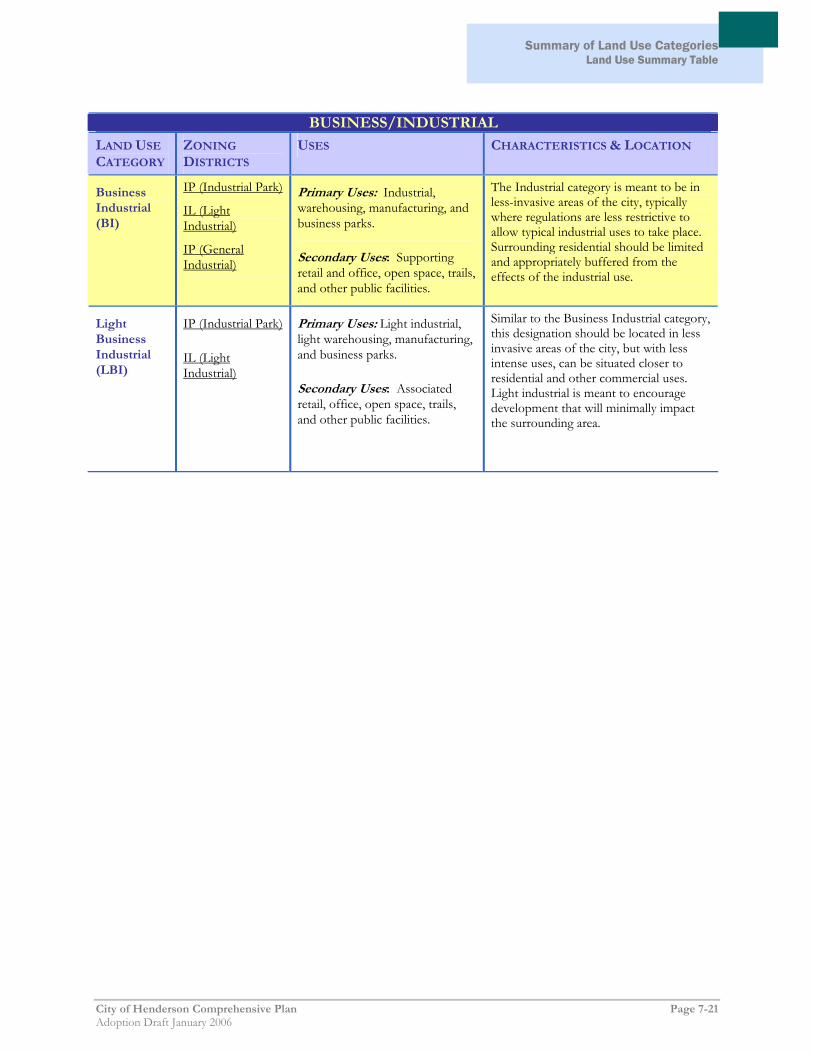
Summary of Land Use Categories
Land Use Summary Table
City of Henderson Comprehensive Plan Page 7-21 Adoption Draft January 2006
BUSINESS/INDUSTRIAL
LAND USE
CATEGORY ZONING
DISTRICTS USES CHARACTERISTICS & LOCATION
Business Industrial (BI)
IP (Industrial Park)
IL (Light Industrial)
IP (General Industrial)
Primary Uses: Industrial, warehousing, manufacturing, and business parks.
Secondary Uses: Supporting retail and office, open space, trails, and other public facilities.
The Industrial category is meant to be in less-invasive areas of the city, typically where regulations are less restrictive to allow typical industrial uses to take place. Surrounding residential should be limited and appropriately buffered from the effects of the industrial use.
Light Business Industrial (LBI)
IP (Industrial Park)
IL (Light Industrial)
Primary Uses: Light industrial, light warehousing, manufacturing, and business parks.
Secondary Uses: Associated retail, office, open space, trails, and other public facilities.
Similar to the Business Industrial category, this designation should be located in less invasive areas of the city, but with less intense uses, can be situated closer to residential and other commercial uses. Light industrial is meant to encourage development that will minimally impact the surrounding area.

Summary of Land Use Categories Land Use Summary Table
Page 7-22 City of Henderson Comprehensive Plan Adoption Draft January 2006
OTHER
LAND USE
CATEGORY ZONING
DISTRICTS USES CHARACTERISTICS & LOCATION
Public and Semi-Public (PS)
PS (Public and Semipublic)
Primary: Parks, libraries, community centers, fire stations, utilities, open space, trails, and other public uses.
Secondary: Hospitals, government offices, schools, places of worship, and cultural institutions.
The purpose of this category is to provide community services to the surrounding areas. The location of such facilities is reliant on the character of the neighborhood, community, or region that the particular facility will serve.
Downtown Public (DP)
DP (Downtown Public)
Primary: Cultural institutions, government offices, hospitals, parks, community services, schools, and conventions.
Secondary: Places of worship, open space, trails, and other public facilities.
Located in the downtown area, the purpose of this category is to provide an attractive, functional arts and entertainment hub, government services, recreational opportunities, and medical services for downtown Henderson.
Planned Community (PC)
PC (Planned Community)
Primary: Dependent on the final development agreement. This area should develop with ideas and projects that are modern and innovative, following the best planning practices available as the venture moves forward.
Typically found on large tracts of vacant land, the purpose of this category is to ensure comprehensive planning of the area to create efficient and stable developments offering a combination of planned uses. This designation gives maximum flexibility to the City Council and the developer in implementing a development agreement that is in the best interests of the community and provides all the necessary facilities and amenities for the subsequent development of the land.
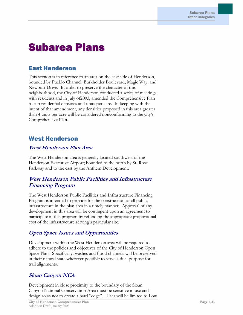
Subarea Plans Other Categories
City of Henderson Comprehensive Plan Page 7-23 Adoption Draft January 2006
SSuubbaarreeaa PPllaannss
East Henderson This section is in reference to an area on the east side of Henderson, bounded by Pueblo Channel, Burkholder Boulevard, Magic Way, and Newport Drive. In order to preserve the character of this neighborhood, the City of Henderson conducted a series of meetings with residents and in July of2003, amended the Comprehensive Plan to cap residential densities at 4 units per acre. In keeping with the intent of that amendment, any densities proposed in this area greater than 4 units per acre will be considered nonconforming to the city’s Comprehensive Plan.
West Henderson West Henderson Plan Area
The West Henderson area is generally located southwest of the Henderson Executive Airport; bounded to the north by St. Rose Parkway and to the east by the Anthem Development. West Henderson Public Facilities and Infrastructure Financing Program
The West Henderson Public Facilities and Infrastructure Financing Program is intended to provide for the construction of all public infrastructure in the plan area in a timely manner. Approval of any development in this area will be contingent upon an agreement to participate in this program by refunding the appropriate proportional cost of the infrastructure serving a particular site. Open Space Issues and Opportunities
Development within the West Henderson area will be required to adhere to the policies and objectives of the City of Henderson Open Space Plan. Specifically, washes and flood channels will be preserved in their natural state wherever possible to serve a dual purpose for trail alignments. Sloan Canyon NCA
Development in close proximity to the boundary of the Sloan Canyon National Conservation Area must be sensitive in use and design so as not to create a hard “edge”. Uses will be limited to Low

Subarea Plans
Page 7-24 City of Henderson Comprehensive Plan Adoption Draft January 2006
Density Residential or community open space. If developed with single-family homes, buildings closest to the NCA shall be situated so that they face the NCA so that the border is not defined by a block wall. Existing Residential Development
Except where already designated for commercial uses, land immediately adjacent to the existing residential uses will remain designated for Low Density Residential or Public/Semi-Public uses. The existing homes are clustered in two general areas: northwest of the intersection of Bicentennial Parkway and Gillespie Street; and on the north side of Larson Lane, east and west of Bermuda Road. West Henderson Executive Airport Safety and Noise Attenuation Buffer Area
In 2000, the Department of Aviation entered into an agreement with the Bureau of Land Management to establish an approximately 60 acre no build area immediately south of the Henderson Executive Airport. The purpose of the area is to serve as a buffer at the end of a new runway which is subject to increased noise and potential hazards from aircraft using the airport. Limited Transition Area
The City of Henderson has entered into an agreement with the Bureau of Land Management to develop a business park on approximately 500 acres of land. This area, designated as a Limited Transitional Area, is located south of the Henderson Executive Airport, adjacent to the South Edge Development.

Chapter 8: Action Plan
City of Henderson Comprehensive Plan Page 8-1 Adoption Draft January 2006
CChhaapptteerr 88:: AAccttiioonn PPllaann A key aspect of this Master Plan is how it will be carried out after it is adopted. To effectively implement the goals and policies of this Plan, it is necessary for the City to identify the types of actions required and determine the priority and timing of the actions so the appropriate resources may be allocated.
Types of Implementation Actions There are three types of actions that are required to implement the city’s Comprehensive Plan; regulatory revisions, ongoing policy actions, and programs. Each category is briefly described below.
Regulatory Revisions In order for the Master Plan to be realized, the city’s development regulations will need to be consistent with the principles and policies contained in the Plan. The city will need to revise the development regulations and standards in several instances to achieve these goals and policies. This is addressed in greater detail within the Summary of Priority Actions outlined below.
Policy Decisions The Plan identifies a number of actions that will be carried out during day-to-day policy decisions made by city planning staff, Planning Commission, and the City Council. The city will continually make decisions regarding development proposals and plan amendments and should use the Plan to guide such policy decisions as they occur.
Programs The Master Plan establishes a foundation for programs necessary to carry out the goals of the Plan. For example, some policies involve continued participation in planning efforts with other jurisdictions, such as ongoing efforts of the Southern Nevada Regional Planning Coalition. Other programs may require new initiatives, such as efforts to promote the development of workforce housing, or the creation of a database of available land for primary employment uses.
Priority Actions The following is a list of priority actions that should be taken as soon as possible to ensure that future land use decisions are aligned with

Chapter 8: Action Plan
Page 8-2 City of Henderson Comprehensive Plan Adoption Draft January 2006
the policies contained in this Plan and with the classifications on the Land Use Map. Priority Actions should be reviewed and updated periodically to reflect the city’s accomplishments, available resources, and potential shifts in policy direction. The following priority actions are recommended:
1. Monitor Supply of Primary Employment Land One of the Plan’s key policies is to promote economic vitality of the city by targeting and reserving land that is suitable for industrial and office employment uses (e.g., primary jobs). In order to do so, the city should develop a database of sites that are suitable and update it on a regular basis.
2. Update the City’s Development Code The city’s Unified Development Code was comprehensively overhauled in 1998. This Plan contains a number of policies that will need to be implemented through revisions to the city’s Development Code, including but not limited to an increased emphasis on mixed-use development; opportunities for transit-oriented development; and policies that encourage better street and pedestrian connections between and within neighborhoods.
3. Establish and Update Design Standards and Guidelines The Plan places a major emphasis on quality development in the city’s neighborhoods, commercial and employment areas, and public spaces. Updated as well as new design standards and guidelines are needed as a means of achieving this goal. These standards and guidelines should be addressed as part of the process of updating the City’s Development Code (see above).
4. Workforce Housing Initiative Increasing the supply of workforce housing is a key issue facing the city. The Plan recommends a number of strategies that should be reviewed as part of a comprehensive effort to bolster the supply of workforce housing in the city, including density bonuses and other incentives, streamlined review procedures, and inclusionary housing programs. It may be appropriate for the City Council to convene a Workforce Housing Task Force to review and recommend specific strategies.
Related Documents