1292 IEEE TRANSACTIONS ON GEOSCIENCE AND REMOTE SENSING, VOL. 37, NO. 3, MAY 1999 Fuzzy Fusion Techniques for Linear Features Detection in Multitemporal SAR Images Jocelyn Chanussot, Gilles Mauris, and Patrick Lambert Abstract—This paper is concerned with the automatic detection of linear features in SAR satellite data, with application to road network extraction. After a directional prefiltering step, a morphological line detector is presented. To improve the detection performances, the results obtained on multitemporal data are fused. Different fusion strategies involving different fusion opera- tors are then presented. Since extensions of classical set union and intersection do not lead to satisfactory results (the corresponding operators are either too indulgent or too severe), the first strategy consists of fusing the data using a compromise operator. The second strategy consists of fusing the results computed with two operators that have opposite properties, in order to obtain a final intermediate result. Thanks to the wide range of properties they provide, fuzzy operators are used to test and compare these two fusion strategies on real ERS-1 multitemporal data. Index Terms— Data fusion, fuzzy operators, linear features extraction, mathematical morphology, nonlinear filtering, SAR images, road detection. I. INTRODUCTION S INCE THE first Earth-viewing spaceborne synthetic aper- ture radar (SAR) was put into orbit in 1978, numerous radar sensors have been launched (Radarsat, ERS-1 & 2, J- ERS [1]). This success can be partly explained by the good resolution of the obtained images, reached thanks to the synthetic aperture. But, the main point is the ability of the used electromagnetic waves to pass through the clouds, which partly frees the observations from the atmospheric conditions. As a consequence, the images provided by these satellites are now very useful in many remote sensing applications. This paper focuses on one of these applications: the problem of automatic line detection, with application to road network extraction. This is a problem of great importance. For instance, it can be used for cartographic purpose, for the registration of SAR images to existing maps or to other sensor images. But, due to the noisy speckled nature of radar images, this remains quite a difficult task [2]. In particular, it prevents the classical methods, developed for the visible domain (for SPOT or LANDSAT data for instance) from providing satisfactory results. Therefore, specific methods that can deal with these highly corrupted images have been developed. Nevertheless, even well suited algorithms usually lead to imperfect results. To improve these performances, one way consists of using Manuscript received June 4, 1998, revised November 4, 1998. The authors are with Laboratoire d’Automatique et de MicroInfor- matique Industrielle, LAMII/CESALP, Universit´ e de Savoie-B.P 806, 74016 Annecy Cedex, France, (e-mail: [email protected]; [email protected]; [email protected]). Publisher Item Identifier S 0196-2892(99)03445-2. different images of the same scene, acquired at different dates (multitemporal data). The information provided by each available image are then fused, both to increase the detection probability and to reduce the false alarm rate. In this framework, the paper is organized as follows. • The first part of the paper presents the detection algorithm that is applied to each image. This is an automatic method based on a morphological approach, preceded by an adaptive directional filtering. • In the second part, the detections obtained on each image are fused. The responses to the line detector obtained for each pixel at the different dates, seen as uncertain values of detection, are merged together. Different fu- sion strategies, involving different fusion operators are presented. Thanks to the wide range of properties they can consider, a special attention is paid to fuzzy fusion operators. Results obtained on real multitemporal ERS- 1 PRI amplitude data are presented and discussed. See Fig. 1 for the global processing synopsis. Note that the two parts of the paper are almost independent. The fusion strategies presented in Part B of Section III could be used to aggregate the results obtained with other line detectors. II. PART A: AUTOMATIC DETECTION OF LINEAR FEATURES This part presents the algorithm that is used to automatically extract the linear features in each image. The method is organized in two separate steps. • First, a prefiltering operator is applied to simultaneously smooth the noise and preserve the anisotropic structures. The used directional filter is presented in the first para- graph. • The second paragraph presents the morphological extrac- tion method that is performed on the filtered images to detect road-pixels. A. Directional Prefiltering Most of the classical noise smoothers are based on an additive model. Since radar images are corrupted, by nature, by a multiplicative noise, called the speckle, specific filters that can deal with this model have been developed to perform optimal noise reduction. But, it turned out that these speckle filters [3]–[6], though statistically optimal in terms of noise reduction, are not necessarily the most suited operators to improve the road detection. Actually, for the addressed prob- lem, the useful information lies in anisotropic structures, and 0196–2892/99$10.00 1999 IEEE

Welcome message from author
This document is posted to help you gain knowledge. Please leave a comment to let me know what you think about it! Share it to your friends and learn new things together.
Transcript
1292 IEEE TRANSACTIONS ON GEOSCIENCE AND REMOTE SENSING, VOL. 37, NO. 3, MAY 1999
Fuzzy Fusion Techniques for Linear FeaturesDetection in Multitemporal SAR Images
Jocelyn Chanussot, Gilles Mauris, and Patrick Lambert
Abstract—This paper is concerned with the automatic detectionof linear features in SAR satellite data, with application toroad network extraction. After a directional prefiltering step, amorphological line detector is presented. To improve the detectionperformances, the results obtained on multitemporal data arefused. Different fusion strategies involving different fusion opera-tors are then presented. Since extensions of classical set union andintersection do not lead to satisfactory results (the correspondingoperators are either too indulgent or too severe), the first strategyconsists of fusing the data using a compromise operator. Thesecond strategy consists of fusing the results computed with twooperators that have opposite properties, in order to obtain a finalintermediate result. Thanks to the wide range of properties theyprovide, fuzzy operators are used to test and compare these twofusion strategies on real ERS-1 multitemporal data.
Index Terms—Data fusion, fuzzy operators, linear featuresextraction, mathematical morphology, nonlinear filtering, SARimages, road detection.
I. INTRODUCTION
SINCE THE first Earth-viewing spaceborne synthetic aper-ture radar (SAR) was put into orbit in 1978, numerous
radar sensors have been launched (Radarsat, ERS-1 & 2, J-ERS [1]). This success can be partly explained by the goodresolution of the obtained images, reached thanks to thesynthetic aperture. But, the main point is the ability of theused electromagnetic waves to pass through the clouds, whichpartly frees the observations from the atmospheric conditions.As a consequence, the images provided by these satellites arenow very useful in many remote sensing applications. Thispaper focuses on one of these applications: the problem ofautomatic line detection, with application to road networkextraction. This is a problem of great importance. For instance,it can be used for cartographic purpose, for the registrationof SAR images to existing maps or to other sensor images.But, due to the noisy speckled nature of radar images, thisremains quite a difficult task [2]. In particular, it prevents theclassical methods, developed for the visible domain (for SPOTor LANDSAT data for instance) from providing satisfactoryresults. Therefore, specific methods that can deal with thesehighly corrupted images have been developed. Nevertheless,even well suited algorithms usually lead to imperfect results.To improve these performances, one way consists of using
Manuscript received June 4, 1998, revised November 4, 1998.The authors are with Laboratoire d’Automatique et de MicroInfor-
matique Industrielle, LAMII/CESALP, Universite de Savoie-B.P 806,74016 Annecy Cedex, France, (e-mail: [email protected];[email protected]; [email protected]).
Publisher Item Identifier S 0196-2892(99)03445-2.
different images of the same scene, acquired at differentdates (multitemporal data). The information provided by eachavailable image are then fused, both to increase the detectionprobability and to reduce the false alarm rate.
In this framework, the paper is organized as follows.
• The first part of the paper presents the detection algorithmthat is applied to each image. This is an automatic methodbased on a morphological approach, preceded by anadaptive directional filtering.
• In the second part, the detections obtained on each imageare fused. The responses to the line detector obtainedfor each pixel at the different dates, seen as uncertainvalues of detection, are merged together. Different fu-sion strategies, involving different fusion operators arepresented. Thanks to the wide range of properties theycan consider, a special attention is paid to fuzzy fusionoperators. Results obtained on real multitemporal ERS-1 PRI amplitude data are presented and discussed. SeeFig. 1 for the global processing synopsis.
Note that the two parts of the paper are almost independent.The fusion strategies presented in Part B of Section III couldbe used to aggregate the results obtained with other linedetectors.
II. PART A: AUTOMATIC DETECTION OF LINEAR FEATURES
This part presents the algorithm that is used to automaticallyextract the linear features in each image. The method isorganized in two separate steps.
• First, a prefiltering operator is applied to simultaneouslysmooth the noise and preserve the anisotropic structures.The used directional filter is presented in the first para-graph.
• The second paragraph presents the morphological extrac-tion method that is performed on the filtered images todetect road-pixels.
A. Directional Prefiltering
Most of the classical noise smoothers are based on anadditive model. Since radar images are corrupted, by nature,by a multiplicative noise, called the speckle, specific filtersthat can deal with this model have been developed to performoptimal noise reduction. But, it turned out that these specklefilters [3]–[6], though statistically optimal in terms of noisereduction, are not necessarily the most suited operators toimprove the road detection. Actually, for the addressed prob-lem, the useful information lies in anisotropic structures, and
0196–2892/99$10.00 1999 IEEE

CHANUSSOTet al.: FUZZY FUSION TECHNIQUES FOR LINEAR FEATURES DETECTION 1293
Fig. 1. Global processing synopsis.
the preprocessing operator has to preserve them as well assmooth the noise. Therefore, we used a constrained directionalmedian filter, derived from [7] with adaptive filtering windowpartitioning.
First, a direction reference map is built. Using the temporalaverage of the data, the direction associated to each pixel isselected as the most homogeneous direction (according to therange) among all the possible orientations of an 11 pixels longsegment shaped filtering window. To get a robust estimation,this direction map is smoothed using a majority vote (themode) within an 11 11 filtering window. A median filteris then applied on each image separately, using an 11 pixelslong segment shaped filtering window, whose direction is setfor each pixel by the reference map. This produces a strongnoise reduction with a good linear structure preservation. Thedrawback is the appearance of many 11 pixels long linearartifacts. The size of the filtering window is empiric. It just hasto be smaller than the minimum length of the sought structuresso that the induced artifacts do not trouble the detection step.
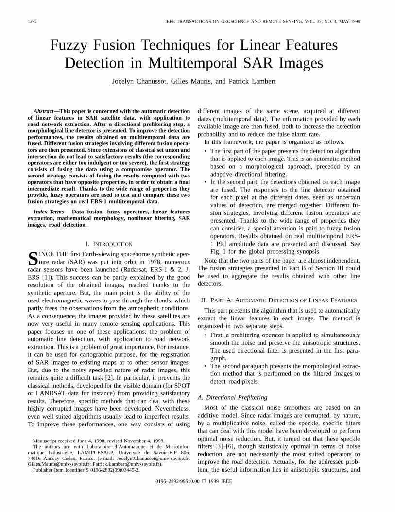
Fig. 2(a) and (b), respectively, present an original ERS-1PRI amplitude image (a region near Saragosse, in Spain) andthe result of the directional filter. The smoothing effect alongthe linear features is clearly visible, as well as the appearanceof the numerous short artifacts.
B. Morphological Extraction
For the extraction step, the model shape and size of thefeatures we are looking for have first to be fixed. We thusdecided to characterize the roads in the image as features thatare as follows.
• Locally Rectilinear: Each road pixel belongs to a segmentthat is longer than aminimumrequired length . We fixedthis minimum length to 21 pixels (corresponding toapproximately 280 meter ground lengths for the processeddata, which is a realistic minimum straight line length fortypical countryside roads).
• Thin: Detected features must not be wider than a maxi-mum width . We decided to seek roads that are up to
pixels wide, which is a typical maximum responsewidth in ERS-1 images for common roads [12].
• Contrasted: Roads appear on SAR data as linear featuresthat are either darker or lighter than their surroundings.
Different methods based on edge detectors [12], [17], [18],statistical [15], [16], Markovian [12], [14], or neural [13] ap-proaches have been proposed in the literature for the extractionof linear structures. But, since the features we are looking for
are intrinsically characterized by their shape, it seemed naturalto us to use morphological operators [8]–[11]. The proposedmethod is simple and fast [19]. It is unsupervised: there isno need for preselected points or for training images. It isalso almost nonparametric (apart from the model dimensions,one single threshold is involved). This is thus a robust andgeneric approach that can be used over a wide range of images,applications and sensors.
We will now detail the operators used for the detectionof light linear features. The extension to dark features isstraightforward: one just has to use the dual operators (ero-sion/dilation, opening/closing).
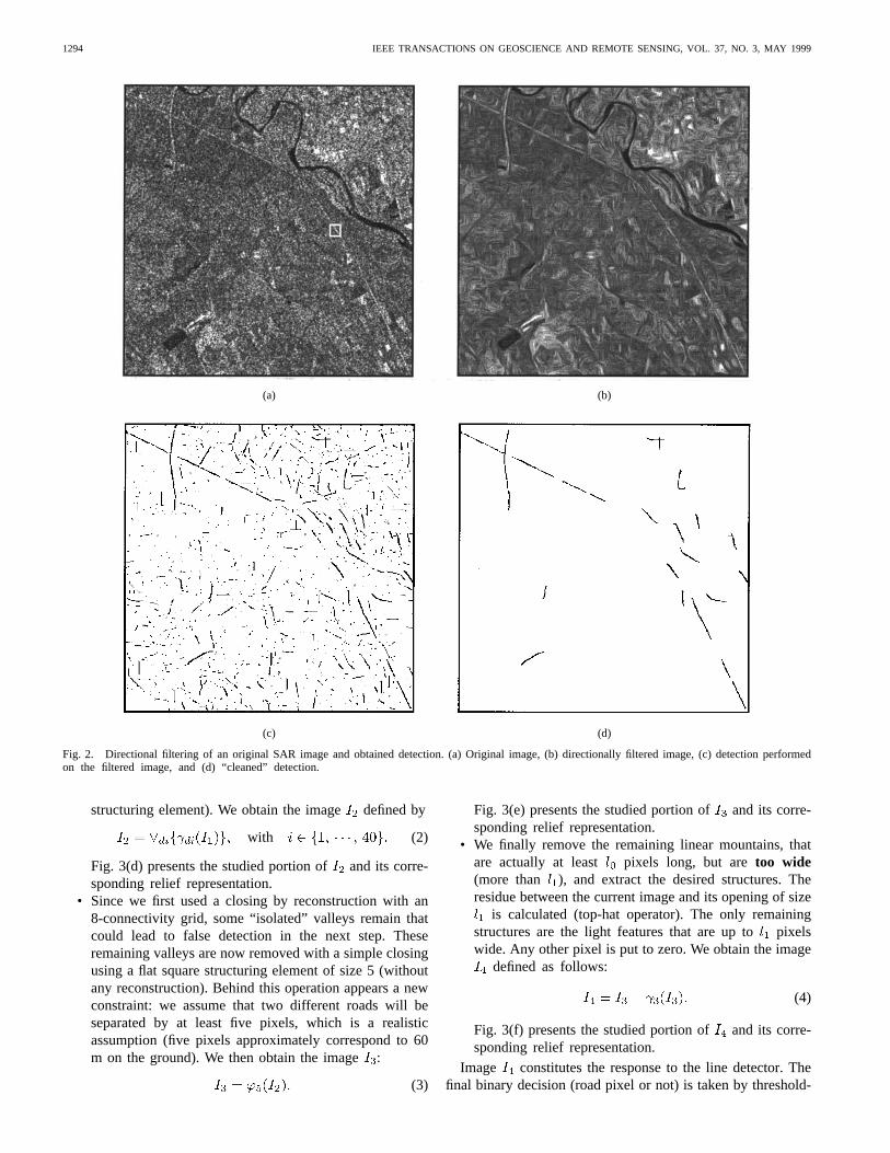
In the following, we will use the classical topographicanalogy for the representation of gray-scale images. In thisrepresentation, the image is considered as a topographic re-lief, the numerical value of each pixel determining the cor-responding point elevation. With this analogy, light linearfeatures correspond toelongated and narrow mountainsin a topographic relief. Fig. 3(a) presents a zoom of thesmall 20 20 square taken in the original image [white squarein Fig. 2(a)] and its corresponding relief. Fig. 3(b) presentsthe same image after the directional prefiltering. The strongsmoothing effect, with preservation of the linear structures isfairly perceptible. But, there nevertheless still remain someparasite structures. Actually, three different types of structureshave to be removed, each one violating one of the basicconstraints of the model definition.
• We first remove the structures that aredarker thantheir surroundings (corresponding to “valleys” in therelief). This is done using a morphological closing byreconstruction with a flat square structuring element ofsize 5 [20]. This operator fills in the nonflat valleys ofthe image. Furthermore, this is a connected operator: ittherefore does not introduce any new discontinuity in theimage. Calling the original filtered image and usingclassical notations, we obtain the image:
(1)
Fig. 3(c) presents the studied portion ofand its corre-sponding relief representation.
• We then removenonlinear (or too short) mountains,and preserve the others. This is achieved by taking thesupremum(denoted “ ”) of all the possible long di-rectional openings. It is computed using linear structuringelements successively oriented in every possible direction
(40 different directions for a 21 pixels long linear
1294 IEEE TRANSACTIONS ON GEOSCIENCE AND REMOTE SENSING, VOL. 37, NO. 3, MAY 1999
(a) (b)
(c) (d)
Fig. 2. Directional filtering of an original SAR image and obtained detection. (a) Original image, (b) directionally filtered image, (c) detection performedon the filtered image, and (d) “cleaned” detection.
structuring element). We obtain the imagedefined by
with (2)
Fig. 3(d) presents the studied portion ofand its corre-sponding relief representation.
• Since we first used a closing by reconstruction with an8-connectivity grid, some “isolated” valleys remain thatcould lead to false detection in the next step. Theseremaining valleys are now removed with a simple closingusing a flat square structuring element of size 5 (withoutany reconstruction). Behind this operation appears a newconstraint: we assume that two different roads will beseparated by at least five pixels, which is a realisticassumption (five pixels approximately correspond to 60m on the ground). We then obtain the image:
(3)
Fig. 3(e) presents the studied portion ofand its corre-sponding relief representation.
• We finally remove the remaining linear mountains, thatare actually at least pixels long, but aretoo wide(more than ), and extract the desired structures. Theresidue between the current image and its opening of size
is calculated (top-hat operator). The only remainingstructures are the light features that are up topixelswide. Any other pixel is put to zero. We obtain the image
defined as follows:
(4)
Fig. 3(f) presents the studied portion of and its corre-sponding relief representation.
Image constitutes the response to the line detector. Thefinal binary decision (road pixel or not) is taken by threshold-
CHANUSSOTet al.: FUZZY FUSION TECHNIQUES FOR LINEAR FEATURES DETECTION 1295
(a) (b) (c)
(d) (e) (f)
Fig. 3. (a) Part of the original image and (b) the prefiltering and the different steps leading to the extraction (c)–(f) and the corresponding relief representations.
ing it. Fig. 2(c) shows the result of the detection obtainedon the original filtered image, with 5 as threshold value.This result can then be “cleaned” by removing the smallestdetected segments. Fig. 2(d) presents the result obtained afterthe removal of the connected components that have a less than50 pixels area. Nevertheless, apart from the visual quality ofthe results, this “cleaning” must be used very carefully sinceall small removed features are not necessarily noisy features.Some of them really belong to the road network and couldhighly increase the quality of the detection in a following step.
Though quite satisfactory, these results are far from perfect.Some false alarms still remain, and the detection is not
exhaustive: roads are disconnectively detected. To improvethese performances, a high level post processing step thatglobally analyzes the image is usually applied. It aims atsuppressing the false alarms and at reconnecting the detectedsegments in order to fully reconstruct the road network. Tupin[12], for instance, recently proposed such a reconnection stepbased on a markovian approach. Nevertheless, the better thelocal detection is, the better the final reconnection will be. Inthis framework, the next part shows how the multitemporalfusion of the marginal detections can improve the local de-tection performances. This would greatly facilitate the globalreconnecting step that could be performed afterwards.
1296 IEEE TRANSACTIONS ON GEOSCIENCE AND REMOTE SENSING, VOL. 37, NO. 3, MAY 1999
III. PART B: MULTITEMPORAL FUSION OF THE RESULTS
This part presents different approaches to fuse the detectionresults obtained on the same scene at different dates (thesemultitemporal data have previously been manually registered).The response of a pixel to the line detector is linearly mappedinto [0, 1] and is then considered as a confidence degreein its being part of a potential road. The degrees obtainedat the different dates have to be merged. After the fusion,the result is linearly mapped back into [0, 255]. Thefinaldecision is put off to the end of the processing: the binarythresholding is appliedafter the fusion has been performed.This classically ensures more flexibility: a decision taken onthe fused data generally leads to better results than the fusionof the different decisions. In particular, it can better deal withconflictual situations.
Extensions of classical union and intersection set operationsare first briefly described in Section I. The correspondingoperators are not satisfactory: they are either too severe or tooindulgent. As a consequence, we then propose two differentfusion strategies to obtain intermediate results: Section IIpresents different compromise operators, whereas Section IIIexplains how to combine two “extreme” operators in orderto build an intermediate one. Fuzzy operators [22]–[27] pro-vide different tools to implement these approaches. Finally,Section IV presents and discusses the results obtained witheach operator on real multitemporal amplitude ERS-1 data.
Note that most of the presented fusion rules assume that thedata are “independent.” Actually, common data are usually fa-vored by the fusion, but if the sources are linked, this increaseof trust is misleading. This “independence” is not the statisticalindependence. It only means that the data are acquired andprocessed independently. Since the images we process areacquired at different dates, spread over a few months, andsince the detection processing is performed on each imageseparately, it is valid to use these fusion operators. We assumethat the roads remain unchanged from one image to another(redundancy of information), whereas the noise (artifacts dueto the fields, unfortunate realizations of the noise and s.o.) isassumed to be nonredundant from one image to another. Gen-erally speaking, the fusion aims at exploiting the informationredundancy and the nonredundancy of the noise to increasethe detection performance and to reduce the false alarm rate.
Notations: In the following, we assume that sourcesare available, corresponding to the images of the same sceneacquired at different dates. The response of a pixel fromthe th image to the line detector will be denoted and theassociated estimated direction will be denoted.
A. Union and Intersection
To extend the notions of set union and set intersection tofuzzy sets, two classes of operators (T-norms and T-conorms)are usually defined [32], [33].
• T-norms generalize the notion of set intersection. A T-norm is defined as an application suchthat:
— is commutative, associative and increasing withrespect to both variables,
— 1 is the neutral element: .
A T-norm has always a conjunctive (severe) behavior.• T-conorms generalize the notion of set union. A T-conorm
is defined as an application such that:
— is commutative, associative, and increasing withrespect to both variables,
— 0 is the neutral element: .
A T-conorm has always a disjunctive (indulgent) behav-ior.
In the following, we will test theminimum operator (5),which is the greatest possible T-norm: the output iscomputed as the minimum of the responses.
(5)
This operator is severe: a pixel will be classified as roadpixel if and only if it was classified as road pixel on everyimage taken separately (if the same threshold value is used,this corresponds to the intersection of the results). As a conse-quence, such an operator will produce an excellent false alarmrate reduction, but it will provide poor detection performances,though with high confidence level. Using another T-norm willaccentuate this effect, suppressing more false alarms, but moredetections too.
The logical counterpart of themin operator is the indulgentmaximumoperator, which is the smallest possible T-conorm.The corresponding output is themaxof the responses:
(6)
This operator leads to very good detection performances,since one single response greater than the threshold value isenough to classify a pixel as road pixel (this corresponds to theunion of the results). But, as a consequence, the false alarmrate is not reduced; on the contrary, all the false alarms of the
different sources are added. Using another T-conorm willaccentuate this effect, providing more detections, but morefalse alarms too.
Due either to a poor detection or to a dramatic false alarmrate, none of these operators is satisfactory. Thus, the generalidea is to find a compromise between a purely conjunctiveand a purely disjunctive behavior, trying to take advantage ofthem both. This can be done using two different approaches:the first one, described in Section II consists of directly usinga compromise operator for fusing the data. The second one,described in Section III consists of fusing the results of aconjunctive fusion and of a disjunctive fusion together, in orderto get an intermediate global behavior.
B. Compromise Operators
A fusion operator is said to be a compromise (cautiousbehavior) if it is always included between themin and themax operators. Different classical classes of fuzzy operatorsbehave in this way.
1) Mean Operators:A mean operator [32]–[34] is anapplication such that
• ;• and ;
CHANUSSOTet al.: FUZZY FUSION TECHNIQUES FOR LINEAR FEATURES DETECTION 1297
• is commutative and increasing with respect to bothvariables.
The arithmetical mean of course belongs to this classof operators. It will be tested in the following.
(7)
Beyond classical averaging operators, mean operators con-stitute a very large family that also include OWA operators[29] described in the following (Section II-C) and the fuzzyintegrals [35], [36]. The behaviors of these operators proceedfrom their definition: they always behave like a compromise.
2) Adaptive Quantified Fusion (AQ):The main idea of theadaptive quantified operator proposed by Dubois and Prade[26], [31] is to assume that only sources, among theavailable, are reliable. These sources are first aggregatedwith a conjunctive rule (T-norm). But, although the numberis assumed to be given, the reliable sources remain unknown:as a consequence, all the possible fusions ofsources among
are computed, and the results are then aggregated with adisjunctive operator (T-conorm). We obtain the operator(8):
T-conorm T-norm
(8)
The first difficulty with this method is to estimate thenumber of reliable sources. Delmotte [28] defines some criteriato determine automatically according to a cost function. Thesecond difficulty lies in the practical computation of the output:the apparent combinational explosion can be reduced, in someparticular cases, as follows.
1) Rank the data increasingly:
(9)
2) a) if the used T-conorm and T-norm, respectively,correspond to themaxand to themin, the output ofthe operator turns out to be simply the ( )ordered data:
(10)
b) if the used T-norm is the product operator, the outputturns out to be the product of thegreatest data:
(11)
Some of these operators also belong to the class of the meanoperators. But, if the used T-norm and T-conorm differ fromthe min and themax, operators defined by (8) can go beyondthe maxor below themin: there is no inclusion between thesetwo families. The key point is that these operators performa partial aggregation: unreliable sources are not taken intoaccount. In the following, we will test one operator from thisfamily: the operator defined by (10). It will then be reportedas , since it also belongs to the family described in thenext section.
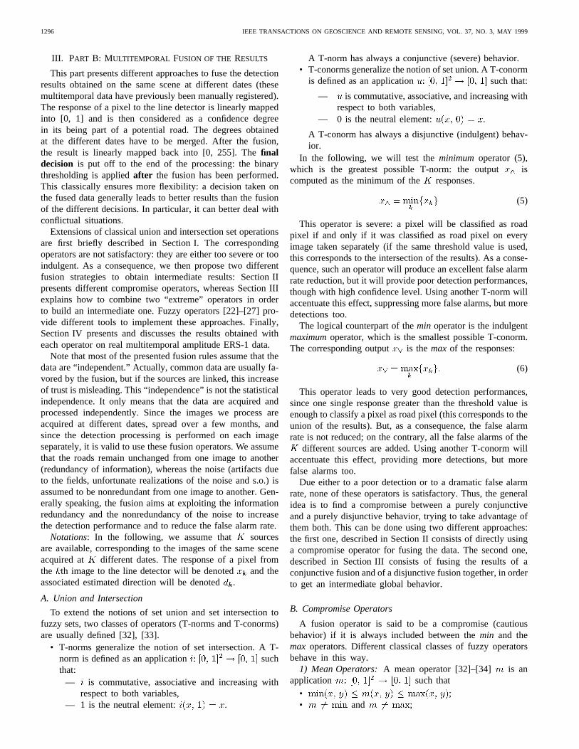
Fig. 4. Partial inclusions between the different presented classes of opera-tors.
3) Order Weighted Averaging Operator:The ranked dataas defined by (9) can also lead to another class of compro-mise fusion operators: the order weighted averaging operators(OWA) [29]. These operators are defined as a linear combina-tion of the ranked input data:
(12)
Depending on the weighting vector (), the min and maxoperators can be considered as particular cases of OWA oper-ators, as well as the arithmetical mean or even the quantifiedoperator introduced by (10) (if , else
). This particular operator will be tested on real datain the following. It will then be reported as . Notethat, on the contrary, the operator defined by (11) is not anOWA operator: there is no inclusion relation between theOWA and the adaptive quantified operators, though there isa nonempty intersection. On the contrary, apart from the limitcasesmin and max, any OWA operator is a mean operator.Fig. 4 summarizes the relations existing between the differentclasses of operators we presented in this section.
Also note that the OWA operators correspond, with adifferent semantics, to an important class of nonlinear filters insignal and image processing: the order statistics based L-filters[30]. Ranking the data pushes aberrant values to the extremepositions away. Using suitable weighting vector for the linearcombination will allow not to take these values into account.In that sense, these operators also perform partial aggregation.
C. Fusion of Extreme Operators
In order to obtain a fusion that is neither purely conjunctive,nor purely disjunctive, previous paragraph presented differentcompromise operators. Another strategy consists in first usingtwo “extreme” operators (a conjunctive one and a disjunctiveone) and in then combining their results together to provide aglobally intermediate result. Section III-A presents a contextdependent operator whose behavior is ruled by a conflictmeasure. Section III-B presents a morphological approachbased on geodesic reconstruction.
1) Context Dependent Fuzzy Operator:Used separately, T-norms or T-conorms cannot help for the fusion: we want tosimultaneously reduce the false alarm rate and to increase thedetection, but T-norms, as themin operator, will reduce bothdetections and false alarms, whereas T-conorms, as themax
1298 IEEE TRANSACTIONS ON GEOSCIENCE AND REMOTE SENSING, VOL. 37, NO. 3, MAY 1999
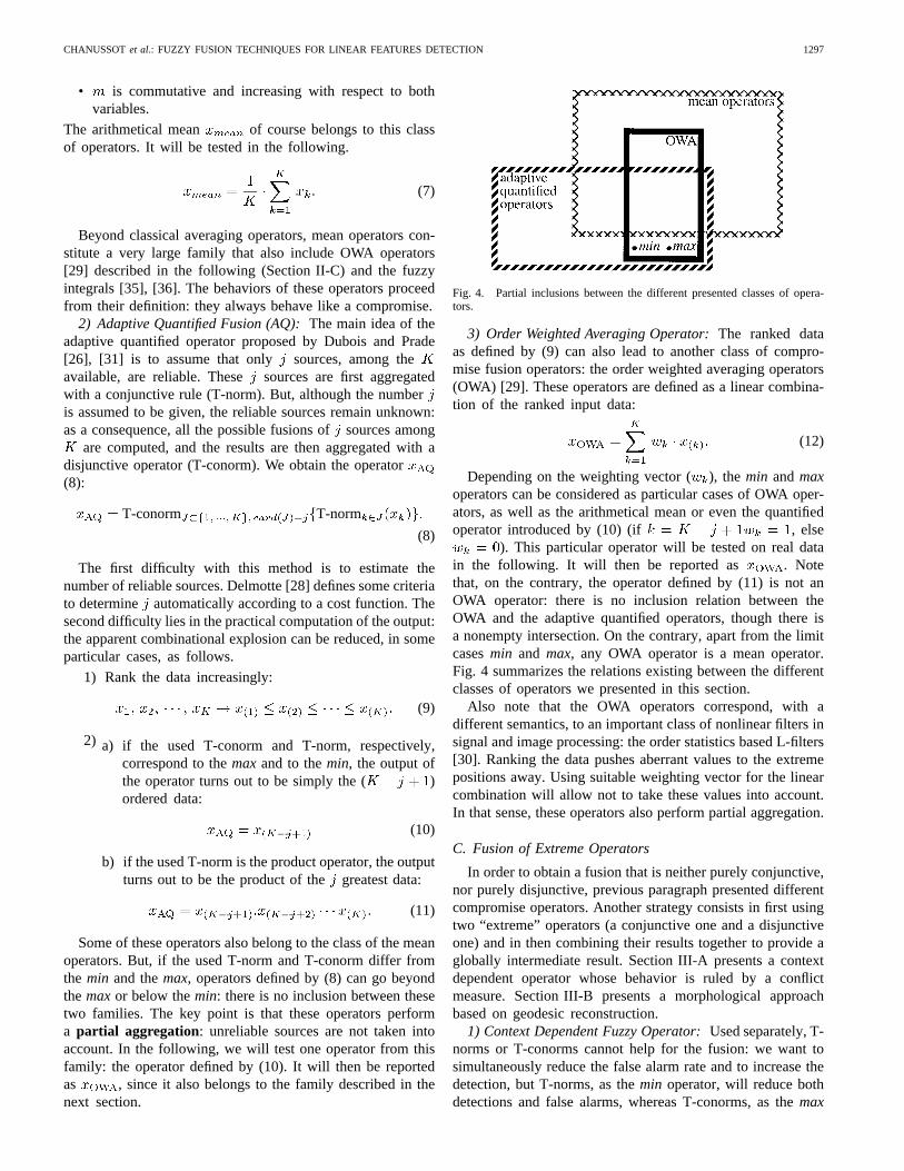
Fig. 5. Geodesic reconstruction ofx^ in x_
operator, will have the opposite effect. To take advantage ofthese two opposite properties, we will use a weighted meanof a T-norm and a T-conorm ruled by parameter (13).As ranges from 0 to 1, the resulting operator continuouslyranges from a conjunctive to a disjunctive behavior.
(13)
In order to take judiciously advantage of both operators,parameter has to be adapted to the context of each pixel,leading to an adaptive context dependent (CD) operator [22].
As a consequence, the weightsand ( ) are adaptivelydetermined using a compatibility measure [25]. A compatibil-ity relation on a universe is an application such that
• : a number is fully compatible withitself;
• : commutativity;• For a given is a convex fuzzy set.
We want to have the maximum compatibility ( : fullycompatible sources) when all the sources found the samedirection. On the contrary, we want the minimum compatibility( : incompatible sources) when orthogonal estimateddirections are found. For a given pixel, we thus defined thecompatibility relation between two different imagesand asthe absolute value of the cosine between the two directionsand selected by the directional opening during the extractionstep Section II-B:
(14)
Other monotonous functions respecting the desired condi-tions could also have been used. Nevertheless, the empiricchoice of the cosine is naturally well suited to quantify angulargaps.
To extend this definition to the sources case, Yager [24]proposed to take the minimum of the compatibilities obtainedfor every pair of sources. We chose to calculate the productof these compatibilities to be more severe (15).
(15)
The operator tested in the following uses this com-patibility measure, and takes themin operator for the T-norm,and themaxfor the T-conorm. A further improvement consistsin using other T-norms and T-conorms in order to induce a
reinforcement effect [25]. For instance, the classical operatorsdefined in (16) and their extension to thesources case (17)can replace themin and themax in (13):
(16)
(17)
The obtained operator, reported as in the following,still has a compromise behavior for mediumvalues, but thelimit cases go respectively beyond themaxand below themin.This results in favoring coherent data and in handicappingincoherent data.
2) Markers and Geodesic Reconstruction:We now pro-pose a morphological approach to fuse a conjunctive operator(for instance, themin) with a disjunctive one (for instancethe max) in order to obtain an intermediate result. Due to thenonredundancy of the noise, the response to the line detectorof false alarm pixels is not great in every image. These pixelsthus have a small value in themin output. As a consequence,since the min operator ensures a high confidence degree,its result can be considered as a referencemarker . To takeadvantage of the good detection provided by themax, thegeodesic reconstruction of themin in the max is computed[20]. This is performed by iterating the geodesic dilation ofthe min under themax (18) until idempotence (19).
(18)
Rec (19)
This defines the following fusion operator, whose output is:
Rec (20)
This is illustrated by the example presented on Fig. 5 on amonodimensional example ( is dilated “horizontally” andis bound by ).
Since the result is necessarily included between theminand themax, this operator always gives less false alarms thanthe max and more detections than themin. The hypothesisinduced by such a reconstruction is that any connected part
CHANUSSOTet al.: FUZZY FUSION TECHNIQUES FOR LINEAR FEATURES DETECTION 1299
detected in themaxthat is marked by themin will be preservedfor the final decision (it is either removed or preserved,but it cannot be cut up into smaller fragments). Thus, theimprovement will be optimal when false alarms and gooddetections are not connected together (otherwise they both arereconstructed), and when the markers provided by themin aresufficiently discriminating (false alarms should not be marked)and exhaustive (all roads detected in themaxshould be markedby the min).
IV. RESULTS AND COMMENTS
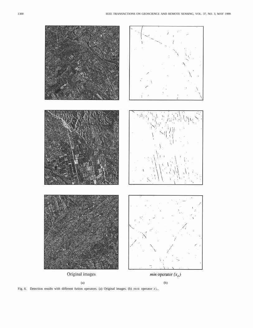
Fig. 6 presents the results obtained on real multitemporalERS-1 PRI amplitude data provided by the IGN (FrenchNational Geographic Institute). These are three looks imagesand the pixel spacing is 12.5 m. For each image, three differentacquisitions spread over a few months were available. Thedetections performed on each of these images are fused usingthe different operators presented in the previous sections.
• Fig. 6(a) presents three different original images: wesought thelight linear features in the first two images.We sought thedark linear features in the last one.
• Fig. 6(b) and (c) presents the detections obtained, respec-tively, with theminand with themaxoperators. Thresholdvalue for the binary decision is set to 5 for the light roads(first two images) and to 2 for the dark ones that areless contrasted with their surroundings (last image). Thesevalues will be kept constant for all the tested operatorsto allow an objective comparison. Themin leads to verygood false alarm rate reduction, but to extremely poordetection. On the contrary, themax leads to excellentdetection, but to a dramatic false alarm rate. This justifiesthe quest for intermediate results.
• Fig 6(d) present the detections obtained with the meanoperator ( ). A “cleaning” that removes all con-nected components that have a less than 50 pixels areahas been applied. Note that the same “cleaning” willbe applied with all the other operators. The results arequite good, both in terms of detection improvement andin terms of false alarm reduction. The main roads arealmost connectively detected.
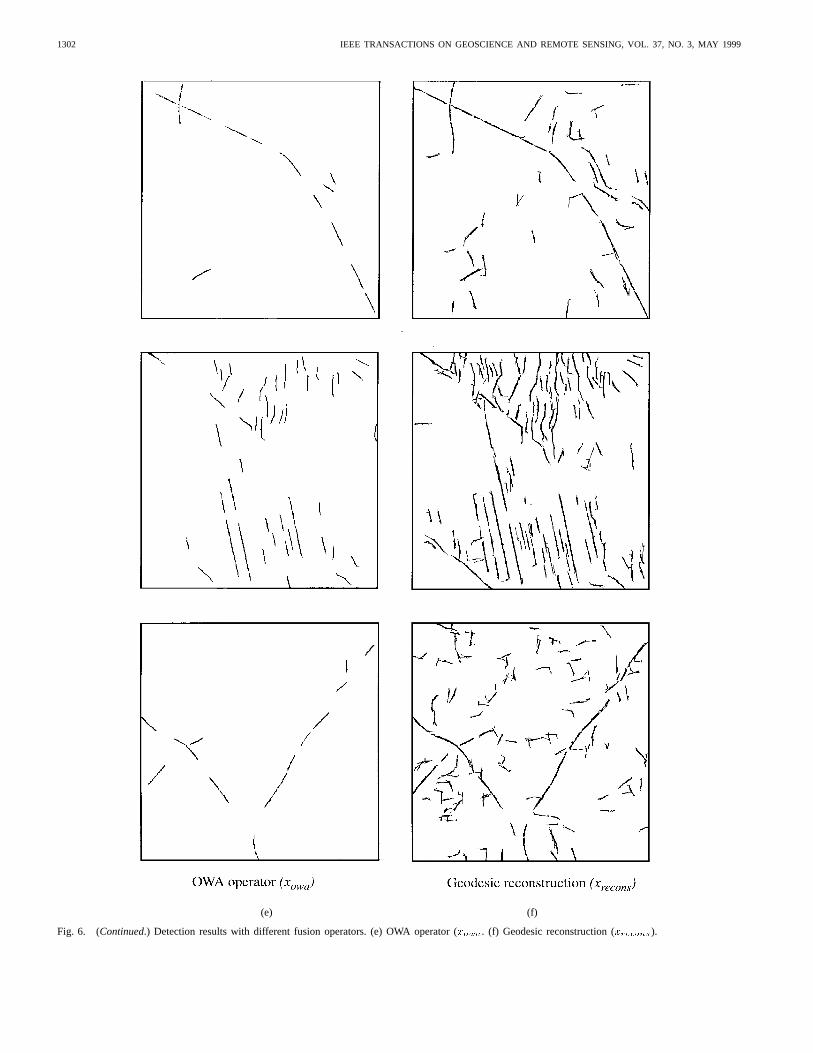
• Fig. 6(e) presents the detection obtained with the OWAoperator ( ). Among the three available sources, weassumed that at least two were reliable. The results aremore satisfactory in terms of false alarm reduction: almostnone of them remain visible. But, the detection is slightlyworse: the main roads are disconnectively detected. Thiscould be easily improved by a global post-processingreconnection step.
• Fig. 6(f) presents the results of the geodesic reconstruc-tion of the min under themax ( ). As expected,the detection performances are good. In particular, theconnection of the detected roads is very good. But somefalse alarms remain: this is either due to noise featuresthat are connected to the road network, or to a lackof selectivity of the markers provided by themin. Asolution could be to “clean” the result of themin beforethe reconstruction, another solution could be to use otherresults, such as , as marker function.
• Fig. 6(g) and (h) presents the results obtained with theadaptive context dependent operator, respectively, with-out reinforcement effect ( ) and with reinforcementeffect ( ). Most of the time, the compatibility mea-sure leads to the right weighting between the conjunctiveand the disjunctive results. In particular, the detection isquite good. But some false alarms still remain. This isslightly improved by the reinforcement effect [some morenoisy features are deleted in Fig. 6(h)].
To choose the most appropriate fusion operator, the userfirst has to set the cost attached to each false alarm and toeach nondetection. The choice is then made depending on thedetermined tolerated compromise and is application dependent.Nevertheless, with the tested configurations, the reinforcedcontext dependent operator and the geodesic reconstructionprovide the best results in terms of detection connectivity. Onthe contrary, the best false alarm rate reduction is given bythe OWA operator.
V. GENERAL CONCLUSION AND PERSPECTIVES
This paper was concerned with the automatic line detectionin satellite radar images, with application to the road networkextraction. After a directional prefiltering step, a morphologi-cal extraction is performed. Based on a geometrical approach,the proposed line detector does not take explicitly the specificnature of radar data into account and is therefore suboptimal.It is nevertheless useful and interesting since it is simple andfast, unsupervised and almost nonparametric.
To globally improve the detection performances, the resultsobtained on the same image acquired at different dates (mul-titemporal data) are fused together. Simple extensions of setunion and intersection did not provide satisfactory results: thecorresponding operators are either too indulgent or too severe.As a consequence, we proposed two different strategies toobtain an intermediate result. The first approach consisted ofdirectly defining an operator that fuses the data with a compro-mise behavior. The second approach consisted of combiningthe results obtained with two extreme operators (a severe andan indulgent one) in order to have a globally intermediateresult. Different operators, mostly fuzzy operators, allowedus to implement these two different strategies on real ERS-1multitemporal amplitude data.
All the presented operators provided interesting compromiseresults. They all greatly contributed to improve the detectionperformances. Nevertheless, none of them provided perfectresults as they could be obtained by a manual extraction. Forinstance, false alarms found in mountainous areas (see the topof the second presented image) are not suppressed. But letus recall that the proposed methods only meant at performingthe local detection of linear structures. A global reconnectingpost-processing that uses high level prior knowledge is usuallyapplied.
Improved implementations of the two proposed strategiesare possible. For instance, some improvements could be madein the definition of compromise operators: an operator thatsimultaneously takes a conflict measure and the reliability ofthe different sources into account (for instance, an adaptiveOWA operator) could lead to better results. Concerning the
1300 IEEE TRANSACTIONS ON GEOSCIENCE AND REMOTE SENSING, VOL. 37, NO. 3, MAY 1999
(a) (b)
Fig. 6. Detection results with different fusion operators. (a) Original images. (b)min operatorx^.

CHANUSSOTet al.: FUZZY FUSION TECHNIQUES FOR LINEAR FEATURES DETECTION 1301
(c) (d)
Fig. 6. (Continued.) Detection results with different fusion operators. (c)max operatorx^. (d) Mean operator (xmean).
1302 IEEE TRANSACTIONS ON GEOSCIENCE AND REMOTE SENSING, VOL. 37, NO. 3, MAY 1999
(e) (f)
Fig. 6. (Continued.) Detection results with different fusion operators. (e) OWA operator (xowa. (f) Geodesic reconstruction (xrecons).

CHANUSSOTet al.: FUZZY FUSION TECHNIQUES FOR LINEAR FEATURES DETECTION 1303
(g) (h)
Fig. 6. (Continued.) Detection results with different fusion operators. (g) Adaptive context dependent operator (xCD). (h) Adaptive context dependentoperator with reinforcement (XCD ).
1304 IEEE TRANSACTIONS ON GEOSCIENCE AND REMOTE SENSING, VOL. 37, NO. 3, MAY 1999
second strategy, another fusion layer consisting of fusing theresults of more than two fusion operators could also improvethe results.
In order to achieve a better discrimination between the gooddetections and the false alarms, a key point is the takinginto account of the (local) context of each pixel. Therefore,operators that have a constant behavior, though providingan interesting compromise, offer very restricted perspectives.In the same way, operators with variable behavior that onlyadapts to the values to be fused themselves (such as theassociative symmetrical sums [22]) also seem inadequate todiscriminate finely between detections and false alarms. Inthis frame, we believe that the second presented strategy ismore promising: the degree of freedom constituted by the waythe two (or more ) chosen fusion operators are combinedensures an optimal flexibility. In particular, taking the contextmore globally into account (for instance by introducing exter-nal complementary information) can be more easily achieved.
For the addressed application, also note that other data couldhave been used. For instance, whereas we only used amplitudedata, Hellwich [21] showed that the coherence images alsocontain information about linear features that have a widthslightly larger than the system resolution. Multisensor data(for instance ERS-1 and JERS-1) could also be used. But,beyond the presented application, this paper principally aimedat presenting different fusion strategies and different classes offusion operators. These operators could be used in many otherremote sensing applications, involving different objectives ordifferent sensors.
REFERENCES
[1] J. Way and E. Atwood Smith, “The evolution of synthetic aperture radarsystems and their progression to the EOS SAR,”IEEE Trans. Geosci.Remote Sensing,vol. 29, pp. 962–985, Nov. 1991.
[2] A. Hendri, S. Quegan, and J. Wood, “The visibility of linear featuresin SAR images,” inProc. IEEE Int. Geoscience Remote Sensing Symp.,1988, pp. 1517–1520.
[3] J. Bruniquel and A. Lopes, “Analysis and enhancement of multitemporalSAR data,”Proc. SPIE,vol. 2315, pp. 342–353, 1994.
[4] J. S. Lee, M. Grunes, and S. Mango, “Speckel reduction in multipo-larization, multifrequency SAR imagery,”IEEE Trans. Geosci. RemoteSensing,vol. 29, pp. 535–544, July 1991.
[5] A. Lopes, R. Touzi, and E. Nezry, “Adaptive speckle filter and sceneheterogeneity,” IEEE Trans. Geosci. Remote Sensing,vol. 28, pp.992–1000, Nov. 1990.
[6] C. Ju and C. Moloney, “An edge-enhanced modified Lee filter forthe smoothing of SAR image speckle noise,” inProc. IEEE WorkshopNonlinear Signal Image Processing,Mackinac Island, MI, 1997.
[7] P. Zamperoni, “Adaptive rank order filters for image processing based onlocal anisotropy measures,”Digital Signal Process.,vol. 2, pp. 174–182,1992.
[8] J. Serra,Mathematical Morphology. London, U.K.: Academic, 1982,vol. 1.
[9] , Mathematical Morphology, Theoretical Advances.London,U.K.: Academic, 1988, vol. 2.
[10] E. Dougherty,Mathematical Morphology in Image Processing.NewYork: Marcel Dekker, 1993.
[11] H. J. A. M. Heijmans,Morphological Image Operators. New York:Academic, 1994.
[12] F. Tupin, H. Maˆıtre, J. F. Mangin, J. M. Nicolas, and E. Pechersky,“Detection of linear features in SAR images: Application to roadnetwork extraction,”IEEE Trans. Geosci. Remote Sensing,vol. 36, pp.434–453, Mar. 1998.
[13] O. Hellwich, “Detection of linear objects in ERS-1 SAR images usingneural network technology,” inProc. IEEE Int. Geoscience RemoteSensing Symp.,Pasadena, CA, 1994.
[14] O. Hellwich and H. Meyer, “Extracting line features from syntheticaperture radar scenes using a Markov random field model,” inProc. 3rdIEEE Int. Conf. Image Processing,Lausanne, Switzerland, vol. 3, pp.883–886, 1996.
[15] A. Evans, N. Sharp, and E. Hancock, “Noise models for linear fea-ture detection in SAR images,” inProc. 1st IEEE Int. Conf. ImageProcessing,Austin, TX, 1994, vol. 1, pp. 466–470.
[16] R. Samadani and J. Vesecky, “Finding curvilinear features in speckeldimages,” IEEE Trans. Geosci. Remote Sensing,vol. 28, pp. 669–673,July 1990.
[17] M. Adair and B. Guindon, “Statistical edge detection operators for linearfeature extraction in SAR images,”Can. J. Remote Sensing,vol. 16, no.2, pp. 10–19, 1990.
[18] A. Bovik, “On detecting edges in speckle images,”IEEE Trans. Acoust.,Speech, Signal Processing,vol. 36, pp. 1618–1627, Oct. 1988.
[19] J. Chanussot and P. Lambert, “An application of mathematical mor-pholohy to road network extraction on SAR images,” inProc. 4thInt. Symp. Mathematical Morphology Its Applications,Amsterdam, TheNetherlands, 1998, pp. 399–406.
[20] J. Crespo, J. Serra, and R. Schafer, “Theoretical aspects of morpholog-ical filters by reconstruction,”Signal Process.,vol. 47, pp. 201–225,1985.
[21] O. Hellwich and C. Streck, “Linear structures in SAR Coherence data,”in Proc. IEEE Int. Geoscience Remote Sensing Symposium,Lincoln, NE,1996, vol. 1, pp. 330–332.
[22] I. Bloch, “Information combination operators for data fusion: A com-parative review with classification,”IEEE Trans. Syst., Man, Cybern. A,vol. 26, pp. 52–67, Jan. 1996.
[23] R. Yager and D. Filev,Essentials of Fuzzy Modeling and Control.NewYork: Wiley, 1994.
[24] R. Yager, “A general approach to the fusion of imprecise information,”Int. J. Intell. Syst.,vol. 12, pp. 1–29, 1997.
[25] R. Yager and A. Kelman, “Fusion of fuzzy information with consider-ations for compatibility, partial aggregation and reinforcement,”Int. J.Approx. Reas.,vol. 15, pp. 93–122, 1996.
[26] D. Dubois and H. Prade, “Possibility theory and data fusion in poorlyinformed environments,”IFAC Contr. Eng. Practice,vol. 2, no. 5, pp.811–823, 1994.
[27] D. Dubois, H. Prade, and C. Testemale, “Weighted fuzzy patternmatching,”Fuzzy Sets Syst.,vol. 28, pp. 313–331, 1988.
[28] F. Delmotte and P. Borne, “Modeling of reliability with possibilitytheory,” IEEE Trans. Syst., Man, Cybern. A,vol. 28, pp. 78–88, Jan.1998.
[29] R. Yager, “On ordered weighted averaging aggregation operators inmulticriteria decisionmaking,”IEEE Trans. Syst., Man, Cybern.,vol.18, pp. 183–190, 1988.
[30] A. Bovik, T. S. Huang, and D. C. Munson, “A generalization of medianfiltering using linear combinations of order statistics,”IEEE Trans.Acoust., Speech, Signal Processing,vol. ASSP-31, pp. 1342–1350, 1983.
[31] D. Dubois and H. Prade, “Adaptive combination rules for possibilitydistributions,” in Proc. EUFIT 2nd Europ. Congr. Intelligent Technicsand Soft Computing,1994, pp. 48–52.
[32] , “A review of fuzzy sets aggregation connectives,”Inform. Sci.,vol. 36, pp. 85–121, 1985.
[33] R. Yager, “Connectives and quantifiers in fuzzy sets,”Fuzzy Sets Syst.,vol. 40, pp. 39–75, 1991.
[34] , “On mean type aggregation,”IEEE Trans. Syst., Man, Cybern.B, vol. 26, pp. 209–221, Apr. 1996.
[35] M. Sugeno, “Theory of fuzzy integrals and its applications,” Ph.D.dissertation, Tokyo Inst. Technol., Tokyo, Japan, 1974.
[36] M. Grabisch, “On the use of fuzzy integrals as a fuzzy connective,” inProc. 2nd IEEE Int. Conf. Fuzzy Systems,San Fransisco, CA, 1993, pp.213–218.
Jocelyn Chanussotgraduated in electrical engineer-ing from the Grenoble National Polytechnic Institute(INPG), Grenoble, France, in 1995. He is cur-rently pursuing the Ph.D. degree in the Automaticsand Industrial Micro-Computer Science Laboratory(LAMII), Universite de Savoie, Annecy, France. Hisresearch interests include multicomponent imageprocessing, nonlinear filtering, remote sensing, anddata fusion.
CHANUSSOTet al.: FUZZY FUSION TECHNIQUES FOR LINEAR FEATURES DETECTION 1305
Gilles Mauris graduated from the Ecole NormaleSuperieure de Cachan, France, in 1985. He receivedthe Ph.D. degree in 1992.
He is currently Assistant Professor of ElectricalEngineering at the Savoie University (TechnologicalAcademic Institute) and works in the Automaticsand Industrial Micro-Computer Science Laboratory(LAMII), Annecy, France. His research interestsinclude fuzzy logic, possibility theory, and dataaggregation in the instrumentation and measurementarea.
Patrick Lambert graduated in electrical engineer-ing from the Grenoble National Polytechnic Institute(INPG), Grenoble, France, in 1978. He received thePh.D. degree in signal processing in 1983.
He is currently Assistant Professor of electricalengineering at the Savoie University (TechnologicalAcademic Institute) and works in the Automaticsand Industrial Micro-Computer Science Laboratory(LAMII), Annecy, France. His research interestsinclude color image representations and segmenta-tions, multicomponent image processing and analy-
sis, data fusion, and fuzzy logic.
Related Documents