Future Land Use

Welcome message from author
This document is posted to help you gain knowledge. Please leave a comment to let me know what you think about it! Share it to your friends and learn new things together.
Transcript

Future Land Use
CITY OF WINTER PARK CHAPTER 1: FUTURE LAND USE ELEMENT
COMPREHENSIVE PLAN Data, Inventory & Analysis 1-1
FUTURE LAND USE ELEMENT DATA, INVENTORY & ANALYSIS Pursuant to the requirements of Chapter 163, this section presents an inventory and analysis of land use data for the City of Winter Park. Data and analysis presented herein are used to assist Winter Park with the formation of goals, objectives, and policies that guide development and redevelopment in the City towards its desired vision and to plan for the efficient delivery of government and public services. Purpose The Future Land Use Element can be seen as the City's blueprint for its continuing physical development. Definition of land use categories and distribution of those categories on the Future Land Use Map will result in a development pattern that reflects the goals, objectives and policies of the Comprehensive Plan. This Element includes an inventory and analysis of the City's existing land uses. It also presents an analysis of the City's residential population and projections on the future growth of Winter Park both through internal growth and external growth through annexations. General Location Winter Park is located in central Florida, north of the City of Orlando and south of the City of Maitland. Interstate 4 crosses portions of the City’s far western boundary. Until 2003, the City’s jurisdictional area fell east of I-4. With annexations of property straddling both sides of Fairbanks Avenue, the City’s corporate boundaries now extend just past I-4. U.S. 17-92 passes in a direct north-south alignment within the western half of the City and SR 436 abuts a portion of the City’s eastern boundary.
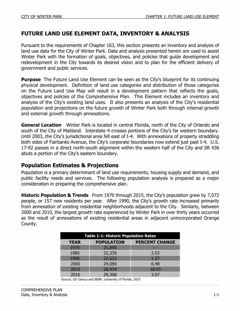
Population Estimates & Projections Population is a primary determinant of land use requirements, housing supply and demand, and public facility needs and services. The following population analysis is prepared as a major consideration in preparing the comprehensive plan. Historic Population & Trends From 1970 through 2015, the City’s population grew by 7,072 people, or 157 new residents per year. After 1990, the City’s growth rate increased primarily from annexation of existing residential neighborhoods adjacent to the City. Similarly, between 2000 and 2010, the largest growth rate experienced by Winter Park in over thirty years occurred as the result of annexations of existing residential areas in adjacent unincorporated Orange County.
Table 1-1: Historic Population Rates
YEAR POPULATION PERCENT CHANGE
1970 21,895 - - 1980 22,339 2.03 1990 22,623 1.27 2000 24,090 6.48 2010 28,434 18.03 2016 29,308 3.07
Source: US Census and BEBR, University of Florida, 2015
CHAPTER 1: FUTURE LAND USE ELEMENT CITY OF WINTER PARK
COMPREHENSIVE PLAN
1-2 Data, Inventory & Analysis
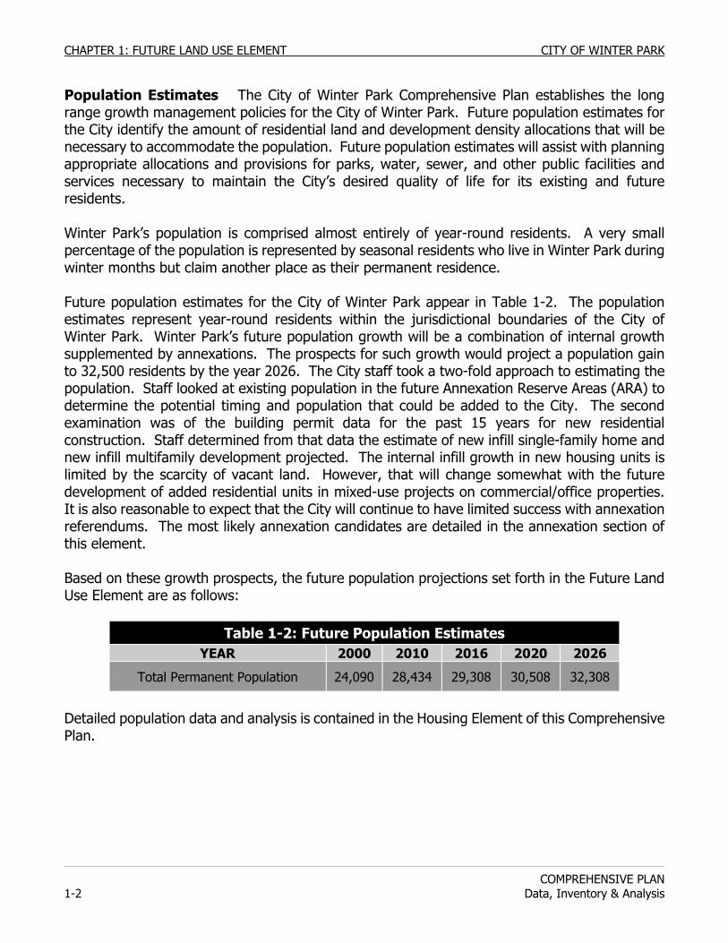
Population Estimates The City of Winter Park Comprehensive Plan establishes the long range growth management policies for the City of Winter Park. Future population estimates for the City identify the amount of residential land and development density allocations that will be necessary to accommodate the population. Future population estimates will assist with planning appropriate allocations and provisions for parks, water, sewer, and other public facilities and services necessary to maintain the City’s desired quality of life for its existing and future residents. Winter Park’s population is comprised almost entirely of year-round residents. A very small percentage of the population is represented by seasonal residents who live in Winter Park during winter months but claim another place as their permanent residence. Future population estimates for the City of Winter Park appear in Table 1-2. The population estimates represent year-round residents within the jurisdictional boundaries of the City of Winter Park. Winter Park’s future population growth will be a combination of internal growth supplemented by annexations. The prospects for such growth would project a population gain to 32,500 residents by the year 2026. The City staff took a two-fold approach to estimating the population. Staff looked at existing population in the future Annexation Reserve Areas (ARA) to determine the potential timing and population that could be added to the City. The second examination was of the building permit data for the past 15 years for new residential construction. Staff determined from that data the estimate of new infill single-family home and new infill multifamily development projected. The internal infill growth in new housing units is limited by the scarcity of vacant land. However, that will change somewhat with the future development of added residential units in mixed-use projects on commercial/office properties. It is also reasonable to expect that the City will continue to have limited success with annexation referendums. The most likely annexation candidates are detailed in the annexation section of this element. Based on these growth prospects, the future population projections set forth in the Future Land Use Element are as follows:
Table 1-2: Future Population Estimates YEAR 2000 2010 2016 2020 2026
Total Permanent Population 24,090 28,434 29,308 30,508 32,308
Detailed population data and analysis is contained in the Housing Element of this Comprehensive Plan.
CITY OF WINTER PARK CHAPTER 1: FUTURE LAND USE ELEMENT
COMPREHENSIVE PLAN Data, Inventory & Analysis 1-3
Comprehensive Plan Amendments 2009-2016 Since the adoption of the Comprehensive Plan in 2009, the City of Winter Park has amended its comprehensive plan on numerous occasions. There were three general types of comprehensive plan amendments. Large Scale Comprehensive Plan Text Amendments Large scale text amendments have occurred since 2009 in response to development request and to further refine policy goals for guiding new development. Comprehensive Plan Amendments in Response to Annexations The second type of Comprehensive Plan amendment that has occurred since 2009 were updates to the future land use map to reflect annexations. Prior to all of these annexations, an annexation report was prepared and sent to Orange County pursuant to the requirements of Chapter 171, Florida Statutes. In addition, a cost/benefit financial analysis and concurrency analysis was completed pursuant to the City’s comprehensive plan annexation policies. Two factors are of critical importance. One is that every single one of these annexations included existing developed areas with less than 2% vacant property. Thus, all of the concurrency impacts already existed. All of these annexations involved unincorporated lands already served by Winter Park Utilities (water and sewer) so there were no net increases in demands. All of these annexations were simply a jurisdictional transfer. The second factor is that again in almost every single case, the annexations that occurred and the resultant updates to the city’s future land use map involved adopting exactly the same future land use designations (and zoning) that pre-existed in the Orange County Comprehensive Plan. With one or two exceptions, the annexation grant to a property owner a future land use designation that permitted more density or intensity than did not previously exist in Orange County. Again, all of these annexations and future land use map amendments were simply a jurisdictional transfer. Small Scale Comprehensive Plan Amendments The third type of Comprehensive Plan amendments that were approved in this time period involved small future land use map amendments done in conjunction with zoning map changes and building project approvals. ANALYSIS OF FUTURE LAND USE
Winter Park's Comprehensive Plan contains a Future Land Use Map. This Comprehensive Plan Future Land Use Map is especially important because the City must base its zoning map upon this Future Land Use Map. Since the Zoning Map must conform to this Future Land Use Map and since this Future Land Use Map takes precedence over the Zoning Map, whenever there is a conflict, the designations established herein are ones upon which all building permits and development orders will be evaluated for conformity and consistency.
CHAPTER 1: FUTURE LAND USE ELEMENT CITY OF WINTER PARK
COMPREHENSIVE PLAN
1-4 Data, Inventory & Analysis
The Future Land Use Map is not intended to be a duplication of the Zoning Map. The Comprehensive Plan adoption and public participation process is intended to allow the City to determine which types and locations of Future Land Use designations are in the best interests of the City of Winter Park. From those decisions, the Zoning Map comes into conformance with the Comprehensive Plan. The validity of the nation's first zoning ordinance was upheld by the U.S. Supreme Court in 1917 due to the fact that it was based on an adopted Comprehensive Plan. Since that time, Comprehensive Plan Future Land Use Elements and Future Land Use Maps have been the legal foundation and rationale behind zoning decisions. The Future Land Use Plan Map is also important as an implementation tool. Winter Park's Map sets forth the extent of land necessary, in the proper designations, to allow for the projected growth, that Winter Park is expected to realize from 2015 to 2025 time period with respect to population growth, housing growth, and business growth. The Future Land Use Plan Map also provides adequate sites for necessary public service and infrastructure that is required to serve the projected population and business base. The Future Land Use Map also implements many of the environmental and natural resource protections included in this Comprehensive Plan.
The Future Land Use Map is presented in a similar manner to the existing land use in that it is a map series. The colored Future Land Use Map depicts future land uses plus existing and planned water wells, lakes, rivers and wetlands. Other natural resource designations, as required for floodplains, soils, and minerals, are shown on separate maps. The City does not expect any area of the community to be designated as an area of critical state concern, pursuant to Chapter 380, Florida Statutes. The Future Land Use Map (FLUM) and Map Series shall implement the Comprehensive Plan as a whole through the designation and categorization of land. All development, redevelopment and land use shall be consistent with those designations and limited to the standards for densities and intensities of use as outlined in the text for the Future Land Use Map Series and in accompanying table(s). The FLUM series, Maps 1-1 through 1-6e, shall allocate future land uses and include the following:
Future Land Use Map (FLUM) Series:
1. FLUM-1-01, Existing Land Use Map 2. FLUM-1-02, Future Land Use Map 3. FLUM-1-03, Maximum Height Map 4. FLUM-1-04, Jurisdictional Boundaries Map 5. FLUM-1-05, Surveyed Historic Properties Map 6. FLUM-1-06, National Register of Historic Properties Map
* The Future Land Use Map Designation Density/ Intensity Table” denotes the maximum range of density and maximum floor area ratios (intensity), within each of the non-residential FLUM designations and shall be used in conjunction with the Future Land Use Map, Maximum Height Map and Map Series to determine the permitted density and intensity of development

CITY OF WINTER PARK CHAPTER 1: FUTURE LAND USE ELEMENT
COMPREHENSIVE PLAN Data, Inventory & Analysis 1-5
Future Land Use Map Densities & Intensities Defined One of the most important issues for the City in regulating its residential, commercial, office and multifamily development is the appropriate density (units per acre) and intensity (floor area ratio). Each future land use category contains either in wording or as expressed in the following table, the maximum densities (units per acre) and intensities (floor area ratio) of development that is permitted.
Table 1-3 Future Land Use Map Designation Maximum Density/Intensity OFFICE COMMERCIAL CENTRAL BUSINESS
DISTRICT Density (units/acre)
17 units/acre
17 units/acre
17 units/acre
INTENSITY (FAR)
Up to 2-3 story 45%*+ 60%**
45%*+ 60%** 200%
Up to 4-story 45%*+ 60%**
45%*+ 60%** Not permitted
Up to 5-8 story 45%*+ 60%**
45%*+ 60%** Not permitted
NOTE All categories count private parking garage floor space toward FAR limits. Maximum number of stories is determined by the Maximum Height Map and may be
further restricted by other policies of this Comprehensive Plan. + The 45% FAR may be increased up to 5% if parking for the increase is entirely
underground beneath the foot print of the building or if the building’s upper floor(s) cantilevered over such parking or for hotel buildings.
* For any building project exclusively commercial or office; or any mix of commercial or
office uses. ** For any building project at least 85% commercial or office on the first floor with
residential units on upper floors. NOTE This table reflects the maximum intensities that may be permitted in the underlying
zoning district. The maximum intensity that will be approved on any specific site will be based on the applicable development regulations and the ability of the project to further promote the goals of the City, but is not an entitlement.
CHAPTER 1: FUTURE LAND USE ELEMENT CITY OF WINTER PARK
COMPREHENSIVE PLAN
1-6 Data, Inventory & Analysis
Table 1-4 Future Land Use – Zoning Compatibility Chart
FUTURE LAND USE DESIGNATION COMPATIBLE ZONING DISTRICTS Single Family Residential R-1AAA, R-1AA, R-1A, PURD Low Density Residential R-2, PURD, R-1A
Medium Density Residential R-3, R-2, PURD, PL Commercial C-3, C-3A, C-1, O-1, O-2, PL
Office and Professional O-1, O-2, PL Central Business District C-2, PL
Industrial I-1, C-3, O-1, O-2, PL Parking Lot PL Institutional PQP, PR, PL
Open Space and Recreation PR Provisions for Affordable/Workforce Housing The development of affordable/workforce housing is a priority of the State Comprehensive Plan and the City’s Comprehensive Plan. As such, in some cases incentives are necessary to insure the provision of affordable/ workforce housing especially within Winter Park with extremely high land costs, along with typical construction costs. Future Land Use Designations Winter Park's Future Land Use Map sets forth future land use designations on a parcel by parcel basis. However, the Future Land Use designations are broader in some instances and generally encompass more uses within each category than the more specific zoning districts. A narrative explanation of the Future Land Use Map designations and their permitted density and intensity of development is as follows:
Single-Family Residential This Future Land Use Map designation indicates areas to be developed for single-family residential uses and the compatible zoning districts for such future land use designation are the R-1AAA, R-1AA, R-1A and PURD zoning districts. The residential uses intended for these areas include single-family detached housing, accessory units and attached townhouse units. The overall density range shall be up to five units per acre except in the approved PURD. areas where the density of single-family, zero lot line or townhouse development maybe increased to eight units per acre but is mediated by the provision of readily useable open space areas. The maximum floor area ratio shall be 38% but may increase to a maximum 43% based upon satisfaction of specific design standards and incentives. Low-Density Residential This Future Land Use Map designation indicates areas to be zoned for and used for low density residential use, zoned R-2. The residential uses intended for these areas include single family homes, duplexes, and cluster housing that do not exceed ten units per acre and the floor area ratio shall not exceed 55%. Medium-Density Residential This Future Land Use Map designation indicates areas to be zoned for the multi-family residential uses. The compatible zoning district for this designation shall be the R-3 zoning district. Included are townhouses, condominiums, and apartments. The maximum density is up to seventeen (17) units per acre on such properties
CITY OF WINTER PARK CHAPTER 1: FUTURE LAND USE ELEMENT
COMPREHENSIVE PLAN Data, Inventory & Analysis 1-7
and the floor area ratio shall not exceed 110% and shall include the floor area of attached and unattached garages, above grade. High-Density Residential This Future Land Use Map designation indicates areas to be zoned for the multi-family residential use. The compatible zoning district for this designation shall be the R-4 zoning district. Included in this classification are townhouses, condominiums, and apartments. The maximum density is twenty-five (25) units per acre. The floor area ratio shall not exceed 200% and shall include the floor area of attached and unattached garages, above grade. Commercial This Future Land Use Map designation includes both the wide variety of commercial retail uses, restaurants, and various professional office uses. It is designed to relate to those areas zoned C-1 and C-3, but may also include areas zoned I-1 when used for commercial or office or residential purposes. This designation also allows a density of residential uses up to 17 units per acre. The intensity of use (floor area ratio) of the corresponding zoning districts to this future land use category may not exceed the standards as listed in the Maximum Future Land Use Density/ Intensity Table and as governed by the maximum number of stories permitted in the Maximum Height Map within this Future Land Use Element. Office & Professional This Future Land Use Map designation includes the business and professional activities housed in office structures such as those allowed in the O-1 and O-2 districts. This designation also allows a density of residential uses up to 17 units per acre. The intensity of use of the underlying zoning districts may not exceed the standards as listed in the Maximum Future Land Use Density/ Intensity Table and as governed by the maximum number of stories permitted in the Maximum Height Map within this Future Land Use Element. Central Business District (CBD) This Future Land Use Map designation includes the retail business, restaurant, professional office and residential uses that are permitted within the Central Business District (C-2) zoning district. This designation differs from the commercial, mixed use and office designations in terms of the land use policies for this area which strive to maintain and enhance pedestrian orientation. The maximum intensity (floor area ratio) shall not exceed the percentages listed in the Maximum Future Land Use Density/ Intensity Table and as governed by the maximum number of stories permitted in the Maximum Height Map within this Future Land Use Element. The maximum density is 17 units per acre. Medical Arts District This Future Land Use Map land use designation includes the land area of the Winter Park Hospital and the adjacent vicinity as depicted on the Future Land Use Map where medical, wellness and associated businesses exist and are encouraged to further develop. This future land use designation is currently limited to the geographic boundaries in Figure 1-14a. Any expansion of the district would require a Comprehensive Plan Amendment. With the exception of existing development patterns which have not redeveloped, this designation does not allow residential uses other than those within related
CHAPTER 1: FUTURE LAND USE ELEMENT CITY OF WINTER PARK
COMPREHENSIVE PLAN
1-8 Data, Inventory & Analysis
nursing homes, rehabilitation beds, and assisted living and memory care facilities. The maximum floor area ratio shall be 100% and shall include the floor area of above grade, attached and unattached garages. This designation differs from others in the Comprehensive Plan in that floor area ratio may be spread across a Hospital/medical center or wellness campus in common ownership (and thus across public streets) provided that the average floor area ratio across the hospital/medical center or wellness campus shall not exceed the maximum of 100% not counting the land area of public streets. Parking Lot This Future Land Use Map land use designation includes those lands designated for use as surface parking only to be used by adjacent commercial, office, institutional, or multi-family building(s) and as such the land is limited and restricted to such us as a surface parking lot only. This designation is intended to be used in proximity to residential properties in order to allow use of land for surface parking lots but be limited and restricted to the use. As this designation does not permit buildings there is no applicable floor area ratio or residential density. Industrial This Future Land Use Map designation includes the light manufacturing storage and warehouse uses which are permitted within I-1 zoning district. Other allowable uses include retail business and offices. The intensity of use in this designation is up to a floor area ratio of 45% when used for retail and office uses and up to a floor area ratio of 100% when used for storage or warehouse uses. Institutional This Future Land Use Map designation includes lands used by governments, hospitals, churches, schools, utilities and social service agencies serving the public. This designation is compatible with the P.Q.P. zoning and any future hospital or medical arts district. However, these types of uses are also permitted as conditional uses within other designations. The intensity of use in the designation is the same as the commercial future land use designation outside of the Central Business District and the same as the Central Business District future land use designation inside the C.B.D. Public parking garages (not private) may be excluded from the floor area ratio by the City Commission. Open Space & Recreation This Future Land Use Map designation accommodates land used for either passive or active recreation and land left in its natural state for environmental or conservation reasons. It encompasses public and private parks and recreation areas and cemeteries which shall be precluded from development and those areas on unplatted parcels which the City shall consider for dedication as parkland when subdivision occurs. Land designated as parks and open space would also preclude its use for streets or roads. This designation standard for intensity of use is for passive recreational or active recreational facilities. The maximum floor area ratio for land designated Open Space and Recreation shall be 20% for active recreation and 10% for passive recreation areas. Conservation This Future Land Use Map designation includes lands that due to environmental attributes are not permitted for development of any kind and thus are designated as “Conservation.” It is the intent of the Conservation future land use designation to provide for the long-term protection and preservation of environmentally
CITY OF WINTER PARK CHAPTER 1: FUTURE LAND USE ELEMENT
COMPREHENSIVE PLAN Data, Inventory & Analysis 1-9
sensitive natural resource systems. The Conservation Future Land Use Map designation is designed to indicate areas, such as wetlands, that shall be conserved in their natural condition so that the physical and biological functions of the land may be optimized. No development other than structures that benefit the land and the general public, such as boardwalks or access way for maintenance, are permitted on this land and/or stream front wetland floodplain areas. Access is generally limited so that these areas may also serve as a safe haven area for wildlife. The City shall have the option of obtaining a conservation easement from the property owner(s) to protect lands that are demonstrated to be environmentally sensitive. The only exception and intensity of use potentially permitted is a boardwalk or gazebo for the passive enjoyment of this natural area provided the construction and use is non-intrusive and non-disruptive to the primary purpose as a natural conservation area.
ANALYSIS OF CITYWIDE LAND USE ISSUES Winter Park is a distinct community within the Central Florida area. It has an individual character with its abundant trees, brick streets and unique Central Business District. Cities and developers throughout the State try to import portions of Winter Park’s style to their own areas. Winter Park is following its own course and is not trying to emulate other communities in the State. One of the major challenges facing Winter Park is to maintain this distinctiveness and individuality in the midst of new development throughout the Orlando Metropolitan Area. The new homes being built are typical of most new development in the State. The commercial areas continue to be redeveloped and the City has begun to utilize design standards in order to improve the appearance of new commercial development in addition to regulating its form and function. This is especially important in the Central Business District (CBD) in order to maintain its unique character and appeal. As a result, the principal goal of the Winter Park Comprehensive Plan since its first adoption in 1976, that is to maintain Winter Park’s pedestrian scale, character and integrity in the midst of Central Florida’s rapid growth.
The City of Winter Park should accommodate its projected residential population growth and its non-residential growth in a manner that incorporates or maintains the following six objectives within the City's zoning, subdivision and other applicable land development codes:
1. Relate future growth and future land uses appropriately with topography, soil conditions and the availability of facilities and services;
2. Encourage the elimination or reduction of uses inconsistent with the City's character and future land uses;
3. Ensure the protection of natural resources, the natural environment and designated historically significant resources, structures and properties;
4. Discourage the proliferation of urban sprawl; 5. Ensure the availability of suitable land for utilities necessary to support
proposed development; and 6. Encourage the use of innovative land development regulations and
techniques.
CHAPTER 1: FUTURE LAND USE ELEMENT CITY OF WINTER PARK
COMPREHENSIVE PLAN
1-10 Data, Inventory & Analysis
ISSUE: Winter Park as a “True” City Winter Park is more than a bedroom community. Winter Park has all of the land use elements that make it a true city. The City contains the full range of residential uses, a Central Business District, a regional Lifestyle Center destination (Winter Park Village), the Winter Park Hospital, Rollins College, small industrial areas, public institutional and religious facilities, and an abundance of park and recreational facilities including a municipal golf course. Having the full range of land use types is one component that qualifies Winter Park as a true city. Winter Park’s residential uses range from lakefront estates to high rise apartments. The single-family neighborhoods within the City contain a variety of housing styles and values. The City’s older neighborhoods have a combination of historic homes and new development. Multifamily uses within Winter Park include duplexes, townhouses, garden apartments and high-rise apartments. The City also has a variety of group housing including retirement homes, nursing homes, adult congregate living facilities, and Rollins College resident facilities. Winter Park also has a wide range of business uses. The City has a true Central Business District. The Central Business District is a compact commercial and office area with a pedestrian scale. The City has its strip commercial areas along major state highways. There are also shopping centers such as The Winter Park Village and K-Mart Shopping Plaza. The City has industrial businesses located in the northern part of the City that include warehousing and light manufacturing. Winter Park contains many types of public uses. Municipality buildings located throughout the City include City Hall, the Public Safety Complex, fire stations, Public Works Facility, and other support buildings. Health care facilities located within the City include Winter Park Memorial Hospital and its support services including the Wellness Center, the Diagnostic Center and the Cancer Care Facility. The City contains two elementary schools, one Ninth Grade center, one high school and one adult vocational school which are a part of the Orange County School Board System. Rollins College and the Winter Park campus of Valencia Community College are in the City. In addition, there is a wide range of religious institutions in the City. The City has an abundance of recreation and open space areas. These park areas include small neighborhood parks, community parks and larger regional parks. The recreation and open space areas of Winter Park help to create the aesthetic beauty of the City and as such shall be protected from development. The demographics of the City’s residents include significant ethnic and economic diversity. While the City of Winter Park is primarily and increasingly an affluent community, there are significant segments of the population who are at or below the median household income. As a result, Winter Park’s residential development spans the range from Habitat for Humanity homes up to custom estate homes.
CITY OF WINTER PARK CHAPTER 1: FUTURE LAND USE ELEMENT
COMPREHENSIVE PLAN Data, Inventory & Analysis 1-11
A primary goal of the Comprehensive Plan is that for the City of Winter Park to protect and maintain its identity as a true city. This will require a proactive effort to maintain the economic and ethnic diversity of the City as well as the land use diversity. These are all of the elements that make Winter Park a true city.
The City should maintain its wide range of land use categories. The City has created a Hospital/Medical Arts land use overlay to appropriately address
the existing development pattern and potential redevelopment of a regional hospital within the community.
The City shall take a proactive position to maintain the ethnic and economic diversity of its population by implementing the affordable/workforce housing program outlined within the Housing Element.
The City will explore a new Mixed Use Land Use Overlay to effectively implement potential mixed use development. This effort will be inclusive to assure that the community has the opportunity to have input into the entire process. This Overlay district will be accompanied by the necessary Land Development Code regulations.
ISSUE: Implementing Future Land Use Element The Future Land Use Element of this Comprehensive Plan and the other Elements should provide the foundation, basis and rationale for all of the City's land development regulations and the Future Land Use Element should take precedence in establishing land development policies, regulations and the categories of land use within the City. The Future Land Use Element should govern and the City's land development regulations should implement the Comprehensive Plan. Amendments to the Future Land Use Map should only occur if the City Commission determines that the proposed amendment ensures land use compatibility. The City should promote compatibility between adjacent land uses by regulating new development or redevelopment in the following ways:
a. Require that appropriate open space, landscaping, and buffers, including but not limited to canopy trees, specimen trees, and shrubs, be preserved, protected and maintained between residential uses and nonresidential uses including parking lots. A combination of architecturally designed fences or walls in combination with aforementioned landscape plant materials shall be required to buffer potentially incompatible uses when the building mass, scale, and intensity of use, and adverse impacts are significant. These shall apply, except for mixed use projects incorporating residential and non-residential uses.
b. The City shall establish conditional use procedures for managing specific locations, site plan characteristics, building intensity, as well as building size, mass, articulation, and other design features in order to minimize the adverse off-site impacts that are characteristic of specific conditional uses, including but not limited to: drive-in businesses such as banks and fast food establishments, vehicle repair or service operations, and
CHAPTER 1: FUTURE LAND USE ELEMENT CITY OF WINTER PARK
COMPREHENSIVE PLAN
1-12 Data, Inventory & Analysis
restaurants serving alcoholic beverages. The purpose of conditional use reviews shall be to permit these types of business operations only if adverse off-site impacts related to on-street parking, traffic congestion, noise and other nuisance and public safety issues can be successfully mitigated.
c. Ensure building projects mitigate any adverse off-site impacts on adjacent properties from overflow parking, noise, odor, lighting or vibration to the extent reasonably possible.
d. Require that no grading or filling of land be permitted that causes additional runoff onto adjacent properties.
e. Ensure permits are not granted for any conditional uses that have buildings located proximate to property lines such that necessitate the removal of trees shared by both properties.
f. Ensure that property access does not cause traffic congestion or other situations that negatively impact access onto adjacent properties.
g. Ensure that in all future zoning and land use decisions, a reduction in intensity or density or other appropriate design solution ensures that a smooth transition shall occur from nonresidential areas to residential or open space/conservation areas except for planned development projects incorporating residential and non-residential uses.
h. Ensure that no structures or uses are permitted in or adjacent to the wetland conservation areas that will intrude on the natural environmental functions of these areas as safe and secure habitat.
i. Implement wellhead protection policies which are specifically defined in Conservation Policies so that incompatible uses involving commercial or industrial businesses or the storage of any sewage or hazardous or toxic waste are not permitted within the protection zone.
The City's concurrency management system should provide, and the City should require, that facilities and services serving proposed development meet the City's adopted level-of-service standards and be available concurrent with the impacts of development, or that development orders and permits are specifically conditioned upon the availability of the facilities and services necessary to serve the proposed development. The City shall, as a precedent to the issuance of any development order or building permits, require that services and facilities be concurrently available to meet the needs of that development and the development must meet locally established level-of-service standards for parks/recreation, drainage, sanitary sewer, and potable water. The Future Land Use Map and Map Series should implement the text of this element and the Comprehensive Plan as a whole through the designation and categorization of land. All development, redevelopment and land use should be consistent with those designations and limited to the standards for densities and intensities of use as outlined in the Comprehensive Plan.
CITY OF WINTER PARK CHAPTER 1: FUTURE LAND USE ELEMENT
COMPREHENSIVE PLAN Data, Inventory & Analysis 1-13
Public utilities which provide essential service to existing and future land uses authorized by this Plan should be permitted in all of the land use categories and should conform to appropriate location criteria. The City's land use regulations should continue to prohibit mining or resource extraction activities since these business enterprises are in conflict with the character of Winter Park, and since these activities will result in an adverse effect on the environmentally sensitive areas of the City. ISSUE: Single-Family Residential Some 59% of the City's land area is devoted to, and zoned for, single-family residential use. A majority of the residential units in Winter Park are single-family homes in residential neighborhoods. Maintaining the character and quality of life for these neighborhoods is a prime focus of the Comprehensive Plan. There are several issues for these established neighborhoods. One is the City's goal of maintaining its current attractive character in the neighborhoods. The City can directly control the public features such as the streets, sidewalks, parkways, trees, etc. There are established policies for these features. The City maintains its brick streets, its street trees, its sidewalks, prohibits parking on parkways, and through direct City involvement, works to maintain the current aesthetic attractiveness of these neighborhoods. Private development within the single-family neighborhoods, however, can exert a larger effect on the character of a neighborhood. It is a factor which the City can only control indirectly through the enforcement of various land development codes. Winter Park has begun to experience significant amounts of redevelopment to single-family homes in developed neighborhoods. Winter Park's attractiveness and convenient location has produced abundant reinvestment and redevelopment to properties which contain homes built in the 1920's-1960. ISSUE: Low-Density Residential Issues (R-2 property) About 3% of the City's land area is devoted to and zoned for low-density residential use (R-2). These areas are developed to approximately one-half of their density capacity and therefore, offer the potential for redevelopment. Many of these residential areas are improved with a mix of single-family homes, duplexes, and small apartments. The recent trend toward townhouse construction is likely to continue in these areas. Winter Park's land development regulations generally encourage redevelopment and renovation in these areas. Properties can be utilized individually as platted lots or as collectively aggregated lots at densities up to 10 units per acre. The City has placed restrictive controls on the height, size and coverage of these duplex and townhouse buildings and has the provision of off-street parking required. The City should continue to review its codes for low-density residential development to insure appropriate size, form and function are achieved. ISSUE: Multifamily Residential Issues (R-3/R-4 property) About 6% of the City's land area is devoted to and zoned for multifamily residential use. These areas are developed at approximately 85% of their density capacity while these areas present
CHAPTER 1: FUTURE LAND USE ELEMENT CITY OF WINTER PARK
COMPREHENSIVE PLAN
1-14 Data, Inventory & Analysis
some opportunity for development or redevelopment, but the scarcity of sites, limits the potential. Winter Park's multifamily districts are intended to provide the sites where, townhouses, apartments and other multifamily uses can be located. These types of multifamily residential complexes are also permitted in commercial and office areas as designated by the Comprehensive Plan. These commercial or office properties are more likely the future locations of multifamily apartment or condominium development in residential buildings or as part of mixed-use projects. Currently, Conditional Use review of such multifamily development is specifically intended to determine appropriate building size which may be less than that permitted by code. Policies of this Comprehensive Plan are intended to legally support such limitations on density including the establishment of a floor area ratio allowed in the multifamily zoning districts. Additionally, it will be the policy of this Comprehensive Plan to establish separate Future Land Use designations for Medium-Density Multifamily and Maximum Density Multifamily uses. Another multifamily land use issue that exists concerns the appropriateness of allowable conditional uses for bed and breakfast inns. These are residential uses of land, but at the same time they represent a commercial business use of residential property. One concern involves the appropriateness of these transient accommodations and their potential negative effect on adjacent permanent housing units. ISSUE: Commercial & Office About 12% of the City's land area is devoted to commercial and office uses primarily near the major arterial highways. The City contains an ample supply of land for commercial and office business such that employment levels within the City approximate the City's population and exceed the number of citizens in the typical working age groups. Winter Park is just as much a place to work as it is to live. The City's location, at the demographic center of the metropolitan area, makes Winter Park a prime location for commercial and office businesses. The prestigious address and location lead to the aforementioned demand for the growth of businesses into residential areas that are discouraged. Commercial and office redevelopment will continue to be the trend and the method by which business expands and grows in Winter Park in the future. There will continue to be too few vacant parcels to satisfy demand so that commercial and office properties will be redeveloped in Winter Park to larger buildings and a more intense and profitable use. To the extent that the redevelopments do not adversely impact the City’s traffic or level-of-service, this redevelopment of existing properties is encouraged by this Comprehensive Plan. Aside from the beneficial growth aspects provided through employment, sales, and tax base, the redevelopment should add to the aesthetic character of the City by replacing older buildings with more modern, attractive buildings. Redevelopment also brings these properties into conformance with the City's landscaping, storm water management, and sign regulations.
CITY OF WINTER PARK CHAPTER 1: FUTURE LAND USE ELEMENT
COMPREHENSIVE PLAN Data, Inventory & Analysis 1-15
Commercial and office development and redevelopment has raised several land use issues and the extent of these is likely to grow in the future. In the 1980's, Winter Park's commercial and office development forced consideration of the issue concerning the height, size and density of business development. The City enacted a floor area ratio in a specific response to certain projects so that the scale of Winter Park's commercial and office buildings would be suburban and not urban. The 45% floor area ratio was planned to provide for sufficient land outside the building's footprint so that parking, landscaping and storm water management could be provided. The floor area ratio precludes the use of at grade parking decks or elevated parking structures to maximize building size, with such at grade or elevated parking areas required to be included within the Floor Area Ratio. Parking garages associated with private development have been extremely limited based on the 45% FAR and the need to count the garage as part of the project. However, the City recognizes that urban planned development with parking garages on properties along the commercial corridors of the City may be appropriate if restricted to appropriate height and density and limited to specific geographical areas. To address that scenario the City in the adoption of the 2009 Comprehensive Plan added Planned Development future land use designations and then also subsequently adopted PD-1 and PD-2 zoning districts for implementation of those future land use categories. Those development codes together with the height limits established in this Comprehensive Plan were intended to foster appropriate commercial redevelopment compatible in scale and density. However, for various reasons, those future land use designations and zoning districts remain unused since 2009. An attempt to revise the policies was not embraced by the community and subsequently not adopted by the City Commission. As a community that wants to ensure quality development, the rationale was based on a lack of information about the implementation of the changes. This Plan repeals these two Future Land Use categories. Recognizing the statutory requirements to address the need for a Mixed Use Future Land Use category that promotes compact urban development through several types of uses, the City will be exploring a new Mixed Use Overlay along several commercial corridors in the City. Any new policies that come from this study will be adopted through the Comprehensive Plan process and will be accompanied by the appropriate Land Development Code regulations. The City's land development regulations also strive to minimize off-site impacts from business on adjacent properties. For that reason, several business and office uses are conditional uses. These include all types of drive-in businesses, from banks to fast food, all vehicle repair or service operations and also some restaurants serving alcoholic beverages. The purpose of these reviews is to permit these types of business operations only when they will have minimal off-site impacts in terms of on-street parking, traffic congestion, noise and other nuisance and public safety considerations. Another commercial land use issue continues to be the appropriate location of vehicle and boat sales operations. While this type of business is accepted as a necessary component of the City, there continues to be at issue the appropriate locations of these businesses throughout the City. The general policy is to concentrate car and boat sales in the northwest section of the City and to concentrate vehicle repair businesses outside the City core.

CHAPTER 1: FUTURE LAND USE ELEMENT CITY OF WINTER PARK
COMPREHENSIVE PLAN
1-16 Data, Inventory & Analysis
ISSUE: Central Business District (C-2 property) About 1% of the City's land area is devoted to the downtown Central Business District (CBD) which is bounded by Swoope Avenue to the north, Knowles Avenue to the east, Comstock Avenue to the south and New York Avenue to the west. This area includes the Park Avenue Corridor, one of the premier downtown retail shopping districts in Florida, with its special character: a combination of the pedestrian scale of the buildings, the eclectic mix of architectural styles, the open space vistas of Central Park and the predominance of small, distinctive specialty shops. The land development and zoning regulations for this area permit the most density and intensity and as such are so different from the other commercial and office business areas of the City that an individual future land use designation is necessary so as to distinguish where these regulations apply. Also, while located outside the traditional CBD, the CRA Plan has encouraged similar development to occur in the Hannibal Square Neighborhood where commercial, office and residential buildings are permitted with the maximum building coverage and minimal setbacks as is appropriate in an urban downtown core setting. This adjunct to the CBD includes those properties located on Morse Boulevard between Capen Avenue and Virginia Avenue, along New England Avenue between Pennsylvania Avenue and New York Avenue, on Pennsylvania Avenue between Garfield Avenue and Lyman Avenue and on Hannibal Square, East. Appropriate size, scale and height are issues that have and will continue to generate considerable public discussion. The CBD and the C-2 zoned portions of the Hannibal Square Neighborhood are the locations where commercial, office and residential buildings are permitted with the maximum building coverage and minimal setbacks as is appropriate in an urban downtown core setting. Appropriate size, scale and height are issues that have and will continue to generate considerable public discussion. One conclusion is the use of C-2 zoning and the scale or size of buildings that are permitted is only appropriate in the downtown core CBD and portions of the Hannibal Square neighborhood specified in the CRA Plan. As such, policies of this Comprehensive Plan prohibit the use of Central Business District (C-2) other than in those locations.
The City of Winter Park should maintain the charm of the City’s Central Business District’s “village” ambiance comprised of compact offices and one of the premier shopping districts in Florida by preserving the eclectic mix of architectural styles that allows offices, unique retail shops and upstairs residents to coexist in a charming manner that is emulated by cities everywhere.
The City should preserve the pedestrian scale and orientation of the Park Avenue Corridor and the Central Business District as a whole, through the C-2 future land use designation and through limitations on building heights, as shown on the Maximum Height Map not to exceed three stories (including additional mezzanine levels) where permitted, and by prohibiting new drive-in businesses within the C-2 zoning locations.
The City should not permit the use of the Central Business District (C-2) zoning in any location outside of the Central Business District except on properties fronting on New England and Pennsylvania Avenues, Morse Boulevard and Hannibal Square, East as designated in the Comprehensive Plan. The City shall maintain the character of the Central Business District (CBD), including
CITY OF WINTER PARK CHAPTER 1: FUTURE LAND USE ELEMENT
COMPREHENSIVE PLAN Data, Inventory & Analysis 1-17
the Park Avenue Corridor as one of the premier downtown retail shopping districts in Florida, by reinforcing attributes that underlie its ambiance and special character, including its pedestrian scale, the relationship of its buildings and their orientation to the street, the eclectic mix of architectural styles, the open space vistas of Central Park, and the predominance of small distinctive specialty shops. The Comprehensive Plan identifies the specific character of sub-areas and corridors within the CBD and its environs, including their function and form, density and intensity, building height, mass, articulation, and fenestration, as well as building relationships to each other and to the street. The Comprehensive Plan shall impose a two story height limit in certain areas designated CBD on the Future Land Use Map but these height restrictions may be exceeded to a maximum 3 stories height limit if the development is approved by the City Commission as a Conditional Use. The maximum floor area ratio within the CBD may not include public parking garages in calculations of floor area. Third floors approved by conditional use must be setback on street frontages equal to their height on a one foot setback for each one foot height of the third floor.
The City shall not permit the use of the Central Business District Future Land Use designation or the Central Business District (C-2) zoning in any location outside of the Central Business District except on properties in conformance with the Comprehensive Plan as defined below. Specifically, the City shall limit the use of the Central Business District future land use designations and CBD (C-2) zoning district to those properties:
1. West of Knowles Avenue, south of Swoope Avenue, north of Comstock Avenue
and east of and including the New York Avenue Corridor, and 2. Abutting Morse Boulevard between Capen and Virginia avenues, and 3. Abutting New England Avenue between Pennsylvania and New York avenues, and 4. Abutting Pennsylvania Avenue between Garfield and Lyman avenues, and 5. Abutting Hannibal Square, East
ISSUE: Industrial About one-half of one percent of the City's land area is devoted to industrial uses which are concentrated in the northwest section of the City. The City contains an ample supply of land for industrial purposes which generally include warehousing and light manufacturing. Given the retail, commercial, office and service industry domination of the local economy, there is minimal need for any expanded areas of industrial uses. However, the City should strive to maintain its light industrial areas as it completes the economic mix and reflects the City's economic diversity. ISSUE: Institutional Some 7% of the City's land area is devoted to these public and private institutional uses. As there is a natural inclination with public service entities to provide ample and additional land for these users that directly or indirectly benefit and serve the City's residents. The issue for this group of institutional uses is to appropriately balance their need for growth and development to better serve their public with the interests of adjacent property owners. The balance is achieved by minimizing off-site impacts from traffic, parking, noise, etc. and allowing these uses or their expansions when these off-site impacts are manageable and when height and size of the requested development is compatible with the surrounding area. Recent utilization of public
CHAPTER 1: FUTURE LAND USE ELEMENT CITY OF WINTER PARK
COMPREHENSIVE PLAN
1-18 Data, Inventory & Analysis
properties for joint public/ private development has been the subject of extreme opposition from the citizenry. It will be the policy of this Comprehensive Plan to facilitate referendums on such developments and the deletion of the residential use of Institutional properties.
Since any new community service facilities or expansions can only occur through conditional uses or future land use changes, these types of facilities, such as public governmental buildings, public schools, colleges or universities, public utility facilities, public parking lots, churches, museums, libraries, retirement and nursing homes, hospitals and non-profit community service facilities (excluding private clubs and lodges), should be exempted from the other policies in this element which discourage land use plan changes so that appropriate future sites may be established that will provide these public services and their benefits.
New community facility uses or expansions should be permitted only when those facilities or uses are compatible with the character of the surrounding area, and when there is minimal additional impact over that possible by existing land use, for such factors as traffic, parking, noise, height and size of the facilities.
The City shall identify and designate existing school sites as “Institutional Use” on the City’s Future Land Use Map.
The City should maintain a Vacant Land Map to assist in identifying undeveloped parcels of property.
The City has included in this Comprehensive Plan, a Public School Element as required by the State.
The City shall accommodate the enhancement and redevelopment of the Rollins College campus to the extent that such redevelopment is compatible with the height and density of surrounding properties and is in compliance with our Land Use Development Codes.
The City shall accommodate the enhancement and redevelopment of the Winter Park Hospital campus and their administrative properties as a paramount public service purpose. As necessary, notwithstanding other policies and density or height limitations of this Comprehensive Plan, the City Commission shall be empowered to permit the additional density and height of the Winter Park Hospital facilities including administrative office buildings as necessary to insure and compliment their public health service mission and the needs of administrative staff, pursuant to the conceptual Master Plan adopted by the City Commission.
ISSUE: Open Space, Recreation & Conservation Issues Some 10% of the City's land area is devoted to open space, passive and active recreation uses, and conservation land. These include public and private parks, recreation areas, cemeteries, and wetlands which should be precluded from development other than for park and recreation purposes. This land use classification includes land used for both passive or active recreation, and conservation purposes. Land designated as parks and open space would also preclude its use for streets or roads. Including the area of the City’s lakes as open space, some 27% of the total area of the City is devoted to this use. The land use issues for these areas include maintenance of these lands for their aesthetic, environmental and recreational value, the appropriateness of buildings on these land areas and the protection of the City’s recreation lands
CITY OF WINTER PARK CHAPTER 1: FUTURE LAND USE ELEMENT
COMPREHENSIVE PLAN Data, Inventory & Analysis 1-19
from negative impacts and encroachment of adjacent development. These issues are discussed in detail in the Recreation and Open Space Element, and the Conservation Element.
The City shall protect parkland, recreation facilities, and conservation areas from the negative impacts of adjacent development. To this end, the City shall consider adopting a Park Overlay Zone. Within one year after adoption, the City Commission shall determine the feasibility of this overlay zone. If deemed, desirable, the Parks and Recreation Board shall provide a draft ordinance to the City Commission to accomplish the following:
Ensure that development of private property adjacent to parks, recreation and open space is compatible with their continued enjoyment;
Protect park resources from visual and physical impacts that may be associated with development of private property near designated parklands;
Preserve the habitat values of parks.
ISSUE: Design & Architectural Review One of the land development controls frequently discussed for addition to the City’s repertoire is design or architectural review. There has been a mixed reaction to this concept because Winter Park contains such a diverse and eclectic mix of building types and styles, and due to the potential subjective nature of such reviews. Still there remain other public benefits that appear only to be achievable through such a design or architectural review. These include the exclusion of building styles that are inappropriate to the surroundings, the ability to achieve compatibility in design within neighborhood context and the ability to provide for consideration of special circumstances involving specimen trees or other natural features. This approach to land development regulation is one that the City should continue to consider and evaluate for its potential addition to the codes. The City shall periodically update regulatory procedures designed to enhance the quality of architectural design, achieve more compatible relationships in the design of buildings, avoid unsightly appearance, avoid structural incompatibilities, and avoid inordinate contrast in building mass, scale, height, articulation, and other design features. The desire is to achieve a beautiful, pleasant, principally village scale pedestrian orientated community by fostering and encouraging good design, pedestrian connectivity, landscaping and buffering, harmonious building colors, materials and signage, outdoor lighting photometrics, and good proportional relationships in design of building mass and scale. The desired design shall allow for individual styles and variety compatible with the historically accepted character of Winter Park. These design review considerations shall also be applied to ensure that proposed development near the perimeter of a Future Land Use Map designation as well as proposed development located near the perimeter of a zoning district boundaries have a land use density and/or intensity as well as design features such as cited herein which promote a smooth land use transition and compatible land use. The City shall apply special review procedures to such properties to ensure that proposed “edge” development has a land use density and intensity as well as design features that foster a smooth and compatible transition in building appearance and design.
CHAPTER 1: FUTURE LAND USE ELEMENT CITY OF WINTER PARK
COMPREHENSIVE PLAN
1-20 Data, Inventory & Analysis
ISSUE: Residential to Non-Residential Land Use Change Since the original adoption of Winter Park's Comprehensive Plan in 1976, one of the most often cited principles of that plan is the City's intention to protect residential areas from non-residential encroachments. In simpler terms, it means the conviction to resist requests to rezone residential properties to office, commercial or other non-residential uses and this continues to be one of the more important land use policies of this Comprehensive Plan. Over the past years it has been extremely difficult for property owners to overcome this policy and successfully obtain a residential to business land use change. The task involves proving that the change is necessary, that the change will not become a precedent that the change is in the best interest of the public at-large, that the change is in the best interest of the adjacent neighborhood, and that residential is not a viable use. Few have been able to successfully prove those points and it is unlikely that many applications will successfully meet these criteria in the future. These criteria continue to be important considerations in these judgments and as such have also been incorporated in the City's land use policies. The City shall require that any change in land use designation from residential to non-residential should verify the following points:
1. That there does not exist in the general area sufficient developed or
undeveloped land of the proper land use designation so as to allow the proposed use;
2. That this change shall not be a precedent toward other similar applications for change requesting similar land use as a matter of equity or fairness;
3. That the change can be demonstrated to be in the best interests of the City at large;
4. That the change can be demonstrated to be in the best interests of the adjacent residential area;
5. That residential use of the property is no longer a viable use.
ISSUE: Maintaining the Scale & Character of Neighborhoods Winter Park as a substantially developed community will continue to experience redevelopment within the established residential neighborhoods. This involves the demolition of existing residential structures and the rebuilding of replacement buildings along with substantial renovation and addition projects to existing buildings. This redevelopment activity is essential to the City for it replaces and upgrades older structures and it can be beneficial to the City to provide the attractiveness and incentive for this substantial reinvestment. Winter Park’s goal is to accommodate this redevelopment activity in a manner that does not produce new residences which substantially alter the scale or character of a street. The aim is to restrict home sizes so they do not visually overpower the natural features or amenities in a neighborhood, but instead compliment those features. Winter Park regulates the degree and scale of development on single-family properties through the use of the typical tools of setbacks, height limits, lot coverage restrictions and impervious coverage restrictions. Winter Park is unique in Florida in that the City also utilizes a floor area ratio limitation for single-family and
CITY OF WINTER PARK CHAPTER 1: FUTURE LAND USE ELEMENT
COMPREHENSIVE PLAN Data, Inventory & Analysis 1-21
townhouse buildings. The floor area ratio, as a proportional restriction on total building area to total land size area, achieves a balance between the size of the structure and its total mass, with the size of the land available for the structure. It is likely that the City’s residential development standards will undergo periodic review and change in response to this goal of maintaining a proper scale and balance of structure to land, and to achieve a neighborhood character that is dominated by trees, landscaping, lawns and open spaces versus domination by buildings, driveways, and other structures. As development trends change, as architectural styles evolve and as the private marketplace desires change, the City will need to regularly adjust its residential development standards. Thus, there is an acceptance and recognition in the Comprehensive Plan that achieving the goals of preserving the character of our neighborhoods is an evolving process versus a single set of standards that will remain inflexible throughout the time horizon of this Comprehensive Plan.
New development and redevelopment shall occur in a manner that preserves the elements of the existing neighborhood character that provide the attractiveness and incentive for this substantial reinvestment.
The City shall regulate the degree and scale of development on single-family properties through the use of the typical tools of setbacks, height limits, lot coverage restrictions and impervious coverage restrictions. Winter Park shall continue to apply a floor area ratio in managing the size, building mass, and design features of single-family and townhouse buildings.
The City shall review its residential development standards as new issues are confronted in maintaining a proper scale and intensity among adjacent uses in order to retain Winter Park’s “village” character.
Maintaining the character and quality of life for these neighborhoods shall continue to be a major policy of the Comprehensive Plan. The City shall maintain the quality and attractiveness of public infrastructure and public property such as streets, sidewalks, parkways, street canopies, and plants on public property.
The City shall update its Land Development Code to ensure that the scale and character of new development/redevelopment is compatible with existing single-family neighborhoods. The City Planning Commission and City Commission shall continue to develop more stringent land development codes as needed to avoid the adverse impacts of increased Commercial and/or High-Density Residential development adjacent to historically Single-Family or Low-Density Residential neighborhoods.
ISSUE: Subdivision Regulations One other land use issue is the request for lot splits within single-family residential areas. As the value of these properties have increased, there is additional interest in subdividing larger single-family properties so as to obtain additional building sites, which often are made with lot size variances. The City's policy on these subdivision or property split proposals has been to allow property splits when the new lots will be of a density or size that is comparable to the existing conditions in the surrounding neighborhood unless the subdivision is of a lakefront estate property as outlined below. This analysis of the density (frontage and lot area) of existing
CHAPTER 1: FUTURE LAND USE ELEMENT CITY OF WINTER PARK
COMPREHENSIVE PLAN
1-22 Data, Inventory & Analysis
properties within a 500-foot radius is referred to as the Comprehensive Plan test. Adherence to this Comprehensive Plan takes precedence over meeting the Zoning Test of conformance to the district's minimum lot sizes. However, the result over the years has been a steady lot of the larger home sites that are homogenized down to the smaller lot size averages and thus the loss of a mix of home site sizes in neighborhoods. As a result, this Comprehensive Plan is removing that pathway to variances so that existing neighborhoods can maintain the variety of lot sizes. Historically, Winter Park is a distinct residential community in part because of the existence of large estate properties. These existing estates, many with historical or architectural significance, provide a character that in turn creates value throughout the surrounding neighborhoods and the community. Thus, their preservation maintains the attractive character of Winter Park that helps to set it apart from other cities in Florida. The existence of large estate properties dispersed throughout Winter Park adds great attractiveness, appeal and value to residents and potential buyers as contrasted with newer more uniform homogenous subdivisions. In order to protect these features and values and preserve neighborhood character, the City shall not consider or approve any subdivisions or lot splits of estate lots (one acre or greater) within areas designated single family residential unless the resulting subdivision creates lots of one acre or greater in size. Furthermore it is a policy of the City and of this Comprehensive Plan to maintain the diversity of sizes of lakefront properties and estates and to prohibit the subdivision or split such properties on the lakefronts. The City shall preserve low densities along the City’s lakefront property, including larger lakefront estates in order to perpetuate the unique character of Winter Park that sets it apart from other cities throughout Florida. ISSUE: Lot Consolidation Regulations Many neighborhoods and streets within the City of Winter Park are comprised predominately of homes on smaller, 50-60 foot lots. Given the attractiveness of these neighborhoods and streets a small minority of property owners have shown a desire to consolidate or combine two or three smaller lots into one larger property in order to build a bigger home. This can create a very large new home on a street where the existing character is smaller, more modest homes, given their smaller property sizes. As a result, the City adopted land development regulations which would require City Commission approval for the consolidation or aggregation of residential lots in order to preclude the formation of lot sizes and resultant larger building sizes that may be out of scale and size with existing street or neighborhood character. Lot consolidations resulting in new lot sizes greater than 150% of the lot width and lot area standards shall require the approval by the City Commission. The City Commission in consideration of lot consolidation requests may limit the applicable floor area ratio as a condition of approval in order to preserve neighborhood scale and character. ISSUE: Lakefront Land Use The lakes within Winter Park are one of its greatest assets. Their contribution toward the enhancement of the quality of life in Winter Park can often be underestimated. Thus, the preservation and conservation of these water resources is of paramount concern to all present and future residents of Winter Park. To this end, control of the character, quality and density
CITY OF WINTER PARK CHAPTER 1: FUTURE LAND USE ELEMENT
COMPREHENSIVE PLAN Data, Inventory & Analysis 1-23
of lakefront land use is critical for both the enhancement of the lakes themselves and the surrounding neighborhoods. In this light, the City of Winter Park recognizes that the lowest density residential land use should be encouraged around the lakes. Environmentally, this is a wise course of action because the availability of open space allows for the increased retention and percolation of storm water runoff which is the biggest threat to the water quality of the lakes. The low-density also aids in the increased recharge of groundwater. Encouraging only the lowest density of residential uses around the lakes also serves to enhance their aesthetic appeal. Limiting lakefront density reduces the number of homes, boathouses, and docks which increases the natural appearance of the lakefront. These waterfront structures can also diminish the natural lake edge habitat that provides food and shelter for a wide range of aquatic wildlife. Limiting lakefront residential density also means fewer boat-oriented impacts on the lake. Limiting lakefront density also helps to preserve many existing estate properties. Traditional subdivisions occur throughout Orange County, with Winter Park a unique residential community in part because of the existence of large estates. These existing estates, many with historical or architectural significance, create an intangible value that in turn creates value throughout the surrounding neighborhoods. Thus, their preservation maintains the unique character of Winter Park that helps set it apart from other cities throughout Florida. Accordingly, when lakefront properties or estates are proposed for subdivision or building that would increase the present density, the City should determine whether these actions are in the best interests of the City's residents and ecology of the lake. Any areas undeveloped should conform to the maximum lot sizes and frontages by the applicable Comprehensive Plan policies and zoning classifications. The development of other lakefront should include policy provisions for public access of a low intensity nature (excluding boat ramps for power boats), and public visual access so that the public may share in the beauty of these lakes with minimal environmental impact. Finally, assurances of the proper maintenance of the lakes and lake frontages should be guaranteed by site plan conditions. The City shall preserve the lowest legally density along the City’s lakefront property, and preserve lakefront estates having historical or architectural significance, in order to perpetuate the unique character of Winter Park that helps set it apart from other cities throughout Florida. Accordingly, when lakefront properties or estates are proposed for subdivision or building that would increase the present density, the City shall require applicants for such development to demonstrate that each of the five conditions stated below affirmatively apply to the subject property:
1. The development is in the best interests of the City's residents; 2. The lot configurations and design of improvements are consistent with best
management principles and practices for preserving the ecology of the lakefront, water quality within the lake, and the lake bed habitat;
CHAPTER 1: FUTURE LAND USE ELEMENT CITY OF WINTER PARK
COMPREHENSIVE PLAN
1-24 Data, Inventory & Analysis
3. Any existing undeveloped areas shall conform to the maximum lot sizes and frontages required by the applicable zoning designation and Comprehensive Plan policies;
4. Any development of large tracts shall include provisions for public access of a low intensity nature (excluding boat ramps for power boats), and public visual access so that the public may share in the beauty of these lakes with minimal environmental impact; and
5. The plan includes a perpetual maintenance agreement that ensures the perpetual maintenance of the lakes and lake frontages.
ISSUE: Lakefront, Canal-front or Stream-front Lot Building Reviews Winter Park has recognized the importance of waterfront land use by empowering the Planning and Zoning Commission to review and approve plans for construction on waterfront properties due to environmental sensitivity of these properties and factors involved with sloping sites and floodplain concerns. There are several objectives that are components of these site and building plan reviews including the preservation of trees, the protection of the natural waterfront environment, the sensitivity of the scale and design of the house to the slope of the site and the surrounding properties, the protection of views to and from the water and the provision of stormwater retention and percolation. In order to accomplish these objectives it is important and essential that the Planning and Zoning Commission have the ability to place conditions on any approval and to impose more restrictive requirements and development standards as necessary.
The City shall require that the Planning and Zoning Commission review and approve plans for construction on waterfront properties due to the environmental sensitivity of such properties, including surface water management consistent with best management principles and practices, water quality control, public safety and reduction of boating hazards, preservation of waterfront views, control of shoreline slope, suitability of soils for development and impacts of development on soil conditions and topography, elevation of water bottom, impact of development on aquatic habitat, and retention of natural shoreline appearance and vegetative cover including tree coverage. The Planning and Zoning Commission shall have the power to apply specific conditions to development approvals for waterfront lots in order to ensure that future development is consistent with best management principles and practices and properly addresses objectives herein stated within this policy or other policies incorporated in the Comprehensive Plan and Land Development Code. Similarly, the Planning and Zoning Commission hall have the power to require scientific data describing existing and proposed characteristics of the site, land forms, water quality, and structural components.
The City shall restrict lakefront development outside of the floodplain and lake setback areas around the lakes to the lowest density residential land uses with the corresponding lot coverage and impervious coverage.
The City shall not approve the subdivision of lakefront properties unless the proposed subdivision is for the lowest density residential use, and contains lots which are
CITY OF WINTER PARK CHAPTER 1: FUTURE LAND USE ELEMENT
COMPREHENSIVE PLAN Data, Inventory & Analysis 1-25
comparable in size, both frontage and area, to those existing on the lakefront within a 500 foot radius of the subject property.
Lakefront areas that are undeveloped but previously platted and in common ownership combine lots so as to conform to the minimum lot sizes and frontages required.
Where legally defensible, the development of large unplatted lakefront tracts shall include provisions for public access of a passive nature and public visual access along with agreements for the proper maintenance of these areas.
The Planning and Zoning Commission shall have the discretion within the general standards of reasonableness and fairness to place conditions on any lake or canal lot construction plan approval and to impose more stringent and restrictive requirements and development standards due to the environmental sensitivity of these properties. For example, the City may require access easements to accomplish a public purpose, preservation of trees (especially heritage trees), and control over density to ensure compatible density with surrounding lakefront development and necessary measures to protect and preserve water quality and unique features of the environmentally fragile environment.
ISSUE: Development of Multi-family Residential, Commercial,
Office & Urban Use Areas The City shall encourage the development or redevelopment of multi-family, residential, and
commercial and office properties, that are consistent with the Future Land Use Map when deemed compatible for scale and density. Such development shall not exceed the maximum building stories or floor area ratio incorporated in this Comprehensive Plan. Mezzanine levels shall not be permitted in addition to the number of stories indicated.
The City shall encourage a stable residential customer base by prohibiting the allowance of time-share or other fractional ownership of residential units.
The City shall encourage single detached homes as opposed to apartments and condominiums by strongly discouraging Future Land Use Map amendments from Single-Family Residential or Low-Density Residential to Medium or High-Density Residential
ISSUE: Development of Flood Prone Areas Florida Statute requires an analysis of the proposed development and redevelopment of flood prone areas. Winter Park is fortunate in having only a minimal degree of areas with flood hazards. The City has adopted floodplain management regulations to protect flood prone areas, to protect the safety of the citizens, and to minimize public and private loss from flood conditions. Winter Park is a participant in the National Flood Insurance Program which provides flood insurance to home owners and businesses. The City has general regulations for all floodplains and specific regulations for the stream floodplains. The general floodplain regulations require that new construction in the floodplain must have the lowest floor above the 100-year flood elevation, and place restrictions on the materials and types of construction permitted. In addition to floodplain regulations, the City also has a minimum fifty foot lakefront setback and site plan review for all lakefront and canal front construction.
CHAPTER 1: FUTURE LAND USE ELEMENT CITY OF WINTER PARK
COMPREHENSIVE PLAN
1-26 Data, Inventory & Analysis
The City’s stream floodplain regulations prohibit filling in the wetlands, and require a conditional use approval for construction in these areas. In addition, no encroachment, fill, or other new development is allowed in the floodway areas directly adjacent to streams. Development of flood prone areas is addressed on a site by site basis as part of the site plan review or conditional use process.
Policies in the Conservation Element for managing environmentally sensitive natural systems such as wetlands, lakes, shorelines, aquifer recharge areas, threatened or endangered habitat and other sensitive resources shall be carried out through applying best management principles and practices. These and other natural resources identified in the Conservation map series shall be protected and/or preserved pursuant to goals, objectives, and Policies established in the Conservation Element of the Comprehensive Plan. In addition, the LDC shall provide more detailed procedures and performance criteria to implement conservation and natural resource protection. This LDC shall also provide for wetland preservation consistent with the requirements and regulations of the St. Johns River Water Management District and the FDEP.
The City shall apply best management principles and practices in managing stormwater runoff and prevent adverse impacts on water quality. Winter Park shall continue to be a participant in the National Flood Insurance Program which provides flood insurance to home owners and businesses.
The City shall enforce its adopted floodplain management regulations which require new construction within the floodplain to construct the lowest floor above the 100 year flood elevation, and place restrictions on the materials and types of construction permitted. In addition to floodplain regulations, the City shall enforce a minimum fifty (50) foot lakefront setback and require site plan review for all lakefront and canal front construction.
The City shall prohibit filling in stream front wetlands and shall require a conditional use approval for any type of allowable construction in such areas. In addition, no encroachment, fill, or other new development shall be permitted in a floodway. Development of flood prone areas shall be addressed on a site by site basis as part of the site plan review or conditional use process.
The City shall coordinate with the State, the St. Johns River Water Management District, the East Central Florida Regional Planning Council, Orange County, state agencies, and other agencies concerned with managing natural resources. Such intergovernmental coordinating activities shall be directed toward protecting the values and functions of respective natural systems.
CITY OF WINTER PARK CHAPTER 1: FUTURE LAND USE ELEMENT
COMPREHENSIVE PLAN Data, Inventory & Analysis 1-27
HISTORIC, ARCHITECTURAL, SCENIC, CULTURAL & ARCHAEOLOGICAL RESOURCES The State Comprehensive Plan statute requires local government comprehensive plans to identify historical properties on the future land use map and to address historical housing resources in the Housing Element. In recognition of the value of Winter Park’s historical and scenic resources the City’s distinctiveness and individuality, this section addresses these historic resources, and it is intended to guide positive action by the City and its citizens, in partnership, to conserve the visible representations of the City’s heritage. Residents and visitors alike recognize the distinctive historic character and ambiance of Winter Park, which can be attributed to both the planning and foresight of its founders and the civic dedication of the residents who have been its stewards over the years. The historic character of Winter Park provides the foundation for the City’s unique sense of place, outstanding quality of life and high property values. The very desirability of Winter Park’s historical residential neighborhoods and Central Business District attracts the greatest threats to their integrity; inappropriate remodeling, demolition, and new construction that are not in keeping with the scale and character of the existing context. The historic preservation aspects of the Comprehensive Plan must be based upon data. A group of volunteers from the Orlando-Winter Park Junior League conducted a survey in the mid-1970s under the direction of the Florida Division of Historical Resources. A number of buildings were recorded with the Florida Master Site File, and a driving tour was published in 1980 by the League. A second, more formal collection of historical resources data took place with a 1986 overview survey that focused on properties built prior to 1930. An architectural analysis identified frequently occurring architectural styles and building materials. The Historic and Architectural Survey Report prepared by Florida Preservation Services provided Florida Master Site File information on approximately 400 buildings. The 1986 overview survey focused primarily on the contexts of Florida’s Post-Reconstruction Period (1877-1897), Turn of the Century Period (1898-1918), and Land Boom Period (1919-1929). The report also identified historic scenic features of the City such as the characteristic streetscapes with narrow, often brick streets, lined with canopy forming oak trees, the surviving orange groves, and the City’s several lakes lined with estate homes on large lots. The preservation plan proposed in the survey report included recommendations for National Register nominations, historic landmark building designations and historic districts. The City of Winter Park updated its survey of historical resources in 2000-2001. The survey report entitled Architectural Survey and National Register Evaluation by GAI Consultants found that 42 previously identified historic resources had been demolished. The survey added 245 additional historical resources built prior to 1950 to the Florida Master Site File. The updated survey included the identification of resources potentially eligible for listing on the National Register of Historic Places. The survey report included an additional historic context for the Depression and Post World War II Period (1929 – 1950). A survey update should take place approximately every ten to fifteen years in order to most efficiently organize the City’s historic contexts and development pattern history.
CHAPTER 1: FUTURE LAND USE ELEMENT CITY OF WINTER PARK
COMPREHENSIVE PLAN
1-28 Data, Inventory & Analysis
The City should participate in the Certified Local Government (CLG) program administered by the State of Florida by maintaining a preservation ordinance complying with state and federal requirements, filing required reports, participating in training workshops for staff and preservation boards, and applying for CLG grants to fund qualifying historic preservation projects.
ECONOMIC DEVELOPMENT The City wishes to diversity the local economy and improve economic and employment opportunities for Winter Park residents. As such, the City’s role is to create an environment for economic development opportunities that will benefit city residents. The city’s business climate should encourage the creation, expansion, and retention of businesses within the community as well as provide an attractive environment for relation to Winter Park. Creating a positive economic environment requires Geographic Context The City of Winter Park was established in the late 1880’s as a destination resort for northern investors looking for a warmer climate. Since that time, the city has become known for an active and thriving downtown retail core, desirable neighborhoods, a broad spectrum of cultural events and an exceptional quality of life. This quality of life is driven by several strongly defined market segments which includes retail and office development with limited warehouse activities. This development pattern has been spurred by the redevelopment of the Park Avenue and the Hannibal Square area as well as the revitalization of the Winter Park Village along US Highway 17-92. The city is also home to several large employers outside of the retail sector, including Bonnier Corporation, Rollins College and Florida Hospital Winter Park. Vacancy rates remain healthy and continue to be some of the lowest in the region. Looking at a more regional picture, Winter Park competes with employment centers in the region such as Downtown Orlando, Maitland, Lake Mary/Heathrow and Millenia/Metrowest markets which are all located along the I-4 corridor, also called the Florida High Tech Corridor. Over the years many, articles and travel pieces have been written about Winter Park including a 2009 National Geographic piece ranking Winter Park in their list of the world’s top historic destinations for their fifth annual “Places Rated” survey. Many qualify Winter Park as a “hidden gem” and a great place to shop, dine and visit. This has encouraged and accommodated the community redevelopment effort along the downtown corridors. Employment For the employed population 16 years and older, the leading industries in Winter Park were educational services, health care, and social assistance which accounted for almost 25% of the workforce, while professional services and finance lead industries accounted for 19% and 11% respectively. Overall, the top four industries represent two-thirds of the city’s employment base.
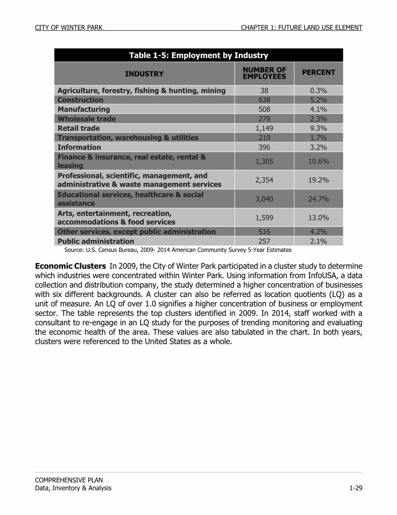
CITY OF WINTER PARK CHAPTER 1: FUTURE LAND USE ELEMENT
COMPREHENSIVE PLAN Data, Inventory & Analysis 1-29
Table 1-5: Employment by Industry
INDUSTRY NUMBER OF EMPLOYEES PERCENT
Agriculture, forestry, fishing & hunting, mining 38 0.3% Construction 638 5.2% Manufacturing 508 4.1% Wholesale trade 279 2.3% Retail trade 1,149 9.3% Transportation, warehousing & utilities 210 1.7% Information 396 3.2% Finance & insurance, real estate, rental & leasing 1,305 10.6%
Professional, scientific, management, and administrative & waste management services 2,354 19.2%
Educational services, healthcare & social assistance 3,040 24.7%
Arts, entertainment, recreation, accommodations & food services 1,599 13.0%
Other services, except public administration 516 4.2% Public administration 257 2.1%
Source: U.S. Census Bureau, 2009- 2014 American Community Survey 5-Year Estimates Economic Clusters In 2009, the City of Winter Park participated in a cluster study to determine which industries were concentrated within Winter Park. Using information from InfoUSA, a data collection and distribution company, the study determined a higher concentration of businesses with six different backgrounds. A cluster can also be referred as location quotients (LQ) as a unit of measure. An LQ of over 1.0 signifies a higher concentration of business or employment sector. The table represents the top clusters identified in 2009. In 2014, staff worked with a consultant to re-engage in an LQ study for the purposes of trending monitoring and evaluating the economic health of the area. These values are also tabulated in the chart. In both years, clusters were referenced to the United States as a whole.
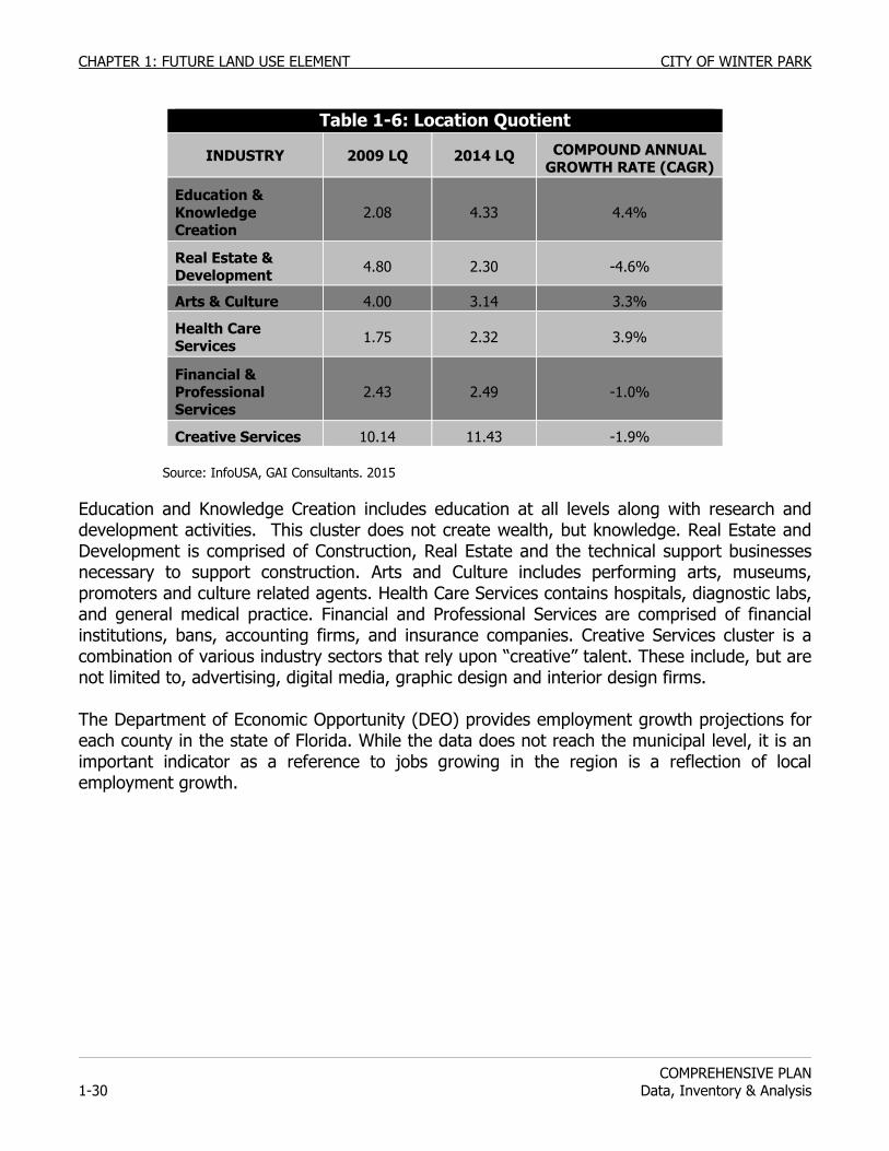
CHAPTER 1: FUTURE LAND USE ELEMENT CITY OF WINTER PARK
COMPREHENSIVE PLAN
1-30 Data, Inventory & Analysis
Table 1-6: Location Quotient
INDUSTRY 2009 LQ 2014 LQ COMPOUND ANNUAL GROWTH RATE (CAGR)
Education & Knowledge Creation
2.08 4.33 4.4%
Real Estate & Development 4.80 2.30 -4.6%
Arts & Culture 4.00 3.14 3.3%
Health Care Services 1.75 2.32 3.9%
Financial & Professional Services
2.43 2.49 -1.0%
Creative Services 10.14 11.43 -1.9% Source: InfoUSA, GAI Consultants. 2015 Education and Knowledge Creation includes education at all levels along with research and development activities. This cluster does not create wealth, but knowledge. Real Estate and Development is comprised of Construction, Real Estate and the technical support businesses necessary to support construction. Arts and Culture includes performing arts, museums, promoters and culture related agents. Health Care Services contains hospitals, diagnostic labs, and general medical practice. Financial and Professional Services are comprised of financial institutions, bans, accounting firms, and insurance companies. Creative Services cluster is a combination of various industry sectors that rely upon “creative” talent. These include, but are not limited to, advertising, digital media, graphic design and interior design firms. The Department of Economic Opportunity (DEO) provides employment growth projections for each county in the state of Florida. While the data does not reach the municipal level, it is an important indicator as a reference to jobs growing in the region is a reflection of local employment growth.
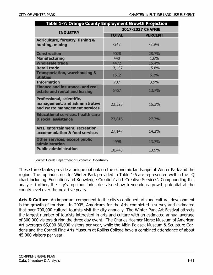
CITY OF WINTER PARK CHAPTER 1: FUTURE LAND USE ELEMENT
COMPREHENSIVE PLAN Data, Inventory & Analysis 1-31
Table 1-7: Orange County Employment Growth Projection
INDUSTRY 2017-2027 CHANGE
TOTAL PERCENT Agriculture, forestry, fishing & hunting, mining -243 -8.9%
Construction 9028 28.7% Manufacturing 440 1.6% Wholesale trade 4472 15.4% Retail trade 13,437 15.8% Transportation, warehousing & utilities 1512 6.2%
Information 707 3.9% Finance and insurance, and real estate and rental and leasing 6457 13.7%
Professional, scientific, management, and administrative and waste management services
22,328 16.3%
Educational services, health care & social assistance 23,816 27.7%
Arts, entertainment, recreation, accommodation & food services 27,147 14.2%
Other services, except public administration 4998 13.7%
Public administration 10,445 13.9% Source: Florida Department of Economic Opportunity These three tables provide a unique outlook on the economic landscape of Winter Park and the region. The top industries for Winter Park provided in Table 1-6 are represented well in the LQ chart including ‘Education and Knowledge Creation’ and ‘Creative Services’. Compounding this analysis further, the city’s top four industries also show tremendous growth potential at the county level over the next five years. Arts & Culture An important component to the city’s continued arts and cultural development is the growth of tourism. In 2005, Americans for the Arts completed a survey and estimated that over 700,000 cultural tourists visit the city annually. The Winter Park Art Festival attracts the largest number of tourists interested in arts and culture with an estimated annual average of 300,000 visitors during the three day event. The Charles Hosmer Morse Museum of American Art averages 65,000-80,000 visitors per year, while the Albin Polasek Museum & Sculpture Gar-dens and the Cornell Fine Arts Museum at Rollins College have a combined attendance of about 45,000 visitors per year.
CHAPTER 1: FUTURE LAND USE ELEMENT CITY OF WINTER PARK
COMPREHENSIVE PLAN
1-32 Data, Inventory & Analysis
As regional tourism becomes more a part of its economic foundation, it is important of the city monitor, support, and assist that it continues to provide as an effective means for commerce for the public and business communities. The city will provide this through several means including exploring economic benchmarks, conduct studies when appropriate, and assemble demographic profiles as quantitative tools for sound decision making.
Public Infrastructure The ability of a community to attract and sustain economic development depends on the quality of the community’s infrastructure. Infrastructure includes roadways, drainage, stormwater facilities, water and wastewater systems, electric distribution, solid waste collection, schools, parks, and any other facility that is basic in daily life. These facilities support community life and economic development. Other elements of this plan provide details on City activities in these areas. However, it is important to understand that economic development touches each one. City Partnership & Intergovernmental Coordination The City of Winter Park works with many public and private entities for the purposes of leveraging resources and for the mutual benefit of those partners and the community. It is critical that the city work with these partners to ensure the economic sustainability of the community is provided in a balanced manner consistent with the charm and unique quality of life of the city and the growing demand for resources of the region. With assistance from the City and Orange County, the Winter Park Community Redevelopment Agency participates in many social and economic programs/projects to better the community. These include, but are not limited to, housing rehabilitation, commercial structure improvements, streetscaping, parking and traffic initiatives, and downtown event support. These projects work to elevate the public landscape in order to drive an attractive atmosphere which ultimately enables commerce and a positive business environment. The City also works with local, regional, and state organizations towards the same end. This includes both financial and resource based programming. Local groups, both internal and external such as advisory boards, the Chamber of Commerce and Park Avenue Merchants Association (PAMA) to develop, promote, and sustain a strong business climate in the community. The city partners on several events with the Chamber and PAMA including marketing support, special event facilitation, and use of city facilities. Regionally, the city is a member of the Metro Orlando Economic Development Commission (EDC). The EDC works with the city on a limited basis to provide business attraction opportunities. In spite of the limited development potential on new land, the city is further benefitted by company leaders purchasing homes in the city in lieu of not relocating their business within city limits. The city, from time to time, also looks to leverage state programming through Enterprise Florida and the Department of Economic Opportunity when applicable.
CITY OF WINTER PARK CHAPTER 1: FUTURE LAND USE ELEMENT
COMPREHENSIVE PLAN Data, Inventory & Analysis 1-33
ANNEXATION RESERVE AREA ISSUES Winter Park has had general annexation policies as part of the Comprehensive Plan since its original adoption in 1976. These policies established criteria for properties to be eligible for annexation and procedures of coordination with Orange County. These policies are reaffirmed within the goals, policies and objectives section of this element. Generally, Winter Park has a limited annexation policy. The first priority for annexations is the islands or enclaves surrounded completely by the City. The second priority is growth expansions to the City limits which are logical in aligning the City limits and avoiding service duplications. The coordination with Orange County involves providing notice of all potential annexations.
Winter Park shall actively pursue the annexation of enclaves as these additions would provide economies and efficiencies in service delivery to both Orange County and the City of Winter Park.
Winter Park should pursue the annexation of growth areas adjacent to the City limits when it would align municipal boundaries, unite sections of the City, or generate revenues in excess of the cost of providing services while providing City control over the quality and scale of development. The City may consider adjusting the park level-of-service standard as necessary to accommodate such annexations as these residents are already using existing City parklands. An annexation cost-benefit study shall be required for all annexations of growth areas through referendums.
Winter Park shall provide written notice to Orange County in advance of any annexation requests to be considered by the City Commission. The City shall coordinate all annexations and designations of annexation reserve areas with Orange County and adjacent municipalities of Orlando and Maitland, and Eatonville. The coordination with Orange County and municipalities adjacent to proposed annexation areas shall include coordinating land use and service delivery issues at an early stage in the annexation process as well as formal notice of all potential annexations consistent with state law.
ANNEXATION RESERVE AREA DESCRIPTIONS Annexation Reserve Area #1: Lake Killarney This ARA, comprised of 198 acres, is located north of Fairbanks Avenue and is bounded by Lake Killarney on the north. The area contains approximately 1,300 residents and is primarily designated Low-Density Residential to the south side of the Lake, Office to the west along Wymore, and the Killarney Elementary School, located to the southwest near I-4, is designated Institutional. Annexation of this area would extend the City limits of Winter Park to I-4, the major barrier west of the City limits. The City undertook an annexation referendum in May 2003. It was not approved by the residents. Under state law there is a two year waiting period for any further annexation attempts. The City intends to implement the sanitary sewer and streetscape improvement program for the Fairbanks Avenue Corridor before the City undertakes another annexation referendum for this neighborhood.
CHAPTER 1: FUTURE LAND USE ELEMENT CITY OF WINTER PARK
COMPREHENSIVE PLAN
1-34 Data, Inventory & Analysis
Annexation Reserve Area #2: Kentucky/Oglesby This ARA, comprised of 13± acres and accommodating approximately 40 residents, is located south of Fairbanks Avenue, north of Oglesby Avenue, west of I-4 and east of Clay Street. Annexation of this area would fill in the gap between the existing City limits and the City limits of Orlando to the south. The area south of Fairbanks Avenue is designated Commercial on the Orange County Future Land Use Map, and Low-Density Residential south of the Commercial designation to Oglesby Avenue. The commercial area contains uses ranging in intensity from office to auto paint and body to light manufacturing. The area to the south west contains primarily single-family dwellings. Annexation Reserve Area #3: Lawndale This ARA, containing 50± acres and approximately 300 residents, is located south of Minnesota Avenue, north of Harmon Avenue, west of Clay Street, and east of Wisconsin Avenue with a section extending north of Minnesota following Jackson Avenue west of Nicolet Avenue and east of Harold Avenue. Annexation of this area would fill in the gap between the existing City limits and the City limits of Orlando to the south. On the Orange County Future Land Use Map the properties south of Minnesota Avenue are predominately designated Low-Medium Density Residential and the area contains primarily single family dwelling units with some duplex units. The properties north of Minnesota Avenue are designated Commercial and include a mixture of uses from car repair, paint and auto body shops to light manufacturing land uses. Annexation Reserve Area #4: Stonehurst This ARA, comprised of 5.6 acres and containing approximately 30 persons located in 13 single-family dwellings, is located in the south section of the City, south of Lake Virginia, north of Glenridge Way, between Lauren Road and Winchester Drive. This area is an unincorporated Orange County enclave, completely surrounded by the City limits of Winter Park. Provision of Services & Impact of Annexations As part of this ARA study, the City of Winter Park has analyzed its ability to provide the full range of its municipal services to these areas and has concluded that the annexation of the five ARA’s detailed in this Comprehensive Plan can be accomplished with minimal impact on Winter Park’s workforce and budget. Altogether, the annexation of these areas four areas would add 227 acres to the City of Winter Park. The annexation of the four areas would increase Winter Park's population by approximately 1,670 persons. AREAS OF CRITICAL STATE CONCERN No area within or adjacent to the City of Winter Park is located within a designated Area of Critical State Concern.
CITY OF WINTER PARK CHAPTER 1: FUTURE LAND USE ELEMENT
COMPREHENSIVE PLAN Data, Inventory & Analysis 1-35
ANALYSIS OF URBAN SPRAWL ISSUES The City of Winter Park has developed as an urban area and is virtually built out. The City has no urban sprawl and its design standards shall continue to foster the best management principles and practices of urban design which are the antithesis of urban sprawl. Nevertheless, the City shall continue to enforce the following policies to avoid urban sprawl:
1. Avoid premature or poorly planned conversion of developed or undeveloped
land to strip centers. 2. Prevent development of areas or uses that that are not functionally related to
the predominant land uses on adjacent land. 3. Preclude development of areas or uses that fail to maximize the use of existing
public facilities. 4. Avoid leapfrog/scattered development or ribbon /strip commercial
development patterns. ANALYSIS OF WINTER PARK PLANNING AREAS Analysis of land use characteristics and population provides a general description of the built and natural environments defining Winter Park, but it does not describe specific land use and development conditions unique to its neighborhoods, communities, or small areas, all of which contribute to Winter Park’s unique character. In order for this Comprehensive Plan to be a more useful tool in the City’s growth management process, detailed analysis of 13 smaller planning areas are presented. The boundaries of Planning Areas A through M are illustrated on Maps FLUM-1-12 through FLUE-1-24 which are part of each planning area’s profile. Evaluation of each area includes a profile summary that provides a brief description of existing land use classifications and identifies community streets, bus routes, and parks serving the planning area. City parks appearing in each profile are located within the planning area or outside of it but within a half mile distance of its residential neighborhoods. Planning issues relevant to the planning area, including ongoing redevelopment activities, are then addressed. Some planning areas may address additional subjects or issues that help describe development conditions and characteristics. A summary of existing land use and acreage for each planning area is presented in Table 1-8.
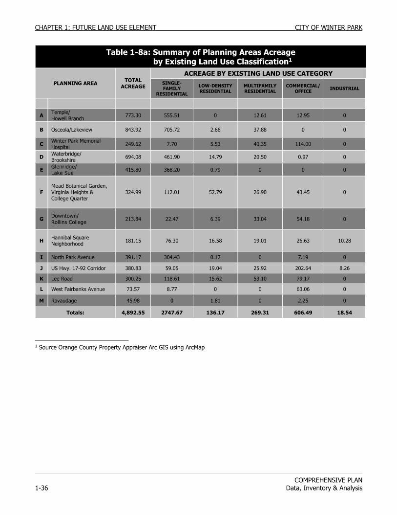
CHAPTER 1: FUTURE LAND USE ELEMENT CITY OF WINTER PARK
COMPREHENSIVE PLAN
1-36 Data, Inventory & Analysis
1 Source Orange County Property Appraiser Arc GIS using ArcMap
Table 1-8a: Summary of Planning Areas Acreage by Existing Land Use Classification1
PLANNING AREA TOTAL ACREAGE
ACREAGE BY EXISTING LAND USE CATEGORY SINGLE-FAMILY
RESIDENTIAL
LOW-DENSITY RESIDENTIAL
MULTIFAMILY RESIDENTIAL
COMMERCIAL/OFFICE INDUSTRIAL
A Temple/ Howell Branch 773.30 555.51 0 12.61 12.95 0
B Osceola/Lakeview 843.92 705.72 2.66 37.88 0 0
C Winter Park Memorial Hospital 249.62 7.70 5.53 40.35 114.00 0
D Waterbridge/ Brookshire 694.08 461.90 14.79 20.50 0.97 0
E Glenridge/ Lake Sue 415.80 368.20 0.79 0 0 0
F Mead Botanical Garden, Virginia Heights & College Quarter
324.99 112.01 52.79 26.90 43.45 0
G Downtown/ Rollins College 213.84 22.47 6.39 33.04 54.18 0
H Hannibal Square Neighborhood 181.15 76.30 16.58 19.01 26.63 10.28
I North Park Avenue 391.17 304.43 0.17 0 7.19 0
J US Hwy. 17-92 Corridor 380.83 59.05 19.04 25.92 202.64 8.26
K Lee Road 300.25 118.61 15.62 53.10 79.17 0
L West Fairbanks Avenue 73.57 8.77 0 0 63.06 0
M Ravaudage 45.98 0 1.81 0 2.25 0
Totals: 4,892.55 2747.67 136.17 269.31 606.49 18.54
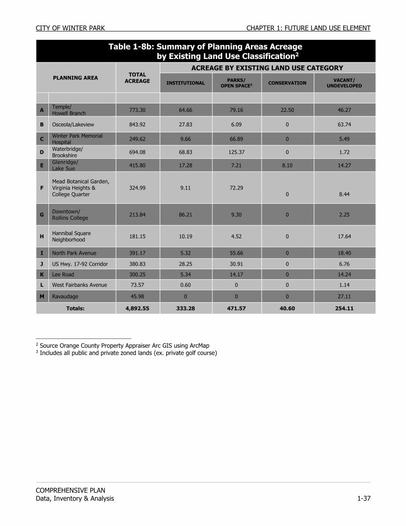
CITY OF WINTER PARK CHAPTER 1: FUTURE LAND USE ELEMENT
COMPREHENSIVE PLAN Data, Inventory & Analysis 1-37
Table 1-8b: Summary of Planning Areas Acreage by Existing Land Use Classification2
PLANNING AREA TOTAL ACREAGE
ACREAGE BY EXISTING LAND USE CATEGORY
INSTITUTIONAL PARKS/ OPEN SPACE3 CONSERVATION VACANT/
UNDEVELOPED
A Temple/ Howell Branch 773.30 64.66 79.16 22.50 46.27
B Osceola/Lakeview 843.92 27.83 6.09 0 63.74
C Winter Park Memorial Hospital 249.62 9.66 66.89 0 5.49
D Waterbridge/ Brookshire 694.08 68.83 125.37 0 1.72
E Glenridge/ Lake Sue 415.80 17.28 7.21 8.10 14.27
F Mead Botanical Garden, Virginia Heights & College Quarter
324.99 9.11 72.29 0
8.44
G Downtown/ Rollins College 213.84 86.21 9.30 0 2.25
H Hannibal Square Neighborhood 181.15 10.19 4.52 0 17.64
I North Park Avenue 391.17 5.32 55.66 0 18.40
J US Hwy. 17-92 Corridor 380.83 28.25 30.91 0 6.76
K Lee Road 300.25 5.34 14.17 0 14.24
L West Fairbanks Avenue 73.57 0.60 0 0 1.14
M Ravaudage 45.98 0 0 0 27.11
Totals: 4,892.55 333.28 471.57 40.60 254.11
2 Source Orange County Property Appraiser Arc GIS using ArcMap 3 Includes all public and private zoned lands (ex. private golf course)
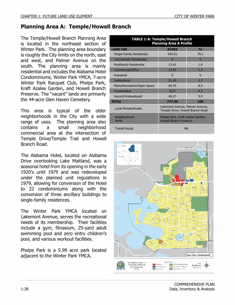
CHAPTER 1: FUTURE LAND USE ELEMENT CITY OF WINTER PARK
COMPREHENSIVE PLAN
1-38 Data, Inventory & Analysis
Planning Area A: Temple/Howell Branch The Temple/Howell Branch Planning Area is located in the northeast section of Winter Park. The planning area boundary is roughly the City limits on the north, east and west, and Palmer Avenue on the south. The planning area is mainly residential and includes the Alabama Hotel Condominiums, Winter Park YMCA, 7-acre Winter Park Racquet Club, Phelps Park, Kraft Azalea Garden, and Howell Branch Preserve. The “vacant” lands are primarily the 44-acre Glen Haven Cemetery. This area is typical of the older neighborhoods in the City with a wide range of uses. The planning area also contains a small neighborhood commercial area at the intersection of Temple Drive/Temple Trail and Howell Branch Road. The Alabama Hotel, located on Alabama Drive overlooking Lake Maitland, was a seasonal hotel from its opening in the early 1920's until 1979 and was redeveloped under the planned unit regulations in 1979, allowing for conversion of the Hotel to 22 condominiums along with the conversion of three ancillary buildings to single-family residences. The Winter Park YMCA located on Lakemont Avenue, serves the recreational needs of its membership. Their facilities include a gym, fitnasium, 25-yard adult swimming pool and zero entry children’s pool, and various workout facilities. Phelps Park is a 5.99 acre park located adjacent to the Winter Park YMCA.
TABLE 1-A: Temple/Howell Branch Planning Area A Profile
LAND USE ACRES % Single-Family Residential 545.51 70.1
Low-Density Residential 0 0
Multifamily Residential 12.61 1.6
Commercial/Office 12.95 1.7
Industrial 0 0
Institutional 21.16 2.7
Parks/Recreation/Open Space 65.70 8.5
Conservation 32.5 4.2
Vacant/Undeveloped 46.27 5.9
TOTAL 777.30 100
Local Streets/Roads Lakemont Avenue, Palmer Avenue, Temple Drive, Howell Branch Road
Neighborhood Parks
Phelps Park, Kraft Azalea Garden, Howell Branch Preserve
Transit Route NA
CITY OF WINTER PARK CHAPTER 1: FUTURE LAND USE ELEMENT
COMPREHENSIVE PLAN Data, Inventory & Analysis 1-39
Kraft Azalea Garden is a 5.26-acre passive park with 1,200 feet of frontage on Lake Maitland along with an exedra. Adjacent to the park is the Rollins College crew-house. The Winter Park Racquet Club is a private club on Lake Maitland including a clubhouse, lake front access boat ramp, seven tennis courts, and a Junior Olympic swimming pool. Howell Branch Preserve is a 10.69 acre parcel acquired to provide additional parkland and to preserve the wetlands as part of the City’s conservation policy. The park features a large playground, bathroom facilities, nature preserve and a mile long fit-trail. In the future, the City desires to acquire an additional 22.5 acres of wetlands in the Howell Creek floodplain to complete the acquisition of the environmentally sensitive lands. The additional wetlands are located in this area are north of Howell Branch Road and south of Lake Waumpi. Most of this area became a part of the municipality under a special legislative act in 1949 that required municipal sewage treatment facilities to be located inside the city limits of the city that owned the facility. Because the Winter Park Sewage Treatment Plant was constructed at this time, the City’s wastewater treatment plant was placed inside the city limits pursuant to the legislative act. Over time, adjacent areas were annexed into this satellite area, creating contiguous borders with the larger portion of the City to the south. The planning area also contains the City Public Works Compound property which is approximately 60 acres in size. This property is also used by the Winter Park Utilities as a headquarters area and as a sanitary sewer major pumping station to the Iron Bridge Regional Treatment Plant. This property also contains a large area of vacant land, the majority of which is wetlands and flood prone, thus making it undevelopable under City and state regulations. Those 38.84 acres of conservation lands are included in the City’s parks and conservation lands inventory. The Madeline Avenue annexation in 2004 eliminated a previous enclave of unincorporated Orange County land. Additionally, a significant portion of the residences within this area were added via annexation in 2002 with the Howell Branch and North Lakemont annexations which added 354 acres to the City. The North Lakemont annexation also added Glen Haven Cemetery. A previous annexation in 1989 added 38 of the single-family homes within the Tuscany Place/Via Sienna neighborhood. The planning area also contains a small neighborhood commercial area at the intersection of Temple Drive and Howell Branch Road that includes several restaurants, personal service uses and a gas station/convenience store, effectively serving the surrounding residents with essential needs thereby allowing them to avoid the City’s more intense commercial areas. Winter Park Fire Station 62 is located north of Howell Branch and serves this portion of the City. Originally an Orange County station, Station 62 was transferred to the City. Three sides of this planning area border four different jurisdictions. The City of Maitland lies to the west and north, unincorporated Orange County to the west, Casselberry to the northeast and unincorporated Seminole County to the east. Land use adjacent to this planning area is predominantly single-family residential. Land use compatibility currently exists with land uses
CHAPTER 1: FUTURE LAND USE ELEMENT CITY OF WINTER PARK
COMPREHENSIVE PLAN
1-40 Data, Inventory & Analysis
in adjacent jurisdictions. Streets within residential areas of this planning area connect with streets extending into residential areas in adjacent Maitland and in unincorporated Seminole County. PLANNING ISSUES: Temple/Howell Branch Transportation. The primary issues confronting this planning area are cut-through traffic along Temple Drive. Cut-through traffic is an issue within the planning area because Temple Drive serves as the most convenient connection to areas south of Planning Area A. Traffic originating from the City of Maitland and other areas northwest or northeast of the City use Temple Drive to travel from Howell Branch Road to Palmer Avenue and to southern destinations. Streets serving residential areas within the planning area extend into residential communities located in Maitland and unincorporated Seminole County. Traffic generated from these adjacent residential areas impact streets within residential areas of this planning area, contributing to cut-through traffic issues. Preservation of Residential Land Use. To ensure that neighborhood commercial development does not expand into the surrounding residential area the City generally prohibits rezonings from residential to office on the south side of Howell Branch Road from the Maitland city limits to Temple Drive. Howell Branch Road. The City also has policies to discourage new or used car sales, auto repair businesses, re-sale stores or pawn shops, tattoo businesses, service/gas stations, fast food businesses and convenience stores in the commercial areas located on Howell Branch Road, as this portion of Howell Branch Road is a gateway into the City of Winter Park. Comprehensive Plan amendments from Residential to Office/Professional on the south side of Howell Branch Road from the New Life Evangelical Church (1720 Howell Branch Road) east to the Seminole County line should only be considered in context of newly constructed one-story office buildings and not the conversion of existing homes. Recreation. The City should preserve and expand the number and extent of recreational trails and greenways in the City to provide public access and enjoyment especially of the stream and waterfront environments along the City’s Howell Creek properties.
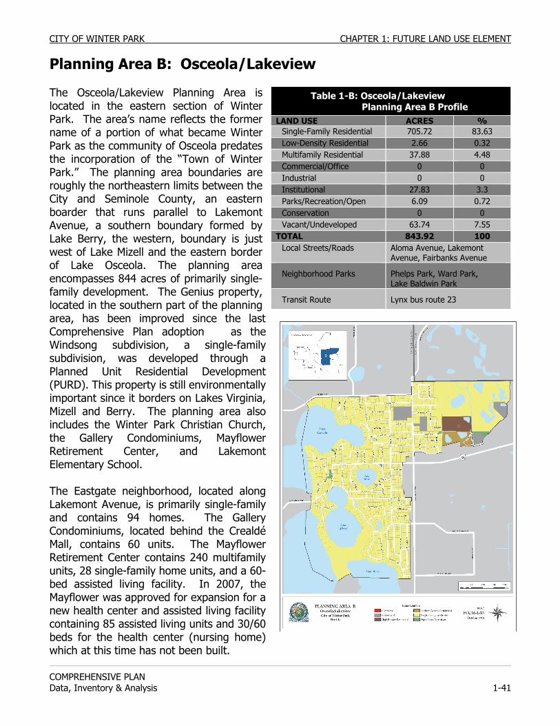
CITY OF WINTER PARK CHAPTER 1: FUTURE LAND USE ELEMENT
COMPREHENSIVE PLAN Data, Inventory & Analysis 1-41
Planning Area B: Osceola/Lakeview The Osceola/Lakeview Planning Area is located in the eastern section of Winter Park. The area’s name reflects the former name of a portion of what became Winter Park as the community of Osceola predates the incorporation of the “Town of Winter Park.” The planning area boundaries are roughly the northeastern limits between the City and Seminole County, an eastern boarder that runs parallel to Lakemont Avenue, a southern boundary formed by Lake Berry, the western, boundary is just west of Lake Mizell and the eastern border of Lake Osceola. The planning area encompasses 844 acres of primarily single-family development. The Genius property, located in the southern part of the planning area, has been improved since the last Comprehensive Plan adoption as the Windsong subdivision, a single-family subdivision, was developed through a Planned Unit Residential Development (PURD). This property is still environmentally important since it borders on Lakes Virginia, Mizell and Berry. The planning area also includes the Winter Park Christian Church, the Gallery Condominiums, Mayflower Retirement Center, and Lakemont Elementary School. The Eastgate neighborhood, located along Lakemont Avenue, is primarily single-family and contains 94 homes. The Gallery Condominiums, located behind the Crealdé Mall, contains 60 units. The Mayflower Retirement Center contains 240 multifamily units, 28 single-family home units, and a 60-bed assisted living facility. In 2007, the Mayflower was approved for expansion for a new health center and assisted living facility containing 85 assisted living units and 30/60 beds for the health center (nursing home) which at this time has not been built.
Table 1-B: Osceola/Lakeview Planning Area B Profile LAND USE ACRES %
Single-Family Residential 705.72 83.63 Low-Density Residential 2.66 0.32 Multifamily Residential 37.88 4.48 Commercial/Office 0 0 Industrial 0 0 Institutional 27.83 3.3 Parks/Recreation/Open 6.09 0.72 Conservation 0 0 Vacant/Undeveloped 63.74 7.55
TOTAL 843.92 100 Local Streets/Roads Aloma Avenue, Lakemont
Avenue, Fairbanks Avenue
Neighborhood Parks Phelps Park, Ward Park, Lake Baldwin Park
Transit Route Lynx bus route 23
CHAPTER 1: FUTURE LAND USE ELEMENT CITY OF WINTER PARK
COMPREHENSIVE PLAN
1-42 Data, Inventory & Analysis
Since 1987, 62 acres have been added to this area through annexation by the City. The largest addition was the 29.8-acre Mayflower Retirement Center, voluntarily annexed in 1987. Gallery Condominiums, and Crealdé Art Center and Mall were annexed in 1988 by referendum, adding 31.4 acres more to this area of the City of Winter Park. The Lake Sylvan area is located in the northeast section of Planning Area B, north of Aloma Avenue and west of Lakemont Avenue. The area is comprised almost entirely of single-family homes, Lakemont Elementary School and several neighborhood parks. It is typical of the older neighborhoods in the City with a wide range of housing types and sizes. The age of housing in this neighborhood places many structures at risk of demolition and replacement by new construction. The newest and largest new subdivision in the City, called Windsong straddles a natural conservation easement between Lake Mizell, Lake Virginia and Lake Berry. This tract is split between two planning areas, Planning Area B and Planning Area D. This tract was previously known as the Genius Property. After careful planning by the planning staff, the Planning & Zoning Board and the City Commission, this area has developed into an upscale single-family neighborhood that is almost fully developed. Approximately 43 acres located between Lakes Mizell and Berry are currently private, unplatted and vacant. This property is owned by the Elizabeth Morse Genius Foundation. The remaining portion of the area includes established single-family homes, generally east of Phelps Avenue and west of the City boundary (Winter Park Pines Neighborhood). PLANNING ISSUES: Osceola/Lakeview Transportation. Within Planning Area B, the Aloma/Fairbanks Avenue corridor carries high traffic volume and serves as a link between south-central Seminole County, Interstate 4 (I-4) and northern Orlando. Cut-through traffic also is an issue due to the rush hour congestion on the major arterials. Preservation of Residential Land Use. The Windsong community is committed to its single-family land use and density. When this subdivision was planned, the City required the developer to provide neighborhood recreation areas which are private and owned by the Windsong’s home owners association. For most of the residents living between Lakemont and Balmoral Road/Phelps Avenue, both Ward Park and Lake Baldwin Park are less than a half mile away. Within Windsong, the east side borders office buildings along Lakemont Avenue in the Winter Park Hospital Planning Area C. It is important to maintain this demarcation line between homes and offices to prevent the spread of offices. Land use compatibility and building scale within the adjacent office area are issues that should be evaluated. This line of demarcation has been held effectively in place since 1971, enforcing the land use philosophy of protecting residential areas from office encroachment.
CITY OF WINTER PARK CHAPTER 1: FUTURE LAND USE ELEMENT
COMPREHENSIVE PLAN Data, Inventory & Analysis 1-43
The City should preserve the mid-block demarcation between Lakemont and Harris Avenues to prohibit office encroachment into the residential area. No rezonings, from residential to office or commercial should occur north of Edwin Boulevard along Lakemont Avenue or on properties fronting on Edwin Boulevard. Preservation of Natural Features. If the Genius Preserve property is proposed for development, the City should endeavor to preserve the natural features of this property by requiring the maximum amount of open space, by requiring all new roads to be public including the existing sections of the private portion of Genius Drive south of Henkel Circle within Windsong, and by requiring that lot sizes conform to the minimum standards of the lakefront lots within Windsong which average 1.5 acres in size with frontages on the lake and street of a minimum of 150 feet wide. Any required dedications of park land or open space coincident with the Genius property development should target natural and environmentally sensitive areas and should provide for physical or visual public access to one or more of the lakes. The required storm water retention facilities should not be located in areas of significant environmental importance. If the property is platted for development and a road network is created, the City should consider utilizing some of the roadway stubs leading to the property unless traffic safety problems are created or new traffic cut-through routes would be created. Roadway links between the southern and northern sections of the Genius property should be precluded so as to avoid a cut-through traffic route from Glenridge Way to Mizell Avenue or Phelps Avenue. Access to Northshore Park. The City should not relinquish its public access rights and public usage of the Northshore Park (north shore of Lake Berry) within Windsong. Preservation of Density. Within Lake Sylvan, the area between Phelps and Palmer Avenues, and Elizabeth Drive and Bryan Avenue is zoned R-1A. However, the character of this area conforms to R-1AA standards and should be considered a candidate for rezoning to R-1AA to prevent the subdivision of lots into smaller lots that do not conform to the neighborhood’s standards. Character of Intersection of Aloma and Lakemont Avenues. In order to promote redevelopment and improve the image at the gateway intersection of Aloma and Lakemont, the City should consider allow the rezoning of the properties on the south side of Aloma at 1810 and 1820 Aloma Avenue, but only together as a new one-story office building with masonry wall screening adjacent residential neighbors and not as the conversion of the existing homes to office.
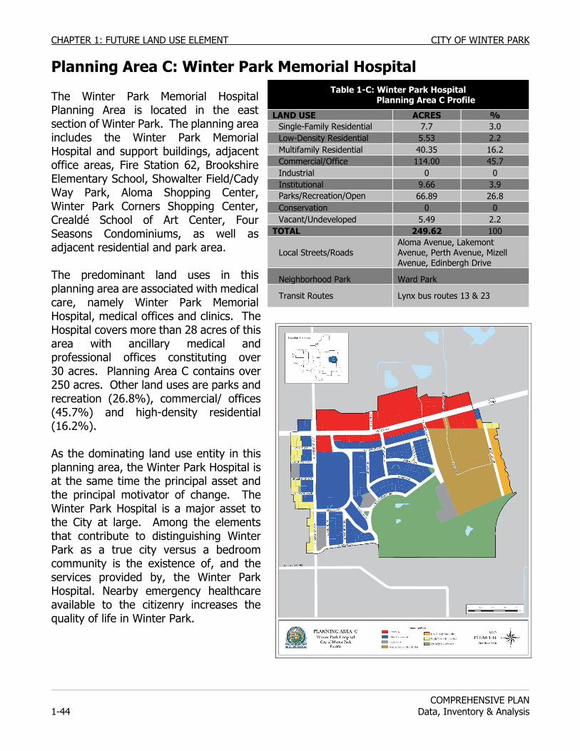
CHAPTER 1: FUTURE LAND USE ELEMENT CITY OF WINTER PARK
COMPREHENSIVE PLAN
1-44 Data, Inventory & Analysis
Planning Area C: Winter Park Memorial Hospital The Winter Park Memorial Hospital Planning Area is located in the east section of Winter Park. The planning area includes the Winter Park Memorial Hospital and support buildings, adjacent office areas, Fire Station 62, Brookshire Elementary School, Showalter Field/Cady Way Park, Aloma Shopping Center, Winter Park Corners Shopping Center, Crealdé School of Art Center, Four Seasons Condominiums, as well as adjacent residential and park area. The predominant land uses in this planning area are associated with medical care, namely Winter Park Memorial Hospital, medical offices and clinics. The Hospital covers more than 28 acres of this area with ancillary medical and professional offices constituting over 30 acres. Planning Area C contains over 250 acres. Other land uses are parks and recreation (26.8%), commercial/ offices (45.7%) and high-density residential (16.2%). As the dominating land use entity in this planning area, the Winter Park Hospital is at the same time the principal asset and the principal motivator of change. The Winter Park Hospital is a major asset to the City at large. Among the elements that contribute to distinguishing Winter Park as a true city versus a bedroom community is the existence of, and the services provided by, the Winter Park Hospital. Nearby emergency healthcare available to the citizenry increases the quality of life in Winter Park.
Table 1-C: Winter Park Hospital Planning Area C Profile
LAND USE ACRES % Single-Family Residential 7.7 3.0 Low-Density Residential 5.53 2.2 Multifamily Residential 40.35 16.2 Commercial/Office 114.00 45.7 Industrial 0 0 Institutional 9.66 3.9 Parks/Recreation/Open 66.89 26.8 Conservation 0 0 Vacant/Undeveloped 5.49 2.2
TOTAL 249.62 100
Local Streets/Roads Aloma Avenue, Lakemont Avenue, Perth Avenue, Mizell Avenue, Edinbergh Drive
Neighborhood Park Ward Park
Transit Routes Lynx bus routes 13 & 23
CITY OF WINTER PARK CHAPTER 1: FUTURE LAND USE ELEMENT
COMPREHENSIVE PLAN Data, Inventory & Analysis 1-45
The Winter Park Hospital facilities are spread over approximately 30 acres of property within the planning area. The Hospital also owns other properties in the vicinity that are contemplated for future redevelopment activities. The Winter Park Hospital is an essential element of the City and its growth and redevelopment is to be encouraged either under existing zoning codes or through the creation of a new Medical Arts zoning district. On March 25, 2005, the Winter Park Hospital Master Plan was conceptually approved by the Planning and Zoning Commission and the City Commission. This Master Plan shows a complete redevelopment of the existing Hospital facilities to occur on the current Hospital property. One major outcome of the expansion/renovation is the conversion of shared rooms to private rooms and the reorientation of the emergency room. Additionally, plans have been prepared for additional and enhanced parking for staff and visitors.
Ward Park has 67.25 acres that is dedicated for baseball/softball fields, tennis courts, soccer/multi-purpose fields, and a football/track stadium and a handicapped-accessible playground made possible by a community-build program and with corporate sponsorships. From the athletic facilities to the playground to the trail through the wetlands, Ward Park is one of the most diverse parks in the city.
Annexation increased the size of this planning area in the late 1980’s-early 1990’s. The Gallery Condominiums and the Crealdé Art Center and Mall were annexed in 1988 by referendum adding another 31.4 acres to the City. The neighborhood to the east of Winter Park Hospital was annexed in 1992. PLANNING ISSUES: Winter Park Memorial Hospital Transportation An issue concerns the traffic and parking problems that accompany expansions of the Hospital or related office buildings. A major component of the Medical Arts district will be to insure adequate parking is provided for the facilities of the Winter Park Hospital campus. Another related goal if for the City to continue working with Orange County to enhance the Cady Way Bike Trail. Preservation of Residential Character & Future Rezoning This planning area, as previously mentioned, is primarily dominated by the activities of the Winter Park Hospital and by doctors and other medical professionals who desire to have their offices located near the hospital. This has caused a demand for more office space in the area, evident in the rezoning focus of residential to office. To resist the growth in offices on the west side of Lakemont Avenue and to preserve the City's residential areas intact, in 1971 the City set up a demarcation line west of Lakemont Avenue to preserve that residential area (see also Planning Area B Planning Issues). This has forced the demand for office space to the east and south of the hospital. With the annexation of the neighborhood east of the Winter Park Hospital, the City inherited Orange County’s Comprehensive Plan Future Land Use Policies that designated the entire neighborhood as a viable candidate for rezonings to Office or Low Density Residential. The stipulation, however, is that these rezonings are to occur in a logical west to east transition, moving from the Hospital properties eastward. The continuing challenge for the City during the past decade has been to manage this change according to that logical transition and to do so
CHAPTER 1: FUTURE LAND USE ELEMENT CITY OF WINTER PARK
COMPREHENSIVE PLAN
1-46 Data, Inventory & Analysis
without negatively affecting the remaining single-family character of the neighborhood. As a result of this Comprehensive Plan, the City should conduct a neighborhood study of the neighborhood east of the Winter Park Memorial Hospital to get input from the citizens and business owners as to the direction they want to see their neighborhood grow.
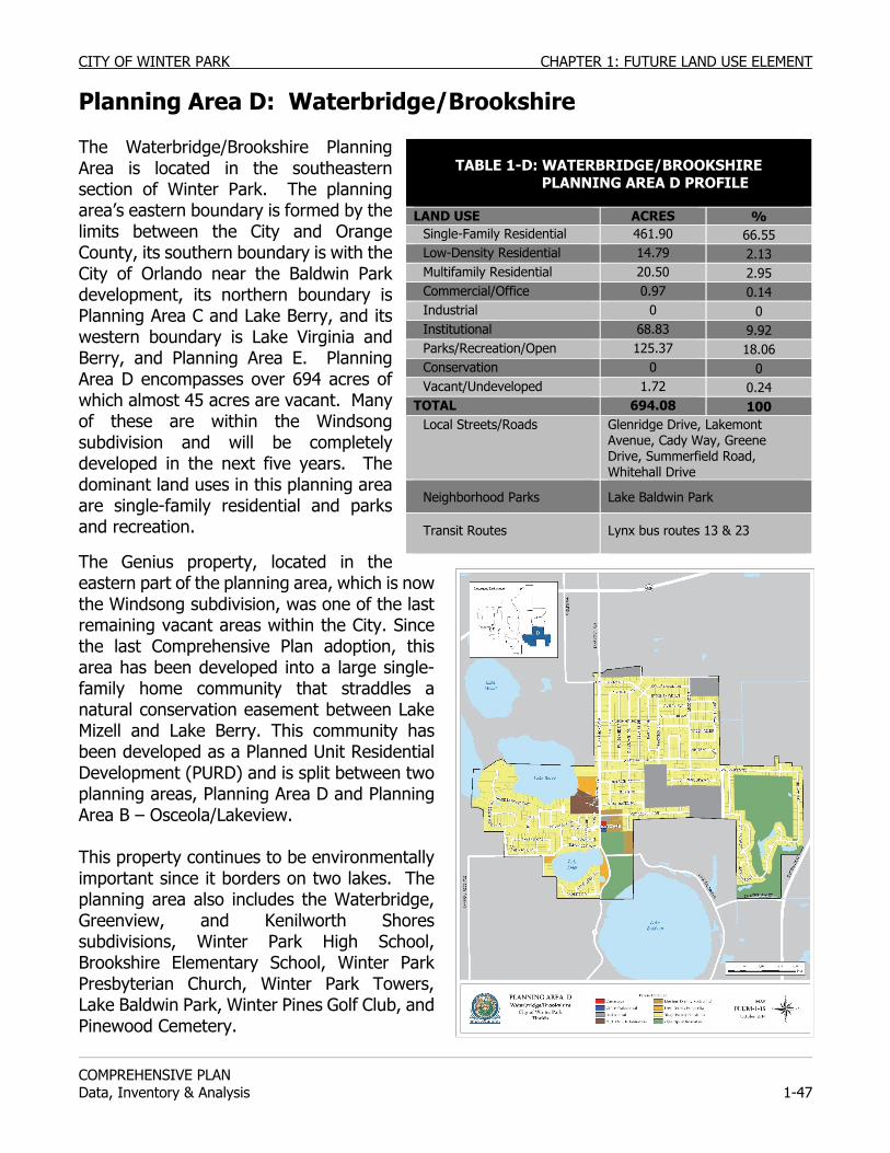
CITY OF WINTER PARK CHAPTER 1: FUTURE LAND USE ELEMENT
COMPREHENSIVE PLAN Data, Inventory & Analysis 1-47
Planning Area D: Waterbridge/Brookshire The Waterbridge/Brookshire Planning Area is located in the southeastern section of Winter Park. The planning area’s eastern boundary is formed by the limits between the City and Orange County, its southern boundary is with the City of Orlando near the Baldwin Park development, its northern boundary is Planning Area C and Lake Berry, and its western boundary is Lake Virginia and Berry, and Planning Area E. Planning Area D encompasses over 694 acres of which almost 45 acres are vacant. Many of these are within the Windsong subdivision and will be completely developed in the next five years. The dominant land uses in this planning area are single-family residential and parks and recreation.
The Genius property, located in the eastern part of the planning area, which is now the Windsong subdivision, was one of the last remaining vacant areas within the City. Since the last Comprehensive Plan adoption, this area has been developed into a large single-family home community that straddles a natural conservation easement between Lake Mizell and Lake Berry. This community has been developed as a Planned Unit Residential Development (PURD) and is split between two planning areas, Planning Area D and Planning Area B – Osceola/Lakeview. This property continues to be environmentally important since it borders on two lakes. The planning area also includes the Waterbridge, Greenview, and Kenilworth Shores subdivisions, Winter Park High School, Brookshire Elementary School, Winter Park Presbyterian Church, Winter Park Towers, Lake Baldwin Park, Winter Pines Golf Club, and Pinewood Cemetery.
TABLE 1-D: WATERBRIDGE/BROOKSHIRE
PLANNING AREA D PROFILE
LAND USE ACRES % Single-Family Residential 461.90 66.55 Low-Density Residential 14.79 2.13 Multifamily Residential 20.50 2.95 Commercial/Office 0.97 0.14 Industrial 0 0 Institutional 68.83 9.92 Parks/Recreation/Open 125.37 18.06 Conservation 0 0 Vacant/Undeveloped 1.72 0.24
TOTAL 694.08 100 Local Streets/Roads Glenridge Drive, Lakemont
Avenue, Cady Way, Greene Drive, Summerfield Road, Whitehall Drive
Neighborhood Parks Lake Baldwin Park
Transit Routes Lynx bus routes 13 & 23
CHAPTER 1: FUTURE LAND USE ELEMENT CITY OF WINTER PARK
COMPREHENSIVE PLAN
1-48 Data, Inventory & Analysis
The Waterbridge development was one of the first developments to take place under the City's Planned Unit Residential Development (PURD) regulations in 1979. The community is comprised 52.8 acres and is made up of three distinct types of residential living areas. A standard single-family subdivision section is located in the western portion of the site, with the southern section of the site containing 46 zero-lot line single-family lots, and with the northeastern section containing 42 townhouse units. The neighborhood also contains open space and recreation areas which resulted from the surplus land area made available by the permitting of the smaller lots for the zero-lot line homes and townhouses. As a whole, the Waterbridge development conforms to single-family residential building density. The Winter Park Towers property is located north of the Waterbridge neighborhood along Lakemont Avenue. The property encompasses 32.5 acres and includes a 305-unit high-rise building and two planned unit areas. The first planned unit development, Village I, was developed in 1977, and contains 20 apartment units and 20 single-family attached homes. The second planned unit development, Village II, was developed in 1983. This area contains a 21-unit mix of single-family and single-family attached homes. The Winter Park Towers property is split by a 20-foot wide strip of property reaching from Lakemont Avenue to Lake Berry that is owned by the Kenilworth Shores Neighborhood Association. The Winter Park Towers is anticipating expansion of their services on site to include additional parking, assisted living and care facilities. This planning area includes a 1-acre area at Lakemont Avenue and Lanier Court which is used for commercial and office purposes. The zoning for this area was established by Orange County and was maintained after the area was annexed into the City. The First Christian Church of Winter Park owns property and a building here adjacent to the northwest side of Pinewood Cemetery. The Waterbridge/Brookshire Planning Area also contains two multifamily residential areas. One is located along Woodcrest Drive and has 32 condominium units, the non-profit institutional headquarters of the Girl Scouts and a church. The second is located on Glenridge Way to the east of Pinewood Cemetery, and has 78 units in the Tara House apartments. The Winter Pines subdivision and the Greenview subdivision, located in the southern portion of the planning area, surround the Winter Pines Golf Course’s 82.9 acres. These two subdivisions are composed entirely of single-family homes. The Winter Pines Golf Club is a privately owned 18-hole golf course and driving range that is open for public use. Also located on the property are supportive uses such as a clubhouse and pro shop. Brookshire Elementary School is 10.3 acres in size and enrolled 516 students in the 2007-08 school year. Its adjusted FISH Capacity is for 442 students. The Orange County School Board has scheduled a renovation project for Brookshire Elementary School to be completed in 2013; the school’s adjusted FISH capacity will not increase. Winter Park High School is 50 acres in size and includes school buildings, tennis courts, a swimming pool, a track, and playing fields. The school enrolled 3,200 students in the 2004-05
CITY OF WINTER PARK CHAPTER 1: FUTURE LAND USE ELEMENT
COMPREHENSIVE PLAN Data, Inventory & Analysis 1-49
school year which was almost a thousand students over the schools then capacity. New building construction and renovations were completed in 2007 and increased Winter Park High School’s FISH capacity to 3,329. Planning Areas D and E border Baldwin Park, a planned community built in the City of Orlando on the former Orlando Naval Training Center property. Blue Jacket Park is a 75-acre park that Winter Park citizens can take advantage of given its close proximity. The City owns several portions of this planning area including the Pineywood Cemetery, the Lake Spier frontage along Glenridge Way, and Lake Baldwin Park. Lake Baldwin Park encompasses 23.3 acres and has 900 feet of frontage on Lake Baldwin. This park contains a public beach, boat launching ramp and dock, picnic tables and shelters, nature trail, dog park, and restroom facilities. Transportation Lynx Route 23 serves this planning area along Lakemont Avenue and Glenridge Way. Within the Waterbridge area, all homes are within a half mile to bus stops along both roads. Route 23 provides access to other areas within Winter Park as well as regional connections through transfer stations near SR 50 to the south, Denning Drive at the Winter Park Village, and SR 434 in Altamonte Springs. Within the Brookshire area an estimated 55% of the homes are within a half mile walking distance of Lakemont Avenue. Lynx Route 41 is available along SR 436 to the east. Route 41 follows SR 436 from the Orlando International Airport to downtown Apopka. This bus route is more than a half mile walk for all residents in the Brookshire area, and can be as much as a one mile walk for the furthest residents. Only residents in Winter Pines homes along the north end of the neighborhood are within a half mile walking distance to SR 436. Most homes are less than a half mile linear distance to a bus route on SR 436, but access to the east is blocked off by private property. The Cady Way Trail is available to all residents within the Planning Area. The trail is directly accessible from homes within the Winter Pines community whose homes border the trail. Residents have access to the trail from Cady Way, Banchory Road, and Summerfield Road. For residents in the Brookshire and Waterbridge neighborhoods, the trail is less accessible. PLANNING ISSUES: Waterbridge/Brookshire Transportation Traffic calming, pass through traffic along Lakemont Avenue and Glenridge Way, and traffic impacts from Winter Park High School and the Baldwin Park neighborhood will be issues affecting this planning area. In addition to traffic generated by the two schools, traffic volumes and travel speed along Lakemont Avenue can be an issue for residents on the western edge of this neighborhood. The City should coordinate with the Orange County School Board and with Orange County regarding a connection of a pedestrian connection linking the east end of Woodcrest Drive with Cady Way Trail. The City should also consider coordination with Orange County regarding extension of the Cady Way Trail southward with a connection to SR 436. Such connections would create better opportunities to walk or bike to commercial and recreation areas to the south and east.
CHAPTER 1: FUTURE LAND USE ELEMENT CITY OF WINTER PARK
COMPREHENSIVE PLAN
1-50 Data, Inventory & Analysis
Compatibility Land use compatibility with future development in the Baldwin Park community should continue to be monitored by Winter Park. Should the Orange County School Board decide to expand or make improvements to Winter Park High School or Brookshire Elementary School, they should coordinate with the City as outlined in the 2008 Amended Interlocal Public School Facility Planning and Implementation of Concurrency Agreement. These improvements should also conform to Winter Park zoning regulations and standards. Land use compatibility with unincorporated development east of this neighborhood should not be an issue. All adjacent development is single-family residential, with the Cady Way Trail serving as a buffer between the two residential areas. Land use compatibility issues can arise from development of the vacant parcel abutting the eastern boundary of Winter Pines. Land use compatibility issues could also arise from redevelopment of any of the multifamily apartment complexes occurring along the neighborhood’s eastern and southern boundaries. Adjacent parcels east and south of the neighborhood lie within unincorporated Orange County. Winter Park will need to coordinate with Orange County regarding land use compatibility and development buffers adjacent to Winter Pines. Winter Pines Golf Club Before the Winter Pines area was developed, the land was characterized by a high water table, mucky soils and occasional wet areas. Therefore, proper drainage is an area of concern since the exposed land has limited drainage ability. If the 90 acres of the Winter Pines Golf Club were developed, drainage problems would increase dramatically. Due to these drainage considerations and the overall character of the neighborhood, preservation of the golf course is essential in maintaining the character and property values of this area. Another land use issue consists of the expansion of the golf course and clubhouse. Should such an expansion be proposed, the effects on the surrounding residential areas should be considered, with expansion to be permitted only if there is no negative effect upon the surrounding residential area. Lake Baldwin Park The City should annually monitor and assess the biological and environmental condition of Lake Baldwin Park adjacent to Lake Baldwin due to the dog park and should manage its future based on those findings.
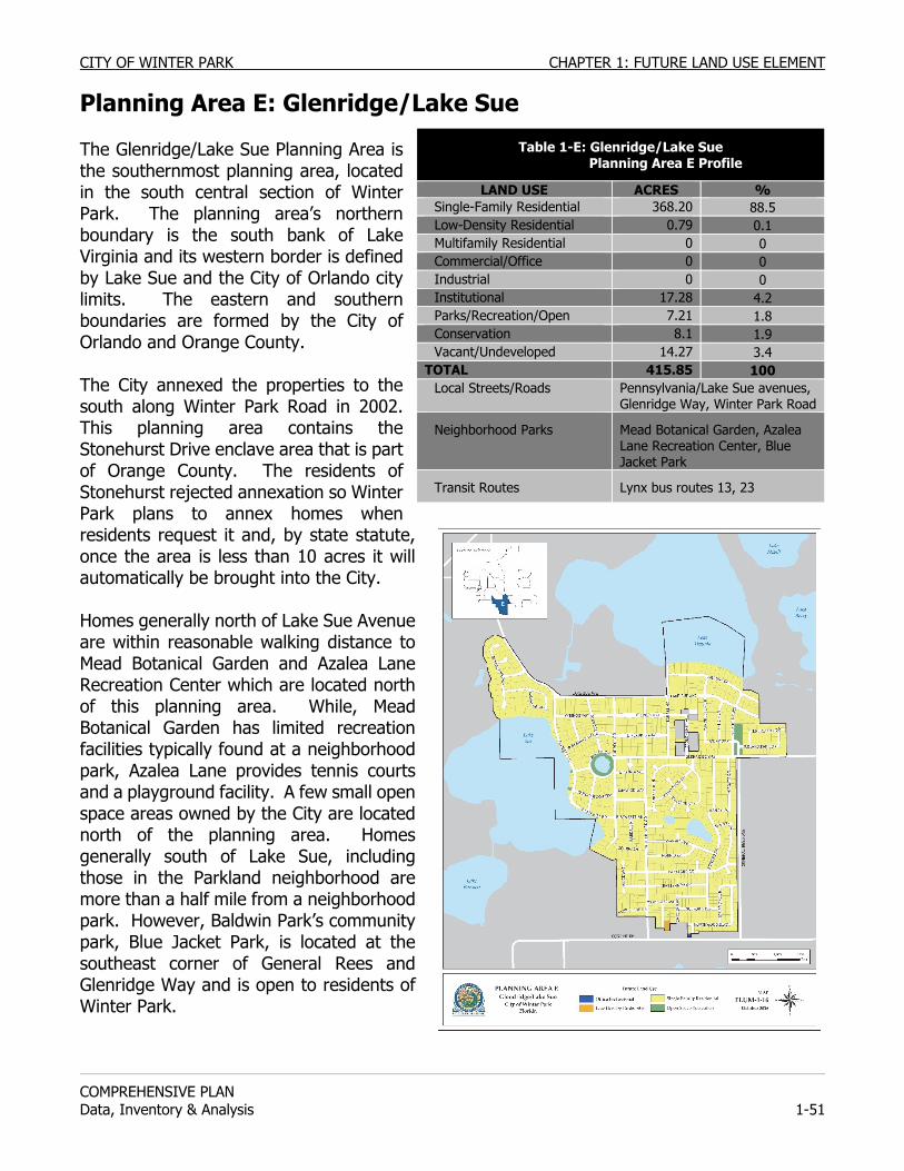
CITY OF WINTER PARK CHAPTER 1: FUTURE LAND USE ELEMENT
COMPREHENSIVE PLAN Data, Inventory & Analysis 1-51
Planning Area E: Glenridge/Lake Sue The Glenridge/Lake Sue Planning Area is the southernmost planning area, located in the south central section of Winter Park. The planning area’s northern boundary is the south bank of Lake Virginia and its western border is defined by Lake Sue and the City of Orlando city limits. The eastern and southern boundaries are formed by the City of Orlando and Orange County. The City annexed the properties to the south along Winter Park Road in 2002. This planning area contains the Stonehurst Drive enclave area that is part of Orange County. The residents of Stonehurst rejected annexation so Winter Park plans to annex homes when residents request it and, by state statute, once the area is less than 10 acres it will automatically be brought into the City. Homes generally north of Lake Sue Avenue are within reasonable walking distance to Mead Botanical Garden and Azalea Lane Recreation Center which are located north of this planning area. While, Mead Botanical Garden has limited recreation facilities typically found at a neighborhood park, Azalea Lane provides tennis courts and a playground facility. A few small open space areas owned by the City are located north of the planning area. Homes generally south of Lake Sue, including those in the Parkland neighborhood are more than a half mile from a neighborhood park. However, Baldwin Park’s community park, Blue Jacket Park, is located at the southeast corner of General Rees and Glenridge Way and is open to residents of Winter Park.
Table 1-E: Glenridge/Lake Sue Planning Area E Profile
LAND USE ACRES % Single-Family Residential 368.20 88.5 Low-Density Residential 0.79 0.1 Multifamily Residential 0 0 Commercial/Office 0 0 Industrial 0 0 Institutional 17.28 4.2 Parks/Recreation/Open 7.21 1.8 Conservation 8.1 1.9 Vacant/Undeveloped 14.27 3.4
TOTAL 415.85 100 Local Streets/Roads Pennsylvania/Lake Sue avenues,
Glenridge Way, Winter Park Road
Neighborhood Parks Mead Botanical Garden, Azalea Lane Recreation Center, Blue Jacket Park
Transit Routes Lynx bus routes 13, 23
CHAPTER 1: FUTURE LAND USE ELEMENT CITY OF WINTER PARK
COMPREHENSIVE PLAN
1-52 Data, Inventory & Analysis
Unincorporated Orange County and the City of Orlando abut the southern boundary of this planning area. The land use adjacent to the City in this area is single-family residential, with commercial and office uses along Corrine Drive. The Glenridge/Lake Sue Planning Area E contains a total of 332 single-family units. There are 105 single-family homes in Timberlane Shores, 94 in Quail Hollow, and 133 in Windsong South (71 lots in Elizabeth’s Walk, 40 in Preserve Point, and 22 in Lookout Landing). Since the last update of the comprehensive plan, the Glenridge Middle School site has been vacated and the school relocated to a new facility across the street in the City of Orlando’s Baldwin Park community. The City of Winter Park purchased the property from the Orange County Public School Board and bids were submitted for the development of a single-family neighborhood with the proposed project to consist of 41 single-family homes and approximately 2.5 acres of park land. A developer was successful in this endeavor and the home sites are now under construction with the 2.5 acres of park dedicated to the City. Additionally, .28 acres were also purchased by the developer and dedicated to the City in Planning Area I to complete the park land acre concurrency requirement. Transportation Residents within the planning area have access to Lynx bus routes 23 and 13 which follow General Rees Road and continue eastward on Glenridge Way. These routes provide access to other areas within Winter Park as well as regional connections through transfer stations near SR 50 to the south, Denning Drive at the Winter Park Village, and along SR 434 in Altamonte Springs. PLANNING ISSUES: Glenridge/Lake Sue Transportation. Traffic impacts generated by the Winter Park 9th Grade Center, located in Planning Area F, will continue to affect roads near or leading to this school. Traffic conditions and volumes will continue to be an issue along Winter Park Avenue, Lake Sue Avenue, and Pennsylvania Avenue. Traffic impacts generated from the new Glenridge Middle School in Orlando will need to be monitored.
The City should discourage traffic through residential areas. The road block on Virginia Drive should be maintained as it prohibits cut-through traffic in the Timberlane Shores neighborhood. With Baldwin Park providing new homes, shopping, and employment areas, traffic impacts within the Glenridge community will be a concern that must be monitored regularly. Prior to the construction of the Baldwin Park community, the City entered into an interlocal agreement with the City of Orlando regarding transportation impacts on City streets. Land use compatibility between development in the Baldwin Park master planned community, which is in the City of Orlando, and the Glenridge planning area community will be an issue that Winter Park will need to monitor during the further development of Baldwin Park. Land Use and Annexation. Implementation of an annexation reserve area agreement with Orange County covering potential southward annexations and annexation of the Stonehurst Drive area is of importance. The Stonehurst Drive enclave area is surrounded by the City of
CITY OF WINTER PARK CHAPTER 1: FUTURE LAND USE ELEMENT
COMPREHENSIVE PLAN Data, Inventory & Analysis 1-53
Winter Park and should be annexed to maintain a continuous area of government services and control. Another land use issue is the subdivision of several parcels within the planning area. These include a parcel along Old Winter Park Road and parcels at the north end of the Stonehurst Drive area. These parcels should be subdivided according to R-1AA standards to conform with the surrounding zoning and single-family homes. Residential Buffer The City should work with the City of Orlando and the neighborhoods adjacent to General Rees Boulevard to create an attractive wall and landscape buffer to ensure privacy and safeguard residential property values while improving the aesthetics of the corridor and providing opportunities for on-street parking as over flow to the recreation events at Blue Jacket Park. Preservation of Single-Family Density The City should preserve single-family residential land use in this planning area. Smooth Transition from Residential to Non-Residential The City should consider rezonings from R-1A to R-2 for residential properties directly adjacent to the commercial and institutional properties on the north side of Corrine Drive as a transitional zone on East End Avenue, Hammerlin Avenue and Northwood Boulevard. Preservation of Wetlands The City should continue to implement and enforce regulations protecting the wetland areas from development.
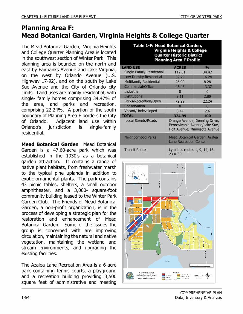
CHAPTER 1: FUTURE LAND USE ELEMENT CITY OF WINTER PARK
COMPREHENSIVE PLAN
1-54 Data, Inventory & Analysis
Planning Area F: Mead Botanical Garden, Virginia Heights & College Quarter
The Mead Botanical Garden, Virginia Heights and College Quarter Planning Area is located in the southwest section of Winter Park. This planning area is bounded on the north and east by Fairbanks Avenue and Lake Virginia, on the west by Orlando Avenue (U.S. Highway 17-92), and on the south by Lake Sue Avenue and the City of Orlando city limits. Land uses are mainly residential, with single- family homes comprising 34.47% of the area, and parks and recreation, comprising 22.24%. A portion of the south boundary of Planning Area F borders the City of Orlando. Adjacent land use within Orlando’s jurisdiction is single-family residential. Mead Botanical Garden Mead Botanical Garden is a 47.60-acre park which was established in the 1930’s as a botanical garden attraction. It contains a range of native plant habitats, from freshwater marsh to the typical pine uplands in addition to exotic ornamental plants. The park contains 43 picnic tables, shelters, a small outdoor amphitheater, and a 3,000- square-foot community building leased to the Winter Park Garden Club. The Friends of Mead Botanical Garden, a non-profit organization, is in the process of developing a strategic plan for the restoration and enhancement of Mead Botanical Garden. Some of the issues the group is concerned with are improving circulation, maintaining the natural and native vegetation, maintaining the wetland and stream environments, and upgrading the existing facilities. The Azalea Lane Recreation Area is a 6-acre park containing tennis courts, a playground and a recreation building providing 3,500 square feet of administrative and meeting
Table 1-F: Mead Botanical Garden, Virginia Heights & College Quarter Historic District Planning Area F Profile
LAND USE ACRES % Single-Family Residential 112.01 34.47 Low-Density Residential 52.79 16.24 Multifamily Residential 26.90 8.28 Commercial/Office 43.45 13.37 Industrial 0 0 Institutional 9.11 2.80 Parks/Recreation/Open 72.29 22.24 Conservation 0 0 Vacant/Undeveloped 8.44 2.6
TOTAL 324.99 100 Local Streets/Roads Orange Avenue, Denning Drive,
Pennsylvania Avenue/Lake Sue, Holt Avenue, Minnesota Avenue
Neighborhood Parks Mead Botanical Garden, Azalea Lane Recreation Center
Transit Routes Lynx bus routes 1, 9, 14, 16, 23 & 39
CITY OF WINTER PARK CHAPTER 1: FUTURE LAND USE ELEMENT
COMPREHENSIVE PLAN Data, Inventory & Analysis 1-55
space. Both Mead Botanical Garden and Azalea Lane Recreation Area are less than half mile distance to all residents within the planning area. The area to the north of Mead Botanical Garden is consists primarily of multifamily residential. This area contains two large condominium complexes consisting of the Winter Park Gardens Condominiums with 127 units, and the Mead Botanical Garden Condominiums with 71 units. The multifamily area to the east of Azalea Lane Recreation Center is zoned Medium Density Residential (R-3). This area contains 89 units. The area to the north of this is Low Density Residential (R-2) and contains 53 units. This area is experiencing redevelopment, from small single-family homes to townhouses and duplexes. Garden Acres, the single-family and multifamily area to the west of Mead Botanical Garden, is a homogeneous neighborhood. This neighborhood contains 121 units, mainly single-family residences, with multifamily units scattered through it. The Lake Midget area has a combination of single-family houses, duplexes, apartments and condominiums. This residential area, which contains some affordable housing, is totally surrounded by major commercial and office development located along Fairbanks Avenue and Orange Avenue. Recreational land use nearby includes Lake Midget Park and Harper-Shepherd Field. Lake Midget Park is a 1.4-acre mini-park located around Lake Midget. Harper-Shepherd Field is 5 acres in size and contains the Rollins College baseball field, locker rooms, and Harold Alfond Stadium. Commercial and office properties occupy approximately 13% of the land use in this planning area. These properties are located along Fairbanks Avenue from New York Avenue to Orange Avenue. Virginia Heights Virginia Heights encompasses the single-family homes, a few duplexes and smaller cluster housing development are located on the Western portion. abutting Planning Area E’s northern boundary and Lake Virginia’s southwestern shoreline. College Quarter Winter Park’s first designated Historic District is located immediately southwest of Winter Park’s Central Business District and is bounded by Lake Virginia and Rollins Collage to the east and south, Holt Avenue to the north, and Pennsylvania Avenue and the CSX railroad tracks to the west. The Winter Park High School Ninth Grade Center is almost 10 acres in size. Built in 1927, this facility originally served as the Winter Park High School. The campus is eligible for listing on the National Register of Historic Places and for designation as a local historic landmark on the Winter Park Register of Historic Places. When the current Winter Park High School was built in 1969, this facility became the Winter Park Junior High School, and became the Ninth Grade Center in the fall of 1987. Renovations are planned to begin 2009. The residential area in the northeast corner of this planning area is adjacent to Rollins College, the Winter Park Ninth High School Grade Center, and the commercial and office properties. All
CHAPTER 1: FUTURE LAND USE ELEMENT CITY OF WINTER PARK
COMPREHENSIVE PLAN
1-56 Data, Inventory & Analysis
of these uses impact the residential area through traffic and noise. To assist in preserving the residential properties on the north side of Holt Avenue an administrative rezoning to R-2 was undertaken in 1980. This was done to prohibit the use of these properties in conjunction with the commercial properties, and to prohibit parking lots that connect Fairbanks Avenue to Holt Avenue, thereby increasing traffic on residential streets. To preserve the character of the single-family area, the division line between the low-density residential area and single-family residential area should be maintained. In 2003, the College Quarter Historic District was established. The historic district contains 155 residential properties. The district is significant for its collection of circa 1920’s architectural styles and for is association with the Florida Land Boom period of development in Winter Park. Several city parks are within a half mile distance to the residents within the College Quarter neighborhood. These parks include Mead Botanical Garden, Azalea Lane Recreation Center, Martin Luther King, Jr. Park, Central Park, and the Winter Park Community Center. However, the latter three parks are located north of Fairbanks Avenue; one of the City’s most heavily traveled roads. A. J. Hanna Park is a third of an acre mini-park with landscaping and a seating area. The College Quarter Conceptual Master Plan created in 1998 recommended expanding the park to create a more usable neighborhood gathering place. Due to roadway constraints, this has not proved feasible; however the City acquired a small lakefront area on Lakeview Drive that could be enhanced to provide a passive gathering place if the city and neighborhood wish to explore this option. Transportation Proximity of the College Quarter neighborhood to the Central Business District, Rollins College, the Winter Park Ninth Grade Center, and commercial and employment activities along Fairbanks Avenue and Orange Avenue allow neighborhood residents to walk or bike to work, stores, or entertainment activities. With Rollins College located at its eastern perimeter and the Ninth Grade Center located inside its neighborhood area, cut-through traffic creates public safety issues for residents. Streets within this neighborhood can also be used by non-local traffic to by-pass Fairbanks Avenue or Orange Avenue. Several Lynx bus routes follow U.S. 17-92, Orange Avenue, and Fairbanks Avenue. Each route connects to the regional transfer stations, including the Denning Drive transfer stop, where other routes connect to locations throughout metropolitan Orlando. All bus routes along these streets are less than a half mile walking distance for all residents within the Mead Botanical Garden, Virginia Heights and College Quarter Planning Area. PLANNING ISSUES: Mead Botanical Garden, Virginia Heights & College Quarter Transportation As in many neighborhoods in Winter Park, traffic will cut through residential areas when community road become congested. In response to intensive redevelopment in the Baldwin Park neighborhood in Orlando and the resulting potential for increased traffic, the City repaved portions of Winter Park Road, Lake Sue Drive and South Pennsylvania Avenue with brick
CITY OF WINTER PARK CHAPTER 1: FUTURE LAND USE ELEMENT
COMPREHENSIVE PLAN Data, Inventory & Analysis 1-57
to calm traffic to speeds appropriate for residential areas. Portions of Lakeview Drive in Virginia Heights and the College Quarter were repaved with brick, and Holt Avenue through the College Quarter neighborhood to Rollins College was repaved with brick to calm traffic as recommended in the College Quarter Conceptual Master Plan. A. J. Hanna Way will be repaved with brick in association with plans to replace the existing on street parking conditions at the western edge of the Rollins College campus with an off street parking area on the campus resulting in improved vehicle and pedestrian safety. The City should continue to promote comprehensive traffic calming for safe multi-modal transportation.
Street signage and way-finding programs should direct traffic to major destinations including Rollins College, Park Avenue and their attractions via Orlando, Orange and Fairbanks Avenues and Denning Drive rather than through the residential neighborhoods of the planning area.
Future commercial or mixed-use redevelopment along Orange and Fairbanks Avenues and Denning Drive should provide for primary access from those roadways to reduce the impact on the adjacent residential areas.
A CSX rail line currently traverses this planning area. The rail line carries freight and would also serve the proposed Central Florida Commuter Rail. Study is necessary; however the rail line right of way through this planning area might offer an opportunity to serve as part of an inter-city bicycle trail.
The Cady Way to Mead Botanical Garden bicycle route passes through the planning area. A portion of the route along Minnesota Avenue in this area has striped bicycle lanes. The posted speeds along the remaining portion of the route through this planning area allow bicycle traffic to share the roadway with automobiles.
Preservation of Affordable Housing As the Lake Midget residential area is an island amid commercial and office properties, from time to time the pressure to rezone is created by land use conflicts. The City is endeavoring to preserve Lake Midget’s residential area and should consider a small area study to address planning solutions to remedy these conflicts. Recognized as an “island of affordable housing,” the City may also want to consider coordination with Orange County and the Florida Department of Community Affairs on joint participation in the planning, formation, and funding of an “affordable housing neighborhood.” Such a program would include implementation of and neighborhood park development. In addition, the City may want to coordinate with Orange County to include the Lake Midget residential area as a target for housing assistance, affordable housing, renovation, and revitalization programs. Winter Park needs to preserve such moderate cost housing areas in order to implement the policies of the Housing Element regarding affordable housing.
The City should preserve and protect the residential land use along Denning Drive in this Planning Area from office and commercial encroachment. In furtherance of this policy, the City
CHAPTER 1: FUTURE LAND USE ELEMENT CITY OF WINTER PARK
COMPREHENSIVE PLAN
1-58 Data, Inventory & Analysis
should not rezone the existing residential properties on Denning Drive to office or any other non-residential zoning. Preservation of Single-Family Density The Garden Acres neighborhood has a Future Land Use mix of single-family residential and Low-Density Residential. Before 1979, the Low-Density Residential area had been zoned R-3, but conformed better to Low Density Residential standards. The majority of the units were single-family and only two properties were large enough to be developed under the R-3 standards. This Low-Density Residential section is experiencing redevelopment activity. Since there is ample Low-Density Residential land not fully developed, this activity should not create a demand for more low-density properties. The single-family area to the south should be preserved from higher intensity. Preservation of Wetlands This planning area contains one of the prime wetland areas in the City. This wetland is located along the Howell Branch Creek between Lake Virginia and Lake Sue. Currently, half of the area is in public ownership and half is owned privately. This wetland has a Conservation designation on the Future Land Use Map and should continue to be protected from development under existing zoning and floodplain regulations. Recreation & Open Space The City should preserve the recreational land use of Lake Midget Park, Azalea Lane and Harper Shepherd Field.
The City should encourage and support the restoration and preservation of Mead Botanical Garden. Promotion of Office Land Use Within this planning area, many of the commercial and office properties were previously zoned industrial. However, since the businesses character of this area is no longer tied to the adjacent railroad line, it was decided in 1981, as part of the Comprehensive Plan Update, to rezone the properties for office uses. This area still contains one remaining industrial property. The City should consider rezoning this property since it is vacant and located adjacent to the residential neighborhood. Orange Avenue is considered one of the important gateways into Winter Park due to the connection to U.S. 17-92 and I-4. A major policy decision of the 1976 Comprehensive Plan was that this entrance should be aesthetically improved by having a predominance of office properties. Although this area is now mostly offices, there are still some notable commercial exceptions. The City should continue to implement land use controls that encourage office uses along this portion of Orange Avenue between U.S. 17-92 and Denning Drive. This area would lend itself to mixed-use applications as the former Progress Energy properties and former Holler automobile businesses redevelop. The City has prohibited certain business types within this Mead Botanical Garden Planning Area including new or used car sales, auto repair businesses, resale stores or pawn shops, tattoo businesses, adult oriented businesses, fast food businesses and convenience stores, as this portion of Orange Avenue is a gateway into the City of Winter Park.
CITY OF WINTER PARK CHAPTER 1: FUTURE LAND USE ELEMENT
COMPREHENSIVE PLAN Data, Inventory & Analysis 1-59
Preservation of Historic Character In 2003, property owners within the College Quarter demonstrated their commitment to protect the historic character and pedestrian orientation of their neighborhood by voting to become a historic district as recommended in the College Quarter Conceptual Master Plan and the City’s survey of historic resources. The redevelopment, additions and renovations that have occurred under the guidance of the City’s Historic Preservation Commission since the historic district’s creation have been well received.
In 2008, the Virginia Heights neighborhood petitioned the Historic Preservation Commission to begin to explore the process of becoming a designated historic district.
The City should encourage the creation of historic districts and individual history property designations with this planning area. Winter Park may want to evaluate potential funding mechanism such as special taxing districts or special neighborhood improvement districts to generate revenue to assist with infrastructure and improvement costs.
Ninth Grade Center If the Orange County School Board (OCSB) is planning a comprehensive renovation of the Ninth Grade Center campus that will begin by the end of 2010. The historic Administration building and Gymnasium will be preserved. The campus playing field, popular for joint use by youth leagues and Rollins College will be restored for use after campus renovations. The City will coordinate with the OCSB for regarding campus improvement compatibility with the surrounding neighborhood, infrastructure, stormwater and traffic flow improvements. Holt Avenue Expansions of commercial or office developments or their parking on properties fronting on Holt Avenue should be prohibited. Access driveways from commercial or office development on Fairbanks Avenue on to Holt Avenue should also be prohibited.
The City will preserve the division line between low-density residential and single-family residential between Holt and Fairbanks Avenues.
Former “Ahik’s” Property at 510 Holt Ave. Redevelopment of the commercial former “Ahik’s” property at the northeast corner of the intersection of Pennsylvania and Holt Avenues should be sensitive to traffic generated onto Holt Avenue. The scale and height of buildings fronting on Holt Avenue should be limited to 2 stories (30 feet) in height as a compatible transition to the adjacent R-2 development standards. In addition, the redevelopment of the property should be compatible with the adjacent historic district. The City will preserve the division line between the commercial property and the adjacent Low-Density Residential property. Notwithstanding the heights and densities permitted or conditionally permitted under the existing commercial land use designations, the redevelopment of the commercial “Ahik” property (as mentioned above) should be concentrated along the railroad and Fairbanks Avenue frontages while maintaining the natural features of the site, especially specimen trees.
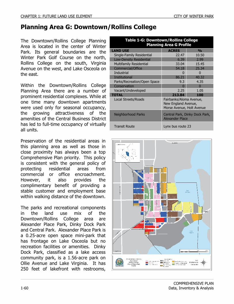
CHAPTER 1: FUTURE LAND USE ELEMENT CITY OF WINTER PARK
COMPREHENSIVE PLAN
1-60 Data, Inventory & Analysis
Planning Area G: Downtown/Rollins College The Downtown/Rollins College Planning Area is located in the center of Winter Park. Its general boundaries are the Winter Park Golf Course on the north, Rollins College on the south, Virginia Avenue on the west, and Lake Osceola on the east. Within the Downtown/Rollins College Planning Area there are a number of prominent residential complexes. While at one time many downtown apartments were used only for seasonal occupancy, the growing attractiveness of the amenities of the Central Business District has led to full-time occupancy of virtually all units. Preservation of the residential areas in this planning area as well as those in close proximity has always been a top Comprehensive Plan priority. This policy is consistent with the general policy of protecting residential areas from commercial or office encroachment. However, it also provides the complimentary benefit of providing a stable customer and employment base within walking distance of the downtown. The parks and recreational components in the land use mix of the Downtown/Rollins College area are Alexander Place Park, Dinky Dock Park and Central Park. Alexander Place Park is a 0.25-acre open space mini-park that has frontage on Lake Osceola but no recreation facilities or amenities. Dinky Dock Park, classified as a lake access community park, is a 1.56-acre park on Ollie Avenue and Lake Virginia. It has 250 feet of lakefront with restrooms,
Table 1-G: Downtown/Rollins College Planning Area G Profile
LAND USE ACRES % Single-Family Residential 22.47 10.50 Low-Density Residential 6.39 2.99 Multifamily Residential 33.04 15.45 Commercial/Office 54.18 25.34 Industrial 0 0 Institutional 86.21 40.32 Parks/Recreation/Open Space 9.3 4.35 Conservation 0 0 Vacant/Undeveloped 2.25 1.05
TOTAL 213.84 100 Local Streets/Roads Fairbanks/Aloma Avenue,
New England Avenue, Morse Avenue, Holt Avenue
Neighborhood Parks Central Park, Dinky Dock Park, Alexander Place
Transit Route Lynx bus route 23
CITY OF WINTER PARK CHAPTER 1: FUTURE LAND USE ELEMENT
COMPREHENSIVE PLAN Data, Inventory & Analysis 1-61
picnic facilities, a fishing dock, swimming beach and boat launching ramps. Boats launched at the Dinky Dock ramp have access via canals to Lakes Mizell, Osceola, Maitland and Minnehaha in Maitland. All Winter Park residents living within Planning Area G are within a half mile distance of these parks. Rollins College provides recreation and athletic facilities available to its students and employees. Central Park is likely the single most important element in providing the attractive character of Winter Park’s downtown area. Sitting in the heart of the Central Business District is the 6.9-acre Central Park that was set aside in 1882 by the founders of the Town, Oliver Chapman and Loring Chase. Central Park was to be the gateway to Winter Park for visitors to the town arriving at the railroad station. The park's original purpose continues to bring a special character to the CBD for both the first time visitor and the everyday citizen. The original founders had the foresight to provide for Central Park in lieu of using the land for more commercially valuable property. However, it was not until 1916 that Central Park became a dedicated and permanent park of the City of Winter Park. Charles Hosmer Morse was the benefactor to whom much of the credit is due for his generosity regarding Central Park and the special character it gives the Central Business District. The instrument deeding Central Park to the City includes an important deed restriction. It reads "this conveyance being made for the purpose of conveying said lands to the Town of Winter Park is for the purpose of parks, and it is expressly understood that the use of any said lands for any other purpose will cause the same to revert to. C.H. Morse, his heirs or assigns". The maintenance of Central Park for its passive park attributes is the result of this reverter clause and the deliberate actions of the City in avoiding the commercialization of the park by a constant stream of events and activities. The City has prepared a set of policies and rules on the use of Central Park that strive to limit its overuse by organized groups and maintain its passive park and open space character. In 1999, the City passed Ordinance 2327 in a continued effort to preserve the character of Central Park. This ordinance deemed it possible to submit to the registered electors of the City for approval or rejection, the proposed construction of any permanent structure or building, including but not limited to office or commercial use, on City-owned lands adjacent to Central Park or which are bounded by Canton Avenue on the north, Park Avenue on the east, New England Avenue on the south and New York Avenue on the west. In 2002, this ordinance was amended to exclude open-park or garden structures such as trellises, fountains, pergolas, gazebos, pavilion or modifications or enhancement to existing Central Park accessory structures. In order to insure the preservation of the character of Central Park while enhancing opportunities for the public to utilize this park, the City has prepared a Central Park Master Plan (CPMP). This provides a vision for both physical improvements to the park as well as landscaping objectives. One goal of the CPMP is to expand Central Park westward to encompass the lands now utilized for public parking lots at the corners of New York Avenue and Morse Boulevard. This Central Park expansion, when realized, will provide the residents with approximately three acres of additional green space, increasing the recreational and aesthetic values of Central Park.
CHAPTER 1: FUTURE LAND USE ELEMENT CITY OF WINTER PARK
COMPREHENSIVE PLAN
1-62 Data, Inventory & Analysis
Additionally, the expansion will allow development along New York Avenue to benefit from the aesthetic value of open vistas of Central Park. The major challenge to achieving this goal is the need to replace the 270 public parking spaces now utilized by customers and employees. This process has already begun. The City has made major financial expenditures towards satisfying this requirement. Community Redevelopment Funds have been used to provide 60 net new public parking spaces in the Park Place Building and 46 new public parking spaces on the ground floor of the Bank of America building. The restriping of New York Avenue resulted in an additional 20 parallel public parking spaces. Any additional required public parking spaces could be provided within parking garage facilities located around the CBD, underground parking beneath a portion of the expanded park, or surface parking lots. These options and others will require much study, analysis and comment from citizens and merchants. Options which propose private development on City properties and/or rights-of-way to achieve all or part of this goal are deemed contrary to the desired vision and policies of this Comprehensive Plan. However, with vision and the financial commitment by citizens and businesses, as well as developer contributions the goal of an expanded Central Park could one day become a reality. The public, religious, educational and community services land uses here provide a range of public services to the citizenry. Governmental land use consists of City Hall, the Public Safety Complex, the Public Library, and six public parking lots. Religious institutions include the Catholic, Christian Science, Congregational, Episcopal and Methodist churches. Educational land uses within Planning Area G consist primarily of the Rollins College campus. Community service uses include the Amtrak railroad station property. The Winter Park Public Library was founded in the 1880's and moved to its current location, at the corner of Chase Avenue and Fairbanks Avenue, in 1977. The two-story, 22,250 square foot building sits on a 1.7-acre site. The Library circulates over 475,000 items and serves the residents of Winter Park as well as its neighbors in Orange and Seminole Counties. Commercial and office properties represent the primary land use in the Central Business District, but account for a smaller extent of the total land than in most downtowns. It is difficult to precisely measure the extent of the business district, but the staff estimates that approximately one million square feet of commercial and office space are within the CBD. The Winter Park Central Business District, featuring the Park Avenue Shops, is one of the premier downtown retail shopping districts in Florida. Its special character is a combination of the pedestrian scale of the buildings, the eclectic mix of architectural styles, the open space vistas of Central Park, and the predominance of small, distinctive specialty shops. While there are other upscale shopping districts in Florida in downtown settings, such as Worth Avenue in Palm Beach, and St. Armands Circle in Sarasota, Winter Park's Park Avenue has claim to rival the best there is not only in Florida but across the nation. In some respects, the land use aspects of the CBD would seem to disqualify Park Avenue from its distinctive status. Classic land use planning would never locate a retail shopping boulevard
CITY OF WINTER PARK CHAPTER 1: FUTURE LAND USE ELEMENT
COMPREHENSIVE PLAN Data, Inventory & Analysis 1-63
within 200 feet of railroad tracks with active freight service and its associated noise, dust and vibration. Commercial land use planning requires that there be ample customer parking within sight of the shoppers’ destinations which rarely include parallel parking. It is also an assumption that shopping districts need large anchor stores or special attractions to draw customers to the smaller shops. Park Avenue succeeds because of a combination of factors that involve the public and private sectors. The majority of the credit belongs to the private sector properties and business owners whose investments in building renovations have provided a range of interesting architectural façades, interior spaces and a diversity of retail shopping options. Property and business owners have voluntarily added their distinctive awnings and canopies which provide attractive styling and are functionally beneficial in providing shelter from Florida's sun and rain. In 1971 the City's downtown zoning regulations were amended to impose a two-story, 30-foot height limit on new buildings in order to maintain the neighborhood’s pedestrian-oriented, “village” atmosphere. It was apparent, with the construction of the six-story Barnett Bank in 1969, that the District’s previous 80-foot height limit did not support the pedestrian character that citizens of Winter Park desired. This amended height limit was reinforced in 1984 when the City enacted a three-story, 35-foot height limit on properties located on the periphery of the Business District and zoned office or general commercial. However, 13 years later, it was decided that the downtown’s pedestrian scale and character would not be harmed by the addition of three-story, 40-foot high buildings as long as these buildings were compatible with the existing, mostly two-story structures, were architecturally compatible, and were designed and constructed with proper building articulations and additional setbacks for portions of the upper floors, and included the requisite number of parking spaces. This decision to allow three-story buildings, through conditional use only, within the Central Business District, resulted in the construction of the Rollins/Sun Trust project, and the Park Place building. There were six restaurants in the Central Business District in 1974. Nine years later, the number of restaurants had risen to twenty. In 2006, there are twenty-six restaurants on and within one block of Park Avenue. The emergence of this area as a restaurant district has generally been a positive influence in broadening the appeal of the area. Restaurants help generate customer traffic for the stores and vice versa. The new restaurants have been beneficial to the downtown employees both for business and pleasure. The restaurants have also drawn people downtown in the evening, offering businesses the potential for expanded shopping hours. The negative effect of the large number of restaurants in the District has been the impact on the availability of parking. Since normal peak parking demand exists during mid-day, the added demand for parking for restaurant customers and employees has lead to an increased strain on available parking. For this reason, the City enacted a zoning code change in 1984 that changed restaurants from permitted use to conditional use here. This mechanism allows the City the ability to control the number and location of new restaurants so that they can be permitted in settings where some off-street parking is available for employees and customers. However, in order to encourage ‘fine dining’ restaurants that are complimentary to the character of Park Avenue, the City, in 2004 exempted such restaurants from the conditional use requirement.
CHAPTER 1: FUTURE LAND USE ELEMENT CITY OF WINTER PARK
COMPREHENSIVE PLAN
1-64 Data, Inventory & Analysis
In 1983, the City became increasingly concerned about banks, real estate offices and other office tenants replacing retail stores in prime Park Avenue locations. It became apparent that large gaps between stores would deplete the pedestrian window shopping experience. A citizen and business owner campaign arose that asked to "Preserve Park Avenue". The response was the adoption of a vertical zoning ordinance. Winter Park’s vertical zoning regulations now exclude banks and offices from the first floor of buildings within the Park Avenue Corridor. This Park Avenue Corridor includes all properties within the downtown that front on Park Avenue or down the side streets 140 feet. While the regulations grandfathered in the existing offices as nonconforming uses, they provide for a continuance of the primary retail shopping character of Park Avenue and the Central Business District. The City recognizes that in this period of rapid development nationwide and specifically in Central Florida, it is the cultural and historic richness and the charm of our pedestrian-scale “village” that provides Winter Park with the discriminators that continue to increase the value of its properties. There continues to be significant public debate concerning the evolution of the Park Avenue Corridor and the Central Business District as a whole on the inclusion of a growing number of national franchise or national company-owned retail stores and restaurants. Many see this trend as a threat to the uniqueness that has been a trademark of the appeal and attractiveness of the Park Avenue area. Others see these retail stores and restaurants as magnets for new customers through brand identity. The City should continue to monitor this situation.
Rollins College, a nonsectarian, independent, co-educational institution that is accredited by several national education organizations, is located on Fairbanks Avenue and along the northwestern shore of Lake Virginia. Rollins was founded in 1885 and is the oldest private college in the state of Florida. Academic programs offered at this liberal arts college include 28 undergraduate majors, 15 minors, graduate degree programs, and 15 other professional education programs. Rollins' full-time undergraduate enrollment was 1778 undergrad students in 2006-07. The campus facilities include the 300,000-volume Olin Library, Bush Science Center, Keene Music Building, Cornell Campus Center, Annie Russell Theater, Knowles Chapel, Cornell Fine Arts Museum, Enyart-Alumni Field House, and Alfond Pool and Stadium.
Rollins also offers graduate and continuing education programs. Its Hamilton Holt School is an evening degree program that serves 2,400 adults a year. The Holt School offers studies in 10 major subjects and 14 minor subjects, four graduate study programs, as well as teacher preparation programs for certification and recertification. Rollins is also home to the Crummer Graduate School of Business, which offers 4 MBA programs. There are two single-family residential neighborhoods in the Rollins area. One is on Lake Osceola, along Interlachen Avenue, and the other is located along Alexander Place and Osceola Avenue. Both areas are north of Fairbanks Avenue. Commercial and office properties occupy a small amount of the land use in the Rollins area. They are located along Fairbanks Avenue from Park to New York Avenues.
CITY OF WINTER PARK CHAPTER 1: FUTURE LAND USE ELEMENT
COMPREHENSIVE PLAN Data, Inventory & Analysis 1-65
Transportation LYNX bus route 23 follows Fairbanks/Aloma Avenues, crossing through the heart of the Downtown/Rollins College Planning Area. This route connects with several Lynx bus transfer stations, providing linkage with other bus routes serving the Orlando metropolitan area. All residents, including Rollins College students living on campus, are within a half mile of Route 23. Portions of the Rollins College campus are also within a half mile distance to other Lynx routes that use Orange and Fairbanks Avenues. While several streets lie within Planning Area G, only Fairbanks/Aloma Avenue has a significant impact on the character and quality of life of its residents and Rollins College students and employees. Only the eastern ends of New England and Morse Avenues extend into northern areas. The eastern ends of these community streets terminate at Lake Osceola. Holt Avenue, serves as one access point to Rollins College but does not extend into the campus and does not serve residents residing in eastern and northern portions of this planning area. AMTRAK provides rail service at the Central Park station, and the proposed Central Florida Commuter Rail system would include a stop in Central Park. PLANNING ISSUES: Downtown/Rollins College Parking As directed by the Land Development Code, the City should continue to require parking for any new building or new floor space constructed within the Central Business District. Any joint public-private development project on City land or City rights-of-way should have to replace the same number of on-site public parking spaces as well as provide the additional spaces required by the private segment of the development.
The City's effort to expand public parking should identify and prioritize actions and programs needed to address the existing deficit, including the provision of parking that would provide for a growth in the size of existing or new buildings or in the size of the Central Business District or provide parking for mass transit needs. Preservation of Residential Density Before 1976, the multifamily area along the south side of Osceola Avenue was zoned R-3, Medium-Density Residential. When the Comprehensive Plan was adopted in 1976, this area’s zoning was changed to R-2, Low-Density Residential on the Future Land Use Map. Higher density residential along the north shore of Lake Virginia would not be compatible with the character of the surrounding area and the environmental protection of the lake’s water quality. Existing traffic volumes and road alignment along Fairbanks/Aloma Avenue could also create issues with level-of-service, quality of flow, and traffic safety related to intersecting driveways. If Rollins College were to sell their property in this area, it would be reasonable for it also to be developed at R-2 standards to conform to the adjacent Low-Density Residential land use designation. Preservation of Residential Character The City should ensure that residential land uses are preserved within the Downtown/Rollins Planning Area. Mixed-use buildings on land currently designated as residential should not qualify.
CHAPTER 1: FUTURE LAND USE ELEMENT CITY OF WINTER PARK
COMPREHENSIVE PLAN
1-66 Data, Inventory & Analysis
Before 1944, the single-family residential area along the north side of Osceola Avenue was zoned R-3. It was administratively rezoned in 1974 to single-family residential. Two properties in this area, the Albin Polasek Museum & Sculpture Gardens and the Greene property on Chase Avenue, are large enough to be subdivided. If these areas are subdivided, they should conform to the surrounding single-family homes site size and R-lAAA/R-lAA standards. Preservation of Pedestrian-friendly Environment Fairbanks/Aloma Avenue traverses the center of this planning area. This corridor is designated a community street. General concept design standards are proposed within the Transportation Element which will create a more pedestrian-friendly environment. As Fairbanks and Aloma Avenues are components of SR 426, jurisdictional control of the roadway belongs to the Florida Department of Transportation. Freight trucks use this state road to move from SR 436 to I-4 and other roadways. To improve the character of the planning area and promote the pedestrian-oriented urban environment promoted by the Transportation Element, the City should coordinate with FDOT to establish a truck route that will lead regional freight truck traffic to other roads. Possible truck bypass routes could be Howell Branch Road and SR 50. A truck bypass would direct regional truck traffic away from Fairbanks/Aloma Avenue but allow entry by local bound truck traffic. The City should preserve the pedestrian scale and orientation of the Park Avenue Corridor by limiting development to two stories with a maximum height of 30 feet or three stories with a maximum height of 40 feet (excluding any mezzanine levels). This should be done on a case by case basis through conditional use review and by prohibiting new drive-in businesses within the C-2 zoning districts. Planned Development Overlay approvals and other variances for more than three stories should also be prohibited within this planning area. The City should preserve the pedestrian scale and orientation of the Central Business District as a whole by limiting development to no more than three stories (excluding any mezzanine levels) in all non-residential zoning districts within this planning area. Improvement of Parks Dinky Dock Park functions as a community park because its lake access and boat launching facilities serve a customer base. Dinky Dock does not include some of the recreation facilities typically found at a neighborhood park. To better serve residents of the planning area, future improvements at the park should include recreation facilities, such as a playground. This improvement would allow Dinky Dock Park to continue to function as a lake access community park, but also function as a neighborhood park for nearby residents, particularly those within a half mile walking distance. The City should preserve the passive character of Central Park, comply with the Central Park Master Plan, and continue to avoid commercialization by user groups. The possible future expansion of the park onto all or part of the existing parking lots at New York Avenue and Morse Boulevard should be encouraged. This expansion should occur only when the existing parking spaces are replaced within the Central Business District. Private development on City property,
CITY OF WINTER PARK CHAPTER 1: FUTURE LAND USE ELEMENT
COMPREHENSIVE PLAN Data, Inventory & Analysis 1-67
on City rights-of-way or on City properties deeded to private parties to fund this program should not be permitted. Preservation of Retail Shopping District The City should preserve the character and style of the Park Avenue Corridor as a retail shopping district with an eclectic architectural mix and a predominance of small distinctive specialty stores along with complimentary restaurant destinations. Within the Park Avenue Corridor the existing vertical zoning regulations should be maintained and bars/nightclubs should be prohibited.
The architectural character of the CBD should be preserved. Design review or architectural review in the City's land development regulations should continue to include a provision for building and storefront façade review, including signage, in the CBD. The City should explore preservation tools to incentivize the preservation of historic buildings. Rollins College Rollins College is one of Winter Park's prime assets, an institution that provides many benefits by contributing to the economic, educational and cultural diversity of Winter Park. Recognized as one of the leading liberal arts colleges in the nation, Rollins College, its faculty, students and alumni, all reflect positively on the image of the City, adding to its attractiveness and distinctiveness. While Rollins brings many benefits to the City, accompanying the College are several inconveniences. These include increased noise and traffic that affect the surrounding residential areas. The character of adjacent neighborhoods has been affected by students parking along streets and from noise generated from on and off campus social activities. Coordination and cooperation between the College and the City have led to the construction of a multi-level parking garage in 1999, owned and operated by Rollins College. These additional parking spaces have reduced the frequency and extent of students parking within neighborhoods adjacent to campus. The land use issue involving Rollins College is how to best balance the improvement of the College’s buildings and facilities without negatively impacting adjacent residential areas. Some redevelopment is expected in the future as the College redevelops its educational and athletic facilities, campus housing and parking. These improvements should be encouraged but only when their impact on surrounding residential areas is minimized. These improvements to and/or expansions of Rollins’ buildings and facilities, as well as those of any other educational, non-profit or other institutional entities, should be accommodated through conditional use reviews, and should conform to existing Winter Park zoning regulations and standards. If campus expansion is required, land use should be changed to PQP as long as the expansion is directly related to the educational purposes of the college in serving students and/or staff.
Other Planning Area G Issues Methods for preservation of Osceola Lodge (231 N. Interlachen Ave.) and/or the Bigelow House (323 N. Knowles Ave.) should be encouraged including changes to land use designations to permit non-residential usage as foundation office space or by other non-profit users when designations as historic landmarks or other assurances are provided.
CHAPTER 1: FUTURE LAND USE ELEMENT CITY OF WINTER PARK
COMPREHENSIVE PLAN
1-68 Data, Inventory & Analysis
The redevelopment plans for building projects on the City Hall property and other municipal properties in the CBD should be submitted for voter referendum if required by the Charter. The City should limit the use of the Central Business District future land use designations and the CBD zoning district to those properties designated in the Future Land Use Element, Goals, Objectives and Policies document The City should promote the cultural institutions existing within this planning area and seek to expand their contributions to Winter Park as the “City of Arts and Culture.”
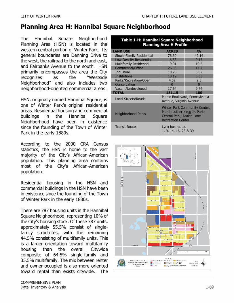
CITY OF WINTER PARK CHAPTER 1: FUTURE LAND USE ELEMENT
COMPREHENSIVE PLAN Data, Inventory & Analysis 1-69
Planning Area H: Hannibal Square Neighborhood The Hannibal Square Neighborhood Planning Area (HSN) is located in the western central portion of Winter Park. Its general boundaries are Denning Drive to the west, the railroad to the north and east, and Fairbanks Avenue to the south. HSN primarily encompasses the area the City recognizes as the “Westside Neighborhood” and also includes two neighborhood-oriented commercial areas. HSN, originally named Hannibal Square, is one of Winter Park's original residential areas. Residential housing and commercial buildings in the Hannibal Square Neighborhood have been in existence since the founding of the Town of Winter Park in the early 1880s. According to the 2000 CRA Census statistics, the HSN is home to the vast majority of the City’s African-American population. This planning area contains most of the City’s African-American population. Residential housing in the HSN and commercial buildings in the HSN have been in existence since the founding of the Town of Winter Park in the early 1880s. There are 787 housing units in the Hannibal Square Neighborhood, representing 10% of the City's housing stock. Of these 787 units, approximately 55.5% consist of single-family structures, with the remaining 44.5% consisting of multifamily units. This is a larger orientation toward multifamily housing than the overall Citywide composite of 64.5% single-family and 35.5% multifamily. The mix between renter and owner occupied is also more oriented toward rental than exists citywide. The
Table 1-H: Hannibal Square Neighborhood Planning Area H Profile
LAND USE ACRES % Single-Family Residential 76.30 42.14Low-Density Residential 16.58 9.17Multifamily Residential 19.01 10.5Commercial/Office 26.63 14.7Industrial 10.28 5.62Institutional 10.19 5.63Parks/Recreation/Open 4.52 2.5Conservation 0 0Vacant/Undeveloped 17.64 9.74
TOTAL 181.15 100
Local Streets/Roads Morse Boulevard, Pennsylvania Avenue, Virginia Avenue
Neighborhood Parks
Winter Park Community Center, Martin Luther Kin,g Jr. Park, Central Park, Azalea Lane Recreation Center
Transit Routes Lynx bus routes 1, 9, 14, 16, 23 & 39
CHAPTER 1: FUTURE LAND USE ELEMENT CITY OF WINTER PARK
COMPREHENSIVE PLAN
1-70 Data, Inventory & Analysis
contrast is 45% owner occupied and 55% rental in the HSN and 63% owner occupied and 37% rental citywide. There are two neighborhood-oriented commercial areas within this planning area. One is the Hannibal Square district located along New England and Pennsylvania Avenues to the south of Morse Boulevard with a companion commercial district on Pennsylvania Avenue, north of Morse Boulevard and south of Canton Avenue. The HSN planning area contains some of the City's light industrial zoning. These are located opposite the City's Public Safety Complex on Virginia Avenue, on the east side of Railroad Avenue between Denning Drive and Webster Avenue and on the west side of Pennsylvania Avenue opposite the golf course. There are also a number of office buildings along Morse Boulevard. Churches have always played an important role in the social development of the HSN. There are 16 churches scattered throughout the neighborhood. The Winter Park Community Center on West New England Avenue is the major park and recreational asset in this area. The HSN plays an important role in making Winter Park a “true” city and not just a residential suburb, providing the ethnic diversity that is essential for a true city. The HSN also provides a significant amount of the City's affordable housing which also guarantees Winter Park's economic diversity. These elements are not just sociological labels but elements which the City's economy requires as essential components. The service and blue collar workers from the HSN, with pedestrian access to Winter Park's primary commercial and office districts nearby, are as essential to the economy of the City as they have been since the early 1880s.
Next to the Community Center is Martin Luther King, Jr. Park. This neighborhood park has a new “spray play” water feature. Martin Luther King, Jr. Park, Central Park, and Azalea Lane Recreation Center, parks with recreation facilities common to neighborhood parks, are all within a half mile distance to residents of this planning area.
In 2007 the City undertook a neighborhood survey and the development of a CRA strategic plan. Aside from the various service improvements requested by the residents, their zoning and housing desires were as follows:
1. Encourage private home ownership. 2. Prefer home ownership to rental apartments. 3. Maintain residential zoning in the neighborhood. 4. Enforce codes on rental housing to improve conditions. 5. Provide public housing for senior citizens.
The City believes that the Westside residents continue to have these same desires concerning land use and housing in their neighborhood. Land use policies will only be successful if they accomplish the citizens’ directives.
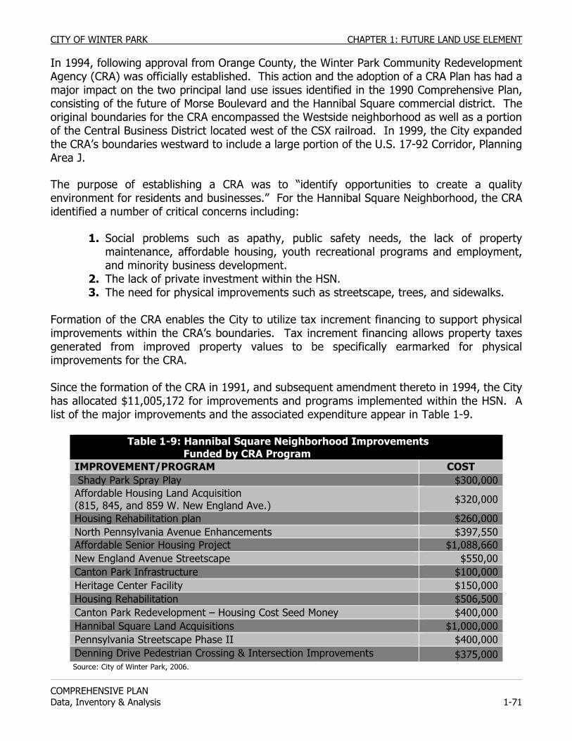
CITY OF WINTER PARK CHAPTER 1: FUTURE LAND USE ELEMENT
COMPREHENSIVE PLAN Data, Inventory & Analysis 1-71
In 1994, following approval from Orange County, the Winter Park Community Redevelopment Agency (CRA) was officially established. This action and the adoption of a CRA Plan has had a major impact on the two principal land use issues identified in the 1990 Comprehensive Plan, consisting of the future of Morse Boulevard and the Hannibal Square commercial district. The original boundaries for the CRA encompassed the Westside neighborhood as well as a portion of the Central Business District located west of the CSX railroad. In 1999, the City expanded the CRA’s boundaries westward to include a large portion of the U.S. 17-92 Corridor, Planning Area J.
The purpose of establishing a CRA was to “identify opportunities to create a quality environment for residents and businesses.” For the Hannibal Square Neighborhood, the CRA identified a number of critical concerns including:
1. Social problems such as apathy, public safety needs, the lack of property maintenance, affordable housing, youth recreational programs and employment, and minority business development.
2. The lack of private investment within the HSN. 3. The need for physical improvements such as streetscape, trees, and sidewalks.
Formation of the CRA enables the City to utilize tax increment financing to support physical improvements within the CRA’s boundaries. Tax increment financing allows property taxes generated from improved property values to be specifically earmarked for physical improvements for the CRA. Since the formation of the CRA in 1991, and subsequent amendment thereto in 1994, the City has allocated $11,005,172 for improvements and programs implemented within the HSN. A list of the major improvements and the associated expenditure appear in Table 1-9.
Table 1-9: Hannibal Square Neighborhood Improvements Funded by CRA Program IMPROVEMENT/PROGRAM COST Shady Park Spray Play $300,000Affordable Housing Land Acquisition (815, 845, and 859 W. New England Ave.) $320,000
Housing Rehabilitation plan $260,000North Pennsylvania Avenue Enhancements $397,550Affordable Senior Housing Project $1,088,660New England Avenue Streetscape $550,00Canton Park Infrastructure $100,000Heritage Center Facility $150,000Housing Rehabilitation $506,500Canton Park Redevelopment – Housing Cost Seed Money $400,000Hannibal Square Land Acquisitions $1,000,000Pennsylvania Streetscape Phase II $400,000Denning Drive Pedestrian Crossing & Intersection Improvements $375,000Source: City of Winter Park, 2006.
CHAPTER 1: FUTURE LAND USE ELEMENT CITY OF WINTER PARK
COMPREHENSIVE PLAN
1-72 Data, Inventory & Analysis
The 1999 amendment to the CRA Plan expanded the boundaries for the CRA District but did not address any new directives or goals for the portion of the CRA covering the Hannibal Square Neighborhood. Hannibal Square, the original commercial district for the HSN, is located on the west side of Central Park, north of Fairbanks Avenue, and east of Denning Drive. While this commercial area itself is quite small, about fifteen properties, the character of the "Square" is pervasive to a much larger area. The situation described in the 1990 Comprehensive Plan was that Hannibal Square was almost exclusively comprised of convenience stores, bars, taverns and boarding or rooming houses. As a result of the clientele of these businesses, there was an atmosphere, both perceived and real, of an unsafe and unlawful area, inviting the potential for increased blighted conditions. This functioned to discourage residential development nearby as well as investment in commercial and office redevelopment.
The City of Winter Park took several actions prior to 1990 to limit the negative influences and to encourage the renovation of this commercial area. In terms of zoning regulations, the City exempted the existing commercial buildings from meeting the zoning code parking requirements. The City and Orange County Community Development jointly constructed a customer parking lot adjacent to Hannibal Square. By removing the parking requirement and by providing parking on an adjacent City lot, it was hoped that redevelopment would be encouraged but these actions had very little effect.
The consensus of the 1990 Comprehensive Plan was that there continued to be interest for the City Commission to “do something" about Hannibal Square. The consensus was that the Square exerted a negative influence on the surrounding area but there was not a consensus on what type of "something" the City should do. The suggestions ranged from better code and law enforcement to wholesale condemnation and urban renewal. There was concern about destroying the integrity of the 100+-year-old commercial area, about actions that would just move the problems elsewhere within the neighborhood, and about whether this small commercial quarter, without visibility or arterial roads, could support a broad range of neighborhood-oriented commercial businesses.
As a result, the 1990 Comprehensive Plan again called for the proposed 1991 Westside Planning Study to address the issues on the future of Hannibal Square, which evolved into the 1994 CRA Plan. The CRA Plan provided that the properties along New England Avenue could convert to a proposed mixed-use commercial zoning. It was hoped that this would spur the redevelopment of New England Avenue and help to replace the blighting influences of the rooming houses, bars, etc. over the ensuing years.
Winter Park has been an active participant in the redevelopment that has occurred. In 1993, the City purchased the Big C Bar in order to close it as this establishment had been a draw for a clientele that participated in many vice activities. As envisioned in the CRA Plan, private property owners have renovated buildings and constructed new commercial buildings. The rezoning of the balance of New England Avenue will continue to encourage this positive redevelopment.
CITY OF WINTER PARK CHAPTER 1: FUTURE LAND USE ELEMENT
COMPREHENSIVE PLAN Data, Inventory & Analysis 1-73
In 1997, the City prepared a Master Plan for the Hannibal Square neighborhood. To promote a mix of residential, office, commercial, public uses, and open space, the Master Plan addresses permissible land uses, compatible land use mix, building design for residential and commercial development, and building orientation and streetscape supporting a pedestrian environment. Other issues addressed within the Hannibal Square Neighborhood Master Plan include vehicle parking, pedestrian facilities, and tree preservation. As previously discussed, safeguards need to be put into place to protect the adjacent residential areas from the impact of this commercial redevelopment. One measure needed is the protection of the integrity of the residential zoning on the streets behind New England Avenue. Similarly, protection is needed against encouraging speculation that this commercial rezoning is likely to occur in other areas away from the New England Avenue’s frontage properties. The adoption of the CRA Plan has also had a major impact on the future of Winter Park’s historic primary east-west corridor, Morse Boulevard. Morse Boulevard is one of the major access routes and gateways to the Central Business District. It connects the Lake Killarney area to the Lake Osceola area and creates a link between the Central Business District and Winter Park Village. As part of the original Town of Winter Park in the early 1880's, Morse Boulevard was platted as a grand boulevard with a landscaped median. While the character of the road has changed over the past century, its function and importance has not. The character of Morse Boulevard and the picture it presents to travelers has been of importance and has developed into a major land use issue for the Hannibal Square Neighborhood. During the 1960's an interest in improving the appeal of this gateway led to a comprehensive rezoning from residential to office for the land fronting Morse Boulevard from U.S. 17-92 to New York Avenue. During this period a number of the existing office buildings were constructed. While this office development had the support of many Winter Park residents, it was viewed negatively by most HSN residents, with most believing that the office rezoning resulted in the displacement of too many homes and threatened to divide their neighborhood in half. Accordingly, the residents petitioned to reclaim Morse Boulevard for residential continuity within their neighborhood. In 1971, the properties fronting on Morse Boulevard between Capen Avenue and Pennsylvania Avenue were rezoned back to residential as was the north side of Morse Boulevard between Pennsylvania and Virginia Avenue. However, some thirty or more years later, no residential development had occurred and the debate continues about the type of zoning and land uses which are in the best interests of the City for these blocks between Capen and Virginia Avenues. One of the major policy decisions of the 1994 CRA Plan was to allow all of the properties which front on Morse Boulevard to be redeveloped as office or commercial. This redevelopment was to occur with strict adherence to the Morse Boulevard Design Guidelines which dictate building orientation, location, setbacks, streetscape, signage and building heights. Per these guidelines, a maximum building height is allowed if the third floor is entirely residential and is deed restricted for that residential usage. The other major difference from the 1960’s is that this redevelopment
CHAPTER 1: FUTURE LAND USE ELEMENT CITY OF WINTER PARK
COMPREHENSIVE PLAN
1-74 Data, Inventory & Analysis
would produce CRA increment revenue to benefit the entire HSN and not just the property owners. Another major policy decision of the CRA Plan is to protect and prohibit any rezoning of residential properties to business designations for properties to the rear on Carolina Avenue, Symonds Avenue and Welbourne Avenue. Policies of this Comprehensive Plan implement these policy decisions.
In the 1990 Comprehensive Plan and in the development of the CRA Plan there was agreement on the following points:
1. The present Residential R-2 zoning is unlikely to result in any development because the residential owners’ properties are too small for extensive development (no more than one duplex per lot) and the owners of the large vacant tracts are holding them for office or commercial rezoning.
2. A comprehensive Residential R-2 apartment development of this area is not favored by Westside residents who favor increased single-family housing for their neighborhood.
3. Administrative rezoning to multifamily is not favored by the residents or by the majority of property owners.
4. A change to non-residential zoning such as office or commercial should only be done based on a Master Plan for the entire blocks not just for piecemeal development, and that plan needs to include some community benefit land use set-asides such as open space, a community park and/or a pedestrian linkage network.
5. The City's existing office and commercial zoning districts do not contain sufficient design controls. A new mixed-use commercial or neighborhood business zoning district needs to be created and adopted for this area.
6. The new zoning districts must provide an opportunity for the neighborhood to benefit not only through the design but through employment opportunities and through business creation focused on the neighborhood.
The conclusion stated in the 1990 Comprehensive Plan was that a redevelopment plan needed to be developed that would benefit the City as a whole, the local residents, and the property owners, and that would end the existing stalemate. That redevelopment plan is the 1994 CRA Plan.
The CRA Plan calls for rezoning for the remaining residential properties on Morse Boulevard to a new mixed-use commercial zoning district. The zoning district would allow for and encourage the redevelopment of Morse Boulevard. It also has strict land use design guidelines requiring that new development contain building elements that are of benefit to the Westside neighborhood. In most instances this means that some portion of any new building must contain retail businesses or some other elements beneficial to the neighborhood and not exclusively office development.
CITY OF WINTER PARK CHAPTER 1: FUTURE LAND USE ELEMENT
COMPREHENSIVE PLAN Data, Inventory & Analysis 1-75
While the CRA Plan opened the door for the rezoning of Morse Boulevard, there are protections needed for the adjacent residential streets and neighborhood. These are to contain the rezoning to Morse Boulevard and not open other streets to such rezoning. It also means protecting residential areas from the desires of developers to use the residentially zoned land for parking lots to serve the adjacent commercial development on Morse Boulevard. Transportation Located between Winter Park Village and the Central Business District, the residents and businesses within the CRA neighborhood are generally close to major employment, business, and social activities within the City. The current development pattern occurring within the Westside neighborhood displays building frontage placed close to the street and a grid pattern street system. This development pattern promotes convenient pedestrian mobility to areas inside and adjacent to this neighborhood. The Transportation Element provides a concept design plan for the redevelopment of Morse Boulevard to create a more pedestrian-friendly corridor. Redevelopment plans for Morse Boulevard, as proposed by the Transportation Element, envision a two-lane roadway divided by a wide median and bordered by on-street parking and 10-foot wide sidewalks. The plan also proposes a bicycle route parallel to the street. A regional bus transfer facility is located on the east side of Winter Park Village along Denning Drive. Though not located within the planning area, this Lynx transfer facility is located immediately adjacent to the Westside neighborhood. Lynx buses providing service to this transfer facility include routes 1, 9, 14, 16, 23, 39. The transfer facility on Denning Drive is located within a half mile walking distance to approximately 60% of the HSN neighborhood area. Access to a bus route can also be reached along Fairbanks Avenue, which crosses through the southern portion of the planning area, further increasing access to bus transit for Westside residents. PLANNING ISSUES: Hannibal Square Neighborhood Affordable Housing One primary planning issue here is the loss of population and housing. The City as a whole gained 5,080 residents and grew 29.6% between 1960 and 1990. This growth was mostly due to annexation although all Winter Park planning areas showed some modest population growth except for two. Those two planning areas were Hannibal Square Neighborhood and Downtown/Rollins College. The HSN lost 820 persons i.e. 22% of their population during those thirty years. This loss of housing and population is one of the most pressing issues the City should address if the stability of this planning area is to be maintained. Related to this is the loss of significant amounts of residential land via rezoning to commercial/office development. The City should actively promote mixed-use projects which include residential units on rezoned commercial/office land. There are various reasons for this decline in population and housing, some of which are outside of the City's control, such as national demographic changes affecting the elderly and families. The elderly are living slightly longer and living at home longer which produces more homesteads without children at home. Since the citizens of Hannibal Square Neighborhood had an older average age (44) as compared to that of the City as a whole (40), per the 1990 US Census, this
CHAPTER 1: FUTURE LAND USE ELEMENT CITY OF WINTER PARK
COMPREHENSIVE PLAN
1-76 Data, Inventory & Analysis
factor does play a role. In addition, the trend toward smaller families cuts across all racial and economic groups. Speculative purchases by real estate investors have caused a further decline in the population and housing here. To some, property within HSN seems like an incredible bargain as vacant lots and houses can be purchased for much less than those in other sections of the City. Investors here note the prime location, the limited downside risk in price, and doubt the long term resolve of the City to maintain this as a residential area. Typically, rental homes are demolished after a decline in housing conditions, with investors land banking vacant lots.
Another reason for the decline in the population and housing here is that private residential builders have been unwilling to utilize the planning area’s assets. There are vacant lots available for development with all urban infrastructure and services existing, low prices, and good locations. However, the potential for enormous profits here is less than in other parts of Winter Park so little residential construction has taken place except for that done by owner-occupants. It was, in part, this situation that prompted the City Commission to develop the Affordable Housing Program, addressed in detail within the Housing Element. In brief, the City has used its Affordable Housing Program’s linkage fee and bond issue revenues to build and sell new, affordable, single-family houses. This work is helping to revitalize the area and sends the visible message that the City of Winter Park is committed to maintaining and improving the residential base of the Hannibal Square Neighborhood.
The City should encourage the building of subsidized multifamily housing for senior or handicapped citizens in projects sponsored by, or which complement those of the Winter Park Housing Authority.
The City should approve density increases for projects of the Hannibal Square Community Land Trust, Habitat for Humanity, the Winter Park Housing Authority and other non-profit organizations when such projects exclusively include workforce/affordable housing.
Preservation of Residential Areas The City should discourage any non-residential encroachments into the residential sections of Hannibal Square Planning Area. As a prerequisite to such rezoning and prior to review by the Planning Commission, the CRA Advisory Board should review the development plan and make recommendations on whether or not it finds the plan consistent with CRA policy.
A condition for approval of any change in zoning from residential to non-residential in this planning area should be that any loss of housing or the potential for housing be compensated by the provision of alternative housing, or negotiated fees in lieu of housing as housing compensation fees. These fees should be paid to the Affordable Housing Trust Fund for alternative residential development within HSN. The City should protect the existing residential character of Lyman Avenue between Hannibal Square East and New York Avenue and on Carolina Avenue. The City should conclude that the use of properties fronting on these streets, in whole or in part, for non-residential, mixed-use,
CITY OF WINTER PARK CHAPTER 1: FUTURE LAND USE ELEMENT
COMPREHENSIVE PLAN Data, Inventory & Analysis 1-77
parking, or storm water retention for adjacent commercial/office development, is in conflict with the Comprehensive Plan. An exception may be made for the “Sports Inn” for redevelopment as a mixed-use (office/residential) project given the previous non-conforming commercial usage. The City should prohibit any rezoning from residential to non-residential for properties to the rear on Carolina, Symonds and Welbourne Avenues.
The City should prohibit a non-residential character for New England Avenue between Denning Drive and Pennsylvania Avenue and on Symonds Avenue between Capen and Pennsylvania Avenues. The City should conclude that the use of properties fronting on these streets, in whole or in part, for non-residential, mixed-use, or parking for adjacent commercial/office development, is in conflict with the Comprehensive Plan.
The City should find that the rezoning from residential to commercial/office or mixed-use of any existing residential property fronting on the east side of Denning Drive or on Webster Avenue is in conflict with the Comprehensive Plan.
Residential Land Use & Density The City should discourage Comprehensive Plan amendments from Low-Density to Medium- or High-Density Multifamily Future Land Use designations except where appropriately located and where such housing meets neighborhood housing needs including workforce/affordable housing. The City should find that the rezoning of any existing single-family property that is 50 feet by 150 feet (i.e., 7,500 square feet) or less to low-density residential (R-2) for the purpose of gaining additional density is in conflict with the Comprehensive Plan (i.e., single-family to duplex). Fairbanks Avenue The City should prohibit the establishment or expansion of auto sales/service enterprises, auto repair businesses, re-sale stores or pawn shops, tattoo businesses, adult oriented businesses, fast food businesses and convenience stores along Fairbanks Avenue. Provisions for Construction & Renovation The City should consider provisions for non-profit service agencies and local neighborhood church construction and renovation as churches in the Hannibal Square Neighborhood Planning Area co-exist side by side with residential properties and that these churches depend upon on-street parking for their congregations.
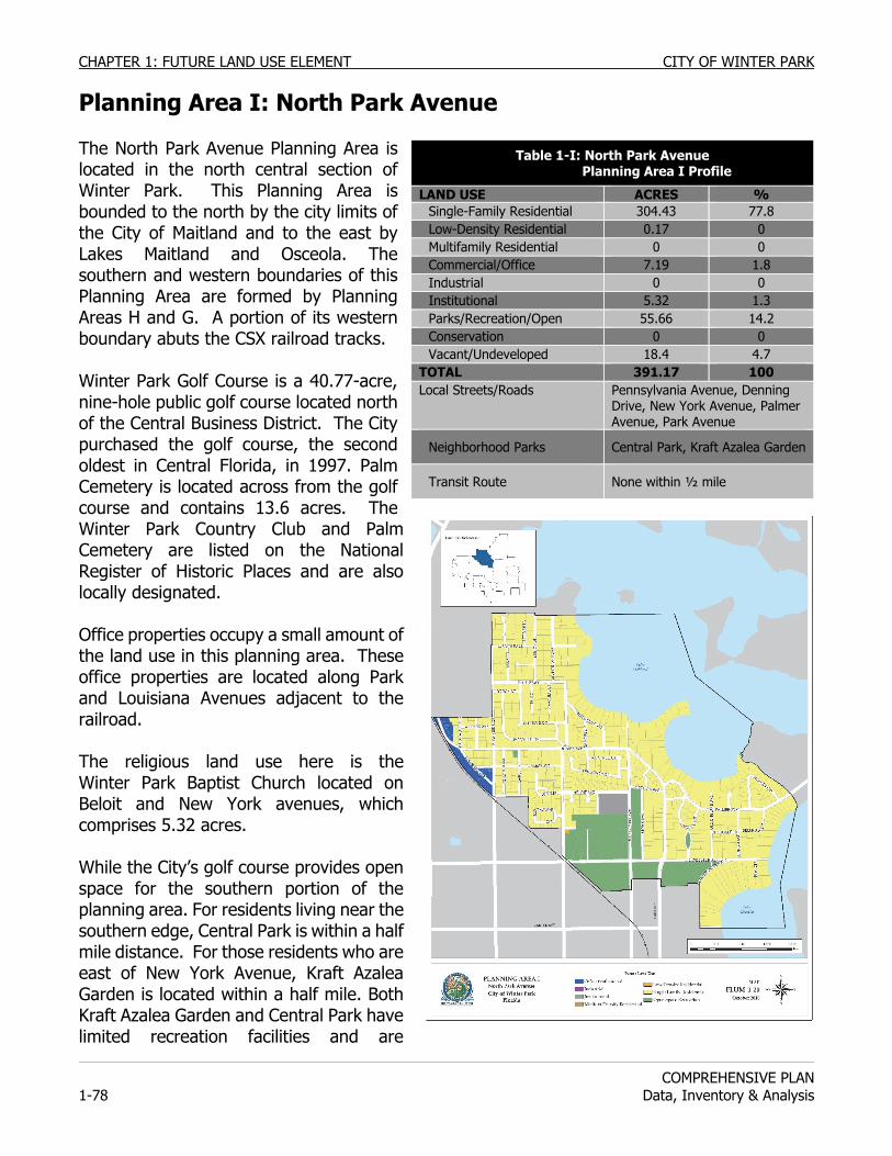
CHAPTER 1: FUTURE LAND USE ELEMENT CITY OF WINTER PARK
COMPREHENSIVE PLAN
1-78 Data, Inventory & Analysis
Planning Area I: North Park Avenue The North Park Avenue Planning Area is located in the north central section of Winter Park. This Planning Area is bounded to the north by the city limits of the City of Maitland and to the east by Lakes Maitland and Osceola. The southern and western boundaries of this Planning Area are formed by Planning Areas H and G. A portion of its western boundary abuts the CSX railroad tracks. Winter Park Golf Course is a 40.77-acre, nine-hole public golf course located north of the Central Business District. The City purchased the golf course, the second oldest in Central Florida, in 1997. Palm Cemetery is located across from the golf course and contains 13.6 acres. The Winter Park Country Club and Palm Cemetery are listed on the National Register of Historic Places and are also locally designated. Office properties occupy a small amount of the land use in this planning area. These office properties are located along Park and Louisiana Avenues adjacent to the railroad. The religious land use here is the Winter Park Baptist Church located on Beloit and New York avenues, which comprises 5.32 acres. While the City’s golf course provides open space for the southern portion of the planning area. For residents living near the southern edge, Central Park is within a half mile distance. For those residents who are east of New York Avenue, Kraft Azalea Garden is located within a half mile. Both Kraft Azalea Garden and Central Park have limited recreation facilities and are
Table 1-I: North Park Avenue Planning Area I Profile
LAND USE ACRES % Single-Family Residential 304.43 77.8 Low-Density Residential 0.17 0 Multifamily Residential 0 0 Commercial/Office 7.19 1.8 Industrial 0 0 Institutional 5.32 1.3 Parks/Recreation/Open 55.66 14.2 Conservation 0 0 Vacant/Undeveloped 18.4 4.7
TOTAL 391.17 100 Local Streets/Roads Pennsylvania Avenue, Denning
Drive, New York Avenue, Palmer Avenue, Park Avenue
Neighborhood Parks Central Park, Kraft Azalea Garden
Transit Route None within ½ mile
CITY OF WINTER PARK CHAPTER 1: FUTURE LAND USE ELEMENT
COMPREHENSIVE PLAN Data, Inventory & Analysis 1-79
designed more as open spaces and gathering places. Neither has a playground or other recreational equipment typically found at a neighborhood park. The closest park with a playground would be the Winter Park Community Center or Phelps Park, both of which are more than a mile away from most North Park Avenue residents. As mentioned earlier in Planning Area E, as part of a park land concurrency requirement a developer has purchased and dedicated to the City ¼ acre of park land located at the south west corner of Oak and Park Avenue. This park is in the design stages but will contain play equipment and sitting areas. The City of Maitland borders the north and northwest sides of Planning Area I. Current land use is single-family residential. Land uses along U.S. 17-92 in Maitland and near the North Park Avenue Planning Area are commercial and office. Land use compatibility issues should only occur if office and commercial uses encroach upon the residential areas of Maitland bordering the North Park Avenue Planning Area. Transportation Houses within the North Park Avenue area are more than a half mile away from the nearest bus route. A LYNX bus transfer station is located on Denning Drive, behind the Winter Park Village, but this site is not within a convenient walking distance for most residents. Residents living west of Pennsylvania or Summerland avenues are within a half mile walk to U.S. 17-92, where Lynx bus routes can be accessed. PLANNING ISSUES: North Park Avenue Church Traffic & Parking Historically, there has been some tension over the traffic and parking impacts that the Winter Park Baptist Church has created on the adjacent residential areas. As the church and its activities have grown, traffic and parking problems have increased. If the church should decide to expand further, these impacts on the surrounding residential area need to be minimized if that development is to be harmonious. Preservation of Residential Areas Office properties adjacent to the North Park Avenue planning area are located on Park and Louisiana Avenues, entrances into the City via U.S. 17-92. There has been and continues to be pressure to rezone more of the residential properties in this neighborhood to office use because of the location. The City of Winter Park has resisted this pressure and will continue to do so to protect this residential area. Land use compatibility will be an issue affecting the neighborhood only if office and commercial uses along U.S. 17-92, within both Winter Park and Maitland, encroach eastward upon existing established residential areas.
The City shall prohibit the subdivision of lots to create lots with less than the required zoning requirements governing minimum size lots.
The City should continue to work with the neighborhood to develop a preferred vision for the recently acquired park space. Street Design & Land Use The City should move to establish a more coordinated review process with the City of Maitland for land development applications in this area and the adjacent section of Maitland. This would protect the interests of the residents in both cities by involving
CHAPTER 1: FUTURE LAND USE ELEMENT CITY OF WINTER PARK
COMPREHENSIVE PLAN
1-80 Data, Inventory & Analysis
citizens of both cities in the development of decisions which have impacts across municipal boundaries. The City should develop a gateway enhancement plan for the North Park Avenue entrance into the City.
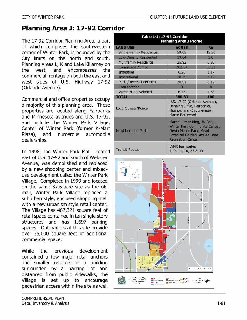
CITY OF WINTER PARK CHAPTER 1: FUTURE LAND USE ELEMENT
COMPREHENSIVE PLAN Data, Inventory & Analysis 1-81
Planning Area J: 17-92 Corridor The 17-92 Corridor Planning Area, a part of which comprises the southwestern corner of Winter Park, is bounded by the City limits on the north and south, Planning Areas L, K and Lake Killarney on the west, and encompasses the commercial frontage on both the east and west sides of U.S. Highway 17-92 (Orlando Avenue).
Commercial and office properties occupy a majority of this planning area. These properties are located along Fairbanks and Minnesota avenues and U.S. 17-92, and include the Winter Park Village, Center of Winter Park (former K-Mart Plaza), and numerous automobile dealerships.
In 1998, the Winter Park Mall, located east of U.S. 17-92 and south of Webster Avenue, was demolished and replaced by a new shopping center and mixed-use development called the Winter Park Village. Completed in 1999 and located on the same 37.6-acre site as the old mall, Winter Park Village replaced a suburban style, enclosed shopping mall with a new urbanism style retail center. The Village has 462,321 square feet of retail space contained in ten single story structures and has 1,697 parking spaces. Out parcels at this site provide over 35,000 square feet of additional commercial space.
While the previous development contained a few major retail anchors and smaller retailers in a building surrounded by a parking lot and distanced from public sidewalks, the Village is set up to encourage pedestrian access within the site as well
Table 1-J: 17-92 Corridor Planning Area J Profile
LAND USE ACRES % Single-Family Residential 59.05 15.50 Low-Density Residential 19.04 5.0 Multifamily Residential 25.92 6.80 Commercial/Office 202.64 53.21 Industrial 8.26 2.17 Institutional 28.25 7.42 Parks/Recreation/Open 30.91 8.12 Conservation 0 0 Vacant/Undeveloped 6.76 1.78
TOTAL 380.83 100
Local Streets/Roads
U.S. 17-92 (Orlando Avenue), Denning Drive, Fairbanks, Orange, and Clay avenues, Morse Boulevard
Neighborhood Parks
Martin Luther King, Jr. Park, Winter Park Community Center, Orwin Manor Park, Mead Botanical Garden, Azalea Lane Recreation Center
Transit Routes LYNX bus routes 1, 9, 14, 16, 23 & 39
CHAPTER 1: FUTURE LAND USE ELEMENT CITY OF WINTER PARK
COMPREHENSIVE PLAN
1-82 Data, Inventory & Analysis
as between buildings, with public sidewalks adjacent to the site. The Winter Park Village contains retail shops such as Ann Taylor Loft, Pier 1, White House Black Market and Ulta. There is a Regal Cinema along with many dining establishments including The Cheesecake Factory, P.F. Chang’s, Brio and Crispers. Lynx has placed a regional transfer site on the east side of the Village that fronts Denning Drive. In 2006, 6 bus routes have stops at the Winter Park Village regional bus transfer station.
The Center of Winter Park (former K-Mart shopping center) is on a 25-acre site and contains large scale retail stores, small dining establishments, and smaller retail space. The total building area is 170,500 square feet. The Winter Park Village area is also near the one true industrial zone in the City. These industrial properties are located along Solana and Railroad avenues in the adjacent Planning Area H, east of U.S. 17-92 (Orlando Avenue) and north of Dixon Avenue. These properties consist of warehouses and light manufacturing.
Winter Park Tech, operated by the Orange County Public School System, is within this planning area. It occupies the 1954 building that was originally Webster Elementary School. Winter Park Tech’s Adult Community Education Center began serving adults over the age of sixteen in 1974 and continues to offer a wide variety of programs. There are vocational programs, including computer programming, electrical technicians programs, and medical assistants programs as well as personal enrichment classes, English classes for the foreign born, high school and general education diplomas. Along with the school site, the Orange County School Board owns 13 acres adjacent to the school which is used as the region’s bus storage and maintenance facility.
Over 27% of this planning area is residential, more than half of which consists of single-family homes. The Orwin Manor-Lawndale area covers 124 acres and contains a total of 355 residential units, primarily single-family homes, although Winter Park Plaza with its former mid-rise Florida Gas building, occupies 7 acres along Orange Avenue. Integral in the history of the City and the Orwin Manor neighborhood was the development of the former Florida Gas building in 1969. It has “fit in” with the surrounding neighborhood due to the well landscaped design of its parking lots which are often cited as examples of how to landscape a parking lot correctly. The “suburban” lay out is of critical importance to the compatibility with the surrounding Orwin Manor neighborhood. Lawndale, to the north of Orwin Manor, is made up of a mix of single-family and duplex homes as well as commercial frontage on U.S. 17-92 and office frontage on Minnesota Avenue. Within Lawndale there is some affordable housing. There are three multifamily areas in this planning area. One area is located to the south of the Center of Winter Park and contains three condominium complexes, the Killarney Bay Condominiums with 45 units, Chateaux du Lac with 104 units, and Lake Killarney Condominiums with 123 units. The area also includes the Plymouth Apartments which serves senior citizens with 196 units. The second multifamily area is located behind Winter Park Tech and contains 8 units that are a combination of single-family houses and duplexes. This area is an island surrounded by other nonresidential land uses. The third multifamily area is the 97-unit Hollianna
CITY OF WINTER PARK CHAPTER 1: FUTURE LAND USE ELEMENT
COMPREHENSIVE PLAN Data, Inventory & Analysis 1-83
Garden Apartments west of the Hollianna Shopping Center. Orwin Manor Park is within a half mile of all Orwin Manor-Lawndale residents. Mead Botanical Garden and Azalea Lane Recreation Center are also nearby, within a half mile of many residents, but U.S. 17-92 serves as a deterrent for most pedestrians and bicyclists. Martin Luther King, Jr. Park is a 28-acre park located within a half mile of Lake Killarney residents although most must cross U.S. 17-92, Fairbanks Avenue or both, to reach it. Martin Luther King, Jr. Park contains a 9-acre lake referred to as Lake Mendsen and the 1981 Winter Park sinkhole which has been named Lake Rose. The park is home to the Rachel D. Murrah Civic Center, built in 1986, which offers 10,000 square feet of space available for public and private activities. The park provides 2,000 square feet of meeting space and 24 shuffleboard courts. The park has one lit soccer field, one lit football field, one lit multipurpose field, two basketball courts, and a patio dock. It is also the home site for the Rollins College Women’s Softball Team and has a state-of-the-art softball facility in the southwest corner of the park. Martin Luther King, Jr. Park also contains the Community Playground, built in 1988 by volunteer manpower and fund raising, that provides 10,000 square feet of playground, parking and restroom facilities. For residents within the Winter Park Village neighborhood, two parks with neighborhood recreation facilities are within a half mile distance: Martin Luther King, Jr. Park and the Winter Park Community Center. An interlocal agreement was established between Winter Park and Orange County regarding annexation and mutually acceptable future land use for unincorporated properties east of I-4 and west of Orwin Manor-Lawndale. Community Redevelopment Agency (CRA) Concurrent with the preparation of the 1999 CRA Plan Amendment, a Master Plan for the U.S. 17-92 (Orlando Avenue) Corridor was also developed. The U.S. 17-92 Corridor Master Plan planning area extended north and south beyond the boundaries of the CRA Expansion Area. The 1994 study concluded that the emergence of blight within this area was on the verge of exacerbating the conditions that would likely accelerate the deterioration of the area’s appearance. Such conditions were anticipated to lead to a decline in property values and a disinterest in investing in building and site improvements. The 1999 CRA Plan Amendment set as its primary objective the transformation of U.S. 17-92 into a “Grand Boulevard.” Other issues identified in this CRA amendment include redevelopment that incorporates Martin Luther King, Jr. Park as a primary activity area and neighborhood focus. Lake Killarney, west of U.S. 17-92, has been underutilized as a community asset. Site design should incorporate sight lines and sensitive design treatments to establish scenic vistas and view corridors. The revised plan also recognizes that more residential use coincides with new commercial redevelopment projects to create a mixed-use neighborhood in which residents can work, shop, and play within walking distance of their homes. Also, the updated plan promotes a more aesthetic built environment along the U.S. 17-92 Corridor.
CHAPTER 1: FUTURE LAND USE ELEMENT CITY OF WINTER PARK
COMPREHENSIVE PLAN
1-84 Data, Inventory & Analysis
Transportation Six streets traverse the 17-92 Corridor. These are Fairbanks Avenue and U.S. 17-92, which carry the highest average daily traffic volumes among major roads within the City, Denning Drive, Morse Boulevard, and Clay and Orange Avenues. As previously mentioned, a regional bus transfer facility is located on the east side of Winter Park Village along Denning Drive. Lynx bus routes providing service from this transfer facility include numbers 1, 9, 14, 16, 23 and 39. Several Lynx bus routes follow U.S. 17-92, and Fairbanks and Orange Avenues, placing access to bus transit within a half mile of all Planning Area J residents. All bus routes serving this area reach bus transfer stations, providing linkage to most areas within the Orlando metropolitan area. PLANNING ISSUES: 17-92 Corridor Transportation The Lake Killarney neighborhood provides residential development densities compatible with transit service and all residential, commercial, and office uses are located along or within a half mile walk of bus routes. Also, the intersection of Fairbanks Avenue and U.S. 17-92 (Orlando Avenue) serves as the crossroads for Lynx transit routes. A potential exists to augment bus facilities in this area, to promote transit use and to make such facilities more convenient and comfortable for Lynx patrons.
If the City extends Lee Road eastward to Denning Drive, it would create an alternative route for local traffic to reach local destinations within Winter Park avoiding the bottleneck between Lee Road and Webster Avenue. With this extension, proposed bicycle lanes on Lee could connect with those proposed for Denning Drive, creating a regional link; ultimately to the Central Business District and other destinations in the central area of the City. This extension would require right-of-way land within the northern parts of the Winter Park Tech campus. If the opportunity arises, the City should consider using any right-of-way lands abutting Railroad Avenue as a neighborhood park or garden plaza to serve residents within this neighborhood but more importantly provide a park within a half mile distance to most residents within the adjacent planning area directly to the north. Lee Road’s eastern terminus is at its intersection with U.S. 17-92 (Orlando Avenue), forcing eastbound traffic to turn north or south when reaching U.S. 17-92. Preservation of Residential Areas The U.S. Highway 17-92 planning area faces pressure for change in the transition area between office/commercial uses and residential communities. One such area where there is pressure to expand commercial and office business areas westward from U.S. Highway 17-92 toward Schultz Avenue exists to the south of Minnesota Avenue. Since 1971 the City has strived to maintain a dividing line separating commercial or office uses from residential midway in the blocks south of Minnesota Avenue between U.S. 17-92 and Shultz Avenue. In the early 1980s, the City breached the line by permitting parking on the rear half of the block for the National Bank of Commerce. In the early 2000’s, we have seen the development of the Harper Place townhouse project, reaffirming after 30 years that residential is a viable option on both sides of Shultz Avenue. The dividing line is irregular however, along the streets of Michigan, Miller and Indiana Avenues. Harper Place has set the standard for residential use to be maintained at least 250 feet east of Shultz Avenue. Thus, as a policy, no rezoning for nonresidential or mixed-use should be permitted within 200 feet of Shultz Avenue.
CITY OF WINTER PARK CHAPTER 1: FUTURE LAND USE ELEMENT
COMPREHENSIVE PLAN Data, Inventory & Analysis 1-85
The Orwin Manor neighborhood is a stable single-family residential area which has not been subjected to rezoning due in large part to the active involvement of the Orwin Manor Neighborhood Association. Instead, the planning issue for this neighborhood has been lot splits and their effect on the character of the neighborhood. Orwin Manor has a mix of home and lot sizes, with many homes situated on 50-60 foot wide lots, but with several home sites existing on larger double lots. In the past, subdivision variances have been requested to create new 50 or 60 foot wide home sites from the larger properties. Neighbors have been united against such lot splits, fearing that it would erode the character of the neighborhood. In order to provide clear direction for future requests, this element contains policies which prohibit variances for lot sizes (especially frontages) less than the required 75 feet for interior lots and 85 feet for corner lots as per the R-1A zoning.
In dealing with the protection of residential areas from adjacent office or commercial uses, the City should address separation of uses, buffering, and traffic calming. For example, the City should consider a limit to the heights of commercial buildings to two stories when constructed within 300 feet of residential areas; a limit on the proximity or setback of commercial buildings to residential properties; added open space or landscaped areas.
As part of the preparation of the Future Land Use Map, the dividing lines between residential and commercial and institutional uses need to be reaffirmed as they now exist in the Comprehensive Plan, or modified to reflect changing conditions or additional protections for these neighborhoods.
Preservation of Residential Density The City should preserve and protect the Low-Density Residential land use west of Schultz Avenue, within Lawndale, in this planning area, from commercial and office encroachment. The Future Land Use Map should maintain the Low-Density Residential designation and no map amendments to non-residential or mixed-use should be permitted within 200 feet of Shultz Avenue.
The City should preserve the multifamily residential land use in the area located south of the Center of Winter Park.
The City should protect the interests of the residents of the multifamily area located behind Winter Park Tech if development or rezoning appears imminent by avoiding non-residential encroachment into residential areas. Non-residential development occurring adjacent to residentially designated property should be required to provide adequate buffers including architecturally designed masonry walls capped and appropriately landscaped with canopy tress, specimen trees, and shrubs.
The City should preserve and protect the single-family residential land use within the Killarney neighborhood from commercial and office encroachment. Preservation of Recreational Land Use The City should preserve the recreational land use of Martin Luther King, Jr. Park.
CHAPTER 1: FUTURE LAND USE ELEMENT CITY OF WINTER PARK
COMPREHENSIVE PLAN
1-86 Data, Inventory & Analysis
Transition from Residential to Non-Residential Land Use Continued transition from residential uses to non-residential uses in areas to the west will create land use compatibility issues for the Orwin Manor-Lawndale neighborhood. Intergovernmental coordination will be needed between the City of Orlando, Orange County, and the City of Winter Park to adequately plan for compatible land uses and transition of development intensities and densities. Transportation and cut-through traffic issues also necessitate coordination among these local governments. Office, commercial, and institutional uses continue to expand in the areas within unincorporated Orange County and within the City of Orlando, west of the planning area J. The institutional uses represent a large religious campus containing a cathedral, a retirement home, and school facilities. Office and commercial uses occur in the area south of the church campus and west of the planning area. Single-family residential uses abut the western boundary of the planning area, but the character of the area east of I-4 is office, commercial and institutional.
Automobile traffic attracted to the church campus, office, and commercial uses impacts residential areas within the Orwin Manor-Lawndale neighborhood. Little vacant land remains within the adjacent areas containing these non-residential uses. The Orwin Manor-Lawndale area will continue to confront potential encroachment of non-residential uses upon its residential areas through petitions for zoning changes and future land use map amendments. The handful of residential properties along Trovillion Avenue and Gay Road should be allowed to transition to low intensity offices as long as the offices are complimentary to the adjacent Killarney Bay and Chateau Du Lac condominiums.
The multifamily area located behind the Winter Park Tech is surrounded by commercial, industrial and educational properties and is too small to be a neighborhood. It now contains 8 units and could be redeveloped under multifamily standards to contain a maximum of 36 apartment units. This area should be preserved as an affordable housing oasis but, should development or rezoning occur, the City should protect the interests of the residents of this area.
Compatibility between Residential & Office/Commercial Land Use. Advancements in technology and communications have also fostered changes in business operations and the geographical span of their markets. Communications and the internet allow businesses to reach markets throughout the world, requiring some businesses to operate into the evening hours to accommodate clients in different time zones. While some office and business activities may be compatible with residential use during the daytime hours, such activities could serve as a nuisance during the evening hours.
Other planning issues that need to be evaluated for the 17-92 Corridor Planning Area and adjacent areas include reduction in signage visible to residential properties; control over the location and design of driveways; and discouragement of office conversion of existing duplexes. The City should consider lowering the intensity allowed for office or commercial buildings than is currently permitted. This reduction in building size would lessen the impact of traffic from
CITY OF WINTER PARK CHAPTER 1: FUTURE LAND USE ELEMENT
COMPREHENSIVE PLAN Data, Inventory & Analysis 1-87
these redeveloped properties as a protection to the residential areas, while still permitting a degree of higher use by the owners.
Commercial/Office Redevelopment Another compatibility question will be the relationship to the five remaining residential properties on Beloit and Cherokee Avenues. However this prospective redevelopment will provide a great opportunity for the City to acquire (through donation) the right of way needed for the Lee Road extension project.
Winter Park Village’s redevelopment as a ‘lifestyle center’ involving mixed-uses allowing for residents to live, work and play has been extremely successful and has been the example for many other similar redevelopments across the nation. At the City’s insistence, the former Winter Park Mall was redeveloped, not into another shopping center/mall, but into a village concept incorporating a mix of uses, a grid street pattern, on-street parking and village character. Winter Park Village is an evolving entity and the City will see requests to redevelop existing buildings or parking areas. Critical elements in the review of such requests will be the density and heights proposed in relation to the village character of the development and context provided by the adjoining streets. For guidance, the City staff held a Denning Drive charrette and established appropriate building heights and setbacks.
The Center of Winter Park (former K-Mart shopping plaza) is a candidate for redevelopment due to its size, location, age of buildings and open surface parking areas. Ideally, a redevelopment program would mirror the experience of the Winter Park Village in form, function, appearance and character. However, given the multiple existing tenants a more likely scenario involves proposals to redevelop portions of the shopping center or proposals to develop the existing parking areas. Technically, all of the existing parking is needed to meet the zoning code parking requirements; however, in reality, the large scale retail users in the south half use only about half their allocated parking. Eventually the City should field requests to redevelop the parking field with new commercial buildings and/or restaurants. The issue of appropriate building height along Denning Drive is critical given the single-family residential neighborhood on the east side of Denning Drive.
Due to the large size of the former Florida Gas building’s parking lot, it has been targeted as a possible candidate for conversion to a parking garage so that new townhouse units could be constructed around the periphery. The density and intensity of a six story office building and parking garage would be incompatible with the adjacent Orwin Manor single-family neighborhood. The City should prohibit the redevelopment of the Florida Gas Building and Commerce National Bank from including a parking garage.
Land use within this corridor is predominantly office and commercial. A small area study or sector plan should be prepared for the Fairbanks Avenue corridor from I-4 to U.S. 17-92 (Orlando Avenue) to promote a uniform development pattern, improve pedestrian orientation in site plan design and streetscape, and encourage redevelopment of nonconforming structures and uses.
CHAPTER 1: FUTURE LAND USE ELEMENT CITY OF WINTER PARK
COMPREHENSIVE PLAN
1-88 Data, Inventory & Analysis
Fairbanks Avenue, at the City’s western boundary, and U.S. 17-92 (Orlando Avenue), at the City’s southern boundary, serve as the major entranceways into the City. They should be aesthetically improved by having a predominance of office properties. Although this area is now mostly offices, there are still some notable commercial exceptions. The City should continue to implement land use controls that encourage office uses along this portion of Fairbanks Avenue west of U.S. 17-92.
Annexation The City should annex the areas between the City limits and Clay Street and Minnesota Avenue when interest in annexation is expressed. See Annexation Reserve Areas for more detail.
Interlocal Plan & Agreements The portion of U.S. 17-92 within this planning area extends northward to the City limits, where Winter Park abuts the City of Maitland. Similar to the development conditions and character along U.S. 17-92 in Winter Park, the City of Maitland has experienced pressures to redevelop commercial buildings along this corridor. An opportunity exists for the two cities to jointly work together to create a uniform and compatible corridor plan for U.S. 17-92 from Winter Park Village northward into southern Maitland. The corridor plan should address street design, access management, streetscape, transit facility locations, pedestrian ways, and other similar issues.
An interlocal agreement has been established between Orange County and Winter Park regarding mutually acceptable future land uses for the area west of Winter Park. Other issues the two governments should address within an interlocal agreement include transportation improvements, traffic calming, mixed-use development, and recreation facilities.
Compatibility & Appearance of Industrial Land Use Industrial land uses align the CSX railroad at the north boundary of this planning area. Residential neighborhoods occur adjacent to some of the light industrial and warehousing uses. To avoid adverse impacts that some light industrial and warehousing activities may have on these neighborhoods, the City should evaluate potential uses that may or may not be compatible with residential areas. Similarly, if residential uses are allowed on upper floors of offices or commercial spaces, the City should ensure that land use compatibility occurs within mixed-use structures and development. The City should improve the appearance of the industrial land located along Solana Avenue and Railroad Avenue. Concentration of Automobile Dealerships This planning area contains several car dealerships and used car lots which are a conditional use in Winter Park. The City should concentrate car dealerships north of Lee Road in this planning area instead of letting them spread throughout the City.
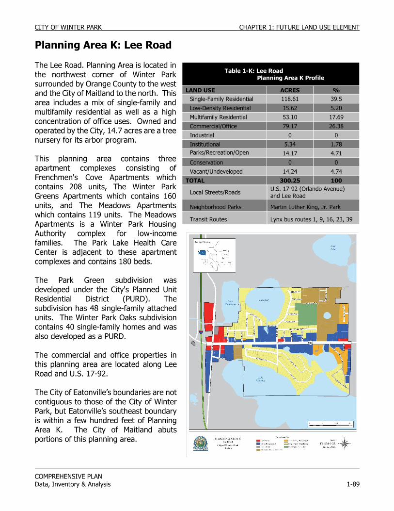
CITY OF WINTER PARK CHAPTER 1: FUTURE LAND USE ELEMENT
COMPREHENSIVE PLAN Data, Inventory & Analysis 1-89
Planning Area K: Lee Road
The Lee Road. Planning Area is located in the northwest corner of Winter Park surrounded by Orange County to the west and the City of Maitland to the north. This area includes a mix of single-family and multifamily residential as well as a high concentration of office uses. Owned and operated by the City, 14.7 acres are a tree nursery for its arbor program. This planning area contains three apartment complexes consisting of Frenchmen's Cove Apartments which contains 208 units, The Winter Park Greens Apartments which contains 160 units, and The Meadows Apartments which contains 119 units. The Meadows Apartments is a Winter Park Housing Authority complex for low-income families. The Park Lake Health Care Center is adjacent to these apartment complexes and contains 180 beds. The Park Green subdivision was developed under the City's Planned Unit Residential District (PURD). The subdivision has 48 single-family attached units. The Winter Park Oaks subdivision contains 40 single-family homes and was also developed as a PURD. The commercial and office properties in this planning area are located along Lee Road and U.S. 17-92. The City of Eatonville’s boundaries are not contiguous to those of the City of Winter Park, but Eatonville’s southeast boundary is within a few hundred feet of Planning Area K. The City of Maitland abuts portions of this planning area.
Table 1-K: Lee Road Planning Area K Profile
LAND USE ACRES % Single-Family Residential 118.61 39.5
Low-Density Residential 15.62 5.20 Multifamily Residential 53.10 17.69 Commercial/Office 79.17 26.38 Industrial 0 0 Institutional 5.34 1.78 Parks/Recreation/Open S
14.17 4.71
Conservation 0 0 Vacant/Undeveloped 14.24 4.74
TOTAL 300.25 100
Local Streets/Roads U.S. 17-92 (Orlando Avenue) and Lee Road
Neighborhood Parks Martin Luther King, Jr. Park
Transit Routes Lynx bus routes 1, 9, 16, 23, 39
CHAPTER 1: FUTURE LAND USE ELEMENT CITY OF WINTER PARK
COMPREHENSIVE PLAN
1-90 Data, Inventory & Analysis
No City parks are located north of Lee Road and east of U.S. 17-92. The nearest park to this planning area is Martin Luther King, Jr. Park, which is approximately one-mile walking distance from residential areas of the Lee Road Planning Area. Transportation All residential areas are less than half a mile to several Lynx bus routes that follow either U.S. 17-92 or Lee Road. PLANNING ISSUES: Lee Road Preservation of Residential Areas The City should preserve the existing single-family residential land use in this planning area. Preservation of Lake Bell The City should ensure that any impacts on Lake Bell from development around the lake be minimized. Neighborhood Park Since it is more cost effective to buy trees than to grow them, the City Parks and Recreation Department should consider converting the City’s Tree Farm to a park facility. A portion of the Tree Farm is used by The Meadows as a playground. Lee Road The City should create a special taxing district along Lee Road to aid in the installation of water and sewer services along this corridor. In order to create and preserve the character of this corridor, the City should promote the creation of Lee Road Planning Area design guidelines that should prohibit certain business types along the frontage of the corridor including new or used car sales, auto repair businesses, resale stores or pawn shops, tattoo businesses, adult oriented businesses, fast food businesses and convenience stores. Concentration of Automobile Dealerships This planning area contains several car dealerships and used car lots which are a conditional use in Winter Park. The City should concentrate car dealerships north of Lee Road in this planning area instead of letting them spread throughout the City.
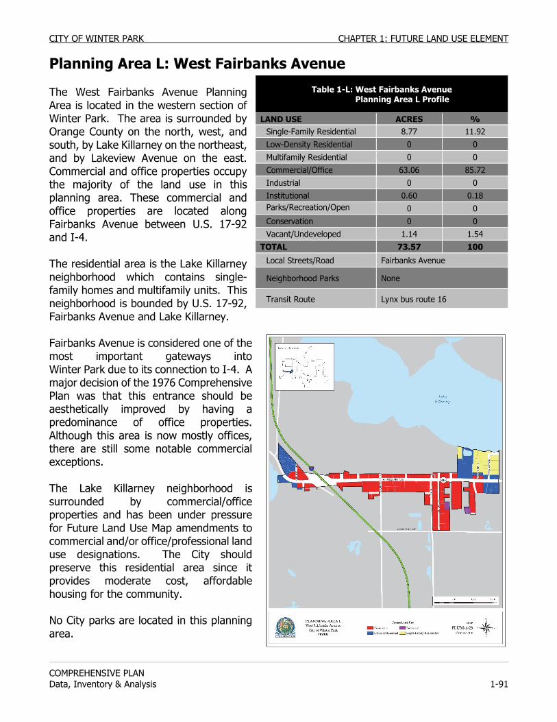
CITY OF WINTER PARK CHAPTER 1: FUTURE LAND USE ELEMENT
COMPREHENSIVE PLAN Data, Inventory & Analysis 1-91
Planning Area L: West Fairbanks Avenue The West Fairbanks Avenue Planning Area is located in the western section of Winter Park. The area is surrounded by Orange County on the north, west, and south, by Lake Killarney on the northeast, and by Lakeview Avenue on the east. Commercial and office properties occupy the majority of the land use in this planning area. These commercial and office properties are located along Fairbanks Avenue between U.S. 17-92 and I-4. The residential area is the Lake Killarney neighborhood which contains single-family homes and multifamily units. This neighborhood is bounded by U.S. 17-92, Fairbanks Avenue and Lake Killarney. Fairbanks Avenue is considered one of the most important gateways into Winter Park due to its connection to I-4. A major decision of the 1976 Comprehensive Plan was that this entrance should be aesthetically improved by having a predominance of office properties. Although this area is now mostly offices, there are still some notable commercial exceptions. The Lake Killarney neighborhood is surrounded by commercial/office properties and has been under pressure for Future Land Use Map amendments to commercial and/or office/professional land use designations. The City should preserve this residential area since it provides moderate cost, affordable housing for the community. No City parks are located in this planning area.
Table 1-L: West Fairbanks Avenue Planning Area L Profile
LAND USE ACRES % Single-Family Residential 8.77 11.92 Low-Density Residential 0 0 Multifamily Residential 0 0
Commercial/Office 63.06 85.72 Industrial 0 0 Institutional 0.60 0.18 Parks/Recreation/Open S
0 0 Conservation 0 0 Vacant/Undeveloped 1.14 1.54
TOTAL 73.57 100
Local Streets/Road Fairbanks Avenue
Neighborhood Parks None
Transit Route Lynx bus route 16
CHAPTER 1: FUTURE LAND USE ELEMENT CITY OF WINTER PARK
COMPREHENSIVE PLAN
1-92 Data, Inventory & Analysis
Transportation The planning area is served by Lynx bus route 16 on Fairbanks Avenue and includes on and off ramps to I-4 PLANNING ISSUES: West Fairbanks Avenue Preservation of Residential Land Use The City should preserve and protect the Lake Killarney neighborhood from Shoreview Drive to Broadview Avenue from commercial, office and parking lot encroachments. In order to create and preserve the character of this corridor as a gateway entrance to Winter Park, the City should prohibit certain business types along the frontage of the corridor including new or used car sales, auto repair businesses, re-sale stores or pawn shops, tattoo businesses, adult oriented businesses, fast food businesses and convenience stores. At such time that annexation occurs, the City should encourage and permit the rezoning and redevelopment of the residential properties which back up to properties that front on the north side of Fairbanks Avenue in the Lake Killarney neighborhood from Kilshore Lane west to I-4 pursuant to the setback and design standards.
At such time that annexation occurs, the City should encourage and permit the rezoning and redevelopment of the residential properties south of Fairbanks Avenue from S.R. 17-92 to I-4 pursuant to the setback and design standards.
Annexation The City should allow this planning area to extend and expand southward through annexation to include all commercial areas south to Minnesota Avenue and Calvary Church properties. Additional, the residential Lake Killarney neighborhood North of Fairbanks Avenue and South of Lake Killarney should be annexed. See Annexation Reserve Areas for more information.
CITY OF WINTER PARK CHAPTER 1: FUTURE LAND USE ELEMENT
COMPREHENSIVE PLAN Data, Inventory & Analysis 1-93
Historical Resources Surveys and Studies
All elements of comprehensive plans must be based upon data (FLA. STAT. § 163.3177 (8)). A group of volunteers from the Orlando-Winter Park Junior League conducted a survey in the mid-1970’s under the direction of the Florida Division of Historical Resources. A number of buildings were recorded on the Florida Master Site File, and a driving tour was published in 1980 by the League. A second, more comprehensive collection of historical resources data took place with a 1986 overview survey that focused on properties built prior to 1930. An architectural analysis identified frequently occurring architectural styles and building materials. The Historic and Architectural Survey Report prepared by Florida Preservation Services provided Florida Master Site File information on approximately 400 buildings. The 1986 overview survey focused primarily on the contexts of Florida’s Post-Reconstruction Period (1877-1897), Turn of the Century Period (1898-1918), and Land Boom Period (1919-1929). The report also identified historic scenic features of the City such as the characteristic streetscapes with narrow, often brick streets, lined with canopy forming oak trees, the surviving orange groves, and the City’s several lakes lined with estate homes on large lots. The preservation plan proposed in the survey report included recommendations for National Register nominations, historic landmark building designations and historic districts. The City of Winter Park updated its survey of historical resources in 2000-2001. The survey report entitled Architectural Survey and National Register Evaluation by GAI Consultants found that 42 previously identified historic resources had been demolished. The survey added 245 additional historical resources built prior to 1950 to the Florida Master Site File. The updated survey included the identification of resources potentially eligible for listing on the National Register of Historic Places. The survey report included an additional historic context for the Depression and Post World War II Period (1929 – 1950). Architectural Survey and National Register Evaluation Report Recommendations The Architectural Survey and National Register Evaluation report identified nine local and National Register eligible historic districts including Park Avenue (downtown section), Osceola Avenue, Rollins College, College Quarter, Virginia Heights, Hannibal Square, Golfview Terrace, Palmer Avenue, and Interlachen Avenue. The College Quarter residential neighborhood has now completed the process for local designation to the Winter Park Register of Historic Places. The report identified 128 historic resources as eligible for nomination to the National Register, and recommended a thematic nomination for buildings designed by James Gamble Rogers II. The report also identified 136 individual historic resources as local historic landmarks, as well as identifying more modest historic resources. The table on the following pages lists the historic resources included on the Florida Master Site Files (FMSF) as well as other historic resources identified by the City.
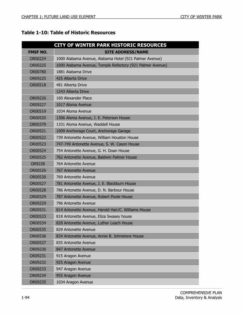
CHAPTER 1: FUTURE LAND USE ELEMENT CITY OF WINTER PARK
COMPREHENSIVE PLAN
1-94 Data, Inventory & Analysis
Table 1-10: Table of Historic Resources
CITY OF WINTER PARK HISTORIC RESOURCES
FMSF NO. SITE ADDRESS/NAME
OR00224 1000 Alabama Avenue, Alabama Hotel (921 Palmer Avenue)
OR00225 1000 Alabama Avenue, Temple Refectory (921 Palmer Avenue)
OR00780 1881 Alabama Drive
OR09225 425 Alberta Drive
OR00518 481 Alberta Drive
1243 Alberta Drive
OR09226 160 Alexander Place
OR09227 1017 Aloma Avenue
OR00519 1034 Aloma Avenue
OR00520 1306 Aloma Avenue, J. E. Peterson House
OR00379 1331 Aloma Avenue, Waddell House
OR00521 1009 Anchorage Court, Anchorage Garage
OR00522 739 Antonette Avenue, William Houston House
OR00523 747-749 Antonette Avenue, S. W. Cason House
OR00524 754 Antonette Avenue, G. H. Doan House
OR00525 762 Antonette Avenue, Baldwin Palmer House
OR9228 764 Antonette Avenue
OR00526 767 Antonette Avenue
OR00530 769 Antonette Avenue
OR00527 781 Antonette Avenue, J. E. Blackburn House
OR00528 786 Antonette Avenue, D. N. Barbour House
OR00529 787 Antonette Avenue, Robert Poole House
OR09229 796 Antonette Avenue
OR00531 814 Antonette Avenue, Harold Hair/C. Williams House
OR00533 818 Antonette Avenue, Eliza Swasey house
OR00534 828 Antonette Avenue, Luther Leach House
OR00535 829 Antonette Avenue
OR00536 834 Antonette Avenue, Annie B. Johnstone House
OR00537 835 Antonette Avenue
OR09230 847 Antonette Avenue
OR09231 915 Aragon Avenue
OR09232 925 Aragon Avenue
OR09233 947 Aragon Avenue
OR09234 955 Aragon Avenue
OR09235 1034 Aragon Avenue
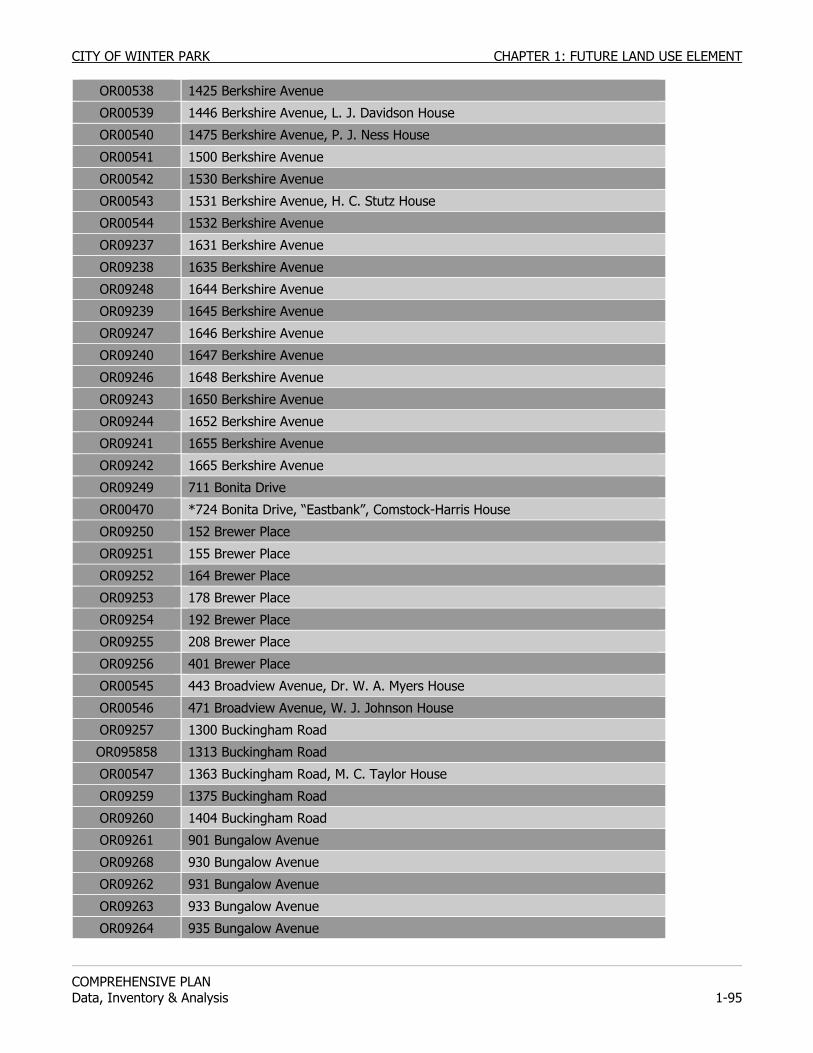
CITY OF WINTER PARK CHAPTER 1: FUTURE LAND USE ELEMENT
COMPREHENSIVE PLAN Data, Inventory & Analysis 1-95
OR00538 1425 Berkshire Avenue
OR00539 1446 Berkshire Avenue, L. J. Davidson House
OR00540 1475 Berkshire Avenue, P. J. Ness House
OR00541 1500 Berkshire Avenue
OR00542 1530 Berkshire Avenue
OR00543 1531 Berkshire Avenue, H. C. Stutz House
OR00544 1532 Berkshire Avenue
OR09237 1631 Berkshire Avenue
OR09238 1635 Berkshire Avenue
OR09248 1644 Berkshire Avenue
OR09239 1645 Berkshire Avenue
OR09247 1646 Berkshire Avenue
OR09240 1647 Berkshire Avenue
OR09246 1648 Berkshire Avenue
OR09243 1650 Berkshire Avenue
OR09244 1652 Berkshire Avenue
OR09241 1655 Berkshire Avenue
OR09242 1665 Berkshire Avenue
OR09249 711 Bonita Drive
OR00470 *724 Bonita Drive, “Eastbank”, Comstock-Harris House
OR09250 152 Brewer Place
OR09251 155 Brewer Place
OR09252 164 Brewer Place
OR09253 178 Brewer Place
OR09254 192 Brewer Place
OR09255 208 Brewer Place
OR09256 401 Brewer Place
OR00545 443 Broadview Avenue, Dr. W. A. Myers House
OR00546 471 Broadview Avenue, W. J. Johnson House
OR09257 1300 Buckingham Road
OR095858 1313 Buckingham Road
OR00547 1363 Buckingham Road, M. C. Taylor House
OR09259 1375 Buckingham Road
OR09260 1404 Buckingham Road
OR09261 901 Bungalow Avenue
OR09268 930 Bungalow Avenue
OR09262 931 Bungalow Avenue
OR09263 933 Bungalow Avenue
OR09264 935 Bungalow Avenue
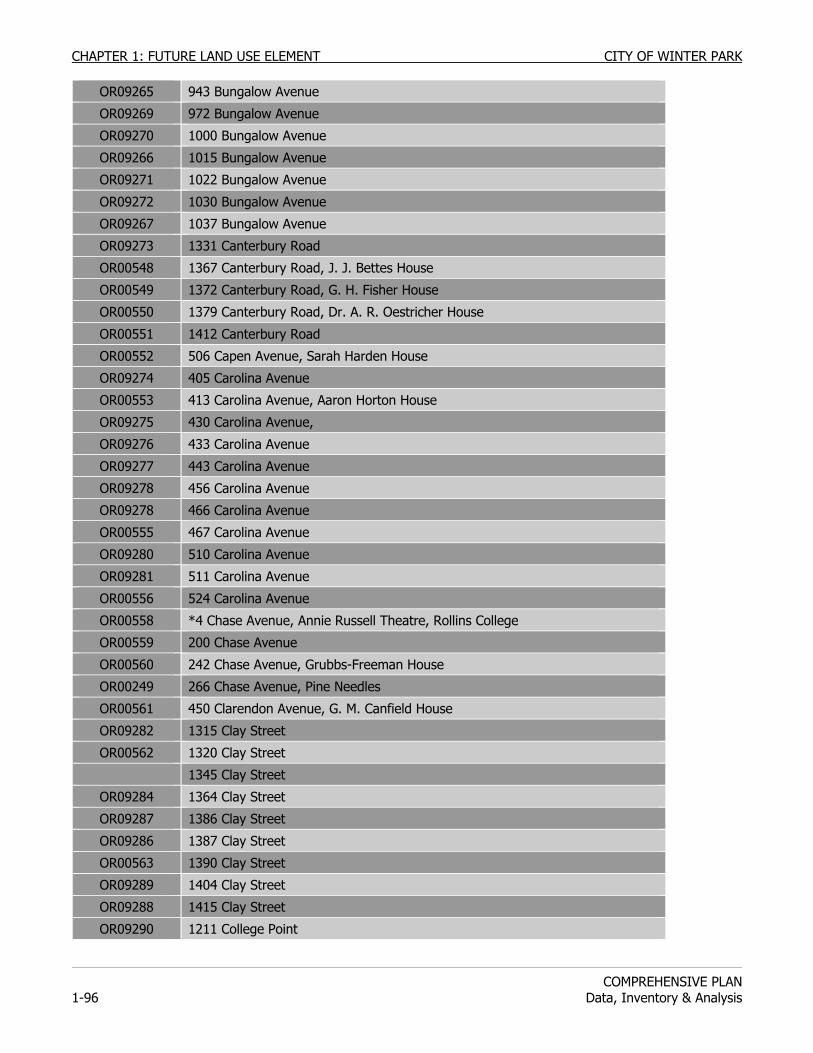
CHAPTER 1: FUTURE LAND USE ELEMENT CITY OF WINTER PARK
COMPREHENSIVE PLAN
1-96 Data, Inventory & Analysis
OR09265 943 Bungalow Avenue
OR09269 972 Bungalow Avenue
OR09270 1000 Bungalow Avenue
OR09266 1015 Bungalow Avenue
OR09271 1022 Bungalow Avenue
OR09272 1030 Bungalow Avenue
OR09267 1037 Bungalow Avenue
OR09273 1331 Canterbury Road
OR00548 1367 Canterbury Road, J. J. Bettes House
OR00549 1372 Canterbury Road, G. H. Fisher House
OR00550 1379 Canterbury Road, Dr. A. R. Oestricher House
OR00551 1412 Canterbury Road
OR00552 506 Capen Avenue, Sarah Harden House
OR09274 405 Carolina Avenue
OR00553 413 Carolina Avenue, Aaron Horton House
OR09275 430 Carolina Avenue,
OR09276 433 Carolina Avenue
OR09277 443 Carolina Avenue
OR09278 456 Carolina Avenue
OR09278 466 Carolina Avenue
OR00555 467 Carolina Avenue
OR09280 510 Carolina Avenue
OR09281 511 Carolina Avenue
OR00556 524 Carolina Avenue
OR00558 *4 Chase Avenue, Annie Russell Theatre, Rollins College
OR00559 200 Chase Avenue
OR00560 242 Chase Avenue, Grubbs-Freeman House
OR00249 266 Chase Avenue, Pine Needles
OR00561 450 Clarendon Avenue, G. M. Canfield House
OR09282 1315 Clay Street
OR00562 1320 Clay Street
1345 Clay Street
OR09284 1364 Clay Street
OR09287 1386 Clay Street
OR09286 1387 Clay Street
OR00563 1390 Clay Street
OR09289 1404 Clay Street
OR09288 1415 Clay Street
OR09290 1211 College Point
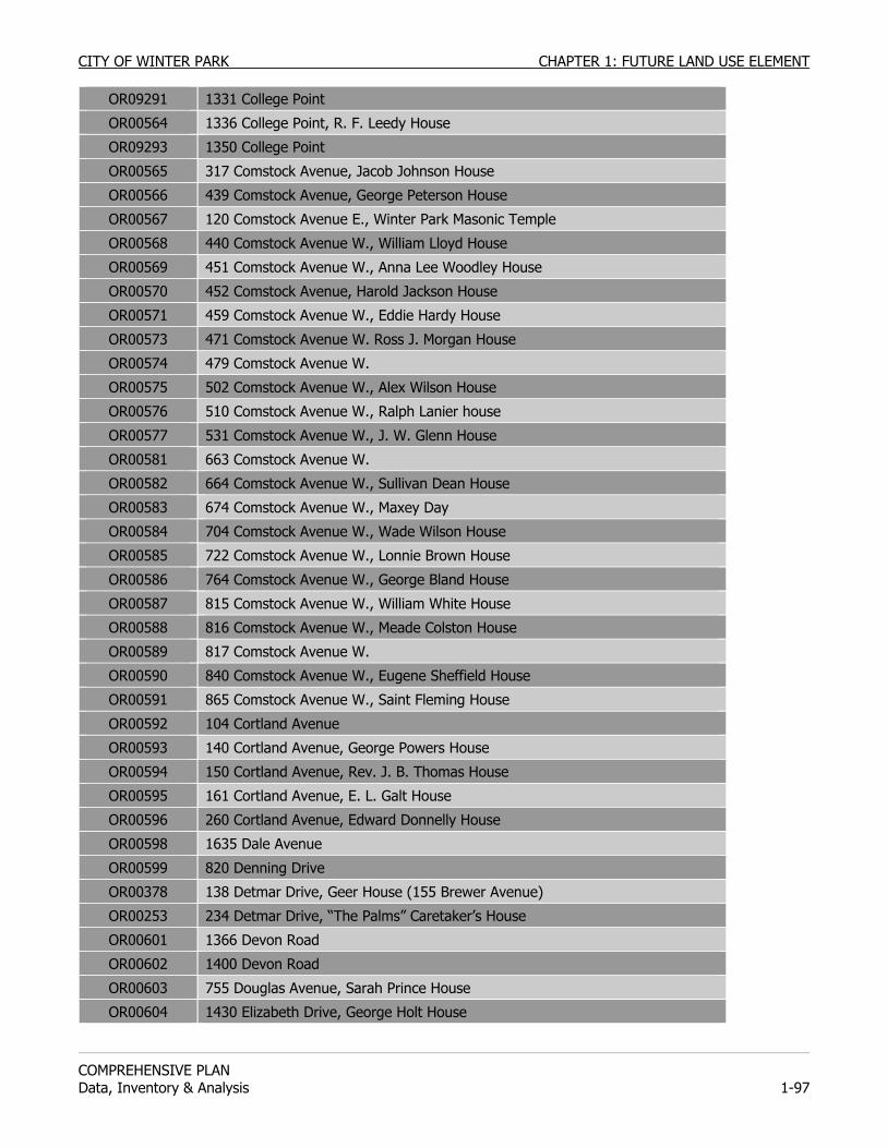
CITY OF WINTER PARK CHAPTER 1: FUTURE LAND USE ELEMENT
COMPREHENSIVE PLAN Data, Inventory & Analysis 1-97
OR09291 1331 College Point
OR00564 1336 College Point, R. F. Leedy House
OR09293 1350 College Point
OR00565 317 Comstock Avenue, Jacob Johnson House
OR00566 439 Comstock Avenue, George Peterson House
OR00567 120 Comstock Avenue E., Winter Park Masonic Temple
OR00568 440 Comstock Avenue W., William Lloyd House
OR00569 451 Comstock Avenue W., Anna Lee Woodley House
OR00570 452 Comstock Avenue, Harold Jackson House
OR00571 459 Comstock Avenue W., Eddie Hardy House
OR00573 471 Comstock Avenue W. Ross J. Morgan House
OR00574 479 Comstock Avenue W.
OR00575 502 Comstock Avenue W., Alex Wilson House
OR00576 510 Comstock Avenue W., Ralph Lanier house
OR00577 531 Comstock Avenue W., J. W. Glenn House
OR00581 663 Comstock Avenue W.
OR00582 664 Comstock Avenue W., Sullivan Dean House
OR00583 674 Comstock Avenue W., Maxey Day
OR00584 704 Comstock Avenue W., Wade Wilson House
OR00585 722 Comstock Avenue W., Lonnie Brown House
OR00586 764 Comstock Avenue W., George Bland House
OR00587 815 Comstock Avenue W., William White House
OR00588 816 Comstock Avenue W., Meade Colston House
OR00589 817 Comstock Avenue W.
OR00590 840 Comstock Avenue W., Eugene Sheffield House
OR00591 865 Comstock Avenue W., Saint Fleming House
OR00592 104 Cortland Avenue
OR00593 140 Cortland Avenue, George Powers House
OR00594 150 Cortland Avenue, Rev. J. B. Thomas House
OR00595 161 Cortland Avenue, E. L. Galt House
OR00596 260 Cortland Avenue, Edward Donnelly House
OR00598 1635 Dale Avenue
OR00599 820 Denning Drive
OR00378 138 Detmar Drive, Geer House (155 Brewer Avenue)
OR00253 234 Detmar Drive, “The Palms” Caretaker’s House
OR00601 1366 Devon Road
OR00602 1400 Devon Road
OR00603 755 Douglas Avenue, Sarah Prince House
OR00604 1430 Elizabeth Drive, George Holt House
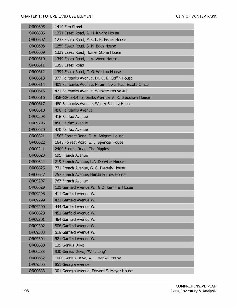
CHAPTER 1: FUTURE LAND USE ELEMENT CITY OF WINTER PARK
COMPREHENSIVE PLAN
1-98 Data, Inventory & Analysis
OR00605 1410 Elm Street
OR00606 1221 Essex Road, A. H. Knight House
OR00607 1235 Essex Road, Mrs. L. B. Fisher House
OR00608 1259 Essex Road, S. H. Edes House
OR00609 1329 Essex Road, Homer Stone House
OR00610 1349 Essex Road, L. A. Wood House
OR00611 1353 Essex Road
OR00612 1399 Essex Road, C. G. Weston House
OR00613 377 Fairbanks Avenue, Dr. C. E. Coffin House
OR00614 401 Fairbanks Avenue, Hiram Power Real Estate Office
OR00615 421 Fairbanks Avenue, Webster House #2
OR00616 458-60-62-64 Fairbanks Avenue, A. K. Bradshaw House
OR00617 480 Fairbanks Avenue, Walter Schultz House
OR00618 496 Fairbanks Avenue
OR09295 416 Fairfax Avenue
OR09296 450 Fairfax Avenue
OR00620 470 Fairfax Avenue
OR00621 1567 Forrest Road, D. A. Ahlgrim House
OR00622 1645 Forrest Road, E. L. Spencer House
OR00241 2400 Forrest Road, The Ripples
OR00623 695 French Avenue
OR00624 719 French Avenue, L.A. Detwiler House
OR00625 731 French Avenue, G. C. Dieterly House
OR00627 757 French Avenue, Huilda Forbes House
OR09297 767 French Avenue
OR00629 121 Garfield Avenue W., G.O. Kummer House
OR09298 411 Garfield Avenue W.
OR09299 421 Garfield Avenue W.
OR09200 444 Garfield Avenue W.
OR00628 451 Garfield Avenue W.
OR09301 464 Garfield Avenue W.
OR09302 506 Garfield Avenue W.
OR09303 519 Garfield Avenue W.
OR09304 521 Garfield Avenue W.
OR00630 139 Genius Drive
OR00235 930 Genius Drive, “Windsong”
OR00632 1000 Genius Drive, A. L. Henkel House
OR09305 851 Georgia Avenue
OR00633 901 Georgia Avenue, Edward S. Meyer House
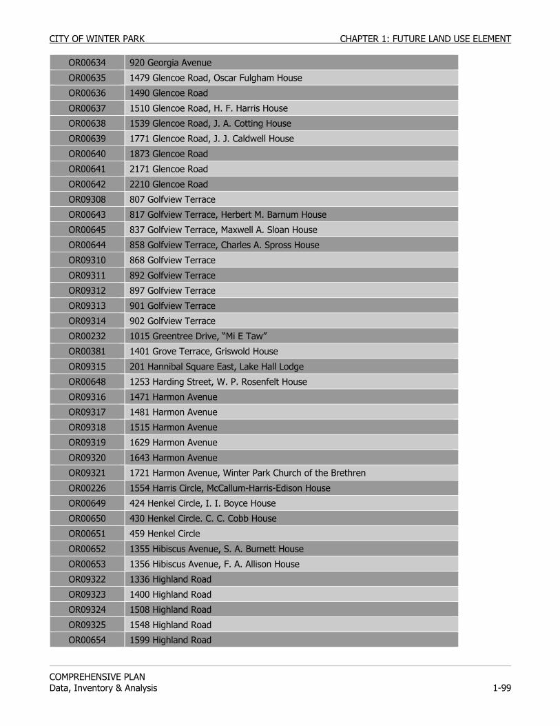
CITY OF WINTER PARK CHAPTER 1: FUTURE LAND USE ELEMENT
COMPREHENSIVE PLAN Data, Inventory & Analysis 1-99
OR00634 920 Georgia Avenue
OR00635 1479 Glencoe Road, Oscar Fulgham House
OR00636 1490 Glencoe Road
OR00637 1510 Glencoe Road, H. F. Harris House
OR00638 1539 Glencoe Road, J. A. Cotting House
OR00639 1771 Glencoe Road, J. J. Caldwell House
OR00640 1873 Glencoe Road
OR00641 2171 Glencoe Road
OR00642 2210 Glencoe Road
OR09308 807 Golfview Terrace
OR00643 817 Golfview Terrace, Herbert M. Barnum House
OR00645 837 Golfview Terrace, Maxwell A. Sloan House
OR00644 858 Golfview Terrace, Charles A. Spross House
OR09310 868 Golfview Terrace
OR09311 892 Golfview Terrace
OR09312 897 Golfview Terrace
OR09313 901 Golfview Terrace
OR09314 902 Golfview Terrace
OR00232 1015 Greentree Drive, “Mi E Taw”
OR00381 1401 Grove Terrace, Griswold House
OR09315 201 Hannibal Square East, Lake Hall Lodge
OR00648 1253 Harding Street, W. P. Rosenfelt House
OR09316 1471 Harmon Avenue
OR09317 1481 Harmon Avenue
OR09318 1515 Harmon Avenue
OR09319 1629 Harmon Avenue
OR09320 1643 Harmon Avenue
OR09321 1721 Harmon Avenue, Winter Park Church of the Brethren
OR00226 1554 Harris Circle, McCallum-Harris-Edison House
OR00649 424 Henkel Circle, I. I. Boyce House
OR00650 430 Henkel Circle. C. C. Cobb House
OR00651 459 Henkel Circle
OR00652 1355 Hibiscus Avenue, S. A. Burnett House
OR00653 1356 Hibiscus Avenue, F. A. Allison House
OR09322 1336 Highland Road
OR09323 1400 Highland Road
OR09324 1508 Highland Road
OR09325 1548 Highland Road
OR00654 1599 Highland Road
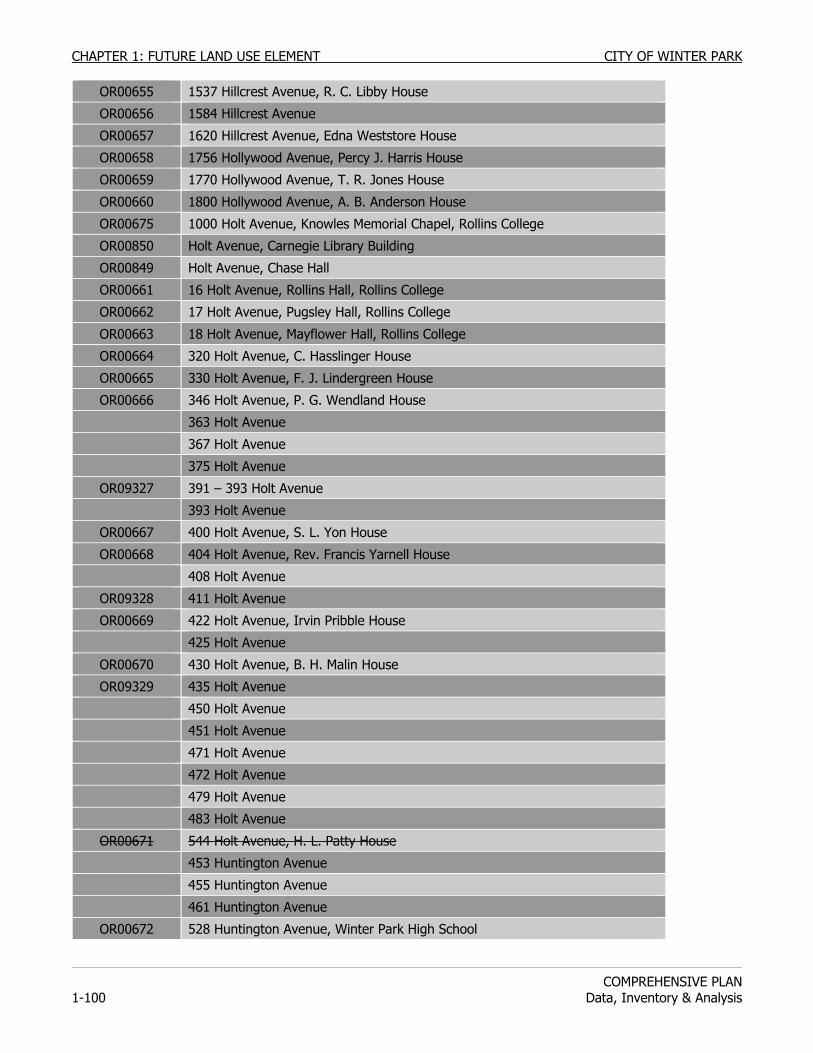
CHAPTER 1: FUTURE LAND USE ELEMENT CITY OF WINTER PARK
COMPREHENSIVE PLAN
1-100 Data, Inventory & Analysis
OR00655 1537 Hillcrest Avenue, R. C. Libby House
OR00656 1584 Hillcrest Avenue
OR00657 1620 Hillcrest Avenue, Edna Weststore House
OR00658 1756 Hollywood Avenue, Percy J. Harris House
OR00659 1770 Hollywood Avenue, T. R. Jones House
OR00660 1800 Hollywood Avenue, A. B. Anderson House
OR00675 1000 Holt Avenue, Knowles Memorial Chapel, Rollins College
OR00850 Holt Avenue, Carnegie Library Building
OR00849 Holt Avenue, Chase Hall
OR00661 16 Holt Avenue, Rollins Hall, Rollins College
OR00662 17 Holt Avenue, Pugsley Hall, Rollins College
OR00663 18 Holt Avenue, Mayflower Hall, Rollins College
OR00664 320 Holt Avenue, C. Hasslinger House
OR00665 330 Holt Avenue, F. J. Lindergreen House
OR00666 346 Holt Avenue, P. G. Wendland House
363 Holt Avenue
367 Holt Avenue
375 Holt Avenue
OR09327 391 – 393 Holt Avenue
393 Holt Avenue
OR00667 400 Holt Avenue, S. L. Yon House
OR00668 404 Holt Avenue, Rev. Francis Yarnell House
408 Holt Avenue
OR09328 411 Holt Avenue
OR00669 422 Holt Avenue, Irvin Pribble House
425 Holt Avenue
OR00670 430 Holt Avenue, B. H. Malin House
OR09329 435 Holt Avenue
450 Holt Avenue
451 Holt Avenue
471 Holt Avenue
472 Holt Avenue
479 Holt Avenue
483 Holt Avenue
OR00671 544 Holt Avenue, H. L. Patty House
453 Huntington Avenue
455 Huntington Avenue
461 Huntington Avenue
OR00672 528 Huntington Avenue, Winter Park High School
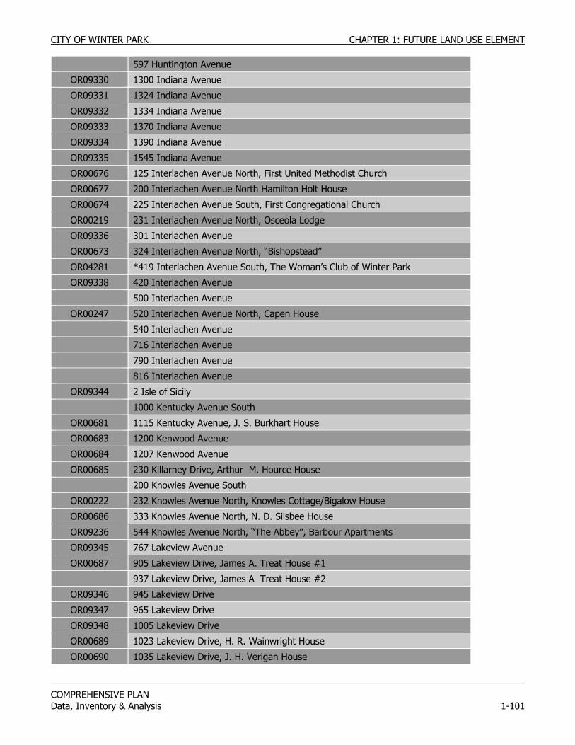
CITY OF WINTER PARK CHAPTER 1: FUTURE LAND USE ELEMENT
COMPREHENSIVE PLAN Data, Inventory & Analysis 1-101
597 Huntington Avenue
OR09330 1300 Indiana Avenue
OR09331 1324 Indiana Avenue
OR09332 1334 Indiana Avenue
OR09333 1370 Indiana Avenue
OR09334 1390 Indiana Avenue
OR09335 1545 Indiana Avenue
OR00676 125 Interlachen Avenue North, First United Methodist Church
OR00677 200 Interlachen Avenue North Hamilton Holt House
OR00674 225 Interlachen Avenue South, First Congregational Church
OR00219 231 Interlachen Avenue North, Osceola Lodge
OR09336 301 Interlachen Avenue
OR00673 324 Interlachen Avenue North, “Bishopstead”
OR04281 *419 Interlachen Avenue South, The Woman’s Club of Winter Park
OR09338 420 Interlachen Avenue
500 Interlachen Avenue
OR00247 520 Interlachen Avenue North, Capen House
540 Interlachen Avenue
716 Interlachen Avenue
790 Interlachen Avenue
816 Interlachen Avenue
OR09344 2 Isle of Sicily
1000 Kentucky Avenue South
OR00681 1115 Kentucky Avenue, J. S. Burkhart House
OR00683 1200 Kenwood Avenue
OR00684 1207 Kenwood Avenue
OR00685 230 Killarney Drive, Arthur M. Hource House
200 Knowles Avenue South
OR00222 232 Knowles Avenue North, Knowles Cottage/Bigalow House
OR00686 333 Knowles Avenue North, N. D. Silsbee House
OR09236 544 Knowles Avenue North, “The Abbey”, Barbour Apartments
OR09345 767 Lakeview Avenue
OR00687 905 Lakeview Drive, James A. Treat House #1
937 Lakeview Drive, James A Treat House #2
OR09346 945 Lakeview Drive
OR09347 965 Lakeview Drive
OR09348 1005 Lakeview Drive
OR00689 1023 Lakeview Drive, H. R. Wainwright House
OR00690 1035 Lakeview Drive, J. H. Verigan House
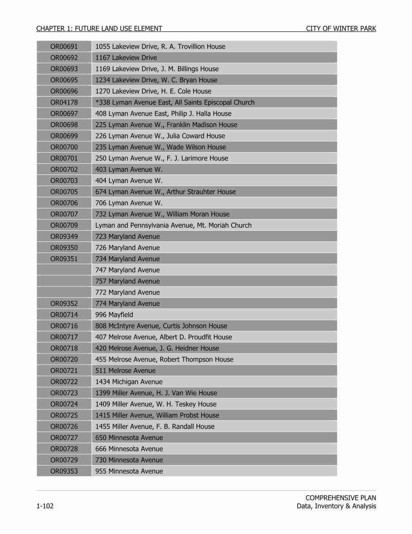
CHAPTER 1: FUTURE LAND USE ELEMENT CITY OF WINTER PARK
COMPREHENSIVE PLAN
1-102 Data, Inventory & Analysis
OR00691 1055 Lakeview Drive, R. A. Trovillion House
OR00692 1167 Lakeview Drive
OR00693 1169 Lakeview Drive, J. M. Billings House
OR00695 1234 Lakeview Drive, W. C. Bryan House
OR00696 1270 Lakeview Drive, H. E. Cole House
OR04178 *338 Lyman Avenue East, All Saints Episcopal Church
OR00697 408 Lyman Avenue East, Philip J. Halla House
OR00698 225 Lyman Avenue W., Franklin Madison House
OR00699 226 Lyman Avenue W., Julia Coward House
OR00700 235 Lyman Avenue W., Wade Wilson House
OR00701 250 Lyman Avenue W., F. J. Larimore House
OR00702 403 Lyman Avenue W.
OR00703 404 Lyman Avenue W.
OR00705 674 Lyman Avenue W., Arthur Strauhter House
OR00706 706 Lyman Avenue W.
OR00707 732 Lyman Avenue W., William Moran House
OR00709 Lyman and Pennsylvania Avenue, Mt. Moriah Church
OR09349 723 Maryland Avenue
OR09350 726 Maryland Avenue
OR09351 734 Maryland Avenue
747 Maryland Avenue
757 Maryland Avenue
772 Maryland Avenue
OR09352 774 Maryland Avenue
OR00714 996 Mayfield
OR00716 808 McIntyre Avenue, Curtis Johnson House
OR00717 407 Melrose Avenue, Albert D. Proudfit House
OR00718 420 Melrose Avenue, J. G. Heidner House
OR00720 455 Melrose Avenue, Robert Thompson House
OR00721 511 Melrose Avenue
OR00722 1434 Michigan Avenue
OR00723 1399 Miller Avenue, H. J. Van Wie House
OR00724 1409 Miller Avenue, W. H. Teskey House
OR00725 1415 Miller Avenue, William Probst House
OR00726 1455 Miller Avenue, F. B. Randall House
OR00727 650 Minnesota Avenue
OR00728 666 Minnesota Avenue
OR00729 730 Minnesota Avenue
OR09353 955 Minnesota Avenue
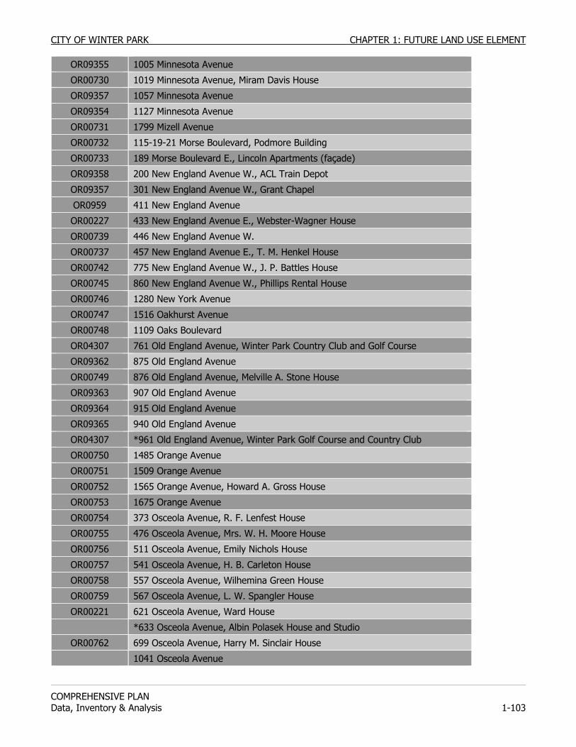
CITY OF WINTER PARK CHAPTER 1: FUTURE LAND USE ELEMENT
COMPREHENSIVE PLAN Data, Inventory & Analysis 1-103
OR09355 1005 Minnesota Avenue
OR00730 1019 Minnesota Avenue, Miram Davis House
OR09357 1057 Minnesota Avenue
OR09354 1127 Minnesota Avenue
OR00731 1799 Mizell Avenue
OR00732 115-19-21 Morse Boulevard, Podmore Building
OR00733 189 Morse Boulevard E., Lincoln Apartments (façade)
OR09358 200 New England Avenue W., ACL Train Depot
OR09357 301 New England Avenue W., Grant Chapel
OR0959 411 New England Avenue
OR00227 433 New England Avenue E., Webster-Wagner House
OR00739 446 New England Avenue W.
OR00737 457 New England Avenue E., T. M. Henkel House
OR00742 775 New England Avenue W., J. P. Battles House
OR00745 860 New England Avenue W., Phillips Rental House
OR00746 1280 New York Avenue
OR00747 1516 Oakhurst Avenue
OR00748 1109 Oaks Boulevard
OR04307 761 Old England Avenue, Winter Park Country Club and Golf Course
OR09362 875 Old England Avenue
OR00749 876 Old England Avenue, Melville A. Stone House
OR09363 907 Old England Avenue
OR09364 915 Old England Avenue
OR09365 940 Old England Avenue
OR04307 *961 Old England Avenue, Winter Park Golf Course and Country Club
OR00750 1485 Orange Avenue
OR00751 1509 Orange Avenue
OR00752 1565 Orange Avenue, Howard A. Gross House
OR00753 1675 Orange Avenue
OR00754 373 Osceola Avenue, R. F. Lenfest House
OR00755 476 Osceola Avenue, Mrs. W. H. Moore House
OR00756 511 Osceola Avenue, Emily Nichols House
OR00757 541 Osceola Avenue, H. B. Carleton House
OR00758 557 Osceola Avenue, Wilhemina Green House
OR00759 567 Osceola Avenue, L. W. Spangler House
OR00221 621 Osceola Avenue, Ward House
*633 Osceola Avenue, Albin Polasek House and Studio
OR00762 699 Osceola Avenue, Harry M. Sinclair House
1041 Osceola Avenue
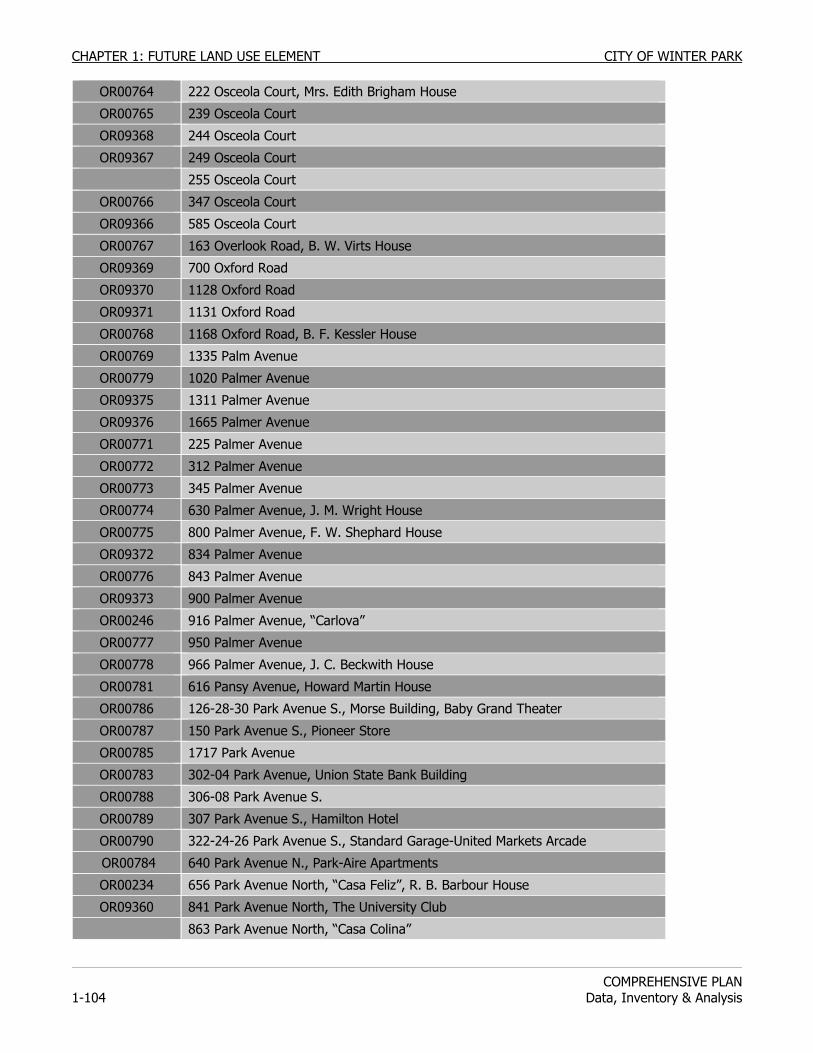
CHAPTER 1: FUTURE LAND USE ELEMENT CITY OF WINTER PARK
COMPREHENSIVE PLAN
1-104 Data, Inventory & Analysis
OR00764 222 Osceola Court, Mrs. Edith Brigham House
OR00765 239 Osceola Court
OR09368 244 Osceola Court
OR09367 249 Osceola Court
255 Osceola Court
OR00766 347 Osceola Court
OR09366 585 Osceola Court
OR00767 163 Overlook Road, B. W. Virts House
OR09369 700 Oxford Road
OR09370 1128 Oxford Road
OR09371 1131 Oxford Road
OR00768 1168 Oxford Road, B. F. Kessler House
OR00769 1335 Palm Avenue
OR00779 1020 Palmer Avenue
OR09375 1311 Palmer Avenue
OR09376 1665 Palmer Avenue
OR00771 225 Palmer Avenue
OR00772 312 Palmer Avenue
OR00773 345 Palmer Avenue
OR00774 630 Palmer Avenue, J. M. Wright House
OR00775 800 Palmer Avenue, F. W. Shephard House
OR09372 834 Palmer Avenue
OR00776 843 Palmer Avenue
OR09373 900 Palmer Avenue
OR00246 916 Palmer Avenue, “Carlova”
OR00777 950 Palmer Avenue
OR00778 966 Palmer Avenue, J. C. Beckwith House
OR00781 616 Pansy Avenue, Howard Martin House
OR00786 126-28-30 Park Avenue S., Morse Building, Baby Grand Theater
OR00787 150 Park Avenue S., Pioneer Store
OR00785 1717 Park Avenue
OR00783 302-04 Park Avenue, Union State Bank Building
OR00788 306-08 Park Avenue S.
OR00789 307 Park Avenue S., Hamilton Hotel
OR00790 322-24-26 Park Avenue S., Standard Garage-United Markets Arcade
OR00784 640 Park Avenue N., Park-Aire Apartments
OR00234 656 Park Avenue North, “Casa Feliz”, R. B. Barbour House
OR09360 841 Park Avenue North, The University Club
863 Park Avenue North, “Casa Colina”
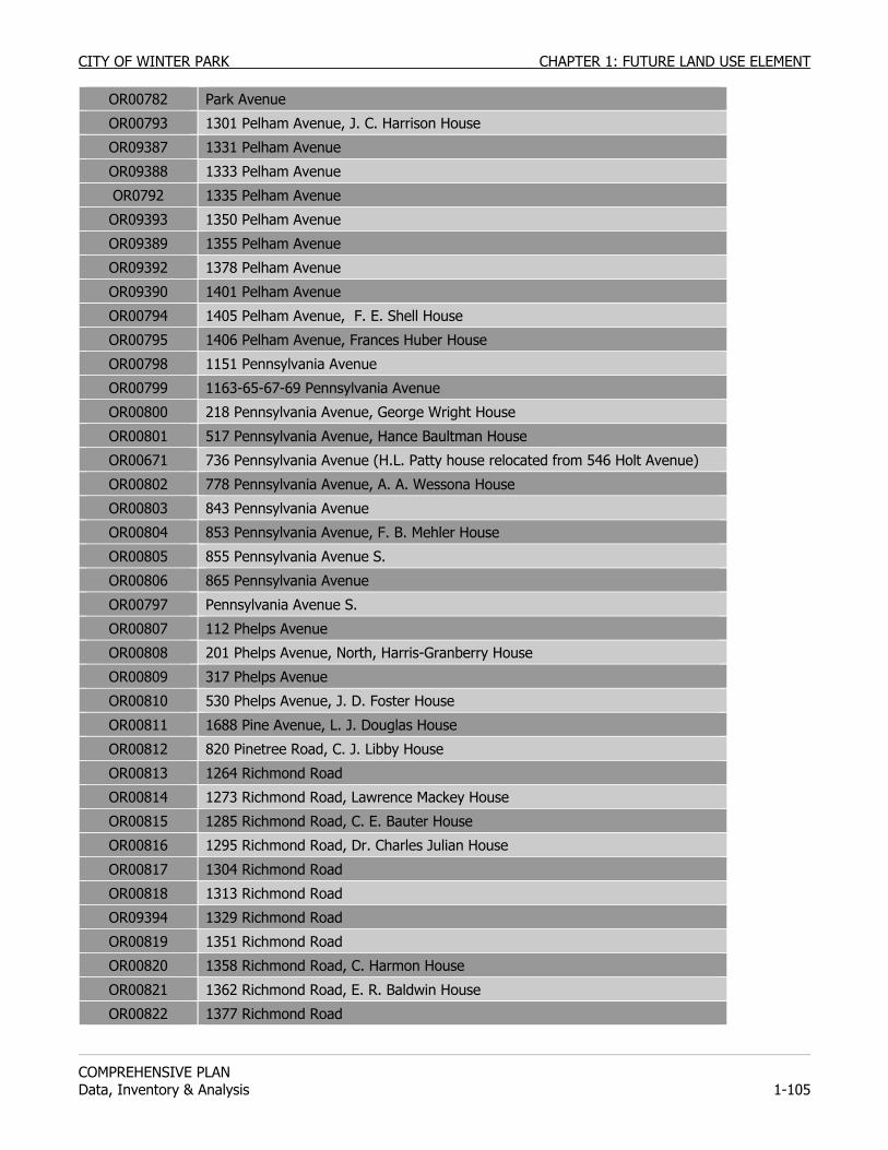
CITY OF WINTER PARK CHAPTER 1: FUTURE LAND USE ELEMENT
COMPREHENSIVE PLAN Data, Inventory & Analysis 1-105
OR00782 Park Avenue
OR00793 1301 Pelham Avenue, J. C. Harrison House
OR09387 1331 Pelham Avenue
OR09388 1333 Pelham Avenue
OR0792 1335 Pelham Avenue
OR09393 1350 Pelham Avenue
OR09389 1355 Pelham Avenue
OR09392 1378 Pelham Avenue
OR09390 1401 Pelham Avenue
OR00794 1405 Pelham Avenue, F. E. Shell House
OR00795 1406 Pelham Avenue, Frances Huber House
OR00798 1151 Pennsylvania Avenue
OR00799 1163-65-67-69 Pennsylvania Avenue
OR00800 218 Pennsylvania Avenue, George Wright House
OR00801 517 Pennsylvania Avenue, Hance Baultman House
OR00671 736 Pennsylvania Avenue (H.L. Patty house relocated from 546 Holt Avenue)
OR00802 778 Pennsylvania Avenue, A. A. Wessona House
OR00803 843 Pennsylvania Avenue
OR00804 853 Pennsylvania Avenue, F. B. Mehler House
OR00805 855 Pennsylvania Avenue S.
OR00806 865 Pennsylvania Avenue
OR00797 Pennsylvania Avenue S.
OR00807 112 Phelps Avenue
OR00808 201 Phelps Avenue, North, Harris-Granberry House
OR00809 317 Phelps Avenue
OR00810 530 Phelps Avenue, J. D. Foster House
OR00811 1688 Pine Avenue, L. J. Douglas House
OR00812 820 Pinetree Road, C. J. Libby House
OR00813 1264 Richmond Road
OR00814 1273 Richmond Road, Lawrence Mackey House
OR00815 1285 Richmond Road, C. E. Bauter House
OR00816 1295 Richmond Road, Dr. Charles Julian House
OR00817 1304 Richmond Road
OR00818 1313 Richmond Road
OR09394 1329 Richmond Road
OR00819 1351 Richmond Road
OR00820 1358 Richmond Road, C. Harmon House
OR00821 1362 Richmond Road, E. R. Baldwin House
OR00822 1377 Richmond Road

CHAPTER 1: FUTURE LAND USE ELEMENT CITY OF WINTER PARK
COMPREHENSIVE PLAN
1-106 Data, Inventory & Analysis
OR09395 1385 Richmond Road
OR09396 1399 Richmond Road
OR00823 141 Rockwood Way
OR00824 1624 Roundelay
OR00248 314 Salvador Square, “Bonnie Burn”
OR00825 616 Seminole Avenue, Fredrick W. Cady House
OR00826 666 Seminole Avenue
OR09411 826 Seminole Avenue
OR09412 911 Seminole Avenue
OR00827 Shoreview Avenue, Abraham Sharpe House
OR00828 518 Shoreview Avenue, A. V. Daugherty House
OR00829 1616 Spruce Avenue
OR00830 144 Stirling Avenue, Proudfit-Macklin House
OR00831 210 Stirling Avenue, Samuel Goss House
OR00832 155 Stovin Avenue, Dr. C. A. Campbell House
OR00833 173 Stovin Avenue, Albert Wagner House
OR00834 183 Stovin Avenue, Frederick Ward House
OR00835 187 Stovin Avenue, C. P. Hutton House
OR00233 1300 Summerland Avenue, Lawrence-Chubb House
OR00836 1499 Summerland Avenue, C. J. Lefevere House
OR00837 1315 Sunset Avenue, A. B. Bradley House
OR00838 1324 Sunset Avenue, J. F. McDonald House
OR00839 1409 Sunset Avenue
OR00840 1572 Sunset Avenue, Joseph King House
OR00841 236 Sylvan Drive
OR00842 244 Sylvan Drive
OR00843 292 Sylvan Drive
OR00844 663 Symonds Avenue, Alton Woodward House
OR00845 852 Symonds Avenue, Ray Beckwith House
OR00846 1864 Taylor Avenue
OR00847 1880 Taylor Avenue
OR00252 *40 Trisman Terrace, “The Palms”, Brewer House
OR00849 Chase Hall, Horseshoe Drive, Rollins College
OR00850 Carnegie Library, Horseshoe Drive, Rollins College
OR00223 701 Via Bella, “Weatogue”
OR00851 1146 Via Capri
OR00852 1247 Via Capri, Ernst Schmeltz House
OR09413 1411 Via Tuscany
OR00245 1461 Via Tuscany, “Sandscove”
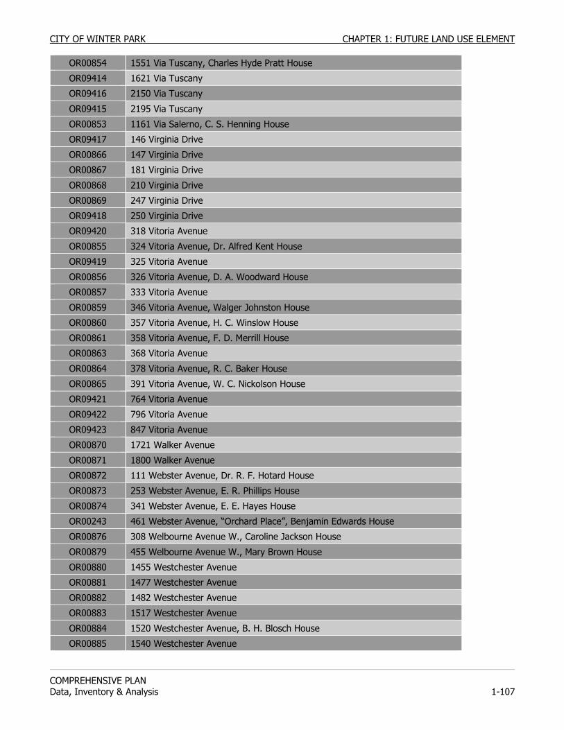
CITY OF WINTER PARK CHAPTER 1: FUTURE LAND USE ELEMENT
COMPREHENSIVE PLAN Data, Inventory & Analysis 1-107
OR00854 1551 Via Tuscany, Charles Hyde Pratt House
OR09414 1621 Via Tuscany
OR09416 2150 Via Tuscany
OR09415 2195 Via Tuscany
OR00853 1161 Via Salerno, C. S. Henning House
OR09417 146 Virginia Drive
OR00866 147 Virginia Drive
OR00867 181 Virginia Drive
OR00868 210 Virginia Drive
OR00869 247 Virginia Drive
OR09418 250 Virginia Drive
OR09420 318 Vitoria Avenue
OR00855 324 Vitoria Avenue, Dr. Alfred Kent House
OR09419 325 Vitoria Avenue
OR00856 326 Vitoria Avenue, D. A. Woodward House
OR00857 333 Vitoria Avenue
OR00859 346 Vitoria Avenue, Walger Johnston House
OR00860 357 Vitoria Avenue, H. C. Winslow House
OR00861 358 Vitoria Avenue, F. D. Merrill House
OR00863 368 Vitoria Avenue
OR00864 378 Vitoria Avenue, R. C. Baker House
OR00865 391 Vitoria Avenue, W. C. Nickolson House
OR09421 764 Vitoria Avenue
OR09422 796 Vitoria Avenue
OR09423 847 Vitoria Avenue
OR00870 1721 Walker Avenue
OR00871 1800 Walker Avenue
OR00872 111 Webster Avenue, Dr. R. F. Hotard House
OR00873 253 Webster Avenue, E. R. Phillips House
OR00874 341 Webster Avenue, E. E. Hayes House
OR00243 461 Webster Avenue, “Orchard Place”, Benjamin Edwards House
OR00876 308 Welbourne Avenue W., Caroline Jackson House
OR00879 455 Welbourne Avenue W., Mary Brown House
OR00880 1455 Westchester Avenue
OR00881 1477 Westchester Avenue
OR00882 1482 Westchester Avenue
OR00883 1517 Westchester Avenue
OR00884 1520 Westchester Avenue, B. H. Blosch House
OR00885 1540 Westchester Avenue
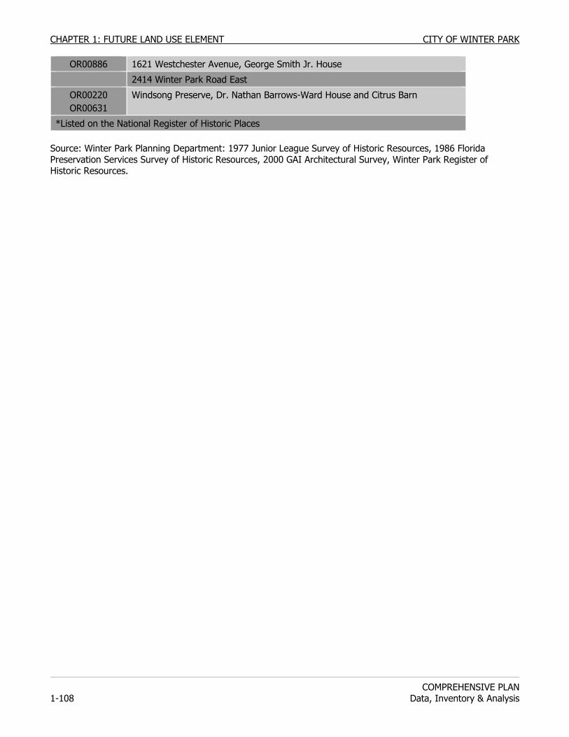
CHAPTER 1: FUTURE LAND USE ELEMENT CITY OF WINTER PARK
COMPREHENSIVE PLAN
1-108 Data, Inventory & Analysis
OR00886 1621 Westchester Avenue, George Smith Jr. House
2414 Winter Park Road East
OR00220 OR00631
Windsong Preserve, Dr. Nathan Barrows-Ward House and Citrus Barn
*Listed on the National Register of Historic Places Source: Winter Park Planning Department: 1977 Junior League Survey of Historic Resources, 1986 Florida Preservation Services Survey of Historic Resources, 2000 GAI Architectural Survey, Winter Park Register of Historic Resources.
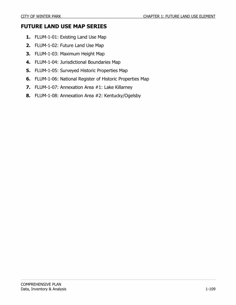
CITY OF WINTER PARK CHAPTER 1: FUTURE LAND USE ELEMENT
COMPREHENSIVE PLAN Data, Inventory & Analysis 1-109
FUTURE LAND USE MAP SERIES
1. FLUM-1-01: Existing Land Use Map
2. FLUM-1-02: Future Land Use Map
3. FLUM-1-03: Maximum Height Map
4. FLUM-1-04: Jurisdictional Boundaries Map
5. FLUM-1-05: Surveyed Historic Properties Map
6. FLUM-1-06: National Register of Historic Properties Map
7. FLUM-1-07: Annexation Area #1: Lake Killarney
8. FLUM-1-08: Annexation Area #2: Kentucky/Ogelsby
CHAPTER 1: FUTURE LAND USE ELEMENT CITY OF WINTER PARK
COMPREHENSIVE PLAN
1-110 Data, Inventory & Analysis
CITY OF WINTER PARK CHAPTER 1: FUTURE LAND USE ELEMENT
COMPREHENSIVE PLAN Data, Inventory & Analysis 1-111
9. FLUM-1-09, Annexation Area #3: Lawndale
10. FLUM-1-10, Annexation Area #4: Stonehurst
CHAPTER 1: FUTURE LAND USE ELEMENT CITY OF WINTER PARK
COMPREHENSIVE PLAN
1-112 Data, Inventory & Analysis
CITY OF WINTER PARK CHAPTER 1: FUTURE LAND USE ELEMENT
COMPREHENSIVE PLAN Data, Inventory & Analysis 1-113
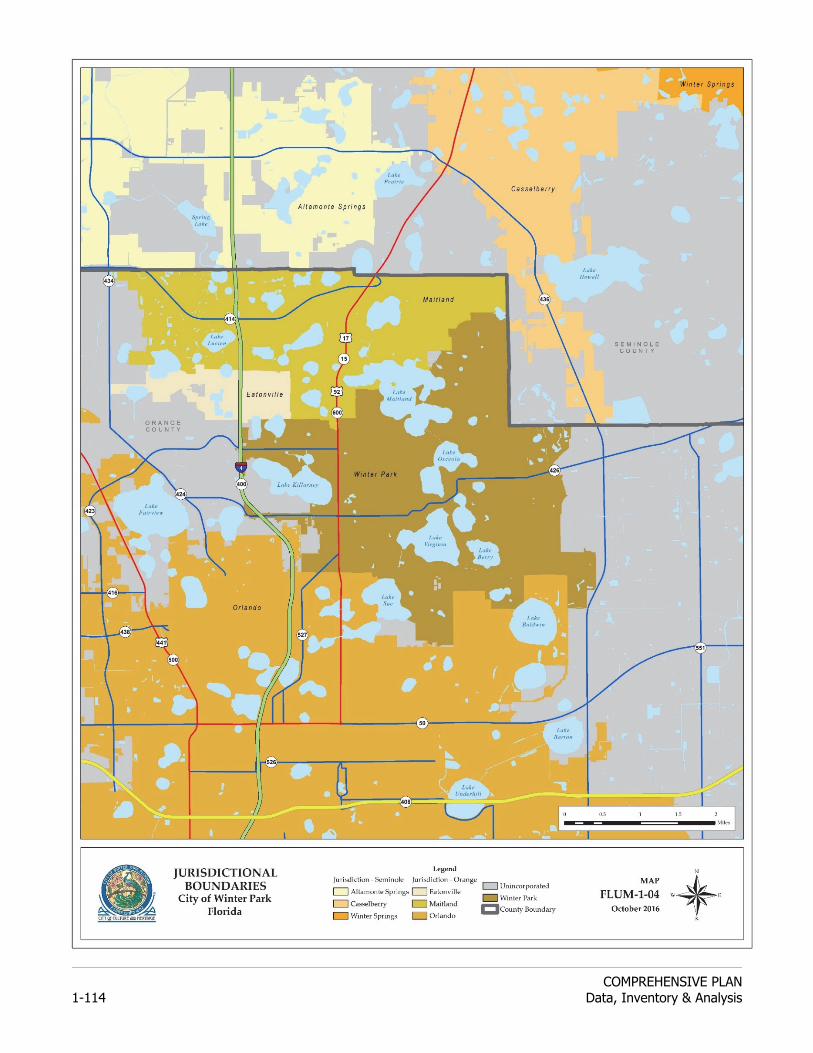
CHAPTER 1: FUTURE LAND USE ELEMENT CITY OF WINTER PARK
COMPREHENSIVE PLAN
1-114 Data, Inventory & Analysis
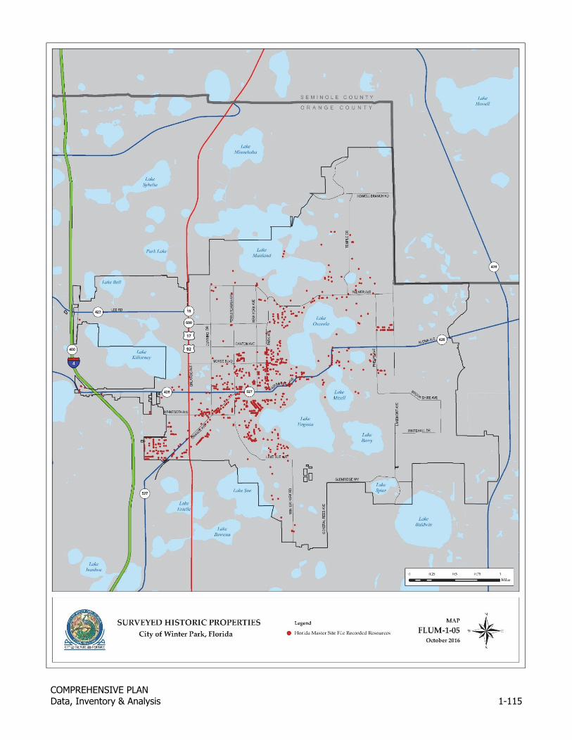
CITY OF WINTER PARK CHAPTER 1: FUTURE LAND USE ELEMENT
COMPREHENSIVE PLAN Data, Inventory & Analysis 1-115
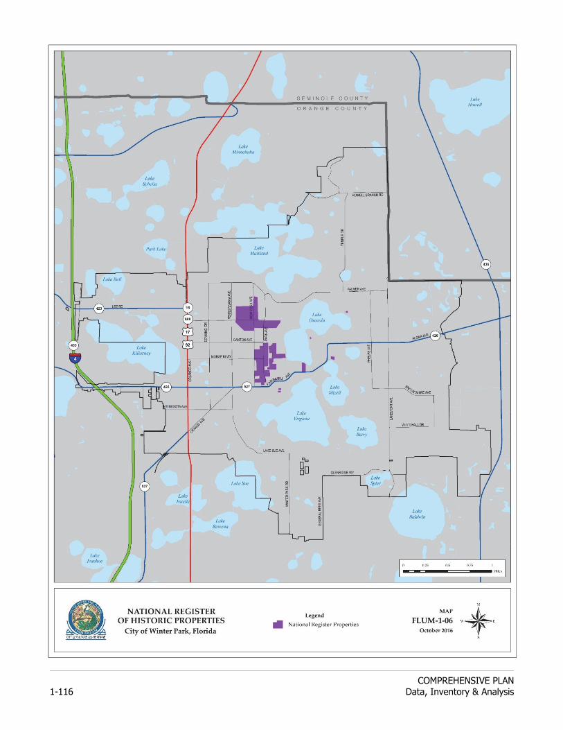
CHAPTER 1: FUTURE LAND USE ELEMENT CITY OF WINTER PARK
COMPREHENSIVE PLAN
1-116 Data, Inventory & Analysis
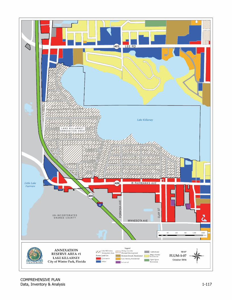
CITY OF WINTER PARK CHAPTER 1: FUTURE LAND USE ELEMENT
COMPREHENSIVE PLAN Data, Inventory & Analysis 1-117
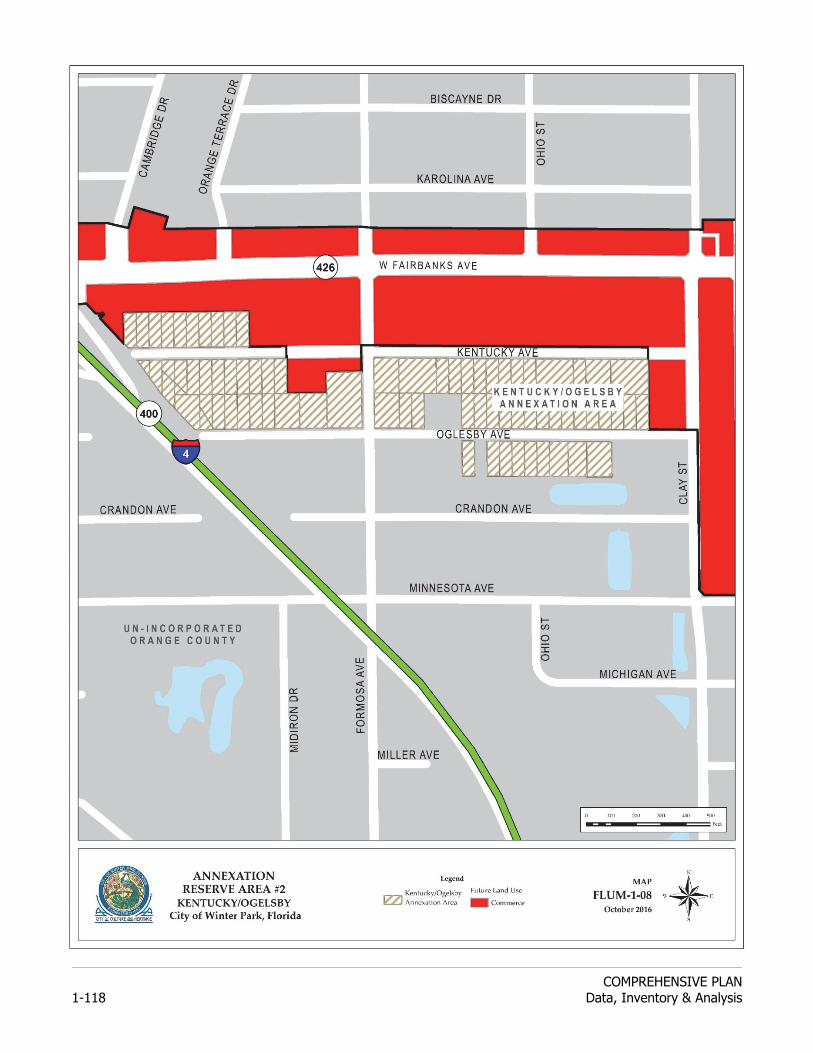
CHAPTER 1: FUTURE LAND USE ELEMENT CITY OF WINTER PARK
COMPREHENSIVE PLAN
1-118 Data, Inventory & Analysis
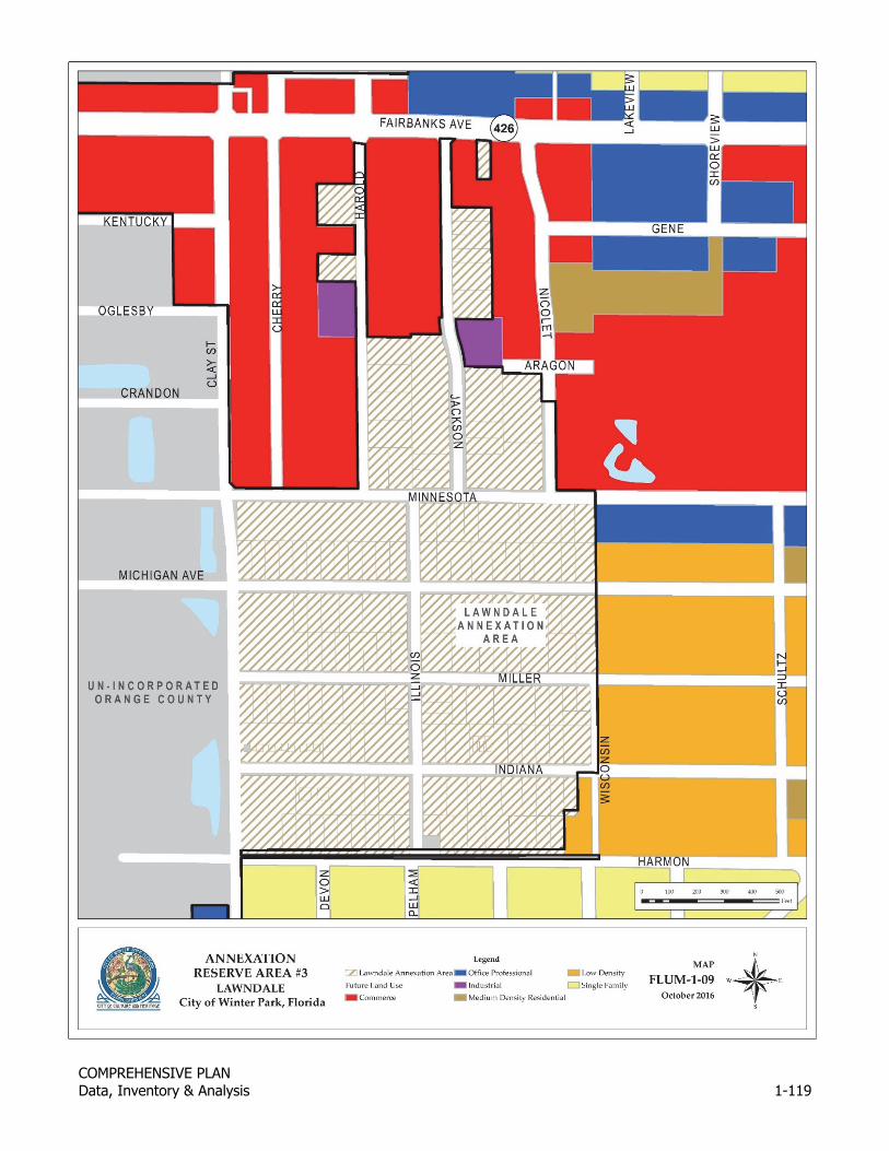
CITY OF WINTER PARK CHAPTER 1: FUTURE LAND USE ELEMENT
COMPREHENSIVE PLAN Data, Inventory & Analysis 1-119
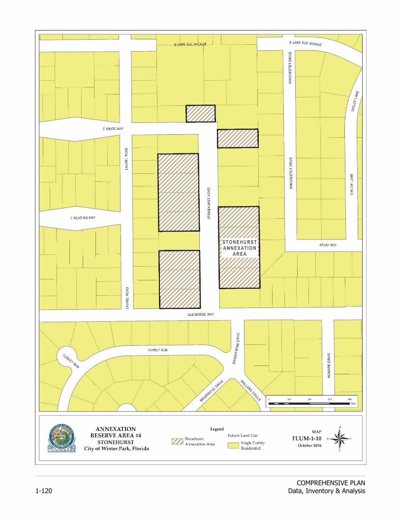
CHAPTER 1: FUTURE LAND USE ELEMENT CITY OF WINTER PARK
COMPREHENSIVE PLAN
1-120 Data, Inventory & Analysis
Related Documents