FINAL PLANNING MEMORANDUM FOR THE ENGINEERING EVALUATION COST ANALYSIS (EE/CA) Furnace Creek Area of Operable Unit 1 Black Butte Mine Superfund Site Cottage Grove, Oregon Prepared for: U.S. Environmental Protection Agency, Region 10 1200 Sixth Avenue, Suite 900 Seattle, WA 98101 October 9, 2015

Welcome message from author
This document is posted to help you gain knowledge. Please leave a comment to let me know what you think about it! Share it to your friends and learn new things together.
Transcript

FINAL PLANNING MEMORANDUM FOR THE ENGINEERING EVALUATION COST ANALYSIS (EE/CA)
Furnace Creek Area of Operable Unit 1 Black Butte Mine Superfund Site
Cottage Grove, Oregon
Prepared for:
U.S. Environmental Protection Agency, Region 10 1200 Sixth Avenue, Suite 900 Seattle, WA 98101
October 9, 2015


Table of Contents
Section 1 Introduction and Purpose ............................................................................. 1-1
Section 2 Conceptual Site Model ................................................................................. 2-1 2.1 Furnace Creek CSM Overview ............................................................................................................................ 2-1 2.2 Contaminant Sources ............................................................................................................................................. 2-2 2.3 Contaminant Transport ........................................................................................................................................ 2-5
2.3.1 Erosion and Particulate Mercury ........................................................................................................ 2-5 2.3.2 Dissolved Mercury ..................................................................................................................................... 2-6
2.4 Affected Media ........................................................................................................................................................ 2-10 2.4.1 Soil .................................................................................................................................................................. 2-10 2.4.2 Sediment ...................................................................................................................................................... 2-10 2.4.3 Surface Water ............................................................................................................................................ 2-10 2.4.4 Groundwater .............................................................................................................................................. 2-11
2.5 Dominant Source of Mercury to the Downstream Watershed ........................................................... 2-11
Section 3 Furnace Creek Removal Action Area Boundary and Preliminary Removal Action Objectives ..................................................................................................................... 3-1
3.1 Source Control Action Area Boundary............................................................................................................ 3-1 3.2 Source Control Action Preliminary Removal Action Objectives .......................................................... 3-2
Section 4 Preliminary Removal Action Alternatives for Source Control Action at Furnace Creek ..................................................................................................................... 4-1
4.1 Overview of Removal Action Alternatives .................................................................................................... 4-1 4.2 Alternative RA1 ........................................................................................................................................................ 4-2 4.3 Alternative RA2 ........................................................................................................................................................ 4-3 4.4 Alternative RA3 ........................................................................................................................................................ 4-4
Section 5 Identification of Information Needed to Develop the EE/CA ......................... 5-1 5.1 Evaluation of Existing Information and Identifying Data Gaps Related to Delineation of Source
Materials at Furnace Creek ..................................................................................................................... 5-1 5.2 Evaluation of Existing Information and Identifying Data Gaps Related to Preliminary Removal
Action Alternatives ..................................................................................................................................... 5-4 5.3 Recommended Field Data Collection or Studies ........................................................................................ 5-6
Section 6 References ................................................................................................... 6-1
i Final_EECA Planning Memo_07OCT'15_clean.docx

• Table of Contents
List of Figures Figure 1-1 Site Location Map Figure 2-1 Schematic of the Conceptual Site Model Figure 2-2 Furnace Creek Conceptual Site Model Figure 2-3 Black Butte Mine Soil Sampling Location Map Mercury Concentrations Figure 2-4 Total versus Dissolved Mercury in Surface Water at Furnace Creek Figure 2-5 Groundwater Monitoring Well Locations and Dissolved Mercury Concentrations Figure 2-6 Incremental Soil Samples at OU1 and Average Mercury Concentrations in Soil Figure 2-7 Mercury Concentrations in Sediment at Upstream and Downstream Furnace Creek Figure 2-8 Percent Contribution to Annual Mercury Loads in Downstream Watershed Figure 3-1 Removal Action Area Boundary
List of Tables Table 5-1 Identification of Data and Informational Needs for Potential Removal Approaches Evaluated in EE/CA, Furnace Creek Area of OU1, Black Butte Mine Superfund Site
Appendices Appendix A XRF and Lumex Mercury Results for Soil from the 2007 Removal Action Appendix B 1952 Aerial Photograph of the Black Butte Mine Site Appendix C Elevation data for the Bottom of Furnace Creek and Upland Groundwater Elevation Appendix D Calculation of Mercury Contribution to Garoutte Creek from Groundwater at MW8
ii
Final_EECA Planning Memo_07OCT'15_clean.docx

Section 1 Introduction and Purpose
This planning memorandum for the engineering evaluation/cost analysis (EE/CA planning memo) was prepared as an initial step in developing an EE/CA for a non-time-critical removal action (NTCRA) at the Furnace Creek area of the Black Butte Mine (BBM) Superfund Site Operable Unit 1 (OU1). The OU1 boundary, Furnace Creek catchment area, and other site features are shown in Figure 1-1.
In 2007, the U.S. Environmental Protection Agency (EPA) completed a time-critical removal action (TCRA) at BBM to address uncontrolled sources of mercury to Dennis Creek and Furnace Creek. During the TCRA, the following activities were completed:
Tailings were removed from Dennis Creek and the tailings slope above the creek was stabilized to limit erosion of materials into Dennis Creek.
Mercury-impacted tailings and soil at the Old Furnace and New Furnace were capped with soil and tailings removed from the Dennis Creek drainage that were determined to have low mercury concentrations.
Tailings removed during the TCRA activities that had high concentrations of mercury were placed in a repository located at the Main Tailings Pile and capped with soil having low mercury concentrations.
The location of the TCRA focus areas, including the Dennis Creek drainage removal area, Old Furnace area, New Furnace, and the tailings repository are shown in Figure 1-1.
In 2009, EPA Region 10 completed a Hazard Ranking System (HRS) evaluation for BBM (Ecology and Environment 2009). Based on the results of the overland discharge/flood component of the evaluation, BBM was added to the National Priorities List (NPL) on March 5, 2010.
In 2012, EPA completed an optimization review of the BBM Superfund Site, which evaluated conditions and identified optimal approaches for conducting the remedial investigation (RI) at the BBM Superfund Site (EPA 2012). In the optimization review, a preliminary sitewide conceptual site model (CSM) was developed that identified several key areas contributing to transport of mercury from BBM to Cottage Grove Lake, including:
Black Butte Mine Site
Coast Fork Willamette (CFW) River and Garoutte Creek
Cottage Grove Lake Wetland Exposed Low Pool
Cottage Grove Reservoir
1-1 Final_EECA Planning Memo_07OCT'15_clean.docx

Section 1 • Introduction and Purpose
From these defined areas, three operable units were established as follows:
Operable unit 1 (OU1): The Black Butte Mine area and vicinity
Operable unit 2 (OU2): The CFW River from Big River confluence to Cottage Grove Lake
Operable unit 3 (OU3): Cottage Grove Lake
The sitewide CSM from the optimization review identified that Furnace Creek may be the largest source of mercury to the downstream watershed. Results of the ongoing OU1 RI, completed between November 2012 and June 2015, document that Furnace Creek is an ongoing and dominant source of mercury from OU1 to the downstream watershed of Garoutte Creek and the CFW River (OU2) and Cottage Grove Lake (OU3). This finding prompted EPA to proceed with a NTCRA to address source control at the Furnace Creek area of OU1.
The purpose of this EE/CA planning memo is to update the CSM specific to Furnace Creek, develop removal action alternatives for the NTCRA, and identify what additional data or studies are needed to complete the EE/CA. Specific objectives for the EE/CA planning memo are:
1. Update the CSM for Furnace Creek (presented in Section 2)
2. Provide rationale for removal action area boundary and develop preliminary removal action objectives (PRAOs) to be considered in the EE/CA (presented in Section 3)
3. Provide and describe the preliminary removal action alternatives identified for the NTCRA at Furnace Creek (presented in Section 4)
4. Identify evaluation steps and/or supplemental field data collection needs (if any) specific to develop the removal alternatives which will be analyzed in the EE/CA (presented in Section 5)
The EE/CA planning memo is focused on the area within the Furnace Creek catchment; however, an evaluation of the former ore processing wastewater handling area, located on the Garoutte Creek floodplain in the vicinity of monitoring well locations MW7 and MW8, has also been included (Figure 1-1). Although this area is not within the Furnace Creek catchment, affected soil and groundwater at this location may be related to historic ore processing associated with Furnace Creek.
1-2 Final_EECA Planning Memo_07OCT'15_clean.docx

Section 2 Conceptual Site Model
This section presents the CSM for transport of mercury and other metals from source materials at Furnace Creek to the downstream watershed. The CSM is a tool that is used to organize and communicate information about a site. It provides a summary of where sources of contamination are located, how contaminants will migrate, and where they will migrate to.
The preliminary CSM from EPA’s optimization review is a sitewide CSM addressing mercury transport from BBM along the CFW to Cottage Grove Reservoir. Mercury loading to Garoutte Creek and the CFW River is believed to have caused elevated mercury concentrations in the sediment and tissue of fish at Cottage Grove Reservoir and the CFW River. A schematic representation of the sitewide CSM from the optimization review is presented in Figure 2-1. In Figure 2-1, only the dominant sources of mercury to the downstream watershed are indicated. For example, although the transport of mercury from the Main Tailing Pile as suspended sediment in Dennis Creek does occur, it is not considered a dominant source of mercury to the downstream watershed and is not indicated as such in Figure 2-1. The sitewide CSM includes two key components: (1) the release and transport of mercury from the BBM mine site and (2) the mercury methylation process in Cottage Grove Reservoir. The OU1 RI was conducted to evaluate the first component, and EPA is currently evaluating the second component. Surface water and sediment data collected during the ongoing OU1 RI activities identified that Furnace Creek is the most significant source of mercury contamination to Garoutte Creek. The following sections present the current CSM for Furnace Creek that are used for planning of the NTCRA.
2.1 Furnace Creek CSM Overview The purpose of the Furnace Creek CSM is to describe mercury source materials within the Furnace Creek catchment area and identify the primary contaminant transport pathways from Furnace Creek source materials to Garoutte Creek.
Mercury is present in surface water at Furnace and Garoutte Creek primarily as particulate-bound mercury in the suspended load, and significant transport of mercury occurs along Furnace Creek during periods of higher stream flow during and following rainfall events. Primary sources of mercury within the Furnace Creek catchment area include mine tailings and mercury furnace wastes at the Furnace Creek Tailings Area and the Old Furnace Area (Figure 1-1). Dispersion of mercury from the primary source materials results in secondary sources of mercury, including contaminated soil and sediment. Erosion and depositional processes result in mobilization of particulate-bound mercury from the primary and secondary sources into Furnace Creek. During active periods of flow at Furnace Creek, particulate-bound mercury is transported in the suspended load, ultimately discharging to Garoutte Creek. Transport of mercury in the dissolved phase also occurs but to a lesser extent than transport of particulate mercury. The dissolved fraction of mercury in surface water results from leaching of mercury from primary and secondary sources to the creek during rain events and from desorption and dissolution of mercury from sediment in Furnace Creek. Particulate and dissolved mercury concentrations
2-1 Final_EECA Planning Memo_07OCT'15_clean.docx

Section 2 • Conceptual Site Model
increase during storm events when the greater amounts of sediment are suspended in the water column.
While dissolved mercury is present in groundwater within the Furnace Creek catchment area, groundwater elevation data collected from wells located in the upper and lower reaches of the creek (MW-10 and MW-9) show the groundwater table is below the creek bed throughout the year. This results in a losing stream condition for Furnace Creek along its entire length. Further evidence for the consistently losing stream condition of Furnace Creek includes a rapid decline in the hydrograph after a storm event near the mouth of the creek, indicating a lack of sustained groundwater baseflow contribution. The water level elevation data and ephemeral character (rapid discharge and dry condition of the creek for 6 months of the year) provide clear evidence for the lack of upland groundwater discharge (baseflow contribution) to Furnace Creek resulting in an incomplete pathway of dissolved mercury entering Furnace Creek discharge from contaminated upland groundwater. A graphical depiction of the Furnace Creek CSM is presented in Figure 2-2.
Other contaminant transport and exposure pathways associated with the Furnace Creek catchment area, but not considered significant or relevant to the downstream transport of mercury, include direct contact (human and ecological) with primary and secondary source materials and surface water, wind dispersion of particulate-bound mercury, and volatilization of elemental mercury from furnace waste at the Old Furnace area. The purpose of the NTCRA at Furnace Creek is to provide source control for reduction of mercury loading to Garoutte Creek; therefore, further discussion of these less significant transport and exposure pathways are excluded from the Furnace Creek CSM and will be addressed later in the sitewide OU1 RI/feasibility study.
2.2 Contaminant Sources Primary Sources Primary sources of mercury within the Furnace Creek catchment area consist of furnace wastes associated with the Old Furnace and tailings at the Furnace Creek Tailings Area. Both of these primary source materials are located on slopes, which are subject to erosion into the channel of Furnace Creek.
Remnants of the Old Furnace are located in the Old Furnace Area, which is located on the north side of Furnace Creek at the location shown in Figure 2-3. The foundation of the furnace and a group of vertical pipes of approximately 12-inch diameter are present in the area, partially covered by soil. These vertical pipes are thought to have been a part of the condenser system for the furnace. Miscellaneous steel pipes and other former furnace-related infrastructure are also present in the area of the foundation. This type of furnace operated by placement of a “charge” of ore and fuel into the furnace and burning the fuel to heat the ore to temperatures that caused mercury and sulfur to volatilize. Potential sources of mercury associated with the Old Furnace include residual mercury in, around, or beneath the remnant ore processing the equipment. Residual mercury may be in the form of cinnabar from ore processed at the site or elemental mercury released during the processing of mercury vapors. The extent of furnace wastes are expected to be limited to the location of the Old Furnace remnants and immediate downslope area. During the 2007 TCRA, the area of the Old Furnace and remnant structures were capped
2-2 Final_EECA Planning Memo_07OCT'15_clean.docx

Section 2 • Conceptual Site Model
with soil and tailings removed during the regrading of the slope above Dennis Creek. The tailings used to cap the Old Furnace area contained less than 23 milligrams per kilogram (mg/kg) mercury, as verified by field screening during the removal action (EPA 2008). The extent of the Old Furnace Area capped during the 2007 TCRA is shown in Figure 2-3. Field x-ray fluorescence (XRF) and Lumex mercury data collected at Furnace Creek during the 2007 removal action are presented in Attachment A. These data include both mercury concentrations in surface soil prior to capping and mercury concentrations in surface soil after the soil cap was placed. Although the remnants of the Old Furnace remain in place and may contain high concentrations of mercury, the capping soil placed during the 2007 TCRA is expected to limit erosion of furnace wastes and affected soil at the Old Furnace area into Furnace Creek.
Prior to startup of the New Furnace in 1927, ore was processed through the Old Furnace, and spent tailings were discharged directly downslope from the furnace. This was common operational mine practice in the U.S. prior to approximately 1970. The Old Furnace tailings are relatively coarse in texture and have a characteristic pink to red color, which results from oxidation of iron present in the ore. The texture of the tailings ranges generally from sandy gravel to gravel, which when combined with the color makes the tailings relatively easy to differentiate from natural materials. These tailings have been remobilized downstream to some extent and have, in places, covered the channel of Furnace Creek. The approximate extent of tailings at the Furnace Creek Tailings Area is indicated by the hatched area shown in Figure 2-3. The extent of the Furnace Creek Tailings Area is depicted in EPA’s optimization review (EPA 2012). Information on the thickness of tailings is limited to:
1. Boring for monitoring well MW10 advanced in the upper portion of the Furnace Creek Tailings Area (Figure 1-1)
2. Borings MP05, MP06, and MP07, which were advanced during the 2005 Removal Assessment investigation (Appendix A).
3. Four test pits or trenches excavated in the Furnace Creek Tailings Area during the 2007 TCRA, including three test pits to depths exceeding 9 feet and one trench of 20-foot length (Appendix A). The exact location of the 2007 TCRA test pit locations are not known.
Test pit observations indicated that the thickness of tailings ranged from less than 1 foot (MP04 and MP06) to greater than 9 feet in at least one of the 2007 TCRA test pit locations. The thickness of tailings outside of the boring and test pit locations is not known.
Tailings sampled at the location of the Old Furnace by the Oregon Department of Environmental Quality (DEQ) in 2003 had mercury concentrations up to 2,090 mg/kg; however, the Old Furnace area was capped during the 2007 TCRA to address this area of high mercury concentrations (DEQ 2004; EPA 2008). Samples collected from other areas of the Furnace Creek Tailings Area, collected during the OU1 RI in 2013-2014, indicated that the remaining surface soil in the Furnace Creek Tailings Area had mercury concentrations up to 543 mg/kg (CDM Smith 2014b). Field XRF data collected from the Furnace Creek Tailings Area during the TCRA indicate that tailings, soil, and sediment in this area may have even higher mercury concentrations. The range of mercury concentrations in Furnace Creek Tailings Area is shown in Figure 2-3.
2-3 Final_EECA Planning Memo_07OCT'15_clean.docx

Section 2 • Conceptual Site Model
Secondary Sources Mercury-impacted soils within the Furnace Creek catchment are a secondary source of mercury to surface water and groundwater via erosion of soil particles into surface water and leaching of mercury to groundwater. Surficial soils adjacent to tailings areas are impacted by mercury when erosion and depositional process results in dispersion of the tailings into soil. Analysis of incremental surface soil sample TMM that was collected over the Furnace Creek Tailings Area and consisted of soil mixed with tailings indicated an average mercury concentration of 176 mg/kg over the Furnace Creek Tailings Area (CDM Smith 2014b). The location of incremental soil sample TMM is shown in Figure 2-6.
Soil underlying the tailings is impacted by mercury when precipitation leaches mercury from tailings and transports it downwards into the underlying soil. Based on discrete-depth soil samples collected at the nearby location MW11 (Figure 1-1) at the Main Tailings Area, mercury concentrations in soil attenuate rapidly (generally within 10 feet below the tailings/soil contact) in the clay soil that underlies the tailings. Given that clay is present at boring MW11 to depth of greater than 70 feet below ground surface (bgs) and at MW10 to a depth of greater than 15 feet bgs (total depth explored), migration of mercury leached from tailings in the underlying soil is not a significant transport pathway.
Sediment within the bed of Furnace Creek is another secondary source of mercury to surface water. Analysis of the one incremental sediment sample collected at the downstream end of the Furnace Creek Tailings Area (sediment sample station FC1) indicated an average mercury concentration in bulk sediment of 136 mg/kg (CDM Smith 2014a). DEQ collected grab sediment samples from Furnace Creek immediately downstream of the Old Furnace area in 2008, and mercury was detected at concentrations of 70.2 and 173 mg/kg in the primary and duplicate sediment samples collected at this location (DEQ 2008).
Another potential source of mercury to Garoutte Creek that is located outside of the Furnace Creek catchment area, but may be related to historic ore processing at Furnace Creek, is a historic ore processing wastewater handling area located on the Garoutte Creek floodplain, north of Furnace Creek (vicinity of monitoring wells MW7 and MW8). This area is indicated on Figure 2-3, and the monitoring well locations are shown on Figure 1-1. Based on interviews with the site resident, during the operating period of the mine, wooden structures were in place at this location to handle ore processing wastewater. The 1952 aerial photograph of the BBM site indicates possible tailings impacts at this location and extending into a former meander of Garoutte Creek (current location of MW8). The 1952 aerial photograph, with a notation of the possible extent of impact from historical wastewater handling processes, has been included in Appendix B. Elevated concentrations of mercury were detected in soil and groundwater collected at MW7 and MW-8 during the OU1 RI and may indicate the presence of mercury source materials. Although no direct surface water flow path to Garoutte Creek has been observed, review of the high resolution light detection and ranging (LiDAR) imagery and field reconnaissance shows a possible buried channel originating from the Old Furnace processing area extending to the abandoned meander of Garoutte Creek where MW-8 is located. Mercury contaminated soil in this area may be a source of mercury to groundwater. Preferential groundwater flow in coarser grained alluvium within the abandoned meander is a potential
2-4 Final_EECA Planning Memo_07OCT'15_clean.docx

Section 2 • Conceptual Site Model
groundwater pathway for dissolved mercury transport to Garoutte Creek outside the Furnace Creek drainage. This pathway is further evaluated in Section 2.3.2.
2.3 Contaminant Transport Mercury derived from primary and secondary sources is transported via surface water in Furnace Creek to Garoutte Creek in particulate and dissolved forms and to a lesser extend via groundwater. The following sections describe the contaminant transport in the Furnace Creek catchment.
2.3.1 Erosion and Particulate Mercury The primary transport mechanism of mercury from the Furnace Creek catchment to Garoutte Creek is particulate mercury in surface water. Transport of particulate mercury in surface water occurs via two mechanisms:
1. Erosion of tailings and mercury-impacted soil into the Furnace Creek
2. Re-suspension of mercury-impacted channel bottom sediments into the water column
The relative contribution of each of these mechanisms to the suspended particulate mercury load in Furnace Creek is not well understood. Re-suspension of mercury impacted channel bottom sediment occurs in response to increased flow at Furnace Creek, generally whenever there is a precipitation event. Erosion of tailings or soil into Furnace Creek may occur less frequently, at isolated areas within the catchment area, and in response to larger storm events. Due to the steep topography within the Furnace Creek catchment area, there is potential for erosion of tailings and soil into the Furnace Creek channel throughout the catchment area. This section provides a general description of the Furnace Creek catchment and a description of the transport of particulate mercury via surface water.
Furnace Creek is a small, ephemeral creek that originates as a spring located along the west facing slopes of Black Butte. The creek is approximately 0.4 mile in length, and the total area of the Furnace Creek catchment is 29.8 acres (0.05 square mile). Based on the 2012-2013 monitoring period, the lower half of the Furnace Creek channel was dry and did not have surface flow for approximately 6 months of the year. During the 2013-2015 monitoring period, annual rainfall was abnormally low and flow at the lower half of Furnace Creek only occurred for a few months of the year. Periods when lower Furnace Creek was flowing include:
November 2012 through May 2013
February 2014 through May 2014
December 2014 through April 2015
Uncertainties in the total annual flow at Furnace Creek during dry years should be considered when evaluating the total annual mercury load from Furnace Creek.
The upper portion of the watershed near the spring source has a continuous, albeit small discharge that reliably supplies water for the nearby residence year round. Furnace Creek is a deeply entrenched channel with no smaller tributary stream segment contributions. A
2-5 Final_EECA Planning Memo_07OCT'15_clean.docx
(b) (6)

Section 2 • Conceptual Site Model
headwall scarp about 120 feet upstream of the confluence with Garoutte Creek is present and reportedly the result of a recent manmade high flow event that occurred when active logging in 1998 broke up a small reservoir in the upper portion of the watershed where the residence receives its water supply ( 2012). Evidence of the large volume of water flushing through the channel is present in the deeply entrenched, much wider channel that is now populated with 15 year old alder trees. This deep entrenchment is unusual for the minimal stream discharges monitored to date and can only be explained by more catastrophic flow events. The deeply entrenched channel leads to a severely eroded former road bed and a 12-inch culvert that was dislodged and is now emerging from the headwall scarp. Mercury transport via surface water at Furnace Creek was characterized by establishing surface water monitoring station F1 (Figure 1-1) on Furnace Creek near the confluence with Garoutte Creek to collect stream flow and water quality data for calculation of the annual mercury load. Continuous stream flow data were collected at F1 using a pressure transducer installed in a stilling pipe that was calibrated to manual stream flow measurements. Surface water quality data were collected through collection of multiple surface water samples at F1 during three storm events in 2013 and 2014. Annual mercury loading to Furnace Creek was calculated using stream flow measurements, mercury concentration data, and the discharge frequency calculation method, as described in CDM Smith 2014a.
Furnace Creek stream flow ranges from no flow during the dry season to up to approximately 3 cubic feet per second (CFS) during large precipitation events. This estimate is based on continuous stream discharge monitoring data collected during the OU1 RI from December 2012 through October 2014. Much higher flow events are expected to occur during 100 year storm events or catastrophic events like the reported failure of the upstream reservoir in 1998.
Water quality monitoring data collected during the OU1 RI indicate that total suspended solids (TSS) and total mercury concentrations increase as the stream flow rate increases during precipitation events. At Furnace Creek, total mercury concentrations ranged from a low of 595 nanograms per liter (ng/L) during the baseline measurement of the March 2013 storm event to a high of 93,800 ng/L during the peak of the larger February 2014 storm event. The flow was approximately 1 CFS during the February 2014 storm event. Based on precipitation statistics at the Cottage Grove 1 NNE weather station for the period of 1914 through 2014, the February 2014 storm event has a 2-year reoccurrence interval (2-year storm event). Higher mercury concentrations in Furnace Creek are expected during larger storm events such as the December 2012 storm when measured flows were 3 CFS. The total and dissolved mercury concentrations in surface water at Furnace Creek monitoring station F1 during the March 2013 and February 2014 events are presented in Figure 2-4. The chart in Figure 2-4 indicates that higher mercury concentrations occur during the rising limb and peak of the stream flow hydrograph. An important finding of the monitoring at F1 was that that total mercury concentrations increase significantly with increased stream flow. This is an important element of the Furnace Creek CSM because high total mercury concentrations and relatively high stream flow rates during storm events result in the largest contribution of mercury to the annual mercury load at Furnace Creek.
2.3.2 Dissolved Mercury Mercury in dissolved form is primarily transported via surface water and shallow alluvial groundwater in the Furnace Creek catchment to Garoutte Creek although at much lower
2-6 Final_EECA Planning Memo_07OCT'15_clean.docx
(b) (6)(b) (6)

Section 2 • Conceptual Site Model
concentrations than particulate mercury. The following sections describe the transport of dissolved mercury in the Furnace Creek catchment.
Dissolved Mercury in Surface Water Dissolved mercury in surface water at Furnace Creek occurs via two mechanisms:
1. Precipitation infiltrating and leaching mercury from surficial tailings and bank soils to Furnace Creek during storm events.
2. Dissolution of mercury from sediment suspended in the water column during storm events. This occurs during storm events when the amount of suspended sediment increases and particle surface area is at a maximum.
As described in Section 2.2, soil and tailings in the Furnace Creek Tailings area have relatively high concentrations of mercury. During the OU1 RI, modified Synthetic Precipitation Leaching Procedure (SPLP) tests were conducted on tailings and soil samples collected from the Furnace Creek Tailings and Main Tailings Pile areas to assess the potential for leaching. The results indicated the potential for mercury to leach from soils at concentrations exceeding applicable human health and ecological regulatory screening levels (CDM Smith 2014a). Based on the data, leaching of mercury from surficial tailings and soil in the Furnace Creek catchment may be occurring during precipitation events as precipitation infiltrates the bank soils, resulting in transient flow into Furnace Creek.
During storm events, dissolved mercury concentrations in surface water of Furnace Creek follow the same trend as total mercury concentrations, as shown in Figure 2-4. Dissolved mercury concentrations rise quickly to a peak concentration at the peak stream flow and then drop back to baseline concentrations as stream flows drop off. This relationship suggests that desorption and dissolution of mercury as sediment particles are suspended in the water column during storm events may be the primary mechanism for the occurrence of dissolved mercury in Furnace Creek.
Transport of dissolved mercury from upland groundwater underlying the Furnace Creek Tailings Area to Furnace Creek does not occur because Furnace Creek is a losing creek along its entire length and therefore not recharged by upland groundwater (Figure 2-2). This is evident during the summer months by the observed diminishing flow of surface water in Furnace Creek from the headwaters near the supply, where creek flow occurs year round, to the downstream reach, where surface flows diminish and eventually cease, below the Old Furnace. Another line of evidence that Furnace Creek is a losing creek is the separation of water levels in Furnace Creek from the groundwater levels at the nearest adjacent upland groundwater monitoring well, MW10. Based on groundwater level monitoring data for MW10, the seasonal high groundwater level is approximately 5 feet lower than the elevation of the bottom of Furnace Creek adjacent to this well. Spatial information for groundwater levels at MW10 and Furnace Creek are provided in Appendix C.
Dissolved mercury concentrations in surface water are low compared to total mercury concentrations in surface water of Furnace Creek. As shown in Figure 2-4, dissolved mercury during storm events ranges from less than 10 to a maximum of 34 percent of the total mercury concentration in surface water of Furnace Creek. Based on loading estimates for the 2-year period
2-7 Final_EECA Planning Memo_07OCT'15_clean.docx
(b) (6)

Section 2 • Conceptual Site Model
from 2012 through 2014, dissolved mercury contributes approximately 15 percent of the total annual mercury load in surface water of Furnace Creek. Due to the relatively low contribution of dissolved mercury to the total annual mercury load of Furnace Creek, no specific components to address dissolved mercury in Furnace Creek will be included in the Furnace Creek removal action.
Dissolved Mercury in Groundwater at Furnace Creek As shown in the graphic presentation of the CSM in Figure 2-2, groundwater occurs within the Furnace Creek catchment as:
1. Upland groundwater – groundwater occurring within the clay-rich soil underlying the Furnace Creek Tailings Area
2. Alluvial groundwater – groundwater occurring within the shallow alluvium directly below the Furnace Creek channel
Monitoring well MW10 is completed in the upland groundwater system near the Old Furnace area. Monitoring well MW9 is completed within the alluvial groundwater underlying Furnace Creek near the mouth. Well locations are shown in Figure 2-5. As shown in Figure 2-2, alluvial groundwater is subflow of Furnace Creek and is a perched system as evident by water elevations in Furnace Creek and alluvial groundwater higher than the water table of the underlying upland groundwater system.
Upland Groundwater System Upland groundwater occurs in a clay-rich soil (clay and gravelly clay) that is hydrothermally altered volcanic tuff of the Fisher Formation (CDM Smith 2014a). Due to the low permeability of the clay soils, recharge rates and groundwater velocity within the upland unit are very low. This is evident by the low recharge rates observed at monitoring well MW10 during well development and sampling. Recharge to upland groundwater occurs as precipitation infiltrates the surficial tailings and underlying soil. As water moves through the tailings or affected soil, leaching of mercury occurs; however, the high clay fraction of the soil has a high capacity to adsorb cations and anions due to greater surface area for attraction and other factors, which limits the mobility of mercury. The relatively high soil to water partitioning coefficients, that were calculated by comparing soil and groundwater concentrations at monitoring wells completed within the upland groundwater system, support the high capacity for soil to adsorb mercury and other metals leached from tailings and affected soil (CDM Smith 2014a).
Dissolved mercury was detected at a concentration of 1,070 ng/L in MW10 in May 2014. The May 2014 results are the only results available for MW10. Prior to May 2014, previous attempts to collect a sample at MW10 in August 2013 and November 2013 were unsuccessful due to insufficient groundwater in the well for sampling. Groundwater levels in the upland groundwater system are generally lowest in the late summer and fall.
Groundwater level monitoring at MW10 shows that the seasonal high groundwater level (April 2014) is approximately 5 feet lower than the elevation of the bottom of Furnace Creek adjacent to this well, which indicates that upland groundwater does not discharge into Furnace Creek. (Appendix C). Based on the low permeability soils and the lack of a hydraulic connection
2-8 Final_EECA Planning Memo_07OCT'15_clean.docx

Section 2 • Conceptual Site Model
between the upland groundwater and Furnace Creek, dissolved mercury from the upland groundwater system is not expected to contribute to mercury loading to Furnace Creek. No components to address mercury transport in the upland groundwater system will be included in the Furnace Creek removal action.
Alluvial Groundwater System Alluvial groundwater occurs in the channel deposits of Furnace Creek. Due to the coarser grained alluvium, groundwater movement in the alluvial system is expected to be higher than for upland groundwater. The thickness and lateral extent of the alluvial groundwater system is expected to be fairly limited based on the narrow confines of the Furnace Creek drainage and the shallow bedrock evident by outcrops present near the mouth of Furnace Creek. Monitoring points used to characterize the alluvial groundwater system are shown in Figure 2-5 and include monitoring well MW9 and the buried culvert located near station F1. The buried culvert receives water from the subflow of Furnace Creek, which is believed to be representative of groundwater with the alluvial groundwater system.
Dissolved mercury concentration in the alluvial groundwater system ranged from 9.21 to 139 ng/L, based on samples collected at MW9 and the buried culvert in November 2013 and May 2014. The highest dissolved mercury concentrations were observed in May 2014 when groundwater flow in the alluvial groundwater system is expected to be highest at the end of the wet season.
Based on low dissolved mercury concentrations in alluvial groundwater and the limited thickness and lateral extent, the alluvial groundwater system is not considered a significant source of mercury to the downstream watershed; therefore, no components to address mercury transport in the alluvial groundwater will be included in the Furnace Creek removal action.
Dissolved Mercury in Groundwater at the Former Ore Wastewater Processing Area Monitoring wells MW7 and MW8 were installed to characterize groundwater at the former ore wastewater processing area on the Garoutte Creek floodplain (Figure 2-5). MW7 was completed in floodplain soils at the suspected location of the former wastewater handling basins, and MW8 was installed in a former channel of Garoutte Creek downgradient of MW7. Mercury was not detected in groundwater at MW7; however, at MW8, dissolved mercury was detected at concentrations of 28.9 and 180 ng/L in November 2013 and May 2014, respectively.
Due to the location of MW8 within a former channel of Garoutte Creek, higher groundwater velocities are expected because the channel deposits have much higher hydraulic conductivity than the surrounding floodplain deposits. To address this potential source of mercury to Garoutte Creek, an estimate was made on the contribution of mercury to Garoutte Creek that could come from groundwater discharge through this channel (calculations included in Appendix D). The annual mercury loading to Garoutte Creek from groundwater flow through the former channel is estimated at 0.0019 kilograms per year (kg/year), based on maximum mercury concentrations detected at MW8, the dimension of the channel, and conservative estimates on the hydrogeologic properties of the channel deposits. This load contributes 0.3 percent of the total mercury load in downstream Garoutte Creek (0.74 kg/year) and is not considered a significant source of mercury
2-9 Final_EECA Planning Memo_07OCT'15_clean.docx

Section 2 • Conceptual Site Model
to the watershed; therefore, no components to address mercury transport in groundwater at the former ore wastewater processing area will be included in the Furnace Creek removal action.
2.4 Affected Media This section provides an overview of the media impacted by mercury within the Furnace Creek catchment and concentrations relative to reference locations, based on the most recent data collected during the OU1 RI. A comprehensive data presentation and evaluation of all data collected from the Furnace Creek catchment during the OU1 RI is presented in CDM Smith 2014a and CDM Smith 2014b.
2.4.1 Soil Soil sample locations and the range of mercury concentrations detected in surface soil at OU1 are shown in Figure 2-3. A background study has not been conducted at OU1; however, as part of the February 2014 Demonstration of Methods Applicability (DMA) study, a 30-point incremental soil sample (GSS) was collected from the floodplain of Garoutte Creek in the area south of the residence, as indicated in Figure 2-6. The purpose of this sample was to determine total mercury concentrations in soil at areas outside of the tailing areas. The average mercury concentration in the incremental sample was 11.6 mg/kg. Also during the DMA study, an incremental sample was also collected from the Furnace Creek Tailings Area (sample TMM), and average mercury concentration in the sample was 176 mg/kg, approximately 15 times greater than mercury concentrations detected in the sample collected from the floodplain of Garoutte Creek. Discrete surface soil sample locations sampled during the DMA study show detections of mercury up to 543 mg/kg, indicating hot spot locations in the Furnace Creek catchment having mercury concentrations at approximately 50 times greater than mercury concentrations detected in the sample collected from the floodplain of Garoutte Creek. The location of the incremental samples GSS and TMM are shown in Figure 2-6.
2.4.2 Sediment The range of mercury concentration in sediment at Furnace Creek at locations upstream and downstream of areas disturbed by mining activities are shown in Figure 2-7. The upstream sample is designated UFC1, and the downstream sample is designated FC1. Location UFC1 serves as a reference location due to its location upstream of areas disturbed by mining. The range in mercury concentrations for the bulk, <2 millimeter, and <62-64 micron sediment size fractions is shown. Based on Figure 2-7, mercury concentrations in sediment at downstream Furnace Creek sample FC1 exceed concentrations at the reference location by 15 to 20 times.
2.4.3 Surface Water The highest concentrations of total and dissolved mercury on record were detected in surface water at Furnace Creek station F1 during the February 2014 storm event at concentrations of 93,800 and 10,300 ng/L, respectively (Figure 2-4). Upstream Garoutte Creek stream monitoring station GU1 (Figure 1-1) serves as the reference location for OU1 because it is located upstream of the confluence with Furnace Creek and areas disturbed by BBM mining activities. The maximum total and dissolved mercury concentrations detected at GU1 during the February 2014 storm event were 192 and 8.78 ng/L, respectively. Based on this, total mercury concentrations in surface water at F1 exceeded concentrations at the reference location by approximately 500
2-10 Final_EECA Planning Memo_07OCT'15_clean.docx
(b) (6)

Section 2 • Conceptual Site Model
times, and dissolved mercury concentrations exceeded concentrations at the reference location by approximately 1,200 times during the February 2014 storm event.
2.4.4 Groundwater Dissolved mercury concentrations in groundwater at upland groundwater monitoring well MW10, the Furnace Creek alluvial groundwater monitoring well MW9, and the seepage from the buried culvert near F1 are shown in Figure 2-5. Dissolved mercury concentrations detected in the background monitoring well MW13 are also shown in Figure 2-5. MW13 was selected as the background location for OU1 groundwater due to its location approximately 1 mile upstream along Garoutte Creek. Dissolved mercury concentrations in upland groundwater monitoring well MW10 exceed concentrations at the reference location by 1,300 times. Dissolved mercury concentrations in Furnace Creek alluvial groundwater monitoring locations MW9 exceed concentrations at the reference location by up to 200 times.
2.5 Dominant Source of Mercury to the Downstream Watershed Furnace Creek is ephemeral, flowing for 4 to 6 months of the year (based on the 2012-2015 monitoring period), and contributes approximately 0.2 percent of the total stream flow in Garoutte Creek, downstream of BBM. However, based on loading calculations for each of the streams monitored during the OU1 RI, Furnace Creek contributes 48 percent of the total annual mercury load to the downstream watershed, representing the largest single contribution of mercury. The 48 percent of the total annual load is conservative (low) estimate because the loading calculations are based on maximum mercury concentrations measured during the February 2014 storm event, which was a moderate intensity storm event that had a 2-year reoccurrence interval (2-year storm event). Percent contributions to the total annual mercury load for Furnace Creek, Dennis Creek, and Garoutte Creek are shown in Figure 2-8. The high concentrations of particulate mercury in surface water within Furnace Creek are the primary factor for Furnace Creek to contribute such a high percentage of the mercury load at such low annual flow rates. Mercury concentrations in sediment within downstream Furnace Creek are 15 to 20 times higher than concentrations measured at the upstream Furnace Creek reference location, indicating a significant increase of mercury concentrations in sediment along Furnace Creek within the Furnace Creek Tailings Area. A NTCRA will be conducted at Furnace Creek to address the high concentrations of particulate mercury in surface water and high mercury concentrations in sediment that are discharging from Furnace Creek to the watershed.
No components to directly address dissolved mercury in surface water and shallow alluvial groundwater underlying Furnace Creek will be included in the NTCRA because the contribution of dissolved mercury from these sources to the total annual load is low. However, NTCRA components to address particulate mercury in Furnace Creek are also expected to reduce dissolved mercury concentrations in Furnace Creek.
2-11 Final_EECA Planning Memo_07OCT'15_clean.docx

Section 2 • Conceptual Site Model
This page intentionally left blank to allow for double sided printing.
2-12 Final_EECA Planning Memo_07OCT'15_clean.docx

Section 3 Furnace Creek Removal Action Area Boundary and Preliminary Removal Action Objectives
The initial identification of the boundary of the removal action for the NTCRA and PRAOs are presented in this section. Rationale for selection of the removal action area boundary is discussed. The removal action area boundaries and PRAOs will be refined, if necessary, during the development of the EE/CA.
3.1 Source Control Action Area Boundary The Furnace Creek removal action area boundary is shown in Figure 3-1. The boundary was selected to include all areas of the Furnace Creek Tailings that are inside the Furnace Creek catchment as defined by the LiDAR dataset, excluding the area of the Furnace Creek Tailings Area that was capped during the 2007 TCRA.
All of the Furnace Creek Tailings that lie within the Furnace Creek catchment are included in the removal action boundary because the tailings have high total mercury concentrations and are located on steep slopes subject to erosion into the channel of Furnace Creek. Once in channel, the tailings are transported in the suspended load of Furnace Creek to the downstream watershed. The entire length of the Furnace Creek Tailings Area is included in the removal action boundary because XRF and Lumex screening data collected from the channel and banks of Furnace Creek during the 2007 TCRA indicate consistently high mercury concentrations in sediment and bank soil extending all the way to the confluence with Garoutte Creek (Appendix A). For removal action alternatives involving excavation or containment, the presence of tailings based on visual identification supplement by field XRF (for tailings identification) will be used to define the removal action boundary.
Tailings or affected soil located outside of the Furnace Creek catchment were excluded from the removal area boundary because these tailings are outside the drainage pathway to Furnace Creek and do not contribute to mercury loading of Furnace Creek.
The portion of the Old Furnace that was capped during the 2007 TCRA was also excluded based on the assumption that the capping soil has limited migration of mercury from residual furnace wastes to Furnace Creek.
3-1 Final_EECA Planning Memo_07OCT'15_clean.docx

Section 3 • Furnace Creek Removal Action Area Boundary and Preliminary Removal Action Objectives
3.2 Source Control Action Preliminary Removal Action Objectives The purpose of the removal action at Furnace Creek is to reduce the loading of mercury from Furnace Creek to Garoutte Creek. The following PRAOs have been developed for the Furnace Creek removal action:
1. Reduce the availability and/or mobility of mercury in soil and sediment within the Furnace Creek catchment area to migrate in particulate form to surface water
2. Reduce the migration of Furnace Creek mercury to Garoutte Creek
Removal action alternatives will be evaluated in the EE/CA based on their effectiveness, implementability, and cost. The evaluation of effectiveness will be based to a large degree on PRAO achievement. The performance of the removal action will be measured by:
Visual confirmation that tailings have been removed or capped for removal action alternatives involving excavation or containment
Comparison of pre- and post-removal action annual mercury loading in surface water of Furnace Creek at the confluence with Garoutte Creek
3-2 Final_EECA Planning Memo_07OCT'15_clean.docx

Section 4 Preliminary Removal Action Alternatives for Source Control Action at Furnace Creek
4.1 Overview of Removal Action Alternatives This section provides an overview of the types of removal technologies and process options considered for the Alternatives RA1, RA2 and RA3. Per EPA’s Guidance on Conducting NTCRAs under CERCLA (EPA 1993), only the most qualified technologies that apply to the media or source of contamination should be discussed in the EE/CA. Rationale for including the most qualified technologies and process options is discussed below in Sections 4.2 through 4.4 under each alternative description.
Although other technologies and process options may be potentially viable, they are not necessarily the most qualified. The following other technologies and process options that have potential application for the media containing mercury contamination were considered but not included for evaluation within alternatives for the reasons described below.
Solidification/stabilization (S/S) would require in-situ or ex-situ mixing of binding agents which would physically bind or encloses the contaminants within a stabilized mass and would chemically reduce the hazard potential of a waste by converting the contaminants into less soluble, mobile, or toxic forms. Though this technology can be effective for mercury contamination in solid media, it would have potential implementability issues due to difficulty in economically obtaining and transporting sufficient quantities of binding agents to the remote location, the heterogeneity of the solid source materials that could affect effect blending with binding agents, and the steep topography within Furnace Creek removal action boundary that could affect proper blending especially if conducted in situ.
Thermal technologies, like vitrification or thermal desorption (in situ or ex-situ), are typically considered for specific applications or soil types with generally low volume for treatment. Thermal technologies can also be effective for mercury contamination in solid media but would also have implementability issues due to the remote locale and steep terrain within the Furnace Creek removal action boundary. Specifically thermal treatment would require surficial tailings and bank soils to be readily accessible for in situ application or excavated for ex situ treatment. Depending on the type of thermal treatment conducted, availability of qualified vendors within a limited construction season are generally more limited than conventional technologies. Although equipment for thermal treatment is designed to be modular and transportable, the size of the equipment may be difficult to transport to a remote locale. In addition, these technologies typically use typically requires a large amount of energy and the utility infrastructure to support them may not be available at the site.
4-1 Final_EECA Planning Memo_07OCT'15_clean.docx

Section 4 • Preliminary Removal Action Alternatives for Source Control Action at Furnace Creek
Containment of contaminated solid media using geosynthetic low permeability cover systems is a conventional approach used at many mine sites. However site specific implementation or construction of a geosynthetic low permeability cover would be difficult within the Furnace Creek removal action boundary due to the fact that Furnace Creek is a smaller, high relief watershed. While vegetated geosynthetic low permeability covers can be very effective at eliminating infiltration of precipitation, they have additional implementability issues at higher cost than vegetated soil covers. They are more difficult to construct on steep slopes and require integral drainage layers to prevent failure of the overlying protective layers than simple vegetated soil covers. Delivery of the geosynthetics to the remote location is required whereas soil for covers can be locally obtained; although both kinds of covers require soil to support vegetation the geosynthetic covers require the layers have sufficient depth for frost protection of the drainage systems. These cover systems also require periodic maintenance specific to continued performance of the drainage systems and integrity of the geosynthetics. Given that the PRAOs for this NTCRA relate to containment of particulates, a vegetated soil cover can achieve those objectives similarly to a vegetated geosynthetic
4.2 Alternative RA1 Alternative RA1 uses separation/reclamation/retention best management practices (BMPs) as the strategy to manage particulate-bound mercury to achieve PRAOs. The following general approaches and specific technical measures were considered to be favorable for site-specific conditions to meet the PRAOs:
Separation approaches to minimize contact of stormwater run-on with contaminated surface soils and sediment
• Installation of run-on ditch/swale diversion systems upgradient of contaminated surface soils areas
• Installation of diversion culverts/headwalls within the upper portion of Furnace Creek to Garoutte Creek to bypass stormwater around contaminated sediment areas during low to moderate flow periods
• Recontouring of slopes upgradient of contaminated surface soil areas
Reclamation approaches to minimize particulate migration and mobility from contaminated surface soils and sediment to Furnace Creek
• Recontouring and revegetation of contaminated surface soil and sediment areas
• Limited surficial treatment of highly contaminated surface soils using chemical agents such as magnesium chloride or potassium permanganate
Retention approaches to remove particulate-bound mercury in Furnace Creek stormwater prior to entry in Garoutte Creek
• Installation of a distal stormwater detention basin within Furnace Creek
• Particulate filtration within the detention basin
4-2 Final_EECA Planning Memo_07OCT'15_clean.docx

Section 4 • Preliminary Removal Action Alternatives for Source Control Action at Furnace Creek
• Installation of step pools within Furnace Creek upgradient of the detention basin to slow flow velocity and thus increase sediment deposition
If designed with adequate storage capacity, the in-line detention/sedimentation basin can provide attenuation to flood peaks and can achieve enough retention time for particulate to settle out of the captured stormwater. It is anticipated that the detention/sedimentation basin would be constructed at the downstream end of Furnace Creek near the confluence with Garoutte Creek. Particulate could be better managed if the designed detention basin includes a forebay (if space allows) or by including an oversized sediment trap. It is anticipated that the detention/ sedimentation basin would be unlined and unvegetated. The potential for the formation of methyl mercury in detained stormwater will be evaluated under this alternative, and mitigation measures for methyl mercury, if needed, will be included in the design.
Implementation of clean surface water diversion would be a viable separation approach, which would bypass stormwater around contaminated sediment areas during low to moderate flow periods.
4.3 Alternative RA2 Alternative RA2 uses containment approach to limit erosion of mercury source materials into Furnace Creek, thus, meeting the established PRAOs. The following general approaches and specific technical measures were considered to be favorable for site-specific conditions to meet the PRAOs:
Containment approaches to minimize or limit contact of stormwater run-on with contaminated surface soils and sediment
• Recontouring of surface tailings and contaminated surface soil areas
• Installation of vegetated soil cover and creek stabilization
• Implementation of erosion and sediment control BMPs
The existing surface tailings and contaminated surface soil areas would be graded to the extent practicable for the installation of a containment system. The material for vegetated soil cover would be selected based upon material properties, onsite availability, and local availability as well as accepted practice for the construction of mine covers. The vegetated soil cover is a multi-layered containment system, which would generally include a barrier protection layer, growth media layer, and vegetative layer.
The barrier protection layer material serves as a buffer between the growth media and the rooting zone above the contaminated soils. This layer helps control the flow of water, provides water storage for vegetation, and provides an expanded root zone. The growth medial portion of the vegetated soil cover has relatively high organic content, which would allow for increased moisture retention to help the vegetation through drought periods. The growth media would be compatible with local soils to be capable of supporting native vegetation. The vegetative layer is one of the most important elements for stability of the containment system. The vegetative layer will minimize erosion of the underlying soils as well as retain precipitation and promote evapo-
4-3 Final_EECA Planning Memo_07OCT'15_clean.docx

Section 4 • Preliminary Removal Action Alternatives for Source Control Action at Furnace Creek
transpiration. Before establishment of the vegetative layer on the covers, use of erosion control measures would limit erosion and subsequent transport of covers soil during storm events. Lateral stormwater bench swales would be constructed on the vegetated soil covers to intercept flows from the upgradient slopes and convey them into the channel of Furnace Creek.
For steep areas near the creek, engineered materials, like geogrid/geoweb cellular confinement system, would be used as a barrier protection layer of the containment system. Another robust earth stabilizing approach, such as articulated concrete block system or turf reinforced mats, may be needed to prevent scour and subsequent erosion of the creek bed.
4.4 Alternative RA3 Alternative RA3 uses removal, onsite disposal, and reclamation along with erosion and sediment control BMPs as the strategy to manage particulate-bound mercury to achieve PRAOs. These approaches would remove source material from the Furnace Creek catchment area, reduce transport of particulate-bound mercury into Furnace Creek surface water, reduce the potential for leaching of metals into groundwater, and reduce surface water and shallow groundwater interaction with contaminated sediment in the bed of Furnace Creek. The following general approaches and specific technical measures were considered to be favorable for site-specific conditions to meet the PRAOs:
Removal approaches to significantly minimize or eliminate the contact of stormwater run-on with contaminated surface soils and sediment
• Mechanical excavation
• Pneumatic excavation
Onsite disposal repository
Under this alternative, the primary source of mercury contamination (i.e., surface tailings and mercury-impacted soils within the Furnace Creek catchment area) would be mechanically excavated. If the actual slope of the excavation is steeper than the maximum allowable slope, then proper mitigation measures, like cutting back the actual slope or sloping and benching system, would be performed. Dewatering of excavated tailings or mercury-impacted soils would be performed to the extent practicable prior to onsite disposal. Pneumatic excavation could be used in areas where accessibility to surface tailings and mercury-impacted soils using standard equipment would be difficult. Horizontal and vertical delineation of surface tailings and mercury-impacted soils would be required prior to commencing the excavation for disposal. Proper delineation would also be required to approximately calculate the excavation volume for disposal and design an onsite repository.
Detailed topographical maps from the LiDAR data set would be used to locate a suitable location for an onsite disposal repository. The design of a disposal facility would vary significantly based on the location of the disposal repository, i.e., bottomland areas versus hillside or a ridgetop. Based on the existing topographical maps, areas with 12 percent grade or less are located north of the existing tailings repository and upstream of the confluence of Dennis Creek and Garoutte Creek (outside of FEMA flood Zone A) [Figure 1-1].
4-4 Final_EECA Planning Memo_07OCT'15_clean.docx

Section 4 • Preliminary Removal Action Alternatives for Source Control Action at Furnace Creek
Ridgetop Disposal Repository Concept The ridgetop would be leveled off through excavation and removal or relocation of the native soil and rock materials to expand and create a level surface foundation for the disposal repository. Over-excavation and compaction of the ridgetop material would be performed as needed to create stabilized fill around the perimeter of the disposal repository location. This level surface would then be used to construct the disposal repository.
Hillside Disposal Repository Concept The hillside disposal repository concept would be on a shallower portion of the hillside or at the bottom of a hillside with progressively steepening slopes on the hillside. The shallower area of the hillside would be excavated using heavy machinery to create a level surface. The steeper areas of the hillside also would be excavated as needed to create either a benched slope or shallower slope to create disposal repository capacity and lessen the slopes on the disposal repository cover.
Bottomland Disposal Repository Concept The bottomland disposal repository concept would be on a bottomland area surrounded by steep hillsides. The shallower areas within the bottomland would be leveled using heavy machinery or blasting to create a level surface. Over-excavation and compaction of the bottomland material would be used to create stabilized fill around the perimeter of the disposal facility site. This level surface would then be used to construct the disposal repository.
This repository would be contained using a similar containment system as described for Alternative RA2 in Section 4.3.
4-5 Final_EECA Planning Memo_07OCT'15_clean.docx

Section 4 • Preliminary Removal Action Alternatives for Source Control Action at Furnace Creek
This page intentionally left blank to allow for double sided printing.
4-6 Final_EECA Planning Memo_07OCT'15_clean.docx

Section 5 Identification of Information Needed to Develop the EE/CA
The following section presents an overview of the information needed for development of the EE/CA, identifies data gaps, and provides recommendations for additional data collection.
5.1 Evaluation of Existing Information and Identifying Data Gaps Related to Delineation of Source Materials at Furnace Creek The CSM presented in this memorandum is a baseline of the existing conditions within the Furnace Creek catchment and provides the basis for the removal action objectives in the EE/CA. The CSM is based on a limited amount of data that were collected during the 1998 site inspection, DEQ’s 2003 reconnaissance soil sampling, EPA’s 2005 removal assessment investigation, EPA’s 2007 TCRA, and OU1 RI activities completed from 2012 through 2014 (Ecology and Environment 1998; DEQ 2004; Ecology and Environment 2006; EPA 2008; CDM Smith 2014a; CDM Smith 2014b). This section provides a discussion of specific data used in the CSM, the completeness of the data, data gaps, and an assessment of how critical the data gaps are for development of the EE/CA. The discussion is organized by the following key evaluation steps of the CSM:
Delineation of source materials (the primary data need for the EE/CA)
• Furnace wastes
• Tailings and mercury-impacted soil
• Sediment
Evaluation of transport pathways
• Erosion of tailings and soil and suspension of particulate mercury in surface water
• Leaching of mercury from tailings and soil and transport of dissolved mercury in surface water and groundwater
• Suspension of particulate mercury in surface water
• Dissolution of mercury from suspended sediment in surface water
5-1 Final_EECA Planning Memo_07OCT'15_clean.docx

Section 5 • Identification of Information Needed to Develop the EE/CA
Mercury inputs to Garoutte Creek
• Mercury in sediment discharging to Garoutte Creek
• Total and dissolved mercury in surface water discharging to Garoutte Creek
• Dissolved mercury in shallow alluvial groundwater discharging to Garoutte Creek
Delineation of Source Materials Furnace wastes are limited to the Old Furnace, which is well defined based on the visible remnants of the Old Furnace structures. The area of the Old Furnace capped during the 2007 TCRA is documented by a post-removal action survey. The outline of the 2007 cap, based on the post-removal action survey, is shown in Figure 3-1. Based on this figure, part of the Old Furnace capped area lies within the Furnace Creek catchment area. Although confirmation soil sampling of the capped area was conducted in 2007 (results included in Appendix A), the analysis of the confirmation samples was done with XRF and Lumex methods without correlation to total mercury analysis by laboratory methods, so the accuracy of the confirmation sampling results is uncertain. No post-2007 TCRA inspection has been completed to evaluate the effectiveness of the cap to provide containment of the furnace wastes, tailings, and impacted soil at the Old Furnace Area. Because the 2007 TCRA cap of the Old Furnace Area consisted of tailings from the main tailings pile, it may not be possible to visually distinguish the capping tailings from the underlying furnace wastes and tailings.
Options to address this data gap include (1) visual inspection of the 2007 TCRA cap for evidence of erosional areas or exposed materials associated with the Old Furnace, (2) soil sample collection from the capped area and analysis for mercury by XRF supplemented by laboratory analysis, or (3) adding the area of the 2007 TCRA capping in the removal action area. The purpose of the sampling and analysis would be to verify that no exposed tailings or soil are present in the portion of the 2007 TCRA cap that falls within the Furnace Creek catchment area and that concentrations do not exceed the 2007 TCRA cap screening level of 23 mg/kg. If the data gap is not addressed, the EE/CA could make the conservative assumption that the area of the 2007 TCRA capping be included in the removal action area boundary.
The current understanding of the extent of the Furnace Creek Tailings Area is based on the extent of tailings presented in the optimization review, which was provided to EPA by DEQ, XRF and Lumex data collected during the 2005 removal assessment investigation and 2007 TCRA, and soil sampling conducted during the DMA investigation in 2014 (EPA 2012; EPA 2008; CDM Smith 2014b). Existing soil sample data to define the lateral extent of tailings and mercury-impacted soil in the upper reach of Furnace Creek is generally sufficient; however, the downstream reach of Furnace Creek has no soil sample data to confirm the lateral extent of tailings and affected soil within the catchment area. Data to constrain the vertical extent of tailings in the Furnace Creek Tailings Area is limited to monitoring well MW10; the 2005 removal action assessment borings MP05, MP06, and MW07; and the four test pits/trenches excavated during the 2007 TCRA, all located in the upper portion of the Furnace Creek Tailings Area. The lateral extent of the tailings in the downstream reach of Furnace Creek and the vertical extent of tailings over much of the Furnace Creek Tailings Area is a data gap. The significance of this data gap relative to the EE/CA is that due to the lack of detailed information on the lateral and vertical extent of tailings,
5-2 Final_EECA Planning Memo_07OCT'15_clean.docx

Section 5 • Identification of Information Needed to Develop the EE/CA
conservative estimates will be required that may bias the evaluation of alternatives against the excavation or capping alternatives. The consequences of these data gaps vary based on the alternative. For example, Alternative RA3 is most affected by the data gap because of uncertainty in excavation volume due to the combined data gaps of the lateral extent and depth of tailings. Alternative RA2 is less affected because the uncertainties in containment area are related only to the extent of the tailings. Effects to Alternative RA1 are minimal because the alternative relies primarily on capture of surface water and that is not affected by the data gaps of lateral extent and depth of tailings. If the EE/CA is conducted without resolving this data gap, then it would need to be addressed during the design phase.
Mercury concentrations in sediment at Furnace Creek have been characterized by XRF and Lumex data collected along Furnace Creek during the 2007 TCRA, sediment samples collected by DEQ from Furnace Creek near the Old Furnace site, and incremental sediment samples collected during the OU1 RI in 2013 from locations upstream of the Furnace Creek Tailings Area and downstream near the confluence with Garoutte Creek (EPA 008; DEQ 2008; CDM Smith 2014a). The sediment is fairly well characterized by these data and indicates continuously elevated mercury concentrations along Furnace Creek from the Old Furnace area to the confluence with Garoutte Creek.
Evaluation of Transport Pathways The surface water samples collected at Furnace Creek station F1 during storm events in March 2013 and February 2014 and flow monitoring data collected from 2012 through 2015 provide a good data set for evaluation of the transport of particulate mercury via erosion of riverbank tailings and soil and re-suspension of sediment in surface water of Furnace Creek. While these data do not differentiate the degree to which bank erosion or re-suspension of sediment contributes to the suspended load in Furnace Creek, the data are sufficient to identify that these two transport mechanisms are responsible for the high particulate mercury loads in Furnace Creek. One data gap associated with the transport of particulate mercury in surface water of Furnace Creek is mercury concentrations during high stream flows, outside of the existing data set. While this information would improve understanding of the mercury loading to Garoutte Creek over time, it is not critical for evaluation of removal action alternatives in the EE/CA.
Leaching of mercury from tailings and mercury-impacted soil is well characterized by SPLP testing results for soil samples collected at the Furnace Creek Tailings Area monitoring well MW10 and from SPLP test results at other locations in OU1 (CDM Smith 2014a). Total mercury concentration data collected from soil samples at MW10 provide a good understanding on the downward transport of mercury leaching from tailings into the underlying soil. There are no significant data gaps related to this pathway.
The surface water samples collected at Furnace Creek station F1 during storm events in March 2013 and February 2014 and flow monitoring data collected from 2012 through 2015 provide a good data set for evaluating the dissolution of mercury from increased suspension of sediment in the water column during higher flow events. While additional surface water data collection at F1 would improve understanding of this process, it is not critical for completing the EE/CA.
Samples collected at MW9 and the buried culvert near F1 in November 2013 and May 2014 provide a good dataset for understanding the dissolved mercury concentrations in alluvial
5-3 Final_EECA Planning Memo_07OCT'15_clean.docx

Section 5 • Identification of Information Needed to Develop the EE/CA
groundwater underlying Furnace Creek. One data gap associated with the alluvial groundwater pathway is the hydrogeologic data groundwater discharge rate to Garoutte Creek. Additional drilling and installation of test wells would be required to determine the hydrogeologic parameters of the alluvial system (i.e., width and depth of alluvial system, transmissivity, hydraulic gradient). Although this information would improve understanding of baseline conditions, it is not critical for completing the EE/CA.
Mercury Inputs to Garoutte Creek The incremental sediment sample FC1 was collected in 2013 at a location just above the confluence with Garoutte Creek and provides a good baseline of the concentration of mercury in sediment that is currently discharging to Garoutte Creek. The surface water samples collected at F1 during storm events in March 2013 and February 2014 provide a baseline for particulate and dissolved mercury concentrations in surface water currently discharging to Garoutte Creek. Groundwater samples collected at MW9 in November 2013 and May 2014, supplemented by seepage water samples collected from the buried culver near F1, provide information on the mercury concentrations in groundwater discharging to Garoutte Creek at the beginning of the wet season and late in the wet season. There are no data gaps related to mercury discharges to Garoutte Creek that are critical for completing the EE/CA.
5.2 Evaluation of Existing Information and Identifying Data Gaps Related to Preliminary Removal Action Alternatives This section presents the evaluation of existing information and data for the Furnace Creek catchment area and focuses on identifying data gaps or information needed to evaluate approaches defined by the specific technologies and process options identified for Alternatives RA1, RA2, and RA3. A comprehensive list of data gaps or information needed to complete the evaluation of removal action alternatives in the EE/CA is presented in Table 5-1. While the data and information needs listed in Table 5-1 will need to be addressed before design of the removal action, they can be overcome by making assumptions that are sufficient for an EE/CA. Following is a discussion of the critical data gaps or needs, justification, and recommended data collection that would be required for completing the evaluation of removal action alternatives.
Alternative RA1 The following critical data gaps or information would be needed to evaluate approaches defined by the specific technologies and process options identified for Alternative RA1:
Detention/Sedimentation Basin: A storm hydrology study would be required to evaluate the sizing of detention/sedimentation basin for particulate management under retention approaches to remove particulate-bound mercury in Furnace Creek stormwater prior to entry in Garoutte Creek. Existing data from the 2012-2015 precipitation and flow monitoring at Furnace Creek and historical precipitation data from area weather stations could be used as the basis for the storm hydrology study and no additional site-specific data collection would be required.
Lateral Extent of Contamination: Accurate knowledge of the lateral extent of surface tailings and mercury-impacted soils within the Furnace Creek watershed is needed to
5-4 Final_EECA Planning Memo_07OCT'15_clean.docx

Section 5 • Identification of Information Needed to Develop the EE/CA
determine the placement of detention/sedimentation basins. Any tailings within the Furnace Creek catchment downstream of the selected detention/sedimentation basin would need to be addressed by the containment or removal measures described under RA2 and RA3. The extent of tailings would be delineated by visual mapping. Surface soil samples would be collected for analysis by XRF supplemented by laboratory analysis to verify visual mapping of tailings. The mapping and soil sampling should be conducted along a series of transects that extend up each bank from Furnace Creek to the edge of the tailings or catchment.
Alternative RA2 The following critical data gaps or information would be needed to evaluate approaches defined by the specific technologies and process options identified for Alternative RA2:
Lateral Extent of Contamination: Accurate knowledge of the lateral extent of surface tailings and mercury-impacted soils within the Furnace Creek watershed is needed to determine the extent of cover required for containment approaches to minimize or limit contact of stormwater run-on with contaminated surface soils and sediment. Means and method of collecting the data is similar to what is described for Alternative RA1.
Geotechnical Data: Soil type and particle size analysis, permeability and hydraulic conductivity, compaction, plasticity index, and slope stability analysis would be required for the evaluation of vegetated soil cover. The main focus of the geotechnical data would be to evaluate stability of soil covers on the steep slopes. A few representative samples of each material (surface tailings, mercury-impacted soils, and borrow soil) would need to be collected for geotechnical analysis.
Alternative RA3 The following data gaps or information would be needed to evaluate approaches defined by the specific remedial technologies and process options identified for Alternative RA3:
Lateral Extent of Contamination: Accurate knowledge of the lateral extent of surface tailings and mercury-impacted soils within the Furnace Creek watershed is needed to determine the extent of removal required for a removal approach to significantly minimize or eliminate contact of stormwater run-on with contaminated surface soils and sediment. Means and method of collecting the data is similar to what is described for Alternative RA1.
Depth of Contamination: Accurate knowledge of the vertical extent of surface tailings and mercury-impacted soils within the Furnace Creek watershed is needed to determine the extent of removal required. The thickness of the tailings can be characterized by excavating test pits or borings along the slopes above Furnace Creek and using visual observations supplemented by soil sample collection, XRF, and laboratory analysis to determine tailings thickness at each test pit/boring location.
Onsite Repository: It would be necessary to research potential onsite disposal locations based on the existing topographical maps from the LiDAR data, geology, accessibility, and ownership. The following minimum considerations for repository locations would be made:
5-5 Final_EECA Planning Memo_07OCT'15_clean.docx

Section 5 • Identification of Information Needed to Develop the EE/CA
• Locations within the extent of topography surrounding the Furnace Creek watershed area that were mapped by LiDAR methods
• Locations with a suitable slope and capacity for repository
• Locations near existing roads
• Locations outside of the floodway of major creeks or streams and predominantly outside the delineation of mapped perennial drainages.
Geotechnical Data: Similar data needs as described for Alternative RA2. The main focus of the geotechnical data would be to evaluate stability of repository slopes and soil covers. A few representative samples of each material (surface tailings, mercury-impacted soils, and borrow soil) would need to be collected for geotechnical analysis.
5.3 Recommended Field Data Collection or Studies Section 5.2 described the information needed to evaluate RA1, RA2, and RA3 and recommended data collection activities or studies to obtain the information. Although this information will be needed prior to the completing the design of the NTCRA, the data gaps related to RA1, RA2, and RA2 can be overcome by making conservative assumptions that are sufficient for an EE/CA. Table 5.1 provides a comprehensive list of the information needs for each removal approach, the availability of the information, rationale for why the information is needed, and implications to the EE/CA if assumptions are used instead of collecting site specific information.
5-6 Final_EECA Planning Memo_07OCT'15_clean.docx

Section 6 References
CDM Smith. 2014a. Final Black Butte OU1 Data Summary Report. July 24, 2014.
CDM Smith. 2014b. Draft Black Butte OU1 Data Summary Report – Addendum 1. September 5, 2014.
Ecology and Environment, Inc. 1998. Black Butte Mine Site Inspection Report, TDD: 98-04-0004, prepared for the U.S. Environmental Protection Agency Region 10 (Reference 4).
Ecology and Environment, Inc. 2006. Black Butte Mine, Removal Assessment Report, TDD: 06-01-0005, prepared for the U.S. Environmental Protection Agency. 134 pages.
Ecology and Environment, Inc. 2009. Hazard Ranking System Document, Black Butte Mine. Prepared for U.S. Environmental Protection Agency Region 10. September 2009.
EPA. 2008. Final Removal Action Report for Black Butte Mine, Cottage Grove, Oregon. July 20, 2008.
EPA. 2012. Optimization Review Black Mine Superfund Site Lane County, Oregon. Office of Solid Waste and Emergency Response. EPA-542-R-12-003.EPA 2008. Removal Action Report. July 13, 2012.
Oregon Department of Environmental Quality (DEQ). 2004. Final Report Reconnaissance Soil Sampling at the Black Butte Mine, Department of Environmental and Molecular Toxicology, Oregon State University, prepared for the Oregon Department of Environmental Quality, August 9, 2004.
Oregon Department of Environmental Quality (DEQ). 2008. Black Butte Mine Mercury Loading Assessment Results. August 21, 2008.
2012. CDM Smith communication with during the November 2012 Surface Monitoring Station Installation Field Event.
Rytuba, J.J. 2002. Mercury Geoenvironmental Models. US Geological Survey Open File Report OF02-195J.
6-1 Final_EECA Planning Memo_07OCT'15_clean.docx
(b) (6) (b) (6)

Section 6 • References
This page intentionally left blank to allow for double sided printing.
6-2 Final_EECA Planning Memo_07OCT'15_clean.docx

Figures

This page intentionally left blank to allow for double sided printing.
Final_EECA Planning Memo_07OCT'15_clean.docx

D1
MW6
MW1
MW12
MW8
MW4MW5
MW7
MW9
MW3MW2
MW11
MW10
New FurnaceCap Area
New FurnaceCap Area
Dennis CreekRemoval Area
Dennis CreekRemoval Area
TailingsRepository
Residence
CollapsedHome
New FurnaceStructure
Adits Adits
Adits
Adits
Adits
GloryHole Glory
Hole
Old FurnaceCap Area
D1GD1
GU1
F1
1 inch = 500 feet
´0 500 1,000250
Feet
Legend!<
Groundwater MonitoringWell (Sonic)
!?Groundwater MonitoringWell (Hand Driven)
!(
Surface Water Monitoring& Sediment SamplingLocation
!R!Surface WaterMonitoring StationRoadCreek/Stream/DrainageIntermittent Creek/Stream/DrainageOU1 BoundaryFurnace CatchmentBoundaryApproximate Extent ofOld Furnace AreaCapped During the 2007Removal Action
Main Tailings PileFurnace Creek TailingsAreaCinnabar Ore Zone
New Furnace Cap AreaAditsCollapsed HomeGlory HoleNew Furnace Structure
ResidenceDennis Creek RemovalAreaTailings Repository
Docu
ment
Path:
E:\_
Proje
cts\Bl
ack B
utte\G
IS\M
apDo
cume
nts\S
ept 2
015\F
ig1-1_
SiteL
ocati
onMa
p102
.mxd
Figure 1-1Black Butte Mine Superfund Site
Site Location Map
Black ButteMine Site
Gar o
utteC
reek
Denni s Creek
Furna ceCreek
(b) (6)
(b) (6)

This page intentionally left blank to allow for double-sided printing.
Final_EECA Planning Memo_07OCT'15_clean.docx

Figure 2-1Schematic of Conceptual Site Model
OU1OU2OU3
Modified from Optimization Review Report, EPA; July 2012

This page intentionally left blank to allow for double-sided printing.
Final_EECA Planning Memo_07OCT'15_clean.docx

OLD FURNACE AREA - CAPPEDWITH SOIL/TAILINGS DURING
2007 REMOVAL ACTION
PRECIPITATION LEACHINGMERCURY FROM TAILINGS
EROSION OF TAILINGS ANDSOIL TO FURNACE CREEK
NORTH SOUTH
MW10
FURNACE CREEK -AN EPHEMERAL
AND LOSING STREAM
SUSPENSION OF MERCURY-LADENSEDIMENT IN SURFACE WATER
DURING PRECIPITATIONEVENTS AND DISSOLUTION OFMERCURY IN SURFACE WATER
MW9
ALLUVIUM
OLD FURNACETAILINGS
TAILINGS
TRANSPORT OF DISSOLVEDMERCURY FROM SURFACE WATER
TO ALLUVIAL GROUNDWATERUNDERLYING FURNACE CREEK
ATTENUATION OF MERCURY IN CLAY(LOW PERMEABILITY, HIGH PARTIONING COEFFICENTS)
SEASONAL HIGH WATER TABLE FORSHALLOW UPLAND GROUNDWATER IS
APPROXIMATELY 5 FEET BELOWBOTTOM OF FURNACE CREEK
PRECIPITATION
CLAY-(HYDROTHERMALLYALTERED VOLCANIC ROCK)
NOT TO SCALE
Figure 2-2Furnace Creek
Conceptual Site ModelBlack Butte MineSuperfund Site

This page intentionally left blank to allow for double sided printing.
Final_EECA Planning Memo_07OCT'15_clean.docx

")
")
")
")
")
")")
")
")
")
")
")
")
")
")
")
")
")
")
")
")
")
")
")
")
")
")
")
")
")
")
")
")
")
#*
#*
#*
#*
#*
#*
")
")
")
")
")
")")
")
")
")
")
")
")
")
")
")
")
")
")
")
")
")
")
")
")
")
")
")
")
")
")
")
")
")
#*
#*
#*
#*
#*
#*
Garou
tteCr
eek
Fur naceCreek
De nnis Cre e k
Legend#*
EPA M onitoring W e llSoil Sam p le Loc ations(2013/2014 Data)EPA Soil Sam p leLocations (Fe b 2014Eve nt)
")DEQ Soil Sam p leLocations (2003)
Soil Concentrationsfor All SamplesMercury (mg/kg)") ≤ 10") >10 - 50") >50 - 100") >100 - 200") >200
Cre e k/Stre am /DrainageInte rm itte nt Cre e k/Stre am /DrainageOU1 Bound aryM ain Tailings PileFurnac e Cre e kTailings Are aAp p roxim ate Exte nt ofOld Furnac e Are aCap p e d During the2007 Re m oval ActionHistoric OreProc e ssingW aste wate r Hand lingAre a
Figure 2-3Black Butte Mine
Soils Sampling Location MapMercury Concentrations
1 inc h = 200 fe e t
´0 200 400100
Fe e t
Black ButteMine Site
Document Path: E:\_Projects\Black Butte\GIS\MapDocuments\July 2015\Fig2-3_Soil-Sample-Locations_1964Photo102.mxd
8/4/2015
Note: 2003 DEQ soil sam p le locations within the footp rint of the 2007 re m oval action cap p ing are no longe r e xp ose d at thesurfac e .

This page intentionally left blank to allow for double-sided printing.
Final_EECA Planning Memo_07OCT'15_clean.docx

Black Butte Mine Superfund Site
Figure 2-4
Total Versus Dissolved Mercury in
Surface Water at Furnace Creek
Notes:
ng/L – nanograms per liter
Samples collected at Furnace Creek station F1

This page intentionally left blank to allow for double sided printing.
Final_EECA Planning Memo_07OCT'15_clean.docx

!<
!<
!?
!?
!<
!<
!<
!?
!<
!<
!<
!<
!(
GaroutteCre
ek
FurnaceCreek
Denni s Creek
F1
MW6
MW1
MW12
MW8
MW4
MW5
MW7
MW9
MW3
MW2
MW11
MW10
Legend
!<Groundwater Monitoring
Well (Sonic)
!?Groundwater Monitoring
Well (Hand Driven)
!(Seepage Sample Point
at the Buried Culvert
Creek/Stream/Drainage
Intermittent Creek/
Stream/Drainage
OU1 Boundary
Figure 2-5
Groundwater MonitoringWell Locations and Dissolved
Mercury Concentrations
1 inch = 300 feet
´0 500
Feet
Black Butte
Mine Site
Docu
me
nt
Path
: E
:\_P
roje
cts
\Bla
ck B
utt
e\G
IS\M
apD
ocu
men
ts\J
uly
20
15
\Fig
2-5
_F
urn
ace-C
reek-G
rou
nd
wa
ter-
Ma
p1
02
.mxd
8/4/2015
Notes:
ng/L = nanograms per liter
ND = not detected

This page intentionally left blank to allow for double-sided printing.
Final_EECA Planning Memo_07OCT'15_clean.docx

SO21
SO22SO23
SO24
SO25SO26SO27
SO28SO29
SO30
SO1SO2SO3
SO5
SO6SO7 SO8
SO9
SO10
SO4
SO11SO12SO13
SO14SO15
SO16SO17
SO18SO19
SO20
SO31SO32
SO33SO34
SO35
General Site Soils (GSS)11.6 mg/kg
Tailings and Mine Materials (TMM)176 mg/kg
1 inch = 500 feet
´0 500 1,000
Feet
LegendLocation of Discrete PointSamplesCreek/Stream/DrainageIntermittent Creek/Stream/DrainageGeneral Site Soils IncrementalSampling Decision UnitTailings and Mineralized MaterialsIncremental Sampling DecisionUnitOU1 Boundary
Docu
ment
Path:
E:\_P
rojec
ts\Bla
ck B
utte\G
IS\M
apDo
cume
nts\Ju
ly 20
15\Fi
g2-6_
Soil-S
ample
s-at-O
U1_1
02.m
xd
Figure 2-6Incremental Soil Samples at OU1
and Average Mercury Concentrationsin Soil
Black ButteMine Site
Notes: mg/kg = milligrams per kilogram
8/4/2015

This page intentionally left blank to allow for double-sided printing.
Final_EECA Planning Memo_07OCT'15_clean.docx

Black Butte Mine Superfund Site
Figure 2-7
Mercury Concentrations in
Sediment at Upstream and
Downstream Furnace Creek
Notes:
mg/kg – milligrams per kilogram
µm – micron
Mm - millimeter
UFC1 – Incremental sediment sample collected from upstream Furnace Creek, upstream of the areas disturbed by the mining activities
FC1 – Incremental sediment sample collected from downstream Furnace Creek, just upstream of the Garoutte Creek confluence

This page intentionally left blank to allow for double sided printing.
Final_EECA Planning Memo_07OCT'15_clean.docx

Black Butte Mine Superfund SiteFigure 2-8
Percent Contribution to Annual Mercury
Loads in Downstream Watershed
Based on data collected through
February 2014

This page intentionally left blank to allow for double sided printing.
Final_EECA Planning Memo_07OCT'15_clean.docx

")
")
")
")
")
")")
")
")
")
")
")
")
")
")
")
")
")
")
")
")
")
")
")
")
")
")
")
")
")
")
")
")
")
#*
#*
#*
#*
#*
#*
")
")
")
")
")
")")
")
")
")
")
")
")
")
")
")
")
")
")
")
")
")
")
")
")
")
")
")
")
")
")
")
")
")
#*
#*
#*
#*
#*
#*
Garou
tteCr
eek
Fur naceCreek
DennisCreek
Legend#*
EPA Monitoring WellSoil Sa m ple Loca tions(2013/2014 Da ta )EPA Soil Sa m pleLoca tions (Feb 2014Event)
")DEQ Soil Sa m pleLoca tions (2003)
Soil Concentrationsfor All SamplesMercury (mg/kg)") ≤ 10") >10 - 50") >50 - 100") >100 - 200") >200
Creek/Strea m /Dra ina g eInterm ittent Creek/Strea m /Dra ina g eLoca tion of OldFurna ce Area Ca ppedDuring th e 2007Rem ova l ActionProposed Furna ceCreek Rem ova l ActionBounda ryOU1 Bounda ryMa in Ta iling s PileFurna ce CreekTa iling s AreaFurna ce Ca tch m entBounda ry
Figure 3-1Removal Action Area
Boundary
1 inch = 200 feet
´0 200 400100
Feet
Black ButteMine Site
Document Path: E:\_Projects\Black Butte\GIS\MapDocuments\July 2015\Fig3-1_Removal-Action-Boundary102.mxd
8/4/2015
Note: 2003 DEQ soil sa m ple loca tions with in th e footprint of th e 2007 rem ova l action ca pping a re no long er exposed a t th esurfa ce.

This page intentionally left blank to allow for double-sided printing.
Final_EECA Planning Memo_07OCT'15_clean.docx

Tables

This page intentionally left blank to allow for double sided printing.
Final_EECA Planning Memo_07OCT'15_clean.docx

Table 5-1 Identification of Data and Information Needs for Potential Removal Approaches Evaluated in EE/CA Furnace Creek Area of OU1, Black Butte Mine Superfund Site
Removal Approaches Technology
Process Option Description of Option
Data and Information Needs
Site Specific Data
Collection Complete? Rationale for Collection of Site Specific Data
Risk in Proceeding with the EE/CA without Additional Data Collection
Particulate Management
Isolation/ Separation Measures
Water Diversion
Water diversion using engineered structures (e.g. pipes, lined channels) or through stream channel relocation would be used to limit or redirect surface water flowing to or contacting contaminated areas to minimize particulate mobilization.
The lateral extent of contaminated solid media for siting water diversion structures
No The lateral extent of tailings are not fully delineated within the Furnace Creek catchment area, particularly in the western half of the catchment. Mapping of the lateral extent of tailings in the field will provide information needed for determining the location extent of isolation/separation measures.
If no additional data is collected of the lateral extent of tailings, the extent and cost of water diversion structures may be overestimated in the EE/CA.
Hydrology and hydraulics information for Furnace Creek and contributing watershed
Yes Information is needed for sizing water diversion structures. Existing topography data from LiDAR data set and watershed model can be used.
None
Geotechnical study for diversion structure construction
No Information is needed to evaluate effectiveness or implementability of the process option. The main focus of the geotechnical data would be to evaluate the suitability and stability of soil for construction water diversion structures on the slopes and drainage within the Furnace Creek catchment. A few representative samples of each material (surface tailings, mercury-impacted soils, and borrow soil) would need to be collected for geotechnical analysis.
Use of assumptions on geotechnical parameters in the EE/CA, rather than site-specific data introduces uncertainty in determining effectiveness and/or implementability of constructing water diversion structures.
Detention Basins/ Impoundments
Basins or impoundments would be constructed to detain surface water before discharge away from contaminated areas using water diversions to slow water velocity and limit further erosion downgradient.
The lateral extent of contaminated solid media for determining the location and sizing of detention basins /impoundments
No The lateral extent of tailings are not fully delineated within the Furnace Creek catchment area, particularly in the western half of the catchment. Mapping of the lateral extent of tailings in the field will provide information needed for determining the location and sizing of detention basins/ impoundments.
If no addition data is collected of the lateral extent of tailings, the size and cost of the detention basins/impoundments may be overestimated in the EE/CA.
Table 5-1_04Oct'15.docx

This page intentionally left blank to allow for double-sided printing.
Final_EECA Planning Memo_07OCT'15_clean.docx

Table 5-1 (continued) Identification of Data and Information Needs for Potential Removal Approaches Evaluated in EE/CA Furnace Creek Area of OU1, Black Butte Mine Superfund Site
Removal Approaches Technology
Process Option Description of Option
Data and Information Needs
Site Specific Data
Collection Complete? Rationale for Collection of Site Specific Data
Risk in Proceeding with the EE/CA without Additional Data Collection
Particulate Management (cont.)
Hydrology and watershed study of the Furnace Creek catchment to determine sizing of detention/sedimentation basins
o Geographic location of the point at which peak flow must be computed.
o Location of the boundaries of the watershed from which runoff contributes to flow at the point of interest.
Properties of the watershed within those boundaries (area, slope, shape, and topography)
Yes Information is needed for siting and sizing detention basins/impoundments. Existing topography data from LiDAR data set and watershed model can be used. Information is a critical need for evaluation of effectiveness or implementability.
Geographic location of the point at which peak flow must be computed will be determined using data from the existing watershed model during the EE/CA.
None
Description of the drainage features of the watershed.
Climate data, rainfall observations and statistics of the precipitation.
Stream discharge observations and statistics on discharge.
Suspended sediment concentrations and particle size.
Table 5-1_04Oct'15.docx

This page intentionally left blank to allow for double-sided printing.
Final_EECA Planning Memo_07OCT'15_clean.docx

Table 5-1 (continued) Identification of Data and Information Needs for Potential Removal Approaches Evaluated in EE/CA Furnace Creek Area of OU1, Black Butte Mine Superfund Site
Removal Approaches Technology
Process Option Description of Option
Data and Information Needs
Site Specific Data
Collection Complete? Rationale for Collection of Site Specific Data
Risk in Proceeding with the EE/CA without Additional Data Collection
Particulate Management (cont.)
Geotechnical data for isolation/ separation or retention measures:
o Soil type and particle size analysis
o Infiltration rate for basin/ impoundments
No Information is needed to evaluate effectiveness or implementability of the process option. The main focus of the geotechnical data would be to evaluate the suitability and stability of soil for construction of detention basins/impoundments and determine infiltration rates. A few representative samples of each material present at the planned construction site would need to be collected for geotechnical analysis.
Use of assumptions on geotechnical parameters in the EE/CA, rather than site-specific data introduce uncertainty in determining effectiveness and/or implementability of detention basin/impoundments. The sizing and cost may be underestimated or overestimated if site-specific infiltration rates are different than assumed.
Retention Measures
Settling or Sedimentation Basins/ Impoundments
Basins or impoundments with or without drop inlet structures would be used to temporarily retain stormwater from contaminated areas to capture sediments and retain them for further management using other approaches to minimize particulate mobilization in stormwater before discharge away from contaminated areas.
Same data and information needs as detention basins/ impoundments
Containment
Surface Source Controls (Covers)
Grading/ Revegetation
Contaminated solid media would be contoured to promote drainage and would be planted with native vegetation.
Lateral extent of contaminated solid media with particulates containing mercury (i.e. tailings, soil, and sediment) to determine extent of grading/ revegetation required
No The lateral extent of tailings are not fully delineated within the Furnace Creek catchment area, particularly in the western half of the catchment. Field mapping of the lateral extent of tailings will provide information needed to determine the extent and location where grading and vegetation is needed.
The extent of tailings and required extent of grading and revegetation may be overestimated if additional field delineation is not completed. This may result overestimation of the cost and implementability of this process option in the EE/CA.
Topographic evaluation to determine grading equipment access limitations. accessibility
Yes The evaluation of grading equipment limitations is critical in determining implementability and cost. Existing LiDAR data set can be used to evaluate slopes and equipment access limitations.
None
Geotechnical data, including soil type, particle size, and slope stability analysis, to evaluate grading measures
No Information is needed to evaluate effectiveness or implementability of the process option. The main focus of the geotechnical data would be to evaluate the suitability and stability of soil for grading and revegetation. A few representative samples of each material (surface tailings, mercury-impacted soils, and borrow soil) would need to be collected for geotechnical analysis. Slope stability calculations would be performed.
Use of assumptions of geotechnical parameters in the EE/CA, rather than site-specific data introduce uncertainty in determining effectiveness and/or implementability of grading and revegetating the removal action area.
Table 5-1_04Oct'15.docx

This page intentionally left blank to allow for double-sided printing.
Final_EECA Planning Memo_07OCT'15_clean.docx

Table 5-1 (continued) Identification of Data and Information Needs for Potential Removal Approaches Evaluated in EE/CA Furnace Creek Area of OU1, Black Butte Mine Superfund Site
Removal Approaches Technology
Process Option Description of Option
Data and Information Needs
Site Specific Data
Collection Complete? Rationale for Collection of Site Specific Data
Risk in Proceeding with the EE/CA without Additional Data Collection
Containment (Cont.)
Regulatory requirements for vegetation selection
No Information is needed to determine restrictions on vegetation to include in process option.
Assumptions of the regulatory requirements may add uncertainty to the implementability and cost during the EE/CA.
Exposure Barrier
Contaminated solid media would be covered with a layer of borrow soil or rock to prevent direct exposure to mercury and reduction of erosion to surface water. However exposure barrier would have minimal reductions of leaching to groundwater.
Lateral extent of contaminated solid media with particulates containing mercury (i.e. tailings, soil, and sediment) to determine extent of covers required
Same data and information needs as grading/revegetation
Geotechnical data, including soil type, particle size analysis, permeability and hydraulic conductivity, slope stability analysis, to evaluate containment measures
No Information is needed to evaluate effectiveness or implementability of the process option. The main focus of the geotechnical data would be to evaluate the suitability and stability of soil for placing borrow soil or rock on the slopes of the Furnace Creek catchment. A few representative samples of each material (surface tailings, mercury-impacted soils, and borrow soil) would need to be collected for geotechnical analysis. Slope stability calculations would be performed.
Use of assumptions on geotechnical parameters in the EE/CA, rather than site-specific data introduce uncertainty in determining effectiveness and/or implementability of constructing a soil or rock cover over the removal action area.
Location, suitability, and availability of potential onsite and offsite borrow areas and quarries
No Identifying a location onsite or offsite borrow areas or quarries is necessary to evaluate the implementability and cost of this process option. Soil samples should be collected and analyzed in a laboratory to determine if geotechnical and chemical properties of the borrow material is suitable for constructing the exposure barrier.
Use of assumptions on the availability of suitable borrow material may introduce uncertainty in the evaluation of implementability and cost in the EE/CA.
Location, suitability, and availability of potential commercial clean soil and rock sources
No Identifying a location of a commercial source of clean soil and rock is necessary to evaluate the implementability and cost (material cost and transport cost) of this process option. Soil samples should be collected and analyzed in a laboratory to determine if geotechnical and chemical properties of the material is suitable for constructing the exposure barrier.
Use of assumptions on the availability of suitable borrow material may introduce uncertainty in the evaluation of implementability and cost in the EE/CA.
Performance data and industry standards necessary to determine effectiveness of exposure barriers like simple soil cover
Yes Information is need to determine the effectiveness of exposure barriers. Information from the 2007 TCRA can be used to evaluate effectiveness of a simple soil cover.
None
Table 5-1_04Oct'15.docx

This page intentionally left blank to allow for double-sided printing.
Final_EECA Planning Memo_07OCT'15_clean.docx

Table 5-1 (continued) Identification of Data and Information Needs for Potential Removal Approaches Evaluated in EE/CA Furnace Creek Area of OU1, Black Butte Mine Superfund Site
Removal Approaches Technology
Process Option Description of Option
Data and Information Needs
Site Specific Data
Collection Complete? Rationale for Collection of Site Specific Data
Risk in Proceeding with the EE/CA without Additional Data Collection
Removal, Transport Disposal
Removal Mechanical Excavation
Contaminated solid media would be excavated using mechanical methods.
Horizontal and vertical extent of contaminated solid media with particulates containing mercury (i.e. tailings, soil, and sediment) to determine the types of excavation methods required and volume of excavation
No The horizontal and vertical extent of tailings are not fully delineated within the Furnace Creek catchment area, particularly in the western half of the catchment. Mapping of the lateral extent of tailings in the field will provide information needed to determine the volume of material that would require excavation. This information is needed to evaluate implementability and cost of mechanical excavation.
The volume of tailings may be overestimated if additional field data collection is not completed. This may result in overestimation of the cost and implementability of the mechanical excavation process option in the EE/CA.
Geotechnical evaluation of slopes and topography affecting waste stability during excavation
No An evaluation of the excavation depths, slopes, and soil properties is needed to assess stability of the excavations. This information is needed to determine excavation methods and equipment, which will affect the implementability and cost. A few representative samples of each material (surface tailings, mercury-impacted soils, and borrow soil) would need to be collected for geotechnical analysis and a slope stability analysis would need to be performed.
Use of assumptions of geotechnical parameters in the EE/CA, rather than site-specific data introduce uncertainty in determining the implementability and cost of excavation.
Topographic evaluation for selected excavation methods and access requirements
Yes Topographic evaluation for excavation methods and access requirements is critical in determining implementability and cost. Existing LiDAR data set can be used to evaluate slopes and equipment access limitations.
None
Evaluation of contaminated building remnants at the Old Furnace structure to determine health and safety requirements and material disposal requirements for excavation of potential high level furnace wastes around the Old Furnace structure.
No Residual mercury furnace wastes in the area of the Old Furnace have the potential for high levels of mercury. Sampling of soil and building materials in the Old Furnace area is needed to determine worker health and safety requirements and waste disposal requirements. This information is needed to evaluate implementability and cost.
If additional data collection is not completed, conservative assumptions will be needed in the EE/CA that may overestimate excavation implementability and cost.
Pneumatic removal (Vacuum Pumping)
Contaminated solid media would be excavated using vacuum hoses, vacuum trucks, or other pneumatic conveyance system.
Same data and information needs as mechanical excavation
Geotechnical data determining feasibility of pneumatic removal
No Geotechnical data is needed to determine the implementability of pneumatic removal. A few representative samples of each material (surface tailings, mercury-impacted soils, and sediment) would need to be collected for particle size analysis, moisture content, and bulk density.
If assumptions are used, rather than site specific geotechnical data, then uncertainties will be introduced in the implementability of pneumatic removal.
Table 5-1_04Oct'15.docx

This page intentionally left blank to allow for double-sided printing.
Final_EECA Planning Memo_07OCT'15_clean.docx

Table 5-1 (continued) Identification of Data and Information Needs for Potential Removal Approaches Evaluated in EE/CA Furnace Creek Area of OU1, Black Butte Mine Superfund Site
Removal Approaches Technology
Process Option Description of Option
Data and Information Needs
Site Specific Data
Collection Complete? Rationale for Collection of Site Specific Data
Risk in Proceeding with the EE/CA without Additional Data Collection
Removal, Transport Disposal (cont.)
Transport Mechanical Transport (Hauling/ Conveying)
Contaminated solid media would be transported by truck or other mechanical conveyance method to disposal site.
Horizontal and vertical extent of contaminated solid media with particulates containing mercury (i.e. tailings, soil, and sediment) to determine volume needing transport
No The horizontal and vertical extent of tailings are not fully delineated within the Furnace Creek catchment area, particularly in the western half of the catchment. Mapping of the extent of tailings in the field will provide information needed to determine the volume of material that would require excavation and transport. This information is needed to evaluate implementability and excavation and transport.
The volume of tailings may be overestimated if additional field data collection is not completed. This may result in overestimation of the cost and implementability of mechanical transport in the EE/CA.
Topographic evaluation using the existing LiDAR data for determining topographic constraints affecting loading of transport equipment and selection of transport methods, and access.
Yes Topographic evaluation for excavation methods and access requirements is critical in determining implementability and cost. Existing LiDAR data set can be used to evaluate slopes and equipment access limitations.
None
Distance to disposal or treatment facility locations.
No The location of the closest suitable offsite disposal or treatment facility would need to be determined. The distance of the disposal or treatment facility from the site will affect the implementability and cost of mechanical transport.
None
Regulatory requirements for transporting mine materials and soils.
No Information is needed to determine restrictions on truck or rail transport from the site.
Assumptions on the regulatory requirements may add uncertainty to the implementability and cost during the EE/CA.
Hydraulic Transport (Slurry Pumping)
Contaminated solid media would be mixed with water and be piped in slurry form to disposal site.
Same data and information needs as mechanical excavation
Regulatory requirements for transporting mine materials and soils in a slurry form or using vacuum system.
No Information is needed to determine restrictions on transport of waste in a slurry form from the site.
Assumptions on the regulatory requirements may add uncertainty to the implementability and cost evaluation during the EE/CA.
Pneumatic Transport (Vacuum Pumping)
Contaminated solid media would be piped using a vacuum system to disposal site.
Same data and information needs as hydraulic transport
Table 5-1_04Oct'15.docx

This page intentionally left blank to allow for double-sided printing.
Final_EECA Planning Memo_07OCT'15_clean.docx

Table 5-1 (continued) Identification of Data and Information Needs for Potential Removal Approaches Evaluated in EE/CA Furnace Creek Area of OU1, Black Butte Mine Superfund Site
Removal Approaches Technology
Process Option Description of Option
Data and Information Needs
Site Specific Data
Collection Complete? Rationale for Collection of Site Specific Data
Risk in Proceeding with the EE/CA without Additional Data Collection
Removal, Transport Disposal (cont.)
Disposal Onsite Disposal
Contaminated solid media would be disposed of onsite in a repository.
Horizontal and vertical extent of contaminated solid media with particulates containing mercury (i.e. tailings, soil, and sediment) to determine capacity of onsite disposal unit.
No The horizontal and vertical extent of tailings are not fully delineated within the Furnace Creek catchment area, particularly in the western half of the catchment. Mapping of the extent of tailings in the field will provide information needed to determine the sizing of an onsite repository. This information is critical in evaluating the implementability and cost of onsite disposal.
The volume of tailings may be overestimated if additional field data collection is not completed. This may result in overestimation of the cost and implementability of construction of an onsite repository in the EE/CA.
Location and suitability of potential disposal locations based on topography, geology, accessibility, and land ownership.
Yes Existing data collected during the OU1 RI will be reviewed to determine a suitable location of on onsite repository.
None
Geotechnical data, including soil type, particle size analysis, moisture content, bulk density, and slope stability analysis, evaluating onsite disposal
No The main focus of the geotechnical data would be to evaluate stability of disposal repository site and soil covers. A few representative samples of each material (surface tailings, mercury-impacted soils, and borrow soil) would need to be collected for geotechnical analysis and a slope stability analysis performed.
If assumptions are used, rather than site specific geotechnical data, then uncertainties will be introduced in the implementability of an onsite repository.
Regulatory requirements for onsite disposal
No Information is needed to determine restrictions on construction of an onsite waste repository.
Assumptions on the regulatory requirements may add uncertainty to the implementability and cost during the EE/CA.
Data and information need described under Containment for determining a source for the onsite disposal repository cap and regulatory requirements for cover thickness.
Same data and information needs as hydraulic transport
Table 5-1_04Oct'15.docx

This page intentionally left blank to allow for double-sided printing.
Final_EECA Planning Memo_07OCT'15_clean.docx

Appendix A XRF and Lumex Mercury Results for Soil from the 2007 Removal Action
A-1 Final_EECA Planning Memo_07OCT'15_clean.docx

Appendix A • XRF and Lumex Mercury Results for Soil from the 2007 Removal Action
This page intentionally left blank to allow for double sided printing.
A-2 Final_EECA Planning Memo_07OCT'15_clean.docx

0 100 200 300 400 50050
Feet
Date:10/15/2007
GIS Analyst:avh
Map Source Information: USGS Topographic Map.Harness Mountain, Oregon. Scale 1-24,000 .
Field Mercury ConcentrationsSite Map
Job Id:002233.0026.01IA
BLACK BUTTE MINE
Scale 1:4,000
Lane County, Oregon
Figure 2
Legend
0 - 10 mg/Kg
10 - 23 mg/Kg
23 - 115 mg/Kg
115 - 500 mg/Kg
> 500 mg/Kg
Dennis Creek
Furnace Creek
Garoutte Creek
Site Roads
Railway
EPA Trailers
Site Structures
Tailings Pile
\EDMS-Projects\Black Butte Mine\removal_aug07\figure 1 site map.mxd

This page intentionally left blank to allow for double sided printing.
Final_EECA Planning Memo_07OCT'15_clean.docx

10EK-61102.99
10EK-61093.07
10EK-61086.13
10EK-61071.90
10EK-61063.36
10EK-61047.66
10EK-61022.28
10EK-42090.82
10EK-42081.93
10EK-42071.01
10EK-42060.87
10EK-42051.46
10EK-42040.66
10EK-42031.15
10EK-42021.49
10EK-42011.70
10EK-41101.88
10EK-41091.86
10EK-41081.17
10EK-41070.18
10EK-41060.51
10EK-41050.86
10EK-41041.18
10EK-41030.93
10EK-41021.64
10EK-41010.08 U
10EK-40052.61
10EK-40032.16
10EK-40012.06
10EK-610511.99
10EK-610312.90
10EK-610121.23
10EK-40105.39
10EK-40091.81
10EK-40082.46
10EK-40072.70
10EK-40062.97
10EK-40042.24
10EK-40023.51
10EK-304936.09 U
10EK-303842.56 U
10EK-204530.61
10EK-204417.30
10EK-3087493.43
10EK-3056622.41
10EK-3043174.65
10EK-3037123.02
10EK-304433.71 U
10EK-204151.60
10EK-308914.44 U
10EK-204286.56
10EK-305516.34 U
10EK-305455.56
10EK-305284.79
10EK-305312.87 U
10EK-3084117.06
10EK-3086613.94
10EK-3051203.12
10EK-3048133.27
10EK-3042106.63
10EK-3037123.02
0 10 20 305
Feet
Date:10/15/2007
GIS Analyst:avh
Map Source Information: USGS Topographic Map.Harness Mountain, Oregon. Scale 1-24,000 .
Field Mercury ConcentrationsFurnace Creek Section 1
(East End)Job Id:002233.0026.01IA
BLACK BUTTE MINE
Scale 1:300
Lane County, Oregon
Figure 2C
Legend
0 - 10 mg/Kg
10 - 23 mg/Kg
23 - 115 mg/Kg
115 - 500 mg/Kg
> 500 mg/Kg
Furnace Creek
\EDMS-Projects\Black Butte Mine\removal_aug07\figure 1c.mxd
Map Figure Area

This page intentionally left blank to allow for double sided printing.
Final_EECA Planning Memo_07OCT'15_clean.docx

10EK-61112.40
10EK-42140.61
10EK-42131.38
10EK-42121.28
10EK-42110.59
10EK-42100.80
10EK-42090.82
10EK-41120.87
10EK-41111.08
10EK-41101.88
10EK-40105.39
10EK-40112.77
10EK-308241.73
10EK-308183.53
10EK-302796.33
10EK-3047244.31
10EK-3041498.23
10EK-3036723.18
10EK-3028228.90
10EK-3026917.42
10EK-30353090.94
10EK-30341042.23
10EK-30232163.27
10EK-302410543.52
10EK-310417.3
10EK-310214.91 U
10EK-310114.38 U
10EK-310016.83 U
10EK-309916.06 U
10EK-309812.56 U
10EK-309714.2 U
10EK-309614.93 U
10EK-309516.22 U
10EK-309416.22 U
10EK-309314.64 U
10EK-309212.45 U
10EK-309122.9
10EK-309012.79 U
10EK-308914.44 U
10EK-304556.46
10EK-304647.63 U
10EK-303967.44
10EK-302142.60 U
10EK-3050117.57
10EK-3031346.46
10EK-3040222.28
10EK-3032551.78
10EK-3042106.63 10EK-3037
123.02
10EK-3022210.14
10EK-30331181.81
10EK-30251487.94
10EK-30583486.70
0 10 20 305
Feet
Date:10/15/2007
GIS Analyst:avh
Map Source Information: USGS Topographic Map.Harness Mountain, Oregon. Scale 1-24,000 .
Field Mercury ConcentrationsOld Furnace Area
Furnace Creek Section 2Job Id:002233.0026.01IA
BLACK BUTTE MINE
Scale 1:300
Lane County, Oregon
Figure 2D
Legend
0 - 10 mg/Kg
10 - 23 mg/Kg
23 - 115 mg/Kg
115 - 500 mg/Kg
> 500 mg/Kg
Site Roads
Railway
Site Structures
\EDMS-Projects\Black Butte Mine\removal_aug07\figure 1d.mxd
Map Figure Area

This page intentionally left blank to allow for double sided printing.
Final_EECA Planning Memo_07OCT'15_clean.docx

10EK-61293.21
10EK-61281.75
10EK-61269.72
10EK-61252.59
10EK-61230.60 U
10EK-61219.53
10EK-61200.82 U
10EK-61192.21
10EK-61161.24 U
10EK-61155.25
10EK-61141.71
10EK-61132.46
10EK-61122.91
10EK-61112.40
10EK-42277.98
10EK-42231.21
10EK-42221.34
10EK-42211.54
10EK-42200.62
10EK-42190.86
10EK-42181.31
10EK-42172.04
10EK-42160.90
10EK-42150.47
10EK-42140.61
10EK-42131.38
10EK-41283.35
10EK-41232.68
10EK-41220.18
10EK-41211.01
10EK-41200.77
10EK-41192.00
10EK-41181.08
10EK-41171.66
10EK-41163.99
10EK-41141.24
10EK-41131.39
10EK-41120.87
10EK-40221.94
10EK-40181.68
10EK-40172.36
10EK-612725.67
10EK-612410.74
10EK-612211.38
10EK-611827.47
10EK-611711.14
10EK-412617.85
10EK-411515.98
10EK-40212.91
10EK-40202.58
10EK-40191.76
10EK-40161.95
10EK-40153.34
10EK-40142.49
10EK-40131.62
10EK-40123.87
10EK-40112.77
10EK-402978.29
10EK-402763.18 J
10EK-402642.36
10EK-402329.20
10EK-4028145.98 J
10EK-4025270.54 J
10EK-4024103.24 J
10EK-403173.9 J
10EK-423117.3
10EK-4228220.27
10EK-4226100.40
10EK-4225100.51
10EK-4224148.03
10EK-4129143.46
10EK-4125101.79
10EK-3057985.35
10EK-41249155.44
10EK-30182880.55
10EK-30179728.00
10EK-30161496.65
10EK-430216.83 U10EK-4127
174.34
10EK-310815.5 U
10EK-310622.0
10EK-310512.85 U
10EK-310417.3
10EK-310715.04 U
10EK-303036.36 U
10EK-301213.67 U
10EK-3002180.78
10EK-30583486.70
10EK-30201955.21
10EK-30192348.35
10EK-302938.69 U
10EK-301512.60 U
10EK-301440.89
0 10 20 305
Feet
Date:10/15/2007
GIS Analyst:avh
Map Source Information: USGS Topographic Map.Harness Mountain, Oregon. Scale 1-24,000 .
Field Mercury ConcentrationsFurnace Creek Section 3
Job Id:002233.0026.01IA
BLACK BUTTE MINE
Scale 1:300
Lane County, Oregon
Figure 2E
Legend
0 - 10 mg/Kg
10 - 23 mg/Kg
23 - 115 mg/Kg
115 - 500 mg/Kg
> 500 mg/Kg
Furnace Creek
Site Structures
\EDMS-Projects\Black Butte Mine\removal_aug07\figure 1e.mxd
Map Figure Area

This page intentionally left blank to allow for double sided printing.
Final_EECA Planning Memo_07OCT'15_clean.docx

10EK-42343.78
10EK-42337.85
10EK-42320.61
10EK-42290.88
10EK-41346.12
10EK-41326.69
10EK-41315.68
10EK-41303.24
10EK-613410.59
10EK-613314.16
10EK-613228.73
10EK-613129.65
10EK-613087.21 J
10EK-423117.28
10EK-413327.00
10EK-403381.90
10EK-403278.81 J
10EK-403173.87 J
10EK-4034115.28
10EK-4030141.46 J
10EK-4230286.13
10EK-4228220.27
10EK-4129143.46
10EK-3063401.54
10EK-700558.700000
10EK-700252.9
10EK-700184.2
10EK-7010579.4
10EK-7008481.3
10EK-7006194.3
10EK-7003194.7
10EK-700449.17 U
10EK-7009790.0
10EK-7007262.3
10EK-300734.35
10EK-300533.47
10EK-300663.72
10EK-300862.29
10EK-305942.47
10EK-306037.78
10EK-301213.67 U
10EK-306189.10
10EK-307940.97
10EK-307512.37 U
10EK-3001661.27
10EK-3004297.98
10EK-3010141.26
10EK-3062175.43
10EK-3011207.94
10EK-3072348.28
10EK-3013125.53
10EK-3074357.23
10EK-30031935.70
10EK-3009186.45
10EK-3002180.78
0 10 20 305
Feet
Date:10/15/2007
GIS Analyst:avh
Map Source Information: USGS Topographic Map.Harness Mountain, Oregon. Scale 1-24,000 .
Field Mercury ConcentrationsFurnace Creek Section 4
Job Id:002233.0026.01IA
BLACK BUTTE MINE
Scale 1:300
Lane County, Oregon
Figure 2F
Legend
0 - 10 mg/Kg
10 - 23 mg/Kg
23 - 115 mg/Kg
115 - 500 mg/Kg
> 500 mg/Kg
Furnace Creek
Site Roads
Site Structures
\EDMS-Projects\Black Butte Mine\removal_aug07\figure 1f.mxd
Map Figure Area

This page intentionally left blank to allow for double sided printing.
Final_EECA Planning Memo_07OCT'15_clean.docx

10EK-61419.40
10EK-614035.89
10EK-613985.76 J
10EK-613785.43 J
10EK-613410.59
10EK-424234.67
10EK-424112.59
10EK-424025.60
10EK-423865.05
10EK-414241.05
10EK-414123.19
10EK-414034.18
10EK-413813.07
10EK-413726.73
10EK-413527.86
10EK-6138124.57 J
10EK-6136203.83 J
10EK-6135267.46 J
10EK-4041211.84 J
10EK-4040158.68 J
10EK-4039299.84 J
10EK-4038191.02 J
10EK-4037486.18 J
10EK-4036183.87 J
10EK-4035258.28 J
10EK-4034115.28
10EK-414034.2
10EK-424363.68
10EK-423971.09
10EK-413968.40
10EK-413664.09
10EK-4237357.57
10EK-4236138.65
10EK-4235830.64
10EK-501461.28 U
10EK-306533.30
10EK-3073264.08
10EK-3076908.69
10EK-3078147.78
10EK-3070145.45
10EK-3067708.77
10EK-3069153.90
10EK-3066277.94
10EK-30772506.03
10EK-30641442.26
10EK-3068225.31
0 10 20 305
Feet
Date:10/15/2007
GIS Analyst:avh
Map Source Information: USGS Topographic Map.Harness Mountain, Oregon. Scale 1-24,000 .
Field Mercury ConcentrationsFurnace Creek Section 5
Job Id:002233.0026.01IA
BLACK BUTTE MINE
Scale 1:300
Lane County, Oregon
Figure 2G
Legend
0 - 10 mg/Kg
10 - 23 mg/Kg
23 - 115 mg/Kg
115 - 500 mg/Kg
> 500 mg/Kg
Furnace Creek
\EDMS-Projects\Black Butte Mine\removal_aug07\figure 1g.mxd
Map Figure Area

This page intentionally left blank to allow for double sided printing.
Final_EECA Planning Memo_07OCT'15_clean.docx

10EK-615163.39
10EK-615031.55
10EK-614934.74
10EK-614863.86
10EK-614722.93
10EK-614529.00
10EK-614455.27
10EK-614214.72
10EK-425130.73 J
10EK-425029.63
10EK-424927.94 J
10EK-424843.82 J
10EK-424527.94
10EK-424445.80
10EK-415031.89
10EK-414952.20
10EK-414856.03
10EK-414720.93
10EK-414691.47 J
10EK-414518.76
10EK-414426.86
10EK-414335.78
10EK-404422.95
10EK-404321.10
10EK-6146142.49 J
10EK-6143204.08 J
10EK-4051137.95
10EK-4050133.18
10EK-4049150.42
10EK-4048129.89 J
10EK-4047265.35 J
10EK-4046228.75 J
10EK-4045108.20 J
10EK-4042140.16 J
10EK-424363.68
10EK-415182.50
10EK-4247106.55
10EK-4246397.23
0 10 20 305
Feet
Date:10/15/2007
GIS Analyst:avh
Map Source Information: USGS Topographic Map.Harness Mountain, Oregon. Scale 1-24,000 .
Field Mercury ConcentrationsFurnace Creek Section 6
Job Id:002233.0026.01IA
BLACK BUTTE MINE
Scale 1:300
Lane County, Oregon
Figure 2H
Legend
0 - 10 mg/Kg
10 - 23 mg/Kg
23 - 115 mg/Kg
115 - 500 mg/Kg
> 500 mg/Kg
Furnace Creek
\EDMS-Projects\Black Butte Mine\removal_aug07\figure 1h.mxd
Map Figure Area

This page intentionally left blank to allow for double sided printing.
Final_EECA Planning Memo_07OCT'15_clean.docx

10EK-61594.92
10EK-61584.85 10EK-4252
5.26
10EK-41602.78
10EK-616579.48
10EK-616447.24
10EK-616358.48 10EK-6162
49.43 10EK-6161
99.40 J
10EK-616061.08
10EK-615715.97
10EK-615634.71
10EK-615511.53
10EK-615417.99
10EK-615333.25
10EK-615240.80
10EK-426522.12
10EK-426457.76 J 10EK-4262
28.32 10EK-4261
12.27
10EK-425869.88
10EK-425554.97
10EK-425464.23
10EK-416241.24
10EK-416156.86
10EK-415726.83
10EK-415436.21
10EK-415313.25
10EK-415239.72
10EK-406538.03
10EK-406174.93 J
10EK-406072.13 J
10EK-405847.43
10EK-405687.53 J
10EK-405536.83
10EK-405470.65 J
10EK-405374.39 J
10EK-4064109.48 J 10EK-4062
107.74 J
10EK-4059103.44 J
10EK-4057129.94 J
10EK-4052105.53 J
10EK-426079.00
10EK-425978.00
10EK-425766.00
10EK-425690.00
10EK-425397.00
10EK-416470.45
10EK-415977.00
10EK-415835.00
10EK-415662.00
10EK-415560.00
10EK-41651518.82
0 10 20 305
Feet
Date:10/15/2007
GIS Analyst:avh
Map Source Information: USGS Topographic Map.Harness Mountain, Oregon. Scale 1-24,000 .
Field Mercury ConcentrationsFurnace Creek Section 7
Job Id:002233.0026.01IA
BLACK BUTTE MINE
Scale 1:300
Lane County, Oregon
Figure 2I
Legend
0 - 10 mg/Kg
10 - 23 mg/Kg
23 - 115 mg/Kg
115 - 500 mg/Kg
> 500 mg/Kg
Furnace Creek
\EDMS-Projects\Black Butte Mine\removal_aug07\figure 1i.mxd
Map Figure Area

This page intentionally left blank to allow for double sided printing.
Final_EECA Planning Memo_07OCT'15_clean.docx

10EK-90080.17
10EK-44716.05
10EK-43717.95
10EK-627210.19
10EK-627118.56
10EK-627031.36
10EK-626932.63
10EK-617231.59
10EK-617126.24
10EK-617043.36
10EK-616943.31 J
10EK-616859.24
10EK-446910.08
10EK-427229.21
10EK-427139.47 10EK-4266
35.84
10EK-417224.79 10EK-4170
68.98 J
10EK-407274.91 J 10EK-4068
39.03 10EK-4067
86.24 J10EK-4066
56.91 J
10EK-6167151.71 J
10EK-6166162.69 J
10EK-4269102.84 J
10EK-4169116.78 J
10EK-4071180.95 J
10EK-4070161.13 J
10EK-4069124.88 J
10EK-41736.70500
10EK-627316.88782
10EK-427323.99444 10EK-4270
82.81 10EK-426773.28
10EK-416785.30
10EK-4369141.18
10EK-4268225.37
10EK-4171136.64 10EK-4168
278.55
10EK-4166150.42
0 10 20 305
Feet
Date:10/15/2007
GIS Analyst:avh
Map Source Information: USGS Topographic Map.Harness Mountain, Oregon. Scale 1-24,000 .
Field Mercury ConcentrationsFurnace Creek Section 8
(West End)Job Id:002233.0026.01IA
BLACK BUTTE MINE
Scale 1:300
Lane County, Oregon
Figure 2J
Legend
0 - 10 mg/Kg
10 - 23 mg/Kg
23 - 115 mg/Kg
115 - 500 mg/Kg
> 500 mg/Kg
Furnace Creek
Garoutte Creek
\EDMS-Projects\Black Butte Mine\removal_aug07\figure 1j.mxd
Map Figure Area

This page intentionally left blank to allow for double sided printing.
Final_EECA Planning Memo_07OCT'15_clean.docx

Table I-2
TOTAL MERCURY IN SAMPLES FROM OLD ORE FURNACE AREA
BLACK BUTTE MINE
LANE COUNTY, OREGON
Record
Number
Sample
Number Sample Location
Sample
Type
Collection
Date
Result
units
XRF
Result
XRF
Reporting
Limit Qualifier
121 10EK-3001 Old Ore Furnace/Immediately Adjacent Tailings 8/21/07 mg/kg 661 18.86
122 10EK-3002 Old Ore Furnace/Immediately Adjacent Tailings 8/21/07 mg/kg 181 9.66
123 10EK-3003 Old Ore Furnace/Immediately Adjacent Tailings 8/21/07 mg/kg 1940 32.34
124 10EK-3004 Old Ore Furnace/Immediately Adjacent Tailings 8/21/07 mg/kg 298 11.99
125 10EK-3005 Old Ore Furnace/Immediately Adjacent Tailings 8/21/07 mg/kg 33.5 5.66
126 10EK-3006 Old Ore Furnace/Immediately Adjacent Tailings 8/21/07 mg/kg 63.7 7.09
127 10EK-3007 Old Ore Furnace/Immediately Adjacent Tailings 8/21/07 mg/kg 34.4 5.93
128 10EK-3008 Old Ore Furnace/Immediately Adjacent Tailings 8/21/07 mg/kg 62.3 7.20
129 10EK-3009 Old Ore Furnace/Immediately Adjacent Tailings 8/21/07 mg/kg 186 9.50
130 10EK-3010 Old Ore Furnace/Immediately Adjacent Tailings 8/21/07 mg/kg 141 10.38
131 10EK-3011 Old Ore Furnace/Immediately Adjacent Tailings 8/21/07 mg/kg 208 10.44
132 10EK-3012 Old Ore Furnace/Immediately Adjacent Tailings 8/21/07 mg/kg 13.7 13.67 U
133 10EK-3013 Old Ore Furnace/Immediately Adjacent Tailings 8/21/07 mg/kg 126 9.14
134 10EK-3014 Old Ore Furnace/Immediately Adjacent Tailings 8/21/07 mg/kg 40.9 5.72
135 10EK-3015 Old Ore Furnace/Immediately Adjacent Tailings 8/21/07 mg/kg 12.6 12.60 U
136 10EK-3016 Old Ore Furnace/Immediately Adjacent Tailings 8/21/07 mg/kg 1500 29.03
137 10EK-3017 Old Ore Furnace/Immediately Adjacent Tailings 8/21/07 mg/kg 9730 109.93
138 10EK-3018 Old Ore Furnace/Immediately Adjacent Tailings 8/21/07 mg/kg 2880 41.06
139 10EK-3019 Old Ore Furnace/Upgradient Tailings 8/21/07 mg/kg 2350 36.16
140 10EK-3020 Old Ore Furnace/Upgradient Tailings 8/21/07 mg/kg 1960 32.03
141 10EK-3021 Old Ore Furnace/Upgradient Tailings 8/21/07 mg/kg 42.6 42.60 U
142 10EK-3022 Old Ore Furnace/Upgradient Tailings 8/21/07 mg/kg 210 29.27
143 10EK-3023 Old Ore Furnace/Upgradient Tailings 8/21/07 mg/kg 2160 76.39
144 10EK-3024 Old Ore Furnace/Upgradient Tailings 8/21/07 mg/kg 10500 319.74
145 10EK-3025 Old Ore Furnace/Upgradient Tailings 8/21/07 mg/kg 1490 66.14
146 10EK-3026 Old Ore Furnace/Upgradient Tailings 8/21/07 mg/kg 917 58.57
147 10EK-3027 Old Ore Furnace/Upgradient Tailings 8/21/07 mg/kg 96.3 23.63
148 10EK-3028 Old Ore Furnace/Upgradient Tailings 8/21/07 mg/kg 229 24.15
149 10EK-3029 Old Ore Furnace/Upgradient Tailings 8/21/07 mg/kg 38.7 38.69 U
150 10EK-3030 Old Ore Furnace/Upgradient Tailings 8/21/07 mg/kg 36.4 36.36 U
151 10EK-3031 Old Ore Furnace/Upgradient Tailings 8/21/07 mg/kg 346 30.60
152 10EK-3032 Old Ore Furnace/Upgradient Tailings 8/21/07 mg/kg 552 41.01
002233.0088.01SF
DRAFT 1 of 4

Table I-2
TOTAL MERCURY IN SAMPLES FROM OLD ORE FURNACE AREA
BLACK BUTTE MINE
LANE COUNTY, OREGON
Record
Number
Sample
Number Sample Location
Sample
Type
Collection
Date
Result
units
XRF
Result
XRF
Reporting
Limit Qualifier
153 10EK-3033 Old Ore Furnace/Upgradient Tailings 8/21/07 mg/kg 1180 61.40
154 10EK-3034 Old Ore Furnace/Upgradient Tailings 8/21/07 mg/kg 1040 70.80
155 10EK-3035 Old Ore Furnace/Upgradient Tailings 8/21/07 mg/kg 3090 127.80
156 10EK-3036 Old Ore Furnace/Upgradient Tailings 8/21/07 mg/kg 723 48.87
157 10EK-3037 Old Ore Furnace/Upgradient Tailings 8/21/07 mg/kg 123 21.08
157 10EK-3037 Old Ore Furnace/Upgradient Tailings 8/21/07 mg/kg 123 21.08
158 10EK-3038 Old Ore Furnace/Upgradient Tailings 8/21/07 mg/kg 42.6 42.56 U
159 10EK-3039 Old Ore Furnace/Upgradient Tailings 8/21/07 mg/kg 67.4 18.44
160 10EK-3040 Old Ore Furnace/Upgradient Tailings 8/21/07 mg/kg 222 23.80
161 10EK-3041 Old Ore Furnace/Upgradient Tailings 8/21/07 mg/kg 498 51.49
162 10EK-3042 Old Ore Furnace/Upgradient Tailings 8/21/07 mg/kg 107 21.00
163 10EK-3043 Old Ore Furnace/Upgradient Tailings 8/21/07 mg/kg 175 24.17
164 10EK-3044 Old Ore Furnace/Upgradient Tailings 8/21/07 mg/kg 33.7 33.71 U
165 10EK-3045 Old Ore Furnace/Upgradient Tailings 8/21/07 mg/kg 56.5 16.11
166 10EK-3046 Old Ore Furnace/Upgradient Tailings 8/21/07 mg/kg 47.6 47.63 U
167 10EK-3047 Old Ore Furnace/Upgradient Tailings 8/21/07 mg/kg 244 26.44
168 10EK-3048 Old Ore Furnace/Upgradient Tailings 8/21/07 mg/kg 133 26.93
169 10EK-3049 Old Ore Furnace/Upgradient Tailings 8/21/07 mg/kg 36.1 36.09 U
170 10EK-3050 Old Ore Furnace/Upgradient Tailings 8/21/07 mg/kg 118 21.44
171 10EK-3051 Old Ore Furnace/Upgradient Tailings 8/21/07 mg/kg 203 10.55
172 10EK-3052 Old Ore Furnace/Upgradient Tailings 8/21/07 mg/kg 84.8 7.57
173 10EK-3053 Old Ore Furnace/Upgradient Tailings 8/21/07 mg/kg 12.9 12.87 U
174 10EK-3054 Old Ore Furnace/Upgradient Tailings 8/21/07 mg/kg 55.6 6.31
175 10EK-3055 Old Ore Furnace/Upgradient Tailings 8/21/07 mg/kg 16.3 16.34 U
176 10EK-3056 Old Ore Furnace/Upgradient Tailings 8/21/07 mg/kg 622 18.90
177 10EK-3057 Old Ore Furnace/Upgradient Tailings 8/21/07 mg/kg 985 20.15
178 10EK-3058 Old Ore Furnace/Upgradient Tailings 8/21/07 mg/kg 3490 47.17
179 10EK-3059 Old Ore Furnace/Upgradient Tailings 8/21/07 mg/kg 42.5 5.79
180 10EK-3060 Old Ore Furnace/Upgradient Tailings 8/21/07 mg/kg 37.8 6.29
181 10EK-3061 Old Ore Furnace/Upgradient Tailings 8/21/07 mg/kg 89.1 7.83
182 10EK-3062 Old Ore Furnace/Upgradient Tailings 8/21/07 mg/kg 175 10.01
183 10EK-3063 Old Ore Furnace/Upgradient Tailings 8/21/07 mg/kg 402 14.11
002233.0088.01SF
DRAFT 2 of 4

Table I-2
TOTAL MERCURY IN SAMPLES FROM OLD ORE FURNACE AREA
BLACK BUTTE MINE
LANE COUNTY, OREGON
Record
Number
Sample
Number Sample Location
Sample
Type
Collection
Date
Result
units
XRF
Result
XRF
Reporting
Limit Qualifier
184 10EK-3064 Old Ore Furnace/Upgradient Tailings 8/21/07 mg/kg 1440 31.19
185 10EK-3065 Old Ore Furnace/Upgradient Tailings 8/21/07 mg/kg 33.3 5.52
186 10EK-3066 Old Ore Furnace/Upgradient Tailings 8/21/07 mg/kg 278 12.55
187 10EK-3067 Old Ore Furnace/Upgradient Tailings 8/21/07 mg/kg 709 18.15
188 10EK-3068 Old Ore Furnace/Upgradient Tailings 8/21/07 mg/kg 225 10.31
189 10EK-3069 Old Ore Furnace/Upgradient Tailings 8/21/07 mg/kg 154 8.71
190 10EK-3070 Old Ore Furnace/Upgradient Tailings 8/21/07 mg/kg 145 8.67
191 10EK-3071 Old Ore Furnace/Upgradient Tailings 8/21/07 mg/kg 148 8.67
192 10EK-3072 Old Ore Furnace/Upgradient Tailings 8/21/07 mg/kg 348 13.88
193 10EK-3073 Old Ore Furnace/Upgradient Tailings 8/21/07 mg/kg 264 11.86
194 10EK-3074 Old Ore Furnace/Upgradient Tailings 8/21/07 mg/kg 357 13.33
195 10EK-3075 Old Ore Furnace/Upgradient Tailings 8/21/07 mg/kg 12.4 12.37 U
196 10EK-3076 Old Ore Furnace/Upgradient Tailings 8/21/07 mg/kg 909 21.25
197 10EK-3077 Old Ore Furnace/Upgradient Tailings 8/21/07 mg/kg 2510 40.44
198 10EK-3078 Old Ore Furnace/Upgradient Tailings 8/21/07 mg/kg 148 9.42
199 10EK-3079 Old Ore Furnace/Upgradient Tailings 8/21/07 mg/kg 41.0 6.23
201 10EK-3081 Old Ore Furnace/Upgradient Tailings 8/30/07 mg/kg 83.5 7.71
202 10EK-3082 Old Ore Furnace/Upgradient Tailings 8/30/07 mg/kg 41.7 5.57
204 10EK-3084 Old Ore Furnace/Upgradient Tailings 8/30/07 mg/kg 117 7.74
206 10EK-3086 Old Ore Furnace/Upgradient Tailings 8/30/07 mg/kg 614 15.56
207 10EK-3087 Old Ore Furnace/Upgradient Tailings 8/30/07 mg/kg 493 14.28
619 10EK-3089 Old Ore Furnace/Confirmation Tailings 9/3/07 mg/kg 14.4 14.44 U
620 10EK-3090 Old Ore Furnace/Confirmation Tailings 9/3/07 mg/kg 12.8 12.79 U
621 10EK-3091 Old Ore Furnace/Confirmation Tailings 9/3/07 mg/kg 22.9 6.54
622 10EK-3092 Old Ore Furnace/Confirmation Tailings 9/3/07 mg/kg 12.5 12.45 U
623 10EK-3093 Old Ore Furnace/Confirmation Tailings 9/3/07 mg/kg 14.6 14.64 U
624 10EK-3094 Old Ore Furnace/Confirmation Tailings 9/3/07 mg/kg 16.2 16.22 U
625 10EK-3095 Old Ore Furnace/Confirmation Tailings 9/3/07 mg/kg 16.2 16.22 U
626 10EK-3096 Old Ore Furnace/Confirmation Tailings 9/3/07 mg/kg 14.9 14.93 U
627 10EK-3097 Old Ore Furnace/Confirmation Tailings 9/3/07 mg/kg 14.2 14.20 U
628 10EK-3098 Old Ore Furnace/Confirmation Tailings 9/3/07 mg/kg 12.6 12.56 U
629 10EK-3099 Old Ore Furnace/Confirmation Tailings 9/3/07 mg/kg 16.1 16.06 U
002233.0088.01SF
DRAFT 3 of 4

Table I-2
TOTAL MERCURY IN SAMPLES FROM OLD ORE FURNACE AREA
BLACK BUTTE MINE
LANE COUNTY, OREGON
Record
Number
Sample
Number Sample Location
Sample
Type
Collection
Date
Result
units
XRF
Result
XRF
Reporting
Limit Qualifier
630 10EK-3100 Old Ore Furnace/Confirmation Tailings 9/3/07 mg/kg 16.8 16.83 U
631 10EK-3101 Old Ore Furnace/Confirmation Tailings 9/3/07 mg/kg 14.4 14.38 U
632 10EK-3102 Old Ore Furnace/Confirmation Tailings 9/3/07 mg/kg 14.9 14.91 U
633 10EK-3103 Old Ore Furnace/Confirmation Tailings 9/3/07 mg/kg 16.1 16.11 U
634 10EK-3104 Old Ore Furnace/Confirmation Tailings 9/3/07 mg/kg 17.3 4.88
635 10EK-3105 Old Ore Furnace/Confirmation Tailings 9/3/07 mg/kg 12.9 12.85 U
636 10EK-3106 Old Ore Furnace/Confirmation Tailings 9/3/07 mg/kg 22.0 5.79
637 10EK-3107 Old Ore Furnace/Confirmation Tailings 9/3/07 mg/kg 15.0 15.04 U
638 10EK-3108 Old Ore Furnace/Confirmation Tailings 9/3/07 mg/kg 15.5 15.50 U
639 10EK-3109 Old Ore Furnace/Confirmation Tailings 9/3/07 mg/kg 15.0 15.04 U
552 10EK-7001 Old Ore Furnace/Downgradient Tailings 8/28/07 mg/kg 84 18.45
553 10EK-7002 Old Ore Furnace/Downgradient Tailings 8/28/07 mg/kg 53 15.17
554 10EK-7003 Old Ore Furnace/Downgradient Tailings 8/28/07 mg/kg 195 29.05
555 10EK-7004 Old Ore Furnace/Downgradient Tailings 8/28/07 mg/kg 49.17 U
556 10EK-7005 Old Ore Furnace/Downgradient Tailings 8/28/07 mg/kg 59 15.51
557 10EK-7006 Old Ore Furnace/Downgradient Tailings 8/28/07 mg/kg 194 25.55
558 10EK-7007 Old Ore Furnace/Downgradient Tailings 8/28/07 mg/kg 262 32.42
559 10EK-7008 Old Ore Furnace/Downgradient Tailings 8/28/07 mg/kg 481 39.84
560 10EK-7009 Old Ore Furnace/Downgradient Tailings 8/28/07 mg/kg 790 55.97
561 10EK-7010 Old Ore Furnace/Downgradient Tailings 8/28/07 mg/kg 579 37.83
562 10EK-7011 Old Ore Furnace/Downgradient Tailings 8/28/07 mg/kg 111 19.82
563 10EK-7012 Old Ore Furnace/Downgradient Tailings 8/28/07 mg/kg 1205 63.26
564 10EK-7013 Old Ore Furnace/Downgradient Tailings 8/28/07 mg/kg 1124 64.25
002233.0088.01SF
DRAFT 4 of 4

TABLE I-4
TOTAL MERCURY IN TAILINGS/SEDIMENT/SOIL FROM FURNACE CREEK AND FURNACE CREEK BANKS
BLACK BUTTE MINE
LANE COUNTY, OREGON
Record
Number
Sample
Number Sample Location Sample Type
Collection
Date
Result
units
XRF/
Lumex
Result
XRF/
Lumex
Reporting
Limit Qualifier
209 10EK-4001 Furnace Creek/within Creek Sediment/Tailings 8/23/07 mg/kg 2.06 0.50
210 10EK-4002 Furnace Creek/within Creek Sediment/Tailings 8/23/07 mg/kg 3.51 0.50
211 10EK-4003 Furnace Creek/within Creek Sediment/Tailings 8/23/07 mg/kg 2.16 0.50
212 10EK-4004 Furnace Creek/within Creek Sediment/Tailings 8/23/07 mg/kg 2.24 0.50
213 10EK-4005 Furnace Creek/within Creek Sediment/Tailings 8/23/07 mg/kg 2.61 0.50
214 10EK-4006 Furnace Creek/within Creek Sediment/Tailings 8/23/07 mg/kg 2.97 0.50
215 10EK-4007 Furnace Creek/within Creek Sediment/Tailings 8/23/07 mg/kg 2.70 0.50
216 10EK-4008 Furnace Creek/within Creek Sediment/Tailings 8/23/07 mg/kg 2.46 0.50
217 10EK-4009 Furnace Creek/within Creek Sediment/Tailings 8/23/07 mg/kg 1.81 0.50
218 10EK-4010 Furnace Creek/within Creek Sediment/Tailings 8/23/07 mg/kg 5.39 0.50
219 10EK-4011 Furnace Creek/within Creek Sediment/Tailings 8/23/07 mg/kg 2.77 0.50
220 10EK-4012 Furnace Creek/within Creek Sediment/Tailings 8/23/07 mg/kg 3.87 0.50
221 10EK-4013 Furnace Creek/within Creek Sediment/Tailings 8/23/07 mg/kg 1.62 0.50
222 10EK-4014 Furnace Creek/within Creek Sediment/Tailings 8/23/07 mg/kg 2.49 0.50
223 10EK-4015 Furnace Creek/within Creek Sediment/Tailings 8/23/07 mg/kg 3.34 0.50
224 10EK-4016 Furnace Creek/within Creek Sediment/Tailings 8/23/07 mg/kg 1.95 0.50
225 10EK-4017 Furnace Creek/within Creek Sediment/Tailings 8/23/07 mg/kg 2.36 0.50
226 10EK-4018 Furnace Creek/within Creek Sediment/Tailings 8/23/07 mg/kg 1.68 0.50
227 10EK-4019 Furnace Creek/within Creek Sediment/Tailings 8/23/07 mg/kg 1.76 0.50
228 10EK-4020 Furnace Creek/within Creek Sediment/Tailings 8/23/07 mg/kg 2.58 0.50
229 10EK-4021 Furnace Creek/within Creek Sediment/Tailings 8/23/07 mg/kg 2.91 0.50
231 10EK-4022 Furnace Creek/within Creek Sediment/Tailings 8/23/07 mg/kg 1.94 0.50
232 10EK-4023 Furnace Creek/within Creek Sediment/Tailings 8/23/07 mg/kg 29.2 0.50
233 10EK-4024 Furnace Creek/within Creek Sediment/Tailings 8/23/07 mg/kg 103 0.50
234 10EK-4025 Furnace Creek/within Creek Sediment/Tailings 8/23/07 mg/kg 271 0.50 J
235 10EK-4026 Furnace Creek/within Creek Sediment/Tailings 8/23/07 mg/kg 42.4 0.50
236 10EK-4027 Furnace Creek/within Creek Sediment/Tailings 8/23/07 mg/kg 63.2 0.50
237 10EK-4028 Furnace Creek/within Creek Sediment/Tailings 8/23/07 mg/kg 146 0.50
238 10EK-4029 Furnace Creek/within Creek Sediment/Tailings 8/23/07 mg/kg 78.3 0.50
239 10EK-4030 Furnace Creek/within Creek Sediment/Tailings 8/23/07 mg/kg 141 0.50
240 10EK-4031 Furnace Creek/within Creek Sediment/Tailings 8/23/07 mg/kg 73.9 0.50
002233.0088.01SF
DRAFT 1 of 10

TABLE I-4
TOTAL MERCURY IN TAILINGS/SEDIMENT/SOIL FROM FURNACE CREEK AND FURNACE CREEK BANKS
BLACK BUTTE MINE
LANE COUNTY, OREGON
Record
Number
Sample
Number Sample Location Sample Type
Collection
Date
Result
units
XRF/
Lumex
Result
XRF/
Lumex
Reporting
Limit Qualifier
10EK-4031 Furnace Creek/within Creek Sediment/Tailings 8/23/07 mg/kg 73.9 0.50
241 10EK-4032 Furnace Creek/within Creek Sediment/Tailings 8/23/07 mg/kg 78.8 0.50
242 10EK-4033 Furnace Creek/within Creek Sediment/Tailings 8/23/07 mg/kg 81.9 0.50
243 10EK-4034 Furnace Creek/within Creek Sediment/Tailings 8/23/07 mg/kg 115 0.50
244 10EK-4035 Furnace Creek/within Creek Sediment/Tailings 8/23/07 mg/kg 258 0.50 J
245 10EK-4036 Furnace Creek/within Creek Sediment/Tailings 8/23/07 mg/kg 184 0.50 J
246 10EK-4037 Furnace Creek/within Creek Sediment/Tailings 8/23/07 mg/kg 486 0.50 J
247 10EK-4038 Furnace Creek/within Creek Sediment/Tailings 8/23/07 mg/kg 191 0.50 J
248 10EK-4039 Furnace Creek/within Creek Sediment/Tailings 8/23/07 mg/kg 300 0.50 J
249 10EK-4040 Furnace Creek/within Creek Sediment/Tailings 8/23/07 mg/kg 159 0.50 J
250 10EK-4041 Furnace Creek/within Creek Sediment/Tailings 8/23/07 mg/kg 212 0.50 J
251 10EK-4042 Furnace Creek/within Creek Sediment/Tailings 8/23/07 mg/kg 140 0.50
252 10EK-4043 Furnace Creek/within Creek Sediment/Tailings 8/23/07 mg/kg 21.1 0.50
253 10EK-4044 Furnace Creek/within Creek Sediment/Tailings 8/23/07 mg/kg 23.0 0.50
254 10EK-4045 Furnace Creek/within Creek Sediment/Tailings 8/23/07 mg/kg 108 0.50
255 10EK-4046 Furnace Creek/within Creek Sediment/Tailings 8/23/07 mg/kg 229 0.50 J
256 10EK-4047 Furnace Creek/within Creek Sediment/Tailings 8/23/07 mg/kg 265 0.50 J
257 10EK-4048 Furnace Creek/within Creek Sediment/Tailings 8/23/07 mg/kg 130 0.50
258 10EK-4049 Furnace Creek/within Creek Sediment/Tailings 8/23/07 mg/kg 150 0.50
259 10EK-4050 Furnace Creek/within Creek Sediment/Tailings 8/23/07 mg/kg 133 0.50
260 10EK-4051 Furnace Creek/within Creek Sediment/Tailings 8/23/07 mg/kg 138 0.50
261 10EK-4052 Furnace Creek/within Creek Sediment/Tailings 8/23/07 mg/kg 106 0.50
262 10EK-4053 Furnace Creek/within Creek Sediment/Tailings 8/23/07 mg/kg 74.4 0.50
263 10EK-4054 Furnace Creek/within Creek Sediment/Tailings 8/23/07 mg/kg 70.7 0.50
264 10EK-4055 Furnace Creek/within Creek Sediment/Tailings 8/28/07 mg/kg 36.8 0.50
265 10EK-4056 Furnace Creek/within Creek Sediment/Tailings 8/28/07 mg/kg 87.5 0.50
266 10EK-4057 Furnace Creek/within Creek Sediment/Tailings 8/28/07 mg/kg 130 0.50
267 10EK-4058 Furnace Creek/within Creek Sediment/Tailings 8/28/07 mg/kg 47.4 0.50
269 10EK-4059 Furnace Creek/within Creek Sediment/Tailings 8/28/07 mg/kg 103 0.50
270 10EK-4060 Furnace Creek/within Creek Sediment/Tailings 8/28/07 mg/kg 72.1 0.50
271 10EK-4061 Furnace Creek/within Creek Sediment/Tailings 8/28/07 mg/kg 74.9 0.50
002233.0088.01SF
DRAFT 2 of 10

TABLE I-4
TOTAL MERCURY IN TAILINGS/SEDIMENT/SOIL FROM FURNACE CREEK AND FURNACE CREEK BANKS
BLACK BUTTE MINE
LANE COUNTY, OREGON
Record
Number
Sample
Number Sample Location Sample Type
Collection
Date
Result
units
XRF/
Lumex
Result
XRF/
Lumex
Reporting
Limit Qualifier
272 10EK-4062 Furnace Creek/within Creek Sediment/Tailings 8/28/07 mg/kg 108 0.50
273 10EK-4064 Furnace Creek/within Creek Sediment/Tailings 8/28/07 mg/kg 109 0.50
274 10EK-4065 Furnace Creek/within Creek Sediment/Tailings 8/28/07 mg/kg 38.0 0.50
275 10EK-4066 Furnace Creek/within Creek Sediment/Tailings 8/28/07 mg/kg 56.9 0.50
276 10EK-4067 Furnace Creek/within Creek Sediment/Tailings 8/28/07 mg/kg 86.2 0.50
277 10EK-4068 Furnace Creek/within Creek Sediment/Tailings 8/28/07 mg/kg 39.0 0.50
278 10EK-4069 Furnace Creek/within Creek Sediment/Tailings 8/28/07 mg/kg 70.8 5.61
279 10EK-4070 Furnace Creek/within Creek Sediment/Tailings 8/28/07 mg/kg 104 6.75
280 10EK-4071 Furnace Creek/within Creek Sediment/Tailings 8/28/07 mg/kg 181 0.50 J
281 10EK-4072 Furnace Creek/within Creek Sediment/Tailings 8/28/07 mg/kg 74.9 0.50
282 10EK-4101 Furnace Creek/Bank Sample NE Side - 5 ft Tailings/Soil 8/23/07 mg/kg 0.08 0.50 U
283 10EK-4102 Furnace Creek/Bank Sample NE Side - 5 ft Tailings/Soil 8/23/07 mg/kg 1.64 0.50
284 10EK-4103 Furnace Creek/Bank Sample NE Side - 5 ft Tailings/Soil 8/23/07 mg/kg 0.93 0.50
285 10EK-4104 Furnace Creek/Bank Sample NE Side - 5 ft Tailings/Soil 8/23/07 mg/kg 1.18 0.50
286 10EK-4105 Furnace Creek/Bank Sample NE Side - 5 ft Tailings/Soil 8/23/07 mg/kg 0.86 0.50
287 10EK-4106 Furnace Creek/Bank Sample NE Side - 5 ft Tailings/Soil 8/23/07 mg/kg 0.51 0.50
288 10EK-4107 Furnace Creek/Bank Sample NE Side - 5 ft Tailings/Soil 8/23/07 mg/kg 0.18 0.50 U
289 10EK-4108 Furnace Creek/Bank Sample NE Side - 5 ft Tailings/Soil 8/23/07 mg/kg 1.17 0.50
290 10EK-4109 Furnace Creek/Bank Sample NE Side - 5 ft Tailings/Soil 8/23/07 mg/kg 1.86 0.50
291 10EK-4110 Furnace Creek/Bank Sample NE Side - 5 ft Tailings/Soil 8/23/07 mg/kg 1.88 0.50
292 10EK-4111 Furnace Creek/Bank Sample NE Side - 5 ft Tailings/Soil 8/23/07 mg/kg 1.08 0.50
293 10EK-4112 Furnace Creek/Bank Sample NE Side - 5 ft Tailings/Soil 8/23/07 mg/kg 0.87 0.50
294 10EK-4113 Furnace Creek/Bank Sample NE Side - 5 ft Tailings/Soil 8/23/07 mg/kg 1.39 0.50
295 10EK-4114 Furnace Creek/Bank Sample NE Side - 5 ft Tailings/Soil 8/23/07 mg/kg 1.24 0.50
296 10EK-4115 Furnace Creek/Bank Sample NE Side - 5 ft Tailings/Soil 8/23/07 mg/kg 16.0 0.50
297 10EK-4116 Furnace Creek/Bank Sample NE Side - 5 ft Tailings/Soil 8/23/07 mg/kg 3.99 0.50
298 10EK-4117 Furnace Creek/Bank Sample NE Side - 5 ft Tailings/Soil 8/23/07 mg/kg 1.66 0.50
299 10EK-4118 Furnace Creek/Bank Sample NE Side - 5 ft Tailings/Soil 8/23/07 mg/kg 1.08 0.50
300 10EK-4119 Furnace Creek/Bank Sample NE Side - 5 ft Tailings/Soil 8/23/07 mg/kg 2.00 0.50
301 10EK-4120 Furnace Creek/Bank Sample NE Side - 5 ft Tailings/Soil 8/23/07 mg/kg 0.77 0.50
302 10EK-4121 Furnace Creek/Bank Sample NE Side - 5 ft Tailings/Soil 8/23/07 mg/kg 1.01 0.50
002233.0088.01SF
DRAFT 3 of 10

TABLE I-4
TOTAL MERCURY IN TAILINGS/SEDIMENT/SOIL FROM FURNACE CREEK AND FURNACE CREEK BANKS
BLACK BUTTE MINE
LANE COUNTY, OREGON
Record
Number
Sample
Number Sample Location Sample Type
Collection
Date
Result
units
XRF/
Lumex
Result
XRF/
Lumex
Reporting
Limit Qualifier
303 10EK-4122 Furnace Creek/Bank Sample NE Side - 5 ft Tailings/Soil 8/23/07 mg/kg 0.18 0.50 U
304 10EK-4123 Furnace Creek/Bank Sample NE Side - 5 ft Tailings/Soil 8/23/07 mg/kg 10.6 10.60 U
305 10EK-4124 Furnace Creek/Bank Sample NE Side - 5 ft Tailings/Soil 8/23/07 mg/kg 9160 107.27
306 10EK-4125 Furnace Creek/Bank Sample NE Side - 5 ft Tailings/Soil 8/23/07 mg/kg 0.00 0.00
307 10EK-4126 Furnace Creek/Bank Sample NE Side - 5 ft Tailings/Soil 8/23/07 mg/kg 45.2 5.67
308 10EK-4127 Furnace Creek/Bank Sample NE Side - 5 ft Tailings/Soil 8/23/07 mg/kg 0.00 0.00
309 10EK-4128 Furnace Creek/Bank Sample NE Side - 5 ft Tailings/Soil 8/23/07 mg/kg 55.0 6.01
310 10EK-4129 Furnace Creek/Bank Sample NE Side - 5 ft Tailings/Soil 8/23/07 mg/kg 0.00 0.00
311 10EK-4130 Furnace Creek/Bank Sample NE Side - 5 ft Tailings/Soil 8/23/07 mg/kg 3.24 0.50
312 10EK-4131 Furnace Creek/Bank Sample NE Side - 5 ft Tailings/Soil 8/23/07 mg/kg 5.68 0.50
313 10EK-4132 Furnace Creek/Bank Sample NE Side - 5 ft Tailings/Soil 8/23/07 mg/kg 6.69 0.50
314 10EK-4133 Furnace Creek/Bank Sample NE Side - 5 ft Tailings/Soil 8/23/07 mg/kg 27.0 0.50
315 10EK-4134 Furnace Creek/Bank Sample NE Side - 5 ft Tailings/Soil 8/23/07 mg/kg 6.12 0.50
316 10EK-4135 Furnace Creek/Bank Sample NE Side - 5 ft Tailings/Soil 8/23/07 mg/kg 30.7 5.39
317 10EK-4136 Furnace Creek/Bank Sample NE Side - 5 ft Tailings/Soil 8/23/07 mg/kg 0.00 0.00
318 10EK-4137 Furnace Creek/Bank Sample NE Side - 5 ft Tailings/Soil 8/23/07 mg/kg 26.7 0.50
319 10EK-4138 Furnace Creek/Bank Sample NE Side - 5 ft Tailings/Soil 8/23/07 mg/kg 14.3 14.27 U
320 10EK-4139 Furnace Creek/Bank Sample NE Side - 5 ft Tailings/Soil 8/23/07 mg/kg 0.00 0.00
321 10EK-4140 Furnace Creek/Bank Sample NE Side - 5 ft Tailings/Soil 8/23/07 mg/kg 34.2 0.50
10EK-4140 Furnace Creek/Bank Sample NE Side - 5 ft Tailings/Soil 8/23/07 mg/kg 34.2 0.50
322 10EK-4141 Furnace Creek/Bank Sample NE Side - 5 ft Tailings/Soil 8/23/07 mg/kg 23.2 0.50
323 10EK-4142 Furnace Creek/Bank Sample NE Side - 5 ft Tailings/Soil 8/23/07 mg/kg 41.1 0.50
324 10EK-4143 Furnace Creek/Bank Sample NE Side - 5 ft Tailings/Soil 8/23/07 mg/kg 35.8 0.50
325 10EK-4144 Furnace Creek/Bank Sample NE Side - 5 ft Tailings/Soil 8/23/07 mg/kg 26.9 0.50
326 10EK-4145 Furnace Creek/Bank Sample NE Side - 5 ft Tailings/Soil 8/23/07 mg/kg 18.8 0.50
327 10EK-4146 Furnace Creek/Bank Sample NE Side - 5 ft Tailings/Soil 8/23/07 mg/kg 91.5 0.50
328 10EK-4147 Furnace Creek/Bank Sample NE Side - 5 ft Tailings/Soil 8/23/07 mg/kg 20.9 0.50
329 10EK-4148 Furnace Creek/Bank Sample NE Side - 5 ft Tailings/Soil 8/23/07 mg/kg 56.0 0.50
330 10EK-4149 Furnace Creek/Bank Sample NE Side - 5 ft Tailings/Soil 8/23/07 mg/kg 52.2 0.50
331 10EK-4150 Furnace Creek/Bank Sample NE Side - 5 ft Tailings/Soil 8/23/07 mg/kg 31.9 0.50
332 10EK-4151 Furnace Creek/Bank Sample NE Side - 5 ft Tailings/Soil 8/23/07 mg/kg 82.5 6.73
002233.0088.01SF
DRAFT 4 of 10

TABLE I-4
TOTAL MERCURY IN TAILINGS/SEDIMENT/SOIL FROM FURNACE CREEK AND FURNACE CREEK BANKS
BLACK BUTTE MINE
LANE COUNTY, OREGON
Record
Number
Sample
Number Sample Location Sample Type
Collection
Date
Result
units
XRF/
Lumex
Result
XRF/
Lumex
Reporting
Limit Qualifier
333 10EK-4152 Furnace Creek/Bank Sample NE Side - 5 ft Tailings/Soil 8/23/07 mg/kg 39.7 0.50
334 10EK-4153 Furnace Creek/Bank Sample NE Side - 5 ft Tailings/Soil 8/23/07 mg/kg 13.3 0.50
335 10EK-4154 Furnace Creek/Bank Sample NE Side - 5 ft Tailings/Soil 8/23/07 mg/kg 36.2 0.50
336 10EK-4155 Furnace Creek/Bank Sample NE Side - 5 ft Tailings/Soil 8/28/07 mg/kg 60.0 0.00
337 10EK-4156 Furnace Creek/Bank Sample NE Side - 5 ft Tailings/Soil 8/28/07 mg/kg 62.0 0.00
338 10EK-4157 Furnace Creek/Bank Sample NE Side - 5 ft Tailings/Soil 8/28/07 mg/kg 26.8 0.50
339 10EK-4158 Furnace Creek/Bank Sample NE Side - 5 ft Tailings/Soil 8/28/07 mg/kg 35.0 0.00
340 10EK-4159 Furnace Creek/Bank Sample NE Side - 5 ft Tailings/Soil 8/28/07 mg/kg 77.0 0.00
341 10EK-4160 Furnace Creek/Bank Sample NE Side - 5 ft Tailings/Soil 8/28/07 mg/kg 2.78 0.50
342 10EK-4161 Furnace Creek/Bank Sample NE Side - 5 ft Tailings/Soil 8/28/07 mg/kg 56.9 0.50
343 10EK-4162 Furnace Creek/Bank Sample NE Side - 5 ft Tailings/Soil 8/28/07 mg/kg 41.2 0.50
344 10EK-4164 Furnace Creek/Bank Sample NE Side - 5 ft Tailings/Soil 8/28/07 mg/kg 70.5 7.34
345 10EK-4165 Furnace Creek/Bank Sample NE Side - 5 ft Tailings/Soil 8/28/07 mg/kg 1520 25.52
346 10EK-4166 Furnace Creek/Bank Sample NE Side - 5 ft Tailings/Soil 8/28/07 mg/kg 150 8.39
347 10EK-4167 Furnace Creek/Bank Sample NE Side - 5 ft Tailings/Soil 8/28/07 mg/kg 85.3 7.14
348 10EK-4168 Furnace Creek/Bank Sample NE Side - 5 ft Tailings/Soil 8/28/07 mg/kg 279 10.76
349 10EK-4169 Furnace Creek/Bank Sample NE Side - 5 ft Tailings/Soil 8/28/07 mg/kg 117 0.50
350 10EK-4170 Furnace Creek/Bank Sample NE Side - 5 ft Tailings/Soil 8/28/07 mg/kg 69.0 0.50
351 10EK-4171 Furnace Creek/Bank Sample NE Side - 5 ft Tailings/Soil 8/28/07 mg/kg 137 8.15
352 10EK-4172 Furnace Creek/Bank Sample NE Side - 5 ft Tailings/Soil 8/28/07 mg/kg 24.8 0.50
353 10EK-4173 Furnace Creek/Bank Sample NE Side - 5 ft Tailings/Soil 8/28/07 mg/kg 6.71 0.50
354 10EK-4201 Furnace Creek/Bank Sample NE Side - 10 ft Tailings/Soil 8/23/07 mg/kg 1.70 0.50
355 10EK-4202 Furnace Creek/Bank Sample NE Side - 10 ft Tailings/Soil 8/23/07 mg/kg 1.49 0.50
356 10EK-4203 Furnace Creek/Bank Sample NE Side - 10 ft Tailings/Soil 8/23/07 mg/kg 1.15 0.50
357 10EK-4204 Furnace Creek/Bank Sample NE Side - 10 ft Tailings/Soil 8/23/07 mg/kg 0.66 0.50
358 10EK-4205 Furnace Creek/Bank Sample NE Side - 10 ft Tailings/Soil 8/23/07 mg/kg 1.46 0.50
359 10EK-4206 Furnace Creek/Bank Sample NE Side - 10 ft Tailings/Soil 8/23/07 mg/kg 0.87 0.50
360 10EK-4207 Furnace Creek/Bank Sample NE Side - 10 ft Tailings/Soil 8/23/07 mg/kg 1.01 0.50
361 10EK-4208 Furnace Creek/Bank Sample NE Side - 10 ft Tailings/Soil 8/23/07 mg/kg 1.93 0.50
362 10EK-4209 Furnace Creek/Bank Sample NE Side - 10 ft Tailings/Soil 8/23/07 mg/kg 0.82 0.50
363 10EK-4210 Furnace Creek/Bank Sample NE Side - 10 ft Tailings/Soil 8/23/07 mg/kg 0.80 0.50
002233.0088.01SF
DRAFT 5 of 10

TABLE I-4
TOTAL MERCURY IN TAILINGS/SEDIMENT/SOIL FROM FURNACE CREEK AND FURNACE CREEK BANKS
BLACK BUTTE MINE
LANE COUNTY, OREGON
Record
Number
Sample
Number Sample Location Sample Type
Collection
Date
Result
units
XRF/
Lumex
Result
XRF/
Lumex
Reporting
Limit Qualifier
364 10EK-4211 Furnace Creek/Bank Sample NE Side - 10 ft Tailings/Soil 8/23/07 mg/kg 0.59 0.50
365 10EK-4212 Furnace Creek/Bank Sample NE Side - 10 ft Tailings/Soil 8/23/07 mg/kg 1.28 0.50
366 10EK-4213 Furnace Creek/Bank Sample NE Side - 10 ft Tailings/Soil 8/23/07 mg/kg 1.38 0.50
367 10EK-4214 Furnace Creek/Bank Sample NE Side - 10 ft Tailings/Soil 8/23/07 mg/kg 0.61 0.50
368 10EK-4215 Furnace Creek/Bank Sample NE Side - 10 ft Tailings/Soil 8/23/07 mg/kg 0.47 0.50 U
369 10EK-4216 Furnace Creek/Bank Sample NE Side - 10 ft Tailings/Soil 8/23/07 mg/kg 0.90 0.50
370 10EK-4217 Furnace Creek/Bank Sample NE Side - 10 ft Tailings/Soil 8/23/07 mg/kg 2.04 0.50
371 10EK-4218 Furnace Creek/Bank Sample NE Side - 10 ft Tailings/Soil 8/23/07 mg/kg 1.31 0.50
372 10EK-4219 Furnace Creek/Bank Sample NE Side - 10 ft Tailings/Soil 8/23/07 mg/kg 0.86 0.50
373 10EK-4220 Furnace Creek/Bank Sample NE Side - 10 ft Tailings/Soil 8/23/07 mg/kg 0.62 0.50
374 10EK-4221 Furnace Creek/Bank Sample NE Side - 10 ft Tailings/Soil 8/23/07 mg/kg 1.54 0.50
375 10EK-4222 Furnace Creek/Bank Sample NE Side - 10 ft Tailings/Soil 8/23/07 mg/kg 1.34 0.50
376 10EK-4223 Furnace Creek/Bank Sample NE Side - 10 ft Tailings/Soil 8/23/07 mg/kg 1.21 0.50
377 10EK-4224 Furnace Creek/Bank Sample NE Side - 10 ft Tailings/Soil 8/23/07 mg/kg 148 8.23
378 10EK-4225 Furnace Creek/Bank Sample NE Side - 10 ft Tailings/Soil 8/23/07 mg/kg 101 7.38
379 10EK-4226 Furnace Creek/Bank Sample NE Side - 10 ft Tailings/Soil 8/23/07 mg/kg 100 7.46
380 10EK-4227 Furnace Creek/Bank Sample NE Side - 10 ft Tailings/Soil 8/23/07 mg/kg 7.98 0.50
381 10EK-4228 Furnace Creek/Bank Sample NE Side - 10 ft Tailings/Soil 8/23/07 mg/kg 220 10.87
382 10EK-4229 Furnace Creek/Bank Sample NE Side - 10 ft Tailings/Soil 8/23/07 mg/kg 0.88 0.50
383 10EK-4230 Furnace Creek/Bank Sample NE Side - 10 ft Tailings/Soil 8/23/07 mg/kg 286 11.96
384 10EK-4231 Furnace Creek/Bank Sample NE Side - 10 ft Tailings/Soil 8/23/07 mg/kg 17.3 0.50
10EK-4231 Furnace Creek/Bank Sample NE Side - 10 ft Tailings/Soil 8/23/07 mg/kg 17 0.50
385 10EK-4232 Furnace Creek/Bank Sample NE Side - 10 ft Tailings/Soil 8/23/07 mg/kg 0.61 0.50
386 10EK-4233 Furnace Creek/Bank Sample NE Side - 10 ft Tailings/Soil 8/23/07 mg/kg 7.85 0.50
387 10EK-4234 Furnace Creek/Bank Sample NE Side - 10 ft Tailings/Soil 8/23/07 mg/kg 3.78 0.50
388 10EK-4235 Furnace Creek/Bank Sample NE Side - 10 ft Tailings/Soil 8/23/07 mg/kg 0.00 0.00
389 10EK-4236 Furnace Creek/Bank Sample NE Side - 10 ft Tailings/Soil 8/23/07 mg/kg 139 8.59
390 10EK-4237 Furnace Creek/Bank Sample NE Side - 10 ft Tailings/Soil 8/23/07 mg/kg 358 12.35
391 10EK-4238 Furnace Creek/Bank Sample NE Side - 10 ft Tailings/Soil 8/23/07 mg/kg 47.6 5.73
392 10EK-4239 Furnace Creek/Bank Sample NE Side - 10 ft Tailings/Soil 8/23/07 mg/kg 0.00 0.00
393 10EK-4240 Furnace Creek/Bank Sample NE Side - 10 ft Tailings/Soil 8/23/07 mg/kg 37.1 5.21
002233.0088.01SF
DRAFT 6 of 10

TABLE I-4
TOTAL MERCURY IN TAILINGS/SEDIMENT/SOIL FROM FURNACE CREEK AND FURNACE CREEK BANKS
BLACK BUTTE MINE
LANE COUNTY, OREGON
Record
Number
Sample
Number Sample Location Sample Type
Collection
Date
Result
units
XRF/
Lumex
Result
XRF/
Lumex
Reporting
Limit Qualifier
394 10EK-4241 Furnace Creek/Bank Sample NE Side - 10 ft Tailings/Soil 8/23/07 mg/kg 12.6 0.50
395 10EK-4242 Furnace Creek/Bank Sample NE Side - 10 ft Tailings/Soil 8/23/07 mg/kg 34.7 0.50
396 10EK-4243 Furnace Creek/Bank Sample NE Side - 10 ft Tailings/Soil 8/23/07 mg/kg 0.00 0.00
397 10EK-4244 Furnace Creek/Bank Sample NE Side - 10 ft Tailings/Soil 8/23/07 mg/kg 54.7 5.90
398 10EK-4245 Furnace Creek/Bank Sample NE Side - 10 ft Tailings/Soil 8/23/07 mg/kg 27.9 0.50
399 10EK-4246 Furnace Creek/Bank Sample NE Side - 10 ft Tailings/Soil 8/23/07 mg/kg 0.00 0.00
400 10EK-4247 Furnace Creek/Bank Sample NE Side - 10 ft Tailings/Soil 8/23/07 mg/kg 107 5.55
401 10EK-4248 Furnace Creek/Bank Sample NE Side - 10 ft Tailings/Soil 8/23/07 mg/kg 36.0 5.01
402 10EK-4249 Furnace Creek/Bank Sample NE Side - 10 ft Tailings/Soil 8/23/07 mg/kg 27.9 0.50
403 10EK-4250 Furnace Creek/Bank Sample NE Side - 10 ft Tailings/Soil 8/23/07 mg/kg 29.6 0.50
404 10EK-4251 Furnace Creek/Bank Sample NE Side - 10 ft Tailings/Soil 8/23/07 mg/kg 30.7 0.50
405 10EK-4252 Furnace Creek/Bank Sample NE Side - 10 ft Tailings/Soil 8/23/07 mg/kg 5.26 0.50
406 10EK-4253 Furnace Creek/Bank Sample NE Side - 10 ft Tailings/Soil 8/23/07 mg/kg 0.00 0.50
407 10EK-4254 Furnace Creek/Bank Sample NE Side - 10 ft Tailings/Soil 8/23/07 mg/kg 40.0 0.00
408 10EK-4255 Furnace Creek/Bank Sample NE Side - 10 ft Tailings/Soil 8/28/07 mg/kg 55.0 0.50
409 10EK-4256 Furnace Creek/Bank Sample NE Side - 10 ft Tailings/Soil 8/28/07 mg/kg 0.00 0.50
410 10EK-4257 Furnace Creek/Bank Sample NE Side - 10 ft Tailings/Soil 8/28/07 mg/kg 66.0 0.00
411 10EK-4258 Furnace Creek/Bank Sample NE Side - 10 ft Tailings/Soil 8/28/07 mg/kg 51.0 0.00
412 10EK-4259 Furnace Creek/Bank Sample NE Side - 10 ft Tailings/Soil 8/28/07 mg/kg 0.00 0.50
413 10EK-4260 Furnace Creek/Bank Sample NE Side - 10 ft Tailings/Soil 8/28/07 mg/kg 79.0 0.00
414 10EK-4261 Furnace Creek/Bank Sample NE Side - 10 ft Tailings/Soil 8/28/07 mg/kg 18.4 4.87
415 10EK-4262 Furnace Creek/Bank Sample NE Side - 10 ft Tailings/Soil 8/28/07 mg/kg 28.3 0.50
416 10EK-4264 Furnace Creek/Bank Sample NE Side - 10 ft Tailings/Soil 8/28/07 mg/kg 57.8 0.50
417 10EK-4265 Furnace Creek/Bank Sample NE Side - 10 ft Tailings/Soil 8/28/07 mg/kg 22.1 0.50
418 10EK-4266 Furnace Creek/Bank Sample NE Side - 10 ft Tailings/Soil 8/28/07 mg/kg 35.8 0.50
419 10EK-4267 Furnace Creek/Bank Sample NE Side - 10 ft Tailings/Soil 8/28/07 mg/kg 0.00 0.50
420 10EK-4268 Furnace Creek/Bank Sample NE Side - 10 ft Tailings/Soil 8/28/07 mg/kg 225 10.17
421 10EK-4269 Furnace Creek/Bank Sample NE Side - 10 ft Tailings/Soil 8/28/07 mg/kg 28.9 4.28
422 10EK-4270 Furnace Creek/Bank Sample NE Side - 10 ft Tailings/Soil 8/28/07 mg/kg 0.00 0.50
423 10EK-4271 Furnace Creek/Bank Sample NE Side - 10 ft Tailings/Soil 8/28/07 mg/kg 34.1 5.38
424 10EK-4272 Furnace Creek/Bank Sample NE Side - 10 ft Tailings/Soil 8/28/07 mg/kg 29.2 0.50
002233.0088.01SF
DRAFT 7 of 10

TABLE I-4
TOTAL MERCURY IN TAILINGS/SEDIMENT/SOIL FROM FURNACE CREEK AND FURNACE CREEK BANKS
BLACK BUTTE MINE
LANE COUNTY, OREGON
Record
Number
Sample
Number Sample Location Sample Type
Collection
Date
Result
units
XRF/
Lumex
Result
XRF/
Lumex
Reporting
Limit Qualifier
425 10EK-4273 Furnace Creek/Bank Sample NE Side - 10 ft Tailings/Soil 8/28/07 mg/kg 24.0 0.50
426 10EK-4301 Furnace Creek/Specific Target on NE Side Sediment/Tailings 8/29/07 mg/kg 0.00 0.00
427 10EK-4302 Furnace Creek/Specific Target on NE Side Sediment/Tailings 8/29/07 mg/kg 16.8 16.83 U
428 10EK-4303 Furnace Creek/Specific Target on NE Side Sediment/Tailings 8/29/07 mg/kg 12.6 3.87
429 10EK-4304 Furnace Creek/Specific Target on NE Side Sediment/Tailings 8/29/07 mg/kg 25.4 5.29
430 10EK-4305 Furnace Creek/Specific Target on NE Side Sediment/Tailings 8/29/07 mg/kg 99.9 7.66
431 10EK-4306 Furnace Creek/Specific Target on NE Side Sediment/Tailings 8/29/07 mg/kg 384 13.08
432 10EK-4307 Furnace Creek/Specific Target on NE Side Sediment/Tailings 8/29/07 mg/kg 750 17.41
433 10EK-4308 Furnace Creek/Specific Target on NE Side Sediment/Tailings 8/29/07 mg/kg 2470 36.27
434 10EK-4309 Furnace Creek/Specific Target on NE Side Sediment/Tailings 8/29/07 mg/kg 2920 41.18
435 10EK-4369 Furnace Creek/Specific Target on NE Side Sediment/Tailings 8/28/07 mg/kg 141 8.29
437 10EK-4371 Furnace Creek/Specific Target on NE Side Sediment/Tailings 8/28/07 mg/kg 7.95 0.50
438 10EK-4469 Furnace Creek/Specific Target on NE Side Sediment/Tailings 8/28/07 mg/kg 10.1 0.50
439 10EK-4471 Furnace Creek/Specific Target on NE Side Sediment/Tailings 8/28/07 mg/kg 6.05 0.50
475 10EK-6101 Furnace Creek/Bank Sample SW Side - 5 ft Sediment/Tailings 8/29/07 mg/kg 21.2 0.5
476 10EK-6102 Furnace Creek/Bank Sample SW Side - 5 ft Sediment/Tailings 8/29/07 mg/kg 2.28 0.5
477 10EK-6103 Furnace Creek/Bank Sample SW Side - 5 ft Sediment/Tailings 8/29/07 mg/kg 12.9 0.5
478 10EK-6104 Furnace Creek/Bank Sample SW Side - 5 ft Sediment/Tailings 8/29/07 mg/kg 7.66 0.5
479 10EK-6105 Furnace Creek/Bank Sample SW Side - 5 ft Sediment/Tailings 8/29/07 mg/kg 12.0 0.5
480 10EK-6106 Furnace Creek/Bank Sample SW Side - 5 ft Sediment/Tailings 8/29/07 mg/kg 3.36 0.5
481 10EK-6107 Furnace Creek/Bank Sample SW Side - 5 ft Sediment/Tailings 8/29/07 mg/kg 1.90 0.5
482 10EK-6108 Furnace Creek/Bank Sample SW Side - 5 ft Sediment/Tailings 8/29/07 mg/kg 6.13 0.5
483 10EK-6109 Furnace Creek/Bank Sample SW Side - 5 ft Sediment/Tailings 8/29/07 mg/kg 3.07 0.5
484 10EK-6110 Furnace Creek/Bank Sample SW Side - 5 ft Sediment/Tailings 8/29/07 mg/kg 2.99 0.5
485 10EK-6111 Furnace Creek/Bank Sample SW Side - 5 ft Sediment/Tailings 8/29/07 mg/kg 2.40 0.5
486 10EK-6112 Furnace Creek/Bank Sample SW Side - 5 ft Sediment/Tailings 8/29/07 mg/kg 2.91 0.5
487 10EK-6113 Furnace Creek/Bank Sample SW Side - 5 ft Sediment/Tailings 8/29/07 mg/kg 2.46 0.5
488 10EK-6114 Furnace Creek/Bank Sample SW Side - 5 ft Sediment/Tailings 8/29/07 mg/kg 1.71 0.5
489 10EK-6115 Furnace Creek/Bank Sample SW Side - 5 ft Sediment/Tailings 8/29/07 mg/kg 5.25 0.5
490 10EK-6116 Furnace Creek/Bank Sample SW Side - 5 ft Sediment/Tailings 8/29/07 mg/kg 1.24 0.5 U
491 10EK-6117 Furnace Creek/Bank Sample SW Side - 5 ft Sediment/Tailings 8/29/07 mg/kg 11.1 0.5
002233.0088.01SF
DRAFT 8 of 10

TABLE I-4
TOTAL MERCURY IN TAILINGS/SEDIMENT/SOIL FROM FURNACE CREEK AND FURNACE CREEK BANKS
BLACK BUTTE MINE
LANE COUNTY, OREGON
Record
Number
Sample
Number Sample Location Sample Type
Collection
Date
Result
units
XRF/
Lumex
Result
XRF/
Lumex
Reporting
Limit Qualifier
492 10EK-6118 Furnace Creek/Bank Sample SW Side - 5 ft Sediment/Tailings 8/29/07 mg/kg 27.5 0.5
493 10EK-6119 Furnace Creek/Bank Sample SW Side - 5 ft Sediment/Tailings 8/29/07 mg/kg 2.21 0.5
494 10EK-6120 Furnace Creek/Bank Sample SW Side - 5 ft Sediment/Tailings 8/29/07 mg/kg 0.82 0.5 U
495 10EK-6121 Furnace Creek/Bank Sample SW Side - 5 ft Sediment/Tailings 8/29/07 mg/kg 9.53 0.5
496 10EK-6122 Furnace Creek/Bank Sample SW Side - 5 ft Sediment/Tailings 8/29/07 mg/kg 11.4 0.5
497 10EK-6123 Furnace Creek/Bank Sample SW Side - 5 ft Sediment/Tailings 8/29/07 mg/kg 0.60 0.5 U
498 10EK-6124 Furnace Creek/Bank Sample SW Side - 5 ft Sediment/Tailings 8/29/07 mg/kg 10.7 0.5
499 10EK-6125 Furnace Creek/Bank Sample SW Side - 5 ft Sediment/Tailings 8/29/07 mg/kg 2.59 0.5
500 10EK-6126 Furnace Creek/Bank Sample SW Side - 5 ft Sediment/Tailings 8/29/07 mg/kg 9.72 0.5
501 10EK-6127 Furnace Creek/Bank Sample SW Side - 5 ft Sediment/Tailings 8/29/07 mg/kg 25.7 0.5
502 10EK-6128 Furnace Creek/Bank Sample SW Side - 5 ft Sediment/Tailings 8/29/07 mg/kg 1.75 0.5
503 10EK-6129 Furnace Creek/Bank Sample SW Side - 5 ft Sediment/Tailings 8/29/07 mg/kg 3.21 0.5
504 10EK-6130 Furnace Creek/Bank Sample SW Side - 5 ft Sediment/Tailings 8/29/07 mg/kg 87.2 0.5 J
505 10EK-6131 Furnace Creek/Bank Sample SW Side - 5 ft Sediment/Tailings 8/29/07 mg/kg 29.7 0.5
506 10EK-6132 Furnace Creek/Bank Sample SW Side - 5 ft Sediment/Tailings 8/29/07 mg/kg 28.7 0.5
507 10EK-6133 Furnace Creek/Bank Sample SW Side - 5 ft Sediment/Tailings 8/29/07 mg/kg 14.2 0.5
508 10EK-6134 Furnace Creek/Bank Sample SW Side - 5 ft Sediment/Tailings 8/29/07 mg/kg 10.6 0.5
509 10EK-6135 Furnace Creek/Bank Sample SW Side - 5 ft Sediment/Tailings 8/29/07 mg/kg 267 0.5 J
510 10EK-6136 Furnace Creek/Bank Sample SW Side - 5 ft Sediment/Tailings 8/29/07 mg/kg 204 0.5 J
511 10EK-6137 Furnace Creek/Bank Sample SW Side - 5 ft Sediment/Tailings 8/29/07 mg/kg 85.4 0.5 J
512 10EK-6138 Furnace Creek/Bank Sample SW Side - 5 ft Sediment/Tailings 8/29/07 mg/kg 125 0.5 J
513 10EK-6139 Furnace Creek/Bank Sample SW Side - 5 ft Sediment/Tailings 8/29/07 mg/kg 85.8 0.5 J
514 10EK-6140 Furnace Creek/Bank Sample SW Side - 5 ft Sediment/Tailings 8/29/07 mg/kg 35.9 0.5
515 10EK-6141 Furnace Creek/Bank Sample SW Side - 5 ft Sediment/Tailings 8/29/07 mg/kg 9.40 0.5
516 10EK-6142 Furnace Creek/Bank Sample SW Side - 5 ft Sediment/Tailings 8/29/07 mg/kg 14.7 0.5
517 10EK-6143 Furnace Creek/Bank Sample SW Side - 5 ft Sediment/Tailings 8/29/07 mg/kg 334 11.4
518 10EK-6144 Furnace Creek/Bank Sample SW Side - 5 ft Sediment/Tailings 8/29/07 mg/kg 55.3 0.5
519 10EK-6145 Furnace Creek/Bank Sample SW Side - 5 ft Sediment/Tailings 8/29/07 mg/kg 29.0 0.5
520 10EK-6146 Furnace Creek/Bank Sample SW Side - 5 ft Sediment/Tailings 8/29/07 mg/kg 142 0.5 J
521 10EK-6147 Furnace Creek/Bank Sample SW Side - 5 ft Sediment/Tailings 8/29/07 mg/kg 22.9 0.5
522 10EK-6148 Furnace Creek/Bank Sample SW Side - 5 ft Sediment/Tailings 8/29/07 mg/kg 63.9 0.5
002233.0088.01SF
DRAFT 9 of 10

TABLE I-4
TOTAL MERCURY IN TAILINGS/SEDIMENT/SOIL FROM FURNACE CREEK AND FURNACE CREEK BANKS
BLACK BUTTE MINE
LANE COUNTY, OREGON
Record
Number
Sample
Number Sample Location Sample Type
Collection
Date
Result
units
XRF/
Lumex
Result
XRF/
Lumex
Reporting
Limit Qualifier
523 10EK-6149 Furnace Creek/Bank Sample SW Side - 5 ft Sediment/Tailings 8/29/07 mg/kg 34.7 0.5
524 10EK-6150 Furnace Creek/Bank Sample SW Side - 5 ft Sediment/Tailings 8/29/07 mg/kg 31.5 0.5
525 10EK-6151 Furnace Creek/Bank Sample SW Side - 5 ft Sediment/Tailings 8/29/07 mg/kg 63.4 0.5
526 10EK-6152 Furnace Creek/Bank Sample SW Side - 5 ft Sediment/Tailings 8/29/07 mg/kg 40.8 0.5
527 10EK-6153 Furnace Creek/Bank Sample SW Side - 5 ft Sediment/Tailings 8/29/07 mg/kg 33.3 0.5
528 10EK-6154 Furnace Creek/Bank Sample SW Side - 5 ft Sediment/Tailings 8/29/07 mg/kg 18.0 0.5
529 10EK-6155 Furnace Creek/Bank Sample SW Side - 5 ft Sediment/Tailings 8/29/07 mg/kg 11.5 0.5
530 10EK-6156 Furnace Creek/Bank Sample SW Side - 5 ft Sediment/Tailings 8/29/07 mg/kg 34.7 0.5
531 10EK-6157 Furnace Creek/Bank Sample SW Side - 5 ft Sediment/Tailings 8/29/07 mg/kg 16.0 0.5
532 10EK-6158 Furnace Creek/Bank Sample SW Side - 5 ft Sediment/Tailings 8/29/07 mg/kg 4.85 0.5
533 10EK-6159 Furnace Creek/Bank Sample SW Side - 5 ft Sediment/Tailings 8/29/07 mg/kg 4.92 0.5
534 10EK-6160 Furnace Creek/Bank Sample SW Side - 5 ft Sediment/Tailings 8/29/07 mg/kg 61.1 0.5
535 10EK-6161 Furnace Creek/Bank Sample SW Side - 5 ft Sediment/Tailings 8/29/07 mg/kg 99.4 0.5 J
536 10EK-6162 Furnace Creek/Bank Sample SW Side - 5 ft Sediment/Tailings 8/29/07 mg/kg 49.4 0.5
537 10EK-6163 Furnace Creek/Bank Sample SW Side - 5 ft Sediment/Tailings 8/29/07 mg/kg 58.5 0.5
538 10EK-6164 Furnace Creek/Bank Sample SW Side - 5 ft Sediment/Tailings 8/29/07 mg/kg 47.2 0.5
539 10EK-6165 Furnace Creek/Bank Sample SW Side - 5 ft Sediment/Tailings 8/29/07 mg/kg 79.5 0.5
540 10EK-6166 Furnace Creek/Bank Sample SW Side - 5 ft Sediment/Tailings 8/29/07 mg/kg 212 10.0
541 10EK-6167 Furnace Creek/Bank Sample SW Side - 5 ft Sediment/Tailings 8/29/07 mg/kg 266 10.6
542 10EK-6168 Furnace Creek/Bank Sample SW Side - 5 ft Sediment/Tailings 8/29/07 mg/kg 59.2 0.5
543 10EK-6169 Furnace Creek/Bank Sample SW Side - 5 ft Sediment/Tailings 8/28/07 mg/kg 43.3 0.5 J
544 10EK-6170 Furnace Creek/Bank Sample SW Side - 5 ft Sediment/Tailings 8/28/07 mg/kg 43.4 0.5
545 10EK-6171 Furnace Creek/Bank Sample SW Side - 5 ft Sediment/Tailings 8/28/07 mg/kg 26.2 0.5
546 10EK-6172 Furnace Creek/Bank Sample SW Side - 5 ft Sediment/Tailings 8/28/07 mg/kg 31.6 0.5
547 10EK-6269 Furnace Creek/Bank Sample SW Side - 5 ft Sediment/Tailings 8/28/07 mg/kg 32.6 0.5
548 10EK-6270 Furnace Creek/Bank Sample SW Side - 5 ft Sediment/Tailings 8/28/07 mg/kg 31.4 0.5
549 10EK-6271 Furnace Creek/Bank Sample SW Side - 5 ft Sediment/Tailings 8/28/07 mg/kg 18.6 0.5
550 10EK-6272 Furnace Creek/Bank Sample SW Side - 5 ft Sediment/Tailings 8/28/07 mg/kg 10.2 0.5
551 10EK-6273 Furnace Creek/Bank Sample SW Side - 5 ft Sediment/Tailings 8/28/07 mg/kg 16.9 0.5
002233.0088.01SF
DRAFT 10 of 10

MP02
MP04
MP03
MP12MP01
MP05
MP07
MP06
MP08
MP09
MP10
MP11
0 250 500 750125
Feet
Date:1/20/06
GIS Analyst:avh
Map Source Information: USGS Topographic Map.Harness Mountain, Oregon. Scale 1-24,000 .
BLACK BUTTE MINE
Job Id:002233.0026.01IA
Lane County, OregonWASTE ROCK/TAILINGSSAMPLE LOCATION MAP
AND TOTAL MERCURY RESULTSScale 1:7,500
Figure 5-1a
MP01
4
8
12
16
20
34.91
Depth Result
31.23
Units
mg/kg
mg/kg
mg/kg
mg/kg
mg/kg
31.36
54.92
2416.48
MP04
4
8
12
16
18.14
Depth Result
20.06
Units
mg/kg
mg/kg
mg/kg
mg/kg
19.97
2.68
MP11
4
8
12
16
20
19.44
Depth Result
43.25
Units
mg/kg
mg/kg
mg/kg
mg/kg
mg/kg
26.58
42.01
21.47
MP02
4 22.72
Depth Result Units
mg/kg
MP03
4 1.13
Depth Result Units
mg/kg
MP06
4 16.10
Depth Result Units
mg/kg
MP07
4 131.67
Depth Result Units
mg/kg
MP08
4 19.12
Depth Result Units
mg/kg
MP09
4 2.99
Depth Result Units
mg/kg
MP10
4 18.23
Depth Result Units
mg/kg
MP05
4
8
1180.6
Depth Result
80.96
Units
mg/kg
mg/kg
MP12
4
8
1.78
Depth Result
9.34
Units
mg/kg
mg/kg
Legend
Mercury Sample Location
8 19.79 mg/kg

This page intentionally left blank to allow for double sided printing.
Final_EECA Planning Memo_07OCT'15_clean.docx

mg/kg
MP01SS04 Main Tailings Pile/Borehole 1 (0 - 4 ft bgs) mg/kg34.91 5.64 30.7 --
MP01SS08 Main Tailings Pile/Borehole 1 (4 - 8 ft bgs) mg/kg31.23 5.26 12.9 --
MP01SS12 Main Tailings Pile/Borehole 1 (8 - 12 ft bgs) mg/kg31.36 5.21 39.3 7.35
MP01SS16 Main Tailings Pile/Borehole 1 (12 - 16 ft bgs) mg/kg54.92 6.22 12.7 --
MP01SS20 Main Tailings Pile/Borehole 1 (16 - 20 ft bgs) mg/kg2,416.48 43.79 1.7 0.808
MP02SS04 Main Tailings Pile/Borehole 2 (0 - 4 ft bgs) mg/kg22.72 4.94 16.8 --
MP02SS08 Main Tailings Pile/Borehole 2 (4 - 8 ft bgs) mg/kgN/A N/A 0.75 J --
MP03SS04 Main Tailings Pile/Borehole 3 (0 - 4 ft bgs) mg/kg1.13 5.32 0.14 J --
MP04SS04 Main Tailings Pile/Borehole 4 (0 - 4 ft bgs) mg/kg18.14 6.6 0.95 J --
MP04SS08 Main Tailings Pile/Borehole 4 (4 - 8 ft bgs) mg/kg20.06 4.7 6.1 --
Removal Assessment (September 2005)
Fixed
Laboratory
Total Mercury
XRF +/-
Environmental Protection Agency Region 9 PRGs 23
Sample Number Sample Location/Identification (depth) UnitsLumex
BLACK BUTTE MINE
LANE COUNTY, OREGON
Table 5-2
TOTAL MERCURY AND ARSENIC IN WASTE ROCK/TAILINGS SAMPLES
FROM REMOVAL ASSESSMENT AND SITE INSPECTION
MP04SS12 Main Tailings Pile/Borehole 4 (8 - 12 ft bgs) mg/kg19.97 5.67 3.1 --
MP04SS16 Main Tailings Pile/Borehole 4 (12 - 16 ft bgs) mg/kg2.68 3.51 0.8 J --
MP05SS04 Old Furnace Area/Borehole 5 (0 - 4 ft bgs) mg/kg1,180.6 26.85 68.6 17.7
MP05SS08 Old Furnace Area/Borehole 5 (4 - 8 ft bgs) mg/kg80.96 7.95 45 --
MP06SS04 Old Furnace Area/Borehole 6 (0 - 4 ft bgs) mg/kg16.1 4.15 386 --
MP07SS04 Old Furnace Area/Borehole 7 (0 - 4 ft bgs) mg/kg131.67 8.7 145 3.83
MP08SS04 Main Tailings Pile/Borehole 8 (0 - 4 ft bgs) mg/kg19.12 4.57 6.5 --
MP09SS04 Main Tailings Pile/Borehole 9 (0 - 4 ft bgs) mg/kg2.99 3.99 1.5 5.42
MP10SS04 Main Tailings Pile/Borehole 10 (0 - 4 ft bgs) mg/kg18.23 4.74 0.89 J --
MP10SS08B Main Tailings Pile/Borehole 10 (4 - 8 ft bgs) mg/kg14.42 4.46 4.6 --
MP10SS08A Main Tailings Pile/Borehole 10 (4 - 8 ft bgs) mg/kg19.79 6.6 5.2 --
MP11SS04 Main Tailings Pile/Borehole 11 (0 - 4 ft bgs) mg/kg19.44 4.64 2.8 --
MP11SS08 Main Tailings Pile/Borehole 11 (4 - 8 ft bgs) mg/kg43.25 5.86 0.95 J --
MP11SS12 Main Tailings Pile/Borehole 11 (8 - 12 ft bgs) mg/kg26.58 5.44 2.5 --
MP11SS16 Main Tailings Pile/Borehole 11 (12 - 16 ft bgs) mg/kg42.01 5.89 2.4 --
MP11SS20 Main Tailings Pile/Borehole 11 (16 - 20 ft bgs) mg/kg21.47 5.01 1.2 J --
MP12SS04 New Furnace Area/Borehole 12 (0 - 4 ft bgs) mg/kg1.78 3.23 8.8 --
MP12SS08 New Furnace Area/Borehole 12 (4 - 8 ft bgs) mg/kg9.34 4 N/A 0.952


2003, U.S.ACE study published in the report: "Sources and Chronology of Mercury Contamination in Cottage Grove Resen/oir for U.S. Army Corps of Engineers, Portland, Oregon" by L.R. Curtis, Oregon State University, May 20, 2003; also demonstrates that the BBM is the source of mercury contamination found in the Cottage Grove Reservoir. On page 37 in the Conclusions Section, the report states "Elevated mercury concentrations in soils surrounding the Black Butte Mine supports the conclusion that the Black Butte Mine is a point source of contamination to the reservoir".
EPA Site Activities:
In July 2004, ODEQ asked EPA to conduct a removal assessment.
September 2005, EPA OSC Mark Callaghan and START completed a Removal Assessment which characterized mining-related impacts. Sampling data was collected from the five main areas: the Main Tailings Pile, the New Furnace area, the Old Furnace Area, the three creeks (Dennis Creek, Garoutte Creek, Furnace Creek), Dennis Creek Adit and the "404" Adit. Results indicated four of the areas should be addressed due to mercury contamination getting into the watershed or potential direct human contact.
May 2006, OSCs Parker and Kitz pertormed a Removal Assessment site visit with ERRS, START and ODEQ Bryn Thoms.
June 27, 2007 Removal Action Memo signed by Dan Opalski
August 20 to September 5, 2007 OSC Kathy Parker conducted Removal Action with 10 ERRS, 4 START and performed the following tasks: reduced slopes of east and west main tailings piles over Dennis Creek and installed sediment controls; capped contaminated soils around the New Furnace Structure and blocked off the road to the area; removed trees and brush over Old Furnace area and capped contaminated soils and mining artifacts; delineated mercury contamination in Furnace Creek, Dennis Creek and Garoutte Creeks using on-site analysis by XRF and Lumex instruments.
Significant mercury contamination remains in the Furnace Creek bed and slopes. • Samples were collected in the creek bed and slopes above the creek every 15 feet for
the length of the creek. Mercury concentrations above 10 ppm were seen for 1030 linear feet of creek bed and slopes.
• The depth of contamination in the creek bed was over four feet in the two test pits dug in the creek bed and the mercury concentration increased with depth (hole#1 at 4 foot depth was 384 ppm, hole#2 at 3 foot depth was 2926ppm). No native soil was reached.
• A nine foot test pit was dug in the top of a tailings pile overlooking Furnace Creek in an attempt to determine the depth of the pile at the apex. Mercury concentration increased with depth to 1205 ppm at nine feet. No native soil was reached.
• A twenty foot trench was dug from the apex of the pile back along the top of the bank to determine where the tailings pile started. No native soil was reached.
• In total 1249 samples were analyzed on-site during the course of the removal action. The average mercury concentration in surface sediment in the bed of the creek in the contaminated stretch was 124ppm and ranged from 21 ppm to 486 ppm.
A possible solution for addressing the mercury contamination in Fumace Creek is to lay back all the tailings slopes and cap with clean soil, cap the creek bed with clean material, install and key in filter fabric covered with heavy rock. An estimate for this work is nine months and $5.4 million.

This page intentionally left blank to allow for double sided printing.
Final_EECA Planning Memo_07OCT'15_clean.docx

Appendix B 1952 Aerial Photograph of the Black Butte Mine Site
B-1 Final_EECA Planning Memo_07OCT'15_clean.docx

Appendix B • 1952 Aerial Photograph of the Black Butte Mine Site
This page intentionally left blank to allow for double sided printing.
B-2 Final_EECA Planning Memo_07OCT'15_clean.docx

Possible historical
mine wastewater
handling area
1952 Aerial Photograph of the Black Bu!e Mine Site

This page intentionally left blank to allow for double sided printing.
Final_EECA Planning Memo_07OCT'15_clean.docx

Appendix C Elevation Data for the Bottom of Furnace Creek and Upland Groundwater Elevation
C-1 Final_EECA Planning Memo_07OCT'15_clean.docx

Appendix C • Elevation Data for the Bottom of Furnace Creek and Upland Groundwater Elevation
This page intentionally left blank to allow for double sided printing.
C-2 Final_EECA Planning Memo_07OCT'15_clean.docx
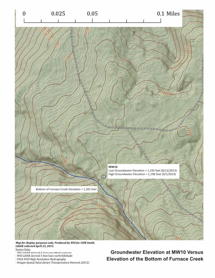
�
���� �����������������������������
������������������������������������
�����
�������������� ��������������������������������
��� ����������� �������������!�������"������"��
#�$�%����&���'��(���)� ���������������������

This page intentionally left blank to allow for double sided printing.
Final_EECA Planning Memo_07OCT'15_clean.docx

Appendix D Calculation of Mercury Contribution to Garoutte Creek from Groundwater at MW8
D-1 Final_EECA Planning Memo_07OCT'15_clean.docx

Appendix D • Calculation of Mercury Contribution to Garoutte Creek from Groundwater at MW8
This page intentionally left blank to allow for double sided printing.
D-2 Final_EECA Planning Memo_07OCT'15_clean.docx


This page intentionally left blank to allow for double sided printing.
Final_EECA Planning Memo_07OCT'15_clean.docx


This page intentionally left blank to allow for double sided printing.
Final_EECA Planning Memo_07OCT'15_clean.docx
Related Documents