FSC-US Forest Management Standard Page 1 of 109 FSC-US Forest Management Standard (v1.0) (w/o FF Indicators and Guidance) Recommended by FSC-US Board, May 25, 2010 Approved by FSC-IC, July 8, 2010 For more information, please contact: FSC-US [email protected] 612.353.4511

Welcome message from author
This document is posted to help you gain knowledge. Please leave a comment to let me know what you think about it! Share it to your friends and learn new things together.
Transcript

FSC-US Forest Management Standard Page 1 of 109
FSC-US Forest Management Standard (v1.0)
(w/o FF Indicators and Guidance)
Recommended by FSC-US Board, May 25, 2010
Approved by FSC-IC, July 8, 2010
For more information, please contact:
FSC-US
612.353.4511

FSC-US Forest Management Standard Page 2 of 109
Table of Contents
Introduction ................................................................................................................... 3
Principle 1: Compliance With Laws and FSC Principles .......................................... 6
Principle 2: Tenure and Use Rights and Responsibilities ........................................ 9
Principle 3: Indigenous Peoples’ Rights .................................................................. 11
Principle 4: Community Relations and Worker’s Rights ........................................ 14
Principle 5: Benefits from the Forest ........................................................................ 19
Principle 6: Environmental Impact............................................................................ 23
Principle 7: Management Plan .................................................................................. 49
Principle 8: Monitoring and Assessment ................................................................. 57
Principle 9: Maintenance of High Conservation Value Forests .............................. 61
Principle 10: Plantation management........................................................................ 65
Appendix A: Glossary of FSC-US Terms .................................................................. 76
Appendix B: FSC-US Regional Map........................................................................... 88
Appendix C: Regional Limits and Other Guidelines on Opening Sizes ................ 89
Appendix D: Ecological Sections of the US ............................................................. 94
Appendix E: Streamside Management Zone (SMZ) Regional Requirements ......... 95
Appendix F: High Conservation Value Forests ...................................................... 102
Appendix G: Plantation classification (Principle 10) .............................................. 107

FSC-US Forest Management Standard Page 3 of 109
INTRODUCTION
Geographical extent: this draft National Standard pertains to forest management in the United States,
with the exclusion of Alaska, Hawaii and the US territories, which are not included in this Standard.
Regional variation: regional variation has been retained from the previous FSC-US regional standards
in Indicators 6.3.g.1, 6.5.e.1, and in Principle 10. Numerous guidance statements throughout this
Standard also provide regional specificity. A regional map depicting the FSC-US regional
delineations can be found in Appendix B of this Standard. Contact FSC-US for more detailed
description of the regions.
Additional FSC policies: this document represents one component of the requirements for FSC
certification. There are multiple other policies, developed at the national and international level, with
which certificate holders must comply. These policies include certificate holder compliance with the
full Standard, partial certification, association with FSC, derogation of requirements, dispute
resolution, federal lands policy, and others that may or may not be referred to in this Standard. These
policies are available at the FSC-IC website (www.fsc.org) or the FSC-US website (www.fscus.org).
Nomenclature used in this Standard: the terms Principles, Criteria, Indicators, Applicability, Intent,
and Guidance are found throughout this Standard.
Principles and Criteria refer to the foundational bases upon which locally adapted forest
management standards are developed. Each Principle comprises multiple Criteria. The
Principles and Criteria are set at the international level and are not open to review or revision
through this FSC-US level process. Major Corrective Action Requests (CARs) are issued
when there is a finding of non-conformance at the Criterion level.
Indicators are set at the national level, originally by FSC-US regional standards working
groups and now revised by a national-level Standards Working Group and Standards
Committee. Indicators are the requirements to which certificate holders must comply. Minor
CARs are issued when there is a finding of non-conformance at the Indicator level. Each
Criterion may comprise one or more Indicators.
Applicability notes are intended to clarify some indicators by defining their scope of
application – for example an Indicator may only apply to management of publicly-owned
lands, or to management operations of a certain size or intensity.
Intent notes expand on the goals or purpose of a requirement and define terms. Intent
statements are used to facilitate consistent application and audit of the Indicators.
Guidance statements are intended to help the landowner/manager and the Certifying Body to
understand how the Principles, Criteria, and Indicators should be applied in practice.
Certifying Bodies are expected to utilize the guidance language associated with each Indicator
when seeking and weighing evidence and assessing conformance with the Indicator.
Individual elements within the guidance when considered separately are not requirements of
this Standard, but, in some circumstances, lack of performance relative to an individual
guidance element could be interpreted to mean non-compliance if, when considering the sum
of the evidence, the Certifying Body finds that there is clear evidence that the Indicator has not
been met. In some cases, other information or management activity not specified in the

FSC-US Forest Management Standard Page 4 of 109
guidance may be provided by the forest owner or manager to demonstrate conformance with
the Indicator.
Glossary terms are in bold italics when they first appear in this Standard. There are some
terms that are defined differently in this Standard than in FSC’s Principles and Criteria (P&C).
These are: Ecosystem, Endangered species, Genetically modified organisms, Indigenous
peoples, Native species, Plantation, Natural forest, Landscape.
Public lands: for the purposes of this standard, public lands refers to non-federal public lands. FSC-
US has a specific protocol for addressing federally-owned lands.
Federal Lands: the process for certifying federal lands must comply with the FSC-US Board
approved Federal Lands Policy and Federal Lands Findings, both of which are available at
www.fscus.org. Certifying Bodies shall consult the Policy and Findings to determine whether there are
FSC-US approved Indicators specific to the type of federal property being assessed.
Non-timber forest products (NTFPs): requirements on NTFPs, in all parts of this Standard, are
intended only for those that are commercially harvested or that are recognized as customary and/or
subsistence use rights. Information used to support NTFP management, including sustained yield
harvest rates and methods for managing NTFPs, is commensurate with the scale, intensity, and risk of
harvest operations, as well as the resources available to quantitatively assess impact and management.
In all cases, the landowner or manager must at a minimum assure that NTFPs are not being depleted
and that there are no negative external effects on other resources. If the landowner or manager wants
to make on-product or off-product FSC-certification claims, then the Certifying Body must evaluate
the management system used for the specific NTFP. The Certifying Body shall use FSC-approved
standards prepared for that NTFP or it shall prepare its own NTFP standard using a process that
follows FSC Standard 20-003.
Management Plans: reference to management plans, in all parts of this Standard, refers to a variety of
documents or an umbrella document that describes how a collection of management documents relate
to an integrated strategy for managing the Forest Management Unit (FMU). This may include a
combination of ownership level plans, unit plans, site level plans, GIS, published guidelines,
landowner policies, and other information.
Demonstrating Conformance: in-the-field verification of conformance with an Indicator is required
whenever it is relevant to confirming that the Indicator is being met.
Areas designated for special management: multiple sections in this Standard call for designations of
special management – among these are High Conservation Value Forests (HCVF); Representative
Sample Areas (RSAs); conservation zones for rare, threatened, and endangered (RTE) species; and
Streamside Management Zones (SMZs). These designations, although designed to capture differing
values are by no means mutually exclusive and in many cases, one would expect to see a high level of
overlap. For example, an unentered old growth stand on an FMU would most likely be designated
HCVF due to its ecological values and would also serve as an RSA as an ecological reference
condition or an under-represented ecological condition. Forest managers and owners are encouraged to
consider the overlap of goals when designing configurations of special management areas in order to
maximize the environmental, social and economic values of the forest.

FSC-US Forest Management Standard Page 5 of 109
Public Lands: Public lands will be eligible to utilize the Family Forest standard only in very limited
situations. City and county parks and forests are eligible, as well as other public lands that are
determined by the Certifying Body to be within the definition of the ‘Small’ component of SLIMF, but
not the ‘Low Intensity’ component, provided by FSC and also to be of low risk with respect to
negative social and environmental impact in those Indicators that are different in the Family Forest
Standard. For public lands that are deemed eligible to use the Family Forest Standard, all Indicators in
the National FSC-US Forest Management Standard that are identified as applicable only to public
lands are also applicable to public lands using the Family Forest Standard.
Group certification and family forest indicators/guidance
Group certification is a process by which multiple landowners or forest managers are certified under
one FSC certificate, and a Group Manager holds the certificate. There are several advantages for the
owners/managers of family forests to form or join a group. The benefits include economies of scale
when it comes to preparing multiple management plans, implementing management activities,
conducting sales and marketing, as well as sharing the costs of preparing for, obtaining, and managing
certification. Group managers are also often better equipped at providing landscape-level guidance,
perspectives and management options on ecological systems and functions.
Group certificates and level of risk
The need to evaluate conformance with an identified Criterion or Indicator will likely increase
with the size of a group and will be influenced by the configuration of the group due to the
cumulative capacity of a group to influence ecological or social objectives, such as affecting
landscape level ecological factors or influencing local economies. The “low risk of negative social
or environmental impact” designation of some Indicators may not always be appropriate for larger
groups and CBs should consider both the cumulative area covered by a group certificate and
spatial structure of the group (e.g. multiple members within a single watershed) when considering
the appropriateness of low risk designations when auditing group certificates. A Group Manager
who wishes to have some or all group members audited to the Family Forest Indicators will
conduct a risk assessment of the Group to evaluate which of the FF Indicators and guidance are
appropriate for that group, and will base this risk assessment on group size, scale and intensity of
operation, likelihood of impact, and other considerations. The CB will evaluate that risk
assessment. These are particularly important for: Criteria 4.1, 4.4, 5.4, 5.6, 6.4 and Indicators
6.1.b, and 9.4.a, where likelihood of HCVF presence would also be taken into consideration.
The risk assessment must be conducted and evaluated as part of the evaluation process or, in cases
where pre-evaluations are required, at the pre-evaluation stage.
Terminology
“Low risk of negative social or environmental impact” – Some Indicators in the Standard have
been determined to be a low risk to negative environmental or social impact in the context of
family forests. In the absence of evidence presented to, or otherwise brought to the attention of
the Certifying Body (CB), the CB can assume that the landowner/manager is in conformance. In
cases where there is cause to believe there is a likelihood of non-conformance with an Indicator
(e.g., observed violations, substantiated complaints) or in cases where local conditions warrant a
higher rigor of audit, CBs are expected to assess conformance with these requirements.

FSC-US Forest Management Standard Page 6 of 109
PRINCIPLE 1: COMPLIANCE WITH LAWS AND FSC PRINCIPLES
Forest management shall respect all applicable laws of the country in which they occur, and
international treaties and agreements to which the country is a signatory, and comply with all
FSC Principles and Criteria.
C1.1 Forest management shall respect all national and local laws and administrative
requirements.
Indicator 1.1.a Forest management plans and operations demonstrate compliance with all applicable
federal, state, county, municipal, and tribal laws, and administrative requirements (e.g., regulations).
Violations, outstanding complaints or investigations are provided to the Certifying Body (CB) during
the annual audit.
Indicator 1.1.b To facilitate legal compliance, the forest owner or manager ensures that employees
and contractors, commensurate with their responsibilities, are duly informed about applicable laws and
regulations.
Intent: This Principle is concerned with adherence to international treaties and agreements and
national, state and local legal requirements, including legislation, forest practice regulations,
mandatory Best Management Practices (BMPs), licenses, and the payment of taxes and fees.
Principle 1 also addresses the extent to which the landowner/manager endorses and supports the
Principles of the FSC. The Criteria and Indicators in this Principle apply not only to the forest
owner/manager’s employees but also to contractors and other forest workers.
Where the FSC Criteria or Indicators are inconsistent with legal compliance and other requirements
covered under Principle 1, and laws prevent the forest owner or manager from attesting that they are
in compliance, the forest owner or manager is expected to adhere to the legal requirements while the
discrepancies are examined. If the discrepancies are not able to be resolved then the forest owner or
manager will be ineligible for FSC certification.
Voluntary BMPs (i.e. not legally mandated regulations) are covered under other Principles.
Guidance: CBs should request and consider the number, severity and temporal pattern of
legal/regulatory violations, outstanding complaints or investigations associated with the Forest
Management Unit (FMU) for the 5 years prior to the certification assessment.
The management plan or other documents provided to the CB should include a list of the key laws
and administrative requirements that typically apply to management operations and a list of contact
information for agencies that are responsible for local enforcement.

FSC-US Forest Management Standard Page 7 of 109
C1.2 All applicable and legally prescribed fees, royalties, taxes and other charges shall be paid.
Indicator 1.2.a The forest owner or manager provides written evidence that all applicable and legally
prescribed fees, royalties, taxes and other charges are being paid in a timely manner. If payment is
beyond the control of the landowner or manager, then there is evidence that every attempt at payment
was made.
C1.3 In signatory countries, the provisions of all binding international agreements such as
CITES, ILO Conventions, ITTA, and Convention on Biological Diversity, shall be respected.
Indicator 1.3.a Forest management plans and operations comply with relevant provisions of all
applicable binding international agreements. Violations, outstanding complaints or investigations are
provided to the CB during the annual audit.
C1.4 Conflicts between laws, regulations and the FSC Principles and Criteria shall be evaluated
for the purposes of certification on a case by case basis, by the certifiers and the involved or
affected parties.
Indicator 1.4.a Situations in which compliance with laws or regulations conflicts with compliance
with FSC Principles, Criteria or Indicators are documented and referred to the CB.
Guidance: Examples for demonstrating compliance include: copies of laws and regulations, and
summaries or checklists, are kept on file; employees are briefed on applicable laws and regulations;
pre-contract meetings are conducted with contractors to review applicable laws and regulations;
contracts include legal requirements; contractors sign agreements to comply with laws and
regulations.
Requirements applied to a contractor or sub-contractor apply only to the extent allowed by US federal
and state law. In many situations, the landowner or manager may address the requirements of this
Principle through the use of contract language.
Intent: Taxes and fees at minimum include, as applicable: local and/or county property taxes;
severance taxes.
Guidance: Compliance may be verified through: a document that includes a list of taxes, fees, and
other charges that typically apply; an annual summary of payments; a signed statement from the forest
owner/manager that all payments are paid on a timely basis.
Applicability: Additional international agreements (such as the UN Framework) are also applicable.
Guidance: The forest owner or manager may demonstrate compliance by maintaining a list of
applicable binding international agreements and completing an assessment to confirm compliance. A
document containing a list of relevant laws, treaties and agreements is available from FSC-US.

FSC-US Forest Management Standard Page 8 of 109
C1.5 Forest management areas should be protected from illegal harvesting, settlement and other
unauthorized activities.
Indicator 1.5.a The forest owner or manager supports or implements measures intended to prevent
illegal and unauthorized activities on the Forest Management Unit (FMU).
Indicator 1.5.b If illegal or unauthorized activities occur, the forest owner or manager implements
actions designed to curtail such activities and correct the situation to the extent possible for meeting all
land management objectives with consideration of available resources.
C1.6 Forest managers shall demonstrate a long-term commitment to adhere to the FSC
Principles and Criteria.
Indicator 1.6.a The forest owner or manager demonstrates a long-term commitment to adhere to the
FSC Principles and Criteria and FSC and FSC-US policies, including the FSC-US Land Sales Policy,
and has a publicly available statement of commitment to manage the FMU in conformance with FSC
standards and policies.
Indicator 1.6.b If the certificate holder does not certify their entire holdings, then they document, in
brief, the reasons for seeking partial certification referencing FSC-POL-20-002 (or subsequent policy
revisions), the location of other managed forest units, the natural resources found on the holdings
Intent: “Unauthorized activities” may include: hunting; fishing; collecting; theft; dumping; and,
prohibited recreational use, including motorized vehicle use on closed roads, closed trails and closed
off-trail areas.
Applicability: The forest owner or manager is not expected to play a law enforcement role, but is
expected to not ignore illegal activities on the FMU.
Guidance: Measures to prevent illegal and unauthorized activities may include, but are not limited to:
clear marking of boundaries; appropriate signage and gates; communications with forest users, local
community members, and other stakeholders; reporting suspected illegal or unauthorized activities to
the proper authorities.
Monitoring and preventative actions should be proportionate to and guided by the nature of the
property and risk of specific types of activities.
Guidance: Efforts to stop illegal or unauthorized activities may include but are not limited to:
cooperating with the appropriate authorities; notifying perpetrators and stakeholders; posting
boundary notices; using gates; making periodic inspections; and reporting suspected illegal or
unauthorized activities to the proper authorities.
No legal action may be appropriate if the proper authorities have been notified and the landowner or
manager demonstrates that legal action may have negative consequences that outweigh its benefit, or
if legal action is not possible.

FSC-US Forest Management Standard Page 9 of 109
being excluded from certification, and the management activities planned for the holdings being
excluded from certification.
Indicator 1.6.c The forest owner or manager notifies the Certifying Body of significant changes in
ownership and/or significant changes in management planning within 90 days of such change.
PRINCIPLE 2: TENURE AND USE RIGHTS AND RESPONSIBILITIES
Long-term tenure and use rights to the land and forest resources shall be clearly defined,
documented and legally established.
C2.1 Clear evidence of long-term forest use rights to the land (e.g. land title, customary rights, or
lease agreements) shall be demonstrated.
Indicator 2.1.a The forest owner or manager provides clear evidence of long-term rights to use and
manage the FMU for the purposes described in the management plan.
Indicator 2.1.b The forest owner or manager identifies and documents legally established use and
access rights associated with the FMU that are held by other parties.
Intent: The purpose of the Indicator is to ensure that changes to the land area that are included in the
certificate are communicated to the CB. This includes changes in group membership as well as
additions or excisions within individual ownerships.
Guidance: The determination of what is a significant change is to be verified by the CB.
Applicability: All landowners are encouraged to certify all their holdings. Certificate holders who are
not members of FSC are encouraged to certify all their holdings, however they are not required to do
so.
Certificate holders who are members of FSC are eligible for partial certification on condition that they
have formally applied for certification assessments for the entire operation, and have also formally
committed to make a strong effort to achieve certification for the entire operation within a reasonable
time frame. The time frame will not normally exceed two years. The commitment applies to the
entire forestry or forest management operation owned or fully controlled by the member or applicant
for membership.
See FSC-POL-20-003, FSC-POL-20-002 and other FSC policy documents for additional guidelines
for partial certification.
Guidance: “Evidence of long-term rights” may include but is not limited to: deeds; long-term lease
agreements; evidence of fee ownership; or a contractual agreement to manage the forest.
Documents do not have to be made publicly available.

FSC-US Forest Management Standard Page 10 of 109
Indicator 2.1.c Boundaries of land ownership and use rights are clearly identified on the ground and
on maps prior to commencing management activities in the vicinity of the boundaries.
C2.2 Local communities with legal or customary tenure or use rights shall maintain control, to
the extent necessary to protect their rights or resources, over forest operations unless they
delegate control with free and informed consent to other agencies.
Indicator 2.2.a The forest owner or manager allows the exercise of tenure and use rights established
by law or regulation.
Indicator 2.2.b In FMUs where tenure or use rights held by others exist, the forest owner or manager
consults with groups that hold such rights so that management activities do not significantly impact the
uses or benefits of such rights.
C2.3 Appropriate mechanisms shall be employed to resolve disputes over tenure claims and use
rights. The circumstances and status of any outstanding disputes will be explicitly considered in
the certification evaluation. Disputes of substantial magnitude involving a significant number of
interests will normally disqualify an operation from being certified.
Guidance: “Use and access rights held by other parties” may include: deed restrictions; long term
leases; timber rights; mineral rights; rights to harvest; conservation easements rights-of-way; non-
timber forest products (NTFP); hunting and fishing rights; and recreational uses.
Intent: This Indicator is not intended to evaluate measures taken to prevent trespass (e.g., marking
property boundaries), which are addressed in Criterion 1.5.
Guidance: Boundary designations do not necessarily have to be comprehensive, but must be
adequate to assure that management activities are implemented where intended. If the boundary
cannot be established, then the manager shall postpone management until the boundaries are
established and marked either by legal survey or by mutual agreement with the adjacent property
owner (see also Criterion 1.5).
Intent: This Criterion addresses non-tribal rights (tribal rights are covered in Principle 3). Tenure and
use rights considered under this Criterion are those substantiated by judicial rulings or otherwise
expressly identified in deeds, other legal instruments or laws.
Guidance: Tenure and use rights may include, but are not limited to: long-term leases; easements;
timber and mineral rights; rights-of-way; access to water supplies, NTFPs, recreational use, hiking,
hunting and fishing; and visiting ancestral grave sites if such permitted access meets the legal
definition of a prescriptive easement. Off-highway Vehicle (OHV) use is not considered a customary
right; however, it may be a privilege granted by the forest owner or manager.
In cases where a conflict exists between tenure/use rights and the conservation of forest resources, the
forest owner/manager brings these conflicts to the attention of the CB.
FSC-US Forest Management Standard Page 11 of 109
Indicator 2.3.a If disputes arise regarding tenure claims or use rights then the forest owner or manager
initially attempts to resolve them through open communication, negotiation, and/or mediation. If these
good-faith efforts fail, then federal, state, and/or local laws are employed to resolve such disputes.
Indicator 2.3.b The forest owner or manager documents any significant disputes over tenure and use
rights.
PRINCIPLE 3: INDIGENOUS PEOPLES’ RIGHTS
The legal and customary rights of indigenous peoples to own, use and manage their lands,
territories, and resources shall be recognized and respected.
C3.1 Indigenous peoples shall control forest management on their lands and territories unless
they delegate control with free and informed consent to other agencies.
Indicator 3.1.a Tribal forest management planning and implementation are carried out by authorized
tribal representatives in accordance with tribal laws and customs and relevant federal laws.
Guidance: Dispute resolution requires a good faith effort of all parties in order to succeed.
Conformance with this Criterion requires the forest owner or manager to make earnest efforts to
resolve disputes, but recognizes that other parties may choose not to respond to opportunities
provided.
The management plan should include written protocol for the dispute resolution process.
Intent: Information about tenure or use rights disputes does not need to be made public. CBs shall
respect the confidentiality of such information. This information also does not include stakeholder
complaints, which are covered elsewhere in this Standard.
Intent: This Principle focuses on Indigenous peoples' rights on their lands and to their resources. Its
focus is generally on collectively held (i.e. tribal) rights and resources; however, individual persons
who demonstrate legal rights to indigenous lands and resources are also included under this Principle.
Applicability: Criterion 3.1 only applies to legally designated lands owned by or held in trust for
American Indians. FMUs that are not on American Indian lands are addressed in Criteria 3.2, 3.3 and
3.4.
Guidance: “free and informed consent” refers to written agreement following adequate, culturally-
appropriate consultation.

FSC-US Forest Management Standard Page 12 of 109
Indicator 3.1.b The manager of a tribal forest secures, in writing, informed consent regarding forest
management activities from the tribe or individual forest owner prior to commencement of those
activities.
C3.2 Forest management shall not threaten or diminish, either directly or indirectly, the
resources or tenure rights of indigenous peoples.
Indicator 3.2.a During management planning, the forest owner or manager consults with American
Indian groups that have legal rights or other binding agreements to the FMU to avoid harming their
resources or rights.
Indicator 3.2.b Demonstrable actions are taken so that forest management does not adversely affect
tribal resources. When applicable, evidence of, and measures for, protecting tribal resources are
incorporated in the management plan.
C3.3 Sites of special cultural, ecological, economic or religious significance to indigenous peoples
shall be clearly identified in cooperation with such peoples, and recognized and protected by
forest managers.
Guidance: Legal delegations of authority may include but are not limited to: a tribal body that is
elected or appointed through hereditary and that authorizes forest management operations; documents
to verify the authority of the tribal body.
Compliance may be evaluated through a signed letter stating compliance from an authorized tribal
representative.
Guidance: Evaluation of forest management to this Criterion is based on the scope, scale and size of
forest management operation.
Guidance: “Tribal resources” may include but are not limited to: subsistence hunting and gathering
areas, fisheries, cultural sites, and other resources on or off the FMU that may be adversely affected
by management activities.
Consultation entails active, culturally-appropriate outreach to tribes or designated tribal
representatives. It is recognized that actual consultation is out of the control of the forest owner or
manager, but that attempts must be made to invite such consultation.
A review of title may be sufficient to demonstrate the existence of current legal rights or other binding
agreements to the FMU.
Intent: This Indicator pertains to tribal resources that may be located either within or off the FMU, but
are affected by management operations within the FMU (for example, effects on fish and game
populations).
FSC-US Forest Management Standard Page 13 of 109
Indicator 3.3.a The forest owner or manager invites consultation with tribal representatives in
identifying sites of current or traditional cultural, archeological, ecological, economic or religious
significance.
Indicator 3.3.b In consultation with tribal representatives, the forest owner or manager develops
measures to protect or enhance areas of special significance (see also Criterion 9.1).
C3.4 Indigenous peoples shall be compensated for the application of their traditional knowledge
regarding the use of forest species or management systems in forest operations. This
compensation shall be formally agreed upon with their free and informed consent before forest
operations commence.
Indicator 3.4.a The forest owner or manager identifies whether traditional knowledge in forest
management is being used.
Indicator 3.4.b When traditional knowledge is used, written protocols are jointly developed prior to
Guidance: It is recognized that actual cooperation and consultation is out of the control of the forest
owner or manager, but that attempts must be made to invite such cooperation and consultation.
Applicability: this Indicator is only applicable if areas of special significance have been identified.
Guidance: Compliance with cultural resource BMPs that have been developed at a state or regional
scale with tribal consultation may be adequate to meet this Indicator in most instances.
The confidentiality of sensitive tribal knowledge is maintained in keeping with applicable laws and at
the behest of tribal representatives. If necessary, public summaries of forest management plans may
omit detailed location and identification data pertaining to sensitive resources.
Applicability: In regions where there are no established tribal representatives, this Criterion may be
inapplicable and the landowner or manager should provide documentation to this effect.
Guidance: Examples of “sites of current or traditional cultural, archeological, ecological, economic or
religious significance” may include but are not limited to: ceremonial, burial, or village sites; areas
used for hunting, fishing, or trapping; current areas for gathering culturally important materials (e.g.
ingredients for baskets, medicinal plants, or plant materials used in dances or other ceremonies);
current areas for gathering subsistence materials (e.g. mushrooms, berries, acorns, etc.).
Direct, culturally-appropriate consultation with tribal representatives is the first preferred method of
consultation. If this is not possible then regional databases or references that contain relevant data may
be used to compile this information.
Applicability: This Criterion is only applicable where traditional knowledge is requested and used in
forest management.

FSC-US Forest Management Standard Page 14 of 109
such use and signed by local tribes or tribal members to protect and fairly compensate them for such
use.
Indicator 3.4.c The forest owner or manager respects the confidentiality of tribal traditional
knowledge and assists in the protection of such knowledge.
PRINCIPLE 4: COMMUNITY RELATIONS AND WORKER’S RIGHTS
Forest management operations shall maintain or enhance the long-term social and economic
well-being of forest workers and local communities.
C4.1 The communities within, or adjacent to, the forest management area should be given
opportunities for employment, training, and other services.
Indicator 4.1.a Employee compensation and hiring practices meet or exceed the prevailing local
norms within the forestry industry.
Indicator 4.1.b Forest work is offered in ways that create high quality job opportunities for
employees.
Indicator 4.1.c Forest workers are provided with fair wages.
Intent: “high quality job opportunities” refer to the way in which work is packaged and the capacity
for growth and development.
Guidance: Depending on the operation, high quality job opportunities may include or are indicated by:
employee relationships are long term and stable; forest owners or managers package work in ways that
support stable employment; jobs include a mixture of diverse tasks that require varying levels of skill;
training opportunities are in place for employees to improve their skills; opportunities for
advancement are available; a comprehensive package of benefits is offered; opportunities are provided
for employee participation in management decision-making; employees are satisfied, within reason,
with the quality of their work environment.
Intent: This Principle addresses the need for the forest owner or manager to consider the social and
economic consequences of the practices they undertake. Social and economic responsibilities are
recognized by FSC as key components in FSC-certified forestry.
See Glossary for the definition of local communities.
Requirements applied to a contractor or sub-contractor apply only to the extent allowed by US federal
and state law. In many situations, the landowner or manager may address the requirements of this
Principle through the use of contract language.
Intent: “Compensation” includes salary or wages, and benefits.

FSC-US Forest Management Standard Page 15 of 109
Indicator 4.1.d Hiring practices and conditions of employment are non-discriminatory and follow
applicable federal, state and local regulations.
Indicator 4.1.e The forest owner or manager provides work opportunities to qualified local applicants
and seeks opportunities for purchasing local goods and services of equal price and quality.
Indicator 4.1.f Commensurate with the size and scale of operation, the forest owner or manager
provides and/or supports learning opportunities to improve public understanding of forests and forest
management.
Indicator 4.1.g The forest owner or manager participates in local economic development and/or civic
activities, based on scale of operation and where such opportunities are available.
C4.2 Forest management should meet or exceed all applicable laws and/or regulations covering
health and safety of employees and their families.
Indicator 4.2.a The forest owner or manager meets or exceeds all applicable laws and/or regulations
covering health and safety of employees and their families (also see Criterion 1.1).
Indicator 4.2.b The forest owner or manager and their employees and contractors demonstrate a safe
work environment. Contracts or other written agreements include safety requirements.
Indicator 4.2.c The forest owner or manager hires well-qualified service providers to safely
implement the management plan.
Guidance: “Conditions of employment” may refer to: remuneration, benefits, safety equipment, safety
of work environment, training, and worker’s compensation.
Intent: Companies should make consistent efforts to source goods and services from local
communities to the extent that they are available and reasonably cost competitive.
Guidance: Efforts to source locally may include, among others: local residents and businesses are
included on a list, maintained by the forest owner or manager, of potential contractors and service
providers (e.g., foresters, loggers); work opportunities are advertised in area newspapers.
Guidance: Evaluation of conformance to this Indicator may be through interviews and observations
and may be demonstrated by: operations have consistently low accident rates; training sessions are
offered/attended; safety procedures and documentation are posted in the workplace; inexperienced
field workers are given adequate instructions and supervision; workers utilize personal protective
equipment; landowners, managers or operators maintain safety-training records; machinery and
equipment is well-maintained and in safe working order.

FSC-US Forest Management Standard Page 16 of 109
C4.3 The rights of workers to organize and voluntarily negotiate with their employers shall be
guaranteed as outlined in Conventions 87 and 98 of the International Labor Organization (ILO).
Indicator 4.3.a Forest workers are free to associate with other workers for the purpose of advocating
for their own employment interests.
Indicator 4.3.b The forest owner or manager has effective and culturally sensitive mechanisms to
resolve disputes between workers and management.
C4.4 Management planning and operations shall incorporate the results of evaluations of social
impact. Consultations shall be maintained with people and groups (both men and women)
directly affected by management operations.
Indicator 4.4.a The forest owner or manager understands the likely social impacts of management
activities, and incorporates this understanding into management planning and operations. Social
impacts include effects on:
Archeological sites and sites of cultural, historical and community significance (on and off the
FMU;
Public resources, including air, water and food (hunting, fishing, collecting);
Aesthetics;
Community goals for forest and natural resource use and protection such as employment,
subsistence, recreation and health;
Community economic opportunities;
Intent: “Service providers” refer to both contract and directly employed staff who implement the
management plan.
Guidance: “Well-qualified” may refer to certified loggers, certified or registered foresters, service
providers who have undergone training programs in their field, or other credentialed professionals.
Service providers do not need degrees in their fields.
Intent: this Indicator covers rights guaranteed under ILO Conventions 87 and 98.
Intent: People “directly affected by management operations” may include: employees and contractors
of the landowner; community members; neighboring landowners; anglers and hunters; recreationists;
local water users; harvesters and processors of forest products; and others identified to be affected by
management operations. People consulted include men and women, ethnic groups and minorities, and
all other stakeholders directly affected by management operations.
The Indicators in this Criterion address the need to include meaningful public participation in forest
management. Public involvement is required in all forests under FSC-certification, including both the
provision of public involvement opportunities as well as the provision of adequate information and
communication. Depending on the nature of the issue, consultation may be required prior to an
activity taking place or on a regularly-scheduled ongoing basis (e.g., annual meetings).
Guidance: Evaluations of social impact are based on the scale and intensity of forest operation.

FSC-US Forest Management Standard Page 17 of 109
Other people who may be affected by management operations.
A summary is available to the CB.
Indicator 4.4.b The forest owner or manager seeks and considers input in management planning from
people who would likely be affected by management activities.
Indicator 4.4.c People who are subject to direct adverse effects of management operations are
apprised of relevant activities in advance of the action so that they may express concern.
Indicator 4.4.d For public forests, consultation includes the following components:
1. Clearly defined and accessible methods for public participation are provided in both long and
short-term planning processes, including harvest plans and operational plans;
2. Public notification is sufficient to allow interested stakeholders the chance to learn of
upcoming opportunities for public review and/or comment on the proposed management;
3. An accessible and affordable appeals process to planning decisions is available.
Planning decisions incorporate the results of public consultation. All draft and final planning
documents, and their supporting data, are made readily available to the public.
Intent: This Indicator focuses on utilizing an evaluation of social impact to guide management
decisions. These evaluations analyze, monitor, and manage the social consequences of a project for
the dual purpose of identifying and improving the negative or unintended consequences of forest
management as well as maximizing the positive outcomes for stakeholders.
Management activities that may have social impacts include but are not limited to: employment
opportunities, harvest, access to land, fire, noise, traffic, and spraying.
Guidance: Social impact evaluations generally include the following three components:
a) Assessment of baseline conditions of identified affected resources and social values; b)
Identification and description of the activities which are likely to cause impact; c) Identification of the
impacts, and how they will be perceived by different stakeholders.
Information may be gathered through the following means: Local community members and groups
such as watershed protection groups, BMP committees, fire councils, outdoor clubs; consultation with
archeological offices, tribes, universities; consultation with other affected groups; field inventories;
municipal and regional plans, landscape biodiversity conservation plans; and cultural plans.
Intent: This Indicator focuses on stakeholder consultation in operations that may directly and
negatively affect stakeholders, such as logging, burning, spraying or traffic.
Guidance: To apprise likely affected neighbors and other stakeholders of specific management
operations, the landowner or manager may post signs or other measures that are readily noticeable by
likely affected stakeholders but that do not necessarily require direct communication. Some situations
may warrant direct communication.
Advance notice should be within a time frame appropriate to the situation.

FSC-US Forest Management Standard Page 18 of 109
C4.5 Appropriate mechanisms shall be employed for resolving grievances and for providing fair
compensation in the case of loss or damage affecting the legal or customary rights, property,
resources, or livelihoods of local peoples. Measures shall be taken to avoid such loss or damage.
Indicator 4.5.a The forest owner or manager does not engage in negligent activities that cause damage
to other people.
Indicator 4.5.b The forest owner or manager provides a known and accessible means for interested
stakeholders to voice grievances and have them resolved. If significant disputes arise related to
resolving grievances and/or providing fair compensation, the forest owner or manager follows
appropriate dispute resolution procedures. At a minimum, the forest owner or manager maintains open
communications, responds to grievances in a timely manner, demonstrates ongoing good faith efforts
to resolve the grievances, and maintains records of legal suites and claims.
Indicator 4.5.c Fair compensation or reasonable mitigation is provided to local people, communities
or adjacent landowners for substantiated damage or loss of income caused by the landowner or
manager.
Applicability: This Indicator only applies to public lands.
Intent: FSC certification does not preclude any individual or group from seeking legislative or judicial
relief.
Guidance: Examples of actions taken to protect others from damage include but are not limited to:
management areas likely to be accessed by recreational users or travelers are signed with precautions;
high use areas such as campgrounds and nature trails are inspected for hazard tree removal; roads to
open pits or other hazards are gated; wells are properly closed; equipment used in commercial
operations is inspected regularly and maintenance is documented; reported hazards are dealt with in a
reasonable time period.
Intent: Methods to comply with this Indicator may be informal or formal depending on the nature of
the grievance.
Guidance: Examples of “appropriate dispute resolution procedures” may include but are not limited
to: developing liaison roles with critical stakeholder groups; program enforcement policies that
emphasize use of appropriate notices or warnings before penalties are applied; hosting open houses or
informal listening opportunities where people are welcomed to express concerns; participating in local
government or on advisory boards and other civic involvement that encourages communication.
Intent: Damage may be to crops, game, trees, land, other managed resources, and impairment of
essential environmental functions (for example, water quality).
The intent of this Indicator is not to provide compensation for a justified business decision, such as
selling product for a higher value or purchasing goods and services at a better price, given relative
equal quality.

FSC-US Forest Management Standard Page 19 of 109
PRINCIPLE 5: BENEFITS FROM THE FOREST
Forest management operations shall encourage the efficient use of the forest's multiple products
and services to ensure economic viability and a wide range of environmental and social benefits.
C5.1 Forest management should strive toward economic viability, while taking into account the
full environmental, social, and operational costs of production, and ensuring the investments
necessary to maintain the ecological productivity of the forest.
Indicator 5.1.a The forest owner or manager is financially able to implement core management
activities, including all those environmental, social and operating costs, required to meet this Standard,
and investment and reinvestment in forest management.
Indicator 5.1.b Responses to short-term financial factors are limited to levels that are consistent with
fulfillment of this Standard.
Intent: Principle 5 primarily focuses on making the most efficient use of harvested resources,
including commercially harvested NTFPs, and maintaining the capacity of both the FMU and the
forest operation to provide long-term economic, environmental, and social benefits. Principle 5 is
intended to promote full-cost accounting but does not require it.
This Principle does not require a financial audit. Rather, it focuses on various indicators of efficiency
and financial viability, such as profit (or loss), financial reserves, trends in market share, price per unit
output, and revenue earned. Much of this information will be highly confidential to the public;
confidentiality is respected.
Guidance: Investment and re-investment activities may include, but are not limited to: planning;
inventory; resource monitoring and protection; post-harvest treatments; capital improvements;
maintenance; and any necessary ecosystem enhancement and restoration measures, over both the
short-term (quarter years and years) and long-term (decades).
Intent: Criterion 5.1 evaluates the ability of forest management operations to be economically viable
while meeting the other Criteria of this Standard.
The forest owner or manager accounts for environmental and social costs by conforming to the
Criteria and Indicators of the other Principles of this Standard.
The following excerpt from the Forest Stewardship Council A.C. By-laws (Revised June 2006)
Mission Statement is included to clarify the relationship between profitability and the full
environmental, social, and economic costs of production:
“Economically viable forest management means that forest operations are structured and managed so
as to be sufficiently profitable, without generating financial profit at the expense of the forest
resource, the ecosystem, or affected communities. The tension between the need to generate adequate
financial returns and the principles of responsible forest operations can be reduced through efforts to
market forest products for their best value.”

FSC-US Forest Management Standard Page 20 of 109
C5.2 Forest management and marketing operations should encourage the optimal use and local
processing of the forest's diversity of products.
Indicator 5.2.a Where forest products are harvested or sold, opportunities for forest product sales and
services are given to local harvesters, value-added processing and manufacturing facilities, and other
operations that are able to offer services at competitive rates and levels of service.
Indicator 5.2.b The forest owner or manager takes measures to optimize the use of harvested forest
products and explores product diversification where appropriate and consistent with management
objectives.
Indicator 5.2.c On public lands where forest products are harvested and sold, some sales of forest
products or contracts are scaled or structured to allow small business to bid competitively.
C5.3 Forest management should minimize waste associated with harvesting and on-site
processing operations and avoid damage to other forest resources.
Indicator 5.3.a Management practices are employed to minimize the loss and/or waste of harvested
forest products.
Indicator 5.3.b Harvest practices are managed to protect residual trees and other forest resources,
including:
soil compaction, rutting and erosion are minimized;
residual trees are not significantly damaged to the extent that health, growth, or values are
noticeably affected;
Intent: Short-term financial factors may include but are not limited to: fluctuations in the market;
requirements for cash flow; and, the need for sawmill equipment and log supplies.
Guidance: “Responses to short-term financial factors” may include but are not limited to: increases in
harvests or debt load; deferred maintenance of roads; and, staff reductions.
Intent: The intent of this Criterion is to maximize forest value by pursuing optimal use (marketing
harvested wood for its highest value) and local processing.
Applicability: this Indicator is only applicable to public lands.
Intent: This Indicator focuses on the ability of small businesses to bid competitively, and does not
assume that the bid will be awarded. Factors such as price, equivalent skills, experience, and abilities
to perform the required tasks must be taken into account in awarding sales and contracts.
Guidance: “Waste” consists of damage or underutilization of harvested products, except where
portions of harvested material need to be left on site to maintain woody debris, nutrient cycling, or
other ecological functions (see Criterion 6.3).

FSC-US Forest Management Standard Page 21 of 109
damage to NTFPs is minimized during management activities; and
techniques and equipment that minimize impacts to vegetation, soil, and water are used
whenever feasible.
C5.4 Forest management should strive to strengthen and diversify the local economy, avoiding
dependence on a single forest product.
Indicator 5.4.a The forest owner or manager demonstrates knowledge of their operation’s effect on
the local economy as it relates to existing and potential markets for a wide variety of timber and non-
timber forest products and services.
Indicator 5.4.b The forest owner or manager strives to diversify the economic use of the forest
according to Indicator 5.4.a.
C5.5 Forest management operations shall recognize, maintain, and, where appropriate, enhance
the value of forest services and resources such as watersheds and fisheries.
Indicator 5.5.a In developing activities on the FMU, the forest owner or manager identifies and
defines appropriate measures for maintaining and/or enhancing forest services and resources that serve
public values, including municipal watersheds, fisheries, carbon storage and sequestration, recreation
and tourism.
Applicability: The capacity of forest management to affect the local economy is dependent on the
scope and scale of operation. Large, highly productive ownerships have a greater capacity to affect the
local economy and should thus explore more thoroughly the range of diversification opportunities than
should a smaller, less productive operation. In public forests, where diversification represents an
important public interest, the forest manager should manage for the broader public interest. Publicly-
owned forests also have different mandates, some of which may require management goals involving
no conventional forest “products” at all.
Intent: It is expected that the landowner/manager will explore a range of products, or act in
cooperation with others in pursuing niche markets, if feasible. However, an actual diversified or value-
added operation is not required, especially if it is financially infeasible.
Applicability: For public lands, diversification of the economic use of the forest is a requirement.
Intent: Economic diversification shall be evaluated in terms of its ecological impacts and shall not
impede maintaining forest composition, structure, function, and other requirements present in this
Standard. Developing new markets shall also be consistent with management objectives.
Guidance: Diversification of economic uses may include but is not limited to: recreation; ecotourism;
hunting; fishing; specialty products and lesser-used species of trees, grades of logs, and lumber;
NTFPs; and emerging markets in new commodities such as water in its value to provide in-stream
water flows.

FSC-US Forest Management Standard Page 22 of 109
Indicator 5.5.b The forest owner or manager uses the information from Indicator 5.5.a to implement
appropriate measures for maintaining and/or enhancing these services and resources.
C5.6 The rate of harvest of forest products shall not exceed levels which can be permanently
sustained.
Indicator 5.6.a In FMUs where products are being harvested, the landowner or manager calculates the
sustained yield harvest level for each sustained yield planning unit, and provides clear rationale for
determining the size and layout of the planning unit. The sustained yield harvest level calculation is
documented in the Management Plan.
The sustained yield harvest level calculation for each planning unit is based on:
documented growth rates for particular sites, and/or acreage of forest types, age-classes and
species distributions;
mortality and decay and other factors that affect net growth;
areas reserved from harvest or subject to harvest restrictions to meet other management goals;
silvicultural practices that will be employed on the FMU;
management objectives and desired future conditions.
The calculation is made by considering the effects of repeated prescribed harvests on the
product/species and its ecosystem, as well as planned management treatments and projections of
subsequent regrowth beyond single rotation and multiple re-entries.
Intent: This Indicator is intended to address forest services and resources that are associated with
public values and not those addressed in Principles 6 and 9. Forest management operations should not
have significant, long term negative impact on these forest services and resources.
If past management has resulted in adverse impacts to forest services and resources, then the forest
owner or manager should identify measures to restore them.
Forest services and resources may vary with ownership type (e.g., public vs. private), size, and region,
and may include but are not limited to watersheds, fisheries, and other non-timber forest values and
services such as recreation, aesthetics, and carbon storage and sequestration.
The reference to carbon storage and sequestration is to have forest managers recognize carbon storage
as an important forest service and public value. It is not intended to preclude harvest that is consistent
with other parts of this Standard, nor is a forest owner/manager required to quantify carbon storage
and sequestration. The forest owner/manager should consider the values associated with carbon and
integrate it into management decisions as done with watersheds, fisheries, and recreation.

FSC-US Forest Management Standard Page 23 of 109
Indicator 5.6.b Average annual harvest levels, over rolling periods of no more than 10 years, do not
exceed the calculated sustained yield harvest level.
Indicator 5.6.c Rates and methods of timber harvest lead to achieving desired conditions, and
improve or maintain health and quality across the FMU. Overstocked stands and stands that have been
depleted or rendered to be below productive potential due to natural events, past management, or lack
of management, are returned to desired stocking levels and composition at the earliest practicable time
as justified in management objectives.
Indicator 5.6.d For NTFPs, calculation of quantitative sustained yield harvest levels is required only
in cases where products are harvested in significant commercial operations or where traditional or
customary use rights may be impacted by such harvests. In other situations, the forest owner or
manager utilizes available information, and new information that can be reasonably gathered, to set
harvesting levels that will not result in a depletion of the non-timber growing stocks or other adverse
effects to the forest ecosystem.
PRINCIPLE 6: ENVIRONMENTAL IMPACT
Forest management shall conserve biological diversity and its associated values, water resources,
soils, and unique and fragile ecosystems and landscapes, and, by so doing, maintain the
ecological functions and the integrity of the forest.
Guidance: If the intent is to change the species balance in a stand or planning unit, or to achieve a
desired age class structure, or to manage a catastrophic or natural event such as fire or pest
outbreak, a particular species might be harvested at a higher-than-sustainable rate until its optimal
stand occupancy could be achieved (e.g., by restocking via planting, etc).
Intent: The term “sustained yield harvest” refers to harvest levels and rates that do not exceed
growth over successive harvests, that contribute directly to achieving desired future conditions, and
that do not diminish the long term ecological integrity and productivity of the site.
The method used to calculate the sustained yield harvest level for timber products is commensurate
with the size and intensity of the forest management operation.
For FMUs in which harvesting occurs infrequently, harvest levels and/or re-entry frequencies are
set consistent with achieving and/or maintaining desired future conditions.

FSC-US Forest Management Standard Page 24 of 109
C6.1 Assessment of environmental impacts shall be completed -- appropriate to the scale,
intensity of forest management and the uniqueness of the affected resources -- and adequately
integrated into management systems. Assessments shall include landscape level considerations as
well as the impacts of on-site processing facilities. Environmental impacts shall be assessed prior
to commencement of site-disturbing operations.
Indicator 6.1.a Using the results of credible scientific analysis, best available information (including
relevant databases), and local knowledge and experience, an assessment of conditions on the FMU is
completed and includes:
1) Forest community types and development, size class and/or successional stages, and associated
natural disturbance regimes;
2) Rare, Threatened and Endangered (RTE) species and rare ecological communities (including
plant communities);
3) Other habitats and species of management concern;
4) Water resources and associated riparian habitats and hydrologic functions;
5) Soil resources; and
6) Historic conditions on the FMU related to forest community types and development, size class
and/or successional stages, and a broad comparison of historic and current conditions.
Intent: Principle 6 focuses on maximizing positive environmental impacts and minimizing adverse
environmental impacts from forest management operations: assessment of impacts, protection of
species and communities, maintenance of ecological functions, the use of pesticides and forest
conversion.
Within the scope of Principle 6 are issues and concepts about which there remains considerable
uncertainty; in cases of uncertainty, the use of a precautionary approach is present both implicitly
and explicitly in several aspects of the Principle because mitigation, repair and restoration is often
difficult, more costly, and sometimes impossible.
See Glossary for definition of biological diversity.
Intent: The primary intent of Criterion 6.1 is to avoid creating significant negative environmental
impact by conducting baseline assessments of resource attributes, assessing the potential
environmental impact of proposed management activities, and then incorporating the results of these
assessments into management planning.
Indicators 6.1.a through 6.1.c follow a logical sequence in which an assessment of current conditions
is completed and compared to historic conditions in order to understand the effects of the short and
long term impacts of management and to determine where restoration may be warranted, and then
management approaches are developed and implemented that minimize and mitigate for these
impacts.
Assessments include all aspects of site-disturbing operations for which the landowner/manager has
direct control, such as: activities associated with timber management, recreational uses, transportation,
on-site wood processing facilities, grazing, mineral extraction, transmission line siting, and other
activities conducted in the FMU.

FSC-US Forest Management Standard Page 25 of 109
Indicator 6.1.b Prior to commencing site-disturbing activities, the forest owner or manager assesses
and documents the potential short and long-term impacts of planned management activities on
elements 1-5 listed in Criterion 6.1.a.
The assessment must incorporate the best available information, drawing from scientific literature and
Intent: Indicator 6.1.a establishes current and historic conditions for assessing environmental impacts.
The purpose of establishing historic conditions is to facilitate creating a baseline for assessing
environmental impacts of operations, to facilitate establishing desired future conditions, and to
determine when restoration may be needed. When historic conditions are not available, best estimates
from available sources may be used. Historic conditions should be used as guidelines for estimating
ecological components of naturally occurring conditions.
The assessment for RTE species and communities includes G1-G3, S1-S2, and some S3 species. The
assessment includes an assessment to determine which S3-ranked species and communities warrant
recognition as RTE, and is based on the following: S3 species/communities that are candidates for
federal or state listing shall be considered RTE species/communities. S3 species/communities that
have been proposed for federal or state listing are also given priority in the assessment. The
assessment shall be designed to identify and recognize as RTE those S3 species/communities that are
more imperiled across their natural ranges, and that are more sensitive and vulnerable to impact from
the types of forest management practices that will occur on the FMU.
Guidance: The forest community and development stage classification system may be based on
regional norms or a landowner-specific system (e.g. the FMO’s stand classification system). At
minimum, the classification must include sufficient specificity and differentiation to account for forest
sites’ natural diversity and tree species, habitat types, stand structures, and their distribution (or lack
thereof) including all development stages from regeneration through old growth characteristic of
regional forest dynamics (see also Indicator 6.3.b).
The above element of the assessment process will also generate information that is relevant to the
assessments required for Representative Sample Areas (Criterion 6.4) and High Conservation Value
Forests (HCVF, Principle 9).
Primary sources of information include state Natural Heritage Programs, NatureServe, LANDFIRE,
state wildlife agencies, US Fish and Wildlife Service and the National Marine Fisheries Service.
Depending on the scale and intensity of operations and potential for risk as indicted by consultation
with conservation agencies, on-site searches for RTE species may be applicable.
In states where S1, S2, S3 or G3 species and communities are not mapped by the Natural Heritage
Program, or where rare species information is incomplete, the best available data for S1-3 and G3
species and communities’ occurrences and finest resolution of classification commonly available in
that state should be used.
“Other habitats and species of management concern” may include a) Species of Greatest Conservation
Need and priority habitats identified in state “Wildlife Action Plans” and priorities identified by state
and federal conservation agencies; b) areas identified in science-based conservation plans developed
by other conservation organizations (e.g., The Nature Conservancy or NatureServe); and c) habitats
for other species potentially at risk due to management. See also Indicators 6.3.c and 6.3.e.

FSC-US Forest Management Standard Page 26 of 109
experts. The impact assessment will at minimum include identifying resources that may be impacted
by management (e.g., streams, habitats of management concern, soil nutrients). Additional detail (i.e.,
detailed description or quantification of impacts) will vary depending on the uniqueness of the
resource, potential risks, and steps that will be taken to avoid and minimize risks.
Indicator 6.1.c Using the findings of the impact assessment (Indicator 6.1.b), management approaches
and field prescriptions are developed and implemented that: 1) avoid or minimize negative short-term
and long-term impacts; and, 2) maintain and/or enhance the long-term ecological viability of the
forest.
Intent: This Indicator focuses on assessing potential impacts to forest resources identified in 6.1.a.
“Short-term impacts” are those that can be measured during or within a short-period of the
management activity (e.g., within one year). “Long-term impacts” are those that persist for longer
periods and include cumulative impacts (e.g., cumulative habitat changes or cumulative impacts to
soils from whole tree harvesting). Cumulative impacts may occur over time at one site (e.g., depletion
of soil nutrients) or at the landscape or ownership scale (e.g., the cumulative impact of many harvests
on wildlife habitat).
“Assessments of environmental impacts” do not require a formal ‘Environmental Impact Assessment’
as defined under federal and state laws and regulations.
Guidance: Potential impacts to site-specific features (e.g., unique habitats, water bodies, identification
of sensitive soils) are typically addressed in operations plans and/or prescriptions. Long-term and
cumulative impacts are addressed in the management plan, while short-term impacts may be
addressed in harvest plans or in separate management guidelines that describe potential risks. While
not all impacts can be easily distinguished as ‘long term’ or ‘short term’ it is important that they are
included in either the management plan or the harvest plan.
Intent: This Indicator focuses on developing/implementing management measures to avoid or
minimize impacts identified in 6.1.b. Emphasis should be placed first on avoidance and then on
minimizing and mitigating negative impacts.
Guidance: Management approaches to address potential long-term impacts, including cumulative
impacts, will typically be addressed in the management plan. They should also be addressed in
operational plans.
Management approaches and field prescriptions to address short-term impacts from management
activities that recur throughout the implementation of the plan may be addressed in the management
plan or in separate management guidelines that are designed to avoid potential risks (for example,
these may be the guidelines required for Criteria 6.3, 6.5, 6.6, 6.8, and 6.9).
Prescriptions to site-specific features (e.g., unique habitats, water bodies, identification of sensitive
soils) are typically addressed in operations plans and/or prescriptions.

FSC-US Forest Management Standard Page 27 of 109
Indicator 6.1.d On public lands, assessments developed in Indicator 6.1.a and management
approaches developed in Indicator 6.1.c are made available to the public in draft form for review and
comment prior to finalization. Final assessments are also made available.
C6.2 Safeguards shall exist which protect rare, threatened and endangered species and their
habitats (e.g., nesting and feeding areas). Conservation zones and protection areas shall be
established, appropriate to the scale and intensity of forest management and the uniqueness of
the affected resources. Inappropriate hunting, fishing, trapping and collecting shall be
controlled.
Indicator 6.2.a If there is a likely presence of RTE species as identified in Indicator 6.1.a then either a
field survey to verify the species' presence or absence is conducted prior to site-disturbing
management activities, or management occurs with the assumption that potential RTE species are
present.
Surveys are conducted by biologists with the appropriate expertise in the species of interest and with
appropriate qualifications to conduct the surveys. If a species is determined to be present, its location
should be reported to the manager of the appropriate database.
Applicability note: This Indicator is only applicable for public lands.
Guidance: Information that the manager and CB deem necessary to keep confidential (e.g., location of
RTE species) may be kept confidential.
Intent: This Criterion establishes safeguards for RTE species that were identified in Criterion 6.1.
Safeguards for RTE communities identified in Criterion 6.1 are addressed in Criterion 6.3.
The landowner has the discretion to keep the specific location of rare populations confidential.
Indicators 6.2.a through 6.2.c follow a logical sequence in which applicants are required to develop a
list of RTE species present in the forest, modify management plans accordingly, and implement
management activities to maintain or enhance habitats for the species. Where adequate plans or
information do not exist and the likely presence of RTE species is indicated, the forest owner or
manager is required to follow a precautionary management approach and manage as though they are
present.
Intent: “Likely” is a judgment decision by the landowner/manager, in consultation with experts (and
verification by the Certifying Body), and is determined by occurrences in the area (e.g., county) of
harvest and/or the similarity of habitat as indicated by input from appropriate natural resource
agencies such as state wildlife agencies, the Natural Heritage programs, NatureServe, the National
Marine Fisheries Service, and knowledge of historic conditions.
Guidance: Depending on the type of FMU (e.g., scale, scope, degree of risks) the landowner/manager
may be required to have surveys conducted by independent experts representing no conflict of interest.
It may also include a secondary review.

FSC-US Forest Management Standard Page 28 of 109
Indicator 6.2.b When RTE species are present or assumed to be present, modifications in
management are made in order to maintain, restore or enhance the extent, quality and viability of the
species and their habitats. Conservation zones and/or protected areas are established for RTE species,
including those S3 species that are considered rare, where they are necessary to maintain or improve
the short and long-term viability of the species. Conservation measures are based on relevant science,
guidelines and/or consultation with relevant, independent experts as necessary to achieve the
conservation goal of the Indicator.
Indicator 6.2.c For medium and large public forests (e.g. state forests), forest management plans and
operations are designed to meet species’ recovery goals, as well as landscape level biodiversity
conservation goals.
Indicator 6.2.d Within the capacity of the forest owner or manager, hunting, fishing, trapping,
collecting and other activities are controlled to avoid the risk of impacts to vulnerable species and
communities (See Criterion 1.5).
C6.3 Ecological functions and values shall be maintained intact, enhanced, or restored,
including:
a) Forest regeneration and succession.
b) Genetic, species, and ecosystem diversity.
c) Natural cycles that affect the productivity of the forest ecosystem.
Intent: The intent of this Indicator is to apply the precautionary approach in order to avoid irreversible
negative consequences to RTE species and their habitats from extractive and recreational activities.
Intent: The goal of this Indicator is to be aware of RTE species and to manage appropriately in
situations where they are present. This may require establishing conservation zones or protected areas
where warranted. Conservation zones are not considered ‘set asides’ and active management within
these areas is allowed where appropriate.
Guidance: In states where S1, S2, S3, or G3 species are not mapped by the local Natural Heritage
Program or where rare species information is incomplete, the best available data should be used.
Applicability note: This Indicator is only applicable for public lands.

FSC-US Forest Management Standard Page 29 of 109
Landscape-scale indicators
Indicator 6.3.a.1 The forest owner or manager maintains, enhances, and/or restores under-represented
successional stages in the FMU that would naturally occur on the types of sites found on the FMU.
Where old growth of different community types that would naturally occur on the forest are under-
represented in the landscape relative to natural conditions, a portion of the forest is managed to
enhance and/or restore old growth characteristics.
Intent: Criterion 6.3 addresses the full range of biodiversity attributes in general management zones
and in special management zones that are not specifically addressed in other Criteria. Each of the
following Indicators is intended to address a specific attribute of biodiversity, and as a whole the
Indicators represent an integrated approach to managing biological diversity.
Outline for Criterion 6.3:
Landscape-Scale Indicators
6.3.a.1 Successional stages
6.3.a.2 Rare ecological communities
6.3.a.3 Old growth
6.3.b Animal species and habitat diversity
6.3.c Riparian Management Zones
Stand- or Site-Scale Indicators
6.3.d Plant species diversity
6.3.e Local seed sources
6.3.f Full range of tree sizes / Declining trees, snags, and coarse debris
6.3.g Even-aged retention
6.3.h Invasive species control
6.3.i Fuels management
Whole tree and biomass harvests: This Criterion does not include an Indicator specific to biomass
harvests or other forms of whole tree harvesting. Rather, biomass and whole tree harvests are
addressed along with other types of removals.
Intent: The manner in which management addresses the landscape scale Indicators will vary greatly
with FMU size. On smaller FMUs, it is generally expected that the landscape-scale Indicators be
considered as property-wide diversity Indicators and that management further considers the context
and characteristics of the surrounding landscape in making management decisions. More detailed
FFFMU size guidance is included with the Indicators below.

FSC-US Forest Management Standard Page 30 of 109
Indicator 6.3.a.2 When a rare ecological community is present, modifications are made in both the
management plan and its implementation in order to maintain, restore or enhance the viability of the
community. Based on the vulnerability of the existing community, conservation zones and/or
protected areas are established where warranted.
Intent: The goal of this Indicator is to maintain, enhance, or restore the biological diversity associated
with the mix of successional stages by forest type that would occur across the FMU under natural
conditions. This goal includes plants, vertebrates, invertebrates, fungi, lichens, and other organisms
associated with those plant community types and other elements of site diversity. The goal is not to
maximize diversity through management, create “museum forests,” explicitly mimic natural
disturbance regimes, or to re-create pre-European-settlement conditions. Non-catastrophic disturbance
should be the focus of analyzing for natural disturbance.
Guidance: The landowner or manager should consider and apply the best available science and
resources when determining natural disturbance and successional processes. The number of potential
plant communities that can be represented, as well as the number of successional stages at any one
time, will vary greatly with ownership size and forest site. Landscape context, including local and
regional landscape needs and opportunities as well as current and desired future ecological conditions
should also be considered in developing diversity goals. While managing for the range of plant
communities and stages or age classes appropriate to the forest size and sites, the land owner/manager
may consider operational and financial feasibility and landowner objectives in deciding their location,
amount, and distribution.
The plant community type and development stage data generated in Indicator 6.1.a (for example, a
community/development stage matrix table) and baseline information from Indicator 6.1.b may be
used as the basic measurement for this Indicator. The level of detail and quantification may vary with
the scale and intensity of management, and is based on the best available data available. This
information should also be used in determining where restoration is needed.
While all forests must meet the requirements of this Indicator, the methods used to meet the Indicator
(e.g., location and extent of communities and age classes) may be influenced by other ownership
objectives if the ecological objectives of this Indicator are met.
The size and conditions of stands should be sufficient to maintain ecological conditions (e.g., light,
humidity, structure) required by species characteristic of the development stage.
Ownership Size Considerations: There is no expectation to manage for a particular development stage
in situations where the range of natural disturbances is such that there would be a very low probability
of that stage occurring on a small parcel. For example, on small parcels there is not an expectation to
create even-aged patches in forest types that do not typically experience stand-replacing disturbances.
As ownership size increases the probability of any one development stage occurring would increase,
and hence the expectation that theses stages would be represented in the managed forest at one or a
number of locations (increasing with forest size).

FSC-US Forest Management Standard Page 31 of 109
Indicator 6.3.a.3 When they are present, management maintains the area, structure, composition, and
processes of all Type 1 and Type 2 old growth. Type 1 and 2 old growth are also protected and
buffered as necessary with conservation zones, unless an alternative plan is developed that provides
greater overall protection of old growth values.
Type 1 Old Growth is protected from harvesting and road construction. Type 1 old growth is also
protected from other timber management activities, except as needed to maintain the ecological values
associated with the stand, including old growth attributes (e.g., remove exotic species, conduct
controlled burning, and thinning from below in dry forest types when and where restoration is
appropriate).
Type 2 Old Growth is protected from harvesting to the extent necessary to maintain the area,
structures, and functions of the stand. Timber harvest in Type 2 old growth must maintain old growth
structures, functions, and components including individual trees that function as refugia (see Indicator
6.3.g).
On public lands, old growth is protected from harvesting, as well as from other timber management
activities, except if needed to maintain the values associated with the stand (e.g., remove exotic
species, conduct controlled burning, and thinning from below in forest types when and where
restoration is appropriate).
On American Indian lands, timber harvest may be permitted in Type 1 and Type 2 old growth in
recognition of their sovereignty and unique ownership. Timber harvest is permitted in situations
where:
1. Old growth forests comprise a significant portion of the tribal ownership.
2. A history of forest stewardship by the tribe exists.
3. High Conservation Value Forest attributes are maintained.
4. Old-growth structures are maintained.
5. Conservation zones representative of old growth stands are established.
Applicability: This Indicator applies to occurrences of rare communities known to state natural
heritage programs and occurrences identified in planning or implementing forest operations.
In states where S1, S2 or S3 communities are not mapped by the Natural Heritage Program, the best
available data for S1-3 communities’ occurrences and finest resolution of classification commonly
available in that state should be used. See Guidance and Intent in Criterion 6.1 for information on S1-
S3 classifications as well as the Glossary listing for Rare, threatened, and endangered species.
Rare communities include some S3 communities. Indicator 6.1.a outlines the process for identifying
which S3 communities must be protected and managed as a rare community.
Guidance: Conservation measures shall be based on relevant science, guidelines and/or consultation
with relevant experts as necessary to achieve the conservation goal of the Indicator.
Field foresters should have an understanding of rare forest communities that may be encountered
during forest operations. At minimum, this generally includes classification at the Alliance or Natural
Community levels, although a more coarse classification may be appropriate in cases where
community types are highly diverse and difficult to classify.

FSC-US Forest Management Standard Page 32 of 109
6. Landscape level considerations are addressed.
7. Rare species are protected.
Indicator 6.3.b To the extent feasible within the size of the ownership, particularly on larger
ownerships, management maintains, enhances, or restores habitat conditions suitable for well-
distributed populations of animal species that are characteristic of forest ecosystems within the
landscape.
Applicability: This Indicator addresses habitats required by species that are not explicitly covered by
Criterion 6.2 and Indicator 6.3.a, with particular consideration of animal species or species guilds
whose populations are influenced by forest management at the multi-stand scale.
Intent: This Indicator is intended to cover habitat diversity of species not specifically associated with
riparian or aquatic habitats, which are addressed in Indicator 6.3.c and Criterion 6.5.
This Indicator addresses management for elements of habitat diversity across the FMU, and includes
consideration of diversity at the landscape-scale. Habitat connectivity at the multi-stand scale is also
considered and is based on the habitat needs of species that are vulnerable to habitat fragmentation.
Guidance: Species that are characteristic of forests within the landscape may include: forest interior
specialists; early successional forest specialists; mature forest specialists; forest understory species;
species with large territories or home ranges whose populations may be dependent on specific habitat
conditions; species at risk from habitat fragmentation; and, species with very restricted ranges
limited by specific habitat conditions.
It is not expected that all species be identified and considered individually. Rather, management may
be based on broad habitat conditions used by a wide range of species (for example, early
successional deciduous forests or large patches of relatively mature coniferous forests) as indicated
by the forest types and other ecosystems found on the forest. Consideration of individual species
may be warranted in the case of listed species or other species of management concern, and for
unique population occurrences, concentrations, remnants or use areas. Examples include habitat for
declining neotropical migrant warblers, nesting areas, refugia, and deer wintering areas.
The level of detail in management and quantification of habitat conditions may vary with the scale
and intensity of management, and as appropriate to ownership size, landscape context, forest
community type, and natural disturbance regimes across the FMU. Greater consideration of the area,
location, and type of habitat is expected when species or species guilds associated with particular
habitat conditions (e.g., large blocks of mature forests, or forest understory species) are adversely
affected by management. At minimum, the forest owner/manager is expected to be able to use cover
type maps as a habitat assessment tool. The plant community type and development stage or age
class data generated in Indicator 6.1.a and 6.2.b (for example, a community/development stage
matrix table) may be used as a basic measurement for this Indicator.
“Well-distributed” means that the population is viable. As feasible considering the forest size, sites
and ecosystems found on the forest, management provides conditions for the population to occur in
multiple locations across the FMU to enhance its viability rather than limiting the occurrence to one
or very few locations.

FSC-US Forest Management Standard Page 33 of 109
Indicator 6.3.c Management maintains, enhances and/or restores the plant and wildlife habitat of
Riparian Management Zones (RMZs) to provide:
a) habitat for aquatic species that breed in surrounding uplands;
b) habitat for predominantly terrestrial species that breed in adjacent aquatic habitats;
c) habitat for species that use riparian areas for feeding, cover, and travel;
d) habitat for plant species associated with riparian areas; and,
e) stream shading and inputs of wood and leaf litter into the adjacent aquatic ecosystem.
Ownership size considerations: the range of species and habitat conditions that can be accommodated
at any one time will vary by ownership size. On smaller ownerships (generally, tens to thousands of
acres), management should meet the requirements of this Indicator by managing for habitat diversity
for the entire forest and consider the role of the ownership within the surrounding landscape.
However, ownership size will limit the type and amount of diversity that can be provided. See
Intent/Guidance for Indicator 6.3.a regarding the expectation of providing development stage diversity
on smaller ownerships.
Very large ownerships address this Indicator on appropriately scaled landscape planning units. These
units may be based on forest boundaries or landscape features and will generally be scaled to
accommodate all but extreme large-scale natural disturbances and the habitat requirements of animals
with large home ranges (or seasonal habitats in the case of migratory animals). Depending on the
ecosystem and regions, a landscape-planning unit might be thousands or tens of thousands of acres in
size.
Intent: This Indicator is intended to cover the habitat and functions of riparian zones around rivers,
perennial and intermittent streams, ponds, lakes, wetlands, vernal pools and tidal waters.
Guidance: Depending on the ecosystem and region, riparian zones frequently extend beyond, and
may have different management guidelines than, those required by Criterion 6.5. Management
activities in the RMZ are acceptable as long as ecological objectives are met.
Aquatic species that breed in surrounding uplands include turtles and cavity-nesting ducks; terrestrial
species that breed in aquatic habitats include some amphibians; species that use riparian areas for
feeding, cover and travel include some birds, mammals, reptiles, amphibians and insects.
In general, it is expected that RMZs for habitat management will vary in width with ecological
importance and with the intensity of timber harvest adjacent to the RMZ. The forest owner/manager
may use ecologically appropriate guidelines such as those that are available in some states or regions,
or other approaches (e.g., focal species) to determine RMZ width and characteristics. Flexibility rather
than uniform RMZ widths is appropriate if based on scientifically based outcomes that maintain or
restore ecological function.

FSC-US Forest Management Standard Page 34 of 109
Stand-scale Indicators
Indicator 6.3.d Management practices maintain or enhance plant species composition, distribution
and frequency of occurrence similar to those that would naturally occur on the site.
Indicator 6.3.e When planting is required, a local source of known provenance is used when available
and when the local source is equivalent in terms of quality, price and productivity. The use of non-
local sources are justified, such as in situations where other management objectives (e.g. disease
resistance or adapting to climate change) are best served by non-local sources. Native species suited to
the site are normally selected for regeneration.
Indicator 6.3.f Management maintains, enhances, or restores habitat components and associated stand
structures, in abundance and distribution that could be expected from naturally occurring processes.
These components include:
a) large live trees, live trees with decay or declining health, snags, and well-distributed coarse down
and dead woody material. Legacy trees where present are not harvested; and
b) vertical and horizontal complexity.
Trees selected for retention are generally representative of the dominant species naturally found on the
site.
Intent: The goal of this Indicator is to maintain local genetic diversity.
Intent: This Indicator addresses species diversity broadly, not simply commercial species. The
assumption is that maintaining species diversity in conformance with this Indicator will conserve
genetic diversity as well, which is a requirement of Criterion 6.3.
Guidance: While some site-specific treatments that simplify diversity may be necessary for specific
objectives (e.g., planting and control of competing vegetation), in general management should strive
to maintain a diversity of native species within stands.
Management practices that address maintenance of natural species diversity include, but are not
limited to: use of natural regeneration methods; intermediate treatments that retain and encourage a
diversity of species; use of site preparation; control of competing vegetation; type and number of
species selected for tree planting; conservation of species at the edge of their ranges; conservation of
representative disease-resistant pockets in areas where plant species are being impacted by disease;
diversified planting schemes; and, creating conditions for understory plants and other biota.
Intent: These Indicators cover elements that are generally considered in harvest plans and other
operations.

FSC-US Forest Management Standard Page 35 of 109
Indicator 6.3.g.1 In the Southeast, Appalachia, Ozark-Ouachita, Mississippi Alluvial Valley, and
Pacific Coast Regions, when even-aged systems are employed, and during salvage harvests, live trees
and other native vegetation are retained within the harvest unit as described in Appendix C for the
applicable region.
In the Lake States Northeast, Rocky Mountain and Southwest Regions, when even-aged silvicultural
systems are employed, and during salvage harvests, live trees and other native vegetation are retained
within the harvest unit in a proportion and configuration that is consistent with the characteristic
natural disturbance regime unless retention at a lower level is necessary for the purposes of restoration
or rehabilitation. See Appendix C for additional regional requirements and guidance.
Intent: The intent of this Indicator is to ensure that the forest owner/manager provides adequate habitat
for species associated with large and/or decaying trees and dead wood. This Indicator applies to all
stands, silvicultural systems, and harvest objectives, including normal operations, salvage harvests,
intermediate, and final harvests and stands regenerated by natural means or by planting.
Some stands may take some time to develop these structural elements. Evidence of conformance may
include measurable goals (e.g., numbers and sizes of trees), and application of silviculture systems and
harvesting practices that develop and maintain these structures over time. Long-term passive
approaches may be used to develop snags and coarse down and dead woody material by allowing
retention trees (e.g., large live decay trees) to die naturally, rather than girdling and/or felling trees
specifically for that purpose.
Trees with decay or declining health include but are not limited to cavity trees.
While species selected for retention should be generally representative of the species found on the site,
flexibility in the proportions of species retained may be based on ecological and financial objectives.

FSC-US Forest Management Standard Page 36 of 109
Indicator 6.3.g.2 Under very limited situations, the landowner or manager has the option to develop a
qualified plan to allow minor departure from the opening size limits described in Indicator 6.3.g.1. A
qualified plan:
1. Is developed by qualified experts in ecological and/or related fields (wildlife biology,
hydrology, landscape ecology, forestry/silviculture).
2. Is based on the totality of the best available information including peer-reviewed science
regarding natural disturbance regimes for the FMU.
3. Is spatially and temporally explicit and includes maps of proposed openings or areas.
4. Demonstrates that the variations will result in equal or greater benefit to wildlife, water
quality, and other values compared to the normal opening size limits, including for sensitive
and rare species.
5. Is reviewed by independent experts in wildlife biology, hydrology, and landscape ecology,
to confirm the preceding findings.
Applicability: This Indicator is applicable only under limited situations where landowners have opted
to conduct site-specific assessments to develop opening sizes that depart from explicit regional limits
set forth in Indicator 6.3.g.1.
Intent: This Indicator is intended to apply to the regeneration phase of even-aged silvicultural systems
in both natural regeneration and planted stands. This Indicator is not meant to preclude even-aged
management in forest types that are typically characterized by gap disturbances. Rather, it is meant to
ensure that biological legacies are retained at the time when even-aged management is used. These
legacies provide plant species diversity, refugia for understory, soil, and leaf-litter species, retention of
wildlife habitat structural elements (e.g., snags, downed logs, etc.), and vertical and horizontal
complexity in developing stands.
Guidance: The method of retention, especially patch size and location, should generally reflect the
type of live vegetation that would be found given natural disturbance regimes and should be sufficient
to provide a variety of “lifeboat” conditions for sensitive understory plant species, fungi, and lichens
and habitat elements for animals. When feasible, retained vegetation should be located to protect
snags, down woody debris, and other retention components from wind throw, and to maintain their
micro-climate and desired function.
Retention objectives and requirements will vary with harvest unit size, the condition of surrounding
stands and silvicultural systems applied to those stands and relative rarity of the plant community. For
example, no retention may be needed if the harvest unit is small and the adjacent stand will be
managed with an uneven-aged system.
It is generally expected that the level of retention will exceed that the minimum requirements of this
Indicator and will include trees of all sizes as well as understory plants.

FSC-US Forest Management Standard Page 37 of 109
Indicator 6.3.h The forest owner or manager assesses the risk of, prioritizes, and, as warranted,
develops and implements a strategy to prevent or control invasive species, including:
1. a method to determine the extent of invasive species and the degree of threat to native
species and ecosystems;
2. implementation of management practices that minimize the risk of invasive establishment,
growth, and spread;
3. eradication or control of established invasive populations when feasible: and,
4. monitoring of control measures and management practices to assess their effectiveness in
preventing or controlling invasive species.
Indicator 6.3.i In applicable situations, the forest owner or manager identifies and applies site-specific
fuels management practices, based on: (1) natural fire regimes, (2) risk of wildfire, (3) potential
economic losses, (4) public safety, and (5) applicable laws and regulations.
C6.4 Representative samples of existing ecosystems within the landscape shall be protected in
their natural state and recorded on maps, appropriate to the scale and intensity of operations
and the uniqueness of the affected resources.
Intent: This Indicator only applies to forest types that are fire-adapted at risk of wildfire.
Applicability: This Indicator is only applicable where invasive species are present.
Intent: The intent of this Indicator is to minimize the risk of invasive species to native ecosystems on
the FMU.
Guidance: A combination of assessment methods may be appropriate, such as including invasive
species in periodic forest inventories, mapping their location and extent, screening sites during harvest
planning, and informal observations by forest managers in the field.
Practices that minimize the risk of establishment and growth of invasive species include: washing
equipment prior to moving on site; avoiding seed mixes that contain potential invasive species; using
weed-free mulch during erosion control operations; seeding landings and other disturbed areas with
native species; altering silvicultural treatments; and effective forest monitoring and early detection.
In prioritizing invasive species control, the forest owner/manager should consider the relative risk of
invasive species infestations relative to other threats to the forest (e.g., fire, insects, disease, etc.).
Control measures should match the scale of the infestation and the potential risks and/or actual
impacts to native species and ecosystems.
Feasibility and consistency with Criterion 6.1 may be considered when developing the invasive
species control plan.
State listings of invasive species are recommended as sources of information.
FSC-US Forest Management Standard Page 38 of 109
Indicator 6.4.a The forest owner or manager documents the ecosystems that would naturally exist on
the FMU, and assesses the adequacy of their representation and protection in the landscape (see
Criterion 7.1). The assessment for medium and large forests include some or all of the following: a)
GAP analyses; b) collaboration with state natural heritage programs and other public agencies; c)
regional, landscape, and watershed planning efforts; d) collaboration with universities and/or local
conservation groups.
For an area that is not located on the FMU to qualify as a Representative Sample Area (RSA), it
should be under permanent protection in its natural state.
Intent: Representative Sample Areas (RSAs) are ecologically viable representative samples
designated to serve one or more of three purposes:
1) To establish and/or maintain an ecological reference condition; or
2) To create or maintain an under-represented ecological condition (i.e., includes samples of
successional phases, forest types, ecosystems, and/or ecological communities); or
3) To serve as a set of protected areas or refugia for species, communities and community types
not captured in other Criteria of this Standard (e.g., to prevent common ecosystems or
components from becoming rare).
RSAs serving purposes 1 and 3 will generally be fixed in location. RSAs serving purpose 2 may move
across the landscape as under-represented conditions change or may be fixed in area and manipulated
to maintain the desired conditions.
For the purposes of this Criterion, ecosystem (or ecological system) refers to mid-level classification
level (i.e., a group of plant communities) or an approximately equivalent level of classification (i.e.,
forest type).
Protection of High Conservation Value Forests, rare species, communities, and ecosystems with
special ecological values are also addressed and protected in other parts of this Standard (see Criteria
6.2, 6.3, and Principle 9). One of the primary provisions in Criterion 6.4 is to ensure that examples of
ecosystem types that are not protected elsewhere in this Standard are protected in their natural state
within the landscape.
The ecosystems that are not sufficiently represented and protected off-property will be protected
within the FMU in a system of RSAs.
Guidance: There is no set appropriate acreage for an RSA; the size can range from a few acres to
hundreds of acres depending on the ecosystem type and purpose. Generally the size should be
representative of the range typical for that ecosystem type and large enough to be viable.

FSC-US Forest Management Standard Page 39 of 109
Indicator 6.4.b Where existing areas within the landscape, but external to the FMU, are not of
adequate protection, size, and configuration to serve as representative samples of existing ecosystems,
forest owners or managers, whose properties are conducive to the establishment of such areas,
designate ecologically viable RSAs to serve these purposes.
Large FMUs are generally expected to establish RSAs of purpose 2 and 3 within the FMU.
Indicator 6.4.c Management activities within RSAs are limited to low impact activities compatible
with the protected RSA objectives, except under the following circumstances:
a) harvesting activities only where they are necessary to restore or create conditions to meet the
objectives of the protected RSA, or to mitigate conditions that interfere with achieving the
RSA objectives; or
b) road-building only where it is documented that it will contribute to minimizing the overall
environmental impacts within the FMU and will not jeopardize the purpose for which the
RSA was designated.
Intent: “Permanent protection” refers to protection levels that are equivalent to GAP Status 1 and
GAP Status 2. In cases where off-FMU GAP Status 3 lands are under management goals and
activities that support the RSA purposes, these lands may be considered. For GAP Status 3, the
landowner/manager must demonstrate how the off-FMU land is being protected to meet its specified
RSA purpose at present and in the long-term, must demonstrate how the off-FMU RSA meets the
other Indicators in this Criterion, and must provide an annual summary to the CB of the status of the
RSA.
Guidance: Assessments for adequacy of representation should generally be in writing. The landowner
should describe the rationale for how determinations of representativeness and uniqueness and level of
existing protection has been made.
Guidance on scaling for Assessments of RSA presence: the forest owner/manager of small and
medium FMUs may comply with this Indicator through more informal consultation. However, on all
FMUs, outstanding examples of common community types (e.g., common types with Natural Heritage
viability rankings of A and B) should be protected or managed to maintain their conservation value.
Guidance on adequacy of representation and protection of RSAs in the landscape:
As a general guideline, if at least five (5) multiple samples of a specific ecosystem type are protected
in a landscape (e.g., ecological section) then no additional samples for that RSA purpose need to be
protected on the FMU. Five is not to be considered an absolute number; fewer or more might be
appropriate in some cases.
Guidance: When forest management activities (including timber harvest) create and maintain
conditions that emulate an intact, mature forest or other successional phases that may be under-
represented in the landscape, the management system that created those conditions may be used to
maintain them, and the area may be considered as a representative sample for the purposes of meeting
this Criterion. RSAs serving as ecological reference areas will generally not be managed for timber
harvest. Threats such as fire, natural pests or pathogens may warrant management measures.

FSC-US Forest Management Standard Page 40 of 109
Indicator 6.4.d The RSA assessment (Indicator 6.4.a) is periodically reviewed and if necessary
updated (at a minimum every 10 years) in order to determine if the need for RSAs has changed; the
designation of RSAs (Indicator 6.4.b) is revised accordingly.
Indicator 6.4.e Managers of large, contiguous public forests establish and maintain a network of
representative protected areas sufficient in size to maintain species dependent on interior core habitats.
C6.5 Written guidelines shall be prepared and implemented to: control erosion; minimize forest
damage during harvesting, road construction, and all other mechanical disturbances; and
protect water resources.
Indicator 6.5.a The forest owner or manager has written guidelines outlining conformance with the
Indicators of this Criterion.
Indicator 6.5.b Forest operations meet or exceed Best Management Practices (BMPs) that address
components of the Criterion where the operation takes place.
Indicator 6.5.c Management activities including site preparation, harvest prescriptions, techniques,
timing, and equipment are selected and used to protect soil and water resources and to avoid erosion,
landslides, and significant soil disturbance. Logging and other activities that significantly increase the
Guidance: If a re-evaluation reveals that off-FMU examples of an ecosystem have been reduced in
extent or viability, are experiencing increased threat, or their management has significantly changed or
is likely to significantly change, then the landowner or manager is expected to make appropriate and
compensatory adjustments to on-FMU RSA designations. Conversely, changes in off-FMU protection
of RSAs may also include an increase in the number of protected ecosystems and hence a reduced
need for protection on the FMU.
Intent: BMPs for water quality, erosion control, protection of forest resources during harvesting, road
construction, and all other mechanical disturbances provide a foundational minimum for compliance
with this Criterion.
BMPs include both voluntary and mandatory state and regional BMPs, as well as analogous terms
used in certain states (e.g., Site Level Guidelines).
Isolated and minor situations of non-compliance with BMPs may or may not result in a finding of
nonconformance with the Indicator.
Applicability: this Indicator only pertains to large, contiguous public forests.
Guidance: Written guidelines may include published guidelines (e.g., BMPs and other guidelines) or
guidelines developed by the forest owner/manager that are supported by scientific literature, published
guidelines, and/or consultation with experts. Where appropriate, guidelines should be measurable.

FSC-US Forest Management Standard Page 41 of 109
risk of landslides are excluded in areas where risk of landslides is high. The following actions are
addressed:
Slash is concentrated only as much as necessary to achieve the goals of site preparation and
the reduction of fuels to moderate or low levels of fire hazard.
Disturbance of topsoil is limited to the minimum necessary to achieve successful regeneration
of species native to the site.
Rutting and compaction is minimized.
Soil erosion is not accelerated.
Burning is only done when consistent with natural disturbance regimes.
Natural ground cover disturbance is minimized to the extent necessary to achieve regeneration
objectives.
Whole tree harvesting on any site over multiple rotations is only done when research indicates
soil productivity will not be harmed.
Low impact equipment and technologies is used where appropriate.
Indicator 6.5.d The transportation system, including design and placement of permanent and
temporary haul roads, skid trails, recreational trails, water crossings and landings, is designed,
Intent: This Indicator includes soil productivity, function, and habitat (including the leaf litter layer
and fine woody debris) in all stands, management systems, and harvest objectives.
Guidance: Attention to this Indicator is expected to increase with the amount and frequency of woody
material removed from the site (e.g., biomass removals and whole tree harvests).
Decisions are made based on objective data regarding slope, erosion-hazard rating, potential for soil
compaction, rutting, and risk of landslides.
To protect soils in areas having a high risk of landslides, logging plans should include tree retention
critical for slope stability, and low-impact harvesting systems such as skyline cable or helicopter.
Clearcutting and other activities that significantly increase the risk of failure should not be conducted
on unstable slopes.
All soil disturbing activities, including road and trail construction, are conducted only during periods
of weather when soil compaction, rutting, surface erosion, or sediment transport into streams and other
bodies of water can be adequately controlled. Soils should be dry enough or frozen to minimize
disturbance and compaction.
In addition, the following guidance is region-specific:
Pacific Coast (PC):
On slopes greater than 30%, ground-based yarding should be used only when it is possible to
do so without exacerbating soil erosion;
On slopes greater than 50%, cable or helicopter logging should be used if it is technically
feasible and will not result in adverse environmental effects due to the management operation.
Ozark Ouachita Region (OO):
Deepening and scouring of existing drainages due to silvicultural or logging operations should
be absent.

FSC-US Forest Management Standard Page 42 of 109
constructed, maintained, and/or reconstructed to reduce short and long-term environmental impacts,
habitat fragmentation, soil and water disturbance and cumulative adverse effects, while allowing for
customary uses and use rights. This includes:
access to all roads and trails (temporary and permanent), including recreational trails, and off-
road travel, is controlled, as possible, to minimize ecological impacts;
road density is minimized;
erosion is minimized;
sediment discharge to streams is minimized;
there is free upstream and downstream passage for aquatic organisms;
impacts of transportation systems on wildlife habitat and migration corridors are minimized;
area converted to roads, landings and skid trails is minimized;
habitat fragmentation is minimized;
unneeded roads are closed and rehabilitated.
Indicator 6.5.e.1 In consultation with appropriate expertise, the forest owner or manager implements
written Streamside Management Zone (SMZ) buffer management guidelines that are adequate for
preventing environmental impact, and include protecting and restoring water quality, hydrologic
conditions in rivers and stream corridors, wetlands, vernal pools, seeps and springs, lake and pond
shorelines, and other hydrologically sensitive areas. The guidelines include vegetative buffer widths
and protection measures that are acceptable within those buffers.
Guidance: Control measures that reduces ecological impacts may include but are not limited to:
roads without a weather resistant surface are used only during periods of weather when conditions are
favorable to minimize road damage, surface erosion, and sediment transport; if necessary to minimize
ecological impacts, access is restricted on roads not immediately necessary for management purposes;
posted or monitored enforcement.
Examples for evaluating adequacy of the transportation system may include but are not limited to:
roads constructed on slopes in excess of 60% are made with full bench cuts or minimal side cast; for
decommissioned roads, bridges and culverts are removed, water bars are installed; slopes are
recontoured or revegetated, and ecologically functional drainage patterns are established; landings are
located on ecologically suitable sites and the size is minimized and the number of landings is
optimized to minimize overall disturbance to the site; landings are seeded, mulched, or covered with
slash after use; Riparian Management Zone crossings are kept to a minimum; stream crossings are
installed at an angle that causes least ecological disturbance; water diversion structures are used
according to locally applicable guidelines.
As part of watershed assessments, habitats for salmonids and other threatened and endangered aquatic
species are identified. If shown to be necessary, road density is reduced in such habitats and/or
mitigated within the watershed.
Cooperative transportation planning with agencies, such as watershed management councils, is used to
minimize negative cumulative impacts across the landscape.
The forest owner or manager should design culverts and take other steps to ensure fish passage in
order to maintain or enhance the biodiversity of the stream, although it is understood that there may be
some situations where free upstream and downstream passage is not possible.

FSC-US Forest Management Standard Page 43 of 109
In the Appalachia, Ozark-Ouachita, Southeast, Mississippi Alluvial Valley, Southwest, Rocky
Mountain, and Pacific Coast regions, there are requirements for minimum SMZ widths and explicit
limitations on the activities that can occur within those SMZs. These are outlined as requirements in
Appendix E.
Indicator 6.5.e.2 Minor variations from the stated minimum SMZ widths and layout for specific
stream segments, wetlands and other water bodies are permitted in limited circumstances, provided the
forest owner or manager demonstrates that the alternative configuration maintains the overall extent of
the buffers and provides equivalent or greater environmental protection than FSC-US regional
requirements for those stream segments, water quality, and aquatic species, based on site-specific
conditions and the best available information. The forest owner or manager develops a written set of
supporting information including a description of the riparian habitats and species addressed in the
alternative configuration. The CB must verify that the variations meet these requirements, based on the
input of an independent expert in aquatic ecology or closely related field.
Indicator 6.5.f Stream and wetland crossings are avoided when possible. Unavoidable crossings are
located and constructed to minimize impacts on water quality, hydrology, and fragmentation of
Intent: This Indicator allows for minor variations in the physical layout of the buffers for specific
stream segments in cases where the landowner/manager must also comply with legal requirements that
compel layouts different than those specified in the Standard, without reducing the overall extent of
the buffer and quality of management within the buffer for those stream segments.
Intent: The focus of this Indicator is on stream and water quality protection, and also involves riparian
management zones and stream management zones. See Indicator 6.3.d for requirements addressing
plant and wildlife habitat values adjacent to water bodies.
Guidance: Guidelines should meet or exceed regional recommendations (e.g., water quality BMPs) as
necessary to meet the objective of water quality protection and restoration measures. Measures for all
stream segments include, but are not limited to:
developing buffer widths sufficient to protect and restore water quality, considering:
temperature, sedimentation, chemical runoff, recruitment of woody debris and stream
structure, and the timing of water flows sufficient to meet water quality standards for both
humans and aquatic species, including invertebrates, fish, and amphibians;
providing filter strips that vary with slope and soils that are sufficient to trap sediment from
upslope sites;
minimizing soil disturbance;
providing adequate shade to protect water temperature;
minimizing or precluding harvest within core portions of buffer strips;
protecting stream banks;
maintaining tree cover and minimizing disturbance of floodplain areas to ensure that proper
aquatic function will be provided when channels shift;
ensuring recruitment of coarse woody debris where needed for aquatic habitats;
regulating harvest and road construction on upslope areas to ensure proper hydrological
function, including the timing, intensity, and location of water delivery.
FSC-US Forest Management Standard Page 44 of 109
aquatic habitat. Crossings do not impede the movement of aquatic species. Temporary crossings are
restored to original hydrological conditions when operations are finished.
Indicator 6.5.g Recreation use on the FMU is managed to avoid negative impacts to soils, water,
plants, wildlife and wildlife habitats.
Indicator 6.5.h Grazing by domesticated animals is controlled to protect in-stream habitats and water
quality, the species composition and viability of the riparian vegetation, and the banks of the stream
channel from erosion.
C6.6 Management systems shall promote the development and adoption of environmentally
friendly non-chemical methods of pest management and strive to avoid the use of chemical
pesticides. World Health Organization Type 1A and 1B and chlorinated hydrocarbon pesticides;
pesticides that are persistent, toxic or whose derivatives remain biologically active and
accumulate in the food chain beyond their intended use; as well as any pesticides banned by
international agreement, shall be prohibited. If chemicals are used, proper equipment and
training shall be provided to minimize health and environmental risks.
Guidance: For the Pacific Coast (PC) region, stream crossings should be designed to accommodate a
100 year peak flood event or to limit the consequences of an unavoidable failure.
Crossing structures should be designed to match the natural stream width, depth, velocities and
substrate through the crossing structure.
Intent: This Indicator focuses on recreation use and not recreation trails, which is covered in Indicator
6.5.e. Unauthorized use of vehicles on the FMU is considered trespassing, which is an illegal activity
and should be addressed accordingly.
Guidance: This includes on-trail and off-trail recreation use. Recreation use includes but is not limited
to: motorized and non-motorized vehicles, horses, hiking, and mountain biking.
Guidance: The location and intensity of grazing (livestock numbers) and/or season of use (grazing
duration) should be managed to avoid adverse impacts. Unauthorized grazing should be treated as any
other illegal activity on the forest and addressed accordingly.
Intent: This Criterion is guided by FSC POL 30 001 EN FSC Pesticides policy 2005 and related
documents. In addition, World Health Organization Type 1A and 1B and chlorinated hydrocarbon
pesticides, pesticides that are persistent, toxic or whose derivatives remain biologically active and
accumulate in the food chain beyond their intended use, and any pesticides banned by international
agreement, shall be prohibited.
This Criterion and its Indicators also require that the forest owner/manager strive to reduce the use of
other chemical pesticides and biocides, and work towards their eventual phase-out whenever feasible,
consistent with the FSC policy on the use of chemical pesticides.
FSC-US Forest Management Standard Page 45 of 109
Indicator 6.6.a No products on the FSC list of Highly Hazardous Pesticides are used (see FSC-POL-
30-001 EN FSC Pesticides policy 2005 and associated documents).
Indicator 6.6.b All toxicants used to control pests and competing vegetation, including rodenticides,
insecticides, herbicides, and fungicides are used only when and where non-chemical management
practices are: a) not available; b) prohibitively expensive, taking into account overall environmental
and social costs, risks and benefits; c) the only effective means for controlling invasive and exotic
species; or d) result in less environmental damage than non-chemical alternatives (e.g., top soil
disturbance, loss of soil litter and down wood debris). If chemicals are used, the forest owner or
manager uses the least environmentally damaging formulation and application method practical.
Written strategies are developed and implemented that justify the use of chemical pesticides.
Whenever feasible, an eventual phase-out of chemical use is included in the strategy. The written
strategy includes an analysis of options for, and the effects of, various chemical and non-chemical pest
control strategies, with the goal of reducing or eliminating chemical use.
Indicator 6.6.c Chemicals and application methods are selected to minimize risk to non-target species
and sites. When considering the choice between aerial and ground application, the forest owner or
manager evaluates the comparative risk to non-target species and sites, the comparative risk of worker
exposure, and the overall amount and type of chemicals required.
Indicator 6.6.d Whenever chemicals are used, a written prescription is prepared that describes the
site-specific hazards and environmental risks, and the precautions that workers will employ to avoid or
minimize those hazards and risks, and includes a map of the treatment area.
Applicability: This restriction applies only to pesticides used on the FMU and not on nursery
operations.
Intent: Minimization is a stepwise process that includes: 1) silviculture and other management
activities that avoid the need for chemical pesticides; and then, 2) activities that minimize the use of
pesticides that cannot be avoided.
Guidance: The forest owner/manager should employ silvicultural systems, integrated pest
management, and strategies for controlling vegetation that minimize negative environmental effects.
This may include: creation and maintenance of habitat that discourages pest outbreak; creation and
maintenance of habitat that encourages natural predators; evaluation of pest populations and
establishment of action thresholds; diversification of species composition and structure; use of low
impact mechanical methods; use of prescribed fire; use of longer rotations or selection harvest; use of
uneven-age management.
Intent: Non-target species and sites include but are not limited to: water courses and buffer zones; rare,
threatened or endangered plant and animal species and their habitats; RSAs and HCVF areas;
vegetation selected for within-stand retention; adjacent stands; and, human use areas.
FSC-US Forest Management Standard Page 46 of 109
Chemicals are applied only by workers who have received proper training in application methods and
safety. They are made aware of the risks, wear proper safety equipment, and are trained to minimize
environmental impacts on non-target species and sites.
Indicator 6.6.e If chemicals are used, the effects are monitored and the results are used for adaptive
management. Records are kept of pest occurrences, control measures, and incidences of worker
exposure to chemicals.
C6.7 Chemicals, containers, liquid and solid non-organic wastes including fuel and oil shall be
disposed of in an environmentally appropriate manner at off-site locations.
Indicator 6.7.a The forest owner or manager, and employees and contractors, have the equipment and
training necessary to respond to hazardous spills.
Indicator 6.7.b In the event of a hazardous material spill, the forest owner or manager immediately
contains the material and engages qualified personnel to perform the appropriate removal and
remediation, as required by applicable law and regulations.
Indicator 6.7.c Hazardous materials and fuels are stored in leak-proof containers in designated storage
areas, that are outside of riparian management zones and away from other ecological sensitive features,
until they are used or transported to an approved off-site location for disposal. There is no evidence of
persistent fluid leaks from equipment or of recent groundwater or surface water contamination.
C6.8 Use of biological control agents shall be documented, minimized, monitored and strictly
controlled in accordance with national laws and internationally accepted scientific protocols. Use
of genetically modified organisms shall be prohibited.
Indicator 6.8.a Biological control agents are used only as part of a pest management strategy for the
control of invasive plants, pathogens, insects, or other animals when other pest control methods are
Guidance: “Equipment and training” may include but is not limited to: spill kits, plans, and knowledge
of qualified personnel to call on in an event of a hazardous spill.
Guidance: “Hazardous materials” include: lubricants, anti-freeze, hydraulic fluids, containers,
pesticides, herbicides, paints, etc.
Intent: “off-site” refers to a designated disposal location formally recognized and/or designated by a
local government authority.
Intent: FSC-POL-30-602 Genetically Modified Organisms provides a definition and guidance on the
interpretation of Criterion 6.8.
Genetically improved organisms (e.g., Mendelian crossed) are not considered to be genetically
modified organisms (GMOs) (i.e., results of genetic engineering), and may be used. The prohibition of
genetically modified organisms applies to all organisms including trees.
FSC-US Forest Management Standard Page 47 of 109
ineffective, or are expected to be ineffective. Such use is contingent upon peer-reviewed scientific
evidence that the agents in question are non-invasive and are safe for native species.
Indicator 6.8.b If biological control agents are used, they are applied by trained workers using proper
equipment.
Indicator 6.8.c If biological control agents are used, their use is documented, monitored and strictly
controlled in accordance with state and national laws and internationally accepted scientific protocols.
A written plan will be developed and implemented justifying such use, describing the risks, specifying
the precautions workers will employ to avoid or minimize such risks, and describing how potential
impacts will be monitored.
Indicator 6.8.d Genetically Modified Organisms (GMOs) are not used for any purpose.
C6.9 The use of exotic species shall be carefully controlled and actively monitored to avoid
adverse ecological impacts.
Indicator 6.9.a The use of exotic species is contingent on the availability of credible scientific data
indicating that any such species is non-invasive and its application does not pose a risk to native
biodiversity.
Indicator 6.9.b If exotic species are used, their provenance and the location of their use are
documented, and their ecological effects are actively monitored.
Indicator 6.9.c The forest owner or manager takes timely action to curtail or significantly reduce any
adverse impacts resulting from their use of exotic species.
Guidance: Monitoring intensity reflects the persistence and risk posed by the species and may be
justified by consultation with regional experts or literature.
Intent: This Criterion applies to how exotic species are controlled and monitored when they are
utilized, and includes all exotic species, including trees and other plants (e.g., herbaceous erosion
control mixes or plants used for wildlife food and cover) and animals used in forest management.
Intent: This Indicator also covers seed mixed and species used for erosion control.
Guidance: State lists of invasive/exotic plant species should generally be used as the basis for
determining if a species is invasive. New cultivars, hybrids, and uncommon plants (e.g., some of those
promoted for use on wildlife food plots) may not have been evaluated by state invasive plant councils.
If such species and/or varieties are being used, then the forest owner/manager is expected to consult
with a state expert in invasive plants.
Unless evidence suggests otherwise, a species that is not identified as being invasive is assumed to not
pose a risk to native biodiversity.

FSC-US Forest Management Standard Page 48 of 109
C6.10 Forest conversion to plantations or non-forest land uses shall not occur, except in
circumstances where conversion:
a) entails a very limited portion of the forest management unit; and
b) does not occur on high conservation value forest areas; and
c) will enable clear, substantial, additional, secure, long term conservation benefits across
the forest management unit.
Indicator 6.10.a Forest conversion to non-forest land uses does not occur, except in circumstances
where conversion entails a very limited portion of the forest management unit (note that Indicators
6.10.a, b, and c are related and all need to be conformed with for conversion to be allowed).
Indicator 6.10.b Forest conversion to non-forest land uses does not occur on high conservation value
forest areas (note that Indicators 6.10.a, b, and c are related and all need to be conformed with for
conversion to be allowed).
Definition of “very limited portion”: less than 2% of the certified forest area on the FMU over a
rolling five-year period. Lands that are converted for forest management purposes (e.g. roads,
landings, management buildings) are not included in calculations of this limit.
Plantations can be established on forest sites that lack the vast majority of the native forest ecosystem
components (see Indicator 10.2.b).
Intent: All three circumstances must be met in order for conversion to be allowed.
Guidance on “conversion”: In general, improvements to land (including provision of utilities,
improved roads, and surveyed blocks) that are likely to result in development, are considered
precursors to conversion. Advanced cases of improvements are considered conversion. For example,
surveying and demarcating the land in and of itself does not constitute conversion, but installation of
roads to each parcel is considered conversion. Although it may be difficult to distinguish some
management activities that are geared toward development from acceptable silvicultural prescriptions
(e.g., “real estate cuts” versus “shelterwood cuts”) it is the responsibility of the certificate holder to
disclose the future goals for that management to the CB.
Definition of “non-forest land”: Non-forest land consists of land that is managed for reasons other
than the production of forest products, values, or amenities. Non-forest land includes land that does
not classify as a forest ecosystem (including old agricultural fields, grasslands). “Non-forest land
uses” include land that is forested, but current zoning and/or conditional use permits present intentions
for future conditions of the land that will result in the loss of, or degradation of, production of forest
products, values or amenities (e.g., commercial or industrial development, residential use).
Applicability: If the forest owner or manager is compliant with Indicator 6.9.a, and an outbreak of an
exotic species occurs, then the outbreak of exotic species does not constitute non-compliance with
Indicator 6.9.b.
Intent: this Criterion is specifically for cases that involve the intentional use of exotic species - it does
not address invasive exotic plants or animals (this is addressed in Criterion 6.3).

FSC-US Forest Management Standard Page 49 of 109
Indicator 6.10.c Forest conversion to non-forest land uses does not occur, except in circumstances
where conversion will enable clear, substantial, additional, secure, long term conservation benefits
across the forest management unit (note that Indicators 6.10.a, b, and c are related and all need to be
conformed with for conversion to be allowed).
Indicator 6.10.d Natural or semi-natural stands are not converted to plantations. Degraded, semi-
natural stands may be converted to restoration plantations.
Indicator 6.10.e Justification for land-use and stand-type conversions is fully described in the long-
term management plan, and meets the biodiversity conservation requirements of Criterion 6.3 (see also
Criterion 7.1.l)
Indicator 6.10.f Areas converted to non-forest use for facilities associated with subsurface mineral
and gas rights transferred by prior owners, or other conversion outside the control of the certificate
holder, are identified on maps. The forest owner or manager consults with the CB to determine if
removal of these areas from the scope of the certificate is warranted. To the extent allowed by these
transferred rights, the forest owner or manager exercises control over the location of surface
disturbances in a manner that minimizes adverse environmental and social impacts.
If the certificate holder at one point held these rights, and then sold them, then subsequent conversion
of forest to non-forest use would be subject to Indicator 6.10.a-d
PRINCIPLE 7: MANAGEMENT PLAN
A management plan -- appropriate to the scale and intensity of the operations -- shall be written,
implemented, and kept up to date. The long term objectives of management, and the means of
Intent of “clear, substantial, additional, secure, long term conservation benefits across the forest
management unit”: Conditions that enable these conservation benefits are limited by the following:
• The forest owner or manager provides documentation that any conversion to non-forest uses
will result in additional conservation and/or restoration of natural forest, particularly HCVF
and/or imperiled (or “rare”) species’ habitats, at levels above and beyond those otherwise
required by the FSC-US FM Standard, and carries out that increased conservation and
restoration.
• Negative environmental impacts of conversion to non-forest uses may be offset through
compensatory management activities. The conservation benefits used to offset conversion to
non-forest use must lead to equal or greater conservation values than those lost by the
conversion. The compensatory activities may include establishment of conservation
easements, contributions to local land trusts, transfer of lands to land trusts or public
ownership, etc.
In general, maintenance of an FSC certificate for the remainder of forest lands does not
constitute sufficient conservation benefit.
Guidance: If the conversion will result in significant loss of forest resources, and where financially
feasible, then the forest owner or manager should make a good faith effort to buy the rights before
conversion occurs.

FSC-US Forest Management Standard Page 50 of 109
achieving them, shall be clearly stated.
C7.1 The management plan and supporting documents shall provide:
a) Management objectives.
b) Description of the forest resources to be managed, environmental limitations, land use
and ownership status, socio-economic conditions, and a profile of adjacent lands.
c) Description of silvicultural and/or other management system, based on the ecology of
the forest in question and information gathered through resource inventories.
d) Rationale for rate of annual harvest and species selection.
e) Provisions for monitoring of forest growth and dynamics.
f) Environmental safeguards based on environmental assessments.
g) Plans for the identification and protection of rare, threatened and endangered species.
h) Maps describing the forest resource base including protected areas, planned
management activities and land ownership.
i) Description and justification of harvesting techniques and equipment to be used.
Indicator 7.1.a The management plan identifies the ownership and legal status of the FMU and its
resources, including rights held by the owner and rights held by others.
Intent: This Principle is intended to ensure that management of the FMU is described in a
comprehensive management plan. The plan should be developed with expertise and public input
appropriate to the scale of the operation. The management plan, and the process of its development,
should embody and consider all of the Principles and Criteria in this Standard.
The management plan may consist of a variety of documents or an umbrella document that describes
how a collection of management documents relate to an integrated strategy for managing the forest.
This may include a combination of ownership level plans, unit plans, site level plans (e.g., harvest
plans), GIS, published guidelines (e.g., regional silviculture or BMP guides), landowner policies, and
other information.
Guidance on scale and intensity of operations: All management plans regardless of the scale and
intensity of operations must address the Indicators of Criterion 7.1 unless otherwise noted in the
guidance below.
Intent: Criterion 7.1 ensures that a written management plan, as described in the Principle-level intent
and guidance above, exists for the property within the scope of the certificate. The actions and
objectives detailed in the plan are specific, achievable, measurable and adaptive. They are also
sufficient to meet the requirements of this Standard.
Whenever the term “management plan” is used, it refers to any combination of documents and
systems that meet the intent of the Indicator.

FSC-US Forest Management Standard Page 51 of 109
Indicator 7.1.b The management plan describes the history of land use and past management, current
forest types and associated development, size class and/or successional stages, and natural disturbance
regimes that affect the FMU (see Indicator 6.1.a).
Indicator 7.1.c The management plan describes:
a) current conditions of the timber and non-timber forest resources being managed; b) desired future
conditions; c) historical ecological conditions; and d) applicable management objectives and activities
to move the FMU toward desired future conditions.
Guidance: “Current conditions” are based on forest inventories or other information sources, as
applicable. The level of detail in the plan may be a summary of the inventory data, or more general in
nature as indicated by the resource and is commensurate with the resource and intensity of
management (e.g., general descriptions of water body or wetland types and extent may suffice).
“Desired future conditions” are the characteristics that describe the long-term (e.g., 30-50 years)
vision of the FMU, such as the amount and age or development class distribution of forest types,
species composition, products, habitats and values, and other resources. Desired future conditions
must be consistent with the requirements of this Standard.
The purpose of establishing historic conditions is to facilitate creating a baseline for assessing
environmental impacts of operations, to facilitate establishing desired future conditions, and to
determine when restoration may be needed. When historic conditions are not available, best estimates
from available sources may be used. Historic conditions should be used as guidelines for estimating
ecological components of naturally occurring conditions.
“Management objectives” are typically time specific, measurable results that correspond to the goals.
Forest resources include timber, fish and wildlife, and NTFPs.
Guidance: This Indicator refers to information already compiled in Indicator 6.1.a
Natural disturbance regimes include wind, fire, insects, and pathogens. Typical disturbance events in
terms of opening size, intensity disturbance, range, and frequency of disturbance are described to the
extent they are known.
Guidance: Legal status information may be summarized in the plan as appropriate to the scale and
complexity of the ownership and the relevance of applicable legal constraints on management
activities.
Ownership status includes ownership type (e.g., fee, easement, lease).
Rights held by others may include: customary uses and use rights; indigenous peoples' rights;
conservation easements, deed restrictions, and other easements or rights held by others; and leasing
arrangements.

FSC-US Forest Management Standard Page 52 of 109
Indicator 7.1.d The management plan includes a description of the landscape within which the FMU
is located and describes how landscape-scale habitat elements described in Criterion 6.3 will be
addressed.
Indicator 7.1.e The management plan includes a description of the following resources and outlines
activities to conserve and/or protect:
rare, threatened, or endangered species and natural communities (see Criterion 6.2);
plant species and community diversity and wildlife habitats (see Criterion 6.3);
water resources (see Criterion 6.5);
soil resources (see Criterion 6.3);
Representative Sample Areas (see Criterion 6.4);
High Conservation Value Forests (see Principle 9);
Other special management areas.
Indicator 7.1.f If invasive species are present, the management plan describes invasive species
conditions, applicable management objectives, and how they will be controlled (see Indicator 6.3.j).
Indicator 7.1.g The management plan describes insects and diseases, current or anticipated outbreaks
on forest conditions and management goals, and how insects and diseases will be managed (see
Criteria 6.6 and 6.8).
Guidance: The landscape description and landscape management objectives consider elements such
as:
land uses and trends in the surrounding landscape;
a general description of forest ownership types and parcel sizes in the landscape;
forest types, type of management, and general condition of forests within the landscape;
significant water bodies and other features that cross the FMU boundary;
diversity of habitats across the ownership, as indicated by forest type;
species or species groups that may be significantly affected by habitat loss or fragmentation on
the FMU.
Guidance: The management plan should have sufficient detail to describe the current resources and
how the landowner/manager complies with Criteria 6.2, 6.3, 6.4, 6.5, and Principle 9.
The plan may reference supporting guidelines and policies that describe specific management
practices. Site-specific information and practices may be included in operational plans.
Guidance: The plan may reference supporting guidelines and policies that describe specific
management practices.

FSC-US Forest Management Standard Page 53 of 109
Indicator 7.1.h If chemicals are used, the plan describes what is being used, applications, and how the
management system conforms with Criterion 6.6.
Indicator 7.1.i If biological controls are used, the management plan describes what is being used,
applications, and how the management system conforms with Criterion 6.8.
Indicator 7.1.j The management plan incorporates the results of the evaluation of social impacts,
including:
traditional cultural resources and rights of use (see Criterion 2.1);
potential conflicts with customary uses and use rights (see Criteria 2.2, 2.3, 3.2);
management of ceremonial, archeological, and historic sites (see Criteria 3.3 and 4.5);
management of aesthetic values (see Indicator 4.4.a);
public access to and use of the forest, and other recreation issues;
local and regional socioeconomic conditions and economic opportunities, including creation
and/or maintenance of quality jobs (see Indicators 4.1.b and 4.4.a), local purchasing
opportunities (see Indicator 4.1.e), and participation in local development opportunities (see
Indicator 4.1.g).
Indicator 7.1.k The management plan describes the general purpose, condition and maintenance needs
of the transportation network (see Indicator 6.5.e).
Indicator 7.1.l The management plan describes the silvicultural and other management systems used
and how they will sustain, over the long term, forest ecosystems present on the FMU.
Indicator 7.1.m The management plan describes how species selection and harvest rate calculations
were developed to meet the requirements of Criterion 5.6.
Intent: The transportation network includes roads, skid trials, landings, and stream crossings.
Management needs include maintenance, upgrades, closures, etc.
Intent: “species selection” refers to species selected to harvest, retain, and promote regeneration.
Guidance: The plan describes the methods used to calculate the harvest level, and describes how that
level is consistent with the composition, structures, and functions of the FMU in accordance with
Criterion 6.3 and other applicable Criteria.
Intent: Disease may include biotic factors (e.g., fungi and other pathogens) and abiotic factors (e.g.,
acidic deposition).
Guidance: Potential impacts on stocking or harvest are described.
The management plan may reference supporting guidelines and policies that describe specific
management practices.
This description is commensurate with the likelihood of outbreaks or infestations.

FSC-US Forest Management Standard Page 54 of 109
Indicator 7.1.n The management plan includes a description of monitoring procedures necessary to
address the requirements of Criterion 8.2.
Indicator 7.1.o The management plan includes maps describing the resource base, the characteristics
of general management zones, special management areas, and protected areas at a level of detail to
achieve management objectives and protect sensitive sites.
Indicator 7.1.p The management plan describes and justifies the types and sizes of harvesting
machinery and techniques employed on the FMU to minimize or limit impacts to the resource.
Indicator 7.1.q Plans for harvesting and other significant site-disturbing management activities
required to carry out the management plan are prepared prior to implementation. Plans clearly
describe the activity, the relationship to objectives, outcomes, any necessary environmental safeguards,
health and safety measures, and include maps of adequate detail.
Guidance: The landowner or manager provides rationale for the types of equipment used in different
situations. Where they are not legally allowed to restrict the type of equipment (e.g., some state
harvesting contracting requirements), the plan describes how different types of equipment are
selected.
Guidance: Depending on the map scale (e.g. forest level vs. stand level) and purpose and intensity of
management, maps should include:
property boundaries and ownership;
roads and trails;
planned management activities including forest product harvest areas;
forest types by age class;
topography, soils, water courses and water bodies;
wetlands and riparian zones;
archeological and cultural sites and customary use areas;
locations of unique and sensitive natural communities, habitats and features;
rare, threatened and endangered species;
Representative Sample Areas, and
designated protected areas and High Conservation Value Forests.
The location of sensitive sites (e.g. rare plants or archaeological sites) need not be made publicly
available to protect the resource.
FSC-US Forest Management Standard Page 55 of 109
Indicator 7.1.r The management plan describes the stakeholder consultation process.
C7.2 The management plan shall be periodically revised to incorporate the results of monitoring
or new scientific and technical information, as well as to respond to changing environmental,
social and economic circumstances.
Indicator 7.2.a The management plan is kept up to date. It is reviewed on an ongoing basis and is
updated whenever necessary to incorporate the results of monitoring or new scientific and technical
information, as well as to respond to changing environmental, social and economic circumstances. At a
minimum, a full revision occurs every 10 years.
Intent: Elements of Criterion 7.2 are elaborated upon more fully under the related Indicators of
Principle 8. This Criterion is closely related to Criterion 8.4 which requires that monitoring results be
incorporated into the management plan.
Intent: This Indicator ensures that potential impacts and outcomes of site specific activities are
addressed in a way that reflects the intent of a more general (not site-specific) management plan.
Desired outcomes include both the immediate post-activity condition (e.g., stocking and composition)
and desired longer-term outcomes (e.g., regeneration).
Other significant site disturbing management activities may include, but are not limited to: site
preparation, prescribed burns, use of chemicals or biological control agents, and road building or
significant road maintenance.
Guidance: Operation plans may be integrated into the management plan (more likely on small
ownerships) or be a separate document prior to the activity (e.g., a form or narrative, with associated
map).
Harvest activity descriptions include the silvicultural system and specific practice, and desired post-
harvest condition and other outcomes (e.g. regeneration).
This Indicator may be addressed with a combination of documents, such as contracts, maps, BMPs,
and pre-harvest checklists.
For public lands, plans should be made available to the public prior to commencement of significant
operations. The land manager should address public comments as part of the process of revising the
plans.

FSC-US Forest Management Standard Page 56 of 109
C7.3 Forest workers shall receive adequate training and supervision to ensure proper
implementation of the management plan.
Indicator 7.3.a Workers are qualified to properly implement the management plan; all forest workers
are provided with sufficient guidance and supervision to adequately implement their respective
components of the plan.
C7.4 While respecting the confidentiality of information, forest managers shall make publicly
available a summary of the primary elements of the management plan, including those listed in
Criterion 7.1.
Indicator 7.4.a While respecting landowner confidentiality, the management plan or a management
plan summary that outlines the elements of the plan described in Criterion 7.1 is available to the public
either at no charge or a nominal fee.
Intent: The owner or manager of a private forest may withhold proprietary information (e.g., timber
volumes by size and age class, marketing strategies, and other financial information, see Criterion 8.5)
but is required to share information from the plan that informs stakeholders of management activities
and implementation of the Principles, Criteria and Indicators found in this Standard.
Guidance: Adequate training and supervision measures may include but are not limited to: employers
actively train employees in the goals and requirements of this and other applicable FSC standards;
loggers and other operators participate in informal and formal training, such as Forest Industry Safety
Training Alliance, Game of Logging and similar programs; professional foresters and resource
managers meet continuing education standards, such as Society of American Foresters 'Certified
Forester' program; foresters, loggers, and other relevant employees are trained to understand SMZ,
RMZ, rare species, and HCVF forest protection requirements for the forest, as well as safeguards
relating to chemical applications; field personnel are provided with written harvest plans and/or maps
that clearly guide actions required to implement the management plan; and meetings occur as needed
to review operations and make any necessary adjustments.
Intent: The rigor of the review and update is contingent upon scale and intensity of management, and
updates should focus on those aspects of the plan where changes are necessary.
It is not the intent that a hard-copy management plan is re-written every time there is a harvest or a
natural disturbance (wildfire or pest infestation) on some part of the FMU. When the impact is large
enough to require changes in management strategy, it may require revision of specific parts of the
management plan.
Reasons for modifying the management plan may include but are not limited to: (1) in response to,
and to incorporate, the results of monitoring as outlined in Principle 8; (2) whenever changes are
proposed to the plan’s primary objectives or management system; (3) whenever a significant
environmental impact, threat or natural disturbance occurs; (4) whenever significant changes in uses
of the FMU occur; (5) when there are significant changes in socio-economic circumstances.
The management system may incorporate ongoing and dynamic processes or data such as GIS.
FSC-US Forest Management Standard Page 57 of 109
.
Indicator 7.4.b Managers of public forests make draft management plans, revisions and supporting
documentation easily accessible for public review and comment prior to their implementation.
Managers address public comments and modify the plans to ensure compliance with this Standard.
PRINCIPLE 8: MONITORING AND ASSESSMENT
Monitoring shall be conducted -- appropriate to the scale and intensity of forest management --
to assess the condition of the forest, yields of forest products, chain of custody, management
activities and their social and environmental impacts.
C8.1 The frequency and intensity of monitoring should be determined by the scale and intensity
of forest management operations as well as the relative complexity and fragility of the affected
environment. Monitoring procedures should be consistent and replicable over time to allow
comparison of results and assessment of change.
Indicator 8.1.a Consistent with the scale and intensity of management, the forest owner or manager
develops and consistently implements a regular, comprehensive, and replicable written monitoring
protocol.
Intent: A key aspect of forest management is monitoring to ensure that current conditions are known
and can be compared with desired future conditions and management objectives, and as necessary to
adjust management techniques to address social, economic or environmental effects. Monitoring
ensures that forest management, conservation, and restoration objectives continue to be met as
effectively as possible, even given unanticipated outcomes and/or changing conditions. Principle 8 is
concerned with design and implementation of the monitoring program. Principle 8 also identifies
requirements that enable an FSC chain-of-custody to operate.
Monitoring programs shall be designed appropriate to the scale and intensity of forest management.
Applicability: this Indicator is applicable only to public forests.
Guidance: See Criterion 8.5 for more information on respecting landowner confidentiality and what is
acceptable to provide in a public summary. Limited elements of the plan may be excluded to protect
the security of environmentally sensitive and/or proprietary information.
When possible, the forest owner/manager should post a summary of the management plan on their
website, but at a minimum this summary is made available upon request.

FSC-US Forest Management Standard Page 58 of 109
C8.2 Forest management should include the research and data collection needed to monitor, at a
minimum, the following indicators:
a) Yield of all forest products harvested.
b) Growth rates, regeneration and condition of the forest.
c) Composition and observed changes in the flora and fauna.
d) Environmental and social impacts of harvesting and other operations.
e) Costs, productivity, and efficiency of forest management.
Indicator 8.2.a.1 For all commercially harvested products, an inventory system is maintained. The
inventory system includes at a minimum: a) species, b) volumes, c) stocking, d) regeneration, and e)
stand and forest composition and structure; and f) timber quality.
Indicator 8.2.a.2 Significant, unanticipated removal or loss or increased vulnerability of forest
resources is monitored and recorded. Recorded information includes date and location of occurrence,
description of disturbance, extent and severity of loss, and may be both quantitative and qualitative.
Indicator 8.2.b The forest owner or manager maintains records of harvested timber and NTFPs
(volume and product and/or grade). Records must adequately ensure that the requirements under
Criterion 5.6 are met.
Indicator 8.2.c The forest owner or manager periodically obtains data needed to monitor presence on
the FMU of:
1) Rare, threatened and endangered species and/or their habitats;
Guidance: Removal, loss or increased vulnerability of forest products may result from poaching, fire,
pests, disease, storm, over-browsing or other depredation, infestation by invasive species or other
disturbances.
Guidance: Information gathered and maintained as part of the inventory system is dependent on the
scale and intensity of the management objectives.
Guidance: Monitoring should be focused on data that are of sufficient detail to evaluate current
conditions, the effects of management on economic, environmental, and social resources of the FMU,
and to track progress towards desired future conditions and management objectives.
The monitoring program should describe procedures and their frequency, and be sufficient to ensure
that current conditions are known and can be compared with desired future conditions and
management objectives.
Scale of operations: Medium and large ownerships are expected to have systematic and robust data
collections for resources that are affected by management, while smaller operations may have
informal and qualitative requirements for data collection.
Intensity and frequency of operations: More and/or better data are needed for resources that are
significantly or frequently altered (e.g., timber stocking composition, and stand structure) than for
those that are minimally impacted (e.g., protected areas where there are no operations).

FSC-US Forest Management Standard Page 59 of 109
2) Common and rare plant communities and/or habitat;
3) Location, presence and abundance of invasive species;
4) Condition of protected areas, set-asides and buffer zones;
5) High Conservation Value Forests (see Criterion 9.4).
Indicator 8.2.d.1 Monitoring is conducted to ensure that site specific plans and operations are
properly implemented, environmental impacts of site disturbing operations are minimized, and that
harvest prescriptions and guidelines are effective.
Indicator 8.2.d.2 A monitoring program is in place to assess the condition and environmental impacts
Guidance: This includes evidence of potential impacts to soil and water quality, wetlands and riparian
zones, and instances of erosion or damage to non-target species.
Short-term impacts are monitored during and at the close of operations.
Long-term impacts are monitored at an appropriate length of time after the operation to ensure that
protection measures (e.g., water bars) are stable and functioning. Once protection measures are
determined to be stable and effective, additional long-term monitoring may not be required.
Intent: It is not the intent of Indicator 8.2.c to require that all species be monitored, but rather to focus
on monitoring of habitat conditions (as indicated by Criterion 6.2 and Criterion 6.3).
Guidance: Monitoring should be adequate to address the habitat conditions required by Criteria 6.2,
6.3, 6.4, and Principle 9.
The intensity of monitoring required to address habitats protected by Criteria 6.2, 6.4, and Principle 9
is relative to the degree of protection and allowed management activities. For protected areas,
informal monitoring may be sufficient. However, if management may have adverse impacts on a
species (for example, intensive harvesting in a small watershed with endangered fish), then population
monitoring may be necessary. Wherever RTE species are involved, more intense evaluation and
protection actions are likely required. Consultation with conservation agencies responsible for the
species or habitat type may be used to determine the level of monitoring.
Common plant and wildlife species habitat is primarily addressed by monitoring the abundance and
distribution of plant communities and/or habitat types and their associated development, size class
and/or successional stages. Approaches to classifying plant communities and development stages are
described in the guidance to Indicator 6.1.a.
The intensity of monitoring for other elements of Criterion 6.3 is dependent on the scale and intensity
of the operations. Elements monitored may include: analysis of habitat connectivity as landscape-scale
habitat features as indicated by forest inventory, cover type data, and aerial imagery; condition of
riparian zones and other important habitats; and the size and abundance of snags and live decay trees.
Informal approaches to monitoring invasive species (e.g., pre-harvest site inspections) may be
adequate if the observations are routinely made and adequate to identify invasive species in early
stages.

FSC-US Forest Management Standard Page 60 of 109
of the forest-road system.
Indicator 8.2.d.3 The landowner or manager monitors relevant socio-economic issues (see Indicator
4.4.a), including the social impacts of harvesting, participation in local economic opportunities (see
Indicator 4.1.g), the creation and/or maintenance of quality job opportunities (see Indicator 4.1.b), and
local purchasing opportunities (see Indicator 4.1.e).
Indicator 8.2.d.4 Stakeholder responses to management activities are monitored and recorded as
necessary.
Indicator 8.2.d.5 Where sites of cultural significance exist, the opportunity to jointly monitor sites of
cultural significance is offered to tribal representatives (see Principle 3).
Indicator 8.2.e The forest owner or manager monitors the costs and revenues of management in order
to assess productivity and efficiency.
C8.3 Documentation shall be provided by the forest manager to enable monitoring and
certifying organizations to trace each forest product from its origin, a process known as the
"chain of custody."
Indicator 8.3.a When forest products are being sold as FSC-certified, the forest owner or manager has
a system that prevents mixing of FSC-certified and non-certified forest products prior to the point of
sale.
Intent: Chain-of-custody (CoC) is an important aspect of the FSC system. For products claimed to be
sourced from FSC-certified forests, CoC tracks certified products from the forest of origin throughout
the supply chain. The critical first link in the supply chain, and the focus of this Criterion, is from the
point of harvest to the transfer of ownership, and it is the responsibility of the forest owner/manager of
a FSC-certified forest to maintain the integrity of certified products within this first link in the supply
chain.
Intent: This Indicator is closely related to Criterion 5.1, which identifies that economic viability
should take into account environmental, social and operational costs of production.
Revenues include income from timber and non-timber resources, recreational leases, payments for
ecosystem services, and other forest uses within the FMU.
Intent: The forest-road system includes trails used for motorized recreation.
Guidance: Road system monitoring may include but is not limited to: potential slope failures, erosion
and water quality impacts, aquatic species’ passage, overall road extent and density, and impacts of
skid trails and other non-permanent roads.
Monitoring requirements may be minimized in areas where there is no management activity and/or on
non-active roads.

FSC-US Forest Management Standard Page 61 of 109
Indicator 8.3.b The forest owner or manager maintains documentation to enable the tracing of the
harvested material from each harvested product from its origin to the point of sale.
C8.4 The results of monitoring shall be incorporated into the implementation and revision of the
management plan.
Indicator 8.4.a The forest owner or manager monitors and documents the degree to which the
objectives stated in the management plan are being fulfilled, as well as significant deviations from the
plan.
Indicator 8.4.b Where monitoring indicates that management objectives and guidelines, including
those necessary for conformance with this Standard, are not being met or if changing conditions
indicate that a change in management strategy is necessary, the management plan, operational plans,
and/or other plan implementation measures are revised to ensure the objectives and guidelines will be
met. If monitoring shows that the management objectives and guidelines themselves are not sufficient
to ensure conformance with this Standard, then the objectives and guidelines are modified.
C8.5 While respecting the confidentiality of information, forest managers shall make publicly
available a summary of the results of monitoring indicators, including those listed in Criterion
8.2.
Indicator 8.5.a While protecting landowner confidentiality, either full monitoring results or an up-to-
date summary of the most recent monitoring information is maintained, covering the Indicators listed
in Criterion 8.2, and is available to the public, free or at a nominal price, upon request.
PRINCIPLE 9: MAINTENANCE OF HIGH CONSERVATION VALUE FORESTS
Management activities in high conservation value forests shall maintain or enhance the
attributes which define such forests. Decisions regarding high conservation value forests shall
always be considered in the context of a precautionary approach.
Guidance: Information that is considered confidential can be presented in such a way as to protect its
confidentiality, including data on production, inventory, growth and costs of operation, and other
information deemed to provide a competitive advantage or proprietary in nature. This information can
be represented in the public summary as trends, percentages, or in terms of their relation to the goals
and limits outlined in the management plan.
Intent: This Indicator requires that the results of monitoring be reflected in the implementation of the
management plan. Revisions to the management plan as a result of monitoring are also addressed in
Criterion 7.2.
Intent: This Indicator does not require the landowner or manager to maintain a Chain-of-Custody
certificate, but rather to be able to sell an FSC-certified product as certified to a Chain-of-Custody
business.
FSC-US Forest Management Standard Page 62 of 109
C9.1 Assessment to determine the presence of the attributes consistent with High Conservation
Value Forests will be completed, appropriate to scale and intensity of forest management.
Indicator 9.1.a The forest owner or manager identifies and maps the presence of High Conservation
Value Forests (HCVF) within the FMU and, to the extent that data are available, adjacent to their
FMU, in a manner consistent with the assessment process, definitions, data sources, and other
guidance described in Appendix F.
Given the relative rarity of old growth forests in the contiguous United States, these areas are normally
designated as HCVF, and all old growth must be managed in conformance with Indicator 6.3.a.3 and
requirements for legacy trees in Indicator 6.3.f.
Intent: High Conservation Value Forests are managed to protect and maintain their identified high
conservation value attributes. In some cases, active management is consistent with these attributes,
and in other cases (e.g., most old growth forests), active management is specifically precluded.
FSC introduced the concept of High Conservation Value Forests (HCVFs) in 1999 to ensure
identification and proper management of forest areas with exceptional conservation value. FSC
defines High Conservation Value Forests as those that possess one or more of the following High
Conservation Values (HCVs):
1. HCV forest areas containing globally, regionally or nationally significant concentrations of
biodiversity values (e.g., endemism, endangered species, refugia), including RTE species and
their habitats;
2. HCV forest areas containing globally, regionally or nationally significant large landscape
level forests, contained within, or containing the management unit, where viable populations
of most if not all naturally occurring species exist in natural patterns of distribution and
abundance;
3. HCV forest areas that are in or contain rare, threatened or endangered ecosystems;
4. HCV forest areas that provide basic services of nature in critical situations (e.g., watershed
protection, erosion control);
5. HCV forest areas fundamental to meeting basic needs of local communities (e.g., subsistence,
health); or,
6. HCV forest areas critical to local communities’ traditional cultural identity (areas of cultural,
ecological, economic or religious significance identified in cooperation with such local
communities).
The FSC-US National HCVF Assessment Framework may be used as a resource for assessing the
presence of HCVs on the FMU, and includes definitions, data resources, and guiding questions. This
Framework is currently available in the Standards section of the FSC-US website, www.fscus.org.
See Appendix F ‘High Conservation Value Forests’ for definitions and guidance on the terms listed
above. Applicability: All forest operations, regardless of size and scale, must adequately meet the intent of
this Criterion; the complexity of the assessment is based on the scale and intensity of the operation.

FSC-US Forest Management Standard Page 63 of 109
Indicator 9.1.b In developing the assessment, the forest owner or manager consults with qualified
specialists, independent experts, and local community members who may have knowledge of areas
that meet the definition of HCVs.
Indicator 9.1.c A summary of the assessment results and management strategies (see Criterion 9.3) is
included in the management plan summary that is made available to the public.
Guidance: Dependent on the potential for negatively impacting HCVs, a credible outside review of the
assessment may be required.
Intent: A High Conservation Value Forest is an area with one or more of the attributes listed in the
Principle-level Intent statement and further defined in Appendix F.
Data resources for HCV 1-4: The rigor of the assessment, including choices of data sources
consulted, is based on the likelihood of, and the occurrence of, HCVs on the FMU and the risk of
negative impacts to the HCVs. Data sources include:
State Natural Heritage Programs
State conservation, fish and wildlife Agencies
State Wildlife Action Plan
US Fish and Wildlife Service
National Marine Fisheries Service
Local or regional water management districts
Nature Serve
Conservation groups whose primary mission is science-based biodiversity protection and
management (e.g., The Nature Conservancy, Audubon)
Local experts (e.g., hydrologists, soil scientists, tribal experts)
Forest Management Unit (FMU) cover type maps and forest inventory data
US Forest Service (USFS) Ecoregions (See Appendix D)
Rare ecosystem information gathered as per Criteria 6.1, 6.2 and 6.4
For old growth, stand-level assessments
Soil, watershed and aquifer maps
Data resources for HCV 5-6: In most cases, assessments of local community rights (i.e., legal or
customary tenure or use rights) and tribal rights consistent with Criterion 2.2, Principle 3, and
Criterion 4.4 will be sufficient to determine if there is potential for this HCV to occur on the FMU.
Additional information sources may include but are not limited to:
Native American tribes, bands, and organizations
Community groups dependent upon the forest for basic needs as identified
Federal and state government agencies with responsibilities to Native American groups and
local communities
Anthropologists or social scientists with local forest expertise
State cultural heritage list
Guidance: The HCVF Assessment Framework may be used as a resource for determining the presence
of HCVFs, and can be found at: www.fscus.org.

FSC-US Forest Management Standard Page 64 of 109
C9.2 The consultative portion of the certification process must place emphasis on the identified
conservation attributes, and options for the maintenance thereof.
Indicator 9.2.a The forest owner or manager holds consultations with stakeholders and experts to
confirm that proposed HCVF locations and their attributes have been accurately identified, and that
appropriate options for the maintenance of their HCV attributes have been adopted.
Indicator 9.2.b On public forests, a transparent and accessible public review of proposed HCV
attributes and HCVF areas and management is carried out. Information from stakeholder consultations
and other public review is integrated into HCVF descriptions, delineations and management.
C9.3 The management plan shall include and implement specific measures that ensure the
maintenance and/or enhancement of the applicable conservation attributes consistent with the
precautionary approach. These measures shall be specifically included in the publicly available
management plan summary.
Indicator 9.3.a The management plan and relevant operational plans describe the measures necessary
to ensure the maintenance and/or enhancement of all high conservation values present in all identified
HCVF areas, including the precautions required to avoid risks or impacts to such values (see Principle
7). These measures are implemented.
Indicator 9.3.b All management activities in HCVFs must maintain or enhance the high conservation
Applicability: If no HCVs are present on the FMU, then the forest owner/manager does not need to
include these measures in the management plan.
Intent: The conservation attribute is the HCVF attribute.
Additional information on the precautionary approach can be found in FSC-DIS-01-008.
Applicability: this Indicator only applies to public lands.
Guidance: Experts may include employees of the forest owner/manager who possess the requisite
expertise, but external stakeholders with experience pertinent to the HCVF attribute must always be
consulted.
Intent: This Criterion is focused on the landowner or manager engaging in a consultation process and
not the CBs certification process. FSC-ADV-30-901 Interpretation of Criterion 9.2 clarifies the
meaning of this Criterion. The FSC Board of Directors agreed that the Criterion requires that forest
managers should consult with stakeholders to identify presence of, and management options for, High
Conservation Values. Further background information is available in the FSC Board paper BM28-17
FSC Criterion 9.2.

FSC-US Forest Management Standard Page 65 of 109
values and the extent of the HCVF.
Indicator 9.3.c If HCVF attributes cross ownership boundaries and where maintenance of the HCV
attributes would be improved by coordinated management, then the forest owner or manager attempts
to coordinate conservation efforts with adjacent landowners.
C9.4 Annual monitoring shall be conducted to assess the effectiveness of the measures employed
to maintain or enhance the applicable conservation attributes.
Indicator 9.4.a The forest owner or manager monitors, or participates in a program to annually
monitor, the status of the specific HCV attributes, including the effectiveness of the measures
employed for their maintenance or enhancement. The monitoring program is designed and
implemented consistent with the requirements of Principle 8.
Indicator 9.4.b When monitoring results indicate increasing risk to a specific HCV attribute, the forest
owner/manager re-evaluates the measures taken to maintain or enhance that attribute, and adjusts the
management measures in an effort to reverse the trend.
PRINCIPLE 10: PLANTATION MANAGEMENT
Plantations shall be planned and managed in accordance with Principles and Criteria 1- 9, and
Principle 10 and its Criteria. While plantations can provide an array of social and economic
benefits, and can contribute to satisfying the world's needs for forest products, they should
complement the management of, reduce pressures on, and promote the restoration and
conservation of natural forests.
Applicability: If no HCVs are present on the FMU, then the forest owner/manager does not need to
conduct this monitoring.
Intent: Management measures are adjusted to the extent allowed by law.
Where risks to HCV attributes are beyond the control of the forest owner/manager, (e.g., acid
deposition, invasive species that are impractical to control), the rationale for lack of action to address
those risks is documented.
Intent: Except where HCV attributes change rapidly or demonstrate ecological instability, or where
site disturbing management activities occur, annual monitoring of all HCVFs may not be necessary
and/or may be combined with other field activities.
Guidance: HCVFs that are not managed and/or are not easily accessible may have a basic form of
monitoring, but the monitoring needs to adequately allow the forest owner/manager to be able to
evaluate whether conservation attributes are being impacted.

FSC-US Forest Management Standard Page 66 of 109
C10.1 The management objectives of the plantation, including natural forest conservation and
restoration objectives, shall be explicitly stated in the management plan, and clearly
demonstrated in the implementation of the plan.
Indicator 10.1.a Consistent with all the indicators within Principle 10 and requirements of Principle 7,
the management plan contains clear descriptions of the management goals and prescriptions for
plantations on the FMU, of the rationale for plantation management within the FMU, and the
relationship between the plantations and natural forest conservation and restoration objectives within
the unit.
Indicator 10.1.b The forest owner or manager demonstrates clear progress in implementation of the
components of the management plan addressing natural forest conservation and restoration objectives
as they pertain to plantation management.
C10.2 The design and layout of plantations should promote the protection, restoration and
conservation of natural forests, and not increase pressures on natural forests. Wildlife corridors,
streamside zones and a mosaic of stands of different ages and rotation periods shall be used in
the layout of the plantation, consistent with the scale of the operation. The scale and layout of
plantation blocks shall be consistent with the patterns of forest stands found within the natural
landscape.
Indicator 10.2.a For plantations established on soils capable of supporting natural forests, harvest
units shall be arranged to provide or maintain areas of vegetative cover that allows populations of mid
to late successional and sedentary native plant and animal species to survive or be reestablished within
the plantation.
Indicator 10.2.b New plantation establishment does not replace, endanger, or otherwise diminish the
ecological integrity of any existing natural ecosystems on the FMU, including primary, natural, or
semi-natural forests on the FMU. Note that restoration plantations may be established on degraded,
Applicability: On sites that historically were natural forest ecosystems and are capable of supporting
natural forests, within the portion of the FMU being managed as plantations, the following indicators
do not apply: 6.3.d, 6.3.e, 6.3.g.1, and 6.3.g.2. On sites that historically were non-forest and those sites
that are not capable of supporting natural forests, within the portion of the FMU being managed as
plantations, the following indicators do not apply: 6.3.b, 6.3.d, 6.3.e, 6.3.f, and 6.3.g.1.
All other indicators are pertinent. These indicators are implemented in the plantation portions of the
FMU devoted to restoration (as covered by Criterion 10.5).
Applicability: this Indicator only applies to plantations established on soils capable of supporting
natural forests.
Guidance: Wildlife corridors, streamside zones and a mosaic of stands of different ages and rotation
periods are addressed in the layout of harvest units and may be used to achieve this Indicator or
parts of this Indicator. This Indicator addresses the FMU in its entirety and the arrangement of
plantations and natural ecosystems within the FMU.

FSC-US Forest Management Standard Page 67 of 109
semi-natural forests (see Criterion 6.10). Plantations can be established on the following sites: former
plantations; agricultural lands; and non-forested lands that were historically naturally forested but have
been used for non-forest purposes since before 1994 (see additional conditions in Criterion 10.9). New
plantations are not established on rare or threatened non-forest habitats or ecosystems.
Indicator 10.2.c In all regions except the Pacific Coast, openings lacking within-stand retention are
limited to a 40 acre average and an 80 acre maximum. Harvest openings larger than 80 acres must
have retention as required in Indicator 10.2.d and be justified by credible scientific analysis. The
average for all openings (with and without retention) does not exceed 100 acres. Departures from
these limits for restoration purposes are permissible but also must be justified by credible scientific
analysis.
In the Pacific Coast region, on plantations established on soils capable of supporting natural forests, a
minimum average of four dominant and/or co-dominant trees and two snags per acre are retained in all
openings. Where sufficient snags do not exist, they are recruited. Harvest openings larger than 80 acres
must have retention as required in Indicator 10.2.d and be justified by credible scientific analysis. The
average for all openings (with and without retention) does not exceed 100 acres. Departures from
these limits for restoration purposes are permissible but also must be justified by credible scientific
analysis.
Indicator 10.2.d On openings larger than 80 acres that are justified by credible scientific analysis,
live trees and native vegetation are retained in a proportion and configuration that are consistent with
the characteristic natural disturbance regime in each community type, unless retention at a lower level
is necessary for restoration purposes.
Applicability: The entire first paragraph applies to all regions except the Pacific Coast region and the
entire second paragraph applies only to the Pacific Coast region.
Intent: the goal of the language pertaining to restoration is to allow silvicultural treatments, including
openings greater than the limits described above, that are important to forest health and restoration as
long as they are justified by credible scientific analysis. The existence of plant pests and pathogens
as well as other restoration efforts may lead to conditions that warrant departures from these limits.
Guidance: Retention for protecting present ecological values, such as streams is of primary
importance. Retention for wildlife purposes is based on the needs of species native to and naturally
present at the site. The levels of green-tree retention depend on such factors as habitat connectivity
and needs of representative plant and animal species. Retention is distributed as clumps, strips, and
dispersed individuals, appropriate to site conditions. Retained trees comprise a diversity of species
and size classes, which includes large and old trees, when available.
Guidance: Refer to Criterion 6.10 for all restrictions regarding conversion of FSC-certified lands.
Conversion of natural and semi-natural forests to plantations is prohibited in all regions of the US.
Conversion of degraded, semi-natural stands to restoration plantings is acceptable.

FSC-US Forest Management Standard Page 68 of 109
Indicator 10.2.e In all regions except the Southeast, before an area is harvested, regeneration in
adjacent forested areas (either natural forest or plantation) on the FMU must be of the subsequent
advanced successional habitat stage, or exceed ten feet in height, or achieve canopy closure along at
least 50% of its perimeter.
In the Southeast Region, harvest units are arranged to support viable populations of native species of
flora and fauna. For hardwood ecosystems, regeneration in previously harvested areas reaches a mean
height of at least ten feet or achieves canopy closure before adjacent areas are harvested. For southern
pine ecosystems, (e.g. upland pine forests, pine flatwoods forests, sand pine scrub), harvest areas are
located, if possible, adjacent to the next youngest stand to enable early successional or groundcover-
adapted species to migrate across the early successional continuum.
C10.3 Diversity in the composition of plantations is preferred, so as to enhance economic,
ecological and social stability. Such diversity may include the size and spatial distribution of
management units within the landscape, number and genetic composition of species, age classes
and structures.
Indicator 10.3.a Plantation management alone or in combination with natural forest management
contributes to the economic stability of the local community, or helps the owner maintain the
property as a working forest.
Indicator 10.3.b On plantations established on soils capable of supporting natural forests, the
forest owner or manager maintains, conserves, and/or restores forest health and diversity,
including wildlife habitat and soil productivity, by maintaining appropriate diversity of size,
structures, age classes, species and genetics across the plantation FMU.
Applicability: This requirement applies to harvest units within an ownership (harvests on adjacent
ownerships need not be accounted for). An area adjacent to a regeneration harvest may be harvested
prior to these green-up conditions providing that the sum area of the opening is not greater than the
opening size restrictions stated in Indicator 10.2.c (e.g., 80 acres). The first paragraph of Indicator
10.2.d applies to all regions except the Southeast, and the second paragraph only applies to the
Southeast Region.
Intent: The goal is to create or enhance a mosaic of habitat types and ages. In the Southeast, the goal is
to provide suitable habitat for early successional species.

FSC-US Forest Management Standard Page 69 of 109
C10.4 The selection of species for planting shall be based on their overall suitability for the site
and their appropriateness to the management objectives. In order to enhance the conservation of
biological diversity, native species are preferred over exotic species in the establishment of
plantations and the restoration of degraded ecosystems. Exotic species, which shall be used only
when their performance is greater than that of native species, shall be carefully monitored to
detect unusual mortality, disease, or insect outbreaks and adverse ecological impacts
Indicator 10.4.a Species shall be used for planting that are suitable and appropriate to the site and are
consistent with maintaining FMU health and productivity. Species native to the region are preferred to
other species (not native to the region).
Indicator 10.4.b For the Northeast, Ouachita/Ozark, Rocky Mountain, Southwest, Pacific Coast and
Lake States regions, the use of exotic species (i.e. species not native to the region) is contingent on
credible scientific analysis confirming that the species in question is non-invasive, will not create
significant risk to forest health, and performs better than species native to the region. If exotic plants
are used, their provenance and the location of their use are documented and their ecological effects are
monitored.
In the Pacific Coast region, on soils capable of supporting natural forests, only species native to
the site are planted.
In the Mississippi Alluvial Valley Appalachian, and Southeast regions, the planting of exotic
species is used only for site remediation. Justification for such plantings is provided. The species
in question shall be non-invasive, shall not create significant risk to forest health, and shall
perform better than native species. Their provenance and the location of their use are documented
and their ecological effects are monitored.
Applicability: This only applies to plantations established on soils capable of supporting natural
forests.
Intent: The goal of the Indicator is in part to create and maintain structural and species diversity
that results in high quality early- and mid-successional wildlife habitat.
Guidance:
Thinnings provide light to the forest floor to enhance the diversity of understory species.
Coarse woody debris and snags are retained and/or recruited for wildlife habitat.
Islands of vegetation and advanced regeneration are retained, and are spatially arranged to
provide refugia for wildlife and plant species.
An herbaceous layer, shrub layer, and mid-story is retained in selected areas and allowed
to develop.
Genetic diversity is maintained as justified by credible scientific analysis to buffer against
pests and extreme environmental conditions.

FSC-US Forest Management Standard Page 70 of 109
C10.5 A proportion of the overall forest management area, appropriate to the scale of the
plantation and to be determined in regional standards, shall be managed so as to restore the site
to a natural forest cover.
Indicator 10.5.a Areas of forest and/or plantation to be restored to natural conditions are chosen
through a landscape analysis that focuses on enhancing principle characteristics of the native
ecosystem or providing important ecological benefits at the stand or landscape level.
Indicator 10.5.b Areas to be restored to natural conditions are prioritized where the analysis indicates
the greatest conservation gain and are designed for long-term restoration.
Indicator 10.5.c Management plans should clearly state the extent and location of areas selected for
such restoration, as well as the rationale for their selection.
Guidance: Areas to be restored to natural conditions are selected with the priority of achieving the
greatest conservation gain but may include considerations of economic feasibility. Greatest
conservation gain includes:
providing mature forest conditions and other ecological attributes that may be under-
represented across the forest landscape;
implementing regional, state, and landscape-level forest ecosystem and native fish and
wildlife habitat conservation and restoration plans and objectives;
creating conservation zones that provide adequate interior forest habitat for native species;
restoring riparian areas, migration corridors among areas of existing natural forest, and
unstable slopes;
providing social and cultural values associated with restoration to natural conditions.
Applicability: The first paragraph applies to all regions except for the Mississippi Alluvial Valley,
Appalachian and Southeast regions. The second paragraph of Indicator 10.4.b applies only to the
Pacific Coast; the third paragraph applies only to the Mississippi Alluvial Valley, Appalachian,
and Southeast regions.
Guidance: See additional conditions under Indicator 10.2.b and Criterion 10.9 addressing where
plantations may be established or re-established and still be considered for certification.
Applicability: The Criterion was written under the assumption that the plantation site was historically
natural forest as opposed to a non-forest ecosystem and, thus, a portion could be restored to natural
forest cover. In cases where the plantation was established on non-forest ecosystems, restoration
efforts should be focused on native ecosystems and prioritized to local conditions and environmental
priorities. Those portions of the FMU that are being maintained and/or restored as natural or semi-
natural forest cover are subject to all requirements in Principles 1-9 of this Standard.
Intent: SMZs and other protected forest areas maintained or restored as natural or semi-natural forests
within the FMU may be included as part of the natural forest cover required to be maintained or
restored. An FMU that has more than these minimum designated percentages in natural or semi-
natural forests may not convert these areas to plantations without addressing requirements in Criterion
6.10.

FSC-US Forest Management Standard Page 71 of 109
Indicator 10.5.d Areas of forest and/or plantation to be restored or maintained as natural forests are
managed to provide a diversity of community types, wildlife habitats, and ecological functions native
to the site.
Indicator 10.5.e The ratio and spatial distribution of plantations, with respect to natural and semi-
natural forests, maintains and/or restores the landscape diversity of community types, wildlife habitats,
and ecological functions similar to a mosaic of natural forests.
Indicator 10.5.f Where natural ecosystems were previously converted to plantations, a percentage of
the total area of the FMU must be maintained and/or restored to natural or semi-natural cover. The
minimum percentage area that is maintained and/or restored in natural or semi-natural state is:
For 100 acres or less, at least 10 percent
For 101-1,000 acres, at least 15 percent
For 1,001-10,000 acres, at least 20 percent
For > 10,000 acres, at least 25 percent
In the Pacific Coast, the area being maintained or restored to natural cover must be managed for late
seral conditions.
In limited situations where restoration on an FMU is not ecologically achievable (e.g. cases of
irreversibly altered geophysical conditions such as former flood plains where rivers have been
dammed), restoration efforts may be allocated to areas outside the FMU. Forest managers may secure
cooperative conservation agreements for those areas, and count them towards the requirements of
10.5.f. To be eligible, the areas outside the FMU must be of equal or higher priority for conservation
and/or restoration than are areas within the FMU.
Indicator 10.5.g All plantations on forest soils on public lands are managed to restore and maintain
natural forest vegetation, structure, function, and habitats, and fully meet, at the earliest possible time,
all aspects of Principles and Criteria 1-9 that are relevant to natural forests for the area.
C10.6 Measures shall be taken to maintain or improve soil structure, fertility, and biological
activity. The techniques and rate of harvesting, road and trail construction and maintenance,
and the choice of species shall not result in long term soil degradation or adverse impacts on
water quality, quantity or substantial deviation from stream course drainage patterns.
Indicator 10.6.a Forest operations do not result in long-term adverse impacts to soil productivity,
water resources, and hydrology. Soil disturbance is minimized during road/trail work and site
preparation, and site preparation is done in accordance with BMPs.
Guidance regarding off-FMU restoration: Examples of eligible conservation agreements include:
purchase of conservation easements
purchase of fee title.
Applicability: this Indicator is only applicable to public lands.

FSC-US Forest Management Standard Page 72 of 109
Indicator 10.6.b Tree seedlings are planted in a way that minimizes damage to the soil, while
facilitating seedling survival. Tree seedling species are selected appropriate for maintaining long-
term site productivity.
Indicator10.6.c Thinning is implemented in a manner that minimizes site disturbance and damage
to the residual stand of crop trees and other desired vegetation (See Criterion 6.5).
Indicator 10.6.d Fertilizer is applied only when all the following conditions are met:
Soil classification or foliar analysis indicates one or more nutrients are a limiting factor
for forest productivity.
Data and/or scientific literature suggest that the response to fertilization is economically
justified.
Where necessary due to topography, soils, or other conditions, measures are taken to
prevent damage from fertilizer runoff or leaching. This includes preventing influences on
native low-nutrient ecological systems, such as pitcher plant bogs, or on ground and
surface water quality.
Fertilizer application maintains or enhances soil condition and site productivity.
Indicator 10.6.e Sufficient woody debris and other organic matter is retained within plantation
stands to ensure adequate soil structure and nutrient recycling.
C10.7 Measures shall be taken to prevent and minimize outbreaks of pests, diseases, fire and
invasive plant introductions. Integrated pest management shall form an essential part of the
management plan, with primary reliance on prevention and biological control methods rather
than chemical pesticides and fertilizers. Plantation management should make every effort to
move away from chemical pesticides and fertilizers, including their use in nurseries. The use of
chemicals is also covered in Criteria 6.6 and 6.7.
Applicability: This Indicator does not apply to plantations that use fire to achieve natural understory
and soil conditions.
Guidance: If mechanized tree planting is used, on slopes greater than five percent, it is carried out on
the contour.
Guidance:
Intensive practices, such as windrowing and/or bedding, are used only when alternative
practices are deemed inadequate and when ecological impacts of these intensive practices are
necessary and justified.
Methods of site preparation are based on terrain, soil conditions, native ground cover,
intensity of vegetative competition, and anticipated response of vegetation and planted trees.
Mechanical site preparation is conducted with the minimum soil disturbance necessary to
achieve the objective of site preparation.
There is little or no evidence of soil erosion and no sedimentation of waterways resulting from
recently planted harvest units.

FSC-US Forest Management Standard Page 73 of 109
Indicator 10.7.a Outbreaks of pests and disease are controlled by maintaining plantation vigor.
Management regimes in plantation areas are designed to minimize forest damage from fire, pests,
diseases, wind and other factors. Where applicable:
Periodic thinnings are scheduled and conducted to reduce competition for light, water, and
nutrients.
The forest owner or manager is aware of potential pest problems associated with the tree
species in the plantation and region, and has some knowledge of control procedures.
Habitat for predators of plantation pests is maintained within or adjacent to the plantation.
Diversity of tree species is encouraged in the stand.
Management techniques are used that minimize reliance on chemicals.
Indicator 10.7.b A strategy is in place to control fire damage. Where applicable, prescribed burns are
conducted according to BMPs and with adequate planning, equipment, training and weather conditions
to maintain control of the burn within the burn plan area.
Indicator 10.7.c The forest owner implements a strategy to prevent or control invasive species, as
noted in Indicator 6.3.h
C10.8 Appropriate to the scale and diversity of the operation, monitoring of plantations shall
include regular assessment of potential on-site and off-site ecological and social impacts, (e.g.
natural regeneration, effects on water resources and soil fertility, and impacts on local welfare
and social well-being), in addition to those elements addressed in principles 8, 6 and 4. No species
should be planted on a large scale until local trials and/or experience have shown that they are
ecologically well-adapted to the site, are not invasive, and do not have significant negative
ecological impacts on other ecosystems. Special attention will be paid to social issues of land
acquisition for plantations, especially the protection of local rights of ownership, use or access.
Indicator 10.8.a Monitoring of the impacts of plantations, both on and off-site, is conducted in the
same manner as the monitoring of natural forests, in accordance with Principles 4, 6, and 8.
Guidance: All requirements of monitoring, as stipulated in Principles 4, 6, and 8, except those exempt
from plantation management (exemptions are listed in the Principle-level applicability note) pertain to
plantation management.
Guidance:
Natural breaks and/or fire lanes are present and functional.
Periodic prescribed burning keeps plantation fuel loads low.
Personnel are adequately trained in fire control or protocol and are aware of available
assistance.
Guidance: In the absence of biological controls, the use of pesticides to control pests is allowed.
Methods for controlling outbreaks include:
A diversity of species or clones is maintained within and among stands.
A diversity of age classes is maintained across the landscape.
Sufficient habitat for native species of predators is maintained within or adjacent to the stand.
FSC-US Forest Management Standard Page 74 of 109
C10.9 Plantations established in areas converted from natural forests after November 1994
normally shall not qualify for certification. Certification may be allowed in circumstances where
sufficient evidence is submitted to the certification body that the manager/owner is not
responsible directly or indirectly of such conversion.
Indicator 10.9.a For plantations established in areas converted after 1994, the forest owner or
manager demonstrates to the CB that the manager/owner was not directly or indirectly responsible for
the conversion of the natural forest to the plantation.
Indicator 10.9.b For plantations established in areas converted after 1994, the forest owner or
manager develops and implements a plan to restore the plantation stands to conditions characteristic of
natural forests and to manage those stands in compliance with all Indicators of Principles 1-9 as
quickly as feasible.
Applicability: This Criterion only applies to plantations established in areas converted from natural
forests. Plantations that are established in other ecosystems (steppe, grassland, etc.) are not covered by
this Criterion. See additional conditions regarding plantation establishment on rare or threatened non-
forest habitats in Criterion 10.2.
Intent: The November 1994 cutoff date refers to the date of conversion, not the date of plantation
establishment. The subsequent requirements do not address plantation areas (or harvested units) that
have been harvested and replanted as plantation since 1994 if the date of conversion was prior to the
cutoff date.

FSC-US Forest Management Standard Page 75 of 109
Applicability: This Indicator is only applicable to those conditions where the current owner or
manager was not responsible for the conversion as stipulated in Indicator 10.9.a.
Intent: The intent is to limit certification of plantations established in areas converted from natural
forests after November 1994.
Guidance:
Younger plantations with significant capital invested may need to be managed with a moderate level
of intensity to recoup investment before full or significant restoration measures are fully implemented.
In these cases, restoration may be phased in as stands reach merchantable ages. Contractual supply
obligations and binding supply agreements are generally not acceptable as rationale for delaying
restoration.
Examples of activities that are carried out in restoration plantations include:
modification of the management plan from commercial to restoration;
enrichment plantings of native species;
management of soils and coarse woody debris to restore or enhance soil fertility;
restoration and/or enhancement of native wildlife habitats;
restoration and/or enhancement of structural diversity by recruiting mid-story and/or
understory components;
control of unwanted vegetation is limited to levels that allow restoration of native species;
restoration of the fire regime common to natural stands is implemented when feasible.

FSC-US Forest Management Standard Page 76 of 109
APPENDIX A: GLOSSARY OF FSC-US TERMS
Administrative requirements: Administrative rules, procedures or regulations that have been
promulgated to carry out laws.
Age class: Intervals into which the age range of a tree crop is divided; also the trees falling into such
an interval.
Aquatic habitat: Habitat for plants and animals that has surface water essential to an organism’s
survival, as differentiated from wetland habitats characterized by saturated soils or riparian zones.
Examples include streams, ponds, and vernal pools.
Best Management Practices (BMPs): A practice or combination of practices considered by a state (or
authorized tribe) to be the most effective means (including technological, economic and institutional
considerations) of preventing or reducing environmental or social impacts, including for water, roads,
runoff, etc. BMPs are generally identified by states or tribal entities and, in the case of water quality,
approved by the US Environmental Protection Agency.
Baseline Conditions: Ecological, economic, and social conditions at the beginning of a planning or
management cycle.
Best available information: The most pertinent, thorough, and credible information that is publicly
available and readily accessible to a forest owner or manager. Determining “best available” among a
variety of sources may include comparing the nature of the source (e.g. stage agency, university,
private company), the date of development of the information, and the applicability of the
information itself.
Biological control agents: Living organisms used to eliminate or regulate the population of other
living organisms.
Biological diversity (also Biodiversity): The variability among living organisms from all sources
including interalia, terrestrial, marine, and other aquatic ecosystems and the ecological complexes of
which the are a part, including diversity within species, between species and of ecosystems
(Convention on Biological Diversity, 1992).
Biological diversity values: The intrinsic, ecological, genetic, social, economic, scientific,
educational, cultural, recreational and aesthetic values of biological diversity and its components
(Convention on Biological Diversity, 1992).
Buffer/buffer zone: A strip of vegetation that is left or managed to reduce the impact of a treatment or
action of one area on another. See also Riparian Management Zone and Streamside Management
Zone.
Catastrophic natural disturbances: The natural events that occur infrequently (i.e. on a time scale of
decades or centuries), and that significantly alter the forest at the landscape level.
Certifying Body (CB): An FSC-accredited third-party auditor.

FSC-US Forest Management Standard Page 77 of 109
Chain of custody (CoC): The channel through which products are distributed from their origin in
the forest to their end-use.
Chemicals (chemical pesticides): The range of insecticides, fungicides, fertilizers and hormones that
are used in forest management.
Coarse woody debris: Dead trees left standing or fallen and the remains of branches on the ground
in forests.
Conservation zone: Areas designated within which maintenance and/or restoration of such species
and community type(s) are the highest priority. Harvesting timber and other uses are allowed within
conservation zones if they protect and/or enhance the species or community type(s).
Conversion: The modifications to the structure and dynamics of a forest as a result of management
activities, resulting in a significant reduction in the complexity of the forest system; or the
transformation of a forest into a permanently non-forested area; or the transformation of a natural
forest into a plantation.
Credible scientific analysis: Scientific opinions supported by data and explanations in articles
published by peer-reviewed professional journals that deal with the natural or social sciences and
judges to be relevant to the matter in questions. Credible scientific analysis may also include non-peer
reviewed studies when conducted by qualified professionals in accordance with accepted scientific
methods. Scientific credibility, as it applies to this Standard, is based on a body of scientific work and
on the judgment of experienced professionals.
Criterion (pl. Criteria): A means of judging whether or not a Principle (of forest stewardship) has
been fulfilled.
Culmination of Mean Annual Increment (CMAI): The peak average yearly growth in volume of
trees or a forest stand, calculated by dividing the total volume by the age of the stand.
Cumulative effects/ impacts: Individual consequences of an action or repeated actions, which may or
may not be observable, that reinforce one another as they occur over time until they cross a threshold
and manifest as a stronger outcome than any of the individual consequences would be by themselves.
Customary tenure: Rights that result from a long series of habitual or customary actions, constantly
repeated, which have, by such repetition and by uninterrupted acquiescence, acquired the force of a
law within a geographical or sociological unit.
Desired Future Condition: A description of the forest and/or resource conditions that are believed
necessary if goals and objectives are fully achieved. Desired Future Condition typically includes forest
attributes such as forest structure, age class distribution, species composition, standing timber quality,
and stand arrangement. For the purposes of this Standard, managing for desired future conditions
implies that all other requirements in this Standard have been fully met.
Development Stage (development): The series of stand development stages characteristic of the
forest community type and natural disturbance regime as measured by tree size and vertical stand
structure. Stand development stages range from early regeneration through old growth.

FSC-US Forest Management Standard Page 78 of 109
Dispute: A dispute exists when the parties have exhausted consultative avenues to resolve their
differences and the following occurs: a person or persons whose rights or interests are directly affected
by the forest manager’s activities gives written notice to the manager, indicating that they wish to
pursue a dispute resolution process and specifying which rights or interests are affected, by which
management activities, in which location, and what modifications are considered appropriate to avoid
or mitigate impacts on the rights or interests; OR, the manager gives written notice to the disputant, in
order to trigger the dispute resolution process and bring closure to the disagreement.
Downed woody debris: Wood from fallen trees or branches that lie on the forest floor, where it
provides important microhabitats and performs the various functions of nutrient cycling. Downed
woody debris is commonly categorized as large and/or coarse or fine woody debris.
Ecological Community: An area defined by its dominant vegetation using the International
Classification of Ecological Communities; an Association or Alliance as used by NatureServe, or a
Natural Community as used by some state ‘natural heritage programs’ (actual agency name may vary
by state).
Ecosystem (also Ecological System): A group of plant community types that tend to co-occur within
landscapes with similar ecological processes, substrates, and/or environmental gradients. A given
terrestrial ecological system will typically manifest itself in a landscape at intermediate geographic
scales of 10s to 1,000s of hectares and persist for 50 or more years. Therefore, these units are intended
to encompass common successional pathways for a given landscape setting. Note: “plant community
types” refers to associations or alliances. (source: NatureServe, 2008,
http://www.natureserve.org/explorer/classeco.htm#terr_ecological).
Ecosystem services: Functions performed by natural ecosystems that benefit human society, such as
hydrological services (water supply, filtration, flood control), protection of the soil, breakdown of
pollutants, recycling of wastes, habitat for economically important wild species (such as fisheries), and
climate regulation.
Endangered species: A species officially designated by the U.S. Fish and Wildlife Service, the
National Marine Fisheries Service, or a state wildlife program as having its continued existence
threatened over all or a significant portion of its range.
Erosion: The displacement of soil from one place to another by any means; including water, wind,
gravity, logging, and road building.
Even-aged silviculture: Silvicultural systems in which stands of trees of roughly the same age and
size are grown and harvested simultaneously. Even-aged systems may involve intermediate entries that
remove some trees before the final, or “regeneration” harvest, when a new even-aged class of trees is
established. A regeneration harvest is designed to remove all or most of the trees within a defined
age/size class, or to convert a stand containing trees having a variety of ages, sizes, or species to a
more uniform stand. The timing of the regeneration harvest is termed the “rotation age” of the timber
stand. Even-aged silvicultural systems include clearcut, seed-tree, shelterwood, two-age silviculture,
and variable retention systems. Even-aged management units may contain more than one age/size class
of trees on the site at any one time for silvicultural reasons or environmental enhancement. For
instance, a variable retention system typically retains 10-25% of the vegetative cover present before
harvest on site and intermixed with the new even-aged stand, to maintain structures and functions
important for wildlife. Classic shelterwood and seed tree cuts retain mature trees from the harvested
FSC-US Forest Management Standard Page 79 of 109
stand during the establishment of the next crop of trees, but these are taken out during a “removal”
harvest to leave one age/size class for future management.
Exotic species (exotic plant species): An introduced species not native or endemic to the area in
question. For the purpose of this Standard, exotic plant species are those not native to the forest
community type that would naturally be found there.
Family Forest (also Small Forest): A forest up to 2,470 acres in size, as defined by the FSCUS's
Family Forest Program (SLIMF) Streamlined Certification Procedures (FSC-POL-20-101 at
http://www.fscus.org/documents/).
Forest: (1) The property or portions of a property that is under certificate or being assessed for
certification; the corresponding FSC International nomenclature is 'Defined Forest Area.'
(2) Generally, an ecosystem characterized by tree cover; more particularly, a plant community
predominantly of trees and other woody vegetation that is growing closely together.
Forest integrity: The composition, dynamics, functions and structural attributes of a natural forest.
Forest Management Unit (FMU): A unit of forest under the FSC certificate managed under a single
management plan. A forest management unit may consist of single or multiple parcels.
Forest management/manager: The person(s) responsible for the operational management of the
forest resource and of the enterprise, as well as the management system and structure, and the planning
and field operations.
Forest owner: A person, group, corporation, public agency or other legal entity with legal title to a
forest property.
Forest workers (workers): Employees of contractors, overlapping or third-party licensees, as well as
employees of the applicant firm and subcontractors. Both union and non-union workers are included.
FSC member (FSC membership): a person or organization who is a member of the Forest
Stewardship Council. This is different from a certificate holder, who maintains a Forest
Management or Chain-of-Custody certificate.
GAP Status: GAP Land Protection Status:
Status 1: An area having permanent protection from conversion of natural land cover and a
mandated management plan in operation to maintain a natural state within which disturbance
events (of natural type, frequency, and intensity) are allowed to proceed without interference
or are mimicked through management. (concept: Wilderness Designation, Ecological
Reserve, etc.).
Status 2: An area having permanent protection from conversion of natural land cover and a
mandated management plan in operation to maintain a primarily natural state, but which may
receive use or management practices that degrade the quality of existing natural communities.
(concept – Park or Natural Area).
Status 3: An area having permanent protection from conversion of natural land cover for the
majority of the area, but subject to extractive uses of either a broad, low-intensity type or

FSC-US Forest Management Standard Page 80 of 109
localized intense type. It also confers protection to federally listed endangered and threatened
species throughout the area. (concept: public or private forest with timber extraction subject to
a conservation easement).
Status 4: Lack of irrevocable easement or mandate to prevent conversion of natural habitat
types to anthropogenic habitat types. Allows for intensive use throughout the tract. Also
includes those tracts for which the existence of such restrictions or sufficient information to
establish a higher status is unknown. (concept: unrestricted forest lands).
Genetically modified organisms: Biological organisms that have had their genetic material
artificially altered in a way that does not occur naturally by mating or natural recombination or both.
Examples of techniques covered by this definition include:
Recombinant DNA techniques using viral or bacterial vectors
The direct introduction of DNA into an organism, eg by microinjection
Cell fusion or hybridization
Clones, hybrids formed by natural pollination processes, or the products of tree selection, grafting,
vegetative propagation or tissue culture are not GMOs, unless produced by GMO techniques.
Habitat: (1) Those parts of the environment (aquatic, terrestrial, and atmospheric) often typified by a
dominant plant form or physical characteristic, on which an organism depends, directly or indirectly,
in order to carry out its life processes. (2) The specific environmental conditions in which organisms
thrive in the wild.
Harvest unit: a spatial unit of forest management that defines a single harvest prescription.
High Conservation Value Forests (HCVF): High Conservation Value Forests possess one or more of
the following attributes:
1. Forest areas containing globally, regionally or nationally significant concentrations of
biodiversity values (e.g., endemism, endangered species, refugia).
2. Forest areas containing globally, regionally or nationally significant large landscape level
forests, contained within, or containing the management unit, where viable populations of
most if not all naturally occurring species exist in natural patterns of distribution and
abundance.
3. Forest areas that are in or contain rare, threatened or endangered ecosystems.
4. Forest areas that provide basic services of nature in critical situations (e.g., watershed
protection, erosion control)
5. Forest areas fundamental to meeting basic needs of local communities (e.g., subsistence,
health).
6. Forest areas critical to local communities’ traditional cultural identity (areas of cultural,
ecological, economic or religious significance identified in cooperation with such local
communities).
Definitions and methods of identifying forest areas with the preceding HCV attributes are included in
Appendix F and the FSC-US National HCVF Assessment Framework (available on the Forest
Management Standard page of the FSC-US website, www.fscus.org)
High grading (highgrade logging): the practice of removing higher quality trees in favor of removing
lower quality trees.
Historic Conditions: Ecological conditions and processes existing prior to substantial modern human

FSC-US Forest Management Standard Page 81 of 109
disturbance of the site, based on best available information.
Indigenous lands and territories: The total environment of the lands, air, water, sea, sea-ice, flora
and fauna, and other resources that indigenous peoples have traditionally owned or otherwise occupied
or used.
Indicator: A specific requirement in the FSC-US forest management standard, subordinate to the
Principles and Criteria.
Indigenous peoples: The existing descendants of the peoples who inhabited the present territory of a
country wholly or partially at the time when persons of a different culture or ethnic origin arrived there
from other parts of the world, overcame them and by conquest, settlement, or other means reduced
them to a non-dominant or colonial situation; people who today live more in conformity with their
particular social, economic, and cultural customs and traditions than with the institutions of the
country of which they now form a part. In the US, Indigenous peoples are recognized members of
American Indian tribes, Native American, Nations, Bands, Rancherias, and Tribal Corporations,
recognized by those particular tribes They may include groups that have not been officially recognized
by the Federal government. Members may include persons who have either married into or been
adopted by American Indian families.
Integrated Pest Management: A pest or weed management strategy that focuses on long-term
prevention or suppression of pest or weed problems through a combination of techniques such as
encouraging biological control, use of resistant varieties, and adoption of alternate cultural practices to
make the habitat less conducive to pest development.
Intermittent stream: A mapped or unmapped stream that typically flows for less than twelve months
of the year and/or that flows below ground for portions of its length.
Invasive species: A species capable of rapid reproduction and spatial expansion, which may displace
more specialized native species and/or is difficult to eradicate. Invasive species are of particular
ecological concern if they are exotic to the area in question.
Landscape: For the purposes of this Standard, the term “Landscape” refers to a delineation of land
area that captures similar environmental and ecological conditions including climate, geology, soils,
and biology. USFS defined Ecological Sections (Cleland 2005, update of Bailey/USFS) or smaller
units are recommended for use to define landscape for purposes of RSA establishment and assessment
(discussion and map available at http://www.natureserve.org/explorer/eodist.htm#ecoregions). For
many other purposes, “landscapes” will often occur at smaller scales than ecological sections. In some
contexts, “landscape” as used in this Standard simply refers to consideration of the area surrounding a
particular site.
Large forest (also large ownership): A forest greater than 50,000 acres in size.
Late successional: Forest in old-growth or mature seral stages.
Legacy Tree: A tree, usually mature or remnant of old growth, that provides a biological legacy. For
the purposes of this Standard, it is an individual old tree that functions as a refuge or provides other
important structural habitat values.

FSC-US Forest Management Standard Page 82 of 109
Local: Adjacent to the forest, or in other ways show significant impact from forest operations. On
public lands, this also includes all citizens of the relevant entity (county, city, or state).
Local communities: Those communities that lie either within or adjacent to the FMU, or in other
ways show significant impact from forest operations. On public lands, this also includes all citizens of
the relevant entity (county, city, or state).
Local laws: All legal norms given by organisms of government whose jurisdiction is less than the
national level, such as departmental, municipal and customary norms.
Long term: The time-scale of the forest owner or manager as manifested by the objectives of the
management plan, the rate of harvesting, and the commitment to maintain permanent forest cover. The
length of time involved will vary according to the context and ecological conditions, and will be a
function of how long it takes a given ecosystem to recover its natural structure and composition
following harvesting or disturbance or to produce mature or primary conditions. This may extend
beyond the duration of a certificate.
Mid-Sized Forest: A forest between 2,475 and 50,000 acres in size.
Native species: Species that naturally occur within the forest community type; endemic to the area.
Natural cycles: Nutrient and mineral cycling as a result of interactions between soils, water, plants,
and animals in forest environments that affect the ecological productivity of a given site.
Natural disturbance regime: Disturbance processes such as wind, fire, insects, and pathogens that
are characteristic of the forest ecosystem, site, and region. Disturbance regimes are typically
characterized by the range of extent, intensity, and return interval of a similar event expected for a
given site. For the purposes of this Standard, non-catastrophic natural disturbance should be the
focus of analyzing for natural disturbance.
Natural Forest: Natural forests include old growth and primary forests as well as managed forests
where most of the principal characteristics and key elements of native ecosystems such as complexity,
structure, wildlife and biological diversity are present. See also semi-natural forests.
Non-timber forest products (NTFP): All forest products except timber, including other materials
obtained from trees such as resins and leaves, as well as any other plant and animal products.
Old growth: (1) the oldest seral stage in which a plant community is capable of existing on a site,
given the frequency of natural disturbance events, or (2) a very old example of a stand dominated by
long-lived early- or mid-seral species The onset of old growth varies by forest community and region.
Depending on the frequency and intensity of disturbances, and site conditions, old-growth forest will
have different structures, species compositions, and age distributions, and functional capacities than
younger forests. Old-growth stands and forests include:
Type 1 Old Growth: three acres or more that have never been logged and that display old-
growth characteristics.
Type 2 Old Growth: 20 acres that have been logged, but which retain significant old-growth
structure and functions.

FSC-US Forest Management Standard Page 83 of 109
Pathogen: Any agent that causes disease, especially microorganisms, such as bacteria or fungi.
Perennial stream: A mapped or unmapped stream that contains water year round.
Pesticide: A substance used to kill or control harmful, competitive, or destructive organisms.
Planning Unit: The specific geographic area for which a sustained yield harvest level is being
calculated. Planning Units should generally be comprised of land that contains similar or commonly
associated forest types. Depending upon the scale of ownership, Planning Units may range in size
from a single stand (for example small, private landowners) to entire watersheds. A Planning Unit
may include the entire Forest Management Unit if not larger than watersheds.
Plant community (plant community type): See ecological community.
Plantation: Forest areas lacking most of the principal characteristics and key elements of native
ecosystems as defined by FSC-approved national and regional standards of forest stewardship, which
result from the human activities of either planting, sowing or intensive silvicultural treatments (source:
FSC-STD-01-001). The use of establishment or subsequent management practices in planted forest stands that perpetuate
the stand-level absence of most principle characteristics and key elements of native forest ecosystems will result in a stand being classified as a plantation. The details addressing ecological conditions used
in stand-level classification are outlined in related guidance. Except for highly extenuating
circumstances the following are classified as plantations: – cultivation of exotic species or recognized exotic sub-species;
– block plantings of cloned trees resulting in a major reduction of within-stand genetic diversity
compared to what would be found in a natural stand of the same species;
– cultivation of any tree species in areas that were naturally non-forested ecosystems.
See Appendix G for: 1) guidance on the classification of plantations; 2) guidance on principle
characteristics and key elements of native forest ecosystems; and 3) guidance on management
practices related to plantations.
Precautionary principle/approach: This principle establishes that a lack of information does not
justify the absence of management measures. On the contrary, management measures should be
established in order to maintain the conservation of the resources
(http://www.fao.org/docrep/006/X8498E/x8498e04.htm); an approach to the management of risk when
scientific knowledge is incomplete (http://www.croplifeasia.org/biotechnology-glossary.html).
Primary forest: A forest ecosystem with the principal characteristics and key elements of native
ecosystems, such as complexity, structure, diversity, an abundance of mature trees, and that is
relatively undisturbed by human activity. Human impacts in such forest areas have normally been
limited to low levels of hunting, fishing, and very limited harvesting of forest products. Such
ecosystems are also referred to as "mature," "old-growth," or "virgin" forests. See also old growth.
Principle: An essential rule or element; in FSC's case, of forest stewardship.
Protected areas: A portion of the forest of special biological, cultural or historical significance that is
designated, mapped, and managed principally to protect its biological, cultural or historic attributes.
Management activities (including logging) for any purposed other than ecological improvements are

FSC-US Forest Management Standard Page 84 of 109
prohibited in protected areas.
Public forest: Forestland held in government ownership in trust for the citizens of a city, county, state,
or nation. For the purposes of this Standard, public land refers to non-federal public land.
Rare ecological community (including plant community): Those ecological communities that have
been identified by state or federal agencies, or natural heritage databases to be rare, consistent with the
parameters for determining RTE species.
Rare, threatened and endangered species (RTE): species that are federally-listed (i.e., by the US
Fish and Wildlife Service or National Marine Fisheries Service) or state-listed (i.e., by state natural
heritage or other state agencies) as threatened, endangered, or sensitive; and species that are listed by
the Natural Heritage Database or NatureServe as critically imperiled, imperiled, or vulnerable. This
includes all G1-G3 and S1-S2 species. Some S3-ranked species, including all S3 species that are listed
as candidates for federal or state listing will also be considered rare. Other S3 species may be
considered rare based on the assessment by the landowner or manager conducted under Criterion 6.1.a.
Refugia: (plural) habitat in which a population can persist and from which it can disperse when the
surrounding habitat becomes suitable for it to live in; locations and habitats that support populations of
organisms that are limited to a small fragment of their previous geographic range.
Regeneration Harvest: Any removal of trees intended to assist regeneration already present or to
make regeneration possible.
Restore (Restoration): The process of modifying a habitat or ecosystem to introduce or reintroduce
composition, structures, and functions that are native to the site.
Restoration plantation (Restoration planting): A stand established through artificial regeneration
that will be managed with a central goal of returning a site to a natural forest condition.
Representative Sample Areas: Ecologically viable representative samples designated to serve one or
more of three purposes: 1) To establish and/or maintain an ecological reference condition; or 2) To
create or maintain an under-represented ecological condition (i.e., includes samples of successional
phases, forest types, ecosystems, and/or ecological communities; or 3) To serve as a set of protected
areas or refugia for species, communities and community types (e.g. developmental stages) not
captured in other Criteria of this Standard (e.g. to prevent common ecosystems or components from
becoming rare).
Retention: Living vegetation, including trees, shrubs, and herbaceous species, that is retained during
even-aged and two-aged regeneration harvests.
Riparian zone: A zone of interaction between aquatic and terrestrial ecosystems along streams, lakes,
wetlands, and other water bodies. Riparian areas both influence water bodies and are influenced by
them, and include both plant and wildlife habitats that are influenced by the proximity to aquatic
ecosystems.
Riparian management zone (RMZ): A strip of land, adjacent to streams, lakes, wetlands, and other
water bodies managed to conserve plant and wildlife habitats characteristic of the riparian zone and to
protect adjacent aquatic habitats and water quality. An RMZ may vary in width depending on the

FSC-US Forest Management Standard Page 85 of 109
habitat values specific to the site (e.g, stream or wetland type) and may be wider than a stream
management zone designed solely to protect water quality and aquatic habitat.
Rutting: The creation of depressions made by tires and treads of mechanical equipment such as
trucks, skidders, tractors, all-terrain vehicles (ATV), and other equipment. Rutting may occur in the
general harvest area and on facilities such as roads and skid trails. Ruts may result from harvest
operations or other uses such recreational ATV use.
Semi-natural forest: A forest ecosystem with many of the characteristics of native ecosystems
present. Semi-natural forests exhibit a history of human disturbance (e.g., harvesting or other
silvicultural activities), are very common in the United States, and include a considerable amount of
unmanaged and most of the managed forest land other than plantations.
Silviculture (Silvicultural): The art of producing and tending a forest by manipulating its
establishment, composition and growth to best fulfill the objectives of the owner. This may, or may
not, include timber production.
Slope: The incline of the land surface measured in degrees from the horizontal or in percent as
determined by the number of units change in elevation per 100 of the same measurement units; also
characterized by the compass direction in which it faces.
Small forest: See ‘Family Forest’.
Snag: A standing dead tree.
Soil: Earth material (rock) so modified by physical, chemical, and biological agents that it will support
rooted plants. Soil also includes organic material, biotic communities and species that live in the
ground and that contribute to their ecological productivity.
Special areas: Areas with important ecological or cultural values where timber management is
modified to conserve those values.
Species: The main category of taxonomic classification into which genera are subdivided, comprising
a group of similar interbreeding individuals sharing a common morphology, physiology, and
reproductive process.
Species composition: The species that occur on a site or within an ecosystem at any point in time.
Stand: Plant communities, particularly of trees, sufficiently uniform in composition, constitution, age,
spatial arrangement, or condition to be distinguished from adjacent communities; also, may delineate a
silvicultural or management entity.
Streamside Management Zones (SMZs): Land and vegetation areas next to lakes and streams where
management practices are modified to protect water quality, fish, and other aquatic resources. These
areas are complex ecosystems that provide food, habitat and movement corridors for both water and
land communities. Also, because these areas are next to water, SMZs help minimize nonpoint source
pollution to surface waters. In the Appalachia, Ozark-Ouachita, Southeast, Mississippi Alluvial Valley,
Southwest, Rocky Mountain, and Pacific Coast regions, there are requirements for minimum SMZ
FSC-US Forest Management Standard Page 86 of 109
widths and explicit limitations on the activities that can occur within those SMZs. These are outlined
as requirements in Appendix E.
Structural diversity: The diversity in a plant community that results from the variety of physical
forms of the plants within the community (such as the layering of vegetation into groundcover, shrub
layer, as well as understory, mid-story, and overstory trees).
Succession: Progressive changes in species composition and forest community structures caused by
natural processes (non-human) over time.
Sustained yield harvest levels: harvest levels and rates that do not exceed growth over successive
harvests, that contribute directly to achieving desired future conditions, and that do not diminish the
long term ecological integrity and productivity of the site. The sustained yield harvest level specific
to the certified FMU is based on calculations made according to Indicator 5.6.a in this Standard.
Tenure (also long-term tenure, legal tenure, tenure claim, customary tenure): Socially-defined
agreements held by individuals or groups, recognized by legal statutes or customary practice,
regarding the 'bundle of rights and duties' of ownership, holding, access and/or usage of a particular
unit of land or the associated resources therein (such as individual trees, plant species, water, minerals,
etc).
Threatened species: Any species officially designated by a state or federal agency, which is likely to
become endangered within the foreseeable future throughout all or a significant portion of its range.
Traditional knowledge: Legal rights of ownership that individuals and corporations have over
products of their creativity and inventiveness. In the context of Principle 3, intellectual property
includes rights claimed by indigenous peoples over their traditional cultural knowledge about the use
of forest species or management systems in forest operations, particularly in instances where that
knowledge is commercialized.
Use rights (also: rights of use): Rights for the use of forest resources that can be defined by local
custom, mutual agreements, or prescribed by other entities holding access rights. These rights may
restrict the use of particular resources to specific levels of consumption or particular harvesting
techniques.
Usufruct rights: see ‘Use rights’.
Vernal pool (vernal pond): A seasonal body of water, typically a self contained depression, that
contains species not normally found in perennial water bodies. Vernal pool types, species, and
identification will vary by region. Vernal pools that occur in eastern and midwestern forests are
characterized by a unique suite of amphibian and invertebrate species. In Mediterranean-type climates
(i.e., wet winters and dry summers), especially on coastal terraces in southwestern California, the
central valley of California, and areas west of the Sierra Mountains, the term vernal pool applies to
shallow, seasonally flooded wet meadows with emergent hydrophytic vegetation and invertebrate
species not found in other wetland types.
Water quality: Timing and volume of water flow and the purity of water determined by a series of
standard physio-chemical parameters (e.g. turbidity, temperature, bacterial count, pH, and dissolved
oxygen), or by biological parameters (e.g. community composition and functionality), as well as the

FSC-US Forest Management Standard Page 87 of 109
incidence of disease.
Wetland: Those areas that are inundated or saturated by surface or ground water at a frequency and
duration sufficient to support, and that under normal circumstances do support, a prevalence of
vegetation typically adapted for life in saturated soil conditions. Wetlands generally include swamps,
marshes, bogs and similar areas (US EPA).
Woody debris: All woody material, from whatever source, that is dead and lying on the forest floor.

FSC-US Forest Management Standard Page 88 of 109
APPENDIX B: FSC-US REGIONAL MAP
Abbreviations of Regions used in the Standard:
Pacific Coast: PC
Rocky Mountain: RM
Southwest: SW
Lake States: LS
Ozark-Oachita: OO
Mississippi Alluvial Valley: MAV
Southwest: SW
Northeast: NE
Appalachian: APP
The specific boundaries can be found on the FSC-US website, www.fscus.org

FSC-US Forest Management Standard Page 89 of 109
APPENDIX C: REGIONAL LIMITS AND OTHER GUIDELINES ON OPENING SIZES
Indicator 6.3.g.1
This Appendix contains regional Indicators and guidance pertinent to maximum opening sizes and
other guidelines for determining size openings and retention. These Indicators are requirements based
on FSC-US regional delineations.
APPALACHIA REGION
Indicator 6.3.g.1.a When even-aged silviculture (e.g., seed tree, regular or irregular shelterwood), or
deferment cutting is employed, live trees and native vegetation are retained and opening sizes are
created within the harvest unit in a proportion and configuration that is consistent with the
characteristic natural disturbance regime in each community type, unless retention at a lower level is
necessary for restoration or rehabilitation purposes. Harvest openings with no retention are limited to
10 acres.
Guidance: Even-age silviculture is used only where naturally occurring species are maintained or
enhanced. Retention within harvest units can include riparian and streamside buffers and other
special zones. In addition, desirable overstory and understory species may be retained outside of
buffers or special zones while allowing for regeneration of shade-intolerant and intermediate species
consistent with overall management principals. Where stands have been degraded, less retention can
be used to improve both merchantable and non-merchantable attributes.
Indicator 6.3.g.1.b When uneven age silvicultural techniques are used (e.g., individual tree selection
or group selection), canopy openings are less than 2.5 acres.
Applicability note: Uneven age silvicultural techniques are used when they maintain or enhance the
overall species richness and biologic diversity, regenerate-shade tolerant or intermediate-tolerant
species, and/or provide small canopy openings to regenerate shade-intolerant and intermediate
species. Uneven-age techniques are generally used to develop forests with at least three age classes.
Uneven age silviculture is employed to prevent high-grading and/or diameter limit cutting.
OZARK-OUACHITA REGION
Indicator 6.3.g.1.a Clear-cuts and shelterwood cuts are limited to 10% of the timber-producing area
per decade. In the Ozark subregion, harvest openings with no retention (clear-cuts) are limited to two
acres. Harvest openings, in which at least 20 – 30% of the canopy is retained (shelterwood and
variable retention cuts), are limited to 20 acres. Tree-species retention is representative of natural
forest composition in the area. In the Ouachita subregion, when even-aged management is employed,
live trees and other native vegetation are retained within the harvest unit in a proportion and
configuration that is consistent with the characteristic natural disturbance regime in each plant
community type, unless retention at a lower level is necessary for the purposes of restoration or
rehabilitation. Even-aged opening sizes are limited to a maximum of 20 acres.
Indicator 6.3.g.1.b Diameter-limit cuts are prohibited. High grading and complete removal of low-
grade trees is not allowed.
Indicator 6.3.g.1.c Use of natural regeneration is required rather than plantings, except when
necessary for restoring specific habitats, stand types, or species.

FSC-US Forest Management Standard Page 90 of 109
Indicator 6.3.g.1.d The forest owner or manager must take into account maintenance of high quality
seed trees in the stand, use of fire to promote regeneration of fire controlled species (pine), and
presence of advanced regeneration (hardwoods) before harvest.
MISSISSIPPI ALLUVIAL VALLEY REGION
Indicator 6.3.g.1.a In openings within regeneration harvest units larger than 20 acres, live trees and
native vegetation are retained in a proportion and configuration that are consistent with the
characteristic natural disturbance regime in each community type, unless retention at a lower level is
necessary for restoration or rehabilitation purposes.
Guidance: Almost all forest types in the Mississippi Alluvial Valley occur naturally in even-aged
stands and can be managed most easily by even-aged silvicultural methods. However, with the
exception of the very shade intolerant species, such as cottonwood and black willow, all species can be
managed in uneven-aged stands, i.e., stands containing at least three age or cohort classes.
For most landowners, ease of management and economics may favor the use of even-aged silvicultural
methods, but uneven-aged methods may be used to enhance species richness, biological diversity,
landscape diversity, and habitat for some species. To assure the structure and functions provided by
uneven-aged stands, canopy openings should be less than 3 acres in size.
Indicator 6.3.g.1.b For natural forest management using even-aged methods, retention of live trees
within regeneration harvest units larger than 20 acres is required to provide a refugium for those
species that would otherwise be lost. Clear cuts that are adjacent or nearly adjacent to each other are
also required to contain retention elements. Retention elements may be comprised of a combination of
clumped and dispersed trees that assures a viable habitat for target species while minimizing the
susceptibility of the retained trees to windthrow.
Indicator 6.3.g.1.c Retention trees may include those left in riparian and streamside buffers and other
special areas, those left in wildlife corridors, deferment trees left for 2-aged management purposes, as
well as other trees selected in groups at random over the harvest area, with special consideration for
selecting mast-bearing trees. The amount of retention should emulate typical natural disturbances
(e.g., less than landscape scale) in the harvest area that permit establishment and development of
regeneration of the next stand. For most stand types, retention is 20-30%. For stands dominated by
shade-intolerant species, less retention is appropriate. The size of the regeneration harvest area that
contains retention may vary depending on stand conditions, stand shape or layout, and operational
considerations but maintaining landscape diversity is a major consideration. The average regeneration
harvest area is no larger than 40 acres.
PACIFIC COAST REGION
Indicator 6.3.g.1.a: Within harvest openings larger than 6 acres, 10-30% of pre-harvest basal area is
retained. The levels of green-tree retention depend on such factors as: opening size, legacy trees,
adjacent riparian zones, slope stability, upslope management, presence of critical refugia, and extent
and intensity of harvesting across the FMU. Retention is distributed as clumps and dispersed
individuals, appropriate to site conditions. Retained trees comprise a diversity of species and size
classes, which includes large and old trees. Regeneration harvest blocks in even-aged stands average
40 acres or less. No individual block is larger than 60 acres.
FSC-US Forest Management Standard Page 91 of 109
Indicator 6.3.g.1.b Even-aged silviculture may be employed where: 1) native species require
openings for regeneration or vigorous young-stand development, or 2) it restores the native species
composition, or 3) it is needed to restore structural diversity in a landscape lacking openings while
maintaining connectivity of older intact forests.
Guidance: In some dry regions, retaining approximately 10 tons of debris per acre may be sufficient.
In wetter regions, retaining 20 tons of debris per acre may be sufficient. Debris is well distributed
spatially and by size and decay class, with a goal of at least 4 large pieces (approximately 20”
diameter x 15’ length) per acre. Three to 10 snags per acre (averaged over 10 acres) are maintained
or recruited. Snags are well represented by size, species, and decay class.
Indicator 6.3.g.1.c Where necessary to protect against wind throw and to maintain microclimate,
green trees and other vegetation are retained around snags, down woody debris, and other retention
components.
Indicator 6.3.g.1.d Native hardwoods and understory vegetation are retained as needed to maintain
and/or restore the natural mix of species and forest structure.
Indicator 6.3.g.1.e If regeneration harvest ages do not approach culmination of mean annual
increment (CMAI), retention approaches the upper end of the range required in Indicator 6.3.h.1.a
(above).
Indicator 6.3.g.1.f No logical logging unit adjacent to a logged even-aged regeneration unit may be
harvested using an even-aged regeneration method unless/until the prior even-aged regeneration unit is
adequately stocked by a stand of trees in which the dominant and co-dominant trees average at least
five feet tall and three years of age from the time of establishment on the site, either by planting or by
natural regeneration. If the requirement to achieve adequate stocking is to be met with trees that were
present at the time of harvest, there shall be a period not less than five years following the completion
of operations before an adjacent even-aged regeneration harvest may occur.
SOUTHEAST REGION
The guidelines describe below are not binding to the certification of forest management in the
Southeastern United States. They have been retained in order to provide certification bodies and other
stakeholders in forest certification with the spirit of the original, SE Regional Standard position on the
use and size of clear-cuts.
Indicator 6.3.g.1.a
Primary and natural forests: clear-cutting is not allowed. Harvesting is not allowed at all in
primary forests.
Semi-natural forests: stands with trees greater than 100 years old: clear-cutting is not allowed;
even-aged stands of hardwood and cypress: clear-cutting is allowed; the size of openings
should be conservative.
Even-aged stands of pine and pine/hardwood: clear-cutting is allowed; the size of openings
should not be higher than the limit for plantations and should be justified by natural
regeneration requirements.

FSC-US Forest Management Standard Page 92 of 109
Clear-cuts up to 80 acres are allowed in cases where a 40-acre stand would not provide enough timber
volume to secure an economically operable timber sale, meaning that the sale would not attract a buyer
and/or the landowner would not make a profit from the sale. Examples of such cases include stands
that have been high graded and the most valuable species of trees have already been removed, or
where a site has been planted with inappropriate, poorly growing species and the landowner/manager
wants to clear and restore the site. This exception cannot be used when a 40-acre clearcut would be
economically operable and a landowner wants to cut 80 acres simply to make a greater profit.
Clearcuts up to 80 acres are allowed in cases where harvesting a stand in 40 acre blocks would cause
unnecessary environmental disturbance to the area surrounding the stand.
An exception to all of the limits on the use and size of clearcuts can be made in cases of ecologic
necessity. Clearcutting may be used in natural forest stands--where appropriate and necessary--as a
tool for maintaining ecosystems that are dependent on large, contiguous openings. An example is the
sand pine scrub ecosystem, which supports the ecologically significant Florida scrub jay and is
currently being managed with large, contiguous clear-cuts. Ecologists urge the use of large clearcuts
in the sand pine scrub ecosystem to mimic the stand-replacing, catastrophic fires that historically
maintained the ecosystem. This exception may only be used when supported by scientific literature.
ROCKY MOUNTAIN REGION:
Indicator 6.3.g.1.a Even-aged management is used as a silvicultural method only when it is
ecologically appropriate to the forest type (e.g., in lodgepole or aspen types), or when human activity
(e.g., highgrading, fire exclusion, or introduction of exotics), has created an imbalance in the natural
disturbance regime that can be remedied only by this method.
Indicator 6.3.g.1.b Highgrade logging is not practiced.
Indicator 6.3.g.1.c Forestry operations minimize habitat fragmentation from timber harvesting by: 1)
aligning the boundaries of harvest units with the boundaries of natural patches of habitat minimizing
the creation of high-contrast edges; 2) maximizing the retention of interior forest habitat relative to
forest edge; 3) maximizing the retention and/or restoring the natural linkages of habitat patches and
habitat corridors that facilitate the movement of wildlife; 4) emulating natural disturbance patterns
that are characteristic of the ecosystem when practicing forestry at the landscape scale.
NORTHEAST REGION:
Indicator 6.3.g.1.a Silvicultural systems favor natural regeneration where appropriate, and forest
operations are planned to protect pre-established natural regeneration of desirable species.
SOUTHWEST REGION:
Indicator 6.3.g.1.a Natural regeneration forms the basis for silvicultural systems. For example,
regeneration harvests create favorable conditions for seedling establishment (e.g., seedbeds, light
conditions, leaving seed trees upslope or upwind; leaving seed trees with desirable phenotypic
characteristics, such as straight boles and healthy crowns).
FSC-US Forest Management Standard Page 93 of 109
Indicator 6.3.g.1.b Planting may be used as necessary to supplement natural regeneration, restore
species diversity, fill gaps, contribute to conservation of genetic resources and facilitate ecological
restoration, but does not replace the natural biotic plant community.
Indicator 6.3.g.1.c In instances where even-aged silviculture is employed, the forest owner or
manager ensures that the density and composition of advanced regeneration is consistent with the
species and characteristics of the site prior to final overstory removal. Note: Clearcutting and
coppicing, which do not rely on advance regeneration, but rather on post harvest regeneration, are an
exception and must be planned in accordance with other indicators.
Indicator 6.3.g.1.d The size of harvest openings is based on: (1) the natural regeneration
requirements of the species on the site, (2) the need to provide horizontal heterogeneity to restore the
landscape or forest mosaic, and (3) requirements to protect the site (soil, hydrology).
Indicator 6.3.g.1.e Forest management maintains and/or restores an average of at least three snags per
acre dispersed across the landscape. Snags are representative of the larger sizes of dominant species
and ‘hard’ and ‘soft’ decay classes.
Indicator 6.3.g.1.f Management activities maintain or restore naturally occurring forest continuity and
connectivity, and minimize the extent of unnatural edge and forest fragmentation. For example,
openings are irregular in shape, wildlife corridors are uninterrupted, clearing and/or patch sizes are
minimized.
Indicator 6.3.g.1.g Residual stands include a range of trees representing the diversity of the pre-
harvest stand, such as larger, high-value individuals and individuals of poor timber value that
nevertheless make important ecological contributions.
Indicator 6.3.g.1.h Uneven-aged management is appropriate for predominately multi-aged forest
types, such as ponderosa pine. Even-aged silviculture is appropriate for predominately even-aged
forest types, such as aspen.
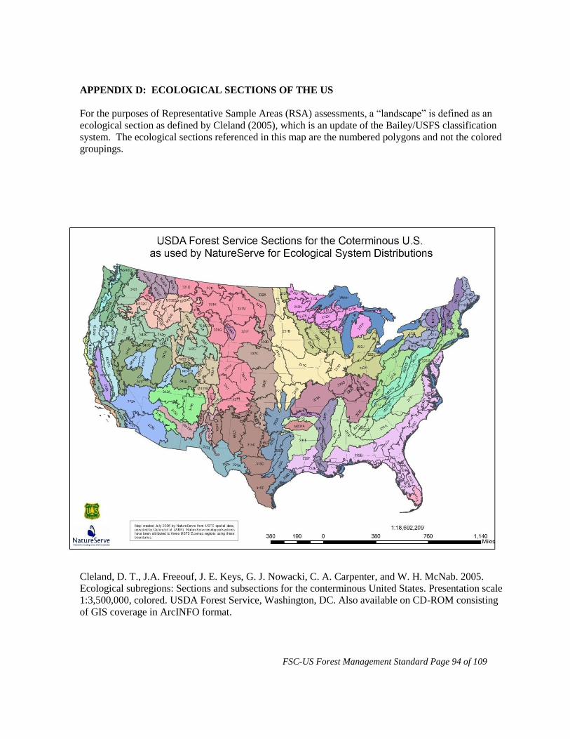
FSC-US Forest Management Standard Page 94 of 109
APPENDIX D: ECOLOGICAL SECTIONS OF THE US
For the purposes of Representative Sample Areas (RSA) assessments, a “landscape” is defined as an
ecological section as defined by Cleland (2005), which is an update of the Bailey/USFS classification
system. The ecological sections referenced in this map are the numbered polygons and not the colored
groupings.
Cleland, D. T., J.A. Freeouf, J. E. Keys, G. J. Nowacki, C. A. Carpenter, and W. H. McNab. 2005.
Ecological subregions: Sections and subsections for the conterminous United States. Presentation scale
1:3,500,000, colored. USDA Forest Service, Washington, DC. Also available on CD-ROM consisting
of GIS coverage in ArcINFO format.

FSC-US Forest Management Standard Page 95 of 109
APPENDIX E: STREAMSIDE MANAGEMENT ZONE (SMZ) REGIONAL
REQUIREMENTS
Indicator 6.5.e
This Appendix addresses regionally explicit requirements for Indicator 6.5.e and includes SMZ widths
and activity limits within those SMZs for the Appalachia, Ozark-Ouachita, Southeast, Mississippi
Alluvial Valley, Southwest, Rocky Mountain, and Pacific Coast regions. The forest owner or manager
will be evaluated based on the sub-indicators within their specific region, below.
APPALACHIA REGION
The SMZ is designed to allow harvesting and provide flexibility for silvicultural management.
6.5.e.1.a All perennial streams have buffers (streamside management zones, SMZs) that include an
inner SMZ and an outer SMZ. SMZ sizes are minimum widths that are likely to provide adequate
riparian habitat and prevent siltation. If functional riparian habitat and minimal siltation are not
achieved by SMZs of these dimensions, wider SMZs are needed.
Table 6.5.f (APP only) Widths of inner and outer Streamside Management Zones.
Widths of outer SMZs are applicable where data do not support narrower widths*
Stream zone
type
SLOPE CATEGORY
1-10% 11-20% 21-30% 31-40% 41 % +
Inner Zone
(perennial)
25’ 25’ 25’ 25’ 25’
Outer Zone
(perennial)
55’ 75’ 105’ 110’ 140’
Total for
perennial
80’ 100’ 130’ 135’ 165’
Zone for
Intermittent
40 50’ 60’ 70’ 80’
*All distances are in feet -slope distance and are measured from the high water mark.
6.5.e.1.b (APP only) The inner SMZ for non-high-quality waters (see state or local listings describing
the highest quality waters in the state or region) extends 25 feet from the high water mark. Single-tree
selection or small group selection (2-5 trees) is allowed in the inner SMZ, provided that the integrity of
the stream bank is maintained and canopy reduction does not exceed 10 percent (90 percent canopy
maintenance). Trees are directionally felled away from streams. Note: The inner SMZ is designed as
a virtual no-harvest zone, while allowing the removal of selected high-value trees.
6.5.e.1.c (APP only) Along perennial streams that are designated as high-quality waters (see state or
local listings describing the highest quality waters in the state or region), no harvesting is allowed in
the inner SMZ (25 feet from the high water mark), except for the removal of wind-thrown trees.
Stream restoration is allowed if a written restoration plan provides a rational justification and if the
plan follows local and regional restoration plans.
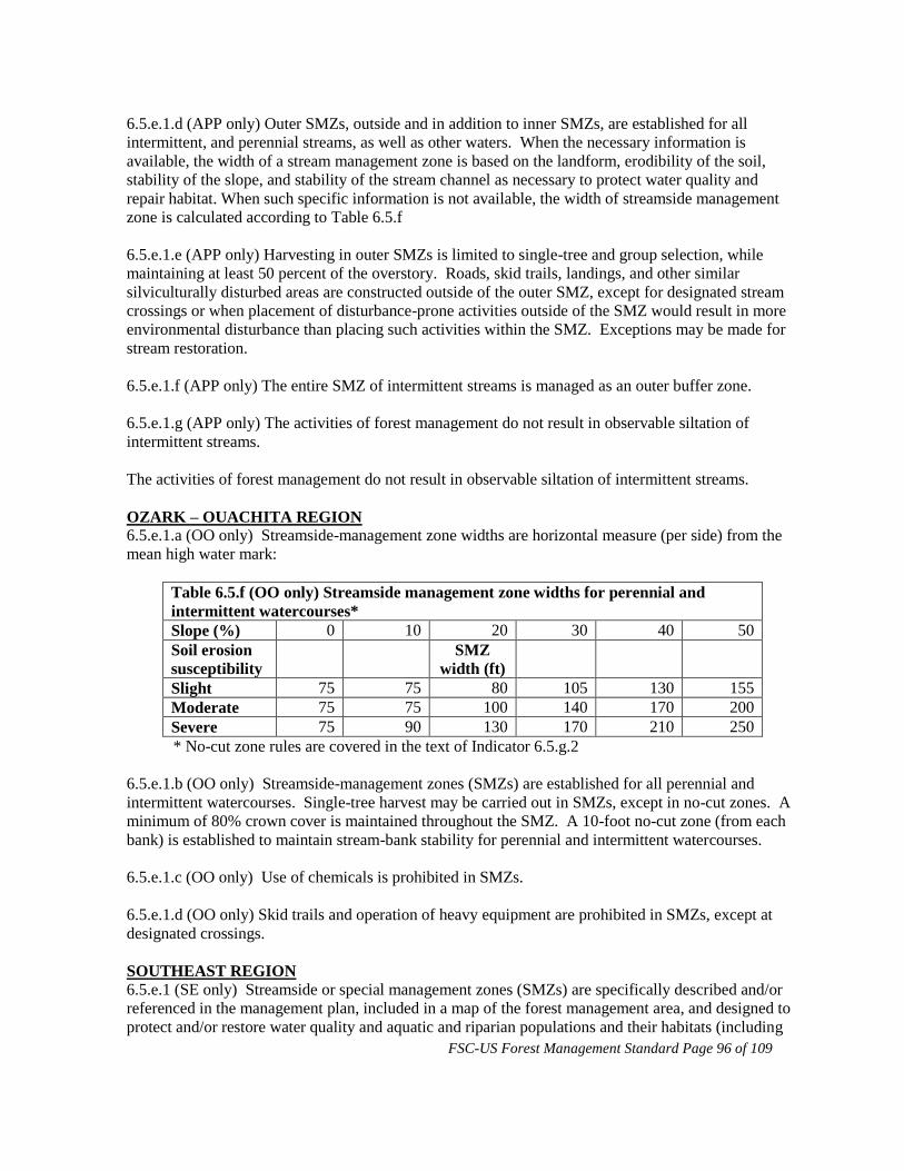
FSC-US Forest Management Standard Page 96 of 109
6.5.e.1.d (APP only) Outer SMZs, outside and in addition to inner SMZs, are established for all
intermittent, and perennial streams, as well as other waters. When the necessary information is
available, the width of a stream management zone is based on the landform, erodibility of the soil,
stability of the slope, and stability of the stream channel as necessary to protect water quality and
repair habitat. When such specific information is not available, the width of streamside management
zone is calculated according to Table 6.5.f
6.5.e.1.e (APP only) Harvesting in outer SMZs is limited to single-tree and group selection, while
maintaining at least 50 percent of the overstory. Roads, skid trails, landings, and other similar
silviculturally disturbed areas are constructed outside of the outer SMZ, except for designated stream
crossings or when placement of disturbance-prone activities outside of the SMZ would result in more
environmental disturbance than placing such activities within the SMZ. Exceptions may be made for
stream restoration.
6.5.e.1.f (APP only) The entire SMZ of intermittent streams is managed as an outer buffer zone.
6.5.e.1.g (APP only) The activities of forest management do not result in observable siltation of
intermittent streams.
The activities of forest management do not result in observable siltation of intermittent streams.
OZARK – OUACHITA REGION
6.5.e.1.a (OO only) Streamside-management zone widths are horizontal measure (per side) from the
mean high water mark:
Table 6.5.f (OO only) Streamside management zone widths for perennial and
intermittent watercourses*
Slope (%) 0 10 20 30 40 50
Soil erosion
susceptibility
SMZ
width (ft)
Slight 75 75 80 105 130 155
Moderate 75 75 100 140 170 200
Severe 75 90 130 170 210 250
* No-cut zone rules are covered in the text of Indicator 6.5.g.2
6.5.e.1.b (OO only) Streamside-management zones (SMZs) are established for all perennial and
intermittent watercourses. Single-tree harvest may be carried out in SMZs, except in no-cut zones. A
minimum of 80% crown cover is maintained throughout the SMZ. A 10-foot no-cut zone (from each
bank) is established to maintain stream-bank stability for perennial and intermittent watercourses.
6.5.e.1.c (OO only) Use of chemicals is prohibited in SMZs.
6.5.e.1.d (OO only) Skid trails and operation of heavy equipment are prohibited in SMZs, except at
designated crossings.
SOUTHEAST REGION
6.5.e.1 (SE only) Streamside or special management zones (SMZs) are specifically described and/or
referenced in the management plan, included in a map of the forest management area, and designed to
protect and/or restore water quality and aquatic and riparian populations and their habitats (including

FSC-US Forest Management Standard Page 97 of 109
river and stream corridors, steep slopes, fragile soils, wetlands, vernal pools, seeps and springs, lake
and pond shorelines, and other hydrologically sensitive areas).
At a minimum, management of SMZs has the following characteristics:
Management meets or exceeds state BMPs.
SMZ width reflects changes in forest condition, stream width, slope, erodibility of soil, and
potential hazard from windthrow along the length of the watercourse.
SMZs provide sufficient vegetation and canopy cover to filter sediment, limit nutrient inputs
and chemical pollution, moderate fluctuations in water temperature, stabilize stream banks,
and provide habitat for riparian and aquatic flora and fauna.
Characteristic diameter-class distributions, species composition, and structures are adequately
maintained within the SMZs.
MISSISSIPPI ALLUVIAL VALLEY REGION
6.5.e.1.a (MAV only) Streamside management zones (SMZs) are created and maintained in
accordance with Table 6.5.
Table 6.5.f (MAV only) Streamside Management Zone Widths
Slope
Stream Class Soil erosion
susceptibility*
0% 10% 20% 30% 40% 50%
Total SMZ width (ft) per side**
Perennial Slight 75 75 80 105 130 155
Perennial Moderate 75 75 100 140 170 200
Perennial Severe 75 90 130 170 210 250
Intermittent All erosion categories 30 30 30 30 30 30
(Table 6.5.f. was modeled after the Forestry BMPs of the state of Mississippi, publication
#107)
*Soil erosion susceptibility is defined at the series level by U.S.D.A.-NRCS State Soil
Surveys.
**Distances are horizontal measures per side of stream, and are measured from the mean high
water mark as evidenced by lack of terrestrial vegetation.
6.5.e.1.b (MAV only) For perennial streams, the inner zone of the SMZ is defined as the area within
30 feet of the mean high water mark. Within that zone, timber harvest is limited to single-tree
selection, and canopy cover is sufficient to maintain shade adequate to moderate water temperature.
Harvesting in this zone maintains the composition, structural complexity, and functions of the SMZ.
6.5.e.1.c (MAV only) For perennial streams, timber harvest in the outer zone of the SMZ is limited to
either single-tree selection or small group selection. Canopy cover and vegetation are maintained to
provide filtration of runoff into a stream.
6.5.e.1.d (MAV only) Within intermittent SMZs, regeneration harvest may be conducted provided
other vegetation and/or ground cover remains to protect the forest floor and the stream bank in a
manner that will maintain water quality.
6.5.e.1.e (MAV only) Prescribed burning is allowed in SMZs when water quality and the structures
and composition of the forest within the SMZ can be maintained.

FSC-US Forest Management Standard Page 98 of 109
6.5.e.1.f (MAV only) Drains (ephemeral streams) do not require an SMZ. Operational limitations for
drains are:
Never use a drain as a skid trail or a road
Never leave logging debris in drain channel
Cross drains only at right angles
Avoid blocking the flow of water
Avoid rutting
SOUTHWEST REGION
6.5.e.1.a (SW only) Buffer zones are established for all natural stream and watercourses with definable
banks, and for ponds, lakes and wetlands. Buffer zones are measured horizontally (in such a way that
ground slope does not reduce the distance) from the following:
the upland edge of the riparian vegetation (if present),
each bank of a stream or water course (in the absence of riparian vegetation), or
the edge of the wetland or water body. (Note: Where wetlands abut watercourses, the edge of
the buffer zone is measured from the edge of the wetland.)
Buffer-zone width is determined as follows:
where riparian vegetation is present, at least 30 feet beyond the edge of the riparian vegetation
or 100 feet from the stream edge, whichever is greater;
where riparian vegetation is not present, at least 50 feet on either side of all perennial streams,
intermittent streams that flow two to three or more months of the year, or along the edge of
waterbodies; such buffer zones extend wider on steep or erosive slopes;
where sideslopes exceed 35 percent, the width is at least 100 feet
as necessary along ephemeral drainage patterns that exhibit a definable bank to protect the
functions listed in the applicability note above;
width is increased in areas of buffer-zone sensitivity (e.g. unstable slopes), which is ultimately
determined by the potential for resource damage or degradation of the functions listed in the
applicability note above.
6.5.e.1.b (SW only) Management in the buffer zone maintains, enhances, or restores the condition of
the riparian area or streamside zone.
For example:
Thinning from below and planting trees may be carried out for purposes of controlling erosion
restoration.
Ecological, aquatic, and riparian functions (e.g., the maintenance or restoration of riparian
microclimates) are demonstrably the priority silvicultural objective of any commercial
harvesting.
6.5.e.1.c (SW only) Transportation systems and mechanical operations (including any form of
significant ground-disturbing activity) in buffer zones do not compromise the filtration, shading,
nutrient, and habitat functions of the SMZ.
For example:
Permanent roads are maintained or installed only as necessary to cross streams at a
perpendicular or other angle that causes the least ecological disturbance. Temporary roads or

FSC-US Forest Management Standard Page 99 of 109
designated skid trails across a buffer zone may be permitted in rare instances after preparation
of a pre-operation plan that protects riparian values.
Operation of wheeled or tracked equipment is restricted to roads and designated crossings.
Temporary or permanent culverts, bridges, or other mechanisms are installed at all
watercourse crossings to avoid disturbance to, and to support the designated use(s) of the
affected watercourses.
Streams, vernal pools, and wetlands are undisturbed by skidding activities.
Stream crossings are located and constructed to minimize fragmentation of aquatic habitat
and maintain water quality.
Maintenance of existing roads and ditches uses appropriate techniques to protect water quality
from adverse impacts.
Storage, handling, or use of hazardous materials is prohibited in buffer zones.
Note: Full suspension yarding is also an option so long as it does not compromise the buffer zone.
6.5.e.1.d (SW only) Where the scale and intensity of forest management activities have the potential to
substantially affect the intensity and timing of water flow, such activities are designed to maintain or
enhance aquatic and riparian habitat and /or downstream uses. For example, extensive removal of
timber in harvests on south-facing slopes is done in a way that does not substantially increase the
speed with which snow melts.
ROCKY MOUNTAIN REGION
RM Applicability Note: Some discretion may be applied to stream segments that support no fish, and
rarely contribute surface flow to other streams or other bodies of water, and normally have surface
flow less than six months of the year. In such instances SMZ widths are designated, but management
restrictions are more flexible, as long as riparian concerns continue to receive highest priority.
6.5.e.1.a (RM only) SMZ width is at least 50 feet on either side of the ordinary high water mark,
extending wider on steep or erosive slopes. Where slopes of SMZs exceed 35 percent, the SMZ
boundary is at least 100 feet. If wetlands touch the SMZ, then the SMZ boundary is extended to
include the wetland. SMZ width is extended wherever necessary to protect riparian functions.
6.5.e.1.b (RM only) Management in the SMZs takes a conservative approach that puts aquatic and
riparian concerns above timber consideration. Roads are prohibited in SMZs, except for permanent
roads necessary to cross the stream at a perpendicular or other angle that causes the least ecological
disturbance. Operation of wheeled or tracked equipment is prohibited in the SMZ, except on
permanent roads. Temporary roads or designated skid trails across the SMZ may be permitted in rare
instances after preparation of a pre-operation plan that protects riparian values. Logging operations
retain at least half of the merchantable trees, representative of the pre-harvest stand, with heavier
retention of bank-edge and leaning trees, shrubs, and sub-merchantable trees. Appropriate techniques
are used to maintain existing roads and ditches to prevent adverse impacts to water quality. Storage,
handling, or use of hazardous materials is prohibited in SMZs.
The forest owner or manager identifies and provides adequate protection for all streams, lakes,
wetlands, and associated riparian areas. Streams, lakes, and wetlands are maintained in or restored to
their properly functioning condition. Streamside management zones (SMZs) are established and
maintained adjacent to all bodies of water and watercourses. The extent and protection of these buffer
zones is adequate to serve all the functions and objectives of such zones in natural forests. These
functions include, but are not limited to: 1) control of erosion of soil and organic debris, 2) control of

FSC-US Forest Management Standard Page 100 of 109
stream sedimentation, 3) stabilization of surface and ground water flow fluctuations, 4) stabilization of
water temperatures, 5) provision of organic debris (including large diameter wood) for the aquatic
habitat, 6) provision of habitat (shelter, water, food, travel corridors, etc.) for many species of plants
and animals.
PACIFIC COAST REGION
PC Applicability note: The following water quality requirements of this Standard are superceded when
and where state or federal laws, regulations, or other contractual requirements are more stringent.
PC Guidance: This section uses the following definitions:
Category A stream: A stream that supports or can support populations of native fish and/or provides a
domestic water supply.
Category B stream: Perennial streams that do not support native fish and are not used as a domestic
water supply.
Category C stream: An intermittent stream that never the less has sufficient water to host populations
of non-fish aquatic species
Category D stream: A stream that flows only after rainstorms or melting snow and does not support
populations of aquatic species
6.5.e.1.a (PC only) For Category A streams, and for lakes and wetlands larger than one acre, an inner
buffer zone is maintained. The inner buffer is at least 50 feet wide (slope distance) from the active
high water mark (on both sides) of the stream channel and increases depending on forest type, slope
stability, steepness, and terrain. Management activities in the inner buffer:
maintains or restore the native vegetation
are limited to single-tree selection silviculture
retain and allows for recruitment of large live and dead trees for shade and stream structure
retain canopy cover and shading sufficient to moderate fluctuations in water temperature, to
provide habitat for the full complement of aquatic and terrestrial species native to the site, and
maintain or restore riparian functions
exclude use of heavy equipment, except to cross streams at designated places, or where the use
of such equipment is the lowest impact alternative
avoid disturbance of mineral soil; where disturbance is unavoidable, mulch and seed are
applied before the rainy season
avoid the spread of pathogens and noxious weeds
avoid road construction and reconstruction.
6.5.e.1.b (PC only) For Category A streams, and for lakes and wetlands larger than one acre, an outer
buffer zone is maintained. This buffer extends from the outer edge of the inner buffer zone to a
distance of at least 150 feet from the edge of the active high water mark (slope distance, on both sides)
of the stream channel. In this outer buffer, harvest occurs only where:
single-tree or group selection silviculture is used
post harvest canopy cover maintains shading sufficient to moderate fluctuations in water
temperature, provide habitat for the full complement of aquatic and terrestrial species native to
the site, and maintain or restore riparian functions
new road construction is avoided and reconstruction enhances riparian functions and reduces
sedimentation;

FSC-US Forest Management Standard Page 101 of 109
disturbance of mineral soil is avoided; where disturbance is unavoidable, mulch and seed are
applied before the rainy season
6.5.e.1.c (PC only) For Category B streams, a 25-foot (slope distance) inner buffer is created and
managed according to provisions for inner buffers for Category A. A 75-foot (slope distance) outer
buffer (for a total buffer of 100 feet) is created and managed according to provisions for outer buffer
for Category A.
6.5.e.1.d (PC only) For Category C streams, and for lakes and wetlands smaller than one acre, a buffer
zone 75 feet wide (on both sides of the stream) is established that constrains management activities to
those that are allowed in outer buffer zones of Category A streams.
6.5.e.1.e (PC only) For Category D streams, management:
• maintains root strength and stream bank and channel stability
• recruits coarse wood to the stream system
• minimizes management-related sediment transport to the stream system.
Streams, vernal pools, lakes, wetlands, seeps, springs, and associated riparian areas are managed to
maintain and/or restore hydrologic processes, water quality, and habitat characteristics (see NMFS
(1996); state water quality standards; Karr (1981) which may include: the capacity for water to
infiltrate the soil; habitat for riparian species; moderating water temperature; controlling
sedimentation; clean gravel for spawning; physical structures to protect the integrity of the stream
channel; including pools used by anadromous fish.
Forest owners or managers retain and recruit sufficient large, green trees; snags; understory vegetation;
down logs; and other woody debris in riparian zones to provide shade, erosion control, and in-channel
structures.

FSC-US Forest Management Standard Page 102 of 109
APPENDIX F: HIGH CONSERVATION VALUE FORESTS
Criterion 9.1
This Appendix addresses requirements for Criterion 9.1, assessing the presence of High Conservation
Values (HCVs) on the FMU. Below are definitions, including FSC-US regional-specific requirements
and guidance, of the six HCVs that must be identified in the assessment. Terms that are italicized and
bolded are further interpreted in the ‘Definition of Terms’ section below. As an additional resource for
assessing the presence of HCVs, the ‘HCVF Assessment Framework’ is available on the FSC-US
website, www.fscus.org.
The examples provided below for each HCV are meant to provide guidance to the landowner/manager
on what types of sites should be considered in determining the presence of HCVs on the FMU, but
they are not necessarily HCVS.
High Conservation Values
HCV 1: HCV forest areas containing globally, regionally or nationally significant concentrations of
biodiversity values (e.g., endemism, endangered species, refugia).
HCV 1 includes RTE species
HCV 2: HCV forest areas containing globally, regionally or nationally significant large landscape level
forests, contained within, or containing the management unit, where viable populations of
most if not all naturally occurring species exist in natural patterns of distribution and
abundance.
HCV 2 includes relatively contiguous areas of forest (which may be crossed by land
management roads or public roads). At the minimum these forests are likely to be
thousands or tens of thousands of acres in size. However, “large” is relative to
ecoregion landscape context (particularly the size of forested blocks in the ecoregion)
and might be smaller or larger than this figure as indicated by consultation with
regional experts. In ecoregions where natural forests are heavily fragmented by forest
type conversion or land use conversion, the increased value of smaller occurrences of
remaining natural forest should also be included in the assessment. The forest may be
in single or multiple ownerships.
HCV 2 also includes the following regional examples:
Pacific Coast:
Native grasslands, wetlands, and other ecologically important non-
forested sites within the FMU.
Ozark Ouachita:
Unique and sensitive geomorphic features, such as caves and rock
outcrops and buffers designed to protect their integrity, and
forested wetlands or glades, including springs, fens, and seeps.
Lake States:
Central Hardwoods:
Old forests/mixed age stands that include trees >160 years old
Intact forest blocks in an agriculturally dominated landscape (refugia)
Intact forests >1000 ac (valuable to interior forest species)
Protected caves
Savannas

FSC-US Forest Management Standard Page 103 of 109
Glades
Barrens
Prairie remnants
North Woods/Lake States:
Old forests/mixed age stands that include trees >120 years old
Blocks of contiguous forest, > 500 ac, which host RTEs
Oak savannas
Hemlock-dominated forests
Pine stands of natural origin
Contiguous blocks, >500 ac, of late successional species, that are
managed to create old growth
Fens, particularly calcareous fens
Other non-forest communities, e.g., barrens, prairies, distinctive
geological land forms, vernal pools
Other sites as defined by GAP analysis, Natural Heritage Inventory,
and/or the World Wildlife Fund’s Forest Communities of Highest
Conservation Concern Appalachia:
Mixed mesophytic cove sites on the Cumberland Plateau
Limestone glades in Tennessee and Kentucky
Pocosins (evergreen shrub bogs) and other mountain bogs in Virginia
Tennessee, and North Carolina
Unique and sensitive geophysical features, such as caves and rock outcrops;
and forested wetlands or glades, such as springs, fens, and seeps
Spruce-fir (Picea rubens-Abies fraseri) forests in southern Appalachia
Atlantic white-cedar (Chamaecyparis thyoides) stands Red spruce (Picea
rubens) forests in central Appalachia
Northeast:
The riverbank areas of the St. John's River in Maine, the "Yellow Bog area"
within the Nulhegan watershed of northeastern Vermont, and the
Southeastern Massachusetts Bioreserve
More common in the northeast are discrete areas of biodiversity value (i. e.,
they generally contain one rare natural community or an endangered species
or two) that are not part of a network of isolated but interconnected habitats
that would lead to HCVF status at the landscape scale
The best examples are in public and/or private conservation ownership such
as the Big Reed Preserve in Maine, parts of the White Mountain National
Forest in New Hampshire and Maine, and parts of the Adirondack and
Catskill Parks in New York
There are areas of a few thousand acres in northern Maine where species
composition and structure closely approach natural conditions due to light
harvest history and a relatively long time (30-50 years) since the last harvest.
In the Northeast, rare communities or assemblages of communities dominated
by a rare community that approach or exceed 500 acres (200 ha) in area are
normally delineated and managed as rare ecosystems under HCVF
Other factors that may be considered include, but are not limited to:
FSC-US Forest Management Standard Page 104 of 109
o Relative rarity of S3-ranked communities (which may range from
21 to 100 examples in a state)
o Distinctiveness in terms of size (a smaller or larger threshold than
500 acres might be appropriate, depending on the size range of
the community type), quality (particularly lack of human
disturbance), or location within the community’s geographic
range
o Vulnerability to degradation
o Proximity to protected examples of the same ecosystem type
HCV 3: HCV forest areas that are in or contain rare, threatened or endangered ecosystems.
HCV 3 includes: old growth, roadless areas greater than 500 acres or that have unique
attributes, and primary forests.
HCV 4: HCV forest areas that provide basic services of nature in critical situations (e.g., watershed
protection, erosion control).
HCV 4 includes forests that are part of a local drinking water catchment or irrigation
supply system, or is a critical source for a remote location (i.e., water is pumped to a
remote location). This service may be considered critical when people are dependent
on the guarantee of water for drinking or irrigation, or where the regulation of water
flow guarantees the existence of fishing grounds or agricultural land on which the
local people are dependent, protects downstream communities from flooding, or
provides critical protection to rare, threatened, or endangered aquatic species.
HCV 5: HCV forest areas fundamental to meeting basic needs of local communities (e.g.,
subsistence, health).
HCV 5 includes forest areas that local people use to obtain resources on which they
are critically dependent. This may be the case if local people harvest food products
from the forest, or collect building materials or medicinal plants where no viable
alternative exists. Forest uses such as recreational hunting or commercial timber
harvesting (i.e., that is not critical for local building materials) are not basic human
needs.
HCV 6: HCV forest areas critical to local communities’ traditional cultural identity (areas of cultural,
ecological, economic or religious significance identified in cooperation with such local
communities).
HCV 6 includes areas of cultural significance that have traditional importance to local
or indigenous people. These may be religious/sacred sites, burial grounds or sites at
which regular traditional ceremonies take place. They may also include outstanding
natural landscapes that have evolved as a result of social, economic, administrative,
and/or religious imperative (i.e., fossils, artifacts, areas representing a traditional way
of life), or areas that by virtue of their natural properties possess significant religious,
artistic or cultural association.
Definition of Terms as used in the HCVF context
Basic human needs: Local people use the area to obtain resources on which they are critically
dependent. This may be the case if local people harvest food products from the forest, or collect
building materials or medicinal plants where no viable alternative exists. Forest uses such as

FSC-US Forest Management Standard Page 105 of 109
recreational hunting or commercial timber harvesting (i.e., that is not critical for local building
materials) are not basic human needs.
Critical: Loss of cultural resources from this area would have a significant impact to the traditional
cultural identity of local and regional communities.
Critical situations – watershed protection: A forest that is part of a local drinking water catchment or
irrigation supply system, or is a critical source for a remote location (i.e., water is pumped to a remote
location) may be considered a ‘critical situation’, particularly when people are dependent on the
guarantee of water for drinking or irrigation, or where the regulation of water flow guarantees the
existence of fishing grounds or agricultural land on which the local people are dependent, protects
downstream communities from flooding, or provides critical protection to rare, threatened, or
endangered aquatic species.
Cultural significance: These include religious/sacred sites, burial grounds or sites at which regular
traditional ceremonies take place. They may also include outstanding natural landscapes that have
evolved as a result of social, economic, administrative, and/or religious imperative (i.e., fossils,
artifacts, areas representing a traditional way of life); or areas that by virtue of their natural properties
possess significant religious, artistic or cultural association.
Fundamental: Loss of the resources from this area would have a significant impact in the supply of
the resource and decrease local community well-being. FSC-US has not set a threshold to determine
the amount of basic human needs that constitute “fundamental.” Outside of the US, precedent has
been set in at least one HCVF “toolkit” at 25% (Indonesia; see Rayden 2008).
Large landscape-level forests: Relatively contiguous areas of forest (which may be crossed by land
management roads or public roads). At the minimum these forests are likely to be thousands or tens of
thousands of acres in size. However, “large” is relative to ecoregion landscape context (particularly the
size of forested blocks in the ecoregion) and might be smaller or larger than this figure as indicated by
consultation with regional experts. In ecoregions where natural forests are heavily fragmented by
forest type conversion or land use conversion, the increased value of smaller occurrences of remaining
natural forest should also be included in the assessment. The forest may be in single or multiple
ownerships.
Region/Ecoregion: For the purposes of HCVF assessment, the ecoregion will in most cases be
consistent with the scale of the USFS Section within which the ownership is located (see Ecoregion
Map). If data for the region are limited, or in the cases of very small ecological sections, a larger area
may be considered if justified.). Where justified by available data, a comparable classification system
(e.g., TNC’s Ecoregion Map) may be used.
Significant: The forest is significant in the ecoregion due to its size, condition, and/or importance to
biodiversity conservation. Factors to consider include:
Rarity of forests of this size and quality within the ecoregion
Less affected by anthropogenic factors than similar areas in the ecoregion
Significant concentrations of biodiversity values: areas that contain concentrations of
rare/threatened/endangered species, natural communities, or other biodiversity values that occur in
numbers, frequency, quality, and/or density that are sufficiently outstanding to be considered unique or

FSC-US Forest Management Standard Page 106 of 109
highly important in comparison with other areas within the ecoregion within which the FMU is
located.
FSC-US Forest Management Standard Page 107 of 109
APPENDIX G: PLANTATION CLASSIFICATION (PRINCIPLE 10)
Guidance on the classification is provided in three parts: 1) guidance on the classification of
plantations; 2) guidance on principle characteristics and key elements of native forest ecosystems;
and 3) guidance on management practices related to plantations.
Guidance on the classification of plantations:
From the definition of plantation it is clear that the presence of most of the principal characteristics
and key elements of native forest ecosystems is primary to discerning natural or semi-natural forests
from plantations. Therefore, a "planted forest" is not necessarily a "plantation" (as defined in this
standard) since it may have most of the principle characteristics and key elements of native forest
ecosystems indigenous to an area. Additionally, given that the intensity of management activities may
influence the presence of these characteristics and traits, classification of a forest stand as a plantation
should be based on the presence or absence of these characters and elements.
As stated in the definition, there are three situations, except for highly extenuating circumstances,
where planted forests are considered plantations. In all other cases, a forest must be determined to be
natural or a plantation depending upon the degree to which it has and provides the principal
characteristics and key elements of native forest ecosystems as compared to a natural stand of similar
forest type and development stage. Further, to the extent that a particular forest does NOT hold these
attributes, it must be clear that the absence of the attributes is a result of silviculture treatments.
Silvicultural treatments that could contribute to the absence of native forest ecosystem attributes and
the characterization of a stand as a plantation are listed later in this appendix under the section
“Guidance on Management Practices Related to Plantations”.
Since almost all of the noted characteristics and elements are very difficult to measure directly,
especially in the short time frame of an audit, forest managers and CBs must use professional
judgment to evaluate sites for these characteristics and elements as well as keep abreast of research
that is designed to specifically measure the effects of various silviculture treatments on these attributes.
Forest managers should be prepared to provide the results of research appropriate to their forest types
and forest management practices.
This guidance must be used for both short-term certification evaluations and as the basis for the
development of more detailed guidance specific to forest types.
Guidance on principle characteristics and key elements of native forest ecosystems:
The term “principle characteristics and key elements of native forest ecosystems” refers to the suite
of characteristics that are to be used to distinguish natural forests and semi-natural forests from
plantations for the purpose of application of this standard. These characteristics are dependent on the
forest type/forest habitat type, temporal nature of forest stand development, and the past management
history of the site. In the context of the progressing stage of stand development (e.g., stand initiation,
stem exclusion, understory reinitiation, and old growth – per Oliver and Larson 1996) there are
principle characteristics of natural forests, which are not present in plantations. This approach is based
on the generalization that native forest ecosystems are also typically characterized by survival through
at least the mid-development (understory reinitiation) stage, given allowances for historic range of
natural variation. These characteristics include:
genetic and species diversity associated with natural forests:

FSC-US Forest Management Standard Page 108 of 109
tree species composition consistent with the concomitant stage of native forests types
occurring on similar sites;
understory plant community species abundance and distribution consistent with the
concomitant stage of stand development for native forests types occurring on similar
sites;
genetic diversity within planted tree species, as represented across the FMU,
consistent with natural genetic diversity.
within-stand structural diversity:
stands are managed to mid-development stages (e.g. understory reinitiation stage);
tree morphology (size and shape) associated with the concomitant stage of stand
development for native forests types occurring on similar sites;
variability in tree density and spacing and age class distribution consistent with the
natural disturbance regimes of the region;
understory plant community structure and density consistent with the concomitant
stage of stand development for native forests types occurring on similar sites;
snags, den trees, and downed woody debris consistent with the stage of stand
development and disturbance regimes for native forests types occurring on similar
sites;
small patch disturbances, too small to be considered a “stand” by themselves, to
provide structural diversity;
between-stand structural diversity
diversity in the stages of development between stands ranging from the stand initiation
stage to at least the understory reinitiation stage;
representative variation in intensity and scale of disturbances consistent with native
forest types on similar sites (e.g. fire, windthrow, disease, insects)
Collectively, these characteristics are considered definitive for native forest ecosystems throughout the
US. However, the quantitative representations of each of these characteristics on a given site exist
along a spatial and temporal continuum ranging from abundant to marginally present depending on the
forest type, stage of development, the range of natural variation associated with the forest type, and the
past management history. This intent should be used as a framework to guide regional decision-
making in lieu of additional FSC-US guidance specific to regions and forest types.
Guidance on Management Practices Related to Plantations:
Management practices that could contribute to the absence of native forest ecosystem attributes and
the characterization of a stand as a plantation include:
– rotation lengths short enough to prevent stands from development into understory reinitiation
stages;
– systematic use of, and reliance on, chemical herbicides, pesticides and fertilizers;
– Intensive chemical or mechanical site preparation;
– through planting, thinning, or other management practices, a single species is maintained as
the primary forest type on sites normally occupied by multiple-species forests;
– use of even-aged silviculture for forest types that do not typically or regularly regenerate as
even-aged stands naturally through stand-replacing events;
– preclusion of successional pathways;

FSC-US Forest Management Standard Page 109 of 109
– use of a silviculture system which purposefully results in a stand with dominant tree species
different than dominant species representative of the native ecosystem that existed historically.
– use of even-aged regeneration units that lack retention, and are uncharacteristic of the natural
disturbance regimes referred to in Criterion 6.3;
– use of a silviculture system which shift the species composition away from natural historic
regime.
Related Documents


