Freshwater Freshwater

Freshwater. Water Resources List of supplies for today: 1. Vocabulary from last night 2. Notes pages for all group members 3. 3-4 markers 4. Big sheet.
Dec 28, 2015
Welcome message from author
This document is posted to help you gain knowledge. Please leave a comment to let me know what you think about it! Share it to your friends and learn new things together.
Transcript

FreshwaterFreshwater

Water ResourcesWater ResourcesList of supplies for today:List of supplies for today:1.1.Vocabulary from last nightVocabulary from last night2.2.Notes pages for all group membersNotes pages for all group members3.3.3-4 markers3-4 markers4.4.Big sheet of paperBig sheet of paper
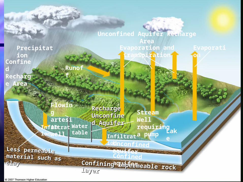
Fig. 14-3, p. 308
Unconfined Aquifer Recharge Area
Precipitation Evaporation and transpiration Evaporation
Confined Recharge Area
Runoff
Flowing artesian well
Recharge Recharge Unconfined Unconfined AquiferAquifer
Stream Well requiring a pumpInfiltration Water
table LakeInfiltration
Unconfined aquifer
Confined aquiferConfining impermeable rock layer Confining impermeable rock layer
Less permeable Less permeable material such as claymaterial such as clay

On your big paper…On your big paper…
Collaborate together and put your Collaborate together and put your words into 4-5 different categories words into 4-5 different categories according to their likes and according to their likes and differences. (NO: my vocab, bob’s differences. (NO: my vocab, bob’s vocab etc.)vocab etc.)

Put stars by surface water sourcesPut stars by surface water sources Square your ground water sourcesSquare your ground water sources Circle uses of waterCircle uses of water Underline ways we control waterUnderline ways we control water

Surface water:Surface water:
Flood plainsFlood plains Riparian zoneRiparian zone Lakes (oligotrophic, Mesotrophic, Lakes (oligotrophic, Mesotrophic,
Eutrophic)Eutrophic) RiversRivers PondsPonds WetlandsWetlands

Ground waterGround water
Aquifers (Confined and Aquifers (Confined and Unconfined)Unconfined)
Water tableWater table SpringsSprings Artesian WellsArtesian Wells

Uses…Uses…
Furrow irrigationFurrow irrigation Flood irrigationFlood irrigation Spray irrigationSpray irrigation Drip IrrigationDrip Irrigation

Controlling waterControlling water
LeveesLevees DikesDikes DamsDams
Sustainability (if you have Sustainability (if you have them)them)
Fish LaddersFish Ladders DesalinizationDesalinization Hydroponic agricultureHydroponic agriculture

On your notesOn your notes List and define the works for ground List and define the works for ground
water and surface water in your water and surface water in your spiral.spiral.
Try to see if you can label the Try to see if you can label the diagramdiagram

You should be able to do You should be able to do (#’s 1,4,5,6,7,)(#’s 1,4,5,6,7,)
1. Aquifer 1. Aquifer 2.confining zone2.confining zone 3. Unsaturated zone3. Unsaturated zone 4. water table4. water table 5. confined aquifer5. confined aquifer 6. unconfined aquifer6. unconfined aquifer 7. artesian wells7. artesian wells 8. water table well8. water table well 9. flowing artesian well9. flowing artesian well

A. Types of WaterA. Types of Water
Surface waterSurface water Lakes, streams, riversLakes, streams, rivers
Ground WaterGround Water Absorbed in to the Absorbed in to the
ground after a rain.ground after a rain. More than 50 percent of More than 50 percent of
the people in the United the people in the United States.States.
The largest use of The largest use of ground water is to ground water is to irrigate crops.irrigate crops.
We get ground water We get ground water out of the ground by out of the ground by wellswells

C. Surface FRESHWATER C. Surface FRESHWATER LIFE ZONESLIFE ZONES
1.1. Standing Standing (lentic) water(lentic) water such as lakes, such as lakes, ponds, and ponds, and inland wetlands.inland wetlands.
2.2. Flowing (lotic) Flowing (lotic) systemssystems such such as streams and as streams and rivers. rivers.
Figure 6-14Figure 6-14

B. Ground WaterB. Ground Water1.1. Ground water is the water that fills the empty spaces Ground water is the water that fills the empty spaces
and cracks.and cracks.
2.2. The top of the water in the soil, sand, or rocks is The top of the water in the soil, sand, or rocks is called the called the water table water table
3.3. Water seeping down from the land surface adds to Water seeping down from the land surface adds to the ground water and is called the ground water and is called recharge waterrecharge water..
4.4. AquiferAquifer is the name given to underground soil or rock is the name given to underground soil or rock through which ground water can easily movethrough which ground water can easily move
5.5. Some wells, called Some wells, called artesian wellsartesian wells, do not need a , do not need a pump. pump.
6.6. These wells are drilled into an These wells are drilled into an artesian aquiferartesian aquifer, which , which is sandwiched between two impermeable layers.is sandwiched between two impermeable layers.

C. Surface FRESHWATER C. Surface FRESHWATER LIFE ZONESLIFE ZONES
1.1. Standing Standing (lentic) water(lentic) water such as lakes, such as lakes, ponds, and ponds, and inland wetlands. inland wetlands.
2.2. Flowing (lotic) Flowing (lotic) systemssystems such as such as streams and streams and rivers. (*)rivers. (*)
Figure 6-14Figure 6-14

D. Flowing Water D. Flowing Water EcosystemsEcosystems
Because of different Because of different environmental conditions in environmental conditions in
each zone, a river is a each zone, a river is a system of different system of different
ecosystems.ecosystems.

Fig. 12-11, p. 267
a) Deliver nutrients to sea to help sustain coastal fisheries
b) Deposit silt that maintains deltas
c) Purify water
d) Renew and renourish wetlands
e) Provide habitats for wildlife
Natural Capital
1. Ecological Services of Rivers

Freshwater Streams and Freshwater Streams and Rivers:Rivers:From the Mountains to the From the Mountains to the OceansOceans
Water flowing from mountains to the sea Water flowing from mountains to the sea creates different aquatic conditions and creates different aquatic conditions and habitats.habitats.
Figure 6-17Figure 6-17

1. Headwater Stream 1. Headwater Stream CharacteristicsCharacteristics
A narrow zone of cold, clear water A narrow zone of cold, clear water that rushes over waterfalls and that rushes over waterfalls and rapids. Large amounts of oxygen rapids. Large amounts of oxygen are present. Fish are also present. are present. Fish are also present. Ex. trout.Ex. trout.

2. Downstream 2. Downstream CharacteristicsCharacteristics
Slower-moving water, less Slower-moving water, less oxygen, warmer temperatures, oxygen, warmer temperatures, and lots of algae and and lots of algae and cyanobacteria.cyanobacteria.

Standing Water Standing Water EcosystemsEcosystems
Lakes, ponds, etc.Lakes, ponds, etc.

Life in LayersLife in Layers
Life in most aquatic systems is found Life in most aquatic systems is found in surface, middle, and bottom layers.in surface, middle, and bottom layers.
1. Temperature, access to sunlight for 1. Temperature, access to sunlight for photosynthesis, dissolved oxygen photosynthesis, dissolved oxygen content, nutrient availability changes content, nutrient availability changes with depth.with depth.
2. 2. Euphotic zone (upper layer in deep Euphotic zone (upper layer in deep water habitats): sunlight can water habitats): sunlight can penetrate.penetrate.

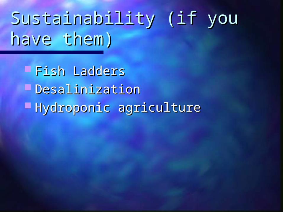
Lakes: Water-Filled Lakes: Water-Filled DepressionsDepressions
Lakes are large natural bodies of standing Lakes are large natural bodies of standing freshwater formed from precipitation, runoff, and freshwater formed from precipitation, runoff, and groundwater seepage consisting of groundwater seepage consisting of
3. 4 zones3. 4 zones Littoral zoneLittoral zone (near shore, shallow, with rooted plants).(near shore, shallow, with rooted plants). Limnetic zoneLimnetic zone (open, offshore area, sunlit).(open, offshore area, sunlit). Profundal zoneProfundal zone (deep, open water, too dark for (deep, open water, too dark for
photosynthesis).photosynthesis). Benthic zoneBenthic zone (bottom of lake, nourished by dead (bottom of lake, nourished by dead
matter).matter).

Littoral ZoneLittoral ZoneA shallow area near the shore, to the A shallow area near the shore, to the
depth at which rooted plants stop depth at which rooted plants stop growing. Ex. frogs, snails, insects, growing. Ex. frogs, snails, insects, fish, cattails, and water lilies.fish, cattails, and water lilies.

Limnetic ZoneLimnetic Zone
Open, sunlit water that extends Open, sunlit water that extends to the depth penetrated by to the depth penetrated by sunlight.sunlight.

Profundal ZoneProfundal ZoneDeep, open water where it Deep, open water where it
is too dark for is too dark for photosynthesis.photosynthesis.

5. Thermal 5. Thermal StratificationStratification
Lakes: Water-Filled Lakes: Water-Filled DepressionsDepressions
Figure 6-15Figure 6-15

DefinitionDefinitionThe temperature difference in The temperature difference in
deep lakes where there are deep lakes where there are warm summers and cold warm summers and cold winterswinters..

Lakes: Water-Filled Lakes: Water-Filled DepressionsDepressions
During summer and winter in deep During summer and winter in deep temperate zone lakes the become temperate zone lakes the become stratified into temperature layers stratified into temperature layers and will overturn.and will overturn. This equalizes the temperature at all This equalizes the temperature at all
depths.depths. Oxygen is brought from the surface to Oxygen is brought from the surface to
the lake bottom and nutrients from the the lake bottom and nutrients from the bottom are brought to the top.bottom are brought to the top.

CausesCauses During the summer, During the summer,
lakes become stratified lakes become stratified into different into different temperature layers that temperature layers that resist resist mixing because mixing because summer sunlight warms summer sunlight warms surface waters, making surface waters, making them less dense.them less dense.

ThermoclineThermocline The middle layer The middle layer
that acts as a that acts as a barrier to the barrier to the transfer of transfer of nutrients and nutrients and dissolved oxygen.dissolved oxygen.

Fall TurnoverFall Turnover
As the temperatures begin to As the temperatures begin to drop, the drop, the surface layer becomes surface layer becomes more dense,more dense, and it sinks to the and it sinks to the bottombottom. This mixing brings . This mixing brings nutrients from the bottom up to nutrients from the bottom up to the surface and sends oxygen to the surface and sends oxygen to the bottom.the bottom.

Spring TurnoverSpring Turnover As top water warms and ice As top water warms and ice
melts, it sinks through and melts, it sinks through and below the cooler, less dense below the cooler, less dense water, water, sending oxygen down sending oxygen down and nutrients upand nutrients up..

Types of LakesTypes of Lakes
Plant nutrients from a lake’s Plant nutrients from a lake’s environment affect the types and environment affect the types and numbers of organisms it can support.numbers of organisms it can support.
OligotrophicOligotrophic (poorly nourished) lake: (poorly nourished) lake: Usually newly formed lake with small Usually newly formed lake with small supply of plant nutrient input.supply of plant nutrient input.
EutrophicEutrophic (well nourished) lake: Over (well nourished) lake: Over time, sediment, organic material, and time, sediment, organic material, and inorganic nutrients wash into lakes inorganic nutrients wash into lakes causing excessive plant growth.causing excessive plant growth.

Types of Lakes: Types of Lakes: OligotrophicOligotrophic
Sunlight
Little shore vegetation
Limnetic zone
Profundalzone
Oligotrophic lake
Low concentration of nutrients and plankton
Sparse fish population
Narrow littoral zone
Sleepily sloping shorelines
Sand, gravel, rock bottom

Types of Lakes: EutrophicTypes of Lakes: Eutrophic
Fig. 7-17b, p. 139
Sunlight
Much shore vegetation
Limnetic zone
Profundalzone
Eutrophic lake
High concentration of nutrients and plankton
Dense fish population
Widelittoral zone
Gentlysloping shorelines
Silt, sand, clay bottom

How we use our water and How we use our water and the problems we createthe problems we create

ProblemsProblems

Too Much WaterToo Much WaterProblems include flooding, Problems include flooding,
pollution of water supply, and pollution of water supply, and sewage seeping into the sewage seeping into the ground.ground.

TOO MUCH WATERTOO MUCH WATER Heavy rainfall, rapid snowmelt, removal Heavy rainfall, rapid snowmelt, removal
of vegetation, and destruction of of vegetation, and destruction of wetlands cause flooding.wetlands cause flooding.
Floodplains, which usually include highly Floodplains, which usually include highly productive wetlands, help provide natural productive wetlands, help provide natural flood and erosion control, maintain high flood and erosion control, maintain high water quality, and recharge groundwater.water quality, and recharge groundwater.
To minimize floods, rivers have been To minimize floods, rivers have been narrowed with levees and walls, and narrowed with levees and walls, and dammed to store water.dammed to store water.
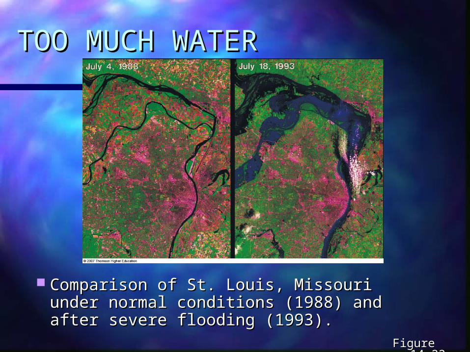
TOO MUCH WATERTOO MUCH WATER
Comparison of St. Louis, Missouri under Comparison of St. Louis, Missouri under normal conditions (1988) and after severe normal conditions (1988) and after severe flooding (1993).flooding (1993).
Figure 14-22Figure 14-22

TOO MUCH WATERTOO MUCH WATER
Human activities have contributed Human activities have contributed to flood deaths and damages.to flood deaths and damages.
Figure 14-23Figure 14-23

Fig. 14-23a, p. 330
Oxygen released by vegetation
Diverse Diverse ecological ecological habitathabitat
Evapotranspiration
Trees reduce soil erosion from heavy rain and wind
Agricultural land
Steady river flow
Leaf litter improves soil fertility
Tree roots stabilize soil and aid water flow
Vegetation releases water slowly and reduces flooding
Forested Hillside
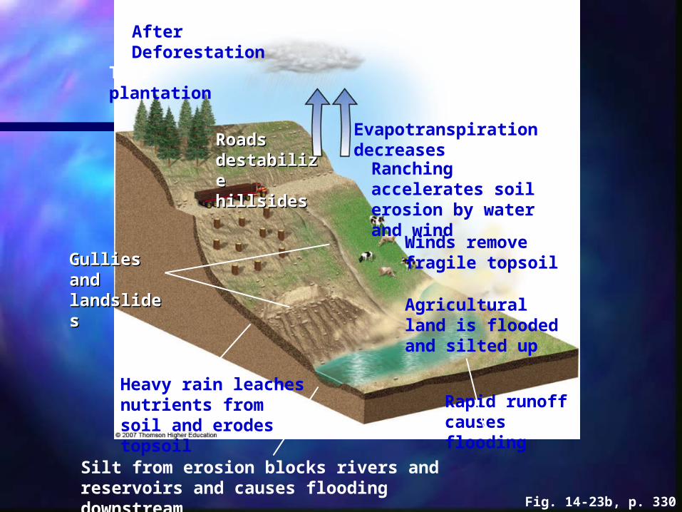
Fig. 14-23b, p. 330
Tree plantation
Roads Roads destabilize destabilize hillsideshillsides
Evapotranspiration decreases
Ranching accelerates soil erosion by water and wind
Winds remove fragile topsoil
Agricultural land is flooded and silted up
Gullies and Gullies and landslideslandslides
Heavy rain leaches nutrients from soil and erodes topsoil
Silt from erosion blocks rivers and reservoirs and causes flooding downstream
Rapid runoff causes flooding
After Deforestation

Too Little WaterToo Little Water
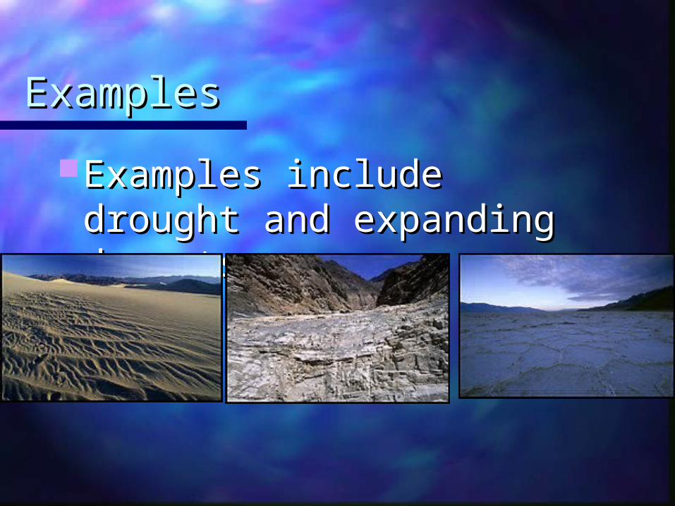
ExamplesExamples
Examples include drought Examples include drought and expanding deserts.and expanding deserts.

Overdrawing Surface Overdrawing Surface WaterWater Lake levels drop, recreation use Lake levels drop, recreation use
drops, fisheries drop, and salinization drops, fisheries drop, and salinization occurs. Ex. Soviet Union (Aral Sea); occurs. Ex. Soviet Union (Aral Sea); the inland sea drained the river that the inland sea drained the river that fed into it. Now it’s a huge disaster fed into it. Now it’s a huge disaster (read pg. 322 in text).(read pg. 322 in text).1964 1997

Case Study: The Aral Sea Case Study: The Aral Sea DisasterDisaster
Diverting water from the Aral Sea and Diverting water from the Aral Sea and its two feeder rivers mostly for irrigation its two feeder rivers mostly for irrigation has created a major ecological, has created a major ecological, economic, and health disaster.economic, and health disaster. About 85% of the wetlands have been About 85% of the wetlands have been
eliminated and roughly 50% of the local bird eliminated and roughly 50% of the local bird and mammal species have disappeared.and mammal species have disappeared.
Since 1961, the sea’s salinity has tripled Since 1961, the sea’s salinity has tripled and the water has dropped by 22 meters and the water has dropped by 22 meters most likely causing 20 of the 24 native fish most likely causing 20 of the 24 native fish species to go extinct.species to go extinct.
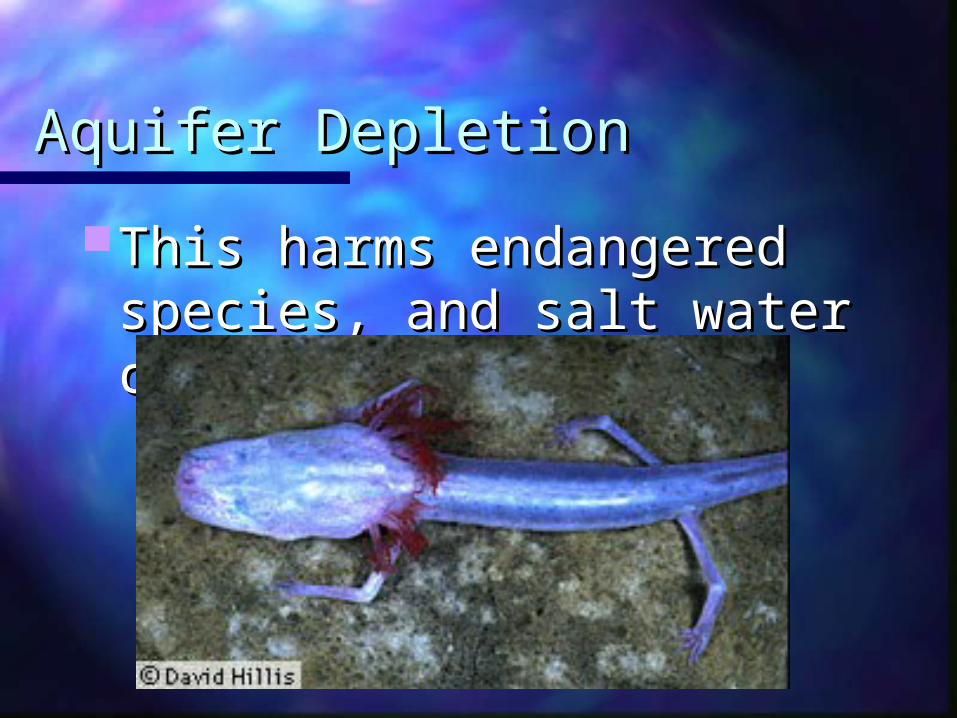
Aquifer DepletionAquifer Depletion
This harms endangered This harms endangered species, and salt water can species, and salt water can seep in.seep in.

Salinization of Irrigated Salinization of Irrigated SoilSoilWater is poured onto soil and Water is poured onto soil and
evaporates. Over time, as this evaporates. Over time, as this is repeated, nothing will grow is repeated, nothing will grow there anymore.there anymore.

U.S. Water U.S. Water ProblemsProblems

Surface Water ProblemsSurface Water Problems
The polluted Mississippi River (non-source The polluted Mississippi River (non-source point pollution) has too much point pollution) has too much phosphorus. phosphorus.
In the Eerie Canal, which connects the In the Eerie Canal, which connects the ocean to the Great Lakes, lampreys came ocean to the Great Lakes, lampreys came in and depleted the fish. The zebra in and depleted the fish. The zebra mollusk is also a problem in the Great mollusk is also a problem in the Great Lakes.Lakes.

Effects of Plant Nutrients on Effects of Plant Nutrients on Lakes:Lakes:Too Much of a Good ThingToo Much of a Good Thing
Plant nutrients from a lake’s Plant nutrients from a lake’s environment affect the types and environment affect the types and numbers of organisms it can support.numbers of organisms it can support.
Figure 6-16Figure 6-16

Effects of Plant Nutrients on Effects of Plant Nutrients on Lakes:Lakes:Too Much of a Good ThingToo Much of a Good Thing
Cultural eutrophicationCultural eutrophication:: Human inputs of nutrients from the Human inputs of nutrients from the
atmosphere and urban and atmosphere and urban and agricultural areas can accelerate the agricultural areas can accelerate the eutrophication process.eutrophication process.

Mono LakeMono Lake(like the Dead Sea) This has a (like the Dead Sea) This has a
huge salt concentration due to huge salt concentration due to man’s draining.man’s draining.

Colorado River BasinColorado River Basin These are dams & These are dams &
reservoirs that feed reservoirs that feed from the Colorado from the Colorado River all the way to River all the way to San Diego, LA, Palm San Diego, LA, Palm Springs, Phoenix & Springs, Phoenix & Mexico. So far has Mexico. So far has worked because worked because they haven’t they haven’t withdrawn their full withdrawn their full allocations. See allocations. See pg306. pg306.
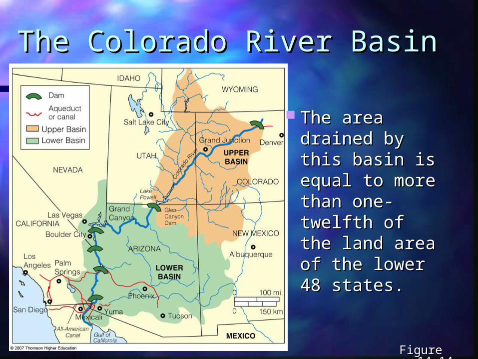
The Colorado River BasinThe Colorado River Basin
The area The area drained by drained by this basin is this basin is equal to equal to more than more than one-twelfth of one-twelfth of the land area the land area of the lower of the lower 48 states.48 states.
Figure 14-14Figure 14-14

Fig. 14-14, p. 318
Dam
Aqueduct or canal
Upper Basin
LOWER BASIN
0 100 mi.
0 150 km
Lower BasinUPPER BASIN
IDAHO
WYOMING
Salt Lake City
Grand JunctionDenver
UTAH
NEVADACOLORADOLake
Powell
Las Vegas
Grand Canyon Glen
Canyon Dam
Boulder CityNEW MEXICO
ARIZONALos Angeles
Albuquerque
PhoenixSan Diego
MexicaliYuma
Tucson
All-American Canal Gulf of
CaliforniaMEXICO
CALIFORNIA
Palm Springs
Col
orad
o R
iver

Case Study: The Colorado Case Study: The Colorado Basin – an Overtapped Basin – an Overtapped ResourceResource
The Colorado River has so many dams The Colorado River has so many dams and withdrawals that it often does not and withdrawals that it often does not reach the ocean.reach the ocean. 14 major dams and reservoirs, and canals.14 major dams and reservoirs, and canals. Water is mostly used in desert area of the Water is mostly used in desert area of the
U.S.U.S. Provides electricity from hydroelectric plants Provides electricity from hydroelectric plants
for 30 million people (1/10for 30 million people (1/10thth of the U.S. of the U.S. population).population).

Case Study: The Colorado Case Study: The Colorado Basin – an Overtapped Basin – an Overtapped ResourceResource
Lake Powell, is Lake Powell, is the second the second largest reservoir largest reservoir in the U.S.in the U.S.
It hosts one of It hosts one of the hydroelectric the hydroelectric plants located plants located on the Colorado on the Colorado River.River.
Figure 14-15Figure 14-15

Groundwater ProblemsGroundwater Problems
These include pollution, These include pollution, salt, and draining too much.salt, and draining too much.

Other Effects of Groundwater Other Effects of Groundwater OverpumpingOverpumping
Sinkholes form Sinkholes form when the roof of when the roof of an underground an underground cavern collapses cavern collapses after being after being drained of drained of groundwater.groundwater.
Figure 14-10Figure 14-10

Groundwater Depletion: Groundwater Depletion: A Growing ProblemA Growing Problem
The Ogallala, the world’s largest aquifer, The Ogallala, the world’s largest aquifer, is most of the red area in the center is most of the red area in the center (Midwest).(Midwest).
Areas of Areas of greatest greatest aquifer aquifer depletion depletion from from groundwater groundwater overdraft in overdraft in the the continental continental U.S.U.S.
Figure 14-8Figure 14-8

Ogallala AquiferOgallala Aquifer
This is the world’s largest known aquifer, This is the world’s largest known aquifer, and fuels agricultural regions in the U.S. It and fuels agricultural regions in the U.S. It extends from South Dakota to Texas. It’s extends from South Dakota to Texas. It’s essentially a non-renewable aquifer from essentially a non-renewable aquifer from the last ice age with an extremely slow the last ice age with an extremely slow recharge rate. In some cases, water is recharge rate. In some cases, water is pumped out 8 to 10 times faster than it is pumped out 8 to 10 times faster than it is renewed. Northern states will still have renewed. Northern states will still have ample supplies, but for the south it’s ample supplies, but for the south it’s getting thinner. It is estimated that ¼ of getting thinner. It is estimated that ¼ of the aquifer will be depleted by 2020. the aquifer will be depleted by 2020.

Global Water Problems

Impacts of Human Activities Impacts of Human Activities on Freshwater Systemson Freshwater Systems Dams, cities, farmlands, and filled-in wetlands Dams, cities, farmlands, and filled-in wetlands
alter and degrade freshwater habitats.alter and degrade freshwater habitats. Dams, diversions and canals have Dams, diversions and canals have
fragmented about 40% of the world’s 237 fragmented about 40% of the world’s 237 large rivers.large rivers.
Flood control levees and dikes alter and Flood control levees and dikes alter and destroy aquatic habitats.destroy aquatic habitats.
Cities and farmlands add pollutants and Cities and farmlands add pollutants and excess plant nutrients to streams and rivers.excess plant nutrients to streams and rivers.
Many inland wetlands have been drained or Many inland wetlands have been drained or filled for agriculture or (sub)urban filled for agriculture or (sub)urban development.development.

Core Case Study: A Biological Core Case Study: A Biological Roller Coaster Ride in Lake Roller Coaster Ride in Lake VictoriaVictoria
Lake Victoria has lost their endemic Lake Victoria has lost their endemic fish species to large introduced fish species to large introduced predatory fish.predatory fish.
Figure 12-1Figure 12-1

Core Case Study: A Biological Core Case Study: A Biological Roller Coaster Ride in Lake Roller Coaster Ride in Lake VictoriaVictoria
Reasons for Lake Victoria’s loss of Reasons for Lake Victoria’s loss of biodiversity:biodiversity: Introduction of Nile perch.Introduction of Nile perch. Lake experienced algal blooms from nutrient Lake experienced algal blooms from nutrient
runoff.runoff. Invasion of water hyacinth has blocked sunlight Invasion of water hyacinth has blocked sunlight
and deprived oxygen.and deprived oxygen. Nile perch is in decline because it has eaten its Nile perch is in decline because it has eaten its
own food supply.own food supply.

Stable RunoffStable Runoff As water runs off from rain, it’s supposed As water runs off from rain, it’s supposed
to get into rivers, and finally off to the to get into rivers, and finally off to the sea. But when we dam rivers, less goes sea. But when we dam rivers, less goes to the ocean, meaning the brackish water to the ocean, meaning the brackish water (where the river hits the ocean) becomes (where the river hits the ocean) becomes more salty. This is the breeding ground more salty. This is the breeding ground for many fish and invertebrates. This for many fish and invertebrates. This harms the ecology of the area.harms the ecology of the area.

Population GrowthPopulation GrowthProblems include over-Problems include over-
drawing fresh water, drawing fresh water, pollution, and over-building pollution, and over-building so that water can’t seep so that water can’t seep into the ground.into the ground.
Sharing Water ResourcesSharing Water Resources
There are water wars out west. There are water wars out west. California bought the water from California bought the water from the Colorado River, but Arizona the Colorado River, but Arizona wants it. Who owns it? The same wants it. Who owns it? The same thing is happening in Texas. More thing is happening in Texas. More water rights are sold than the water rights are sold than the actual amount of water. How do actual amount of water. How do you share water? This is a you share water? This is a problem all over the world.problem all over the world.
Water Management

Dams and ReservoirsDams and Reservoirs
•Description: A dammed stream that can capture & store water from rain & melted snow.
•Benefits: Hydroelectric power; provides water to towns; recreation; controls floods downstream
• Problems: Reduces downstream flow; prevents water from reaching the sea (Colorado River) devastates fish life; reduces biodiversity.

USING DAMS AND USING DAMS AND RESERVOIRS TO SUPPLY RESERVOIRS TO SUPPLY MORE WATERMORE WATER
Large dams and reservoirs can Large dams and reservoirs can produce cheap electricity, reduce produce cheap electricity, reduce downstream flooding, and provide downstream flooding, and provide year-round water for irrigating year-round water for irrigating cropland, but they also displace cropland, but they also displace people and disrupt aquatic systems.people and disrupt aquatic systems.

Fig. 14-13a, p. 317
Provides water for year-round irrigation of cropland
Flooded land destroys forests or cropland and displaces people
Large losses of water through evaporation
Provides water for drinking Downstream
cropland and estuaries are deprived of nutrient-rich silt
Reservoir is useful for recreation and fishing
Risk of failure and devastating downstream flooding
Can produce cheap electricity (hydropower)
Downstream flooding is reduced
Migration and spawning of some fish are disrupted

Fig. 14-13b, p. 317
Powerlines
Reservoir
Dam
PowerhouseIntake
Turbine

Case Study: Case Study: China’s Three Gorges DamChina’s Three Gorges Dam
There is a debate over whether the advantages of There is a debate over whether the advantages of the world’s largest dam and reservoir will outweigh the world’s largest dam and reservoir will outweigh its disadvantages.its disadvantages. The dam will be 2 kilometers long.The dam will be 2 kilometers long. The electric output will be that of 18 large coal-burning The electric output will be that of 18 large coal-burning
or nuclear power plants.or nuclear power plants. It will facilitate ship travel reducing transportation costs.It will facilitate ship travel reducing transportation costs. Dam will displace 1.2 million people.Dam will displace 1.2 million people. Dam is built over seismatic fault and already has small Dam is built over seismatic fault and already has small
cracks. cracks.

Dam RemovalDam Removal
Some dams are being removed for ecological Some dams are being removed for ecological reasons and because they have outlived their reasons and because they have outlived their usefulness.usefulness. In 1998 the U.S. Army Corps of Engineers announced In 1998 the U.S. Army Corps of Engineers announced
that it would no longer build large dams and diversion that it would no longer build large dams and diversion projects in the U.S.projects in the U.S.
The Federal Energy Regulatory Commission has The Federal Energy Regulatory Commission has approved the removal of nearly 500 dams.approved the removal of nearly 500 dams.
Removing dams can reestablish ecosystems, but can Removing dams can reestablish ecosystems, but can also re-release toxicants into the environment.also re-release toxicants into the environment.

Water DiversionWater Diversion
•Description: Damming a river to control where the water flows
•Benefits: Keeps water where we want it- cities!
•Problems: Drains wetlands, destroys land

DesalinizationDesalinization
•Description: Removing salt from salt water
•Benefits: Freshwater
•Problems: Uses lots of energy; costs 3-5X’s more money; what do we do with the salt?

DESALTING SEAWATER, DESALTING SEAWATER, SEEDING CLOUDS, AND SEEDING CLOUDS, AND TOWING ICEBERGS AND TOWING ICEBERGS AND GIANT BAGGIESGIANT BAGGIES
Removing salt from seawater by current Removing salt from seawater by current methods is expensive and produces large methods is expensive and produces large amounts of salty wastewater that must be amounts of salty wastewater that must be disposed of safely.disposed of safely. DistillationDistillation: heating saltwater until it evaporates, : heating saltwater until it evaporates,
leaves behind water in solid form.leaves behind water in solid form. Reverse osmosisReverse osmosis: uses high pressure to force : uses high pressure to force
saltwater through a membrane filter.saltwater through a membrane filter.

DESALTING SEAWATER, DESALTING SEAWATER, SEEDING CLOUDS, AND SEEDING CLOUDS, AND TOWING ICEBERGS AND TOWING ICEBERGS AND GIANT BAGGIESGIANT BAGGIES
Seeding clouds with tiny particles of Seeding clouds with tiny particles of chemicals to increase rainfall towing chemicals to increase rainfall towing icebergs or huge bags filled with icebergs or huge bags filled with freshwater to dry coastal areas have freshwater to dry coastal areas have all been proposed but are unlikely all been proposed but are unlikely to provide significant amounts of to provide significant amounts of freshwater.freshwater.

Harvesting IcebergsHarvesting Icebergs
•Description: Towing massive icebergs to arid coastal areas (S. California; Saudi Arabia)
•Benefits: freshwater
•Problems: Technology not available; costs too high; raise temperatures around the earth.
INCREASING WATER SUPPLIES INCREASING WATER SUPPLIES BY WASTING LESS WATERBY WASTING LESS WATER
Sixty percent of the world’s irrigation Sixty percent of the world’s irrigation water is currently wasted, but improved water is currently wasted, but improved irrigation techniques could cut this waste irrigation techniques could cut this waste to 5-20%.to 5-20%.
Center-pivot, low pressure sprinklers Center-pivot, low pressure sprinklers sprays water directly onto crop.sprays water directly onto crop. It allows 80% of water to reach crop.It allows 80% of water to reach crop. Has reduced depletion of Ogallala aquifer in Has reduced depletion of Ogallala aquifer in
Texas High Plains by 30%.Texas High Plains by 30%.

Fig. 14-18, p. 325
Center pivotCenter pivot
Drip irrigationDrip irrigation
Gravity flowGravity flow(efficiency 60% and
80% with surge valves)
Above- or below-ground pipes or tubes deliver water to individual plant roots.
Water usually comes from an aqueduct system or a nearby river.
(efficiency 90–95%)
(efficiency 80%–95%)
Water usually pumped from underground and sprayed from mobile boom with sprinklers.

ConservationConservation
•Description: Saving the water we have
•Methods: recycling; conserving at home; xeriscaping; fix leaks
•Benefits: Saves money; Saves Wildlife
•Problems: bothersome to people; lack of caring; laziness
Related Documents