Welcome message from author
This document is posted to help you gain knowledge. Please leave a comment to let me know what you think about it! Share it to your friends and learn new things together.
Transcript


Questions
• Who am I?– Software Developer
– Working with GIS application since 1991
• Ph.D from Maine in 2001
• Associate professor at Information Sciences at Penn State University since 2001

After 7 years …
• Sabbatical– Question:
• How to work with Gilberto– Amazon
• and Clodoveu– SDI – spatial data infrastructures
• and with myself of course – information integration from multiple perspectives
» Ontologies, philosophy, conflicting views on the same subject
– SDI for the Amazon project • see web page: google sdi for the amazon

Special Issue of Earth Science and Informatics
• Cfp (google “SDI for the Amazon”)• Miguel: “we have to think about our papers”• Sven Schade
– Schema translation and data quality. Integrating sensor data in decision processes often requires translating their formats and underlying conceptualizations. Accounting for accuracy and otherquality parameters is a key part of this translation. I will present recent work on ontological approaches and how it can help to improve our understanding of the environment.
• Patrick Maué– Metadata and information communities. The traditional metadata models have failed in practice. New ideas evolving in the social web provide better answers to information seekers and decision makers. I will present a software architecture applying these ideas, showing how it can be used for environmental information.

The idea
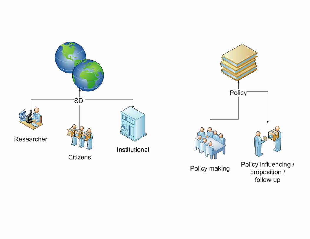
• SDI is more than distributing maps• an enabler for understanding space
• Multidisciplinarity
• Policy making
• Public participation
• And of course data integration


Summary of the workshop
• Keynote– From today’s SDI to tomorrow’s digital earth(s) (Max Craglia)
• Presentations based on position papers– Understanding global change (Clodoveu/Fred)
– Building an SDI for a Sustainable Amazonia based on Brazil´s policy needs (Gilberto)
– Spatial data for scientific research in the Amazon (Silvana Amaral – INPE)

Summary
• Presentations based on position papers (cont.)• Infra‐estrutura de dados espaciais para a Amazônia (cap. Soraya Issmael – DSG/EB)
• Status of Spatial Data Infrastructure in Brazil (LuizPaulo Fortes – DG/IBGE)
• Globo Amazonia (Eduardo Acquarone – RedeGlobo)
• Spatial data infrastructures: reuse beyond the metadata (Odilon Silva/Jugurta Lisboa – UFV)

Research Challenge
How is the Earth’s environmentchanging and what are theconsequences for human
civilization?

GIScience Research Agenda
• Four proposed topics:– Modeling
– Data collection
– Knowledge discovery
– Support for policy‐making

Global Land Project• What are the drivers and
dynamics of variability and change in terrestrial human-environment systems?
• How is the provision of environmental goods and services affected by changes in terrestrial human-environment systems?
• What are the characteristics and dynamics of vulnerability in terrestrial human-environment systems?

Tania Sanaiotti - 2008
So hard to get… Why shoud I share???
Data availability “Cultural task”

Exército Brasileiro/DSG WORKSHOP SDI FOR AMAZON –GEOINFO 2008
ProvedorOficial A
EDGV
EMDG
RDGV
Outras
ADGV
EDGM
EmpresasContratadas
ÓrgãosEstaduais
ProvedorOficial B
EDGV – Estrutura Dados Geoespaciais Vetoriais
EMDG – Estrutura MetadadosGeoespaciais
EDGM – Estrutura DadosGeoespaciais Matriciais
ADGV – Aquisição DadosGeoespaciais Vetoriais
RDGV – Representação DadosGeoespaciais Vetoriais
PORT
AL
Usuário final
A INDE A INDE –– EspecificaEspecificaççõesões TTéécnicascnicas

1. Breve histórico: notícias + mapa interativo

Perspectives
• SDI research– Sustainability: refine definition and establishrequirements for data
– Tools and techniques for creating SDIs
• Institutional data providers– Official/governmental SDI: INDE, INSPIRE
• Users / researchers– Scientific demand for data
• Voluntary/popular participation

Ideas
• We need ways to promote the interaction andcollaboration among people regardingsustainability in the Amazon– Information sharing– Collaboration mechanisms
• Opinions/validation• Wikis• Blogs
– Community building• Digital Earth perspective: more than SDI• “Reading club vs. Library”
– “e‐Science”


Ideas
• A set of Web‐based interaction resources– Facilitate access to actual data– Encourage researchers to make studies and data available
• Strong presence of recognized members of thecommunity
• Inclusive• “Just do it” versus “We’ll do it for you”• Scientists influence policy making• Citizens have a presence and can contribute

Opportunities
• Globally important
• Strong popular interest
• Much data is available, although not easilyaccessible

Challenges
• Not actually a SDI
• Available information has to reach differentcommunities, which have different languages
• Interaction and collaboration resources haveto show added value

Challenges
• Supporting Sustainability Science and Policy Making– What is sustainability? Can we define create a “community of practice” for sustainability science?
• How can we motivate the community of practice to contribute and interact? Recognition mechanisms, gathering contributions from many sources
– What are the specific spatial data needs of sustainability science?

Challenges
• Data– What´s available? What are the data policies in place?
– What´s not available? What are the data gaps?
– What will be available? What are the present and future data sources?
– What can be made available (geosensors technology, future remote sensing, scientific data not on the Web)?
– How can we obtain data about people and on the impact of human actions?

Challenges
• Individual contributions– How can citizens, scientists and policy makers interact as individuals?
– Can the monitoring of the Amazon be “wikified”, i.e., can volunteers closely monitor environmental issues by working in their free time over freely‐available geographic data? What kind of tools would they need?

Challenges
• Individual contributions (cont.)– Are volunteers able to obtain, analyze, and identify change vectors from online data sources?
– Can the quality of this volunteer work be assessed?
– How can people be motivated to contribute?
– Is it possible to approach real‐time monitoring if there are enough volunteers?

Challenges
• Modeling– How to model the interactions between nature and society, and how to measure the impact of governmental policies?
– How can SDI and other sources of data be used for that?


Related Documents