Shore & Beach Vol. 78, No. 4 / Vol. 79, No. 1 Fall 2010 / Winter 2011 Page 75 T he 25-mile-long barrier island of Bogue Banks in North Carolina trends along an east-west axis and is bound by the Atlantic Ocean to the south and Bogue Sound to the north. Two inlets — Bogue Inlet to the west, and Beaufort Inlet to the east — separate the island from adjacent undeveloped barrier islands (see Figure 1). Long-term erosion rates along the is- land are generally low, at less than 2 feet per year (Benton et al. 1993; NCDCM 2004). Mean tidal range based on the National Ocean Service (NOS) 1983 to 2001 tidal epoch is approximately 3.7 feet. Longshore sediment transport along Bogue Banks is generally from east to west, with reversal currents in the vicinity of Beaufort Inlet due to wave and tidal in- teractions with the ebb tidal delta (Olsen Associates 2006; USACE 2001). The terminal ends of this barrier island have experienced periods of both erosion and accretion over the years, mostly due to the shifting tidal inlets typical of this Fort Macon Terminal Groin, Beaufort Inlet, North Carolina By Rob Walker, P.E. Anchor QEA, [email protected] Greg “Rudi” Rudolph Carteret County (NC) Shore Protection Office, [email protected] Spencer Rogers, P.G. North Carolina Sea Grant, [email protected] ABSTRACT Beaufort Inlet is one of North Carolina’s two deep-draft inlets and provides an im- portant navigation path to the Morehead City Harbor. On the east side of the inlet sits the historic Fort Macon, which dates back to 1826 and is now a state park. Since the initial occupation of this area by federal forces, coastal erosion has continuously threatened the fort structure and associated park infrastructure. Beginning in 1831, a variety of groin configurations have been constructed to protect the site. The groins — which lined the ocean beach and continued around the inlet — managed to stabilize the site but not without a constant struggle with coastal processes and inlet dynamics, requiring an extensive long-term management scheme and constant re-evaluations and improvements to the structures. After a series of hurricanes in the 1950s threatened the historic fort, construction began in 1961 for a terminal groin on the east end of the barrier island to permanently stabilize the site. After several extensions, the terminal groin was finalized in 1970 and has continued to maintain the Fort Macon site in a stable condition. ADDITIONAL KEYWORDS: Tidal inlet, terminal groin, inlet bypassing, ebb tidal delta, porosity, longshore sediment transport. Manuscript submitted 31 May, 2010, revised and accepted 25 August 2010. geographic setting. While Bogue Inlet has remained unstructured and was the site of a major channel re-alignment in 2005 to protect private homes and the public beach, a variety of coastal structures dating back to 1831 have been installed at Beaufort Inlet to protect his- toric Fort Macon. Beaufort Inlet (known historically as Old Topsail Inlet) is also one of only three inlets in North Carolina that has been continuously open since 1585 or earlier (Payne 1985). HISTORY OF FORT MACON Located on the east end of Bogue Banks, the site of the current Fort Macon has a civil defense history dating back to 1756. The site’s location is strategic: it guards Beaufort Inlet, an important navigable inlet that connects Bogue Sound to the Atlantic Ocean. Originally, a different fort ― Fort Dobbs ― was to be constructed on the site during the French and Indian War but was never completed. Another fort was also built nearby: in 1809, the United States began construct- ing Fort Hampton, approximately 900 feet northeast of the present-day Fort Macon. By 1825, however, the shifting Beaufort Inlet had caused severe erosion, and both Fort Hampton and some 600 feet of beach had been washed away. Construction of Fort Macon began in 1826 and was completed eight years later. After a series of occupations by both state and federal forces throughout both war- and peacetime, the fort was finally abandoned in 1903. In 1924, the state of North Carolina acquired the property with intentions of making it into a state park and, by the 1940s, Fort Macon had been restored after years of neglect and was opened to the public. HISTORIC SHORE PROTECTION STRUCTURES After Fort Hampton had washed into the encroaching Beaufort Inlet, the Army Engineer Department made shoreline erosion control a top priorty for the new Fort Macon. The initial erosion control scheme was completed in 1831 and consisted of a groin field constructed of rows of wood pilings laid at right angles to the beach and filled with brush that was weighted down with brickbats and logs (Branch 2005). While the groins did temporarily stabilize the beach, quick deterioration

Welcome message from author
This document is posted to help you gain knowledge. Please leave a comment to let me know what you think about it! Share it to your friends and learn new things together.
Transcript

Shore & Beach Vol. 78, No. 4 / Vol. 79, No. 1 Fall 2010 / Winter 2011 Page 75
The 25-mile-long barrier island of Bogue Banks in North Carolina trends along an east-west axis
and is bound by the Atlantic Ocean to the south and Bogue Sound to the north. Two inlets — Bogue Inlet to the west, and Beaufort Inlet to the east — separate the island from adjacent undeveloped barrier islands (see Figure 1).
Long-term erosion rates along the is-land are generally low, at less than 2 feet per year (Benton et al. 1993; NCDCM 2004). Mean tidal range based on the National Ocean Service (NOS) 1983 to 2001 tidal epoch is approximately 3.7 feet. Longshore sediment transport along Bogue Banks is generally from east to west, with reversal currents in the vicinity of Beaufort Inlet due to wave and tidal in-teractions with the ebb tidal delta (Olsen Associates 2006; USACE 2001).
The terminal ends of this barrier island have experienced periods of both erosion and accretion over the years, mostly due to the shifting tidal inlets typical of this
Fort Macon Terminal Groin, Beaufort Inlet, North Carolina
By
Rob Walker, P.E.Anchor QEA, [email protected]
Greg “Rudi” RudolphCarteret County (NC) Shore Protection Office, [email protected]
Spencer Rogers, P.G.North Carolina Sea Grant, [email protected]
ABSTRACTBeaufort Inlet is one of North Carolina’s two deep-draft inlets and provides an im-portant navigation path to the Morehead City Harbor. On the east side of the inlet sits the historic Fort Macon, which dates back to 1826 and is now a state park. Since the initial occupation of this area by federal forces, coastal erosion has continuously threatened the fort structure and associated park infrastructure. Beginning in 1831, a variety of groin configurations have been constructed to protect the site. The groins — which lined the ocean beach and continued around the inlet — managed to stabilize the site but not without a constant struggle with coastal processes and inlet dynamics, requiring an extensive long-term management scheme and constant re-evaluations and improvements to the structures. After a series of hurricanes in the 1950s threatened the historic fort, construction began in 1961 for a terminal groin on the east end of the barrier island to permanently stabilize the site. After several extensions, the terminal groin was finalized in 1970 and has continued to maintain the Fort Macon site in a stable condition.
ADDITIONAL KEYWORDS: Tidal inlet, terminal groin, inlet bypassing, ebb tidal delta, porosity, longshore sediment transport.
Manuscript submitted 31 May, 2010, revised and accepted 25 August 2010.
geographic setting. While Bogue Inlet has remained unstructured and was the site of a major channel re-alignment in 2005 to protect private homes and the public beach, a variety of coastal structures dating back to 1831 have been installed at Beaufort Inlet to protect his-toric Fort Macon. Beaufort Inlet (known historically as Old Topsail Inlet) is also one of only three inlets in North Carolina that has been continuously open since 1585 or earlier (Payne 1985).
HISTORY OF FORT MACONLocated on the east end of Bogue
Banks, the site of the current Fort Macon has a civil defense history dating back to 1756. The site’s location is strategic: it guards Beaufort Inlet, an important navigable inlet that connects Bogue Sound to the Atlantic Ocean. Originally, a different fort ― Fort Dobbs ― was to be constructed on the site during the French and Indian War but was never completed. Another fort was also built nearby: in 1809, the United States began construct-
ing Fort Hampton, approximately 900 feet northeast of the present-day Fort Macon. By 1825, however, the shifting Beaufort Inlet had caused severe erosion, and both Fort Hampton and some 600 feet of beach had been washed away.
Construction of Fort Macon began in 1826 and was completed eight years later. After a series of occupations by both state and federal forces throughout both war- and peacetime, the fort was finally abandoned in 1903. In 1924, the state of North Carolina acquired the property with intentions of making it into a state park and, by the 1940s, Fort Macon had been restored after years of neglect and was opened to the public.
HISTORIC SHORE PROTECTION STRUCTURES After Fort Hampton had washed into
the encroaching Beaufort Inlet, the Army Engineer Department made shoreline erosion control a top priorty for the new Fort Macon. The initial erosion control scheme was completed in 1831 and consisted of a groin field constructed of rows of wood pilings laid at right angles to the beach and filled with brush that was weighted down with brickbats and logs (Branch 2005).
While the groins did temporarily stabilize the beach, quick deterioration
Shore & Beach Vol. 78, No. 4 / Vol. 79, No. 1 Fall 2010 / Winter 2011Page 76
Figure 1. Site location map. (Credit: Carteret County Shore Protection Office.)
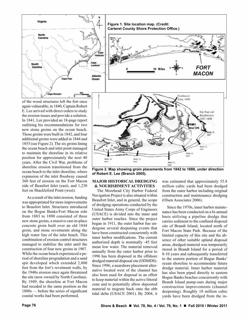
Figure 2. Map showing groin placements from 1842 to 1888, under direction of Robert E. Lee (Branch 2005).
of the wood structures left the fort once again vulnerable; in 1840, Captain Robert E. Lee arrived with direct orders to study the erosion issues and provide a solution. In 1841, Lee provided an 18-page report outlining his recommendations for two new stone groins on the ocean beach. Those groins were built in 1842, and four additional groins were added in 1844 and 1855 (see Figure 2). The six groins lining the ocean beach and inlet point managed to maintain the shoreline in its relative position for approximately the next 40 years. After the Civil War, problems of shoreline erosion transitioned from the ocean beach to the inlet shoreline, where expansion of the inlet floodway caused 360 feet of erosion on the Fort Macon side of Beaufort Inlet (east), and 1,230 feet on Shackleford Point (west).
As a result of the inlet erosion, funding was appropriated for more improvements to Beaufort Inlet. Structures introduced on the Bogue Banks/Fort Macon side from 1883 to 1890 consisted of three new stone groins, a massive cast-in-place concrete groin built over an old 1844 groin, and stone revetments along the high water line of the inlet beach. This combination of erosion control structures managed to stabilize the inlet until the construction of four new groins in 1907. While the ocean beach experienced a pe-riod of shoreline progradation and a sand spit developed which extended 2,800 feet from the fort’s revetment walls, by the 1940s erosion once again threatened the site (now owned by North Carolina). By 1949, the shoreline at Fort Macon had receded to the same position as the 1880s — before the series of significant coastal works had been performed.
MAJOR HISTORICAL DREDGING & NOURISHMENT ACTIVITIES
The Morehead City Harbor Federal Navigation Project is also situated within Beaufort Inlet, and in general, the scope of dredging operations conducted by the United States Army Corps of Engineers (USACE) is divided into the inner and outer harbor reaches. Since the project began in 1911, the outer harbor has un-dergone several deepening events that have been constructed concurrently with inner harbor modifications. The current authorized depth is nominally -45 feet mean low water. The material removed annually from the outer harbor prior to 1996 has been disposed in the offshore dredged material disposal site (ODMDS). Since 1996, a nearshore placement alter-native located west of the channel has also been used for disposal in an effort to keep material within the active littoral zone and to potentially allow deposited material to migrate back onto the ebb tidal delta (USACE 2001). By 2004, it
was estimated that approximately 55.8 million cubic yards had been dredged from the outer harbor including original construction and maintenance dredging (Olsen Associates 2006).
Since the 1970s, inner harbor mainte-nance has been conducted on a bi-annual basis utilizing a pipeline dredge that carries sediment to the confined disposal site of Brandt Island, located north of Fort Macon State Park. Because of the limited capacity of this site and the ab-sence of other suitable upland disposal areas, dredged material was temporarily stored in Brandt Island for a period of 8-10 years and subsequently transferred to the eastern portion of Bogue Banks’ ocean shoreline to accommodate future dredge material. Inner harbor material has also been piped directly to eastern Bogue Banks beaches concurrently with Brandt Island pump-outs during major construction improvements (channel deepening). Roughly 18 million cubic yards have been dredged from the in-

Shore & Beach Vol. 78, No. 4 / Vol. 79, No. 1 Fall 2010 / Winter 2011 Page 77
Figure 3. Reproduced typical cross-section design of Fort Macon terminal groin (Credit: Criser Troutman Tanner Consulting Engineers).
Figure 4 (below). Aerial photo from 1964, prior to construction of terminal groin (Credit: USACE, Wilmington District).
ner harbor; 12 million of which (either actively dredged or “recycled”) have been placed along eastern Bogue Banks, including Fort Macon, since 1978.
Concerns over the sediment quality of the inner harbor material that was trans-ferred to the beach from Brandt Island in 2005 and legal action pursued by Carteret County regarding outer harbor dredging and disposal methods have resulted in the preparation of a new Dredged Material Management Plan (DMMP). Pursuant to conditions stipulated in a legal settlement, the USACE must complete the DMMP by October 2011. The USACE has also developed a three-year Interim Operation Plan (IOP) that will be implemented until the DMMP is completed. Importantly, the IOP (and likely the DMMP) includes a beach disposal option for Fort Macon State Park and a portion or the entirety of Atlantic Beach.
Carteret County is most concerned with the offshore dumping of beach-quality sand that has been dredged from the harbor since 1911. As previously stated, roughly 60 million cubic yards of

Shore & Beach Vol. 78, No. 4 / Vol. 79, No. 1 Fall 2010 / Winter 2011Page 78
Figure 5. Reproduced construction drawing shows proposed 600-foot extension and predicted “optimum” shoreline response (Credit: Criser Troutman Tanner Consulting Engineers).
Figure 6. Aerial photo from 1971, immediately after terminal groin construction (Credit: USACE, Wilmington District).
sand to date (2010) have been dumped offshore. A Section 111 report by the USACE and an independent study con-tracted by Carteret County (that utilized data current as of 2000) both documented the cumulative loss of approximately 16 million cubic yards to Bogue Banks and approximately 24 million cubic yards to the ebb delta, with the remaining losses (10 million cubic yards) attributed to Shackleford Banks and the flood delta system. The reports also document de-flation and seaward displacement of the ebb delta and shoreface steepening along the Bogue Banks oceanfront, especially along the Fort Macon oceanfront shore-line (USACE 2001; Olsen Associates 2006)
FORT MACON TERMINAL GROIN
The 1950s brought a series of large hurricanes that devastated the east coast and further exacerbated erosion of the beach surrounding Fort Macon State Park. After the park’s infrastructure was undermined and the fort’s integrity threatened, construction of a new termi-nal groin began in 1961 that would line

Shore & Beach Vol. 78, No. 4 / Vol. 79, No. 1 Fall 2010 / Winter 2011 Page 79
Figure 7. Aerial photo from 1980, 10 years after terminal groin construction (Credit: USACE, Wilmington District).
Figure 8. Aerial photo from 1990, 20 years after terminal groin construction (Credit: USACE, Wilmington District).

Shore & Beach Vol. 78, No. 4 / Vol. 79, No. 1 Fall 2010 / Winter 2011Page 80
Figure 9. Aerial photo from 2000, 30 years after terminal groin construction (Credit: USACE, Wilmington District).
the shipping channel and extend seaward 675 feet from the shoreline. The groin was extended around the inlet shoreline in form of a rock revetment, making the total length of the structure 1,250 feet. In 1962, the USACE released a study of beach and inlet erosion at the site that ultimately recommended the construction of a terminal groin structure with a total length of 2,450 feet. The groin was ex-tended by 410 feet in 1965 and combined with beach nourishment; another 540 feet was added in 1969. The total length of the groin was then 2,250 feet, just 200 feet short USACE’s original recommendation (Branch 2005).
The typical cross-section design of the terminal groin is shown in Figure 3. With a crest elevation of +6 feet mean low water (MLW), the structure protruded above the mean high water elevation ap-proximately 2.4 feet. The design called
for the structure’s outer armor layer to be 15 tons per linear foot, ranging in size from 7.5 tons to 12.5 tons with a minimum of 75 percent at least 10 tons per piece. The underlayer consists of stones with an average weight of 2,000 pounds per piece, while the core stone specified ranged from 2 to 12 inches with a minimum of 50 percent at least 6 inches in diameter.
The stone used in the original ter-minal groin extension was a porous, low-density, shelly limestone (cemented shell stone) available from a local quarry in New Bern, North Carolina. While the dry unit weight of the stone was about 125 pounds per cubic foot, the wet weight (once saturated) was closer to 160 pounds per cubic foot. The quarry and several existing coastal structures using the stone were inspected by the Coastal Engineering Research Center (CERC)
in 1965; general conclusions were that the roughness of the stone could provide interlocking capabilities that would compensate for its low density and po-rous composition. Further concerns by USACE of the long-term durability of the stone when subjected to wave action eventually led to a series of physical tests, carried out both in the laboratory at the CERC in 1965 and in the field at the Fort Macon site between 1967 and 1969 (USACE 1976).
Laboratory tests were carried out at CERC in a large wave tank (635 feet long, 15 feet wide and 20 feet deep). Waves were generated by a 23-foot-high vertical bulkhead, capable of generating mono-chromatic waves from 2.6 to 24.5 seconds. Final testing consisted of 14 tests conduct-ed with 3.75-, 5.60- and 7.87-second wave periods and wave heights ranging from 2.5 to 4.2 feet. Those stones still identifiable

Shore & Beach Vol. 78, No. 4 / Vol. 79, No. 1 Fall 2010 / Winter 2011 Page 81
Figure 10. Maps showing (A, above) shoreline progradation west of terminal structure and on inlet beach and (B, below) landward extent of groin structure (Moffatt & Nichol 2010).
at the end of testing displayed an average percent weight loss of 5.5 percent. As a result of the stone weight losses observed in the laboratory tests, arrangements were made with the USACE Wilmington District to conduct field tests at the Fort Macon site. Thirteen stones were placed on or near the Fort Macon terminal groin and periodically removed, weighed, and replaced for about 18 months. Results showed the best quality stones lost 5-20 percent of their original weight after 6 months; additional heavy weight losses (45-60 percent) observed at the end of the test period indicated that excessive weight loss could continue indefinitely. Because of the tests, the USACE issued a formal recommendation in 1976 advising against the use of the New Bern marine limestone as armor layer or underlayers of rubble mound structures (USACE 1976).
It is uncertain whether the original cross-section design was altered in the later extensions of the terminal groin. As discussed later in this paper, the observed porosity of the structure allowing for the passage of sediment to the inlet beach raises questions regarding the actual size of underlayer and core stone used for final construction. Regardless of the design of later groin extensions, it is believed that the marine limestone used in early construc-tion has contributed greatly to the overall porosity of the structure as a whole.
PREDICTED RESPONSE OF TERMINAL GROIN
CONSTRUCTIONBoth the USACE’s Section 111
Report and additional studies conclude the predominant direction of net littoral transport at Beaufort Inlet is from east to west, with exception of the easterly reversal node within approximately 2.4 miles west of the inlet (Olsen Associates 2006). The phenomena of reverse long-shore sediment transport along the ocean beach facing Fort Macon State Park is the result of wave interactions with ebb tidal delta, including refraction, diffraction, shoaling, breaking and wave attenuation (Douglass 1991). These complex interac-tions of the wave climate with the ebb tidal delta are the primary mechanism supporting the success of the terminal groin structure at this site.
The authors were unable to recover de-tailed discussions outlining the predicted response of the terminal groin, as would be expected to be contained within the
USACE’s missing 1962 report. However, some information can be gathered from a review of the design documents provided by the consulting engineers retained by the state of North Carolina to provide a long-term solution to Fort Macon’s battle with the encroaching sea.
In 1965, the coastal engineers at Henry von Oesen & Associates, Inc. in Wilmington, North Carolina (now Criser Troutman Tanner Consulting Engineers) provided engineering design and construction drawings to imple-ment the extension of the terminal groin structure. Based on observations of the inlet and coastal processes affecting the site, it was anticipated that the easterly
reversal in longshore sediment transport in the vicinity of Fort Macon would pro-mote accretion of the south facing ocean beach on the updrift side of the terminal groin. Figure 4 is an aerial photo taken in 1964 which shows the Fort Macon site in its pre-project condition. Figure 5 demonstrates the engineer’s estimations for the “optimum” shoreline which could be expected from the proposed terminal structure.
OBSERVED SEDIMENT PROCESSES AND SHORELINE
RESPONSE TO TERMINAL GROIN CONSTRUCTION
Construction of the terminal groin at Beaufort Inlet between 1961 and 1969

Shore & Beach Vol. 78, No. 4 / Vol. 79, No. 1 Fall 2010 / Winter 2011Page 82
Figure 11. Oblique aerial photograph of
the western shoulder of Beaufort Inlet and
Fort Macon State Park. Dredged material is
routinely placed along the oceanfront just west of
the picture where natural hydraulic forces transport
the material back toward the inlet -- passing over, through, and around the terminal groin structure
and subsequently creating the large
accretion area labeled in the picture (Credit:
Carteret County Shore Protection Office).
has protected the Fort Macon site and served to stabilize the eastern end of Bogue Banks, which previously had a history of severe shoreline erosion. Through beach nourishment and natural sediment transport processes, the shore-line immediately adjacent to the terminal groin prograded seaward to near the end of the structure by the late 1970s.
Subsequent aerial photographs of eastern Bogue Banks shown in Figure 8 (1990) and Figure 9 (2000) demonstrate that the south facing ocean beach has maintained a position near the end of the terminal groin since construction. Addi-tionally, a noteworthy area of sediment accretion can be observed on the inlet side of the fort. Figures 6, 7, 8, and 9 show a gradual increase in the east-facing shoreline of Fort Macon, establishing a healthy beach and providing a natural buffer between the fort’s infrastructure and the dynamic ebb and flood currents of Beaufort Inlet.
As a part of a North Carolina State Assembly-mandated study on the use of terminal groins at North Carolina tidal inlets, in 2009 and 2010, Moffat & Nichol studied the shoreline impacts of the Fort Macon terminal groin by exam-ining shoreline change before and after construction. Historical shoreline data obtained from the North Carolina Divi-sion of Coastal Management consisted of
transects at 50 meter stationing and ex-tending 3 miles to either side of the inlet. The pre-structure study period consisted of shoreline data from the years 1933 to 1946, and the post-construction period of 1971 to 2004 was used in the analy-sis. The coastal engineering assessment revealed that prior to construction of the terminal groin the shoreline to the west side of Beaufort Inlet (Bogue Banks) was eroding. After construction, the Bogue Banks shoreline within the 3-mile study area demonstrates a general trend of accretion, with some localized areas of minor erosion. For the eastern side of Beaufort Inlet (Shackleford Banks), pre-construction data showed an accretionary trend on the inlet side with erosion along the ocean beach. The post-construction review revealed a general reversal in this pattern, with increased erosion on the inlet side and accretion to the ocean beach of Shackleford Banks (Moffatt & Nichol 2010). Moffatt & Nichol’s study also incorporates dredging and beach nourishment history on a volumetric basis to discern the impact of natural processes from these anthropogenic activities.
Figure 10 serves to further demon-strate the observed sediment processes and shoreline response to the terminal groin construction. The figure, which appears in Moffatt & Nichol’s terminal groin study final report (2010), dem-onstrates longshore sediment transport
around the seaward end of the terminal groin. The series of aerial photographs demonstrate that as the fillet on the up-drift side of the terminal groin was filled with sediment, the structure no longer impeded the flow of sediment into the inlet system.
The significant shoreline prograda-tion along the inlet side of Fort Macon (Figure 11) further demonstrates how sediment has continued to be transported over, through or around the terminal groin structure. It is likely that during elevated storm surge conditions, the relatively low crest elevation, only +2.4 feet above MHW, allows some sediment to be transported over the structure. Due to uncertainties in the final constructed groin cross-section of later extensions, it is unclear if the low permeability de-sign consisting of underlayer stone and relatively small core stone (see Figure 3) was altered in later construction periods providing a more porous structure. It is understood that marine limestone from the New Bern quarry was used in original groin construction, and subsequent labo-ratory and field tests conducted by the CERC proved that this material is subject to decomposition and deterioration over time upon interaction with ocean currents and wave action. These natural processes are believed to have contributed to the overall porosity of the structure over time, thereby significantly contributing
Shore & Beach Vol. 78, No. 4 / Vol. 79, No. 1 Fall 2010 / Winter 2011 Page 83
to the observed accretion area on the inlet side of the fort.
CONCLUSIONSThe Fort Macon terminal groin, in com-
bination with beach nourishment activities on the nearby shoreline of Bogue Banks, has served to protect the historic Fort Macon and stabilize both the ocean and inlet shorelines. Indeed, this combination of both engineered structure and continued beach nourishment has proved to be a successful shore protection strategy at this site.
Observed sediment processes as a result of the groin construction demonstrate that sediment has continued to be transported over, through, or around the groin structure allowing for a significant spit formation on the inlet shoreline. This area of accretion on the west side of Beaufort Inlet provides an active beach for public enjoyment, increased erosion protection for Fort Macon, and a unique inlet spit that is considered to be valu-able shorebird habitat at other tidal inlets in North Carolina.
REFERENCESBenton, S.B., C.J. Bellis, M.F. Overton, J.S. Fisher,
and J.L. Hench 1993. Long term average annual rates of shoreline change updated through 1992, North Carolina Department of Environmental and Natural Resources and the NC Division of Coastal Management, Raleigh, NC, 27611, 16 p, 14 plates.
Branch, P., 2005. “Erosion control at Fort Macon.” Fort Macon Ramparts. Atlantic Beach, NC.
Douglass, S., 1991. “Simple conceptual explanation of down-drift offset inlets.” J. Waterway, Port Coastal and Ocean Eng. 117( 2), 136-142.
North Carolina Division of Coastal Management (NCDCM) 2004. Last accessed at: http://dcm2.enr.state.nc.us/Maps/SB_Factor.htm.
Payne, R.L., 1985. Place Names of the Outer Banks,
Washington NC, T.A. Williams, 198 p.Moffatt & Nichol 2010. “NC terminal groin study.”
Prepared for the NC Coastal Resources Com-mission, http://dcm2.enr.state.nc.us/CRC/tgs/finalreport.html
Olsen Associates Inc. 2006. Regional sand trans-port study: Morehead City Harbor Federal Navigation project, Jacksonville, Florida, 110 p.
United States Army Corps of Engineers (USACE), 2001. Final Section 111 Feasibility Report, Morehead City Harbor/Pine Knoll Shores, NC. Wilmington District, Wilmington, NC.
United States Army Corps of Engineers (USACE) 1976. “Tests of low-density marine limestone for use in breakwaters.” Technical Paper No. 76-4. Coastal Engineering Research Center.
ASBPA 2011 National Coastal Conference Oct. 19-21, 2011
New Orleans MarriottNew Orleans, Louisiana
Check at www.asbpa.org for updates and information
ASBPA 2011 National Coastal Conference Oct. 19-21, 2011
New Orleans MarriottNew Orleans, Louisiana
Check at www.asbpa.org for updates and information
Related Documents