3380 IEEE TRANSACTIONS ON GEOSCIENCE AND REMOTE SENSING, VOL. 46, NO. 11, NOVEMBER 2008 FORMOSAT-3/COSMIC Constellation Spacecraft System Performance: After One Year in Orbit Chen-Joe Fong, Member, IEEE, Shan-Kuo Yang, Chung-Huei Chu, Cheng-Yung Huang, Jia-Jing Yeh, Chen-Tsung Lin, Tien-Chuan Kuo, Tie-Yue Liu, Nick L. Yen, Shao-Shing Chen, Ying-Hwa Kuo, Yuei-An Liou, Senior Member, IEEE, and Sien Chi Abstract—The FORMOSAT-3 mission, also known as Con- stellation Observing System for Meteorology, Ionosphere, and Climate (COSMIC), is the third major project of the For- mosa Satellite (FORMOSAT) series implemented by the National Space Organization of Taiwan. FORMOSAT-3/COSMIC is a joint Taiwan/U.S. mission consisting of six identical low Earth orbit satellites. All six cluster satellites were successfully launched by a single Minotaur launch vehicle on April 15, 2006. The retrieved global positioning system (GPS) radio occultation (RO) data have been freely available online to the science community since shortly after the completion of satellite bus in-orbit checkout. Having completed the verification and validation, the worldwide science communities are highly satisfied with the RO data. Scientists have hailed the RO sensors as offering the most accurate, precise, and stable thermometers in space. After one year in orbit, all six FORMOSAT-3/COSMIC satellites were in good condition (except FM2, which had power shortage issues) and were on their way toward the final constellation of six separate orbit planes with 30 ◦ separation. Four out of six satellites had already reached their final mission orbit of 800 km by mid-May 2007. Together, the six satellites have generated a total of more than 2500 RO data per day. However, only 50%–70% of the RO data as received one year after launch could be retrieved into useful atmosphere profiles. The retrieved RO data, about 1800 per day on average, have been assimilated into numerical weather prediction models by many major weather forecast centers and research institutes. This paper provides an overview of the constellation mission, the spacecraft system performance after one year in orbit, the technical challenges we have encountered, and the performance enhancements we have accomplished. Manuscript received September 1, 2007; revised May 4, 2008. Current version published October 30, 2008. C.-J. Fong is with the National Space Organization, Hsinchu 300, Taiwan, and also with the Department of Photonics and Institute of Electro-Optical Engineering, National Chiao Tung University, Hsinchu 300, Taiwan (e-mail: [email protected]). S.-K. Yang, C.-H. Chu, J.-J. Yeh, C.-T. Lin, T.-C. Kuo, T.-Y. Liu, N. L. Yen, and S.-S. Chen are with the National Space Organization, Hsinchu 300, Taiwan (e-mail: [email protected]). C.-Y. Huang was with the Science Development Division, National Space Organization, Hsinchu 300, Taiwan. He is now with the Institute for Sci- entific Research, Boston College, Chestnut Hill, MA 02135 USA (e-mail: [email protected]). Y.-H. Kuo is with the University Corporation for Atmospheric Research, Boulder, CO 80307 USA (e-mail: [email protected]). Y.-A. Liou is with the Center for Space and Remote Sensing Research, National Central University, Chungli 320, Taiwan (e-mail: yueian@csrsr. ncu.edu.tw). S. Chi is with the Department of Photonics and Institute of Electro-Optical Engineering, National Chiao Tung University, Hsinchu 300, Taiwan, and also with the Department of Electrical Engineering, Yuan Ze University, Chungli 320, Taiwan (e-mail: [email protected]). Color versions of one or more of the figures in this paper are available online at http://ieeexplore.ieee.org. Digital Object Identifier 10.1109/TGRS.2008.2005203 Index Terms—Constellation, Constellation Observing System for Meteorology, Ionosphere, and Climate (COSMIC), FORMOSAT-3, radio occultation (RO), remote sensing, satellite, system performance. I. I NTRODUCTION F ORMOSAT-3/CONSTELLATION Observing System for Meteorology, Ionosphere, and Climate (COSMIC) is a joint mission of Taiwan and the U.S. The mission consists of six identical low Earth orbit satellites and is being carried out by Taiwan’s National Space Organization (NSPO) and the U.S. University Corporation for Atmospheric Research (UCAR), Orbital Sciences Corporation (OSC), National Aeronautics and Space Administration’s Jet Propulsion Laboratory (JPL), and Naval Research Laboratory (NRL). This is the third major project of the Formosa Satellite (FORMOSAT) series imple- mented by the NSPO. FORMOSAT-3/COSMIC’s mission is to collect a large amount of atmospheric data for meteorological, climatic, ionospheric, and geodetic research, as well as for weather forecasting and space weather monitoring [1]–[5]. All six satellites were successfully launched by a single Mino- taur launch vehicle from Vandenberg Air Force Base (VAFB) in California at 1:40 UTC (Coordinated Universal Time) on April 15, 2006 into the same orbit plane of a designated circular parking orbit, at an altitude of 516 km [6], [7]. The global positioning system (GPS) radio occultation (RO) science data have been freely available online to the science community since shortly after the completion of satellite in- orbit checkout [8], [9]. Preliminary results show that this new constellation GPS RO system can boost the accuracy of the prediction of hurricane behavior, significantly improve long- range weather forecasts, and monitor climate change with unprecedented accuracy and precision. The worldwide science community is highly satisfied with the science data results. Scientists have described the RO sensors as the most accurate, precise, and stable thermometer in space for measuring global and regional climate change [10], [11]. Preliminary assessments have also shown that the GPS RO data from FORMOSAT-3/COSMIC are of better quality than those from the previous missions [7], [12]–[15], e.g., the proof- of-concept GPS/Meteorology experiment, the Challenging Mini-Satellite Payload (CHAMP), and the Satelite de Aplica- ciones Cientificas-C missions. The GPS RO soundings pene- trate much farther down into the troposphere; from 70% to 90% of the soundings reach to within 1 km of the surface on a global basis [16]–[19]. As a result, the FORMOSAT-3/COSMIC 0196-2892/$25.00 © 2008 IEEE Authorized licensed use limited to: National Science Council. Downloaded on December 1, 2008 at 19:14 from IEEE Xplore. Restrictions apply.

Welcome message from author
This document is posted to help you gain knowledge. Please leave a comment to let me know what you think about it! Share it to your friends and learn new things together.
Transcript
3380 IEEE TRANSACTIONS ON GEOSCIENCE AND REMOTE SENSING, VOL. 46, NO. 11, NOVEMBER 2008
FORMOSAT-3/COSMIC Constellation SpacecraftSystem Performance: After One Year in Orbit
Chen-Joe Fong, Member, IEEE, Shan-Kuo Yang, Chung-Huei Chu, Cheng-Yung Huang, Jia-Jing Yeh,Chen-Tsung Lin, Tien-Chuan Kuo, Tie-Yue Liu, Nick L. Yen, Shao-Shing Chen, Ying-Hwa Kuo,
Yuei-An Liou, Senior Member, IEEE, and Sien Chi
Abstract—The FORMOSAT-3 mission, also known as Con-stellation Observing System for Meteorology, Ionosphere, andClimate (COSMIC), is the third major project of the For-mosa Satellite (FORMOSAT) series implemented by the NationalSpace Organization of Taiwan. FORMOSAT-3/COSMIC is a jointTaiwan/U.S. mission consisting of six identical low Earth orbitsatellites. All six cluster satellites were successfully launched bya single Minotaur launch vehicle on April 15, 2006. The retrievedglobal positioning system (GPS) radio occultation (RO) data havebeen freely available online to the science community since shortlyafter the completion of satellite bus in-orbit checkout. Havingcompleted the verification and validation, the worldwide sciencecommunities are highly satisfied with the RO data. Scientists havehailed the RO sensors as offering the most accurate, precise,and stable thermometers in space. After one year in orbit, allsix FORMOSAT-3/COSMIC satellites were in good condition(except FM2, which had power shortage issues) and were on theirway toward the final constellation of six separate orbit planes with30◦ separation. Four out of six satellites had already reached theirfinal mission orbit of 800 km by mid-May 2007. Together, thesix satellites have generated a total of more than 2500 RO dataper day. However, only 50%–70% of the RO data as receivedone year after launch could be retrieved into useful atmosphereprofiles. The retrieved RO data, about 1800 per day on average,have been assimilated into numerical weather prediction modelsby many major weather forecast centers and research institutes.This paper provides an overview of the constellation mission,the spacecraft system performance after one year in orbit, thetechnical challenges we have encountered, and the performanceenhancements we have accomplished.
Manuscript received September 1, 2007; revised May 4, 2008. Currentversion published October 30, 2008.
C.-J. Fong is with the National Space Organization, Hsinchu 300, Taiwan,and also with the Department of Photonics and Institute of Electro-OpticalEngineering, National Chiao Tung University, Hsinchu 300, Taiwan (e-mail:[email protected]).
S.-K. Yang, C.-H. Chu, J.-J. Yeh, C.-T. Lin, T.-C. Kuo, T.-Y. Liu, N. L. Yen,and S.-S. Chen are with the National Space Organization, Hsinchu 300, Taiwan(e-mail: [email protected]).
C.-Y. Huang was with the Science Development Division, National SpaceOrganization, Hsinchu 300, Taiwan. He is now with the Institute for Sci-entific Research, Boston College, Chestnut Hill, MA 02135 USA (e-mail:[email protected]).
Y.-H. Kuo is with the University Corporation for Atmospheric Research,Boulder, CO 80307 USA (e-mail: [email protected]).
Y.-A. Liou is with the Center for Space and Remote Sensing Research,National Central University, Chungli 320, Taiwan (e-mail: [email protected]).
S. Chi is with the Department of Photonics and Institute of Electro-OpticalEngineering, National Chiao Tung University, Hsinchu 300, Taiwan, and alsowith the Department of Electrical Engineering, Yuan Ze University, Chungli320, Taiwan (e-mail: [email protected]).
Color versions of one or more of the figures in this paper are available onlineat http://ieeexplore.ieee.org.
Digital Object Identifier 10.1109/TGRS.2008.2005203
Index Terms—Constellation, Constellation Observing Systemfor Meteorology, Ionosphere, and Climate (COSMIC),FORMOSAT-3, radio occultation (RO), remote sensing, satellite,system performance.
I. INTRODUCTION
FORMOSAT-3/CONSTELLATION Observing System forMeteorology, Ionosphere, and Climate (COSMIC) is a
joint mission of Taiwan and the U.S. The mission consists ofsix identical low Earth orbit satellites and is being carried outby Taiwan’s National Space Organization (NSPO) and the U.S.University Corporation for Atmospheric Research (UCAR),Orbital Sciences Corporation (OSC), National Aeronautics andSpace Administration’s Jet Propulsion Laboratory (JPL), andNaval Research Laboratory (NRL). This is the third majorproject of the Formosa Satellite (FORMOSAT) series imple-mented by the NSPO. FORMOSAT-3/COSMIC’s mission is tocollect a large amount of atmospheric data for meteorological,climatic, ionospheric, and geodetic research, as well as forweather forecasting and space weather monitoring [1]–[5]. Allsix satellites were successfully launched by a single Mino-taur launch vehicle from Vandenberg Air Force Base (VAFB)in California at 1:40 UTC (Coordinated Universal Time) onApril 15, 2006 into the same orbit plane of a designated circularparking orbit, at an altitude of 516 km [6], [7].
The global positioning system (GPS) radio occultation (RO)science data have been freely available online to the sciencecommunity since shortly after the completion of satellite in-orbit checkout [8], [9]. Preliminary results show that this newconstellation GPS RO system can boost the accuracy of theprediction of hurricane behavior, significantly improve long-range weather forecasts, and monitor climate change withunprecedented accuracy and precision. The worldwide sciencecommunity is highly satisfied with the science data results.Scientists have described the RO sensors as the most accurate,precise, and stable thermometer in space for measuring globaland regional climate change [10], [11].
Preliminary assessments have also shown that the GPS ROdata from FORMOSAT-3/COSMIC are of better quality thanthose from the previous missions [7], [12]–[15], e.g., the proof-of-concept GPS/Meteorology experiment, the ChallengingMini-Satellite Payload (CHAMP), and the Satelite de Aplica-ciones Cientificas-C missions. The GPS RO soundings pene-trate much farther down into the troposphere; from 70% to 90%of the soundings reach to within 1 km of the surface on a globalbasis [16]–[19]. As a result, the FORMOSAT-3/COSMIC
0196-2892/$25.00 © 2008 IEEE
Authorized licensed use limited to: National Science Council. Downloaded on December 1, 2008 at 19:14 from IEEE Xplore. Restrictions apply.
FONG et al.: FORMOSAT-3/COSMIC CONSTELLATION SPACECRAFT SYSTEM PERFORMANCE 3381
TABLE IFORMOSAT-3/COSMIC MISSION CHARACTERISTICS
GPS RO data are making a positive impact on opera-tional global weather forecast models. The European Cen-tre for Medium-range Weather Forecasts (ECMWF) beganto use the FORMOSAT-3/COSMIC data operationally fromDecember 12, 2006 [20]. The National Centers for Environ-mental Prediction (NCEP) announced that the GPS RO datafrom the FORMOSAT-3/COSMIC mission would go into oper-ational use with the implementation of the system of GridpointStatistical Interpolation/Global Forecast System at NCEP onMay 1, 2007 [21]. Several other global operational centers,e.g., Taiwan’s Central Weather Bureau (CWB), the CanadianMeteorological Centre, the United Kingdom MeteorologicalOffice (UKMO), and Météo France, plan to use FORMOSAT-3/COSMIC data operationally later in 2007 [22], [23]. Hence,the FORMOSAT-3/COSMIC mission has become the world’sfirst operational GPS RO constellation mission [22], [23]. Thispaper provides a constellation mission overview and reviewsthe spacecraft system performance after one year in orbit.It also assesses the technical challenges encountered and theperformance enhancement achieved [24]–[26].
II. CONSTELLATION MISSION OVERVIEW
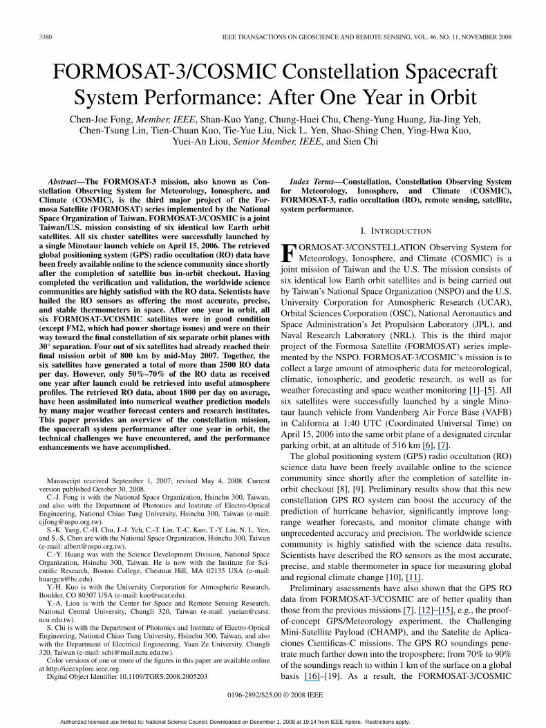
The FORMOSAT-3/COSMIC mission requirements weredefined by NSPO and UCAR in order to meet the needs of theatmospheric science communities. NSPO served as the primecontractor for the development, deployment, and operations ofthe FORMOSAT-3/COSMIC spacecraft, while OSC providedthe spacecraft, integrated and tested the first Flight Model(FM), and delivered the ready kits to NSPO for five additionalspacecraft. NSPO integrated and tested FMs 2–6 in the SatelliteIntegration and Test facility in Hsinchu, Taiwan, and thencoordinated the effort to integrate the six spacecraft in a stackconfiguration with the Minotaur launch vehicle provided by theU.S. Air Force at VAFB in California. UCAR provided the pay-load suite of scientific instruments and the science data process-ing of scientific instruments. Each spacecraft is equipped witha GPS Occultation Experimental Receiver (GOX) payload,developed by JPL and built by Broad Reach Engineering, a TinyIonospheric Photometer (TIP) built by NRL, and a Tri-BandBeacon (TBB), also provided by NRL. Table I shows theFORMOSAT-3/COSMIC mission characteristics, and Fig. 1shows the spacecraft in deployed configuration, along with itsmajor components [13]–[15].
After the successful launch of FORMOSAT-3/COSMICsatellites, NSPO conducted mission operations from the
Satellite Operations Control Center (SOCC) with support fromOSC, UCAR, and JPL for resolution of spacecraft anomalies,mission enhancement and scientific payload operations, andupdating GOX payload firmware, respectively. The missionoperation team in Taiwan is executing and managing all day-to-day activities of the system. Today, this team carefully con-ducts the deployment of the constellation and the constellationoperations schedule in order to ensure that measurements areglobally homogeneous and to minimize the latency of data fedinto weather prediction models [13]–[15], [24], [25].
All science data are processed by the UCAR COSMIC DataAnalysis and Archive Center (CDAAC) located in Boulder, CO,and then transferred to the Taiwan Analysis Center forCOSMIC at the CWB, as well as to other facilities for scienceand data archival [8], [9]. The processed results are then passedfrom the CDAAC to the U.S.’s National Environmental Satel-lite, Data, and Information Service at National Oceanic andAtmospheric Administration (NOAA). These data are furtherrouted to weather centers all over the world, including theJoint Center for Satellite Data Assimilation, NCEP, ECMWF,CWB, UKMO, the Japan Meteorological Agency, the Air ForceWeather Agency, and others. The data under the operationsteam’s integral teamwork effort are currently provided to theseweather centers within 90 min (data latency requirement is180 min) of satellite on-orbit science data collection in orderto be used by the operational weather forecast model [24], [25].
III. CONSTELLATION SPACECRAFT SYSTEM
PERFORMANCE: AFTER ONE YEAR IN ORBIT
A. Constellation Spacecraft Performance Summary
The FORMOSAT-3/COSMIC constellation provides aunique opportunity to assess the performance of multiplespacecraft at the same time. During the early weeks of thedeployment, the satellites were spaced very closely togetherand in cluster formation. This has offered scientists a uniqueopportunity to verify the high precision of GPS RO measure-ments. Table II shows the constellation spacecraft performancesummary as of April 15, 2007. After one year in orbit, allsix FORMOSAT-3/COSMIC spacecraft were in good condition(except for the FM2 satellite, which had power shortage issuessince March 2007) and were on their way toward the finalconstellation of six separate orbit planes with 30◦ separation[6], [7], [13]–[15].
B. Spacecraft Subsystem On-Orbit Performance Summary
Table III shows the operational status of each subsystem inall six spacecraft. Table IV shows the spacecraft subsystemperformance and its major functions. All the radio frequency(RF) uplink and downlink trend data show that the spacecraftmeet the specified RF subsystem requirements. Suspectedspace weather disturbances, which are correlated to thespacecraft onboard computer reboot and spacecraft resetevents, had no performance impact on the command and datahandling subsystem and spacecraft system. The flight softwaresubsystem (FSW) status of all six satellites is normal, and thespacecraft are recovered automatically as expected by design
Authorized licensed use limited to: National Science Council. Downloaded on December 1, 2008 at 19:14 from IEEE Xplore. Restrictions apply.
3382 IEEE TRANSACTIONS ON GEOSCIENCE AND REMOTE SENSING, VOL. 46, NO. 11, NOVEMBER 2008
Fig. 1. FORMOSAT-3/COSMIC spacecraft in deployed configuration.
TABLE IICONSTELLATION SPACECRAFT PERFORMANCE SUMMARY (APRIL 15, 2007)
TABLE IIISPACECRAFT OPERATION STATUS OF EACH SUBSYSTEM IN ALL SIX SPACECRAFT (APRIL 15, 2007)
Authorized licensed use limited to: National Science Council. Downloaded on December 1, 2008 at 19:14 from IEEE Xplore. Restrictions apply.
FONG et al.: FORMOSAT-3/COSMIC CONSTELLATION SPACECRAFT SYSTEM PERFORMANCE 3383
TABLE IVSPACECRAFT SUBSYSTEM PERFORMANCE (APRIL 15, 2007)
from abnormal reboot/reset conditions. Under normal FSWconditions, the error count is less than ten per day. The thermalcontrol subsystem is behaving nominally across the range of so-lar beta angles. There was an issue concerning excessive Earthhorizon sensor (EHS) temperature increases at high beta angles,which has been resolved by an operations solution of turningoff the secondary payloads during these periods [6], [24]–[26].
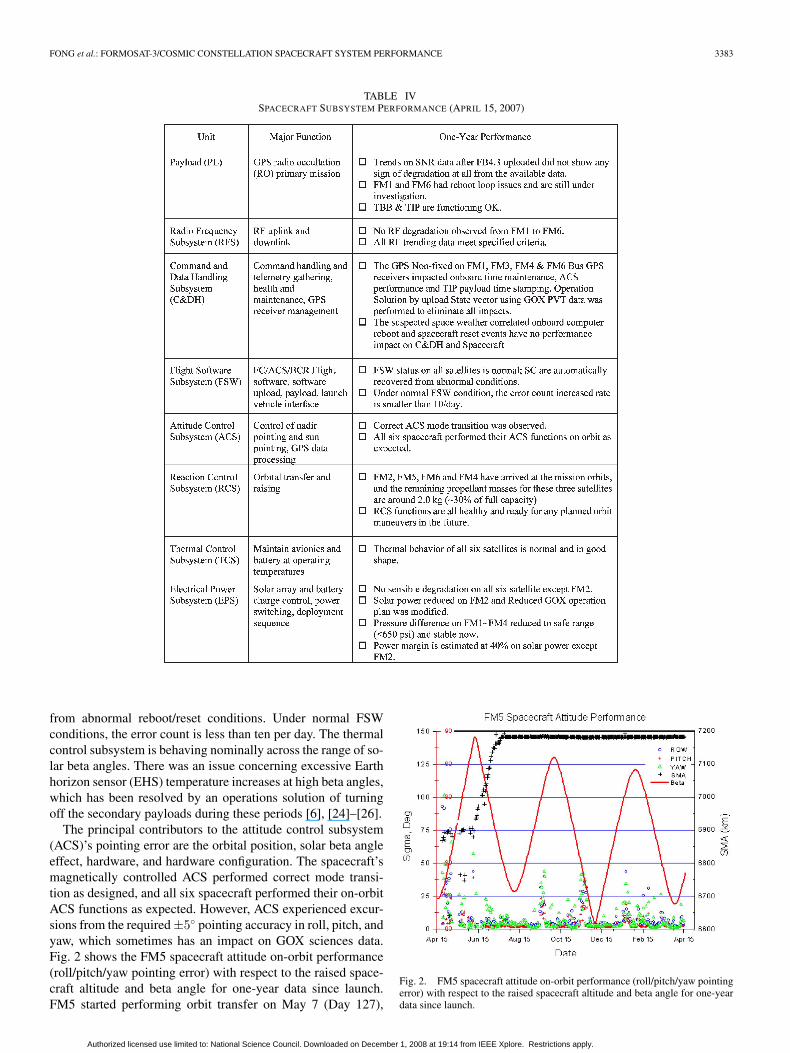
The principal contributors to the attitude control subsystem(ACS)’s pointing error are the orbital position, solar beta angleeffect, hardware, and hardware configuration. The spacecraft’smagnetically controlled ACS performed correct mode transi-tion as designed, and all six spacecraft performed their on-orbitACS functions as expected. However, ACS experienced excur-sions from the required ±5◦ pointing accuracy in roll, pitch, andyaw, which sometimes has an impact on GOX sciences data.Fig. 2 shows the FM5 spacecraft attitude on-orbit performance(roll/pitch/yaw pointing error) with respect to the raised space-craft altitude and beta angle for one-year data since launch.FM5 started performing orbit transfer on May 7 (Day 127),
Fig. 2. FM5 spacecraft attitude on-orbit performance (roll/pitch/yaw pointingerror) with respect to the raised spacecraft altitude and beta angle for one-yeardata since launch.
Authorized licensed use limited to: National Science Council. Downloaded on December 1, 2008 at 19:14 from IEEE Xplore. Restrictions apply.
3384 IEEE TRANSACTIONS ON GEOSCIENCE AND REMOTE SENSING, VOL. 46, NO. 11, NOVEMBER 2008
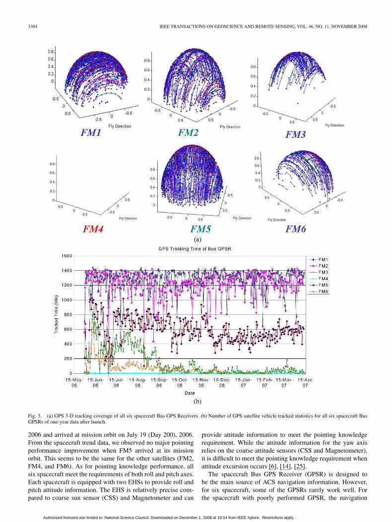
Fig. 3. (a) GPS 3-D tracking coverage of all six spacecraft Bus GPS Receivers. (b) Number of GPS satellite vehicle tracked statistics for all six spacecraft BusGPSRs of one-year data after launch.
2006 and arrived at mission orbit on July 19 (Day 200), 2006.From the spacecraft trend data, we observed no major pointingperformance improvement when FM5 arrived at its missionorbit. This seems to be the same for the other satellites (FM2,FM4, and FM6). As for pointing knowledge performance, allsix spacecraft meet the requirements of both roll and pitch axes.Each spacecraft is equipped with two EHSs to provide roll andpitch attitude information. The EHS is relatively precise com-pared to coarse sun sensor (CSS) and Magnetometer and can
provide attitude information to meet the pointing knowledgerequirement. While the attitude information for the yaw axisrelies on the coarse attitude sensors (CSS and Magnetometer),it is difficult to meet the pointing knowledge requirement whenattitude excursion occurs [6], [14], [25].
The spacecraft Bus GPS Receiver (GPSR) is designed tobe the main source of ACS navigation information. However,for six spacecraft, some of the GPSRs rarely work well. Forthe spacecraft with poorly performed GPSR, the navigation
Authorized licensed use limited to: National Science Council. Downloaded on December 1, 2008 at 19:14 from IEEE Xplore. Restrictions apply.
FONG et al.: FORMOSAT-3/COSMIC CONSTELLATION SPACECRAFT SYSTEM PERFORMANCE 3385
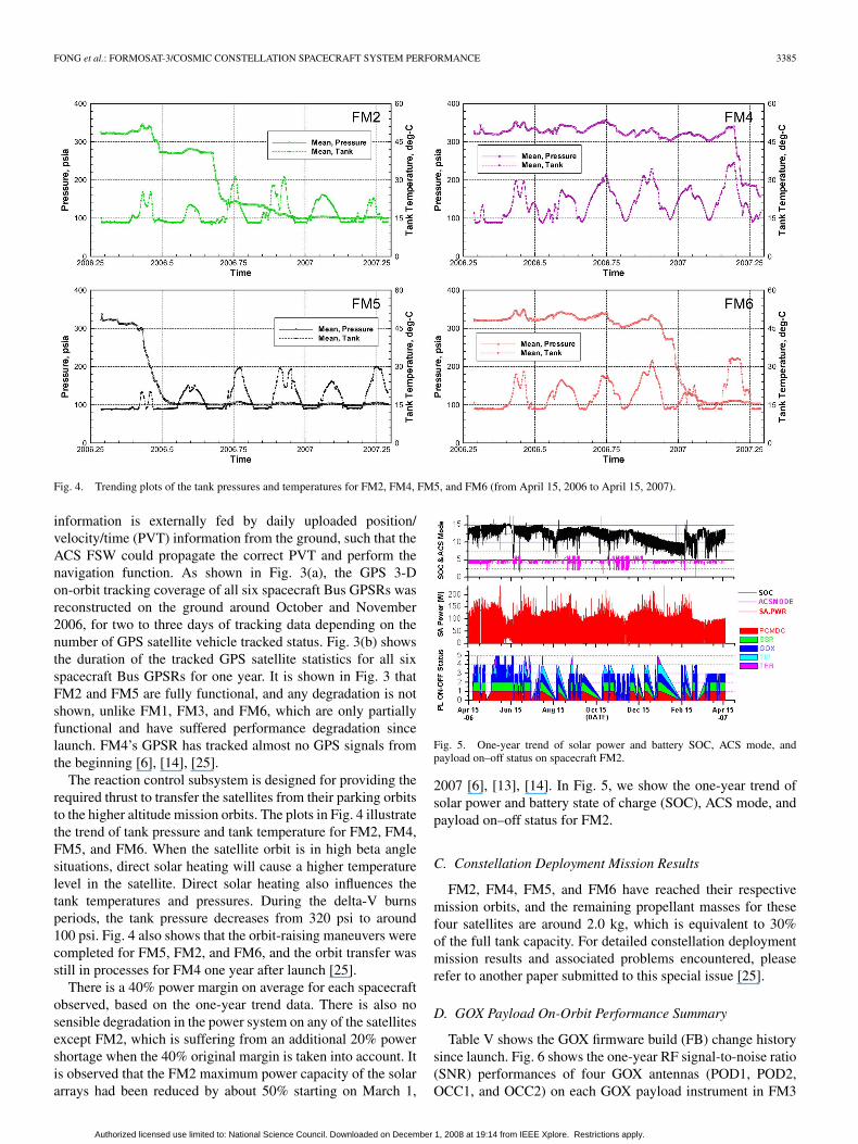
Fig. 4. Trending plots of the tank pressures and temperatures for FM2, FM4, FM5, and FM6 (from April 15, 2006 to April 15, 2007).
information is externally fed by daily uploaded position/velocity/time (PVT) information from the ground, such that theACS FSW could propagate the correct PVT and perform thenavigation function. As shown in Fig. 3(a), the GPS 3-Don-orbit tracking coverage of all six spacecraft Bus GPSRs wasreconstructed on the ground around October and November2006, for two to three days of tracking data depending on thenumber of GPS satellite vehicle tracked status. Fig. 3(b) showsthe duration of the tracked GPS satellite statistics for all sixspacecraft Bus GPSRs for one year. It is shown in Fig. 3 thatFM2 and FM5 are fully functional, and any degradation is notshown, unlike FM1, FM3, and FM6, which are only partiallyfunctional and have suffered performance degradation sincelaunch. FM4’s GPSR has tracked almost no GPS signals fromthe beginning [6], [14], [25].
The reaction control subsystem is designed for providing therequired thrust to transfer the satellites from their parking orbitsto the higher altitude mission orbits. The plots in Fig. 4 illustratethe trend of tank pressure and tank temperature for FM2, FM4,FM5, and FM6. When the satellite orbit is in high beta anglesituations, direct solar heating will cause a higher temperaturelevel in the satellite. Direct solar heating also influences thetank temperatures and pressures. During the delta-V burnsperiods, the tank pressure decreases from 320 psi to around100 psi. Fig. 4 also shows that the orbit-raising maneuvers werecompleted for FM5, FM2, and FM6, and the orbit transfer wasstill in processes for FM4 one year after launch [25].
There is a 40% power margin on average for each spacecraftobserved, based on the one-year trend data. There is also nosensible degradation in the power system on any of the satellitesexcept FM2, which is suffering from an additional 20% powershortage when the 40% original margin is taken into account. Itis observed that the FM2 maximum power capacity of the solararrays had been reduced by about 50% starting on March 1,
Fig. 5. One-year trend of solar power and battery SOC, ACS mode, andpayload on–off status on spacecraft FM2.
2007 [6], [13], [14]. In Fig. 5, we show the one-year trend ofsolar power and battery state of charge (SOC), ACS mode, andpayload on–off status for FM2.
C. Constellation Deployment Mission Results
FM2, FM4, FM5, and FM6 have reached their respectivemission orbits, and the remaining propellant masses for thesefour satellites are around 2.0 kg, which is equivalent to 30%of the full tank capacity. For detailed constellation deploymentmission results and associated problems encountered, pleaserefer to another paper submitted to this special issue [25].
D. GOX Payload On-Orbit Performance Summary
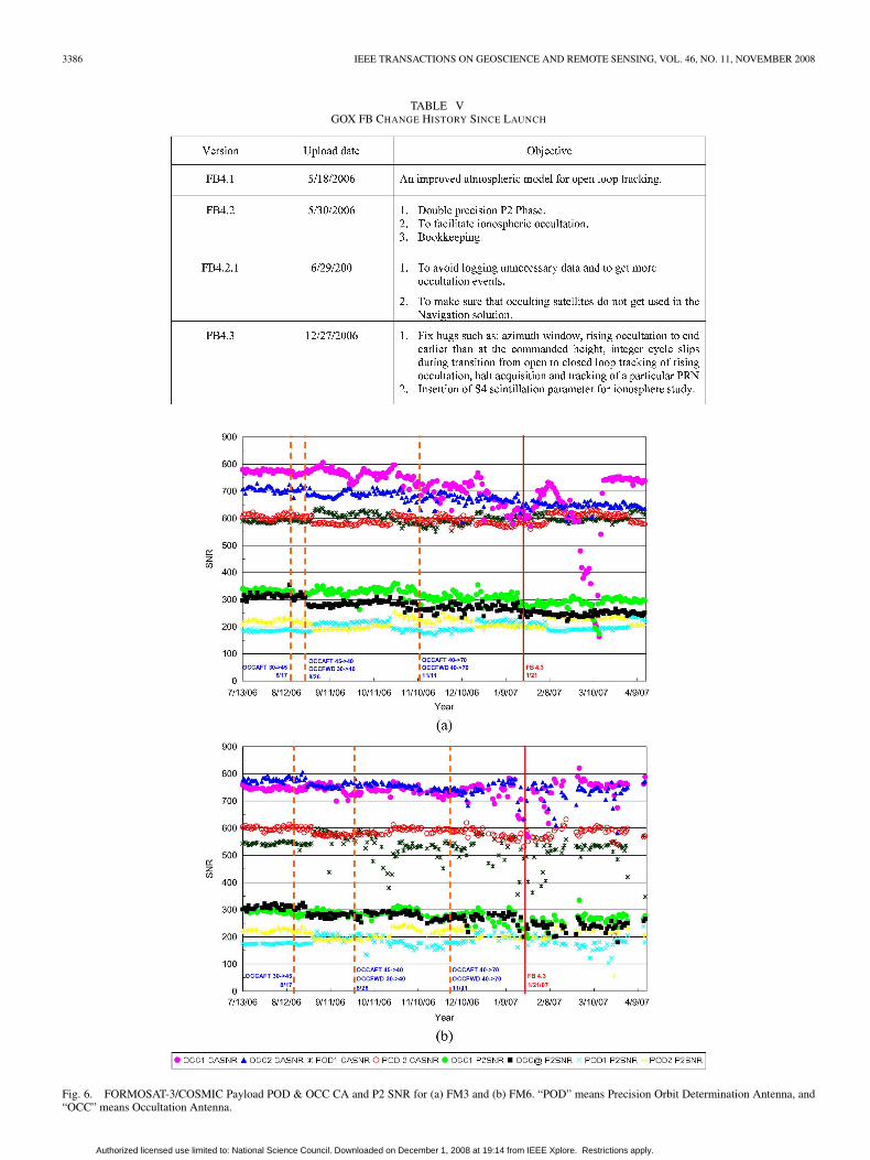
Table V shows the GOX firmware build (FB) change historysince launch. Fig. 6 shows the one-year RF signal-to-noise ratio(SNR) performances of four GOX antennas (POD1, POD2,OCC1, and OCC2) on each GOX payload instrument in FM3
Authorized licensed use limited to: National Science Council. Downloaded on December 1, 2008 at 19:14 from IEEE Xplore. Restrictions apply.
3386 IEEE TRANSACTIONS ON GEOSCIENCE AND REMOTE SENSING, VOL. 46, NO. 11, NOVEMBER 2008
TABLE VGOX FB CHANGE HISTORY SINCE LAUNCH
Fig. 6. FORMOSAT-3/COSMIC Payload POD & OCC CA and P2 SNR for (a) FM3 and (b) FM6. “POD” means Precision Orbit Determination Antenna, and“OCC” means Occultation Antenna.
Authorized licensed use limited to: National Science Council. Downloaded on December 1, 2008 at 19:14 from IEEE Xplore. Restrictions apply.
FONG et al.: FORMOSAT-3/COSMIC CONSTELLATION SPACECRAFT SYSTEM PERFORMANCE 3387
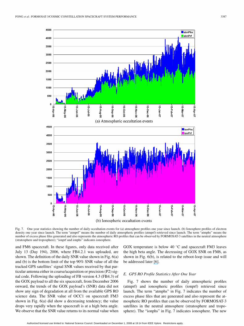
Fig. 7. One-year statistics showing the number of daily occultation events for (a) atmosphere profiles one year since launch. (b) Ionosphere profiles of electrondensity one year since launch. The term “atmprf” means the number of daily atmospheric profiles (atmprf) retrieved since launch. The term “atmphs” means thenumber of excess phase files generated and also represents the atmospheric RO profiles that can be observed by FORMOSAT-3 satellites in the neutral atmosphere(stratosphere and troposphere); “ionprf and ionphs” indicates ionosphere.
and FM6 spacecraft. In these figures, only data received afterJuly 13 (Day 194), 2006, where FB4.2.1 was uploaded, areshown. The definition of the daily SNR value shown in Fig. 6(a)and (b) is the bottom limit of the top 90% SNR value of all thetracked GPS satellites’ signal SNR values received by that par-ticular antenna either in coarse/acquisition or precision (P2) sig-nal code. Following the uploading of FB version 4.3 (FB4.3) ofthe GOX payload to all the six spacecraft, from December 2006onward, the trends of the GOX payload’s (SNR) data did notshow any sign of degradation at all from the available GPS ROscience data. The SNR value of OCC1 on spacecraft FM3shown in Fig. 6(a) did show a decreasing tendency; the valuedrops very rapidly when the spacecraft is at a high beta angle.We observe that the SNR value returns to its normal value when
GOX temperature is below 40 ◦C and spacecraft FM3 leavesthe high beta angle. The decreasing of GOX SNR on FM6, asshown in Fig. 6(b), is related to the reboot-loop issue and willbe addressed later [6].
E. GPS RO Profile Statistics After One Year
Fig. 7 shows the number of daily atmospheric profiles(atmprf) and ionospheric profiles (ionprf) retrieved sincelaunch. The term “atmphs” in Fig. 7 indicates the number ofexcess phase files that are generated and also represent the at-mospheric RO profiles that can be observed by FORMOSAT-3satellites in the neutral atmosphere (stratosphere and tropo-sphere). The “ionphs” in Fig. 7 indicates ionosphere. The new
Authorized licensed use limited to: National Science Council. Downloaded on December 1, 2008 at 19:14 from IEEE Xplore. Restrictions apply.
3388 IEEE TRANSACTIONS ON GEOSCIENCE AND REMOTE SENSING, VOL. 46, NO. 11, NOVEMBER 2008
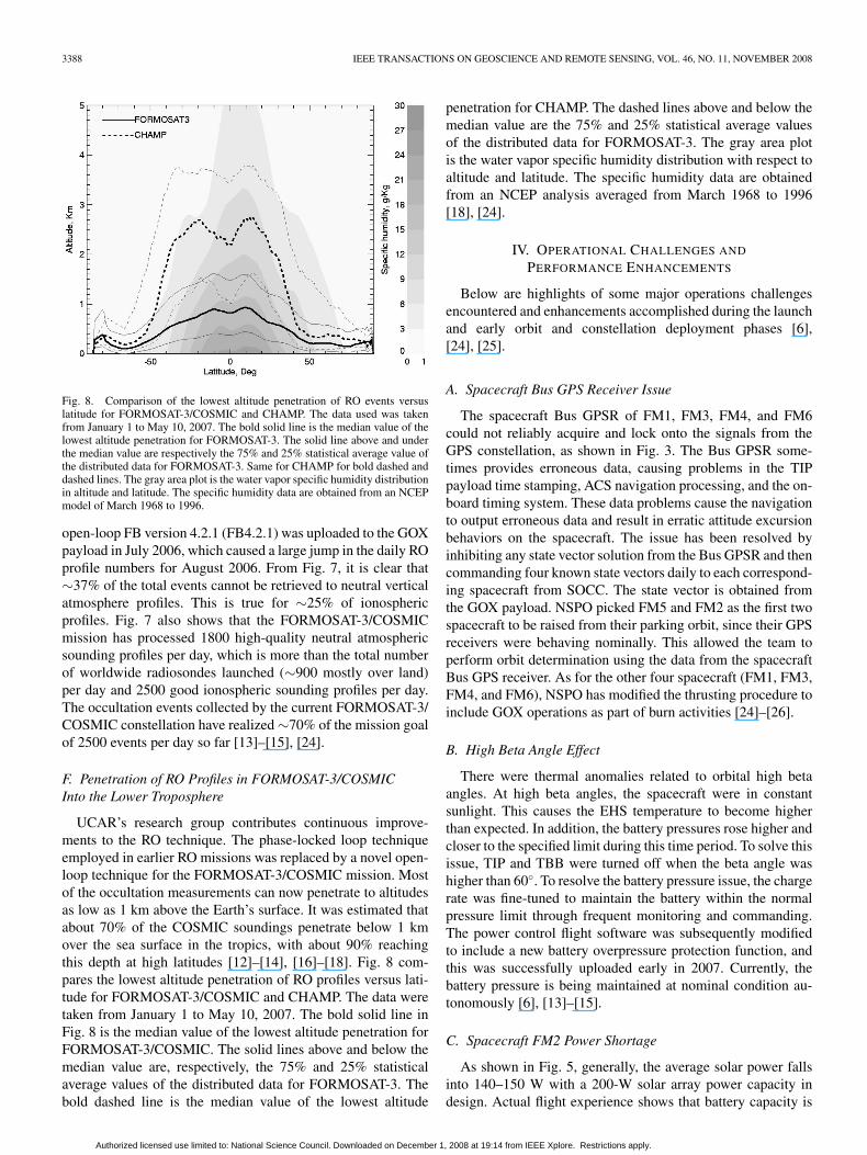
Fig. 8. Comparison of the lowest altitude penetration of RO events versuslatitude for FORMOSAT-3/COSMIC and CHAMP. The data used was takenfrom January 1 to May 10, 2007. The bold solid line is the median value of thelowest altitude penetration for FORMOSAT-3. The solid line above and underthe median value are respectively the 75% and 25% statistical average value ofthe distributed data for FORMOSAT-3. Same for CHAMP for bold dashed anddashed lines. The gray area plot is the water vapor specific humidity distributionin altitude and latitude. The specific humidity data are obtained from an NCEPmodel of March 1968 to 1996.
open-loop FB version 4.2.1 (FB4.2.1) was uploaded to the GOXpayload in July 2006, which caused a large jump in the daily ROprofile numbers for August 2006. From Fig. 7, it is clear that∼37% of the total events cannot be retrieved to neutral verticalatmosphere profiles. This is true for ∼25% of ionosphericprofiles. Fig. 7 also shows that the FORMOSAT-3/COSMICmission has processed 1800 high-quality neutral atmosphericsounding profiles per day, which is more than the total numberof worldwide radiosondes launched (∼900 mostly over land)per day and 2500 good ionospheric sounding profiles per day.The occultation events collected by the current FORMOSAT-3/COSMIC constellation have realized ∼70% of the mission goalof 2500 events per day so far [13]–[15], [24].
F. Penetration of RO Profiles in FORMOSAT-3/COSMICInto the Lower Troposphere
UCAR’s research group contributes continuous improve-ments to the RO technique. The phase-locked loop techniqueemployed in earlier RO missions was replaced by a novel open-loop technique for the FORMOSAT-3/COSMIC mission. Mostof the occultation measurements can now penetrate to altitudesas low as 1 km above the Earth’s surface. It was estimated thatabout 70% of the COSMIC soundings penetrate below 1 kmover the sea surface in the tropics, with about 90% reachingthis depth at high latitudes [12]–[14], [16]–[18]. Fig. 8 com-pares the lowest altitude penetration of RO profiles versus lati-tude for FORMOSAT-3/COSMIC and CHAMP. The data weretaken from January 1 to May 10, 2007. The bold solid line inFig. 8 is the median value of the lowest altitude penetration forFORMOSAT-3/COSMIC. The solid lines above and below themedian value are, respectively, the 75% and 25% statisticalaverage values of the distributed data for FORMOSAT-3. Thebold dashed line is the median value of the lowest altitude
penetration for CHAMP. The dashed lines above and below themedian value are the 75% and 25% statistical average valuesof the distributed data for FORMOSAT-3. The gray area plotis the water vapor specific humidity distribution with respect toaltitude and latitude. The specific humidity data are obtainedfrom an NCEP analysis averaged from March 1968 to 1996[18], [24].
IV. OPERATIONAL CHALLENGES AND
PERFORMANCE ENHANCEMENTS
Below are highlights of some major operations challengesencountered and enhancements accomplished during the launchand early orbit and constellation deployment phases [6],[24], [25].
A. Spacecraft Bus GPS Receiver Issue
The spacecraft Bus GPSR of FM1, FM3, FM4, and FM6could not reliably acquire and lock onto the signals from theGPS constellation, as shown in Fig. 3. The Bus GPSR some-times provides erroneous data, causing problems in the TIPpayload time stamping, ACS navigation processing, and the on-board timing system. These data problems cause the navigationto output erroneous data and result in erratic attitude excursionbehaviors on the spacecraft. The issue has been resolved byinhibiting any state vector solution from the Bus GPSR and thencommanding four known state vectors daily to each correspond-ing spacecraft from SOCC. The state vector is obtained fromthe GOX payload. NSPO picked FM5 and FM2 as the first twospacecraft to be raised from their parking orbit, since their GPSreceivers were behaving nominally. This allowed the team toperform orbit determination using the data from the spacecraftBus GPS receiver. As for the other four spacecraft (FM1, FM3,FM4, and FM6), NSPO has modified the thrusting procedure toinclude GOX operations as part of burn activities [24]–[26].
B. High Beta Angle Effect
There were thermal anomalies related to orbital high betaangles. At high beta angles, the spacecraft were in constantsunlight. This causes the EHS temperature to become higherthan expected. In addition, the battery pressures rose higher andcloser to the specified limit during this time period. To solve thisissue, TIP and TBB were turned off when the beta angle washigher than 60◦. To resolve the battery pressure issue, the chargerate was fine-tuned to maintain the battery within the normalpressure limit through frequent monitoring and commanding.The power control flight software was subsequently modifiedto include a new battery overpressure protection function, andthis was successfully uploaded early in 2007. Currently, thebattery pressure is being maintained at nominal condition au-tonomously [6], [13]–[15].
C. Spacecraft FM2 Power Shortage
As shown in Fig. 5, generally, the average solar power fallsinto 140–150 W with a 200-W solar array power capacity indesign. Actual flight experience shows that battery capacity is
Authorized licensed use limited to: National Science Council. Downloaded on December 1, 2008 at 19:14 from IEEE Xplore. Restrictions apply.
FONG et al.: FORMOSAT-3/COSMIC CONSTELLATION SPACECRAFT SYSTEM PERFORMANCE 3389
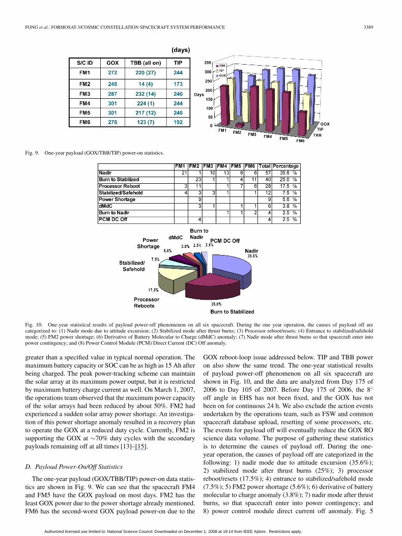
Fig. 9. One-year payload (GOX/TBB/TIP) power-on statistics.
Fig. 10. One-year statistical results of payload power-off phenomenon on all six spacecraft. During the one year operation, the causes of payload off arecategorized to: (1) Nadir mode due to attitude excursion; (2) Stabilized mode after thrust burns; (3) Processor reboot/resets; (4) Entrance to stabilized/safeholdmode; (5) FM2 power shortage; (6) Derivative of Battery Molecular to Charge (dMdC) anomaly; (7) Nadir mode after thrust burns so that spacecraft enter intopower contingency; and (8) Power Control Module (PCM) Direct Current (DC) Off anomaly.
greater than a specified value in typical normal operation. Themaximum battery capacity or SOC can be as high as 15 Ah afterbeing charged. The peak power-tracking scheme can maintainthe solar array at its maximum power output, but it is restrictedby maximum battery charge current as well. On March 1, 2007,the operations team observed that the maximum power capacityof the solar arrays had been reduced by about 50%. FM2 hadexperienced a sudden solar array power shortage. An investiga-tion of this power shortage anomaly resulted in a recovery planto operate the GOX at a reduced duty cycle. Currently, FM2 issupporting the GOX at ∼70% duty cycles with the secondarypayloads remaining off at all times [13]–[15].
D. Payload Power-On/Off Statistics
The one-year payload (GOX/TBB/TIP) power-on data statis-tics are shown in Fig. 9. We can see that the spacecraft FM4and FM5 have the GOX payload on most days. FM2 has theleast GOX power due to the power shortage already mentioned.FM6 has the second-worst GOX payload power-on due to the
GOX reboot-loop issue addressed below. TIP and TBB poweron also show the same trend. The one-year statistical resultsof payload power-off phenomenon on all six spacecraft areshown in Fig. 10, and the data are analyzed from Day 175 of2006 to Day 105 of 2007. Before Day 175 of 2006, the 8◦
off angle in EHS has not been fixed, and the GOX has notbeen on for continuous 24 h. We also exclude the action eventsundertaken by the operations team, such as FSW and commonspacecraft database upload, resetting of some processors, etc.The events for payload off will eventually reduce the GOX ROscience data volume. The purpose of gathering these statisticsis to determine the causes of payload off. During the one-year operation, the causes of payload off are categorized in thefollowing: 1) nadir mode due to attitude excursion (35.6%);2) stabilized mode after thrust burns (25%); 3) processorreboot/resets (17.5%); 4) entrance to stabilized/safehold mode(7.5%); 5) FM2 power shortage (5.6%); 6) derivative of batterymolecular to charge anomaly (3.8%); 7) nadir mode after thrustburns, so that spacecraft enter into power contingency; and8) power control module direct current off anomaly. Fig. 5
Authorized licensed use limited to: National Science Council. Downloaded on December 1, 2008 at 19:14 from IEEE Xplore. Restrictions apply.
3390 IEEE TRANSACTIONS ON GEOSCIENCE AND REMOTE SENSING, VOL. 46, NO. 11, NOVEMBER 2008
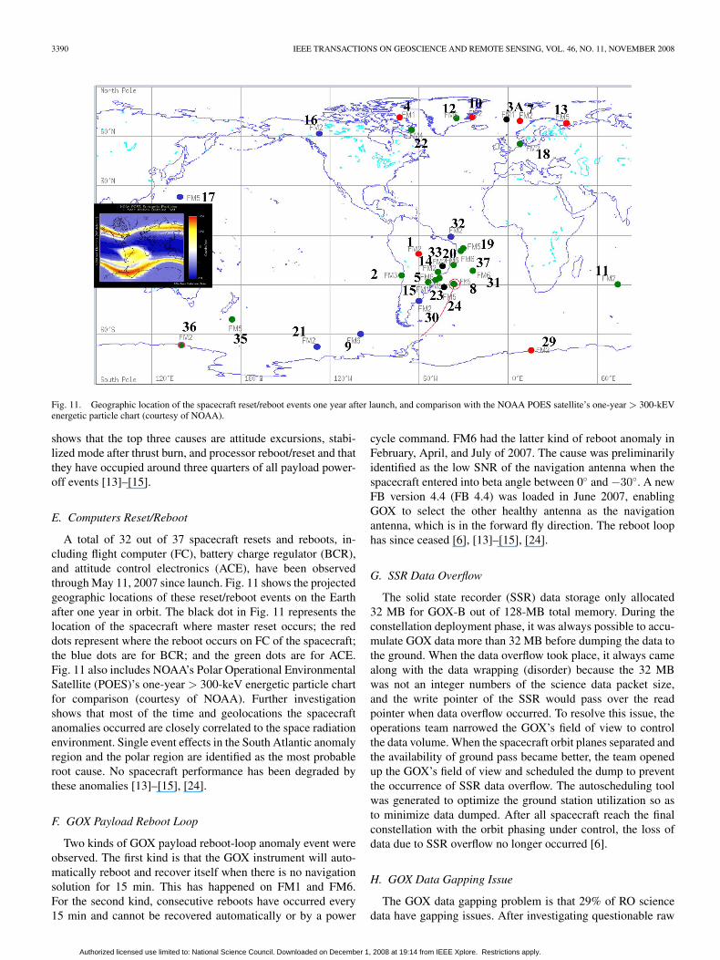
Fig. 11. Geographic location of the spacecraft reset/reboot events one year after launch, and comparison with the NOAA POES satellite’s one-year > 300-kEVenergetic particle chart (courtesy of NOAA).
shows that the top three causes are attitude excursions, stabi-lized mode after thrust burn, and processor reboot/reset and thatthey have occupied around three quarters of all payload power-off events [13]–[15].
E. Computers Reset/Reboot
A total of 32 out of 37 spacecraft resets and reboots, in-cluding flight computer (FC), battery charge regulator (BCR),and attitude control electronics (ACE), have been observedthrough May 11, 2007 since launch. Fig. 11 shows the projectedgeographic locations of these reset/reboot events on the Earthafter one year in orbit. The black dot in Fig. 11 represents thelocation of the spacecraft where master reset occurs; the reddots represent where the reboot occurs on FC of the spacecraft;the blue dots are for BCR; and the green dots are for ACE.Fig. 11 also includes NOAA’s Polar Operational EnvironmentalSatellite (POES)’s one-year > 300-keV energetic particle chartfor comparison (courtesy of NOAA). Further investigationshows that most of the time and geolocations the spacecraftanomalies occurred are closely correlated to the space radiationenvironment. Single event effects in the South Atlantic anomalyregion and the polar region are identified as the most probableroot cause. No spacecraft performance has been degraded bythese anomalies [13]–[15], [24].
F. GOX Payload Reboot Loop
Two kinds of GOX payload reboot-loop anomaly event wereobserved. The first kind is that the GOX instrument will auto-matically reboot and recover itself when there is no navigationsolution for 15 min. This has happened on FM1 and FM6.For the second kind, consecutive reboots have occurred every15 min and cannot be recovered automatically or by a power
cycle command. FM6 had the latter kind of reboot anomaly inFebruary, April, and July of 2007. The cause was preliminarilyidentified as the low SNR of the navigation antenna when thespacecraft entered into beta angle between 0◦ and −30◦. A newFB version 4.4 (FB 4.4) was loaded in June 2007, enablingGOX to select the other healthy antenna as the navigationantenna, which is in the forward fly direction. The reboot loophas since ceased [6], [13]–[15], [24].
G. SSR Data Overflow
The solid state recorder (SSR) data storage only allocated32 MB for GOX-B out of 128-MB total memory. During theconstellation deployment phase, it was always possible to accu-mulate GOX data more than 32 MB before dumping the data tothe ground. When the data overflow took place, it always camealong with the data wrapping (disorder) because the 32 MBwas not an integer numbers of the science data packet size,and the write pointer of the SSR would pass over the readpointer when data overflow occurred. To resolve this issue, theoperations team narrowed the GOX’s field of view to controlthe data volume. When the spacecraft orbit planes separated andthe availability of ground pass became better, the team openedup the GOX’s field of view and scheduled the dump to preventthe occurrence of SSR data overflow. The autoscheduling toolwas generated to optimize the ground station utilization so asto minimize data dumped. After all spacecraft reach the finalconstellation with the orbit phasing under control, the loss ofdata due to SSR overflow no longer occurred [6].
H. GOX Data Gapping Issue
The GOX data gapping problem is that 29% of RO sciencedata have gapping issues. After investigating questionable raw
Authorized licensed use limited to: National Science Council. Downloaded on December 1, 2008 at 19:14 from IEEE Xplore. Restrictions apply.
FONG et al.: FORMOSAT-3/COSMIC CONSTELLATION SPACECRAFT SYSTEM PERFORMANCE 3391
data, we found that a similar data dropout pattern has beenobserved in the ground End-To-End (ETE) tests. However, theon-orbit gapping issue is much worse than that found in theETE tests. Through several analyses and tests, it was concludedthat when dumping the stored spacecraft data and science datasimultaneously, the data dropouts are the worst. The operationsteam made these two data dumps separately to recover the datadropout issue, and rescued 70% of the lost data. Even whenthe science data are downloaded alone, the data dropouts stillcause 8% of data gapping. A typical dump has a very smallamount of data dropouts (∼0.04%), but it actually causes 8%of RO data gapping. The remedy for reducing data gappingis to dump the same science data twice. Eventually, these twodumps will not drop the same data packets, so we can makeup any dropout. The saved data from double dumps are onlyabout 0.04% of the whole data volume, but the RO data willincrease 8%. Hence, even though double dumps increase localdata storage and double the data transfer time from groundstation to the data analysis center, they are still worthwhile. [6],[13], [14], [24].
I. Assimilation in Numerical Weather Prediction Models
The ECMWF and the NCEP are assimilating the RO datainto their real-time operational forecast systems. Preliminaryresults have shown that the FORMOSAT-3/COSMIC dataimprove the prediction of typhoon/hurricane tracks, includingwhen and where they will hit land. ECMWF shows that theFORMOSAT-3/COSMIC measurements improve the accuracyof their forecasts by about 11% in the Southern Hemisphere at100 mb. More than 70% of the data have a latency of less than3 h as reported by ECMWF [12], [20]. NCEP’s studies haveshown that their forecasts have significantly improved inaccuracy when the FORMOSAT-3/COSMIC data are assimi-lated into the system [12], [21]. Taiwan’s CWB has reportedthat the contribution of FORMOSAT-3/COSMIC has advancedtheir prediction capabilities by two years [27].
J. Impact on Ionospheric Space Weather Structure
The launch of the innovative FORMOSAT-3/COSMIC satel-lite constellation has ushered in a new era of studying the effectsof ionospheric space weather [28], [29]. Taking advantage ofdense global 3-D observation coverage, a new ionosphericstructure and some important atmosphere–ionosphere couplingtheories have been proposed and verified based on observa-tions made [28]. A newly discovered ionospheric structure,namely, the low-latitude ionospheric plasma cave, shows adepleted plasma region underneath the region of strongestplasma concentration [28]. Meticulous observation of this newionospheric structure will certainly improve our fundamentalunderstanding of ionospheric dynamics and will be beneficialin evaluating ionospheric effects on the space environmentand on communications through space. The data providedby FORMOSAT-3/COSMIC have also uncovered a uniqueionospheric structure, which could possibly be associatedwith tropical rainstorms and is proposed to be formed by anatmosphere–ionosphere coupling process [29]. FORMOSAT-3/
COSMIC’s capability to observe vertical plasma distributionacross a 24-h period led to the verification of a plausi-ble physical mechanism of this unique ionospheric structure.The influences of the tropical rainstorms and atmosphericweather have been included as considerations for space weather[28], [29].
V. CONCLUSION
We have summarized the satellite constellation system per-formance after one year in orbit. All six spacecraft are in goodcondition after six satellite years of operation and were on theirway toward the final constellation. With the development andapplication of the open-loop tracking technique by JPL andUCAR, the quality, accuracy, and lowest penetration altitude ofthe RO sounding profiles have been improved in comparisonto previous RO missions. As of April 15, 2007, about 1800high-quality soundings were being retrieved daily on a globalbasis. The constellation spacecraft system on-orbit performancewill be constantly monitored, tracked, evaluated, and enhancedby NSPO’s operations team in the future. It is anticipatedthat an increasing number of global operational centers willuse FORMOSAT-3/COSMIC data operationally for the yearsto come.
ACKNOWLEDGMENT
The authors would like to thank the spacecraft team, par-ticularly M.-S. Chang, A. Chang, R. Lo, and Y. Hsu, forproviding one-year statistical trend data in various subsystems.The authors would also like to thank Dr. C. H. Lin of NSPO forsummarizing the ionosphere research portion.
REFERENCES
[1] R. A. Anthes, C. Rocken, and Y. H. Kuo, “Application of COSMIC tometeorology and climate,” Terrestrial, Atmos. Ocean. Sciences (TAO),vol. 11, no. 1, pp. 115–156, Mar. 2000.
[2] T. P. Yunck, C. H. Liu, and R. Ware, “A history of GPS sounding,”Terrestrial, Atmos. Ocean. Sciences (TAO), vol. 11, no. 1, pp. 1–20,Mar. 2000.
[3] Y.-H. Kuo, T.-K. Wee, S. Sokolovskiy, C. Rocken, W. Schreiner,D. Hunt, and R. A. Anthes, “Inversion and error estimation of GPS radiooccultation data,” J. Meteorol. Soc. Jpn., vol. 82, no. 1B, pp. 507–531,2004.
[4] A. Rius, G. Ruffini, and A. Romeo, “Analysis of ionospheric electrondensity distribution from GPS/MET occultations,” IEEE Trans. Geosci.Remote Sens., vol. 36, no. 2, pp. 383–394, Mar. 1998.
[5] J. M. Pallares, G. Ruffini, and L. Ruffini, “Ionospheric tomography usingGNSS reflections,” IEEE Trans. Geosci. Remote Sens., vol. 43, no. 2,pp. 321–326, Feb. 2003.
[6] C.-J. Fong, N. L. Yen, C.-H. Chu, S.-K. Yang, W.-T. Shiau, C.-Y. Huang,S. Chi, S.-S. Chen, Y. A. Liou, and Y. H. Kuo, “FORMOSAT-3/COSMICspacecraft constellation system, mission results, and prospect for follow-on mission,” Terr., Atmos. Ocean. Sci. (TAO), vol. 20, no. 1, Jan. 2009.
[7] Y.-A. Liou, A. G. Pavelyev, S.-F. Liu, A. A. Pavelyev, N. Yen,C.-Y. Huang, and C.-J. Fong, “FORMOSAT-3/COSMIC GPS radio occul-tation mission: Preliminary results,” IEEE Trans. Geosci. Remote Sens.,vol. 45, no. 11, pp. 3813–3826, Nov. 2007. DOI: 10.1109/TGRS.2007.903365.
[8] TACC Website. [Online]. Available: http://tacc.cwb.gov.tw/en/index.htm[9] CDAAC Website. [Online]. Available: http://cosmic-io.cosmic.ucar.edu/
cdaac/index.html[10] R. Anthes, “Welcome to a new era!” in Proc. FORMOSAT-3/COSMIC
Workshop—Early Results IOP Campaign, Taipei, Taiwan, Nov. 28–Dec. 1, 2006.
Authorized licensed use limited to: National Science Council. Downloaded on December 1, 2008 at 19:14 from IEEE Xplore. Restrictions apply.
3392 IEEE TRANSACTIONS ON GEOSCIENCE AND REMOTE SENSING, VOL. 46, NO. 11, NOVEMBER 2008
[11] C.-H. Chu, S.-K. Yang, C.-J. Fong, N. Yen, T.-Y. Liu, W.-J. Chen,D. Hawes, Y.-A. Liou, and Y.-H. Kuo, “The most accurate and stablespaceborne thermometers—FORMOSAT-3/COSMIC constellation,” inProc. 21st Annu. AIAA/USU Conf. Small Satell., Logan, UT, Aug. 13–16,2007, vol. SSC07-VII-1.
[12] R. A. Anthes, P. A. Bernhardt, Y. Chen, L. Cucurull, K. F. Dymond,D. Ector, S. B. Healy, S.-P. Ho, D. C. Hunt, Y.-H. Kuo, H. Liu,K. Manning, C. McCormick, T. K. Mehan, W. J. Randel, C. Rocken,W. S. Schreiner, S. V. Sokolovskiy, S. Syndergaard, D. C. Thompson,K. E. Trenberth, T. K. Wee, N. L. Yen, and Z. Zeng, “The COSMIC/FORMOSAT-3 mission: Early results,” Bull. Amer. Meteorol. Soc.(BAMS), vol. 89, no. 3, pp. 313–333, Mar. 2008. DOI: 10.1175/BAMS-89-3-313.
[13] C.-J. Fong, C. Y. Huang, V. Chu, A. Shiau, E. Yang, N. Yen, S. S. Chao,D. Hawes, Y.-H. Kuo, Y.-A. Liou, and S. Chi, “Mission results fromFORMOSAT-3/COSMIC constellation system,” presented at the AIAASPACE Conf. Expo., Long Beach, CA, Sep. 18–20, 2007, Paper No.AIAA-2007-6086.
[14] C.-J. Fong, C. Y. Huang, V. Chu, N. Yen, Y.-H. Kuo, Y.-A. Liou, andS. Chi, “Mission results from FORMOSAT-3/COSMIC constellation sys-tem,” J. Spacecr. Rockets, 2008, to be published.
[15] C.-J. Fong, N. Yen, S. K. Yang, S. S. Chen, and S. Chi, “GPS radiooccultation and mission results from FORMOSAT-3/COSMIC space-craft constellation,” in Proc. 3rd Int. Conf. Recent Advances Space-craft Technol., Istanbul, Turkey, Jun. 14–16, 2007, pp. 748–753. DOI:10.1109/RAST.2007.4284093.
[16] S. Sokolovskiy, C. Rocken, D. Hunt, W. Schreiner, J. Johnson,D. Masters, and S. Esterhuizen, “GPS profiling of the lower tropospherefrom space: Inversion and demodulation of the open-loop radio occulta-tion signals,” Geophys. Res. Lett., vol. 33, no. 14, p. L14 816, Jul. 2006.DOI: 10.1029/2006GL026112.
[17] W. Schreiner, C. Rocken, S. Sokolovskiy, S. Syndergaard, andD. Hunt, “Estimates of the precision of GPS radio occultations from theCOSMIC/FORMOSAT-3 mission,” Geophys. Res. Lett., vol. 34, no. 4,Feb. 2007. L04 808.
[18] C.-Y. Huang, C. Z. Cheng, P. H. Lin, C. J. Fong, J. Wicker, andC. C. Hsiao, “Radio occultation retrieval of atmospheric profiles in theFORMOSAT-3/COSMIC mission: Current status,” Terr., Atmos. Ocean.Sci. (TAO), vol. 20, no. 1, Jan. 2009.
[19] K. W. Manning and Y. H. Kuo, “Using COSMIC refractivity profiles inan evaluation of Antarctic forecast models,” in Proc. 1st Formosat-3/COSMIC Data Users Workshop, Boulder, CO, Oct. 16–18,2006.
[20] S. Healy, “Assimilation of GPS radio occultation measurements atECMWF,” European Centre for Medium-range Weather Forecasts(ECMWF) Newsletter, Spring 2007. No. 111.
[21] “COSMIC data to be assimilated operationally at NOAA,” Joint Cen-ter for Satellite Data Assimilation (JCSDA) Quarterly, Mar. 2007.No. 18.
[22] COSMIC Website. [Online]. Available: http://www.cosmic.ucar.edu/[23] FORMOSAT-3 Website. [Online]. Available: http://www.nspo.org.tw/
2005e/projects/project3/[24] C.-J. Fong, N. Yen, V. Chu, S. S. Chen, and S. Chi, “Operations challenges
from the FORMOSAT-3/COSMIC constellation for global Earth weathermonitoring,” in Proc. IEEE Aerosp. Conf., Big Sky, MT, Mar. 3–10, 2007,pp. 1–14. DOI: 10.1109/AERO.2007.352986.
[25] C.-J. Fong, A. Shiau, T. Lin, T.-C. Kuo, C.-H. Chu, S.-K. Yang,N. Yen, S. S. Chen, C.-Y. Huang, Y.-H. Kuo, Y.-A. Liou, and S. Chi,“Constellation deployment for FORMOSAT-3/COSMIC mission,” IEEETrans. Geosci. Remote Sens., vol. 46, no. 11, Nov. 2008.
[26] C.-T. Lin and R.-Y. Liu, “On orbit performance and constellationdeployment lessons learnt of FORMOSAT-3/COSMIC satellite atti-tude control subsystem,” ESA GNC, Tralee, Kerry, Ireland, Jun. 2–5,2008.
[27] M. D. Cheng et al., FORMOSAT-3/COSMIC radio occultation data veri-fication report—March 2007, Mar. 2007, Taipei, Taiwan: Central WeatherBureau. (in Traditional Chinese), Internal Report.
[28] C. H. Lin, W. B. Wang, M. E. Hagan, C. C. Hsiao, T. J. Immel, M. L. Hsu,J. Y. Liu, L. J. Paxton, T. W. Fang, and C. H. Liu, “Plausible ef-fect of atmospheric tides on the equatorial ionosphere observed bythe FORMOSAT-3/COSMIC: Three-dimensional electron density struc-tures,” Geophys. Res. Lett., vol. 34, no. 11, p. L11 112, Jun. 2007. DOI:10.1029/2007GL029265.
[29] C. H. Lin, C. C. Hsiao, J. Y. Liu, and C. H. Liu, “Longitudinal structureof the equatorial ionosphere: Time evolution of the four-peaked EIAstructure,” J. Geophys. Res., vol. 112, no. A12, p. A12 305, Dec. 2007.DOI: 10.1029/2007JA012455.
Chen-Joe Fong (S’04–M’08) received the B.S.E.E.and M.S.E.E. degrees in electrophysics and elec-trooptical engineering from the National Chiao TungUniversity (NCTU), Hsinchu, Taiwan, in 1983 and1985, respectively, where he is currently workingtoward the Ph.D. degree in the Department of Pho-tonics and Institute of Electro-Optical Engineering.
He is also currently the FORMOSAT-3 pro-gram Systems Engineering Manager of NationalSpace Organization (NSPO), Hsinchu. During theFORMOSAT-3/COSMIC mission operation phase,
he is a Spacecraft Lead and responsible for the anomaly resolution team. Hehas been with NSPO since 1993, where he was a Satellite Integration & Test(I&T) Project Manager of ROCSAT-1 program and I&T division Director. From1987 to 1993, he was a Microwave Lab Head with the Center for MeasurementStandards and a Systems Engineer with the Center for Aviation and SpaceTechnology, Industrial Technology Research Institute, for ROCSAT-1 program.His current research interests include incoherent time-domain pump fiberRaman amplifier, optical soliton, GPS radio occultation, systems engineering,and mission simulation.
Mr. Fong is a member of AIAA, OSA, AASRC, and Phi Tau Phi.
Shan-Kuo (Eddy) Yang received the M.S. degree inengineering science from the National Cheng KungUniversity, Tainan, Taiwan, in 1987.
Since 1993, he has been with the National SpaceOrganization, Hsinchu, Taiwan, where he was incharge of End-To-End Test between ground seg-ment and space segment and in charge of the com-munication infrastructure setup and interphase testbetween SOCC and the remote ground stationsduring FORMOSAT-3 I&T phase. He is currentlythe Deputy Operation Director of FORMOSAT-3
Mission Operation Team. His current research interests include GPS radio oc-cultation for the FORMOSAT-3 follow-on mission, satellite simulator, missionplanning and scheduling, and long-term trending development.
Chung-Huei (Vicky) Chu received the B.S. degreein atmospheric sciences from the National TaiwanUniversity, Taipei, Taiwan and the M.S. degree inmeteorology from Penn State University, Univer-sity Park.
She is currently the FORMOSAT-3/COSMICMission Operations Manager of National SpaceOrganization, Hsinchu, Taiwan. She has worked onFORMOSAT series satellite programs since 1994.She spent one year in the development of sci-ence data processing, five years in the flight oper-
ations and ground operations, and six years in mission analysis and systemengineering.
Cheng-Yung Huang received the B.S. degree inatmospheric science, the M.S. degree, and Ph.D.degree in space science from the National CentralUniversity, Chungli, Taiwan, in 1995, 1997, and2005, respectively.
From 2005 to 2007, he was with the NationalSpace Organization, Hsinchu, Taiwan, where he de-veloped radio occultation atmospheric profile re-trieval method and analyzed the GPS OccultationExperiment data and provided science information tosupport FORMOSAT-3 satellites operation. He has
been a Post Doctor with the Institute for Scientific Research, Boston College,Chestnut Hill, MA, since November 2007. He is currently working on neutraldensity in ionosphere.
Authorized licensed use limited to: National Science Council. Downloaded on December 1, 2008 at 19:14 from IEEE Xplore. Restrictions apply.
FONG et al.: FORMOSAT-3/COSMIC CONSTELLATION SPACECRAFT SYSTEM PERFORMANCE 3393
Jia-Jing (James) Yeh received the B.S. and M.S.degrees in physics from the National Cheng KungUniversity, Tainan, Taiwan, in 1987 and 1989,respectively.
Since 1992, he has been with the National SpaceOrganization (NSPO), Hsinchu, Taiwan, where hasbeen responsible for the electrical power subsystemdevelopment of FORMOSAT series satellites. Healso served as a responsible Engineer for the valida-tion and testing engineering of subsystem as well assatellite launch countdown activities. Currently, he is
developing a satellite power simulator and leading a team to develop powercontrol electronics. He is currently in charge of Satellite Power Departmentin NSPO.
Chen-Tsung (Tom) Lin received the B.S. degree inelectrical engineering from the National Taiwan Uni-versity of Science and Technology, Taipei, Taiwan,in 1988, and the M.S. degree in control system en-gineering from the National Chiao Tung University,Hsinchu, Taiwan, in 1994.
He is currently with the National Space Or-ganization, Hsinchu, where he is responsible forFORMOSAT-2 and FORMOSAT-3 Attitude De-termination and Control Subsystem. His currentresearch interests include attitude determination,
attitude control, engineering development model, hardware in the loop test, andGPS simulation.
Tien-Chuan Kuo received the B.S., M.S., and Ph.D.degrees in nuclear engineering from the NationalTsing Hua University, Hsinchu, Taiwan, in 1988,1990, and 1996, respectively.
Since 1996, he has been with the National SpaceOrganization (NSPO), Hsinchu, where he is cur-rently in charge of the propulsion subsystem ofthe FORMOSAT-serious satellite programs as wellas the NSPO interior propulsion development pro-grams. He has 11-year design, analysis, and en-gineering experience of the spacecraft propulsion
system. He has also published 30 journals and conference papers in the areasof satellite propulsion, computational fluid dynamics, Monte Carlo simulations,multiphase flows, phase distribution mechanism, turbulent flow modeling, andparticle image velocimetry.
Dr. Kuo is a member of AIAA, NMA, and Phi Tau Phi.
Tie-Yue Liu received the B.S. degree in chemistryfrom Soochow University, Taipei, Taiwan, and thePh.D. degree from the University of South Florida,Tampa.
Since 1993, she has been with the NationalSpace Organization, Hsinchu, Taiwan, working onFORMOSAT series satellite programs. She coor-dinates domestic science projects and internationalcollaboration. Her current research interests includeradio occultation constellation science missions.
Nick L. Yen received the M.S. degree in mechan-ical engineering from the Oregon State University,Corvallis, in 1980.
He is with the National Space Organization,Hsinchu, Taiwan, in 2004 as the Deputy ProgramDirector and soon became the Program Directorof FORMOSAT-3/COSMIC Program. He was withthe Space Systems/Loral (SS/L), Palo Alto, CA,from 1992 to 2003. He held many key positions inSSL, including SUPERBIRD Senior System Engi-neer, MBSAT Antenna Subsystem Manager, Control
Mechanisms Department Manager, Launch Integration and Launch OperationDepartment Manager, and Europe∗Star Deputy Executive Director. Before that,he was with Ford Aerospace Corporation (former SS/L), Palo Alto, from 1986to 1992, where he was primarily an Antenna Design Engineer and AntennaProject Manager. Ford Aerospace Corporation was acquired by Loral Corpora-tion and became SS/L in 1992. He was with RCA, East Windsor, NJ, in 1985as an Antenna Design/Analysis Engineer. He was also with Ford AerospaceCorporation from 1981 to 1984, after the graduate school from Oregon StateUniversity, as an Antenna Design/Analysis Engineer. His current researchinterests include front-to-end process, systems engineering, and FORMOSAT-3Follow-On constellation mission.
Shao-Shing Chen received the B.E. degree fromChung Cheng Institute of Technology, Tashi, Taiwan,the MBA degree from the National Chengchi Univer-sity, Taipei, Taiwan, and the Ph.D. degree from theOklahoma State University, Stillwater.
He has a 30-year aerospace engineering work ex-perience. He is currently the Deputy Director Gen-eral with the National Space Organization (NSPO),Hsinchu, Taiwan The FORMOSAT-3/COSMIC pro-gram is under his supervision. Prior to NSPO, hewas the Deputy Director with the National Precision
Instrument Development Center. He was also with Chung-Shan Institute ofScience and Technology, Longtan Township, where he served as the Directorof the Planning Division, the Section Head of International Cooperation, a QCEngineer, a Reliability Engineer, and QA Planning Officer. He is the author ofnumerous articles.
Dr. Chen is a member of American Society of Quality Control, Institute ofIndustrial Engineers, Aeronautical and Astronautical Society of the Republicof China, Chinese Society of Quality Control, Chinese Institute of IndustrialEngineers, and Alpha Pi Mu, as well as the adviser of several governmentaldepartments and organizations. He has received a great deal of awards fromquality and engineering.
Ying-Hwa Kuo received the B.S. degree in at-mospheric sciences from National Taiwan Univer-sity, Taipei, Taiwan, in 1976, the M.S. degreefrom South Dakota School of Mines and Technol-ogy, Rapid City, in 1979, and the Ph.D. degreefrom Pennsylvania State University, University Park,in 1983.
He is currently the Director of the COSMIC Pro-gram of the University Corporation for AtmosphericResearch (UCAR), Boulder, CO, and the Head of theMesoscale Prediction Group/MMM Division with
the National Center for Atmospheric Research (NCAR), UCAR. He is arecognized leader in the field of mesoscale numerical modeling, meteorologicaldata assimilation, and applications of the GPS radio occultation observationtechnique. He has served as the NCAR advisor for more than 20 Ph.D. studentssince 1988. He has authored more than 120 journal papers and numerousconference proceeding articles and reports. His research interest includesmesoscale modeling, explosive marine cyclogenesis, mesoscale convectivesystems, heavy rainfall prediction, data assimilation, GPS/MET research, andmodel initialization.
Authorized licensed use limited to: National Science Council. Downloaded on December 1, 2008 at 19:14 from IEEE Xplore. Restrictions apply.
3394 IEEE TRANSACTIONS ON GEOSCIENCE AND REMOTE SENSING, VOL. 46, NO. 11, NOVEMBER 2008
Yuei-An Liou (S’91–M’96–SM’01) received theB.S. degree in electrical engineering from the Na-tional Sun Yat-Sen University, Kaohsiung, Taiwan,in 1987, and the M.S.E. degree in electrical engineer-ing, the M.S. degree in atmospheric and space sci-ences, and the Ph.D. degree in electrical engineeringand atmospheric, oceanic, and space sciences fromthe University of Michigan, Ann Arbor, in 1992,1994, and 1996, respectively.
From 1989 to 1990, he was a Research Assis-tant with the Robotics Laboratory, National Taiwan
University, Taipei, Taiwan. From 1991 to 1996, he was a Graduate StudentResearch Assistant with the Radiation Laboratory, University of Michigan,where he developed land-air interaction and microwave emission models forprairie grassland. He was with the faculty at the Center for Space and RemoteSensing Research (CSRSR) in 1996, Institute of Space Sciences in 1997, andDepartment of Electrical Engineering, all at the National Central University(NCU), Chungli, Taiwan, in 2005, where he is currently a Professor and theDirector of CSRSR. He served as a Division Director of the Science ResearchDivision, National Space Organization (NSPO), Hsinchu, Taiwan, in 2005, andcontinued to serve as an Advisor to NSPO in 2006. From August 2006 toJuly 2007, he was a Chair Professor and Dean of the College of ElectricalEngineering and Computer Science, Ching Yun University, Chungli. Hiscurrent research activities include GPS meteorology and ionosphere, remotesensing of the atmosphere and land surface, land surface processes modeling,and application of neural networks and fuzzy systems in inversion problems. Heis a Principal Investigator on many research projects sponsored by the NationalScience Council (NSC), Council of Agriculture, NSPO, Civil AeronauticsAdministration, Minister of Interior, Water Conservancy Agency of Taiwan,and Office of Naval Research of USA. He has over 70 referral papers and morethan 200 international conference papers.
Dr. Liou is a member of the Editorial Advisory Board to GPS Solutions.He is also a member of the American Geophysical Union, the AmericanMeteorological Society, and the International Association of HydrologicalSciences. He serves as a Guest Editor for the June 2005 Special Issue of “GPSRadio Occultation (RO) Experiments” of GPS Solutions. He also serves as aLeading Guest Editor for the IEEE TGRS special issue “Meteorology, Climate,Ionosphere, Geodesy, and Reflections from the Ocean surfaces: Studies byRadio Occultation Methods.” He also serves as an Associated Editor of IEEE-JSTARS starting from 2008. He is listed in Who’s Who in the World. He wasa recipient of Annual Research Awards from NSC in 1998, 1999, and 2000;a recipient of The First Class Research Awards from NSC in 2004, 2005,and 2006; and a recipient of NCU Outstanding Research Awards in 2004and 2006. He was awarded “Contribution Award to FORMOSAT3 NationalSpace Mission” by NSPO in 2006. He was awarded Honorary Life Member ofThe Korean Society of Remote Sensing in 2007. He was elected as foreignmember of Russian Academy of Engineering Sciences in 2008. He wasawarded Outstanding Alumni Award by the University of Michigan AlumniAssociation in Taiwan in 2008. He is a Referee for Terrestrial, Atmosphericand Oceanic Sciences; IEEE TRANSACTIONS ON GEOSCIENCE AND REMOTE
SENSING; Asian Journal of Geoinformatics; International Journal of RemoteSensing; Earth, Planets, and Space; Water Resources Research; EnvironmentalModelling and Software; Remote Sensing of Environment; J. Geophys. Res.; andAnnales Geophysicae.
Sien Chi received the B.S.E.E. degree from theNational Taiwan University, Taipei, Taiwan, in 1959,the M.S.E.E. degree from the National Chiao TungUniversity (NCTU), Hsinchu, Taiwan, in 1961,and the Ph.D. degree in electrophysics from thePolytechnic Institute of Brooklyn, Brooklyn, NY,in 1971.
He is currently a Professor of electrooptical en-gineering with the Department of Photonics andInstitute of Electro-Optical Engineering, NCTU. Heis also with the Department of Electrical Engineer-
ing, Yuan Ze University, Chungli, Taiwan. From 1972 to 1973, he chaired theDepartment of Electrophysics; from 1973 to 1977, he directed the Instituteof Electronics; from 1977 to 1978, he was a Resident Visitor with Bell Lab.,Holmdel, NJ; from 1985 to 1988, he was the Principal Advisor with theHua-Eng Wires and Cables Company, Taiwan; from 1988 to 1990, he directedthe Institute of Electro-Optical Engineering; and from 1998 to 2001, he wasthe NCTU Vice President. He was the symposium Chair of the InternationalSymposium of Optoelectronics in Computers, Communications and Controlin 1992, which was coorganized by NCTU and SPIE. Since 1996, he hasbeen the Chair Professor of the Foundation for Advancement of OutstandingScholarship. His research interests include optical fiber communications, opti-cal solitons, and optical fiber amplifiers.
Dr. Chi is a Fellow of OSA and the Photonics Society of Chinese–Americans.He received the Distinguished Research Award sponsored by the NationalScience Council from 1993 to 1996.
Authorized licensed use limited to: National Science Council. Downloaded on December 1, 2008 at 19:14 from IEEE Xplore. Restrictions apply.
Related Documents


