1 2 3 4 5 6 7 8 9 10 11 12 13 14 15 16 17 18 19 20 21 22 23 24 25 26 27 28 29 30 31 32 33 34 35 36 37 38 39 40 41 42 43 44 45 46 47 48 49 50 51 52 53 54 55 56 57 58 FORMER ADAK NAVAL COMPLEX DECLARATION OF THE RECORD OF DECISION, OPERABLE UNIT B-1 SITE NAME AND LOCATION Operable Unit B-1 CERCLIS ID # AK4170024323 Adak Naval Complex Adak Island, Alaska STATEMENT OF BASIS AND PURPOSE This Record of Decision (ROD) presents the selected remedial actions for Operable Unit B-1 (OU B-1) at the former Adak Naval Complex (NAF Adak or Adak military reservation) on Adak Island, Alaska. OU B-1 includes 131 ordnance and explosives (OE) or unexploded ordnance (UXO) areas of concern (AOCs, or sites). A ROD was prepared for OU A in 1999 and signed in 2000, which covered petroleum sites and Comprehensive Environmental Response, Compensation, and Liability Act (CERCLA) sites. An additional ROD will be prepared for the areas of concern (AOCs) within OU B-2. The ROD for OU B-2 will be the final ROD for the former Adak Naval Complex on Adak Island, Alaska. Naval Air Facility (NAF) Adak was placed on the National Priorities List (NPL) in 1994. For technical and administrative purposes, Adak was divided into two operable units (OUs), OU A and OU B in 1998. In general, OU A encompasses the entire military reservation with respect to chemical contamination, while OU B encompasses the entire military reservation with respect to ordnance contamination. OU B was further subdivided into OU B-1 and OU B-2 to facilitate expedited transfer of real estate within OU B-1. This decision document presents the Selected Remedy for OU B-1, which was chosen in accordance with CERCLA (1980) as amended by the Superfund Amendments and Reauthorization Act of 1986 (SARA); 42 United States Code (USC) Section 9601 et seq.; and, to the extent practicable, the National Oil and Hazardous Substances Pollution Contingency Plan (NCP). This decision is based on the Administrative Record for sites identified within OU B-1. The State of Alaska concurs with the selected remedy. ASSESSMENT OF THE SITE The response actions selected in this Record of Decision are necessary to protect public health, welfare or the environment from actual or threatened releases of hazardous substances into the environment. Such a release or threat of release may present an imminent and substantial endangerment to public health, welfare, or the environment. DESCRIPTION OF THE SELECTED REMEDIES OU B-1 addresses all of the OE/UXO sites within the former Adak Naval Complex with the exception of areas in the vicinity of Mt. Moffett and Andrew Lake. OU B-1 includes 131 sites containing OE/UXO items. OE/UXO educational awareness programs and incorporation of deed notices in property transfer documents will be implemented throughout the former Adak Naval Complex that will encompass these 131 sites. No Further Action (NOFA) is selected for 104 of the 131 sites. NOFA, as this term is used in this ROD, includes the continuation of the Adak OE/UXO Awareness Program and the inclusion of a deed notice pursuant to CERCLA § 120(h)(3)(A)(i) or other suitable information on OE/UXO in the Bureau of Land Management permanent file concerning the conveyance. OE/UXO clearance to 4 feet below ground surface (bgs) will be conducted at three of the 27 sites. Ground surface is defined as the interface between surface vegetation and underlying mineral soil. The remaining 24 sites will undergo final characterization and clearance to 4 feet bgs, as needed to support future land use. Disposal sites will be cleared to a depth of 4 feet below the lowest depth that OE/UXO is found or to bedrock, whichever is encountered first. Nine targets in seven of the 24 sites will have soil sampled for explosives-related chemicals and soil removed, treated, and disposed of, either on site or offsite, as necessary. The major components of the selected remedies are summarized in the following section. Final OU B-1 ROD 10-31-01 i

Welcome message from author
This document is posted to help you gain knowledge. Please leave a comment to let me know what you think about it! Share it to your friends and learn new things together.
Transcript
1 2 3 4 5 6 7 8 9
10 11 12 13 14 15 16 17 18 19 20 21 22 23 24 25 26 27 28 29 30 31 32 33 34 35 36 37 38 39 40 41 42 43 44 45 46 47 48 49 50 51 52 53 54 55 56 57 58
FORMER ADAK NAVAL COMPLEXDECLARATION OF THE RECORD OF DECISION, OPERABLE UNIT B-1
SITE NAME AND LOCATION
Operable Unit B-1 CERCLIS ID # AK4170024323 Adak Naval Complex Adak Island, Alaska
STATEMENT OF BASIS AND PURPOSE
This Record of Decision (ROD) presents the selected remedial actions for Operable Unit B-1 (OU B-1) at the former Adak Naval Complex (NAF Adak or Adak military reservation) on Adak Island, Alaska. OU B-1 includes 131 ordnance and explosives (OE) or unexploded ordnance (UXO) areas of concern (AOCs, or sites). A ROD was prepared for OU A in 1999 and signed in 2000, which covered petroleum sites and Comprehensive Environmental Response, Compensation, and Liability Act (CERCLA) sites. An additional ROD will be prepared for the areas of concern (AOCs) within OU B-2. The ROD for OU B-2 will be the final ROD for the former Adak Naval Complex on Adak Island, Alaska.
Naval Air Facility (NAF) Adak was placed on the National Priorities List (NPL) in 1994. For technical and administrative purposes, Adak was divided into two operable units (OUs), OU A and OU B in 1998. In general, OU A encompasses the entire military reservation with respect to chemical contamination, while OU B encompasses the entire military reservation with respect to ordnance contamination. OU B was further subdivided into OU B-1 and OU B-2 to facilitate expedited transfer of real estate within OU B-1.
This decision document presents the Selected Remedy for OU B-1, which was chosen in accordance with CERCLA (1980) as amended by the Superfund Amendments and Reauthorization Act of 1986 (SARA); 42 United States Code (USC) Section 9601 et seq.; and, to the extent practicable, the National Oil and Hazardous Substances Pollution Contingency Plan (NCP). This decision is based on the Administrative Record for sites identified within OU B-1.
The State of Alaska concurs with the selected remedy.
ASSESSMENT OF THE SITE
The response actions selected in this Record of Decision are necessary to protect public health, welfare or the environment from actual or threatened releases of hazardous substances into the environment. Such a release or threat of release may present an imminent and substantial endangerment to public health, welfare, or the environment.
DESCRIPTION OF THE SELECTED REMEDIES
OU B-1 addresses all of the OE/UXO sites within the former Adak Naval Complex with the exception of areas in the vicinity of Mt. Moffett and Andrew Lake. OU B-1 includes 131 sites containing OE/UXO items. OE/UXO educational awareness programs and incorporation of deed notices in property transfer documents will be implemented throughout the former Adak Naval Complex that will encompass these 131 sites. No Further Action (NOFA) is selected for 104 of the 131 sites. NOFA, as this term is used in this ROD, includes the continuation of the Adak OE/UXO Awareness Program and the inclusion of a deed notice pursuant to CERCLA § 120(h)(3)(A)(i) or other suitable information on OE/UXO in the Bureau of Land Management permanent file concerning the conveyance. OE/UXO clearance to 4 feet below ground surface (bgs) will be conducted at three of the 27 sites. Ground surface is defined as the interface between surface vegetation and underlying mineral soil. The remaining 24 sites will undergo final characterization and clearance to 4 feet bgs, as needed to support future land use. Disposal sites will be cleared to a depth of 4 feet below the lowest depth that OE/UXO is found or to bedrock, whichever is encountered first. Nine targets in seven of the 24 sites will have soil sampled for explosives-related chemicals and soil removed, treated, and disposed of, either on site or offsite, as necessary. The major components of the selected remedies are summarized in the following section.
Final OU B-1 ROD 10-31-01 i
1 2 3 4 5 6 7 8 9
10 11 12 13 14 15 16 17 18 19 20 21 22 23 24 25 26 27 28 29 30 31 32 33 34 35 36 37 38 39 40 41 42 43 44 45 46 47 48 49 50 51 52 53 54 55 56 57
NO FURTHER ACTION (NOFA)
NOFA is selected for 104 of the OU B-1 sites, based on initial screening efforts by the Adak OU B Project Team and on evaluations completed as part of the Remedial Investigation/ Feasibility Study (RI/FS) process. NOFA, as this term is used in this ROD, includes the continuation of the Adak OE/UXO Awareness Program and the inclusion of a deed notice pursuant to CERCLA § 120(h)(3)(A)(i) or other suitable information on OE/UXO in the Bureau of Land Management permanent file concerning the conveyance.
The major components of the NOFA Selected Remedy include:
• Continue the Adak OE/UXO awareness program for the foreseeable future and evaluate its continuation as part of the 5-year CERCLA review process. The program applies to the entire military reservation at Adak. This program is intended to familiarize island residents and visitors with the history of ordnance use, storage, handling, and disposal on Adak Island; basic characteristics of OE/UXO items on Adak; and the procedures that should be followed if a suspected OE/UXO item is encountered.
• Provide copies of this ROD and the Finding of Suitability to Transfer (FOST) to the Bureau of Land Management (BLM) to be maintained as part of the permanent file of conveyance documentation. This information will summarize the known nature and extent of OE/UXO on these sites and the depths of clearance actions taken. Reference to these documents and their availability in the BLM permanent conveyance file will be included in the interim conveyance executed by BLM.
UXO CLEARANCE TO 4 FEET BELOW GROUND SURFACE
Based on additional field investigation and documentation through the RI/FS process, 3 of the remaining 27 sites (C3-01A, C6-01A, and ML-01A) were recommended for OE/UXO Clearance to 4 feet bgs.
The major components of the selected remedy for the C3-01A, C6-01A, and ML-01A sites include:
• Remove all metallic debris from the surface that could interfere with geophysical surveys.
• Geophysically survey sites to find possible OE/UXO.
• Identify locations to dig for possible OE/UXO (based upon geophysical data).
• Re-locate and excavate identified targets to 4 feet bgs
• Dispose of OE/UXO by detonation in place or removal and treatment at a remote location
• In addition, disposal sites will be cleared to a depth of 4 ft below the lowest depth that OE/UXO was found or to bedrock – whichever is encountered first.
SITES SELECTED FOR OBSERVATIONAL APPROACH AND PRESUMPTIVE CLEARANCE (OAPC SITES)
The 24 other sites have been identified for final characterization and clearance to 4 feet bgs, as needed to support future land use. These sites include the following: Combat Range 3 Sites C3-01B, -01C, -01D, -01E, and C3-04A; Combat Range 8 Sites C8-01, -03 and -05A; Lake Jean Site LJ-01; Mitt Lake Sites ML-01B, -02A, and -02B; Lake DeMarie Site DM-06A; Finger Bay Sites FB-01 and -04; Blind Cove Site BC-01; Husky Pass Training Area (HP-01); the Shagak Bay Gun Emplacement (SH-01); the 20-mm, 40mm, and 37-mm gun emplacements (GUN-01, -02, and –03); and the Ammo Pier sites, FBAP-02 and AP-02, and FB-03 (see Section 13). OE/UXO that has been identified at these areas during past investigations has been removed.
Final OU B-1 ROD 10-31-01 ii
1 2 3 4 5 6 7 8 9
10 11 12 13 14 15 16 17 18 19 20 21 22 23 24 25
The major components of the selected remedy for 15 of the 24 sites noted above are the same as for the 3 sites previously discussed. For these sites, implementing the remedy will first require gathering final characterization data on the extent of ordnance contamination as part of an observational approach to executing clearance at the site. However, at 9 sites (FB-01, FB-04, Husky Pass Training Area, the Shagak Bay Gun Emplacement, 20-mm, 40-mm, and 37-mm gun emplacements, and the two Ammo Pier sites, FBAP-02 and AP-02, a reconnaissance survey will be performed in addition to these activities. The purpose of the reconnaissance survey is to better define the area for characterization through visual inspections and with hand-held geophysical detectors, as needed.
SITES SELECTED FOR EXPLOSIVE-RELATED CHEMICAL INVESTIGATIONS
Based on field observations during OE/UXO clearance activities (for 9 targets in 7 sites of the 24 OAPC sites), there is a potential for the presence of explosives-related chemical contamination in soils. The selected remedy at these sites includes the following:
• Sample sites where explosives compounds may pose a risk to human receptors and excavate, containerize, and treat and/or dispose contaminated soils (either on-site or off-site) that exceed cleanup levels.
CHANGES TO THE REMEDY SINCE PUBLICATION OF THE PROPOSED PLAN
As a result of changes in site nomenclature since the publication of the Proposed Plan and Final RI/FS, the identification of new sites, and the inclusion of former OU B-2 sites within OU B-1 to facilitate property transfer, remedies in addition to those described in the Proposed Plan and above are described in Section 13.
26 NEW SITE JM-01 27 28 JM-01 (a suspected burial and detonation site for twenty 105mm mustard rounds) was recently discovered 29 southeast of Lake Jean. However, there is insufficient information to draw conclusions about the nature and 30 extent of potential OE and chemical contamination, much less required remedial actions. This site will be 31 addressed as part of OU B-2 Record of Decision and will be excluded from the parcel of real estate to be 32 considered in the FOST. 33 34 INSTITUTIONAL CONTROLS 35 36 Due to limitations in current technology and site-specific conditions on Adak, it is not possible to entirely 37 eliminate the potential for encountering OE/UXO. While the selected remedies for OU B-1 sites will allow 38 residential land use, the need for maintaining the existing ordnance education and awareness program is 39 recognized by the Navy as a component of the selected remedy for all OU B sites. This institutional 40 control will provide residents and visitors with information on the past ordnance use, storage, handling, and 41 disposal practices on Adak as well as necessary procedures to be followed should they encounter OE/UXO 42 items. 43 44 The Navy will also provide copies of this ROD and the Finding of Suitability to Transfer (FOST) to the 45 Bureau of Land Management (BLM) to be maintained as part of the permanent file of conveyance 46 documentation. This information will summarize the known nature and extent of OE/UXO on these sites 47 and the depths of clearance actions taken. Reference to these documents and their availability in the BLM 48 permanent conveyance file will be included in the interim conveyance executed by BLM. 49 50 51 52 53 54 55 56
Final OU B-1 ROD 10-31-01 iii
1 2 3 4 5 6 7 8 9
10 11 12 13 14 15 16 17 18 19 20 21 22 23 24 25 26 27 28 29 30 31 32 33 34 35 36 37 38 39 40 41 42 43 44
ROD DATA CERTIFICATION CHECKLIST
The following information is included in the Decision Summary section of this ROD. Additional information can be found in the Administrative Record for OU B-1.
√ Land and groundwater restrictions, if any (Section 6)
√ Cleanup levels established for chemicals of concern and the basis for these levels (Sections 7 and 8)
√ How source materials constituting principal threats are addressed (Section 11.2)
√ Current and reasonably anticipated future land use assumptions (Section 6)
√ Potential land and groundwater that would be available at the site as a result of the selected remedy (Sections 6 and 11)
√ Estimated capital, operation and maintenance (O&M), and total present worth costs; discount rate; and the number of years over which the remedy cost estimates are projected (Section 11.3 and Tables 11-2 through 11-4)
√ Decisive factor(s) that led to the selection of the remedy (Section 11.1).
Information concerning explosive compound chemicals of concern (COCs) and their respective concentrations, baseline risks represented by the COCs, and cleanup levels established for COCs and the basis for the levels, can be found in Sections 5.8 and 8.3 of this document.
STATUTORY DETERMINATIONS
The Selected Remedy is protective of human health and the environment and protects the public from explosive safety hazards, complies with federal and state requirements that are applicable or relevant and appropriate to the remedial action, is cost-effective, and uses permanent solutions and alternative treatment technologies to the maximum extent practicable.
This remedy also satisfies the statutory preference for treatment as a principal element of the remedy (i.e., reduces the toxicity, mobility, or volume of hazardous substances, pollutants, or contaminants as a principal element through treatment) by destroying OE/UXO through excavation and detonation. Furthermore, soils contaminated with explosives-related chemicals will be excavated, treated and disposed of either on-site, or off-site at a permitted facility. Since there is the potential that OE/UXO contamination may still exist on Adak Island, the effectiveness of the OE/UXO Educational Awareness Program will be evaluated as part of the 5-year review process to assure that final remedial actions for OE/UXO on Adak Island remain protective. In addition, Navy and DoD are responsible for responding to any discovery of ordnance on Adak and any additional clean up that is required.
Final OU B-1 ROD 10-31-01 iv
FINAL RECORD OF DECISION, OU B-1
Engineering Field Activity, Northwest
1 CONTENTS Section Page
2 3 ABBREVIATIONS AND ACRONYMS.......................................................................................................xi 4
5 1.0 SITE NAME, LOCATION, AND DESCRIPTION........................................................................... 1-1
6 2.0 SITE HISTORY AND ENFORCEMENT ACTIVITIES .................................................................. 2-1 7 2.1 Site History........................................................................................................................... 2-1 8 2.2 History of Site Investigations, Removals, and Remedial Actions conducted under CERCLA 9 or other Authorities .............................................................................................................. 2-1
10 2.3 History Of Enforcement Actions.......................................................................................... 2-2
11 3.0 HIGHLIGHTS OF COMMUNITY PARTICIPATION .................................................................... 3-1 12 3.1 Information Repositories...................................................................................................... 3-1 13 3.2 Community Relations Plan (CRP) ....................................................................................... 3-1 14 3.3 Restoration Advisory Board (RAB) ..................................................................................... 3-1 15 3.4 OU B Project Team Activities.............................................................................................. 3-2 16 3.5 Mailing List.......................................................................................................................... 3-2 17 3.6 Fact Sheets and Newsletters ................................................................................................. 3-3 18 3.7 Open Houses ........................................................................................................................ 3-3 19 3.8 Hot Lines.............................................................................................................................. 3-3 20 3.9 Public Comment................................................................................................................... 3-3 21 3.10 Stakeholder Relations........................................................................................................... 3-3 22 3.10.1 Stakeholder Identification........................................................................................ 3-4 23 3.11 Web Site ............................................................................................................................... 3-5
24 4.0 SCOPE AND ROLE OF OPERABLE UNIT B-1 ............................................................................. 4-1 25 4.1 Planned Sequence Of Activity ............................................................................................. 4-1 26 4.2 Scope of OE/UXO Problems and Approach ........................................................................ 4-1
27 5.0 SITE CHARACTERISTICS.............................................................................................................. 5-1 28 5.1 Overview of Site .................................................................................................................. 5-1 29 5.1.1 Size of Site............................................................................................................... 5-1 30 5.1.2 Conceptual Site Model ............................................................................................ 5-1 31 5.1.3 Areas of Archaeological or Historical Importance .................................................. 5-1 32 5.2 Archive Information ............................................................................................................. 5-2 33 5.3 Preliminary Investigations.................................................................................................... 5-2 34 5.3.1 NAS Whidbey EOD Survey .................................................................................... 5-3 35 5.3.2 SWMU 2 Investigation and Clearance .................................................................... 5-3 36 5.3.3 Intrusive Investigation of UXO in the Downtown Areas......................................... 5-3 37 5.3.4 Investigation of Potential Minefields....................................................................... 5-3 38 5.3.5 1999 and 2000 Physical and Intrusive Investigations .............................................. 5-4 39 5.4 Sampling Strategy ................................................................................................................ 5-4 40 5.5 OU B-1 AOPCs and AOCs .................................................................................................. 5-5 41 5.6 Nature and Extent of OE/UXO Contamination.................................................................... 5-5 42 5.6.1 Remedial Investigation Sampling Methodology...................................................... 5-5 43 5.6.2 Geophysical Survey Approach ................................................................................ 5-6 44 5.6.3 Intrusive Investigation ............................................................................................. 5-6 45 5.7 Results of the Intrusive Investigation ................................................................................... 5-7 46 5.7.1 Combat Range 3 (C3) .............................................................................................. 5-7 47 5.7.2 Combat Range 6 (C6) (Portion North of Military Boundary).................................. 5-7 48 5.7.3 Mitt Lake Impact Area (ML) ................................................................................... 5-8 49 5.7.4 Additional Sites For Final Characterization and Clearance ..................................... 5-8
Final OU B-1 ROD 10-31-01 viii
1 2 3 4 5
FINAL RECORD OF DECISION, OU B-1
Engineering Field Activity, Northwest
5.8 OE/UXO Contamination Information .................................................................................. 5-8 5.8.1 Current/Potential Pathways for Exposure ................................................................ 5-9 5.8.2 Likelihood for Migration of OE/UXO from Current Locations or to Other Media . 5-9
5.9 Explosives-Related Chemical Contamination ...................................................................... 5-9 5.10 Site Access Limitations........................................................................................................ 5-9
6 6.0 CURRENT AND POTENTIAL FUTURE LAND AND RESOURCE USES .................................. 6-1 7 6.1 Current On-Site Land, Groundwater, and Surface Water Uses............................................ 6-1
8 7.0 SUMMARY OF SITE HAZARDS AND RISKS.............................................................................. 7-1 9 7.1 Preliminary Assessment ....................................................................................................... 7-1
10 7.1.1 Preliminary Assessment Screening.......................................................................... 7-1 11 7.1.2 Preliminary Assessment Outcomes.......................................................................... 7-1 12 7.2 Explosive Safety Hazard Assessment (ESHA) .................................................................... 7-2 13 7.2.1 Adak Island OU B Explosive Safety Hazard Assessment Methodology................. 7-2 14 7.2.2 Results of ESHA Analysis....................................................................................... 7-3 15 7.3 Risks From Explosives-Related Chemicals.......................................................................... 7-3
16 8.0 REMEDIAL ACTION OBJECTIVES .............................................................................................. 8-117 8.1 Background .......................................................................................................................... 8-1 18 8.2 Remedial Action Objectives to Control Explosive Hazards................................................. 8-1 19 8.3 Remedial Action Objectives to Control Chemical Risks ..................................................... 8-2
20 9.0 DESCRIPTION OF ALTERNATIVES............................................................................................. 9-121 9.1 Alternative 1- NOFA (No Further Action/Facility-Wide Ordnance Awareness Porgram) .. 9-122 9.2 Alternative 2-Surface Clearance (Removal of Surface OE/UXO) ....................................... 9-1 23 9.3 Alternative 3-Surface and Subsurface Clearance to 4 Feet .................................................. 9-1 24 9.4 Alternative 4-Sampling for Ordnance Compounds and Removal and Disposal of Explosives25 Contaminated Soils .............................................................................................................. 9-2
26 10.0 COMPARATIVE ANALYSIS OF ALTERNATIVES ................................................................... 10-1 27 10.1 Comparative Analysis For C3-01A, C6-01A, And ML-01A ............................................. 10-1 28 10.1.1 Overall Protection of Human Health and the Environment ................................... 10-1 29 10.1.2 Compliance with ARARs/TBCs ............................................................................ 10-2 30 10.1.3 Long-Term Effectiveness and Permanence ........................................................... 10-2 31 10.1.4 Reduction of Toxicity, Mobility, and Volume through Treatment ........................ 10-3 32 10.1.5 Short-Term Effectiveness ...................................................................................... 10-3 33 10.1.6 Implementability.................................................................................................... 10-434 10.1.7 Cost........................................................................................................................ 10-4 35 10.1.8 State and Community Acceptance ......................................................................... 10-5
36 11.0 SELECTED REMEDY.................................................................................................................... 11-1 37 11.1 Selection Rationale............................................................................................................. 11-1 38 11.2 Detailed Description........................................................................................................... 11-2 39 11.3 Cost of the Selected Remedy.............................................................................................. 11-3 40 11.4 Expected Outcomes of the Selected Remedy ..................................................................... 11-4
41 12.0 STATUTORY DETERMINATIONS.............................................................................................. 12-142 12.1 Protection of Human Health and the Environment ............................................................ 12-1 43 12.2 Compliance With Applicable or Relevant and Appropriate Requirements........................ 12-1 44 12.3 Cost-Effectiveness.............................................................................................................. 12-4 45 12.4 Utilization of Permanent Solutions and Alternative Treatment Technologies to the Maximum46 Extent Practicable............................................................................................................... 12-4 47 12.5 Preference for Treatment as a Principal Element ............................................................... 12-4 48 12.6 Five-Year Review Requirements ....................................................................................... 12-5
Final OU B-1 ROD 10-31-01 ix
1 2 3 4 5 6 7
FINAL RECORD OF DECISION, OU B-1
Engineering Field Activity, Northwest
13.0 DOCUMENTATION OF SIGNIFICANT CHANGES SINCE THE PROPOSED PLAN ............. 13-1 13.1 Mt. Moffett Sites ................................................................................................................ 13-1 13.2 Finger Bay Site................................................................................................................... 13-1 13.3 Combat Range Sites ........................................................................................................... 13-2 13.4 Chemical Sampling Sites.…………………………………………………………………13-2 13.5 New Site JM-01……………………………………………………………………….. …13-2 13.6 Changes In OU B Site Counts…………………………………………………………….13-2
8 14.0 REFERENCES ................................................................................................................................ 14-1 9
10 11 12 APPENDICES 13 14 Appendix A Responsiveness Summary
15 FIGURES
..................................................................................... 1-2 ................................................................................ …4-3
........................................................................................................ 5-11 .................................................................................... 5-12 .................................................................................... 5-13
..………………………………………… ..…..5-14 .. .5-15
.................................................................................................. 6-2 ................................................................. 13-2
............................................................................................ 4-5 ........................................................................................ 5-16
....... 5-17
35 .......................................................... 5-25
.......................................... 7-5 .. …7-6
..................................................................... 8-3 .................................................................................................... 10-6
..................................................................................... 11-5 ..11-6
..11-16 ......................................... 13-4
16 17 Figure 1-1 Location Map, Adak Island, Alaska 18 Figure 4-1 OU B RA Sites Adak Island, Alaska19 Figure 4-2 Summary of OUB-1 and OU B-2 Site Evaluations………………………………… . ……4-4 20 Figure 5-1 Conceptual Site Model21 Figure 5-2 Map of Combat Range 3 (C3) Sites 22 Figure 5-3 Map of Combat Range 6 (C6) Sites 23 Figure 5-4 Map of Mitt Lake (ML) Sites……………24 Figure 5-5 Bedrock Areas On Adak Island…………………………………………………………25 Figure 6-1 Future Land Uses For Adak 26 Figure 13-1 Additional Sites Identified For Remedial Action27 28 29 TABLES 30 31 Table 4-1 Adak OE/UXO Sites in OU B-132 Table 5-1 Summary of Significant Records 33 Table 5-2 Ordnance-Related Target Anomaly Item Summary For 1999 and 2000 Field Seasons34 Table 5-3 Investigation Approach, Geophysical Investigation and Ordnance-Related Finds in
36 Table 5-4 Summary of Sites Identified For Chemical Sampling37 Table 6-1 Current and Projected Future Land Uses ………………………………………………….…6-4 38 Table 7-1 Explosives Safety Hazard Weighting Factors and Scoring Rules 39 Table 7-2 ESHA Scoring Results and Disposition of OU B-1 Sites……….………………………40 Table 8-1 Cleanup Levels for Soil Chemicals of Concern 41 Table 10-1 Evaluation of Alternatives42 Table 11-1 Summary of Remedial Action Sites 43 Table 11-2 Cost Estimate For Selected Remedies for C3-01A, C6-01A, and ML-01A………………44 Table 11-3 Cost Estimate For Sites Undergoing Additional Investigation and Clearance ……….……11-9 45 Table 11-4 Cost Estimate For Explosive-Related Chemical Investigations…………………… ……46 Table 13-1 Additional Sites Identified For Remedial Action Under OU B-1 47
OU B-1 Area Sectors During Intrusive Investigations………………………………….. …5-18
Final OU B-1 ROD 10-31-01 x
1 2 3 4 5 6 7 8 9
10 11 12 13 14 15 16 17 18 19 20 21 22 23 24 25 26 27 28 29 30 31 32 33 34 35 36 37 38 39 40 41 42 43 44 45 46
FINAL RECORD OF DECISION, OU B-1
Engineering Field Activity, Northwest
ABBREVIATIONS AND ACRONYMS
°F degrees Fahrenheit A/PIA Aleutian/Pribilof Islands Association AAC Alaska Administrative Code ADEC Alaska Department of Environmental Conservation ADCRA Alaska Department of Community and Regional Affairs ADNR Alaska Department of Natural Resources AO abandoned ordnance AOCs area of concern AOPC area of potential concern AP armor piercing ARAR applicable or relevant and appropriate requirement ARC Adak Reuse Corporation ATV all-terrain vehicle bgs below ground surface BLM Bureau of Land Management BRAC Base Realignment and Closure BTAG Biological Technical Assistance Group CAD cartridge actuated device CD compact disc CERCLA Comprehensive Environmental Response, Compensation, and Liability Act CFR Code of Federal Regulations COC chemicals of concern Corps U.S. Army Corps of Engineers CRP Community Relations Plan CSM Conceptual Site Model CSO Caretaker Support Office CWS Chemical Warfare Service DDESB Department of Defense Explosives Safety Board DERP-FUDS Defense Environmental Reuse Program-Formerly Utilized Defense Sites DGPS differential global positioning system DoD Department of Defense DQO data quality objective EBS environmental baseline survey ECC Environmental Chemical Corporation, Inc. EFA Northwest Engineering Field Activity, Northwest EHS environmental, health, and safety EM electromagnetic EOD explosive ordnance disposal EPA U.S. Environmental Protection Agency ESHA Explosive Safety Hazard Assessment FFA Federal Facilities Agreement FFCA Federal Facilities Compliance Act FOSL Finding of Suitability to Lease FOST Finding of Suitability to Transfer FS Feasibility Study FUDS Formerly Used Defense Site
Final OU B-1 ROD 10-31-01 xi
1 2 3 4 5 6 7 8 9
10 11 12 13 14 15 16 17 18 19 20 21 22 23 24 25 26 27 28 29 30 31 32 33 34 35 36 37 38 39 40 41 42 43 44 45 46
FINAL RECORD OF DECISION, OU B-1
Engineering Field Activity, Northwest
ABBREVIATIONS AND ACRONYMS
FWENC Foster Wheeler Environmental Corporation GPS global positioning system GRA General Response Action HE high explosive IAS Initial Assessment Study IR installation restoration IR3M Interim Range Rule Risk Methodology LRA Local Reuse Authority m meter NACIP Navy Assessment and Control of Installation Pollutants NAF Adak Naval Air Facility Adak NAS Naval Air Station National Register National Register of Historic Places NAVFAC Naval facility NAVSEA Naval Sea Systems Command Navy U.S. Navy NCDC National Climatic Data Center NCP National Contingency Plan NEESA Naval Energy and Environmental Support Activity NEHC Navy Environmental Health Center NOAA National Oceanic and Atmospheric Administration NOFA no further action NPL National Priorities List NSGA Naval Security Group Activity O&M operation and maintenance OAPC observational approach and presumptive clearance OB/OD open burn/open detonation OE ordnance and explosives OSHA Occupational Safety and Health Administration OU A Operable Unit A OU B Operable Unit B OU B-1 Operable Unit B-1 OU B-2 Operable Unit B-2 OUs Operable Units PA preliminary assessment PD point detonating PPE personal protective equipment PRG preliminary remedial goal Proj projectile (or Projo) PSE preliminary source evaluation PT project team QC quality control QCP Quality Control Plan RAB Restoration Advisory Board RAO remedial action objective RBSC risk-based screening concentration
Final OU B-1 ROD 10-31-01 xii
FINAL RECORD OF DECISION, OU B-1
Engineering Field Activity, Northwest
ABBREVIATIONS AND ACRONYMS
1 RCRA Resource Conservation and Recovery Act 2 RD/RA remedial design/remedial action 3 RDX Cyclonite or Cyclotrimethylenetrinatramine 4 RI remedial investigation 5 RI/FS remedial investigation/feasibility study 6 ROD Record of Decision 7 SA source area 8 SAERA State Adak Environmental Restoration Agreement 9 SHPO State Historic Preservation Officer
10 SI site investigation 11 SOP standard operating procedure 12 SSPORTS Superintendent of Shipbuilding, Conversion, and Repair, Portsmouth, Virginia 13 SWMU solid waste management unit 14 TAC The Aleut Corporation 15 TAPP Technical Assistance Public Participation 16 TBC To Be Considered 17 TBD To Be Determined 18 Tetryl Trinitrophenylmethylnitramine 19 TNT Trinitrotoluene 20 TSI TAC Services Incorporated 21 USATCES United States Army Technical Center for Explosives Safety 22 USC United States Code 23 USFWS U.S. Fish and Wildlife Service 24 USGS U.S. Geological Survey 25 U/W underwater 26 UXO unexploded ordnance 27 VDS Validation of Detection Systems 28 WWII World War II 29
Final OU B-1 ROD 10-31-01 xiii
1 2 3 4 5 6
FINAL RECORD OF DECISION, OU B-1
Engineering Field Activity, Northwest
RECORD OF DECISION DECISION SUMMARY
FORMER ADAK NAVAL COMPLEX OPERABLE UNIT B-1
7 1.0 SITE NAME, LOCATION, AND DESCRIPTION
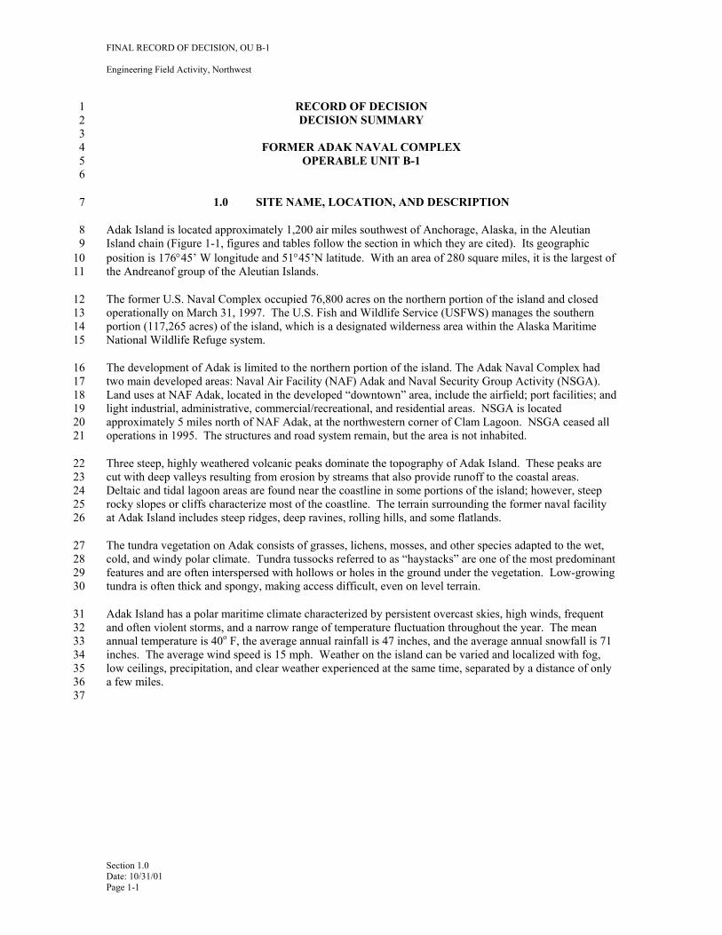
8 Adak Island is located approximately 1,200 air miles southwest of Anchorage, Alaska, in the Aleutian 9 Island chain (Figure 1-1, figures and tables follow the section in which they are cited). Its geographic
10 position is 176°45’ W longitude and 51°45’N latitude. With an area of 280 square miles, it is the largest of 11 the Andreanof group of the Aleutian Islands.
12 The former U.S. Naval Complex occupied 76,800 acres on the northern portion of the island and closed 13 operationally on March 31, 1997. The U.S. Fish and Wildlife Service (USFWS) manages the southern 14 portion (117,265 acres) of the island, which is a designated wilderness area within the Alaska Maritime 15 National Wildlife Refuge system.
16 The development of Adak is limited to the northern portion of the island. The Adak Naval Complex had 17 two main developed areas: Naval Air Facility (NAF) Adak and Naval Security Group Activity (NSGA). 18 Land uses at NAF Adak, located in the developed “downtown” area, include the airfield; port facilities; and 19 light industrial, administrative, commercial/recreational, and residential areas. NSGA is located 20 approximately 5 miles north of NAF Adak, at the northwestern corner of Clam Lagoon. NSGA ceased all 21 operations in 1995. The structures and road system remain, but the area is not inhabited.
22 Three steep, highly weathered volcanic peaks dominate the topography of Adak Island. These peaks are 23 cut with deep valleys resulting from erosion by streams that also provide runoff to the coastal areas. 24 Deltaic and tidal lagoon areas are found near the coastline in some portions of the island; however, steep 25 rocky slopes or cliffs characterize most of the coastline. The terrain surrounding the former naval facility 26 at Adak Island includes steep ridges, deep ravines, rolling hills, and some flatlands.
27 The tundra vegetation on Adak consists of grasses, lichens, mosses, and other species adapted to the wet, 28 cold, and windy polar climate. Tundra tussocks referred to as “haystacks” are one of the most predominant 29 features and are often interspersed with hollows or holes in the ground under the vegetation. Low-growing 30 tundra is often thick and spongy, making access difficult, even on level terrain.
31 Adak Island has a polar maritime climate characterized by persistent overcast skies, high winds, frequent 32 and often violent storms, and a narrow range of temperature fluctuation throughout the year. The mean 33 annual temperature is 40o F, the average annual rainfall is 47 inches, and the average annual snowfall is 71 34 inches. The average wind speed is 15 mph. Weather on the island can be varied and localized with fog, 35 low ceilings, precipitation, and clear weather experienced at the same time, separated by a distance of only 36 a few miles. 37
Section 1.0 Date: 10/31/01 Page 1-1
FINAL RECORD OF DECISION, OU B-1
Engineering Field Activity, Northwest
1 Figure 1-1 Location Map, Adak Island, Alaska 2 3
4
Section 1.0 Date: 10/31/01 Page 1-2
FINAL RECORD OF DECISION, OU B-1
Engineering Field Activity, Northwest
1 2.0 SITE HISTORY AND ENFORCEMENT ACTIVITIES
2 2.1 SITE HISTORY
3 In recorded history, indigenous people known as the Aleuts (Alaska Natives having a common heritage and 4 sharing common interests) frequented Adak Island. The site of the NAS was actually an active seasonal 5 hunting/fishing camp used by Aleuts from other villages. The first recorded visit by non-natives to Adak 6 Island was September 9, 1741, by Captain Alexi Chirof aboard the Russian vessel St. Paul. It was 7 estimated that over 20,000 Aleuts once lived in hundreds of small villages scattered throughout the 8 Aleutian Islands.
9 In 1913, President Taft, by Executive Order, designated Adak Island as part of the Aleutian Islands 10 National Wildlife Refuge (renamed the Alaska Maritime National Wildlife Refuge in 1980). It is currently 11 included within the Alaska Maritime National Wildlife Refuge managed by the USFWS. The island was 12 unoccupied in 1942 when the U.S. Army established a military presence on the island to take offensive 13 action against Japanese forces occupying Attu and Kiska Islands. The World War II (WWII) military 14 forces at Adak (both on island and in support ships) numbered approximately 100,000 troops. After WWII, 15 the military installation was transferred to the U.S. Air Force and in 1950 became a naval complex. On 16 August 19, 1959, Public Land Order No. 1949 withdrew the northern portion of Adak Island 17 (approximately 76,800 acres) for use by the Navy for military purposes. By the early 1990s, the military 18 facility at Adak Island included approximately 6,000 military personnel, civilian federal employees, and 19 civilian support contractors.
20 The military reservation uses included airfields, port facilities, warehouses, housing areas, schools, chapels, 21 dining facilities, medical clinics, recreational facilities, landfills, vehicle and aircraft maintenance and 22 repair sites, fuel facilities, military and non-military firing ranges, and ammunition and ordnance storage 23 and disposal sites.
24 Naval Air Facility, Adak, was placed on the 1995 base closure list under the Base Realignment and Closure 25 Act (BRAC). The BRAC recommendation became final when Congress did not disapprove the list. The 26 active Navy mission ceased and the base operationally closed on March 31, 1997. From April 1997 27 through September 2000, the Navy continued to operate critical facilities such as the power plant, airfield, 28 and other utilities and services in support of environmental cleanup activities through a caretaker contract. 29 In June 1998, the Navy entered into a lease with the Adak Reuse Corporation (ARC), which is the 30 designated local redevelopment authority, which authorized ARC to use or sublease property in the 31 developed core of the military reservation for commercial reuse purposes. In October 2000, ARC 32 commenced operation of community facilities, such as the airfield and utility systems. A land transfer 33 agreement among the Navy, Department of Interior, and The Aleut Corporation (TAC) was signed in 34 September 2000. This agreement sets forth terms and conditions for an eventual land exchange under 35 which TAC will obtain title to approximately 47,000 acres of the former military reservation, including all 36 of the downtown area, housing units, and industrial facilities. Special legislation by Congress is needed to 37 execute this exchange. Congress is expected to introduce and enact this legislation in 2001. Based on the 38 latest reuse plan for Adak (ASCG, 2000), the anticipated future land uses are expected to be generally 39 similar to current land uses.
40 2.2 HISTORY OF SITE INVESTIGATIONS, REMOVALS, AND REMEDIAL ACTIONS 41 CONDUCTED UNDER CERCLA OR OTHER AUTHORITIES
42 Navy investigation of environmental problems associated with past military practices began in 1986 with 43 oversight from EPA Region 10 (EPA) and the State of Alaska Department of Environmental Conservation 44 (ADEC) (NEESA 1986). During years of active military activity at Adak, numerous OE/UXO items were 45 discovered during normal activity, and were removed and disposed of in accordance with military 46 requirements at the time. It is estimated, based on Explosive Ordnance Disposal (EOD) Detachment
Section 2.0 Date: 10/31/01 Page 2-1
FINAL RECORD OF DECISION, OU B-1
Engineering Field Activity, Northwest
1 records that over 75,000 individual OE/UXO items were recovered between 1942 and 1996, the majority of 2 them small arms ammunition.
3 Based on these records and historical archive information, the Navy began an OE/UXO investigation, 4 removal and disposal program in 1996 to meet the requirements of the Department of Defense Explosives 5 Safety Board (DDESB), the EPA, and ADEC to take all necessary actions to protect human health and the 6 environment and make the real estate suitable for transfer to TAC for the reasonably expected future land 7 use. A complete listing of OE/UXO investigations is presented in the Remedial Investigation/Feasibility 8 Study (RI/FS) Report for OU B (ECC, 2001).
9 In July 1999, under the provisions of the existing Federal Facilities Agreement (FFA) for the cleanup of the 10 former Navy base at Adak Island and in order to address issues of concern, the Navy, EPA, and the State of 11 Alaska formed an OU B Project Team. The OU B Project Team, which also includes membership by 12 USFWS, TAC, the Aleutian/Pribilof Islands Association (A/PIA) and Adak community members was 13 tasked with developing a plan for investigating sites with potential UXO contamination that addressed the 14 concerns of regulatory agencies as well as community members and TAC, the future landowner. This plan 15 is formally referred to as the RI/FS Work Plan for OU B. Since its formation in July of 1999, the OU B 16 Project Team worked closely to resolve complex technical issues related to completing the RI/FS Work 17 Plan. The project team generally met on a monthly basis with regular teleconferences and e-mail 18 communication among members of the team.
19 2.3 HISTORY OF ENFORCEMENT ACTIONS
20 In October 1992, NAF Adak was proposed for addition to the National Priorities List under CERCLA and 21 as finalized on the list in May 1994. In September 1993, the Navy, EPA, and ADEC signed the Adak FFA 22 to conduct RI/FS and remedial design/remedial action (RD/RA) activities for chemical and petroleum sites. 23 These sites are addressed as OU A. In early 1998, the FFA was amended to include ordnance sites and 24 OU B was created. In June 1999, EPA and ADEC initiated formal dispute proceedings with the Navy over 25 proposed methods for the investigation and evaluation of OE/UXO sites on Adak. That dispute was 26 resolved through the efforts of the OU B Project Team and the approval of the OU B RI/FS Work Plan in 27 December 2000. To expedite the property transfer under the BRAC program, the Navy recommended 28 dividing OU B into OU B-1 and OU B-2. OU B-1 is the portion of the military reservation that contains 29 the core of the proposed reuse area.
Section 2.0 Date: 10/31/01 Page 2-2
FINAL RECORD OF DECISION, OU B-1
Engineering Field Activity, Northwest
1 3.0 HIGHLIGHTS OF COMMUNITY PARTICIPATION
2 A key component of the OU B project team’s work was reaching out to stakeholders to ensure that their 3 concerns were addressed. The project team met with the Restoration Advisory Board (RAB) and held open 4 houses in Anchorage and on Adak to invite community input. In addition, a cooperative agreement 5 between the Navy and the A/PIA was created to facilitate their participation as a member of the OU B 6 Project Team. The following sections describe some of the strategies used to address community concerns.
7 3.1 INFORMATION REPOSITORIES
8 The Information Repository, which includes a copy of the Administrative Record, is located at the 9 University of Alaska, Reserve Room, 3211 Providence Drive, Anchorage, Alaska and is open to the public.
10 The Administrative Record includes all documents used by the parties to the FFA to come to its decisions 11 regarding Adak remediation. The official copy of the Administrative Record is located at Engineering 12 Field Activity, Northwest (EFA Northwest), Poulsbo, Washington. In addition, documents regarding the 13 environmental investigation of Adak and the cleanup process are available to individuals on Adak at the 14 Caretaker Site Office. The entire body of documents produced relative to OU B-1 issues is available on 15 Adak, along with copies of community and RAB briefing materials, newsletters, and fact sheets. Recently 16 issued documents are also available at the web site for Adak environmental cleanup, www.adakupdate.com.
17 3.2 COMMUNITY RELATIONS PLAN (CRP)
18 The CRP formalizes the process for involving the Adak Island community, members of the public and the 19 extended community interested in environmental restoration and property reuse. The first CRP, prepared in 20 1993, was rewritten in September 1994, revised in May 1995, and revised again in December 1996. The 21 plan was reviewed in August 1999 and revised to include a comprehensive stakeholder relations plan, 22 monthly newsletters, and the development of a web site. An updated CRP was issued in October of 2001.
23 3.3 RESTORATION ADVISORY BOARD (RAB)
24 The Adak RAB was formed in 1996 to advise the Navy on decisions concerning cleanup on Adak. 25 Individuals interested in becoming members of the RAB filled out applications. All applicants were 26 accepted as RAB members. The group originally consisted of approximately 45 interested private citizens 27 and representatives of various organizations such as TAC and the ARC. By early 1998, the RAB consisted 28 of approximately 18 members. In 1999 and again in September 2000, additional RAB members 29 representing the new emerging community on Adak were added as official members of the RAB.
30 The RAB generally meets on a monthly basis. Meetings are held in Anchorage or on Adak Island and 31 facilities are provided to allow interested parties to participate by telephone if desired. One of the RAB’s 32 activities is to review technical reports and provide comments and recommendations to the Navy. Prior to 33 the incorporation of the second class City of Adak in April of 2001, on-island permanent residents and 34 families were represented on the RAB by the Adak Community Council. As of May 2001, the mayor of 35 City of Adak participated as a member of the RAB. The Aleut community was involved in the 36 development of the Adak cleanup. The Chief Executive Officer for TAC served as the RAB co-chair from 37 the RAB’s inception until April 2000. Members of the A/PIA, which is the designated representative for 38 the federally recognized Aleut tribal interests, and other Aleut community members are active participants 39 in the RAB. In addition, A/PIA and the Navy have entered into a cooperative agreement to facilitate 40 A/PIA’s participation as a member of the OU B Project Team. A toll-free information line (1-800-360-41 1561) was established in 1995 to provide meeting dates and times, and since 1999, all RAB meeting 42 information was regularly posted on the web site www.adakupdate.com.
Section 3.0 Date: 10/31/01 Page 3-1
FINAL RECORD OF DECISION, OU B-1
Engineering Field Activity, Northwest
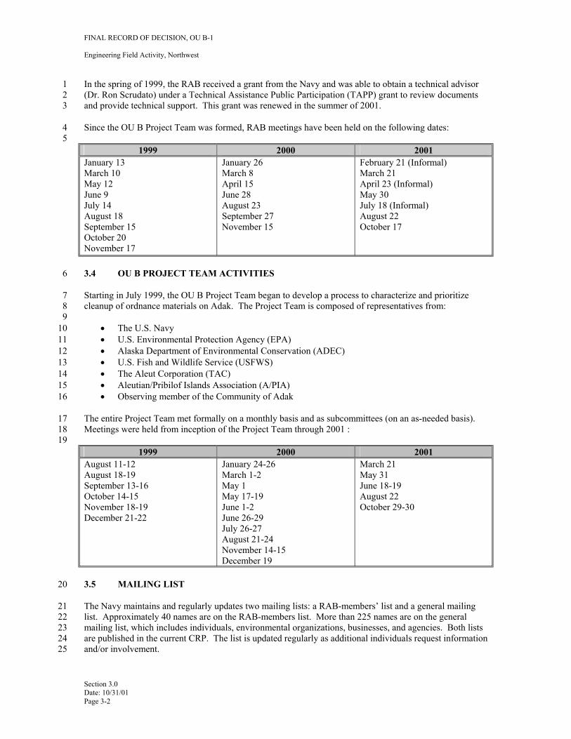
1 In the spring of 1999, the RAB received a grant from the Navy and was able to obtain a technical advisor 2 (Dr. Ron Scrudato) under a Technical Assistance Public Participation (TAPP) grant to review documents 3 and provide technical support. This grant was renewed in the summer of 2001.
4 Since the OU B Project Team was formed, RAB meetings have been held on the following dates: 5
1999 2000 2001
June 9 June 28
January 13 March 10 May 12
July 14 August 18 September 15 October 20 November 17
January 26 March 8 April 15
August 23 September 27 November 15
February 21 (Informal) March 21 April 23 (Informal) May 30 July 18 (Informal) August 22 October 17
6 3.4 OU B PROJECT TEAM ACTIVITIES
7 Starting in July 1999, the OU B Project Team began to develop a process to characterize and prioritize 8 cleanup of ordnance materials on Adak. The Project Team is composed of representatives from:9
10 • The U.S. Navy11 • U.S. Environmental Protection Agency (EPA) 12 • Alaska Department of Environmental Conservation (ADEC)13 • U.S. Fish and Wildlife Service (USFWS) 14 • The Aleut Corporation (TAC) 15 • Aleutian/Pribilof Islands Association (A/PIA) 16 • Observing member of the Community of Adak
17 The entire Project Team met formally on a monthly basis and as subcommittees (on an as-needed basis). 18 Meetings were held from inception of the Project Team through 2001 :19
1999 2000 2001
May 1
June 1-2 June 26-29
June 18-19
August 11-12 August 18-19 September 13-16 October 14-15 November 18-19 December 21-22
January 24-26 March 1-2
May 17-19
July 26-27 August 21-24 November 14-15 December 19
March 21 May 31
August 22 October 29-30
20 3.5 MAILING LIST
21 The Navy maintains and regularly updates two mailing lists: a RAB-members’ list and a general mailing 22 list. Approximately 40 names are on the RAB-members list. More than 225 names are on the general 23 mailing list, which includes individuals, environmental organizations, businesses, and agencies. Both lists 24 are published in the current CRP. The list is updated regularly as additional individuals request information 25 and/or involvement.
Section 3.0 Date: 10/31/01 Page 3-2
FINAL RECORD OF DECISION, OU B-1
Engineering Field Activity, Northwest
1 3.6 FACT SHEETS AND NEWSLETTERS
2 Since September 1999, 11 newsletters have been distributed. Since September 1999, a joint Navy, EPA, 3 ADEC newsletter (called Adak Update), or a fact sheet from the Navy has been published (U.S. Navy, et. al 4 1999-2001). The newsletter is distributed to the individuals and groups on the general mailing list, as 5 outlined in the revised CRP. Additional copies of the newsletter and fact sheets are sent to the information 6 repository on Adak and to the Adakupdate.com web-site.
7 3.7 OPEN HOUSES
8 In addition to formal community briefings and RAB meetings, a series of open houses have been held on 9 Adak and in Anchorage. These open houses allow for project managers and project team members from
10 the Navy, EPA, and ADEC to be available on a one-on-one basis to answer questions from the public and 11 to address concerns. These open houses first started in July 1993 and have been held in May 1994; 12 February 1998; September 1999; and January, April, and June 2000. A meeting with the community was 13 held by the RAB in late September 1999. In addition, an open house was held in conjunction with the 14 November 1999 RAB meeting in Anchorage.
15 3.8 HOT LINES
16 To support the local reuse authority and the RAB, the Navy established a toll-free hot line in December 17 1995. RAB members and citizens interested in reuse or environmental restoration of Adak are encouraged 18 to call 1-800-360-1561 and to leave a message regarding their questions or concerns. Messages are 19 retrieved daily and responded to as soon as possible, generally within 3 days.
20 3.9 PUBLIC COMMENT
21 Public comments regarding OU B-1 also are solicited through informal avenues such as hot lines, open 22 houses, and RAB meetings, via the Internet, through formal public comment periods, and at public 23 meetings held for the OU B-1 Proposed Plan.
24 The Navy, EPA, and ADEC respond to public comment in a variety of ways. During a RAB meeting in 25 August of 2000, RAB members and public participants participated in the development of existing and 26 future land use areas by reviewing existing land use maps and making recommendations. The reuse maps 27 were revised in September 2000 to reflect the input of the stakeholders, RAB members, and the public. 28 These maps are included in the OU B-1 RI/FS Report (ECC, 2001).
29 Ordnance materials constitute a primary concern for many community members. In response to these 30 concerns, the Navy conducted ordnance materials surveys and extensive intrusive sampling in the 31 downtown area. The Navy completed clearance of the Solid Waste Management Unit (SWMU) 2 32 minefield in the fall of 1998. The updated community relations and stakeholder involvement plan was 33 specifically designed to address community concerns relative to ordnance issues under OU B.
34 The Proposed Plan for OU B-1 was distributed to the public on May 14, 2001 with a one-month public 35 comment period (U.S. Navy, 2001). Comments from public meetings held on Adak Island on May 29, 36 2001 and in Anchorage on May 31, 2001, are summarized in the attached Responsiveness Summary 37 (Appendix A).
38 3.10 STAKEHOLDER RELATIONS
39 As part of the updated CRP, a comprehensive stakeholder relations program has been implemented. A 40 “stakeholder” is defined as anyone with an economic, social, political, or personal interest in an issue. A 41 wide range of stakeholders are involved and interested in the clean up effort and transfer of Naval Air 42 Facility Adak including government agencies, the community of Adak, Native groups, residents of the
Section 3.0 Date: 10/31/01 Page 3-3
FINAL RECORD OF DECISION, OU B-1
Engineering Field Activity, Northwest
1 greater Aleutian Islands, the Alaska State Legislature, and citizens throughout the state. The goal of the 2 CRP is to create a forum that allows the voice of interested individuals to be considered in decision3 making. The stakeholder communications agenda identifies the ideas, concerns, values, principles, 4 motivations, and plans of all interest groups involved. The stakeholder relations program currently in place 5 serves to identify and reconcile conflicting information, and perceptions of stakeholders. It further seeks to 6 assist the public in understanding the selected technical solutions under development by providing the 7 public additional opportunities for input and an avenue for responding to proposed solutions. Numerous 8 one-on-one stakeholder meetings were conducted both in person and via telephone since August 1999. In 9 addition, the Navy stakeholders relations’ specialist conducted on-island visits in November 1999, April
10 2000, July 2000, and May 2001 to solicit community input, suggestions, and concerns.
11 In addition, the stakeholder relation program provides an opportunity for stakeholders to identify concerns 12 related to proposed environmental investigation and cleanup approaches on Adak. These concerns are 13 considered by the Navy and regulatory agencies as they develop and finalize decisions on required 14 environmental cleanup.
15 3.10.1 Stakeholder Identification
16 The following is a partial list of stakeholders involved or interested in the clean up and transfers of Naval 17 Air Facility Adak.
18 Federal Agencies 19 • U.S. Department of the Navy 20 • U.S. Army Corps of Engineers, Alaska District (Corps) 21 • U.S. Department of the Interior, U.S. Fish and Wildlife Service 22 • Department of Transportation, U.S. Coast Guard 23 • U.S. Environmental Protection Agency 24 • Department of Defense Explosives Safety Board 25 • United States Geological Survey 26 27 State Agencies 28 • Alaska State Legislature 29 • Department of Environmental Conservation 30 • Department of Natural Resources 31 • Office of Governor 32 • Division of Governmental Coordination 33 • Department of Community and Economic Development 34 • Department of Public Safety 35 36 Local Government Agencies 37 • City of Adak 38 • Attu Community Council, School District Superintendent 39 • City of Dutch Harbor 40 • City of Atka 41 • Aleutian Region School District 42 43 Organizations and Individuals 44 • Adak Reuse Corporation (ARC) 45 • Aleutian/Pribilof Islands Association (A/PIA) 46 • United Aleut Nation 47 • Alaska Federation of Natives 48 • Aleutian Village Corporations 49 • Glen Reed, Fishery Industry representative
Section 3.0 Date: 10/31/01 Page 3-4
FINAL RECORD OF DECISION, OU B-1
Engineering Field Activity, Northwest
1 • Environmental Groups 2 • Adak Restoration Advisory Board 3 4 Business Entities 5 • Aleut Enterprise Corporation 6 • Peninsula Airways (PenAir) 7 • TAC Services Incorporated (TSI) 8 • Evergreen International Airlines, Inc. 9 • The Aleut Corporation (TAC)
10 • Construction Companies 11 • Norquest Fisheries 12 • Adak Seafoods 13 14 Media 15 • Alaskan media outlets
16 Although the list is not inclusive, it identifies many of the participants from whom information and 17 involvement is being sought and to which follow-up stakeholder visits/telephone calls are being conducted. 18 In addition, these stakeholders are part of the ongoing efforts to keep the general public informed about 19 Adak issues.
20 3.11 WEB SITE
21 A project web site www.adakupdate.com is currently on line. The site is easily accessible through common 22 Internet search engines. Information is added and updated on a regular basis.
23 The site contains all project newsletters, all presentation materials prepared for the RAB, fact sheets and 24 news releases. Links to appropriate technical documents are provided. Information on RAB meetings, 25 public meetings and open houses, and links to state and federal agency sites are also provided. The web 26 site also provides an interactive opportunity by enabling stakeholders and the public to e-mail their 27 questions and comments.
Section 3.0 Date: 10/31/01 Page 3-5
FINAL RECORD OF DECISION, OU B-1
Engineering Field Activity, Northwest
1 4.0 SCOPE AND ROLE OF OPERABLE UNIT B-1
2 Adak consists of two operable units: OU A and OU B. OU A includes CERCLA and petroleum sites. 3 OU B deals exclusively with OE/UXO sites. The Navy signed the Record of Decision for OU A in 4 October 1999, the EPA in March 2000, and the State of Alaska in April 2000. Copies of the OU A ROD 5 are available at the Adak Administrative Record and Information Repository locations listed in Section 3.3 6 of this document.
7 Under the terms of a land transfer agreement finalized in September 2000, Navy will relinquish 8 approximately 47,000 acres to Department of Interior, which will convey these lands to TAC for private 9 sector reuse in exchange for other lands in the Aleutian Islands that will be managed by USFWS (U.S
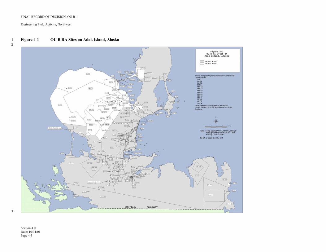
10 Navy, et. al, 2000). To identify lands that are environmentally suitable for transfer as quickly as possible, 11 the Navy recommended that OU B be divided into OU B-1 and OU B-2 (see Figure 4-1).
12 The OU B Project Team identified a group of 131 sites that includes all identified areas of concern (AOCs) 13 within the military reservation, lying outside of the Mt. Moffett/Andrew Lake area (Table 4-1), where the 14 RI work was completed during the 2000 field season. This group of 131 sites is collectively known as 15 OU B-1.
16 This group of sites also includes many potential AOCs that met the criteria for NOFA during the 17 preliminary assessment conducted in 1999 and several land areas that were never associated in the 18 historical record with any ordnance-related activities. The results of the RI/FS at OU B-1 sites are 19 presented in this ROD. Sites not included in this group (OU B-2 sites) will undergo remaining RI/FS work. 20 The results of investigation in those areas will be reported in a separate RI/FS Report for OU B-2.
21 4.1 PLANNED SEQUENCE OF ACTIVITY
22 Upon completion of the OU B-1 ROD, clearance actions will be taken for all sites recommended for 23 remediation. Remedial actions selected in this ROD will be implemented by the Navy, as the lead agency, 24 with oversight and verification by EPA Region 10 and ADEC. Specific language will be incorporated into 25 the property conveyance documents to help maintain an active OE/UXO education program for future 26 residents and visitors to Adak Island. This will also include information on the nature and extent of 27 OE/UXO on Adak and depth of clearance activities. Five-year review and follow-on inspection and 28 maintenance will be performed as required. The remainder of OU B will be addressed in a separate ROD 29 covering OU B-2.
30 To enable the conveyance of property to TAC as set forth in the land exchange agreement, the Department 31 of the Navy will complete a finding of suitability to transfer (FOST). The FOST documents compliance 32 with CERCLA 120(h)(3) concerning environmental suitability of federal property for conveyance to a non33 federal party, and sets forth any land use restrictions. In addition, when addressing OE/UXO sites, the site34 specific guidelines of Department of Defense (DoD) Instruction 6055.9-STD promulgated by the DDESB 35 must be met with regards to clearance depths for future land uses and land transfer requirements. 36 DDESB/NOSSA concurrence will be obtained for the ordnance safety aspects of the FOST.
37 4.2 SCOPE OF OE/UXO PROBLEMS AND APPROACH
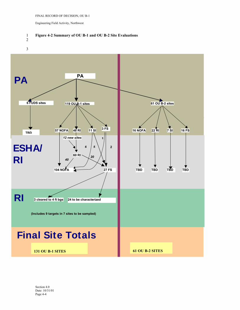
38 Throughout Adak’s history as a military facility, ordnance or munitions were present for various purposes 39 related to the military's mission on island, such as for use, storage, transloading, or disposal at the military 40 reservation. One of the first priorities for evaluation of OE/UXO issues on Adak was obtaining reliable 41 historical information that could focus investigation efforts in areas known or suspected to contain 42 OE/UXO. This information was obtained through an archive search of military records for the island in 43 combination with a review of ordnance-related records remaining at the site. The sites identified by this 44 archive search process were called Areas of Potential Concern (AOPCs). A total of 192 sites (131 in OU
Section 4.0 Date: 10/31/01 Page 4-1
FINAL RECORD OF DECISION, OU B-1
Engineering Field Activity, Northwest
1 B-1 and 61 in OU B-2) were identified (Figure 4-2). These include four new sites (Husky Pass Training 2 Area, Shagak Bay Gun Emplacement, and the Chemical Mortar Site within MM-04) which were not 3 included in the RI/FS. Six other sites south of the military reservation are to be addressed by the Defense 4 Environmental Restoration Program (DERP)/Formerly Used Defense Sites (FUDS) administered by the 5 Corps. These six sites will not be evaluated in OU B, nor will the RODs for OU B dictate actions at these 6 sites.
7 An initial screening was developed as part of an overall hazard assessment methodology developed for 8 OU B to eliminate sites that had little or no likelihood of OE/UXO concerns. This hazard assessment 9 methodology is an Adak-specific process developed as part of an overall framework for assessing and
10 managing potential threats to human health and the environment. These potential threats include explosive 11 safety hazards due to the presence of unexploded ordnance and the potential release of hazardous chemical 12 substances related to that ordnance. Risks associated with releases from ordnance-related chemical 13 substances are addressed through the chemical sampling and risk analysis methods developed under OU A 14 (URS 1995ab) and updated for current toxicity screening values for explosives-related chemicals.
15 Sites identified during the preliminary assessment screening as having little or no likelihood of OE/UXO 16 concern were recommended for the Adak NOFA (No Further Action/Institutional Controls) alternative. 17 Sixty sites were referred to the RI/FS. During the RI/FS, site information was assessed for explosive 18 hazard through a CERCLA-like risk evaluation process. This Adak-specific Explosives Safety Hazards 19 Analysis (ESHA) model was developed by the OU B Project Team to evaluate explosive safety hazards to 20 human health based on RI data. Of the 44 sites evaluated under the ESHA process, 41 of the sites were 21 recommended for the Adak NOFA Alternative, and three were evaluated through the CERCLA FS process 22 and recommended for clearance action to a depth of four feet bgs. One of the “A” sites (BC-01) was 23 subsequently removed from ESHA. 24
Section 4.0 Date: 10/31/01 Page 4-2
FINAL RECORD OF DECISION, OU B-1
Engineering Field Activity, Northwest
1 Figure 4-1 OU B RA Sites on Adak Island, Alaska 2
3
Section 4.0 Date: 10/31/01 Page 4-3
methodology is an Adak-specific process developed as part of an overall framework for assessing and 4 managing potential threats to human health and the environment. These potential threats include explosive 5 safety hazards due to the presence of unexploded ordnance and the potential release of hazardous chemical 6 substances related to that ordnance. Risks associated with releases from ordnance-related chemical 7 substances are addressed through the chemical sampling and risk analysis methods developed under OU A 8 (URS 1995ab) and updated for current toxicity screening values for explosives-related chemicals. 9
Sites identified during the preliminary assessment screening as having little or no likelihood of OE/UXO 10 concern were recommended for the Adak NOFA (No Further Action/Institutional Controls) alternative. 11 Sixty sites were referred to the RI/FS. During the RI/FS, site information was assessed for explosive 12 hazard through a CERCLA-like risk evaluation process. This Adak-specific Explosives Safety Hazards 13 Analysis (ESHA) model was developed by the OU B Project Team to evaluate explosive safety hazards to 14 human health based on RI data. Of the 44 sites evaluated under the ESHA process, 41 of the sites were 15 recommended for the Adak NOFA Alternative, and three were evaluated through the CERCL16 and recommended for clearance action to a depth of four feet bgs. One of the “A” sites (BC-01) was 17 subsequently removed from ESHA. 18
19
Figure 4-2 Summary of OU B-1 and OU B-2 Site Evaluations 20
21
22
Figure 4-2 Summary of Evaluation of OU B-1 and OU B-2 Sites 23
24
25
FINAL RECORD OF DECISION, OU B-1
Engineering Field Activity, Northwest
1 Figure 4-2 Summary of OU B-1 and OU B-2 Site Evaluations 2
3
A FS process
PA
6 FUDS sites 119 OU B-1 sites 61 OU B-2 sites
PA
57 NOFA 48 RI 11 SI 3 FS 16 NOFA 22 RI 7 SI 16 FS
60 RI ESHA/ RI
104 NOFA 27 FS TBD TBD TBD TBD
RI 3 cleared to 4 ft bgs 24 to be characterized
(Includes 9 targets in 7 sites to be sampled)
20 40
12 new sites
Final Site Totals
TBD
1
26 5
131 OU B-1 SITES 61 OU B-2 SITES
Section 4.0 Date: 10/31/01 Page 4-4
FINAL RECORD OF DECISION, OU B-1
Engineering Field Activity, Northwest
Table 4-1 Adak OE/UXO Sites in OU B-1
1
Minefields
Candidate Site Name Bay of Islands Impact Area Blind Cove/Campers Cove Impact Area Chemical Warfare Materials Warehouses Combat Range #3
C6-01 (C6-01A) Combat Range #6 C6-01B C8-01, C8-02, C8-03, C8-04, C8-05 (C8-05B) Combat Range #8 C8-05 (C8-05A)
Davis Lake Ordnance Warehouses
DL-01
FBAP-01 Finger Bay Ammunition Pier FBAP-02
Finger Bay Dynamite Storage FBDS-01 FB-01, FB-02, FB-04, FB-05 Finger Bay Impact Area FB-03 (see note), FB-06, FB-07, FB-08, FB-09
Gun Emplacements GUN-01, GUN-02, GUN-03 Gun Emplacement Shagak Bay Hammer Head Cover Impact Area HH-01, HH-02
HL-01, HL-02 Haven Lake Ordnance Area HL-03 DM-01, DM-02, DM-03, DM-04, DM-05, DM-06B Lake DeMarie Impact Area DM-06 (DM-06A) LJ-01, LJ-02, LJ-03, LJ-04 Lake Jean Ammunition Complex LJ-05
MAUW Complex MC-01 Candlestick East (MF-04), Candlestick West (MF-05), Clam Lagoon Spit (MF06), Finger Bay North Road (MF-07), Finger Bay NW (MF-08), Finger Bay SE (MF-09), Finger Bay SW (MF-10), Husky Pass (MF-11), Kuluk Bay (MF-12), Kuluk Bay South (MF-13), Lake Bonnie Rose (MF-14), NAVFAC (MF-15), Palisades (MF-16), Shagak Bay NE (MF-17), Shagak Bay NW (MF-18), Shagak Bay SE (MF-19), Shagak Bay SW (MF-20), Sweeper Cove North (MF-22), Sweeper Cove NW (MF-23), Sweeper Cove South (MF-26), Sweeper Cove SW (MF-25), Sweeper Cove West (MF-24), Yakutat (MF-27), Zeto Point (MF-28) SWMU 2 Clam Lagoon (MF-21) a.k.a. Husky Pass Training ML-01 (ML-01A, ML-01B), ML-02 (ML-02A) ML-01 (ML-01C), ML-02 (ML-02B), ML-03, ML-04, ML-05
√
√ √
√ √ √ √
√ √
√ √
√ (see note)
√ √ √
Preliminary Assessment
Site Identifier/Name NOFA RI/
Inspect FS BI-02 √ BC-01, BC-05, BC-06, BC-07, BC-08, BC-09A √ BC-02, BC-04, BC-09B √ CWS-01 √
C3-01 (C3-01A, C3-01B, C3-01C, C3-01D, C3-01E), C3-04 (C3-04A) (see note) C3-01 (C3-01F), C3-02, C3-03, C3-04 (C3-04B) √
(see note) √ √
(see note) √
√ √
(see note) √
√
Small Arms Ranges
Husky Pass Mitt Lake Impact Area
ML-06, ML-07 NM-02, NM-03, NM-04 NAF Adak/Lake DeMarie
Ammunition Complex NM-05 NSGA Magazine Complex NSGA-01 Scabbard Bay Impact Area SB-01, SB-02, SB-03, SB-04, SB-05
UA-01, UA-02Urban Area UA-03, UA-04 AP-01 WWII Ammunition Pier (Sweeper
Cove) AP-02
Finger Bay Pistol Range (SA-06), Finger Bay Rifle Range (SA-07), Finger Bay Submachine Gun Range (SA-08), Lake DeMarie Rifle Range (SA-09), Mitt Lake Sportsman’s Pistol Range (SA-10), Mitt Lake Sportsman’s Rifle Range (SA-11), NSGA Rifle Range (SA-13), NAF Trap and Skeet Range (SA-12), Nurses Creek Rifle Range (SA-14), Radar Hill Rifle Range (SA-15)
√
√
√ √
√ √
√
√
√
Section 4.0 Date: 10/31/01 Page 4-5
FINAL RECORD OF DECISION, OU B-1
Engineering Field Activity, Northwest
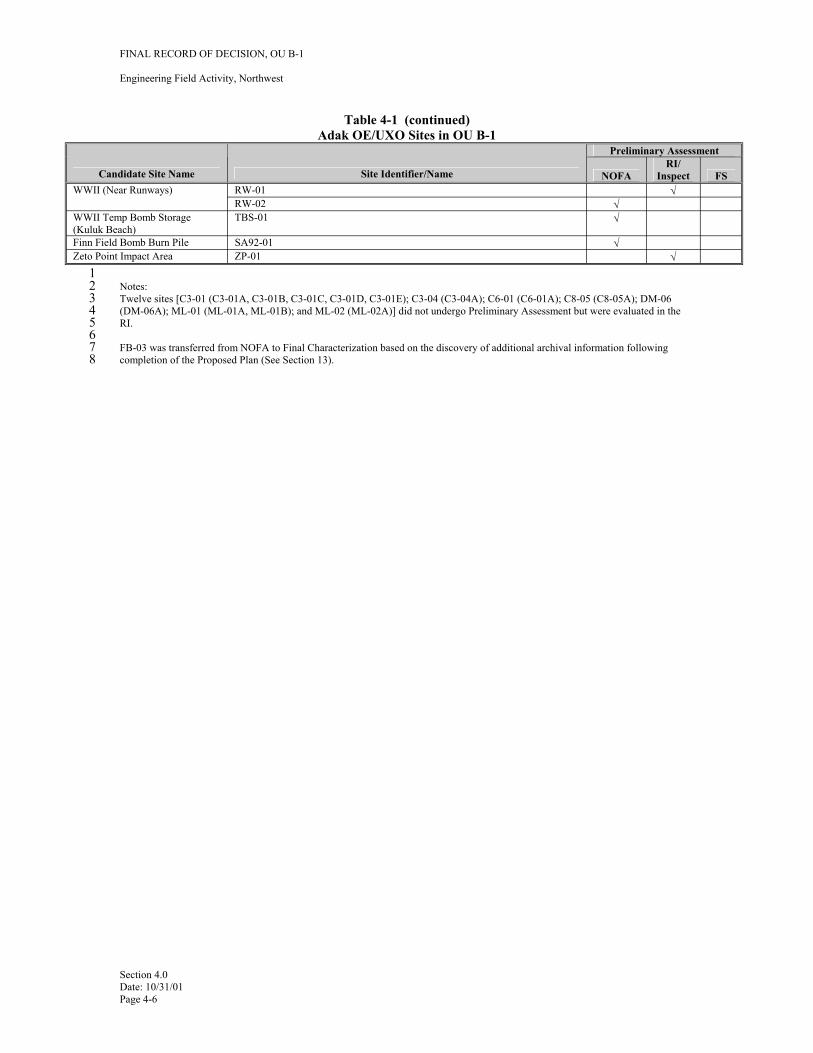
Table 4-1 (continued) Adak OE/UXO Sites in OU B-1
Candidate Site Name Site Identifier/Name
Preliminary Assessment
NOFA RI/
Inspect FS WWII (Near Runways) RW-01 √
RW-02 √ WWII Temp Bomb Storage (Kuluk Beach)
TBS-01 √
Finn Field Bomb Burn Pile SA92-01 √ Zeto Point Impact Area ZP-01 √
1 2 Notes: 3 Twelve sites [C3-01 (C3-01A, C3-01B, C3-01C, C3-01D, C3-01E); C3-04 (C3-04A); C6-01 (C6-01A); C8-05 (C8-05A); DM-06 4 (DM-06A); ML-01 (ML-01A, ML-01B); and ML-02 (ML-02A)] did not undergo Preliminary Assessment but were evaluated in the 5 RI. 6 7 FB-03 was transferred from NOFA to Final Characterization based on the discovery of additional archival information following 8 completion of the Proposed Plan (See Section 13).
Section 4.0 Date: 10/31/01 Page 4-6
FINAL RECORD OF DECISION, OU B-1
Engineering Field Activity, Northwest
1 5.0 SITE CHARACTERISTICS
2 This section provides a summary of the site and water body characterizations performed during CERCLA 3 and OE/UXO investigation at Adak. Site characteristics will be described for the northern portion of Adak.
4 5.1 OVERVIEW OF SITE
5 Adak Island is located approximately 1,200 air miles southwest of Anchorage, Alaska, in the Aleutian 6 Island chain. Its geographic position is longitude 176°45’ and latitude 51°45’. At 280 square miles, it is 7 the largest of the Andreanof group of the Aleutian Islands. The developed portion of Adak is limited to the 8 northern portion of the island, which is the area historically designated as the military reservation. Current 9 land use at the former NAF Adak, located in the developed “downtown” area of the island, includes the
10 airfield; port facilities; and light industrial, administrative, commercial/recreational, and residential areas. 11 The USFWS manages the southern portion of the island, which is a designated wilderness area within the 12 Alaska Maritime National Wildlife Refuge system.
13 5.1.1 Size of Site
14 The total acreage of the military reservation is approximately 76,800 acres. Potential OE/UXO sites 15 comprise approximately 20,000 acres or 26 percent (%). The size of each OE/UXO site is provided in the 16 RI/FS Work Plan (FWENC, 2000a).
17 5.1.2 Conceptual Site Model
18 A conceptual site model (CSM) (Figure 5-1) was developed based on review of existing data, release and 19 physical transport processes, and identification of potential human and ecological receptors associated with 20 OU B. The CSM was developed to provide a framework for the identification and analysis of the AOPCs 21 in the preliminary assessment Screening Process. The CSM brings together environmental and human land 22 use activities to illustrate the understanding of existing transport and exposure processes.
23 The CSM is intended to encompass all potential past ordnance-related uses on Adak (the primary sources) 24 and the expected exposure pathways associated with those uses. In the CSM, the AOPC types are the 25 primary sources of contamination. The primary release mechanisms are the actions that occurred in the 26 AOPCs that possibly resulted in the release of ordnance contamination. The expected type of ordnance 27 contamination in an AOPC depends on both the AOPC type and the type of primary release mechanism. 28 Secondary sources are the media in which the ordnance contamination is expected to be located.
29 5.1.3 Areas of Archaeological or Historical Importance
30 5.1.3.1 World War II-Era Resources
31 The Adak Naval Complex contains three National Register resources from World War II according to the 32 Historic and Archeological Resources Protection (I-L4RP) Plan (U.S. Navy, 1996a). The three National 33 Register Resources are:
34 • The Adak Army Base and Adak Naval Operating Base National Historic Landmark (listed on the 35 National Register).
36 • The Old Chapel, sometimes referred to as the Bering Chapel, Navy Facility T-4182, and Alaska 37 Heritage Resources Survey (AHRS) number ADK-155 (eligible for the National Register but not 38 formally listed).
Section 5.0 Date: 10/31/01 Page 5-1
FINAL RECORD OF DECISION, OU B-1
Engineering Field Activity, Northwest
1 • The Adak World War II Cultural Landscape Historic District (eligible for the National Register but not 2 formally listed).
3 5.1.3.2 Cold War-Era Resources
4 The White Alice Site, a Cold War-era communications site, was listed in the National Register as part of 5 the White Alice System; however, all antennas and structures have since been removed. The State Historic 6 Preservation Office (SHPO) has determined that the site is not individually significant and no additional 7 consultation is necessary.
8 5.1.3.3 Archaeological Resources
9 Previous surveys have identified 37 prehistoric archaeological sites and locations of potential sites within 10 the boundaries of the Adak military reservation. The sites are mainly house foundations and middens 11 containing shell, sea urchin, bone, and artificial detritus. Some of these sites were damaged by various 12 military actions on the island. Nine sites were formally assessed for a determination of eligibility for the 13 National Register, and eight of those nine were determined to meet eligibility criteria. As a resource 14 protection measure, the exact location of these sites will not be publicized, but will be kept by the Alaska 15 Department of Natural Resources (ADNR) Division of Parks and Recreation. A burial was found at one 16 site, and others might contain them. There may also be some burials on islands off the west shore.
17 5.2 ARCHIVE INFORMATION
18 Throughout Adak’s military history, ordnance items were managed and handled as part of the active duty 19 military requirements of the stationed organizations and frequently discovered in areas throughout the 20 island. Historical archive records regarding ordnance activities on Adak are the primary source for initial 21 identification and delineation of areas potentially contaminated with ordnance. These documents—which 22 include defense plans for the island, firing orders for weapons training, munitions inventories, photographs, 23 maps, and other training and operations documents— provided valuable data regarding the types of 24 ordnance activities that may have taken place on Adak Island, the areas where these activities most likely 25 took place, and the types of ordnance that may be present in the various areas. These data were reviewed 26 and interpreted to delineate candidate sites for the OU B RI/FS process.
27 Historical archive research and investigation was performed by several consulting firms in support of site 28 characterization and remediation activities on Adak, including URS, Clearwater Engineering, and Foster 29 Wheeler Environmental Corporation (Foster Wheeler Environmental). Research also was conducted by a 30 number of government organizations, including the Corps; the Navy Environmental Health Center 31 (NEHC); and Superintendent of Shipbuilding, Conversion, and Repair, Portsmouth, Virginia (SSPORTS) 32 Environmental Detachment, Vallejo, California; and U.S. Army Technical Center for Explosives Safety 33 (USATCES). The results of some of the major research efforts are provided in detail in the Archive Search 34 Report (FWENC, 1998) and are summarized in Table 5-1.
35 5.3 PRELIMINARY INVESTIGATIONS
36 Numerous environmental studies have taken place on Adak Island over the past 10 years, including several 37 preliminary source evaluations (PSEs) (URS 1995ab) and an RI/FS for OU A (URS 1997), which 38 encompasses the military reservation with respect to chemical contamination. OU B, which encompasses 39 the northern portion of the entire island with respect to ordnance (explosives) contamination, was studied 40 less extensively as part of these previous investigations; however, a number of important investigations 41 were completed, which influenced the design of the OU B RI/FS program. These previous studies and their 42 relevance to the current work are summarized below. Additional details are available in numerous 43 documents contained within the administrative record.
Section 5.0 Date: 10/31/01 Page 5-2
FINAL RECORD OF DECISION, OU B-1
Engineering Field Activity, Northwest
1 5.3.1 NAS Whidbey EOD Survey
2 In 1996, the EOD Mobile Unit 11 Detachment Whidbey Island stationed at NAS Whidbey, Washington, 3 conducted an ordnance survey in the known range areas of Adak (U.S. Navy 1996b). This survey4 suggested that significant effort would be required to remove OE/UXO from certain sites. These sites 5 include the downtown area within OU B-1 and SWMUs 1, 2, 8, and Source Area 93 in OU B-2.
6 5.3.2 SWMU 2 Investigation and Clearance
7 In 1996, following the EOD survey, SSPORTS performed an investigation of SWMU 2 (SSPORTS, 1999). 8 SSPORTS began clearance operations in mid-1998. The SWMU 2 clearance (to a depth of one foot 9 because there was no evidence of deeper ordnance) was completed in fall of 1998. The majority of mines
10 located at the site were inert training mines. However, a small number of live service mines were also 11 removed during clearance activities. Also found were remnants of Bangalore torpedoes that were typically 12 used during minefield clearance activities.
13 5.3.3 Intrusive Investigation of UXO in the Downtown Areas
14 Throughout 55 years of military history on Adak, a number of ordnance items have been recovered. Most 15 of the items were considered souvenirs or abandoned ordnance that originated from other sources and were 16 brought to the “downtown area” by hikers. In 1996, the Navy initiated an ordnance investigation of the 17 downtown area in order to facilitate leasing of the primary reuse area of the island (FWENC 1997). The 18 investigation of the Downtown Areas included review of historical records and archives, surface clearance 19 with a metal detector, a geophysical investigation using electro-magnetic equipment, and excavation of 20 selected geophysical anomalies to a depth of 4 feet bgs. Intrusive investigations and clearance activities 21 were completed in the Downtown Area in 1998. Within the approximately 2200 acres that were 22 investigated, 7116 geophysical anomalies were excavated. Only three UXO items were found from the 23 surface clearance and three OE/UXO items were found during subsurface investigations. These included a 24 50-millimeter (mm) mortar, a 37-mm anti-aircraft cartridge case, a 20-mm high-explosive point-detonating 25 (HEPD) projectile with cartridge case, an abandoned incendiary bomblet, a smoke grenade without a fuze, 26 and a thermite grenade.
27 5.3.4 Investigation of Potential Minefields
28 In April 1998, ongoing archival research on historical ordnance-related activities on Adak resulted in the 29 discovery of World War II era defensive plans for the island (May 1945). These plans contained proposed 30 locations for defensive works, including 27 potential minefield locations with instructions to emplace up to 31 22,000 mines in the event of an imminent invasion by Japanese troops. The archival and physical 32 investigation has revealed no evidence that defensive minefields were installed on Adak. Historical EOD 33 incident reports do not list any contact with mines or mine-related wastes in the vicinity of proposed 34 minefields, and no mine-related injuries have occurred on Adak, in spite of heavy use of many of the 35 potential minefield locations for military and recreational purposes. Furthermore, the date of the defensive 36 plans calling for the installation of the potential minefields indicates that the conditions that would have 37 mandated the installation of such minefields (i.e. threat of enemy invasion of Adak) never occurred 38 subsequent to the date of the defensive plans. In fact, WWII ended 3 months later in August 1945.
39 Twenty-three of the potential minefield locations on Adak have been investigated either intrusively (14), 40 using geophysical and surface clearing data from previous UXO investigations (8), or by visual inspection 41 (1). The SWMU 2 minefield was cleared in 1998. The three others in the Andrew Lake area were not 42 investigated and remain part of OU B-2 within the Navy exclusion zone. The visual inspection site (Shagak 43 Bay) was also the location for removal of Rommel Stakes. This included preliminary investigations of the 44 areas near the Rommel Stakes with hand-held geophysical equipment. Mines were found only at one 45 location (SWMU 2) and are believed to have been placed there for training and not as part of the defensive 46 plan. Live mines and training mines (inert and live) were found and removed from this site during 1998.
Section 5.0 Date: 10/31/01 Page 5-3
FINAL RECORD OF DECISION, OU B-1
Engineering Field Activity, Northwest
1 5.3.5 1999 and 2000 Physical and Intrusive Investigations
2 The 1999 and 2000 investigation was focused on the remote areas north of the Military Reservation 3 Boundary outside of the downtown area, which was investigated previously. The areas that were 4 investigated in 1999 for ordnance contamination used the following methods: 5 6 • Sector SelectionAreas potentially contaminated with OE/UXO based on evidence suggesting 7 past use, storage, handling, or disposal of OE/UXO were designated as sectors. Historical archive 8 records and documents were reviewed by UXO personnel and aided in identifying the 26 distinct 9 sectors that were investigated during the field seasons.
10 11 • Terrain Analysis—Each sector was analyzed to identify the terrain that was inaccessible to 12 geophysical technicians performing subsurface investigations of OE/UXO items. Areas steeper 13 than 30 degrees (from the horizontal) were excluded from the investigation area. This criterion 14 was established to address access limitation on steep terrain for recreational hikers. 15 16 • Demarcation of the Investigation Areas—Each sector was evaluated to determine the sampling 17 area required to characterize the sector. Waypoint maps were developed to identify investigation 18 paths within the sectors. These idealized pathways were adjusted in the field as necessary to 19 accommodate site-specific terrain and vegetation or other physical features that may have limited 20 access or posed a danger to field personnel. 21 22 • Geophysical Survey and Target Selection—Subsurface anomaly data were collected over the 23 selected areas using a time-domain electromagnetic instrument (Geonics EM-61) and processed to 24 develop geophysical anomaly maps and target anomaly lists. 25 26 • Anomaly Selection—Digital geophysical data were recorded, post-processed, and analyzed to 27 identify with an associated signal indicative of metallic wastes that may be ordnance related. Post28 processing refers to the analysis of geophysical data collected from the field to determine which 29 anomalies are to be selected for intrusive investigation. Based on the data obtained from this 30 geophysical investigation, target anomalies were chosen for intrusive investigation (excavation). 31 32 • Intrusive Investigation—All selected target anomalies were excavated to identify and record 33 findings of geophysical targets within 4 feet of the ground surface. Ground surface at Adak for 34 these investigations is defined as the top of the mineral soil zone. In tundra areas on Adak, this can 35 be between 6 inches and 36 inches below the walking surface. 36 37 • Data ValidationThe Adak OU B Project Team established data validation protocols during the 38 2000 field season as summarized in the Validation of Detection Systems (VDS) Report (ECC, 39 2000). This protocol determined the applicability of the 1999 data to the decision-making process 40 for sites within OU B.
41 Ordnance-related findings for the 1999 and 2000 field seasons are summarized in Table 5-2.
42 5.4 SAMPLING STRATEGY
43 Adak OE/UXO AOPCs identified through the archive records search and preliminary investigations were 44 evaluated through a screening program (preliminary assessment) to identify which sites would require 45 physical inspection or remedial investigation. The details of this screening process and results are 46 presented in the Preliminary Assessment Report (FWENC, 2000b).
47 Those AOPCs determined to require additional investigation or evaluation were designated as AOCs and 48 forwarded to the next level in the risk evaluation process. This process of evaluation that was carried out as 49 part of the RI/FS, is based on application of the Explosive Safety Hazard Assessment (ESHA)
Section 5.0 Date: 10/31/01 Page 5-4
FINAL RECORD OF DECISION, OU B-1
Engineering Field Activity, Northwest
1 Methodology specifically developed for OU B on Adak. The ESHA methodology and its application at 2 Adak is discussed in Section 7 of this ROD. One of the steps necessary to support use of the ESHA 3 Methodology is the acquisition of quantitative field data to further assess the presence or absence of 4 ordnance within each of the AOCs that were identified by the preliminary assessment screen. This process 5 includes three basic investigation elements: 6 7 • Site assessment/reconnaissance 8 • Site inspection 9 • Site characterization
10 Prior investigations, such as in the downtown area, as well as the during 1999 field season, were 11 accomplished prior to the development of the Preliminary Assessment and RI/FS hazard evaluation 12 approach by the OU B Project Team. The OU B Project Team carefully reviewed the data gathered during 13 these previous investigations to ensure data quality objectives were met.
14 In preparation for the 2000 field season, the Navy performed a VDS test on Adak to validate the equipment 15 to be used for further investigations and the statistical sampling methodology to be used. The Geonics 16 EM-61, which had been used for all geophysical data collection on Adak, was tested and found to exceed 17 the data quality objectives (DQOs) established by the OU B Project Team. These DQOs included a 18 probability of detection of 0.85 with a confidence interval of 90%. The probability of detection is defined 19 as the number of ordnance items detected with geophysical survey equipment relative to the total number 20 of ordnance items actually present. The confidence interval is the range on either side of the probability of 21 detection, and is a function of the selected statistical power, the standard deviation and the number of 22 ordnance items. Details on the VDS program are provided in the VDS Report (ECC, 2000). Detailed 23 explanations and applications of the preliminary assessment and RI/FS evaluations are identified in Section 24 7 of this document.
25 5.5 OU B-1 AOPCS AND AOCS
26 The initial AOPC screening was a qualitative assessment of potential ordnance contamination in AOPCs. 27 Those AOPCs that require additional investigation or evaluation were designated as AOCs and forwarded 28 to gain additional information through the RI/FS process.
29 5.6 NATURE AND EXTENT OF OE/UXO CONTAMINATION
30 The approach and rationale for the investigations performed at all sites investigated during the 2000 RI/FS 31 work on Adak Island are described in detail in the Final Preliminary Assessment (FWENC, 2000b) and the 32 Final RI/FS Work Plan (FWENC, 2000a). Results of the remedial investigation are provided in detail in 33 the RI/FS Report (ECC, 2001). The following sections provide a summary of the results.
34 5.6.1 Remedial Investigation Sampling Methodology
35 The OU B RI Sampling Methodology includes three basic investigation elements: reconnaissance, site 36 inspection, and site characterization. A reconnaissance was used to determine whether a site had potential 37 impacts that would warrant further investigation through site inspection or site characterization. 38 Reconnaissance for numerous firing points was accomplished by walking the approved transect spacing 39 within the known boundaries of the area. Using archive data to establish the best location for firing points, 40 UXO teams reacquired those points by using GPS instruments. UXO teams searched within a radius of 41 300 feet around each GPS point (firing point) looking for any evidence of a gun emplacement at that 42 location.
43 Site inspection mode (also called “site inspection/search” mode) is a systematic search for ordnance 44 contamination by locating areas to be investigated in more detail through a site characterization. The site
Section 5.0 Date: 10/31/01 Page 5-5
FINAL RECORD OF DECISION, OU B-1
Engineering Field Activity, Northwest
1 inspection was performed based on historical information and other factors at sites that were either impact 2 or discharge areas and where significant densities of ordnance were suspected.
3 Site characterization (also called bound and characterized mode) is a systematic search for ordnance 4 contamination that includes bounding and characterizing contaminated areas. Site inspection and site 5 characterization are similar in that both stages acquire geophysical and positional data, analysis of 6 subsurface anomaly data, intrusive investigation of anomalies, and Conceptual Site Model-based sampling 7 requirements (transect spacing). Bound and characterize methodology was performed on areas known to 8 contain ordnance and was used to identify the nature and extent of the contaminants in a more thorough 9 manner. At sites that contained single or multiple OE/UXO items, the investigation consisted of 100
10 percent geophysical and intrusive investigation within a specified distance of the OE/UXO find.
11 5.6.2 Geophysical Survey Approach
12 Geophysical data acquisition was performed in each AOC sector through one or more of the following 13 methods by walking parallel transects whose spacing was developed based on the known or suspected 14 weapons system(s) fired in the AOC by walking a star [an “X” superimposed on a “T,” or X/T] patterns, 15 grid patterns, or by completing a 100 percent geophysical survey. The transect spacings were calculated 16 based on known fragmentation patterns around a target and were established at a 90% confidence interval 17 of detecting a target area within an AOC. The specific methods used in each AOC are listed in Table 5-3. 18 Transect surveying required the team to carry the geophysical survey instruments and Differential Global 19 Positioning System (DGPS) instruments across the AOC from waypoint to waypoint. Subsurface anomaly 20 data were collected over the investigated areas using a time-domain electromagnetic instrument (Geonics 21 EM-61) and processed to develop geophysical anomaly maps and target anomaly lists for excavation.
22 Geophysical data were downloaded from recording units at the end of each day. Data were backed-up on 23 removable media and stored in a fire-resistant container for additional data security. Data from the DGPS 24 base station were also downloaded to the data management computer and backed-up on electronic media.
25 Target anomalies were chosen for intrusive investigation using signal selection and interpretation protocols 26 for investigated areas. Digital geophysical data were recorded, post-processed, and analyzed to identify 27 associated signals indicative of metallic wastes, which may be ordnance-related. Post-processing refers to 28 the analysis of geophysical data collected from the field to determine the location of potential OE/UXO 29 anomalies to be selected for intrusive investigation.
30 5.6.3 Intrusive Investigation
31 Intrusive sampling of all valid target anomalies was performed to identify OE/UXO present from the 32 ground surface to a depth of 4 feet bgs. Based on post-processing of subsurface geophysical data, each 33 team received a dig package that contained all necessary information and maps to perform the assigned 34 work. Electronic files containing target reacquisition coordinates were uploaded onto each team’s DGPS. 35 UXO teams proceeded to the coordinates for each target and set up an exclusion zone to protect non36 essential personnel from potential OE/UXO in the immediate area.
37 Exclusion zones were expanded if an OE/UXO item was encountered. The DGPS was used to locate the 38 target area and a Vallon metal detector was used to pin point the target anomaly. All anomalies located 39 within a 5-foot radius were intrusively investigated to ensure that the target area had been correctly located. 40 OE/UXO debris and scrap (i.e., frag, fins, and expended munitions) were inspected for signs of hazardous 41 waste residue and disposed of properly. One criterion used in determining the proper characterization 42 category included whether or not the item was fired, and if the item contained or ever contained energetic 43 material.
44 If OE/UXO was intact upon discovery (i.e., no exposed HE or filler), it was noted. If the ordnance item 45 was safe to transport, it was transported to the explosives storage magazine. If the item was unsafe to move
Section 5.0 Date: 10/31/01 Page 5-6
FINAL RECORD OF DECISION, OU B-1
Engineering Field Activity, Northwest
1 it was left in place for disposal by Navy EOD personnel. Because most of the sectors investigated were in 2 remote areas of the island, the position of the OE/UXO was marked, photo-documented, and electronically 3 recorded. The OE/UXO remained at the location for later disposal. All metal debris, OE/UXO scrap, and 4 OE/UXO were documented and disposed or destroyed in accordance with Navy and DDESB requirements 5 (in accordance with OPNAVINST 8027.1G from U.S. Navy, 1992). Under this directive, final disposal 6 procedures may include demolition, burning in place, or other authorized means. Inert OE/UXO scrap 7 (containing no OE residue) from Adak ordnance operations was disposed of in Roberts Landfill.
8 5.7 RESULTS OF THE INTRUSIVE INVESTIGATION
9 The basis for the RI evaluations for the OU B-1 sites included all previous investigative work performed 10 throughout the military reservation of Adak. Additional investigations will be conducted in the 2001 field 11 season for selected sites. The evaluations of sites within OU B-1 are provided in the RI/FS Report for OU 12 B-1 (ECC, 2001). Table 5-3 contains a summary of the ordnance findings for the OU B-1 sites examined 13 in the RI/FS Report. A summary of the RI is presented below for the three sites found to pose a potential 14 explosive safety hazard.
15 5.7.1 Combat Range 3 (C3)
16 5.7.1.1 Physical Characteristics
17 C3 is a trapezoidal area southwest of downtown Adak adjacent to Combat Range 6 (C6) on the north 18 (Figure 5-2). The area stretches between Mt. Reed and Shagak Bay and encompasses the Lake De Marie 19 Impact Area. The Lake De Marie Impact Area was investigated separately. C3 is approximately 6,124 20 acres and has a variety of terrain and vegetation, including some of the most rugged terrain found on Adak. 21 This area is divided north to southeast by the Mt. Reed mountain range. There are steep, rocky cliffs along 22 the western shoreline to sloping plateaus and rolling hills descending from the Mt. Reed range.
23 5.7.1.2 Results of Investigation
24 During the 2000 RI, four AOCs were investigated within C3: C3-01, C3-02, C3-03, and C3-04. The 25 geophysical investigation and the intrusive investigation were completed in July, August, and September 26 2000. AOC C3-01 contained several pieces of UXO and AO, along with multiple pieces of OE scrap. 27 There is an area within this AOC C3-01, which clearly appears to have been extensively used for ordnance 28 disposal (C3-01A). Single UXO items within C3-01 indicate that some portions of the area may have been 29 used for maneuvers or training. Table 5-3 summarizes the results of the SI and the RI for this area (C3).
30 5.7.2 Combat Range 6 (C6) (Portion North of Military Boundary)
31 5.7.2.1 Physical Characteristics
32 C6 is a triangular area that stretches across the entire width of Adak (east to west) near the military 33 reservation boundary (Figure 5-3). The orientation is such that a portion of the combat range is within the 34 military reservation and a portion of the range is located outside the military reservation in the wilderness 35 area of the wildlife refuge. (The portions of C6 within the wilderness area of the wildlife refuge are the 36 responsibility of the Corps under the DERP-FUDS program). Only that portion of the combat range within 37 the military reservation was included in the current ordnance investigation. This portion of the sector is 38 approximately 6,820 acres and has a variety of terrain and vegetation. The area surrounding the entire 39 south half of Lake Betty is a high, steep, bowl-shaped ridge of exposed rock. This range of mountains is 40 divided by two high saddles known as Gannet Pass and Hiker’s Pass. This mountain ridge is located in the 41 center of the sector, and divides the sector from west to east. The majority of topographic formations noted 42 in C6 consist of high mountains separated by large wide valleys.
Section 5.0 Date: 10/31/01 Page 5-7
FINAL RECORD OF DECISION, OU B-1
Engineering Field Activity, Northwest
1 Access was limited because of the division by mountain ranges throughout the area. The western side of 2 the sector was surveyed from a staging area at Beverley Cove within the Bay of Islands during boating 3 operations. Due to the high valley separation, travel in this area was difficult and only limited ATV routes 4 were available. The eastern side of the sector proved to be one of the most difficult areas on Adak to 5 access because of its remote location. Survey data were collected in the eastern portion of the sector by 6 helicopter transportation that provided quick access to this remote site during periods of good weather.
7 5.7.2.2 Results of Investigation
8 During the 2000 RI, one sector (C6-01) was investigated in C6. This included all portions of the combat 9 range north of the military reservation boundary. Several pieces of UXO were found in C6-01, along with
10 multiple pieces of OE scrap. UXO detected included a single rifle grenade found along the trail over 11 Husky Pass and several 60-mm mortars found in the western portion of the C6-01. Table 5-3 summarizes 12 the results of the RI and SI for C6.
13 5.7.3 Mitt Lake Impact Area (ML)
14 5.7.3.1 Physical Characteristics
15 The Mitt Lake Impact Area is located southwest of downtown Adak adjacent to the Naval Magazine sector. 16 (Figure 5-4) This sector is approximately 482 acres, with a variety of terrain and vegetation. Lowlands, 17 cut deep by meandering streambeds, dominate the northern end of the sector. There is also a large lake, 18 surrounded by a marshy area, and the lowlands rise to rolling hills (mid-sector) and finally to a tall peak 19 near the southern boundary.
20 Vegetation in the Mitt Lake sector is varied; tall grasses dominate the slopes; and short grasses, mosses, 21 and wetland species occupy the lowland areas. Some of the ridgetops in this sector have bare patches with 22 rocky outcrops.
23 5.7.3.2 Results of Investigation
24 During the 2000 RI, five AOCs were investigated within the Mitt Lake Impact Area: ML-01, ML-02, 25 ML-03, ML-04, and ML-05. The geophysical and intrusive investigations were completed in July and 26 August 2000. Two of the AOCs, ML-03 and ML-04, did not contain any OE/UXO or related scrap. The 27 remaining AOCs contained ordnance related items. AOC ML-01 contained several pieces of UXO (60-mm 28 mortars), along with multiple pieces of OE scrap. Table 5-3 summarizes the results of the RI and SI in the 29 Mitt Lake Impact Area.
30 5.7.4 Additional Sites For Final Characterization and Clearance
31 Twenty-four sites were identified during the review of the RI/FS for final characterization and clearance. 32 These sites have identified data gaps where OE/UXO may be present. All previously identified OE/UXO 33 was removed during earlier investigations. These include Combat Range 3 Sites C3-01B, -01C, -01D, 34 01E and C3-04A; Combat Range 8 Sites C8-01, -03 and -05A; Lake Jean Site LJ-01; Mitt Lake Sites ML35 01B, -02A, and -02B; Lake DeMarie Site DM-06A; Finger Bay Sites FB-01, FB-03 (see Section 13.0), and 36 -04; Blind Cove Site BC-01; Husky Pass Training Area (HP-01); the Shagak Bay Gun Emplacement (SH37 01); the 20-mm, 40-mm, and 37-mm gun emplacements (GUN-01, -02, and –03); and the Ammo Pier sites, 38 FBAP-02 and AP-02. These are relatively small sites that include ordnance disposal sites, impact areas, 39 ammunition storage areas, firing points, training areas, or gun emplacements.
40 5.8 OE/UXO CONTAMINATION INFORMATION
41 During the course of various OE/UXO investigations and cleanup activities, a wide variety of ordnance 42 items, from small arms ammunition (.22 through .50 caliber), anti-aircraft munitions (20-mm, 37-mm, 40
Section 5.0 Date: 10/31/01 Page 5-8
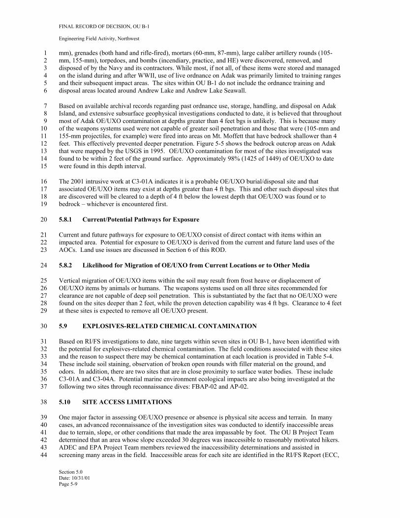
FINAL RECORD OF DECISION, OU B-1
Engineering Field Activity, Northwest
1 mm), grenades (both hand and rifle-fired), mortars (60-mm, 87-mm), large caliber artillery rounds (1052 mm, 155-mm), torpedoes, and bombs (incendiary, practice, and HE) were discovered, removed, and 3 disposed of by the Navy and its contractors. While most, if not all, of these items were stored and managed 4 on the island during and after WWII, use of live ordnance on Adak was primarily limited to training ranges 5 and their subsequent impact areas. The sites within OU B-1 do not include the ordnance training and 6 disposal areas located around Andrew Lake and Andrew Lake Seawall.
7 Based on available archival records regarding past ordnance use, storage, handling, and disposal on Adak 8 Island, and extensive subsurface geophysical investigations conducted to date, it is believed that throughout 9 most of Adak OE/UXO contamination at depths greater than 4 feet bgs is unlikely. This is because many
10 of the weapons systems used were not capable of greater soil penetration and those that were (105-mm and 11 155-mm projectiles, for example) were fired into areas on Mt. Moffett that have bedrock shallower than 4 12 feet. This effectively prevented deeper penetration. Figure 5-5 shows the bedrock outcrop areas on Adak 13 that were mapped by the USGS in 1995. OE/UXO contamination for most of the sites investigated was 14 found to be within 2 feet of the ground surface. Approximately 98% (1425 of 1449) of OE/UXO to date 15 were found in this depth interval.
16 The 2001 intrusive work at C3-01A indicates it is a probable OE/UXO burial/disposal site and that 17 associated OE/UXO items may exist at depths greater than 4 ft bgs. This and other such disposal sites that 18 are discovered will be cleared to a depth of 4 ft below the lowest depth that OE/UXO was found or to 19 bedrock – whichever is encountered first.
20 5.8.1 Current/Potential Pathways for Exposure
21 Current and future pathways for exposure to OE/UXO consist of direct contact with items within an 22 impacted area. Potential for exposure to OE/UXO is derived from the current and future land uses of the 23 AOCs. Land use issues are discussed in Section 6 of this ROD.
24 5.8.2 Likelihood for Migration of OE/UXO from Current Locations or to Other Media
25 Vertical migration of OE/UXO items within the soil may result from frost heave or displacement of 26 OE/UXO items by animals or humans. The weapons systems used on all three sites recommended for 27 clearance are not capable of deep soil penetration. This is substantiated by the fact that no OE/UXO were 28 found on the sites deeper than 2 feet, while the proven detection capability was 4 ft bgs. Clearance to 4 feet 29 at these sites is expected to remove all OE/UXO present.
30 5.9 EXPLOSIVES-RELATED CHEMICAL CONTAMINATION
31 Based on RI/FS investigations to date, nine targets within seven sites in OU B-1, have been identified with 32 the potential for explosives-related chemical contamination. The field conditions associated with these sites 33 and the reason to suspect there may be chemical contamination at each location is provided in Table 5-4. 34 These include soil staining, observation of broken open rounds with filler material on the ground, and 35 odors. In addition, there are two sites that are in close proximity to surface water bodies. These include 36 C3-01A and C3-04A. Potential marine environment ecological impacts are also being investigated at the 37 following two sites through reconnaissance dives: FBAP-02 and AP-02.
38 5.10 SITE ACCESS LIMITATIONS
39 One major factor in assessing OE/UXO presence or absence is physical site access and terrain. In many 40 cases, an advanced reconnaissance of the investigation sites was conducted to identify inaccessible areas 41 due to terrain, slope, or other conditions that made the area impassable by foot. The OU B Project Team 42 determined that an area whose slope exceeded 30 degrees was inaccessible to reasonably motivated hikers. 43 ADEC and EPA Project Team members reviewed the inaccessibility determinations and assisted in 44 screening many areas in the field. Inaccessible areas for each site are identified in the RI/FS Report (ECC,
Section 5.0 Date: 10/31/01 Page 5-9
FINAL RECORD OF DECISION, OU B-1
Engineering Field Activity, Northwest
1 2001) and are recommended for NOFA because the terrain prevents most human contact (e.g. recreational 2 hiker) to surface and subsurface OE/UXO. Areas within these sites that are not cleared will be documented 3 with survey information contained in clearance reports (ECC, 2001) and will be included in the Adak 4 OE/UXO Educational Awareness Plan. 5
Section 5.0 Date: 10/31/01 Page 5-10
FINAL RECORD OF DECISION, OU B-1
Engineering Field Activity, Northwest
Transport andSecondary Migration
Sources Mechanisms Exposure Media Exposure Routes
Surface
Human Activities
Run-Off (Precipitation and
Snow-Melt)
Subsurface
Human Activities
Erosion
OE Leachate2 Percolation
Near-Coastal Waters
Storm Surge
Tides/Wave Action
Ground Surface (as defined)1
Subsurface
Inland Surface Water Sediments
Coastal Beaches or Near-Shore
Sediment
Inland Surface Waters
Ground Water
Direct Contact
Direct Contact
Direct Contact
Direct Contact
Ingestion
Ingestion
Dermal Exposure
Subsurface Soil Dermal Exposure R
esid
ent i
Com
m./I
ndus
t. W
orke
r
Con
stru
ctio
n W
orke
r
EOD
/UXO
Wor
kers
Rec
reat
onal
Use
rs
Hun
ters
/Fis
herm
en
1 2 3 Figure 5-1 Conceptual Site Model4 5 Notes: 6 1Ground surface (as defined): For some users “Ground Surface” may include incidental subsurface intrusion (e.g., placing tent stakes).7 2OE Residue on the surface may give an exposure pathway to inland surface waters through erosion and run-off. 8 Shaded squares represent potentially complete pathways.
Res
earc
her
i
Aqua
ti
Terre
stra
l Wild
life
c W
ildlif
e
Section 5.0 Date: 10/31/01 Page 5-11
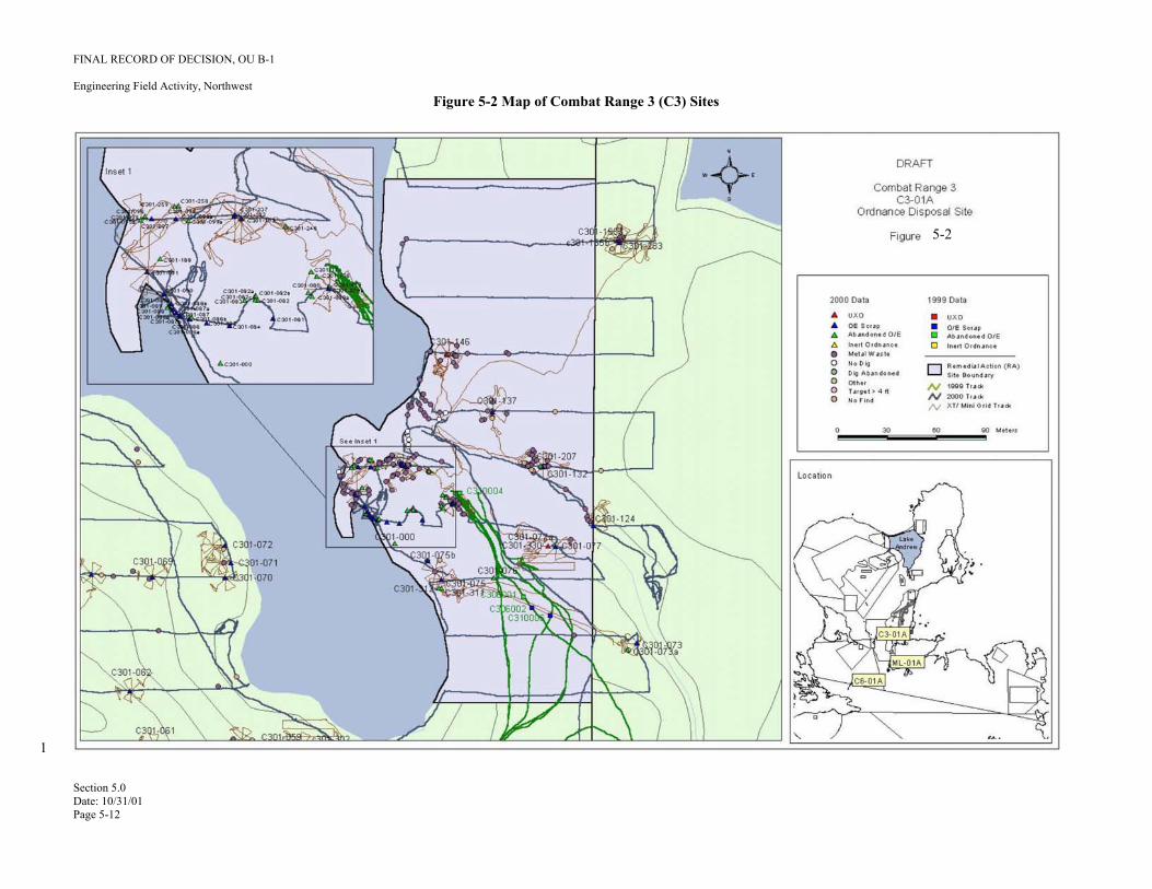
FINAL RECORD OF DECISION, OU B-1
Engineering Field Activity, Northwest Figure 5-2 Map of Combat Range 3 (C3) Sites
1
5-2
Section 5.0 Date: 10/31/01 Page 5-12
FINAL RECORD OF DECISION, OU B-1
Engineering Field Activity, Northwest Figure 5-3 Map of Combat Range 6 (C6) Sites
1
5-3
Section 5.0 Date: 10/31/01 Page 5-13
FINAL RECORD OF DECISION, OU B-1
Engineering Field Activity, Northwest Figure 5-4 Map of Mitt Lake (ML) Sites
1
5-4
Section 5.0 Date: 10/31/01 Page 5-14
FINAL RECORD OF DECISION, OU B-1
Engineering Field Activity, Northwest
1 Figure 5-5 Bedrock Areas on Adak Island (In color shown in green)2
Bedrock outcrops
Section 5.0 Date: 10/31/01 Page 5-15
FINAL RECORD OF DECISION, OU B-1
Engineering Field Activity, Northwest
1 Table 5-1 2 Summary of Significant Records 3
Firing Orders (1943 & 1944) Type of Record
Specific location (coordinates) of 10 target impact areas for test firing of large caliber weapons; information on the types of weapons fired into each area; and, in some cases, the location of the firing point and the range fan (1 area only).
Data Obtained
Field Order #1 – Adak Defense Plan (May 1945)
The general location (sketches) of planned defensive works for Adak including anti-tank barriers, proposed minefields, and existing gun emplacements. Directives for when and how minefields will be laid.
Training Memorandum #12 – Orientation Lecture (Oct. 1944)
Defense Plan for Adak confirming the proposed minefield locations in Field Order #1 and showing additional proposed minefield locations.
Training Memorandum #12 – Practice Firing (July 1943)
Sketch of newly designated combat ranges for use in troop training maneuvers and test firing of weapons. Specification that written requests to test fire large caliber weapons and written permission will be required (see firing orders).
Training Memorandum Number 38 (Sept. 1944)
Sketch of the location of 16 designated post-firing ranges (pistol, rifle, machine gun, rifle grenade, hand grenade, anti-tank grenade, etc.); no coordinates supplied.
Unexploded Ordnance Survey 1996 Map showing the configuration of several of the practice ranges and the Open Burn/Open Detonation ordnance disposal range at Andrew Lake (formerly called Parcel 4). Summary of ordnance survey, including recommendations for future investigation of selected areas. Anecdotal information regarding the potential for mines/ordnance in SWMU 2 at Clam Lagoon.
EOD Incident Reports 1945 – 1995
Information regarding all reported contact with ordnance items discovered during the period 1945-95. Most reports contain the type and number of items found and the general area of the contact.
Photographs Photographs from 1945 showing a firepower demonstration at the Finger Bay Small Arms Range Complex. The demonstration was conducted using mortars fired from the range area toward the west/southwest.
War Diaries/Unit Journals History of units/groups including limited information on test firing exercises conducted by various groups.
Ordnance Inventories from Archival Search Report
Information on the types and amounts of ordnance delivered to Adak; limited information on the amounts of ordnance allotted for training/testing purposes. This effort (FWENC, 1998) consisted of historical document reviews in government archives and personnel interviews with people who served on Adak during and after World War II. This information, including 1500 ordnance-related documents, was evaluated to aid in the location and evaluation of ordnance related activities.
4 5 Source: FWENC, 1998 6
Section 5.0 Date: 10/31/01 Page 5-16

FINAL RECORD OF DECISION, OU B-1
Engineering Field Activity, Northwest
1 Table 5-2 2 Ordnance-Related Target Anomaly Item Summary For 1999 and 2000 Field Seasons 3
Year
Sectors Transect Miles
Ribbon-Walk
Acreage
Target Anomalies Detected
Anomalies Investigated
Ordnance-Related Items1/ UXO
Abandoned OE
OE Scrap
1999 26 594 236 7,243 4,991 906 66 48 790 2000 72 6962/ 277 5,957 4,407 1,433 67 143 1,174
4 5 Notes 6 1/ Includes total of UXO, abandoned OE, OE/UXO scrap, and inert ordnance. 7 The differences between the values in columns five and six of this table are due to the presence of non-ordnance related metallic items 8 such as nails, cans, etc., or false positive target identification stemming from conservative interpretation of raw geographical data. 9 2/ Includes mileage from investigations within OU B-1 and OU B-2.
10
Section 5.0 Date: 10/31/01 Page 5-17
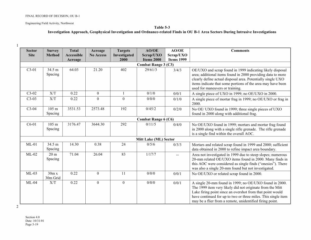
--
1
FINAL RECORD OF DECISION, OU B-1
Engineering Field Activity, Northwest Table 5-3
Investigation Approach, Geophysical Investigation and Ordnance-related Finds in OU B-1 Area Sectors During Intrusive Investigations
Sector Site
Survey Method
Total Accessible Acreage
Acreage No Access
Targets Investigated
2000
AO/OE Scrap/UXO Items 2000
AO/OE Scrap/UXO Items 1999
Comments
Combat Range 3 (C3) C3-01 34.5 m
Spacing 64.03 21.20 402 29/61/3 3/4/3 OE/UXO and scrap found in 1999 indicating likely disposal
area; additional items found in 2000 providing data to more clearly define actual disposal area. Potentially single UXO items indicate that some portions of the area may have been used for maneuvers or training.
C3-02 X/T 0.22 0 1 0/1/0 0/0/1 A single piece of UXO in 1999; no OE/UXO in 2000. C3-03 X/T 0.22 0 0 0/0/0 0/1/0 A single piece of mortar frag in 1999; no OE/UXO or frag in
2000. C3-04 105 m
Spacing 3531.53 2573.48 192 0/45/2 0/2/0 No OE/ UXO found in 1999; three single pieces of UXO
found in 2000 along with additional frag. Combat Range 6 (C6)
C6-01 105 m Spacing
3176.47 3644.30 292 0/11/5 0/4/0 No OE/UXO found in 1999; mortars and mortar frag found in 2000 along with a single rifle grenade. The rifle grenade is a single find within the overall AOC.
Mitt Lake (ML) Sector ML-01 34.5 m
Spacing 14.30 0.38 24 0/5/6 0/3/3 Mortars and related scrap found in 1999 and 2000; sufficient
data obtained in 2000 to refine impact area boundary. ML-02 20 m
Spacing 71.04 26.04 83 1/17/7 Area not investigated in 1999 due to steep slopes; numerous
20-mm related OE/UXO items found in 2000. Many finds in this AOC were considered as single finds (“onesies”). There was also a single 20-mm found but not investigated.
ML-03 30m x 30m Grid
0.22 0 11 0/0/0 0/0/1 No OE/UXO or related scrap found in 2000.
ML-04 X/T 0.22 0 0 0/0/0 0/0/1 A single 20-mm found in 1999; no OE/UXO found in 2000. The 1999 item very likely did not originate from the Mitt Lake firing point since an overshot from that point would have continued for up to two or three miles. This single item may be a flier from a remote, unidentified firing point.
Section 4.0 Date: 10/31/01 Page 5-19
2
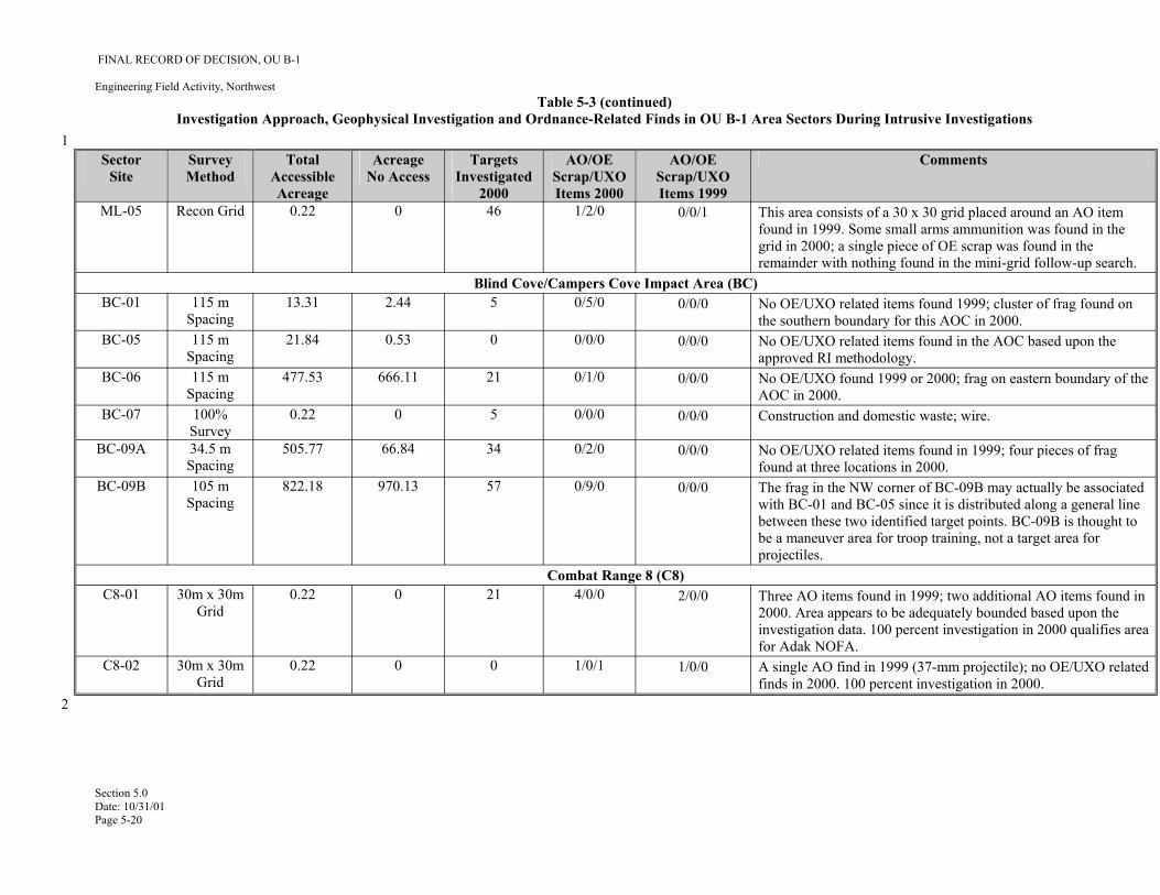
1
FINAL RECORD OF DECISION, OU B-1
Engineering Field Activity, Northwest Table 5-3 (continued)
Investigation Approach, Geophysical Investigation and Ordnance-Related Finds in OU B-1 Area Sectors During Intrusive Investigations
Sector Site
Survey Method
Total Accessible Acreage
Acreage No Access
Targets Investigated
2000
AO/OE Scrap/UXO Items 2000
AO/OE Scrap/UXO Items 1999
Comments
ML-05 Recon Grid 0.22 0 46 1/2/0 0/0/1 This area consists of a 30 x 30 grid placed around an AO item found in 1999. Some small arms ammunition was found in the grid in 2000; a single piece of OE scrap was found in the remainder with nothing found in the mini-grid follow-up search.
Blind Cove/Campers Cove Impact Area (BC) BC-01 115 m
Spacing 13.31 2.44 5 0/5/0 0/0/0 No OE/UXO related items found 1999; cluster of frag found on
the southern boundary for this AOC in 2000. BC-05 115 m
Spacing 21.84 0.53 0 0/0/0 0/0/0 No OE/UXO related items found in the AOC based upon the
approved RI methodology. BC-06 115 m
Spacing 477.53 666.11 21 0/1/0 0/0/0 No OE/UXO found 1999 or 2000; frag on eastern boundary of the
AOC in 2000. BC-07 100%
Survey 0.22 0 5 0/0/0 0/0/0 Construction and domestic waste; wire.
BC-09A 34.5 m Spacing
505.77 66.84 34 0/2/0 0/0/0 No OE/UXO related items found in 1999; four pieces of frag found at three locations in 2000.
BC-09B 105 m Spacing
822.18 970.13 57 0/9/0 0/0/0 The frag in the NW corner of BC-09B may actually be associated with BC-01 and BC-05 since it is distributed along a general line between these two identified target points. BC-09B is thought to be a maneuver area for troop training, not a target area for projectiles.
Combat Range 8 (C8) C8-01 30m x 30m
Grid 0.22 0 21 4/0/0 2/0/0 Three AO items found in 1999; two additional AO items found in
2000. Area appears to be adequately bounded based upon the investigation data. 100 percent investigation in 2000 qualifies area for Adak NOFA.
C8-02 30m x 30m Grid
0.22 0 0 1/0/1 1/0/0 A single AO find in 1999 (37-mm projectile); no OE/UXO related finds in 2000. 100 percent investigation in 2000.
Section 5.0 Date: 10/31/01 Page 5-20
2
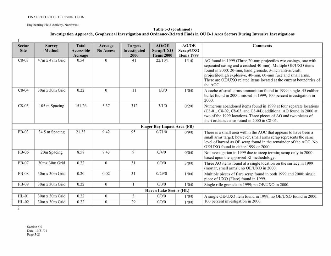
1
FINAL RECORD OF DECISION, OU B-1
Engineering Field Activity, Northwest Table 5-3 (continued)
Investigation Approach, Geophysical Investigation and Ordnance-Related Finds in OU B-1 Area Sectors During Intrusive Investigations
Sector Site
Survey Method
Total Accessible Acreage
Acreage No Access
Targets Investigated
2000
AO/OE Scrap/UXO Items 2000
AO/OE Scrap/UXO Items 1999
Comments
C8-03 47m x 47m Grid 0.54 0 41 22/10/1 1/1/0 AO found in 1999 (Three 20-mm projectiles w/o casings, one with separated casing and a crushed 40-mm). Multiple OE/UXO items found in 2000: 20-mm, hand grenade, 3-inch anti-aircraft projectile/high explosive, 40-mm, 60-mm fuze and small arms. There are OE/UXO related items located at the current boundaries of the AOC.
C8-04 30m x 30m Grid 0.22 0 11 1/0/0 1/0/0 A cache of small arms ammunition found in 1999; single .45 caliber bullet found in 2000; missed in 1999; 100 percent investigation in 2000.
C8-05 105 m Spacing 151.26 5.37 312 3/1/0 0/2/0 Numerous abandoned items found in 1999 at four separate locations (C8-01, C8-02, C8-03, and C8-04); additional AO found in 2000 at two of the 1999 locations. Three pieces of AO and two pieces of inert ordnance also found in 2000 in C8-05.
Finger Bay Impact Area (FB) FB-03 34.5 m Spacing 21.33 9.42 95 0/71/0 0/9/0 There is a small area within the AOC that appears to have been a
small arms target; however, small arms scrap represents the same level of hazard as OE scrap found in the remainder of the AOC. No OE/UXO found in either 1999 or 2000.
FB-06 20m Spacing 8.58 7.43 9 0/4/0 0/0/0 No investigation in 1999 due to steep terrain; scrap only in 2000 based upon the approved RI methodology.
FB-07 30mx 30m Grid 0.22 0 31 0/0/0 3/0/0 Three AO items found at a single location on the surface in 1999 (mortar, small arms); no OE/UXO in 2000.
FB-08 30m x 30m Grid 0.20 0.02 31 0/29/0 1/0/0 Multiple pieces of flare scrap found in both 1999 and 2000; single piece of UXO (Flare) found in 1999.
FB-09 30m x 30m Grid 0.22 0 1 0/0/0 1/0/0 Single rifle grenade in 1999; no OE/UXO in 2000. Haven Lake Sector (HL)
HL-01 30m x 30m Grid 0.22 0 3 0/0/0 1/0/0 A single OE/UXO item found in 1999; no OE/UXO found in 2000. 100 percent investigation in 2000. HL-02 30m x 30m Grid 0.22 0 29 0/0/0 1/0/0
Section 5.0 Date: 10/31/01 Page 5-21
2
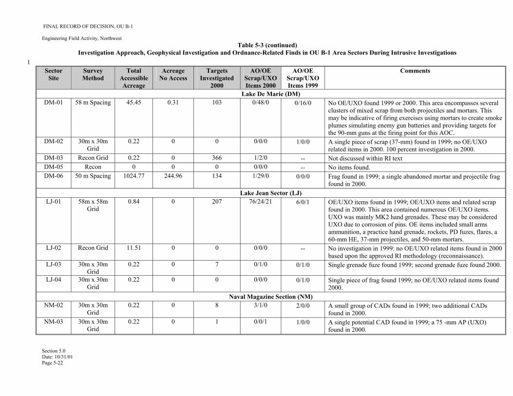
-- --
--
1
FINAL RECORD OF DECISION, OU B-1
Engineering Field Activity, Northwest Table 5-3 (continued)
Investigation Approach, Geophysical Investigation and Ordnance-Related Finds in OU B-1 Area Sectors During Intrusive Investigations
Sector Site
Survey Method
Total Accessible Acreage
Acreage No Access
Targets Investigated
2000
AO/OE Scrap/UXO Items 2000
AO/OE Scrap/UXO Items 1999
Comments
Lake De Marie (DM) DM-01 58 m Spacing 45.45 0.31 103 0/48/0 0/16/0 No OE/UXO found 1999 or 2000. This area encompasses several
clusters of mixed scrap from both projectiles and mortars. This may be indicative of firing exercises using mortars to create smoke plumes simulating enemy gun batteries and providing targets for the 90-mm guns at the firing point for this AOC.
DM-02 30m x 30m Grid
0.22 0 0 0/0/0 1/0/0 A single piece of scrap (37-mm) found in 1999; no OE/UXO related items in 2000. 100 percent investigation in 2000.
DM-03 Recon Grid 0.22 0 366 1/2/0 Not discussed within RI text DM-05 Recon 0 0 0 0/0/0 No items found. DM-06 50 m Spacing 1024.77 244.96 134 1/29/0 0/0/0 Frag found in 1999; a single abandoned mortar and projectile frag
found in 2000. Lake Jean Sector (LJ)
LJ-01 58m x 58m Grid
0.84 0 207 76/24/21 6/0/1 OE/UXO items found in 1999; OE/UXO items and related scrap found in 2000. This area contained numerous OE/UXO items. UXO was mainly MK2 hand grenades. These may be considered UXO due to corrosion of pins. OE items included small arms ammunition, a practice hand grenade, rockets, PD fuzes, flares, a 60-mm HE, 37-mm projectiles, and 50-mm mortars.
LJ-02 Recon Grid 11.51 0 0 0/0/0 No investigation in 1999: no OE/UXO related items found in 2000 based upon the approved RI methodology (reconnaissance).
LJ-03 30m x 30m Grid
0.22 0 7 0/1/0 0/1/0 Single grenade fuze found 1999; second grenade fuze found 2000.
LJ-04 30m x 30m Grid
0.22 0 0 0/0/0 0/1/0 Single piece of frag found 1999; no OE/UXO related items found 2000.
Naval Magazine Section (NM) NM-02 30m x 30m
Grid 0.22 0 8 3/1/0 2/0/0 A small group of CADs found in 1999; two additional CADs
found in 2000. NM-03 30m x 30m
Grid 0.22 0 1 0/0/1 1/0/0 A single potential CAD found in 1999; a 75 -mm AP (UXO)
found in 2000.
Section 5.0 Date: 10/31/01 Page 5-22

--
FINAL RECORD OF DECISION, OU B-1
Engineering Field Activity, Northwest Table 5-3 (continued)
Investigation Approach, Geophysical Investigation and Ordnance-Related Finds in OU B-1 Area Sectors During Intrusive Investigations Sector Survey Total Acreage Targets AO/OE AO/OE Comments
Site Method Accessible No Access Investigated Scrap/UXO Scrap/UXO Acreage 2000 Items 2000 Items 1999
NM-04 30m x 30m Grid
0.22 0 60 0/0/0 0/0/1 A single armed grenade found in 1999; no OE/ UXO related items found in 2000.
Scabbard Bay (SB) SB-01 58 m Spacing 24.94 307.25 0 0/0/0 0/0/0 Nothing found in 1999 or 2000.
Urban Area (UA) UA-01 30m x 30m
Grid 0.22 0 26 0/1/0 1/0/0 A single piece of AO in 1999; a single piece of OE scrap in 2000.
Trash pit; numerous pieces of scrap metal including electrical parts. 100 percent investigation in 2000.
UA-02 78m x 122m Grid
2.32 0 368 3/95/0 1/1/0 One abandoned incendiary bomblet found in 1999 and numerous pieces of related, burned scrap indicating potential disposal; AO found in 2000 including a smoke grenade without fuze and one thermite grenade; OE scrap found including fire bomb weights, M50 thermite bomb noses, a 3-lb. Practice bomb, and a lead practice bomb. Trash pit; a very large number of pieces of metal waste found including steel pipes, wire, machine parts, cans, steel. An energized cable ran through the dig site. 100 percent investigation in 2000.
Runway Sector (RW) RW-01 30m x 30m
Grid 0.22 0 4 0/4/0 1/0/0 A single piece of AO found in 1999 (practice bomb); nothing
found in 2000. Zeto Point (ZP)
ZP-01 65 m Spacing 21.5 0 6 0/0/0 Suspected practice bombing range. Nothing found in 1999 or 2000. EOD reports of small practice bombs disposed of in Lake Shirley.
1 AO – abandoned ordnance 2 AOC – area of concern 3 AP – armor piercing 4 CAD – cartridge actuated device 5 EOD - explosive ordnance disposal 6 ESHA - Explosive Safety Hazard Assessment 7 Frag - fragment (or fragmentation) 8 FS - feasibility study
Section 5.0 Date: 10/31/01 Page 5-23
FINAL RECORD OF DECISION, OU B-1
Engineering Field Activity, Northwest Table 5-3 (continued)
Investigation Approach, Geophysical Investigation and Ordnance-Related Finds in OU B-1 Area Sectors During Intrusive Investigations 1 HE – high explosive 2 NOFA - no further action 3 OE – ordnance and explosives 4 PD - point detonating 5 X/T - star-shaped geophysical transect consisting of 15- or 30-m segments centered over OE/UXO objects and oriented at 45-degree intervals.
Section 5.0 Date: 10/31/01 Page 5-24
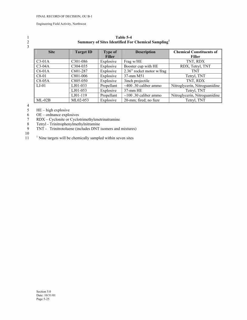
FINAL RECORD OF DECISION, OU B-1
Engineering Field Activity, Northwest
1 Table 5-4 2 Summary of Sites Identified For Chemical Sampling1
3 Site Target ID Type of
Filler Description Chemical Constituents of
Filler C3-01A C301-086 Explosive Frag w/HE TNT, RDX C3-04A C304-035 Explosive Booster cup with HE RDX, Tetryl, TNT C6-01A C601-287 Explosive 2.36” rocket motor w/frag TNT C8-01 C801-006 Explosive 37-mm M51 Tetryl, TNT C8-05A C805-050 Explosive 3inch projectile TNT, RDX LJ-01 LJ01-033 Propellant ~400 .30 caliber ammo Nitroglycerin, Nitroguanidine
LJ01-053 Explosive 37-mm HE Tetryl, TNT LJ01-119 Propellant ~100 .30 caliber ammo Nitroglycerin, Nitroguanidine
ML-02B ML02-053 Explosive 20-mm; fired; no fuze Tetryl, TNT 4 5 HE – high explosive 6 OE – ordnance explosives 7 RDX – Cyclonite or Cyclotrimethylenetrinatramine 8 Tetryl - Trinitrophenylmethylnitramine 9 TNT - Trinitrotoluene (includes DNT isomers and mixtures)
10 11 1 Nine targets will be chemically sampled within seven sites
Section 5.0 Date: 10/31/01 Page 5-25
FINAL RECORD OF DECISION, OU B-1
Engineering Field Activity, Northwest
1 6.0 CURRENT AND POTENTIAL FUTURE LAND AND RESOURCE USES
2 In 1995, the State of Alaska, through the Alaska Department of Community and Regional Affairs 3 (ADCRA), established a Local Reuse Authority (LRA) consisting of stakeholders with potential reuse 4 interest in Adak. The first conceptual reuse plan, prepared for the LRA in 1996 by Tryck Nyman Hayes, 5 Inc., presented three reuse scenarios—low use, middle use, and high use (Tryck Nyman Hayes, Inc. 1996). 6 This plan concluded that reuse was not likely to be economically viable.
7 Some of the participants in the reuse planning process took issue with that conclusion and sought state 8 recognition of a new LRA to proceed with further reuse planning. Accordingly, the Adak Reuse 9 Corporation (ARC) was established to take the role of the LRA. A “revised final” plan was prepared for
10 ARC by ASCG Consultants and released in August 1998 (ASCG 1998). This plan was further refined 11 (ASCG, 2000) and is the land use plan used in preparation of the ROD.
12 The Navy, U.S. Department of the Interior, and TAC signed the Adak Land Transfer Agreement in 13 September of 2000 (U.S. Navy, et. al., 2000). The future land uses established for Adak for the purposes of 14 this ROD are described in the Existing and Future Uses Map, Figure 6-1. Current and project land uses 15 include: residential housing and school facilities; industrial and port facilities, including fishing fleet 16 support, seafood processing, wastewater treatment, power plant operation, domestic landfill operations; 17 ongoing environmental cleanup; administration of USFWS facilities; and recreational activities, including 18 fishing, hunting, hiking, and eco-tours.
19 Current and future land use was considered in the development of the conceptual site models for OU B-1 20 sites. It was also a factor in the ESHA evaluations made for OU B-1 sites. These are discussed in more 21 detail in Section 7 of this ROD. The land uses identified for each site are included in Table 6-1.
22 6.1 CURRENT ON-SITE LAND, GROUNDWATER, AND SURFACE WATER USES
23 The Navy operationally closed the former Naval Air Facility Adak on March 31, 1997. A caretaker 24 contract was awarded by the Navy and on April 1, 1997, that contractor began to maintain base facilities 25 and continue providing services to support environmental cleanup, including billeting, food, water and 26 wastewater, fuel, power, heating, and airport operations. From April 1997 through September 2000, 27 critical facilities such as the power plant, airfield, and environmental cleanup systems were operated by the 28 Navy through that caretaker contract. Since that time, The ARC has been operating and maintaining Adak 29 facilities pursuant to a lease with the Navy. Drinking water continues to be supplied from the surface water 30 reservoir at Lake Bonnie Rose. Throughout the history of the development of Adak, surface water has been 31 used for potable water due to the high quality and abundance of available supply. Groundwater has never 32 been used for potable or industrial purposes. The restriction on installation of groundwater wells in the 33 downtown area under the Adak OU A ROD remains in effect as an institutional control. OU B-1 areas that 34 are subject to ongoing OE/UXO intrusive investigations and clearance activities are designated as exclusion 35 zones during such activities. At the successful conclusion of these activities, access restrictions and 36 warning signs will be removed.
Section 6.0 Date: 10/31/01 Page 6-1
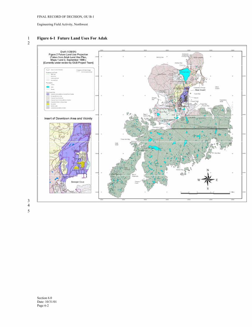
FINAL RECORD OF DECISION, OU B-1
Engineering Field Activity, Northwest
1 Figure 6-1 Future Land Uses For Adak 2
3 4 5
Section 6.0 Date: 10/31/01 Page 6-2
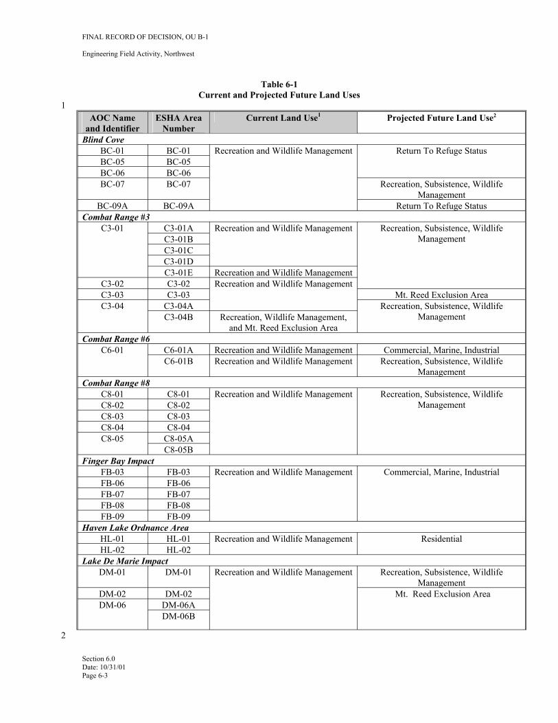
1
FINAL RECORD OF DECISION, OU B-1
Engineering Field Activity, Northwest
Table 6-1 Current and Projected Future Land Uses
AOC Name and Identifier
ESHA Area Number
Current Land Use1 Projected Future Land Use2
Blind Cove BC-01 BC-01 Recreation and Wildlife Management Return To Refuge Status BC-05 BC-05 BC-06 BC-06 BC-07 BC-07 Recreation, Subsistence, Wildlife
Management BC-09A BC-09A Return To Refuge Status
Combat Range #3 C3-01 C3-01A Recreation and Wildlife Management Recreation, Subsistence, Wildlife
Management C3-01B C3-01C C3-01D C3-01E Recreation and Wildlife Management
C3-02 C3-02 Recreation and Wildlife Management C3-03 C3-03 Mt. Reed Exclusion Area C3-04 C3-04A Recreation, Subsistence, Wildlife
Management C3-04B Recreation, Wildlife Management, and Mt. Reed Exclusion Area
Combat Range #6 C6-01 C6-01A Recreation and Wildlife Management Commercial, Marine, Industrial
C6-01B Recreation and Wildlife Management Recreation, Subsistence, Wildlife Management
Combat Range #8 C8-01 C8-01 Recreation and Wildlife Management Recreation, Subsistence, Wildlife
Management C8-02 C8-02 C8-03 C8-03 C8-04 C8-04 C8-05 C8-05A
C8-05B Finger Bay Impact
FB-03 FB-03 Recreation and Wildlife Management Commercial, Marine, Industrial FB-06 FB-06 FB-07 FB-07 FB-08 FB-08 FB-09 FB-09
Haven Lake Ordnance Area HL-01 HL-01 Recreation and Wildlife Management Residential HL-02 HL-02
Lake De Marie Impact DM-01 DM-01 Recreation and Wildlife Management Recreation, Subsistence, Wildlife
Management DM-02 DM-02 Mt. Reed Exclusion Area DM-06 DM-06A
DM-06B
Section 6.0 Date: 10/31/01 Page 6-3
2
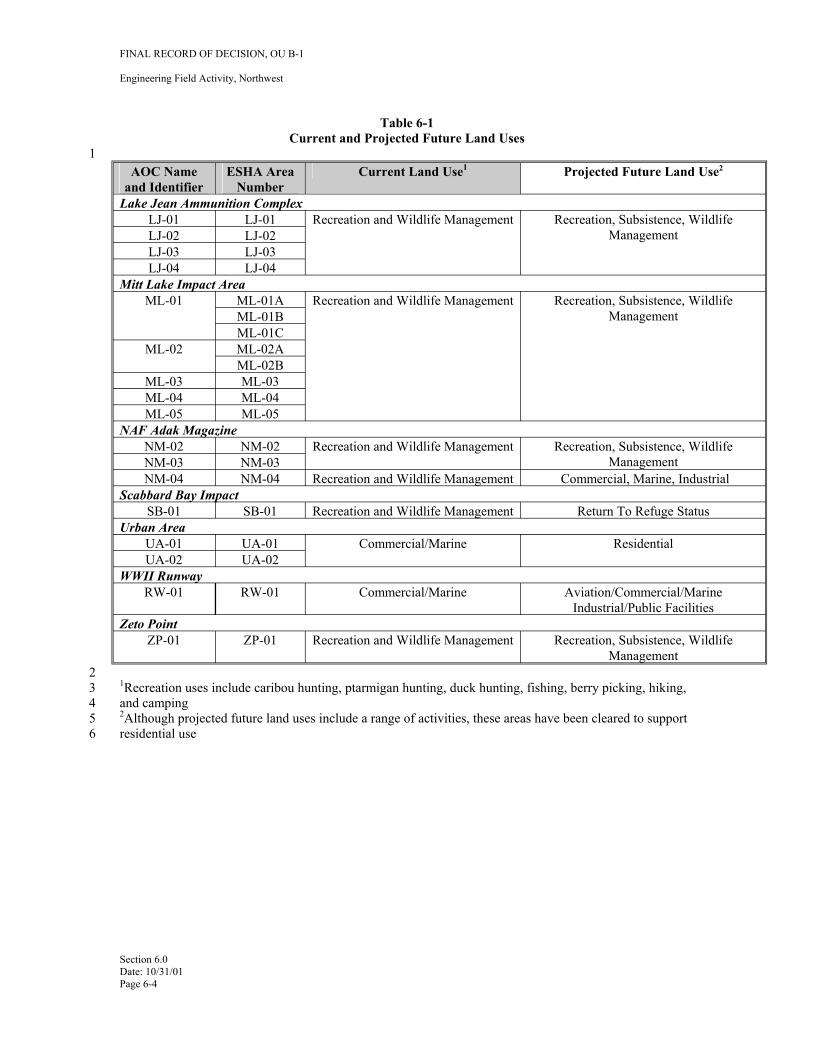
1
FINAL RECORD OF DECISION, OU B-1
Engineering Field Activity, Northwest
Table 6-1 Current and Projected Future Land Uses
AOC Name and Identifier
ESHA Area Number
Current Land Use1 Projected Future Land Use2
Lake Jean Ammunition Complex LJ-01 LJ-01 Recreation and Wildlife Management Recreation, Subsistence, Wildlife
Management LJ-02 LJ-02 LJ-03 LJ-03 LJ-04 LJ-04
Mitt Lake Impact Area ML-01 ML-01A Recreation and Wildlife Management Recreation, Subsistence, Wildlife
Management ML-01B ML-01C
ML-02 ML-02A ML-02B
ML-03 ML-03 ML-04 ML-04 ML-05 ML-05
NAF Adak Magazine NM-02 NM-02 Recreation and Wildlife Management Recreation, Subsistence, Wildlife
Management NM-03 NM-03 NM-04 NM-04 Recreation and Wildlife Management Commercial, Marine, Industrial
Scabbard Bay Impact SB-01 SB-01 Recreation and Wildlife Management Return To Refuge Status
Urban Area UA-01 UA-01 Commercial/Marine Residential UA-02 UA-02
WWII Runway RW-01 RW-01 Commercial/Marine Aviation/Commercial/Marine
Industrial/Public Facilities Zeto Point
ZP-01 ZP-01 Recreation and Wildlife Management Recreation, Subsistence, Wildlife Management
2 3 1Recreation uses include caribou hunting, ptarmigan hunting, duck hunting, fishing, berry picking, hiking, 4 and camping 5 2Although projected future land uses include a range of activities, these areas have been cleared to support 6 residential use
Section 6.0 Date: 10/31/01 Page 6-4
FINAL RECORD OF DECISION, OU B-1
Engineering Field Activity, Northwest
1 7.0 SUMMARY OF SITE HAZARDS AND RISKS
2 The OU B Project Team was created to develop an investigation and cleanup approach for OU B consistent 3 with the CERCLA process and acceptable to Adak stakeholders. The stakeholder involvement was of 4 particular importance in the development and application of conceptual site models (CSM) that 5 incorporated their unique Adak experiences. Based on evaluation of hazard assessment approaches, a two6 part evaluation of risk was developed. Part 1 was considered the Preliminary Assessment (PA), an initial 7 screening to determine if potential sites should be retained for evaluation through the RI/FS process. Part 2 8 was the development of site-specific explosive safety hazard assessment (ESHA) model to evaluate data 9 provided by the RI process. In addition to potential explosive safety hazards, an evaluation of risk based
10 screening criteria for ordnance related chemicals in soils was developed for sites on Adak where limited 11 releases of ordnance related chemicals may have occurred. These are discussed separately in this section of 12 the ROD.
13 7.1 PRELIMINARY ASSESSMENT
14 7.1.1 Preliminary Assessment Screening
15 The initial step in this approach to evaluate potential explosive safety hazards was the development of a 16 preliminary analytical framework, building on four screening criteria, with which to categorize an AOPC: 17 18 • Likelihood of UXO contamination 19 • Density of UXO contamination 20 • Ordnance hazard severity 21 • Strength of archival and field evidence
22 The OU B Project Team developed the framework, the interrelationship between the criteria, and the data 23 relevant to each screening criterion for AOPCs in increasing detail during the development of the 24 Preliminary Assessment (FWENC, 2000b).
25 Phase I of the PA screening process was conducted to determine whether or not each AOPC represented a 26 hazard significant enough to warrant further consideration. Those sites not initially screened as NOFA 27 were forwarded to the next phase of the PA screening process for decision making on the need for future 28 actions such as investigation or remediation. Sites known or suspected to have low quantities of low29 hazard ordnance, but not having an acceptable strength of data to support the assumed CSM, were referred 30 to site investigation in order to complete the hazard screening for these sites.
31 Phase II of the PA screening process evaluated AOPCs with respect to the ease of access for both 32 assessment and exposure to ordnance. Sites with very limited access would not only be very difficult to 33 assess, but would not pose the same level of hazard as an accessible site containing the same type and 34 quantity of ordnance. Sites with lower accessibility were judged to have a lower priority for action than 35 those easily accessible to the public.
36 Following this phase of screening, AOPCs having a high enough ranking for further action were evaluated 37 to determine the most appropriate level of action. This determination was based on the qualitative hazard 38 for the AOPC (ordnance hazard ranking) and the relative access for public exposure. A decision tree was 39 developed for each ordnance hazard category to simplify and standardize this process. Sites that did not 40 meet the minimum strength of data requirement for further action were eliminated from the process and 41 designated as no further action was required in the RI/FS process.
42 7.1.2 Preliminary Assessment Outcomes
43 One hundred ninety-two (192) AOPCs were evaluated during the PA screening (131 in OU B-1 and 61 in 44 OU B-2). Of the number of OU B-1 sites, 104 were found to require No Further Action (i.e., no further 45 consideration in the RI/FS process), based on historical and physical evidence that indicated the site posed
Section 7.0 Date: 10/31/01 Page 7-1
FINAL RECORD OF DECISION, OU B-1
Engineering Field Activity, Northwest
1 little or no qualitative hazard to future residents of Adak. This group of AOPCs includes 27 potential 2 defensive minefield locations on Adak (24 within OU B-1), which evidence indicates were never installed. 3 This group of AOPCs also includes 15 small arms ranges (11 in OU B-1), which all evidence indicates 4 were used only for firing small caliber non-explosive weapons. Eleven AOPCs were referred for Site 5 Inspection due to a lack of evidence with which to assess potential hazard. These sites include firing points 6 and bivouac areas, as well as the known gun emplacements on Adak. Sixty of the OU B-1 AOPCs 7 screened were referred for RI either because the available field data did not support the documented 8 historical land use or because the site requires further physical investigation or remediation. These AOPCs 9 include the majority of the impact areas on Adak, as well as most of the sites where ordnance was found
10 during the 1999 field investigation.
11 The results of the PA are summarized in Table 4-1. It also contains comments that reflect adjustments to 12 the outcome that were agreed to during the OU B Project Team discussions and meetings. For example, 13 the combat ranges were referred for additional investigation even though these areas emerged from the PA 14 process as NOFA sites. The Navy also determined that a small number of sites identified for inspection 15 should move directly to RI in order to facilitate complete and efficient collection of data needed for FS (i.e., 16 collect all data with fewer site visits to optimize use of investigation time and funding). Six AOPCs were 17 not carried forward in the RI process under the BRAC program (not included in the numeric totals cited 18 above), because they encompass areas outside the military reservation. The sites will be addressed by the 19 Corps under the DERP-FUDS program. The adjustments to AOPC status made following the preliminary 20 assessment screen are summarized in Table 2-6 of the RI/FS, which includes the rationale for each change.
21 7.2 EXPLOSIVE SAFETY HAZARD ASSESSMENT (ESHA)
22 7.2.1 Adak Island OU B Explosive Safety Hazard Assessment Methodology (ESHA)
23 Prior to conducting the FS for ordnance-contaminated areas on Adak in OU B-1, it was necessary to 24 identify appropriate areas for the study (i.e., those areas that represent a potential explosive safety hazard to 25 the current and future residents of Adak). These areas were identified using a hazard assessment to analyze 26 the results of the RI and to determine the potential magnitude of risk and hazards associated with any 27 ordnance- related contamination on Adak. The findings of the hazard assessment focus the subsequent 28 development, evaluation, and selection of appropriate response action alternatives for areas where the 29 projected level of risk and hazard is judged to be unacceptable.
30 CERCLA has no specific provisions for dealing with ordnance-related explosive hazards, and the processes 31 developed for assessing health risks associated with chemical substances do not lend themselves directly to 32 the evaluation of explosive hazards. In addition, the hazard assessment methodology developed for Adak is 33 a site-specific process. This process was developed as part of an overall framework for assessing and 34 managing potential threats to human health and the environment on Adak due to the presence of 35 unexploded ordnance (hazard assessment) and the potential release of hazardous chemical substances 36 related to that ordnance (risk assessment).
37 The EHSA developed for Adak is a site-specific hazard assessment process for explosive dangers that 38 addresses the unique character of the island, as allowed by DDESB 6055.9-STD C12.3.4.3. The 39 methodology is qualitative in nature, but makes use of both qualitative and quantitative inputs in a 40 framework that results in recommendations for proper site management of OE/UXO. For example, sites 41 scored as an “A” or “B” were recommended for NOFA; those with a “C” or “D” were recommended for 42 further investigation or remediation.
43 The Adak ESHA is based on four primary factors: 44 45 • Ordnance Search/Removal Status (areas where OE/UXO are known or indicated to be present 46 have higher potential for explosive hazards than areas where OE/UXO have been searched for and 47 not found or where all known ordnance items have been removed) 48
Section 7.0 Date: 10/31/01 Page 7-2
FINAL RECORD OF DECISION, OU B-1
Engineering Field Activity, Northwest
1 • Ordnance Characteristics (different types of ordnance have different potentials for detonation 2 when disturbed, and if detonated, can produce a range of potential consequences) 3 4 • Ordnance Accessibility (the potential for explosive hazards is higher if energetic ordnance items 5 are located at a depth where they would likely be disturbed by current or future land use activities) 6 7 • Public Exposure (a greater potential for explosive hazards occurs when people interact with the 8 land more intensively or more frequently)
9 Each of the four primary factors is subdivided into subfactors. These subfactors are weighted in the 10 calculation of the primary factor to reflect the relative importance of each element. For example, public 11 exposure is influenced by the ease of public access (Are roads or trails present in the area? What is the 12 planned future use for the land?), the intensity of public activity (How much energy will be imparted to the 13 ground?), and the portability of ordnance items present in the area (How easily can the items be transported 14 by a child). All three subfactors influence public exposure hazard; however, the ease with which people 15 may reach and use an area, and the purpose for which they will use that area, are considered more 16 important in the overall evaluation of public exposure than the other two subfactors. Existing and future 17 land uses, which influence these subfactors, are described in Section 6.0.
18 The primary hazard factors are not only made up of weighted sub-factors but are also weighted themselves 19 in the final calculation of explosive hazard to ensure that factors which have more influence in creating risk 20 are more significant in the calculation. The presence or absence of ordnance and the relative hazard of that 21 ordnance are far more important in assessing the overall risk to future residents of Adak. If there is no 22 ordnance present, based on the results of an approved RI approach, then there is little risk no matter how 23 intensively an area is used.
24 The primary factors and subfactors for the Adak ESHA are outlined on the ESHA Scoring Sheet presented 25 in the RI/FS Report (ECC, 2001). A more detailed description of the development and application of the 26 ESHA is presented in the ADAK OU B ESHA Methodology, Version 11 (FWENC, 2000a) which is 27 incorporated in the RI/FS work plan for OU B. Table 7-1 includes the inputs to ESHA used to arrive at a 28 letter score.
29 7.2.2 Results of ESHA Analysis
30 The ESHA process was conducted initially on 44 individual sites located within 41 OU B-1 AOCs. The 31 majority of the sites screened in the ESHA received either an A score (38 sites) or a B score (3 sites), which 32 results in a recommendation for NOFA. One of the “A” sites (BC-01) was subsequently removed from 33 ESHA (leaving a total of 43 sites), and it was forwarded to the FS for additional data needs. For Adak, the 34 NOFA recommendation includes an ordnance awareness and education program (a.k.a. Blue Card training) 35 for island residents and visitors. This program is intended to familiarize residents and visitors with the 36 history of ordnance use, storage, handling, and disposal on Adak, and to inform them of the proper 37 procedures to follow in the event they encounter a suspected ordnance item. This program applies to all 38 areas of the military reservation on Adak, including NOFA sites, and is necessary to address the potential 39 for encountering ordnance, even in areas that have no known ordnance hazard. Three sites received scores 40 of C (2 sites) or D (1 site) in the ESHA, thereby indicating that further remedial action is needed to reduce 41 potential explosive safety hazards at these sites. These are sites C3-01A, C6-01A, and ML-01A. None of 42 the 43 sites screened received an E score, which represents the greatest level of relative explosive hazard. 43 Table 7-2 presents a summary of the EHSA scoring results for the 43 sites.
44 7.3 RISKS FROM EXPLOSIVES-RELATED CHEMICALS
45 Chemical contamination from ordnance on Adak was first evaluated during the SWMU 1 investigation 46 performed under OU A. As SWMU 1 is the most heavily contaminated OE/UXO site identified on Adak, 47 samples taken from within the site and downgradient were considered a worst-case scenario for 48 contamination by OE/UXO. Based on the sampling performed at SWMU 1, contaminant migration of 49 explosives-related compounds was not considered a risk to human health or the environment. Additional
Section 7.0 Date: 10/31/01 Page 7-3
FINAL RECORD OF DECISION, OU B-1
Engineering Field Activity, Northwest
1 details on the chemical contamination evaluation of OE/UXO can be found in the OU A RI/FS Report2 (URS, 1997). Post-removal action sampling was performed at SWMU 2 subsequent to the clearance of 3 OE/UXO from the site. No ordnance-related compounds were detected during this sampling.
4 A complete baseline risk assessment for sites in OU B-1 where ordnance-related chemicals may be present 5 was not undertaken. This is due to several reasons. First, the areas noted in the field notes in Table 5-4 as 6 having potential releases of ordnance chemicals are single items or multiple small arms rounds. Therefore, 7 the potential for release is very limited in terms of quantity and areal extent. The NCP 300.430 (e) 8 indicates that the extent of the evaluation of risks and alternatives should be commensurate with the nature 9 of the release. In this case, given the limited nature of any potential releases, the OU B Team developed a
10 combined soil screening and cleanup approach based on risk based soil screening levels for an assumed 11 residential exposure scenario. Finally, baseline risks for other OE/UXO sites was undertaken under OU A 12 activities at sites with greater impacts and no unacceptable risks were found. Metals were not considered to 13 pose a potential for adverse human health or ecological risk due to the nature of the sites, including those 14 with single or limited rounds where filler release was noted or where soil staining was observed. These 15 observations would not indicate the presence of metals in sufficient quantity to pose potential adverse risks. 16 In a similar manner, filler material was not evaluated for potential adverse ecological risks due to the 17 limited area of release. Several OE/UXO sites with much greater areal extent investigated during the OU A 18 RI/FS were determined not to pose significant adverse ecological risk, given the small number of OE 19 constituents detected and the very low RBSCs (below detection limits) for some OE constituents. For these 20 reasons, it was determined that human health risk-based screening criteria associated with the filler 21 materials would be relied upon for soil remediation decisions.
22 All of the sites listed in Table 5-4 for chemical sampling are in locations designated for recreational or 23 wildlife management in the current and future land use plans. The use of residential soil screening criteria 24 will provide for an added level of conservatism. The numeric values for screening that will also be used for 25 cleanup are the lowest default values from the USEPA Region 9 residential soil screening criteria for 26 ordnance related compounds that may be encountered at these sites (U.S. EPA 1999). The numeric criteria 27 are presented in Section 8 of this ROD. These criteria are equivalent to a 1x10⁻⁶ risk in a residential 28 exposure scenario. 29
Section 7.0 Date: 10/31/01 Page 7-4
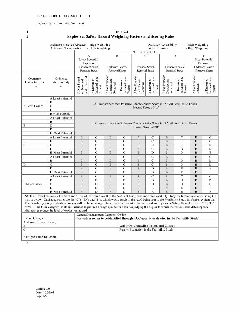
FINAL RECORD OF DECISION, OU B-1
Engineering Field Activity, Northwest
1 Table 7-1 2 Explosives Safety Hazard Weighting Factors and Scoring Rules
Ordnance Presence/Absence - High Weighting Ordnance Accessibility - High Weighting Ordnance Characteristics - High Weighting Public Exposure - High Weighting
PUBLIC EXPOSURE A
Least Potential Exposure
B C D E Most Potential
Exposure Ordnance Search/ Removal Status
Ordnance Search/ Removal Status
Ordnance Search/ Removal Status
Ordnance Search/ Removal Status
Ordnance Search/ Removal Status
Ordnance Characteristics
↓
Ordnance Accessibility
↓
A N
ot F
ound
or D
etec
ted
and
Rem
oved
B K
now
n or
Indi
cated
to b
ePr
esen
t
A N
ot F
ound
or
Dete
cted
and
Rem
oved
B K
now
n or
Indi
cated
to b
ePr
esen
t
A N
ot F
ound
or
Dete
cted
and
Rem
oved
B K
now
n or
Indi
cated
to b
ePr
esen
t
A N
ot F
ound
or
Dete
cted
and
Rem
oved
B K
now
n or
Indi
cated
to b
ePr
esen
t
A N
ot F
ound
or
Dete
cted
B K
now
n or
Indi
cated
to b
ePr
esen
t
A Least Potential
All cases where the Ordnance Characteristics Score is “A” will result in an Overall Hazard Score of “A”
B A Least Hazard C
D E Most Potential A Least Potential
All cases where the Ordnance Characteristics Score is “B” will result in an Overall Hazard Score of “B”
B B C
D E Most Potential A Least Potential B C B C B C B C B C B B C B C B C B C B C
C C B C B C B C B C B D D B C B C B C B D B D E Most Potential B C B C B D B D B E A Least Potential B C B C B C B C B C B B C B C B C B D B D
D C B C B C B C B D B D D B C B C B D B E B E E Most Potential B C B D B D B E B E A Least Potential B C B C B C B C B C B B D B D B D B D B D
E Most Hazard C B D B D B D B D B D D B D B D B E B E B E E Most Potential B D B D B E B E B E
NOTE: Shaded scores are the “A”s and “B”s, which would result in the AOC not being sent on to the Feasibility Study for further evaluation using the matrix below. Unshaded scores are the “C”s, “D”s and “E”s, which would result in the AOC being sent to the Feasibility Study for further evaluation. The Feasibility Study evaluation process will be the same regardless of whether an AOC has received an Explosives Safety Hazard Score of “C”, “D”, or “E”. The three category levels are included to provide a rough qualitative scale for judging the degree to which the various candidate response alternatives reduce the level of explosives hazard.
Hazard Category General Management Response Option (Actual responses to be identified through AOC-specific evaluation in the Feasibility Study)
A (Lowest Hazard Level) B “Adak NOFA”/Baseline Institutional Controls C D E (Highest Hazard Level)
Further Evaluation in the Feasibility Study
Section 7.0 Date: 10/31/01 Page 7-5
3
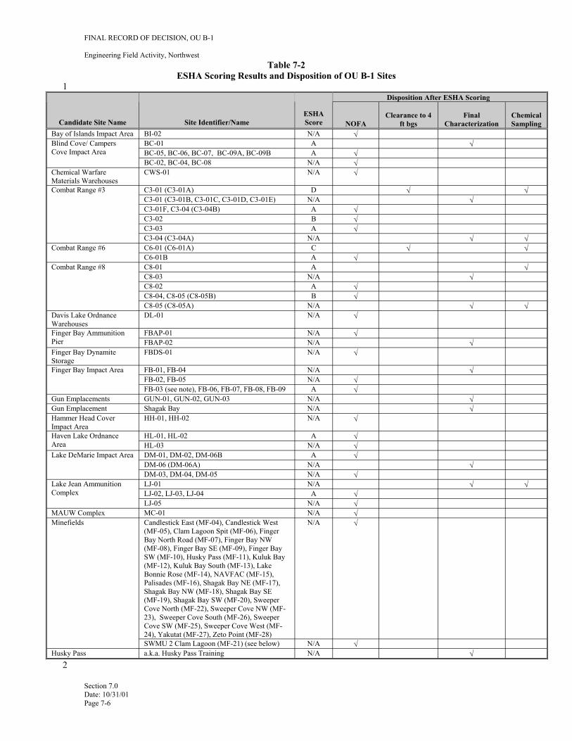
1
FINAL RECORD OF DECISION, OU B-1
Engineering Field Activity, Northwest Table 7-2
ESHA Scoring Results and Disposition of OU B-1 Sites
Candidate Site Name Bay of Islands Impact Area BI-02
BC-01Blind Cove/ Campers
Site Identifier/Name ESHA Score N/A
A
NOFA √
Clearance to 4 ft bgs
Disposition After ESHA Scoring
Final Characterization
√
Chemical Sampling
Chemical Warfare Materials Warehouses
Cove Impact Area
Combat Range #3
CWS-01
BC-05, BC-06, BC-07, BC-09A, BC-09B BC-02, BC-04, BC-08
C3-01 (C3-01A) C3-01 (C3-01B, C3-01C, C3-01D, C3-01E) C3-01F, C3-04 (C3-04B) C3-02 C3-03 C3-04 (C3-04A) C6-01 (C6-01A)
N/A
A N/A
D N/A A B A
N/A C A
√
√ √
√ √ √
√
√
√
√
√
√ √
√
Davis Lake Ordnance Warehouses
Combat Range #6 C6-01B C8-01 C8-03 C8-02 C8-04, C8-05 (C8-05B)
Combat Range #8
C8-05 (C8-05A) DL-01
FBAP-01
N/A
A N/A A B
N/A √
√
√ √
√
√ √
Finger Bay Dynamite Storage
Finger Bay Ammunition Pier FBAP-02
Finger Bay Impact Area
FBDS-01
FB-01, FB-04 FB-02, FB-05 FB-03 (see note), FB-06, FB-07, FB-08, FB-09
N/A
N/A N/A
N/A N/A A
√
√
√ √
√
√
Hammer Head Cover Impact Area
Gun Emplacements Gun Emplacement
Haven Lake Ordnance Area HL-03 Lake DeMarie Impact Area
LJ-01Lake Jean Ammunition Complex
LJ-05 MC-01
HH-01, HH-02
GUN-01, GUN-02, GUN-03 Shagak Bay
HL-01, HL-02
DM-01, DM-02, DM-06B DM-06 (DM-06A) DM-03, DM-04, DM-05
LJ-02, LJ-03, LJ-04
N/A
N/A N/A
A N/A A
N/A N/A N/A A
N/A N/A
√
√ √ √
√
√ √ √
√ √
√
√ √
Minefields MAUW Complex
Husky Pass
Candlestick East (MF-04), Candlestick West (MF-05), Clam Lagoon Spit (MF-06), Finger Bay North Road (MF-07), Finger Bay NW (MF-08), Finger Bay SE (MF-09), Finger Bay SW (MF-10), Husky Pass (MF-11), Kuluk Bay (MF-12), Kuluk Bay South (MF-13), Lake Bonnie Rose (MF-14), NAVFAC (MF-15), Palisades (MF-16), Shagak Bay NE (MF-17), Shagak Bay NW (MF-18), Shagak Bay SE (MF-19), Shagak Bay SW (MF-20), Sweeper Cove North (MF-22), Sweeper Cove NW (MF23), Sweeper Cove South (MF-26), Sweeper Cove SW (MF-25), Sweeper Cove West (MF24), Yakutat (MF-27), Zeto Point (MF-28) SWMU 2 Clam Lagoon (MF-21) (see below) a.k.a. Husky Pass Training
N/A
N/A N/A
√
√ √
Section 7.0 Date: 10/31/01 Page 7-6
2
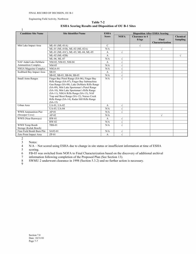
1
FINAL RECORD OF DECISION, OU B-1
Engineering Field Activity, Northwest Table 7-2
ESHA Scoring Results and Disposition of OU B-1 Sites
Candidate Site Name Site Identifier/Name ESHA Disposition After ESHA ScoringScore NOFA Clearance to 4 Chemical
ft bgs Final Sampling Characterization
Mitt Lake Impact Area ML-01 (ML-01A) C √ ML-01 (ML-01B), ML-02 (ML-02A) N/A √ ML-01 (ML-01C), ML-03, ML-04, ML-05 A √ ML-02 (ML-02B) A √ ML-06, ML-07 N/A √
NAF Adak/Lake DeMarie Ammunition Complex
NM-02, NM-03, NM-04 A √ NM-05 N/A √
NSGA Magazine Complex NSGA-01 N/A √ Scabbard Bay Impact Area SB-01 A √
SB-02, SB-03, SB-04, SB-05 N/A √ Small Arms Ranges Finger Bay Pistol Range (SA-06), Finger Bay
Rifle Range (SA-07), Finger Bay Submachine N/A √
Gun Range (SA-08), Lake DeMarie Rifle Range (SA-09), Mitt Lake Sportsman’s Pistol Range (SA-10), Mitt Lake Sportsman’s Rifle Range (SA-11), NSGA Rifle Range (SA-13), NAF Trap and Skeet Range (SA-12), Nurses Creek Rifle Range (SA-14), Radar Hill Rifle Range (SA-15)
Urban Area UA-01, UA-02 A √ UA-03, UA-04 N/A √
WWII Ammunition Pier (Sweeper Cove)
AP-01 N/A √ AP-02 N/A √
WWII (Near Runways) RW-01 A √ RW-02 N/A √
WWII Temp Bomb Storage (Kuluk Beach)
TBS-01 N/A √
Finn Field Bomb Burn Pile SA92-01 N/A √ Zeto Point Impact Area ZP-01 A √
2 3 Notes: 4 N/A – Not scored using ESHA due to change in site status or insufficient information at time of ESHA 5 scoring. 6 FB-03 was switched from NOFA to Final Characterization based on the discovery of additional archival7 information following completion of the Proposed Plan (See Section 13). 8 SWMU 2 underwent clearance in 1998 (Section 5.3.2) and no further action is necessary. 9
Section 7.0 Date: 10/31/01 Page 7-7
FINAL RECORD OF DECISION, OU B-1
Engineering Field Activity, Northwest
1 8.0 REMEDIAL ACTION OBJECTIVES
2 8.1 BACKGROUND
3 The goal of the OU B investigation and remediation activities on Adak Island is to take steps to effectively 4 reduce and manage potential explosive hazards and potential chemical risks posed by OE/UXO in order to 5 protect human health and the environment for the current and reasonably expected future land use. 6 Remedial action criteria are established to define the performance goals for the cleanup. Remedial action 7 criteria typically include Remedial Action Objectives (RAOs), Cleanup Levels, and General Response 8 Actions (GRAs). Because of the limited number of technologies available for addressing OE/UXO, GRAs 9 were not developed in the FS.
10 8.2 REMEDIAL ACTION OBJECTIVES TO CONTROL EXPLOSIVE HAZARDS
11 The RAOs and cleanup levels were considered within the overall framework of the Adak Island OU B 12 ESHA Methodology as described in the RI/FS Work Plan (FWENC, 2000a). This ESHA considers a broad 13 range of factors that influence potential explosive hazards relative to possible exposures at a given site on 14 Adak. These include: 15 16 • The indicated presence or absence of OE/UXO and the strength of evidence of sampling results 17 18 • Type, size, and detonation sensitivity of the ordnance items found 19 20 • The relationship between the depth at which OE/UXO was found (or may migrate to) and the 21 depth at which people may intrude into the soil during the performance of current or projected 22 future activities 23 24 • Frequency of public access to OE/UXO as measured by the ease with which the public can gain 25 access and the nature of the land use (current and/or future), or the ease with which the OE/UXO 26 may be transported out of the area to result in exposures elsewhere
27 The RAOs pertaining to the explosive safety aspect of the ordnance are directly related to the relationship 28 among these risk factors in order to eliminate or reduce the potential for exposure to explosive ordnance in 29 an area. The ESHA Methodology was applied to qualitatively evaluate the baseline (i.e., Adak NOFA) 30 level of explosive hazard projected for the public, given the specified future use and set of associated 31 activities. The ESHA was also used to qualitatively project the change in explosive hazard level and the 32 residual explosive hazard associated with the implementation of a particular remedial alternative. This 33 results in an RAO to reduce remaining potential explosive safety hazards throughout OU B-1 through the 34 application of the ESHA process and subsequent clearance of OE/UXO, as necessary, to support current 35 and reasonably expected future land use.
36 Cleanup levels are typically numeric expressions of RAOs. For explosive hazards, the cleanup level would 37 entail removing all known OE/UXO that can be located with the methods developed for Adak.
38 While there are no current applicable, or relevant and appropriate (ARARs) promulgated federal or state 39 standards to address potential explosive safety hazards, the Department of Defense has issued policies that 40 have been identified as “to be considered” (TBC) for OU B-1. These include DDESB MIL-STD 6055.9, 41 and the DoD policy concerning responsibilities for OE/UXO response actions post-transfer of property 42 (DoD policy memorandum from Under Secretary of Defense, “Responsibility for Additional 43 Environmental Cleanup After Transfer of Real Property,” dated July 25, 1997).
44
Section 8.0 Date: 10/31/01 Page 8-1
FINAL RECORD OF DECISION, OU B-1
Engineering Field Activity, Northwest
1 8.3 REMEDIAL ACTION OBJECTIVES TO CONTROL CHEMICAL RISKS
2 As discussed in Section 7 of this ROD, a combined soil screening and cleanup level approach was 3 developed for the sites listed in Table 5-4. The current and projected future uses of these sites is 4 recreational and wildlife management. The RAO for potential ordnance-related chemical risks at these 5 sites is to prevent future residents and recreational users from being exposed to explosives-related 6 contamination in soil above the cleanup levels. These cleanup levels are based on USEPA Region 9 default 7 residential soil screening levels. The assumptions used to develop these criteria are more conservative than 8 those used in the development of Adak baseline risk assessments for OU A recreational exposure scenarios. 9 The soil cleanup levels for explosives-related chemicals are shown in Table 8-1. Achievement of these
10 cleanup levels will result in an estimated residential risk of 1x10⁻⁶ or lower, and a potential recreational risk 11 that is also lower.
12 The State of Alaska 18 AAC 75 requires a cumulative risk of no more than 1x10⁻⁵. Compliance with this 13 state ARAR should be met by achieving the cleanup levels in Table 8-1. For on-site treatment 18 AAC 14 75.365 Offsite or Portable Treatment would be an ARAR. In the event that off-site treatment and disposal 15 is required for soils containing ordnance related chemicals, 40 CFR Part 264 would be an ARAR.
16 17
Section 8.0 Date: 10/31/01 Page 8-2
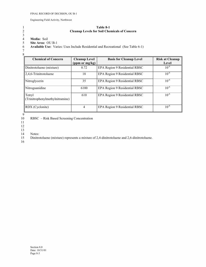
FINAL RECORD OF DECISION, OU B-1
Engineering Field Activity, Northwest
1 Table 8-1 2 Cleanup Levels for Soil Chemicals of Concern 3 4 Media: Soil 5 Site Area: OU B-1 6 Available Use: Varies: Uses Include Residential and Recreational (See Table 6-1) 7 8
Chemical of Concern Cleanup Level (ppm or mg/kg)
Basis for Cleanup Level Risk at Cleanup Level
Dinitrotoluene (mixture) 0.72 EPA Region 9 Residential RBSC 10-6
2,4,6-Trinitrotoluene 18 EPA Region 9 Residential RBSC 10-6
Nitroglycerin 35 EPA Region 9 Residential RBSC 10-6
Nitroguanidine 6100 EPA Region 9 Residential RBSC 10-6
Tetryl (Trinitrophenylmethylnitramine)
610 EPA Region 9 Residential RBSC 10-6
RDX (Cyclonite) 4 EPA Region 9 Residential RBSC 10-6
9 10 RBSC – Risk Based Screening Concentration 11 12 13 14 Notes: 15 Dinitrotoluene (mixture) represents a mixture of 2,4-dinitrotoluene and 2,6-dinitrotoluene. 16
Section 8.0 Date: 10/31/01 Page 8-3
FINAL RECORD OF DECISION, OU B-1
Engineering Field Activity, Northwest
1 9.0 DESCRIPTION OF ALTERNATIVES
2 This section presents the remedial alternatives that were developed and evaluated in the OU B-1 RI/FS.
3 9.1 ALTERNATIVE 1- NOFA (NO FURTHER ACTION/FACILITY-WIDE ORDNANCE 4 AWARENESS PROGRAM)
5 Alternative 1 (Adak NOFA) provides a baseline for comparing the other alternatives. Alternative 1 is 6 evaluated assuming the projected land use for each site given its present state with no additional site7 specific activities aimed at locating, removing, or disposing of any potential OE/UXO. Alternative 1 8 includes the OE/UXO awareness program that is currently required for Adak residents and visitors. This 9 program applies to the entire military reservation at Adak, including sites that are not part of OU B-1, and
10 therefore is not an AOC-specific institutional control. This program is intended to familiarize on-island 11 residents and visitors with the history of ordnance use, storage, handling and disposal on Adak Island; basic 12 characteristics of OE/UXO items on Adak; and the procedures that should be followed if a suspected 13 OE/UXO item is encountered. In addition to maintaining this program, deed notices or other legal 14 instruments will also be used to inform future users of information related to past investigations for 15 OE/UXO.
16 Navy will provide a copy of this OU B-1 ROD and the FOST to BLM to be maintained as part of the 17 permanent file of conveyance documentation. The FOST will contain a full legal description of the 18 properties, associated Institutional Controls, and a legal description of covenants, as appropriate based on 19 decisions in place for the specific OU reference to these documents and their availability in the BLM 20 permanent conveyance file will be included in the interim conveyance executed by BLM. This BLM 21 permanent file of interim conveyance documents will be available to current and future owners of the real 22 estate seeking information about past land uses, including the potential for OE/UXO items. This measure 23 will provide the current and future landowners with a source for information about OE/UXO and the type 24 of remedial actions that have been taken. Otherwise, no AOC-specific actions are provided under the Adak 25 NOFA, and no land use restrictions are identified for the NOFA sites.
26 9.2 ALTERNATIVE 2-SURFACE CLEARANCE (REMOVAL OF SURFACE OE/UXO)
27 Surface clearance involves identifying and removing OE/UXO at the surface (top of the mineral soil level) 28 by conducting a surface sweep and a subsequent removal and disposal operation. This surface clearance 29 action would be applied to all accessible portions of the site, removing and disposing of all metal scrap, 30 OE/UXO debris, and OE/UXO found on the surface. Hand-held metal detectors would be used to assist in 31 locating these items. Digging for OE/UXO is not included with this alternative. Sites subject to this 32 alternative would also be covered by the educational awareness programs.
33 9.3 ALTERNATIVE 3-SURFACE AND SUBSURFACE CLEARANCE TO 4 FEET
34 Alternative 3 includes all the work performed as part of the Surface Clearance alternative with an 35 additional subsurface investigation and clearance to four feet bgs. In addition to reducing risk at a site, 36 subsurface clearance to the maximum depth that OE/UXO were found will further meet the site-specific 37 requirements outlined in DoD 6055.9-STD Chapter 12 for cleanup and transfer of property potentially 38 contaminated by OE/UXO. All accessible portions of a site will be geophysically surveyed, with 39 subsequent removal of detected subsurface OE/UXO and ordnance debris. While a clearance depth of two 40 feet bgs is the minimum required clearance to support the current and reasonably likely future land use for 41 recreational and wildlife areas on Adak, a 4-foot depth was chosen by the OU B Project Team based upon 42 site conditions, ordnance management history, technology to be used for clearance, and the depth intervals 43 at which nearly all OE/UXO has been found on Adak. Achieving a 4-foot clearance depth on these sites
Section 9.0 Date: 10/31/01 Page 9-1

FINAL RECORD OF DECISION, OU B-1
Engineering Field Activity, Northwest
1 will allow residential land use for these sites. Sites subject to this alternative would also be covered by the 2 educational awareness programs.
3 Discovery during the 2001 field season of probable WWII OE/UXO burial/disposal site at C3-01A and 4 subsequent initial investigations and clearance activities indicate that OE/UXO at this location exists below 5 4 feet bgs. This disposal site, and any others where similar conditions are encountered, will be cleared to a 6 depth of 4 feet below the lowest depth that OE/UXO was found or to bedrock – whichever is encountered 7 first.
8 9.4 ALTERNATIVE 4-SAMPLING FOR ORDNANCE COMPOUNDS AND REMOVAL AND 9 DISPOSAL OF EXPLOSIVES-CONTAMINATED SOILS
10 Alternative 4 is an observational approach that addresses 9 targets within 7 sites that were identified 11 through year 2000 field notes. Sampling will be performed where field observations indicate that breached 12 ordnance or staining may have contaminated the soil with chemicals from OE/UXO. Field screening 13 methods will be used to identify soils that are contaminated above cleanup levels in Table 8-1. All such 14 soils at the sites listed in Table 5-4 will be excavated and containerized at the site. Confirmatory sampling 15 to verify that cleanup levels have been achieved will be done through fixed lab analyses. Based on 16 considerations such as the final volume, chemical composition of contaminated soils from the sites, and 17 costs, the soils will either undergo final treatment and disposal on-site, or off-site at a permitted facility. 18 This alternative also assumes excavation and shipment for ultimate treatment and/or disposal of a nominal 19 volume of soil (less than 1 cubic meter per site) contaminated above the cleanup levels from each of these 20 sites.
Section 9.0 Date: 10/31/01 Page 9-2
FINAL RECORD OF DECISION, OU B-1
Engineering Field Activity, Northwest
1 10.0 COMPARATIVE ANALYSIS OF ALTERNATIVES
2 CERCLA requires that the ROD address and support the specific statutory requirements, emphasize long3 term effectiveness, and encourage evaluation of innovative technologies. Nine evaluation criteria 4 contained in the NCP provide the basis for determining which alternative provides the “best balance” 5 among the alternatives to meet the nine criteria. The nine criteria are grouped into three categories, based 6 upon the role of each during remedy selection.
7 • Threshold criteria: 8 − Overall protection of human health and the environment 9 − Compliance with ARARs/TBCs
10 • Balancing criteria: 11 − Long-term effectiveness and permanence 12 − Reduction of toxicity, mobility, and volume through treatment 13 − Short-term effectiveness 14 − Implementability 15 − Cost of implementation 16 • Modifying criteria 17 − State acceptance 18 − Community acceptance
19 This section presents the evaluation of the four identified remedial alternatives based on the nine selection 20 criteria. A description of each criterion is presented along with the evaluation of each alternative in the 21 following sections.
22 The comparative analysis evaluates the relative performance of each alternative in relation to each specific 23 evaluation criterion. The advantages and the disadvantages of each alternative are identified and discussed 24 so that key tradeoffs can be identified for the decision-makers.
25 10.1 COMPARATIVE ANALYSIS FOR C3-01A, C6-01A, ML-01A, AND THE 24 AOPC SITES. 26 AND THE 7 POTENTIAL CHEMICAL RELEASE SITES.
27 This section presents the results of the nine NCP criteria evaluation for the C3-01A Ordnance Disposal 28 Site, C6-01A Mortar Impact Area, the ML-01A Mortar Impact Area, the 24 AOPC sites, and the 7 sites 29 (nine targets) where potential ordnance-related chemicals may been released into the environment. 30 Table 10-1 provides a summary of these evaluations.
31 10.1.1 Overall Protection of Human Health and the Environment
32 This criterion addresses whether each alternative provides adequate protection of human health and the 33 environment and describes how risks posed through each exposure pathway are eliminated, reduced, or 34 controlled through treatment, engineering controls, and/or institutional controls. The overall protection of 35 human health and the environment reflects the level of relative residual hazard remaining after the 36 alternative has been implemented, compliance with ARARs/TBCs, and long-term and short-term 37 effectiveness.
38 Alternative 3 (OE/UXO Surface and Subsurface Clearance to 4 feet bgs) is highly protective of human 39 health and the environment with respect to explosives safety. Removal of OE/UXO will be protective of 40 human health and the environment. Alternative 2 (Surface Clearance) is considered slightly protective of 41 human health and the environment, but a moderate level of relative residual hazard remains. This 42 alternative does not meet the threshold of being compliant with the site-specific DDESB TBC (DoD
Section 10.0 Date: 10/31/01 Page 10-1
FINAL RECORD OF DECISION, OU B-1
Engineering Field Activity, Northwest
1 Instruction 6055.9-STD), and the long-term effectiveness is not reduced because some of the OE/UXO 2 remain.
3 Alternative 1 is the baseline alternative providing no remedial action. The results show the Adak4 NOFA/Baseline Institutional Controls Alternative has the lowest level of relative protectiveness.
5 Alternative 4 (Sampling, Removal, Treatment and Disposal of Explosives-Contaminated Soils) involves 6 clean up of soils that contain ordnance-related compounds through treatment and disposal that will be 7 protective of human health and the environment.
8 10.1.2 Compliance with ARARs/TBCs
9 This criterion evaluates whether a remedial action meets state and federal environmental laws and 10 regulations that pertain to the site. For explosive safety concerns, the primary TBC is the site-specific 11 DDESB DoD Instruction 6055.9-STD guidelines (DoD, 1999) for clearance for property transfer. These 12 standards establish policies and procedures necessary to provide protection to personnel as a result of DoD 13 ammunition, explosives, or chemical agents and contamination of real property currently or formerly 14 owned, leased, or used by DoD. These include default clearance depths for projected land uses, absent site15 specific clearance requirements.
16 Alternative 3 (OE/UXO Surface and Subsurface Clearance) complies with the site-specific clearance 17 depths developed for the Adak OU B-1 clearance activities. A clearance depth of 4 feet bgs will exceed 18 site-specific depths for recreational and wildlife management, and will meet residential clearance depths. 19 The projected depth of intrusion associated with site-specific future activities relative to the OE/UXO 20 clearance depth specified for this alternative is the determining factor in establishing the performance of 21 this alternative.
22 Previously, the maximum depth of OE/UXO discovered at three sites was between 1 foot (ML-01A) and 2 23 feet (C3-01A and C6-01A). The 2001 intrusive work at C3-01A indicates it is a probable OE/UXO 24 burial/disposal site and that associated OE/UXO items may exist at depths greater than 4 ft bgs. This and 25 other such disposal sites that are discovered will be cleared to a depth of 4 ft below the lowest depth that 26 OE/UXO was found or to bedrock – whichever is encountered first. Clearance to 4 feet bgs is the only 27 alternative that will satisfy the site-specific requirements for land transfer.
28 Alternative 2 (Surface Clearance) does not comply with this TBC. Even though surface clearance activities 29 may reduce the presence of OE/UXO, they do not meet the clearance depth requirement of 2 feet for 30 wildlife management and recreation, and without waivers available, remain non-compliant.
31 Alternative 1 (Adak NOFA/Facility-Wide Ordnance Awareness Program) also does not comply with the 32 site-specific DDESB TBC. Alternative 4 will meet or exceed 18 AAC 75 cumulative risk requirements.
33 10.1.3 Long-Term Effectiveness and Permanence
34 Long-term effectiveness and permanence refers to expected residual risk and the ability of a remedy to 35 maintain reliable protection of human health and the environment over time, once cleanup levels have been 36 met. The effectiveness of the alternative is dependent on the level of the relative residual hazard and the 37 adequacy of response.
38 Alternative 3 (Surface and Subsurface Clearance) results in the highest scores for the relative residual 39 hazards and adequacy of the response because the OE/UXO has been rendered safe and the exposure 40 eliminated to 4 feet bgs. These factors combine to establish a high level of long-term effectiveness for 41 Alternative 3.
Section 10.0 Date: 10/31/01 Page 10-2
FINAL RECORD OF DECISION, OU B-1
Engineering Field Activity, Northwest
1 Permanence is based on the need for engineering or institutional controls and maintenance activities to 2 ensure continued protection from residual hazards. Alternative 3 clears OE/UXO, and does not rely on 3 additional controls or maintenance for the site. After the OE/UXO has been cleared, it is assumed the 4 clearance is permanent and complete to the level of certification as defined in the remedial action design 5 documents. The combination of high effectiveness and permanence yields low relative residual hazards for 6 this site, thereby providing the best solution for the long-term.
7 Alternative 2 (Surface Clearance) also involves a permanent OE/UXO clearance. However, the 8 effectiveness is less because of the level of relative residual hazard and the adequacy of response when only 9 clearing the surface of the site. Even though surface clearance of OE/UXO would reduce the presence of
10 OE/UXO it would not remove it completely. Because C3-01A is a disposal area, there are some unique 11 concerns associated with Alternative 2. In addition, both C6-01A and ML-01A are mortar impact areas and 12 because the dud rate for this type of munition is moderately high and dud mortars are capable of burying 13 themselves on impact, the possibility of subsurface OE/UXO remaining is of greater concern. Overall, the 14 long-term effectiveness and permanence for Alternative 2 does not fully eliminate the relative residual 15 hazard, and is not a complete solution for these three sites. Similar concerns exist for some of the 24 16 AOPC sites.
17 Alternative 1 does not reduce the level of relative residual hazard, and remains inadequate as a solution.
18 Alternative 4 includes the cleanup and on-site or offsite treatment and disposal of ordnance contaminated 19 soils that will result in a permanent solution.
20 10.1.4 Reduction of Toxicity, Mobility, and Volume through Treatment
21 This criterion evaluates a remedial action's use of treatment to reduce the harmful effects of principal 22 contaminants, their ability to move in the environment, and the amount of residual contamination 23 remaining.
24 All UXO and OE containing energetic material under Alternative 3 will either be subject to treatment by 25 blow in place or through collection for consolidated detonation at approved locations. Alternative 3 is the 26 only alternative offering a complete reduction in OE/UXO, and is viewed as the best choice for this 27 criterion.
28 Alternative 2 offers partial treatment of the OE/UXO. However, this alternative does not remove OE/UXO 29 to the depth to which it may be present, thereby representing a potential for residual OE/UXO remaining 30 below the ground surface. This alternative would reduce mobility concerns and reduce the potential 31 volume of explosive material present at the surface of the site.
32 Alternative 1 does not provide any reduction in toxicity, mobility, or volume through treatment, as 33 treatment is not a component. Therefore, this alternative does not take steps in risk reduction for this 34 criterion.
35 On-site or off-site treatment and disposal of soils contaminated with ordnance-related compounds under 36 Alternative 4 would satisfy this criterion. Currently available technologies include thermal desorption and 37 composting, both of which are highly effective at reducing toxicity, mobility, and volume of contaminants.
38 10.1.5 Short-Term Effectiveness
39 Short-term effectiveness considers how fast a remedial action reaches the cleanup goal and the risk that the 40 remedial action poses to workers, residents, and the environment during the construction or implementation 41 of the remedial action.
Section 10.0 Date: 10/31/01 Page 10-3
FINAL RECORD OF DECISION, OU B-1
Engineering Field Activity, Northwest
1 Both of the OE-clearance alternatives (2 and 3) are acceptable for short-term effectiveness criteria. Short2 term effectiveness typically considers four components: community risk, worker risk, environmental 3 impacts, and completion time. Community risk is a potential concern because of the proximity of roads to 4 C3-01A and other sites. During intrusive investigations and any detonations of OE/UXO that are required 5 as part of the clearance activities, road access will be restricted and exclusion zones established around the 6 sites. For C6-01A and ML-01A, community risk is minimal due to its remote location and limited access. 7 C6-01A and ML-01A are 1,000 meters and 100 meters, respectively, from the closest hiking trail, and are 8 not on the way to any destination of general interest. These remote locations do however cause some 9 logistical challenges for personnel and equipment due to lack of road access to C6-01A and ML-01A. As a
10 result, staging of equipment and personnel would need to be performed in multiple phases.
11 Worker risk is always a consideration for OE-clearance (Alternatives 2 and 3) and is based on the amount 12 and type of intrusive work involved. The site worker short-term risk is measured by the potential for an 13 explosive accident/incident to occur. Though many precautions are taken to protect the site workers, the 14 density and type of OE/UXO cannot be accurately determined because of the many different caches and 15 types of ordnance found in C3-01A during the previous investigations. The risk of OE/UXO within this 16 site is consistent with a disposal area where typically the items are found not fully destroyed by a 17 demolition shot, or are abandoned by being buried. Prior investigations have shown the risk of OE/UXO 18 within C6-01A and ML-01A to be consistent with a mortar impact area where dud-fired and low-ordered 19 rounds are found. Given the potential for loss of limb or life when dealing with OE/UXO, all clearance 20 activities are considered higher in risk.
21 As would be expected, Alternative 1 is considered the lowest short-term risk, and poses no worker risk 22 hazards. The site factors and UXO factors do not change between Alternatives 2 and 3, but the logistics 23 factors can involve scheduling and controlling crews, accommodating seasonal/weather issues, and 24 providing access to medical assistance. The tundra environment at Adak is fragile and can take many years 25 to return, as evidenced by the footprints of WWII Quonset huts still visible in many areas. OE/UXO 26 clearance to 4 feet bgs is assumed to create a measurable, but not severe, environmental effect. Completion 27 time is the last factor for short-term effectiveness. It is assumed each of the alternatives could be 28 completed in less than 6 months, based on previous field activities on Adak.
29 Under Alternative 4, there is little short-term risk associated with the soil cleanup because of the small 30 volumes and lack of acute toxicity. Personal protective equipment and adherence to standard protocols for 31 sampling and cleanup will minimize any exposure risks to workers.
32 10.1.6 Implementability
33 Implementability addresses the technical and administrative feasibility of a remedy from design through 34 construction and operation. Factors such as availability of services and materials, administrative feasibility, 35 and coordination with other governmental entities are also considered.
36 Alternatives 2, 3, and 4 meet the technical and administrative OE/UXO requirements and are 37 implementable. There are no extraordinary technical requirements due to access, available technology, or 38 interference with subsequent responses. The personnel and general support services provided on Adak are 39 a concern. The site terrain and logistics at each of the three sites may pose unique problems in the 40 mobilization of equipment and personnel under Alternatives 2 and 3. Steep access and multiple streams are 41 present near C3-01A. The waters of Mitt Lake bound the entire western end of ML-01A and implementing 42 C6-0A presents several logistical hurdles, including steep access from the water, long overland access 43 distances, and the uncertainty of DGPS radio access near Mt. Reed.
Section 10.0 Date: 10/31/01 Page 10-4
FINAL RECORD OF DECISION, OU B-1
Engineering Field Activity, Northwest
1 10.1.7 Cost
2 The cost summary sheets with assumptions for the three sites (C3-01A, C6-01A, and ML-01A) are 3 presented in the RI/FS Report (ECC, 2001) and are based on costs for previously performed clearance 4 activities performed at similar sites on Adak. Based on EPA guidance, the cost estimates were developed 5 in the RI/FS Report to be accurate to a range of -30 percent to +50 percent, given the available information. 6 Alternative 3 (OE/UXO Surface and Subsurface Clearance to 4 feet bgs) for the three sites is the most 7 costly at $450,674 for C3-01A, $94,021 for C6-01A, and $171,467 for ML-01A. Alternative 2 (Surface 8 Clearance) is the second most costly at $126,224 for C3-01A, $34,759 for C6-01A, and $50,327 for 9 ML-01A. Costs for Alternative 1 are estimated to be $50,000 for management of the program.
10 For Alternative 4, the cost for the chemical sampling and disposition of soil at is estimated to be $15,305. 11 These costs are based upon the assumptions that the 9 targets within 7 sites to be sampled will generate 12 seven drums of hazardous waste that must be disposed of off-island.
13 An additional 24 sites will undergo final characterization and clearance. The costs for site recon, surface 14 clearance, and subsurface clearance to 4 feet bgs have been estimated to $692,163.
15 10.1.8 State and Community Acceptance
16 ADEC has had significant involvement over the past two years in the OU B process and supports the 17 recommended cleanup remedy. ADEC did provide comments on the Proposed Plan that addressed four 18 concerns: (1) the distinction between clearance for residential use as selected by Alternative 3 and 19 clearance for unlimited use, (2) the designation of the party who will administer the Ordnance Awareness 20 Educational Plan in the future, (3) the recommendation to craft institutional controls as part of the property 21 conveyance such that they would “run with the land,” and (4) a recommendation to address improvements 22 in ordnance detection and clearance equipment as part of the 5-year review process. ADEC’s signed 23 statement at page vii of this Record of Decision sets forth its concurrence with the remedies selected and its 24 concurrence with the disposition of its comments, subject to certain specified reservations.
25 Community concerns were voiced during the Proposed Plan briefing and subsequent RAB meeting, as well 26 as through written comments provided by A/PIA. Community concerns generally centered on the level of 27 documentation of ordnance survey and clearance activities conducted during the RI and the importance of 28 the ongoing educational program. All comments received during the public comment period for the 29 Proposed Plan, as well as written responses are included in the Responsiveness Summary attached to this 30 ROD as Appendix A.
Section 10.0 Date: 10/31/01 Page 10-5
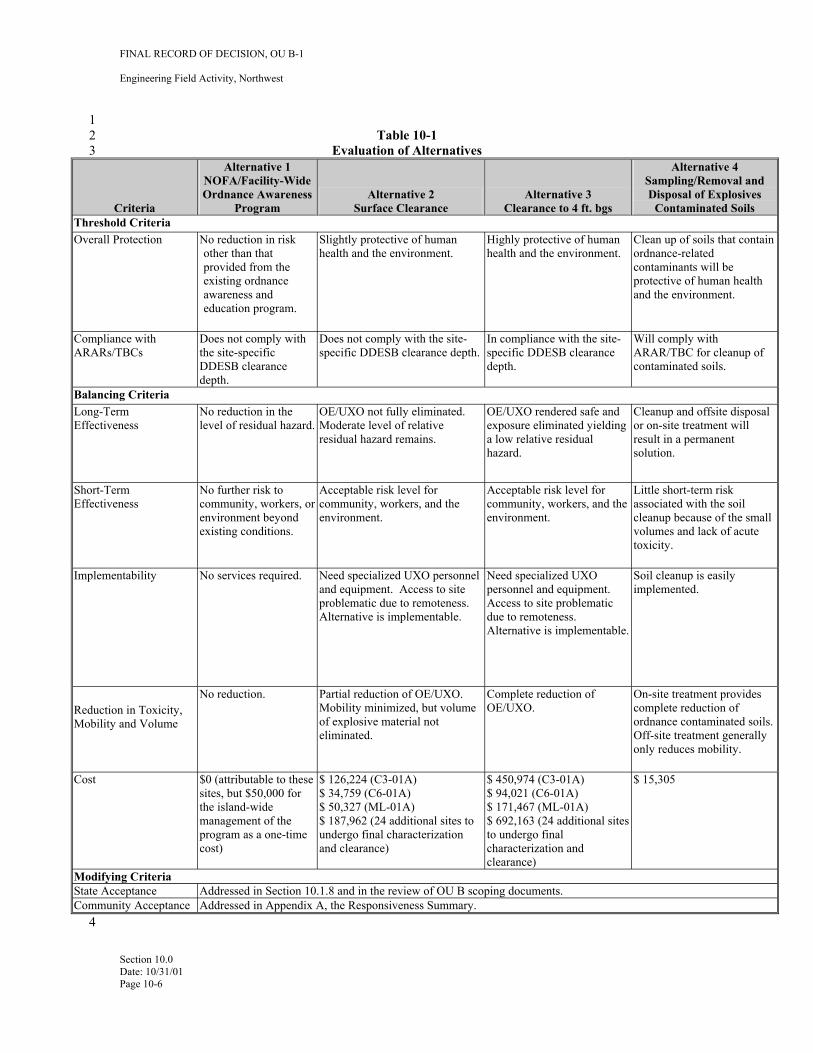
FINAL RECORD OF DECISION, OU B-1
Engineering Field Activity, Northwest
1 2 Table 10-1 3 Evaluation of Alternatives
Criteria
NOFA/Facility-Wide
Program
Sampling/Removal and Disposal of Explosives
Contaminated Soils
Overall Protection No reduction in risk other than that provided from the existing ordnance
education program.
health and the environment. health and the environment. Clean up of soils that contain ordnance-related
protective of human health and the environment.
ARARs/TBCs
depth. depth.
ARAR/TBC for cleanup of
Balancing Criteria Long-Term No reduction in the
Moderate level of relative OE/UXO rendered safe and
a low relative residual hazard.
Cleanup and offsite disposal
solution.
Short-Term No further risk to
existing conditions. environment. environment.
volumes and lack of acute
Implementability Need specialized UXO personnel and equipment. Access to site problematic due to remoteness.
Need specialized UXO personnel and equipment.
due to remoteness.
Soil cleanup is easily implemented.
No reduction. Partial reduction of OE/UXO.
of explosive material not
Complete reduction of OE/UXO.
On-site treatment provides complete reduction of
Off-site treatment generally
Cost $0 (attributable to these sites, but $50,000 for the island-wide management of the program as a one-time
)
$ 126,224 (C3-01A) $ 34,759 (C6-01A) $ 50,327 (ML-01A) $ 187,962 (24 additional sites to undergo final characterization and clearance)
$ 450,974 (C3-01A) $ 94,021 (C6-01A) $ 171,467 (ML-01A) $ 692,163 (24 additional sites to undergo final characterization and clearance)
$ 15,305
Alternative 1
Ordnance Awareness Alternative 2 Surface Clearance
Alternative 3 Clearance to 4 ft. bgs
Alternative 4
Threshold Criteria
awareness and
Slightly protective of human Highly protective of human
contaminants will be
Compliance with Does not comply with the site-specific DDESB clearance
Does not comply with the site-specific DDESB clearance depth.
In compliance with the site-specific DDESB clearance
Will comply with
contaminated soils.
Effectiveness level of residual hazard. OE/UXO not fully eliminated.
residual hazard remains. exposure eliminated yielding or on-site treatment will
result in a permanent
Effectiveness community, workers, or environment beyond
Acceptable risk level for community, workers, and the
Acceptable risk level for community, workers, and the
Little short-term risk associated with the soil cleanup because of the small
toxicity.
No services required.
Alternative is implementable. Access to site problematic
Alternative is implementable.
Reduction in Toxicity, Mobility and Volume
Mobility minimized, but volume
eliminated. ordnance contaminated soils.
only reduces mobility.
cost
Modifying Criteria State Acceptance Addressed in Section 10.1.8 and in the review of OU B scoping documents. Community Acceptance Addressed in Appendix A, the Responsiveness Summary.
4
Section 10.0 Date: 10/31/01 Page 10-6
FINAL RECORD OF DECISION, OU B-1
Engineering Field Activity, Northwest
1 11.0 SELECTED REMEDY 2
3 For sites C3-01A, C6-01A, and ML-01A Alternative 3 is selected remedy because it permanently removes 4 OE/UXO to 4 feet bgs. Ground surface is defined as the beginning of the mineral soil layer. As noted 5 earlier in this ROD, discovery during the 2001 field season of probable WWII OE/UXO burial/disposal site 6 at C3-01A and subsequent initial investigations and clearance activities indicate that OE/UXO at this 7 location exists below 4 feet bgs. This disposal site, and any others where similar conditions are 8 encountered, will be cleared to a depth of 4 feet below the lowest depth that OE/UXO was found or to 9 bedrock – whichever is encountered first. It also achieves clearance depths that will allow for future
10 residential land use throughout OU B-1. This also renders the real estate suitable for transfer to private 11 sector ownership for reuse. The costs and implementability issues are considered acceptable for this 12 alternative. The selected remedy is considered permanent and protective of human health and the 13 environment.
14 Alternative 3 is also selected for the twenty-four OAPC sites. These sites are listed in Table 11-1. The 15 implementation of this remedy will include final characterization to determine the extent of (clearance 16 required at these sites. This approach will incorporate site reconnaissance, inspection, and geophysical 17 investigation techniques consistent with those employed during the OU B-1 RI/FS to address concerns 18 related to data gaps on specific portions of these sites. These are identified in EPA and ADEC comments on 19 the OU B-1 RI/FS Report. After final characterization, 100 percent of all identified target anomalies to a 20 depth of 4 ft bgs will be intrusively investigated and all OE/UXO will be cleared through blow in place or 21 through consolidated detonation at an approved location on Adak.
22 Alternative 4 is selected for 7 of the 24 OAPC sites where ordnance related chemical contamination may be 23 present in soils. Excavation until soil cleanup levels in Table 8-1 are met, followed by onsite or offsite 24 treatment and disposal will also achieve residential cleanup levels at these sites. This will ensure 25 achievement of consistent remedial actions for OU B-1 sites.
26 For the remaining 104 OU B-1 sites, Alternative 1 (NOFA/Facility-Wide Ordnance Awareness Program) is 27 the selected as the remedy. The No Further Action selection for these sites is considered protective of 28 human health and the environment, based on the evaluation processes developed and implemented during 29 the PA and SI process that resulted in determinations of little or no OE/UXO hazards, or the results of RI 30 and ESHA evaluations that resulted in similar determinations. The process of intrusive investigation and 31 clearance of OE/UXO during field activities associated with one of these steps resulted in the effective 32 clearance of OE/UXO at the site to support residential land use, thereby supporting the NOFA selection.
33 11.1 SELECTION RATIONALE
34 Based on information currently available, the Navy believes the Preferred Alternative meets the threshold 35 criteria and provides the best balance compared to other alternatives evaluated with respect to the balancing 36 and modifying criteria. The Navy expects the Selected Alternative to satisfy the following statutory 37 requirements of CERCLA §121(b): 38 39 • Protective of human health and the environment 40 • Compliance with ARARs and TBCs 41 • Cost-effective 42 • Utilize permanent solutions and alternative treatment technologies to the maximum extent 43 practicable 44 • Satisfy the preference for treatment as a principal element
Section 11.0 Date: 10/31/01 Page 11-1
FINAL RECORD OF DECISION, OU B-1
Engineering Field Activity, Northwest
1 11.2 DETAILED DESCRIPTION
2 The elements of the selected remedy for sites C3-01A, C6-01A, and ML-01A includes:
3 • Mobilize equipment and personnel to each site. Survey and Clearance workers would 4 access the sites by an all-terrain vehicle from a base of operations in the Adak downtown area. 5 Radio repeaters would be placed in key locations to provide two-way communications with 6 the base of operations
7 • Provide on-site training and certification of field crews. All personnel assigned to the 8 geophysical investigation teams require an initial certification with the equipment used at the 9 VDS site. This equipment includes: the Leica DGPS, EM-61, and Schonstedt detector
10 • Clear surface. Prior to performing geophysical surveys, the site would be cleared of all 11 metallic items after having first located them through the use of hand-held 12 magnetometers/gradiometers as described in Alternative 2
13 • Conduct geophysical survey of each site. Using proven equipment and techniques, gather 14 geophysical data from the accessible portions of the site and transmit the data off-island for 15 signal processing and data interpretation
16 • Process the electronic geophysical data. Using proven software and quality control 17 methods, analyze the geophysical data and select anomalies to be further investigated and 18 excavated
19 • Identify target for excavation. When anomalies have been evaluated, assign target numbers 20 and provide coordinates and anticipated depths to on-island OE/UXO clearance personnel
21 • Perform excavation and removal/destruction of targets. On-island OE/UXO clearance 22 personnel will return to each site and locate each target using DGPS-locating equipment. 23 When located, OE/UXO clearance personnel will establish an exclusion zone and excavate 24 the identified target(s). OE/UXO items will be handled in accordance with established UXO 25 safety procedures (in accordance with OPNAVINST 8027.1G)
26 • Perform QA/QC of the data collected during field activities. QA/QC of the geophysical 27 equipment will be performed by conducting daily repeatability checks prior to the beginning 28 of each data acquisition file. Equipment checks will also be performed at specific areas and 29 recorded in digital files in order to assess data trends over the duration of the project.
30 At the 24 OAPC sites all of the activities listed above for the previous three sites will also be implemented. 31 In addition, and prior to implementing those steps, these sites will be subject to final characterization 32 activities to address data concerns in specific portions of the sites. The final characterization approach will 33 incorporate site recon, inspection, and geophysical investigation techniques consistent with those employed 34 during the OU B RI/FS. To the extent that clearance of OE/UXO items is required at any of these 24 sites, 35 clearance operations will be conducted as described above for the selected remedy for sites C3-01A, 36 C6-01A, and ML-01A.
37 In addition to the above elements, the selected remedy for 9 targets within 7 of the 24 OAPC sites will 38 include soil sampling at sites where explosives compounds may pose a risk to human or ecological 39 receptors. Sampling will be performed where field observations indicate that breached ordnance or staining 40 may have contaminated the soil with chemicals from OE/UXO. Field screening methods will be used to 41 identify soils that are contaminated above cleanup levels in Table 8-1. All such soils at the sites listed in 42 Table 5-4 will be excavated and containerized at the site. Confirmatory sampling to verify that cleanup
Section 11.0 Date: 10/31/01 Page 11-2
FINAL RECORD OF DECISION, OU B-1
Engineering Field Activity, Northwest
1 levels have been achieved will be done through fixed lab analyses. Based on considerations such as the 2 final volume, chemical composition of contaminated soils from the sites, and costs, the soils will either 3 undergo final treatment and disposal on-site, or off-site at a permitted facility. This alternative also assumes 4 excavation and shipment for ultimate treatment and/or disposal of a nominal volume of soil (less than 1 5 cubic meter per site) contaminated above the cleanup levels from each of these sites.
6 The common elements of the selected remedy for all of OU B-1 includes the following activities that will 7 be undertaken by the Navy:
8 • Continue to provide the existing OE/UXO awareness and avoidance training program for 9 Adak residents and visitors
10 • Provide the OU B-1 ROD and other key documents to the Bureau of Land Management 11 (BLM) to maintain as part of the permanent file for conveyance of real estate to private 12 ownership, and refer to the availability of this documentation in the interim conveyance 13 executed by BLM. This intent of providing these references is to disclose to current and 14 future landowners what is known about OE/UXO and the depth to which clearance actions 15 were taken
16 As noted in previous sections of this ROD, these activities are not triggered by the specific requirements of 17 any single AOC or site, rather, these are considered to be base-wide requirements to provide adequate 18 educational awareness for current and future residents and visitors to Adak Island. The selection of the 19 NOFA remedial action for any of the 104 OU B-1 sites in this ROD triggers the need for these programs on 20 a base-wide basis.
21 11.3 COST OF THE SELECTED REMEDY
22 Costs for the Selected Remedy for the three RA sites were first presented in the Appendix E of the RI/FS 23 Report (ECC, 2001). The costs have been reformatted and revised based on EPA FS costing guidance 24 (EPA 2000) with the addition of contingency and project management factors (Table 11-2). Assumptions 25 for production rates are indicated within the tables presented below. Costs assume that remote access 26 vehicles/equipment will be available on Adak and will not have to be mobilized from off-island. 27 Additional costs will be required if housing or office space is not available for temporary use by clearance 28 personnel.
29 Estimated combined costs for the three RA sites are:
30 Combat Range 3, Site C3-01A $ 450,974 31 Combat Range 6, Site C6-01A $ 94,021 32 Mitt Lake Impact Area, Site ML-01A $ 171,467 33 Total Selected Remedy Cost $ 716,462
34 The 24 OAPC sites will be required to undergo final characterization and clearance to four feet bgs. A 35 summary of costs associated with these activities is presented in Table 11-3. The costs have been estimated 36 to $692,163. These costs have been updated to reflect additional site-specific information obtained since 37 the preparation of the Proposed Plan.
38 Alternative 4 is estimated to cost $15,305 based on the chemical sampling and disposition of soil during the 39 summer 2001 field season (Table 11-4). This represents the worst-case assumption that each of the 9 targets 40 from 7 sites to be sampled will generate a drum of hazardous waste that must be treated and disposed of 41 off-island.
Section 11.0 Date: 10/31/01 Page 11-3
FINAL RECORD OF DECISION, OU B-1
Engineering Field Activity, Northwest
1 For the remainder of the sites, Alternative 1 (NOFA/Facility-Wide Ordnance Awareness Program) costs are 2 $50,000. This is a one-time capital cost of the development of the training materials. These materials were 3 first developed and put in place in 1997. They were updated in 2001and provided by the Navy to the City 4 of Adak.
5 11.4 EXPECTED OUTCOMES OF THE SELECTED REMEDY
6 Based on the selection of Alternative 3 (Clearance to a depth of 4 feet bgs) for, Site C3-01A, Site C6-01A, 7 and Site ML-01A that were determined to pose a potential explosive safety hazard threat to human health 8 and the environment; the Selection of Alternative 3 for the 24 OAPC sites along with completion of final 9 characterization; the selection of Alternative 4 for 7 sites with potential ordnance-related chemical
10 contamination; and the continued implementation of the Adak NOFA OE/UXO Ordnance Awareness 11 Program for Adak residents and visitors, a number of actions are anticipated to progress: 12 13 14 • Exposure to OE/UXO at three sites (C3-01A, C6-01A, and ML-01A) will be eliminated by 15 clearance to 4 feet bgs. 16 17 • Sampling and cleanup work for the additional sites outlined in the OU B-1 ROD will be 18 accomplished in one field season to eliminate exposure to explosives-related chemical 19 contamination in soil. 20 21 • A FOST will be prepared for selected parcels. 22 23 • Selected parcels will be relinquished by the Navy to Department of Interior in accordance 24 with land transfer agreements.
25 The results of the OU B-1 ROD, once completed, are not anticipated to place any restrictions on the current 26 or future use of Adak property. When the selected remedy is implemented, the OU B-1 sites will no longer 27 pose a threat to human health or the environment in accordance with CERCLA guidance. 28
Section 11.0 Date: 10/31/01 Page 11-4
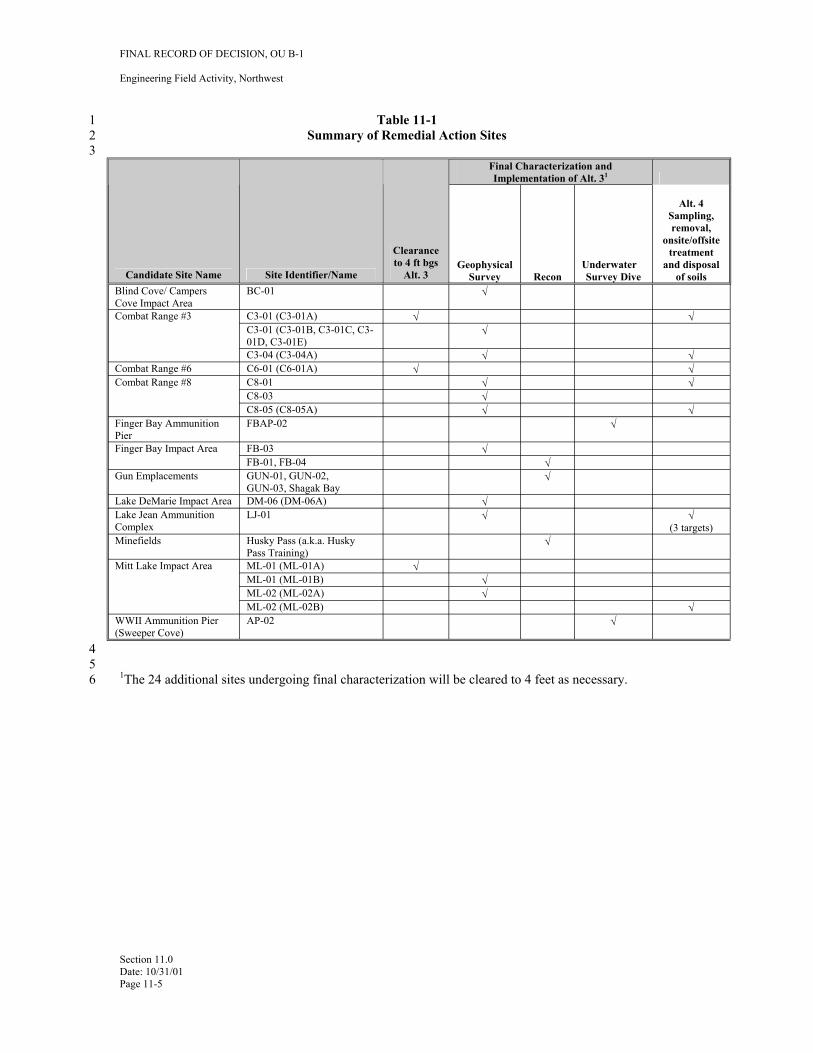
FINAL RECORD OF DECISION, OU B-1
Engineering Field Activity, Northwest
1 Table 11-1 2 Summary of Remedial Action Sites 3
Candidate Site Name Blind Cove/ Campers Cove Impact Area Combat Range #3
Combat Range #6 Combat Range #8
Finger Bay Ammunition Pier Finger Bay Impact Area
Gun Emplacements
Lake DeMarie Impact Area Lake Jean Ammunition Complex Minefields
Mitt Lake Impact Area
WWII Ammunition Pier (Sweeper Cove)
Site Identifier/Name BC-01
C3-01 (C3-01A) C3-01 (C3-01B, C3-01C, C301D, C3-01E) C3-04 (C3-04A) C6-01 (C6-01A) C8-01 C8-03 C8-05 (C8-05A) FBAP-02
FB-03 FB-01, FB-04 GUN-01, GUN-02, GUN-03, Shagak Bay DM-06 (DM-06A) LJ-01
Husky Pass (a.k.a. Husky Pass Training) ML-01 (ML-01A) ML-01 (ML-01B) ML-02 (ML-02A) ML-02 (ML-02B) AP-02
Clearance to 4 ft bgs
Alt. 3
√
√
Geophysical Survey
√
√
√
√ √ √
√ √ √
√ √
√
√ √ √
Recon
Final Characterization and Implementation of Alt. 31
Underwater Survey Dive
√
Alt. 4 Sampling, removal,
onsite/offsite treatment
and disposal of soils
√
√ √ √
√
√ (3 targets)
√ √
4 5 6 1The 24 additional sites undergoing final characterization will be cleared to 4 feet as necessary.
Section 11.0 Date: 10/31/01 Page 11-5
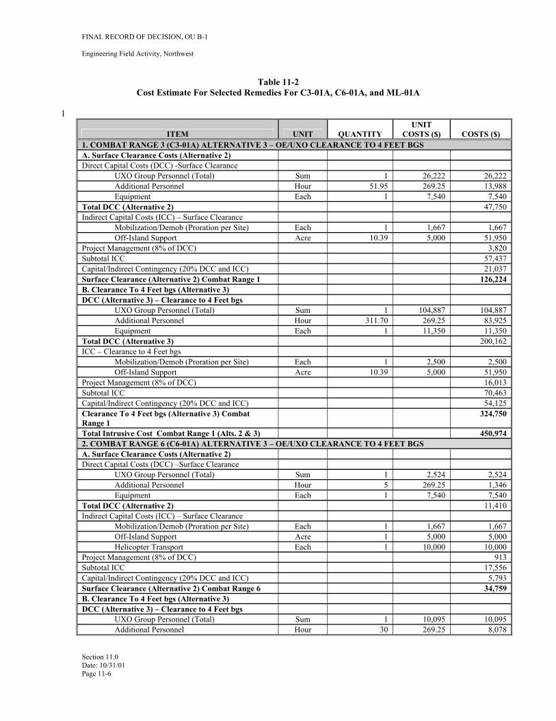
1
FINAL RECORD OF DECISION, OU B-1
Engineering Field Activity, Northwest
Table 11-2 Cost Estimate For Selected Remedies For C3-01A, C6-01A, and ML-01A
ITEM UNIT QUANTITY UNIT
COSTS ($) 1. COMBAT RANGE 3 (C3-01A) ALTERNATIVE 3 – OE/UXO CLEARANCE TO 4 FEET BGS A. Surface Clearance Costs (Alternative 2) Direct Capital Costs (DCC) -Surface Clearance
UXO Group Personnel (Total) Sum 1 26,222 Additional Personnel Hour 51.95 269.25 Equipment Each 1 7,540
Total DCC (Alternative 2) Indirect Capital Costs (ICC) – Surface Clearance
Mobilization/Demob (Proration per Site) Each 1 1,667 Off-Island Support Acre 10.39 5,000
Project Management (8% of DCC) Subtotal ICC Capital/Indirect Contingency (20% DCC and ICC) Surface Clearance (Alternative 2) Combat Range 1 B. Clearance To 4 Feet bgs (Alternative 3) DCC (Alternative 3) – Clearance to 4 Feet bgs
UXO Group Personnel (Total) Sum 1 104,887 Additional Personnel Hour 311.70 269.25 Equipment Each 1 11,350
Total DCC (Alternative 3) ICC – Clearance to 4 Feet bgs
Mobilization/Demob (Proration per Site) Each 1 2,500 Off-Island Support Acre 10.39 5,000
Project Management (8% of DCC) Subtotal ICC Capital/Indirect Contingency (20% DCC and ICC) Clearance To 4 Feet bgs (Alternative 3) Combat Range 1 Total Intrusive Cost Combat Range 1 (Alts. 2 & 3) 2. COMBAT RANGE 6 (C6-01A) ALTERNATIVE 3 – OE/UXO CLEARANCE TO 4 FEET BGS A. Surface Clearance Costs (Alternative 2) Direct Capital Costs (DCC) –Surface Clearance
UXO Group Personnel (Total) Sum 1 2,524 Additional Personnel Hour 5 269.25 Equipment Each 1 7,540
Total DCC (Alternative 2) Indirect Capital Costs (ICC) – Surface Clearance
Mobilization/Demob (Proration per Site) Each 1 1,667 Off-Island Support Acre 1 5,000 Helicopter Transport Each 1 10,000
Project Management (8% of DCC) Subtotal ICC Capital/Indirect Contingency (20% DCC and ICC) Surface Clearance (Alternative 2) Combat Range 6 B. Clearance To 4 Feet bgs (Alternative 3) DCC (Alternative 3) – Clearance to 4 Feet bgs
UXO Group Personnel (Total) Sum 1 10,095 Additional Personnel Hour 30 269.25
COSTS ($)
26,222 13,988 7,540
47,750
1,667 51,950
3,820 57,437 21,037
126,224
104,887 83,925 11,350
200,162
2,500 51,950 16,013 70,463 54,125
324,750
450,974
2,524 1,346 7,540
11,410
1,667 5,000
10,000 913
17,556 5,793
34,759
10,095 8,078
Section 11.0 Date: 10/31/01 Page 11-6
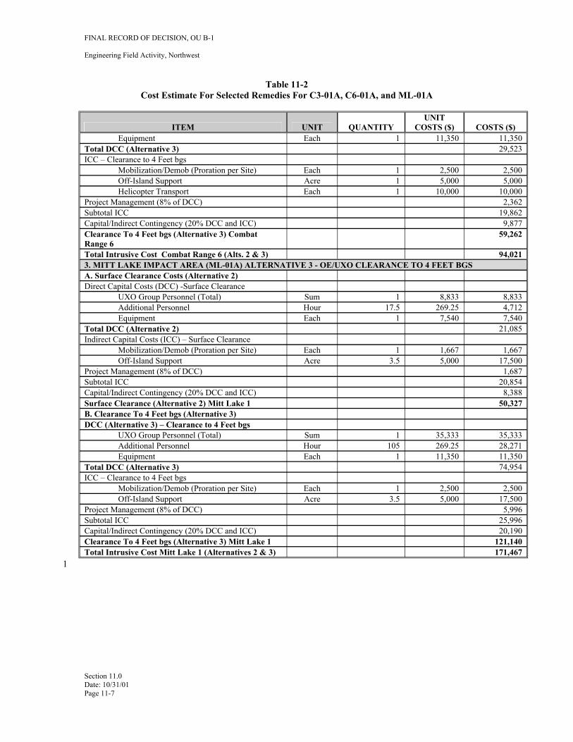
FINAL RECORD OF DECISION, OU B-1
Engineering Field Activity, Northwest
Table 11-2 Cost Estimate For Selected Remedies For C3-01A, C6-01A, and ML-01A
ITEM UNIT QUANTITY UNIT
COSTS ($) COSTS ($) Equipment Each 1 11,350 11,350
Total DCC (Alternative 3) 29,523 ICC – Clearance to 4 Feet bgs
Mobilization/Demob (Proration per Site) Each 1 2,500 2,500 Off-Island Support Acre 1 5,000 5,000 Helicopter Transport Each 1 10,000 10,000
Project Management (8% of DCC) 2,362 Subtotal ICC 19,862 Capital/Indirect Contingency (20% DCC and ICC) 9,877 Clearance To 4 Feet bgs (Alternative 3) Combat Range 6
59,262
Total Intrusive Cost Combat Range 6 (Alts. 2 & 3) 94,021 3. MITT LAKE IMPACT AREA (ML-01A) ALTERNATIVE 3 - OE/UXO CLEARANCE TO 4 FEET BGS A. Surface Clearance Costs (Alternative 2) Direct Capital Costs (DCC) -Surface Clearance
UXO Group Personnel (Total) Sum 1 8,833 8,833 Additional Personnel Hour 17.5 269.25 4,712 Equipment Each 1 7,540 7,540
Total DCC (Alternative 2) 21,085 Indirect Capital Costs (ICC) – Surface Clearance
Mobilization/Demob (Proration per Site) Each 1 1,667 1,667 Off-Island Support Acre 3.5 5,000 17,500
Project Management (8% of DCC) 1,687 Subtotal ICC 20,854 Capital/Indirect Contingency (20% DCC and ICC) 8,388 Surface Clearance (Alternative 2) Mitt Lake 1 50,327 B. Clearance To 4 Feet bgs (Alternative 3) DCC (Alternative 3) – Clearance to 4 Feet bgs
UXO Group Personnel (Total) Sum 1 35,333 35,333 Additional Personnel Hour 105 269.25 28,271 Equipment Each 1 11,350 11,350
Total DCC (Alternative 3) 74,954 ICC – Clearance to 4 Feet bgs
Mobilization/Demob (Proration per Site) Each 1 2,500 2,500 Off-Island Support Acre 3.5 5,000 17,500
Project Management (8% of DCC) 5,996 Subtotal ICC 25,996 Capital/Indirect Contingency (20% DCC and ICC) 20,190 Clearance To 4 Feet bgs (Alternative 3) Mitt Lake 1 121,140 Total Intrusive Cost Mitt Lake 1 (Alternatives 2 & 3) 171,467
Section 11.0 Date: 10/31/01 Page 11-7
1
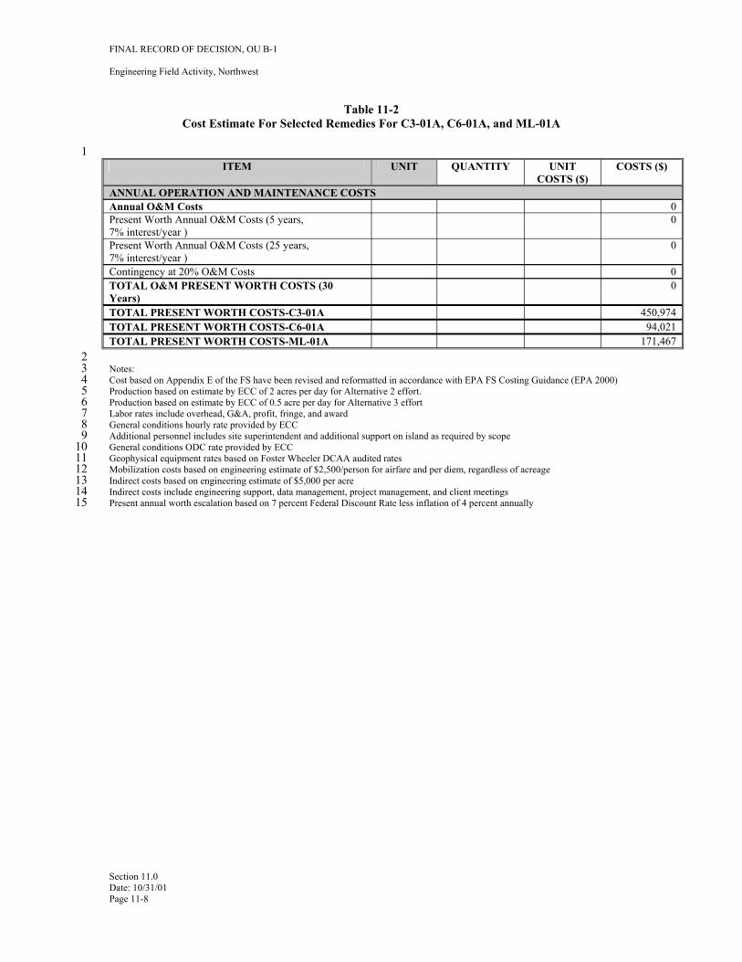
1
FINAL RECORD OF DECISION, OU B-1
Engineering Field Activity, Northwest
Table 11-2 Cost Estimate For Selected Remedies For C3-01A, C6-01A, and ML-01A
ITEM UNIT QUANTITY UNIT COSTS ($)
COSTS ($)
ANNUAL OPERATION AND MAINTENANCE COSTS Annual O&M Costs 0 Present Worth Annual O&M Costs (5 years, 7% interest/year )
0
Present Worth Annual O&M Costs (25 years, 7% interest/year )
0
Contingency at 20% O&M Costs 0 TOTAL O&M PRESENT WORTH COSTS (30 Years)
0
TOTAL PRESENT WORTH COSTS-C3-01A 450,974 TOTAL PRESENT WORTH COSTS-C6-01A 94,021 TOTAL PRESENT WORTH COSTS-ML-01A 171,467
2 3 Notes: 4 Cost based on Appendix E of the FS have been revised and reformatted in accordance with EPA FS Costing Guidance (EPA 2000) 5 Production based on estimate by ECC of 2 acres per day for Alternative 2 effort. 6 Production based on estimate by ECC of 0.5 acre per day for Alternative 3 effort 7 Labor rates include overhead, G&A, profit, fringe, and award 8 General conditions hourly rate provided by ECC 9 Additional personnel includes site superintendent and additional support on island as required by scope
10 General conditions ODC rate provided by ECC 11 Geophysical equipment rates based on Foster Wheeler DCAA audited rates 12 Mobilization costs based on engineering estimate of $2,500/person for airfare and per diem, regardless of acreage 13 Indirect costs based on engineering estimate of $5,000 per acre 14 Indirect costs include engineering support, data management, project management, and client meetings 15 Present annual worth escalation based on 7 percent Federal Discount Rate less inflation of 4 percent annually
Section 11.0 Date: 10/31/01 Page 11-8
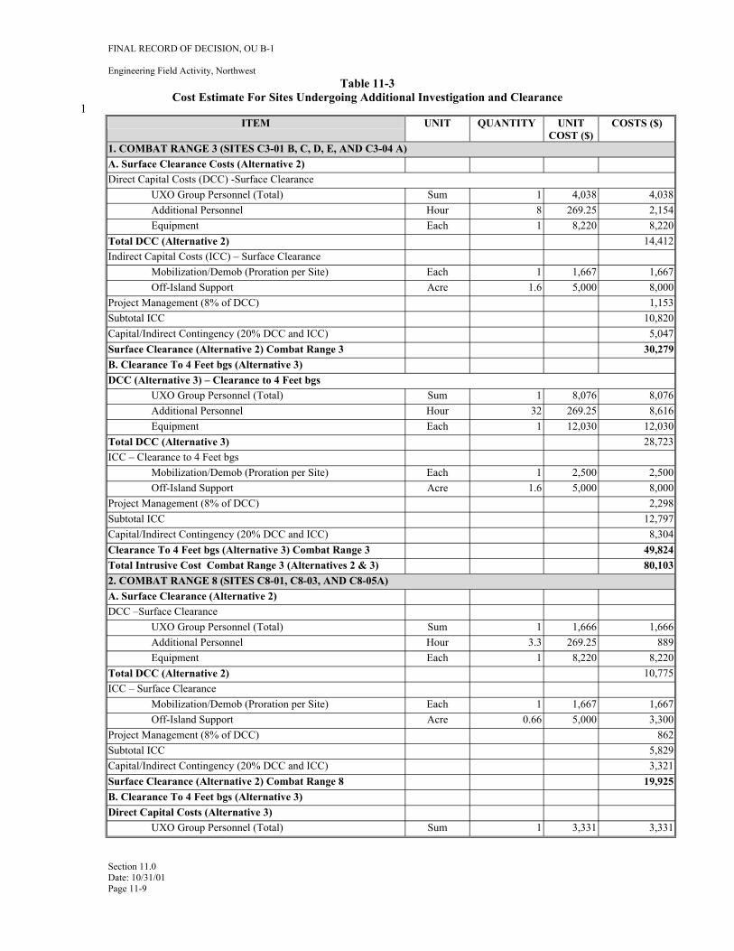
1
FINAL RECORD OF DECISION, OU B-1
Engineering Field Activity, Northwest Table 11-3
Cost Estimate For Sites Undergoing Additional Investigation and Clearance
ITEM UNIT QUANTITY UNIT COST ($)
COSTS ($)
1. COMBAT RANGE 3 (SITES C3-01 B, C, D, E, AND C3-04 A) A. Surface Clearance Costs (Alternative 2) Direct Capital Costs (DCC) -Surface Clearance
UXO Group Personnel (Total) Sum 1 4,038 4,038 Additional Personnel Hour 8 269.25 2,154 Equipment Each 1 8,220 8,220
Total DCC (Alternative 2) 14,412 Indirect Capital Costs (ICC) – Surface Clearance
Mobilization/Demob (Proration per Site) Each 1 1,667 1,667 Off-Island Support Acre 1.6 5,000 8,000
Project Management (8% of DCC) 1,153 Subtotal ICC 10,820 Capital/Indirect Contingency (20% DCC and ICC) 5,047 Surface Clearance (Alternative 2) Combat Range 3 30,279 B. Clearance To 4 Feet bgs (Alternative 3) DCC (Alternative 3) – Clearance to 4 Feet bgs
UXO Group Personnel (Total) Sum 1 8,076 8,076 Additional Personnel Hour 32 269.25 8,616 Equipment Each 1 12,030 12,030
Total DCC (Alternative 3) 28,723 ICC – Clearance to 4 Feet bgs
Mobilization/Demob (Proration per Site) Each 1 2,500 2,500 Off-Island Support Acre 1.6 5,000 8,000
Project Management (8% of DCC) 2,298 Subtotal ICC 12,797 Capital/Indirect Contingency (20% DCC and ICC) 8,304 Clearance To 4 Feet bgs (Alternative 3) Combat Range 3 49,824 Total Intrusive Cost Combat Range 3 (Alternatives 2 & 3) 80,103 2. COMBAT RANGE 8 (SITES C8-01, C8-03, AND C8-05A) A. Surface Clearance (Alternative 2) DCC –Surface Clearance
UXO Group Personnel (Total) Sum 1 1,666 1,666 Additional Personnel Hour 3.3 269.25 889 Equipment Each 1 8,220 8,220
Total DCC (Alternative 2) 10,775 ICC – Surface Clearance
Mobilization/Demob (Proration per Site) Each 1 1,667 1,667 Off-Island Support Acre 0.66 5,000 3,300
Project Management (8% of DCC) 862 Subtotal ICC 5,829 Capital/Indirect Contingency (20% DCC and ICC) 3,321 Surface Clearance (Alternative 2) Combat Range 8 19,925 B. Clearance To 4 Feet bgs (Alternative 3) Direct Capital Costs (Alternative 3)
UXO Group Personnel (Total) Sum 1 3,331 3,331
Section 11.0 Date: 10/31/01 Page 11-9
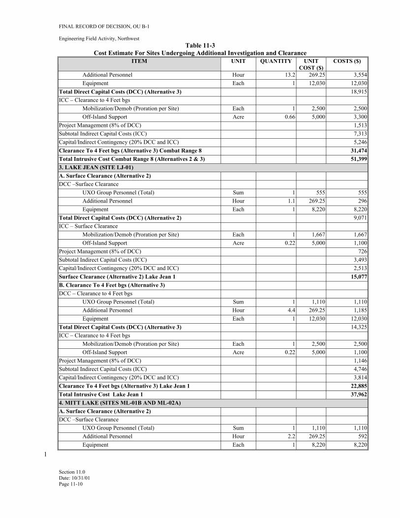
FINAL RECORD OF DECISION, OU B-1
Engineering Field Activity, Northwest Table 11-3
Cost Estimate For Sites Undergoing Additional Investigation and Clearance ITEM UNIT QUANTITY UNIT
COST ($) COSTS ($)
Additional Personnel Hour 13.2 269.25 3,554 Equipment Each 1 12,030 12,030
Total Direct Capital Costs (DCC) (Alternative 3) 18,915 ICC – Clearance to 4 Feet bgs
Mobilization/Demob (Proration per Site) Each 1 2,500 2,500 Off-Island Support Acre 0.66 5,000 3,300
Project Management (8% of DCC) 1,513 Subtotal Indirect Capital Costs (ICC) 7,313 Capital/Indirect Contingency (20% DCC and ICC) 5,246 Clearance To 4 Feet bgs (Alternative 3) Combat Range 8 31,474 Total Intrusive Cost Combat Range 8 (Alternatives 2 & 3) 51,399 3. LAKE JEAN (SITE LJ-01) A. Surface Clearance (Alternative 2) DCC –Surface Clearance
UXO Group Personnel (Total) Sum 1 555 555 Additional Personnel Hour 1.1 269.25 296 Equipment Each 1 8,220 8,220
Total Direct Capital Costs (DCC) (Alternative 2) 9,071 ICC – Surface Clearance
Mobilization/Demob (Proration per Site) Each 1 1,667 1,667 Off-Island Support Acre 0.22 5,000 1,100
Project Management (8% of DCC) 726 Subtotal Indirect Capital Costs (ICC) 3,493 Capital/Indirect Contingency (20% DCC and ICC) 2,513 Surface Clearance (Alternative 2) Lake Jean 1 15,077 B. Clearance To 4 Feet bgs (Alternative 3) DCC – Clearance to 4 Feet bgs
UXO Group Personnel (Total) Sum 1 1,110 1,110 Additional Personnel Hour 4.4 269.25 1,185 Equipment Each 1 12,030 12,030
Total Direct Capital Costs (DCC) (Alternative 3) 14,325 ICC – Clearance to 4 Feet bgs
Mobilization/Demob (Proration per Site) Each 1 2,500 2,500 Off-Island Support Acre 0.22 5,000 1,100
Project Management (8% of DCC) 1,146 Subtotal Indirect Capital Costs (ICC) 4,746 Capital/Indirect Contingency (20% DCC and ICC) 3,814 Clearance To 4 Feet bgs (Alternative 3) Lake Jean 1 22,885 Total Intrusive Cost Lake Jean 1 37,962 4. MITT LAKE (SITES ML-01B AND ML-02A) A. Surface Clearance (Alternative 2) DCC –Surface Clearance
UXO Group Personnel (Total) Sum 1 1,110 1,110 Additional Personnel Hour 2.2 269.25 592 Equipment Each 1 8,220 8,220
Section 11.0 Date: 10/31/01 Page 11-10
1
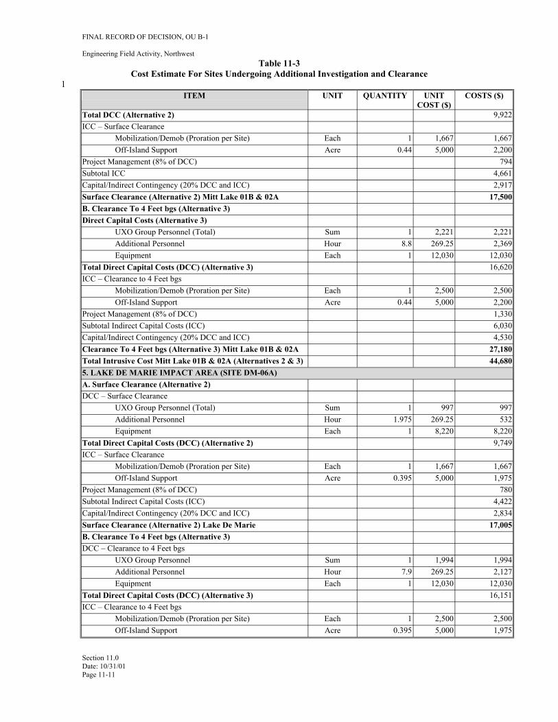
1
FINAL RECORD OF DECISION, OU B-1
Engineering Field Activity, Northwest Table 11-3
Cost Estimate For Sites Undergoing Additional Investigation and Clearance
ITEM UNIT QUANTITY UNIT COST ($)
COSTS ($)
Total DCC (Alternative 2) 9,922 ICC – Surface Clearance
Mobilization/Demob (Proration per Site) Each 1 1,667 1,667 Off-Island Support Acre 0.44 5,000 2,200
Project Management (8% of DCC) 794 Subtotal ICC 4,661 Capital/Indirect Contingency (20% DCC and ICC) 2,917 Surface Clearance (Alternative 2) Mitt Lake 01B & 02A 17,500 B. Clearance To 4 Feet bgs (Alternative 3) Direct Capital Costs (Alternative 3)
UXO Group Personnel (Total) Sum 1 2,221 2,221 Additional Personnel Hour 8.8 269.25 2,369 Equipment Each 1 12,030 12,030
Total Direct Capital Costs (DCC) (Alternative 3) 16,620 ICC – Clearance to 4 Feet bgs
Mobilization/Demob (Proration per Site) Each 1 2,500 2,500 Off-Island Support Acre 0.44 5,000 2,200
Project Management (8% of DCC) 1,330 Subtotal Indirect Capital Costs (ICC) 6,030 Capital/Indirect Contingency (20% DCC and ICC) 4,530 Clearance To 4 Feet bgs (Alternative 3) Mitt Lake 01B & 02A 27,180 Total Intrusive Cost Mitt Lake 01B & 02A (Alternatives 2 & 3) 44,680 5. LAKE DE MARIE IMPACT AREA (SITE DM-06A) A. Surface Clearance (Alternative 2) DCC – Surface Clearance
UXO Group Personnel (Total) Sum 1 997 997 Additional Personnel Hour 1.975 269.25 532 Equipment Each 1 8,220 8,220
Total Direct Capital Costs (DCC) (Alternative 2) 9,749 ICC – Surface Clearance
Mobilization/Demob (Proration per Site) Each 1 1,667 1,667 Off-Island Support Acre 0.395 5,000 1,975
Project Management (8% of DCC) 780 Subtotal Indirect Capital Costs (ICC) 4,422 Capital/Indirect Contingency (20% DCC and ICC) 2,834 Surface Clearance (Alternative 2) Lake De Marie 17,005 B. Clearance To 4 Feet bgs (Alternative 3) DCC – Clearance to 4 Feet bgs
UXO Group Personnel Sum 1 1,994 1,994 Additional Personnel Hour 7.9 269.25 2,127 Equipment Each 1 12,030 12,030
Total Direct Capital Costs (DCC) (Alternative 3) 16,151 ICC – Clearance to 4 Feet bgs
Mobilization/Demob (Proration per Site) Each 1 2,500 2,500 Off-Island Support Acre 0.395 5,000 1,975
Section 11.0 Date: 10/31/01 Page 11-11
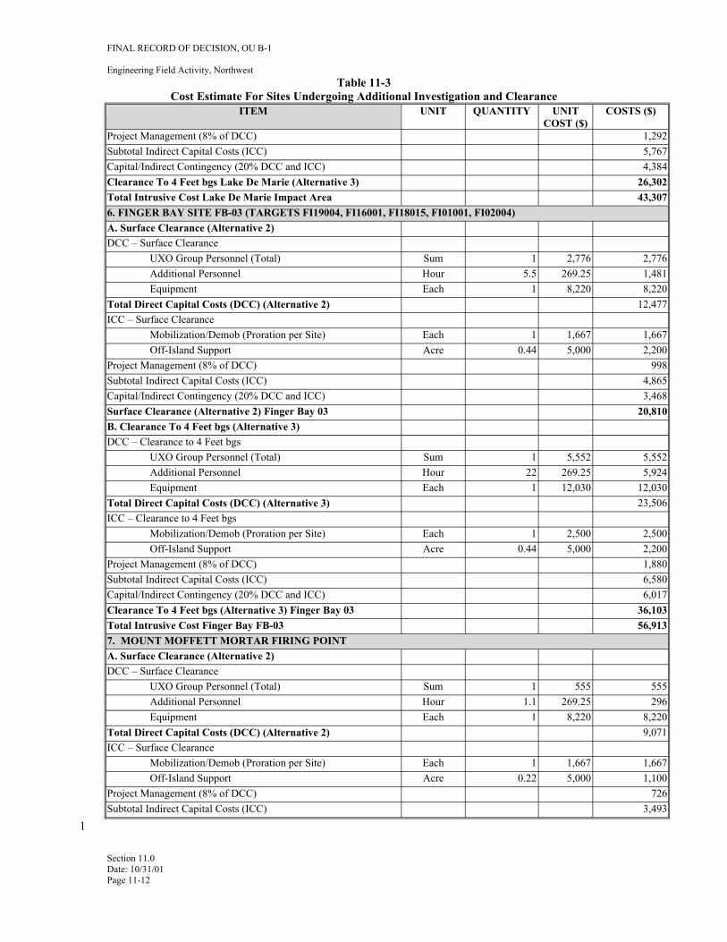
FINAL RECORD OF DECISION, OU B-1
Engineering Field Activity, Northwest Table 11-3
Cost Estimate For Sites Undergoing Additional Investigation and Clearance ITEM UNIT QUANTITY UNIT
COST ($) COSTS ($)
Project Management (8% of DCC) 1,292 Subtotal Indirect Capital Costs (ICC) 5,767 Capital/Indirect Contingency (20% DCC and ICC) 4,384 Clearance To 4 Feet bgs Lake De Marie (Alternative 3) 26,302 Total Intrusive Cost Lake De Marie Impact Area 43,307 6. FINGER BAY SITE FB-03 (TARGETS FI19004, FI16001, FI18015, FI01001, FI02004) A. Surface Clearance (Alternative 2) DCC – Surface Clearance
UXO Group Personnel (Total) Sum 1 2,776 2,776 Additional Personnel Hour 5.5 269.25 1,481 Equipment Each 1 8,220 8,220
Total Direct Capital Costs (DCC) (Alternative 2) 12,477 ICC – Surface Clearance
Mobilization/Demob (Proration per Site) Each 1 1,667 1,667 Off-Island Support Acre 0.44 5,000 2,200
Project Management (8% of DCC) 998 Subtotal Indirect Capital Costs (ICC) 4,865 Capital/Indirect Contingency (20% DCC and ICC) 3,468 Surface Clearance (Alternative 2) Finger Bay 03 20,810 B. Clearance To 4 Feet bgs (Alternative 3) DCC – Clearance to 4 Feet bgs
UXO Group Personnel (Total) Sum 1 5,552 5,552 Additional Personnel Hour 22 269.25 5,924 Equipment Each 1 12,030 12,030
Total Direct Capital Costs (DCC) (Alternative 3) 23,506 ICC – Clearance to 4 Feet bgs
Mobilization/Demob (Proration per Site) Each 1 2,500 2,500 Off-Island Support Acre 0.44 5,000 2,200
Project Management (8% of DCC) 1,880 Subtotal Indirect Capital Costs (ICC) 6,580 Capital/Indirect Contingency (20% DCC and ICC) 6,017 Clearance To 4 Feet bgs (Alternative 3) Finger Bay 03 36,103 Total Intrusive Cost Finger Bay FB-03 56,913 7. MOUNT MOFFETT MORTAR FIRING POINT A. Surface Clearance (Alternative 2) DCC – Surface Clearance
UXO Group Personnel (Total) Sum 1 555 555 Additional Personnel Hour 1.1 269.25 296 Equipment Each 1 8,220 8,220
Total Direct Capital Costs (DCC) (Alternative 2) 9,071 ICC – Surface Clearance
Mobilization/Demob (Proration per Site) Each 1 1,667 1,667 Off-Island Support Acre 0.22 5,000 1,100
Project Management (8% of DCC) 726 Subtotal Indirect Capital Costs (ICC) 3,493
Section 11.0 Date: 10/31/01 Page 11-12
1
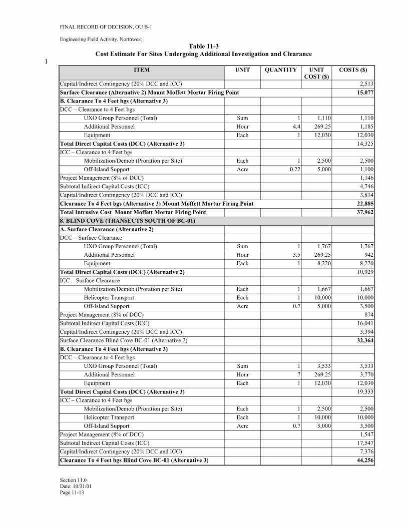
1
FINAL RECORD OF DECISION, OU B-1
Engineering Field Activity, Northwest Table 11-3
Cost Estimate For Sites Undergoing Additional Investigation and Clearance
ITEM UNIT QUANTITY UNIT COST ($)
COSTS ($)
Capital/Indirect Contingency (20% DCC and ICC) 2,513 Surface Clearance (Alternative 2) Mount Moffett Mortar Firing Point 15,077 B. Clearance To 4 Feet bgs (Alternative 3) DCC – Clearance to 4 Feet bgs
UXO Group Personnel (Total) Sum 1 1,110 1,110 Additional Personnel Hour 4.4 269.25 1,185 Equipment Each 1 12,030 12,030
Total Direct Capital Costs (DCC) (Alternative 3) 14,325 ICC – Clearance to 4 Feet bgs
Mobilization/Demob (Proration per Site) Each 1 2,500 2,500 Off-Island Support Acre 0.22 5,000 1,100
Project Management (8% of DCC) 1,146 Subtotal Indirect Capital Costs (ICC) 4,746 Capital/Indirect Contingency (20% DCC and ICC) 3,814 Clearance To 4 Feet bgs (Alternative 3) Mount Moffett Mortar Firing Point 22,885 Total Intrusive Cost Mount Moffett Mortar Firing Point 37,962 8. BLIND COVE (TRANSECTS SOUTH OF BC-01) A. Surface Clearance (Alternative 2) DCC – Surface Clearance
UXO Group Personnel (Total) Sum 1 1,767 1,767 Additional Personnel Hour 3.5 269.25 942 Equipment Each 1 8,220 8,220
Total Direct Capital Costs (DCC) (Alternative 2) 10,929 ICC – Surface Clearance
Mobilization/Demob (Proration per Site) Each 1 1,667 1,667 Helicopter Transport Each 1 10,000 10,000 Off-Island Support Acre 0.7 5,000 3,500
Project Management (8% of DCC) 874 Subtotal Indirect Capital Costs (ICC) 16,041 Capital/Indirect Contingency (20% DCC and ICC) 5,394 Surface Clearance Blind Cove BC-01 (Alternative 2) 32,364 B. Clearance To 4 Feet bgs (Alternative 3) DCC – Clearance to 4 Feet bgs
UXO Group Personnel (Total) Sum 1 3,533 3,533 Additional Personnel Hour 7 269.25 3,770 Equipment Each 1 12,030 12,030
Total Direct Capital Costs (DCC) (Alternative 3) 19,333 ICC – Clearance to 4 Feet bgs
Mobilization/Demob (Proration per Site) Each 1 2,500 2,500 Helicopter Transport Each 1 10,000 10,000 Off-Island Support Acre 0.7 5,000 3,500
Project Management (8% of DCC) 1,547 Subtotal Indirect Capital Costs (ICC) 17,547 Capital/Indirect Contingency (20% DCC and ICC) 7,376 Clearance To 4 Feet bgs Blind Cove BC-01 (Alternative 3) 44,256
Section 11.0 Date: 10/31/01 Page 11-13
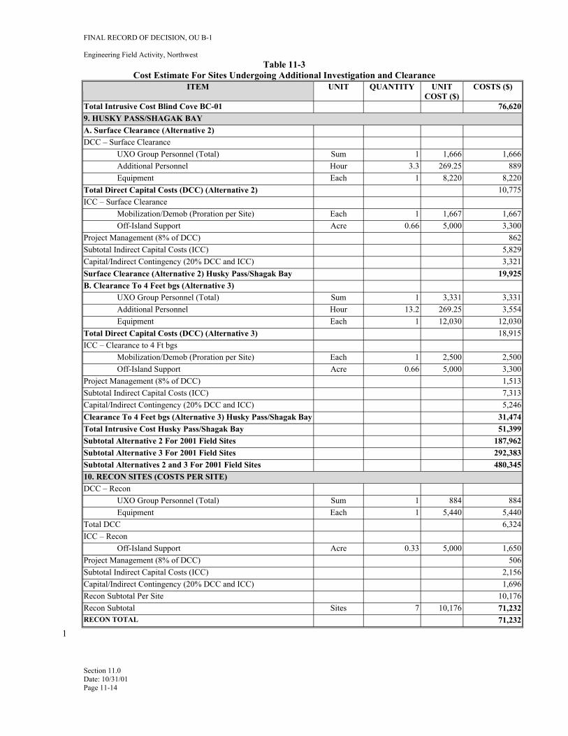
FINAL RECORD OF DECISION, OU B-1
Engineering Field Activity, Northwest Table 11-3
Cost Estimate For Sites Undergoing Additional Investigation and Clearance ITEM UNIT QUANTITY UNIT
COST ($) COSTS ($)
Total Intrusive Cost Blind Cove BC-01 76,620 9. HUSKY PASS/SHAGAK BAY A. Surface Clearance (Alternative 2) DCC – Surface Clearance
UXO Group Personnel (Total) Sum 1 1,666 1,666 Additional Personnel Hour 3.3 269.25 889 Equipment Each 1 8,220 8,220
Total Direct Capital Costs (DCC) (Alternative 2) 10,775 ICC – Surface Clearance
Mobilization/Demob (Proration per Site) Each 1 1,667 1,667 Off-Island Support Acre 0.66 5,000 3,300
Project Management (8% of DCC) 862 Subtotal Indirect Capital Costs (ICC) 5,829 Capital/Indirect Contingency (20% DCC and ICC) 3,321 Surface Clearance (Alternative 2) Husky Pass/Shagak Bay 19,925 B. Clearance To 4 Feet bgs (Alternative 3)
UXO Group Personnel (Total) Sum 1 3,331 3,331 Additional Personnel Hour 13.2 269.25 3,554 Equipment Each 1 12,030 12,030
Total Direct Capital Costs (DCC) (Alternative 3) 18,915 ICC – Clearance to 4 Ft bgs
Mobilization/Demob (Proration per Site) Each 1 2,500 2,500 Off-Island Support Acre 0.66 5,000 3,300
Project Management (8% of DCC) 1,513 Subtotal Indirect Capital Costs (ICC) 7,313 Capital/Indirect Contingency (20% DCC and ICC) 5,246 Clearance To 4 Feet bgs (Alternative 3) Husky Pass/Shagak Bay 31,474 Total Intrusive Cost Husky Pass/Shagak Bay 51,399 Subtotal Alternative 2 For 2001 Field Sites 187,962 Subtotal Alternative 3 For 2001 Field Sites 292,383 Subtotal Alternatives 2 and 3 For 2001 Field Sites 480,345 10. RECON SITES (COSTS PER SITE) DCC – Recon
UXO Group Personnel (Total) Sum 1 884 884 Equipment Each 1 5,440 5,440
Total DCC 6,324 ICC – Recon
Off-Island Support Acre 0.33 5,000 1,650 Project Management (8% of DCC) 506 Subtotal Indirect Capital Costs (ICC) 2,156 Capital/Indirect Contingency (20% DCC and ICC) 1,696 Recon Subtotal Per Site 10,176 Recon Subtotal Sites 7 10,176 71,232 RECON TOTAL 71,232
Section 11.0 Date: 10/31/01 Page 11-14
1
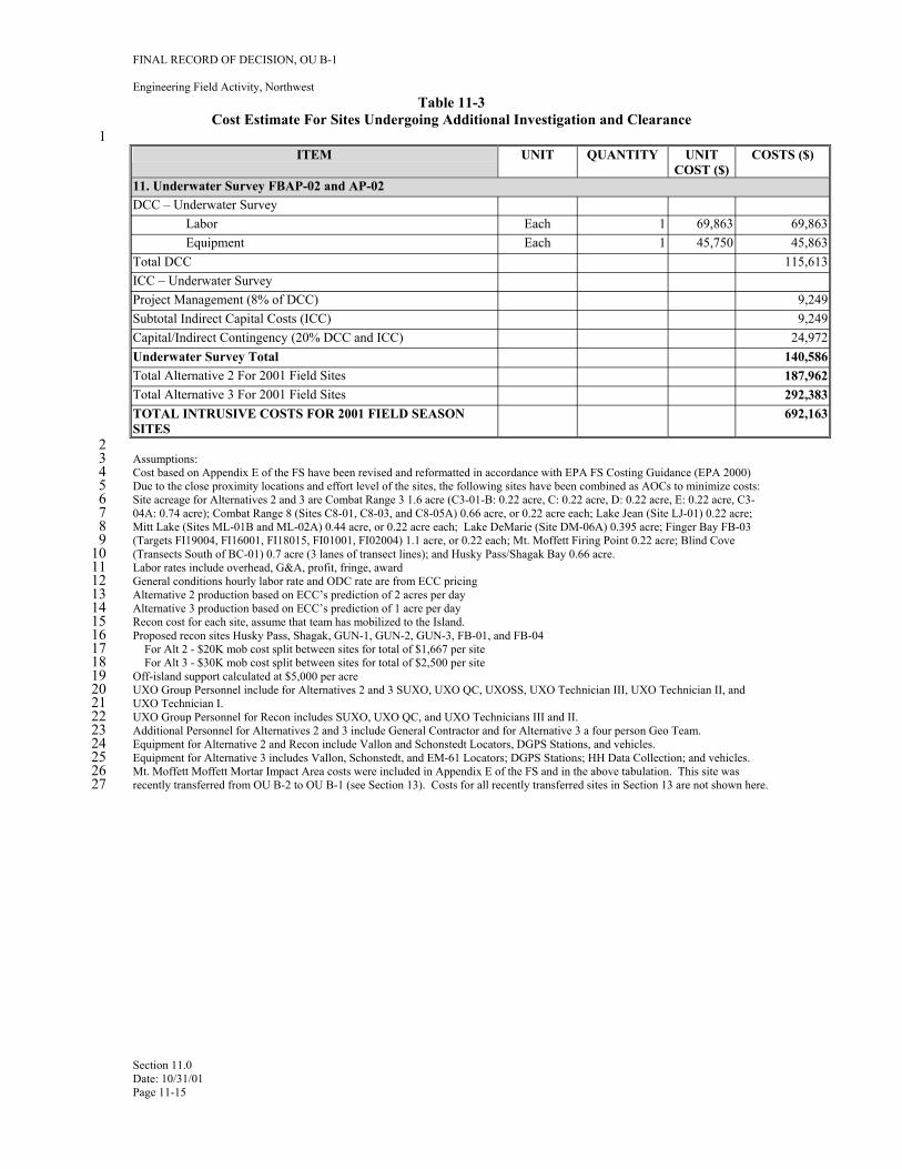
1
FINAL RECORD OF DECISION, OU B-1
Engineering Field Activity, Northwest Table 11-3
Cost Estimate For Sites Undergoing Additional Investigation and Clearance
ITEM UNIT QUANTITY UNIT COST ($)
COSTS ($)
11. Underwater Survey FBAP-02 and AP-02 DCC – Underwater Survey
Labor Each 1 69,863 69,863 Equipment Each 1 45,750 45,863
Total DCC 115,613 ICC – Underwater Survey Project Management (8% of DCC) 9,249 Subtotal Indirect Capital Costs (ICC) 9,249 Capital/Indirect Contingency (20% DCC and ICC) 24,972 Underwater Survey Total 140,586 Total Alternative 2 For 2001 Field Sites 187,962 Total Alternative 3 For 2001 Field Sites 292,383 TOTAL INTRUSIVE COSTS FOR 2001 FIELD SEASON SITES
692,163
2 3 Assumptions: 4 Cost based on Appendix E of the FS have been revised and reformatted in accordance with EPA FS Costing Guidance (EPA 2000) 5 Due to the close proximity locations and effort level of the sites, the following sites have been combined as AOCs to minimize costs: 6 Site acreage for Alternatives 2 and 3 are Combat Range 3 1.6 acre (C3-01-B: 0.22 acre, C: 0.22 acre, D: 0.22 acre, E: 0.22 acre, C37 04A: 0.74 acre); Combat Range 8 (Sites C8-01, C8-03, and C8-05A) 0.66 acre, or 0.22 acre each; Lake Jean (Site LJ-01) 0.22 acre; 8 Mitt Lake (Sites ML-01B and ML-02A) 0.44 acre, or 0.22 acre each; Lake DeMarie (Site DM-06A) 0.395 acre; Finger Bay FB-03 9 (Targets FI19004, FI16001, FI18015, FI01001, FI02004) 1.1 acre, or 0.22 each; Mt. Moffett Firing Point 0.22 acre; Blind Cove
10 (Transects South of BC-01) 0.7 acre (3 lanes of transect lines); and Husky Pass/Shagak Bay 0.66 acre. 11 Labor rates include overhead, G&A, profit, fringe, award 12 General conditions hourly labor rate and ODC rate are from ECC pricing 13 Alternative 2 production based on ECC’s prediction of 2 acres per day 14 Alternative 3 production based on ECC’s prediction of 1 acre per day 15 Recon cost for each site, assume that team has mobilized to the Island. 16 Proposed recon sites Husky Pass, Shagak, GUN-1, GUN-2, GUN-3, FB-01, and FB-04 17 For Alt 2 - $20K mob cost split between sites for total of $1,667 per site 18 For Alt 3 - $30K mob cost split between sites for total of $2,500 per site 19 Off-island support calculated at $5,000 per acre 20 UXO Group Personnel include for Alternatives 2 and 3 SUXO, UXO QC, UXOSS, UXO Technician III, UXO Technician II, and 21 UXO Technician I. 22 UXO Group Personnel for Recon includes SUXO, UXO QC, and UXO Technicians III and II.23 Additional Personnel for Alternatives 2 and 3 include General Contractor and for Alternative 3 a four person Geo Team. 24 Equipment for Alternative 2 and Recon include Vallon and Schonstedt Locators, DGPS Stations, and vehicles. 25 Equipment for Alternative 3 includes Vallon, Schonstedt, and EM-61 Locators; DGPS Stations; HH Data Collection; and vehicles. 26 Mt. Moffett Moffett Mortar Impact Area costs were included in Appendix E of the FS and in the above tabulation. This site was 27 recently transferred from OU B-2 to OU B-1 (see Section 13). Costs for all recently transferred sites in Section 13 are not shown here.
Section 11.0 Date: 10/31/01 Page 11-15
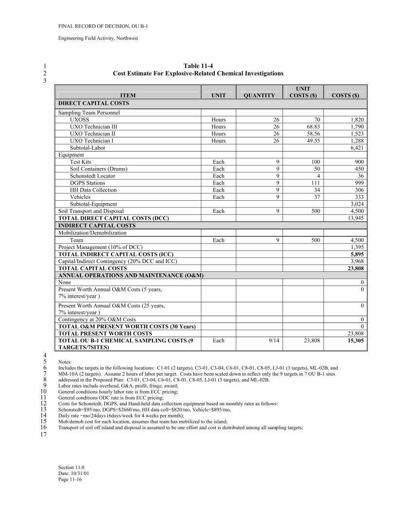
FINAL RECORD OF DECISION, OU B-1
Engineering Field Activity, Northwest
1 Table 11-4 2 Cost Estimate For Explosive-Related Chemical Investigations 3
ITEM UNIT QUANTITY UNIT
COSTS ($) COSTS ($) DIRECT CAPITAL COSTS Sampling Team Personnel
UXOSS Hours 26 70 1,820 UXO Technician III Hours 26 68.83 1,790 UXO Technician II Hours 26 58.56 1,523 UXO Technician I Hours 26 49.55 1,288 Subtotal-Labor 6,421
Equipment Test Kits Each 9 100 900
Soil Containers (Drums) Each 9 50 450 Schonstedt Locator Each 9 4 36
DGPS Stations Each 9 111 999 HH Data Collection Each 9 34 306 Vehicles Each 9 37 333 Subtotal-Equipment 3,024
Soil Transport and Disposal Each 9 500 4,500 TOTAL DIRECT CAPITAL COSTS (DCC) 13,945 INDIRECT CAPITAL COSTS Mobilization/Demobilization
Team Each 9 500 4,500 Project Management (10% of DCC) 1,395 TOTAL INDIRECT CAPITAL COSTS (ICC) 5,895 Capital/Indirect Contingency (20% DCC and ICC) 3,968 TOTAL CAPITAL COSTS 23,808 ANNUAL OPERATIONS AND MAINTENANCE (O&M) None 0 Present Worth Annual O&M Costs (5 years, 0 7% interest/year )
Present Worth Annual O&M Costs (25 years, 0 7% interest/year )Contingency at 20% O&M Costs 0 TOTAL O&M PRESENT WORTH COSTS (30 Years) 0 TOTAL PRESENT WORTH COSTS 23,808 TOTAL OU B-1 CHEMICAL SAMPLING COSTS (9 TARGETS/7SITES)
Each 9/14 23,808 15,305
4 5 Notes: 6 Includes the targets in the following locations: C1-01 (2 targets), C3-01, C3-04, C6-01, C8-01, C8-05, LJ-01 (3 targets), ML-02B, and 7 MM-10A (2 targets). Assume 2 hours of labor per target. Costs have been scaled down to reflect only the 9 targets in 7 OU B-1 sites 8 addressed in the Proposed Plan: C3-01, C3-04, C6-01, C8-01, C8-05, LJ-01 (3 targets), and ML-02B. 9 Labor rates include overhead, G&A, profit, fringe, award;
10 General conditions hourly labor rate is from ECC pricing; 11 General conditions ODC rate is from ECC pricing; 12 Costs for Schonstedt, DGPS, and Hand-held data collection equipment based on monthly rates as follows: 13 Schonstedt=$95/mo, DGPS=$2660/mo, HH data coll=$820/mo, Vehicle=$895/mo, 14 Daily rate =mo/24days (6days/week for 4 weeks per month); 15 Mob/demob cost for each location, assumes that team has mobilized to the island; 16 Transport of soil off island and disposal is assumed to be one effort and cost is distributed among all sampling targets; 17
Section 11.0 Date: 10/31/01 Page 11-16
FINAL RECORD OF DECISION, OU B-1
Engineering Field Activity, Northwest
1 12.0 STATUTORY DETERMINATIONS
2 Under CERCLA § 121 and the NCP, the lead agency must select remedies that are protective of human 3 health and the environment, comply with ARARs/TBCs, are cost-effective, and use permanent solutions 4 and alternative treatment technologies or resource recovery technologies In addition, CERCLA includes a 5 preference for remedies that employ treatment that permanently and significantly reduces the volume, 6 toxicity, or mobility of hazardous wastes as a principal element and a bias against off-site disposal of 7 untreated wastes. This section discusses how the selected remedy meets these statutory requirements.
8 12.1 PROTECTION OF HUMAN HEALTH AND THE ENVIRONMENT
9 In accordance with CERCLA guidance, the selected remedies for the OU B-1 sites are considered 10 protective of human health and the environment, as they remove OE/UXO items in sites that currently pose 11 potential explosive safety hazards and may exceed risk-based chemical cleanup levels in soil.
12 12.2 COMPLIANCE WITH APPLICABLE OR RELEVANT AND APPROPRIATE 13 REQUIREMENTS
14 Pursuant to CERCLA and the NCP, existing cleanup authorities and programs will be used in the risk and 15 hazard reduction actions. The risk or hazard reduction actions will comply with ARARs/TBCs Applicable 16 requirements are defined by the NCP (40 CFR 300.5) as those cleanup standards; standards of control; and 17 other substantive requirements, criteria, or limitations promulgated under federal or state environmental 18 and facility siting laws that specifically address a hazardous substance, pollutant, contaminant, remedial 19 action, location, or other circumstance at a CERCLA site. Relevant and appropriate requirements are 20 defined (40 CFR 300.5) as those cleanup standards; standards of control; and other substantive 21 requirements, criteria, or limitations promulgated under federal or state environmental and facility-siting 22 laws that, while not applicable to a hazardous substance, pollutant, contaminant, remedial action, location, 23 or other circumstance found at a CERCLA site, address problems or situations sufficiently similar to those 24 encountered at CERCLA sites and their use is well suited to a particular site.
25 A requirement that is relevant and appropriate must be complied with to the same degree as if it were 26 applicable. In addition to ARARs, the lead agency may, as appropriate, identify other advisories, criteria, 27 or guidance as “to be considered” (TBCs). Only those state standards that are identified by the state in a 28 timely manner and that are more stringent than federal requirements may be considered ARARs (40 CFR 29 300.400[g][4]).
30 ARARs/TBCs may be categorized as contaminant-, location-, or action-specific, as described below:
31 • Contaminant-specific ARARs/TBCs set health or risk-based concentration limits or ranges in various 32 environmental media for specific hazardous substances, pollutants, or contaminants.
33 • Location-specific ARARs/TBCs set restrictions on activities within specific locations, such as 34 wetlands and floodplains, and depend on the characteristics of a site and its immediate environment.
35 • Action-specific ARARs/TBC set controls or restrictions on particular kinds of remedial activities (such 36 as disposal) that may be selected to accomplish a remedy. These ARARs/TBCs may specify 37 performance levels, actions, or technologies to be used to manage hazardous substances, pollutants, or 38 contaminants.
39 Although no activities are planned to occur outside of the boundary of the military reservation, any off-site 40 activities must comply with all necessary federal, state, and local requirements. Occupational Safety and 41 Health Administration (OSHA) requirements are also not considered ARARs pursuant to EPA’s adopted
Section 12.0 Date: 10/31/01 Page 12-1
FINAL RECORD OF DECISION, OU B-1
Engineering Field Activity, Northwest
1 final rule on the NCP. The NCP identified specific OSHA requirements that must be complied with during 2 all CERCLA response actions (i.e., 29 CFR 1910 and 1926).
3 The selected remedies comply with all ARARs and TBCs of DDESB, EPA, State of Alaska, and 4 Department of Defense. Clearance to 4 feet bgs at C3-01A, C6-01A, ML-01A and the 24 OAPC sites will 5 satisfy the DDESB site-specific requirements for land transfer without OE/UXO-related land use 6 restrictions. Listed below are the chemical-specific, location-specific, action-specific ARARs/TBCs. Soil 7 sampling at the 9 targets in 7 sites identified in Table 11-1 along with excavation of all soils above cleanup 8 levels in Table 8-1, followed by onsite or offsite treatment and disposal of ordnance contaminated soils will 9 meet State of Alaska 18 AAC 75 requirements for reduction of potential human health cumulative
10 carcinogenic risks to no more than 1x10⁻⁵.
11 Chemical-Specific ARARs/TBCs:
12 • Alaska Oil and Hazardous Substances Pollution Control regulations (18 AAC 75) are applicable to 13 releases of hazardous substances including ordnance-related compounds during remedial actions. 14 They specify cleanup levels for soils in the over-40-inch rain zone (18 AAC 75.340 and 341, 15 Tables B1 and B2) and cleanup levels for groundwater and surface water (18 AAC 75.345).
16 • Alaska Water Quality Standards regulations (18 AAC 70) are relevant and appropriate for fresh and 17 marine surface waters that could be impacted by chemical and turbidity releases from UXO/OE 18 excavation and disposal activities. The regulation includes the protection of the growth and 19 propagation of fish, shellfish, other aquatic life, and wildlife, as well as protection of uses (e.g., 20 harvesting for consumption of raw mollusks and other raw aquatic life). The regulations specify that 21 turbidity standards not exceed 25 nephelometric turbidity units (NTU) above natural conditions. Total 22 dissolved solids (TDS) may not exceed 1,500 mg/L, including natural conditions; increase in TDS may 23 not exceed one-third of the concentration of the natural condition of the water body.
24 • 33 USC Section 1314, Clean Water Act. Ambient water quality criteria are relevant and appropriate 25 for surface water that could be impacted by migration of OE-related contaminants in proximity to 26 surface water bodies.
27 Location-Specific ARARs/TBCs:
28 • Clean Water Act (CWA), 40 CFR Part 320.1 et seq., 401 et seq. specifies criteria for evaluating effects 29 to waters of the U.S. (including wetlands) and sets factors for considering mitigation measures 30 associated with disrupting ground surface during excavation activities. The criteria would be 31 applicable for any site excavation work within rivers, streams, tidal areas, and wetlands.
32 • Executive Order 11990, Protection of Wetlands (also 40 CFR Part 6, Appendix A). The requirement 33 that federal agencies avoid adversely impacting wetlands wherever possible to minimize wetlands 34 destruction and to preserve values of wetlands is applicable for any site excavation work within tidal 35 areas and wetlands. Such areas may include C3-01A, C3-04, FBAP-02, and AP-02.
36 • Fish and Wildlife Coordination Act (16 USC 661-666c) is relevant and appropriate. It requires 37 consultation with U.S. Fish and Wildlife Service to develop any appropriate protective measures 38 before implementation of the project. Adequate provision shall be made for the conservation, 39 maintenance, and management of wildlife resources and habitat to be affected. It is applicable to 40 activities that might disturb wildlife resources or habitat.
41
Section 12.0 Date: 10/31/01 Page 12-2
FINAL RECORD OF DECISION, OU B-1
Engineering Field Activity, Northwest
1
2 Action-Specific ARARs/TBCs:
3 • Federal Clean Water Act NPDES Stormwater regulations (40 CFR 122.26) are relevant and 4 appropriate for point source discharge of stormwater from construction sites to surface water and 5 provide for Best Management Practices such as erosion control for removal and management of 6 sediments to prevent run-on and run-off.
7 • National Toxics Rule (40 CFR 131.36). Concentration limits for toxics, as well as acute and chronic 8 exposure criteria for freshwater and marine water, are relevant and appropriate to protect human health 9 and aquatic life. Application of these standards will ensure that releases during remedial action do not
10 cause exceedances in water quality in nearby surface waters.
11 • Alaska Water Quality Standards regulations (18 AAC 70) are applicable to protect the growth and 12 propagation of fish, shellfish, other aquatic life, and wildlife. The regulations specify that turbidity 13 standards not exceed 25 NTU above natural conditions. TDS may not exceed 1,500 mg/L, including 14 natural conditions; increase in TDS may not exceed one-third of the concentration of the natural 15 condition of the water body.
16 • Alaska Oil and Hazardous Substances Pollution Control regulations (18 AAC 75.375) are applicable. 17 They define situations where institutional controls are required, describe institutional controls, and 18 specify criteria that institutional controls must meet.
19 • 18 AAC 75.365, Offsite or Portable Treatment Facilities. Requirements for approval of temporary 20 treatment facilities are relevant and appropriate for soil contaminated with explosives-related 21 contamination that may require on-site treatment.
22 • 18 AAC 75.370, Soil Storage and Disposal. Requirements for location, liner permeability for 23 temporary stockpiling of ordnance-contaminated soils, and blending with other soils prior to treatment 24 and disposal are applicable.
25 • Resource Conservation and Recovery Act (RCRA), 42 USC 6921-22, 40 CFR 260 through 270; These 26 regulations establish requirements for the proper designation (40 CFR 261), storage, treatment, and 27 disposal (40 CFR 262) of hazardous waste including OE/UXO as a potentially reactive (D003) or toxic 28 (D008) hazardous waste. The requirements for the treatment of waste explosives through burning are 29 contained within 40 CFR 265.382. The substantive requirements for the open burning of waste 30 explosives (40 CFR 265.382), on-site transportation (40 CFR 263), storage (40 CFR 265.250), 31 treatment (40 CFR 265.370), and land disposal restrictions (40 CFR 265.268) are relevant and 32 appropriate.
33 • RCRA Management of Military Munitions, Military Munitions Rule (40 CFR 260 through 265 and 34 270). Amendments to hazardous waste identification and management rules for military munitions, and 35 definition of explosive emergencies are relevant and appropriate for the removal and management of 36 unexploded ordnance pursuant to RCRA.
37 • Clean Air Act, (42 U.S.C. 1857-18571; 40 CFR 50-100). The Clean Air Act (CAA) regulates releases 38 of specific substances into the air. Pursuant to the CAA, EPA has promulgated National Ambient Air 39 Quality Standards (40 CFR 50), National Emission Standards for Hazardous Air Pollutants (40 CFR 40 61), and New Source Performance Standards (40 CFR 60, 63). These standards are relevant and 41 appropriate for air releases resulting from response actions such as detonation activities that may 42 generate particulate matter emissions or that use commercially available equipment to demilitarize 43 explosives.
Section 12.0 Date: 10/31/01 Page 12-3
FINAL RECORD OF DECISION, OU B-1
Engineering Field Activity, Northwest
1 • Alaska Clean Air Act regulations (18 AAC 50.300 through 50.380). The substantive requirements are 2 relevant and appropriate for the burning and detonation of OE/UXO. These sections include, by 3 reference, other chapters and sections of 18 AAC 50 that specify chemical emissions.
4 • U.S. Department of Transportation (49 U.S.C. 1803, 1804, 1808; 49 CFR 107, 171, 172). 5 Requirements for the transport of hazardous materials and substances by land, sea, or air are applicable 6 if off-site transport of hazardous materials should become necessary.
7 Other Criteria, Advisories, or Guidance To Be Considered (TBC):
8 • DoD Ammunition and Explosives Safety Standards, DoD 6055.9—STD. DoD policy issued by the 9 DDESB establishes policies and procedures necessary to provide protection to personnel as a result of
10 DoD ammunition, explosives, or chemical agents and contamination of real property currently or 11 formerly owned, leased, or used by DoD. This is a TBC for identifying default clearance depths and a 12 process for determining site-specific considerations to modify these depths.
13 • DoD policy on responsibility for OE/UXO post-transfer (DoD, 1997)— This policy requires that if 14 applicable regulatory requirements are revised to reflect new scientific or health data and the remedy 15 put in place by DoD is determined to be no longer protective of human health and the environment, 16 DoD would return to perform such additional cleanup as would generally be required by regulatory 17 agencies of any responsible party in a similar situation.
18 12.3 COST-EFFECTIVENESS
19 The selected remedies are considered to be cost-effective with respect to the level of protection of human 20 health and the environment and the cost of the selected remedies. In making this determination, the 21 following definition was used: “A remedy shall be cost-effective if its costs are proportional to its overall 22 effectiveness” (NCP Section 300.430(f)(1)(ii)(D)). This was accomplished by evaluating the overall 23 effectiveness of those alternatives that satisfied the threshold criteria (i.e., were both protective of human 24 health and the environment and were ARAR-compliant). Overall effectiveness was evaluated by assessing 25 three of the five balancing criteria in combination (long-term effectiveness and permanence; reduction in 26 toxicity, mobility, and volume through treatment; and short-term effectiveness). The removal and 27 treatment of UXO through destruction will provide for permanent protectiveness for current and future 28 Adak residents and visitors. The excavation, treatment and disposal of soils that contain ordnance related 29 chemicals will also provide permanent protectiveness for current and future Adak residents and visitors.
30 12.4 UTILIZATION OF PERMANENT SOLUTIONS AND ALTERNATIVE TREATMENT 31 TECHNOLOGIES TO THE MAXIMUM EXTENT PRACTICABLE
32 The selected remedies represent the maximum extent to which permanent solutions and treatment 33 technologies can be used in a practicable manner at a site. Of those alternatives that are protective of 34 human health and the environment and comply with ARARs/TBCs, The Navy, EPA, and ADEC have 35 determined that the selected remedies (Alternatives 1, 3, and 4) provides the best balance of tradeoffs in 36 terms of the nine criteria, These determinations are described in Section 9.0, and summarized in Sections 37 10.1.1 and 10.2.2, where the rationale is provided for the selected remedy components.
38 12.5 PREFERENCE FOR TREATMENT AS A PRINCIPAL ELEMENT
39 The selected remedies use permanent solutions through removal and disposal of OE/UXO items through 40 treatment of UXO through detonation, and through onsite or offsite treatment and disposal of ordnance 41 contaminated soils.
Section 12.0 Date: 10/31/01 Page 12-4
FINAL RECORD OF DECISION, OU B-1
Engineering Field Activity, Northwest
1 12.6 FIVE-YEAR REVIEW REQUIREMENTS
2 Since there is the potential that OE/UXO contamination may still exist on Adak Island, the effectiveness of 3 the OE/UXO Educational Awareness Program will be evaluated as part of the 5-year review process to 4 assure that final remedial actions for OE/UXO on Adak Island remain protective.
Section 12.0 Date: 10/31/01 Page 12-5
FINAL RECORD OF DECISION, OU B-1
Engineering Field Activity, Northwest
1 13.0 DOCUMENTATION OF SIGNIFICANT CHANGES SINCE THE PROPOSED PLAN
2 This section of the ROD discusses significant changes that have occurred since the issuance of the 3 Proposed Plan in May 2001 (U.S. Navy, 2001), including the site counts and disposition of sites described 4 in the Proposed Plan. This discussion summarizes the inclusion of Mt. Moffett sites for final 5 characterization and clearance and the inclusion of one new site (FB-03) that has been recently identified 6 within OU B-1 for characterization and clearance. These changes were not considered to require the 7 issuance of a new proposed plan. The decision to include Mt Moffett sites was based on discussions among 8 the OU B Project Team, and was also discussed at the Public Meeting for the OU B-1 Proposed Plan. The 9 sites on Mt Moffett are being addressed in same manner as the 27 sites selected for clearance to 4 feet bgs.
10 This is also true for site FB-03.
11 The sites shown in Table 13-1 are proposed for addition to OU B-1 at this time. However, field conditions 12 may dictate that some or all of these sites may not be completed by the end of the 2001 field season. The 13 actual sites to be included in OU B-1 for transfer purposes will await completion of the field activities. 14 These sites are being considered for inclusion in OU B-1 to facilitate transfer of real property to BLM and 15 then to TAC.
16 13.1 MT. MOFFETT SITES
17 As a result of written and verbal comments provided by the EPA on the OU B-1 RI/FS Report and the OU 18 B-1 Remedial Action Design Work Plan, the Navy has agreed to include the Mt. Moffett AOCs in the 19 scope of this ROD for cleanup decisions. At the time of the release of the Proposed Plan, the Navy had not 20 made a final decision on whether to include Mt Moffett AOCs in OU B-1 or OU B-2 decision documents. 21 A description of the Mt. Moffett AOCs, and the selected remedy is presented below.
22 The Mt. Moffett AOCs identified through the PA, SI, and RI/FS process included combat ranges, impact 23 areas (MM-01, -02, -03, -10, and -11), potential firing points (MM-04 and -22), an isolated fuze (MM-07), 24 frag sites (MM-05, -06, -08, -09), and a chemical mortar training site (MM-23) (Figure 13-1). During the 25 2000 field season, approximately 1,800 target anomalies were identified through the geophysical 26 investigations and post-processing of data. Locations of these anomalies are recorded in the DGPS data 27 system. These targets will be re-acquired and intrusively investigated. All OE/UXO will be addressed 28 under Alternative 3, and the locations will be cleared to a depth of four feet. In this manner, these locations 29 will be addressed in the same approach as the OAPC sites that will be subject to final characterization and 30 clearance.
31 MM-14 and MM-20 were inadvertently removed from OU B-1 when the decision was made to separate 32 OU B-1 and OU B-2. Both sites have undergone completed reconnaissance during the 2000 PA activities. 33 Since no OE/UXO were found at the sites, both have been selected for NOFA.
34 A nearby site, BI-01 (Bay of Islands Impact Area Firing Point), was reconned in the 2000 field season and 35 subsequently recommended for NOFA.
36 13.2 FINGER BAY SITE
37 One site was recently identified through the discovery of additional archival information. The new site is 38 within the geographic boundary of OU B-1 and is included in the site summary Figure 4-2. This site and 39 the selected remedial action are described below.
40 The additional site, FB-03, or Finger Bay Impact Area is a 31-acre site. It represents the historical impact 41 area for mortars used in live fire power demonstrations. The site was investigated during the SI. No 42 OE/UXO was found; however, numerous pieces of scrap associated with mortars were found. Since no
Section 13.0 Date: 10/31/01 Page 13-1
FINAL RECORD OF DECISION, OU B-1
Engineering Field Activity, Northwest
1 additional investigation in the form of X-Ts or mini-grids was done at this site during the RI, the Navy has 2 agreed to re-evaluate several individual targets to help ensure that UXO is not present in a previously 3 unidentified location within this AOC. These targets are: FI9004, FI16001, FI18015, FI01001 and 4 FI02004. All OE/UXO will be addressed under Alternative 3, and the locations will be cleared to a depth 5 of four feet. In this manner, these locations will be addressed in the same approach as the OAPC sites that 6 will be subject to final characterization and clearance.
7 13.3 COMBAT RANGE SITES
8 Two sites within both Combat Range 1 (C1) and three from Combat Range 2 (C2) have been added back 9 into OU B-1 for characterization and clearance to facilitate land transfer. At C1, the two sites to be added
10 are located within steep terrain near Mt. Moffett located northwest of downtown Adak. These two sites 11 from C1 include C1-02 (Time Fuze Site) located on the lower flanks of the west side of Mt. Moffett and 12 C1-03 (Combat Range #1 Remainder) located on the north side of Mt. Moffett.
13 The three C2 sites are located northwest of downtown Adak on steep terrain along the western flank of Mt. 14 Moffett and include C2-01A, C2-01B, and C2-02. These locations at C1 and C2 will be addressed in the 15 same approach as the OAPC sites that will be subject to final characterization and clearance.
16 13.4 CHEMICAL SAMPLING SITES
17 Based upon observations during the 2001 field season, additional chemical sampling will be characterized 18 in several sites; specifically at one open detonation site and several dozen burn sites within C3-01A, at two 19 detonation sites within C3-04A, two targets within MM-10A, and at open detonation sites within C8-03.
20 13.5 NEW SITE JM-01
21 JM-01 (a suspected burial and detonation site for twenty 105mm mustard rounds) was recently discovered 22 southeast of Lake Jean. However, there is insufficient information to draw conclusions about the nature and 23 extent of OE and chemical contamination, much less required remedial actions. This site will be addressed 24 as part of OU B-2 Record of Decision and will be excluded from the parcel of real estate to be considered 25 in the FOST.
26 13.6 CHANGES IN OU B SITE COUNTS
27 As a result in changes in site nomenclature, since the publication of the Proposed Plan and Final OU B 28 RI/FS, the identification of new sites, and the inclusion of former OU B-2 sites within OU B-1 to facilitate 29 property transfer, the following summarize the revised site counts for OU B-1:
30 131 OU B-1 sites (including FB-03) + 22 transferred from OU B-2 + 2 (MM-14 and MM-20) = 155 OU B31 1 sites.
Section 13.0 Date: 10/31/01 Page 13-2
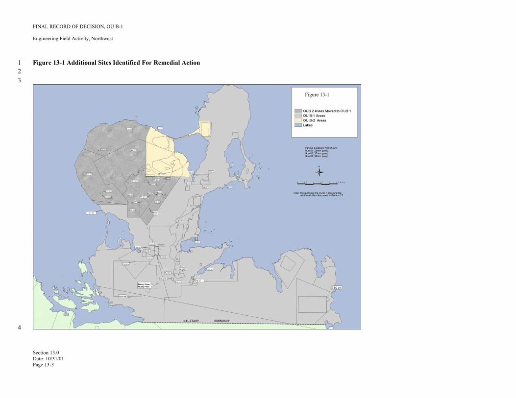
FINAL RECORD OF DECISION, OU B-1
Engineering Field Activity, Northwest
1 Figure 13-1 Additional Sites Identified For Remedial Action 2 3
4
Figure 13-1
Section 13.0 Date: 10/31/01 Page 13-3
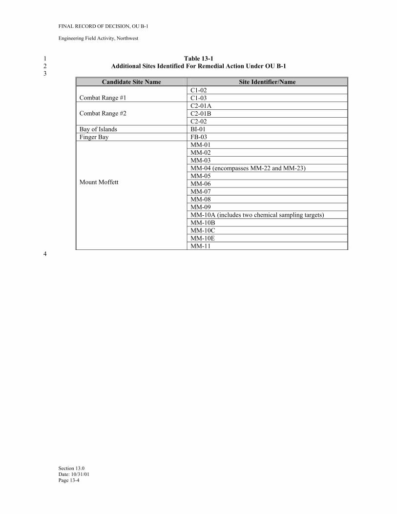
4
FINAL RECORD OF DECISION, OU B-1
Engineering Field Activity, Northwest
1 Table 13-1 2 Additional Sites Identified For Remedial Action Under OU B-1 3
Candidate Site Name Site Identifier/Name C1-02
Combat Range #1 C1-03 C2-01A
Combat Range #2 C2-01B C2-02
Bay of Islands BI-01 Finger Bay FB-03
MM-01 MM-02 MM-03 MM-04 (encompasses MM-22 and MM-23) MM-05
Mount Moffett MM-06 MM-07 MM-08 MM-09 MM-10A (includes two chemical sampling targets) MM-10B MM-10C MM-10E MM-11
Section 13.0 Date: 10/31/01 Page 13-4
FINAL RECORD OF DECISION, OU B-1
Engineering Field Activity, Northwest
1 14.0 REFERENCES
2 ASCG Consultants (ASCG). 2000. Adak Naval Station Economic Reuse Study, Phase II: Engineering 3 Analysis. Prepared for the Adak Reuse Corporation. Economic Development Administration, 4 U.S. Department of Commerce. September 14, 2000.
5 ———. 1998. Adak Naval Station Economic Reuse Study, Revised Final. Prepared for the Adak Reuse 6 Corporation. Economic Development Administration, U.S. Department of Commerce. August7 18, 1998.
8 DoD. 1997. DoD policy memorandum from Under Secretary of Defense, “Responsibility for Additional 9 Environmental Cleanup After Transfer of Real Property”, dated July 25, 1997
10 ______. 1999. DoD Ammunition and Explosives Safety and Standards: Chapter 12 – Real Property 11 Contaminated with Ammunition Explosives, or Chemical Agents. DoD 6055.9 STD, July 1999.
12 Environmental Chemical Corporation (ECC), 2001. Final Remedial Investigation/Feasibility Study Report 13 For OU B 1 Site Former Naval Air Facility Adak Island, Alaska. Submitted by ECC and prepared 14 by Foster Wheeler Environmental Corporation for Engineering Field Activity, Northwest Naval 15 Facilities Engineering Command Poulsbo, WA under Contract Number N62742-99-D-1800 CTO 16 0002, July 2001.
17 ———. 2000. Draft Validation of Detection System (VDS) Test Plan for Adak, Alaska: Test Site 18 Construction and Operation Plan. May 2000.
19 Foster Wheeler Environmental Corporation (FWENC). 2000a. Draft Final RI/FS Work Plan, Former Naval 20 Air Facility, Adak, Alaska. Delivery Order No. 0083. August 15, 2000.
21 ———. 2000b. Draft Final Preliminary Assessment Report, Selected Areas of Concern in Operable Unit 22 B, Former Naval Air Facility Adak, Alaska. Volumes I, II, and III. Delivery Order No. 0083. 23 December 1, 2000.
24 ———. 1998. Archive Search Summary Report, Naval Air Facility, Adak, Alaska. Delivery Order No. 25 0081. Volumes I and II. October 2, 1998.
26 ———. 1997. Intrusive Investigation of UXO in the Priority I and II Areas; Conduct Archive Search 27 Reports, Geophysical Surveys, and Intrusive Sampling; Naval Air Facility, Adak, Alaska. 28 Prepared for Engineering Field Activity, Northwest, Poulsbo, Washington. Delivery Order No. 29 0075. October 24, 1997.
30 NEESA 1986. Initial Assessment Study of Naval Air Station, Naval Security Group Activity, and Naval 31 Facility, Adak Island, Alaska. NEESA 13-103. Prepared by Environmental Science and 32 Engineering, Inc., Gainesville, Florida, for Naval Energy and Environmental Support Activity 33 (NEESA). April 1986.
34 Rohrer, W. L., M. Beagle, M. Folsom, D. Murray, and M. Murphy. Measurement Of Frost Heave On Adak 35 Island, AK. Presented at UXO/Countermine Forum 2001, April 9-12, 2001, New Orleans, LA.
36 Supervisor of Shipbuilding Conversion and Repair, USN, Portsmouth, VA (SSPORTS). 1999. Final 37 Unexploded Ordnance Minefield Investigation, Solid Waste Management Unit No. 2, Naval Air 38 Facility Adak, Adak, Alaska. April 8, 1999.
Section 14.0 Date: 10/31/01 Page 14-1
FINAL RECORD OF DECISION, OU B-1
Engineering Field Activity, Northwest
1 Tryck Nyman Hayes, Inc. Adak Reuse Plan. Project ASPS #96-0121. Anchorage, Alaska. August 19, 2 1996.
3 URS 1997. Final Remedial Investigation/Feasibility Study Report, Operable Unit A, Adak Naval Complex, 4 Adak Island, Alaska. Prepared for U.S. Navy CLEAN Contract N62474-89-D-9295. Seattle, 5 Washington. September 23, 1997.
6 ———. 1995a. Final Preliminary Source Evaluation (PSE-1) Batch 2 Report, Operable Unit A, Naval 7 Air Facility (NAF) Adak, Adak Island, Alaska. Prepared for U.S. Navy CLEAN Contract N624748 89-D-9295. Seattle, Washington. November 13, 1995.
9 ———. 1995b. Final Preliminary Source Evaluation 2 (PSE-2) Report for Batch 1 Sites, Operable 10 Unit A, Adak Naval Complex, Adak Island, Alaska. 3 vols. Prepared for U.S. Navy CLEAN 11 Contract N62474-89-D-9295. Seattle, Washington. June 30, 1995.
12 U.S. EPA, U.S. Army Corps of Engineers. 2000. A Guide to Developing and Documenting Costs 13 Estimates During the Feasibility Study. July 2000. EPA 540-R-00-002. OSWER 9355.0-75.
14 U.S. EPA Region 9. 1999. Preliminary Remediation Goal Update. 15 (www.epa.gov/region9/waste/sfund/prg). October 9, 1999.
16 U.S. Navy U.S. Environmental Protection Agency (USEPA), and Alaska Department of Environmental 17 Conservation (ADEC). 2001. Proposed Plan for Cleanup of Ordnance and Explosives and 18 Unexploded Ordnance Within Operable Unit B-1 On Adak Island. May 2001.
19 U.S. Navy, USEPA, and ADEC. 1999. Record of Decision for Operable Unit A, Former Adak Naval 20 Complex, Adak Island, Alaska. Prepared by URS Greiner, Inc., for Engineering Field Activity, 21 Northwest, under CLEAN Contract No. N62474-89-D-9295. Poulsbo, Washington. October 22 1999.
23 U.S. Navy, USEPA, and ADEC. 1999-2001. Adak Update, September 1999 through April 2001 located at 24 www.adakupdate.com. Web site maintained by Engineering Field Activity NW, Poulsbo, WA.
25 U.S. Navy, U.S. Department of the Interior, and The Aleut Corporation (TAC). 2000. Agreement 26 Concerning the Conveyance of Property at the Adak Naval Complex, Adak, Alaska. September 27 2000.
28 U.S. Navy. 1996a. Historic and Archeological Resources Protection (HARP) Plan for Naval Air 29 Complex; Naval Air Facility Adak, Naval Security Group Activity Adak. Prepared by EDAW, 30 Inc., for Engineering Field Activity, Northwest, Poulsbo, Washington. October 1996.
31 ———. 1996b. Unexploded Ordnance (UXO) Survey Conducted at Naval Air Facility (NAF), Adak. 32 Department of the Navy, Explosive Ordnance Disposal Mobile Unit Eleven, Detachment Whidbey 33 Island.
34 _______. 1992. OPNAVINST 8027.1G Interservice responsibilities for explosives ordnance disposal
Section 14.0 Date: 10/31/01 Page 14-2
FINAL RECORD OF DECISION, OU B-1
Engineering Field Activity, Northwest
1 APPENDIX A 2 RESPONSIVENESS SUMMARY
3 The responsiveness summary addresses public comments on the proposed plan for remedial action at OU 4 B-1 at Adak Island, Alaska. The proposed plan was issued on May 14, 2001 (U.S. Navy, 2001). The 5 public comment period was held from May 14 through June 12, 2001. A public meeting was held on Adak 6 Island on May 29, 2001 to present the proposed plan and accept oral and written public comments. A 7 similar opportunity was provided in Anchorage on May 31, 2001. A RAB meeting was also held on May 8 30, 2001 on Adak (with a teleconference connection to Anchorage RAB members).
9 Eighteen comments or questions were received verbally at the Adak Island public meeting. Four comments 10 were received at the RAB meeting from two on-island residents and an Anchorage RAB member. 11 Comments were also solicited from a pre-printed comment form attached to the proposed plan. Written 12 comments were to be submitted to the Navy at the address included with the proposed plan. The proposed 13 plan was mailed to addressees on the Adak Community Relations Plan mailing list; it was also sent to the 14 Anchorage repository, the on-island repository, and it was distributed to island residents prior to the 15 proposed plan meeting. The proposed plan was also added to the Adakupdate.com website on May 14, 16 2001 with directions to on-line users to submit comments electronically. As of the end of the public 17 comment period, no comments had been received electronically via the Adakupdate website. As of the end 18 of the public comment period, written comments had been received from the Aleutian/Pribilof Islands 19 Association and ADEC.
20 Nine comments and questions received at the Adak public meeting addressed the approach to ordnance 21 survey and cleanup on Adak; one addressed ordnance survey maps, three addressed responses by the Navy 22 to future ordnance discoveries, one addressed the ordnance-related chemical contamination, two addressed 23 the land transfer process, one addressed Rommel Stake removals, and one addressed the contract under 24 which the ordnance work has been conducted. The comments/questions and responses are presented below.
25 The following comments and questions address the approach to ordnance survey and cleanup on 26 Adak:
27 1.
28 Response: 29 30 31 32
33 2. 34
35 Response: 36
37 3.
38 Response: 39 40 41 42
Is clearance of ordnance to a depth of 1 ft. sufficient (at the Clam Lagoon minefield site)?
Yes. The ordnance experts that were consulted as part of the plan for clearing the minefield were very confident that one foot would be a sufficient clearance depth for the mines in that area since mines are not placed at depths greater than one foot below ground surface. All (100% coverage) of the area was covered twice. Navy is very confident that all mines have been removed.
What about if the weather brings in addition cover or material that may cover mines deeper than 1 foot.
In some cases that would be a concern. At this site, there is almost no chance of additional coverage with wind-blown debris; the site is too far from the shoreline.
How deep could ordnance be detected at the minefield site?
The ordnance detection system used at the Clam Lagoon minefield is adequate to detect mines to 18" below ground surface). Based on the site characteristics, a detection depth of 18 inches was adequate for the site. At other sites, Navy used detection equipment capable of detecting ordnance-related items to greater depths when site characteristics required such depths.
Appendix A Date: 10/31/01 Page A-1
FINAL RECORD OF DECISION, OU B-1
Engineering Field Activity, Northwest
1 4. Do tundra knolls and surface clutter interfere with detectors? What is considered the 2 ground surface?
3 Response: No. These do not affect the detectors. The top of the ground surface (0 feet bgs) starts 4 with mineral soil, not surface vegetation or other debris.
5 5. Would the detectors have been affected by water?
6 Response: No. Testing was done of the ordnance detectors in the field conditions that occurred on 7 the sites that were investigated on Adak. These tests demonstrated that our data set has a 8 high reliability.
9 6. Did the 2000 field season investigation criteria change from previous years?
10 Response: Yes, the criteria changed prior to commencement of the field season based on the work 11 plans and methods developed through the OU B Project Team efforts. These criteria 12 included geophysical and investigation methods that are more stringent than the 1999 13 work. Data from the 1999 work was compared to the 2000 criteria. The 1999 data that 14 meet the 2000 data quality criteria were used, while some of the 1999 data were not used.
15 7. What process was used to investigate an area?
16 Response: Initially, a surface sweep of the path to be walked by the geophysical data collection team 17 was conducted to remove any surface OE/UXO items and metallic debris that would have 18 interfered with the subsurface ordnance detection system. The Geophysical Team 19 collected subsurface data by walking a path, or transect, and recording the location of 20 potential ordnance items (anomalies). Based on the information gathered by the 21 Geophysical Team, UXO investigation teams excavated these anomalies to determine if 22 they were ordnance or non-ordnance items. Prior to executing the investigation, the 23 Navy's contractors were required to demonstrate their capability to detect and relocate 24 ordnance items with the required statistical reliability.
25 8. Is there any part of the south half of the island that’s dangerous?
26 Response: Combat ranges that were investigated in the northern part of the island suggest a low 27 ordnance density. However, the Navy has not investigated any of the combat ranges on 28 the south half of the island. The Corps will address this area under the Formerly Used 29 Defense Sites (FUDS) program.
30 9. If the metal detectors only go down to a depth of 18 inches, how can we say that 31 minefields are clear to 4 feet?
32 33 Response: At a minefield, no mines would be expected below 18 inches. So, that was the depth to 34 which the investigation was conducted. All other locations, except the minefield 35 locations, have been investigated to a depth of 4 feet using instrumentation proven to 36 detect ordnance down to this depth.
37 The following comment and question addresses the ordnance survey maps generated for Adak:
38 10. Have the land use maps and other materials being presented here been presented to the 39 public on previous occasions?
Appendix A Date: 10/31/01 Page A-2
FINAL RECORD OF DECISION, OU B-1
Engineering Field Activity, Northwest
1 Response: Yes, the graphics have been presented at several previous meetings and workshops to get 2 community input on land use and activities. These are also in the information repository. 3 They are full size poster board graphics.
4 The following comment and question addresses ordnance-related chemical contamination:
5 11. Will ordinary water filters or other treatment technologies filter out ordnance 6 contaminants from drinking water?
7 Response: Some ordnance chemical contamination sampling has already been done on Adak, as part 8 of the previous RI/FS. As far as we know, the OB/OD range was used more than any 9 other area for ordnance related purposes. We did extensive sampling for groundwater,
10 surface water, and subsurface and surface soil contamination in this area for ordnance 11 chemical constituents in that area. No contamination was found at any levels that would 12 be a threat to human health and the environment, so filtration of such contaminants from 13 Adak drinking water is not an issue. As a follow up to this question, EPA provided 14 information to the person who asked the question regarding portable camping filters that 15 are considered effective at removing nitroamine class explosive compounds.
16 The following comments and questions address the Navy’s response to future ordnance discoveries 17 on Adak:
18 12. If an item or ordnance is found, who will respond?
19 Response: Navy and DoD are responsible for responding to any discovery of ordnance on Adak and 20 any additional clean up required.
21 13. What would be the timetable for response?
22 Response: The Navy would decide on a case by case basis. Some ordnance discovery doesn’t 23 require immediate response because it doesn't pose any immediate threat. Typically, a 24 picture would be taken of the discovery, sent to the Navy, and an ordnance specialist 25 would determine the nature of the hazard, if any. Based on this information, a decision 26 on what kind of response and when it would be taken would be made. It really depends 27 on what type of ordnance is discovered. A decision on the required response is usually 28 made within a day of receipt by Navy of information about the discovery.
29 14. Would you use a [response] team from Anchorage to help?
30 Response: Currently, response is provided by Explosive Ordnance Disposal Detachment Mobile 31 Unit Eleven based at Naval Air Station Whidbey Island, Washington, but in the future a 32 response could be initiated from Anchorage by another Explosive Ordnance Disposal 33 Unit detachment.
34 The following comments and questions address the land transfer process:
35 15. How does OU A play in the land transfer?
36 Response: All OU A cleanup required to enable land transfer has been completed. There is still 37 some petroleum site cleanup yet to be completed, but petroleum sites are not subject to 38 CERCLA 120(h) covenant requirements and, therefore, not an obstacle to land transfer
39 16. What effect did budget cuts have on potential land transfer?
Appendix A Date: 10/31/01 Page A-3
FINAL RECORD OF DECISION, OU B-1
Engineering Field Activity, Northwest
1 Response: Navy believes that there is adequate budget to complete all work needed to enable land 2 transfer.
3 The following comment and question addresses the contract under which the ordnance survey and 4 cleanup was conducted on Adak:
5 17. Why was ECC brought in vice FWENC?
6 Response: The Navy follows Federal Acquisition Regulations (FAR) in awarding all contract work. 7 Navy awarded a contract to ECC and issued delivery orders against that contract to 8 perform ordnance investigation and clearance work at Adak by following FAR9 procedures.
10 The following comment and question addresses Rommel stake removals on Adak:
11 18. Will there be any more Rommel stake removal?
12 Response: Navy believes it has removed all known, accessible Rommel stakes from areas where 13 they pose a hazard. However, the issue of Rommel stake removal is not part of this ROD.
14 The following comments and questions address issues raised at the May 30, 2001 Adak RAB meeting:
15 19. said his concern was that the Navy performed work in 1997 and 1998 that the 16 regulatory agencies did not approve.
17 Response: Mr. Oates noted that those work plans were part of Operable Unit B, and that the issues 18 were more about national policy rather than approval of the work plans. He said that one 19 thing that came out of the OU B dispute was the project team came up with something 20 that will work on Adak, and it will make it a better place to live. Mr. Oates also stated 21 that much of the work performed by the Navy before the dispute was able to be retained 22 and ultimately used.
23 20. said he noticed that there was an Adak-specific requirement for OU B-1 that 24 states 30 percent slopes are not accessible. He stated that a 30 percent slope was not that 25 extreme and it was not uncommon for him to hike in that type of terrain.
26 Response: The OU B Project Team agreed that a 30-degree slope delineated accessible from 27 inaccessible areas. That doesn’t mean that it is not possible to climb in these areas, but it 28 was agreed that these areas are very unlikely to be accessed on a regular basis compared 29 to those areas with less severe slopes. It was stated that consideration for historical 30 practices in a particular area was part of the evaluation process. It was further stated that 31 while it was possible that someone will access areas with greater than a 30-degree slope, 32 this would be the exception rather than the rule. Areas adjacent to these "inaccessible" 33 areas were thoroughly investigated and that the data from these areas provides an 34 indication of the likelihood of UXO contamination in the surrounding (inaccessible) 35 areas. Generally, it was agreed to by the project team that people are much more likely to 36 walk in the areas where the slopes are less than 30 degrees.
37 21. Tim Roy stated he was The Aleut Corporation representative on the OU B project team 38 and he had not been receiving emails.
39 Response: Tim Roy is on the OU B project team distribution list for The Aleut Corporation, as are 40 Chris Gates and Vince Tutiakoff.
Appendix A Date: 10/31/01 Page A-4
(b) (6)
(b) (6)
FINAL RECORD OF DECISION, OU B-1
Engineering Field Activity, Northwest
1 22. asked if the comment period for the OU B-1 proposed plan could be 2 extended beyond the June 12, 2001 due date, since some of the RAB members had just3 received their copies in the mail.
4 Response: The Proposed Plan has been available on the adakupdate.com web site since May 14th, 5 and since the document is only 12 pages in length, no extension of the comment period 6 was planned.
7 The following comments and questions addresses A/PIA concerns:
8 23. The proposed plan, along with other Navy briefings and presentations, seems to 9 emphasize the number of miles of geophysical investigation conducted, but provides little
10 to no discussion of the grid spacing for the different areas. The grid spacing issue will 11 probably become a sore point with the public in the future as they become more aware of 12 the reality of the spacing of grids for the various types of ordnance suspected. Indeed, 13 other criteria were taken into consideration during development of investigation 14 methodologies for the various sites and types of ordnance. But learning about these 15 methodologies, understanding them, and feeling comfortable with them is a long process, 16 and would probably be a struggle for the average person reviewing the various technical 17 documents on the subject.
18 This comment is not about whether or not these grid spacings are adequate for thorough 19 characterization. But we do strongly recommend that the Navy continue to focus on 20 education of the public on the work done, and work to address the vital issue of 21 “perception.” Much effort has been dedicated to this very issue of perception by 22 education and involvement of the public. But it is critical to continue with work in this 23 area to develop public any possibility of “buy in” on the methodologies and remedies 24 selected. The project is and has been moving forward at a very fast rate, much faster than 25 the public can be expected to follow. So, the public, including concerned community 26 members and the Aleut tribes of the region, will need some time to understand the 27 decisions made in the past and the work completed. That means questions about “old 28 issues” will probably continue to arise far into the future. It will be important for the 29 Navy to be careful to not dismiss such concerns as “old issues,” or “already talked to 30 death.” This would not be taken well by the public as it would tend to contribute to 31 apathy and to reinforce a common public opinion that the Department of Defense might 32 not really care about their comments, going forward with plans and decisions without 33 consideration of public input. Navy briefings and documents do mention the 34 involvement of the public including stakeholders in the past, so that shows consideration 35 on this issue.
36 Educating the public and working on the perception issue will not necessarily result in 37 agreement or buy in from the public. It is only stressed here as an important and vital 38 part of this project.
39 As evidenced during the Proposed Plan briefing at the Public Meeting on Adak last 40 month, there was a comment of concern from the public about the grid spacings, and also 41 about the areas called “inaccessible.” On the first issue, it would be helpful to present 42 information on the percentage of area within each site that was actually covered by 43 geophysical investigation. This, as opposed to miles walked at some designated spacing, 44 will paint a more realistic picture for people trying to understand the work done. Indeed, 45 it might be more difficult for people to accept the work if presented this way, but it is 46 reality, and people might come to accept it as reasonable if the evaluation, scoring, and 47 decision-making process is explained.
Appendix A Date: 10/31/01 Page A-5
(b) (6)
FINAL RECORD OF DECISION, OU B-1
Engineering Field Activity, Northwest
1 On the second issue of “accessible” versus “inaccessible” areas, this one will be difficult 2 to address because people might not agree with these designations for some areas. A 3 “motivated hiker” could include a family picking berries on a fairly steep hill. As one 4 member of the public commented, a 30-degree slope isn’t really that steep as to call it 5 completely inaccessible.
6 Response: Grid spacing, other details about the geophysical survey approach to investigate 7 ordnance, and the ordnance safety assessment methodology used for Adak will be 8 described in the Record of Decision. The Navy appreciates the comments regarding the 9 importance of stakeholder involvement and the ordnance safety awareness educational
10 program for Adak residents and visitors.
11 With regard to the second issue, the operational definition of “inaccessible” was defined 12 during the early stages of the RI/FS as a reasonable benchmark to differentiate lands on 13 Adak on the basis of slope. This benchmark was developed with input and review 14 solicited from all project team members and stakeholders. It is acknowledged that 15 members of the public may have greater or lesser abilities to access specific areas that 16 may be this steep.
17 24. The presentation of the Proposed Plan at the Public Meetings on Adak in May seemed to 18 be much too technical for the public. Although the presentation was interesting, it 19 probably was difficult for the public to follow. It is a challenge to present work of this 20 complexity and extent in a way that is easy for the “lay person” or community member to 21 understand, but this is certainly key to public acceptance of the work completed. The 22 work completed by the Navy on Adak is remarkable and very impressive, but certainly 23 not complete. It has indeed been a lengthy and sometimes very difficult challenge to all 24 parties involved, and will continue to involve challenges into the future. As mentioned 25 previously, it is very important to continue efforts to work with the public and the 26 community, to continue with the education and public awareness process, and to address 27 comments and concerns as they arise.
28 So, the point here is that while it is good to savor the project successes to date, it is also 29 important to remember that the project is not done. Involvement of the public, the 30 community, and stakeholders will continue far into the future.
31 Response: The Navy agrees that the educational program is a critical component of the institutional 32 controls selected as part of the overall remedy. Details of this component will be 33 described in detail in the Institutional Controls Management Plan currently being 34 developed by the Navy.
35 25. Good statements! This gets the facts up front and doesn’t make any attempt to hide the 36 fact that the Navy can’t guarantee everywhere will be 100% safe. Also, this clearly states 37 that “the Navy will also continue to respond to any future discoveries of OE/UXO.”
38 Response: The Navy appreciates the comment.
39 26. Good writeup about the history of Adak, including an accurate account of Aleut history 40 there. In the future, it would be good to add that the site of the NAS was actually an 41 active seasonal hunting/fishing camp used by Aleuts from other villages. We do 42 understand that it is also good to keep these types of documents as short as possible so 43 that they are readable and not too long, so such text additions may need to be reserved for 44 other documents.
45 Response: The introduction section of the ROD will be revised to reflect this information.
Appendix A Date: 10/31/01 Page A-6
FINAL RECORD OF DECISION, OU B-1
Engineering Field Activity, Northwest
1 27. As discussed previously, the Proposed Plan focuses on the number of acres covered, but 2 it is not clear what this coverage represents. Is it a function of miles? Actual square feet 3 of land that was investigated using geophysical survey methods? Does it include those 4 lands which were in between grid lines, but were not actually checked with geophysical 5 survey equipment?
6 Response: This information will be included in a summary table in the Record of Decision.
7 28. The glossary section is good, but could use some improvement. In the future, it would 8 helpful to the reader if the terms “NOFA” and “anomalies” were re-written in layperson’s 9 terminology. Also, under the definition of FUDS, recommend clarifying that FUDS
10 don’t necessarily need to have contained ordnance items; it also applies to other types of 11 hazards and contamination associated with former military sites.
12 Response: The reviewer’s comment is noted.
13 29. Under definition for “Record of Decision,” shouldn’t it say “feasibility study”?
14 Response: The reviewer’s comment is correct.
15 The following comments and questions address ADEC concerns:
16 30. Although the ordnance sites were investigated and cleared using methodology that had 17 the consent of project team members and the best technology available to date, due to 18 limitations of these technologies, we cannot state that Adak is 100 percent clear of 19 ordnance and explosives (OE) and unexploded ordnance (UXO). Despite the residential 20 use designation established for Adak, residents must not confuse this with unrestricted 21 use. Residents and visitors must exercise caution when engaging in activities in and 22 around known or suspected ordnance sites and follow procedures outlined in the 23 ordnance awareness program.
24 Response: As stated in ADEC's comment and acknowledged in the Proposed Plan, it is not possible 25 to entirely eliminate the potential for encountering OE/UXO. While the proposed 26 remedies for OU B-1 sites will, in most cases, allow residential land use, the need for 27 maintaining the existing ordnance education and awareness program for Adak Island is 28 recognized by the Navy and will be incorporated as an institutional control for OU B-1 in 29 the Record of Decision (ROD). This institutional control will provide residents and 30 visitors with information on the past ordnance use, storage, handling, and disposal 31 practices on Adak as well as necessary procedures to be followed should they encounter 32 OE/UXO items on Adak. For OU B-1 sites designated for residential use, no other 33 institutional controls or land restrictions will apply.
34 31. The Navy is committed to providing awareness training in the form of Blue Card briefing 35 for all island residents and visitors. The Navy must reach an agreement with the Aleut 36 Corporation prior to completion of land transfer to determine which party will be 37 responsible for ensuring training is implemented and continued for the life of reuse on 38 Adak.
39 Response: The Navy acknowledges its responsibility to provide an ordnance awareness and 40 education program on Adak for all island residents and visitors. The Navy also 41 recognizes that responsibility for maintaining this program as an effective part of the 42 selected remedy for OU B-1 sites after property conveyance rests with the Navy 43 regardless how the program is administered.
Appendix A Date: 10/31/01 Page A-7
FINAL RECORD OF DECISION, OU B-1
Engineering Field Activity, Northwest
1 32. All future property owners on Adak must be informed of the history of their property in 2 order to make responsible decisions regarding land use. To accomplish this, ADEC 3 requires the Navy to implement institutional controls that “run with the land.”
4 Response: The general institutional control of maintaining the existing ordnance awareness and 5 education program will be included in the ROD for OU B-1. As stated above, the Navy 6 is committed to maintaining this institutional control and retains this responsibility 7 regardless of land ownership. For sites within OU B-1 designated for residential land 8 use, no other institutional controls or land use restrictions will be imposed.
9 For any OU B-1 sites that employ land use restrictions as part of the selected remedy (e.g. 10 land use limited to recreational purposes or wildlife refuge) Navy will provide specific 11 descriptions of the applicable land use restrictions as well as complete legal descriptions 12 of the sites to which these land use restrictions apply. These restrictions will be recited in 13 the conveyance documentation prepared and executed by Department of Interior to 14 convey the property to The Aleut Corporation, and will "run with the land".
15 33. ADEC is aware that despite the soundness of the technology used to cleanup Adak, 16 improvements in technology are made every day, including technology related to 17 ordnance investigation and clearance. ADEC reserves the right to evaluate technologies 18 available at the time of the CERCLA 5-year Review to determine the need for additional 19 work on former ordnance sites if a higher degree of cleanup standard is warranted. If 20 additional work is determined necessary, work may include performing additional 21 investigative activities as well as removal.
22 ADEC is aware that the Navy is committed to removing all ordnance items found and 23 reported on Adak. If ordnance items are found and reported, ADEC reserves the right to 24 require the Navy to perform investigative activities in the area surrounding the found 25 ordnance item in addition to performing removal, using the best technology available at 26 that time. Determination to conduct additional investigative activities will be made based 27 on evaluation of location of found ordnance item, type, size, and quantity.
28 Response: The OU B Project team agreed to data quality objective (DQOs) to support remedial 29 decisions for OU B-1 sites during the development of the Remedial Investigation and 30 Feasibility Study (RI/FS) work plans for OU B. These DQOs included criteria for 31 ordnance detection technology used to gather data in support of OU B-1 proposed 32 remedial decisions. Based on the review conducted by the OU B Project Team, the data 33 used in support of the proposed remedial decision for OU B-1 meets these DQOs. 34 Therefore, these decisions are fully supportable as protective of human health and the 35 environment.
36 The Navy recognizes the obligation under CERCLA to perform a five-year review to 37 determine the effectiveness of the proposed remedy. This review should be based on the 38 effectiveness of the remedy in place in meeting the remedial action objectives as stated in 39 the ROD. Should the CERCLA five year review of the remedies in place for OU B-1 40 conclude that additional remedial actions are necessary to meet the remedial action 41 objectives as stated in the ROD, the Navy will participate with ADEC and EPA to 42 determine what additional remediation is necessary to protect human health and the 43 environment.
44 The Navy will conduct additional cleanup at Adak pursuant to and consistent with DoD 45 policy memorandum from Under Secretary of Defense, “Responsibility for Additional 46 Environmental Cleanup After Transfer of Real Property”, dated July 25, 1997. This 47 policy requires that if applicable regulatory requirements are revised to reflect new
Appendix A Date: 10/31/01 Page A-8
FINAL RECORD OF DECISION, OU B-1
Engineering Field Activity, Northwest
1 scientific or health data and the remedy put in place by DoD is determined to be no 2 longer protective of human health and the environment, DoD would return to perform 3 such additional cleanup as would generally be required by regulatory agencies of any 4 responsible party in a similar situation.
5 As stated in ADEC’s comment, the Navy recognizes its responsibility to respond to all 6 ordnance items found on the current military reservation on Adak. This responsibility 7 includes any investigation required in the area surrounding the found ordnance item.
8 34. DEC also request[s] that the OU B-1 ROD discuss the following subjects in substantially 9 greater detail than presented in this proposed plans:
10 − The maximum depth below ground surface at which OE/UXO could be expected to 11 exist on Adak, and the reasons for concluding that penetration or other placement or 12 migration of OE/UXO would not have occurred below that level.
13 − Any site-specific determination(s) made under DDESB 6055.9-STD C12.3.4.3.
14 − The “reasonably likely future land use” for each site, as referred to (but not 15 described) in the second column of page 7 of the Proposed Plan.
16 Response: As suggested by ADEC, the Navy will provide more detailed discussion in the OU B-1 17 ROD for the following subjects:
18 - The maximum depth below ground surface at which OE/UXO could be expected to 19 exist on Adak, and the reasons for concluding that penetration or other placement or 20 migration of OE/UXO would not have occurred below that level (see Section 5.8).
21 -Any site-specific determination(s) made under DDESB 6055.9-STD C12.3.4.3 (see 22 Section 7.2.1)
23 - The "reasonably likely future land use" for each site, as referred to (but not described) in 24 the second column of page 7 of the Proposed Plan (see Table 6-1).
Appendix A Date: 10/31/01 Page A-9
Related Documents