Forestry to Farming Your guide to land conversion using environmental best management practices

Welcome message from author
This document is posted to help you gain knowledge. Please leave a comment to let me know what you think about it! Share it to your friends and learn new things together.
Transcript
Forestry to FarmingYour guide to land conversion using environmental best management practices

Forestry to FarmingYour guide to land conversion using environmental best-management practices
Forestry to Farming | Your guide to land conversion using environmental best management practices2
Acknowledgements | this guide for famers of the Waikato and Bay of Plenty has been developed by the Forest to Farming Group. The group represents farmers, the agriculture industry, Environment Waikato and Environment Bay of Plenty. Sincere thanks to the many people who have provided input to this guide and to the following organisations for their vital funding support:
ISBN 978-0-478-29571-9 (Print) | ISBN 978-0-478-29572-6 (Online) | Published July 2007Please note | this guide is intended to give practical advice to support planning for the conversion of plantation forestry to pasture. Information has been checked for accuracy and is published in
good faith. However, on no grounds whatsoever will any liability or responsibility be taken for the use or misuse of any information. You are advised to seek specialist advice and expertise.

3
Introduction
Planning guide
Legal compliance and taxation
Harvesting and initial land conversion
Ongoing construction and management
Fertiliser and productive pasture
About the Forest to Farming Group
Scientifi c assessments from farm monitoring
Case Study: Ian Elliott
Case Study: Tim Mackintosh
Case Study: Mark Waldin
Contact details and more information
“As we plan and proceed with conversion projects, we need to positively consider
and implement sound environmental and management practices, ensuring our
development does not bring permanent harm to our surrounding environment.”
Ian Elliott
05 |
07 |
13 |
17 |
23 |
27 |
33 |
35 |
41 |
43 |
45 |
47 |
Contents

Forestry to Farming | Your guide to land conversion using environmental best management practices4
EXPERIENCE counts. So right up front, here’s some thinking from 20 farmers who have recently completed land conversions from plantation forestry, most into dairying. The farmers were asked to share thinking to help other farmers considering conversion. They recommended that you: • Talk to successful forestry to pasture
converters, including experienced farmers and contractors
• Involve regional councils with environmental issues from the start
• Get fi rm quotes from competent contractors
• Establish a strong relationship with your bank
• Secure funding before you start• Speak to your accountant/taxation
specialist about tax implications• Do cash fl ow budgets
• Plan for over-runs (one farmer suggested up to 30%) and delays
• Budget realistically for the cost of Fonterra shares, including increases in price/number
• Get fertiliser information from consultants and fertiliser representatives
• Source and/or rear additional stock at all stages of the conversion.
Smart thinking from other farmers
FARMERS around the Waikato and Bay of Plenty have converted tens of thousands of hectares of pine and eculypt forest into pasture in recent years.
Done well, such development is a win-win. Soundly managed and environmentally responsible conversions lead to new fi nancial, personal and community prosperity.
In converting land, there are essential issues to consider and steps to take, to achieve best results. In addition to environmental considerations such as erosion, there are important management aspects like effective management of new soils to pasture.
This guide supports your planning and decision-making. It has been developed by farmers and others with hands-on experience, including agri-business experts, specialist
consultants, researchers and regional council staff. These members make up the Forest to Farming Group. Read all about the Group and its ongoing work on page 33.
Of course, there is no one solution in converting land. Each block has unique advantages and disadvantages, and you will have your own objectives and vision for your block. After all, isn’t that what makes the whole challenge so appealing?
All the best with your project planning and action, and congratulations for having the professionalism and commitment to do the job right.
To discuss your project further, or ask questions about any information in this quide, you’ll fi nd contact details on page 47-49.
5
WHEN asked what value they expected from the conversion, the farmers noted:• Tax savings• Adding value to your existing property • Higher operating returns relative to
total cost of conversion• Lower cost per kg milk solids compared
to the cost of an established dairy unit• Capital gain.They noted important benefi ts for the
local community:• More families in rural communities,
including more children for school rolls• More permanent jobs in the
community as opposed to forestry• More work for contractors and support
industries.Note: Future local or central government policies may have an impact on the economics of conversion.
Benefi ts of land conversion
Introduction
Planning guide
Legal compliance and taxation
Harvesting and initial land conversion
Ongoing construction and management
Fertiliser and productive pasture
About the Forest to Farming Group
Scientifi c assessments from farm monitoring
Case Study: Ian Elliott
Case Study: Tim Mackintosh
Case Study: Mark Waldin
Contact details and more information
05 |
07 |
13 |
17 |
23 |
27 |
33 |
35 |
41 |
43 |
45 |
47 |
Introduction
Introduction

Forestry to Farming | Your guide to land conversion using environmental best management practices6

Planning guideIN this section you’ll fi nd advice and ideas to help progress your farm development plan for the conversion.
There’s thinking here on accessing and gathering information; and on using that information to clarify your needs and develop an effective plan.
Because it’s for planning only, issues like erosion control, harvesting plans and infrastructure development are an introduction only. Full details are in subsequent sections.
Getting together all the background information and identifying environmental values and risks will help you produce a farm development plan which is operationally and environmentally sound, and which meets regulatory requirements. Your good planning will minimise the chance of nasty surprises which require major operational changes, costs, and delays.
In short, it’s time and effort well spent.
7
Introduction
Planning guide
Legal compliance and taxation
Harvesting and initial land conversion
Ongoing construction and management
Fertiliser and productive pasture
About the Forest to Farming Group
Scientifi c assessments from farm monitoring
Case Study: Ian Elliott
Case Study: Tim Mackintosh
Case Study: Mark Waldin
Contact details and more information
05 |
07 |
13 |
17 |
23 |
27 |
33 |
35 |
41 |
43 |
45 |
47 |
Planning guide

Forestry to Farming | Your guide to land conversion using environmental best management practices8
Infrastructure plan
IN converting land from forestry to farming you’re ideally placed to plan the most effi cient, environmentally sustainable farm layout and operational system. An infrastructure plan will help you prioritise and manage this process over time.
On former forest sites there is likely to be an existing infrastructure of roads, tracks and stream crossings. Use these wherever practicable.
New infrastructure needs careful consideration to optimise farm management, meet the regulatory requirements and minimise the environmental impacts.
In addition to the land conversion activity, constructing races, bridges and culverts, cowshed, feed pad and other buildings will involve land, and possibly stream, disturbance. You may need a resource consent(s) and/or building permit.
The process of preparing applications and obtaining consents and permits can take time so factor this into your plans.
Mapping natural and physical features
Create or source detailed maps of your property’s existing natural and physical features - at the beginning of the project. This will help you plan the conversion and facilitate the consent process. Many forest sites already have very detailed, high-quality maps and aerial photographs. Source these from terralink or other mapping agencies.
Your map should include:• Boundaries or area of the conversion• Topographical features, contours and
steep slopes such as over 25 degrees, and actual/potential erosion areas
• Soil types, particularly erodible or wet soils
• Water areas, such as perennial streams or rivers; and seasonal streams lakes, wetlands and springs
• Cultural and historic features such as pa sites and protected reserves
• Areas of native vegetation and signifi cant biodiversity
• Residential areas or areas likely to be subdivided
• Public access, roads or walkways
• Electricity pylons, gas/water mains and other utilities either over or under the ground
• Forestry roads, landing sites, water points, culverts and other stream crossings
• Quarries, borrow pits or similar sources of metal
• Areas not to be converted such riparian land, steep gullies and steep, long faces.
Soil maps
Soil maps and data provide key information on soils. They include: spatial distribution, topography, geology, classifi cation, texture, drainage, chemical and sometimes physical characteristics. Soil maps may also provide interpretative classifi cations for major land uses.
For more details see page 49
“I would encourage anyone looking at converting a forestry block to see as many examples as possible beforehand”
Tim Mackintosh
For mapping resources see contact pages 47-49

9
Land Use Capability Maps and New Zealand Land Resource Inventory
These maps (above) give broad scale (1:50 000) information about the soils and land use capability of a parcel of land. They can be viewed at regional council offi ces.
The New Zealand Land Resource Inventory (NZLRI) describes a parcel of land by fi ve characteristics or attributes: rock, soil, slope, erosion and vegetation.
Land Use Capability (LUC) assesses the capacity of an individual parcel of land for sustained productive use. It takes into account physical limitations, soil conservation needs and management requirements.
Land Use Capability separates land into eight classes:• Classes I to IV are most versatile.
They are considered capable of supporting arable farming and have few limitations to use.
• Classes V to VII are considered suitable for pastoral farming or forestry.
• Class VIII is considered suitable only
for protection and retirement. Each class is further subdivided by four areas of major physical limitation: erodibility (e), wetness (w), soil (s), and climate (c). So for example, an area suitable for pastoral farming but limited by moderate erosion would be marked on a LUC map as class Vle.
Areas of signifi cant value
Regional and/or district councils can help you identify areas of signifi cant environmental or community value, such as wetlands, native vegetation, landscape values, stream information, cultural and historical features.
Further mapping resources
Regional council planning staff may be able to provide additional resources, such as planning maps detailing water quality and fi sheries information about streams in a conversion area. The district council may hold a register of signifi cant
ecological sites and will hold a register of recorded historic sites.
Forest harvesting plan
In some situations, trees remain under different ownership, for removal at maturity. Ongoing management and harvesting along with environmental compliance requirements usually remain with the tree owners.
To help minimise impacts on your farm, it is worth liaising with the forest company about how/when trees will be harvested. You may be able to have input into the harvesting plan, such as in choosing optimal routing of roads. As land owner, make sure you are satisfi ed harvesting will not lead to environmental problems and liabilities, such as erosion and sediment discharge into waterways.
If trees are in farm ownership, it is worth engaging a harvest planner or forest management company to produce the harvesting plan. Good harvesting plans more than pay for themselves by minimising logging costs and adverse effects.
Planning guide
Mo/Vo - 18H - D
- N6
As an example of the data contained in a LRI map, this inventry code gives us the following information:
Rock Type: Mo = Ashes Older than Taupo AshVo = Welded Volcanic Rocks
Soil Unit: 18H = Yellow-Brown Pumice Soils: Taupo Sandy Silt, Hill Soil
Slope: D = Slope of 16 - 20 Degrees
Errosion Degree = Negligible Degree of Erosionand Type:
Vegetation: N6 = Exotic Forest
New Zealand Land Resource InventoryIVe
Land Use Capability class IVwith an erosion (e) limitation and described as - strongly rolling to
rolling slopes with brown granular loams and clays and brown loams developed on basaltic lithology’s. There is a potential for moderate
to severe sheet and rill erosion when
cultivated.

Forestry to Farming | Your guide to land conversion using environmental best management practices10
A forest harvesting plan includes:• Planning the sequence and timing of
harvesting activities• Defi ning operational boundaries and
environmentally sensitive areas, using mapping and on-site visits
• Defi ning road, landing and track locations
• Confi rming maintenance of infrastructure and access
• Selecting methods/machinery for harvesting
• Consulting with all affected parties• Reviewing relevant council plans• Preparing consent application(s) if
required.
Removing immature trees
There are various methods of tree removal, depending on size, slope, scale and available machinery. Your planning needs to include the scale, location and timing of operations. Identify environmentally high-risk areas and time work to minimise impacts.
For large-scale tree removal, consider removal in two stages, fi rst focusing on trees on fl at areas, then perhaps in the next year, progressing to trees on steeper ground or close to streams. This strategy will:• Fragment and minimize the area of
disturbed ground at any one time• Ensure that when steeper areas
are treated, they will have fl atter established areas around to help contain sediment runoff
• Allow you to stagger subsequent conversion activities
• Allow assessment of where steep areas can be retired from production.
Re-foresting options
Harvested areas too steep to convert to productive pasture can be replanted in plantation or native trees.
Make sure any plantation trees are economically viable for the location. Consider the size of the block(s), the altitude/exposure, access, stream crossings, roading, ease or diffi culty of harvesting, and distance to markets. Plantation trees offer a number of benefi ts, such as:• Soil retention on steep slopes• Revenue in 25-35 years• Landscape diversity• Wildlife habitat• Shade for livestock • Possible carbon credits (subject to
ongoing debate).By the trees’ harvesting time, environmental constraints for high risk sites are likely to be more, not less, restrictive. If plantation trees are not economically viable, consider alternatives. Diffi cult areas, riparian margins, and sites which are inaccessible are likely better replanted with natives or left to regenerate.
To get natives established by planting or regeneration you’ll need to manage weeds and wilding pines. Effort is rewarded, however: native species have benefi ts to offset plantation value. A farm with a mix of small blocks of trees, native areas and well vegetated riparian margins as well as pasture is desirable economically, environmentally and visually. It’s something increasing numbers of land owners are considering.
It is a good idea to discuss your block’s native plantings with council staff or ecological consultants.
Read more on page 20
Erosion issues from stumpremoval
Removal of stumps and other deep earthworks are the conversion activities with greatest rick of causing environmental problems, particularly on steep slopes or close to streams.
Clearing and disposing of trees/stumps
and slash, developing seed beds, applying fertiliser and managing waterways all need careful planning to minimise cost and environmental impacts. By using maps with soil and erosion information, you can identify high risk areas which could be left in trees or replanted.
If steep areas will be converted, stumps can be left in the ground. Also consider two-stage removal or harvesting.
Read more on page 18
Dairy shed/race siting
Consider dairy shed/race siting in relation to environmental impact as well as operational needs. If a shed is close to a stream or waterway there is much more risk of effl uent entering the stream if there’s a breakdown. There is also greater risk of stream contamination as stock move to/from the shed.
Your planning should site any dairy shed as far as practicable from streams or other sensitive areas such as wetlands or roads.
Read more on page 25
Fencing planning and requirements
Your land conversion will be a blank canvas for developing a fencing and paddock plan – so plan carefully.
Base your fence layout on effi ciency but consider environmental aspects in doing so. Plan paddock layout and fencing to barrier off waterways, wetland and soil conservation areas. This will minimise bank erosion and sediment entering waterways and prevent stock from directly contaminating the water.
Excluding stock access to water is now a requirement under Regional Plans and the Fonterra Clean Streams Accord. This means that perennial streams in new dairy conversions must be fenced along with wetlands.
Read more on page 20
“The forestry company was keen to sell and we seized the opportunity”
Ian Elliott
11
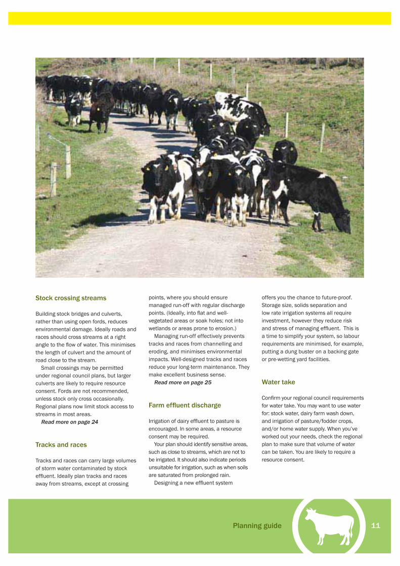
Stock crossing streams
Building stock bridges and culverts, rather than using open fords, reduces environmental damage. Ideally roads and races should cross streams at a right angle to the fl ow of water. This minimises the length of culvert and the amount of road close to the stream.
Small crossings may be permitted under regional council plans, but larger culverts are likely to require resource consent. Fords are not recommended, unless stock only cross occasionally. Regional plans now limit stock access to streams in most areas.
Read more on page 24
Tracks and races
Tracks and races can carry large volumes of storm water contaminated by stock effl uent. Ideally plan tracks and races away from streams, except at crossing
points, where you should ensure managed run-off with regular discharge points. (Ideally, into fl at and well-vegetated areas or soak holes; not into wetlands or areas prone to erosion.)
Managing run-off effectively prevents tracks and races from channelling and eroding, and minimises environmental impacts. Well-designed tracks and races reduce your long-term maintenance. They make excellent business sense.
Read more on page 25
Farm effl uent discharge
Irrigation of dairy effl uent to pasture is encouraged. In some areas, a resource consent may be required.
Your plan should identify sensitive areas, such as close to streams, which are not to be irrigated. It should also indicate periods unsuitable for irrigation, such as when soils are saturated from prolonged rain.
Designing a new effl uent system
offers you the chance to future-proof. Storage size, solids separation and low rate irrigation systems all require investment, however they reduce risk and stress of managing effl uent. This is a time to simplify your system, so labour requirements are minimised, for example, putting a dung buster on a backing gate or pre-wetting yard facilities.
Water take
Confi rm your regional council requirements for water take. You may want to use water for: stock water, dairy farm wash down, and irrigation of pasture/fodder crops, and/or home water supply. When you’ve worked out your needs, check the regional plan to make sure that volume of water can be taken. You are likely to require a resource consent.
Planning guide

Forestry to Farming | Your guide to land conversion using environmental best management practices12

Legal compliance and taxationYOUR conversion project may well require Resource Management Act (RMA) Resource Consent(s) for work. If there are any historic or cultural sites, you may also need Historic Places Trust (HPT) Approval(s).
These are legal requirements with major penalties for non-compliance. It is essential to be clear on your responsibilities.
Similarly, there are important tax issues to consider. There can be signifi cant tax benefi ts in converting land, but also serious penalties for getting the books wrong.
This section outlines Resource Consents, HPT Approvals, and tax – and how these apply in land conversion.
13
Introduction
Planning guide
Legal compliance and taxation
Harvesting and initial land conversion
Ongoing construction and management
Fertiliser and productive pasture
About the Forest to Farming Group
Scientifi c assessments from farm monitoring
Case Study: Ian Elliott
Case Study: Tim Mackintosh
Case Study: Mark Waldin
Contact details and more information
05 |
07 |
13 |
17 |
23 |
27 |
33 |
35 |
41 |
43 |
45 |
47 |
Legal compliance and taxation

Forestry to Farming | Your guide to land conversion using environmental best-management practices14
YOU need to be very clear about your responsibilities under the Resource Management Act 1991 (RMA).
Depending on the specifi c activities and environmental impacts, your conversion may require a Resource Consent, or consents, from your regional or/and district council.
Some ‘permitted activities’ do not need consent. However these usually have conditions which must be met – if you cannot do so, you will need a consent.
Generally the higher the risk, the more likely it is you will need a consent. For example, removal of tree stumps in fl at areas away from streams may be a permitted activity; whereas removal of stumps in steep areas, or close to streams may require a consent.
Each council produces plans to detail how they manage responsibilities under the RMA. All councils are different, so is essential to know YOUR council requirements. Talk with them as soon as possible.
Why the RMA is so important
A landowner or developer who fails to comply with the RMA can potentially face major penalties, up to $200,000 and imprisonment. For lesser offences, Infringement or Abatement Notices can mean a fi ne or stopping the activity until the problem is resolved.
The reason for these penalties is that the RMA provides important protection for New Zealand’s environments, wildlife, history and culture - while supporting use and development.
As the act states, it aims to “promote the sustainable management of natural and physical resources [and] manage the use, development and protection of natural and physical resources in a way or at a rate which enables people and communities to provide for their social, economic and cultural well being and for their health and safety while:• Sustaining the potential of natural and
physical resources to meet reasonably foreseeable needs of future generations
• Safeguarding the life supporting capacity of air, water, soil and ecosystems
• Avoiding, remedying, or mitigating any adverse effects of activities on the environment.”
Correctly applied, the RMA should enable you to undertake any form of land use, so long as adverse effects are avoided, remedied, or mitigated to an acceptable standard.
Key steps to take • You need to look through both your
regional and district plans under the RMA to see what activities will require resource consents. Environment Waikato’s and Environment Bay of Plenty’s plans are available online, in the council offi ces and in public libraries. Note: these plans are often written in policy language and are hard to understand. After browsing and getting the direction of the plans, contact a staff member at the appropriate council if you need clarifi cation.
• Talk to your council(s) planning department BEFORE making any decisions about your conversion activities. Arrange for a staff member to make a site visit. They will be able to tell you whether you need to apply for resource consent and:
- How your activity is classed - What kind of consent is needed - What information you need to
supply - Who you may need to consult - How long the process is likely to
take - How much council is likely to
charge - If relevant, other information
such as historic sites, high value ecological sites, stream information
- The same activity may need resource consents from BOTH your regional and district council.
• After checking the plans and talking with council, you should have a clear understanding of what activities you are seeking consent for.
• The amount of information you may need to supply with your application depends on the scale and effect of the proposed activity, the designation under the Council Plan and the type(s) of consent.
• Accurately answering the application questions will make it easier to assess, so cheaper and quicker to process. If you leave out information (or subsequently change your plans), the application will likely go on hold, delaying any approval.
• Because there are many activities in land conversion, and council plans under the RMA are complex, it may be worth engaging an Environmental Planning Consultant to prepare your application. You’ll save hassles and gain sound environmental advice.
• Many councils offer information resources on land use practices and environmental management. Ask whether any are available.
Be sure with the Resource Management ActWhile the following is correct at the time of writing, contact your council for latest information and advice.
You can visit the Environment Waikato and Environment Bay of Plenty web sites for council
plans, details about consent applications and contacts for
planning staff.

15
SUCH sites include pa sites, uru pa (cemeteries), middens, terraces, gardens, house sites, gum pits, old mine workings, forestry tram lines, logging camps and old buildings.
It is essential your planning (and all subsequent conversion work) respects these sites. Note that most forest companies have good records of known archaeological sites. Where relevant, get copies of records and maps to support your planning and approval applications.
Gaining approval for work
Historic sites are protected under the Historic Places Act and can not be “modifi ed, damaged or destroyed” without approval (or Authority) from the Historic Places Trust (HPT). This approval is similar in importance to a Resource Consent. To apply, provide a written description of the proposed activity and how it will affect the site. The site will need to be assessed/approved by an archaeologist, and if Maori, by tangata whenua.
If already harvested, the forestry company will have an HPT Authority. There should be evidence on the ground, such as tape, around site boundaries. Future development must consider the site and its protection. Ideally, the site should be
permanently fenced (HPT Authority is not required for fencing). Any work which may damage the site will require an additional Authority.
Marking of sites
Where sites are recorded but not identifi ed on the ground, they should be located and marked before work begins. If your activities will affect the site, you will need HPT Authority before any activity begins.
If there are recorded sites, it is possible there are also further unrecorded sites, so it may be prudent to undertake an archaeological survey. In planning a conversion it is prudent to contact your local marae or iwi representative early and check if there are known sites of signifi cance. Much of the central plateau holds sites of signifi cance, not only areas that are recorded, but sites such as wetlands that are spawning grounds for eel and other indigenous foods. It is much easier to start a relationship positively than play catch up with local marae later after an oversight.
It is worthwhile developing a working relationship with local tangata whenua. As tangata whenua become comfortable that sites will not be damaged, this will
help smooth the process of conversion and they can assist in future identifi cation and management of the sites.
Unrecorded sites
Sometimes a possible unrecorded site is discovered during operations. If this occurs:• Stop work (if safe)• Tape off the area• Ensure all workers are aware of the
possible site and no work continues• Get an archaeologist to assess the site
and confi rm its value• If it is Maori, consult local tangata
whenua• Consider future management (such as
fencing off)• You must receive HPT Authority before
the site is “modifi ed, damaged or destroyed” in any way
• Manage all work to the conditions of the Authority
• Ensure protective fences are maintained.
Damage to historic sites can cause great offence and emotional hurt. It may also be an offence under the Historic Places Act leading to a fi ne of up to $100,000.
Historic Places and areas of cultural signifi cance Sites which show human activity and pre-date 1900 are very important to New Zealand’s history, and local communities.
Legal compliance and taxation

Forestry to Farming | Your guide to land conversion using environmental best management practices16
TAX law is complicated and ever-changing. If transactions are treated incorrectly the IRD may impose penalties ranging from 20% for lack of reasonable care to 150% for evasion; plus penalty interest on any shortfall.
With the money involved, you should have a close working partnership with an accountant or tax specialist who is well-versed in the relevant rules. Clarify with them how to best organise your records to simplify year-end accounting.
It is useful from a fi nancial management perspective to have a general understanding of the tax rules.
The general tax rules
Knowing the general tax rules will help you to ask the right questions, provide the right information, and keep your costs down. As a general rule:• Expenses which recur each year as
a regular part of the business are deductible in the year they arise. Examples include rates, repairs and maintenance, animal health, brought in feed, electricity, interest, grazing, insurance and other administration costs.
• Expenses that do not recur annually and benefi t the business long-term usually need to be capitalised, and claimed over a number of years. Examples include buildings, new tracks, water pumps, irrigation systems and drains. For conversions the capital application of fertiliser and initial grassing costs also need to be capitalised.
Claiming on year-one expenditure
This bit is important for land conversion work. Overlaying the general rules, there is specifi c legislation that allows some expenditure, which would normally be capitalised and claimed over a number of
years, to be claimed in year one.Fencing is one of these items. Under
the general rules, new fencing would be a capital cost and claimed over a number of years. However the specifi c legislation allows all the costs to be claimed as they arise.
Similarly, costs can be claimed as they arise for:
• Destroying weeds or plants detrimental to the land
• Destroying animal pests detrimental to the land
• Repairing fl ood/erosion damage to the land
• Clearing or removing of scrub, stumps, or undergrowth
• Destroying scrub, stumps, or undergrowth on the land.
Good records save money
Make absolutely sure all your capital costs are correctly identifi ed, to maximise tax deductibility (and avoid penalty). For example, new milking machinery currently has a depreciation rate of 26.4% whereas the current rate for the farm dairy is 4%.
Taxation strategiesAs there are signifi cant costs associated with conversions, it follows that tax implications are signifi cant.
“This year, the production has reached a pleasing level and the cash surplus is very satisfactory.
There has been considerable advantage with taxation
planning and capital growth.” Ian Elliott

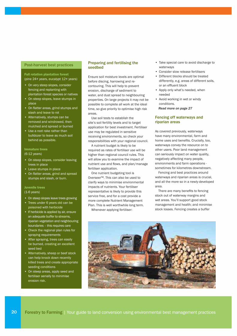
Harvesting and initial land conversionHARVESTING and post-harvest activities present many potential risks to the environment.
You need to stay vigilent to soil erosion, especially on hilly terrain. Similarly, sediment generation into streams and waterways needs continual attention and care.
The following pages aim to help, with advice on harvesting and post-harvest best practices, fencing and planting strategies, and more.
17
Introduction
Planning guide
Legal compliance and taxation
Harvesting and initial land conversion
Ongoing construction and management
Fertiliser and productive pasture
About the Forest to Farming Group
Scientifi c assessments from farm monitoring
Case Study: Ian Elliott
Case Study: Tim Mackintosh
Case Study: Mark Waldin
Contact details and more information
05 |
07 |
13 |
17 |
23 |
27 |
33 |
35 |
41 |
43 |
45 |
47 |
Harvesting and initial land conversion

Forestry to Farming | Your guide to land conversion using environmental best management practices18
Identifying high value/risk areas
BY following advice on the previous pages and by compiling planning information, you should know the location of all high value/risk areas on your block. These include areas:• Close to streams, lakes or wetlands• Close to native bush• Close to archaeological or other
culturally sensitive sites• Close to ownership boundaries• On steep slopes.
Key risks at harvesting time
Harvesting of mature plantation trees can have an adverse environmental effect. The greatest risk is due to road and track construction, rather than harvesting itself. Minimising erosion from roads and tracks is your number-one environmental objective as this will minimise sediment entering wetlands and streams.
Adverse effects from increased sediment entering streams include:• Ineffectual management of waterways/
fl ood control• Poor/contaminated water for stock and
farm use, including downstream• Increased wear on pumps• Smothering of wetland/aquatic
vegetation and ecosystems• Damage to fi sheries habitats• Reduced clarity, affecting visual
feeders such as trout• Negative visual and recreational user
effects.A second major risk from harvesting is removal of riparian vegetation. Plantation forest streams usually have high water quality during the growing cycle. If trees are planted to the edge of streams, they should be pulled back from the stream wherever possible. Tracking should be minimised and kept away from stream margins.
Often, there is other vegetation on stream margins. Retain this if at all possible, because it:
• Provides shade to keep the stream cool (fi sh have narrow temperature tolerance)
• Allows leaves and insects to fall into the water and provide food for macro invertebrates and fi sh
• Retains stream banks• Forms a barrier to minimise soil
disturbance near the water• Forms a buffer to trap sediment,
nutrients such as phosphates and effl uent
• Creates a wildlife corridor• Can be enhanced to beautify your farm
and increase capital value.Although wetlands can intercept and slow down water fl ows, they should not be viewed as sediment traps. Keep these areas free of slash and sediment.
Compaction of soils is another risk. This can inhibit drainage and root penetration, reducing pasture growth. Ensure appropriate harvesting machinery, and that it stays on specifi ed tracks, particularly if soils are wet or have poor structure.
Topsoil – your most precious resource
Sound planning (including soil and topographical maps) will help preserve topsoil. If you lose topsoil during the conversion process, building the land up to economic levels under pasture could take decades.
Steep slopes (such as long slopes over 25 degrees) may well be best left forested
“The very steep areas I decided from the start would be retired
and replanted in production forestry. This decision was made
easier due to the subsidies available from our regional council
to retire this land from grazing.” Tim Mackintosh
Harvesting best practices
• Ensure special areas ecological/cultural/historical sites have been protected
• Isolate steep slopes – keep them in forestry, replant them or target them for later soil conservation
• Plan with contractors the most appropriate sites for roads, tracks, haul directions, landings and processing sites
• Ensure no-go zones are clearly identifi ed and understood
• Keep machinery on specifi ed tracks and landings
• Avoid heavy machinery on steep slopes and riparian margins
• On land prone to erosion, use low-impact extraction techniques
• Retire areas of native bush or regenerating areas
• Leave riparian vegetation along waterway margins - at least 10 metres on either side
• Protect wetlands from slash and sediment
• Install effective culverts and run-offs to maintain drainage patterns
• Keep culverts, fords and other water structures clear of slash and debris.

19
to reduce erosion. It may be appropriate to harvest these trees later, at which stage the area can be fenced and replanted or allowed to regenerate naturally.
The benefi ts of tree stumps
Especially on steeper slopes, leaving tree stumps in place offers real environmental benefi ts. You’ll minimise soil disturbance. The tree roots will help soil stability and keep soil on the hill during early sowing/re-vegetation. Over time the roots will break down.
On fl atter areas, it can be worth grinding stumps and slash (rather than burning or removing) and leaving the ground material to rot on-site. This adds valuable organic material into the soil and supports moisture retention during summer. Note that large amounts of rotting organic material remove soil nitrogen. Accelerate the rotting process by applying nitrogen appropriately.
On fl atter areas, whole trees can be plucked from the ground, roots and all. Merchantable pulpwood may be removed. As with mature trees, consider grinding and leaving on the ground to rot.
Leaving young trees in place
Where trees are below merchantable size, there are the same environmental considerations as with mature trees.
Consider leaving trees on long slopes
over 25 degrees. Steep ground is expensive to establish in pasture and is unlikely to gain as good production as easy terrain. It will generate more sediment and potentially higher run-off; while trees will create shade and add visual appeal.
As always, though, consider each area specifi cally. For example if adjacent trees have been removed, remaining young trees may be unstable and best also removed. If this is the case, leave stumps in place. They will quickly break down but provide important soil retention.
Burning slash and stumps
Burning of slash and stumps is likely to be allowed, so long as you have a permit and meet permit requirements. These may cover issues like materials not allowed as accelerants, such as tyres or waste oil; and smoke drift.
If you cannot comply with permit
requirements, you will need a Resource Consent. Talk with regional council planning staff to clarify your responsibilities. Failure to gain approvals may lead to prosecution.
A permit from your Rural Fire Authority may be required.
When burning:• Gain all permits and meet all
requirements• Notify neighbours what you’re doing• Don’t burn in foggy or windy conditions• Ensure material is dry and relatively
soil-free• Stack material to assist good air fl ow
and encourage a hotter, cleaner burn • Don’t use accelerants that cause toxic
fumes• Keep smoke within your site
boundaries.
2006 research in the Waikato showed that taking steep land out of pasture
and returning it to plantation forest boosted profi ts from pasture by 15%
- despite the reduced land area.Whatawhata Research Centre, NIWA Paper by Quinn, et al 2006
Harvesting and initial land conversion
21 degree slope 23 degree slope25 degree slope
Preparing and fertilising the seedbed
Ensure soil moisture levels are optimal before discing, harrowing and re-contouring. This will help to prevent erosion, discharge of sediment to water, and dust spread to neighbouring properties. On large projects it may not be possible to complete all work at the ideal time, so give priority to optimise high risk areas.
Use soil tests to establish the site’s soil fertility levels and to target application for best investment. Fertiliser use may be regulated in sensitive receiving environments, so check your responsibilities with your regional council.
A nutrient budget is likely to be required as rates of fertiliser use will be higher than regional council rules. This will allow you to examine the impact of nutrient use and fl ows, and plan/manage fertiliser application.
One nutrient budgeting tool is Overseer™. This can also be used to clarify ways to minimise environmental impacts of nutrients. Your fertiliser representative is likely to provide this service free, and for a cost provide a more complete Nutrient Management Plan. This is well worthwhile long term.
Whenever applying fertiliser:
• Take special care to avoid discharge to waterways
• Consider slow release fertilisers• Different blocks should be treated
differently, e.g. areas of different soils, or an effl uent block
• Apply only what’s needed, when needed
• Avoid working in wet or windy conditions.Read more on page 27
Fencing off waterways and riparian areas
As covered previously, waterways have many environmental, farm and home uses and benefi ts. Crucially, too, waterways convey the resource on to other users. Poor land management can seriously impact on water quality, negatively affecting many people, environments and farm operations - sometimes for kilometres downstream.
Fencing and best practices around waterways and riparian areas is crucial, and all the more so in a newly-developed area.
There are many benefi ts to fencing stock out of waterway margins and wet areas. You’ll support good stock management and health; and minimise stock losses. Fencing creates a buffer
Forestry to Farming | Your guide to land conversion using environmental best management practices20
Post-harvest best practices
Full rotation plantation forest(pine 24+ years, eucalypt 12+ years)
• On very steep slopes, consider fencing and replanting with plantation forest species or natives
• On steep slopes, leave stumps in place
• On fl atter areas, grind stumps and slash and leave to rot
• Alternatively, stumps can be removed and windrowed, then mulched and spread or burned
• Use a root rake rather than bulldozer to leave as much soil behind as possible.
Immature trees(6-12 years)
• On steep slopes, consider leaving trees in place
• Leave stumps in place • On fl atter areas, grind and spread
stumps and slash, or burn.
Juvenile trees(1-6 years)
• On steep slopes leave trees growing• Trees under 6 years old can be
poisoned with herbicide • If herbicide is applied by air, ensure
an adequate buffer to streams, riparian vegetation and neighbouring boundaries – this requires care
• Check the regional plan rules for spraying requirements
• After spraying, trees can easily be burned, creating an excellent seed bed
• Alternatively, sheep or beef stock can help knock down recently killed trees and create appropriate seeding conditions
• On steep areas, apply seed and fertiliser aerially to minimise erosion risk.

21
zone to reduce contamination/sediment entering waterways and support good water quality. And it protects erodible stream and riverbanks from stock trampling.
Fencing riparian areas brings many of the same benefi ts. Grasses and low scrub will rapidly improve sediment trapping. Wetlands are very effi cient systems for absorbing excess nitrogen. In general, the wider the riparian buffer zone the more effective it is.
Many riparian margins in plantations already contain appropriate species which will rapidly grow with the increased light. Fencing off and leaving these species is the quickest and cheapest method of promoting riparian vegetation on newly converted land, but you will need to keep on top of weeds and animal pests.
Riparian planting
In harvesting, it is sometimes suggested that one or two rows of plantation trees be left as riparian protection: but this is not a good idea. If trees are large, removal of the adjacent trees is likely to lead to instability and wind throw. If the trees are small, when they reach maturity, the cost of harvesting and fence
management is likely to offset their value.It is much better to remove the
plantation trees from the riparian area at the time of harvesting - then manage the area as below:• Protect suitable non-plantation
vegetation with fencing• If there is no such vegetation, plant
native species between fence and stream
• Get the most out of your investment with a planting plan and a plan to manage weeds and pests.
Wetlands need to stay sediment-free
Wetlands need protecting. They deliver very important ecological, economic, social and cultural benefi ts:• Support a wide range of fl ora and
fauna• Good absorbers of nitrogen• Create visual diversity• Support habitat features such as
spawning area for eel• Regulate stormwater fl ow and
minimise fl ood risk.Although wetlands tend to be fl at areas, they should never be seen as sediment traps. Large volumes of sediment will bury and possibly destroy a wetland.
Crucial protection methods include sediment control measures and fencing to prevent stock access.
Other bush/forest areas
In addition to waterways, riparian areas and wetlands, your conversion area may contain other areas of vegetation worth protecting. These areas may be legally protected under the RMA. They are likely to be on slopes too steep for forestry, which means they are far too steep for conversion.
Many larger forest companies have surveyed areas of native bush/forest. Mapping will indicate species and ecological value and sometimes management recommendations.
Many of the environmental/farm management benefi ts of waterways and riparian areas apply to these bush/forest areas. They also offer shade and protection for stock, and visual appeal that is likely to increase capital value on farm.
Bush/forest areas should be protected with fencing. Further enhancement may be achievable by management such as planting, noxious weed control, and pest/predator control.
Harvesting and initial land conversion

Forestry to Farming | Your guide to land conversion using environmental best management practices22
• Before planting on converted land, draw a rough plan of the site. Detail any damp, dry, steep, fl at, sheltered, windy, sunny and shady areas.
• Determine the size of the area to be planted and the number of plants to be established each year, based on what you can realistically water and weed.
• Clarify suitable species and decide on walkways and other features.
• Plant seedlings relatively close together and replace any that die to exclude weeds more rapidly.
• Canopy closure is the aim for native planting. Once trees close out light weed species become less of an issue.
• Mark all seedlings with stakes to reduce likelihood of accidental spraying or slashing when releasing plants.
• Consider leaving pasture or less problematic weeds between seedlings as removal can open up the site to invasive species.
• Spray or slash grasses and weeds from around native seedlings two to four times a year (mainly during summer) for at least two years.
• In general avoid blanket spraying. An air induction nozzle on the spray unit will reduce spray drift.
• The need for weed control diminishes as seedlings form a shade canopy.
• Rabbit/hare control may be necessary until growing tips of seedlings are above bite height. Possum control is ongoing.
• Bait stations can be an effective, low-cost method of maintaining possum and rat control in a riparian
area. Several commercial animal repellents also appear to deter rabbits and possums (available from horticultural suppliers or stock and station agents).
• As bush grows, seed will be produced naturally and birds, insects and other animals will arrive. Controlling rats and mice (which eat seed, insects and eggs) and stoats, ferrets and cats (which eat eggs and birds) will support the health and vitality of the whole eco-system.
• Until ground cover vegetation is established, wilding pines may develop. These need controling by hand pulling or spraying.
Planting and pest-control best practices
QEII is worth considering when retiring wetlands or native bush.
23
Introduction
Planning guide
Legal compliance and taxation
Harvesting and initial land conversion
Ongoing construction and management
Fertiliser and productive pasture
About the Forest to Farming Group
Scientifi c assessments from farm monitoring
Case Study: Ian Elliott
Case Study: Tim Mackintosh
Case Study: Mark Waldin
Contact details and more information
05 |
07 |
13 |
17 |
23 |
27 |
33 |
35 |
41 |
43 |
45 |
47 |
Ongoing construction and managementFOLLOWING fencing, sowing and other early conversion work, there are a raft of issues to consider and plan for.
This section gives you greater detail on topics such as stocking, installing permanent culverts, tracks and races, and more.
Ensuring that the right infrastructure and management practices are in place is vital to the long-term performance and profi tability of your converted land.
IMPORTANT: refer to pages 13-15 on gaining Resource Consents and HPT Authorities. This is an essential consideration for all work prior to starting works.
Ongoing construction and management

Forestry to Farming | Your guide to land conversion using environmental best management practices24
The right farm management system
TAILOR farm management to suit the nature of the converted land. For example, it may not be appropriate to feed supplements in the paddock if the farm is very steep and risky for tractors. High intensity farming systems may not be appropriate if there is an inadequate area to irrigate the effl uent.
Managing stocking/grazing
Stand-alone blocks are harder to manage so timing is critical. Grazing sheep and cattle on very steep or erosion-prone land often removes surface vegetation. This reduces root binding and surface protection, increasing the chance of erosion. Preventing stock access will help in re-establishing existing vegetation and provide for soil conservation.
Paddock size/number
As anywhere, the size/number of paddocks depends on your herd numbers and preferred rotation length. Too many paddocks can make life more diffi cult, not easier.
For example, one herd, 12 hour grazing, 20 day rotation = 40 paddocks. Consider shape and contour in deciding paddocks.
Building bridges and culverts
As outlined on page 11, building stock bridges and culverts, rather than using open fords, will reduce environmental damage. Ideally roads and races should cross streams at a right angle to the fl ow of water. This minimises the length of culvert and amount of road close to the water.
Small crossings may be permitted
under regional council plans, but larger culverts are likely to require a resource consent. Fords are only recommended if stock cross occasionally. • Check council plans and with staff for
requirements on crossing structures. If disturbing the bed of a river or stream then the need for a consent is likely.
• If needed, apply for a Resource Consent• Ensure culverts can handle a fl ood by
checking up-stream catchment size and expected rainfall patterns and use appropriate engineering formula eg TM61
• Ensure an adequate overfl ow channel to protect the structure
• Avoid steep approaches and cross streams at right angles where practicable
• Protect culvert ends from erosion using rock, concrete, wood or other protection
• Ensure the culvert base is angled with the stream bed and is slightly below the current bed level
• Avoid a drop-off at the outlet or a large increase in water velocity, as either could stop fi sh passage and create surge pools
• If necessary, revegetate disturbed areas • Minimise disturbance of stream bed,
banks and vegetation• Try to keep machines out of streams
during construction• Try to install the crossing in a timely way
to minimise effect on fi sh.
Culverts – how big?
CULVERT size depends on a number of factors, some related to council requirements (such as fl ood risk on upstream properties). Most of the factors relate to the importance of the structure, regularity of use and quality of the storm overfl ow channel.
For a small pipe where stock cross infrequently a one-in-two year storm design may be adequate. A pipe beneath a signifi cant farm road may need to handle a one-in-10 year storm fl ow.
Large culverts should be designed by engineers, who will undertake size calculations to cater for all factors. An undersized pipe could cause regular fl ooding or blowout, while an oversized pipe is simply wasted investment.
Under Fresh Water Fisheries Regulations, all new culverts must permit fi sh passage.
25
Building tracks and races
Do not locate tracks and races close to streams unless there are no alternatives. A wide vegetated zone between race and stream will help buffer the effects of sediment, nutrient and faecal contamination.• Slightly round or ‘crown’ the surface of
the track/race so water runs off easily• Keep the level above the level of
surrounding paddocks• Remove any ‘lip’ or raised edge that
builds up along the edges, so runoff fl ows into pasture, which will fi lter and use contaminants and help keep waterways clean
• Keep gradients gentle to reduce runoff speed and erosion
• Avoid sharp corners• Add a surface you could walk down in
bare feet, such as pumice or lime rock• Locate tracks away from steep sidlings
to reduce the need for cut and fi ll• Construct cross culverts or cutouts to
move water across the track to regular discharge points that run out over pasture to fi lter sediment
• Ensure discharge points feed onto erosion-resistant areas such as fl ats, vegetated areas or rock; this will keep water volumes down and reduce erosion.
Locating silage pits and feedpads
Leachate from silage pits and feedpads has high contamination levels. This can affect the environment, particularly water quality. Controlling discharges to avoid waterways will avoid future problems.
Locate silage stacks away from bores, streams and wetlands.
Constructing water supply/irrigation
Fencing off waterways sometimes removes a source of stock water. Building a reticulated stock water system (using water extracted from streams, dams or bores) can be expensive but will improve stock health and productivity through the ability to dose water supplies for micronutrients or anthelmentics. Resource consent may be required, so contact your regional council. Note that many ex-plantation areas have accessible fi re ponds which may support water supply.
For effective water reticulation:• Ensure good quality and quantity of
water• Get an engineer to calculate line
size and length, pump pressure and capacity, height of troughs
• Consider the ideal number and location of troughs, such as water troughs at bottom and top of a hill paddock
• Consider storage for shed/stock water• Assure emergency water supply.
Building the dairy shed
• Design the shed for the number of cows and labour confi guration of the farm. Most farmers prefer a dairy to milk all cows within two hours. This means up to 12-15 rows of cows in a herringbone dairy or 12-15 cows per bale in a rotary. Rotaries tend to be more labour effi cient if there are 40-50+ bales. Herringbones are cheaper and more fail-safe.
• Size the shed for the eventual size of
your herd, and for labour effi ciency. Consider labour versus capital: can cup-removers replace a staff member? Can yard washing be automated?
• Site in the central milking area if possible. Long-term, it is cheaper to install long power lines and tanker track than have cows walking further. Prevent issues with potential effl uent spills, by siting the shed away from streams. Consider shelter, warmth, and distance to paddocks.
• Milker-friendly, family-friendly, safe for children and adults, AB technician-friendly, vet-friendly: consult professionals and look at other farm dairies.
• Ensure plenty of area is available for irrigation, to maximise the fertiliser value of effl uent. Consider pump size, lines and storage, emergency storage, rainwater diversion.
• Don’t underestimate how many cows you will eventually want to milk. It will be much cheaper to build it now than extend it later.
Visual and landscape values
Visual appeal is an important consideration, not least for promoting wider community acceptance that your job is being well-managed.
In the short-term, large areas of land may be disturbed in your conversion project. After seeding and re-greening, the greatest visual impact will pass. Even so, large areas of pasture are enhanced by different vegetation.
Other sections of this guide detail environmental, economic and social benefi ts of retaining or replanting
A wide vegetated zone between race and stream will help buffer the effects of
sediment, nutrient and faecal contamination.
Ongoing construction and management
Forestry to Farming | Your guide to land conversion using environmental best management practices26
vegetation. Add to this, never under-estimate the look. Retaining existing vegetation gives a sense of maturity and fi t with the wider environment. Do all you can to support a conversion project that quickly looks at home with the surroundings.• Consider visual impact of dairy sheds
and effl uent storage• Avoid cross slope tracking • Avoid large volumes of sidecaste
material (oversowing or end hauling will greatly reduce the impact)
• Sow and replant in a timely way.
“We have a very attractive
fi nished product”Ian Elliott
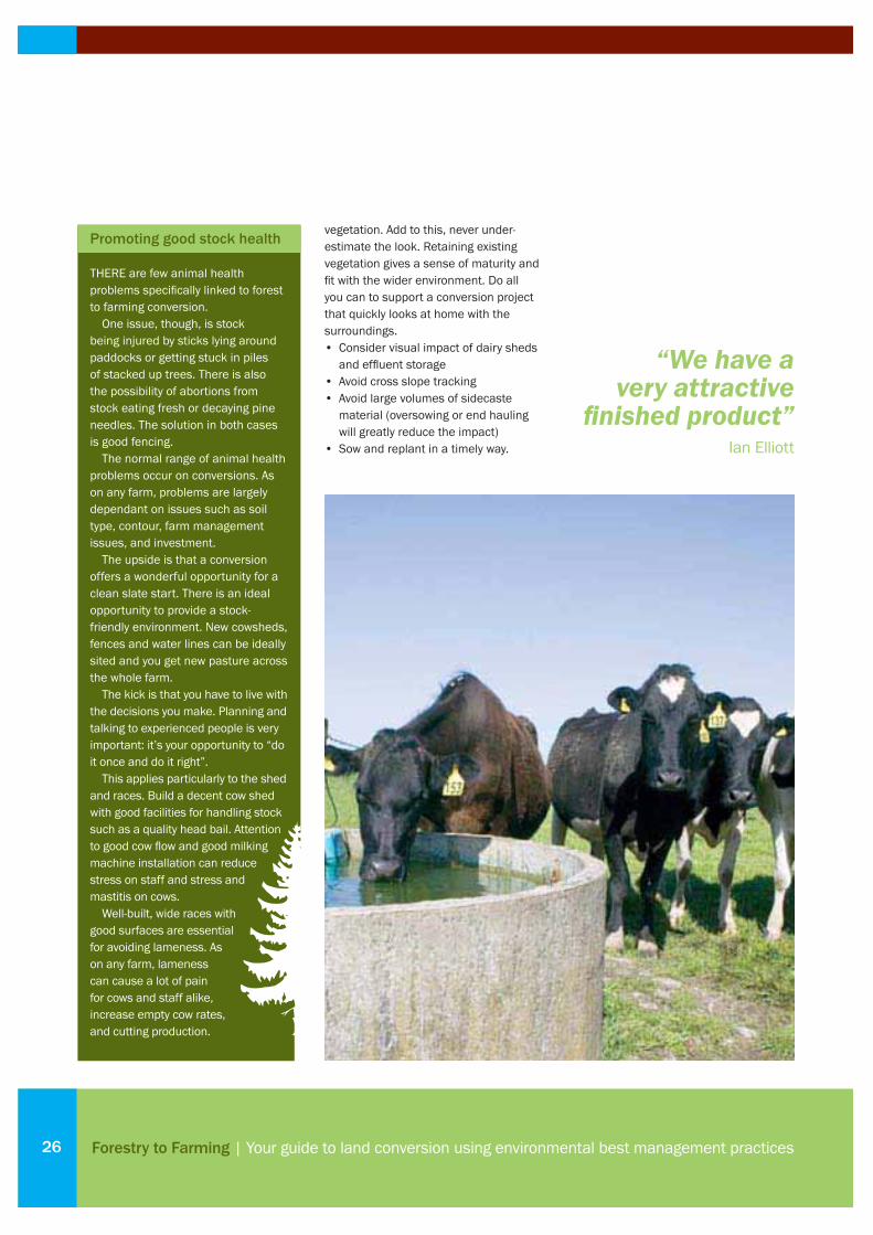
Promoting good stock health
THERE are few animal health problems specifi cally linked to forest to farming conversion.
One issue, though, is stock being injured by sticks lying around paddocks or getting stuck in piles of stacked up trees. There is also the possibility of abortions from stock eating fresh or decaying pine needles. The solution in both cases is good fencing.
The normal range of animal health problems occur on conversions. As on any farm, problems are largely dependant on issues such as soil type, contour, farm management issues, and investment.
The upside is that a conversion offers a wonderful opportunity for a clean slate start. There is an ideal opportunity to provide a stock-friendly environment. New cowsheds, fences and water lines can be ideally sited and you get new pasture across the whole farm.
The kick is that you have to live with the decisions you make. Planning and talking to experienced people is very important: it’s your opportunity to “do it once and do it right”.
This applies particularly to the shed and races. Build a decent cow shed with good facilities for handling stock such as a quality head bail. Attention to good cow fl ow and good milking machine installation can reduce stress on staff and stress and mastitis on cows.
Well-built, wide races with good surfaces are essential for avoiding lameness. As on any farm, lameness can cause a lot of pain for cows and staff alike, increase empty cow rates, and cutting production.

Fertiliser and productive pastureSOIL fertility, biological activity and nutrient cycling effi ciency are all likely to be lower in an area of long-term forestry. To achieve top quality, productive pasture, signifi cant nutrient input will be required.
This section offers step-by-step guidance to ensuring economic and responsible fertiliser use.
27
Introduction
Planning guide
Legal compliance and taxation
Harvesting and initial land conversion
Ongoing construction and management
Fertiliser and productive pasture
About the Forest to Farming Group
Scientifi c assessments from farm monitoring
Case Study: Ian Elliott
Case Study: Tim Mackintosh
Case Study: Mark Waldin
Contact details and more information
05 |
07 |
13 |
17 |
23 |
27 |
33 |
35 |
41 |
43 |
45 |
47 |
Fertiliser and productive pasture

Forestry to Farming | Your guide to land conversion using environmental best management practices28
Soil testing
THE importance of soil testing cannot be overstated. Without a soil test, there is no knowing what specifi c factors are limiting pastoral production. Every site is likely to have different requirements.
As an example, initial conversion work on a property at Tikitere showed Olsen-P levels of 50 mg/L after land clearance. As expected, there was no yield response to capital P inputs at this site. However, the high Olsen-P levels at this site are not typical of cleared forestry blocks. Generally, soil ex-forestry will be acidic, with low nutrient availability and low organic matter.
The optimum soil fertility ranges for pumice and ash soils are shown below. These should be the target levels for any land going in to pasture.
Check for pasture pests before sowing
Generally, populations of common pasture pests such as grass grub and clover root weevil are low in ex-forestry soil, as it is not their preferred environment.
However, such pests may be present. Check before sowing into crop or pasture, as they can damage emerging seedlings. The use of chemical or biological (such as bioshield grass grub) controls may offer economic advantages.
Even if populations are low at sowing, pasture pests can rapidly colonise new
areas. Natural biological pathogens and predators tend to be low and can’t control the pests.
Effective planning to correct soil fertility defi ciencies
Cropping sequences can be helpful in developing land. For example, brassica crops may be used to break in raw ground. These crops can be useful in building soil organic matter levels as they are grazed. Whatever crop/pasture succession is used, ensure poor soil fertility does not limit yield.
pH - As a rule of thumb, 1 t/ha of good-quality lime should lift pH by around 0.1 pH unit. Therefore, if soil pH is 5.2 and the optimum pH is 5.8-6.2, 6 t lime/ha will be required. Keep in mind that lime applied to the soil surface is very slow to correct pH down through the soil profi le.
Therefore, if high rates of lime are required, lime should be worked into the soil to ensure subsoil pH is corrected. Bringing pH into the optimum range will improve biological activity, which in turn assists nutrient cycling, and can also improve root depth (through reducing high exchangeable aluminium levels, which can be toxic to roots).
Nitrogen (N) - Ex-forestry soil has a low N content, which will favour the clover population in the pasture sward. However, several factors will lead to ryegrass in the pasture quickly becoming N defi cient:• Little N will be fi xed and released to
the soil N pool by clover in the fi rst 12-
18 months• Naturally low soil organic matter levels
in newly converted soils will mean little mineralisation of soil organic-N
• High soil carbon to nitrogen ratios will mean that any free N in the soil solution will be strongly competed for by soil microbes, hence in the short term, less mineral N will be available to the pasture.
To overcome soil N defi ciency, apply small doses of N frequently during pasture establishment. Around 20-25 kg N/ha should be applied after each grazing of the paddock. Do not exceed 50 kg N/ha in any one application or 200 kg N/ha annually. Graze new pastures lightly and keep the sward height under 200 mm so clovers do not get shaded out.
Phosphate (P) - If you need capital fertiliser, it is most cost-effectively applied in as short a time span as possible. Maintenance nutrient requirements must be factored into a capital fertiliser programme. This is often forgotten in multi-year capital fertiliser programmes, leading to lower fertility increases.
Every site is different. Don’t farm by averages or estimates.
Soil type PH Olsen-P QT K S (SO4) QT Mg QT Ca QT Na (mg/L) (mg/L)
Pumice 5.8-6.2 35-45 7-10 10-12 8* 10 5
Ash 5.8-6.2 20-30 7-10 10-12 8* 10 5
*This level meets pasture requirements; to minimise animal health problems it should be 25-30
Optimum soil fertility ranges for pumice and ash soils

29
It is recommended that in capital fertiliser programs, add no more than 100 kg P/ha in any single application to minimise risk of O losses through runoff and leaching. If soil is extremely raw (for example if it contains little organic matter and is a coarse texture, or has ASC/P-retention levels below 20%) it may be necessary to split applications at lighter rates, particularly with highly soluble P fertilisers. Alternatively, lower solubility P fertilisers such as serpentine super can give improved results.
The example below shows steps to lift
Olsen-P levels of an ex-forestry ash soil and an ex-forestry pumice soil over three years. The ash soil has a higher anion storage capacity (ASC), so needs more P to achieve the same unit increase in Olsen-P as the pumice soil.
Sulphur (S) - S is a relatively cheap
nutrient, so always ensure it is not limiting yield. Superphosphate is designed to supply S and P at the same time at a similar ratio. However, depending on soil conditions, extra S (or no S) may be required.
Elemental S can be incorporated to lift
To overcome soil N defi ciency, apply small doses of N frequently during
pasture establishment.
Steps to life Olsen-P levels
Pumice soil Ash soil
Initial Olsen-P 5 5
Optimum Olsen-P 35-45 20-30
Required Olsen-P increase to reach optimum range 30 15
Phosphate (P) required (above maintenance) to lift Olsen-P by 1 unit (kg P/ha) 7 11
Capital P fertiliser required (kg P/ha) 210 165
Approximate annual maintenance P requirement (kg P/ha/y) for 12 SU/ha on easy slopes 20 20
Maintenance P input over 3 years (kg P/ha) 60 60
Total P input required over 3 years to reach optimum Olsen-P range (kg P/ha) 270 225
Year 1 – Capital phase (kg P/ha) 100 100
Year 2 – Capital phase (kg P/ha) 100 100
Year 3 – Capital phase (kg P/ha) 70 25
Year 4 – Maintenance phase (kg P/ha) 20 20
Fertiliser and productive pasture

Forestry to Farming | Your guide to land conversion using environmental best management practices30
S levels. It is also a good alternative when fertiliser S is being applied to low ASC soils in autumn, as it is less susceptible to leaching than sulphate sulphur.
Potassium (K) - Fertiliser K application should occur in split dressings if more than 50 kg K/ha is applied. Low organic matter levels will reduce the soil’s cation exchange capacity; therefore, its ability to store cations such as K is lowered.
On some coarse pumice soils, K levels are very diffi cult to increase economically. In such soils, timing is perhaps more important than the total rate. If soil K levels are low, applications are best targeted for October – November, when clover growth will be enhanced.
Magnesium (Mg)- For every 8-10 kg Mg/ha applied above maintenance, soil QT Mg level should lift by one unit. A wide range of Mg products are available, but when high Mg inputs are required, slower release products such as calcined magnesite (Mg oxide) are preferred.
The right fertiliser is crucial
To achieve best results, there are several important factors in selecting fertiliser: • P is a relatively immobile nutrient, so it
should be banded with the seed. This
is particularly important when sowing into low-P fertility soil. Any fertiliser drilled directly with seed should have a low salt index, to avoid seed burn. Ideally, use a reverted product such as serpentine super. Avoid drilling nitrogenous products directly with seed; if N is required, apply pre- or post-sowing. Boron must also be kept separate from seed, especially with brassica crops.
• Ensure you pay a fair price for the product, with calculations based on nutrient value. Your fertiliser representative can advise. For example, to calculate the cost per kilogram of P in Superten, refer to the graph below.
• Ensure fertiliser is independently verifi ed and endorsed. Always look for the Fertmark tick to ensure quality.
• Consider the release characteristics such as solubility of fertiliser nutrients, and the characteristics of the soil. For example, because of its slow-release nature, RPR is ineffective if capital P inputs are required. RPR becomes a suitable fertiliser product once there is a good base level of soil fertility, provided soil pH is less than 6, and rainfall is > 800 mm.
• Soil biological activity is strongly
related to both the level of organic matter (OM) and the soil pH. Low OM levels and the acidic pH of ex-forestry soil mean low biological activity and poor nutrient cycling. Lifting pH is relatively easy, but soil OM can take some time to build. Manures can be applied to lift fertility and will also add a small amount of OM.
• The best way to build soil OM levels is to return the land to permanent pasture. A well-nourished pasture will return 4000-5000 kg OM/ha to the soil in its fi rst year (see page 31) so ensure the correct nutrients are applied at correct ratios, to optimise pasture growth.
• If the fi xed nutrient ratio of manure suits the nutrient requirement of the soil, it is a good option, provided the cost of nutrients applied with the manure is economic, relative to using a conventional fertiliser.
• Phosphate leaching is not common, but can occur on raw soils (with low levels of organic matter), coarse soils, or soils with a low ASC (<20). The risk of P leaching on such soils increases as the rate of P applied rises, and with heavy rainfall following application.
Calculating fertiliser value
1 tonne of Superten contains 97 kg of P and 105 kg of S and costs $195/t (at time of printing)
Is S required?Yes No
The value of S needs to be removed from the price of The value of S should not be removed from the price ofSuperten when working out the value of P in Superten Superten when working out the value of P in Superten
Subtract value of S from the cost of Superten ($0.35/kg S) The P value is therefore based on the full cost 105 kg S x $0.35/kg S = $37 worth of S per tonne of Superten of Superten at $195/tonne $195 ÷ 97 kg P/tonne = $2.01/kg PThe P content therefore costs $158 per tonne of Superten $158 ÷ 97 kg P/tonne = $1.62/kg P
31
Fertiliser application best practices
How you apply fertiliser can impact both the wider environment and the pasture results. Consider the following:• Use Speadmark-certifi ed spreaders for
most accurate fertiliser placement.• Ensure a buffer zone around
waterways. This is particularly important to minimise input from P and N fertilisers.
• Avoid applying fertiliser in windy conditions, particularly less granulated products.
• Where there is a risk of P leaching, avoid high rates of P application (for example, do more regular, lighter applications) particularly when rain is imminent. Or use products with lower solubility.
Herbage test to fi ne-tune pasture quality
Soil testing is useful for determining pH and macronutrient levels. However, it is very diffi cult to predict trace element requirements from soil tests, particularly since, in New Zealand, there has been
little calibration done between soil and herbage levels.
This makes herbage testing a useful way to fi ne-tune your fertiliser requirements.
In forestry land being converted to pasture, it is likely herbage cobalt, copper and selenium will be low. Soil boron levels are likely to be reduced in soil that’s been in long-term forestry. This is because boron leaching may have occurred in the acidic soil conditions.
Using a clover-only sample, determine plant macronutrient levels and check for molybdenum (Mo) and boron. Mo defi ciency can dramatically reduce N-fi xation potential of clover plants.
Direct sampling of livestock blood and/or livers is the most comprehensive way to assess animal trace element requirements. Mixed pasture tests provide a useful indicator.
Talk to your fertiliser representative about trace element requirements, as there can be a fi ne line in what’s needed. Stock can ingest trace elements from drinking water supplements, drenches and injections, pasture fortifi cation, and even soil ingestion. Trace elements can easily be over-prescribed.
Pasture establishment
You will have a biologically clean slate - normal pasture pests and other organisms will be scarce or absent.
Ryegrass endophytes will be effectively absent. This presents an ideal opportunity to establish latest ryegrass cultivars using modern novel endophytes that confer signifi cant production, animal health and insect resistance advantages. There are a number of these new to the market, such as AR1, AR37, and NEA2. Consult AgResearch, Dexcel, and seed companies for specifi c advice.
A cheaper seed infected with a wild endophyte type could well be false economy.
Clover root nematode is absent ex-forestry, and may take several years to establish. In nitrogen defi cient environments modern aggressive clover cultivars will become dominant in the new pasture sward. The usual seeding rate for clover can be halved with good success.
As discussed, soil nitrogen will be in short supply. There will often be little organic matter so nitrogen is at risk of leaching in rain. To ensure pasture gets well established, N fertiliser needs to be applied frequently at light rates.
Pasture with cover of 3000 kg DM/ha and 23% protein content will have a nitrogen content of 110 kg of N above ground, and a similar amount below ground.
This suggests that over 450 kg/ha of urea or equivalent fertiliser is needed to to kick start the pasture nutrient cycle. In practice, clover becomes dominant where lesser amounts are applied, until there is adequate nitrogen available for pastures to grow.
Organic matter returned by roots of crops (McLaren and Cameron, 1990)
Crop OM added to top 20 cm soil (kg/ha)
1 year grass 4000-5000
3 years grass 6000-8500
winter cereals 2200
spring cereals 1100
red clover 2000
10 tonnes farmyard manure 4000
Fertiliser and productive pasture
Forestry to Farming | Your guide to land conversion using environmental best management practices32
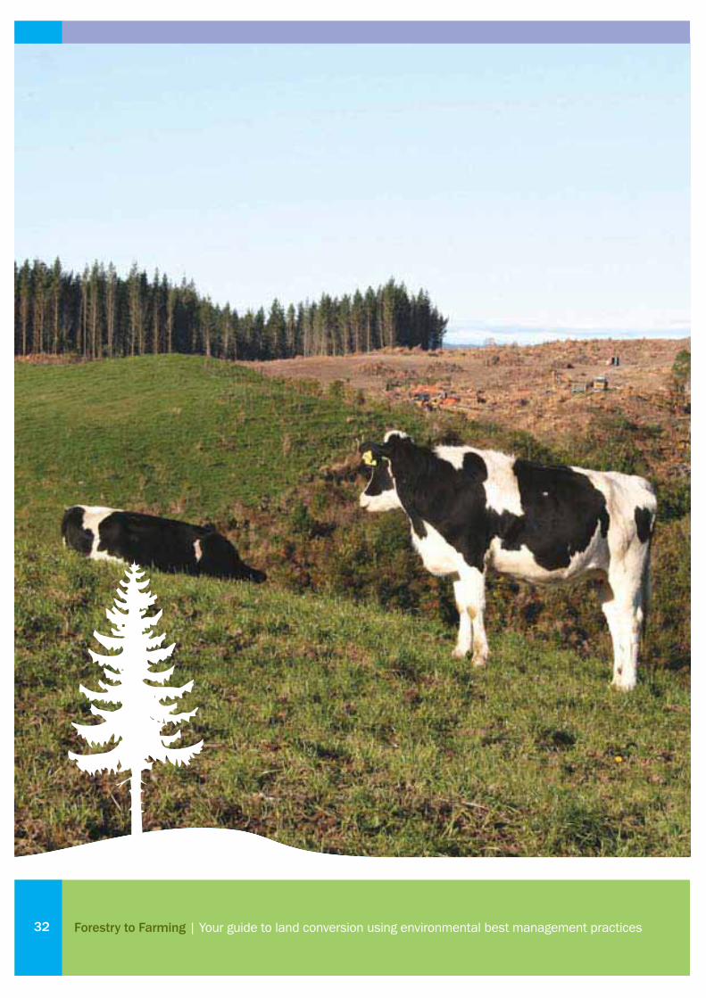
About the Forest to Farming GroupTHIS guide is part of a larger project: the Forest to Farming Group.
The group was formed in recognition of recent large scale conversions - and the new challenges farmers face in converting land. There were also concerns about the possible long-term environmental impacts of conversion and the scale of land use change.
Many activities in forestry to farming conversion are standard practices for farmers. The potential adverse effects are readily managed.
Other aspects of conversion, though, are less well documented or understood.
By bringing together expertise and experience, and monitoring the effects of real-world conversions, the group aims to increase understanding – and support farmers in successfully turning forest into productive pasture.
Introduction
Planning guide
Legal compliance and taxation
Harvesting and initial land conversion
Ongoing construction and management
Fertiliser and productive pasture
About the Forest to Farming Group
Scientifi c assessments from farm monitoring
Case Study: Ian Elliott
Case Study: Tim Mackintosh
Case Study: Mark Waldin
Contact details and more information
05 |
07 |
13 |
17 |
23 |
27 |
33 |
35 |
41 |
43 |
45 |
47 |
33About the Forest to Farming Group
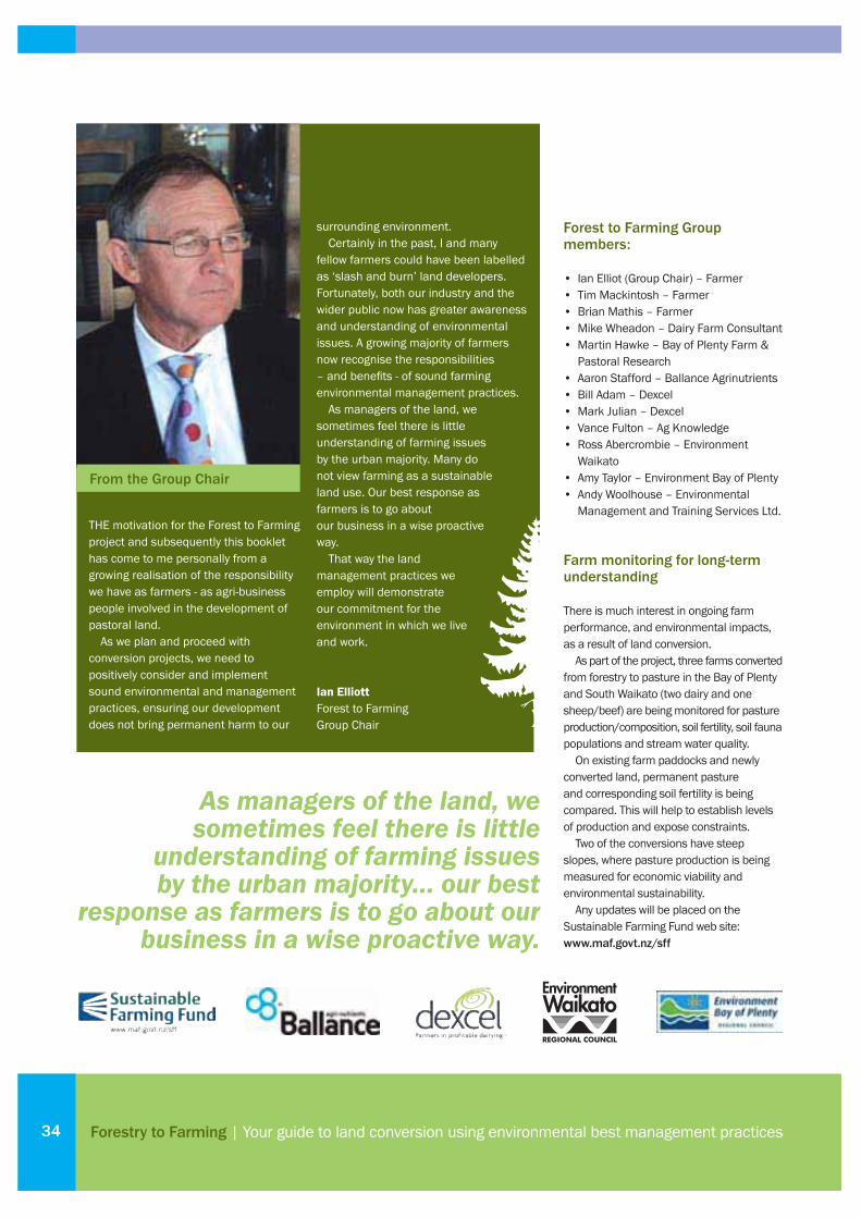
Forestry to Farming | Your guide to land conversion using environmental best management practices34
As managers of the land, we sometimes feel there is little
understanding of farming issues by the urban majority… our best
response as farmers is to go about our business in a wise proactive way.
Forest to Farming Group members:
• Ian Elliot (Group Chair) – Farmer• Tim Mackintosh – Farmer• Brian Mathis – Farmer• Mike Wheadon – Dairy Farm Consultant• Martin Hawke – Bay of Plenty Farm &
Pastoral Research• Aaron Stafford – Ballance Agrinutrients• Bill Adam – Dexcel• Mark Julian – Dexcel• Vance Fulton – Ag Knowledge• Ross Abercrombie – Environment
Waikato• Amy Taylor – Environment Bay of Plenty• Andy Woolhouse – Environmental
Management and Training Services Ltd.
Farm monitoring for long-term understanding
There is much interest in ongoing farm performance, and environmental impacts, as a result of land conversion.
As part of the project, three farms converted from forestry to pasture in the Bay of Plenty and South Waikato (two dairy and one sheep/beef) are being monitored for pasture production/composition, soil fertility, soil fauna populations and stream water quality.
On existing farm paddocks and newly converted land, permanent pasture and corresponding soil fertility is being compared. This will help to establish levels of production and expose constraints.
Two of the conversions have steep slopes, where pasture production is being measured for economic viability and environmental sustainability.
Any updates will be placed on the Sustainable Farming Fund web site: www.maf.govt.nz/sff
THE motivation for the Forest to Farming project and subsequently this booklet has come to me personally from a growing realisation of the responsibility we have as farmers - as agri-business people involved in the development of pastoral land.
As we plan and proceed with conversion projects, we need to positively consider and implement sound environmental and management practices, ensuring our development does not bring permanent harm to our
surrounding environment.Certainly in the past, I and many
fellow farmers could have been labelled as ‘slash and burn’ land developers. Fortunately, both our industry and the wider public now has greater awareness and understanding of environmental issues. A growing majority of farmers now recognise the responsibilities – and benefi ts - of sound farming environmental management practices.
As managers of the land, we sometimes feel there is little understanding of farming issues by the urban majority. Many do not view farming as a sustainable land use. Our best response as farmers is to go about our business in a wise proactive way.
That way the land management practices we employ will demonstrate our commitment for the environment in which we live and work.
Ian ElliottForest to Farming Group Chair
From the Group Chair

Scientifi c assessments from farm monitoringTHE three farms monitored by the Forest to Farming Group are located near Tokoroa, at Upper Atiamuri and Manawahe.
These farms were essentially benchmarked to provide baseline data on the effects of conversion on pasture, soil fertility and soil fauna populations.
Water quality was also analysed, with samples taken from streams within a forest (introduced or native) and from pastoral catchment adjacent to the recent conversions.
This section presents the fi ndings, with highlights at the end.
Introduction
Planning guide
Legal compliance and taxation
Harvesting and initial land conversion
Ongoing construction and management
Fertiliser and productive pasture
About the Forest to Farming Group
Scientifi c assessments from farm monitoring
Case Study: Ian Elliott
Case Study: Tim Mackintosh
Case Study: Mark Waldin
Contact details and more information
05 |
07 |
13 |
17 |
23 |
27 |
33 |
35 |
41 |
43 |
45 |
47 |
35Scientifi c assessments from farm monitoring
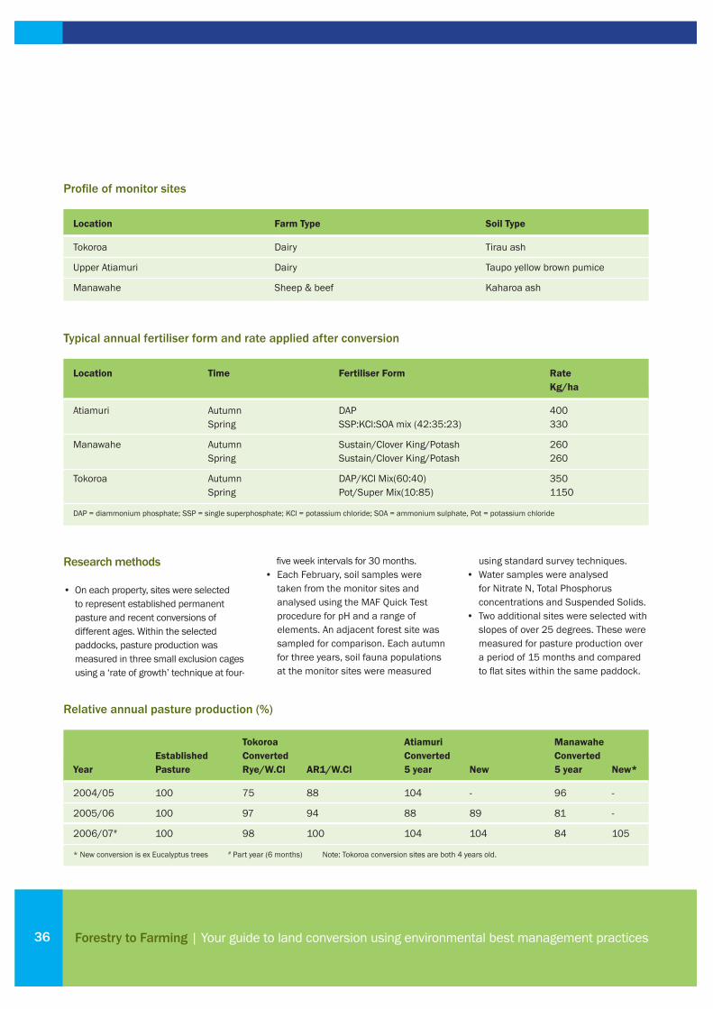
Forestry to Farming | Your guide to land conversion using environmental best management practices36
Research methods
• On each property, sites were selected to represent established permanent pasture and recent conversions of different ages. Within the selected paddocks, pasture production was measured in three small exclusion cages using a ‘rate of growth’ technique at four-
fi ve week intervals for 30 months. • Each February, soil samples were
taken from the monitor sites and analysed using the MAF Quick Test procedure for pH and a range of elements. An adjacent forest site was sampled for comparison. Each autumn for three years, soil fauna populations at the monitor sites were measured
using standard survey techniques.• Water samples were analysed
for Nitrate N, Total Phosphorus concentrations and Suspended Solids.
• Two additional sites were selected with slopes of over 25 degrees. These were measured for pasture production over a period of 15 months and compared to fl at sites within the same paddock.
Profi le of monitor sites
Location Farm Type Soil Type
Tokoroa Dairy Tirau ash
Upper Atiamuri Dairy Taupo yellow brown pumice
Manawahe Sheep & beef Kaharoa ash
Typical annual fertiliser form and rate applied after conversion
Location Time Fertiliser Form Rate Kg/ha
Atiamuri Autumn DAP 400 Spring SSP:KCl:SOA mix (42:35:23) 330
Manawahe Autumn Sustain/Clover King/Potash 260 Spring Sustain/Clover King/Potash 260
Tokoroa Autumn DAP/KCl Mix(60:40) 350 Spring Pot/Super Mix(10:85) 1150
DAP = diammonium phosphate; SSP = single superphosphate; KCl = potassium chloride; SOA = ammonium sulphate, Pot = potassium chloride
Relative annual pasture production (%)
Tokoroa Atiamuri Manawahe Established Converted Converted Converted Year Pasture Rye/W.Cl AR1/W.Cl 5 year New 5 year New*
2004/05 100 75 88 104 - 96 -
2005/06 100 97 94 88 89 81 -
2006/07# 100 98 100 104 104 84 105
* New conversion is ex Eucalyptus trees # Part year (6 months) Note: Tokoroa conversion sites are both 4 years old.
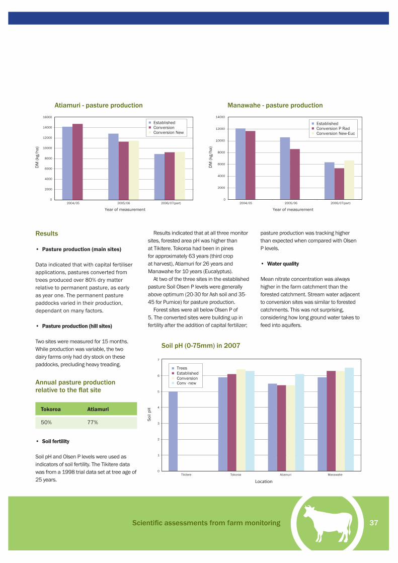
37
Results
• Pasture production (main sites)
Data indicated that with capital fertiliser applications, pastures converted from trees produced over 80% dry matter relative to permanent pasture, as early as year one. The permanent pasture paddocks varied in their production, dependant on many factors.
• Pasture production (hill sites)
Two sites were measured for 15 months. While production was variable, the two dairy farms only had dry stock on these paddocks, precluding heavy treading.
• Soil fertility
Soil pH and Olsen P levels were used as indicators of soil fertility. The Tikitere data was from a 1998 trial data set at tree age of 25 years.
Results indicated that at all three monitor sites, forested area pH was higher than at Tikitere. Tokoroa had been in pines for approximately 63 years (third crop at harvest), Atiamuri for 26 years and Manawahe for 10 years (Eucalyptus).
At two of the three sites in the established pasture Soil Olsen P levels were generally above optimum (20-30 for Ash soil and 35-45 for Pumice) for pasture production.
Forest sites were all below Olsen P of 5. The converted sites were building up in fertility after the addition of capital fertilizer;
pasture production was tracking higher than expected when compared with Olsen P levels.
• Water quality
Mean nitrate concentration was always higher in the farm catchment than the forested catchment. Stream water adjacent to conversion sites was similar to forested catchments. This was not surprising, considering how long ground water takes to feed into aquifers.
Atiamuri - pasture production Manawahe - pasture production
Annual pasture production relative to the fl at site
Tokoroa Atiamuri
50% 77%
Soil pH (0-75mm) in 2007
Scientifi c assessments from farm monitoring
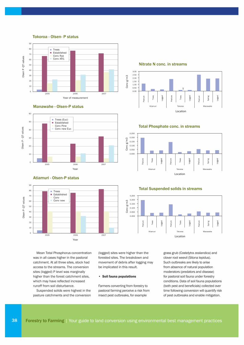
Forestry to Farming | Your guide to land conversion using environmental best management practices38
Mean Total Phosphorus concentration was in all cases higher in the pastoral catchment. At all three sites, stock had access to the streams. The conversion sites (logged) P level was marginally higher than the forest catchment sites, which may have refl ected increased runoff from soil disturbance.
Suspended solids were highest in the pasture catchments and the conversion
(logged) sites were higher than the forested sites. The breakdown and movement of debris after logging may be implicated in this result.
• Soil fauna populations
Farmers converting from forestry to pastoral farming perceive a risk from insect pest outbreaks, for example
grass grub (Costelytra zealandica) and clover root weevil (Sitona lepidus). Such outbreaks are likely to arise from absence of natural population moderators (predators and disease) for pastoral soil fauna under forestry conditions. Data of soil fauna populations (both pest and benefi cials) collected over time following conversion will quantify risk of pest outbreaks and enable mitigation.
Tokoroa - Olsen- P status
Atiamuri - Olsen-P status
Manawahe - Olsen-P status
Nitrate N conc. in streams
Total Phosphate conc. in streams
Total Suspended solids in streams
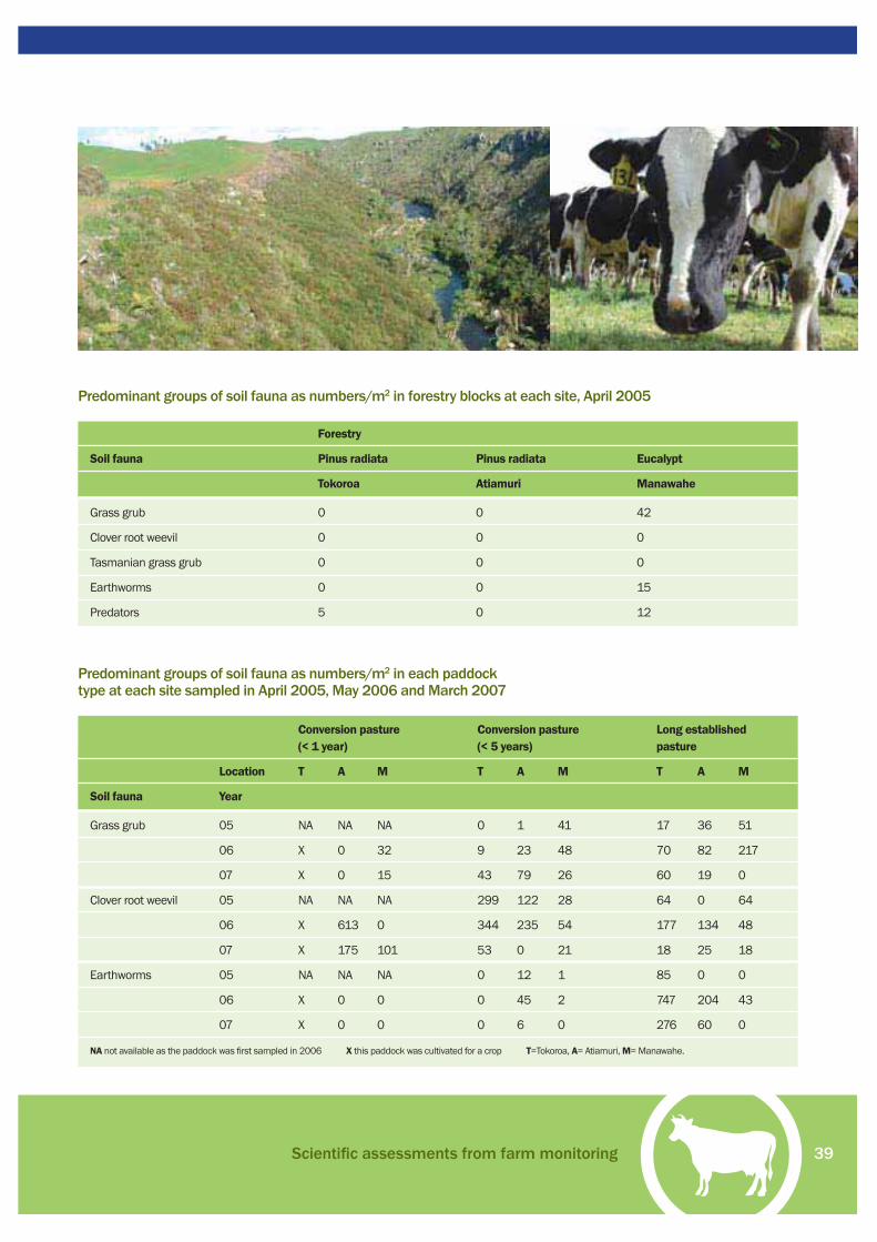
39
Conversion pasture Conversion pasture Long established (< 1 year) (< 5 years) pasture
Location T A M T A M T A M
Soil fauna Year
Grass grub 05 NA NA NA 0 1 41 17 36 51
06 X 0 32 9 23 48 70 82 217
07 X 0 15 43 79 26 60 19 0
Clover root weevil 05 NA NA NA 299 122 28 64 0 64
06 X 613 0 344 235 54 177 134 48
07 X 175 101 53 0 21 18 25 18
Earthworms 05 NA NA NA 0 12 1 85 0 0
06 X 0 0 0 45 2 747 204 43
07 X 0 0 0 6 0 276 60 0
NA not available as the paddock was fi rst sampled in 2006 X this paddock was cultivated for a crop T=Tokoroa, A= Atiamuri, M= Manawahe.
Predominant groups of soil fauna as numbers/m2 in each paddock type at each site sampled in April 2005, May 2006 and March 2007
Predominant groups of soil fauna as numbers/m2 in forestry blocks at each site, April 2005
Forestry
Soil fauna Pinus radiata Pinus radiata Eucalypt
Tokoroa Atiamuri Manawahe
Grass grub 0 0 42
Clover root weevil 0 0 0
Tasmanian grass grub 0 0 0
Earthworms 0 0 15
Predators 5 0 12
Scientifi c assessments from farm monitoring
Forestry to Farming | Your guide to land conversion using environmental best management practices40
Farm monitoring summary
• Monitoring on the three farms highlighted that good pasture production was achieved once pasture was established. Strong clover growth was measured at all three conversion sites, particularly in the new swards. Capital fertiliser inputs were required on all three farms.
• There were initial indications that stream water quality was declining (Total P and Suspended Solids) adjacent to conversion sites.
• Soil fauna populations indicated that grass grubs and clover root weevils were
absent after harvesting trees, but they built up and could pose a problem within a few years.
• There was almost complete absence of earthworms in the converted sites. This suggests earthworms should be re-established so soil structure and health is improved.
• Monitoring of less than three years provides a glimpse of the effects of conversion. Longer periods of measurement will confi rm much more about best practices in land conversion.
2005
SOIL fauna including earthworms are virtually absent in mature Pinus radiata plantations with implications for the delayed development of soil structure upon conversion to pasture.
Recommendation: Consider re-establishing earthworm populations in situations when pasture is established following the harvest of mature Pinus radiata. Eucalypt forests at year 10 do not appear to confer the same degree of soil fauna degradation as Pinus radiata.
2006
It was noted in the 2005 report that native grass grub populations did not appear to pose a threat to pastures established from pine forestry in a two-four year period post harvest. In light of the 2006 sampling where a pasture established six months after Eucalypt forestry had a signifi cant grass grub population, a risk is recognised from this pest for new pastures when the
forestry under-storey continues to host grass grub.
Recommendation: Monitor over a minimum of three years to determine if grass grub populations are in an incremental or declining phase. Where grass species exist in a forest under-storey prior to clearing and pasture establishment, take a grass grub sampling and consider seedling protection.
Clover root weevil populations in newly converted pastures pose a serious threat to productivity and survival of clover. Mitigate effects through clover management strategies. These could include pasture management to favor clover: for example, in spring ensure grasses do not shade the clover; in summer ensure clovers are not exposed to excessive radiation; and in winter avoid pugging.
Most clover is unable to fi x atmospheric N in the presence of weevil so the application of N may be considered. Farmers in the Waikato, where clover root weevil is a problem, are getting good clover survival and
production by applying N fertiliser to an annual total of 150 to 250 kgs of N in six-10 small doses.
2007
Earthworms are failing to establish in pastures newly converted from forest. Establishment is very slow at site three. This may refl ect young soils, from the Tarawera eruption in 1886.
Recommendation: Consider augmenting valuable soil organisms in pastures where the populations are low or absent. The methodology is available and proven.
In new pastures, clover root weevil has compromised clover ability to fi x atmospheric nitrogen.
Recommendation: Consider application of nitrogenous fertiliser to maintain the pasture quality and sustainability.
Results and recommendations

41
WE were irrigating dairy factory wash water from Fonterra’s Lichfi eld site on to our dairy pastures. The land needed to be spelled over winter due to heavy pugging. Our dairy cattle were showing distinct health problems by grazing on the land in winter, due to the chemicals in the wash water. Vetinerary advice was the animals would be better grazed on non-irrigated land in winter.
Converting neighbouring forestry land was a perfect solution. We had a strong desire to have total control of our stock over the winter months. We wanted to grow our own supplements and essentially be self-contained. The taxation advantages of developing land provided added incentive.
The forestry company was keen to sell and we seized the opportunity. Obviously their business objectives and current return for logs affected their decision. This process commenced in August 2002.
Conversion method?All the land we cleared was covered in juvenile pine. We used contractors with two D5 bulldozers and two 20-tonne diggers. The diggers pulled the trees out and placed them in heaps or rows. The bulldozers also pushed up the residual stumps from the previous harvest.
The process was much slower with the older trees because the forestry contractors pulled these trees out by the roots, extracted the pulp log for sale and made heaps out of the branches and stumps. The land covered in juvenile trees was relatively easy and cheap to clear, however they needed time before they could be burnt. After about four years the heaps are easier to burn.
Pasture management?We followed clearing with heavy discs, levelling bar and heavy harrows.
Pasture establishment through broadcasting has been excellent. We have been very pleased with the AR1 Ryegrasses. Bronson, Impact and the Maverick Gold have all performed very well. Clover dominance during the fi rst couple of years is forcing us to under-sow rye in the third year. Subsequently when we have regrassed, we have halved the clover rate from four kilos to two kilos per hectare.
There are no nematodes in the soil to attack the clover roots. This allows clover to reach full potential. Cattle are thriving with our replacement heifers the best we have had for years.
The Swede crops have produced a mixed result ranging in yield from four to 12 tonnes of dry matter per hectare. The poor yielding crops have been a result of either late planting, dry weather and/or insuffi cient fertiliser and nitrogen.
Maize has been sown after clearing with crop yields ranging from 12 to 20 tonnes of dry matter per hectare. High yields are achieved when we plant the crops early, get the fertiliser right and use the right varieties. Increasing plant population from 100,000 to 120,000 per hectare has helped.
Overall the weed problem has not been as great as I expected. Ragwort has been a minor issue. A high population of nodding and scotch thistles has resulted when paddocks have been cultivated in the late summer. These have been
Introduction
Planning guide
Legal compliance and taxation
Harvesting and initial land conversion
Ongoing construction and management
Fertiliser and productive pasture
About the Forest to Farming Group
Scientifi c assessments from farm monitoring
Case Study: Ian Elliott
Case Study: Tim Mackintosh
Case Study: Mark Waldin
Contact details and more information
05 |
07 |
13 |
17 |
23 |
27 |
33 |
35 |
41 |
43 |
45 |
47 |
Case Study:
Ian ElliottDairy Farmer, Lichfi eld, South Waikato
“We largely left areas of land steeper than 25 degrees. We fenced off young trees to provide a cover on erosion prone
soil and provide shade for our livestock.”
Case Study: Ian Elliott
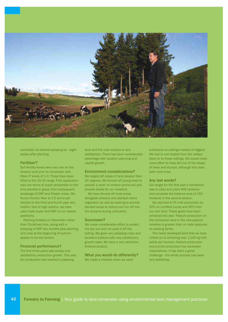
controlled via blanket spraying six - eight weeks after planting.
Fertiliser?Soil fertility levels were very low on the forestry land prior to conversion with Olson P levels of 1-3. These have been lifted to the 20-33 range. First application was one tonne of super phosphate on the land planted in grass, then subsequent dressings of DAP and Potash mixes. We found chicken litter at 2.5 tonne per hectare in the third and fourth year very helpful. Due to high sulphur, we have used triple super and DAP on our swede paddocks.
Planting brassica in November rather than Christmas time, along with a dressing of DAP two months post planting and urea at the beginning of autumn appear to be key factors.
Financial performance?The fi rst three years saw steady and satisfactory production growth. This year, the production has reached a pleasing
level and the cash surplus is very satisfactory. There has been considerable advantage with taxation planning and capital growth.
Environment considerations?We largely left areas of land steeper than 25 degrees. We fenced off young trees to provide a cover on erosion prone soil and provide shade for our livestock.
We have fenced off most areas alongside streams and planted native vegetation as well as seeking to provide banded areas to reduce soil run off into the streams during cultivation.
Successes?We made considerable effort to protect the top soil and not push it off the sidling. We grew very pleasing crops and excellent pasture with very satisfactory growth rates. We have a very attractive fi nished product.
What you would do differently?We made a mistake when we used
bulldozers on sidlings instead of diggers. We had to cart topsoil from the valleys back on to these sidlings. We would make more effort to keep dirt out of the heaps of trees and stumps, although this does take more time.
Any last words?Our target for the fi rst year’s conversion was to clear and plant 400 hectares and complete the balance area of 150 hectares in the second season.
We planned to lift milk production by 50% on Lichfi eld Lands and 30% from our own land. These goals have been achieved this year. Pasture production on the conversion land in the new pasture varieties is greater than on older pastures on existing farms.
The newly developed land that we have milked on is achieving over 1,100 kg milk solids per hectare. Pasture production and animal production has exceeded expectations. It has been a great challenge - the whole process has been very satisfying.
Forestry to Farming | Your guide to land conversion using environmental best management practices42

43
IN 2003 the 220 ha forestry block next door to our sheep and beef property was sale. The block was planted in eucalyptus nitens, which have a 10 year rotation. The company selling the block tendered the land but retained cutting rights. A rental was paid to the purchaser until harvest.
The block is adjacent to our existing property; it would allow us to expand our operation, so we were always going to have a shot at it. I established as best as I could what it might cost to convert the block and deducted this from the price of fully developed land in the area. This was one of the fi rst gum blocks to be harvested, and there wasn’t much information regarding conversions. Fortunately the tender was successful.
Conversion method?The block is easily divided into three land types. About 40% is good contour that can be cultivated, 40% is rolling to steep and the balance is very steep.
The stumps needed to be removed from the good contour area because I wanted to cultivate and crop. I hired a digger to push the whole tree out of the ground in front of the logging crew. As this saved them an operation they spent more time skidding the whole tree, stump and all, back to the skid site for processing. This meant all the stumps, branches and
bark were concentrated in heaps in one spot.
The biggest problem was the heaps became too big which made them hard to burn due to moisture. The cut over area required a small amount of root raking to clean up remaining material before cultivation.
Any areas too steep to get a wheel tractor over were harvested using chainsaws and a digger with a grapple. I didn’t feel the extra cost of removing the stumps was warranted and the stumps may help in stabilising the hillsides until pasture was established.
There was quite a bit of slash on the ground. A few weeks after harvesting this material was dry enough to burn.
Pasture management?The good contour land was cultivated using disc and power harrow and then crops sown. The turnips will be used to
winter a dairy herd, helping to consolidate the soil and start the nutrient cycling process. Permanent pasture will be drilled following the crop.
The burnt areas were over sown with a rye clover mix as soon after the fi re as possible and fertilised once the grass had germinated.
Fertiliser?Fertility was very low on the converted block with P levels in the single fi gures. Two tonne/ha of lime and three tonne/ha of chicken was worked in before sowing and the crop will receive two-three dressing of DAP.
Financial performance?The easy contour was where I felt the best payback would be so this is where the bulk of the time and money would be spent in the conversion.
The block is still in the process of
Introduction
Planning guide
Legal compliance and taxation
Harvesting and initial land conversion
Ongoing construction and management
Fertiliser and productive pasture
About the Forest to Farming Group
Scientifi c assessments from farm monitoring
Case Study: Ian Elliott
Case Study: Tim Mackintosh
Case Study: Mark Waldin
Contact details and more information
05 |
07 |
13 |
17 |
23 |
27 |
33 |
35 |
41 |
43 |
45 |
47 |
Case Study:
Tim MackintoshDry Stock Farmer, Manawahe, Bay of Plenty
“During actual clearance the farthest thing from my mind was
fencing and water but it wasn’t long before pasture was established
which needed to be grazed.”
Case Study: Tim Mackintosh

being converted, so it is too early to establish payback. Although it should be continually improving, I envisage major development to be done in two years and production nearing a status quo in four.
Environment considerations?The very steep areas I decided from the start would be retired and replanted in production forestry. This decision was made easier due to the considerable subsidies available from our regional council to retire this land from grazing.
Successes?Differentiating the land classes and
using different techniques was a big positive of the project. It meant that the bulk of the money was spent where the best return on that investment could be obtained. It also meant that the impact on the environment was minimised due to keeping heavy machinery off the steeper country.
What you would do differently?I would try to be better organised and pre-empt the next step. During actual clearance the farthest thing from my mind was fencing and water but it wasn’t long before pasture was established and needing to be grazed. Without proper
infrastructure in place opportunities can be lost.
Any last words?I would encourage anyone looking at converting a forestry block to see as many examples as possible beforehand. There are many different techniques and methods. By having some input at harvesting stage, the landowner can greatly infl uence the state the cut over area is left in.
This may mean spending money at the outset, but spending money to prevent a mess can be cheaper than cleaning one up afterwards.
Forestry to Farming | Your guide to land conversion using environmental best management practices44

45
I AM a Farm Supervisor for Landcorp, which is converting 25,000 ha of pine forests north of Taupo. The land is owned by a farming syndicate.
Conversion method?The development techniques will partly depend on budget. Our experience revolves around two methods with some variation caused by contour.
• Pick & stack – uses excavators to pick the stumps and stack them into piles. Stumps may be moved several times. Big wood is also moved to the heaps. Rough ground may be levelled with a skidder and bar to allow the tractor to mulch and harrow the ground.
• Stump Grinding – we are utilising an excavator mounted grinder, followed by a skidder with rake for the slash and then the mulchers.
Both methods are effective. Grinding has tendered to be more expensive and slower but you have no stump piles to deal with later. The pick & stack is a quicker method and can be done on steeper country but leaves piles for later burning or rot down.
The age of the trees when removed will also impact on the development method
used. Young trees pulled out whole will leave relatively clear ground as the old crop stumps have rotted, thus only requiring a mulch and a level. Mature cutover blocks are signifi cantly more diffi cult with older, harder larger wood that is usually stacked.
With the farm layout done, areas of better contour, soil type and location within the farm can be identifi ed for extra work to create some areas for taking supplements. These areas require special attention from a wood removal point of view to allow hay mowing within a year or two.
Environment considerations?These are foremost in our mind. We have signifi cant Waikato River boundary to deal with in time. All waterways and springs are fenced out completely from day one. These are enhanced with native tree and scrub planting.
Any steep slopes are cleared of slash where possible but the stumps are left on the hills to help hold the fragile soil and
stop any soil movement. These areas are oversown aerially with the normal pasture mix and will generally remain as part of the paddock. Any steep large slopes are left completely and will be planted in long term production type trees, such as Douglas Fir and Redwoods.
The farming systems will generally be lower input type relying on grass and some winter and summer crops. Stocking rates will not be high with emphasis on per head performance. Effl uent management will use standard types of dispersal systems although we will operate these over a signifi cantly larger (2.5 times) area than EW require. The effl uent is looked at as a resource not a waste product. We will investigate biodigester type systems in the future.
The farming system will adopt the appropriate best management practises as they are scientifi cally proven to work.
Successes?Farm Layout - this should be the starting point. It is easier to work forward on
Introduction
Planning guide
Legal compliance and taxation
Harvesting and initial land conversion
Ongoing construction and management
Fertiliser and productive pasture
About the Forest to Farming Group
Scientifi c assessments from farm monitoring
Case Study: Ian Elliott
Case Study: Tim Mackintosh
Case Study: Mark Waldin
Contact details and more information
05 |
07 |
13 |
17 |
23 |
27 |
33 |
35 |
41 |
43 |
45 |
47 |
Case Study:
Mark WaldinDairy Farm Supervisor, Taupo
“We are establishing large river buffer zones, minimum
30m up to 80m in places.”
Case Study: Mark Waldin

a plan. This will dictate where piles or rows of stumps and slash are put to avoid having to move things later as dairy races, fences and water supply are established.
Farm layout can infl uence irrigation.
We have adopted a radial pattern in one location to accommodate a centre pivot move easily. With a gun system, paddocks could be made longer with the appropriate width to allow full runs for effi cient watering.
We set out to cause minimal disturbance to the light/thin pumice topsoil. This removed bulldozers from our list of desired equipment to use.
Forestry to Farming | Your guide to land conversion using environmental best management practices46

Contact details and more informationTHIS fi nal section offers web site links, and other ways to access further information on issues related to land conversion from forestry to farming.
Finally, there’s a list of contact phone numbers and addresses. If you would like to know more, or discuss your plans – there are people ready and keen to hear from you.
Introduction
Planning guide
Legal compliance and taxation
Harvesting and initial land conversion
Ongoing construction and management
Fertiliser and productive pasture
About the Forest to Farming Group
Scientifi c assessments from farm monitoring
Case Study: Ian Elliott
Case Study: Tim Mackintosh
Case Study: Mark Waldin
Contact details and more information
05 |
07 |
13 |
17 |
23 |
27 |
33 |
35 |
41 |
43 |
45 |
47 |
47Contact details and more information

Forestry to Farming | Your guide to land conversion using environmental best management practices48
Waterways
Managing Waterways on Farms: a guide to sustainable water and riparian management in rural New Zealand. 2001. Ministry for the Environment Publication No. 385www.mfe.govt.nz
Clean Streams - A Guide to Managing Waterways on Farmswww.dexcel.co.nz/main.cfm?id=238
Stream Health Awareness Information and Extension Package www.dexcel.co.nz/main.cfm?id=324#507
Integrated watershed management improves economic and environmental performance of a New Zealand hill country pastoral farm Quinn JM, Dodd MB, Thorrold BSPaper at the International Water Association Conference, Istanbul 2006
Design guidelines for dairy farmers considering constructing a culvert or bridgeMinistry for the Environmentwww.mfe.govt.nz
Erosion, tracks and raceways
Erosion and sediment control guidelines, 2001/03Environment Bay of Plenty www.envbop.govt.nz
Erosion and Sediment Control: Guidelines for Soil Disturbing Activities TR 2002/01, Grant Blackiewww.ew.govt.nz/enviroinfo/land/erosion/sediment.htm
Tracks and racewayswww.ew.govt.nz/enviroinfo/land/management/runoff/tracks.htm
Soil and fertilizer
Soil Management Guidelines for Sustainable CroppingT G Shepherd, C W Ross, L R Basher, & S Saggar, 2000
Overseer™ – nutrient budgeting toolwww.agresearch.co.nz/overseerweb/default.aspx
Code of Practice for Nutrient ManagementFertiliser Manufacturer’s Research Association Inc, 2007. www.fertresearch.org.nz
Effl uent disposal
For advice on best practice in dairy effl uent management, contact your local Dexcel consulting offi cer or visit www.envirodirect.co.nz
Dairy Shed Effl uent Treatment and Disposal Guidelines (2003) www.envbop.govt.nz
A Guide to Managing Farm Dairy Effl uent www.ew.govt.nz/audiences/documents/effl uentwaikato.pdf
Minimising muck, Maximising money - Guidelines www.dexcel.co.nz/main.cfm?id=322&nid=97
Forestry codes, practices and contacts
New Zealand Forest Code of Practice Vaughan L, 1990, Revised by Visser R and Smith M, 1993. New Zealand (Currently being revised, renamed and expanded)
Harvesting a Small ForestSmall Forest Management Series, Ministry of Forestrywww.maf.govt.nz/forestry/publications/index.htm
Farm Forestry Association Information on creation/management of farm woodlots.www.nzffa.org.nz
New Zealand Institute of ForestryRepresents the forestry profession in New Zealand and produces a list of Registered Forestry Consultants and Forest Management Companies www.forestry.org.nz
More Information

49
Contacts
Regional councils
Environment Waikatowww.ew.govt.nzFreephone 0800 800 401Contact Land Management Offi cer
Environment Bay of Plentywww.envbop.govt.nz Freephone 0800 368 268Contact Land Management Offi cer
Other regional council webs siteswww.localgovt.co.nzUnder Local Government/Find a council
Sustainable Farming Fund
Sustainable Farming FundMinistry of Agriculture and ForestryPhone 0800 100 087 Email: [email protected] Contact Helen Percy
Cultural or Historic Features
Ngati Raukawa Maori Trust BoardTokoroaPhone 07 886 7140Contact Stephanie O’Sullivan
Historic Places Trust www.historic.org.nz
Industry Representatives
Fonterra Milk SupplyNorth IslandPhone 07 850 9852Contact Kim Mashlan
Fonterra Area Managerswww.fonterra.co.nzPhone 0800 65 65 68
Waikato Carolyn Rippey Karen Gray
Bay of Plenty Kerry ThompsonJeff Neilson
Dexcel www.dexcel.co.nzPhone 07 858 3750Contact Local Consulting Offi cer Meat and Wool New Zealandwww.meatandwoolnz.co.nzFreephone 0800 696 328Contact Christina Gorgan
Fert Researchwww.fertresearch.org.nzPhone 09 415 1357
Soil and Land Use Capability maps
Regional councils
Landcare Researchwww.landcareresearch.co.nzPhone 06 353 4800 Contact Helene Kingsley-Smith
Aerial Photographs and Topographic maps
Terralinkwww.terralink.co.nzFreephone 0508 483 772
Land Information New Zealandwww.linz.govt.nzPhone 04 460 0110
Covenants
QEII National Trustwww.nationaltrust.org.nzPhone 04 472 6626
Nga Whenua RahuiThe KaitakawaengaPhone 0800 112 771Email [email protected]
Forest to Farming Group Contacts
Ian Elliot (Chair)Lichfi eld Lands Incorporated Phone 07 886 7466
Please ring Ian Elliot for other farmer contact details.
Mike WheadonDairy Farm ConsultantPhone 07 347 1489
Martin HawkeBay of Plenty Farm & Pastoral ResearchPhone 07 345 9519
Andy Woolhouse Environment Management and Training Services LtdEmail [email protected] 027 292 3138
Vance FultonagKnowledge Ltd Freephone 0800 33 73 46
Aaron StaffordBallance Agri Nutrients LtdFreephone 0800 222 090
Bill AdamDexcel Consulting Offi cerWhakatane07 307 8299
Contact details and more information

Forestry to Farming | Your guide to land conversion using environmental best management practices50
Notes

51
Notes
Notes

Related Documents