FORESTRY HANDBOOK For Laurentian Upland North Biophysical Region Itasca County, Minnesota April 2006 I. Background The purpose of this “Forestry Handbook” is to provide managers and foresters with a ready reference that described in detail the environment of each biophysical region and opportunities for producing quality consumptive and non consumptive products. Contents of this handbook are intended for integrating with proven silviculture principles and practices during the preparation of prescriptions for strategic and project activities. Users of this reference can analyze and evaluate a specific area of forestland and determine its capacity for supporting a proposed use. The reference can also be used for screening large areas of forestland for its capacity for supporting individual uses or combination of uses. Managers and foresters can then make decisions and prepare prescriptions that will have highly predictable results for producing sustainable products, maintaining site quality and substantially reducing risk of any adverse impacts. Each handbook is comprised of description of the biophysical region, description of each biophysical landscape ecological unit (BLEU), an analysis of biophysical information and presentation of opportunities for managing forestland. II. Laurentian Upland North Biophysical Region Introduction The Laurentian Upland North (LUN) biophysical region occupies 241,112 acres of which 72,567 are County forestland in the east central portion of Itasca County and is bordered on the north by Bigfork-Cook Plain biophysical region and on the south by Mesabi Region. A major portion of the population of Itasca County is located near and in the Mesabi Iron Range adjoining LUN. A significant portion of citizens living in LUN is employed in Iron Range industries or supporting businesses. Active and abandoned farmsteads in the LUN are rather common near the Range and add contrast to vegetation that includes hay fields, brushy fields, fields with scattered trees and forest. A majority of rural, town and city population is located within 10 miles of the Iron Range. State highway 65 is the main north to south route and State highway 169 is the main west to east route through the area. Those State highways combined with county and forest roads provide an effective all season transportation system within LUN. An enormous amount of local commerce is moved over that system. Airports at Hibbing (east of LUN) and at Grand Rapids (south of LUN), Minnesota provide all season air transportation capabilities for the area. Iron World and Hockey Hall of Fame are located near LUN and generate a significant volume of tourist traffic and visitors to the area. Within this LUN is portion of the George Washington State Forest. Climate Climate in Laurentian Upland North biophysical is continental and air masses flowing north in the Mississippi Valley and those flowing south from Canada are major contributors to climate and local weather. Extremes in local weather occurring over a short time in both winter and summer are characteristic of LUN. Average annual precipitation is 29 inches of which 15 inches occurs in May through August. Average annual temperature is 36 degrees and average May through August is 59 degrees. Estimated growing degree days are 3000. Climate data are based on certified weather stations located in the general area. Laurentian Upland North biophysical region is located immediately north of the Laurentian Divide that is a bedrock ridge oriented east to west. Extreme low winter temperatures frequently occur along the north side of the Divide due to the collection of cold air flowing south from Canada. Record low temperatures have been recorded in that area. Because of numerous significant changes in local relief, distinct deep glacial channels and local obstacles to airflow, there are many chances for microclimate departures from region weather patterns. Those glacial channels are pathways through which chilling winter air flows from “trap” created by the northwest to southeast oriented elongated glacial ridge that forms the boundary between the LUN and Bigfork-Cook Plain biophysical region to the north. This biophysical region could 1

Welcome message from author
This document is posted to help you gain knowledge. Please leave a comment to let me know what you think about it! Share it to your friends and learn new things together.
Transcript
FORESTRY HANDBOOK For
Laurentian Upland North Biophysical Region Itasca County, Minnesota
April 2006 I. Background The purpose of this “Forestry Handbook” is to provide managers and foresters with a ready reference that described in detail the environment of each biophysical region and opportunities for producing quality consumptive and non consumptive products. Contents of this handbook are intended for integrating with proven silviculture principles and practices during the preparation of prescriptions for strategic and project activities. Users of this reference can analyze and evaluate a specific area of forestland and determine its capacity for supporting a proposed use. The reference can also be used for screening large areas of forestland for its capacity for supporting individual uses or combination of uses. Managers and foresters can then make decisions and prepare prescriptions that will have highly predictable results for producing sustainable products, maintaining site quality and substantially reducing risk of any adverse impacts. Each handbook is comprised of description of the biophysical region, description of each biophysical landscape ecological unit (BLEU), an analysis of biophysical information and presentation of opportunities for managing forestland.
II. Laurentian Upland North Biophysical Region
Introduction The Laurentian Upland North (LUN) biophysical region occupies 241,112 acres of which 72,567 are County forestland in the east central portion of Itasca County and is bordered on the north by Bigfork-Cook Plain biophysical region and on the south by Mesabi Region. A major portion of the population of Itasca County is located near and in the Mesabi Iron Range adjoining LUN. A significant portion of citizens living in LUN is employed in Iron Range industries or supporting businesses. Active and abandoned farmsteads in the LUN are rather common near the Range and add contrast to vegetation that includes hay fields, brushy fields, fields with scattered trees and forest. A majority of rural, town and city population is located within 10 miles of the Iron Range. State highway 65 is the main north to south route and State highway 169 is the main west to east route through the area. Those State highways combined with county and forest roads provide an effective all season transportation system within LUN. An enormous amount of local commerce is moved over that system. Airports at Hibbing (east of LUN) and at Grand Rapids (south of LUN), Minnesota provide all season air transportation capabilities for the area. Iron World and Hockey Hall of Fame are located near LUN and generate a significant volume of tourist traffic and visitors to the area. Within this LUN is portion of the George Washington State Forest. Climate Climate in Laurentian Upland North biophysical is continental and air masses flowing north in the Mississippi Valley and those flowing south from Canada are major contributors to climate and local weather. Extremes in local weather occurring over a short time in both winter and summer are characteristic of LUN. Average annual precipitation is 29 inches of which 15 inches occurs in May through August. Average annual temperature is 36 degrees and average May through August is 59 degrees. Estimated growing degree days are 3000. Climate data are based on certified weather stations located in the general area. Laurentian Upland North biophysical region is located immediately north of the Laurentian Divide that is a bedrock ridge oriented east to west. Extreme low winter temperatures frequently occur along the north side of the Divide due to the collection of cold air flowing south from Canada. Record low temperatures have been recorded in that area. Because of numerous significant changes in local relief, distinct deep glacial channels and local obstacles to airflow, there are many chances for microclimate departures from region weather patterns. Those glacial channels are pathways through which chilling winter air flows from “trap” created by the northwest to southeast oriented elongated glacial ridge that forms the boundary between the LUN and Bigfork-Cook Plain biophysical region to the north. This biophysical region could
1
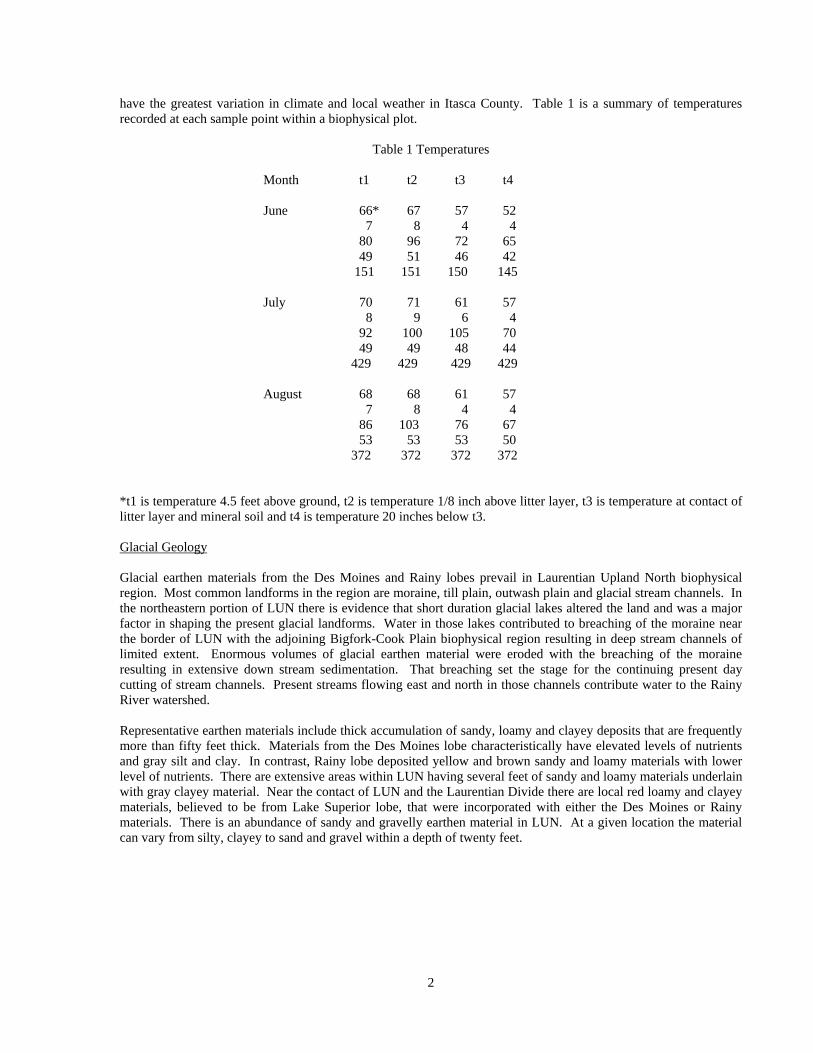
have the greatest variation in climate and local weather in Itasca County. Table 1 is a summary of temperatures recorded at each sample point within a biophysical plot.
Table 1 Temperatures
Month t1 t2 t3 t4 June 66* 67 57 52 7 8 4 4 80 96 72 65 49 51 46 42 151 151 150 145 July 70 71 61 57 8 9 6 4 92 100 105 70 49 49 48 44 429 429 429 429 August 68 68 61 57 7 8 4 4 86 103 76 67 53 53 53 50 372 372 372 372 *t1 is temperature 4.5 feet above ground, t2 is temperature 1/8 inch above litter layer, t3 is temperature at contact of litter layer and mineral soil and t4 is temperature 20 inches below t3. Glacial Geology Glacial earthen materials from the Des Moines and Rainy lobes prevail in Laurentian Upland North biophysical region. Most common landforms in the region are moraine, till plain, outwash plain and glacial stream channels. In the northeastern portion of LUN there is evidence that short duration glacial lakes altered the land and was a major factor in shaping the present glacial landforms. Water in those lakes contributed to breaching of the moraine near the border of LUN with the adjoining Bigfork-Cook Plain biophysical region resulting in deep stream channels of limited extent. Enormous volumes of glacial earthen material were eroded with the breaching of the moraine resulting in extensive down stream sedimentation. That breaching set the stage for the continuing present day cutting of stream channels. Present streams flowing east and north in those channels contribute water to the Rainy River watershed. Representative earthen materials include thick accumulation of sandy, loamy and clayey deposits that are frequently more than fifty feet thick. Materials from the Des Moines lobe characteristically have elevated levels of nutrients and gray silt and clay. In contrast, Rainy lobe deposited yellow and brown sandy and loamy materials with lower level of nutrients. There are extensive areas within LUN having several feet of sandy and loamy materials underlain with gray clayey material. Near the contact of LUN and the Laurentian Divide there are local red loamy and clayey materials, believed to be from Lake Superior lobe, that were incorporated with either the Des Moines or Rainy materials. There is an abundance of sandy and gravelly earthen material in LUN. At a given location the material can vary from silty, clayey to sand and gravel within a depth of twenty feet.
2
Terrain Extensive plain combined with low rolling hills, hills with shallow glacial earthen material underlain with bedrock, distinct glacial stream channels and scattered open pit mines (near Laurentian Divide) result in a forestland with many contrasting features. In specific locations, glacial streams breached moraine hills that created steep walled channels that persist today. Lakes are scattered somewhat throughout the region and appear in arc pattern in northeastern portion of region. Present day lakes resulted from a combination of deep depressions caused by melting of buried ice blocks in glacial earthen material and collection of runoff in stream valleys dammed with glacial earthen materials. Local hills and ridges with shallow glacial drift underlain with bedrock express irregular somewhat angular slopes. Geological erosion of the parent bedrock has formed the present shape of the forestland. Rounded and sub-angular rocks are found throughout the region and the more angular rock is found in areas where depth to bedrock is typically less than 5 feet. Vegetation Present vegetation in the Laurentian Upland North biophysical region is the combined result of thousands of years of response to natural disturbances, climate change and disturbances caused by indigenous cultural followed by decades of activities by European settlers. Natural disturbances included fire, insect infestations, high velocity wind and grazing of various mammals that inhabited the prairie and forestland. In LUN were indigenes that frequently burned extensive areas encourage local grazing of mammals that they used for food. They also used fire for control of insects and as an element of war. Larch sawfly disseminated tamarack in recent history and now it has recovered is covers hundreds of acres. Balsam fir was severely impacted by the spruce budworm. American elm has been disseminated by Dutch elm disease and appears to be incapable if surviving the epidemic and may be eliminated from the LUN. White pine succumbed to white pine blister rust and is currently there is limited natural regeneration and selected organizations are planting it to increase its present in forestland. European settlers converted forestland to farmland for growing of food crops for themselves and farm animals. They used the wood for building structures, heating homes, fence posts and wooden fences. They introduced plants for food production and aesthetic purposes and many remain in current plant communities. There was also extensive removal of wood products to support the buildings necessary to support growth of local towns connected to the mining of iron, timbers in mines, ties for railroads and for construction of buildings in growing population centers beyond the immediate region. During and following the removal of wood products, there were forest fires that burned large areas of forestland at varying intensities that strongly influenced the resulting plant communities. The combined result of all those impacts and disturbances of the vegetation in LUN is a forestland that comprised of rich biophysical variability, highly contrasting plant communities and an abundance of habitat diversity. Immediately following the retreat of the glacier the tundra developed followed eventually by the present boreal forest that is near its southern boundary and adjoining hardwood forest. Trembling aspen is most common broadleaf tree and balsam fir is the most common conifer. In select areas of LUN there are northern hardwood communities comprised of sugar maple, paper birch, basswood and associated shrubs and forbs. Burr oak and red oak are scattered throughout LUN. Tamarack, black ash and black spruce and locally white cedar occur in wetlands and bogs. Within LUN 523 species of plants have been identified by individuals collecting biophysical data. Those species represent a combination of forest and prairie plants and boreal and northern hardwood plants. Individual species and specific combination of species are effective indicators of inherent fertility in the root zone. Structure of plant communities includes very dense multi level plant communities and communities that are park like. Typically, the more fertile land has the former and land with low fertility supports the latter. Fertile forestland in selected locations now supports dense brush as result of past disturbances that favored forest shrubs at the expense of trees. In certain forestland in LUN, fire has suppressed woody shrubs and result in a rather open forest with moderate to high fertility root zones. Grazing has a similar effect. That forestland often has dense grass beneath a tree canopy. Results of glacial deposition and post-glacial erosion created highly contrasting terrain in portions of LUN that is conducive to microclimate departures form regional weather and subsequent effects on plant communities.
3

Water Unique to the Laurentian Upland North biophysical region is the natural divide of watersheds between the Hudson Bay and Mississippi River watersheds. Thus; water flows both north and south from LUN. This biophysical region represents a minor portion of the headwaters for each watershed and volume of runoff is correspondingly small. Lakes and streams in LUN reveal the distinct influence of post-glacial drainage and erosion by the huge volume of water from the melting of the massive accumulation of ice in the glacier. Portions of that glacier water accumulation behind elongated glacial ridges and eventually breached those ridges at weaker points and created local ravines in which present streams flow. Many of the present lakes are distinct depressions in the forestland caused by huge blocks of ice in the glacial debris that subsequently melted leaving deep depressions that now collect precipitation, runoff and inputs from springs. Presently, many streams flow in channels cut by glacial water and low gradients are common in the often meandering stream course. According to USGS information there is substantial potable water available in LUN. Varying combination of earthen materials create highly varied level of selected lakes and streams. Lakes and streams in vicinities with clayey materials extending to forest floor produce large volumes of surface runoff during spring and fall recharges and prolonged rain during the growing season. Lakes and streams in those vicinities will have significant changes in levels from spring to late summer and there is often local flooding. In contrast, vicinities with sandy and loamy earthen materials will have low volume of surface runoff and major contributions to perched and regional ground water, springs and seeps. According to USGS information, the quality of water from LUN is high and typical of high quality water from forestland in Itasca County. Representative analyses from USGS files include 68 milligrams/liter (mg/l) of iron, 0.04 mg/l of manganese, 20 mg/l calcium, 5.8 mg/l of magnesium, 2.7 mg/l of sodium, 1.4 mg/l of potassium, 82 mg/l of bicarbonate, 7.1 mg/l of sulfate1.3 mg/l of chloride and pH 7.8. Excellent esthetic values are repeatedly reported for water quality in lakes and streams representative of LUN.
Management Analysis Facilities necessary for supporting human residences and similar developments can be easily supported in the main portion of the Laurentian Upland North region. Deep sandy and loamy drift offers many opportunities for using standard building designs and features. Potable water is readily available for domestic uses. Sewage disposal systems designed in accordance with the nature of the deep drift will provide for adequate sewage treatment with minimum maintenance. In the Laurentian Divide those same facilities will require special evaluation of all sites and individual designs that are necessary for the shallow drift over bedrock and the irregular broken terrain. Construction and maintenance will be substantially higher than in the areas of deep drift. Because of the shallow drift over bedrock, special attention will be required for monitoring sewage disposal systems and assure that no pollution of water is occurring. Potable well casing will require a secure seal at the bedrock contact to prevent contaminates from entering the water
A combination of the steep terrain in the Laurentian Divide, the sandy beaches at many lakes and the extensive plains and rolling low hills provide an excellent base for a wide variety of outdoor recreation activities. Skiing and walking trails in the Divide are very popular. Camping, summer homes, swimming and fishing and are characteristic of many of the high quality lakes. Snowmobiling is a growing recreation activity in this region and the trials lead through the plains, rolling hills and the steeper slopes in the Divide. Autumn colors combined with the contrasting terrain attract many visitors to this region. Hunters are attracted to the region in the autumn because big game and upland bird populations are usually quite high. There are numerous opportunities for wildlife management projects due to the climate, the natural fertility, the mix of uplands and lowlands and the sharply contrasting vegetation communities associated with the farming and forest land uses. Juvenile plant communities have substantial amounts of food available for a wide range of wildlife species. Maturing forests offer both cover and food for wildlife. Open grass fields and associated high insect populations attract many species of wildlife.
4
Road construction and maintenance can be done at very attractive costs in the sandy plains. Low standard roads can be constructed with the material in place. Road prisms constructed of the sandy material are durable and drain well. Costs will increase in the rolling terrain with the higher levels of silt and clay. Those costs are associated with the need for hauling in material for road prisms and drainage facilities necessary for proper ditching. Contained in this region are sandy deposits underlain with material having high levels of silt and clay and perched water. History has shown that roads with improper cross drainage in these areas of low relief can dam that perched water causing a flooded ground surface and the water can reach depths of a few feet and extend over several acres. A proper evaluation of the land before construction and proper road design can prevent the flooding problem. In the Divide there would be a sizable increase in both construction and maintenance cost of roads. High standard roads would require the blasting and removal of substantial volumes of bedrock.
Moderate to high volumes of wood products can be produced in the Laurentian Upland North region. In the plains and rolling hills there are numerous opportunities for producing various kinds of high quality wood products. Moderate to high yields of native trees can be expected in those plains and hills. There will be opportunities for matching rotation cycles with maximum yields for specific trees. In selected areas in the sandy plains it will be necessary to evaluate the total nutrients removed in wood products using shortened rotations. The potential for favorable economic returns from the production of wood products in the Laurentian Upland North region makes it quite attractive for enterprise operations. The moderate to high level of yields of quality wood products and the reasonable costs for road construction and maintenance in the majority of the region match quite well with the requirements of an enterprise forest land management operation. Potential net returns for both small and large diameter trees during normal economic cycles should be quite attractive in the majority of this region. Intensive forest management inputs for stands common in this region should increase both net and gross returns. Fast growing hybrids or superior native tree seedlings should be considered for extensive use in this region. Cost effective species conversions can also be realized in the majority of this region with the use of prescriptive integrated resource strategies.
BIOPHYSICAL KEY FOR LAURENTIAN UPLAND NORTH (LUN) BIOPHYSICAL REGION
A. Forestland includes till plain and moraine with moist and wet shallow depressions (less than 10 feet deep)
depressions, tree canopy has density of 40 to 100 percent (unless noted otherwise) and few rocks on ground surface.
A1. Mixed stands of hardwoods and conifers or nearly pure stands of each; dominant shrubs greater that 6 feet tall with 40 to 100 percent canopy comprised of mountain maple, hazel and arrow-wood; forbs include wood anemone, strawberry, bedstraw, twisted stalk and black snakeroot can be present; DRY clayey & loamy root zone with few rocks that may increase with depth ITLUN 5 WINTER: Shrubs with red, gray or brown opposite branches mixed with shrubs having brown alternate branches. A2. Mixed stands of hardwoods and conifers or nearly pure stands of each; dominant shrubs greater than 6 feet tall with 20 to 70 percent canopy comprised of mountain maple, black ash, hazel and arrow-wood (dogwoods can be present); forbs include wild ginger, sweet cicely, jewelweed and large flowered bellwort; DRY-MOIST loamy & clayey over clayey root zone with few or no rocks ITLUN 3 WINTER: Shrubs with red, gray and green opposite branches mixed with shrubs having brown alternate branches.
5
A3. Mixed stands of hardwoods and conifers or nearly pure stands of each; dominant shrubs 4 too greater than 6 feet tall with 40 to 100 percent canopy comprised of hazel, (mountain maple), dogwoods, fly honeysuckle and arrow-wood; forbs include lady fern, coltsfoot, bellwort and upland strawberry; DRY fine sandy and silty root zone with no or few rock fragments ITLUN 6 WINTER: Shrubs with gray, green, red and brown opposite branches mixed with shrubs having brown alternate branches. A4. Mixed hardwood and conifer stands or nearly pure stands of each; dominant shrubs greater than 6 feet tall with 40 to 100 percent canopy comprised of speckled alder, mountain maple, dogwood and hazel; forbs include lady fern, ginger, naked miterwort, sweet white violet, bedstraw and horsetail; MOIST loamy or clayey over clayey root zone with few or no rocks; scattered moist or wet depressions during spring and fall recharge ITLUN 10 WINTER: Shrubs with green, red and gray opposite branches mixed with shrubs having gray, green and brown alternate branches. A5. Mixed hardwood or conifer or nearly pure stands of each; dominant shrubs 4 to greater than 6 feet tall with 20 to 70 percent canopy comprised of black ash, speckled alder, pale laurel and mountain maple; forbs include swamp blue aster, jewelweed, coltsfoot, three leaved false Solomon’s seal and northern white violet; WET: Loamy or clayey over clayey root zone with few or no rocks ITLUN 9 WINTER: Shrubs with brown, green and red opposite branches mixed with shrubs having brown and gray alternate branches.
AA. Forestland includes outwash plain, sandy till plain or local lacustrine plain (with dry shallow depressions and a few scattered moist depressions), eskers and kames. AA1. Mixed hardwood or conifer or nearly pure stands of each; dominant shrubs 4 to 6 feet tall with 40 to 70 percent canopy comprised of hazel, bush honeysuckle and blueberry; forbs include sarsaparilla, bunchberry, meadow strawberry and lily-of-the-valley; DRY: Thin loamy over sand root zone ITLUN 1 WINTER: Shrubs with brown and green alternate and opposite branches. AA2. Mixed hardwood or conifer or nearly pure stands; dominant shrubs greater than 6 feet tall with 40 to 100 percent canopy comprised of hazel, bush honeysuckle, black ash and blueberry; forbs include wood anemone, lady fern, upland strawberry and rough bedstraw; DRY: Fine sand, loamy fine sand and fine sandy loam root zone ITLUN 2 WINTER: Shrubs with brown and green opposite branches mixed with shrubs having alternate brown and green branches. AA3. Mixed hardwood or conifer or nearly pure stands; 4 to more that 6 feet tall with 40 to 70 (100) percent canopy comprised of mountain maple, hazel, (dogwood) and bush honeysuckle; forbs include wood anemone, strawberry, sweet bedstraw and sweet cicely; DRY: Sandy over loamy over clayey root zone ITLUN 4 WINTER: Shrubs with brown alternate branches and shrubs with red, gray and brown branches.
6
AA4. Low to medium quality lowland hardwood and lowland conifer stands; shrubs generally less than 6 feet tall with 20 to 70 percent canopy comprised of black ash, speckled alder, cranberry, bog rosemary and leather leaf; forbs include round leaved sundew and clintonia; WET: Sandy root zone with low content of rock ITLUN 7 WINTER: Shrubs with gray and green opposite branches mixed with shrubs having gray and brown alternate branches. AA5. Medium to low quality lowland hardwood and lowland conifer stands; shrubs generally less than 6 feet tall with 20 to 70 percent canopy and comprised of hazel, speckled alder and narrow leaved meadowsweet (dogwoods may be present); forbs include gold thread, horsetail, starflower and northern white violet; MOIST: Sandy root zone with variable content of rock ITLUN 8 WINTER: Shrubs with brown, gray and green alternate branches and can be mixed with shrubs having red or green opposite branches. AA6. Esker or kame; low to medium quality hardwood or conifer stands with 20 to 70 percent canopy; dominant shrubs less than 6 feet tall with 10 to 40 percent canopy comprised of hazel, bush honeysuckle and blueberry; forbs include sarsaparilla, bracken fern, bunchberry and wintergreen; DROUGHTY- DRY: Thin loamy over sandy and gravelly root zone ITLUN 11 WINTER: Shrubs with brown or green alternate branches mixed with shrubs having brown opposite branches. AA7. High to medium quality upland hardwoods and conifers with greater 70 percent canopy, dominant shrubs more than 6 feet tall with 40 to 100 percent canopy and comprised of mountain maple, hazel and dogwoods; forb densities 40 to 100 percent canopy and include sarsaparilla, clintonia, strawberry and twisted stalk; DRY: Deep loamy, more than 50 inches, root zone. ITLUN 12 WINTER: Shrubs with red and gray opposite branches mixed with shrubs with brown alternate branches. III. Biophysical Landscape Ecological Units
Biophysical Ecological Unit 1
ENVIRONMENT CULTURAL: This Biophysical Landscape Ecological Unit (BLEU) 1 occurs in forestland that has evolved for thousands of years and has included cycles of cooling and warming. In response to changes in climate, tundra gave way to boreal forest that has evolved into a mixed hardwood and conifer forest. European culture has influenced the land for nearly three centuries. Lumber required by local settlers for homes and service buildings and for buildings in major cities initiated extensive logging in this forestland. Farming was necessary for support of individual families and local communities. Consequently, land near small communities was cleared for cropping and grazing livestock. Such clearing removed several thousands of acres of forestland in selected locations. Current forests are thus the result of natural evolution, historical removal of forest products and farming. Evidence of fire was reported in fifty two percent of samples. Earthworms or evidence of their activities were reported in 10 percent of samples. Dead logs were reported in 97 percent of samples and snags were reported in 58 percent of samples. Biophysical landscape ecological unit 1 occurs in Laurentian Upland North biophysical region.
7

CLIMATE: Climate in forestland dominated by BLEU 1 since the last glacier retreated has been constantly changing. There were cycles of cooling and warming and current conditions are considered continental and reported information is based on data from certified weather stations. Annual mean precipitation is 29 inches with May through August being 15. Mean annual air temperature is 36’F and May through August mean temperature is 59’F. Estimated growing degree days (40 F base) is 3000. GEOLOGY: Glacial outwash and sandy till from Des Moines and Rainy lobes prevail in forestland with BLEU 1 with the areas of highest elevation being bedrock ridges. Melt water from Des Moines and Rainy glacial lobes flowed into the area from the north, northwest and northeast depositing extensive areas of sandy earthen materials often exceeding twenty feet in thickness. Glacial deposition and post-glacier erosion formed the current landscape of an outwash plain with ice block depressions and moraine with scattered stream channels. This BLEU occurs in forestland that adjoins the iron range and Laurentian Divide with numerous bedrock ridges. TERRAIN: Forestland with BLEU 1 is characteristically a plain with dry shallow depressions and occasional moist or wet deep depressions mixed with low rolling hills. Natural drainage system is distinct. Slope gradients of less than 5 percent are common and gradient ranges locally to more than 15 percent on side slopes. In selected locations, BLEU 1 adjoins marshes and bogs resulting in contrasting forestland. WATER: BLEU 1 is dry and will contribute insignificant amounts to surface runoff during spring and fall recharge. Surface runoff is uncommon and occurs primarily on frozen ground during spring thaw. There can be limited surface runoff during high intensity summer rain. This BLEU contributes significant amounts of moisture through the pervious earthen material to local water tables during recharge in spring and fall. During winter with early deep snow cover, there can be limited amount of subsurface runoff. Average rain during the summer will result in no or little contribution of water to streams and lakes as a result of estimated evapotranspiration equaling or exceeding normal rain. There will be no or limited capillary moisture from depth due to the porous earthen material. Moisture available in the sandy root zone is insufficient to support vigorous plant growth resulting in low yield. Seasonal and prolonged droughts will have short and long term adverse impacts on the health of native trees. Water stored in the pervious substratum from spring and fall recharge can contribute water to springs, streams and lakes. NUTRIENTS: Natural level of nutrients in a representative root zone is estimated to be low through the root zone. Root zones in Des Moines lobe are believed to be more fertile than those in Rainy lobe. Laboratory analyses completed at a certified laboratory support findings in the following table that summarizes major nutrients in pounds per acre 60 inches and associated chemical properties for BLEU 1.
Nutrients Per 60 Inch Root Zone Biophysical Landscape Ecological Unit 1
K* C MG P CEC BASE_SAT pH 450 2679 571 815 3.8 meq/100g 31% 5.6 *K=potassium; CA=calcium; MG=magnesium; P=phosphorus; CEC=cation exchange capacity; BASE_SAT=base saturation and pH=measure of acidity and alkalinity. BLEU 1 ranks tenth in total nutrients for all BLEUs in LUN. Calcium and magnesium are low in comparison to levels in other BLEUs and nutrient conservation will be considered in prescriptive removal of wood products. Trembling aspen wood products removed from the land would potentially be the highest drain of nutrients in comparison to other native trees. VEGETATION DENSITY & STRUCTURE: The canopy density is for mixed hardwood stands and pine stands and does not include stands dominated by balsam fir or spruce. Shrub and forb densities will respond to heat and light increased at ground surface as the canopy of hardwood and pine becomes higher and open beneath. That response will reflect the low level of moisture and nutrients in the root zone. Balsam fir and spruce canopies remain close to the ground surface and effectively intercept heat and light that eliminates plants beneath them in this BLEU. In BLEU 1 regenerating hardwood stands can have a few indicator shrub species mixed with tree suckers and sprouts.
8

Mature Plant Communities -Overstory canopy density 3-4, subdominant canopy 2-3, shrubs 6 to 25 feet tall 2-3, shrubs 3 to 6 feet tall 1-2, shrubs less than 2 feet tall 1-2, forbs taller than 18 inches tall 1-2 and forbs less than 18 inches tall 3-4. Shrubs in mature plant communities in BLEU 1 will have an estimated peak height of 6 feet or less. Space between shrubs and dominant tree canopy will have an estimated range of twenty-five to thirty-five feet. There will be a distinct open space below tree canopy in those communities. Shrubs are light and heat sensitive and will have moderate increase in density and slight increase in height with removal of tree canopy. Indicator Species – Beaked hazel, bush honeysuckle, blueberry, sarsaparilla, bunchberry, meadow strawberry and lily-of-the-valley. Balsam fir is common in the shrub layers on mature plant communities. in many locations. ROOT ZONE: Moisture –DRY. Soil Texture by depth - 10” 20” 30” 40” 50” 60” sand sand sand sand sand sand Rock Content – Percent of root zone occupies by rocks is consistently less than 10 percent and increases with depth in select locations. Uniformity – A root zone in BLEU 1 is medium and fine sand throughout with bands of finer or coarser sands occurring at selected locations.
MANAGEMENT ANALYSIS Information presented in management analysis will provide a base for managing forestland within its capacity for supporting sustained supply of quality wood products, high quality water, high quality recreation opportunities and mixture of natural wildlife species. Biophysical information will be integrated with other forestland information for prescriptive management projects and for long-term forestland management planning. TIMBER MANAGEMENT: BLEU 1 has potential for producing sustained moderate level supply of quality pulpwood, bolts and sawlogs from native trees grown within their respective commercial botanical range. Jack pine, red pine and white pine will yield higher quality sawlogs than will most hardwoods. That supply can be further assured with integration of biophysical information with silvicultural prescriptions. Those prescriptions will guide site preparation, assure proper stocking and spacing, guide weed control and initiate commercial thinning. Current level of stocking and rotations for selected trees should be evaluated for practical adjustment that could increase yield. Estimated level of nutrients in the root zone and nutrient displacement with current and anticipated harvest practices require nutrient conservation measures and slash must remain scattered throughout area from which wood products have been harvested. Trembling aspen has reported high level of nutrients and nutrient conservation is especially important for stands growing in BLEU 1. Shorten rotations and increased removal of biomass will necessitate replacement of nutrients to assure sustained site quality and productivity. Trees stressed by diseases and insects will have a low level of resilience that is associated with the low inherent fertility in the root zone. Logging operations in BLEU 1 can be conducted any time the root zone is dry or frozen and delayed during spring and fall moisture recharges and uncommon prolonged wet periods during growing season. During moisture recharge, the surface 5 to 15 inches of the root zone can become unstable and equipment traffic can cause rutting and compaction that will result in adverse impacts of intermediate duration. Short term reduction in plant growth will occur in the ruts and compacted portions of the root zone. That reduction will not extend beyond the impacted area. The ground surface will dry rapidly after summer rains and adjustments in timing of equipment operations would be appropriate. Concentrating skid trails will significantly reduce potential adverse impacts and it is advisable to locate them during harvest project planning. Earthen materials in BLEU 1 can be considered for construction of low speed and low volume traffic. Binder will have to be added to earthen material used for road and trail prisms. Road and trail constructed from native material in BLEU 1 will normally not be slick when wet and can be somewhat dusty when dry. Crowning road and trail surface coupled with adequate ditching will result in satisfactory surface for vehicular traffic.
9

Conversion of hardwoods to conifers can be accomplished with minimum weed control because of competition resulting from low inherent fertility. Proper site preparation timed for maximum impact of woody plants can minimize or eliminate need for release. Quality planting stock and quality planting will readily ensure adequate stocking. One release should be considered for conversions. Low moisture holding capacity in root zone will not buffer planted seedlings from seasonal droughts and extensive mortality can be expected. Seedlings planted during seasonal droughts must be inventoried before the next planting season so that advantage of site preparation can be taken if survival is below standard. Chemical exchange capacity of the surface organic-rich forest duff is high and is low in the remainder of the root zone. Chemicals applied to control weeds and in accordance with that chemical capacity, label standards, weather conditions and soil properties will sustain quality of forestland. Because of its importance to site quality, forest duff should be left intact or incorporated into the root zone. That is especially important for BLEU 1, which has sandy root zone. Within a BLEU 1 root zone, the surface organic layer has the highest level of nutrients, the highest water holding capacity, the highest chemical exchange capacity, enhances infiltration of water, reduces impact of frost heaving and reduces extremes in surface soil temperatures in clearings. The forest duff substantially reduces the risk of erosion, sedimentation and can reduce impact of compaction. Micro organism and macro organism populations are typically highest in the forest duff. Those organisms decompose the organic material and add to the fertility of the underlying portion of a root zone. Decomposition of the organic material also releases nutrients that can be utilized by plants. RECREATION: Somewhat varied plant communities, dry low rolling hills, bogs, marshes and streams are natural properties to consider for recreation opportunities in a forest environment. Inherent properties of forestland dominated by BLEU 1 can support a variety of facilities associated with recreation activities. Natural earthen materials can be used for low volume traffic trails and hiking trails. The materials at the ground surface when used for trails and low traffic trails normally will not create a muddy problem except during periods of above normal summer rain and moisture recharge in spring and fall. Vegetation can be altered with silviculture techniques for enhancement of autumn colors, erosion control, air movement and natural screening. Natural mature plant communities with a closed tree canopy will have a medium to low density shrub layer typically 3 to 6 tall. Autumn colors will consist of multiple layers of yellow and fading green mixed with green of conifers and scattered red. WILDIFE: A mature plant community with closed tree canopy in BLEU 1 will have multiple layers of shrubs generally less than 6 feet tall and forbs. There will be tens of feet separating shrub canopy and mature tree canopy. Shrub density, species mix and height can be altered with silviculture techniques. Openings in recently disturbed areas tend to have higher species richness than non-disturbed areas. Openings can develop into intermediate and tall hazel dominated shrub communities with forbs generally less than eighteen inches tall. Fruiting plants are not common in natural communities but can be significantly increased with silviculture alterations. Hazel is a common nut bearing plant. Managed food plots will provide low amounts of biomass using native or introduced plants. Clovers selected will have to be adapted too low fertility, acid root zone and low moisture capacity. Other species adapted to those properties can provide some food for selected wildlife species. Thermal cover can be readily produced with customized silviculture alterations for encouraging conifers. WATER: Routine forestland management activities in BLEU 1 guided by prescriptions that incorporate biophysical information, silviculture principles and water quality standards will continue to sustain natural quality water. Those prescriptions include prevention of erosion, sedimentation, compaction and rutting. Such prescriptions will reflect the high content of sand and rock and low content of silt and clay in the root zone and rapid to moderate rates of infiltration and percolation. BLEU 1 contributes substantial amounts of water to underground systems during frost-free periods associated with moisture recharges in spring and fall and surface runoff while ground is frozen. There will be minimum surface runoff in BLEU 1 during frost-free period. Evapotranspiration can exceed summer rain and substantially decrease water stored in the root zone to short term droughty conditions. Plots/Points: 110/1,3; 111/1 156/7 289/4 115/2/10 117/8,9 157/1,2 400/7.10 118/4 124/5 163/7 411/3 127,1,9 149/10 287/3.4.5.6.7
10

Biophysical Landscape Ecological Unit 2
ENVIRONMENT CULTURAL: This BLEU represents forestland that has been forested for centuries and represents the influence of forest management and natural processes. Timber harvest, fire and wind were reported as common disturbances to that forestland. Farming has never been a major activity in areas where BLEU 2 is common. Charcoal was reported in 18 percent of samples and was common in the forest floor and less common in the root zone. The latter indicates fire in heavy fuels during drought. Earthworms or their activities were reported in 9 percent of samples. Dead logs on the ground were reported in 96% of samples and vertical snags were reported in 50% of samples. Biophysical landscape ecological unit 2 occurs in Laurentian Upland North biophysical region. CLIMATE: Average annual precipitation 29 inches; May through August average precipitation 15 inches; representative growing degree days 3000; average annual temperature 36’F and May through August average temperature 59’F. North slopes will be moister and cool than south slopes. North slopes will have less extreme temperatures and fewer wetting and drying cycles than south slopes that will be significantly dryer and subject to frequent wetting and drying and freezing and thawing cycles. GEOLOGY: Des Moines lobe glacial materials provided the base for the root zone of BLEU 2. There may be smaller areas of Rainy lobe materials near the contact with Laurentian Upland North biophysical region. An outwash plain and lacustrine plain with scattered dry or moist shallow depressions and low hills form forestland for this BLEU. The outwash plain and lacustrine plain are dominated by fine sands and loamy material with very high level of fine sands and silts. Earthen materials in those plains are consistently more than 10 feet thick. BLEU 2 can be underlain within ten feet by gray clay. Rocks on the ground surface are very uncommon and 96% of plots had no rocks. Rocks are distinctly rounded and typically represent upper level of glacial lake beaches that were subjected to frequent wave action and seasonal changes in water level. TERRAIN: Low gradient plains with scattered low rolling hills form the landscape in which BLEU 2. Slopes are smooth and gradient is dominantly less than 5. Local relief increases around the deep depressions, lakes and low rolling hills. Shallow depressions are frequently dry and deeper depressions can be moist or wet, which indicates ground water levels that may be part of a regional water table or it may represent water perched above clay. WATER: This BLEU has a dry root zone and water saturated material is generally below 5 feet and seasonally can be temporally within 4 feet of ground surface. Shallow water saturation consistently occurs during spring and fall recharge and during prolonged high intensity summer rain. During normal growing seasons, evapotranspiration can equal or exceed precipitation. Perched water within a depth of 10 feet can occur in BLEU 2 in locations with clayey material in substratum. Moisture available in the root zone is favorable for most plants and can limit growth during late summer droughts. Prolonged drought will have adverse effect on plant growth and delayed mortality can occur. Water not consumed by evapotranspiration will percolate to ground water and will result in small amount of water reaching the water table during the growing season. Contributions of water to the ground water can be substantial during spring and fall recharge periods when evapotranspiration in minimal. Flooded depressions reflect level of ground water or level of water perched above clay or surface and subsurface runoff collected in depressions sealed with fine materials. Percolating ground water through this pervious sand will contribute to streams and lakes and buffer them from extremes in levels during normal weather. The greatest contribution of water from BLEU 2 to streams and lakes will be during spring and fall recharge. NUTRIENTS: Laboratory analyses completed at certified laboratory support the following summary of nutrients in pounds per acre 60 inch root zone for potassium, calcium, magnesium and phosphorus in BLEU 2. Potassium Calcium Magnesium Phosphorus C.E.C. Base Saturation pH 351 3086 576 883 3.7 meq/100g 31% 5.3 BLEU 2 ranks ninth in level of nutrients in comparison to other BLEUs in LUN. Conservation of nutrients will be appropriate for prescriptive removal of wood products from BLEU 2 and trembling aspen will remove the greatest amount of nutrients when compared to other native species.
11

VEGETATION: Representative density of crowns and structure of plant communities are described in the following paragraphs. Species richness will peak immediately following a disturbance of the mature community and can persist for several years. Regenerating plant communities normally have tree seedlings mixed with shrubs in shrub layers and that is due to moderately fertile root zone. Species richness will be greatest immediately following disturbances that remove tree canopy and create complex of micro sites for germination and growth of plants. Mature plant community: Osd 3-4, Osb 1-2, Sht 3-4, Shi 1-2, Shs 3-4, Fot 1-2 and Fos 3-4. This community will have an elevated tree canopy and low to moderate density codominant tree canopy and high to medium density shrub layers and low to high density forb layers. Many shrubs will exceed a height of 6 feet. Species richness and densities will have stabilized during this stage. Natural thinning of selected native trees can be prolonged in BLEU 2 resulting in significant amount of tree species in codominant and shrub layers. That natural thinning pattern can result in mature stand with few large trees. Dry deep root zone supports wind firm trees. Dead woody materials and snags will be common in selected timber types prior to this stage of the plant community and custodial forestland management will potentially increase dead wood on the ground and dead vertical snags. Based on inherent fertility of root zone, most native trees will have moderate to low resistance to impacts from diseases and insects. The dry fine sandy and loamy root zone will support plant communities with many tree species native to the area. Indicator species: Beaked hazel, bush honeysuckle, black ash, blueberries, wood anemone, lady fern, upland strawberry and rough bedstraw. ROOT ZONE: Moisture – DRY. Soil texture 0 – 60 inches fine sands, loamy fine sand & fine sandy loam Rock fragments <5% Root zone tends to be uniform and free of rock and obstacles to root growth. MANAGEMENT ANALYSIS Throughout this analysis, the objective will be to provide information supportive of maintaining high quality forest and water through quality forestland stewardship. That objective can be accomplished by integrating biophysical information with silviculture prescriptions, strategic planning, tactical planning and project planning. Such integration will substantially increase probability of success and significantly reduce risk of adverse impacts. ENGINEERING: Earthen materials in BLEU 2 are suitable for selected uses associated with forestland management. The very high content of fine sands results in a pervious material that dries rather quickly with artificial drainage. The prism for low traffic forest roads and trails can be constructed in place with these materials when coupled with effective ditching. Driving surface will require binder for increasing stability. Frost action generally is a problem with the fine sands and silts and will result in unfavorable conditions for driving surfaces during spring breakup. Also, unstable road conditions can occur in the absence of effective drainage during spring and fall recharges. The high content of dry fine sands and silts renders this BLEU a candidate for evaluation for standard sewage disposal systems. Generally favorable conditions in the root zone will enhance growth of natural plants following disturbance. TIMBER PRODUCTION: This BLEU should be considered for production of pulpwood, bolts and sawtimber for most native trees. Rapid growing hybrids should be considered for BLEU 2. Based on the estimated level of nutrients in the root zone and estimated displacement of nutrients with removal of wood products, nutrient conservation measures should be evaluated for each stand to maintain the quality of the forestland. Nutrient conservation measures would include leaving branches, leaves and buds in the harvested area and maintaining current medium and long rotations. Tree species requiring deep root zone free of obstacles will thrive in this BLEU. Diseases and insects can have substantial adverse impacts on selected trees growing in this BLEU. Natural fertility in root zone will foster moderate resistance by trees to selected attacks by diseases and insects.
12
Equipment traffic required for harvest, regeneration and tending forest crops could have adverse impacts on the forestland represented by BLEU 2 due to periodical water saturated condition in the root zone during spring, fall and prolonged rain in summer. Summer harvest of wood products should be considered for this BLEU with understanding that vehicular traffic may be restricted during and immediately following prolonged rain in summer. The high content of fine sands and silts render the earthen material in BLEU 2 very unstable during periods of water saturation. Rutting and compaction would be the main potential impacts. Compaction and rutting can be readily avoided in BLEU 2 by directing vehicular traffic to frozen or dry conditions. Ruts at right angles to topography with steep slope gradients will result in substantial erosion and gullies due to the easy of detachment and transport of the fine sands and silts. All treatments of this forestland must be done in a manner that will maintain the integrity of the organic-rich forest floor. That forest floor is rich in nutrients, has high water holding capacity, contributes organic compounds to the root zone that increases fertility and buffers the root zones from extremes in temperatures. Mixing the organic-rich forest floor with the surface mineral material will result in a favorable seedbed for many native plants and can increase growth of plants. Natural regeneration of most native tree species can be accomplished with routine silviculture practices. Conversion to contrasting species can be done with current forest management practices. Native shrub and forb competition, which can be grasses, will readily establish following disturbances and can persist for several years. Properly timed appropriate site preparation techniques will successfully control competition with combination of mechanical and chemical treatments. Due to the low chemical exchange capacity of the native earthen material in the root zone of BLEU 2, directions for application of chemicals must be carefully followed. RECREATION: Earthen materials in BLEU 2 will support development and maintenance of low traffic walking and hiking trails. All trails will require prism with effective drainage. Those materials can be used in place for building trail prisms and filling low spots. Such materials will dry quickly following spring thaw and summer rains. Citizens desiring a less demanding physical recreation experience will find the areas of low local relief and gentle slopes of the BLEU 2 landscape to their liking. The more rolling topography will provide citizens with numerous opportunities for hiking, skiing, snowmobiling and viewing contrasting landscape conditions over a short distance. There are opportunities for using silvicultural treatments for adding contrasting fall colors that include red, yellow and green of conifers. Thinning from above will stimulate growth of plants with contrasting fall colors and add more color to all levels in the forest. Selected plant communities can be effectively altered using current forest management practices to increase yield of blueberries, raspberries, elder and selected other fruiting plants. WILDLIFE: Mature plant communities in BLEU 2 will have an elevated tree canopy, a low density intermediate tree canopy and medium to high density shrub canopy that will extend above 6 feet in height. Thus, there will be a somewhat continuous canopy arrangement of woody plants from near forest floor to dominant tree canopy. Mature plant communities can have moderate species richness and will be dominated by species reflecting a root zone with high content of fine sands and silts. Wildlife food plots will respond favorably to full sunlight and plant species that will respond to the moderately fertile root zone. Removal of tree canopy can stimulate growth of natural shrubs and can increase wildlife foods including fruit baring plants. Generally, BLEU 2 has a moderate potential for producing large amounts of food for wildlife in the absence of very intensive management. Forestland dominated by this BLEU can accumulate significant amount of cold air in the numerous shallow depressions and in openings in the forest lacking trees and shrubs. WATER QUALITY: BLEU 2 is dominated by thick pervious sandy and silty root zone that has low chemical exchange capacity and low nutrient and water retention capacity. Subsequently, water moving through the sand has a high probability of leaching nutrients and chemicals to lower portions of root zones. Percolating water can carry nutrients and chemicals to open water via springs and seeps. Due to low clay content in the root zone, soluble nutrients are easy to dislodge and move with flowing water. Thus, management prescriptions that remove the forest floor and the natural binding of the earthen materials by roots must design water control features to replaces those properties. Improperly designed roads and trails can readily result in undesirable wet and unstable driving and walking surfaces. Routine forestland management activities and silviculture practices will maintain the high quality of water that citizens expect from a forest. Independent audits of forestland management activities document that current forestland management produces high quality water. Those activities prevent or minimize erosion of soil and sedimentation of water bodies. Forest roads and trails are designed, located, constructed and maintained in accordance with the inherent capacity of BLEU 2 earthen materials and in a manner that protects both water quality
13

and quantity in this forestland. A considerable amount of water during spring thaw and fall recharge can move to lakes and streams through ground water pathways in the pervious sand that prevails in BLEU 2. Plot/Points: 83/4 113/1,3 119/2,3,4 146/8 147/1 155/7.8 156/1,2,3,4,5,6 396/6 397/1,2 429/1,2,3
Biophysical Landscape Ecological Unit 3
ENVIRONMENT CULTURAL: This Biophysical Landscape Ecological Unit (BLEU) 3 occurs in forestland that has evolved for thousands of years and has included cycles of cooling and warming. In response to changes in climate, tundra gave way to boreal forest that has evolved into a mixed hardwood and conifer forest. European culture has influenced the land for nearly three centuries. Lumber required by local settlers for homes and service buildings and for buildings in major cities initiated extensive logging in this forestland. Farming was necessary for support of individual families and local communities. Land near isolated small communities was cleared for cropping and grazing livestock. Such clearing removed several thousands of acres of forestland in selected locations. Current forests are thus the result of natural evolution, historical removal of forest products and farming. Evidence for fire was reported in 38 percent of samples. Earthworms or their activities were reported in 15 percent of samples. Dead logs were reported in 82 percent of samples and snags were reported in 47 percent of samples. Biophysical landscape ecological unit 3 occurs in Laurentian Upland North biophysical region. CLIMATE: Climate in forestland dominated by BLEU 3 since the last glacier retreated has been constantly changing. There were cycles of cooling and warming and current conditions are considered continental and reported information is based on data from certified weather stations. Annual mean precipitation is 29 inches with May through August being 15 inches. Estimated growing degree days (40’ F base) are 3000. Mean annual air temperature is 36’F and May through August mean temperature is 59’F. GEOLOGY: Glacial landforms prevail in forestland with BLEU 3 with the areas of highest elevation being hills of glacial debris and isolated bedrock knolls. Glacial earthen material in ground moraines and local glacial lake plains subjected to post glacial deposition, erosion and other natural forces and events shaped the current forestland. Consequently, natural forces and events have determined the present landscape in which BLEU 3 occurs. Loamy materials near the ground surface underlain with clayey materials with low content of rock were deposited by Des Moines glacial lobe that moved into the area from the north and northwest. Post-glacial erosion created the well defined stream channels with current streams flowing generally south and southwest. Glacial fluvial stream channels typically expose fine sand, silt and clay and in scattered localized locations have high content of large rocks. TERRAIN: Forestland with BLEU 3 is characteristically distinct plain with local low rolling hills formed by combination of glacial deposition and post glacial erosion. Local geologically weathered bedrock is expressed in isolated low hills. Dry and moist shallow depressions and well-defined stream channels are common place in this forestland. Erosive high velocity and large volume glacial rivers feed by melting glacial ice formed current stream valleys in which substantially smaller streams flow today. Present streams can adjoin sandy banks of dry uplands, grassy marshes and peat bogs have lowland hardwood, lowland conifers or lowland shrubs. Active and abandoned beaver ponds are common in BLEU 3 forestland. Abandoned ponds are quickly vegetated with natural plants including grasses, shrubs and eventually trees. Those ponds can remain in grass and or shrubs for many decades. Associated with forestland with low relief are streams with low velocity current. Slope gradients of 5 percent or less are common in the smooth simple and linear slopes. There are short concaved slopes near the base of selected low rolling hills. Isolated and scattered somewhat angular rocks occur in BLEU 3. WATER: Because of the moderate to slow infiltration and permeability of the loamy and clayey glacial earthen materials, BLEU 3 sheds a significant volume of water to depressions, marshes, bogs and streams. Surface runoff will contribute significant volume of water to those areas of forestland during spring and fall recharge and periods of above normal summer rain. Springs and seeps along lower slopes are common in selected portions of forestland that
14

is dominated by BLEU 3. Evapotranspiration typically exceeds normal rain but will not cause droughty conditions in the BLEU 3 due to a natural moisture holding capacity of the root zone. There can be capillary moisture from lower portion of the root zone do to the fine pores associated with loamy and clayey materials. Temporary water saturation of the upper portion of the root zone results from surface water percolating through the surface loamy material above and along the its contact with underlying clayey material. Subsequently, there will be perched water table but not a regional water table within the root zone. Moisture available in the loamy and clayey root zone will suffice for most plant growth throughout a growing season and will have high potential productivity. Water stored in the slowly permeable substratum during spring and fall recharge can contribute water to springs, streams and lakes. NUTRIENTS: Laboratory analyses completed at a certified laboratory support the summary in the following table. The values represent an acre of land and a sixty inch root zone. Units are pounds per acre for potassium, calcium, magnesium and phosphorus. Potassium Calcium Magnesium Phosphorus C.E.C Base Saturation pH 766 17872 7321 979 13.3 meq/100g 57% 6.1 BLEU 3 ranks fifth for level of nutrients for all BLEUs in LUN. Nutrient conservation is not a current issue and should cropping practices of future crops include rotations of 20 years or less, then nutrient conservation would be a part of all prescriptive harvest of wood products. VEGETATION DENSITY & STRUCTURE: The canopy density is for mixed hardwood stands and does not include stands dominated by balsam fir or spruce. Shrub and forb densities will respond to heat and light increased at ground surface as the canopy of hardwood and pine becomes higher and open beneath. That response will reflect level of moisture and nutrients in the root zone. Balsam fir and spruce canopies remain close to ground surface and effectively intercept heat and light. In BLEU 3 regenerating hardwood stands will have indicator shrub species mixed with tree suckers and sprouts. Mature Plant Communities – Osd 3-4, Osb 2-3, Sht 2-3(4), Shi 2-3, Shs 1-2, Fot 1-2 and Fos 3-4. Hardwoods or conifers can dominate the tree canopy. Distance to lower portion of hardwood canopy can be small creating a nearly continuous matrix of woody plants. In contrast, fir and spruce canopies will be nearer the ground surface resulting in lower shrub canopy density beneath them and contrasting high density shrub canopies beyond conifer canopy. Trees in this community are prone to wind tipping during spring and fall moisture recharge due to temporary saturation of the root zone. Wind tipping, diseases and insects are major natural disturbances. Fire is less important and occurs mainly only during prolonged droughts because of permanently moist condition in community. Abandoned beaver ponds frequently become vegetated with prolonged dense grass and or shrubs communities that can prevail for many decades. Indicator Species – Mountain maple, black ash, hazel, arrow-wood, (dogwoods), ginger, sweet cicely, jewelweed, large flowered bellwort and dog violet. ROOT ZONE: Moisture – DRY - MOIST Soil Texture by depth - 10” 20” 30” 40” 50” 60” loamy loamy clayey clayey clayey clayey Rock Content – Percent of root zone occupied by rocks is consistently less than 5 percent and rocks on ground surface and very uncommon. Uniformity – A root zone in BLEU 3 typically has 10 inches of loamy materials underlain with clayey materials having a high percent of silt and clay.
15

MANAGEMENT ANALYSIS
Information presented in management analysis will provide a base for managing forestland within its capacity for supporting sustained supply of quality wood products, high quality water, high quality recreation opportunities and mixture of natural wildlife species. Biophysical information will be integrated with other forestland information for prescriptive management projects and for long-term forestland management planning. TIMBER MANAGEMENT: BLEU 3 has potential for producing sustained large supply of quality pulpwood, bolts and sawlogs from native trees grown within their respective commercial botanical range and adapted to high fertility dry root zone. Trees adapted to that root zone will yield high quality sawlogs. Trembling aspen, paper birch, white pine, black ash, spruce, balsam fir, cedar and tamarack can produce quality wood products. That supply can be further assured with integration of biophysical information with silvicultural prescriptions. Those prescriptions will guide site preparation, assure proper stocking and spacing, guide weed control and initiate commercial thinning. Current rotations for selected trees should be evaluated for practical adjustment that could increase yield. Nutrient displacement with current and anticipated harvest practices is considered to be in balance with nutrient capital in root zone and its capacity for replacing nutrients. Shorten rotations and increased removal of biomass would necessitate an evaluation of nutrient conservation strategy for the purpose of assuring sustained site quality and productivity. Trees stressed by diseases and insects will have a high level of resilience that is associated with the high inherent fertility in a dry root zone. Logging operations in BLEU 3 can be conducted any time the root zone is frozen and not during spring and fall moisture recharges and prolonged wet periods during growing season. During seasonal moisture recharge, the portion of the root zone above the clayey material is very unstable due too frequent water saturation and equipment traffic will cause rutting and compaction that will result in prolonged adverse impacts in the immediate area and in selected locations those impacts can extend into adjoining areas. Reduction in plant growth will occur in the ruts and compacted portions of the root zone and can extend into adjoining forestland. If the ground surface is dry during summer weather, operating logging equipment with low pounds per square inch pressure and using woody debris beneath tracks or wheels would minimize potential adverse impacts on the root zone. Concentrating skid trails will significantly reduce potential adverse impacts and it is advisable to locate them during harvest project planning. Earthen material in BLEU 3 can be considered for use as binder in gravel and crushed rock but it has limited use for driving surfaces due to high level of silt and clay. Driving surfaces constructed of that material would be extremely slick when wet and extremely dusty when dry. Conversion of hardwoods to conifers will require control of hardwood suckers and sprouts and brush. Site preparation timed to provide maximum impact on the competition would provide effective control of competing plants. High quality planting stock will be necessary to ensure adequate stocking. Two releases should be considered for conversions and one can suffice for selected trees. High moisture holding capacity in root zone will buffer planted seedlings from seasonal droughts. Frost heaving of seedlings and frost damage in late spring must be considered for BLEU 3. Mortality generally does not result from frost damage to buds, but it does significantly reduce height growth. Seedlings planted during seasonal droughts should have adequate survival due to the high moisture holding capacity and highly fertile root zone. Chemical exchange capacity of the surface organic-rich peat is high and is moderate to high in the remainder of the root zone. Chemicals applied to control weeds and in accordance with that chemical capacity, label standards, weather conditions and soil properties will sustain quality of forestland. To ensure sustained site quality, it is extremely important to prevent rutting and compaction in BLEU 3 with loamy-clayey root zone. RECREATION: Recreation opportunities are somewhat limited in BLEU 3 because of the moist loamy and clayey materials. Varied plant communities associated with those materials can produce contrasting combinations of plants depending on kind and timing of disturbances. Inherent properties of forestland dominated by BLEU 3 are not suited for supporting facilities associated with recreation activities. Natural earthen materials will result in muddy
16

and dusty low standard roads and hiking trails. Roads and trails built in BLEU 3 will require prism of porous earthen material for maintaining dry driving and walking surface. Side ditches will be necessary to assure effective removal of water that will be especially problematic during moisture recharge in spring and fall and during above normal rain in summer. Vegetation can be altered with silviculture techniques for enhancement of autumn colors, erosion control, air movement and natural screening. Natural mature plant communities with a closed tree canopy will have a moderate to high density shrub layer typically more than 6 tall. Autumn colors will consist of multiple layers of yellow, orange and red mixed with green of conifers. WILDLIFE: A mature plant community with closed tree canopy in BLEU 3 will have multiple layers of shrubs and forbs. Shrub density, species mix and height can be altered with silviculture techniques. Openings in recently disturbed areas tend to have higher species richness than non-disturbed areas. Openings can develop into communities dominated by tall shrubs, grass and forbs adapted to rich dry root zone. Fruiting plants are abundant in natural communities and can be significantly increased with silviculture alterations. Blueberries, ribes, elder, raspberries, dogwood and high bush cranberry can be grown successfully in BLEU 3. Nut bearing plants are common in BLEU 3 and can be increased with silviculture prescriptions. Managed food plots of native species will provide significant amounts of biomass for wildlife. Introducing non-native would be very difficult because of limitations on use of tillage equipment. Thermal cover can be readily produced with customized silviculture alterations for encouraging conifers. WATER: Routine forestland management activities in BLEU 3 guided by prescriptions that incorporate biophysical information, silviculture principles and water quality standards will continue to sustain natural quality water. Those prescriptions include preventing erosion, sedimentation and especially compaction and rutting. Such prescriptions will reflect permanent moist root zone, the high content of silt and clay and slow to very slow rates of infiltration and percolation. BLEU 3 contributes a significant amount of water to surrounding lowland and contributes substantial amounts of water to surface runoff and especially during moisture recharges in spring and fall and surface runoff while ground is frozen. There can be substantial surface runoff in BLEU 3 during frost-free period and above normal summer rain. Evapotranspiration can exceed summer rain, but will not adversely impact plant growth because of the high moisture holding capacity and the moist root zone. Plots/Points: 56/10 59/6 439/5 63/3,5,6 86/1,5,10 135/8 142/1,2 144/3 159/3,8 166/8 167/2 171/8,9 172/2 175/7 178/4 180/9 189/4,5 196/7 197/1,2 198/7 201/10 203/3 206/3,4 207/8 437/5,7,8
Biophysical Landscape Ecological Unit 4
ENVIRONMENT
CULTURAL: This Biophysical Landscape Ecological Unit (BLEU) 4 occurs in forestland that has evolved for thousands of years and has included cycles of cooling and warming. In response to changes in climate, tundra gave way to boreal forest that has evolved into a mixed hardwood and conifer forest. European culture has influenced the land for nearly three centuries. Lumber required by local settlers for homes and service buildings and for buildings in major cities initiated extensive logging in this forestland. Farming was necessary for support of individual families and local communities. Consequently, land near more small communities was cleared for cropping and grazing livestock. Such clearing removed several thousands of acres of forestland in selected locations. Current forests are thus the result of natural evolution, historical removal of forest products and farming. Evidence of fire was reported in fifty seven percent of samples. Earthworms or evidence of their activities was reported in 7 percent
17

of samples. Dead logs were reported in 86 percent of samples and snags were observed in 64 percent of samples. Biophysical landscape ecological unit 4 occurs in Laurentian Upland North biophysical region. CLIMATE: Climate in forestland dominated by BLEU 4 since the last glacier retreated has been constantly changing. There were cycles of cooling and warming and current conditions are considered continental and reported information is based on data from certified weather stations. Annual mean precipitation is 29 inches with May through August being 15 inches. Estimated growing degree days (40’ F base) are 3000. Mean annual air temperature is 36’F and May through August mean temperature is 59’F. GEOLOGY: Glacial landforms in a landscape shaped by glacial deposition and post-glacier erosion prevail in forestland with BLEU 4 and areas of highest elevation can be hills of glacial debris or reflect forestland with thin glacial debris underlain with bedrock. An outwash plain and sandy moraine dominates this forestland creating a plain with rolling hills. A distinct drainage system expresses post-glacier erosion and development of natural channels. Sandy over clayey materials are characteristic of BLEU 4 and were deposited by the Des Moines glacial lobe that moved into the area from the north and northwest and lesser amounts of glacial debris was deposited by the Rainy lobe that entered the biophysical region from the north and northeast. The underlying clayey materials can be till or glacial lake sediments that were capped by the sandy outwash. Glacial deposits are typically greater than twenty thick. TERRAIN: Forestland with BLEU 4 is characteristically a plain with numerous dry or moist shallow depressions and moist or flooded deep depressions. Dry and moist depressions consistently depict thickness of sand over the underlying clayey materials. Depressions greater than 10 feet in depth can be wet during moisture recharge in spring and fall and periods of prolonged above normal rain. Adjoining streams that consistently have low to steep gradients and considerable rocks are sandy banks, marshes and scattered bogs. Slope gradients of 5 to 10 percent are common and most slopes are smooth and rounded. Concaved slopes can occur at lower slope positions and reflect movement of earthen material above a moist zone. Rocks on ground surface are uncommon. WATER: BLEU 4 is dry and contributes a significant amount of water to streams, lakes and adjoining marshes and bogs. Surface runoff occurs when ground is frozen or during selected prolonged high intensity rain. During winter with early deep snow cover, there can be limited amount of subsurface runoff. Subsurface runoff along the topography of the contact between the sand with the clayey materials can be substantial. That subsurface runoff will appear as seeps in road cuts and other excavations that expose the contact between sand and clayey materials at middle and lower slope positions. The amount of that runoff is tempered by evapotranspiration that can exceed normal summer rain. Moisture available in the sand over clayey root zone is sufficient for moderate plant growth and yield. Runoff in land dominated by BLEU 4 and adjoining land has been reported to be about 30 per cent of annual precipitation. NUTRIENTS: Laboratory analyses of samples of earthen material from representative root zones were completed at a certified laboratory and support the values in the following table. Values for potassium, calcium, magnesium and phosphorus are pounds per acre for root zones 60 inches deep. Potassium Calcium Magnesium Phosphorus C.E.C. Base Saturation pH 1202 25692 5343 226 13.3 meq/100g 62% 5.7 BLEU 4 ranks fourth for all BLEUs in LUN and has one of the most nutrient-rich root zones. Nutrient conservation with current prescriptive management is not an issue. Should rotations be reduced to less than 20 years, then nutrient conservation would be a consideration for all prescriptive removal of wood products. VEGETATION DENSITY & STRUCTURE: The canopy density is for mixed hardwood stands and pine stands and does not include stands dominated by balsam fir or spruce. Northern hardwoods are common in BLEU 4. Shrub and forb densities will respond to heat and light increased at ground surface as the canopy of hardwood and pine becomes higher and open beneath. That response will reflect level of moisture and nutrients in the root zone. Balsam fir and spruce canopies remain close to ground surface and effectively intercept heat and light. In BLEU 4 regenerating hardwood stands will have indicator shrub species mixed with tree suckers and sprouts. Plant communities will reflect species that have adapted to sand in the upper portion of the root zone that is underlain with
18

clayey materials Mature Plant Communities – Osd 3-4, Osb 1-2, Sht 3(4), Shi 2, Shs 2, Fot 1-2 and Fos 3-4. Trees in this community frequently have lower branches pruned by competition from mixture of competing trees and vigorously growing shrubs. This community can have blending of different layers of woody plants but distinct separation of layers is characteristic of mature communities. Those layers of vegetation reflect low fertility in upper portion of root zone and moderate to high fertility in the lower portion of the root zone. Indicator Species – Hazel, mountain maple, bush honey honeysuckle, (dogwoods), wood anemone, strawberry, sweet bedstraw, sweet cicely and tentatively coltsfoot. ROOT ZONE: Moisture – DRY. Soil Texture by depth - 10” 20” 30” 40” thru 60” sand sand sand & loamy clayey Rock Content – Percent of root zone occupied by rocks is consistently less than 5 percent Uniformity – A root zone in BLEU 4 typically has 20 to 30” of sand underlain with clayey material.
MANAGEMENT ANALYSIS
Information presented in management analysis will provide a base for managing forestland within its capacity for supporting sustained supply of quality wood products, high quality water, high quality recreation opportunities and mixture of natural wildlife species. Biophysical information will be integrated with other forestland information for prescriptive management projects and for long-term forestland management planning. BLEU 4 has moderate fertility and loamy and sandy material underlain with clayey materials in the root zone requires special attention for all forest management activities during spring and fall moisture recharges. Long-term adverse impacts can occur during those recharges. Those impacts will be localized and associated with compaction and rutting. TIMBER MANAGEMENT: BLEU 4 has potential for producing sustained supply of high quality pulpwood, bolts and sawlogs from native trees, including northern hardwoods, within their respective commercial botanical range. Micro sites become the determining factor for growing selected trees in northern hardwood group for production of quality wood. That supply can be further assured with integration of biophysical information with silvicultural prescriptions that guide site preparation, proper stocking and spacing, guides weed control and initiates commercial thinning. Current rotations for selected trees should be evaluated for practical adjustment that could increase yield. In selected stands the opportunity for early commercial thinning from below should be evaluated. Nutrient displacement with current and anticipated harvest practices is considered to be in balance with nutrient capital in root zone and its capacity for replacing nutrients. Shorten rotations and increased removal of biomass could necessitate replacement of nutrients to assure sustained site quality and productivity. Trees stressed by diseases and insects will have a moderate to high level of resilience that is associated with the inherent fertility in the root zone. Logging operations can be conducted any time the root zone is dry or frozen and delayed during spring and fall moisture recharges and prolonged wet periods during growing season. During moisture recharge, the root zone is very unstable and equipment traffic will cause rutting and compaction that will result in long-term adverse impacts and will substantially reduce potential productivity for selected trees. The sand portion of the root zone will dry within a few hours after normal summer rains but can remain moist for several days following above normal summer rain and adjustments in timing of logging operations would be appropriate. Dryness of that sand will depend on the nature of the topography of the underlying clayey material. Depressions in the clayey material will cause water saturation of the overlying sand that can remain moist for prolonged periods. Those depressions can be indicated in selected locations by depressions in the forest floor and the occurrence of plants indicating moist or wet root zone. Concentrating skid trails will significantly reduce potential adverse impacts and it is advisable to locate them during harvest project planning.
19

Earthen materials in BLEU 4 are suitable for certain types of forest roads and trails. The sandy materials can be considered for use in road and trail prisms. The underlying loamy and clayey materials can be used as binder. Road cuts and excavations that expose the sand and clayey contact frequently expose seeps that will require drainage from road prism. Conversion of hardwoods to conifers will require control of hardwood suckers and sprouts, brush and potential grass competition. Site preparation must be timed to provide maximum impact on the competition. Improper site preparation can result in dense brush or grass. Vigorous planting stock will be necessary to compete with potential weeds and will adequate stocking. One or two releases should be considered for conversions. A low moisture holding capacity in the sand portion of the root zone will impact seedlings during a drought and can cause mortality during multi season droughts. Chemical exchange capacity of the surface organic-rich forest duff is high, is low in the sand and moderate to high in the underlying clayey materials that comprise representative BLEU 4 root zone. Chemicals applied to control weeds and in accordance with that chemical capacity, label standards, weather conditions and soil properties will sustain quality of forestland. Because of its importance to site quality, forest duff should be left intact or incorporated into the root zone. Within a BLEU 4 root zone, it has the highest level of nutrients, the highest water holding capacity, the highest chemical exchange capacity, enhances infiltration of water, reduces impact of frost heaving and reduces extremes in surface soil temperatures in clearings. The forest duff substantially reduces the risk of erosion, sedimentation and can reduce impact of compaction. Micro organism and macro organism populations are typically highest in the forest duff. Those organisms decompose the organic material, release nutrients, add fertility, improve soil structure and increase tilth of the underlying sand portion of BLEU4 root zone RECREATION: Varied plant communities, contrasting slope gradients, low rolling hills mixed with streams, bogs and marshes combine to offer a multitude of recreation opportunities in a forest environment. Inherent properties of the land in BLEU 4 can support selected facilities associated with recreation activities in forestland. Loamy and sandy earthen materials can be considered for certain kinds of roads and trails. The sandy earthen materials exposed to sunlight will be dry in a few hours following normal summer rains. Vegetation can be altered with silviculture techniques for enhancement of autumn colors, erosion control, air movement and natural screening. Natural mature plant communities with a closed tree canopy will have a medium to high density shrub layer typically more than 6 tall. Autumn colors will consist of multiple layers of yellow, orange and red mixed with green of conifers. Those multiple layers often blend into one another resulting is a mosaic of rich contrasting colors. WILDIFE: A mature plant community with closed tree canopy in BLEU 4 will have multiple layers of shrubs and forbs. Shrub density, species mix and height can be altered with silviculture techniques. Openings in recently disturbed areas can have high species richness and can develop into tall mixed species shrub communities with distinct forb layers. Fruiting plants are limited in natural communities and can be significantly increased with silviculture alterations. Hazel is a common nut bearing plant. Managed food plots will provide significant amounts of biomass using native or introduced plants. Clovers in seed mixtures are recommended for use in managed food plots. Managed food plots will provide and abundance of food for a variety of wildlife species. Those plots can be managed to favor a robust insect population. Thermal cover can be readily produced with customized silviculture alterations for encouraging conifers. BLEU 4 occurs in a landscape with small shallow moist nutrient-rich depressions with contrasting plant communities. WATER: Routine forestland management activities in BLEU 4 guided by prescriptions that incorporate biophysical information, silviculture principles and water quality standards will continue to sustain natural quality water. Those prescriptions include prevention of erosion, sedimentation, compaction and rutting. Such prescriptions will reflect the moderate to high infiltration rate and rapid permeability of sandy materials underlain at depth by the slowly permeable clayey material. BLEU 4 contributes little surface runoff during frost-free periods associated with moisture recharges in spring and fall and surface runoff while ground is frozen. Evapotranspiration and runoff can exceed summer rain. Water stored in root zone in low slope gradient terrain can offset that loss of moisture and prevent shortage for plant growth. Plants growing on land with more than 10 per cent slope gradient can be subjected to seasonal moisture stress due to excessive water loss to runoff and will be especially critical on narrow ridges and shoulder position of slope.
20

Plots/Points: 56/3 118/2 143/8,9 144/8.9 154/9 169/2 287/9 288/1,3,6,8
Biophysical Landscape Ecological Unit 5
ENVIRONMENT
CULTURAL: This Biophysical Landscape Ecological Unit (BLEU) 5 occurs in forestland that has evolved for thousands of years and has included cycles of cooling and warming. In response to changes in climate, tundra gave way to boreal forest that has evolved into a mixed hardwood and conifer forest. European culture has influenced the land for nearly three centuries. Lumber required by local settlers for homes and service buildings and for buildings in major cities initiated extensive logging in this forestland. Farming was necessary for support of individual families and local communities. Land near isolated small communities was cleared for cropping and grazing livestock. Such clearing removed several thousands of acres of forestland in selected locations. Current forests are thus the result of natural evolution, historical removal of forest products and farming. Evidence for fire was reported in 86 percent of samples. Earthworms or their activities were reported in 29 percent of samples. Dead logs were reported in 100 percent of samples and snags were reported in 57 percent of samples. Biophysical landscape ecological unit 5 occurs in Laurentian Upland North biophysical region. CLIMATE: Climate in forestland dominated by BLEU 5 since the last glacier retreated has been constantly changing. There were cycles of cooling and warming and current conditions are considered continental and reported information is based on data from certified weather stations. Annual mean precipitation is 29 inches with May through August being 15 inches. Estimated growing degree days (40’ F base) are 3000. Mean annual air temperature is 36’F and May through August mean temperature is 59’F. GEOLOGY: Glacial landforms prevail in forestland with BLEU 5 with the areas of highest elevation being deep accumulation of earthen materials and local bedrock ridges. Ground moraine and till plain deposits in a forest landscape that shows results of geologic, glacial deposition and post-glacier erosion is representative of land where BLEU 5 occurs. Clayey materials with low content of rock were deposited by Des Moines glacial lobe that moved into the area from the north and northwest and the Rainy lobe that move in from the north and northeast. Post-glacial erosion and glacial streams created the well defined stream channels with current streams flowing generally northeast and east into the Hudson Bay watershed. Stream channels typically expose fine sand, silt and clay and in scattered localized locations have high content of large rocks. TERRAIN: Forestland with BLEU 5 is characteristically distinct plain with local low rolling hills formed by combination of glacial deposition and post glacial erosion. Local geologically weathered bedrock is expressed in scattered low hill. Moist and scattered wet shallow depressions and well-defined stream channels are commonplace in this forestland. Peat bogs often adjoin streams that consistently have low gradients and low to high content of large rocks. Slope gradients of 5 percent or less with prevailing rounded and concaved slopes are common in BLEU 5. Reported slope gradients of 6 to 10 % were reported in 29 percent of samples and slope gradients greater than 10 % were also reported in 29 percent of samples WATER: BLEU 5 sheds to surrounding depressions and low areas that contribute water to streams and limited amount to ground water. Surface runoff will contribute significant amounts to lower landscape units during spring and fall recharge and periods of above normal summer rain. During winter with early deep snow cover, there can be limited amount of subsurface runoff. Average rain during the summer can produce limited contribution of water to streams and lakes as a result of very slow infiltration and very slow permeability of the clayey material. Evapotranspiration typically exceeds normal rain but will not cause dry conditions in the BLEU 5. There can be capillary moisture from lower portion of the root zone do to the fine pores associated with loamy and clayey materials. Moisture available in the loamy and clayey root zone will suffice for most plant growth throughout a growing season and will have high potential productivity. Water stored in the slowly permeable substratum from spring and fall recharge can contribute water to springs, streams and lakes. With peat, silt and clay being more common in stream channels the water level in those channels is not believed to reflect water levels in adjoining
21
clayey BLEU 5. NUTRIENTS: Laboratory analyses completed at a certified laboratory for samples of root zones representative of BLEU5 are summarized in the following table. All values are representative of a 60 inch deep root zone. Values for potassium, calcium, magnesium and phosphorus are pounds per acre/60 inch root zone. Stratification of nutrients and associated chemical properties can be summarized at 10 inch intervals. The root zone in BLEU5 ranks third for all BLEUs in LUN. This root zone is very rich in calcium; that combined with other levels of nutrients and physical properties make for favorable growing conditions for native plants. With current prescriptive removal of wood products, nutrient depletion of the root zone is not an issue. Should prescriptive removal include rotations less than 20 years, then nutrient conservation would become an integral part of all prescriptive removal of wood products. Potassium Calcium Magnesium Phosphorus C.E.C. Base Saturation pH 717 27704 6290 175 13.1 meq/100g 76% 6.6 VEGETATION DENSITY & STRUCTURE: The canopy density is for mixed hardwood stands and does not include stands dominated by balsam fir or spruce. Shrub and forb densities will respond to heat and light increased at ground surface as the canopy of hardwood and pine becomes higher and open beneath. That response will reflect level of moisture and nutrients in the root zone. Balsam fir and spruce canopies remain close to ground surface and effectively intercept heat and light. In BLEU 5 regenerating hardwood stands will have indicator shrub species mixed with tree suckers and sprouts. Mature Plant Communities – Osd 3-4, Osb 2, Sht 3-4, Shi 2-3, Shs 2-3, Fot 2 and Fos 3-4. Hardwoods or conifers can dominate the tree canopy. Distance to lower portion of hardwood canopy can be small creating a nearly continuous matrix of woody plants. In contrast, fir and spruce canopies will be nearer the ground surface resulting in lower shrub canopy density beneath them and contrasting high density shrub canopies beyond conifer canopy. Trees in this community are prone to wind tipping during spring and fall moisture recharge due to elevated level on moisture in the root zone. Wind tipping, fire, diseases and insects are major natural disturbances. Indicator Species – Mountain maple, hazel, arrowwood, (red maple and dogwoods), wood anemone, strawberry, bedstraw and twisted stalk. Black snakeroot may also be present. ROOT ZONE: Moisture – DRY Soil Texture by depth - 10” 20” 30” 40” 50” 60” clayey clayey clayey clayey clayey clayey loamy loamy Rock Content – Percent of root zone occupied by rocks is consistently less than 5 percent and rocks on ground surface are uncommon. Uniformity – A root zone in BLEU 5 typically has clayey materials throughout the root zone and there are some clayey & loamy materials within 20 inches.
MANAGEMENT ANALYSIS Information presented in management analysis will provide a base for managing forestland within its capacity for supporting sustained supply of quality wood products, high quality water, high quality recreation opportunities and mixture of natural wildlife species. Biophysical information will be integrated with other forestland information for prescriptive management projects and for long-term forestland management planning. TIMBER MANAGEMENT: BLEU 5 has potential for producing sustained large supply of quality pulpwood, bolts and sawlogs from native trees grown within their respective commercial botanical range and adapted to high fertility dry root zone. Trees adapted to that root zone will yield high quality sawlogs. Trembling aspen, paper birch, jack
22
pine, white pine, black ash, spruce, balsam fir, cedar and tamarack can produce quality wood products. That supply can be further assured with integration of biophysical information with silvicultural prescriptions. Those prescriptions will guide site preparation, assure proper stocking and spacing, guide weed control and initiate commercial thinning. Current rotations for selected trees should be evaluated for practical adjustment that could increase yield. Nutrient displacement with current and anticipated harvest practices is considered to be in balance with nutrient capital in root zone and its capacity for replacing nutrients. Shorten rotations and increased removal of biomass would necessitate an evaluation of nutrient conservation strategy for the purpose of assuring sustained site quality and productivity. Trees stressed by diseases and insects will have a high level of resilience that is associated with the high inherent fertility in a dry root zone. Logging operations in BLEU 5 can be conducted any time the root zone is frozen but not during spring and fall moisture recharges. During moisture recharge, the root zone is very unstable and equipment traffic will cause rutting and compaction that will result in adverse impacts of long-term duration. Reduction in plant growth will occur in the ruts, compacted portions of the root zone and adjoining land. That reduction normally does not extend beyond the immediately impacted area. The ground surface is typically dry during representative summer weather and operating logging equipment with low pounds per square inch pressure and using woody debris beneath tracks or wheels would minimize potential adverse impacts on the root zone. Concentrating skid trails will significantly reduce potential adverse impacts and it is advisable to locate them during harvest project planning. Earthen material in BLEU 5 can be considered for use as binder in gravel and crushed rock but it has limited use for driving surfaces due to high level of silt and clay. Driving surfaces constructed of that material will be extremely slick when wet and extremely dusty when dry. Conversion of hardwoods to conifers will require control of hardwood suckers and sprouts and brush. Site preparation timed to provide maximum impact on the competition would provide effective control of competing plants. High quality planting stock will be necessary to ensure adequate stocking. Two releases should be considered for conversions and one can suffice for selected trees. High moisture holding capacity in root zone will buffer planted seedlings from seasonal droughts. Frost heaving of seedlings and frost damage in late spring must be considered for BLEU 5. Mortality generally does not result from frost damage to buds, but it does significantly reduce height growth. Seedlings planted during seasonal droughts should have adequate survival due to the high moisture holding capacity and highly fertile root zone. Chemical exchange capacity of the surface organic-rich peat is high and is moderate to high in the remainder of the root zone. Chemicals applied to control weeds and in accordance with that chemical capacity, label standards, weather conditions and soil properties will sustain quality of forestland. To ensure sustained site quality, it is extremely important to prevent rutting and compaction in BLEU 5 with loamy-clayey root zone. RECREATION: Recreation opportunities requiring site development will have to be designed in accordance with the high silt and clay earthen material in BLEU 5. Varied plant communities associated with those materials can produce contrasting combinations of plants depending on kind and timing of disturbances. Earthen materials in BLEU 5 will result in muddy and dusty low standard roads and hiking trails. Roads and trails built in BLEU 5 will require prism of porous earthen material for maintaining dry driving and walking surface. Side ditches will be necessary to assure effective removal of water that will be especially problematic during moisture recharge in spring and fall and during above normal rain in summer. Vegetation can be altered with silviculture techniques for enhancement of autumn colors, erosion control, air movement and natural screening. Natural mature plant communities with a closed tree canopy will have a moderate to high density shrub layer typically more than 6 tall. Autumn colors will consist of multiple layers of yellow, orange and red mixed with green of conifers. WILDIFE: A mature plant community with closed tree canopy in BLEU 5 will have multiple layers of shrubs and forbs. Shrub density, species mix and height can be altered with silviculture techniques. Openings in recently disturbed areas tend to have higher species richness than non-disturbed areas. Openings can develop into communities dominated by tall shrubs, grass and forbs adapted to rich dry root zone. Fruiting plants are abundant in natural communities and can be significantly increased with silviculture alterations. Blueberries, ribes, elder, raspberries, dogwood and high bush cranberry can be grown successfully in BLEU 5. Nut bearing plants are
23

common in BLEU 5 and can be increased with silviculture prescriptions. Managed food plots of native species will provide significant amounts of biomass for wildlife. Introducing non-native would be very difficult because of limitations on use of tillage equipment. Thermal cover can be readily produced with customized silviculture alterations for encouraging conifers. WATER: Routine forestland management activities in BLEU 5 guided by prescriptions that incorporate biophysical information, silviculture principles and water quality standards will continue to sustain natural quality water. Those prescriptions include preventing erosion, sedimentation and especially compaction and rutting. Such prescriptions will reflect root zone, the high content of silt and clay and slow to very slow rates of infiltration and percolation. BLEU 5 contributes a significant amount of water to surrounding lowland and contributes substantial amounts of water to surface runoff and especially during moisture recharges in spring and fall and surface runoff while ground is frozen. There can be substantial surface runoff in BLEU 5 during frost-free period and above normal summer rain. Evapotranspiration can exceed summer rain, but will not adversely impact plant growth because of the high moisture holding capacity and the moist root zone. Plots/Points: 70/8 169/6 206/8 436/10 440/3 443/8,10
Biophysical Landscape Ecological Unit 6
ENVRIONMENT
CULTURAL: This Biophysical Landscape Ecological Unit (BLEU) 6 occurs in forestland that has evolved for thousands of years and has included cycles of cooling and warming. In response to changes in climate, tundra gave way to boreal forest that has evolved into a mixed hardwood and conifer forest. European culture has influenced the land for nearly three centuries. Lumber required by local settlers for homes and service buildings and for buildings in major cities initiated extensive logging in this forestland. Farming was necessary for support of individual families and local communities. Consequently, land nearer to Duluth and near more isolated small communities was cleared for cropping and grazing livestock. Such clearing removed several thousands of acres of forestland in selected locations. Current forests are thus the result of natural evolution, historical removal of forest products and farming. Evidence of fire was reported in 80 percent of samples. Earthworms or their activities were reported in 40 percent of samples. Dead logs were reported in 90 percent of samples and snags were reported in 50 percent of samples. Biophysical landscape ecological unit 6 occurs in Laurentian Upland North biophysical region. CLIMATE: Climate in forestland dominated by BLEU 6 since the last glacier retreated has been constantly changing. There were cycles of cooling and warming and current conditions are considered continental and reported information is based on data from certified weather stations. Annual mean precipitation is 29 inches with May through August being 15 inches. Mean annual air temperature is 36’F and May through August mean temperature is 59’F. Estimated growing degree days (40’ F base) is 3000. GEOLOGY: The forestland dominated by BLEU 6 is the result of multiple glaciations and prevailing landforms are outwash plain and lake plain and less common moraines. The highest elevation can be bedrock knobs capped with glacial drift or thick glacial earthen materials. Glacial deposits from the Des Moines lobe are most common and there is limited amount of Rainy lobe deposits. Stream channels can have high concentrations of fine sand and silt and in selected locations clay can be common TERRAIN: Forestland with BLEU 6 is characteristically a plain and low smooth rounded hills of fine sandy and silty glacial drift. Shallow depressions are dry and deep depressions can be moist or flooded. Moist or wet shallow depressions reflect configuration and thickness of underlying clayey materials that usually occur in localized areas. Peat bogs often adjoin streams that consistently have low to steep gradients and considerable rocks. A majority of slope gradients is 5 percent or less. Smooth rounded slopes prevail in BLEU 6. Distinct river channels developed by glacial melt water are pathways for current streams and rivers.
24
WATER: BLEU 6 is dry and can contribute significant amounts to subsurface runoff to springs, ground water, streams, lakes and adjoining marshes and bogs during recharges in spring and fall. Surface runoff can increase with increasing slope gradient and runoff will peak during moisture recharge in spring and fall. Runoff can also occur during high intensity summer rain in the steeper terrain. Average summer rain will result in little or no runoff due to evapotranspiration exceeding rain and a significant portion of stored water in root zone is taken up by plants that result in dry root zone. That dry root zone is adequate for supporting moderate to high level of plant growth and yield. NUTRIENTS: Laboratory analyses completed at a certified laboratory for samples from representative root zones for BLEU 6 are summarized in the following table. Values for potassium, calcium, magnesium and phosphorus are pounds per acre for root zones 60 inches deep. Potassium Calcium Magnesium Phosphorus C.E.C. Base Saturation pH 429 7077 1585 1352 6.6 meq/100g 53% 5.4 BLEU 6 ranks sixth for all BLEUs in LUN and nutrient conservation would be a serious consideration for prescriptive removal of wood products and especially for the removal of products from stands of aspen. Native trees requiring fewer nutrients for growth of quality wood products would be appropriate for BLEU 6. VEGETATION DENSITY & STRUCTURE: The canopy density is for mixed hardwood stands and pine stands and does not include stands dominated by balsam fir or spruce. Shrub and forb densities will respond to heat and light increased at ground surface as the canopy of hardwood and pine becomes higher and open beneath. That response will reflect level of moisture and nutrients in the root zone. Balsam fir and spruce canopies remain close to ground surface and effectively intercept heat and light. In BLEU 6 regenerating hardwood stands will have indicator shrub species mixed with tree suckers and sprouts. Mature Plant Communities - Overstory canopy density 4, subdominant canopy 2, shrubs 6 to 25 feet tall 3-4, shrubs 3 to 6 feet tall 1-2, shrubs less than 3 feet tall 2, forbs taller than 18 inches tall 2-3 and forbs less than 18 inches tall 2-4. This community can have a somewhat “brushy” appearance resulting from vigorously growing woody plants. In the absence of tree seedlings, this community can be dominated by shrubs for many decades. Shrubs will increase in density and height following removal of tree canopy. Indicator Species – Hazel, dogwoods, fly honeysuckle, arrow-wood, lady fern, coltsfoot, bellwort and upland strawberry. ROOT ZONE: Moisture – DRY. Soil Texture by depth - 10” to 60” fine sand & loamy & silty Rock Content – Percent of root zone occupies by rocks is consistently less than 5 percent. Uniformity – A root zone in BLEU 6 typically is dominated by layers of fine sands and loamy and silty materials.
MANAGEMENT ANALYSIS Information presented in management analysis will provide a base for managing forestland within its capacity for supporting sustained supply of quality wood products, high quality water, high quality recreation opportunities and mixture of natural wildlife species. Biophysical information will be integrated with other forestland information for prescriptive management projects and for long-term forestland management planning. BLEU 6 has a medium fertile loamy root zone that can be subjected to adverse impacts resulting from improperly timed equipment operations. Spring and fall recharges are critical periods of BLEU 6 because the fine sandy, loamy and silty material is very unstable when saturated with water. That material will become hard and brittle following compaction by vehicular traffic.
25

TIMBER MANAGEMENT: BLEU 6 has potential for producing medium to high sustained supply of quality pulpwood, bolts and sawlogs from native trees grown within their respective commercial botanical range. Jack pine, red pine, white pine, tamarack, trembling aspen and white birch can be utilized for production of quality wood products. That supply can be further assured with integration of biophysical information with silvicultural prescriptions. Those prescriptions will guide identification of micro sites, site preparation, assure proper stocking and spacing, guide weed control and initiate commercial thinning. Current rotations for selected trees should be evaluated for practical adjustment that could increase yield. Nutrient displacement with current and anticipated harvest practices is considered to be in balance with nutrient capital in root zone and its capacity for replacing nutrients. Shorten rotations and increased removal of biomass will necessitate replacement of nutrients to assure sustained site quality and productivity. Trees stressed by diseases and insects will have a moderate level of resilience that is associated with the moderate inherent fertility in the root zone. Logging operations in BLEU 6 can be conducted any time the root zone is dry or frozen and delayed during spring and fall moisture recharges and prolonged wet periods during growing season. During moisture recharge, the root zone is very unstable and equipment traffic will cause rutting and compaction and that will result in adverse impacts of intermediate and long term duration. Reduction of plant growth will occur in the ruts and compacted portions of the root zone. That reduction can extend beyond the impacted area. The ground surface will dry rather quickly after summer rains and adjustments in timing of logging operations would be appropriate to prevent potential long term adverse impacts on the root zone. Concentrating skid trails will significantly reduce potential adverse impacts and it is advisable to locate them during harvest project planning. Earthen materials in BLEU 6 can be considered for construction of low speed and low volume traffic, but the materials will be extremely dusty when dry and muddy when wet. Crowning road and trail surfaces coupled with adequate ditching is imperative when using those materials and will substantially improve conditions. Roads and trails constructed in areas dominated by BLEU 6 will require a prism of more pervious and stable materials. Conversion of hardwoods to conifers will require control of hardwood suckers and sprouts and brush. Site preparation timed to provide maximum impact on the competition would provide effective control of competing plants. Quality planting stock and quality planting will readily ensure adequate stocking. One to two releases should be considered for conversions. Moderate moisture holding capacity in root zone will buffer planted seedlings from seasonal droughts and extensive mortality should not occur. Seedlings planted during seasonal droughts ought to be inventoried before the next planting season so that advantage of site preparation can be taken if survival is below standard. Chemical exchange capacity of the surface organic-rich forest duff is high and is low to moderate in the remainder of the root zone. Chemicals applied to control weeds and in accordance with that chemical capacity, label standards, weather conditions and soil properties will sustain quality of forestland. Because of its importance to site quality, forest duff should be left intact or incorporated into the root zone. Within a BLEU 6 root zone, it has the highest level of nutrients, the highest water holding capacity, the highest chemical exchange capacity, enhances infiltration of water, reduces impact of frost heaving and reduces extremes in surface soil temperatures in clearings. The forest duff substantially reduces the risk of erosion, sedimentation and can reduce impact of compaction. Micro organism and macro organism populations are typically highest in the forest duff. Those organisms decompose the organic material and add to the fertility of the underlying loamy portion of a root zone. Decomposition of the organic material also releases nutrients that can be utilized by plants. RECREATION: Somewhat varied plant communities, dry plain mixed with low rolling hills, bogs, marshes and streams are natural properties to consider for recreation opportunities in a forest environment. Inherent properties of forestland dominated by BLEU 6 can support a variety of facilities associated with recreation activities. Natural earthen materials can be used for low volume traffic trails and hiking trails. The loamy earthen materials when used for trails and low traffic trails can be slick and muddy during periods of extended summer rain and during recharges in spring and fall. Vegetation can be altered with silviculture techniques for enhancement of autumn colors, erosion control, air movement and natural screening. Natural mature plant communities with a closed tree canopy will have a medium to high-density shrub layer typically more than 6 tall. Autumn colors will consist of multiple layers of
26
yellow and scattered red and orange mixed with green of conifers. In selected instances, those layers can blend together creating a mosaic colors. WILDIFE: A mature plant community with closed tree canopy in BLEU 6 will have multiple layers of shrubs and forbs. Shrub density, species mix and height can be altered with silviculture techniques. Openings in recently disturbed areas tend to have higher species richness than non-disturbed areas. Openings can develop into communities of intermediate and tall shrubs comprised of mountain maple, hazel, sugar maple, dogwoods, hazel and elder. Such communities with have forbs exceeding eighteen inches tall. Fruiting plants are rather common in natural communities and can be significantly increased with silviculture alterations. Hazel is a common nut bearing plant. Managed food plots will provide significant amounts of biomass using native or introduced plants. Clovers are recommended for use in management food plots. Thermal cover can be readily produced with customized silviculture alterations for encouraging conifers. WATER: Routine forestland management activities in BLEU 6 guided by prescriptions that incorporate biophysical information, silviculture principles and water quality standards will continue to sustain natural quality water. Those prescriptions include prevention of erosion, sedimentation, compaction and rutting. Such prescriptions will reflect the content of sand, silt and clay in the root zone and rapid to moderate rates of infiltration and percolation. BLEU 6 contributes water to underground systems during frost-free periods associated with moisture recharges in spring and fall and surface runoff while ground is frozen. There will be minimum surface runoff in BLEU 6 during frost-free period. Evapotranspiration can exceed summer rain and substantially decrease water stored in the root zone and short-term droughty condition is typically not a problem due to the moderate water holding capacity of the fine sands, loamy and silty material. Plots/Points: 118/10 119/6,7 149/1,5 423/2 438/6,9,10 439/1
Biophysical Landscape Ecological Unit 7
ENVIRONMENT
CULTURAL: This Biophysical Landscape Ecological Unit (BLEU) 7 occurs in forestland that has evolved for thousands of years and has included cycles of cooling and warming. In response to changes in climate, tundra gave way to boreal forest that has evolved into a mixed hardwood and conifer forest. European culture has influenced the land for nearly three centuries. Lumber required by local settlers for homes and service buildings and for buildings in major cities initiated extensive logging in this forestland. Farming was necessary for support of individual families and local communities. Such clearing removed several thousands of acres of forestland in selected locations. Current forests are thus the result of natural evolution, historical removal of forest products and farming. There was no evidence of fire in biophysical samples. There was no evidence of earthworms in the biophysical samples. Dead logs were reported in 83 percent of samples and snags in 28 percent of samples. Biophysical landscape ecological unit 7 occurs in Laurentian Upland North biophysical region. . CLIMATE: Climate in forestland dominated by BLEU 7 since the last glacier retreated has been constantly changing. There were cycles of cooling and warming and current conditions are considered continental and reported information is based on data from certified weather stations. Annual mean precipitation is 29 inches with May through August being 15 inches. Estimated growing degree days (40’ F base) are 3000. Mean annual air temperature is 36’F and May through August mean temperature is 59’F. GEOLOGY: Glacial landforms prevail in forestland with BLEU 7 with the areas of highest elevation being bedrock ridges with cover of shallow glacial drift. Nearly level bogs and marshes prevail in this wet forestland. Fine sandy glacial material deposited by the Des Moines glacial lobe that moved into the area from Canada and followed a south and southeast path occupy a majority of BLEU 7. Less common are reported Rainy lobe deposits of similar materials that came into the area from the north and northeast. Post-glacial erosion created the well defined stream channels with current streams flowing into the Rainy River watershed. Stream channels generally have high content
27

of fine sand and in selected locations there can be silt or clay. TERRAIN: Forestland with BLEU 7 is characteristically low gradient plain or bog with extensive wet forestland stream channels with log gradient. Peat bogs often adjoin BLEU 7 and streams. A majority of slope gradients are less than 5 percent. WATER: BLEU 7 collects water from surrounding sloping drier land and contributes water to streams and ground water. Wetness of BLEU 7 is caused by prolonged water saturated root zone resulting from surface runoff and water table. Depth to water table can range from less than 6 inches to more than 1 foot annually. Surface runoff will contribute significant amounts to lower landscape units during spring and fall recharge and periods of above normal summer rain. BLEU 7 floods frequently during recharge periods and above normal rain during the growing season. Surface runoff during floods can flow into adjoining bogs, marshes or streams. Subsurface runoff can potentially contribute significant amount of water to springs and ground water. NUTRIENTS: Laboratory analyses completed at a certified laboratory for samples from representative root zones for BLEU 7 are summarized in the following table. Values for potassium, calcium, magnesium and phosphorus are pounds per acre for root zones 60 inches deep. Potassium Calcium Magnesium Phosphorus C.E.C. Base Saturation ph 351 2085 361 612 6.6 meq/100g 19% 5.2 BLEU 7 ranks eleventh for all BLEUs in LUN and nutrient conservation is of utmost importance for prescriptive removal of wood products. Future crops of quality wood products should include growing native trees that consume fewer nutrients but grow quality wood products. VEGETATION DENSITY & STRUCTURE: The canopy density is for mixed hardwood stands and does not include stands dominated by balsam fir or spruce. Shrub and forb densities will respond to heat and light increased at ground surface as the canopy of hardwood and pine becomes higher and open beneath. Balsam fir and spruce canopies remain close to ground surface and effectively intercept heat and light. In BLEU 7 regenerating hardwood stands will have indicator shrub species mixed with tree suckers and sprouts. Mature Plant Communities – Osd 2-3, Osb 0-2, Sht 2-4, Shi 2, Shs 2-3, Fot 2 and Fos 2-34. This community will be a good example of a forest adapted to wet, sandy and low fertility site. Wind tipping is a major problem due to frequent floods and prolonged saturated root zone. Maximum richness of species will occur for a few years immediately following disturbances that remove the tree canopy and create complex seedbed conditions. Indicator Species – Black ash, speckled alder, bog rosemary, leather leaf and cranberry, round leaved sundew and clintonia. ROOT ZONE: Moisture – WET caused by water table that can fluctuate from surface to a foot below ground surface in a year. Soil Texture by depth - 10” – 60 sandy Rock Content – Percent of root zone occupied by rocks is consistently less than 5 percent. Uniformity – A root zone in BLEU 7 typically has more that 60” of sandy materials and fine sand is common.
28
MANAGEMENT ANALYSIS Information presented in management analysis will provide a base for managing forestland within its capacity for supporting sustained supply of quality wood products, high quality water, high quality recreation opportunities and mixture of natural wildlife species. Biophysical information will be integrated with other forestland information for prescriptive management projects and for long-term forestland management planning. BLEU 7 is a wet sandy site with low fertility that requires special management attention when the ground is not frozen. Improper equipment during those recharges can result in long-term adverse impacts that can extend beyond the immediate area of impact. TIMBER MANAGEMENT: BLEU 7 has potential for producing sustained low to medium volume supply of quality pulpwood, some bolts and few sawlogs from native trees grown within their respective commercial botanical range and adapted to wet low fertility root zone. Lowland hardwoods and lowland conifers will comprise the forestland. A low volume supply of wood products can be assured with integration of biophysical information with silvicultural prescriptions. Those prescriptions will guide site preparation, assure proper stocking and spacing, guide weed control and initiate commercial thinning. Current rotations for selected trees should be evaluated for practical adjustment that could increase yield. Nutrient displacement with current and anticipated harvest practices is considered to be in balance with nutrient capital in root zone and its capacity for replacing nutrients. Shorten rotations and increased removal of biomass will necessitate replacement of nutrients to assure sustained site quality and productivity. Trees stressed by diseases and insects will have a low level of resilience that is associated with the low inherent fertility in the root zone. Logging operations in BLEU 7 using current equipment can be conducted any time the root zone is frozen. Without frost, the ground is very unstable and extensive rutting will result from vehicular traffic. Reduction in plant growth will occur in the ruts and frequency of flooding can be increased. Earthen material in BLEU 7 can be considered for use in roads and trails, but excavation will require equipment suitable for operating in water saturated materials. Conversion of forest types in BLEU 7 with the wet, low fertility root zone should focus on use of native trees and natural regeneration. Shrubs can become very competitive in this BLEU and remain for prolonged period. Site preparation techniques that will improve drainage in root zone will enhance survival of regenerating trees. Chemicals applied to control weeds, approved for application in wet forestland and applied label standards, weather conditions and soil properties will sustain quality of forestland. RECREATION: Recreation opportunities in BLEU 7 are associated with prolonged wet forestland and can include all season activities. Plants adapted to wet low fertility root zones will provide contrast to plant communities in adjoining dry upland. Inherent properties of forestland dominated by BLEU 7 are not suited for supporting facilities associated with intensive recreation activities. Roads and trails built in BLEU 7 will require prism of porous earthen material that is elevated above the surrounding wet forestland. Side ditches will be necessary to assure effective removal of water that will be especially problematic during moisture recharge in spring and fall and during above normal rain in summer. Vegetation can be altered with silviculture techniques for enhancement of autumn colors, erosion control, air movement and natural screening. Natural mature plant communities with a closed tree canopy will have a low to medium density shrub layer typically 6 feet or less in height. Autumn colors will consist of multiple layers of yellow and green of conifer trees. There can be scattered orange and red mixed with lowland forest. It is common for there to be considerable separation of layers in mature communities that can be almost park like. WILDIFE: A mature plant community BLEU 7 typically does not have a closed tree canopy and multiple layers of shrubs and forbs will have low to medium density canopies. Shrub density, species mix and height can be altered with silviculture techniques. Openings in recently disturbed areas tend to have higher species richness than non-
29

disturbed areas. Openings can develop into communities dominated by tall shrubs, grass and forbs adapted to wet low fertility. Fruiting plants are not abundant in natural communities but can be significantly increased with silviculture alterations that substantially increase sunlight. Ribes and raspberries can be grown successfully in BLEU 7. Nut bearing plants are uncommon in BLEU 7 and would be difficult to introduce. Managed food plots with plants adapted to wet low fertility root zone can provide additional food for wildlife. Thermal cover can be readily produced with customized silviculture alterations for encouraging conifers. WATER: Routine forestland management activities in BLEU 7 guided by prescriptions that incorporate biophysical information, silviculture principles and water quality standards will continue to sustain natural quality water. Those prescriptions include prevention of erosion, sedimentation and especially compaction and rutting. BLEU 7 contributes substantial amounts of water to surface runoff and especially during moisture recharges in spring and fall and surface runoff while ground is frozen. There can be substantial surface runoff in BLEU 7 during frost-free period and above normal summer rain Plots/Points: 111/6 119/5 170/3 286/5,6 396/7,8 397/8 400/8 411/6 422/4 426/6 427/6,7,8,9 431/1,5
Biophysical Landscape Ecological Unit 8
ENVIRONMENT
CULTURAL: This Biophysical Landscape Ecological Unit (BLEU) 8 occurs in forestland that has evolved for thousands of years and has included cycles of cooling and warming. In response to changes in climate, tundra gave way to boreal forest that has evolved into a mixed hardwood and conifer forest. European culture has influenced the land for nearly three centuries. Lumber required by local settlers for homes and service buildings and for buildings in major cities initiated extensive logging in this forestland. Farming was necessary for support of individual families and local communities. Such clearing removed several thousands of acres of forestland in selected locations. Current forests are thus the result of natural evolution, historical removal of forest products and farming. There was evidence of fire in 38 percent of biophysical samples. There was no evidence of earthworms in the biophysical samples. Dead logs were reported in 88 percent of samples and snags in 50 percent of samples. Biophysical landscape ecological unit 8 occurs in Laurentian Upland North biophysical region. . CLIMATE: Climate in forestland dominated by BLEU 8 since the last glacier retreated has been constantly changing. There were cycles of cooling and warming and current conditions are considered continental and reported information is based on data from certified weather stations. Annual mean precipitation is 29 inches with May through August being 15 inches. Estimated growing degree days (40’ F base) are 3000. Mean annual air temperature is 36’F and May through August mean temperature is 59’F. GEOLOGY: Glacial landforms prevail in forestland with BLEU 8 with the areas of highest elevation being bedrock ridges with cover of shallow glacial drift. Nearly level bogs and marshes prevail in this moist forestland. Fine sandy glacial material deposited by the Des Moines glacial lobe that moved into the area from Canada and followed a south and southeast path occupy a majority of BLEU 8. Less common are reported Rainy lobe deposits of similar materials that came into the area from the north and northeast. Post-glacial erosion created the well defined stream channels with current streams flowing into the Rainy River watershed. Stream channels generally have high content of fine sand and in selected locations there can be silt or clay. TERRAIN: Forestland with BLEU 8 is characteristically low gradient plain with scattered low rolling hills. Extensive marshes and bogs and stream channels with low gradient are characteristic of forestland where BLEU 8 is common. Peat bogs often adjoin BLEU 8 and streams. A majority of slope gradients are less than 5 percent.
30

WATER: BLEU 8 collects water from surrounding sloping drier land and contributes water to streams and ground water. Wetness of BLEU 8 is caused by prolonged water saturated root zone resulting from surface runoff and water table. Depth to water table ranges from about 15 to 30 inches below forest floor. It can be temporarily shallower during spring and fall recharge and prolonged above normal summer rain. Surface runoff is uncommon in BLEU 8 due to the rapid infiltration and permeability of the sandy root zone. A majority of water from BLEU 8 flows through the root zone to ground water, springs, streams or lakes. BLEU 8 floods infrequently. NUTRIENTS: Laboratory analyses completed at a certified laboratory for samples from root zones representative for BLEU 8 are summarized in the following table. Values for potassium, calcium, magnesium and phosphorus are pounds per acre for root zones 60 inches deep. Potassium Calcium Magnesium Phosphorus C.E.C. Base Saturation pH 288 3973 727 80 7.2 meq/100g 46% 5.8 BLEU 8 ranks eighth for fertility in comparison for all other BLEUs in LUN. Nutrient conservation will be an integral part of all prescriptive removal of wood products. Future prescriptive management should include native trees that grow quality wood products but consume considerably few nutrients. VEGETATION DENSITY & STRUCTURE: The canopy density is for mixed hardwood stands and does not include stands dominated by balsam fir or spruce. Shrub and forb densities will respond to heat and light increased at ground surface as the canopy of hardwood and pine becomes higher and open beneath. Balsam fir and spruce canopies remain close to ground surface and effectively intercept heat and light. In BLEU 8 regenerating hardwood stands will have indicator shrub species mixed with tree suckers and sprouts. Mature Plant Communities – Osd 2-4, Osb 0-2, Sht 2-3, Shi 2-3, Shs 1-2, Fot 1 and Fos 2-3. This community will be a good example of a forest adapted to moist, sandy and low fertility site. Wind tipping is a major problem due to frequent floods and prolonged saturated root zone. Maximum richness of species will occur for a few years immediately following disturbances that remove the tree canopy and create complex seedbed conditions. Indicator Species – Beaked hazel, speckled alder, narrow leaved meadowsweet, gold thread, horsetail, starflower and northern white violet. ROOT ZONE: Moisture –MOIST caused by water table that can fluctuate from 15 to 30 inches below forest floor. Soil Texture by depth - 10” – 60 sandy Rock Content – Percent of root zone occupied by rocks is consistently less than 5 percent. Uniformity – A root zone in BLEU 8 typically has more that 60” of sandy materials and fine sand is common.
MANAGEMENT ANALYSIS Information presented in management analysis will provide a base for managing forestland within its capacity for supporting sustained supply of quality wood products, high quality water, high quality recreation opportunities and mixture of natural wildlife species. Biophysical information will be integrated with other forestland information for prescriptive management projects and for long-term forestland management planning. BLEU 8 is a moist sandy site with low fertility that requires special management attention when the ground is not frozen. Improper equipment during those recharges can result in long-term adverse impacts that can extend beyond the immediate area of impact. TIMBER MANAGEMENT: BLEU 8 has potential for producing sustained low to medium volume supply of quality pulpwood, some bolts and medium volume of sawlogs from native trees grown within their respective commercial botanical range and adapted to moist low fertility root zone. Lowland hardwoods and lowland conifers will comprise the forestland. A medium volume supply of wood products can be assured with integration of biophysical information with silvicultural prescriptions. Those prescriptions will guide site preparation, assure proper stocking
31

and spacing, guide weed control and initiate commercial thinning. Current rotations for selected trees should be evaluated for practical adjustment that could increase yield. Nutrient displacement with current and anticipated harvest practices is considered to be in balance with nutrient capital in root zone and its capacity for replacing nutrients. Shorten rotations and increased removal of biomass will necessitate replacement of nutrients to assure sustained site quality and productivity. Trees stressed by diseases and insects will have a low level of resilience that is associated with the low inherent fertility in the root zone. Logging operations in BLEU 8 using current equipment can be conducted any time the root zone is frozen. Without frost, the ground is very unstable and extensive rutting will result from vehicular traffic. Reduction in plant growth will occur in the ruts and frequency of flooding can be increased. Earthen material in BLEU 8 can be considered for use in roads and trails, but excavation will require equipment suitable for operating in water saturated materials below 12 inches. Conversion of forest types in BLEU 8 with the moist, low fertility root zone should focus on use of native trees and natural regeneration. Shrubs can become very competitive in this BLEU and remain for prolonged period. Site preparation techniques that will improve drainage in root zone will enhance survival of regenerating trees. Chemicals applied to control weeds, approved for application in moist forestland and applied label standards, weather conditions and soil properties will sustain quality of forestland. RECREATION: Recreation opportunities in BLEU 8 are associated with prolonged moist forestland and can include all season activities. Plants adapted to moist low fertility root zones will provide contrast to plant communities in adjoining dry upland. Inherent properties of forestland dominated by BLEU 8 are not suited for supporting facilities associated with intensive recreation activities. Roads and trails built in BLEU 8 will require prism of porous earthen material that is elevated above the surrounding moist forestland. Side ditches will be necessary to assure effective removal of water that will be especially problematic during moisture recharge in spring and fall and during above normal rain in summer. Vegetation can be altered with silviculture techniques for enhancement of autumn colors, erosion control, air movement and natural screening. Natural mature plant communities with a closed tree canopy will have a low to medium density shrub layer typically 6 feet or less in height. Autumn colors will consist of multiple layers of yellow and green of conifer trees. There can be scattered orange and red mixed with lowland forest. It is common for there to be considerable separation of layers in mature communities that can be almost park like. WILDIFE: A mature plant community BLEU 8 typically does not have a closed tree canopy and multiple layers of shrubs and forbs will have low to medium density canopies. Shrub density, species mix and height can be altered with silviculture techniques. Openings in recently disturbed areas tend to have higher species richness than non-disturbed areas. Openings can develop into communities dominated by tall shrubs, grass and forbs adapted to moist low fertility. Fruiting plants are not abundant in natural communities but can be significantly increased with silviculture alterations that substantially increase sunlight. Ribes and raspberries can be grown successfully in BLEU 8. Nut bearing plants are uncommon in BLEU 8 and would be difficult to introduce. Managed food plots with plants adapted to moist low fertility root zone can provide additional food for wildlife. Thermal cover can be readily produced with customized silviculture alterations for encouraging conifers. WATER: Routine forestland management activities in BLEU 8 guided by prescriptions that incorporate biophysical information, silviculture principles and water quality standards will continue to sustain natural quality water. Those prescriptions include prevention of erosion, sedimentation and especially compaction and rutting. BLEU 8 contributes substantial amounts of water to subsurface runoff and especially during moisture recharges in spring and fall and surface runoff while ground is frozen. Plots/Points: 115/5 151/1,2 155/10 397/3,4 436/4 441/4
32

Biophysical Landscape Ecological Unit 9
ENVIRONMENT
CULTURAL: This Biophysical Landscape Ecological Unit (BLEU) 9 occurs in forestland that has evolved for thousands of years and has included cycles of cooling and warming. In response to changes in climate, tundra gave way to boreal forest that has evolved into a mixed hardwood and conifer forest. European culture has influenced the land for nearly three centuries. Lumber required by local settlers for homes and service buildings and for buildings in major cities initiated extensive logging in this forestland. Farming was necessary for support of individual families and local communities. Such clearing removed several thousands of acres of forestland in selected locations. Current forests are thus the result of natural evolution, historical removal of forest products and farming. There was evidence of fire reported in 14 percent of biophysical sample points. Earthworms or evidence of their activities were reported in 14 percent of biophysical samples. Dead logs were reported in 86 percent of samples and snags were reported in 54 percent of samples. Biophysical landscape ecological unit 9 occurs in Laurentian Upland North biophysical region. CLIMATE: Climate in forestland dominated by BLEU 9 since the last glacier retreated has been constantly changing. There were cycles of cooling and warming and current conditions are considered continental and reported information is based on data from certified weather stations. Annual mean precipitation is 29 inches with May through August being 15 inches. Estimated growing degree days (40’ F base) are 3000. Mean annual air temperature is 36’F and May through August mean temperature is 59’F. Airflow through the low gradient plain landscape where BLEU 9 is common creates numerous sites for trapping cold air resulting in frost pockets with prolonged duration. GEOLOGY: Glacial landforms prevail in forestland with BLEU 9 with the areas of highest elevation being bedrock ridges. Moraine and till plain with low local relief dominates that forestland. Local low rolling hills with contrasting biophysical units having loamy and sandy glacial earthen materials occur in selected portions of that forestland. Extensive wet and moist depressions are characteristic of BLEU 9 Silty and clayey materials material and with no or very low content of rock were deposited by Rainy and Des Moines lobe glacier that moved into the area from the north, northeast and northwest. Post-glacial erosion is distinct in low gradient, frequently meandering stream channels that frequently have silty and clayey banks and bottoms. TERRAIN: Forestland with BLEU 9 is characteristically low gradient plain with extensive wet shallow depressions. Intermittent stream channels that have cut into the silt and clay earthen materials are common in selected locations. Marshes and peat bogs often adjoin streams that consistently have low gradients and low content of large rocks. Slope gradients are less than 3 percent or less with concaved and smooth features prevailing in this forestland. BLEU 9 occurs in forestland with numerous moist and wet shallow depressions that may or may not be connected to natural drains that connect to stream channels. WATER: BLEU 9 collects water from surrounding sloping drier land and contributes large volume of water to streams and very little to ground water. Wetness of BLEU 9 dominated forestland results from surface accumulating on the forest floor and water saturated portion of root zone is caused by water percolating through the clayey earthen material that has a very slow infiltration and permeability rate. Clayey material becomes drier with increasing depth in the root zone. Surface runoff will contribute significant amounts to lower landscape units during spring and fall recharge and periods of above normal summer rain. Late snow cover coupled with early fall frozen soil can result in substantial subsurface runoff during spring thaw. Average rain during the summer will result in limited contribution of water to streams and lakes as a result of evapotranspiration exceeding normal rain. High intensity prolonged summer rain will contribute substantial volumes of surface runoff to lowlands and streams. There can be capillary moisture from lower portion of the root zone do to the fine pores associated with loamy and clayey materials. Water saturated loamy and clayey root zones can adversely impact plant growth throughout a growing season and resulting in low to moderate potential productivity for plants adapted to wet condition in the upper portion of loamy and clayey root zone. Water stored in the slowly permeable substratum from spring and fall recharge can contribute limited amount of water to springs, streams and lakes. Water on ground surface is surface runoff and not water from a rising water table beneath the forest floor and does not reflect water levels in adjoining uplands with pervious dry sandy or loamy earthen materials with BLEU 9.
33

NUTRIENTS: Laboratory analyses completed at a certified laboratory for samples from representative root zones for BLEU 9 are summarized in the following table. Values for potassium, calcium, magnesium and phosphorus are pounds per acre for root zones 60 inches deep. Potassium Calcium Magnesium Phosphorus C.E.C Base Saturation pH 1497 26918 7069 245 17.0 meq/100g 62% 6.2 BLEU 9 ranks second in level of nutrients for all BLEUs in LUN. BLEU 9 has nutrient-rich root zone with prolonged wet conditions that reduces the choice of native trees that can grow quality wood products. Native trees adapted to a wet nutrient-rich root zone can grow quality wood products. VEGETATION DENSITY & STRUCTURE: The canopy density is for mixed hardwood stands and does not include stands dominated by balsam fir or spruce. Shrub and forb densities will respond to heat and light increased at ground surface as the canopy of hardwood and pine becomes higher and open beneath. That response will reflect level of moisture and nutrients in the root zone. Balsam fir and spruce canopies remain close to ground surface and effectively intercept heat and light. In BLEU 9 regenerating hardwood stands will have indicator shrub species mixed with tree suckers and sprouts. Mature Plant Communities –Respective density of canopy of tree, shrub and forb layers is: Osd 3-4, Osb 2-3, Sht 2-3, Shi 1-2, Shs 2, Fot 2-3 and Fos 3-4. A typical plant community has structure consisting of several distinct layers beneath the tree canopy comprised of saplings, tree seedlings, shrubs and forbs. Space between layers can be substantial and there can be considerable space between dominant tree canopy and tall shrubs. Mature hardwoods, conifers or a mixture of both are prone to wind tipping and gaps in forest types are common in BLEU 9. Indicator Species – Black ash, speckled alder, mountain maple, pale laurel, swamp blue aster, jewelweed, coltsfoot, three leaved false Solomon’s seal and northern white violet. ROOT ZONE: Moisture – WET. Soil Texture by depth - 10” 20” 30” 40” 50” 60” Loamy & clayey clayey clayey clayey clayey clayey Rock Content – Forest ground surface is typically free of rock. Uniformity – A root zone in BLEU 9 typically has 10 inches of loamy, silty or clayey material underlain with clayey materials.
MANAGEMENT ANALYSIS Information presented in management analysis will provide a base for managing forestland within its capacity for supporting sustained supply of quality wood products, high quality water, high quality recreation opportunities and mixture of natural wildlife species. Biophysical information will be integrated with other forestland information for prescriptive management projects and for long-term forestland management planning. TIMBER MANAGEMENT: BLEU 9 is rich in nutrients, is wet and has moderate to low potential for producing sustained supply of quality pulpwood and bolts, but limited sawlogs from native trees grown within their respective commercial botanical range and adapted to wet root zone. Wind tipping is a common problem and can cause extensive damage to stands of trees. Black ash, spruce, balsam fir, cedar and tamarack can produce quality wood products. That supply can be further assured with integration of biophysical information with silvicultural prescriptions. Many of stands are under stocked as result of past land use, gaps caused by wind tipping and mortality from diseases and insects. Management would guide site preparation, assure proper stocking and spacing, guide weed control and initiate commercial thinning. Current rotations for selected trees should be evaluated for
34

practical adjustment that could increase yield. Nutrient displacement with current and anticipated harvest practices is considered to be in balance with nutrient capital in root zone and its capacity for replacing nutrients. Shorten rotations and increased removal of biomass could necessitate replacement of nutrients to assure sustained site quality and productivity. Trees stressed by diseases and insects will have a moderate level of resilience that is associated with the wet root zone. All equipment operations in BLEU 9 must be done within prescription and associated standards to ensure sustained production of forest products and to prevent adverse impacts to the site. Logging operations in BLEU 9 can be conducted any time the root zone is frozen. Operations during moisture recharge in spring and fall is not recommended due to the very unstable root zone. Equipment traffic during that recharge and frost free period will cause rutting and compaction that will result in long-term adverse impacts. Reduction in plant growth will occur in the ruts, compacted portions of the root zone and adjoining land. That reduction will extend beyond the immediately impacted area. Earthen material in BLEU 9 can be considered for use as binder in gravel and crushed rock but it has limited use for driving surfaces due to high level of silt and clay. Driving surfaces constructed of that material will be extremely slick when wet and extremely dusty when dry. Conversion of hardwoods to conifers will require a combination of mechanical and chemical treatments for control of hardwood suckers, sprouts, brush and grass. Site preparation timed to provide maximum impact on the competition would provide effective control of competing plants. High quality planting stock will be necessary to ensure adequate stocking. Two releases should be considered for conversions and one can suffice for selected trees. Freezing of the wet clayey materials will cause substantial heaving of planted seedlings. Site preparation and planting should be directed to minimize heaving. Frost damage in late spring due to accumulation of cold air in depressions is common in BLEU 9 and the residual forest following harvest should be designed to minimize blockage of movement of air. Mortality generally does not result from frost damage to buds, but it does significantly reduce height growth. Chemical exchange capacity of the surface organic-rich forest duff is high and is low to moderate and is substantially limited by water saturation of portion of the root zone. Chemicals applied to control weeds and in accordance with that chemical capacity, label standards, weather conditions and soil properties will sustain quality of forestland. RECREATION: Recreation opportunities are limited in BLEU 9 because of the wet clayey earthen materials. Varied plant communities associated with those materials can produce limited combinations contrasting plants depending on kind and timing of disturbances. Inherent properties of forestland dominated by BLEU 9 are not suited for supporting facilities associated with recreation activities. Natural earthen materials will result in muddy unstable low standard roads and hiking trails. Roads and trails built in BLEU 9 will require prism of porous earthen material for maintaining dry driving and walking surface. Side ditches will be necessary to assure effective removal of water that will be especially problematic during moisture recharge in spring and fall and during above normal rain in summer. Vegetation can be altered with silviculture techniques for enhancement of autumn colors, erosion control, air movement and natural screening. Natural mature plant communities with a closed tree canopy will have a medium to high density shrub layer typically more than 6 tall. Autumn colors will consist of multiple layers of yellow and limited red mixed with green of conifers. Silviculture techniques provide numerous opportunities for enhancing autumn colors and can produce blended multiple color layers or distinct single color layers. WILDIFE: A mature plant community with closed tree canopy in BLEU 9 will have multiple layers of shrubs and forbs. Those communities tend to have significant distance between tall shrubs and tree canopy. Shrub density, species mix and height can be successfully altered by integrating biophysical information with silviculture techniques. Openings in recently disturbed areas tend to have higher species richness than non-disturbed areas. Openings can develop into communities dominated by tall shrubs, grass and forbs adapted to wet conditions. Fruiting plants are not abundant in natural communities but can be increased with silviculture alterations. Ribes, raspberries and dogwood can be grown successfully in BLEU 9. Nut bearing plants are not common in BLEU 9 and would be difficult to introduce. Managed food plots can provide additional biomass using native or introduced plants. Thermal cover can be readily produced with customized silviculture alterations for encouraging lowland conifers.
35
WATER: Wetness in BLEU 9 is caused by accumulation of surface runoff and not by shallow depth to regional water table. The clayey earthen material has very slow infiltration and permeability causing frequent flooding and water saturation of the upper foot of the root zone. Excavations in BLEU 9 will fill with water from surface runoff and lateral flowage in the upper portion of the root zone. Routine forestland management activities in BLEU 9 guided by prescriptions that incorporate biophysical information, silviculture principles and water quality standards will continue to sustain quality water. Those prescriptions include prevention of erosion, sedimentation and especially compaction and rutting. Such prescriptions will reflect the high content of silt and clay and slow to very slow rates of infiltration and percolation. BLEU 9 contributes large amounts of water to surface runoff and especially during spring and fall moisture recharges and during prolonged high intensity summer rain. Plots/Points: 53/9 54/8 198/9 67/3 78/1,9,10 284/5 86/9 159/5 289/2 163/2,3 164/1,8 421/3 166/5 170/7 436/8 171/3,10 189/1,3 439/7 194/6 195/4 440/2,9 201/3,6 203/10 205/6,7,8 207/4
Biophysical Landscape Ecological Unit 10
ENVIRONMENT
CULTURAL: This Biophysical Landscape Ecological Unit (BLEU) 10 occurs in forestland that has evolved for thousands of years and has included cycles of cooling and warming. In response to changes in climate, tundra gave way to boreal forest that has evolved into a mixed hardwood and conifer forest. European culture has influenced the land for nearly three centuries. Lumber required by local settlers for homes and service buildings and for buildings in major cities initiated extensive logging in this forestland. Farming was necessary for support of individual families and local communities. Such clearing removed several thousands of acres of forestland in selected locations. Current forests are thus the result of natural evolution, historical removal of forest products and farming. There was no evidence of fire reported in biophysical plots. Earthworms or evidence of their activities were reported in 14 percent of samples. Dead logs were reported in 86 percent of samples and snags were reported in 48 percent of samples. Biophysical landscape ecological unit 10 occurs in Laurentian Upland North biophysical region CLIMATE: Climate in forestland dominated by BLEU 10 since the last glacier retreated has been constantly changing. There were cycles of cooling and warming and current conditions are considered continental and reported information is based on data from certified weather stations. Annual mean precipitation is 29 inches with May through August being 15 inches. Estimated growing degree days (40’ F base) are 3000. Mean annual air temperature is 36’F and May through August mean temperature is 59’F GEOLOGY: Glacial landforms prevail in forestland with BLEU 10 with the areas of highest elevation being shallow glacial earthen material underlain with bedrock. Dominant landforms are ground moraine and till plain in forestland that shows results of geologic, glacial deposition and post-glacier erosion. Loamy and clayey materials with no or very low content of rock were deposited by Des Moines lobe glacier that moved into the area from the north and northwest. Post-glacial erosion created the well defined stream channels with current streams flowing generally west, north and northwest. Stream channels typically have a high content of fine sand, silt or clay and at selected scattered locations there can be high content of large rocks. TERRAIN: Forestland with BLEU 10 is characteristically low gradient moraine and plain with scattered low rolling hills, moist and wet shallow depressions and distinct stream channels. Marshes and peat bogs often adjoin streams that consistently have low gradients and low to high content of large rocks. Slope gradients of 5 percent or less with convexed, concaved and smooth features prevail in this forestland. BLEU 10 occurs in forestland with numerous
36

moist and wet shallow depressions that may or may not be connected to natural drains that connect to stream channels. WATER: BLEU 10 collects water from surrounding sloping drier land and contributes water to streams and ground water. Moistness in this BLEU results from surface water infiltrating and percolating to depths of 20 to 40 inches in the slowly and very slowly permeable clayey root zone. Typically, the clayey root zone becomes drier with increasing depth below 40 inches. Surface runoff will contribute significant amounts to lower landscape units during spring and fall recharge and periods of above normal summer rain. Late snow cover coupled with early fall frozen soil can result in substantial subsurface runoff during spring thaw. Average rain during the summer will result in limited contribution of water to streams and lakes as a result of evapotranspiration exceeding normal rain. There can be capillary moisture from lower portion of the root zone do to the fine pores associated with loamy and clayey materials. Moisture available in the loamy and clayey root zone will suffice for most plant growth throughout a growing season and will have moderate to high potential productivity for plants adapted to moist loamy and clayey root zone. Water stored in the slowly permeable substratum from spring and fall recharge can contribute water to springs, streams and lakes. With peat, silt and clay being more common in stream channels, the water level in those channels is not believed to reflect water levels in adjoining uplands with BLEU 10. NUTRIENTS: Laboratory analyses completed at certified laboratory for samples from representative root zones for BLEU 10 are summarized in the following table. Values for potassium, calcium, magnesium and phosphorus are pounds per acre for root zones 60 inches deep. Potassium Calcium Magnesium Phosphorus C.E.C. Base Saturation pH 984 29781 6468 193 14.7 meq/100g 75% 7.0 BLEU 10 ranks first in the level of nutrients for all BLEUs in LUN. BLEU 10 has moist nutrient-rich root zone that is limits the selection of native trees for growing quality wood products. Native trees adapted to that root zone can grow high yields of quality wood products. VEGETATION DENSITY & STRUCTURE: The canopy density is for mixed hardwood stands and does not include stands dominated by balsam fir or spruce. Shrub and forb densities will respond to heat and light increased at ground surface as the canopy of hardwood and pine becomes higher and open beneath. That response will reflect level of moisture and nutrients in the root zone. Balsam fir and spruce canopies remain close to ground surface and effectively intercept heat and light. In BLEU 10 regenerating hardwood stands will have indicator shrub species mixed with tree suckers and sprouts. Mature Plant Communities – Estimated - Osd 3-4, Osb 1-2, Sht 3-4, Shi 2, Shs 2-3, Fot 3 and Fos 3. This is a community with structure consisting of numerous distinct layers of trees, tree saplings, tree seedlings, shrubs and forbs. Space between layers can be short and one layer can blend into another. Mature hardwoods, conifers or a mixture of both that are adapted to moist fertile root zone will prevail in BLEU 10 for many decades. Indicator Species – Speckled alder, mountain maple, dogwood, hazel, wild ginger, horsetail, lady fern, naked miterwort, sweet white violet and bedstraw. ROOT ZONE: Moisture – MOIST Moistness in root zone results from surface water infiltrating and percolating to a depth of 20 to 40 inches into the very slowly permeable clayey earthen material. Soil Texture by depth - 10” 20” 30” 40” 50” 60” loamy or clayey loamy or clayey clayey clayey clayey clayey Rock Content – Ground surface in forestland is typically free of rock and percent of root zone occupied by rocks is consistently less than 5 percent. Uniformity – A root zone in BLEU 10 typically has 10-20” of loamy and clayey material underlain with clayey materials having a high percent of silt and clay.
37
MANAGEMENT ANALYSIS
Information presented in management analysis will provide a base for managing forestland within its capacity for supporting sustained supply of quality wood products, high quality water, high quality recreation opportunities and mixture of natural wildlife species. Biophysical information will be integrated with other forestland information for prescriptive management projects and for long-term forestland management planning. TIMBER MANAGEMENT: BLEU 10 is rich in nutrients, is moist and has high potential for producing sustained supply of quality pulpwood, bolts and of sawlogs from native trees grown within their respective commercial botanical range and adapted to moist fertile root zone. Black ash, spruce, balsam fir, cedar and tamarack can produce quality wood products. That supply can be further assured with integration of biophysical information with silvicultural prescriptions. Those prescriptions will guide site preparation, assure proper stocking and spacing, guide weed control and initiate commercial thinning. Current rotations for selected trees should be evaluated for practical adjustment that could increase yield. Nutrient displacement with current and anticipated harvest practices is considered to be in balance with nutrient capital in root zone and its capacity for replacing nutrients. Shorten rotations and increased removal of biomass could necessitate replacement of nutrients to assure sustained site quality and productivity. Trees stressed by diseases and insects will have a moderate to high level of resilience that is associated with the moist fertile root zone. Seedlings and saplings of intolerant trees may persist for 2 or 4 decades due to the moist rich root zone. For example, a trembling aspen community may not naturally thin seedlings and saplings until after 3 or 4 decades. In such a community, for maximizing fiber yield it would be highly advisable to thin the stand from below. All equipment operations in BLEU 10 must be done within prescription and associated standards to ensure sustained production of forest products and to prevent adverse impacts in this very productive moist, rich fertile site. Logging operations in BLEU 10 can be conducted any time the root zone is frozen. Operations during moisture recharge in spring and fall is not recommended due to the very unstable root zone. Equipment traffic during that recharge will cause rutting and compaction that will result in adverse impacts of long-term duration. Reduction in plant growth will occur in the ruts, compacted portions of the root zone and adjoining land. That reduction will extend beyond the immediately impacted area. The ground surface will dry slowly after summer rains and logging operations would have long-term adverse impacts. Concentrating skid trails outside BLEU 10 in drier land will significantly reduce potential adverse impacts and it is advisable to locate them during harvest project planning. Earthen material in BLEU 10 can be considered for use as binder in gravel and crushed rock but it has limited use for driving surfaces due to high level of silt and clay. Driving surfaces constructed of that material will be extremely slick when wet and extremely dusty when dry. Conversion of hardwoods to conifers will require control of hardwood suckers, sprouts, brush and grass. Site preparation timed to provide maximum impact on the competition would provide effective control of competing plants. High quality planting stock will be necessary to ensure adequate stocking. Two releases should be considered for conversions and one can suffice for selected trees. High moisture holding capacity in root zone will buffer planted seedlings from seasonal droughts. Frost heaving of seedlings caused by freezing of moist clayey materials and frost damage in late spring due to accumulation of cold air in moist depressions must be considered for BLEU 10. Mortality generally does not result from frost damage to buds, but it does significantly reduce height growth. Seedlings planted during seasonal droughts will have adequate survival due to the high moisture holding capacity and moist condition in root zone. Chemical exchange capacity of the surface organic-rich forest duff is high and is low to moderate and is substantially limited by water saturation of root zone. Chemicals applied to control weeds and in accordance with that chemical capacity, label standards, weather conditions and soil properties will sustain quality of forestland. Because of its importance to site quality, forest duff should be left intact or incorporated into the root zone. That is especially important for BLEU 10, which has high levels of silt and clay. Decomposing organic matter will improve the structure and tilth of the silt and clay combination. The forest duff substantially reduces the risk of erosion, sedimentation and can reduce impact of compaction. Micro organism and macro organism populations are typically highest in the forest duff. Those organisms decompose the organic material and add to the fertility and physical
38

properties of the underlying portion of a root zone. Decomposition of the organic material also releases nutrients that can be utilized by plants. RECREATION: Recreation opportunities are somewhat limited in BLEU 10 because of the moist loamy and clayey materials. Varied plant communities associated with those materials can produce can have contrasting combinations of plants depending on kind and timing of disturbances. Inherent properties of forestland dominated by BLEU 10 are not suited for supporting facilities associated with recreation activities. Natural earthen materials will result in muddy and dusty low standard roads and hiking trails. Roads and trails built in BLEU 10 will require prism of porous earthen material for maintaining dry driving and walking surface. Side ditches will be necessary to assure effective removal of water that will be especially problematic during moisture recharge in spring and fall and during above normal rain in summer. Vegetation can be altered with silviculture techniques for enhancement of autumn colors, erosion control, air movement and natural screening. Natural mature plant communities with a closed tree canopy will have a medium to high density shrub layer typically more than 6 tall. Autumn colors will consist of multiple layers of yellow, orange and red mixed with green of conifers. Silviculture techniques provide numerous opportunities for enhancing autumn colors and can produce blended multiple color layers or distinct single color layers. WILDIFE: A mature plant community with closed tree canopy in BLEU 10 will have multiple layers of shrubs and forbs. Shrub density, species mix and height can be altered with silviculture techniques. Openings in recently disturbed areas tend to have higher species richness than non-disturbed areas. Openings can develop into communities dominated by tall shrubs, grass and forbs adapted to rich moist conditions. Fruiting plants are not abundant in natural communities but can be significantly increased with silviculture alterations. Ribes, elder, raspberries, dogwood and high bush cranberry can be grown successfully in BLEU 10. Nut bearing plants are uncommon in BLEU 10 and would be difficult to introduce. Managed food plots will provide significant amounts of biomass using native or introduced plants. Clovers are recommended for use in management food plots because of rich moist high fertility root zone. Species adapted to those properties can provide considerable food for selected wildlife species. Thermal cover can be readily produced with customized silviculture alterations for encouraging conifers. WATER: Routine forestland management activities in BLEU 10 guided by prescriptions that incorporate biophysical information, silviculture principles and water quality standards will continue to sustain natural quality water. Those prescriptions include prevention of erosion, sedimentation and especially compaction and rutting. Such prescriptions will reflect the high content of silt and clay and slow to very slow rates of infiltration and percolation. Moistness in this BLEU is caused by surface water percolating to depth of 20 to 40 inches in a very slowly permeable clayey root zone. Moistness in root zone does not result from a regional water table that fluctuates up into the root zone. Typically, the root zone becomes drier with increasing depth below forest floor. BLEU 10 contributes substantial amounts of water to surface runoff and especially during moisture recharges in spring and fall and surface runoff while ground is frozen. There can be substantial surface runoff in BLEU 10 during frost-free period and above normal summer rain. Evapotranspiration can exceed summer rain, but will not adversely impact plant growth because of the high moisture holding capacity and high moisture level in the root zone. Plots/Points: 67/1 86/5 103/6 160/6 171/1 189/2 431/2
39

Biophysical Landscape Ecological Unit 11
ENVIRONMENT CULTURAL: This Biophysical Landscape Ecological Unit (BLEU) 11 occurs in forestland that has evolved for thousands of years and has included cycles of cooling and warming. It occupies very small acreage in managed forestland. In response to changes in climate, tundra gave way to boreal forest that has evolved into a mixed hardwood and conifer forest. European culture has influenced the land for nearly three centuries. Lumber required by local settlers for homes and service buildings and for buildings in major cities initiated extensive logging in this forestland. Farming was necessary for support of individual families and local communities. Consequently, land near communities was cleared for cropping and grazing livestock. Such clearing removed several thousands of acres of forestland in selected locations. Current forests are thus the result of natural evolution, historical removal of forest products and farming. Charcoal was reported in 67 percent of biophysical samples and earthworms were absence in all samples. Logs were reported in 100 percent of biophysical samples and snags were reported in 67 percent of samples. Biophysical landscape ecological unit 11 occurs in Laurentian Upland North biophysical region. CLIMATE: Climate in forestland dominated by BLEU 11 since the last glacier retreated has been constantly changing. There were cycles of cooling and warming and current conditions are considered continental and reported information is based on data from certified weather stations. Annual mean precipitation is 29 inches with May through August being 15. Mean annual air temperature is 36’F and May through August mean temperature is 59’F. GEOLOGY: Glacial landforms prevail in forestland with BLEU 11 with the areas of highest elevation being bedrock ridges. Eskers and kames deposited by Des Moines and Rainy glacial lobes in landscape whose form is controlled by configuration of glacial landforms that have been subjected to geologic and glacial erosion makeup the forestland where BLEU 11 is common. Loamy and sandy materials m mixed with gravel deposited by the glacial streams in the ice mass that were fed by glacial melt water. Geologic and post-glacial erosion created well-defined stream channels with current streams flowing to Rainy River watershed TERRAIN: Forestland with BLEU 11 is characteristically elongated curving steep ridges with steep side slopes or rounded hill with steep side slopes. Slope gradients of less than 5 percent on summits and more than 20 percent on side slopes are characteristic of BLEU 11. BLEU 11 can adjoin marshes and bogs resulting in sharply contrasting land conditions over very short distance. WATER: BLEU 11 is xeric to dry and will contribute insignificant amounts to surface runoff during spring and fall recharge. Surface runoff is uncommon and occurs primarily on frozen ground during spring thaw. There can be limited surface runoff during high intensity summer rain. This BLEU contributes significant amounts of moisture to local water tables during recharges in spring and fall. During winter with early deep snow cover, there can be limited amount of subsurface runoff. Average rain during the summer will result in no or little contribution of water to streams and lakes as a result of estimated evapotranspiration equaling or exceeding normal rain. There will be no or limited capillary moisture from depth due to the porous substratum capped with a thin layer of loamy material. Moisture available in the loamy surface is insufficient to overcome moisture deficit in the sandy substratum and that combined with high content of rocks in the root zone results in low plant growth and yield. Droughts are common in BLEU 11. Water stored in the pervious substratum from spring and fall recharge can contribute water to springs, streams and lakes NUTRIENTS: Natural level of nutrients in a representative root zone is estimated to be low to medium in the loamy surface twenty inches and very low in the sand and gravel substratum. That combined with high rock content in the root zone results in low fertility. VEGETATION DENSITY & STRUCTURE: The canopy density is for mixed hardwood stands and pine stands and does not include stands dominated by balsam fir or spruce. Shrub and forb densities will respond to heat and light increased at ground surface as the canopy of hardwood and pine becomes higher and open beneath. That response will reflect the low level of moisture and nutrients in the root zone. Balsam fir and spruce canopies remain close to ground surface and effectively intercept heat and light that eliminates most plant growth beneath them in this BLEU. In BLEU 11 regenerating hardwood stands will have few or no indicator shrub species mixed with tree suckers and
40

sprouts. Mature Plant Communities -Overstory canopy density 3-4, Sub dominate canopy 2, Shrubs 6 to 25 feet tall 2, Shrubs 3 to 6 feet tall 2, Shrubs less than 2 feet tall 3-4, Forbs taller than 18 inches tall 2 and Forbs less than 18 inches tall 4-5. Shrubs in mature plant communities in BLEU 11 will have an estimated peak height of 5 feet. Space between shrubs and dominant tree canopy will have an estimated range of twenty-five to thirty-five feet. There will be a distinct open space below tree canopy in those communities. Shrubs are light and heat sensitive and will have moderate increase in density and slight increase in height with removal of tree canopy. Indicator Species – Beaked hazel, bush honeysuckle, blueberry, bracken fern, bunchberry, and wintergreen. Balsam fir an indicator in selected areas. ROOT ZONE: Moisture –XERIC-DRY. Soil Texture by depth - 10” 20” 30” 40” 50” 60” sandy loam sandy loam sand sand sand sand loamy sand gravel gravel gravel gravel Rock Content – Percent of root zone occupies by rocks is consistently more than 10 percent and ranges to an estimated 70 percent. Rocks range in size from less than 3 inches in diameter to more than 18”. Uniformity – A root zone in BLEU 11 typically has less than 10” to 20” of loamy material and lower percent of rocks than material below 20” that consistently has less fine sand and has higher percent of rock and larger rocks.
MANAGEMENT ANALYSIS Information presented in management analysis will provide a base for managing forestland within its capacity for supporting sustained supply of quality wood products, high quality water, high quality recreation opportunities and mixture of natural wildlife species. Biophysical information will be integrated with other forestland information for prescriptive management projects and for long-term forestland management planning. TIMBER MANAGEMENT: BLEU 11 has potential for producing sustained low level supply of quality pulpwood, bolts and sawlogs from native trees grown within their respective commercial botanical range. Jack pine, red pine and white pine will yield higher quality sawlogs than will most hardwoods. That supply can be further assured with integration of biophysical information with silvicultural prescriptions. Those prescriptions will guide site preparation, assure proper stocking and spacing, guide weed control and initiate commercial thinning. Current rotations for selected trees should be evaluated for practical adjustment that could increase yield. Estimated level of nutrients in the root zone and nutrient displacement with current and anticipated harvest practices require nutrient conservation measures and slash must remain scattered throughout area from which wood products have been harvested. Trembling aspen has reported high level of nutrients and nutrient conservation is especially important for stands growing in BLEU 11. Shorten rotations and increased removal of biomass will necessitate replacement of nutrients to assure sustained site quality and productivity. Trees stressed by diseases and insects will have a low level of resilience that is associated with the low inherent fertility in the root zone. Logging operations in BLEU 11 can be conducted any time the root zone is dry or frozen and delayed during spring and fall moisture recharges and prolonged wet periods during growing season. During moisture recharge, the surface twenty inches of the root zone can become unstable and equipment traffic can cause rutting and compaction that will result in adverse impacts of intermediate duration. Reduction in plant growth will occur in the ruts and compacted portions of the root zone. That reduction will not extend beyond the impacted area. The ground surface will dry rapidly after summer rains and adjustments in timing of logging operations would be appropriate. Concentrating skid trails will significantly reduce potential adverse impacts and it is advisable to locate them during harvest project planning. Earthen materials in BLEU 11 can be considered for construction of low speed and low volume traffic. That binder can be considered for incorporating into crushed stone. Road and trail constructed from native material in BLEU 11
41

will normally not be slick when wet and can be somewhat dusty when dry. Crowning road and trail surface coupled with adequate ditching is imperative when using those materials and will substantially improve conditions Conversion of hardwoods to conifers can be accomplished with minimum weed control because of low fertility. Proper site preparation timed for maximum impact of woody plants can minimize or eliminate need for release. Quality planting stock and quality planting will readily ensure adequate stocking. One release should be considered for conversions. Low moisture holding capacity in root zone will not buffer planted seedlings from seasonal droughts and extensive mortality can be expected. Seedlings planted during seasonal droughts must be inventoried before the next planting season so that advantage of site preparation can be taken if survival is below standard. Chemical exchange capacity of the surface organic-rich forest duff is high and is low in the remainder of the root zone. Chemicals applied to control weeds and in accordance with that chemical capacity, label standards, weather conditions and soil properties will sustain quality of forestland. Because of its importance to site quality, forest duff should be left intact or incorporated into the root zone. That is especially important for BLEU 11, which has a gravelly and sandy root zone below twenty inches. Within a BLEU 11 root zone, it has the highest level of nutrients, the highest water holding capacity, the highest chemical exchange capacity, enhances infiltration of water, reduces impact of frost heaving and reduces extremes in surface soil temperatures in clearings. The forest duff substantially reduces the risk of erosion, sedimentation and can reduce impact of compaction. Micro organism and macro organism populations are typically highest in the forest duff. Those organisms decompose the organic material and add to the fertility of the underlying portion of a root zone. Decomposition of the organic material also releases nutrients that can be utilized by plants. RECREATION: Somewhat varied plant communities, dry low rolling hills, bogs, marshes and streams are natural properties to consider for recreation opportunities in a forest environment. Inherent properties of forestland dominated by BLEU 11 can support a variety of facilities associated with recreation activities. Natural earthen materials can be used for low volume traffic trails and hiking trails. The loamy earthen materials at the ground surface when used for trails and low traffic trails normally will not create a muddy problem except during periods of above normal summer rain and moisture recharge in spring and fall. Vegetation can be altered with silviculture techniques for enhancement of autumn colors, erosion control, air movement and natural screening. Natural mature plant communities with a closed tree canopy will have a medium to low density shrub layer typically 3 to 6 tall. Autumn colors will consist of multiple layers of yellow and fading green mixed with green of conifers. WILDIFE: A mature plant community with closed tree canopy in BLEU 11 will have multiple layers of shrubs and forbs. Shrub density, species mix and height can be altered with silviculture techniques. Openings in recently disturbed areas tend to have higher species richness than non-disturbed areas. Openings can develop into intermediate and tall hazel dominated shrub communities with forbs generally less than eighteen inches tall. Fruiting plants are not common in natural communities but can be significantly increased with silviculture alterations. Hazel is a common nut bearing plant. Managed food plots will provide low amounts of biomass using native or introduced plants. Clovers are not recommended for use in management food plots because of low fertility, acid root zone and low moisture capacity. Species adapted to those properties can provide some food for selected wildlife species. Thermal cover can be readily produced with customized silviculture alterations for encouraging conifers. WATER: Routine forestland management activities in BLEU 11 guided by prescriptions that incorporate biophysical information, silviculture principles and water quality standards will continue to sustain natural quality water. Those prescriptions include prevention of erosion, sedimentation, compaction and rutting. Such prescriptions will reflect the high content of sand and rock and low content of silt and clay in the root zone and rapid to moderate rates of infiltration and percolation. BLEU 11 contributes substantial amounts of water to underground systems during frost-free periods associated with moisture recharges in spring and fall and surface runoff while ground is frozen. There will be minimum surface runoff in BLEU 11 during frost-free period. Evapotranspiration can exceed summer rain and substantially decrease water stored in the root zone to short term droughty conditions. Plots/Points: 53/5 56/10 129/3
42

Biophysical Landscape Ecological Unit 12
ENVIRONMENT
CULTURAL: This Biophysical Landscape Ecological Unit (BLEU) 12 occurs in forestland that has evolved for thousands of years and has included cycles of cooling and warming. In response to changes in climate, tundra gave way to boreal forest that has evolved into a mixed hardwood and conifer forest. European culture has influenced the land for nearly three centuries. Lumber required by local settlers for homes and service buildings and for buildings in major cities initiated extensive logging in this forestland. Farming was necessary for support of individual families and local communities. Consequently, land near more isolated small communities was cleared for cropping and grazing livestock. Such clearing removed several thousands of acres of forestland in selected locations. Current forests are thus the result of natural evolution, historical removal of forest products and farming. Evidence of fire was reported in 29 percent of biophysical samples. Evidence of earthworms was reported in 43 percent of samples. Dead logs occurred in 86 percent of biophysical samples and there were no dead snags reported. BLEU 12 occurs in the Laurentian Upland North biophysical region.
CLIMATE: Climate in forestland dominated by BLEU 12 since the last glacier retreated has been constantly changing. There were cycles of cooling and warming and current conditions are considered continental and reported information is based on data from certified weather stations. Annual mean precipitation is 29 inches with May through August being 15 inches. Estimated growing degree days (40’ F base) are 3000. Mean annual air temperature is 36’F and May through August mean temperature is 59’F. GEOLOGY: Glacial landforms prevail in forestland with BLEU 12 and the areas of highest elevation have shallow glacial material underlain with bedrock. A glacial moraine, with smaller areas of outwash plain, dominates this forestland creating a plain with low hills. Loamy earthen materials deposited by the Rainy and Des Moines glacial lobes moved into the area from Canada and followed a southerly path. Deposition by glaciers and post-glacial erosion created the well defined stream channels with current streams flowing generally northeast and north to Rainy River Watershed. Stream channels in selected locations have high content of large rocks in rapids. Glacial materials in these channels consistently have higher content of silt and clay that do the adjoining uplands. TERRAIN: Forestland with BLEU 12 is characteristically a plain with low rolling hills, dry shallow depressions and well defined stream channels. Peat bogs often adjoin streams that consistently have low gradients and low to high content of large rocks. Slope gradients of 5 percent or less were reported in 58 percent of samples and 14 percent of samples had 6 to 10 percent slope gradient and 28 percent of samples had slope gradients greater than 10 percent. Slopes commonly have smooth rounded features. WATER: BLEU 12 is dry and contributes significant amounts to surface and subsurface runoff to streams, lakes, water tables and springs during spring and fall recharge. Surface runoff is uncommon and occurs primarily on frozen ground during spring thaw. During winter with early deep snow cover, there can be limited amount of subsurface runoff. Water saturated condition in a root zone is consistently below 5 feet. A representative root zone in BLEU 12 has moderately rapid infiltration and permeability rates that allow surface water to move to depths of more than 5 feet. Portions of a root zone can be temporarily saturated with water during spring and fall recharges and during prolonged high intensity rain in the growing season. Average rain during the summer will result in no or little contribution of water to streams and lakes as a result of evapotranspiration exceeding normal rain. Moisture available in the loamy surface is believed to be sufficient to overcome seasonal moisture deficit, but insufficient to compensate for prolong drought. With peat, silt and clay being more common in stream channels the water level in those channels is not believed to reflect water levels in adjoining uplands with BLEU 12. NUTRIENTS: Laboratory analyses completed at a certified laboratory for samples from representative root zones for BLEU 12 are summarized in the following table. Values for potassium, calcium, magnesium and phosphorus are pounds per acre for root zones 60 inches deep. Potassium Calcium Magnesium Phosphorus C.E.C. Base Saturation pH 422 5336 1536 893 5.6 meq/100g 39% 5.6
43

BLEU 12 ranks seventh in level of nutrients for all BLEUs in LUN. The root zone in BLEU 12 is uniformly loamy and is supports the growth of quality wood products from a majority of native trees. Nutrients removed in wood products with current prescriptive management are not an issue. Should future prescriptive removal of wood include rotations of less than 20 years, then nutrient conservation would be a part of all prescriptions. VEGETATION DENSITY & STRUCTURE: The canopy density is for mixed hardwood stands and pine stands and does not include stands dominated by balsam fir or spruce. Shrub and forb densities will respond to heat and light increased at ground surface as the canopy of hardwood and pine becomes higher and open beneath. That response will reflect level of moisture and nutrients in the root zone. Balsam fir and spruce canopies remain close to ground surface and effectively intercept heat and light. In BLEU 12 regenerating hardwood stands will have indicator shrub species mixed with tree suckers and sprouts. This community without trees would remain in shrubs for several decades. Tall forbs tend to become more distinct in this community. Mature Plant Communities – Osd 3-4, Osb 0-2, Sht 3-4, Shi 2-4, Shs 2, Fot 1-2 and Fos 3-4. This community will have well defined layers and noticeable space between them. Dominant tree canopy will be substantially elevated above shrub layers. Indicator Species – Mountain maple, hazel, dogwood, bush honeysuckle, pin cherry, sarsaparilla, clintonia, upland strawberry and twisted stalk. ROOT ZONE: Moisture – DRY and water saturation within 5 feet is uncommon Soil Texture by depth - 10” 20” 30” 40” 50” 60” loamy loamy loamy loamy loamy loamy Rock Content – Percent of root zone occupied by rocks is consistently less than 10 percent and tends to be less than 5 inches in diameter. Uniformity – A root zone in BLEU 12 typically has 5 feet of uniform dry loamy material with an estimated high percent of fine sand Medium fertility, low content of rock and absence of other restrictions for root growth results in a root zone with favorable conditions for plant growth.
MANAGEMENT ANALYSIS
Information presented in management analysis will provide a base for managing forestland within its capacity for supporting sustained supply of quality wood products, high quality water, high quality recreation opportunities and mixture of natural wildlife species. Biophysical information will be integrated with other forestland information for prescriptive management projects and for long-term forestland management planning. BLEU 12 is a dry with moderate fertility and can support quality pine, spruce and cedar beyond a century, but most hardwoods will have substantial mortality before one century. TIMBER MANAGEMENT: BLEU 12 has potential for producing sustained supply of high quality pulpwood, bolts and sawlogs from native trees grown within their respective commercial botanical range. Most hardwoods should be considered for smaller sawlogs in BLEU 12, but pine, spruce, tamarack and cedar can be considered for larger logs. That supply can be further assured with integration of biophysical information with silvicultural prescription that guide site preparation, assures proper stocking and spacing, guides weed control and initiates commercial thinning. Current rotations for selected trees should be evaluated for practical adjustment that could increase yield. Nutrient displacement with current and anticipated harvest practices is considered to be in balance with nutrient capital in root zone and its capacity for replacing nutrients. Shorten rotations and increased removal of biomass could necessitate replacement of nutrients to assure sustained site quality and productivity. Trees stressed by diseases and insects will have a moderate level of resilience that is associated with the inherent fertility in the root zone. Considerable damage to tree roots will occur with higher concentration of rock in root zone due to breakage of roots by frost heaving of rock and rocking of tree by wind. Damage to root system shows as numerous small nodules. That breakage is an opening in root for entry of diseases and insect attack.
44

Logging operations can be conducted any time the root zone is dry or frozen and delayed during spring and fall moisture recharges and prolonged wet periods during growing season. During moisture recharge, the root zone is very unstable and equipment traffic will cause rutting and compaction that will result in long-term adverse impacts and will substantially reduce potential productivity in the immediate area of the impact for selected trees. Soil will dry somewhat slowly after summer rains and adjustments in timing of logging operations would be appropriate. Concentrating skid trails will significantly reduce potential adverse impacts and it is advisable to locate them during harvest project planning. Borrow materials in BLEU 12 can be considered for construction of low speed and low volume traffic. The material in the surface 40 inches has an estimated percent of clay that can be considered for binder. That binder can be considered for incorporating into crushed stone. Road and trail constructed from native material in BLEU 12 will be slick when wet and very dusty when dry. Crowning road and trail surface coupled with adequate ditching is imperative when using those materials and will substantially improve conditions for traffic. Conversion of hardwoods to conifers will require control of hardwood suckers and sprouts, brush and potential grass competition. Site preparation must be timed to provide maximum impact on the competition. Proper site preparation can reduce substantially weed competition and need for more than on release. Improper site preparation can result in dense brush or grass. Local high content of rock can hamper site preparation and planting of seedlings. Vigorous planting stock will be necessary to compete with potential weeds and will adequate stocking. One or two releases should be considered for conversions. A moderate moisture holding capacity in root zone will limit impact of seasonal droughts on survival of recently planted seedlings. Chemical exchange capacity of the surface organic-rich forest duff is high and is moderate to low in the remainder of the root zone. Chemicals applied to control weeds and in accordance with that chemical capacity, label standards, weather conditions and soil properties will sustain quality of forestland. Because of its importance to site quality, forest duff should be left intact or incorporated into the root zone. Within a BLEU 12 root zone, it has the highest level of nutrients, the highest water holding capacity, the highest chemical exchange capacity, enhances infiltration of water, reduces impact of frost heaving and reduces extremes in surface soil temperatures in clearings. The forest duff substantially reduces the risk of erosion, sedimentation and can reduce impact of compaction. Micro organism and macro organism populations are typically highest in the forest duff. Those organisms decompose the organic material and add to the fertility of the underlying portion of a root zone. Decomposition of the organic material also releases nutrients that can be utilized by plants. RECREATION: Varied plant communities, low rolling hills, bogs, marshes and streams are natural properties to consider for recreation opportunities in a forest environment. Inherent properties of the land in BLEU 12 can support a variety of facilities associated with recreation activities in forestland. Natural earthen materials can be used for low volume traffic trails and hiking trails. The loamy earthen materials at the ground surface can be muddy during extended wet periods in the summer and during moisture recharge in spring and fall. Vegetation can be altered with silviculture techniques for enhancement of autumn colors, erosion control, air movement and natural screening. Natural mature plant communities with a closed tree canopy will have medium to high-density shrub layer typically more than 6 tall. Autumn colors will consist of multiple layers of yellow, orange and red mixed with green of conifers. Juvenile plant communities will have maximum height of 10 to 25 feet and mixed colors will occur within layers that tend to blend through 25 feet. Immature and mature communities will have more distinct layers and colors will be more mixed in lower layers, however the dominant tree canopy can be treated with silviculture treatments that result in multiple colors. In juvenile communities duration raspberries, blueberries and selected other fruiting plants can be prolonged with current silviculture treatments. WILDIFE: A mature plant community with closed tree canopy in BLEU 12 will have multiple layers of shrubs and forbs. There will be substantial space between shrub canopy and tree canopy. Shrub density, species mix and height can be altered with silviculture techniques. Openings in recently disturbed areas can have high species richness and can develop into tall mixed species shrub communities with distinct forb layers. Fruiting plants are not common in natural communities but can be significantly increased with silviculture alterations. Hazel is a common nut bearing plant. Managed food plots will provide significant amounts of biomass using native or introduced plants. Clovers adapted to medium fertility and medium acid soil can be considered for managed food plots.
45
Thermal cover can be readily produced with customized silviculture alterations for encouraging conifers. BLEU 12 occurs in a landscape with small shallow moist nutrient-rich depressions with contrasting plant communities. WATER: Routine forestland management activities in BLEU 12 guided by prescriptions that incorporate biophysical information, silviculture principles and water quality standards will continue to sustain natural quality water. Those prescriptions include prevention of erosion, sedimentation, compaction and rutting. Such prescriptions will reflect the high content of sand, silt and rock in the root zone and moderate rates of infiltration and percolation. BLEU 12 contributes substantial amounts of water to underground systems during frost-free periods associated with moisture recharges in spring and fall and surface runoff while ground is frozen. There will be minimum surface runoff in BLEU 12 during frost-free period. Evapotranspiration can exceed summer rain and substantially decrease water stored in the root zone. Plots/Points: 144/2 189/7,8 194/3 197/10 422/2 436/1
BIOPHYSICAL LANDCAPE ECOLOGICAL UNIT (BLEU) 13
Itasca County, Minnesota – LUN January 2007
Cultural: This Biophysical Landscape Ecological Unit (BLEU) 13 occurs in forestland that has evolved for thousands of years and has included cycles of cooling and warming. In response to changes in climate, tundra gave way to boreal forest that has evolved into mixed hardwood and conifer forest. European culture has influenced the land for three centuries. Lumber required by local settlers for homes and service buildings and for building major cities initiated extensive logging in the forestland. Current forests are thus the results of natural processes and historical removal of forest products. Evidence of fire was not reported in any samples. Earthworms or evidence of their presence was absent in all samples. Dead logs were present in many samples and snags in 33 percent of samples. Biophysical Landscape Ecological Unit 13 occurs in Laurentian Upland North biophysical region. CLIMATE: Climate in forestland dominated by BLEU 13 since the last glacier retreated has been constantly changing. Annual mean precipitation is 29 inches with May through August being 15 inches. Mean annual air temperature is 38’F and May through August mean temperature is 59’F. BLEU 13 occurs in large bogs and accumulation of cold air is common and moderation of microclimate is direct effect of the cold air and permanently water saturated organic matter. GEOLOGY: A glacial lake plain or ground moraine mixed with an outwash plain that are capped with thick accumulation of organic matter prevail in forestland with BLEU 13. Rocks are typically absence on and below the ground surface. The earthen materials below the organic matter were deposited by the Des Moines glacial lobe and melt water from the lobe, which moved in to the area from Canada and followed a south southeast path. Post glacial erosion of the earthen material is masked by the thick accumulation of organic matter. TERRAIN: Forestland with BLEU 13 is characteristically a low gradient plain that has developed into a peat bog during post glacial time. Slope gradient of three percent or less with smooth features prevail in this forestland. Contrasting dry, moist and wet sandy, loamy and silty BLEUs adjoin BLEU 13 are common occurrences that typify the terrain of this forestland. WATER: BLEU 13 collects water from surrounding sloping dry and moist land, and contributes water to streams and ground water. Surface runoff will contribute significant amounts to lower landscape units during spring and fall recharge during which time the bog is full of water. Frost in the organic matter can extend in to early May and prevent percolation of spring melt water and rain causing flooding in the bog. Moisture available in the organic root zones exceeds the requirements of native plants and inhibits growth. Surface water is typically very acid. NUTRIENTS: Natural level of nutrients in a representative root zone of BLEU 13 is moderate to high, but not all nutrients are available to plants because of permanently water saturated root zone. That combination results in a root zone with low to moderate fertility. Drainage of the organic matter would substantially increase availability of nutrients.
46

VEGETAION DENSITY & STRUCTURE: The canopy density is for lowland conifer stands and stands of mixed lowland conifers and lowland hardwoods. Shrub and forb densities will vigorously respond to heat and light at the ground surface. That response will reflect the inherent natural fertility in the root zone. Forest plant communities can include black spruce, tamarack, northern white cedar, black ash, and limited amounts of aspen, paper birch, and balm. MATURE PLANT COMMUNITIES: Over story canopy density 2 to 4, subdominant 0 to 2, shrubs 6 to 25 feet tall 2 to3, shrubs 3 to 6 feet tall 1 to 2, shrubs less than 3 feet 2 to 3, forbs greater than 18 inches 0 to 3 and forbs less than 18 inches 1 to 3. Wind tipping is a problem due to saturated root zone. Maximum species richness will occur for several years immediately following disturbance that remove the tree canopy and create complex seedbed conditions. INDICATOR SPECIES: alder, cedar, spruce, tamarack, labrador tea, raspberries, Crested shield fern, marsh marigold, gold thread ROOT ZONE: moisture- WET SOIL TEXTURE BY DEPTH: 0” through 60” = moderate and well decomposed organic matter ROCK CONTENT: Rock fragments were not reported in any samples. UNIFORMITY: A root zone in BLEU 13 typically has about 60 inches of moderate and well decomposed organic matter.
MANAGEMENT ANALYSIS Information presented in management analysis will provide a base for managing forestland within its capacity for supporting sustained supply of quality wood products, high quality water, high quality recreation opportunities and mixture of natural wildlife species Biophysical information will be integrated with other forestland information for prescriptive management projects and for long-term forestland management planning TIMBER MANAGEMENT: BLEU 13 has an estimated low to medium level of nutrients, is wet and has moderate to high potential for producing sustained supply of quality pulpwood and bolts. Wind tipping is a common problem and can cause extensive damage to stands of trees. Black spruce, white cedar, balsam fir, and tamarack can produce quality wood products. That supply can be further assured with integration of biophysical information with silvicultural prescriptions. Current rotations for selected trees should be evaluated for practical adjustment that could increase yield. Nutrient displacement with current and anticipated harvest practices is considered to be in balance with nutrient capital in root zone and its capacity for replacing nutrients Shorten rotations and increased removal of biomass could necessitate replacement of nutrients to assure sustained site quality and productivity. Trees stressed by diseases and insects will have a low to moderate level of resilience that is associated with the wet root zone. All equipment operations in BLEU 13 must be done within prescription and associated standards to ensure sustained production of forest products and to prevent adverse impacts. Logging operations in BLEU 13 can be conducted any time the root zone is frozen. Operations during moisture recharge in spring and fall is not recommended due to the very unstable root zone. Reduction in plant growth will occur in the ruts, compacted portions of the root zone and adjoining land. That reduction will extend beyond the immediately impacted area Chemical exchange capacity of the accumulated organic matter is high, and is substantially limited by water saturation. Chemicals applied to control weeds and in accordance with that chemical capacity, label standards, weather conditions and soil properties will sustain quality of forestland. RECREATION: Recreation opportunities are limited in BLEU 13 because of the wet organic matter. Winter recreation activities are generally compatible with inherent capacity of BLEU 13. Plant communities unique to BLEU 13 offer opportunity to citizens interested in botany and plant ecology. Inherent properties of forestland
47

dominated by BLEU 13 are not suited for supporting facilities associated with intensive recreation activities. BLEU 13 should be avoided for trails and roads intended for vehicular traffic. WILDIFE: A mature plant community with closed tree canopy in BLEU 13 will offer effective thermal and concealment for wildlife. There is potential for increasing wildlife food in plant communities in BLEU 13. Wildlife food plots can be successfully developed in cultivated openings. Nut bearing plants are not common in BLEU 13 and would be difficult to introduce. WATER: Wetness in BLEU 13 is caused by shallow depth to water table within bog. Excavations in BLEU 13 will fill with water from surface runoff and lateral flowage in the upper portion of the root zone. Routine forestland management activities in BLEU 13 guided by prescriptions that incorporate biophysical information, silviculture principles and water quality standards will continue to sustain natural quality water. Those prescriptions include prevention of erosion, sedimentation and especially compaction and rutting. Such prescriptions will reflect the accumulation of organic matter and slow rate of infiltration and percolation. Plot and points: 103-7 104-1 178-10 198-2,9 285-7 286-4,5,6,8 421-3 436-5 IV Trembling Aspen in Laurentian Upland North Biophysical Region
Background: The focus of this section is trembling aspen and the other common trees will be discussed in the same format in separate sections. This section for trembling aspen and other trees is based on 94 biophysical plots and 337 1/50th acre fixed radius sample points that were stratified and randomly located and from which objective verifiable biophysical data were collected in 72,587 acres of County Forest throughout the Laurentian Upland North (LUN) biophysical region. Trembling aspen forest type occupies 30,359 acres in the County Forests. The LUN region extends into an adjoining county to the east. Each 10 acre plot has ten 1/50th acres fixed radius sample points and is oriented across topographic lines to maximize the characterization of the natural biophysical variability of the forestland. At each sample point complete forestry data (in accordance with FIA system) was recorded, all plants were identified and the root zone was characterized to depth of 60 inches. Soil samples in root zone were collected at intervals of 10 inches. The structure of each plant community was separated into 7 distinct layers and dominant plant species and shading of leaf surface were recorded. Data collection began in 1996 and was completed in 2001 and majority of data was collected in June, July and August. All plots and points have GPS coordinates and each point is marked with a wire flag and metal washer. All plots and points are electronically stored and displayed on based map in Land Department’s GIS.
Trembling aspen communities were separated into 4 separate communities based on the dominant tall shrub that included beaked hazel, balsam fir, speckled alder and mountain maple. All associated biophysical properties are characterized for each of the communities. This report will be amended as future data is collected from permanent plots which are part of the total biophysical system designed by Land Department.
Analysis of Biophysical Data
This group of 94 biophysical plots and 337 1/50th sample points reflect the total subset of biophysical data for all trembling aspen plant communities. The plots were scattered throughout the Laurentian Upland North biophysical region. A majority of biophysical data was collected during peak growing conditions. Glacial earthen materials deposited an estimated 10,000 years before present by the Rainy and Des Moines lobes prevail in the forestland sampled. Those materials occur primarily in moraines and outwash plains and brown and gray loamy, clayey and sandy earthen materials with low to moderate content of high rock fragments occupy a majority of LUN. Local deposits of gray silt and clay are occurring in selected landscapes with slope gradients of less than 10 percent. Elevation above sea level ranges from 1310 to 1540 feet. A summary of temperatures is shown in table 2 and t1 is air temperatures recorded at 4.5 feet above ground level, t2 is temperature recorded at 1/8th inch above ground level, t3 is temperature recorded at contact of litter layer and underlying earthen material and t4 is recorded at depth of 20 inches below t3.
48
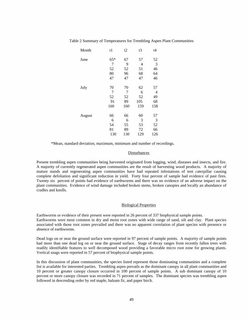
Table 2 Summary of Temperatures for Trembling Aspen Plant Communities
Month t1 t2 t3 t4 June 65* 67 57 52 7 9 4 3 52 52 51 46 80 96 68 64 47 47 47 46 July 70 70 62 57 7 7 6 4 52 52 52 49 91 89 105 68 160 160 159 158 August 66 66 60 57 6 6 3 3
54 55 53 52 81 89 72 66 130 130 129 126 *Mean, standard deviation, maximum, minimum and number of recordings.
Disturbances
Present trembling aspen communities being harvested originated from logging, wind, diseases and insects, and fire. A majority of currently regenerated aspen communities are the result of harvesting wood products. A majority of mature stands and regenerating aspen communities have had repeated infestations of tent caterpillar causing complete defoliation and significant reduction in yield. Forty four percent of sample had evidence of past fires. Twenty six percent of points had evidence of earthworms and there was no evidence of an adverse impact on the plant communities. Evidence of wind damage included broken stems, broken canopies and locally an abundance of cradles and knolls.
Biological Properties
Earthworms or evidence of their present were reported in 26 percent of 337 biophysical sample points. Earthworms were most common in dry and moist root zones with wide range of sand, silt and clay. Plant species associated with those root zones prevailed and there was no apparent correlation of plant species with presence or absence of earthworms.
Dead logs on or near the ground surface were reported in 97 percent of sample points. A majority of sample points had more than one dead log on or near the ground surface. Stage of decay ranges from recently fallen trees with readily identifiable features to well decomposed wood providing a favorable micro root zone for growing plants. Vertical snags were reported in 57 percent of biophysical sample points.
In this discussion of plant communities, the species listed represent those dominating communities and a complete list is available for interested parties. Trembling aspen prevails as the dominant canopy in all plant communities and 10 percent or greater canopy closure occurred in 100 percent of sample points. A sub dominant canopy of 10 percent or more canopy closure was recorded in 71 percent of samples. The dominant species was trembling aspen followed in descending order by red maple, balsam fir, and paper birch.
49
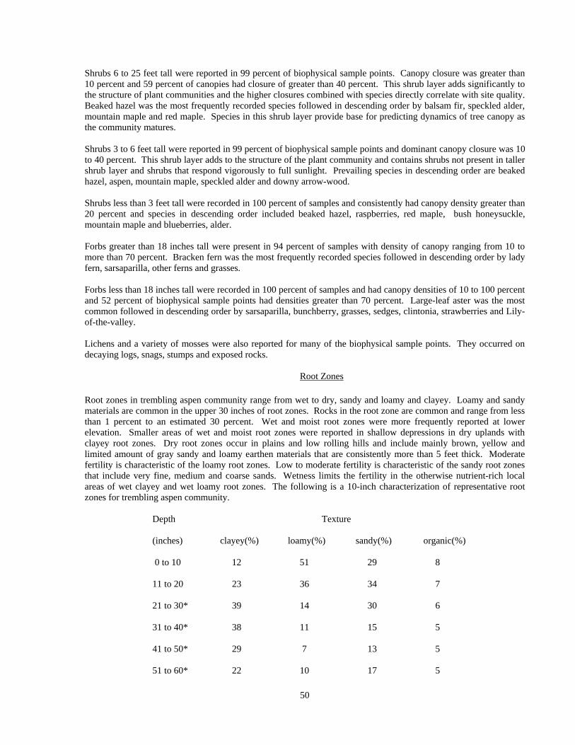
Shrubs 6 to 25 feet tall were reported in 99 percent of biophysical sample points. Canopy closure was greater than 10 percent and 59 percent of canopies had closure of greater than 40 percent. This shrub layer adds significantly to the structure of plant communities and the higher closures combined with species directly correlate with site quality. Beaked hazel was the most frequently recorded species followed in descending order by balsam fir, speckled alder, mountain maple and red maple. Species in this shrub layer provide base for predicting dynamics of tree canopy as the community matures.
Shrubs 3 to 6 feet tall were reported in 99 percent of biophysical sample points and dominant canopy closure was 10 to 40 percent. This shrub layer adds to the structure of the plant community and contains shrubs not present in taller shrub layer and shrubs that respond vigorously to full sunlight. Prevailing species in descending order are beaked hazel, aspen, mountain maple, speckled alder and downy arrow-wood. Shrubs less than 3 feet tall were recorded in 100 percent of samples and consistently had canopy density greater than 20 percent and species in descending order included beaked hazel, raspberries, red maple, bush honeysuckle, mountain maple and blueberries, alder. Forbs greater than 18 inches tall were present in 94 percent of samples with density of canopy ranging from 10 to more than 70 percent. Bracken fern was the most frequently recorded species followed in descending order by lady fern, sarsaparilla, other ferns and grasses. Forbs less than 18 inches tall were recorded in 100 percent of samples and had canopy densities of 10 to 100 percent and 52 percent of biophysical sample points had densities greater than 70 percent. Large-leaf aster was the most common followed in descending order by sarsaparilla, bunchberry, grasses, sedges, clintonia, strawberries and Lily-of-the-valley. Lichens and a variety of mosses were also reported for many of the biophysical sample points. They occurred on decaying logs, snags, stumps and exposed rocks.
Root Zones
Root zones in trembling aspen community range from wet to dry, sandy and loamy and clayey. Loamy and sandy materials are common in the upper 30 inches of root zones. Rocks in the root zone are common and range from less than 1 percent to an estimated 30 percent. Wet and moist root zones were more frequently reported at lower elevation. Smaller areas of wet and moist root zones were reported in shallow depressions in dry uplands with clayey root zones. Dry root zones occur in plains and low rolling hills and include mainly brown, yellow and limited amount of gray sandy and loamy earthen materials that are consistently more than 5 feet thick. Moderate fertility is characteristic of the loamy root zones. Low to moderate fertility is characteristic of the sandy root zones that include very fine, medium and coarse sands. Wetness limits the fertility in the otherwise nutrient-rich local areas of wet clayey and wet loamy root zones. The following is a 10-inch characterization of representative root zones for trembling aspen community. Depth Texture
(inches) clayey(%) loamy(%) sandy(%) organic(%) 0 to 10 12 51 29 8 11 to 20 23 36 34 7 21 to 30* 39 14 30 6 31 to 40* 38 11 15 5 41 to 50* 29 7 13 5 51 to 60* 22 10 17 5
50
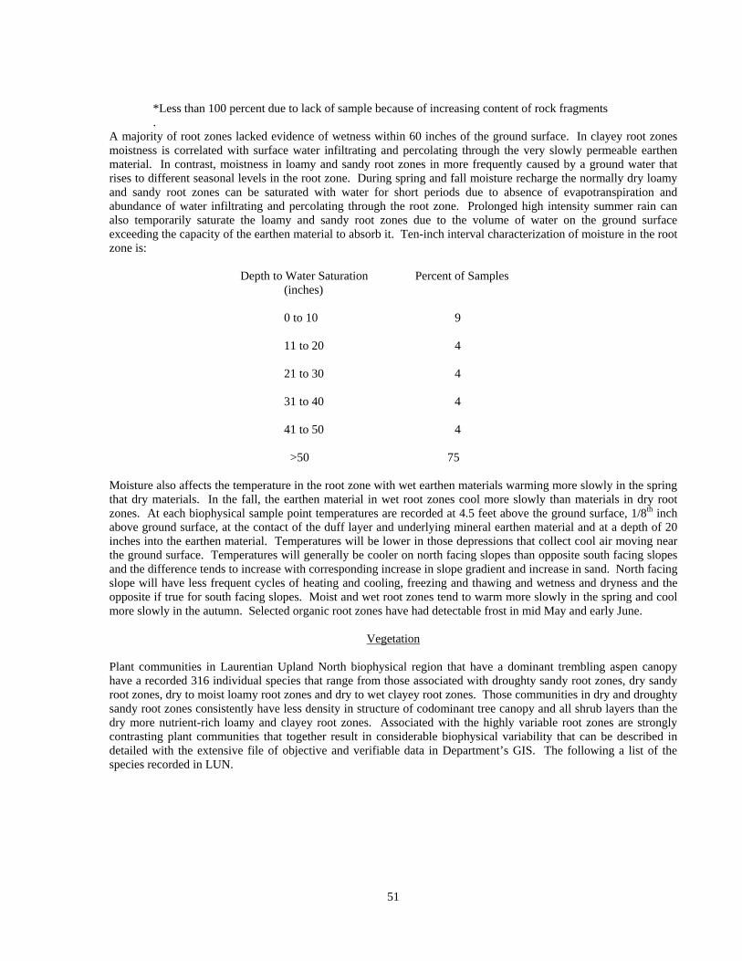
*Less than 100 percent due to lack of sample because of increasing content of rock fragments .
A majority of root zones lacked evidence of wetness within 60 inches of the ground surface. In clayey root zones moistness is correlated with surface water infiltrating and percolating through the very slowly permeable earthen material. In contrast, moistness in loamy and sandy root zones in more frequently caused by a ground water that rises to different seasonal levels in the root zone. During spring and fall moisture recharge the normally dry loamy and sandy root zones can be saturated with water for short periods due to absence of evapotranspiration and abundance of water infiltrating and percolating through the root zone. Prolonged high intensity summer rain can also temporarily saturate the loamy and sandy root zones due to the volume of water on the ground surface exceeding the capacity of the earthen material to absorb it. Ten-inch interval characterization of moisture in the root zone is:
Depth to Water Saturation Percent of Samples (inches) 0 to 10 9 11 to 20 4 21 to 30 4 31 to 40 4 41 to 50 4 >50 75
Moisture also affects the temperature in the root zone with wet earthen materials warming more slowly in the spring that dry materials. In the fall, the earthen material in wet root zones cool more slowly than materials in dry root zones. At each biophysical sample point temperatures are recorded at 4.5 feet above the ground surface, 1/8th inch above ground surface, at the contact of the duff layer and underlying mineral earthen material and at a depth of 20 inches into the earthen material. Temperatures will be lower in those depressions that collect cool air moving near the ground surface. Temperatures will generally be cooler on north facing slopes than opposite south facing slopes and the difference tends to increase with corresponding increase in slope gradient and increase in sand. North facing slope will have less frequent cycles of heating and cooling, freezing and thawing and wetness and dryness and the opposite if true for south facing slopes. Moist and wet root zones tend to warm more slowly in the spring and cool more slowly in the autumn. Selected organic root zones have had detectable frost in mid May and early June.
Vegetation Plant communities in Laurentian Upland North biophysical region that have a dominant trembling aspen canopy have a recorded 316 individual species that range from those associated with droughty sandy root zones, dry sandy root zones, dry to moist loamy root zones and dry to wet clayey root zones. Those communities in dry and droughty sandy root zones consistently have less density in structure of codominant tree canopy and all shrub layers than the dry more nutrient-rich loamy and clayey root zones. Associated with the highly variable root zones are strongly contrasting plant communities that together result in considerable biophysical variability that can be described in detailed with the extensive file of objective and verifiable data in Department’s GIS. The following a list of the species recorded in LUN.
51

LUN TREMBLING ASPEN PLANT LIST TYPE USDA SCIENTIFIC COMMON M N H L CODE NAME NAME 1 ABBA ABIES BALSAMEA BALSAM FIR 4 2 1 2 5 ACAT2 ACIRPUS ATROVIRENS LEAFY BULRUSH 4 2 4 3 4 ACPA ACTAEA PACHYPODA WHITE BANEBERRY 3 4 2 1 1 ACRU ACER RUBRUM RED MAPLE 2 2 3 3 4 ACRU2 ACTAEA RUBRA RED BANEBERRY 3 3 2 1 1 ACSA3 ACER SACCHARUM SUGAR MAPLE 3 5 3 1 2 ACSP2 ACER SPICATUM MOUNTAIN MAPLE 3 2 2 1 4 AGGR2 AGRIMONIA LARGE LEAVED GRYPOSEPALA AGRIMONY 2 3 4 2 4 AGRO3 AGRIMONIA ROSTELLATA BEAKED AGRIMONY 2 2 5 4 4 AGSC AGASTACHE SCRO- PURPLE GIANT PHYLARIAEFOLIA HYSSOP 3 5 4 3 4 AGST AGRIMONIA STRIATA COMMON AGRIMONY 2 2 3 3 2 ALCR6 ALNUS CRISPA GREEN ALDER 2 1 1 4 2 ALRU3 ALNUS RUGOSA SPECKLED ALDER 5 2 1 4 2 AMAL2 AMELANCHIER ALNIFOLIA SASKATOON 2 3 2 4 4 AMBR4 AMPHICARPA BRAC- TEATA COMMON HOG PEANUT 3 2 4 3 2 AMELA AMELANCHIER SPP SERVICEBERRY 3 2 2 4 2 AMHU AMELA NCHIER COMMON HUMILIS JUNEBERRY 2 3 3 3 2 AMINC AMELANCHIER COMPLEX INTERMEDIA JUNEBERRY 2 AMLA AMELANCHIER SMOOTH LAEVIS JUNEBERRY 3 3 4 3 2 AMSAC AMELANCHIER SANGUINEA COMPLEX JUNEBERRY 4 AMSPC AMELANCHIER SPICATA COMPLEX JUNEBERRY 4 ANCA ANTENNARIA CAN- CANADA ADENSIS PUSSY TOES 1 1 2 5 4 ANCA8 ANEMONE CAN- ADENSIS CANADA ANEMONE 3 2 2 4 4 ANMA ANYAPHALIS MARGARIT- ACEA PEARLY EVERLASTING 1 2 2 5 4 ANQU ANEMONE QUINQUEFOLIA WOOD ANEMONE 4 3 3 4 4 APAN2 APOCYNUM ANDROSAE- SPREADING MIFOLIUM DOGBANE 1 2 3 5 4 APCA APOCYNUM CANNABINUM INDIAN HEMP 2 2 3 4 4 AQCA AQUILEGIA CANADENSIS SCARLET COLUMBINE 1 3 3 4 4 ARIAT ARISAEMA ATRORUBENS JACK IN THE PULPIT 3 5 4 1 4 ARNU2 ARALIA NUDICAULIS WILD SARSAPARILLA 2 2 2 3 4 ARRA ARALIA RACEMOSA SPIKENARD 3 5 4 1
52

4 ARTR ARISAEMA TRIPHYLLUM SMALL JACK IN THE PULPIT 4 5 3 2 4 ASCA ASARUM CANADENSE WILD GINGER 4 5 3 1 4 ASCO4 ASTER CORDIFOLIUS COMMON BLUE HEART LEAVED ASTER ASTER 1 2 3 5 4 ASLA6 ASTER LATERIFLORUS NECKLACE ASTER 2 2 3 4 4 ASLO9 ASTER LOWRIENUS LOWRY'S ASTER 4 ASMA2 ASTER MACROPHYLLUS LARGE LEAF ASTER 2 2 2 3 4 ASNO ASTER NOVAE ANGLIAE NEW ENGLAND ASTER3 2 3 4 4 ASPR2 ASTER PREALTUS WILLOWLEAF ASTER 4 ASPR4 ASTER PRENANTHOIDES CROOKED STEM ASTER 4 ASPU5 ASTER PUNICEUS SWAMP BLUE ASTER 4 2 2 4 4 ASSA ASTER SAGITTIFOLIUS ARROW LEAVED ASTER 2 2 2 4 4 ASSI2 ASTER SIMPLEX WHITE PANICLED ASTER 3 2 3 4 4 ASTER ASTER SPP ASTER UNKNOWN SPECIES 4 ASUM ASTER UMBELLATUS FLAT TOP WHITE ASTER 2 2 3 4 4 ASVI ASCLEPIAS VIRIDIFLORA GREEN MILKWEED 1 2 3 5 8 ATFI ATHYRIUM FILIX-FEMINA LADY FERN 3 3 2 1 8 ATTH ATHYRIUM THELYPTERI- SILVERY GLADE OIDES FERN 3 5 4 2 1 BEPA BETULA PAPYRIFERA PAPER BIRCH 3 2 2 5 8 BOVI BOTRYCHIUM VIRGINIANUM RATTLESNAKE FERN 4 4 3 1 4 CAPA5 CALTHA PALUSTRIS MARSH MARIGOLD 5 2 2 4 5 CAPE6 CAREX PENSYLVANICA PENNSYLVANIA SEDGE 1 2 3 4 5 CAREX CAREX SPP UNKNOWN SEDGE 4 CARO2 CAMPANULA ROTUNDIFOLIA HAREBELL 2 2 3 4 4 CATH2 CAULOPHYLLUM THALIC- TROIDES BLUE COHOSH 3 5 4 1 4 CHAL7 CHENOPODIUM ALBUM LAMBS QUARTERS 2 3 4 5 3 CHUM CHIMAPHILA UMBELLATA PIPSISSEWA 1 1 2 4 4 CIAL CIRCAEA ALPINA NORTHERN ENCHAN- TERS NIGHTSHADE 4 3 2 1 4 CIAL2 CIRSIUM ALTISSIMUM TALL THISTLE 3 1 4 4 4 CIAR4 CIRSIUM ARVENSE CANADA THISTLE 2 2 3 5 4 CIMA2 CICUTA MACULATA SPOTTED WATER HEMLOCK 4 2 3 4 4 CIMU CIRSIUM MUTICUM SWAMP THISTLE 4 3 3 2 4 CIQU CIRCAEA QUADRISULCATA ENCHANTERS NIGHTSHADE 4 5 4 1 4 CIVU CIRSIUM VULGARE BULL THISTLE 4 CLBO3 CLINTONIA BOREALIS CLINTON LILY 3 2 1 2 7 CLVI5 CLEMATIS VIRGINIANA VIRGINS BOWER 3 3 4 3 2 COAL2 CORNUS ALTERNIFOLIA ALTERNATE LEAVED DOGWOOD 2 5 4 1 2 COAM3 CORYLUS AMERICANA AMERICAN HAZEL 1 2 3 5 4 COAR4 CONVOLVULUS ARVENSIS FIELD BINDWEED 2 2 2 5 4 COCA13 CORNUS CANADENSIS BUNCHBERRY 3 2 1 2 2 COCO6 CORYLUS CORNUTA BEAKED HAZEL 2 1 2 3 4 COGR COPTIS GROENLANDICA GOLDTHREAD 4 2 1 1
53

3 COMPE COMPTONIA PEREGRINA SWEET FERN 1 1 2 5 2 CORA6 CORNUS RACEMOSA PANICLED OR GRAY DOGWOOD 1 4 4 3 4 CORI COMANDRA RICHARDSIANA BASTARD TOADFLAS 2 3 3 4 2 CORU CORNUS RUGOSA ROUND LEAVED DOGWOOD 2 3 3 2 4 COSE14 CONVOLVULUS SEPIUM HEDGE BINDWEED 4 COSP2 CONVOLVULUS SPITHA- MAEUS UPRIGHT BINDWEED 1 2 3 4 2 COST4 CORNUS STOLONIFERA RED OSIER DOGWOOD 4 2 2 3 4 COTR3 CORALLORHIZA TRIFIDA EARLY CORAL ROOT 3 2 2 3 4 COUM COMANDRA UMBELLATA STAR TOADFLAX 1 1 3 4 2 CRATA CRATAEGUS SPP HAWTHORN or THORN APPLE 3 5 4 4 8 CYFR2 CYSTOPTERIS FRAGILIA COMMON BLADDER FERN 3 4 2 2 4 CYOF CYNOZLOSSUM OFFICINALE GYPSYFLOWER BORAGNACEAE 4 DACA6 DAUCUS CAROTUS WILD CARROT 2 3 4 5 4 DEGL5 DESMODIUM GLUTINOSUM POINT LEAVEDTICK TREFOIL 2 5 4 1 2 DILO DIERVILLA LONICERA BUSH HONEYSUCKLE 1 2 2 3 2 DIPA9 DIRCA PALUSTRIS LEATHERWOOD 3 5 4 1 8 DRCR4 DRYOPTERIS CRISTATA CRESTED SHIELD FERN 4 2 1 3 8 DRDI DRYOPTERIS DISJUNCTA OAK FERN 4 3 1 1 8 DRPH DRYOPTERIS PHEGOPTERIS BEACH FERN 4 3 1 1 8 DRSP4 DRYOPTERIS SPINULOSA COMMON SHIELD FERN 4 2 1 1 8 DRTH2 DRYOPTERIS THELYPTERIS MARSH SHIELDFERN 5 2 1 1 4 EPAN2 EPILOBIUM ANGUSTIFOLIUM FIREWEED 3 2 2 5 3 EPRE2 EPIGAEA REPENS TRAILING ARBUTUS 1 1 2 5 9 EQAR EQUISETUM ARVENSE FIELD HORSETAIL 4 2 1 1 9 EQFL EQUISETUM FLUVIATILE WATER HORSETAIL 5 2 2 5 9 EQHY EQUISETUM HYEMALE TALL SCOURING RUSH 2 2 1 5 9 EQPA EQUISETUM PALUSTRE MARSH HORSETAIL 4 2 1 5 9 EQPR EQUISETUM PRATENSE MEADOW HORSETAIL 1 2 2 5 5 EQSC EQUISETUM SCIRPOIDES DWARF SCOURING RUSH 4 2 1 2 9 EQSY EQUISETUM SYLVATICUM FOREST HORSETAIL 3 2 1 3 4 EUMA6 EUPATORIUM MACULATUM JOE PYE WEED 4 4 3 3 6 FMOSS FEATHER MOSS UNKNOWN SPECIES 1 FRNI FRAXINUS NIGRA BLACK ASH 4 3 3 2 1 FRPE FRAXINUS PENNSYLVANICA GREEN ASH 3 5 4 4 4 FRVE FRAGARIA VESCA var UPLAND AMERICAN STRAWBERRY 3 3 2 4 4 FRVI FRAGARIA VIRGINIANA MEADOW STRAWBERRY 2 2 2 4 4 GAAP2 GALIUM APARINE CLEAVERS 3 4 3 2 4 GAAS2 GALIUM ASPRELLUM ROUGH BEDSTRAW 5 3 2 1 4 GABO2 GALIUM BOREALE NORTHERN BED- STRAW 1 2 2 5 4 GABR6 GALIUM BREVIPES FERN LIMESTONE OR
54
SWAMP BEDSTRAW 4 GACO3 GALIUM CONCINNUM SHINING BEDSTRAW 2 3 4 2 4 GACO5 GAURA COCCINEA SCARLET GAURA 1 3 4 5 3 GAHI2 GAULTHERIA HISPIDULA CREEPING SNOW- BERRY 5 1 1 3 4 GALA GALIUM LANCEOLATUM LANCE-LEAVED WILD LICORICE 4 GAPA GALIUM PALUSTRE MARSH BEDSTRAW 3 GAPR2 GAULTHERIA PROCUMBENS WINTERGREEN 1 1 2 5 4 GATE2 GALEOPSIS TETRAHIT COMMON HEMP NETTLE 3 2 2 5 4 GATR3 GALIUM TRIFOLORUM SWEET BEDSTRAW 3 2 2 1 4 GEAL3 GEUM ALLEPICUM var. STRUCTUM COMMON AVENS 4 2 3 4 4 GELA GEUM LACINATUM ROUGH AVENS 4 GEMA GERANIUM MACULATUM WILD GERANIUM 3 3 4 3 4 GEMA4 GEUM MACROPHYLLUM LARGE LEAVED AVENS 3 3 2 3 4 GEPU GENTIANA PUBERULENTA PRAIRIE GENTIAN 2 4 4 4 4 GERI2 GEUM RIVALE PURPLE AVENS 4 2 2 3 5 GRASS POACEAE SPP GRASS UNKNOWN SPECIES 8 GYDR GYMNOCARPIUM DRYOP- TERIS OAK FERN 3 5 3 3 4 HADE2 HALENIA DEFLEXA SPURRED GENTIAN 3 3 1 2 REIN ORCHID 4 1 1 2 4 HEAM5 HEPATICA AMERICANA ROUND LOBED HEPATICA 1 3 3 2 4 HIAU HIERACIUM AURANTIACUM DEVILS PAINT BRUSH 3 3 3 5 4 HICA3 HIERACIUM CANADENSE CANADIAN HAWKWEED 1 2 3 4 4 HIFL3 HIERACIUM X FLORIBUNDUM GLAUCOUS HAWKWEED 4 HIPR HIERACIUM PRATENSE FIELD HAWKWEED 4 HISC HIERACIUM SCABRUM ROUGH HAWKWEED 1 2 2 5 4 HOPU2 HOUSTONIA PURPUREA none 4 IMCA IMPATIENS CAPENSIS SPOTTED JEWELWEED 4 5 4 1 4 IRVE2 IRIS VERSICOLOR WILD IRIS 5 2 2 5 4 ISBI ISOPYRUM BITERNATUM FALSE RUE ANAMONE 4 5 5 3 4 LAAL LAMIUM ALBUM L. WHITE DEADNETTLE 4 LABI LACTUCA BIENNIS TALL WILD LETTUCE 3 3 2 4 4 LACA LACTUCA CANADENSIS COMMON WILD LETTUCE 2 3 3 4 4 LAOC2 LATHYRUS OCHROLEUCUS WHITE PEAVINE 1 2 3 5 1 LALA LARIX LARICINA TAMARACK 5 1 1 5 4 LAPA4 LATHYRUS PALUSTRIS SWAMP SWEET PEA 4 2 2 3 4 LAPAL LATHYRUS PALUSTRIS MARSH VETCHLING 4 LAPR LATHYRUS PRATENSIS MEADOW PEA 4 LAPUX LAMIUM PURPUREUM RED DEAD NETTLE 4 LASC LACTUCA SCARIOLA PRICKLY LETTUCE 2 3 3 4 4 LASE LACTUCCA SERRIOLA PRICKLY LETTUCE 4 LAVE LATHYRUS VENOSUS WILD SWEET PEA 1 2 2 5 4 LECA2 LEONURUS CARDIACA MOTHERWORT 2 2 3 5 4 LECA5 LEPIDIUM CAMPESTRE L FIELD PEPPERWEED 4 LEDE LEPIDIUM DENSIFLORUM COMMON
55

PEPPERWORT 2 3 3 5 3 LEGR LEDUM GROENLANDICUM LABRADOR TEA 5 1 1 5 4 LEIN LECHEA INTERMEDIA COMMON PINWEED 1 1 3 5 4 LELI MELAMPYRUM LINEARE COW WHEAT 1 1 3 5 4 LEMI3 LEMA MINOR DUCKWEED 4 LETE LECHEA TENUIFOLIA NARROWLEAF PINWEED 4 LEVI3 LEPIDUM VIRGINICUM PEPPERWEED 4 LIAS LIATRIS ASPERA ROUGHT BLAZING STAR 1 2 4 5 4 LIAU2 LISTERA AURICULATA AURICLED TWAYBLADE 4 4 1 5 4 LIBO3 LINNAEA BOREALIS TWIN FLOWER 3 2 1 3 4 LICA12 LITHOSPERMUM CANESCENS HOARY PUCCOON 1 2 4 5 4 LICAU LILIUM CANADENSE CANADA LILY 6 LICHEN LICHEN SPP LICHEN UNKNOWN SPECIES 4 LICO6 LISTERA CORDATA HEART LEAF TWAYBLADE 4 2 1 2 4 LICR LITHOSPERMUM CAROLI- NIENSE var. CROCE PLAINS PUCCOON 1 2 4 5 4 LIIN2 LITHOSPERMUM INCISUM NARROW-LEAVED PUCCOON 1 2 5 5 4 LILI LIATRIS LIGULISTYLIS LGE HEADED BUTTON SNAKE ROOT 3 2 5 5 4 LILIU LILLIUM L LILY 4 LILO LIPARIS LOESELII SHINNY TWAYBLADE 5 2 2 3 4 LIMI LILIUM MICHIGANENSE MEADOW LILY 4 3 3 4 4 LIPH LILIUM PHILADELPHICUM PLAINS or PRAIRE LILY "Wood Lily" 2 3 3 4 4 LIPU LIATRIS PUNCTATA PRAIRIE BLAZING STAR 1 2 5 5 4 LISC2 LIATRIS SCARIOSA NORTHERN BLAZING STAR 1 2 5 4 4 LISQ LIATRIS SQUARROSA SCALY BLAZING STAR 1 2 4 4 4 LISU LILIUM SUPERBUM TURKSCAP LILY 4 LISU4 LINUM SULCATUM WILD YELLOW FLAX 1 4 4 4 9 LIVER LIVERWORTS LIVERWORTS 4 LIVU2 LINARIA VULGARIS BUTTER AND EGGS 1 2 3 5 2 LOCA7 LONICERA CANADENSIS AMERICAN FLYHONEYSUCKLE 3 2 2 1 4 LOCO6 LOTUS CORNICULATUS L BIRDFOOT DEERVETCH 2 LODI2 LONICERA DIOICA LIMBER HONEYSUCKLE 1 2 3 5 3 LOGL6 LONICERA DIOICA GLAUCOUS var. GLAUCESCENS HONEYSUCKLE 2 LOHI LONICERA HIRSUTA HAIRY HONEYSUCKLE 3 2 2 3 4 LOIN LOBELIA INFLATA INDIAN TOBACCO 3 4 4 3 2 LONIC LONICERA SPP L. HONEYSUCKLE 2 LOOB LONICERA OBLONGIFOLIA SWAMP FLY HONEYSUCKLE 4 2 2 3 4 LOSP LOBELIA SPICATA SPIKE LOBELIA 1 2 3 5
56

3 LOTA LONICERA TATARICA TARTARIAN HONEYSUCKLE 2 LOVI LONICERA VILLOSA MOUNTAIN FLY HONEYSUCKLE 4 2 2 5 4 LUAC LUZULA ACUMINATA COMMON WOODRUSH 2 2 2 4 4 LUDWI LUDWIGIA SEEDBOX 4 LUPE3 LUPINUS PERENNIS WILD LUPINE 3 3 4 3 4 LYAL LYCHNIS ALBA WHITE CAMPION 3 3 4 2 4 LYAM LYCOPUS AMERICANUS WATER HOREHOUND 4 2 4 5 4 LYAMP LYCOPUS AMPLECTENS SESSILE-LEAVED WATER HOREHOUND 9 LYAN2 LYCOPODIUM ANNOTINUM STIFF CLUBMOSS 4 2 1 1 4 LYCI LYSIMACHIA CILIATA FRINGED LOOSESTRIFE 3 3 2 4 9 LYCL LYCOPODIUM CLAVATUM RUNNING CLUBMOSS 3 1 2 1 9 LYCO3 LYCOPODIUM COMPLANA- FLAT-STEM TUM GROUNDPINE 2 2 2 3 9 LYCOP LYCOPODIUM SPP CLUBMOSS UNKNOWN SPECIES 4 LYHY LYSIMACHIA HYBRIDA LANCE-LEAVED LOOSESTRIFE 4 LYJU LYGODESMIA JUNCEA SKELETON-WEED 2 2 5 5 9 LYLU LYCOPODIUM LUCIDULUM SHINY CLUBMOSS 4 2 2 2 4 LYNU LYSIMACHIA NUMMU- LARIA L. CREEPING JENNY 9 LYOB LYCOPODIUM OBSCURUM GROUND PINE 2 3 1 2 4 LYQU2 LYSIMACHIA QUADRIFOLIA WHORLED LOOSESTRIFE 2 2 4 4 9 LYSE LYCOPODIUM SELAGO FIR CLUBMOSS 3 1 1 5 4 LYSI20 LYSIMACHIA SPP LOOSESTRIFE UNKNOWN SPECIES 8 LYSY LYCOPODIUM SYLVANICA CLUBMOSS 4 LYTE2 LYSIMACHIA TERRESTRIS SWAMP LOOSESTRIFE 4 2 2 4 4 LYTH2 LYSIMACHIA THYRIFLORA TUFTED LOOSESTRIFE 4 2 1 5 9 LYTR LYCOPODIUM TRISTACHYUM DEEP ROOT CLUBMOSS 4 LYUN LYCOPUS UNIFLORUS COMMON WATER HOREHOUND 4 3 3 2 4 MACA4 MAIANTHEMUM LILY OF THE VALLEY 1 2 2 4 4 MAMA11 MATRICARIA MATRICIOIDES PINEAPPLE-WEED 8 MAST MATTEUCCIA STRUTHI- OPTERIS var. PENSY OSTRICH FERN 3 5 4 1 4 MAUN MALAXIS UNIFOLIA GREEN ADDERS MOUTH 3 3 3 4 4 MEAL2 MELILOTUS ALBUS WHITE SWEET CLOVER 4 MEAR4 MENTHA ARVENSIS SWEET MINT 3 3 2 4 4 MEBE2 MEGALADONTA BECKII AQUATIC BEGGARTICK 7 MECA3 MENISPERMUM CANADENSE MOONSEED 3 5 5 3 4 MELI MELAMPYRYM LINEARE COW-WHEAT 4 MELI2 MELAMPYRUM LINEARE NARROWLEAF COWWHEAT 4 MELIA2 MELAMPYRUM LINEARE AMERICAN
57

VAR AMERICANUM COWWHEAT 4 MELU MEDICAGO LUPULINA BLACK MEDICK 4 MEOF MELILOTUS OFFICINALIS YELLOW SWEET CLOVER 2 3 3 5 4 MEPA MERTENSIA PANICULATA NORTHERN LUNGWORT 3 5 2 3 4 MEPI MENTHA PIPORITA PEPPERMINT 4 MESA MEDICAGO SATIVA ALFALFA 2 3 3 5 4 MESP3 MENTHA SPICATA L SPEARMINT 4 METR3 MENYANTHES TRIFOLIATA BUCKBEAN 5 2 1 4 4 MEVI MEDEOLA VIRGINIA INDIAN CUCUMBERROOT 4 MEVI3 MERTENSIA VIRGINICA VIRGINIA BLUEBELLS 4 MIDI3 MITELLA DIPHYLLA BISHOPS CAP OR MITERWORT 3 4 3 2 5 MIEF MILIUM EFFUSUM TALL MILLET GRASS 3 5 3 2 4 MINU3 MITELLA NUDA NAKED MITERWORT 4 2 1 1 4 MINY MIRABILIS NYCTAGINEA HEART LEAVED UMBRELLAWORT 3 5 5 5 4 MIRE MITCHELLA REPENS PARTRIDGEBERRY 2 3 3 3 4 MIRI MIMULUS RINGENS COMMON MONKEY FLOWER 4 2 3 5 4 MOFI MONARDA FISTULOSA WILD BERGAMDT 1 2 3 3 4 MOHY3 MONOTROPA HYPOPITHYS INDIANPIPE 4 MOUN2 MONESES UNIFLORA ONE FLOWERED PYROLA 4 2 2 5 4 MOUN3 MONOTROPA UNIFLORA INDIAN PIPE 2 3 1 2 4 MOVE MOLLUGO VERTICILLATA GREEN CARPET WEED 5 MUFR2 MUHLENBERGIA FRONDOSA WIRESTEM MUHLY 3 4 4 4 5 MUGL3 MUHLENBERGIA GLOMERATA MARSH MUHLY 4 2 4 5 3 MYGA MYRICA GALE SWEET GALE BAYBERRY 5 2 1 5 4 NECA2 NEPETA CATARIA CATNIP 2 2 3 5 4 NEMU2 NEMOPONTHES MUCRONATUS CAT BERRY 4 NYOD NYMPHAEA ODORATA AMERICAN WHITE WATERLILY 4 OEBI OENOTHERA BIENNIS COMMON EVENING PRIMROSE 2 3 4 5 4 OESE OENOTHERA SERRULATA PRAIRIE EVENING PRIMROSE 2 2 4 5 4 ONHI ONOSMODIUM SHAGGY FALSE HISPIDISSIMUM CROMWELL 1 3 4 5 8 ONSE ONOCLEA SENSIBILIS SENSITIVE FERN 4 4 3 3 4 OPHO OPLOPANAX HORRIDUS DEVILS CLUB 3 2 3 3 3 OPHU OPUNTIA HUMIFUSA PRICKLY PEAR 1 3 5 5 5 ORAS ORYZOPSIS ASPERIFOLIA ROUGHLEAF RICEGRASS 5 ORPU4 ORYSOPSIS PUNGENS SLENDER MOUNTAIN RICE GRASS 3 2 2 4 4 ORRO ORCHIS ROTUNDISFOLIA SMALL ROUND LEAVED ORCHIS 4 4 1 4 8 OSCI OSMUNDA CINNAMOMEA CINNAMON FERN 4 2 1 1 4 OSCL OSMORHIZA CLAYTONI SWEET CICELY 3 5 3 1
58
8 OSCL2 OSMUNDA CLAYTONIANA INTERRUPTED FERN 2 5 5 2 4 OSLO OSMORHIZA LONGISTYLIS OSLO ANISEROOT 3 5 4 1 8 OSRE OSMUNDA REGALIS ROYAL FERN 5 3 3 2 1 OSVI OSTRYA VIRGINIANA EASTERN HOPHORNBEAM 2 5 4 1 4 OXACM OXALIS ACETASELLA SSP NORTHERN WOOD-SORREL 4 OXALI OXALIS SPP WOOD SORREL UNKNOWN SPECIES 4 OXGR OXALIS GRANDIS GREAT WOOD SOREL 4 OXLA OXYTROPIS LAMBERTII PURPLE LOCO-WEED 1 3 4 5 4 OXRI OXYPOLIS RIGIDIOR STIFF COWBANE 4 OXST OXALIS STRICTA COMMON YELLOW WOOD SORREL 4 OXVI OXALIS VIOLACEA VIOLET WOOD SORREL 2 3 5 3 5 PABO PANICUM BOREALE NORTHERN PANIC GRASS 3 3 2 4 9 PACA11 PARONYCHIA CANADENSIS SMOOTH FORKED NAILWORT 5 PACA6 PANICUM CAPILLARE WITCHGRASS 2 2 2 5 5 PALAF2 PANICUM LANUGINOSUM COMMON VAR FASCICULATU PANIC GRASS 2 2 2 5 5 PALE PANICUM LEIBERGII LEIBERS PANIC GRASS 2 3 4 4 4 PAPA8 PARNASSIA PALUSTRIS GRASS OF PARNASSUS 4 2 1 5 4 PAQU PANAX QUINQUEFOLIUS GINSENG 3 4 4 2 7 PAQU2 PARTHENOCISSUS QUINQUEFOLIA VIRGINIA CREEPER 3 3 4 3 4 PASA2 PASTINACA SATIVA L. WILD PARSNIP 5 PAVI2 PANICUM VIRGATUM SWITCHGRASS 2 3 4 5 5 PAXA2 PANICUM XANTHOPHYSUM BLADDER PANIC GRASS 1 2 2 4 6 PEAPX PELTIGERA APTHOSA SPOTTED DOG LICHEN 4 PECA PEDICULARIS CANADENSIS WOOD BETONY OR LOUSEWORT 1 1 3 5 4 PECA11 PETALOSTEMUM WAITE PRAIRIE CANDIDUM CLOVER 2 3 4 4 4 PEGR5 PENSTEMON GRACILIS SLENDER BEARD TONGUE 2 3 2 4 4 PEGR7 PENSTEMON GRANDIFLORUS GREATFLOWERED BEARD TONGUE 2 3 4 5 4 PEPA31 PETASITES PALMATUS EARLY SWEET COLTSFOOT 4 2 1 3 4 PEPU6 PETALOSTEMUM PURPLE PRAIRIE PURPUREUM CLOVER 1 3 4 5 4 PESA5 PETASITES SAGITTATUS ARROW LEAVED COLTSFOOT 4 2 2 4 4 PEVI PETASITES VITIFOLIUS GRAPE LEAVED COLTSFOOT 4 3 2 2 4 PEVI5 PETALOSTEMUM VILLOSUM DOWNY PRAIRIE CLOVER 2 2 4 5 5 PHAR3 PHALARIS ARUNDINACEA REED CANARY GRASS 3 3 3 5 5 PHCO15 PHRAGMITES COMMUNIS var. BERLANDIERI REED GRASS 5 3 4 5
59
4 PHLE5 PHRYMA LEPTOSTACHYA LOPSEED 3 5 5 3 2 PHOP PHYSOCARPUS OPULIFOLIUS NINEBARK 3 3 3 2 4 PHPI PHLOX PILOSA DOWNY PHLOX 1 3 5 4 5 PHPR3 PHALEUM PRATENSE none 2 3 3 5 4 PHVI PHYSALIS VIRGINIANA VIRGINIA GROUND CHERRY 2 4 5 5 1 PIBA2 PINUS BANKSIANA JACK PINE 1 1 2 5 4 PIFO PILEA FONTAN A BLACK FRUITED CLEARWEED 4 2 3 5 1 PIGL PICEA GLAUCA WHITE SPRUCE 3 2 1 2 1 PIMA PICEA MARIANA BLACK SPRUCE 4 1 1 3 1 PIRE PINUS RESINOSA RED PINE 1 2 2 4 1 PIST PINUS STROBUS EASTERN WHITE PINE 2 2 2 3 1 PISY PINUS SYLVESTRIS L SCOTCH PINE 4 PLHY2 PLATANTHERA NORTHERN GREEN HYPERBOREA L ORCHID 4 PLMA2 PLANTAGO MAJOR COMMON PLANTAIN 2 3 3 5 4 POAM5 POTAMOGETON LARGELEAF AMPLIFOLIUS PONDWEED 4 POAM8 POLYGONUM AMPHIBIUM WATER SMARTWEED 5 2 3 5 4 POAR7 POTENTILLA ARGUTA TAIL CINQUEFOIL 2 2 3 5 4 POAR8 POTENTILLA ARGENTEA L SILVER CINQUEFOIL 4 POARP POLYGONUM ARIFOLIUM HALBERD-LEAVED var. PUBESCENS TEARTHUMB 4 3 3 5 1 POBA2 POPULUS BALSAMIFERA BALSAM POPLAR 4 3 2 3 4 POBI2 POLYGONATUM BIFLORUM SMOOTH SOLOMONS SEAL 3 5 4 2 4 POCA POLYGONATUM GREAT SOLOMONS CANALICULATUM SEAL 2 5 5 5 4 POCA17 POTENTILLA CANADENSIS DWARF CINQUEFOIL 2 2 3 5 7 POCI POLYGONUM CILINODE FRINGED BINDWEED 2 3 3 3 5 POCO POA COMPRESSA CANADIAN BLUEGRASS 2 2 3 4 4 POCO10 POLYGONUM CONVOLVULUS BLACK BINDWEED 2 3 3 5 4 POCO8 POLYGONUM COCCINEUM SWAMP SMARTWEED 4 POCOC5 POLYTRICHUM COMMUNE POLYTRICHUM MOSS 1 PODE3 POPULUS DELTOIDES EASTERN COTTONWOOD 3 5 5 4 4 POER2 POLYGONUM ERECTUM L ERECT KNOTWEED 4 POFR4 POTENTILLA FRUTICOSA SHRUBBY CINQUEFOIL 4 2 2 5 4 POFRT POTENTILLA FRUTICOSA SHRUBBY var. TENUIFOLIA FIVE-FINGERS 2 2 2 5 1 POGR4 POPULUS GRANDIDENTATA BIGTOOTH ASPEN 1 3 3 3 4 POHY2 POLYGONUM MILD WATER HYDROPIPEROIDES PEPPER 5 2 3 5 4 POLA4 POLYGONUM CURLYTOP LAPATHIFOLIUM KNOTWEED 4 POLY POLYGONUM SPP KNOTWEED 4 PONO3 POTENTILLA NORVEGICA ROUGH CINQUEFOIL 2 3 2 4 4 POOL PORTULACA OLERACEA L LITTLE HOGWEED 4 POOP POGONIA OPHIOGLOSSOIDES ROSE POGONIA 4 2 3 5 4 POPA14 POTENTILLA PALUSTRIS MARSH CINQUEFOIL 5 1 1 5 5 POPA2 POA PALUSTRIS FOWL BLUEGRASS 3 3 3 4
60

4 POPA5 POLYGALA PAUCIFOLIA FRINGED MILKWORT 3 3 3 3 4 POPE PODOPHYLLUM PELTATUM MAYAPPLE OR MANDRAKE 3 5 5 1 4 POPE2 POLYGONUM PENSYLVANICUM PINK KNOTWEED 3 3 4 2 4 POPO POLYGALA POLYGAMA RACEMED MILKWORT 5 POPR POA PRATENSIS KENTUCKY BLUEGRASS 3 3 2 4 4 POPU4 POLYGONATUM PUBESCENS HAIRY SOLOMONS SEAL 3 5 4 2 4 PORE5 POTENTILLA RECTA ROUGH FRUITED CINQUEFOIL 2 3 3 4 4 POSA5 POLYGONUM SAGITTATUM ARROW LEAVED TEARTHUMB 4 2 3 5 7 POSC3 POLYGONUM SCANDENS CLIMBING FALSE BUCKWHEAT 3 2 4 3 4 POSE POLYGALA SENEGA SENECO SNAKEROOT 2 3 4 3 4 POSI11 POTENTILLA SIMPLEX OLD FIELD CINQUEFOIL 1 POTR5 POPULUS TREMULOIDES QUAKING ASPEN 2 2 2 4 4 POTR7 POTENTILLA TRIDENTATA THREE TOOTHED CINQUEFOIL 2 2 1 5 8 POVI7 POLYPODIUM VIRGINIANUM POLYPODY FERN 2 1 1 3 4 POVU3 POLYPODIUM VULGARE POLYPODIUM AUCT. VIRGINIANUM 4 PRAL PRENANTHES ALBA WHITE LETTUCE 2 3 1 3 4 PRAL3 PRENANTHES ALTISSIMA TAIL WHITE LETTUCE 4 3 4 2 2 PRAM PRUNUS AMERICANA WILD PLUM 2 3 4 3 1 PRNI PRUNUS NIGRA CANADA PLUM 3 4 4 3 2 PRPE2 PRUNUS PENSYLVANICA PIN or FIRE CHERRY 1 2 3 5 2 PRPU3 PRUNUS PUMILA SAND CHERRY 1 2 1 5 1 PRSE2 PRUNUS SEROTINA BLACK CHERRY 2 3 4 3 4 PRSE4 PRNANTHES SERPENTARIA LION'S FOOT 2 PRSU PRUNUS SUSQUEHANAE SAND CHERRY 2 1 3 5 2 PRVI PRUNUS VIRGINIANA CHOKECCHERRY 2 3 3 4 4 PRVU PRUNELLA VULGARIS SELF HEAL 2 3 4 3 4 PSAR2 PSORALEA ARGOPHYLLA SILVERY SCURF PEA 1 3 4 5 4 PSCU PSORALEA CUSPIDATA STRIGOSE PEA 1 4 4 5 4 PSES PSORALEA ESCULENTA SHAGGY PEA 1 4 5 4 8 PTAQ PTERIDIUM AQUILINUM COMMON BRACKEN 1 2 2 4 2 PTTR PTELEA TRIFOLIATA HOP TREE 3 3 4 3 2 PYAM PYRUS AMERICANA CRAB-APPLE 4 PYAS PYROLA ASARIFOLIA PINK PYROLA OR BOG WINTERGREEN 3 4 2 2 4 PYEL PYROLA ELLIPTICA SHINLEAF 2 2 3 3 4 PYMI PYROLA MINOR LESSER PYROLA 3 2 2 1 4 PYRO PYROLA ROTUNDIFOLIA ROUND LEAVED PYROLA 2 2 2 3 4 PYSE PYROLA SECUNDA ONE-SIDED PYROLA 2 2 2 3 4 PYTE PYCNANTHEMUM NARROW-LEAVED TENUIFOLIUM MOUNTAIN MINT 4 PYVI PYCNANTHEMUM VIRGIN VIRGINIANUM MOUNTAIN MINT 3 3 4 4 4 PYVI3 PYROLA VIRENS GREENISH FLOWERED PYROLA 2 3 2 3 1 QUAL QUERCUS ALBA WHITE OAK 2 5 5 2
61

1 QUMA2 QUERCUS MACROCARPA BUR OAK 1 3 4 3 1 QUMU QUERCUS MUEHLENBERGII CHINKOPIN OAK 1 QURU QUERCUS RUBRA NORTHERN RED OAK 1 4 3 3 4 RAAB RANUNCULUS ABORTIVUS LITTLELEAF BUTTERCUP 4 RAAC3 RANUNCULUS ACRIS TALL BUTTERCUP 3 3 3 5 4 RAAM RANUNCULUS AMBIGENS WATER-PLANTAIN SPEARWORT 4 RABU RANUNCULUS BULBOUS BULBOUS BUTTERCUP 4 RACO3 RATIBIDA COLUMNIFERA LONG HEAD PRAIRIE CONEFLOWER 2 3 4 5 4 RAFA RANUNCULUS FLABELLARIS THICK ROOTED BUTTERCUP 4 RAFA3 RANUNCULUS FLACATUS EARLY BUTTERCUP 4 RAFI RANUNCULUS FICARIA LESSER CELANDINE 4 RAFL RANUNCULUS FLABELLARIS YELLOW WATER BUTTERCUP 5 3 4 5 4 RAHI RANUNCULUS HISPIDUS HISPID BUTTERCUP 4 RANUN RANUNCULUS L. BUTTERCUP 4 RAPE RANUNCULUS PEDATIFIDUS none 2 4 2 4 4 RAPE2 RANUNCULUS PENSYLVANICUS BRISTLY CROWFOOT 4 2 3 5 4 RARE2 RANUNCULUS RECURVATUS HOOKED CROWFOOT 2 3 3 3 4 RARE3 RANUNCULUS REPENS CREEPING BUTTERCUP 3 3 3 5 4 RASC3 RANUNCLULUS CELERYLEAF SCELERATUS BUTTERCUP 4 RASE RANUNCULUS SEPTENTRIONALIS HISPID BUTTERCUP 4 RASEC RANUNCULUS SEPTENTRIONALIS SWAMP BUTTERCUP 2 RHAL RHAMNUS ALNIFOLIA ALDER LEAVED BUCKTHORN 5 1 2 4 5 RHAL3 RHYNCHOSPORA ALBA BEAK RUSH 4 2 3 5 2 RHCA6 RHODODENDRON CANADENSE RHODORA 3 2 1 5 2 RHGL RHUS GLABRA SMOOTH SUMAC 1 3 4 5 3 RHRA RHUS RADICANS POISON IVY 1 3 3 4 2 RHTY RHUS TYPHINA STAGHORN SUMAC 1 2 3 3 2 RHVE RHUS VERNIX POISON SUMAC 4 2 4 3 4 RHVI RHODODENDRON VICOSUM SWAMP AZALEA 2 RIAM2 RIBES AMERICANUM WILD BLACK CURRANT 3 5 3 2 2 RIBES RIBES SPP GOOSEBERRY UNKNOWN SPECIES 2 RICY RIBES CYNOSBATI PRICKLY GOOSEBERRY 3 4 4 2 2 RIGL RIBES GLANDULOSUM SKUNK CURRANT 4 2 1 2 2 RIHI RIBES HIRTELLUM SMOOTH GOOSEBERRY 4 2 2 3 2 RIHU RIBES HUDSONIANUM NORTHERN BLACK CURRENT 5 2 2 4 2 RILA RIBES LACUSTRE BRISTLY BLACK CURRENT 4 2 2 2 2 RIMI RIBES MISSOURIENSE MISSOURI GOOSEBERRY 2 3 4 3
62

2 RIOD RIBES ODORATUM GOLDEN CURRENT 3 3 4 4 2 RIOX RIBES OXYACANTHOIDES NORTHERN GOOSEBERRY 3 2 1 4 2 RITR RIBES TRISTE SWAMP RED CURRANT 4 3 1 2 2 ROAC ROSA ACICULARIS PRICKLY ROSE 1 2 3 5 2 ROAR3 ROSA ARKANSANA PRAIRIE ROSE 2 3 4 4 2 ROBL ROSA BLANDA SMOOTH ROSE 1 2 2 5 4 ROCA4 ROSA CAROLINA L PASTURE ROSE 4 RONA2 RORIPPA NASTURTIUM AQUATICUM WATERCRESS 4 RONI ROSA NITIDA SHINING ROSE 4 ROPA2 PORIPPA PALUSTRIS BOG YELLOW-CRESS 2 RORU ROSA RUGOSA RUGOSA ROSE 2 ROSA ROSA SPP ROSE UNKNOWN SPECIES 4 ROSY RORIPPA SYLVESTRIS CREEPING YELLOWCRESS 3 RUAC RUBUS ACAULIS ARCTIC RASPBERRY 4 2 1 2 4 RUAC3 RUMEX ACETOSELLA FIELD SORREL 2 2 3 5 3 RUAL RUBUS ALLEGHENIENSIS COMMON BLACKBERRY 3 2 2 5 4 RUCR RUMEX CRISPUS CURLED DUCK 2 3 3 5 3 RUFL RUBUS FLAGELLARIS DEWBERRY 1 3 4 4 3 RUHI RUBUS HISPIDUS SWAMP DEWBERRY 3 3 4 4 4 RUHI2 RUDBECKIA HIRTA none 3 3 4 4 3 RUID RUBUS IDAEUS WILD RED var. STRIGOSUS RASPBERRY 3 2 2 4 4 RULA3 RUDBECKIA LACINIATA WILD GOLDEN GLOW 4 5 4 3 3 RUOC RUBUS OCCIDENTALIS BLACK RASPBERRY 3 3 3 4 4 RUOR2 RUMEX ORBICULATUS GREAT WATER DOCK 4 2 2 4 3 RUPA RUBUS PARVIFLORUS THIMBLEBERRY 3 2 2 3 3 RUPU RUBUS PUBESCENS DWARF RASPBERRY 4 2 1 1 3 RUSE RUBUS SETOSUS BIGELOW BRISTLY BLACKBERRY 4 RUSE5 RUDBECKIA SEROTINA BROWN EYED SUSAN 2 2 3 5 5 RUVE3 RUMEX VERTICILLATUS SWAMP DOCK 2 SAAM2 SALIX AMYGDALOIDES PEACH LEAF WILLOW 4 2 3 4 2 SABE2 SALIX BEBBIANA BEAKED WILLOW 2 2 3 4 2 SACA12 SAMBUCUS CANADENSIS COMMON ELDER 2 5 4 1 4 SACA13 SANGUINARIA CANADENSIS BLOODROOT 2 3 4 1 4 SACA15 SANICULA CANADENSIS SHORT-STYLED SNAKEROOT 2 SACA4 SALIX CANDIDA SAGE WILLOW 5 2 1 4 4 SACU SAGITTARIA CUNEATA WEDGELEAF ARROWHEAD 5 4 4 5 2 SADI SALIX DISCOLOR PUSSY WILLOW 2 SAFR SALIX FRAGILIS CRACK WILLOW 3 2 3 4 2 SAGR SALIX GRACILIS SLENDER WILLOW 4 3 2 5 4 SAGR6 SANICULA GREGARIA CLUSTER SANICLE 2 SAHU2 SALIX HUMILIS PRAIRIE WILLOW 1 2 3 4 2 SAIN3 SALIX INTERIOR SANDBAR WILLOW 2 3 2 5 4 SALA SAGITTARIA LATIFOLIA COMMON ARROWHEAD 5 2 4 5 2 SALU SALIX LUCIDA SHINY WILLOW 4 2 2 5 4 SAMA2 SANICULA MARILANDICA BLACK SNAKEROOT 2 3 3 3
63
4 SAMI SAXIFRAGA MICRANTHIDIFOLIA LETTUCE SAXIFRAGE 2 SANI SALIX NIGRA BLACK WILLOW 4 5 4 4 2 SAPE2 SALIX PEDICELLARIS BOG WILLOW 5 1 1 5 2 SAPE4 SALIX PENTANDRA LAUREL WILLOW 4 SAPE8 SAXIFRAGA PENSYLVANICA SWAMP SAXIFRAGE 4 2 3 4 4 SAPU4 SARRACENIA PURPUREA PITCHER PLANT 5 2 1 5 2 SAPY SALIX PYRIFOLIA BALSAM WILLOW 4 2 1 2 2 SARAP SAMBUCUS PUBENS RED ELDER BERRY 3 5 3 3 2 SARI2 SALIX RIGIDA STIFF WILLOW 4 2 4 4 2 SASE2 SALIX SERISSIMA AUTUMN WILLOW 4 3 2 5 4 SAVU SATUREJA VULGARIS var. NEOGAEA WILD BASIL 2 2 3 4 5 SCAT2 SCIRPUS ATROVIRENS GREEN BULRUSH 5 SCAT4 SCIRPUS ATROCINCTUS WOOL GRASS 4 2 2 5 5 SCCY SCIRPUS CYPERINUS PELIUS FERN 4 2 4 5 4 SCEL SCUTELLARIA ELIPTICA ERECT SKULLCAP 4 SCEP SCUTELLARIA EPILOBIFOLIA MARSH SKULLCAP 3 3 3 3 5 SCFL SCIRPUS FLUVIATILIS RIVER BULRUSH 4 4 4 5 4 SCGA SCUTELLARIA GALERICULATA MARSH SKULL-CAP 5 SCHU SCIRPUS HUDSONIANUS ALPINE COTTON GRASS 5 2 1 5 4 SCIN SCUTELLARIA INCANA DOWNY SKULLCAP 4 SCLA SCROPHULARIA LANCEOLATA LANCELEAF FIGWORT 4 SCLA2 SCUTELLARIA MAD DOG LATERIFLORA SKULLCAP 4 3 3 4 5 SCNI3 SCLERIA NITIDA WHIPGRASS 4 SCPA2 SCHEUCHZERIA PALUSTRIS POD-GRASS 5 2 2 5 4 SCPAP3 SCUTELLARIA PARVULA SMALL SKULLCAP var. PARVULA 5 SCPU SCHIZACHNE PURPURASCENS FALSE MELIC 3 3 2 3 4 SCUTE SCUTELLARIA L SKULLCAP 5 SCVA SCIRPUS VALIDUS CREBER FERN 5 3 4 5 9 SEAP SELAGINELLA APODA SPRING SPIKEMOSS 4 SEAU2 SENECIO AUREUS GOLDEN RAGWORT 4 SECO2 SENECIO CONGESTUS var. PALUSTRIS MARSH RAGWORT 4 2 1 5 5 SEGL2 SETARIA GLAUCA YELLOW FOXTAIL 2 3 4 5 4 SENSPP SENECIA SPP RAGWORT 4 SEOB SENECIO OBVATUS RUNNING GROUNDSEL 4 SEPA5 SENECIO PAUPERCULUS NORTHERN RAGWORT 1 2 3 5 8 SERU SELAGINELLA RUPESTRIS COMMON SPIKEMOSS 1 1 4 4 4 SETE3 SEDUM TERNATUM WILD STONECROP 2 SHCA SHEPHERDIA CANADENSIS NORTHERN BUFFALO BERRY 2 4 2 4 4 SIAN SICYOS ANGULATUS ONE SEEDED BUR CUCUMBER 3 4 4 4 4 SIAN2 SILENE ANTRIRRHINA SLEEPY CATCHFLY 1 2 4 5 4 SIMU3 SISYRINCHIUM SLENDER BLUE MUCRONATUM EYED GRASS 3 3 3 4 4 SINO SILENE NOCTIFLORA NIGHT FLOWERING CATCHFLY 3 3 4 5 4 SISU2 SIUM SUAVE WATER PARSNIP 4 3 3 4
64

4 SMHE SMILAX HERBACEA CARRION FLOWER 2 5 4 2 4 SMLA3 SMILAX LASIONEURA DOWNY CARRION FLOWER 3 5 5 3 6 SMOSS SPHAGNUM SPP SPAGNUM 4 SMRA SMILACINA RACEMOSA FAISE SOLOMONS SEAL 3 5 4 1 4 SMRO SMILAX ROTUNDIFOLIA L ROUNDLEAF GREENBRIER 4 SMST SMILACINA STELLATA STAR FLOWERED SOLOMONS SEAL 2 5 4 3 4 SMTA2 SMILAX TAMNOIDES BRISTLY var. HISPIDA GREENBRIER 2 5 5 4 4 SMTR SMILACINA TRIFOLIA THREE LEAVED SOLOMONS SEAL 4 2 2 4 2 SOAM3 SORBUS AMERICANA AMERICAN MT ASH 4 2 1 1 4 SOAR2 SONCHUS ARVENSIS PERENNIAL SOW THISTLE 3 3 2 5 4 SOBIO SOLIDAGO BICOLOR SILVERROD 4 SOCA4 SOLIDAGO CAESIA BLUE STEMMED 3 4 5 3 4 SOCA6 SOLIDAGO CANADENSIS SMALL FLOWERED GOLDENROD 2 2 2 5 4 SOCAS5 SOLIDAGO CANADENSIS CANADA var. SCABRA GOLDENROD 4 SODE3 SORBUS DECORA NORTHERN MOUNTAIN ASH 4 SOFL2 SOLIDAGO FLEXICAULIS WIDE LEAVED GOLDENROD 3 5 3 1 4 SOGI SOLIDAGO GIGANTEA GREATER GOLDENROD 4 3 3 4 4 SOGR SOLIDAGO GRAMINIFOLIA GRASS LEAVED GOLDENROD 3 3 3 5 4 SOHI SOLIDAGO HISPIDA UPLAND GOLDENROD 2 2 3 4 4 SOJU SOLIDAGO JUNCEA SMOOTH GOLDENROD 1 2 2 4 4 SOJUJ SOLIDAGO JUNCEA EARLY GOLDENROD 4 SOMI2 SOLIDAGO MISSOURIENSIS PRAIRIE GOLDENROD 1 3 4 5 4 SONE SOLIDAGO NEMORALIS PASTURE GOLDENROD 1 2 3 5 4 SONEL SOLIDAGO NEMORALIS GREY var. LONGIPETIOLA GOLDENROD 5 SONU2 SORGHASTRUM NUTANS INDIAN GRASS 2 3 5 4 4 SOOL SONCHUS OLERACEUS COMMON SOWTHISTLE 4 SORI2 SOLIDAGO RIGIDA STIFF GOLDENROD 2 3 4 4 4 SORO SOLANUM ROSTRATUM BUFFALOBUR NIGHTSHADE 4 SORU2 SOLIDAGO RUGOSA ROUGH STEMMED GOLDENROD 3 3 3 3 4 SOSP2 SOLIDAGO SPECIOSA NUTT. SHOWY GOLDENROD 4 SOTE2 SOLIDAGO TENUIFOLIA SLENDER LEAVED GOLDENROD 2 3 4 5 4 SOUL SOLIDAGO ULIGINOSA SWAMP GOLDENROD 4 1 3 3 4 SOULU SOLIDAGO ULIGINOSA NORTHERN BOG GOLDENROD 2 SPAL2 SPIRAEA ALBA NARROW LEAVED MEADOWSWEET 4 3 3 3 2 SPALL SPIREA ALBA var.
65
LATIFOLIA WHITE MEADOWSWEET 4 SPAN3 SPARANIUM ANDROCLADUM BUR-REED 4 SPCE SPIRANTHES CERNUA RICH NODDING LADIESTRESSES 5 SPCR SPOROBOLUS CRYPTANDRUS SAND DROPWEED 1 2 5 4 4 SPEU SPARGANIUM EURYCARPUM LARGE FRUITED BUR REED 5 3 4 5 4 SPIRA2 SPIRANTHES SPP LADIES TRESSES 4 SPLA4 SPIRANTHES LACERA SLENDER LADIES TRESSES 2 2 3 4 5 SPPE SPARTINA PECTINATA CORDGRASS 4 3 4 5 4 SPRO SPIRANTHES CHAMHODDED ROMANZOFFIANA LADIESTRESSES 2 SPTO4 SPIRAEA TOMENTOSA STEEPLE BUSHOR HARDHACK 3 1 3 5 4 STAM2 STREPTOPUS TWISTED AMPLEXIFOLIUS STALK 2 3 3 1 4 STBOB STELLARIA BOREALIS SSP NORTHERN STITCHWORT 4 STCA STELLARIA CALYCANTHA NORTHERN CHICKWEED 4 2 1 3 5 STCO4 STIPA COMATA HAIRY PORCUPINE GRASS 1 3 4 5 4 STGR STELLARIA GRAMINEA LESSER SWITCHWORT 4 2 3 5 4 STHY31 STACHYS HYSSOPIFOLIA HYSSOP HEDGE NETTLE 4 STLO STELLARIA LONGIFOLIA LONG LEAVED SWITCHWORT 4 3 3 4 4 STME2 STELLARIA MEDIA L. COMMON CHICKWEED 4 STPA STACHYS PALUSTRIS MARSH HEDGE NETTLE 4 3 2 4 4 STRO4 STREPTOPUS ROSEUS ROSE TWISTEDSTALK 2 3 3 1 5 STSP2 STIPA SPARTEA TALL PORCUPINE GRASS 1 2 3 5 4 STTE STACYS TENUIFOLIA COMMON HEDGE NETTLE 3 4 5 4 4 STTR STAPHYLEA TRIFOLIA AMERICAN BLADDERNUT 3 5 4 4 2 SYAL SYMPHORICARPOS ALBUS SNOWBERRY 1 2 3 5 3 SYFO SYMPLOCARPUS FOETIDUS SKUNK CABBAGE 2 SYOC SYMPHORICARPOS OCCIDENTALIS PRAIRIE WOLFBERRY 2 4 5 5 4 SYOF SYMPHYTUM OFFICINALE L COMMON COMFREY 2 TACA7 TAXUS CANADENSIS NORTHERN YEW 4 3 2 1 4 TAOF TARAXACUM OFFICINALE COMMON DANDELION 2 2 3 5 4 TARA TARAXICUM SPP DANDYLION 4 TAVU TAXACETUM VULGARE COMMON TANSY 4 TECA3 TEUCRIUM CANADENSE AMERICAN GERMANDER 3 3 3 3 4 THBA THASPIUM BARBINODE HAIRY JOINTED MEADOW PARSNIP 3 4 3 3 4 THDA THALICTRUM DASYCARPUM PURPLE MEADOW RUE 4 3 3 4
66

4 THDI THALICTRUM DIOICUM EARLY MEADOW RUE 2 3 3 3 1 THOC2 THUJA OCCIDENTALIS NORTHERN WHITE CEDAR 4 2 1 1 4 THPA THELYPTERIS PALUSTERIS EASTERN MARSH FERN 4 THPAX THELYPTERIS PALUSTRIS MARSH FERN 8 THPH THELYPTERIS PHEGOPTERIS LONG BEACH FERN 4 THPO8 THALICTRUM POLYGAMUM TALL MEADOW RUE 1 TIAM TILIA AMERICANA AMERICAN BASSWOOD 2 5 4 1 4 TICO TIARELLA CORDIFOLIA FOAMFLOWER OR FALSE MITERWORT 3 4 2 2 4 TRAG TRIFOLIUM AGARIUM YELLOW CLOVER 2 3 3 5 4 TRAR4 TRIFOLIUM ARVENSE RABBITFOOT CLOVER 4 TRBO2 TRIENTALIS BOREALIS STARFLOWER 4 2 1 1 4 TRBR TRADESCANTIA BRACTEATA STICKY SPIDERWORT 2 3 4 5 4 TRCE TRILLIUM CERNUUM NODDING TRILLIUM 3 5 3 1 4 TRDU TRAGOPOGON DUBIUM GOATS BEARD 2 3 5 5 4 TRFR TRIADENUM FRASERI FRASEI'S MARSH ST. JOHNSWORT 4 TRGR4 TRILLIUM GRANDIFLORUM LARGE FLOWERED TRILLIUM 3 5 4 2 4 TRHY TRIFOLIUM HYBRIDUM ALSIKE CLOVER 2 3 3 5 4 TRLA TROLLIUS LAXUS SPREADING GLOBEFLOWER 4 TRMA4 TRIGLOCHIN MARITIMA GREATER ARROW GRASS 5 4 4 5 4 TROC TRADESCANTIA PRAIRIE OCCIDENTALIA SPIDERWORT 2 2 5 5 4 TRPE5 TRIOSTEUM PERFOLIATUM FEVERWORT 4 TRPR TRAGOPOGON PRATENSIS YELLOW GOATSBEARD 4 TRPR2 TRIFOLIUM PRATENSE RED CLOVER 2 3 3 5 4 TRRE3 TRIFOLIUM REPENS WHITE CLOVER 2 3 4 4 4 TRUN TRILLIUM UNDULATUM PAINTED TRILLIUM 1 TSCA TSUGA CANADENSIS EASTERN HEMLOCK 4 3 1 1 4 TUFA TUSSILAGO FARFARA COLTSFOOT 5 TYLA TYPHA LATIFOLIA COMMON CATTAIL 5 3 3 5 1 ULAM ULMUS AMERICANA AMERICAN ELM 3 5 4 2 4 URDI URTICA DIOICA L. STINGING NETTLE 4 5 5 1 4 URDIG URTICA DIOICA Sp. CALIFORNIA NETTLE 4 UVGR UVULARIA GRANDIFLORA LGE FLOWERED BELLWORT 2 5 4 1 4 URGR3 URTICA GRACILIS SLENDER NETTLE 4 URPR7 URTICA DIOCIA var. PROCERA STINGING NETTLES 4 UTIN2 UTRICULARIA INTERMEDIA FLATLEAF BLADDERWORT 4 UTVU UTRICULARIA VULGARIS COMMON BLADDERWORT 5 1 3 5 4 UVGR UVULARIA GRANDIFLORA LARGE FLOWERED BELLWORT 2 5 4 1 4 UVPE UVULARIA PERFOLIATES MERRYBELLS 4 UVPU UVULARIA PUDICA MOUNTAIN BELLWORT 2 4 3 1 4 UVSE UVULARIA SESSILIFOLIA SESSILE LEAVED BELWORT 2 4 3 1
67

3 VAAN VACCINIUM EARLY LOW ANGUSTIFOLIUM BLUEBERRY 1 1 1 5 3 VACE VACCINIUM CESPITOSUM DRAWF BLUEBERRY 3 VAMA VACCINIUM MACROCARPON CRANBERRY 3 VAMY VACCINIUM MYRTILLOIDES VELVETLEAF BLUEBERRY 2 1 1 4 3 VAOX VACCINIUM OXYCOCCOS SMALL CRANBERRY 5 1 1 5 3 VAUL VACCINIUM ULIGINOSUM BOG BLUEBERRY 3 VAVI VACCINIUM VITIS-IDEA var. MINUS MTN CRANBERRY 5 1 1 5 4 VEAM2 VERONICA AMERICANA AMERICAN BROOKLIME 5 3 3 5 4 VEAN2 VERONICA ANAGALLIS var. AQUATICA WATER SPEED-WELL 4 VEAR VERONICA ARVENSIS CORN SPEEDWELL 4 VEHA2 VERBENA HASTATA BLUE VERVAIN 3 3 4 5 4 VESC2 VERONICA SCUTELLATA L SKULLCAP SPEEDWELL 4 VETH VERBASCUM THAPSUS COMMON MULLEIN 2 3 3 4 4 VEVI4 VERONICASTRUM VIRGINICUM CULVERS ROOT 3 5 5 4 4 VIAD VIOLA ADUNCA SAND VIOLET 1 1 2 4 4 VIAF2 VIOLA AFFINES SAND VIOLET 4 VIAM VICIA AMERICANA AMERICAN VETCH 3 3 4 3 7 VIAN VICIA ANGUSTIFOLIUM NARROW LEAVED VETCH 4 VIBL VIOLA BLANDA SWEET WHITE VIOLET 4 4 4 4 4 VICA2 VICIA CARALINANA CARALINA VETCH 4 VICA4 VIOLA CANDENSIS CANADA VIOLET 3 3 3 2 4 VICAS VIBURNUM CASSINOIDES WILD RAISIN 4 VICO2 VIOLA CONSPERSA DOG VIOLET 3 5 4 1 4 VICR VICIA CRACCA COW VETCH 2 3 3 5 4 VICU5 VIOLA CUCULLATA BLUE MARSH VIOLET 2 VIED VIBURNUM EDULE SQUASHBERRY 3 2 2 3 4 VIFI VIOLA FIMBRIATULA OVATE LEAVED VIOLET 4 VIIN VIOLA INCOGNITA LGE LEAVED WHITE VIOLET 3 2 2 3 4 VILA4 VIOLA LANCEOLATA L. BOG WHITE VIOLET 2 VILE VIBURNUM LENTAGO NANNYBERRY 3 5 5 2 4 VIMA2 VIOLA MACLOSKEYI SMALL WHITE VIOLET 4 VIPA21 VIOLA PAPILIONACEA DOORYARD VIOLET 4 VIPA8 VIOLA PALLENS NORTHERN WHITE VIOLET 4 3 2 3 4 VIPE VIOLA PEDATA BIRDFOOT VIOLET 1 2 4 5 4 VIPRI2 VIOLA PRIMULIFOLIA PRIMROSE-LEAVED VIOLET 4 VIPU3 VIOLA PUBESCENS DOWNY YELLOW VIOLET 2 2 2 3 4 VIPUP2 VIOLA PUBESCENS SMOOTH YELLOW var. PUBESCENS VIOLET 2 VIRA VIBURNUM RAFINESQUIANUM DOWNY ARROWWOOD 2 3 3 3 4 VIRE2 VIOLA RENIFOLIA KIDNEY LEAVED VIOLET 3 3 2 2
68

7 VIRI VITIS RIPARIS RIVERBANK GRAPE 2 5 5 5 4 VIRO2 VIOLA ROTUNDIFOLIA ROUND LEAVED VIOLET 3 5 3 3 4 VIROS VIOLA ROSTRATA LONG-SPURRED VIOLET 4 VIRU3 VIOLA RUGULOSA PINK & WHITE VIOLET 4 2 2 1 3 VISA VICIA SATIVA COMMON VETCH 4 VISA2 VIOLA SAGITTATA ARROWLEAF VIOLET 4 VISA22 VICIA SATIVA COMMON VETCH 4 VISE2 VIOLA SELKIRKII GREAT SPURRED VIOLET 3 4 2 2 4 VISO VIOLA SORORIA WOOLLY BLUE VIOLET 3 3 3 2 4 VITE VICIA TETRASPERMA FOUR-SEED VETCH 4 VITR VIOLA TRICOLOR JOHNNY JUMPUP 2 VITR8 VIBURNUM TRILOBUM HIGHBUSH CRANBERRY 3 3 3 3 4 WAFR WALDSTEINIA BARREN FRAGARIOIDES STRAWBERRY 3 3 3 4 8 WOIL WOODSIA ILVENSIS RUSTY CLIFF FERN 1 1 2 1 2 XAAM XANTHOXYLUM NORTHERN PRICKLY AMERICANUM ASH 2 5 5 1 4 ZIAP ZIZIA APTERA HEART LEAVED ALEXANDERS 2 3 3 3 4 ZIAU ZIZIA AUREA GOLDEN ALEXANDERS 3 4 4 5 4 ZIGL ZIGADENUS GLAUCUS WHITE CAMASS 4 4 3 5
Trembling Aspen & Beaked Hazel Community A total of 67 biophysical plots and 160 sample points support this section. The elevation above sea level ranged from 1310 to 1515 feet. Logging, wind, diseases and insects were the most frequently recorded disturbances. Earthen materials were deposited mainly by the Rainy lobe with considerable deposits by the Des Moines lobe. Common landforms were moraines and outwash plain. Slopes were consistently smooth, rounded and local irregular landscape. Slope gradients of 5% or less occupied 80 percent of the landscape. Seventy-five percent of the land had no rocks on the ground surface. Dead logs on the ground occurred in 97 percent of samples. Dead snags were reported in 58 percent of samples.
Charcoal was reported in 51 percent of samples. Earthworms or evidence for their presence were reported in 28 percent of samples. Water saturation of root zone was 1 to 20 inches- 14%, 21 to 40 inches-5% and greater than 40 inches-81%. Temperatures were recorded at each sample point at 4.5 feet above the ground (t1), 1/8th inch above duff layer (t2), at contact of duff (t3) and earthen material and at 20 inched below that contact (t4). The following table is a summary of those temperatures taken in June, July and August with calibrated thermometers.
69
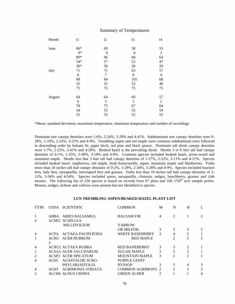
Summary of Temperatures
Month t1 t2 t3 t4 June 66* 69 58 53 9* 9 8 3 80* 96 68 64 54* 57 52 47 30* 30 30 29 July 71 71 63 57 8 7 8 4 88 84 105 68 55 55 52 49 75 75 75 75 August 64 64 60 57 6 5 3 2 78 75 67 64 54 55 53 54 55 55 55 55 *Mean, standard deviation, maximum temperature, minimum temperature and number of recordings Dominant tree canopy densities were 1-6%, 2-24%, 3-29% and 4-41%. Subdominant tree canopy densities were 0-28%, 1-10%, 2-32%, 3-22% and 4-9%. Trembling aspen and red maple were common subdominant trees followed in descending order by balsam fir, paper birch, red pine and black spruce. Dominant tall shrub canopy densities were 1-7%, 2-25%, 3-41% and 4-28%. Beaked hazel is the prevailing shrub. Shrubs 3 to 6 feet tall had canopy densities of 0-1%, 1-25%, 2-49%, 3-18% and 4-8%. Common species included beaked hazel, arrow-wood and mountain maple. Shrubs less that 3 feet tall had canopy densities of 1-27%, 2-52%, 3-11% and 4-11%. Species included beaked hazel, raspberries, red maple, bush honeysuckle, aspen, mountain maple and blueberries. Forbs more than 18 inches tall had canopy densities of 0-2%, 1-28%, 2-34%, 3-28% and 4-9%. Species included bracken fern, lady fern, sarsaparilla, interrupted fern and grasses. Forbs less than 18 inches tall had canopy densities of 2-12%, 3-34% and 4-54%. Species included asters, sarsaparilla, clintonia, sedges, bunchberry, grasses and club mosses. The following list of 230 species is based on records from 67 plots and 160 1/50th acre sample points. Mosses, sedges, lichens and willows were present but not identified to species.
LUN TREMBLING ASPEN/BEAKED HAZEL PLANT LIST TYPE USDA SCIENTIFIC COMMON M N H L 1 ABBA ABIES BALSAMEA BALSAM FIR 4 2 1 2 4 ACMI2 ACHILLEA MILLEFOLIUM YARROW OR MILFOIL 3 3 3 5 4 ACPA ACTAEA PACHYPODA WHITE BANEBERRY 3 4 2 1 1 ACRU ACER RUBRUM RED MAPLE 2 2 3 3 4 ACRU2 ACTAEA RUBRA RED BANEBERRY 3 3 2 1 1 ACSA3 ACER SACCHARUM SUGAR MAPLE 3 5 3 1 2 ACSP2 ACER SPICATUM MOUNTAIN MAPLE 3 2 2 1 4 AGSC AGASTACHE SCRO- PURPLE GIANT PHYLARIAEFOLIA HYSSOP 3 5 4 3 4 AGST AGRIMONIA STRIATA COMMON AGRIMONY 2 2 3 3 2 ALCR6 ALNUS CRISPA GREEN ALDER 2 1 1 4
70
2 ALRU3 ALNUS RUGOSA SPECKLED ALDER 5 2 1 4 2 AMAL2 AMELANCHIER ALNIFOLIA SASKATOON 2 3 2 4 4 AMBR4 AMPHICARPA BRAC- COMMON HOG TEATA PEANUT 3 2 4 3 2 AMELA AMELANCHIER SPP SERVICEBERRY 3 2 2 4 2 AMHU AMELA NCHIER COMMON HUMILIS JUNEBERRY 2 3 3 3 2 AMINC AMELANCHIER COMPLEX INTERMEDIA JUNEBERRY 2 AMSAC AMELANCHIER SANGUINEA COMPLEX JUNEBERRY 4 AMSPC AMELANCHIER SPICATA COMPLEX JUNEBERRY 4 ANCA ANTENNARIA CAN- CANADA ADENSIS PUSSY TOES 1 1 2 5 4 ANMA ANYAPHALIS MARGARIT- ACEA PEARLY EVERLASTING 1 2 2 5 4 ANQU ANEMONE QUINQUEFOLIA WOOD ANEMONE 4 3 3 4 4 APAN2 APOCYNUM ANDROSAE- SPREADING MIFOLIUM DOGBANE 1 2 3 5 4 AQCA AQUILEGIA CANADENSIS SCARLET COLUMBINE 1 3 3 4 4 ARIAT ARISAEMA ATRORUBENS JACK IN THE PULPIT 3 5 4 1 4 ARNU2 ARALIA NUDICAULIS WILD SARSAPARILLA 2 2 2 3 4 ARTR ARISAEMA TRIPHYLLUM SMALL JACK IN THE PULPIT 4 5 3 2 4 ASCA ASARUM CANADENSE WILD GINGER 4 5 3 1 4 ASCO4 ASTER CORDIFOLIUS COMMON BLUE HEART LEAVED ASTER 4 ASLA6 ASTER LATERIFLORUS NECKLACE ASTER 2 2 3 4 4 ASMA2 ASTER MACROPHYLLUS LARGE LEAF ASTER 2 2 2 3 4 ASPR2 ASTER PREALTUS WILLOWLEAF ASTER 4 ASPU5 ASTER PUNICEUS SWAMP BLUE ASTER 4 2 2 4 4 ASSA ASTER SAGITTIFOLIUS ARROW LEAVED ASTER 2 2 2 4 4 ASSI2 ASTER SIMPLEX WHITE PANICLED ASTER 3 2 3 4 4 ASUM ASTER UMBELLATUS FLAT TOP WHITE ASTER 2 2 3 4 8 ATFI ATHYRIUM FILIX-FEMINA LADY FERN 3 3 2 1 1 BEPA BETULA PAPYRIFERA PAPER BIRCH 3 2 2 5 5 CAPE6 CAREX PENSYLVANICA PENNSYLVANIA SEDGE 1 2 3 4 5 CAREX CAREX SPP UNKNOWN SEDGE 4 CARO2 CAMPANULA ROTUNDIFOLIA HAREBELL 2 2 3 4 3 CHUM CHIMAPHILA UMBELLATA PIPSISSEWA 1 1 2 4 4 CIAL2 CIRSIUM ALTISSIMUM TALL THISTLE 3 1 4 4 4 CIAR4 CIRSIUM ARVENSE CANADA THISTLE 2 2 3 5 4 CIMA2 CICUTA MACULATA SPOTTED WATER HEMLOCK 4 2 3 4 4 CLBO3 CLINTONIA BOREALIS CLINTON LILY 3 2 1 2 2 COAL2 CORNUS ALTERNIFOLIA ALTERNATE LEAVED DOGWOOD 2 5 4 1 2 COAM3 CORYLUS AMERICANA AMERICAN HAZEL 1 2 3 5
71

4 COCA13 CORNUS CANADENSIS BUNCHBERRY 3 2 1 2 2 COCO6 CORYLUS CORNUTA BEAKED HAZEL 2 1 2 3 4 COGR COPTIS GROENLANDICA GOLDTHREAD 4 2 1 1 3 COMPE COMPTONIA PEREGRINA SWEET FERN 1 1 2 5 2 CORA6 CORNUS RACEMOSA PANICLED OR GRAY DOGWOOD 1 4 4 3 4 CORI COMANDRA RICHARDSIANA BASTARD TOADFLAS 2 3 3 4 2 CORU CORNUS RUGOSA ROUND LEAVED DOGWOOD 2 3 3 2 4 COSE14 CONVOLVULUS SEPIUM HEDGE BINDWEED 2 COST4 CORNUS STOLONIFERA RED OSIER DOGWOOD 4 2 2 3 4 COTR3 CORALLORHIZA TRIFIDA EARLY CORAL ROOT 3 2 2 3 4 COUM COMANDRA UMBELLATA STAR TOADFLAX 1 1 3 4 2 CRATA CRATAEGUS SPP HAWTHORN or THORN APPLE 3 5 4 4 2 DILO DIERVILLA LONICERA BUSH HONEYSUCKLE 1 2 2 3 2 DIPA9 DIRCA PALUSTRIS LEATHERWOOD 3 5 4 1 8 DRCR4 DRYOPTERIS CRISTATA CRESTED SHIELD FERN 4 2 1 3 8 DRSP4 DRYOPTERIS SPINULOSA COMMON SHIELD FERN 4 2 1 1 4 EPAN2 EPILOBIUM ANGUSTIFOLIUM FIREWEED 3 2 2 5 9 EQAR EQUISETUM ARVENSE FIELD HORSETAIL 4 2 1 1 9 EQFL EQUISETUM FLUVIATILE WATER HORSETAIL 5 2 2 5 9 EQPR EQUISETUM PRATENSE MEADOW HORSETAIL 1 2 2 5 RUSH 9 EQSY EQUISETUM SYLVATICUM FOREST HORSETAIL 3 2 1 3 6 FMOSS FEATHER MOSS UNKNOWN SPECIES 1 FRNI FRAXINUS NIGRA BLACK ASH 4 3 3 2 1 FRPE FRAXINUS PENNSYLVANICA GREEN ASH 3 5 4 4 4 FRVE FRAGARIA VESCA var UPLAND AMERICAN STRAWBERRY 3 3 2 4 4 FRVI FRAGARIA VIRGINIANA MEADOW STRAWBERRY 2 2 2 4 4 GAAP2 GALIUM APARINE CLEAVERS 3 4 3 2 4 GAAS2 GALIUM ASPRELLUM ROUGH BEDSTRAW 5 3 2 1 4 GABO2 GALIUM BOREALE NORTHERN BED- STRAW 1 2 2 5 4 GACO3 GALIUM CONCINNUM SHINING BEDSTRAW 2 3 4 2 4 GALA GALIUM LANCEOLATUM LANCE-LEAVED WILD LICORICE 3 GAPR2 GAULTHERIA PROCUMBENS WINTERGREEN 1 1 2 5 4 GATE2 GALEOPSIS TETRAHIT COMMON HEMP NETTLE 3 2 2 5 4 GATR3 GALIUM TRIFOLORUM SWEET BEDSTRAW 3 2 2 1 4 GEAL3 GEUM ALLEPICUM var. STRUCTUM COMMON AVENS 4 2 3 4 4 GEMA GERANIUM MACULATUM WILD GERANIUM 3 3 4 3 5 GRASS POACEAE SPP GRASS UNKNOWN SPECIES 8 GYDR GYMNOCARPIUM DRYOP- TERIS OAK FERN 3 5 3 3 4 HADE2 HALENIA DEFLEXA SPURRED GENTIAN 3 3 1 2 4 HEAM5 HEPATICA AMERICANA ROUND LOBED HEPATICA 1 3 3 2
72

4 HEMA HERACLEUM MAXIMUM COW PARSNIP 3 4 4 2 4 IMCA IMPATIENS CAPENSIS SPOTTED JEWELWEED 4 5 4 1 4 IRVE2 IRIS VERSICOLOR WILD IRIS 5 2 2 5 4 LABI LACTUCA BIENNIS TALL WILD LETTUCE 3 3 2 4 4 LACA LACTUCA CANADENSIS COMMON WILD LETTUCE 2 3 3 4 1 LALA LARIX LARICINA TAMARACK 5 1 1 5 4 LAOC2 LATHYRUS OCHROLEUCUS WHITE PEAVINE 1 2 3 5 4 LAVE LATHYRUS VENOSUS WILD SWEET PEA 1 2 2 5 3 LEGR LEDUM GROENLANDICUM LABRADOR TEA 5 1 1 5 4 LIBO3 LINNAEA BOREALIS TWIN FLOWER 3 2 1 3 6 LICHEN LICHEN SPP LICHEN UNKNOWN SPECIES 2 LOHI LONICERA HIRSUTA HAIRY HONEYSUCKLE 3 2 2 3 2 LOOB LONICERA OBLONGIFOLIA SWAMP FLY HONEYSUCKLE 4 2 2 3 2 LOVI LONICERA VILLOSA MOUNTAIN FLY HONEYSUCKLE 4 2 2 5 4 LUAC LUZULA ACUMINATA COMMON WOODRUSH 2 2 2 4 4 LYAM LYCOPUS AMERICANUS WATER HOREHOUND 4 2 4 5 9 LYAN2 LYCOPODIUM ANNOTINUM STIFF CLUBMOSS 4 2 1 1 4 LYCI LYSIMACHIA CILIATA FRINGED LOOSESTRIFE 3 3 2 4 9 LYCL LYCOPODIUM CLAVATUM RUNNING CLUBMOSS 3 1 2 1 9 LYCO3 LYCOPODIUM COMPLANA- FLAT-STEM TUM GROUNDPINE 2 2 2 3 9 LYLU LYCOPODIUM LUCIDULUM SHINY CLUBMOSS 4 2 2 2 9 LYOB LYCOPODIUM OBSCURUM GROUND PINE 2 3 1 2 4 LYQU2 LYSIMACHIA QUADRIFOLIA WHORLED LOOSESTRIFE 2 2 4 4 4 LYUN LYCOPUS UNIFLORUS COMMON WATER HOREHOUND 4 3 3 2 4 MACA4 MAIANTHEMUM LILY OF THE VALLEY 1 2 2 4 8 MAST MATTEUCCIA STRUTHI- OPTERIS var. PENSY OSTRICH FERN 3 5 4 1 4 MEAR4 MENTHA ARVENSIS SWEET MINT 3 3 2 4 4 MELI MELAMPYRYM LINEARE COW-WHEAT 4 MELI2 MELAMPYRUM LINEARE NARROWLEAF COWWHEAT 4 MESP3 MENTHA SPICATA L SPEARMINT 4 MINU3 MITELLA NUDA NAKED MITERWORT 4 2 1 1 MOSS MOSS SP 4 MOUN3 MONOTROPA UNIFLORA INDIAN PIPE 2 3 1 2 4 NEMU2 NEMOPONTHES MUCRONATUS CAT BERRY 5 ORAS ORYZOPSIS ASPERIFOLIA ROUGHLEAF RICEGRASS 4 OSCL OSMORHIZA CLAYTONI SWEET CICELY 3 5 3 1 8 OSCL2 OSMUNDA CLAYTONIANA INTERRUPTED FERN 2 5 5 2 7 PAQU2 PARTHENOCISSUS QUINQUEFOLIA VIRGINIA CREEPER 3 3 4 3 BEARD TONGUE 2 3 4 5
73

4 PEPA31 PETASITES PALMATUS EARLY SWEET COLTSFOOT 4 2 1 3 1 PIBA2 PINUS BANKSIANA JACK PINE 1 1 2 5 1 PIGL PICEA GLAUCA WHITE SPRUCE 3 2 1 2 1 PIMA PICEA MARIANA BLACK SPRUCE 4 1 1 3 1 PIRE PINUS RESINOSA RED PINE 1 2 2 4 1 PIST PINUS STROBUS EASTERN WHITE PINE 2 2 2 3 4 PLMA2 PLANTAGO MAJOR COMMON PLANTAIN 2 3 3 5 1 POBA2 POPULUS BALSAMIFERA BALSAM POPLAR 4 3 2 3 4 POBI2 POLYGONATUM BIFLORUM SMOOTH SOLOMONS SEAL 3 5 4 2 4 POCA17 POTENTILLA CANADENSIS DWARF CINQUEFOIL 2 2 3 5 7 POCI POLYGONUM CILINODE FRINGED BINDWEED 2 3 3 3 5 POCO POA COMPRESSA CANADIAN BLUEGRASS 2 2 3 4 4 POCO10 POLYGONUM CONVOLVULUS BLACK BINDWEED 2 3 3 5 1 POGR4 POPULUS GRANDIDENTATA BIGTOOTH ASPEN 1 3 3 3 4 POPA5 POLYGALA PAUCIFOLIA FRINGED MILKWORT 3 3 3 3 4 POPU4 POLYGONATUM PUBESCENS HAIRY SOLOMONS SEAL 3 5 4 2 1 POTR5 POPULUS TREMULOIDES QUAKING ASPEN 2 2 2 4 4 PRAL PRENANTHES ALBA WHITE LETTUCE 2 3 1 3 1 PRNI PRUNUS NIGRA CANADA PLUM 3 4 4 3 2 PRPE2 PRUNUS PENSYLVANICA PIN or FIRE CHERRY 1 2 3 5 2 PRSE2 PRUNUS SEROTINA BLACK CHERRY 2 3 4 3 2 PRVI PRUNUS VIRGINIANA CHOKECCHERRY 2 3 3 4 8 PTAQ PTERIDIUM AQUILINUM COMMON BRACKEN 1 2 2 4 2 PYAM PYRUS AMERICANA CRAB-APPLE 4 PYEL PYROLA ELLIPTICA SHINLEAF 2 2 3 3 4 PYMI PYROLA MINOR LESSER PYROLA 3 2 2 1 4 PYRO PYROLA ROTUNDIFOLIA ROUND LEAVED PYROLA 2 2 2 3 4 PYSE PYROLA SECUNDA ONE-SIDED PYROLA 2 2 2 3 1 QUMA2 QUERCUS MACROCARPA BUR OAK 1 3 4 3 1 QURU QUERCUS RUBRA NORTHERN RED OAK 1 4 3 3 4 RAHI RANUNCULUS HISPIDUS HISPID BUTTERCUP 4 RAPE2 RANUNCULUS PENSYLVANICUS BRISTLY CROWFOOT 4 2 3 5 4 RARE2 RANUNCULUS RECURVATUS HOOKED CROWFOOT 2 3 3 3 2 RHAL RHAMNUS ALNIFOLIA ALDER LEAVED BUCKTHORN 5 1 2 4 3 RHRA RHUS RADICANS POISON IVY 1 3 3 4 2 RICY RIBES CYNOSBATI PRICKLY GOOSEBERRY 3 4 4 2 2 RIGL RIBES GLANDULOSUM SKUNK CURRANT 4 2 1 2 2 RIHI RIBES HIRTELLUM SMOOTH GOOSEBERRY 4 2 2 3 2 RILA RIBES LACUSTRE BRISTLY BLACK CURRENT 4 2 2 2 2 RITR RIBES TRISTE SWAMP RED CURRANT 4 3 1 2 2 ROAC ROSA ACICULARIS PRICKLY ROSE 1 2 3 5 2 ROBL ROSA BLANDA SMOOTH ROSE 1 2 2 5 4 ROCA4 ROSA CAROLINA L PASTURE ROSE
74

2 ROSA ROSA SPP ROSE UNKNOWN SPECIES 3 RUAL RUBUS ALLEGHENIENSIS COMMON BLACKBERRY 3 2 2 5 3 RUID RUBUS IDAEUS WILD RED var. STRIGOSUS RASPBERRY 3 2 2 4 3 RUPA RUBUS PARVIFLORUS THIMBLEBERRY 3 2 2 3 3 RUPU RUBUS PUBESCENS DWARF RASPBERRY 4 2 1 1 2 SACA12 SAMBUCUS CANADENSIS COMMON ELDER 2 5 4 1 4 SACA15 SANICULA CANADENSIS SHORT-STYLED SNAKEROOT 2 SAGR SALIX GRACILIS SLENDER WILLOW 4 3 2 5 2 SALIX SALIX SP 4 SAMA2 SANICULA MARILANDICA BLACK SNAKEROOT 2 3 3 3 9 SEAP SELAGINELLA APODA SPRING SPIKEMOSS 6 SMOSS SPHAGNUM SPP SPAGNUM 2 SOAM3 SORBUS AMERICANA AMERICAN MT ASH 4 2 1 1 4 SOFL2 SOLIDAGO FLEXICAULIS WIDE LEAVED GOLDENROD 3 5 3 1 4 SOGI SOLIDAGO GIGANTEA GREATER GOLDENROD 4 3 3 4 4 SOGR SOLIDAGO GRAMINIFOLIA GRASS LEAVED GOLDENROD 3 3 3 5 4 SOOL SONCHUS OLERACEUS COMMON SOWTHISTLE 4 SORU2 SOLIDAGO RUGOSA ROUGH STEMMED GOLDENROD 3 3 3 3 4 SOSP2 SOLIDAGO SPECIOSA NUTT. SHOWY GOLDENROD 4 SOULU SOLIDAGO ULIGINOSA NORTHERN BOG GOLDENROD 2 SPAL2 SPIRAEA ALBA NARROW LEAVED MEADOWSWEET 4 3 3 3 2 SPALL SPIREA ALBA var. LATIFOLIA WHITE MEADOWSWEET 4 STGR STELLARIA GRAMINEA LESSER SWITCHWORT 4 2 3 5 4 STLO STELLARIA LONGIFOLIA LONG LEAVED SWITCHWORT 4 3 3 4 4 STRO4 STREPTOPUS ROSEUS ROSE TWISTEDSTALK 2 3 3 1 4 TAOF TARAXACUM OFFICINALE COMMON DANDELION 2 2 3 5 4 TARA TARAXICUM SPP DANDYLION 4 THDI THALICTRUM DIOICUM EARLY MEADOW RUE 2 3 3 3 1 THOC2 THUJA OCCIDENTALIS NORTHERN WHITE CEDAR 4 2 1 1 8 THPH THELYPTERIS PHEGOPTERIS LONG BEACH FERN 1 TIAM TILIA AMERICANA AMERICAN BASSWOOD 2 5 4 1 4 TRAG TRIFOLIUM AGARIUM YELLOW CLOVER 2 3 3 5 4 TRBO2 TRIENTALIS BOREALIS STARFLOWER 4 2 1 1 4 TRCE TRILLIUM CERNUUM NODDING TRILLIUM 3 5 3 1 4 TRGR4 TRILLIUM GRANDIFLORUM LARGE FLOWERED TRILLIUM 3 5 4 2 4 TRPR2 TRIFOLIUM PRATENSE RED CLOVER 2 3 3 5 1 ULAM ULMUS AMERICANA AMERICAN ELM 3 5 4 2 4 URPR7 URTICA DIOCIA var. PROCERA STINGING NETTLES 4 UVGR UVULARIA GRANDIFLORA LARGE FLOWERED BELLWORT 2 5 4 1
75
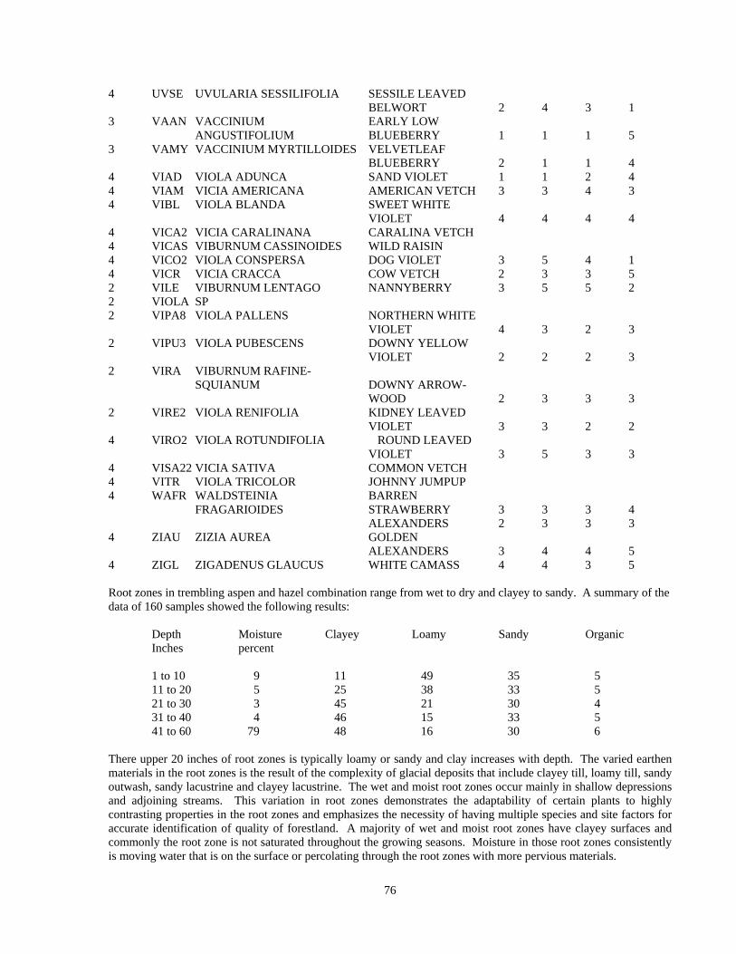
4 UVSE UVULARIA SESSILIFOLIA SESSILE LEAVED BELWORT 2 4 3 1 3 VAAN VACCINIUM EARLY LOW ANGUSTIFOLIUM BLUEBERRY 1 1 1 5 3 VAMY VACCINIUM MYRTILLOIDES VELVETLEAF BLUEBERRY 2 1 1 4 4 VIAD VIOLA ADUNCA SAND VIOLET 1 1 2 4 4 VIAM VICIA AMERICANA AMERICAN VETCH 3 3 4 3 4 VIBL VIOLA BLANDA SWEET WHITE VIOLET 4 4 4 4 4 VICA2 VICIA CARALINANA CARALINA VETCH 4 VICAS VIBURNUM CASSINOIDES WILD RAISIN 4 VICO2 VIOLA CONSPERSA DOG VIOLET 3 5 4 1 4 VICR VICIA CRACCA COW VETCH 2 3 3 5 2 VILE VIBURNUM LENTAGO NANNYBERRY 3 5 5 2 2 VIOLA SP 2 VIPA8 VIOLA PALLENS NORTHERN WHITE VIOLET 4 3 2 3 2 VIPU3 VIOLA PUBESCENS DOWNY YELLOW VIOLET 2 2 2 3 2 VIRA VIBURNUM RAFINE- SQUIANUM DOWNY ARROW- WOOD 2 3 3 3 2 VIRE2 VIOLA RENIFOLIA KIDNEY LEAVED VIOLET 3 3 2 2 4 VIRO2 VIOLA ROTUNDIFOLIA ROUND LEAVED VIOLET 3 5 3 3 4 VISA22 VICIA SATIVA COMMON VETCH 4 VITR VIOLA TRICOLOR JOHNNY JUMPUP 4 WAFR WALDSTEINIA BARREN FRAGARIOIDES STRAWBERRY 3 3 3 4 ALEXANDERS 2 3 3 3 4 ZIAU ZIZIA AUREA GOLDEN ALEXANDERS 3 4 4 5 4 ZIGL ZIGADENUS GLAUCUS WHITE CAMASS 4 4 3 5 Root zones in trembling aspen and hazel combination range from wet to dry and clayey to sandy. A summary of the data of 160 samples showed the following results: Depth Moisture Clayey Loamy Sandy Organic Inches percent 1 to 10 9 11 49 35 5 11 to 20 5 25 38 33 5 21 to 30 3 45 21 30 4 31 to 40 4 46 15 33 5 41 to 60 79 48 16 30 6 There upper 20 inches of root zones is typically loamy or sandy and clay increases with depth. The varied earthen materials in the root zones is the result of the complexity of glacial deposits that include clayey till, loamy till, sandy outwash, sandy lacustrine and clayey lacustrine. The wet and moist root zones occur mainly in shallow depressions and adjoining streams. This variation in root zones demonstrates the adaptability of certain plants to highly contrasting properties in the root zones and emphasizes the necessity of having multiple species and site factors for accurate identification of quality of forestland. A majority of wet and moist root zones have clayey surfaces and commonly the root zone is not saturated throughout the growing seasons. Moisture in those root zones consistently is moving water that is on the surface or percolating through the root zones with more pervious materials.
76
V. Silviculture Integrated with Biophysical Information This section presents an integration of silviculture principles and practices with biophysical information applicable to managing trees commonly found in the Laurentian Upland North biophysical region. Additional integrated information each tree includes botanical, physiological and fertility requirements. Information in this section will support growing each tree in pure stands, in mixed stands, for producing high quality wood, for supporting diversity of wildlife habitat and for scenic quality within view sheds. Trembling Aspen Trembling aspen is intolerant to shade, is considered a pioneer tree and reproduces by seed and suckers. This aspen grows in the Great Lake States, Rocky Mountains and the Great Lakes-St. Lawrence and southern portion of the Boreal Forest in Canada. North central Minnesota, that includes Laurentian Upland North, has been suggested as being near the botanical center for trembling aspen and that in combination with nutrient-rich root zones results in vigorous growth and high quality of tree extending beyond a hundred years of age in selected sites and selected clones. Trembling aspen consumes large amounts of nutrients in comparison to pines and spruces. For example, North Central Forest Experiment Station reported that the concentration of calcium, magnesium, potassium and phosphorus in aspen exceeded respective concentration of nutrients in jack pine by 5.6 times, 2.2, 2.2 and 2.6. Thus, substantially greater amounts of nutrients would be displaced with removal of aspen wood products verse jack pine. Regeneration Trembling aspen requires full sunlight for successful regeneration. Regeneration can be accomplished with suckers in sites with little disturbance of forest floor. In sites with major exposure of mineral earthen material, aspen often regenerates by seeds and suckers. Suckers of varying quality will regenerate in partially shaded sites. Genetic makeup of parent trees plays a significant role in determining the quality of suckers and seedlings. Forestland managers will find it beneficial to identify the different aspen clones in a specific stand and favor the expansion of the high quality clones in regeneration prescriptions. That expansion begins with design of harvest area, trees selected for harvest and method of cutting. Regeneration is most vigorous with potentially high quality suckers and seedlings in dry and moist nutrient-rich root zones. In LUN, that would include BLEUs 3, 5, 6, 10 and 12. Potentially low vigor suckers and seedlings will occur on the droughty and wet sites that include BLEUs 7, 9 and 11. BLEUs 1, 2, 4, and 8 are intermediate in site quality and can support manageable crops of trembling aspen. All aspen regeneration should be evaluated for quality, spacing and stocking every five years for assuring maximum yields of quality wood. Aspen stands with low quality stocking or low density stocking are candidates for conversion to more productive trees. Harvest Harvest must be scheduled for maximum stocking of new aspen stands with high quality and adequately spaced suckers and seedlings Potential for dry summer harvest include BLEUs 1, 2, 11 and 12. Actual operations need to be evaluated based on rain events during the summer and appropriate action taken for assurance of maintaining the quality of the site. BLEUs 3, 7, 8, 9 and 10 must be scheduled for harvest during frozen and snow covered ground. For quality and quantity of suckers and seedlings, harvest of aspen must be scheduled outside the moisture recharge periods in the fall and spring for BLEUs 3, 4, 5, 6, 9, 10 and 12. In the fall this period is generally between leaf-drop and onset of frozen and snow covered ground and in the spring this period is between snow melt and full leaf-out of forbs, shrubs and trees. Improper equipment operations outside of prescriptive management will cause long term adverse impacts that can a duration of several decades. Rutting and compaction of the clayey and loamy earthen materials have been observed to remain a problem after two decades. Nutrient conservation Prescriptive management integrating biophysical nutrient budget with nutrient conservation measures for managing
77

repeated crops of aspen is appropriate for crops of aspen on BLEUs 1, 7 and 11. Such management includes scattering tops on land from which aspen wood is harvested. In selected instances the availability of nutrient-rich waste products from sewage disposal systems and wood processing plants can be applied to those BLEUs as part of a nutrient conservation strategy. Drainage of moist and wet BLEUs will release nutrients for plant uptake that otherwise are unavailable due to root zone being saturated with water for prolonged periods. Conversion of trembling aspen to jack pine or red pine would result in production of increased volume and higher quality wood products with less uptake of nutrients. Quality pine sawlogs would become a new wood product for those BLEUs also.
Nutrient Dynamics
Nutrient dynamics in forestland are the culmination of the results of climate, geological processes, biological processes, natural weathering processes of earthen materials, specific events including outbreaks of plant diseases, insect infestations, fire and human activities. Selected amounts of nutrients are leached deep into root zones beyond feeding roots and are a net loss to the immediate population of organisms and plants. Human activities do not make or destroy nutrients but rather they displace nutrients from one location to another. An example is wood burned to heat a home displaces nutrients from the forest and converts them to moisture, aerosol in smoke and dry in ash.
Changes in climate directly influence the weathering of minerals and subsequent release of nutrient inherent to their composition. Moist warm climates accelerate the weathering process and sedimentary rock (limestone and sandstone for example) and earthen materials derived from them will weather rather rapidly under such condition and yield high levels of nutrients important for plant growth and reproduction and give rise to rich fertile soils. Granite and other igneous rocks will weather more slowly and yield low to moderate levels of nutrients and resulting soils will have low to medium fertility. Those conditions are characteristic of Itasca County. In contrast, a dry warm climate will foster slow weathering of rocks in general and desert conditions with low fertility soils are common. Abrasive action of glacial motion physically grinds rocks to smaller particles and soft limestone and sandstone will be readily reduced to fines and pebbles. Igneous rocks are much harder and that abrasive action will result in larger sand particles, gravel and boulders. As the rocks are ground to smaller particles, the chemical weathering processes are accelerated due to the significant increase in exposed surface. Melting glaciers produce enormous volumes of water, which move and sort particles of earthen materials in accordance with the changing volume and velocity of the water. Fast flowing water will deposit large rocks and as the velocity decrease smaller and smaller particles will be sorted and deposited and finally in lakes the fine sand, silt and clay will be deposited. Those materials will then be subjected to post glacial erosion and deposition. Micro and macro organisms play a significant role in extracting nutrients from decaying organic material and particles of earthen materials. Nutrients assimilates by organisms are released as they decompose and become available for other organisms and plants. Plant roots and leaves extract nutrients from the soil and air and deposit a portion of them with decaying leaves, buds and other plant parts. Decaying roots release nutrients that can be taken up by organisms and other plant roots. Managing organic matter in forestland is one of the most important aspects of sustaining inherent fertility. Cycles of wetting and drying, heating and cooling and freezing and thawing contribute to the weathering of organic matter and earthen materials and subsequent release of nutrients for organisms and plants. Those cycles will be more intense on south facing slopes and micro sites and moderate on north facing slopes and micro sites and the difference will be profound. Earthen materials of limestone origin will weather quite rapidly as a result of those cycles. Natural events of outbreaks of diseases and insects can concentrate and accelerate the weathering of and transformation of nutrients. Plant mortality from diseases can in a brief period of time change uptake of nutrients by living plants to release of nutrients by dead and decaying plants. The thousands of tons of dead balsam fir from spruce budworm outbreak are an example where hundreds of pounds of nutrients are released as fir decays. The repeated outbreak of forest tent caterpillar cycles hundreds of pounds of nutrients from preferred plants and returns those nutrients to the forest litter as they die and decompose. Birds and animals that consume a portion of the caterpillars can translocate a portion of those nutrients to other part of the forestland. Plants defoliated by the
78

caterpillars must take up significant amounts of additional nutrients from the root zone to replace foliage. Consequently, the intensity of nutrient cycling in the forestland is increased considerably are result of the outbreak of insects. Fires can have little or no effect on nutrients in the forestland or fires can have a major impact on supply of nutrients available to organisms and plants. Fast moving ground fires consuming only fine fuels have little effect on the dynamics of nutrients in the impacted area. In contrast, a fire burning in heavy fuels during a drought can convert hundreds of pounds of nutrients to aerosol compounds that are lost from the forestland in addition to tons of nutrient-rich ash lost by wind and water erosion. Under those conditions, the fire typically consumes the entire forest floor and the form of nutrients is changed. Selected nutrients become more readily available for feeding organisms and plants and other nutrients can be in slow release forms such as those contained in ash and charcoal. Accelerated loss of nutrients from the forestland is also associated with such a fire. Nutrients can also be made unavailable to plants and organisms as a result of such a fire due to the coating of soil particles with compounds that tend to seal the particles from water and biological activity for a prolonged period of time. That coating is especially acute as the percent of sand increase in the matrix of earthen materials. Activities of humans can have varied effects of the dynamic of nutrients in land. In Itasca County displacement of nutrients began with the removal trees for fuel, building houses, railroads, city buildings, fences and bridges. The use of earthen materials for buildings, bridges, trails and roads displaces nutrients from the forestland. Farming the land was a common land use once the forestland was cleared of trees. Presently, hundreds of acres of that farmland converted to forestland comprised of native plants following cessation of farming. In Itasca County general farming was common and small grain and hay were major crops. A substantial amount of the farming had an inadequate fertility program and level of nutrients in the root zone decreased over time. It was very uncommon for example to add fertilize to hay fields. Consequently, with removal of each hay crop the root zone was further depleted of nutrients. Repeated haying also created compacted layers within the surface foot of root zone. That layer was firm and effective in restricting root growth that in turn reduced the amount of nutrients available to a given crop. Such compaction was common in loamy and clayey root zones. Root zones inherently low in lime became more acid with the repeated removal of crops and no application of lime. In selected locations, farming included draining of moist and wet land. That drainage initially increased the availability of nutrients for plants, but with the common practice of not fertilizing the land following removal of annual and seasonal crops, the amount of nutrients available for plants was reduced. In the drained land, native trees that became established in prior farm fields benefited from the dryer root zone and will continue to benefit as long as the integrity of the drainage is maintained. Present day dynamic of nutrients in forestland is primarily associated with management activities and natural processes. Management activities include preparing sites for reforestation, weeding stands of trees of undesirable plants and removal of wood products. Natural processes include leaching of nutrients by surface and subsurface water, weathering of earthen materials and release of nutrients, atmospheric deposition (both wet and dry) of nutrients, concentration of nutrients by outbreak of insect population, cycling of nutrients with feeding roots and annual leaf fall, differential uptake of nutrients by different plants and cycling of nutrients by feeding animals. Microbial decomposition of organic matter releases nutrients to the environment. Earthworms ingest organic and earthen materials and cycle nutrients in the process. Burrowing animals bring nutrients from below the root zone to the surface of the forest floor and place nutrients within reach of feeding roots. Selected managers of forestland are specifically interested in the nutrient composition of trees and the amount of nutrients in root zones. Table 3 shows nutrient values for 4 tree species with associated shrubs and forbs that are based on a combination of USFS data and are common in Itasca County.
79
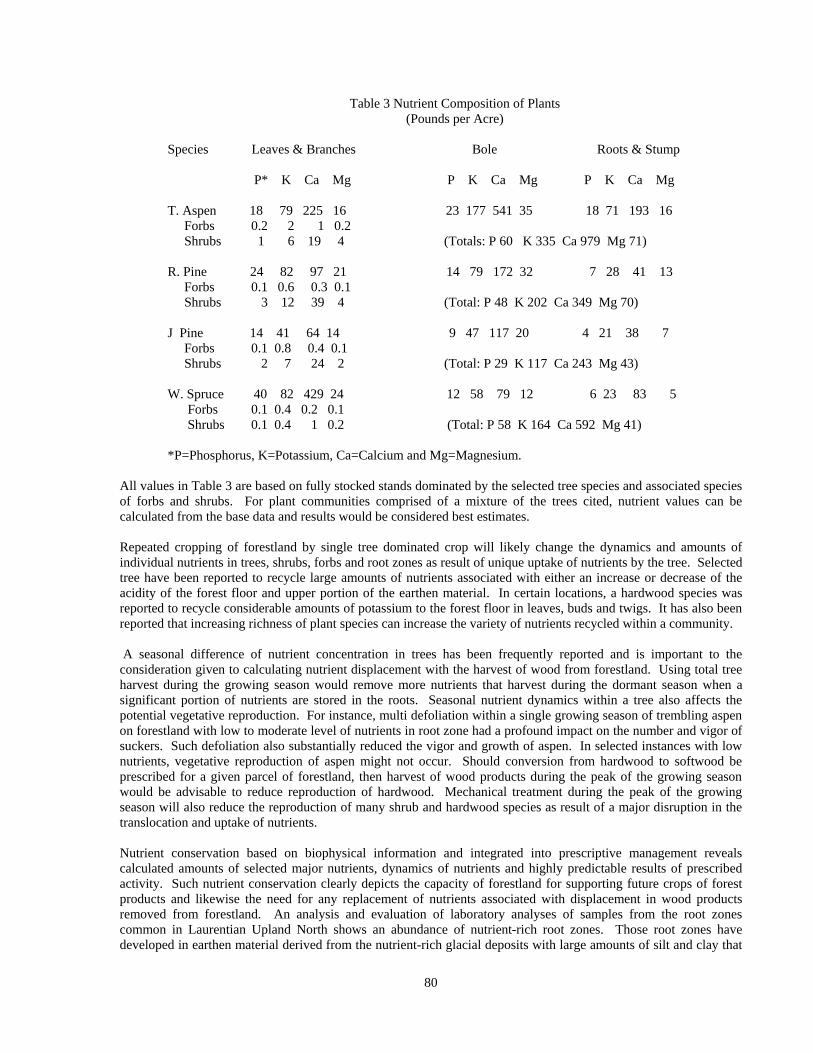
Table 3 Nutrient Composition of Plants (Pounds per Acre)
Species Leaves & Branches Bole Roots & Stump P* K Ca Mg P K Ca Mg P K Ca Mg T. Aspen 18 79 225 16 23 177 541 35 18 71 193 16 Forbs 0.2 2 1 0.2 Shrubs 1 6 19 4 (Totals: P 60 K 335 Ca 979 Mg 71) R. Pine 24 82 97 21 14 79 172 32 7 28 41 13 Forbs 0.1 0.6 0.3 0.1 Shrubs 3 12 39 4 (Total: P 48 K 202 Ca 349 Mg 70) J Pine 14 41 64 14 9 47 117 20 4 21 38 7 Forbs 0.1 0.8 0.4 0.1 Shrubs 2 7 24 2 (Total: P 29 K 117 Ca 243 Mg 43) W. Spruce 40 82 429 24 12 58 79 12 6 23 83 5 Forbs 0.1 0.4 0.2 0.1 Shrubs 0.1 0.4 1 0.2 (Total: P 58 K 164 Ca 592 Mg 41) *P=Phosphorus, K=Potassium, Ca=Calcium and Mg=Magnesium.
All values in Table 3 are based on fully stocked stands dominated by the selected tree species and associated species of forbs and shrubs. For plant communities comprised of a mixture of the trees cited, nutrient values can be calculated from the base data and results would be considered best estimates. Repeated cropping of forestland by single tree dominated crop will likely change the dynamics and amounts of individual nutrients in trees, shrubs, forbs and root zones as result of unique uptake of nutrients by the tree. Selected tree have been reported to recycle large amounts of nutrients associated with either an increase or decrease of the acidity of the forest floor and upper portion of the earthen material. In certain locations, a hardwood species was reported to recycle considerable amounts of potassium to the forest floor in leaves, buds and twigs. It has also been reported that increasing richness of plant species can increase the variety of nutrients recycled within a community. A seasonal difference of nutrient concentration in trees has been frequently reported and is important to the consideration given to calculating nutrient displacement with the harvest of wood from forestland. Using total tree harvest during the growing season would remove more nutrients that harvest during the dormant season when a significant portion of nutrients are stored in the roots. Seasonal nutrient dynamics within a tree also affects the potential vegetative reproduction. For instance, multi defoliation within a single growing season of trembling aspen on forestland with low to moderate level of nutrients in root zone had a profound impact on the number and vigor of suckers. Such defoliation also substantially reduced the vigor and growth of aspen. In selected instances with low nutrients, vegetative reproduction of aspen might not occur. Should conversion from hardwood to softwood be prescribed for a given parcel of forestland, then harvest of wood products during the peak of the growing season would be advisable to reduce reproduction of hardwood. Mechanical treatment during the peak of the growing season will also reduce the reproduction of many shrub and hardwood species as result of a major disruption in the translocation and uptake of nutrients. Nutrient conservation based on biophysical information and integrated into prescriptive management reveals calculated amounts of selected major nutrients, dynamics of nutrients and highly predictable results of prescribed activity. Such nutrient conservation clearly depicts the capacity of forestland for supporting future crops of forest products and likewise the need for any replacement of nutrients associated with displacement in wood products removed from forestland. An analysis and evaluation of laboratory analyses of samples from the root zones common in Laurentian Upland North shows an abundance of nutrient-rich root zones. Those root zones have developed in earthen material derived from the nutrient-rich glacial deposits with large amounts of silt and clay that
80
were derived from limestone.
Management Analyses
Selected managers of forestland are keen on continuing to increase their knowledge about the environment in which they prescribe activities. A significant part of that knowledge is determining the different levels of quality of forestland and the respective capacity of each level for supporting specific prescribed uses. Identifying the amount, dynamics and sustainability of nutrients is a key element in determining the quality of land. The characterization for each biophysical landscape ecological unit (BLEU) contains that key element and it is based on objective verifiable geographic-specific data. By knowing that about nutrients, an interested manager can prescribe appropriate and effective activities that have a prime element of conservation of nutrients included. For example, should a manager prescribe increasing the yield of wood products with increased entries to minimize biological loss and reduce the amount of decaying wood on the forest floor, then an evaluation of the increase in nutrient displacement is in order and appropriate action would be prescribed. A BLEU with nutrient-rich root zone could support increase yields without decreasing site quality Another example is a major conversion on a site with low fertility from current tree species that consume large amounts of nutrients but produce crops of low quality wood to a tree that uses less nutrients and produces a quality wood product. The efficient use of nutrients by the latter tree will reduce the displacement of nutrients with removal of wood products and result in maintaining the quality of the site while producing a higher quality wood product. An example of species conversion for a low quality site would be trembling aspen to jack pine.
Nutrient and Role in Plant Growth
This discussion focuses on forestland that receives all nutrients from natural sources that include atmosphere, weathering rock fragments, weathering soil particles, soil liquids, decomposing animals, decomposing plants, macro soil organisms and micro soil organisms. Atmospheric sources include dust, lightening, snow and rain. Rock fragments from limestone weather readily releasing significant amounts of calcium. Volcanic rocks (granite and gabbro for example) weather slowly and release varying amounts of the major nutrients that are consistently less than from limestone. Weathering soil particles yield nutrients and the amount depends on the mineralogy of the particles. Soil liquids pickup nutrients from all weathering and decomposing materials and in non-saturated earthen material those nutrients can be readily available to plants. Decaying animals contribute nutrients to very localized site and bones contribute a significant amount of calcium to the site. Decaying plants contribute substantial amounts of nutrients over large portions of forestland and the amount contributed depends on species and nutrient status of the local root zone. Macro organisms (earthworms and insects for example) process earthen materials and plant parts through respective digestive systems and that combined with their decay contribute nutrients to the root zone.
Factors that affect the availability of nutrients to growing plants and ease of uptake by roots include temperature in root zone, magnitude of short term changes in temperatures, moisture content of root zone, magnitude of short and long term changes in the moisture content in root zone, the stage of development of individual plants and availability and amount of total composition of all nutrients in root zone. Within a temperature climatic zone, extremely low or high temperatures in the root zone will inhibit the uptake of nutrients by plants. Extremely dry root zones will have insufficient moisture for many plants to take up nutrients even though there might be a large amount of nutrients present. Saturated root zone of long duration will reduce the availability and uptake of nutrients that can result from insufficient oxygen and nutrients in unavailable forms for plant uptake. Nitrogen forms most commonly assimilated by plants are nitrates and ammonium and to a lesser extent urea. Nitrogen is generally associated with proteins and functional rather than structural role in plants. Many of the proteins are enzymes and selected forms are found in chromosomes. Proteins serve as directors and catalysts for metabolism and are important for proper utilization of carbohydrates. An insufficient amount proteins can result in thicken leaves caused by accumulation of carbohydrates, stunted yellowish older leaves and in severe cases leaves will cease too function and turn brown. An excess of proteins can cause enlarged weak cells resulting in structural damage to plant parts. Nitrogen in an integral part of chlorophyll molecules and sufficient amounts are associated with rich green healthy plants. Common forms of phosphorous absorbed by plants are primary orthophosphate and a smaller amount is secondary orthophosphate. Phosphorus is made availability by weathering of minerals in the root zone and the decomposition
81

of animal parts, macro and microorganisms and plant parts. Absorption of phosphorous is strongly influenced by pH and deficiency can occur at low pH because of influence of aluminum and iron and at high pH by calcium. Phosphorous is important for juvenile plant growth, reproductive processes, formation of fruit and seed and development of balanced root system. Inadequate phosphorous during the juvenile stage of plant growth can adversely impact plant growth and seed production A low level of phosphorous reduces photosynthesis and selected metabolic processes. Insufficient phosphorous can cause purple color in plant parts and often in leaves. Potassium is used in large amounts by selected plants and is probably second in uptake to only nitrogen. An increase in amount of water in the root zone can release additional potassium for uptake by plants. It is absorbed by plants in the ion form and is important for carbohydrate metabolism, synthesis of proteins, regulator of other nutrients and water-plant relations Potassium is very important for developing strong cell walls. Low level of potassium in plants can reduce plant health and resistance to diseases and increase susceptibility to injury from insects. Large amounts of nitrogen coupled with low potassium results in large weak cells that coupled with insufficient moisture can cause severe damage to plant parts. Those large weak cells will also be subject to substantial damage from freezing. Sufficient potassium is essential for effective level of photosynthesis and selected metabolism. Inadequate potassium can reduce the rate of photosynthesis while increasing the rate of transpiration causing severe plant stress, reduced growth and reduced vigor. An indication of inadequate potassium often appears as yellow and brown wrinkled leaf margins and interior of leaf. Calcium in significant to numerous plant functions and is used in relative large amounts by selected plants. It is important for cell growth, cell structure and uptake of other nutrients. Plants absorb calcium in the ion form out of solutions in the root zone. The largest source of calcium is limestone and lesser amounts are contained in calcite, apatite, feldspars and amphiboles. Calcium is readily transported within the root zone by percolating water and moves rapidly through sandy earthen material. In LUN biophysical region the natural supply of native calcium ranges from low to high and plants growing in dry root zones reflect the positive influence of that supply. Magnesium is taken up by plants in ion form and is significant to the uptake of other nutrients, enhances the uptake of calcium and contributes to the general vigor of plants A major native source is dolomitic limestone and other smaller sources are biotite, chlorite, serpentine and olivine. Magnesium is readily transported through the root zone and is leached rapidly through sandy earthen materials. Phosphorus in foliage decreased throughout the growing season. In bark and branches phosphorus decreased through June and then increased to a maximum in October. In the wood, phosphorus decreased slightly in the spring and remained nearly uniform through October. Potassium in the foliage decreases sharply April through October. In bark and branches, potassium decrease slightly April to June and levels off until it peaks in October (April and October peaks are nearly equal). Potassium in the wood increases May to June and then decreases to its lowest level in October. Calcium in foliage increase steadily throughout the growing season. In the bark and branches, calcium decreases from a peak in April to a low in June and then has a secondary peak in October.
Biophysical Landscape Ecological Units, Nutrient Status and Wood Products
Referring to the data in Table 3, trembling aspen has the highest concentration of all nutrients reported. For phosphorus the concentrations are trembling aspen > white spruce > red pine > jack pine. For potassium trembling aspen > red pine > white spruce > jack pine. For calcium trembling aspen > white spruce > red pine > jack pine. For magnesium trembling aspen > red pine > jack pine > white spruce. A comparison of full tree harvest of aspen verse jack pine is shown in table 4 and reveals that aspen would displace significantly more nutrients for the same volume of wood that would jack pine. Thus, trembling aspen removes 1.8 times the amount of phosphorus compared to jack pine, 6.7 times the amount of potassium, 4.2 times the amount of calcium and 1.5 times the amount of magnesium. Knowing this relationship, an interested manager of forestland could make a more informed decision for best management of land for sustaining site quality and producing quality wood products.
Table 4 Nutrient Displacement Comparison
82
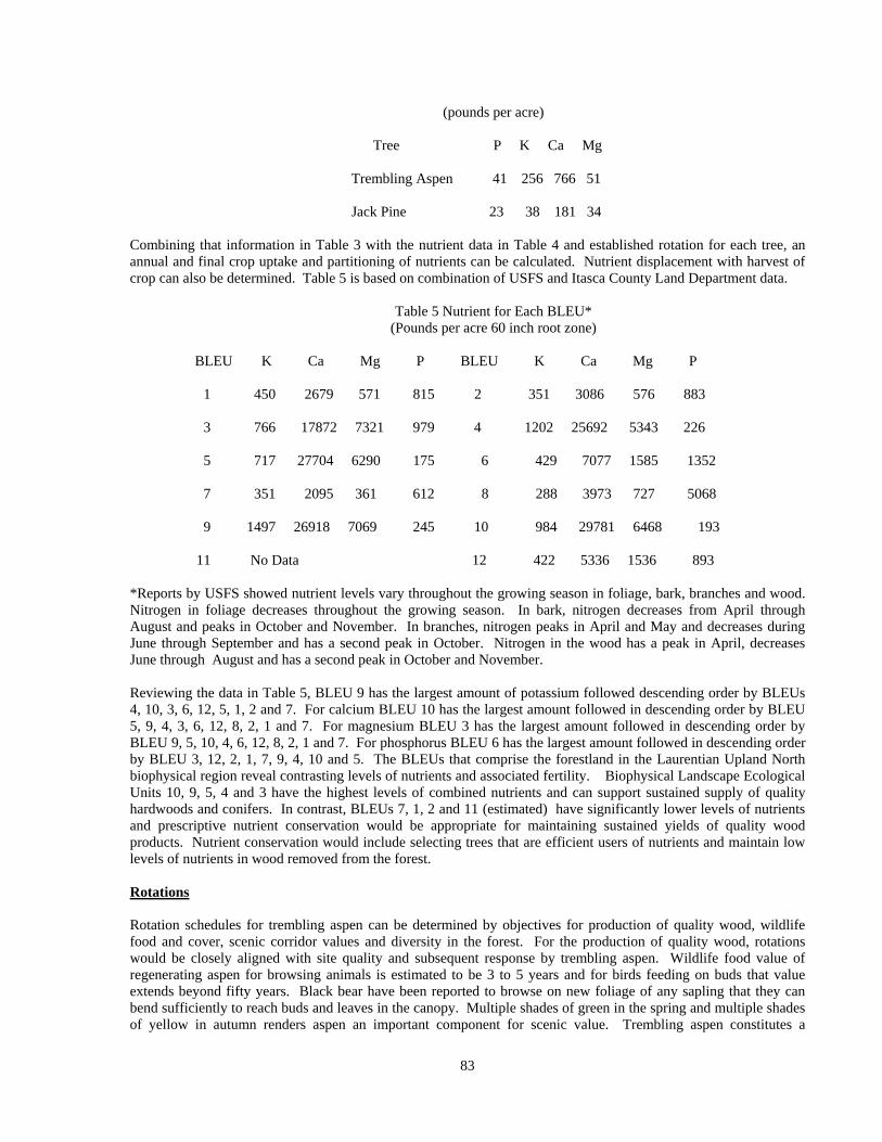
(pounds per acre) Tree P K Ca Mg Trembling Aspen 41 256 766 51 Jack Pine 23 38 181 34
Combining that information in Table 3 with the nutrient data in Table 4 and established rotation for each tree, an annual and final crop uptake and partitioning of nutrients can be calculated. Nutrient displacement with harvest of crop can also be determined. Table 5 is based on combination of USFS and Itasca County Land Department data.
Table 5 Nutrient for Each BLEU*
(Pounds per acre 60 inch root zone)
BLEU K Ca Mg P BLEU K Ca Mg P 1 450 2679 571 815 2 351 3086 576 883 3 766 17872 7321 979 4 1202 25692 5343 226 5 717 27704 6290 175 6 429 7077 1585 1352 7 351 2095 361 612 8 288 3973 727 5068 9 1497 26918 7069 245 10 984 29781 6468 193 11 No Data 12 422 5336 1536 893
*Reports by USFS showed nutrient levels vary throughout the growing season in foliage, bark, branches and wood. Nitrogen in foliage decreases throughout the growing season. In bark, nitrogen decreases from April through August and peaks in October and November. In branches, nitrogen peaks in April and May and decreases during June through September and has a second peak in October. Nitrogen in the wood has a peak in April, decreases June through August and has a second peak in October and November.
Reviewing the data in Table 5, BLEU 9 has the largest amount of potassium followed descending order by BLEUs 4, 10, 3, 6, 12, 5, 1, 2 and 7. For calcium BLEU 10 has the largest amount followed in descending order by BLEU 5, 9, 4, 3, 6, 12, 8, 2, 1 and 7. For magnesium BLEU 3 has the largest amount followed in descending order by BLEU 9, 5, 10, 4, 6, 12, 8, 2, 1 and 7. For phosphorus BLEU 6 has the largest amount followed in descending order by BLEU 3, 12, 2, 1, 7, 9, 4, 10 and 5. The BLEUs that comprise the forestland in the Laurentian Upland North biophysical region reveal contrasting levels of nutrients and associated fertility. Biophysical Landscape Ecological Units 10, 9, 5, 4 and 3 have the highest levels of combined nutrients and can support sustained supply of quality hardwoods and conifers. In contrast, BLEUs 7, 1, 2 and 11 (estimated) have significantly lower levels of nutrients and prescriptive nutrient conservation would be appropriate for maintaining sustained yields of quality wood products. Nutrient conservation would include selecting trees that are efficient users of nutrients and maintain low levels of nutrients in wood removed from the forest. Rotations Rotation schedules for trembling aspen can be determined by objectives for production of quality wood, wildlife food and cover, scenic corridor values and diversity in the forest. For the production of quality wood, rotations would be closely aligned with site quality and subsequent response by trembling aspen. Wildlife food value of regenerating aspen for browsing animals is estimated to be 3 to 5 years and for birds feeding on buds that value extends beyond fifty years. Black bear have been reported to browse on new foliage of any sapling that they can bend sufficiently to reach buds and leaves in the canopy. Multiple shades of green in the spring and multiple shades of yellow in autumn renders aspen an important component for scenic value. Trembling aspen constitutes a
83
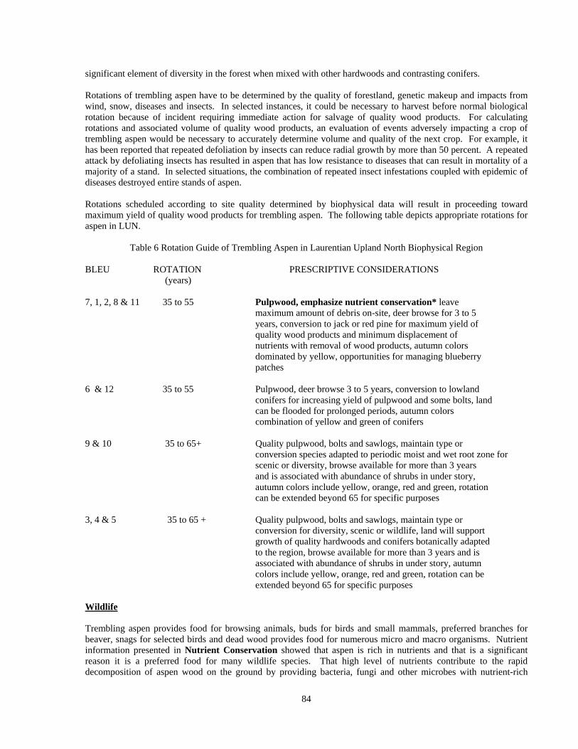
significant element of diversity in the forest when mixed with other hardwoods and contrasting conifers. Rotations of trembling aspen have to be determined by the quality of forestland, genetic makeup and impacts from wind, snow, diseases and insects. In selected instances, it could be necessary to harvest before normal biological rotation because of incident requiring immediate action for salvage of quality wood products. For calculating rotations and associated volume of quality wood products, an evaluation of events adversely impacting a crop of trembling aspen would be necessary to accurately determine volume and quality of the next crop. For example, it has been reported that repeated defoliation by insects can reduce radial growth by more than 50 percent. A repeated attack by defoliating insects has resulted in aspen that has low resistance to diseases that can result in mortality of a majority of a stand. In selected situations, the combination of repeated insect infestations coupled with epidemic of diseases destroyed entire stands of aspen. Rotations scheduled according to site quality determined by biophysical data will result in proceeding toward maximum yield of quality wood products for trembling aspen. The following table depicts appropriate rotations for aspen in LUN.
Table 6 Rotation Guide of Trembling Aspen in Laurentian Upland North Biophysical Region
BLEU ROTATION PRESCRIPTIVE CONSIDERATIONS (years) 7, 1, 2, 8 & 11 35 to 55 Pulpwood, emphasize nutrient conservation* leave maximum amount of debris on-site, deer browse for 3 to 5 years, conversion to jack or red pine for maximum yield of quality wood products and minimum displacement of nutrients with removal of wood products, autumn colors dominated by yellow, opportunities for managing blueberry patches 6 & 12 35 to 55 Pulpwood, deer browse 3 to 5 years, conversion to lowland conifers for increasing yield of pulpwood and some bolts, land can be flooded for prolonged periods, autumn colors combination of yellow and green of conifers 9 & 10 35 to 65+ Quality pulpwood, bolts and sawlogs, maintain type or conversion species adapted to periodic moist and wet root zone for scenic or diversity, browse available for more than 3 years and is associated with abundance of shrubs in under story, autumn colors include yellow, orange, red and green, rotation can be extended beyond 65 for specific purposes 3, 4 & 5 35 to 65 + Quality pulpwood, bolts and sawlogs, maintain type or conversion for diversity, scenic or wildlife, land will support growth of quality hardwoods and conifers botanically adapted to the region, browse available for more than 3 years and is associated with abundance of shrubs in under story, autumn colors include yellow, orange, red and green, rotation can be extended beyond 65 for specific purposes Wildlife Trembling aspen provides food for browsing animals, buds for birds and small mammals, preferred branches for beaver, snags for selected birds and dead wood provides food for numerous micro and macro organisms. Nutrient information presented in Nutrient Conservation showed that aspen is rich in nutrients and that is a significant reason it is a preferred food for many wildlife species. That high level of nutrients contribute to the rapid decomposition of aspen wood on the ground by providing bacteria, fungi and other microbes with nutrient-rich
84
material. That rapid decomposition releases nutrients that support the growth of other plants that provide important source of food for wildlife. Trembling aspen regeneration is typically provides browsers with significant amount of food for 3 or more years. Biophysical landscape ecological units with low level of nutrients (examples are BLEUs 11, 1, & 7) in root zone support slower growing aspen suckers and seedlings that extends the useful period for browsing animals. Associated with those BLEUs is less plant species in a community that add to the supply of food for wildlife. Food plots containing native and domestic plants could enlarge somewhat the amount of food available in a given area. In this group of BLEUs, an effort ought to be made to develop diversity in plant communities that increases the insect population, fruiting plants and browse. In sharp contrast, BLEUs 3, 4 and 5 have higher level of fertility and greater number of other plant species that increase the amount of food available for wildlife. The faster growth of aspen regeneration moves many suckers and seedlings beyond reach of many browsers within less than 5 years. As those suckers and seedlings grow out of reach of browsers, other species such as mountain maple, hazel, dogwoods and hardwood seedlings become more common and important for a source of browse, fruit and nuts for wildlife. Food plots comprised of native and domestic plants would substantially enlarge the amount of food available for a wide variety of wildlife species. Robust growth of native and domestic plants in openings and in seeded trails can provide substantial food comprise of plant materials and insects for a variety of wildlife species. Those areas can provide favorable conditions for productive walk hunting trails. Diversity of plant communities as result of routine prescriptive silviculture practices will significantly increase the population of insects, amount of fruit, nuts and buds and browse. Erosion control measures using various plants can function also as food plots for wildlife. Scenic Quality Prescriptive management of forestland based on an integration of biophysical information, silviculture practices and visual quality guidelines can produce strikingly attractive and predictive results. Those results utilize natural biological processes and native plants blended with landscape features and thus reflect the natural capacity of an environment for providing long term results. Prescriptive management can convert a corridor of tunneled monotype scenery to a mosaic of a multitude of spring and autumn colors, large trees, medium size trees and seedlings. Selected plant communities growing in high fertility land will have a multitude of layers of vegetation and significant species richness. And in such land there is a wide range of viable alternatives for increasing attractiveness of forestland within view sheds, because of the variety species of forbs, shrubs and trees. For autumn colors, those species can produce yellow, orange and red colors ground level to twenty five feet in height beneath a yellow tree canopy. Or those forbs and shrubs can be produced beneath orange or red colors. In contrast to those combinations, pine or spruce can be prescribed in the over story. Another combination would be a pine and hardwood canopy. Abandoned farm fields can be converted to any of the previously mentioned combinations or managed as grass or grass-shrub openings. Water Prescriptive management that integrates biophysical information with silviculture practices will assure the continued yield of high quality water and natural volume of runoff that is mainly determined by weather events. Harvesting of aspen will reduce transpiration for a period of about five years, after which it will return to normal. Reduced transpiration will produce an increase in soil moisture and ground water and quality of water according to USFS reports will not be altered. In clayey earthen materials, there can be a slight increase in accumulation of surface water and in pervious sandy materials there will be an increase in ground water. Surface runoff will increase for a short period in land dominated by clayey and silty earthen materials. In contrasting sandy earthen materials, there will be an increase in water available for infiltration and percolation into the root zone. Harvesting of aspen will have considerably less effect on surface, clayey and silty earthen materials, and subsurface runoff, sandy materials, than adjoining farmland that will greatly increase both. There will be substantially more scouring of stream channels in clayey and silty materials in farm land than adjoining forestland.
85

Conclusion Laurentian Upland North biophysical region (LUN) has a combination of nutrient-rich clayey and silty root zones, medium nutrient-rich loamy root zones and low nutrient sandy root zones. Those root zones vary from xeric sand and gravel to clayey and silty. Associated with that contrasting range in root zones is high degree of natural biophysical diversity that includes highly contrasting adjoining plant communities. That diversity can be altered with predicable results with prescriptive management that routinely integrates biophysical information and silviculture practices. This LUN has capacity for producing large volumes of quality aspen, hardwoods and conifers pulp, bolts and sawlogs. That capacity is supported with a major portion of the region having nutrient-rich root zones. Rotations will be guided by the inherent quality of land and will be designed to maximize utilization of quality wood and significantly reduce loss resulting from biological mortality and damage from diseases, insects, fire and weather. Rotations and selection of species for the next crop of quality wood products will be prescribed in accordance with nutrient conservation necessary for maintaining quality of forestland. Rotations can be extended for support of a specific objective for non consumptive uses of the forestland with examples being wildlife, scenic, diversity of forest composition guided by considerations for minimizing damage by diseases, insects and fire. Selected aspen stands can be converted to conifers for increasing yield of quality wood and reducing displacement of nutrients with removable of wood products. Selected areas can be converted to wildlife food and cover plant communities. Blueberry patches can be successfully managed for recreational harvesting. This region has the capacity for supporting a wide range of consumptive and non consumptive uses of natural resources common in County forestland. Those uses guided by prescriptions based on integration of biophysical information and silviculture practices will assure sustained quality of water and forestland. See also Appendix 1 Reference Literature and Suggested Reading List.
Appendix 1 Reference Literature and Suggested Reading List
Barnes, Burton V. 1969. Natural variation and delineation of clones of Populus tremuloides and P. grandidentata in northern Lower Michigan. Silvae Genetica 18:130-142. Brinkman, Kenneth A. and Eugene I. Roe. 1975. Quaking aspen: silvics and management in the Lake States. U.S. Dep. Agric. Handb. 486. 52p. Ek, Alan R. and J. D. Brodie. 1975. A preliminary analysis of short-rotation aspen management. Can. J. For. Res. 5:245-258. Fralish, J S., and O. L. Loucks. 1975. Site quality evaluation models for aspen (Populus tremuloides Michx.) in Wisconsin. Canadian Journal of Forest Research 5: 523-528. Ostry, M. E. and et. Al. 1989. A Guide to Insect, Disease, and Animal Pests of Poplars. USDA. For. Serv. Res. Agric. Handbook 677. Perala, D. A. 1974. Prescribed burning in an aspen-mixed hardwood forest. Can. J. For. Res. 4:222-228. Perala, D. A. 1979. Regeneration and productivity of aspen grown on repeated short rotations. USDA For. Serv. Res. Pap. NC-176, 7 p. U.S. Dep. Agric. For. Serv., North Cent. For. Exp. Stn., St. Paul, MN. Prettyman, Donald H. 1992. Forest Soils-Climate-Site Index Relationships for Minnesota. Un. Of Mn., Mn. Rpt. 228-1992 (Item No. AD-MR-6062-D), Minn. Ag. Exp. Sta., St Paul, Minnesota. Schlaegel, Bryce E. 1971. Growth and yield of quaking aspen in north-central Minnesota. USDA For. Serv. Res. Pap. NC-58, 11 p. North Cent For. Exp. Stn., St. Paul, Minnesota. Stoeckeler, Joseph H. 1960. Soil factors affecting the growth of quaking aspen forest in Lake States. Univ.
86

87
Minnesota Agric. Exp. Stn., Tech. Bull. 233, 48 p. U. S. Department of Agriculture, Forest Service. 1972. Aspen: Symposium Proceedings. USDA. For. Serv. Gen. Tech. Rep. NC-1, 154 p. North Cent. For. Exp. Stn., St. Paul, Minnesota. Verry, Elon S. 1976. Estimating water yield differences between hardwood and pine forests: an application of net precipitation data. USDA For. Serv. Res. Pap. NC-128, 12 p. North Cent. For. Exp. Stn., St. Paul, Minnesota.
Related Documents