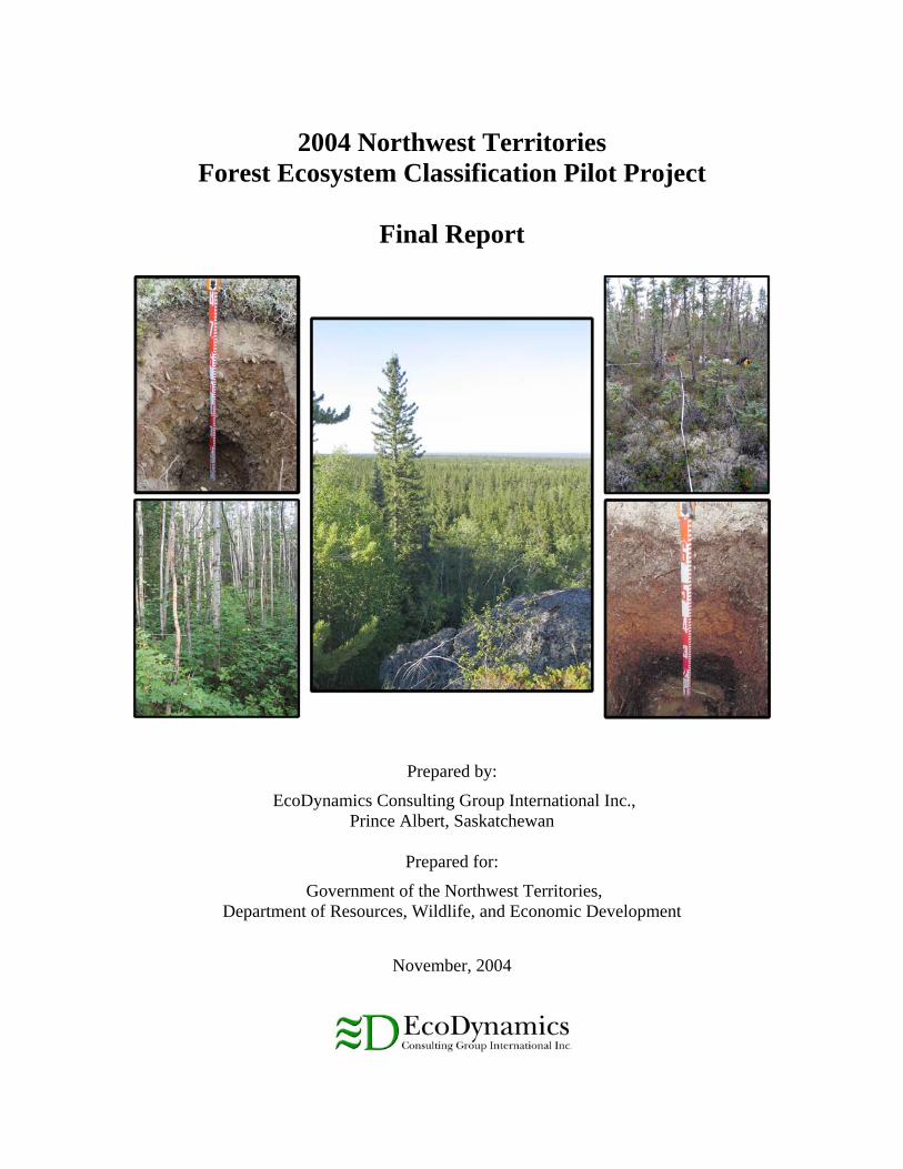
2004 Northwest Territories Forest Ecosystem Classification Pilot Project Final Report Prepared by: EcoDynamics Consulting Group International Inc., Prince Albert, Saskatchewan Prepared for: Government of the Northwest Territories, Department of Resources, Wildlife, and Economic Development November, 2004

Welcome message from author
This document is posted to help you gain knowledge. Please leave a comment to let me know what you think about it! Share it to your friends and learn new things together.
Transcript
2004 Northwest Territories
Forest Ecosystem Classification Pilot Project
Final Report
Prepared by:
EcoDynamics Consulting Group International Inc., Prince Albert, Saskatchewan
Prepared for:
Government of the Northwest Territories, Department of Resources, Wildlife, and Economic Development
November, 2004

NWT FEC Pilot Project Final Report November 2004
Table of Contents Section Page
1.0 INTRODUCTION............................................................................................................. 1 1.1 Project Background and Scope ....................................................................................... 1 1.2 Study Area Locations and Description ........................................................................... 2
2.0 PILOT PROJECT METHODOLOGY .......................................................................... 4 2.1 Field Sampling Approach ............................................................................................... 4 2.2 Field Data Collection ...................................................................................................... 4
3.0 RESULTS AND DISCUSSION ....................................................................................... 6 3.1 Provisional Ecosite Calls ................................................................................................ 6 3.2 Apparent Environmental Gradients ................................................................................ 8 3.3 Utility of the Manual and Field Forms ......................................................................... 10
4.0 FUTURE SAMPLING AND ANALYSIS CONSIDERATIONS ............................... 11 4.1 Introduction................................................................................................................... 11 4.2 Overview of Ecosystem Sampling and Classification Approaches.............................. 11 4.3 Environmental Gradients and Sampling Specifics ....................................................... 12
4.3.1 Gradient-Based Sampling Approaches ................................................................. 12 4.3.2 Additional Sampling Considerations .................................................................... 14
4.4 Use of Existing Plot Data.............................................................................................. 16
5.0 CONCLUSIONS AND RECOMMENDATIONS............................................................ 17 5.1 Conclusions................................................................................................................... 17 5.2 Recommendations......................................................................................................... 18
LITERATURE CITED .............................................................................................................. 21
APPENDIX A - PHOTO PLATE SUMMARIES.................................................................... 24
APPENDIX B - TAXONOMY RECOMMENDATIONS....................................................... 24
APPENDIX C - MANUAL AND FORM CHANGES............................................................. 30
APPENDIX D - LIST OF OBSERVED SPECIES. ................................................................. 35
i

NWT FEC Pilot Project Final Report November 2004
ACKNOWLEDGEMENTS The EcoDynamics study team would like to extend special thanks to Bob Decker and Bas Oosenbrug of the Government of the Northwest Territories, Department of Resources, Wildlife, and Economic Development, for their continued support throughout the project. We would like to also thank Dr. Rob Wright, Forest Service, Saskatchewan Environment for sharing his insights and experiences with the Saskatchewan Forest Ecosystem Classification System.
ii

NWT FEC Pilot Project Final Report November 2004
STUDY TEAM Jason Nelson, B.Sc. Manager, Biophysical Division and Senior Pedologist Randy Olson, B.Sc. Botanist/Plant Ecologist Miodrag Tkalec, B.Sc. (Forest Engineering) Project Forester
iii

NWT FEC Pilot Project Final Report November 2004
1.0 INTRODUCTION 1.1 Project Background and Scope The Department of Resources, Wildlife and Economic Development (RWED), of the Government of the Northwest Territories, has recently embarked on the development of a Forest Ecosystem Classification (FEC) system and field guide for use in sustainable forest management and environmental assessment. The FEC system will be based on the analysis of site, soil, and vegetation data from detailed ecological plots distributed across the Taiga Plain Ecozone of the Northwest Territories, together with existing data from ecologically equivalent areas in neighboring jurisdictions (i.e., British Columbia, Alberta, Yukon and Saskatchewan). The purpose of FEC is to: Further the understanding of NWT forest ecosystem processes;
Provide a consistent ecological framework for making forest management decisions and predicting impacts on forest ecosystems; and
Provide a common ecological language for communication among forest users and managers.
In the summer of 2004, EcoDynamics Consulting Group International Inc. was contracted by RWED to establish fifty detailed ecological plots in the Hay River Lowland Ecoregion as a pilot project for the FEC program. The scope of the pilot project was to:
1. Establish fifty (50) 10m x 10m (100m2) ecological plots at predetermined locations in the Hay River Lowlands Ecoregion of the Taiga Plain Ecozone;
2. Collect site, soil, vegetation, and forest mensuration data at each plot according to the Ecological Land Survey Site Description Manual – 2nd Edition (Alberta Sustainable Resource Development, 2003) and the NWT Inventory Field Sampling Manual – Version 2.0 (Forest Management Division, Resources Wildlife & Economic Development, 2004);
3. Classify each plot to Ecosite, Ecosite Phase, and Plant Community level using the Field Guide to the Ecosites of Northern Alberta (Beckingham and Archibald, 1996a) to test the guide's applicability to the Northwest Territories; and
4. Prepare a project report summarizing the results of the pilot project and making recommendations for future FEC sampling.
This final report presents the results of the pilot project and recommendations for future FEC survey work.
1

NWT FEC Pilot Project Final Report November 2004
1.2 Study Area Locations and Description The fifty pilot project FEC plots are located in the Hay River Lowlands Ecoregion of the Taiga Plain Ecozone in the Northwest Territories (Figure 1). The Hay River Lowlands Ecoregion consists of a broad, level lowland plain, most of which lies within the Northwest Territories. Small portions extend into northeastern British Columbia and northwestern Alberta. Regional drainage is via the Fort Nelson, Liard, and Hay Rivers, which all ultimately flow into the Mackenzie River. The ecoregion is classified as having a subhumid mid-boreal ecoclimate, marked by short, warm summers and long, cold winters. The mean annual temperature is approximately -2.5°C. The mean summer temperature is 13°C and the mean winter temperature is -19°C. The mean annual precipitation ranges 350-450 mm. The area is underlain by flat-lying Palaeozoic limestones and dolomites near Great Slave Lake, and Cretaceous shale towards its western flank. The Paleozoic bedrock is spectacularly exposed as numerous waterfalls and cliffs along major rivers, and as steep, wave-cut escarpments along the south shore of Great Slave Lake. The sedimentary bedrock is in turn covered by a mixture of glacial and recent deposits. Glacial materials consist mainly of calcareous, clayey glaciolacustrine and glacial till deposits, with nearly level to gently rolling topography. In many locations the till deposits have been washed or eroded by Glacial Lake McConnel (Lemmen, 1990). This glacial lake also produced a series of gravelly raised beach ridges along the southern shores of Great Slave Lake. Glaciofluvial deposits are relatively rare. Sporadic discontinuous permafrost with low ice content is associated mainly with organic deposits. Upland soils consist largely of Gray Luvisols and Eutric Brunisols. Cumulic Regosols predominate in the silty alluvial sediments along river channels. Lowland soils are dominated by peaty phase Gleysols, Organics, and Organic Cryosols. The well-drained upland forests of this Ecoregion are typically closed mixedwood, with various combinations of coniferous (white spruce, black spruce, jack pine, balsam fir) and deciduous (trembling aspen, balsam poplar and birch) tree species. Deciduous and mixed conifer-deciduous forests are richer is understorey shrubs and herbs, while coniferous forests tend to encourage a moss-dominated understorey. Poorly drained tamarack and black spruce peatlands cover about 30% of the ecoregion.
2

NWT FEC Pilot Project Final Report November 2004
Figure 1. Plot location map.
3

NWT FEC Pilot Project Final Report November 2004
2.0 Pilot Project Methodology 2.1 Field Sampling Approach A variety of forest stand types were targeted for FEC sampling, representing a range of moisture and nutrient regimes. Each stand was pre-selected by RWED staff and was plotted on forest inventory maps and accompanying air photos. A field reconnaissance was then conducted to ensure suitability of the candidate stands (i.e., relatively undisturbed, healthy, and at least 40 years old). Most targeted stands (38) were within 100 m of major NWT highways. The remaining stands were mostly within 750m of the highway. The prior reconnaissance and focus on accessibility were designed to maximize plot the rate-of-progress and cost-effectiveness of plot establishment.
2.2 Field Data Collection and Reporting Field sampling was conducted between August 9 and 18, 2004, by a three-person field team consisting of a botanist, a forester, and a pedologist (soil specialist). Prior to the start of the fieldwork, the team met with RWED staff in Hay River for a review of the project scope and to obtain marked copies of the inventory maps and air photos, along with geographic coordinates for each proposed plot location. Once the field team arrived to the closest stand access point along the highway, a Garmin 12XL GPS unit was used to navigate to the pre-selected plot position. Once the team arrived at the preset location, the forest overstorey composition was compared with the targeted type. If the site was disturbed (i.e., evidence of recent harvesting or fire, extensive windthrow, severe insect, or disease damage) or did not match the targeted type the team proceeded in a cardinal compass direction at 25m intervals until out of the disturbance or an overstorey match was found. Obvious ecotones were deliberately avoided, with all plots being at least 30m from a polygon or stand boundary. This overall approach was designed to be consistent with the ecological sampling method advocated by Mueller-Dumbois and Ellenburg (1974) – ‘subjective without pre-conceived bias’. Once at the pre-selected plot position, a metal pigtail pin was placed to mark the NW corner of the plot. From this point, a 60m tape was used to establish a 10m x 10m plot along north-south and east-west axes, such that each side faced a cardinal direction. Only the NW corner and plot center pins were left in place as permanent markers. Site, soil and vegetation data was collected at each plot using the procedures and field forms found in Ecological Land Survey Site Description Manual – 2nd Edition (Alberta Sustainable Resource Development, 2003). A soil pit was excavated to approximately 1m at a representative location outside of the plot for soil description and classification. Voucher specimens of unknown specimens were collected for later identification. All forest mensuration data was collected in a manner consistent with the NWT Inventory Field Sampling Manual – Version 2.0 (Forest Management Division, Resources Wildlife & Economic Development, 2004). Total height, dbh (diameter, breast height) and age at breast height (1.3 m)
4

NWT FEC Pilot Project Final Report November 2004
was measured on a minimum of three (3) healthy, representative trees from the co-dominant height class. In stands where more than one species made up the co-dominant crown, two sample trees of each species were measured. In stands that also had a dominant and/or intermediate crown class, an additional sample tree was measured from each of these crown classes. An inventory field call was also made describing stand structure, crown closure, and species composition. Representative digital photographs of the overstorey and understorey vegetation, and the soil profile, were taken at each plot for future reference and for inclusion in the planned field guide. A panoramic digital video was also recorded from plot center. Before leaving the site, the GPS coordinates of plot centre were recorded using a Trimble GeoExplorer 3 GPS Unit. Generally, these uncorrected coordinates may be considered to be accurate to within 10 m. After data collection, each plot was given a provisional classification to the Ecosite, Ecosite Phase, and Plant Community levels using the Boreal Mixedwood and/or Boreal Highland Sections of the Field Guide to the Ecosites of Northern Alberta (Beckingham and Archibald, 1996a). At each level of classification (Ecosite, Ecosite Phase, and Plant Community), a rating (good, fair, poor, or no fit) was applied to indicate how well the plot fit the classification. Table 1 describes the rating criteria, which are partially based on Alberta Environmental Protection (1996). The vascular plant scientific nomenclature used in this report follows Porsild and Cody (1980), except for the genus Salix, which follows Argus (2001 onwards). Lichen nomenclature follows Brodo et al. (2001), and bryophyte nomenclature follows the W3MOST database (Missouri Botanical Garden, 2004). A more detailed description of taxonomic recommendations is provided in Appendix B. Table 1. Ecosite classification "fit" ratings. Rating Criteria Good (G) Most or all dominant/abundant species present, including most indicator species.
(after Alberta Environmental Protection, 1996). Fair (F) Many dominant/abundant species present, including selected indicator species. Poor (P) Some dominant/abundant species present, with almost no indicator species present. No Fit (N) Few to no dominant/abundant species present, and no indicator species present. A brief literature review was also conducted in order to place the pilot project data within a preliminary ecological context and to assist in making informed recommendations for future FEC sampling.
5
NWT FEC Pilot Project Final Report November 2004
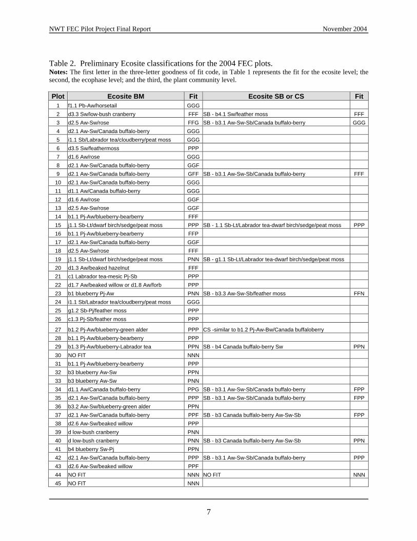
3.0 Results and Discussion 3.1 Provisional Ecosite Calls Provisional classifications of each plot to the Ecosite, Ecosite Phase, and Plant Community phase using the Field Guide to the Ecosites of Northern Alberta (Beckingham and Archibald, 1996a) are presented in Table 2. For plots that did not fit the Boreal Mixedwood (BM) section well, a further attempt was made using the Subarctic (SB) and Canadian Shield (CS) sections of the guide. It is possible that after the pilot project data is analyzed in a database environment, the fit of the plots to the Northern Alberta guide may be refined further. Several observations were made:
In general, provisional classification of the pilot project plot using the Field Guide to the Ecosites of Northern Alberta (Beckingham and Archibald, 1996a) produced generally unsatisfactory results, probably related to the steep climate gradients evident in the NWT (Dr. Rob Wright, pers. comm.). The goodness of fit became poor relatively quickly as the plots progress north. In some cases, the SB and CS sections fit better, possibly reflecting the beginning of the transition from boreal to sub-arctic climates in the study area. However, few plots fit well into the ecosites defined in the Alberta guide.
While 177 species of plants were observed (Appendix D), several indicator species
needed for keying in the Northern Alberta guide were not observed or rarely encountered in the plot data, including:
- Prunus virginiana, Aralia nudicaulis, Corylus cornuta (not observed). - Vaccinium myrtilloides (uncommon, possibly due to the high base status of most
soils, since it is acidophilic); - Viburnum edule (not observed north of Enterprise); - Maianthemum canadense (very rarely encountered); and - Ledum groenlandicum (found only in poorest/wettest regimes).
Several species may have potential as indicator species:
- Tofieldia glutinosa may be a good indicator of seepage. Plot #25 occurred along a beach ridge with apparently strong seepage, and a lot of short-range variability in the soils and vegetation. More transect work is needed along beach ridges and regions with shallow soils to capture this variability.
- Juniperus communis may be a good indicator for gravelly or stony sites, especially in shallow soils over bedrock.
- Antennaria appears to be invading wetland sites that are drying out. For example, at plot #49, it appears that Antennaria is moving onto the drier hummocks of this former permafrost site (has a "drunken forest" structure).
Several plots, such as #8 and 9, possibly had poor fit due to their location in riparian
areas. Ecosite guides are usually restricted in their coverage of ecotones, as such areas are usually avoided during plot sampling. Roads may also introduce 'artificial' ecotones, which have the potential to introduce noise into the data.
6
NWT FEC Pilot Project Final Report November 2004
Table 2. Preliminary Ecosite classifications for the 2004 FEC plots. Notes: The first letter in the three-letter goodness of fit code, in Table 1 represents the fit for the ecosite level; the second, the ecophase level; and the third, the plant community level. Plot Ecosite BM Fit Ecosite SB or CS Fit
1 f1.1 Pb-Aw/horsetail GGG 2 d3.3 Sw/low-bush cranberry FFF SB - b4.1 Sw/feather moss FFF 3 d2.5 Aw-Sw/rose FFG SB - b3.1 Aw-Sw-Sb/Canada buffalo-berry GGG4 d2.1 Aw-Sw/Canada buffalo-berry GGG 5 i1.1 Sb/Labrador tea/cloudberry/peat moss GGG 6 d3.5 Sw/feathermoss PPP 7 d1.6 Aw/rose GGG 8 d2.1 Aw-Sw/Canada buffalo-berry GGF 9 d2.1 Aw-Sw/Canada buffalo-berry GFF SB - b3.1 Aw-Sw-Sb/Canada buffalo-berry FFF
10 d2.1 Aw-Sw/Canada buffalo-berry GGG 11 d1.1 Aw/Canada buffalo-berry GGG 12 d1.6 Aw/rose GGF 13 d2.5 Aw-Sw/rose GGF 14 b1.1 Pj-Aw/blueberry-bearberry FFF 15 j1.1 Sb-Lt/dwarf birch/sedge/peat moss PPP SB - 1.1 Sb-Lt/Labrador tea-dwarf birch/sedge/peat moss PPP 16 b1.1 Pj-Aw/blueberry-bearberry FFP 17 d2.1 Aw-Sw/Canada buffalo-berry GGF 18 d2.5 Aw-Sw/rose FFF 19 j1.1 Sb-Lt/dwarf birch/sedge/peat moss PNN SB - g1.1 Sb-Lt/Labrador tea-dwarf birch/sedge/peat moss 20 d1.3 Aw/beaked hazelnut FFF 21 c1 Labrador tea-mesic Pj-Sb PPP 22 d1.7 Aw/beaked willow or d1.8 Aw/forb PPP 23 b1 blueberry Pj-Aw PNN SB - b3.3 Aw-Sw-Sb/feather moss FFN 24 i1.1 Sb/Labrador tea/cloudberry/peat moss GGG 25 g1.2 Sb-Pj/feather moss PPP 26 c1.3 Pj-Sb/feather moss PPP
27 b1.2 Pj-Aw/blueberry-green alder PPP CS -similar to b1.2 Pj-Aw-Bw/Canada buffaloberry 28 b1.1 Pj-Aw/blueberry-bearberry PPP 29 b1.3 Pj-Aw/blueberry-Labrador tea PPN SB - b4 Canada buffalo-berry Sw PPN 30 NO FIT NNN 31 b1.1 Pj-Aw/blueberry-bearberry PPP 32 b3 blueberry Aw-Sw PPN 33 b3 blueberry Aw-Sw PNN 34 d1.1 Aw/Canada buffalo-berry PPG SB - b3.1 Aw-Sw-Sb/Canada buffalo-berry FPP 35 d2.1 Aw-Sw/Canada buffalo-berry PPP SB - b3.1 Aw-Sw-Sb/Canada buffalo-berry FPP 36 b3.2 Aw-Sw/blueberry-green alder PPN 37 d2.1 Aw-Sw/Canada buffalo-berry PPF SB - b3 Canada buffalo-berry Aw-Sw-Sb FPP 38 d2.6 Aw-Sw/beaked willow PPP 39 d low-bush cranberry PNN 40 d low-bush cranberry PNN SB - b3 Canada buffalo-berry Aw-Sw-Sb PPN 41 b4 blueberry Sw-Pj PPN 42 d2.1 Aw-Sw/Canada buffalo-berry PPP SB - b3.1 Aw-Sw-Sb/Canada buffalo-berry PPP 43 d2.6 Aw-Sw/beaked willow PPF 44 NO FIT NNN NO FIT NNN 45 NO FIT NNN
7
NWT FEC Pilot Project Final Report November 2004
46 d2.6 Aw-Sw/beaked willow PPP 47 h1 Labrador tea/horsetail Sw-Sb PPN 48 NO FIT NNN 49 g1 Labrador tea-subhygric Sb-Pj PPN 50 a1 lichen Pj PPN
3.2 Apparent Environmental Gradients Timoney et al. (1993) conducted ordination, classification, and statistical analysis of vegetation and site data from the subarctic forest-tundra transition, which revealed that plant species occurrence and community composition were strongly correlated with soil pH, moisture, texture and latitude. Base-rich, loamy soils derived from Paleozoic bedrock show greater species richness and the favouring of calciphiles, compared to Shield-derived soils. A parallel paper by Timoney et al. (1992) present significant findings illustrating how some environmental variables, such as soil base status and regional slope, compensate for the synoptic climate gradient. While these gradients are discussed in the context of the subarctic forest-tundra transition, some of these same gradients were evident in the study area. Based on the 2004 field observations and preliminary ecosite classification, the study area vegetation appears to be strongly influenced by some of the same gradients reported by Timoney et al. (1992 and 1993), particularly calcareousness and depth to carbonates (chemogradient). Strongly calcareous parent materials were common in the study area, producing shallow solum depths (commonly less than 30 cm), with a corresponding shallow depth to carbonates. Interestingly, effective rooting depth is often coincident with the depth to carbonates, possibly indicating a vegetation response. Depth to carbonates has been found to be an important factor in the growth of conifers (Kishchuk, 2000). Many common plant species from the more northern sections of the study area are normally associated with different base statuses in the soil (e.g., Arctostaphylos rubra, Hedysarum alpinum in moderately calcareous sites; Dryas integrifolia in extremely calcareous sites), which is consistent with the findings of Timony et al. (1992). The higher base status may also account for the limited observation of certain acid-loving ericaceous species, otherwise common in the Boreal Forest, such as blueberry (Vaccinium myrtilloides) and Labrador Tea (Ledum groenlandicum). The observed lower lichen covers were also consistent with calcium-rich soils. Landform or topographic gradient (topogradient) is also a key environmental variable affecting forest ecosystems in the study area, as would generally be expected. While level and gently undulating landscapes are predominant, this gentle topographic gradient is periodically broken by abrupt changes in the environmental gradient due to changes in local landform. These steep topographic gradients are most evident along the beach ridges and steep, wave-cut escarpments, which frequent the south shore of Great Slave Lake, as well as in proximity to the spectacular waterfalls and cliffs common along major rivers. Hillside seepage was apparent at several plots along the beach ridges. Seepage areas were also observed on riverine slopes near waterfalls at several Territorial Parks in the study area. In both cases the seepage appeared to be associated with the glacial till/bedrock contact.
8

NWT FEC Pilot Project Final Report November 2004
It should also be recognized that a significant portion of the plots established between the Alberta border and Hay River, lie within the riparian zone of the Hay River itself. These plots along with any future plots within riparian zones, should be stratified into a distinct plot group prior to data analysis. Riparian forests typically reflect a unique microclimate, which may compensate for the regional climate gradient. Suspected permafrost was observed during the pilot project (e.g., plot #49) and could be considered an indicator of the regional climate gradient. There has been a notable impact by intensified buffalo grazing in the plots along the highway (plots #32-39). Grazing appears to have thinned the understorey and compacted the soil in some locations. Overall, these plots likely represent a maximum for buffalo-related disturbance in this area. Plot #39 (Figure 2) was especially impacted: the soil is compacted, the vegetation is thin, there are broken trees, and woody debris is increased in the area. In fact, the whole area smelled like a pasture. Future FEC plots may need to be put farther away from concentrations of buffalo to prevent such high disturbance from impacting data analysis. The buffalo also appear to be a vector for increasing the presence of certain weedy species in the forest, including Taraxacum officinale. Figure 2. Plot #39. Left: an apparently grazed understorey. Right: A small white spruce from plot that was found snapped off at the base.
9

NWT FEC Pilot Project Final Report November 2004
A more thorough literature review may reveal more details on the differences between Northern Alberta and the study area in terms of environmental gradients. The obvious influence of arctic gradients, make the study area increasingly dissimilar to the region covered by Field Guide to Ecosites of Northern Alberta the farther one moves away from the Northwest Territories-Alberta border. For this reason, the applicability of this field guide is limited to only the extreme southern portion of the Hay River Lowlands Ecoregion. Future FEC surveys should be restricted to the period July 1st to August 15th to minimize variance in species presence and abundance data due to differences in the emergence and senescence of various plant species. 3.3 Utility of the Manual and Field Forms The procedures and field forms found in the Ecological Land Survey Site Description Manual – 2nd Edition (Alberta Sustainable Resource Development, 2003) were generally applicable to the data collection needs of the FEC pilot project. However, given the broad target audience of the manual, not necessarily every parameter listed in the field forms is relevant to the needs of the NWT FEC project. Appendix C discusses specific issues regarding the field form and the collection of specific ecological parameters
10

NWT FEC Pilot Project Final Report November 2004
4.0 FUTURE SAMPLING AND ANALYSIS CONSIDERATIONS 4.1 Introduction The pilot project results obviously provide some insights for developing a comprehensive sampling design in advance of the main data collection program. It is also an opportunity to clarify the project purpose and scope. What are the end products and how will they be used? What science and past experience can the project draw on for the field sampling design and for subsequent data analysis? How do we ensure costs-effectiveness, efficiency, and scientific credibility? Answers to these and other important questions help to refine the sampling and analysis approach used, allowing effort to be focused on ecological factors of greatest importance. 4.2 Overview of Ecosystem Sampling and Classification Approaches
“A classification system is of limited operational use if ecosystems cannot be allocated to classes quickly in the field using a few easily identified diagnostic features. Ultimately there should be sufficient classes to characterize the wide range of conditions that prevail…yet few enough to keep the classification relatively simple and the number of resulting management options reasonable.” (Sims et al., 1997).
Most ecological site classifications in Canada, present some form of integrated vegetation/soil taxonomic units, derived from a multivariate statistical analysis of ecological plot data. Most of the science and analytical techniques underlying these classifications originate from the integration of the community and continuum concepts of vegetation ecology, the classification and ordination methods of mathematical ecology, and the mapping traditions of geography and soil science (Ponomarenko and Alvo, 2001). Fortunately, there is a substantial body of ecological classification knowledge and experience to draw from. An excellent starting point is a review of the science behind ecological classification and its history presented in Perspectives on Developing a Canadian Classification of Ecological Communities (Ponomarenko and Alvo, 2001). A paper by Barnes (1986) also presents a discussion of various forest classification systems and emphasizes the distinction made by Rowe (1984) between taxonomic and cartographic approaches to ecological classification. There are also published reviews of specific site classification projects in other parts of Canada. Sims and Uhlig (1992) and Sims et al. (1986) provide excellent discussions about the development of Forest Ecosystem Classification in Ontario, as well as the province’s site classification history. Similarly, a paper by Corns and Annas (1986) provides insights into the development of the first ecological site guide in Alberta, which laid the foundation for subsequent guides (e.g., Beckingham and Archibald, 1996a). The most common approach in western Canada is the “multi-factor integrated approach” (Grossman et al., 1998), whereby all major ecological factors (e.g., natural vegetation, soils, and landscape features) are collectively used to define ecological site types (e.g., Beckingham and
11

NWT FEC Pilot Project Final Report November 2004
Archibald, 1996a; Beckingham and Archibald, 1996b). This type of ecological site classification places more emphasis on grouping vegetation communities with respect to major environmental gradients, with the expectation that they will respond to disturbance or management in a similar manner (Cleland et al., 1994). In this approach the concept of the edatope (a matrix or grid of moisture and nutrient regimes) is central to the grouping of similar plots. An alternative approach is the “multi-factor component approach” (Grossman et al., 1998), wherein separate vegetation and soil classifications are developed (e.g., Sims et al., 1997; Zoladeski et al., 1995). The vegetation classifications are primarily based on variations in overstorey and understorey composition. Various combinations of vegetation and soil types are then analyzed to develop operational groups or ‘treatment units’ for management purposes (Sims et al. 1997; Racey et al., 1989). This more detailed approach focuses on the plant community level of classification, and roughly corresponds to the ecoelement level in the Canadian ELC. The distinction between these two approaches to ecological site classification is important primarily due to cost. Of the two approaches, the component approach (i.e., a V-types and S-types system) is often the most expensive, usually requiring thousands of plots within a given region in order to reliably differentiate individual plant communities (Dr. Rob Wright, pers. comm.). The integrative approach is focused on defining forest ecosystems rather than individual components, thus usually requiring fewer plots (i.e., hundreds vs. thousands). 4.3 Environmental Gradients and Sampling Specifics 4.3.1 Gradient-Based Sampling Approaches While a given vegetation community may be widely distributed regionally, it should not be assumed that these communities will have identical site characteristics (Grossman et al., 1994). Each may have developed from different combinations of environmental variables and may have different responses to disturbance and management (Grossman et al., 1994). Ecological site classification attempts to identify the links between plant communities and environmental gradients across a given landscape. As such, a gradient-based sampling approach is crucial (Ponomarenko and Alvo, 2001). Most environmental gradients affecting forest vegetation distributions commonly derive from differences in climate, topography, bedrock geology, surficial geology (soil parent materials), and groundwater regime (e.g., seepage). Additionally, in the NWT, the regional permafrost gradient may also be of significance. Some apparent local gradients observed during the pilot project were previously discussed in section 3.2 The most common gradient-based methodology recommended for ecological sampling is stratified random sampling, both for its statistical validity and the ability to capture the range of ecological variation (Grossman et al., 1994; Dr. Rob Wright, pers. comm.). For example, a nested, stratified random sampling design based on landform and ecoregions was used by Orloci and Stanek (1979) for an ecological classification in the southern Yukon, Canada. The study results showed that these stratifying variables accounted for a statistically significant portion of the regional variation in the ecological dataset. A similar approach was used for development of
12

NWT FEC Pilot Project Final Report November 2004
an ecosite classification system for Saskatchewan, where stratification occurred at the ecoregion, ecodistrict, soil landscape unit, and surficial geology unit levels, to capture both the local and regional environmental gradients (Dr. Rob Wright, pers. comm.). This sampling approach takes advantage of the integrated capture of environmental gradients inherent in ecological land classification maps – this could be described as an indirect gradient sampling approach (gradient is implicit). Grossman et al., (1994) also discuss a variant of the stratified random sampling, called ‘gradsect sampling’. The gradsect sampling approach is more gradient-direct (gradient is explicit), with transects placed along the strongest regional and local environmental gradients in accessible areas, capturing the greatest range of vegetation/gradient interactions with the least sampling effort (Gillison and Brewer 1985; Austin and Heyligers, 1989). The gradsect method has been proven statistically to capture ecological patterns more efficiently and more cost-effectively than most traditional statistical designs (Gillison and Brewer 1985). Gradsect sampling is particularly applicable when it is not possible to cover all areas of the study area, due to budget and accessibility restrictions (Grossman et al., 1994). Additionally this method builds a stronger understanding of vegetation-environmental relationships and key ecological processes (Grossman et al., 1994), as it offers more direct control of stratifying variables. Grossman et al. (1994) summarize the general gradsect sampling process, as follows:
1. Key environmental variables are selected based on prior understanding of the principle factors driving the distribution of the vegetation in the study area;
2. Selected variables are broken down into three to five ecologically-relevant classes to produce environmental theme maps;
3. The resulting theme maps are overlaid to generate a ‘biophysical’ map representing the various combinations of variables and classes, and in turn reflecting the major environmental gradient complexes.
The gradsect methodology may also be further refined to include levels of environmental stratification within each gradsect (Austin and Heyligers, 1989). This modified gradsect approach utilizes a two-stage sampling design: (1) gradsects are selected; (2) further local environmental stratification and replication are performed along each gradsect. Since, the result is a map similar to an ecological land classification (ELC), one might ask why not just use the existing ELC stratification? The answer is, it depends on the level of detail of ELC itself and the data, which went into its construction, as well as the specific needs of the project. If the existing ecological map base is sufficiently detailed and captures the principal gradients, a standard ELC-based stratified sampling approach may be more applicable. In the absence of a suitable scale of ELC, and if detailed digital datasets at the appropriate scale are available, the gradsect method may theoretically be the best approach. The gradsect approach is probably worth exploring further, especially with modern GIS software and digital datasets commonly available to facilitate overlay analysis. Some digital inputs that would be required for a GIS-based gradsect sampling design include:
13

NWT FEC Pilot Project Final Report November 2004
Climate data (including ecoclimatic zones);
Bedrock and surficial geology maps (and soil maps where available);
Vegetation and species distribution maps (e.g., inventory maps and other sources);
Permafrost zone maps;
Environmental impact assessment data (e.g., Mackenzie Gas Project EIA);
Digital Elevation Models (DEMs) (for both regional and local landform and site parameters);
A combined approach may be the most expedient. The study area would first be stratified by ecoregion, ecodistrict, soil landscape unit, and soil map unit or surficial geology units (where available), and within each major stratification, plots could be distributed across all major identifiable gradients (i.e., slope positions, landforms, parent materials, forest cover and wetland types, etc.) to capture as much ecological variation as possible (Ponomarenko and Alvo, 2001) While sampling will understandably focus on accessible areas, some portion of plots (perhaps 10 to 20%) should be away from road network. Restriction of sampling to road corridors may lead to a biased and unrepresentative samples, as roads tend to follow specific landforms in response to engineering and borrow material requirements. In areas with navigable rivers and lakes, fixed-wing aircraft and/or boat could be used to gain access for plot establishment, thereby reducing dependency on costly helicopters. 4.3.2 Additional Sampling Considerations Most of Canada has already gone through the process of planning, writing, and publishing various ecosystem classification guides. There are also many experts that have experiences to learn from. Dr. Rob Wright, who is currently finalizing the new Saskatchewan Ecosite guide, was briefly consulted regarding his experience with FEC data collection, management and analysis (Dr. Rob Wright, pers. comm.). . Dr. Wright indicated that the effort put into planning and data management is one of the most important factors that will govern the success of the FEC program. More specifically, he emphasized that data management was the most expensive aspect of an FEC project and can be the deciding factor between success and failure. Therefore, the project work plan must clearly indicate how the entire project will be managed, and how data will be collected, stored and analyzed. Before initiating the main data collection program, selection of data variables and analytical techniques must be finalized. Upon deciding on what analysis will be used and what variables need to be collected, appropriately structured, field-expedient forms should be constructed to allow consistent, easy entry of data. Based on Dr. Wright’s experience, some of the most important points to consider in an FEC data collection program, are as follows:
14
NWT FEC Pilot Project Final Report November 2004
If data is being collected with a justification of "because we might use it later", then that data does not need to be collected. Minimizing the amount of data collected at each plot will maximize the amount of plots that can be completed.
The number of teams collecting the data should be minimized and their expertise
maximized. Poorly collected data that needs to be cleaned up will delay the project and cost a large amount of money, and will reduce data integrity.
Considering the substantial cost of field data collection, the focus should be only on those
parameters that will be of significance in differentiating ecosites. Regarding data storage and management specifics, Dr. Wright stressed that analysis of FEC plot data is highly complex, and that it may be necessary to work with a professional programmer to create a database that will facilitate analysis. In Saskatchewan’s case, the programmer ensured that the database was robust enough to handle complex statistical analysis, quickly, and with the least delays. The Saskatchewan data was entered via an automated text recognition system. However, substantial time was wasted repairing the structure of the data that was lost in this process, as the data forms were not sufficiently designed for this process. Ultimately, whether or not the NWT data should be entered by a text recognition system, will depend on a cost-comparison between regular data-entry text-recognition system, including extra resources expended on planning, training, and obtaining. Dr. Wright also emphasized the need to recognize the steep climate gradient in the NWT, which is expressed by quick changes in synoptic climate over relatively short distances in comparison with other parts of the boreal forest. He recommended that the first version of the FEC guide restrict itself to smaller area (e.g., the Hay River Lowlands), to reduce the impacts of climate variability and make the most of a smaller dataset. Too many extremes in gradient require too many plots to capture in a statistically valid fashion. The relatively late start in creating an ecosystem classification system for this region has also created an opportunity to take advantage of recent wetland research that was not available during period most existing guides were developed. The prominence of wetlands in this region, as well as adherence to the ecosystem-based forest management paradigm, should require that wetlands be given more priority in these guides. One very important source of information is the Canadian Wetland Classification System (National Wetlands Working Group, 1997). This system is based on environmental gradients (Zoltai and Vitt, 1995) and is designed for use by non-experts. By using the CWCS, the project could be integrated with an international-scale methodology for consistently classifying wetlands. Ultimately, this integration would increase the scientific credibility and utility of the guide.
15

NWT FEC Pilot Project Final Report November 2004
4.4 Use of Existing Plot Data If existing data from ecologically equivalent areas in neighboring jurisdictions (i.e., British Columbia, Alberta, Yukon and Saskatchewan) is to be included in the data analysis, this data should be obtained and reviewed prior to finalizing the field sampling plan, to ensure that the core attributes are consistent between the existing and new plot data. Specifically, the existing plot data must (Grossman et al., 1994):
Be sufficiently recent to reflect present vegetation;
Be georeferenced to allow revisiting;
Include species structural and cover data, key environmental and site history information.
16
NWT FEC Pilot Project Final Report November 2004
5.0 CONCLUSIONS AND RECOMMENDATIONS 5.1 Conclusions
Provisional classifications of the pilot project plot using the Field Guide to the Ecosites of Northern Alberta (Beckingham and Archibald, 1996a) produced generally unsatisfactory results. Few plots fit well into the ecosites defined in the Alberta guide, probably related to the steep climate gradients evident in the NWT (Dr. Rob Wright, pers. comm.).
There are obvious differences between Northern Alberta and the study area in terms of
environmental gradients, particularly climate. At best, this field guide is limited to the most southern portion of the Hay River Lowlands Ecoregion only.
While 177 species of plants were observed, several indicator species needed for keying in
the Northern Alberta guide were not observed or rarely encountered in the plot data, including:
- Prunus virginiana, Aralia nudicaulis, Corylus cornuta (not observed). - Vaccinium myrtilloides (uncommon, possibly due to the high base status of most
soils, since it is acidophilic); - Viburnum edule (not observed north of Enterprise); - Maianthemum canadense (very rarely encountered); and - Ledum groenlandicum (found only in poorest/wettest regimes).
The study area is underlain mostly by highly calcareous parent materials, which result in
high base status soils, with shallow depth to carbonates. Soil base status is known to produce a strong environmental gradient, directly impacting plant community composition, particularly with regard to the proportions of calciphilic and acidophilic species. Some species present in some of the plots are direct indicators of high base status (e.g., Arctostaphylos rubra, Hedysarum alpinum in moderately calcareous sites; Dryas integrifolia in extremely calcareous sites). The higher base status may also account for the absence or near absence of certain acid-loving ericaceous species and the frequently low lichen covers.
While level and gently undulating landscapes are predominant, abrupt changes in the
topographic gradient are associated with beach ridges and wave-cut escarpments, and waterfalls and cliffs along major rivers. Hillside seepage is common in these areas, often associated the glacial till/bedrock contact.
A significant portion of the plots are within or in proximity to the riparian zone of the
Hay River. This may account for the poor fit of some plots during classification with the Alberta guide, as such ecotones are usually avoided during plot sampling.
The impact of bison was clearly evident at plots north of Fort Providence (plots #32 to
39), with the soil often compacted and the understorey thinned. The buffalo also appear to be a vector for spreading certain weedy species in the forest (e.g., Taraxacum
17

NWT FEC Pilot Project Final Report November 2004
officinale). The exact nature of the ecological impacts of Bison are indeterminate at this time.
Permafrost was observed at several plots, including upland sites.
The Ecological Land Survey Site Description Manual was generally applicable to the
needs of the FEC pilot project. However, not necessarily every parameter listed in the field forms is relevant to the needs of the NWT FEC project. A thorough review of procedures is in order.
Focusing data collection in road accessible areas, and the reconnaissance of target stands
prior to sampling, contributed substantially to field crew productivity.
The pilot project results and related discussion provides substantial insights for planning the main FEC data collection program and subsequent analysis.
5.2 Recommendations
Dependency on guides from adjacent jurisdictions is not recommended. A NWT-specific guide is needed for ecosystem-based forest management, as well as use in environmental assessment.
Future sampling should take into account the possible effects of microtopography within
the stand. Certain taxa, such as bryophytes and lichens, often have a highly heterogeneous distribution based on microhabitat. This may limit the utility of the data.
Sampling for the first version of the FEC guide should focus on the Hay River Lowlands,
to reduce the impacts of climate variability and make the most of a smaller dataset in a statistically valid manner.
Before initiating the main data collection program, selection of data variables and
analytical techniques must be finalized in light of project goals and objectives. This requires a solid understanding of the environmental gradients driving ecosystem character and distribution.
Analysis of FEC plot data is highly complex, and requires a very robust and specific database structure to facilitate analysis. Since ecosite classification databases have been developed for similar projects in other provinces (e.g., Saskatchewan Environment), responsible agencies should be contacted to inquire as to whether their existing databases would be available for use by RWED. Given the importance of an effective database structure, a database programmer should be consulted during any modifications to such a database.
The pilot project data should be entered into provisional database tables to assist in
identifying specific database needs and for preliminary analysis.
18

NWT FEC Pilot Project Final Report November 2004
Various common sampling approaches should be explored, including the basic stratified random sampling and the more gradient-specific ‘gradsect approach’.
Data collection effort should be focused on ecological parameters of greatest importance
to the analysis and future functionality of the future guide. Data should not be collected "because we might use it later”. Minimizing the amount of data collected at each plot to that which is essential, will maximize the amount of plots that can be completed.
The number of field teams collecting the data should be minimized and their expertise
maximized. Poorly collected data that requires excessive clean-up will add additional costs and delays to the project, and may put data integrity into question.
Field-expedient forms need to be constructed to allow accurate and consistent entry of
FEC data; more discussion is needed.
Continue to focus data collection in road accessible areas in order to reduce costs, as well as limit travel time to maximize rate-of-progress. However, some portion of plots (perhaps 10 to 20%) should be away from road network to reduce the biases associated with roads. In order to conduct cost-effective sampling of off-road areas, navigable rivers and lakes, fixed-wing aircraft and/or boat should be considered to gain, thereby reducing dependency on costly helicopters.
Continue practice of conducting a brief aerial reconnaissance of target stands prior to sampling, which increases field crew productivity by confirming accessibility and avoiding unsuitable stands.
Restrict the survey to the period July 1st to August 15th to minimize variance in species presence and abundance data due to differences in the emergence and senescence of various plant species.
Riparian plots should be dealt with as distinct plot group during sampling and data analysis, as riparian forests typically reflect a unique microclimate.
Future FEC plots should be placed farther away from concentrations of buffalo to prevent
such high disturbance from impacting data analysis.
The use of existing plot data should be assessed during the early stages of the project. The assessment should focus on ensuring that the data is sufficiently current and georeferenced, and those key data parameters are present.
Assess the utility of the existing Canadian Wetland Classification System (National
Wetlands Working Group, 1997) for dealing with wetland areas. While every effort was made to maximize available resources, this list of recommendations should not be considered exhaustive. Further research and discussion is warranted.
19

NWT FEC Pilot Project Final Report November 2004
20

NWT FEC Pilot Project Final Report November 2004
LITERATURE CITED Alberta Environmental Protection. 1996. Pre-harvest Ecological Assessment Handbook. Version 2.0. Environmental Training Centre. Hinton, Alberta. 36 pp. Alberta Sustainable Resource Development. 2003. Ecological land survey site description manual – 2nd Edition. Edmonton, Alberta. 112pp. Argus, G. W. 2001 onwards. Interactive Identification of New World Salix (Salicaceae) using Intkey. http://www.uaa.alaska.edu/enri/willow/ Austin, M.P. and P.C. Heyligers. 1989. Vegetation survey design for conservation: gradsect sampling of forests in northeastern New South Wales. Biological conservation 50:13 32. Barnes, B.V. 1986. Varieties of experience in classifying and mapping forestland ecosystems. In: Site Classification in Relation to Forest Management. Symp. Proc. G.W. Wickware and W.C. Stevens. Aug. 27-29, 1985, Sault Ste. Marie, Ont. Canadian Forest Service, pp. 5-23. Beckingham, J.D. and Archibald, J.H. 1996a. Field guide to ecosites of northern Alberta. Natural Resources Canada, Canadian Forest Service, Northwest Region, Northern Forestry Centre, Edmonton, Alberta. Beckingham, J.D. and Archibald, J.H. 1996b. Field guide to ecosites of the mid-boreal uplands ecoregions of Saskatchewan. Natural Resources Canada, Canadian Forest Service, Northwest Region, Northern Forestry Centre, Edmonton, Alberta. Spec. Rep. 6. Brodo, I. M., S. D. Sharnoff and S. Sharnoff. 2002. Lichens of North America. Yale University Press, New Haven & London. Cleland, D.T., J.B. Hart, G.E. Host, K.S. Pregitzer and C.W. Ramm. 1994. Ecological Classification and Inventory System of the Huron-Manistee National Forests. U.S. Department of Agriculture, Forest Service, Region 9. Milwaukee, Wisconsin. Corns, I.G.W. and R. M. Annas. 1986. Field guide to forest ecosystems of west-central Alberta. Canadian Forest Service, Northern Forest Centre, Edmonton, Alberta. 251 p. Forest Management Division, Resource Wildlife and Economic Development. 2004. NWT Inventory Field Sampling Manual, v 2.0. 68 pp. Gillison, A.N. and K.R.W. Brewer. 1985. The use of gradient directed transects or gradsects in natural resource survey. Journal of Environmental Management 20:103 127. Grossman, D. H., D. Faber-Langendoen, A. S. Weakley, M. Anderson, P. Bourgeron, R. Crawford, K. Goodin, S. Landaal, K. Metzler, K. D. Patterson, M. Pyne, M. Reid and L. Sneddon. 1998. International Classification of Ecological Communities: Terrestrial Vegetation
21

NWT FEC Pilot Project Final Report November 2004
of the United States. Volume I. The National Vegetation Classification System: Development, Status, and Applications. The Nature Conservancy, Arlington, VA. Grossman, D.H., K.L. Goodin and C. Reuss (editors). 1994. Rare Plant Communities of the Conterminous United States: An Initial Survey. The Nature Conservancy. Kishchuk, B.E. 2000. Calcareous soils, their properties and potential limitations to conifer growth in southeastern British Columbia and western Alberta: a literature review. Natural Resources Canada, Canadian Forest Service, Northwest Region, Northern Forestry Centre, Edmonton, Alberta and Invermere Forest District Enhanced Forest Management Pilot Project, B.C. Ministry of Forests, Invermere, British Columbia. Information Report NOR-X-370. Lemmen, D.S. 1990. Surficial materiasl associated with glacial Lake McConnell, southern District of Mackenzie. In: Current Research, Part D. Geological Survey of Canada. Paper 90-1D. p. 79-83. Missouri Botanical Garden. 2004. W3MOST database. [ONLINE] Available at: http://mobot.mobot.org/W3T/Search/most.html Accessed: September 30, 2004. Mueller-Dombois, D. and H. Ellenberg. 1974. Aims and methods of vegetation ecology. John Wiley and Sons, New York, New York. 547 pp National Wetlands Working Group (NWWG). 1997. The Canadian wetland classification system, second edition. B.G. Warner and C.D.A. Rubec (ed.). Wetlands Research Centre, University of Waterloo, Waterloo. 68 pp. Available online at: http://www.uwwrc.net/web/wetlandsrc/cat/books/books-1053313151236 Orloci, L. and W. Stanek. 1979. Vegetation survey of the Alaska Highway, Yukon Territory: types and gradients. Vegetatio 41 (1): 1-56. Ponomarenko, S. and R. Alvo. 2001. Perspectives on developing a Canadian classification of ecological communities. Canadian Forest Service, Science Branch, Information Report ST-X-18E. Natural Resources Canada, Ottawa. Porsild, A.E. and W. J. Cody. 1980. Vascular plants of continental Northwest Territories, Canada. National Museum of Natural Sciences, Ottawa. Racey, G.D., T.S. Whitfield and R.A. Sims. 1989. Northwestern Ontario forest ecosystem interpretations. Ont. Ministry of Natural Resources. NWOFTDU Tech. Re. 46. 90pp. Rowe, J.S. 1984. Forestland classification: limitation of the use of vegetation. Pages 132-147. In Forest land classification: experience, problems, perspectives. Editor: J.G. Bockheim. University of Wisconsin, Madison. Sponsored by NCR-102, The North Central Forest Soils Committee, USDA Forest Service. 276 pp.
22
NWT FEC Pilot Project Final Report November 2004
Sims, R.A., W.D. Towill, K.A. Baldwin, P. Uhlig and G.M. Wickware. 1997. Field guide to the forest ecosystem classification for northwestern Ontario. Ont. Ministry of Natural Resources, Northwest Science. & Technology. Thunder Bay, Ont. Field Guide FG-03. 176 pp. Sims, R.A., W. D. Towill and G. M. Wickware. 1986. Forest ecosystem classification in the north central region of Ontario: a status report. Pages 72-82. In Site classification in relation to forest management. COJFRC symp. proc. O-P-14. Canadian Forestry Service., Sault Ste. Marie, ON. 142 pp. Sims, R.A. and Uhlig, P. 1992. The current status of forest site classification in Ontario. Forest. Chron. 62: 64-77.
Timoney, K.P., La Roi, G.H., Zoltai, S.C., and Robinson, A.L. 1992. The high subarctic forest- tundra of northwestern Canada: position, width, and vegetation gradients in relation to climate. Arctic 45: 1-9.
Timoney, K. P., G. H. La Roi, S. C. Zoltai and A. L. Robinson. 1993. Vegetation communities and plant distributions and their relationships with parent materials in the forest-tundra of northwestern Canada. Ecography 16: 174-188.
Zoladeski, C.A. G.M. Wickware, R.J. Delorme, R.A. Sims and I.G.W. Corns. 1995. Forest ecosystem classification for Manitoba: field guide. Natural Resources Canada, Canadian Forest Service, Northwest Region, Northern Forestry Centre, Edmonton, Alberta. Special Report 2. Zoltai, S. C. and D. H. Vitt. 1995. Canadian wetlands: environmental gradients and classification. Vegetatio 118: 131-137.
23

NWT FEC Pilot Project Final Report November 2004
APPENDICES APPENDIX A - PHOTO PLATE SUMMARIES Numerous photos were taken of the fifty FEC plots that were done for this project. An Adobe Acrobat (.pdf) file was created for each plot. Each file, if available, contains a photo of the stand, soil profile, and understorey. The header on each file contains the plot number, date, ecosite classification, and stand type. In order to reduce the file size of this document the photo plate summaries are not included in the main text body, but were provided in an accompanying CD-ROM. APPENDIX B - TAXONOMY RECOMMENDATIONS The following discussion is intended to outline taxonomy problems encountered during fieldwork and how taxonomic issues may affect the project in the future. The vascular plant, bryophyte, and lichen taxonomy in this region is not standardized in a consistent, accessible, and up-to-date manner. In Ecological Land Survey Site Description Manual – 2nd Edition (Alberta Sustainable Resource Development, 2003), the only taxonomic standard mentioned is the Alberta Plants and Fungi – Master Species List and Species Group Checklists published by Alberta Environment (1993). The problem with using this checklist as a taxonomic standard is that, as an internal Alberta Environment document, it is difficult to acquire and has not been recently updated. Vascular plant taxonomy has changed significantly in the last 11 years, and with projects like the Flora of North America, the taxonomy of vascular plants and bryophytes will continue to change in the years to come. What this means for this project is that to be relevant, needs to keep the taxonomy used in the guide should be consistent, accessible, and an updated taxonomic standard needs to be established. For this pilot project, Vascular Plants of the Continental Northwest Territories by Porsild and Cody (1980), was used for identification and naming of vascular plants. Until a new flora is published, this will remain the standard for identification of vascular plants for most people. The one group that was not fully identified using Porsild and Cody (1980) is the genus Salix. For this group, the program IntKey was used with the files provided under Interactive Identification of New World Salix (Salicaceae) using Intkey on the Alaska Natural Heritage website (http://aknhp.uaa.alaska.edu/willow/) (Argus, 2001 onwards; Dallwitz, 1980; Dallwitz, Paine, and Zurcher, 1993 onwards; Dallwitz, Paine, and Zurcher, 1995; Dallwitz, Paine, and Zurcher, 2000). Salix taxonomy is discussed more fully below. The problem with solely using Porsild and Cody (1980) is two-fold. Firstly, direct synonyms may be extremely out of date and not in common usage. For example, the name Hieracium scabriusculum is used in Porsild and Cody, which is a rarely used synonym of Hieracium umbellatum. In these cases, users of the flora may have trouble going in between the names of this flora and more familiar names. Since these names are direct synonyms, they can easily be updated at a later time. Including a list of direct taxonomic synonyms with the guide(s) would make their application much more practical.
24
NWT FEC Pilot Project Final Report November 2004
The second case is more serious. Taxonomic changes, where species have been split and lumped, are not so easily corrected. A good example of this is that of Salix. Most of the taxonomy in Porsild and Cody (1980) has not changed significantly in the last 11 years. However, certain, key groups that were poorly investigated at the time when Porsild and Cody (1980) have had more correct taxonomy applied to them. Solving problems with lumped or split species will need to be dealt with before extensive work is done on the ecosite guide. Updated names for the North American flora are available on websites like the Integrated Taxonomic Information System (ITIS) at http://www.itis.usda.gov/. Simply using an updated checklist like ITIS or Alberta Plants and Fungi is that the current identification resources do not match the updated checklists. The solution to this problem is to continue using Porsild and Cody (1980) as a main identification resource and either target “problem” groups using an alternative resource like the (currently incomplete) Flora of North America or IntKey. If a group is not going to be particularly important in the project’s data, a certain amount of lumping (e.g.- Carex sp.) may be acceptable. However, I strongly recommended that in the early stages of this project, species should be identified to the furthest extent possible until it is known whether or not the presence of that species is providing important data. Certain groups may not be practical to use because of difficulties spotting or identifying a species. These cases could be left out entirely, or certain important species could be required for identification. For example, for groups like Carex, common or important species could be used in the guide(s) as long as users are provided with photos or drawings, a set of identifying characters, and an illustrated glossary defining technical terms. As taxonomy changes, keeping up with more recent taxonomy may not be practical and may not significantly change the usage of the guide(s) produced by this project. Any future updates would have to be done concurrently with the update of the guide(s). If updating the taxonomy of the guide is not practical or necessary, an out of date taxonomy could be used as long as that old taxonomy does not provide inaccurate information about those ecosites. Regardless of this, using up to date taxonomy from the early stages of this project should prevent taxonomy from creating too many problems in the future. So, when problems are encountered using Porsild and Cody (1980) the suggested process would be to:
1) Investigate the most up-to-date taxonomy using Flora of North America, or ITIS. Use W3MOST (http://mobot.mobot.org/cgi-bin/search_vast) for bryophytes not covered by ITIS. Nomenclature for lichens can be looked up in Lichens of North America by Brodo et al. (2001).
2) Find out how important full identification of a group is. Is identification of that group practical? Can that group be simply lumped, or key species identified without impeding the goals of the project? Is further investigation (and full identification) needed to know if the species is important enough to the project?
3) If not, determine what resources should be used for the identification of that group as a standard for use with this manual.
25

NWT FEC Pilot Project Final Report November 2004
Below are suggestions regarding some specific groups dealt with during our fieldwork: Rosa: Hybridization and phenotypic plasticity among Rosa tends to make identification of Rosa acicularis, and Rosa woodsii difficult (Looman and Best, 1987; Tesky, 1992). In my experience, the only reliable character for non-specialists is to use the mature fruit (August to October). The keys in Porsild and Cody (1980) only apply to fully mature specimens that clearly are not hybridized. A third species, Rosa blanda, is uncommon in the study region and can be separated using the lack of thorns and larger leaves. In cases where Rosa cannot be easily separated as Rosa blanda, I would suggest that if there are no mature fruit, the shrubs in question should be listed as Rosa spp. In the study area, the species found were either R. woodsii or R. acicularis. Salix: Since Porsild and Cody (1980) was published, extensive changes have been made to the taxonomy of Salix (Argus, 1999; Argus, 2001 onwards; Argus, 2004). A good example of this is the taxonomy of Salix myrtillifolia and Salix pseudomyrsinites (Argus, 1999; Argus, 2001 onwards). Salix pseudomyrsinites was recently separated as a distinct species from Salix myrtillifolia var. pseudomyrsinites (Andersson) Ball and Dorn (Dorn 1975). Separating these two species should be useful, since they are recognized as having distinct habitats (Argus, 1973). Most species of Salix have had their ecological characteristics and preferences for moisture and nutrient regime documented to some degree (Argus, 1973; Coladonato, 1993; Porsild and Cody, 1980; Viereck and Little, 1972). Since many species of Salix are common plants in the study area, and are somewhat difficult to identify, special consideration should be given to their treatment in this study. The problem with using Salix in too much detail is that many species are very difficult to identify reliably in the field. Field workers could do cover for Salix separated by height class (e.g., prostrate/decumbent-shrubs under 3m-shrubs over 3m-trees) and, if possible, by species. Regardless of how Salix is treated, field workers should be collecting voucher specimens for each species at all of the plots, taking care to note the measured height and micro-habit of the plant. Specimens with floral parts would preferably be collected. A botanist would then identify the collected specimens with the use of a herbarium and George Argus’ Salix treatment for Intkey (Argus, 2001 onwards). Betula: Betula glandulosa, Betula pumila, and Betula nana are common species throughout the study area and are known for challenging taxonomy and difficulties in identification (Flora of North America Editorial Committee, 1993; De Groot et al., 1997). Extensive hybridization between these species leaves most vegetative identification using available keys unreliable. For this project, identifications of this complex were done using the fruiting characters from the keys in Porsild and Cody (1980). However, Porsild and Cody (1980) incorrectly lumps B. glandulosa with B. nana ssp. exilis (Flora of North America Editorial Committee, 1993; De Groot et al., 1997). Since the moisture and nutrient requirements of these species are similar (De Groot et al.,
26
NWT FEC Pilot Project Final Report November 2004
1997) the cost of spending time separating these species would be quite high compared to the benefits of having them separated. The only major difference appears to be their respective tolerances to temperature extremes (De Groot et al., 1997). Given the difficulty separating these species, I would suggest continuing to use the taxonomy in Porsild and Cody (1980), while keeping in mind the taxonomy of this group for any analysis and discussion. See the taxonomic discussion on the Flora of North America web site (http://www.efloras.org/florataxon.aspx?flora_id=1&taxon_id=233500248) for a detailed discussion of the issues around the B. pumila/glandulosa/nana complex. A note on the differing taxonomy of FNA and ITIS: Two taxonomic resources mentioned above are the Flora of North America Project, and Integrated Taxonomic Information System (ITIS). The Flora of North America Project is an expert treatment of all of North America’s vascular and non-vascular plants. ITIS has it's own, separate taxonomy that is modified as new taxonomic evidence is found. Most of the taxa covered by these systems are very similar, but when using these systems one should be aware that there are differences to be found in treatments of different species. Voucher Specimens Any voucher specimens should be deposited in a recognized herbarium. Unknowns can be confirmed at a later date and can be stored for free, indefinitely. Mosses should be sent to the Devonian Botanical Gardens (UAMH). Vascular plants should be sent to one of the following:
W. P. Fraser Herbarium (SASK) Devonian Botanical Gardens (UAMH) University of Alberta (ALTA) Agriculture and Agri-Food Canada (DAO) Canadian Museum of Nature (CAN)
Contact information and addresses of these institutions can be retrieved from the Index Herbariorum, available online at http://sciweb.nybg.org/science2/IndexHerbariorum.asp. Appendix B References: Alberta Environmental Protection. 1993. Alberta plants and fungi - master species list and species group checklists. Editorial Services Unit, General Services Division, Edmonton, AB. 87 pp. Alberta Sustainable Resource Development. 2003. Ecological land survey site description manual – 2nd Edition. Edmonton, Alberta. 112 pp. Argus, G. W. 1973. The genus Salix in Alaska and the Yukon. Canadian National Museum of Natural Sciences Publications in Botany. 2. 279 pp.
27

NWT FEC Pilot Project Final Report November 2004
Argus, G.W. 1999. Classification of Salix in the New World. Version: 5 July 1999. Botanical Electronic News (BEN) # 227. Argus, G.W. 2004. A Guide to the identification of Salix (willows) in Alaska, the Yukon Territory, and adjacent regions. [ONLINE] Available from: http://aknhp.uaa.alaska.edu/willow/Accessed: October 31, 2004 Argus, G. W. (2001 onwards). Interactive Identification of New World Salix (Salicaceae) using Intkey. http://www.uaa.alaska.edu/enri/willow/ Coladonato, M. 1993 Salix brachycarpa. In: Fire Effects Information System, [ONLINE]. U.S. Department of Agriculture, Forest Service, Rocky Mountain Research Station, Fire Sciences Laboratory (Producer). Available: http://www.fs.fed.us/database/feis/Accessed: October 31, 2004. Dallwitz, M. J. (1980). A general system for coding taxonomic descriptions. Taxon 29, 41–6. Dallwitz, M. J., Paine, T. A., and Zurcher, E. J. (1993 onwards). User’s guide to the DELTA System: a general system for processing taxonomic descriptions. 4th edition. http://biodiversity.uno.edu/delta/ Dallwitz, M. J., Paine, T. A., and Zurcher, E. J. (1995 onwards). User’s guide to Intkey: a program for interactive identification and information retrieval. 1st edition. http://biodiversity.uno.edu/delta/ Dallwitz, M. J., Paine, T. A. and Zurcher, E. J. (2000 onwards). Principles of interactive keys. http://biodiversity.uno.edu/delta/ De Groot W.J., Thomas, P.A. & Wein, R.W. (1997) Betula nana L. and Betula glandulosa Michx. Journal of Ecology 85: 241-264 Dorn, R. D. 1975. A systematic study of Salix section Cordatae in North America. Canadian Journal of Botany 53: 1491-1522. Flora of North America Editorial Committee, eds. 1993+. Flora of North America North of Mexico. 7+ vols. New York and Oxford. Flora of North America Editorial Committee, eds. 1993. 17b. Betula nana subsp. exilis (Sukaczev) Hultén. In: Flora of North America North of Mexico [ONLINE]. vol 3. New York and Oxford. Available at: http://www.efloras.org/florataxon.aspx?flora_id=1&taxon_id=233500255 Accessed: October 31, 2004.
28

NWT FEC Pilot Project Final Report November 2004
Looman, J. and K. F. Best, eds. 1987. Budd's flora of the Canadian prairie provinces. Agriculture Canada Research Branch, Publ. 1662. Missouri Botanical Garden. 2004. W3MOST database. [ONLINE] Available at: http://mobot.mobot.org/W3T/Search/most.html Accessed: September 30, 2004. Payette, S. 1974. Classification écologique des formes de croissance de Picea glauca (Moench) Voss et de Picea mariana (Mill.) BSP. en milieux subarctiques et subalpins. Naturaliste can. 101: 893-903. Porsild, A.E. and W. J. Cody. 1980. Vascular plants of continental Northwest Territories, Canada. National Museum of Natural Sciences, Ottawa. Tesky, J. L. 1992. Rosa woodsii. In: Fire Effects Information System, [ONLINE]. U.S. Department of Agriculture, Forest Service, Rocky Mountain Research Station, Fire Sciences Laboratory (Producer). Available at: http://www.fs.fed.us/database/feis/ Accessed: October 31, 2004. USDA, NRCS. 2004. The PLANTS Database, Version 3.5. National Plant Data Center, Baton Rouge, LA 70874-4490 USA. [ONLINE] Available at: http://plants.usda.gov; Accessed October 20, 2004. Viereck, L. A., and E. L. Little. 1972. Alaska trees and shrubs. Agriciculture Handbook 410. Washington, D.C.: U.S. Department of Agriculture. Forest Service.
29

NWT FEC Pilot Project Final Report November 2004
APPENDIX C - MANUAL AND FORM CHANGES There are a number of issues to discuss regarding the methodologies and forms included in the Ecological Land Survey Site Description Manual. Soil Parameter Issues Some soil parameters are clearly non-quantitative, highly subjective, and would be of dubious value in multivariate analysis. Extraneous soil parameters include:
Horizon boundary distinctiveness and form – digital picture and depth range information captures this sufficiently;
Soil consistency and plasticity – extremely subjective, especially under field conditions with varying soil moisture;
Faint mottles –not used in soil drainage or moisture regime determination; difficult to see and distinguish from other forms of oxidation;
Colour aspect (soil matrix and mottles) – unnecessary;
Roots – very subjective, especially when describing a jumbled mass of various sized roots; horizonation, texture, structure and effective rooting depth (a less subjective root parameter) provide adequate information regarding rooting and potential root restriction.
While soil colour may be considered optional, it is useful for classifying soils in the Chernozemic and Podzolic Orders, and may also be of use correlating specific parent materials (especially different tills) with existing soil and surficial geology maps and reports. Field pH was not conducted due to the highly unreliable nature of most field test kits. Laboratory analysis is highly recommended if pH is determined to be necessary. However, pH has a high degree of variability at the site level, often exhibited as a high coefficient of variation in sample data. As a result of this variability, subsampling across the site is required (typically five or more) at each site to gain a reliable sample; this can be time-consuming and hence costly. There is a difference in effervescence/calcareousness classes in the Alberta manual versus that found in many Canadian soil manuals. In the Alberta manual a very weak class is added and very strong and extremely calcareous classes are dropped). Consistency in such an ecologically key parameter is important, especially when integrating with existing data sets from other sources and differences should be noted. Given the importance of mottle identification in the determination of soil drainage class and moisture regime, extra care must be taken to distinguish true mottling from other pedological (e.g., iron or manganese concretions) or geological phenomena (e.g., Cretaceous iron flecks, which were observed in some soils north of Fort Providence).
30
NWT FEC Pilot Project Final Report November 2004
Vegetation Parameter Issues Naming Species The methodology pages 81-85 of the Ecological Land Survey Site Description Manual (Alberta Sustainable Resource Development, 2003) describing the 7-letter naming system is overly complicated and error-prone. Some of the problems are:
In general, naming conventions as simple as possible. If necessary, a “cheat sheet” could be included with each clipboard listing the rules of nomenclature, and common species codes that may be confusing (e.g., Stellaria longipes and S. longifolia). If workers do not know a species code, it is likely not encountered regularly and would not use up too much time being written out in full. If there is a problematic name, workers could note the code that they are using with the name written in full in the comments or notes sections.
Codes for naming voucher specimens should be simplified. On p.82, the manual
recommends naming species using the collector's last initial followed by a stratum layer code, followed by a three-digit number. The genus name or a descriptive four-letter code should be used, followed by a number (e.g., Sali sp1, Sali sp2, Forb sp1, Grass sp1, Moss sp1, Lich sp1 etc.). A more simple system is going to result in fewer errors. As long as each name uniquely identifies a specimen and as long as that name is carefully labeled on the voucher specimen using with the collector's name, plot number, and collection name, voucher specimens should be adequately referenced.
Page 85 of the site description manual suggests using “$” signs for spacers for less-than
7-letter genera names. This step adds another level of unnecessary complexity to the naming of species. However, if this is important enough to the naming of species, boxes could be provided for each letter of the species name (10 boxes per line) to separate the genus, species, and subspecies levels. In the case where 7 letters are used for a genus, the spaces normally used for the genus and species would be used, with blanks representing the spacers. Alternatively, the name could be written out in full.
Shrub Height Classes For practical reasons, shrubs should be generalized by layer using the tallest cover class over a given area. However, care should be taken to not generalize too much. If there is a separate area in the plot with the same species in a taller or shorter height class, those shrubs should be treated separately. Subshrubs A consistent definition of what species are shrubs and which are forbs is needed. Several species, such as Rubus pubescens, and Cornus canadensis in the Northwest Territories are occasionally classed "subshrubs". Field Guide to Ecosites of Northern Alberta lists Cornus canadensis as herb, while the Site Description manual treats Cornus canadensis as a low shrub.
31

NWT FEC Pilot Project Final Report November 2004
One can follow Field Guide to Ecosites of Northern Alberta to determine the whether or not a subshrub is treated as a forb or a shrub for major species. Porsild and Cody (1980) is a good source for the remaining species in the field. When the data is fully collected, this reference and be used to verify that the strata assigned match those of any data sources being used for this project. Data can be cleaned up during the data-entry process, but for the sake of efficiency, it would be a good idea to get stratum layers correctly assigned in the field. Percent Cover Several clarifications are needed on the methodology of assigning cover values:
Individual shrubs were assigned a single stratum corresponding to their maximum height, rather than those strata in which they occurred.
At the beginning of the project, time should be taken to correlate between workers for
cover and distribution evaluations.
Fungal and epiphyte covers: The presence of mushrooms is too ephemeral and covers for epiphytes too vague for any of this data to be useful. During the first 50 plots, only one mushroom was found.
Distribution Ideally, this very subjective and time consuming variable should not be collected unless absolutely needed to make the Northwest Territories data compatible with other data sources. If this variable is going to be used, more guidelines are needed. One question that came up was the relation between distribution and cover. This is only vaguely implied in the Site Description Manual. In evaluating distribution, one must note that cover is only indirectly related to distribution. It is obvious that if a species has a distribution of 11 or 12, there should be a relatively high cover. On the other hand, distribution is directly related to the plant size and the number of individuals. For very small plants (e.g., Mitella nuda), one could easily have a relatively low cover, while having a "high" distribution. For example, Mitella nuda has an average leaf area of about 4 cm2. One could have 100 plants per square meter for a total of 400 cm2 or a cover of 400 cm2/10000 cm2 *100 = 4%. With 100 plants per square meter, I would give a distribution of 10. An average-sized plant, such as Cornus canadensis has an average leaf area of about 80 cm2 and with 100 plants per square meter would have a distribution of 10 and a cover of 80%. The same holds true for those cover classes with clusters of plants. Unless there are very large numbers of plants, Mitella nuda is going to have, on average, much smaller clusters than a species like Cornus canadensis. With this in mind, I would not place too much emphasis on this relationship. A more clear explanation of this is needed in any procedures that workers will be using.
32
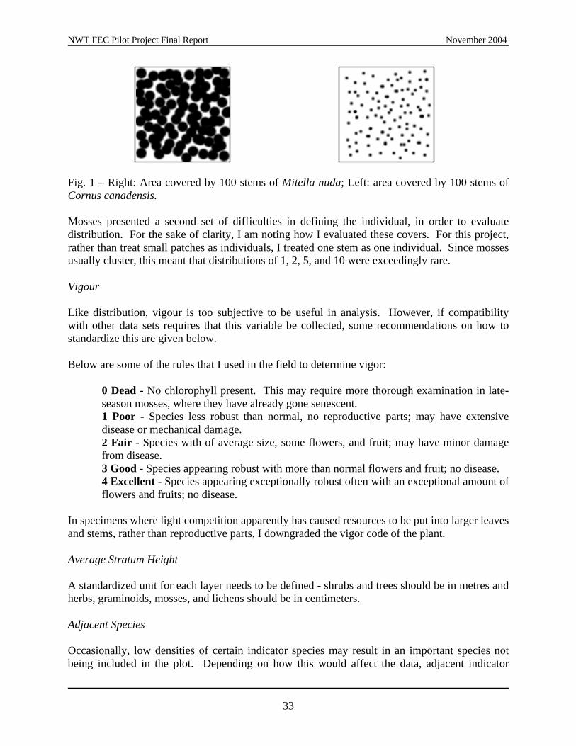
NWT FEC Pilot Project Final Report November 2004
Fig. 1 – Right: Area covered by 100 stems of Mitella nuda; Left: area covered by 100 stems of Cornus canadensis. Mosses presented a second set of difficulties in defining the individual, in order to evaluate distribution. For the sake of clarity, I am noting how I evaluated these covers. For this project, rather than treat small patches as individuals, I treated one stem as one individual. Since mosses usually cluster, this meant that distributions of 1, 2, 5, and 10 were exceedingly rare. Vigour Like distribution, vigour is too subjective to be useful in analysis. However, if compatibility with other data sets requires that this variable be collected, some recommendations on how to standardize this are given below. Below are some of the rules that I used in the field to determine vigor:
0 Dead - No chlorophyll present. This may require more thorough examination in late-season mosses, where they have already gone senescent. 1 Poor - Species less robust than normal, no reproductive parts; may have extensive disease or mechanical damage. 2 Fair - Species with of average size, some flowers, and fruit; may have minor damage from disease. 3 Good - Species appearing robust with more than normal flowers and fruit; no disease. 4 Excellent - Species appearing exceptionally robust often with an exceptional amount of flowers and fruits; no disease.
In specimens where light competition apparently has caused resources to be put into larger leaves and stems, rather than reproductive parts, I downgraded the vigor code of the plant. Average Stratum Height A standardized unit for each layer needs to be defined - shrubs and trees should be in metres and herbs, graminoids, mosses, and lichens should be in centimeters. Adjacent Species Occasionally, low densities of certain indicator species may result in an important species not being included in the plot. Depending on how this would affect the data, adjacent indicator
33

NWT FEC Pilot Project Final Report November 2004
species may need to be noted. If this is the case, how far away should one be searching, how uncommon should these plants be? In a couple of plots, Alnus crispa was not present in the plot, but some large A. crispa shrubs occurred in a low density outside of the plot. Miscellaneous Issues Field Form There were also several things that could be improved or clarified on the form layout and how the forms are filled out:
Sections of the form, like “Plot Area” and “Plot Shape” should either be printed automatically on the sheet, or if there is more than one type of plot shape used, a check box system would be more efficient (e.g., plot shape: square: circle: ). A check box "collected" column would be highly desirable, to indicate that a voucher has
been collected for a given species. In cases where more than one sheet is used for the vegetation or soils, a box for indicating
page numbers is needed (i.e., ‘Page 1 of 2’). Tracking multiple pages is a lot less error-prone when pages are numbered appropriately. On the vegetation sampling data sheet, cover classes should be separated. Evaluating and
entering the data is a lot easier when all of the trees, shrubs, herbs, bryophytes, and lichens are separated.
Nutrient Regime Determination
The chart on page 21 of Field Guide to Ecosites of Northern Alberta was much more effective for determining nutrient regime than that of the Ecological Land Survey Site Description Manual.
34
NWT FEC Pilot Project Final Report November 2004
APPENDIX D - LIST OF OBSERVED SPECIES. Species Code Scientific Name Current Nomenclature Achi mil Achillea millefolium Achillea millefolium L. Acte rub Actaea rubra Actaea rubra (Aiton) Willdenow Agro sca Agrostis scabra Agrostis scabra Willd. Agrostis sp Agrostis sp Agrostis sp Agro tra Agropyron trachycaulum Elymus trachycaulus (Link) Gould ex Shinners Agro tra tra Agropyron trachycaulum var trachycaulum Elymus trachycaulus ssp. trachycaulus (Link) Gould ex Shinners Agro tra uni Agropyron trachycaulum var unilaterale Elymus trachycaulus ssp. subsecundus (Link) A.& D. Löve Alnu cri Alnus crispa Alnus viridis subsp. crispa (Aiton) Turrill Amel aln Amelanchier alnifolia Amelanchier alnifolia (Nutt.) Nutt. ex M. Roemer Andr pol Andromeda polifolia Andromeda polifolia L. Anem mul Anemone multifida Anemone multifida Poiret Anem par Anemone parviflora Anemone parviflora Michaux Ante ros Antennaria rosea Antennaria rosea Greene Ante sp Antennaria sp. N/A Aqui bre Aquilegia brevistyla Aquilegia brevistyla Hooker Arct rub Arctostaphylos rubra Arctostaphylos rubra (Rehd. & Wilson) Fern. Arct uva Arctostaphylos uva-ursi Arctostaphylos uva-ursi (L.) Spreng. Aste cil Aster ciliolatus Symphyotrichum ciliolatum (Lindl.) A.& D. Löve Aste jun Aster juncifolius Symphyotrichum boreale (Torr. & Gray) A.& D. Löve Aste sib Aster sibiricus Aster sibiricus L. Astr ame Astragalus americanus Astragalus americanus (Hook.) M.E. Jones Aula pal Aulacomnium palustre Aulacomnium palustre (Hedw.) Schwaegr. Betu gla Betula glandulosa Betula glandulosa Michaux Betu occ Betula occidentalis Betula occidentalis Hooker Betu pap Betula papyrifera Marshall Betula papyrifera Marshall Betu pap com Betula papyrifera var. commutata Betula papyrifera Marshall Betu pap neo Betula papyrifera var neoalaskana Betula neoalaskana Sargent Betu pum Betula pumila Betula pumila Linnaeus Betu sp Betula sp Betula sp. Bryo spp Bryophyte spp Bryophyte spp Cala can Calamagrostis canadensis Calamagrostis canadensis (Michx.) Beauv. Cala ine Calamagrostis inexpansa Calamagrostis inexpansa Gray Cala lap nea Calamagrostis lapponica var. nearctica Calamagrostis lapponica (Wahlenb.) Hartman Camp rot Campanula rotundifolia Campanula rotundifolia L. Card pra Cardimine pratensis Cardamine pratensis L. Care aen Carex aenea Carex foenea Willdenow Care atr ray Carex atratiformis ssp. raymondii Carex atratiformis Britton Care aur Carex aurea Carex aurea Nuttall Care cap Carex capillaris Carex capillaris Linnaeus Care cap rob Carex capillaris ssp. robustior Carex capillaris Linnaeus Care con Carex concinna Carex concinna R. Brown Care dis Carex disperma Carex disperma Dewey Care foe Carex foenea Carex siccata Dewey Care gyn Carex gynocrates Carex gynocrates Wormskjöld ex Drejer Care las ame Carex lasiocarpa var. americana Carex lasiocarpa Ehrhart subsp. americana (Fernald) Hultén Care lept Carex leptalea Carex leptalea Wahlenberg Care ric Carex richardsonii Carex richardsonii R. Brown Care sci Carex scirpoidea Carex scirpoidea Michaux Care sp Carex sp Carex sp. Care vag Carex vaginata Carex vaginata Tausch Cera arv Cerastium arvense Cerastium arvense L.
35
NWT FEC Pilot Project Final Report November 2004
Cham cal Chamaedaphne calcyculata Chamaedaphne calyculata (L.) Moench Clad mit Cladina mitis Clad ran Cladina rangiferina Clad spp Cladonia spp Clad ste Cladina stellaris Corn can Cornus canadensis Cornus canadensis L. Corn sto Cornus stolonifera Cornus sericea L. ssp. sericea L. Cypr cal Cypripedium calceolus Cypripedium parviflorum var. pubescens (Willdenow) O. W. Knight Dicr fus Dicranum fuscescens Dicranum fuscescens Turn. Dicr pol Dicranum polysetum Dicranum polysetum Sw. Dicr sp Dicranum sp Dicranum sp. Dicr spp Dicranum spp. Dicranum spp. Drep ver Drepanocladus vernicosus Drepanocladus vernicosus (Mitt.) Warnst. Drep unc Drepanocladus uncinatus Drepanocladus uncinatus (Hedw.) Warnst. Dros rot Drosera rotundifolia Drosera rotundifolia L. Elym inn Elymus innovatus Leymus innovatus (Beal) Pilger Empe nig Empetrum nigrum Empetrum nigrum L. Epil ang Epilobium angustifolium Chamerion angustifolium ssp. angustifolium (L.) Holub Epil pal Epilobium palustre Epilobium palustre L. Equi arv Equisetum arvense Equisetum arvense Linnaeus Equi pra Equisetum pratense Equisetum pratense Ehrhart Equi sci Equisetum scirpoides Equisetum scirpoides Michaux Equi syl Equisetum sylvaticum Equisetum sylvaticum Linnaeus Erig hys Erigeron hyssopifolius Erigeron hyssopifolius Michx. Erio vag Eriophorum vaginatum Eriophorum vaginatum Linnaeus Forb sp Forb sp N/A Frag ves Fragaria vesca Fragaria vesca L. Frag vir Fragaria virginiana Fragaria virginiana Duchesne Gali bor Galium boreale Galium boreale L. Gent acu Gentiana acuta Gentiana acuta Michx. Geoc liv Geocaulon lividum Geocaulon lividum (Richards.) Fern. Glyc str str Glyceria striata var. stricta Glyceria striata (Lam.) A.S. Hitchc. Good rep Goodyera repens Goodyera repens (Linnaeus) R. Brown Grass sp Grass sp Grass sp Habe hyp Habenaria hyperborea Platanthera hyperborea (Linnaeus) Lindley Habe obt Habenaria obtusata Platanthera obtusata (Banks ex Pursh) Lindley Habe orb Habenaria orbiculata Platanthera orbiculata (Pursh) Lindley Hedy alp Hedysarum alpinum Hedysarum alpinum L. Hedy mac Hedysarum mackenzeii Hedysarum mackenzei Richards. Hier sca Hieracium scabruisculum Hieracium umbellatum L. Hylo spl Hylocomnium splendens Hylocomium splendens (Hedw.) Schimp. in B.S.G. Hypn cup Hypnum cupressiforme Hypnum cupressiforme Hedw. Hypnum sp. Hypnum sp. Hypnum sp. Junc bal Juncus balticus Juncus arcticus var. balticus (Willdenow) Trautvetter Juni com Juniperus communis Juniperus communis Linnaeus Juni hor Juniperus horizontalis Juniperus horizontalis Moench Lari lar Larix laricina Larix laricina (Du Roi) K. Koch Lath och Lathyrus ochroleucus Lathyrus ochroleucus Hook. Ledu dec Ledum decumbens Ledum palustre ssp. decumbens (Ait.) Hultén Ledu gro Ledum groenlandicum Ledum groenlandicum Oeder Lich sp Lichen sp Linn bor Linnaea borealis Linnaea borealis L. Loma rot Lomatogonium rotatum Lomatogonium rotatum (L.) Fries ex Fern. Loni dio Lonicera dioica Lonicera dioica L. var. glaucescens (Rydb.) Butters
36

NWT FEC Pilot Project Final Report November 2004
Maia can Maianthemum canadense Maianthemum canadense Desfontaines Marc pol Marchantia polymorpha Marchantia polymorpha L. Mert pan Mertensia paniculata Mertensia paniculata (Ait.) G. Don Mite nud Mitella nuda Mitella nuda L. Moeh lat Moehringia lateriflora Moehringia lateriflora (L.) Fenzl Mone uni Moneses uniflora Moneses uniflora (L.) Gray Orch rot Orchis rotundifolia Amerorchis rotundifolia (Banks ex Pursh) Hultén Oryz asp Oryzopsis asperifolia Oryzopsis asperifolia Michx. Oryz pun Oryzopsis pungens Piptatherum pungens (Torr.) Barkworth, comb. nov. ined. Pedi lab Pedicularis labridorica Pedicularis labradorica Wirsing Pelt spp Peltigera spp Peta pal Petasites palmatus Petasites frigidus var. palmatus (Ait.) Cronq. Peta sag Petasites sagitattus Petasites sagittatus (Banks ex Pursh) Gray Pice gla Picea glauca Picea glauca (Moench) Voss, Mitt. Deutsch. Pice mar Picea mariana Picea mariana (Miller) Britton, Sterns & Poggenburg, Sterns, & Poggenburg Pinu ban Pinus banksiana Pinus banksiana Lambert Plan eri Platago eriopoda Plantago eriopoda Torr. Pleu sch Pleurozium schrebneri Pleurozium schreberi (Brid.) Mitt. Poa pal Poa palustris Poa palustris L. Poa pra Poa pratensis Poa pratensis L. Poly str Polytrichum strictum Polytrichum strictum Brid. Popu bal Populus balsamifera Populus balsamifera L. Popu tre Populus tremuloides Populus tremuloides Michx. Pote fru Potentilla fruticosa Dasiphora floribunda (Pursh) Kartesz, comb. nov. ined. Pote tri Potentilla tridentata Sibbaldiopsis tridentata (Ait.) Rydb. Ptil cri Ptilium crista-castrensis Ptilium crista-castrensis (Hedw.) De Not. Ptil pul Ptilidium pulcherimum Ptilidium pulcherimum (G. Web.) Hampe Pyro asa Pyrola asarifolia Pyrola asarifolia Michx. Pyro gra Pyrola grandiflora Pyrola grandiflora Radius Pyro sec Pyrola secunda Orthilia secunda (L.) House Pyro chl Pyrola chlorantha Pyrola chlorantha Sw. Rhiz pun Rhizomnium punctatum Rhizomnium punctatum (Hedw.) T.J. Kop. Ribe lac Ribes lacustre Ribes lacustre (Pers.) Poir. Ribe oxy Ribes oxycanthoides Ribes oxyacanthoides L. Ribe tri Ribes triste Ribes triste Pallas Rosa aci Rosa acicularis Rosa acicularis Lindl. Rosa sp Rosa sp Rosa sp. Rosa spp Rosa spp. Rosa spp. Rosa woo Rosa woodsii Rosa woodsii Lindl. Rubu aca Rubus acaulus Rubus arcticus ssp. acaulis (Michx.) Focke Rubu cha Rubus chamaemorus Rubus chamaemorus L. Rubu pub Rubus pubescens Rubus pubescens Raf. Sali arb Salix arbusculoides Salix arbusculoides Anderss. Sali ath Salix athabascensis Salix athabascensis Raup Sali beb Salix bebbiana Salix bebbiana Sarg. Sali bra Salix brachycarpa Salix brachycarpa Nutt. Sali gla Salix glauca Salix glauca L. Sali lut Salix lutea Salix lutea Nutt. Sali myr Salix myrtilloides Salix pedicellaris Pursh Sali psu Salix pseudomyrsinites Salix pseudomyrsinites Anderss. Sali sco Salix scouleriana Salix scouleriana Barratt ex Hook. Sali sp Salix sp Salix sp. Sela sel Selaginella selaginoides Selaginella selaginoides (L.) Beauv. ex Mart. & Schrank Sene pau Senecio paupercula Packera paupercula (Michx.) A.& D. Löve
37

NWT FEC Pilot Project Final Report November 2004
Shep can Shepherdia canadensis Shepherdia canadensis (L.) Nutt. Smil tri Smilacina trifoliata Maianthemum trifolium (Linnaeus) Sloboda Soli dec ore Solidago decumbens var. oreophila Solidago simplex var. nana (Gray) Ringius Soli sp Solidago sp Solidago sp. Spha spp Sphagnum spp Sphagnum spp. Spir rom Spiranthes romanzoffiana Amerorchis rotundifolia (Banks ex Pursh) Hultén Stel log Stellaria longipes Stellaria longipes Goldie Tara off Taraxacum officinale Taraxacum officinale G.H. Weber ex Wiggers Thui rec Thuidium recognitum Thuidium recognitum (Hedw.) Lindb. Tofi glu Tofieldia glutinosa Triantha glutinosa (Michaux) Baker Tome nit Tomenthypnum nitens Tomenthypnum nitens (Hedw.) Loeske Vacc myr Vaccinium myrtilloides Vaccinium myrtilloides Michx. Vacc oxy Vaccinium oxycoccus Vaccinium oxycoccus Linnaeus Vacc vit Vaccinium vitis-idaea Vaccinium vitis-idaea L. Vibu edu Viburnum edule Viburnum edule (Michx.) Raf. Vici ame Vicia americana Vicia americana Muhl. ex Willd. Viol ren Viola renifolia Viola renifolia Gray Zyga ele Zygadenus elegans Zigadenus elegans Pursh
38
Related Documents