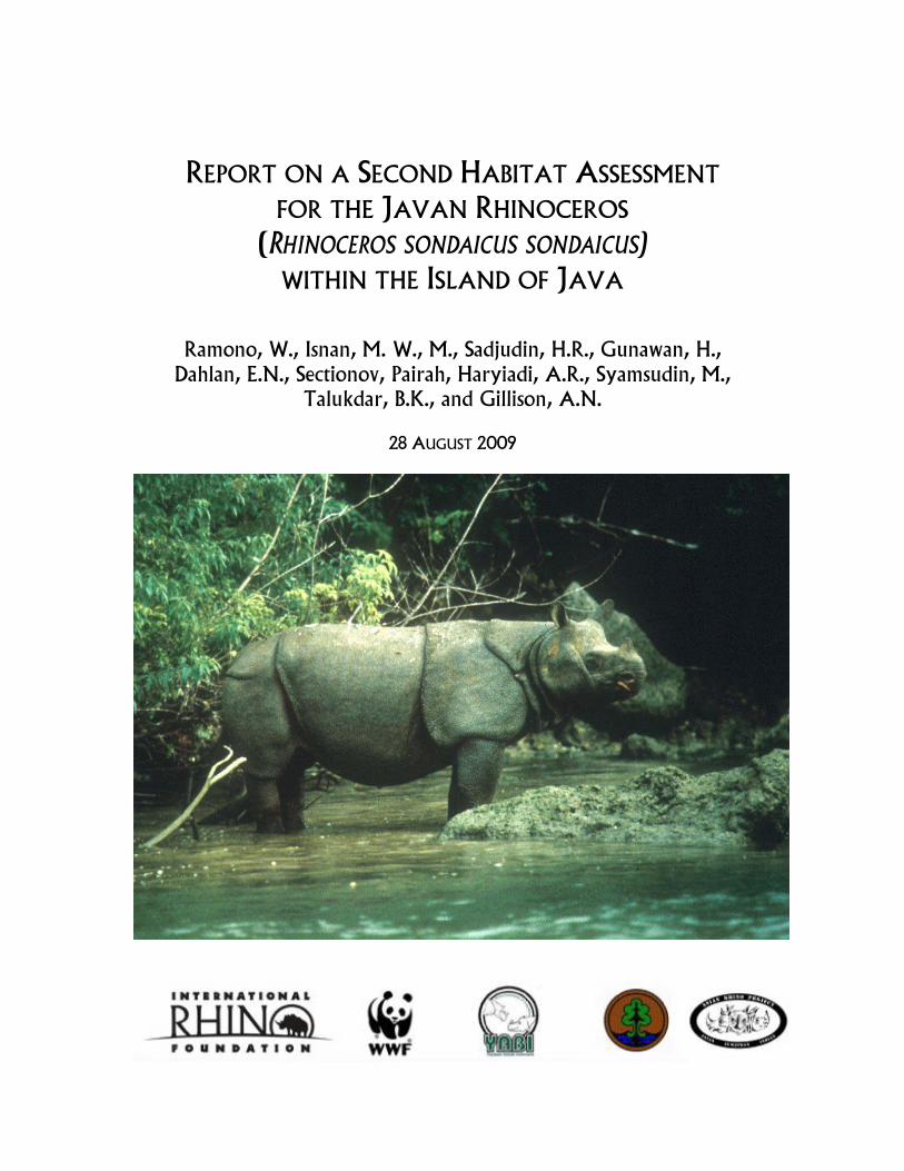
REPORT ON A SECOND HABITAT ASSESSMENT FOR THE JAVAN RHINOCEROS (RHINOCEROS SONDAICUS SONDAICUS) WITHIN THE ISLAND OF JAVA Ramono, W., Isnan, M. W., M., Sadjudin, H.R., Gunawan, H., Dahlan, E.N., Sectionov, Pairah, Haryiadi, A.R., Syamsudin, M., Talukdar, B.K., and Gillison, A.N. 28 AUGUST 2009

Welcome message from author
This document is posted to help you gain knowledge. Please leave a comment to let me know what you think about it! Share it to your friends and learn new things together.
Transcript
[ 1 ]
REPORT ON A SECOND HABITAT ASSESSMENT FOR THE JAVAN RHINOCEROS
(RHINOCEROS SONDAICUS SONDAICUS) WITHIN THE ISLAND OF JAVA
Ramono, W., Isnan, M. W., M., Sadjudin, H.R., Gunawan, H., Dahlan, E.N., Sectionov, Pairah, Haryiadi, A.R., Syamsudin, M.,
Talukdar, B.K., and Gillison, A.N.
28 AUGUST 2009

SUGGESTED CITATION: RAMONO, W., ISNAN, M. W., M., SADJUDIN, H.R, GUNAWAN, H, DAHLAN, E.N., SECTIONOV, PAIRAH, HARIYADI, A.R., SYAMSUDIN, M., TALUKDAR, B.K., AND GILLISON, A.N. 2009. REPORT ON A SECOND HABITAT ASSESSMENT FOR THE JAVAN RHINOCEROS (RHINOCEROS SONDAICUS SONDAICUS) WITHIN THE ISLAND OF JAVA. INTERNATIONAL RHINO FOUNDATION, YULEE, FL, USA.
COVER PHOTO COURTESY OF ALAIN COMPOST.
[ 3 ]
REPORT ON A SECOND HABITAT ASSESSMENT FOR THE JAVAN RHINOCEROS
(RHINOCEROS SONDAICUS SONDAICUS) WITHIN THE ISLAND OF JAVA
TABLE OF CONTENTS
1. Executive Summary……………………………………………………..1
1.1 Background……………………………………………………………1 1.2 Methodology…………………………………………………………..1 1.3 Results of data analysis…………………………………………………2 1.4 Spatial modeling of habitat preference...………………………………..3 1.5 Vulnerability to threat………………………………………………….3 1.6 Potential interactions with government, non-government
Stakeholders and local communities…………………………………...3 1.7 Conclusions………………………………………………………….....4 1.8 Recommendations……………………………………………………..4
2. Introduction…………………………………………………………….6
2.1 Background……………………………………………………………6 2.2 The name………………………………………………………………7 2.3 Distribution and habitat………………………………………………..7 2.4 Dependence on wallows………………………………………………..8 2.5 Feeding behavior and food resources…………………………………...8 2.6 Vulnerability to threats………………………………………………....9
3. Team structure………………………………………………………….10
4. Methodology……………………………………………………………14
5. Areas 1 and 2 - Survey of Peninsular Ujung Kulon National Park
and Gunung Honje 5.1 Geographic location…………………………………………………....18 5.2 Physical features……………………………………………………….18 5.3 Climate………………………………………………………………...20 5.4 Results of data analysis………………………………………………....20 5.5 Spatial modeling of habitat preference……………………………… ..24 5.6 Vulnerability to threat………………………………………………....27 5.7 Potential interaction with government and non-government stakeholders and local communities……………27
6. Area 3 - Survey of Gunung Halimun National Park 6.1 Location and history…………………………………………………...30 6.2 Climate………………………………………………………………...31
[ 4 ]
6.3 Geology………………………………………………………………..31 6.4 Hydrology……………………………………………………………..32 6.5 Vegetation……………………………………………………………..32 6.6 Survey of Gunung Halimun National Park…………………………….33 6.7 Results of survey………………………………………………………34
7. Area 4 - Leuweung Sancang 7.1 Overview of physiography, land cover and land use…………………...34 7.2 Review of current information on biodiversity, rhino abundance and habitat……………….……………35 7.3 Potential interaction with government and non-government stakeholders and local communities………………...36 7.4 Conclusions…………………………………………………………...36
8. Area 5 - Masigit Kareumbi 8.1 Overview of physiography, land cover and land use…………………..36 8.2 Review of current information on biodiversity, rhino abundance and habitat…………………………………………36 8.3 Potential interaction with government and non-government stakeholders and local communities………………..37 8.4 Conclusions…………………………………………………………..37
9. Discussion ……………………………………………………………..37
10. Conclusions……………………………………………………………40
11. Recommendations……………………………………………………...41
12. Acknowledgements…………………………………………………….42
13. References……………………………………………………………...43
14. Annexes Annex I. Terms of reference………………………………………….........46 Annex 2. List of data variables recorded for each 40 x 5m transect………...49 Annex 3. List of plant functional types and plant species for Ujung Kulon, Gunung Honje, and Gunung Halimun……..........50
[ 5 ]
List of Figures
1. Wallow in bamboo thicket, UKNP 2. Sapling pushed by feeding rhino UKNP 3. Preferred food-plant assemblage for Javan rhino 4. Team 1 Peninsula Ujung Kulon 5. Team 2 Gunung Honje 6. Team 3 Gunung Halimun National Park 7. Survey route through Gunung Honje traversing a range of environmental
gradients from shoreline to low hills. 8. Example of a page of field records from the VegClass proforma 9. Map showing the borders of Ujung Kulon National Park and adjacent
Gunung Honje. Source: www.panda.org 10. Rhino habitat preference score regressed against multi-dimensional scaling
(MDS) of combined variables (spp, species richness; PFT, plant functional type richness; ratio spp:PFT richness; BA, basal area all woody plants m2ha-1 ). Points are 40x5m (200m2) transects for UKNP, Gn. Honje and Gn. Halimun NP.
11. Rhino habitat preference score regressed against elevation 12. UKNP Transect 4 Rhino preference score 8. Note patches of regenerating
forest 13. Spatial analysis using key physical variables (geology, soil type, land cover,
proximity to water, proximity to village) 14. DOMAIN mapping of environmental representativeness of all 24 transect
sites for UKNP and Gunung Honje. Red = highest similarity, grading through yellow to blue (lowest). Based on Landsat bands 1,2,3.
15. DOMAIN potential mapping of most preferred rhino habitat (matched against preference scores ~ 8 or higher). Red = highest similarity, grading through yellow to blue (lowest match). Based on Landsat Bands 1,2,3.
16. Location of Gunung Halimun-Salak NP 17. Gunung Halimun NP survey area. Ciusul upper center. Pin indicates
transect # 2. 18. Transect locations in Gunung Halimun Salak NP 19. Example of extreme erosion in G. Halimun NP 20. Leuweung Sancang area showing remnant forest patches surrounded by
intensive land use pressure 21. Masigit Kareumbi reserve surrounded by intensive land use pressure 22. Rhino habitat suitability of Gunung Honje as assessed by van Merm (2008)
following earlier assessment by Haryono (1996). (Block numbers follow Table 6)
23. Rhino accessibility to the Gunung Honje area as initially defined by Haryono (1996) and modified by van Merm (2008). (Block numbers follow Table 6)
[ 6 ]
List of Tables
1. Survey teams
a. Ujung Kulon peninsula survey members b. Gunung Honje survey team members c. Gunung Halimun survey team members
2. Site locations, Ujung Kulon NP, Gunung Honje, Halimun – Salak NP 3. Summary of species, PFTs and PFC 4. Vegetation structural features 5. Criteria for the second habitat assessment of Javan rhino 6. Results from field interviews 7. Water availability for rhino in Gunung Honje*
List of Annexes
I. Terms of reference II. List of data variables recorded for each 40 x 5m transect III. List of Plant Functional Types and plant Species for Ujung Kulon, Gunuung Honje and Gunung Halimun transects

[ 7 ]
Acronyms
AREAS
Asian Rhino and Elephant Action Strategy Program
ARP Asian Rhino Project CBM Center for Biodiversity Management, Australia FAO GHNP
Food and Agriculture Organization, Rome Gunung Halimun National Park
IRF International Rhino Foundation, Yulee, FL, USA IUCN International Union for the Conservation of Nature LIPI Lembaga Ilmu Pengetahuan Indonesia (Indonesian Institute of Science) MDS Multi-Dimensional Scaling NP National Park PFC Plant Functional Complexity PFT Plant Functional Type PHKA Perlindungan Hutan dan Konservasi Alam (Forest Protection and Nature
Conservation PPA Perlindungan dan Pengawetan Alam ( Protection and Conservation of Nature) RPU Rhino Protection Unit SRTM Shuttle Radar Topography Mission UKNP Ujung Kulon National Park WWF Worldwide Fund for Nature YABI Yayasan Badak Indonesia (Indonesian Rhino Foundation)
[ 1 ]
REPORT ON A SECOND HABITAT ASSESSMENT FOR THE JAVAN RHINOCEROS (RHINOCEROS SONDAICUS SONDAICUS)
WITHIN THE ISLAND OF JAVA 1. EXECUTIVE SUMMARY 1.1 Background
The Critically Endangered1
Javan rhinoceros (Rhinoceros sondaicus) is one of the most threatened of all land mammals and the rarest of the five rhino species. It survives in two small populations: 35-50 in a reproducing population in West Java’s Ujung Kulon National Park (UKNP), and fewer than six animals in a non-reproducing population in Cat Tien National Park in Vietnam.
Following the implementation of the 2007 Strategy and Action Plan for the Conservation of Rhinos in Indonesia, a meeting was convened on 9 May 2008 to assess progress of the conservation strategy for the Javan rhino in Ujung Kulon National Park and to set immediate goals and actions. Whereas it was formerly believed that Ujung Kulon had the holding capacity for more than 100 Javan rhino, today it is suggested that the park’s carrying capacity has diminished to as low as 70 due to habitat changes and possible food competition. One of the strategies outlined in the 2007 action plan was to relocate a second population of Javan rhino to another area in order to increase carrying capacity and to sustain overall health of the population. At the 9 May 2008 meeting, it was agreed that habitat surveys, along with a rhino and banteng census, are an immediate priority. It was also agreed that the habitat assessments for both Ujung Kulon National Park (UKNP) and possible second habitat-relocation sites outside Ujung Kulon peninsula should be carried out by an independent agency to ensure critical information would be unbiased. This independent agent would be required to present the results to a board of reviewers consisting of the Indonesian Ministry of Forestry, Rhino Task Force, Scientific authority (the Indonesian Institute of Sciences or Lembaga Ilmu Pengetahuan Indonesia -LIPI) and rhino NGOs (the Indonesian Rhino Foundation or Yayasan Badak Indonesia – YABI, the World Wide Fund for Nature - WWF, the International Rhino Foundation - IRF, and BirdLife Indonesia or Burung Indonesia). This report presents findings from a field survey of Ujung Kulon peninsula and proposed relocation sites on the island of Java in Gunung Honje, Gunung Halimun, Masigit Kareumbi and Leuweung Sancang. 1.2 Methodology
To sustainably manage targeted elements of the biota requires appropriate baseline information. To this end, sampling should include those key elements of the biophysical
1 www.iucnredlist.org
[ 2 ]
environment that influence the range distributions and behavior of the species in question. For this study, environmental gradient-based (gradsect) survey design was coupled with a comprehensive plant-based recording protocol (VegClass) that also included key attributes of site physical features as well as plant species, plant functional types (PFTs) and vegetation structure. As part of the gradsect procedure, environmentally representative sites (40 x 5m transects) were located initially through an inspection of available vegetation maps, previous reports and satellite imagery. Transects were then located on ground so that they traversed a range of known rhino habitat preference from low to high. All data were spatially referenced to facilitate mapping and spatial modeling of habitat pattern. A team made up of YABI, WWF and IRF personnel accompanied by an expatriate consultant surveyed these areas, and a core YABI Rhino Protection Unit (RPU) group was present at each survey. In each survey and at each study site, a member of the RPU team well-experienced in rhino habitat assessment was asked to provide a habitat preference score (1-10) based on an intuitive assessment of all habitat criteria. Each transect site was comprehensively photographed. Additional information on site features critical to Javan rhino habitat preference was recorded, as well as levels of browsing impact. To facilitate comparative analysis, the same methodology was uniformly applied to an ‘orientation’ survey of known rhino habitat in the peninsula of Ujung Kulon National Park (UKNP - 7 transects) followed by on-ground surveys of potential habitat in adjacent Gunung Honje (17 transects) and subsequently Gunung Halimun National Park (GHNP - 8 transects). As well as biophysical elements, in-depth socioeconomic interviews were conducted in villages surrounding Gunung Honje and at Ciusul in GHNP. Biophysical field data were compiled in industry standard format and analyzed using standard statistical regression and multivariate procedures. Suggested alternative areas in Masigit Kareumbi and Leuweung Sancang were examined using available remotely sensed imagery. 1.3 Results of data analysis
Plant-based predictors of rhino habitat preference: plant diversity or richness (number of species and plant-functional types – PFTs per transect) is negatively correlated with rhino habitat preference score as is plant litter depth. Ecological diversity measures for PFTs (Shannon H`, Simpson’s and Fisher’s Alpha), although statistically significant, were only weakly correlated with habitat preference. Two key vegetation structural variables, mean canopy height and basal area are not significantly correlated whereas there is a significant (P < 0.0001) quadratic relationship between rhino score and the ratio of projective foliage cover of woody to non-woody plants that is consistent with observed habitat preference for intermediate levels of disturbance. While elevation is negatively correlated with rhino score, other site features such as slope percent and aspect are not statistically significant. Individual plant-based variables, although statistically significant, are only of marginal value as estimators of rhino habitat preference. On the other hand, specific combinations of plant variables such as species and PFT richness, Plant Functional Complexity (PFC) and basal area, show strong non-linear correlation with rhino habitat scores. At the time of writing, the team was unable to explore predictive linkages between rhino score and remotely-sensed variables (Landsat, SRTM). Of general ecological interest is the fact that plant species and PFT diversity is surprisingly low in inland lowland peninsula UKNP (~ 20 species and 17 PFTs per 200m2) and moderately low (~ 38 species, 25 PFTs) in Gunung Honje and
[ 3 ]
somewhat higher (57 species, 43 PFTs) in GHNP. By comparison, 200m2 transects in lowland Jambi and Riau Provinces in Sumatra commonly contain more than 120 species and 80 PFTs. Presented with these facts, one may speculate that unusually low plant diversity in the areas currently occupied by Javan rhino may be a result of previous devastation caused by the eruption of Krakatau and subsequent reinvasion from shoreline plant gene pools. In UKNP inland lowland sites, this is supported by unusually high numbers of genera that are more commonly associated with littoral habitats. 1.4 Spatial modeling of habitat preference
Spatial analysis using key physical variables (geology, soil type, land cover, proximity to water, proximity to village) suggests a high percentage of areas in peninsula UKNP and Gunung Honje suitable for Javan rhinos. Modeling using DOMAIN potential mapping procedures also highlight a significant number of areas suitable for Javan rhino management. While generally indicative, neither of these approaches includes other key variables such as conditions suitable for maintaining long-term wallows or access to mineral salt sources. As such, output from these initial models should be viewed with caution. 1.5 Vulnerability to threat
Poaching activity in peninsular UKNP has been greatly reduced due to ongoing management by the RPUs. Within peninsula UKNP, possibly the greatest threat lies in the gradual reduction of food-plant resources due to forest closure and invasion of Langkap (Arenga obtusifolia). In Gunung Honje, increased threats arise from increasing human activity through high population pressure (including potential for rhino poaching), the fact that many people do not own land and that there is some negative reaction to the possibility of a Javan rhino reserve being established. Well-used human paths that were found on the study sites give a clear sign of trespassers using the area for subsistence. This level of threat will increase should land ownership become more extensive and land management more intensive through plantation and sedentary agriculture, as has been the case in the other areas under consideration. Aside from these major threats, other issues concern disease, especially anthrax, and comparatively low risk to tectonic events (e.g., tsunamis, earthquakes).
1.6 Potential interaction with government and non-government stakeholders and local
communities
A survey of areas surrounding Gunung Honje and Gunung Halimun was conducted using a comprehensive set of 54 socioeconomic parameters designed to record positive and negative responses to rhino translocation and management. Gunung Honje recorded 38 (70%) positive responses compared to 18 (30%) for Gunung Halimun. The essentially negative response in Gunung Halimun (Ciusul) is largely due to the fact that there is no established history of rhino occupation in the area and the historical and economic background is not conducive to sustainable management of a Javan rhino population. Local government consideration to Javan rhino conservation is largely influenced by the extent to which there will be a direct financial benefit to local people.
[ 4 ]
1.7 Conclusions
Javan rhino habitat preference is governed by a wide variety of biophysical site factors including sensitivity to human activity. While vegetation and elevation are clearly important determinants of rhino habitat, their influence is strongly modified by proximity to water, to mineral salt, and especially to site conditions that favor the maintenance of long-term wallows. In times of drought, water scarcity can become problematic, as indicated in the history of UKNP, and may severely restrict rhino movement. Historical patterns of both natural and human disturbance in Ujung Kulon have generated a mosaic of successional stages of vegetation regeneration in which the early to mid-pioneer stages were valuable sources of food-plants and where patches of mature forest provided cover. Examination of vegetation cover on ground and via remote-sensing suggests that these mosaics are becoming increasingly homogeneous as succession moves toward closed forest. As a result, food-plant availability may be decreasing, especially where closed forest is being invaded by Arenga. In Gunung Halimun, Masigit Kareumbi and Leuweung Sancang, where human activity has greatly restricted access to favorable habitat, such resources are extremely minimal. Taking into account the various biophysical elements, including the influence of human activity, we can conclude that while conditions in peninsular UKNP and adjacent Gunung Honje may not be entirely optimal for sustained management of the Javan rhino, they are considerably better than those offered in GHNP or the other two areas, where translocation would almost certainly lead to failure. 1.8 Recommendations
The following recommendations are indicated:
1. Establish a Javan rhino research and conservation area inside the Gunung Honje area
to focus on the localities covering Legon Pakis, Cihujan, Cikarang, Cikalejetan, Ranca Gebang and Aermokla to Cimahi.
2. Support establishing a Javan rhino research and conservation area through intensification of active management such as:
a. Reforestation (replanting natural forest vegetation with rhino foodplants) around Legon Pakis and Cihujan.
b. Implementing controlled slash and burn patch management in designated and closed forest areas with careful consideration in order to promote regeneration of rhino foodplants.
c. Increased patrol and government-initiated protection measures to ensure against poaching in both UKNP and Gunung Honje.
d. Establish new patrol paths and additional guard posts for both RPUs and NP staff in Gunung Honje.
3. Reduce infestation by Langkap (Arenga) palm through a well-planned operation using environmentally friendly herbicides (e.g., glyphosphate) as applied elsewhere in national parks in other countries such as Australia.
4. Increase education programs in areas adjacent to Gunung Honje to explain the benefits of rhino conservation, thereby facilitating the groundwork for a establishing second rhino habitat.
[ 5 ]
5. Conduct a detailed consultative study to explore the likely benefits of rhino-tourism. 6. Use the study outlined in this report as a framework for a more comprehensive study
of the socioeconomic issues surrounding the establishment of a rhino sanctuary and related infrastructure in Gunung Honje.
7. Explore alternative approaches to land management as a means of improving livelihoods linked to active rhino management (e.g., wildlife tourism, cottage industries, agriculture intensification outside the designated conservation area).
8. Include financial and other incentives for villagers who support conservation efforts. 9. Identify families living inside the park boundary whose circumstances can be
reconciled either by relocation and compensation, or by re-aligning the park boundary. Arbitration should be carried out on a case-by-case basis.
10. Establish a conservation extension and interpretative center in the Gunung Honje area.
11. Promote national and international awareness of the rhino conservation program and consider additional avenues for conservation support to include local and national governments.
12. Re-examine existing policy incentives and legal instruments surrounding rhino conservation with a view to improving conservation management.
13. Ensure funding mobilization from related government institutions, rhino conservation NGOs, and other related rhino conservation stakeholders in order to support the development of a second Javan rhino habitat.
[ 6 ]
2. INTRODUCTION 2.1 Background
The Critically Endangered2
Javan rhinoceros (Rhinoceros sondaicus) is one of the most threatened of all land mammals and the rarest of the five rhino species. It survives in two small populations: 35-50 in a reproducing population in West Java’s Ujung Kulon National Park (UKNP), and fewer than six animals in a non-reproducing population in Cat Tien National Park in Vietnam.
Following the implementation of the 2007 Strategy and Action Plan for the Conservation of Rhinos in Indonesia, a meeting was convened on 9 May 2008 to assess progress of the conservation strategy for the Javan rhino in Ujung Kulon National Park and to set immediate goals and actions. Whereas it was formerly believed that Ujung Kulon had the holding capacity for more than 100 Javan rhino, today it is suggested that due to habitat changes and possible food competition the park’s carrying capacity has diminished to as low as 70. One of the strategies outlined in the 2007 action plan was to relocate a second population of Javan rhino to another area in order to increase carrying capacity and to sustain overall health of the population. At the 9 May 2008 meeting, it was agreed that habitat surveys, along with a rhino and banteng census, are an immediate priority. It was also agreed that the habitat assessments for both Ujung Kulon National Park (UKNP) and possible second habitat-relocation sites outside Ujung Kulon peninsula should be carried out by an independent agency to ensure critical information would be unbiased. This independent agent would be required to present the results to a board of reviewers consisting of the Indonesian Ministry of Forestry, Rhino Task Force, Scientific authority (the Indonesian Institute of Sciences or Lembaga Ilmu Pengetahuan Indonesia -LIPI) and rhino NGOs (the Indonesian Rhino Foundation or Yayasan Badak Indonesia – YABI, the World Wide Fund for Nature - WWF, the International Rhino Foundation - IRF, and BirdLife Indonesia or Burung Indonesia). This report presents findings from a field survey of Ujung Kulon peninsula and proposed relocation sites on the island of Java in Gunung Honje, Gunung Halimun National Park (GHNP), Masigit Kareumbi and Leuweung Sancang. The project was generously supported by the Asian Rhino Project, the International Rhino Foundation, and the Worldwide Fund for Nature. Specific terms of reference for the study are outlined in Annex I. Much of the available literature that deals with Javan rhino habitat, although relevant for its time (Hoogerwerf 1970; Schenkel and Schenkel-Hulliger (nd), 1969; Schenkel et al. 1978; Amman 1985; Hommel 1987, 1989; Haryono 1996), is largely outdated due to recent and continuing changes in human demography and habitat conditions. Sectionov (2009) has produced a valuable comparative overview of the prevailing conditions in UKNP including Gunung Honje, and other potential relocation sites in Java (GHNP, Leuweung Sancang, Masigit Kareumbi). For an assessment of habitat
2 www.iucnredlist.org
[ 7 ]
suitability in Gunung Honje, the most recent and most comprehensive treatment is that of van Merm (2008), which includes a comprehensive literature review and an extensive investigation of socioeconomic factors that have the potential to influence the sustainable management of the rhino. However, the study did not include an ecological survey of Gunung Honje and related environments in UKNP and this, together with rapidly changing socioeconomic factors led van Merm (2008, p. 88) to conclude that “A new elaborate study of the suitability of the Honje Mountains as Javan rhino habitat is necessary.” The present study is intended to complement the findings by van Merm in a way that can help formulate urgent policy implementation in line with the Strategy and Action Plan outlined above. It is also intended to serve as a science-based framework for more intensive investigation of both socioeconomic and biophysical factors concerned with improved rhino management. 2.2 The name
The scientific name for the Javan rhinoceros or lesser one-horned rhinoceros is Rhinoceros sondaicus Desm. There are three distinct subspecies, of which only two are presumed to be extant. The Indonesian Javan rhinoceros (Rhinoceros sondaicus sondaicus) is the most common of all Javan rhino subspecies. Once widespread throughout Java and Sumatra, it is now confined almost entirely to the small peninsula of Ujung Kulon on Western Java. Only 50 or 60 remain. The related Vietnamese Javan rhinoceros (Rhinoceros sondaicus annamiticus) is now reduced to no more than five individuals (sex unknown) contained in Cat Tien National Park within an area of about 4000 ha of severely degraded habitat (van Strien 1998; Khairani 2009). The Indian Javan rhinoceros (Rhinoceros sondaicus inermis) is believed to have become extinct early in the 20th Century. 2.3 Distribution and habitat
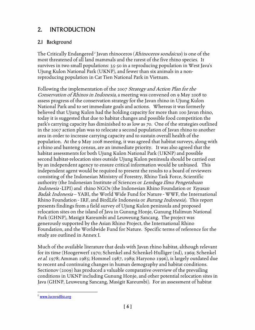
While the current distribution of Javan rhino is restricted to UKNP, available records suggest it is unlikely to have bred in any other locality in Java in recent times (cf. Sadjudin 1991) and despite anecdotal accounts of its occurrence in GHNP (Sectionov 2009). Unlike other rhino species that range across a variety of vegetation types from open savanna and swamps to closed forest, the Javan rhino is far more cryptic, preferring instead, dense lowland forest, adjacent tall grass and reed beds and areas of secondary forest succession or
Figure 1. Wallow in bamboo thicket, UKNP.
[ 8 ]
‘Belukar’. It has a marked preference for areas such as floodplains that contain complex networks of watercourses and soil types that facilitate the establishment of wallows. Although this pattern of behavior is consistent with an assumed historical preference for low-lying areas, the Vietnamese subspecies ranges to about 2,000m – although this may be due to human population pressure (Khairani 2009). 2.4 Dependence on wallows
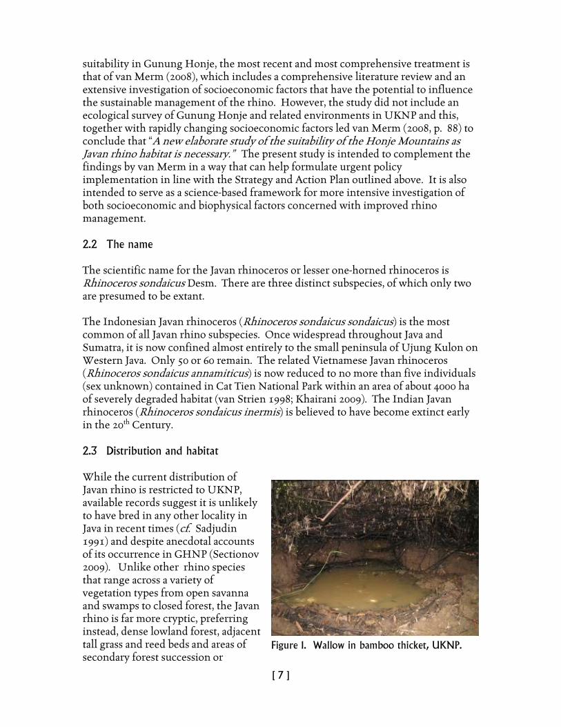
Wallowing in mud serves a variety of functions. It assists with thermoregulation and helps maintain skin condition as well as protecting against ectoparasites. A protective envelope is maintained by a post-wallowing layer of drying clay. Access to wallows is therefore a critical element of the Javan rhino habitat. According to Amman (1985) (quoted by Khairani 2009), four primary factors determine the location of wallows: a) Topography: mainly on plains rather than in hilly areas; b) Type of vegetation: a strong preference shown for Arenga forest, however no wallows were ever found in bamboo; c) Shade: influences the temperature of water and mud in the wallow and; d) Concealability: most wallows occur in well hidden, dense areas of vegetation accessed through vegetation ‘tunnels’. 2.5 Feeding behavior and food resources The Javan rhino is a browsing herbivore. It eats shoots, twigs, young foliage and fallen fruit (Novak 1999). Although the Javan rhino rarely eats grasses (hence its compatibility in feeding niche with banteng) it consumes a wide range of plant species and plant types. According to Sadjudin (1984), 166 species from 127 genera and 61 families have been recorded. Apart from a prehensile lip, the Javan rhino is capable of pushing over tall saplings (Figure 2) to access foliage and twigs. According to Schenkel and Schenkel-Hulliger (1969), “In normal years the needs of the rhino such as cover, wallows, and bathing places are provided amply in Ujung Kulon. Only as to food plants the habitat does not appear optimal. The saplings of the plant species on which the rhino feeds are widely scattered and not frequent. Nowhere in the reserve larger stands of food plants are found. In this respect the nomadism of the rhino is essential. A low population density when not in balance with the food supply aggravates the situation of the rhino in these ways:
• Saplings of food plants are not chopped or broken in time to grow new shoots within reach of the rhino. • If growing without having been chopped they soon become inaccessible for
the rhino.
Figure 2. Sapling pushed by feeding rhino UKNP.
[ 9 ]
• The track system which would facilitate movement if well maintained loses its favorable qualities.
• Communication within the rhino population suffers directly with the low population density and indirectly with the deterioration of the path system….”
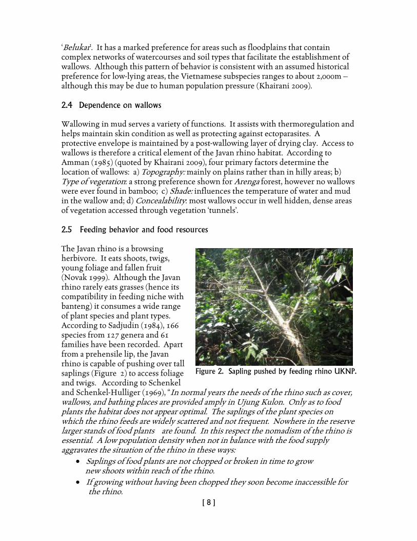
Saltlicks, so important to the Sumatran rhino, are unknown in UKNP (Khairani 2009). However, the Javan rhino has been observed visiting the seashore, where the need for salt may be satisfied (Schenkel and Schenkel-Hulliger 1969). According to Amman (1985), littoral zone plants contain higher levels of salt than plants further inland and this may also serve as a source of mineral salt for the rhino. Figure 3 shows typical mix of regenerating secondary forest species especially Amomum melanocheilos in a typical forest mosaic in UKNP and Gunung Honje lowlands. Other species include Barringtonia macrocarpa, Merremia peltata, Macaranga tanarius andFicus spp. 2.6 Vulnerability to threats
Poaching: Although poaching has declined significantly since 1967 with improvements in protection measures, it remains a serious threat to the species. Competition: While banteng and Javan rhino occupy compatible niches, there are overlapping demands for certain food-plant species. Spatial compatibility is also a concern where increasing numbers of banteng and feral pigs may further restrict Javan rhino habitat. Disease: In 1981-82 five rhinos died in UKNP from an unknown disease. While Anthrax is suspected, this has not been confirmed. Vulnerability to parasitic and bacterial infections transmitted by domestic ungulates from nearby villages is also of concern. Inbreeding depression: The small size of the Javan rhino population in UKNP renders it vulnerable to a loss of genetic diversity through inbreeding. Maintenance of gene diversity is essential to confer resilience to disease carrying parasites, changes in food-plant resources, climate and inter-specific competition (Ramono et al. 1991).
Figure 3. Preferred food-plant assemblage for Javan rhino.
[ 10 ]
Human pressure: Increased human settlement and farming activities in the eastern section of UKNP and adjacent Gunung Honje present real threats from habitat encroachment. Access to water: Current access appears to be adequate. Although historical records (Schenkel and Schenkel-Hulliger 1969) indicate the Javan rhino has been subject to severe drought where water supply became critical. Should similar droughts occur in the future, we can only speculate about the resilience of the present herd to cope with such events. Natural disasters: UKNP is situated in a dynamic tectonic zone that renders it vulnerable to earthquakes and tsunamis. The last eruption of Krakatau and the ensuing devastation of the UK peninsula have had a lasting effect on the Javan rhino habitat. More recent trends in climate change suggest we may expect greater variation in seasonal rainfall. These are factors to be considered in habitat planning and management.
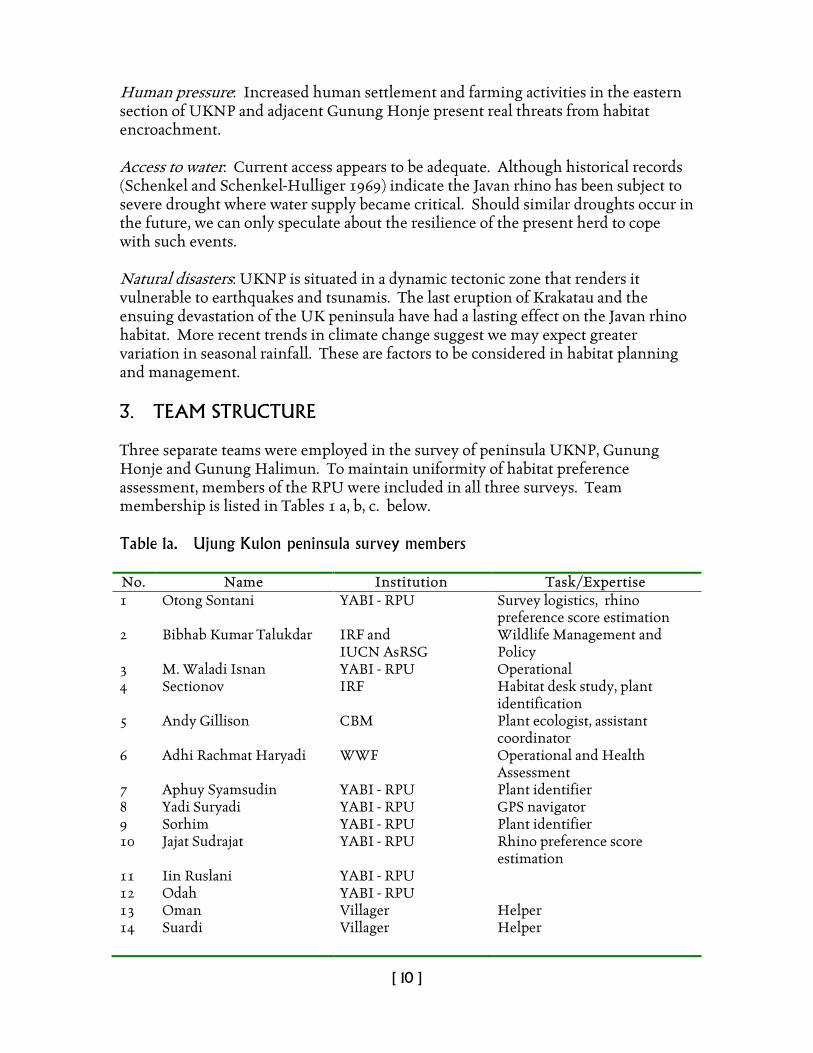
3. TEAM STRUCTURE Three separate teams were employed in the survey of peninsula UKNP, Gunung Honje and Gunung Halimun. To maintain uniformity of habitat preference assessment, members of the RPU were included in all three surveys. Team membership is listed in Tables 1 a, b, c. below. Table 1a. Ujung Kulon peninsula survey members No. Name Institution Task/Expertise 1 Otong Sontani YABI - RPU Survey logistics, rhino
preference score estimation 2 Bibhab Kumar Talukdar IRF and
IUCN AsRSG Wildlife Management and Policy
3 M. Waladi Isnan YABI - RPU Operational 4 Sectionov IRF Habitat desk study, plant
identification 5 Andy Gillison CBM Plant ecologist, assistant
coordinator 6 Adhi Rachmat Haryadi WWF Operational and Health
Assessment 7 Aphuy Syamsudin YABI - RPU Plant identifier 8 Yadi Suryadi YABI - RPU GPS navigator 9 Sorhim YABI - RPU Plant identifier 10 Jajat Sudrajat YABI - RPU Rhino preference score
estimation 11 Iin Ruslani YABI - RPU 12 Odah YABI - RPU 13 Oman Villager Helper 14 Suardi Villager Helper
[ 11 ]
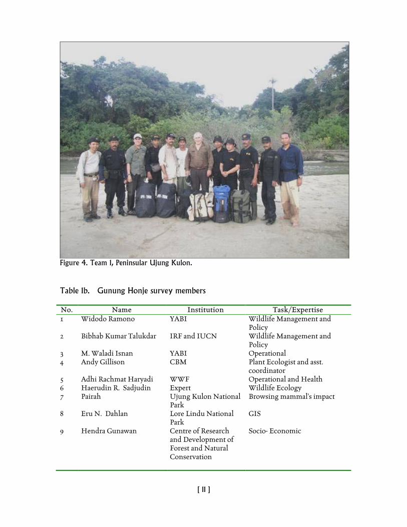
Figure 4. Team 1, Peninsular Ujung Kulon. Table 1b. Gunung Honje survey members No. Name Institution Task/Expertise 1 Widodo Ramono YABI Wildlife Management and
Policy 2 Bibhab Kumar Talukdar IRF and IUCN Wildlife Management and
Policy 3 M. Waladi Isnan YABI Operational 4 Andy Gillison CBM Plant Ecologist and asst.
coordinator 5 Adhi Rachmat Haryadi WWF Operational and Health 6 Haerudin R. Sadjudin Expert Wildlife Ecology 7 Pairah Ujung Kulon National
Park Browsing mammal’s impact
8 Eru N. Dahlan Lore Lindu National Park
GIS
9 Hendra Gunawan Centre of Research and Development of Forest and Natural Conservation
Socio- Economic
[ 12 ]
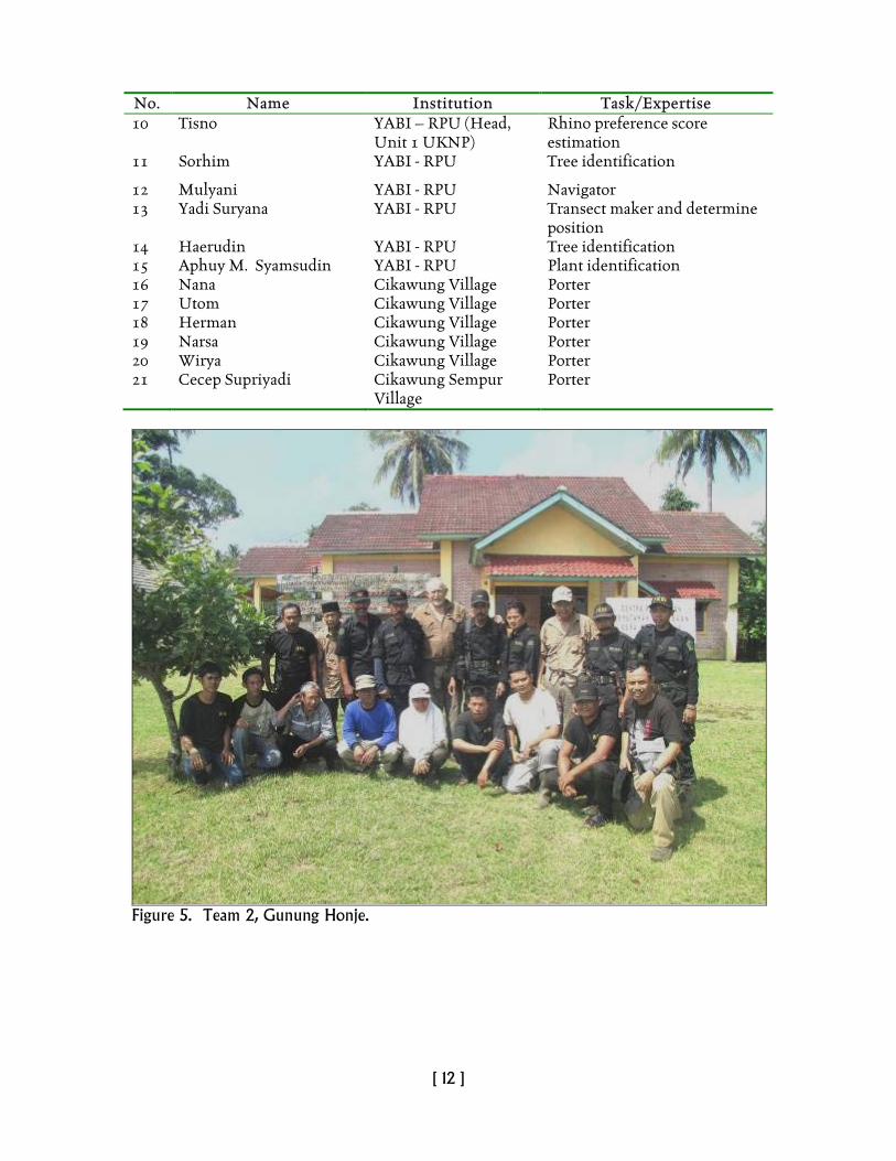
No. Name Institution Task/Expertise 10 Tisno YABI – RPU (Head,
Unit 1 UKNP) Rhino preference score estimation
11 Sorhim YABI - RPU Tree identification
12 Mulyani YABI - RPU Navigator 13 Yadi Suryana YABI - RPU Transect maker and determine
position 14 Haerudin YABI - RPU Tree identification 15 Aphuy M. Syamsudin YABI - RPU Plant identification 16 Nana Cikawung Village Porter 17 Utom Cikawung Village Porter 18 Herman Cikawung Village Porter 19 Narsa Cikawung Village Porter 20 Wirya Cikawung Village Porter 21 Cecep Supriyadi Cikawung Sempur
Village Porter
Figure 5. Team 2, Gunung Honje.
[ 13 ]
Table 1c. Gunung Halimun survey members No. Name Institution Task/Expertise 1 M. Waladi Isnan YABI - RPUs Operational 2 Adhi Rachmat Haryadi WWF Operational and health
assessment 3 Haerudin R. Sadjudin Expert Wildlife Ecology 4 Andy Gillison CBM Plant ecologist, asst.
coordinator 5 Pairah UKNP Browsing mammal’s impact 6 Eru N. Dahlan Lore Lindu National
Park GIS
7 Hendra Gunawan Centre of Research and Development of Forest and Natural Conservation
Socio- Economic
8 Tisno YABI – RPU (Head, Unit 1 UKNP)
Rhino preference score estimation
9 Sorhim YABI - RPU Tree identification 10 Yadi Suryana YABI - RPU GPS navigator 11 Aphuy M. Syamsudin RPU Check the scientific name of
the plant 12 Anda Joni Halimun Salak
National Park Navigator
13 Ahmad Rustiadi Halimun Salak National Park
Navigator
14 Ridwan Setiawan WWF Operational and tree identification
15 Sumardi Cikawung Village Tree identification 16 Daryan UKNP Tree identification 17 Astab Ciusul Porter 18 Sanan Ciusul Porter 19 Kemid Ciusul Porter 20 Asrip Ciusul Porter 21 Ipong Ciusul Porter 22 Yadi Suryana Ciusul Porter
[ 14 ]
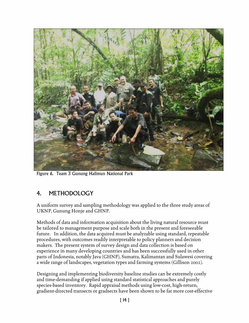
Figure 6. Team 3 Gunung Halimun National Park 4. METHODOLOGY A uniform survey and sampling methodology was applied to the three study areas of UKNP, Gunung Honje and GHNP. Methods of data and information acquisition about the living natural resource must be tailored to management purpose and scale both in the present and foreseeable future. In addition, the data acquired must be analyzable using standard, repeatable procedures, with outcomes readily interpretable to policy planners and decision makers. The present system of survey design and data collection is based on experience in many developing countries and has been successfully used in other parts of Indonesia, notably Java (GHNP), Sumatra, Kalimantan and Sulawesi covering a wide range of landscapes, vegetation types and farming systems (Gillison 2002). Designing and implementing biodiversity baseline studies can be extremely costly and time-demanding if applied using standard statistical approaches and purely species-based inventory. Rapid appraisal methods using low-cost, high-return, gradient-directed transects or gradsects have been shown to be far more cost-effective
[ 15 ]
(Gillison and Brewer 1985; Wessels et al. 1998; USGS-NPS 2003). Gradsects are now widely used in surveys where there is a need for rapid appraisal of the distribution of existing biota. They are the preferred option for the National Vegetation Classification of the mainland USA as implemented by the Parks Service and The Nature Conservancy. When coupled with a standard recording protocol for species, plant functional types (PFTs) (Gillison and Carpenter 1997; Gillison 2002), vegetation structure and key site physical variables, gradsects provide an extremely useful means of rapidly establishing a knowledge baseline for planning and management. The method known as the VegClass system that is fully described elsewhere3
is user-friendly and has been used in 12 developing countries to successfully train personnel with limited field experience and for whom English is not a first language. Unlike the majority of surveys that employ non-standard approaches, data acquired from more than 1800 sites worldwide using the standard rapid survey VegClass protocol provide a ready means of data comparison and evaluation within and between countries.
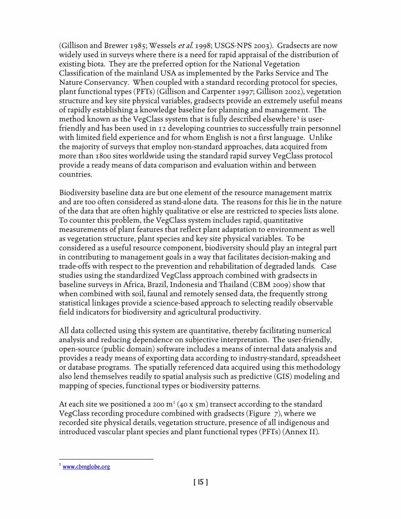
Biodiversity baseline data are but one element of the resource management matrix and are too often considered as stand-alone data. The reasons for this lie in the nature of the data that are often highly qualitative or else are restricted to species lists alone. To counter this problem, the VegClass system includes rapid, quantitative measurements of plant features that reflect plant adaptation to environment as well as vegetation structure, plant species and key site physical variables. To be considered as a useful resource component, biodiversity should play an integral part in contributing to management goals in a way that facilitates decision-making and trade-offs with respect to the prevention and rehabilitation of degraded lands. Case studies using the standardized VegClass approach combined with gradsects in baseline surveys in Africa, Brazil, Indonesia and Thailand (CBM 2009) show that when combined with soil, faunal and remotely sensed data, the frequently strong statistical linkages provide a science-based approach to selecting readily observable field indicators for biodiversity and agricultural productivity. All data collected using this system are quantitative, thereby facilitating numerical analysis and reducing dependence on subjective interpretation. The user-friendly, open-source (public domain) software includes a means of internal data analysis and provides a ready means of exporting data according to industry-standard, spreadsheet or database programs. The spatially referenced data acquired using this methodology also lend themselves readily to spatial analysis such as predictive (GIS) modeling and mapping of species, functional types or biodiversity patterns. At each site we positioned a 200 m2 (40 x 5m) transect according to the standard VegClass recording procedure combined with gradsects (Figure 7), where we recorded site physical details, vegetation structure, presence of all indigenous and introduced vascular plant species and plant functional types (PFTs) (Annex II).
3 www.cbmglobe.org
[ 16 ]
Figure 7. Survey route through Gunung Honje traversing a range of environmental gradients from shoreline to low hills. A rule set and grammar (Gillison and Carpenter 1997) incorporated in the VegClass software were used to construct plant functional types (PFTs) from a generic set of 36 plant functional elements (PFEs) ( based on the plant functional attributes of Gillison (1981). We used VegClass to generate a plant functional complexity (PFC) value as a complement to PFT richness. PFC is not a measure of functional diversity in the usual ecological sense ( cf. Magurran 2004) but is potentially useful when comparing transects especially where PFT richness may be identical but where PFE composition varies. Standard Pearson correlation analysis was used to explore statistical relationships between the variables recorded by VegClass and the independent rhino score assessment to see if a score for rhino habitat could be independently estimated by other, readily observable biophysical attributes. Only correlates with P < 0.05 were considered for potential indicator value. Under conditions where single attribute correlations may carry limited information, improvements in predictive value can be explored through multidimensional scaling (MDS) of defined attribute sets. In our case we used MDS via the PATN multivariate software package (Belbin 2008) with a Bray-Curtis similarity measure and a semi-strong hybrid scaling (SSH) procedure (Belbin 1991, 1993, 2008).
[ 17 ]
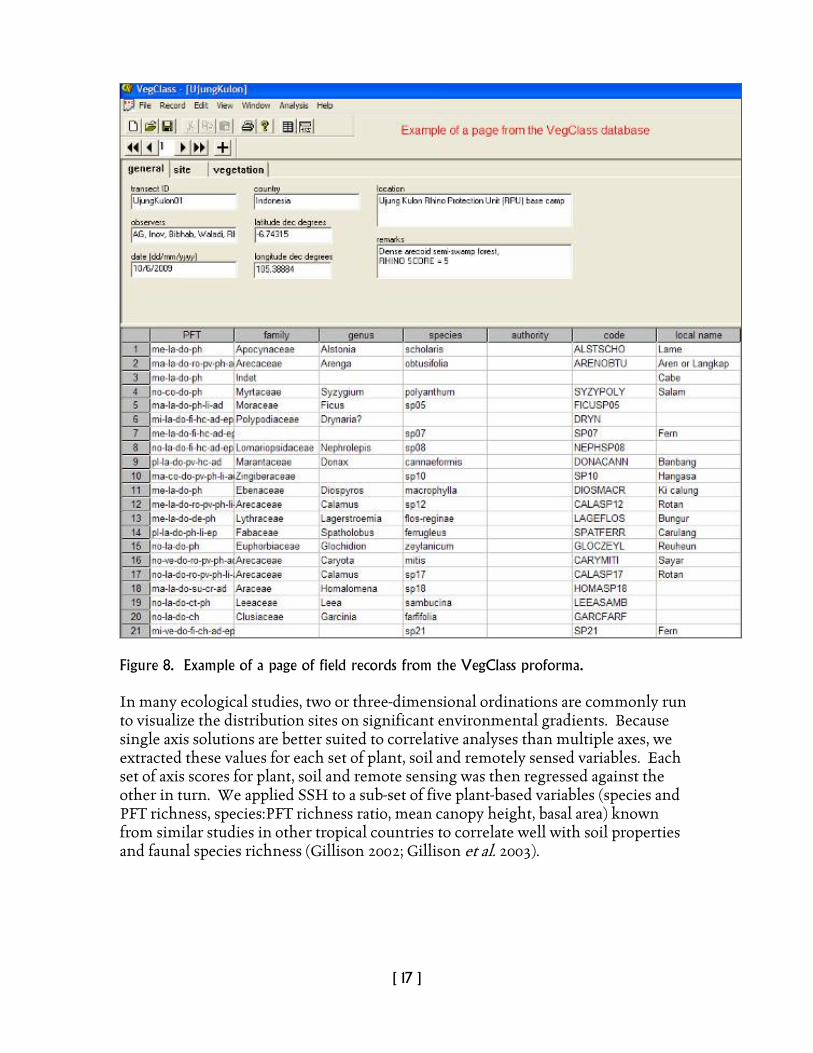
Figure 8. Example of a page of field records from the VegClass proforma. In many ecological studies, two or three-dimensional ordinations are commonly run to visualize the distribution sites on significant environmental gradients. Because single axis solutions are better suited to correlative analyses than multiple axes, we extracted these values for each set of plant, soil and remotely sensed variables. Each set of axis scores for plant, soil and remote sensing was then regressed against the other in turn. We applied SSH to a sub-set of five plant-based variables (species and PFT richness, species:PFT richness ratio, mean canopy height, basal area) known from similar studies in other tropical countries to correlate well with soil properties and faunal species richness (Gillison 2002; Gillison et al. 2003).

[ 18 ]
5. AREAS 1 AND 2 - PENINSULAR UJUNG KULON NATIONAL PARK AND GUNUNG HONJE
5.1 Geographic location Ujung Kulon National Park (6° 45'S, 105° 20'E) and Krakatau Nature Reserve (6° 06'S, 105° 25'E) make up a World Heritage Site. UKNP lies on the extreme south-western tip of Java within the administrative province of Java Barat (West Java) and the Kabupaten of Pandeglang. The point-to-point ocean boundary encloses Ujung Kulon Peninsula and the offshore islands of Pulau Handeuleum and Pulau Peucang, whilst the island of Pulau Panaitan is separated by the 10-km-wide Panaitan Straits. The eastern boundary follows contours along the eastern foothills of the Gunung Honje massif. UKNP is located in the south-westernmost corner of the island of Java, Indonesia. It covers an area of about 300 km², including the entire Ujung Kulon peninsula, the islands of Peucang, Handeuleum and Panaitan and part of the mainland, including Mount Honje, of which the eastern slopes define the border of the Park (Figure 9 ). Ujung Kulon National Park 120,551hectares (ha) (terrestrial: 76,214 ha; marine: 44,337 ha) and ranges from sea level to 620 meters (m) at the summit of Gunung Honje. 5.2 Physical features Ujung Kulon is a triangular peninsula protruding from the southwest extremity of mainland Java, to which it is joined by a low isthmus some 1-2 km wide. The topography is dominated in the southwest by the three north-south aligned ridges of the Gunung Payung massif, with the peaks of Gunung Payung, Gunung Guhabendang and Gunung Cikuja forming the highest points on the peninsula. To the northeast, the relief attenuates to the low rolling hills and plains of the Telanca Plateau, and ultimately to the low-lying swamps in the region of the isthmus. To the east the Gunung Honje massif forms the mainland component of the park. Coastal formations include a number of raised coral islands and their associated fringing reefs which lie off the northern coast of the peninsula, the largest of these being Pulau Handeuleum. To the south, the coastline is characterized by sand dune formations, areas of raised coral reef, and further west a long stretch of undermined and shattered sandstone slabs. Extensive coral reefs and spectacular volcanic formations occur along the exposed and broken west coast. Geologically, Ujung Kulon, Gunung Honje and Pulau Panaitan are part of a young Tertiary mountain system, which overlies the pre-Tertiary strata of the Sunda Shelf. Both Ujung Kulon and Gunung Honje are thought to have formed the southernmost extension of the Bukit Barisan mountains during the Pleistocene, having become separated from Sumatra following the collapse of the arched Sunda straits dome. Central and eastern Ujung Kulon comprise raised Miocene limestone formations, which have become overlain in the north by alluvial deposits and in the south by sandstones. To the west, the Gunung Payung massif is of Miocene sedimentary
[ 19 ]
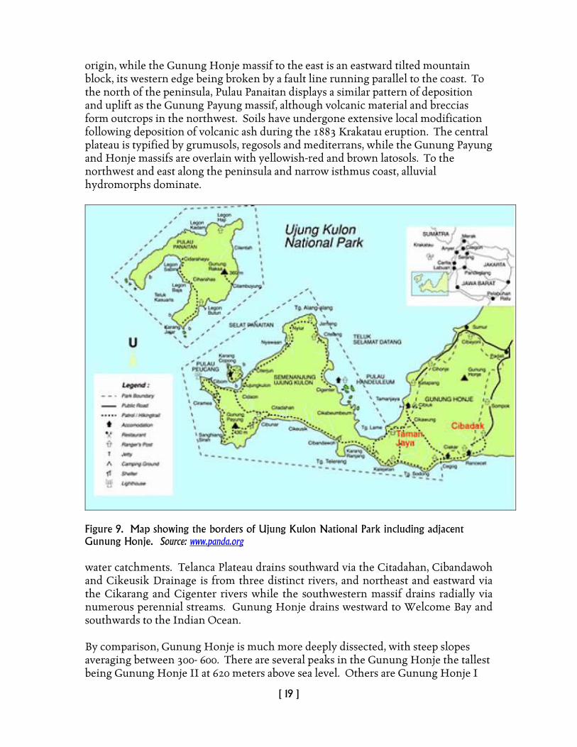
origin, while the Gunung Honje massif to the east is an eastward tilted mountain block, its western edge being broken by a fault line running parallel to the coast. To the north of the peninsula, Pulau Panaitan displays a similar pattern of deposition and uplift as the Gunung Payung massif, although volcanic material and breccias form outcrops in the northwest. Soils have undergone extensive local modification following deposition of volcanic ash during the 1883 Krakatau eruption. The central plateau is typified by grumusols, regosols and mediterrans, while the Gunung Payung and Honje massifs are overlain with yellowish-red and brown latosols. To the northwest and east along the peninsula and narrow isthmus coast, alluvial hydromorphs dominate.
Figure 9. Map showing the borders of Ujung Kulon National Park including adjacent Gunung Honje. Source: www.panda.org water catchments. Telanca Plateau drains southward via the Citadahan, Cibandawoh and Cikeusik Drainage is from three distinct rivers, and northeast and eastward via the Cikarang and Cigenter rivers while the southwestern massif drains radially via numerous perennial streams. Gunung Honje drains westward to Welcome Bay and southwards to the Indian Ocean. By comparison, Gunung Honje is much more deeply dissected, with steep slopes averaging between 300- 600. There are several peaks in the Gunung Honje the tallest being Gunung Honje II at 620 meters above sea level. Others are Gunung Honje I
[ 20 ]
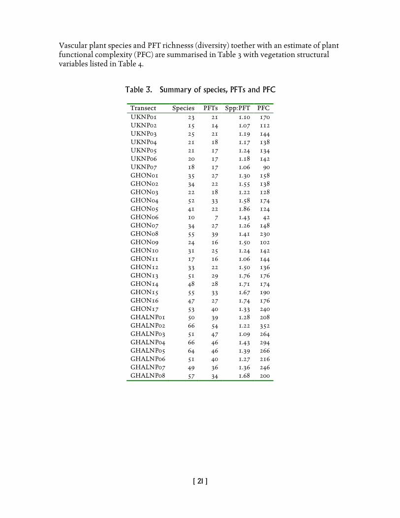
(608 m), Gunung Tilu (465 m), Gunung Patujah (400 m), Gunung Batu (314 m), and Gunung Cimahi (183 m). 5.3 Climate Conditions are tropical maritime, with a seasonal mean annual rainfall of approximately 3250 millimeters (mm). Heaviest rainfall is between October and April during the northwest monsoon, and a noticeably drier period occurs between May and September during the southeast monsoon. Mean monthly rainfall figures of 400 mm have been recorded for December and January, and 100 mm per month during May to September. Mean temperatures range between 25°C and 30°C and relative humidity between 65% and 100%. Fauzi and Stoops (2004) describe the climate in the northern part of the Gunung Honje as isohyperthermic, with a mean annual temperature of 26.8°C and an average annual rainfall of 3388 mm, with peak of 549 mm in December. July is the driest month with only 108 mm of rainfall on average. Ujung Kulon National Park received World Heritage Site status from the World Heritage Commission of UNESCO under decree No: SC/Eco/5867.2.409, after considering the uniqueness of this conservation area as the habitat of the last remaining population of the Javan rhino and the possibility that it is the world’s most endangered large mammal species. 5.4 Results of data analysis Site locations and their key physical features are listed in Table 2 (see also Figure 14 for peninsular UKNP and Gn. Honje). Table 2. Site locations, Ujung Kulon NP, Gunung Honje, Halimun – Salak NP Transect Location Lat. S Long. E Elevn (m) Slope% Aspect° UKNP01 Ujung Kulon NP -6.74315 105.38884 3 3 360 UKNP02 Ujung Kulon NP -6.74818 105.38330 70 5 250 UKNP03 Ujung Kulon NP -6.74969 105.37697 13 40 190 UKNP04 Ujung Kulon NP -6.45175 105.23043 21 10 20 UKNP05 Ujung Kulon NP -6.45293 105.23360 30 0 0 UKNP06 Ujung Kulon NP -6.45270 105.23528 15 0 0 UKNP07 Ujung Kulon NP -6.45046 105.23572 5 0 0 GHON01 Geundir -6.82190 105.50580 21 0 0 GHON02 Cikanyere -6.82960 105.50383 28 5 290 GHON03 Kalecetan -6.83369 105.50352 45 0 0 GHON04 Hulu Cikalejetan -6.83791 105.50629 50 0 0 GHON05 Hulu Cikalejetan -6.84179 105.50508 46 0 0 GHON06 Cikalejetan selatan -6.85099 105.50107 70 0 0 GHON07 Cikalejetan - Air Moklah -6.85567 105.50391 71 0 0 GHON08 Kubangen Cikarang -6.85607 105.50704 67 0 0 GHON09 Ranta sebang. -6.85896 105.50599 64 0 0 GHON10 Airmoklah - Kalejetan -6.86198 105.50597 6 0 0 GHON11 Pantai Kalejetan -6.86223 105.50558 7 40 200 GHON12 West of Kalejetan river -6.85683 105.49607 13 0 0 GHON13 Cimahi bukit -6.82033 105.52248 62 12 210
[ 21 ]
Vascular plant species and PFT richnesss (diversity) toether with an estimate of plant functional complexity (PFC) are summarised in Table 3 with vegetation structural variables listed in Table 4.
Table 3. Summary of species, PFTs and PFC
Transect Species PFTs Spp:PFT PFC UKNP01 23 21 1.10 170 UKNP02 15 14 1.07 112 UKNP03 25 21 1.19 144 UKNP04 21 18 1.17 138 UKNP05 21 17 1.24 134 UKNP06 20 17 1.18 142 UKNP07 18 17 1.06 90 GHON01 35 27 1.30 158 GHON02 34 22 1.55 138 GHON03 22 18 1.22 128 GHON04 52 33 1.58 174 GHON05 41 22 1.86 124 GHON06 10 7 1.43 42 GHON07 34 27 1.26 148 GHON08 55 39 1.41 230 GHON09 24 16 1.50 102 GHON10 31 25 1.24 142 GHON11 17 16 1.06 144 GHON12 33 22 1.50 136 GHON13 51 29 1.76 176 GHON14 48 28 1.71 174 GHON15 55 33 1.67 190 GHON16 47 27 1.74 176 GHON17 53 40 1.33 240 GHALNP01 50 39 1.28 208 GHALNP02 66 54 1.22 352 GHALNP03 51 47 1.09 264 GHALNP04 66 46 1.43 294 GHALNP05 64 46 1.39 266 GHALNP06 51 40 1.27 216 GHALNP07 49 36 1.36 246 GHALNP08 57 34 1.68 200
[ 22 ]
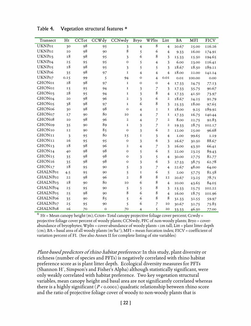
Table 4. Vegetation structural features *
Transect Ht CCTot CCWdy CCNwdy Bryo WPlts Litt BA MFI FICV UKNP01 30 98 95 3 4 8 4 20.67 25.00 116.26 UKNP02 10 98 90 8 5 6 4 9.33 16.00 174.91 UKNP03 18 98 95 3 6 8 3 15.33 15.50 194.65 UKNP04 25 95 95 0 5 4 3 6.00 23.00 116.41 UKNP05 18 98 95 3 5 5 3 18.67 18.50 189.11 UKNP06 35 98 97 1 4 4 4 18.00 22.00 141.14 UKNP07 0.15 99 5 94 0 4 0.01 0.01 100.00 0.00 GHON01 28 98 97 1 0 0 4 17.33 24.75 77.13 GHON02 15 95 94 1 3 7 3 17.33 35.75 90.67 GHON03 28 95 94 1 3 8 4 17.33 41.50 73.97 GHON04 20 98 96 2 3 6 2 18.67 24.25 91.79 GHON05 38 98 97 1 6 8 3 25.33 18.00 97.65 GHON06 30 98 98 0 4 2 1 18.00 9.25 189.92 GHON07 17 90 80 10 4 7 1 17.33 16.75 140.44 GHON08 10 98 96 2 4 7 2 8.00 22.75 92.83 GHON09 35 90 89 1 3 7 2 19.33 28.75 102.17 GHON10 12 90 85 0 3 6 2 12.00 25.00 96.68 GHON11 3 95 80 15 1 3 4 1.00 99.65 1.19 GHON12 16 95 95 0 3 6 3 16.67 30.50 88.67 GHON13 18 98 96 2 4 7 3 16.00 43.50 66.41 GHON14 40 98 98 0 5 6 5 22.00 23.25 89.43 GHON15 35 98 98 0 3 5 4 30.00 27.75 82.77 GHON16 35 98 98 0 3 6 3 27.33 38.75 62.78 GHON17 18 95 90 5 3 7 4 22.67 48.00 64.00 GHALNP01 4.5 95 90 5 1 6 5 2.00 57.75 81.58 GHALNP02 22 98 96 2 8 8 12 20.67 23.25 78.71 GHALNP03 18 90 80 10 6 8 4 10.00 43.65 84.05 GHALNP04 25 95 90 5 5 8 3 15.33 25.75 102.22 GHALNP05 25 98 90 8 6 8 4 16.00 18.75 101.96 GHALNP06 35 90 85 5 6 8 8 31.33 32.55 59.97 GHALNP07 25 95 90 5 6 7 10 30.67 32.75 75.85 GHALNP08 16 70 0 70 4 5 20 33.33 46.50 77.00
* Ht = Mean canopy height (m); Cctot= Total canopy projective foliage cover percent; Ccwdy = projective foliage cover percent of woody plants; CCNwdy, PFC of non-woody plants; Bryo = cover-abundance of bryophytes; Wplts = cover-abundance of woody plants <2m tall; Litt = plant litter depth (cm); BA = basal area of all woody plants (m2ha-1); MFI = mean furcation index; FICV = coefficient of variation percent of FI. (See also Annex II for complete listing of site variables) Plant-based predictors of rhino habitat preference: In this study, plant diversity or richness (number of species and PFTs) is negatively correlated with rhino habitat preference score as is plant litter depth. Ecological diversity measures for PFTs (Shannon H´, Simpson’s and Fisher’s Alpha) although statistically significant, were only weakly correlated with habitat preference. Two key vegetation structural variables, mean canopy height and basal area are not significantly correlated whereas there is a highly significant (P < 0.0001) quadratic relationship between rhino score and the ratio of projective foliage cover of woody to non-woody plants that is
[ 23 ]
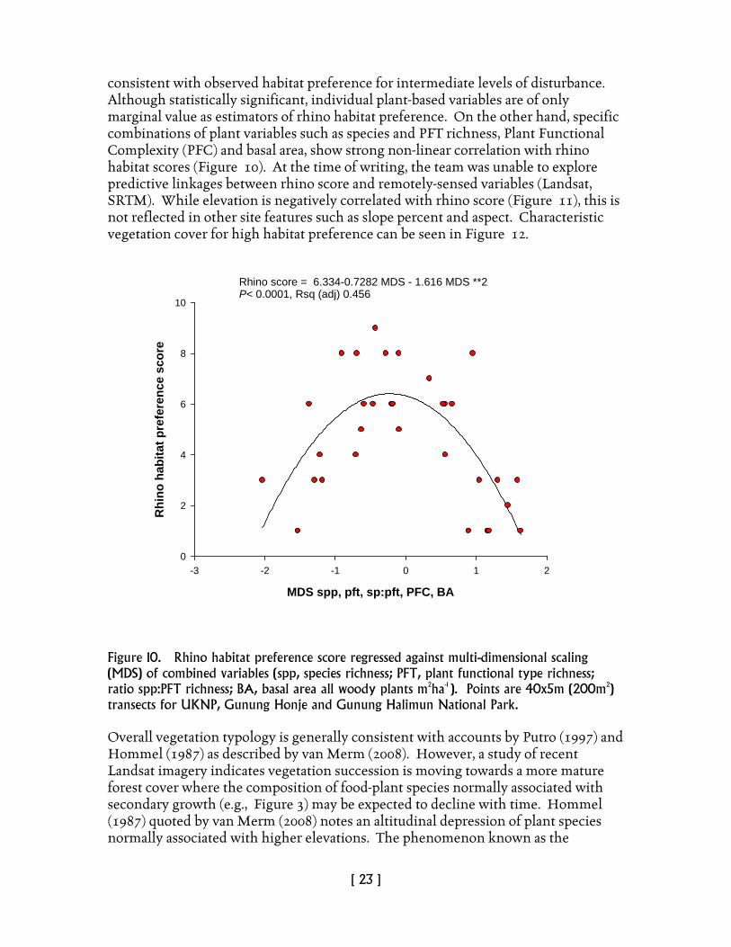
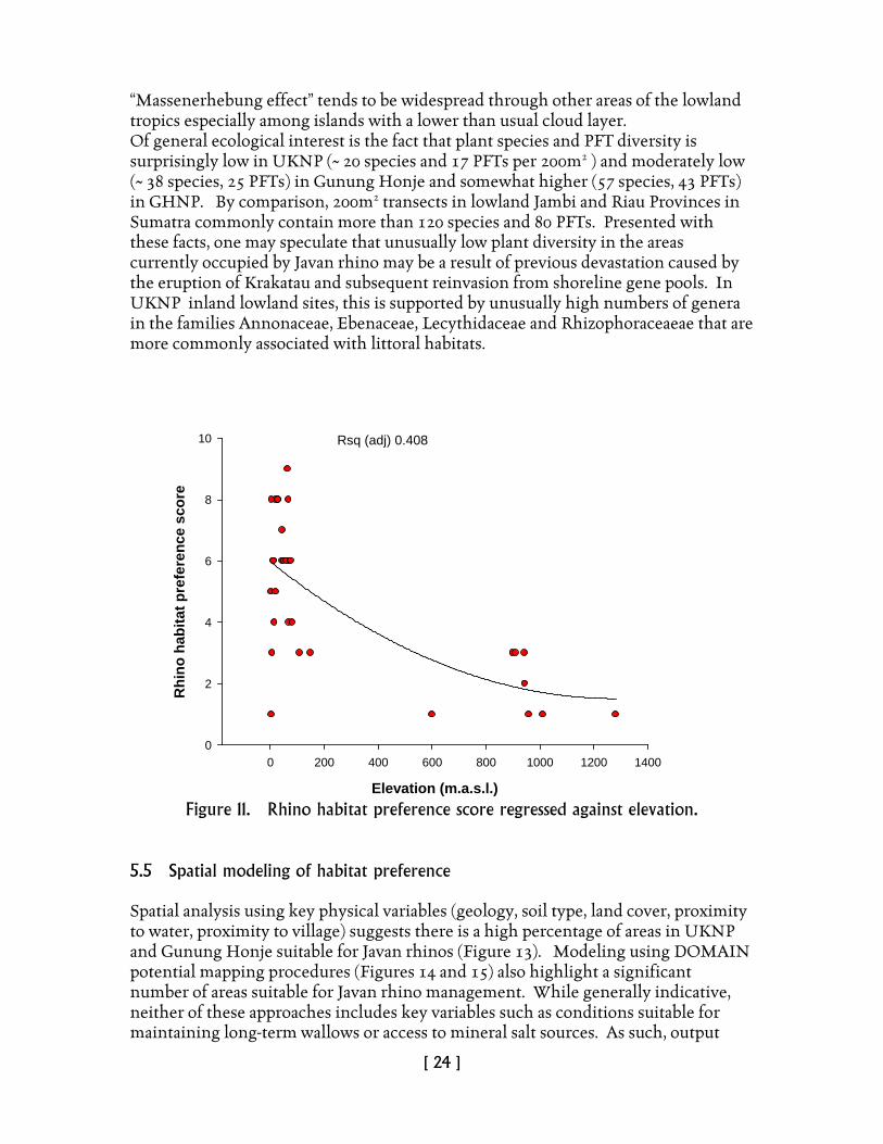
consistent with observed habitat preference for intermediate levels of disturbance. Although statistically significant, individual plant-based variables are of only marginal value as estimators of rhino habitat preference. On the other hand, specific combinations of plant variables such as species and PFT richness, Plant Functional Complexity (PFC) and basal area, show strong non-linear correlation with rhino habitat scores (Figure 10). At the time of writing, the team was unable to explore predictive linkages between rhino score and remotely-sensed variables (Landsat, SRTM). While elevation is negatively correlated with rhino score (Figure 11), this is not reflected in other site features such as slope percent and aspect. Characteristic vegetation cover for high habitat preference can be seen in Figure 12.
Figure 10. Rhino habitat preference score regressed against multi-dimensional scaling (MDS) of combined variables (spp, species richness; PFT, plant functional type richness; ratio spp:PFT richness; BA, basal area all woody plants m2ha-1 ). Points are 40x5m (200m2) transects for UKNP, Gunung Honje and Gunung Halimun National Park. Overall vegetation typology is generally consistent with accounts by Putro (1997) and Hommel (1987) as described by van Merm (2008). However, a study of recent Landsat imagery indicates vegetation succession is moving towards a more mature forest cover where the composition of food-plant species normally associated with secondary growth (e.g., Figure 3) may be expected to decline with time. Hommel (1987) quoted by van Merm (2008) notes an altitudinal depression of plant species normally associated with higher elevations. The phenomenon known as the
MDS spp, pft, sp:pft, PFC, BA
-3 -2 -1 0 1 2
Rhi
no h
abita
t pre
fere
nce
scor
e
0
2
4
6
8
10
Rhino score = 6.334-0.7282 MDS - 1.616 MDS **2P< 0.0001, Rsq (adj) 0.456
[ 24 ]
“Massenerhebung effect” tends to be widespread through other areas of the lowland tropics especially among islands with a lower than usual cloud layer. Of general ecological interest is the fact that plant species and PFT diversity is surprisingly low in UKNP (~ 20 species and 17 PFTs per 200m2 ) and moderately low (~ 38 species, 25 PFTs) in Gunung Honje and somewhat higher (57 species, 43 PFTs) in GHNP. By comparison, 200m2 transects in lowland Jambi and Riau Provinces in Sumatra commonly contain more than 120 species and 80 PFTs. Presented with these facts, one may speculate that unusually low plant diversity in the areas currently occupied by Javan rhino may be a result of previous devastation caused by the eruption of Krakatau and subsequent reinvasion from shoreline gene pools. In UKNP inland lowland sites, this is supported by unusually high numbers of genera in the families Annonaceae, Ebenaceae, Lecythidaceae and Rhizophoraceaeae that are more commonly associated with littoral habitats.
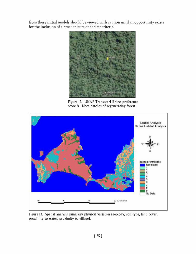
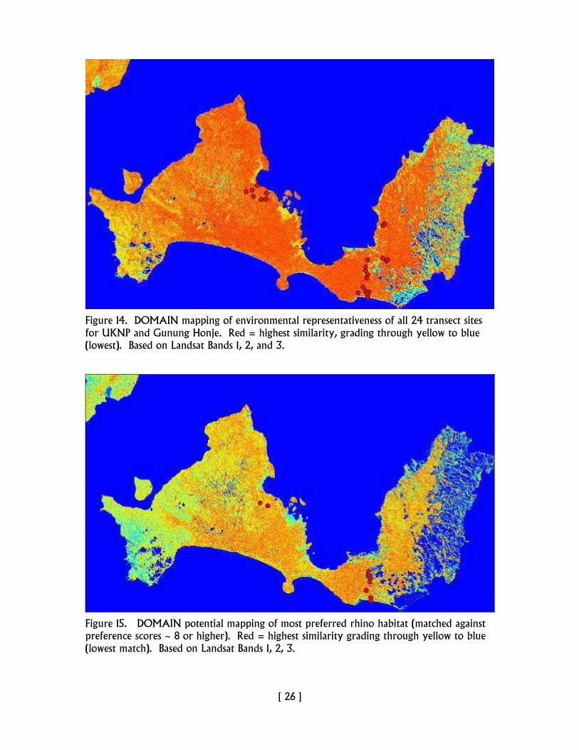
Figure 11. Rhino habitat preference score regressed against elevation. 5.5 Spatial modeling of habitat preference Spatial analysis using key physical variables (geology, soil type, land cover, proximity to water, proximity to village) suggests there is a high percentage of areas in UKNP and Gunung Honje suitable for Javan rhinos (Figure 13). Modeling using DOMAIN potential mapping procedures (Figures 14 and 15) also highlight a significant number of areas suitable for Javan rhino management. While generally indicative, neither of these approaches includes key variables such as conditions suitable for maintaining long-term wallows or access to mineral salt sources. As such, output
Elevation (m.a.s.l.)
0 200 400 600 800 1000 1200 1400
Rhi
no h
abita
t pre
fere
nce
scor
e
0
2
4
6
8
10 Rsq (adj) 0.408
[ 25 ]
from these initial models should be viewed with caution until an opportunity exists for the inclusion of a broader suite of habitat criteria.
Figure 13. Spatial analysis using key physical variables (geology, soil type, land cover, proximity to water, proximity to village).
Figure 12. UKNP Transect 4 Rhino preference score 8. Note patches of regenerating forest.
[ 26 ]
Figure 14. DOMAIN mapping of environmental representativeness of all 24 transect sites for UKNP and Gunung Honje. Red = highest similarity, grading through yellow to blue (lowest). Based on Landsat Bands 1, 2, and 3.
Figure 15. DOMAIN potential mapping of most preferred rhino habitat (matched against preference scores ~ 8 or higher). Red = highest similarity grading through yellow to blue (lowest match). Based on Landsat Bands 1, 2, 3.
[ 27 ]
5.6 Vulnerability to threat Poaching activity in peninsular UKNP has been greatly reduced due to ongoing management by the RPUs. Within peninsular UKNP, possibly the greatest threat lies in the gradual reduction of food-plant resources due to forest closure and invasion of Langkap (Arenga obtusifolia). In Gunung Honje, increased threats arise from increasing human activity through high population pressure (including potential for rhino poaching), the fact that many people do not own land and that there is some negative reaction to the possibility of a Javan rhino reserve being established. A number of well-trodden human paths were intercepted during the survey. This level of threat will increase should land ownership become more extensive and land management more intensive through plantation and sedentary agriculture as has been the case in the other areas under consideration. Aside from these major threats, other issues concern disease, especially Anthrax, and comparatively low risk to tectonic events (e.g., tsunamis, earthquakes). Apart from the threat levels identified in the introduction, threats in Gunung Honje are significantly higher due mainly to the relative increase in human activity through agricultural and forestry activities and greater potential for poaching. 5.7 Potential interaction with government and non-government stakeholders and local communities Building on results from a previous survey (van Merm 2008) and with respect to the assessment criteria (Table 4), a survey of areas surrounding Gunung Honje and Gunung Halimun was conducted using a comprehensive set of 54 socioeconomic parameters designed to record positive and negative responses to rhino translocation and management. Gunung Honje recorded 38 (70%) positive responses compared to 18 (30%) for Gunung Halimun. The overall negative response in Gunung Halimun (Ciusul) is largely due to the fact that there is no recorded history of rhino occupation in the area and the socioeconomic conditions are not conducive to sustainable management of a Javan rhino population. Table 5 below outlines in detail the socioeconomic assessment (compiled by H. Gunawan).
[ 28 ]
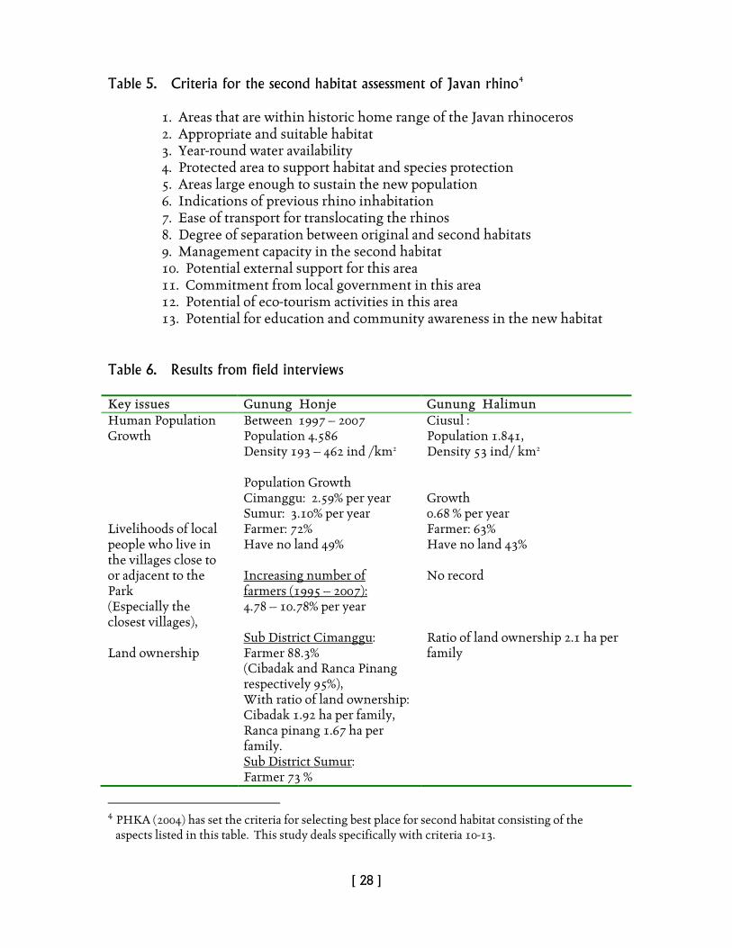
Table 5. Criteria for the second habitat assessment of Javan rhino4
1. Areas that are within historic home range of the Javan rhinoceros 2. Appropriate and suitable habitat 3. Year-round water availability 4. Protected area to support habitat and species protection 5. Areas large enough to sustain the new population 6. Indications of previous rhino inhabitation 7. Ease of transport for translocating the rhinos 8. Degree of separation between original and second habitats 9. Management capacity in the second habitat 10. Potential external support for this area 11. Commitment from local government in this area 12. Potential of eco-tourism activities in this area 13. Potential for education and community awareness in the new habitat
Table 6. Results from field interviews
Key issues Gunung Honje Gunung Halimun Human Population Growth
Between 1997 – 2007 Population 4.586 Density 193 – 462 ind /km2 Population Growth Cimanggu: 2.59% per year Sumur: 3.10% per year
Ciusul : Population 1.841, Density 53 ind/ km2 Growth 0.68 % per year
Livelihoods of local people who live in the villages close to or adjacent to the Park (Especially the closest villages), Land ownership
Farmer: 72% Have no land 49%
4.78 – 10.78% per year
Increasing number of farmers (1995 – 2007):
Sub District CimangguFarmer 88.3%
:
(Cibadak and Ranca Pinang respectively 95%), With ratio of land ownership: Cibadak 1.92 ha per family, Ranca pinang 1.67 ha per family. Sub District SumurFarmer 73 %
:
Farmer: 63% Have no land 43% No record Ratio of land ownership 2.1 ha per family
4 PHKA (2004) has set the criteria for selecting best place for second habitat consisting of the aspects listed in this table. This study deals specifically with criteria 10-13.
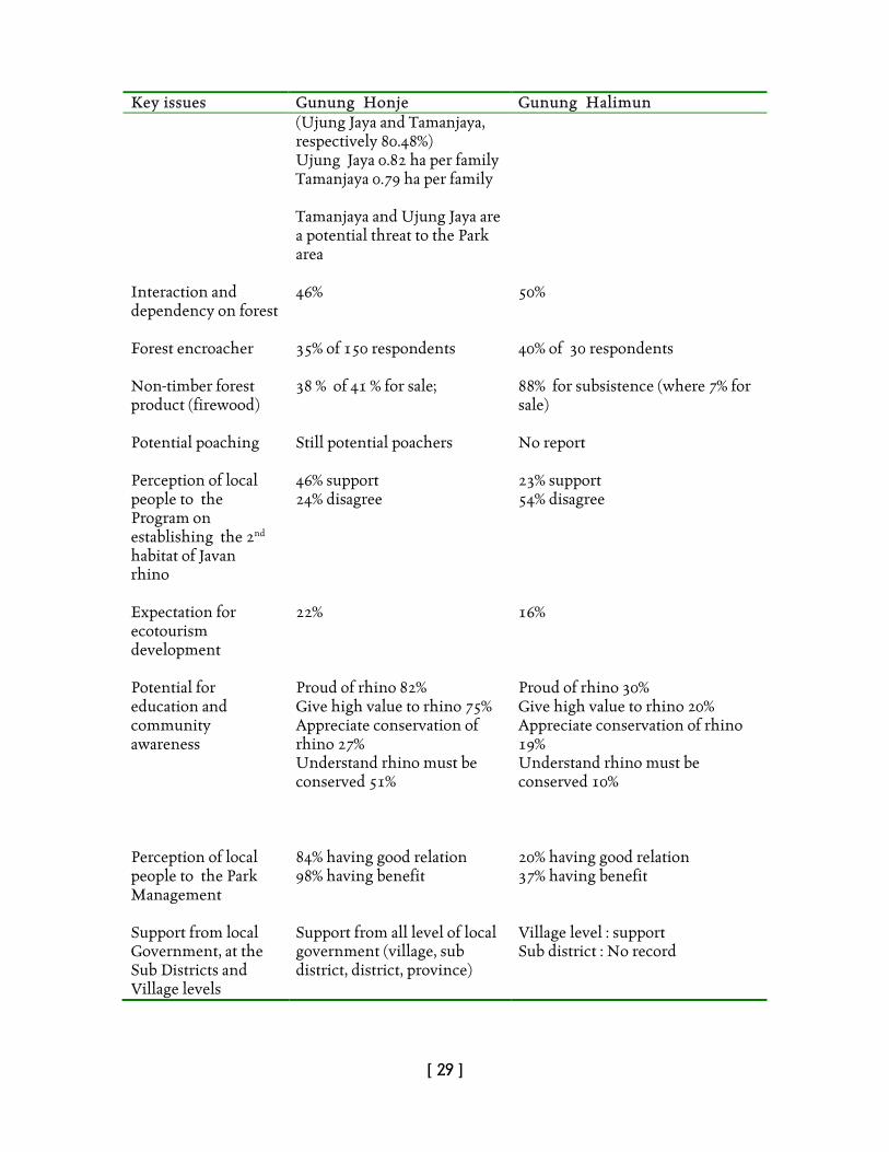
[ 29 ]
Key issues Gunung Honje Gunung Halimun (Ujung Jaya and Tamanjaya, respectively 80.48%) Ujung Jaya 0.82 ha per family Tamanjaya 0.79 ha per family Tamanjaya and Ujung Jaya are a potential threat to the Park area
Interaction and dependency on forest
46%
50%
Forest encroacher
35% of 150 respondents
40% of 30 respondents
Non-timber forest product (firewood)
38 % of 41 % for sale;
88% for subsistence (where 7% for sale)
Potential poaching
Still potential poachers
No report
Perception of local people to the Program on establishing the 2nd habitat of Javan rhino
46% support 24% disagree
23% support 54% disagree
Expectation for ecotourism development
22% 16%
Potential for education and community awareness
Proud of rhino 82% Give high value to rhino 75% Appreciate conservation of rhino 27% Understand rhino must be conserved 51%
Proud of rhino 30% Give high value to rhino 20% Appreciate conservation of rhino 19% Understand rhino must be conserved 10%
Perception of local people to the Park Management
84% having good relation 98% having benefit
20% having good relation 37% having benefit
Support from local Government, at the Sub Districts and Village levels
Support from all level of local government (village, sub district, district, province)
Village level : support Sub district : No record

[ 30 ]
6. AREA 3 - GUNUNG HALIMUN NATIONAL PARK5
6.1 Location and history Gunung Halimun (Halimun-Salak) National Park (GHNP) is a conservation area in the Indonesian province of West Java. It is located near the better-known Gunung Gede Pangrango National Park, and to the city of Bogor, home to Bogor Botanical Gardens. GHNP is 400 km2 in area, half of which makes up what is arguably the best and most complete forest area in Java (Figure 16). GHNP is a large national park that includes the Nirmala tea estate. Since the mid 1980s, Javan hawk-eagles have been regularly observed both from the estate and along its borders. The forests of the Mount Halimun Massif are the largest tract of true rain forest now remaining on Java. The wide altitudinal range contributes to great habitat diversity. The area's particular importance for wildlife protection was acknowledged on 26 February 1992, when GHNP was established by Ministry of Forestry decree SK No. 282/Kpts-II/92. Originally, most of the Park’s 40,000 ha was classified as protection forest, declared during the period 1924-1934. The area was slightly enlarged in 1979 when its status changed to nature reserve. On 26 May 1992, management and responsibility for the setting up of the new National Park was transferred to the Headquarters of Gunung Gede Pangrango National Park. The park is located between longitudes 106°21' - 106°38' East and latitudes 6°37' - 6°51' South, within the regencies of Bogor, Sukabumi and Lebak. The gazetted area is mountainous, ranging from 500 m to 1,929 m above sea level (asl). Many peaks lie within the Park’s boundaries: Halimun 1929m, Sanggabuana 1919m, Kendeng 1867m, Botol 1785m, South Kendeng 1764m, South Halimun 1744m and Amdan 1463m. Apart from the primary function of habitat protection, the National Park plays an important role in supporting regional development and opportunities for research, education, eco-tourism and horticultural activities such as orchid growing. With the creation of GHNP, the three West Javan parks (Gunung Gede Pangrango, Gunung Halimun and Ujung Kulon), together provide a range of habitats from sea level to the highest peaks. Such conservation planning will help assure a secure future for the rich and threatened wildlife of this densely-populated province. Its mountain tops reach 1929m and are often mist-shrouded, while its valleys are thought to hide as-yet undiscovered biodiversity. The lower zones hold apparently secure populations of the endangered West Javan gibbon (Hylobates moloch moloch). Mount Halimun is its most secure habitat, but its range is restricted to a thin ring around the park as the species is not found above 1200m. Javan langur (Trachypithecus auratus), and other endemic species are evident; about half of its 145 known bird species are rarely seen elsewhere in Java. The Park protects the water catchments for the densely populated urban and agricultural areas to the north.
5 Extracted from Sectionov (2009)
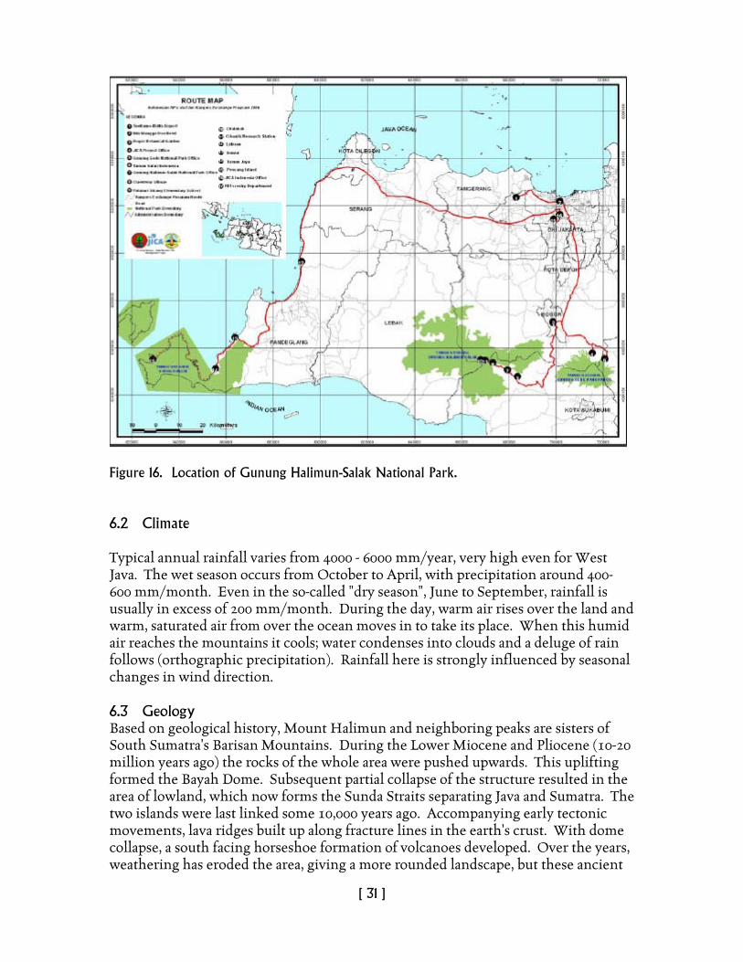
[ 31 ]
Figure 16. Location of Gunung Halimun-Salak National Park. 6.2 Climate Typical annual rainfall varies from 4000 - 6000 mm/year, very high even for West Java. The wet season occurs from October to April, with precipitation around 400-600 mm/month. Even in the so-called "dry season", June to September, rainfall is usually in excess of 200 mm/month. During the day, warm air rises over the land and warm, saturated air from over the ocean moves in to take its place. When this humid air reaches the mountains it cools; water condenses into clouds and a deluge of rain follows (orthographic precipitation). Rainfall here is strongly influenced by seasonal changes in wind direction. 6.3 Geology Based on geological history, Mount Halimun and neighboring peaks are sisters of South Sumatra's Barisan Mountains. During the Lower Miocene and Pliocene (10-20 million years ago) the rocks of the whole area were pushed upwards. This uplifting formed the Bayah Dome. Subsequent partial collapse of the structure resulted in the area of lowland, which now forms the Sunda Straits separating Java and Sumatra. The two islands were last linked some 10,000 years ago. Accompanying early tectonic movements, lava ridges built up along fracture lines in the earth's crust. With dome collapse, a south facing horseshoe formation of volcanoes developed. Over the years, weathering has eroded the area, giving a more rounded landscape, but these ancient
[ 32 ]
features remain. Mount Halimun's rocks largely consist of breccia and andesitic and basalt lavas. There also as few sedimentary areas. Gold and silver ores occur, and mining takes place in the west and southwest. 6.4 Hydrology The Halimun Massif is a vital watershed, being the source of several important rivers supplying both the urban and farming communities of West Java. To the north, large rivers flow towards the densely populated regencies of Tangerang and Bogor, while to the South Sukabumi and Lebak regencies and the coast are fed by many small rivers. The park's forested ridges slowly release water helping to preventing floods in the wet season and water shortages in the dry season. 6.5 Vegetation In contrast to the Mount Gede area, Mount Halimun has been poorly researched. There is still a strong conviction that the mountains are haunted; because of this, early researchers found it very difficult to obtain guides. The past geological link with South Sumatra is reflected in the vegetational affinity between the two areas. More than half the forest occurs in the altitudinal range 1000-1400m. This can be regarded as sub-montane forest, a type which possesses a greater diversity of plants than higher, cooler areas. Dominant tree species are the huge rasamala (Altingia excelsa), the puspa (Schima walichii), and oaks (Castanopsis, Lithocarpus, Quercus). Smaller laurel trees (Litsea spp.) also make up an important constituent. Orchids and other epiphytes are numerous. Lianas, are well represented and include rattans. The high rainfall gives rise to a rich community of ferns and mosses, palms, rhododendrons, tree ferns and orchids, all of which add to the area's high botanical value. In the higher montane forest diversity is less, with dominant conifers (Dacrycarpus imbricatus, Podocarpus blumeii and P. neriifolius).
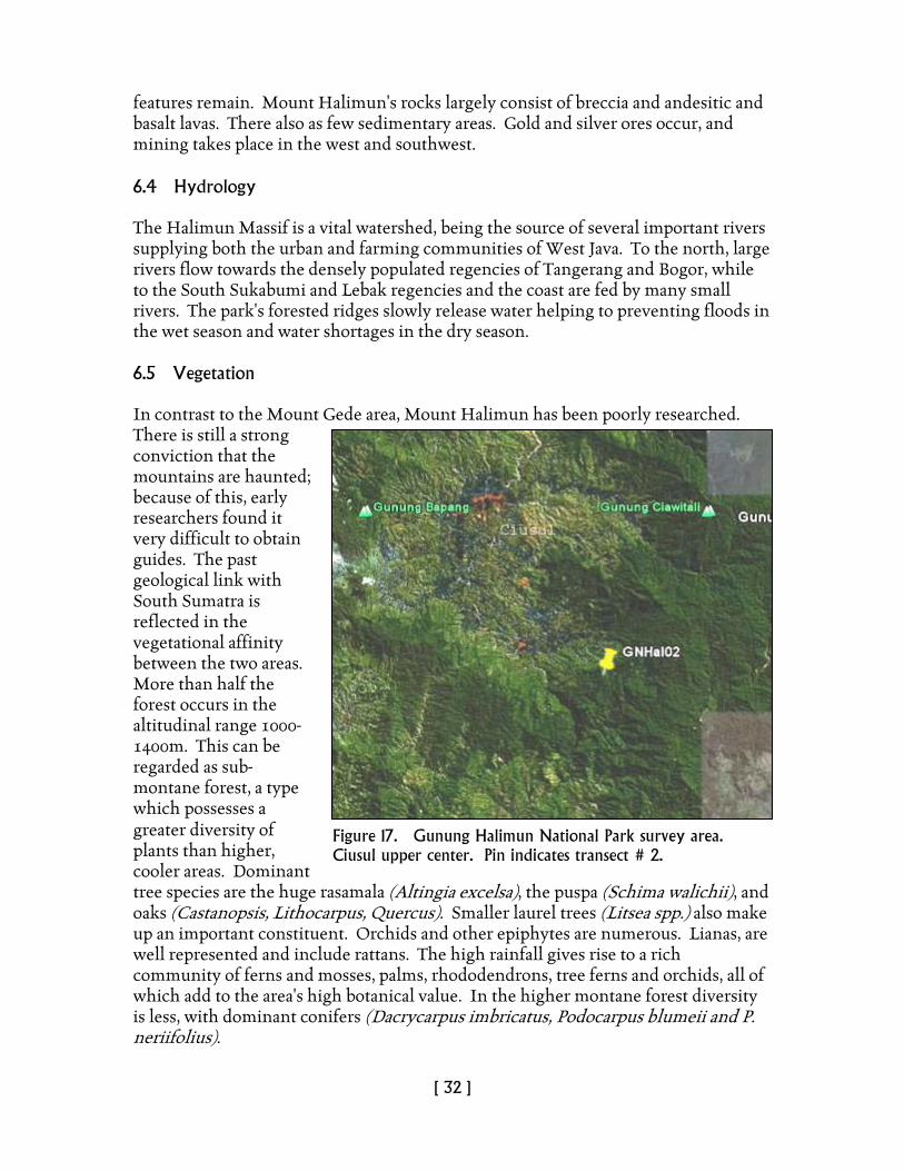
Figure 17. Gunung Halimun National Park survey area. Ciusul upper center. Pin indicates transect # 2.
[ 33 ]
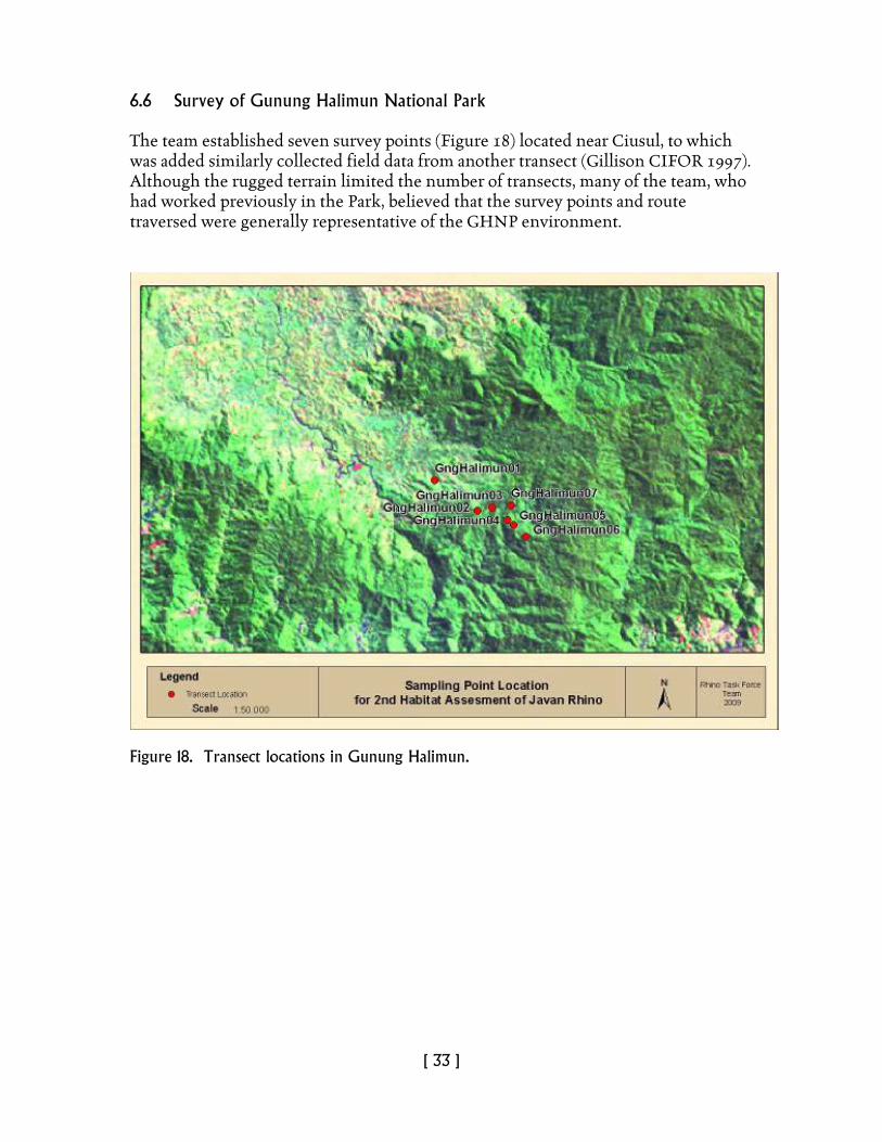
6.6 Survey of Gunung Halimun National Park The team established seven survey points (Figure 18) located near Ciusul, to which was added similarly collected field data from another transect (Gillison CIFOR 1997). Although the rugged terrain limited the number of transects, many of the team, who had worked previously in the Park, believed that the survey points and route traversed were generally representative of the GHNP environment.
Figure 18. Transect locations in Gunung Halimun.

[ 34 ]
6.7 Results of survey Recorded transect biophysical data are listed in Tables 2, 3, and 4 and in Annex III. Plant biodiversity is generally higher than that recorded for UKNP and Gunung Honje, but considerably less than that recorded using similar methodology in Sumatra (e.g., Bukit Barisan, Jambi, Riau). Farming (padi rice or Sawah) extends to more than 700m and the presence of invasive weed species, especially Maesopsis emenii and Melastomataceae (Bellucia axinanthera, Clidemia hirta) as well as Chromolaena odorata, Mikania micrantha and Psidium guajava indicates a continuing threat to any management system that requires opening of the forest canopy. Evidence from UKNP suggests that occasional opening of the canopy is necessary to promote the growth of food-plant species for rhino, normally associated with pioneer assemblages. Within GHNP, illegal mining and forest plantations are widespread. In addition, the team observed a number of examples of landscape instability as a result of some of these activities (Figure 19). While the team identified localities where rhino might survive temporarily, the highly disturbed environment coupled with intense human activity pose a continuing threat to any possibility of translocation of rhino. For these reasons, we undertook no spatial modeling of potential rhino habitat.
7. AREA 4 - LEUWEUNG SANCANG 6
7.1 Overview of physiography, land cover and land use The Leuweung Sancang Nature Reserve of 4,000 lies on the south coast of West Java, 40 km east of Pameunpeuk. The reserve comprises the estuaries of the Cikaengan and Ciporeang rivers that are partly covered by extensive coral reefs, mangroves swamps and sandy beaches (Figure 20). The adjacent undulating lowlands include brackish swamp forest, dry-beach forest, freshwater swamp. The reserve includes a tropical rain forest ecosystem. Of the total area, 1434 ha is tropical rain forest, 94 ha is secondary forest, 40 ha grazing ground, 509 ha is without cover (no forest) and 78 ha is rubber forest (BKSDA 1976). The region is located in Sancang village, Cibalong sub district, between 0-18m above mean sea level. Leuweung Sancang is one of the few declared international-level nature reserves in Indonesia that is yet to be impacted by tourism. Access to conservation areas in Leuweung Sancang in the Cibalong district requires a 5 hour, 118 km-long hard drive trip from Garut. Topography and Soil
6 Extracted from Sectionov (2009)
Figure 19. Example of extreme erosion in GHNP.
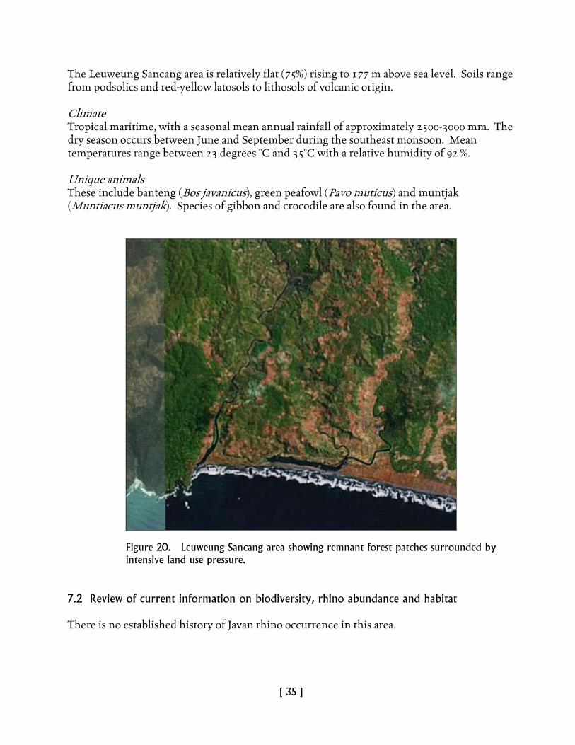
[ 35 ]
The Leuweung Sancang area is relatively flat (75%) rising to 177 m above sea level. Soils range from podsolics and red-yellow latosols to lithosols of volcanic origin. Climate Tropical maritime, with a seasonal mean annual rainfall of approximately 2500-3000 mm. The dry season occurs between June and September during the southeast monsoon. Mean temperatures range between 23 degrees °C and 35°C with a relative humidity of 92 %. Unique animals These include banteng (Bos javanicus), green peafowl (Pavo muticus) and muntjak (Muntiacus muntjak). Species of gibbon and crocodile are also found in the area.
Figure 20. Leuweung Sancang area showing remnant forest patches surrounded by intensive land use pressure.
7.2 Review of current information on biodiversity, rhino abundance and habitat There is no established history of Javan rhino occurrence in this area.
[ 36 ]
7.3. Potential interaction with government and non-government stakeholders and local communities
Potential interaction with local stakeholders is unknown. 7.4 Conclusions Preliminary assessment indicates that the level of human population pressure and land use intensity combined with the relatively restricted areas of potential rhino habitat mitigate against any realistic chance of successful translocation of the Javan rhino in Leuweung Sancang. 8. AREA 5 - MASIGIT KAREUMBI GAME RESERVE 8.1 Overview of physiography, land cover and land use. The 70-ha reserve of is located between 107°57‘E, 6°57‘S, within the regency of West Java. (SK Mentan No.297/Kpts/Um/5/1976) (Figure 21) Topography Generally hilly to mountainous (Gunung Kerenceng 1736m asl) with steep slopes averaging between 20%-30% . Climate Mean annual rainfall of approximately 1900 mm. Mean temperatures range between 23°C and 25°C with a relative humidity between 60% and 90%. Hydrology The area is well served by several rivers including the Ciguruguy, Cikantap, Cimanggung, Cihanjawar, Citarik, etc. There is also evidence that animal wallows exist during the dry season. 8.2 Review of current information on biodiversity, rhino abundance and habitat. Flora The forest contains oaks and laurels together with numerous palms and pandans, some secondary growth with Zingiberaceae and ferns. Almost 40% of the forest is dominated by Pinus merkusii, bamboo and Acacia decurrens. Fauna Sambar deer (Cervus unicolor), wild boar (Sus scrofa), wild dog (Cuon alpinus), leopard (Panthera pardus), long-tailed macaque (Macaca fascicularis), Javan langur (Trachypithecus auratus), red junglefowl (Gallus gallus), brown-headed barbet (Megalaima zeylanica).
[ 37 ]
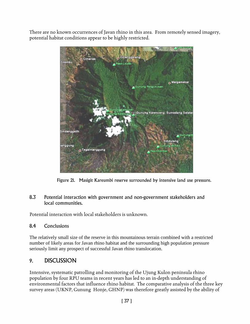
There are no known occurrences of Javan rhino in this area. From remotely sensed imagery, potential habitat conditions appear to be highly restricted.
Figure 21. Masigit Kareumbi reserve surrounded by intensive land use pressure.
8.3 Potential interaction with government and non-government stakeholders and
local communities. Potential interaction with local stakeholders is unknown. 8.4 Conclusions The relatively small size of the reserve in this mountainous terrain combined with a restricted number of likely areas for Javan rhino habitat and the surrounding high population pressure seriously limit any prospect of successful Javan rhino translocation. 9. DISCUSSION Intensive, systematic patrolling and monitoring of the Ujung Kulon peninsula rhino population by four RPU teams in recent years has led to an in-depth understanding of environmental factors that influence rhino habitat. The comparative analysis of the three key survey areas (UKNP, Gunung Honje, GHNP) was therefore greatly assisted by the ability of
[ 38 ]
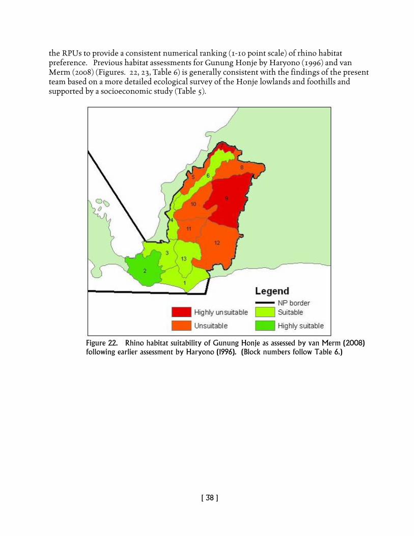
the RPUs to provide a consistent numerical ranking (1-10 point scale) of rhino habitat preference. Previous habitat assessments for Gunung Honje by Haryono (1996) and van Merm (2008) (Figures. 22, 23, Table 6) is generally consistent with the findings of the present team based on a more detailed ecological survey of the Honje lowlands and foothills and supported by a socioeconomic study (Table 5).
Figure 22. Rhino habitat suitability of Gunung Honje as assessed by van Merm (2008) following earlier assessment by Haryono (1996). (Block numbers follow Table 6.)
[ 39 ]
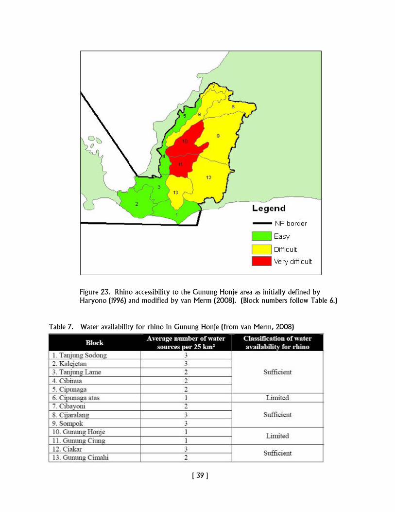
Figure 23. Rhino accessibility to the Gunung Honje area as initially defined by Haryono (1996) and modified by van Merm (2008). (Block numbers follow Table 6.) Table 7. Water availability for rhino in Gunung Honje (from van Merm, 2008)
[ 40 ]
While water availability may be reflected in Table 6, past events such as the drought of 1967 indicate that such conditions cannot be taken for granted, especially given climate-change scenarios that suggest increased warming and seasonality. For this reason, any potential relocation site should be positioned to accommodate such events as well as possible. Of considerable concern is the current and potentially rapid invasion of Arenga obtusifolia, particularly given its capacity to invade and suppress regrowth under closed forest. Schenkel et al. 1978) performed pilot experiments with cutting and opening of forest that led to a significant change in light increase and thereby growth of tree saplings. They noted, “Already two years after the cutting of palms rhino visits to the plots and feeding on saplings were observed.” While such results are promising, from a practical viewpoint, manual removal of palms is unlikely to be cost-effective. The use of rapidly degradable herbicides such as glyphosphate is likely to far more effective. The ecological survey of peninsular UKNP and Gunung Honje has produced a reasonably clear idea of current conditions and the routes taken (much via GPS navigation through trackless vegetation cover) appear to intercept most of the heterogeneity indicated by remote sensing via Landsat and GoogleEarth. Vegetation however, is only one part of the biophysical story and more needs to be known about soil variability especially as this relates to wallow establishment, food-plant distribution and availability of mineral salts. The spatial modeling of rhino habitat, while indicative and to a large degree consistent with the team’s observations in the field, can only be regarded as a first cut. Next steps should include spatial referencing at finer scale, especially focusing on conditions that determine food-plant location and establishment together with known and potential sites for wallows both in the mid- to long-term. Given the potentially critical impact of land use with increasing human population pressure, attention to socioeconomic issues is vital for planning purposes. While the socioeconomic survey conducted in the surrounds of Gunung Honje and GHNP has provided many useful insights, it should be regarded not as the final word but more of a framework to guide future, more detailed studies. 10. CONCLUSIONS Javan rhino habitat preference is governed by a wide variety of biophysical site factors including sensitivity to human activity. While vegetation and elevation are clearly important determinants of rhino habitat, their influence is strongly modified by proximity to water, to mineral salt and especially to site conditions that favor the maintenance of long-term wallows. In times of drought, water scarcity can become problematical as indicated in the history of UKNP and may severely restrict rhino movement. Historical patterns of both natural and human disturbance in Ujung Kulon have generated a mosaic of successional stages of vegetation regeneration in which the early to mid-pioneer stages were valuable sources of food-plants and where patches of mature forest provided cover. Examination of vegetation cover on ground and via remote-sensing suggest that these
[ 41 ]
mosaics are becoming increasingly homogeneous as succession moves toward closed forest. As a result, food-plant availability may be decreasing, especially where closed forest is being invaded by Arenga. In Gunung Halimun, Masigit Kareumbi and Leuweung Sancang, where human activity has greatly restricted access to favorable habitat, such resources are extremely minimal. Taking into account the various biophysical elements, including the influence of human activity, we can conclude that while conditions in UKNP and adjacent Gunung Honje may not be entirely optimal for sustained management of the Javan rhino, they are considerably better than those offered in GHNP or the other two areas, where translocation would almost certainly lead to failure. 11. RECOMMENDATIONS The following recommendations are indicated:
1. Establish a Javan rhino research and conservation area inside the Gunung Honje area
to focus on the localities covering Legon Pakis, Cihujan, Cikarang, Cikalejetan, Ranca Gebang and Aermokla to Cimahi.
2. Support establishing a Javan rhino research and conservation area through intensification of active management such as:
a. Reforestation (replanting natural forest vegetation with rhino foodplants) around Legon Pakis and Cihujan.
b. Implementing controlled slash and burn patch management in designated and closed forest areas with careful consideration in order to promote regeneration of rhino foodplants.
c. Increased patrol and government-initiated protection measures to ensure against poaching in both UKNP and Gunung Honje.
d. Establish new patrol paths and additional guard posts for both RPUs and NP staff in Gunung Honje.
3. Reduce infestation by Langkap (Arenga) palm through a well-planned operation using environmentally friendly herbicides (e.g., glyphosphate) as applied elsewhere in national parks in other countries such as Australia.
4. Increased education programs in areas adjacent to Gunung Honje to explain the benefits of rhino conservation, thereby facilitating the groundwork for establishing a second rhino habitat.
5. Conduct a detailed consultative study to explore the likely benefits of rhino-tourism. 6. Use the study outlined in this report as a framework to undertake a more
comprehensive study of the socioeconomic issues surrounding the establishment of a rhino sanctuary and related infrastructure in Gunung Honje.
7. Explore alternative approaches to land management as a means of improving livelihoods linked to active rhino management (e.g. wildlife tourism, cottage industries, agriculture intensification outside the designated conservation area).
8. Include financial and other incentives for villagers who support conservation efforts.
[ 42 ]
9. Identify families living inside the park boundary whose circumstances can be reconciled either by relocation and compensation, or by re-aligning the park boundary. Arbitration should be carried out on a case-by-case basis.
10. Establish a conservation extension and interpretative center in the Gunung Honje area.
11. Promote national and international awareness of the rhino conservation program and consider additional avenues for conservation support to include local and national governments.
12. Re-examine existing policy incentives and legal instruments surrounding rhino conservation with a view to improving conservation management.
13. Ensure funding mobilization from related government institutions, rhino conservation NGOs, and other related rhino conservation stakeholders in order to support the development of a second Javan rhino habitat.
12. ACKNOWLEDGEMENTS This survey was truly an international and inter-organizational endeavor which reflects our mutual commitment to the long-term survival of the Javan rhino. The authors of this report are indebted to the YABI team for their untiring efforts and assistance to make this assessment a success, in particular the assistance of Pak Widodo, Pak Eeng, Pak Waladi and the RPU team in the field. The spatial modeling was successfully achieved by the combined efforts of Pak Eru and Bibhab Kumar Talukdar in the face of considerable odds. Dr. Gillison would like to extend thanks to Drs. Susie Ellis (IRF) and Christy Williams (WWF- AREAS) for providing the opportunity to be involved in this critical conservation challenge. Funding for this assessment was provided by the IRF, WWF-AREAS and the Asian Rhino Project. Special thanks to Peter Hall for his generous commitment to Javan rhinos and to Susie Ellis for editing and formatting the final report.
[ 43 ]
13. REFERENCES Amman, H (1985). Contributions to the ecology and sociology of the Javan
Rhinoceros (Rhinoceros sondaicus Desm.). Inaugural Dissertation. Zur Erlangung der Würde eines Doktors der Philosophie vorgelegt der Philosophisch-Naturwissenschaftlichen Fakultät der Universität Basel. Econom-druck AG, Basel.
Belbin, L (1991). Semi-strong Hybrid Scaling, a new ordination algorithm. Journal of Vegetation Science, 2, 491-49.
Belbin ,L (1993). PATN Pattern Analysis Package, Technical Reference. Division of Wildlife and Ecology, Commonwealth Scientific and Industrial Organization, Canberra.
Belbin, L (2008). http://www.patn.com.au. (Accessed December 10, 2008). Carpenter, G, Gillison, AN, Winter, J (1993). DOMAIN: a flexible modelling
procedure for mapping potential distributions of plants and animals. Biodiversity Conservation, 2, 667-680.
CBM (Center for Biodiversity Management) (2008). Access to online information about VegClass global database. WWW.cbmglobe.org (Accessed 21 January 2009).
Fauzi, AI, Stoops, G (2004). Reconstruction of a toposequence on volcanic material in the Honje Mountains, Ujung Kulon Peninsula, West Java. Catena 56, 45-66.
Gillison AN, Brewer KRW (1985). The use of gradient-directed transects or gradsects in natural resource survey. Journal of Environmental Management, 20, 103-127.
Gillison AN, Carpenter, G (1997). A generic plant functional attribute set and grammar for dynamic vegetation description and analysis. Functional Ecology, 11, 775-783.
Gillison, AN, Jones, D, Susilo, F-X, Bignell, D (2003). Vegetation indicates diversity of soil macroinvertebrates: a case study with termites along a land-use intensification gradient in lowland Sumatra. Organisms, Diversity and Evolution, 3, 111-126.
Gillison, AN (1981). Towards a functional vegetation classification. In: Vegetation Classification in Australia (eds Gillison AN and Anderson DJ) pp. 30-41. CSIRO and Australian National University Press, Canberra.
Gillison, AN (2002) A generic, computer-assisted method for rapid vegetation classification and survey: tropical and temperate case studies. Conservation Ecology 6, 3. [online] http://www.consecol.org/vol6/iss2/art3 (Accessed 5 Jan. 2009).
Haryono, M (1996). Analisis kesesuaian kawasan Gunung Honje sebagai habitat badak Jawa (Rhinoceros sondaicus Desmarest). (Javan Rhinoceros Habitat Suitability Analysis of the Honje Mountains). Master of Science Programme of the Agricultural Institute of Bogor (IPB).
[ 44 ]
Hommel, PWFM (1987). Landscape ecology of Ujung Kulon (West Java, Indonesia). Privately published. Soil Survey Institute. Wageningen, The Netherlands.
Hommel, PWFM, Reuler, H van (1989). Forest types of Ujung Kulon (West Java, Indonesia).
Hoogerwerf, A (1970). The Land of the Last Javan Rhinoceros, Ujong Kulon. E.J. Brill, Leiden. pp. 156.
Khairani, KO (2009). Rhinoceros sondaicus (Desmarest 1822). The Javan Rhinoceros or Smaller One-horned rhinoceros. A Compilation of Literature. Project for Professional Internship program for Veterinary Profession in Sumatran Rhino Sanctuary – Rhino foundation of Indonesia (YABI).
Magurran, AE (2004). Measuring Biological Diversity. Blackwell Publishing, Oxford UK. pp. 246.
Merm, RH van (2008). Ecological and Social Aspects of Reintroducing Megafauna: A case study on the suitability of the Honje Mountains as a release site for the Javan Rhinoceros (Rhinoceros sondaicus). MSc thesis, Saxion Universities of Applied Sciences (NL) and Greenwich University (UK).
Novak, RM (1999). Walker’s Mammals of the World Sixth Edn. The Johns Hopkins University Press, Baltimore. USA. 97).
Putro, H.R. (1997). Heterogenitas habitat Badak Jawa (Rhinoceros sondaicus Desm. 1822) di Taman Nasional Ujung Kulon. Media Konservasi Edisi Khusus. Hal. 17-40.
Ramono, WS, Santiapilai, C, MacKinnon, K (1991). Conservation and Management of Javan Rhino (Rhinoceros sondaicus) in Indonesia. (Quoted by Khairani, 2009).
Sadjudin, HR (1984). Studi Prilaku dan Populasi Badak Jawa (Rhinoceros sondaicus Desmarest, 1822) di Taman Nasional Ujung Kulon. Skripsi Fakultas Biologi Universitas Nasional. Jakarta. Unpublished
Sadjudin, HR (1991). Ekologi dan Perilaku Badak Jawa (Rhinoceros sondaicus Desm. 1822) di Ujung Kulon. Thesis. Universitas Nasional.
.
Schenkel, R, Schenkel-Hulliger, L (1969). The Javan Rhinoceros (Rh. sondaicus Desm.) in Udjung Kulon Nature reserve. Its Ecology and Behaviour. Field study 1967 and 1968. Acta Tropica 26, 2
Schenkel, R, Schenkel-Hulliger, L (nd.) The last remnants of Javan Rhinoceros (Rhinoceros sondaicus Desm.) in Udjung Kulon Nature Reserve, Java. From: Biological Conservation and Conservation Around the World.
Schenkel, R, Schenkel-Hulliger, L, Widodo, SR (1978). Area management for the Javan Rhinoceros (Rhinoceros sondaicus Desm.) A pilot study. Malayan Nature Journal 31, 4, 253-275.
Sectionov (2009). Desk Study of Second Habitat Assessment Javan Rhino. YABI, Bogor, Indonesia.
Strien, N van (1998). “Javan Rhinoceros”. In: Fulconis, Save The Rhinos: EAZA Rhino Campaign 2005. London. European Association of Zoos and Aquaria 75-79. http://www.nationmaster.com/encyclopedia/javan.Rhinoceros

[ 45 ]
USGS-NPS, United States Geological Survey – National Parks Service (2003), Vegetation Mapping Program 5.0 Field methods.
Wessels, KJ, Van Jaarsveld, AS, Grimbeek, JD, Van der Linde, MJ (1998). An evaluation of the gradsect biological survey method. Biological Conservation, 7, 1093-1121.
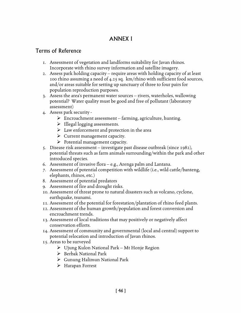
[ 46 ]
ANNEX I Terms of Reference
1. Assessment of vegetation and landforms suitability for Javan rhinos.
Incorporate with rhino survey information and satellite imagery. 2. Assess park holding capacity – require areas with holding capacity of at least
100 rhino assuming a need of 4.25 sq. km/rhino with sufficient food sources, and/or areas suitable for setting up sanctuary of three to four pairs for population reproduction purposes.
3. Assess the area’s permanent water sources – rivers, waterholes, wallowing potential? Water quality must be good and free of pollutant (laboratory assessment)
4. Assess park security - Encroachment assessment – farming, agriculture, hunting. Illegal logging assessments. Law enforcement and protection in the area Current management capacity. Potential management capacity.
5. Disease risk assessment – investigate past disease outbreak (since 1982), potential threats such as farm animals surrounding/within the park and other introduced species.
6. Assessment of invasive flora – e.g., Arenga palm and Lantana. 7. Assessment of potential competition with wildlife (i.e., wild cattle/banteng,
elephants, rhinos, etc.) 8. Assessment of potential predators 9. Assessment of fire and drought risks. 10. Assessment of threat prone to natural disasters such as volcano, cyclone,
earthquake, tsunami. 11. Assessment of the potential for forestation/plantation of rhino feed plants. 12. Assessment of the human growth/population and forest conversion and
encroachment trends. 13. Assessment of local traditions that may positively or negatively affect
conservation efforts. 14. Assessment of community and governmental (local and central) support to
potential relocation and introduction of Javan rhinos. 15. Areas to be surveyed
Ujung Kulon National Park – Mt Honje Region Berbak National Park Gunung Halimun National Park Harapan Forrest
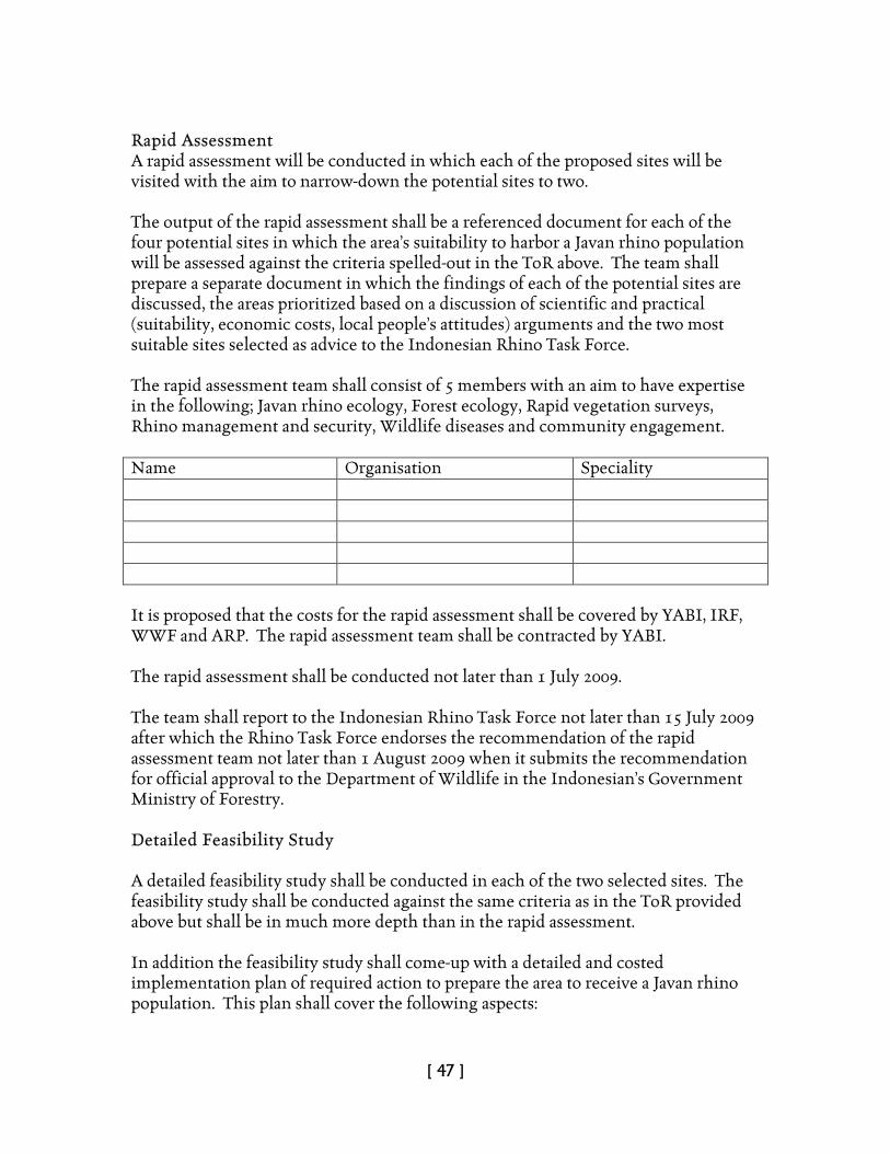
[ 47 ]
Rapid Assessment A rapid assessment will be conducted in which each of the proposed sites will be visited with the aim to narrow-down the potential sites to two. The output of the rapid assessment shall be a referenced document for each of the four potential sites in which the area’s suitability to harbor a Javan rhino population will be assessed against the criteria spelled-out in the ToR above. The team shall prepare a separate document in which the findings of each of the potential sites are discussed, the areas prioritized based on a discussion of scientific and practical (suitability, economic costs, local people’s attitudes) arguments and the two most suitable sites selected as advice to the Indonesian Rhino Task Force. The rapid assessment team shall consist of 5 members with an aim to have expertise in the following; Javan rhino ecology, Forest ecology, Rapid vegetation surveys, Rhino management and security, Wildlife diseases and community engagement. Name Organisation Speciality It is proposed that the costs for the rapid assessment shall be covered by YABI, IRF, WWF and ARP. The rapid assessment team shall be contracted by YABI. The rapid assessment shall be conducted not later than 1 July 2009. The team shall report to the Indonesian Rhino Task Force not later than 15 July 2009 after which the Rhino Task Force endorses the recommendation of the rapid assessment team not later than 1 August 2009 when it submits the recommendation for official approval to the Department of Wildlife in the Indonesian’s Government Ministry of Forestry. Detailed Feasibility Study A detailed feasibility study shall be conducted in each of the two selected sites. The feasibility study shall be conducted against the same criteria as in the ToR provided above but shall be in much more depth than in the rapid assessment. In addition the feasibility study shall come-up with a detailed and costed implementation plan of required action to prepare the area to receive a Javan rhino population. This plan shall cover the following aspects:

[ 48 ]
• Law enforcement requirements (staffing, staff training, guard posts, and equipment needs and an outline patrol schedule).
• Infrastructure requirements (temporary rhino paddocks, fencing of a 4,000 ha sanctuary, access roads and paths).
• Community engagement requirements (outreach and awareness raising). • Mitigation of encroachments where required (indication of scope (no. of ha,
no of people and households involved; compensation). • Maintenance requirements of the above for a period of 10 years in yearly
installments. • A proposed allocation of costs towards the Indonesian Government with
selected inputs from NGOs (YABI, WWF, IRF, ARP) and institutional donors (World Bank GEF, USAID, etc).
The output of the detailed assessment shall be a referenced document for each of the two potential sites in which the investments required to prepare the area to harbor a Javan rhino population. The team shall submit the document as advice to the Indonesian Rhino Task Force. The detailed assessment team shall consist of Name Organisation Speciality It is proposed that the costs for the detailed assessment be shared between the Indonesian Government and NGOs (YABI, IRF, WWF, ARP). The detailed assessment team shall be contracted by YABI. The detailed rapid assessment of the short-listed sites is estimated to last 6 months and shall be conducted not later than 1 January 2010. The team shall report to the Indonesian Rhino Task Force not later than 15 January 2010 after which the Rhino Task Force shall select the best suitable site for submission to the Department of Wildlife in the Indonesian’s Government Ministry of Forestry for official approval not later than 1 February 2010.
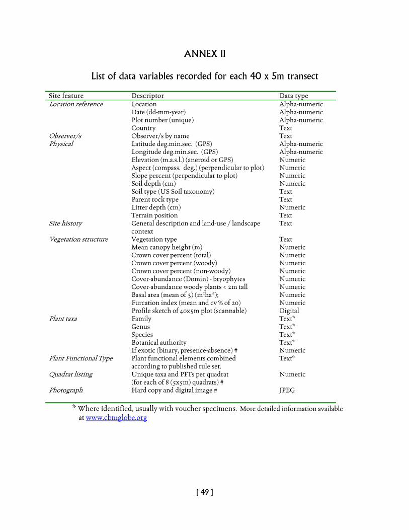
[ 49 ]
ANNEX II
List of data variables recorded for each 40 x 5m transect
Site feature Descriptor Data type Location reference Location Alpha-numeric Date (dd-mm-year) Alpha-numeric Plot number (unique) Alpha-numeric Country Text Observer/s Observer/s by name Text Physical Latitude deg.min.sec. (GPS) Alpha-numeric Longitude deg.min.sec. (GPS) Alpha-numeric Elevation (m.a.s.l.) (aneroid or GPS) Numeric Aspect (compass. deg.) (perpendicular to plot) Numeric Slope percent (perpendicular to plot) Numeric Soil depth (cm) Numeric Soil type (US Soil taxonomy) Text Parent rock type Text Litter depth (cm) Numeric Terrain position Text Site history General description and land-use / landscape
context Text
Vegetation structure Vegetation type Text Mean canopy height (m) Numeric Crown cover percent (total) Numeric Crown cover percent (woody) Numeric Crown cover percent (non-woody) Numeric Cover-abundance (Domin) - bryophytes Numeric Cover-abundance woody plants < 2m tall Numeric Basal area (mean of 3) (m2ha-1); Numeric Furcation index (mean and cv % of 20) Numeric Profile sketch of 40x5m plot (scannable) Digital Plant taxa Family Text* Genus Text* Species Text* Botanical authority Text* If exotic (binary, presence-absence) # Numeric Plant Functional Type Plant functional elements combined
according to published rule set. Text*
Quadrat listing Unique taxa and PFTs per quadrat (for each of 8 (5x5m) quadrats) #
Numeric
Photograph Hard copy and digital image # JPEG
* Where identified, usually with voucher specimens. More detailed information available at www.cbmglobe.org
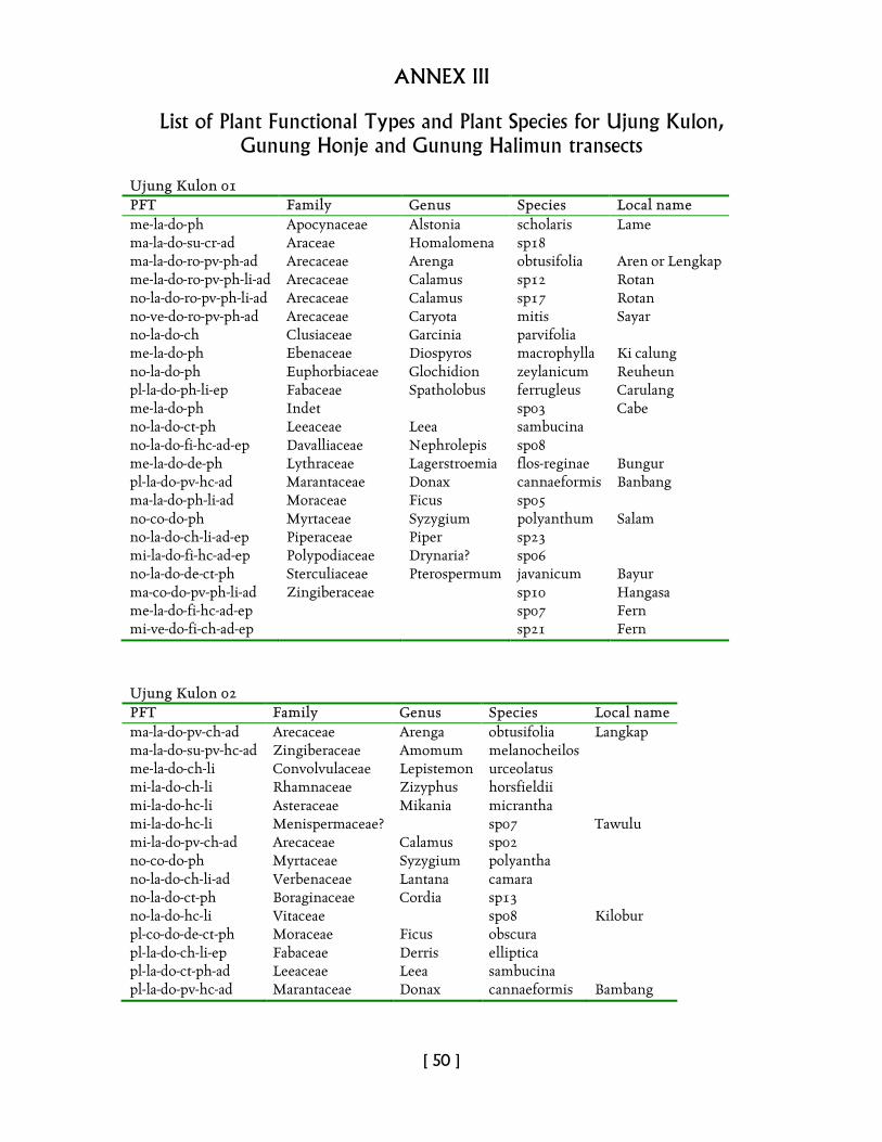
[ 50 ]
ANNEX III
List of Plant Functional Types and Plant Species for Ujung Kulon, Gunung Honje and Gunung Halimun transects
Ujung Kulon 01 PFT Family Genus Species Local name me-la-do-ph Apocynaceae Alstonia scholaris Lame ma-la-do-su-cr-ad Araceae Homalomena sp18 ma-la-do-ro-pv-ph-ad Arecaceae Arenga obtusifolia Aren or Lengkap me-la-do-ro-pv-ph-li-ad Arecaceae Calamus sp12 Rotan no-la-do-ro-pv-ph-li-ad Arecaceae Calamus sp17 Rotan no-ve-do-ro-pv-ph-ad Arecaceae Caryota mitis Sayar no-la-do-ch Clusiaceae Garcinia parvifolia me-la-do-ph Ebenaceae Diospyros macrophylla Ki calung no-la-do-ph Euphorbiaceae Glochidion zeylanicum Reuheun pl-la-do-ph-li-ep Fabaceae Spatholobus ferrugleus Carulang me-la-do-ph Indet sp03 Cabe no-la-do-ct-ph Leeaceae Leea sambucina no-la-do-fi-hc-ad-ep Davalliaceae Nephrolepis sp08 me-la-do-de-ph Lythraceae Lagerstroemia flos-reginae Bungur pl-la-do-pv-hc-ad Marantaceae Donax cannaeformis Banbang ma-la-do-ph-li-ad Moraceae Ficus sp05 no-co-do-ph Myrtaceae Syzygium polyanthum Salam no-la-do-ch-li-ad-ep Piperaceae Piper sp23 mi-la-do-fi-hc-ad-ep Polypodiaceae Drynaria? sp06 no-la-do-de-ct-ph Sterculiaceae Pterospermum javanicum Bayur ma-co-do-pv-ph-li-ad Zingiberaceae sp10 Hangasa me-la-do-fi-hc-ad-ep sp07 Fern mi-ve-do-fi-ch-ad-ep sp21 Fern
Ujung Kulon 02 PFT Family Genus Species Local name ma-la-do-pv-ch-ad Arecaceae Arenga obtusifolia Langkap ma-la-do-su-pv-hc-ad Zingiberaceae Amomum melanocheilos me-la-do-ch-li Convolvulaceae Lepistemon urceolatus mi-la-do-ch-li Rhamnaceae Zizyphus horsfieldii mi-la-do-hc-li Asteraceae Mikania micrantha mi-la-do-hc-li Menispermaceae? sp07 Tawulu mi-la-do-pv-ch-ad Arecaceae Calamus sp02 no-co-do-ph Myrtaceae Syzygium polyantha no-la-do-ch-li-ad Verbenaceae Lantana camara no-la-do-ct-ph Boraginaceae Cordia sp13 no-la-do-hc-li Vitaceae sp08 Kilobur pl-co-do-de-ct-ph Moraceae Ficus obscura pl-la-do-ch-li-ep Fabaceae Derris elliptica pl-la-do-ct-ph-ad Leeaceae Leea sambucina pl-la-do-pv-hc-ad Marantaceae Donax cannaeformis Bambang
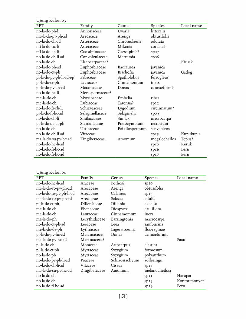
[ 51 ]
Ujung Kulon 03 PFT Family Genus Species Local name no-la-do-ph-li Annonaceae Uvaria littoralis ma-la-do-pv-ph-ad Arecaceae Arenga obtusifolia no-la-do-ch-ad Asteraceae Chromolaena odorata mi-la-do-hc-li Asteraceae Mikania cordata? mi-la-do-ch-li Caesalpinaceae Caesalpinia? sp07 no-la-do-ch-li-ad Convolvulaceae Merremia sp06 no-la-do-ch Elaeocarpaceae? Kituak no-la-do-ph-ad Euphorbiaceae Baccaurea javanica no-la-do-ct-ph Euphorbiaceae Bischofia javanica Gadog pl-la-do-pv-ph-li-ad-ep Fabaceae Spatholobus ferrogleus pi-la-do-ct-ph Lauraceae Cinnamomum iners pl-la-do-pv-ch-ad Marantaceae Donax cannaeformis no-la-do-hc-li Menispermaceae? me-la-do-ch Myrsinaceae Embelia ribes me-la-do-ch Rubiaceae Tarenna? sp21 no-la-do-fi-ch-li Schizaeaceae Lygodium circinnatum? pi-la-do-fi-hc-ad Selaginellaceae Selaginella sp09 no-la-do-ch-li Smilacaceae Smilax macrocarpa pl-la-do-de-ct-ph Sterculiaceae Pterocymbium tectorium no-la-do-ch Urticaceae Poikilospermum suaveolens no-la-do-ch-li-ad Vitaceae sp25 Kupukupu ma-la-do-su-pv-hc-ad Zingiberaceae Amomum megalocheilos Tepus? no-la-do-hc-li-ad sp10 Keruk no-la-do-fi-hc-ad sp16 Fern no-la-do-fi-hc-ad sp17 Fern
Ujung Kulon 04 PFT Family Genus Species Local name no-la-do-hc-li-ad Araceae Pothos? sp20 ma-la-do-ro-pv-ph-ad Arecaceae Arenga obtusifolia no-la-do-ro-pv-ph-li-ad Arecaceae Calamus sp15 ma-la-do-ro-pv-ph-ad Arecaceae Salacca edulis pi-la-do-ct-ph Dilleniaceae Dillenia excelsa me-la-do-ch Ebenaceae Diospyros cauliflora me-la-do-ch Lauraceae Cinnamomum iners ma-la-do-ph Lecythidaceae Barringtonia macrocarpa no-la-do-ct-ph-ad Leeaceae Leea sambucina me-la-do-de-ph Lythraceae Lagerstroemia flos-reginae pl-la-do-pv-hc-ad Marantaceae Donax cannaeformis ma-la-do-pv-hc-ad Marantaceae? Patat pl-la-do-ch Moraceae Artocarpus elastica pl-la-do-ct-ph Myrtaceae Syzygium formosum no-la-do-ph Myrtaceae Syzygium polyanthum no-la-do-pv-ph-li-ad Poaceae Schizostachyum zolleringii no-la-do-ch-li-ad Vitaceae Cissus sp18 ma-la-do-su-pv-hc-ad Zingiberaceae Amomum melanocheilos? no-la-do-ch sp11 Harupat no-la-do-ch sp13 Kontor monyet no-la-do-fi-hc-ad sp19 Fern
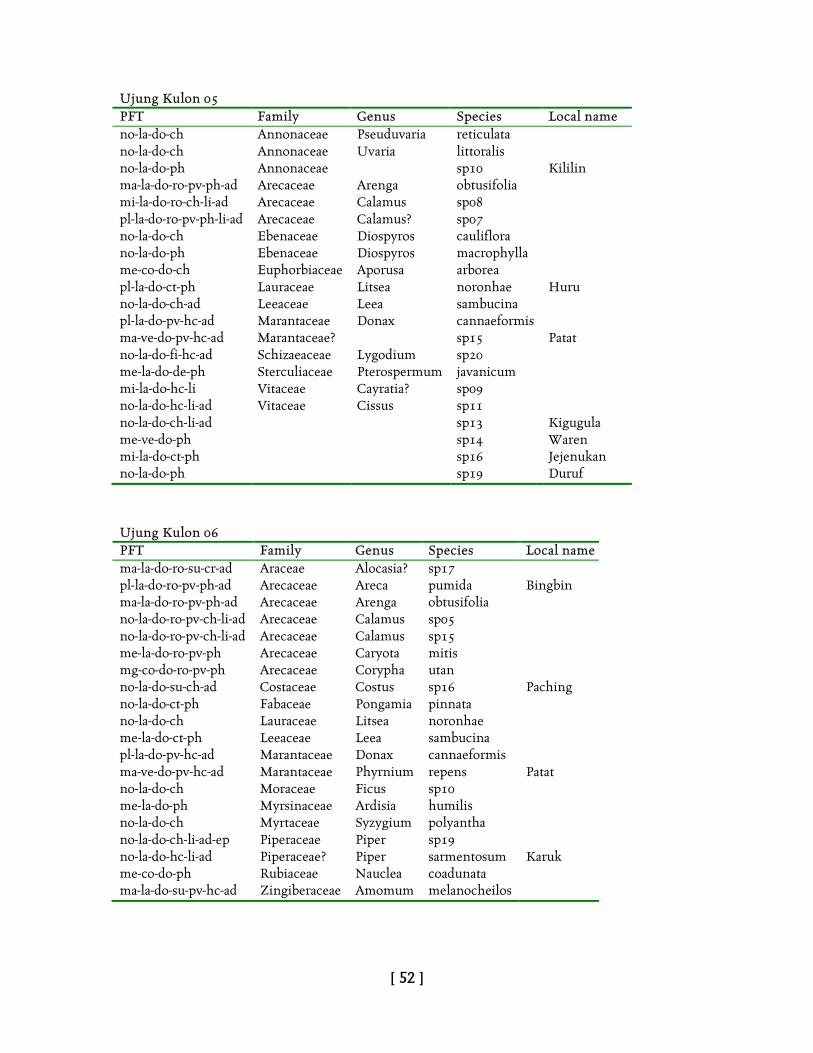
[ 52 ]
Ujung Kulon 05 PFT Family Genus Species Local name no-la-do-ch Annonaceae Pseuduvaria reticulata no-la-do-ch Annonaceae Uvaria littoralis no-la-do-ph Annonaceae sp10 Kililin ma-la-do-ro-pv-ph-ad Arecaceae Arenga obtusifolia mi-la-do-ro-ch-li-ad Arecaceae Calamus sp08 pl-la-do-ro-pv-ph-li-ad Arecaceae Calamus? sp07 no-la-do-ch Ebenaceae Diospyros cauliflora no-la-do-ph Ebenaceae Diospyros macrophylla me-co-do-ch Euphorbiaceae Aporusa arborea pl-la-do-ct-ph Lauraceae Litsea noronhae Huru no-la-do-ch-ad Leeaceae Leea sambucina pl-la-do-pv-hc-ad Marantaceae Donax cannaeformis ma-ve-do-pv-hc-ad Marantaceae? sp15 Patat no-la-do-fi-hc-ad Schizaeaceae Lygodium sp20 me-la-do-de-ph Sterculiaceae Pterospermum javanicum mi-la-do-hc-li Vitaceae Cayratia? sp09 no-la-do-hc-li-ad Vitaceae Cissus sp11 no-la-do-ch-li-ad sp13 Kigugula me-ve-do-ph sp14 Waren mi-la-do-ct-ph sp16 Jejenukan no-la-do-ph sp19 Duruf
Ujung Kulon 06 PFT Family Genus Species Local name ma-la-do-ro-su-cr-ad Araceae Alocasia? sp17 pl-la-do-ro-pv-ph-ad Arecaceae Areca pumida Bingbin ma-la-do-ro-pv-ph-ad Arecaceae Arenga obtusifolia no-la-do-ro-pv-ch-li-ad Arecaceae Calamus sp05 no-la-do-ro-pv-ch-li-ad Arecaceae Calamus sp15 me-la-do-ro-pv-ph Arecaceae Caryota mitis mg-co-do-ro-pv-ph Arecaceae Corypha utan no-la-do-su-ch-ad Costaceae Costus sp16 Paching no-la-do-ct-ph Fabaceae Pongamia pinnata no-la-do-ch Lauraceae Litsea noronhae me-la-do-ct-ph Leeaceae Leea sambucina pl-la-do-pv-hc-ad Marantaceae Donax cannaeformis ma-ve-do-pv-hc-ad Marantaceae Phyrnium repens Patat no-la-do-ch Moraceae Ficus sp10 me-la-do-ph Myrsinaceae Ardisia humilis no-la-do-ch Myrtaceae Syzygium polyantha no-la-do-ch-li-ad-ep Piperaceae Piper sp19 no-la-do-hc-li-ad Piperaceae? Piper sarmentosum Karuk me-co-do-ph Rubiaceae Nauclea coadunata ma-la-do-su-pv-hc-ad Zingiberaceae Amomum melanocheilos
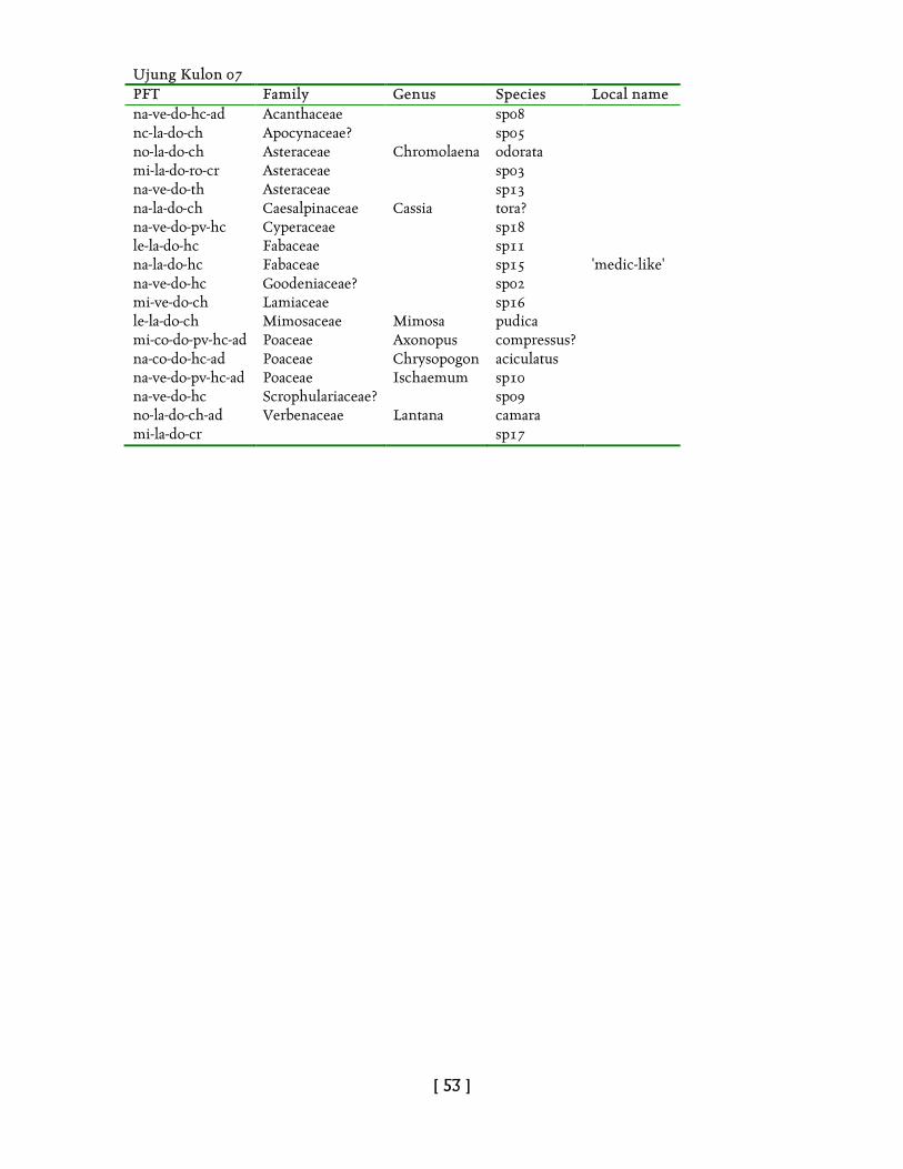
[ 53 ]
Ujung Kulon 07 PFT Family Genus Species Local name na-ve-do-hc-ad Acanthaceae sp08 nc-la-do-ch Apocynaceae? sp05 no-la-do-ch Asteraceae Chromolaena odorata mi-la-do-ro-cr Asteraceae sp03 na-ve-do-th Asteraceae sp13 na-la-do-ch Caesalpinaceae Cassia tora? na-ve-do-pv-hc Cyperaceae sp18 le-la-do-hc Fabaceae sp11 na-la-do-hc Fabaceae sp15 'medic-like' na-ve-do-hc Goodeniaceae? sp02 mi-ve-do-ch Lamiaceae sp16 le-la-do-ch Mimosaceae Mimosa pudica mi-co-do-pv-hc-ad Poaceae Axonopus compressus? na-co-do-hc-ad Poaceae Chrysopogon aciculatus na-ve-do-pv-hc-ad Poaceae Ischaemum sp10 na-ve-do-hc Scrophulariaceae? sp09 no-la-do-ch-ad Verbenaceae Lantana camara mi-la-do-cr sp17
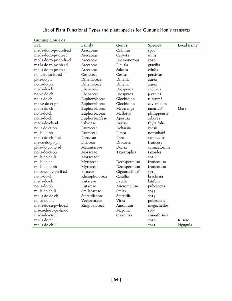
[ 54 ]
List of Plant Functional Types and plant species for Gunung Honje transects Gunung Honje 01 PFT Family Genus Species Local name me-la-do-ro-pv-ch-li-ad Arecaceae Calamus sp07 me-la-do-ro-pv-ch-ad Arecaceae Caryota mitis me-la-do-ro-pv-ch-li-ad Arecaceae Daemonorops sp30 ma-la-do-ro-pv-ph-ad Arecaceae Licuala gracilis me-la-do-ro-pv-ch-ad Arecaceae Salacca edulis no-la-do-su-hc-ad Costaceae Costus persistus pl-la-do-ph Dilleniaceae Dillenia aurea no-la-do-ph Dilleniaceae Dillenia aurea me-la-do-ch Ebenaceae Diospyros celebica no-ve-do-ch Ebenaceae Diospyros javanica no-la-do-ch Euphorbiaceae Glochidion rubrum? me-ve-do-ct-ph Euphorbiaceae Glochidion zeylanicum me-la-do-ch Euphorbiaceae Macaranga tanarius? Mara no-la-do-ch Euphorbiaceae Mallotus philippensis no-la-do-ch Euphorbiacfeae Aporusa arborea me-la-do-ch-ad Fabaceae Derris thyrsifolia no-la-do-ct-ph Lauraceae Dehaasia caesia mi-la-do-ph Lauraceae Litsea noronhae? me-la-do-ch-li-ad Leeaceae Leea sambucina me-co-do-pv-ph Liliaceae Dracaena fruticosa pl-la-do-pv-hc-ad Marantaceae Donax cannaeformis no-la-do-ct-ph Moraceae Taxotrophis taxoides mi-la-do-ch-li Moraceae? sp36 mi-la-do-ch Myrtaceae Decaspermum fruticosum mi-la-do-ct-ph Myrtaceae Decaspermum fruticosum no-co-do-pv-ph-li-ad Poaceae Gigantochloa? sp15 no-la-do-ch Rhizophoraceae Carallia brachiata me-la-do-ch Rutaceae Evodia latifolia no-la-do-ph Rutaceae Micromelum pubescens mi-la-do-ch-li Smilacaceae Smlax sp33 me-la-do-de-ch Sterculiaceae Sterculia sp19 no-co-do-ph Verbenaceae Vitex pubescens me-la-do-su-pv-hc-ad Zingiberaceae Amomum megacheilos ma-co-do-ro-pv-hc-ad Mapania sp05 me-la-do-ct-ph Oxymitra cuneiformis me-la-do-ph sp10 Ki sero me-la-do-ch-li sp21 kigugula
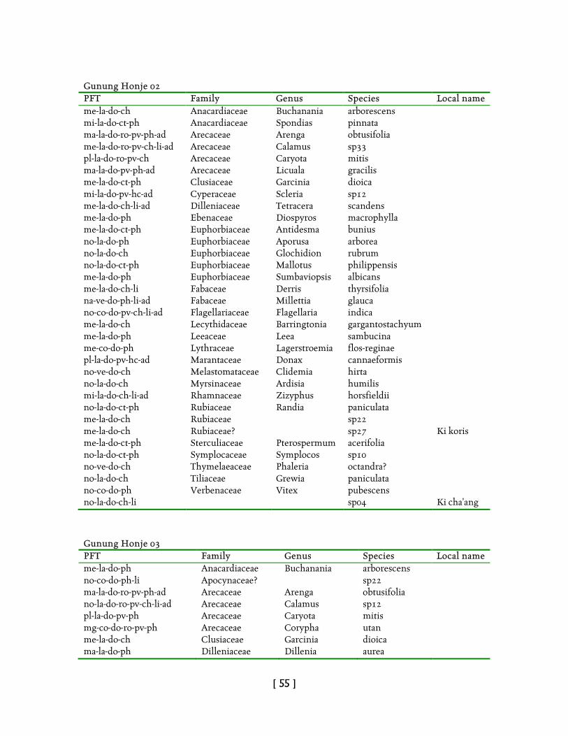
[ 55 ]
Gunung Honje 02 PFT Family Genus Species Local name me-la-do-ch Anacardiaceae Buchanania arborescens mi-la-do-ct-ph Anacardiaceae Spondias pinnata ma-la-do-ro-pv-ph-ad Arecaceae Arenga obtusifolia me-la-do-ro-pv-ch-li-ad Arecaceae Calamus sp33 pl-la-do-ro-pv-ch Arecaceae Caryota mitis ma-la-do-pv-ph-ad Arecaceae Licuala gracilis me-la-do-ct-ph Clusiaceae Garcinia dioica mi-la-do-pv-hc-ad Cyperaceae Scleria sp12 me-la-do-ch-li-ad Dilleniaceae Tetracera scandens me-la-do-ph Ebenaceae Diospyros macrophylla me-la-do-ct-ph Euphorbiaceae Antidesma bunius no-la-do-ph Euphorbiaceae Aporusa arborea no-la-do-ch Euphorbiaceae Glochidion rubrum no-la-do-ct-ph Euphorbiaceae Mallotus philippensis me-la-do-ph Euphorbiaceae Sumbaviopsis albicans me-la-do-ch-li Fabaceae Derris thyrsifolia na-ve-do-ph-li-ad Fabaceae Millettia glauca no-co-do-pv-ch-li-ad Flagellariaceae Flagellaria indica me-la-do-ch Lecythidaceae Barringtonia gargantostachyum me-la-do-ph Leeaceae Leea sambucina me-co-do-ph Lythraceae Lagerstroemia flos-reginae pl-la-do-pv-hc-ad Marantaceae Donax cannaeformis no-ve-do-ch Melastomataceae Clidemia hirta no-la-do-ch Myrsinaceae Ardisia humilis mi-la-do-ch-li-ad Rhamnaceae Zizyphus horsfieldii no-la-do-ct-ph Rubiaceae Randia paniculata me-la-do-ch Rubiaceae sp22 me-la-do-ch Rubiaceae? sp27 Ki koris me-la-do-ct-ph Sterculiaceae Pterospermum acerifolia no-la-do-ct-ph Symplocaceae Symplocos sp10 no-ve-do-ch Thymelaeaceae Phaleria octandra? no-la-do-ch Tiliaceae Grewia paniculata no-co-do-ph Verbenaceae Vitex pubescens no-la-do-ch-li sp04 Ki cha'ang
Gunung Honje 03 PFT Family Genus Species Local name me-la-do-ph Anacardiaceae Buchanania arborescens no-co-do-ph-li Apocynaceae? sp22 ma-la-do-ro-pv-ph-ad Arecaceae Arenga obtusifolia no-la-do-ro-pv-ch-li-ad Arecaceae Calamus sp12 pl-la-do-pv-ph Arecaceae Caryota mitis mg-co-do-ro-pv-ph Arecaceae Corypha utan me-la-do-ch Clusiaceae Garcinia dioica ma-la-do-ph Dilleniaceae Dillenia aurea
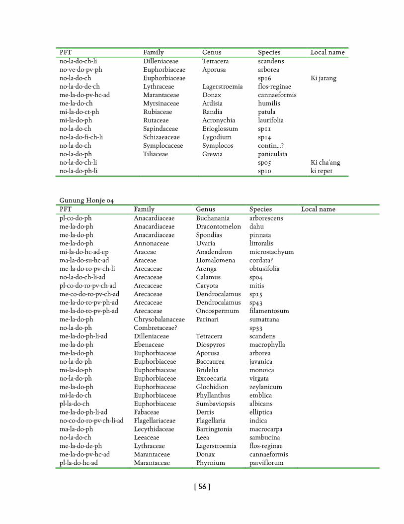
[ 56 ]
PFT Family Genus Species Local name no-la-do-ch-li Dilleniaceae Tetracera scandens no-ve-do-pv-ph Euphorbiaceae Aporusa arborea no-la-do-ch Euphorbiaceae sp16 Ki jarang no-la-do-de-ch Lythraceae Lagerstroemia flos-reginae me-la-do-pv-hc-ad Marantaceae Donax cannaeformis me-la-do-ch Myrsinaceae Ardisia humilis mi-la-do-ct-ph Rubiaceae Randia patula mi-la-do-ph Rutaceae Acronychia laurifolia no-la-do-ch Sapindaceae Erioglossum sp11 no-la-do-fi-ch-li Schizaeaceae Lygodium sp14 no-la-do-ch Symplocaceae Symplocos contin...? no-la-do-ph Tiliaceae Grewia paniculata no-la-do-ch-li sp05 Ki cha'ang no-la-do-ph-li sp10 ki repet
Gunung Honje 04 PFT Family Genus Species Local name pl-co-do-ph Anacardiaceae Buchanania arborescens me-la-do-ph Anacardiaceae Dracontomelon dahu me-la-do-ph Anacardiaceae Spondias pinnata me-la-do-ph Annonaceae Uvaria littoralis mi-la-do-hc-ad-ep Araceae Anadendron microstachyum ma-la-do-su-hc-ad Araceae Homalomena cordata? me-la-do-ro-pv-ch-li Arecaceae Arenga obtusifolia no-la-do-ch-li-ad Arecaceae Calamus sp04 pl-co-do-ro-pv-ch-ad Arecaceae Caryota mitis me-co-do-ro-pv-ch-ad Arecaceae Dendrocalamus sp15 me-la-do-ro-pv-ph-ad Arecaceae Dendrocalamus sp43 me-la-do-ro-pv-ph-ad Arecaceae Oncospermum filamentosum me-la-do-ph Chrysobalanaceae Parinari sumatrana no-la-do-ph Combretaceae? sp33 me-la-do-ph-li-ad Dilleniaceae Tetracera scandens me-la-do-ph Ebenaceae Diospyros macrophylla me-la-do-ph Euphorbiaceae Aporusa arborea no-la-do-ph Euphorbiaceae Baccaurea javanica mi-la-do-ph Euphorbiaceae Bridelia monoica no-la-do-ph Euphorbiaceae Excoecaria virgata me-la-do-ph Euphorbiaceae Glochidion zeylanicum mi-la-do-ch Euphorbiaceae Phyllanthus emblica pl-la-do-ch Euphorbiaceae Sumbaviopsis albicans me-la-do-ph-li-ad Fabaceae Derris elliptica no-co-do-ro-pv-ch-li-ad Flagellariaceae Flagellaria indica ma-la-do-ph Lecythidaceae Barringtonia macrocarpa no-la-do-ch Leeaceae Leea sambucina me-la-do-de-ph Lythraceae Lagerstroemia flos-reginae me-la-do-pv-hc-ad Marantaceae Donax cannaeformis pl-la-do-hc-ad Marantaceae Phyrnium parviflorum
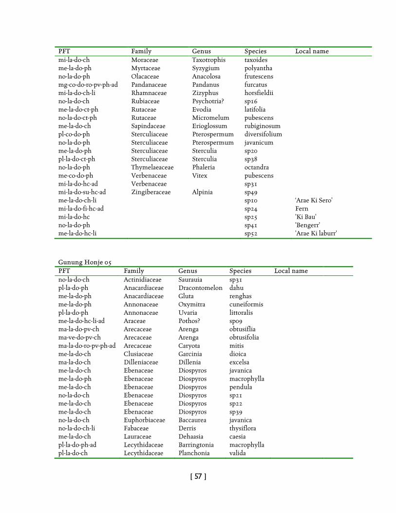
[ 57 ]
PFT Family Genus Species Local name mi-la-do-ch Moraceae Taxotrophis taxoides me-la-do-ph Myrtaceae Syzygium polyantha no-la-do-ph Olacaceae Anacolosa frutescens mg-co-do-ro-pv-ph-ad Pandanaceae Pandanus furcatus mi-la-do-ch-li Rhamnaceae Zizyphus horsfieldii no-la-do-ch Rubiaceae Psychotria? sp16 me-la-do-ct-ph Rutaceae Evodia latifolia no-la-do-ct-ph Rutaceae Micromelum pubescens me-la-do-ch Sapindaceae Erioglossum rubiginosum pl-co-do-ph Sterculiaceae Pterospermum diversifolium no-la-do-ph Sterculiaceae Pterospermum javanicum me-la-do-ph Sterculiaceae Sterculia sp20 pl-la-do-ct-ph Sterculiaceae Sterculia sp38 no-la-do-ph Thymelaeaceae Phaleria octandra me-co-do-ph Verbenaceae Vitex pubescens mi-la-do-hc-ad Verbenaceae sp31 mi-la-do-su-hc-ad Zingiberaceae Alpinia sp49 me-la-do-ch-li sp10 ‘Arae Ki Sero' mi-la-do-fi-hc-ad sp24 Fern mi-la-do-hc sp25 'Ki Bau' no-la-do-ph sp41 'Bengerr' me-la-do-hc-li sp52 'Arae Ki laburr'
Gunung Honje 05 PFT Family Genus Species Local name no-la-do-ch Actinidiaceae Saurauia sp31 pl-la-do-ph Anacardiaceae Dracontomelon dahu me-la-do-ph Anacardiaceae Gluta renghas me-la-do-ph Annonaceae Oxymitra cuneiformis pl-la-do-ph Annonaceae Uvaria littoralis me-la-do-hc-li-ad Araceae Pothos? sp09 ma-la-do-pv-ch Arecaceae Arenga obtusiflia ma-ve-do-pv-ch Arecaceae Arenga obtusifolia ma-la-do-ro-pv-ph-ad Arecaceae Caryota mitis me-la-do-ch Clusiaceae Garcinia dioica ma-la-do-ch Dilleniaceae Dillenia excelsa me-la-do-ch Ebenaceae Diospyros javanica me-la-do-ph Ebenaceae Diospyros macrophylla me-la-do-ch Ebenaceae Diospyros pendula no-la-do-ch Ebenaceae Diospyros sp21 me-la-do-ch Ebenaceae Diospyros sp22 me-la-do-ch Ebenaceae Diospyros sp39 no-la-do-ch Euphorbiaceae Baccaurea javanica no-la-do-ch-li Fabaceae Derris thysiflora me-la-do-ch Lauraceae Dehaasia caesia pl-la-do-ph-ad Lecythidaceae Barringtonia macrophylla pl-la-do-ch Lecythidaceae Planchonia valida
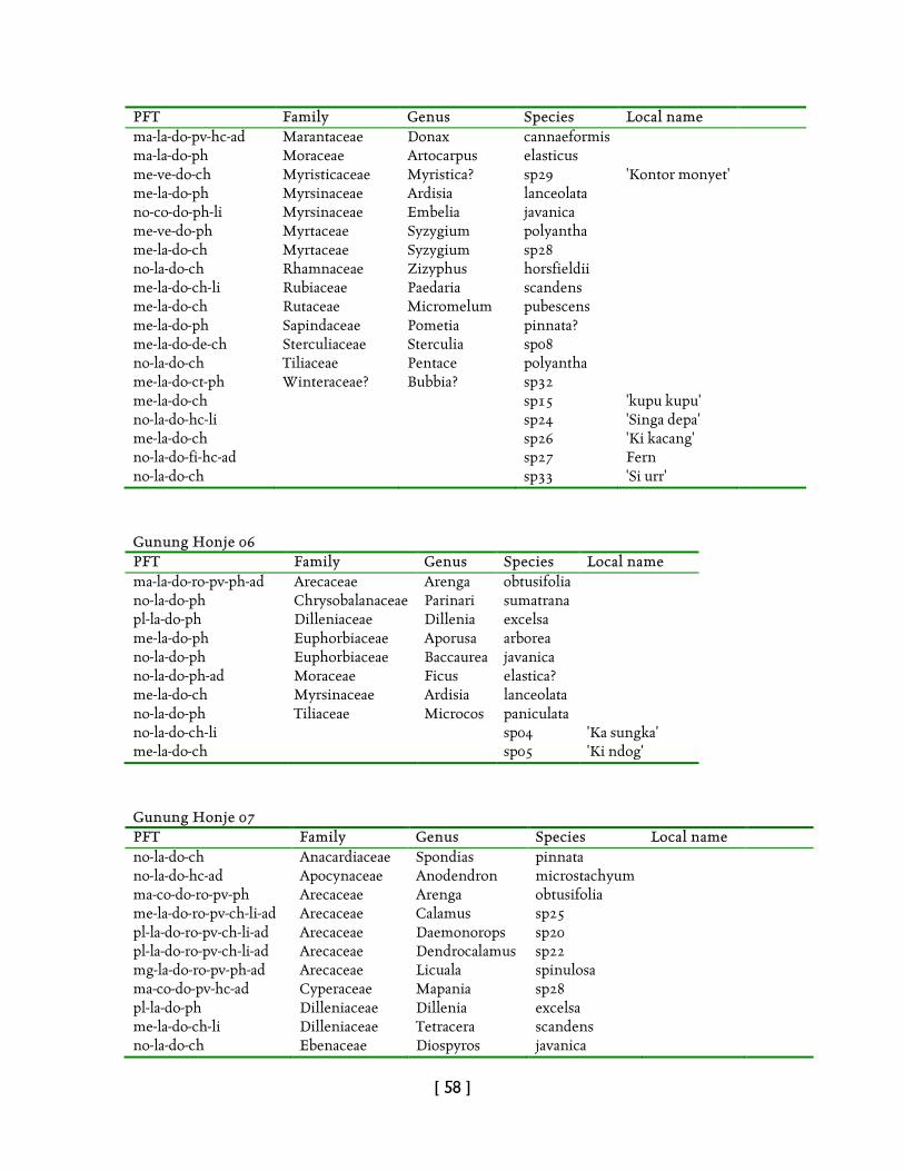
[ 58 ]
PFT Family Genus Species Local name ma-la-do-pv-hc-ad Marantaceae Donax cannaeformis ma-la-do-ph Moraceae Artocarpus elasticus me-ve-do-ch Myristicaceae Myristica? sp29 'Kontor monyet' me-la-do-ph Myrsinaceae Ardisia lanceolata no-co-do-ph-li Myrsinaceae Embelia javanica me-ve-do-ph Myrtaceae Syzygium polyantha me-la-do-ch Myrtaceae Syzygium sp28 no-la-do-ch Rhamnaceae Zizyphus horsfieldii me-la-do-ch-li Rubiaceae Paedaria scandens me-la-do-ch Rutaceae Micromelum pubescens me-la-do-ph Sapindaceae Pometia pinnata? me-la-do-de-ch Sterculiaceae Sterculia sp08 no-la-do-ch Tiliaceae Pentace polyantha me-la-do-ct-ph Winteraceae? Bubbia? sp32 me-la-do-ch sp15 'kupu kupu' no-la-do-hc-li sp24 'Singa depa' me-la-do-ch sp26 'Ki kacang' no-la-do-fi-hc-ad sp27 Fern no-la-do-ch sp33 'Si urr'
Gunung Honje 06 PFT Family Genus Species Local name ma-la-do-ro-pv-ph-ad Arecaceae Arenga obtusifolia no-la-do-ph Chrysobalanaceae Parinari sumatrana pl-la-do-ph Dilleniaceae Dillenia excelsa me-la-do-ph Euphorbiaceae Aporusa arborea no-la-do-ph Euphorbiaceae Baccaurea javanica no-la-do-ph-ad Moraceae Ficus elastica? me-la-do-ch Myrsinaceae Ardisia lanceolata no-la-do-ph Tiliaceae Microcos paniculata no-la-do-ch-li sp04 'Ka sungka' me-la-do-ch sp05 'Ki ndog'
Gunung Honje 07 PFT Family Genus Species Local name no-la-do-ch Anacardiaceae Spondias pinnata no-la-do-hc-ad Apocynaceae Anodendron microstachyum ma-co-do-ro-pv-ph Arecaceae Arenga obtusifolia me-la-do-ro-pv-ch-li-ad Arecaceae Calamus sp25 pl-la-do-ro-pv-ch-li-ad Arecaceae Daemonorops sp20 pl-la-do-ro-pv-ch-li-ad Arecaceae Dendrocalamus sp22 mg-la-do-ro-pv-ph-ad Arecaceae Licuala spinulosa ma-co-do-pv-hc-ad Cyperaceae Mapania sp28 pl-la-do-ph Dilleniaceae Dillenia excelsa me-la-do-ch-li Dilleniaceae Tetracera scandens no-la-do-ch Ebenaceae Diospyros javanica
[ 59 ]
PFT Family Genus Species Local name no-la-do-ph Euphorbiaceae Baccaurea javanica me-la-do-ph Euphorbiaceae Macaranga tanarius? me-la-do-ch Euphorbiaceae Sumbaviopsis albicans me-la-do-ph-li Fabaceae Derris thyrsiflora me-la-do-pv-ch-li-ad Flagellariaceae Flagellaria indica me-ve-do-pv-hc-ad Hypoxidaceae Curculigo orchioides? pl-la-do-ch Lecythidaceae Barringtonia macrocarpa me-la-do-ch Lecythidaceae Planchonia valida no-la-do-ch-ad Leeaceae Leea sambucina ma-la-do-pv-hc-ad Marantaceae Phrynium parviflorum me-la-do-ch Myristicaceae Myristica sp04 no-la-do-ch Myristicaceae Myristica sp24 'Kupu kupu' no-la-do-ct-ph Myrtaceae Decaspermum fruticosum mi-la-do-ch Rubiaceae Randia patula me-la-do-ct-ph Rubiaceae sp26 no-la-do-ch Rutaceae Micromelum pubescens ma-la-do-ch Sterculiaceae Pterospermum diversifolium me-ve-do-ph Verbenaceae Vitex pubescens me-ve-do-su-hc-ad Zingiberaceae Globba pendella? me-la-do-hc-ad sp12 'Singa depa' me-la-do-ch sp17 'Si urr' no-la-do-ph-li sp34 'Ki liburr' na-la-do-fi-hc-ad-ep sp23 Fern Gunung Honje 08 PFT Family Genus Species Local name pl-la-do-ch Anacardiaceae Buchanania arborescens no-la-do-ch Annonaceae Oxymitra cuneiformis me-la-do-ch Annonaceae Stelechocarpus burahol no-la-do-ph-li Annonaceae Uvaria littoralis me-la-do-hc-li-ad Apocynaceae Anodendron microstachyum ma-la-do-hc-li-ad-ep Araceae Rhaphidophora? sp42 me-la-do-ct-ph Araliaceae Polyscias sp37 ma-la-do-ro-pv-ph-ad Arecaceae Arenga obtusifolia pl-co-do-ro-pv-ph-ad Arecaceae Daemonorops sp03 pl-la-do-ro-pv-ch-li-ad Arecaceae Daemonorops sp06 mg-la-do-ro-pv-ch Arecaceae Licuala spinosa no-la-do-hc-li Asteraceae Mikania micrantha me-la-do-ch-li Caesalpinaceae Phanera sp08 me-la-do-hc-li-ad Convolvulaceae Merremia peltata me-la-do-su-hc-ad Costaceae Costus speciosus? pl-la-do-ph Dilleniaceae Dillenia excelsa no-la-do-ph Ebenaceae Diospyros sp31 no-ve-do-ct-ph Euphorbiaceae Baccaurea javanica mi-la-do-ch Euphorbiaceae Bridelia stipularis me-la-do-ch Euphorbiaceae Sumbaviopsis albicans mi-la-do-ch-li Fabaceae Derris sp46 me-la-do-ch-li-ad Fabaceae Derris thyrsiflora
[ 60 ]
PFT Family Genus Species Local name na-la-do-ch-li Fabaceae Millettia sp24 me-la-do-ph-li Fabaceae Spatholobus sp45 me-co-do-pv-ch-li-ad-ep Flagellariaceae Flagellaria indica no-la-do-ch-li Gnetaceae Gnetum costatum? me-la-do-ch Lauraceae Dehaasia caesia me-la-do-ct-ph Lauraceae Litsea noronhae pl-la-do-ph Lecythidaceae Barringtonia macrocarpa no-la-do-ch-ad Leeaceae Leea sambucina pl-la-do-pv-hc-ad Marantaceae Donax cannaeformis mg-la-do-pv-hc-ad Marantaceae Phrynium parviflorum no-la-do-ch-li Myristicaceae Myristica me-la-do-ch Myristicaceae Myristica? sp48 no-la-do-ch Myrtaceae Decaspermum fruticosum pl-la-do-ch Myrtaceae Eugenia sp56 ma-co-do-ro-pv-ch-ad Pandanaceae Pandanus sp17 nc-co-do-pv-ch-li Poaceae Gigantochloa sp52 nc-la-do-ch Rhamnaceae Zizyphus horsfieldii no-la-do-ch-li-ad Rubiaceae Uncaria sp18 me-la-do-ch Rutaceae Evodia latifolia no-la-do-ph Sapindaceae Erioglossum sp13 mi-la-do-fi-hc-li Schizaeaceae Lygodium circinnatum no-pe-do-hc-li-ad Smilacaceae Smilax sp07 pl-la-do-ph Sterculiaceae Pterospermum diversifolium me-la-do-ph Verbenaceae Vitex pubescens no-la-do-ch-li-ad Vitaceae Cayratia geniculata mg-la-do-su-pv-hc-ad Zingiberaceae Amomum melanocheilos me-la-do-su-pv-hc-ad Zingiberaceae sp11 na-pe-do-fi-hc-ad-ep sp29 Fern no-la-do-ch-li sp32 'Ki ngugula' mi-la-do-hc-ad sp38 'Singa depa' no-la-do-ch sp39 'Ki parapin' no-la-do-fi-hc-ad Fern no-la-do-fi-hc-ad Fern me-la-do-ch-li-ad 'Ka sungka' Gunung Honje 9 PFT Family Genus Species Local name mg-co-do-ro-pv-ph Arecaceae Corypha utan mg-la-do-ro-pv-ch Arecaceae Licuala spinosa no-la-do-hc-li-ad-ep Blechnaceae Stenochlaena palustris pl-la-do-ch Dilleniaceae Dillenia excelsa me-la-do-ph Ebenaceae Diospyros celebica me-la-do-ph Ebenaceae Diospyros javanica me-la-do-ph Euphorbiaceae Aporusa arborea no-la-do-ph Euphorbiaceae sp14 me-la-do-ch-li-ad Fabaceae Derris thyrsiflora me-la-do-ph Lauraceae Dehaasia caesia me-la-do-de-ph Lythraceae Lagerstroemia flos-reginae
[ 61 ]
PFT Family Genus Species Local name pl-co-do-ph Moraceae Ficus elastica me-la-do-ch Myrsinaceae Ardisia humilis no-la-do-ch Myrtaceae Decaspermum fruticosum me-la-do-ch Myrtaceae Eugenia sp09 no-la-do-ph Myrtaceae Eugenia sp23 me-la-do-hc-ad Pteridaceae Acrostichum aureum mi-la-do-ph-li Rubiaceae Uncaria sp17 no-la-do-ch Thymelaeaceae Phaleria octandra me-la-do-ph Verbenaceae Vitex pubescens no-la-do-ch Verbenaceae sp11 no-la-do-ch-li sp07 'Ki gugula' no-la-do-ct-ph sp19 'Bingbin' no-la-do-fi-hc-ad Fern Gunung Honje 10 PFT Family Genus Species Local name mi-la-do-hc-ad Acanthaceae Hemigraphis sp09 pl-la-do-ch Annonaceae Oxymitra albicans no-co-do-ph Apocynaceae Alstonia scholaris no-pe-do-su-hc-li-ad-ep Apocynaceae Anodendron sp23 me-la-do-su-cr-ad Araceae Alocasia sp28 no-la-do-su-ch-li-ad Asclepiadaceae Hoya sp20 no-la-do-ch-li-ad Asteraceae Chromolaena odorata mi-la-do-hc-li-ad Asteraceae Mikania micrantha no-la-do-ro-ch Cycadaceae Cycas rumphii me-la-do-ph-li-ad Dilleniaceae Tetracera scandens no-la-do-ch Ebenaceae Diospyros javanica no-la-do-ch Ebenaceae Diospyros maritima me-la-do-ph-ad Leeaceae Leea sambucina pl-la-do-ct-ph Meliaceae Aglaia latifolia me-co-do-ph Meliaceae Chisocheton macrocarpus pl-la-do-ch Myrsinaceae Ardisia humilis me-la-do-ph Myrtaceae Eugenia sp14 mi-la-do-pv-hc-ad Poaceae Leptaspis sp11 mi-la-do-pv-hc-ad Poaceae Paspalum sp12 mi-ve-do-ct-ph Rubiaceae Randia patula pl-la-do-ph Sapotaceae Palaquium? sp29 pl-la-do-ct-ph Urticaceae Laportea stimulans no-la-do-ch-li-ad Verbenaceae Lantana camara me-co-do-ch-li-ad Vitaceae Cayratia geniculata no-co-do-hc-li-ad Vitaceae Cissus bicolor me-la-do-hc-li-ad Vitaceae Cissus repens na-la-do-fi-hc-ad Tectaria? sp13 na-la-do-fi-hc-ad sp05 Fern me-la-do-ct-ph sp15 'Ki ndog' no-la-do-ph-li-ad sp16 'Ki liburr' no-la-do-ph-li sp17 'Ka
kapotputchang'
[ 62 ]
Gunung Honje 11 PFT Family Genus Species Local name no-la-do-ch Asteraceae Chromolaena odorata me-ve-do-hc-li-ad Convolvulaceae Ipomoea pes-caprae na-ve-do-pv-hc-ad Cyperaceae Scleria sp06 mi-ve-do-ch Euphorbiaceae Breynia sp14 na-ve-do-hc-ad Fabaceae Atylosia? sp16 na-la-do-hc-ad Fabaceae Zornia? sp04 me-ve-do-su-ch Goodeniaceae Scaevola frutescens na-co-is-hc-li-ep-pa Lauraceae Cassytha filiformis me-pe-do-ct-ph Meliaceae Aglaia latifolia no-pe-do-hc-li-ad Menispermaceae sp011 mg-ve-do-ro-pv-ch-ad Pandanaceae Pandanus tectorius na-ve-do-pv-hc-ad Poaceae Ischaemum? sp05 na-ve-do-hc Scrophulariaceae sp17 mi-pe-do-ch-li-ad Verbenaceae Lantana camara me-co-do-ct-ph Verbenaceae Premna corymbosa mi-la-do-ch-li-ad Vitaceae Cayratia sp03 me-pe-do-hc-li Vitaceae Cissus repens Gunung Honje 12 PFT Family Genus Species Local name no-la-do-hc Acanthaceae sp28 ma-la-do-ph Anacardiaceae Buchanania arborescens ma-la-do-su-hc-ad Araceae Homalomena sp25 pl-la-do-hc-li-ad-ep Araceae Rhaphidophora sp10 me-la-do-ro-pv-ph-ad Arecaceae Areca catechu ma-la-do-pv-ph-ad Arecaceae Arenga obtusifolia me-ve-do-ro-pv-ph-ad Arecaceae Caryota mitis mg-la-do-ro-pv-ph-ad Arecaceae Licuala spinosa me-la-do-ch Ebenaceae Diospyros javanica me-la-do-ch Ebenaceae Diospyros pendula no-la-do-ch Euphorbiaceae Baccaurea javanica me-la-do-ch-li Fabaceae Derris thyrsiflora no-la-do-ch-li Fabaceae Spatholobus sp05 no-la-do-ch Fabaceae sp29 me-la-do-ch Lauraceae Dehaasia caesia ma-la-do-ph Lecythidaceae Barringtonia macrocarpa no-la-do-ch Leeaceae Leea sambucina me-co-do-de-ph Lythraceae Lagerstroemia flos-reginae me-la-do-hc-ad Marantaceae Donax cannaeformis ma-ve-do-pv-hc-ad Marantaceae Phrynium parviflorum me-ve-do-ch Myrsinaceae Ardisia lanceolata me-la-do-ch Myrsinaceae Embelia javanica me-la-do-ph Myrtaceae Eugenia sp18 me-la-do-ch Myrtaceae Syzygium polyantha ma-co-do-ro-pv-ch-ad Pandanaceae Pandanus sp07
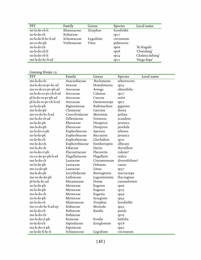
[ 63 ]
PFT Family Genus Species Local name mi-la-do-ch-li Rhamnaceae Zizyphus horsfieldii no-la-do-ch Rubiaceae sp27 no-la-do-fi-hc-li-ad Schizaeaceae Lygodium circinatum no-co-do-ph Verbenaceae Vitex pubescens no-la-do-ch sp06 'Ki Kugula' no-la-do-ch-li sp08 'Charulang' no-la-do-ch-li sp14 Chalana dahang' me-la-do-hc-li-ad sp11 'Singa depa' Gunung Honje 13 PFT Family Genus Species Local name me-la-do-ch Anacardiaceae Buchanania arborescens ma-la-do-su-pv-hc-ad Araceae Homalomena sp35 ma-ve-do-ro-pv-ph-ad Arecaceae Arenga obtusifolia no-la-do-ro-pv-ch-li-ad Arecaceae Calamus sp27 pl-la-do-ro-pv-ph-ad Arecaceae Caryota mitis pl-la-do-ro-pv-ch-li-ad Arecaceae Daemonorops sp07 no-la-do-ph Bignoniaceae Rademachera gigantea me-la-do-ph Clusiaceae Garcinia dioica me-ve-do-hc-li-ad Convolvulaceae Merremia peltata me-la-do-ch-ad Dilleniaceae Tetracera scandens no-la-do-ph Ebenaceae Diospyros javanica me-la-do-ph Ebenaceae Diospyros pendula no-la-do-ct-ph Euphorbiaceae Aporusa arborea no-la-do-ph Euphorbiaceae Baccaurea javanica no-la-do-ch Euphorbiaceae Glochidion sp20 me-la-do-ch Euphornbiaceae Sumbaviopsis albicans me-la-do-ch Fabaceae Derris thyrsiflora no-la-do-ct-ph Flacourtiaceae Flacourtia rukum? no-co-do-pv-ph-li-ad Flagellariaceae Flagellaria indica me-la-do-ch Lauraceae Cinnamomum diversifolium? no-la-do-ph Lauraceae Dehaasia caesia me-co-do-ph Lauraceae Litsea sp37 ma-la-do-ph Lecythidaceae Barringtonia macrocarpa me-ve-do-de-ph Lythraceae Lagerstroemia flos-reginae pl-la-do-hc-ad Marantaceae Donax cannaeformis no-la-do-ph Myrtaceae Eugenia sp06 no-la-do-ph Myrtaceae Eugenia sp25 me-la-do-ch Myrtaceae Eugenia sp49 no-la-do-ph Myrtaceae Syzygium sp43 mi-la-do-ch Rhamnaceae Zizyphus horsfieldii me-co-do-hc-li-ad-ep Rubiaceae Morinda sp45 mi-la-do-ch Rubiaceae Randia patula me-la-do-ch Rubiaceae sp16 me-la-do-ct-ph Rutaceae Evodia latifolia no-la-do-ch Sapindaceae Erioglossum sp18 ma-la-do-ct-ph Sapotaceae sp42 no-la-do-fi-hc-li Schizaeaceae Lygodium circinatum
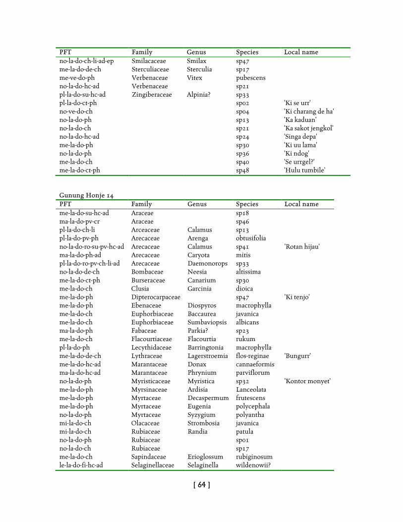
[ 64 ]
PFT Family Genus Species Local name no-la-do-ch-li-ad-ep Smilacaceae Smilax sp47 me-la-do-de-ch Sterculiaceae Sterculia sp17 me-ve-do-ph Verbenaceae Vitex pubescens no-la-do-hc-ad Verbenaceae sp21 pl-la-do-su-hc-ad Zingiberaceae Alpinia? sp33 pl-la-do-ct-ph sp02 'Ki se urr' no-ve-do-ch sp04 'Ki charang de ha' no-la-do-ph sp13 'Ka kaduan' no-la-do-ch sp21 'Ka sakot jengkol' no-la-do-hc-ad sp24 'Singa depa' me-la-do-ph sp30 'Ki uu lama' no-la-do-ph sp36 'Ki ndog' me-la-do-ch sp40 'Se urrgel?' me-la-do-ct-ph sp48 'Hulu tumbile' Gunung Honje 14 PFT Family Genus Species Local name me-la-do-su-hc-ad Araceae sp18 ma-la-do-pv-cr Araceae sp46 pl-la-do-ch-li Arceaceae Calamus sp13 pl-la-do-pv-ph Arecaceae Arenga obtusifolia no-la-do-ro-su-pv-hc-ad Arecaceae Calamus sp41 'Rotan hijau' ma-la-do-ph-ad Arecaceae Caryota mitis pl-la-do-ro-pv-ch-li-ad Arecaceae Daemonorops sp33 no-la-do-de-ch Bombaceae Neesia altissima me-la-do-ct-ph Burseraceae Canarium sp30 me-la-do-ch Clusia Garcinia dioica me-la-do-ph Dipterocarpaceae sp47 'Ki tenjo' me-la-do-ph Ebenaceae Diospyros macrophylla me-la-do-ch Euphorbiaceae Baccaurea javanica me-la-do-ch Euphorbiaceae Sumbaviopsis albicans ma-la-do-ph Fabaceae Parkia? sp23 me-la-do-ch Flacourtiaceae Flacourtia rukum pl-la-do-ph Lecythidaceae Barringtonia macrophylla me-la-do-de-ch Lythraceae Lagerstroemia flos-reginae 'Bungurr' me-la-do-hc-ad Marantaceae Donax cannaeformis ma-la-do-hc-ad Marantaceae Phrynium parviflorum no-la-do-ph Myristicaceae Myristica sp32 'Kontor monyet' me-la-do-ph Myrsinaceae Ardisia Lanceolata me-la-do-ph Myrtaceae Decaspermum frutescens me-la-do-ph Myrtaceae Eugenia polycephala no-la-do-ph Myrtaceae Syzygium polyantha mi-la-do-ch Olacaceae Strombosia javanica mi-la-do-ch Rubiaceae Randia patula no-la-do-ph Rubiaceae sp01 no-la-do-ch Rubiaceae sp17 me-la-do-ch Sapindaceae Erioglossum rubiginosum le-la-do-fi-hc-ad Selaginellaceae Selaginella wildenowii?
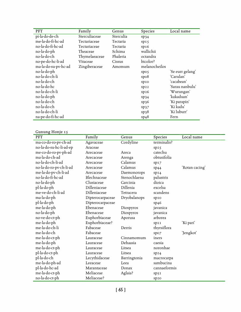
[ 65 ]
PFT Family Genus Species Local name pi-la-do-de-ch Sterculiaceae Sterculia sp34 me-la-do-fi-hc-ad Tectariaceae Tectaria sp15 no-la-do-fi-hc-ad Tectariaceae Tectaria sp16 no-la-do-ph Theaceae Schima wallichii no-la-do-ch Thymelaeaceae Phaleria octandra no-pe-do-hc-li-ad Vitaceae Cissus bicolor? ma-la-do-su-pv-hc-ad Zingiberaceae Amomum melanocheilos no-la-do-ph sp05 'Se eurr gelang' no-la-do-ch-li sp08 'Carulan' no-la-do-ch sp10 'cacabean' no-la-do-hc sp22 'Sarau nanbulu' no-la-do-ch-li sp26 'Wurungan' no-la-do-ph sp34 'kakaduan' no-la-do-ch sp36 'Ki parapin' no-la-do-ch sp37 'Ki kadu' no-la-do-ch-li sp38 'Ki luburr' na-pe-do-fi-hc-ad sp48 Fern Gunung Honje 15 PFT Family Genus Species Local name ma-co-do-ro-pv-ch-ad Agavaceae Cordyline terminalis? no-la-do-su-hc-li-ad-ep Araceae sp25 me-co-do-ro-pv-ph-ad Arecaceae Areca catechu ma-la-do-ch-ad Arecaceae Arenga obtusifolia no-la-do-ch-li-ad Arecaceae Calamus sp17 no-la-do-ro-pv-ch-li-ad Arecaceae Calamus sp44 'Rotan cacing' me-la-do-pv-ch-li-ad Arecaceae Daemonorops sp14 no-la-do-fi-hc-ad Blechnaceae Stenochlaena palustris no-la-do-ph Clusiaceae Garcinia dioica pl-la-do-ph Dilleniaceae Dillenia excelsa me-ve-do-ch-li-ad Dilleniaceae Tetracera scandens ma-la-do-ph Dipterocarpaceae Dryobalanops sp10 pl-la-do-ph Dipterocarpaceae sp46 me-la-do-ph Ebenaceae Diospyros javanica no-la-do-ph Ebenaceae Diospyros javanica no-ve-do-ct-ph Euphorbiaceae Aporusa arborea me-la-do-ph Euphorbiaceae? sp11 'Ki pari' me-la-do-ch-li Fabaceae Derris thyrsiflora me-la-do-ch Fabaceae sp07 'Jengkot' me-la-do-ct-ph Lauraceae Cinnamomum iners me-la-do-ph Lauraceae Dehaasia caesia me-la-do-ct-ph Lauraceae Litsea noronhae pl-la-do-ct-ph Lauraceae Litsea sp24 pl-la-do-ch Lecythidaceae Barringtonia macrocarpa me-la-do-ph-ad Leeaceae Leea sambucina pl-la-do-hc-ad Marantaceae Donax cannaeformis me-la-do-ct-ph Meliaceae Aglaia? sp51 no-la-do-ct-ph Meliaceae? sp20

[ 66 ]
PFT Family Genus Species Local name me-la-do-ch-li Menispermaceae Sarcopetalum macrophylla me-co-do-de-ct-ph Moraceae Ficus callosa me-la-do-ph Myristicaceae Myristica sp12 me-la-do-ch Myrsinaceae Ardisia lanceolata me-co-do-ph Myrtaceae Eugenia cuprea no-la-do-ch Myrtaceae Eugenia sp38 no-la-do-ph Myrtaceae Eugenia spicata me-la-do-ro-pv-ch-li-ad-ep Pandanaceae Freycinetia sp03 na-la-do-ch Rhizophoraceae Anisophyllea disticha pl-la-do-ch-li Rubiaceae sp09 me-la-do-ct-ph Sapindaceae Xerospermum norhonianum le-la-do-hc-ad Selaginellaceae Selaginella sp05 no-la-do-ct-ph Tiliaceae Pentara polyantha no-la-do-pv-hc-ad p35 me-la-do-ph-li sp04 'Ki cepotpudchang' me-co-do-ph-li-ad sp08 'Kasongket' no-la-do-ch sp19 'Ki parapin' no-la-do-ch-li sp26 'Ki carolang' no-la-do-ch-li sp30 'Ki rapet' no-la-do-ch sp32 'Ki lamparr' no-la-do-ch sp34 'Ki loho' no-la-do-ct-ph sp37 'Ki kacangan' no-la-do-ch sp40 'Se urr' pl-la-do-ph sp41 'Hantap' no-la-do-ch sp55 Carangdahan' me-la-do-ch sp57 'Ki bulu' me-la-do-ch sp63 'Dudukuan' no-la-do-ch 'Zirak' Gunung Honje 16 PFT Family Genus Species Local name no-la-do-ph Anacardiaceae Dracontomelon dahu pl-la-do-ch Anacardiaceae Gluta renghas no-la-do-ph Annonaceae Oxymitra cuneiforms ma-la-do-su-hc-ad Araceae Homalomena sp43 ma-la-do-ro-pv-ch-ad Arecaceae Arenga obtusifolia no-la-do-ro-pv-ph-li-ad Arecaceae Calamus sp36 pl-la-do-ro-pv-ph Arecaceae Caryota mitis me-la-do-de-ph Burseraceae Canarium sp18 no-la-do-ph Chrysobalanaceae Parinari sumatrana ma-la-do-su-pv-hc-ad Commelinaceae sp30 me-pe-do-ph Ebenaceae Diospyros javanica me-la-do-ch Euphorbiaceae Baccaurea javanica mi-la-do-ch Euphorbiaceae Bridelia aspera me-la-do-ch Euphorbiaceae Sumbaviopsis albicans me-la-do-ct-ph Lauraceae Litsea sp22 me-la-do-ph-ad Leeaceae Leea sambucina no-la-do-ch Meliaceae Agalia latifolia
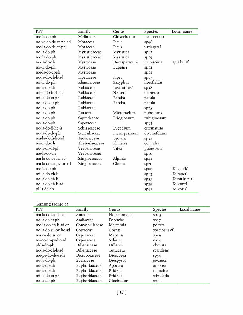
[ 67 ]
PFT Family Genus Species Local name me-la-do-ph Meliaceae Chisocheton macrocarpa no-ve-do-de-ct-ph-ad Moraceae Ficus sp48 me-la-do-de-ct-ph Moraceae Ficus variegata? no-la-do-ph Myristicaceae Myristica sp12 me-la-do-ph Myristicaceae Myristica sp19 no-la-do-ch Myrtaceae Decaspermum frutescens 'Ipis kulit' mi-la-do-ph Myrtaceae Eugenia sp14 me-la-do-ct-ph Myrtaceae sp11 no-la-do-ch-li-ad Piperaceae Piper sp17 mi-la-do-ph Rhamnaceae Zizyphus horsfieldii no-la-do-ch Rubiaceae Lasianthus? sp38 mi-la-do-hc-li-ad Rubiaceae Nertera depressa mi-la-do-ct-ph Rubiaceae Randia patula no-la-do-ct-ph Rubiaceae Randia patula no-la-do-ph Rubiaceae sp25 no-la-do-ph Rutaceae Micromelum pubescans no-la-do-ph Sapindaceae Erioglossum rubiginosum no-la-do-ph Sapotaceae sp33 no-la-do-fi-hc-li Schizaeaceae Lygodium circinatum no-la-do-de-ph Sterculiaceae Pterospermum diversifolium ma-la-do-fi-hc-ad Tectariaceae Tectaria sp31 mi-la-do-ch Thymelaeaceae Phaleria octandra no-la-do-ct-ph Verbenaceae Vitex pubescens me-la-do-ch Verbenaceae? sp10 ma-la-do-su-hc-ad Zingiberaceae Alpinia sp41 ma-la-do-su-pv-hc-ad Zingiberaceae Globba sp20 me-la-do-ph sp06 'Ki ganik' mi-la-do-ch-li sp13 'Ki rapet' no-la-do-ch-li sp37 'Kupu kupu' no-la-do-ch-li-ad sp39 'Ki kunti' pl-la-do-ch sp47 'Ki koris' Gunung Honje 17 PFT Family Genus Species Local name ma-la-do-su-hc-ad Araceae Homalomena sp23 no-la-do-ct-ph Araliaceae Polyscias sp17 me-la-do-ch-li-ad-ep Convolvulaceae Merremia peltata no-la-do-su-pv-hc-ad Costaceae Costus speciosus cf. ma-co-do-su-cr Cyperaceae Mapania sp49 mi-co-do-pv-hc-ad Cyperaceae Scleria sp24 pl-la-do-ph Dilleniaceae Dillenia obovata no-la-do-ch-li-ad Dilleniaceae Tetracera scandens me-pe-do-de-cr-li Dioscoreaceae Dioscorea sp54 no-la-do-ph Ebenaceae Diospyros javanica no-la-do-ch Euphorbiaceae Aporusa arborea no-la-do-ch Euphorbiaceae Bridelia monoica mi-la-do-ct-ph Euphorbiaceae Bridelia stipularis no-la-do-ph Euphorbiaceae Glochidion sp11
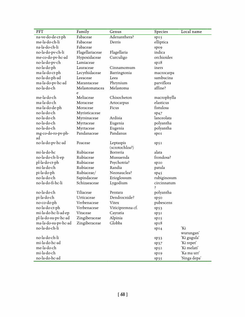
[ 68 ]
PFT Family Genus Species Local name na-ve-do-de-ct-ph Fabaceae Adenanthera? sp15 me-la-do-ch-li Fabaceae Derris elliptica na-la-do-ch-li Fabaceae sp09 no-la-do-pv-ch-li Flagellariaceae Flagellaria indica me-co-do-pv-hc-ad Hypoxidaceae Curculigo orchioides no-la-do-pv-ch Lamiaceae sp28 no-la-do-ph Lauraceae Cinnamomum iners ma-la-do-ct-ph Lecythidaceae Barringtonia macrocarpa no-la-do-ph-ad Leeaceae Leea sambucina ma-la-do-pv-hc-ad Marantaceae Phrynium parviflora no-la-do-ch Melastomatacea
e Melastoma affine?
me-la-do-ch Meliaceae Chisocheton macrophylla ma-la-do-ch Moraceae Artocarpus elasticus ma-la-do-de-ph Moraceae Ficus fistulosa no-la-do-ch Myristicaceae sp47 no-la-do-ch Myrsinaceae Ardisia lanceolata no-la-do-ch Myrtaceae Eugenia polyantha no-la-do-ch Myrtaceae Eugenia polyantha mg-co-do-ro-pv-ph-ad
Pandanaceae Pandanus sp01
no-la-do-pv-hc-ad Poaceae Leptaspis (scrotochloa?)
sp51
mi-la-do-hc Rubiaceae Borreria alata no-la-do-ch-li-ep Rubiaceae Mussaenda frondosa? pl-la-do-ct-ph Rubiaceae Psychotria? sp20 mi-la-do-ch Rubiaceae Randia patula pi-la-do-ph Rubiaceae/ Neonauclea? sp45 no-la-do-ch Sapindaceae Erioglossum rubiginosum no-la-do-fi-hc-li Schizaeaceae Lygodium circinnatum
?
no-la-do-ch Tiliaceae Pentara polyantha pi-la-do-ch Urticaceae Dendrocnide? sp50 no-co-do-ph Verbenaceae Vitex pubescens no-la-do-ct-ph Verbenaceae Viticipremna cf. sp53 mi-la-do-hc-li-ad-ep Vitaceae Cayratia sp31 pl-la-do-su-pv-hc-ad Zingiberaceae Alpinia sp25 ma-la-do-su-pv-hc-ad Zingiberaceae Globba sp18 no-la-do-ch-li sp14 'Ki
wurungan'
no-la-do-ch-li sp33 'Ki gugula' mi-la-do-hc-ad sp37 'Ki repet' me-la-do-ch sp52 'Ki melati' mi-la-do-ch sp19 'Ka ma urr' no-la-do-hc-ad sp35 'Singa depa'
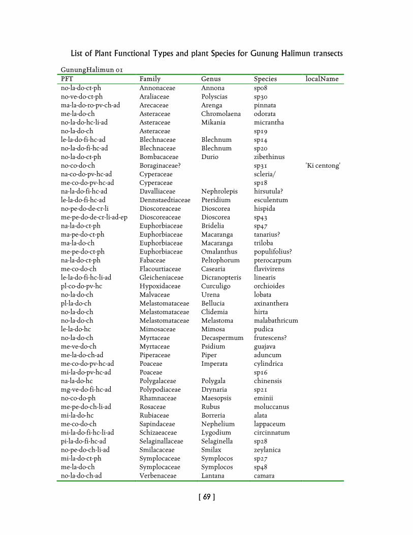
[ 69 ]
List of Plant Functional Types and plant Species for Gunung Halimun transects GunungHalimun 01 PFT Family Genus Species localName no-la-do-ct-ph Annonaceae Annona sp08 no-ve-do-ct-ph Araliaceae Polyscias sp30 ma-la-do-ro-pv-ch-ad Arecaceae Arenga pinnata me-la-do-ch Asteraceae Chromolaena odorata no-la-do-hc-li-ad Asteraceae Mikania micrantha no-la-do-ch Asteraceae sp19 le-la-do-fi-hc-ad Blechnaceae Blechnum sp14 no-la-do-fi-hc-ad Blechnaceae Blechnum sp20 no-la-do-ct-ph Bombacaceae Durio zibethinus no-co-do-ch Boraginaceae? sp31 'Ki centong' na-co-do-pv-hc-ad Cyperaceae scleria/ me-co-do-pv-hc-ad Cyperaceae sp18 na-la-do-fi-hc-ad Davalliaceae Nephrolepis hirsutula? le-la-do-fi-hc-ad Dennstaedtiaceae Pteridium esculentum no-pe-do-de-cr-li Dioscoreaceae Dioscorea hispida me-pe-do-de-cr-li-ad-ep Dioscoreaceae Dioscorea sp43 na-la-do-ct-ph Euphorbiaceae Bridelia sp47 ma-pe-do-ct-ph Euphorbiaceae Macaranga tanarius? ma-la-do-ch Euphorbiaceae Macaranga triloba me-pe-do-ct-ph Euphorbiaceae Omalanthus populifolius? na-la-do-ct-ph Fabaceae Peltophorum pterocarpum me-co-do-ch Flacourtiaceae Casearia flavivirens le-la-do-fi-hc-li-ad Gleicheniaceae Dicranopteris linearis pl-co-do-pv-hc Hypoxidaceae Curculigo orchioides no-la-do-ch Malvaceae Urena lobata pl-la-do-ch Melastomataceae Bellucia axinanthera no-la-do-ch Melastomataceae Clidemia hirta no-la-do-ch Melastomataceae Melastoma malabathricum le-la-do-hc Mimosaceae Mimosa pudica no-la-do-ch Myrtaceae Decaspermum frutescens? me-ve-do-ch Myrtaceae Psidium guajava me-la-do-ch-ad Piperaceae Piper aduncum me-co-do-pv-hc-ad Poaceae Imperata cylindrica mi-la-do-pv-hc-ad Poaceae sp16 na-la-do-hc Polygalaceae Polygala chinensis mg-ve-do-fi-hc-ad Polypodiaceae Drynaria sp21 no-co-do-ph Rhamnaceae Maesopsis eminii me-pe-do-ch-li-ad Rosaceae Rubus moluccanus mi-la-do-hc Rubiaceae Borreria alata me-co-do-ch Sapindaceae Nephelium lappaceum mi-la-do-fi-hc-li-ad Schizaeaceae Lygodium circinnatum pi-la-do-fi-hc-ad Selaginallaceae Selaginella sp28 no-pe-do-ch-li-ad Smilacaceae Smilax zeylanica mi-la-do-ct-ph Symplocaceae Symplocos sp27 me-la-do-ch Symplocaceae Symplocos sp48 no-la-do-ch-ad Verbenaceae Lantana camara
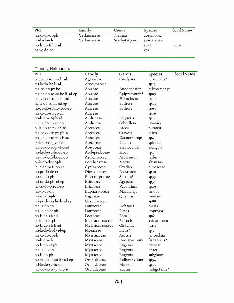
[ 70 ]
PFT Family Genus Species localName me-la-do-ct-ph Verbenaceae Premna corymbosa mi-la-do-ch Verbenaceae Stachytarpheta jamaicensis no-la-do-fi-hc-ad sp22 Fern na-ve-do-hc
sp34
Gunung Halimun 02 PFT Family Genus Species localName pi-co-do-ro-pv-ch-ad Agavaceae Cordyline terminalis? mi-la-do-hc-li-ad Apocynaceae sp23 me-pe-do-pv-hc Araceae Anodendrum microstachya me-co-do-ro-su-hc-li-ad-ep Araceae Epipremnum? sp09 ma-ve-do-su-pv-hc-ad Araceae Homolaena cordata na-la-do-su-hc-ad-ep Araceae Pothos? sp43 no-co-do-so-hc-li-ad-ep Araceae Pothos? sp65 me-la-do-su-pv-ch Araceae sp46 no-la-do-ct-ph-ad Araliaceae Polyscias sp24 me-la-do-ch-ad-ep Araliaceae Schefflera javanica pl-la-do-ro-pv-ch-ad Arecaceae Areca pumida ma-co-do-ro-pv-ph-ad Arecaceae Caryota mitis me-co-do-ro-pv-ch-ad Arecaceae Daemonorops sp41 pi-la-do-ro-pv-ph-ad Arecaceae Licuala spinosa ma-co-do-ro-pv-hc-ad Arecaceae Plectocomia elongata mi-la-do-su-hc-ad-ep Asclepiadaceae Hoya sp14 ma-ve-do-fi-hc-ad-ep Aspleniaceae Asplenium nidus pl-la-do-de-ct-ph Bombacaceae Neesia altissima le-la-do-ro-fi-ph-ad Cyatheaceae Cyathea pubescens no-pe-do-de-cr-li Dioscoreaceae Dioscorea sp50 no-co-do-ph Elaeocarpaceae Sloanea? sp33 mi-co-do-ph-ad-ep Ericaceae Agapetes sp51 na-co-do-ph-ad-ep Ericaceae Vaccinium sp49 ma-la-do-ch Euphorbiaceae Macaranga triloba me-co-do-ph Fagaceae Quercus sondaica mi-pe-do-su-hc-li-ad-ep Gesneriaceae sp88 me-la-do-ch Lauraceae Dehaasia caesia me-la-do-ct-ph Lauraceae Litsea impressa no-la-do-ch-ad Leeaceae Leea sp61 pi-la-do-ct-ph Melastomataceae Bellucia axinanthera no-la-do-ch-li-ad Melastomataceae Clidemia hirta mi-la-do-hc-li-ad-ep Moraceae Ficus? sp37 me-la-do-ct-ph Myrsinaceae Ardisia lanceolata no-la-do-ch Myrtaceae Decaspermum frutescens? no-la-do-ct-ph Myrtaceae Eugenia cymosa me-la-do-ch Myrtaceae Eugenia opaca no-la-do-ph Myrtaceae Eugenia subglauca no-ve-do-so-su-hc-ad-ep Orchidaceae Bulbophyllum sp34 mi-la-do-su-hc-ad Orchidaceae Malaxia sp25 ma-co-do-su-pv-hc-ad Orchidaceae Phaius indigoferus?
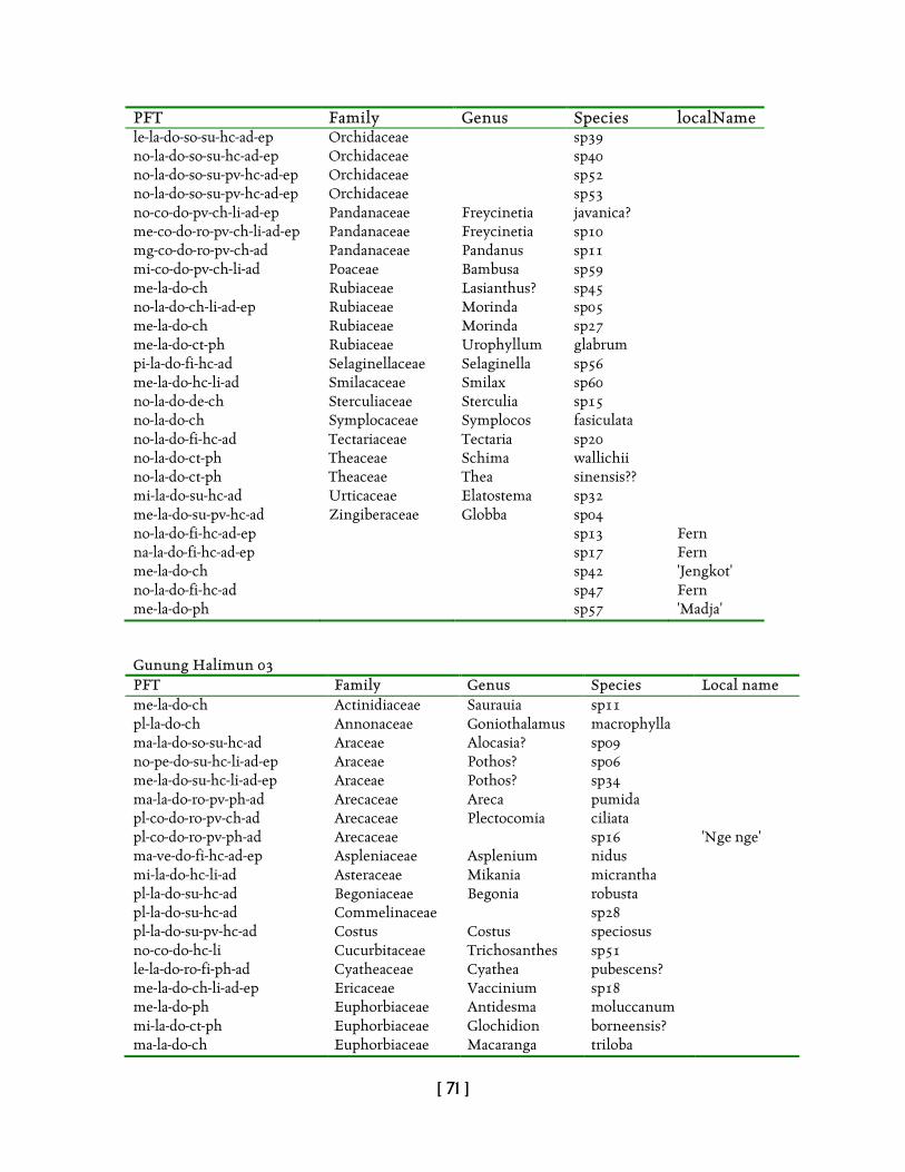
[ 71 ]
PFT Family Genus Species localName le-la-do-so-su-hc-ad-ep Orchidaceae sp39 no-la-do-so-su-hc-ad-ep Orchidaceae sp40 no-la-do-so-su-pv-hc-ad-ep Orchidaceae sp52 no-la-do-so-su-pv-hc-ad-ep Orchidaceae sp53 no-co-do-pv-ch-li-ad-ep Pandanaceae Freycinetia javanica? me-co-do-ro-pv-ch-li-ad-ep Pandanaceae Freycinetia sp10 mg-co-do-ro-pv-ch-ad Pandanaceae Pandanus sp11 mi-co-do-pv-ch-li-ad Poaceae Bambusa sp59 me-la-do-ch Rubiaceae Lasianthus? sp45 no-la-do-ch-li-ad-ep Rubiaceae Morinda sp05 me-la-do-ch Rubiaceae Morinda sp27 me-la-do-ct-ph Rubiaceae Urophyllum glabrum pi-la-do-fi-hc-ad Selaginellaceae Selaginella sp56 me-la-do-hc-li-ad Smilacaceae Smilax sp60 no-la-do-de-ch Sterculiaceae Sterculia sp15 no-la-do-ch Symplocaceae Symplocos fasiculata no-la-do-fi-hc-ad Tectariaceae Tectaria sp20 no-la-do-ct-ph Theaceae Schima wallichii no-la-do-ct-ph Theaceae Thea sinensis?? mi-la-do-su-hc-ad Urticaceae Elatostema sp32 me-la-do-su-pv-hc-ad Zingiberaceae Globba sp04 no-la-do-fi-hc-ad-ep sp13 Fern na-la-do-fi-hc-ad-ep sp17 Fern me-la-do-ch sp42 'Jengkot' no-la-do-fi-hc-ad sp47 Fern me-la-do-ph sp57 'Madja' Gunung Halimun 03 PFT Family Genus Species Local name me-la-do-ch Actinidiaceae Saurauia sp11 pl-la-do-ch Annonaceae Goniothalamus macrophylla ma-la-do-so-su-hc-ad Araceae Alocasia? sp09 no-pe-do-su-hc-li-ad-ep Araceae Pothos? sp06 me-la-do-su-hc-li-ad-ep Araceae Pothos? sp34 ma-la-do-ro-pv-ph-ad Arecaceae Areca pumida pl-co-do-ro-pv-ch-ad Arecaceae Plectocomia ciliata pl-co-do-ro-pv-ph-ad Arecaceae sp16 'Nge nge' ma-ve-do-fi-hc-ad-ep Aspleniaceae Asplenium nidus mi-la-do-hc-li-ad Asteraceae Mikania micrantha pl-la-do-su-hc-ad Begoniaceae Begonia robusta pl-la-do-su-hc-ad Commelinaceae sp28 pl-la-do-su-pv-hc-ad Costus Costus speciosus no-co-do-hc-li Cucurbitaceae Trichosanthes sp51 le-la-do-ro-fi-ph-ad Cyatheaceae Cyathea pubescens? me-la-do-ch-li-ad-ep Ericaceae Vaccinium sp18 me-la-do-ph Euphorbiaceae Antidesma moluccanum mi-la-do-ct-ph Euphorbiaceae Glochidion borneensis? ma-la-do-ch Euphorbiaceae Macaranga triloba
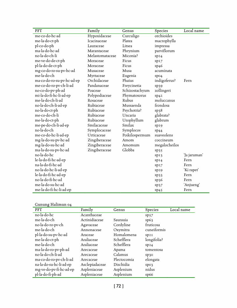
[ 72 ]
PFT Family Genus Species Local name me-co-do-hc-ad Hypoxidaceae Curculigo orchioides me-la-do-ct-ph Icacinaceae Platea macrophylla pl-co-do-ph Lauraceae Litsea impressa ma-la-do-hc-ad Marantaceae Phrynium parviflorum no-la-do-ch-li Melastomataceae Miconia? sp24 me-ve-do-de-ct-ph Moraceae Ficus sp17 pl-la-do-de-ct-ph Moraceae Ficus sp46 mg-co-do-ro-su-pv-hc-ad Musaceae Musa acuminata me-la-do-ch Myrtaceae Eugenia sp04 ma-co-do-ro-su-pv-hc-ad-ep Orchidaceae Phaius indigoferus? Fern me-co-do-ro-pv-ch-li-ad Pandanaceae Freycinetia sp39 no-co-do-pv-ph-ad Poaceae Schizostachyum zollingeri mi-la-do-fi-hc-li-ad-ep Polypodiaceae Phymatosorus sp42 me-la-do-ch-li-ad Rosaceae Rubus moluccanus no-la-do-ch-li-ad-ep Rubiaceae Mussaenda frondosa no-la-do-ct-ph Rubiaceae Psychotria? sp38 me-co-do-ch-li Rubiaceae Uncaria glabrata? me-la-do-ct-ph Rubiaceae Urophyllum glabrum me-pe-do-ch-li-ad-ep Smilacaceae Smilax sp19 no-la-do-ch Symplocaceae Symplocos sp44 me-co-do-hc-li-ad-ep Urticaceae Poikilospermum suaveolens mg-la-do-su-pv-hc-ad Zingiberaceae Amom coccineum mg-la-do-su-hc-ad Zingiberaceae Amomum megalocheilos ma-la-do-su-pv-hc-ad Zingiberaceae Globba sp35 no-la-do-hc sp13 'Ja jaruman' le-la-do-fi-hc-ad-ep sp14 Fern na-la-do-fi-hc-ad sp27 Fern no-la-do-hc-li-ad-ep sp29 'Ki rapet' le-la-do-fi-hc-ad-ep sp33 Fern no-la-do-fi-hc-ad sp36 Fern me-la-do-su-hc-ad sp37 'Anjueng' me-la-do-fi-hc-li-ad-ep sp45 Fern Gunung Halimun 04 PFT Family Genus Species Local name no-la-do-hc Acanthaceae sp57 me-la-do-ch Actinidiaceae Saurauia sp63 no-la-do-ro-pv-ch Agavaceae Cordyline fruticosa me-la-do-ch Annonaceae Oxymitra cuneiformis pl-la-do-su-pv-hc-ad Araceae Homalomena sp21 me-la-do-ct-ph Araliaceae Schefflera longifolia? me-la-do-ch Araliaceae Schefflera sp24 ma-la-do-ro-pv-ph-ad Arecaceae Apama tomentosa no-la-do-ch-li-ad Arecaceae Calamus sp30 ma-co-do-ro-pv-ch-li-ad Arecaceae Plectocomia elongata na-la-do-su-hc-li-ad-ep Asclepiadaceae Dischidia sp03 mg-ve-do-pv-fi-hc-ad-ep Aspleniaceae Asplenium nidus pl-la-do-fi-ph-ad Aspleniaceae Asplenium sp66
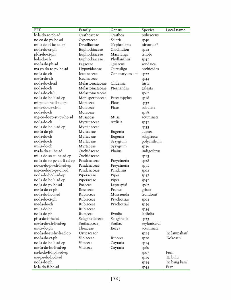
[ 73 ]
PFT Family Genus Species Local name le-la-do-ro-ph-ad Cyatheaceae Cyathea pubescens no-co-do-pv-hc-ad Cyperaceae Scleria sp40 mi-la-do-fi-hc-ad-ep Davalliaceae Nephrolepis hirsutula? no-la-do-ct-ph Euphorbiaceae Glochidion sp12 pl-la-do-ct-ph Euphorbiaceae Macaranga triloba le-la-do-ch Euphorbiaceae Phyllanthus sp41 me-la-do-ph-ad Fagaceae Quercus sondaica ma-co-do-ro-pv-hc-ad Hypoxidaceae Curculigo orchioides no-la-do-ch Icacinaceae Gonocaryum - cf sp22 me-la-do-ch Icacinaceae sp44 no-la-do-ch-ad Melastomataceae Clidemia hirta no-la-do-ch Melastomataceae Pternandra galeata no-la-do-ch-li Melastomataceae sp61 no-la-do-hc-li-ad-ep Menispermaceae Percampylus sp18 mi-pe-do-hc-li-ad-ep Moraceae Ficus sp32 mi-la-do-de-ch-li Moraceae Ficus subulata no-la-do-ch Moraceae sp58 mg-co-do-ro-su-pv-hc-ad Musaceae Musa acuminata no-la-do-ch Myrsinaceae Ardisia sp31 no-la-do-hc-li-ad-ep Myrsinaceae sp33 me-la-do-ph Myrtaceae Eugenia cuprea no-la-do-ch Myrtaceae Eugenia subglauca no-la-do-ch Myrtaceae Syzygium polyanthum mi-la-do-ch Myrtaceae Syzygium sp36 ma-la-do-su-hc-ad Orchidaceae Phaius indigoferus mi-la-do-so-su-hc-ad-ep Orchidaceae sp13 no-la-do-ro-pv-ch-li-ad-ep Pandanaceae Freycinetia sp28 no-co-do-pv-ch-li-ad-ep Pandanaceae Freycinetia sp51 mg-co-do-ro-pv-ch-ad Pandanaceae Pandanus sp02 no-la-do-hc-li-ad-ep Piperaceae Piper sp37 no-la-do-hc-li-ad-ep Piperaceae Piper sp42 no-la-do-pv-hc-ad Poaceae Leptaspis? sp62 me-la-do-ct-ph Rosaceae Prunus grisea no-la-do-hc-li-ad Rubiaceae Mussaenda frondosa? no-la-do-ct-ph Rubiaceae Psychotria? sp04 me-la-do-ch Rubiaceae Psychotria? sp59 mi-la-do-hc Rubiaceae sp54 no-la-do-ph Rutaceae Evodia latifolia pi-la-do-fi-hc-ad Selaginellaceae Selaginella sp23 me-la-do-ch-li-ad-ep Smilacaceae Smilax zeylanica-cf mi-la-do-ph Theaceae Eurya acuminata me-la-do-su-hc-li-ad-ep Urticaceae? sp15 'Ki lampahan' me-la-do-ct-ph Violaceae Rinorea sp10 'Kokosan' no-la-do-hc-li-ad-ep Vitaceae Cayratia sp14 me-la-do-hc-li-ad-ep Vitaceae Cayratia sp60 na-la-do-fi-hc-li-ad-ep sp07 Fern me-pe-do-hc-li-ad sp19 'Ki bulu' no-la-do-ph sp34 'Ki bang bara' le-la-do-fi-hc-ad sp45 Fern
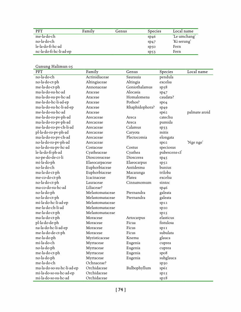
[ 74 ]
PFT Family Genus Species Local name me-la-do-ch sp46 'Le umchang' no-la-do-ch sp47 'Ki serung' le-la-do-fi-hc-ad sp50 Fern nc-la-do-fi-hc-li-ad-ep sp53 Fern Gunung Halimun 05 PFT Family Genus Species Local name no-la-do-ch Actinidiaceae Saurauia pendula no-la-do-ct-ph Altingiaceae Altingia excelsa me-la-do-ct-ph Annonaceae Goniothalamus sp58 ma-la-do-su-hc-ad Araceae Alocasia sp47 ma-la-do-su-pv-hc-ad Araceae Homalomena caudata? me-la-do-hc-li-ad-ep Araceae Pothos? sp04 ma-la-do-su-hc-li-ad-ep Araceae Rhaphidophora? sp49 me-la-do-su-hc-ad Araceae sp62 palmate aroid me-la-do-ro-pv-ph-ad Arecaceae Areca catechu ma-la-do-ro-pv-ph-ad Arecaceae Areca pumida me-la-do-ro-pv-ch-li-ad Arecaceae Calamus sp33 pl-la-do-ro-pv-ph-ad Arecaceae Caryota mitis ma-la-do-ro-pv-ch-ad Arecaceae Plectocomia elongata no-la-do-ro-pv-ph-ad Arecaceae sp02 'Nge nge' no-la-do-su-pv-hc-ad Costaceae Costus speciosus le-la-do-fi-ph-ad Cyatheaceae Cyathea pubescens-cf no-pe-do-de-cr-li Dioscoreaceae Dioscorea sp45 mi-la-do-ph Elaeocarpaceae Elaeocarpus sp52 no-la-do-ch Euphorbiaceae Antidesma bunius ma-la-do-ct-ph Euphorbiaceae Macaranga triloba me-co-do-ct-ph Icacinaceae Platea excelsa no-la-do-ct-ph Lauraceae Cinnamomum sintoc ma-co-do-su-hc-ad Liliaceae? sp46 no-la-do-ph Melastomataceae Pternandra galeata no-la-do-ct-ph Melastomataceae Pternandra galeata mi-la-do-hc-li-ad-ep Melastomataceae sp12 me-la-do-ch-li-ad Melastomataceae sp20 me-la-do-ct-ph Melastomataceae sp25 ma-la-do-ct-ph Moraceae Artocarpus elasticus pl-la-do-de-ph Moraceae Ficua fistulosa na-la-do-hc-li-ad-ep Moraceae Ficus sp11 me-la-do-de-ct-ph Moraceae Ficus subulata me-la-do-ph Myristicaceae Knema glauca mi-la-do-ch Myrtaceae Eugenia cuprea no-la-do-ph Myrtaceae Eugenia cuprea me-la-do-ct-ph Myrtaceae Eugenia sp08 no-la-do-ph Myrtaceae Eugenia subglauca me-la-do-ch Ochnaceae? sp30 ma-la-do-so-su-hc-li-ad-ep Orchidaceae Bulbophyllum sp61 mi-la-do-so-su-hc-ad-ep Orchidaceae sp15 mi-la-do-so-su-hc-ad Orchidaceae sp18
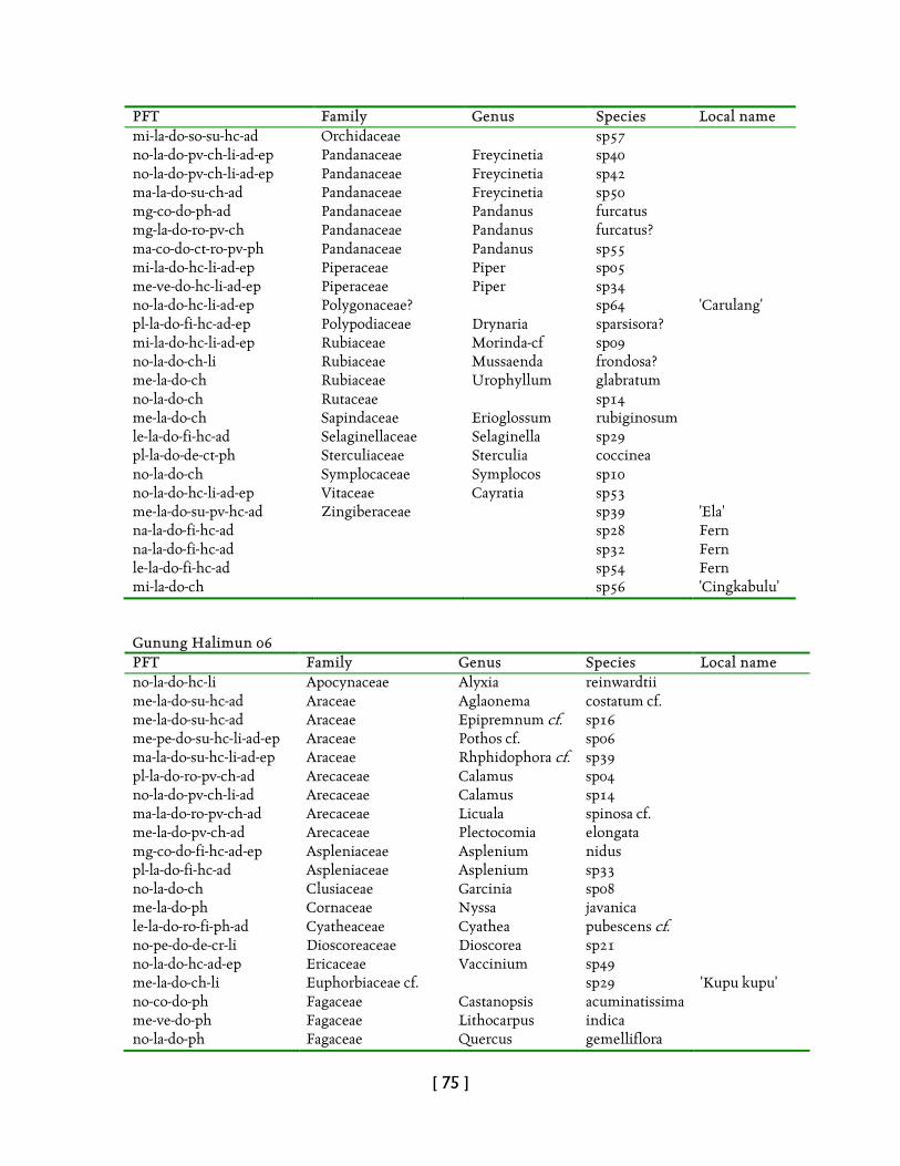
[ 75 ]
PFT Family Genus Species Local name mi-la-do-so-su-hc-ad Orchidaceae sp57 no-la-do-pv-ch-li-ad-ep Pandanaceae Freycinetia sp40 no-la-do-pv-ch-li-ad-ep Pandanaceae Freycinetia sp42 ma-la-do-su-ch-ad Pandanaceae Freycinetia sp50 mg-co-do-ph-ad Pandanaceae Pandanus furcatus mg-la-do-ro-pv-ch Pandanaceae Pandanus furcatus? ma-co-do-ct-ro-pv-ph Pandanaceae Pandanus sp55 mi-la-do-hc-li-ad-ep Piperaceae Piper sp05 me-ve-do-hc-li-ad-ep Piperaceae Piper sp34 no-la-do-hc-li-ad-ep Polygonaceae? sp64 'Carulang' pl-la-do-fi-hc-ad-ep Polypodiaceae Drynaria sparsisora? mi-la-do-hc-li-ad-ep Rubiaceae Morinda-cf sp09 no-la-do-ch-li Rubiaceae Mussaenda frondosa? me-la-do-ch Rubiaceae Urophyllum glabratum no-la-do-ch Rutaceae sp14 me-la-do-ch Sapindaceae Erioglossum rubiginosum le-la-do-fi-hc-ad Selaginellaceae Selaginella sp29 pl-la-do-de-ct-ph Sterculiaceae Sterculia coccinea no-la-do-ch Symplocaceae Symplocos sp10 no-la-do-hc-li-ad-ep Vitaceae Cayratia sp53 me-la-do-su-pv-hc-ad Zingiberaceae sp39 'Ela' na-la-do-fi-hc-ad sp28 Fern na-la-do-fi-hc-ad sp32 Fern le-la-do-fi-hc-ad sp54 Fern mi-la-do-ch sp56 'Cingkabulu' Gunung Halimun 06 PFT Family Genus Species Local name no-la-do-hc-li Apocynaceae Alyxia reinwardtii me-la-do-su-hc-ad Araceae Aglaonema costatum cf. me-la-do-su-hc-ad Araceae Epipremnum cf. sp16 me-pe-do-su-hc-li-ad-ep Araceae Pothos cf. sp06 ma-la-do-su-hc-li-ad-ep Araceae Rhphidophora cf. sp39 pl-la-do-ro-pv-ch-ad Arecaceae Calamus sp04 no-la-do-pv-ch-li-ad Arecaceae Calamus sp14 ma-la-do-ro-pv-ch-ad Arecaceae Licuala spinosa cf. me-la-do-pv-ch-ad Arecaceae Plectocomia elongata mg-co-do-fi-hc-ad-ep Aspleniaceae Asplenium nidus pl-la-do-fi-hc-ad Aspleniaceae Asplenium sp33 no-la-do-ch Clusiaceae Garcinia sp08 me-la-do-ph Cornaceae Nyssa javanica le-la-do-ro-fi-ph-ad Cyatheaceae Cyathea pubescens cf. no-pe-do-de-cr-li Dioscoreaceae Dioscorea sp21 no-la-do-hc-ad-ep Ericaceae Vaccinium sp49 me-la-do-ch-li Euphorbiaceae cf. sp29 'Kupu kupu' no-co-do-ph Fagaceae Castanopsis acuminatissima me-ve-do-ph Fagaceae Lithocarpus indica no-la-do-ph Fagaceae Quercus gemelliflora
[ 76 ]
PFT Family Genus Species Local name me-co-do-ph Fagaceae Quercus sondaica pl-la-do-ch Lauraceae Litsea impressa no-la-do-ch Lauraceae Litsea sp07 no-la-do-ch-ad Leeaceae Leea sp40 no-la-do-fi-hc-ad Marattiaceae Marattia asiatica no-la-do-ch-li Moraceae Ficus subulata me-la-do-ct-ph Myristicaceae aff. sp42 no-co-do-ph Myrtaceae Eugenia excelsa mi-la-do-ch Myrtaceae Eugenia sp17 mi-la-do-pv-hc-ad Orchidaceae Malaxis sp44 me-ve-do-so-su-pv-hc-ad Orchidaceae sp26 no-la-do-pv-hc-ad Orchidaceae sp41 me-co-do-so-su-hc-ad-ep Orchidaceae sp48 no-la-do-so-su-hc-ad Orchidaceae sp51 no-pe-do-su-ch-li-ad-ep Pandanaceae Freycinetia sp05 mg-la-do-ro-pv-ch-ad Pandanaceae Pandanus sp16 me-la-do-ch Piperaceae Piper sp45 no-la-do-fi-hc-ad-ep Polypodiaceae Drynaria sp47 no-la-do-ct-ph Rubiaceae Urophyllum glabrum cf le-la-do-fi-hc-ad Selaginellaceae Selaginella sp50 me-la-do-ch-li Smilacaceae Smilax sp37 no-la-do-fi-hc-ad Tectariaceae Tectaria sp13 no-la-do-ct-ph Theaceae Schima wallichii me-la-do-ch Tiliaceae Pentara polyantha me-la-do-su-hc-ad Zingiberaceae sp35 mi-la-do-fi-hc-ad sp10 Fern me-la-do-fi-hc-ad sp11 Fern no-la-do-ch sp19 'Ki melati' me-la-do-ch sp20 'Ki bulu' le-la-do-fi-hc-li-ad-ep sp38 Fern no-la-do-ch-li sp46 'Arae tatankilan' Gunung Halimun 07 PFT Family Genus Species Local name mi-la-do-hc-li-ad Apocynaceae sp31 pl-pe-do-su-hc-li-ad-ep Araceae Epipremnum cf. sp15 no-pe-do-su-pv-hc-li-ad-ep Araceae Pothos sp37 ma-la-do-su-hc-ad Araceae sp47 me-la-do-ch Araliaceae Schefflera sp50 ma-la-do-ro-pv-ph-ad Arecaceae Areca pumida ma-la-do-ro-pv-ch-ad Arecaceae Daemonorops sp06 ma-la-do-ro-pv-ch-ad Arecaceae Licuala spinosa cf. ma-ve-do-ro-pv-hc-ad-ep Aspleniaceae Asplenium nidus no-la-do-ch Chloranthaceae cf. Chloranthus cf. sp13 le-la-do-ro-fi-ph-ad Cyatheaceae Cyathea pubescens mi-la-do-fi-hc-ad-ep Davalliaceae Nephrolepis hirsutula cf. me-la-do-ct-ph Elaeocarpaceae Elaeocarpus petiolatus cf. no-la-do-ch Euphorbiaceae Aporusa arborea
[ 77 ]
PFT Family Genus Species Local name me-la-do-ph Euphorbiaceae Glochidion palustre cf. no-la-do-ct-ph Euphorbiaceae Glochidion sp32 ma-la-do-ch Euphorbiaceae Macaranga triloba no-la-do-hc-ad Fabaceae Derris thyrsiflora cf. no-la-do-ch Fagaceae Lithocarpus sp10 no-la-do-ph-ad Fagaceae Lithocarpus sp48 me-co-do-ph Fagaceae Quercus teysmanii me-la-do-ch Lauraceae Cinnamomun iners me-la-do-ph Lauraceae Litsea brachstachya me-la-do-ch Lauraceae Litsea impressa cf. no-la-do-ch Lauraceae Litsea sp28 no-la-do-ch-ad Leeaceae Leea sambucina cf. ma-la-do-ct-ph Moraceae Artocarpus elasticus no-pe-do-hc-li-ad-ep Moraceae Ficus sp07 no-la-do-su-ch-li-ad-ep Moraceae Ficus sp18 me-la-do-ph Myristicaceae Myristica cf. sp44 me-la-do-ct-ph Myrtaceae Eugenia sp33 me-co-do-ph Myrtaceae Eugenia subglauca no-la-do-ph Myrtaceae Rhodamnia cinerea no-co-do-pv-ch-li-ad-ep Pandanaceae Freycinetia sp02 mg-co-do-pv-ch-ad Pandanaceae Pandanus sp17 mi-la-do-pv-ch-li-ad Poaceae Bambusa cf. sp41 no-la-do-pv-hc-ad Poaceae Leptaspis sp20 le-la-do-ph Podocarpaceae Dacrycarpus imbricatus no-la-do-ph Rhizophoraceae Gynotroches axillaris me-la-do-ch Rubiaceae Psychotria montana cf. pi-la-do-fi-hc-ad Selaginellaceae Selaginella sp27 me-la-do-de-ph Sterculiaceae Sterculia sp03 no-la-do-ch Symplocaceae Symplocos cochinchinensis cf. no-la-do-ch Theaceae Schima wallichii me-la-do-ph Theaceae Schima wallichii pl-la-do-su-pv-hc-ad Zingiberaceae sp08 'Ela' no-pe-do-fi-ph-li-ad-ep sp14 Fern na-la-do-fi-hc-ad sp30 Fern no-la-do-ph-li-ad-ep sp36 'Harrnang' le-la-do-fi-hc-ad-ep sp39 Fern no-la-do-ph sp42 'Madja' Gunung Halimun 08 PFT Family Genus Species Local name mi-la-do-ch-li Apocynaceae Alyxia Reinwardtii mi-la-do-ch-li Apocynaceae Indet sp46 no-la-do-ro-pv-hc Arecaceae Areca pumida cf. pl-la-do-ro-pv-hc Arecaceae Indet sp27 mi-pe-do-ph Cunoniaceae Weinmannia blumei ma-la-do-fi-hc-ad Dipteridaceae Dipteris conjugata mi-ve-do-ct-ph Elaeocarpaceae Elaeocarpus petiolatus cf. me-co-do-ph Elaeocarpaceae Sloanea sp15
[ 78 ]
PFT Family Genus Species Local name no-la-do-ch-li-ad-ep Ericaceae Vaccinium sp54 no-la-do-ch Euphorbiaceae Glochidion sp12 mi-co-do-ph Fagaceae Castanopsis acuminatissima? le-la-do-fi-hc-li-ad Fern Indet sp10 mi-ve-do-ph Grossulariaceae Quintinia? sp01 no-la-do-ct-ph Indet Indet sp13 no-la-do-hc-li Indet Indet sp20 mi-la-do-ch Indet Indet sp25 mi-la-do-ch-li Indet Indet sp34 no-ve-do-ct-ph Indet Indet sp36 mi-co-do-ph Indet Indet sp41 no-la-do-ch Indet Indet sp44 mi-co-do-ct-ph Indet Indet sp52 mi-ve-do-su-hc-li-ad-ep Indet Indet sp55 mi-co-do-ph Indet Indet sp56 mi-co-do-ph Juglandaceae Engelhardia sp43 mi-la-do-ch Lauraceae Cinnamomum iners mi-ve-do-ct-ph Lauraceae Cinnamomum sp39 no-co-do-ph Lauraceae Indet sp04 no-co-do-ph Lauraceae Indet sp45 mi-ve-do-ph Myrsinaceae Indet sp05 mi-la-do-ct-ph Myrtaceae Syzygium sp33 mi-la-do-ch Olacaceae Indet sp53 me-la-do-fi-hc-ad Oleandraceae Indet so06 no-ve-do-so-su-hc-ad-ep Orchidaceae Bulbophyllum sp18 me-co-do-so-su-pv-hc-ad-ep Orchidaceae Bulbophyllum sp31 me-co-do-so-su-pv-hc-ad-ep Orchidaceae Coelogyne sp49 mi-ve-do-so-su-hc-ad-ep Orchidaceae Indet sp07 mi-co-do-so-su-hc-ad-ep Orchidaceae Indet sp08 mi-pe-do-so-su-pv-hc-ad-ep Orchidaceae Indet sp23 mi-co-do-so-su-pv-hc-ad-ep Orchidaceae Indet sp50 na-ve-do-so-su-hc-ad-ep Orchidaceae Indet sp57 no-co-do-ro-ch-li-ad-ep Pandanaceae Freycinetia sp32 le-la-do-ph Podocarpaceae Dacrycarpus imbricatus mi-ve-do-fi-hc-ad-ep Polypodiaceae Pyrrosia sp40 me-la-do-ch Rubiaceae Indet sp16 no-la-do-ch Rubiaceae Indet sp24 no-la-do-ct-ph Rubiaceae Indet sp35 mi-la-do-ch-li Rubiaceae Indet sp38 no-la-do-ch Rubiaceae Lasianthus sp28 no-la-do-ch-li-ep Rubiaceae Morinda sp30 no-la-do-ch Rubiaceae Psychotria sp09 no-la-do-ct-ph Rubiaceae Timonius sp48 no-la-do-ch Sapindaceae Indet sp42 no-la-do-hc-li Smilacaceae Smilax sp19 mi-la-do-ch Solanaceae Indet sp29 mi-la-do-ch Theaceae Eurya acuminata mi-la-do-ch Thymelaeaceae Indet sp47
Related Documents