306 Ice Age Trail Guidebook 2014 0 1 2 3 4 Miles February 3, 2014 45 Campbellsport Dundee 1 : 200,000 compilation scale Campbellsport Drumlins SH EBOY GAN W ASHIN GTON Sheboygan Marsh 23 67 F O N D D U L A C S H E B O Y G A N Nor t h e rn K e ttl e M o ra i n e St a t e Fo re s t Milwaukee River (Fond du Lac County) Segment Existing Ice Age Trail, subject to change as it evolves toward completion Other Trail County Boundary Public or IATA Land Unofficial Connecting Route (unmarked) MA N IT O WO C S S SS 67 Greenbush Glenb

Welcome message from author
This document is posted to help you gain knowledge. Please leave a comment to let me know what you think about it! Share it to your friends and learn new things together.
Transcript

306 Ice Age Trail Guidebook 2014
SheboyganFalls
Plymouth
28
43
Ice Age TrailFond du Lac and Sheboygan Counties
0 1 2 3 4Miles
February 3, 2014
Ice Age Trail Alliancewww.iceagetrail.org
32
23
45
Campbellsport
Dundee
1 : 200,000 compilation scale
ElkhartLake
Fond du Lacand
SheboyganCounties
CampbellsportDrumlins
SHEBOYGAN
WASHINGTON
Kohler
57
67
SheboyganMarsh
23
67
FO
ND
DU
LA
C
SH
EB
OY
GA
N
67
Nor
ther
nKet
tleM
orai
neSta
teFor
est
57
Milwaukee River(Fond du Lac County)
Segment
ParnellSegment
GreenbushSegment
LaBudde CreekSegment
Existing Ice Age Trail,subject to change as itevolves toward completion
Other Trail
County Boundary
Public or IATA Land
Unofficial Connecting Route (unmarked)
28
MANITOWOC
FF
A
P
A
S
S
28
144
SS
67
Greenbush
Glenbeulah
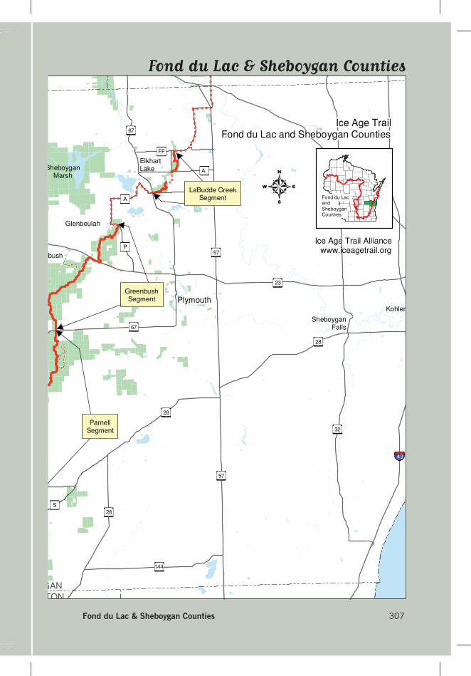
Fond du Lac & Sheboygan Counties 307
SheboyganFalls
Plymouth
28
43
Ice Age TrailFond du Lac and Sheboygan Counties
0 1 2 3 4Miles
February 3, 2014
Ice Age Trail Alliancewww.iceagetrail.org
32
23
45
Campbellsport
Dundee
1 : 200,000 compilation scale
ElkhartLake
Fond du Lacand
SheboyganCounties
CampbellsportDrumlins
SHEBOYGAN
WASHINGTON
Kohler
57
67
SheboyganMarsh
23
67
FO
ND
DU
LA
C
SH
EB
OY
GA
N
67
Nor
ther
nKet
tleM
orai
neSta
teFor
est
57
Milwaukee River(Fond du Lac County)
Segment
ParnellSegment
GreenbushSegment
LaBudde CreekSegment
Existing Ice Age Trail,subject to change as itevolves toward completion
Other Trail
County Boundary
Public or IATA Land
Unofficial Connecting Route (unmarked)
28
MANITOWOC
FF
A
P
A
S
S
28
144
SS
67
Greenbush
Glenbeulah
Fond du Lac & Sheboygan Counties
312 Ice Age Trail Guidebook 2014
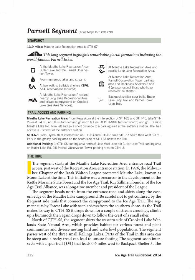
Parnell Segment (Atlas Maps 87f, 88f, 89f)
SnAPShoT
13.9 miles: Mauthe Lake Recreation Area to STH-67
4 3 Th is long segment highlights remarkable glacial formations including the world-famous Parnell Esker.
TRAIL ACCeSS AnD PARKInG
Mauthe Lake Recreation Area: From Kewaskum at the intersection of STH-28 and STH-45, take STH-28 east 0.4 mi. At CTH-S turn left and go north 6.1 mi. At CTH-GGG turn left (north) and go 1.0 mi to Mauthe Lake Rd. Turn left and go a short distance to a parking area at the entrance station. The Trail access is just west of the entrance station.
STh-67: From Plymouth at intersection of STH-23 and STH-67, take STH-67 south then west 8.3 mi. Park in the grassy parking area on the south side of STH-67 next to the Trail.
Additional Parking: (i) CTH-SS parking area north of Little Mud Lake. (ii) Butler Lake Trail parking area on Butler Lake Rd. (iii) Parnell Observation Tower parking area on CTH-U.
The hIKe
ITh e segment starts at the Mauthe Lake Recreation Area entrance road Trail access, just west of the Recreation Area entrance station. In 1926, the Milwau-kee Chapter of the Izaak Walton League protected Mauthe Lake, known as
Moon Lake at the time. Th is initiative was a precursor to the development of the Kett le Moraine State Forest and the Ice Age Trail. Ray Zillmer, founder of the Ice Age Trail Alliance, was a long-time member and president of the League.
Th e segment heads north from the entrance road and skirts along the east-ern edge of the Mauthe Lake campground. Be careful not to get confused by the frequent side trails that connect the campground to the Ice Age Trail. Th e seg-ment cuts by Forest Lake with scenic views from the southern shore. As the Trail makes its way to CTH-SS it drops down for a couple of stream crossings, climbs up a hummock then again drops down to follow the crest of a small esker.
North of CTH-SS, the segment skirts the western side of Crooked Lake Wet-lands State Natural Area, which provides habitat for various forest and plant communities and diverse nesting bird and waterfowl populations. Th e segment passes west of the three small Kellings Lakes. Parts of the Trail in this area can be steep and a rocky tread can lead to unsure footing. Th e segment soon inter-sects with a spur trail (SF6) that leads 0.6 miles west to Backpack Shelter 3. Th e
At the Mauthe Lake Recreation Area, Butler Lake and the Parnell Observa-tion Tower.
From numerous lakes and streams.
At two walk-to trailside shelters (SF6, SF4, reservations required).
At Mauthe Lake Recreation Area and nearby Long Lake Recreational Area and private campground on Crooked Lake (see Area Services).
At Mauthe Lake Recreation Area and nearby Long Lake Recreation Area.
At Mauthe Lake Recreation Area, Parnell Observation Tower parking area and Backpack Shelters 3 and 4 (please respect those who have reserved the shelter).
Backpack shelter spur trails, Butler Lake Loop Trail and Parnell Tower Loop Trail.
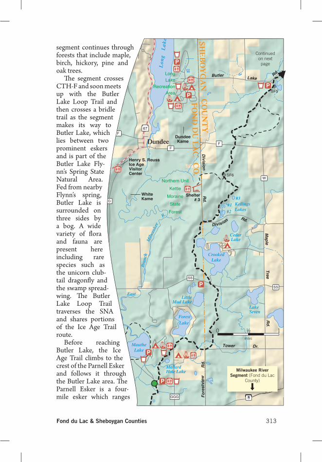
Fond du Lac & Sheboygan Counties 313
segment continues through forests that include maple, birch, hickory, pine and oak trees.
Th e segment crosses CTH-F and soon meets up with the Butler Lake Loop Trail and then crosses a bridle trail as the segment makes its way to Butler Lake, which lies between two prominent eskers and is part of the Butler Lake Fly-nn’s Spring State Natural Area. Fed from nearby Flynn’s spring, Butler Lake is surrounded on three sides by a bog. A wide variety of fl ora and fauna are present here including rare species such as the unicorn club-tail dragonfl y and the swamp spread-wing. Th e Butler Lake Loop Trail traverses the SNA and shares portions of the Ice Age Trail route.
Before reaching Butler Lake, the Ice Age Trail climbs to the crest of the Parnell Esker and follows it through the Butler Lake area. Th e Parnell Esker is a four-mile esker which ranges
P
PP
P
P
P
A
W
W
FF
G
SS
SS
F
V67
67
SGGG
SHE
BO
YG
AN
F
ON
D D
U L
AC
C
OU
NT
YC
O.
Northern UnitKettle
MoraineStateForest
LongLake
RecreationArea
Scenic
Butler LakeRd.
Maple
TreeR
d.
Rd.
Dr.
Division Rd.
Division
Fore
stvi
ewR
d.
Tower Dr.
ParnellEsker
GarrityHill
Shelter# 3
JohnsonHill
ConnerHill
WhiteKame
Henry S. ReussIce AgeVisitorCenter
DundeeKameDundee
R.
Milw
auke
e
Forest
East
Bra
nch
LittleMud Lake
LakeSeven
CrookedLake
Cedar Lake
#2
#1 KellingsLakes
CedarLake
Lo
ng
L
ak
e
#3
Lake
MallardHole Lake
MautheLake
SF6
SF5
Segment 88 Parnell Apage 399 03/07/14
Continued on next page
S
Milwaukee River Segment (Fond du Lac
County)
0 1miles
½
314 Ice Age Trail Guidebook 2014
P
P
P
A
A
V
V
F
F
V
V
U
U
67A
67
SHE
BO
YG
AN
C
OU
NT
Y
Northern UnitKettle
MoraineStateForest
Scenic
Butler Lake
Rd.
Scenic
Dr.
Dr.
ParnellEsker
GarrityHill
Shelter# 4
JohnsonHill
ConnerHill
ParnellObservation
Tower
ButlerLake
Wat
ercress Cre
ek
SF5
SF4
Segment 88 Parnell Bpage 340 01/31/14
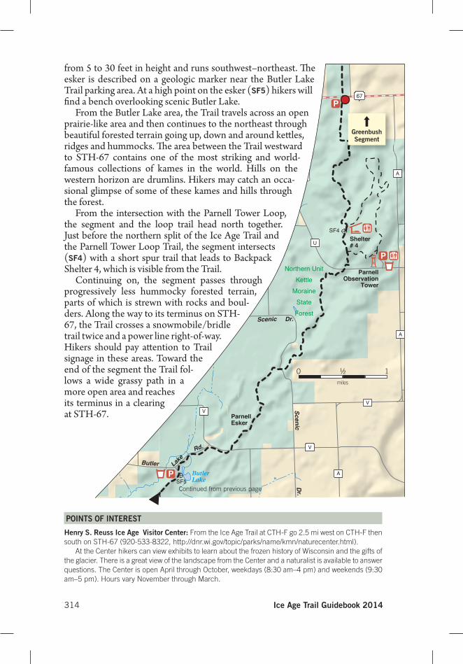
from 5 to 30 feet in height and runs southwest–northeast. Th e esker is described on a geologic marker near the Butler Lake Trail parking area. At a high point on the esker (SF5) hikers will fi nd a bench overlooking scenic Butler Lake.
From the Butler Lake area, the Trail travels across an open prairie-like area and then continues to the northeast through beautiful forested terrain going up, down and around kett les, ridges and hummocks. Th e area between the Trail westward to STH-67 contains one of the most striking and world-famous collections of kames in the world. Hills on the western horizon are drumlins. Hikers may catch an occa-sional glimpse of some of these kames and hills through the forest.
From the intersection with the Parnell Tower Loop, the segment and the loop trail head north together. Just before the northern split of the Ice Age Trail and the Parnell Tower Loop Trail, the segment intersects (SF4) with a short spur trail that leads to Backpack Shelter 4, which is visible from the Trail.
Continuing on, the segment passes through progressively less hummocky forested terrain, parts of which is strewn with rocks and boul-ders. Along the way to its terminus on STH-67, the Trail crosses a snowmobile/bridle trail twice and a power line right-of-way. Hikers should pay att ention to Trail signage in these areas. Toward the end of the segment the Trail fol-lows a wide grassy path in a more open area and reaches its terminus in a clearing at STH-67.
Continued from previous page
Greenbush Segment
0 1miles
½
PoInTS oF InTeReST
henry S. Reuss Ice Age Visitor Center: From the Ice Age Trail at CTH-F go 2.5 mi west on CTH-F then south on STH-67 (920-533-8322, http://dnr.wi.gov/topic/parks/name/kmn/naturecenter.html).
At the Center hikers can view exhibits to learn about the frozen history of Wisconsin and the gifts of the glacier. There is a great view of the landscape from the Center and a naturalist is available to answer questions. The Center is open April through October, weekdays (8:30 am–4 pm) and weekends (9:30 am–5 pm). Hours vary November through March.
Must-Have Ice Age Trail Books!
The Ice Age Trail Guidebook 2014 features more than 100 detailed segment-by-segment descriptions and maps to help you connect with the thousand-mile Ice Age National Scenic Trail. Written for those seeking a wide range of adventures on the Ice Age Trail, the softcover Guidebook includes these items and more:
- A detailed written description of each segment along the Ice Age Trail’s thousand-mile route. - A helpful map excerpt for each segment from the Ice Age Trail Alliance’s popular Ice Age Trail Atlas. - Ratings for each segment on a variety of criteria to help hikers find the Ice Age Trail excursion that’s right
for them. The Ice Age Trail Atlas 2014 is a set of 105 color, shaded relief–style maps at 1:48,000 scale. In contrast to the smaller map excerpts in the Ice Age Trail Guidebook 2014, each map in this package is printed on an 8.5” x 11” sheet and includes not just the Ice Age Trail route but also a wider snapshot of the area around the Trail. Both books were written and published by the Ice Age Trail Alliance. All proceeds for each book help build and maintain the Ice Age Trail. Please call the IATA at (800) 227-0046 with any questions. To order, visit www.iceagetrail.org or complete the order form below. Name: Address: City/State/Zip: Phone: Email: Item Quantity Price
Guidebook x $24 (members) or $30 (nonmembers) =
Atlas x $18 (M) or $22.50 (NM) =
Shipping $6 for one book, $1.50 extra for each additional book = Sales Tax 5.5% for orders shipped to a Wisconsin address = TOTAL = I have enclosed a check or money order payable to the Ice Age Trail Alliance Please charge my Visa or MasterCard
Card number: Please send this form to: Expiration date: Ice Age Trail Alliance Amount: 2110 Main Street Signature: Cross Plains, WI 53528
Related Documents