: A 2016 joint project of: • University of Florida GeoPlan Center • Florida Department of Agriculture and Consumer Services • 1000 Friends of Florida www.1000friendsofflorida.org/florida2070 • and Consumer Services • 1000 Friends of Florida

Welcome message from author
This document is posted to help you gain knowledge. Please leave a comment to let me know what you think about it! Share it to your friends and learn new things together.
Transcript

:A 2016 joint project of:• University of Florida GeoPlan Center• Florida Department of Agriculture and
Consumer Services• 1000 Friends of Florida
www.1000friendsofflorida.org/florida2070• and Consumer Services• 1000 Friends of Florida

1000 Friends of Florida
Founded in 1986, 1000 Friends is a
501(c)(3) not-for-profit
organization that focuses on
saving special places and building
better communities in one of the
fastest growing states in the
nation.
www.1000friendsofflorida.org
:
Florida Department of Agriculture and
Consumer Services
DACS supports and promotes Florida agriculture, protects the environment, safeguards consumers, and ensure the safety and wholesomeness of food. Our programs and activities are so varied and extensive, they touch the life of just about every Floridian.
www.freshfromflorida.org
Geoplan
Established in 1984, Geoplan is a multidisciplinary GIS laboratory located in the University of Florida’s School of Landscape Architecture and Planning, College of Design, Construction and Planning. It was developed in response to the need for a teaching and research environment for Geographic Information Systems, or GIS. Under its auspices spatial analysis is conducted in support of a broad range of academic disciplines.
www.geoplan.ufl.edu

Florida/Water 2070 IS:
• A GIS-based map series
• An airplane view of 2010
existing development and
water demand, and two
2070 projections based
on simple assumptions
• A foundation for future
GIS-based projects
• A tool to inform and
engage the general
public
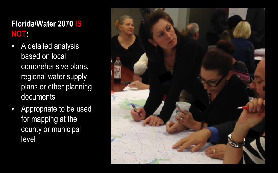
Florida/Water 2070 IS
NOT:
• A detailed analysis
based on local
comprehensive plans,
regional water supply
plans or other planning
documents
• Appropriate to be used
for mapping at the
county or municipal
level
WHY FLORIDA 2070?
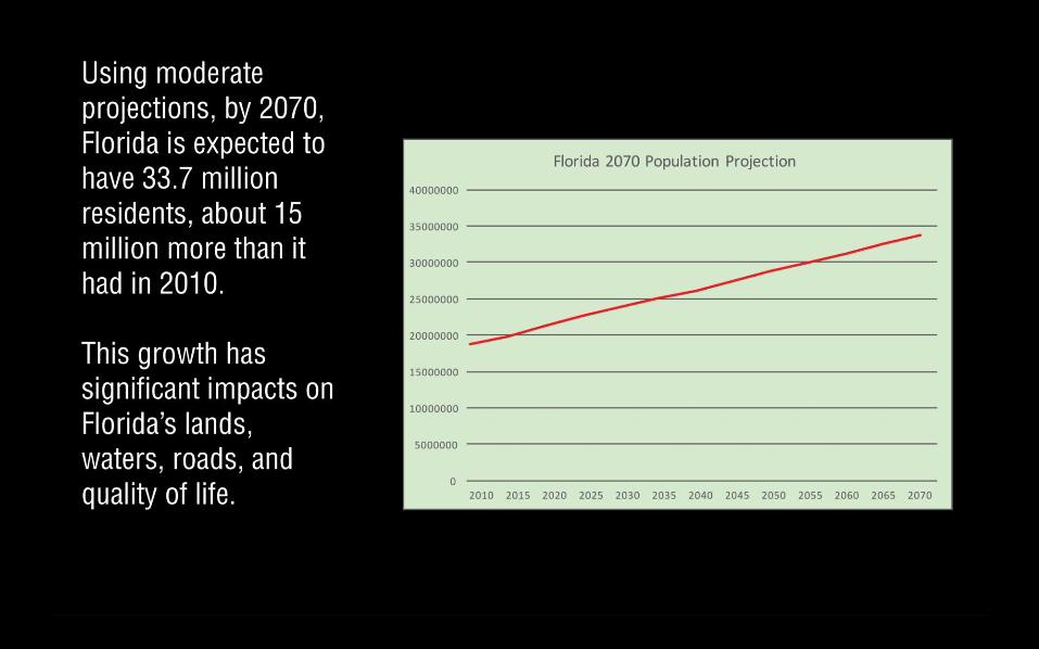

We are losing Florida’s
natural and agricultural
lands at an alarming rate.
Once again, more than
1000 people are moving
to Florida every day.
And in 2014, Florida’s
population surpassed
that of New York, making
it the third largest state in
the nation.
Stock.adobe.com
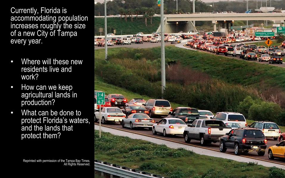
Currently, Florida is accommodating population increases roughly the size of a new City of Tampa every year.
• Where will these new residents live and work?
• How can we keep agricultural lands in production?
• What can be done to protect Florida’s waters, and the lands that protect them?
Reprinted with permission of the Tampa Bay Times. All Rights Reserved.
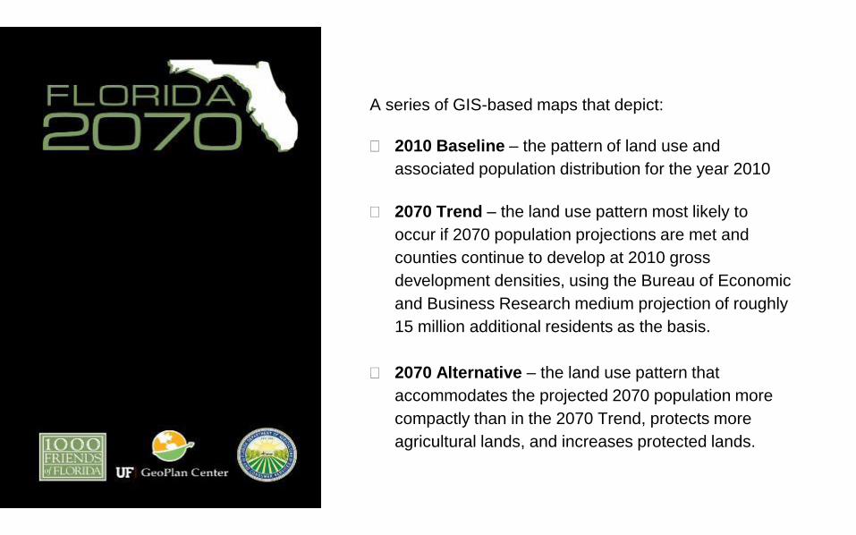
A series of GIS-based maps that depict:
2010 Baseline – the pattern of land use and
associated population distribution for the year 2010
2070 Trend – the land use pattern most likely to
occur if 2070 population projections are met and
counties continue to develop at 2010 gross
development densities, using the Bureau of Economic
and Business Research medium projection of roughly
15 million additional residents as the basis.
2070 Alternative – the land use pattern that
accommodates the projected 2070 population more
compactly than in the 2070 Trend, protects more
agricultural lands, and increases protected lands.


BASELINE 2010
Where was existing development, and conservation and other
lands in 2010?

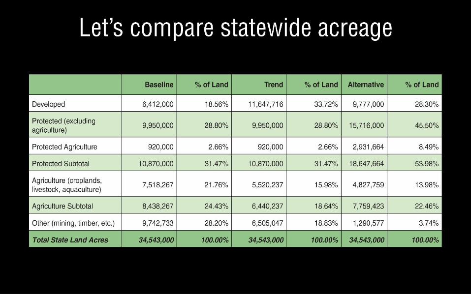
2010 BaselineAt the time of the U.S. Census in 2010, Florida had:
• 18.8 million residents
• 6.4 million acres of developed lands
• 9.95 million acres of protected lands (excluding agriculture)
• 920,000 acres of protected agricultural lands
• 7.5 million acres of agricultural lands (excluding timber)
• 9.5 million acres of other undeveloped lands

TREND 2070
What happens if current patterns of development remain the
same, and no new conservation lands are added?
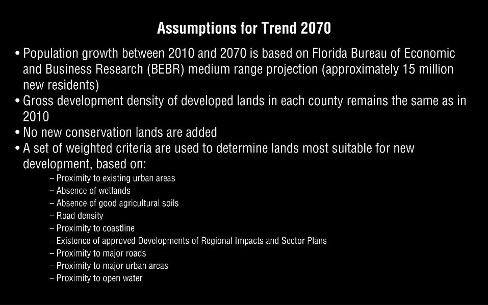
TREND 2070
What happens if current patterns of development remain the
same and no new conservation lands are added?
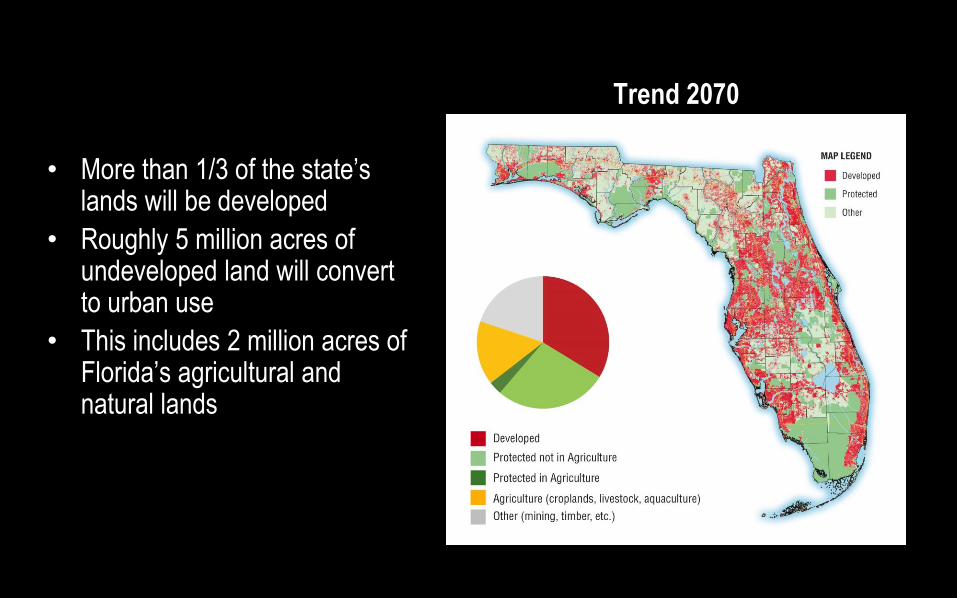
Trend 2070
• More than 1/3 of the state’s lands will be developed
• Roughly 5 million acres of undeveloped land will convert to urban use
• This includes 2 million acres of Florida’s agricultural and natural lands
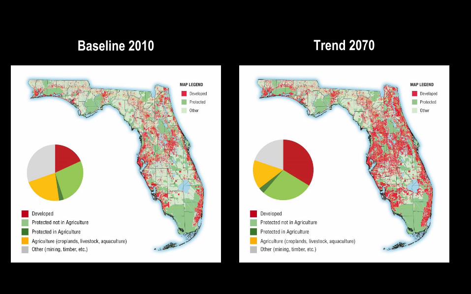
Baseline 2010 Trend 2070

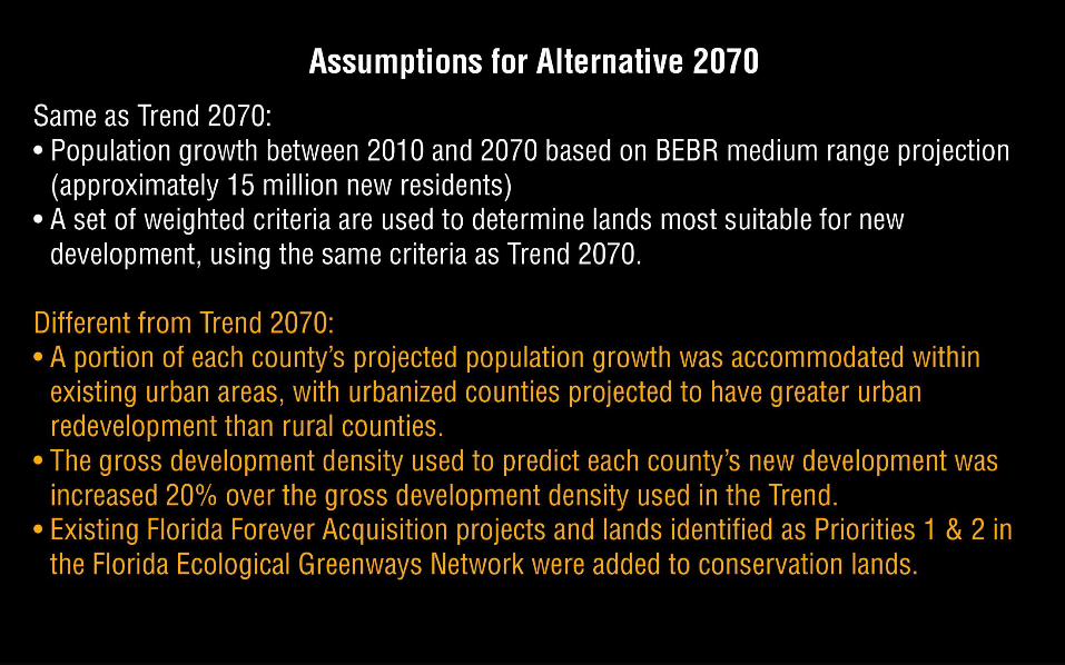
ALTERNATIVE 2070
What happens in 2070 if new development is more compact,
important conservation lands are protected, and good agricultural
lands aren’t developed?

Baseline 2010 Conservation & Working Lands Alternative 2070 Conservation Lands
With Florida Forever & Florida Greenways Priorities 1 and 2 Lands

Alternative 2070
• 1.8 million acres of land will be saved from development
• 5.8 million acres of conservation lands will be protected
• 1.1 million more acres of land will remain in agricultural production
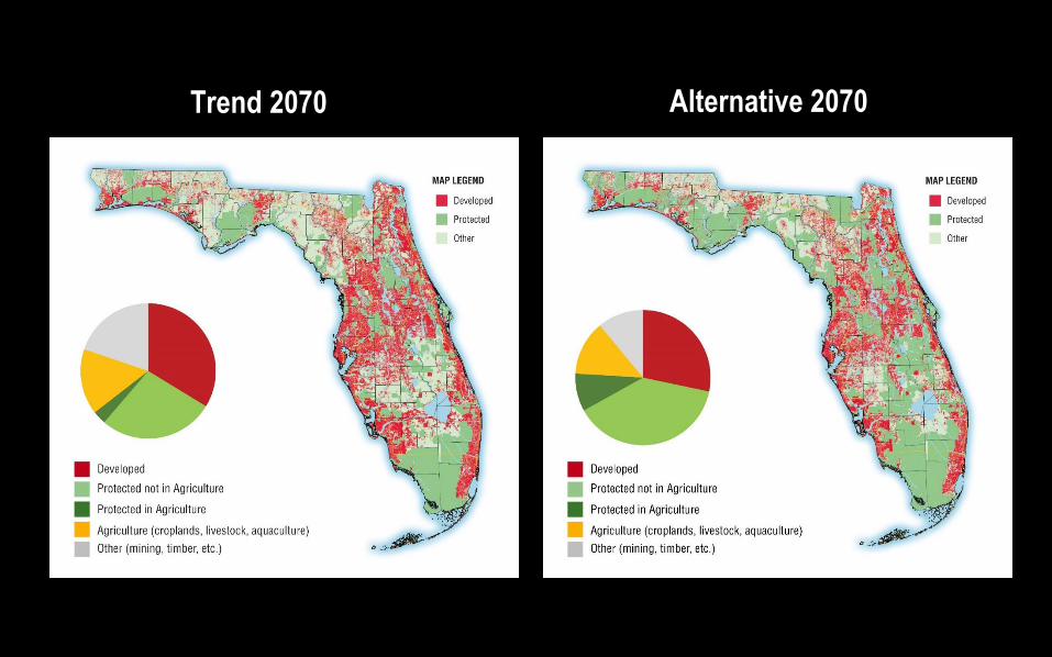
Trend 2070 Alternative 2070


:
HOW DO WE ACHIEVE A MORE SUSTAINABLE FUTURE? 1000 Friends of Florida

Save Special Places
• Protect vital conservation, agricultural and other working lands like those on Florida Forever and Florida Greenways lists
• Support funding for greenways and corridors that protect wildlife habitat and provide recreational opportunities
• Establish incentives and increase funding to help landowners conserve important agricultural lands and other working landscapes
• Work to significantly lessen the impact of new development on Florida’s lands and waters
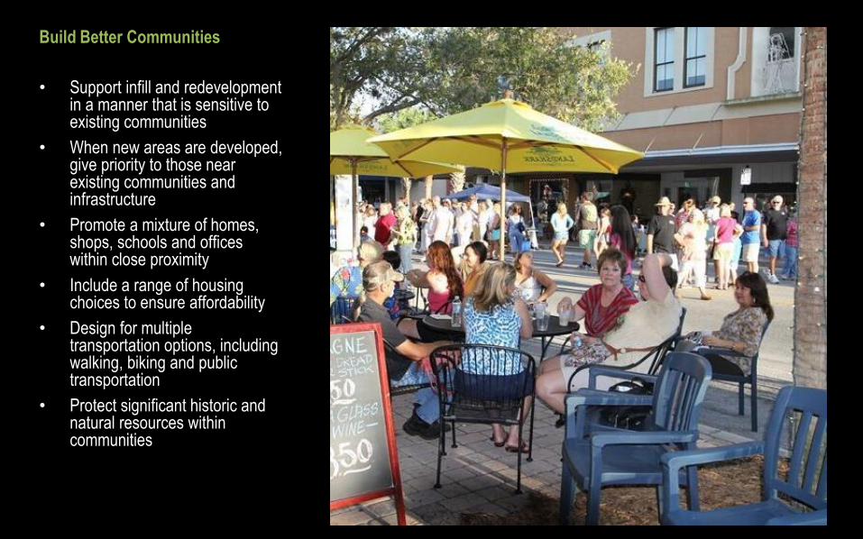
Build Better Communities
• Support infill and redevelopment in a manner that is sensitive to existing communities
• When new areas are developed, give priority to those near existing communities and infrastructure
• Promote a mixture of homes, shops, schools and offices within close proximity
• Include a range of housing choices to ensure affordability
• Design for multiple transportation options, including walking, biking and public transportation
• Protect significant historic and natural resources within communities

The project website includes presentations, summary reports, technical reports with methodology, downloadable maps and more:
www.1000friendsofflorida.org/florida2070
Detailed 1 ½ hour broadcasts on both Florida 2070 and Water 2070 are available at:
http://www.1000friendsofflorida.org/communications/past-webinars/
Related Documents