EARTH SURFACE PROCESSES AND LANDFORMS, VOL 22, 923–936 (1997) FLOODPLAIN SEDIMENTATION AND SENSITIVITY: SUMMER 1993 FLOOD, UPPER MISSISSIPPI RIVER VALLEY BASIL GOMEZ 1 , J. D. PHILLIPS 2 , F. J. MAGILLIGAN 3 AND L. A. JAMES 4 1 Department of Geography and Geology, Indiana State University, Terre Haute, Indiana 47809, USA 2 Department of Geography, Texas A&M University, College Station, TX77843, USA 3 Department of Geography, Dartmouth College, Hanover, New Hampshire 03755, USA 4 Department of Geography, University of South Carolina, Columbia, South Carolina 29208, USA Received 23 February 1996; Revised 6 September 1996; Accepted 11 October 1996 ABSTRACT Patterns of overbank sedimentation in the vicinity of, and far removed from, levee breaks that occurred in response to the >100 year, summer 1993 flood in the upper Mississippi River valley are elucidated. Two suites of overbank deposits were associated with the failure of artificial levees within a 70 km long study reach. Circumjacent sand deposits are a component of the levee break complex that develops in the immediate vicinity of a break site. As epitomized by the levee break complex at Sny Island, these features consist of an erosional, scoured and/or stripped zone, together with a horseshoe- shaped, depositional zone. At locales farther removed from the break site, the impact of flooding was exclusively depositional and was attributed to the settling of suspended sediment from the water column. The overall picture was one of modest scour at break sites and minimal suspended sediment deposition (<4 mm) at locales farther removed from the breach. Downriver from the confluence with the Missouri River, suspended sediment deposition was of a similar magnitude to that observed within the study reach and levee break complexes exhibited a similar morphology, but scour at break sites was greatly enhanced and the excavated sand formed extensive deposits on the floodplain surface. The different erosional response was probably engendered by the higher sand content and reduced aggregate cohesion of the floodplain soils downriver from the confluence with the Missouri River. A qualitative comparison serves to highlight the influence that the resistance threshold may have on the sensitivity of floodplains bordering large low-gradient rivers to high magnitude floods. Earth surf. process. landforms, 22, 923–936 (1997) No. of figures: 6 No. of tables: 0 No. of refs: 77 KEY WORDS: erosion thresholds; floods; floodplains; overbank deposition INTRODUCTION Floodplain sedimentation occasioned by any given overbank flow is known to be characterized by substantial spatial variability (Walling et al., 1992). Information about patterns of overbank deposition is required to facilitate understanding of floodplain development (Nanson and Croke, 1992), as well as to test models of sediment dispersal across floodplain surfaces and elucidate the fate of contaminated matter that is transferred to the floodplain environment (cf. James, 1985; Pizzuto, 1987; Howard, 1992; Bradley and Cox, 1986; Marron, 1989; Sahu et al., 1994; Nicholas and Walling, 1995). Event-based field studies typically yield at-a-point information about the likely range and magnitude of overbank sedimentation that is derived from sediment traps or post-flood surveys (e.g. Grover, 1938; Kesel et al., 1974; Brown, 1983; Gretener and Strömquist, 1987). Spatial variations in rates of overbank deposition averaged over a period of years have also been delineated through the use of environmental radionuclides, such as 137 Cs (Walling et al., 1992). However, even on a flood- by-flood basis, little is known about the large-scale spatial variability of overbank sedimentation because limitations on sampling densities practicably confine field surveys to parcels of land that typically are of the order of a few square kilometres in area (cf. Asselman and Middelkoop, 1995; Simm, 1995). * Correspondence to: B. Gomez Contract grant sponsor: National Science Foundation; Contract grant number: SBR 9403479 CCC 0197-9337/97/100923–14 $17.50 1997 by John Wiley & Sons, Ltd.

Welcome message from author
This document is posted to help you gain knowledge. Please leave a comment to let me know what you think about it! Share it to your friends and learn new things together.
Transcript

EARTH SURFACE PROCESSES AND LANDFORMS, VOL 22, 923–936 (1997)
FLOODPLAIN SEDIMENTATION AND SENSITIVITY: SUMMER 1993FLOOD, UPPER MISSISSIPPI RIVER VALLEY
BASIL GOMEZ1, J. D. PHILLIPS2, F. J. MAGILLIGAN 3 AND L. A. JAMES4
1 Department of Geography and Geology, Indiana State University, Terre Haute, Indiana 47809, USA2 Department of Geography, Texas A&M University, College Station, TX77843, USA
3 Department of Geography, Dartmouth College, Hanover, New Hampshire 03755, USA4 Department of Geography, University of South Carolina, Columbia, South Carolina 29208, USA
Received 23 February 1996; Revised 6 September 1996; Accepted 11 October 1996
ABSTRACT
Patterns of overbank sedimentation in the vicinity of, and far removed from, levee breaks that occurred in response to the>100 year, summer 1993 flood in the upper Mississippi River valley are elucidated. Two suites of overbank deposits wereassociated with the failure of artificial levees within a 70km long study reach. Circumjacent sand deposits are a componentof the levee break complex that develops in the immediate vicinity of a break site. As epitomized by the levee breakcomplex at Sny Island, these features consist of an erosional, scoured and/or stripped zone, together with a horseshoe-shaped, depositional zone. At locales farther removed from the break site, the impact of flooding was exclusivelydepositional and was attributed to the settling of suspended sediment from the water column. The overall picture was one ofmodest scour at break sites and minimal suspended sediment deposition (<4mm) at locales farther removed from thebreach.
Downriver from the confluence with the Missouri River, suspended sediment deposition was of a similar magnitude tothat observed within the study reach and levee break complexes exhibited a similar morphology, but scour at break siteswas greatly enhanced and the excavated sand formed extensive deposits on the floodplain surface. The different erosionalresponse was probably engendered by the higher sand content and reduced aggregate cohesion of the floodplain soilsdownriver from the confluence with the Missouri River. A qualitative comparison serves to highlight the influence that theresistance threshold may have on the sensitivity of floodplains bordering large low-gradient rivers to high magnitudefloods.
Earth surf. process. landforms, 22, 923–936 (1997)No. of figures: 6 No. of tables: 0 No. of refs: 77KEY WORDS: erosion thresholds; floods; floodplains; overbank deposition
INTRODUCTION
Floodplain sedimentation occasioned by any given overbank flow is known to be characterized by substantialspatial variability (Walling et al., 1992). Information about patterns of overbank deposition is required tofacilitate understanding of floodplain development (Nanson and Croke, 1992), as well as to test models ofsediment dispersal across floodplain surfaces and elucidate the fate of contaminated matter that is transferred tothe floodplain environment (cf. James, 1985; Pizzuto, 1987; Howard, 1992; Bradley and Cox, 1986; Marron,1989; Sahu et al., 1994; Nicholas and Walling, 1995). Event-based field studies typically yield at-a-pointinformation about the likely range and magnitude of overbank sedimentation that is derived from sedimenttraps or post-flood surveys (e.g. Grover, 1938; Kesel et al., 1974; Brown, 1983; Gretener and Strömquist, 1987).Spatial variations in rates of overbank deposition averaged over a period of years have also been delineatedthrough the use of environmental radionuclides, such as 137Cs (Walling et al., 1992). However, even on a flood-by-flood basis, little is known about the large-scale spatial variability of overbank sedimentation becauselimitations on sampling densities practicably confine field surveys to parcels of land that typically are of theorder of a few square kilometres in area (cf. Asselman and Middelkoop, 1995; Simm, 1995).
* Correspondence to: B. GomezContract grant sponsor: National Science Foundation; Contract grant number: SBR 9403479
CCC 0197-9337/97/100923–14 $17.50 1997 by John Wiley & Sons, Ltd.
924 B. GOMEZ ET AL.
Figure 1. (A) Location of study reach and the sites of other levee break complexes referred to in the text. C=Columbia Levee,K=Kaskaskia Island Levee, and L=Len Small Levee. (B) Levee and drainage districts, principal towns and the location of break siteswithin the study reach referred to in the text. Figures in parentheses indicate the areal extent of flooding (km2). The dashed box indicates
the location of Figure 6.
The purpose of this paper is to elaborate on the pattern of overbank sedimentation associated with the pointfailure of artificial levees during the summer 1993 flood in the upper Mississippi River basin. These failuresinundated clearly delineated, 16 to 179km2 sections of the floodplain (Figure 1). The point failure of an artificiallevee mimics flood-basin inundation following the formation of crevasses in a natural levee. In this overbankenvironment, sediment transport and the resulting pattern of deposition are conditioned by water and sedimentdelivered from a discrete source (cf. Popov and Gavrin, 1970; Knight, 1975; O’Brien and Wells, 1986; Farrell,1987). We draw on information about the nature, magnitude and spatial variability of the overbank depositsderived from post-flood field surveys and a calibrated TM image (Gomez et al., 1995). Specifically we focus on:(i) the levee break complex at Sny Island and; (ii) the aggregate pattern of overbank deposition within the20·2km2 Union Township Levee and Drainage District. We also examine the sensitiviy of the riparianlandscape in the upper Mississippi River valley to the summer 1993 flood by comparing the response of thefloodplain in the study reach to that of the floodplain reaches further downriver, in the vicinity of breaks in theKaskaskia Island, Columbia and Len Small levees (Chrzastowski et al., 1994; Jacobson and Oberg, in press).
EARTH SURFACE PROCESSES AND LANDFORMS, VOL. 22, 923–936 (1997) 1997 by John Wiley & Sons, Ltd.

925FLOODPLAIN SEDIMENTATION
Figure 2. Hourly stage record at Quincy during July 1993, showing the effect of levee failures upriver (the reference level is provided by anarbitrary datum). The discontinuity in the stage record on 23 July was caused by a barge colliding with the gauge house. The stage recordfor Hannibal (dotted line) is superimposed to show the effect of the failure of the Sny Island Levee; the higher pre-failure stage is due tobackwater effects upriver of the railway bridge at Hannibal. Inset shows the record of mean daily stage at Quincy for the 1992–3 water
year. The dashed line indicates flood stage (5·18m) and the stippled bar the duration of the summer 1993 flood.
SUMMER 1993 FLOODING AND THE STUDY REACH
The highest frequency of flooding in the upper Mississippi River basin as a whole is associated with the spring(April–June) snowmelt season, although the largest magnitude floods in the smaller tributary basins (of theorder of a several hundred square kilometres in area) tend to occur during the summer months (June–August) inresponse to high-intensity excess rainfall (Knox, 1988). By contrast, the summer 1993 flood had its origins in anextended period of wet weather that began in the autumn of 1992 (Dowgiallo, 1994); it did not develop from asingle catastrophic event. The pattern of wetter than average weather persisted over the upper midwesternUnited States for the first six months of 1993 and culminated with a series of intense storms in late June and July(Wahl et al., 1993). The storms arose from the highly anomalous circulation evident throughout much of thenorthern hemisphere that locally allowed the easterly flowing jet stream and its associated surface front, whichspawned the recurrent thunderstorm systems, to establish a quasi-stationary position over the northern portionof the Mississippi River basin (Dowgiallo, 1994). These climatic conditions were similar to those that prefacedthe spring 1973 flood (Chin et al., 1975; Wahl et al., 1993; Parrett et al., 1993).
Numerous gauging stations in the upper Mississippi River basin recorded record peak discharges during thesummer of 1993, including gauges on the Mississippi River throughout the 300km long reach between Keokuk,Iowa, and St Louis, Missouri, where the recurrence interval of the flood was >100 years (Parrett et al., 1993).Our survey of the geomorphological effects of the 1993 flood focused on the 70km long reach between Keokuk,Iowa, and Hannibal, Missouri (Figure 1). At Keokuk, the Mississippi River drains an area of 308000km2.During the summer 1993 flood the peak discharge of 12320m3 s−1 was about 20 per cent larger than the previous
1997 by John Wiley & Sons, Ltd. EARTH SURFACE PROCESSES AND LANDFORMS, VOL. 22, 923–936 (1997)

926 B. GOMEZ ET AL.
maximum recorded (1973: 9735m3 s−1) and estimated (1851: 10195m3 s−1) peak discharges. The flood peakpassed through the study reach between 10 and 16 July. At Quincy, Illinois, which is located in the centralportion of the study reach, the river crested 4·6m above flood stage (5·18m) on 13 July. However, the stage didnot begin to fall appreciably until 25 July and the river remained above flood stage for 101 consecutive days(Figure 2).
Within the study reach the river channel is about 1km wide. The floodplain ranges from 8 to 12km wide andis bordered by prominent bluffs. Its very subdued relief (typically <3m) has been reinforced by agriculturalactivity. Upriver from the confluence with the Missouri River, the sediment load of the Mississippi Riverconsists predominantly of silt- and clay-sized material, and the floodplain soils are very cohesive (cf. Bushue,1979). Prior to and throughout the historic period, the position of the river has remained stable (Van Nest, 1990),but navigation and flood protection works undertaken over the past 150 years have constricted the main channel,decoupled the river from its floodplain, and locally enhanced flood stages (Belt, 1975; Chin et al., 1975; Chenand Simons, 1986). However, long-term trends in flooding in the upper Mississippi River basin are stronglycorrelated with a coincident increase in average annual precipitation (Knapp, 1994).
During the summer 1993 flood, 1082 of the 1576 federal and non-federal levees within the Missouri andupper Mississippi river basins failed, flooding some 93000km2 of land. Within the study reach, all or part of 11levee and drainage districts, accounting for 630km2 of protected floodplain (Figure 1), and >200km2 ofunleveed floodplain, were inundated. Along the upper Mississippi River the crown elevation of main-channellevees corresponds to a minimum 50 year flood design with 0·61m freeboard, although the design criteria forlevees protecting urban and industrial areas are more rigorous than those for agricultural levees. For agriculturallevees within the study reach, the design flood typically corresponds to a river stage of c. 8m (cf. Figure 2). Thelevees typically are linear features of the order of 5 to 7m high, with 1:3 to 1:5 river and floodplain side slopes,and a c. 3m wide crown. They are 40 to 50m wide at the base and are constructed from locally availablematerial dredged from the river or excavated from the floodplain. During the summer of 1993, the crown ofvulnerable sections of many levees was temporarily raised by steepening the floodplain side slope profile. AtSny Island, the crown elevation at several locations was increased by vertical boards backed by sandbags, thatwere draped with plastic sheeting to protect against wave action (cf. Stewart, 1993).
Levee failures within the study reach occurred primarily as a consequence of overtopping linked with wave-induced surface erosion rather than structural failure, but a number of saturation-induced mass failures wereprecipitated by the high flood stages that persisted for much of July. In particular, side slope seepage andunderseepage were recurrent problems along the Sny Island levee, and were probably responsible for itseventual failure (Chrzastowski et al., 1994). Because the levee systems compartmentalized the floodplain, thefailure of any given main-channel levee was associated with flooding within a well-defined area, the integrity ofwhich was preserved because the crowns of the encircling levees projected above the impounded floodwater(cf. Gomez et al., 1995). Depending on the size of the area involved, water levels in the river and on thefloodplain were equalized over a period of 7 to 15h (Figure 2). Thereafter the transfer of water and sedimentacross the channel–floodplain boundary was curtailed and the breach deactivated because there was no outletfor the floodwater.
FIELD SURVEY AND REMOTE SENSING
We made a preliminary aerial reconnaissance of the study reach in November 1993. On the basis of thisappraisal we undertook a detailed field survey of three sections of leveed floodplain and a 15km long section ofunleveed floodplain in the vicinity of Canton, Missouri, in the winter of 1993–1994. The levee break complex atSny Island levee and the Union Township Levee and Drainage District were selected for detailed study becausethe respective failures occurred following and in advance of the passage of the flood peak through the studyreach (Figure 2). Both levee break complexes displayed a similar morphology, although the Sny Island complexwas much larger than the other levee break complexes in the study reach. The fields in the vicinity of the breaksites were planted with row crops (soya beans or maize).
At each break site we profiled and determined the depth of the circumjacent sand deposits by probing anddigging shallow pits along a series of some five to ten transects. High-water marks on trees and buildings within
EARTH SURFACE PROCESSES AND LANDFORMS, VOL. 22, 923–936 (1997) 1997 by John Wiley & Sons, Ltd.

927FLOODPLAIN SEDIMENTATION
view of a break site were also surveyed. The summer 1993 flood deposits typically were separated from the pre-existing soil by crop residue, and could also be differentiated on the basis of colour. We sampled and measuredthe thickness of the overbank (sand and silt) deposits in soil pits dug at c. 100m intervals along a 1km longprofile originating at the break site, and recorded the thickness of sediment present at numerous (>100) otherrandomly selected locations on the floodplain. No corrections for moisture content were made because the flooddeposits had dried out by the time our field surveys were undertaken. Particle-size distributions weredetermined by dry sieving and/or laser granulometry.
Remotely sensed data have long been used to provide a synoptic perspective on flooding (e.g. Rango andSalomonson, 1974), and spectral reflectance affords the potential for deriving estimates of suspended sedimentconcentration in the surface water (e.g. Ritchie and Cooper, 1988; Stumpf and Pennock, 1989; Mertes et al.,1993). A Landsat 5 Thematic Mapper (TM) image (path 25 row 32) was analyzed to derive estimates of near-surface suspended sediment concentration in the floodwater (Gomez et al., 1995). The image was acquired priorto the failure of the Sny Island levee, on the morning of 25 July, one to two weeks after most of the levees in thestudy reach failed. Nevertheless, the overall pattern of sedimentation was preserved by virtue of the low settlingvelocity of the clay particles in suspension (cf. Mehta et al., 1989) and because, once a break was deactivated,the continuous transfer of water and sediment across the channel–floodplain boundary was hindered by thecrowns of levees which projected above the floodwater. Gomez et al., (1995) noted that the pattern of suspendedsediment transport across the floodplain was dominated either by a sediment plume originating at the break site,or a large-scale eddy that probably reflected the wind-driven circulation pattern that developed within theshallow, ponded floodwater (cf. Liggett and Hadjitheodorou, 1968).
Mertes et al. (1993) showed that after nominal calibration to water-surface reflectance, near-surfacesuspended sediment concentrations could be estimated for each 30×30m pixel using linear spectral mixtureanalysis. Reflectance spectral end-members were based on data for a variety of sediment/water mixtures, andthe end-member fractions were related to absolute sediment concentrations using a non-linear calibration curve(Mertes et al., 1993; Mertes, 1994). Although the exact relation between surface and depth-integratedconcentrations depends on local boundary shear stress, water depth and sediment size (McLean, 1992), near-surface suspended sediment concentrations approximate depth-average concentrations in shallow (<10m deep)water (Ongley et al., 1990; Mertes et al., 1993). It was also assumed that all of the sediment in the water columnsettled out and the post-flood peak slack-water near-surface sediment concentrations could be used tocharacterize the loading during inundation. In such circumstances, if the depth of the water column is known,and in the absence of the continuous transfer of water and sediment onto the floodplain, the surfaceconcentrations in the floodwater convert directly to an estimate of sediment thickness. The spatial distributionof overbank deposits within the 20km2 Union Township Levee and Drainage District was mapped on this basis.
SNY ISLAND LEVEE BREAK COMPLEX
The Sny Island levee break complex covered an area of abou 2km2 in the immediate vicinity of the break site(Figure 3). It comprised a localized zone of concentrated scour, a more extensive zone of superficial stripping,and a circumjacent depositional zone. The levee borders McDonald Chute and is separated from the mainchannel by McDonald Island at low flows, but at the time the levee failed the depth of flow over the island wasabout 3m. Although the final width of the break was about 1000m, significant scour occurred only in thevicinity of the initial failure. The principal scour hole was of the order of 125m long, 20m wide and <2m deep,and assumed the generalized form of the inverted frustum of an elliptical cone, with the deepest portion of thescour hole located on the floodplain side of the levee, downstream of the vena contracta (cf. Das, 1973). Thevolume of the scour hole was about 4000m3. On the river side of the levee, scour upstream of the vena contractadirectly linked the break site with the chute. Several smaller, secondary scour holes apparently developed on theopposing side of the breach as it widened, so that a pothole scour pattern was evidenced on the floodplain over adistance of about 300m within the general vicinity of the initial break.
The 0·1 to 0·5m deep spur-and-furrow topography of the stripped zone was the most prominent erosionalfeature associated with the levee break at Sny Island. Stripped zones characteristically develop in the vicinity oflevee breaks (cf. Bhowmik, 1994; Chrzastowski et al., 1994; Jacobson and Oberg, in press). They extend
1997 by John Wiley & Sons, Ltd. EARTH SURFACE PROCESSES AND LANDFORMS, VOL. 22, 923–936 (1997)

928 B. GOMEZ ET AL.
Figure 3. Levee break complex at Sny Island. The length of the section of levee shown in the photograph is about 2·25km. P=potholescour in the vicinity of the initial failure, S=stripped zone, R=sand rim, and Ss=sand sheet. A–A’ indicates the location of the transect
depicted in Figure 5.
beyond the scour zone and, if a break widens, supplant localized scour as flow through the breach becomesmore diffuse. The pattern of spur-and-furrow topography in the stripped zone of the Sny Island levee breakcomplex primarily reflected the orientation of old plough furrows (running perpendicular to the levee), whichprobably helped concentrate the floodwater and initially accentuated erosion. However, flume experimentshave demonstrated that analogous erosional bed features can also develop on initially plane, cohesive surfaces(Partheniades, 1965; Allen, 1969).
Two-dimensional model simulations of flooding in impounded areas following the point failure of artificiallevees (e.g. Memos et al., 1983; Popovska, 1989), and real-time video coverage of the failure (on 16 July) of theFabius River levee provided an insight into the manner in which the floodwater spread across the floodplain.The hydrogeomorphological characteristics of flooding in the region near to the break, where the flow isdominated by inertial effects, differ from those in regions farther removed from the break site, where thefloodplain topography and soil properties exert a fundamental control on the flow. When a levee fails, water isreleased through the breach in the form of a jet. The accelerating flow promotes scour in the vicinity of thebreak, that typically widens with time. A quasi-stable flow depth that is slightly less than the level of water in thechannel is maintained at the levee. Away from the break site, the flow depth initially decreases with increasingdistance across the floodplain. Near the wave-front the flow may locally become supercritical in the early stagesof flooding. Reversion to a subcritical condition is marked by a hydraulic jump. On a plane surface the wave-front assumes an approximately semi-circular form, but its exact configuration and position are determined bythe local floodplain topography and soil properties. Frictional energy losses help to increase the flow depthbehind the wave-front as it spreads out across the floodplain. Once the wave-front reaches the floodplainboundaries the water depth increases in a more uniform manner. Depth continues to increase until the pressuregradient across the channel–floodplain boundary approaches zero and the breach is deactivated.
Little bed material encroached onto the floodplain through the breaks; overbank sedimentation is related tobank height (Harvey and Schumm, 1994). In the case of the break sites we examined, the transfer of sedimentfrom the river onto the floodplain was inhibited by nearly vertical, 1 to 2m high banks, as well as by the general
EARTH SURFACE PROCESSES AND LANDFORMS, VOL. 22, 923–936 (1997) 1997 by John Wiley & Sons, Ltd.
929FLOODPLAIN SEDIMENTATION
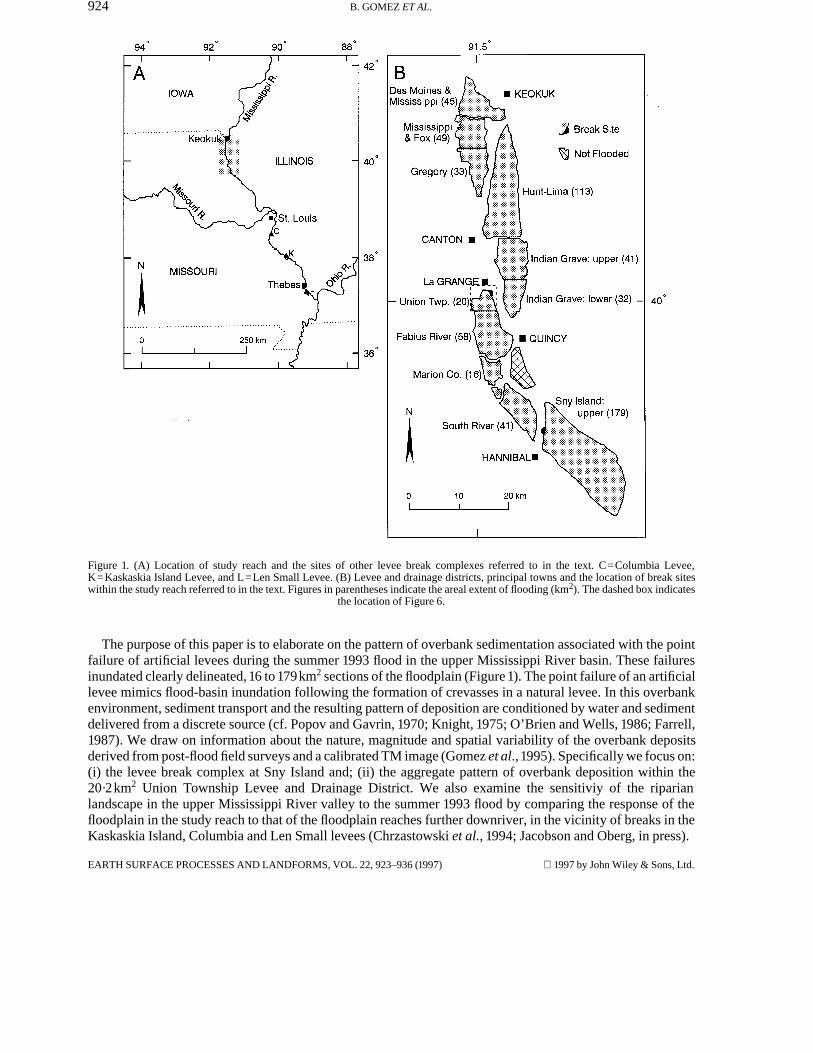
Figure 4. (A) Composite particle size distribution of the sand deposits within the levee break complex at Sny Island. The particle sizedistribution of a sample of levee sand is shown for comparison. (B) Composite particle size distribution of overbank deposits within theUnion Township Levee and Drainage District. A composite curve for silt deposits found on unleveed sections of the floodplain adjacent to
the main channel is shown for comparison.
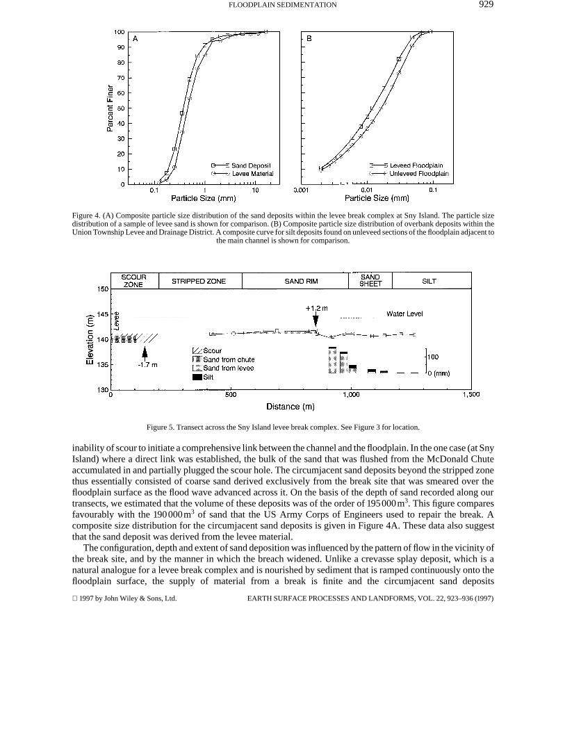
Figure 5. Transect across the Sny Island levee break complex. See Figure 3 for location.
inability of scour to initiate a comprehensive link between the channel and the floodplain. In the one case (at SnyIsland) where a direct link was established, the bulk of the sand that was flushed from the McDonald Chuteaccumulated in and partially plugged the scour hole. The circumjacent sand deposits beyond the stripped zonethus essentially consisted of coarse sand derived exclusively from the break site that was smeared over thefloodplain surface as the flood wave advanced across it. On the basis of the depth of sand recorded along ourtransects, we estimated that the volume of these deposits was of the order of 195000m3. This figure comparesfavourably with the 190000m3 of sand that the US Army Corps of Engineers used to repair the break. Acomposite size distribution for the circumjacent sand deposits is given in Figure 4A. These data also suggestthat the sand deposit was derived from the levee material.
The configuration, depth and extent of sand deposition was influenced by the pattern of flow in the vicinity ofthe break site, and by the manner in which the breach widened. Unlike a crevasse splay deposit, which is anatural analogue for a levee break complex and is nourished by sediment that is ramped continuously onto thefloodplain surface, the supply of material from a break is finite and the circumjacent sand deposits
1997 by John Wiley & Sons, Ltd. EARTH SURFACE PROCESSES AND LANDFORMS, VOL. 22, 923–936 (1997)
930 B. GOMEZ ET AL.
characteristically take the form of a horseshoe-shaped sand rim that encircles the stripped zone (Figure 3). AtSny Island, the sand rim had a gently ramped backslope, several hundred metres long, that terminated in a well-defined slip face (Figure 5). Sand thicknesses of 0·15 to 1·3m were typically observed at the crest, the locationof which was probably constrained in the period immediately following failure by the position of the hydraulicjump that marked the transition to rapidly decelerating, divergent flow on the floodplain. The traction carpet inthe zone of divergent flow is manifest by a splay-like sand sheet or discontinuous sand streaks that extend outacross the floodplain beyond the leading edge of the sand rim (Figure 3). Where the sand sheet was not present,there was an abrupt transition between the leading edge of the sand rim and the surrounding, undisturbedfloodplain surface. In other locations, although the transition appeared abrupt, the sand sheet was draped withsilt which had settled from suspension (Figure 3). However, there were no obvious horizontal laminationswithin this silt unit or within any of the other silt deposits we scrutinized, which were all massively bedded (cf.Singh, 1972; Ray, 1976).
Features that exhibited essentially the same configuration (but which were neither as large nor as wellpreserved) as the levee break complex at Sny Island were associated with all of the levee breaks in the studyreach (cf. Figure 5). They exemplify the erosional effects of flooding and the suite of sediments present in theregion near to a break. At locales farther removed from the break site, the impact of flooding was entirelydepositional, and was primarily a function of the settling of suspended sediment from the water column after thebreak had been deactivated. A silt deposit, a few millimetres thick, draped the leading edge of the sand rim andthe sand sheet that encircled the Sny Island break site (Figure 3), and a barely detectable veneer of silt waspresent at most surveyed locations on the floodplain that were far removed (>1·5km) from the break site.
SUSPENDED SEDIMENT DEPOSITS AT UNION TOWNSHIP
The break in the Union Township levee was <100m wide and the associated levee break complex covered anarea of some 0·01km2. As estimated from the calibrated TM image, the magnitude and pattern of suspendedsediment deposition resulting from the failure of the levee on 7 July are shown in Figure 6. For each of the fourzones delimited in Figure 6, the magnitude (though not the extent) of the fine sediment deposition wascorroborated by the point-specific field survey we conducted before the image was processed. The sizedistribution of the deposits is characterized by the composite curve presented in Figure 4B. The depth ofsediment was greatest in the region immediately beyond the break site, where the impact of scour and strippingon the cohesive floodplain soils was most pronounced and towards which the main body of flow from the breaksite was presumably directed. Effects due to overtopping of the levee at other sites can also be discerned inFigure 6. On natural floodplains the decrease in the depth of overbank deposits with increasing distance from ariver is well known, and previous field surveys on leveed floodplains have revealed that the depth of overbankdeposits also decreases with increasing distance from a break site (e.g. Grover, 1938). Such observations arealso consistent with theory (e.g. Bursik, 1995). However, this is the first time that the aggregate pattern ofsediment deposition has been revealed. The amount of deposition is typical of the other (leveed and unleveed)locales we investigated, and our field survey suggests that it is also typical of the study reach as a whole.Commensurate with the timing of the summer 1993 flood, the small amount (typically a few millimetres) ofoverbank suspended sediment deposition that characterized this >100 year event was linked with low sedimentconcentrations in the main channel rather than the isolation of the floodplain from the main channel by levees(Gomez et al., 1995).
FLOODPLAIN SENSITIVITY
The preceding case studies typify the erosional and depositional impact that the summer 1993 flood had on thestudy reach. Within the study reach, cohesive floodplain soils helped limit scour at break sites and there was nosubstantive channel change, suggesting that the resistance of the riparian landscape to erosion generallyexceeded the erosive power of the summer 1993 flood. There is a correlation between the rate of energydissipation of flowing water and hydraulic erodibility (Annandale, 1995), and the effect that large floods haveon river and floodplain morphology has long been recognized (Melton, 1936). Resistance to erosion is
EARTH SURFACE PROCESSES AND LANDFORMS, VOL. 22, 923–936 (1997) 1997 by John Wiley & Sons, Ltd.

931FLOODPLAIN SEDIMENTATION
Figure 6. Spatial variation of the depth of overbank deposits within the Union Township Levee and Drainage District, south of La Grange,Missouri, derived and mapped from a calibrated TM image acquired on 25 July 1993 (Gomez et al., 1995). See text for explanation. Landabove 150m in elevation (cross-hatched) and to the west of State Highway 61 was not flooded. The extent of the levee break complex isindicated by the semi-circle that surrounds the break site (arrowed). Other locations where overtopping of the main channel leveeoccurred are also arrowed. Figures adjacent to the solid triangles indicate the mean depth of water on the floodplain. See Figure 1B for
location.
acknowledged to be a major factor determining the riparian landscape’s response to large, rare floods (Bull,1979; Brunsden, 1993), and Costa and O’Connor (1995) have commented on the dissimilar impact on channelsand floodplains that floods of a similar magnitude and frequency often evince. Such comparisons are usuallyeffected by considering the impact of different flood events on different river systems or, occasionally, theimpact of different floods on the same river system (cf. Huckleberry, 1994). The summer 1993 flood afforded anopportunity to contrast the response of different sections of the Mississippi River floodplain to a single high-magnitude event.
The Missouri River transports a higher proportion of sand than the Mississippi River, and downriver fromthe confluence with the Missouri River the floodplain soils contain a correspondingly higher proportion of sand(Parks and Fehrenbacher, 1968; Higgins, 1987; Miles, 1988). Typically, although a shallow (<1m deep)cohesive top-stratum characteristically is present, these soils are less cohesive than the soils in the study reachand the position of the channel is known to have changed frequently throughout the Holocene, as well as within
1997 by John Wiley & Sons, Ltd. EARTH SURFACE PROCESSES AND LANDFORMS, VOL. 22, 923–936 (1997)

932 B. GOMEZ ET AL.
the historic period, primarily in response to cutoff development (cf. Fisk, 1944; Chrzastowski et al., 1994;Jacobson and Oberg, in press). Record stages were recorded as far downriver as Thebes, Illinois, and the floodwas equally protracted, although downriver from St Louis the recurrence interval of the 1993 flood wassubstantially less than 100 years (Parrett et al., 1993; Bhowmik, 1994). Low flows in the Ohio River and anincrease in channel capacity were responsible for the additional reduction in the magnitude of the summer 1993flood that was experienced downriver from Cairo, Illinois (Dowgiallo, 1994). Under normal flow conditionstwo-thirds of the flow downriver from Cairo is contributed from the Ohio River.
Chrzastowski et al. (1994) and Jacobson and Oberg (in press) have described the levee break complexes thatwere associated with the failure of the Kaskaskia Island and Columbia levees, and the Len Small levee insouthwest Illinois (Figure 1). The pattern of floodplain landuse in these areas was similar to that in the studyreach. In as much as they were characterized by erosion and depositional patterns that embodied distinctscoured, stripped and depositional zones, their morphology was similar to that of levee break complexes in thestudy reach (cf. Jacobson and Oberg, in press). Low sediment concentrations in the main channel also reducedthe transfer of suspended sediment to the floodplain and, where it was recognized, suspended sedimentdeposition was of a similar magnitude to that observed in the Union Township Levee and Drainage District.
The width of levee breaks in the reach downriver from St Louis typically was similar to that observed in thestudy reach but, by contrast, large, deep scour holes developed before the breach was deactivated, and thick,extensive sand deposits were left on the floodplain in the vicinity of and beyond break sites. In the case of theKaskaskia Island levee break, the maximum depth of scour across the levee axis at the vena contracta was>15·25m, and the total volume of the scour hole was >800000m3. At Columbia, the circumjacent sand deposit,that was mapped to a minimum thickness of 0·15m (maximum thickness 2·44m), covered an area of about3km2 and extended up to 2·4km beyond the break site. Both breaks were of the order of 150m wide, and thescour failed to connect the break sites directly to the main channel. Thus the bulk of the sand deposited on thefloodplain was derived from the scour holes (Chrzastowski et al. 1994).
Oberg and Jacobson (1994) characterized the continuously active break and the associated scour in the MillerCity Levee and Drainage District as an incipient meander cutoff. As much as 8100m3 s−1 of water flowedthrough the breach, bypassing a 31km long, high-amplitude meander bend before re-entering the main channel.The scour connected the break site directly to the main channel and the flow excavated an irregular channel,2·2km long and up to 25m deep, across the floodplain, which was able to accommodate c. 25 per cent of thedischarge of the Mississippi River. This channel facilitated the transfer of sediment from the river to thefloodplain in the same manner as a natural crevasse. In excess of 80km2 of floodplain land were inundated bythe failure of the Len Small levee (Jacobson and Oberg, in press). Sand deposits were estimated to cover an areaof 75km2 and some 7·6km2 were subject to scour or stripping. Inlcuding the stripped zone, the total volume ofscour was about 5·7×106 m3. The total volume of the sand deposits was of the order of 13·9×106 m3. Thus,transport of sediment from the main channel through the breach resulted in the net deposition of >8·2×106 m3 ofsand on the floodplain, a figure that represents 22 to 36 per cent of the total sediment load of the MississippiRiver at Thebes, Illinois, during the summer 1993 flood (Jacobson and Oberg, in press; Holmes, 1996).
In the study reach and elsewhere (cf. Jacobson and Oberg, in press), the style of flooding and thecharacteristic morphology of the levee break complexes were, in large part, conditioned by the long duration ofthe summer 1993 flood and the artificially enhanced hydraulic head that the levees themselves promoted.Whether or not overbank flooding of the magnitude experienced during the summer of 1993 would haveproduced a comparable response in the absence of the artificial levees is open to debate. The catastrophicdisruption to the floodplain that occurred following the failure of the Len Small levee was occasioned by thedevelopment of active (channelized) flow across the floodplain in combination with the formation of adownriver outlet for the floodwater (Oberg and Jacobson, 1994). Nevertheless, in reaches downriver from theconfluence with the Missouri River the overall picture was one of greatly enhanced scour at break sites coupledwith extensive sand deposition. The strikingly different response was probably engendered by the higher sandcontent and reduced aggregate cohesion of the floodplain soils downriver from the confluence with the MissouriRiver.
There is a tendency to depict high-magnitude floods on large, low-gradient rivers, such as the MississippiRiver, as generating a large amount of total energy while accomplishing minimal geomorphological change
EARTH SURFACE PROCESSES AND LANDFORMS, VOL. 22, 923–936 (1997) 1997 by John Wiley & Sons, Ltd.
933FLOODPLAIN SEDIMENTATION
because peak energy expenditure is considered too low to exceed the potential resistance threshold of thechannel and floodplain (Costa and O’Conner, 1995). The results of our study ostensibly lend support to thisnotion. However, although confounded by a four-fold increase in stream power (the peak stream power atKeokuk and Thebes was 23 and 110Wm−2, respectively), we suggest that the contrast in the magnitude oferosion and deposition associated with levee break complexes upriver and downriver from the confluence withthe Missouri River primarily affords evidence of the dissimilar response that sections of floodplain withdifferent resistance thresholds may have to a single flood event. At-a-station stream power is controlled bynormal downstream changes in channel and floodplain properties (e.g. the shape of the longitudinal profile) andby local controls (e.g. valley constrictions). Thus a flood of a given flow frequency may generate a non-systematic downstream pattern of stream power. Specific stream power also has varying frequencies ofoccurrence within a drainage basin (Magilligan, 1992).
The flood characteristics (e.g. the peak flow and flow volume) which determine the amount of energyavailable for geomorphic work may be characterized by unique values and it is tempting to characterize thesensitivity of a floodplain to erosion in similar terms. For example, percentage (silt and) clay is correlated withthe critical tractive force required to initiate motion of cohesive soil which contains a sand component (Dunn,1959; Smerdon and Beasley, 1961), bank strength and resistance to lateral erosion are related to texturalcharacteristics (Hicken and Nanson, 1984), and there is also a posited link between the sediment transportregime of a river and its sedimentary record (Pizzuto, 1985). However, a plethora of modifying factors(including sedimentological and biological criteria that encompass stratigraphic relations and vegetation type)influence the strength of bank materials (Hicken and Nanson, 1984), and electrochemical as well as mechanicalproperties affect the critical shear stress of cohesive sediment (Abdel-Rahmann, 1964; Grissinger, 1966; Kellyand Gularte, 1981; Kuijper et al., 1989). Spatial discontinuities may also frustrate attempts to identify a uniqueresistance threshold for floodplains bordering any given river system (cf. Flaxman, 1963). Indeed, Fisk (1947)observed that fine-grained alluvial deposits tended to retard river migration in the lower Mississippi Rivervalley. In addition, sediment concentration also affects the erosivity of the flow (Lane, 1953), and Huckleberry(1994) has shown that floodplain instabiliy may be conditioned more by flow duration and volume than peakdischarge. Thus, in common with other incipient motion problems, the resistance threshold for any particularfloodplain will probably be defined by a range of values.
CONCLUSION
Two suites of overbank deposits were associated with the failure of artificial levees in the 70km long studyreach during the summer 1993 flood: (i) circumjacent sand deposits that are a component of the levee breakcomplex that develops in the immediate vicinity of a break site; and (ii) suspended sediment deposition on thefloodplain beyond the break site. Levee break complexes consist of an erosional, scoured and/or stripped zone,together with a circumjacent depositional zone. As exemplified by the Sny Island levee break complex, therewas modest scour and stripping in the immediate vicinity of break sites within the study reach. The distinctivespur-and-furrow topography of the stripped zone often reflected the orientation of old plough furrows. Scourholes typically were not directly connected to adjacent chutes or to the main channel. In consequence, there wasalmost no sediment transport through the breaches and the circumjacent sand deposits present on the floodplainwere derived primarily from levee material at the break site. The finite supply of sediment from the break sitegave rise to the characteristic horseshoe morphology that the sand rim encircling the stripped zone exhibited.Except in the area immediately beyond the break site, where the impact of scour and stripping on the cohesivefloodplain soils was most pronounced and towards which the main body of flow from the break site wasprobably directed, the amount of suspended sediment deposition on the floodplain was also modest. Theaggregate pattern of suspended sediment deposition within the 20·2km2 Union Township Levee and DrainageDistrict was resolved from a calibrated Landsat TM image, and validated by field survey. Estimated andmeasured sediment depths typically ranged from <1 to 4mm, figures that were representative of the magnitudeof overbank deposition on the floodplain throughout the study reach.
Cohesive floodplain soils probably limited scour at break sites, and the impression is that within the studyreach the resistance of the riparian landscape to erosion generally exceeded the erosive power of this >100 year
1997 by John Wiley & Sons, Ltd. EARTH SURFACE PROCESSES AND LANDFORMS, VOL. 22, 923–936 (1997)
934 B. GOMEZ ET AL.
flood. However, the disruption to the floodplain, evidenced at break sites within a 300km long reach downriverfrom the confluence with the Missouri River, where the summer 1993 flood was a 10–50 year event, affords asomewhat different perspective. Within this reach the overall picture that emerged was one of greatly enhancedscour at break sites (although the scour typically did not link the break site to the main channel), and extensivesand deposition that was propagated by material derived from the scour hole. A reduction in the aggregatecohesion of the floodplain soils downriver from the confluence with the Missouri River probably precipitatedthe strikingly different response.
ACKNOWLEDGEMENTS
This investigation was supported by National Science Fundation grant SBR9403479. We thank RobertJacobson for sharing his work on the 1993 flood with us. Alex House and numerous other landowners within thestudy reach allowed us access to their land and shared their first-hand experiences of the 1993 flood with us. Thefine particle size analyses were accomplished in the School of Geography, University of Oxford. Leal Mertes(University of California Santa Barbara) produced the calibrated TM image which forms the basis of Figure 6.The Cartographic Unit, School of Geography, University of Oxford, assisted with the preparation of Figure 6.Scott Lecce, Patrick Pease and Jason Simpson also contributed to various aspects of the study.
REFERENCES
Abdel-Rahmann, N. M. 1964. ‘The effect of flowing water on cohesive beds’, Mitteilungen der Versuchsanstalt fur Wasserbau undErdbau an der Eidgenossischen Technischen Hochschule, Zurich, 56, 114 pp.
Allen, J. R. L. 1969. ‘Erosional current marks of weakly cohesive mud beds’, Journal of Sedimentary Petrology, 39, 607–623.Annandale, G. W. 1995. ‘Erodibility’, Journal of Hydraulic Research, 33, 461–494.Asselman, N. E. M. and Middelkoop, H. 1995. ‘Floodplain sedimentation: quantities, patterns and processes’, Earth Surface Processes
and Landforms, 20, 481–499.Belt, C. B. 1975. ‘The 1973 flood and man’s constriction of the Mississippi River’, Science, 189, 681–684.Beven, K. 1981. The effect of ordering on the geomorphic effectiveness of hydrologic events, International Association of Hydrological
Sciences Publication 132, 510–526.Bhowmik, N. G. (Ed.) 1994. The 1993 Flood on the Mississippi River in Illinois, Illinois State Water Survey Miscellaneous Publication
151, 149 pp.Bradley, S. B. and Cox, J. J. 1986. ‘Heavy metals in the Hamps and Manifold valleys, North Staffordshire, U.K: distribution in floodplain
soils’, The Science of the Total Environment, 50, 103–128.Brown, A. G. 1983. ‘An analysis of overbank deposits of a flood at Blandford-Forum, Dorset, England’, Revue de Geomorphologie
Dynamique, 32, 95–99.Brunsden, D. 1993. ‘Barriers to geomorphological change’, in Thomas, D. S. G. and Allison, R. J. (Eds), Landscape Sensitivity, John
Wiley and Sons, Chichester, 7–12.Bull, W. B. 1979. ‘Threshold of critical stream power in streams’, Geological Society of America Bulletin, 90, 453–464.Bursik, M. I. 1995. ‘Theory of the sedimentation of suspended sediment particles from fluvial plumes’, Sedimentology, 42, 831–838.Bushue, L. J. 1979. Soil Survey of Adams County, Illinois, Soil Conservation Service, Washington DC, 143 pp.Chen, Y. H. and Simons, D. B. 1986. ‘Hydrology, hydraulics and geomorphology of the upper Mississippi River system’, Hydrobiologia,
136, 5–20.Chin, E. H., Skelton, J. and Guy, H. P. 1975. The 1973 Mississippi River basin flood: compilation and analysis of meteorologic, streamflow
and sediment data, US Geological Survey Professional Paper 937, 137 pp.Chrzastowski, M. J., Killey, M. M., Bauer, R. A., DuMontelle, P. B., Erdmann, A. L., Herzog, B. L., Masters, J. M. and Smith, L. R. 1994.
The Great Flood of 1993: Geological perspectives on the flooding along the Mississippi River and its tributaries in Illinois, IllinoisState Geological Survey Special Report 2, 44 pp.
Costa, J. E. and O’Connor, J. E. 1995. ‘Geomorphologically effective floods’, in Costa, J. E., Miller, A. J., Potter, K. W. and Wilcock, P. R.(Eds), Natural and Anthropogenic Influences in Fluvial Geomorphology, American Geophysical Union, Washington DC, 45–56.
Das, B. P. 1973. ‘Bed scour at end-dump channel constrictions’, Journal of the Hydraulics Division, American Society of Civil Engineers,99, 2273–2291.
Dowgiallo, M. J. (Ed.) 1994. Coastal oceanographic effects of summer 1993 Mississippi River flooding, Special National Oceanic andAtmospheric Administration (NOAA) Report, 77 pp.
Dunn, I. S. 1959. ‘Tractive resistance of cohesive channels’, Journal of Soil Mechanics and Foundations Division, American Society ofCivil Engineers, 85, 1–24.
Farrell, K. M. 1987. ‘Sedimentology and facies architecture of overbank deposits of the Mississippi River, False River region, Louisiana’,Journal of Sedimentary Petrology, 57, 111–120.
Fisk, H. N. 1944. Geological investigations of the alluvial valley of the lower Mississippi River, US Army Corps of Engineers, MississippiRiver Commission, Vicksburg, 78 pp.
Fisk, H. N. 1947. Fine-grained alluvial deposits and their effects on Mississippi River activity, US Army Corps of Engineers, MississippiRiver Commission, Vicksburg, 82 pp.
EARTH SURFACE PROCESSES AND LANDFORMS, VOL. 22, 923–936 (1997) 1997 by John Wiley & Sons, Ltd.
935FLOODPLAIN SEDIMENTATION
Flaxman, E. M. 1963. ‘Channel stability in undisturbed cohesive soils’, Journals of the Hydraulics Division, American Society of CivilEngineers, 89, 87–96.
Gomez, B., Mertes, L. A. K., Phillips, J. D., Magilligan, F. J. and James, L. A. 1995. ‘Sediment characteristics of an extreme flood: 1993upper Mississippi River valley’, Geology, 23, 963–966.
Gretener, B. and Strömquist, L. 1987. ‘Overbank sedimentation rates of fine grained sediments: a study of the recent deposition in thelower River Fyrisan’, Geografiska Annaler, 69A, 139–146.
Grissinger, E. H. 1966. ‘Resistance of selected clay systems to erosion by water’, Water Resources Research, 2, 131–138.Grover, N. G. 1938. Floods of Ohio and Mississippi Rivers, January–February, 1937, US Geological Survey Water-Supply Paper 838,
736 pp.Harvey, M. D. and Schumm, S. A. 1994. ‘Alabama River: variability of overbank flooding and deposition’, in Schumm, S. A. and
Winkley, B. R. (Eds), The Variability of Large Alluvial Rivers, American Society of Civil Engineers, New York, 313–337.Hicken, E. J. and Nanson, G. C. 1984. ‘Lateral migration rates of river bends’, Journal of Hydraulic Engineering, 110, 1557–1567.Higgins, S. K. 1987. Soil Survey of Monroe County, Illinois, Soil Conservation Service, Washington, DC, 174 pp.Holmes, R. R. 1996. ‘Sediment transport in the lower Missouri and the central Mississippi rivers during the 1993 flood’, US Geological
Survey Circular, 1120-I.Howard, A. D. 1992. ‘Modelling channel migration and floodplain sedimentation in meandering streams’, in Carling, P. A. and Petts, G. E.
(Eds), Lowland Floodplain Rivers: Geomorphological Perspectives, John Wiley & Sons, Chichester, 1–41.Huckleberry, G. 1994. ‘Contrasting channel responses to floods on the middle Gila River, Arizona’, Geology, 22, 1083–1086.Jacobson, R. B. and Oberg, K. A. in press. ‘Geomorphic changes of the Mississippi River floodplain at Miller City, Illinois, as a result of
the floods of 1993’, US Geological Survey Circular, 1120-J.James, S. C. 1985. ‘Sediment transfer to overbank sections’, Journal of Hydraulic Research, 23, 435–452.Kelley, W. E. and Gularte, R. C. 1981. ‘Erosion resistance of cohesive soils’, Journal of the Hydraulics Division, American Society of Civil
Engineers, 107, 1211–1224.Kesel, R., Dunne, K. C., McDonald, R. C. and Allison, K. R. 1974. ‘Lateral erosion and overbank deposition on the Mississippi River in
Louisiana caused by 1973 flooding’, Geology, 2, 461–464.Knapp, H. V. 1994. ‘Historical trends in flood discharges on the upper Mississippi River’, in Cotroneo G. V. and Rumer, R. R. (Eds),
Hydraulic Engineering ‘94, American Society of Civil Engineers, New York, 2, 618–622.Knight, M. J. 1975. ‘Recent crevassing of the Erap River, Papua New Guinea’, Australian Geographical Studies, 13, 77–84.Knox, J. C. 1988. ‘Climatic influence on upper Mississippi valley floods’, in Baker, V. R., Kochel, R. C. and Patton, P. C. (Eds), Flood
Geomorphology, John Wiley and Sons, Chichester, 279–300.Kuijper, C., Cornelisse, J. M. and Winterwerp, J. C. 1989. ‘Research on erosive properties of cohesive sediments’, Journal of Geophysical
Research, 94, 14341–14350.Lane, E. W. 1953. ‘Progress report on studies on the design of stable channels by the Bureau of Reclamation’, Proceedings of the
American Society of Civil Engineers, 79, 280:1–280:31.Liggett, J. A. and Hadjitheodorou, C. 1968. ‘Circulation in shallow homogeneous lakes’, Journal of the Hydraulics Division, American
Society of Civil Engineers, 95, 609–620.Magilligan, F. J. 1992. ‘Thresholds and spatial variability of flood power during extreme floods’, Geomorphology, 5, 373–390.Marron, D. C. 1989. ‘The transport of mine tailings as suspended sediment in the Belle Fourche River, west-central South Dakota,
U.S.A.’, International Association of Hydrological Sciences Publication, 184, 19–26.McLean, S. R. 1992. ‘On the calculation of suspended load for non-cohesive sediments’, Journal of Geophysical Research, 97, 5759–
5770.Mehta, A. J., Hayter, E. J., Parker, W. R., Krone, R. B. and Teeter, A. M. 1989. ‘Cohesive sediment transport. I: Process description’,
Journal of Hydraulic Engineering, 115, 1076–1093.Melton, F. A. 1936. ‘An empirical classification of flood-plain streams’, Geographical Review, 26, 593–609.Memos, C. D., Georgakakos, A. and Vomvoris, S. 1983. ‘Some experimental results of the two-dimensional dam-break problem’,
International Association for Hydraulic Research, Proceedings 20th Congress, 2, 555–563.Mertes, L. A. K., Smith, M. O. and Adams, J. B. 1993. ‘Estimating suspended sediment concentrations in surface waters of the Amazon
River wetlands from Landsat images’, Remote Sensing of the Environment, 43, 281–301.Mertes, L. A. K. 1994. ‘Rates of flood-plain sedimentation on the central Amazon River’, Geology, 22, 171–174.Miles, C. C. 1988. Soil Survey of Randolph County, Illinois, Soil Conservation Service, Washington DC, 264 pp.Nanson, G. C. and Croke, J. C. 1992. ‘A genetic classification of floodplains’, Geomorphology, 4, 459–486.Nicholas, A. P. and Walling, D. E. 1995. ‘Modelling contemporary overbank sedimentation on floodplains: some preliminary results’, in
Hicken, E. J. (Ed.), River Geomorphology, John Wiley and Sons, Chichester, 131–153.Oberg, K. A. and Jacobson, R. B. 1994. ‘The Miller City levee break and incipient meander cutoff’, in Cotroneo G. V. and Rumer, R. R.
(Eds), Hydraulic Engineering, 94, American Society of Civil Engineers, New York, 2, 623–627.O’Brien, P. E. and Wells, A. T. 1986. ‘A small, alluvial crevasse splay’, Journal of Sedimentary Petrology, 56, 876–879.Ongley, E. D., Yuzyk, T. R. and Krishnappan, B. G. 1990. ‘Vertical and lateral distribution of fine-grained particulates in prairie and
cordilleran rivers: sampling implications for water quality programs’, Water Research, 24, 303–312.Parks, W. D., and Fehrenbacher, J. B. 1968. Soil survey of Pulaski and Alexander Counties, Illinois, Soil Conservation Service,
Washington, DC, 121 pp.Parrett, C., Melcher, N. B. and James, R. W. 1993. ‘Flood discharges in the upper Mississippi River basin, 1993’, US Geological Survey
Circular 1120-A, 14 pp.Partheniades, E. 1965. Erosion and deposition of cohesive soils, Journal of the Hydraulics Division, American Society of Civil Engineers,
91, 105–139.Pizzuto, J. E. 1985. ‘Bank sediment type and suspended-sediment transport in sand-bed streams’, Journal of Sedimentary Petrology, 55,
222–225.Pizzuto, J. E. 1987. ‘Sediment diffusion during overbank flows’, Sedimentology, 34, 301–317.
1997 by John Wiley & Sons, Ltd. EARTH SURFACE PROCESSES AND LANDFORMS, VOL. 22, 923–936 (1997)

936 B. GOMEZ ET AL.
Popov, I. V. and Gavrin, Y. S. 1970. ‘Use of aerial photography in evaluating the flooding and emptying of river flood plains and thedevelopment of flood-plain currents’, Soviet Hydrology, 1970–5, 413–425.
Popovska, C. 1989. ‘Mathematical model for two-dimensional dam break propogation’, in Maksimovic, C. and Radojkovic, M. (Eds),Computer Modelling and Experimental Methods in Hydraulics, Elsevier, Amsterdam, 127–136.
Rango, A. and Salomonson, V. V. 1974. ‘Regional flood mapping from space’, Water Resources Research, 10, 473–484.Ray, P. K. 1976. ‘Structure and sedimentological history of the overbank deposits of a Mississippi River point bar’, Journal of
Sedimentary Petrology, 46, 788–801.Ritchie, J. C. and Cooper, C. M. 1988. ‘Comparison of measured suspended sediment concentrations with suspended sediment
concentrations estimated from Landsat MSS data’, International Journal of Remote Sensing, 9, 379–387.Sahu, K. C., Prusty, B. G. and Godgul, G. 1994. Metal contamination due to mining and milling activities at the Zawar zinc mine,
Rajasthan, India: 2. Dispersion in floodplain soils of stream, Chemical Geology, 112, 293–307.Simm, D. J. 1995. ‘The rates and patterns of overbank deposition on a lowland floodplain’, in Foster, I. D. L., Gurnell, A. M. and Webb, B.
W. (Eds), Sediment and Water Quality in River Catchments, John Wiley and Sons, Chichester, 247–264.Singh, I. B. 1972. ‘On the bedding in the natural-levee and point-bar deposits of the Gomti River, Uttar Pradesh, India’, Sedimentary
Geology, 7, 309–317.Smerdon, E. T. and Beasley, R. P. 1961. ‘Critical tractive forces in cohesive soils’, Agricultural Engineering, 42, 26–29.Stewart, J. B. 1993. ‘Battle on the Sny’, The New Yorker, 69(25), 30–40.Stumpf, R. P. and Pennock, J. R. 1989. ‘Calibration of a general optical equation for remote sensing of suspended sediments in a
moderately turbid estuary’, Journal of Geophysical Research, 94, 14363–14371.Van Nest, J. 1990. ‘Archaeological Geology in the Sny Bottom of the Mississippi River Valley, Western Illinois’, Unpublished Report,
Center for American Archaeology, Kampsville, Illinois, 133 pp.Wahl, K. L., Vining, K. C. and Wiche, G. J. 1993. ‘Precipitation in the upper Mississippi River basin, January 1 through July 31, 1993’,
U.S. Geological Survey Circular 1120-B, 13 pp.Walling, D. E., Quine, T. A. and He, Q. 1992. ‘Investigation of contemporary rates of floodplain sedimentation’, in Carling, P. A. and
Petts, G. E. (Eds), Lowland floodplain rivers: Geomorphological perspectives, John Wiley & Sons, Chichester, 165–184.
EARTH SURFACE PROCESSES AND LANDFORMS, VOL. 22, 923–936 (1997) 1997 by John Wiley & Sons, Ltd.
Related Documents