Floodplain Forest (Global Rank G3?; State Rank S3) Overview: Distribution, Abundance, Environmental Setting, Ecological Processes Floodplain Forest occurs along low gradient rivers and streams and is most extensive, diverse, and best developed south of the Tension Zone. e larger rivers of the Driſtless Area, especially in the Western Coulees and Ridges Ecologi- cal Landscape, are oſten flanked by extensive tracts of Flood- plain Forest that are noteworthy for their size, generally good condition, connectivity, and associated biodiversity. In ungla- ciated southwestern and central Wisconsin, the Mississippi, Wisconsin, Chippewa, Black, Yellow, and Lemonweir rivers support extensive Floodplain Forests. In Wisconsin’s glaci- ated regions, the floodplains of the Wolf, St. Croix, Sugar, Milwaukee, and several other river systems also support important floodplain forests. In northern Wisconsin, variants of Floodplain Forest occur, almost to the shores of Lake Superior and the Upper Michigan border, where this community reaches its north- ernmost range limits. Stands have been documented along the Bad, Menominee, Nemadji, Peshtigo, Totagatic, upper Wisconsin, and several other rivers. Northern stands, espe- cially in the North Central Forest, Northern Highland, and Superior Coastal Plain ecological landscapes, tend to be more limited in extent, discontinuous, isolated, and relatively spe- cies poor, but they do support species that are rare or absent in other northern Wisconsin settings and habitats. e dominant trees of Floodplain Forest are deciduous species adapted to periodic inundation. In most years, floods occur during and aſter spring snowmelt, but they sometimes take place at other seasons, for example, during thaws or aſter major precipitation events. River floodplains are dynamic and may contain complex, highly variable microtopography and substrates (with the coarser materials deposited closer to the main channel, sometimes forming a natural levee). is results in a diverse mosaic of aquatic habitats and vegetation types (Bayley 1995). e patterns of deposition and scouring associated with floods vary with flood magnitude, frequency, timing, and duration and also landform, elevation, distance from the main channel, and land uses within the watershed (Turner et al. 2004). ese may all affect canopy composi- tion and structure. Moisture conditions within stands can be extremely variable. Sites that are inundated by several meters or more of rapidly moving water in the spring—sometimes transporting large quantities of ice or other large debris— may be high and dry by summer. Where the substrates are composed of coarse-textured materials, dry conditions may prevail during summer and fall until the next spring flood. is contrasts with the hydrological attributes of hardwood swamp communities, where substrates may remain saturated throughout the growing season, flood peaks and associated mechanical forces are less extreme than in the major river floodplains, and internal stand topography is less variable. Trees in floodplain systems grow quickly and can reach great size. Trees with large crowns and cavities are important The lower Wolf River demonstrates a complex mosaic of intertwined natural communities including floodplain forest, shrub-carr, south- ern sedge meadow, and emergent marsh. Ponds, riverine lakes, and running sloughs add to the complexity of this highly diverse ecosys- tem. Southeast Glacial Plains Ecological Landscape. Photo by Eric Epstein, Wisconsin DNR. ! ( ! ( ! ( ! ( ! ( ! ( ! ( ! ( ! ( ! ( ! ( ! ( ! ( ! ( ! ( ! ( ! ( ! ( ! ( ! ( ! ( ! ( ! ( ! ( ! ( ! ( ! ( ! ( ! ( ! ( ! ( ! ( ! ( ! ( ! ( ! ( ! ( ! ( ! ( ! ( ! ( ! ( ! ( ! ( ! ( ! ( ! ( ! ( ! ( ! ( ! ( ! ( ! ( ! ( ! ( ! ( ! ( ! ( ! ( ! ( ! ( ! ( ! ( ! ( ! ( ! ( ! ( ! ( ! ( ! ( ! ( ! ( ! ( ! ( ! ( ! ( ! ( ! ( ! ( ! ( ! ( ! ( ! ( ! ( ! ( ! ( ! ( ! ( ! ( ! ( ! ( ! ( ! ( ! ( ! ( ! ( ! ( ! ( ! ( ! ( ! ( ! ( ! ( ! ( ! ( ! ( ! ( ! ( ! ( ! ( ! ( ! ( ! ( ! ( ! ( ! ( ! ( ! ( ! ( ! ( ! ( ! ( ! ( ! ( ! ( ! ( ! ( ! ( ! ( ! ( ! ( ! ( ! ( ! ( ! ( ! ( ! ( ! ( ! ( ! ( ! ( ! ( ! ( ! ( ! ( ! ( ! ( ! ( ! ( ! ( ! ( ! ( ! ( ! ( ! ( ! ( ! ( ! ( ! ( ! ( ! ( ! ( ! ( ! ( ! ( ! ( ! ( ! ( ! ( ! ( ! ( ! ( ! ( ! ( Locations of Floodplain Forest in Wisconsin. The deeper hues shad- ing the ecological landscape polygons indicate geographic areas of greatest abundance. An absence of color indicates that the commu- nity has not (yet) been documented in that ecological landscape. The dots indicate locations where a significant occurrence of this com- munity is present, has been documented, and the data incorporated into the Natural Heritage Inventory database.

Welcome message from author
This document is posted to help you gain knowledge. Please leave a comment to let me know what you think about it! Share it to your friends and learn new things together.
Transcript

Floodplain Forest (Global Rank G3?; State Rank S3)Overview: Distribution, Abundance, Environmental Setting, Ecological Processes Floodplain Forest occurs along low gradient rivers and streams and is most extensive, diverse, and best developed south of the Tension Zone. The larger rivers of the Driftless Area, especially in the Western Coulees and Ridges Ecologi-cal Landscape, are often flanked by extensive tracts of Flood-plain Forest that are noteworthy for their size, generally good condition, connectivity, and associated biodiversity. In ungla-ciated southwestern and central Wisconsin, the Mississippi, Wisconsin, Chippewa, Black, Yellow, and Lemonweir rivers support extensive Floodplain Forests. In Wisconsin’s glaci-ated regions, the floodplains of the Wolf, St. Croix, Sugar, Milwaukee, and several other river systems also support important floodplain forests.
In northern Wisconsin, variants of Floodplain Forest occur, almost to the shores of Lake Superior and the Upper Michigan border, where this community reaches its north-ernmost range limits. Stands have been documented along the Bad, Menominee, Nemadji, Peshtigo, Totagatic, upper Wisconsin, and several other rivers. Northern stands, espe-cially in the North Central Forest, Northern Highland, and
Superior Coastal Plain ecological landscapes, tend to be more limited in extent, discontinuous, isolated, and relatively spe-cies poor, but they do support species that are rare or absent in other northern Wisconsin settings and habitats.
The dominant trees of Floodplain Forest are deciduous species adapted to periodic inundation. In most years, floods occur during and after spring snowmelt, but they sometimes take place at other seasons, for example, during thaws or after major precipitation events. River floodplains are dynamic and may contain complex, highly variable microtopography and substrates (with the coarser materials deposited closer to the main channel, sometimes forming a natural levee). This results in a diverse mosaic of aquatic habitats and vegetation types (Bayley 1995). The patterns of deposition and scouring associated with floods vary with flood magnitude, frequency, timing, and duration and also landform, elevation, distance from the main channel, and land uses within the watershed (Turner et al. 2004). These may all affect canopy composi-tion and structure. Moisture conditions within stands can be extremely variable. Sites that are inundated by several meters or more of rapidly moving water in the spring—sometimes transporting large quantities of ice or other large debris—may be high and dry by summer. Where the substrates are composed of coarse-textured materials, dry conditions may prevail during summer and fall until the next spring flood. This contrasts with the hydrological attributes of hardwood swamp communities, where substrates may remain saturated throughout the growing season, flood peaks and associated mechanical forces are less extreme than in the major river floodplains, and internal stand topography is less variable.
Trees in floodplain systems grow quickly and can reach great size. Trees with large crowns and cavities are important
The lower Wolf River demonstrates a complex mosaic of intertwined natural communities including floodplain forest, shrub-carr, south-ern sedge meadow, and emergent marsh. Ponds, riverine lakes, and running sloughs add to the complexity of this highly diverse ecosys-tem. Southeast Glacial Plains Ecological Landscape. Photo by Eric Epstein, Wisconsin DNR.
!(
!(
!(
!(
!(
!(
!(
!(
!(
!(
!(
!(
!(
!(
!(
!(
!(
!(!(
!(
!(
!(
!(
!(
!(
!(!(
!(
!(
!(
!(
!(
!(
!(
!(
!(
!(
!(
!(
!(
!(
!(
!(
!(
!(
!(
!(
!(
!(
!(
!(
!(
!(!(
!(
!(
!(
!(
!(
!(
!(
!(
!(
!(
!(!(
!(!(
!(
!(
!(!(
!(!(
!(
!(
!(
!(!(
!(
!(
!(
!(
!(
!(
!(
!(
!(
!(
!(
!(!(
!(
!(
!(
!(
!(
!(
!( !(
!(
!(
!(
!(
!(
!(
!(
!(
!(
!(
!(!(
!(
!(
!(
!(!(
!(
!(
!(
!(
!(
!(
!(
!(
!(
!(
!(
!(
!(
!(
!(
!(
!(
!(
!(
!(
!(
!(
!(
!(!(
!(
!(!(
!(
!(
!(
!(
!(!(!(
!(
!(
!(!(
!(
!(!(
!(!(!(
!(
!(
!(!(
!(!(!(
!(
!(
!(!(!(
Locations of Floodplain Forest in Wisconsin. The deeper hues shad-ing the ecological landscape polygons indicate geographic areas of greatest abundance. An absence of color indicates that the commu-nity has not (yet) been documented in that ecological landscape. The dots indicate locations where a significant occurrence of this com-munity is present, has been documented, and the data incorporated into the Natural Heritage Inventory database.
structural features for some birds, bats, mammals, and insects. Snags and the coarse woody debris present in older stands may eventually be exported downstream by floods.
Natural disturbances include windthrow, ice, drought, insect infestations, and plant diseases. Major flood events can alter flow patterns by cutting new channels or filling old ones. Multi-trunked stems are common in stands subjected to the physical damage caused by moving ice during major flood events following cold winters.
Riverine lakes may occur as isolated oxbows and cutoff meanders, water-filled backwaters, widenings within running sloughs, and small temporary ponds. All of these features may be connected to the main channel during major flood events, although some may become isolated and disconnected from active channels due to channel meandering and/or a drop in water level. The riverine lakes are of high importance to fish, herptiles, and many invertebrates as breeding sites and
An extensive area of floodplain forest with a canopy of silver maple, swamp white oak, green ash, and others is present along the lower Wolf River. Large patches of mature forest such as this offer critical habitat to many rare and declining species, especially birds. Embar-rass River, Outagamie County, Central Lake Michigan Coastal Eco-logical Landscape. Photo by Eric Epstein, Wisconsin DNR.
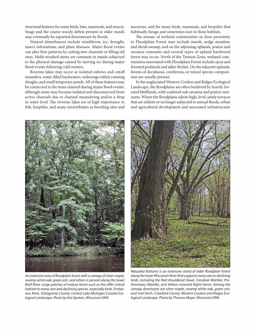
Wauzeka Bottoms is an extensive stand of older floodplain forest along the lower Wisconsin River that supports many rare or declining birds, including the Red-shouldered Hawk, Cerulean Warbler, Pro-thonotary Warbler, and Yellow-crowned Night-heron. Among the canopy dominants are silver maple, swamp white oak, green ash, and river birch. Crawford County, Western Coulees and Ridges Eco-logical Landscape. Photo by Thomas Meyer, Wisconsin DNR.
nurseries, and for many birds, mammals, and herptiles that habitually forage and sometimes nest in these habitats.
The mosaic of wetland communities in close proximity to Floodplain Forest may include marsh, sedge meadow, and shrub swamp, and on the adjoining uplands, prairie and savanna remnants and several types of upland hardwood forest may occur. North of the Tension Zone, wetland com-munities associated with Floodplain Forest include open and forested peatlands and alder thicket. On the adjacent uplands, forests of deciduous, coniferous, or mixed species composi-tion are usually present.
In the unglaciated Western Coulees and Ridges Ecological Landscape, the floodplains are often bordered by heavily for-ested blufflands, with scattered oak savanna and prairie rem-nants. Where the floodplains adjoin high, level, sandy terraces that are seldom or no longer subjected to annual floods, urban and agricultural development and associated infrastructure
wild cucumber (Echinocystis lobata), and common eastern poison-ivy (Toxicodendron radicans), are often common in Floodplain Forest.
In addition to stand condition and past disturbance his-tory, understory development is in large part dependent on the timing, severity, and duration of the annual floods. In some years, herbaceous cover may be minimal until June or even later. The graminoid species include grasses such as Virginia wild-rye (Elymus virginicus), common wood-reed (Cinna arundinacea), cut grasses, and many sedges, includ-ing hop sedge (Carex lupulina), Gray’s bur sedge (C. grayii), Tuckerman’s sedge (C. tuckermanii), and cat-tail sedge (C. typhina). Other common or characteristic herbs are the net-tles, including Canadian wood-nettle (Laportea canadensis), stinging nettle (Urtica dioica), small-spike false nettle (Boeh-meria cylindrica), and Canadian clearweed (Pilea pumila). Ferns such as sensitive fern (Onoclea sensibilis) and ostrich fern (Matteucia struthiopteris) are often present. Ostrich fern may form a dense, almost solid, stratum one to nearly two meters in height by mid-summer. Among the showier
can be prevalent land uses. This pattern is especially common along the Mississippi and parts of the lower Wisconsin rivers. In unglaciated parts of the state, the forests within and border-ing the river corridors provide some of the least fragmented forest habitat remaining in southern Wisconsin.
Community Description: Composition and StructureCanopy dominants of the Floodplain Forest include silver maple (Acer saccharinum), green ash (Fraxinus pennsylva-nica), swamp white oak (Quercus bicolor), river birch (Betula nigra), and eastern cottonwood (Populus deltoides). Ameri-can elm (Ulmus americana) was formerly a significant canopy component until Dutch elm disease, caused by a nonnative fungus (Ophiostoma ulmi), killed almost all of the older and larger elms in the Upper Midwest during the latter half of the 20th century. The diverse group of additional tree species sometimes occurring in the Floodplain Forest canopy may include black willow (Salix nigra), hackberry (Celtis occidenta-lis), red maple (Acer rubrum), bur oak (Quercus macrocarpa), black ash (Fraxinus nigra), and sycamore (Platanus occi-dentalis). Eastern white pine (Pinus strobus), rarely red pine (Pinus resinosa), and some of the oaks are sometimes pres-ent as occasional trees on higher sandy ridges in central and northern stands. Less flood tolerant, more mesophytic hard-woods such as northern red oak (Quercus rubra), American basswood (Tilia americana), bitternut-hickory (Carya cordi-formis), honey locust (Gleditsia triacanthos), Kentucky coffee-tree (Gymnocladus dioica), along with associated understory plants, may occupy alluvial terraces on slightly higher or better-drained portions of the floodplains that now seldom, if ever, flood. Early successional stands composed of flood-toler-ant pioneering species such as eastern cottonwood and black willow may be less prevalent now than they were historically, at least in part because of the impacts of dams, which have reduced flood peaks and altered the scouring and depositional patterns that formerly occurred in the floodplains.
Plant species diversity in Floodplain Forest diminishes from south to north, and the northernmost stands may be quite species poor. Some of the characteristic or co-dominant trees of the southern stands drop out (including river birch and swamp white oak), as do many of the less common asso-ciates. Few rare understory plants have been documented in the northernmost stands. Among the trees that become more common in the canopy toward the northern range limits of the community are balsam poplar (Populus balsamifera), box elder (Acer negundo), bur oak, and black ash.
Buttonbush (Cephalanthus occidentalis) is a locally domi-nant shrub in some southern stands, where it can form dense thickets on the margins of oxbow lakes, sloughs, secondary channels, and ponds. Other shrubs that may be present are several dogwoods (Cornus spp.), eastern wahoo (Euony-mus atropurpurea), and elderberry (Sambucus canadensis). Vines, such as the woodbines (Parthenocissus spp.), grapes (Vitus spp.), Canadian moonseed (Menispermum canadense),
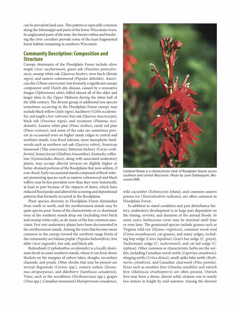
Cardinal-flower is a characteristic herb of floodplain forests across southern and central Wisconsin. Photo by June Dobberpuhl, Wis-consin DNR.
herbs representative of Floodplain Forest are cardinal-flower (Lobelia cardinalis), cut-leaved coneflower (Rudbeckia lacini-ata), Virginia bluebells (Mertensia virginiana), green dragon (Arisaema dracontium), false dragonhead (Physostegia vir-giniana), false rue anemone (Enemion biternatum), and com-mon sneezeweed (Helenium autumnale).
Rare or uncommon plants include Assiniboine sedge (Carex assiniboinensis), smooth-sheathed sedge (C. laevivagi-nata), false hop sedge (C. lupuliformis), wild chervil (Chaero-phyllum procumbens), beak grass (Diarrhena obovata), purple rocket (Iodanthus pinnatifidus), three-flowered melic grass (Melica nitens), and small forget-me-not (Myosotis laxa). On the forest margins, snowy campion (Silene nivea) and the upper midwestern endemic glade mallow (Napaea dioica) may sometimes be found. Several trees, including sycamore and Kentucky coffee-tree, also belong on the Wisconsin list of rare Floodplain Forest associates.
Floodplain Forest provides important habitat for many rare animals, especially birds. Examples include Red-shoul-dered Hawk (Buteo lineatus), Cerulean Warbler (Setophaga cerulean), Prothonotary Warbler (Protonotaria citrea), Yel-low-crowned Night-heron (Nyctanassa violacea), and Yellow-throated Warbler (Setophaga dominica). In recent years, the statewide recoveries of the Bald Eagle (Haliaeetus leucocepha-lus) and Osprey (Pandion haliaetus) have included reoccupa-tion of former breeding habitat in the floodplain forests of southern Wisconsin. On some of the large rivers, extensive and remote stands of Floodplain Forest may serve as secure winter roosts for Bald Eagles. Cavity nesters such as the Pro-thonotary Warbler, Great Crested Flycatcher (Myiarchus crinitus), Tree Swallow (Tachycineta bicolor), Tufted Titmouse (Baeolophus bicolor), White-breasted Nuthatch (Sitta carolin-ensis), Black-capped Chickadee (Poecile atricapillus), Eastern Bluebird (Sialia sialis), many woodpeckers, and several owl species are well represented in older stands that contain a component of large living trees and snags. The isolation pro-vided by floods and running sloughs reduces the vulnerability of raptors and colonial birds such as Great Blue Heron (Ardea herodias) and Great Egret (Ardea alba) to some predators. See Mossman (1988), Knutson et al. (2005), and Miller et al. (2005) for additional information on the birdlife of Wiscon-sin’s Floodplain Forest communities.
Unvegetated stream banks are important features of large river floodplains and provide nest sites for species such as Bank Swallow (Riparia riparia), Northern Rough-winged Swallow (Stelgidopteryx serripennis), and Belted Kingfisher (Megaceryle alcyon) and denning sites for a number of mammals, includ-ing the North American river otter (Lontra canadensis).
Numerous herptiles (frogs, salamanders, turtles, and snakes) are associated with Floodplain Forest, including the Wisconsin Endangered eastern massasauga (Sistrurus cat-enatus catenatus) and the Wisconsin Threatened wood turtle (Glyptemys insculpta). In addition to making use of the forest,
the riverine lakes and ponds, oxbows, and cut-off channels provide foraging, basking, hibernating, and breeding habitat for herptiles. The aquatic habitats within complex floodplain ecosystems, including the main channel and secondary chan-nels in addition to those mentioned above, host many rare fish, including paddle fish (Polyodon spathula), lake sturgeon (Acipenser fulvescens), river redhorse (Moxostoma carinatum), blue sucker (Cycleptus elongatus), western sand darter (Ammo-crypta clara), and banded killifish (Fundulus diaphanous).
Tree bats make significant use of Floodplain Forest, espe-cially eastern red bat (Lasiurus borealis), hoary bat (L. cinereus), and silver-haired bat (Lasionycteris noctivagans). Several rare or uncommon small mammals that use various floodplain habitats, including forests, are the woodland jumping mouse (Napaeozapus insignis) and water shrew (Sorex palustris).
In addition to the vertebrates mentioned, overall inver-tebrate diversity of functional floodplains can be very high and in some river systems supports extremely rare species of mayflies and aquatic beetles (WDNR 2000).
The running channels, riverine lakes and ponds, button-bush thickets, spring seepages, unvegetated vertical banks, exposed sandbars, and mud flats are often integral compo-nents of large, complex floodplain ecosystems. These provide breeding, basking, foraging, wintering, and resting habitats for a wealth of species in addition to those mentioned above.
Conservation and Management ConsiderationsProtection and, where needed and feasible, restoration of site hydrology are of the utmost importance if Floodplain For-est and its many species of dependent birds, herptiles, fish, and invertebrates are to be maintained in viable populations over the long term. Disruption of hydrology is the key con-servation concern, as many of southern Wisconsin’s major rivers and large streams have been dammed. In addition to fragmenting habitats used by species inhabiting the water, the timing, magnitude, and duration of the annual floods have been altered. Land uses on the adjoining uplands may contribute excessive amounts of sediments and nutrients to floodplain ecosystems, reducing water quality and altering, and sometimes impairing, natural stream functions. Though all of Wisconsin’s major rivers have been dammed, it should be noted that the lower stretches of the Wisconsin, Chip-pewa, Black, St. Croix, and Wolf rivers each have long runs of unimpeded flow.
Invasive plants are now serious problems in some stands to the detriment of the native biota, a situation that can be exac-erbated when the canopy is opened up due to windthrow, ice storms, disease, insect infestations, or logging. While moni-toring for the presence and spread of invasives is an impor-tant management activity, follow-up control once a problem has been identified is even more important if we are to do more than simply document the decline of our native plant communities. Some stands are still used for livestock grazing,
which can be problematic when heavy. Excessive white-tailed deer (Odocoileus virginiana) browse can hamper regeneration of desirable woody plants (Castleberry et al. 2005), including commercially valuable trees such as swamp white oak.
The nonindigenous Dutch elm disease has altered the composition and structure of many stands throughout Flood-plain Forest’s midwestern range. Emerald ash borer (Agri-lus planipennis), an exotic insect, now poses an extremely serious threat to our forested floodplains, as the ashes are major components of many stands and all ash species are susceptible to destruction by the larvae of this beetle. Among the especially problematic invasive plants are garlic mustard (Alliaria petiolata), moneywort (Lysimachia nummularia), creeping-Charlie (Glechoma hederacea), stinging nettle, and reed canary grass (Phalaris arundinacea). Reed canary grass has invaded many stands in southern Wisconsin. When abundant, it reduces native understory diversity and poses serious difficulties for tree reproduction because of its size, stand density, the shade it casts, and its deep litter.
Removal of trees due to threat of disease or for commercial purposes will generate a number of problems for managers, as in many cases there will need to be follow up actions to ensure that patches of extensive forest with high canopy clo-sure are maintained.
In landscapes where natural habitats are now severely fragmented such as southern and eastern Wisconsin, Floodplain Forest now provides some of the most intact and extensive areas of contiguous forest cover. The com-munity is critically important for area-sensitive animals and for habitat specialists dependent on structural features (such as large trees, living and dead snags, numerous cavi-ties, and a multi-layered canopy) that are often associated with older, relatively undisturbed stands. The combination of periodic inundation, dense stands of Canadian wood nettle, and hordes of mosquitoes afford a measure of protection for some disturbance-sensitive animals, some of which must now occupy isolated or degraded habitat remnants elsewhere within their former ranges.
Riverine lakes and ponds (which may be temporary or per-manent, large or small, and include oxbows, running sloughs, cut-off sloughs, and backwaters) are important features within well-developed floodplain systems and support many aquatic organisms (fish, herptiles, and invertebrates), some of which are strongly associated with and at least partially dependent on these waterbodies. In addition to the forests and riverine lakes, open sandbars and mud flats are among the other important habitats within the major floodplain ecosystems, and these need to be maintained without compromising the integrity of large patches of contiguous forest.
Maintaining or restoring connections between patches of forest both within the floodplain and between the floodplain and natural communities on the adjoining uplands will best ensure that area-sensitive species will continue to find secure
habitat. Representation of functional environmental gradi-ents within conservation projects will allow for adaptation to changing conditions over time. There are many species that require more than one habitat to successfully complete their life cycles (e.g., many waterbirds, amphibians, turtles, aquatic insects such as dragonflies).
Successional patterns in floodplain forests need to be understood better, especially in systems affected by the opera-tion of dams, dikes, or water diversions (Gergel et al. 2002). An issue worthy of further study is the decline and present rarity of stands dominated by pioneering, early successional floodplain trees such as eastern cottonwood and black wil-low. Excessive inputs of sediments and nutrients may occur where agriculture is the dominant use on adjoining uplands. In recent years, commercial timber harvest operations have increased in the lowland forests along some of the larger rivers, including the lower Wisconsin and Wolf. Because of successional uncertainties, altered disturbance regimes, mul-tiple threats posed by invasive species, and the high degree of association many native plants and animals have with this community, monitoring of these harvest activities will be essential to ensure that the best management decisions are made over the long term. Retention of key forest structural elements at stand and landscape levels, ensuring that large patches of older, species-rich forest are maintained across the range of variability inherent in the Floodplain Forest type across its Wisconsin range, and maintaining or restor-ing connectivity between stands, both within the floodplain and across the floodplain and adjoining uplands, are just a few of the important considerations for planners, managers, and property owners. In the more heavily developed parts of southern Wisconsin, including the southeastern and east cen-tral regions but also in parts of the Driftless Area, the forested floodplains now constitute a large proportion of the remain-ing forest cover. Sites that contain large patches of forest that have retained connectivity with other forest patches (includ-ing the adjacent uplands) and with somewhat intact hydrol-ogy are extremely important from a conservation perspective. Given the opportunities for protection and management that have already been identified in Wisconsin, this state appears to have a critical role to play in the conservation of floodplain ecosystems at regional and continental scales.
Additional Information For additional information on similar or related natural communities, see the descriptions for Southern Hardwood Swamp, Northern Hardwood Swamp, Forested Seep, and Mesic Hardwood Alluvial Terrace. Also see the descriptions in Curtis (1959) of Southern Wet Forest and Southern Wet-mesic Forest. Floodplain Forest corresponds most closely to the U.S. National Vegetation Classification type CEGL002586 Silver Maple – Elm – (Cottonwood) Forest (Faber-Langen-doen 2001) but overlaps with several other associations.

Also see:Amoros and Bornette (2002)Baker and Barnes (1998) Barnes (1978) Bayley (1995) Crow et al. (2000) Freeman et al. (2003)Gergel et al. (2002)Gregory et al. (1991)Hale et al. (2008)Hanowski et al. (2003) Johnson and Waller (2015)Meadows and Nowacki (1996)Nilsson and Berggren (2000)
Noble (1979)Post (1994)Richter et al. (2003)Rudis (1995)Sparks (1995) Stanturf et al. (2001) Stewart et al. (2001) Tanner and Hamel (2001) Turner et al. (2004)Ward (1998) WDATCP (2016)WDNR (2006)WDNR (2016a)
FROM: Epstein, E.E. Natural communities, aquatic features, and selected habitats of Wisconsin. Chapter 7 in The ecological land-scapes of Wisconsin: An assessment of ecological resources and a guide to planning sustainable management. Wisconsin Department of Natural Resources, PUB-SS-1131H 2017, Madison. For a list of terms used, please visit the Glossary. For a reference list, please see the Literature Cited.
Related Documents