FLOOD SOLUTIONS Residence Overall Opinion PASSED Argyll's Overview The Site is not considered to be at a significant risk of flooding. This is as a result of flood defences in proximity to the Site which have been considered in the overall assessment. The Local Authority is likely to require that any proposed development at the Site be accompanied by a Flood Risk Assessment (FRA). A prudent purchaser should ask the vendor whether there has been any historical flooding and obtain insurance terms before exchange of contracts. Report on: Sample Site, Sample Street, Anytown, UK Report prepared for: Sample_FSR_180416 Client Reference: Sample Report Reference: Sample National Grid Reference: Sample Report date: 18 April 2016

Welcome message from author
This document is posted to help you gain knowledge. Please leave a comment to let me know what you think about it! Share it to your friends and learn new things together.
Transcript
FLOOD SOLUTIONS
Residence
Overall Opinion
PASSED
Argyll's Overview
The Site is not considered to be at a significant risk of flooding.
This is as a result of flood defences in proximity to the Site which have been considered in the overall assessment.
The Local Authority is likely to require that any proposed development at the Site be accompanied by a Flood Risk Assessment (FRA).
A prudent purchaser should ask the vendor whether there has been any historical flooding and obtain insurance terms before exchange of contracts.
Report on:
Sample Site, Sample Street, Anytown, UK
Report prepared for:
Sample_FSR_180416
Client Reference:
Sample
Report Reference:
Sample
National Grid Reference:
Sample
Report date:
18 April 2016

Site Location
Report prepared onSample Site, Sample Street, Anytown, UK
Site Area (m2)161.52Current UseResidentialProposed UseResidentialReport AuthorHannah Burke BSc (Hons) AIEMA Telephone: 0845 458 5250
www.argyllenvironmental.com Intelligent Due DiligenceSample_FSR_180416 2 18 April 2016

Flood Risk Screening
RiskIssue Evaluation
1 Flooding What is the overall risk of flooding, assuming defences fail or are absent or over-topped?
High
2 Flood Defences Are there existing flood defences that might benefit the Site?
Yes
3 Effect What is the risk of flooding when these defences are operational?
Moderate
Insurance Flood insurance for most residential properties should be available and affordable despite this level of flood risk due to the introduction of Flood Re. However, several types of residential property fall outside Flood Re and we cannot determine the eligibility of the property from this assessment. Please see recommendations for next steps.
Flood Analysis
River CoastalGround Water
Surface Water
Other1
High
Moderate to High
Moderate
Low to Moderate
Low
Negligible
Argyll'sComment
Although the entire Site lies within a Flood Zone 3, it is also in an area benefiting from flood defences as defined by the EA and is expected be offered protection from local or regional flood defences. The Site has also been identified as being at a low risk of flooding according to the Risk of Flooding from Rivers or Seas (RoFRS) dataset. This is why the risk rating for river flooding differs when looked at with and without defences.
The Site is at a moderate risk from surface water flooding. The expected depth of flooding at the Site may range from 0.3-1m. Current on Site drainage provisions or improvements to Site drainage could reduce the risk of surface water flooding, but you would need expert advice to confirm this. This would entail a review of the existing drainage or proposals for any new drainage.
1Other factors influencing flood risk include historic flood events, geological indicators of flooding, proximate surface water features, and elevation above sea level.
www.argyllenvironmental.com Intelligent Due DiligenceSample_FSR_180416 3 18 April 2016
Recommendations
1. We recommend carrying out a more detailed assessment (a FLOODSOLUTIONS Consult Report). Using the highest detail topographical data available and Environment Agency flood levels, the report will specify the expected flood depths at the property. This can be used to increase your understanding of the risk and the potential significance of a flood event, and to inform a flood survey, to ensure the recommended protection measures are suitable. This Report is available from £450 plus VAT (including all disbursements) dependent upon the nature of the risk and the Site. This report can usually be prepared within 15-20 working days, although may take up to 25 depending upon regulatory response times.
2. Alternatively, we can arrange for a suitably trained surveyor to visit the property and provide a cost appraisal for installing flood protection measures across all the potential ingress points. Surveys cost from £350.00 + VAT although vary across the country based upon location and complexity.
3. Speak to the seller to confirm whether the property or the surrounding area has flooded before. This information may be contained within the TA6 Property Information Form.
4. You should check that your property is eligible for Flood Re with your insurer or via the Flood Re website www.floodre.co.uk/eligibility. For excluded properties, buildings and contents insurance terms are likely to have a higher premium. You should therefore obtain insurance terms before exchange of contracts.
www.argyllenvironmental.com Intelligent Due DiligenceSample_FSR_180416 4 18 April 2016
Additional Considerations
Item SummaryRiparian Ownership
A riparian owner describes anyone who owns a property where there is a watercourse within or adjacent to the boundaries of their property.
Under common law, a riparian owner has rights and responsibilities relating to the stretch of watercourse that falls within or beside the boundaries of their land. Their primary responsibility is to keep the watercourse free of any obstructions that could hinder normal water flow. If the riparian owner fails to carry out their responsibilities, this could result in civil action.
A riparian owner should also check before carrying out any works near to the edge of a river, as such works may be subject to byelaws. If infringed, this could lead to enforcement action by The Environment Agency.
There is a presumption that the boundary between properties abutting a watercourse is the centre line of that watercourse. To confirm whether this is the case, a solicitor should check the deeds or the Index Map.
The Environment Agency has published useful guidance “Living on the edge” for owners of land or property alongside a watercourse. Sometimes, The Environment Agency or other organisations managing flood risk, may have statutory rights of access to properties which adjoin a watercourse. This may be for maintenance, repair or rebuilding of any part of the watercourse or for access to or repair of monitoring equipment.
Development Control
Sites which lie close to (but do not adjoin) a watercourse, may be subject to planning controls should redevelopment be considered. The Environment Agency are normally consulted regarding any development within 20m of a Main River and Internal Drainage Boards should be similarly contacted regarding developments close to drainage channels. Navigation authorities are normally consulted regarding any development within 250m of a canal, although this varies on a site by site basis.
The Environment Agency should also be contacted with regards to development (other than minor development) in Flood Zones 2 and 3.
Sewer Flooding In times of extreme rainfall events sewers can overflow and cause local flooding. Ofwat’s ‘DG5 - At Risk Registers’ record properties that have flooded from sewers and are at risk of flooding again, with separate registers for internal and external flooding. The At Risk Registers are maintained by each of the ten water and sewerage companies in England and Wales and details of properties subject to sewer flooding are normally kept for between two and five years. These registers are not necessarily complete as not all episodes of past flooding may be recorded. The answer to this question is based on replies given by the relevant water and sewerage provider to specific enquiries. The response provided is based on the information held. Sometimes, the water and sewerage provider is unable to confirm whether the Site has flooded, but provides a response based on all properties connected to a local sewer network (normally up to ten houses). This is due to the way in which the data is collected.
Argyll'sComment
Whilst this assessment is primarily a flood risk screening report, you may wish to consider the above potential liability considerations that fall outside the scope of the Flood Risk Screening Methodology.
Argyll can provide additional information on riparian ownership, development control and sewer flooding. The cost of this additional information is from £50 + VAT and any disbursements.
www.argyllenvironmental.com Intelligent Due DiligenceSample_FSR_180416 5 18 April 2016

Risk Management OptionsFlooding can often be managed by the installation of flood protection measures either on/within the building(s) or across the Site. Flood protection measures can be divided into two categories; flood resistance and flood resilience.
Both flood resistance and flood resilience solutions can be integrated with design proposals for new build properties or retro-fitted to existing properties. Specific flood protection packages can often include both resistance and resilience measures. What is suitable will depend on a number of factors including flood source, likely flood depths, property design and age.
Research conducted by CLG Sustainable Buildings Division and The Environment Agency revealed that installing flood resistance measures may be inappropriate where likely flooding will be deep. Certain types of building construction are unable to resist the pressure load placed on the exterior skin of the building by retained flood waters. Generally a flood depth between 0.6m and 1.0m above ground level is used as a benchmark to decide whether to consider flood resilience measures rather than rely on flood resistance measures. This is dependent on the age and construction of the property.
Guideline Costs for Resistance Measures
Building Feature Cost Estimate for Baffles (+ VAT)
Standard 900mm single door
Standard 1800mm double entrance door
Large roller shutter door up to 2745mm span
Standard garage door
Standard window up to 1240mm span
Large window 1240mm to 2150mm span
Single air brick
Double air brick
£750
£950
£1420 including channel
£1400 - £1575
£750
£550 - £700
£60 - £90
£80 - £230
Building Feature Cost Estimate for Tanking (+ VAT)
Tanking of basement, walls, or floors £25 - £50 per metre²
System Component Cost Estimate for Plumbing (+ VAT)
Simple non-return valve
Sophisticated non-return valve
£35 - £170
£670 - £900
The costs above are for indicative budget purposes only. They are based on installing components of a standard design and colour. If the Site requires bespoke products, these are likely to cost more (for example, if the Site is in a conservation area, different colours may be required).
If you require a property specific assessment of which measures are suitable, and a more accurate cost appraisal, Argyll will need to complete a FLOODSOLUTIONS Consult Report. This report normally costs £450 (plus VAT) and provides more detailed information on the likelihood and, in particular, the depth of all potential types of flooding. Argyll can also arrange for one of a panel of specialist contractors to provide a tailored estimate for flood protection measures.
www.argyllenvironmental.com Intelligent Due DiligenceSample_FSR_180416 6 18 April 2016

Tabular Summary
Flooding
Current Flood Risk Source On-site 1-250m 251-500m
Flooding From Rivers or Sea EA YES YES YES
Flooding From Rivers or Sea (in an Extreme Flood) EA YES YES YES
Areas Benefiting from Flood Defences EA YES YES YES
Flood Storage Areas EA - - -
Flood Defences EA - - -
Risk of Flooding from Rivers and Sea EA YES YES YES
Groundwater Flooding Risk ESI YES YES YES
Surface Water Flooding (1:75 year rainfall event) JBA YES YES YES
Surface Water Flooding (1:200 year rainfall event) JBA YES YES YES
Surface Water Flooding (1:1000 year rainfall event) JBA YES YES YES
Dam or Reservoir Failure JBA - - -
Historical Flooding On-site 1-250m 251-500m
Historical Flood Events EA - YES YES
Geological Indicators of Flooding BGS - YES YES
Other Flood Information Reply
Height of Site Above Sea Level OS 3.9m
Distance of Site Boundary to Nearest Water Feature OS 466.3m
Tabular Summary Explanation
Argyll has carefully selected a range of datasets which are considered appropriate for the intended use of this report. Each dataset is searched to a set radius from the
Site boundary and the tabular summary is divided into different search bands accordingly. If a database is searched and information is found, then the number of
records available are detailed in the table above. If the database was searched and no data was found, then a zero will be present. If a database was not searched
then the abbreviation N/A will be found, indicating this information was not available at the radius searched.
www.argyllenvironmental.com Intelligent Due DiligenceSample_FSR_180416 7 18 April 2016

Current Flood Risk
www.argyllenvironmental.com Intelligent Due DiligenceSample_FSR_180416 8 18 April 2016
Current Flood Risk
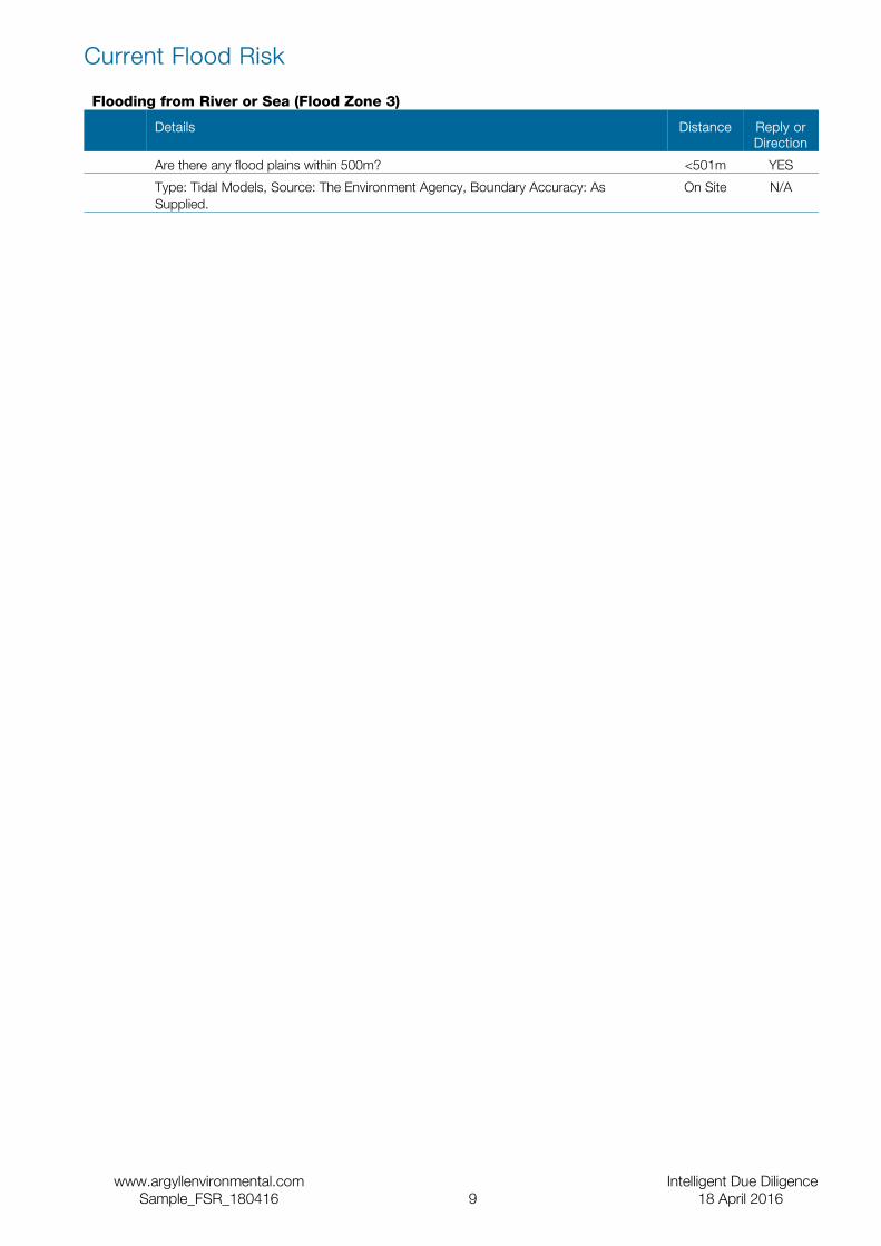
Flooding from River or Sea (Flood Zone 3)
Details Distance Reply or Direction
Are there any flood plains within 500m? <501m YES
Type: Tidal Models, Source: The Environment Agency, Boundary Accuracy: As Supplied.
On Site N/A
www.argyllenvironmental.com Intelligent Due DiligenceSample_FSR_180416 9 18 April 2016
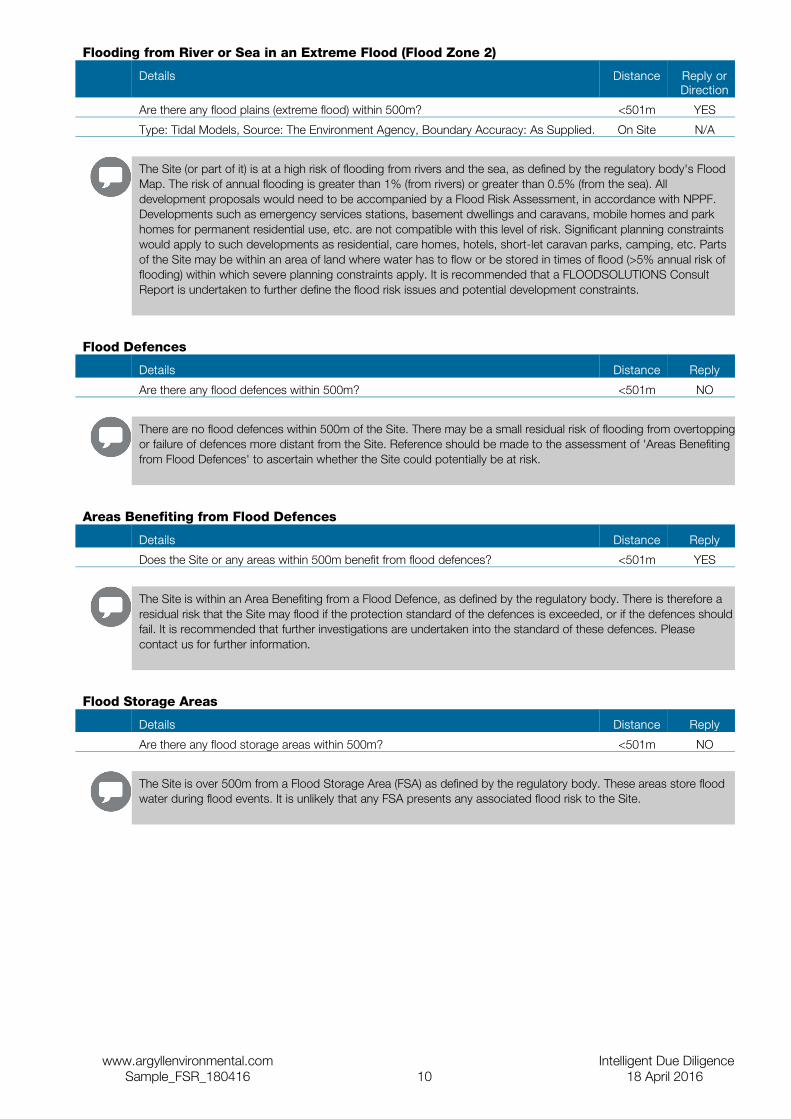
Flooding from River or Sea in an Extreme Flood (Flood Zone 2)
Details Distance Reply or Direction
Are there any flood plains (extreme flood) within 500m? <501m YES
Type: Tidal Models, Source: The Environment Agency, Boundary Accuracy: As Supplied. On Site N/A
The Site (or part of it) is at a high risk of flooding from rivers and the sea, as defined by the regulatory body's Flood Map. The risk of annual flooding is greater than 1% (from rivers) or greater than 0.5% (from the sea). All development proposals would need to be accompanied by a Flood Risk Assessment, in accordance with NPPF. Developments such as emergency services stations, basement dwellings and caravans, mobile homes and park homes for permanent residential use, etc. are not compatible with this level of risk. Significant planning constraints would apply to such developments as residential, care homes, hotels, short-let caravan parks, camping, etc. Parts of the Site may be within an area of land where water has to flow or be stored in times of flood (>5% annual risk of flooding) within which severe planning constraints apply. It is recommended that a FLOODSOLUTIONS Consult Report is undertaken to further define the flood risk issues and potential development constraints.
Flood Defences
Details Distance Reply
Are there any flood defences within 500m? <501m NO
There are no flood defences within 500m of the Site. There may be a small residual risk of flooding from overtopping or failure of defences more distant from the Site. Reference should be made to the assessment of 'Areas Benefiting from Flood Defences' to ascertain whether the Site could potentially be at risk.
Areas Benefiting from Flood Defences
Details Distance Reply
Does the Site or any areas within 500m benefit from flood defences? <501m YES
The Site is within an Area Benefiting from a Flood Defence, as defined by the regulatory body. There is therefore a residual risk that the Site may flood if the protection standard of the defences is exceeded, or if the defences should fail. It is recommended that further investigations are undertaken into the standard of these defences. Please contact us for further information.
Flood Storage Areas
Details Distance Reply
Are there any flood storage areas within 500m? <501m NO
The Site is over 500m from a Flood Storage Area (FSA) as defined by the regulatory body. These areas store flood water during flood events. It is unlikely that any FSA presents any associated flood risk to the Site.
www.argyllenvironmental.com Intelligent Due DiligenceSample_FSR_180416 10 18 April 2016
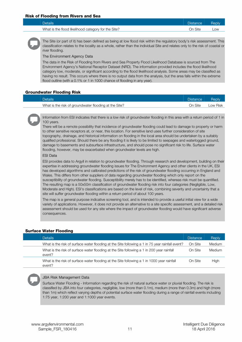
Risk of Flooding from Rivers and Sea
Details Distance Reply
What is the flood likelihood category for the Site? On Site Low
The Site (or part of it) has been defined as being at low flood risk within the regulatory body's risk assessment. This classification relates to the locality as a whole, rather than the individual Site and relates only to the risk of coastal or river flooding.
The Environment Agency Data
The data in the Risk of Flooding from Rivers and Sea Property Flood Likelihood Database is sourced from The Environment Agency’s National Receptor Dataset (NRD). The information provided includes the flood likelihood category low, moderate, or significant according to the flood likelihood analysis. Some areas may be classified as having no result. This occurs where there is no output data from the analysis, but the area falls within the extreme flood outline (with a 0.1% or 1 in 1000 chance of flooding in any year).
Groundwater Flooding Risk
Details Distance Reply
What is the risk of groundwater flooding at the Site? On Site Low Risk
Information from ESI indicates that there is a low risk of groundwater flooding in this area with a return period of 1 in 100 years.There will be a remote possibility that incidence of groundwater flooding could lead to damage to property or harm to other sensitive receptors at, or near, this location. For sensitive land uses further consideration of site topography, drainage, and historical information on flooding in the local area should be undertaken by a suitably qualified professional. Should there be any flooding it is likely to be limited to seepages and waterlogged ground, damage to basements and subsurface infrastructure, and should pose no significant risk to life. Surface water flooding, however, may be exacerbated when groundwater levels are high.
ESI Data
ESI provides data to Argyll in relation to groundwater flooding. Through research and development, building on their expertise in addressing groundwater flooding issues for The Environment Agency and other clients in the UK, ESI has developed algorithms and calibrated predictions of the risk of groundwater flooding occurring in England and Wales. This differs from other suppliers of data regarding groundwater flooding which only report on the susceptibility of groundwater flooding. Susceptibility merely has to be identified, whereas risk must be quantified. The resulting map is a 50x50m classification of groundwater flooding risk into four categories (Negligible, Low, Moderate and High). ESI’s classifications are based on the level of risk, combining severity and uncertainty that a site will suffer groundwater flooding within a return period of about 100 years.
The map is a general purpose indicative screening tool, and is intended to provide a useful initial view for a wide variety of applications. However, it does not provide an alternative to a site specific assessment, and a detailed risk assessment should be used for any site where the impact of groundwater flooding would have significant adverse consequences.
Surface Water Flooding
Details Distance Reply
What is the risk of surface water flooding at the Site following a 1 in 75 year rainfall event? On Site Medium
What is the risk of surface water flooding at the Site following a 1 in 200 year rainfall event?
On Site Medium
What is the risk of surface water flooding at the Site following a 1 in 1000 year rainfall event?
On Site High
JBA Risk Management Data
Surface Water Flooding - Information regarding the risk of natural surface water or pluvial flooding. The risk is classified by JBA into four categories, negligible, low (more than 0.1m), medium (more than 0.3m) and high (more than 1m) which reflect varying depths of potential surface water flooding during a range of rainfall events including 1:75 year, 1:200 year and 1:1000 year events.
www.argyllenvironmental.com Intelligent Due DiligenceSample_FSR_180416 11 18 April 2016

Historical Flooding
Historical Flood Events
Details Distance Reply
Have any historical flood events occurred at the Site or within 500m? <501m YES
The Site is less than 2m above a historical flood event, as recorded by the regulatory body. It is recommended that a FLOODSOLUTIONS Consult Report is undertaken to further define the flood risk to the Site.
The Environment Agency Data
The Environment Agency has collated extensive records (including outlines) of flooding from rivers, the sea or groundwater which have occurred in England and Wales since c. 1950. This information comes from various sources including maps, aerial photographs, and private records. It is not necessarily comprehensive.
Geological Indicators of Flooding
Details Distance Reply or Direction
Are there any geological deposits which indicate the Site may have been flooded in the past?
<26m NO
Data from the British Geological Survey (BGS) indicates that the type of deposits in the locality of the Site are not of the type normally associated with floodplains. However, this data should only be considered as complementary to the regulatory body's Flood Map. This BGS data does not indicate the likelihood of flooding, since such deposits may be due to flood events which occurred thousands of years ago. Refer to the other assessments in this report for an overall assessment of flood risk.
British Geological Survey Data
Geological Indicators of Flooding – The BGS Geological Indicators of Flooding (GIF) data set is a digital map based on the BGS Digital Geological Map of Great Britain at the 1:50,000 scale (DiGMapGB-50). It was produced by characterising Superficial (Drift) Deposits on DiGMapGB-50 in terms of their likely vulnerability to flooding, either from coastal or inland water flow and reflects areas which may have flooded in the recent geological past. This normally relates to flooding which happened many thousands of years ago.
www.argyllenvironmental.com Intelligent Due DiligenceSample_FSR_180416 12 18 April 2016

Other Flood Information
Height Above Sea Level
Details Distance Reply
Minimum height of the Site above sea level On Site 3.8m
Average height of the Site above sea level On Site 3.9m
Maximum height of the Site above sea level On Site 3.9m
The Site is at a relatively low height above sea level. However, this is not in itself indicative of the degree of flood risk and reference should be made to other assessments within this report.
Distance to Water Features
Details Distance Reply or Direction
Are there any water features within 500m? <501m YES
There is a water feature shown on the Ordnance Survey within 500m of the Site. This does not represent a flood risk in itself, but its presence has been taken into account in the overall risk assessment in this Report.
Dam or Reservoir Failure
Details Distance Reply
Is there a risk of the Site being affected by the failure of a nearby dam or reservoir? On Site NO
Neither the Site nor areas near to it will be likely to flood if a dam or reservoir in the surrounding area failed.
JBA Risk Management Data
Dam or Reservoir Failure – JBA has modelled approximately 1700 dams and reservoirs across the UK which are considered to pose the greatest risks to people and property. These models are able to predict the areas likely to flood on all sides of a feature, should an element of it fail e.g. a wall, dam or earth bund.
www.argyllenvironmental.com Intelligent Due DiligenceSample_FSR_180416 13 18 April 2016
GlossaryBusiness Continuity PlanA business continuity plan is a strategic plan of action for a business to implement in an emergency (i.e. flood event). This plan ensures a business can continue to operate during emergency situations and reduces the risk of suffering avoidable losses. For example, it may cover such items as emergency accommodation and computer back up off site.
Flood Evacuation PlanA flood evacuation plan sets out clear steps to ensure the safe evacuation of staff during a flood. It will form part of the Business Continuity Plan.
Coastal FloodingCoastal flooding is the inundation of land areas along the coast caused by sea water rising above normal tidal conditions. Coastal flooding can arise from a combination of high tides, wind induced tidal surge, storm surge created by low pressure and wave action.
Flood Resistance MeasuresThese measures are designed to prevent flood water from entering the buildings on Site.
Flood Resilience MeasuresThese measures are intended to make buildings more resilient to flood damage so that they recover more quickly from flooding. They are not designed to prevent flood water entering the property.
Flood Risk AssessmentA full Flood Risk Assessment (FRA) Report is a bespoke report required under NPPF for any development site within The Environment Agency Flood Zones 2 or 3 and/or any development site larger than 1 hectare. These reports are generally prepared following liaison with the Local Planning Authority and the application of the sequential test.
Flood Zone 1The area where flooding from rivers or sea is very unlikely as defined by The Environment Agency. There is less than 0.1% (1 in 1000) chance of flooding occurring each year.
Flood Zone 2The area of medium probability of flooding as defined by The Environment Agency – a flood with an annual chance of occurring of between 1% (1 in 100) to 0.1% (1 in 1000) for river flooding and 0.5% (1 in 200) to 1% (1 in 1000) for coastal flooding.
Flood Zone 3aThe area of high probability of flooding as defined by The Environment Agency – a flood with an annual chance of occurring of 1% (1 in 100) or greater for river flooding and 0.5% (1 in 200) or greater for coastal flooding.
Flood Zone 3bThe boundary between 3a and 3b is a planning decision made by the Local Authority. This information is usually in the strategic flood risk assessment. This area is a functional floodplain as defined by The Environment Agency. It is an area which is designed to flood – a flood return period of 1 in 20 or less.
Groundwater FloodingGroundwater flooding occurs when ground water levels increase sufficiently for the water table to intersect the ground surface. Groundwater flooding can occur in a variety of geological settings including valleys and in areas underlain by chalk, and in river valleys with thick deposits of alluvium and river gravels.
NPPFThis relates to the National Planning Policy Framework and the associated Technical Guidance.
Pluvial (Surface Water) FloodingPluvial flooding results from rainfall running over ground before entering a watercourse or sewer. It is usually associated with high intensity rainfall events (typically greater than 30mm per hour) but can also occur with lower intensity rainfall or melting snow where the ground is already saturated, frozen, developed (for example in an urban setting) or otherwise has low permeability.
Rainfall EventA period of rainfall that is expected to occur on average once every ‘X’ years. A rainfall event is also measured in terms of duration (hours or days) and the intensity of the event may differ depending upon where it occurs.
www.argyllenvironmental.com Intelligent Due DiligenceSample_FSR_180416 14 18 April 2016

Return PeriodReturn periods are a measure of how likely flooding is to occur. They are commonly expressed as a ratio (for example 1 in 75 or 1:75). This means that this level of flooding is expected once in every 75 years.
River FloodingRiver flooding mainly happens when the river catchment (that is the area of land that feeds water into the river and the streams that flow into the main river) receives greater than usual amounts of water (for example through rainfall or melting of snow). The amount of runoff depends on the soil type, catchment steepness, drainage characteristics, agriculture and urbanisation as well as the saturation of the catchment. The extra water causes the level of the water in the river to rise above its banks or retaining structures.
Contacts
Argyll Environmental Limited1st Floor98 – 99 Queens RoadBrightonBN1 3XF
Telephone 0845 458 5250
Email [email protected]
Website www.argyllenvironmental.com
For advice on this report
EnvirorepFlood Risk Helpline Telephone 0845 606 6650
Website envirep.co.uk
For advice on groundwater flooding
The Environment AgencyPO Box 544TempleboroughRotherhamS60 1BY
General enquiries 08708 506 506Floodline 0845 988 1188
Email [email protected]
For advice on regulatory information
Flood Protection Association10 Cavalry RideNorwichNR3 1U
Telephone 01603 633 440Fax 01603 763256
Website www.floodprotectionassoc.co.uk
For advice on Flood Protection Measures
British Geological SurveyKingsley Dunham CentreKeyworthNottinghamNG12 5GG
General enquiries 0115 936 3143Fax 0115 936 3276
Website www.bgs.ac.uk
For advice on geological causes of groundwater flooding
British Insurance Brokers' Association 8th FloorJohn Stow House8 Bevis MarksLondonEC3A 7JB
Consumer helpline 0870 950 1790 For advice on flood insurance
JBA Risk Management - Head Office South Barn Broughton HallSkiptonNorth YorkshireBD23 3AE
General enquiries 01756 799 919Fax 01756 799 [email protected]
For advice on JBA flood risk data
© Argyll Environmental Limited 2016. All Rights Reserved. The copyright on the information and data as contained in the Data section of this Report ("Report") is the
property of Argyll Environmental Limited ("Argyll") and several other Data Providers, including (but not limited to) Ordnance Survey, British Geological Survey, the
Environment Agency and JBA Risk Management Ltd, and must not be reproduced in whole or in part by photocopying or any other method.
www.argyllenvironmental.com Intelligent Due DiligenceSample_FSR_180416 15 18 April 2016
Flood Risk Screening MethodologyThe FloodSolutions Residence report is a desktop flood risk screening report, designed to enable property professionals to assess the risk of flooding at residential sites. It examines three areas; how flood risk might affect the availability of insurance for a site; how flood risk affects the potential to redevelop a site; and the overall risk of flooding at a site (taking into account any flood defences present). The report considers current Government guidance including the National Planning Policy Framework (NPPF). The report has been produced and quality-checked by qualified flood risk specialists using the data contained in this report.
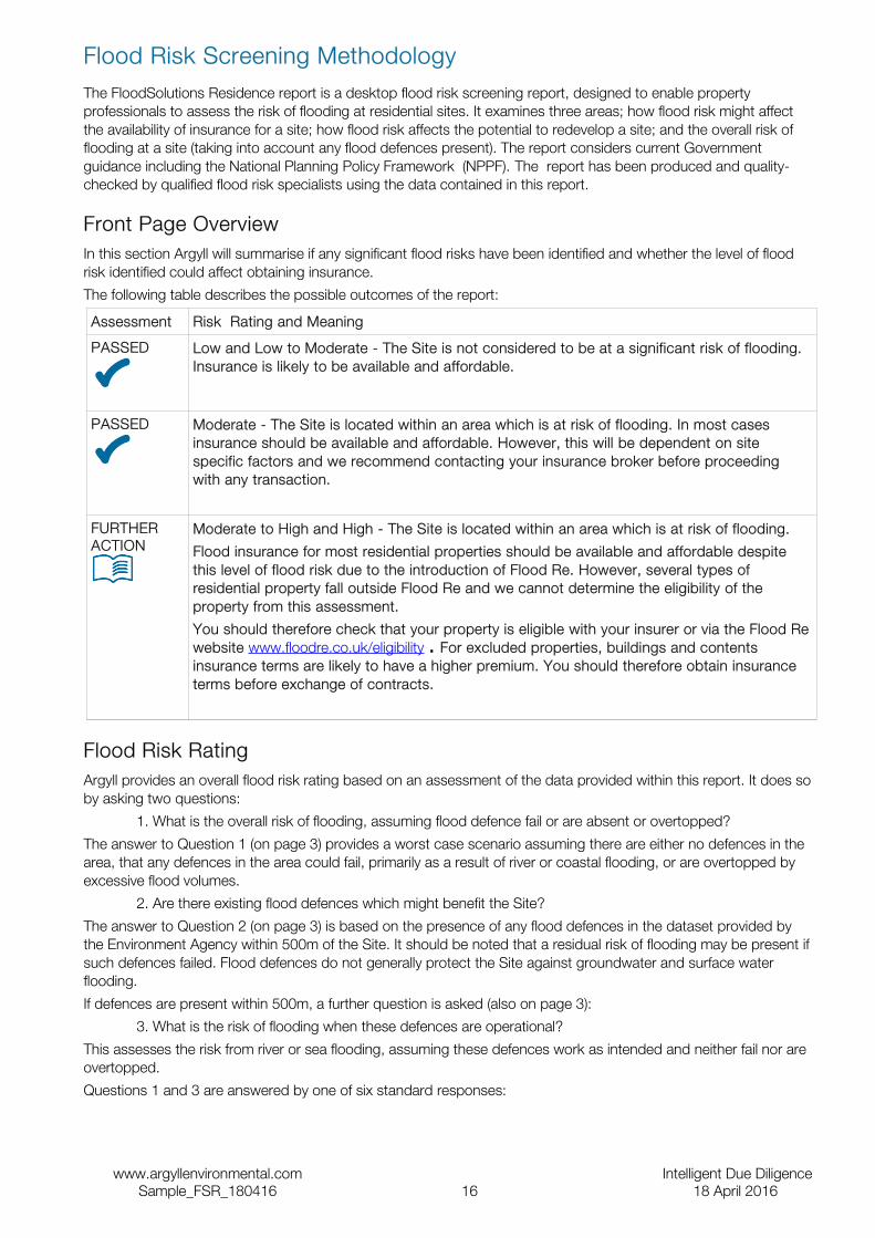
Front Page OverviewIn this section Argyll will summarise if any significant flood risks have been identified and whether the level of flood risk identified could affect obtaining insurance.
The following table describes the possible outcomes of the report:
Assessment Risk Rating and Meaning
PASSED
Low and Low to Moderate - The Site is not considered to be at a significant risk of flooding. Insurance is likely to be available and affordable.
PASSED
Moderate - The Site is located within an area which is at risk of flooding. In most cases insurance should be available and affordable. However, this will be dependent on site specific factors and we recommend contacting your insurance broker before proceeding with any transaction.
FURTHER ACTION
Moderate to High and High - The Site is located within an area which is at risk of flooding.
Flood insurance for most residential properties should be available and affordable despite this level of flood risk due to the introduction of Flood Re. However, several types of residential property fall outside Flood Re and we cannot determine the eligibility of the property from this assessment.
You should therefore check that your property is eligible with your insurer or via the Flood Re website www.floodre.co.uk/eligibility . For excluded properties, buildings and contents insurance terms are likely to have a higher premium. You should therefore obtain insurance terms before exchange of contracts.
Flood Risk RatingArgyll provides an overall flood risk rating based on an assessment of the data provided within this report. It does so by asking two questions:
1. What is the overall risk of flooding, assuming flood defence fail or are absent or overtopped?
The answer to Question 1 (on page 3) provides a worst case scenario assuming there are either no defences in the area, that any defences in the area could fail, primarily as a result of river or coastal flooding, or are overtopped by excessive flood volumes.
2. Are there existing flood defences which might benefit the Site?
The answer to Question 2 (on page 3) is based on the presence of any flood defences in the dataset provided by the Environment Agency within 500m of the Site. It should be noted that a residual risk of flooding may be present if such defences failed. Flood defences do not generally protect the Site against groundwater and surface water flooding.
If defences are present within 500m, a further question is asked (also on page 3):
3. What is the risk of flooding when these defences are operational?
This assesses the risk from river or sea flooding, assuming these defences work as intended and neither fail nor are overtopped.
Questions 1 and 3 are answered by one of six standard responses:
www.argyllenvironmental.com Intelligent Due DiligenceSample_FSR_180416 16 18 April 2016

Response Meaning
Negligible The overall flood risk rating for the Site is assessed to be 'Negligible'. Existing datasets do not indicate any risk at the Site itself, or any feature within the locality of the Site, which would be expected to pose a threat of flooding. It is not considered that any further investigations are necessary in regard to flood risk.
Low The overall flood risk rating for the Site is assessed to be 'Low'. Although large sites (over 1 ha) would require a Drainage Impact Assessment to accompany any planning application, it is not considered necessary to undertake any other further investigations into the flood risk to the Site.
Low to Moderate The overall flood risk rating for the Site is assessed to be 'Low to Moderate'. The presence of such features as flood defences, flood storage areas and watercourses within the locality of the Site suggests that there may be a risk of flooding to the Site itself. Further investigations could be undertaken to further assess this risk.
Moderate The overall flood risk rating for the Site is assessed to be 'Moderate'. Information from existing datasets suggests that there are certain features which may present a risk to the Site and its occupants. Further assessment would normally be suggested as a prudent measure to clarify the risk of flooding at the Site.
Moderate to High The overall flood risk rating for Site is assessed to be 'Moderate to High'. Information from existing datasets suggests that there are certain features which may present a significant risk to the Site and its occupants. Further assessment is usually recommended in order to clarify the risk of flooding at the Site.
High The overall flood risk rating for Site is assessed to be 'High', with a consequent risk to life and property. This means that existing datasets reveal significant flood risk issues which need to be addressed. Further assessment is usually recommended in order to clarify the risk of flooding at the Site.
InsuranceThe response to the ‘Insurance’ question on the front page assumes the property is an existing domestic property and makes no allowance for previous claims arising from any type of flooding, nor for non-flood related risks such as subsidence. Based on the data assessed within this report, an indication of whether the property is likely to be insurable for flood risk is provided using the following datasets:
• Environment Agency: Risk of Flooding from Rivers and the Sea
• JBA: Surface Water Risk 1:200
Our opinion does not take into account any historic episodes of flooding or previous insurance claims arising from flooding at the site.
Since April 2016 insurers of residential property are all free to decide whether to offer insurance against flooding, at what price, and on what terms. They will have different attitudes to risk. This means there are no universal guidelines to whether insurance will be available against flood risk or not.
Where an insurer is not willing itself to offer cover, it can arrange for flood insurance cover (for either or both of buildings and contents) to be provided by Flood Re, a government approved scheme which opened for business in April 2016.
Properties will be eligible for Flood Re only if they meet all of the criteria – see details of eligible properties at www.floodre.co.uk/eligibility .
We do not know whether the site falls into any of the excluded categories. Therefore, where we consider there to be a moderate or high risk of flooding to the property, we will recommend that you consult your proposed insurer or broker prior to exchange of contracts, to establish the terms on which flood insurance would be offered.
For some sites, it is possible to reduce the risk of flooding by installing flood protection measures (either flood resistance or flood resilience measures). If these measures are appropriate to the site, and have been installed properly, then an insurer may offer better terms Further details of such measures can be found on page 4 or at www.knowyourfloodrisk.co.uk/sites/default/files/FloodGuide_ForHomeowners.pdf
Flood AnalysisThe flood risk gauges provide a more detailed analysis of the risk from each of the four main types of flooding – river, coastal, groundwater and surface water. In addition, a fifth gauge provides an analysis of other factors (i.e. historic flood events, geological deposits which are indicative of past flooding, proximity to surface water features and elevation above sea level) that may affect the overall flood risk. For surface water flooding, only the risk rating
www.argyllenvironmental.com Intelligent Due DiligenceSample_FSR_180416 17 18 April 2016
generated from the 1:200 year rainfall event data is included in the overall risk assessment. The data on 1:75 year and 1:1000 year rainfall events is provided for information only.
This analysis takes into account any existing flood defences that are intended to protect the Site and assumes that these work as designed. The analysis also takes into account the other information contained in those data sections of the report which are relevant to that particular type of flooding. The assessment of the risk as shown in the flood gauge should therefore take priority over the information in the individual data sections of the report.
Limitations of the ReportThe FloodSolutions Residence report has been designed to satisfy basic flood-related environmental due-diligence enquiries for residential properties. It is a desktop review of information provided by the client and from selected private and public databases. It does not include a site investigation, nor are specific information requests made of the regulatory authorities for any relevant information (other than local water and sewerage providers). Therefore, Argyll cannot guarantee that all issues of concern will be identified by this report, or that the data and information supplied to it by third parties is accurate and complete.
This report includes an assessment of surface water flooding which examines the risk of the general drainage network overflowing during periods of extreme rainfall. This report does not make a detailed site-specific assessment of the suitability of the existing drainage on the Site. If this is required, then a site survey should be considered. The assessment of pluvial flooding does not take into account particular local or temporary factors that may cause surface water flooding such as the blockage or failure of structures on or within watercourses, drains, foul sewers, water mains, canals and other water infrastructure; and any history of drains flooding at the Site or in the locality. Surface water flooding can occur before surface water reaches the general drainage network, for example on hills and inclines.
The dataset provided by the Environment Agency does take account of failure of flood defences but does not take into account particular local or temporary factors such as blockage. Environment Agency data does not include flood risk from very small catchments as models of such small scale catchments are not considered to be reliable for UK-wide flood risk assessments. The potential impact of climate change on flood risk to the Site would require further study.
When answering any questions within this report, current applicable legislation is taken into account.
The data used in this report may have inherent limitations and qualifications. For further details you can call our technical team on 0845 458 5250.
This report is provided under The Argyll Environmental Terms and Conditions for Flood Solutions Reports, a copy of which is available on our website, www.argyllenvironmental.com , or by calling one of our technical team on 0845 458 5250
www.argyllenvironmental.com Intelligent Due DiligenceSample_FSR_180416 18 18 April 2016

Important Consumer Protection InformationThis search has been produced by Argyll Environmental Ltd, 1st Floor, 98 – 99 Queens Road, Brighton, BN1 3XF. Telephone: 0845 458 5250, e-mail: [email protected] which is registered with the Property Codes Compliance Board (PCCB) as a subscriber to the Search Code. The PCCB independently monitors how registered firms maintain compliance with the Code.
The Search Code:
• provides protection for homebuyers, sellers, estate agents, conveyancers and mortgage lenders who rely on the information included in property search reports undertaken by subscribers on residential and commercial property within the United Kingdom
• sets out minimum standards which firms compiling and selling search reports have to meet
• promotes the best practice and quality standards within the industry for the benefit of consumers and property professionals
• enables consumers and property professionals to have confidence in firms which subscribe to the code, their products and services.
By giving you this information, the search firm is confirming that they keep to the principles of the Code. This provides important protection for you.
The Code's core principles
Firms which subscribe to the Search Code will:
• display the Search Code logo prominently on their search reports
• act with integrity and carry out work with due skill, care and diligence
• at all times maintain adequate and appropriate insurance to protect consumers
• conduct business in an honest, fair and professional manner
• handle complaints speedily and fairly
• ensure that products and services comply with industry registration rules and standards and relevant laws
• monitor their compliance with the Code
Complaints
If you have a query or complaint about your search, you should raise it directly with the search firm, and if appropriate ask for any complaint to be considered under their formal internal complaints procedure. If you remain dissatisfied with the firm’s final response, after your complaint has been formally considered, or if the firm has exceeded the response timescales, you may refer your complaint for consideration under The Property Ombudsman scheme (TPOs). The Ombudsman can award compensation of up to £5,000 to you if he finds that you have suffered actual loss as a result of your search provider failing to keep to the Code.
Please note that all queries or complaints regarding your search should be directed to your search provider in the first instance, not to TPOs or to the PCCB.
TPOs Contact Details:The Property Ombudsman schemeMilford House43-55 Milford StreetSalisburyWiltshire SP1 2BPTel: 01722 333306Fax: 01722 332296Email: [email protected]
You can get more information about the PCCB from www.propertycodes.org.uk.
PLEASE ASK YOUR SEARCH PROVIDER IF YOU WOULD LIKE A COPY OF THE SEARCH CODE
www.argyllenvironmental.com Intelligent Due DiligenceSample_FSR_180416 19 18 April 2016

Complaints procedure
If you want to make a complaint, we will:
• Acknowledge it within 5 working days of receipt.
• Normally deal with it fully and provide a final response, in writing, within 20 working days of receipt.
• Keep you informed by letter, telephone or e-mail, as you prefer, if we need more time.
• Provide a final response, in writing, at the latest within 40 working days of receipt.
• Liaise, at your request, with anyone acting formally on your behalf.
Complaints should be sent to:
Legal DirectorArgyll Environmental Ltd1st Floor98 – 99 Queens RoadBrightonBN1 3XF
Telephone: 0845 458 5250Email: [email protected]
If you are not satisfied with our final response, or if we exceed the response timescales, you may refer the complaint to The Property Ombudsman scheme (TPOs): Tel: 01722 333306, E-mail: [email protected]
We will co-operate fully with the Ombudsman during an investigation and comply with his final decision.
www.argyllenvironmental.com Intelligent Due DiligenceSample_FSR_180416 20 18 April 2016
Related Documents