Page 1 of 30 Flood Protection Corridor Program Proposal for Fallbrook Creek, Fallbrook CA II. General Information Project Name: Fallbrook Creek Restoration Plan Project Location: Fallbrook Community – downtown area County: San Diego County Name and address of sponsoring agency or non-profit organization: Mission Resource Conservation District P.O. Box 1777 Fallbrook, CA 92088-1777 Name of Project Manager (contact): Judy Mitchell Phone Number: (760) 728-1332 Email Address: [email protected] Grant Request Amount: 3,137,000.00 _______________________________ __________________________ Project Manager Title _______________________________ Date

Welcome message from author
This document is posted to help you gain knowledge. Please leave a comment to let me know what you think about it! Share it to your friends and learn new things together.
Transcript
Page 1 of 30
Flood Protection Corridor Program
Proposal for Fallbrook Creek, Fallbrook CA
II. General Information
Project Name: Fallbrook Creek Restoration Plan
Project Location: Fallbrook Community – downtown area
County: San Diego County
Name and address of sponsoring agency or non-profit organization:
Mission Resource Conservation District
P.O. Box 1777
Fallbrook, CA 92088-1777
Name of Project Manager (contact): Judy Mitchell
Phone Number: (760) 728-1332 Email Address: [email protected]
Grant Request Amount: 3,137,000.00
_______________________________ __________________________
Project Manager Title
_______________________________
Date

Page 2 of 30
INTRODUCTION
I. Purpose of Project
This Fallbrook Creek Restoration project aims to obtain funding from the California Department of Water Resources for the protection, creation and enhancement of an urban flood protection corridor within the Fallbrook Community, California (see Appendix A, Figure 1). The proposal includes restoration concepts, design features and support documentation based on current conditions and previous studies. The proposed restoration area is a 1,300 feet segment of Fallbrook Creek within the urbanized section of Fallbrook. This riparian greenbelt channel is deteriorating due to urbanization and encroachment of adjacent properties. The major environmental impacts on the creek due to urbanization include:
• Frequent flooding of adjacent properties due to the limited capacity of downstream storm drains. • Loss of habitats due to encroachment and disturbance of the flood protection corridor; • Poor water quality in stream due to urban runoff;
The urban stream restoration plan presents a feasible design concept to prevent further deterioration of the riparian stream, to improve the water quality in the stream and to reduce the flooding frequency to the adjacent property while creating an aesthetic riparian corridor within the Fallbrook Community.
The Mission Resource Conservation District (MRCD) will head the project in private partnership with Fuscoe Engineering, Inc. (FEI). MRCD will manage and guide the project including all administrative and budgeting tasks. FEI will provide technical support related to the engineering, biological and environmental components of the project. In addition, in-kind technical support from the USDA Soil Conservation Service will be available to the project team when needed. With this plan, the (MRCD) can also pursue other grants and funding sources to assist with further design details, environmental processing and implementation of the project.
II. FPCP Objectives
The Fallbrook Creek Restoration Plan is consistent with the following Flood Protection Corridor Program goals and fundable activities including:
• Non-structural flood damage reduction projects within flood corridors; • Acquisition of real property or easements in a floodplain; • Habitat enhancement within a flood corridor improving the wildlife value of the property.
III. Project Objectives
The primary goal of the restoration plan is to restore the existing urban stream into an environmental sensitive riparian corridor while incorporating the following components. See Appendix A, Figure 5 for the proposed restoration plan.
Page 3 of 30
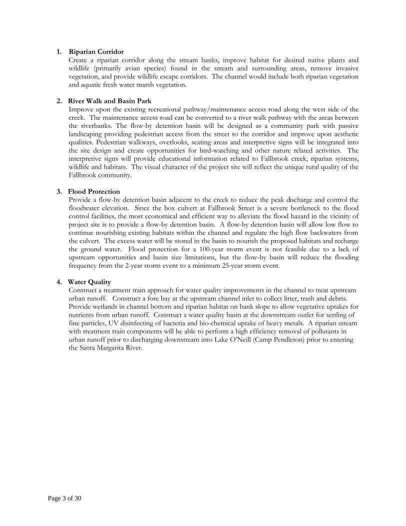
1. Riparian Corridor Create a riparian corridor along the stream banks, improve habitat for desired native plants and wildlife (primarily avian species) found in the stream and surrounding areas, remove invasive vegetation, and provide wildlife escape corridors. The channel would include both riparian vegetation and aquatic fresh water marsh vegetation.
2. River Walk and Basin Park
Improve upon the existing recreational pathway/maintenance access road along the west side of the creek. The maintenance access road can be converted to a river walk pathway with the areas between the riverbanks. The flow-by detention basin will be designed as a community park with passive landscaping providing pedestrian access from the street to the corridor and improve upon aesthetic qualities. Pedestrian walkways, overlooks, seating areas and interpretive signs will be integrated into the site design and create opportunities for bird-watching and other nature related activities. The interpretive signs will provide educational information related to Fallbrook creek, riparian systems, wildlife and habitats. The visual character of the project site will reflect the unique rural quality of the Fallbrook community.
3. Flood Protection
Provide a flow-by detention basin adjacent to the creek to reduce the peak discharge and control the floodwater elevation. Since the box culvert at Fallbrook Street is a severe bottleneck to the flood control facilities, the most economical and efficient way to alleviate the flood hazard in the vicinity of project site is to provide a flow-by detention basin. A flow-by detention basin will allow low flow to continue nourishing existing habitats within the channel and regulate the high flow backwaters from the culvert. The excess water will be stored in the basin to nourish the proposed habitats and recharge the ground water. Flood protection for a 100-year storm event is not feasible due to a lack of upstream opportunities and basin size limitations, but the flow-by basin will reduce the flooding frequency from the 2-year storm event to a minimum 25-year storm event.
4. Water Quality
Construct a treatment train approach for water quality improvements in the channel to treat upstream urban runoff. Construct a fore bay at the upstream channel inlet to collect litter, trash and debris. Provide wetlands in channel bottom and riparian habitat on bank slope to allow vegetative uptakes for nutrients from urban runoff. Construct a water quality basin at the downstream outlet for settling of fine particles, UV disinfecting of bacteria and bio-chemical uptake of heavy metals. A riparian stream with treatment train components will be able to perform a high efficiency removal of pollutants in urban runoff prior to discharging downstream into Lake O’Neill (Camp Pendleton) prior to entering the Santa Margarita River.

Page 4 of 30
Section 497.7 of Title 23, California Code of Regulations, Division 2 Requirements
NOTE: In order for an application package to be complete, it must include the FPCP application form prescribed by the Department of Water Resources in addition to all items specified in the proposed Section 497.7 of Title 23, CCR, Division 2. In many instances, the two forms overlap and therefore, the applicant has chosen to fill out the entire Section 497.7 and reference the duplicate sections within the FPCP application accordingly.
(a) Description of Proposed Project and Background Information
The community of Fallbrook is located in the hills of north central San Diego County and is an unincorporated, low-density residential and agricultural community. Fallbrook’s primary business is agriculture and is known as the primary Avocado Capital of the World with agricultural accounting for just under a third of the area’s personal income. The project site is located within the urbanized section of Fallbrook Creek near the downtown Village Area. Fallbrook Creek is an intermittent stream within the Santa Margarita Watershed. The 680-acre drainage area to the north of the project site is primarily urbanized and built out1. Upstream development will continue to exasperate the existing flood conditions due to the increased impervious surfaces associated with urban development. The specific area of interest is a flood control channel within a four-block section from Fallbrook Street to Elder Street (see Appendix A – Figure 2). The total project area is approximately 2.2 acres. At the downstream end of the project site is a severely undersized culvert that results in frequent flooding of the adjacent downtown area.
The proposed project will convert a near by burned down citrus packing plant adjacent to the flood control corridor into a dual purpose flow-by detention basin/park that will alleviate much of the existing flood conditions. The proposed project will build upon a previous grant project that obtained a permit (US Fish and Wildlife Service) for the removal of Arundo donax within the channel and to carry out long-term maintenance of the site. In addition to the flood control benefits, the proposed project will restore the riparian and wetland habitat within the channel and incorporate water quality BMPs into the design of the project.
(1) A statement of the problem being addressed
At Fallbrook Street, the Fallbrook creek flows underground through a box culvert at the Market Place Shopping Center. The peak discharge of a 100-year storm event is an estimated 1,200 cfs at the Fallbrook Street box culvert. The inlet of the culvert is limited to only 415 cfs, thereby resulting in a severe bottleneck to Fallbrook Creek at the downstream end of the project area. The undersized culvert leads to localized flooding of private properties and public streets during a 2-year storm event or greater. In a 100-year storm event, the estimated peak flow of 1,200 cfs results in a significantly greater flood hazard2. Within the 100-year floodplain includes residential homes, offices, churches, shopping centers and public right-of-ways. A school site exists west of the project site and flooding of the area results in safety issues related to children walking home from school during larger rain events.
1 Flood Drainage Management Report for Fallbrook Area, Rick Engineering Company and SD County Department of Public Works, February 1992.
2 Preliminary Report for the Fallbrook Creek Stream Restoration Project, Urban and Community Assistance Team; 1994.
Page 5 of 30
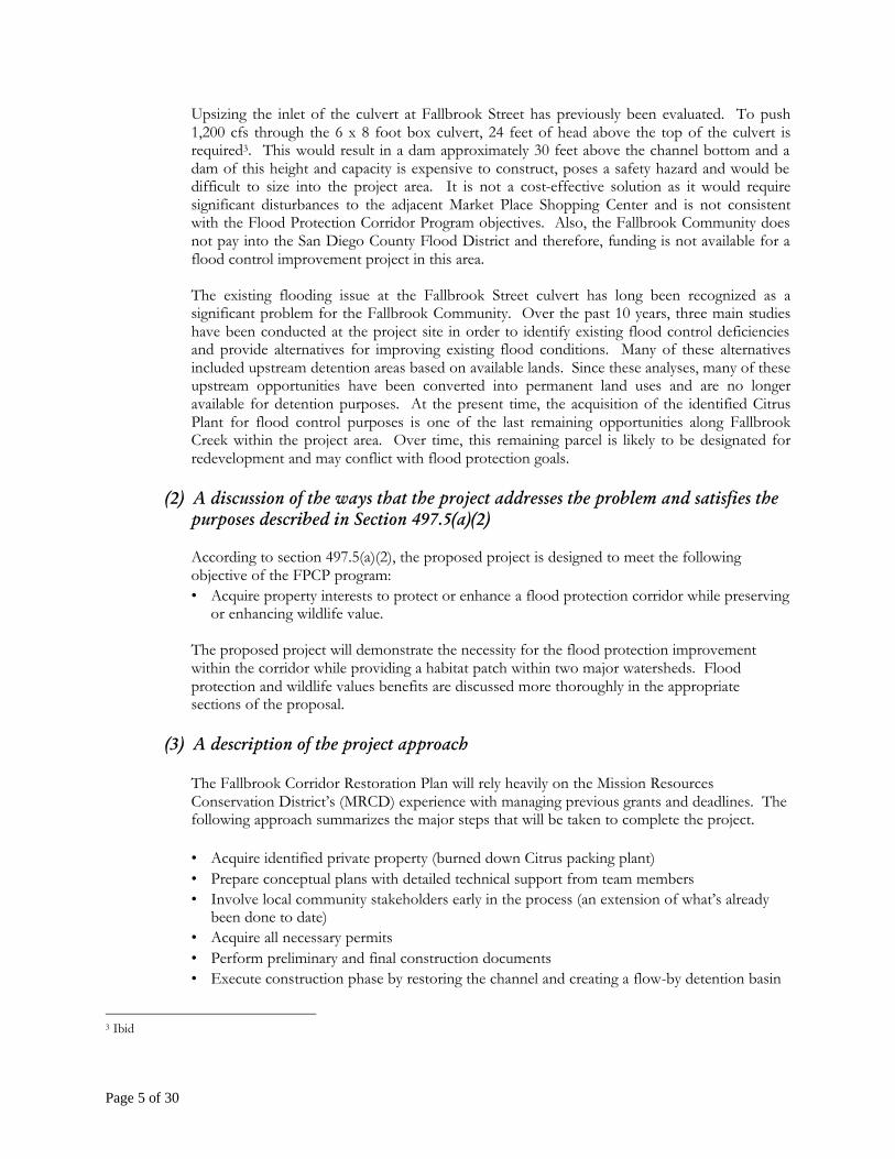
Upsizing the inlet of the culvert at Fallbrook Street has previously been evaluated. To push 1,200 cfs through the 6 x 8 foot box culvert, 24 feet of head above the top of the culvert is required3. This would result in a dam approximately 30 feet above the channel bottom and a dam of this height and capacity is expensive to construct, poses a safety hazard and would be difficult to size into the project area. It is not a cost-effective solution as it would require significant disturbances to the adjacent Market Place Shopping Center and is not consistent with the Flood Protection Corridor Program objectives. Also, the Fallbrook Community does not pay into the San Diego County Flood District and therefore, funding is not available for a flood control improvement project in this area.
The existing flooding issue at the Fallbrook Street culvert has long been recognized as a significant problem for the Fallbrook Community. Over the past 10 years, three main studies have been conducted at the project site in order to identify existing flood control deficiencies and provide alternatives for improving existing flood conditions. Many of these alternatives included upstream detention areas based on available lands. Since these analyses, many of these upstream opportunities have been converted into permanent land uses and are no longer available for detention purposes. At the present time, the acquisition of the identified Citrus Plant for flood control purposes is one of the last remaining opportunities along Fallbrook Creek within the project area. Over time, this remaining parcel is likely to be designated for redevelopment and may conflict with flood protection goals.
(2) A discussion of the ways that the project addresses the problem and satisfies the
purposes described in Section 497.5(a)(2)
According to section 497.5(a)(2), the proposed project is designed to meet the following objective of the FPCP program: • Acquire property interests to protect or enhance a flood protection corridor while preserving
or enhancing wildlife value.
The proposed project will demonstrate the necessity for the flood protection improvement within the corridor while providing a habitat patch within two major watersheds. Flood protection and wildlife values benefits are discussed more thoroughly in the appropriate sections of the proposal.
(3) A description of the project approach
The Fallbrook Corridor Restoration Plan will rely heavily on the Mission Resources Conservation District’s (MRCD) experience with managing previous grants and deadlines. The following approach summarizes the major steps that will be taken to complete the project.
• Acquire identified private property (burned down Citrus packing plant) • Prepare conceptual plans with detailed technical support from team members • Involve local community stakeholders early in the process (an extension of what’s already
been done to date) • Acquire all necessary permits • Perform preliminary and final construction documents • Execute construction phase by restoring the channel and creating a flow-by detention basin
3 Ibid

Page 6 of 30
• Initiate monitoring and maintenance program for long-term success of the project (4) A discussion of the expected outcome and benefits of the project
The proposed project will provide flood protection from a 2-year event (existing) up to a 25-year event (proposed) and minimize localized flooding within the Fallbrook Street area. The flood boundary will be reduced, the depth of inundation will decrease significantly, and flood damage costs will be reduced significantly. Also, indirect benefits include improved pedestrian crossing for nearby school children during rain events and improved property values within the affected community that consists primarily of underrepresented citizens. 2.2 acres of “patch” habitat including fresh water marsh (wetland) and riparian zones will be created within the channel resulting in increased habitat for wildlife, particularly avian species.
(5) A description of the geographic boundaries of the project
See Section 497.7(a) for details.
(6) Verification that the project is located at least partially in one of the qualifying
areas listed in Section 497.5(a)
a. The California Conservation Corps or community conservation corps is used when feasible (Water Code Section 79038(b)).
b. No proposed acquisitions of property interests are fee interests unless the Department has
considered all practical alternatives (Water Code Section 79039). c. All proposed acquisitions of property interests are from willing sellers (Water Code Section
79040). d. If the project includes acquisitions of property interests, it also includes a plan to minimize
the impact on adjacent landowners (Water Code Section 79041). e. If the project includes acquisitions of property interests, a public hearing has been held or
will be held before acquiring the property interest (Water Code Section 79042). f. The applicant certifies that it can maintain the project, if necessary using a trust fund
established with grant funds (Water Code Section 79044).
The Mission Resource Conservation District has reviewed and certifies that the proposed project meets conditions A, C, D, and F identified in the above section. Where applicable, additional details have been provided in the remainder of the proposal.
(7) A description and justification of any proposed use of program funds for flood
control system or water system repairs performed as part of an easement program or a project developed or financed under the program (Water Code Section 79043).
The Fallbrook area has an extensive system of year round and intermittent streams which have been largely unaltered by development and which provide a distinctive image of the riparian

Page 7 of 30
forest throughout the community. At its downtown core, Fallbrook is inadequately provisioned to handle storm water runoff. In the 1960’s, the residents of Fallbrook elected not to join the County of San Diego Flood Control District (County) resulting in the drainage systems exclusion from the County’s Maintained System. The County updated a Fallbrook Drainage and Flood Control Plan in the late 1980’s and in 1989, with limited funding, partially improved and re-graded the channel. At the same time, a master plan was prepared by Beale and Rogers for the Creek and in accord with the wishes of the community, a plan for an environmentally sensitive flood control creek was developed.
The Master Plan created in 1989 has not been implemented and three flood control studies (Rick Engineering, February 1992, USDA Soil Conservation Service, September 1994 and Berryman and Henigar, November 2000) have indicated that since the work performed by the County in 1989, undersized culverts and pipes have restricted flows making it a high probability that homes and businesses along the downtown reaches will flood. Flooding routinely occurs today during larger storms. Today, most of the system is privately maintained or not maintained at all. With money not available for Creek improvement through the County Flood Control District and very limited funding available from the County of San Diego, the alternative is to seek funding from other sources to achieve the level of improvement necessary to alleviate the flooding situation in downtown Fallbrook.
(8) A demonstration that the project is technically feasible
Based on previous hydrologic and hydraulic analyses (see #9 below) and current analyses performed by Fuscoe Engineering, it has been determined that the conversion of the existing designated area into a flow by detention basin will result in a significant flood reduction of the adjacent area. Supporting hydrologic documents can be found in Appendices A that demonstrate the technical feasibility of the project as well as projected peak hydrographs, inundation depths and reductions in peak discharge. In addition, the feasibility of the converting the existing channel into “patch” habitat relies heavily on the field reconnaissance performed for the preparation of this proposal and the extensive experience of the project team.
(9) A hydrologic and hydraulic analysis prepared by a civil engineer registered
pursuant to California law or a Professional Hydrologist-Surface Water certified by the American Institute of Hydrology.
Three independent studies served as the hydrology-related technical support for this Fallbrook Creek Restoration Plan including the Preliminary Report for the Fallbrook Creek Stream Restoration Project (USDA Soil Conservation Service, 1994)Flood and Drainage Management Report for the Fallbrook Area (Rick Engineering and SD County Department of Public Works, 1992) and the Fallbrook Creek Flood Control Study (Berryman and Henigar, 2000). The two latter studies utilized hydrology and hydraulic methodology consistent with the County of San Diego Hydrology Manual and Design Procedures Manual and are available upon request. Armed with this information, Fuscoe Engineering was able to estimate flood reduction impacts of the proposed project (See Appendix A). All hydrology related analyses from Fuscoe Engineering were performed by J.T. Yean, PhD, P.E. (see Appendix E for qualifications). Appendix B contains the following exhibits:
Page 8 of 30
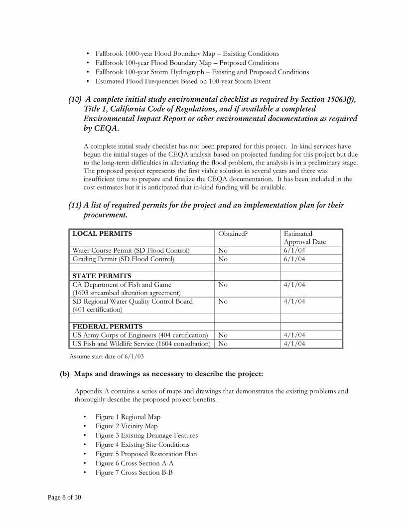
• Fallbrook 1000-year Flood Boundary Map – Existing Conditions • Fallbrook 100-year Flood Boundary Map – Proposed Conditions • Fallbrook 100-year Storm Hydrograph – Existing and Proposed Conditions • Estimated Flood Frequencies Based on 100-year Storm Event
(10) A complete initial study environmental checklist as required by Section 15063(f),
Title 1, California Code of Regulations, and if available a completed Environmental Impact Report or other environmental documentation as required by CEQA.
A complete initial study checklist has not been prepared for this project. In-kind services have begun the initial stages of the CEQA analysis based on projected funding for this project but due to the long-term difficulties in alleviating the flood problem, the analysis is in a preliminary stage. The proposed project represents the first viable solution in several years and there was insufficient time to prepare and finalize the CEQA documentation. It has been included in the cost estimates but it is anticipated that in-kind funding will be available.
(11) A list of required permits for the project and an implementation plan for their
procurement. LOCAL PERMITS Obtained? Estimated
Approval Date Water Course Permit (SD Flood Control) No 6/1/04 Grading Permit (SD Flood Control) No 6/1/04 STATE PERMITS CA Department of Fish and Game (1603 streambed alteration agreement)
No 4/1/04
SD Regional Water Quality Control Board (401 certification)
No 4/1/04
FEDERAL PERMITS US Army Corps of Engineers (404 certification) No 4/1/04 US Fish and Wildlife Service (1604 consultation) No 4/1/04
Assume start date of 6/1/03 (b) Maps and drawings as necessary to describe the project:
Appendix A contains a series of maps and drawings that demonstrates the existing problems and thoroughly describe the proposed project benefits.
• Figure 1 Regional Map • Figure 2 Vicinity Map • Figure 3 Existing Drainage Features • Figure 4 Existing Site Conditions • Figure 5 Proposed Restoration Plan • Figure 6 Cross Section A-A • Figure 7 Cross Section B-B

Page 9 of 30
• Figure 8 Cross Section C-C • Figure 9 Cross Section D-D
(c) A financial summary including:
(1) The estimated cost of the project broken down by task
The cost estimates for the proposed restoration plan are categorized into four major components:
1. Land Acquisition Costs 2. Engineering / Design / Environmental Assessment / Agency Processing Costs 3. Construction Costs 4. Maintenance Costs.
The following cost estimates provide preliminary costs for the key components as identified in previous sections. Land acquisition costs include the burned down Citrus Plant for the 1.7 acres detention basin. Engineering costs include all expenses for preparing design documents, environmental assessment, permit processing, and project coordination. Construction costs are mainly for the major components of the restoration plan as described in this proposal. Maintenance costs including sediment/debris removal, cleaning, repairing and re-planting vegetation are on an annual basis. The costs would be further refined in the final engineering stage but will not exceed the costs reported in this proposal. In addition, MRCD will continue to solicit funds and in-kind support for future improvements to the project area (i.e. linear park, additional signage).
Task Number Description Quantity Cost Totals Task 1: Land Acquisition 1.1 Citrus Plant 1.7 acres $995,000 Sub-total $995,000 $995,000 Task 2: Permit and Processing 2.1 CEQA Documentation L.S. $12,000 2.2 Permit acquisition (USACOE, RWQCB,etc.) L.S. $14,000 2.3 Meetings, coordination, presentations L.S. $15,000 2.4 Final documentation and submittals L.S. $18,000 Sub-total $59,000 $59,000 Task 3: Engineering Studies 3.1 Flood Control and Wetland Hydro-period
Analysis L.S. $45,000
3.2 Alternative Analysis L.S. $18,000 Sub-total $63,000 $63,000 Task 4 Engineering Design 4.1 Channel Restoration Plans (engineering and
grading) L.S. $80,000
4.2 Channel Restoration Plans (landscaping and plant palate design)
L.S. $55,000
4.3 Existing Utility Protection or Relocation Plan
L.S. $15,000
Sub-total $150,000 $150,000
Page 10 of 30
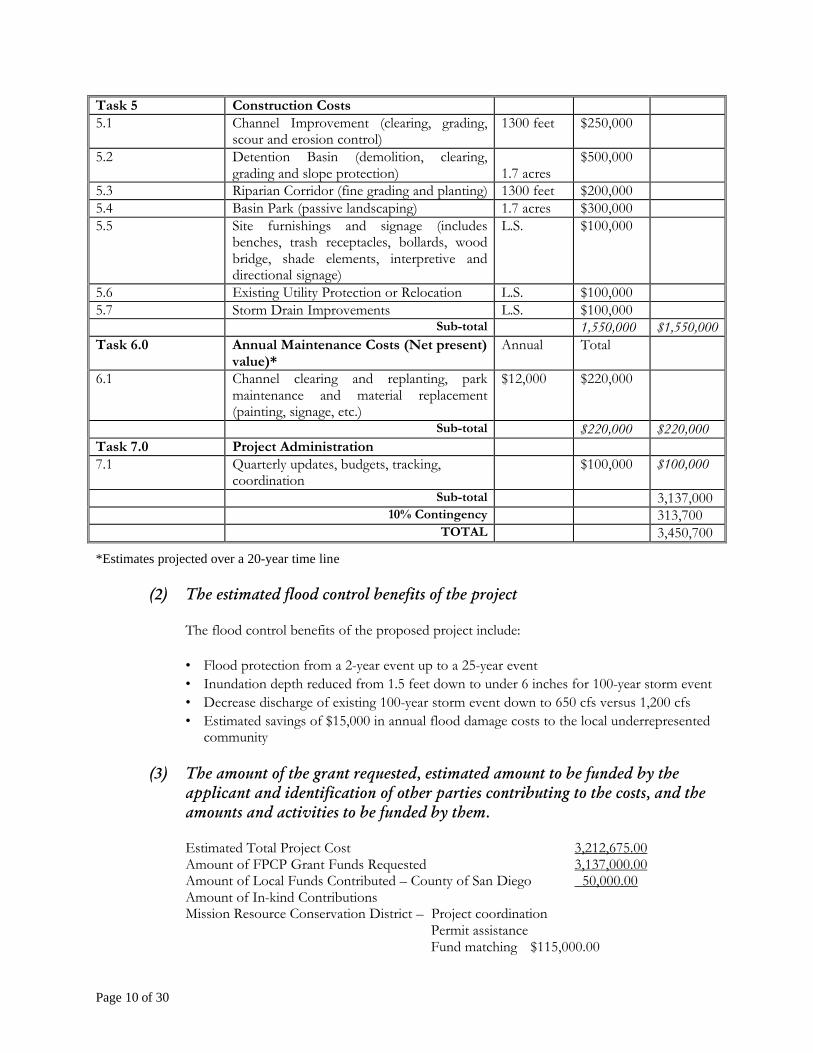
Task 5 Construction Costs 5.1 Channel Improvement (clearing, grading,
scour and erosion control) 1300 feet $250,000
5.2 Detention Basin (demolition, clearing, grading and slope protection)
1.7 acres
$500,000
5.3 Riparian Corridor (fine grading and planting) 1300 feet $200,000 5.4 Basin Park (passive landscaping) 1.7 acres $300,000 5.5 Site furnishings and signage (includes
benches, trash receptacles, bollards, wood bridge, shade elements, interpretive and directional signage)
L.S. $100,000
5.6 Existing Utility Protection or Relocation L.S. $100,000 5.7 Storm Drain Improvements L.S. $100,000 Sub-total 1,550,000 $1,550,000 Task 6.0 Annual Maintenance Costs (Net present)
value)* Annual Total
6.1 Channel clearing and replanting, park maintenance and material replacement (painting, signage, etc.)
$12,000 $220,000
Sub-total $220,000 $220,000 Task 7.0 Project Administration 7.1 Quarterly updates, budgets, tracking,
coordination $100,000 $100,000
Sub-total 3,137,000 10% Contingency 313,700 TOTAL 3,450,700
*Estimates projected over a 20-year time line (2) The estimated flood control benefits of the project
The flood control benefits of the proposed project include: • Flood protection from a 2-year event up to a 25-year event • Inundation depth reduced from 1.5 feet down to under 6 inches for 100-year storm event • Decrease discharge of existing 100-year storm event down to 650 cfs versus 1,200 cfs • Estimated savings of $15,000 in annual flood damage costs to the local underrepresented
community
(3) The amount of the grant requested, estimated amount to be funded by the applicant and identification of other parties contributing to the costs, and the amounts and activities to be funded by them.
Estimated Total Project Cost 3,212,675.00 Amount of FPCP Grant Funds Requested 3,137,000.00 Amount of Local Funds Contributed – County of San Diego 50,000.00 Amount of In-kind Contributions Mission Resource Conservation District – Project coordination Permit assistance Fund matching $115,000.00

Page 11 of 30
USDA Natural Resource Conservation Service Technical Support $157,675.00 Fallbrook Village Association Maintenance support $220,000.00 San Diego County Flood Control District consultation/studies $160,000.00 Fallbrook Revitalization Council design consultation $150,000.00
In-kind Contribution Total: 687,675.00 Additional Funding Sources 50,000.00 Number of persons expected to benefit __36,000 Flood Protection Corridor Funds per person benefited.* _9,000.00
(* Count as beneficiaries those receiving flood benefits, recreational users of habitat areas protected by the Project, and consumers of food products from agricultural areas conserved by the Project.)
FPCP Share Match Amount Total Budget
1. Task 1: Land Acquisition _995,000. ______________ ___995,000. 2. Task 2: Studies __63,000. _160,000.00 ___223,000. 3. Task 3: Permits __59,000. __15,000.00 ____74,000. 4. Task 4: Design _150,000. _150,000.00 ___300,000. 5. Task 5: Construction 1,550,000 _157,675.00 _1,707,675.00 6. Task 6: Maintenance _220,000. ____220,000. __440,000.00 7. Task 7: Administration _100,000. _____50,000. __150,000.00
(d) A summary of proposed property acquisition rights including:
(1) Identification of each property
Abandoned “Packing Plant” located at 400 Mission Road adjacent to Fallbrook Creek corridor (See Appendix A, Figure 5).
(2) Names, addresses and telephone numbers of the property owners and lessees or
tenants.
Lee and Associates represents the owner, Cdenek Riha exclusively. Mr. Riha resides in Fallbrook, CA (phone number 760-728-5167).
(3) The type of property rights to be acquired (such as easement or fee title).
Private property
(4) Evidence that affected landowners are willing participants in any proposed
real property transactions.

Page 12 of 30
See Appendix E.
(5) A justification of any proposed acquisition of fee interest in property to protect
or enhance a flood protection corridor or floodplain while preserving or enhancing agricultural use (Water Code Section 79037(b)(1)) which includes:
a. Reason for the fee title acquisition b. Alternatives considered to fee title acquisition for each property
c. Proposed final disposition of the property
d. Effect on county property tax revenue
The proposed project does not directly involve lands related to the preservation or enhancement of agricultural use and therefore section D(5) does not apply.
(e) A tentative work plan for the project including:
(1) A timetable for execution of the project
Task Duration Estimated Completion Date 1. Land Acquisition 6 months 1/1/04 2. Conceptual level studies 3 months 9/1/03 3. Conceptual level design 3 months 1/1/04 4. Permit Application Process (including CEQA analysis)
4 months 4/1/04
5. Permit Negotiation and Clearance 4 months 8/1/04 6. Final Design 6 months 2/1/05 7. Construction Bidding 2 months 4/1/05 8. Season work 6-8 months 12/1/05 9. Long-term Maintenance 5 years Though 1/1/10
Assume start date of 6/1/03
(2) A task breakdown for the project
See budget and task breakdown in section C1.
(3) A description of how services of the California Conservation Corps, or local community conservation corps will be used in the project.
The Mission Resource Conservation District has extensive experience using CCC and local community conservation corps for their local projects. The symbiotic relationship has produced high quality work well within the budget constraints. For this particular project, it is anticipated that CCC members or local community conservation corps will be used for the clearing out of invasive species within the Fallbrook Creek channel during the initial stages and also for the planting of the riparian and freshwater wetland plants during the later stages.

Page 13 of 30
(f) A list of names and addresses of owners of all property interests in parcels adjacent to
those for which acquisition of property rights is proposed.

Page 14 of 30
Parcel # Owner Owner’s Address 10404037 FALLBROOK UNION HIGH SCHOOL PUBLIC AGENCY 00000
10405102 WINDBIGLER RICKY+SHERI 2465 VIA OESTE DR, FALLBROOK CA 92028
10405210 HAMPTON JOHN H TR+HAMPTON 2352 CASITAS DEL SOL, FALLBROOK CA 92028
10405209 HAMPTON JOHN H TR+HAMPTON 2352 CASITAS DEL SOL, FALLBROOK CA 92028
10405403 RIHA ZDENEK 47850 ROCK MOUNTAIN DR, FALLBROOK CA 92028
10405301 B L U PROPERTIES INC. 215 W FALLBROOK ST, FALLBROOK CA 92028
10405309 BLU PROPERTIES INC. 215 W FALLBROOK ST, FALLBROOK CA 92028
10405306 HERR DEVELOPMENT INC 854 BANGOR ST, SAN DIEGO CA 92106
10406105 FALLBROOK VILLAGE ASSOCIATION P O BOX 508, FALLBROOK CA 92028
10406110 WARNER ROBERT A+SUSAN E TRS 1420 SLEEPING INDIAN RD, OCEANSIDE CA 92057
10406210 TERRIERE FREDRICK J 1295 E MISSION RD, FALLBROOK CA 92028
10406202 CORONADO SANTANA P+NAOMI A 1275 OLD STAGE RD, FALLBROOK CA 92028
10406108 FALLBROOK VILLAGE ASSOCIATION P O BOX 508, FALLBROOK CA 92028
10406209 HERNANDEZ MANUEL R TRUST P O BOX 254, FALLBROOK CA 92028
The table shows each parcel of land that is potentially affected by the flooding problems and the proposed project. The owners of each parcel and their respective addresses are listed above.
(g) If property rights are to be acquired for the project, or if a need is indicated in
environmental review documentation prepared for the project pursuant to CEQA, a plan to minimize the impact of the project on adjacent property owners, including but not limited to the following (Water Code Section 79041):
a. An evaluation of the impact on floodwaters b. The structural integrity of affected levees -- Not applicable c. Diversion facilities -- Not applicable d. Current and historicagricultural practices on the project site and in the vicinity -
Not applicable e. Timber extraction operations -- Not applicable f. An evaluation with regard to maintenance -- Not applicable
The acquisition of the abandoned citrus plant for conversion into a flow by detention basin will have no negative impacts on adjacent landowners. Floodwaters will be significantly reduced on adjacent landowners.
(h) A description of the input and participation that local groups and affected parties
provided in the preparation of the work plan and application.
Many local support groups and stakeholders have been supportive of a flood control project that would improve upon the existing flood conditions around Fallbrook Street. In addition, the concept

Page 15 of 30
of utilizing the burned down citrus plant that has been unoccupied for 14 years and creates an “eye-sore” downtown for detention purposes is strongly supported by the community. The following list summarizes the communities desire to alleviate flooding at Fallbrook Street and to create a habitat patch within the channel. • Rural Redevelopment Community (Fallbrook) • SD County Flood Control • 5th District County Supervisor Bill Horn • Fallbrook Village Association
(i) A statement relative to the use of a trust fund for maintenance, or any proposed
alternative, as specified in Water Code Section 79044.
The Mission Resource Conservation District has previously operated and managed Department of Water Resource funded projects with proper execution. MRCD is also currently in charge of a Santa Margarita in-lieu mitigation moneys to pay for maintenance of portions of the Santa Margarita River. MRCD has full authority and clearance to use a trust fund for maintenance based on previous experiencing performing such tasks.
(j) Either or both of the following, depending on applicability:
(1) An analysis of the project benefits to wildlife habitat. (2) A description of project actions to preserve agricultural land.
See Section 5A of the FPCP proposal for an analysis of the benefits to wildlife habitat and agricultural land.
(k) A statement of qualifications for the project team.
In order to meet the goals of the Flood Protection Corridor Program and accomplish the design objectives of the Fallbrook Corridor Restoration Plan, the Mission Resource Conservation District (MRCD), in private partnership agreement with Fuscoe Engineering, Inc. (FEI), will form a team with in-kind support from the USDA Soil Conservation Service. MRCD has extensive experience managing grants and is currently in charge of nine grants at this time. MRCD will perform all administrative and public outreach about the project. FEI will provide all technical related support in terms of hydrology, engineering, water quality, biology and landscaping expertise. FEI has extensive experience creating environmentally sensitive flood control solutions while incorporating creating water quality and habitat improvements into the design. USDA Soil Conservation Service personnel will provide in-house expertise and review technical issue where appropriate. A summary of the Mission Resource Conservation District experience can be found in the appropriate sections of the proposal and Fuscoe Engineering has provided a summary of qualifications within Appendix E.
(l) A written statement by an attorney certifying that the applicant is authorized to enter
into a grant agreement with the State of California.
See Appendix D

Page 16 of 30
III. Minimum Qualifications
A. The Fallbrook Creek Restoration project will use all granted funds for protection, creation, and enhancement of flood protection corridors [Water Code Section 79037(b)].
B. The Mission Resource Conservation District, a non-profit agency located in San Diego County,
in private partnership with Fuscoe Engineering, Inc propose the following Fallbrook Creek Restoration Plan for funding [Water Code Section 79037(a)]. The Mission Resource Conservation District will serve as the primary contact for the project and will perform all project administration, including budgeting and contractors.
C. The Mission Resource Conservation District will use the California Conservation Corps or a
community conservation corps whenever feasible [Water Code Section 79038(b)]. D. Not Applicable: If it is proposed to acquire property in fee to protect or enhance flood
protection corridors and floodplains while preserving or enhancing agricultural use, the proponent has considered and documented all practical alternatives to acquisition of fee interest [Water Code Section 79039(a)].
E. The property interests to be acquired within the Fallbrook Creek Restoration project are willing
to sell as required by Water Code Section 79040. F. With regards to the proposed acquisition of property interests, the Fallbrook Creek Restoration
proposal includes a plan that evaluates and minimizes the impact on adjacent landowners prior to such acquisition and evaluates the impact on the following [Water Code Section 79041]:
? The project demonstrates that floodwaters including water surface elevations and flow
velocities are significantly reduced to all adjacent landowners. Not Applicable: ? The structural integrity of affected levees ? Diversion facilities ? Customary agricultural husbandry practices ? Timber extraction operations
The Fallbrook Creek Restoration proposal also includes maintenance requirements for a) the acquired property, b) and all constructed or altered facilities.
G. The Fallbrook Creek project site is located in the following flood zone:
Locally designated Flood Hazard Area, with credible hydrologic data to support designation of at least one in 100 annual probability of flood risk. This is applicable to locations without levees, or where existing levees can be set back, breached, or removed. In the latter case, levee setbacks, removal, or breaching to allow inundation of the floodplain should be part of the project. Hydrologic supporting data can be found in Appendix B.

Page 17 of 30
IV. (340 points) Flood Protection Benefits
A. Existing and potential urban development in the floodplain (50)
1. Describe the existing and potential urban development at the site and the nature of the flood risk.
The project site is located within the urbanized section of Fallbrook Creek within the community of Fallbrook. The community of Fallbrook is an unincorporated, low-density residential and agricultural community. The area of interest is a four-block section of Fallbrook Creek that runs from Fallbrook Street to Elder Street (see Appendix A Figure 2). The flood corridor is an intermittent stream within the Santa Margarita Watershed. The 680-acre drainage area to the north of the project site is primarily urbanized and with some opportunities for further development4. The peak discharge of a 100-year storm event is an estimated 1,200 cfs at the Fallbrook Street culvert5. Fallbrook Creek drains south ultimately discharging into the Santa Margarita River. At the downstream end of the project site is a severely undersized box culvert where the creek returns to sub-sub-surface flows underneath an adjacent commercial center before day-lighting 4 blocks downstream. Urbanization will continue to exasperate the flood problem at the culvert in downtown Fallbrook as development projects continue in the upstream end.
2. How often has flooding occurred historically?
Due to the undersized culvert at Fallbrook Street, flooding occurs with any 2-year storm event or greater, affecting private properties and public streets. At Fallbrook Street, the creek flows underground through a box culvert at the Market Place Shopping Center. There, the Fallbrook Street box culvert is limited to only 415 cfs, thereby resulting in a severe bottleneck to Fallbrook Creek at the downstream end of the project area. In a 100-year storm event, the estimated peak flow of 1,200 cfs overcomes the undersized culvert and results in a significantly greater flood hazard.
3. Discuss the importance of improving the flood protection at this location. Include
the number of people and structures that are affected by the flood hazard, and the flood impacts to highways and roads, railroads, airports and other infrastructure, and agriculture.
Within the 100-year floodplain includes several residential homes, 3 offices, a church, a large shopping center and public right-of-ways. The specific area of flooding for storms less than the predicted 100-year event primarily affect low-income residential units owned underrepresented populations. Flooding of the project area causes frequent maintenance requirements for the roads and sidewalks within the flood zone. Also, during day-time rain events, flooding often causes safety issues for students that walk to and from school using
4 Flood Drainage Management Report for Fallbrook Area, Rick Engineering Company and SD County Department of Public Works, February 1992.
5 Ibid
Page 18 of 30
Fallbrook Street. The flooding causes alternate pedestrian routes to be used that are less safe from a pedestrian perspective.
B. Flood damage reduction benefits of the project (100)
1. Does the proposed project provide for transitory storage of floodwaters? What is the total community need for transitory storage related to this water course and what percentage of the total need does this project satisfy? What is the volume of water and how long is it detained?
The Fallbrook Creek Restoration Project will provide transitory storage of floodwaters during storm events. According to a previous study6, 41-acre feet of total storage are required to reduce flooding impacts during a 100-year storm event. The flow-by detention basin will be able to store approximately 20-ac feet or 49% of the required amount for 100-year flood protection. The storm water will be detained for up to 24 hours.
2. Describe any structural and non-structural flood damage reduction elements of the
project. (Examples of structural elements are levees, weirs, detention/retention basins, rock slope-protection, etc. Examples of non-structural elements are acquisition of property for open space, acquisition of land for flood flow easements, transitory storage, relocation of structures and other flood prone development, elevating flood prone structures, flood proofing structures, etc.)
Structural flood damage reduction elements include a 1.7-acre flow-by detention approximately 12 feet deep, with rock slope protection along the east embankment within the residential encroachment areas and at the outlet of the detention basin, plus improved inlet control from various areas draining into the creek. Non-structural flood damage reduction elements include the acquisition of the burned down Citrus plant area for conversion into the flow-by detention basin and transitory storage of flood waters within the detention basin.
3. By what methods and by how much dollar value will the project decrease expected
average annual flood damages?
Based on a simplified version of the expected annual flood damages model, it is anticipated that the flood control measures for Fallbrook Creek will reduce the annual flood damages by roughly $15,000. Factors in this assessment included:
• Acreage of project area inundated for 2-year event • Number of residential homes and buildings • Average value of homes and buildings for the particular area • Frequency of flooding (2-year event) • 10% damage assumption to structures in floodplain
Flood damages for a 100-year storm event are estimated at a range of $625,000 to $800,000 and would be reduced to less than $100,000 after the implementation of the project.
6 Preliminary Report for the Fallbrook Creek Stream Restoration Project, Urban and Community Assistance Team; 1994.

Page 19 of 30
4. How does the project affect the hydrologic and hydraulic conditions at the project site and adjacent properties?
a.) The proposed restoration plan will reduce the frequency and magnitude of the flood
flows from a 2-year storm event to a 25-year storm event. The project will decrease the peak discharge of 1,200 cfs from the existing condition to 650 cfs for the proposed condition.
b.) The flow-by detention basin will reduce the water surface elevation of Fallbrook Creek during a flood event to 1 foot below the top of the bank for 25-year storm events or smaller.
c.) Flow velocities will not be affected within the proposed plan because the design of the flow-by detention facility will not alter the existing flow velocities. Under the existing and proposed conditions, flow velocities are not considered a significant safety or environmental hazard.
d.) Flood inundation depths for the 100-year storm event are estimated at 1.5 feet while the proposed plan results in flooding depths of less than 6 inches within a flood plain reduced by 20%.
C. Restoration of natural processes (60)
1. Describe how any natural channel processes will be restored (for example: for channel meander, sediment transport, inundation of historic floodplain, etc.) and describe how these natural processes will affect flood management and adjacent properties.
Channel meandering will be restored within the low flow channel to mimic natural processes and the sinuosity of the channel will be based on the hydraulic modeling results during the design phase. Sediment transport processes will remain essentially unchanged from the existing conditions and sediment from the upstream urbanized area will continue to move through the channel. The natural processes of the proposed plan will not affect flood management and adjacent properties but will serve to improve the enhanced habitat areas within the channel.
2. Describe any upstream or downstream hydraulic or other effects (such as bank
erosion or scour, sediment transport, growth inducement, etc.).
Bank erosion along the east side of the channel exists along certain sections of the creek due to residential encroachment. The restoration plan will provide bank protection in the form of geo-web and native vegetative cover along these susceptible areas.
3. If the project includes channel modification or bank protection work, will riprap or
dredging be part of the design? If so, provide an analysis of potential benefits and impacts.
No dredging is required for the Fallbrook Creek Restoration project. Native vegetation with geo-web covering will be the preferred method for bank stabilization. Channel hydraulic results will determine areas susceptible to erosion and riprap will only be used where necessary.

Page 20 of 30
D. Project effects on the local community (60)
1. How will the project impact future flooding on and off this site?
The project will reduce future flooding conditions and provide flood protection up to a 25-year storm event. Depths of inundation will be significantly decreased (from 1.5 feet to under 6 inches).
2. How will the project affect emergency evacuation routes or emergency services and
demands for emergency services?
The proposed project will improve emergency evacuation routes that utilize Fallbrook Street because the proposed project will serve to reduce overtopping of floodwaters within this area.
3. Explain how the project will comply with the local community floodplain
management ordinance and the floodplain management criteria specified in the Federal Emergency Management Agency’s National Flood Insurance Program (FEMA’s NFIP).
The proposed project will consult with the San Diego County Flood Control District (SDCFCD) in order to demonstrate the project is consistent with their floodplain management criteria. The Mission Resource Conservation District has extensive experience working with SDCFCD and understands the processes that this project must do. FEMA studies do not cover the project site area within Fallbrook but all floodplain management criteria will be followed where applicable.
E. Value of improvements protected (70)
1. What is the assessed value of structural improvements that will be protected by the
project?
The assessed value of structural improvements including the flow-by detention basin and the improved channel that will be protected by the project are estimated at $500,000.
2. What is the estimated replacement value of any flood control facilities or structures
protected by the project?
The estimated replacement values of the structures protected by the project are based off the property values affected by the flooding. The property value of these areas is $2.2 million.

Page 21 of 30
V. (340 points) Wildlife and Agricultural Land Conservation Benefits
Proponent should provide a statement of the relative importance of the project’s wildlife and agricultural land conservation benefits. DWR will use the statement and all other project materials to assign a fraction of the total benefits to each type (wildlife (Fw) or agricultural land conservation (Fa)) so that the fractions total unity. Actual points scored for each type of resource will be multiplied by the respective fraction for each resource, and the wildlife and agricultural scores resulting for each type of resource will be added together.
A. (340xFw points) Wildlife Benefits
Habitat values refer to the ecological value and significance of the habitat features at this location that presently occur, have occurred historically, or will occur after restoration. Viability refers to the site’s ability, after restoration if necessary, to remain ecologically viable with minimal on-site management over the long-term, and to be able to recover from any natural catastrophic disturbances (fire, floods, etc.).
A1. Importance of the site to regional ecology (70)
1. Describe any habitat linkages, ecotones, corridors, or other buffer zones within or adjacent to the site. How are these affected by the project?
2. Is the site adjacent to any existing conservation areas?
3. Describe any plans for aquatic restoration resulting in in-stream benefits.
4. Discuss any natural landscapes within the site that support representative examples
of important, landscape-scale ecological functions (flooding, fire, sand transport, sediment trapping, etc.)?
The project site resides within the Santa Margarita Watershed within close proximity to the San Luis Rey Watershed. More specifically, the project site falls within a migratory corridor and supports connectivity between habitat patches used by migratory birds along both the Santa Margarita and San Luis Rey drainages. The conversion of the existing site to a riparian habitat appropriate to historical vegetation patterns shall support diversity and ensure that patch areas, configuration and connectivity are maintained throughout the corridor. The conversion of the existing channel is also consistent with Executive Order 13186 issued on January 10, 2001 that mandates that Federal agencies implement measures that will assist with migrating birds, including habitat patches.
A2. Diversity of species and habitat types (70) 1. Does the site possess any:
i. areas of unique ecological and/or biological diversity? ii. vegetative complexity either horizontally or vertically?
2. Describe habitat components including year-round availability of water, adequate
nesting/denning areas, food sources, etc.
3. Describe any superior representative examples of specific species or habitats.
4. Does the site contain a high number of species and habitat types? List and describe.

Page 22 of 30
5. Does the site contain populations of native species that exhibit important subspecies
or genetic varieties historically present prior to European immigration?
Under current conditions, the existing habitat does not qualify as an area of unique ecological or biological diversity nor does it demonstrate vegetative complexity. The vegetation within the channel consists of low growing weedy grasses. The vegetation is primarily non-native species including water cress (Rorippa nasturtium-aquaticum), annual beard-grass (Polypogon monspeliensis), rough cockelebur (Xanthium strumarium), and bristly oxtongue (Picris echioides). Small clumps of native species exist throughout the channel include cattail and bulrush. Significant canopy vegetation is not present within the right-of-way corridor although historically willow and mulefat were present. Under the proposed condition, the flood corridor will be restored to support native riparian habitat. The riparian corridor design will incorporate the geomorphic characteristics of the channel and the modifications for the channel bank to provide sufficient stability for native vegetative cover. This proposed plan will provide visual and physical access to the stream; create flat, pond areas; and restore native vegetation and stream habitat within the right-of-way (See Appendix A, Figure 7). The right-of-way will include establishment of native vegetation consisting of arroyo willow (Salix lasiolepis), narrow leaf willow (Salix exigua), mulefat (Baccharis salicifolia), and Fremont cottonwood (Populus fremontii).
Ø Creation of 1.6 acres of riparian habitat for wildlife (primarily avian species) and
recreational opportunities.
In addition to the riparian restoration component, aquatic restoration of wetland habitat will be created along the channel bottom. A 20 feet wide linear wetland will be restored in the channel bottom to support fresh water marsh habitats. River rocks consisting of three to six inch cobbles will be set in the low flow path to dissipate the flow momentum and prevent channel erosion. The river rocks will be aesthetically compatible with the natural stream. The typical cross-section varies along the length of stream according to adjacent land uses and landscape. In general, the depth of the cross-section varies from 4.5 feet in the upstream end to 6 feet in the downstream end, and maintains an average depth of 5 feet. The vegetation in the streambed will be low growing groundcover plant pallets intermittently located within river rocks. The plant pallets will be selected by a professional biologist and will meet very specific criteria for height and density in order to minimize flood conveyance impacts. Fresh water marsh plants will be distributed within channel bottom and will be sustained with the available groundwater and surface runoff. Recommended species for the wetland channel bottom include deer grass (Muhlenbergia rigens), saltgrass (Distichlis spicata), and bulrush (Scirpus californicus and Scirpus americanus).
Ø Creation of 0.6 acre of continuous freshwater habitat
The combined benefits from the both the increased wetland channel bottom and riparian habitat will increase wildlife areas for avian species such as: • Common yellow throats • Song sparrows • Marsh wrens • Black-chinned hummingbird

Page 23 of 30
• Yellow warbler (Sensitive species) • Yellow-breasted chat (Sensitive species) • Egrets • Herons • Waterfowl
The increase in avian populations is consistent with the Fallbrook Community goal to increase habitat areas for wildlife and subsequent recreational bird-watching opportunities.
A3. Ecological importance of species and habitat types (100)
1. Discuss the significance of habitat types at this location and include any local, regional, or statewide benefits received by preserving or improving the area.
2. Does the site contain any significant wintering, breeding, or nesting areas?
Does it fall within any established migratory corridors? What is the level of significance? How are these affected by the project?
3. Describe any existing habitats that support any sensitive, rare, “keystone” or
declining species with known highly restricted distributions in the region or state. Does the site contain any designated critical habitat? How are these affected by the project?
4. What is the amount of shaded riverine aquatic (SRA) and riparian habitat to
be developed, restored, or preserved?
Previous regulatory permits have designated the stretch of flood corridor as southwestern willow flycatcher habitat although significant degradation of the vegetation has reduced potential nesting habitat. The site also falls within an established migratory corridor for local and regional birds. One of the main objectives of this project is to restore native habitat back into the channel. The project applicant recognizes the size of the restoration area does not qualify the restored area as a significant habitat area but it does qualify as habitat patch that will provide some benefit to the local wildlife. In total, 2.2 acres of riparian and wetland habitat will be restored within the flood control corridor.
A4. Public benefits accrued from expected habitat improvements (60)
1. Describe present public use/access, if any. For instance, does or will the public have access for the purpose of wildlife viewing, hunting, fishing, photography, picnics, etc.
2. Discuss areas on the site that are critical for successfully implementing
landscape or regional conservation plans. How will the project help to successfully implement the plans?
3. Describe the surrounding vicinity. Include the presence or absence of large
urban areas, rapidly developing areas, and adjacent disturbed areas with non-

Page 24 of 30
native vegetation and other anthropogenic features. Do any surrounding areas detract from habitat values on the site?
4. Describe compatibility with adjacent land uses.
The proposed project will maximize pedestrian access to the improved channel and increase recreational opportunities for wildlife viewing, photography and picnics. Based on the surrounding urbanized area, the project site provides a very important environmental awareness opportunity for the local community and nearby elementary school.
A5. Viability/sustainability of habitat improvements (40)
1. Describe any future operation, maintenance and monitoring activities planned for the site. How would these activities affect habitat values?
2. Does the site contain large areas of native vegetation or is it adjacent to large
protected natural areas or other natural landscapes (for example, a large stand of blue-oak woodland adjacent to public land)?
3. Is the watershed upstream of the site relatively undisturbed or undeveloped and
likely to remain so into the foreseeable future? Describe its condition.
4. Describe any populations of native species or stands of native habitats that show representative environmental settings, such as soil, elevations, geographic extremes, or climatic conditions (for example, the wettest or most northerly location of a species within the state.)
Maintenance of the proposed components of the project is an integral part of the long-term viability of the project. One of the primary maintenance objectives is to focus heavily on the upstream and downstream areas while minimizing impacts within the continuous stretches of improved habitat. Any significant maintenance activity will occur outside the breeding season of the local bird species. It is expected that the water quality basins at the upstream end and downstream end will require more frequent maintenance than the channel itself. Preliminary maintenance requirements have been addressed and have also been accounted for in the cost estimate (Section VI). More detailed maintenance requirements for each major component of the plan will be submitted during the preliminary and final design phases.
• Routine removal of trash and debris (i.e. weekly) from water quality basins • Remove invasive species 3-4 times/year as required from channel and water quality
basins • Check slopes of basin and channel for erosion and replace eroded material if
necessary • Inlet/outlet facilities should be inspected annually and observed during storm
events to ensure they are working properly • Remove accumulated sediment when quantity of sediment (12” or more) may
impair storage volume of basin within park • Establish and maintain 90% vegetative cover within water quality basins • Inspect basins and channel after major storm events (greater than 1” rainfall)

Page 25 of 30
• Remove dead plants in water quality basins and replace in accordance with planting scheme
The upstream watershed is primarily urbanized and will not influence the long-term sustainability of the project.

Page 26 of 30
B. (340xFa points) Agricultural Land Conservation Benefits
B1. Potential productivity of the site as farmland (120)
Not applicable
B2. Farming practices and commercial viability (40)
1. Does the area possess necessary market infrastructure and agricultural support services?
2. Are surrounding parcels compatible with commercial agricultural production?
3. Is there local government economic support in place for agricultural enterprises including water policies, public education, marketing support, and consumer and recreational incentives?
The Fallbrook Community is an agricultural town that relies heavily on avocados, nurseries and citrus fruit as their primary crops. This small-town community is very supportive of its agricultural infrastructure and formed a Rural Future Task Force in recent years to conserve agricultural services as retail and business services expand. Agricultural support services are also in place to preserve the agri-economy and utilize the downtown area as a focal point for citizens to come together and exchange their products (farmer’s markets). Funding of the proposed project will directly benefit the property values of the areas subject to flooding and provide support for many of the underrepresented families that live within the affected area and work within the agricultural industry.
B3. Need and urgency for farmland preservation measures (70)
Not applicable
B4. Compatibility of project with local government planning (50)
Not applicable
B5. Quality of agricultural conservation measures in the project (50)
Not applicable
Page 27 of 30
VI. (320 points) Miscellaneous Benefits and Quality of Proposal
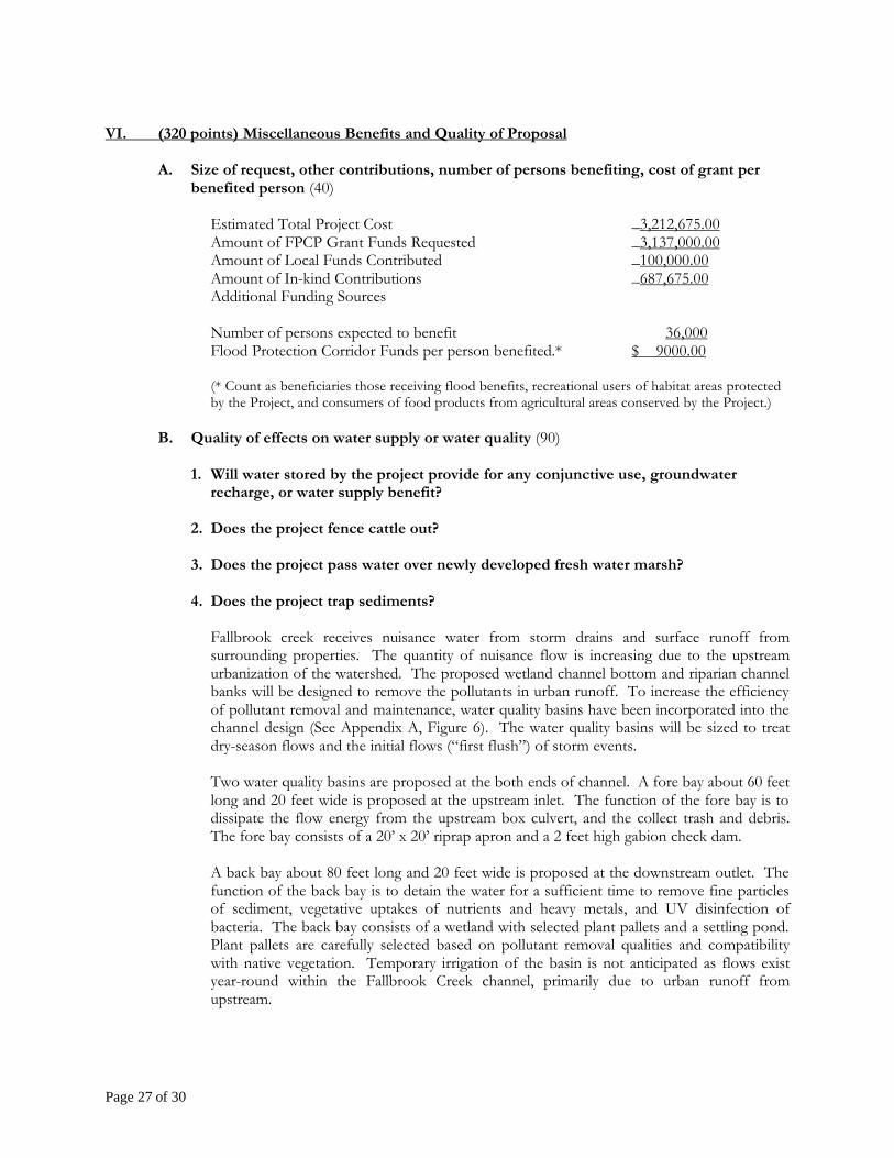
A. Size of request, other contributions, number of persons benefiting, cost of grant per benefited person (40)
Estimated Total Project Cost _3,212,675.00 Amount of FPCP Grant Funds Requested _3,137,000.00 Amount of Local Funds Contributed _100,000.00 Amount of In-kind Contributions _687,675.00 Additional Funding Sources Number of persons expected to benefit 36,000 Flood Protection Corridor Funds per person benefited.* $ 9000.00 (* Count as beneficiaries those receiving flood benefits, recreational users of habitat areas protected
by the Project, and consumers of food products from agricultural areas conserved by the Project.) B. Quality of effects on water supply or water quality (90)
1. Will water stored by the project provide for any conjunctive use, groundwater recharge, or water supply benefit?
2. Does the project fence cattle out?
3. Does the project pass water over newly developed fresh water marsh?
4. Does the project trap sediments?
Fallbrook creek receives nuisance water from storm drains and surface runoff from surrounding properties. The quantity of nuisance flow is increasing due to the upstream urbanization of the watershed. The proposed wetland channel bottom and riparian channel banks will be designed to remove the pollutants in urban runoff. To increase the efficiency of pollutant removal and maintenance, water quality basins have been incorporated into the channel design (See Appendix A, Figure 6). The water quality basins will be sized to treat dry-season flows and the initial flows (“first flush”) of storm events. Two water quality basins are proposed at the both ends of channel. A fore bay about 60 feet long and 20 feet wide is proposed at the upstream inlet. The function of the fore bay is to dissipate the flow energy from the upstream box culvert, and the collect trash and debris. The fore bay consists of a 20’ x 20’ riprap apron and a 2 feet high gabion check dam. A back bay about 80 feet long and 20 feet wide is proposed at the downstream outlet. The function of the back bay is to detain the water for a sufficient time to remove fine particles of sediment, vegetative uptakes of nutrients and heavy metals, and UV disinfection of bacteria. The back bay consists of a wetland with selected plant pallets and a settling pond. Plant pallets are carefully selected based on pollutant removal qualities and compatibility with native vegetation. Temporary irrigation of the basin is not anticipated as flows exist year-round within the Fallbrook Creek channel, primarily due to urban runoff from upstream.

Page 28 of 30
Ø Pollutant removal of urban runoff utilizing recommended NPDES Best Management Practices (BMPs)
A 20 feet wide linear wetland will be restored in the channel bottom to support fresh water marsh habitats. River rocks consisting of three to six inch cobbles will be set in the low flow path to dissipate the flow momentum and prevent channel erosion. The river rocks will be aesthetically compatible with the natural stream. The vegetation in the streambed will be low growing groundcover plant pallets intermittently located within river rocks. The plant pallets will be selected by a professional biologist and will meet very specific criteria for height and density in order to minimize flood conveyance impacts. Fresh water marsh plants will be distributed within channel bottom and will be sustained with the available groundwater and surface runoff. Recommended species for the wetland channel bottom include deer grass (Muhlenbergia rigens), saltgrass (Distichlis spicata), and bulrush (Scirpus californicus and Scirpus americanus). Ø Creation of 0.6 acre of continuous freshwater habitat
C. Quality of impact on underrepresented populations or historic or cultural resources (60)
1. Does the project benefit underrepresented populations? Explain.
The project area has a population of 2,000 which is 6% of the total population of Fallbrook. The project area has a pedestrian orientation which has a higher than average Hispanic population of 36% and a senior population of 12%. The income level for the project area is 23% lower per household than the average Fallbrook income and 34% lower than the San Diego Region. In 1990, 21% of the families in the project area were considered below the poverty level. (Fallbrook Economic Revitalization Plan, November 1999)
2. Are historical or cultural resources impacted by the project? Explain.
The project is in the village area of Fallbrook which is in the older section where many of the buildings date back to the late 1800’s. Three of the structures in the project area are eligible for National Registry listing. (The Fallbrook Economic Revitalization Plan, November, 1999)
D. Technical and fiscal capability of the project team (60)
1. Does the project require scientific or technical expertise, and if so, is it provided for in the grant proposal?
The project requires a combination of scientific and engineering expertise in order to restore the flood corridor into a sustainable habitat area that alleviates flooding of the adjacent areas. Bio-engineering techniques and environmentally sensitive flood control solutions will be incorporated into the project design and these services have been accounted for in the grant proposal.
2. Grant funds will be available in phases. What monitoring and reporting
mechanisms are built into your administrative plan to track progress, initiation, and completion of successive phases?

Page 29 of 30
Based on Mission Resource Conservation District (MRCD) extensive experience with administering grants to local projects, the District has found that quarterly reports are the most efficient way to track progress, initiation and completion of goals. These report updates will document the work completed, percent budget spent and objectives for the next quarter of work. Long-term and short-term goals will be set at the kick-off meeting and updated as required.
3. Please outline your team’s management, fiscal and technical capability to
effectively carry out your proposal. Mention any previous or ongoing grant management experience you have.
Judith Mitchell of the MRCD has served as District Coordinator for 15 years and she will be the primary contact for this proposal. She is currently managing nine grants at this time.
List of currently managed grants:
1. San Luis Rey Arundo Removal and Habitat Restoration Southern California Wetlands Recovery Program - $1,270.00 2. Department of Water Resources Urban Stream Restoration Program Ostrich Creek Restoration - $422,600 3. Department of Water Resources Urban Stream Restoration Program Live Oak
Creek Restoration - $345,600 4. National Fish and Wildlife Foundation Environmental Enhancement Grant –
$123,000.00 5. California Transportation Commission Environmental Enhancement and Mitigation
Program - $259,800 6. State Water Resources Control Board, Arundo Control and Riparian Habitat
Restoration - $911,000 7. The Resources Agency and Department of Conservation, Watershed Coordinator
Grant Program - $153,282.00 8. San Diego County Water Authority, Agricultural Irrigation Water Management
Program - $195,000.00 9. Bureau of Reclamation – Irrigation Water Management - $45,000.00
E. Coordination and cooperation with other projects, partner agencies, and affected
organizations and individuals (80)
1. List cost sharing and in-kind partners and any other stakeholders involved with your project and indicate the nature of their contribution, if any. Address the team’s ability to leverage outside funds.
2. Does your project overlap with or complement ongoing activities being carried
out by others (such as CALFED, the Sacramento and San Joaquin River Basins
Page 30 of 30
Comprehensive Study, the Delta levee program, local floodplain management programs, the Reclamation Board’s Designated Floodway program, or a multiple objective regional or watershed plan)? If so, indicate any coordination that has taken place to date or is scheduled to take place in the future.
The proposed project does not overlap, complement or involve any other regional watershed projects.
3. Will this application, if approved, begin the next phase of a previously approved
project or advance an ongoing project substantially toward completion?
The proposed project will continue on with the a previous grant funded project that removed Arundo donax from the channel and provided channel improvements to the section of Fallbrook Creek. In-kind support in terms of maintenance from this project will be applied towards the proposed project.
4. Describe how the proposal demonstrates a coordinated approach among affected
landowners, local governments, and nonprofit organizations. If other entities are affected, is there written support for the proposal and a willingness to cooperate?
During the past several years, numerous groups and affected landowners have demonstrated a desire to alleviate the flood problems at Fallbrook Creek while enhancing the flood corridor. More recently, MRCD has solicited comments on the plan to convert the abandoned packing plant into a recreational flow-by basin while improving native habitat within the channel. Written support for the project can be found in Appendix G.
Related Documents


