Watershed Management Strategies for Flood Mitigation: a case study of Jakarta’s flooding Dr. Chay Asdak Institute of Ecology, Padjadjaran University Jalan Sekeloa Selatan 1 Bandung 40132, Indonesia; Fax: +62-22- 2504982 e-mail: [email protected] Abstract Jakarta is a capital city of Indonesia located in the delta of Ciliwung river. This city suffers annual flooding with some serious damage for certain extreme rainfall events, especially occuring at the upper parts of the Ciliwung watershed. In 1992 rainy season, flooding in Jakarta were scattered in 61 sites. In 1996, the flooding increased to 90 sites, and further increased in the rainy season of 2002 to be 159 sites. This flooding has caused tremendous economic loss as well as loss of human life. To reduce the magnitute and frequency of further flooding, on-site as well as off-site program actions need to be taken comprehensively. To be effective, the program actions should be integrated with the Ciliwung catchment management strategies, covering both upstream and downstream areas. This paper is specifically aimed at, firstly understanding the main problems causing flooding in the coastal area of Jakarta, and secondly proposing medium and long-term solutions from the perspective of integrated watershed management approach. The proposed solution will also include institutional and financial arrangements in a cross administrative boundary situation. Key words: flooding, watershed management, upstream-downstream biophysical relation, Indonesia Introduction As in many cities in the flood-prone areas in Indonesia, Jakarta has been reported to have big flood as early as in Paper presented for the Research Workshop on Integrated Water Resource Management, jointly organised by LabMath Indonesia, ITB, University of Twente, and Universitas Padjadjaran, Bandung 7-18 January 2008.

Welcome message from author
This document is posted to help you gain knowledge. Please leave a comment to let me know what you think about it! Share it to your friends and learn new things together.
Transcript

Watershed Management Strategies for FloodMitigation:
a case study of Jakarta’s flooding
Dr. Chay AsdakInstitute of Ecology, Padjadjaran University
Jalan Sekeloa Selatan 1 Bandung 40132, Indonesia; Fax: +62-22-2504982
e-mail: [email protected]
AbstractJakarta is a capital city of Indonesia located in the delta ofCiliwung river. This city suffers annual flooding with some seriousdamage for certain extreme rainfall events, especially occuring atthe upper parts of the Ciliwung watershed. In 1992 rainy season,flooding in Jakarta were scattered in 61 sites. In 1996, theflooding increased to 90 sites, and further increased in the rainyseason of 2002 to be 159 sites. This flooding has caused tremendouseconomic loss as well as loss of human life. To reduce themagnitute and frequency of further flooding, on-site as well asoff-site program actions need to be taken comprehensively. To beeffective, the program actions should be integrated with theCiliwung catchment management strategies, covering both upstreamand downstream areas. This paper is specifically aimed at, firstlyunderstanding the main problems causing flooding in the coastalarea of Jakarta, and secondly proposing medium and long-termsolutions from the perspective of integrated watershed managementapproach. The proposed solution will also include institutional andfinancial arrangements in a cross administrative boundarysituation.
Key words: flooding, watershed management, upstream-downstreambiophysical relation, Indonesia
IntroductionAs in many cities in the flood-prone areas in Indonesia,Jakarta has been reported to have big flood as early as in Paper presented for the Research Workshop on Integrated Water Resource Management, jointly organised by LabMath Indonesia, ITB, Universityof Twente, and Universitas Padjadjaran, Bandung 7-18 January 2008.

the year of 1621 (Kompas, 29/1/2005). There was no detailedinformation on this flood, but it was reported that the depthof the flood was more than one meter high. In 1876, anotherreport indicated that the downstream area of the Ciliwungriver, which was then known as part of the city of Jakartawas flooded severely. This flood forced the Dutch governmentat that time to build three dams to control the river flow.The three dams were Bendungan Hilir located at the downstream ofthe Ciliwung river (Jakarta), Bendungan Jago and Bendungan Udikwere both located at the upper parts of the same river. Lateron, as a result of the large flood occuring in 1876 and thesubsequence flood events, the Dutch government through itsrepresentative for the flood control task force, Prof. Hermanvan Breen, built the Banjir Kanal (flood canal) stretching fromManggarai in the city center to Muara Angke at the coastalarea of Jakarta. The main purpose of this canal is to makethe flood water flowing faster into the Java sea, and hence,preventing the flooding in Jakarta (Wijnker, 1997).
Despite various efforts to reduce the flood carried out bythe Dutch government, and later on by the Indonesiangovernment, Jakarta can not be entirely freed from flooding.Naturally, this is associated with the fact that Jakarta islocated on a flat area and in some areas are even lower thanthe surface of the sea. In another word, it is typical offlood-prone areas located in the delta of major rivers. Othernatural factor that make Jakarta critical to the flood isthat there are more than 10 small rivers flowing andtransfering large amount of rainwater into around 40% area ofthe city of Jakarta (Fig. 1). Apart from the natural causingfactors, the recent uncontrolled land-based development ofupstream areas of those rivers combined with high populationgrowth in the city of Jakarta and poor urban-rural planningmake the flooding-related problems becoming more serious andcomplicated (to handle).
The scale of the flooding problem associated with thesenatural as well as man-made (anthropogenic) factors can beseen from the following flooding-related impacts. In 1979,
2

Jakarta was inundated by a 50-year return period flood thatcovered more than two-third of its lower area of Jakarta,forcing around 100,000 household homeless and 10 people dead.In 1992 rainy season, flooding in Jakarta were scattered in61 sites. In 1996, the flooding increased to 90 sites, andfurther increased in the rainy season of 2002 to be 159sites. The average depth of these floods were ranged between1 to 5 m. The flood of 2002 causing two people dead and40,000 households becoming temporary refugees. The mostrecent flooding in Jakarta was taken place on January 2005leaving 8,000 household without home (Kompas, 18 January2005). These floodings have caused tremendous economic lossas well as loss of human life. To reduce the magnitute andfrequency of flooding in the future, on-site as well as off-site program actions need to be taken comprehensively. To beeffective, the program actions should be integrated with theCiliwung catchment management strategies, covering upstream,middlestream, and downstream areas. This paper isspecifically aimed at, firstly understanding the mainproblems causing flooding in the coastal area of Jakarta, andsecondly proposing medium and long-term solutions from theperspective of integrated watershed management approach. Theproposed solution will also include institutional andfinancial arrangements in a cross administrative boundarysituation.
Understanding the Hydrological ProcessesIn Java island, flooding has been around for centuries,especially during big rainfall events. The flood givesbenefits, mostly in the form of basic requirement for plantsand animals to grow, flashing down any unwanted materials atsoil surface as well as in rivers, and forming fertile deltasthat benefiting people in the downstream areas. However, mostfloodings resulting in negative impacts as shown by floodingthat hits Jakarta and other areas in Indonesia.
In the case of flooding in the city of Jakarta, one shouldput the downstream flood in the context of the entireCiliwung watershed. The Ciliwung river drains into the Java
3

sea and it runs about 117 km long from its upper most area inPuncak, West Java. As can be seen from Fig. 2, the city ofJakarta is in the downstream part of the Ciliwung watershed.It was mentioned that despite the Ciliwung river, there aremore than 10 streams flowing into Jakarta area, however thispaper focuses on the Ciliwung watershed for at least threereasons. First, this river is the largest river systementering Jakarta. Second, the upper and middle parts of thisriver are now experiencing large change in land use,particularly from mostly land uses that recharge the groundwater to be runoff-producing type of land uses. Third, theCiliwung watershed covering three different localgovernments, namely the capital city of Jakarta, the Districtof Bogor and the city of Depok. These local governments wouldhave their own different interests in managing/planning theirareas, and therefore would need a collective agreement forflood control measures in a transboundary situation. Thefollowing is the land use characteristics and change and itsupstream-downstream linkages of the Ciliwung watershed.
The Ciliwung watershed area is around 32,573 ha and consistsof three areas of the upper Ciliwung (around 15,800 ha),middle Ciliwung (11,050 ha), and the lower Ciliwung (5,720ha) as can be seen in Table 1. Table 1 shows that theCiliwung watershed is classified as a disturbed watetershed,especially in the middle and upper parts of the watershed asindicated by small area of forest cover ( 15%) and highhousing/building coverage (35%). This is understandableconsidering that the middle and upper Citarum watershed isclosed to the capital city of Jakarta and closed to thecenter of economic development activities in the upstreamareas such as Depok, Bogor, and Puncak (West Java).
The scale of catchment disturbance of the Ciliwung watershed,especially in the middle and upper parts of the watershed canbe seen from the rate of land use change during the period of1990 and 1999. In that period of time, the forested areadeclined by 10%. So does the plantation (18%), mostly teaplantation in the upper parts of the Ciliwung watershed. Not
4
Bay of

surprisingly that the declining of the forest and plantationareas was followed by the sharp increased of dry land farming(169%) and housing/building coverage (338%) in 10 yearsperiod of time. This land use changes in the middle and upperparts of the Ciliwung watershed have resulted in a tremendousnegative environmental effects, especially hydrologicaldisturbances. The hydrological disturbances associated withthe land use changes can be briefly explained as follows.
In a watershed system, upstream areas are hydrologicallylinked to downstream areas through streamflow behaviour andsediment transfer. Land use change in the upstream areas arenot only resulting in an on-site impact in the form ofincreasing runoff and soil erosion, but it will also giveoff-site impact of increasing streamflow and riversedimentation downstream. The increasing of both runoff anderosion rates are mainly caused by decreasing conservationindex (CI) as a result of land use changing from forest coverto poor agricultural practices and/or housing/buildingcoverage as illustrated in Fig. 3. Land use with greaterconservation index means greater capability of infiltringrainwater into the soil (greater ground water recharge),therefore reducing runoff and soil erosion.
The Causes of the FloodingIt was mentioned earlier that the flood in the city ofJakarta is closely associated with both natural andanthropogenic factors. Natural factors are commonly relatedto the following: (1) Jakarta is located on a low-lying flatcoastal area (a deltaic city), which is influenced by
5

backwater effect from the Java sea during the rise of the sealevel, (2) more than ten small rivers flowing into Jakarta,and (3) annual rainfall in the Ciliwung watershed, especiallyin the upper part is high ( 3000 mm). While natural factorsare not so easy to handle for flood mitigation, theanthropogenic factors making the flooding mitigation evenmore difficult. This later factors including landscapechanging due to high competition on land-base economicactivities, poor urban as well as rural spatial planning, andlack of integrated institutional capacity and arrangement,especially in the context of cross administrative boundarysituation (special district of Jakarta versus the province ofWest Java).
Rapid Landscape ChangesThe major flooding hits the streets of Jakarta is commonlyassociated with the overload of Jakarta’s drainage watersystem and landscape changing occuring in the middle andupper parts of the Ciliwung watershed. Table 1 shows thatduring 1990 – 1999, the forest and plantation areas declinedby 28%. So does the wet paddy field, declining by 73%. Theseland use types are widely known as an effective surface water(runoff) retention. Reducing large area of these land usesmaking more rainwater available for flooding in thedownstream area. Another land use that good for surface waterretention is pond/lake. Table 1 shows that the change ofpond/lake is not significant. But other source indicates thatbefore 1997 the number of pond/lake in the upper Ciliwung wasabout 122. After 1997, the number went down to be only 28(BPLHD, 2002). If this report is correct, then the scale ofhydrological disturbance in the upper part of the Ciliwungshould be greater. In the lower part (the Jakarta area),apart from the steadily increase in population, the number ofwater retention systems (mostly ponds) were sharply reducedfrom 35 in 1997 to none in 1999 (Kompas, 2002). Theconversion of mangrove forest in the northwest parts ofJakarta’s coastal areas for waterfront luxurious housingcomplex and the so-called reclamation of other parts of the
6

same coastal areas have exacerbated the scale of the flood inJakarta.
The adverse hydrological impact caused by reducing thosesurface water retention areas has been exacerbated by sharpincreased in dry land farming areas (169%) and increased ofhousing/building coverage by 338%. Opposite to the goodfunction of forest, plantation and wet paddy field for waterconservation measures, the dry land farming andhousing/building areas commonly found in the Ciliwungwatershed are not favorable for conserving ground water,which means increasing runoff, because their conservationindex numbers are reduced substantially (Fig. 3). Therefore,it can be said from this data that landscape changing in themiddle and upper parts of the Ciliwung watershed could be animportant factor for flooding in Jakarta.
7
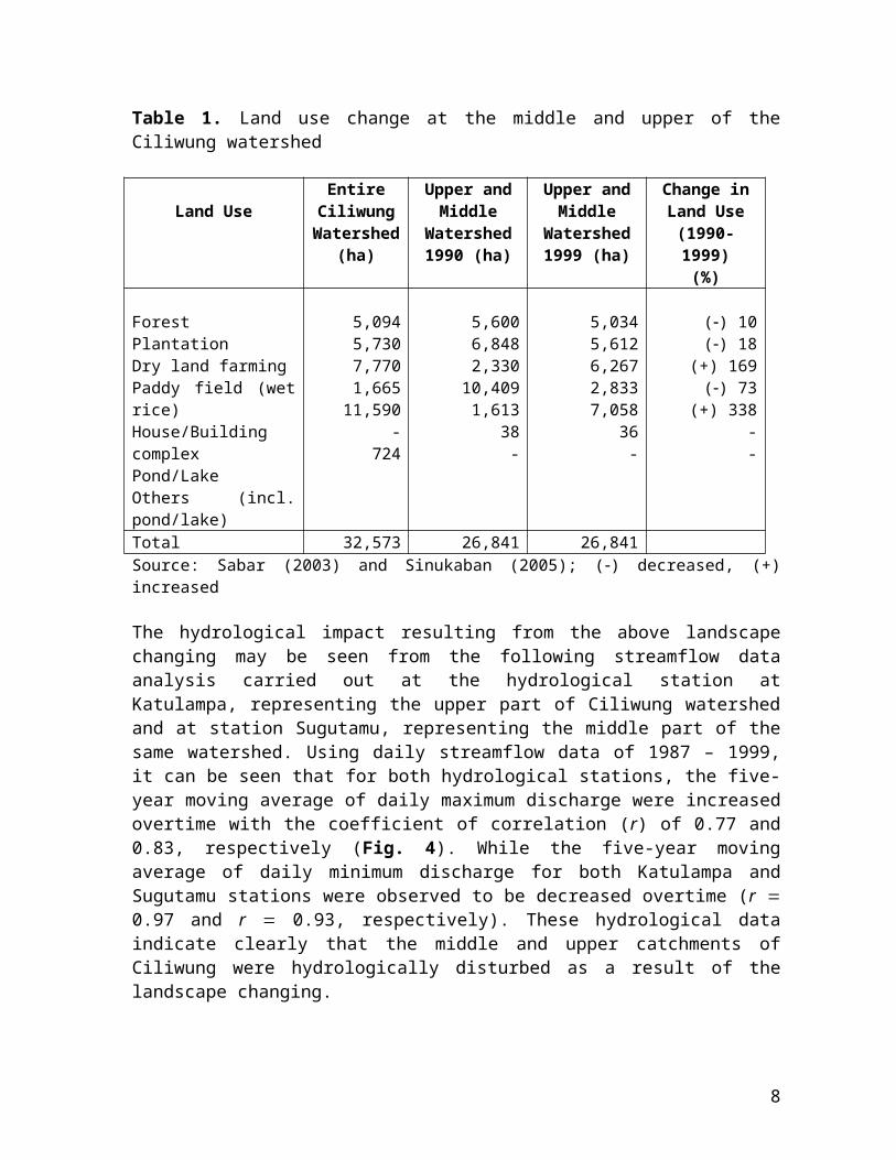
Table 1. Land use change at the middle and upper of theCiliwung watershed
Land UseEntireCiliwungWatershed
(ha)
Upper andMiddle
Watershed1990 (ha)
Upper andMiddle
Watershed1999 (ha)
Change inLand Use(1990-1999)(%)
ForestPlantationDry land farmingPaddy field (wetrice)House/BuildingcomplexPond/LakeOthers (incl.pond/lake)
5,0945,7307,7701,665
11,590-
724
5,6006,8482,330
10,4091,613
38-
5,0345,6126,2672,8337,058
36-
() 10() 18
(+) 169() 73
(+) 338--
Total 32,573 26,841 26,841Source: Sabar (2003) and Sinukaban (2005); () decreased, (+)increased
The hydrological impact resulting from the above landscapechanging may be seen from the following streamflow dataanalysis carried out at the hydrological station atKatulampa, representing the upper part of Ciliwung watershedand at station Sugutamu, representing the middle part of thesame watershed. Using daily streamflow data of 1987 – 1999,it can be seen that for both hydrological stations, the five-year moving average of daily maximum discharge were increasedovertime with the coefficient of correlation (r) of 0.77 and0.83, respectively (Fig. 4). While the five-year movingaverage of daily minimum discharge for both Katulampa andSugutamu stations were observed to be decreased overtime (r 0.97 and r 0.93, respectively). These hydrological dataindicate clearly that the middle and upper catchments ofCiliwung were hydrologically disturbed as a result of thelandscape changing.
8

The flooding in Jakarta is not only causing the loss ofeconomic and human life, but it also spurs the debate withinscientific communities whether disappearing of forest land inthe upper most Ciliwung watershed to be the important factorfor the Jakarta’s flooding. To clarify this issue, the Centerfor Research and Development of Water Resources conducted ahydrological simulation study linking the disappearance offorest in the upper Ciliwung (station Katulampa) with thedownstream flooding (Ilyas, 2004). Apart from clarifying thedebatable issue, this study is also important for consideringwhich factors need to be given high priority for solving
9
Grafik 2. Debit Maksimum Rerata St. Katulampa (R-5 Tahun)
061218243036424854606672
1987-91 1989-93 1991-95 1993-97 1995-99Tahun
Debi
t (m
^3/d
et)
Debit (R-5th) Trend Linier
r = 0.77
Grafik 6. Debit Maksimum Rerata St. Sugutamu (R-5 Tahun)
0255075100125150175200225250
1987-91 1989-93 1991-95 1993-97 1995-99
Debit (R-5th) Trend Linierr = 0.83 0,83
Grafik 8. Debit Minimum Rerata St. Sugutamu (R-5 Tahun)
0.01.53.04.56.07.59.010.512.013.515.0
1987-91 1989-93 1991-95 1993-97 1995-99
Debit (R-5th) Trend Linier
r = -0.93
Grafik 4. Debit Minimum Rerata St. Katulampa (R-5 Tahun)
012345678910
1987-91 1989-93 1991-95 1993-97 1995-99Tahun
Debi
t (m
^3/d
et)
Debit (R-5th) Trend Linier
r = -0.97
Fig. 4. The five-year maximum and minimum moving average of the streamflow for twohydrological stations at Katulampa (left) and Sugutamu (right) (adapted from Sabar, 2003)

flooding in the deltaic city of Jakarta. The hydrologicsimulation study uses the ANSWERS model (Beasley et al.,1980) with rainfall data from JICA (1996).
The result of the hydrologic simulation study shows that forthe five-year return period, the reduction of forested areaat the upper part of Citarum watershed from 58% to 34%resulting in the increase of peak flood around 14%, from312.5 m3/sec to 364.5 m3/sec (Fig. 5). The simulation studyalso indicates that when the rainfall regime were increasedto 192 mm (25-year return period), 206 mm (50-year returnperiod), and 238 mm (100-year return period), the percentageof increase in the peak flood at Katulampa hydrologicalstation were all less than 10%. This hydrological simulationresult is in line with many other research findings world-wide, where small rainfall events produce significant effecton peak flow as a result of forest cutting, but when rainfallregime increased considerably, then there is no significanthydrological effect statistically.
Based on this simulation study, the influence of forest coverin the upper most parts of the Ciliwung watershed to theJakarta’s flooding is relatively small. Therefore, it issuspected that the major contributor for the Jakarta’sflooding is defined more by the landscape changing in themiddle parts of the Ciliwung watershed, especially the sharpincrease in housing/building areas combined with inadequatedrainage system within the city of Jakarta.
10
Peak flood 364.5 m3/secArea 150 km2
Rainfall 137 mmForest 34%; RP 5 years
Peak flood 312.5 m3/secArea 150 km2
Rainfall 137 mmForest 58%; RP 5 years
Fig. 5. Forest area changed from 58% to 34% and its impact on peak flood at 5-year return period in the Upper Ciliwung watershed (adapted from Ilyas, 2004)

Problems Associated with Spatial Planning and Institutional CapacityIt has been stated that the important anthropogenic factorcontributing to the downstream flooding is the uncontrolledland-based activities in the middle and upper parts of theCiliwung watershed. This is mainly caused by rapid populationgrowth combined with un-integrated urban-rural spatialplanning within the watershed. The population growth ingreater Jakarta is increasing from 4.5 millions people in1975 to 6.3 millions in 1985, 9.0 millions in 1995, andaround 12 millions in 2005 (Kompas, 2005). The difficultsituation is intensified with the implementation of Laws No.22/1999 [revised to Law No. 32/2004] on Regional Governmentwhich is also known as the law of regional autonomy(decentralization). According to this law, central governmentto decentralise most of its authority to local governmentsincluding the management of natural resources. With thislaw, the local governments (district and city governments)are autonomously in charge in the management and allocationof local resources for their regional income. With the newlaw, local government does not receive full funding from thecentral government any more, therefore, most of the localgovernments then intensify their economic activities withoutpaying too much attention to negative consequences on theirneighbors. What is actually happening in the last four yearssince the implementation of the Law No. 22/1999 [revised toLaw No. 32/2004] on Regional Government is that:
(1) Local governments are becoming too economic oriented inthe management of their natural and man-made resources.Because of the short-term economic orientation activitiesmany natural resources, for example forested areas, arechanged to other cash crops and/or human settlement formore fresh money.
(2) Local governments are becoming independent from centraland provincial governments. This is becoming a big problem
11

for an integrated cross administrative boundary planning,because each of the local government is now making its ownspatial planning (Rencana Tata Ruang Wilayah) withoutconsidering other local government’s spatial planning andnot referring to the provincial and national spatialplanning.
According to Law No. 24/1992 [revised to Law No. 26/2007] onSpatial Planning, the spatial planning of every localgovernment should refers to the provincial and nationalspatial planning. But this, in many cases, is not happeningbecause there is no such mechanism to force the localgovernment to follow the regulation and lack of institutionalcapacity in facilitating the formulation of a spatialplanning in a cross administrative boundary system. Theproblem with the current system of spatial planning is if thespatial planning of a district/city in the upstream of awatershed is tend to increase annual streamflow or waterpollution, the downstream district/city will be sufferingwithout economic compensation (from the upstream activities).This is because there is no upstream-downstream compensationmechanism that is now operating in Indonesia. Without thismechanism and adequate institutional capacity to run themechanism, cross-boundary conflicts will be intensified. Forexample, in cases where downstream area is sensitive to watershortage and/or floods, conflicts between local government inthe upstream area and that of the local government in thedownstream is intensified. This kind of conflict should havebeen prevented if the urban-rural planning is designedproperly, especially when this rural-urban areas isintegrated in one watershed, one plan and one integrated (upstream-downstream) management. In the case of the Ciliwungwatershed, the rural-urban planning system should include thedistrict of Bogor in the upper part, city of Depok in themiddle, and the city of Jakarta in the lower area. Right now,each of these administrative units has its own planningsystem, which is not linked adequately from the perspectiveof the integrated watershed management. The problem is
12

intensified with the distorted interpretation of Law No.22/1999 [revised to Law No. 32/2004].
The Strategy for Flooding MitigationStrategy for flooding mitigation for short to medium-terms isto encourage the local government of Bogor, Depok, andJakarta to get together and do the following:
(1) Discuss all previous flood events that hit Jakarta,learned from it and formulate or proposed an integratedflood mitigation involving the three local governments.It should be clearly defined who is doing what, whereand how.
(2) Involve universities, research institutions, largecompanies, and other relevant parties in the jointanalysis and program formulation of any related aspectsto flood mitigation. Any formulated flood mitigationprograms should be accepted by all stakeholders andagreed to do what is considered to be the stakeholderown responsibility.
(3) Identify all buildings (villas/bungalows, housingcomplex, and other buildings) in the catchments of allrivers flowing into Jakarta, especially those in theJakarta’s river banks for their legality. Illegalbuildings at the catchments and along the banks of therivers should be evaluated for possible relocation.
(4) The government of Jakarta should evaluate andcontrol its policy on the so-called reclamation ofJakarta’s coastal areas and the development ofwaterfront luxurious homes on the mangrove forest areas.This kind of development activities will reduce waterretention areas in the coastal zone and will increasethe possibility of occuring “backwater effect”.
(5) Considering that the time of concentration (floodtravel time) from Katulampa hydrological station to thecity of Jakarta is about 7-8 hours and considering thatthe long-distance rainfall prediction system has alreadybeen in place, it is possible to establish and operatean early warning system which involve different relevant
13

institutions/organisations working in an integratedfashion. The organisations involved in this earlywarning system should consist of the center for nationaldisaster mitigation, the Directorate General of WaterResources, the Police Department, local government,NGOs, religious organisations, print and electronicmedia, and telecommunication services.
The strategy for flood mitigation in the long-run should befocused on a sustainable conservative programs focusing on acomprehensive-integrative approach. This long-term strategyshould also involve the local government of Tangerang andBekasi districts.
(1) Formulate a grand design for water resourcemanagement of the Ciliwung-Cisadane watersheds coveringJakarta, Bogor, Depok, and Tangerang-Bekasi areas whichconsider biophysical as well as socio-economic aspectsof the areas. The current single focus of engineeringapproach in water resource management for floodmitigation should be avoided.
(2) Formulate an improved water resource-relatedorganisation which focus more on a multi-disciplinaryand transboundary institutional approach in designing anintegrated spatial planning. This type oforganisation/institution arrangement should alsoconsider the important of establishing an upstream-downstream cash flow as part of the upstream-downstreamcompensation mechanism.
(3) The long-term proposed strategy for floodmitigation will require a large amount of funding. Thespecial province of Jakarta alone will not capable offinancing the proposed flood mitigation program.Therefore, it is important to involve large companies inJakarta such as the Jakarta International Airport, theJakarta International Seaport, and other Jakarta-basedlarge companies that suffered from flooding tocontribute financially to the proposed program.
14

(4) As part of the program on dispersing big flood inJakarta into many small floods in the upper and middleareas of the Ciliwung and Cisadane watersheds (flooddistribution concept), it is necessary to build smalldams at the tributaries and other artificial surfacewater retention at the catchment of the two main rivers.
(5) To encourage rural people in the middle and upperCiliwung and Cisadane watersheds to maintain andestablish homegardens and mixed gardens and othersurface water retention such as ponds, small check dams,and ground water recharge wells. To get this programmoving at a massive scale, it should be integrated tothe incentive and dis-incentive system, for examplethrough tax measures or other incentive mechanism. Thislarge scale movement program should involvesociologists, anthropologists, and other socialscientists for getting a widespread public acceptance.
ConclusionThe flooding in Jakarta is becoming a regular event. It showsa tendency of increasing in magnitude as well as in frequencyrather than decreasing despite a number of engineeringefforts have been carried out to control it. The causes ofthe Jakarta’s flooding are a combination of natural as wellas anthropogenic factors. The factors are from within thecity of Jakarta and from its upstream areas. Meaning, itrequires more than just a conventional on-site engineeringsolution to control the flooding. To be more effective in thelong run, the approach to mitigate the flooding in Jakartashould be shifted from an on-site conventional engineeringflood mitigation to a more integrated catchment managementone. It is clear from the spatial analysis based on landscapechanges and the hydrological data that the middle and upperparts of the Ciliwung watershed plays an important role inthe Jakarta’s flooding. Therefore, an integrate catchmentmanagement of the Ciliwung and Cisadane watersheds for theJakarta’s flooding mitigation should be given greaterpriority, especially on how to make a multi-stakeholderparticipation in a trans-boundary planning system.
15
ReferencesAsdak, C. 2004. Hydrology and the Management of Watershed. Gadjah
Mada University Press, Yogyakarta (revised edition,Indonesian).
BPLHD. 2002. Implementasi Kajian Lingkungan Strategik dalamPengelolaan Kawasan Bogor, Puncak, dan Cianjur. KerjasamaPPSDAL-Lembaga Penelitian Unpad dan BPLHD Propinsi Jawa Barat(Indonesian).
Beasley, D.B., L.F. Huggins and E.J. Monke. 1980. ANSWERS: a modelfor watershed planning. Trans ASAE, Vol. 23 (4):988-994.
Ilyas, M. A. 2004. Usaha Konservasi Terhadap Banjir, Erosi,Sedimentasi pada DAS Cipinang, Ciliwung di Jawa Barat danDKI. Proceeding of the National Seminar on Water andDisasters. Jakarta, 23 April 2004 (Indonesian).
Kompas daily news paper, 18 January 2005.Sabar, A. 2003. Kajian Ekstremitas Debit Air dan Pelestarian Air di
Kawasan Konservasi. Proceeding of the National Seminar onImplementation and Development of Environmentally SoundTechnology in the Globalization Era. Surabaya, 1-2 October2003 (Indonesian).
Sinukaban, N. 2005. Menjinakkan Ciliwung untuk Mengamankan Jakarta.Harian Kompas, 29 Januari 2005, hal. 49 (Indonesian).
Wijnker, L.G. 1997. Performance of the Western Banjir Canal Systemfor Flood Control in Jakarta, Indonesia. Delf University ofTechnology, Faculty of Civil Engineering, Department of WaterManagement, Environment, and Sanitation.
16
Related Documents