Flood Hazard Modelling Standard 6 May 2021 Prepared for Greater Wellington Regional Council

Welcome message from author
This document is posted to help you gain knowledge. Please leave a comment to let me know what you think about it! Share it to your friends and learn new things together.
Transcript
Flood Hazard Modelling Standard 6 May 2021
Prepared for Greater Wellington Regional Council
ii
Foreword
Rivers are an important part of New Zealand’s landscape and culture. Not only providing environmental and social value to all New Zealanders, but holding a special place in Maori culture. To enjoy these benefits many of our communities are on floodplains. As a result river flooding is a significant hazard across New Zealand.
The Wellington Region is no exception with many of our major towns at risk from large floods. Being able to understand the potential scale and extent of floods is a critical tool for engineers, emergency managers and planners.
While no model can be 100% accurate they provide the basis for most risk management options. Such as guiding the siting of defences, providing the basis for flood forecasting and warning systems and informing planners where areas of appropriate development should be.
We have developed this standard to provide a robust flood hazard modelling process which will provide confidence to the community, planners, and engineers. Through the development of this process we have sought to imbed community engagement, and peer review at each stage to ensure the best possible outcome.
Flood Protection would like to acknowledge Cardno NZ for their hard work in developing this standard. It is intended that this standard will inform the flood hazard modelling carried out by Greater Wellington Regional Council, the communities we serve, our partners, and the consultants we work with to deliver these projects and aid all in delivering robust flood hazard modelling to aid in our understanding of risk and our management of it.
Andy Brown
Team leader – Investigations, Strategy & Planning, Flood Protection, Greater Wellington Regional Council.
iii
Table of Contents
PROCEDURE 00 – Process 04
PROCEDURE 01 – Gather and Access Data 14
PROCEDURE 02 – Hydrology 29
PROCEDURE 03 – Peer Review 43
PROCEDURE 04 – Hydraulics 52
PROCEDURE 05 – Outputs 69
PROCEDURE 06 – Independent Audit 83
Revision Reason for Issue Date Developed by Approved by
1 Final for issue. May 2021 Cardno NZ
Andy Brown – TL Investigations,
Strategy, and Planning GWRC
PROCEDURE 00
PROCESS This procedure outlines the flood hazard modelling process, and provides an overview of the protocols to be followed during planning of flood hazard modelling projects.
Procedure 00 Table of Contents
1 Introduction 1
1.1 What is the Flood Hazard Modelling Standard? 1
1.2 When is flood hazard modelling undertaken? 4
1.3 Community engagement 4
1.4 Event frequency descriptor 5
2 Project Planning 5
2.1 Procurement approach 6
2.2 Process review/lessons learnt 7
3 Documentation 8
4 Procedure review 8
Flood Hazard Modelling Standard 6 May 2021
1
1 Introduction
Flooding is a significant hazard in the Wellington Region that poses a risk to life, property and infrastructure. A number of communities within the region are considered to be at risk – including urban areas within the Hutt Valley, townships on the Kapiti Coast, Masterton and Greytown in the Wairarapa and rural areas throughout the region. The 2004 flood in the Waiwhetu Stream that caused major flooding to residential properties along Riverside Drive, the Hutt Park raceway and the industrial area in Gracefield is a recent reminder of the damage that flooding can cause.
Flood hazard modelling is considered a crucial activity in understanding flood risk as it provides the basis for investment and emergency management decisions by Greater Wellington Regional Council (GWRC). Flood hazard modelling involves the use of hydrological and hydraulic models to estimate the range of possible floods that could occur in a catchment and the hazard associated with these events. The output produced from flood hazard models is a series of flood hazard maps and tabulated data for each scenario modelled.
Having a good understanding of the flood hazard in an area enables informed decisions to be made about the best ways to manage risk. This may be through managing or reducing the risk to existing development, and future planning decisions such as excluding sensitive land uses (i.e. residential development, hospitals and schools) from higher hazard areas.
1.1 What is the Flood Hazard Modelling Standard?
GWRC have developed this Flood Hazard Modelling Standard (FHMS) to outline the protocols to be followed by any person working on GWRC’s flood hazard modelling projects. The FHMS process should be followed on all new flood hazard modelling projects.
The protocols in the FHMS have been developed to ensure that flood hazard modelling projects are undertaken in a robust and consistent way that is in line with accepted industry practice, while still allowing for flexibility in approach in recognition that the optimal approach may be dependent on catchment or project specific factors. The protocols require that every stage of the process is well documented in reports or spreadsheet logs and registers.
The FHMS is made up of 7 Procedures and 7 Specifications, and a number of templates and supporting documents. The Procedures, Specifications and Templates have the following functions:
Procedure: a Procedure outlines the tasks required to be undertaken within each step of the FHMS process, and describes any technical detail or methodology to be prescribed. The procedure also outlines how the work undertaken at that step of the FHMS process should be documented.
Specification: a Specification is tied to a Procedure and forms part of a request for proposal (RFP) for works to be undertaken by a consultant or contractor. Specifications are typically a brief schedule of requirements with the majority of the technical detail located within the relevant procedure to prevent duplication.
Template: a number of templates are provided as part of the FHMS process. Each template is tied to a Procedure that outlines how these templates should be used. Templates are provided where a consistent format is required to document a process or finding. Templates outline the minimum documentation requirements for these elements. Additional detail should be provided where needed.
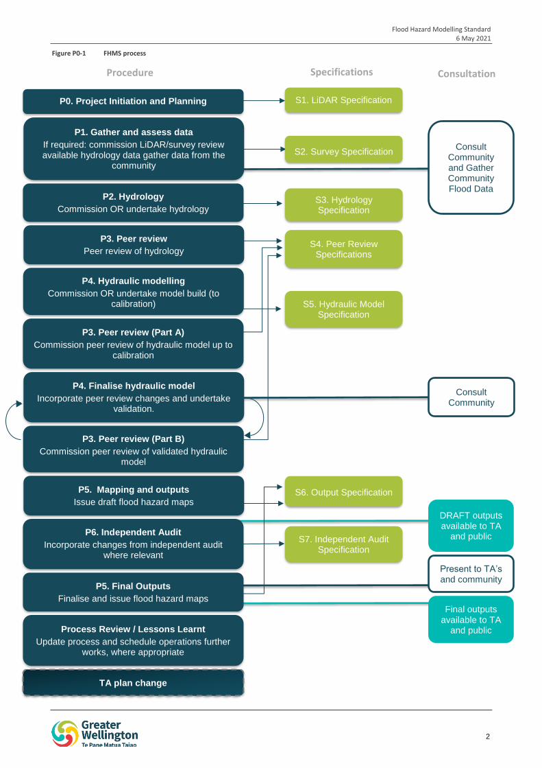
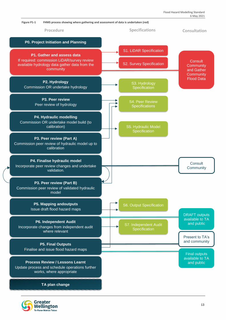
The FHMS process is summarised in Figure P0-1 below.
Flood Hazard Modelling Standard 6 May 2021
2
iop
1
S1. LiDAR Specification
S2. Survey Specification
S3. Hydrology Specification
P2. Hydrology
Commission OR undertake hydrology
S4. Peer Review Specifications
P4. Hydraulic modelling
Commission OR undertake model build (to calibration) S5. Hydraulic Model
Specification
P3. Peer review (Part A)
Commission peer review of hydraulic model up to calibration
P4. Finalise hydraulic model
Incorporate peer review changes and undertake validation.
S6. Output Specification P5. Mapping and outputs
Issue draft flood hazard maps
P6. Independent Audit
Incorporate changes from independent audit where relevant
TA plan change
S7. Independent Audit Specification
P3. Peer review (Part B)
Commission peer review of validated hydraulic model
P3. Peer review
Peer review of hydrology
Consult Community
Present to TA’s and community
Consult Community and Gather Community Flood Data
Process Review / Lessons Learnt
Update process and schedule operations further works, where appropriate
P1. Gather and assess data
If required: commission LiDAR/survey review available hydrology data gather data from the
community
DRAFT outputs available to TA
and public
Final outputs available to TA
and public
P0. Project Initiation and Planning
P5. Final Outputs
Finalise and issue flood hazard maps
Procedure Specifications Consultation
Figure P0-1 FHMS process
Flood Hazard Modelling Standard 6 May 2021
3
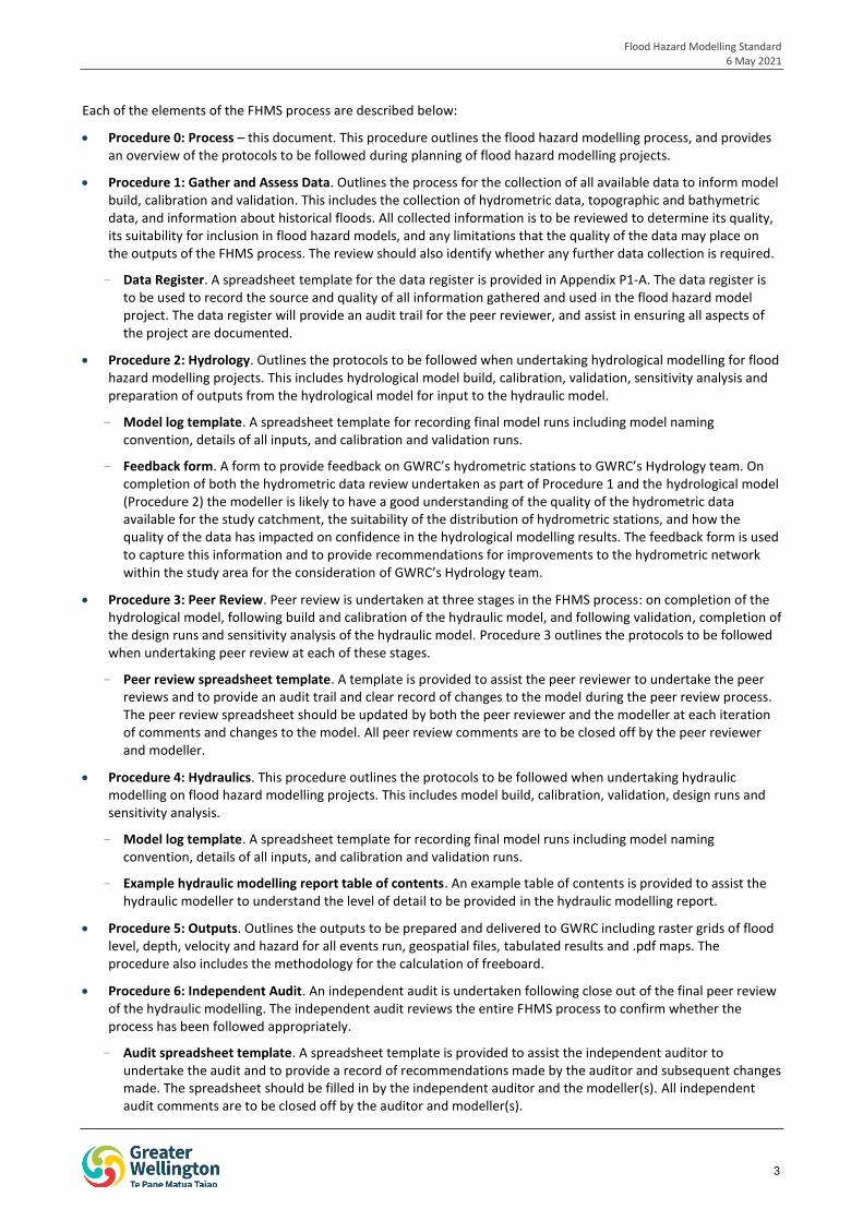
Each of the elements of the FHMS process are described below:
Procedure 0: Process – this document. This procedure outlines the flood hazard modelling process, and provides an overview of the protocols to be followed during planning of flood hazard modelling projects.
Procedure 1: Gather and Assess Data. Outlines the process for the collection of all available data to inform model build, calibration and validation. This includes the collection of hydrometric data, topographic and bathymetric data, and information about historical floods. All collected information is to be reviewed to determine its quality, its suitability for inclusion in flood hazard models, and any limitations that the quality of the data may place on the outputs of the FHMS process. The review should also identify whether any further data collection is required.
- Data Register. A spreadsheet template for the data register is provided in Appendix P1-A. The data register is to be used to record the source and quality of all information gathered and used in the flood hazard model project. The data register will provide an audit trail for the peer reviewer, and assist in ensuring all aspects of the project are documented.
Procedure 2: Hydrology. Outlines the protocols to be followed when undertaking hydrological modelling for flood hazard modelling projects. This includes hydrological model build, calibration, validation, sensitivity analysis and preparation of outputs from the hydrological model for input to the hydraulic model.
- Model log template. A spreadsheet template for recording final model runs including model naming convention, details of all inputs, and calibration and validation runs.
- Feedback form. A form to provide feedback on GWRC’s hydrometric stations to GWRC’s Hydrology team. On completion of both the hydrometric data review undertaken as part of Procedure 1 and the hydrological model (Procedure 2) the modeller is likely to have a good understanding of the quality of the hydrometric data available for the study catchment, the suitability of the distribution of hydrometric stations, and how the quality of the data has impacted on confidence in the hydrological modelling results. The feedback form is used to capture this information and to provide recommendations for improvements to the hydrometric network within the study area for the consideration of GWRC’s Hydrology team.
Procedure 3: Peer Review. Peer review is undertaken at three stages in the FHMS process: on completion of the hydrological model, following build and calibration of the hydraulic model, and following validation, completion of the design runs and sensitivity analysis of the hydraulic model. Procedure 3 outlines the protocols to be followed when undertaking peer review at each of these stages.
- Peer review spreadsheet template. A template is provided to assist the peer reviewer to undertake the peer reviews and to provide an audit trail and clear record of changes to the model during the peer review process. The peer review spreadsheet should be updated by both the peer reviewer and the modeller at each iteration of comments and changes to the model. All peer review comments are to be closed off by the peer reviewer and modeller.
Procedure 4: Hydraulics. This procedure outlines the protocols to be followed when undertaking hydraulic modelling on flood hazard modelling projects. This includes model build, calibration, validation, design runs and sensitivity analysis.
- Model log template. A spreadsheet template for recording final model runs including model naming convention, details of all inputs, and calibration and validation runs.
- Example hydraulic modelling report table of contents. An example table of contents is provided to assist the hydraulic modeller to understand the level of detail to be provided in the hydraulic modelling report.
Procedure 5: Outputs. Outlines the outputs to be prepared and delivered to GWRC including raster grids of flood level, depth, velocity and hazard for all events run, geospatial files, tabulated results and .pdf maps. The procedure also includes the methodology for the calculation of freeboard.
Procedure 6: Independent Audit. An independent audit is undertaken following close out of the final peer review of the hydraulic modelling. The independent audit reviews the entire FHMS process to confirm whether the process has been followed appropriately.
- Audit spreadsheet template. A spreadsheet template is provided to assist the independent auditor to undertake the audit and to provide a record of recommendations made by the auditor and subsequent changes made. The spreadsheet should be filled in by the independent auditor and the modeller(s). All independent audit comments are to be closed off by the auditor and modeller(s).
Flood Hazard Modelling Standard 6 May 2021
4
A number of specifications have been prepared to assist with the tendering of works associated with Procedures 1 – 6 of the FHMS. These specifications include:
Specification 1: LiDAR
Specification 2: Survey
Specification 3: Hydrology
Specification 4: Peer Review
Specification 5: Hydraulic Model
Specification 6: Outputs
Specification 7: Independent Audit
1.2 When is flood hazard modelling undertaken?
GWRC’s flood protection team undertake on-going flood management and hazard planning in catchments across the greater Wellington Region. Flood management plans and flood hazard models have been prepared for a number of catchments where there is a history of flooding in urban areas, or where significant flooding has occurred in rural areas or across key transport routes.
Where a flood hazard model has been prepared, it may be revised within 5-10 years of the initial model development. Models are revised over time due to:
Increased data availability – over time longer rainfall and river flow records become available. These records allow for better estimates of the frequency of large floods and storms, and whether this is changing over time (eg, due to climate change).
Improved data quality – river flow gauging is undertaken to confirm the relationship between flow and levels measured by automatic river level sensors. Over time, more gauging (particularly high flow gauging) can improve the understanding of this relationship.
More floods – data from actual floods is used to calibrate and validate flood hazard models. When a new flood occurs, this data can be used to test or improve a current model, or may be a trigger for the creation of a new model.
Catchment changes – over time catchments experience changes to land use, natural and human processes cause changes to river geomorphology (eg, bed aggradation or degradation), and structures are constructed in rivers and floodplains. These changes may affect the validity of previous models.
Technological changes – technology is continually developing. When new methods of data collection become available or the technology in hydrological and hydraulic models improves existing models may become out of date.
Changes to industry accepted practice – like all scientific methods, the methods used to estimate rainfall and floods are continually improving. When industry accepted practice changes, existing models should be reviewed to determine whether revision is needed.
1.3 Community engagement
GWRC recognise the importance and value of the community’s knowledge and experiences of flooding in their area. Consultation, and in some cases collaboration, will be undertaken in an effort to develop the most accurate flood information. Community consultation is undertaken at a minimum of three stages in the FHMS process as shown in Figure P0-1. Additional consultation can be undertaken if required. The minimum consultation stages include:
In the initial stages of the FHMS process under Procedure 1: Gather and Assess Data. At this stage the community should be notified that flood hazard modelling is being undertaken in their community. Information about historic flood events should also be sought from the community to help inform calibration and validation of the hydraulic model. The protocols for gathering this information from the public are outlined in Procedure 1.
Flood Hazard Modelling Standard 6 May 2021
5
The community should be consulted when finalising the hydraulic model, after the initial (Part A) peer review. The purpose of this consultation is to update the community on the progress to date, the process that has been undertaken and the next steps.
The community should also be consulted at the end of the project following the independent audit and preparation of the final outputs. The purpose of this consultation is to show the community and explain the results of the flood hazard modelling, and to explain the independent auditors’ findings and recommendations.
The FHMS does not provide protocols on how community engagement is to undertaken, other than for the collection of historical flood information from the community. All community consultation should be undertaken in conjunction with GWRC and in line with their protocols and policy.
1.4 Event frequency descriptor
The FHMS uses the percentage Annual Exceedance Probability (% AEP) terminology as the descriptor for the frequency of flood events. This terminology is preferred over the Average Recurrence Interval (ARI) terminology which can be misinterpreted by the community as an event that will only occur every given number of years, rather than the probability of occurrence in any given year. The AEP terminology and how this equates to ARI is outlined in Table P0-1 below. Modellers and reviewers undertaking work under the FHMS should maintain consistency and reference event frequency using the AEP terminology.
Table P0-1 Event frequency terminology
Frequency AEP ARI
Very frequent 39% AEP 1 in 2-year ARI
Frequent 20% AEP 1 in 5-year ARI
10% AEP 1 in 10-year ARI
Rare 5% AEP 1 in 20-year ARI
2% AEP 1 in 50-year ARI
1% AEP 1 in 100-year ARI
Very rare 0.1% AEP 1 in 1000-year ARI
2 Project Planning
Each flood hazard modelling project will be managed by a GWRC staff member as project manager. The project manager will develop a project plan during the project initiation to outline the objectives of the project, project background, key tasks and programme. The project plan should include the following elements:
Outline of the objectives of the study. Flood hazard modelling projects should generally aim to understand the flood extent, hazard and behaviour that may affect the study area for a range of current, future climate and residual hazard scenarios. The outputs will generally need to be prepared to a sufficient level of detail and quality in order to inform district planning and emergency management.
Project team structure including project manager, internal team members and identification of which tasks will be undertaken by third parties (i.e. consultants).
Definition of the extent of the study area, including approximate extents for the hydrological and hydraulic models.
Flood Hazard Modelling Standard 6 May 2021
6
Background to the project including a summary of any previous work undertaken within the study area including previous modelling. The summary should include any discussions GWRC has had with the community or territorial authority related to flood hazard in the study area.
Identification of linkages or dependencies with other GWRC or external projects (i.e. Wellington Water or territory authority projects).
Any proposed departures from the FHMS and justification for this.
Any project specific tasks or runs to be undertaken, additional to the FHMS requirements.
Identification of key stakeholders including the relevant territorial authority.
Outline of the community engagement approach, noting minimum requirements of the FHMS. The media/communications approach should also be outlined for potentially controversial projects.
Plan for procurement of FHMS tasks (i.e. direct appoint, closed contest or open tender).
Budget allocated to the FHMS project and breakdown of budget for each key task.
Programme addressing all steps in the FHMS project, and allowing time for reiterations of the modelling following peer review and independent audit. Key milestones should be identified.
Method for reporting (i.e. monthly progress reports). Detail of how consultants will report to the GWRC project manager.
The location where all project information including communication (emails) will be stored.
A register of potential risks and how these are proposed to be managed. An example risk register is provided in Table P0-2.
Table P0-2 Example risk table
Risk Category What can go wrong?
Likelihood
(H/M/L) Mitigation
Quality Quality of deliverables is poor
Low Selection of experienced consultant, with track record of producing high quality work.
Provide sufficient time to undertake work.
Time Project delivered late
Medium On-going communication with consultants to identify and address issues early.
Ensure timeframes at start of project are realistic.
Community dis-satisfaction
Community unhappy with results
Medium Early and on-going community engagement. Ensure transparency of process and decision making. Independent audit.
The project plan should be updated as the project evolves, with all key decisions recorded.
2.1 Procurement approach
As outlined in Section 1.1 the flood hazard modelling process requires a multi-disciplinary approach incorporating surveying and data capture, hydrological and hydraulic modelling, independent peer review and audit, and mapping of final outputs. It is envisaged that a team of internal and external specialists will be required to complete these works.
The following specialists are likely to be procured for FHMS projects, however it is noted that some works may be undertaken in house on some FHMS projects:
Procedure 1: Gather and Assess Data – surveyor, hydrological modeller, hydraulic modeller.
Procedure 2: Hydrology – hydrological modeller.
Procedure 3: Peer review – peer reviewer (expertise in hydrological and/or hydraulic modelling as applicable).
Flood Hazard Modelling Standard 6 May 2021
7
Procedure 4: Hydraulics – hydraulic modeller.
Procedure 5: Outputs – hydraulic modeller.
Procedure 6: Independent Audit – auditor (expertise in hydrological modelling, hydraulic modelling and/or auditing).
2.2 Process review/lessons learnt
The FHMS is intended to be a living document. As such, the final step in the FHMS process is to undertake a review of both the flood hazard modelling project and the FHMS process to determine whether any improvements can be made to the process. This process is likely to be undertaken internally within GWRC but may include a workshop with the consultants involved in the flood hazard modelling project to gather their feedback.
The review should address:
Whether the FHMS addresses all steps in the flood hazard modelling process?
Whether the FHMS was flexible enough to cover catchment/watercourse specific factors?
Whether the requirements in the FHMS were clear enough?
Whether there were any items that are listed in the FHMS for discussion or workshopping with GWRC that could be formalised in a procedure for implementation in future FHMS projects?
Whether the specifications were clear enough to the bidders (i.e. were the proposals received consistent enough for comparison? Did tenderers ask questions seeking clarification of the process?)
Whether enough community engagement is included in the FHMS?
Whether any issues with the FHMS process were raised by the peer reviewer or independent auditor?
Whether the order of tasks in the FHMS flow chart is appropriate?
Any issues that arose during the project, and whether they could they be addressed by the FHMS?
Any changes to accepted industry practice since the FHMS was prepared, and whether the FHMS needs to be updated.
Any changes to GWRC’s policy or preferences eg, use of new modelling software or new modelling approach that should be included in the FHMS.
Whether the territorial authority or community provided any feedback that should be incorporated into the FHMS.
Proposed changes to the FHMS should be discussed and agreed with GWRC’s flood protection investigations team prior to updating the FHMS.
Flood Hazard Modelling Standard 6 May 2021
8
3 Documentation
All steps in the FHMS must be fully documented. This will ensure an audit trail for the peer reviewer and independent auditor. It will also ensure that the process is transparent, and that the modelling can be replicated if needed.
The required documentation is summarised in Table P0-3, and provided in more detail in each of the procedures. Documentation must be provided in report and spreadsheet format.
Table P0-3 Required documentation
FHMS step Required documentation
Procedure 1: Gather and Assess Data Data register
Summary of data review in hydrological modelling report and hydraulic modelling report as relevant to each.
Procedure 2: Hydrology Hydrological modelling report
Model log
Hydrometric feedback form
Procedure 3: Peer review Peer review spreadsheet – hydrology, Part A hydraulic model and Part B hydraulic model
Peer review report - hydrology, Part A hydraulic model and Part B hydraulic model
Procedure 4: Hydraulics Hydraulic modelling report
Model log
Procedure 5: Outputs Methodologies used described in hydraulic modelling report
Procedure 6: Independent audit Independent audit spreadsheet
Independent audit report
All model files and the required outputs listed in Procedure 5: Outputs must also be provided.
4 Procedure review
This procedure is intended to be a living document that can be revised as technology advances and best-practice evolves.
The need for review of the procedures within the FHMS, including this one, will be determined at the end of each modelling project at the ‘process review / lessons learnt’ checkpoint on the FHMS flow chart.
PROCEDURE 01
GATHER & ASSESS DATA This procedure has been prepared to outline the protocols to be followed by any person gathering and assessing data for GWRC flood hazard modelling projects.
Procedure 01 Table of Contents
1 Introduction 11
1.1 Data collection and assessment in the FHMS Process 11
1.2 What types of information should be collected? 11
1.3 Why is it important to gather information from the community? 12
1.4 Who undertakes data gathering and assessment? 12
2 Hydrometric Data 14
2.1 Data collection 14
2.2 Assessment of hydrometric data 15
3 Catchment Information 16
4 Historic Flood Data 16
4.1 Community Data 17
4.2 Types of data 18
4.3 Quality Control 19
4.4 New flood information 19
5 Topographic and Bathymetric Data 19
5.1 Data Collection – existing data 20
5.2 Assessment of data quality 20
5.3 Data Capture 22
6 Structures 23
7 Documentation 23
7.1 Data Register 23
7.2 Reporting 23
7.3 Modeller’s acceptance 23
8 Procedure Review 24
Flood Hazard Modelling Standard 6 May 2021
11
1 Introduction
This document forms Procedure 1 of Greater Wellington Regional Council’s (GWRC) Flood Hazard Modelling Standard (FHMS). This procedure has been prepared to outline the protocols to be followed by any person gathering and assessing data for GWRC flood hazard modelling projects.
This document should be read in the context of the wider FHMS. It has a particular relationship to Specification 1: LiDAR and Specification 2: Survey.
1.1 Data collection and assessment in the FHMS Process
Confidence in flood hazard model results is significantly improved where high quality input and calibration data is available. A comprehensive process of data collection, and the assessment of the quality of collected data, are important for ensuring that all flood hazard models are built and calibrated using all available reliable information.
Data collection should be undertaken prior to commencing modelling to prevent delays and re-work associated with discovering new information after modelling has commenced. The assessment of the quality of the data should also be undertaken at this stage to ensure that any limitations of the gathered data are understood prior to undertaking the modelling.
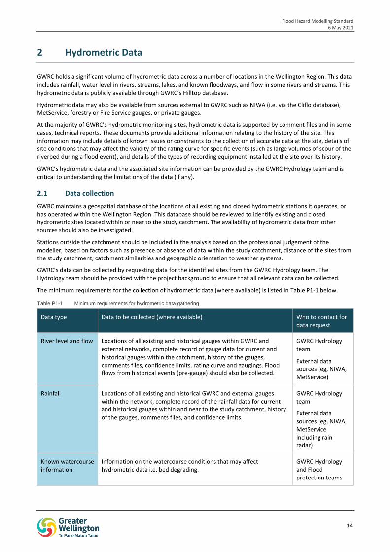
As such, the collection and assessment of all available data is the first step in the Flood Hazard Modelling process. The stages of the FHMS process that are related to the gathering and assessment of data for flood hazard modelling projects are outlined in red in Figure P1-1 below.
1.2 What types of information should be collected?
Data collection efforts should focus on the collection of:
Hydrometric data. For example, flow and rainfall data in the study area, including details about the recording station (i.e. type and purpose of site) and details of conditions that may have affected hydrometric records and quality of the data collection (eg, stream bed aggradation, date of most recent gauging, recorded rainfall aligning with check gauge). The rating curves for flow sites, data from the gaugings used to develop the rating curve, and information on confidence in the rating curve (if available) should also be collected.
Catchment data. For example, land use data, current and historical aerial photography, records of changes in the catchment that may invalidate historical evidence in a current scenario model validation (eg, new bridges, construction of flood protection structures, long term aggradation or degradation).
Historical flooding information. For example, community recollections, photographs, flood marks on structures, flood records, newspaper or social media articles, details of conditions that may have affected flood extent and behaviour (eg, presence and height of storm surge, lake flooding, tidal conditions etc) and flood incident reports.
Topographic and Bathymetric data. For example, survey of river cross sections, and LiDAR of the catchment including metadata.
Details of structures. For example, survey of structures within the river channel or floodplain that may affect flood levels and behaviour, dates the survey were undertaken, details of any major maintenance works.
The types of data to be collected are described in more detail in the following sections. Following collection, the quality of the data must be assessed to determine:
Whether the collected data is suitable for inclusion in the flood hazard modelling.
What level of confidence can be applied to the collected data.
Whether the quality of the data, or lack of data, is likely to result in limitations being placed on the use of the final model results.
Whether additional data should be collected prior to commencing the modelling. For example, additional survey.
Flood Hazard Modelling Standard 6 May 2021
12
1.3 Why is it important to gather information from the community?
Local communities, particularly residents who have lived in the study area for a long time, may hold historic flood information that is unknown to GWRC. This information may be in the form of photographs, recollections, flood marks on buildings or other private structures, or records of damage or disruption. Access to this information could assist with calibration and/or validation of flood hazard models.
Collection of historic flood information from communities may also assist with community engagement in the flood hazard modelling process, and may increase community confidence in the final model results.
1.4 Who undertakes data gathering and assessment?
Initial data gathering and review should be undertaken by the hydrological and hydraulic modellers undertaking the flood hazard modelling, where the modellers collect and assess the information relevant to their component of the modelling.
For example, the project hydrologist would gather and assess rainfall and flow data prior to commencing the hydrological model, while the hydraulic modeller would be required to gather and review data relating to structures in the river channel, and any existing survey cross-sections.
However, where flood hazard modelling projects are expected to run over a long timeframe, the hydraulic modeller may not have been engaged at the time that the initial data gathering and review is undertaken. In this case, the review may be undertaken by another party with expertise in hydraulic modelling, or internally by GWRC.
When a hydraulic modeller is engaged to build the flood hazard model, if different from the party that conducted the data gathering and review, they must:
Undertake a review of the data gathering and suitability documentation.
Identify any limitations that the available data/data quality may place on the model results.
Confirm whether they agree with the data gathering and suitability assessment, and raise any concerns.
Identify whether any additional data needs to be collected before modelling should commence.
Confirm their acceptance of the suitability of the available data into be used the hydraulic model.
GWRC may assist with data collection through the provision of data, records and technical reports and will lead any community consultation and data gathering required.
Flood Hazard Modelling Standard 6 May 2021
13
iop
1
S1. LiDAR Specification
S2. Survey Specification
S3. Hydrology Specification
P2. Hydrology
Commission OR undertake hydrology
S4. Peer Review Specifications
P4. Hydraulic modelling
Commission OR undertake model build (to calibration) S5. Hydraulic Model
Specification
P3. Peer review (Part A)
Commission peer review of hydraulic model up to calibration
P4. Finalise hydraulic model
Incorporate peer review changes and undertake validation.
S6. Output Specification P5. Mapping andoutputs
Issue draft flood hazard maps
P6. Independent Audit
Incorporate changes from independent audit where relevant
TA plan change
S7. Independent Audit Specification
P3. Peer review (Part B)
Commission peer review of validated hydraulic model
P3. Peer review
Peer review of hydrology
Consult Community
Present to TA’s and community
Consult Community and Gather Community Flood Data
Process Review / Lessons Learnt
Update process and schedule operations further works, where appropriate
P1. Gather and assess data
If required: commission LiDAR/survey review available hydrology data gather data from the
community
DRAFT outputs available to TA
and public
Final outputs available to TA
and public
P0. Project Initiation and Planning
P5. Final Outputs
Finalise and issue flood hazard maps
Procedure Specifications Consultation
Figure P1-1 FHMS process showing where gathering and assessment of data is undertaken (red)
Flood Hazard Modelling Standard 6 May 2021
14
2 Hydrometric Data
GWRC holds a significant volume of hydrometric data across a number of locations in the Wellington Region. This data includes rainfall, water level in rivers, streams, lakes, and known floodways, and flow in some rivers and streams. This hydrometric data is publicly available through GWRC’s Hilltop database.
Hydrometric data may also be available from sources external to GWRC such as NIWA (i.e. via the Cliflo database), MetService, forestry or Fire Service gauges, or private gauges.
At the majority of GWRC’s hydrometric monitoring sites, hydrometric data is supported by comment files and in some cases, technical reports. These documents provide additional information relating to the history of the site. This information may include details of known issues or constraints to the collection of accurate data at the site, details of site conditions that may affect the validity of the rating curve for specific events (such as large volumes of scour of the riverbed during a flood event), and details of the types of recording equipment installed at the site over its history.
GWRC’s hydrometric data and the associated site information can be provided by the GWRC Hydrology team and is critical to understanding the limitations of the data (if any).
2.1 Data collection
GWRC maintains a geospatial database of the locations of all existing and closed hydrometric stations it operates, or has operated within the Wellington Region. This database should be reviewed to identify existing and closed hydrometric sites located within or near to the study catchment. The availability of hydrometric data from other sources should also be investigated.
Stations outside the catchment should be included in the analysis based on the professional judgement of the modeller, based on factors such as presence or absence of data within the study catchment, distance of the sites from the study catchment, catchment similarities and geographic orientation to weather systems.
GWRC’s data can be collected by requesting data for the identified sites from the GWRC Hydrology team. The Hydrology team should be provided with the project background to ensure that all relevant data can be collected.
The minimum requirements for the collection of hydrometric data (where available) is listed in Table P1-1 below.
Table P1-1 Minimum requirements for hydrometric data gathering
Data type Data to be collected (where available) Who to contact for data request
River level and flow Locations of all existing and historical gauges within GWRC and external networks, complete record of gauge data for current and historical gauges within the catchment, history of the gauges, comments files, confidence limits, rating curve and gaugings. Flood flows from historical events (pre-gauge) should also be collected.
GWRC Hydrology team
External data sources (eg, NIWA, MetService)
Rainfall Locations of all existing and historical GWRC and external gauges within the network, complete record of the rainfall data for current and historical gauges within and near to the study catchment, history of the gauges, comments files, and confidence limits.
GWRC Hydrology team
External data sources (eg, NIWA, MetService including rain radar)
Known watercourse information
Information on the watercourse conditions that may affect hydrometric data i.e. bed degrading.
GWRC Hydrology and Flood protection teams
Flood Hazard Modelling Standard 6 May 2021
15
Technical reports GWRC technical reports relating to hydrometric data in the region, eg,
Flow gauge network review (Cardno, 2020)
Hydrological statistics for surface water monitoring sites in the Wellington Region (GWRC, 2016)
Ratings and gauging priority assessment (GWRC, 2015)
Hydrology network review (GWRC, 2015)
External technical reports (eg, NIWA, Ministry of Works and Development)
GWRC Hydrology and Flood protection teams
External data sources (eg, NIWA, Ministry of Works and Development)
2.2 Assessment of hydrometric data
Collected hydrometric data should be reviewed and analysed in order to determine the suitability of the data for inclusion in flood hazard modelling. This assessment should include a determination of whether the quality of the data is likely to limit confidence in the model results and should consider whether the level of confidence will vary across reaches and/or events.
Where appropriate, the assessment of hydrometric data should include, but is not limited to:
Rainfall sites:
- Assessment of the appropriateness of the gauge sites in relation to the catchment including assessment of rainfall variance for individual events and in general.
- Review of the completeness of the hydrometric record, including length of record, and number and length of gaps.
- Consideration of whether there is sufficient data to determine a temporal pattern of rainfall.
- Consideration of whether there is more than one dominant synoptic pattern that generates flooding in the catchment, for example frontal systems vs. tropical lows.
- Review of rain gauge comment files and notes on data quality, and assessment of the level of confidence in the rainfall data.
- Comparison of rainfall frequency data to HIRDS, where rainfall record lengths are less than half the maximum recurrence interval to be modelled.
- Patching of rainfall records where needed. Patched data should be supplied to GWRC for their records. Refer to Section 2.2.1 of Procedure 2 Hydrology for further guidance on patching rainfall records.
- Consideration of whether the recorded rainfall data is likely to have been impacted by snow.
Water level and flow sites:
- Review of rating curve and gaugings, particularly during high-flow events and assessment of the confidence in the high flow portion of the rating curve.
- Review of gauge control conditions, eg, is the control stable, and how does this affect confidence in the data.
- Identification of any limitations or issues associated with the use of the flow data for calibration and validation.
- Review of the suitability of the data for frequency analysis, including the length of the record relative to the largest recurrence interval to be modelled.
- Confirm whether the gauge is likely affected by tides or backwater.
- Confirm the bankfull level at the gauge, and whether flows above the bankfull level are realistic?
- Confirm whether the data quality is similar throughout the record, or whether there are events that affect this eg, change of recording equipment, installation or wash-out of a weir.
An assessment should be made of:
Whether the collected data is suitable for inclusion in the flood hazard modelling.
Flood Hazard Modelling Standard 6 May 2021
16
What level of confidence can be applied to the collected data.
Whether the quality of the data, or lack of data, is likely to result in limitations being placed on the use of the final model results.
Whether additional data should be collected prior to commencing the modelling.
It is noted that flow data recorded before the 1970s should be treated with caution due to the limitations of the data collection methods at the time. GWRC’s statistics for flow sites are calculated from the mid-70s onwards.
3 Catchment Information
Catchment information is an important input to both hydrological and hydraulic modelling. Catchment information may include:
Details of current land use and historical land use changes. Details of future (planned) land use changes may also be of interest, such as where large-scale urban development is planned for the catchment, or land use changes permitted under district plan zones. This information may be obtained from a range of sources such as current and historical aerial photography, catchment reports, and GIS datasets.
Details of structures located on the watercourse being modelled such as bridges, culverts and flood protection structures (i.e. stopbanks), the design standards for these structures, and when they were built relative to historic floods.
Historic river channel information and details of modifications to stream banks, i.e. erosion protection works.
Geological information, to assist with understanding of infiltration and runoff rates.
Previous modelling and associated technical reports.
It is noted that the collection and review of survey and LiDAR data is discussed in Section 5. The minimum requirements for the collection of catchment data (where available) is listed in Table P1-2 below.
Table P1-2 Minimum requirements for gathering catchment data
Data type Data to be collected (where available)
Aerial photography Current and historical aerial photography showing catchment land use
Technical reports Catchment studies or watercourse studies
Land use Geospatial datasets of land use, records of land use change
Buildings Geospatial dataset of buildings within the catchment that may affect flow paths
River structures Records of bridges, stopbanks or other flood control structures etc. Data verifying losses across structures, where available.
It is noted that GWRC’s Guide to Flood Protection Advisory Responses may assist with locating catchment specific flood information.
The quality of all gathered catchment information, and the applicability of the data to the required model scenarios should be assessed.
4 Historic Flood Data
Historic flood information is required for calibration and validation of flood hazard models. Historic flood information can be gathered from both GWRC and public records, and the private records of the community.
Flood Hazard Modelling Standard 6 May 2021
17
The minimum requirements for the collection of historic flood information from GWRC and public records is listed in Table P1-3.
Table P1-3 Minimum requirements for collection of historic flood data from GWRC and public records
Data type Data to be collected (where available)
Photography Photographs of previous flooding. It is noted historical flood photography and levels can be found on GWRC’s Flood Protection WebApp on the GWRC website.
Technical reports Previous flood studies and modelling reports.
Flood records Recorded levels, incident reports, flood marks, damage reports, newspaper articles, CCTV footage, TV news footage.
The quality of the collected data should be assessed, including:
Whether photographs have been time and date stamped, and if not, whether the timing can be verified.
Whether the location and direction that the photos were taken from is clear, and correct.
The source of historic level data and how this was measured i.e. was the level surveyed?
Whether the recorded flood extents and levels may have been affected by other factors, such as blockage, wave action etc.
4.1 Community Data
The community, in particular residents who have lived in an area for a long time, may have information about historical floods that is unknown to GWRC, and could be useful for model validation.
In accordance with the FHMS flow chart in Figure P1-1, community consultation should be undertaken at a number of stages within the FHMS process. The first consultation session should be commenced early in the process to enable the collection of community flood information to inform flood hazard model validation.
4.1.1 Role of the Territorial Authority
The local Territorial Authority (TA) should be consulted prior to undertaking community consultation. The role of the TA in the on-going community consultation associated with the flood hazard modelling project should be agreed during this consultation, noting that different levels of involvement are preferred at different TAs.
The TA may also have information on consultation methods that have been found to be effective or ineffective within their local government area.
4.1.2 Notifying the community of upcoming consultation and data collection
Effective communication of upcoming consultation and data collection is required to ensure that:
The community is aware that consultation relating to flood hazard modelling that may affect their community is being undertaken.
The community is aware of when and where this consultation will happen.
The community has sufficient notice of the consultation to enable them to make arrangements to attend.
The community is aware that the consultation involves the gathering of historic flood information from the community, why this type of information is being gathered, and types of information they should bring to the session.
Notification of the consultation and data collection should be undertaken by methods that are targeted to the demographics of the community. Methods could include:
Letter drop in mailboxes. Previous GWRC experience indicates that personal letters can be more effective than flyers which could be mistaken for advertising.
Notices in public areas, such as the local library.
Flood Hazard Modelling Standard 6 May 2021
18
Notices in the local newspaper.
Posts on social media. It is noted that sponsored posts may reach a larger audience.
Methods that are correctly targeted to the demographics of the community are likely to be more effective. For example, a notice in the local newspaper or letter drops may be most effective in communities with a high proportion of older people, whereas social media may be more effective in younger communities. A range of methods could be applied to capture the entire demographic.
4.1.3 Gathering Data
Data may be gathered from the community via a number of avenues including:
In person drop-in sessions – these sessions can be used to tell the community about the flood hazard modelling project and seek community flood knowledge.
Community walk-arounds – a walkover of a property previously affected by flooding with the landowner.
Website – a form or hub could be set up on the GWRC website for people to upload photos and flood information.
Email address – an email address could be provided for community members to send their flood information to.
Where in-person sessions are held, it is important that the hydraulic modeller attends to ensure that details of reported flood events are correctly captured.
4.1.3.1 Drop-in sessions
Drop-in sessions can be used to obtain flood information from the community and to share information about the flood hazard modelling project. This in-person approach may reduce the likelihood of misunderstanding the information provided by the community.
During these sessions, GWRC should provide the following information:
Description of the flood hazard modelling work being undertaken by GWRC.
What the process for flood hazard modelling is (i.e. this FHMS process), and how seeking historic flood information from the community fits in.
What types of flood information are sought from the community.
When the next consultation session will be.
The format of drop in sessions should be determined on a project by project basis, suited to the demographics of the particular community. Some options include:
Running a presentation on a regular basis throughout the session (i.e. every 15 minutes).
Displaying visual aids, such as newspaper articles of flood events to help jog memories, and previous flood maps as a starting point for discussion.
Printing a large map of the study area to allow members of the community to identify previous flood locations, and tell the story of the event. The contact details of each contributor should be recorded to allow for clarification at a later date, if needed.
Attendees should be encouraged to bring materials such as photos to the drop in sessions to confirm and clarify flood locations and behaviour. Previous GWRC experience indicates that it is more difficult to obtain photos after the session.
4.1.3.2 Community walk-arounds
Where significant flooding has occurred on a property, a walk-over with the landowner can be used to observe and map where flooding occurred during both large and regular flood events. During the walk around the landowner should be asked about flood depth, locations of ponding and flow, and factors that may have affected flooding such as blockage of structures.
4.2 Types of data
The types of data that can be collected from the community are outlined in Table P1-4.
Flood Hazard Modelling Standard 6 May 2021
19
Table P1-4 Data to be collected from the community
Data type Data to be collected (where available)
Photography Photographs of recent and historical flooding, including where the river has not broken its bank. Photos that are time and date stamped and where the location and direction the photo is taken is known are preferred where available.
Marks on structures Locations of marks on buildings or private structures indicating the level that flood waters reached, and the date the flooding occurred.
Recollections Information on flood depth, information on flood behaviour such as areas of ponding and flow, timing (eg, this area floods first), information on structures that blocked, and events that may have affected flood behaviour eg, sandbagging.
Any changes in flood behaviour due to changes in the river morphology.
Members of the community may also share information about how they were impacted by flooding (such as which roads became blocked) which may help to tell the story of the flood event and assist with calibration.
4.3 Quality Control
The quality of the data gathered from the community should be assessed to confirm its likely accuracy. A number of approaches can be applied, such as:
Community members can be asked to ‘self-rate’ their level of confidence in the information they have provided.
Comparison to hard evidence such as photos.
Comparison to recollections from other members of the community, to identify contradictions.
Modellers estimate of reliability based on modelling results and hard evidence.
It is noted that inconsistencies in the information provided by community members may be a result of a communication error. Where contact details are provided during the collection of the information, the community member should be contacted to clarify or confirm understanding of the information. Other inconsistencies may be the result of a localised intense rainfall burst, blockage, or flooding caused by other factors such as a surcharged manhole.
Any inconsistencies identified and the quality of the information gathered should be noted in the relevant modelling report. The modeller should justify the use or exclusion of gathered data in the calibration or validation in the modelling report.
4.4 New flood information
If a large flood occurs during the flood hazard modelling process, then further collection of information from the community should be undertaken. This additional data collection is at the discretion of GWRC.
GWRC may encourage members of the community to take photographs of flooding during the event if it is safe to do so.
Flood information may also be captured from social media and the news media during a flood event.
5 Topographic and Bathymetric Data
Spatial data, such as catchment topographic data and river bathymetry is a key input to flood hazard models. As these data define the river channel, top of bank elevations and floodplain morphology within the model, inaccuracies can have a significant impact on model results, including inaccuracies in the location, extent and depth of flooding.
As such, it is important that all available topographic and bathymetric data is gathered prior to commencing modelling, and that this data is thoroughly assessed to determine its quality and limitations. Where this assessment
Flood Hazard Modelling Standard 6 May 2021
20
determines that additional data collection (i.e. further survey) is required then this should be undertaken prior to the commencement of modelling, where possible.
5.1 Data Collection – existing data
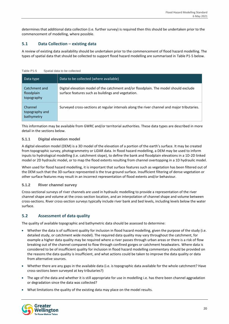
A review of existing data availability should be undertaken prior to the commencement of flood hazard modelling. The types of spatial data that should be collected to support flood hazard modelling are summarised in Table P1-5 below.
Table P1-5 Spatial data to be collected
Data type Data to be collected (where available)
Catchment and floodplain topography
Digital elevation model of the catchment and/or floodplain. The model should exclude surface features such as buildings and vegetation.
Channel topography and bathymetry
Surveyed cross-sections at regular intervals along the river channel and major tributaries.
This information may be available from GWRC and/or territorial authorities. These data types are described in more detail in the sections below.
5.1.1 Digital elevation model
A digital elevation model (DEM) is a 3D model of the elevation of a portion of the earth’s surface. It may be created from topographic survey, photogrammetry or LiDAR data. In flood hazard modelling, a DEM may be used to inform inputs to hydrological modelling (i.e. catchment slope), to define the bank and floodplain elevations in a 1D-2D linked model or 2D hydraulic model, or to map the flood extents resulting from channel overtopping in a 1D hydraulic model.
When used for flood hazard modelling, it is important that surface features such as vegetation has been filtered out of the DEM such that the 3D-surface represented is the true ground surface. Insufficient filtering of dense vegetation or other surface features may result in an incorrect representation of flood extents and/or behaviour.
5.1.2 River channel survey
Cross-sectional surveys of river channels are used in hydraulic modelling to provide a representation of the river channel shape and volume at the cross-section location, and an interpolation of channel shape and volume between cross-sections. River cross-section surveys typically include river bank and bed levels, including levels below the water surface.
5.2 Assessment of data quality
The quality of available topographic and bathymetric data should be assessed to determine:
Whether the data is of sufficient quality for inclusion in flood hazard modelling, given the purpose of the study (i.e. detailed study, or catchment wide model). The required data quality may vary throughout the catchment, for example a higher data quality may be required where a river passes through urban areas or there is a risk of flow breaking out of the channel compared to flow through confined gorges or catchment headwaters. Where data is considered to be of insufficient quality for inclusion in flood hazard modelling commentary should be provided on the reasons the data quality is insufficient, and what actions could be taken to improve the data quality or data from alternative sources.
Whether there are any gaps in the available data (i.e. is topographic data available for the whole catchment? Have cross-sections been surveyed at key tributaries?)
The age of the data and whether it is still appropriate for use in modelling i.e. has there been channel aggradation or degradation since the data was collected?
What limitations the quality of the existing data may place on the model results.
Flood Hazard Modelling Standard 6 May 2021
21
Whether any additional data capture (survey or LiDAR) is required.
5.2.1 Digital Elevation Model
The quality assessment of the DEM should include (but is not limited to) a review of:
Whether a DEM is available (or needed) for the entire study area.
Whether unusual shapes are present in the DEM that may indicate insufficient filtering of structures and vegetation. For example, where a row of houses has not been sufficiently filtered out of a DEM a series of cone shapes may be apparent. This originates from the original data capture detecting true ground elevations around individual houses, while also detecting points on the roof of the house, which is interpolated as a cone or other raised shape.
Bridges may also be represented in a DEM by higher elevation within the river channel.
- If the filtering undertaken is insufficient, the original cloud point data should be sourced for re-processing of the DEM, if possible.
- The DEM may need to be edited to appropriately represent flow paths such as under bridges, tunnels and verandas/walkthroughs.
Comparison of the DEM to other available topographic data, such as survey. For example, comparison of top of bank elevations between surveyed river cross sections and the DEM.
Review of the tidal conditions and water levels in watercourses, ponds and lakes at the time the LiDAR was flown to confirm whether the DEM represents typical conditions around these features.
Assessment of whether the spatial resolution is sufficiently fine for input into the hydraulic model. Note that the acceptable spatial resolution may vary across the catchment.
Assessment of whether the vertical resolution of the DEM is suitable for the application.
The age of the dataset, and whether works have been undertaken in the catchment since the data was captured (eg, new development) or whether features in the catchment may have been affected by natural processes such as stopbank subsidence, severe river erosion, or land shifting due to large earthquakes etc.
If the assessment determines that additional data collection is required, the data capture area and the required spatial and vertical resolutions should be determined and reported to GWRC.
5.2.2 River channel cross-sections
It is noted that river cross-sections are available for the majority of the major rivers within the Wellington Region. In gravel bed rivers, surveys are undertaken on a regular schedule as part of gravel extraction works that are undertaken for flood management.
The quality assessment of river channel cross-sections should include (but is not limited to) a review of:
Whether the spacing between cross-sections is sufficient, or whether more cross-sections need to be captured.
Whether cross-sections for any tributaries are available or needed.
Whether the length of the cross-sections is sufficient (i.e. do the cross-sections extend to the top of bank? Is information needed beyond top of bank?).
Whether the spacing of collection points across the section are sufficiently dense.
Whether the surveyed vertical accuracies are acceptable.
The age of the cross-sections, and whether there have been any floods, severe bank erosion, channel aggradation or degradation since the cross-sections were captured.
If the assessment determines that additional data collection is required, the number, location and extent of cross-sections required should be determined and reported to GWRC.
Flood Hazard Modelling Standard 6 May 2021
22
5.3 Data Capture
Where the findings of the data review indicate that additional data capture of topographic and bathymetric data is required, the protocols in Sections 5.3.1 and 5.3.2 should be applied.
5.3.1 LiDAR
LiDAR (light detection and ranging) is a technique used to capture topographic data through a device mounted to an aircraft or large drone that emits pulses of laser light and measures the time it takes for the reflected light to return to the sensor after bouncing off the ground, or other object (i.e. water, a building or vegetation) on the surface.
Where data collection by LiDAR is required, this work should be commissioned using Specification 1: LiDAR. This specification outlines how this work should be undertaken. A summary of key points is included here:
Data should be captured in NZTM2000, vertical elevations should be in Wellington Vertical Datum 1953. Where the survey is undertaken in the Wairarapa, the vertical datum should be confirmed with GWRC prior to commencement.
The LiDAR should capture sufficient ground points to ensure that the ground elevation is captured. Additional points may be required in areas of dense vegetation. Ground verification should also occur.
In areas with dense riverbank vegetation, LiDAR should be flown in winter when deciduous trees are not in leaf, to improve capture of ground points. LiDAR collection should not be undertaken when there is snow cover or when the ground is flooded, as this will prevent the capture of true ground levels. Near the coast, LiDAR should be flown at low tide.
The spatial and vertical resolution should be agreed with GWRC prior to commencement and may vary across the survey (i.e. with increasing detail near to the river channel).
5.3.2 Survey
Ground based survey may be undertaken to capture specific features such as stopbank elevations, or in areas where capture of accurate LiDAR is not possible (eg, under water or under dense vegetation). Survey may also be used to capture topographic features that are too fine to be picked up in LiDAR accurately, for example, narrow tributaries.
Ground survey may also be undertaken to capture additional or more up to date cross-sections of the river channels.
Additional ground survey work should be undertaken in accordance with Specification 2: Survey of the FHMS. This specification outlines how this work should be undertaken. A summary of key points is included here:
Data should be captured in NZTM2000, vertical elevations should be in Wellington Vertical Datum 1953. Where the survey is undertaken in the Wairarapa, the vertical datum should be confirmed with GWRC prior to commencement.
For cross-section surveys:
- Where existing cross-section locations exist, the survey is to be undertaken at these locations. Where new cross-section locations are to be surveyed, the locations are to be agreed between GWRC and the hydraulic modeller.
- Profile spot heights shall be taken at no more than 1 m intervals where the profile is even. Within the river flow, spot heights should be taken at no more than 0.5 m intervals.
- The water level at the time of survey must be recorded for each cross-section. Where a river is braided a water level is required for each channel.
5.3.3 Other techniques
It is noted that alternative technologies, such as the use of a drone (using photogrammetry or LiDAR) or a drone boat with sounder may be appropriate in some cases.
Where proposed, the use of these technologies should be discussed with GWRC and approved prior to undertaking the survey.
Flood Hazard Modelling Standard 6 May 2021
23
6 Structures
The as-built details of structures within the river channel and floodplain, such as bridges and culverts, are required to inform the hydraulic model. It is important that the details of these structures are accurate in order to allow the model to reliably estimate potential constrictions to flood flows, and to estimate hydraulic losses over the structures.
All available details of structures within the river channel and key structures within the floodplain should be gathered during the initial data collection phase prior to commencement of the hydraulic model build. This information may be obtained from as-built drawings or previous survey and should be requested from GWRC, the territorial authority or the asset owner (eg, NZTA).
The quality assessment of the as-built drawings, and/or previous surveys should include (but is not limited to) a review of:
The age of the as-built drawings or previous survey, and whether the structure could have been modified since this time.
The condition of structure (i.e. has the structure washed out, been damaged by floods or is there long-term blockage/capacity reduction due to aggradation).
Whether the existing data contains all of the details that are required.
Where as-built drawings are unavailable, do not contain all details required or are considered to be unreliable or not representative of current conditions, then new survey may be required. This should be confirmed with GWRC on a case by case basis.
Where survey of structures is required, this work should be undertaken in accordance with Specification 2: Survey of the FHMS.
7 Documentation
7.1 Data Register
All data and documents gathered as part of the FHMS process should be recorded in a data register. The data register records the name and type of data, source, date collected, any limitations or licencing associated with the use of the data, and a summary of any assessment of the data quality, or key findings during analysis of the data or review of a document. The data register should also include justification for including or excluding data from the hydrological or hydraulic model. A template for this register is provided in Appendix P1-A
The purpose of the data register is to:
Provide an audit trail that may be used during peer reviews and/or independent audit.
Clearly identify all of the data that has been collected and reviewed.
Clearly outline the quality of the data, any issues identified, and if these can be addressed by the collection of additional data or the use of other datasets.
The completed data register should be provided to GWRC on completion for review by the GWRC hydraulic modeller. The data register should be appended to the hydrology and hydraulic modelling reports.
7.2 Reporting
The data gathering and assessment undertaken under this procedure should be documented in the hydrology report (Procedure 2) and hydraulic modelling report (Procedure 4), where relevant to each.
7.3 Modeller’s acceptance
As outlined in Section 1.4, where the data gathering and review of the quality of the available data required by this procedure is not undertaken by the hydraulic modeller used to build the hydraulic model, then the hydraulic modeller must:
Flood Hazard Modelling Standard 6 May 2021
24
Undertake a review of the data gathering and suitability documentation.
Identify any limitations that the available data/data quality may place on the model results.
Confirm whether they agree with the data gathering and suitability assessment, and raise any concerns.
Identify whether any additional data needs to be collected before modelling should commence.
Confirm their acceptance of the suitability of the available data into be used the hydraulic model.
The modeller’s acceptance should be provided to the GWRC in writing.
8 Procedure Review
This procedure is intended to be a living document that can be revised as technology advances and best-practice evolves.
The need for review of the procedures within the FHMS, including this one, will be determined at the end of each modelling project at the ‘process review / lessons learnt’ checkpoint on the FHMS flow chart.
Flood Hazard Modelling Standard 6 May 2021
25
PROCEDURE 02
HYDROLOGY This procedure has been prepared to outline the protocols to be followed by any person undertaking hydrological modelling for GWRC’s flood hazard modelling projects.
Flood Hazard Modelling Standard 6 May 2021
26
Procedure 02 Table of Contents
1 Introduction 27
1.1 Hydrology in the FHMS process 27
2 Hydrological analysis 29
3 Hydrological modelling 29
3.1 Software 29
3.2 Model extent 29
3.3 Naming convention 29
3.4 Provision of data 31
4 Rainfall 31
4.1 Event rainfall 32
4.2 Design rainfall 32
4.3 Interpolation between gauges 33
4.4 Areal reduction factors 33
4.5 Climate change 34
5 Hydrological methods 34
6 Calibration and validation 35
6.1 Calibration 35
6.2 Validation 35
6.3 Comparison to alternate methods 35
7 Design runs 35
7.1 Storm durations 36
7.2 Sensitivity analysis 36
8 Outputs 37
9 Documentation 37
9.1 Data register 38
9.2 Model log 38
9.3 Report 38
9.4 Feedback form 39
10 Procedure review 39
11 References 39
Flood Hazard Modelling Standard 6 May 2021
27
1 Introduction
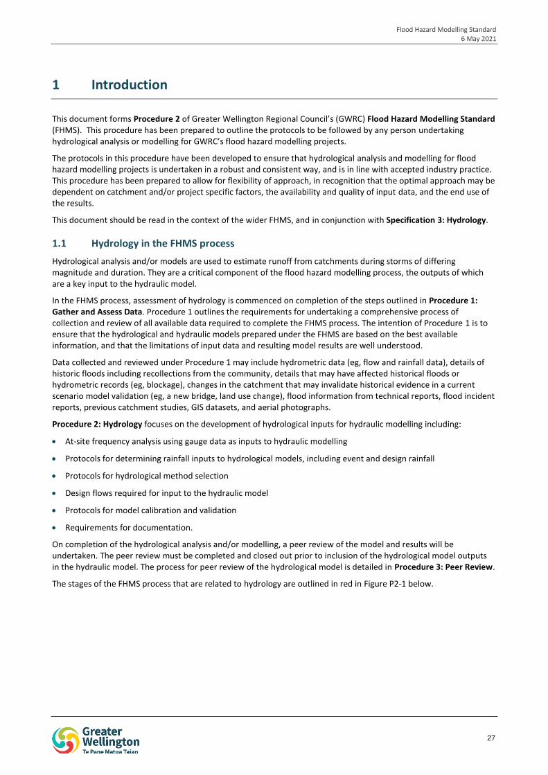
This document forms Procedure 2 of Greater Wellington Regional Council’s (GWRC) Flood Hazard Modelling Standard (FHMS). This procedure has been prepared to outline the protocols to be followed by any person undertaking hydrological analysis or modelling for GWRC’s flood hazard modelling projects.
The protocols in this procedure have been developed to ensure that hydrological analysis and modelling for flood hazard modelling projects is undertaken in a robust and consistent way, and is in line with accepted industry practice. This procedure has been prepared to allow for flexibility of approach, in recognition that the optimal approach may be dependent on catchment and/or project specific factors, the availability and quality of input data, and the end use of the results.
This document should be read in the context of the wider FHMS, and in conjunction with Specification 3: Hydrology.
1.1 Hydrology in the FHMS process
Hydrological analysis and/or models are used to estimate runoff from catchments during storms of differing magnitude and duration. They are a critical component of the flood hazard modelling process, the outputs of which are a key input to the hydraulic model.
In the FHMS process, assessment of hydrology is commenced on completion of the steps outlined in Procedure 1: Gather and Assess Data. Procedure 1 outlines the requirements for undertaking a comprehensive process of collection and review of all available data required to complete the FHMS process. The intention of Procedure 1 is to ensure that the hydrological and hydraulic models prepared under the FHMS are based on the best available information, and that the limitations of input data and resulting model results are well understood.
Data collected and reviewed under Procedure 1 may include hydrometric data (eg, flow and rainfall data), details of historic floods including recollections from the community, details that may have affected historical floods or hydrometric records (eg, blockage), changes in the catchment that may invalidate historical evidence in a current scenario model validation (eg, a new bridge, land use change), flood information from technical reports, flood incident reports, previous catchment studies, GIS datasets, and aerial photographs.
Procedure 2: Hydrology focuses on the development of hydrological inputs for hydraulic modelling including:
At-site frequency analysis using gauge data as inputs to hydraulic modelling
Protocols for determining rainfall inputs to hydrological models, including event and design rainfall
Protocols for hydrological method selection
Design flows required for input to the hydraulic model
Protocols for model calibration and validation
Requirements for documentation.
On completion of the hydrological analysis and/or modelling, a peer review of the model and results will be undertaken. The peer review must be completed and closed out prior to inclusion of the hydrological model outputs in the hydraulic model. The process for peer review of the hydrological model is detailed in Procedure 3: Peer Review.
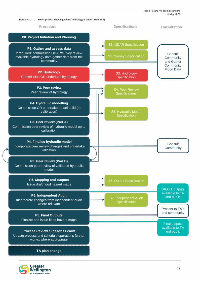
The stages of the FHMS process that are related to hydrology are outlined in red in Figure P2-1 below.
Flood Hazard Modelling Standard 6 May 2021
28
iop
1
S1. LiDAR Specification
S2. Survey Specification
S3. Hydrology Specification
P2. Hydrology
Commission OR undertake hydrology
S4. Peer Review Specifications
P4. Hydraulic modelling
Commission OR undertake model build (to calibration) S5. Hydraulic Model
Specification
P3. Peer review (Part A)
Commission peer review of hydraulic model up to calibration
P4. Finalise hydraulic model
Incorporate peer review changes and undertake validation.
S6. Output Specification P5. Mapping and outputs
Issue draft flood hazard maps
P6. Independent Audit
Incorporate changes from independent audit where relevant
TA plan change
S7. Independent Audit Specification
P3. Peer review (Part B)
Commission peer review of validated hydraulic model
P3. Peer review
Peer review of hydrology
Consult Community
Present to TA’s and community
Consult Community and Gather Community Flood Data
Process Review / Lessons Learnt
Update process and schedule operations further works, where appropriate
P1. Gather and assess data
If required: commission LiDAR/survey review available hydrology data gather data from the
community
DRAFT outputs available to TA
and public
Final outputs available to TA
and public
P0. Project Initiation and Planning
P5. Final Outputs
Finalise and issue flood hazard maps
Procedure Specifications Consultation
Figure P2-1 FHMS process showing where hydrology is undertaken (red)
Flood Hazard Modelling Standard 6 May 2021
29
2 Hydrological analysis
A review of the available at-site flow records should be undertaken to determine whether there is sufficient data available to use as inputs to hydraulic modelling. For example, this analysis may include:
Frequency analysis of flow records. Care should be taken when estimating peak flows for return periods that are double the flow record length. Consideration should also be given to the record length, level of confidence in the flow gauge and the high flow portion of the rating curve.
Scaling of recorded flow data by area to represent flows in other portions of the catchment.
The approach used to generate inputs for hydraulic modelling should be discussed and agreed with GWRC. Rainfall-runoff modelling may be required if there is insufficient at-site data to adequately represent catchment runoff across a range of events. The protocols for undertaking rainfall-runoff modelling are provided in the sections below.
3 Hydrological modelling
3.1 Software
Hydrological modelling may be undertaken using any widely available, industry accepted software package. The ready availability of the software package is important to allow the model to be re-run or updated at a later date, if needed.
The modeller should confirm that the software package selected produces outputs that are easily converted or imported into the hydraulic modelling package used by GWRC (likely to be DHI software).
3.2 Model extent
The model extent is to be provided by, or confirmed with GWRC prior to commencing modelling. In determining the model extent GWRC will consider the preferred extent of the hydraulic model, and where hydrological inputs may be required to inform hydraulic modelling.
3.3 Naming convention
A logical naming convention should be adopted for all hydrological models and output files. The naming convention should clearly outline the details of the model run and/or scenario.
It is acknowledged that the appropriate naming convention is likely to vary between software packages, due to differing methods of packaging versions and scenarios. The nomenclature used in the model file naming convention should be described in detail in the hydrological model report and model log, and should be broadly based on the naming convention for model outputs detailed below.
Outputs should follow the naming convention listed in Table P2-1, Table P2-2, Table P2-3 and Table P2-4 below. This naming convention has been adopted to ensure consistency between projects, for ease of use for the end user. The output naming convention shall be:
Project ID _RunTypeRunScenario_ Event_Version
For example,
For the first version of the hydrological model calibration (calibration event on 20 December 1976) for the Hutt River model, the output name would be:
HUTT_C19761220_001
For the final (peer reviewed) version of the design run of the 1% AEP event with allowance for climate change for the Hutt River the output name would be:
HUTT_D_1PCAEPCC_F
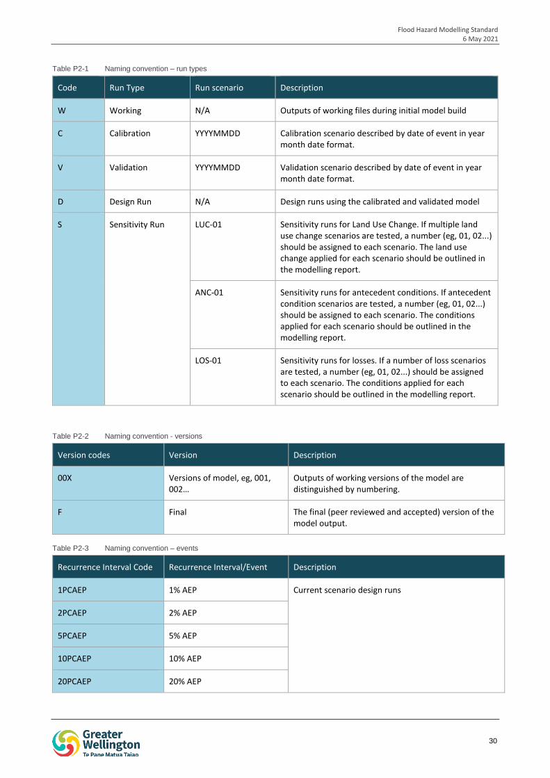
Flood Hazard Modelling Standard 6 May 2021
30
Table P2-1 Naming convention – run types
Code Run Type Run scenario Description
W Working N/A Outputs of working files during initial model build
C Calibration YYYYMMDD Calibration scenario described by date of event in year month date format.
V Validation YYYYMMDD Validation scenario described by date of event in year month date format.
D Design Run N/A Design runs using the calibrated and validated model
S Sensitivity Run LUC-01 Sensitivity runs for Land Use Change. If multiple land use change scenarios are tested, a number (eg, 01, 02...) should be assigned to each scenario. The land use change applied for each scenario should be outlined in the modelling report.
ANC-01 Sensitivity runs for antecedent conditions. If antecedent condition scenarios are tested, a number (eg, 01, 02...) should be assigned to each scenario. The conditions applied for each scenario should be outlined in the modelling report.
LOS-01 Sensitivity runs for losses. If a number of loss scenarios are tested, a number (eg, 01, 02...) should be assigned to each scenario. The conditions applied for each scenario should be outlined in the modelling report.
Table P2-2 Naming convention - versions
Version codes Version Description
00X Versions of model, eg, 001, 002…
Outputs of working versions of the model are distinguished by numbering.
F Final The final (peer reviewed and accepted) version of the model output.
Table P2-3 Naming convention – events
Recurrence Interval Code Recurrence Interval/Event Description
1PCAEP 1% AEP Current scenario design runs
2PCAEP 2% AEP
5PCAEP 5% AEP
10PCAEP 10% AEP
20PCAEP 20% AEP
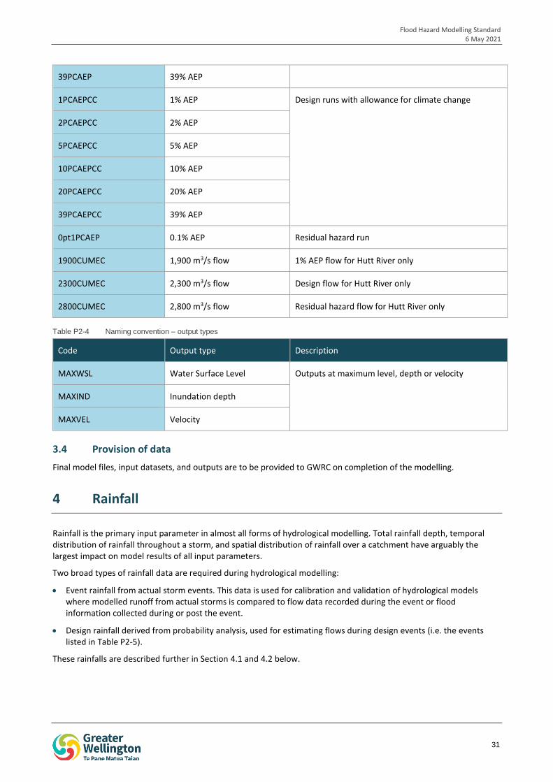
Flood Hazard Modelling Standard 6 May 2021
31
39PCAEP 39% AEP
1PCAEPCC 1% AEP Design runs with allowance for climate change
2PCAEPCC 2% AEP
5PCAEPCC 5% AEP
10PCAEPCC 10% AEP
20PCAEPCC 20% AEP
39PCAEPCC 39% AEP
0pt1PCAEP 0.1% AEP Residual hazard run
1900CUMEC 1,900 m3/s flow 1% AEP flow for Hutt River only
2300CUMEC 2,300 m3/s flow Design flow for Hutt River only
2800CUMEC 2,800 m3/s flow Residual hazard flow for Hutt River only
Table P2-4 Naming convention – output types
Code Output type Description
MAXWSL Water Surface Level Outputs at maximum level, depth or velocity
MAXIND Inundation depth
MAXVEL Velocity
3.4 Provision of data
Final model files, input datasets, and outputs are to be provided to GWRC on completion of the modelling.
4 Rainfall
Rainfall is the primary input parameter in almost all forms of hydrological modelling. Total rainfall depth, temporal distribution of rainfall throughout a storm, and spatial distribution of rainfall over a catchment have arguably the largest impact on model results of all input parameters.
Two broad types of rainfall data are required during hydrological modelling:
Event rainfall from actual storm events. This data is used for calibration and validation of hydrological models where modelled runoff from actual storms is compared to flow data recorded during the event or flood information collected during or post the event.
Design rainfall derived from probability analysis, used for estimating flows during design events (i.e. the events listed in Table P2-5).
These rainfalls are described further in Section 4.1 and 4.2 below.
Flood Hazard Modelling Standard 6 May 2021
32
4.1 Event rainfall
Event rainfall is actual rainfall data recorded during a real storm event. Event rainfall is primarily used for calibration and validation of hydrological models where rainfall from a real storm is run through the model to test the ability of the model to generate river flows or flooding similar to those observed.
Event rainfall should be selected from gauges within or close to the catchment. Gauges that record rainfall at high frequency (i.e. event or sub-5 minute) are considered to have more value than gauges with daily records only. The quality of available rainfall data should also be considered when selecting gauges. This data should be reviewed as part of Procedure 1: Gather and Assess Data.
Where multiple gauges exist, interpolation methods should be applied to obtain a representative estimate of rainfall over the spatial extent of the catchment. This is discussed further in Section 4.3.
4.2 Design rainfall
4.2.1 Frequent, Intermediate and Rare events (39% AEP to 1% AEP)
Design runs of hydrological models are undertaken to estimate catchment runoff during a range of storms of differing likelihoods. Under this procedure, design runs involve running a suite of storms with annual exceedance probabilities (AEP) between 39% and 0.1%. For the frequent, intermediate and rare events, design rainfalls can be derived from two sources:
1. Analysis of historical rainfall data from nearby gauge(s). This source should be used preferentially where it is available. Where multiple gauges are present, interpolation methods should be applied as discussed in Section 4.3. Selection of rain gauges should consider the length of the dataset, resolution of the data and the frequency and length gaps in the data.
Gaps in the rainfall record should be patched based on data from nearby representative gauge(s). Direct patching of rainfall data from one gauge to another is unlikely to be appropriate given that rainfall is typically highly spatially variable. As such, the use of regression (or other) techniques should be considered to determine the relationship between the donor gauge and patched gauge, and to allow for adjustment of donor data accordingly. The methodology applied should be discussed and justified in the hydrological modelling report.
2. NIWA’s High Intensity Rainfall Design System (HIRDS). This source should be used when:
- There are no rain gauges within, or near to the catchment being modelled. The suitability of gauges outside the catchment should be determined based on distance from the catchment, gauge elevation and orientation to prevailing weather systems as compared to the catchment being modelled.
- Rain gauges within or near to the site do not have a sufficiently long record relative to the events being modelled. For example, 10 years of rainfall record is considered insufficient for estimation of rainfall depths and intensities during a 1% AEP event.
- Rain gauge data within or near to the site is not of sufficient quality for use in modelling. For example, the data is recorded at low frequency (eg, daily or hourly in small catchments), the record has been poorly maintained, or there are long and frequent gaps in the record.
4.2.2 Very rare events (0.1% AEP)
An estimate of design rainfall during the 0.1% AEP event is required to enable modelling of residual hazard during hydraulic modelling.
As estimation of these rare rainfalls is an extrapolation beyond recorded events, all estimates should be treated with caution. It is noted that as NIWA’s HIRDS only provides estimates of rainfall intensities up to the 0.4% AEP event, extrapolation is required regardless of the rainfall data source for more frequent events.
One approach used for calculation of rainfall during rare events outlined in Book 2 of Australian Rainfall and Runoff (2019) is extrapolation of a frequency analysis using a GEV distribution fitted using LH-moments. This places more weight on larger rainfalls as opposed to L-moments used for more frequent rainfalls.
The approach selected should be discussed and justified in the hydrological modelling report.
Flood Hazard Modelling Standard 6 May 2021
33
4.2.3 Temporal patterns
Rainfall temporal patterns describe how the total rainfall depth is distributed across the duration of a storm. A wide range of temporal patterns can occur within a catchment. Temporal patterns may vary with storm duration, or with other factors such as type of weather system. For example, NIWA (2018) cites that frontal systems tend to generate peak rainfalls early in the storm, compared to tropical lows where peak rainfalls tend to occur towards the middle of the storm.
Rainfall temporal patterns can be estimated using a number of techniques, including the average variability method proposed by Pilgrim et al.,(1969), and Pilgrim and Cordery (1975) and modified in Australian Rainfall and Runoff (1987). This method is commonly applied in New Zealand and is accepted by GWRC. The average variability method assumes a single rainfall burst (i.e. no pre- or post-burst rainfall) and assumes that temporal patterns are independent of probability (i.e. the same temporal pattern applies for frequent and infrequent events).
Book 2 of Australian Rainfall and Runoff (2019) notes that there are a number of limitations with this method, and that it is most effective where there is a dominant temporal pattern. Alternative methods of temporal pattern generation may be applied where they are industry accepted and justified in the hydrological modelling report.
Where more than one temporal pattern is found to be dominant, hydrological modelling may be undertaken using up to two temporal patterns. However, this should be discussed with GWRC prior to commencement.
It is noted that some international guidance, such as Australian Rainfall and Runoff (2016) recommends the use of an ensemble of temporal patterns. This practice has not been widely applied in New Zealand to date.
4.2.3.1 Nested storm
A nested storm is a type of temporal pattern that is most commonly applied in urbanised catchments where stormwater flooding is a key consideration.
A nested storm contains the peak rainfall intensities for each duration ‘nested’ within longer duration profiles. The peak intensities are typically nested at the centre of the storm, however this can be shifted where appropriate. For example, Wellington Water’s reference guide for design storm hydrology found that nesting peak intensities at 67% of the duration was more suitable for small urban catchments in the Wellington Region (Cardno, 2018).
Caution should be applied where nested storms are used for the estimation of riverine flooding as peak flows in watercourses may be overestimated. Care should be taken to confirm whether modelled flows are comparable to gauged flows.
4.3 Interpolation between gauges
Where more than one rain gauge is located within or near to the catchment, methods of interpolation between these gauges should be undertaken to ensure that applied rainfall is spatially representative.
A common method of interpolation is the Thiessen Polygon method, which can be used to develop an area-weighted rainfall series for the catchment. The method applied should be discussed and justified in the hydrological modelling report.
4.4 Areal reduction factors
4.4.1 Design Rainfall
Design rainfalls are typically derived for a specific point in a catchment. In large catchments, HIRDS rainfall intensities generated for specific locations are unlikely to be representative of the rainfall intensities experienced over the entire catchment during a given storm.
To correct for this, areal reduction factors can be applied to adjust point estimates of rainfall intensities to the average rainfall intensity over the entire catchment. Areal reduction factors should be calculated based on industry accepted methods such as those in Book 2 of Australian Rainfall and Runoff (2019) or the guidance in Auckland Council’s TP108. Recent research in the Journal of Hydrology (New Zealand) (Singh et al., 2018) and NIWA (2018) should also be considered.
Flood Hazard Modelling Standard 6 May 2021
34
4.4.2 Event Rainfall
As event rainfall is the recorded depth at a gauge it does not represent the maximum rainfall at a point. The effective mean rainfall depth across the catchment may be greater than or less than the recorded rainfall, although this is unknown. As such, an areal reduction factor is typically not applied.
4.5 Climate change
A number of design runs with allowance for climate change are required to be undertaken, as outlined in Table P2-5. Climate change is to be applied in line with current advice from the Ministry for the Environment (MfE), and should be in line with GWRC’s policy.
MfE climate change predictions (at the time of writing of this procedure) are outlined in Climate Change Projections for New Zealand: Atmospheric Projections Based on Simulations from the IPCC Fifth Assessment, 2nd Edition (Ministry for Environment, 2018), and equate to an approximate 20% increase in rainfall depth estimates to 2100 based on an 8% increase in peak rainfall for each degree of climate warming, and a 0.7 – 3.0 degree projected temperature increase.
Predictions of percentage changes to rainfall depths for a range of storm durations and recurrence intervals provided in NIWA (2018) should also be considered.
5 Hydrological methods
Hydrological modelling undertaken for flood hazard modelling projects must be undertaken using methods that estimate hydrograph shape, timing and magnitude, as opposed to methods which are limited to estimation of peak flows only.
A wide range of hydrological methods are available that meet this criterion, including:
A range of conceptual models, such as the storage routing models used in Hydstra, XP-RAFTS, NAM and RORB.
A number of empirical models, such as kinematic wave equation with Horton’s loss model which is frequently used in stormwater modelling in Christchurch City; and the SCS curve number method used widely in stormwater modelling by Auckland Council, Bay of Plenty Regional Council and Wellington Water.
Some physical models, such as MIKE-SHE.
Hydrological methods for flood hazard modelling projects should be selected on the basis of:
Availability of method within the software being used. Software is to be selected based on the criteria outlined in Section 3.1.
Applicability to the Wellington Region (i.e. is the method appropriate for the climate, soils etc.)
Applicability to the specific catchment (for example, some methods are only applicable to catchments up to a certain size, and some methods are intended to be applied to urban or rural catchments).
Applicability to the purpose of the modelling.
Whether the method is industry accepted in New Zealand.
Whether the method is widely used in New Zealand, with satisfactory results.
The selection of method should be discussed and justified in the hydrological modelling report. The discussions should include any known limitations with the application of the method.
Flood Hazard Modelling Standard 6 May 2021
35
6 Calibration and validation
6.1 Calibration
Calibration involves the adjusting of model parameters to alter model results to improve agreement between modelled and recorded hydrographs. Calibration should aim to match all aspects of the hydrograph, including hydrograph peak, volume and timing, where possible.
Calibration should be undertaken for all hydrological models developed under the FHMS where sufficient data is available. Ideally, calibration would utilise rainfall and flow records for at least three flood events of differing magnitudes, with at least one event being greater than a 2% AEP event to ensure that modelled parameters accurately represent catchment runoff behaviour, losses and routing across a range of events.
However, it is noted that data for calibration is often limited within the Wellington Region, and sufficient data for three events may not be available. It is also noted that the confidence in the recorded hydrograph should be considered during this process, particularly with regard to the upper end of rating curves. Calibration should also consider how the catchment may have changed since the calibration event, for example land use change.
The calibration process should be documented in full, including final parameters, and how data quality and changes in the catchment and any other factors were accounted for.
6.2 Validation
Validation is undertaken following model calibration and is used to verify that the model can acceptably reproduce events that are different to the calibration event. This ensures that the calibration parameters are representative of a wide range of possible events that could occur in the catchment.
Where possible, validation should be undertaken for a minimum of three events of varying magnitude. However, it is recognised that for the majority of watercourses in the region sufficient data is unlikely to be available.
6.3 Comparison to alternate methods
Alternative methods of peak flow estimation such as frequency analysis and the regional flood frequency method derived by Pearson and McKerchar (1989), should be used to provide an estimate of peak flow during design storms for comparison to modelled results.
6.3.1 Regional flood frequency method
Pearson and McKerchar (1989) developed a regional method for estimating peak flow for design floods of various magnitudes using contour plans of specific discharge and flood frequency factors. This method was updated with specific maps for the Wellington Region by Pearson in 1990.
If using the regional flood frequency method to validate peak flows, the Pearson (1990) method should be applied. A summary of this analysis should be provided in the hydrological modelling report.
6.3.2 Frequency analysis
Where available, frequency analysis of peak flows should be undertaken using at-site flow data. The results of this analysis should be compared to the modelling results, and reported in the hydrological modelling report.
Care should be taken when estimating peak flows for return periods that are double the flow record length. Consideration should also be given to the record length, level of confidence in the flow gauge and the high flow portion of the rating curve.
7 Design runs
A suite of design runs is required to inform the hydraulic model and the ultimate outputs of the flood hazard modelling process. These design runs include:
A suite of runs across a range of event probabilities, based on current climate conditions.
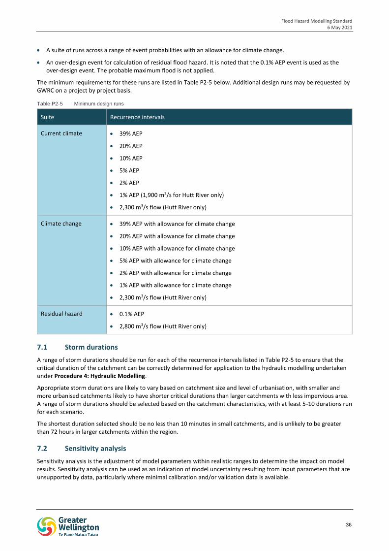
Flood Hazard Modelling Standard 6 May 2021
36
A suite of runs across a range of event probabilities with an allowance for climate change.
An over-design event for calculation of residual flood hazard. It is noted that the 0.1% AEP event is used as the over-design event. The probable maximum flood is not applied.
The minimum requirements for these runs are listed in Table P2-5 below. Additional design runs may be requested by GWRC on a project by project basis.
Table P2-5 Minimum design runs
Suite Recurrence intervals
Current climate 39% AEP
20% AEP
10% AEP
5% AEP
2% AEP
1% AEP (1,900 m3/s for Hutt River only)
2,300 m3/s flow (Hutt River only)
Climate change 39% AEP with allowance for climate change
20% AEP with allowance for climate change
10% AEP with allowance for climate change
5% AEP with allowance for climate change
2% AEP with allowance for climate change
1% AEP with allowance for climate change
2,300 m3/s flow (Hutt River only)
Residual hazard 0.1% AEP
2,800 m3/s flow (Hutt River only)
7.1 Storm durations
A range of storm durations should be run for each of the recurrence intervals listed in Table P2-5 to ensure that the critical duration of the catchment can be correctly determined for application to the hydraulic modelling undertaken under Procedure 4: Hydraulic Modelling.
Appropriate storm durations are likely to vary based on catchment size and level of urbanisation, with smaller and more urbanised catchments likely to have shorter critical durations than larger catchments with less impervious area. A range of storm durations should be selected based on the catchment characteristics, with at least 5-10 durations run for each scenario.
The shortest duration selected should be no less than 10 minutes in small catchments, and is unlikely to be greater than 72 hours in larger catchments within the region.
7.2 Sensitivity analysis
Sensitivity analysis is the adjustment of model parameters within realistic ranges to determine the impact on model results. Sensitivity analysis can be used as an indication of model uncertainty resulting from input parameters that are unsupported by data, particularly where minimal calibration and/or validation data is available.
Flood Hazard Modelling Standard 6 May 2021
37
Sensitivity analysis can also be used to investigate possible peak flows, hydrograph shapes and timing that could occur under conditions outside of those included in the base model run, for example, during wet or dry antecedent conditions, or where there is an increase in impervious area (i.e. urban development) in the catchment.
Sensitivity analysis of key parameters should be undertaken on all hydrological models prepared for flood hazard modelling projects. Sensitivity parameters should include, but are not limited to:
Antecedent conditions
Temporal pattern
Losses
Land use change, such as new urban development, where likely in the catchment.
Sensitivity analysis should be fully documented in the hydrological modelling report. Output hydrographs from the sensitivity scenarios should be provided to the hydraulic modeller to be included in the hydraulic model sensitivity testing, and for development of freeboard.
8 Outputs
The required outputs of the hydrological modelling are outlined in Table P2-6. These outputs are required to:
Provide inputs for hydraulic modelling.
Assist the peer reviewer to undertake the peer review.
Keep records for future model updates and additional design runs if required.
Table P2-6 Hydrological model outputs
Element Requirement
Hydrographs All current climate, climate change and residual hazard runs.
The hydrographs should be provided in a timeseries format for input into the hydraulic modelling.
Model files All model files to be provided to the peer reviewer for review, and to GWRC for their records.
Model log A detailed model log should be kept and provided on completion of the modelling. This is described in Section 9.2.
Geospatial files All geospatial files used during modelling, eg, catchment boundaries, Thiessen polygons, etc.
9 Documentation
The hydrological modelling should be fully documented to:
Provide background information, reasoning and assumptions for the peer review.
Ensure that the model can be reproduced in another modelling software at a later date if required.
Ensure transparency for the end users of the model results, including the community.
The methods of documentation outlined in the sections below are required for all hydrological models constructed under the FHMS.
Flood Hazard Modelling Standard 6 May 2021
38
9.1 Data register
A data register will be prepared for each flood hazard modelling project as part of works undertaken under Procedure 1: Gather and Assess Data. Details of the format of the data register is provided in Procedure 1, and a template is provided in Appendix P1-A.
The data register should be updated with any data gathered or reviewed as part of this procedure. On completion of this component of work the updated data register should be appended to the hydrology report, and provided in electronic format to GWRC.
9.2 Model log
A detailed model log should be kept while undertaking the modelling. This log should be appended to the hydrological report, and should document the model build, assumptions made, and all inputs. The model log should assist with version control and will describe the model naming convention.
The model log should be provided to the peer reviewer to assist with the peer review. A model log template is provided in Appendix P2-A.
9.3 Report
A detailed technical report should be prepared to outline the hydrological modelling undertaken. The report should include, but is not limited to:
Details of the software used
Model extent
Data availability and quality
- Detailed summary of the analytical process and findings of the data collection and review undertaken as part of Procedure 1: Gather and Assess Data
Details of the rainfall inputs, including:
- Gauges located within and near to catchment, length of record, and quality of data
- Method of interpolation between gauges, where undertaken
- Any areal reduction factors applied
- Development of design rainfall depths (i.e. frequency analysis or HIRDS)
- Temporal pattern used, and details of method used to derive the temporal pattern
- Details of how the rainfall is applied in the model
- Details of how climate change has been applied to future climate scenarios
- Storm events used in calibration and validation
Hydrological methods
- Summary of the method used, and discussion of suitability for the flood hazard modelling project
- Summary and justification for all parameters used
Calibration
- Flood events selected for calibration
- Results of calibration
Validation
- Flood events selected for validation
- Results of validation
Alternative methods of peak flow estimation
Flood Hazard Modelling Standard 6 May 2021
39
- Description of application of alternative methods of peak flow estimation
- Discussion and comparison to model results
9.4 Feedback form
It is anticipated that the work undertaken under Procedure 1: Gather and Assess data and this procedure will increase the understanding of the limitations of the hydrometric stations used in this assessment. As such, a feedback form has been prepared to provide this information to GWRC for consideration for future data collection.
For example, the analysis undertaken under the FHMS may indicate that a flow gauge would be more useful if it was located in a different position in the catchment. This information can be provided in the feedback form.
The feedback form is provided in Appendix P2-B and should be filled out and provided to GWRC on completion of the hydrological modelling.
10 Procedure review
This procedure is intended to be a living document that can be revised as technology advances and industry accepted practice evolves.
The need for review of the procedures within the FHMS, including this one, will be determined at the end of each modelling project at the ‘process review / lessons learnt’ checkpoint on the FHMS flow chart.
11 References
Ball J, Babister M, Nathan R, Weeks W, Wienmann E, Retallick M, Testoni I (editors) Australian Rainfall and Runoff: A guide to flood estimation (2019). Commonwealth of Australia (Geoscience Australia).
NIWA (2018) High Intensity Rainfall Design System Version 4. Prepared for Envirolink.
Cardno (2019). Reference Guide for Stormwater Modelling - Standardised Parameters for Hydrological Modelling. Prepared for Wellington Water.
Ministry for Environment (2018). Climate Change Projections for New Zealand: Atmospheric Projections Based on Simulations from the IPCC Fifth Assessment, 2nd Edition
Pearson, C.P and McKerchar, A.I (1989). Flood Estimation – A Revised Design Procedure.
Pearson, C.P (1990) Hutt River Flood Control Scheme Review. Climatology and Hydrology Volume 2 of 5 Flood Hydrology. NIWA.
Pilgrim, D.H (ed) (1987) Australian Rainfall and Runoff – A guide to flood estimation, Institution of Engineers, Australia.
Pilgrim, D.H., Cordery, I. and French, R. (1969). Temporal patterns of design rainfall for Sydney, Institution of Engineers, Australia, Civil Eng. Trans., CE11: 9-14
Pilgrim, D.H., and Cordery, I. (1975). Rainfall temporal patterns for design floods, Journal of the Hydraulics Division, 101(1), 81-95.
Singh, S.K., Griffiths, G.A. and McKerchar, A.I (2018) Towards estimating areal reduction factors for design rainfalls in New Zealand. Journal of Hydrology (NZ) Volume 57 Number 1
Flood Hazard Modelling Standard 6 May 2021
40
PROCEDURE 03
PEER REVIEW This procedure has been prepared to outline the protocols to be followed by any person undertaking peer review of GWRC flood hazard modelling projects.
Flood Hazard Modelling Standard 6 May 2021
41
Procedure 03 Table of Contents
1 Introduction 42
1.1 What is a Peer Review? 42
1.2 Peer Review in the FHMS Process 42
1.3 Who can be a Peer Reviewer? 42
1.4 How should a peer reviewer be engaged? 44
2 Undertaking a Peer Review 44
2.1 Hydrology Review 44
2.2 Hydraulic Model Review: Part A 45
2.3 Hydraulic Model Review: Part B and Outputs 46
3 Documentation 46
3.1 Peer Review Spreadsheets 47
3.2 Peer Review Report 48
3.3 Peer Review Close Out 48
4 Procedure Review 48
Flood Hazard Modelling Standard 6 May 2021
42
1 Introduction
This document forms Procedure 3 of Greater Wellington Regional Council’s (GWRC) Flood Hazard Modelling Standard (FHMS). This procedure has been prepared to outline the protocols to be followed by any person undertaking peer review of GWRC flood hazard modelling projects.
This document should be read in the context of the wider FHMS, and has a particular relationship to Specification 4: Peer Review Specifications which provide a template Request for Proposal for engaging external suppliers to undertake peer review.
A peer review template is provided in Appendix P3-A of this procedure. This template should be used as the basis of all peer reviews undertaken as part of the FHMS process.
1.1 What is a Peer Review?
In the context of this procedure, a peer review is an independent, thorough technical assessment of a hydrological or hydraulic model, or outputs of a hydraulic model. The review is based on a ‘hands-on’ interrogation of a model by a suitably qualified and experienced professional who uses their technical expertise, current best-practice and unbiased judgement to review the work.
The peer reviewer’s role is to determine whether the work reviewed meets accepted industry standard, and is of suitable quality to proceed to the next step of the FHMS process.
The suitability of the model should be assessed in the context of the purpose of the model. For example, a model prepared for the purpose of providing flood hazard information to support district planning, may be able to proceed to next stage of the FHMS process even though it does not have sufficient detail for bridge design, given that bridge design is not the purpose of the model, and is not the responsibility of GWRC.
It is noted that a peer review is distinct from an Independent Audit which is the subject of Procedure 6 of the FHMS.
1.2 Peer Review in the FHMS Process
Peer review is undertaken at three stages within the FHMS process:
Peer review of hydrological modelling, on completion of Procedure 2: Hydrology
Peer review of the hydraulic model build and calibration, on completion of Part A of Procedure 4: Hydraulic Modelling
Peer review of the hydraulic model validation, runs, sensitivity testing and draft outputs on completion of Part B of Procedure 4: Hydraulic Model and Procedure 5: Outputs.
These stages are outlined in red in the FHMS process flow chart provided in Figure P3-1 below.
Peer review should be undertaken for all new models that proceed through the FHMS process. Peer review may also be undertaken where changes are made to existing models that have the potential to result in changes to district plans or GWRC’s flood hazard advice.
Where changes are made to existing models, it is acceptable for the peer reviewer to only review the changes in the context of the model, provided that the model has previously been peer reviewed. If a peer review has not been previously undertaken, then a full peer review is required.
1.3 Who can be a Peer Reviewer?
Peer reviewers must meet the following criteria:
Peer reviewers must be independent from the flood hazard modelling project. Independent means that the peer reviewer has not personally been involved with the project at any stage. However, it is acceptable for a peer reviewer to have previously undertaken work separate to the flood hazard modelling project within the catchment.
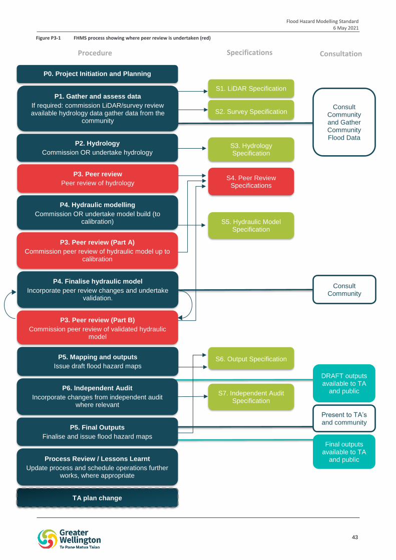
Flood Hazard Modelling Standard 6 May 2021
43
iop
1
S1. LiDAR Specification
S2. Survey Specification
S3. Hydrology Specification
P2. Hydrology
Commission OR undertake hydrology
S4. Peer Review Specifications
P4. Hydraulic modelling
Commission OR undertake model build (to calibration) S5. Hydraulic Model
Specification
P3. Peer review (Part A)
Commission peer review of hydraulic model up to calibration
P4. Finalise hydraulic model
Incorporate peer review changes and undertake validation.
S6. Output Specification P5. Mapping and outputs
Issue draft flood hazard maps
P6. Independent Audit
Incorporate changes from independent audit where relevant
TA plan change
S7. Independent Audit Specification
P3. Peer review (Part B)
Commission peer review of validated hydraulic model
P3. Peer review
Peer review of hydrology
Consult Community
Present to TA’s and community
Consult Community and Gather Community Flood Data
Process Review / Lessons Learnt
Update process and schedule operations further works, where appropriate
P1. Gather and assess data
If required: commission LiDAR/survey review available hydrology data gather data from the
community
DRAFT outputs available to TA
and public
Final outputs available to TA
and public
P0. Project Initiation and Planning
P5. Final Outputs
Finalise and issue flood hazard maps
Procedure Specifications Consultation
Figure P3-1 FHMS process showing where peer review is undertaken (red)
Flood Hazard Modelling Standard 6 May 2021
44
The peer reviewer should be from a different organisation than the organisation that undertook the work being reviewed. A person is still eligible to undertake peer review of a model if their organisation was involved in another component of the flood hazard modelling project, as long the peer reviewer was not personally involved in that work. For example, if company A undertook the hydrological modelling, company A is not excluded from peer reviewing the hydraulic modelling, as long as the peer review is undertaken by a different member of staff.
GWRC staff are not considered independent, and therefore are not eligible to peer review work undertaken under the FHMS process.
The peer reviewer should not have any form of dependent relationship with the modeller and should have no conflicts of interest relating to the project or modellers organisation including financial or other interests.
1.4 How should a peer reviewer be engaged?
Peer reviewers should be engaged using the request for proposal template in Specification 4: Peer Review Specification.
1.4.1 Liability
Peer reviewers may be liable for damages jointly with the original modeller’s organisation if claims against the work are upheld.
The level of liability will be agreed on as part of the contract between GWRC and the reviewer’s organisation. All peer reviewers should hold appropriate insurances.
2 Undertaking a Peer Review
When reviewing modelling, the peer reviewer should undertake a detailed hands-on interrogation of the model. The peer reviewer should also review any accompanying documentation such as the inputs (eg, hydrology report and peer review), model log and model report to assist with their understanding of the work undertaken and assumptions made.
The peer reviewer should also consider whether the modelling has been undertaken in accordance with the appropriate procedures of the FHMS (eg, Procedure 2: Hydrology or Procedure 4: Hydraulic Modelling). If there are departures from the FHMS the peer review is to assess whether these departures and the reasons for them have been recorded and are appropriate, technically correct, and to an industry accepted standard.
The peer review is expected to be an iterative process, and will involve on-going conversations between the modeller and peer reviewer. All comments and each iteration of the work is required to be documented, as outlined in Section 3 below.
It is noted that in undertaking the peer review, the peer reviewer or modeller may place limitations on the use of the model. For example, the peer reviewer may determine that the model is suitable for use for the next 5 years, while additional flow data is gathered, but that the model should be revised after this time.
The peer review is undertaken at three points in the FHMS process:
Hydrology Peer Review
Hydraulic Model Peer Review: Part A
Hydraulic Model Peer Review: Part B and Outputs
The contents of each phase are detailed in the sections below.
2.1 Hydrology Review
A peer review of the hydrological model should be undertaken on completion of the modelling (including calibration, validation and sensitivity testing, and design runs).
Flood Hazard Modelling Standard 6 May 2021
45
The purpose of the review is to assess whether the inputs, assumptions and functioning of the model is technically correct, and has been built according to the requirements of the FHMS and industry accepted practice. The review should also consider the sensibility of the model results.
The peer reviewer should assess all aspects of the model including, but not limited to:
Suitability of software
Rainfall inputs, including the suitability of event rainfall used in calibration and validation, suitability of method used for design storm generation, and the suitability of the temporal pattern(s) and areal reduction factors applied.
Input parameters such as time of concentration and catchment drainage parameters, with consideration given to historical and proposed changes within the catchment.
Hydrological method
Run parameters
Calibration – including calibration data used and approach to calibration
Review of validation and sensitivity testing
Review and sensibility check of design storm results
Review and sensibility check of sensitivity and optioneering results
Model documentation is complete.
A more detailed list of review parameters is provided in the review template in Appendix P3-A. The peer reviewer may add items to the review template as needed.
The findings of each iteration of the peer review should confirm whether the reviewer’s comments have been addressed sufficiently for the project to proceed to the next stage of the FHMS process (i.e. input to the hydraulic model). For the comment to be considered to be addressed sufficiently, the amendments or decision not to amend must be agreed between both the modeller and peer reviewer.
2.2 Hydraulic Model Review: Part A
The first peer review of the hydraulic modelling, referred to as Part A, should be undertaken following the initial hydraulic model build and calibration.
The purpose of this review is to assess the inputs, assumptions and functioning of the model to confirm that the model is technically correct, is stable, and has been built according to the requirements of the FHMS and industry best-practice. This review is undertaken prior to model validation, design runs, sensitivity testing and optioneering.
The peer reviewer should assess all aspects of the model including, but not limited to:
Model schematisation
Channel and floodplain modelling – topography (DEM), cross-sections, roughness, structures
Boundary conditions
Inputs
1D/2D connectivity
Run parameters
Model stability, convergence and mass balance
Calibration – including calibration data used and approach to calibration
Model results, including 1D long-sections
Model documentation (model log and internal QA) is complete.
Flood Hazard Modelling Standard 6 May 2021
46
A more detailed list of review parameters is provided in the review template in Appendix P3-A. The peer reviewer may add items to the review template as needed.
The peer reviewer of the hydraulic modelling review is not required to review the hydrology as this will have been peer reviewed prior to the preparation of the hydraulic model. However, the peer reviewer should consider how the hydrology is impacting the hydraulic results and whether this is appropriate or requires further investigation.
For large models, it is acceptable for the peer reviewer to review a random sample of at least 25% of cross-sections, and a random sample of at least 25% of structures for correctness rather than reviewing every element. The sample should include sections and structures from every modelled watercourse within the model.
If a large number of errors are found in the random sample, the model should be returned to the modeller for correction prior to resuming the review. If the reviewer considers that cross-sections or structures in a certain reach are likely to have a larger impact on the results, then these should be reviewed in more detail. It is noted that GWRC may specify areas to be reviewed in more detail, in addition to the random sample. The peer reviewer should confirm with GWRC whether this is the case prior to commencing the review.
The findings of each iteration of the Part A peer review should confirm whether the reviewer’s comments have been addressed sufficiently for the project to proceed to the next stage of the FHMS process. For the comment to be considered to be addressed sufficiently, the amendments or decision not to amend must be agreed between both the modeller and peer reviewer.
2.3 Hydraulic Model Review: Part B and Outputs
The Part B hydraulic model review commences following the completion of Part B of Procedure 4: Hydraulic Modelling. The purpose of this review is to:
Review validation and sensitivity testing
Review and sensibility check of design storm results
Review and sensibility check of sensitivity and optioneering results
Sensibility check of preliminary outputs.
The review should include a review of both the changes to the model set up and results as part of the validation, design runs, sensitivity testing and any optioneering.
A more detailed list of review parameters is provided in the review template in Appendix P3-A. The peer reviewer may add items to the review template as needed.
The Part B review includes a sensibility check of the preliminary outputs. After the peer reviewers Part B comments are addressed, the peer reviewer is required to undertake a further review of the revised outputs.
The findings of each iteration of the Part B peer review should confirm whether the reviewer’s comments have been addressed sufficiently for the project to proceed to the next stage of the FHMS process.
3 Documentation
The initial peer review and subsequent iterations must be clearly documented. The following documents are required to be prepared to record the peer review, and subsequent revisions:
Peer review spreadsheet (a template is provided in Appendix P3-A).
Peer review report
Peer review close-out
These documents are detailed in the sections below. All correspondence between the reviewer and the modeller should be documented.
Flood Hazard Modelling Standard 6 May 2021
47
3.1 Peer Review Spreadsheets
A template of the peer review spreadsheets is provided in Appendix P3-A. A separate spreadsheet is provided for the hydrology and hydraulics (Part A and Part B) reviews. These spreadsheets must be used to record the peer reviewer and modeller’s comments for all peer reviews. The peer reviewer may add additional items to the template, as required.
The peer review template is made up of a number of tabs (blue/green) to record the peer reviewers’ findings while interrogating the model. The time and date of issue of the reviewer’s comments should be recorded in the spreadsheet to assist with version control.
Each of the comments in the summary table is then given a rating in line with the criteria in Table P3-1 below.
Table P3-1 Review rating table
Review ratings Model suitable to move to next step in FHMS?
Ok The element or parameter being used is modelled correctly Yes
Minor Issue is unlikely to significantly affect model results Yes
Major Issue compromises the model and should be rectified, but may be resolved by explanation or acceptance of model limitations.
To be determined in discussion with GWRC
Critical Issue severely compromises the model and should be rectified before moving to the next step of the FHMS.
No
Other categories
Future data collection
Identifies where additional future data collection could result in model improvements in the future.
Yes
Source: modified from Beca (2015). Pinehaven Stream Flood Mapping Audit.
The spreadsheet is then issued to the original modeller. The modeller will review each comment and amend the model as necessary. Any changes made to the model and/or responses to the reviewer’s comments are recorded in a separate column in the review summary tab of the spreadsheet. The time and date of issue is to be recorded in the spreadsheet.
The peer reviewer is then required to review the comments and changes to the model made by the original modeller, and provide further comments (if necessary) and a further review rating for each comment in a separate column. This process continues until all of the issues have been resolved and the model is deemed suitable to continue to the next stage of the FHMS.
A review log is provided within the peer review spreadsheet. The reviewer and modeller should record the date and the overall outcome of each iteration of the review in this table. Outcome should be defined in accordance with the categories in Table P3-2 below.
Table P3-2 Outcome descriptors
Outcome categories Description
Action Required Issues have been identified within the model that are likely to affect the results and should be rectified before the model moves the next stage of the FHMS process.
Suitable to proceed Issues identified in the model have been rectified (if any), and the model is considered to be of sufficient quality to move to the next stage of the FHMS process.
An example of a completed review log is provided in Table P3-3.
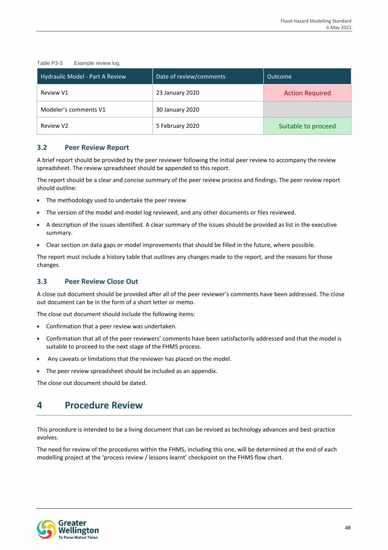
Flood Hazard Modelling Standard 6 May 2021
48
Table P3-3 Example review log.
Hydraulic Model - Part A Review Date of review/comments Outcome
Review V1 23 January 2020 Action Required
Modeler’s comments V1 30 January 2020
Review V2 5 February 2020 Suitable to proceed
3.2 Peer Review Report
A brief report should be provided by the peer reviewer following the initial peer review to accompany the review spreadsheet. The review spreadsheet should be appended to this report.
The report should be a clear and concise summary of the peer review process and findings. The peer review report should outline:
The methodology used to undertake the peer review
The version of the model and model log reviewed, and any other documents or files reviewed.
A description of the issues identified. A clear summary of the issues should be provided as list in the executive summary.
Clear section on data gaps or model improvements that should be filled in the future, where possible.
The report must include a history table that outlines any changes made to the report, and the reasons for those changes.
3.3 Peer Review Close Out
A close out document should be provided after all of the peer reviewer’s comments have been addressed. The close out document can be in the form of a short letter or memo.
The close out document should include the following items:
Confirmation that a peer review was undertaken.
Confirmation that all of the peer reviewers’ comments have been satisfactorily addressed and that the model is suitable to proceed to the next stage of the FHMS process.
Any caveats or limitations that the reviewer has placed on the model.
The peer review spreadsheet should be included as an appendix.
The close out document should be dated.
4 Procedure Review
This procedure is intended to be a living document that can be revised as technology advances and best-practice evolves.
The need for review of the procedures within the FHMS, including this one, will be determined at the end of each modelling project at the ‘process review / lessons learnt’ checkpoint on the FHMS flow chart.
Flood Hazard Modelling Standard 6 May 2021
49
PROCEDURE 04
HYDRAULICS This procedure has been prepared to allow for flexibility of approach, in recognition that the optimal modelling approach may be dependent on catchment and/or project specific factors, the availability and quality of input data, and the end use of the model.
Flood Hazard Modelling Standard 6 May 2021
50
Procedure 04 Table of Contents
1 Introduction 51
1.1 Hydraulic modelling in the FHMS process 51
1.2 Software 51
1.3 Model extent 51
1.4 Naming convention 53
1.5 Provision of data 55
2 PART A: Hydraulic model build 55
2.1 Model schematisation 55
2.2 Grid 56
2.3 Model inputs 56
2.4 Boundaries 59
2.5 Calibration 60
2.6 Mass balance 60
3 PART B: Finalise hydraulic model 60
3.1 Validation 60
3.2 Sensitivity analysis 61
3.3 Design runs 61
3.4 Freeboard 63
4 Outputs 63
4.1 Confidence in results 63
5 Documentation 64
5.1 Data register 64
5.2 Model log 64
5.3 Report 65
6 Procedure review 65
7 References 65
Flood Hazard Modelling Standard 6 May 2021
51
1 Introduction
This document forms Procedure 4 of Greater Wellington Regional Council’s (GWRC) Flood Hazard Modelling Standard (FHMS). This procedure has been prepared to outline the protocols to be followed by any person undertaking hydraulic modelling for GWRC’s flood hazard modelling projects.
The protocols in this procedure have been developed to ensure that hydraulic modelling for flood hazard modelling projects is undertaken in a robust and consistent way, and is in line with accepted industry practice. This procedure has been prepared to allow for flexibility of approach, in recognition that the optimal modelling approach may be dependent on catchment and/or project specific factors, the availability and quality of input data, and the end use of the model.
This document should be read in the context of the wider FHMS, and in conjunction with Specification 5: Hydraulic Model.
1.1 Hydraulic modelling in the FHMS process
In the FHMS process, hydraulic modelling is undertaken in order to convert estimates of catchment runoff from hydrological modelling into flood levels and velocities by modelling the hydraulic behaviour of flow in the river channel and floodplain.
Results from hydraulic modelling are used to prepare the final outputs of the FHMS process including maps of flood extent, level, depth, velocity and hazard across various storm events.
Hydraulic modelling is undertaken at two stages in the FHMS process:
Part A: Hydraulic model build
Part A of the hydraulic modelling process is undertaken following close out of the hydrological model peer review. Under the FHMS, hydrological modelling is undertaken in accordance with Procedure 2: Hydrology while the peer review of the hydrological model is undertaken in accordance with Procedure 3: Peer Review. All aspects of Procedure 1: Gather and Assess Data should also be complete prior to commencing hydraulic modelling. This includes a review of the data gathering and suitability assessment documentation by the hydraulic modeller (if they were not the party that completed this assessment). This is discussed in more detail in Section 1.4 and 7.3 of Procedure 1: Gather and Assess Data.
Part A of the hydraulic modelling process includes the model build and calibration. On completion of Part A, a Part A peer review of the hydraulic model is to be undertaken in accordance with Procedure 3: Peer Review. This is likely to be an iterative process between the hydraulic modeller and peer reviewer, and may result in changes to the hydraulic model. The Part A peer review is closed out when the peer reviewer is satisfied that the model is suitable to progress to the next stage of the FHMS process.
Part B: Finalise hydraulic model
Part B of the hydraulic modelling process occurs following close out of the Part A peer review. Part B involves undertaking validation, sensitivity testing, design runs, and the preparation of preliminary outputs.
Outputs should be prepared in accordance with Procedure 5: Outputs.
The stages of the FHMS process that are related to hydraulic modelling are outlined in red in Figure P4-1 below.
1.2 Software
Hydraulic modelling should be undertaken using the software package nominated by GWRC. The preferred software package is Mike by DHI, although consideration will also be given to TUFLOW.
1.3 Model extent
The model extent is to be provided by, or confirmed with GWRC prior to commencing modelling. GWRC will confirm the model extent prior to preparation of the hydrological model.
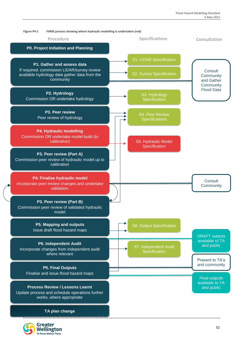
Flood Hazard Modelling Standard 6 May 2021
52
iop
1
S1. LiDAR Specification
S2. Survey Specification
S3. Hydrology Specification
P2. Hydrology
Commission OR undertake hydrology
S4. Peer Review Specifications
P4. Hydraulic modelling
Commission OR undertake model build (to calibration) S5. Hydraulic Model
Specification
P3. Peer review (Part A)
Commission peer review of hydraulic model up to calibration
P4. Finalise hydraulic model
Incorporate peer review changes and undertake validation.
S6. Output Specification P5. Mapping and outputs
Issue draft flood hazard maps
P6. Independent Audit
Incorporate changes from independent audit where relevant
TA plan change
S7. Independent Audit Specification
P3. Peer review (Part B)
Commission peer review of validated hydraulic model
P3. Peer review
Peer review of hydrology
Consult Community
Present to TA’s and community
Consult Community and Gather Community Flood Data
Process Review / Lessons Learnt
Update process and schedule operations further works, where appropriate
P1. Gather and assess data
If required: commission LiDAR/survey review available hydrology data gather data from the
community
DRAFT outputs available to TA
and public
Final outputs available to TA
and public
P0. Project Initiation and Planning
P5. Final Outputs
Finalise and issue flood hazard maps
Procedure Specifications Consultation
Figure P4-1 FHMS process showing where hydraulic modelling is undertaken (red)
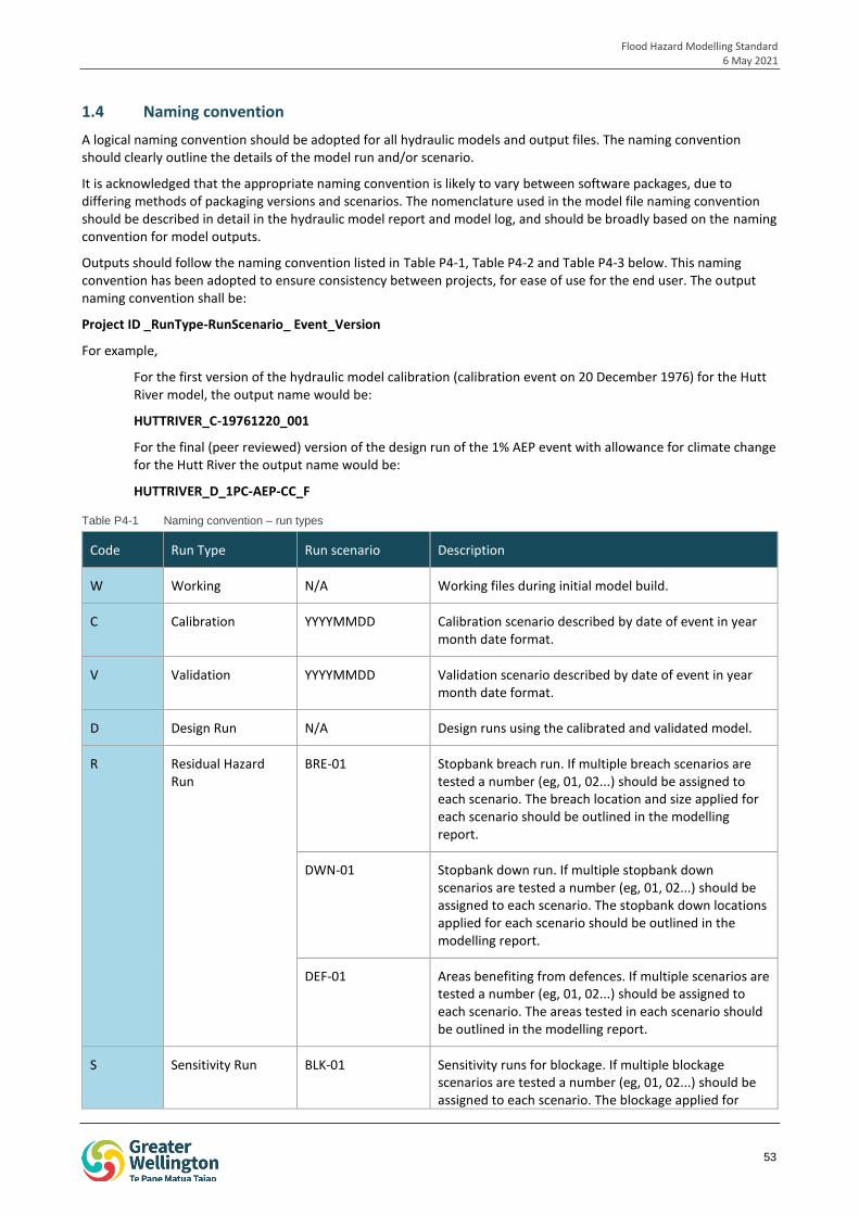
Flood Hazard Modelling Standard 6 May 2021
53
1.4 Naming convention
A logical naming convention should be adopted for all hydraulic models and output files. The naming convention should clearly outline the details of the model run and/or scenario.
It is acknowledged that the appropriate naming convention is likely to vary between software packages, due to differing methods of packaging versions and scenarios. The nomenclature used in the model file naming convention should be described in detail in the hydraulic model report and model log, and should be broadly based on the naming convention for model outputs.
Outputs should follow the naming convention listed in Table P4-1, Table P4-2 and Table P4-3 below. This naming convention has been adopted to ensure consistency between projects, for ease of use for the end user. The output naming convention shall be:
Project ID _RunType-RunScenario_ Event_Version
For example,
For the first version of the hydraulic model calibration (calibration event on 20 December 1976) for the Hutt River model, the output name would be:
HUTTRIVER_C-19761220_001
For the final (peer reviewed) version of the design run of the 1% AEP event with allowance for climate change for the Hutt River the output name would be:
HUTTRIVER_D_1PC-AEP-CC_F
Table P4-1 Naming convention – run types
Code Run Type Run scenario Description
W Working N/A Working files during initial model build.
C Calibration YYYYMMDD Calibration scenario described by date of event in year month date format.
V Validation YYYYMMDD Validation scenario described by date of event in year month date format.
D Design Run N/A Design runs using the calibrated and validated model.
R Residual Hazard Run
BRE-01 Stopbank breach run. If multiple breach scenarios are tested a number (eg, 01, 02...) should be assigned to each scenario. The breach location and size applied for each scenario should be outlined in the modelling report.
DWN-01 Stopbank down run. If multiple stopbank down scenarios are tested a number (eg, 01, 02...) should be assigned to each scenario. The stopbank down locations applied for each scenario should be outlined in the modelling report.
DEF-01 Areas benefiting from defences. If multiple scenarios are tested a number (eg, 01, 02...) should be assigned to each scenario. The areas tested in each scenario should be outlined in the modelling report.
S Sensitivity Run BLK-01 Sensitivity runs for blockage. If multiple blockage scenarios are tested a number (eg, 01, 02...) should be assigned to each scenario. The blockage applied for
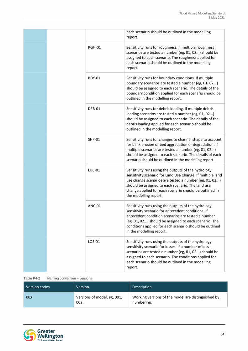
Flood Hazard Modelling Standard 6 May 2021
54
each scenario should be outlined in the modelling report.
RGH-01 Sensitivity runs for roughness. If multiple roughness scenarios are tested a number (eg, 01, 02...) should be assigned to each scenario. The roughness applied for each scenario should be outlined in the modelling report.
BDY-01 Sensitivity runs for boundary conditions. If multiple boundary scenarios are tested a number (eg, 01, 02...) should be assigned to each scenario. The details of the boundary condition applied for each scenario should be outlined in the modelling report.
DEB-01 Sensitivity runs for debris loading. If multiple debris loading scenarios are tested a number (eg, 01, 02...) should be assigned to each scenario. The details of the debris loading applied for each scenario should be outlined in the modelling report.
SHP-01 Sensitivity runs for changes to channel shape to account for bank erosion or bed aggradation or degradation. If multiple scenarios are tested a number (eg, 01, 02...) should be assigned to each scenario. The details of each scenario should be outlined in the modelling report.
LUC-01 Sensitivity runs using the outputs of the hydrology sensitivity scenario for Land Use Change. If multiple land use change scenarios are tested a number (eg, 01, 02...) should be assigned to each scenario. The land use change applied for each scenario should be outlined in the modelling report.
ANC-01 Sensitivity runs using the outputs of the hydrology sensitivity scenario for antecedent conditions. If antecedent condition scenarios are tested a number (eg, 01, 02...) should be assigned to each scenario. The conditions applied for each scenario should be outlined in the modelling report.
LOS-01 Sensitivity runs using the outputs of the hydrology sensitivity scenario for losses. If a number of loss scenarios are tested a number (eg, 01, 02...) should be assigned to each scenario. The conditions applied for each scenario should be outlined in the modelling report.
Table P4-2 Naming convention – versions
Version codes Version Description
00X Versions of model, eg, 001, 002…
Working versions of the model are distinguished by numbering.
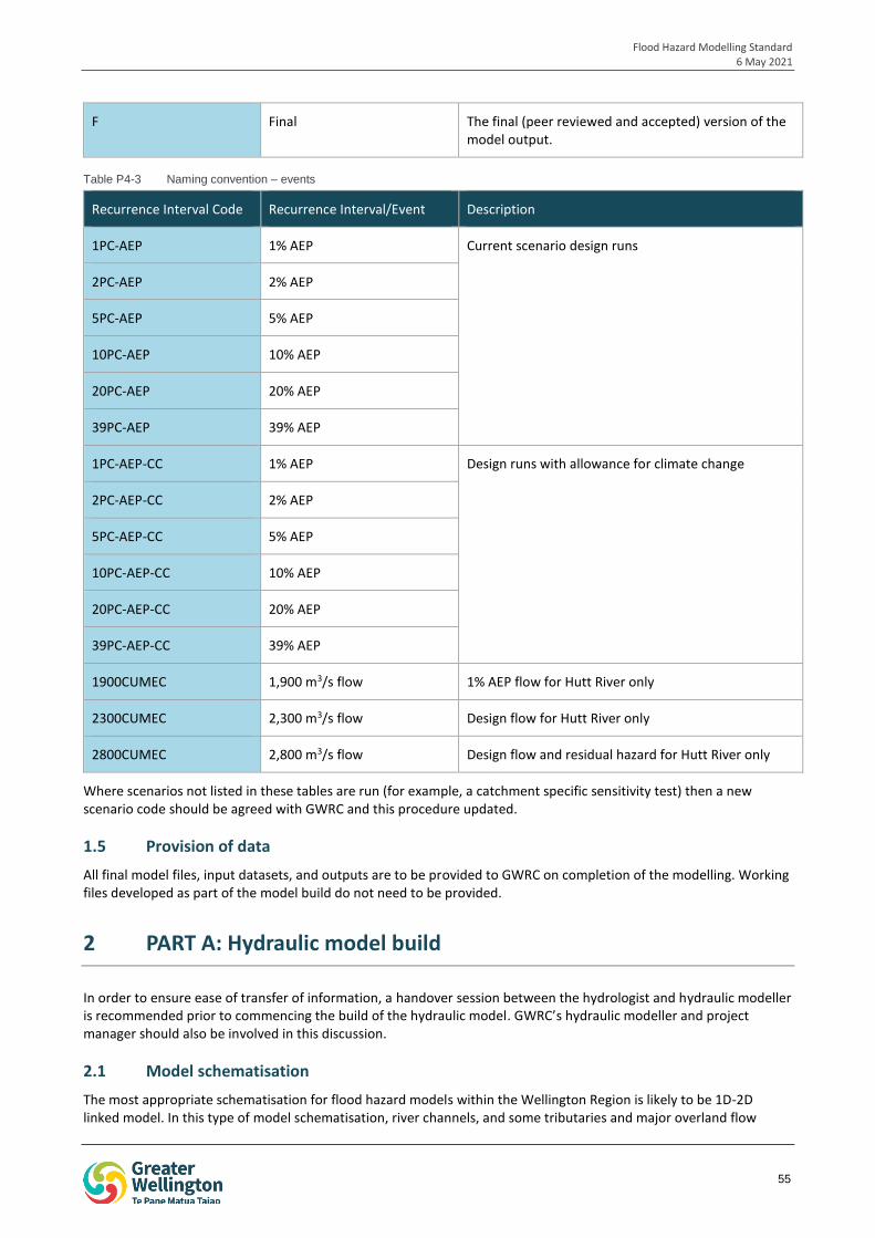
Flood Hazard Modelling Standard 6 May 2021
55
F Final The final (peer reviewed and accepted) version of the model output.
Table P4-3 Naming convention – events
Recurrence Interval Code Recurrence Interval/Event Description
1PC-AEP 1% AEP Current scenario design runs
2PC-AEP 2% AEP
5PC-AEP 5% AEP
10PC-AEP 10% AEP
20PC-AEP 20% AEP
39PC-AEP 39% AEP
1PC-AEP-CC 1% AEP Design runs with allowance for climate change
2PC-AEP-CC 2% AEP
5PC-AEP-CC 5% AEP
10PC-AEP-CC 10% AEP
20PC-AEP-CC 20% AEP
39PC-AEP-CC 39% AEP
1900CUMEC 1,900 m3/s flow 1% AEP flow for Hutt River only
2300CUMEC 2,300 m3/s flow Design flow for Hutt River only
2800CUMEC 2,800 m3/s flow Design flow and residual hazard for Hutt River only
Where scenarios not listed in these tables are run (for example, a catchment specific sensitivity test) then a new scenario code should be agreed with GWRC and this procedure updated.
1.5 Provision of data
All final model files, input datasets, and outputs are to be provided to GWRC on completion of the modelling. Working files developed as part of the model build do not need to be provided.
2 PART A: Hydraulic model build
In order to ensure ease of transfer of information, a handover session between the hydrologist and hydraulic modeller is recommended prior to commencing the build of the hydraulic model. GWRC’s hydraulic modeller and project manager should also be involved in this discussion.
2.1 Model schematisation
The most appropriate schematisation for flood hazard models within the Wellington Region is likely to be 1D-2D linked model. In this type of model schematisation, river channels, and some tributaries and major overland flow
Flood Hazard Modelling Standard 6 May 2021
56
paths are represented in 1D, where river bathymetry is interpolated between a series of channel cross-sections. The floodplain is represented in 2D, and water is able to flow between the 1D and 2D model components.
Pure 1D models are generally considered to be insufficient to provide an accurate representation of out of bank flood risk in the majority of catchments where GWRC undertake flood hazard modelling. As such, GWRC should be consulted prior to undertaking any 1D modelling.
2D modelling is not currently widely used in the Wellington Region due to a lack of bathymetry data. However, 2D modelling may be undertaken more widely in future. Care should be taken to accurately reflect the bathymetry within modelled watercourses.
The proposed model schematisation should be discussed and agreed with GWRC prior to commencing modelling, and should be determined on a project-by-project basis based on the purpose of the modelling, and the scale and level of detail required.
2.2 Grid
Grids are used to set the framework for model computation in 2D models and the 2D components of 1D-2D linked models.
As grid type and resolution may have a significant effect on model results, they should be determined by the modeller on a project-by-project basis based on the scale of the model and floodplain features to be captured (such as stopbanks and overland flow paths), while maintaining a practical model run time. Application of a variable grid may be appropriate for some projects, to allow a finer grid size to be applied around key features and flow paths.
The Flood Modelling Guidelines for Responsible Authorities prepared by the Scottish Environmental Protection Agency indicate that a minimum grid resolution of 3 to 4 cells across major flow paths may be appropriate. For example, a major flow path that is 10 m wide would require a grid cell size of 2.5 – 3 m. In 1D-2D linked models these overland flow paths may alternatively be modelled in 1D.
Minimum grid sizes may be limited by the resolution of the DEM as there is unlikely to be any benefit to using a finer grid size than the DEM, and computation times may be significantly increased.
The selected grid type and resolution should be outlined and justified in the hydraulic modelling report.
2.3 Model inputs
All model inputs should be listed and described in the data register prepared for the FHMS project. The function and use of the data register is described in Procedure 1: Gather and Assess Data.
All model inputs are also to be listed within the hydraulic model log. The model log is discussed further in Section 5.2.
2.3.1 DEM
As outlined in Procedure 1: Gather and Assess Data, a digital elevation model (DEM) is a 3D model of the elevation of a portion of the earth’s surface. It may be created from topographic survey, photogrammetry or LiDAR data. The DEM may be used to define the bank and floodplain elevations in a 1D-2D linked model or 2D hydraulic model, or to map the flood extents resulting from channel overtopping in a 1D hydraulic model.
The quality of the DEM is assessed earlier in the FHMS process as part of Procedure 1. The requirements for this assessment are outlined in Section 5.2 of that procedure.
During the hydraulic model build, modifications may need to be made to DEM to ensure that features that are not well represented in the DEM (typically linear features such as small open drains or rail embankments) are included in the model. Similarly, where detailed modelling is undertaken in urban areas, kerbed roads may need to be burnt into the DEM to ensure runoff flows along kerbed roads rather than through properties, where this is unlikely to occur in practice.
Bridges, culverts, tunnels or awnings may appear as blockages or barriers to flow in the DEM. These features should be represented through the use of a 1D structure or modification of the DEM.
Buildings may be represented in the DEM by blocking out or creating voids in the DEM. An alternative approach is to increase roughness in building locations, as described in Section 2.3.5. The representation of building should be described and justified in the hydraulic modelling report.
Flood Hazard Modelling Standard 6 May 2021
57
2.3.2 Cross-sections
Where the river channel or tributaries are represented in 1D, surveyed cross-section data will be a key model input. This data is gathered and reviewed as part of Procedure 1: Gather and Assess Data. This review will usually be undertaken by the hydraulic modeller prior to the commencement of modelling.
Where additional cross-sections are required and this is discovered after modelling is underway, then this should be discussed with GWRC and procured in accordance with Procedure 1 and Specification 2 of the FHMS.
2.3.3 Hydrology inputs
Hydrology inputs into the hydraulic model are derived from the outputs of the hydrological model. The outputs to be provided are described in Procedure 2: Hydrology.
Hydrology inputs will generally form the upstream boundary of the hydraulic model.
2.3.4 Climate change
Climate change should be accounted for in a number of hydraulic model design runs. The design runs where climate change is to be included are outlined in Table P4-3.
Climate change is incorporated into the hydrological inputs as part of the hydrological modelling and as such, input flows do not need to be adjusted further. Refer to Procedure 2: Hydrology for further information.
Within the hydraulic model, climate change is accounted for at the downstream boundary where tidal boundaries, river boundaries etc. should reflect future climate conditions in climate change runs. This is outlined further in Section 2.4.
2.3.5 Roughness
Surface roughness is a key input into hydraulic models and is used to represent energy losses due to frictional resistance to flow. Surface roughness is required at channel cross-sections in 1D models / 1D channel representations, and across 2D surfaces such as 2D river beds and floodplains.
Roughness is generally represented in hydraulic modelling using Manning’s n coefficient. Channel and floodplain roughness should be estimated on the basis of the channel and floodplain conditions for the specific reach considering factors such as bed material, straightness of channel, vegetation type and density.
Table P4-4 provides some example ranges of manning’s n roughness values for open channels and closed conduits. More detail is provided in Chow, 1959. Roughness may be derived from other sources such as the Roughness Advisor database within the CES/AES free software developed by the Environment Agency of the UK and others.
Manning’s n roughness values used in hydraulic modelling should be stated and justified in the hydraulic modelling report.
Table P4-4 Example ranges of Manning’s n roughness values. Source: Summarised from Chow, 1959
Description Range (Mannings n)
Minor Streams (top width at flood stage <30 m)
On a plain:
- Clean to some weeds, straight, full stage 0.025 – 0.040
- Clean to some weeds, winding, some pools and shoals 0.033 – 0.050
- As above, but at lower stages with more ineffective slopes and sections, more stones 0.040 – 0.060
- Sluggish reaches, weedy, deep pools 0.050 – 0.080
- Very weedy reaches, deep pools or floodways with trees and underbrush 0.075 – 0.150
Flood Hazard Modelling Standard 6 May 2021
58
Mountain streams:
- Bottom: gravels, cobbles, few boulders 0.030 – 0.050
- Bottom: cobbles with large boulders 0.040 – 0.070
Major Streams (top width at flood stage > 30 m)
The n value is less than that for minor streams of similar description as banks offer less effective resistance
- Regular section with no boulders or brush 0.025 – 0.060
- Irregular and rough section 0.035 – 0.100
Floodplain
- Pasture, no brush 0.025 – 0.050
- Cultivated – no crop 0.020 – 0.040
- Cultivated – mature crop 0.025 – 0.050
- Brush – scattered, heavy weeds 0.035 – 0.070
- Brush – light brush and trees 0.035 – 0.080
- Brush – medium to dense 0.045 – 0.160
- Trees – dense willows 0.110 – 0.200
- Trees – heavy stand of timber, little undergrowth, flood stage below branches 0.080 – 0.120
- Trees – heavy stand of timber, little undergrowth, flood stage reaching branches 0.100 – 0.160
Excavated or dredged channels
- Earth, straight and uniform 0.016 – 0.033
- Earth, winding and sluggish 0.023 – 0.040
- Channels not maintained, weeds and brush uncut 0.050 – 0.140
Closed conduits
- Concrete – culvert, straight and free of debris 0.010 – 0.013
- Concrete – culvert, with bends, connections and some debris 0.011 – 0.014
Where a hydraulic model is prepared for a watercourse that is within the same catchment as another hydraulic model (eg, Pinehaven Stream and the Hutt River), or within a nearby catchment with very similar catchment characteristics, consideration should be given to the manning’s n roughness values used in the previous modelling. Where departures are made from the values used in this modelling this should be justified in the hydraulic modelling report.
Flood Hazard Modelling Standard 6 May 2021
59
2.3.5.1 Representation of buildings
Buildings can present significant barriers to flow, and may be represented by increasing roughness to very high levels to simulate the frictional resistance of flow passing through a building. Where it is known the buildings will present a complete barrier to flow (eg, concrete block buildings), buildings may be blocked out of the DEM.
The hydraulic modeller should determine the most appropriate method for representing buildings in the particular catchment based on model set up (eg, grid size) and catchment factors (eg, type of buildings – timber or concrete, whether basements or underground carparks are present).
The method of representing buildings should be detailed in the hydraulic modelling report.
2.3.6 Stormwater network
The inclusion or exclusion of the stormwater network from the hydraulic model should be discussed and agreed with GWRC prior to model commencement. Where included, the stormwater network representation (i.e. a hydraulic model of the network versus an inflow point from the network to the watercourse) should be discussed and agreed with GWRC.
2.3.7 Structures
Hydraulic structures such as bridges and culverts should typically be represented in 1D. However, there may be some situations where representation in 2D is appropriate. The hydraulic modeller should document in the model log how hydraulic structures are represented and justification for this.
The hydraulic modeller has discretion to choose which minor structures are represented in the model i.e. minor structures that only impact flows at low stages may be omitted, however all build decisions should be fully documented in the hydraulic modelling report. Structures should be included where they constrict flow under high flow conditions.
Structures should be modelled based on survey data or as-built drawings collected and reviewed as part of Procedure 1: Gather and Assess Data.
2.3.8 Initial conditions
Initial conditions are used to set the starting point for the model. The initial conditions used should be documented in the hydraulic modelling report. Care should be undertaken setting initial conditions where there are significant amounts of storage in the catchment.
2.4 Boundaries
2.4.1 Upstream boundary
Outputs from the hydrological model will be provided to the hydraulic modeller for use as the upstream boundary. This is discussed in Section 2.3.2.
2.4.2 Downstream boundary
Downstream boundary conditions should be applied at downstream model boundaries. The downstream boundary of the model is to be far enough downstream such that any hydraulic conditions that may affect model results are accounted for.
The type of downstream boundary selected should be determined on a project-by-project basis, but may be a tidal boundary, or a riverine boundary (eg, confluence with another watercourse). Downstream boundary conditions may be static or time-variable as appropriate, and should be set in a way that prevents the creation of artificial backwater at the outlet of the model.
Tidal boundaries should be based on mean high water springs. An oscillating tide should generally be used with the high tide timed to coincide with the flood peak.
2.4.2.1 Climate change
Where climate change design runs are being undertaken, downstream boundary conditions should be adjusted to the same time horizon as the climate adjusted design rainfall used in the hydrological model.
Flood Hazard Modelling Standard 6 May 2021
60
A 1 m allowance for sea level rise should be applied to tidal boundaries in climate change scenarios. Further information on expected sea level rises is provided in Coastal Hazards and Climate Change. Guidance for Local Government published by the Ministry for the Environment in 2017.
2.4.3 Joint probability assessment
A joint probability assessment is undertaken on the basis that extreme rainfall and events such as storm surge are statistically dependent, and are therefore may occur at the same time. Joint probability assessment is generally not required where factors are independent (i.e. not likely to be caused by, or occur under similar conditions) as the likelihood that a high magnitude low frequency event will occur simultaneously for both factors is low.
Downstream tidal and river boundaries should assume a joint probability scenario of a 5% AEP event at the downstream boundary during the 1% AEP rainfall event. Probabilities for more frequent events should be discussed and confirmed with GWRC.
Joint probabilities applied at downstream boundaries should be described in the hydraulic modelling report.
2.5 Calibration
Calibration involves the adjustment of model parameters to alter model results to improve agreement between modelled and recorded flood extents, levels/depths, velocities and behaviours. Calibration should aim to match all aspects of the flood, including maximum levels, time to peak, inundation time and any known flood behaviours, where possible.
Calibration should be undertaken for all hydraulic models developed under the FHMS where sufficient data is available. Ideally, calibration would utilise flood records for at least three flood events of differing magnitudes, with at least one event being greater than a 2% AEP event to ensure that modelled parameters accurately represent catchment runoff behaviour, losses and routing across a range of events.
However, it is noted that data for calibration is often limited within the Wellington Region, and sufficient data for three events may not be available, and that confidence in available data may be limited. Calibration should also consider how the catchment may have changed since the calibration event, for example whether new development such as a new bridge may change flood levels or behaviour.
The calibration process should be documented in full, including final parameters, and how data quality and changes in the catchment and any other factors were accounted for. Parameter modifications for calibration should take care to remain within realistic ranges.
Calibration data should be gathered as part of Procedure 1: Gather and Assess Data, and may include aerial photography during a flood event (ideally at the peak), historical flood levels, surveyed flood extents or records of debris lines, photographs of the flood event, and anecdotal information provided by community members who witnessed the flood. Ideally data would be available to allow calibration of extent, level, timing and behaviour.
2.6 Mass balance
The model continuity error should be maintained at less than 5%. The continuity error measures the total water volume lost from the model by comparing to the total inflow and outflow volumes, and accounting for the volume stored in the model.
3 PART B: Finalise hydraulic model
As outlined in Section 1.1, Part B of the hydraulic modelling process will be undertaken following close-out of the Part A peer review. The Part A peer review is to be undertaken and documented in accordance with Procedure 3: Peer Review.
3.1 Validation
Validation is undertaken following model calibration and is used to verify that the model can acceptably reproduce events that are different to the calibration event. This ensures that the calibration parameters are representative of a wide range of possible events that could occur in the catchment.
Flood Hazard Modelling Standard 6 May 2021
61
Where possible, validation should be undertaken for a minimum of three events of varying magnitude. However, it is recognised that for the majority of watercourses in the region sufficient data is unlikely to be available.
Similarly to calibration, validation data should be gathered as part of Procedure 1: Gather and Assess Data, and may include aerial photography during a flood event (ideally at the peak), historical flood levels, surveyed flood extents or records of debris lines, photographs of the flood event, and anecdotal information provided by community members who witnessed the flood. Ideally data would be available to allow validation of extent, level, timing and behaviour.
Where no validation data is available, the sensibility of the calibration results should be reviewed to ensure that model results are within reasonably expected values.
3.2 Sensitivity analysis
Sensitivity analysis is the adjustment of model parameters within realistic ranges to determine the impact on model results. Sensitivity analysis can be used as an indication of model uncertainty resulting from input parameters that are unsupported by data, particularly where minimal calibration and/or validation data is available.
Sensitivity analysis of key parameters should be undertaken on all hydraulic models prepared for flood hazard modelling projects. Sensitivity parameters may include:
Roughness – upper and lower manning’s n roughness values should be tested.
Blockage – GWRC’s operations team should be consulted to confirm whether and where blockages regularly occur within the study catchment.
Downstream boundary conditions
Debris loading
Changes to input hydrology – this should be undertaken using the outputs from the sensitivity analysis of the hydrological model. Sensitivity parameters include antecedent conditions, temporal pattern, losses and land use change such as new urban development.
Changes to channel shape (i.e. channel erosion, bed aggradation / degradation), where relevant.
Catchment specific factors, where relevant
Specific river characteristics, where relevant
The parameters selected for sensitivity analysis should be agreed with GWRC and should be fully documented in the hydraulic modelling report.
3.3 Design runs
A suite of design runs is required to be undertaken. The required design runs are outlined in Table P4-5.
Table P4-5 Required design runs.
Risk type Scenario
Current flood hazard - 39% AEP (1 in 2-year Average Recurrence Interval (ARI))
- 20% AEP (1 in 5-year ARI)
- 10% AEP (1 in 10-year ARI)
- 5% AEP (1 in 20-year ARI)
- 2% AEP (1 in 50-year ARI)
- 1% AEP (1 in 100-year ARI) (1,900 m3/s for Hutt River only)
- 2,300 m3/s flow (Hutt River only)
Future flood hazard (climate change)
- 39% AEP (1 in 2-year ARI) with allowance for climate change
- 20% AEP (1 in 5-year ARI) with allowance for climate change
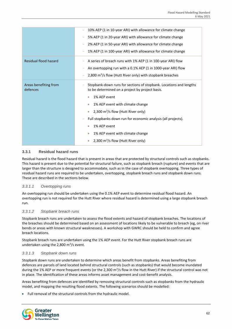
Flood Hazard Modelling Standard 6 May 2021
62
- 10% AEP (1 in 10-year ARI) with allowance for climate change
- 5% AEP (1 in 20-year ARI) with allowance for climate change
- 2% AEP (1 in 50-year ARI) with allowance for climate change
- 1% AEP (1 in 100-year ARI) with allowance for climate change
Residual flood hazard - A series of breach runs with 1% AEP (1 in 100-year ARI) flow
- An overtopping run with a 0.1% AEP (1 in 1000-year ARI) flow
- 2,800 m3/s flow (Hutt River only) with stopbank breaches
Areas benefiting from defences
- Stopbank-down runs for sections of stopbank. Locations and lengths to be determined on a project by project basis.
1% AEP event
1% AEP event with climate change
2,300 m3/s flow (Hutt River only)
- Full stopbanks down run for economic analysis (all projects).
1% AEP event
1% AEP event with climate change
2,300 m3/s flow (Hutt River only)
3.3.1 Residual hazard runs
Residual hazard is the flood hazard that is present in areas that are protected by structural controls such as stopbanks. This hazard is present due to the potential for structural failure, such as stopbank breach (rupture) and events that are larger than the structure is designed to accommodate, such as in the case of stopbank overtopping. Three types of residual hazard runs are required to be undertaken, overtopping, stopbank breach runs and stopbank down runs. These are described in the sections below.
3.3.1.1 Overtopping runs
An overtopping run should be undertaken using the 0.1% AEP event to determine residual flood hazard. An overtopping run is not required for the Hutt River where residual hazard is determined using a large stopbank breach run.
3.3.1.2 Stopbank breach runs
Stopbank breach runs are undertaken to assess the flood extents and hazard of stopbank breaches. The locations of the breaches should be determined based on an assessment of locations likely to be vulnerable to breach (eg, on river bends or areas with known structural weaknesses). A workshop with GWRC should be held to confirm and agree breach locations.
Stopbank breach runs are undertaken using the 1% AEP event. For the Hutt River stopbank breach runs are undertaken using the 2,800 m3/s event.
3.3.1.3 Stopbank down runs
Stopbank down runs are undertaken to determine which areas benefit from stopbanks. Areas benefiting from defences are parcels of land located behind structural controls (such as stopbanks) that would become inundated during the 1% AEP or more frequent events (or the 2,300 m3/s flow in the Hutt River) if the structural control was not in place. The identification of these areas informs asset management and cost-benefit analysis.
Areas benefiting from defences are identified by removing structural controls such as stopbanks from the hydraulic model, and mapping the resulting flood extents. The following scenarios should be modelled:
Full removal of the structural controls from the hydraulic model.
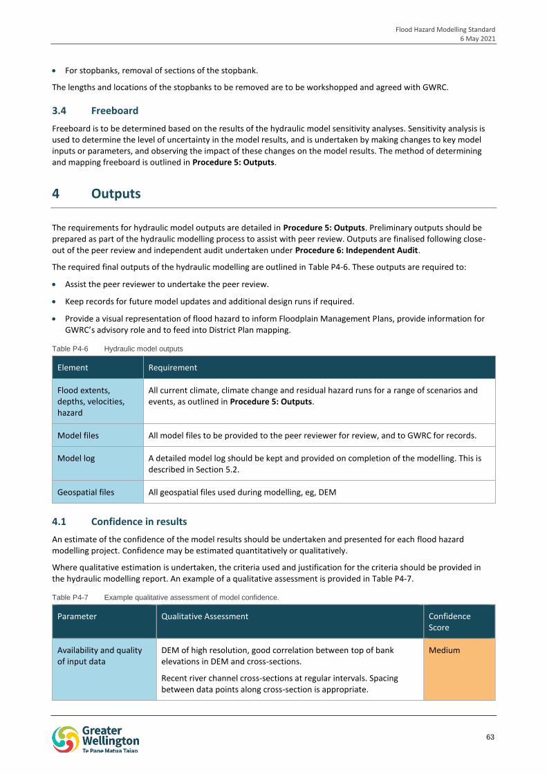
Flood Hazard Modelling Standard 6 May 2021
63
For stopbanks, removal of sections of the stopbank.
The lengths and locations of the stopbanks to be removed are to be workshopped and agreed with GWRC.
3.4 Freeboard
Freeboard is to be determined based on the results of the hydraulic model sensitivity analyses. Sensitivity analysis is used to determine the level of uncertainty in the model results, and is undertaken by making changes to key model inputs or parameters, and observing the impact of these changes on the model results. The method of determining and mapping freeboard is outlined in Procedure 5: Outputs.
4 Outputs
The requirements for hydraulic model outputs are detailed in Procedure 5: Outputs. Preliminary outputs should be prepared as part of the hydraulic modelling process to assist with peer review. Outputs are finalised following close-out of the peer review and independent audit undertaken under Procedure 6: Independent Audit.
The required final outputs of the hydraulic modelling are outlined in Table P4-6. These outputs are required to:
Assist the peer reviewer to undertake the peer review.
Keep records for future model updates and additional design runs if required.
Provide a visual representation of flood hazard to inform Floodplain Management Plans, provide information for GWRC’s advisory role and to feed into District Plan mapping.
Table P4-6 Hydraulic model outputs
Element Requirement
Flood extents, depths, velocities, hazard
All current climate, climate change and residual hazard runs for a range of scenarios and events, as outlined in Procedure 5: Outputs.
Model files All model files to be provided to the peer reviewer for review, and to GWRC for records.
Model log A detailed model log should be kept and provided on completion of the modelling. This is described in Section 5.2.
Geospatial files All geospatial files used during modelling, eg, DEM
4.1 Confidence in results
An estimate of the confidence of the model results should be undertaken and presented for each flood hazard modelling project. Confidence may be estimated quantitatively or qualitatively.
Where qualitative estimation is undertaken, the criteria used and justification for the criteria should be provided in the hydraulic modelling report. An example of a qualitative assessment is provided in Table P4-7.
Table P4-7 Example qualitative assessment of model confidence.
Parameter Qualitative Assessment Confidence Score
Availability and quality of input data
DEM of high resolution, good correlation between top of bank elevations in DEM and cross-sections.
Recent river channel cross-sections at regular intervals. Spacing between data points along cross-section is appropriate.
Medium
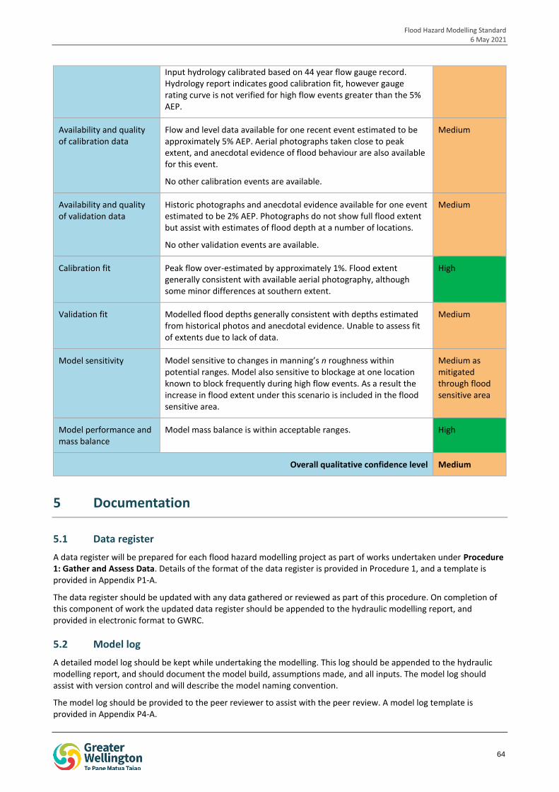
Flood Hazard Modelling Standard 6 May 2021
64
Input hydrology calibrated based on 44 year flow gauge record. Hydrology report indicates good calibration fit, however gauge rating curve is not verified for high flow events greater than the 5% AEP.
Availability and quality of calibration data
Flow and level data available for one recent event estimated to be approximately 5% AEP. Aerial photographs taken close to peak extent, and anecdotal evidence of flood behaviour are also available for this event.
No other calibration events are available.
Medium
Availability and quality of validation data
Historic photographs and anecdotal evidence available for one event estimated to be 2% AEP. Photographs do not show full flood extent but assist with estimates of flood depth at a number of locations.
No other validation events are available.
Medium
Calibration fit Peak flow over-estimated by approximately 1%. Flood extent generally consistent with available aerial photography, although some minor differences at southern extent.
High
Validation fit Modelled flood depths generally consistent with depths estimated from historical photos and anecdotal evidence. Unable to assess fit of extents due to lack of data.
Medium
Model sensitivity Model sensitive to changes in manning’s n roughness within potential ranges. Model also sensitive to blockage at one location known to block frequently during high flow events. As a result the increase in flood extent under this scenario is included in the flood sensitive area.
Medium as mitigated through flood sensitive area
Model performance and mass balance
Model mass balance is within acceptable ranges. High
Overall qualitative confidence level Medium
5 Documentation
5.1 Data register
A data register will be prepared for each flood hazard modelling project as part of works undertaken under Procedure 1: Gather and Assess Data. Details of the format of the data register is provided in Procedure 1, and a template is provided in Appendix P1-A.
The data register should be updated with any data gathered or reviewed as part of this procedure. On completion of this component of work the updated data register should be appended to the hydraulic modelling report, and provided in electronic format to GWRC.
5.2 Model log
A detailed model log should be kept while undertaking the modelling. This log should be appended to the hydraulic modelling report, and should document the model build, assumptions made, and all inputs. The model log should assist with version control and will describe the model naming convention.
The model log should be provided to the peer reviewer to assist with the peer review. A model log template is provided in Appendix P4-A.
Flood Hazard Modelling Standard 6 May 2021
65
5.3 Report
A detailed technical report should be prepared to outline the hydraulic modelling undertaken. The report should be prepared as part of the Part A works, and issued to GWRC and the peer reviewer. Following close out of the Part A peer review, the report should be updated to incorporate any changes or recommendations following the peer review, and the Part B works. The report should include, but is not limited to:
PART A:
Details of the software used.
Model extent.
Model schematisation.
Grid type and resolution.
Data availability and quality.
- Detailed summary of the analytical process and findings of the data collection and review undertaken as part of Procedure 1: Gather and Assess Data.
Summary of and justification for input parameters including roughness.
Representation of structures and justification for any structures not modelled.
Initial conditions.
Boundary conditions.
Calibration, including details of the calibration events selected, parameters adjusted and calibration performance.
Details of model performance, including numerical stability and mass balance errors.
PART B:
Validation, including details of the validation events selected, parameters adjusted and validation performance.
Sensitivity analysis including details of the sensitivity scenarios tested and results.
Design runs.
Application of freeboard.
Details of model performance, including numerical stability and mass balance errors.
Assessment of confidence in the model results.
6 Procedure review
This procedure is intended to be a living document that can be revised as technology advances and industry accepted practice evolves.
The need for review of the procedures within the FHMS, including this one, will be determined at the end of each modelling project at the ‘process review / lessons learnt’ checkpoint on the FHMS flow chart.
7 References
Chow, V.T. (1959). Open Channel Hydraulics. McGraw-Hill Book Co. Singapore.
Ministry for the Environment (2017). Coastal Hazards and Climate Change. Guidance for Local Government.
Scottish Environmental Protection Agency (2015). Flood Modelling Guidance for Responsible Authorities.
Flood Hazard Modelling Standard 6 May 2021
66
PROCEDURE 05
OUTPUTS This procedure has been prepared to outline the protocols to be followed by any person preparing outputs from hydraulic modelling on GWRC’s flood hazard modelling projects.
Flood Hazard Modelling Standard 6 May 2021
67
Procedure 05 Table of Contents
1 Introduction 68
1.1 What are outputs? 68
1.2 Outputs in the FHMS Process 68
1.3 Who produces the outputs 68
2 Schedule of outputs 70
2.1 Output types 72
2.2 Residual hazard 73
2.3 Emergency management outputs 74
2.4 Areas benefiting from defences 74
3 Freeboard 75
3.1 Calculating freeboard 75
4 Output formats 76
4.1 Terminology and units 76
4.2 Mapping 76
4.3 Animations 78
4.4 District plan mapping 78
5 Procedure review 78
Flood Hazard Modelling Standard 6 May 2021
68
1 Introduction
This document forms Procedure 5 of Greater Wellington Regional Council’s (GWRC) Flood Hazard Modelling Standard (FHMS). This procedure has been prepared to outline the protocols to be followed by any person preparing outputs from hydraulic modelling on GWRC’s flood hazard modelling projects.
This document should be read in the context of the wider FHMS, and has a particular relationship to Specification 6: Outputs.
1.1 What are outputs?
The outputs of the hydraulic modelling are the ‘final product’ of the flood hazard modelling process. Outputs include maps, tables of results, long-sections, and geospatial files such as raster and shape files. The outputs specified in this document are the minimum requirements for all flood hazard modelling undertaken under the FHMS.
The outputs are used by GWRC for flood warning, floodplain management planning, asset management and advisory responses. GWRC provide relevant sets of outputs to other parties such as Wellington Region Emergency Management Office (WREMO), Territorial Authorities (TAs), and the public for emergency planning and management, district planning, consenting, insurance and ownership information and decision making.
This procedure has been prepared to ensure that the outputs of flood hazard modelling projects meet the needs of their end users, and are clear and consistent for ease of interpretation.
1.2 Outputs in the FHMS Process
Preliminary outputs are created following finalisation of the hydraulic model. The review of these preliminary outputs is included in the Part B hydraulic model peer review.
The Part B hydraulic model peer review is an iterative process where the model runs, validation and sensitivity analysis will be reviewed and modified. Due to the iterative nature of this process, the preliminary outputs will also be updated iteratively at this time. The peer review is described in more detail in Procedure 3: Peer Review. Following close-out of the peer review, the preliminary outputs may be issued to interested parties such as WREMO, TAs and the public as drafts.
Final outputs are prepared and issued following the independent audit of the flood hazard modelling process, which is the subject of Procedure 6: Independent Audit.
The stages of the FHMS process that are related to the preparation of outputs are outlined in red in the Figure 5-1 below.
1.3 Who produces the outputs
The outputs should be prepared by the hydraulic modeller as part of the hydraulic modelling scope.
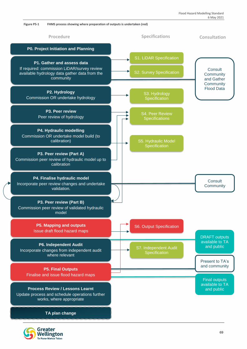
Flood Hazard Modelling Standard 6 May 2021
69
iop
1
S1. LiDAR Specification
S2. Survey Specification
S3. Hydrology Specification
P2. Hydrology
Commission OR undertake hydrology
S4. Peer Review Specifications
P4. Hydraulic modelling
Commission OR undertake model build (to calibration) S5. Hydraulic Model
Specification
P3. Peer review (Part A)
Commission peer review of hydraulic model up to calibration
P4. Finalise hydraulic model
Incorporate peer review changes and undertake validation.
S6. Output Specification P5. Mapping and outputs
Issue draft flood hazard maps
P6. Independent Audit
Incorporate changes from independent audit where relevant
TA plan change
S7. Independent Audit Specification
P3. Peer review (Part B)
Commission peer review of validated hydraulic model
P3. Peer review
Peer review of hydrology
Consult Community
Present to TA’s and community
Consult Community and Gather Community Flood Data
Process Review / Lessons Learnt
Update process and schedule operations further works, where appropriate
P1. Gather and assess data
If required: commission LiDAR/survey review available hydrology data gather data from the
community
DRAFT outputs available to TA
and public
Final outputs available to TA
and public
P0. Project Initiation and Planning
P5. Final Outputs
Finalise and issue flood hazard maps
Procedure Specifications Consultation
Figure P5-1 FHMS process showing where preparation of outputs is undertaken (red)
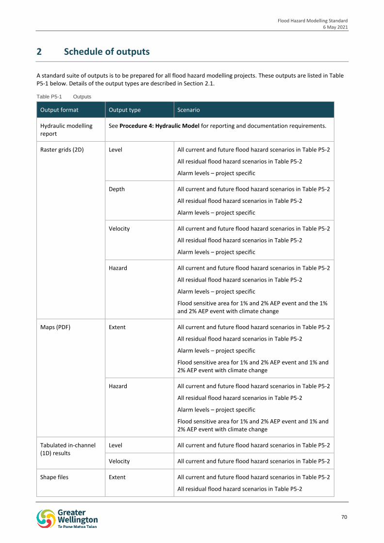
Flood Hazard Modelling Standard 6 May 2021
70
2 Schedule of outputs
A standard suite of outputs is to be prepared for all flood hazard modelling projects. These outputs are listed in Table P5-1 below. Details of the output types are described in Section 2.1.
Table P5-1 Outputs
Output format Output type Scenario
Hydraulic modelling report
See Procedure 4: Hydraulic Model for reporting and documentation requirements.
Raster grids (2D) Level All current and future flood hazard scenarios in Table P5-2
All residual flood hazard scenarios in Table P5-2
Alarm levels – project specific
Depth All current and future flood hazard scenarios in Table P5-2
All residual flood hazard scenarios in Table P5-2
Alarm levels – project specific
Velocity All current and future flood hazard scenarios in Table P5-2
All residual flood hazard scenarios in Table P5-2
Alarm levels – project specific
Hazard All current and future flood hazard scenarios in Table P5-2
All residual flood hazard scenarios in Table P5-2
Alarm levels – project specific
Flood sensitive area for 1% and 2% AEP event and the 1% and 2% AEP event with climate change
Maps (PDF) Extent All current and future flood hazard scenarios in Table P5-2
All residual flood hazard scenarios in Table P5-2
Alarm levels – project specific
Flood sensitive area for 1% and 2% AEP event and 1% and 2% AEP event with climate change
Hazard All current and future flood hazard scenarios in Table P5-2
All residual flood hazard scenarios in Table P5-2
Alarm levels – project specific
Flood sensitive area for 1% and 2% AEP event and 1% and 2% AEP event with climate change
Tabulated in-channel (1D) results
Level All current and future flood hazard scenarios in Table P5-2
Velocity All current and future flood hazard scenarios in Table P5-2
Shape files Extent All current and future flood hazard scenarios in Table P5-2
All residual flood hazard scenarios in Table P5-2
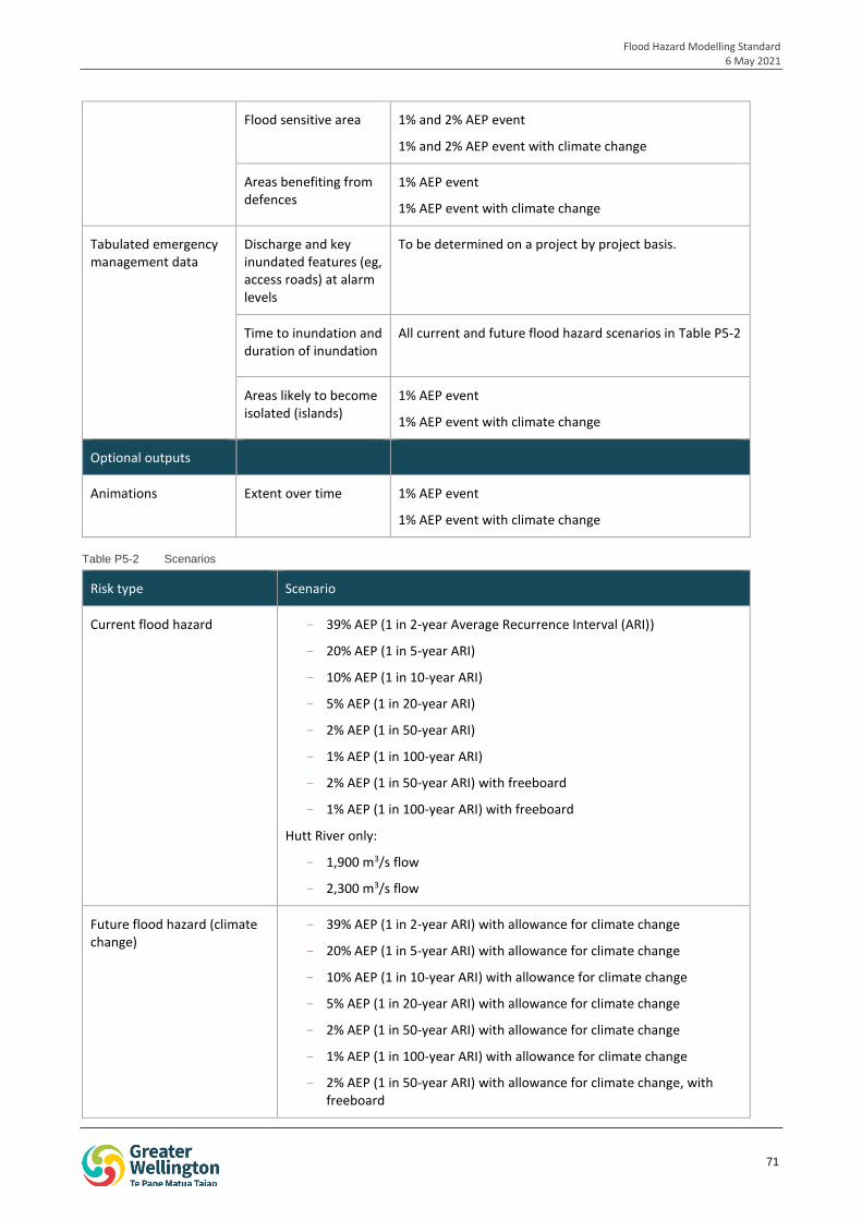
Flood Hazard Modelling Standard 6 May 2021
71
Flood sensitive area 1% and 2% AEP event
1% and 2% AEP event with climate change
Areas benefiting from defences
1% AEP event
1% AEP event with climate change
Tabulated emergency management data
Discharge and key inundated features (eg, access roads) at alarm levels
To be determined on a project by project basis.
Time to inundation and duration of inundation
All current and future flood hazard scenarios in Table P5-2
Areas likely to become isolated (islands)
1% AEP event
1% AEP event with climate change
Optional outputs
Animations Extent over time 1% AEP event
1% AEP event with climate change
Table P5-2 Scenarios
Risk type Scenario
Current flood hazard - 39% AEP (1 in 2-year Average Recurrence Interval (ARI))
- 20% AEP (1 in 5-year ARI)
- 10% AEP (1 in 10-year ARI)
- 5% AEP (1 in 20-year ARI)
- 2% AEP (1 in 50-year ARI)
- 1% AEP (1 in 100-year ARI)
- 2% AEP (1 in 50-year ARI) with freeboard
- 1% AEP (1 in 100-year ARI) with freeboard
Hutt River only:
- 1,900 m3/s flow
- 2,300 m3/s flow
Future flood hazard (climate change)
- 39% AEP (1 in 2-year ARI) with allowance for climate change
- 20% AEP (1 in 5-year ARI) with allowance for climate change
- 10% AEP (1 in 10-year ARI) with allowance for climate change
- 5% AEP (1 in 20-year ARI) with allowance for climate change
- 2% AEP (1 in 50-year ARI) with allowance for climate change
- 1% AEP (1 in 100-year ARI) with allowance for climate change
- 2% AEP (1 in 50-year ARI) with allowance for climate change, with freeboard
Flood Hazard Modelling Standard 6 May 2021
72
- 1% AEP (1 in 100-year ARI) with allowance for climate change, with freeboard
Residual flood hazard - A series of breach runs with 1% AEP (1 in 100-year ARI) flow
- An overtopping run with a 0.1% AEP (1 in 1000-year ARI) flow
Hutt River only:
- 2,800 m3/s flow with stopbank breaches.
Areas benefiting from defences
- Stopbank-down runs for sections of stopbank. Locations and lengths to be determined on a project by project basis.
1% AEP event
1% AEP event with climate change
Hutt River only: 2,300 m3/s flow
- Full stopbanks down run for economic analysis (all projects).
1% AEP event
1% AEP event with climate change
Hutt River only: 2,300 m3/s flow
2.1 Output types
2.1.1 Extent
Flood extent is the area of land to be inundated under a particular scenario, such as a 1% AEP event. Flood extent does not include land that becomes inundated after freeboard is applied, which is displayed separately as a flood sensitive area. This is discussed further in Section 2.1.4.
Flood extents include all land inundated during a particular scenario, and are not adjusted to remove areas with very shallow inundation.
2.1.2 Level, depth and velocity
Flood level is the maximum elevation of flood water during a particular scenario at a particular location. Flood level does not include freeboard.
Flood depth is the difference between the maximum flood level and ground elevation at a particular location, during a particular scenario. Flood depth also does not include freeboard.
Velocity is the maximum velocity of flood waters at a particular location during a particular scenario. Velocity may be used to differentiate flow paths from ponding areas.
2.1.3 Hazard
Hazard is a function of the depth and velocity of flood waters at a particular location. It informs the likely risk to people and property as a result of flooding. Hazard is low in shallow slow-moving waters, and increases with increasing depth and velocity.
Hazard raster grids are to be prepared based on the general flood hazard classification from Book 6: Flood Hydraulics of Australian Rainfall and Runoff (2016), unless otherwise requested by GWRC and external stakeholders. The Australian Rainfall and Runoff hazard classification is provided in Figure P5-2 below.
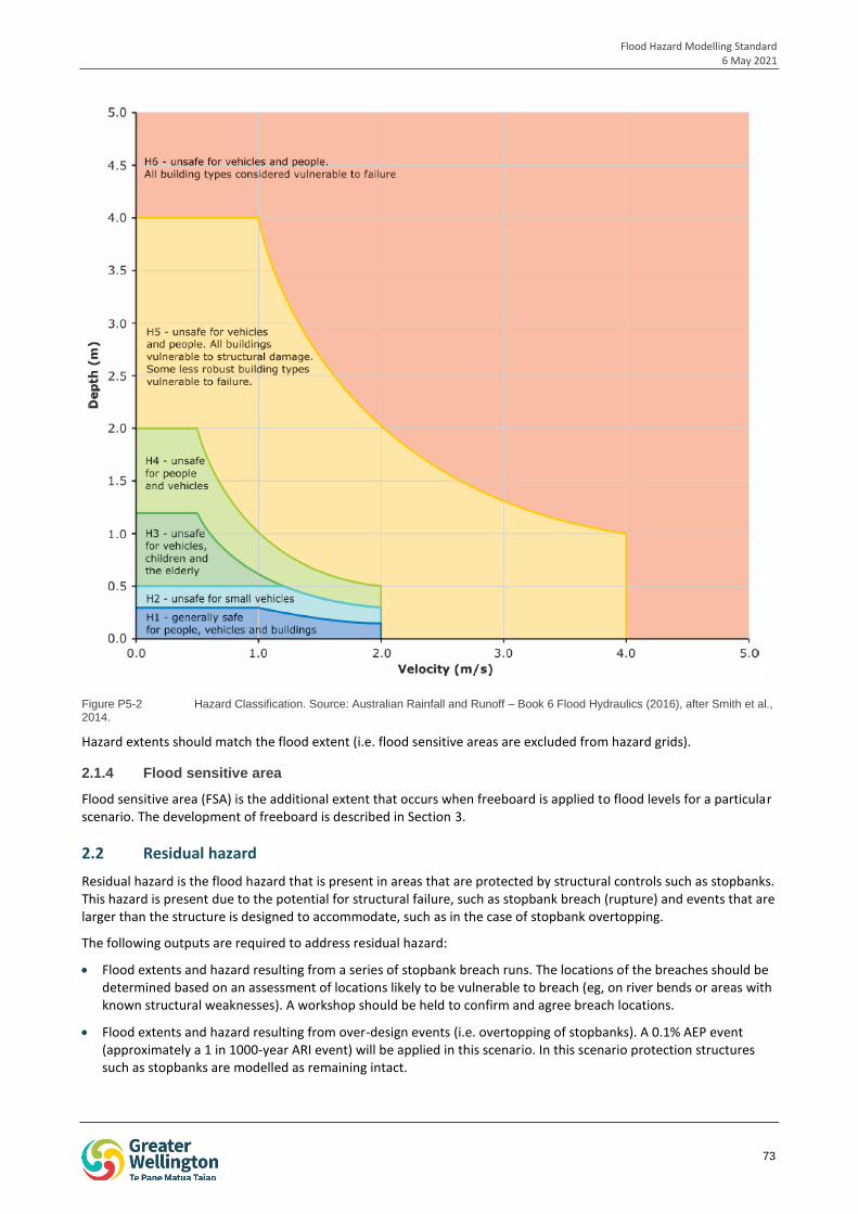
Flood Hazard Modelling Standard 6 May 2021
73
Figure P5-2 Hazard Classification. Source: Australian Rainfall and Runoff – Book 6 Flood Hydraulics (2016), after Smith et al., 2014.
Hazard extents should match the flood extent (i.e. flood sensitive areas are excluded from hazard grids).
2.1.4 Flood sensitive area
Flood sensitive area (FSA) is the additional extent that occurs when freeboard is applied to flood levels for a particular scenario. The development of freeboard is described in Section 3.
2.2 Residual hazard
Residual hazard is the flood hazard that is present in areas that are protected by structural controls such as stopbanks. This hazard is present due to the potential for structural failure, such as stopbank breach (rupture) and events that are larger than the structure is designed to accommodate, such as in the case of stopbank overtopping.
The following outputs are required to address residual hazard:
Flood extents and hazard resulting from a series of stopbank breach runs. The locations of the breaches should be determined based on an assessment of locations likely to be vulnerable to breach (eg, on river bends or areas with known structural weaknesses). A workshop should be held to confirm and agree breach locations.
Flood extents and hazard resulting from over-design events (i.e. overtopping of stopbanks). A 0.1% AEP event (approximately a 1 in 1000-year ARI event) will be applied in this scenario. In this scenario protection structures such as stopbanks are modelled as remaining intact.
Flood Hazard Modelling Standard 6 May 2021
74
2.3 Emergency management outputs
2.3.1 Time to inundation
Time to inundation is the time taken for particular features (i.e. access roads) within the modelled catchment to become inundated. Time is measured from the exceedance of the first alarm level in the catchment, or as determined by GWRC, in consultation with WREMO. This information is used for emergency planning and management, such as determining evacuation timeframes and routes.
The alarm levels and features of interest that time to inundation should be provided for are to be determined by GWRC in consultation with WREMO, and may be developed iteratively as preliminary flood levels and extents become available.
An example of the alarm levels and features of interest for calculation of time to inundation is provided in Table P5-3.
Table P5-3 Example of alarm levels and features of interest for calculation of time to inundation
Gauge Height
Hutt River at Birchville (m)
Recurrence Interval Flow (m3/s) Description
3.5
First alarm level
4.0 63% AEP 400 Block Road floods
4.3 63% AEP 460 HCC carpark floods
5.0
Second alarm level
2.3.2 Duration of inundation
Duration of inundation is the amount of time that an area or a feature of interest (i.e. an access road) is inundated. The areas or features that duration of inundation should be measured for are to be determined by GWRC in consultation with WREMO, and may be developed iteratively as preliminary flood levels and extents become available.
2.3.3 Areas likely to become isolated
Developed areas that are likely to become isolated (i.e. areas that may become islands) can be hazardous during a flood event, due to:
The risk of water levels rising further and drowning the island, which may result in stranded people entering the flood waters.
The risk of stranded people self-evacuating through the flood waters.
The risk to emergency services when rescuing stranded people.
Developed areas that are likely to form islands during the development of the flood should be identified and mapped to assist emergency services to evacuate these areas while hazard is low. A series of maps should be produced to show the development of the island and the point at which the island becomes cut off from evacuation routes.
2.4 Areas benefiting from defences
Areas benefiting from defences are parcels of land located behind structural controls (such as stopbanks) that would become inundated during the 1% AEP or more frequent events (or the 2,300 m3/s flow in the Hutt River) if the structural control was not in place. The identification of these areas informs asset management and cost-benefit analysis.
Areas benefiting from defences are identified by removing structural controls such as stopbanks from the hydraulic model, and mapping the resulting flood extents. The following scenarios should be modelled:
Full removal of the structural controls from the hydraulic model.
Flood Hazard Modelling Standard 6 May 2021
75
For stopbanks, removal of sections of the stopbank. The lengths and locations of the stopbanks to be removed are to be determined by GWRC.
3 Freeboard
Freeboard is an allowance that is added to modelled flood levels to account for:
The effects of real factors that cannot be modelled, such as bow waves from vehicles moving through flood waters.
Uncertainties in model inputs and assumptions.
Freeboard does not include an allowance for climate change, as this is modelled as part of the design run scenarios.
Freeboard as applied to hydraulic modelling is separate from freeboard applied during the design of structures, which accounts for the passage of debris under the structure (in the case of bridges), or long-term settling (in the case of stopbanks).
Freeboard should be applied to the 1% AEP, 1% AEP with climate change, 2% AEP and 2% AEP with climate change scenarios. For the Hutt River, freeboard should be applied to events greater than or equal to the 2% AEP event. Freeboard may be applied to more frequent events on a case by case basis.
3.1 Calculating freeboard
Freeboard is to be determined based on the results of the hydraulic model sensitivity analyses. Sensitivity analysis is used to determine the level of uncertainty in the model results, and is undertaken by making changes to key model inputs or parameters, and observing the impact of these changes on the model results. Sensitivity analysis of the hydraulic modelling is described in more detail in Procedure 4: Hydraulic Modelling.
The method of determining freeboard from the findings of the sensitivity analysis should be workshopped with GWRC on a case by case basis. The method is likely to involve:
1. Determining the likely worse case of each sensitivity test, based on professional judgement and expertise. Sensitivity parameters may include a selection of:
> Manning’s n roughness
> Downstream boundary conditions
> Structure blockage
> Debris loading
> Changes to input hydrology, such as increased flow, modified hydrograph shape, different rainfall durations, and changes to the level of development in the catchment
> Bed level changes
> Changes to channel shape due to erosion, such as erosion of the bank in a key overflow area
> Other catchment specific factors, or variations in river/stream characteristics.
2. Preparing hazard raster grids of the likely worst case from each sensitivity test.
3. Workshopping with GWRC which of the sensitivity scenarios to include in the calculation of freeboard. Sensitivity scenarios may be selected based on risk, or the community may be consulted for their input.
4. Combining the selected hazard grids into a single map by taking the highest hazard at each location from across all likely sensitivity scenarios. Scenarios are not added together, but rather the highest hazard across all likely worse case scenarios is selected at each point in the map.
5. Application of a small allowance for wave action and factors that cannot be modelled to the combined results by routing a block of water through the hydraulic model of a selected sensitivity scenario. The increase in flood extent should be mapped on the combined hazard map.
Flood Hazard Modelling Standard 6 May 2021
76
6. The resulting hazard grid is used by GWRC to determine flood hazard categories including river corridors, overflow paths, and ponding areas to support district planning.
7. The extent of the combined hazard grid is mapped as a flood sensitive area.
This approach to calculating freeboard is considered to be more appropriate than the traditional approach of a fixed freeboard depth to the hydraulic model results (eg, applying 500 mm across the entire flood extent), as:
A fixed freeboard depth does not account for the topography of the floodplain, and may be overly conservative in wide floodplains where an unrealistically large volume of water is required to raise flood levels to the freeboard level. Similarly, fixed freeboard depths may be under-conservative in gorges or areas prone to extensive blockage.
The approach allows for locations that are less sensitive to local effects such as blockage to have a lower freeboard.
3.1.1 Mapping freeboard
The additional flood extent after freeboard is applied is to be mapped as a flood sensitive area. The format and style of this mapping is described in more detail in Section 4.2 below.
4 Output formats
All outputs should be developed in accordance with the styles and formats outlined in this procedure. This requirement is to ensure that all outputs are clear and consistent for ease of interpretation.
4.1 Terminology and units
Annual Exceedance Probability (AEP) should be used to describe recurrence intervals on all outputs.
Results should be provided in appropriate SI units. Recommended units are listed in Table P5-4.
Table P5-4 Recommended units
Parameter Unit
Velocity Metres per second (m/s)
Flow / discharge Cubic metres per second (m3/s)
Depth Metres (m)
Area Square kilometres (km2), square metres (m2)
Level (elevation) Metres above mean sea level (m aMSL)
4.1.1 Projection
All geospatial data should be projected in New Zealand Transverse Mercator 2000 (NZTM2000).
The Wellington Vertical Datum (1953) should be used as the height datum for projects within Kapiti Coast, Hutt Valley, Porirua and Wellington City.
For projects in Wairarapa, GWRC should be consulted on whether the GWRC Wairarapa Datum should be used. This datum is an unofficial datum based off the Wellington Vertical Datum (1953) +9.22 m.
4.2 Mapping
Flood maps should be prepared and provided in pdf format. Maps should be clearly labelled with the location, event and scenario details. All maps should be dated. Maps should include a north arrow and scale.
Maps should use the colour scheme provided in Table P5-5 below.
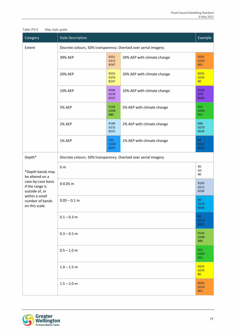
Flood Hazard Modelling Standard 6 May 2021
77
Table P5-5 Map style guide
Category Style Description Example
Extent Discrete colours. 50% transparency. Overlaid over aerial imagery.
39% AEP R251 G212 B167
39% AEP with climate change R255 G153 B51
20% AEP R255 G255 B147
20% AEP with climate change R255 G255 B0
10% AEP R206 G150 B252
10% AEP with climate change R140 G76 B234
5% AEP R146 G208 B80
5% AEP with climate change R51 G204 B51
2% AEP R189 G231 B255
2% AEP with climate change R98 G233 B230
1% AEP R33 G160 B255
1% AEP with climate change R0 G112 B192
Depth*
*Depth bands may be altered on a case-by-case basis if the range is outside of, or within a small number of bands on this scale.
Discrete colours. 50% transparency. Overlaid over aerial imagery.
0 m R0 G0 B0
0-0.05 m R193 G211 B239
0.05 – 0.1 m R0 G176 B240
0.1 – 0.3 m R0 G112 B192
0.3 – 0.5 m R146 G208 B80
0.5 – 1.0 m R51 G204 B51
1.0 – 1.5 m R255 G255 B0
1.5 – 2.0 m R255 G153 B51
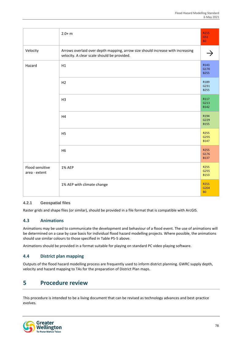
Flood Hazard Modelling Standard 6 May 2021
78
2.0+ m R255 G51 B0
Velocity Arrows overlaid over depth mapping, arrow size should increase with increasing velocity. A clear scale should be provided. →
Hazard H1 R143 G170 B255
H2 R189 G231 B255
H3 R117 G213 B142
H4 R194 G229 B155
H5 R255 G255 B147
H6 R255 G176 B137
Flood sensitive area - extent
1% AEP R255 G255 B153
1% AEP with climate change R255 G204 B0
4.2.1 Geospatial files
Raster grids and shape files (or similar), should be provided in a file format that is compatible with ArcGIS.
4.3 Animations
Animations may be used to communicate the development and behaviour of a flood event. The use of animations will be determined on a case by case basis for individual flood hazard modelling projects. Where possible, the animations should use similar colours to those specified in Table P5-5 above.
Animations should be provided in a format suitable for playing on standard PC video playing software.
4.4 District plan mapping
Outputs of the flood hazard modelling process are frequently used to inform district planning. GWRC supply depth, velocity and hazard mapping to TAs for the preparation of District Plan maps.
5 Procedure review
This procedure is intended to be a living document that can be revised as technology advances and best-practice evolves.

Flood Hazard Modelling Standard 6 May 2021
79
The need for review of the procedures within the FHMS, including this one, will be determined at the end of each modelling project at the ‘process review / lessons learnt’ checkpoint on the FHMS flow chart.
Flood Hazard Modelling Standard 6 May 2021
PROCEDURE 06
INDEPENDENT AUDIT This procedure has been prepared to outline the protocols to be followed by any person undertaking independent audits of GWRC’s flood hazard modelling projects.
Flood Hazard Modelling Standard 6 May 2021
Procedure 06 Table of Contents
1 Introduction 82
1.1 What is an Independent Audit? 82
1.2 Independent Audit in the FHMS Process 82
1.3 Who can be an Independent Auditor? 82
1.4 How should an Independent Auditor be engaged? 82
2 Undertaking an Independent Audit 84
3 Documentation 84
3.1 Independent Audit Spreadsheet 85
3.2 Independent Audit Report 86
3.3 Independent Audit Close Out 86
4 Procedure Review 86
Flood Hazard Modelling Standard 6 May 2021
82
1 Introduction
This document forms Procedure 6 of Greater Wellington Regional Council’s (GWRC) Flood Hazard Modelling Standard (FHMS). This procedure has been prepared to outline the protocols to be followed by any person undertaking independent audits of GWRC’s flood hazard modelling projects.
This document should be read in the context of the wider FHMS, and has a particular relationship to Specification 7: Independent Audit Specifications which provide a template Request for Proposal for engaging external suppliers to undertake independent audits.
An independent audit template is provided in Appendix P6-A of this procedure. This template should be used as the basis of all independent audits undertaken as part of the FHMS process.
1.1 What is an Independent Audit?
In the context of this procedure, an independent audit is an independent review of an entire flood hazard modelling project from project initiation to the production of the modelling outputs. The audit is focused on determining whether the FHMS process has been followed and whether any deviations from the process are reasonable and appropriate. The independent audit provides an additional layer of scrutiny to give confidence that the outputs of the process are suitable for their intended uses.
It is noted that an independent audit is distinct from a peer review which is a hands-on technical review of the hydrological and/or hydraulic modelling, and the subject of Procedure 3 of the FHMS.
1.2 Independent Audit in the FHMS Process
Independent audit is undertaken following the production and peer review of the modelling outputs. This stage is outlined in red in the FHMS process flow chart provided in Figure P6-1 below.
Independent audit should be undertaken for all new models that proceed through the FHMS process. Independent audit may also be undertaken where changes are made to existing models that have the potential to result in changes to district plans or GWRC’s flood hazard advice.
1.3 Who can be an Independent Auditor?
Independent auditors must meet the following criteria:
Independent auditors must be completely independent from the flood hazard modelling project. Independent means that they, or their organisation, have not been involved in the process at any stage.
GWRC’s staff are not considered independent, and therefore are not eligible to undertake independent audits of work undertaken under the FHMS process.
The independent auditor should not have any form of dependent relationship with the modellers or peer reviewers who undertook work on the project, and should have no conflicts of interest relating to the project or modellers/peer reviewers’ organisations including financial or other interests. Additionally, independent auditors should not have personal assets or other conflicts of interest within the modelled flood hazard area.
The independent auditor should be familiar with the development of hydrological and hydraulic models.
There is no requirement for an independent auditor to be based in the Wellington Region, however the independent auditor should be familiar with the mechanisms of flooding with the region, or in similar environments.
Territorial authorities may assist GWRC to determine additional criteria for independent auditors for specific projects, if necessary.
1.4 How should an Independent Auditor be engaged?
Independent auditors should be engaged using the request for proposal template in Specification 7: Independent Audit Specification.
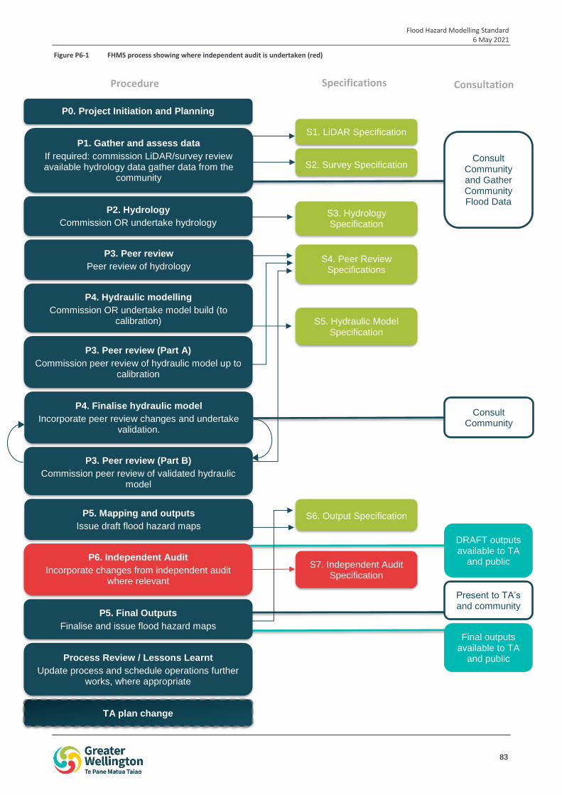
Flood Hazard Modelling Standard 6 May 2021
83
iop
1
S1. LiDAR Specification
S2. Survey Specification
S3. Hydrology Specification
P2. Hydrology
Commission OR undertake hydrology
S4. Peer Review Specifications
P4. Hydraulic modelling
Commission OR undertake model build (to calibration) S5. Hydraulic Model
Specification
P3. Peer review (Part A)
Commission peer review of hydraulic model up to calibration
P4. Finalise hydraulic model
Incorporate peer review changes and undertake validation.
S6. Output Specification P5. Mapping and outputs
Issue draft flood hazard maps
P6. Independent Audit
Incorporate changes from independent audit where relevant
TA plan change
S7. Independent Audit Specification
P3. Peer review (Part B)
Commission peer review of validated hydraulic model
P3. Peer review
Peer review of hydrology
Consult Community
Present to TA’s and community
Consult Community and Gather Community Flood Data
Process Review / Lessons Learnt
Update process and schedule operations further works, where appropriate
P1. Gather and assess data
If required: commission LiDAR/survey review available hydrology data gather data from the
community
DRAFT outputs available to TA
and public
Final outputs available to TA
and public
P0. Project Initiation and Planning
P5. Final Outputs
Finalise and issue flood hazard maps
Procedure Specifications Consultation
Figure P6-1 FHMS process showing where independent audit is undertaken (red)
Flood Hazard Modelling Standard 6 May 2021
84
1.4.1 Liability
Independent auditors may be liable for damages if claims against the flood hazard modelling are upheld. The level of liability will be agreed as part of the contract between GWRC and the auditor’s organisation, and will generally be limited to a multiple of the contract value.
All independent auditors should hold appropriate insurances.
2 Undertaking an Independent Audit
The independent audit should assess whether the FHMS process has been correctly applied at all stages. The auditor should assess:
Whether all steps of the FHMS process have been undertaken, and have been undertaken in accordance with the requirements of the relevant procedures of the FHMS. If there is deviation from the FHMS process, the independent auditor should determine whether the deviation has been documented, the reasons for the deviation and whether the deviation is reasonable and appropriate.
Whether peer reviews of the hydrology, hydraulic modelling (both part A and part B reviews) have been undertaken, whether all items raised by the reviewer have been addressed, and the reviews closed out.
Whether all of the required outputs have been prepared in accordance with requirements of the FHMS process.
Whether community consultation has been undertaken, and whether this consultation was undertaken at the appropriate stages in the FHMS process.
The auditor should undertake a sensibility check of the peer reviewed outputs.
The auditor should determine whether the documentation prepared to support the process (eg, modelling reports, peer review reports, peer review close-out documents) are clear.
The auditor should determine whether the modelling and peer reviews are robust and defendable.
The auditor should confirm whether community queries and concerns raised through the consultation undertaken have been addressed, or whether further work is required.
A more detailed list of audit parameters is provided in the independent audit spreadsheet template in Appendix P6-A.
It is noted that the auditor is not required to assess the technical detail of the models, as a detailed technical review is undertaken during the peer review. The auditor is encouraged to liaise with the project team (i.e. the modeller and peer reviewers) for clarification, where needed. All correspondence should be recorded.
The independent audit may be an iterative process involving on-going conversations with the project team.
The independent auditor may be required to appear as an Expert Witness in Environment Court proceedings related to District Plan changes that result from the flood hazard modelling.
3 Documentation
The initial audit and subsequent iterations must be clearly documented. The following documents are required to be prepared to record the audit, and subsequent revisions:
Independent audit spreadsheet (a template is provided in Appendix P6-A).
Independent audit report
Independent audit close-out
These documents are detailed in the sections below. All correspondence between the auditor and members of the project team should be documented.
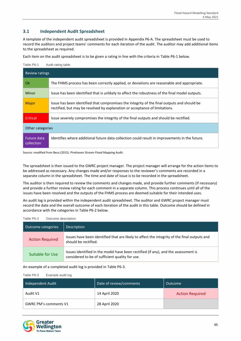
Flood Hazard Modelling Standard 6 May 2021
85
3.1 Independent Audit Spreadsheet
A template of the independent audit spreadsheet is provided in Appendix P6-A. The spreadsheet must be used to record the auditors and project teams’ comments for each iteration of the audit. The auditor may add additional items to the spreadsheet as required.
Each item on the audit spreadsheet is to be given a rating in line with the criteria in Table P6-1 below.
Table P6-1 Audit rating table
Review ratings
Ok The FHMS process has been correctly applied, or deviations are reasonable and appropriate.
Minor Issue has been identified that is unlikely to affect the robustness of the final model outputs.
Major Issue has been identified that compromises the integrity of the final outputs and should be rectified, but may be resolved by explanation or acceptance of limitations.
Critical Issue severely compromises the integrity of the final outputs and should be rectified.
Other categories
Future data collection
Identifies where additional future data collection could result in improvements in the future.
Source: modified from Beca (2015). Pinehaven Stream Flood Mapping Audit.
The spreadsheet is then issued to the GWRC project manager. The project manager will arrange for the action items to be addressed as necessary. Any changes made and/or responses to the reviewer’s comments are recorded in a separate column in the spreadsheet. The time and date of issue is to be recorded in the spreadsheet.
The auditor is then required to review the comments and changes made, and provide further comments (if necessary) and provide a further review rating for each comment in a separate column. This process continues until all of the issues have been resolved and the outputs of the FHMS process are deemed suitable for their intended uses.
An audit log is provided within the independent audit spreadsheet. The auditor and GWRC project manager must record the date and the overall outcome of each iteration of the audit in this table. Outcome should be defined in accordance with the categories in Table P6-2 below.
Table P6-2 Outcome descriptors
Outcome categories Description
Action Required Issues have been identified that are likely to affect the integrity of the final outputs and should be rectified.
Suitable for Use Issues identified in the model have been rectified (if any), and the assessment is considered to be of sufficient quality for use.
An example of a completed audit log is provided in Table P6-3.
Table P6-3 Example audit log
Independent Audit Date of review/comments Outcome
Audit V1 14 April 2020 Action Required
GWRC PM’s comments V1 28 April 2020
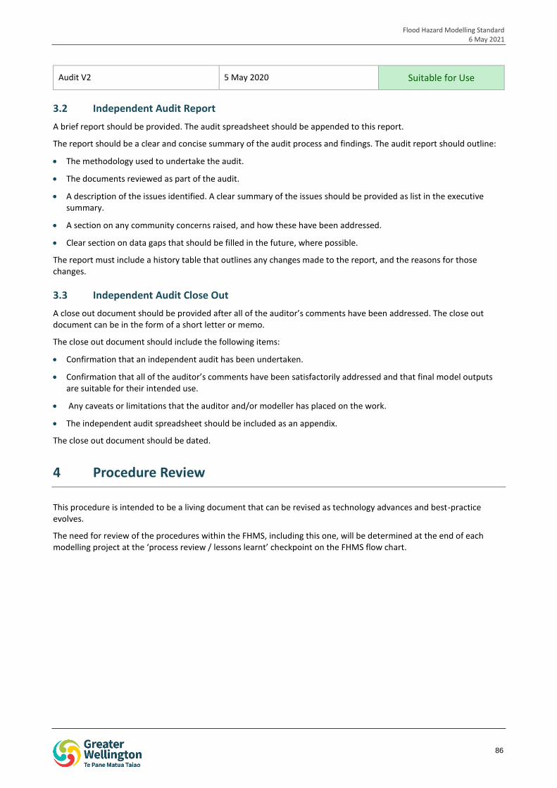
Flood Hazard Modelling Standard 6 May 2021
86
Audit V2 5 May 2020 Suitable for Use
3.2 Independent Audit Report
A brief report should be provided. The audit spreadsheet should be appended to this report.
The report should be a clear and concise summary of the audit process and findings. The audit report should outline:
The methodology used to undertake the audit.
The documents reviewed as part of the audit.
A description of the issues identified. A clear summary of the issues should be provided as list in the executive summary.
A section on any community concerns raised, and how these have been addressed.
Clear section on data gaps that should be filled in the future, where possible.
The report must include a history table that outlines any changes made to the report, and the reasons for those changes.
3.3 Independent Audit Close Out
A close out document should be provided after all of the auditor’s comments have been addressed. The close out document can be in the form of a short letter or memo.
The close out document should include the following items:
Confirmation that an independent audit has been undertaken.
Confirmation that all of the auditor’s comments have been satisfactorily addressed and that final model outputs are suitable for their intended use.
Any caveats or limitations that the auditor and/or modeller has placed on the work.
The independent audit spreadsheet should be included as an appendix.
The close out document should be dated.
4 Procedure Review
This procedure is intended to be a living document that can be revised as technology advances and best-practice evolves.
The need for review of the procedures within the FHMS, including this one, will be determined at the end of each modelling project at the ‘process review / lessons learnt’ checkpoint on the FHMS flow chart.

Flood Hazard Modelling Standard 20 August 2020
Related Documents