FLAT RIVER NATURAL RIVER PLAN KENT, IONIA, MONTCALM COUNTIES OCTOBER 1979 MICHIGAN DEPARTMENT OF NATURAL RESOURCES Revised March 12, 2002 FISHERIES DIVISION

Welcome message from author
This document is posted to help you gain knowledge. Please leave a comment to let me know what you think about it! Share it to your friends and learn new things together.
Transcript
FLAT RIVER NATURAL RIVER PLAN
KENT, IONIA, MONTCALM COUNTIES
OCTOBER 1979
MICHIGAN DEPARTMENT OF NATURAL RESOURCES Revised March 12, 2002
FISHERIES DIVISION

FLAT RIVER NATURAL RIVER PLAN
At its November 9, 1979 meeting, the Natural Resources Commission
Formally adopted this plan and designated the Flat River as a country-scenic river under authority of Act 231 of the Public Acts of 1970
MICHIAGN NATURAL RESOURCES COMMISSION Jacob Hoefer
Carl T. Johnson E. M. Laitala Hilary Snell
Harry H. Whiteley Joan L. Wolfe
Charles G. Younglove
MICHIGAN DEPARTMENT OF NATURAL RESOURCES Howard A. Tanner, Director
DIVISION OF LAND RESOURCE PROGRAMS
Karl R. Hosford, Chief
The preparation of this document was financially Aided by a grant from the
U.S. Water Resources Council, provided pursuant to Title III of the
Water Resources Planning Act of 1965 (P.L. 89080)

FLAT RIVER
PREFACE...................................................................................................................1 Map of Watershed ......................................................................................................3 THE WATERSHED AND THE STUDY AREA............................................................4 A. General Description .........................................................................................4 B. Physiography and Soils ...................................................................................4 C. Stream Characteristics.....................................................................................4 D. Vegetation........................................................................................................6 E. Climate.............................................................................................................6 F. Ownership........................................................................................................7 G. Accessibility .....................................................................................................9 EXISTING USES AND RECREATIONAL OPPORTUNITIES...................................10 A. Land Use .......................................................................................................10 B. Private Recreation Facilities ..........................................................................10 C. Public Recreation Facilities............................................................................10 D. Fishing ...........................................................................................................12 E. Wildlife Observation and Hunting...................................................................12 F. Canoeing and Boating ...................................................................................13 G. Historic and Archaeological Sites ..................................................................13 PRELIMINARY NATURAL RIVER PLAN .................................................................16 A. Goal ...............................................................................................................16 B. Objectives ......................................................................................................16 C. Proposed Designation....................................................................................16 D. Natural River District ......................................................................................17 E. Residential Housing.......................................................................................17 F. Industrial and Commercial Structures and Uses............................................17 G. Building Setbacks ..........................................................................................18 H. Building Design and Screening......................................................................18 I. Docks.............................................................................................................19 J. On-Site Sanitation Systems...........................................................................19 K. Signs..............................................................................................................19 L. Minerals .........................................................................................................20 M. Utilities ...........................................................................................................20 N. Agriculture......................................................................................................21 O. Disposal of Solid Wastes ...............................................................................21 P. Stream Alteration ...........................................................................................21 Q. Land Alteration...............................................................................................22 R. Soil Erosion and Sediment Control Measures ...............................................22
S. Natural Vegetation Strip on Adjacent Shorelines ...........................................23 T. Recreation .....................................................................................................23 U. Public Access Sites .......................................................................................24 V. Motorized Vehicles ........................................................................................25 W. Historic and Archaeological Sites ..................................................................25 X. Administration ................................................................................................25 Y. Management of Areas Beyond the Natural River Zone .................................27 APPENDIX A—PART 305 – NATURAL RIVERS PA 451 OF 1994 .........................29 APPENDIX B--“ALTERATION OF RIVERS” LAWS .................................................33 APPENDIX C--RELATED LAWS..............................................................................36 APPENDIX D - HISTORICAL/ARCHAEOLOGICAL SITES......................................49 APPENDIX E – COMMISSION RESOLUTIONS......................................................50 APPENDIX F – SUGGESTED MANAGEMENT CONTROLS ..................................52 APPENDIX G – SUGGESTED GUIDELINES FOR MANAGEMENT OF FLAT RIVER SYSTEM..............................................................56
1
PREFACE
The Flat River is rich in historical values, has an excellent smallmouth bass fishery, and is generally considered one of the most scenic streams in southern Michigan. In addition to being an important element in both Indian and lumbering history, the river boasts two of the remaining four original wooden covered bridges in Michigan. The oldest, White's Bridge near Smyrna, was built in 1867. Both White's Bridge and Fallasburg Bridge are on the National and State Registers of Historic Places. For these values, the Flat River was included on the list of streams for study under the Michigan Natural River Act (Part 305, P.A. 451 of 1994). Staff recruited and began organization of a local Flat River Planning Committee during the fall of 1975. While there was general support for protection of the values of the Flat River, it soon became evident many citizens were concerned with the state's involvement in this matter. At the meeting of the Natural Resources Commission on February 12, 1976, a delegation of citizens and representatives of local government from Ionia, Kent and Montcalm counties asked the Commission to discontinue its study and possible designation of the Flat River under the Natural River Act, and allow them the opportunity to protect the river solely through local ordinances without state assistance or intervention. The Commission discussed the matter thoroughly at their March 25, 1976 "Philosophical" meeting. The general consensus was that local units of government be given the opportunity to prove their sincerity for protection of the natural qualities of the Flat River system. The Commission adopted a resolution at the April 9, 1976 meeting, encouraging local units of government to prepare a management plan for the protection of the Flat River and present it to the Commission for review by October 15, 1976. The plan was developed under general Department of Natural Resources guidelines and included a method of implementation. At its December 10, 1976 meeting, the Natural Resources Commission formally adopted a resolution tentatively approving the amended management controls for protection of the Flat River through local zoning without designation under Act 231, P.A. 1970, and subject to a one year timetable for local zoning to be in effect. The resolution also asked that local units of government submit to the Natural Resources Commission by April 1, 1977 resolutions indicating acceptance of and assuring compliance with the amended management controls. To date, the Department has received resolutions of acceptance of the suggested management controls from the nine involved townships. Copies of the Natural Resources Commission resolutions and management guidelines are included as appendices to this report.
2
The Natural Resources Commission originally gave the townships one-year, until December 15, 1977, to have in place effective zoning to implement the local plan. This deadline was subsequently extended to August 1978. By that date, only six of the nine townships along the river had adopted proper zoning. Upon direction of the Natural Resources Commission, staff of the Department of Natural Resources has prepared this Flat River Natural River Plan. This plan recommends that the Flat River and its most significant tributaries be designated a "County-Scenic" river. A "Country-Scenic" river is defined as a river in an agricultural setting with narrow bands of woods or pastoral borders. Farms and other developments may be visible from the river; it may be readily accessible by road; it may have undergone some impounding; and its waters should meet established water quality standards. This report (1) provides a physical description of the river and the watershed as a whole; (2) reviews values of the river and factors affecting it future nature and use; and (3) provides a plan for the protection of the river's natural qualities and to guide its future use. The plan follows the locally prepared management plan for the Flat River, previously approved by the Natural Resources Commission. It should be emphasized that those townships which have to date adopted and approved zoning ordinances for the Flat River will not be required to take further action. Those townships which at the date of adoption of this plan have adopted local zoning controls which meet the approved management guidelines are: Belvidere, Pine, Douglass, Montcalm, Eureka, Fairplain and Vergennes. Department of Natural Resources approved local zoning, that is adequately administered and enforced, will take precedence over state administrative zoning rules should it be necessary to adopt such rules to protect the river resource. Keene Township in Ionia County has indicated they are not interested in zoning at all. Otisco Township did adopt an ordinance for the river, but it did not include protection for Dickerson Creek and had some unacceptable wording. This Natural River Plan recommends designation of three streams within two Kent County townships which were not involved in the local river management plan. If these streams are designated, the Department will work closely with Spencer and Oakfield townships to achieve appropriate protection.
3
4
THE WATERSHED AND STUDY AREA
A. General Description
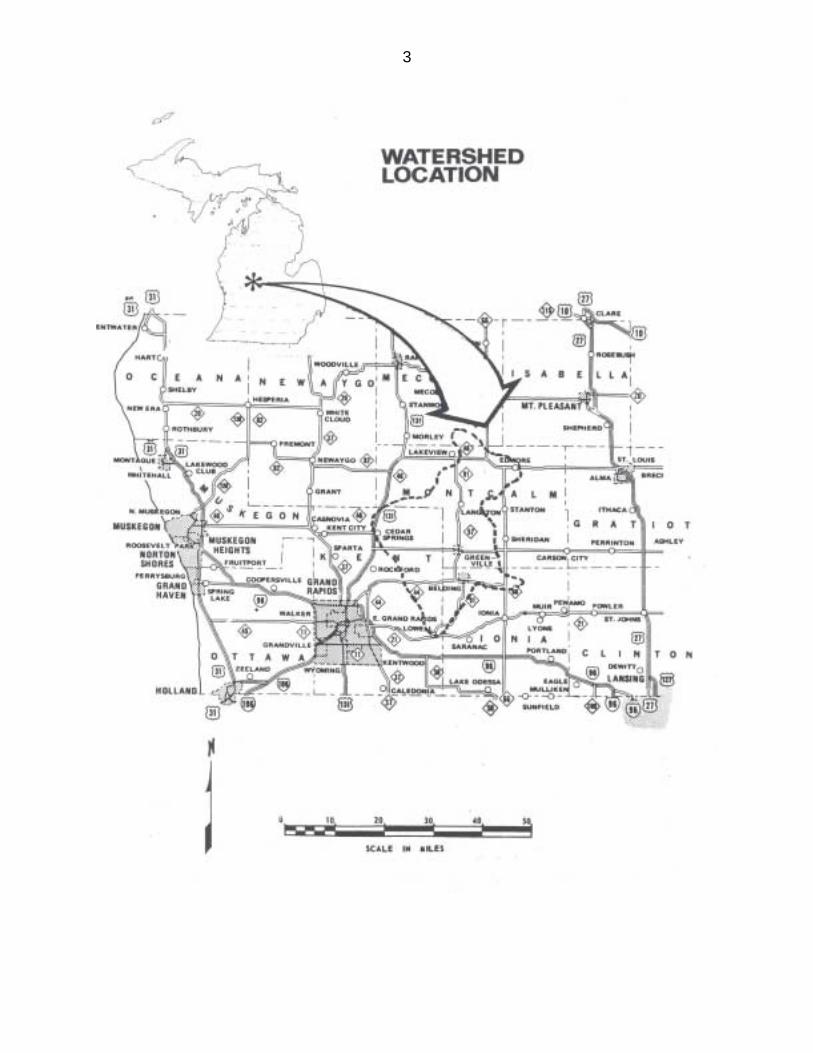
1. The Watershed. The Flat River drains an area of approximately 560 square miles as it flows through the counties of Montcalm, Ionia and Kent. The mainstream originates in the Six Lakes area and flows approximately 70 miles until it joins the Grand River at Lowell.
2. The Study Area. The area of study included the entire mainstream from
Six Lakes to its mouth at the Grand River, Dickerson Creek, its major tributary, as well as the numerous smaller tributaries which make up the system.
B. Physiography and Soils
About 15,000 years ago, most of the watershed was covered with glacial ice. The effects of the glaciation are still evident. The rolling, hilly moraines, flat outwash plains, and kettle lakes are typical features in the watershed. The Flat River originates at the outfall of First Lake, at an elevation of approximately 915 feet above sea level and drops to an elevation of about 617 feet where it meets the Grand River in Lowell. The majority of the soils in the upper reaches of the watershed are sandy loams or loamy sands. Around the Langston area along the mainstream, Grayling sands are the general soil feature. Organic soils (muck and peats) are a common feature in the Greenville area with loamy sands or sandy loams the predominant. Towards the lower reaches of the watershed, the soils are still fairly well drained with loamy soils predominating. The Mancelona-Fox-Boyer association is a predominant association along the Flat mainstream.
C. Stream Characteristics
1. Stream Lengths. The table below summarizes the Flat River system.
Flat River Mainstream 70.0 miles Wolf Creek 1.2 miles Townline Creek 3.4 miles Horseshoe Creek 1.4 miles Clear Creek (from outfall of Lincoln Lake) 2.2 miles Butternut Creek 3.8 miles Cooper Creek 9.2 miles Wabasis (from outfall of Morgan Lake) 6.9 miles
5
Dickerson Creek 25.6 miles Seely Creek 3.9 miles West Branch Creek 7.1 miles Unnamed creeks and drains 13.1 miles TOTAL 147.8 miles
2. Water Quality. All of the waters in the Flat river system are protected for the following:
a) agriculture b) industrial water supply c) navigation d) public water supply e) partial body contact (with the exception, Fallasburg Dam backwater
which is protected for total body contact)
Water samples taken at M-21 in Lowell near its confluence with the Grand River indicate that the water quality of the Flat River is within the parameters for which the river is being protected.
In certain areas of the mainstream, heavy spring runoff and nutrients from
crop fertilizers contribute to the growth of heavy concentrations of aquatic vegetation. Many of the tributaries making up the Flat River system are often weed choked during the warm summer months.
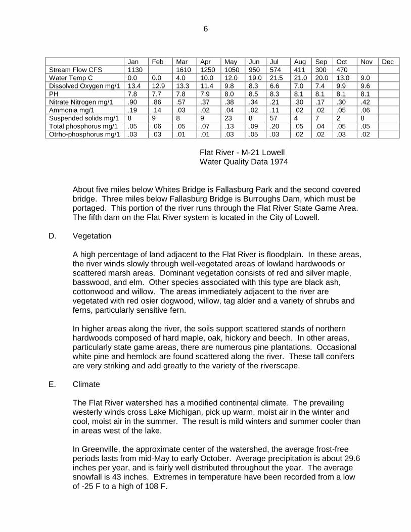
The table on the following page shows the chemical, physical and biological water analysis for 1974.
The Flat River mainstream starts at the outfall of First Lake in Belvidere Township, Montcalm County. Approximately 1 1/2 miles downstream is the M-66/46 bridge crossing. From this bridge crossing to the Village of Langston, approximately 22 river miles, there are many windfalls and carryovers. This, and the generally low water in the summer months, makes this portion of the mainstream generally unsuitable for canoeing. Access to the mainstream below Langston may be obtained at the Montcalm County Park along M-91. From this point to the City of Greenville is about nine river miles. At Greenville, the dam must be portaged. Between Greenville and the City of Belding, the river flows through the Flat River State Game Area. At Belding, a second dam must be portaged. About three miles below the dam at Belding, near the Village of Smyrna, a dam has been removed exposing the old log cribs. The swift water at this point offers a challenge to the novice canoeist. About 5.5 miles further downstream is the Whites Bridge Dam, which must be portaged. At Whites Bridge, one of the two covered bridges in the Flat Rive system, there are no publicly provided access facilities.
6
Jan Feb Mar Apr May Jun Jul Aug Sep Oct Nov Dec Stream Flow CFS 1130 1610 1250 1050 950 574 411 300 470 Water Temp C 0.0 0.0 4.0 10.0 12.0 19.0 21.5 21.0 20.0 13.0 9.0 Dissolved Oxygen mg/1 13.4 12.9 13.3 11.4 9.8 8.3 6.6 7.0 7.4 9.9 9.6 PH 7.8 7.7 7.8 7.9 8.0 8.5 8.3 8.1 8.1 8.1 8.1 Nitrate Nitrogen mg/1 .90 .86 .57 .37 .38 .34 .21 .30 .17 .30 .42 Ammonia mg/1 .19 .14 .03 .02 .04 .02 .11 .02 .02 .05 .06 Suspended solids mg/1 8 9 8 9 23 8 57 4 7 2 8 Total phosphorus mg/1 .05 .06 .05 .07 .13 .09 .20 .05 .04 .05 .05 Otrho-phosphorus mg/1 .03 .03 .01 .01 .03 .05 .03 .02 .02 .03 .02 Flat River - M-21 Lowell Water Quality Data 1974 About five miles below Whites Bridge is Fallasburg Park and the second covered
bridge. Three miles below Fallasburg Bridge is Burroughs Dam, which must be portaged. This portion of the river runs through the Flat River State Game Area. The fifth dam on the Flat River system is located in the City of Lowell.
D. Vegetation
A high percentage of land adjacent to the Flat River is floodplain. In these areas, the river winds slowly through well-vegetated areas of lowland hardwoods or scattered marsh areas. Dominant vegetation consists of red and silver maple, basswood, and elm. Other species associated with this type are black ash, cottonwood and willow. The areas immediately adjacent to the river are vegetated with red osier dogwood, willow, tag alder and a variety of shrubs and ferns, particularly sensitive fern. In higher areas along the river, the soils support scattered stands of northern hardwoods composed of hard maple, oak, hickory and beech. In other areas, particularly state game areas, there are numerous pine plantations. Occasional white pine and hemlock are found scattered along the river. These tall conifers are very striking and add greatly to the variety of the riverscape.
E. Climate
The Flat River watershed has a modified continental climate. The prevailing westerly winds cross Lake Michigan, pick up warm, moist air in the winter and cool, moist air in the summer. The result is mild winters and summer cooler than in areas west of the lake. In Greenville, the approximate center of the watershed, the average frost-free periods lasts from mid-May to early October. Average precipitation is about 29.6 inches per year, and is fairly well distributed throughout the year. The average snowfall is 43 inches. Extremes in temperature have been recorded from a low of -25 F to a high of 108 F.
7
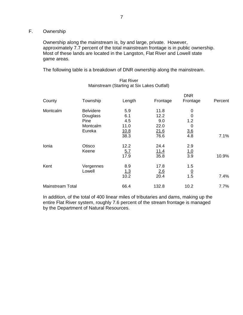
F. Ownership Ownership along the mainstream is, by and large, private. However,
approximately 7.7 percent of the total mainstream frontage is in public ownership. Most of these lands are located in the Langston, Flat River and Lowell state game areas.
The following table is a breakdown of DNR ownership along the mainstream.
Flat River Mainstream (Starting at Six Lakes Outfall)
DNR County Township Length Frontage Frontage Percent Montcalm Belvidere 5.9 11.8 0 Douglass 6.1 12.2 0 Pine 4.5 9.0 1.2 Montcalm 11.0 22.0 0 Eureka 10.8 21.6 3.6 38.3 76.6 4.8 7.1% Ionia Otisco 12.2 24.4 2.9 Keene 5.7 11.4 1.0 17.9 35.8 3.9 10.9% Kent Vergennes 8.9 17.8 1.5 Lowell 1.3 2.6 0 10.2 20.4 1.5 7.4% Mainstream Total 66.4 132.8 10.2 7.7% In addition, of the total of 400 linear miles of tributaries and dams, making up the entire Flat River system, roughly 7.6 percent of the stream frontage is managed by the Department of Natural Resources.
8
9
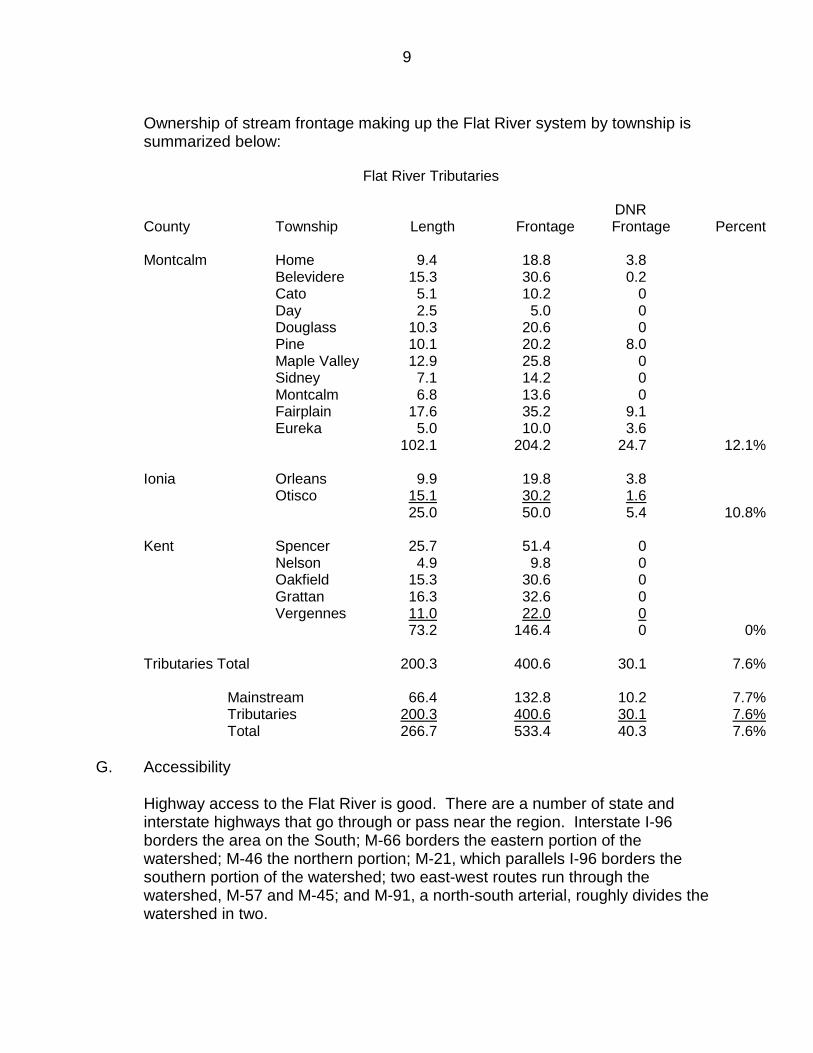
Ownership of stream frontage making up the Flat River system by township is summarized below:
Flat River Tributaries
DNR County Township Length Frontage Frontage Percent Montcalm Home 9.4 18.8 3.8 Belevidere 15.3 30.6 0.2 Cato 5.1 10.2 0 Day 2.5 5.0 0 Douglass 10.3 20.6 0 Pine 10.1 20.2 8.0 Maple Valley 12.9 25.8 0 Sidney 7.1 14.2 0 Montcalm 6.8 13.6 0 Fairplain 17.6 35.2 9.1 Eureka 5.0 10.0 3.6 102.1 204.2 24.7 12.1% Ionia Orleans 9.9 19.8 3.8 Otisco 15.1 30.2 1.6 25.0 50.0 5.4 10.8% Kent Spencer 25.7 51.4 0 Nelson 4.9 9.8 0 Oakfield 15.3 30.6 0 Grattan 16.3 32.6 0 Vergennes 11.0 22.0 0 73.2 146.4 0 0% Tributaries Total 200.3 400.6 30.1 7.6% Mainstream 66.4 132.8 10.2 7.7% Tributaries 200.3 400.6 30.1 7.6% Total 266.7 533.4 40.3 7.6%
G. Accessibility
Highway access to the Flat River is good. There are a number of state and interstate highways that go through or pass near the region. Interstate I-96 borders the area on the South; M-66 borders the eastern portion of the watershed; M-46 the northern portion; M-21, which parallels I-96 borders the southern portion of the watershed; two east-west routes run through the watershed, M-57 and M-45; and M-91, a north-south arterial, roughly divides the watershed in two.
10
Excluding road bridges in incorporated cities and villages, the river is crossed 25 times on the mainstream. There are eight railroad bridges crossing the mainstream.
EXISTING USES AND RECREATIONAL OPPORTUNITIES
A. Land Use
The Flat River watershed is situated in the rural areas of Ionia, Montcalm and Kent counties. Based on available information from these counties, the major land use of the area is agriculture which utilizes 780,700 acres (57%) of the available 1,386,240 acres. Of the total acreage in agriculture, 63.8% is harvestable crops, the remaining acreage is utilized for pasture or lies idle. The second largest land use is forestland which accounts for 325,800 acres or 23% of the land area. Although much of the forestland is in small woodlots, considerable acreage lies within the boundaries of the state game areas in the watershed. Timber harvest is not a major industry in the watershed, but figures show that 99% of the small woodlots are commercially harvested. Based strictly on county figures, recreational uses make up only about 3% of the land area. However, this figure would be considerably higher when one considers the recreational use derived from forested areas and the allowed hunting on agricultural acreage.
B. Private Recreation Facilities
There are 21 private campgrounds within the Flat River watershed which provide 1,194 sites to the camping enthusiast. Most of these are located on the western edge of the watershed, in eastern Kent County. There presently exists only two canoe liveries which offer 25 canoes for rent on the Flat River. The Flat River Historical Society has developed the Flat River Museum in the Old Ridley Warehouse site in the City of Greenville. The museum is open to the public and includes displays on the lumbering era, the geography and geology of the watershed, farming tools and household goods, businesses of the watershed, and archives including newspapers, photographs and genealogical files. The Lowell Showboat is docked near the Lowell Dam, and annually presents some of the most famous entertainers in the nation. Both the Girl Scouts of America and the Young Marines own and operate recreational camps for young people along the Flat River. Other recreational activities provided by private sources include golf courses, horseback riding, snowmobile and off-road vehicle racetracks, both Alpine and cross-country skiing, and rental cottages.
C. Public Recreation Facilities
11
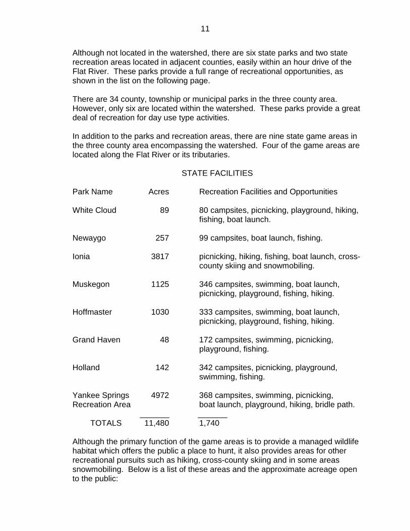
Although not located in the watershed, there are six state parks and two state recreation areas located in adjacent counties, easily within an hour drive of the Flat River. These parks provide a full range of recreational opportunities, as shown in the list on the following page. There are 34 county, township or municipal parks in the three county area. However, only six are located within the watershed. These parks provide a great deal of recreation for day use type activities. In addition to the parks and recreation areas, there are nine state game areas in the three county area encompassing the watershed. Four of the game areas are located along the Flat River or its tributaries.
STATE FACILITIES
Park Name Acres Recreation Facilities and Opportunities White Cloud 89 80 campsites, picnicking, playground, hiking,
fishing, boat launch. Newaygo 257 99 campsites, boat launch, fishing. Ionia 3817 picnicking, hiking, fishing, boat launch, cross-
county skiing and snowmobiling. Muskegon 1125 346 campsites, swimming, boat launch,
picnicking, playground, fishing, hiking. Hoffmaster 1030 333 campsites, swimming, boat launch,
picnicking, playground, fishing, hiking. Grand Haven 48 172 campsites, swimming, picnicking,
playground, fishing. Holland 142 342 campsites, picnicking, playground,
swimming, fishing. Yankee Springs 4972 368 campsites, swimming, picnicking, Recreation Area boat launch, playground, hiking, bridle path. TOTALS 11,480 1,740
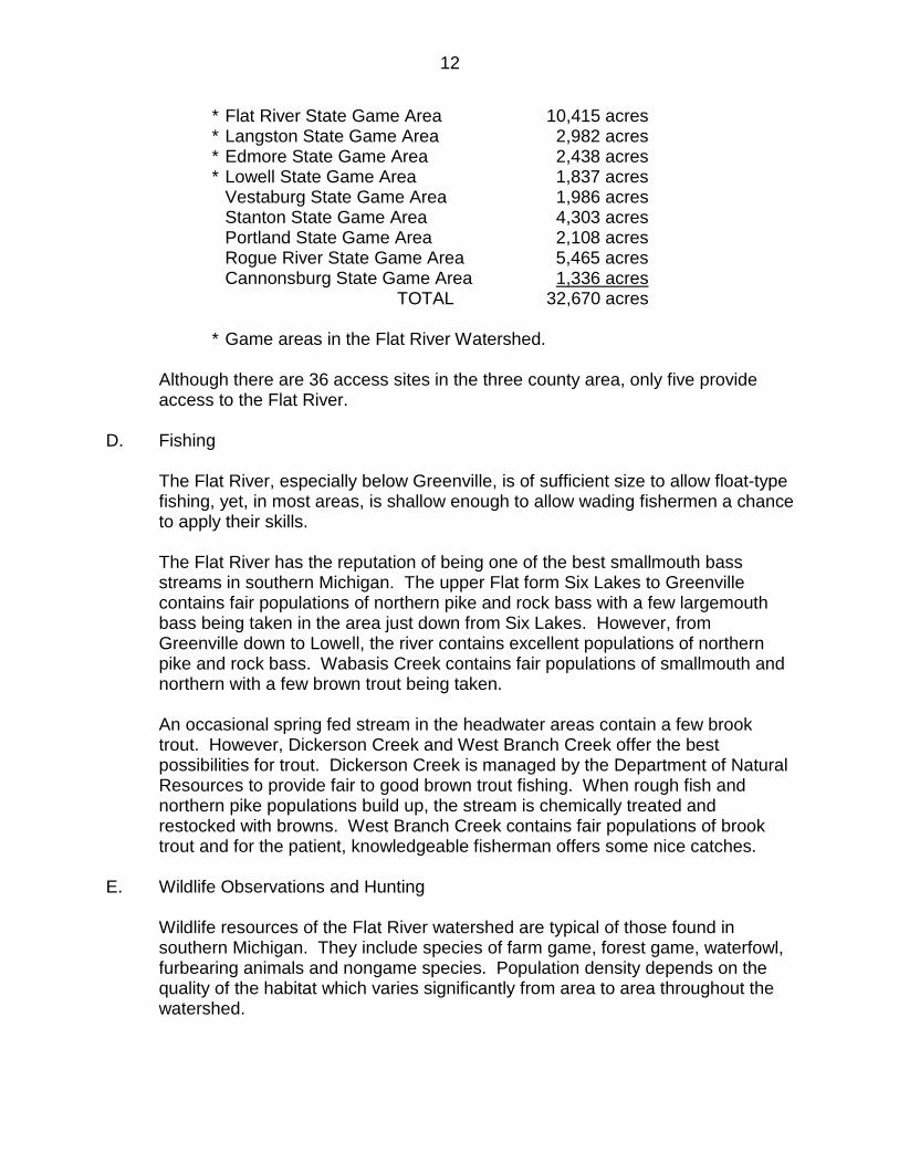
Although the primary function of the game areas is to provide a managed wildlife habitat which offers the public a place to hunt, it also provides areas for other recreational pursuits such as hiking, cross-county skiing and in some areas snowmobiling. Below is a list of these areas and the approximate acreage open to the public:
12
* Flat River State Game Area 10,415 acres * Langston State Game Area 2,982 acres * Edmore State Game Area 2,438 acres * Lowell State Game Area 1,837 acres Vestaburg State Game Area 1,986 acres Stanton State Game Area 4,303 acres Portland State Game Area 2,108 acres Rogue River State Game Area 5,465 acres Cannonsburg State Game Area 1,336 acres TOTAL 32,670 acres
* Game areas in the Flat River Watershed. Although there are 36 access sites in the three county area, only five provide
access to the Flat River. D. Fishing
The Flat River, especially below Greenville, is of sufficient size to allow float-type fishing, yet, in most areas, is shallow enough to allow wading fishermen a chance to apply their skills. The Flat River has the reputation of being one of the best smallmouth bass streams in southern Michigan. The upper Flat form Six Lakes to Greenville contains fair populations of northern pike and rock bass with a few largemouth bass being taken in the area just down from Six Lakes. However, from Greenville down to Lowell, the river contains excellent populations of northern pike and rock bass. Wabasis Creek contains fair populations of smallmouth and northern with a few brown trout being taken. An occasional spring fed stream in the headwater areas contain a few brook trout. However, Dickerson Creek and West Branch Creek offer the best possibilities for trout. Dickerson Creek is managed by the Department of Natural Resources to provide fair to good brown trout fishing. When rough fish and northern pike populations build up, the stream is chemically treated and restocked with browns. West Branch Creek contains fair populations of brook trout and for the patient, knowledgeable fisherman offers some nice catches.
E. Wildlife Observations and Hunting
Wildlife resources of the Flat River watershed are typical of those found in southern Michigan. They include species of farm game, forest game, waterfowl, furbearing animals and nongame species. Population density depends on the quality of the habitat which varies significantly from area to area throughout the watershed.
13
The watershed generally contains moderately productive farm game habitat. There is fair ring-necked pheasant and cottontail rabbit populations and good fox squirrel numbers. Quail are found in the basin, but their numbers are limited. Forest game species include primarily white-tailed deer and ruffed grouse. There is excellent ruffed grouse hunting in the upland areas adjacent to the river and tributaries, and a heavy white-tailed deer population throughout the watershed. Furbearers are distributed throughout the watershed. Aquatic species such as muskrats and mink are restricted to the watercourses and associated marsh areas. Muskrats are abundant and mink are common in the area. A few beaver are beginning to establish themselves in the headwaters of the river system. Raccoons are numerous and red fox common throughout the watershed. Waterfowl are numerous and generally distributed over all the water courses and wetlands of the basin. Mallards, black ducks, wood ducks and blue-winged teal constitute breeding populations. However, other species may be seen during spring and fall migrations. In addition to the game and furbearing animals, a large number of nongame species are found in the watershed. These include a large variety of songbirds, shore birds, rodents, birds of prey, reptiles and amphibians. Nine state game areas in or near the watershed offer numerous opportunities for hunting or wildlife observation.
F. Canoeing and Boating
Although much of the Flat River is canoeable, especially in the spring and early summer, the area from Greenville downstream to Lowell is the best. A moderate current, changing bottom types, vegetative cover, fish and wildlife, and two historic covered bridges makes this an enjoyable stretch to canoe. The river above Greenville to Langston flows slowly through lowland hardwood areas and many dead trees across the river makes it difficult to canoe. The river from Langston to Six Lakes is generally too small and brushy for enjoyable canoeing. The current will be greatly reduced or nil in the five impoundments making canoeing more difficult. Portages will be necessary at Greenville, Belding, Whites Bridge, Burroughs and Lowell dams to complete a trip from Langston to the Grand River. During low flows, canoeists should be extremely cautious at the old Smyrna Dam, which was removed a number of years ago, as the canoe may hit portions of the old structure causing damage to the canoe or possibly overturning it. Inexperienced canoeists would be advised to portage around this structure. Except on the impoundments or lower river area, the river is not generally suitable for boating as it is quite shallow.
G. Historic and Archaeological Sites
14
The Flat River and surrounding areas are rich in historic values of state and national significance. In addition to being an important element in both Indian and lumbering history, the river boasts two of the remaining four original wooden covered bridges in Michigan. The oldest, Whites Bridge near Smyrna, was built in 1867. Both Whites Bridge and Fallasburg Bridge are on the National and State Registers of Historic Places. The third covered bridge of historic significance is located a few miles west of the Flat, at Ada, on the Thornapple River. Although only a few historic sites are located within the Flat River watershed, there are over 50 in the surrounding counties. Archaeological surveys have identified numerous prehistoric sites, such as Indian villages, campsites, mounds and burial sites, along the Grand and Thornapple rivers in the vicinity of the Flat. Since the Flat River was a major route of travel for the Indians, the upriver Flat River Trail from the Grand which was also crossed at Greenville by a major east-west trail, the Saginaw-Pentwater trail, it must be assumed that many additional sites are in this area. A detailed historical and archaeological sites survey has not been done for the Flat River. However, numerous sites have been identified (see Appendix A). A professional survey of the river area would undoubtedly uncover more sites.
15
16
PRELIMINARY NATURAL RIVER PLAN
A. Goal
To preserve, protect and enhance the river environment in a natural state for the use and enjoyment of present and future generations.
B. Objectives
1. To maintain water quality consistent with the designated classification of the river and adhere to the concept of nondegradation of water quality.
2. To prohibit development or activities which may damage the ecologic, aesthetic or historic values of the river and adjacent lands.
3. To ensure that any development which may occur shall be done in an orderly manner consistent with the natural environment and aesthetic qualities of the stream.
4. To ensure that recreational uses which occur, be done in an orderly manner consistent with the natural environment and aesthetic qualities of the stream, and that a quality recreation experience is maintained.
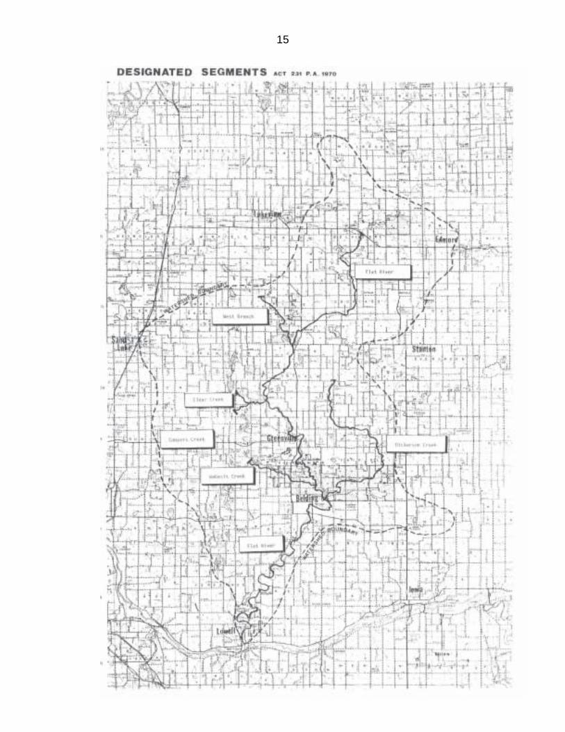
C. It is recommended that the following portions of the Flat River be designates a
country-scenic river under authority of (Part 305, P.A. 451 of 1994), the Natural River Act (approximate mileage--mainstream 70; tributaries 39).
Mainstream. From the M-46/M-66 bridge in Montcalm County to the northern limits of the City of Lowell, excluding those portions which flow through the incorporated city limits of Greenville and Belding. Tributaries. 1. Dickerson Creek from Sidney Road (Sidney Township) to its confluence
with the Flat River (20.3 miles). 2. Wabasis Creek from Mills Avenue (Oakfield Township) to its confluence with
the Flat River (6.8 miles). 3. Coopers Creek from Lincoln Lake Avenue (Spencer Township) to its
confluence with the Flat River (1.5 miles). 4. Clear Creek from Lincoln Lake Avenue (Spencer Township) to its
confluence with Cooper Creek (2.8 miles). 5. West Branch Creek from its source in Pine Township to its confluence with
the Flat River (7.1 miles).
These tributaries possess the necessary outstanding fish, wildlife, scenic, aesthetic, floodplain, ecologic, historic or recreational values to be of statewide significance and hence, should be considered for designation.
Other tributaries not recommended for designation may still be protected through
adoption of protective zoning ordinances at the local level.
17
D. Natural River District
The Flat River Natural District includes an area 300 feet wide on each side of and parallel to all channels of the mainstream and designated tributaries. This district establishes a defineable area within which local zoning may guide future development and use. ESTABLISHMENT OF THIS DISTRICT IN NO WAY IMPLIES A "TAKING" OF THESE LANDS BY THE STATE OR OPENING THEM UP TO THE PUBLIC USE. PRIVATE LANDS REMAIN PRIVATE AND ARE SUBJECT TO THE RIGHTS OF PRIVATE OWNERSHIP.
E. Residential Housing
Unplatted lost and new subdivisions in the Natural River District shall accommodate the building setbacks as set forth in Section G, and shall have a minimum riverfront lot width of 100 feet on the mainstream and all designated tributaries. Lots of property of record that are nonconforming at the time of the effective date of these regulations because of lack of size to accommodate building setbacks from the water's edge shall be allowed to be built upon and variances shall be allowed for required setbacks upon such reasonable terms as set forth by the zoning board, providing that structures be so placed as to best meet the objectives of the Natural River Act. One single family dwelling will be permitted on each lot or parcel within the Natural River District subject to the building setbacks as a detached building or structure designed for or occupied exclusively by one (1) family and containing housekeeping facilities.
F. Industrial and Commercial Structures and Uses
1. New industrial use and buildings, and expansion of existing uses and buildings will not be permitted within 300 feet of the designated river and tributaries.
2. Commercial uses and buildings; such as gas stations, motels, restaurants, retail stores, etc., will not be permitted within 300 feet of the designated river and tributaries. However, certain commercial uses requiring special exception permits may be compatible with maintaining the natural aspects of the river. Those uses permitted under the special exception procedure shall be strictly controlled. Controls on location, parking, drainage, setback, natural vegetation strip, signs, and hours of operation of the proposed use, shall all be considered in the special exception procedure. Those uses which may be compatible with natural river designation include:
a) Commercial crop farms or forest plantations that are landward of the
native vegetation strip. b) Campgrounds that are constructed, maintained and operated in
accordance with State Health Department (Act 17, P.A 1970), including
18
tent, travel trailer, camper and motor home uses, buildings, cement pads, hookups, etc. in conformance with established setbacks.
c) Sales, rental and service of recreational watercraft. d) Small home operated businesses such as photography studio, beauty
shop, home repair, insurance or other businesses which do not alter the residential nature of the property and are in conformance with established setbacks.
e) Small rental cabins with light housekeeping, but not motels, which are in conformance with setback requirements.
G. Building Setback
On the designated portions of the Flat River mainstream and tributaries, new buildings and appurtenances will be required to setback a minimum of 100 feet from the ordinary high water mark* or 25 feet from an identified or documented 100-year flood plain line, whichever results in the greatest distance from the edge of the river. Further, new buildings and appurtenances must be setback at least 50 feet from the top of a bluff.**
H. Building Design and Screening
1. Property owners are encouraged to use natural materials and natural unobtrusive colors in the construction of new or remodeling of existing buildings. Upon request to the Department of Natural Resources, individual property owners will receive technical advice on location and design of structures and management of their lands.
2. Property owners of new or existing buildings visible from the river are encouraged to screen them with native vegetation. On request, the Department of Natural Resources Area Forester will advise on planting stock, etc. When available at state nurseries, recommended planting materials will be supplied to property owners at cost.
*Ordinary high water mark means "the line between upland and bottomland which persists through successive changes in water levels, below which the presence and action of the water is so common or recurrent that the character of the land is marked distinctly from the upland and is apparent in the soil itself, the configuration of the surface of the soil and the vegetation. Where water returns to its natural level as the result of the permanent removal or abandonment of a dam, it means the natural ordinary high water mark.” (This is the definition for administration of the Inland Lakes and Streams Act, Part 305, P.A. 451 of 1994.) **"Bluff" means the top of a steep bank rising sharply from the water's edge.
I. Docks
The construction of docks along the designated portions of the Flat River is discouraged. However, if necessary to provide safe and ecologically sound access for the riparian landowner, docks may be constructed not to exceed four
19
feet in width nor more than 16 feet in length with no more than four feet of the dock extending over the water. Docks must be constructed in accordance with the rules of Part 305, P.A. 451 of 1994. The use of "natural" materials and camouflaging is encouraged. Property owners are encouraged to build "log-sod covered" docks. Upon request from the property owner, the Department of Natural Resources will supply plans and specifications for this type of dock or assist in the siting and location of a dock so as to blend in with the natural surroundings and best meet the objectives of natural rivers designation.
J. On-Site Sanitation Systems
All habitations within the Natural River District shall be provided with sanitary waste disposal facilities conforming in type to those required by health specifications of the State of Michigan and the county or district health department having legal jurisdiction. The facilities provided may be for either water borne waste disposal by the septic tank absorption tile field method or for nonwater borne disposal by the use of a health department approved or other state approved sanitary system. New septic tanks and absorption tile fields or other approved sanitary systems within the Natural River District shall be located not less than 100 feet from the ordinary high water mark or an identified 100-year floodplain line, whichever results in the greatest distance from the edge of the river. The absorption field shall be located in a well-drained area and the bottom of the field shall be at least four feet above the known high groundwater table. No absorption field shall be closer than 100 feet from any surface or subsurface drainage system, including sump pumps discharging into the river or its tributaries. The bottom of an earth privy shall be not less than four feet above the known high groundwater table. Where this is not feasible, a watertight vault shall be installed.
K. Only those signs necessary for: (a) identification, (b) direction, (c) resource information, (d) regulation of use, and (e) related to permitted uses, shall be placed along the designated river and tributaries. Within the Natural River District, signs for the sale of products or services shall be prohibited. Signs within the Natural River District must be:
1. Not illuminated. 2. Stationary and with no moving parts. 3. In conformance with the following standards:
a. Signs may not be larger than one square foot in area posted no more than one per 100 feet or one sign posted at upstream and downstream corner of lot. However, one temporary real estate "For Sale" sign per parcel of land not to exceed four square feet in area shall be allowed outside of the natural vegetation strip (as described in Section S).
b. Signs posted by public agencies must be kept to a minimum, of rustic design, no larger than 10 square feet in area, not attached to any tree
20
or shrub, and placed so as to best meet the objective of the Natural River Act.
The Department of Natural Resources shall initiate a signing program at major access sites along the mainstream emphasizing litter control and respect for private property.
L. Minerals
New development, exploration or production of oil, gas, salt brine, sand and gravel or other minerals except groundwater are not permitted within 300 feet of the designated portions of the Flat River or tributaries (Section 10, Natural River Act). On new leases on state land, Natural Resources Commission policy prohibits drilling for gas or oil within 1/4 mile of any major stream.
M. Utilities
New gas or oil pipelines, or electric transmission lines shall not be permitted in the Natural River District or to cross the designated portions of the Flat River and the tributaries without prior written consent of the Department of Natural Resources. Plans for these transmission lines which include crossing the river district or the river and designated tributaries shall be done in accordance with the rules entitled Utilities and Publicly Provided Facilities in Natural Rivers Areas (Part 305, P.A. 451 of 1994). New distribution lines shall not cross the designated portions of the river or housing setback zone unless they are placed underground. Overhead lines may be used if they are less disruptive to the environment. Plans for distribution lines which are to be placed under the river shall be approved by the Department of Natural Resources and all construction shall meet the requirements under the Soil Erosion and Sedimentation Control Act (Act 347, P.A. 1972) and the Inland Lakes and Streams Act (Act 347, P.A. 1972). Local service lines to private dwellings shall originate from the landward side of the dwelling insofar as practical. Management of trees, shrubs and other vegetation for maintenance of utility rights-of-way shall be done manually in the natural vegetation strip. However, hand application of herbicides to stumps of selectively cut trees will be allowed in the natural vegetation strip where it is the objective to establish and maintain a low growing shrub community in this zone. The Department may authorize application of selected pesticides to control insect or disease infestations.
21
N. Agriculture
1. Tilling and plowing outside of the natural vegetation strip, and grazing will not be affected by natural rivers designation, but will continue to be permitted unless the Department of Environmental Quality determines that it contributes to stream degradation (Part 305, P.A. 451 of 1994). In those cases, the necessary measures to protect the riverbanks will be taken. Cattle crossings and watering areas shall be constructed according to accepted methods, after the landowner has consulted with the local Soil Conservation District, Soil Conservation Service, County Extension Service, and/or Department of Natural Resources.
2. Water withdrawal for irrigation will not be affected by natural river designation, but will continue to be permitted in accordance with the riparian doctrine of reasonable use.
O. Disposal of Solid Wastes
No unsightly or offensive material, including but not limited to: trash, refuse, junk cars, junk appliances or garbage, including liquid wastes (except for on-site sanitation systems from private homes) shall be dumped, stored or buried within the Natural River District.
P. Stream Alteration
To protect the natural character of the Flat River and its tributaries, and the natural flow of its waters, no damming, dredging, filling or channelization of the stream channel will be permitted in those portions of the Flat River or tributaries designated under the Natural River Act unless approved by the Department of Natural Resources under authority of the Inland Lakes and Streams Act (Part 301, P.A. 451 of 1994). However, the dam, which was located in the Flat River State Game Area on Dickerson Creek (Kiddville Dam) may be reconstructed. Such reconstruction may be permitted for purposes of wildlife habitat improvement and for fisheries values, provided it is done in accordance with the purposes and objective of natural river designation. Natural materials should be used to construct stream bank stabilization projects to control erosion, or to enhance fisheries habitat. These structure should be camouflaged and the local conservation officer or district fish biologist contacted to provide technical advice for such projects. Permission must be obtained from the property owner when removing fallen trees and log jams from the river. If any extensive removal of log material from the bottom is planned, advice should be sought from the district fish biologist.
22
Q. Land Alteration
Cutting or filling for building, including appurtenances, on the floodplain and filling for buildings on the upland within 300 feet of the river's edge where the highest ground water table is within four feet of the surface shall be prohibited. Dredging or filling for the construction of fish or wildlife ponds within 500 feet of the river requires a permit under the Inland Lakes and Streams Act, Part 301, P.A. 451 of 1994.
R. Soil Erosion and Sediment Control Measures
All earth changing activities, other than normal landscaping or maintenance, undertaken within 500 feet or a lake or stream, must be conducted in accordance with the requirements of Act 347 of the Public Acts of 1972, its administrative rules and those procedures established by the local enforcing agency. Development along the Flat River and its tributaries involving earth moving shall provide for water disposal and/or protection of the soil surface during and after construction. Practical combinations of the following will provide effective erosion control when skillfully used in planning and construction: 1. The development plan should be fitted to the soils and topography so as to
create the lease erosion potential. Local offices of the Soil Conservation Service can provide detailed information on the soil characteristics of a given site and on the suitability of such soils for various uses.
2. Wherever feasible during construction, natural vegetation shall be retained and protected. Where adequate vegetation does not exist, temporary or permanent vegetation shall be established where possible.
3. Where it is necessary to remove vegetation for construction, limit the exposed area to the smallest practical size at any one time.
4. Limit the duration of exposure to the shortest practical time. 5. Critical areas exposed during construction should be protected with
temporary vegetation and/or mulching. 6. Permanent vegetation and improvements, such as roads, storm sewers and
other features of development capable of carrying storm runoff in a safe manner, shall be installed as early as possible.
7. Provisions should be made to accommodate the increased runoff caused by changed soil and surface conditions during and after construction.
8. Sediment basins to remove suspended soil particles from runoff water from land undergoing development should be constructed and maintained wherever erosive conditions indicate their need to prevent sediment damage to the river.
9. Diversions, grassed waterways, grade stabilization structures, and similar mechanical measures required by the site shall be installed as early in the development as possible.
23
Natural Vegetation Strip on Adjacent Shorelines
Trees, shrubs and other vegetation types native to the area shall be maintained and enhanced on each side of the Flat River and its tributaries to retain the river's natural values. The presence of the natural vegetation strip is to help in stabilizing river banks, prevent erosion, provide shading which will help maintain cool water temperatures, absorb nutrients from surface water runoff, provide screening of man-made features, enhance fisheries and wildlife habitat and maintain the aesthetic natural quality of the river. Public Land. On all publicly owned land, a 50-foot minimum restricted cutting strip shall apply on each side of the mainstream and designated tributaries. Private Land. On privately owned land, a 25-foot minimum restricted cutting strip shall apply on each side of the mainstream and designated tributaries. Distance of natural vegetation strip is measured horizontally from the ordinary high water mark. 1. Restricted Cutting and Removal of Vegetation: Cutting of dead, diseased,
unsafe or fallen trees is allowed. Removal of trees for commercial timber harvest, access or woodlot improvement shall be allowed only upon specific approval of the local zoning administrator and the Department of Natural Resources or their representative.
2. Selected Cutting for Visual Access: Trees and shrubs may be selectively pruned or removed for a filtered view of the river upon approval of the local zoning administrator or the Department of Natural Resources or their representative. A filtered view of the river means maintenance or establishment of woody vegetation of sufficient density to screen new developments from the river, provide for streambank stabilization and erosion control, serve as an aid to infiltration of surface runoff and provide cover to shade the water. It need not be so dense as to completely block the river view. It means no clear cutting.
3. Planting of Native Vegetation: Planting of native species is encouraged in the vegetation strip to enhance and protect the river's edge. The Department of Natural Resources or the Soil Conservation Service may be consulted for selection of native plant species. For purposes of erosion control and/or screening of existing developments within the Natural River District and where available at state nurseries, recommended planting materials will be supplied to property owners at cost from the Department of Natural Resources.
S. Recreation
1. Campgrounds and Picnic Areas: On public land, no new structures associated with a campground or picnic area, except those necessary to protect the riverbank, will be permitted within 300 feet of the designated Flat River mainstream or tributaries without approval of the Department of
24
Natural Resources. Such structures shall be designed and constructed in such a manner as to further the purposes and objectives of the Natural River Act, and shall meet established setbacks. No public campgrounds along the Flat River are recommended at this time.
2. Fishing, Hunting and Trapping:
a. Fishing, hunting and trapping will be permitted in the Natural River
District in accord with current state and local laws and regulations. b. IT IS EMPHASIZED THAT NATURAL RIVER DESIGNATION, OR
ESTABLISHMENT OF A ZONING DISTRICT ALONG THE RIVER, DOES NOT OPEN PRIVATE LANDS TO THE PUBLIC.
c. Fisheries and wildlife management practices will be done in conformance with the character of the area and objectives of the "country-scenic" classification of the natural river designation.
3. Boating and Canoeing:
a. Nonmotorized boating and canoeing is permitted. b. Use of motorized watercraft will be permitted in accordance with local
controls promulgated under authority of the Marine Safety Act (Act 303, P.A. 1967).
4. Litter: In view of the special status of the Flat River and its unique beauty
and character, the Department of Natural Resources shall initiate river clean-up programs in cooperation with local governmental units, riparian landowners and other interested agencies and groups.
T. Public Access Sites
With a couple of exceptions, public access along the Flat River is limited to road crossings and dam sites. The following is recommended to provide safe access to the river, protect resource values and to help minimize trespass on private lands. The development of such facilities will be done in conformance with this plan. To help control trespass, litter and other associated public use problems, toilet and trash collection facilities may need to be located closer than established setbacks so that they can be seen from the river. An access site should be established at Greenville at the dam or immediately downstream. Another access site is recommended approximately 5.5 miles downstream at Bricker Road (Montcalm-Ionia county line). This site would be located in the Flat Rive State Game Area. Six miles downstream of Bricker Road is the dam below the City of Belding. An access site/portage is developed at this location. The construction cost for this facility was shared with the City of Belding which provided 10 percent of the funds and the other 90 percent provided by the Waterways Division of the Department of Natural Resources. This facility provides safe movement of
25
canoes around the dam, and a convenient rest stop below the Greenville access in terms of time and location, as well as being a convenient put in and take out point. The access site is located below the dam portage. White's Bridge Dam is located about 8.5 miles below Belding. An access site is recommended at this location. White's Bridge historic site is located approximately 3.5 miles downstream of the White's Bridge Dam. White's Bridge is the oldest of Michigan's four remaining wooden covered bridges. There presently exists no public access at this point. It is recommended that an access site be provided which will protect and enhance the integrity of this important historic resource. Six miles below White's Bridge is Fallasburg Park. The park is operated by the Kent County Parks Commission, where the second covered bridge is located. No additional launch or take out facilities are recommended. Three miles below Fallasburg Park is Burroughs Dam. This dam must be portaged on the left if downstream travel is desired. Approximately 2.5 miles downstream of Burroughs Dam is Vergennes Road, and 2.5 miles farther is Lowell Dam. It is recommended an access site be located in the area between Burroughs Dam and Lowell Dam.
U. Motorized Vehicles
Operation of all motorized vehicles except normal farm and lawn machinery other than on designated public roads or private access roads to permitted uses, will be prohibited within the Natural River District. Use of ORV's on publicly owned land contiguous to the Natural River District shall be in conformance with guidelines and regulations of the agency administering such lands, and with state and federal noise level standards strictly enforced. (Muffler requirement of MVC - Section 7, Act 300, P.A. 1949, etc.)
V. Historic and Archaeologic Sites and Districts
The numerous historic and archaeologic sites and districts adjacent to the river offer a unique opportunity to view Michigan's past. The further identification, preservation and interpretation of historical and archaeological site along the Flat River and its tributaries, by public agencies and local historical societies is strongly encouraged.
W. Administration
1. Land Use Guidelines:
26
a. Zoning under Part 305, P.A. 451 of 1994, zoning by local government units shall be the chief means of protecting the Flat River and its designated tributaries as a natural river.
1) Zoning shall be applied within the 300-foot Natural River District
on both the designated mainstream and tributaries. Upon adoption of a local zoning ordinance, certified copies of maps and/or documents describing the Natural River District shall be filed with the local tax assessing officer and County Equalization Department.
Those townships which, at the date of natural river designation, have adopted and had approved protective zoning for the Flat River and tributaries as a result of previous action by the Natural Resources Commission resolutions, will not be required to take additional action under this plan. In establishing the cash value of property within the Natural River District, the assessing officer shall recognize the effect of use limits established by the ordinance (Part 305, P.A. 451 of 1994). Local government units are urged to adopt building setbacks, vegetation management and septic system controls for other streams under their jurisdiction not within the natural rivers designation.
2) Appeals: Under certain circumstances, strict adherence to this plan may create unreasonable hardships for the property owner along the Flat River. Such cases may be appealed to the appropriate local board for a variance. Applications for a variance shall be based on a site plan.* The County Health Department, Soil Conservation Service, appropriate staff and field personnel of the Department of Natural Resources and other experts should be consulted to recommend to the appeals board a course of action which will have the least degrading impact on the character of the natural river. Final determination of the variance shall be made by the local appeals board.
3) Nonconforming Uses: As stated in Part 305, P.A. 451 of 1994, the
"lawful use of any building or structure and of any land or premise as existing and lawful at the time of enactment of a zoning ordinance or rule or an amendment thereof may be continued although such use does not conform with the provisions of the ordinance, rule or amendment. The
*Site Plan means a surface view showing elevations or contours of the ground, including existing earth fills; generalized vegetative cover; size, location and spatial
27
arrangement of all proposed and existing structures and uses on the site; location and elevations of streets, access roads, water supply and sanitary facilities.
ordinance or rule shall provide for the completion, restoration, extension or substitution of nonconforming uses upon such reasonable terms as may be set forth in the zoning ordinance or rule."
b. Land Acquisition. The state may purchase or trade lands with the owner's consent on the designated portions of the Flat River and its tributaries to maintain or improve the river and its environment.
c. Any property owner with undeveloped river frontage on the designated portions of the Flat River or its designated tributaries may sign an open space development rights easement with the state under Act 116, P.A. 1974 to obtain potential tax relief.
d. Some landowners in the Flat River Natural River District may be interested in offering scenic or other easements or inserting restrictions in their deeds which serve to protect the river environment and which coincide with their property interests. The opportunity to obtain such easements or restrictions should be pursued.
e. State Resources. Overall responsibility for implementing and coordinating the natural river plan is assigned to the Region III Director of the Department of Natural Resources. The Natural River Program Unit of the Department of Natural Resources Natural Rivers Task Force will act in an advisory capacity. Enforcement of water quality standards and water of use regulations will be the responsibility of the Surface Water Quality Division and other divisions of the Department of Environmental Quality.
f. Other Public Land. Cooperative agreements between the Director of the Department of Natural Resources and the chief administrative officer of other public agencies administering lands within the Natural River District will govern the use and management of those lands in accordance with the provisions of this plan.
2. Other laws and programs reinforcing natural rivers management objectives
should be utilized to the extent necessary to protect the river in implementing the management plan for the river and tributaries (see Appendix A).
X. Management of Areas Beyond the Natural River Zone
Land use and water resources are closely related. What happens on the lands beyond the Natural River District but within the drainage area of the Flat River affects the river. Local units of government adjacent to the district, through their powers to influence the location, timing and nature of development, can have a positive effect on water resources.

28
It is recommended that local governmental units zone adjacent to the Natural River District to maintain the integrity of the Flat River and designated tributaries as a country-scenic river.
29
1. By limiting residential development to low density single-family structures or medium density cluster developments. Medium density cluster developments are recommended because it is easier to provide services and control.
2. By providing districts where industry which may produce noise, smoke, fumes, odors, etc., will not affect the natural characteristics of the river area.
3. By providing districts for commerce where heavy traffic, parking, automobile exhaust and noise will not create environmental intrusion.
Further, it is recommended that local units of government incorporate water resource protection and/or management measures into their plans, programs and decisions involving land use. Such measures are of particular importance when dealing with lands in the stream corridor as defined below.
A stream corridor essentially consists of lands contiguous to the stream, the alteration or development of which could potentially cause direct impacts on the stream and its environment. It is a composite of:
1. Soil types with severe limitations for development. 2. Vegetation along creek banks. 3. Wetlands. 4. Slopes. 5. Flood profiles when known.
Sensitive areas involving one or more of the above factors may occur within the drainage area of the river, but outside of the Natural River District itself. Modification or development within such areas may adversely affect water resource benefits within the district or create problems requiring costly public investment to rectify.
It is recommended that local units of government consider such measures as regulating changes in surface water runoff from specific locations through use of the site plan review process; and protecting sensitive areas outside of the Natural River District through use of conditional use permit procedures. Local units of government should seek the assistance of, and work with, local agencies involved with water resources.
On private lands adjacent to and within one-quarter mile of the Natural River District, it is recommended that the local Soil Conservation Districts, local Soil Erosion and Sedimentation Control agencies, Cooperative Extension Service and the Department of Natural Resources cooperate with landowners to ensure that timer harvest, agricultural practices, housing, road building or other land use activities are compatible with the country-scenic designation of the river and with maintaining the water quality of the river.
30
APPENDIX A
PART 305 NATURAL RIVERS
324.30501 Definitions. Sec. 30501. As used in this part: (a) "Free flowing" means existing or flowing in natural condition without impoundment, diversion, straightening, riprapping, or other modification. (b) "Natural river" means a river that has been designated by the department for inclusion in the wild, scenic, and recreational rivers system. (c) "River" means a flowing body of water or a portion or tributary of a flowing body of water, including streams, creeks, or impoundments and small lakes thereon. (d) "System" means all of those rivers or portions of rivers designated under this part. History: Add. 1995, Act 59, Imd. Eff. May 24, 1995. 324.30502 Natural river; designation; purpose; long-range plans; publicity; cooperation. Sec. 30502. The department, in the interest of the people of the state and future generations, may designate a river or portion of a river as a natural river area for the purpose of preserving and enhancing its values for water conservation, its free flowing condition, and its fish, wildlife, boating, scenic, aesthetic, floodplain, ecologic, historic, and recreational values and uses. The area shall include adjoining or related lands as appropriate to the purposes of the designation. The department shall prepare and adopt a long-range comprehensive plan for a designated natural river area that sets forth the purposes of the designation, proposed uses of lands and waters, and management measures designed to accomplish the purposes. State land within the designated area shall be administered and managed in accordance with the plan, and state management of fisheries, streams, waters, wildlife, and boating shall take cognizance of the plan. The department shall publicize and inform private and public landowners or agencies as to the plan and its purposes, so as to encourage their cooperation in the management and use of their land in a manner consistent with the plan and the purposes of the designation. The department shall cooperate with federal agencies administering any federal program concerning natural river areas, and with any watershed council established under part 311, when such cooperation furthers the interest of the state. History: Add. 1995, Act 59, Imd. Eff. May 24, 1995. 324.30503 Qualifications for designation; categories of rivers. Sec. 30503. A river qualifying for designation as a natural river area shall possess 1 or more of the natural or outstanding existing values cited in section 30502 and shall be permanently managed for the preservation or enhancement of such values. Categories of natural rivers shall be defined and established by the department, based on the characteristics of the waters and the adjoining lands and their uses, both as existing and as proposed, including such categories as wild, scenic, and recreational. The categories shall be specified in the designation and the long-range comprehensive plan. History: Add. 1995, Act 59, Imd. Eff. May 24, 1995. 324.30504 Land acquisition; purpose; interest acquired; consent. Sec. 30504. The department may acquire lands or interests in lands adjacent to a designated natural river for the purpose of maintaining or improving the river and its environment in conformance with the purposes of the designation and the plan.
31
Interests that may be acquired include, but are not limited to, easements designed to provide for preservation and to limit development, without providing public access and use. Lands or interests in lands shall be acquired under this part only with the consent of the owner. History: Add. 1995, Act 59, Imd. Eff. May 24, 1995. 324.30505 Federal financial assistance programs; leases; expenditures; purposes. Sec. 30505. (1) The department may administer federal financial assistance programs for natural river areas. (2) The department may enter into a lease or agreement with any person or political subdivision to administer all or part of their lands in a natural river area. (3) The department may expend funds for works designed to preserve and enhance the values and uses of a natural river area and for construction, management, maintenance, and administration of facilities in a natural river area conforming to the purposes of the designation, if the funds are appropriated by the legislature. History: Add. 1995, Act 59, Imd. Eff. May 24, 1995. 324.30506 Public hearings; notice. Sec. 30506. Before designating a river as a natural river area, the department shall conduct public hearings in the county seat of any county in which a portion of the designated natural river area is located. Notices of the hearings shall be advertised at least twice, not less than 30 days before the hearing, in a newspaper having general circulation in each such county and in at least 1 newspaper having general circulation in the state and 1 newspaper published in the Upper Peninsula. History: Add. 1995, Act 59, Imd. Eff. May 24, 1995. 324.30507 Land uses; zoning; local ordinances; state rule. Sec. 30507. After designation of a river or portion of a river as a natural river area and following the preparation of the long-range comprehensive plan, the department may determine that the uses of land along the river, except within the limits of an incorporated municipality, shall be controlled by zoning contributing to accomplishment of the purposes of this part and the natural river plan. County and township governments are encouraged to establish these zoning controls and additional controls as may be appropriate, including, but not limited to, building and subdivision controls. The department may provide advisory, planning, and cooperative assistance in the drafting of ordinances to establish these controls. If the local unit does not, within 1 year after notice from the department, have in full force and effect a zoning ordinance or interim zoning ordinance established under authority of the acts cited in section 30510, the department, on its own motion, may promulgate a zoning rule in accordance with section 30512. A zoning rule may also be promulgated if the department finds that an adopted or existing zoning ordinance fails to meet adequately guidelines consistent with this part as provided by the department and transmitted to the local units concerned, does not take full cognizance of the purposes and objectives of this part, or is not in accord with the purposes of designation of the river as established by the department. History: Add. 1995, Act 59, Imd. Eff. May 24, 1995. 324.30508 Zoning ordinance or rule; purpose. Sec. 30508. A zoning ordinance adopted by a local unit of government or a zoning rule promulgated by the department shall provide for the protection of the river and its related land resources consistent with the preservation and enhancement of their values and the objectives set forth in section 30502. The ordinance or rule shall protect the interest of the people of the state as a whole. It shall take cognizance of the
32
characteristics of the land and water concerned, surrounding development, and existing uses and provide for conservation of soil, water, streambed and banks, floodplains, and adjoining uplands. History: Add. 1995, Act 59, Imd. Eff. May 24, 1995. 324.30509 Zoning ordinance or rule; establishment of districts; powers; distance. Sec. 30509. The ordinance or rule shall establish zoning districts within which such uses of land as for agriculture, forestry, recreation, residence, industry, commerce, and additional uses may be encouraged, regulated, or prohibited. It may limit or prohibit the placement of structures of any class or designate their location with relation to the water's edge, to property or subdivision lines, and to flood flows and may limit the subdivision of lands for platting purposes. It may control the location and design of highways and roads and of public utility transmission and distribution lines, except on lands or other interests in real property owned by the utility on January 1, 1971. It may prohibit or limit the cutting of trees or other vegetation, but such limits shall not apply for a distance of more than 100 feet from the river's edge. It may specifically prohibit or limit mining and drilling for oil and gas, but such limits shall not apply for a distance of more than 300 feet from the river's edge. It may contain other provisions necessary to accomplish the objectives of this part. A zoning rule promulgated by the department shall not control lands more than 400 feet from the river's edge. History: Add. 1995, Act 59, Imd. Eff. May 24, 1995. 324.30510 Local zoning ordinance; conformance with applicable law; construction. Sec. 30510. A local unit of government, in establishing a zoning ordinance, in addition to the authority and requirements of this part, shall conform to the township zoning act, 1943 PA 184, MCL 125.271 to 125.310, or the county zoning act, 1943 PA 183, MCL 125.201 to 125.240, including, but not limited to, the variance provisions of those acts. Any conflict shall be resolved in favor of the provisions of this part. The powers granted under this part shall be liberally construed in favor of the local unit or the department exercising them, in such manner as to promote the orderly preservation or enhancement of the values of the rivers and related land resources and their use in accordance with a long-range comprehensive general plan to ensure the greatest benefit to the state as a whole. History: Add. 1995, Act 59, Imd. Eff. May 24, 1995;--Am. 2000, Act 17, Imd. Eff. Mar. 8, 2000. 324.30511 Districts; valuation for tax purposes. Sec. 30511. Upon adoption of a zoning ordinance or rule, certified copies of the maps showing districts shall be filed with the local tax assessing officer and the state tax commission. In establishing true cash value of property within the districts zoned, the assessing officer shall take cognizance of the effect of limits on use established by the ordinance or rule. History: Add. 1995, Act 59, Imd. Eff. May 24, 1995. 324.30512 Rules; enforcement; promulgation; variance; existing use. Sec. 30512. (1) The department shall prescribe administrative procedures and rules and provide personnel as it considers necessary for the enforcement of a zoning ordinance or rule enacted in accordance with this part. A circuit court, upon petition and a showing by the department that there exists a violation of a rule properly promulgated under this part, shall issue any necessary order to the defendant to correct the violation or to restrain the defendant from further violation of the rule. (2) The department shall promulgate a zoning rule to implement this part. The rule shall include procedures for receiving and acting upon applications from local units of
33
government or landowners for change of boundaries or change in permitted uses in accordance with chapter 4 of the administrative procedures act of 1969, 1969 PA 306, MCL 24.271 to 24.287. An aggrieved party may seek judicial review under chapter 6 of the administrative procedures act of 1969, 1969 PA 306, MCL 24.301 to 24.306. (3) A variance from a zoning rule promulgated by the department to implement this part may be applied for and granted pursuant to section 4 of the uniform condemnation procedures act, 1980 PA 87, MCL 213.54, and the variance provisions of the zoning rule. (4) The lawful use of any building or structure and of any land or premise as existing and lawful at the time of enactment of a zoning ordinance or rule or of an amendment of a zoning ordinance or rule may be continued although the use does not conform with the ordinance, rule, or amendment. The ordinance or rule shall provide for the completion, restoration, reconstruction, extension, or substitution of nonconforming uses upon reasonable terms as set forth in the zoning ordinance or rule. History: Add. 1995, Act 59, Imd. Eff. May 24, 1995;--Am. 2000, Act 17, Imd. Eff. Mar. 8, 2000. 324.30513 National wild and scenic river system; administration. Sec. 30513. This part does not preclude a component of the system from becoming a part of the national wild and scenic river system under the wild and scenic rivers act, Public Law 90-542, 16 U.S.C. 1271 to 1287. The department may enter into written cooperative agreements for joint federal-state administration of rivers that may be designated under the wild and scenic rivers act. History: Add. 1995, Act 59, Imd. Eff. May 24, 1995. 324.30514 Area plans; approval; rules. Sec. 30514. The department shall approve preliminary and final plans for site or route location, construction, or enlargement of utility transmission lines, publicly provided recreation facilities, access sites, highways, roads, bridges, or other structures and for publicly developed water management projects, within a designated natural river area, except within the limits of a city or incorporated village. The department may require any measure necessary to control damaging erosion or flow alteration during or in consequence of construction. The department shall promulgate rules concerning the approvals and requirements provided for in this section. History: Add. 1995, Act 59, Imd. Eff. May 24, 1995. 324.30515 Construction of part. Sec. 30515. This part does not prohibit a reasonable and lawful use of any other natural resource that benefits the general welfare of the people of this state and that is not inconsistent with the purpose of this part. History: Add. 1995, Act 59, Imd. Eff. May 24, 1995.
34
APPENDIX B
“ALTERATION OF RIVERS” LAWS
Construction on Streams (Act 156, 1951): Authorizes county commissioners to permit or prohibit the construction of dams or bridges on navigable streams. They can also provide for the removal of obstructions. Construction of Dams in Streams (Act 184, 1963): Prohibits dam building on a stream or river impounding more than five acres without a permit from the Department of Natural Resources. Inland Lakes and Streams Act of 1972 (Act 346, 1972): Authorizes the Department of Natural Resources to regulate structures, fills, dredgings and other such actions on waterfronts. Soil Erosion and Sedimentation Control Act of 1972 (Act 347, 1972): Control of soil erosion for the identified land uses of an area to prevent sedimentation of the waters of this state. Regulate Alteration of Floodplain and Floodways (Act 167, 1968): Authorizes the Water Resources Commission to control alteration of the water courses and the floodplains of all rivers and streams, and to prohibit the obstruction of the floodways of rivers and streams of the state. Goemaere-Andreson Wetland Protection Act (Act 203, 1979): Authorizes the Department of Natural Resources to regulate dredging, filling, draining and other such actions to wetlands, including those contiguous to Michigan rivers (effective October 1, 1980).
RIVER USE LAWS
Marine Safety Act (Act 303, 1967): Sets forth general regulations for the use of vessels on waters of the state. Department of Natural Resources may, via hearings and adoption of rules by local governments, further regulate the use of such waters by special regulation. Pending Canoe Registration Act: Would require registering of canoes that are intended for use in public waters of the state.
POLLUTION LAWS AND PROGRAMS
Water Resources Commission (Act 245, 1929): Commission must establish “pollution standards for waters of the state in relation to the use to which they are or may be put.” Has the authority to make regulations and issue orders and permits restricting the polluting content of discharges into state surface and ground waters. Act prohibits discharges of any substance into water which are or may become injurious to public
35
health, safety, welfare; domestic, commercial, industrial, agricultural, recreational or other uses of water; value or utility of riparian lands; to livestock, wild animals, birds, fish, aquatic life or plants, etc. Prohibits structures that will unduly restrict the capacity of the floodway. Environmental Protection Act (Act 127, 1970): Allows the Attorney General, any public body, and private body or person to sue to enjoin the pollution or likely pollution of any natural resource or obtain relief with respect to such actions. Clean Water Boding Act (Act 76, 1968 implemented by Act 329, 1966, as amended): For sewage treatment facilities eligible for federal aid, the Water Resources Commission may grant up to 25 percent of the project cost providing that the sum of state and federal aid shall not exceed 80 percent of the project cost.
RELATED & GENERAL LAWS APPLICABLE TO NATURAL RIVERS PROGRAM
Shorelands Protection and Management Act (Act 245, 1970): The Great Lakes counterpart of the Natural River Act. Farmland and Open Space Preservation Act (Act 116, 1974): Provides tax relief for certain property owners signing nondevelopment agreements with the state. Subdivision Control Act (Act 288, 1967): Regulates the subdivision of land; requires that the land be suitable for building sites and public improvements, and that there be adequate drainage thereof; to control residential building development within floodplain areas, etc. State Constitution (Act IV, s.52): Legislature must provide for the protection of natural resources. Department of Conservation (Act 17, 1921): Department must protect and conserve the natural resources of the State of Michigan. Natural Beauty Roads (Act 150, 1970): Such roads may be established by county road commission upon local petition. After establishment, commission may enact regulations to preserve native vegetation in the road right-of-way. Safety Zones (Act 61, 1968): Prohibits discharge of firearms within 150 yards of an occupied dwelling. Reckless Use of Firearms Act (Act 45, 1952): Recreational Trespass Act (Act 323, 1976): Must have written permission to be on an individual’s property, and prohibits possession or discharge of a firearm within the limits of a right-of-way on certain public roads.
36
RIVER PLANNING & DEVELOPMENT ORGANIZATIONS
Local River Management Act (Act 253, 1964): Authority to establish both a watershed council (like a planning or advisory board) and a river management district and board (planning a development agency). Intermunicipality Study Committee (Act 200, 1957): Two or more municipalities may establish an intermunicipality study committee to study area problems and formulate recommendations to their governing bodies.
37
APPENDIX C
DEPARTMENT OF NATURAL RESOURCES FISHERIES DIVISION
FLAT RIVER NATURAL RIVER ZONING
(By authority conferred on the commission of natural resources by section 13 of Act No. 231 of the Public Acts of 1970, being §281.773 of the Michigan Compiled Laws) R 281.221 Definitions. Rule 1. As used in these rules: (a) "Applicant" means a person who requests, on proper forms and pursuant to proper procedures, a zoning permit, special exception permit, or variance. (b) "Appurtenance" means a structure that is incidental to a dwelling, including, but not limited to, any of the following: (i) Garages. (ii) Private access roads. (iii) Pump houses. (iv) Wells. (v) Sanitary facilities. (vi) Electrical service lines. (c) "Bluff" means a steep bank which rises sharply from the river's edge. (d) "Building inspector" means the agency or individual who is appointed by the appropriate governmental subdivision to issue building permits and to administer the provisions of Act No. 230 of the Public Acts of 1972, as amended, being §125.1501 et seq. of the Michigan Compiled Laws, and known as the state construction code act of 1972. (e) "Building permit" means a permit that is issued by the appropriate governmental subdivision as presently required under the provisions of Act No. 230 of the Public Acts of 1972, as amended, being §125.1501 et seq. of the Michigan Compiled Laws. (f) "Commission" means the natural resources commission. (g) "Cutting edge of the river" means the edge of the river or stream where the water velocity is such that it may cause soil or streambank erosion. (h) "Director" means the director of the department of natural resources. (i) "Family" means either of the following: (i) One or more persons who are related by blood, legal adoption, or marriage and who occupy a single-family dwelling unit with not more than 3 other persons. (ii) Not more than 5 unrelated persons who occupy a single-family dwelling unit. (j) "Filtered view of the river" means the maintenance or establishment of woody vegetation of sufficient density to screen developments from the river, to provide for streambank stabilization and erosion control, to serve as an aid to infiltration of surface runoff, and to provide cover to shade the water. The vegetation need not be so dense as to completely block the river view. "Filtered view of the river" means no clear cutting. (k) "Floodplain" means land lying within an identified or documented 100-year floodplain line. (1) "Floodway" means the channel of a river or stream and those portions of the floodplain adjoining the channel which are reasonably required to carry and discharge a 100-year flood.
38
(m) "Front" means that side of a lot abutting the river's edge of the mainstream or tributary. (n) "Land that is subject to flooding" means that area of land adjoining the designated portions of river and tributaries which will be inundated by a flood which has a 1% chance of occurring or being exceeded in any given year as determined by detailed hydraulic studies which are acceptable to the Michigan department of natural resources or which, in the absence of such detailed floodplain studies, has a history of flooding or is delineated by approximate methods, such as United States geological survey flood prone area maps or the federal emergency management agency's special flood hazard boundary maps. (o) "Lot" means a continuous area or acreage of land which can be described for purposes of transfer, sale, lease, rental, or other conveyance. (p) "Lot of record" means a lot that actually exists in a subdivision plat as shown on the records of the county register of deeds before the effective date of these rules, or a lot or parcel described by metes and bounds which has been recorded as required by law. (q) "Natural river district" means the Flat river natural river district as described in R 281.223. (r) "0rdinary high-water mark" means the line between the upland and bottomland which persists through successive changes in water level and below which the presence and action of the water is so common or recurrent that the character of the land is marked distinctly from the upland and is apparent in the soil itself, the configuration of the surface of the soil, and the vegetation. (s) "Reforestation" means the renewal of vegetative cover by seeding, planting, or transplanting. (t) "River's edge" means the ordinary high-water mark as used in Act No. 346 of the Public Acts of 1972, being §281.951 et seq. of the Michigan Compiled Laws, and as defined in subdivision (r) of this rule. (u) "Setback" means the horizontal distance between any portion of a structure and the river's edge, measured at the structure's closest point to the river's edge. (v) "Single-family dwelling" means a detached building, or portion thereof, which is used exclusively for residential purposes, which is designed for, or occupied exclusively by, 1 family, and which contains housekeeping facilities. (w) "Soil erosion and sedimentation control enforcement agency" means the local agency that is appointed by the appropriate governmental subdivision to enforce the provisions of Act No. 347 of the Public Acts of 1972, as amended, being §282.101 et seq. of the Michigan Compiled Laws. (x) "Structure" means anything that is constructed, erected, or moved to or from any premises which is located above, on, or below the ground, including, but not limited to, roads, signs, billboards, and mobile homes. Temporary recreational facilities, including, but not limited to, tents, camper trailers, and recreation vehicles are not considered structures when used less than 30 days per year and located landward of the natural vegetation strip. (y) "Zoning administrator" means the administrator of these rules who is appointed by the natural resources commission. (z) "Zoning permit" means a standard form which is issued by the zoning administrator upon a determination that the proposed construction and use of land and buildings and structures thereon is in compliance with all provisions of these rules.
39
(aa) "Zoning review board" means a group of not less than 3 nor more than 7 people which includes not less than 2 local representatives and 1 department of natural resources representative and which is appointed by the commission to act upon requests for special exceptions. History: 1985 MR 1, Eff. Feb. 13, 1985. R 281-222 Purpose. Rule 2. The commission, on its own motion, in order to implement the intent of Act No. 231 of the Public Acts of 1970, being §281.761 et seq. of the Michigan Compiled Laws, and in the absence of local zoning to protect the Flat river, a designated natural river, promulgates these zoning rules whose purposes are as follows: (a) To promote the public health, safety, and general welfare, to prevent economic and ecological damage due to unwise development patterns within the natural river district, and to preserve the values of the natural river district for the benefit of present and future generations. (b) To protect the free-flowing condition, fish and wildlife resources, water quality, scenic and aesthetic qualities, and historical and recreational values of the Flat river and adjoining land. (c) To prevent flood damage due to interference with natural floodplain characteristics by excluding developments which are vulnerable to flood damages and which may reduce the capacity of the floodway of the river to withstand flooding conditions. (d) To provide for residential and other compatible, permitted uses that complement the natural characteristics of the natural river system. (e) To protect individuals from investing funds in structures proposed for location on lands unsuited for such development because of high groundwater, erosion, or vulnerability to flood damage. History: 1985 MR 1, Eff. Feb. 13, 1985. R 281.223 Boundaries; rules of construction; display and filing of zoning map; effect of zoning rules. Rule 3. (1) The boundaries of the Flat river natural river district shall be as described in these rules and as depicted on the certified Flat river natural river zoning map. The Flat river natural river zoning district comprises an area which is described as follows: (a) The mainstream of the Flat river from the Montcalm/Ionia county line to the northern limits of the city of Lowell, excluding those portions which flow through the incorporated city limits of Belding. (b) Dickerson creek from the Montcalm/Ionia county line to its confluence with the Flat river. (c) Wabasis creek from Mills avenue, Oakfield township, to the Kent/Montcalm county line. (d) Coopers creek from Lincoln Lake avenue, Spencer township, to the Kent/Montcalm county line. (e) Clear creek from Lincoln Lake avenue, Spencer township, to the Kent/Montcalm county line. (f) The lands lying within 300 feet of the river's edge which are enumerated in subdivisions (a) to (e) of this subrule. (2) Certified copies of the Flat river natural river zoning map shall be filed with the local tax assessing officers and with the state tax commission, and additional display copies shall be provided to local officials in the Flat river area, including all of the following: (a) County register of deeds. (b) Zoning administrator of these rules.
40
(c) Local planning, zoning, and health officials. (d) Township and county clerks. (e) Local building inspector. (f) Local soil erosion and sedimentation control enforcement agencies. (g) The soil conservation service. (h) Soil conservation district. (i) West Michigan regional planning commission. (3) These zoning rules do not repeal, abrogate, or impair any existing easements, covenants, or deed restrictions applicable to lands within the natural river district, except that if these rules impose greater restrictions than those found on such easements, covenants, or deeds, the provisions of these rules shall prevail. (4) These zoning rules do not permit actions prohibited by other statutes or ordinances which are applicable to the natural river district. These include state and federal statutes, rules, and regulations dealing with dredge and fill activities, floodplains and wetlands protection, and soil erosion and sedimentation control and construction in streams, and local zoning ordinances, health codes, and building codes, including requirements for permits and approvals. (5) If uncertainty exists with respect to the boundaries indicated on the Flat river natural river zoning map, all of the following rules shall apply: (a) Boundaries that are indicated as approximately following streets or highways shall be construed to be the center lines of the streets or highways. (b) Boundaries that are indicated as approximately following lot lines shall be construed as following such lot lines. (c) Boundaries that are indicated as approximately following city, township, or county boundary lines shall be construed as following such city, township, or county boundary lines. (d) Boundaries that are indicated as approximately following railroad lines shall be construed to be midway between the main tracks. (e) Boundaries that are indicated as approximately parallel to the center lines of streets or highways shall be construed as being parallel thereto and at such distance therefrom as indicated on the official Flat river natural river zoning map. If no distance is given, the dimension shall be determined by the use of the scale shown on the official Flat river natural river zoning map. (f) Boundaries that follow the shoreline of a river, stream, lake, or other body of water shall be construed to follow such shoreline and, in the event of change in the shoreline, shall be construed as moving with the actual shoreline. Boundaries that are indicated as approximately following the thread of streams, canals, or other bodies of water shall be construed to follow such threads. History: 1985; MR 1, Eff. Feb. 13, 1985. R 281.224 Zoning permits; applications; additional requirements. Rule 4. (1) A person shall not commence excavation, erection, alteration, or repair on a building or structure or commence a land use until a zoning permit has been obtained from the zoning administrator. If the alteration or ordinary maintenance made on a dwelling does not change the character of the structure or land use and does not enlarge or extend the structure or use beyond the confines of the existing foundation or elevation, the owner of the structure or land is exempt from obtaining a zoning permit, but may be required to obtain a local building permit from the appropriate local building inspector.
41
(2) A zoning permit application shall be filed with the zoning administrator. This application is available from the zoning administrator. All of the following information shall be submitted on or with the application: (a) Two copies of a site plan which give accurate dimensions on either a scale drawing or a rough sketch and which contain all of the following information: (i) The location on the lot of all existing and proposed structures. (ii) The location and general type of trees, shrubs, and other similar vegetation. (iii) The lines and dimensions of the lot to be used. (b) The intended use of proposed structures. (c) Evidence of ownership of all property affected by the coverage of the permit. (d) Evidence that all required federal, state, county, and township licenses or permits have been acquired or that applications have been filed for the licenses or permits. (e) Other information, as required by the zoning administrator, which is necessary to carry out the intent and provisions of these rules. The zoning administrator shall notify the applicant of the need for additional information within 15 days of the receipt of an application. (3) One copy of both site plans and specifications shall be filed and retained by the zoning administrator, and the other copy shall be delivered to the applicant when the zoning administrator has approved the application, completed the site inspection, and issued the zoning permit. To ensure that new land uses in the natural river district are in conformance with these rules, before beginning construction or commencing a land use, the applicant shall display the permit required by these rules face out in a conspicuous place facing the nearest street or roadway and shall display it continuously until the purpose for which the permit was issued is completed. Failure to obtain and display a permit is a violation of these rules. (4) Within 30 days of receipt of a completed application, the zoning administrator shall render a decision to issue or deny a permit. If a permit is denied, notice of the denial, together with the reasons for the denial, shall be sent to the applicant. (5) Zoning permits are valid for 1 year and are not transferable. All buildings shall be completed within 1 year from the date of issuance of the zoning permit. However, 1 extension may be authorized by the zoning administrator, in writing, for a period of time not to exceed 6 months. Any subsequent extensions shall have the written approval of the zoning review board. History: 1985 MR 1, Eff. Feb. 13, 1985. R 281.225 Subdivision of land; plats with preliminary approval. Rule 5. (1) A lot that exists on the effective date of this rule, or amendment thereto, shall not be subdivided or reduced in dimension or area below the minimum requirements of these rules. Lots that are created after the effective date of this rule shall meet the minimum requirements of these rules, except as provided in subrule (2) of this rule. (2) Proposed lots which have preliminary plat approval pursuant to Act No. 288 of the Public Acts of 1967, as amended, being §560.101 et seq. of the Michigan Compiled Laws, but which do not meet the dimensional requirements of these rules on their effective date shall, on final plat approval, be issued a permit subject to the requirements provided in R 281.229. History: 1985 MR 1, Eff. Feb. 13, 1985. R 281.226 Permitted uses. Rule 6. (1) The following uses are permitted by the owner upon the owner's property within the natural river district, subject to the limitations and requirements outlined in these zoning rules, local ordinances, and other applicable statutes:
42
(a) Private camping and other recreational activities which do not require the installation of permanent structures and which are outside of the natural vegetation strip. (b) The operation of watercraft, subject to the limitations of local ordinances established under the authority of Act No. 303 of the Public Acts of 1967, as amended, being §281.1001 et seq. of the Michigan Compiled Laws. (c) Fishing and hunting in compliance with existing laws and rules. (d) Reforestation and other accepted forest management practices, subject to the limitations outlined in R 281.227. (e) Acceptable agricultural practices, if the practices meet the requirements of these rules, unless the bureau of environmental protection of the department of natural resources determines that such activities contribute to stream degradation. (f) The operation of licensed motor vehicles on dedicated public roads or access roads to private single-family dwellings. (g) Off-road operation of emergency and public utility maintenance vehicles. Operation of other motorized vehicles off-road is prohibited within the natural vegetation strip. (h) Private footpaths that are constructed by the landowner of natural materials to facilitate permitted uses. (2) The following uses are permitted upon prior approval of the zoning administrator: (a) One single-family dwelling and appurtenances on a lot not less than 100 front-feet wide, subject to the following limitations: (i) On all streams within the natural river district, new buildings and appurtenances shall be required to set back a minimum of 100 feet from the ordinary high-water mark, or 25 feet from an identified or documented 100-year floodplain line, whichever results in the greatest distance from the edge of the river. (ii) New buildings and appurtenances shall be set back not less than 50 feet from the top of a bluff. (iii) Setback shall be not less than 15 feet from side lot lines and not less than 25 feet from the right-of-way of a public road. (iv) New structures shall not be located on land that is subject to flooding. (b) Plats, if the minimum setbacks and lot width requirements specified in subdivision (a) of this subrule are met. (c) Private boat docks that do not exceed 4 feet in width or 16 feet in length, with not more than 4 feet of the dock extending from the riverbank, if designed, constructed, and maintained to blend with the natural surroundings, and if a permit is issued under the authority of Act No. 346 of the Public Acts of 1972, being §281.951 et seq. of the Michigan Compiled Laws. The use of natural, indigenous materials is encouraged. (d) Mining and extracting industries which are located more than 300 feet from the ordinary high-water mark, if they are constructed and operated pursuant to applicable local ordinances and state laws and rules. (e) Utility lines to service private single-family dwellings. (f) Utility transmission lines on lands or interests in real property which are continuously owned by a utility from January 1, 1971, subject to review and approval by the commission. (g) Disposal fields and septic tanks which are located not less than 100 feet from the ordinary high-water mark or an identified 100-year floodplain line, whichever distance is greater, and which are in conformance with local county health codes and these rules. In addition, a septic tank or absorption field shall not be closer than 100 feet to any surface or subsurface drainage system emptying into the Flat river or its designated
43
tributaries. The bottom of an earth privy shall not be less than 4 feet above the known high-groundwater table. (h) Land alteration, such as grading, dredging, and filling of the land surface, unless the high groundwater table is within 4 feet of the land surface, if the activities meet all of the provisions of Act No. 347 of the Public Acts of 1972, as amended, being §282.101 et seq. of the Michigan Compiled Laws, Act No. 346 of the Public Acts of 1972, being §281.951 et seq. of the Michigan Compiled Laws, Act No. 203 of the Public Acts of 1979, being §281.701 et seq. of the Michigan Compiled Laws, and Act No. 245 of the Public Acts of 1929, as amended, being §323.1 et seq. of the Michigan Compiled Laws, and if approval is granted by the local soil erosion and sedimentation control enforcement agency and the department of natural resources. (i) Signs and outdoor advertising devices shall meet the following requirements: (i) They shall be related to permitted uses. (ii) For residential uses, they shall not be larger than 1 square foot in area and not posted more than 1 per 100 feet or 1 sign at the upstream and downstream corner of the lot; however, 1 temporary real estate "for sale" sign which does not exceed 4 square feet in area shall be allowed on a parcel of land outside of the natural vegetation strip. (iii) They shall be stationary and with no moving parts. (iv) They shall not be illuminated by a neon light or flashing device. (v) They shall not be attached to a tree or shrub. (j) Other uses for which an applicant is granted a permit by the zoning administrator pursuant to R 281.228, R 281.229, and R 281.230. History: 1985 MR 1, Eff. Feb. 13, 1985. R 281.227 Natural vegetation strip. Rule 7. Within the natural river district, a 25-foot minimum restrictive cutting belt shall be maintained on each side of the mainstream of the Flat river and its designated tributaries. Trees and shrubs may be pruned for a filtered view of the river, but clear cutting in the natural vegetation strip is prohibited. The natural vegetation strip is also subject to both of the following provisions: (a) Dead, diseased, unsafe, or fallen trees and noxious plants and shrubs, including poison ivy, poison sumac, and poison oak, may be removed. (b) Selected removal or trimming of trees for timber harvest, access or woodlot improvement, landscaping, or public utility lines to service private single-family dwellings is permitted upon approval of the area forester or zoning administrator. History: 1985 MR 1, Eff. Feb. 13, 1985. R 281.228 Special exception permits. Rule 8. (1) Special exception permits may be granted to allow a use in the natural river district which is not specifically permitted by R 281.226 if implementation of that use does not contravene the purposes of these rules as specified in R 281.222. (2) Application for a special exception permit shall be made on a form provided by the zoning administrator. (3) Upon reviewing an application for a special exception permit, the zoning review board, at any time before rendering a decision thereon, shall require the applicant to furnish such of the following information which the zoning review board deems necessary for determining the suitability of the particular site for the proposed use: (a) A detailed description of the proposed activity or use. (b) A surface view plan which gives accurate dimensions on either a scale drawing or a rough sketch and which shows all of the following: (i) Elevations or contours of the ground, including existing earth fills.
44
(ii) Generalized vegetative cover. (iii) The size, location, and spatial arrangement of all proposed and existing structures on the site. (iv) The location and elevations of streets, access roads, and water supply and sanitary facilities. (c) Photographs that show existing land uses and vegetation upstream and downstream from the proposed use. (d) Valley cross sections that show the natural stream channel, streambanks, high-water marks, flood marks, if known, and locations of proposed developments. (e) All other information which is deemed relevant by the zoning administrator and which is necessary to carry out the intent and provisions of these rules. The zoning administrator shall notify the applicant of the need for additional information within 15 days of the receipt of an application. (4) Before considering applications, the zoning review board shall give notice, by certified mail, to all of the following: (a) Property owners whose property is within 500 feet of the proposed use as shown on the current tax assessment rolls. (b) The appropriate local officials and department of natural resources personnel, including all of the following: (i) The township supervisor. (ii) The township building inspector. (iii) The county health officer. (iv) The local soil erosion and sedimentation control enforcement agency. (v) County and township planning and zoning officials. (vi) The soil conservation service. (vii) The regional office and natural rivers section of the department of natural resources. (viii) Soil conservation district. (ix) West Michigan regional planning commission. (c) Any other interested parties who request that they be notified of such applications in the natural river district. (5) In reviewing an application, the zoning review board shall consider all of the following: (a) All relevant factors specified in these rules in light of the spirit and intent of the purposes specified in R 281.222. (b) The economic effect of the subject property weighed in light of the applicant's entire contiguous holdings and not merely the portion within the natural river district. If the subject portion is the remainder of a larger holding, this fact, together with a description of the title history, shall be included in the hearing evidence. (c) Increases in flood levels and flood damages that may be occasioned by the proposed use at the site and upstream and downstream from the site, water quality consequences, and other relevant factors within the terms of these rules. (d) The cumulative effect upon the natural river district from the potential development of holdings in a legal position similar to the applicant's, if the applicant's request is approved by the zoning review board. (e) Reasonable alternatives that are available to the applicant.
45
(6) In weighing the applicant's request, consideration of public health, safety, and welfare shall prevail, unless private injury is proven by a preponderance of the evidence to be so great as to override the public interest. (7) A requested use shall not be granted if the zoning review board determines that the requested use poses a substantial hazard to life or to public or private property rights. (8) The zoning review board may require public hearings to be held regarding the application. The zoning review board shall decide on an application within 30 days after its receipt, except that if public hearings are held or if additional information is required pursuant to subrule (3) of this rule, the zoning review board shall render a decision within 30 days following the hearings or receipt of the last requested item of information. (9) The zoning review board shall attach such conditions to the granting of a special exception permit as are necessary to further the purposes of these rules. (10) A special exception use shall adhere strictly to the terms of the special exception permit. A special exception use that does not adhere strictly to the terms of the permit may be revoked by the zoning administrator. History: 1985 MR 1, Eff. Feb. 13, 1985. R 281.229 Substandard lots of record. Rule 9. (1) The zoning administrator, in compliance with the terms of this subrule, shall grant a permit if, because of either of the following circumstances, a proposed structure cannot be erected on a lot of record or a lot described in a deed or land contract executed and delivered before the effective date of this rule: (a) The lot is of insufficient width, depth, or area. (b) Physical limitations exist on an existing lot or parcel. (2) The zoning administrator shall ensure that all structures are located to best meet the objectives and purposes of these rules, the adopted Flat river natural river plan, and Act No. 231 of the Public Acts of 1970, being §281.761 et seq. of the Michigan Compiled Laws. (3) The zoning administrator shall determine if a proposed structure on a lot of record or on a lot described in a deed or land contract executed and delivered before the effective date of these rules cannot conform to the standards listed in R 281.226(2)(a) and is, therefore, ineligible for consideration for use under R 281.226. (4) A written application for a zoning permit on a lot of record shall be filed with the zoning administrator. The same information required in R 281.224(2) shall be submitted with an application. (5) The zoning administrator shall grant a zoning permit for the use of a substandard lot of record only upon a showing of all of the following: (a) Granting the permit is not contrary to the public interest. (b) The permit does not allow the establishment of a use not otherwise permitted by these rules. (c) The permit applies only to the property under the control of the applicant. (d) The practical difficulties claimed by the applicant are not the result of actions taken by the applicant. (e) Granting the permit poses no substantial hazard to life or to public or private property rights, secures public safety, and does substantial justice. (f) Granting the permit will not result in an increase of flood levels or risk of flood damage to other lands.
46
(g) The lot shall be developed pursuant to department of natural resources requirements under Act No. 245 of the Public Acts of 1929, as amended, being §323.1 et seq. of the Michigan Compiled Laws. (h) Use of the lot will not significantly impair existing water quality, vegetative cover, fisheries, or wildlife habitat or increase the risk of erosion. (i) The substandard lot size shall be the minimum dimensional reduction necessary to achieve a reasonable use of the land, after evaluation of alternative dimensional arrangements and permitted land uses available to the applicant, given the peculiar characteristics of the lot and circumstances surrounding the request. Alternatives shall be examined in light of the applicant's entire contiguous holdings and not merely a single lot or the portion within the natural river area. If dimensional requirements may be more nearly met through lot combination of contiguous holdings, the zoning administrator may so require. (j) The permit provides that no fill shall be placed within the natural vegetation strip and that the approval of both the appropriate county or district health department and the soil erosion and sedimentation control enforcement agency shall be secured. (k) The permit provides conditions necessary to ensure the proper development of the substandard lot pursuant to these rules. (6) A special exception permit is required if a dimensional reduction of more than 50% of any of the standards listed in R 281.226(2)(a) is necessary to achieve a reasonable use of the land. The zoning review board shall base its decision upon the standards set forth in R 281.228(5). (7) The zoning administrator may confer with, and seek the advice of, the zoning review board, personnel of the Michigan department of natural resources, and other federal, state, and local officials to determine the possible effects of, and a suitable location for, a proposed structure. (8) One copy of the plans, specifications, and the zoning permit, with conditions attached, shall be filed and retained by the zoning administrator, and another copy of each shall be delivered to the applicant when the zoning administrator has approved the application, completed the site inspection, and issued a zoning permit. (9) The applicant may appeal any decision of the zoning administrator or any conditions attached to a zoning permit under authority of the provisions of this rule to the zoning review board. History: 1985 MR 1, Eff. Feb. 13, 1985. R 281.230 Nonconforming uses. Rule 10. (1) The lawful use of any land or structure which is in existence on the effective date of these rules may be continued although the use does not conform to these rules. (2) Routine or normal repairs and maintenance work required to keep a nonconforming structure or other use, such as a roadway, in sound condition are permitted. Remodeling of nonconforming structures within the confines of the existing foundation and elevations is permitted if the structure is neither enlarged nor extended and its use is not changed. (3) A special exception permit is required for the restoration of a nonconforming building or structure which is damaged or destroyed by more than 50% of its value due to flood, fire, or other means. In determining whether 50% of the value has been destroyed, the zoning review board shall use appraised replacement costs, as determined by a qualified individual appointed by the zoning review board, and shall compare the value of the part destroyed to the value of the total operating unit where there are several
47
buildings or structures which are used together by the landowner as a single operating unit. A request for a permit to restore a nonconforming building or structure damaged or destroyed by more than 50% of its value shall be approved if all of the following conditions exist: (a) The land on which the building or structure is situated is not subject to flooding. (b) The continued use of a nonconforming building or structure will not lead to accelerated bank erosion or other material degradation of the river resource, and the use of the building or structure is approved by the local soil erosion and sedimentation control enforcement agency. (c) The continued use conforms with local county health codes and is approved by the local county health department. (d) The continued use conforms with local building codes and is approved by the local building inspector. (e) Restoration of a damaged building or structure, if approved by the zoning review board, shall be started within 1 year after the time of damage. (4) A nonconforming use may be changed to a use of a like or similar character if the new use more closely conforms to the rules of the natural river district. (5) A nonconforming use of any land or structure shall not be enlarged or extended without a special exception permit granted upon consideration of the factors outlined in subrule (3) of this rule. An enlargement or extension of a nonconforming use of up to 50% of the land area or the floor area of a residential structure or public accommodation which provides overnight facilities and which does not exceed 12 units may be approved by the zoning review board if the owner submits to the zoning review board a detailed description of the proposed enlargement or extension, together with a site plan showing the location of all new structures or uses, and if the zoning review board determines that all of the following conditions exist: (a) The land on which the nonconforming use is situated is not subject to flooding. (b) The enlargement or extension of the nonconforming use does not lead to accelerated bank erosion or other material degradation of the river resource, and the enlargement or extension is approved by the local soil erosion and sedimentation control enforcement agency. (c) The enlargement or extended use conforms with local county health codes and is approved by the local county health department. (d) The enlarged or extended use conforms with local building codes and is approved by the local building inspector. (e) The enlarged or extended use does not contravene the purposes of these rules as specified in R 281.222. (6) The substitution of a nonconforming use with another nonconforming use may be made if a special exception permit is granted, based upon consideration of the factors outlined in subrule (5) of this rule, to ensure that the changed use conforms as closely as possible to the purposes of these rules as specified in R 281.222. (7) If a nonconforming use is discontinued for 12 consecutive months, any future use at that site shall conform to these rules. (8) A property owner may request the zoning review board to certify the existence of a prior nonconforming use on the owner's property. Certification of a prior nonconforming use shall be granted if the use meets the criteria of this rule and the common law criteria of nonconforming uses of this state. History: 1985 MR 1, Eff. Feb. 13, 1985.
48
R 281.231 Appeals; contested cases. Rule 11. An aggrieved party who contests the decision of the zoning administrator or zoning review board shall be granted a hearing if a petition is filed with the director within 60 days after notice of disapproval is received. The hearing shall be conducted pursuant to the provisions for contested cases of Act No. 306 of the Public Acts of 1969, as amended, being §24.201 et seq. of the Michigan Compiled Laws, and R 299.3071 to R 299.3081. History: 1985 MR 1, Eff. Feb. 13, 1985. R 281.232 Zoning administrator and zoning review board; appointment; duties. Rule 12. (1) The commission shall appoint a zoning administrator and zoning review board to act as its agents to enforce these rules. (2) The duties of the zoning administrator include, but are not limited to, all of the following: (a) Receiving and processing applications for zoning permits, special exception permits, petitions for appeals, requests for changes, amendments, and supplements. (b) Inspecting sites. (c) Issuing or denying zoning permits as outlined in these rules. (d) Assisting with other matters requiring a decision by the commission. (3) It shall be the duty of the zoning review board to act upon requests for special exception permits. In establishing the zoning review board, the commission shall cooperate with, and seek the advice of, all of the following: (a) Affected townships and counties. (b) Soil conservation districts. (c) Property owners’ associations. (d) Other interested local organizations and citizens. (4) The commission shall request each affected township to appoint 1 person to represent its interests on matters within its jurisdiction. The commission shall request each affected county to appoint 2 persons to represent its interests on matters within its jurisdiction. One of the 2 persons shall be a county official working in planning, zoning, public health, soil erosion and sedimentation control, or a related field. The commission shall request each affected soil conservation district to appoint 1 person to represent its interests on matters within its jurisdiction. Representatives appointed pursuant to this rule shall vote only on those matters within their respective jurisdictions. If affected townships, counties, or soil conservation districts do not appoint someone to represent them within 60 days from the request by the commission, the commission may make appointments on its own motion. History: 1985 MR 1, Eff. Feb. 13, 1985. R 281.233 Violations. Rule 13. (1) An alleged violation shall be inspected by the staff of the department and, if it is determined that a violation exists, the department shall order the applicant, in writing, to correct all conditions found to be in violation of these rules. (2) The owner of a building or structure or land which violates these rules is subject to the provisions of section 13 of Act No. 231 of the Public Acts of 1970, being §281.773 of the Michigan Compiled Laws. History: 1985 MR 1, Eff. Feb. 13, 1985. R 281.234 Boundaries and permitted uses; changes, amendments, and supplements. Rule 14. (1) The commission may make changes, amendments, and supplements to boundaries and to permitted uses requested by a local unit of government or by a
49
landowner, if implementation of the change, amendment, or supplement does not contravene the purposes of these rules as specified in R 281.222. (2) A local unit of government or a landowner who requests a change, amendment, or supplement to the boundaries or to permitted uses shall have a hearing held pursuant to sections 71 to 87 of Act No. 306 of the Public Acts of 1969, as amended, being §§24.271 to 24.287 of the Michigan Compiled Laws. (3) Copies of any changes, supplements to boundaries, or adopted amendments shall be sent to all of the following: (a) The county register of deeds. (b) The zoning administrator of these rules. (c) Local planning, zoning, and health officials. (d) Township and county clerks. (e) The local building inspector. (f) Local soil erosion and sedimentation control enforcement agencies. (g) The soil conservation service. (h) Public utility companies which provide service to riverfront property owners affected by these rules. (i) Soil conservation district. (j) West Michigan regional planning commission. (4) Upon approval by the director, a local zoning ordinance which meets all of the requirements of Act No. 231 of the Public Acts of 1970, being §281.761 et seq. of the Michigan Compiled Laws, Act No. 184 of the Public Acts of 1943, as amended, being §125.271 et seq. of the Michigan Compiled Laws, or Act No. 183 of the Public Acts of 1943, as amended, being §125. 101 et seq. of the Michigan Compiled Laws, whichever is applicable, shall take precedence over these rules. If the director withdraws his or her approval of a local zoning ordinance, or if the local ordinance becomes inapplicable to the land area encompassed by the Flat river natural river district through court action or for any other reason, these rules shall apply. History: 1985 MR 1, Eff. Feb. 13, 1985.
50
APPENDIX D
NATURAL RESOURCES COMMISSION RESOLUTIONS
Tri-County River Planning Committee John M. Robertson read a letter from the Tri-County River Planning Committee which expressed concern over a resolution passed by the Natural Resources Commission which set forth certain guidelines for implementing the Flat River Management Plan. The Committee would like a six-month extension to allow all the townships to comply with the adoption of the river management plan in ordinance form. Commissioner Snell stated that staff should analyze the townships’ representation to see if the ordinances have achieved full compliance. Karl Hosford stated that staff has analyzed three out of the four ordinances and each is in compliance. Hosford felt that the townships are acting in good faith and are making an honest effort to include the river management plan in their ordinances. Hosford suggested that a six-month extension be granted and that staff be directed to prepare a Natural Rivers management plan for the Flat River to be completed at the end of six months. If the local achievements are inadequate, the staff would have made every effort to work with them and would be ready to begin designation under the Natural Rivers Act. This would enforce our interest and would protect the Flat River for future generations. Commissioner Johnson, supported by Commissioner Younglove, moved acceptance of Karl Hosford’s recommendation that a six-month extension be granted to the Tri-County River Planning Committee allowing the townships to comply with the river management plan in ordinance form. The motion was carried by voice vote. (From minutes of the Natural Resources Commission meeting January 12-13, 1978, page 13.)
51
APPENDIX E
RESOLUTION OF THE NATURAL RESOURCES COMMISSION REGARDING APPROVAL OF THE TRI-COUNTY RIVER PLANNING COMMITTEE’S PROPOSED
MANAGEMENT PLAN FOR THE PROTECTION OF THE FLAT RIVER WHEREAS local citizens and governmental officials formed the Tri-County River Planning Committee in response to the Commission’s resolution of April 9, 1976, and WHEREAS the Tri-County River Planning Committee prepared a tentative plan for the protection of the Flat River, and WHEREAS the tentative plan generally meets the resolution and suggested guidelines, with the following exceptions: 1. The tentative plan did not include resolutions of support from local units of government assuring compliance to the plan nor a timetable for effectuation of local zoning to protect the river. 2. It is recommended that to be consistent with other state and federal programs dealing with the floodplain, that reference to the 50-year floodplain line be changed to 100-year floodplain in number 2 and 4 of the suggested management controls. 3. It is recommended that a few wording changes be made in number 5 of suggested controls, to read as follows: “A strip 25 feet wide on each side of the parallel to the Flat River and tributaries shall be maintained in trees, vegetation and shrubs in its natural state except that dead, diseased, unsafe or fallen trees as well as noxious plants may be removed. Trees, vegetation and shrubs may be selectively pruned or removed for landscaping purposes, harvest of merchantable timber, or to provide a view of the river, as long as a root system remains intact to provide for streambank stabilization and erosion control, serve as an aid to infiltration of surface runoff and provide cover to shade the water.” and WHEREAS the Tri-County River Planning Committee requests the Natural Resources Commission to act on these tentative management controls in order that they may be presented to each township board for approval prior to initiating local zoning. THEREFORE, be it resolved that the Natural Resources Commission tentatively approves this plan, with the changes suggested above. BE IT FURTHER RESOLVED that the Tri-County River Planning Committee present this plan to local units of government to gain their acceptance and their assurance that they will enact and conscientiously administer zoning ordinances which will implement this local governmental plan for protection of the natural values along the Flat River and its tributaries. BE IT FURTHER RESOLVED that local units of government along the Flat River submit to the Natural Resources Commission by April 1, 1977 resolutions indicating
52
acceptance of and assuring compliance with the suggested management controls as amended in this resolution. BE IT FURTHER RESOLVED that the local units of government along the Flat River promulgate and have in effect, on or before December 15, 1977, a zoning ordinance which will implement this management plan. BE IT FURTHER RESOLVED that the Division of Land Resource Programs of the Department of Natural Resources will give technical assistance in the preparation of such zoning if requested by the local units of government along the Flat River. BE IT FURTHER RESOLVED that the Natural Resources Commission, by this approach, does not abdicate its legislative responsibilities for protection of the lands and waters of the state in general or for the outstanding natural and cultural values of the Flat River system. BE IT FURTHER RESOLVED that the Natural Resources Commission does not relinquish the responsibility of designating the Flat River under Act 231, P.A. 1970 in the future, if local ordinances or their administration are not adequate to protect the values of the Flat River system noted in the April 9, 1976 resolution of the Commission. Formally adopted December 10, 1976.
53
RESOLUTION OF THE NATURAL RESOURCES COMMISSION REGARDING PROTECTION OF THE NATURAL VALUES OF THE FLAT RIVER
WHEREAS the Flat River system in Montcalm, Ionia and Kent counties is characterized by outstanding scenic, ecologic, floodplain and recreational values and an excellent smallmouth bass fishery; and WHEREAS the Flat River system possesses outstanding historic values, including two of the four remaining original covered bridges of Michigan; and WHEREAS these values should be protected for the use and enjoyment of present and future generations; and WHEREAS the Flat River system is located near the urban population center of Grand Rapids, and itself within easy reach of urbanization, and where uncontrolled development might cause irreparable damage to these values; and WHEREAS Act 231 of the Public Acts of 1970 charges the Department of Natural Resources with responsibility for protection of these outstanding values of designated rivers of the state; and WHEREAS local citizens and governmental officials appeared before the Natural Resources Commission on February 12, 1976 to ask the Commission to discontinue its study of the Flat River for possible designation under Act 231, P.A. 1970 and allow them to protect the river solely through local ordinances, without Department of Natural Resources assistance or intervention; and WHEREAS Mr. Thomas Hebert, Chairman of the Flat River Planning Committee, stated before the Commission that “all the townships have expressed a willingness to work together toward the adoption of reasonable ordinances” to protect the river; and WHEREAS ten townships and the Montcalm County Board of Commissioners, by resolution, have stated that the use of land and the maintaining of the high water quality of the Flat River can be carried out by local controls, and they will demonstrate a concern for good land use in the future; and WHEREAS the Montcalm County Board of Commissioners further recommended that the involved township boards meet with designated township citizens to work out a master plan which will preserve the Flat River through local zoning; and WHEREAS it is the intent of the Department of Natural Resources to work closely with local units of government in protection of the lands and waters of the state; and WHEREAS the Natural Resources Commission recognizes the sincerity of the intent of the local units of government to enact protective zoning ordinances along the Flat River. THEREFORE, BE IT RESOLVED that the Natural Resources Commission encourages local units of government, working together, to prepare a management plan for the Flat
54
river system and adjoining lands to maintain the existing high water quality, prevent erosion and provide for sedimentation control, enhance fisheries and wildlife habitat, preserve historic values, protect the floodplain, respect and enhance the aesthetics of the lands, improve ecological values, and maintain the quality and control of legal recreational uses. BE IT FURTHER RESOLVED that the local governmental plan include a method of implementation and a reasonable timetable for effectuation, and contain resolutions from local units of government assuring compliance. BE IT FURTHER RESOLVED that a report be submitted by local units of government to the Natural Resources Commission by July 15, 1976 to outline the progress that is being made towards development of the management plan, with the goal of completion of the plan by October 15, 1976. BE IT FURTHER RESOLVED that the suggested guidelines attached to this resolution by used by local of government in development of the management plan. BE IT FURTHER RESOLVED that the Natural Resources Commission, by this approach, does not abdicate its legislative responsibilities for protection of the lands and waters of the state in general or for the outstanding natural and cultural values of the Flat River system. BE IT FURTHER RESOLVED that the Natural Resources Commission does not relinquish the responsibility of designating the Flat River under Act 231, P.A. 1970 in the future, if local ordinances or their administration are not adequate to protect these values of the Flat River system. Formally adopted April 9, 1976.
55
APPENDIX F
SUGGESTED MANAGEMENT CONTROLS FOR FLAT RIVER AND TRIBUTARIES
The Tri-County River Committee recommends that the following controls be adopted by appropriate zoning by all townships having jurisdiction over any part of the Flat River and its tributaries. Some townships already have some or all of these proposed controls, in which case only part of our recommendations would need be added. 1. The following recommended guidelines shall apply to the Flat River and its
tributaries beginning at First Lake outlet, Montcalm County, and extending downstream to the Grand River at Lowell. It is recommended that local units of government adopt zoning ordinances based on these guidelines for all private lands along the river. The restrictions set forth will also be a minimum for management of public lands. These guidelines will affect a district 300 feet from the ordinary high water mark on each side of and paralleling the Flat River and its tributaries.
2. The minimum setback for new construction shall be 25 feet from an identified or
documented 50-year floodplain line or 100 feet from the ordinary high water mark, whichever results in the greatest distance from the edge of the river. Minimum lot width shall be 100 feet at the building line nearest the water’s edge, with no less than 20,000 square feet, total, excluding the flood plain. Any new residential construction shall also be governed by the State Construction Code: Act 231 of 1972, Sections 124.1401 through 125.1531.
3. There shall be no commercial, industrial or mining operations within 300 feet of
the river. 4. There shall be a minimum setback of 100 feet from the ordinary high water mark
or an identified 50-year flood plain line, whichever results in the greatest distance from the edge of the river, for the installation of septic tanks, tile fields and other sanitary facilities. The bottom of the absorption field shall meet health department requirements but in no case be less than four feet above the high water table.
5. A strip 25 feet wide on each side of and parallel to the Flat River and tributaries
shall be maintained in trees, vegetation and shrubs or in its natural state except that dead, diseased, unsafe or fallen trees as well as noxious plants may be removed. Trees, vegetation and shrubs may be selectively pruned or removed for landscaping purposes, commercial timber harvest, or to provide a view of the river, as long as the root system remains intact to provide for streambank stabilization and erosion control, serve as an aid to infiltration of surface runoff and provide cover to shade the water.
6. The development of private land for recreational purposes such as hunting,
camping, picnicking, etc. shall be at the discretion of and under the control of the
56
property owner in conformance with the restrictions of the 300-foot river management district.
7. Access to the river across private land shall be controlled by the property owner. 8. There shall be no commercial signs within 300 feet of the water’s edge. 9. The owner shall reserve the right to clean the deadfall and logs from the river as
he deems necessary, to maintain a safe and clean river.
57
APPENDIX G
SUGGESTED GUIDELINES FOR MANAGEMENT OF FLAT RIVER SYSTEM IONIA, KENT AND MONTCALM COUNTIES
• Minimum setbacks for new development of 100’ to 150’ no building on lands subject
to flooding or on poorly drained soils • Management of vegetation along the river’s edge minimum of 25’ to 50’ to maintain
live trees or shrub root system. • Minimum lot width of 100’ to 200’ • No commercial, industrial or mining operations within 300’ of the river • Septic tanks, tile fields and other sanitary facilities setback to minimum of 100’ to
150’ and not on land subject to flooding or which has a high water table • Other protection as appropriate, as expressed in the attached document entitled,
“Management Considerations”, dated 12/15/75
Related Documents


![WAIKAIA RIVER [PIANO FLAT], MURIHIKU](https://static.cupdf.com/doc/110x72/61a7df4f7e982c38f46d424a/waikaia-river-piano-flat-murihiku.jpg)