69 Cafarella et al. 2006: Polar Research 25(1), 69–73 We present the interpretation of radio echo sound- ing (RES) measurements collected during 1995, 1999, 2001 and 2003 Italian expeditions in the region between Vostok and the Belgica Subgla- cial Highlands, East Antarctica (Fig. 1). The 1995 campaign was focused on exploring the Dome C area, the 1999 and 2001 expeditions were dedi- cated to the area surrounding Lake Vostok and the 2003 survey investigated the Aurora and Vin- cennes Subglacial Basins and the Belgica High- Lands (Tabacco et al. 2002; Forieri et al. 2003). Data were acquired with a radar system oper- ating at 60 MHz frequency; to locate radar traces a GPS system was coupled to the radar. The bed topography (m WGS84) was obtained by sub- tracting the ice thickness to the ERS-1 surface elevation (Remy et al. 1999). Figure 2 shows the bed topography and locations of radar data. During the 1999 survey an ice thickness of about 4750 m (± 16 m, Forieri et. al 2003) was measured. This value is close to the maximum ice thickness (4776 m) hitherto measured in Ant- arctica, over the Astrolabe Basin (Drewry 1983). We came back over this profile in 2001 and 2003 surveys to confirm the measurement. The radar- grams and the ice thickness sections of the three profiles are shown in Fig. 3. The maximum ice thickness of 4755 m was calculated using a con- Five subglacial lakes and one of Antarctica’s thickest ice covers newly determined by radio echo sounding over the Vostok–Dome C region Lili Cafarella, Stefano Urbini, Cesidio Bianchi, Achille Zirizzotti, Ignazio E. Tabacco & Alessandro Forieri Radio echo sounding (RES) measurements were collected from 1995 to 2003 during Italian Antarctic expeditions over the Vostok–Dome C region. The data collected allow for the reconstruction of a bedrock ele- vation map between the Belgica Highlands and the Aurora Subglacial Basin (112.0° - 124.0° E; 74.0° - 78.0° S). Moreover, analysis of the RES data has revealed one of the thickest ice covers in Antarctica (4755 ± 16 m; 118.321° E, 76.059° S) as well as five new subglacial lakes. L. Cafarella, S. Urbini, C. Bianchi & A. Zirizzotti, Istituto Nazionale di Geofisica e Vulcanologia, Via di Vigna Murata 605, 00143 Rome, Italy, [email protected]; I. E. Tabacco & A. Forieri, Dip. Scienze della Terra, Sez. Geofisica, Via Cicognara 7, 20129 Milan, Italy. Letter Fig. 1. The location of the surveyed area: the Vostok and Belg- ica Subglacial Highlands region, East Antarctica.

Welcome message from author
This document is posted to help you gain knowledge. Please leave a comment to let me know what you think about it! Share it to your friends and learn new things together.
Transcript
69Cafarella et al. 2006: Polar Research 25(1), 69–73
We present the interpretation of radio echo sound-ing (RES) measurements collected during 1995, 1999, 2001 and 2003 Italian expeditions in the region between Vostok and the Belgica Subgla-cial Highlands, East Antarctica (Fig. 1). The 1995 campaign was focused on exploring the Dome C area, the 1999 and 2001 expeditions were dedi-cated to the area surrounding Lake Vostok and the 2003 survey investigated the Aurora and Vin-cennes Subglacial Basins and the Belgica High-Lands (Tabacco et al. 2002; Forieri et al. 2003).
Data were acquired with a radar system oper-ating at 60 MHz frequency; to locate radar traces a GPS system was coupled to the radar. The bed topography (m WGS84) was obtained by sub-tracting the ice thickness to the ERS-1 surface elevation (Remy et al. 1999). Figure 2 shows the bed topography and locations of radar data.
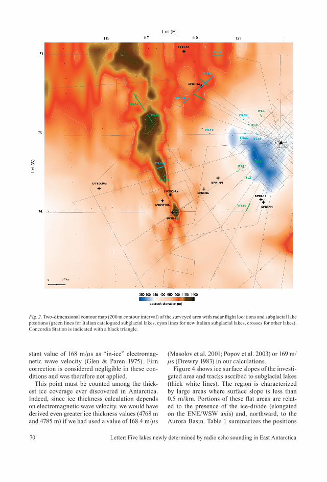
During the 1999 survey an ice thickness of about 4750 m (± 16 m, Forieri et. al 2003) was measured. This value is close to the maximum ice thickness (4776 m) hitherto measured in Ant-arctica, over the Astrolabe Basin (Drewry 1983).
We came back over this profi le in 2001 and 2003 surveys to confi rm the measurement. The radar-grams and the ice thickness sections of the three profi les are shown in Fig. 3. The maximum ice thickness of 4755 m was calculated using a con-
Five subglacial lakes and one of Antarctica’s thickest ice covers newly determined by radio echo sounding over the Vostok–Dome C region
Lili Cafarella, Stefano Urbini, Cesidio Bianchi, Achille Zirizzotti, Ignazio E. Tabacco & Alessandro Forieri
Radio echo sounding (RES) measurements were collected from 1995 to 2003 during Italian Antarctic expeditions over the Vostok–Dome C region. The data collected allow for the reconstruction of a bedrock ele-vation map between the Belgica Highlands and the Aurora Subglacial Basin (112.0° - 124.0° E; 74.0° - 78.0° S). Moreover, analysis of the RES data has revealed one of the thickest ice covers in Antarctica (4755 ± 16 m; 118.321° E, 76.059° S) as well as fi ve new subglacial lakes.
L. Cafarella, S. Urbini, C. Bianchi & A. Zirizzotti, Istituto Nazionale di Geofi sica e Vulcanologia, Via di Vigna Murata 605, 00143 Rome, Italy, [email protected]; I. E. Tabacco & A. Forieri, Dip. Scienze della Terra, Sez. Geofi sica, Via Cicognara 7, 20129 Milan, Italy.
Letter
Fig. 1. The location of the surveyed area: the Vostok and Belg-ica Subglacial Highlands region, East Antarctica.
70 Letter: Five lakes newly determined by radio echo sounding in East Antarctica
stant value of 168 m/µs as “in-ice” electromag-netic wave velocity (Glen & Paren 1975). Firn correction is considered negligible in these con-ditions and was therefore not applied.
This point must be counted among the thick-est ice coverage ever discovered in Antarctica. Indeed, since ice thickness calculation depends on electromagnetic wave velocity. we would have derived even greater ice thickness values (4768 m and 4785 m) if we had used a value of 168.4 m/µs
(Masolov et al. 2001; Popov et al. 2003) or 169 m/µs (Drewry 1983) in our calculations.
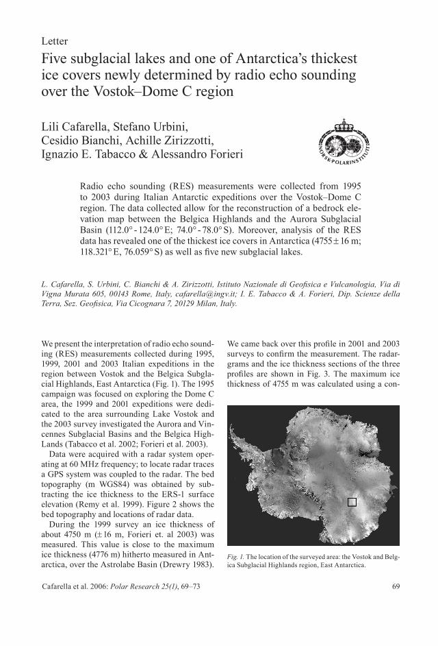
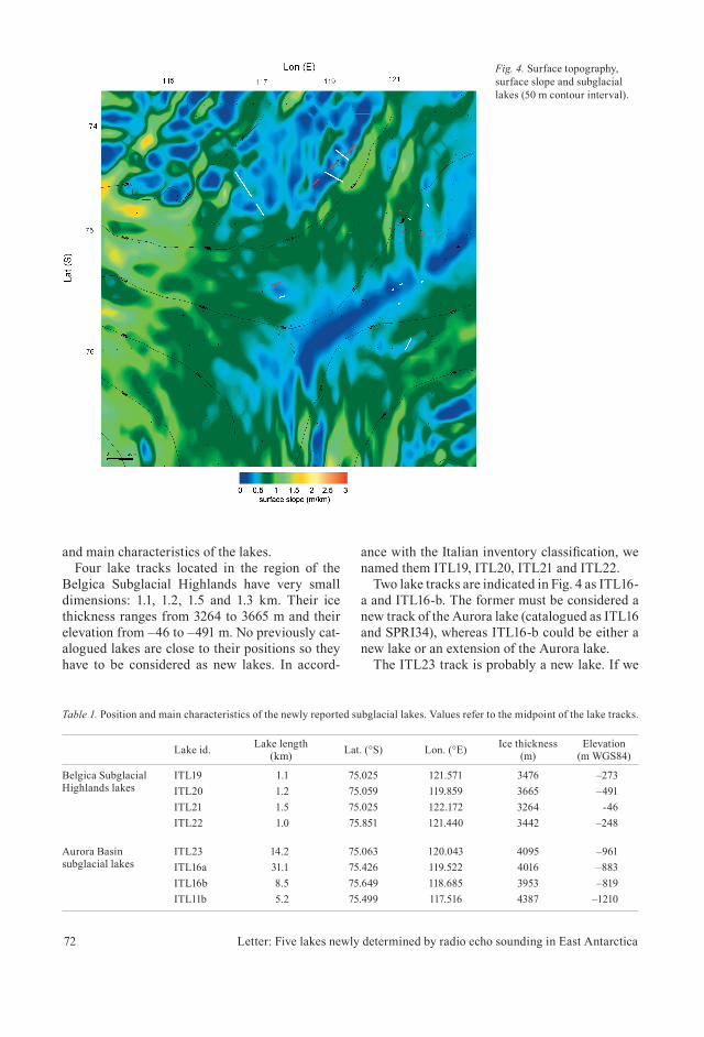
Figure 4 shows ice surface slopes of the investi-gated area and tracks ascribed to subglacial lakes (thick white lines). The region is characterized by large areas where surface slope is less than 0.5 m/km. Portions of these fl at areas are relat-ed to the presence of the ice-divide (elongated on the ENE/WSW axis) and, northward, to the Aurora Basin. Table 1 summarizes the positions
Fig. 2. Two-dimensional contour map (200 m contour interval) of the surveyed area with radar fl ight locations and subglacial lake positions (green lines for Italian catalogued subglacial lakes, cyan lines for new Italian subglacial lakes, crosses for other lakes). Concordia Station is indicated with a black triangle.
71Cafarella et al. 2006: Polar Research 25(1), 69–73
Fig. 3. (a) Thickest ice coverage profi les radargrams. (b) Ice thickness sections with surface elevation.
(a)
(b)
72 Letter: Five lakes newly determined by radio echo sounding in East Antarctica
and main characteristics of the lakes.Four lake tracks located in the region of the
Belgica Subglacial Highlands have very small dimensions: 1.1, 1.2, 1.5 and 1.3 km. Their ice thickness ranges from 3264 to 3665 m and their elevation from –46 to –491 m. No previously cat-alogued lakes are close to their positions so they have to be considered as new lakes. In accord-
ance with the Italian inventory classifi cation, we named them ITL19, ITL20, ITL21 and ITL22.
Two lake tracks are indicated in Fig. 4 as ITL16-a and ITL16-b. The former must be considered a new track of the Aurora lake (catalogued as ITL16 and SPRI34), whereas ITL16-b could be either a new lake or an extension of the Aurora lake.
The ITL23 track is probably a new lake. If we
Fig. 4. Surface topography, surface slope and subglacial lakes (50 m contour interval).
Table 1. Position and main characteristics of the newly reported subglacial lakes. Values refer to the midpoint of the lake tracks.
Lake id. Lake length (km) Lat. (°S) Lon. (°E) Ice thickness
(m)Elevation
(m WGS84)
Belgica Subglacial Highlands lakes
ITL19 1.1 75.025 121.571 3476 –273ITL20 1.2 75.059 119.859 3665 –491ITL21 1.5 75.025 122.172 3264 -46ITL22 1.0 75.851 121.440 3442 –248
Aurora Basin subglacial lakes
ITL23 14.2 75.063 120.043 4095 –961ITL16a 31.1 75.426 119.522 4016 –883ITL16b 8.5 75.649 118.685 3953 –819ITL11b 5.2 75.499 117.516 4387 –1210
73Cafarella et al. 2006: Polar Research 25(1), 69–73
consider that its ice thickness and elevation are similar to the Aurora lake and that it is located under the same surface slope anomaly, it could also be interpreted as an extension of Aurora. However, in the absence of further data to support for this hypothesis, we have provisionally ascribed this track to a new lake (ITL23). The radar track ITL11-a is an extension of lake ITL11.
To conclude, fi ve lakes have to be added to the revised inventory of Antarctic subglacial lakes (Siegert et al. 2005). This brings to 40 the total number of lakes known in this region.
ReferencesDrewry, D. J. 1983: Internal layering in the Antarctic Ice
Sheet, sheet 9 in Antarctica: glaciological and geophysical folio. Cambridge: Scott Polar Research Institute.
Forieri, A., Tabacco, I. E., Della Vedova, A., Zirizzotti, A., Bianchi, C., De Michelis, P. & Passerini, A. 2003: A new bedrock map of Dome Concordia area. Terr. Antarct. Rep. 8, 169–174.
Glen, J. W. & Paren, J. G. 1975: The electrical properties of snow ice. J. Glaciol. 15, 15–38.
Masolov, V. N., Lukin, V. V., Sheremetiev, A. N. & Popov, S. V. 2001: Geophysical investigations of the subglacial lake Vostok in eastern Antarctica. Doklady Earth Sci. 5, 734–738.
Popov, V. S., Sheremetiev, A. N., Masolov, V. N., Lukin, V. V., Mironov, A. V. & Luchininov, V. S. 2003: Velocity of radio-wave propagation in ice at Vostok station, Antarctica. J. Glaciol. 49, 179–183.
Remy F., Shaeffer, P. & Legresy, B. 1999: Ice fl ow physical processes derived from ERS-1 high resolution map of Ant-arctica and Greenland ice sheet. Geophys. J. Int. 139, 645–656.
Siegert, M., Carter S., Tabacco I., Popov S. & Blankenship, D. D. 2005: A revised inventory of Antarctic subglacial lakes. Antarct. Sci. 17, 453–460.
Tabacco, I. E., Bianchi, C., Chiappini, M., Zirizzotti, A., Zuc-cheretti, E., Forieri, A. & Della Vedova, A. 2002: Airborne radar survey above Vostok region, East–Central Antarcti-ca: ice thickness and Lake Vostok geometry. J. Glaciol. 48, 62–69.

Related Documents