First Magnitude Springs of Florida FLORIDA GEOLOGICAL SURVEY OPEN FILE REPORT NO. 85

Welcome message from author
This document is posted to help you gain knowledge. Please leave a comment to let me know what you think about it! Share it to your friends and learn new things together.
Transcript
First Magnitude Springsof Florida
FFLLOORRIIDDAA GGEEOOLLOOGGIICCAALL SSUURRVVEEYYOOPPEENN FFIILLEE RREEPPOORRTT NNOO.. 8855

Cover: Alexander Spring, Lake County (photo by Tom Scott).
STATE OF FLORIDADEPARTMENT OF ENVIRONMENTAL PROTECTION
David Struhs, Secretary
DIVISION OF RESOURCE ASSESSMENT AND MANAGEMENTEdwin J. Conklin, Director
FLORIDA GEOLOGICAL SURVEYWalter Schmidt, State Geologist and Chief
Open File Report No. 85
FIRST MAGNITUDE SPRINGS OF FLORIDA
By
Thomas M. Scott, Guy H. Means,Ryan C. Means, and Rebecca P. Meegan
Published for the
FLORIDA GEOLOGICAL SURVEYTallahassee, Florida
2002

ii
Printed for theFlorida Geological Survey
Tallahassee2002
ISSN 1058-1391
LETTER OF TRANSMITTAL
FLORIDA GEOLOGICAL SURVEY
Tallahassee, Florida2002
Governor Jeb BushTallahassee, Florida 32301
Dear Governor Bush:
The 2001 Florida Legislature funded the Florida Springs Initiative to investigate thefirst order magnitude springs in the State. In response to the initiative's mandate, theFlorida Geological Survey, Division of Resource Assessment and Management, Departmentof Environmental Protection, is publishing as its Open-file Report No. 85, First MagnitudeSprings of Florida, by Thomas M. Scott, Guy H. Means, Ryan C. Means, and Rebecca P.Meegan. The physical characteristics, water chemistry and bacteriology of Florida's firstorder magnitude springs are discussed and described in this report. The information here-in on Florida's largest springs, unique and treasured natural resources, provides data to beused by scientists, planners, environmental managers and the citizens of Florida.
Respectfully,
Walter Schmidt, Ph.D.State Geologist and ChiefFlorida Geological Survey
iii

iv
TABLE OF CONTENTS
PageIntroduction . . . . . . . . . . . . . . . . . . . . . . . . . . . . . . . . . . . . . . . . . . . . . . . . . . . . . . . . . .1Acknowledgements . . . . . . . . . . . . . . . . . . . . . . . . . . . . . . . . . . . . . . . . . . . . . . . . . . . . . . . .3Florida Spring's Task Force . . . . . . . . . . . . . . . . . . . . . . . . . . . . . . . . . . . . . . . . . . . . . . . . .3
Task Force Members and Advisors . . . . . . . . . . . . . . . . . . . . . . . . . . . . . . . . . . . . . . . .5Classification of Springs . . . . . . . . . . . . . . . . . . . . . . . . . . . . . . . . . . . . . . . . . . . . . . . . . . . .6Archaeological Significance of Springs . . . . . . . . . . . . . . . . . . . . . . . . . . . . . . . . . . . . . . . . .8Hydrogeology of Florida Springs . . . . . . . . . . . . . . . . . . . . . . . . . . . . . . . . . . . . . . . . . . . . .9Water Quality . . . . . . . . . . . . . . . . . . . . . . . . . . . . . . . . . . . . . . . . . . . . . . . . . . . . . . . . .13
Methodology . . . . . . . . . . . . . . . . . . . . . . . . . . . . . . . . . . . . . . . . . . . . . . . . . . . . . . . . .13Field Parameters . . . . . . . . . . . . . . . . . . . . . . . . . . . . . . . . . . . . . . . . . . . . . . . . . .13Water Samples . . . . . . . . . . . . . . . . . . . . . . . . . . . . . . . . . . . . . . . . . . . . . . . . . . .14Additional Data . . . . . . . . . . . . . . . . . . . . . . . . . . . . . . . . . . . . . . . . . . . . . . . . . . .14Discharge Measurements . . . . . . . . . . . . . . . . . . . . . . . . . . . . . . . . . . . . . . . . . . .14
Characteristics of Spring Water . . . . . . . . . . . . . . . . . . . . . . . . . . . . . . . . . . . . . . . . .16Descriptions of Analytes . . . . . . . . . . . . . . . . . . . . . . . . . . . . . . . . . . . . . . . . . . . . . . .16Physical Field Parameters . . . . . . . . . . . . . . . . . . . . . . . . . . . . . . . . . . . . . . . . . . . . . .17
Dissolved Oxygen . . . . . . . . . . . . . . . . . . . . . . . . . . . . . . . . . . . . . . . . . . . . . . . . .17pH . . . . . . . . . . . . . . . . . . . . . . . . . . . . . . . . . . . . . . . . . . . . . . . . . . . . . . . . .17Specific Conductance . . . . . . . . . . . . . . . . . . . . . . . . . . . . . . . . . . . . . . . . . . . . . . .17Water Temperature . . . . . . . . . . . . . . . . . . . . . . . . . . . . . . . . . . . . . . . . . . . . . . . .18Discharge . . . . . . . . . . . . . . . . . . . . . . . . . . . . . . . . . . . . . . . . . . . . . . . . . . . . . . .18Other Field Data . . . . . . . . . . . . . . . . . . . . . . . . . . . . . . . . . . . . . . . . . . . . . . . . . .18
Laboratory Analytes . . . . . . . . . . . . . . . . . . . . . . . . . . . . . . . . . . . . . . . . . . . . . . . . . .18Alkalinity . . . . . . . . . . . . . . . . . . . . . . . . . . . . . . . . . . . . . . . . . . . . . . . . . . . . . . .18Biochemical Oxygen Demand . . . . . . . . . . . . . . . . . . . . . . . . . . . . . . . . . . . . . . . .18Chloride . . . . . . . . . . . . . . . . . . . . . . . . . . . . . . . . . . . . . . . . . . . . . . . . . . . . . . . . .18Color . . . . . . . . . . . . . . . . . . . . . . . . . . . . . . . . . . . . . . . . . . . . . . . . . . . . . . . . .18Hardness . . . . . . . . . . . . . . . . . . . . . . . . . . . . . . . . . . . . . . . . . . . . . . . . . . . . . . . .18Nitrate + Nitrite . . . . . . . . . . . . . . . . . . . . . . . . . . . . . . . . . . . . . . . . . . . . . . . . . .19Organic Carbon . . . . . . . . . . . . . . . . . . . . . . . . . . . . . . . . . . . . . . . . . . . . . . . . . . .19Orthophosphate . . . . . . . . . . . . . . . . . . . . . . . . . . . . . . . . . . . . . . . . . . . . . . . . . . .19Potassium . . . . . . . . . . . . . . . . . . . . . . . . . . . . . . . . . . . . . . . . . . . . . . . . . . . . . . .19Sodium . . . . . . . . . . . . . . . . . . . . . . . . . . . . . . . . . . . . . . . . . . . . . . . . . . . . . . . . .19Sulfate . . . . . . . . . . . . . . . . . . . . . . . . . . . . . . . . . . . . . . . . . . . . . . . . . . . . . . . . .19Total Ammonia . . . . . . . . . . . . . . . . . . . . . . . . . . . . . . . . . . . . . . . . . . . . . . . . . . .20Total Dissolved Solids . . . . . . . . . . . . . . . . . . . . . . . . . . . . . . . . . . . . . . . . . . . . . .20Total Kjeldahl Nitrogen . . . . . . . . . . . . . . . . . . . . . . . . . . . . . . . . . . . . . . . . . . . .20Total Nitrogen . . . . . . . . . . . . . . . . . . . . . . . . . . . . . . . . . . . . . . . . . . . . . . . . . . . .20Total Suspended Solids . . . . . . . . . . . . . . . . . . . . . . . . . . . . . . . . . . . . . . . . . . . . .20Turbidity . . . . . . . . . . . . . . . . . . . . . . . . . . . . . . . . . . . . . . . . . . . . . . . . . . . . . . . .20Trace Metals . . . . . . . . . . . . . . . . . . . . . . . . . . . . . . . . . . . . . . . . . . . . . . . . . . . . .20Biological Analytes . . . . . . . . . . . . . . . . . . . . . . . . . . . . . . . . . . . . . . . . . . . . . . . .21
Descriptions of Individual Springs and Results of Analyses . . . . . . . . . . . . . . . . . . . . . . .23Alachua County . . . . . . . . . . . . . . . . . . . . . . . . . . . . . . . . . . . . . . . . . . . . . . . . . . . . . .23
Hornsby Spring . . . . . . . . . . . . . . . . . . . . . . . . . . . . . . . . . . . . . . . . . . . . . . . . . . .23
v
Bay County . . . . . . . . . . . . . . . . . . . . . . . . . . . . . . . . . . . . . . . . . . . . . . . . . . . . . . . . .26Gainer Springs Group . . . . . . . . . . . . . . . . . . . . . . . . . . . . . . . . . . . . . . . . . . . . . .26
Gainer Spring No. 1C . . . . . . . . . . . . . . . . . . . . . . . . . . . . . . . . . . . . . . . . . . .27Gainer Spring No. 2 . . . . . . . . . . . . . . . . . . . . . . . . . . . . . . . . . . . . . . . . . . . .27Gainer Spring No. 3 . . . . . . . . . . . . . . . . . . . . . . . . . . . . . . . . . . . . . . . . . . . .27
Citrus County . . . . . . . . . . . . . . . . . . . . . . . . . . . . . . . . . . . . . . . . . . . . . . . . . . . . . . .31Chassahowitzka Springs Group . . . . . . . . . . . . . . . . . . . . . . . . . . . . . . . . . . . . . .31
Chassahowitzka Main Spring . . . . . . . . . . . . . . . . . . . . . . . . . . . . . . . . . . . . .32Chassahowitzka No. 1 . . . . . . . . . . . . . . . . . . . . . . . . . . . . . . . . . . . . . . . . . .32
Homosassa Springs Group . . . . . . . . . . . . . . . . . . . . . . . . . . . . . . . . . . . . . . . . . .35Homosassa Springs Nos. 1, 2 and 3 . . . . . . . . . . . . . . . . . . . . . . . . . . . . . . . .35
Kings Bay Springs Group . . . . . . . . . . . . . . . . . . . . . . . . . . . . . . . . . . . . . . . . . . .39Hunter Spring . . . . . . . . . . . . . . . . . . . . . . . . . . . . . . . . . . . . . . . . . . . . . . . .40Tarpon Hole Spring . . . . . . . . . . . . . . . . . . . . . . . . . . . . . . . . . . . . . . . . . . . .40
Columbia County . . . . . . . . . . . . . . . . . . . . . . . . . . . . . . . . . . . . . . . . . . . . . . . . . . . . .43Columbia Spring . . . . . . . . . . . . . . . . . . . . . . . . . . . . . . . . . . . . . . . . . . . . . . . . . .43Ichetucknee Springs Group . . . . . . . . . . . . . . . . . . . . . . . . . . . . . . . . . . . . . . . . . .46
Ichetucknee Head Spring . . . . . . . . . . . . . . . . . . . . . . . . . . . . . . . . . . . . . . . .47Blue Hole . . . . . . . . . . . . . . . . . . . . . . . . . . . . . . . . . . . . . . . . . . . . . . . . . . . .47Cedar Head Spring . . . . . . . . . . . . . . . . . . . . . . . . . . . . . . . . . . . . . . . . . . . . .47Mission Springs . . . . . . . . . . . . . . . . . . . . . . . . . . . . . . . . . . . . . . . . . . . . . . .50
Santa Fe River Rise . . . . . . . . . . . . . . . . . . . . . . . . . . . . . . . . . . . . . . . . . . . . . . .51Treehouse Spring . . . . . . . . . . . . . . . . . . . . . . . . . . . . . . . . . . . . . . . . . . . . . . . . .54
Gilchrist County . . . . . . . . . . . . . . . . . . . . . . . . . . . . . . . . . . . . . . . . . . . . . . . . . . . . . .57Devil's Ear Spring . . . . . . . . . . . . . . . . . . . . . . . . . . . . . . . . . . . . . . . . . . . . . . . . .57Siphon Creek Rise . . . . . . . . . . . . . . . . . . . . . . . . . . . . . . . . . . . . . . . . . . . . . . . . .60
Hamilton County . . . . . . . . . . . . . . . . . . . . . . . . . . . . . . . . . . . . . . . . . . . . . . . . . . . . .63Alapaha River Rise . . . . . . . . . . . . . . . . . . . . . . . . . . . . . . . . . . . . . . . . . . . . . . . .63Holton Creek Rise . . . . . . . . . . . . . . . . . . . . . . . . . . . . . . . . . . . . . . . . . . . . . . . . .66
Hernando County . . . . . . . . . . . . . . . . . . . . . . . . . . . . . . . . . . . . . . . . . . . . . . . . . . . . .69Weeki Wachee Spring . . . . . . . . . . . . . . . . . . . . . . . . . . . . . . . . . . . . . . . . . . . . . .69
Jackson County . . . . . . . . . . . . . . . . . . . . . . . . . . . . . . . . . . . . . . . . . . . . . . . . . . . . . .72Jackson Blue Spring . . . . . . . . . . . . . . . . . . . . . . . . . . . . . . . . . . . . . . . . . . . . . . .72
Jefferson County . . . . . . . . . . . . . . . . . . . . . . . . . . . . . . . . . . . . . . . . . . . . . . . . . . . . .75Wacissa Springs Group . . . . . . . . . . . . . . . . . . . . . . . . . . . . . . . . . . . . . . . . . . . . .75
Spring No. 2 . . . . . . . . . . . . . . . . . . . . . . . . . . . . . . . . . . . . . . . . . . . . . . . . . .75Big Spring (Big Blue Spring) . . . . . . . . . . . . . . . . . . . . . . . . . . . . . . . . . . . . .78
Lafayette County . . . . . . . . . . . . . . . . . . . . . . . . . . . . . . . . . . . . . . . . . . . . . . . . . . . . .79Lafayette Blue Spring . . . . . . . . . . . . . . . . . . . . . . . . . . . . . . . . . . . . . . . . . . . . . .79Troy Spring . . . . . . . . . . . . . . . . . . . . . . . . . . . . . . . . . . . . . . . . . . . . . . . . . . . . . .82
Lake County . . . . . . . . . . . . . . . . . . . . . . . . . . . . . . . . . . . . . . . . . . . . . . . . . . . . . . . . .85Alexander Spring . . . . . . . . . . . . . . . . . . . . . . . . . . . . . . . . . . . . . . . . . . . . . . . . .85
Leon County . . . . . . . . . . . . . . . . . . . . . . . . . . . . . . . . . . . . . . . . . . . . . . . . . . . . . . . . .88St. Marks River Rise . . . . . . . . . . . . . . . . . . . . . . . . . . . . . . . . . . . . . . . . . . . . . . .88
Levy County . . . . . . . . . . . . . . . . . . . . . . . . . . . . . . . . . . . . . . . . . . . . . . . . . . . . . . . . .91Fanning Springs . . . . . . . . . . . . . . . . . . . . . . . . . . . . . . . . . . . . . . . . . . . . . . . . . .91Manatee Springs . . . . . . . . . . . . . . . . . . . . . . . . . . . . . . . . . . . . . . . . . . . . . . . . . .94
Madison County . . . . . . . . . . . . . . . . . . . . . . . . . . . . . . . . . . . . . . . . . . . . . . . . . . . . . .97Madison Blue Spring . . . . . . . . . . . . . . . . . . . . . . . . . . . . . . . . . . . . . . . . . . . . . . .97
vi
Marion County . . . . . . . . . . . . . . . . . . . . . . . . . . . . . . . . . . . . . . . . . . . . . . . . . . . . . .100Rainbow Springs Group . . . . . . . . . . . . . . . . . . . . . . . . . . . . . . . . . . . . . . . . . . .100
Rainbow No. 1 . . . . . . . . . . . . . . . . . . . . . . . . . . . . . . . . . . . . . . . . . . . . . . .100Rainbow No. 4 . . . . . . . . . . . . . . . . . . . . . . . . . . . . . . . . . . . . . . . . . . . . . . .101Rainbow No. 6 . . . . . . . . . . . . . . . . . . . . . . . . . . . . . . . . . . . . . . . . . . . . . . .101Bubbling Spring . . . . . . . . . . . . . . . . . . . . . . . . . . . . . . . . . . . . . . . . . . . . . .101
Silver Glen Springs . . . . . . . . . . . . . . . . . . . . . . . . . . . . . . . . . . . . . . . . . . . . . . .105Silver Springs Group . . . . . . . . . . . . . . . . . . . . . . . . . . . . . . . . . . . . . . . . . . . . . .108
Main Spring . . . . . . . . . . . . . . . . . . . . . . . . . . . . . . . . . . . . . . . . . . . . . . . . .108Reception Hall . . . . . . . . . . . . . . . . . . . . . . . . . . . . . . . . . . . . . . . . . . . . . . .111Blue Grotto . . . . . . . . . . . . . . . . . . . . . . . . . . . . . . . . . . . . . . . . . . . . . . . . . .111
Suwannee County . . . . . . . . . . . . . . . . . . . . . . . . . . . . . . . . . . . . . . . . . . . . . . . . . . .112Falmouth Spring . . . . . . . . . . . . . . . . . . . . . . . . . . . . . . . . . . . . . . . . . . . . . . . . .112
Taylor County . . . . . . . . . . . . . . . . . . . . . . . . . . . . . . . . . . . . . . . . . . . . . . . . . . . . . .115Nutall Rise . . . . . . . . . . . . . . . . . . . . . . . . . . . . . . . . . . . . . . . . . . . . . . . . . . . . .115Steinhatchee River Rise . . . . . . . . . . . . . . . . . . . . . . . . . . . . . . . . . . . . . . . . . . .118
Union County . . . . . . . . . . . . . . . . . . . . . . . . . . . . . . . . . . . . . . . . . . . . . . . . . . . . . . .121Santa Fe Spring . . . . . . . . . . . . . . . . . . . . . . . . . . . . . . . . . . . . . . . . . . . . . . . . .121
Volusia County . . . . . . . . . . . . . . . . . . . . . . . . . . . . . . . . . . . . . . . . . . . . . . . . . . . . . .124Volusia Blue Spring . . . . . . . . . . . . . . . . . . . . . . . . . . . . . . . . . . . . . . . . . . . . . .124
Wakulla County . . . . . . . . . . . . . . . . . . . . . . . . . . . . . . . . . . . . . . . . . . . . . . . . . . . . .128Spring Creek Springs Group . . . . . . . . . . . . . . . . . . . . . . . . . . . . . . . . . . . . . . . .128
Spring Creek No. 1 . . . . . . . . . . . . . . . . . . . . . . . . . . . . . . . . . . . . . . . . . . . .128Spring Creek No. 2 . . . . . . . . . . . . . . . . . . . . . . . . . . . . . . . . . . . . . . . . . . . .131
Wakulla Spring . . . . . . . . . . . . . . . . . . . . . . . . . . . . . . . . . . . . . . . . . . . . . . . . . .132Springs Information Resources on the Web . . . . . . . . . . . . . . . . . . . . . . . . . . . . . . . . . . .135References . . . . . . . . . . . . . . . . . . . . . . . . . . . . . . . . . . . . . . . . . . . . . . . . . . . . . . . . . . . . .135Glossary . . . . . . . . . . . . . . . . . . . . . . . . . . . . . . . . . . . . . . . . . . . . . . . . . . . . . . . . . . . . . .138
Figures
1. Old photograph of the bath house at White Springs, Hamilton County, 1920s . . . . . .22. Springs Task Force members at Madison Blue Spring . . . . . . . . . . . . . . . . . . . . . . . . .43. Location of first order magnitude springs. . . . . . . . . . . . . . . . . . . . . . . . . . . . . . . . . . .74. Native American artifacts . . . . . . . . . . . . . . . . . . . . . . . . . . . . . . . . . . . . . . . . . . . . . . .95. Generalized geologic map of Florida . . . . . . . . . . . . . . . . . . . . . . . . . . . . . . . . . . . . . .116. Karst areas related to first magnitude springs . . . . . . . . . . . . . . . . . . . . . . . . . . . . . .127. An FGS Spring Sampling Team, 2001 . . . . . . . . . . . . . . . . . . . . . . . . . . . . . . . . . . . . .178. Jackson Blue Springs aerial photo . . . . . . . . . . . . . . . . . . . . . . . . . . . . . . . . . . . . . . . .229. Hornsby Spring . . . . . . . . . . . . . . . . . . . . . . . . . . . . . . . . . . . . . . . . . . . . . . . . . . . . . .2310. Hornsby Spring location map . . . . . . . . . . . . . . . . . . . . . . . . . . . . . . . . . . . . . . . . . . .2411. Gainer Springs Group Vent 1C . . . . . . . . . . . . . . . . . . . . . . . . . . . . . . . . . . . . . . . . . .2612. Gainer Springs Group Vent 2 . . . . . . . . . . . . . . . . . . . . . . . . . . . . . . . . . . . . . . . . . . .2613. Gainer Springs Group location map . . . . . . . . . . . . . . . . . . . . . . . . . . . . . . . . . . . . . .2814. Chassahowitzka Main Spring . . . . . . . . . . . . . . . . . . . . . . . . . . . . . . . . . . . . . . . . . . .3115. Chassahowitzka No. 1 . . . . . . . . . . . . . . . . . . . . . . . . . . . . . . . . . . . . . . . . . . . . . . . . .3116. Chassahowitzka Springs Group location map . . . . . . . . . . . . . . . . . . . . . . . . . . . . . . .3317. Homosassa Springs Group . . . . . . . . . . . . . . . . . . . . . . . . . . . . . . . . . . . . . . . . . . . . . .35
vii
18. Homosassa Springs Group location map . . . . . . . . . . . . . . . . . . . . . . . . . . . . . . . . . . .3619. Kings Bay Springs Group, Hunter Spring . . . . . . . . . . . . . . . . . . . . . . . . . . . . . . . . .3920. Kings Bay Springs Group, Tarpon Hole Spring . . . . . . . . . . . . . . . . . . . . . . . . . . . . . .3921. Kings Bay Springs Group location map . . . . . . . . . . . . . . . . . . . . . . . . . . . . . . . . . . . .4122. Columbia Spring . . . . . . . . . . . . . . . . . . . . . . . . . . . . . . . . . . . . . . . . . . . . . . . . . . . . .4323 Columbia Spring location map . . . . . . . . . . . . . . . . . . . . . . . . . . . . . . . . . . . . . . . . . . .4424. Ichetucknee Springs Group, Ichetucknee Head Spring . . . . . . . . . . . . . . . . . . . . . . . .4625. Ichetucknee Springs Group, Blue Hole Spring . . . . . . . . . . . . . . . . . . . . . . . . . . . . . .4626. Ichetucknee Springs Group location map . . . . . . . . . . . . . . . . . . . . . . . . . . . . . . . . . .4827. Santa Fe River Rise . . . . . . . . . . . . . . . . . . . . . . . . . . . . . . . . . . . . . . . . . . . . . . . . . . .5128. Santa Fe River Rise location map . . . . . . . . . . . . . . . . . . . . . . . . . . . . . . . . . . . . . . . .5229. Treehouse Spring . . . . . . . . . . . . . . . . . . . . . . . . . . . . . . . . . . . . . . . . . . . . . . . . . . . . .5430. Treehouse Spring location map . . . . . . . . . . . . . . . . . . . . . . . . . . . . . . . . . . . . . . . . . .5531. Devil's Ear Spring . . . . . . . . . . . . . . . . . . . . . . . . . . . . . . . . . . . . . . . . . . . . . . . . . . . .5732. Devil’s Ear Spring location map . . . . . . . . . . . . . . . . . . . . . . . . . . . . . . . . . . . . . . . . .5833. Siphon Creek Rise . . . . . . . . . . . . . . . . . . . . . . . . . . . . . . . . . . . . . . . . . . . . . . . . . . . .6034. Siphon Creek Rise location map . . . . . . . . . . . . . . . . . . . . . . . . . . . . . . . . . . . . . . . . .6135. Alapaha River Rise . . . . . . . . . . . . . . . . . . . . . . . . . . . . . . . . . . . . . . . . . . . . . . . . . . .6336. Alapaha River Rise location map . . . . . . . . . . . . . . . . . . . . . . . . . . . . . . . . . . . . . . . . .6437. Holton Creek Rise . . . . . . . . . . . . . . . . . . . . . . . . . . . . . . . . . . . . . . . . . . . . . . . . . . . .6638. Holton Creek Rise location map . . . . . . . . . . . . . . . . . . . . . . . . . . . . . . . . . . . . . . . . .6739. Weeki Wachee Spring . . . . . . . . . . . . . . . . . . . . . . . . . . . . . . . . . . . . . . . . . . . . . . . . .6940. Weeki Wachee Spring location map . . . . . . . . . . . . . . . . . . . . . . . . . . . . . . . . . . . . . . .7041. Jackson Blue Spring . . . . . . . . . . . . . . . . . . . . . . . . . . . . . . . . . . . . . . . . . . . . . . . . . .7242. Jackson Blue Spring location map . . . . . . . . . . . . . . . . . . . . . . . . . . . . . . . . . . . . . . . .7343. Wacissa Springs Group, Big Blue Spring . . . . . . . . . . . . . . . . . . . . . . . . . . . . . . . . . .7544. Wacissa Springs Group location map . . . . . . . . . . . . . . . . . . . . . . . . . . . . . . . . . . . . .7645. Lafayette Blue Spring . . . . . . . . . . . . . . . . . . . . . . . . . . . . . . . . . . . . . . . . . . . . . . . . .7946. Lafayette Blue Spring location map . . . . . . . . . . . . . . . . . . . . . . . . . . . . . . . . . . . . . .8047. Troy Spring . . . . . . . . . . . . . . . . . . . . . . . . . . . . . . . . . . . . . . . . . . . . . . . . . . . . . . . . .8248. Troy Spring location map . . . . . . . . . . . . . . . . . . . . . . . . . . . . . . . . . . . . . . . . . . . . . . .8349. Alexander Spring . . . . . . . . . . . . . . . . . . . . . . . . . . . . . . . . . . . . . . . . . . . . . . . . . . . . .8550. Alexander Spring location map . . . . . . . . . . . . . . . . . . . . . . . . . . . . . . . . . . . . . . . . . .8651. St. Marks River Rise . . . . . . . . . . . . . . . . . . . . . . . . . . . . . . . . . . . . . . . . . . . . . . . . . .8852. St. Marks River Rise location map . . . . . . . . . . . . . . . . . . . . . . . . . . . . . . . . . . . . . . .8953. Fanning Spring . . . . . . . . . . . . . . . . . . . . . . . . . . . . . . . . . . . . . . . . . . . . . . . . . . . . . .9154. Fanning Spring location map . . . . . . . . . . . . . . . . . . . . . . . . . . . . . . . . . . . . . . . . . . . .9255. Manatee Springs main spring . . . . . . . . . . . . . . . . . . . . . . . . . . . . . . . . . . . . . . . . . . .9456. Manatee Springs location map . . . . . . . . . . . . . . . . . . . . . . . . . . . . . . . . . . . . . . . . . .9557. Madison Blue Spring . . . . . . . . . . . . . . . . . . . . . . . . . . . . . . . . . . . . . . . . . . . . . . . . . .9758. Madison Blue Spring location map . . . . . . . . . . . . . . . . . . . . . . . . . . . . . . . . . . . . . . .9859. Rainbow Springs Group . . . . . . . . . . . . . . . . . . . . . . . . . . . . . . . . . . . . . . . . . . . . . . .10060. Rainbow Springs Group location map . . . . . . . . . . . . . . . . . . . . . . . . . . . . . . . . . . . .10261. Silver Glen Springs . . . . . . . . . . . . . . . . . . . . . . . . . . . . . . . . . . . . . . . . . . . . . . . . . .10562. Silver Glen Springs location map . . . . . . . . . . . . . . . . . . . . . . . . . . . . . . . . . . . . . . .10663. Silver Springs Group . . . . . . . . . . . . . . . . . . . . . . . . . . . . . . . . . . . . . . . . . . . . . . . . .108
viii
64. Silver Springs Group location map . . . . . . . . . . . . . . . . . . . . . . . . . . . . . . . . . . . . . .10965. Falmouth Spring location map . . . . . . . . . . . . . . . . . . . . . . . . . . . . . . . . . . . . . . . . .11366. Nutall Rise . . . . . . . . . . . . . . . . . . . . . . . . . . . . . . . . . . . . . . . . . . . . . . . . . . . . . . . . .11567. Nutall Rise location map . . . . . . . . . . . . . . . . . . . . . . . . . . . . . . . . . . . . . . . . . . . . . .11668. Steinhatchee River Rise . . . . . . . . . . . . . . . . . . . . . . . . . . . . . . . . . . . . . . . . . . . . . . .11869. Steinhatchee River Rise location map . . . . . . . . . . . . . . . . . . . . . . . . . . . . . . . . . . . .11970. Santa Fe Spring . . . . . . . . . . . . . . . . . . . . . . . . . . . . . . . . . . . . . . . . . . . . . . . . . . . . .12171. Santa Fe Spring location map . . . . . . . . . . . . . . . . . . . . . . . . . . . . . . . . . . . . . . . . . .12272. Volusia Blue Spring - A - Old Photo around 1900; B - 1970s photo . . . . . . . . . . . .12473. Volusia Blue Spring location map . . . . . . . . . . . . . . . . . . . . . . . . . . . . . . . . . . . . . . .12674. Spring Creek Springs Group . . . . . . . . . . . . . . . . . . . . . . . . . . . . . . . . . . . . . . . . . . .12875. Spring Creek Springs Group location map . . . . . . . . . . . . . . . . . . . . . . . . . . . . . . . .12976. Wakulla Spring . . . . . . . . . . . . . . . . . . . . . . . . . . . . . . . . . . . . . . . . . . . . . . . . . . . . .13277. Wakulla Spring location map . . . . . . . . . . . . . . . . . . . . . . . . . . . . . . . . . . . . . . . . . . .133
Tables
1. Sampling order . . . . . . . . . . . . . . . . . . . . . . . . . . . . . . . . . . . . . . . . . . . . . . . . . . . . . .142. Units of measurement for each analyte . . . . . . . . . . . . . . . . . . . . . . . . . . . . . . . . . . . .163. Hornsby Spring water quality analysis . . . . . . . . . . . . . . . . . . . . . . . . . . . . . . . . . . . .254. Hornsby Spring bacteriological analysis . . . . . . . . . . . . . . . . . . . . . . . . . . . . . . . . . . .255. Gainer Springs Group water quality analyses . . . . . . . . . . . . . . . . . . . . . . . . . . . . . . .296. Gainer Springs Group bacteriological analyses . . . . . . . . . . . . . . . . . . . . . . . . . . . . . .307. Chassahowitzka Springs Group bacteriological analyses . . . . . . . . . . . . . . . . . . . . . .328. Chassahowitzka Springs Group water quality analyses . . . . . . . . . . . . . . . . . . . . . . .349. Homosassa Springs Group water quality analyses . . . . . . . . . . . . . . . . . . . . . . . . . . .3710. Homosassa Springs Group bacteriological analyses . . . . . . . . . . . . . . . . . . . . . . . . . .3811. Kings Bay Springs Group water quality analyses . . . . . . . . . . . . . . . . . . . . . . . . . . . .4212. Kings Bay Springs Group bacteriological analyses . . . . . . . . . . . . . . . . . . . . . . . . . . .4213. Columbia Spring water quality analysis . . . . . . . . . . . . . . . . . . . . . . . . . . . . . . . . . . .4514. Columbia Spring bacteriological analysis . . . . . . . . . . . . . . . . . . . . . . . . . . . . . . . . . .4515. Ichetucknee Springs Group water quality analyses . . . . . . . . . . . . . . . . . . . . . . . . . .4916. Ichetucknee Springs Group bacteriological analyses . . . . . . . . . . . . . . . . . . . . . . . . . .5017. Santa Fe River Rise water quality analysis . . . . . . . . . . . . . . . . . . . . . . . . . . . . . . . .5318. Santa Fe River Rise bacteriological analysis . . . . . . . . . . . . . . . . . . . . . . . . . . . . . . . .5319. Treehouse Spring water quality analysis . . . . . . . . . . . . . . . . . . . . . . . . . . . . . . . . . .5620. Treehouse Spring bacteriological analysis . . . . . . . . . . . . . . . . . . . . . . . . . . . . . . . . . .5621. Devil's Ear Spring water quality analysis . . . . . . . . . . . . . . . . . . . . . . . . . . . . . . . . . .5922. Devil's Ear Spring bacteriological analysis . . . . . . . . . . . . . . . . . . . . . . . . . . . . . . . . .5923. Siphon Creek Rise water quality analysis . . . . . . . . . . . . . . . . . . . . . . . . . . . . . . . . . .6224. Siphon Creek Rise bacteriological analysis . . . . . . . . . . . . . . . . . . . . . . . . . . . . . . . . .6225. Alapaha River Rise water quality analysis . . . . . . . . . . . . . . . . . . . . . . . . . . . . . . . . .6526. Alapaha River Rise bacteriological analysis . . . . . . . . . . . . . . . . . . . . . . . . . . . . . . . .6527. Holton Creek Rise water quality analysis . . . . . . . . . . . . . . . . . . . . . . . . . . . . . . . . . .6828. Holton Creek Rise bacteriological analysis . . . . . . . . . . . . . . . . . . . . . . . . . . . . . . . . .6829. Weeki Wachee Spring water quality analysis . . . . . . . . . . . . . . . . . . . . . . . . . . . . . . .71
ix
30. Weeki Wachee Spring bacteriological analysis . . . . . . . . . . . . . . . . . . . . . . . . . . . . . .7131. Jackson Blue Spring water quality analysis . . . . . . . . . . . . . . . . . . . . . . . . . . . . . . . .7432. Jackson Blue Spring bacteriological analysis . . . . . . . . . . . . . . . . . . . . . . . . . . . . . . .7433. Wacissa Springs Group water quality analyses . . . . . . . . . . . . . . . . . . . . . . . . . . . . . .7734. Wacissa Springs Group bacteriological analyses . . . . . . . . . . . . . . . . . . . . . . . . . . . . .7835. Lafayette Blue Spring water quality analysis . . . . . . . . . . . . . . . . . . . . . . . . . . . . . . .8136. Lafayette Blue Spring bacteriological analysis . . . . . . . . . . . . . . . . . . . . . . . . . . . . . .8137. Troy Spring water quality analysis . . . . . . . . . . . . . . . . . . . . . . . . . . . . . . . . . . . . . . .8438. Troy Spring bacteriological analysis . . . . . . . . . . . . . . . . . . . . . . . . . . . . . . . . . . . . . .8439. Alexander Spring water quality analysis . . . . . . . . . . . . . . . . . . . . . . . . . . . . . . . . . .8740. Alexander Spring bacteriological analysis . . . . . . . . . . . . . . . . . . . . . . . . . . . . . . . . . .8741. St. Marks River Rise water quality analysis . . . . . . . . . . . . . . . . . . . . . . . . . . . . . . . .9042. St. Marks River Rise bacteriological analysis . . . . . . . . . . . . . . . . . . . . . . . . . . . . . . .9043. Fanning Spring water quality analysis . . . . . . . . . . . . . . . . . . . . . . . . . . . . . . . . . . . .9344. Fanning Spring bacteriological analysis . . . . . . . . . . . . . . . . . . . . . . . . . . . . . . . . . . .9345. Manatee Springs water quality analysis . . . . . . . . . . . . . . . . . . . . . . . . . . . . . . . . . . .9646. Manatee Springs bacteriological analysis . . . . . . . . . . . . . . . . . . . . . . . . . . . . . . . . . .9647. Madison Blue Spring water quality analysis . . . . . . . . . . . . . . . . . . . . . . . . . . . . . . . .9948. Madison Blue Spring bacteriological analysis . . . . . . . . . . . . . . . . . . . . . . . . . . . . . . .9949. Rainbow Springs Group water quality analyses . . . . . . . . . . . . . . . . . . . . . . . . . . . .10350. Rainbow Springs Group bacteriological analyses . . . . . . . . . . . . . . . . . . . . . . . . . . .10451. Silver Glen Springs water quality analysis . . . . . . . . . . . . . . . . . . . . . . . . . . . . . . . .10752. Silver Glen Springs bacteriological analysis . . . . . . . . . . . . . . . . . . . . . . . . . . . . . . .10753. Silver Springs Group water quality analyses . . . . . . . . . . . . . . . . . . . . . . . . . . . . . .11054. Silver Springs Group bacteriological analyses . . . . . . . . . . . . . . . . . . . . . . . . . . . . . .11155. Falmouth Spring water quality analysis . . . . . . . . . . . . . . . . . . . . . . . . . . . . . . . . . .11456. Falmouth Spring bacteriological analysis . . . . . . . . . . . . . . . . . . . . . . . . . . . . . . . . .11457. Nutall Rise water quality analysis . . . . . . . . . . . . . . . . . . . . . . . . . . . . . . . . . . . . . .11758. Nutall Rise bacteriological analysis . . . . . . . . . . . . . . . . . . . . . . . . . . . . . . . . . . . . . .11759. Steinhatchee River Rise water quality analysis . . . . . . . . . . . . . . . . . . . . . . . . . . . .12060. Steinhatchee River Rise bacteriological analysis . . . . . . . . . . . . . . . . . . . . . . . . . . . .12061. Santa Fe Spring water quality analysis . . . . . . . . . . . . . . . . . . . . . . . . . . . . . . . . . .12362. Santa Fe Spring bacteriological analysis . . . . . . . . . . . . . . . . . . . . . . . . . . . . . . . . . .12363. Volusia Blue Spring water quality analysis . . . . . . . . . . . . . . . . . . . . . . . . . . . . . . . .12764. Volusia Blue Spring bacteriological analysis . . . . . . . . . . . . . . . . . . . . . . . . . . . . . . .12765. Spring Creek Springs Group water quality analyses . . . . . . . . . . . . . . . . . . . . . . . .13066. Spring Creek Springs Group bacteriological analyses . . . . . . . . . . . . . . . . . . . . . . . .13167. Wakulla Spring water quality analysis . . . . . . . . . . . . . . . . . . . . . . . . . . . . . . . . . . .13468. Wakulla Spring bacteriological analysis . . . . . . . . . . . . . . . . . . . . . . . . . . . . . . . . . .134
x
FIRST MAGNITUDE SPRINGS OF FLORIDAby
Thomas M. Scott, P.G. #99, Guy H. Means, Ryan C. Means, Rebecca P. Meegan
INTRODUCTION
The bank was dense with magnolia and loblolly bay, sweet gum and gray-barked ash. Hewent down to the spring in the cool darkness of their shadows. A sharp pleasure came overhim. This was a secret and a lovely place. - Marjory Kinnan Rawlings, The Yearling, 1938
Mysterious, magical, even "awesome" - springs elicit an emotional response from near-ly everyone who peers into the crystalline depths. The cool, clear, azure waters of Florida'ssprings have long been a focus of daily life during the humid, hot months of the year. ManyFloridians have a lifetime of memories surrounding our springs. Visit any spring during themuggy months and you will find people of all ages partaking of Nature's soothing remedy -spring water! Marjory Stoneman Douglas, the granddame of Florida environmentalists,stated that "Springs are bowls of liquid light." Al Burt (writer/author) observed that"Springs add a melody to the land."
Springs and spring runs have been a focal point of life, from prehistoric times to thepresent. Undoubtedly, the ancient issuing of cool, fresh water attracted animals now longabsent from Florida's landscape. Many a diver has recovered fossil remains from the state'sspring runs and wondered what the forest must have looked like when the animals roamedthe spring-run lowlands.
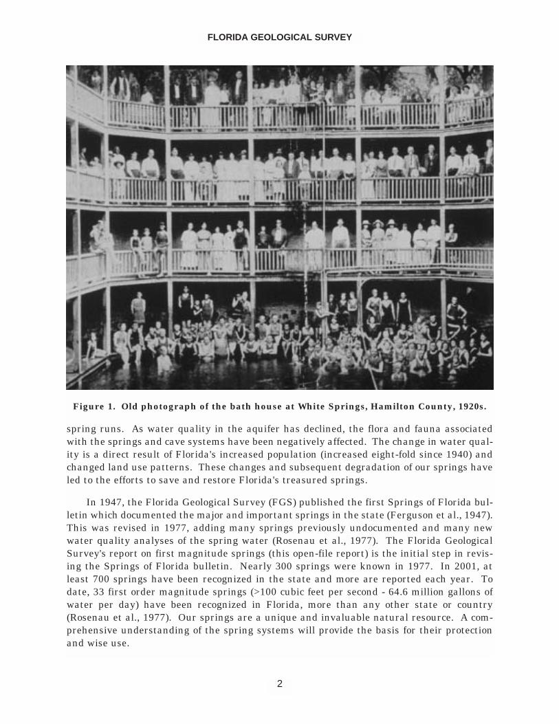
Human artifacts, found in widespread areas of the state, attest to the importance ofsprings to Florida's earliest inhabitants. The explorers of Florida, from Ponce de Leon toJohn and William Bartram and others, often mentioned the subterranean discharges offresh water that were scattered across central and northern Florida. As colonists and set-tlers began to inhabit Florida, springs continued to be the focus of human activity, becom-ing sites of missions, towns and steamboat landings. Spring runs provided power for grist-mills. Baptisms were held in the clear, cool waters and the springs often served as watersupplies for local residents. Today, even bottled water producers are interested in utilizingthese waters. Some springs have been valued for their purported therapeutic effects andpeople flocked to them to soak in the medicinal waters (Figure 1).
The recreational opportunities provided by the state's springs are numerous.Swimming, snorkeling, diving and canoeing are among the most common activities center-ing around Florida's springs. The springs and spring runs are magnets for wildlife and, sub-sequently, draw many individuals and groups to view these animals in their natural sur-roundings.
Spring water is a natural discharge from the Floridan aquifer system, the state's pri-mary aquifer, and the springs provide a "window" into the aquifer allowing for a measure ofthe health of the aquifer. Chemical and biological constituents that enter the aquiferthrough recharge processes may affect the water quality and flora and fauna of springs and
OPEN FILE REPORT NO. 85
1
spring runs. As water quality in the aquifer has declined, the flora and fauna associatedwith the springs and cave systems have been negatively affected. The change in water qual-ity is a direct result of Florida's increased population (increased eight-fold since 1940) andchanged land use patterns. These changes and subsequent degradation of our springs haveled to the efforts to save and restore Florida's treasured springs.
In 1947, the Florida Geological Survey (FGS) published the first Springs of Florida bul-letin which documented the major and important springs in the state (Ferguson et al., 1947).This was revised in 1977, adding many springs previously undocumented and many newwater quality analyses of the spring water (Rosenau et al., 1977). The Florida GeologicalSurvey's report on first magnitude springs (this open-file report) is the initial step in revis-ing the Springs of Florida bulletin. Nearly 300 springs were known in 1977. In 2001, atleast 700 springs have been recognized in the state and more are reported each year. Todate, 33 first order magnitude springs (>100 cubic feet per second - 64.6 million gallons ofwater per day) have been recognized in Florida, more than any other state or country(Rosenau et al., 1977). Our springs are a unique and invaluable natural resource. A com-prehensive understanding of the spring systems will provide the basis for their protectionand wise use.
FLORIDA GEOLOGICAL SURVEY
2
Figure 1. Old photograph of the bath house at White Springs, Hamilton County, 1920s.
ACKNOWLEDGEMENTS
The authors wish to acknowledge a number of individuals and thank them for theirassistance in creating this volume. Gary Maddox, Laura Morse, Gail Sloane, MargaretMurray, Tom Biernacki, Cindy Cosper, Andy Roach, Paul Hansard, and Jay Silvanima, fromDivision of Water Resource Management, Watershed Monitoring and Data ManagementSection guided the spring water analyses effort. Without their knowledge and experience,the sampling, analyses and data quality and delivery could not have been accomplishedwithin the requisite timeframe.
We would also like to acknowledge the efforts of numerous people from various WaterManagement Districts and State Parks who were so helpful in either collecting or helping tocollect data for this project. In particular, the authors wish to thank David Hornsby fromthe Suwannee River Water Management District for contributing his time and expertise.We also thank Tony Countryman and Nick Wooten from the Northwest Florida WaterManagement District; Eric DeHaven, David DeWitt, Joe Haber, and Chris Tomlinson fromthe Southwest Florida Water Management District; Richard Harris from Blue Springs StatePark, and Will Ebaugh from the U.S. Forest Service. There are many other anonymousindividuals whose efforts benefited this project.
Many thanks go to staff members of the Florida Geological Survey. Frank Rupertorganized the text, figures, tables and photographs into the digital publishable format. JohnMarquez, Alan Baker and Jim Cichon, with their cartographic expertise, created the manymaps utilized in this report. Walt Schmidt, Jon Arthur, Rodney DeHan, Rick Copeland andJackie Lloyd reviewed the text and data, supplying many suggestions and corrections.
Many Florida Department of Environmental Protection (FDEP) employees assistedwith this project. They are: Division of Water Resource Management, Bureau ofLaboratories - Sampling Training: Russel Frydenborg, Tom Frick; Bureau of Laboratories -Chemistry and Biology Analyses: Yuh-Hsu Pan, Kate Brackett, Maria Gonzalez, AmzadShaik, Harrison Walker, Chris Armour, Tom Ebrahimizadeh, Chris Morgan, Colin Wright,Matt Curran, Dave Avrett, Rick Kimsey, Latasha Fisher, Elena Koldacheva, Keith Tucker,Elliot Healy, Dawn Dolbee, Blanca Fach, Ping Hua, Anna Blalock, Patsy Vichaikul, AkbarCooper, Richard Johnson, Paula Peters, Gary Dearman, Virginia Leavell, Ceceile Wight,Travis Tola, Dale Simmons, Latasha Fisher, Rob Buda, Melva Campos, Karla Whiddon,Daisys Tamayo; Bureau of Watershed Management, Watershed Monitoring and DataManagement Section: Tracy Wade, Thomas Seal; Division of Waste Management: BillMartin, David Meyers. We appreciate the efforts of all these individuals.
Finally, the Florida Geological Survey Springs Team Members wish to thank JimStevenson, Florida Springs Task Force Chairman, for his tireless dedication to Florida'ssprings.
FLORIDA SPRINGS TASK FORCE
David Struhs, Secretary of the Florida Department of Environmental Protection, direct-ed the formation of a multi-agency Florida Springs Task Force to provide recommendedstrategies for the protection and restoration of Florida's springs. The Task Force, consistingof sixteen Floridians who represent one federal and three state agencies, four water man-
OPEN FILE REPORT NO. 85
3
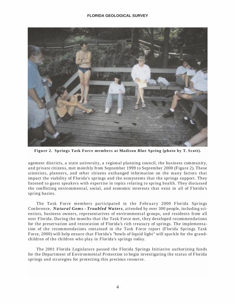
agement districts, a state university, a regional planning council, the business community,and private citizens, met monthly from September 1999 to September 2000 (Figure 2). Thesescientists, planners, and other citizens exchanged information on the many factors thatimpact the viability of Florida's springs and the ecosystems that the springs support. Theylistened to guest speakers with expertise in topics relating to spring health. They discussedthe conflicting environmental, social, and economic interests that exist in all of Florida'sspring basins.
The Task Force members participated in the February 2000 Florida SpringsConference, Natural Gems - Troubled Waters, attended by over 300 people, including sci-entists, business owners, representatives of environmental groups, and residents from allover Florida. During the months that the Task Force met, they developed recommendationsfor the preservation and restoration of Florida's rich treasury of springs. The implementa-tion of the recommendations contained in the Task Force report (Florida Springs TaskForce, 2000) will help ensure that Florida's "bowls of liquid light" will sparkle for the grand-children of the children who play in Florida's springs today.
The 2001 Florida Legislature passed the Florida Springs Initiative authorizing fundsfor the Department of Environmental Protection to begin investigating the status of Floridasprings and strategies for protecting this precious resource.
FLORIDA GEOLOGICAL SURVEY
4
Figure 2. Springs Task Force members at Madison Blue Spring (photo by T. Scott).
Task Force Members and Advisors
Task Force Chairman - Jim Stevenson, Division of State Lands, FDEP
Technical Writer and Editor - Frances M. Hartnett,Technical and Creative Writing Services
Task Force MembersDianne McCommons Beck, FDEPJeff Bielling, Florida Department of Community AffairsGreg Bitter, Withlacoochee Regional Planning CouncilHal Davis, U.S. Geological SurveyRussel Frydenborg, Division of Resource Assessment and Management, FDEPJon Martin, University of FloridaGregg Jones, Southwest Florida Water Management DistrictJack Leppert, CitizenGary Maddox, Division of Water Resource Management, FDEPPam McVety, Division of Recreation and Parks, FDEPDoug Munch, St. Johns River Water Management DistrictTom Pratt, Northwest Florida Water Management DistrictTom Scott, Florida Geological Survey, FDEPWes Skiles, Karst Environmental ServicesKirk Webster, Suwannee River Water Management District
Technical AdvisorsFlorida Department of Environmental Protection
Karl Kurka, Office of Water PolicyKathleen Toolan, Office of General CounselJoe Hand, Division of Water Resource ManagementJennifer Jackson, Division of Water Resource ManagementJim McNeal, Division of Water Resource Management
Florida Department of Community AffairsRichard Deadman
Florida Department of HealthTim Mayer
Florida Fish and Wildlife Conservation CommissionKent Smith
Karst Environmental ServicesTom Morris
St. Johns River Water Management DistrictDavid MiracleBill Osburn
Suwannee River Water Management DistrictDavid Hornsby
US Fish and Wildlife ServiceJim Valade
OPEN FILE REPORT NO. 85
5
CLASSIFICATION OF SPRINGS
There are two general types of springs in Florida, seeps (water table springs) and karstsprings (artesian springs). Rainwater, percolating downward through permeablesediments, may encounter a much less permeable or impermeable formation, forcing thewater to move laterally. Eventually the water may reach the surface in a lower lying areaand form a seep (for example the steephead seeps along the eastern side of the ApalachicolaRiver). Karst springs form when groundwater discharges to the surface through a karstopening. The vast majority of Florida's more than 700 springs and all of the first order mag-nitude springs are the karst spring type.
Springs are most often classified based upon the average discharge of water. The clas-sification listed below was utilized by Rosenau et al. (1977):
Magnitude Average Flow (Discharge)
1 100 cfs or more (64.6 mgd or more) cfs = cubic feet per second2 10 to 100 cfs (6.46 to 64.6 mgd) mgd = million gallons per day)3 1 to 10 cfs (0.646 to 6.46 mgd) gpm = gallons per minute4 100 gpm to 1 cfs (448 gpm) pint/min = pints per minute5 10 to 100 gpm6 1 to 10 gpm7 1 pint to 1 gpm8 Less than 1 pint/min
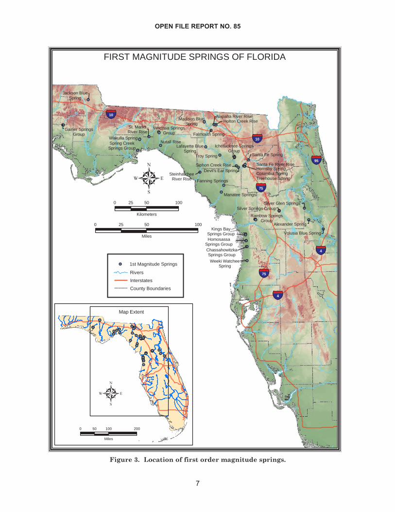
Current Florida springs tabulations list 33 first order magnitude springs (modified afterRosenau et al., 1977) (Figure 3). The list includes individual springs, spring groups andriver rises. This listing has created some confusion due to the grouping of hydrogeological-ly unrelated springs into groups and the inclusion of river rises and karst windows (Wilsonand Skiles, 1989). Often, individual springs comprising a group do not have the same watersource region or spring recharge basin and are not hydrogeologically related. The individ-ual spring vents within a group may not discharge enough water to be classed as first mag-nitude. Wilson and Skiles (1989) recommended grouping only hydrogeologically relatedsprings into spring groups. Spring groups are used in the report as presented by Rosenauet al. (1977).
River rises are the resurgence of river water that descended underground through asinkhole some distance away. The resurging water may contain a significant portion ofaquifer water but are primarily river water therefore should not be classified as a spring(Wilson and Skiles, 1989). River rises have continued to be considered in the first magni-tude listing for this report.
Karst windows are where the roof of a cave collapsed exposing an underground streamfor a short distance. One karst window is included in this report.
Future springs recharge basin delineations will identify the hydrogeological relation-ships between springs and facilitate changes in the first magnitude springs list and willaddress these issues. This will be done considering the recommendations put forth byWilson and Skiles (1989) and by hydrogeologists representing the government, private sec-
FLORIDA GEOLOGICAL SURVEY
6
OPEN FILE REPORT NO. 85
7
Gainer SpringsGroup
Jackson BlueSpring
Spring CreekSprings Group
Nutall RiseWakulla Spring
St. MarksRiver Rise
Wacissa SpringsGroup
Weeki WatcheeSpring
ChassahowitzkaSprings Group
HomosassaSprings Group
Kings BaySprings Group
Rainbow SpringsGroup
Silver Springs GroupSilver Glen Springs
Alexander Spring
Volusia Blue Spring
Fanning Springs
Manatee Springs
SteinhatcheeRiver Rise
Madison BlueSpring
Holton Creek RiseAlapaha River Rise
Santa Fe Spring
Falmouth Spring
Lafayette BlueSpring
Troy Spring
Ichetucknee SpringsGroup
Siphon Creek RiseDevil’s Ear Spring
Santa Fe River Rise
Columbia SpringHornsby Spring
Treehouse Spring
���75
���4
���4
���95
���10
���75
���10
�
FIRST MAGNITUDE SPRINGS OF FLORIDA
0 50 10025
Miles
0 50 10025
Kilometers
Map Extent
0 100 20050
Miles
�1st Magnitude Springs
Rivers
Interstates
County Boundaries
Figure 3. Location of first order magnitude springs.
tor and academia.
There have been inconsistencies in the naming of springs. We have attempted to makenames more clear in this volume. For example, a spring site that physically has one vent isno longer referred to as springs - Wakulla Springs becomes Wakulla Spring. Also, if a riverrise was called a spring, the term river rise now replaces the spring.
There are many Blue Springs in Florida. FDEP scientists have adopted the conventionof referring to these springs with the county name placed before the name "Blue Spring."Thus, Blue Spring in Jackson County becomes Jackson Blue Spring.
ARCHAEOLOGICAL SIGNIFICANCE OF SPRINGS
Archaeological research has shown that Florida's springs have been important tohuman inhabitants for many thousands of years. Prehistoric peoples exploited the concen-tration of resources found in and around springs. Water, chert and game animals were allavailable in and near springs. Today, springs serve as recreation areas and continue toattract people because of their unique beauty.
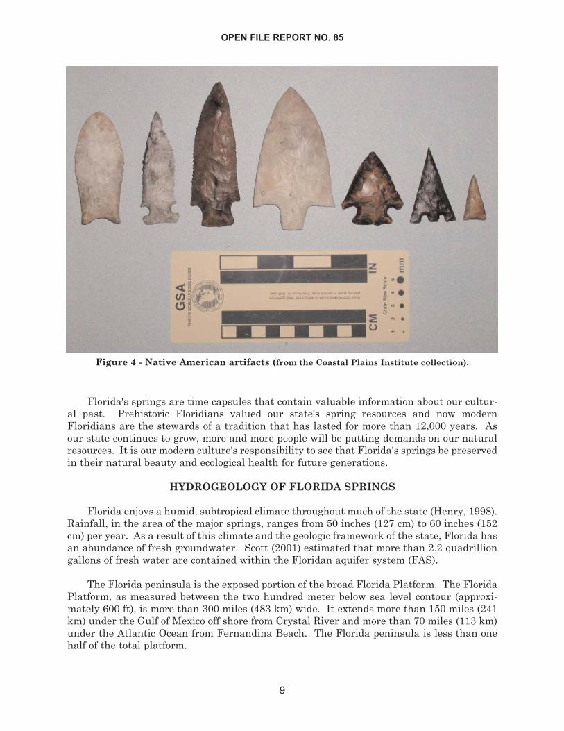
Florida's first people, called paleoindians, left behind evidence of their culture in theform of chert, bone and ivory tools that date to more than 12,000 years before present(Figure 4) (Dunbar et al., 1988). These people coexisted with large now extinct megafaunalanimals like mastodon, mammoth, ground sloth, giant beaver, and giant armadillo. Duringthe late Pleistocene, 10,000 to 12,000 years ago, sea level was as much as 300 ft (100 m)below present levels. Deep springs and sinkholes may have been some of the only sourcesof fresh water in ancient Florida. Investigations at Wakulla Spring, Hornsby Spring,Ichetucknee Springs, and the Wacissa River have shown that paleoindians were livingaround springs and utilizing the resources of these areas.
One example of prehistoric human utilization of springs comes from Warm MineralSprings, located in Sarasota County. Archaeologists recovered human remains from a ledgelocated 43 ft (13 m) below the water level that contained preserved brain material. Theremains were radiocarbon dated and produced an age of 10,000 +/- 200 years before present(Royal and Clark, 1960). Other archaeological material and fossils were recovered from thissite, which has proven to be one of the most important archaeological sites in the south-eastern United States.
As the Pleistocene Epoch came to a close in Florida, many environmental changes weretaking place. The large megafaunal animals that once had roamed the Florida landscape,were becoming extinct. Global weather patterns changed, and sea level began to rise. Asthese drastic changes were taking place, Florida's human inhabitants had to adapt. Aswater tables rose, springs became more abundant and people continued to exploit theresources in and around the springs. Prehistoric peoples living around springs built largeshell middens and mounds as they disposed of the inedible portions of their food items.Numerous examples of these mounds exist throughout the state with some of the best exam-ples being located along the St. Johns, Ocklawaha, and the Aucilla/Wacissa River systems.Abundant supplies of fresh water, aquatic food sources, chert and clay sources, and the sheerbeauty of Florida's springs made them perfect habitation sites.
FLORIDA GEOLOGICAL SURVEY
8
Florida's springs are time capsules that contain valuable information about our cultur-al past. Prehistoric Floridians valued our state's spring resources and now modernFloridians are the stewards of a tradition that has lasted for more than 12,000 years. Asour state continues to grow, more and more people will be putting demands on our naturalresources. It is our modern culture's responsibility to see that Florida's springs be preservedin their natural beauty and ecological health for future generations.
HYDROGEOLOGY OF FLORIDA SPRINGS
Florida enjoys a humid, subtropical climate throughout much of the state (Henry, 1998).Rainfall, in the area of the major springs, ranges from 50 inches (127 cm) to 60 inches (152cm) per year. As a result of this climate and the geologic framework of the state, Florida hasan abundance of fresh groundwater. Scott (2001) estimated that more than 2.2 quadrilliongallons of fresh water are contained within the Floridan aquifer system (FAS).
The Florida peninsula is the exposed portion of the broad Florida Platform. The FloridaPlatform, as measured between the two hundred meter below sea level contour (approxi-mately 600 ft), is more than 300 miles (483 km) wide. It extends more than 150 miles (241km) under the Gulf of Mexico off shore from Crystal River and more than 70 miles (113 km)under the Atlantic Ocean from Fernandina Beach. The Florida peninsula is less than onehalf of the total platform.
OPEN FILE REPORT NO. 85
9
Figure 4 - Native American artifacts (from the Coastal Plains Institute collection).
The Florida Platform is composed of a thick sequence of variably permeable carbonatesediments, limestone and dolostone, lying on older igneous, metamorphic and sedimentaryrocks. The carbonate sediments may exceed 4,000 ft (1,220 m) in thickness. A sequence ofsand, silt and clay with variable amounts of limestone and shell overlie the carbonatesequence (see Scott [1992 a, b] for discussion of the Cenozoic sediment sequence). In por-tions of the west-central and north-central peninsula and in the central panhandle, the car-bonate rocks, predominantly limestone, occur at or very near the surface. Away from theseareas, the overlying sand, silt and clay sequence becomes thicker. The complex Floridanaquifer system (FAS) occurs within this thick sequence of permeable carbonate sediments(see Miller, 1986; Berndt et al., 1998 for discussion of the FAS).
Natural recharge to the FAS by rain water, made slightly acidic by carbon dioxide fromthe atmosphere and organic acids in the soil, dissolved portions of the limestone. The dis-solution enhanced the permeability of the sediments and formed cavities and caverns.Sinkholes formed by the collapse of overlying sediments into the cavities. Occasionally, thecollapse of the roof of a cave creates an opening to the land surface.
Karst springs occur both onshore and offshore in Florida. Little is currently knownabout the offshore springs with the exception of the Spring Creek Group of springs - thelargest spring in Florida (more than one billion gallons of water discharged per day) (Lane,2001). In order to better understand the water resources of the state, the FGS has initiat-ed a program to investigate the occurrence, discharge and water quality of the offshoresprings.
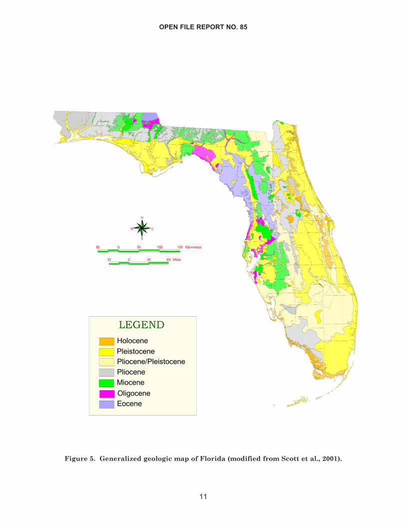
Florida's first magnitude springs occur in the northern two-thirds of the peninsula andthe central panhandle where carbonate rocks are at or near the land surface (Figure 5). Allof these springs produce water from the upper FAS (Berndt et al., 1998) which consists ofsediments that range in age from Late Eocene (approximately 38 - 36 million years old [my])to mid-Oligocene (approximately 33 my). Miocene to Pleistocene sediments (24 my to 10,000years) may be exposed in the springs.
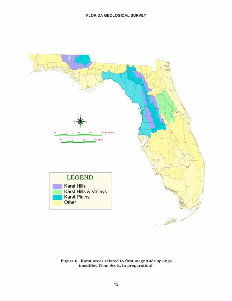
The geomorphology (physiography) of the state, coupled with the geologic framework,controls the distribution of springs. The springs occur in areas where karst features (forexample, sinkholes and caves) are common and the surface elevations are low enough toallow groundwater to flow at the surface. These areas are designated karst plains, karsthills and karst hills and valleys on Figure 6. The state's springs occur primarily within theOcala Karst District and the Dougherty Karst Plain District (Scott, in preparation). Threesprings, Alexander, Silver Glen and Volusia Blue occur in the Central Lakes District (Scott,in preparation).
Recharge to the FAS occurs over approximately 55% of the state (Berndt et al., 1998).Recharge rates vary from less than one inch (2.54 cm) per year to more than ten inches (25.4cm) per year. Recharge water entering the upper FAS that eventually discharges from aspring has a variable residence time. Katz et al. (2001) found that water flowing from larg-er springs had a groundwater residence time of more than 20 years.
Discharge, water quality and temperature of the first order magnitude springs remainreasonably stable over extended periods of time (Berndt et al., 1998). However, because dis-
FLORIDA GEOLOGICAL SURVEY
10
OPEN FILE REPORT NO. 85
11
������
�� � �� �� �����
�� � �� �� �� ����� ���
�
��
�
��������� ������ �������� �� �����
�� ���
������
��������
����������������
����� �����
���������������������� �����
Figure 5. Generalized geologic map of Florida (modified from Scott et al., 2001).
FLORIDA GEOLOGICAL SURVEY
12
� �������� ������� ���
�
��
�
�� � �� ��� ��� ��������
�� � �� � �����
�����������������������������������������������
Figure 6. Karst areas related to first magnitude springs(modified from Scott, in preparation).
charge rates are driven by the rate of recharge, climatic fluctuations often have a majoreffect on spring flow. During 1998 - 2001, Florida suffered a major drought with a rainfalldeficit totaling more than 50 inches (127 cm). The resulting reduction in recharge from thedrought and normal withdrawals caused a lowering of the potentiometric surface in theFAS. Many first order magnitude springs experienced a significant flow reduction. Somesprings, such as Hornsby Spring, ceased flowing completely. The flow data given for eachfirst order magnitude spring (see individual spring descriptions) reflects the drought-influ-enced flows.
WATER QUALITY
Methodology
Seventeen springs, eight spring groups/systems, seven river rises, and one karst win-dow (49 vents total) were sampled from 25 September 2001 through 15 November 2001.Tidally influenced springs (10) were sampled at low tide to minimize the influence of saltwater on the water-quality samples. Standard FDEP sampling protocols were followed foreach sampling event (Morse et al., 2001).
Field Parameters
Temperature, dissolved oxygen, specific conductance, and pH were measured usingHydrolab Quanta and YSI data sonde (model no. 6920) and data logger (model no. 6100).Instruments were calibrated twice daily, before and after sampling events. For qualityassurance purposes, field reference standards were analyzed every five to ten samples andten equipment blanks were submitted to the FDEP Bureau of Laboratories throughout thesampling period.
To begin each sampling event, two stainless steel weights were attached to polyethyl-ene tubing (3/8" O.D. x 0.062" wall) which was then lowered into the spring vent opening,ensuring the intake line was not influenced by surrounding surface water. Masterflex tub-ing was attached to the other end, run through a Master Flex E/S portable peristaltic pump(model no. 07571-00), and the discharge line was fed directly into a closed system flow cham-ber. The data sonde was inserted into the flow chamber and water was pumped throughwith a constant flow rate between 0.25 and 1 gallon/minute. No purge was required becausesprings are considered already purged. The field parameter values were recorded after thefield meter displayed a stable reading (approximately 10 minutes). The flow chamber wasremoved and sampling was conducted directly from the freshly cut masterflex dischargeline.
Two exceptions to this sampling method occurred at Wakulla Spring and HomosassaSprings. Both springs have pre-set pipes running down into the cave systems where thespring vents are located. In the case of Homosassa Springs, tubes from the three vents con-verge at an outlet box with three valves inside, one for each vent. Sampling is conductedfrom these valves. At Wakulla Spring, the pipe runs to a pump on shore from which sam-pling is conducted. The sampling system was designed and operated by Northwest FloridaWater Management District (NWFWMD) (Wakulla Spring) and Southwest Florida WaterManagement District (SWFWMD) (Homosassa Springs). Each tube is purged for 10 min-
OPEN FILE REPORT NO. 85
13
utes as there are gallons of water remaining in tubes from the last sampling effort. FDEPstandard operating procedure for water quality sampling is then applied.
Water Samples
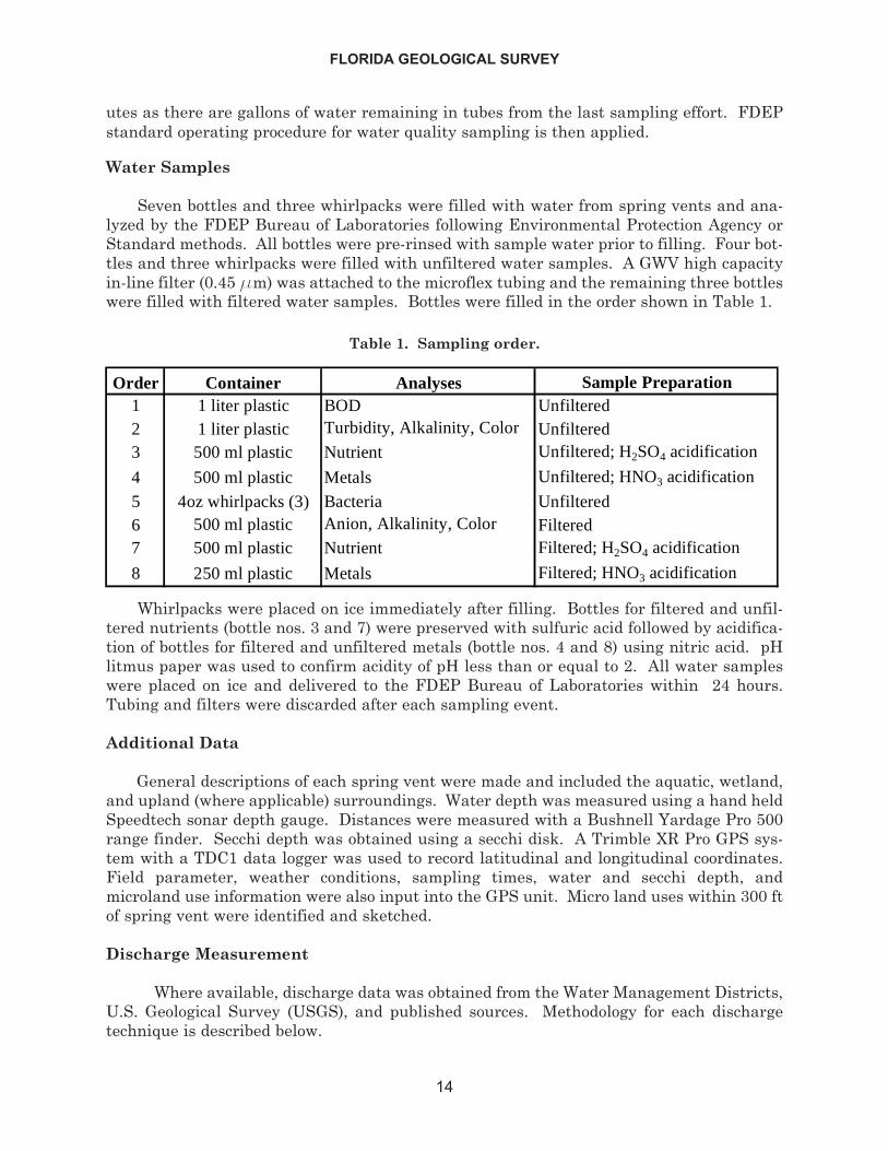
Seven bottles and three whirlpacks were filled with water from spring vents and ana-lyzed by the FDEP Bureau of Laboratories following Environmental Protection Agency orStandard methods. All bottles were pre-rinsed with sample water prior to filling. Four bot-tles and three whirlpacks were filled with unfiltered water samples. A GWV high capacityin-line filter (0.45 mm) was attached to the microflex tubing and the remaining three bottleswere filled with filtered water samples. Bottles were filled in the order shown in Table 1.
Whirlpacks were placed on ice immediately after filling. Bottles for filtered and unfil-tered nutrients (bottle nos. 3 and 7) were preserved with sulfuric acid followed by acidifica-tion of bottles for filtered and unfiltered metals (bottle nos. 4 and 8) using nitric acid. pHlitmus paper was used to confirm acidity of pH less than or equal to 2. All water sampleswere placed on ice and delivered to the FDEP Bureau of Laboratories within 24 hours.Tubing and filters were discarded after each sampling event.
Additional Data
General descriptions of each spring vent were made and included the aquatic, wetland,and upland (where applicable) surroundings. Water depth was measured using a hand heldSpeedtech sonar depth gauge. Distances were measured with a Bushnell Yardage Pro 500range finder. Secchi depth was obtained using a secchi disk. A Trimble XR Pro GPS sys-tem with a TDC1 data logger was used to record latitudinal and longitudinal coordinates.Field parameter, weather conditions, sampling times, water and secchi depth, andmicroland use information were also input into the GPS unit. Micro land uses within 300 ftof spring vent were identified and sketched.
Discharge Measurement
Where available, discharge data was obtained from the Water Management Districts,U.S. Geological Survey (USGS), and published sources. Methodology for each dischargetechnique is described below.
FLORIDA GEOLOGICAL SURVEY
14
Table 1. Sampling order.
Order Container Analyses Sample Preparation1 1 liter plastic BOD Unfiltered2 1 liter plastic Turbidity, Alkalinity, Color Unfiltered3 500 ml plastic Nutrient Unfiltered; H2SO4 acidification
4 500 ml plastic Metals Unfiltered; HNO3 acidification
5 4oz whirlpacks (3) Bacteria Unfiltered6 500 ml plastic Anion, Alkalinity, Color Filtered7 500 ml plastic Nutrient Filtered; H2SO4 acidification
8 250 ml plastic Metals Filtered; HNO3 acidification
The USGS Tallahassee office operates continuous recording gauges on Fanning andManatee Springs. Discharge rates are calculated using continuous data for gauge heightand stream velocity. The latest discharge measurement used to define the rate at eachspring was used in this report.
Discharge for the Devil's Ear Spring complex was measured by FDEP using an AcousticDoppler Current Profiler (ADCP). ADCP measurements were performed following theguidelines established in the most current ADCP manuals by RD Instruments. ADCP meas-urements included 5 cross-sectional traverses of the stream. The discharge values from eachtraverse were summed and a mean was calculated to determine the discharge.
Recording gauges, operated by NWFWMD, are located on Econfina Creek above andbelow the Gainer Springs complex. Readings are recorded in ten-minute increments. Thedifference in discharge between the two recorder stations, incorporating an eleven hour lagto travel the approximate six miles between each station, was calculated as the GainerSprings Group flow. An average discharge rate for the day of sampling was calculated.
The NWFWMD operates a submerged flow meter within the cave system of WakullaSprings main vent. The meter is surfaced monthly and discharge measurements are calcu-lated from the velocity data. The most current reading was included in this report.
The discharge for Kings Bay Group was obtained from a publication prepared by theSWFWMD (Jones et al., 1998) in connection with the ambient ground-water quality moni-toring program.
Provisional discharge data for Chassahowitzka, Homosassa, and Weeki Wachee springswere obtained from USGS, Tampa office. Mean discharge per day is calculated using phys-ical discharge measurements at the springs, the stage and nearby groundwater well. Themeasurements control the equation and are compiled over the water year, therefore the dataare provisional and subject to change when the site is computed at the end of the water year.See Yobbi and Knochenmus (1989) for more information on this methodology.
Discharge rates of the remaining nineteen springs were measured with Price-AA andPygmy current meters by the Suwannee River Water Management District (SRWMD)(Alapaha Rise, Lafayette Blue, Madison Blue, Columbia, Falmouth, Hornsby, Ichetucknee,Santa Fe Spring, Tree House, Troy), USGS Orlando office (Alexander, Rainbow, Silver Glen,Silver Springs, Volusia Blue), and by FGS (Holton Creek, Jackson Blue, Nutall Rise, St.Marks). Vertical-axis meter discharge measurements were conducted at intervals acrossthe spring channel such that no partial section contained more than 5 percent of the flowfrom the spring. At least 20 sectional readings were obtained per spring. When water depthwas less than 2.5 ft (0.8 m), one velocity measurement was recorded at six-tenths of totaldepth. For water depths greater than 2.5 ft (0.8 m), the two-point method (velocity meas-urements at two-tenths and eight-tenths of total depth) was used primarily for velocitymeasurement in a partial section. The discharge values for each partial section weresummed to obtain the total discharge measurement.
OPEN FILE REPORT NO. 85
15
Characteristics of Spring Water
Spring water discharges provide a means of determining the quality of water in theaquifer from which the water flows. Upchurch (1992) states that a number of factors influ-ence ground-water chemistry. These include the precipitation chemistry, surface conditionsat the site of recharge, soil type in the recharge area, mineralogy and composition of theaquifer system, nature of aquifer system porosity and structure, flow path in the aquifer,residence time of the water in the aquifer, mixing of other waters in the aquifer system, andaquifer microbiology. Refer to Upchurch (1992) for a detailed discussion of the factors affect-ing the chemistry of groundwater.
Descriptions of Analytes
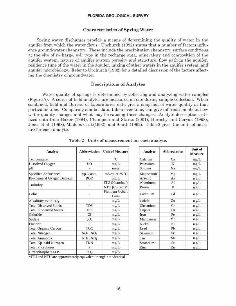
Water quality of springs is determined by collecting and analyzing water samples(Figure 7). A series of field analytes are measured on site during sample collection. Whencombined, field and Bureau of Laboratories data give a snapshot of water quality at thatparticular time. Comparing similar data, taken over time, can give information about howwater quality changes and what may be causing these changes. Analyte descriptions uti-lized data from Baker (1994), Champion and Starks (2001), Hornsby and Ceryak (1998),Jones et al. (1998), Maddox et al.(1992), and Smith (1992). Table 2 gives the units of meas-ure for each analyte.
FLORIDA GEOLOGICAL SURVEY
16
Analyte Abbreviation Unit of Measure Analyte AbbreviationUnit of
Measure
Temperature - oC Calcium Ca mg/LDissolved Oxygen DO mg/L Potassium K mg/LpH - units Sodium Na mg/L
Specific Conductance Sp. Cond. u S/cm at 25 oC Magnesium Mg mg/LBiochemical Oxygen Demand BOD mg/L Arsenic As u g/L
Aluminum Al u g/LBoron B u g/L
Color -Platinum Cobalt
UnitsCadmium Cd u g/L
Alkalinity as CaCO3 - mg/L Cobalt Co u g/LTotal Dissolved Solids TDS mg/L Chromium Cr u g/LTotal Suspended Solids TSS mg/L Copper Cu u g/LChloride Cl mg/L Iron Fe u g/LSulfate SO4 mg/L Manganese Mn u g/LFluoride F mg/L Nickel Ni u g/LTotal Organic Carbon TOC mg/L Lead Pb u g/LTotal Nitrogen NO3 + NO2 mg/L Selenium Se u g/L
Total Ammonia NH3 + NH4 mg/L Tin Sn u g/LTotal Kjeldahl Nitrogen TKN mg/L Strontium Sr u g/LTotal Phosphorus P mg/L Zinc Zn u g/LOrthophosphate as P PO4 mg/L*JTU and NTU are approximately equivalent though not identical
TurbidityJTU (Historical) NTU (Current)*
-
Table 2 - Units of measurement for each analyte.
Physical Field Parameters
Measurements of field analytes are taken directly in the field prior to water sampling.They include dissolved oxygen, pH, specific conductance, water temperature and discharge.Other data collected in the field include local geology, weather conditions and adjacent landuse practices.
Dissolved Oxygen - Oxygen readily dissolves in water. The source of oxygen can be atmos-pheric or biological. Typically, springs that discharge water from a deep aquifer source havea low dissolved oxygen content. On the other hand, relative to springs, the dissolved oxygencontent in river rise water is high. This is due to a greater exposure to the atmosphere andan increase in biological activity.
pH - pH measures the acidity oralkalinity of water. It is definedas the negative log of the activityof the hydrogen ion in a solution.Values range between 0 and 14.A low pH represents acidic, and ahigh pH represents alkaline con-ditions. A pH near 7 indicatesthe water is near neutral condi-tions.
Rainwater has a low pH and isnaturally acidic. As moisturepasses through the atmosphere,it picks up dissolved carbon diox-ide, forming carbonic acid. InFlorida, as rainwater passesthrough soil layers it incorpo-rates organic acids and the acidi-ty increases.
When acidic water enters alimestone aquifer, the acids reactwith calcium carbonate in thelimestone and dissolution occurs.Generally, most spring waterfalls within a pH range of 7 to 8.During heavy rain events, spring water can drop in pH as tannic acids, from nearby surfacewaters, are flushed into the spring system. It should be noted that sampled river rises tendto have a lower pH than the spring systems, due to the surficial component of the water.
Specific Conductance - Specific conductance is a measure of the ability of a substance, inthis case spring water, to conduct electricity. The conductance is a function of the amountand type of ions in the water. The variability of the specific conductance of spring water canbe quite high when the spring is discharging saline water or when the spring is discharginginto the marine environment.
OPEN FILE REPORT NO. 85
17
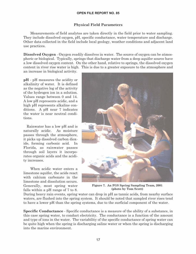
Figure 7. An FGS Spring Sampling Team, 2001(photo by Tom Scott)
Water Temperature - Geologic material is a good thermal insulator. It tends to bufferchanges in the temperature of spring water. Thus, spring water temperature does not varymuch and tends to reflect the average annual air temperature in the vicinity of the spring.This temperature can range from 68°F to 75°F (20°C to 24°C), plus or minus several tenthsof a degree. Temperature plays a role in chemical and biological activity within the aquiferand can help in determining residence time of the water in the aquifer.
Discharge - Discharge, or springflow, is controlled by the potentiometric levels in the FAS.Discharge generally changes slowly in response to fluctuations in the water levels in theaquifer. Discharge is measured in cubic feet per second or gallons per day.
Other Field Data - During sample collection, total water depth, sample depth, local geolo-gy, adjacent land use and current weather conditions are noted at each spring. This gener-alized information can be useful in helping to determine certain water quality-related issuesof the spring.
Laboratory Analytes
Alkalinity - The alkalinity of spring water is affected primarily by the presence of bicar-bonate, hydroxide and carbon dioxide. Highly alkaline waters are usually associated withhigh pH, dissolved solids and hardness which, when combined, may be detrimental to theaquatic environment.
Biochemical Oxygen Demand - Biochemical oxygen demand (BOD) is a measure of thequantity of molecular oxygen utilized in the decomposition of organic material, during aspecified incubation time, by microorganisms such as bacteria. When the BOD is high, thedepletion of oxygen can have a detrimental effect on aquatic organisms. BOD is measuredin mg/L. In Florida, there is no set standard for BOD in groundwater.
Chloride (Cl-) - Chloride is the most abundant constituent in seawater, and springs thatare tidally influenced have high chloride concentrations. Chloride is added to the atmos-phere via marine aerosols from the ocean. In most of Florida's springs, chloride is intro-duced to the spring system via rainfall. Chloride is chemically conservative and reacts verylittle with spring water. When chloride concentrations in drinking water exceed 250 mg/Lit is considered unfit for drinking. This is the secondary standard established by the Stateof Florida.
Color - The color of spring water can be affected by factors such as the presence of metallicions, tannic acids, biological activity and industrial waste. Generally, spring water inFlorida is clear. Color measurements are made on filtered water samples so the true colorof the water is determined. Color is reported in either color units or Platinum Cobalt units(Pt/Co). In Florida, the secondary (aesthetic) standard for groundwater is 15 color units.
Hardness - The hardness of water is a function of the presence of calcium, magnesium, andother alkali metal ions. The higher the calcium/magnesium content of the water, the hard-er the water. Hard water forms insoluble residues on surfaces where evaporation has takenplace. Hard water, when used with soap, can also form residues on surfaces. The hardnessof water is expressed either in parts per million, or in milligrams per liter, and is usually ameasure of the calcium carbonate dissolved in the water.
FLORIDA GEOLOGICAL SURVEY
18
Nitrate + Nitrite (NO3, NO2) - Nitrate and nitrite are both found in spring water inFlorida. Nitrate contamination recently has become a problem in Florida's springs. Nitratefound in spring water originates from fertilizers, septic tanks and animal waste that entersthe aquifer in the spring recharge area. Nitrate, being a nutrient, encourages algal andaquatic plant growth in spring water, which may lead to eutrophication of the spring andassociated water body. Nitrite, which is much less of a problem, can originate from sewageand other organic waste products. When nitrate levels exceed 10 mg/L in drinking water, itis potentially hazardous to infants, causing methemoglobinemia or "blue baby syndrome".For this reason, the FDEP has set the Primary Drinking Water Standard for nitrate ingroundwater at 10 mg/L and nitrite at 1 mg/L.
Organic Carbon - Natural and non-naturally occurring organic carbon are present in vary-ing concentrations in spring water in Florida. The primary source of naturally occurringorganic carbon is humic substances (decaying plant material). Synthetic organics representa minor component. There are no standards set for naturally occurring organic carbon indrinking water however, synthetic organic carbon compounds are regulated on an individ-ual basis in Florida.
Orthophosphate (PO4-3) - Phosphate is an essential nutrient and occurs in spring water inFlorida. Unfortunately, an excess of phosphate can cause run-away plant growth and theeutrophication of surface waters. The Hawthorn Group, a geological unit in Florida, is theprimary source of phosphate in spring water. Other sources include organic and inorganicfertilizers, animal waste, human waste effluent and industrial waste. In Florida, there isno regulation nor standard for phosphate.
Potassium (K) - Potassium occurs in trace amounts in Florida's spring water and is derivedprimarily from sea water. Therefore, it occurs in higher concentration along the coast. Theweathering of feldspars and clays can contribute potassium to spring water. In addition,because potassium is an essential nutrient, it is a component of fertilizers. In Florida, thereis no standard for potassium and it is considered to be beneficial in moderate concentrations.
Sodium (Na) - In Florida, sodium occurring in spring water has several sources. Marineaerosols, mixing of sea water with fresh water and the weathering of sodium bearing min-erals like feldspars and clays are the primary sources. The Florida Department ofEnvironmental Regulation, in 1994, set the maximum allowable concentration of sodium indrinking water at 160 mg/L. Concentrations exceeding this standard can occur in springsthat discharge from deep Floridan aquifer sources and in coastal areas where spring waterand marine water mixing may occur.
Sulfate (SO4) - Sulfate is commonly found in aquifer waters in Florida and has severalsources. The two most common sources are from sea water and the dissolution of gypsumand anhydrite (naturally occurring rock types within Florida's aquifer systems). Sulfate isoften used as a soil amendment to acidify soils, and thus is associated with agriculturalactivities. Finally, disposal and industrial waste activities release sulfate to ground water.Sulfate rich spring water can potentially be toxic to plants. In higher concentrations itaffects the taste of drinking water. For this reason, the FDEP established a SecondaryDrinking Water standard for sulfate of 250 mg/L.
OPEN FILE REPORT NO. 85
19
Total Ammonia (NH3 + NH4+) - Ammonia (NH3) occurs in groundwater primarily as theammonium ion (NH4+) because of the prevalent pH and reduction-oxidation potential(Upchurch, 1992). Microbial activity within the soil and aquifer can convert other nitroge-nous products to ammonium. There is no set standard for ammonia in Florida groundwa-ter.
Total Dissolved Solids - Total dissolved solids is a measure of the dissolved chemical con-stituents, primarily ions, in spring water. Concentrations in Florida's spring water varywidely. Since most of Florida's spring water issues from carbonate aquifers, the total dis-solved solid concentrations are fairly high. Higher concentrations are found in springs thatare tidally influenced and springs that discharge into the marine environment. The FloridaSecondary Drinking Water Standard for total dissolved solids is 500 mg/L.
Total Kjeldahl Nitrogen - This is a measure of the sum of the ammonia nitrogen andorganic nitrogen in the spring water sample. The ammonia nitrogen, mainly occurring asammonium (NH4+), occurs in trace amounts in spring water (see ammonia (NH3) above).Organic nitrogen originates from biological sources including sewage and other waste. DEPregulates nitrogen, in the form of nitrates and nitrites, in drinking water in Florida (see pre-vious descriptions above).
Total Nitrogen - The amount of nitrate, nitrite, ammonia, and organic nitrogen, whensummed, gives the total nitrogen content of spring water. See description of each nitrogencompound for regulation standards in Florida.
Total Suspended Solids - This refers to the amount of solid material suspended in thewater column. As opposed to turbidity, total suspended solids does not take into account thelight scattering ability of the water. Total suspended solids are filtered out of the watersample and are measured in mg/L.
Turbidity - Turbidity is a measure of the colloidal suspension of tiny particles and precip-itates in spring water. High turbidity water impedes the penetration of light and can beharmful to aquatic life. Most Florida springs discharge water low in turbidity. Turbidity ismeasured in Nephlometric Turbidity Units (NTU's).
Trace Metals
Trace metals analyzed for this report include: arsenic (As), barium (Ba), boron (B), cal-cium (Ca), cadmium (Cd), cobalt (Co), chromium (Cr), copper (Cu), fluoride (F), iron (Fe),lead (Pb), magnesium (Mg), manganese (Mn), nickel (Ni), phosphorous (P), selenium (Se),strontium (Sr), tin (Sn) and zinc (Zn). Trace metals, when present in spring water, are foundin very low concentrations and are measured in parts per billion (ppb), or micrograms perliter (mg/L). In Florida, calcium and magnesium occur in higher concentrations and aretherefore measured in milligrams per liter.
The naturally low abundance of trace metals in Florida's groundwater can be attributedto several factors including low natural abundance in aquifer rocks, low solubility of metalbearing minerals, high adsorption potential of metal ions on clays and organic particulates,and precipitation in the form of sulfides and oxides (Upchurch, 1992). Many biochemicalprocesses require small amounts of trace metals however, higher concentrations can be
FLORIDA GEOLOGICAL SURVEY
20
toxic. Industrialization and increased demand for products containing trace metals hasoverwhelmed the natural biogeochemical cycle, and anthropogenic sources for trace metalsnow far outweigh natural sources (Smith, 1992).
In Florida, lead is one of the most important metal contaminants found in groundwater.This contaminant, along with other metals, is primarily distributed in the atmosphere,water, soil and sediments. Atmospheric pollutants are often the primary source of water-borne metals. These pollutants are introduced into the atmosphere by mining operations,smelting, manufacturing activities and the combustion of fossil fuels (Smith, 1992).
Contamination of groundwater by lead is caused primarily by combustion of fossil fuelscontaining lead additives. Lead additives were phased out of fuels in the U.S. and Canadaby 1990, but other sources of contamination including mining, smelting and refining of leadand other metals still persist. Lead bioaccumulates in aquatic organisms affecting the high-er trophic levels the most. In humans, lead causes severe health problems including meta-bolic disorders, neurological and reproductive damage and hypertension. In Florida, thePrimary Standard for lead in drinking water is 15 mg/L.
When trace metals are released into the environment, they present major problemsbecause they are not biodegradable. These pollutants tend to stay in the environment andaccumulate in foodwebs and ecosystems. In higher concentrations, other trace metals, likearsenic and cadmium, can have adverse effects on aquatic and terrestrial environments.There are Primary Standards for other trace metals found in groundwater in Florida(Florida DEP Ground Water Guidance Concentrations, 1994).
Biological Analytes
Spring water samples were analyzed for total coliform, fecal coliform, Escherichia coli(E. coli), and Enterococci. These analytes are used to assess the sanitary quality of springwater and to determine the potential for waterborne diseases (bacterial and viral). The pri-mary source of these contaminants is fecal waste from warm-blooded animals. Whendetected in numbers that exceed the maximum contaminant level (MCL), coliforms mayindicate that the spring has been contaminated by domestic sewage overflow or non-pointsources of human and animal waste. Measurements made on these biological analytes arereported in colonies per 100 milliliters.
Total coliform bacteria are a group of closely related, mostly harmless bacteria that livein the digestive tract of animals. The extent to which total coliforms are present in springwater can indicate general water quality and the amount of fecal contamination. By furtherexamining fecal coliforms, E. coli and Enterococci, it is possible to estimate the amount ofhuman fecal contamination of the sample. Human contact with water that is contaminatedwith fecal wastes can result in diseases of the digestive tract including gastroenteritis anddysentery. Typhoid fever, hepatitis A, and cholera are also related to contact with fecallycontaminated water.
Currently, there are criteria for bacteriological quality in Florida's ground water.Groundwater in the state has a limit on total coliform bacteria of 4 colonies per 100 milli-liters. E. coli and Enterococci do not currently have water quality standards in Florida.
OPEN FILE REPORT NO. 85
21
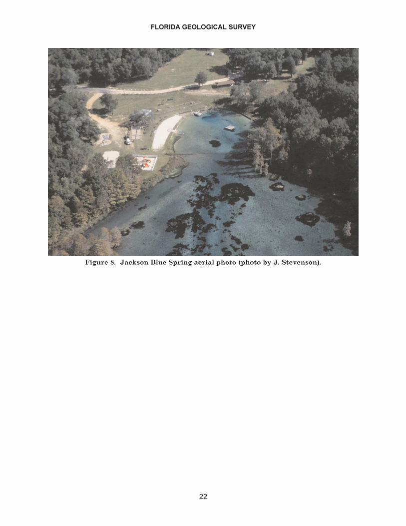
FLORIDA GEOLOGICAL SURVEY
22
Figure 8. Jackson Blue Spring aerial photo (photo by J. Stevenson).
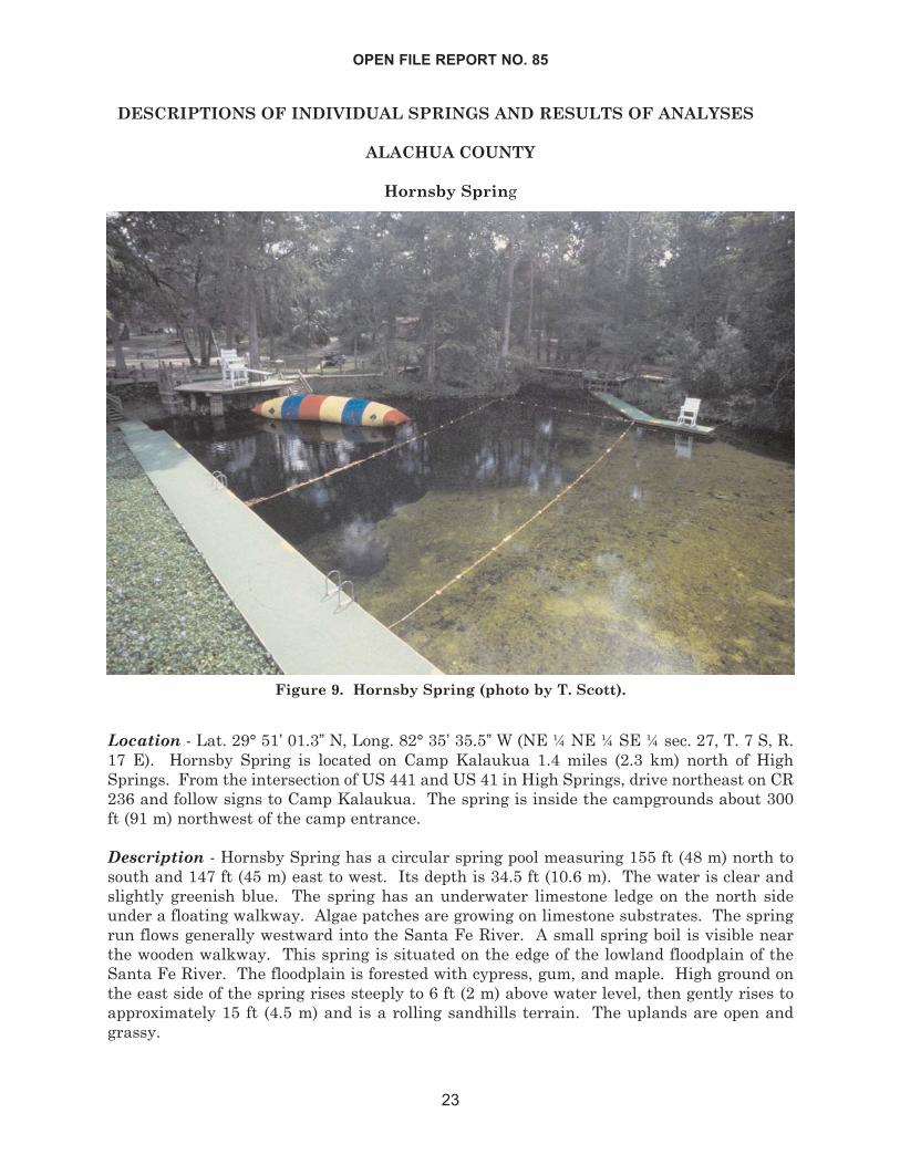
DESCRIPTIONS OF INDIVIDUAL SPRINGS AND RESULTS OF ANALYSES
ALACHUA COUNTY
Hornsby Spring
Location - Lat. 29° 51’ 01.3” N, Long. 82° 35’ 35.5” W (NE ¼ NE ¼ SE ¼ sec. 27, T. 7 S, R.17 E). Hornsby Spring is located on Camp Kalaukua 1.4 miles (2.3 km) north of HighSprings. From the intersection of US 441 and US 41 in High Springs, drive northeast on CR236 and follow signs to Camp Kalaukua. The spring is inside the campgrounds about 300ft (91 m) northwest of the camp entrance.
Description - Hornsby Spring has a circular spring pool measuring 155 ft (48 m) north tosouth and 147 ft (45 m) east to west. Its depth is 34.5 ft (10.6 m). The water is clear andslightly greenish blue. The spring has an underwater limestone ledge on the north sideunder a floating walkway. Algae patches are growing on limestone substrates. The springrun flows generally westward into the Santa Fe River. A small spring boil is visible nearthe wooden walkway. This spring is situated on the edge of the lowland floodplain of theSanta Fe River. The floodplain is forested with cypress, gum, and maple. High ground onthe east side of the spring rises steeply to 6 ft (2 m) above water level, then gently rises toapproximately 15 ft (4.5 m) and is a rolling sandhills terrain. The uplands are open andgrassy.
OPEN FILE REPORT NO. 85
23
Figure 9. Hornsby Spring (photo by T. Scott).
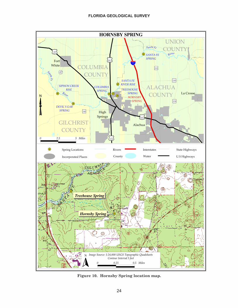
FLORIDA GEOLOGICAL SURVEY
24
������������
��
��
��
��
��
��
��
��������� �����
����
���������
������� �������
�����������
��������
���
��� ������������
�����������������
������������
������������������
������������������
���������������������� ����
������
�����
��������������
�������������
�����������
���������� � ������
���
��������
�����
�����
�����
���������������������������� �!�����
��"��������#
���������������� �$������%�#�
����������%�#�
� � ! ! ��"�#
��
��
�
������������
�� ���� �����
�$�%���&'(�)�*)�+,����������&-&%�-.�(�/'�0#.���#
� � �! � ! ��"�#
� �&��&'������"�!�1���
�
Figure 10. Hornsby Spring location map.
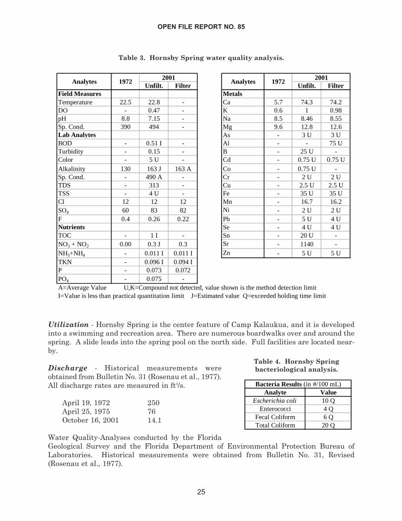
OPEN FILE REPORT NO. 85
25
Utilization - Hornsby Spring is the center feature of Camp Kalaukua, and it is developedinto a swimming and recreation area. There are numerous boardwalks over and around thespring. A slide leads into the spring pool on the north side. Full facilities are located near-by.
Discharge - Historical measurements wereobtained from Bulletin No. 31 (Rosenau et al., 1977).All discharge rates are measured in ft3/s.
April 19, 1972 250April 25, 1975 76October 16, 2001 14.1
Water Quality-Analyses conducted by the FloridaGeological Survey and the Florida Department of Environmental Protection Bureau ofLaboratories. Historical measurements were obtained from Bulletin No. 31, Revised(Rosenau et al., 1977).
Unfilt. Filter Unfilt. FilterField Measures MetalsTemperature 22.5 22.8 - Ca 5.7 74.3 74.2DO - 0.47 - K 0.6 1 0.98pH 8.8 7.15 - Na 8.5 8.46 8.55Sp. Cond. 390 494 - Mg 9.6 12.8 12.6Lab Analytes As - 3 U 3 UBOD - 0.51 I - Al - - 75 UTurbidity - 0.15 - B - 25 U -Color - 5 U - Cd - 0.75 U 0.75 UAlkalinity 130 163 J 163 A Co - 0.75 U -Sp. Cond. - 490 A - Cr - 2 U 2 UTDS - 313 - Cu - 2.5 U 2.5 UTSS - 4 U - Fe - 35 U 35 UCl 12 12 12 Mn - 16.7 16.2SO4 60 83 82 Ni - 2 U 2 UF 0.4 0.26 0.22 Pb - 5 U 4 UNutrients Se - 4 U 4 UTOC - 1 I - Sn - 20 U -NO3 + NO2 0.00 0.3 J 0.3 Sr - 1140 -NH3+NH4 - 0.011 I 0.011 I Zn - 5 U 5 UTKN - 0.096 I 0.094 IP - 0.073 0.072PO4 - 0.075 -
Analytes 19722001
Analytes
A=Average Value U,K=Compound not detected, value shown is the method detection limitI=Value is less than practical quantitation limit J=Estimated value Q=exceeded holding time limit
19722001
Analyte ValueEscherichia coli 10 Q
Enterococci 4 QFecal Coliform 6 QTotal Coliform 20 Q
Bacteria Results (in #/100 mL)
Table 3. Hornsby Spring water quality analysis.
Table 4. Hornsby Springbacteriological analysis.

BAY COUNTY
Gainer Springs Group
Group Location - Lat. 30° 25’ N, Long. 85° 32’ W(southern half of sec. 4, T. 1 S, R. 13 W). Gainersprings complex is located 0.4 miles (0.7 km) down-stream from the SR 20 bridge on Econfina Creek . Itis best accessed by canoe, however, there is a gateddirt track on Northwest Florida Water ManagementDistrict (NWFWMD) land that leads to the springsgroup on the east side of the creek.
Group Description - At least 5 known springs asso-ciated with Gainer Springs Group are along bothsides of Econfina Creek. The uplands surroundingthis group are high rolling sand hills that are forest-ed with sand pine plantations and patches of longleafpine-turkey oak community. High ground adjoiningthe west side of the creek near Spring No. 2 andSpring No. 3 rises to 27 ft (8 m) above water surfaceand is densely forested with mixed hardwoods andpines. The creek floodplain is forested with cypressand hardwoods. Land on the west side of the
FLORIDA GEOLOGICAL SURVEY
26
Figure 11. Gainer Springs Group Vent 1C (photo by T. Scott).
Figure 12. Gainer Springs GroupVent 2 (photo by H. Means).
Econfina Creek at Gainer Springs is owned by Patronis, Inc (out of Panama City, Fla). Theeast side of the creek is owned and managed by the NWFWMD.
GAINER SPRING NO. 1C - Lat. 30° 25’ 39.6” N, Long. 85° 32’ 46.0”W (SW¼ NW¼ SE¼ sec.4, T. 1 S, R. 13 W). Gainer Spring Nos. 1A, 1B, and 1C form a 820 ft (250 m) long springrun that enters Econfina Creek on the east side directly across from Spring No. 2. SpringNo. 1C is the first spring encountered approximately 495 ft (150 m) upstream from thecreek, and its pool is adjacent to the run on the southeast side. Spring pool dimensions areapproximately 72 ft (22 m) east to west and 33 ft (10 m) north to south. Water issues upwardfrom a vertical tunnel in the limestone. Shell and sand particles are suspended in the springflow. Pool depth is 20 ft (6.1 m) measured over the vent opening. There is very little aquat-ic vegetation, however, algae patches in spring pool are common. The adjoining, swampylowlands are heavily forested with cypress and mixed hardwoods. The nearest uplands tothe southeast support a mixed hardwood and pine forest. There is no high ground adjacentto the spring pool.
GAINER SPRING NO. 2 - Lat. 30° 25’ 38.6” N, Long. 85° 32’ 54.0” W (SW¼ NE¼ SW¼ sec.4, T. 1 S, R. 13 W). This spring is located directly across from the mouth of Gainer SpringNo. 1 run along the west side of Econfina Creek. Spring water issues forcefully from thebase of the riverbank and forms a pool along the edge of the creek. Pool diameter is approx-imately 60 ft (18 m) east to west and 62 ft (17 m) north to south. Pool depth is 5 ft (1.5 m).Vent diameter is approximately 5 ft (1.5 m). There is little or no aquatic vegetation, butpatches of dark green algae are present. The water is light greenish blue. A concrete wallforms the south side of the spring pool. Two parallel pipes that extract drinking water runfrom inside the spring vent toward the top of the bluff and beyond. There are at least threeother smaller vents issuing from the bank just above this spring. A 23 ft (7 m) high bluffmeets Econfina Creek at Spring No. 2. A mixed hardwood and pine forest inhabits the bluffface and high ground.
GAINER SPRING NO. 3 - Lat. 30° 25’ 44.3” N, Long. 85° 32’ 53.9” W (NE¼ NE¼ SW¼ sec.4, T. 1 S, R. 13 W). This spring is located along the west side of Econfina Creek, and is about655 ft (200 m) upstream of Spring No. 2. It is at the head of a 325 ft (100 m) long springrun. There are at least three vent complexes in the combined spring pool. The depressionis large and mostly shallow with a sandy bottom and limestone boulders. The combinedspring pool diameter is about 305 ft (93 m) east to west and 125 ft (39 m) north to south.There is a forested island in the center of the combined spring pool. Some emergent vege-tation exists along the pool's shores, but there is very little aquatic vegetation. Dark greenalgal mats are ubiquitous throughout the bottom of the spring pool. The western vent issuesout of a limestone sidewall and has a small boardwalk nearby. The north vent where waterquality was sampled is the largest and deepest. This spring is about 15 ft (5 m) south of awooden wall presumably constructed for shore erosion management. Light greenish bluewater issues vertically from the bottom of a 16 ft (5 m) diameter conical depression and pro-duces a boil at the surface. The depression is 7.4 ft (2.3 m) deep over the vent. Vent diam-eter is about 1.5 ft (.5 m). On the eastern side of the combined spring pool, there are at least3 other vents. Uphill to the north, there are picnic tables under a pavilion in a grassy open-ing. The rest of the uplands adjoining the spring pool to the west are forested with mixedhardwoods and pines.
Utilization - Gainer Spring No. 2 is owned by Patronis, a bottled-water company. Econfina
OPEN FILE REPORT NO. 85
27
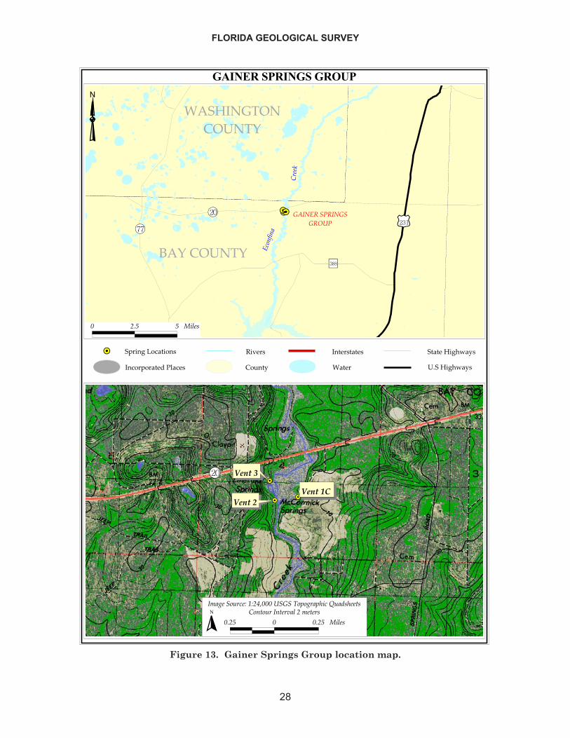
FLORIDA GEOLOGICAL SURVEY
28
������������������
�����������
����
������
��
��
����������
���� ���������
� �� ������� ��������
�����
����
� ��� � ����
��
��
��
���� ������
�������������
����������� ��!"���������#�$����$%���&��'�%(�
���� � ���� �������(���� �(�)������(���
�
������������������������������������
�����������
��������������� �!����"#� �
��������"#� �
Figure 13. Gainer Springs Group location map.
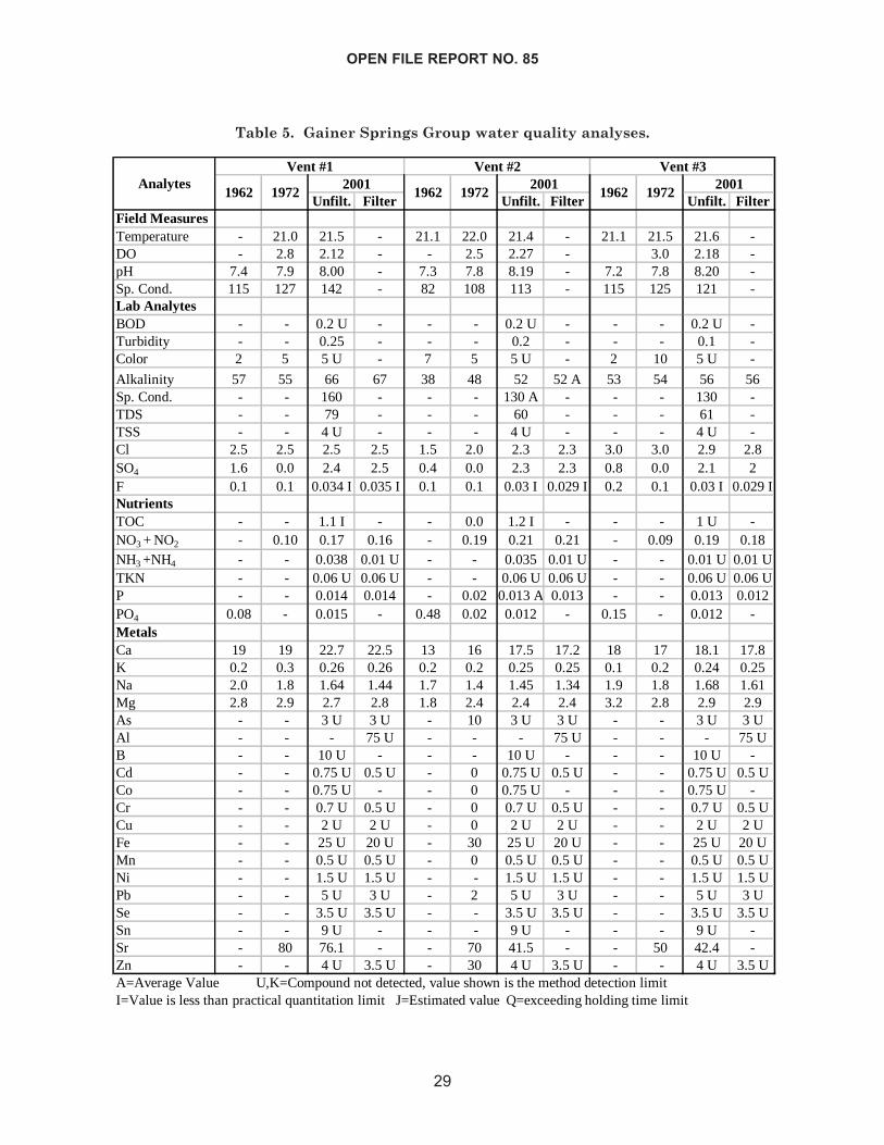
OPEN FILE REPORT NO. 85
29
Unfilt. Filter Unfilt. Filter Unfilt. FilterField MeasuresTemperature - 21.0 21.5 - 21.1 22.0 21.4 - 21.1 21.5 21.6 -DO - 2.8 2.12 - - 2.5 2.27 - 3.0 2.18 -pH 7.4 7.9 8.00 - 7.3 7.8 8.19 - 7.2 7.8 8.20 -Sp. Cond. 115 127 142 - 82 108 113 - 115 125 121 -Lab AnalytesBOD - - 0.2 U - - - 0.2 U - - - 0.2 U -Turbidity - - 0.25 - - - 0.2 - - - 0.1 -Color 2 5 5 U - 7 5 5 U - 2 10 5 U -
Alkalinity 57 55 66 67 38 48 52 52 A 53 54 56 56Sp. Cond. - - 160 - - - 130 A - - - 130 -TDS - - 79 - - - 60 - - - 61 -TSS - - 4 U - - - 4 U - - - 4 U -Cl 2.5 2.5 2.5 2.5 1.5 2.0 2.3 2.3 3.0 3.0 2.9 2.8SO4 1.6 0.0 2.4 2.5 0.4 0.0 2.3 2.3 0.8 0.0 2.1 2F 0.1 0.1 0.034 I 0.035 I 0.1 0.1 0.03 I 0.029 I 0.2 0.1 0.03 I 0.029 INutrientsTOC - - 1.1 I - - 0.0 1.2 I - - - 1 U -NO3 + NO2 - 0.10 0.17 0.16 - 0.19 0.21 0.21 - 0.09 0.19 0.18NH3 +NH4 - - 0.038 0.01 U - - 0.035 0.01 U - - 0.01 U 0.01 UTKN - - 0.06 U 0.06 U - - 0.06 U 0.06 U - - 0.06 U 0.06 UP - - 0.014 0.014 - 0.02 0.013 A 0.013 - - 0.013 0.012PO4 0.08 - 0.015 - 0.48 0.02 0.012 - 0.15 - 0.012 -MetalsCa 19 19 22.7 22.5 13 16 17.5 17.2 18 17 18.1 17.8K 0.2 0.3 0.26 0.26 0.2 0.2 0.25 0.25 0.1 0.2 0.24 0.25Na 2.0 1.8 1.64 1.44 1.7 1.4 1.45 1.34 1.9 1.8 1.68 1.61Mg 2.8 2.9 2.7 2.8 1.8 2.4 2.4 2.4 3.2 2.8 2.9 2.9As - - 3 U 3 U - 10 3 U 3 U - - 3 U 3 UAl - - - 75 U - - - 75 U - - - 75 UB - - 10 U - - - 10 U - - - 10 U -Cd - - 0.75 U 0.5 U - 0 0.75 U 0.5 U - - 0.75 U 0.5 UCo - - 0.75 U - - 0 0.75 U - - - 0.75 U -Cr - - 0.7 U 0.5 U - 0 0.7 U 0.5 U - - 0.7 U 0.5 UCu - - 2 U 2 U - 0 2 U 2 U - - 2 U 2 UFe - - 25 U 20 U - 30 25 U 20 U - - 25 U 20 UMn - - 0.5 U 0.5 U - 0 0.5 U 0.5 U - - 0.5 U 0.5 UNi - - 1.5 U 1.5 U - - 1.5 U 1.5 U - - 1.5 U 1.5 UPb - - 5 U 3 U - 2 5 U 3 U - - 5 U 3 USe - - 3.5 U 3.5 U - - 3.5 U 3.5 U - - 3.5 U 3.5 USn - - 9 U - - - 9 U - - - 9 U -Sr - 80 76.1 - - 70 41.5 - - 50 42.4 -Zn - - 4 U 3.5 U - 30 4 U 3.5 U - - 4 U 3.5 U
1962
Vent #3
1962 19722001
A=Average Value U,K=Compound not detected, value shown is the method detection limitI=Value is less than practical quantitation limit J=Estimated value Q=exceeding holding time limit
AnalytesVent #2
1962 19722001
19722001
Vent #1
Table 5. Gainer Springs Group water quality analyses.
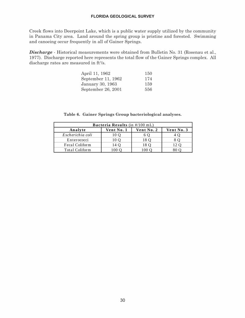
Creek flows into Deerpoint Lake, which is a public water supply utilized by the communityin Panama City area. Land around the spring group is pristine and forested. Swimmingand canoeing occur frequently in all of Gainer Springs.
Discharge - Historical measurements were obtained from Bulletin No. 31 (Rosenau et al.,1977). Discharge reported here represents the total flow of the Gainer Springs complex. Alldischarge rates are measured in ft3/s.
April 11, 1962 150September 11, 1962 174January 30, 1963 159September 26, 2001 556
FLORIDA GEOLOGICAL SURVEY
30
Analyte Vent No. 1 Vent No. 2 Vent No. 3Escherichia coli 10 Q 6 Q 4 Q
Enterococci 10 Q 18 Q 8 QFecal Coliform 14 Q 18 Q 12 QTotal Coliform 100 Q 100 Q 80 Q
Bacteria Results (in #/100 mL)
Table 6. Gainer Springs Group bacteriological analyses.
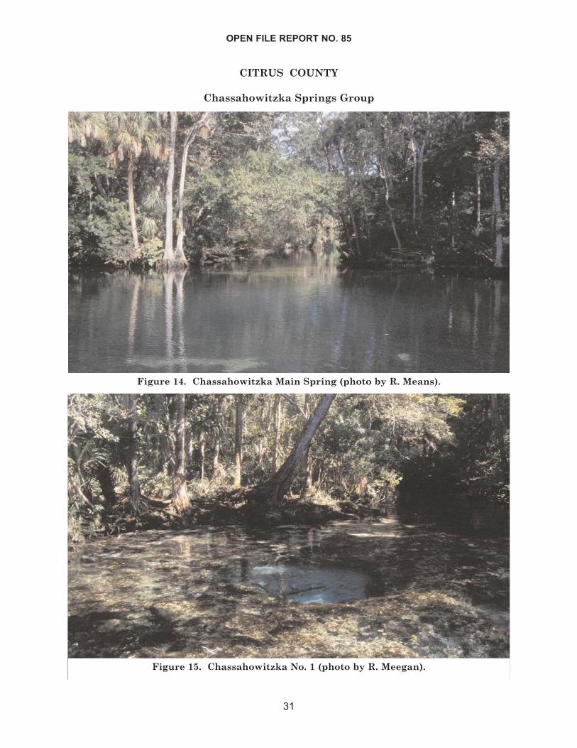
CITRUS COUNTY
Chassahowitzka Springs Group
OPEN FILE REPORT NO. 85
31
Figure 14. Chassahowitzka Main Spring (photo by R. Means).
Figure 15. Chassahowitzka No. 1 (photo by R. Meegan).
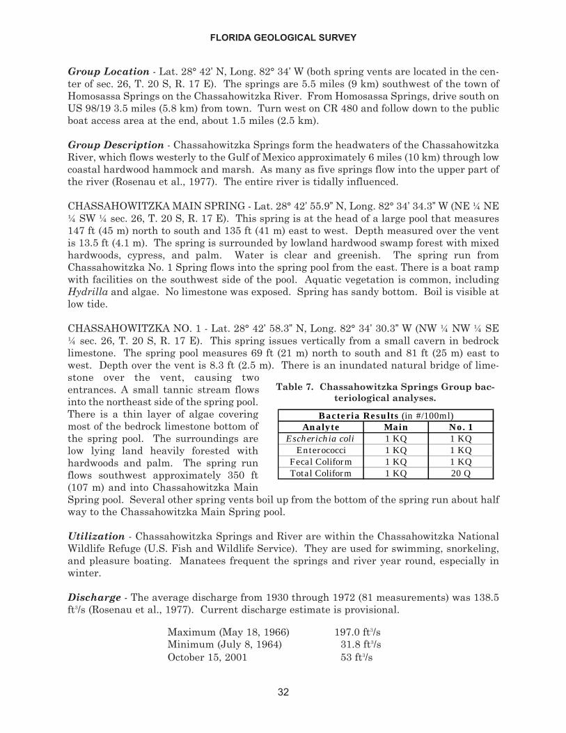
Group Location - Lat. 28° 42’ N, Long. 82° 34’ W (both spring vents are located in the cen-ter of sec. 26, T. 20 S, R. 17 E). The springs are 5.5 miles (9 km) southwest of the town ofHomosassa Springs on the Chassahowitzka River. From Homosassa Springs, drive south onUS 98/19 3.5 miles (5.8 km) from town. Turn west on CR 480 and follow down to the publicboat access area at the end, about 1.5 miles (2.5 km).
Group Description - Chassahowitzka Springs form the headwaters of the ChassahowitzkaRiver, which flows westerly to the Gulf of Mexico approximately 6 miles (10 km) through lowcoastal hardwood hammock and marsh. As many as five springs flow into the upper part ofthe river (Rosenau et al., 1977). The entire river is tidally influenced.
CHASSAHOWITZKA MAIN SPRING - Lat. 28° 42’ 55.9” N, Long. 82° 34’ 34.3”W (NE ¼ NE¼ SW ¼ sec. 26, T. 20 S, R. 17 E). This spring is at the head of a large pool that measures147 ft (45 m) north to south and 135 ft (41 m) east to west. Depth measured over the ventis 13.5 ft (4.1 m). The spring is surrounded by lowland hardwood swamp forest with mixedhardwoods, cypress, and palm. Water is clear and greenish. The spring run fromChassahowitzka No. 1 Spring flows into the spring pool from the east. There is a boat rampwith facilities on the southwest side of the pool. Aquatic vegetation is common, includingHydrilla and algae. No limestone was exposed. Spring has sandy bottom. Boil is visible atlow tide.
CHASSAHOWITZKA NO. 1 - Lat. 28° 42’ 58.3” N, Long. 82° 34’ 30.3” W (NW ¼ NW ¼ SE¼ sec. 26, T. 20 S, R. 17 E). This spring issues vertically from a small cavern in bedrocklimestone. The spring pool measures 69 ft (21 m) north to south and 81 ft (25 m) east towest. Depth over the vent is 8.3 ft (2.5 m). There is an inundated natural bridge of lime-stone over the vent, causing twoentrances. A small tannic stream flowsinto the northeast side of the spring pool.There is a thin layer of algae coveringmost of the bedrock limestone bottom ofthe spring pool. The surroundings arelow lying land heavily forested withhardwoods and palm. The spring runflows southwest approximately 350 ft(107 m) and into Chassahowitzka MainSpring pool. Several other spring vents boil up from the bottom of the spring run about halfway to the Chassahowitzka Main Spring pool.
Utilization - Chassahowitzka Springs and River are within the Chassahowitzka NationalWildlife Refuge (U.S. Fish and Wildlife Service). They are used for swimming, snorkeling,and pleasure boating. Manatees frequent the springs and river year round, especially inwinter.
Discharge - The average discharge from 1930 through 1972 (81 measurements) was 138.5ft3/s (Rosenau et al., 1977). Current discharge estimate is provisional.
Maximum (May 18, 1966) 197.0 ft3/sMinimum (July 8, 1964) 31.8 ft3/sOctober 15, 2001 53 ft3/s
FLORIDA GEOLOGICAL SURVEY
32
Analyte Main No. 1Escherichia coli 1 KQ 1 KQ
Enterococci 1 KQ 1 KQFecal Coliform 1 KQ 1 KQTotal Coliform 1 KQ 20 Q
Bacteria Results (in #/100ml)
Table 7. Chassahowitzka Springs Group bac-teriological analyses.
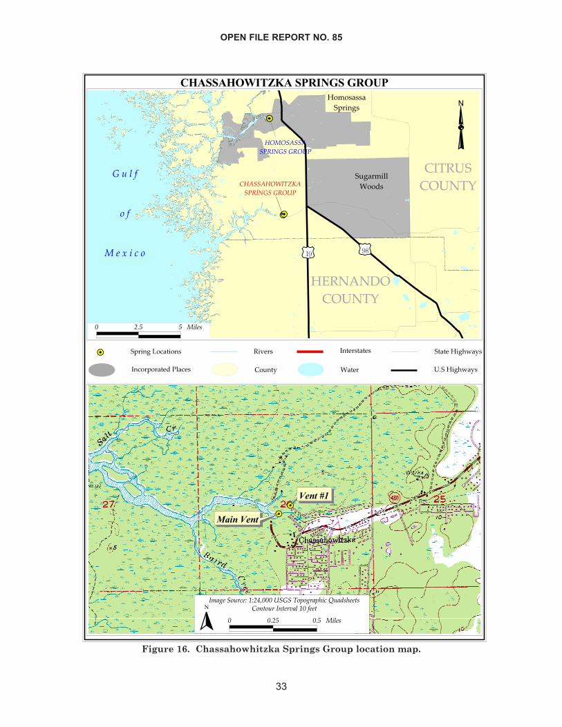
OPEN FILE REPORT NO. 85
33
����������������� �������
����
������
���� ����
������������
���������� �������
�����
����������������
����������������� �� ���
�
�
������
���
�����������
������������� �� ���
�������������������������������������
�� ���
�� ��!
�����������
����� �"�����#$�!�
���������#$�!�
� ��� � �����
����
�������
��������
��� �����!��"�#"�$%������ ����&� !�&'���(��)�'��*�
� ���� ��� ������ ��+*��!��+*�!,���#�����*
�
Figure 16. Chassahowhitzka Springs Group location map.
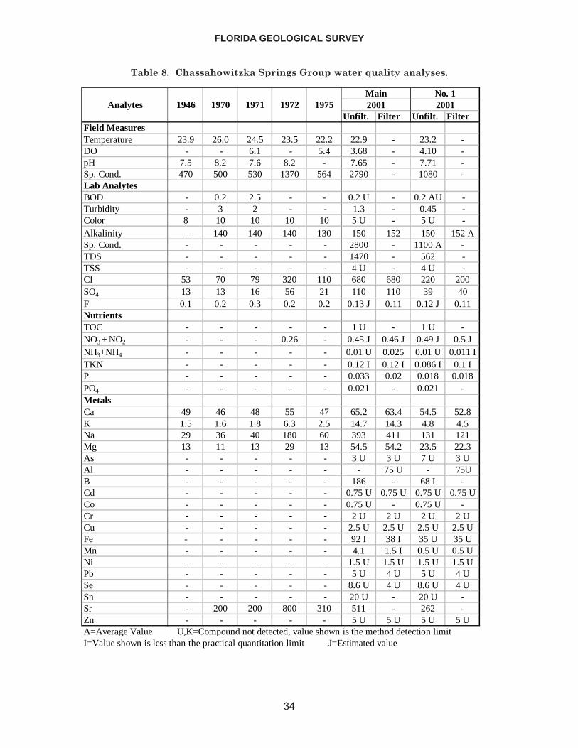
FLORIDA GEOLOGICAL SURVEY
34
Unfilt. Filter Unfilt. FilterField MeasuresTemperature 23.9 26.0 24.5 23.5 22.2 22.9 - 23.2 -DO - - 6.1 - 5.4 3.68 - 4.10 -pH 7.5 8.2 7.6 8.2 - 7.65 - 7.71 -Sp. Cond. 470 500 530 1370 564 2790 - 1080 -Lab AnalytesBOD - 0.2 2.5 - - 0.2 U - 0.2 AU -Turbidity - 3 2 - - 1.3 - 0.45 -Color 8 10 10 10 10 5 U - 5 U -Alkalinity - 140 140 140 130 150 152 150 152 ASp. Cond. - - - - - 2800 - 1100 A -TDS - - - - - 1470 - 562 -TSS - - - - - 4 U - 4 U -Cl 53 70 79 320 110 680 680 220 200SO4 13 13 16 56 21 110 110 39 40F 0.1 0.2 0.3 0.2 0.2 0.13 J 0.11 0.12 J 0.11NutrientsTOC - - - - - 1 U - 1 U -NO3 + NO2 - - - 0.26 - 0.45 J 0.46 J 0.49 J 0.5 JNH3+NH4 - - - - - 0.01 U 0.025 0.01 U 0.011 ITKN - - - - - 0.12 I 0.12 I 0.086 I 0.1 IP - - - - - 0.033 0.02 0.018 0.018PO4 - - - - - 0.021 - 0.021 -MetalsCa 49 46 48 55 47 65.2 63.4 54.5 52.8K 1.5 1.6 1.8 6.3 2.5 14.7 14.3 4.8 4.5Na 29 36 40 180 60 393 411 131 121Mg 13 11 13 29 13 54.5 54.2 23.5 22.3As - - - - - 3 U 3 U 7 U 3 UAl - - - - - - 75 U - 75UB - - - - - 186 - 68 I -Cd - - - - - 0.75 U 0.75 U 0.75 U 0.75 UCo - - - - - 0.75 U - 0.75 U -Cr - - - - - 2 U 2 U 2 U 2 UCu - - - - - 2.5 U 2.5 U 2.5 U 2.5 UFe - - - - - 92 I 38 I 35 U 35 UMn - - - - - 4.1 1.5 I 0.5 U 0.5 UNi - - - - - 1.5 U 1.5 U 1.5 U 1.5 UPb - - - - - 5 U 4 U 5 U 4 USe - - - - - 8.6 U 4 U 8.6 U 4 USn - - - - - 20 U - 20 U -Sr - 200 200 800 310 511 - 262 -Zn - - - - - 5 U 5 U 5 U 5 U
No. 11946
Main20011972 19751970 1971Analytes 2001
A=Average Value U,K=Compound not detected, value shown is the method detection limitI=Value shown is less than the practical quantitation limit J=Estimated value
Table 8. Chassahowitzka Springs Group water quality analyses.
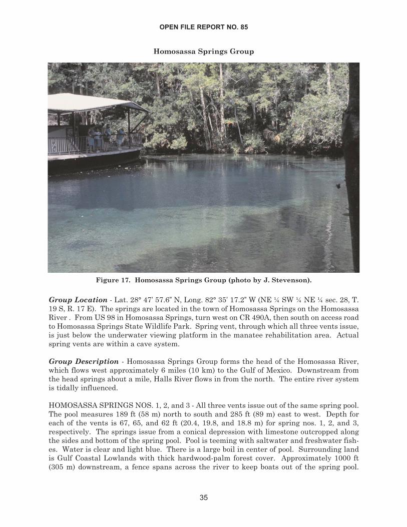
Homosassa Springs Group
Group Location - Lat. 28° 47’ 57.6” N, Long. 82° 35’ 17.2” W (NE ¼ SW ¼ NE ¼ sec. 28, T.19 S, R. 17 E). The springs are located in the town of Homosassa Springs on the HomosassaRiver . From US 98 in Homosassa Springs, turn west on CR 490A, then south on access roadto Homosassa Springs State Wildlife Park. Spring vent, through which all three vents issue,is just below the underwater viewing platform in the manatee rehabilitation area. Actualspring vents are within a cave system.
Group Description - Homosassa Springs Group forms the head of the Homosassa River,which flows west approximately 6 miles (10 km) to the Gulf of Mexico. Downstream fromthe head springs about a mile, Halls River flows in from the north. The entire river systemis tidally influenced.
HOMOSASSA SPRINGS NOS. 1, 2, and 3 - All three vents issue out of the same spring pool.The pool measures 189 ft (58 m) north to south and 285 ft (89 m) east to west. Depth foreach of the vents is 67, 65, and 62 ft (20.4, 19.8, and 18.8 m) for spring nos. 1, 2, and 3,respectively. The springs issue from a conical depression with limestone outcropped alongthe sides and bottom of the spring pool. Pool is teeming with saltwater and freshwater fish-es. Water is clear and light blue. There is a large boil in center of pool. Surrounding landis Gulf Coastal Lowlands with thick hardwood-palm forest cover. Approximately 1000 ft(305 m) downstream, a fence spans across the river to keep boats out of the spring pool.
OPEN FILE REPORT NO. 85
35
Figure 17. Homosassa Springs Group (photo by J. Stevenson).
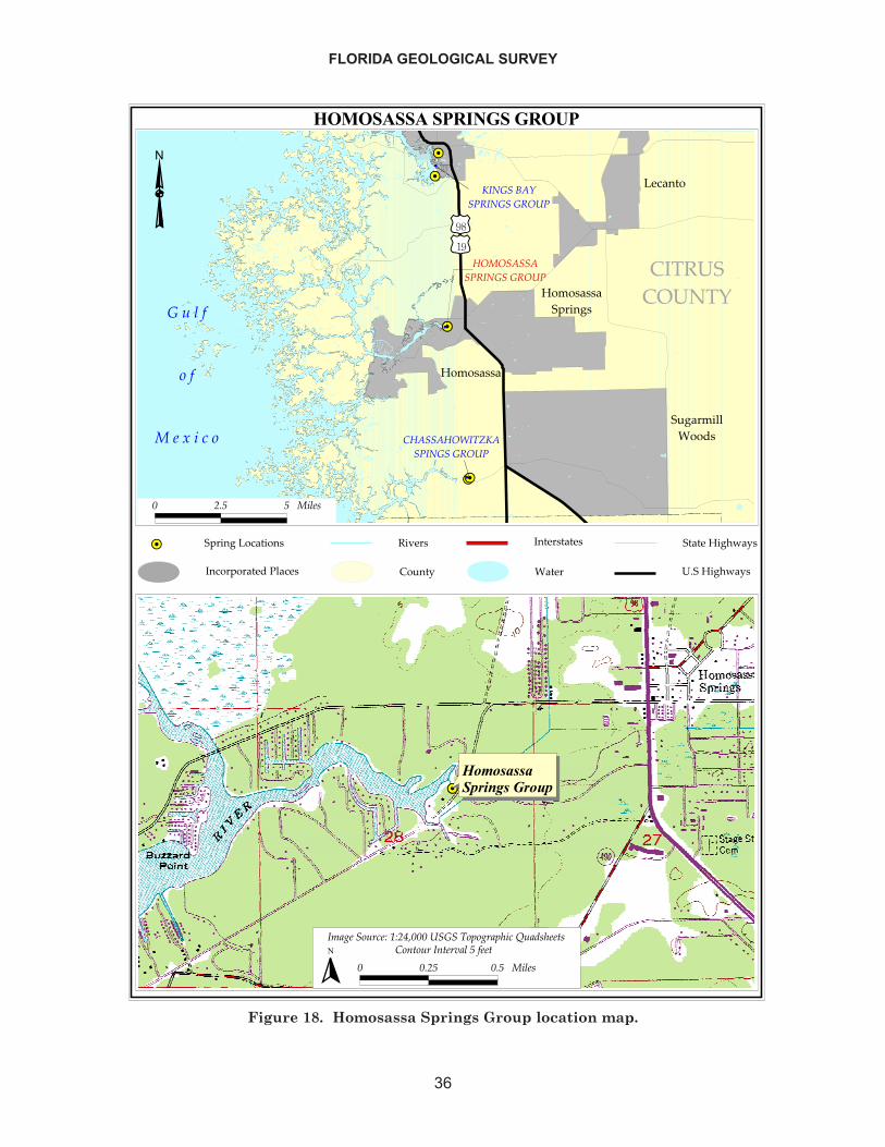
FLORIDA GEOLOGICAL SURVEY
36
��������������������
����
������
����
��������
���������
� ������������
����������������
���������
�������
������������������ ����
�
�
��������������� ����
� � � �
� �
� � � � � �
���� ��������� ����
�
��������
�������������������������������������
�� ���
�� ��!
�����������
����� �"�����#$�!�
���������#$�!�
� ��� � �����
������ �������������������������������� �
� !"� ���#��$ %$�&'��� ���� ��(�"#!()�� *�!+�)��,�
� ���� ��� ������ ��-,��# �-,�#.!� � ���,
�
Figure 18. Homosassa Springs Group location map.
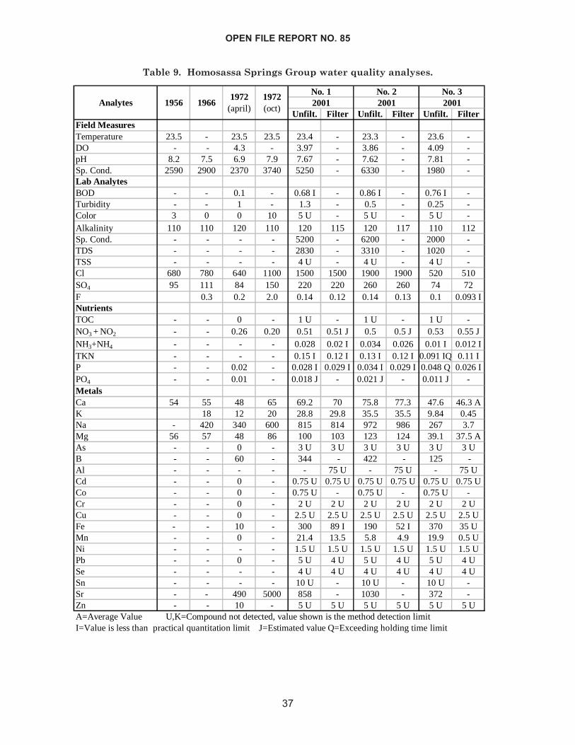
OPEN FILE REPORT NO. 85
37
Unfilt. Filter Unfilt. Filter Unfilt. FilterField MeasuresTemperature 23.5 - 23.5 23.5 23.4 - 23.3 - 23.6 -DO - - 4.3 - 3.97 - 3.86 - 4.09 -pH 8.2 7.5 6.9 7.9 7.67 - 7.62 - 7.81 -Sp. Cond. 2590 2900 2370 3740 5250 - 6330 - 1980 -Lab AnalytesBOD - - 0.1 - 0.68 I - 0.86 I - 0.76 I -Turbidity - - 1 - 1.3 - 0.5 - 0.25 -Color 3 0 0 10 5 U - 5 U - 5 U -Alkalinity 110 110 120 110 120 115 120 117 110 112Sp. Cond. - - - - 5200 - 6200 - 2000 -TDS - - - - 2830 - 3310 - 1020 -TSS - - - - 4 U - 4 U - 4 U -Cl 680 780 640 1100 1500 1500 1900 1900 520 510SO4 95 111 84 150 220 220 260 260 74 72F 0.3 0.2 2.0 0.14 0.12 0.14 0.13 0.1 0.093 INutrientsTOC - - 0 - 1 U - 1 U - 1 U -NO3 + NO2 - - 0.26 0.20 0.51 0.51 J 0.5 0.5 J 0.53 0.55 JNH3+NH4 - - - - 0.028 0.02 I 0.034 0.026 0.01 I 0.012 ITKN - - - - 0.15 I 0.12 I 0.13 I 0.12 I 0.091 IQ 0.11 IP - - 0.02 - 0.028 I 0.029 I 0.034 I 0.029 I 0.048 Q 0.026 IPO4 - - 0.01 - 0.018 J - 0.021 J - 0.011 J -MetalsCa 54 55 48 65 69.2 70 75.8 77.3 47.6 46.3 AK 18 12 20 28.8 29.8 35.5 35.5 9.84 0.45Na - 420 340 600 815 814 972 986 267 3.7Mg 56 57 48 86 100 103 123 124 39.1 37.5 AAs - - 0 - 3 U 3 U 3 U 3 U 3 U 3 UB - - 60 - 344 - 422 - 125 -Al - - - - - 75 U - 75 U - 75 UCd - - 0 - 0.75 U 0.75 U 0.75 U 0.75 U 0.75 U 0.75 UCo - - 0 - 0.75 U - 0.75 U - 0.75 U -Cr - - 0 - 2 U 2 U 2 U 2 U 2 U 2 UCu - - 0 - 2.5 U 2.5 U 2.5 U 2.5 U 2.5 U 2.5 UFe - - 10 - 300 89 I 190 52 I 370 35 UMn - - 0 - 21.4 13.5 5.8 4.9 19.9 0.5 UNi - - - - 1.5 U 1.5 U 1.5 U 1.5 U 1.5 U 1.5 UPb - - 0 - 5 U 4 U 5 U 4 U 5 U 4 USe - - - - 4 U 4 U 4 U 4 U 4 U 4 USn - - - - 10 U - 10 U - 10 U -Sr - - 490 5000 858 - 1030 - 372 -Zn - - 10 - 5 U 5 U 5 U 5 U 5 U 5 U
1972 (april)
19661956No. 1
A=Average Value U,K=Compound not detected, value shown is the method detection limitI=Value is less than practical quantitation limit J=Estimated value Q=Exceeding holding time limit
1972 (oct)
No. 2 No. 320012001Analytes 2001
Table 9. Homosassa Springs Group water quality analyses.
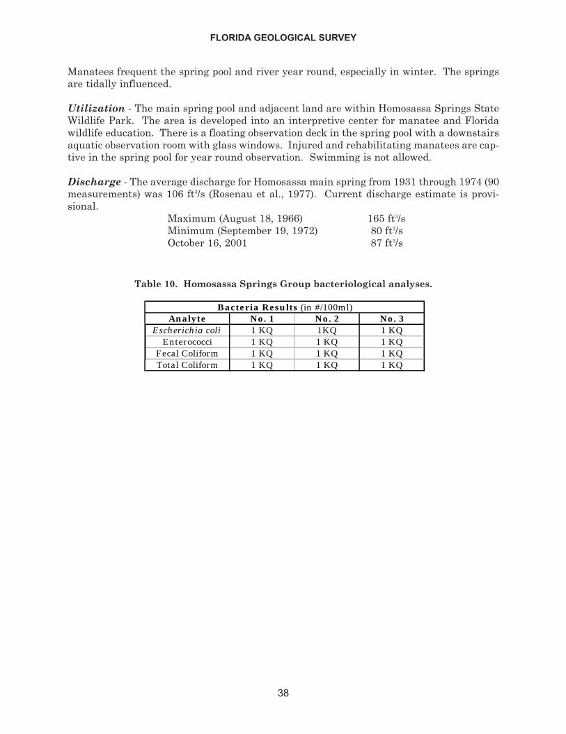
Manatees frequent the spring pool and river year round, especially in winter. The springsare tidally influenced.
Utilization - The main spring pool and adjacent land are within Homosassa Springs StateWildlife Park. The area is developed into an interpretive center for manatee and Floridawildlife education. There is a floating observation deck in the spring pool with a downstairsaquatic observation room with glass windows. Injured and rehabilitating manatees are cap-tive in the spring pool for year round observation. Swimming is not allowed.
Discharge - The average discharge for Homosassa main spring from 1931 through 1974 (90measurements) was 106 ft3/s (Rosenau et al., 1977). Current discharge estimate is provi-sional.
Maximum (August 18, 1966) 165 ft3/sMinimum (September 19, 1972) 80 ft3/sOctober 16, 2001 87 ft3/s
FLORIDA GEOLOGICAL SURVEY
38
Analyte No. 1 No. 2 No. 3Escherichia coli 1 KQ 1KQ 1 KQ
Enterococci 1 KQ 1 KQ 1 KQFecal Coliform 1 KQ 1 KQ 1 KQTotal Coliform 1 KQ 1 KQ 1 KQ
Bacteria Results (in #/100ml)
Table 10. Homosassa Springs Group bacteriological analyses.
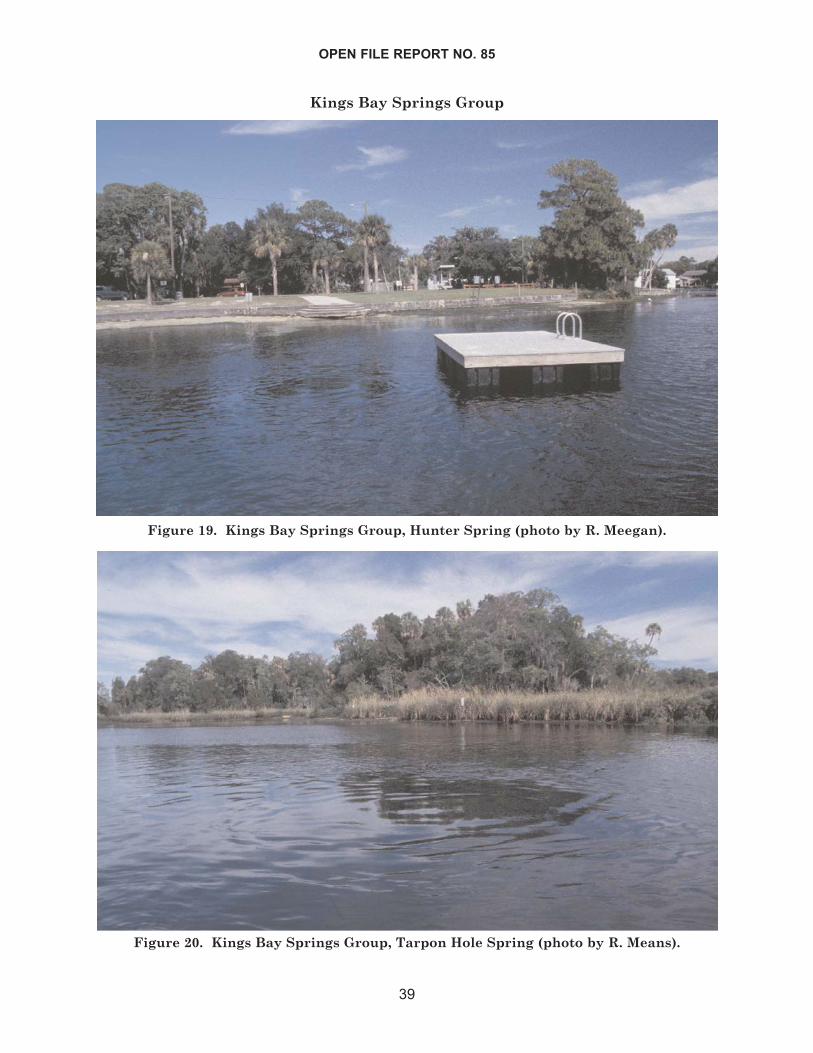
Kings Bay Springs Group
OPEN FILE REPORT NO. 85
39
Figure 19. Kings Bay Springs Group, Hunter Spring (photo by R. Meegan).
Figure 20. Kings Bay Springs Group, Tarpon Hole Spring (photo by R. Means).
Group Location - Lat. 28° 53’ N, Long. 82° 35’ W (sections 28 and 21, T. 18 S, R 17 E). Thesprings are located in Kings Bay west of the City of Crystal River. Kings Bay is approxi-mately 60 miles (96 km) north of Tampa and 30 miles (48 km) southwest of Ocala.
Group Description - Kings Bay is the head of Crystal River. There are about 30 knownsprings, including Tarpon Hole and Hunter Spring, that either issue from the bottom ofKings Bay or flow into the bay from side creek heads. Their combined flow feeds CrystalRiver, which flows approximately 7 miles (11 km) west to the Gulf of Mexico. Surroundingland is Gulf Coastal Lowlands with brackish marsh and hardwood-palm hammock to thewest and the City of Crystal River to the east. The whole system is tidally influenced, andKings Bay is brackish. Rosenau et al. (1977) referred to these springs as the Crystal RiverSprings Group.
HUNTER SPRING - Lat. 28° 53’ 40.0” N, Long. 82° 35’ 33.0” W (NW ¼ SW ¼ SE ¼ sec. 21,T. 18 S, R. 17 E). This spring issues vertically from the bottom of a conical depression nearthe head of a side creek channel feeding the eastside of Kings Bay. Another spring is at thehead of the channel. Hunter Spring pool is circular and measures 210 ft (64 m) in diameter.Depth measured over the vent is 13 ft (4 m). Spring has sandy bottom with some limestonenear the vent. The spring bottom is choked with dark green filamentous algae, and someHydrilla is present. Water is clear and bluish. There is a large boil in pool center. Land onthe north rises to approximately 4 ft (1.2 m) above water and is a county maintained recre-ational park. Land on all other sides of spring pool is extensively developed with apart-ments and houses. A concrete sea wall entirely surrounds pool except for outflow and inflow.There is a square swimming dock floating in the center of the spring pool. This spring wasclosed to swimming during summer 2001 due to high coliform bacteria levels detected in thewater (Eric Dehaven, SWFWMD, pers. comm.).
TARPON HOLE SPRING - Lat. 28° 52’ 54.6” N, Long. 82° 35’ 41.3” W (NW ¼ NW ¼ SW ¼sec. 28, T. 18 S, R. 17 E). This spring issues from a deep, conical depression underneathKings Bay on the south side of Banana Island. The spring pool measures approximately 450ft (137 m) north to south and 550 ft (168 m) east to west. Depth measured over the vent is58 ft (17.6m). Water is typically clear and bluish, but can be cloudy during high tide. Thereis a large boil present in center of pool. Visibility was low when visited in October 2001.Algae cover limestone substrates. Vent is a large circular hole in limestone. Nearby islandsto the north are part of the Crystal River National Wildlife Refuge and have marsh grassesand hardwood-palm hammock. Land to the east is privately owned with many houses anda marina. This spring is a favorite scuba diving location and manatee observation area.
Utilization - All of Kings Bay and most of its springs are used for swimming, manateeobservation, pleasure boating, and scuba diving. The west side of Kings Bay and someislands within are part of the Crystal River National Wildlife Refuge. The city of CrystalRiver nearly adjoins the east side of Kings Bay.
Discharge - Jones et al. (1998): 975 ft3/s
FLORIDA GEOLOGICAL SURVEY
40
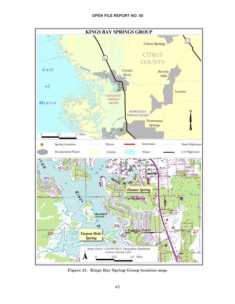
OPEN FILE REPORT NO. 85
41
�������������������
������
����
������������
�� �� �������
��� ��
�
�������������������
����
� �
��
������
����� ������
�����������������
�
������������
��������������
������ ��
����
��������� ������������ ������ ���
������
�����
������� ���
� ��� � ����!" ��
�� �����!" ��
� �� �� ��
��
��
�����������
���� ��� �������
�!�"�������#$#�%&������'�(�"��()��*��+�)����
� ��� �� �� ��� ��,�����,���-� ����
�
Figure 21. Kings Bay Spring Group location map.
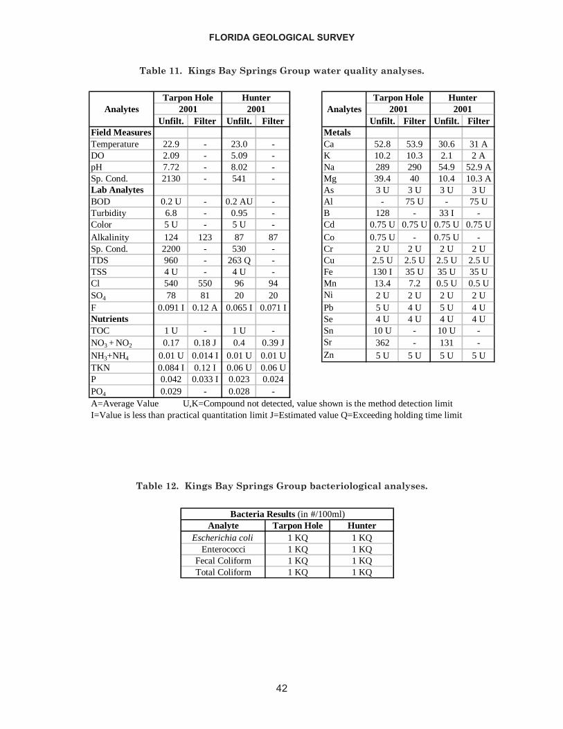
FLORIDA GEOLOGICAL SURVEY
42
Unfilt. Filter Unfilt. Filter Unfilt. Filter Unfilt. FilterField Measures MetalsTemperature 22.9 - 23.0 - Ca 52.8 53.9 30.6 31 ADO 2.09 - 5.09 - K 10.2 10.3 2.1 2 ApH 7.72 - 8.02 - Na 289 290 54.9 52.9 ASp. Cond. 2130 - 541 - Mg 39.4 40 10.4 10.3 ALab Analytes As 3 U 3 U 3 U 3 UBOD 0.2 U - 0.2 AU - Al - 75 U - 75 UTurbidity 6.8 - 0.95 - B 128 - 33 I -Color 5 U - 5 U - Cd 0.75 U 0.75 U 0.75 U 0.75 UAlkalinity 124 123 87 87 Co 0.75 U - 0.75 U -Sp. Cond. 2200 - 530 - Cr 2 U 2 U 2 U 2 UTDS 960 - 263 Q - Cu 2.5 U 2.5 U 2.5 U 2.5 UTSS 4 U - 4 U - Fe 130 I 35 U 35 U 35 UCl 540 550 96 94 Mn 13.4 7.2 0.5 U 0.5 USO4 78 81 20 20 Ni 2 U 2 U 2 U 2 UF 0.091 I 0.12 A 0.065 I 0.071 I Pb 5 U 4 U 5 U 4 UNutrients Se 4 U 4 U 4 U 4 UTOC 1 U - 1 U - Sn 10 U - 10 U -NO3 + NO2 0.17 0.18 J 0.4 0.39 J Sr 362 - 131 -NH3+NH4 0.01 U 0.014 I 0.01 U 0.01 U Zn 5 U 5 U 5 U 5 UTKN 0.084 I 0.12 I 0.06 U 0.06 UP 0.042 0.033 I 0.023 0.024PO4 0.029 - 0.028 -
2001 2001Analytes
A=Average Value U,K=Compound not detected, value shown is the method detection limitI=Value is less than practical quantitation limit J=Estimated value Q=Exceeding holding time limit
Tarpon Hole Hunter20012001 Analytes
Tarpon Hole Hunter
Table 11. Kings Bay Springs Group water quality analyses.
Analyte Tarpon Hole HunterEscherichia coli 1 KQ 1 KQ
Enterococci 1 KQ 1 KQFecal Coliform 1 KQ 1 KQTotal Coliform 1 KQ 1 KQ
Bacteria Results (in #/100ml)
Table 12. Kings Bay Springs Group bacteriological analyses.
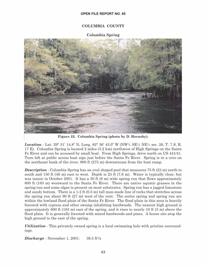
COLUMBIA COUNTY
Columbia Spring
Location - Lat. 29° 51’ 14.8” N, Long. 82° 36’ 43.0” W (NW¼ SE¼ NE¼ sec. 28, T. 7 S, R.17 E). Columbia Spring is located 2 miles (3.2 km) northwest of High Springs on the SantaFe River and can be accessed by small boat. From High Springs, drive north on US 441/41.Turn left at public access boat sign just before the Santa Fe River. Spring is in a cove onthe northeast bank of the river, 900 ft (275 m) downstream from the boat ramp.
Description - Columbia Spring has an oval shaped pool that measures 75 ft (23 m) north tosouth and 150 ft (46 m) east to west. Depth is 25 ft (7.6 m). Water is typically clear, butwas tannic in October 2001. It has a 30 ft (9 m) wide spring run that flows approximately600 ft (183 m) westward to the Santa Fe River. There are native aquatic grasses in thespring run and some algae is present on most substrates. Spring run has a jagged limestoneand sandy bottom. There is a 1-2 ft (0.5 m) tall man-made line of rocks that stretches acrossthe spring run about 90 ft (27 m) west of the vent. The entire spring and spring run arewithin the lowland flood plain of the Santa Fe River. The flood plain in this area is heavilyforested with cypress and other swamp inhabiting hardwoods. The nearest high ground isapproximately 600 ft (183 m) east of the spring, and it rises to nearly 10 ft (3 m) above theflood plain. It is generally forested with mixed hardwoods and pines. A house sits atop thehigh ground to the east of the spring.
Utilization - This privately owned spring is a local swimming hole with pristine surround-ings.
Discharge - November 1, 2001: 39.5 ft3/s
OPEN FILE REPORT NO. 85
43
Figure 22. Columbia Spring (photo by D. Hornsby).
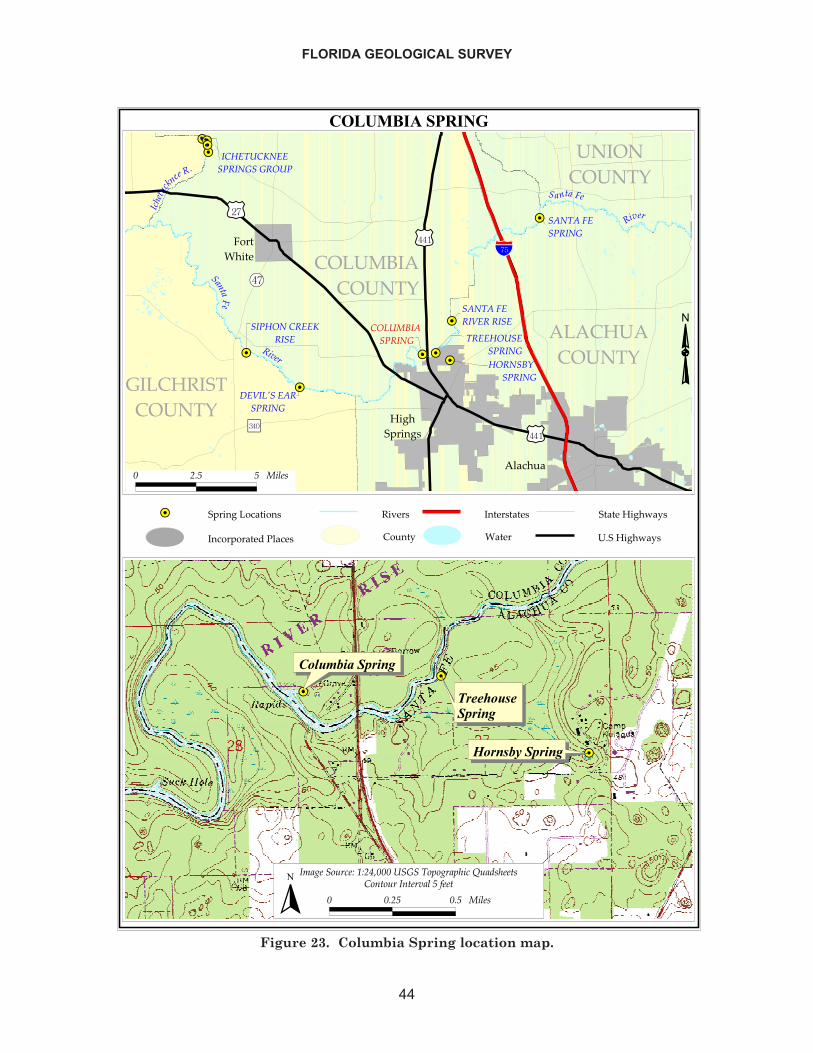
FLORIDA GEOLOGICAL SURVEY
44
������������ ��������
��
��
��
��
��
��
��
� �
������������
��������� ��������������
������� �������
�����������
������ �
����
�
��������������
���������������
������������
�����������������
��� !������������
���"�� ��������"���� ��
�����
�����
���"�� ������
����" �������������� �
�������������
�����������
���������
� ����� �
����
���������������������������� �!�����
��"��������#
���������������� �$������%�#�
����������%�#�
# $% % !�&�'
����
��
������������ �����������
�������������
�����������
�(�)���*����+�,+$-.###� ����"*/*)��/����0��1'����'
# #$% #% !�&�'� �*��*����������&�%�2���
�
Figure 23. Columbia Spring location map.
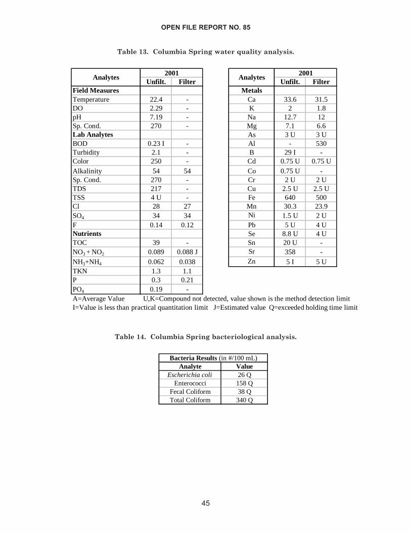
OPEN FILE REPORT NO. 85
45
Unfilt. Filter Unfilt. FilterField Measures MetalsTemperature 22.4 - Ca 33.6 31.5DO 2.29 - K 2 1.8pH 7.19 - Na 12.7 12Sp. Cond. 270 - Mg 7.1 6.6Lab Analytes As 3 U 3 UBOD 0.23 I - Al - 530Turbidity 2.1 - B 29 I -Color 250 - Cd 0.75 U 0.75 UAlkalinity 54 54 Co 0.75 U -Sp. Cond. 270 - Cr 2 U 2 UTDS 217 - Cu 2.5 U 2.5 UTSS 4 U - Fe 640 500Cl 28 27 Mn 30.3 23.9SO4 34 34 Ni 1.5 U 2 UF 0.14 0.12 Pb 5 U 4 UNutrients Se 8.8 U 4 UTOC 39 - Sn 20 U -NO3 + NO2 0.089 0.088 J Sr 358 -NH3+NH4 0.062 0.038 Zn 5 I 5 UTKN 1.3 1.1P 0.3 0.21PO4 0.19 -A=Average Value U,K=Compound not detected, value shown is the method detection limitI=Value is less than practical quantitation limit J=Estimated value Q=exceeded holding time limit
2001Analytes Analytes
2001
Table 13. Columbia Spring water quality analysis.
Analyte ValueEscherichia coli 26 Q
Enterococci 158 QFecal Coliform 38 QTotal Coliform 340 Q
Bacteria Results (in #/100 mL)
Table 14. Columbia Spring bacteriological analysis.
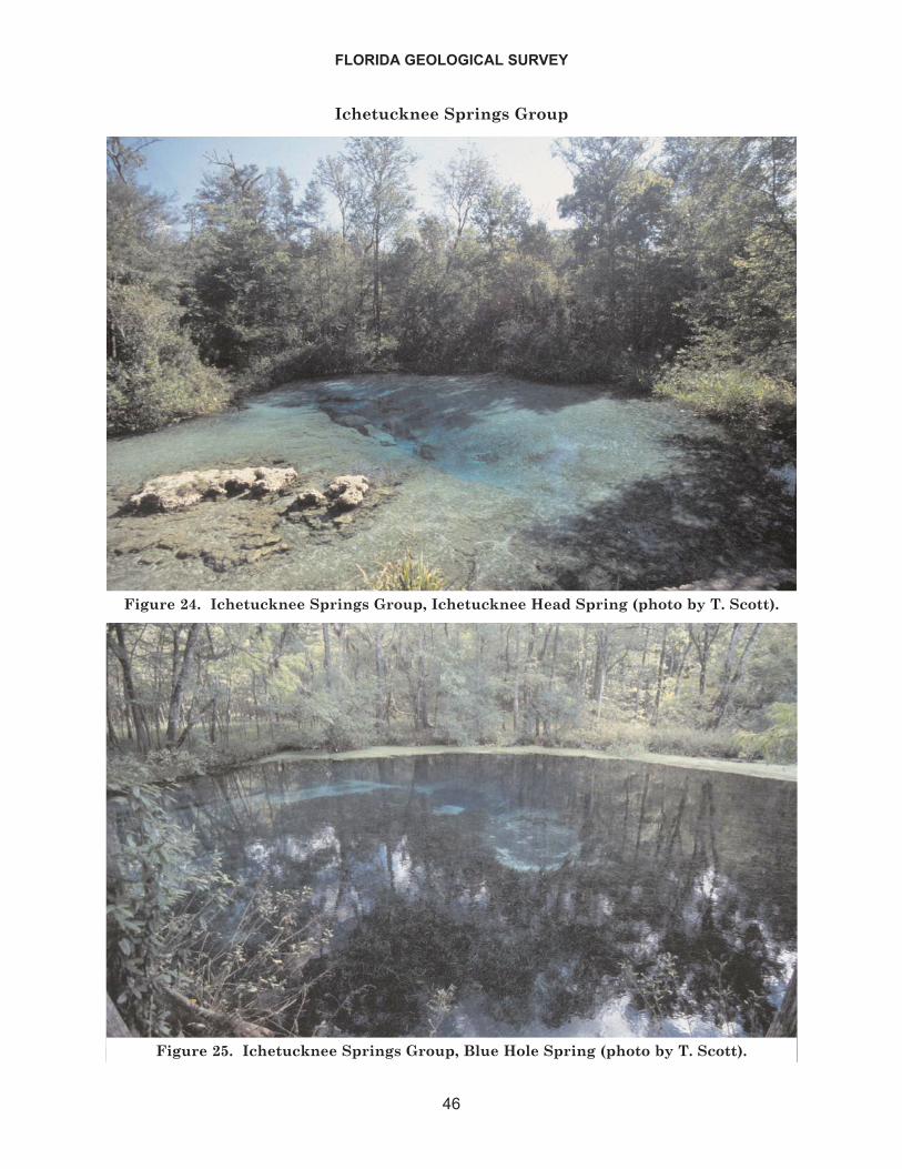
Ichetucknee Springs Group
FLORIDA GEOLOGICAL SURVEY
46
Figure 24. Ichetucknee Springs Group, Ichetucknee Head Spring (photo by T. Scott).
Figure 25. Ichetucknee Springs Group, Blue Hole Spring (photo by T. Scott).
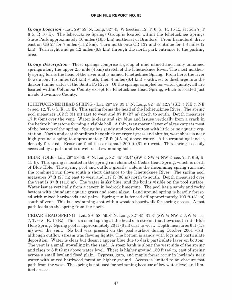
Group Location - Lat. 29° 59’ N, Long. 82° 45’ W (section 12, T. 6 S., R. 15 E., section 7, T6 S, R 16 E). The Ichetucknee Springs Group is located within the Ichetucknee SpringsState Park approximately 10 miles (16.5 km) northeast of Branford. From Brandford, driveeast on US 27 for 7 miles (11.2 km). Turn north onto CR 137 and continue for 1.3 miles (2km). Turn right and go 4.2 miles (6.8 km) through the north park entrance to the parkingarea.
Group Description - These springs comprise a group of nine named and many unnamedsprings along the upper 2.5 mile (4 km) stretch of the Ichetucknee River. The most norther-ly spring forms the head of the river and is named Ichetucknee Spring. From here, the riverflows about 1.5 miles (2.4 km) south, then 4 miles (6.4 km) southwest to discharge into thedarker tannic water of the Santa Fe River. Of the springs sampled for water quality, all arelocated within Columbia County except for Ichetucknee Head Spring, which is located justinside Suwannee County.
ICHETUCKNEE HEAD SPRING - Lat. 29° 59’ 03.1” N, Long. 82° 45’ 42.7” (SE ¼ NE ¼ NE¼ sec. 12, T. 6 S, R. 15 E). This spring forms the head of the Itchetucknee River. The springpool measures 102 ft (31 m) east to west and 87 ft (27 m) north to south. Depth measures17 ft (5m) over the vent. Water is clear and sky blue and issues vertically from a crack inthe bedrock limestone forming a visible boil. A thin, transparent layer of algae carpets mostof the bottom of the spring. Spring has sandy and rocky bottom with little or no aquatic veg-etation. North and east shorelines have thick emergent grass and shrubs, west shore is nearhigh ground sloping to approximately 15 ft (4.5 m) above water. All surrounding land isdensely forested. Restroom facilities are about 200 ft (61 m) west. This spring is easilyaccessed by a path and is a well used swimming hole.
BLUE HOLE - Lat. 29° 58’ 49.9” N, Long. 82° 45’ 30.4” (SW ¼ SW ¼ NW ¼ sec. 7, T. 6 S, R.15 E). This spring is located in the spring run channel of Cedar Head Spring, which is northof Blue Hole. The spring pool and outflow greatly widens the incomming spring run, andthe combined run flows south a short distance to the Ichetucknee River. The spring poolmeasures 87 ft (27 m) east to west and 117 ft (36 m) north to south. Depth measured overthe vent is 37 ft (11.3 m). The water is sky blue, and the boil is visible on the pool surface.Water issues vertically from a cavern in bedrock limestone. The pool has a sandy and rockybottom with abundant aquatic grass and some algae. Land around spring is heavily forest-ed with mixed hardwoods and palm. Spring run is fenced off approximately 100 ft (31 m)south of vent. This is a swimming spot with a wooden boardwalk for spring access. A footpath leads to the spring from the north.
CEDAR HEAD SPRING - Lat. 29° 58’ 59.8” N, Long. 82° 45’ 31.3” (SW ¼ NW ¼ NW ¼ sec.7, T. 6 S., R. 15 E.). This is a small spring at the head of a stream that flows south into BlueHole Spring. Spring pool is approximately 20 ft (6 m) east to west. Depth measures 6 ft (1.8m) over the vent. No boil was present on the pool surface during October 2001 visit,although outflow stream was flowing lightly. The bottom is sandy with logs and particulatedeposition. Water is clear but doesn't appear blue due to dark particulate layer on bottom.The vent is a small upwelling in the sand. A steep bank is along the west side of the springand rises to 8 ft (2 m) above water level. There is higher ground 150 ft (46 m) east of springacross a small lowland flood plain. Cypress, gum, and maple forest occur in lowlands nearwater with mixed hardwood forest on higher ground. Access is limited to an obscure footpath from the west. The spring is not used for swimming because of low water level and lim-ited access.
OPEN FILE REPORT NO. 85
47
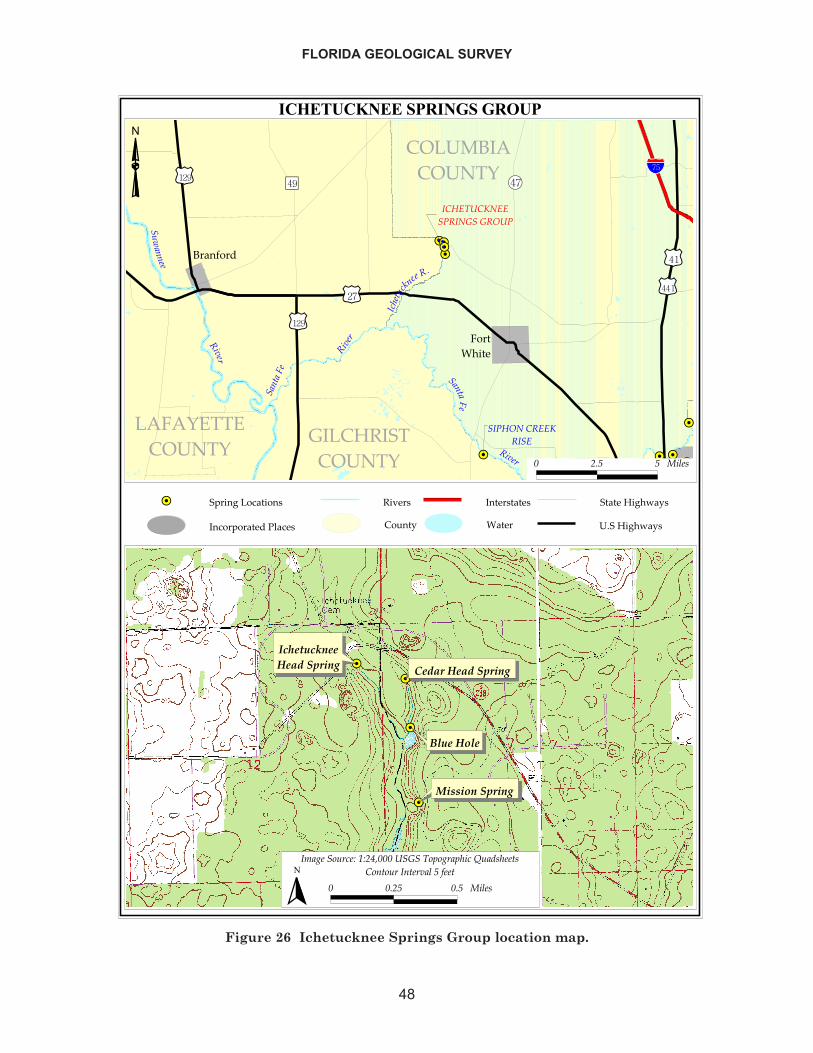
FLORIDA GEOLOGICAL SURVEY
48
������������������� �
��������
�� �� ��
��
��
��������
�����
� �
�����
����� ������
������
���
���
��� ���������
�����
�������������
���� ���������������
�������������
����� ������
�������
�
��������
���
��������
���
�
����������������������
��������������
������� ���������� ����������!"� ��
��#����$��%
���������������� �& �����'�%�
���������'�%�
� �� � �� �!
��
��
��
��
���������������������� ����
�����
�������� ����
���������
��������� ����
�"�#���$� ��%�&%�'(����������$)$# �)����*��+!����!�$��$� ����� �� ���,���
� ��� �� �� �!�
�
Figure 26 Ichetucknee Springs Group location map.
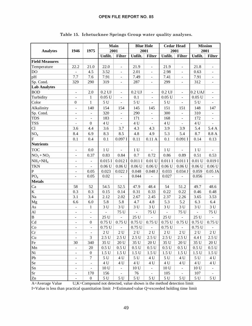
OPEN FILE REPORT NO. 85
49
Unfilt. Filter Unfilt. Filter Unfilt. Filter Unfilt. FilterField MeasuresTemperature 22.2 21.0 22.0 - 21.9 - 21.9 - 21.8 -DO - 4.5 3.52 - 2.01 - 2.98 - 0.63 -pH 7.7 7.6 7.91 - 7.49 - 7.41 - 7.91 -Sp. Cond. 329 290 319 - 287 - 299 - 312 -Lab AnalytesBOD - 2.0 0.2 UJ - 0.2 UJ - 0.2 UJ - 0.2 UAJ -Turbidity - 1 0.05 U - 0.1 - 0.05 U - 0.05 U -Color 0 1 5 U - 5 U - 5 U - 5 U -Alkalinity - 140 154 154 145 145 151 151 148 147Sp. Cond. - - 320 - 290 - 300 - 310 -TDS - - 183 - 171 - 168 - 172 -TSS - 0 4 U - 4 U - 4 U - 4 U -Cl 3.6 4.4 3.6 3.7 4.3 4.3 3.9 3.9 5.4 5.4 ASO4 8.4 6.9 8.3 8.5 4.8 4.9 5.3 5.4 8.7 8.8 AF 0.1 0.4 0.1 0.097 I 0.11 0.11 A 0.1 0.091 I 0.14 0.13NutrientsTOC - 0.0 1 U - 1 U - 1 U - 1 U -NO3 + NO2 - 0.37 0.83 0.84 0.7 0.72 0.86 0.89 0.51 0.53NH3+NH4 - - 0.015 I 0.012 I 0.011 I 0.01 U 0.011 I 0.011 I 0.01 U 0.019 ITKN - - 0.06 U 0.06 U 0.06 U 0.06 U 0.06 U 0.06 U 0.06 U 0.06 UP - 0.05 0.023 0.022 J 0.048 0.048 J 0.033 0.034 J 0.059 0.05 JAPO4 - 0.05 0.02 - 0.044 - 0.027 - 0.056 -MetalsCa 58 52 54.5 52.5 47.9 48.4 54 51.2 49.7 48.6K 0.3 0.3 0.15 0.14 0.31 0.33 0.22 0.22 0.46 0.48Na 3.1 3.4 2.12 2.02 2.67 2.45 2.37 2.26 3.65 3.53Mg 6.6 6.0 5.8 5.8 4.7 4.8 5.3 5.2 6.3 6.4As - 1 3 U 3 U 3 U 3 U 3 U 3 U 3 U 3 UAl - - - 75 U - 75 U - 75 U - 75 UB - - 25 U - 25 U - 25 U - 25 U -Cd - 0 0.75 U 0.75 U 0.75 U 0.75 U 0.75 U 0.75 U 0.75 U 0.75 UCo - - 0.75 U - 0.75 U - 0.75 U - 0.75 U -Cr - - 2 U 2 U 2 U 2 U 2 U 2 U 2 U 2 UCu - 3 2.5 U 2.5 U 2.5 U 2.5 U 2.5 U 2.5 U 4.4 I 2.5 UFe 30 340 35 U 20 U 35 U 20 U 35 U 20 U 35 U 20 UMn - 20 0.5 U 0.5 U 0.5 U 0.5 U 0.5 U 0.5 U 0.5 U 0.5 UNi - 0 1.5 U 1.5 U 1.5 U 1.5 U 1.5 U 1.5 U 1.5 U 1.5 UPb - 7 5 U 4 U 5 U 4 U 5 U 4 U 5 U 4 USe - - 4 U 4 U 4 U 4 U 4 U 4 U 4 U 4 USn - - 10 U - 10 U - 10 U - 10 U -Sr - 170 156 - 76 - 105 - 107 -Zn - 0 5 U 5 U 5 U 5 U 5 U 5 U 5 U 5 UA=Average Value U,K=Compound not detected, value shown is the method detection limitI=Value is less than practical quantitation limit J=Estimated value Q=exceeded holding time limit
Mission2001Analytes 1946 1975 2001
Cedar HeadMain2001
Blue Hole2001
Table 15. Ichetucknee Springs Group water quality analyses.
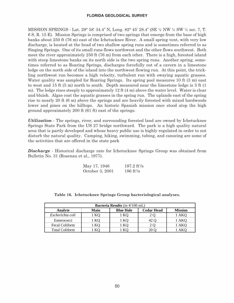
MISSION SPRINGS - Lat. 29° 58’ 34.4” N, Long. 82° 45’ 28.4” (SE ¼ NW ¼ SW ¼ sec. 7, T.6 S, R. 15 E). Mission Springs is comprised of two springs that emerge from the base of highbanks about 250 ft (76 m) east of the Ichetucknee River. A small spring vent, with very lowdischarge, is located at the head of two shallow spring runs and is sometimes referred to asSinging Springs. One of its small runs flows northwest and the other flows southwest. Bothmeet the river approximately 250 ft (76 m) from each other. There is a high, forested islandwith steep limestone banks on its north side is the two spring runs. Another spring, some-times referred to as Roaring Springs, discharges forcefully out of a cavern in a limestoneledge on the north side of the island into the northwest flowing run. At this point, the trick-ling northwest run becomes a high velocity, turbulent run with swaying aquatic grasses.Water quality was sampled for Roaring Springs. Its spring pool measures 10 ft (3 m) eastto west and 15 ft (5 m) north to south. Depth measured near the limestone ledge is 3 ft (1m). The ledge rises steeply to approximately 12 ft (4 m) above the water level. Water is clearand bluish. Algae coat the aquatic grasses in the spring run. The uplands east of the springrise to nearly 20 ft (6 m) above the springs and are heavily forested with mixed hardwoodslower and pines on the hilltops. An historic Spanish mission once stood atop the highground approximately 200 ft (61 ft) east of the springs.
Utilization - The springs, river, and surrounding forested land are owned by IchetuckneeSprings State Park from the US 27 bridge northward. The park is a high quality naturalarea that is partly developed and whose heavy public use is highly regulated in order to notdisturb the natural quality. Camping, hiking, swimming, tubing, and canoeing are some ofthe activities that are offered in the state park
Discharge - Historical discharge rate for Ichetucknee Springs Group was obtained fromBulletin No. 31 (Rosenau et al., 1977).
May 17, 1946 197.2 ft3/sOctober 3, 2001 186 ft3/s
FLORIDA GEOLOGICAL SURVEY
50
Analyte Main Blue Hole Cedar Head MissionEscherichia coli 1 KQ 1 KQ 2 Q 1 AKQ
Enterococci 1 KQ 1 KQ 42 Q 1 AKQFecal Coliform 1 KQ 1 KQ 2 Q 1 AKQTotal Coliform 1 KQ 1 KQ 20 Q 1 AKQ
Bacteria Results (in #/100 mL)
Table 16. Ichetucknee Springs Group bacteriological analyses.
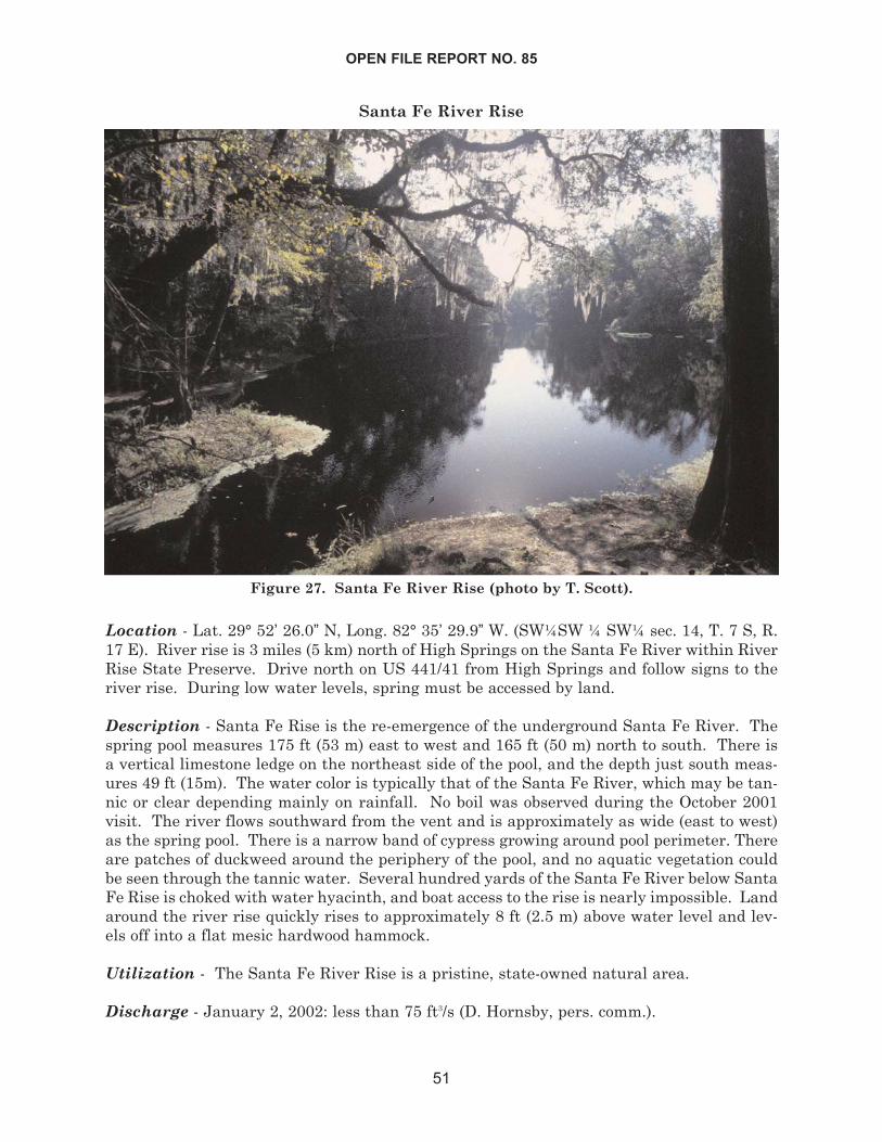
Santa Fe River Rise
Location - Lat. 29° 52’ 26.0” N, Long. 82° 35’ 29.9” W. (SW¼SW ¼ SW¼ sec. 14, T. 7 S, R.17 E). River rise is 3 miles (5 km) north of High Springs on the Santa Fe River within RiverRise State Preserve. Drive north on US 441/41 from High Springs and follow signs to theriver rise. During low water levels, spring must be accessed by land.
Description - Santa Fe Rise is the re-emergence of the underground Santa Fe River. Thespring pool measures 175 ft (53 m) east to west and 165 ft (50 m) north to south. There isa vertical limestone ledge on the northeast side of the pool, and the depth just south meas-ures 49 ft (15m). The water color is typically that of the Santa Fe River, which may be tan-nic or clear depending mainly on rainfall. No boil was observed during the October 2001visit. The river flows southward from the vent and is approximately as wide (east to west)as the spring pool. There is a narrow band of cypress growing around pool perimeter. Thereare patches of duckweed around the periphery of the pool, and no aquatic vegetation couldbe seen through the tannic water. Several hundred yards of the Santa Fe River below SantaFe Rise is choked with water hyacinth, and boat access to the rise is nearly impossible. Landaround the river rise quickly rises to approximately 8 ft (2.5 m) above water level and lev-els off into a flat mesic hardwood hammock.
Utilization - The Santa Fe River Rise is a pristine, state-owned natural area.
Discharge - January 2, 2002: less than 75 ft3/s (D. Hornsby, pers. comm.).
OPEN FILE REPORT NO. 85
51
Figure 27. Santa Fe River Rise (photo by T. Scott).
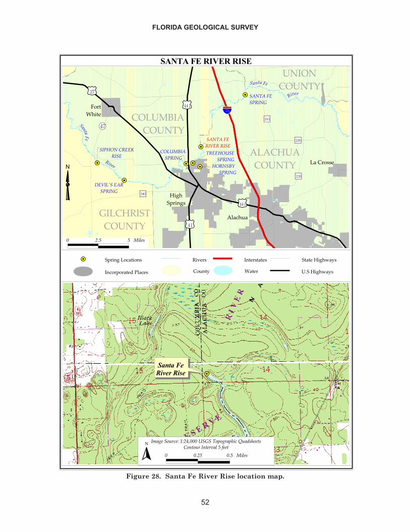
FLORIDA GEOLOGICAL SURVEY
52
������������������
��
��
��
��
��
��
��
��������� �����
����
���������
������� �������
�����������
��������
���
��� ������������
�����������������
������������
������������������
������������������
���������������������� ����
������
�����
��������������
�������������
�����������
���������� � ������
���
��������
�����
�����
�����
���������������������������� �!�����
��"��������#
���������������� �$������%�#�
����������%�#�
� � ! ! ��"�#
������������������
�$�%���&'(�)�*)�+,����������&-&%�-.�(�/'�0#.���#
� � �! � ! ��"�#� �&��&'������"�!�1���
�
Figure 28. Santa Fe River Rise location map.
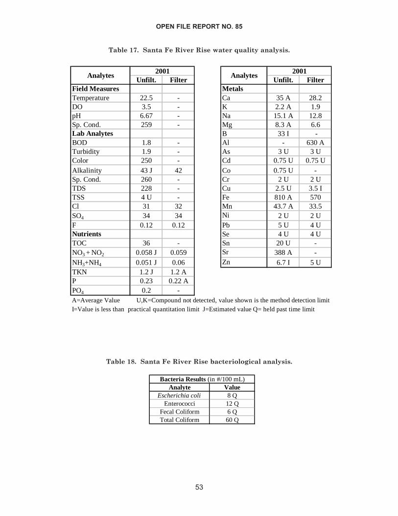
OPEN FILE REPORT NO. 85
53
Unfilt. Filter Unfilt. FilterField Measures MetalsTemperature 22.5 - Ca 35 A 28.2DO 3.5 - K 2.2 A 1.9pH 6.67 - Na 15.1 A 12.8Sp. Cond. 259 - Mg 8.3 A 6.6Lab Analytes B 33 I -BOD 1.8 - Al - 630 ATurbidity 1.9 - As 3 U 3 UColor 250 - Cd 0.75 U 0.75 UAlkalinity 43 J 42 Co 0.75 U -Sp. Cond. 260 - Cr 2 U 2 UTDS 228 - Cu 2.5 U 3.5 ITSS 4 U - Fe 810 A 570Cl 31 32 Mn 43.7 A 33.5SO4 34 34 Ni 2 U 2 UF 0.12 0.12 Pb 5 U 4 UNutrients Se 4 U 4 UTOC 36 - Sn 20 U -NO3 + NO2 0.058 J 0.059 Sr 388 A -NH3+NH4 0.051 J 0.06 Zn 6.7 I 5 UTKN 1.2 J 1.2 AP 0.23 0.22 APO4 0.2 -A=Average Value U,K=Compound not detected, value shown is the method detection limitI=Value is less than practical quantitation limit J=Estimated value Q= held past time limit
Analytes Analytes20012001
Table 17. Santa Fe River Rise water quality analysis.
Analyte ValueEscherichia coli 8 Q
Enterococci 12 QFecal Coliform 6 QTotal Coliform 60 Q
Bacteria Results (in #/100 mL)
Table 18. Santa Fe River Rise bacteriological analysis.
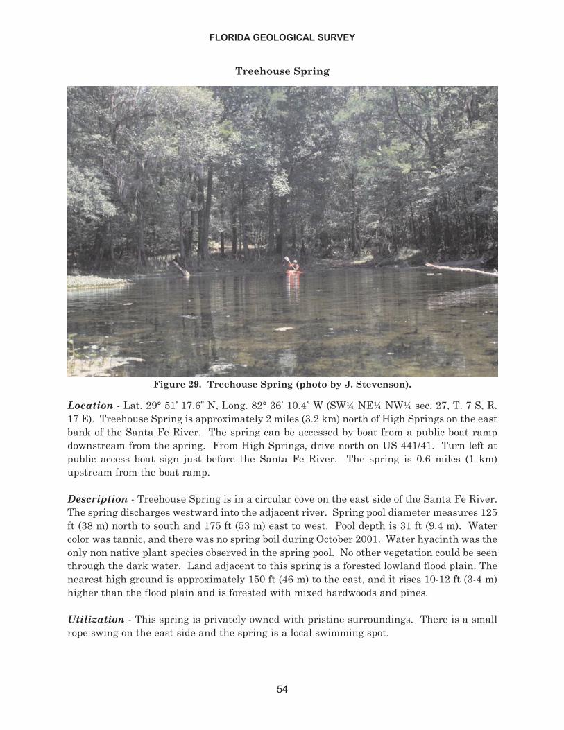
Treehouse Spring
Location - Lat. 29° 51’ 17.6” N, Long. 82° 36’ 10.4” W (SW¼ NE¼ NW¼ sec. 27, T. 7 S, R.17 E). Treehouse Spring is approximately 2 miles (3.2 km) north of High Springs on the eastbank of the Santa Fe River. The spring can be accessed by boat from a public boat rampdownstream from the spring. From High Springs, drive north on US 441/41. Turn left atpublic access boat sign just before the Santa Fe River. The spring is 0.6 miles (1 km)upstream from the boat ramp.
Description - Treehouse Spring is in a circular cove on the east side of the Santa Fe River.The spring discharges westward into the adjacent river. Spring pool diameter measures 125ft (38 m) north to south and 175 ft (53 m) east to west. Pool depth is 31 ft (9.4 m). Watercolor was tannic, and there was no spring boil during October 2001. Water hyacinth was theonly non native plant species observed in the spring pool. No other vegetation could be seenthrough the dark water. Land adjacent to this spring is a forested lowland flood plain. Thenearest high ground is approximately 150 ft (46 m) to the east, and it rises 10-12 ft (3-4 m)higher than the flood plain and is forested with mixed hardwoods and pines.
Utilization - This spring is privately owned with pristine surroundings. There is a smallrope swing on the east side and the spring is a local swimming spot.
FLORIDA GEOLOGICAL SURVEY
54
Figure 29. Treehouse Spring (photo by J. Stevenson).
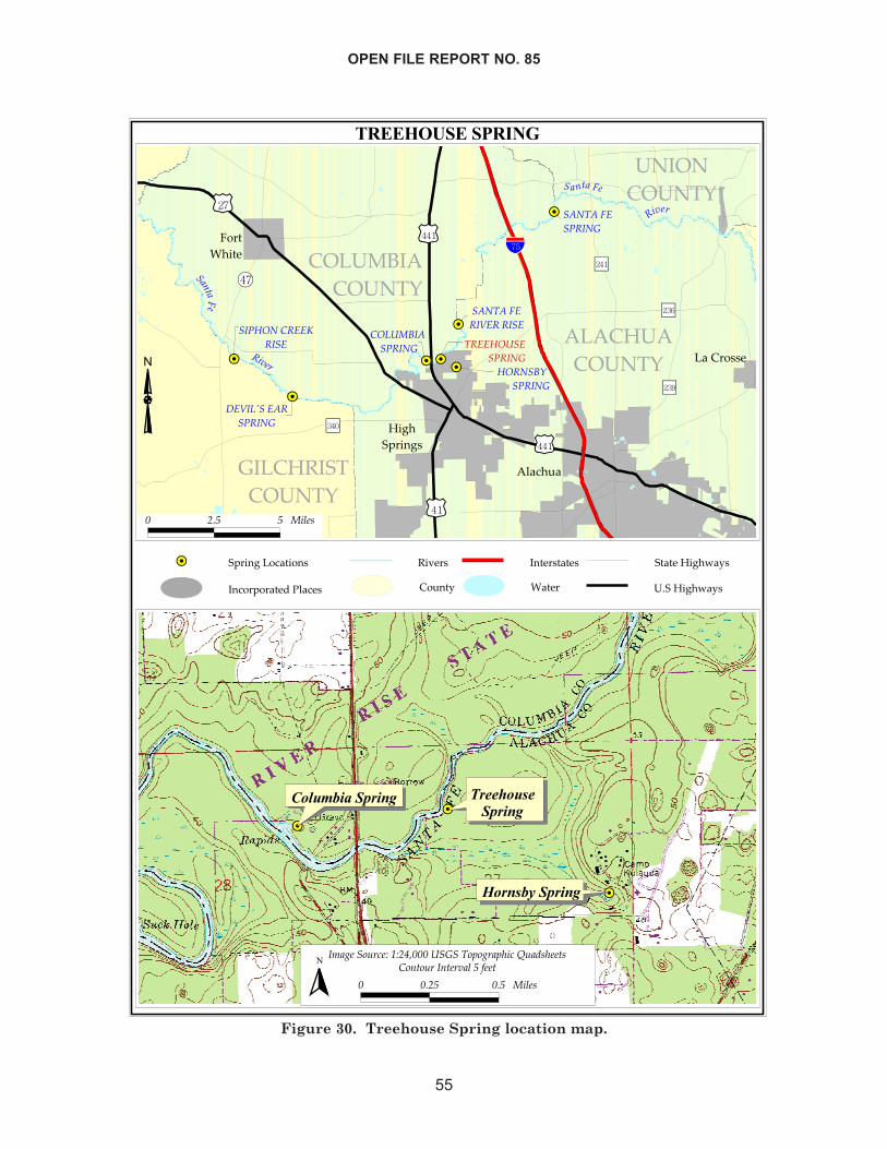
OPEN FILE REPORT NO. 85
55
��������������
��
��
��
��
��
��
��
��������� �����
����
���������
������� �������
�����������
��������
���
��� ������������
�����������������
������������
������������������
������������������
������������������
���� ����������
�����
��������������
�������������
�����������
���������� � ������
���
��������
�����
�����
�����
���������������������������� �!�����
��"��������#
���������������� �$������%�#�
����������%�#�
� � ! ! ��"�#
����
��
�������������
���� ������
����� ������
�$�%���&'(�)�*)�+,����������&-&%�-.�(�/'�0#.���#
� � �! � ! ��"�#� �&��&'������"�!�1���
�
Figure 30. Treehouse Spring location map.
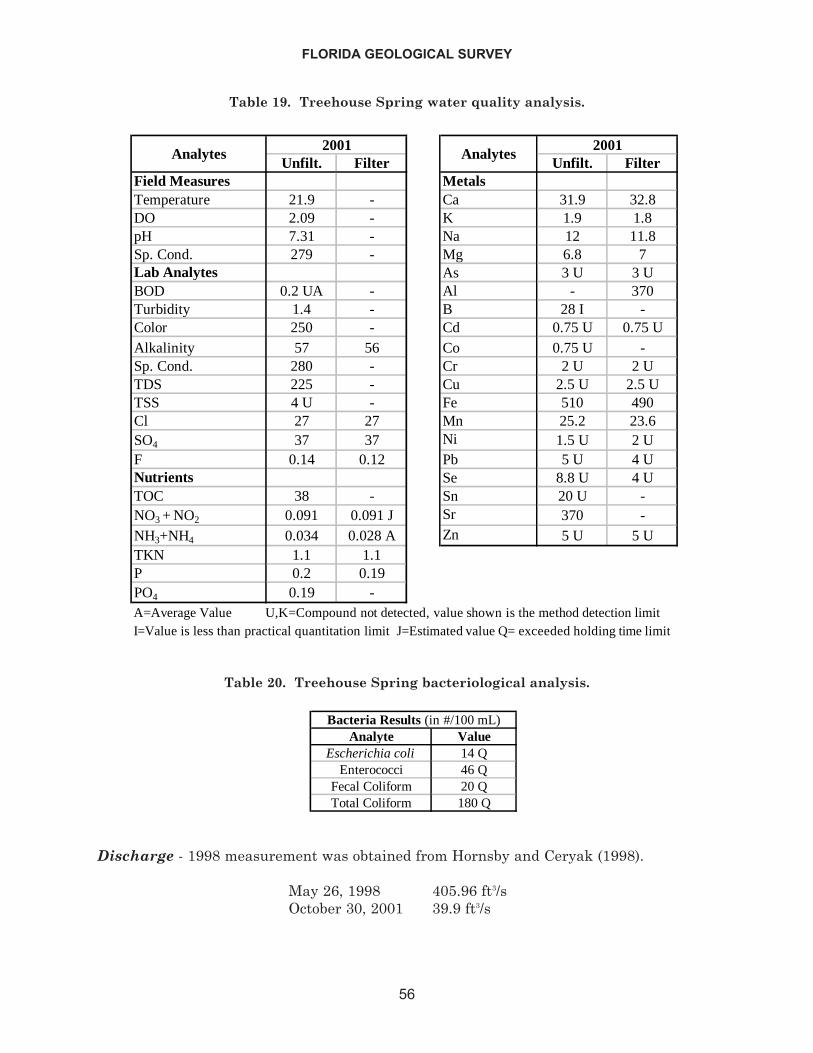
Discharge - 1998 measurement was obtained from Hornsby and Ceryak (1998).
May 26, 1998 405.96 ft3/sOctober 30, 2001 39.9 ft3/s
FLORIDA GEOLOGICAL SURVEY
56
Unfilt. Filter Unfilt. FilterField Measures MetalsTemperature 21.9 - Ca 31.9 32.8DO 2.09 - K 1.9 1.8pH 7.31 - Na 12 11.8Sp. Cond. 279 - Mg 6.8 7Lab Analytes As 3 U 3 UBOD 0.2 UA - Al - 370Turbidity 1.4 - B 28 I -Color 250 - Cd 0.75 U 0.75 UAlkalinity 57 56 Co 0.75 U -Sp. Cond. 280 - Cr 2 U 2 UTDS 225 - Cu 2.5 U 2.5 UTSS 4 U - Fe 510 490Cl 27 27 Mn 25.2 23.6SO4 37 37 Ni 1.5 U 2 UF 0.14 0.12 Pb 5 U 4 UNutrients Se 8.8 U 4 UTOC 38 - Sn 20 U -NO3 + NO2 0.091 0.091 J Sr 370 -NH3+NH4 0.034 0.028 A Zn 5 U 5 UTKN 1.1 1.1P 0.2 0.19PO4 0.19 -A=Average Value U,K=Compound not detected, value shown is the method detection limitI=Value is less than practical quantitation limit J=Estimated value Q= exceeded holding time limit
Analytes Analytes20012001
Table 19. Treehouse Spring water quality analysis.
Analyte ValueEscherichia coli 14 Q
Enterococci 46 QFecal Coliform 20 QTotal Coliform 180 Q
Bacteria Results (in #/100 mL)
Table 20. Treehouse Spring bacteriological analysis.
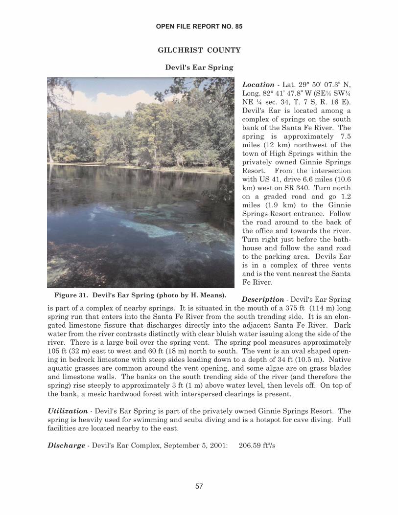
GILCHRIST COUNTY
Devil's Ear Spring
Location - Lat. 29° 50’ 07.3” N,Long. 82° 41’ 47.8”W (SE¼ SW¼NE ¼ sec. 34, T. 7 S, R. 16 E).Devil's Ear is located among acomplex of springs on the southbank of the Santa Fe River. Thespring is approximately 7.5miles (12 km) northwest of thetown of High Springs within theprivately owned Ginnie SpringsResort. From the intersectionwith US 41, drive 6.6 miles (10.6km) west on SR 340. Turn northon a graded road and go 1.2miles (1.9 km) to the GinnieSprings Resort entrance. Followthe road around to the back ofthe office and towards the river.Turn right just before the bath-house and follow the sand roadto the parking area. Devils Earis in a complex of three ventsand is the vent nearest the SantaFe River.
Description - Devil's Ear Springis part of a complex of nearby springs. It is situated in the mouth of a 375 ft (114 m) longspring run that enters into the Santa Fe River from the south trending side. It is an elon-gated limestone fissure that discharges directly into the adjacent Santa Fe River. Darkwater from the river contrasts distinctly with clear bluish water issuing along the side of theriver. There is a large boil over the spring vent. The spring pool measures approximately105 ft (32 m) east to west and 60 ft (18 m) north to south. The vent is an oval shaped open-ing in bedrock limestone with steep sides leading down to a depth of 34 ft (10.5 m). Nativeaquatic grasses are common around the vent opening, and some algae are on grass bladesand limestone walls. The banks on the south trending side of the river (and therefore thespring) rise steeply to approximately 3 ft (1 m) above water level, then levels off. On top ofthe bank, a mesic hardwood forest with interspersed clearings is present.
Utilization - Devil's Ear Spring is part of the privately owned Ginnie Springs Resort. Thespring is heavily used for swimming and scuba diving and is a hotspot for cave diving. Fullfacilities are located nearby to the east.
Discharge - Devil's Ear Complex, September 5, 2001: 206.59 ft3/s
OPEN FILE REPORT NO. 85
57
Figure 31. Devil's Ear Spring (photo by H. Means).
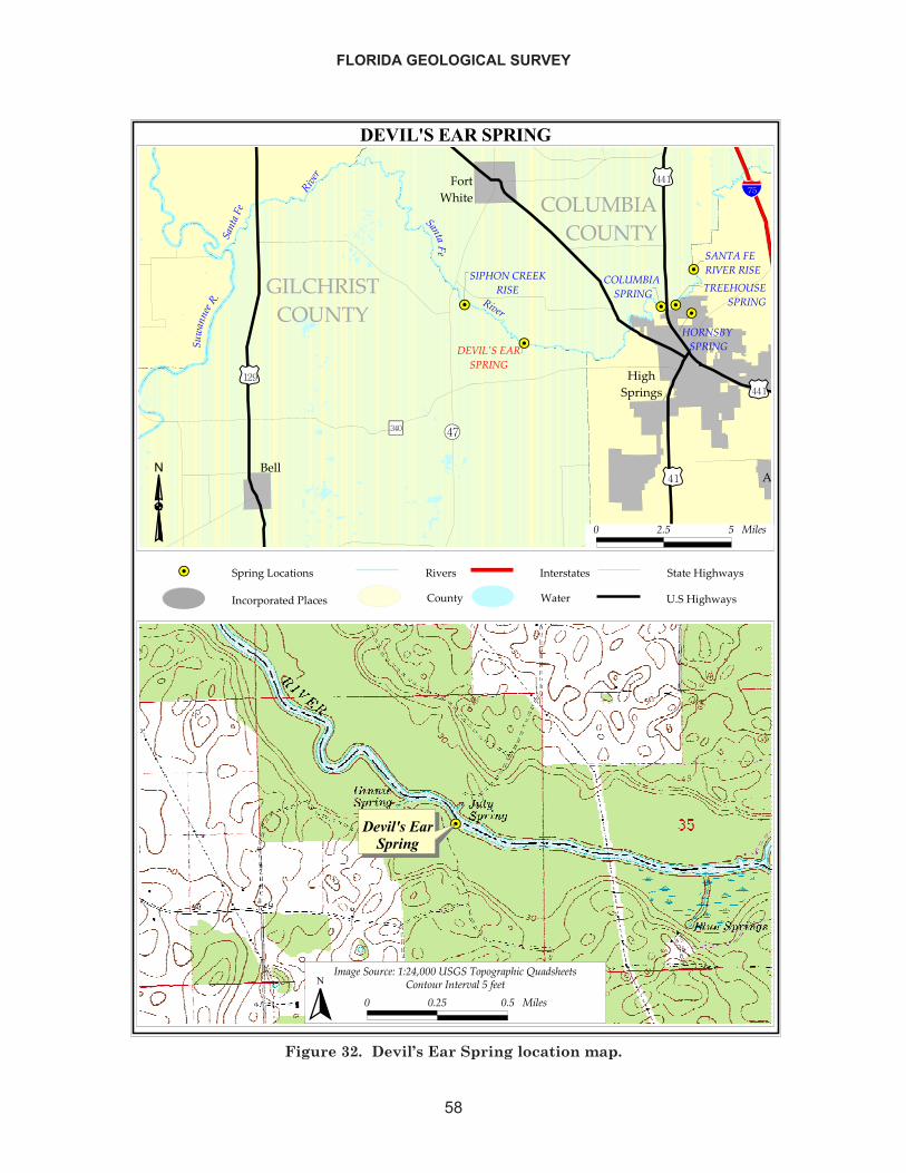
FLORIDA GEOLOGICAL SURVEY
58
���������������
�� ��
��
��
��
��
�����
�������������
����� � ������� �����
����
�����
����
�����������
�����������
�����
�
������
�����
��� �����������
����������������
���� ����
�����
������������
��������������
������������������� ����
������
�����
����
�����
�������� ���� ������� �� ���� �!�����
��"���� ���#
���������������� $������%�#�
����������%�#�
! " # # ��$�%
�������������� �
�&�'��(��)�*+*",-!!!�����(.('��./�)0��1%/���%
! ! "# ! # ��$�%� �(��(���������$#2���
�
Figure 32. Devil’s Ear Spring location map.
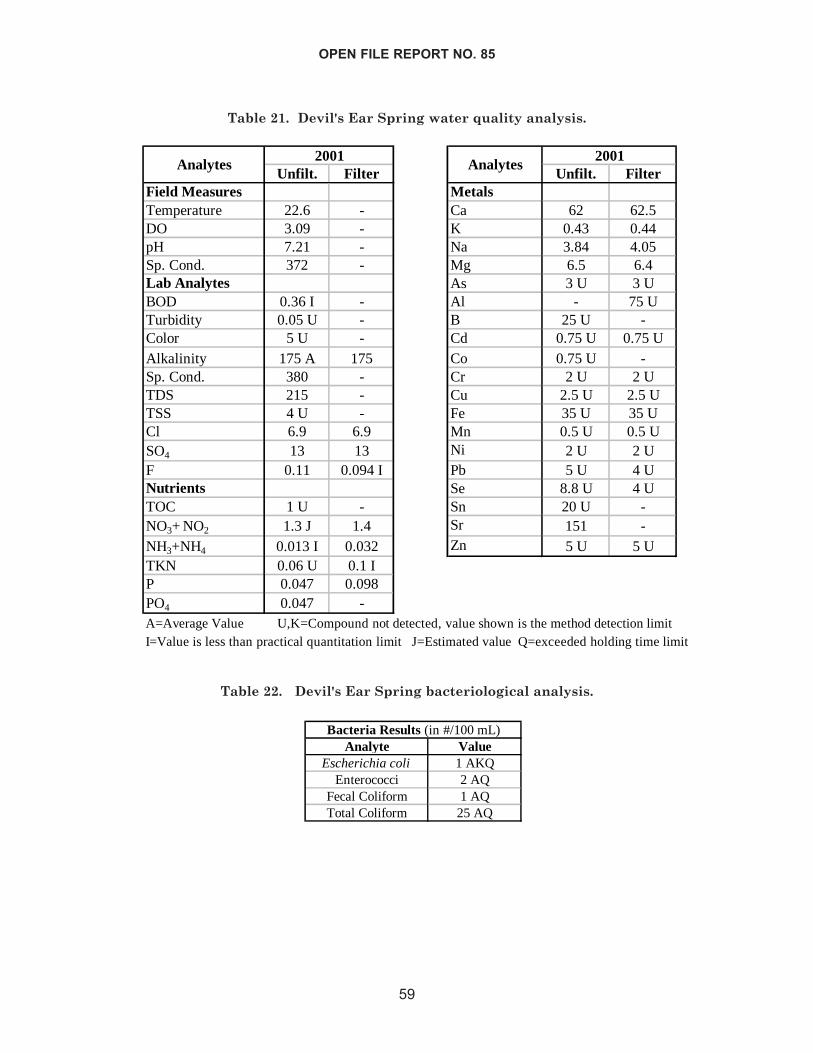
OPEN FILE REPORT NO. 85
59
Unfilt. Filter Unfilt. FilterField Measures MetalsTemperature 22.6 - Ca 62 62.5DO 3.09 - K 0.43 0.44pH 7.21 - Na 3.84 4.05Sp. Cond. 372 - Mg 6.5 6.4Lab Analytes As 3 U 3 UBOD 0.36 I - Al - 75 UTurbidity 0.05 U - B 25 U -Color 5 U - Cd 0.75 U 0.75 UAlkalinity 175 A 175 Co 0.75 U -Sp. Cond. 380 - Cr 2 U 2 UTDS 215 - Cu 2.5 U 2.5 UTSS 4 U - Fe 35 U 35 UCl 6.9 6.9 Mn 0.5 U 0.5 USO4 13 13 Ni 2 U 2 UF 0.11 0.094 I Pb 5 U 4 UNutrients Se 8.8 U 4 UTOC 1 U - Sn 20 U -NO3+ NO2 1.3 J 1.4 Sr 151 -NH3+NH4 0.013 I 0.032 Zn 5 U 5 UTKN 0.06 U 0.1 IP 0.047 0.098PO4 0.047 -A=Average Value U,K=Compound not detected, value shown is the method detection limitI=Value is less than practical quantitation limit J=Estimated value Q=exceeded holding time limit
2001Analytes Analytes
2001
Table 21. Devil's Ear Spring water quality analysis.
Analyte ValueEscherichia coli 1 AKQ
Enterococci 2 AQFecal Coliform 1 AQTotal Coliform 25 AQ
Bacteria Results (in #/100 mL)
Table 22. Devil's Ear Spring bacteriological analysis.
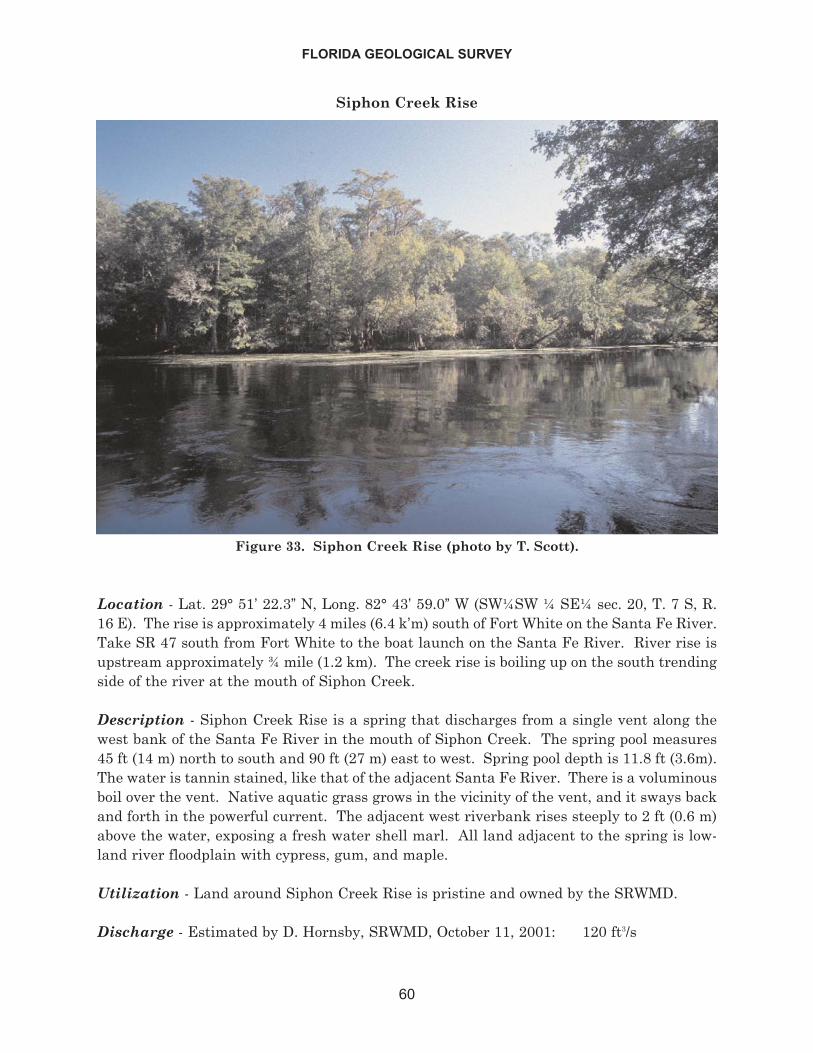
Siphon Creek Rise
Location - Lat. 29° 51’ 22.3” N, Long. 82° 43’ 59.0” W (SW¼SW ¼ SE¼ sec. 20, T. 7 S, R.16 E). The rise is approximately 4 miles (6.4 k’m) south of Fort White on the Santa Fe River.Take SR 47 south from Fort White to the boat launch on the Santa Fe River. River rise isupstream approximately ¾ mile (1.2 km). The creek rise is boiling up on the south trendingside of the river at the mouth of Siphon Creek.
Description - Siphon Creek Rise is a spring that discharges from a single vent along thewest bank of the Santa Fe River in the mouth of Siphon Creek. The spring pool measures45 ft (14 m) north to south and 90 ft (27 m) east to west. Spring pool depth is 11.8 ft (3.6m).The water is tannin stained, like that of the adjacent Santa Fe River. There is a voluminousboil over the vent. Native aquatic grass grows in the vicinity of the vent, and it sways backand forth in the powerful current. The adjacent west riverbank rises steeply to 2 ft (0.6 m)above the water, exposing a fresh water shell marl. All land adjacent to the spring is low-land river floodplain with cypress, gum, and maple.
Utilization - Land around Siphon Creek Rise is pristine and owned by the SRWMD.
Discharge - Estimated by D. Hornsby, SRWMD, October 11, 2001: 120 ft3/s
FLORIDA GEOLOGICAL SURVEY
60
Figure 33. Siphon Creek Rise (photo by T. Scott).
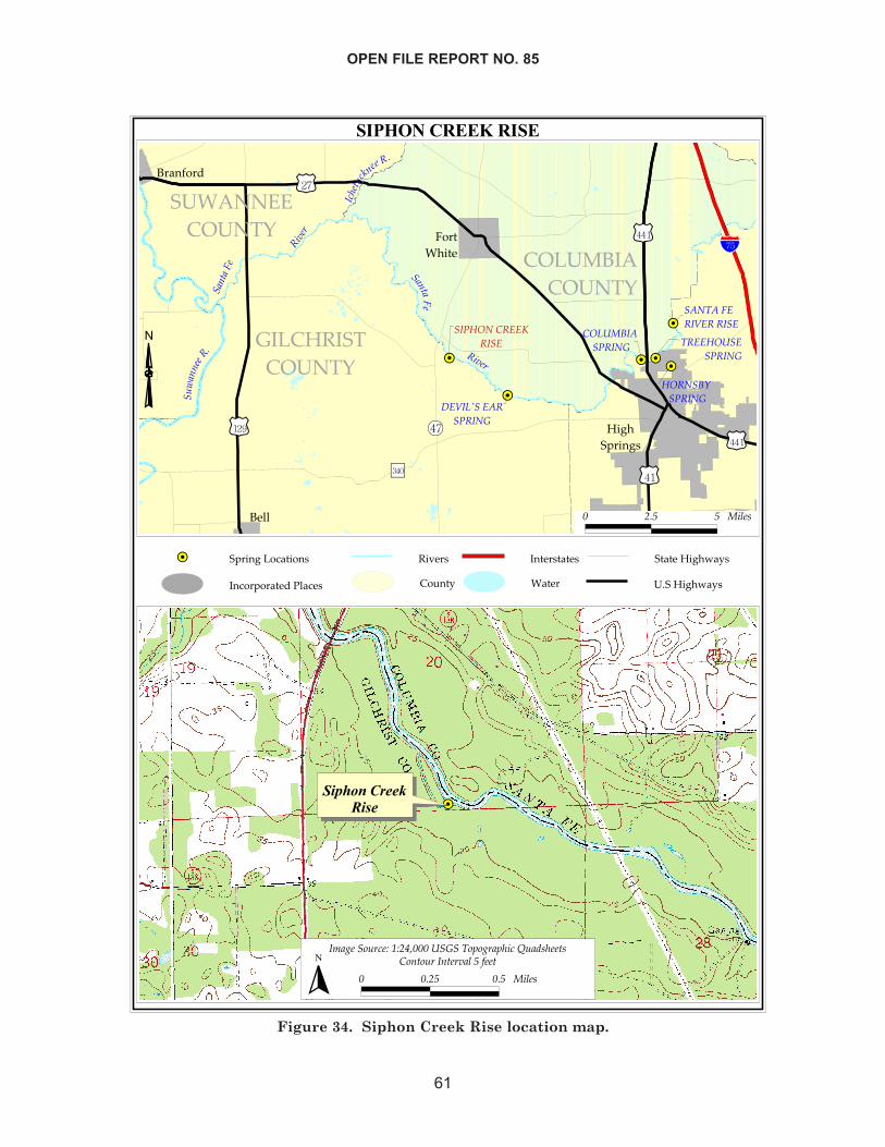
OPEN FILE REPORT NO. 85
61
�������������
�� ��
��
��
��
��
�����
�������������
���������
���
��� � ��
����� �����
����
�����
����
����
�����������
�����������
��������
��������
���
��������������
���������������
����
�����
������������
��� !������������
���"�����������"���� ��
�����
�����
��#������
���������
����� ��
������ � !��� ������! �� ����� "��!��
��#���� $��%
���������������� &� ����'�%�
����� ����'�%�
$ %& & !�'�(
�����������
���
�)�*���+� ��,�-,%./$$$� ����"+0+* �0����1��2(����(
$ $%& $& !�'�(� �+��+� ����� ��'�&�3���
�
Figure 34. Siphon Creek Rise location map.
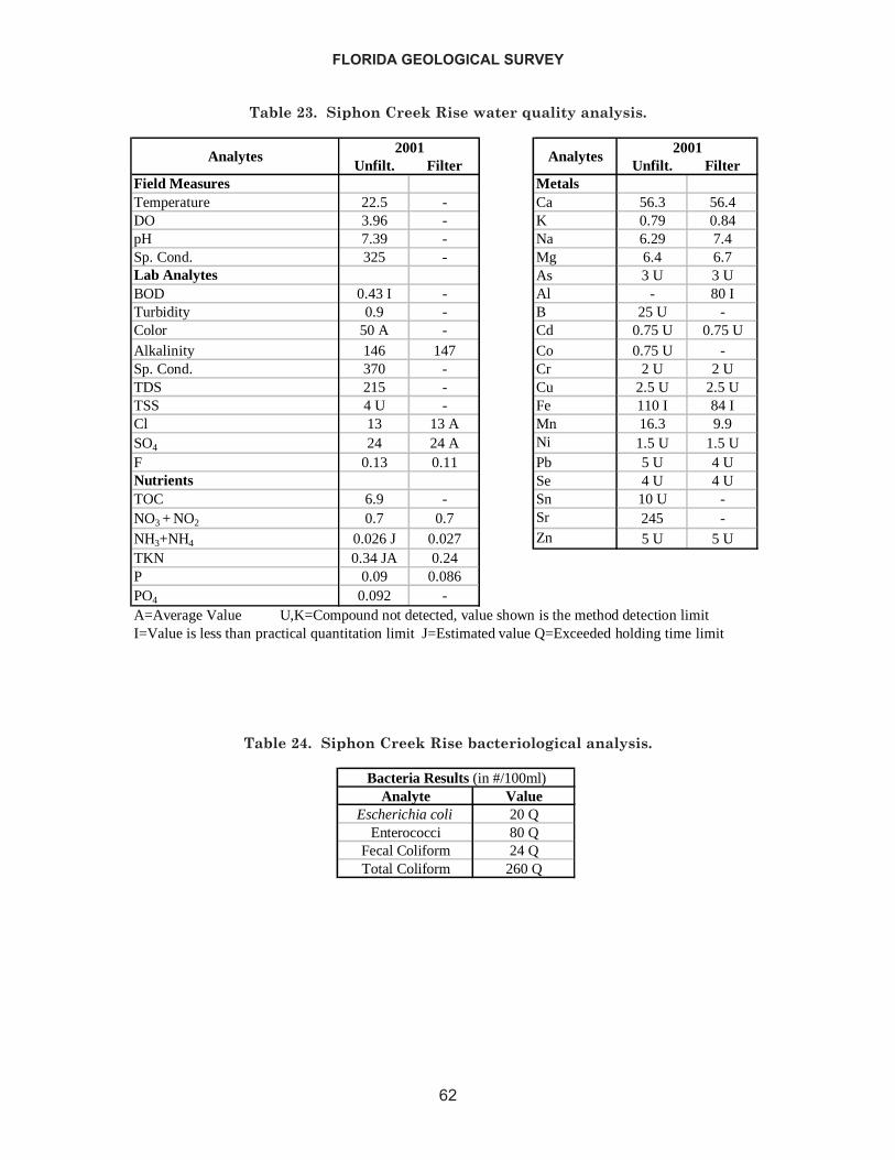
FLORIDA GEOLOGICAL SURVEY
62
Unfilt. Filter Unfilt. FilterField Measures MetalsTemperature 22.5 - Ca 56.3 56.4DO 3.96 - K 0.79 0.84pH 7.39 - Na 6.29 7.4Sp. Cond. 325 - Mg 6.4 6.7Lab Analytes As 3 U 3 UBOD 0.43 I - Al - 80 ITurbidity 0.9 - B 25 U -Color 50 A - Cd 0.75 U 0.75 UAlkalinity 146 147 Co 0.75 U -Sp. Cond. 370 - Cr 2 U 2 UTDS 215 - Cu 2.5 U 2.5 UTSS 4 U - Fe 110 I 84 ICl 13 13 A Mn 16.3 9.9SO4 24 24 A Ni 1.5 U 1.5 UF 0.13 0.11 Pb 5 U 4 UNutrients Se 4 U 4 UTOC 6.9 - Sn 10 U -NO3 + NO2 0.7 0.7 Sr 245 -NH3+NH4 0.026 J 0.027 Zn 5 U 5 UTKN 0.34 JA 0.24P 0.09 0.086PO4 0.092 -A=Average Value U,K=Compound not detected, value shown is the method detection limitI=Value is less than practical quantitation limit J=Estimated value Q=Exceeded holding time limit
2001Analytes Analytes
2001
Table 23. Siphon Creek Rise water quality analysis.
Analyte ValueEscherichia coli 20 Q
Enterococci 80 QFecal Coliform 24 QTotal Coliform 260 Q
Bacteria Results (in #/100ml)
Table 24. Siphon Creek Rise bacteriological analysis.
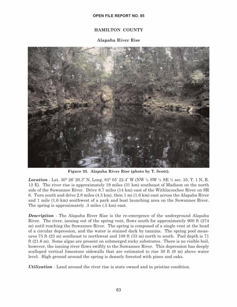
HAMILTON COUNTY
Alapaha River Rise
Location - Lat. 30° 26’ 20.3” N, Long. 83° 05’ 22.4” W (NW ¼ SW ¼ SE ¼ sec. 35, T. 1 N, R.12 E). The river rise is approximately 19 miles (31 km) southeast of Madison on the northside of the Suwannee River. Drive 8.7 miles (14 km) east of the Withlacoochee River on SR6. Turn south and drive 2.8 miles (4.5 km), then 1 mi (1.6 km) east across the Alapaha Riverand 1 mile (1.6 km) southwest of a park and boat launching area on the Suwannee River.The spring is approximately .3 miles (.5 km) east.
Description - The Alapaha River Rise is the re-emergence of the underground AlapahaRiver. The river, issuing out of the spring vent, flows south for approximately 900 ft (274m) until reaching the Suwannee River. The spring is composed of a single vent at the headof a circular depression, and the water is stained dark by tannins. The spring pool meas-ures 75 ft (23 m) southeast to northwest and 108 ft (33 m) north to south. Pool depth is 71ft (21.6 m). Some algae are present on submerged rocky substrates. There is no visible boil,however, the issuing river flows swiftly to the Suwannee River. This depression has deeplyscalloped vertical limestone sidewalls that are estimated to rise 30 ft (9 m) above waterlevel. High ground around the spring is densely forested with pines and oaks.
Utilization - Land around the river rise is state owned and in pristine condition.
OPEN FILE REPORT NO. 85
63
Figure 35. Alapaha River Rise (photo by T. Scott).
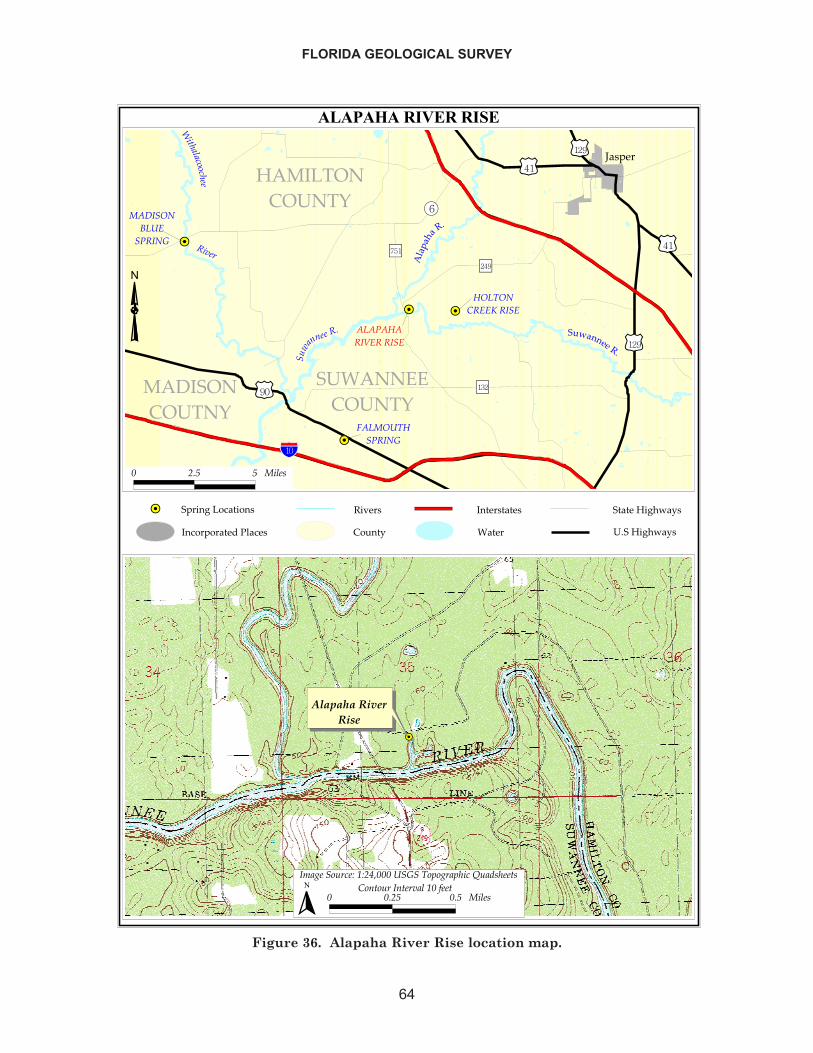
FLORIDA GEOLOGICAL SURVEY
64
�����������������
��
�� ��
��
������
�����
����� �����
������� �����
������� ���������
������ ��
�����
� ��������������
�� ��������������
�����
����������
���
���������
�����
����
� �����������
��������������
����������
�����
�����
!�"
"����#
$ %#& & ����'
��
��������������
�(�)��� ���*�+*%,-$$$������.�)��.����/ �0'����'$ $#%& $#& ����'
� ��"�� ���"�������+$�1���
�
�������� �!������� ������!�"�#�� ��
��$��� ���!%
�!���!�!����!�� ���������%�
!�!��������%�
Figure 36. Alapaha River Rise location map.
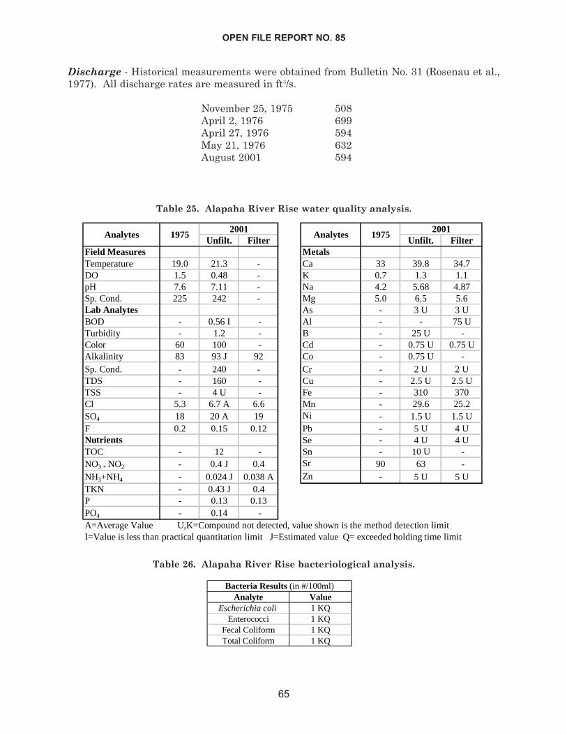
Discharge - Historical measurements were obtained from Bulletin No. 31 (Rosenau et al.,1977). All discharge rates are measured in ft3/s.
November 25, 1975 508April 2, 1976 699April 27, 1976 594May 21, 1976 632August 2001 594
OPEN FILE REPORT NO. 85
65
Unfilt. Filter Unfilt. FilterField Measures MetalsTemperature 19.0 21.3 - Ca 33 39.8 34.7DO 1.5 0.48 - K 0.7 1.3 1.1pH 7.6 7.11 - Na 4.2 5.68 4.87Sp. Cond. 225 242 - Mg 5.0 6.5 5.6Lab Analytes As - 3 U 3 UBOD - 0.56 I - Al - - 75 UTurbidity - 1.2 - B - 25 U -Color 60 100 - Cd - 0.75 U 0.75 UAlkalinity 83 93 J 92 Co - 0.75 U -Sp. Cond. - 240 - Cr - 2 U 2 UTDS - 160 - Cu - 2.5 U 2.5 UTSS - 4 U - Fe - 310 370Cl 5.3 6.7 A 6.6 Mn - 29.6 25.2SO4 18 20 A 19 Ni - 1.5 U 1.5 UF 0.2 0.15 0.12 Pb - 5 U 4 UNutrients Se - 4 U 4 UTOC - 12 - Sn - 10 U -NO3 + NO2 - 0.4 J 0.4 Sr 90 63 -NH3+NH4 - 0.024 J 0.038 A Zn - 5 U 5 UTKN - 0.43 J 0.4P - 0.13 0.13PO4 - 0.14 -A=Average Value U,K=Compound not detected, value shown is the method detection limitI=Value is less than practical quantitation limit J=Estimated value Q= exceeded holding time limit
Analytes 19752001
Analytes 19752001
Table 25. Alapaha River Rise water quality analysis.
Analyte ValueEscherichia coli 1 KQ
Enterococci 1 KQFecal Coliform 1 KQTotal Coliform 1 KQ
Bacteria Results (in #/100ml)
Table 26. Alapaha River Rise bacteriological analysis.
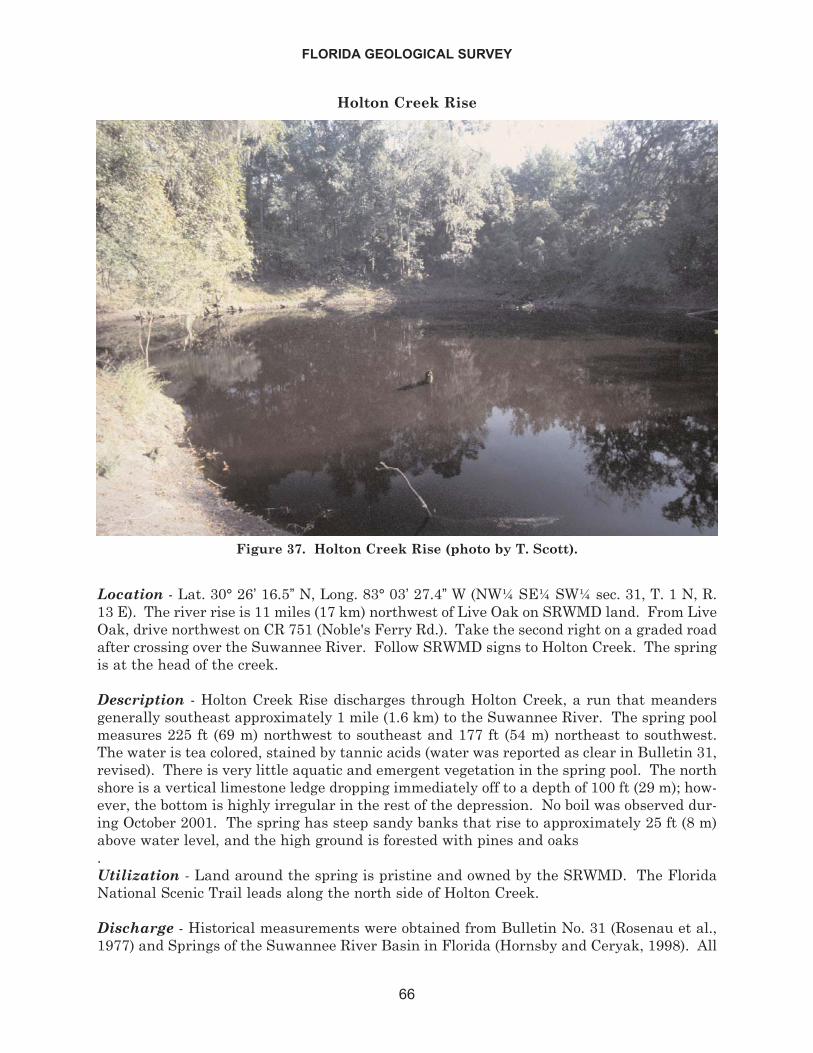
Holton Creek Rise
Location - Lat. 30° 26’ 16.5” N, Long. 83° 03’ 27.4” W (NW¼ SE¼ SW¼ sec. 31, T. 1 N, R.13 E). The river rise is 11 miles (17 km) northwest of Live Oak on SRWMD land. From LiveOak, drive northwest on CR 751 (Noble's Ferry Rd.). Take the second right on a graded roadafter crossing over the Suwannee River. Follow SRWMD signs to Holton Creek. The springis at the head of the creek.
Description - Holton Creek Rise discharges through Holton Creek, a run that meandersgenerally southeast approximately 1 mile (1.6 km) to the Suwannee River. The spring poolmeasures 225 ft (69 m) northwest to southeast and 177 ft (54 m) northeast to southwest.The water is tea colored, stained by tannic acids (water was reported as clear in Bulletin 31,revised). There is very little aquatic and emergent vegetation in the spring pool. The northshore is a vertical limestone ledge dropping immediately off to a depth of 100 ft (29 m); how-ever, the bottom is highly irregular in the rest of the depression. No boil was observed dur-ing October 2001. The spring has steep sandy banks that rise to approximately 25 ft (8 m)above water level, and the high ground is forested with pines and oaks.Utilization - Land around the spring is pristine and owned by the SRWMD. The FloridaNational Scenic Trail leads along the north side of Holton Creek.
Discharge - Historical measurements were obtained from Bulletin No. 31 (Rosenau et al.,1977) and Springs of the Suwannee River Basin in Florida (Hornsby and Ceryak, 1998). All
FLORIDA GEOLOGICAL SURVEY
66
Figure 37. Holton Creek Rise (photo by T. Scott).
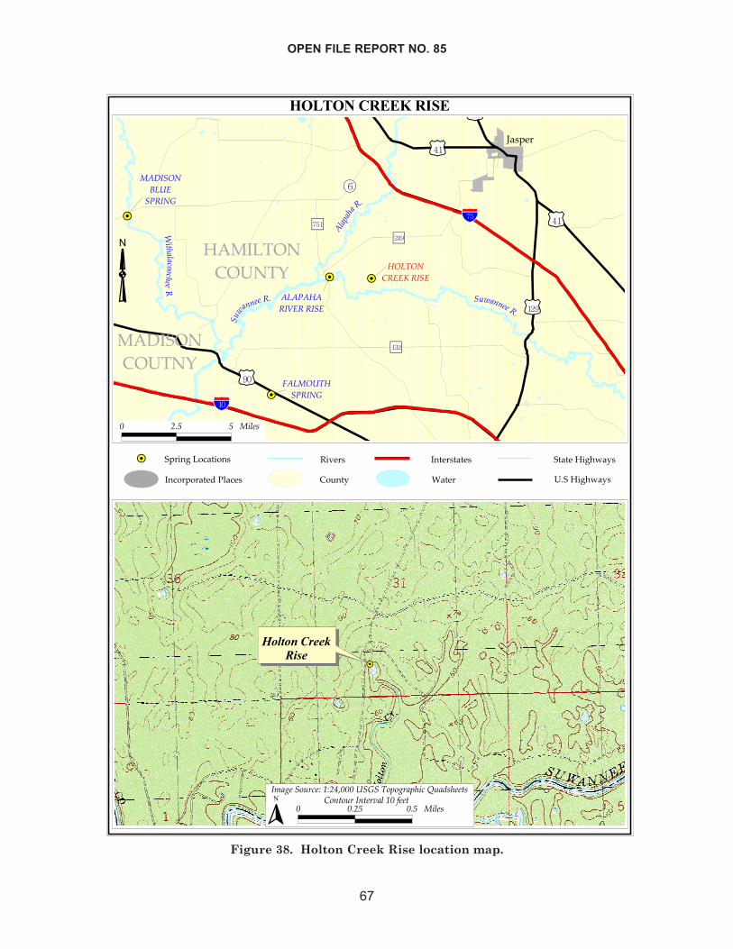
OPEN FILE REPORT NO. 85
67
���������������
��
�� ��
��
������
����� �����
������� �����
����
���������
�����
���������������
������������ �����
�����
����������
���
�����
����
�����
����
�������������
����������� �����������
������
���������
�� �� ��!""!�����
# �$
% &�' ' ����(
��
��������������
�)�*���"�$!�+�,+&-.%%%�� ���"�"*$����!�/��0(��� (% %�&' %�' ����(
� �"� "�$��� �$#���,%�1��
�
�����������������������������������
�� ��� �!��"
��������������� �#����$%�"�
��������$%�"�
Figure 38. Holton Creek Rise location map.
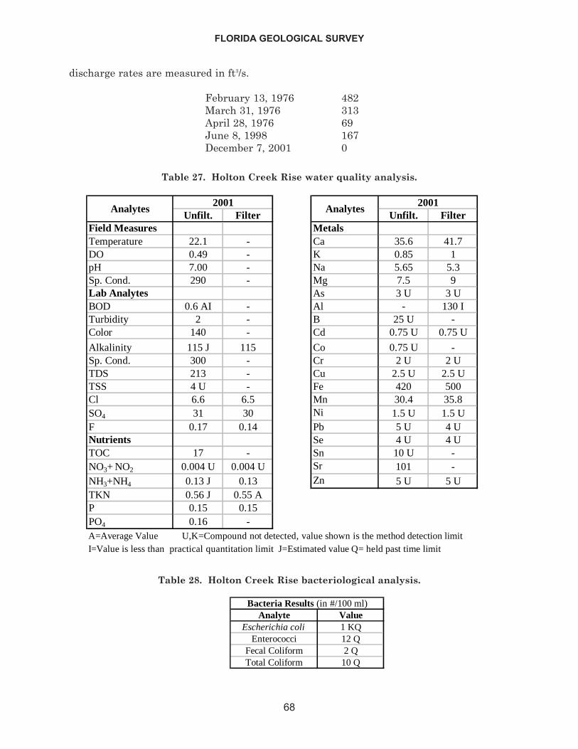
discharge rates are measured in ft3/s.
February 13, 1976 482March 31, 1976 313April 28, 1976 69June 8, 1998 167December 7, 2001 0
FLORIDA GEOLOGICAL SURVEY
68
Unfilt. Filter Unfilt. FilterField Measures MetalsTemperature 22.1 - Ca 35.6 41.7DO 0.49 - K 0.85 1pH 7.00 - Na 5.65 5.3Sp. Cond. 290 - Mg 7.5 9Lab Analytes As 3 U 3 UBOD 0.6 AI - Al - 130 ITurbidity 2 - B 25 U -Color 140 - Cd 0.75 U 0.75 U
Alkalinity 115 J 115 Co 0.75 U -Sp. Cond. 300 - Cr 2 U 2 UTDS 213 - Cu 2.5 U 2.5 UTSS 4 U - Fe 420 500Cl 6.6 6.5 Mn 30.4 35.8SO4 31 30 Ni 1.5 U 1.5 UF 0.17 0.14 Pb 5 U 4 UNutrients Se 4 U 4 UTOC 17 - Sn 10 U -NO3+ NO2 0.004 U 0.004 U Sr 101 -NH3+NH4 0.13 J 0.13 Zn 5 U 5 UTKN 0.56 J 0.55 AP 0.15 0.15PO4 0.16 -A=Average Value U,K=Compound not detected, value shown is the method detection limitI=Value is less than practical quantitation limit J=Estimated value Q= held past time limit
Analytes Analytes20012001
Table 27. Holton Creek Rise water quality analysis.
Analyte ValueEscherichia coli 1 KQ
Enterococci 12 QFecal Coliform 2 QTotal Coliform 10 Q
Bacteria Results (in #/100 ml)
Table 28. Holton Creek Rise bacteriological analysis.
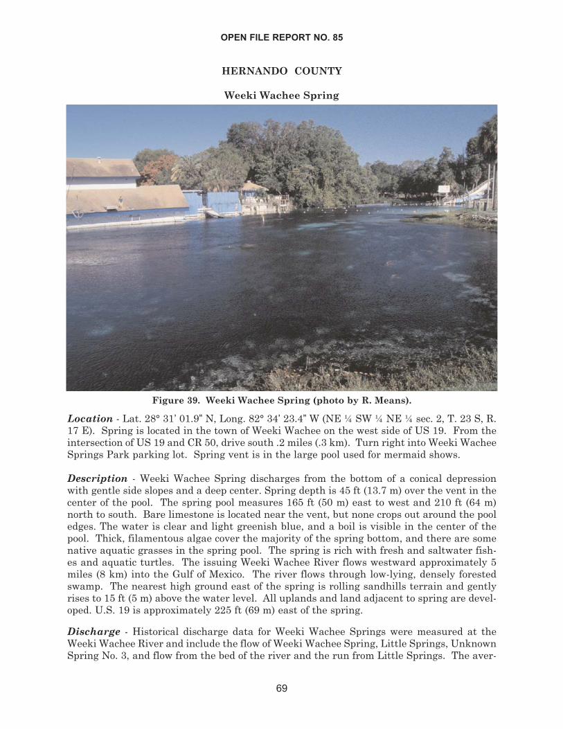
HERNANDO COUNTY
Weeki Wachee Spring
Location - Lat. 28° 31’ 01.9” N, Long. 82° 34’ 23.4” W (NE ¼ SW ¼ NE ¼ sec. 2, T. 23 S, R.17 E). Spring is located in the town of Weeki Wachee on the west side of US 19. From theintersection of US 19 and CR 50, drive south .2 miles (.3 km). Turn right into Weeki WacheeSprings Park parking lot. Spring vent is in the large pool used for mermaid shows.
Description - Weeki Wachee Spring discharges from the bottom of a conical depressionwith gentle side slopes and a deep center. Spring depth is 45 ft (13.7 m) over the vent in thecenter of the pool. The spring pool measures 165 ft (50 m) east to west and 210 ft (64 m)north to south. Bare limestone is located near the vent, but none crops out around the pooledges. The water is clear and light greenish blue, and a boil is visible in the center of thepool. Thick, filamentous algae cover the majority of the spring bottom, and there are somenative aquatic grasses in the spring pool. The spring is rich with fresh and saltwater fish-es and aquatic turtles. The issuing Weeki Wachee River flows westward approximately 5miles (8 km) into the Gulf of Mexico. The river flows through low-lying, densely forestedswamp. The nearest high ground east of the spring is rolling sandhills terrain and gentlyrises to 15 ft (5 m) above the water level. All uplands and land adjacent to spring are devel-oped. U.S. 19 is approximately 225 ft (69 m) east of the spring.
Discharge - Historical discharge data for Weeki Wachee Springs were measured at theWeeki Wachee River and include the flow of Weeki Wachee Spring, Little Springs, UnknownSpring No. 3, and flow from the bed of the river and the run from Little Springs. The aver-
OPEN FILE REPORT NO. 85
69
Figure 39. Weeki Wachee Spring (photo by R. Means).
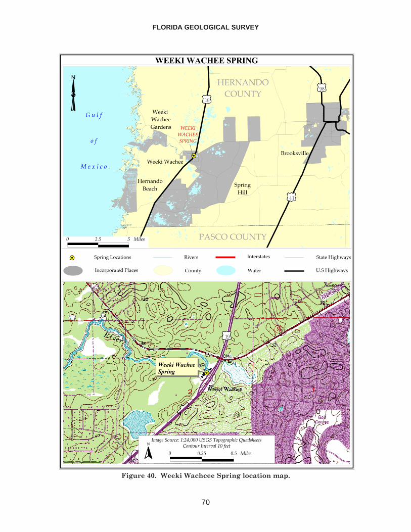
FLORIDA GEOLOGICAL SURVEY
70
�����������������
��
�����������������
���������� �����
���
����������������������
���������������
�
��������
����
�������������
������������
�� ����
���
�����������
������ ���!������"������!��������
�����
��#�!$
"�!��!�!��
��!� �%�� ���&�$�
�!�!�� ���&�$�
� ��� � �����
������������������
����
�������� ����� ��!"����#����$�%����%&���' �(�&��)�
� ���� ��� ������ ��*)� ���*)��+��� �����)
�
Figure 40. Weeki Wachcee Spring location map.
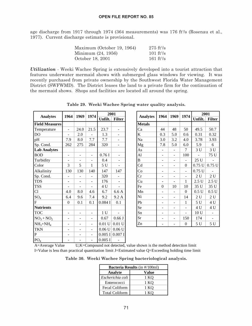
age discharge from 1917 through 1974 (364 measurements) was 176 ft3/s (Rosenau et al.,1977). Current discharge estimate is provisional.
Maximum (October 19, 1964) 275 ft3/sMinimum (24, 1956) 101 ft3/sOctober 18, 2001 161 ft3/s
Utilization - Weeki Wachee Spring is extensively developed into a tourist attraction thatfeatures underwater mermaid shows with submerged glass windows for viewing. It wasrecently purchased from private ownership by the Southwest Florida Water ManagementDistrict (SWFWMD). The District leases the land to a private firm for the continuation ofthe mermaid shows. Shops and facilities are located all around the spring.
OPEN FILE REPORT NO. 85
71
Unfilt. Filter Unfilt. FilterField Measures MetalsTemperature - 24.0 21.5 23.7 - Ca 44 48 50 49.5 50.7DO - 2.0 - 1.3 - K 0.3 5.0 0.6 0.31 0.32pH 7.9 8.0 7.7 7.7 - Na 3.0 3.2 4.0 3.78 3.93Sp. Cond. 262 275 284 320 - Mg 7.8 5.0 6.0 5.9 6Lab Analytes As - - 7 3 U 3 UBOD - - - 0.76 I - Al - - 100 - 75 UTurbidity - - - 0.4 - B - - - 25 U -Color 3 5 1 5 U - Cd - - 0 0.75 U 0.75 UAlkalinity 130 130 140 147 147 Co - - - 0.75 U -Sp. Cond. - - - 320 - Cr - - - 2 U 2 UTDS - - - 176 - Cu - - 1 2.5 U 2.5 UTSS - - - 4 U - Fe 0 10 10 35 U 35 UCl 4.0 8.0 4.6 6.7 6.6 A Mn - - 0 0.5 U 0.5 USO4 6.4 9.6 7.4 9.2 9.2 A Ni - - 14 2 U 2 UF 0 0.1 0.1 0.084 I 0.1 Pb - - 1 5 U 4 UNutrients Se - - - 4 U 4 UTOC - - - 1 U - Sn - - - 10 U -NO3 + NO2 - - - 0.67 0.66 J Sr - - 150 174 -NH3+NH4 - - - 0.01 U 0.01 U Zn - - 0 5 U 5 UTKN - - - 0.06 U 0.06 UP - - - 0.005 I 0.007 IPO4 - - - 0.005 I -
20011969 1974
2001Analytes 1964
A=Average Value U,K=Compound not detected, value shown is the method detection limitI=Value is less than practical quantitation limit J=Estimated value Q=Exceeding holding time limit
1969Analytes 1964 1974
Table 29. Weeki Wachee Spring water quality analysis.
Analyte ValueEscherichia coli 1 KQ
Enterococci 1 KQFecal Coliform 1 KQTotal Coliform 1 KQ
Bacteria Results (in #/100ml)
Table 30. Weeki Wachee Spring bacteriological analysis.
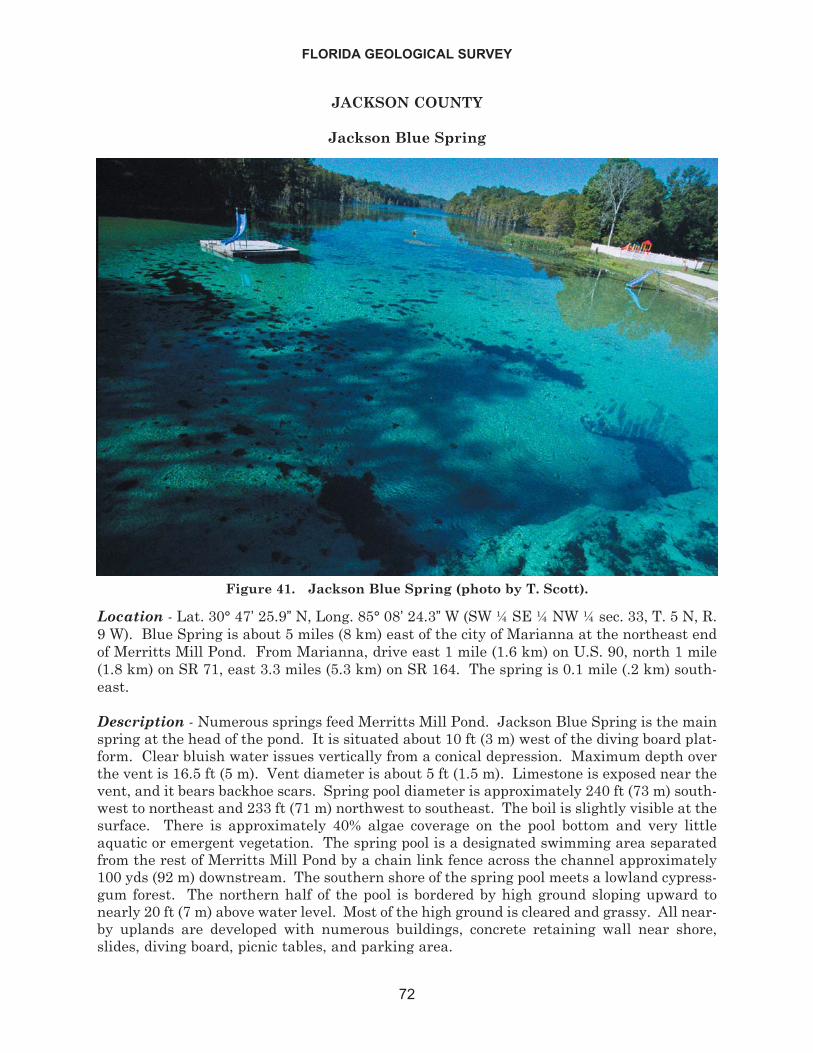
JACKSON COUNTY
Jackson Blue Spring
Location - Lat. 30° 47’ 25.9” N, Long. 85° 08’ 24.3” W (SW ¼ SE ¼ NW ¼ sec. 33, T. 5 N, R.9 W). Blue Spring is about 5 miles (8 km) east of the city of Marianna at the northeast endof Merritts Mill Pond. From Marianna, drive east 1 mile (1.6 km) on U.S. 90, north 1 mile(1.8 km) on SR 71, east 3.3 miles (5.3 km) on SR 164. The spring is 0.1 mile (.2 km) south-east.
Description - Numerous springs feed Merritts Mill Pond. Jackson Blue Spring is the mainspring at the head of the pond. It is situated about 10 ft (3 m) west of the diving board plat-form. Clear bluish water issues vertically from a conical depression. Maximum depth overthe vent is 16.5 ft (5 m). Vent diameter is about 5 ft (1.5 m). Limestone is exposed near thevent, and it bears backhoe scars. Spring pool diameter is approximately 240 ft (73 m) south-west to northeast and 233 ft (71 m) northwest to southeast. The boil is slightly visible at thesurface. There is approximately 40% algae coverage on the pool bottom and very littleaquatic or emergent vegetation. The spring pool is a designated swimming area separatedfrom the rest of Merritts Mill Pond by a chain link fence across the channel approximately100 yds (92 m) downstream. The southern shore of the spring pool meets a lowland cypress-gum forest. The northern half of the pool is bordered by high ground sloping upward tonearly 20 ft (7 m) above water level. Most of the high ground is cleared and grassy. All near-by uplands are developed with numerous buildings, concrete retaining wall near shore,slides, diving board, picnic tables, and parking area.
FLORIDA GEOLOGICAL SURVEY
72
Figure 41. Jackson Blue Spring (photo by T. Scott).
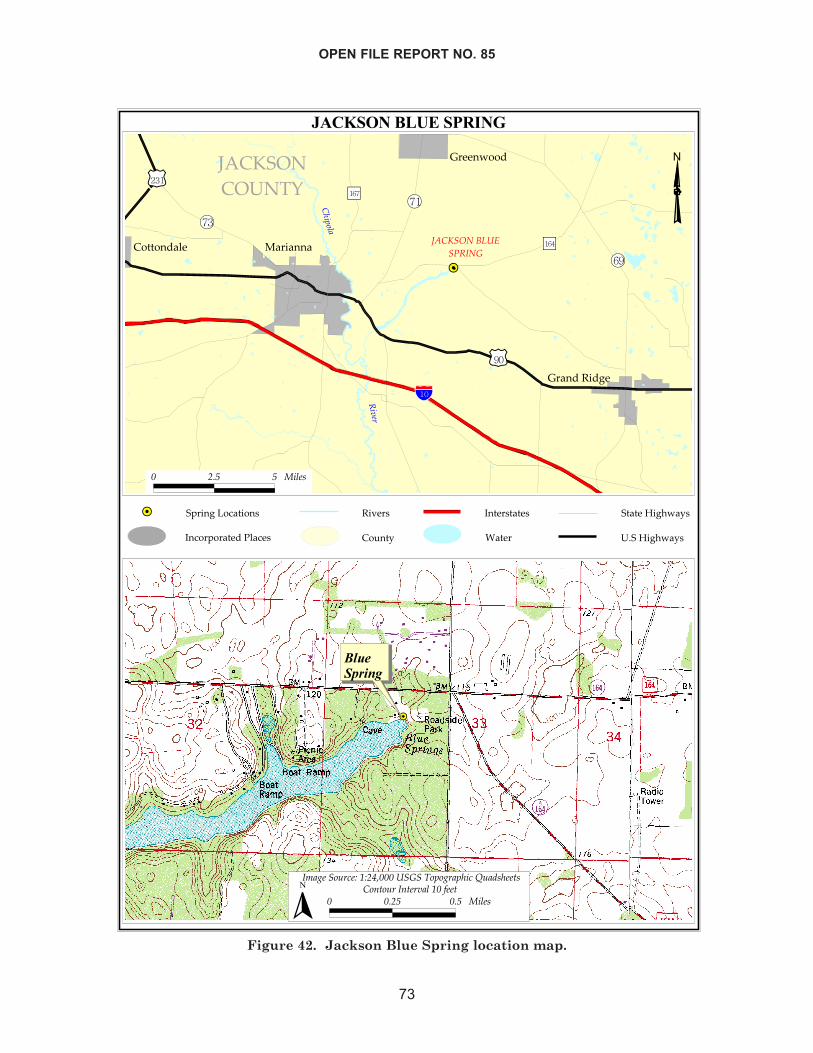
OPEN FILE REPORT NO. 85
73
������������� ���
��
�����
�����
����
�����
�
��� ��������������
�����
���������
�������
���������
���������
�
�� ���� �����
����
��������
�����
�����
���������������������������������
� ��� �!��"
�����������#���� �$�%�&��"�
�����%�&��"�
� ��� � ����
��
���������
�� ����!�"�#�$#�%&���������'��� ����"�(!)����*�� ���� ��� ����
� ��+*�!���+*����$��,��*
�
Figure 42. Jackson Blue Spring location map.
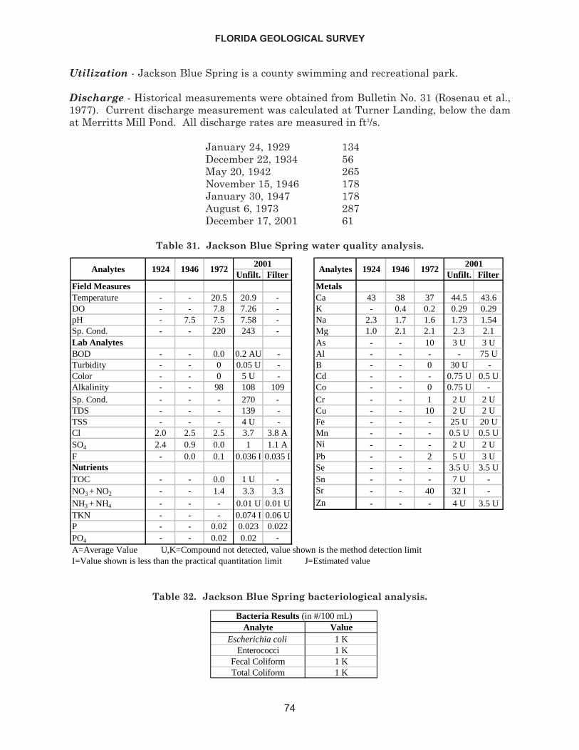
Utilization - Jackson Blue Spring is a county swimming and recreational park.
Discharge - Historical measurements were obtained from Bulletin No. 31 (Rosenau et al.,1977). Current discharge measurement was calculated at Turner Landing, below the damat Merritts Mill Pond. All discharge rates are measured in ft3/s.
January 24, 1929 134December 22, 1934 56May 20, 1942 265November 15, 1946 178January 30, 1947 178August 6, 1973 287December 17, 2001 61
FLORIDA GEOLOGICAL SURVEY
74
Unfilt. Filter Unfilt. FilterField Measures MetalsTemperature - - 20.5 20.9 - Ca 43 38 37 44.5 43.6DO - - 7.8 7.26 - K - 0.4 0.2 0.29 0.29pH - 7.5 7.5 7.58 - Na 2.3 1.7 1.6 1.73 1.54Sp. Cond. - - 220 243 - Mg 1.0 2.1 2.1 2.3 2.1Lab Analytes As - - 10 3 U 3 UBOD - - 0.0 0.2 AU - Al - - - - 75 UTurbidity - - 0 0.05 U - B - - 0 30 U -Color - - 0 5 U - Cd - - - 0.75 U 0.5 UAlkalinity - - 98 108 109 Co - - 0 0.75 U -Sp. Cond. - - - 270 - Cr - - 1 2 U 2 UTDS - - - 139 - Cu - - 10 2 U 2 UTSS - - - 4 U - Fe - - - 25 U 20 UCl 2.0 2.5 2.5 3.7 3.8 A Mn - - - 0.5 U 0.5 USO4 2.4 0.9 0.0 1 1.1 A Ni - - - 2 U 2 UF - 0.0 0.1 0.036 I 0.035 I Pb - - 2 5 U 3 UNutrients Se - - - 3.5 U 3.5 UTOC - - 0.0 1 U - Sn - - - 7 U -NO3 + NO2 - - 1.4 3.3 3.3 Sr - - 40 32 I -NH3 + NH4 - - - 0.01 U 0.01 U Zn - - - 4 U 3.5 UTKN - - - 0.074 I 0.06 UP - - 0.02 0.023 0.022PO4 - - 0.02 0.02 -
2001
A=Average Value U,K=Compound not detected, value shown is the method detection limitI=Value shown is less than the practical quantitation limit J=Estimated value
Analytes 19242001
Analytes 1924 19721946 1946 1972
Table 31. Jackson Blue Spring water quality analysis.
Analyte ValueEscherichia coli 1 K
Enterococci 1 KFecal Coliform 1 KTotal Coliform 1 K
Bacteria Results (in #/100 mL)
Table 32. Jackson Blue Spring bacteriological analysis.
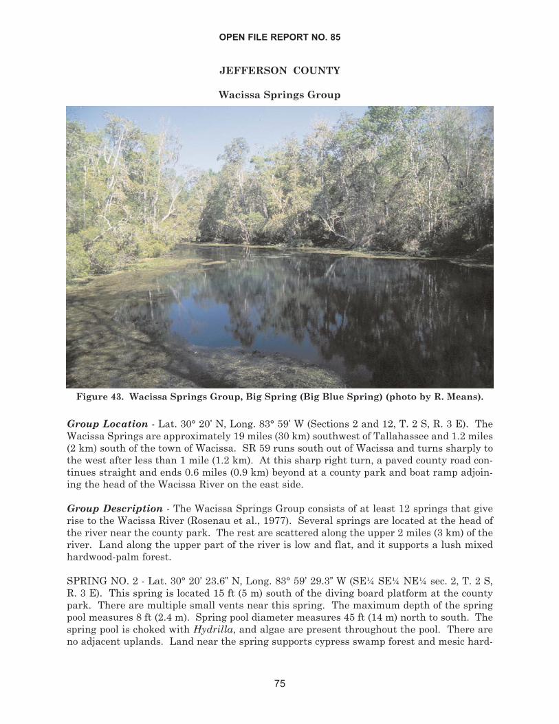
JEFFERSON COUNTY
Wacissa Springs Group
Group Location - Lat. 30° 20’ N, Long. 83° 59’ W (Sections 2 and 12, T. 2 S, R. 3 E). TheWacissa Springs are approximately 19 miles (30 km) southwest of Tallahassee and 1.2 miles(2 km) south of the town of Wacissa. SR 59 runs south out of Wacissa and turns sharply tothe west after less than 1 mile (1.2 km). At this sharp right turn, a paved county road con-tinues straight and ends 0.6 miles (0.9 km) beyond at a county park and boat ramp adjoin-ing the head of the Wacissa River on the east side.
Group Description - The Wacissa Springs Group consists of at least 12 springs that giverise to the Wacissa River (Rosenau et al., 1977). Several springs are located at the head ofthe river near the county park. The rest are scattered along the upper 2 miles (3 km) of theriver. Land along the upper part of the river is low and flat, and it supports a lush mixedhardwood-palm forest.
SPRING NO. 2 - Lat. 30° 20’ 23.6” N, Long. 83° 59’ 29.3” W (SE¼ SE¼ NE¼ sec. 2, T. 2 S,R. 3 E). This spring is located 15 ft (5 m) south of the diving board platform at the countypark. There are multiple small vents near this spring. The maximum depth of the springpool measures 8 ft (2.4 m). Spring pool diameter measures 45 ft (14 m) north to south. Thespring pool is choked with Hydrilla, and algae are present throughout the pool. There areno adjacent uplands. Land near the spring supports cypress swamp forest and mesic hard-
OPEN FILE REPORT NO. 85
75
Figure 43. Wacissa Springs Group, Big Spring (Big Blue Spring) (photo by R. Means).
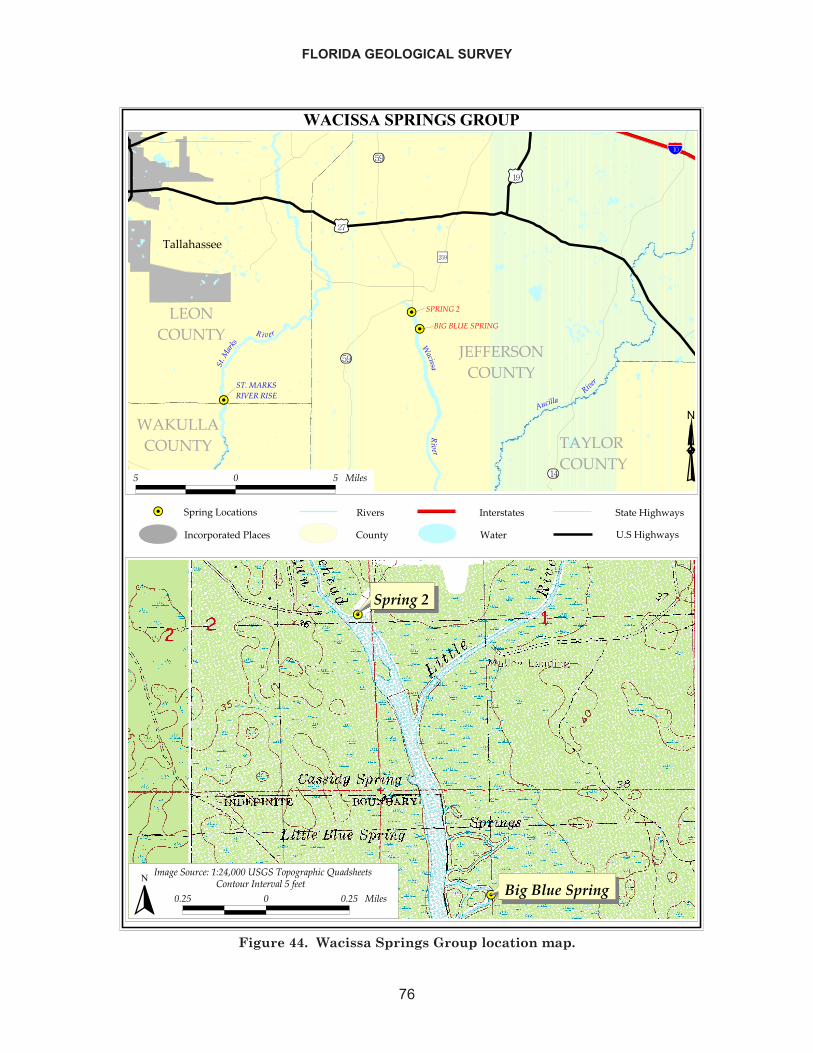
FLORIDA GEOLOGICAL SURVEY
76
������������������
����
��
������������
���� ��������
���� �����
���������
����
����
����������������
����� ���� ����������
������������
� ����
���������
�����
�������
����
��������
����������������
�����
� � � �����
��
��
��������
�������������� �!���"����#�$#�%&������ ���"'"!��'(���)��*�(����
���� � ���� ������ +",�"����,���������-���
�
�������������������������������������
� �����!��"
���������������� �#��$���%�"�
������$���%�"�
Figure 44. Wacissa Springs Group location map.
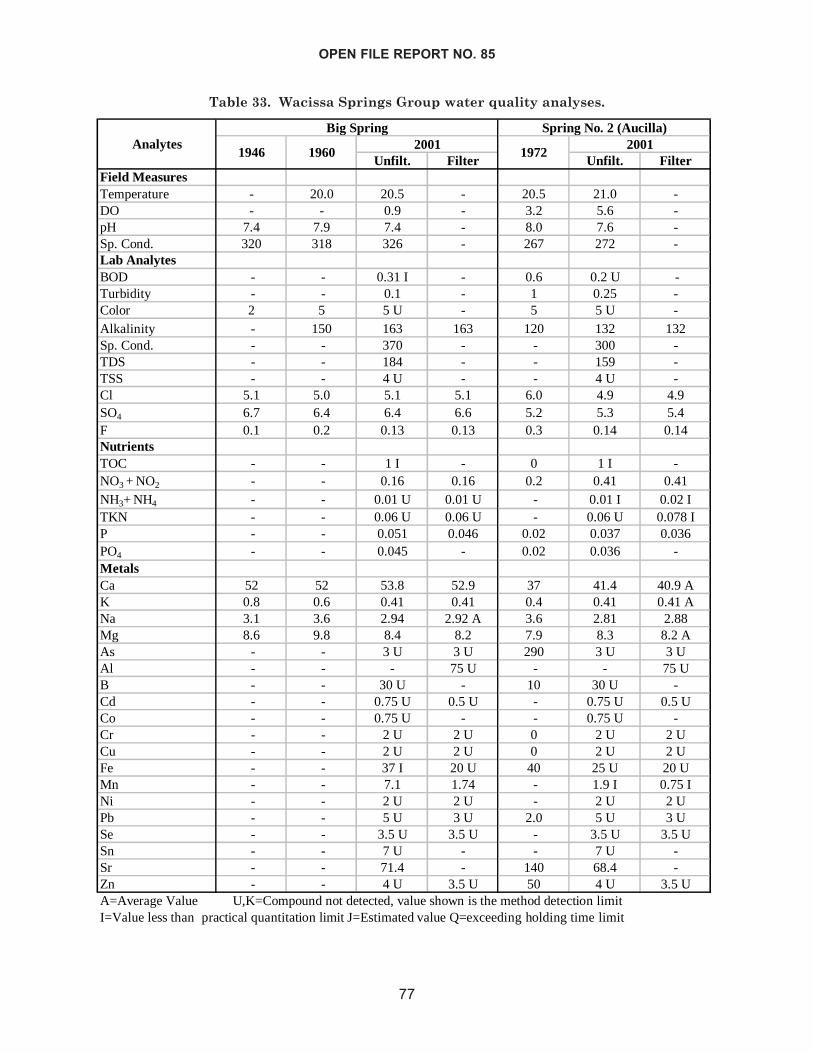
OPEN FILE REPORT NO. 85
77
Unfilt. Filter Unfilt. FilterField MeasuresTemperature - 20.0 20.5 - 20.5 21.0 -DO - - 0.9 - 3.2 5.6 -pH 7.4 7.9 7.4 - 8.0 7.6 -Sp. Cond. 320 318 326 - 267 272 -Lab AnalytesBOD - - 0.31 I - 0.6 0.2 U -Turbidity - - 0.1 - 1 0.25 -Color 2 5 5 U - 5 5 U -Alkalinity - 150 163 163 120 132 132Sp. Cond. - - 370 - - 300 -TDS - - 184 - - 159 -TSS - - 4 U - - 4 U -Cl 5.1 5.0 5.1 5.1 6.0 4.9 4.9SO4 6.7 6.4 6.4 6.6 5.2 5.3 5.4F 0.1 0.2 0.13 0.13 0.3 0.14 0.14NutrientsTOC - - 1 I - 0 1 I -NO3 + NO2 - - 0.16 0.16 0.2 0.41 0.41NH3+ NH4 - - 0.01 U 0.01 U - 0.01 I 0.02 ITKN - - 0.06 U 0.06 U - 0.06 U 0.078 IP - - 0.051 0.046 0.02 0.037 0.036PO4 - - 0.045 - 0.02 0.036 -MetalsCa 52 52 53.8 52.9 37 41.4 40.9 AK 0.8 0.6 0.41 0.41 0.4 0.41 0.41 ANa 3.1 3.6 2.94 2.92 A 3.6 2.81 2.88Mg 8.6 9.8 8.4 8.2 7.9 8.3 8.2 AAs - - 3 U 3 U 290 3 U 3 UAl - - - 75 U - - 75 UB - - 30 U - 10 30 U -Cd - - 0.75 U 0.5 U - 0.75 U 0.5 UCo - - 0.75 U - - 0.75 U -Cr - - 2 U 2 U 0 2 U 2 UCu - - 2 U 2 U 0 2 U 2 UFe - - 37 I 20 U 40 25 U 20 UMn - - 7.1 1.74 - 1.9 I 0.75 INi - - 2 U 2 U - 2 U 2 UPb - - 5 U 3 U 2.0 5 U 3 USe - - 3.5 U 3.5 U - 3.5 U 3.5 USn - - 7 U - - 7 U -Sr - - 71.4 - 140 68.4 -Zn - - 4 U 3.5 U 50 4 U 3.5 U
Spring No. 2 (Aucilla)
1946 1960
Big Spring2001
A=Average Value U,K=Compound not detected, value shown is the method detection limitI=Value less than practical quantitation limit J=Estimated value Q=exceeding holding time limit
19722001Analytes
Table 33. Wacissa Springs Group water quality analyses.
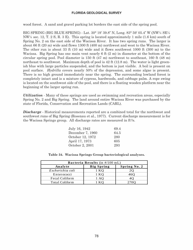
wood forest. A sand and gravel parking lot borders the east side of the spring pool.
BIG SPRING (BIG BLUE SPRING) - Lat. 30° 19’ 39.8” N, Long. 83° 59’ 05.4” W (NW¼ SE¼NW¼ sec. 12, T. 2 S, R. 3 E). This spring is located approximately 1 mile (1.6 km) south ofSpring No. 2 on the east side of the Wacissa River. It has two spring runs. The larger isabout 66 ft (20 m) wide and flows 1300 ft (400 m) northwest and west to the Wacissa River.The other run is about 33 ft (10 m) wide and it flows southwest 1000 ft (300 m) to theWacissa. Big Spring has one main vent nearly 6 ft (2 m) in diameter at the bottom of thecircular spring pool. Pool diameter is 150 ft (47 m) northwest to southeast, 160 ft (48 m)northeast to southwest. Maximum depth of pool is 42 ft (12.8 m). The water is light green-ish blue with large particles suspended, and the bottom is just visible. A boil is present onpool surface. Hydrilla covers nearly 50% of the depression, and some algae is present.There is no high ground immediately near the spring. The surrounding lowland forest iscompletely intact and is a mixture of cypress, hardwoods, and cabbage palm. A rope swingis located on the southwest side of the pool, and there is a floating wooden platform near thebeginning of the larger spring run.
Utilization - Many of these springs are used as swimming and recreation areas, especiallySpring No. 2 and Big Spring. The land around entire Wacissa River was purchased by thestate of Florida, Conservation and Recreation Lands (CARL).
Discharge - Historical measurements reported are a combined total for the northwest andsouthwest runs of Big Spring (Rosenau et al., 1977). Current discharge measurement is forthe Wacissa Springs group. All discharge rates are measured in ft3/s.
July 16, 1942 69.4December 7, 1960 64.5October 12, 1972 280April 17, 1973 605October 2, 2001 293
FLORIDA GEOLOGICAL SURVEY
78
Analyte Big Spring Spring No. 2Escherichia coli 1 KQ 2Q
Enterococci 1 KQ 46QFecal Coliform 1 AQ 4QTotal Coliform 1 KQ 270Q
Bacteria Results (in #/100 mL)
Table 34. Wacissa Springs Group bacteriological analyses.
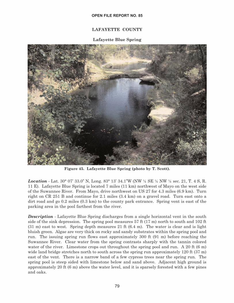
LAFAYETTE COUNTY
Lafayette Blue Spring
Location - Lat. 30° 07’ 33.0” N, Long. 83° 13’ 34.1”W (NW ¼ SE ¼ NW ¼ sec. 21, T. 4 S, R.11 E). Lafayette Blue Spring is located 7 miles (11 km) northwest of Mayo on the west sideof the Suwannee River. From Mayo, drive northwest on US 27 for 4.3 miles (6.9 km). Turnright on CR 251 B and continue for 2.1 miles (3.4 km) on a gravel road. Turn east onto adirt road and go 0.2 miles (0.3 km) to the county park entrance. Spring vent is east of theparking area in the pool farthest from the river.
Description - Lafayette Blue Spring discharges from a single horizontal vent in the southside of the sink depression. The spring pool measures 57 ft (17 m) north to south and 102 ft(31 m) east to west. Spring depth measures 21 ft (6.4 m). The water is clear and is lightbluish green. Algae are very thick on rocky and sandy substrates within the spring pool andrun. The issuing spring run flows east approximately 300 ft (91 m) before reaching theSuwannee River. Clear water from the spring contrasts sharply with the tannin coloredwater of the river. Limestone crops out throughout the spring pool and run. A 20 ft (6 m)wide land bridge stretches north to south across the spring run approximately 120 ft (37 m)east of the vent. There is a narrow band of a few cypress trees near the spring run. Thespring pool is steep sided with limestone below and sand above. Adjacent high ground isapproximately 20 ft (6 m) above the water level, and it is sparsely forested with a few pinesand oaks.
OPEN FILE REPORT NO. 85
79
Figure 45. Lafayette Blue Spring (photo by T. Scott).
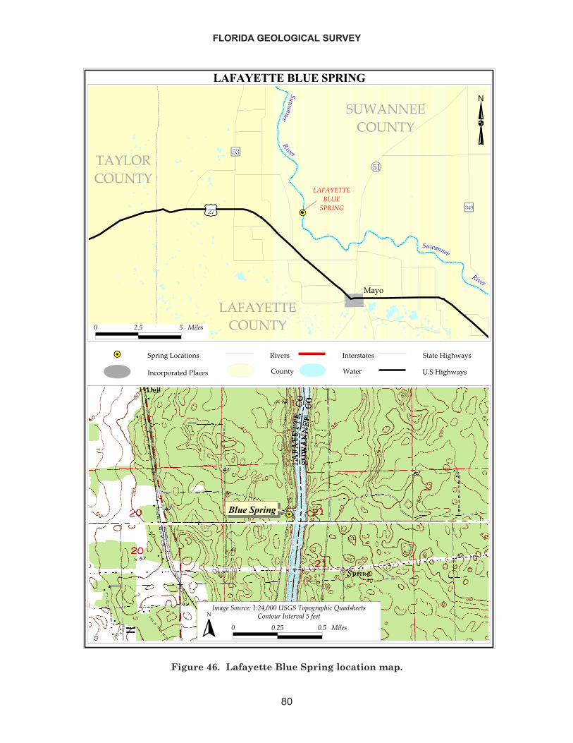
FLORIDA GEOLOGICAL SURVEY
80
����������������� �
��
��������
����
����
����
�
��� �������
�������
����������
���� ������
�� �������
��������
����
��������
�����
�������������������������������������
������� ���
���������������� �!��"��#$���
������"��#$���
� ��� � �����
�����������
������� �!�"�#"�$%���������� & ��&'�!�(��)�'��*�
� ���� ��� ������ + �* ����*�������,��*
�
Figure 46. Lafayette Blue Spring location map.
Utilization - This spring is developed into a county swimming and recreation park withfacilities.
Discharge - Historical measurement was obtained from Bulletin No. 31 (Rosenau et al.,1977). All discharge rates are measured in ft3/s.
November 23, 1973 92.8October 24, 2001 45.9
OPEN FILE REPORT NO. 85
81
Unfilt. Filter Unfilt. FilterField Measures MetalsTemperature 21.5 21.7 - Ca 54 67.2 65.3DO 2.0 0.92 - K 1.0 0.84 0.86pH 7.2 7.17 - Na 4.2 4.68 4.88Sp. Cond. 400 382 - Mg 11 11.7 11.8Lab Analytes As - 3 U 3 UBOD - 0.2 AU - Al - - 75 UTurbidity - 0.1 - B - 25 U -Color 5 5 U - Cd - 0.75 U 0.75 UAlkalinity 170 200 200 Co - 0.75 U -Sp. Cond. - 430 - Cr - 2 U 2 UTDS - 233 - Cu - 2.5 U 2.5 UTSS - 4 U - Fe - 35 U 35 UCl 7.0 9 9.2 Mn - 3.7 3.4SO4 8.1 13 13 Ni - 1.5 U 1.5 UF 0.0 0.1 0.088 I Pb - 5 U 4 UNutrients Se - 4 U 4 UTOC - 1 U - Sn - 10 U -NO3 +NO2 - 1.8 1.8 Sr 0 94 -NH3+NH4 - 0.059 0.022 Zn - 5 U 5 UTKN - 0.16 I 0.1 IP - 0.041 A 0.041PO4 - 0.045 -A=Average Value U,K=Compound not detected, value shown is the method detection limitI=Value is less than practical quantitation limit J=Estimated value Q=Exceeding holding time limit
2001Analytes Analytes 1973
20011973
Table 35. Lafayette Blue Spring water quality analysis.
Analyte ValueEscherichia coli 2 Q
Enterococci 10 QFecal Coliform 6 QTotal Coliform 40 Q
Bacteria Results (in #/100 ml)
Table 36. Lafayette Blue Spring bacteriological analysis.
Troy Spring
Location - Lat. 30° 00’ 21.7” N, Long. 82° 59’ 51.0” W (NW ¼ NE ¼ SE ¼ sec. 34, T. 5 S, R.13 E). Troy Spring is located 5.5 miles (8.5 km) northwest of Branford and flows into theSuwannee River. From the intersection of US 129 and US 27 in Branford, travel northweston US 27 for 5.3 miles (8.5 km). Turn right on a paved road across highway from whitehouse and go north 1.3 miles (2 km). As the paved road curves left, there is a small greenhouse trailer on the right. Turn onto the dirt road that runs between the trailer and a fenceline, and travel 0.6 miles (1 km) to the spring.
Description - Troy spring is an inundated sink hole with vertical limestone sidewalls. Pooldepth is 61 ft (18.6 m). Pool diameter measures 138 ft (42 m) north to south and 118 ft (36m) east to west. The spring run is about 325 ft (100 m) long and flows in a straight patheastward to the Suwannee River. A thick layer of dark green filamentous algae covers near-ly all aquatic substrates. There is little to no other aquatic or emergent vegetation. Watercolor is distinctively greenish. Limestone is exposed around the spring pool and has a scal-loped appearance. High ground surrounds the spring and rises to approximately 18 ft (6 m)above water surface. The uplands are generally forested with pines and hardwoods. Thereis a nearby cabin to the south.
Utilization - This spring is a swimming, snorkeling, and scuba diving hotspot. There areno public facilities. A small boat dock is located about half way down the run on the eastside. Land around the spring is owned by the SRWMD.
FLORIDA GEOLOGICAL SURVEY
82
Figure 47. Troy Spring (photo by T. Scott).
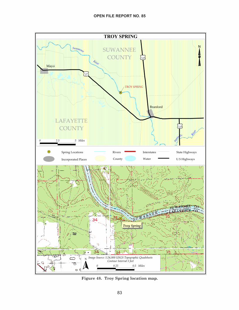
OPEN FILE REPORT NO. 85
83
����������
��
��������
�����������
��� ��
�����
����
���������
������� �� ������
����� ������
�� ����� ���
��
��������������������������� ��!"�� �
��# ����$���
��� ����� ���� � �%�����&'���
���� ����&'���
� ��� � �����
����������������������
������������� ��!"����#�����$����$%���&�'�%����
� ���� ��� ������ (� ����� ���������)���
�
Figure 48. Troy Spring location map.

Discharge - Historical measurements were obtained from Bulletin No. 31 (Rosenau et al.,1977). All discharge rates are measured in ft3/s.
July 17, 1942 149November 26, 1960 161May 28, 1963 148October 16, 1973 205October 30, 2001 106
FLORIDA GEOLOGICAL SURVEY
84
Unfilt. Filter Unfilt. FilterField Measures Metals
Temperature 21.7 21.5 21.7 - Ca 54 56 57.3 59.3DO - 1.4 0.85 - K 0.2 1.3 0.9 0.97pH 7.8 7.1 7.49 - Na 2.4 2.6 2.68 2.45Sp. Cond. 307 358 357 - Mg 6.7 6.4 7 7.3
Lab Analytes As - - 3 U 3 UBOD - 0.2 0.25 I - Al - - - 75UTurbidity - 1 0.15 - B - - 25 U -Color 5 0 5 U - Cd - 0 0.75 U 0.5 UAlkalinity 150 150 163 164 Co - 0 0.75 U -Sp. Cond. - - 350 - Cr - 0 2 U 2 UTDS - - 196 - Cu - 10 2 U 2 UTSS - - 4 U - Fe - - 25 U 20 UCl 3.0 4.0 5.3 5.2 Mn - - 0.73 I 0.31 ISO4 6.0 5.6 12 12 Ni - - 1.5 U 1.5 UF 0.1 0.1 0.085 I 0.09 I Pb - 6 5 U 3 UNutrients Se - - 3.5 U 3.5 UTOC - 0.0 1.8 I - Sn - - 7 U -NO3+ NO2 - 0.96 2.3 2.2 Sr - 240 66.8 -NH3+NH4 - - 0.012 I 0.01 U Zn - - 4 U 3.5 UTKN - - 0.075 I 0.067 IP - 0.03 0.034 A 0.03 APO4 - 0.02 0.024 J -
Analytes Analytes 1960 1973 20012001
A=Average Value U,K=Compound not detected, value is the method detection limitI=Value less than practical quantitation limit J=Est value Q=exceeding holding time limit
19731960
Table 37. Troy Spring water quality analysis.
Analyte ValueEscherichia coli 1 KQ
Enterococci 1 KQFecal Coliform 1 KQTotal Coliform 1 KQ
Bacteria Results (in #/100 mL)
Table 38. Troy Spring bacteriological analysis.
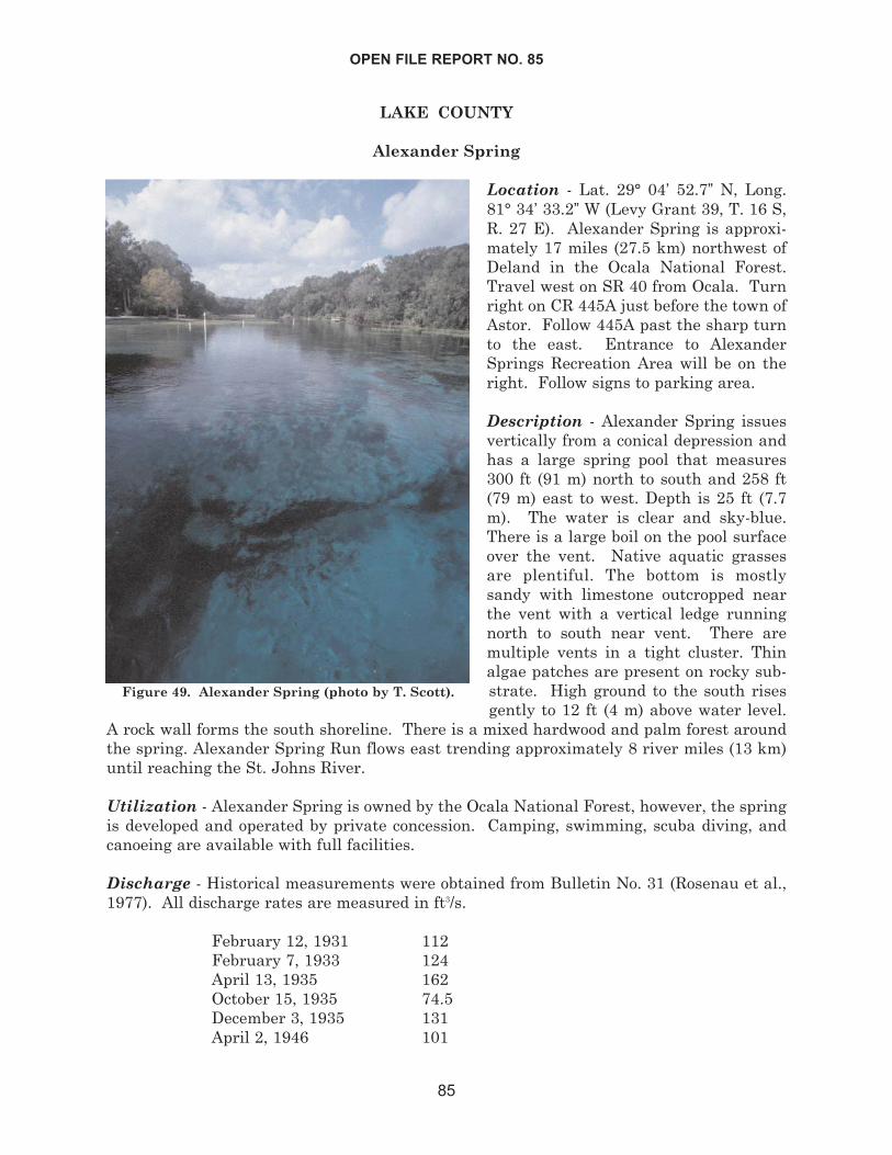
LAKE COUNTY
Alexander Spring
Location - Lat. 29° 04’ 52.7” N, Long.81° 34’ 33.2” W (Levy Grant 39, T. 16 S,R. 27 E). Alexander Spring is approxi-mately 17 miles (27.5 km) northwest ofDeland in the Ocala National Forest.Travel west on SR 40 from Ocala. Turnright on CR 445A just before the town ofAstor. Follow 445A past the sharp turnto the east. Entrance to AlexanderSprings Recreation Area will be on theright. Follow signs to parking area.
Description - Alexander Spring issuesvertically from a conical depression andhas a large spring pool that measures300 ft (91 m) north to south and 258 ft(79 m) east to west. Depth is 25 ft (7.7m). The water is clear and sky-blue.There is a large boil on the pool surfaceover the vent. Native aquatic grassesare plentiful. The bottom is mostlysandy with limestone outcropped nearthe vent with a vertical ledge runningnorth to south near vent. There aremultiple vents in a tight cluster. Thinalgae patches are present on rocky sub-strate. High ground to the south risesgently to 12 ft (4 m) above water level.
A rock wall forms the south shoreline. There is a mixed hardwood and palm forest aroundthe spring. Alexander Spring Run flows east trending approximately 8 river miles (13 km)until reaching the St. Johns River.
Utilization - Alexander Spring is owned by the Ocala National Forest, however, the springis developed and operated by private concession. Camping, swimming, scuba diving, andcanoeing are available with full facilities.
Discharge - Historical measurements were obtained from Bulletin No. 31 (Rosenau et al.,1977). All discharge rates are measured in ft3/s.
February 12, 1931 112February 7, 1933 124April 13, 1935 162October 15, 1935 74.5December 3, 1935 131April 2, 1946 101
OPEN FILE REPORT NO. 85
85
Figure 49. Alexander Spring (photo by T. Scott).
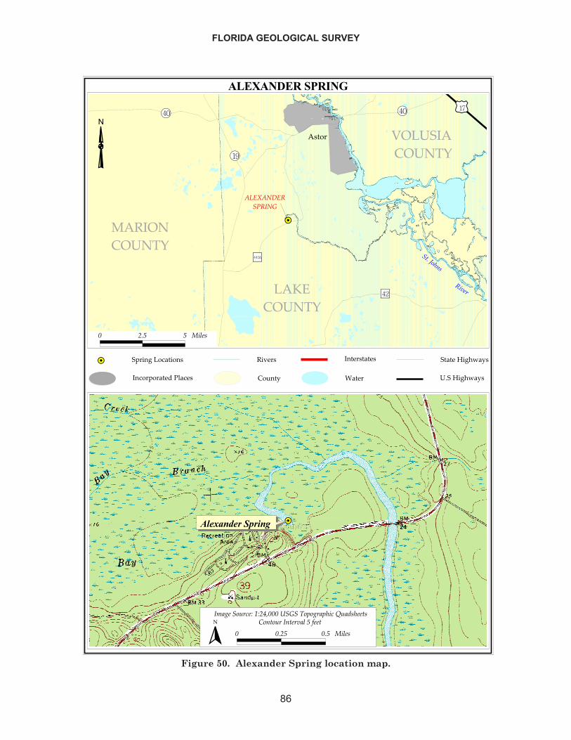
FLORIDA GEOLOGICAL SURVEY
86
��������������
��
���������
���
�����������
�������������
�������������
��� ����������
�������� ����
����
������
����
�� ������������������ �� ����������
����
�����
���� ����
!��� �"��#��$%�
������#��$%�
� ��� � �����
��� ������ �������������������
���� ���� �! "!�#$��� %�� &�'����'�� (��)������
� ���� ��� ������ *������ ������� � +���
�
Figure 50. Alexander Spring location map.
April 23, 1956 136November 16, 1960 124June 8, 1960 124April 25, 1967 146June 22, 1967 114July 2, 1969 109April 19, 1972 103September 12, 2001 94.2
OPEN FILE REPORT NO. 85
87
Unfilt. Filter Unfilt. FilterField Measures MetalsTemperature - 24.0 23.6 - Ca 41 44 43.4 J 43.4DO - - 1.13 - K 2.3 2.0 3.9 3.9pH 6.9 7.9 7.55 - Na 100 130 122 117Sp. Cond. 920 1050 1026 - Mg 18 20 20 19.9Lab Analytes As - 0 3 U 3 UBOD - 0.1 0.2 AU - Al - - - 75 UTurbidity - - 0.05 - B - 180 47 I -Color 0 5 5 U - Cd - 0 0.75 U 0.75 UAlkalinity - 120 82 82 Co - 0 0.75 U -Sp. Cond. - - 1000 - Cr - 0 2 U 2 UTDS - - 547 - Cu - 0 2.5 U 2.5 UTSS - - 4 U - Fe 30 10 35 U 35 UCl 192 230 230 230 Mn - 0.0 0.5 U 1 USO4 56 60 63 62 Ni - - 2 U 2 UF 0.9 0.5 0.11 0.11 Pb - - 5 U 4 UNutrients Se - - 4 U 4 UTOC - 3.0 1 U - Sn - - 10 U -NO3 + NO2 - 0.03 0.04 0.044 Sr - - 722 -NH3+NH4 - - 0.01 U 0.01 U Zn - 10 5 U 5 UTKN - - 0.06 U 0.074 IP - 0.04 0.048 0.044PO4 - 0.04 0.045 -
20011972 Analytes 1946 1972
A=Average Value U,K=Compound not detected, value shown is the method detection limitI=Value is less than practical quantitation limit J=Estimated value Q=Exceeding holding time limit
Analytes 19462001
Table 39. Alexander Spring water quality analysis.
Analyte ValueEscherichia coli 1 KQ
Enterococci 1 KQFecal Coliform 1 KQTotal Coliform 10 Q
Bacteria Results (in #/100ml)
Table 40. Alexander Spring bacteriological analysis.
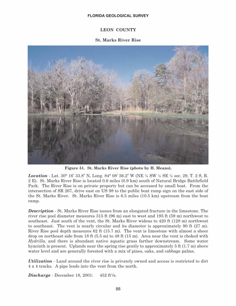
LEON COUNTY
St. Marks River Rise
Location - Lat. 30° 16’ 33.8” N, Long. 84° 08’ 56.2” W (NE ¼ SW ¼ SE ¼ sec. 29, T. 2 S, R.2 E). St. Marks River Rise is located 0.6 miles (0.9 km) south of Natural Bridge BattlefieldPark. The River Rise is on private property but can be accessed by small boat. From theintersection of SR 267, drive east on US 98 to the public boat ramp sign on the east side ofthe St. Marks River. St. Marks River Rise is 6.5 miles (10.5 km) upstream from the boatramp.
Description - St. Marks River Rise issues from an elongated fracture in the limestone. Theriver rise pool diameter measures 315 ft (96 m) east to west and 195 ft (59 m) northwest tosoutheast. Just south of the vent, the St. Marks River widens to 420 ft (128 m) northwestto southeast. The vent is nearly circular and its diameter is approximately 90 ft (27 m).River Rise pool depth measures 62 ft (15.7 m). The vent is limestone with almost a sheerdrop on northeast side from 18 ft (5.5 m) to 48 ft (15 m). Area near the vent is choked withHydrilla, and there is abundant native aquatic grass farther downstream. Some waterhyacinth is present. Uplands near the spring rise gently to approximately 5 ft (1.7 m) abovewater level and are generally forested with a mix of pines, oaks, and cabbage palms.
Utilization - Land around the river rise is privately owned and access is restricted to dirt4 x 4 tracks. A pipe leads into the vent from the north.
Discharge - December 18, 2001: 452 ft3/s.
FLORIDA GEOLOGICAL SURVEY
88
Figure 51. St. Marks River Rise (photo by H. Means).
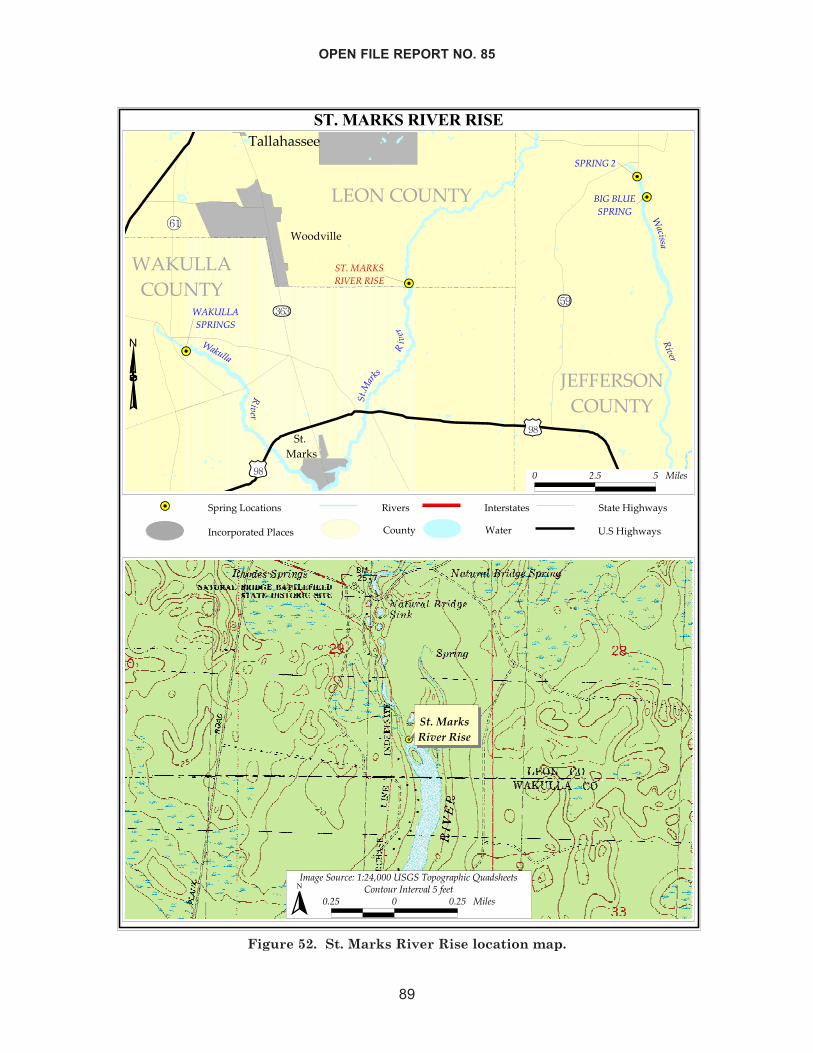
OPEN FILE REPORT NO. 85
89
�����������������
����
��
��
���������
���� ��
����
����
�������
����
�� ���
� ���
������������
��� ������������
�������
�������������
���������������
�������
����� ����
����
����������
�������������
���������������
�� �� ��!��������"�!� �� ����#��!��
���� ���$��%
"��� ���������� ��&� �'�%�
�����&� �'�%�
� ��� � ����
�����������������
� �!��"���#�$#�%&��������"'"!�'(���)��*�(�������� � ���� ����
� +",�"���,��������-���
�
Figure 52. St. Marks River Rise location map.
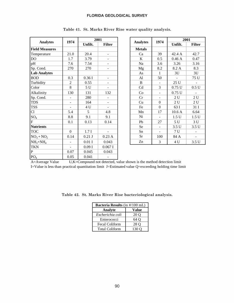
FLORIDA GEOLOGICAL SURVEY
90
Unfilt. Filter Unfilt. FilterField Measures MetalsTemperature 21.0 20.4 - Ca 39 42.4 A 42.7DO 1.7 3.79 - K 0.5 0.46 A 0.47pH 7.6 7.54 - Na 3.6 3.26 3.16Sp. Cond. 270 270 - Mg 8.2 8.2 A 8.3Lab Analytes As 1 3U 3UBOD 0.3 0.36 I - Al 50 - 75 UTurbidity 2 0.55 - B - 25 U -Color 8 5 U - Cd 3 0.75 U 0.5 UAlkalinity 130 131 132 Co - 0.75 U -Sp. Cond. - 280 - Cr - 2 U 2 UTDS - 164 - Cu 0 2 U 2 UTSS - 4 U - Fe 0 63 I 31 ICl 5.4 5 4.8 Mn 17 10.6 A 6.64SO4 8.8 9.1 9.1 Ni - 1.5 U 1.5 UF 0.1 0.13 0.14 Pb 27 5 U 3 UNutrients Se - 3.5 U 3.5 UTOC 0 1.7 I - Sn - 7 U -NO3 + NO2 0.14 0.21 J 0.23 A Sr 100 84 A -NH3+NH4 - 0.01 I 0.043 Zn 3 4 U 3.5 UTKN - 0.09 I 0.067 IP 0.07 0.045 0.043PO4 0.05 0.041 -A=Average Value U,K=Compound not detected, value shown is the method detection limitI=Value is less than practical quantitation limit J=Estimated value Q=exceeding holding time limit
Analytes2001
1974 Analytes 19742001
Table 41. St. Marks River Rise water quality analysis.
Analyte ValueEscherichia coli 20 Q
Enterococci 64 QFecal Coliform 28 QTotal Coliform 130 Q
Bacteria Results (in #/100 mL)
Table 42. St. Marks River Rise bacteriological analysis.
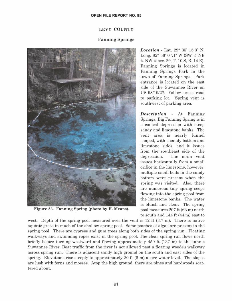
LEVY COUNTY
Fanning Springs
Location - Lat. 29° 35’ 15.3” N,Long. 82° 56’ 07.1” W (SW ¼ NE¼ NW ¼ sec. 29, T. 10 S, R. 14 E).Fanning Springs is located inFanning Springs Park in thetown of Fanning Springs. Parkentrance is located on the eastside of the Suwannee River onUS 98/19/27. Follow access roadto parking lot. Spring vent issouthwest of parking area.
Description - At FanningSprings, Big Fanning Spring is ina conical depression with steepsandy and limestone banks. Thevent area is nearly funnelshaped, with a sandy bottom andlimestone sides, and it issuesfrom the southeast side of thedepression. The main ventissues horizontally from a smallorifice in the limestone, however,multiple small boils in the sandybottom were present when thespring was visited. Also, thereare numerous tiny spring seepsflowing into the spring pool fromthe limestone banks. The wateris bluish and clear. The springpool measures 207 ft (63 m) northto south and 144 ft (44 m) east to
west. Depth of the spring pool measured over the vent is 12 ft (3.7 m). There is nativeaquatic grass in much of the shallow spring pool. Some patches of algae are present in thespring pool. There are cypress and gum trees along both sides of the spring run. Floatingwalkways and swimming ropes exist in the spring pool. The clear spring run flows northbriefly before turning westward and flowing approximately 450 ft (137 m) to the tannicSuwannee River. Boat traffic from the river is not allowed past a floating wooden walkwayacross spring run. There is adjacent sandy high ground on the south and east sides of thespring. Elevations rise steeply to approximately 20 ft (6 m) above water level. The slopesare lush with ferns and mosses. Atop the high ground, there are pines and hardwoods scat-tered about.
OPEN FILE REPORT NO. 85
91
Figure 53. Fanning Spring (photo by H. Means).
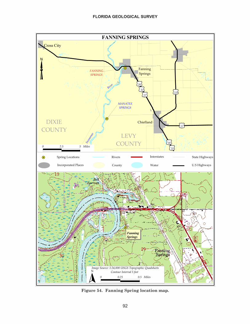
FLORIDA GEOLOGICAL SURVEY
92
���������������
��
�� ���������
������� ���
�����
����
��
��� ���������
��������������
�����������
����������
��������
����
������������ �����
����������
�� ������������������ �� �����������
�� � �
��!��"
���� ������
#��� �$��%��&�"�
������%��&�"�
� ��� � ����
�����������������������
����������������� !����"���� �#����#$���%��&�$��'�
� ���� ��� ����� (�'�����'��������)��'
�
Figure 54. Fanning Spring location map.
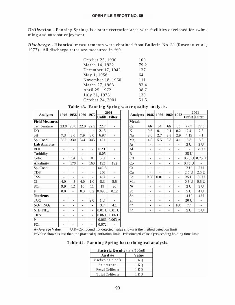
Utilization - Fanning Springs is a state recreation area with facilities developed for swim-ming and outdoor enjoyment.
Discharge - Historical measurements were obtained from Bulletin No. 31 (Rosenau et al.,1977). All discharge rates are measured in ft3/s.
October 25, 1930 109March 14, 1932 79.2December 17, 1942 137May 1, 1956 64November 18, 1960 111March 27, 1963 83.4April 25, 1972 98.7July 31, 1973 139October 24, 2001 51.5
OPEN FILE REPORT NO. 85
93
Unfilt. Filter Unfilt. FilterField Measures MetalsTemperature 23.0 23.0 22.0 22.5 22.7 - Ca 66 64 66 63 77.7 77.5DO - - - - 2.15 - K 0.6 0.1 0.1 0.2 2.4 2.5pH 7.3 8.0 7.9 8.0 6.97 - Na 2.6 2.7 2.8 2.9 4.15 4.1Sp. Cond. 357 330 344 345 421 - Mg 4.8 5.5 3.8 4.1 5.8 5.8Lab Analytes As - - - - 3 U 3 UBOD - - - - 0.2 U - Al - - - - - 75 UTurbidity - - - - 0.05 - B - - - - 25 U -Color 2 14 0 0 5 U - Cd - - - - 0.75 U 0.75 UAlkalinity - 170 - 160 193 192 Co - - - - 0.75 U -Sp. Cond. - - - - 440 A - Cr - - - - 2 U 2 UTDS - - - - 256 - Cu - - - - 2.5 U 2.5 UTSS - - - - 4 U - Fe 0.08 0.01 - - 35 U 35 UCl 4.0 4.5 4.0 1.0 8.3 8.5 Mn - - - - 0.5 U 0.5 USO4 9.9 12 10 11 19 20 Ni - - - - 2 U 3 UF 0.0 - 0.3 0.2 0.098 I 0.12 Pb - - - - 5 U 4 UNutrients Se - - - - 4 U 4 UTOC - - - 2.0 1 U - Sn - - - - 20 U -NO3 + NO2 - - - - 3.7 4.1 Sr - - - 100 77 -NH3+NH4 - - - - 0.01 U 0.01 U Zn - - - - 5 U 5 UTKN - - - - 0.06 U 0.06 UP - - - - 0.066 0.063 APO4 - - - - 0.072 -A=Average Value U,K=Compound not detected, value shown is the method detection limitI=Value shown is less than the practical quantitation limit J=Estimated value Q=exceeding holding time limit
2001 20011946 1956 1960 1972Analytes Analytes1946 1956 1960 1972
Table 43. Fanning Spring water quality analysis.
A nal yte V al ueE s c h e r ic h ia c o l i 1 K Q
En te ro c o c c i 1 K QF e c a l Co lifo rm 1 K QT o t a l Co lifo rm 1 K Q
B ac te r ia R e s u lts (in # /100m l)
Table 44. Fanning Spring bacteriological analysis.
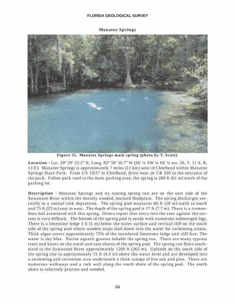
Manatee Springs
Location - Lat. 29° 29’ 22.2” N, Long. 82° 58’ 36.7” W (SE ¼ SW ¼ SE ¼ sec. 26, T. 11 S, R.13 E). Manatee Springs is approximately 7 miles (11 km) west of Chiefland within ManateeSprings State Park. From US 19/27 in Chiefland, drive west on CR 320 to the entrance ofthe park. Follow park road to the main parking area, the spring is 200 ft (61 m) north of theparking lot.
Description - Manatee Springs and its issuing spring run are on the east side of theSuwannee River within the densely wooded, lowland floodplain. The spring discharges ver-tically in a conical sink depression. The spring pool measures 60 ft (18 m) north to southand 75 ft (23 m) east to west. The depth of the spring pool is 17 ft (7.7 m). There is a tremen-dous boil associated with this spring. Divers report that entry into the vent against the cur-rent is very difficult. The bottom of the spring pool is sandy with numerous submerged logs.There is a limestone ledge 3 ft (1 m) below the water surface and vertical cliff on the southside of the spring pool where wooden steps lead down into the water for swimming access.Thick algae covers approximately 75% of the inundated limestone ledge and cliff face. Thewater is sky blue. Native aquatic grasses inhabit the spring run. There are many cypresstrees and knees on the north and east shores of the spring pool. The spring run flows south-ward to the Suwannee River approximately 1200 ft (365 m). Uplands on the south side ofthe spring rise to approximately 15 ft (4.5 m) above the water level and are developed intoa swimming and recreation area underneath a thick canopy of live oak and pine. There arenumerous walkways and a rock wall along the south shore of the spring pool. The northshore is relatively pristine and wooded.
FLORIDA GEOLOGICAL SURVEY
94
Figure 55. Manatee Springs main spring (photo by T. Scott).
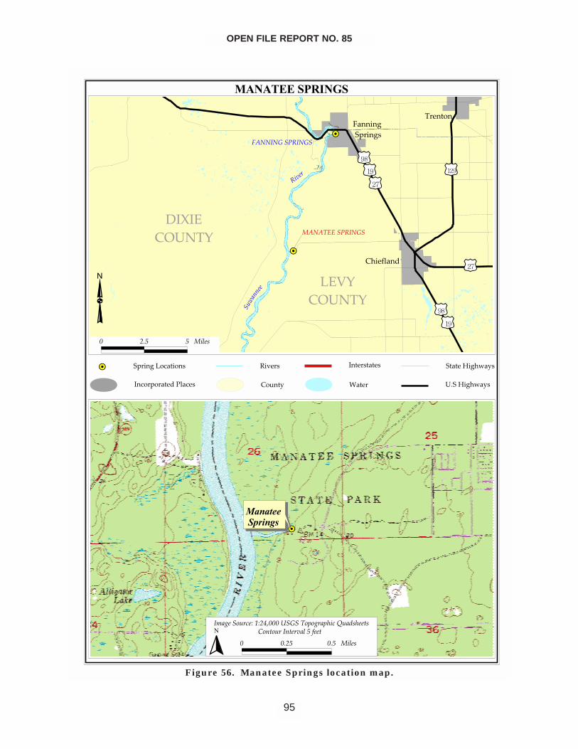
OPEN FILE REPORT NO. 85
95
�������������
��
�����������
������� ����
�������
�����������
����������
���������������
�������������
�� ��
������
��
������������
�����
��������
����
� �������������������� �������������
�� ���
��!��"
�����������
#���� �$��%��&�"�
������%��&�"�
� ��� � ����
��������������
������������
����������������� !����"�����#����#$���%��&�$��'�
� ���� ��� ����� (��'������'�� �����)��'
�
Figure 56. Manatee Springs location map.
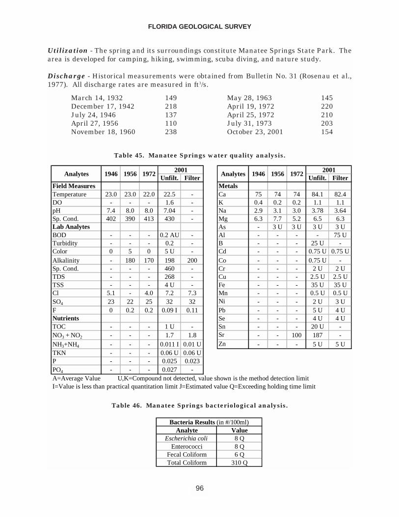
Utilization - The spring and its surroundings constitute Manatee Springs State Park. Thearea is developed for camping, hiking, swimming, scuba diving, and nature study.
Discharge - Historical measurements were obtained from Bulletin No. 31 (Rosenau et al.,1977). All discharge rates are measured in ft3/s.
FLORIDA GEOLOGICAL SURVEY
96
Unfilt. Filter Unfilt. FilterField Measures MetalsTemperature 23.0 23.0 22.0 22.5 - Ca 75 74 74 84.1 82.4DO - - - 1.6 - K 0.4 0.2 0.2 1.1 1.1pH 7.4 8.0 8.0 7.04 - Na 2.9 3.1 3.0 3.78 3.64Sp. Cond. 402 390 413 430 - Mg 6.3 7.7 5.2 6.5 6.3Lab Analytes As - 3 U 3 U 3 U 3 UBOD - - - 0.2 AU - Al - - - - 75 UTurbidity - - - 0.2 - B - - - 25 U -Color 0 5 0 5 U - Cd - - - 0.75 U 0.75 UAlkalinity - 180 170 198 200 Co - - - 0.75 U -Sp. Cond. - - - 460 - Cr - - - 2 U 2 UTDS - - - 268 - Cu - - - 2.5 U 2.5 UTSS - - - 4 U - Fe - - - 35 U 35 UCl 5.1 - 4.0 7.2 7.3 Mn - - - 0.5 U 0.5 USO4 23 22 25 32 32 Ni - - - 2 U 3 UF 0 0.2 0.2 0.09 I 0.11 Pb - - - 5 U 4 UNutrients Se - - - 4 U 4 UTOC - - - 1 U - Sn - - - 20 U -NO3 + NO2 - - - 1.7 1.8 Sr - - 100 187 -NH3+NH4 - - - 0.011 I 0.01 U Zn - - - 5 U 5 UTKN - - - 0.06 U 0.06 UP - - - 0.025 0.023PO4 - - - 0.027 -A=Average Value U,K=Compound not detected, value shown is the method detection limitI=Value is less than practical quantitation limit J=Estimated value Q=Exceeding holding time limit
Analytes2001
Analytes 1946 19562001
1972 1946 1956 1972
Table 45. Manatee Springs water quality analysis.
Analyte ValueEscherichia coli 8 Q
Enterococci 8 QFecal Coliform 6 QTotal Coliform 310 Q
Bacteria Results (in #/100ml)
Table 46. Manatee Springs bacteriological analysis.
March 14, 1932 149December 17, 1942 218July 24, 1946 137April 27, 1956 110November 18, 1960 238
May 28, 1963 145April 19, 1972 220April 25, 1972 210July 31, 1973 203October 23, 2001 154
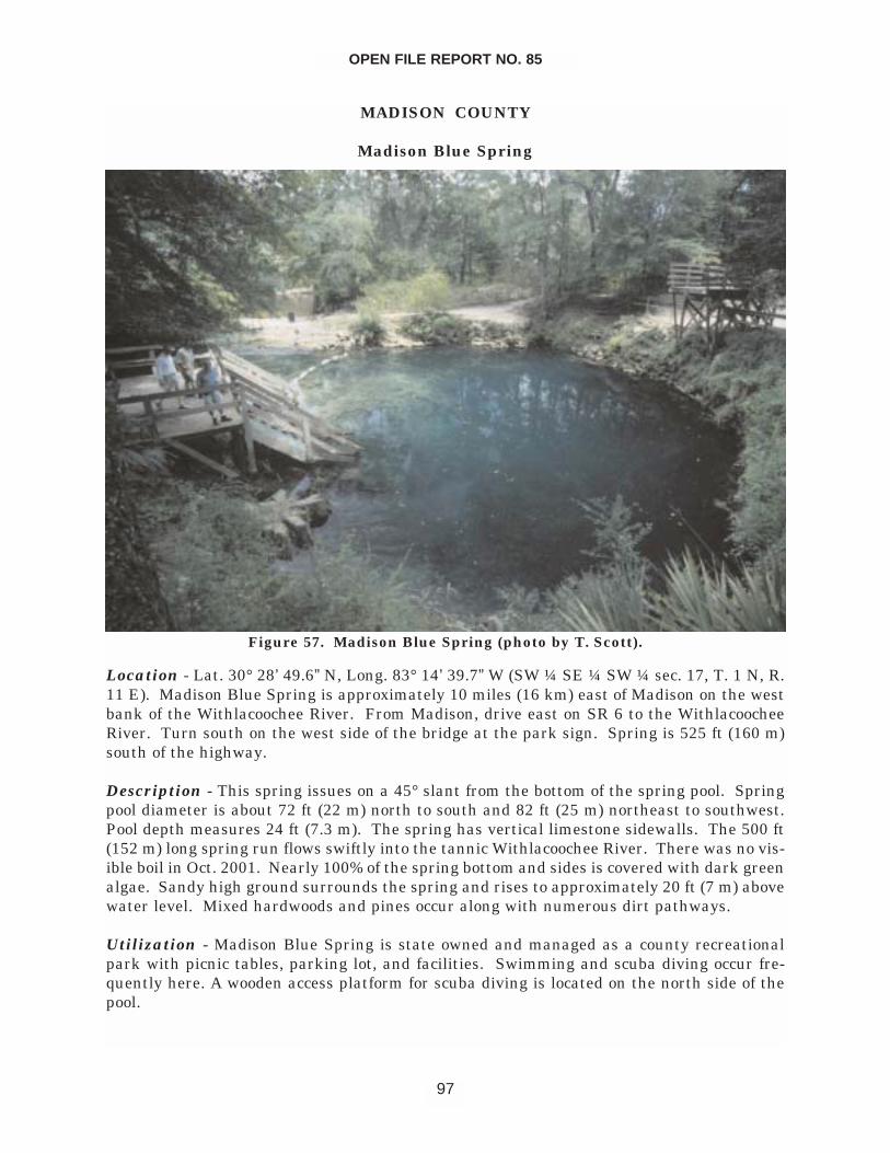
MADISON COUNTY
Madison Blue Spring
Location - Lat. 30° 28’ 49.6” N, Long. 83° 14’ 39.7” W (SW ¼ SE ¼ SW ¼ sec. 17, T. 1 N, R.11 E). Madison Blue Spring is approximately 10 miles (16 km) east of Madison on the westbank of the Withlacoochee River. From Madison, drive east on SR 6 to the WithlacoocheeRiver. Turn south on the west side of the bridge at the park sign. Spring is 525 ft (160 m)south of the highway.
Description - This spring issues on a 45° slant from the bottom of the spring pool. Springpool diameter is about 72 ft (22 m) north to south and 82 ft (25 m) northeast to southwest.Pool depth measures 24 ft (7.3 m). The spring has vertical limestone sidewalls. The 500 ft(152 m) long spring run flows swiftly into the tannic Withlacoochee River. There was no vis-ible boil in Oct. 2001. Nearly 100% of the spring bottom and sides is covered with dark greenalgae. Sandy high ground surrounds the spring and rises to approximately 20 ft (7 m) abovewater level. Mixed hardwoods and pines occur along with numerous dirt pathways.
Utilization - Madison Blue Spring is state owned and managed as a county recreationalpark with picnic tables, parking lot, and facilities. Swimming and scuba diving occur fre-quently here. A wooden access platform for scuba diving is located on the north side of thepool.
OPEN FILE REPORT NO. 85
97
Figure 57. Madison Blue Spring (photo by T. Scott).
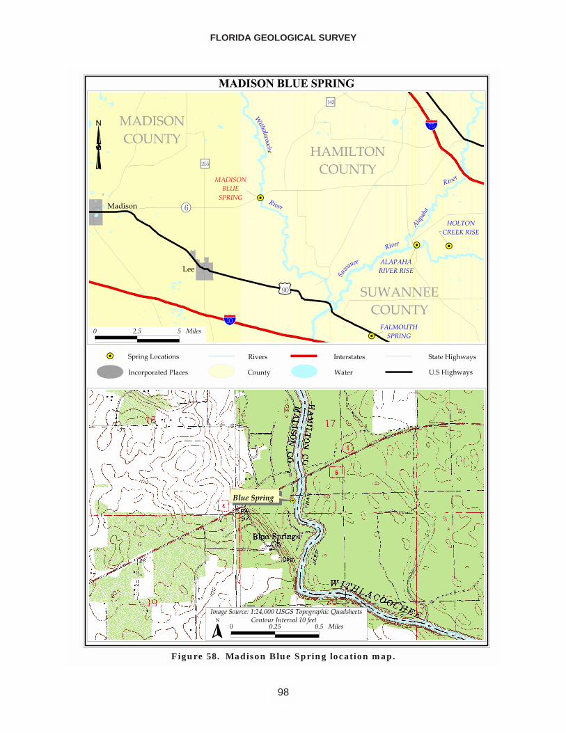
FLORIDA GEOLOGICAL SURVEY
98
������������� ���
��
�� ��
��
���
�������
������������������
���
���
� �
����
������
�
���
�������� �� ���� ����� �
� ����
�������� ����
���
�����
����
�����
�����������
�����
��������������
�����!������
���!��"��#����
$ %&' ' ����(
�����������
�)�*���� ���+�,+%-.$$$������!���*�������/ �0(����($ $&%' $&' ����(
� "���� ����������,$�1���
�
�������������������������������������
�������� ��!
���������������� �"�����#$�!�
���������#$�!�
Figure 58. Madison Blue Spring location map.
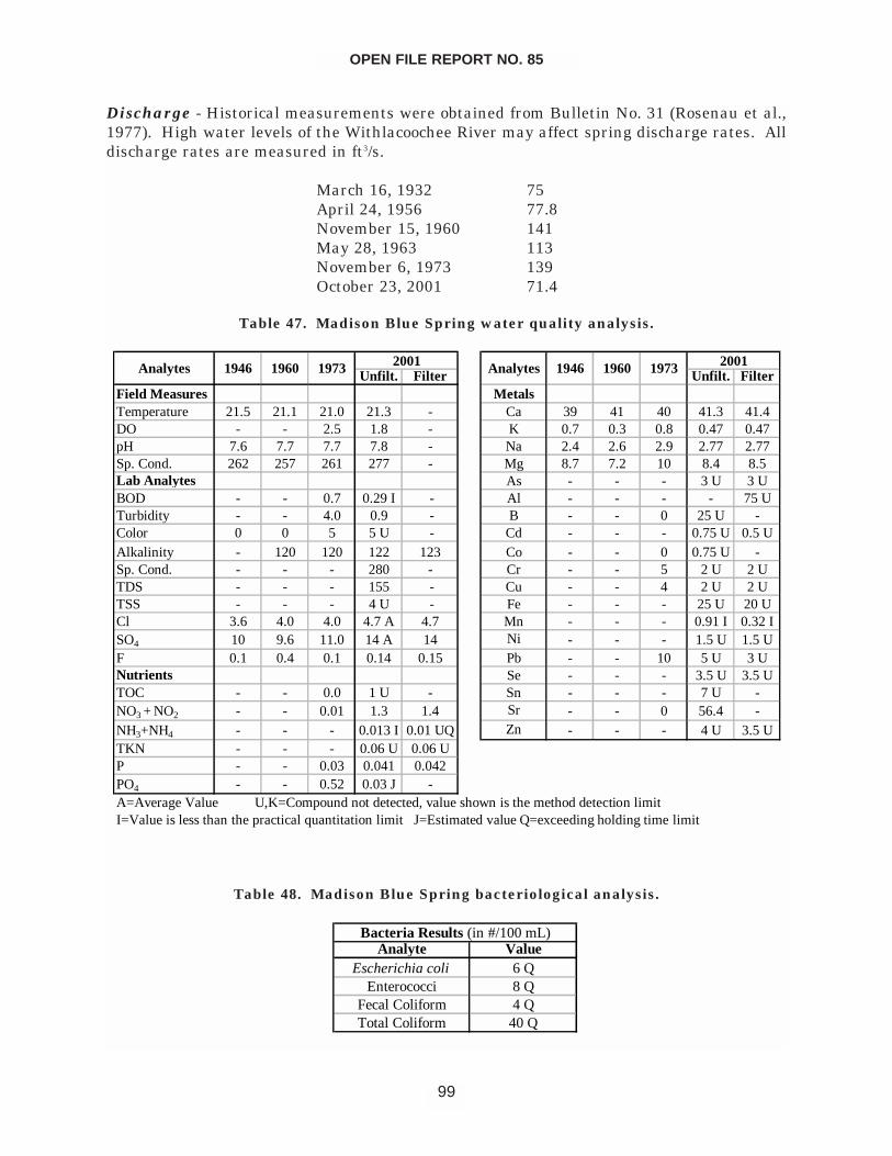
Discharge - Historical measurements were obtained from Bulletin No. 31 (Rosenau et al.,1977). High water levels of the Withlacoochee River may affect spring discharge rates. Alldischarge rates are measured in ft3/s.
March 16, 1932 75April 24, 1956 77.8November 15, 1960 141May 28, 1963 113November 6, 1973 139October 23, 2001 71.4
OPEN FILE REPORT NO. 85
99
Unfilt. Filter Unfilt. FilterField Measures MetalsTemperature 21.5 21.1 21.0 21.3 - Ca 39 41 40 41.3 41.4DO - - 2.5 1.8 - K 0.7 0.3 0.8 0.47 0.47pH 7.6 7.7 7.7 7.8 - Na 2.4 2.6 2.9 2.77 2.77Sp. Cond. 262 257 261 277 - Mg 8.7 7.2 10 8.4 8.5Lab Analytes As - - - 3 U 3 UBOD - - 0.7 0.29 I - Al - - - - 75 UTurbidity - - 4.0 0.9 - B - - 0 25 U -Color 0 0 5 5 U - Cd - - - 0.75 U 0.5 UAlkalinity - 120 120 122 123 Co - - 0 0.75 U -Sp. Cond. - - - 280 - Cr - - 5 2 U 2 UTDS - - - 155 - Cu - - 4 2 U 2 UTSS - - - 4 U - Fe - - - 25 U 20 UCl 3.6 4.0 4.0 4.7 A 4.7 Mn - - - 0.91 I 0.32 ISO4 10 9.6 11.0 14 A 14 Ni - - - 1.5 U 1.5 UF 0.1 0.4 0.1 0.14 0.15 Pb - - 10 5 U 3 UNutrients Se - - - 3.5 U 3.5 UTOC - - 0.0 1 U - Sn - - - 7 U -NO3 + NO2 - - 0.01 1.3 1.4 Sr - - 0 56.4 -NH3+NH4 - - - 0.013 I 0.01 UQ Zn - - - 4 U 3.5 UTKN - - - 0.06 U 0.06 UP - - 0.03 0.041 0.042PO4 - - 0.52 0.03 J -
19731960
A=Average Value U,K=Compound not detected, value shown is the method detection limitI=Value is less than the practical quantitation limit J=Estimated value Q=exceeding holding time limit
Analytes 1946 2001 1973 2001Analytes 1946 1960
Table 47. Madison Blue Spring water quality analysis.
Analyte ValueEscherichia coli 6 Q
Enterococci 8 QFecal Coliform 4 QTotal Coliform 40 Q
Bacteria Results (in #/100 mL)
Table 48. Madison Blue Spring bacteriological analysis.
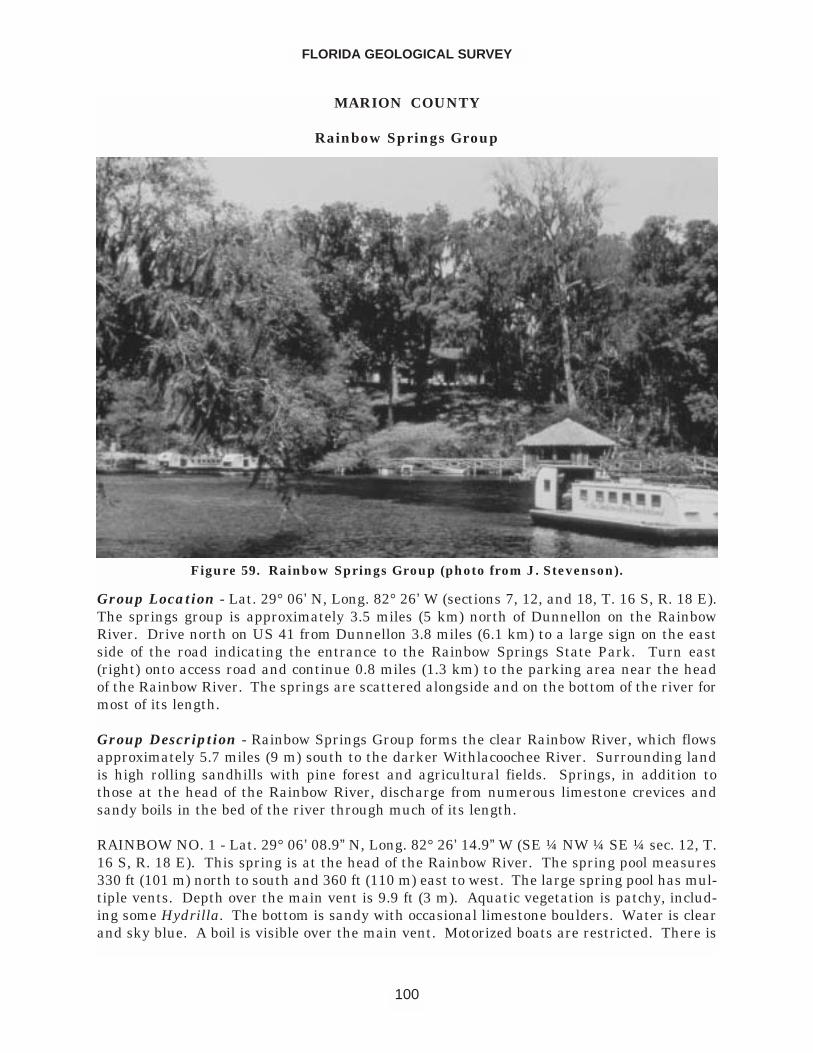
MARION COUNTY
Rainbow Springs Group
Group Location - Lat. 29° 06’ N, Long. 82° 26’ W (sections 7, 12, and 18, T. 16 S, R. 18 E).The springs group is approximately 3.5 miles (5 km) north of Dunnellon on the RainbowRiver. Drive north on US 41 from Dunnellon 3.8 miles (6.1 km) to a large sign on the eastside of the road indicating the entrance to the Rainbow Springs State Park. Turn east(right) onto access road and continue 0.8 miles (1.3 km) to the parking area near the headof the Rainbow River. The springs are scattered alongside and on the bottom of the river formost of its length.
Group Description - Rainbow Springs Group forms the clear Rainbow River, which flowsapproximately 5.7 miles (9 m) south to the darker Withlacoochee River. Surrounding landis high rolling sandhills with pine forest and agricultural fields. Springs, in addition tothose at the head of the Rainbow River, discharge from numerous limestone crevices andsandy boils in the bed of the river through much of its length.
RAINBOW NO. 1 - Lat. 29° 06’ 08.9” N, Long. 82° 26’ 14.9” W (SE ¼ NW ¼ SE ¼ sec. 12, T.16 S, R. 18 E). This spring is at the head of the Rainbow River. The spring pool measures330 ft (101 m) north to south and 360 ft (110 m) east to west. The large spring pool has mul-tiple vents. Depth over the main vent is 9.9 ft (3 m). Aquatic vegetation is patchy, includ-ing some Hydrilla. The bottom is sandy with occasional limestone boulders. Water is clearand sky blue. A boil is visible over the main vent. Motorized boats are restricted. There is
FLORIDA GEOLOGICAL SURVEY
100
Figure 59. Rainbow Springs Group (photo from J. Stevenson).
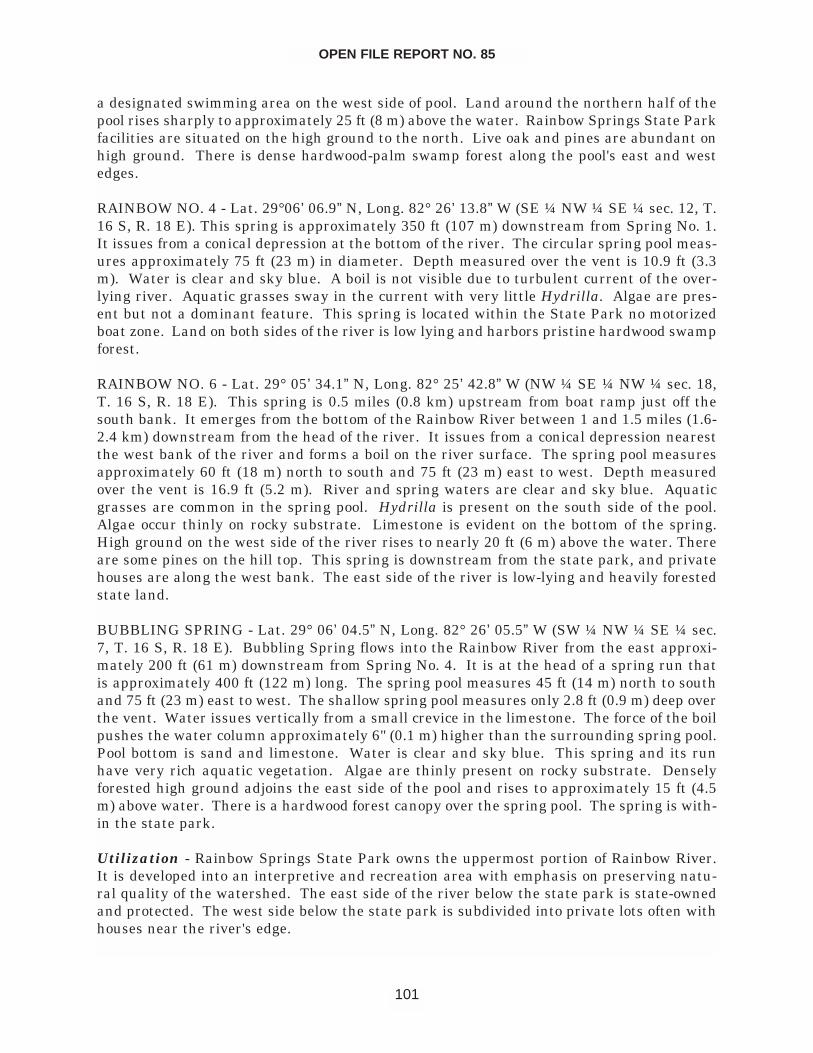
a designated swimming area on the west side of pool. Land around the northern half of thepool rises sharply to approximately 25 ft (8 m) above the water. Rainbow Springs State Parkfacilities are situated on the high ground to the north. Live oak and pines are abundant onhigh ground. There is dense hardwood-palm swamp forest along the pool's east and westedges.
RAINBOW NO. 4 - Lat. 29°06’ 06.9” N, Long. 82° 26’ 13.8” W (SE ¼ NW ¼ SE ¼ sec. 12, T.16 S, R. 18 E). This spring is approximately 350 ft (107 m) downstream from Spring No. 1.It issues from a conical depression at the bottom of the river. The circular spring pool meas-ures approximately 75 ft (23 m) in diameter. Depth measured over the vent is 10.9 ft (3.3m). Water is clear and sky blue. A boil is not visible due to turbulent current of the over-lying river. Aquatic grasses sway in the current with very little Hydrilla. Algae are pres-ent but not a dominant feature. This spring is located within the State Park no motorizedboat zone. Land on both sides of the river is low lying and harbors pristine hardwood swampforest.
RAINBOW NO. 6 - Lat. 29° 05’ 34.1” N, Long. 82° 25’ 42.8” W (NW ¼ SE ¼ NW ¼ sec. 18,T. 16 S, R. 18 E). This spring is 0.5 miles (0.8 km) upstream from boat ramp just off thesouth bank. It emerges from the bottom of the Rainbow River between 1 and 1.5 miles (1.6-2.4 km) downstream from the head of the river. It issues from a conical depression nearestthe west bank of the river and forms a boil on the river surface. The spring pool measuresapproximately 60 ft (18 m) north to south and 75 ft (23 m) east to west. Depth measuredover the vent is 16.9 ft (5.2 m). River and spring waters are clear and sky blue. Aquaticgrasses are common in the spring pool. Hydrilla is present on the south side of the pool.Algae occur thinly on rocky substrate. Limestone is evident on the bottom of the spring.High ground on the west side of the river rises to nearly 20 ft (6 m) above the water. Thereare some pines on the hill top. This spring is downstream from the state park, and privatehouses are along the west bank. The east side of the river is low-lying and heavily forestedstate land.
BUBBLING SPRING - Lat. 29° 06’ 04.5” N, Long. 82° 26’ 05.5” W (SW ¼ NW ¼ SE ¼ sec.7, T. 16 S, R. 18 E). Bubbling Spring flows into the Rainbow River from the east approxi-mately 200 ft (61 m) downstream from Spring No. 4. It is at the head of a spring run thatis approximately 400 ft (122 m) long. The spring pool measures 45 ft (14 m) north to southand 75 ft (23 m) east to west. The shallow spring pool measures only 2.8 ft (0.9 m) deep overthe vent. Water issues vertically from a small crevice in the limestone. The force of the boilpushes the water column approximately 6" (0.1 m) higher than the surrounding spring pool.Pool bottom is sand and limestone. Water is clear and sky blue. This spring and its runhave very rich aquatic vegetation. Algae are thinly present on rocky substrate. Denselyforested high ground adjoins the east side of the pool and rises to approximately 15 ft (4.5m) above water. There is a hardwood forest canopy over the spring pool. The spring is with-in the state park.
Utilization - Rainbow Springs State Park owns the uppermost portion of Rainbow River.It is developed into an interpretive and recreation area with emphasis on preserving natu-ral quality of the watershed. The east side of the river below the state park is state-ownedand protected. The west side below the state park is subdivided into private lots often withhouses near the river's edge.
OPEN FILE REPORT NO. 85
101
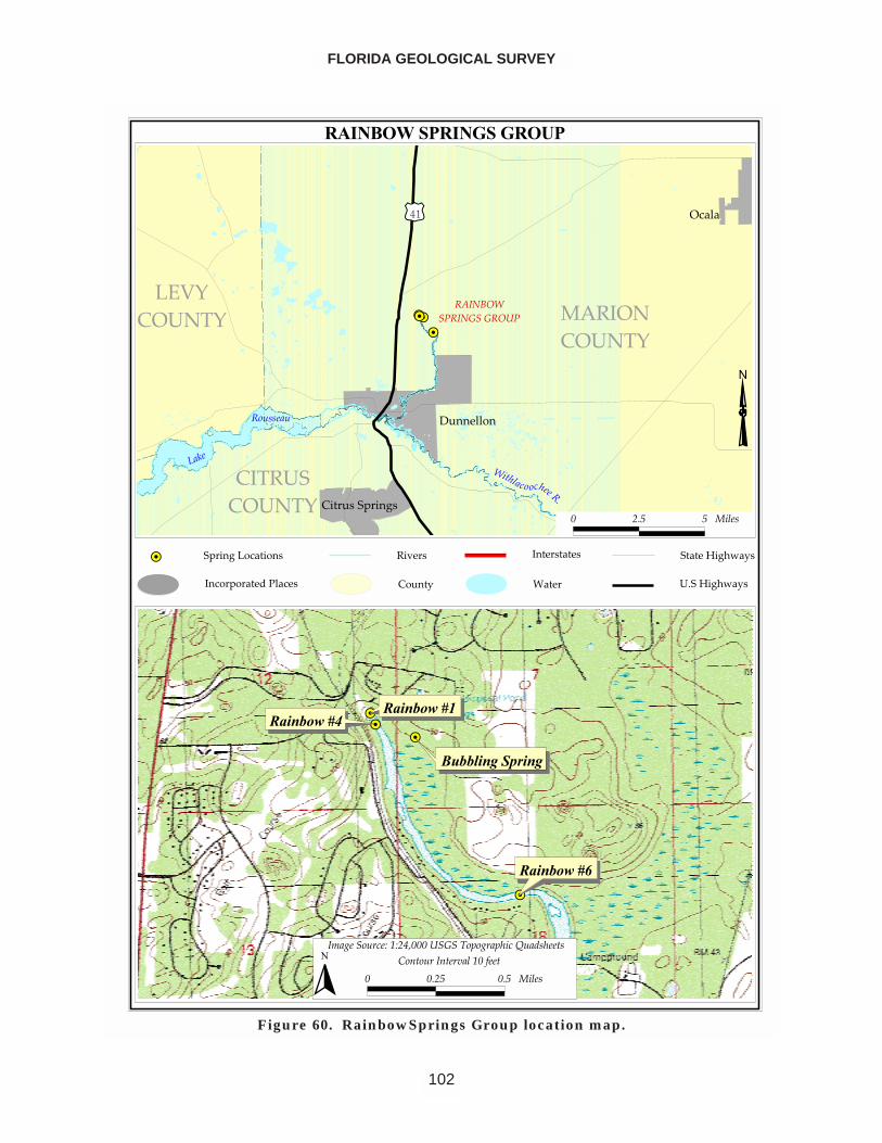
FLORIDA GEOLOGICAL SURVEY
102
�����������������
��������
������������ ��� ������
���������
����
���������� ������
������
�����
��������
�����
��� ���������� ��
���� ����������������
������������ �������������������
����
����
���� ��
!��� �"��#�$%�
����#�$%�
� ��� � �����
������
��
������������������
���� ����������
����������
�� ��������!�"!�#$���������%�&� ��&����'��(������
� ���� ��� ������ )�*�����*�������"��+���
�
Figure 60. RainbowSprings Group location map.
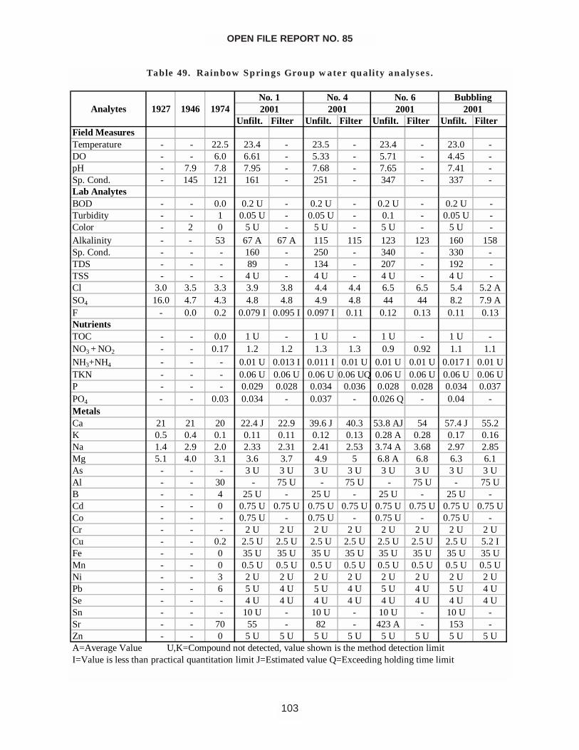
OPEN FILE REPORT NO. 85
103
Unfilt. Filter Unfilt. Filter Unfilt. Filter Unfilt. FilterField MeasuresTemperature - - 22.5 23.4 - 23.5 - 23.4 - 23.0 -DO - - 6.0 6.61 - 5.33 - 5.71 - 4.45 -pH - 7.9 7.8 7.95 - 7.68 - 7.65 - 7.41 -Sp. Cond. - 145 121 161 - 251 - 347 - 337 -Lab AnalytesBOD - - 0.0 0.2 U - 0.2 U - 0.2 U - 0.2 U -Turbidity - - 1 0.05 U - 0.05 U - 0.1 - 0.05 U -Color - 2 0 5 U - 5 U - 5 U - 5 U -Alkalinity - - 53 67 A 67 A 115 115 123 123 160 158Sp. Cond. - - - 160 - 250 - 340 - 330 -TDS - - - 89 - 134 - 207 - 192 -TSS - - - 4 U - 4 U - 4 U - 4 U -Cl 3.0 3.5 3.3 3.9 3.8 4.4 4.4 6.5 6.5 5.4 5.2 ASO4 16.0 4.7 4.3 4.8 4.8 4.9 4.8 44 44 8.2 7.9 AF - 0.0 0.2 0.079 I 0.095 I 0.097 I 0.11 0.12 0.13 0.11 0.13NutrientsTOC - - 0.0 1 U - 1 U - 1 U - 1 U -NO3 + NO2 - - 0.17 1.2 1.2 1.3 1.3 0.9 0.92 1.1 1.1NH3+NH4 - - - 0.01 U 0.013 I 0.011 I 0.01 U 0.01 U 0.01 U 0.017 I 0.01 UTKN - - - 0.06 U 0.06 U 0.06 U 0.06 UQ 0.06 U 0.06 U 0.06 U 0.06 UP - - - 0.029 0.028 0.034 0.036 0.028 0.028 0.034 0.037PO4 - - 0.03 0.034 - 0.037 - 0.026 Q - 0.04 -MetalsCa 21 21 20 22.4 J 22.9 39.6 J 40.3 53.8 AJ 54 57.4 J 55.2K 0.5 0.4 0.1 0.11 0.11 0.12 0.13 0.28 A 0.28 0.17 0.16Na 1.4 2.9 2.0 2.33 2.31 2.41 2.53 3.74 A 3.68 2.97 2.85Mg 5.1 4.0 3.1 3.6 3.7 4.9 5 6.8 A 6.8 6.3 6.1As - - - 3 U 3 U 3 U 3 U 3 U 3 U 3 U 3 UAl - - 30 - 75 U - 75 U - 75 U - 75 UB - - 4 25 U - 25 U - 25 U - 25 U -Cd - - 0 0.75 U 0.75 U 0.75 U 0.75 U 0.75 U 0.75 U 0.75 U 0.75 UCo - - - 0.75 U - 0.75 U - 0.75 U - 0.75 U -Cr - - - 2 U 2 U 2 U 2 U 2 U 2 U 2 U 2 UCu - - 0.2 2.5 U 2.5 U 2.5 U 2.5 U 2.5 U 2.5 U 2.5 U 5.2 IFe - - 0 35 U 35 U 35 U 35 U 35 U 35 U 35 U 35 UMn - - 0 0.5 U 0.5 U 0.5 U 0.5 U 0.5 U 0.5 U 0.5 U 0.5 UNi - - 3 2 U 2 U 2 U 2 U 2 U 2 U 2 U 2 UPb - - 6 5 U 4 U 5 U 4 U 5 U 4 U 5 U 4 USe - - - 4 U 4 U 4 U 4 U 4 U 4 U 4 U 4 USn - - - 10 U - 10 U - 10 U - 10 U -Sr - - 70 55 - 82 - 423 A - 153 -Zn - - 0 5 U 5 U 5 U 5 U 5 U 5 U 5 U 5 U
200120012001Bubbling
2001
I=Value is less than practical quantitation limit J=Estimated value Q=Exceeding holding time limitA=Average Value U,K=Compound not detected, value shown is the method detection limit
AnalytesNo. 1 No. 6No. 4
1927 1946 1974
Table 49. Rainbow Springs Group water quality analyses.
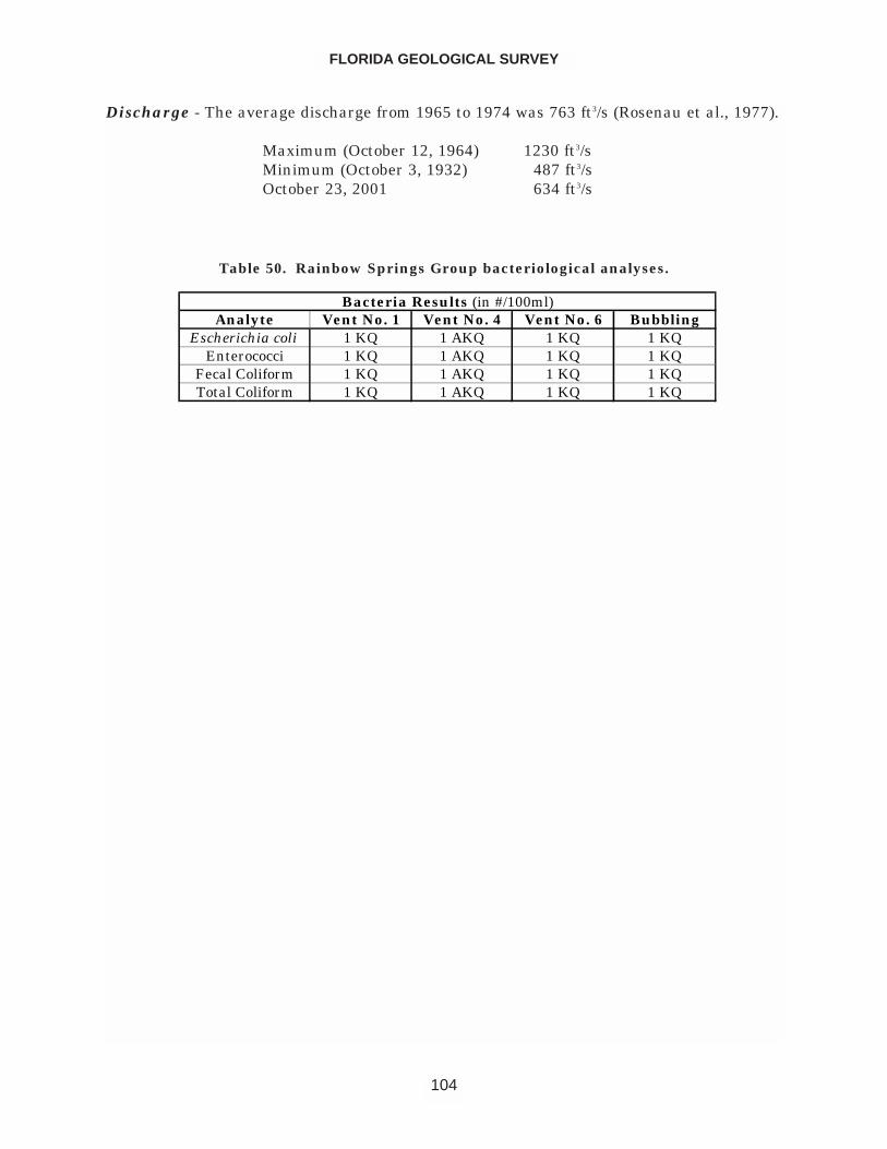
Discharge - The average discharge from 1965 to 1974 was 763 ft3/s (Rosenau et al., 1977).
Maximum (October 12, 1964) 1230 ft3/sMinimum (October 3, 1932) 487 ft3/sOctober 23, 2001 634 ft3/s
FLORIDA GEOLOGICAL SURVEY
104
Analyte Vent No. 1 Vent No. 4 Vent No. 6 BubblingEscherichia coli 1 KQ 1 AKQ 1 KQ 1 KQ
Enterococci 1 KQ 1 AKQ 1 KQ 1 KQFecal Coliform 1 KQ 1 AKQ 1 KQ 1 KQTotal Coliform 1 KQ 1 AKQ 1 KQ 1 KQ
Bacteria Results (in #/100ml)
Table 50. Rainbow Springs Group bacteriological analyses.
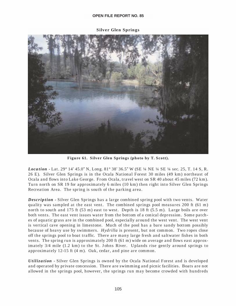
Silver Glen Springs
Location - Lat. 29° 14’ 45.0” N, Long. 81° 38’ 36.5” W (SE ¼ NE ¼ SE ¼ sec. 25, T. 14 S, R.26 E). Silver Glen Springs is in the Ocala National Forest 30 miles (49 km) northeast ofOcala and flows into Lake George. From Ocala, travel west on SR 40 about 45 miles (72 km).Turn north on SR 19 for approximately 6 miles (10 km) then right into Silver Glen SpringsRecreation Area. The spring is south of the parking area.
Description - Silver Glen Springs has a large combined spring pool with two vents. Waterquality was sampled at the east vent. The combined springs pool measures 200 ft (61 m)north to south and 175 ft (53 m) east to west. Depth is 18 ft (5.5 m). Large boils are overboth vents. The east vent issues water from the bottom of a conical depression. Some patch-es of aquatic grass are in the combined pool, especially around the west vent. The west ventis vertical cave opening in limestone. Much of the pool has a bare sandy bottom possiblybecause of heavy use by swimmers. Hydrilla is present, but not common. Two ropes closeoff the springs pool to boat traffic. There are many large fresh and saltwater fishes in bothvents. The spring run is approximately 200 ft (61 m) wide on average and flows east approx-imately 3/4 mile (1.2 km) to the St. Johns River. Uplands rise gently around springs toapproximately 12-15 ft (4 m). Oak, cedar, and pine are common.
Utilization - Silver Glen Springs is owned by the Ocala National Forest and is developedand operated by private concession. There are swimming and picnic facilities. Boats are notallowed in the springs pool, however, the springs run may become crowded with hundreds
OPEN FILE REPORT NO. 85
105
Figure 61. Silver Glen Springs (photo by T. Scott).
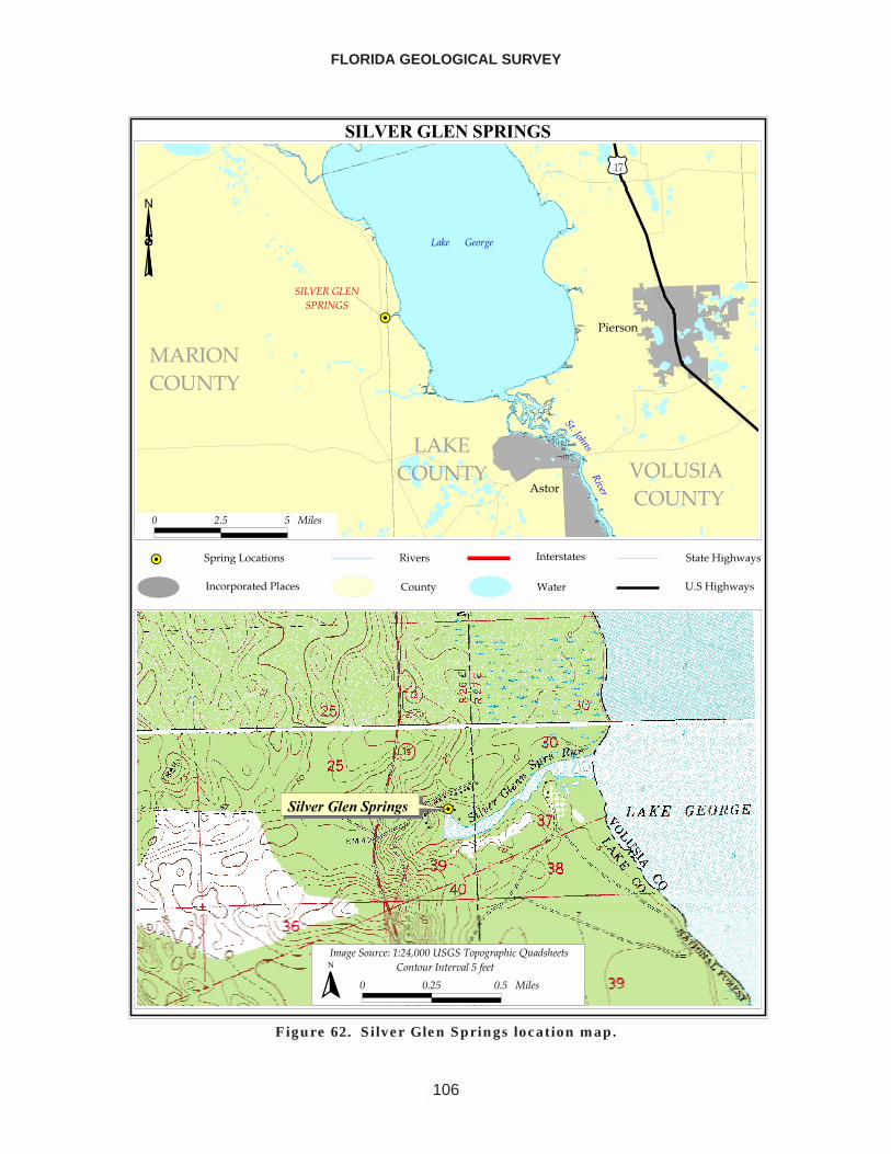
FLORIDA GEOLOGICAL SURVEY
106
������������������
��
�������������� ��
�������
����������������
��� ������ ��
���� ��� ��
������� ��
����
�������� ����
�����������������������������������
������
�����
����������
!���� �"�#��$%� �
�����#��$%� �
� ��� � �����
�������������������
���������� �! �"#����$��%�&����&����'��(������
� ���� ��� ������ )�����������������*���
�
Figure 62. Silver Glen Springs location map.
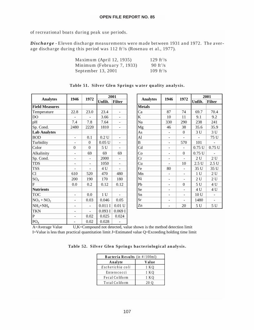
of recreational boats during peak use periods.
Discharge - Eleven discharge measurements were made between 1931 and 1972. The aver-age discharge during this period was 112 ft3/s (Rosenau et al., 1977).
Maximum (April 12, 1935) 129 ft3/sMinimum (February 7, 1933) 90 ft3/sSeptember 13, 2001 109 ft3/s
OPEN FILE REPORT NO. 85
107
Unfilt. Filter Unfilt. FilterField Measures MetalsTemperature 22.8 23.0 23.4 - Ca 87 74 69.7 70.4DO - - 3.66 - K 10 11 9.1 9.2pH 7.4 7.8 7.64 - Na 330 290 238 241Sp. Cond. 2480 2220 1810 - Mg 46 38 35.6 35.9Lab Analytes As - 0 3 U 3 UBOD - 0.1 0.2 U - Al - - - 75 UTurbidity - 0 0.05 U - B - 570 101 -Color 0 0 5 U - Cd - - 0.75 U 0.75 UAlkalinity - 69 69 69 Co - 0 0.75 U -Sp. Cond. - - 2000 - Cr - - 2 U 2 UTDS - - 1050 - Cu - 10 2.5 U 2.5 UTSS - - 4 U - Fe 80 - 35 U 35 UCl 610 520 470 480 Mn - - 1 U 2 USO4 200 190 170 180 Ni - - 2 U 2 UF 0.0 0.2 0.12 0.12 Pb - 0 5 U 4 UNutrients Se - - 4 U 4 UTOC - 0.0 1 U - Sn - - 10 U -NO3 + NO2 - 0.03 0.046 0.05 Sr - - 1480 -NH3+NH4 - - 0.011 I 0.01 U Zn - 20 5 U 5 UTKN - - 0.093 I 0.069 IP - 0.02 0.025 0.024PO4 - 0.02 0.028 -
Analytes 1946 19722001
A=Average Value U,K=Compound not detected, value shown is the method detection limitI=Value is less than practical quantitation limit J=Estimated value Q=Exceeding holding time limit
Analytes 1946 19722001
Table 51. Silver Glen Springs water quality analysis.
A nal yte V al ueE s c h e r ic h ia c o l i 1 K Q
En te ro c o c c i 1 K QF e c a l Co lifo rm 1 K QT o t a l Co lifo rm 20 Q
B ac te r ia R e s u lts (in # /100m l)
Table 52. Silver Glen Springs bacteriological analysis.
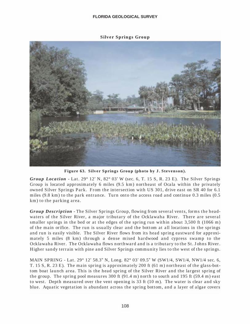
Silver Springs Group
Group Location - Lat. 29° 12’ N, 82° 03’ W (sec. 6, T. 15 S, R. 23 E). The Silver SpringsGroup is located approximately 6 miles (9.5 km) northeast of Ocala within the privatelyowned Silver Springs Park. From the intersection with US 301, drive east on SR 40 for 6.1miles (9.8 km) to the park entrance. Turn onto the access road and continue 0.3 miles (0.5km) to the parking area.
Group Description - The Silver Springs Group, flowing from several vents, forms the head-waters of the Silver River, a major tributary of the Ocklawaha River. There are severalsmaller springs in the bed or at the edges of the spring run within about 3,500 ft (1066 m)of the main orifice. The run is usually clear and the bottom at all locations in the springsand run is easily visible. The Silver River flows from its head spring eastward for approxi-mately 5 miles (8 km) through a dense mixed hardwood and cypress swamp to theOcklawaha River. The Ocklawaha flows northward and is a tributary to the St. Johns River.Higher sandy terrain with pine and Silver Springs community lies to the west of the springs.
MAIN SPRING - Lat. 29° 12’ 58.3” N, Long. 82° 03’ 09.5” W (SW1/4, SW1/4, NW1/4 sec. 6,T. 15 S, R. 23 E). The main spring is approximately 200 ft (61 m) northeast of the glass-bot-tom boat launch area. This is the head spring of the Silver River and the largest spring ofthe group. The spring pool measures 300 ft (91.4 m) north to south and 195 ft (59.4 m) eastto west. Depth measured over the vent opening is 33 ft (10 m). The water is clear and skyblue. Aquatic vegetation is abundant across the spring bottom, and a layer of algae covers
FLORIDA GEOLOGICAL SURVEY
108
Figure 63. Silver Springs Group (photo by J. Stevenson).
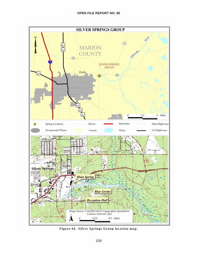
OPEN FILE REPORT NO. 85
109
�����������������
�����������
����������������
�� ��
�������
����������������
�����
����
��������������
�����
����
�����
�����
��������� ��������������� ��������
������
���� �
�� ��� � ��
�� �� ����������
� � ��������
� ��� � �����
����
��
�����������
��� �����
������������
������������ �! �"#��������$�%����%����&��'����(�
� ���� ��� ������ )�*(�����*(�� �����+��(
�
Figure 64. Silver Springs Group location map.
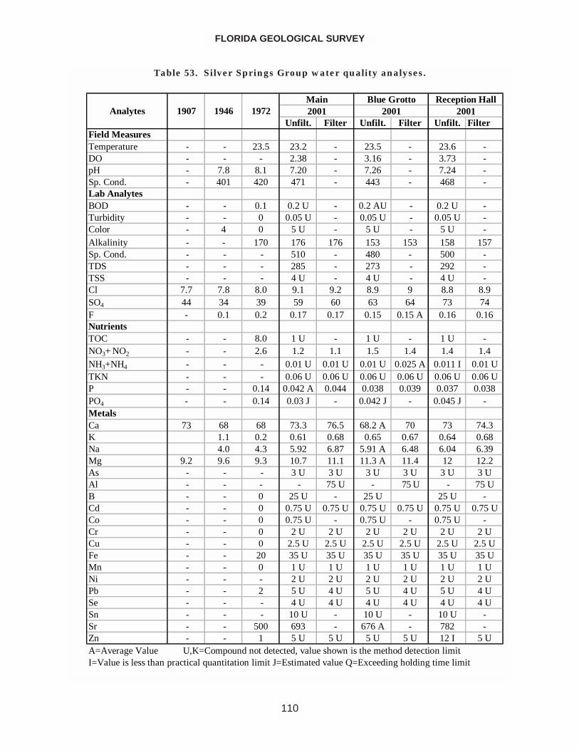
FLORIDA GEOLOGICAL SURVEY
110
Unfilt. Filter Unfilt. Filter Unfilt. FilterField MeasuresTemperature - - 23.5 23.2 - 23.5 - 23.6 -DO - - - 2.38 - 3.16 - 3.73 -pH - 7.8 8.1 7.20 - 7.26 - 7.24 -Sp. Cond. - 401 420 471 - 443 - 468 -Lab AnalytesBOD - - 0.1 0.2 U - 0.2 AU - 0.2 U -Turbidity - - 0 0.05 U - 0.05 U - 0.05 U -Color - 4 0 5 U - 5 U - 5 U -Alkalinity - - 170 176 176 153 153 158 157Sp. Cond. - - - 510 - 480 - 500 -TDS - - - 285 - 273 - 292 -TSS - - - 4 U - 4 U - 4 U -Cl 7.7 7.8 8.0 9.1 9.2 8.9 9 8.8 8.9SO4 44 34 39 59 60 63 64 73 74F - 0.1 0.2 0.17 0.17 0.15 0.15 A 0.16 0.16NutrientsTOC - - 8.0 1 U - 1 U - 1 U -NO3+ NO2 - - 2.6 1.2 1.1 1.5 1.4 1.4 1.4NH3+NH4 - - - 0.01 U 0.01 U 0.01 U 0.025 A 0.011 I 0.01 UTKN - - - 0.06 U 0.06 U 0.06 U 0.06 U 0.06 U 0.06 UP - - 0.14 0.042 A 0.044 0.038 0.039 0.037 0.038PO4 - - 0.14 0.03 J - 0.042 J - 0.045 J -MetalsCa 73 68 68 73.3 76.5 68.2 A 70 73 74.3K 1.1 0.2 0.61 0.68 0.65 0.67 0.64 0.68Na 4.0 4.3 5.92 6.87 5.91 A 6.48 6.04 6.39Mg 9.2 9.6 9.3 10.7 11.1 11.3 A 11.4 12 12.2As - - - 3 U 3 U 3 U 3 U 3 U 3 UAl - - - - 75 U - 75 U - 75 UB - - 0 25 U - 25 U 25 U -Cd - - 0 0.75 U 0.75 U 0.75 U 0.75 U 0.75 U 0.75 UCo - - 0 0.75 U - 0.75 U - 0.75 U -Cr - - 0 2 U 2 U 2 U 2 U 2 U 2 UCu - - 0 2.5 U 2.5 U 2.5 U 2.5 U 2.5 U 2.5 UFe - - 20 35 U 35 U 35 U 35 U 35 U 35 UMn - - 0 1 U 1 U 1 U 1 U 1 U 1 UNi - - - 2 U 2 U 2 U 2 U 2 U 2 UPb - - 2 5 U 4 U 5 U 4 U 5 U 4 USe - - - 4 U 4 U 4 U 4 U 4 U 4 USn - - - 10 U - 10 U - 10 U -Sr - - 500 693 - 676 A - 782 -Zn - - 1 5 U 5 U 5 U 5 U 12 I 5 U
2001Blue Grotto
2001Main Reception Hall
1907 1946 1972Analytes 2001
A=Average Value U,K=Compound not detected, value shown is the method detection limitI=Value is less than practical quantitation limit J=Estimated value Q=Exceeding holding time limit
Table 53. Silver Springs Group water quality analyses.
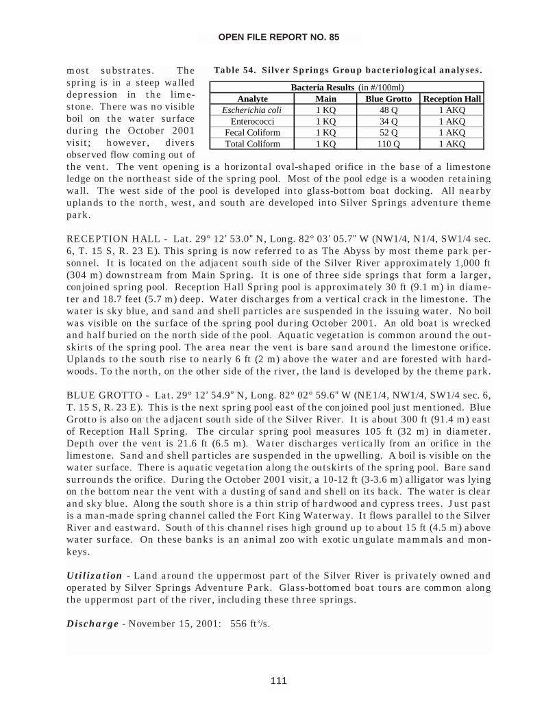
most substrates. Thespring is in a steep walleddepression in the lime-stone. There was no visibleboil on the water surfaceduring the October 2001visit; however, diversobserved flow coming out ofthe vent. The vent opening is a horizontal oval-shaped orifice in the base of a limestoneledge on the northeast side of the spring pool. Most of the pool edge is a wooden retainingwall. The west side of the pool is developed into glass-bottom boat docking. All nearbyuplands to the north, west, and south are developed into Silver Springs adventure themepark.
RECEPTION HALL - Lat. 29° 12’ 53.0” N, Long. 82° 03’ 05.7” W (NW1/4, N1/4, SW1/4 sec.6, T. 15 S, R. 23 E). This spring is now referred to as The Abyss by most theme park per-sonnel. It is located on the adjacent south side of the Silver River approximately 1,000 ft(304 m) downstream from Main Spring. It is one of three side springs that form a larger,conjoined spring pool. Reception Hall Spring pool is approximately 30 ft (9.1 m) in diame-ter and 18.7 feet (5.7 m) deep. Water discharges from a vertical crack in the limestone. Thewater is sky blue, and sand and shell particles are suspended in the issuing water. No boilwas visible on the surface of the spring pool during October 2001. An old boat is wreckedand half buried on the north side of the pool. Aquatic vegetation is common around the out-skirts of the spring pool. The area near the vent is bare sand around the limestone orifice.Uplands to the south rise to nearly 6 ft (2 m) above the water and are forested with hard-woods. To the north, on the other side of the river, the land is developed by the theme park.
BLUE GROTTO - Lat. 29° 12’ 54.9” N, Long. 82° 02° 59.6” W (NE1/4, NW1/4, SW1/4 sec. 6,T. 15 S, R. 23 E). This is the next spring pool east of the conjoined pool just mentioned. BlueGrotto is also on the adjacent south side of the Silver River. It is about 300 ft (91.4 m) eastof Reception Hall Spring. The circular spring pool measures 105 ft (32 m) in diameter.Depth over the vent is 21.6 ft (6.5 m). Water discharges vertically from an orifice in thelimestone. Sand and shell particles are suspended in the upwelling. A boil is visible on thewater surface. There is aquatic vegetation along the outskirts of the spring pool. Bare sandsurrounds the orifice. During the October 2001 visit, a 10-12 ft (3-3.6 m) alligator was lyingon the bottom near the vent with a dusting of sand and shell on its back. The water is clearand sky blue. Along the south shore is a thin strip of hardwood and cypress trees. Just pastis a man-made spring channel called the Fort King Waterway. It flows parallel to the SilverRiver and eastward. South of this channel rises high ground up to about 15 ft (4.5 m) abovewater surface. On these banks is an animal zoo with exotic ungulate mammals and mon-keys.
Utilization - Land around the uppermost part of the Silver River is privately owned andoperated by Silver Springs Adventure Park. Glass-bottomed boat tours are common alongthe uppermost part of the river, including these three springs.
Discharge - November 15, 2001: 556 ft3/s.
OPEN FILE REPORT NO. 85
111
Analyte Main Blue Grotto Reception HallEscherichia coli 1 KQ 48 Q 1 AKQ
Enterococci 1 KQ 34 Q 1 AKQFecal Coliform 1 KQ 52 Q 1 AKQTotal Coliform 1 KQ 110 Q 1 AKQ
Bacteria Results (in #/100ml)
Table 54. Silver Springs Group bacteriological analyses.
SUWANNEE COUNTY
Falmouth Spring
Location - Lat. 30° 21’ 40.2” N, Long. 83° 08’ 06.0” W (NW ¼ NE ¼ NE ¼ sec. 32, T. 1 S, R.12 E). Falmouth Spring is 10 miles (16 km) northwest of Live Oak. From Live Oak, travelabout 10 miles (16 km) northwest on US 90. Enter Falmouth Spring at the SRWMD signon the left. Spring is west of the parking area, and is accessed by an interpretive hikingpath.
Description - Falmouth Spring is a karst window. At the spring head, the spring poolmeasures 87 ft (27 m) north to south and 81 ft (25 m) east to west. Depth is 39 ft (3.7 m).The spring is in a conical sink depression. Water is greenish with tiny suspended algae par-ticles. The spring bottom and sides are thickly covered with dark green filamentous algae.No visible boil during the October 2001 visit. Limestone is outropped along sides. The bot-tom is sandy and rocky. High banks rise steeply along the spring and run to 25 to 30 ft (8to 9 m) above water level. Surrounding high ground has mixed hardwood and pine forest.Spring run flows 450 ft (137 m) northeast until disappearing into a siphon. The east side ofspring and its short run has a wooden boardwalk leading down to spring.
Utilization - Falmouth Springs is an interpretive park owned by SRWMD. Swimming isallowed.
Discharge - Historical measurements were obtained from Bulletin No. 31 (Rosenau et al.,1977). All discharge rates are measured in ft3/s. A high river stage on the Suwannee Rivercaused a reversal of flow in February 1933.
1908 1671913 220February 10, 1933 365December 9, 1942 59.6July 22, 1946 157November 16, 1960 183November 15, 1973 159November 13, 2001 1.59
FLORIDA GEOLOGICAL SURVEY
112
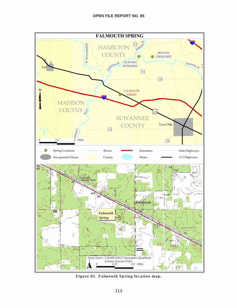
OPEN FILE REPORT NO. 85
113
����������� �
�� ��
��
��������
���
���� ���� �
������ ��� ��
��� ����� ��
����
����������������
���� ������������
����������
�����
����
���������������
�����
����� ����������
����
�����
������������� �������� �
� � �!
���"� �
����
���
����
# $�% % ����&
�������������
�'�(����!��)�*)$+,###� ����"�(!�"����-��.&����&# #�$% #�% ����&
� ������!�����! ���*#�/���
�
�������������������������������� ����
!�������"��#
���������������� �$�����%&�#�
���������%&�#�
Figure 65. Falmouth Spring location map.
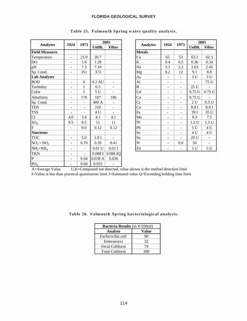
FLORIDA GEOLOGICAL SURVEY
114
Unfilt. Filter Unfilt. FilterField Measures MetalsTemperature - 21.0 20.7 Ca 65 53 63.1 62.3DO - 1.6 1.28 K 0.4 0.5 0.36 0.34pH - 7.3 7.10 Na 3.1 2.2 2.63 2.45Sp. Cond. - 351 373 Mg 9.2 12 9.1 8.8Lab Analytes As - - 3 U 3 UBOD - 0 0.2 AU - Al - - - 75 UTurbidity - 1 0.3 - B - - 25 U -Color - 5 5 U - Cd - - 0.75 U 0.75 UAlkalinity - 170 187 186 Co - - 0.75 U -Sp. Cond. - - 400 A - Cr - - 2 U 0.5 UTDS - - 210 - Cu - - 8.8 I 8.8 ITSS - - 4 U - Fe - - 39 I 35 UCl 4.0 3.4 4.1 4.1 Mn - - 9.3 7.5SO4 9.5 9.5 11 11 Ni - - 1.5 U 1.5 UF - 0.0 0.12 0.12 Pb - - 5 U 4 UNutrients Se - - 4 U 4 UTOC - 5.0 1.8 I - Sn - - 20 U -NO3 + NO2 - 0.70 0.39 0.41 Sr - 0.0 50 -NH3+NH4 - - 0.01 U 0.01 I Zn - - 5 U 5 UTKN - - 0.088 I 0.086 IQP - 0.04 0.038 A 0.036PO4 - 0.04 0.033 -A=Average Value U,K=Compound not detected, value shown is the method detection limitI=Value is less than practical quantitation limit J=Estimated value Q=Exceeding holding time limit
2001Analytes 1924 1973Analytes 1924
20011973
Table 55. Falmouth Spring water quality analysis.
Analyte ValueEscherichia coli 90
Enterococci 32Fecal Coliform 74Total Coliform 180
Bacteria Results (in #/100ml)
Table 56. Falmouth Spring bacteriological analysis.
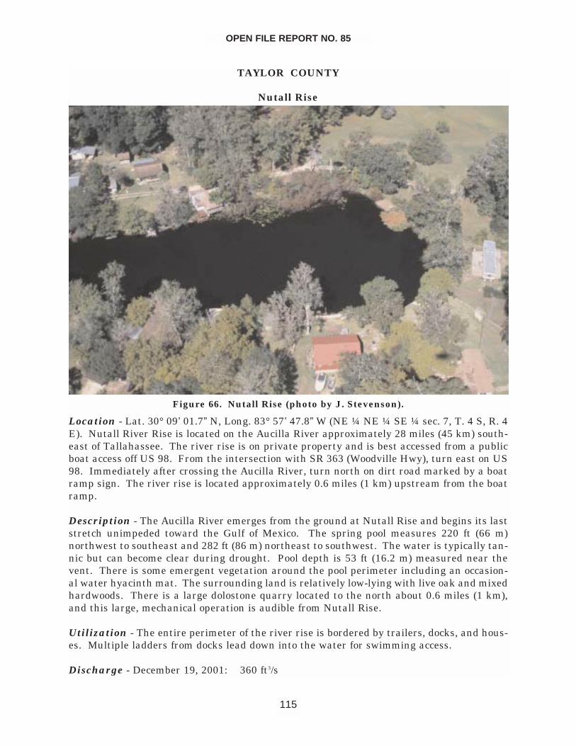
TAYLOR COUNTY
Nutall Rise
Location - Lat. 30° 09’ 01.7” N, Long. 83° 57’ 47.8” W (NE ¼ NE ¼ SE ¼ sec. 7, T. 4 S, R. 4E). Nutall River Rise is located on the Aucilla River approximately 28 miles (45 km) south-east of Tallahassee. The river rise is on private property and is best accessed from a publicboat access off US 98. From the intersection with SR 363 (Woodville Hwy), turn east on US98. Immediately after crossing the Aucilla River, turn north on dirt road marked by a boatramp sign. The river rise is located approximately 0.6 miles (1 km) upstream from the boatramp.
Description - The Aucilla River emerges from the ground at Nutall Rise and begins its laststretch unimpeded toward the Gulf of Mexico. The spring pool measures 220 ft (66 m)northwest to southeast and 282 ft (86 m) northeast to southwest. The water is typically tan-nic but can become clear during drought. Pool depth is 53 ft (16.2 m) measured near thevent. There is some emergent vegetation around the pool perimeter including an occasion-al water hyacinth mat. The surrounding land is relatively low-lying with live oak and mixedhardwoods. There is a large dolostone quarry located to the north about 0.6 miles (1 km),and this large, mechanical operation is audible from Nutall Rise.
Utilization - The entire perimeter of the river rise is bordered by trailers, docks, and hous-es. Multiple ladders from docks lead down into the water for swimming access.
Discharge - December 19, 2001: 360 ft3/s
OPEN FILE REPORT NO. 85
115
Figure 66. Nutall Rise (photo by J. Stevenson).
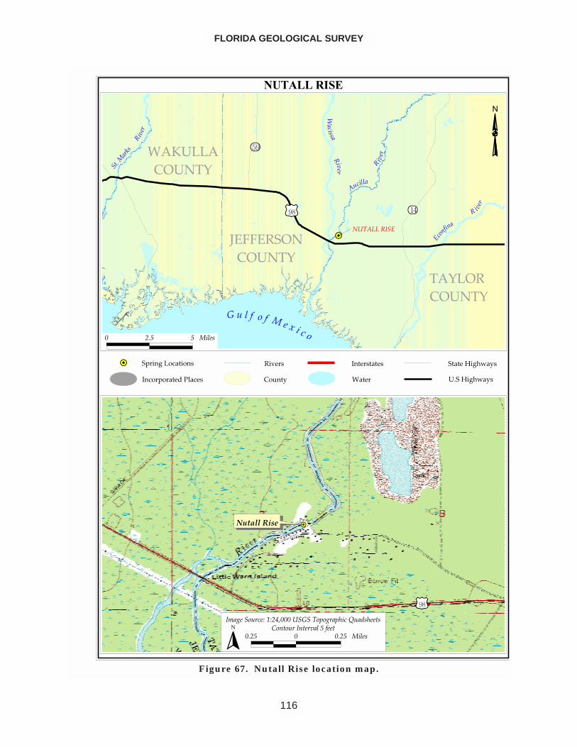
FLORIDA GEOLOGICAL SURVEY
116
����������
������������
�� ������
���������������
�� ��������
����
����
����� ���� �������������
����
�������
����� � ����
� ����
��
� ���
�����
���������
�������
� ��� � �����
������������
����� �!��������"�#"�$%����������&�!��&'���(��)�'����
���� � ���� ������ *������������������ ���
�
������� ����������������������� !����
��"�����#��$
��������������� ����%��&'�$�
������%��&'�$�
Figure 67. Nutall Rise location map.
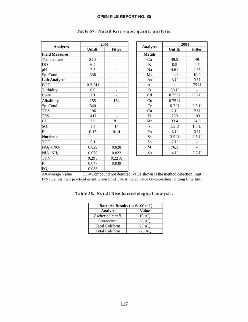
OPEN FILE REPORT NO. 85
117
Unfilt. Filter Unfilt. FilterField Measures MetalsTemperature 21.3 - Ca 49.8 49DO 6.4 - K 0.5 0.5pH 7.5 - Na 4.61 4.65Sp. Cond. 338 - Mg 11.1 10.9Lab Analytes As 3 U 3 UBOD 0.2 AU - Al - 75 UTurbidity 0.9 - B 30 U -Color 20 - Cd 0.75 U 0.5 UAlkalinity 155 154 Co 0.75 U -Sp. Cond. 340 - Cr 0.7 U 0.5 UTDS 196 - Cu 2 U 2 UTSS 4 U - Fe 299 193Cl 7.6 8.1 Mn 33.4 24.5SO4 14 14 Ni 1.5 U 1.5 UF 0.15 0.14 Pb 5 U 3 UNutrients Se 3.5 U 3.5 UTOC 5.1 - Sn 7 U -NO3 + NO2 0.029 0.028 Sr 76.1 -NH3+NH4 0.026 0.022 Zn 4 U 3.5 UTKN 0.29 J 0.22 AP 0.047 0.039PO4 0.033 -A=Average Value U,K=Compound not detected, value shown is the method detection limitI=Value less than practical quantitation limit J=Estimated value Q=exceeding holding time limit
2001Analytes Analytes
2001
Table 57. Nutall Rise water quality analysis.
Analyte ValueEscherichia coli 19 AQ
Enterococci 38 AQFecal Coliform 23 AQTotal Coliform 225 AQ
Bacteria Results (in #/100 mL)
Table 58. Nutall Rise bacteriological analysis.
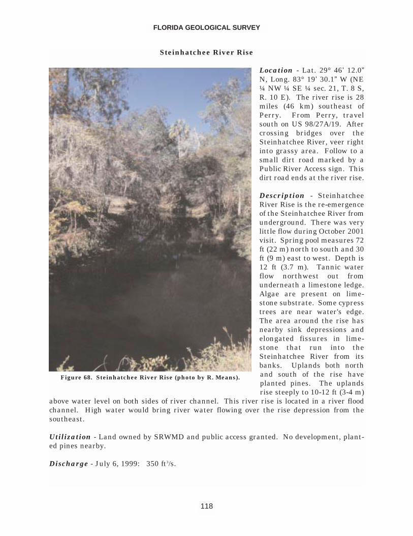
Steinhatchee River Rise
Location - Lat. 29° 46’ 12.0”N, Long. 83° 19’ 30.1” W (NE¼ NW ¼ SE ¼ sec. 21, T. 8 S,R. 10 E). The river rise is 28miles (46 km) southeast ofPerry. From Perry, travelsouth on US 98/27A/19. Aftercrossing bridges over theSteinhatchee River, veer rightinto grassy area. Follow to asmall dirt road marked by aPublic River Access sign. Thisdirt road ends at the river rise.
Description - SteinhatcheeRiver Rise is the re-emergenceof the Steinhatchee River fromunderground. There was verylittle flow during October 2001visit. Spring pool measures 72ft (22 m) north to south and 30ft (9 m) east to west. Depth is12 ft (3.7 m). Tannic waterflow northwest out fromunderneath a limestone ledge.Algae are present on lime-stone substrate. Some cypresstrees are near water's edge.The area around the rise hasnearby sink depressions andelongated fissures in lime-stone that run into theSteinhatchee River from itsbanks. Uplands both northand south of the rise haveplanted pines. The uplandsrise steeply to 10-12 ft (3-4 m)
above water level on both sides of river channel. This river rise is located in a river floodchannel. High water would bring river water flowing over the rise depression from thesoutheast.
Utilization - Land owned by SRWMD and public access granted. No development, plant-ed pines nearby.
Discharge - July 6, 1999: 350 ft3/s.
FLORIDA GEOLOGICAL SURVEY
118
Figure 68. Steinhatchee River Rise (photo by R. Means).
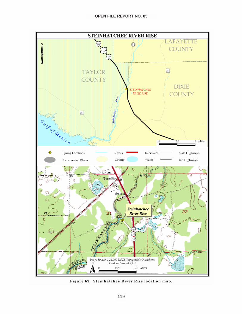
OPEN FILE REPORT NO. 85
119
�������������������
��
������������
������������
�� �������
����
����
�����
�����
���������
��������������������
��� �
�� � ������
������� �����������������������������������������
�����������
�����������!���� �"��#��$%� �
������#��$%� �
� ��� � ��� �
��
��������������������
������������
� �! ����� "#"�$%���&�����'�!��'���(��)�� ��
� ���� ��� ��� �� ���������� ������ �
�
Figure 69. Steinhatchee River Rise location map.
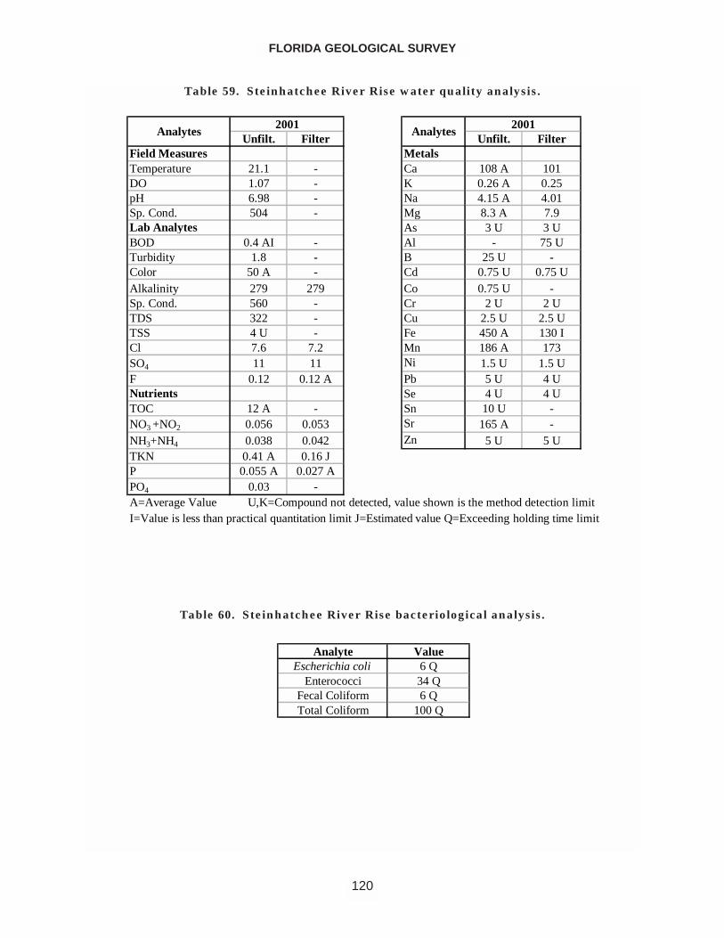
FLORIDA GEOLOGICAL SURVEY
120
Unfilt. Filter Unfilt. FilterField Measures MetalsTemperature 21.1 - Ca 108 A 101DO 1.07 - K 0.26 A 0.25pH 6.98 - Na 4.15 A 4.01Sp. Cond. 504 - Mg 8.3 A 7.9Lab Analytes As 3 U 3 UBOD 0.4 AI - Al - 75 UTurbidity 1.8 - B 25 U -Color 50 A - Cd 0.75 U 0.75 UAlkalinity 279 279 Co 0.75 U -Sp. Cond. 560 - Cr 2 U 2 UTDS 322 - Cu 2.5 U 2.5 UTSS 4 U - Fe 450 A 130 ICl 7.6 7.2 Mn 186 A 173SO4 11 11 Ni 1.5 U 1.5 UF 0.12 0.12 A Pb 5 U 4 UNutrients Se 4 U 4 UTOC 12 A - Sn 10 U -NO3 +NO2 0.056 0.053 Sr 165 A -NH3+NH4 0.038 0.042 Zn 5 U 5 UTKN 0.41 A 0.16 JP 0.055 A 0.027 APO4 0.03 -A=Average Value U,K=Compound not detected, value shown is the method detection limit
2001Analytes Analytes
2001
I=Value is less than practical quantitation limit J=Estimated value Q=Exceeding holding time limit
Table 59. Steinhatchee River Rise water quality analysis.
Analyte ValueEscherichia coli 6 Q
Enterococci 34 QFecal Coliform 6 QTotal Coliform 100 Q
Table 60. Steinhatchee River Rise bacteriological analysis.
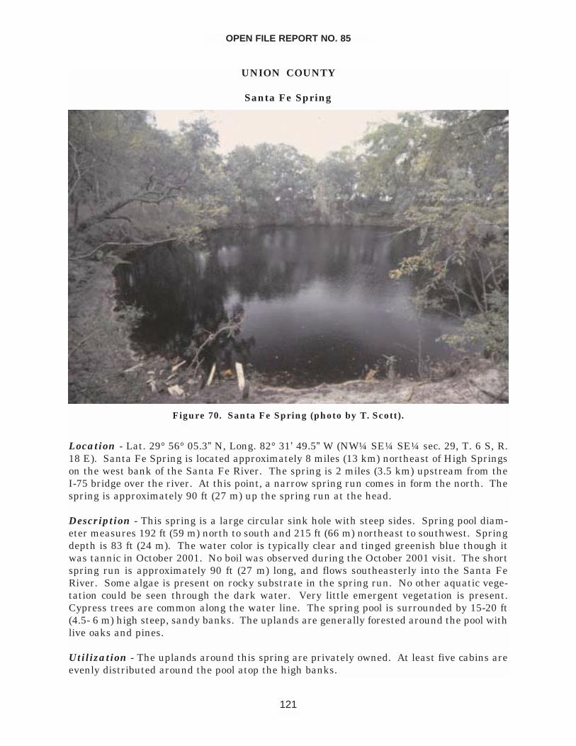
UNION COUNTY
Santa Fe Spring
Location - Lat. 29° 56° 05.3” N, Long. 82° 31’ 49.5” W (NW¼ SE¼ SE¼ sec. 29, T. 6 S, R.18 E). Santa Fe Spring is located approximately 8 miles (13 km) northeast of High Springson the west bank of the Santa Fe River. The spring is 2 miles (3.5 km) upstream from theI-75 bridge over the river. At this point, a narrow spring run comes in form the north. Thespring is approximately 90 ft (27 m) up the spring run at the head.
Description - This spring is a large circular sink hole with steep sides. Spring pool diam-eter measures 192 ft (59 m) north to south and 215 ft (66 m) northeast to southwest. Springdepth is 83 ft (24 m). The water color is typically clear and tinged greenish blue though itwas tannic in October 2001. No boil was observed during the October 2001 visit. The shortspring run is approximately 90 ft (27 m) long, and flows southeasterly into the Santa FeRiver. Some algae is present on rocky substrate in the spring run. No other aquatic vege-tation could be seen through the dark water. Very little emergent vegetation is present.Cypress trees are common along the water line. The spring pool is surrounded by 15-20 ft(4.5- 6 m) high steep, sandy banks. The uplands are generally forested around the pool withlive oaks and pines.
Utilization - The uplands around this spring are privately owned. At least five cabins areevenly distributed around the pool atop the high banks.
OPEN FILE REPORT NO. 85
121
Figure 70. Santa Fe Spring (photo by T. Scott).
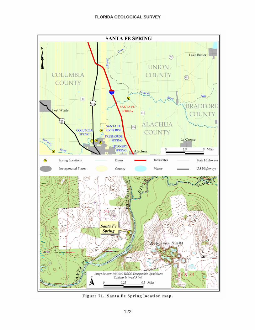
FLORIDA GEOLOGICAL SURVEY
122
�������������
��
��
��
��
��
��
���������
�����
���������
�����������
���
�� ��
��
����
������ �������
���
������ �����������
�����������������
���������������
�������������
��������������
�����������
�������������
��� �� ������
��!�������
��������
�����
�����
����
�����
�����
����
�����
�����
�"��#$�������#����#��"�����%�����
��&���
���#�'
�#���������
����� �(����$�)�'�
��������$�)�'�
� ��� � �����
��������������
�������� �������� ����!�"��#�$���$%���& �'�%����
� ���� ��� ������ ����� ����������(���
�
Figure 71. Santa Fe Spring location map.
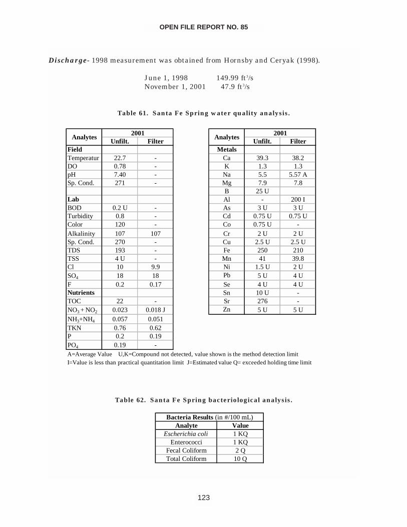
Discharge- 1998 measurement was obtained from Hornsby and Ceryak (1998).
June 1, 1998 149.99 ft3/sNovember 1, 2001 47.9 ft3/s
OPEN FILE REPORT NO. 85
123
Unfilt. Filter Unfilt. FilterField MetalsTemperatur 22.7 - Ca 39.3 38.2DO 0.78 - K 1.3 1.3pH 7.40 - Na 5.5 5.57 ASp. Cond. 271 - Mg 7.9 7.8
B 25 ULab Al - 200 IBOD 0.2 U - As 3 U 3 UTurbidity 0.8 - Cd 0.75 U 0.75 UColor 120 - Co 0.75 U -Alkalinity 107 107 Cr 2 U 2 USp. Cond. 270 - Cu 2.5 U 2.5 UTDS 193 - Fe 250 210TSS 4 U - Mn 41 39.8Cl 10 9.9 Ni 1.5 U 2 USO4 18 18 Pb 5 U 4 UF 0.2 0.17 Se 4 U 4 UNutrients Sn 10 U -TOC 22 - Sr 276 -NO3 + NO2 0.023 0.018 J Zn 5 U 5 UNH3+NH4 0.057 0.051TKN 0.76 0.62P 0.2 0.19PO4 0.19 -A=Average Value U,K=Compound not detected, value shown is the method detection limitI=Value is less than practical quantitation limit J=Estimated value Q= exceeded holding time limit
Analytes Analytes20012001
Table 61. Santa Fe Spring water quality analysis.
Analyte ValueEscherichia coli 1 KQ
Enterococci 1 KQFecal Coliform 2 QTotal Coliform 10 Q
Bacteria Results (in #/100 mL)
Table 62. Santa Fe Spring bacteriological analysis.
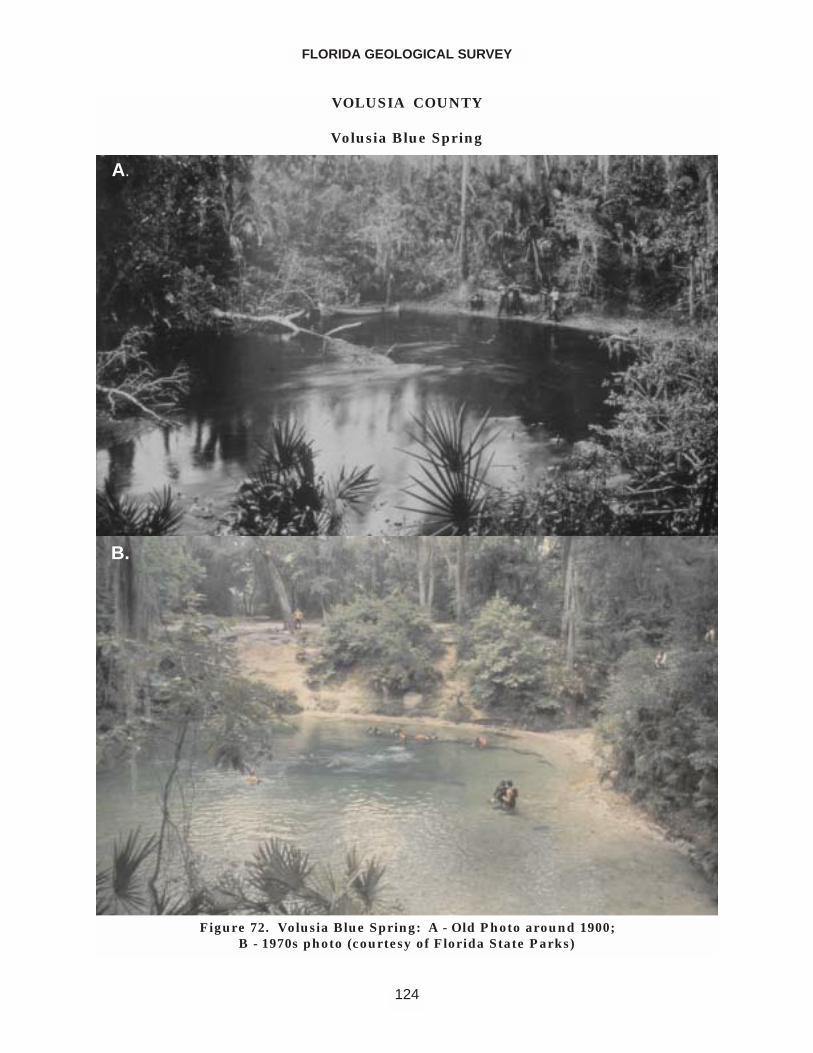
VOLUSIA COUNTY
Volusia Blue Spring
FLORIDA GEOLOGICAL SURVEY
124
Figure 72. Volusia Blue Spring: A - Old Photo around 1900; B - 1970s photo (courtesy of Florida State Parks)
A.
B.
Location - Lat. 28° 56’ 51.0” N, Long. 81° 20’ 22.5” W (NW ¼ NW ¼ NE ¼ sec. 8, T. 18 S, R30 E). Volusia Blue Spring is 6 miles (10 km) southwest of Deland in Blue Spring StatePark. From Deland, drive south on US 17. Turn west on CR 4142 in Orange City and con-tinue 3.25 miles (5.2 km) to Blue Spring State Park. The spring is at the head of Blue Runabout .25 miles (0.4 km) north of the parking area and is reached by a wooden boardwalktrail on the east bank of the spring run.
Description - Blue Spring has a circular spring pool in a conical depression with a notableboil in the center. The water is sky blue with a greenish tinge. The spring pool measures135 ft (41 m) north to south and 105 ft (32 m) east to west. Depth of the spring measuredover the vent is 20 ft (9.3 m), however, as with the majority of Florida springs, much greaterdepths are attained back in the cave system. The bottom of the spring is limestone andsand. The vent is an elongated crack in the bedrock limestone. Algae are ubiquitous in thespring and its run. No other aquatic vegetation was observed during the October 2001 visit.The spring has steep sandy banks that rise to approximately 15 to 20 ft (4.5 to 6 m) abovewater level. The spring run also has steep sandy banks, and it flows south and west approx-imately 1050 ft (320 m) to the St. Johns River through dense hardwood and palm forest.
Utilization - The spring and its surroundings are owned and managed by Blue SpringsState Park. It is an excellent place for nature study, swimming, scuba diving, and canoeing.Camping and hiking also are permitted in the park. Full facilities are available.
Discharge - Average discharge from March 1932 to August 1974 was 162 ft3/s (360 meas-urements) (Rosenau et al., 1977).
Maximum (November 1, 1960) 214 ft3/sMinimum (November 6, 1935) 63 ft3/sNovember 24, 2001 87 ft3/s
OPEN FILE REPORT NO. 85
125
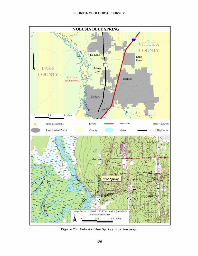
FLORIDA GEOLOGICAL SURVEY
126
����������������
��
������� ��������
�����
���� �
� �������
����������
�������������
����
����
���������������
����������
�������� ��
�� ������������������ �� ���� ����
!�"� �
��#��
��� ����
$�� �%�����&'���
�������&'���
� ��� � �����
������ ��������������
�������� !�"#"�$%����� �&�'�� �'��!(��)������
� ���� ��� ������ *����� ���� +���,���
�
Figure 73. Volusia Blue Spring location map.
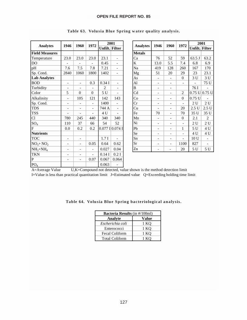
OPEN FILE REPORT NO. 85
127
Unfilt. Filter Unfilt. FilterField Measures MetalsTemperature 23.0 23.0 23.0 23.1 - Ca 76 52 59 63.5 J 63.2DO - - - 0.45 - K 13.0 5.5 7.4 6.8 6.9pH 7.6 7.5 7.8 7.21 - Na 419 128 260 167 170Sp. Cond. 2840 1060 1800 1402 - Mg 51 20 29 23 23.1Lab Analytes As - - 0 3 U 3 UBOD - - 0.3 0.34 I - Al - - - - 75 UTurbidity - - - 2 - B - - 76 I -Color 5 0 0 5 U - Cd - - 2 0.75 U 0.75 UAlkalinity - 105 121 142 143 Co - - 0 0.75 U -Sp. Cond. - - - 1400 - Cr - - - 2 U 2 UTDS - - - 744 A - Cu - - 20 2.5 U 2.5 UTSS - - - 4 U - Fe 70 - 70 35 U 35 UCl 780 245 440 340 340 Mn - - 0 2.1 2SO4 110 37 66 54 52 Ni - - - 2 U 2 UF 0.0 0.2 0.2 0.077 I 0.074 I Pb - - 1 5 U 4 UNutrients Se - - - 4 U 4 UTOC - - 1.7 I - Sn - - - 10 U -NO3+ NO2 - - 0.05 0.64 0.62 Sr - - 1100 827 -NH3+NH4 - - - 0.027 0.04 Zn - - 20 5 U 5 UTKN - - - 0.14 I 0.2 IP - - 0.07 0.067 0.064PO4 0.063 -A=Average Value U,K=Compound not detected, value shown is the method detection limitI=Value is less than practical quantitation limit J=Estimated value Q=Exceeding holding time limit
2001 2001AnalytesAnalytes 1946 19721960 1946 1960 1972
Table 63. Volusia Blue Spring water quality analysis.
Analyte ValueEscherichia coli 1 KQ
Enterococci 1 KQFecal Coliform 1 KQTotal Coliform 1 KQ
Bacteria Results (in #/100ml)
Table 64. Volusia Blue Spring bacteriological analysis.
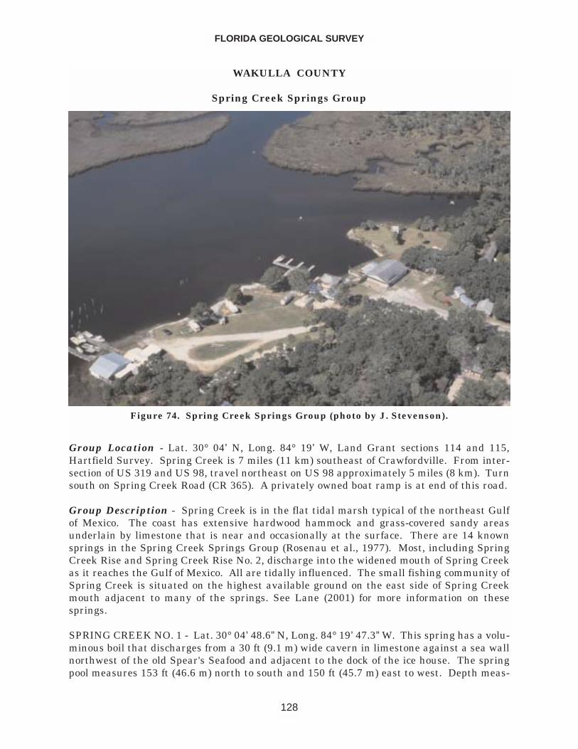
WAKULLA COUNTY
Spring Creek Springs Group
Group Location - Lat. 30° 04’ N, Long. 84° 19’ W, Land Grant sections 114 and 115,Hartfield Survey. Spring Creek is 7 miles (11 km) southeast of Crawfordville. From inter-section of US 319 and US 98, travel northeast on US 98 approximately 5 miles (8 km). Turnsouth on Spring Creek Road (CR 365). A privately owned boat ramp is at end of this road.
Group Description - Spring Creek is in the flat tidal marsh typical of the northeast Gulfof Mexico. The coast has extensive hardwood hammock and grass-covered sandy areasunderlain by limestone that is near and occasionally at the surface. There are 14 knownsprings in the Spring Creek Springs Group (Rosenau et al., 1977). Most, including SpringCreek Rise and Spring Creek Rise No. 2, discharge into the widened mouth of Spring Creekas it reaches the Gulf of Mexico. All are tidally influenced. The small fishing community ofSpring Creek is situated on the highest available ground on the east side of Spring Creekmouth adjacent to many of the springs. See Lane (2001) for more information on thesesprings.
SPRING CREEK NO. 1 - Lat. 30° 04’ 48.6” N, Long. 84° 19’ 47.3” W. This spring has a volu-minous boil that discharges from a 30 ft (9.1 m) wide cavern in limestone against a sea wallnorthwest of the old Spear's Seafood and adjacent to the dock of the ice house. The springpool measures 153 ft (46.6 m) north to south and 150 ft (45.7 m) east to west. Depth meas-
FLORIDA GEOLOGICAL SURVEY
128
Figure 74. Spring Creek Springs Group (photo by J. Stevenson).
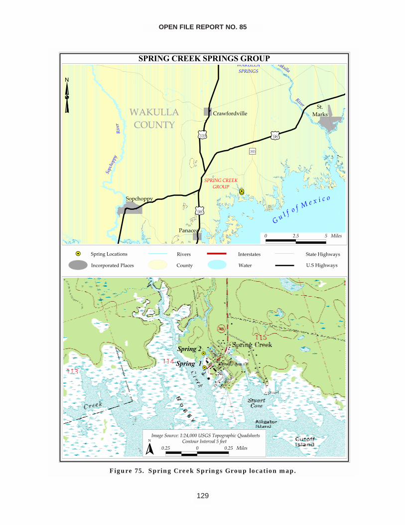
OPEN FILE REPORT NO. 85
129
������������������������
����
��������
�����
������������
�������������
����������
���������
����
��� �������������
������
��������������
���
�����
���
�����
�����������������
�������
� !" " ���#
��
����������
���������
�$�%����� �&�'& ()���������*���% ����+��,#���-#
�! " � �! " ���#� ��.-�� ��.-� ����"����-
�
���� !����������"���������!�����
#�������$���
"���������� ���� ���!%� �����
�����!%� �����
Figure 75. Spring Creek Springs Group location map.
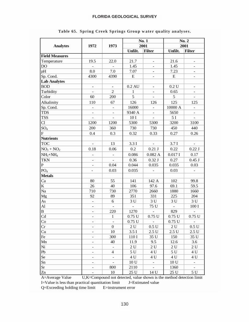
FLORIDA GEOLOGICAL SURVEY
130
Unfilt. Filter Unfilt. FilterField MeasuresTemperature 19.5 22.0 21.7 - 21.6 -DO - - 1.45 - 1.45 -pH 8.0 7.0 7.07 - 7.23 -Sp. Cond. 4300 4390 E - E -Lab AnalytesBOD - - 0.2 AU - 0.2 U -Turbidity - 2 1 - 0.65 -Color 60 200 5 - 5 -Alkalinity 110 67 126 126 125 125Sp. Cond. - - 16000 - 10000 A -TDS - - 9340 A - 5650 -TSS - - 10 I - 5 I -Cl 1200 1200 5300 5300 3200 3100SO4 200 360 730 730 450 440F 0.4 0.3 0.32 0.33 0.27 0.26NutrientsTOC - 13 3.3 I - 3.7 I -NO3 + NO2 0.18 0.06 0.2 0.21 J 0.22 0.22 JNH3+NH4 - - 0.086 0.082 A 0.017 I 0.17TKN - - 0.36 0.32 J 0.27 0.45 JP - 0.04 0.044 0.035 0.035 0.03PO4 - 0.03 0.035 - 0.03 -MetalsCa 80 55 141 142 A 102 99.8K 26 40 106 97.6 69.1 59.5Na 710 730 2770 2660 1880 1660Mg 92 89 351 331 225 204As - 6 3 U 3 U 3 U 3 UAl - - - 75 U - 100 IB - 220 1270 - 829 -Cd - 1 0.75 U 0.75 U 0.75 U 0.75 UCo - - 0.75 U - 0.75 U -Cr - 0 2 U 0.5 U 2 U 0.5 UCu - 10 3.5 I 2.5 U 2.5 U 2.5 UFe - 300 110 I 35 U 150 35 UMn - 40 11.9 9.5 12.6 3.6Ni - - 2 U 2 U 2 U 2 UPb - 4 5 U 4 U 5 U 4 USe - - 4 U 4 U 4 U 4 USn - - 10 U - 10 U -Sr - 800 2110 - 1360 -Zn - 10 25 U 14 U 25 U 5 U
2001
Q=Exceeding holding time limit E=instrument errorI=Value is less than practical quantitation limit J=Estimated value A=Average Value U,K=Compound not detected, value shown is the method detection limit
1972 1973AnalytesNo. 1 No. 22001
Table 65. Spring Creek Springs Group water quality analyses.
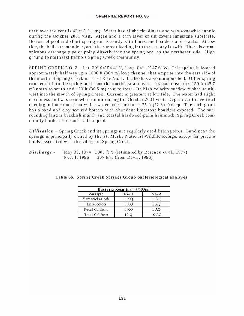
ured over the vent is 43 ft (13.1 m). Water had slight cloudiness and was somewhat tannicduring the October 2001 visit. Algae and a thin layer of silt covers limestone substrate.Bottom of pool and short spring run is sandy with limestone boulders and cracks. At lowtide, the boil is tremendous, and the current leading into the estuary is swift. There is a con-spicuous drainage pipe dripping directly into the spring pool on the northeast side. Highground to northeast harbors Spring Creek community.
SPRING CREEK NO. 2 - Lat. 30° 04’ 54.4” N, Long. 84° 19’ 47.6” W. This spring is locatedapproximately half way up a 1000 ft (304 m) long channel that empties into the east side ofthe mouth of Spring Creek north of Rise No. 1. It also has a voluminous boil. Other springruns enter into the spring pool from the northeast and east. Its pool measures 150 ft (45.7m) north to south and 120 ft (36.5 m) east to west. Its high velocity outflow rushes south-west into the mouth of Spring Creek. Current is greatest at low tide. The water had slightcloudiness and was somewhat tannic during the October 2001 visit. Depth over the verticalopening in limestone from which water boils measures 75 ft (22.8 m) deep. The spring runhas a sand and clay scoured bottom with abundant limestone boulders exposed. The sur-rounding land is brackish marsh and coastal hardwood-palm hammock. Spring Creek com-munity borders the south side of pool.
Utilization - Spring Creek and its springs are regularly used fishing sites. Land near thesprings is principally owned by the St. Marks National Wildlife Refuge, except for privatelands associated with the village of Spring Creek.
Discharge - May 30, 1974 2000 ft3/s (estimated by Rosenau et al., 1977)Nov. 1, 1996 307 ft3/s (from Davis, 1996)
OPEN FILE REPORT NO. 85
131
Analyte No. 1 No. 2Escherichia coli 1 KQ 1 AQ
Enterococci 1 KQ 1 AQFecal Coliform 1 KQ 1 AQTotal Coliform 10 Q 10 AQ
Bacteria Results (in #/100ml)
Table 66. Spring Creek Springs Group bacteriological analyses.
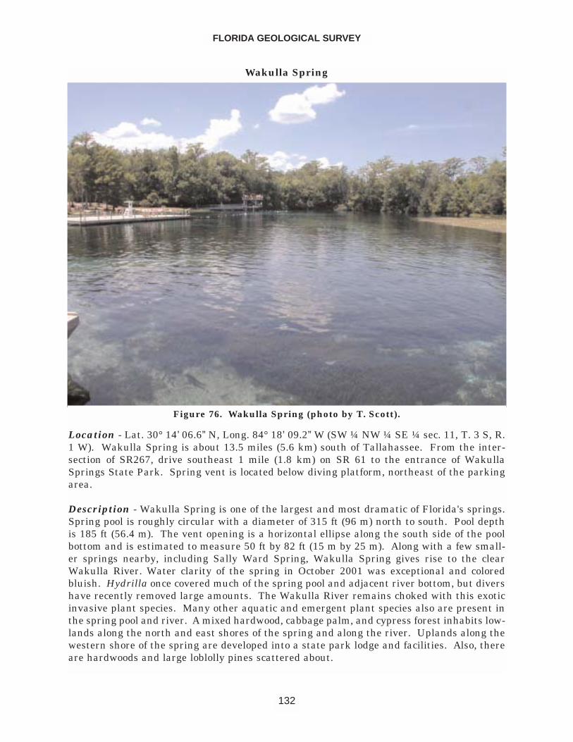
Wakulla Spring
Location - Lat. 30° 14’ 06.6” N, Long. 84° 18’ 09.2” W (SW ¼ NW ¼ SE ¼ sec. 11, T. 3 S, R.1 W). Wakulla Spring is about 13.5 miles (5.6 km) south of Tallahassee. From the inter-section of SR267, drive southeast 1 mile (1.8 km) on SR 61 to the entrance of WakullaSprings State Park. Spring vent is located below diving platform, northeast of the parkingarea.
Description - Wakulla Spring is one of the largest and most dramatic of Florida's springs.Spring pool is roughly circular with a diameter of 315 ft (96 m) north to south. Pool depthis 185 ft (56.4 m). The vent opening is a horizontal ellipse along the south side of the poolbottom and is estimated to measure 50 ft by 82 ft (15 m by 25 m). Along with a few small-er springs nearby, including Sally Ward Spring, Wakulla Spring gives rise to the clearWakulla River. Water clarity of the spring in October 2001 was exceptional and coloredbluish. Hydrilla once covered much of the spring pool and adjacent river bottom, but divershave recently removed large amounts. The Wakulla River remains choked with this exoticinvasive plant species. Many other aquatic and emergent plant species also are present inthe spring pool and river. A mixed hardwood, cabbage palm, and cypress forest inhabits low-lands along the north and east shores of the spring and along the river. Uplands along thewestern shore of the spring are developed into a state park lodge and facilities. Also, thereare hardwoods and large loblolly pines scattered about.
FLORIDA GEOLOGICAL SURVEY
132
Figure 76. Wakulla Spring (photo by T. Scott).
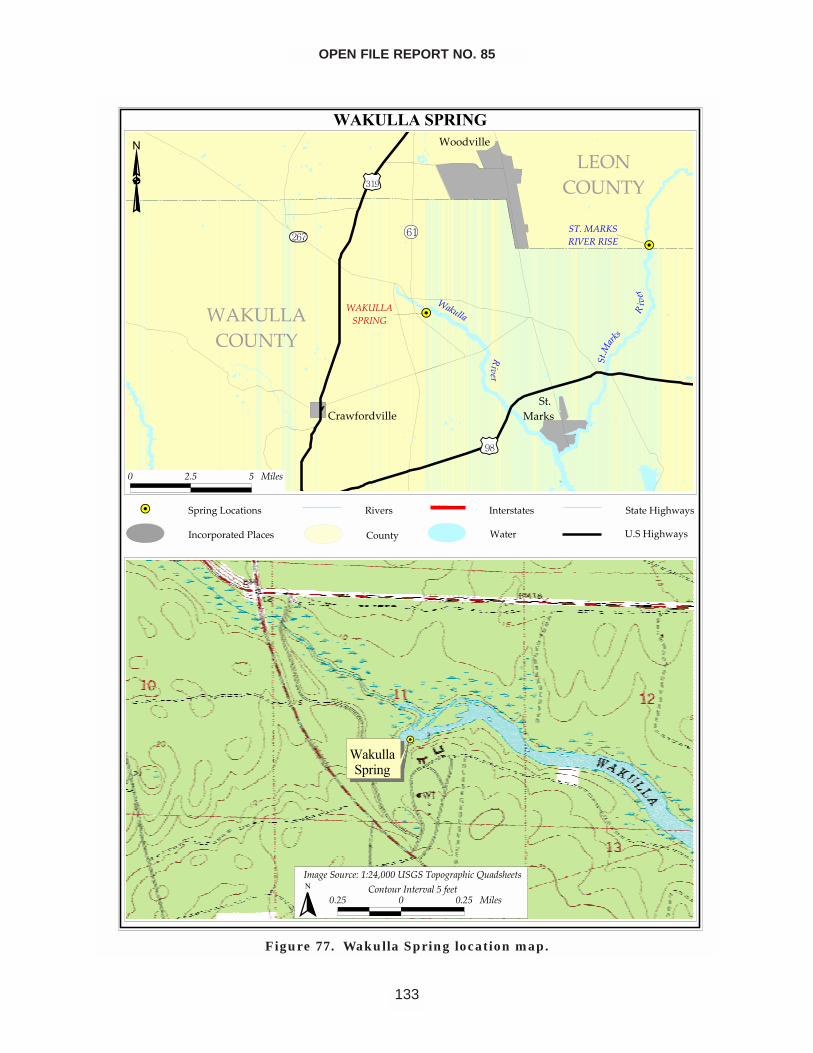
OPEN FILE REPORT NO. 85
133
������������
��
��
���������
���� ��
�����
���������
����
�����������
�� �
��
� ���
������������
��� ������������
� ���� ������
�������������
����������
�� �������������� ��� �� ����!�����
"��� �
��#��$
��� ���������� ��%��&��$�
�����%��&��$�
� ��� � ����
�������������
������ �!�"�#"�$%�������� & ��&'�!�(��)�'����
���� � ���� ����� * +� ���+��������,���
�
Figure 77. Wakulla Spring location map.
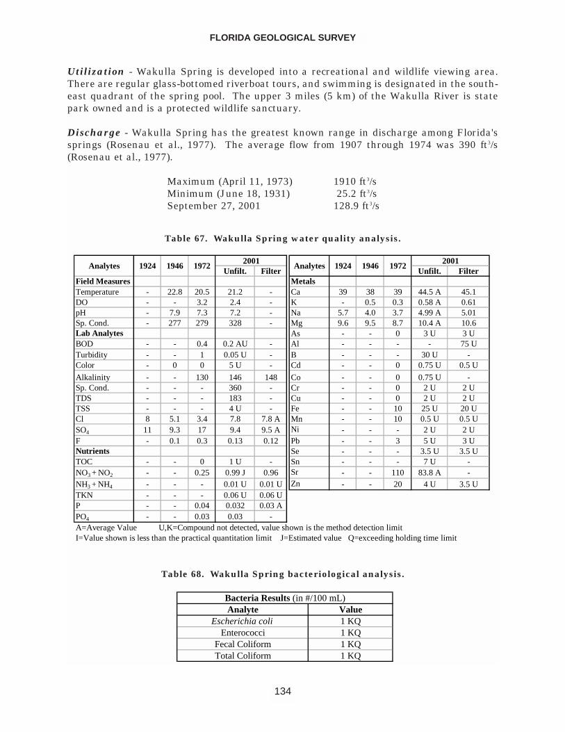
Utilization - Wakulla Spring is developed into a recreational and wildlife viewing area.There are regular glass-bottomed riverboat tours, and swimming is designated in the south-east quadrant of the spring pool. The upper 3 miles (5 km) of the Wakulla River is statepark owned and is a protected wildlife sanctuary.
Discharge - Wakulla Spring has the greatest known range in discharge among Florida'ssprings (Rosenau et al., 1977). The average flow from 1907 through 1974 was 390 ft3/s(Rosenau et al., 1977).
Maximum (April 11, 1973) 1910 ft3/sMinimum (June 18, 1931) 25.2 ft3/sSeptember 27, 2001 128.9 ft3/s
FLORIDA GEOLOGICAL SURVEY
134
Unfilt. Filter Unfilt. FilterField Measures MetalsTemperature - 22.8 20.5 21.2 - Ca 39 38 39 44.5 A 45.1DO - - 3.2 2.4 - K - 0.5 0.3 0.58 A 0.61pH - 7.9 7.3 7.2 - Na 5.7 4.0 3.7 4.99 A 5.01Sp. Cond. - 277 279 328 - Mg 9.6 9.5 8.7 10.4 A 10.6Lab Analytes As - - 0 3 U 3 UBOD - - 0.4 0.2 AU - Al - - - - 75 UTurbidity - - 1 0.05 U - B - - - 30 U -Color - 0 0 5 U - Cd - - 0 0.75 U 0.5 U
Alkalinity - - 130 146 148 Co - - 0 0.75 U -Sp. Cond. - - - 360 - Cr - - 0 2 U 2 UTDS - - - 183 - Cu - - 0 2 U 2 UTSS - - - 4 U - Fe - - 10 25 U 20 UCl 8 5.1 3.4 7.8 7.8 A Mn - - 10 0.5 U 0.5 USO4 11 9.3 17 9.4 9.5 A Ni - - - 2 U 2 UF - 0.1 0.3 0.13 0.12 Pb - - 3 5 U 3 UNutrients Se - - - 3.5 U 3.5 UTOC - - 0 1 U - Sn - - - 7 U -NO3 + NO2 - - 0.25 0.99 J 0.96 Sr - - 110 83.8 A -NH3 + NH4 - - - 0.01 U 0.01 U Zn - - 20 4 U 3.5 UTKN - - - 0.06 U 0.06 UP - - 0.04 0.032 0.03 APO4 - - 0.03 0.03 -
1972 1924
A=Average Value U,K=Compound not detected, value shown is the method detection limitI=Value shown is less than the practical quantitation limit J=Estimated value Q=exceeding holding time limit
1946Analytes 19242001
19722001
Analytes 1946
Table 67. Wakulla Spring water quality analysis.
Analyte ValueEscherichia coli 1 KQ
Enterococci 1 KQFecal Coliform 1 KQTotal Coliform 1 KQ
Bacteria Results (in #/100 mL)
Table 68. Wakulla Spring bacteriological analysis.
SPRINGS INFORMATION RESOURCES ON THE WEB
For the interested reader, there are sources of information concerning Florida's springs onthe Web. These include the following:
Springs Fever: A field and recreation guide to Florida springs by Joe Follman and RichardBuchanan. This site includes an excellent listing of web links -
http://www.tfn.net/Museum/Springbook
Florida State Parks System - http://www.dep.state.fl.us/parks/index.asp
The Public Broadcasting web site - http://www.pbs.org/wnet/nature/springs/
The Springs of Florida website from Karst Environmental provides numerous links to morespring's information - http://floridasprings.com/aboutsprings.html
Sites related to cave diving contain significant amounts of spring's information -http://web.tampabay.rr.com/mblitch/cave/http://www.extendedrange.com/springstats.htmhttp://www.geocities.com/cavedivingx2/
Link to Florida Geological Survey's Springs of Florida Bulletin on-line -http://www.flmnh.ufl.edu/springs_of_fl/aaj7320/content.html
REFERENCES
Baker, B., (compiler), 1994, Ground water guidance concentrations: Florida Department ofEnvironmental Protection, Division of Water Facilities, Bureau of Drinking Water andGround Water Resources, 53 p.
Berndt, M. P., Oaksford, E. T., and Mahon, G. L., 1998, Groundwater: in E. A. Fernald andE. D. Purdum (eds.), Water Resources Atlas of Florida: Tallahassee, FL: Florida StateUniversity p. 38-63.
Champion, K.M. and Starks, R., 2001, The hydrology and water quality of springs in west-central Florida: Southwest Florida Water Management District Report, 148 p.
Davis, H., 1996, Hydrogeologic investigation and simulation of ground-water flow in theUpper Floridan aquifer of north-central Florida and southwestern Georgia and delin-eation of contributing areas for selected City of Tallahassee, Florida, water supply wells:U.S. Geological Survey Water Resources Investigations Report 95-4296, 55 p.
Dunbar, J.S., Faught, M.K., and Webb, S.D., 1988, Page/Ladson (8JE591): An underwaterpaleo-indian site in northwestern Florida: Florida Anthropologist, v. 41, p. 442-452.
Ferguson, G.E., Lingham, C.W., Love, S.K., and Vernon, R.O., 1947, Springs of Florida:Florida Geological Survey Bulletin 31, 196 p.
OPEN FILE REPORT NO. 85
135
Florida Department of Environmental Protection Ground Water Guidance Concentrations,1994.
Florida Springs Task Force, 2000, Florida's springs - Strategies for protection and restora-tion: Florida Department of Environmental Protection, 63 p.
Henry, J.A., 1998, Weather and climate: in E. A. Fernald and E. D. Purdum (eds.), WaterResources Atlas of Florida, Tallahassee, FL: Florida State University, p. 16-37.
Hornsby, D. and Ceryak, R., 1998, Springs of the Suwannee River Basin in Florida:Suwannee River Water Management District publication, 178 p.
Jones, G.W., Upchurch, S.B., and Champion, K.M., 1998 (Revised), Origin of nutrients inground water discharging from the Kings Bay Springs: Ambient Ground-Water QualityMonitoring Program, Southwest Florida Water Management District Report, 158 p.
Katz, B.G., Bohlke, J.K., and Hornsby, H.D., 2001, Timescales for nitrate contamination ofspring waters: Florida Scientist, v. 64, Program Issue, p. 52-53.
Lane, B.E., 2001, The Spring Creek submarine springs group, Wakulla County, Florida:Florida Geological Survey Special Publication 47, 34 p.
Maddox, G.L., Lloyd, J.M., Scott, T.M., Upchurch, S.B., and Copeland, R., (eds.), 1992,Florida's Ground Water Quality Monitoring Program, Background Geochemistry:Florida Geological Survey Special Publication 34, 364 p.
Miller, J.A., 1986, Hydrogeologic framework of the Floridan aquifer system in Florida andparts of Georgia, Alabama, and South Carolina: United States Geological Suvey,Professional Paper 1403-B, 91 p., 33 maps
Morse, L., Biernacki, T., Silvanima, J., Hansard, P., Ouellette, D., and North, J., 2001,Status and temporal variability monitoring network sampling manual: WatershedMonitoring and Data Management Section, Florida Department of EnvironmentalProtection, Tallahassee, FL, 90 p.
Rosenau, J.C., Faulkner, G.L., Hendry, C.W., Jr., and Hull, R.W., 1977, Springs of Florida:Florida Geological Survey Bulletin 31 Revised, 461 p.
Royal, W.D. and Clark, E., 1960, Natural preservation of human brain, Warm Springs,Florida: American Antiquity, 26, p.285-287.
Scott, T.M., 1992a, A geological overview of Florida (upgraded and extended): FloridaGeological Survey Open File Report 50, 78p.
________, 1992b, Chapter III - Hydrostratigraphy: in Maddox, G.L., Lloyd, J.M., Scott, T.M.,Upchurch, S.B., and Copeland, R., (editors), 1992, Florida's Ground Water QualityMonitoring Program, Background Geochemistry: Florida Geological Survey SpecialPublication 34, p. 6-11.
FLORIDA GEOLOGICAL SURVEY
136
________, 2001, Water sustainability in Florida - Research, policy and geologist's responsi-bilities: Abstracts with program, Geological Society of America annual meeting, v. 33, n.6, p. A-200, Boston, MA.
_________, in preparation, Geomorphic map of Florida: Florida Geological Survey MapSeries.
_________, Campbell, K.M., Rupert, F.R., Arthur, J.D., Green, R.C., Means, G.H., Missimer,T.M., Lloyd, J.M., Yon, J.W. and Duncan, J.G., 2001, Geologic map of Florida: FloridaGeological Survey Map Series no. 146.
Smith, R.P., 1992, A primer of environmental toxicology: Health Sciences, p. 142-150.
Upchurch, S.B., 1992, Quality of water in Florida's aquifer systems: in Maddox, G.L., Lloyd,J.M., Scott, T.M., Upchurch, S.B. and Copeland, R. (editors), Florida's ground waterquality monitoring program - Background hydrogeochemistry: Florida GeologicalSurvey Special Publication 34, p. 12- 63
Wilson, W. L., and Skiles, W. C., 1989, Partial reclassification of first-magnitude springs inFlorida: in Beck, B. F., (ed.), The proceedings of the 3rd multidisciplinary conference onsinkholes and the environmental impacts of karst, Rotterdam, A. A. Balkema, p. 65-72.
Yobbi, D. and Knochenmus, L., 1989, Effects of river discharge and high-tide stage on salin-ity intrusion in the Weeki Wachee, Crystal, and Withlacoochee River estuaries,Southwest Florida: U.S. Geological Survey WRI Report, 88-4116, 63 p.
OPEN FILE REPORT NO. 85
137
GLOSSARY
aquifer - an underground geological formation that stores water; aquifers are the source ofspring water and well water.
chert - limestone replaced by quartz (silica). Used by Native Americans for variety of imple-ments including knives and projectile points. Also known as flint.
first magnitude spring - a spring with a flow rate of 100 cubic feet per second (64.6 mil-lion gallons per day) or more.
groundwater level - the measurement, in feet, of the elevation of the top of an aquifer, asmeasured in a network of groundwater monitoring wells and/or supply wells. The level canfluctuate in response to aquifer recharge and groundwater withdrawals.
Hydrilla - an invasive, exotic, aquatic plant that is growing rampant in many springs andrivers.
hydrogeology - the study of subsurface waters in their geologic context.
impermeable - not permitting the passage of fluids. In the case of geologic formations, animpermeable layer of earth is one through which groundwater cannot pass.
karst - a limestone region with underground drainage and many cavities and passagescaused by the dissolution of the rock.
sinkhole - a hole at the earth's surface that is formed when an underlying limestone cavi-ty collapses.
spring recharge basin -the "area of contribution" for a spring's supply of groundwater.Spring recharge basins encompass land areas that contribute surface water and rainwaterto the spring flow. The boundaries of this three-dimensional area are determined fromhydrologic studies of the groundwater flow, which can then be delineated on the land sur-face. Within the spring recharge basin, large volumes of groundwater are contained withinmicroscopic spaces in the limestone; however, groundwater movement is generally domi-nated by the flow of water through water filled conduits and fractures in the limestoneaquifer.
spring run - a spring-fed stream.
FLORIDA GEOLOGICAL SURVEY
138
FLORIDA GEOLOGICAL SURVEY903 W. TENNESSEE STREET
TALLAHASSEE, FLORIDA 32304-7700
Walter Schmidt, State Geologist and Chief
ADMINISTRATIVE AND GEOLOGICAL DATA MANAGEMENT SECTIONJacqueline M. Lloyd, Assistant State Geologist
Karen Achille, SecretaryCarol Armstrong, LibrarianRebekah Brosky, Research AssistantCara Gowan, Administrative SecretaryWanda Bissonnette, Administrative Assistant Paulette Bond, Research Geologist Jessie “Ace” Fairley, Network Administrator
Jessie Hawkins, CustodianJohn Marquez, GIS Analyst Paula Polson, CAD Analyst Frank Rupert, Research GeologistCarolyn Stringer, Operations & Mgmt. ConsultantSusan Trombley, Secretary
GEOLOGICAL INVESTIGATIONS SECTIONThomas M. Scott, Assistant State Geologist
Jon Arthur, Hydrogeology Program SupervisorAlan Baker, HydrogeologistKristy Baker, Research AssistantJim Balsillie, Coastal GeologistCraig Berninger, DrillerLee Booth, Driller’s AssistantKen Campbell, Drilling SupervisorJim Cichon, HydrogeologistBri Coane, Research AssistantRick Copeland, HydrogeologistJim Cowart, Research AssociateBrian Cross, Research AssistantAdel Dabous, Research AssociateRodney DeHan, Senior Research ScientistJoe Donoghue, Research AssociateErin Dorn, Research Assistant Will Evans, Research AssociateShaun Ferguson, Research AssistantCindy Fischler, Research AssistantHenry Freedenberg, Coastal GeologistRick Green, Stratigrapher
Tom Greenhalgh, GeologistEric Harrington, Engineering TechnicianRon Hoenstine, Coastal Research Group SupervisorClint Kromhout, Research AssistantTed Kiper, EngineerMichelle Lachance, Research Assistant Jim Ladner, Coastal GeologistEdward Marks, Research AssistantHarley Means, GeologistRyan Means, Research AssistantRebecca Meegan, Research AssistantMatthew Mayo, Research AssistantKerri Narwocki, Research Assistant David Paul, Research AssistantSarah Ramdeen, Research AssistantDrew Robertson, Research AssistantAndrew Rudin, Research AssistantFrank Rush, Lab TechnicianSteve Spencer, Economic MineralogistWade Stringer, Marine MechanicJeff Thelen, Research Assistant
OIL AND GAS SECTIONDavid Curry, Environmental Administrator
Paul Attwood, Asst. District CoordinatorRobert Caughey, District CoordinatorEd Gambrell, District Coordinator
Ed Garrett, GeologistTracy Phelps, SecretaryDavid Taylor, Engineer
Related Documents