Western Representations of Poland, Lithuania and Muscovy in the Fifteenth – First Half of the Sixteenth Centuries A Comparative Approach Using Visual Text Analysis by Alena Kliuchnik Submitted to Central European University Department of Medieval Studies In partial fulfillment of the requirements for the degree of Doctor of Philoshophy Supervisor: Gerhard Jaritz Budapest, Hungary 2020 CEU eTD Collection

Welcome message from author
This document is posted to help you gain knowledge. Please leave a comment to let me know what you think about it! Share it to your friends and learn new things together.
Transcript
Western Representations of Poland,Lithuania and Muscovy in the Fifteenth –
First Half of the Sixteenth Centuries
A Comparative Approach Using Visual Text Analysisby
Alena Kliuchnik
Submitted to
Central European University
Department of Medieval Studies In partial fulfillment of the requirements for the
degree of
Doctor of Philoshophy
Supervisor: Gerhard Jaritz
Budapest, Hungary
2020
CE
UeT
DC
olle
ctio
n

CE
UeT
DC
olle
ctio
n
i
AcknowledgementsFirst of all, I want to express my very profound gratitude to my supervisor Ger-
hard Jaritz, Professor of Medieval Studies at Central European University, for
his immense professionalism, expertise, wisdom and patience he provided me.
Working with Gerhard was my honor and great pleasure. This is a real virtue
that he possesses inspiring students to find new ideas, develop and express them.
Gerhard also knows how to make a "happy" science. I have greatly benefited from
working with him both in academic and human sense.
I thank the Medieval Studies Department at CEU, its faculty and staff for the
nice and fruitful collaboration we had all these years and for all the support I had
from the very beginning until the end of my dissertation work. I was privileged to
be accepted to the Medieval Studies Department and to CEU in general. I thank
this institution for providing me and all its students with the most fascinating
international research environment, opportunities and life-changing experiences.
I thank all my colleagues for the wonderful time we spent together during the
course work in CEU.
I thank the committee members and the external readers, who kindly accepted
to read my dissertation, express their expertise opinion and evaluate it.
I thank my husband Athanasios Stavrakoudis, Professor at the Department of
Economics, University of Ioannina, for suggesting me to use in my work visual
text analysis, for his support and love. After having listened to a bunch of Me-
dieval stories during my dissertation writing period I hope he is still curious to
read my work one day.
I thank my beloved children, Nestor and Nikoleta, for supporting me with
their smiles, for their ability to make me live all possible kinds of feelings and
emotions within few hours, for always keeping me fit and for reminding me how
life looks like. This teaches me to manage my time and resources.
Finally, I thank my mother Nedezda Kliuchnik, relatives and friends who are
just happy to share with me the joy of the completion of this exciting project.
CE
UeT
DC
olle
ctio
n
Table of contents
List of Figures iv
1 Introduction 1
1.1 Chronological and geographical frameworks . . . . . . . . . . . . . 5
1.2 Secondary literature . . . . . . . . . . . . . . . . . . . . . . . . . . . . 12
1.3 Research aims . . . . . . . . . . . . . . . . . . . . . . . . . . . . . . . 14
1.4 Research questions . . . . . . . . . . . . . . . . . . . . . . . . . . . . 15
1.5 Expected results and importance . . . . . . . . . . . . . . . . . . . . 18
2 Sources and methodology 20
2.1 Sources . . . . . . . . . . . . . . . . . . . . . . . . . . . . . . . . . . . 20
2.2 Encyclopedic descriptions and travel accounts as narratives . . . . 25
2.3 Maps and visual images as narratives . . . . . . . . . . . . . . . . . 27
2.4 Computer and the humanities . . . . . . . . . . . . . . . . . . . . . . 28
2.5 Word clouds . . . . . . . . . . . . . . . . . . . . . . . . . . . . . . . . 30
2.6 Basic text analysis with Voyant . . . . . . . . . . . . . . . . . . . . . 31
2.7 Optical character recognition . . . . . . . . . . . . . . . . . . . . . . 32
3 Poland, Lithuania and Muscovy in encyclopedias 34
3.1 The genre . . . . . . . . . . . . . . . . . . . . . . . . . . . . . . . . . . 34
3.2 The authors . . . . . . . . . . . . . . . . . . . . . . . . . . . . . . . . 36
3.3 The issue of nature and culture . . . . . . . . . . . . . . . . . . . . . 40
ii
CE
UeT
DC
olle
ctio
n
Table of contents iii
3.4 Poland in the encyclopedic references . . . . . . . . . . . . . . . . . 41
3.4.1 Aeneas Silvius Piccolomini on Poland . . . . . . . . . . . . . 41
3.4.2 Hartmann Schedel’s description of Poland . . . . . . . . . . 45
3.4.3 Sebastian Münster on Poland . . . . . . . . . . . . . . . . . . 46
3.4.4 Text visualizations for entries on Poland . . . . . . . . . . . . 56
3.5 Lithuania in the encyclopedic references . . . . . . . . . . . . . . . . 63
3.5.1 Aeneas Silvius Piccolomini and Hartmann Schedel on Lithua-
nia . . . . . . . . . . . . . . . . . . . . . . . . . . . . . . . . . . 65
3.5.2 Lithuania by Sebastian Münster . . . . . . . . . . . . . . . . . 72
3.5.3 Text visualizations for entries on Lithuania . . . . . . . . . . 81
3.6 Muscovy in the Encyclopedic Works . . . . . . . . . . . . . . . . . . 87
3.6.1 Münster about Muscovy . . . . . . . . . . . . . . . . . . . . . 88
3.6.2 Text visualizations for the entry on Muscovy . . . . . . . . . 96
3.7 Findings and observations . . . . . . . . . . . . . . . . . . . . . . . . 99
4 Poland, Lithuania and Muscovy in travelers’ accounts 106
4.1 Travel narratives . . . . . . . . . . . . . . . . . . . . . . . . . . . . . . 106
4.2 Gilbert de Lannoy in the eastern lands of Europe . . . . . . . . . . . 111
4.3 Ambrogio Contarini and Josafa Barbaro traveling eastwards . . . . 124
4.4 Sigismund von Herberstein on Lithuania and Muscovy . . . . . . . 134
4.4.1 Lithuania by Herberstein . . . . . . . . . . . . . . . . . . . . . 134
4.4.2 Muscovy by Herberstein . . . . . . . . . . . . . . . . . . . . . 140
4.5 Findings and observations . . . . . . . . . . . . . . . . . . . . . . . . 159
5 Poland, Lithuania and Muscovy in maps 163
5.1 General tendencies in cartography of the period and new critical
approaches . . . . . . . . . . . . . . . . . . . . . . . . . . . . . . . . . 163
5.2 Cartographic representations of Poland, Lithuania and Muscovy . . 167
CE
UeT
DC
olle
ctio
n
iv
5.2.1 Hartmann Schedel . . . . . . . . . . . . . . . . . . . . . . . . 168
5.2.2 Sebastian Münster . . . . . . . . . . . . . . . . . . . . . . . . 175
5.2.3 Olaus Magnus . . . . . . . . . . . . . . . . . . . . . . . . . . . 184
5.2.4 Sigismund von Herberstein . . . . . . . . . . . . . . . . . . . 192
5.3 Findings and observations . . . . . . . . . . . . . . . . . . . . . . . . 196
6 Conclusions 200
Bibliography 210
CE
UeT
DC
olle
ctio
n
List of Figures
1.1 Map of Europe 1472 . . . . . . . . . . . . . . . . . . . . . . . . . . . . 8
3.1 Münster, Cosmographiae uniuersalis..., 887. Map of Poland . . . . . . 47
3.2 Münster, Cosmographiae uniuersalis..., 903. Polish nobles . . . . . . . 52
3.3 Münster, Cosmographiae uniuersalis..., 904. King Sigismund . . . . . 52
3.4 Münster, Cosmographiae uniuersalis..., 895. A monk . . . . . . . . . . 53
3.5 Münster, Cosmographiae uniuersalis..., 902. Baptism . . . . . . . . . . 53
3.6 Münster, Cosmographiae uniuersalis..., 889. Krakow monster . . . . . 54
3.7 Münster, Cosmographiae uniuersalis..., 905. Monstrous Krakow child 55
3.8 Word cloud for Piccolomini’s entry on Poland . . . . . . . . . . . . . 58
3.9 Word trends for Piccolomini’s entry on Poland . . . . . . . . . . . . 59
3.10 Word cloud for Schedel’s entry on Poland . . . . . . . . . . . . . . . 60
3.11 Word trends for Schedel’s entry on Poland . . . . . . . . . . . . . . . 60
3.12 Word cloud for Münster’s entry on Poland . . . . . . . . . . . . . . 62
3.13 Word trends for Münster’s entry on Poland . . . . . . . . . . . . . . 63
3.14 Schedel Liber chronicarum, folio CCC. Map of Europe, detail . . . . . 71
3.15 Münster, Cosmographiae uniuersalis..., 906. Coat of arms in Lithuania 73
3.16 Münster, Cosmographiae uniuersalis..., 908. A city in Lithuania . . . . 76
3.17 Münster, Cosmographiae uniuersalis..., 909. Deers in Lithuania . . . . 77
v
CE
UeT
DC
olle
ctio
n
vi
3.18 Münster, Cosmographiae uniuersalis..., 887. Map of Poland . . . . . . 79
3.19 Münster, Cosmographiae uniuersalis..., 906. Idols in Lithuania . . . . . 81
3.20 Word cloud for Piccolomini’s entry on Lithuania . . . . . . . . . . . 82
3.21 Word trends for Piccolomini’s entry on Lithuania . . . . . . . . . . . 84
3.22 Word cloud for Schedel’s entry on Lithuania . . . . . . . . . . . . . 85
3.23 Word trends for Schedel’s entry on Lithuania . . . . . . . . . . . . . 85
3.24 Word cloud for Münster’s entry on Lithuania . . . . . . . . . . . . . 86
3.25 Word trends for Münster’s entry on Lithuania . . . . . . . . . . . . 87
3.26 Münster, Cosmographiae uniuersalis..., 910. Map of Muscovy . . . . . 94
3.27 Münster, Cosmographiae uniuersalis..., 911. A bull in Muscovy . . . . 94
3.28 Münster, Cosmographiae uniuersalis..., 912. Bees in Muscovy . . . . . 95
3.29 Münster, Cosmographiae uniuersalis..., 912. A bear in Muscovy . . . . 95
3.30 Münster, Cosmographiae uniuersalis..., 913. Depiction of pagan cults
in the remote parts of Muscovy . . . . . . . . . . . . . . . . . . . . . 95
3.31 Word cloud for Münster’s entry on Muscovy . . . . . . . . . . . . . 97
3.32 Word trends for Münster’s entry on Muscovy . . . . . . . . . . . . . 99
4.1 Gilbert de Lannoy’s travels . . . . . . . . . . . . . . . . . . . . . . . . 114
4.2 Word cloud for de Lannoy’s diary, 1413. . . . . . . . . . . . . . . . . 120
4.3 Word trends for de Lannoy’s diary, 1413. . . . . . . . . . . . . . . . . 120
4.4 Word cloud for Contarini’s diary . . . . . . . . . . . . . . . . . . . . 132
4.5 Word trends for Contarini’s diary . . . . . . . . . . . . . . . . . . . . 132
4.6 Word cloud for Herberstein’s text "On Lithuania" . . . . . . . . . . . 139
4.7 Word trends for Herberstein’s text "On Lithuania" . . . . . . . . . . 139
4.8 Word cloud for Herberstein’s Muscovy . . . . . . . . . . . . . . . . . 146
CE
UeT
DC
olle
ctio
n
List of Figures vii
4.9 Word trends for Herberstein’s Muscovy . . . . . . . . . . . . . . . . 147
4.10 Herberstein, Zapiski o Moskovii, in 2 vols, vol. 1: Latin and German
texts, 706. The three rulers Herberstein met during his mission . . . 149
4.11 Herberstein, Zapiski o Moskovii, 711. The Muscovite Tsar . . . . . . . 150
4.12 Herberstein, Zapiski o Moskovii, 720. Muscovite warriors . . . . . . . 150
4.13 Herberstein, Zapiski o Moskovii, 722. Muscovite weapons . . . . . . 151
4.14 Herberstein, Zapiski o Moskovii, 721. Winter travel in Muscovy and
a Muscovite warrior . . . . . . . . . . . . . . . . . . . . . . . . . . . . 152
4.15 Herberstein, Zapiski o Moskovii, 718. Bison or zubr in Muscovy . . . 153
4.16 Herberstein, Zapiski o Moskovii, 719. Urus (aurox or tur) in Muscovy 154
4.17 Herberstein, Zapiski o Moskovii, 727. Herberstein getting the univer-
sity degree . . . . . . . . . . . . . . . . . . . . . . . . . . . . . . . . . 155
4.18 Herberstein, Zapiski o Moskovii, 730. Herberstein ordained as a knight156
4.19 Herberstein, Zapiski o Moskovii, 728. Herberstein armed in a mili-
tary campaign . . . . . . . . . . . . . . . . . . . . . . . . . . . . . . . 157
4.20 Herberstein, Zapiski o Moskovii, 729. Herberstein among troops . . . 158
5.1 Hartmann Schedel World Map . . . . . . . . . . . . . . . . . . . . . . 169
5.2 Ptolemy’s paradigm World Map . . . . . . . . . . . . . . . . . . . . . 169
5.3 Hartmann Schedel World Map, detail . . . . . . . . . . . . . . . . . . 170
5.4 Hartmann Schedel Map of Northern and Central Europe . . . . . . . . 172
5.5 Hartmann Schedel Map of Northern and Central Europe, detail . . . . 173
5.6 Sebastian Münster Map of Poland and Hungary . . . . . . . . . . . . . 175
5.7 Sebastian Münster Map of Poland and Hungary, detail . . . . . . . . . 176
5.8 Sebastian Münster Map of Poland . . . . . . . . . . . . . . . . . . . . 179
5.9 Sebastian Münster Map of Muscovy (Moscovia) . . . . . . . . . . . . . 181
CE
UeT
DC
olle
ctio
n
viii
5.10 Early Image of Münster’s Europa Regina . . . . . . . . . . . . . . . . 183
5.11 Europa Regina from Cosmographia, editions after 1588 . . . . . . . . 184
5.12 Olaus Magnus Carta Marina . . . . . . . . . . . . . . . . . . . . . . . 186
5.13 Olaus Magnus Carta Marina, detail . . . . . . . . . . . . . . . . . . . 187
5.14 Olaus Magnus Carta Marina, Grand Prince of the Muscovites, detail 188
5.15 Magnus Carta Marina, smaller detail . . . . . . . . . . . . . . . . . . 189
5.16 Magnus Map of the Sea, second edition 1572, smaller detail . . . . . 189
5.17 Magnus Map of the Sea, second edition 1572, detail . . . . . . . . . . 190
5.18 Magnus Map of the Sea, second edition 1572 . . . . . . . . . . . . . . 191
5.19 Topographical map of Muscovy. Herberstein, Zapiski o Moskovii, 713. . 193
5.20 Physical map of Muscovy. Herberstein, Zapiski o Moskovii, 715. . . . . 195
CE
UeT
DC
olle
ctio
n
CHAPTER 1
Introduction
Perceiving, constructing, transmitting and using the images of other people and
of other lands in different historical periods has been a hot topic in the humani-
ties. It is also one of the challenges in contemporary societies. Massive internal
and external migrations in all parts of the world, the globalization and urbaniza-
tion processes require understanding and knowledge about the other at personal,
international as well as at intergovernmental levels.
Every historical period and production center had their own criteria and com-
ponents while talking or writing about other lands. The Renaissance and Early
Modern Period in Europe was an extremely fruitful time in this respect. New
peoples and new lands were being discovered and incorporated into its world
picture, economy, cultural geography and ethnology of that period. The old pic-
ture of the world, known to Europeans, the conceptions about its size and its
inhabitants had been challenged. The geographical discoveries of the fifteenth
and the sixteenth centuries opened up windows into previously unknown lands
and continents. The contribution of exploration was crucial, not only for expand-
ing geographical knowledge, but also for notions and concepts about the world
in general.1
These changes were interconnected with the new tendencies in the intellectual
1 John H. Elliot, The Old World and the New, 1492 – 1650 (Cambridge: Cambridge UniversityPress, 1970); Karl W. Butzer, "From Columbus to Acosta: Science, Geography, and the NewWorld," Annals of the Association of American Geographers 82 (1992): 543-565; W.R. Jones. "TheImage of the Barbarian in Medieval Europe," Comparative Studies in Society and History 13(1971): 376-407 (esp.387-407).
1
CE
UeT
DC
olle
ctio
n
2
sphere, like the Renaissance culture and the ideas of Humanism, the rediscovery
and translations of the works by Ptolemy, Pliny the Elder and other ancient au-
thorities in geography and ethnology, dissemination of the university education,
printing, etc. All these processes stimulated and influenced each other and, fi-
nally, led to the formation of new ethnological languages, crucial to the Enlighten-
ment and to modern anthropology.2 That was the period when the world became
globalized for the first time through contacts, exploration, trade, colonization and
intellectual comprehension as a whole. Thus, travel and exploration comprise
major defining components of the Renaissance itself.
The Renaissance with the rediscovery of Classical writings together with the
ideas of European Humanism created new trends evoking an interest in human
diversity, its nature, and the history of different peoples.3 Analytic discourse,
emphasized in this period, provided a methodology for writing about these new
experiences. This was expressed by a combination of interpretation through rea-
soning and use of empirical evidence.4 Ancient techniques of exploration, inspec-
tion, travel and interrogation were adapted to the contemporary needs.5 In the
sixteenth century, Humanist ideas and approaches concerning travel and explo-
ration had already been expressed theoretically and were starting to be taught as
an art. These were theoretical works, namely, collections of instructions which
informed those who traveled about the purposes of travel, how to prepare for the
travel, what to learn and to look for while traveling, whom to ask and what to ask,
finally, what to do with the collected information. Hundreds of such works in the
"art of travel" (ars apodemica) were published in Latin, as well as in main European
2 Joan-Pau Rubies, "New Worlds and Renaissance Ethnology," History and Anthropology, 6(1993): 157-197.
3 Antony Grafton, New Worlds, Ancient Texts: The Power of Tradition and the Shock of Discovery(Cambridge, Mass: Belknap Press of Harvard University Press, 1992).
4 Rubies, "New Worlds and Renaissance Ethnology"; idem, "Instructions for Travelers: Teach-ing the Eye to See," History and Anthropology 9 (1996): 139-190.
5 Boies Penrose, Travel and Discovery in the Renaissance, 1420-1620 (Cambridge, Mass.: HarvardUniversity Press, 1952).
CE
UeT
DC
olle
ctio
n
Chapter 1. Introduction 3
languages from the middle of the sixteenth through the eighteenth centuries.6
During the Renaissance, the main challenge for the ethnography scholars, map-
makers and geographers were the attempts to reconcile the classical, Biblical and
medieval sources to the new information, gathered from the voyages and explo-
ration expeditions. The "old world picture" needed rethinking, renewal, rebirth.
Thus, travel and exploration inspired development of analytical discourse while
writing about other lands and peoples.7
The main forms for geographical representations in the depicted period were
the descriptions in text and images. These two forms of representation comple-
mented each other in such sources like: illustrated accounts and encyclopedias,
illustrated maps with historical and interpretive inscriptions, travel notes with
maps and drawings, etc. The production of textual and cartographic sources
about distant people and lands reached its widest extent in this period. The main
centers for this activity were the Low Countries, France, Iberia, Italy and the Ger-
man lands.8
The invention of printing made the information easier to circulate and avail-
able to a wider audience. It reduced the cost of book production and book prices.
The technology of the printing press had spread quickly throughout Catholic
Europe. As a result, new information reached readers faster and made quicker
6 Edward Godfrey Cox, A Reference Guide to the Literature of Travel: Including Voyages, Geograph-ical Descriptions, Adventures, Shipwrecks and Expeditions (Seattle and New York: University ofWashington and Greenwood Press, 1935); Justin Stagl, Klaus Orda, und Christel Kämpfer,Apodemiken: Eine räsonnierte Bibliographie der reisetheoretischen Literatur des 16., 17. Und 18.Jahrhunderts (Paderborn: Ferdinand Schöningh, 1983); Luigi Monga, "A Bibliography of Re-naissance Hodoeporics (1500-1700)," Annali d’italianistica 14 (1996): 645-662.
7 Rubies, Travel and Ethnology in the Renaissance: South India through European Eyes 1250-1625(Cambridge: Cambridge University Press, 2000).
8 Cornelis Koeman and Marco van Egmond, "Surveying and Official Mapping in the LowCountries, 1500 – ca. 1670," in Cartography in the European Renaissance, ed. David Wood-ward (Chicago: University of Chicago Press, 2007), 1246-95; Jordan Branch, "Mapping theSovereign State: Technology, Authority, and Systemic Change." International Organization 65,no.1 (2011): 1-36; Monique Pelletier, "The Cordiform World Maps by Oronce Fine," Carto-graphica Helvetica 12 (1995): 27–37; David Buisseret, "Spanish Peninsular Cartography, 1500–1700," in Cartography in the European Renaissance, ed. David Woodward (Chicago: Universityof Chicago Press, 2007), 1069–94; Christine R. Johnson, "Renaissance German Cosmographersand the naming of America," Past and Present 191 (2006): 3-43.
CE
UeT
DC
olle
ctio
n
4
impact upon individuals as well as societies in general.9 Broader dissemina-
tion of knowledge offered also more information about world view and self-
identification.10 These achievements of the period need to be mentioned here as
they partly reflect the general historical context in which the depicted sources
were created, disseminated and made their impact.
While dealing with geographical and ethnological conceptions one should also
keep in mind that we are often speaking about "imagined" conceptions. Imagined
does not mean wrong or false, but perceived or interpreted. This perception was
built upon the contemporary cultural convictions of authors, the existing textual
tradition, political situation, religious agenda and often not that much upon the
physical objectivity of the described phenomena.11
The formation of strong imagined conceptions, cultural prejudice and mental
constructs in Western Europe during the period of Enlightenment that finally led
to the contemporary idea of Eastern and Western Europe has been analyzed by
Larry Wolff, for example.12 The role of mental constructs dating back to the pe-
riod of Enlightenment and crucial for the ideas of nationalism and the national
state building were discussed by Benedict Anderson.13 In this respect, it is quite
interesting to analyze a number of available sources from previous periods and
see what kind of ideas were expressed by Western European authors concerning
other, less familiar areas of the known world. It is quite possible that the roots of
the ideas that are believed to be born during the Enlightenment go deeper to the
9 Elizabeth Eisenstein, The Printing Press as an Agent of Change: Communication and CulturalTransformations in Early Modern Europe (Cambridge and New York: Cambridge UniversityPress, 1979); Chandra Mukerji, "Printing, Cartography and Conceptions of Place in Renais-sance Europe," Media, Culture and Society 28 (2006): 651-659.
10 Justin Stagl, A History of Curiosity: the Theory of Travel 1550-1800 (Chur: Harwood AcademicPublishers, 1995), 8.
11 Ruth Morse, Truth and Conventions in the Middle Ages: Rhetoric, Representation and Reality (Cam-bridge: Cambridge University Press, 1991), 106.
12 Larry Wolff, Inventing Eastern Europe: The Map of Civilization on the Mind of the Enlightenment(Stanford: Stanford University Press, 1994).
13 Benedict Anderson, Imagined Communities: Reflections on the Origin and Spread of Nationalism,rev. ed. (London and New York: Verso, 1991); See also the “imaginative geography“ inEdward W. Said, Orientalism (New York: Vintage, 1979), passim.
CE
UeT
DC
olle
ctio
n
Chapter 1. Introduction 5
previous historical periods.
The present research is an attempt to depict and visually present the main
composite elements in contemporary textual images of Eastern Europe, that is,
Poland, Lithuania and Muscovy, to trace the dynamics of the created images
through the fifteenth - first half of the sixteenth centuries. I will also involve illus-
trations and maps that accompany the textual sources for a better understanding
of the image-making process for these lands.
1.1 Chronological and geographical frameworks
Before discussing the chronological limits of the present research, let us consider
the main tendencies of the era, decisive for the issues of European expansion,
traveling, interest in other lands, contacts and missionary work. There has been an
argument in scholarship concerning the European expansion in the Late Middle
Ages, namely, that during the fourteenth century Europe became rather isolated
from the rest of the world. In some works this century is characterized as a sharp
line dividing the medieval and the modern periods in its expansion activity and
interest in other lands.14
Such factors like the Western or the Papal Schism of 1378 - 1417; the Black
Death; the decline of the Latin Christian initiatives in the eastern Mediterranean
after the loss of Acre in 1291; then the failure of the Nicopolis crusade in 1396; the
Golden Horde’s possessions in the East reaching the peak of its military power
and adopting of Islam affected European exploration activities in the eastern di-
rection and caused their significant drop. Although, it would be wrong to say
that the contacts in this direction stopped, but traveling eastwards for a European
was connected with increasing difficulty at that period. Discussing all the above
mentioned events in his book, James Muldoon points out that facing the diffi-
culties and pressures in the eastern direction the European expansion "gradually
14 Archibald R. Lewis, "The Closing of the Medieval Frontier 1250-1350," Speculum 33, no. 4(Oct., 1958): 475-483.
CE
UeT
DC
olle
ctio
n
6
shifted its emphasis" to West and South.15 The beginning of the fifteenth century,
or more precisely, the conquest of Ceuta by Portugal in North Africa in 1415 is
characterized as the starting point for the new age of expansion and discovery.16
Taking into consideration the above mentioned processes of the preceding pe-
riod, I am interested to explore the images of the depicted lands in the eastern
part of the European continent as created in the fifteenth - first half of the six-
teenth centuries, the period when the European exploration activity experienced
a new period of activation and started turning its emphasis and its vector from
East to West and South.
In any case, it is always hard to talk about strict historical frameworks. The
chosen period was the time when Poland, Lithuania and Muscovy represented
three relatively separate political entities. Between 1385 and 1569 Poland and the
Grand Duchy of Lithuania were in dynastic union. Nevertheless, this was still
not a unified state, which they formed after, in 1569. In the mentioned period
they were also being described separately in the involved sources.
As for the lands beyond Poland and Lithuania, this was the period when the
Golden Horde and its heirs start losing their geopolitical positions in the east of
Europe.17 A new state body, namely, the Grand Duchy of Moscow grew there
in strength and size. These processes called forth interest of economic, political,
military and religious nature in these lands. Popes and European rulers were
involved in diplomatic and religious contacts there, merchants were seeking to
open up new markets and trade destinations and mercenaries were leaving for
the East to offer their services to new lords. Thus, the fifteenth century was the
time of an increasing interest to Muscovy from Europeans. Through the sixteenth
15 James Muldoon, Popes, Lawyers, and Infidels: the Church and the Non-Christian World, 1250-1550(Philadelphia: University of Pennsylvania Press, 1979), 74.
16 Malyn Newitt, A History of Portuguese Overseas Expansion 1400–1668 (New York and London:Routledge, 2005), 1-11; Peter O.Koch, To the Ends of the Earth: The Age of the European Explorers(Jefferson NC: McFarland, 2003); Ronald S. Love, Maritime Exploration in the Age of Discovery,1415-1800 (New York: Greenwood Press, 2006), 11-19.
17 Christopher Pratt Atwood, Encyclopedia of Mongolia and the Mongol Empire (New York: Factson File, 2004), 480.
CE
UeT
DC
olle
ctio
n
Chapter 1. Introduction 7
century, contacts of various kinds became more and more intensive.
Muscovy gained significant influence upon the political situation in the East
of Europe and became the main player in the region through the research period.
The end point of my research period is the middle of the sixteenth century. In 1547
Ivan IV (Ivan the Terrible) adopted the title of the "Tsar of All the Russians". The
new title was also used by his successors. From mid-sixteenth century and hence-
forth Muscovy was transformed in a sense into a new state with a different kind
of self-representation. It was declared a "Tsardom" and experienced a tremendous
expansion of its territory to the East and South through the following centuries.
The chronological framework of the research, that is, from fifteenth to mid-
sixteenth century, was chosen for the following main reasons:
ã In this period the lands of Poland, Lithuania and Muscovy existed and were
described as three separate entities. After 1569 Poland and Lithuania formed
one state. Respectively, one would talk not about three, but about two state
bodies since then.
ã The fifteenth and the first half of the sixteenth century were the time when
the Muscovite Duchy became the main power in its area and started being
"discovered" by Western Europeans. From mid-sixteenth century it changed
its political status from Duchy to Tsardom. Thus, mid-sixteenth century is
considered a closing chronological limit for Muscovy in the context of the
present research as well.
The geographical edges of the Latin Medieval world were usually associated
with the east and north.18 The geographical frameworks of the present research re-
fer to the area towards the eastern edge of the Latin Medieval world and beyond.
The textual images of Poland, Lithuania and Muscovy as described in encyclope-
dic works and travel accounts, as well as maps and illustrations that accompany
18 Gerhard Jaritz and Juhan Kreem (eds.), The Edges of the Medieval World (Budapest: CEU Press,2009), passim.
CE
UeT
DC
olle
ctio
n
8
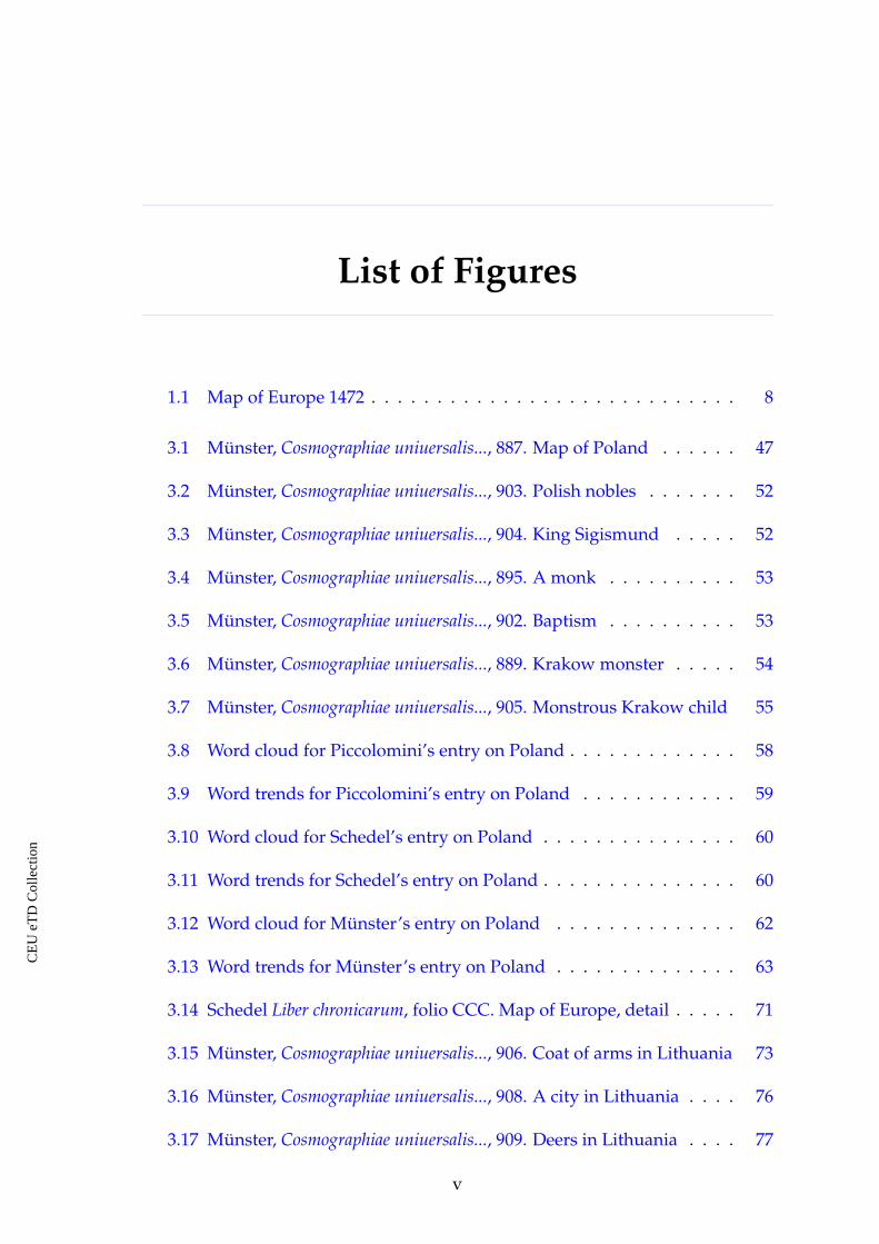
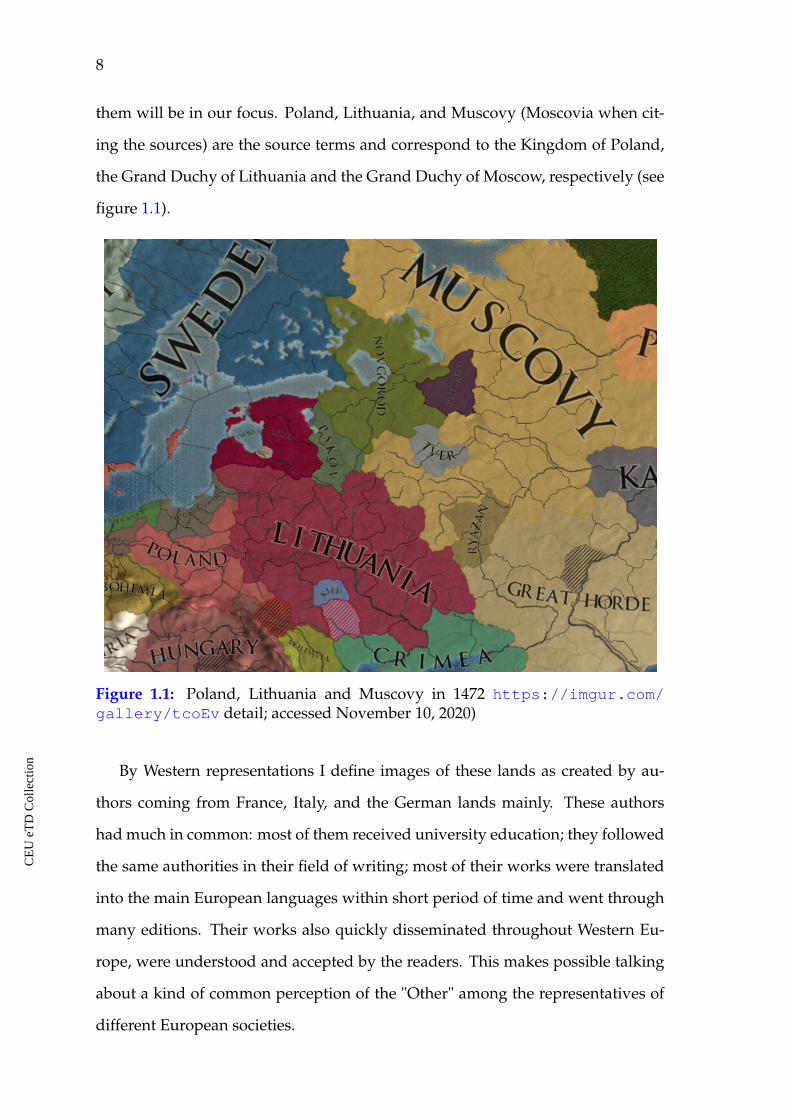
them will be in our focus. Poland, Lithuania, and Muscovy (Moscovia when cit-
ing the sources) are the source terms and correspond to the Kingdom of Poland,
the Grand Duchy of Lithuania and the Grand Duchy of Moscow, respectively (see
figure 1.1).
Figure 1.1: Poland, Lithuania and Muscovy in 1472 https://imgur.com/gallery/tcoEv detail; accessed November 10, 2020)
By Western representations I define images of these lands as created by au-
thors coming from France, Italy, and the German lands mainly. These authors
had much in common: most of them received university education; they followed
the same authorities in their field of writing; most of their works were translated
into the main European languages within short period of time and went through
many editions. Their works also quickly disseminated throughout Western Eu-
rope, were understood and accepted by the readers. This makes possible talking
about a kind of common perception of the "Other" among the representatives of
different European societies.
CE
UeT
DC
olle
ctio
n
Chapter 1. Introduction 9
It should be mentioned that the depicted lands represent different cases in
the context of this research. By the fifteenth century, Poland had already been
in close diplomatic, economic, etc. relations and contact with European courts
for centuries.19 Ecclesiastically, it was in the jurisdiction of the Roman Catholic
Church.20 Thus, it was to some extent "familiar" to Western society. It also repre-
sented a Western European type of society in terms of its political and institutional
infrastructures, culture, etc.
The Grand Duchy of Lithuania was also familiar in the west by the fifteenth
century. The emergence of its image and descriptions mainly goes back to the
thirteenth century, the time when the Lithuanian pagans became familiar to Euro-
peans through the expansion of the crusades and missionary work in the eastern
Baltic region.21 Lithuania had contacts with its Western neighbors: Poland,22 Livo-
nia, and also with other European courts.23 In cultural and religious terms it was,
however, rather different. Lithuania was a multi-ethnic and multi-confessional
state with Orthodox, Catholic, Muslim, Jewish populations, as well as the rem-
nants of paganism in some regions of the country. Thus, it can be considered a
borderland between the different types of European civilization, namely, those
shaped by the influence of the distinct religious, political and cultural impulses.
The Grand Duchy of Moscow in the east of Europe and its center in Moscow,
possessed different political and institutional structures in comparison to those
existing in the West. It also had a different religion. As a result, also its culture
differed a lot from the ones to be found in other parts of Europe. Starting from
the fifteenth century, Muscovy constantly grew in its power and influence. Af-
19 Patrice M. Dabrowski, The First Thousand Years (DeKalb: Northern Illinois University Press,2014).
20 Jerzy Kloczowski, History of Polish Christianity (Cambridge and New York: Cambridge Uni-versity Press, 2000, 1-84.
21 Stephen Christopher Rowell, "Unexpected Contacts: Lithuanians at Western Courts." The En-glish Historical Review 111 (1996): 557-559; Nils Blomkvist, The Discovery of the Baltic: The Re-ception of a Catholic World-System in the European North (A.D. 1075–1225) (Boston: Brill, 2005).
22 Under the Jagiellon dynasty (1385-1572), founded by the Lithuanian Grand Duke Jogaila,Poland and the Grand Duchy of Lithuania formed a union.
23 Rowell, "Unexpected Contacts," 557-577.
CE
UeT
DC
olle
ctio
n
10
ter the fall of the Byzantine Empire in 1453 the duchy of Muscovy acquired the
leadership of the Orthodox Christian church. The highlighted factors impacted
the number, content and quantity of such sources like travel accounts, reports,
and encyclopedic compilations about these lands. In spite of the fact that Western
societies possessed information about this area from the times of the Kievan Rus’
and the Tartar and Mongol domination in the region thanks to diplomatic affairs,
economic contacts, dynastic marriages, and political relations,24 the depicted pe-
riod was the time when new information about these remote eastern peripheries
of Europe was introduced in large amount.
Many of the things that authors saw and described, or copied, or interpreted
were out of their previous experiences and were difficult to understand. This
could result in "fantastic" descriptions, in various generalizations and stereotypes.
It is also expected that the farther the described land was situated from the places
of origin of the authors or from Western centers, the more detailed descriptions
would be produced. Thus, speaking in terms of the geographical limits, the east-
ern lands of Europe have been chosen for the present investigation mainly for the
following reasons:
ã The lands of Poland, Lithuania and Muscovy comprise a contiguous and
continuous area in the context of the research. They may represent a grad-
ual shift from familiar to less familiar and unfamiliar not only for those
who traveled themselves, but also for those who gathered information about
these lands in order to put it in a cosmography, chronicle, or treatise, as well
for those who would read them.
ã For some considered sojourners from Western Europe, the destination point
24 See: Donald Ostrowski, Christian Raffensperger eds., Portraits of Medieval Eastern Europe,900–1400 (New York: Routledge, 2017); Raffensperger “Reimagining Europe: An OutsiderLooks at the Medieval East-West Divide” in Medieval Networks in East Central Europe: Com-merce, Contacts, Communication, eds. Balázs Nagy, Felicitas Schmieder and András Vadas(New York: Routledge, 2018), 9-24; Vera I. Matuzova Anglijskie srednevekovye istochniki IX-XII vv.: Teksty, perevod, kommentarii [English Medieval Sources of the IX-XII Centuries: Texts,Translation, Comments] (Moscow: Nauka, 1979); Friedrich von Adelung, Kritisch-LiterarischeÜbersicht der Reisenden in Russland bis 1700, 2 vols. (St Petersburg, 1846).
CE
UeT
DC
olle
ctio
n
Chapter 1. Introduction 11
was Muscovy or the lands beyond it. Those travelers would have had to
pass through all the three countries along the way. As far as the depicted
lands represented different cultures, one would expect that the same author
would display different attitudes to each of them. An attempt to trace this
shift and demonstrate it visually will be made in the present research as
well.
ã Traveling eastwards through these lands called forth feelings of "them", as
being increasingly different from "us", a constantly recurring theme in Eu-
ropean mentalities at that period.25 However, this kind of dualism may not
have been as intensively applied to each of these lands. Poland may have
been less strange for the Western travelers because the gap in culture, pol-
itics, religion, etc. was not that big. Lithuania was already different, and
Muscovy was totally different. This gradual transition from "us" to "them"
was partly connected to ideas about moving, about space and distance. The
lands of Poland, Lithuania and Muscovy represented to authors growing
distances and, by that, might have implied growing differences in culture,
something which I am also planning to analyse.
Distance was usually connected with danger and the unknown. Partly be-
cause of these ideas, Muscovy was often associated with Asia in written and
cartographic sources from the beginning of the sixteenth century.26 Asia histor-
ically called forth feelings of danger, disgust, dread, distrust and even hatred in
contemporary European mentalities. The mental constructs for Europe and Asia
were built around the ideas of shared religion, morals, politics, etc. Muscovy did
not correspond to the European "requirements;" it looked partly European, partly
25 Mary B. Campbell, The Witness and the Other World: Exotic EuropeanTravel Writing, 400-1600(New York: Cornell University Press, 1988), 3-4.
26 Ekkehard Klug, "Das "asiatische" Russland. Über die Entstehung eines europäischenVorurteils." Historische Zeitschrift 245 (1987): 265-289; Alexander Filiushkin, "Kak Rossiya staladlya Europy Aziej?" [How Russia became Asia for Europe?] Ab Imperio 1 (2004): 191-228;Charles J. Halperin, Russia and the Golden Horde: The Mongol Impact on Medieval Russian His-tory (Bloomington: Indiana University Press, 1987).
CE
UeT
DC
olle
ctio
n
12
Asian. This was not the case in the previous periods of history, although. The
lands of Rus’ did not call forth such strong associations of being unknown and
separate for Europeans before.27 Muscovy was different in this respect.
1.2 Secondary literature
The sources that will be involved in this investigation have long been considered
as subjects for historical analysis. Out of the three lands in this study, Muscovy,
has been investigated in terms of foreign descriptions the most intensively since
the nineteenth century. Scholarly literature on or about its foreign descriptions
of different kinds can be classified into several types. These are the bibliographic
editions or catalogs of foreign accounts, thematic monographs, editions and trans-
lations of the texts themselves, and individual studies of one or several accounts.
The literature is vast and it can hardly be discussed in several pages. I will refer
to the analytic bibliography collections of primary sources and secondary litera-
ture on them which offer solid knowledge on the subject.28 Poland has also been
investigated in terms of Western European accounts and descriptions in regional
historiography.29
Not so much research has been carried out on foreign descriptions of medieval
Lithuania. In Belorussian historiography, for instance, the topic of the image of
Lithuania in the Middle Ages has not been much studied. The only and most
recent work is a short review by Valiantsin Grytskevich and Adam Maldis.30 In
27 Christian Raffensperger, "The Place of Rus’ in Medieval Europe." History Compass 12/11(2014): 853-865.
28 The earliest and still authoritative one is by Adelung, Kritisch-Literarische Übersicht derReisenden in Russland bis 1700; Poe, Foreign Descriptions of Muscovy; the most recent and one ofthe most detailed reference books on the subject is by Piotr D. Malygin, Zapadnoevropeiskie av-tory XV - XVII vv. o Rossii [Western European Authors of the XV-XVII Centuries about Russia](Moscow: IA RAN, 2018).
29 Antoni Maczak, Travel in Early Modern Europe (Cambridge: Cambridge University Press, 1995)(cases related to Poland are placed in a broader European context); Jan Antoni Wilder, Okiemcudzoziemca. Ze wspomnien cudzoziemców o dawnej Polsce [With the eyes of a foreigner. Memoirsof foreigners about Old Poland] (Warsaw: Arkady, 1959); William Coxe, Travels into Poland(New York: Arno Press, 1971).
30 Valiantsin Grytskevich and Adam Maldis, Shliahi viali praz Belarus [The routes led through
CE
UeT
DC
olle
ctio
n
Chapter 1. Introduction 13
spite of the fact that the interest in this topic has not yet revived in Belorussian
historiography, the sources which will be used in this investigation have been
known and collected for other studies.31
Also, just several works on the subject come from Lithuanian historiography.
These are compilations of sources, organized on thematic basis.32 The source edi-
tion by Norbertas Velius may be mentioned too.33
As a general note, it should be mentioned, that the vast majority of the works
on the image of the eastern European lands belong to local historiographies. They
are also written in the local languages. Most probably, because of these factors the
above mentioned literature is not referred to in the international reviews.
One of the specialists working with history of conceptualization of Eastern
Europe in the Middle Ages is Paul Milliman. He delivered a number of conference
papers on the topic which are close to the ones discussed in the present research.34
It is hard to make a more specific reference to them, as I was not able to trace them
published.
Belarus] (Minsk: Mastatskaja Litaratura, 1980).
31 Paula Urban, Da pytannia etnichnaj prynaleznastsi starazytnyh Litsvinow [On the matter of eth-nicity of the Old Lithuanians] (Minsk: Batskaushchyna, 1994); eadem, Starazytnyja Litsviny:Mova, pahodzanne, etnichnaja prynaleznast [The Old Lithuanians: language, origins, ethnicity](Minsk: Tehnalogija, 2003).
32 Petras Klimas, Gillebert de Lannoy in Medieval Lithuania (New York: The Lithuanian-AmericanInformation Center, 1945); Kraštas ir žmones. Lietuvos geografiniai ir etnografiniai aprašymai(XIV-XIX a.) [Land and people. Geographical and ethnographical descriptions of Lithua-nia (fourteenth-nineteenth century)], ed. Juozas Jurginis and Algirdas Šidlauskas (Vilnius:Mokslas, 1983); Angele Vyšniauskaite, Lietuviai IX a.- XIX a. vidurio istoriniuose šaltiniuose[Lithuanians in the historical sources of the ninth – mid-nineteenth centuries] (Vilnius: Mok-slo ir enciklopediju leidykla, 1994).
33 Baltu religijos ir mitologijos šaltiniai. Nuo seniausiu laiku iki XV amžiaus pabaigos [Sources of Balticreligion and mythology. From the oldest times to the end of the XV century], ed. NorbertasVelius (Vilnius: Mokslo ir enciklopediju Leidykla, 1996).
34 Paul Milliman, "Inventing Eastern Europe in the Late Middle Ages." Paper presentedat the 21st International Medieval Congress, Institute for Medieval Studies, Universityof Leeds, Leeds, UK, July 2014; or "The First Invention of Eastern Europe: Sclavia,Scythia, and the East in the Medieval Map of Civilization." Paper presented at theRalph and Ruth Fisher Forum: Central and Eastern Europe in the Global MiddleAges, the Russian East European, Eurasian Center (REEEC) at the University of Illi-nois, June 2017; or "Sauerkraut, Beer, and Crusading: Medieval Western European Viewson Eastern Europe’s Place in the World." Paper presented at the 94th Annual Meetingof the Medieval Academy of America, Philadelphia, PA, March 2019. Paul Milliman,online CV https://history.arizona.edu/sites/history.arizona.edu/files/CV%20Brief%202011-2019%20Milliman%20UA%20Form.pdf (accessed 11 May, 2020).
CE
UeT
DC
olle
ctio
n
14
1.3 Research aims
The major interest and research aim of this project is to analyze in what ways
and with which means the consulted authors represented Poland, Lithuania and
Muscovy and composed their images, in other words, what themes/topics were
considered important for creating the textual images of our lands, how the au-
thors played with the vocabulary and the thematic range.
One of the main challenges of the present research is in applying visual text
analysis methods to the textual entries in general works on world geography,
cosmography, history and ethnology as well as in the travel accounts from the
fifteenth and the first half of the sixteenth century in order to extract the main
contemporary thematic and terminological components of their images. I will
argue that the thematic and terminological components of the entries reflect the
authors’ textual strategies while creating the images of the lands in the eastern
edge of Europe; namely, the topics discussed in the entries about each of these
lands, the number of themes, their length, the vocabulary used while speaking
about the same phenomena in different lands that were important for the authors
and their audiences. I will try to prove that these were the strategies to textually
map the diversities and also to communicate the motion towards the edges of the
continent. Basically, there is a structural idea behind this statement, meaning that
the entries on each of the lands, mainly in the general works on world geography
and cosmography, are parts of a larger structure, they have their own function,
their own utility and place in the universal picture of the world. Meaning, it is
expected that the images of the parts should carry and reflect the elements of a
larger structure. Besides, I will seek to demonstrate that this structure of general
works affected the content of the entries on Poland, Lithuania and Muscovy, as its
component elements and, in some cases, it found its reflection in travel accounts
and visual representations of some learned authors.
It was mentioned that the selected sources are well known to scholars, but it
CE
UeT
DC
olle
ctio
n
Chapter 1. Introduction 15
is the first time when methods of general visual text analysis and computational
text deconstruction will be applied to them. Applying computational tools like
Word Cloud, quantification, or Voyant text analysis tools, for example, helps to
analyze and visually demonstrate certain tendencies in the dynamics of the im-
ages of Poland, Lithuania and Muscovy that, most probably, were not observed
before.
The computational visualizations are expected to be a handy tool to demon-
strate the gradual shift from familiar to unfamiliar based on the example of the
selected lands. The obtained topics and the main terms are supposed to show the
ways this shifting was communicated in the sources. No studies of such compar-
ative character and methodological approach have been attempted until now in
application to the selected sources.
The examination of the criteria, common patterns and differences in textual
practice used by fifteenth- and sixteenth-century authors and tracing the evolu-
tion of the created images may introduce new reading of these sources, to bet-
ter understand the existing cultural convictions. Tracing certain patterns and the
main composite elements in the images through the investigated period may also
indicate developing stereotypes in the writings about these lands. Sometimes,
such stereotypes survived for centuries and shaped general ideas and concepts
about other peoples, nations, cultures, and countries. Thus, the proposed inves-
tigation also aims to contribute to a deeper understanding of the historical roots
of prejudice and estrangement in the outlined period. Analyzing the images and
maps that accompany the textual sources aims to observe the variety of visual
image-making strategies for Poland, Lithuania and Muscovy.
1.4 Research questions
The main research question of this project is:
Which textual strategies concerning the thematic and terminological content
in the images of the eastern lands of Europe in the fifteenth and the first half of
CE
UeT
DC
olle
ctio
n
16
the sixteenth centuries were decisive while creating their images?
In order to give an answer to the main research question I will undertake the
following steps:
ã Converting texts from the scanned old prints into txt digital format with the
help of Optical Character Recognition (OCR) tools, if necessary. This allows
the researcher to apply digital text utilities and methods upon the text rather
than just reading it from the image.
ã Using existing translations and translating the Latin texts into English where
necessary. This is done for one practical reason, namely, certain digital tools
are better developed for English and not so well developed for Latin. Word
Cloud is one of them. The "problem" with Latin is that it is highly inflected:
Latin words are modified depending on tense, case, aspect, person, number,
gender and the computer specifies them as different words, not as modifica-
tions of the same word. As a result, the Word Cloud analysis of a Latin text
needs additional skills, manual processing and more time.
ã Close text reading and defining the component parts/themes of the textual
images of Lithuania, Poland and Muscovy.
ã Applying computational quantification and tracing the thematic distribu-
tion in the images of the three countries; for example, what kind of repre-
sentation is prevailing: political, economic, religious, or social.
ã Defining the distribution of space dedicated to the description of component
topics within the texts.
ã Applying visual text analysis to the texts and defining the main terminolog-
ical content of the entries about the specified lands. This will give visual
ground for the final comparison.
I am interested to compare the written images of the specified countries in the
eastern edges of the medieval world and see what they have in common and in
CE
UeT
DC
olle
ctio
n
Chapter 1. Introduction 17
what terms they differ from each other. What themes or topics were considered
to be important while writing about the lands in the edges of the continent for the
European authors? What role did the author’s manipulating with the thematic
content and the length of the topics play while constructing the images of "other"
lands in the periphery of Europe considering space, time and motion?
I will also concentrate on the questions:
ã What is the utility of the component parts in the textual images of the de-
picted lands concerning structure of the selected works on world geography
and cosmography?
ã Did the images of these lands change over the investigated period?
ã What are the differences in the descriptions of the specified lands concerning
genre, who wrote the texts and the reasons the texts were written?
ã In what terms did the authors communicate geographical, political, social,
religious and other kinds of borders?
ã Can we talk about pre-existing patterns of thought, common for common
for the considered authors?
ã What information can images and cartographic data provide?
ã What is the context and the utility of the illustrations and woodcuts in the
texts?
To answer these more specific questions I will:
ã analyze the above-mentioned textual sources about Poland, Lithuania and
Muscovy comparatively; ascertain the cultural models of "otherness" for
each country and how it was perceived and communicated, depending on
the genre of the source, on who the authors were and what the aim of their
visit and/or description was;
CE
UeT
DC
olle
ctio
n
18
ã trace the impact of discourse patterns and topoi on the descriptions of these
lands, the "reliability" of information they offer, and the applied stereotypes;
ã include available maps of the area within the analysis in order to see where
and how cartographers located and presented these lands, namely, to what
extent they tried to show visually that these lands were close to or far away
from Western civilization, etc.;
ã analyze available visual images in terms of their content and context, whether
they may be considered "positive" or "negative," trace changes in the content
of the sources and find the relationships between images and texts.
1.5 Expected results and importance
The proposed research aims to contribute to the study of contextualizing of Poland,
Lithuania and Muscovy in the geographical and ethnological writings and cartog-
raphy of the Latin learned world in the fifteenth and the first half of the sixteenth
centuries. As it was mentioned before, I am not that much looking for what was
"true" or "untrue" in the descriptions of these medieval countries, but what were
their constructed images like and what influenced the authors while creating their
images. A comparative approach will help to identify criteria, common patterns,
rhetorical tools used by the authors and trace the evolution of the images. Another
interesting aspect to be investigated is how the authors handled the problem of
cultural diversity, marked it, and defined its borders.
The main innovation of the proposed research is in its methodological ap-
proach. This project is an attempt to apply computational tools to the textual
entries on eastern European lands in general works on world geography and cos-
mography and travel accounts from the fifteenth and the first half of the sixteenth
centuries in order to open new aspects with regard to their images as well as their
image making strategies. This is the first time when methods of visual text analy-
sis and computational text deconstruction will be applied to these sources.
CE
UeT
DC
olle
ctio
n
Chapter 1. Introduction 19
The expected contribution of the work is that this approach will explore a tech-
nical aspect in the image building strategies in the depicted sources, namely, ma-
nipulating with the thematic range and space dedicated to the topics within the
text. I argue that such textual strategies were used by the authors in order to
communicate the motion towards the edges of the known world. This agenda
influenced the images of the depicted lands and could have been transmitted and
borrowed further.
Computational tools are expected to be rather effective for such kind of investi-
gations and the results may be better introduced and demonstrated with the help
of different types of visualizations. The innovation of the proposed investigation
is also in its approach where the images of the three countries will be considered
comparatively through the research period. This has not been previously done.
The innovation of the present investigation is also in its interdisciplinary na-
ture expressed not only in its methodology, but also in the diversity of the in-
volved sources: encyclopedic entries, travel accounts, illustrations, and maps.
CE
UeT
DC
olle
ctio
n
CHAPTER 2
Sources and methodology
2.1 Sources
The main sources involved in the present research are the textual descriptions,
containing pictorial images and maps of the investigated area. These represen-
tations reflect contemporary constitutive elements of socially constructed ideas
about Poland, Lithuania and Muscovy. As it was mentioned above, most of the
authors considered in this work were influenced by previous tradition of geo-
graphical representation of the world.35 At the same time they provided their
readers with new information about the area. It is worth to mention two sig-
nificant ancient authorities, whose ideas and approaches to world representation
were followed and developed in the defined research period. Those were Ptolemy
and Strabo. Ptolemy offered a set of mathematical principles for mapping a spher-
ical world in two dimensions. For him, the descriptive product of geographical
knowledge was the map.36 The legacy of Strabo, Geography or Geographica, was a
multi-volume work that did not contain maps and no mathematical calculations
to represent the world. This was an encyclopedic description of all parts of the
world known to Greeks and Romans. The work contained structured informa-
35 For developing tradition of geographic representations of the world and history of geographicideas see, Geoffrey J. Martin, All Possible Worlds: A History of Geographical Ideas (New York:Oxford University Press, 2005).
36 Denis Cosgrove, Geography and Vision: Seeing, Imagining and Representing the World (London:I. B. Tauris, 2008), 6.
20
CE
UeT
DC
olle
ctio
n
Chapter 2. Sources and methodology 21
tion on geography, flora and fauna, ethnology, peoples, their social organization,
history, habits and culture, strange, marvellous and unusual things in different
places.
The main principle for the choice of the involved sources is that they should
contain the description of at least two depicted lands, ideally three of them. This
approach facilitates one of the main targets of the present work, namely, the com-
parison. This selection principle also corresponds to the intention to trace how the
growing distance and, in some cases, time affected the authors and were commu-
nicated through their works. The selected sources represent rich descriptive ma-
terial, providing diverse information about the mentioned societies. The value of
these sources is in the richness of their thematic content. The selected societies at
that period were not being described by their own members, particularly, in such
a detailed way as the foreign visitors did it. Of course, many factors impacted
the authors and, finally, their texts: a lack of knowledge of local languages; cul-
tural, religious, political prejudices; borrowings and copying from earlier texts;
the purpose of writing and, not to forget, the intellectual, social and economic
background of the authors. All these factors will be taken into consideration.
I am interested in the following types of sources:
ã World chronicles, geographies and cosmographies. These works contain
contemporary "encyclopedic" information about the "known" world in gen-
eral, or about a particular region. They are synthesized, reasoned descrip-
tions of the universe written by authors who did not travel themselves into
the region under consideration, but collected and compiled their informa-
tion from a variety of sources (written as well as oral). They offer the possi-
bility to compare and trace patterns used by the authors as they constructed
their images of Poland, Lithuania and Muscovy. Such sources have a single
author, but provide information on multiple countries, facilitating compar-
isons.
ã Diplomatic reports. I am particularly interested in the documents gener-
CE
UeT
DC
olle
ctio
n
22
ated by members of diplomatic missions that contain "exploration reports."
In these writings the authors touch upon various aspects of the described
societies, outline new discoveries and tell about "strange and exotic" things
one may find there.
ã Travel accounts of merchants, missionaries, mercenaries, etc. These are
sources produced by their authors during or soon after visiting these lands.
ã Cartographic data: maps from the textual sources.
ã Pictorial images and illustrations: illustrations and woodcuts that accom-
pany the textual sources.
Most of the sources that finally formed the bases of this research were pub-
lished within the framework of the specified period. The fact that the work was
published may indicate that it was of contemporary interest, widely dissemi-
nated, read and became "popular," that it also was actively used to "participate"
in the formation of the images and often of stereotypes about the depicted lands.
Those works which appeared, but were not published during the investigated
period will not be considered as "less important." Probably, they were less influ-
ential, but they are equally valuable in the context of the present research and will
equally be used for the critical and comparative analysis.
The following encyclopedic collections describing the known world and the
depicted area as its part were selected for the present investigation:
ã De Europa by Aeneas Silvius Piccolomini, 1458 37
ã Liber Chronicarum by Hartmann Schedel, 1493 38
37 Enea Silvio Piccolomini, Cosmographia Pii papae in Asiae et Europae eleganti descriptione ..., ed.Geoffroy Tory (Paris: Apud Collegium Plesseiacum, 1509); Enea Silvio Piccolomini, De Eu-ropa, ed. Adrianus van Heck (Vatican: Biblioteca Apostolica Vaticana, 2001); Enea Silvio Pic-colomini, Europe (c. 1400-1458), trans. Robert Brown, introd. Nancy Bisaha (Washington: TheCatholic University of America Press, 2013).
38 Hartmann Schedel, Weltchronik (Nuremberg: A. Koberger, 1493, reprint Munich: KonradKölbl, 1975).
CE
UeT
DC
olle
ctio
n
Chapter 2. Sources and methodology 23
ã Cosmographia by Sebastian Münster, 1544 39
As a short introduction to this group of sources it is worth mentioning a few
general things. The genre of medieval world cosmography, world geography, or
world chronicle from the period is not easy to define, it is often hard to draw
clear differences between them as well. These encyclopedic collections are fas-
cinating sources that represent a fusion of contemporary knowledge and beliefs
on world geography, cosmology, history, cartography, ethnology, flora and fauna,
etc. These are the representations of the world and its parts in written and il-
lustrated form. The authors of these encyclopedias synthesized in them Chris-
tian cosmology, Aristotelian natural philosophy, astrology, Ptolemy’s Geographia,
Strabo’s Geographia, historical treatises, accounts by the voyages of missionaries,
pilgrims, diplomats, merchant travelers, mariners, and other sources of informa-
tion. Schedel’s and Münster’s encyclopedic collections were lavishly decorated
with images and maps. Those will be considered for discussing and analyzing
the visual representations of the area.
The diplomatic reports are represented by the work of Sigismund von Her-
berstein.40 This report was published in 1549, it represents a treatise on his diplo-
matic visits to Muscovy. Along with the notes of his personal experiences, he
used many other sources of information concerning history, geography, politics,
religion, trade and goods, morals and everyday life in Muscovy. This is the apogee
39 Sebastian Münster, Cosmographiae uniuersalis Lib(ri) VI. in quibus, iuxta certioris fideiscriptorum traditionem describuntur, Omniu(m) habitabilis orbis partiu(m) situs, propri-aeq(ue) dotes. Regionum Topographicae effigies. Terrae ingenia, quibus fit ut tam differenteset uarias species res, et animatas et inanimatas, ferat. Animalium peregrinorum naturaeet picturae. Nobiliorum ciuitatum icones et descriptiones. Regnorum initia, incrementa ettranslationes. Omnium gentium mores, leges, religio, res gestae, mutationes : Item regumet principium genealogiae. (Basel: Henrich Petri, 1552), https://daten.digitale- samm-lungen.de/0007/bsb00078496/images/index.html?id=00078496&groesser=&fip=xdsydeayaxseayasdasyztseayafsdrqrsxdsydewqxs&no=10&seite=1 (accessed 11November, 2020).
40 Sigmund Freiherr von Herberstein, Rerum Moscovitarum Commentarii... (Vienna: AegidiusAdler and Hans Kohl, 1549); Herberstein, Rerum Moscoviticarum Commentarii. Synoptische Edi-tion der lateinischen und der deutschen Fassung letzter Hand Basel 1556 und Wien 1557, ed. Her-mann Beyer-Thoma (München: Osteuropa-Institut Regensburg, 2007); Herberstein S., Zapiskio Moskovii, [Notes on Muscovy], in 2 vols, vol. 1: Latin and German texts, trans. from LatinA.I. Malein and A.V. Nazarenko, trans. from early modern high German A.V. Nazarenko, ed.A.L. Khoroshkevich (Moscow: Pamiatniki Istoricheskoj Mysli, 2008).
CE
UeT
DC
olle
ctio
n
24
source within the framework of the present research. It represents the most de-
tailed Western description of the Muscovite Rus’ from the selected period. When
the work was published, it became a sensation. It represented the most profound
monograph of its kind up to that point. It offered the first detailed and systematic
presentation of the Muscovite state and its society. It gained immediate and great
popularity. From 1549 till 1605, it was translated into 5 languages and re-issued
21 times.41 It became the archetypal description of Muscovy. Almost all the later
treatments of Muscovy used Herberstein’s work as a model and borrowed from it.
I will limit the period of my investigation up to the time it appeared, namely the
middle of the sixteenth century. This work also contains a number of illustrations
and maps that will be discussed along with the text.
The following travel accounts were selected and will be analysed in the present
work:
ã Gilbert de Lannoy, diary of his first trip to the eastern lands of Europe, 1413-
1414.42
ã Josafa Barbaro, diary of his diplomatic mission to Persia, 1473.43
ã Ambrogio Contarini, diary of his diplomatic mission to Persia 1474-1477.44
The writings of these authors contain descriptions of their personal experi-
ences. In this respect, they provide a different perspective and different represen-
41 Marshall Poe, Foreign descriptions of Muscovy: An Analytic Bibliography of Primary and SecondarySources (Columbus,OH: Slavica Publishers, 1995), 12.
42 Guillebert de Lannoy, Voyages et ambassades de messire Guillebert de Lannoy, 1399-1450 (Mons:Hoyois, 1840); Emelyanov V. "Puteshestvija Gillbera de Lannoa v vostochnye zemli Evropyv 1413-14 i 1421 godah" [Travels by Gilbert de Lannoy to the Eastern Lands of Europe in theyears 1413-14 and 1421]. Universitetskie izvestija. 8/V. Kiev, 1873: 1-45.
43 Giosafat Barbaro, Viaggi fatti da Venezia, alla Tana, in Persia, India, e Costantinopoli,... (Venice:Aldus Manutius, 1543-1545); Travels to Tana and Persia by Josafa Barbaro and Ambrogio Contarini,trans. from the Italian by William Thomas and S.A. Roy, ed. Lord Stanley of Alderley. (Lon-don: Hakluyt Society, 1873, reprint New York: Burt Franklin, 1968), 1-103.
44 Ambrogio Contarini, Viaggio al signor Usun Hassan re di Persia (Venice: Annibale Fossi, 1487);Travels to Tana and Persia by Josafa Barbaro and Ambrogio Contarini, trans. from the Italian byWilliam Thomas and S.A. Roy, ed. Lord Stanley of Alderley. (London: Hakluyt Society, 1873,reprint New York: Burt Franklin, 1968), 106-173.
CE
UeT
DC
olle
ctio
n
Chapter 2. Sources and methodology 25
tations of Poland, Lithuania and Muscovy in comparison to the "bookish" ency-
clopedic images, for instance.
2.2 Encyclopedic descriptions and travel accounts as narratives
In order to apply similar methods of investigation to different textual sources in
the present work I will consider these sources as narratives. Basically, a narrative
can be defined as a story of connected events. New experiences about life and
society are incorporated into the previous paradigms through such narratives. In
this respect, the considered descriptions of Poland, Lithuania and Muscovy reflect
both: the existing paradigms about the world as well as new knowledge about it.
Narratives were a powerful and one of the main means of transmitting, sharing
and receiving knowledge.
Narrative analysis as approach within the social sciences has increased consid-
erably since the 1990s. This is a widely interdisciplinary field, as a lot of different
tools are applied.45 There is no unified method or way for conducting narrative
analysis. Nevertheless, there are several important aspects and common charac-
teristics which are decisive for it:
First, narrative analysts are always interested in social origins of narratives. A
particular individual narrative is considered as part of broader context, common
culture, views, etc. This may shed light on why people from the same society
broadcast similar ideas, use the same genre, rhetoric, etc. These will be the char-
acteristics not just for individuals, but also for societies.
Second, narrative analysts see the language as a cultural tool, it reflects the
socio-cultural context of the person or the narrative itself, it connects the individ-
ual and the story with the society, but not necessarily gives direct information
about what "really" happened.
Third, for narrative analysis, the context is of great importance and in the fo-
45 Catherine Kohler Riessman, Narrative Methods for the Human Sciences (Thousand Oaks.CA:SAGE, 2008).
CE
UeT
DC
olle
ctio
n
26
cus of interest are: who told the story, what were the conditions, who were the
audience, etc.?
When considering the main groups of sources for the present study, I could
characterize the general writings on world geography and ethnology as narra-
tives, bearing information on how Western societies made sense of the world.
Behind the themes of the entries comprising the images of the described lands,
behind the vocabulary and rhetoric one may read the cultural code of perceiving
and representing the "other."
The entries on different lands and countries in World Geographies and Cosmo-
graphies may be read as narratives about peoples and regions. These are "stories"
on who the people in different lands were, what the depicted lands looked like
and how they were understood and described.
As for travel accounts, they are sources providing information on how indi-
viduals made sense of their experiences of visiting the studied geographical area.
With the help of them, it is often possible to construct the narrative identity of the
individual authors.
Thus, different kinds of narrative sources about Poland, Lithuania and Mus-
covy will be investigated to study their thematic, terminological and visual con-
tent. This content will offer the picture of contemporary cultural markers when
speaking about other lands. In cases of individual travel narratives, this approach
will shed light upon the ways of expressing personal cultural perception and rep-
resentation of these lands.
The methods of text visualization will be used extensively. The visual as a tool
of textual analysis has a characteristic of being an eloquent representation of the
involved data. Its popularity is constantly growing in the social sciences.46
Based on narrative perspective, particular attention will be paid to:
ã What is said: themes, topics, words.
46 Nan Cao and Weiwei Cui, Introduction to Text Visualization (Paris: Atlantis Press, 2016);Markus Hofmann and Andrew Chisholm, Text Mining and Visualization: Case Studies UsingOpen-Source Tools (Boca Raton, FL: CRC Press, 2016).
CE
UeT
DC
olle
ctio
n
Chapter 2. Sources and methodology 27
ã How it is said: comparisons, links, parallels.
ã Case studies, comparison of and parallels between different descriptions
and different groups of sources.
2.3 Maps and visual images as narratives
Maps and visual images are being considered as narratives too.47 In this perspec-
tive maps are representations of compressed knowledge about space through the
language of signs. In this sense a map presupposes a narrative. The spatial turn in
the arts, humanities, social and cultural studies also brought to life new perspec-
tives in approaching the issues of space. Such terms and fields of spatial studies
like "literary mapping," "narrative cartography," "literary geography," "geocriti-
cism" were introduced. Spatial textual and visual narratives are a social product,
they provide humans with meaningful images of the surrounding world. As far
as the maps and other visual materials, involved into the present research, de-
pict in their own way the above mentioned fusion of contemporary knowledge
and beliefs on geography, history, and ethnology, I find approaching them from
their narrative meaning pretty well applicable. This approach offers a way to
consider the visual sources in context with the textual ones. This approach also
offers a common base in order to see how Western mentalities located themselves
and others in their visual world picture, how different notions about space were
being transmitted. Lately, a new perspective of considering spatial narratives as
"textual maps" has been introduced.48 In this sense maps, geographic texts, explo-
ration accounts, etc., are vitally interconnected; they influence and stimulate each
other and represent different modes of telling spatiality.49
Thus, spatial descriptions, historical and ethnological references, settlement
47 Dawn Mannay, Visual, narrative and creative research methods: application, reflection and ethics(Abingdon: Routledge, 2015).
48 Robert J. Tally, Literary Cartographies: Spatiality, Representation, and Narrative (Geocriticism andSpatial Literary Studies) (New York: Palgrave Macmillan, 2014).
49 Robert J. Tally, Spatiality (London: Routledge, 2013).
CE
UeT
DC
olle
ctio
n
28
insights, and many other aspects which are merging in textual images of Poland,
Lithuania and Muscovy, can be seen as components of a broader concept of lit-
erary or narrative geography, literary or narrative cartography. Through these
components, which are socially colored and produced, places and spaces were
being interpreted.50
As further developments, computational methods for literary or narrative car-
tography have been suggested and continue to be developed.51
2.4 Computer and the humanities
Modern computational developments offer new possibilities for analysis of his-
torical texts. Two new terms were introduced in historians’ usage to describe
this evolution of research methods: Digital Humanities (DH) to describe creation,
dissemination and use of resources of humanities data and Computational Hu-
manities (CH) to describe the exploratory and mainly semi-automatic analysis of
the historical data. Digital Humanities and the methods of Computational Hu-
manities for text analysis as its part are a rapidly developing field. However,
there is a number of ongoing debates concerning different aspects in this area.52
At the same time, the clear message behind all the discussions is that the aca-
demic and general audiences nowadays think, perceive and communicate in digi-
tal/computational terms.53 Besides, these approaches have proved to be effective,
prompted and precise. They open new perspectives for humanities scholars, and
50 Yi-Fu Tuan, Space and Place: The Perspective of Experience (Minneapolis: University of Min-nesota Press, 1977).
51 David Cooper, Christopher Donaldson and Patricia Murrieta-Flores, eds., Literary Mapping inthe Digital Age (London: Routledge, 2016).
52 Matthew K. Gold and Lauren F. Klein, eds., Debates in the Digital Humanities 2016 (Minneapo-lis: University of Minnesota Press, 2016).
53 Ian Anderson, "History and Computing," in Making History: The Changing Face of the Professionin Britain (London: Institute of Historical Research, University of London, 2008); Daniel J.Cohen and Roy Rosenzweig, Digital History: A Guide to Gathering, Preserving, and Presentingthe Past on the Web (Philadelphia: University of Pennsylvania Press, 2005); Roy Rosenzweig,"Scarcity or Abundance? Preserving the Past in a Digital Era," American Historical Review 108,no.3 (2003): 735-762.
CE
UeT
DC
olle
ctio
n
Chapter 2. Sources and methodology 29
offer possibilities to work with huge amounts of data, which was simply impos-
sible to do before. William G. Thomas in his contribution to A New Companion to
Digital Humanities discusses the way gone by the humanities scholarship towards
the digital turn. The author proposes solutions on further move of humanities to
the open digital environment.54
As it was pointed out in the introduction to the present research, one of the
main challenges of this work is in applying particular computational methods/tools
of visual text analysis. For humanities scholars it is important to approach the ob-
jects of study from as many different and multiple perspectives as it is possible.
Thus, I intend to use certain computational tools mostly for automatic text con-
tent analysis, namely: word clouds, word counts, sorting words, generating term-
frequency visualizations, drawing term-frequency distribution lines, etc. The se-
lected computational tools will be used for the purpose of extracting the main
terminological content of the entries on the three defined eastern European lands,
tracing the evolution of the vocabulary and its thematic usage through the pe-
riod and for visualization of the results. Another utility of the selected methods
is depicting the thematic content of the descriptions, their thematic richness and
variety.
A brief description of these methods and of their utility is presented in this
chapter. Only open sources are being involved in this project, as well as only free
software and tools will be used for formal text analysis.
Together with the computational approaches, I am using several traditional
methods, applicable for such kind of investigations. I analyze comparatively the
above-mentioned textual images of Poland, Lithuania and Muscovy and ascertain
the cultural models of "otherness" for each country and the ways they were per-
ceived and communicated (constitutive topics and the main vocabulary content),
depending on the genre of the source, on who the authors were, etc.
54 William G. Thomas, "The Promise of the Digital Humanities and the Contested Nature ofDigital Scholarship," in A New Companion to Digital Humanities, eds. Susan Schreibman, RaySiemens, John Unsworth. 2nd edition (Oxford: Blackwell, 2016), 524-537.
CE
UeT
DC
olle
ctio
n
30
2.5 Word clouds
Information visualization and automatic text analysis have increasingly become
standard tools in the humanities.55 Let us consider the most common and user
friendly tools for formal automatic text analysis and text visualization available
on-line.
Word cloud (also tag cloud or text cloud) is a graphical representation of text
data. Word clouds belong to the so-called static visualizations. Their aim is gen-
erating a view of a document, usually with single perspective on available data.
The user can modify its layout and different styling parameters depending on the
purposes. Among other static visualizations available in most of word cloud tool
bars are: bar charts, pie charts, graphs. They are handy and precise instruments
to present, display and understand information. They also accommodate various
interpretations of visually presented data.
The most common word cloud visualization for a general reader is a cluster
of the most frequently used words in which the size of each word corresponds to
its frequency in the text. The main vocabulary content is easily captured by eye:
the more frequent the occurrence of a word in the text, the larger is its drawing
in the plot. I will not focus on the quantitative aspect of term frequencies, namely
on how many times this or that term was used in the text. Such information is
not much helpful for this particular research, partly because the texts are very
different in size. What is really important in the context of this investigation are
the relative frequencies in each text. They are clearly expressed in word cloud
visualizations by the size of the most frequent words. Usually, it is desirable to
exclude from the analysis the function words, or sometimes other categories of
words in order not to overload the plot.
55 Isabel Meirelles, Design for Information An Introduction to the Histories, Theories, and Best Prac-tices Behind Effective Information Visualizations (Osceola, WI: Rockport Publishers, 2013); Ric-cardo Mazza, Introduction to Information Visualization (London: Springer, 2009).
CE
UeT
DC
olle
ctio
n
Chapter 2. Sources and methodology 31
Wordle56 is probably the most popular word cloud tool generator. It was cre-
ated by Jonathan Feinberg, and it has many contributors.57 It is very user friendly:
basically one can just paste a text sample into its input area and create a word
cloud.
TagCrowd58 is also a web-based word cloud generator created by Daniel Stein-
bock.59 The software is run free of charge for any academic or even commercial
use. It can accept as input raw text (copy/paste or typed), URLs, or file upload.
2.6 Basic text analysis with Voyant
Voyant was chosen among other computational tools. It is a powerful text analysis
instrument with numerous functions and applications, proposed by Rockwell and
Sinclair. Many of the Voyant tools are interactive. The user can just paste a piece
of text for analysis, or insert a URL of a web-page that contains the desirable text.
Alternatively, a digitally stored file can be uploaded and used as input for the
analysis.
Voyant tools offer much more analytic insight than a common word cloud.
Among the options are:
ã Visual aggregation of the most frequent words displayed as word cloud,
called Cirrus.
ã Besides, the trends for the most frequent words are displayed. By default,
the software splits the text into 10 equivalent pieces and generates the word
frequencies in each part separately. The trends plot reveals the frequency
variation of the most commonly found words within the text. It should be
noted that the word trends can be generated for any term used in the text
56 http://www.wordle.net (This page as well as the following ones in this chapter wereaccessed 11 November, 2020).
57 http://www.wordle.net/credits
58 http://tagcrowd.com
59 http://tagcrowd.com/patrons.html
CE
UeT
DC
olle
ctio
n
32
and for any focus terms according to the researcher’s interest.
ã The Context tool shows the keywords within the phrase (the "context"). It
can be used for studying of how the specific terms behave within a certain
part of the text, as well as in tracing their context.
Another methodological tool which I consider useful in this research is quan-
tification60 or quantitative history. These methods come in many shapes and
forms, but generally they refer to the analysis and presentation of data in numeri-
cal rather than narrative form. These approaches may be successfully applied for
content analysis. I will apply the basic quantification while dealing with "nature"
and "culture" descriptions, as I find it important to analyze why the entries on
Poland, Lithuania and Muscovy in this respect are often different in size. I want
to illustrate this with the help of numbers and graphics.
2.7 Optical character recognition
In order to apply the computational text analysis tools to the sources that do not
exist in txt-format, it was necessary to convert them with the help of OCR. Optical
Character Recognition (OCR) programs are software tools developed to convert
text images to text documents which can be easily searched, copied, edited, and
used for computational text analysis. There are several software tools for OCR.
The most well-known are the following:
ã Adobe Acrobat Pro.61
ã ABBYY Finereader.62
60 Pat Hudson, History by Numbers:An Introduction to Quantitative Approaches (Hodder ArnoldPublication: Bloomsbury Academic, 2000).
61 https://acrobat.adobe.com/us/en/acrobat.html
62 https://www.abbyy.com/en-apac/finereader/
CE
UeT
DC
olle
ctio
n
Chapter 2. Sources and methodology 33
ã Tesseract63 that can be applied for many languages, even for less common,
like Arabic or Vietnamese, and also Latin.64
ã Google drive also offers OCR capabilities.65
ã Rescribe’s Latin Optical Character Recognition can be particularly recom-
mended for those who are working with the early Latin prints. This software
provides a free and open tool to enable individual researchers and libraries
to convert scanned images of early modern printed books into txt files. The
Latin OCR’s page provides links and instructions for installing the package
for Windows, Linux and Mac. Non-experienced users can successfully use
this tool thanks to the guided instructions.66 The Latin Optical Character
Recognition is specifically developed to decode the peculiarities of historic
fonts and characters used in printing from 1500 to 1800.
63 https://github.com/tesseract-ocr
64 https://ryanfb.github.io/latinocr/
65 https://support.google.com/drive/answer/176692?co=GENIE.Platform%3DDesktop&hl=en
66 https://latinocr.org/
CE
UeT
DC
olle
ctio
n
CHAPTER 3
Poland, Lithuania and Muscovy in
encyclopedias
3.1 The genre
Dealing with the European Late Medieval and Early Modern conceptions of the
known world in the encyclopedic works is a rather challenging issue, meaning
that one cannot speak in clear geographic, historical or ethnological terms while
reading them. In these works, the above mentioned spheres were closely linked
with each other and with further areas of belief and knowledge comprising the
contemporary world view. As it was briefly mentioned before, the roots of the
European Renaissance tradition of writing about other lands and about the world
in general go back to the previous historical periods.67 The main topographical
data and the theoretical structure in the field of geography formulated by the
ancient Greeks and Romans were thoroughly followed through the Antiquity, the
Middle Ages and Renaissance. In the depicted research period, though, some of
those ideas start to be questioned, argued and "corrected."
Angelo Cattaneo in his essay on the European Medieval and Renaissance Cos-
mography refers to main historical processes that inspired further developments
67 Duane W. Roller, Ancient Geography: The Discovery of the World in Classical Greece and Rome(London: I.B. Tauris, 2015); Colin Adams, Ray Laurence, eds., Travel and Geography in theRoman Empire (London and New York: Routledge, 2001); Andrew H. Merrills, History andGeography in Late Antiquity (Cambridge: Cambridge University Press, 2005), 1-34.
34
CE
UeT
DC
olle
ctio
n
Chapter 3. Poland, Lithuania and Muscovy in encyclopedias 35
in the image of the world and and in cartography in the depicted period.68 Among
them were "the development of long-distance networks of knowledge; the foun-
dation of a world capitalist economy within a context that Fernand Braudel, Vi-
torino Magalhães Godinho and Emmanuel Wallerstein have defined as a "world
economy"; and, finally, the expansion and mental opening towards lands and seas
previously considered inaccessible to humans.69
Analyzing these sources, I will be dealing not that much with the contempo-
rary scope of geographical or ethnological knowledge about the depicted area and
not with the history of the discoveries in the region, but mostly with contempo-
rary cultural and geographic perception or, in many cases, symbolic geographic
and ethnological views about the eastern European region in the European west.
I will be tracing in what way this area was incorporated into the contemporary
Western picture of the inhabited world.
I will pay attention to possible continuity and developments concerning the
images of Poland, Lithuania and Muscovy in the works of the Italian author Ae-
neas Silvio Piccolomini and, later, the German authors Hartmann Schedel and
Sebastian Münster. On the one hand, the continuity in this period found its ex-
pression in numerous borrowings and copying from earlier authors, but at the
same time the "old" image was being gradually improved and challenged by the
later authors who added more recent data to it. This investigation will help to
trace possible networks of knowledge as well.
I will also attempt to look after the mentioned impulses of the contemporary
European agenda in the texts and the images of different lands in encyclopedias.
I will try to find out whether the texts tell us about the existing search for new
markets while speaking about Poland, Lithuania and Muscovy, which is one of
the basic indicators for the emerging world market economy.70
68 Angelo Cattaneo, "European Medieval and Renaissance Cosmography: A Story of MultipleVoices," Asian Review of World Histories 4, no.1 (2016): 35-81.
69 Ibid., 54.
70 Concerning trade and developing knowledge about the world see the work by Jerry Brot-
CE
UeT
DC
olle
ctio
n
36
I expect that the computational visualizations for constitutive topics and fre-
quent terms, which were important for the authors while writing about the de-
picted lands will offer wide possibilities to comparatively trace different kinds
of information, patterns, characteristics, and networks. The amount of text, dedi-
cated to this or that topic may also be an indicator of "unfamiliar", unusual or new,
an indicator of importance. Thus, this approach is a way to find new insights con-
cerning the images of the depicted lands, as well as concerning the image-making
strategies in this group of sources.
A comparative approach is also used in order to trace how the conceptions
about Poland, Lithuania and Muscovy were similar or different, how they were
changing while moving through time and space, through the period and from the
West to the East.
3.2 The authors
Speaking about encyclopedias from the depicted period containing such a wide
range of knowledge let us pay some attention to their learned authors.
The author of the earliest analyzed world descriptions, Aeneas Sylvius Pic-
colomini, is well-known to researchers of Renaissance culture, but also to those
who deal with Church history. He was a distinguished Italian humanist, politi-
cian, writer, and historian, who became Pope Pius II in 1458.71 He was born in
Corsignano, near Siena in 1405. When he was eighteen, he entered the University
of Siena and then studied classics and poetry in Florence. He excelled in human-
ities and poetry. He got the reputation of being a good orator, but also became
known for his dissolute lifestyle. Piccolomini served as a secretary to several bish-
ops, cardinals, even to Emperor Frederick III and the Antipope Felix V. He went
ton, Trading Territories: Mapping the Early Modern World (Ithaca, NY: Cornell University Press,1998), 108.
71 John Julius Norwich, Absolute Monarchs: A History of the Papacy (New York: Random House,2011), 209-212; Michael de la Bedoyere, The Meddlesome Friar and the Wayward Pope (GardenCity, NY: Hanover House, 1958), 59-208.
CE
UeT
DC
olle
ctio
n
Chapter 3. Poland, Lithuania and Muscovy in encyclopedias 37
on diplomatic missions with some of them to different European countries. This
helped him a great deal in his career. Through his trips he gained much personal
experience and his career opened him access to any possible writings and materi-
als, necessary for his work as a cosmographer. This resulted in his geographic and
ethnographic descriptions of Asia72 and Europe. Both books remained unfinished
and they are often referred together as the Cosmographia, or more properly, Historia
rerum ubique gestarum locorumque descriptio.73 De Europa, which is important for the
present investigation, remained uncompleted and was first published long after
his death in 1509. In this work he recorded his personal impressions about vis-
iting different countries, but it was also extended to narration about many other
lands of Europe. Information about them was partly taken from earlier sources
and in case of Lithuania, for example, he also used the oral reference provided
by Jerome of Prague. Piccolomini wrote about the Czech lands, Poland, Livonia,
Prussia, Lithuania, and other contemporary European lands. Most of the East-
ern European lands that he described he never visited in person. Among earlier
authors, he relied upon, were also ancient Greeks and Romans: Ptolemy, Pliny,
Strabo, Pompeius Trogus, and Apollodorus.74
The author of a famous World Chronicle, Hartmann Schedel, was born in 1440
in Nuremberg.75 He got his bachelor degree in 1457 in Leipzig, and his master in
1460. After that he dedicated himself to jurisprudence. Soon after, he decided to
follow the calling for humanistic learning and in 1463 he left for Padua. He stud-
ied there medicine and received his doctorate in 1466. Schedel became a physician
in 1472 and lived in different places, but in 1481 he returned to Nuremberg, where
he spent the rest of his life. Schedel was famous for his good library, where he col-
72 See the bibliographical review on editions of this work by Benedict Konrad Vollmann, "Ae-neas Silvius Piccolomini as a Historiographer: Asia," in Pius II — ’El Pìu Expeditivo Pontifice’,ed. Z.R.W.M. von Martels and Arjo J. Vanderjagt (Leiden and Boston: Brill, 2003), 41-54.
73 John Block Friedman, Kristen Mossler Figg, eds., Trade, Travel, and Exploration in the MiddleAges: An Encyclopedia (New York and London: Garland, 2000), 493.
74 Ibid., 494.
75 New Catholic Encyclopedia. Vol.12 (New York: McGraw-Hill, 1967), 1122.
CE
UeT
DC
olle
ctio
n
38
lected manuscripts, early printed books and pieces of art. As an author he became
famous to a big extent thanks to printing. He also was one of the first cartogra-
phers to use the print machine. The main work of his life is the Liber Chronicarum
richly illustrated with maps and images.76 He is mostly known for this work. It
contributed a lot to the spread of geographic, ethnographic, and historical knowl-
edge in Europe. 77 It was first published in 1493 in Latin in Nuremberg;78 the
same year a German translation by Georg Alt79 appeared.80 The main character-
istic of the work is that it is a compilation of earlier chronicles. The author mostly
took the information from other sources, often word by word, and he practically
did not express his own thoughts in it. On the other hand, many pieces of infor-
mation and images survived only in his copy. The chronicle gained popularity
partly thanks to more than 1800 woodcuts81 done by two artists, Michael Wolge-
muth and William Pleydenwurff, and to printing that made it widely available.
Sebastian Münster (1488-1552),82 one of the most famous cartographers of the
sixteenth century, was born in Nieder-Ingelheim, a small town on the Rhine be-
tween Mainz and Bingen. From 1503 until 1508 he studied arts and theology in
Heidelberg, where he entered the Franciscan Order in 1505. The formative period
for his personality was from 1509 to 1518, when he was sent to the Franciscan
monastery of Ruffach. There he studied Hebrew, Greek, mathematics, cosmogra-
phy and later, astronomy, under the humanist Konrad Pellikan and subsequently
under the Swabian mathematician Johann Stoffler. After 1514, Münster’s interest
76 Hartmann Schedel, Liber Chronicarum (Nuremberg: A. Koberger, 1493, reprint Burgos: Siloé,2002).
77 Jonathan P. Green, "The Nuremberg Chronicle and Its Readers: The Reception of HartmannSchedel’s Liber Cronicarum" (PhD diss., University of Illinois at Urbana-Champaign, 2003).
78 Hartmann Schedel, Liber Chronicarum (Nuremberg: A. Koberger, 1493).
79 Hartmann Schedel, Weltchronik (Nuremberg: A. Koberger, 1493, reprint Munich: KonradKölbl, 1975).
80 Adrian Wilson, Joyce Lancaster Wilson, The Making of the Nuremberg Chronicle (Amsterdam:Nico Israel, 1976).
81 Carol Belanger Grafton, Medieval Woodcut Illustrations: City Views and Decorations from theNuremberg Chronicle (Mineola, New York: Dover Publications, 1998).
82 Karl Heinz Burmeister, Sebastian Münster – Eine Bibliographie (Wiesbaden: Guido Pressler,1964); New Catholic Encyclopedia, vol.10 (New York: McGraw-Hill, 1967), 78.
CE
UeT
DC
olle
ctio
n
Chapter 3. Poland, Lithuania and Muscovy in encyclopedias 39
particularly in cartography began to develop. He became a professor of Hebrew,
first at Heidelberg University. Later, Münster accepted an invitation to be the
chair of Hebrew at the University of Basel, where he moved to in 1529. He spent
the rest of his life in Basel until his death from plague in 1552. In 1540, Münster’s
edition of Ptolemy appeared. It was illustrated with 48 woodcut maps. In 1544,
the first edition of the Cosmographia was published. It was a summary of Mün-
ster’s geographical research and of what was known about the world in his time.
It contains a huge amount of detailed textual information together with several
hundreds of woodcuts and town prospects.83 One of its parts is dedicated to the
area which is being investigated here, namely Poland, Lithuania and Muscovy. In
1552, Münster died of plague. The Cosmographia continued to be published long
after its author’s death. 46 editions of it were produced in German, Latin, Italian,
Czech and French between 1544 and 1628. It was one of the most popular and
influential books on geography and ethnology in the sixteenth century.
None of these authors traveled himself into the region under consideration,
but the short references about their lives allow us to see that they were among the
most learned representatives of their societies and time, experts in different fields
like: geography, history, theology, cartography, and other. In order to create their
descriptions of the world, they collected and compiled information from a variety
of written sources as well as oral ones available to them thanks to their position
and status. Their works gained wide popularity all around Europe and are still
known as the most influential in the selected research period.
I argue that while approaching and analyzing the descriptions of the selected
lands in these sources one should keep in mind that Poland, Lithuania and Mus-
covy are presented in them in the context of contemporary world cosmography,
namely in relation to the rest of the inhabited world. This is applied to the ref-
erences on their geography, history, politics, religion, climate, etc. They have
their own place in the ordered description of the world. Piccolomini’s De Europa
83 Matthew McLean, The Cosmographia of Sebastian Münster: Describing the World in the Reforma-tion (Abingdon: Routledge, 2007).
CE
UeT
DC
olle
ctio
n
40
is the earliest source from this group, in which we may find entries on Poland
and Lithuania. One also finds the descriptions of these two lands in Hartmann
Schedel’s work. The entry on Muscovy first appeared in the Cosmographia by Se-
bastian Münster along with neighboring Poland and Lithuania.
3.3 The issue of nature and culture
An important aspect I will be discussing while analyzing the entries on Poland,
Lithuania and Muscovy in encyclopedic collections, and also later with regard to
other source corpora, is how much attention and space the authors paid to the
descriptions of "nature" or natural environment in these lands in comparison to
the themes of human culture there. This aspect that attracted my attention at first
sight.
There are plenty of definitions for the term of "nature" in dictionaries.84 Based
on several of them and having in mind the specifics of the research, by "nature" I
will be meaning the following: any references to the material world surrounding
humankind and existing independently of human activities. These may include
the phenomena and forces of the physical world collectively (weather, climate,
etc.), descriptions of wild nature, plants and animals, the landscape (rivers, seas,
lakes, hills, mountains, forests, swamps), and other features and products of the
earth (natural goods, like honey, wood, furs, etc.), as opposed to or existing inde-
pendently of humans or human activity.
The set of topics different to those dealing with nature I will unite under the
notion of "culture." By "culture" I will understand textual references to human ac-
tivity/cultivation. These may include the way of life, customs, traditions, beliefs
and religion, agriculture and breeding, production of goods, arts, architecture,
social, administrative and political organization, and any other manifestations of
84 Based on Longman Dictionary of Contemporary English, 6th ed., s.v. "nature;" Longman Dictionaryof English Language and Culture, 3rd revised ed., s.v. "nature;" Webster’s Encyclopedic UnabridgedDictionary of the English Language, new revised edition, s.v. "nature;" Compact Oxford EnglishDictionary, 3rd revised ed., s.v. "nature."
CE
UeT
DC
olle
ctio
n
Chapter 3. Poland, Lithuania and Muscovy in encyclopedias 41
human achievement or process of cultivating.85
At close reading of the sources one can immediately notice that there is certain
dynamics of these themes concerning time and space. I am interested in better
understanding the authors’ playing with these two components of the images. I
also want to see what other kind of agenda, besides the requirements of the genre
and the structure of the selected sources are behind this "nature" and "culture"
distribution in the texts. Focusing on the "nature" component in the descriptions
of the eastern regions would indicate a kind of cultural pointing to the potential
resource destinations or even colonization: to find new markets, new places to go
and bring something from there, to move and settle down.
3.4 Poland in the encyclopedic references
While analyzing the selected documents on Poland in this part of the work the
main focus will be put on their constitutive topics. The attention will also be paid
to the frequent terms and the characteristics of the described phenomena, objects
and personalities. It is interesting to see whether they are positive, or negative,
and what developments can be observed in the image of Poland based on the
selected sources.
3.4.1 Aeneas Silvius Piccolomini on Poland
Let us consider which information Piccolomini provided in his Europe for Poland.86
First, he describes its location, saying that it is a "vast region, next to Silesia in the
west and borders with the Hungarians, Lithuanians, and Prussians. The capital
city of the kingdom is Krakow. It has a flourishing school of fine arts. Its bishop
Zbigniew is notable for his literary erudition and charming personality. Piccolo-
85 Based on Longman Dictionary of Contemporary English, 6th ed., s.v. "culture;" Longman Dictionaryof English Language and Culture, 3rd revised ed., s.v. "culture;" Webster’s Encyclopedic UnabridgedDictionary of the English Language, New Revised Edition, s.v. "culture;" Compact Oxford EnglishDictionary, 3rd revised ed., s.v. "culture."
86 Piccolomini, Europe, 138-141.
CE
UeT
DC
olle
ctio
n
42
mini exchanged with him letters and in recognition of his singular merits, the
Roman Church sent him a cardinal’s red hat."87
The beginning of Piccolomini’s entry on Poland concerning its location, its
capital, the "flourishing" school of fine arts, the local bishop make it possible to
assume the first lines as providing quite a positive image of Poland for Piccolo-
mini’s audiences. Such image sounded familiar to them: the capital of Poland had
a university and its bishop corresponded to high standards being a learned and
nice person.
Mentioning the University of Krakow is rather important for the image of the
country. The university culture was an important element and attribute of the
European societies.88 Indicating it meant that Krakow belonged to the sphere of
influence of European standards and values. At the same time this would indicate
that in this sense Poland was at the edge of such culture, as there were no other
universities to the east of it.
"Apart from Krakow, the cities of Poland are less than elegant. They build
most of their houses out of wood and smear the majority with mud. The region
is flat and forested. The national drink is beer, which is made of wheat and hops;
the use of wine is very rare, and the cultivation of the vine is unknown. The land
is fertile in grain. The people own much livestock and also devote much time to
hunting wild animals. They eat a woodland horse which is similar to deer except
for the horns. They also hunt wild cattle, which the ancients called aurochs. They
abound in fish and fowl, but the land is lacking in silver and gold."89
Several topics can be defined here: towns, building materials, landscape, drinks,
food, activities of people, animals and other natural goods. The reference about
towns in Poland does not present them in favorable terms. Except for the ar-
chitecture one does not find other characteristics for urban settlements there. The
87 ibid., 138.
88 Hilde de Ridder-Symoens, A History of the University in Europe. Vol. I: Universities in the MiddleAges, rev. ed. (Cambridge: Cambridge University Press, 1992).
89 ibid., 138.
CE
UeT
DC
olle
ctio
n
Chapter 3. Poland, Lithuania and Muscovy in encyclopedias 43
reference about prevailing wooden architecture in polish cities other than Krakow
may be interpreted as an indication of lacking stone buildings, which were com-
mon attributes of urban status in Europe.
The description of the country being rich in different natural goods, wild an-
imals, cattle, fertile for wheat and so on is quite attractive. People in Poland had
beer to cheer up their mood, but they did not have wine which was familiar for
an European reader. Such information also provided a positive and a kind of safe
image for Poland as a place for living. The statement that Poland was poor in
silver and gold indicates the limitations of its richness and resources.
Then he says that the Kingdom of Poland was divided into four parts and the
king with his court was spending three months per year in each of them. During
this period they were provided with everything necessary in each region. The
rest is dedicated to the story of Grand Duke Jogaila of Lithuania (Wladyslaw)
taking the throne by accepting Christian baptism, marrying Jadwiga, the queen
of Poland, establishing the Jagiellonian dynasty and a short reference to his two
sons who became kings after him.90
An extended reference to the political history of Poland is the largest topic
in Piccolomini’s description occupying about two thirds of the text. It is quite
expected for a man of Church, who Piccolomini was, to pay attention to the par-
ticular figure of a Polish ruler, who came to power in that country more than half
a century ago. Jogaila had been a heathen, a worshiper of idols before receiving
the rule of the kingdom, but he agreed to accept baptism as a requirement for
becoming king. It is remarkable how Piccolomini described Jogaila (Wladyslaw).
"After his conversion to Christ, he proved himself a pious leader, attracting many
Lithuanians to the Gospel, founding several pontifical churches, and treating the
bishops with considerable honor. While he was out riding, he took off his cap and
lowered his head whenever he saw church towers, in homage to the God who was
worshiped within. He fought successfully against the Tartars who were harassing
90 Ibid., 139-141.
CE
UeT
DC
olle
ctio
n
44
the frontiers of his kingdom. He defeated the Prussians in a great war..."91
Thereby, Piccolomini provided quite a positive image of a Christian ruler. Jo-
gaila’s baptism and his Christian mission was an important symbolical act of
space appropriation from the European perspective. It indicated the possibility
of further ecclesiastical and political integration of another country into European
matters.92 This was also considered as a kind of guarantee for future dialogue, for
common language, common values and interests. An extended reference to the
fact that Poland wanted a Christian king, and made Jogaila, who was a heathen
to accept baptism as a condition for becoming its king, indicated the country’s
faithfulness to the values of the European Christian community and culture.
The fact that Jogaila chose to marry Jadwiga, the queen of Poland, to become
king and a Catholic Christian was an important and decisive step for him as a
ruler, but also for Lithuania.93 He had also an option to marry Sofia, a daughter
of the prince of Moscow. In that case he was required to convert to Orthodoxy.
That would literary have meant an open provocation against the Teutonic Order,
and in that respect, was unrealistic. Thus, by this step of marrying Jadwiga and
by baptism of his pagan subjects Jogaila tried to neutralize the official ambitions
of the Teutonic Order.94
In the end of the Piccolomini’s text about Poland one finds the story of Jo-
gaila’s/Vladislav’s II sons Wladyslaw and Casimir. After their father’s death the
power was divided between them: Wladyslaw received the throne of Poland and
91 Piccolomini, Europe, 139.
92 Nora Berend, Przemysław Urbanczyk and Przemysław Wiszewski, Central Europe in the HighMiddle Ages: Bohemia, Hungary and Poland, c.900-c.1300 (Cambridge, New York: CambridgeUniversity Press, 2014), 110-164; Nora Berend, Christianization and the Rise of Christian Monar-chy: Scandinavia, Central Europe and Rus’ c. 900-1200, rev. ed. (Cambridge, New York: Cam-bridge University Press, 2007), 1-56; Jocelyn N. Hillgarth, Christianity and Paganism, 350-750:The Conversion of Western Europe Middle Ages, rev. ed. (Philadelphia: University of Pennsylva-nia Press, 1986), 89-204.
93 See the analytical article on the historical sources of the event by Stephen C. Rowell, "1386:The Marriage of Jogaila and Jadwiga Embodies the Union of Lithuania and Poland," Lithua-nian Historical Studies 11 (2006): 137–144.
94 Daniel Z. Stone, The Polish-Lithuanian State, 1386-1795 (Seattle: University of WashingtonPress, 2001), 3-21.
CE
UeT
DC
olle
ctio
n
Chapter 3. Poland, Lithuania and Muscovy in encyclopedias 45
Casimir obtained the dukedom of Lithuania. When Wladyslaw fell in combat
with Turks, the Polish nobility tried to invite Frederick, margrave of Brandenburg,
to become the new king. Frederick refused, because Casimir was the eligible heir
to the throne. Piccolomini gives examples of two more similar cases when "duke
Albert of Bavaria showed equal restraint with regard to Ladislas, the son of Al-
bert, in refusing the kingdom of Bohemia when it was offered to him. Emperor
Frederick, too, when he was invited by the Hungarians and Bohemians to suc-
ceed Ladislas, could never bring himself to listen, since it would jeopardize his
cousin’s rights."95 Piccolomini concludes with the following statement: "This is a
great glory of our age and a great credit to the German nation, though doubtless
some attribute it less to fair mindedness than to indolence that anyone should es-
chew another’s kingdom. For my part, I can only praise something that has all
the appearance of rectitude."96 The author praises the political dignity and noble-
ness of rules coming from Germany. Finally, Casimir was called to Krakow and
peacefully took control of the kingdom.
If one takes the considered text for hundred per cent, then about five per cent
of it are dedicated to the description of the land, its nature and natural resources,
and its people’s interactions with nature (hunting, fishing). The rest of the text
is dedicated to the discussion of personalities, mentioning towns, building meth-
ods, and, finally, the political history of the country. Thus, in case of Poland,
Piccolomini provided information that mainly represents the topics of "culture,"
like: social, political, economic, etc.
3.4.2 Hartmann Schedel’s description of Poland
Hartmann Schedel copied large parts of Piccolomini’s description of Poland. He
shortened Piccolomini’s entry, and cut off the references to nature in Poland, as
well as the information about the food, drinks, activities of people and the nat-
95 Piccolomini, Europe, 140.
96 Ibid., 140.
CE
UeT
DC
olle
ctio
n
46
ural goods. Just the title to the entry is what he provided himself.97 He calls
Poland Sarmatia, using an ancient naming of the area. After the reference about
the location of the country and its capital he continues with the passage on its po-
litical history, which is copied from Piccolomini without changes. Thus, this text
is more or less exclusively dedicated to Poland’s political history. It is not easy
to interpret why he cut off Piccolomini’s introductory part and kept only the in-
formation about the political culture in Poland, the story about the establishment
of the Jagiellonian dynasty. It may look fine for an author who wrote a world
chronicle to concentrate on political events. On the other hand, he provided in-
formation on nature in case of Lithuania as we will see later. It is also not easy
to say why Hartmann Schedel did not refer to more recent historical events of his
period concerning Poland in his description, but to those that started a century
old. The text on Poland in Schedel’s Chronicle lost its component on nature and
became a hundred percent dedicated to the topics of culture.
3.4.3 Sebastian Münster on Poland
Sebastian Münster’s text on Poland has a totally different content in comparison
to the previous authors. The text occupies ten and a half folios or 21 pages. It
starts with the chapter on the administrative division of the country with a map
(see figure 3.1).
97 Hartmann Schedel, Liber chronicarum, folio CCLXXIX. https://cudl.lib.cam.ac.uk/view/PR-INC-00000-A-00007-00002-00888/604 (Accessed 11 November, 2020).
CE
UeT
DC
olle
ctio
n
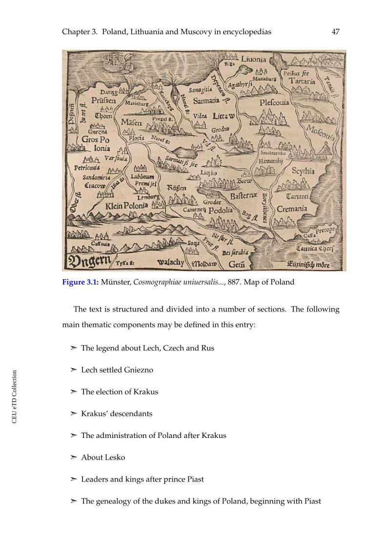
Chapter 3. Poland, Lithuania and Muscovy in encyclopedias 47
Figure 3.1: Münster, Cosmographiae uniuersalis..., 887. Map of Poland
The text is structured and divided into a number of sections. The following
main thematic components may be defined in this entry:
ã The legend about Lech, Czech and Rus
ã Lech settled Gniezno
ã The election of Krakus
ã Krakus’ descendants
ã The administration of Poland after Krakus
ã About Lesko
ã Leaders and kings after prince Piast
ã The genealogy of the dukes and kings of Poland, beginning with Piast
CE
UeT
DC
olle
ctio
n
48
ã Extension of the history of Piast’s leadership to his successors and further
generations
ã How and when Poland became kingdom.
ã About Casimir, the third king of Poland and his sons.
ã The Kingdom of Poland reduced to a duchy.
ã Bolesław the Curly, the Grand Duke of Poland.
ã The Polish campaign against Prussians.
ã The Duchy of Krakow as a subject of tossing between the leaders of Poland.
ã The Duchy of Poland again raised to kingdom.
ã Poland and Hungary under one rule.
ã The infidel ruler of Lithuania arrived at Poland and became king and a
Christian.
ã Polish kings of our time who rule the kingdom.
ã The names of bishoprics and other provinces in Poland.
As one may see, the entry is dedicated to the political history of Poland start-
ing from the legends about the very beginnings of the state till the latest events
known to Münster. One finds a totally new image of Poland here in comparison
to the previously considered cases. This is a short chronicle of Poland. One of the
main sources for Münster was the chronicler and humanist Jan Długosz.98 His
Annals or Chronicles of the Famous Kingdom of Poland in 12 volumes were written in
1455–80 and first published in 1711–12 in style of humanistic historiography. Indi-
viduals and their influence on history, political events and problems described in
98 Ioannis Długossi, Historiae Polonicae libri XII (Leipzig: Gleditsch / Weidmann, 1712); Jan Dłu-gosz, The Annals of Jan Długosz: An English Abridgement, trans. Maurice Michael (Chichester:IM, 1997).
CE
UeT
DC
olle
ctio
n
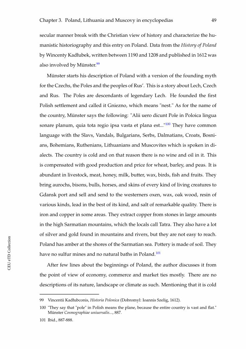
Chapter 3. Poland, Lithuania and Muscovy in encyclopedias 49
secular manner break with the Christian view of history and characterize the hu-
manistic historiography and this entry on Poland. Data from the History of Poland
by Wincenty Kadłubek, written between 1190 and 1208 and published in 1612 was
also involved by Münster.99
Münster starts his description of Poland with a version of the founding myth
for the Czechs, the Poles and the peoples of Rus’. This is a story about Lech, Czech
and Rus. The Poles are descendants of legendary Lech. He founded the first
Polish settlement and called it Gniezno, which means "nest." As for the name of
the country, Münster says the following: "Alii uero dicunt Pole in Poloica lingua
sonare planum, quia tota regio ipsa vasta et plana est..."100 They have common
language with the Slavs, Vandals, Bulgarians, Serbs, Dalmatians, Croats, Bosni-
ans, Bohemians, Ruthenians, Lithuanians and Muscovites which is spoken in di-
alects. The country is cold and on that reason there is no wine and oil in it. This
is compensated with good production and price for wheat, barley, and peas. It is
abundant in livestock, meat, honey, milk, butter, wax, birds, fish and fruits. They
bring aurochs, bisons, bulls, horses, and skins of every kind of living creatures to
Gdansk port and sell and send to the westerners oxen, wax, oak wood, resin of
various kinds, lead in the best of its kind, and salt of remarkable quality. There is
iron and copper in some areas. They extract copper from stones in large amounts
in the high Sarmatian mountains, which the locals call Tatra. They also have a lot
of silver and gold found in mountains and rivers, but they are not easy to reach.
Poland has amber at the shores of the Sarmatian sea. Pottery is made of soil. They
have no sulfur mines and no natural baths in Poland.101
After few lines about the beginnings of Poland, the author discusses it from
the point of view of economy, commerce and market ties mostly. There are no
descriptions of its nature, landscape or climate as such. Mentioning that it is cold
99 Vincentii Kadłubconis, Historia Polonica (Dobromyl: Ioannis Szelig, 1612).
100 "They say that "pole" in Polish means the plane, because the entire country is vast and flat."Münster Cosmographiae uniuersalis..., 887.
101 Ibid., 887-888.
CE
UeT
DC
olle
ctio
n
50
there, the Sarmatian mountains and the Sarmatian sea is done in the context of
production, natural resources, and goods.
Münster continues his description with a story about another legendary leader
of the Poles named Krakus, the story of his ingenious defeating a monster in
the area of the Wawel Hill and the Vistula river, his building the Wawel castle
and founding the city of Krakow named after him. Little by little it grew in size
and was fortified with high walls, battlements and towers. Nowadays, it is sur-
rounded by earthworks and ditches with water. The whole city is supplied with
water. Other cities of the kingdom are not built of stone, big part of the country
are swamps and forests. The country produces a lot of wheat and has good pas-
tures for cattle and wild animals. It produces lead, salt and has honey in large
amounts.102
Krakus left after him two sons, Krakus and Lech, and a daughter, Wanda. The
two brothers died in result of a conflict concerning the throne, and Wanda became
the queen. She did not have good fortune as well. She sacrificed herself to gods
throwing herself from the bridge to the waters of Vistula. Since then, the river
was often called after her name and the people who lived there Vandals. Vistula
flows to the Baltic sea. There are other important rivers here, like the Chronus or
Neman, Viadrus or Oder, Tyras or Dniester, Bug, Borysthenes or Dnieper.103
The considered opening sections of the entry on Poland contain references to
its remote legendary history. At the same time, Münster added elements repre-
senting a contemporary description of this land, facts known at his time. Some
pieces of information were repeated. This is a sign that he was using different
sources, and those sources had common pieces of information about Poland. It
looks like the country was known for certain goods to different providers of in-
formation used by Münster. Copying them resulted in repeating of information.
The following part of the entry is an overview of political history of the land.
102 Ibid., 888-889.
103 Ibid., 889-890.
CE
UeT
DC
olle
ctio
n
Chapter 3. Poland, Lithuania and Muscovy in encyclopedias 51
The legendary part of Polish history finishes by reference to the period when
Poland’s numerous duchies were not consolidated into one state and the rule of
three more figures: Leszko I, Leszko II, and Leszko III is mentioned. After that,
Sebastian Münster continues with the Piast dynasty. He discussed the rule of
the first duke of the dynasty Mieszko and his alliance with the Bohemian Prince
Boleslaus, his marriage with the Bohemian Princess Dobrawa in 965, his baptism,
and his building churches. Bolesław, Mieszko’s son, is referred to have been ac-
tive in politics and ecclesiastical issues. He was crowned as first king of Poland,
consolidated the country, and undertook successful military campaigns. Then one
finds the story of the ecclesiastical and political conflict in Poland that finally let
to its partition in to duchies. Consolidation of the duchies and restoration of the
kingdom became possible in front of the threat to be conquered by different exter-
nal powers. The last king of the Piast dynasty Casimir died and left his throne to
his nephew Louis of Hungary. Louis tried to rule Poland with the help of his pa-
trons, but the nobility of Poland did not really accept them. After Louis death his
youngest daughter Jadwiga was crowned to the Polish thrown. The heathen duke
of Lithuania Jogaila married Jadwiga, became king of Poland and was baptised
with the name of Wladyslaw. He turned his people to Christian faith as well and
built many churches in Lithuania and a cathedral in Vilno. He left two sons after
him: Wladyslaw and Casimir. After his death his elder son Wladyslaw received
the throne, but soon after he was killed in a battle against the Turks. His brother
Casimir, who ruled Lithuania at that period, was invited to Krakow to succeed
his brother in 1445. He had long rule, until 1492. Casimir’s son and successor
was John Albert who tried to military resist the Turks and Tartars. After his death
in 1501, his brother, the Grand Duke of Lithuania Alexander was elected king of
Poland. He was succeeded by king Sigismund in 1506.
Thus, the main observation for the textual image of Poland in Münster’s entry
is that the descriptions of the land, its nature and everything related to that occupy
minor space in it. Such mentioning corresponds to approximately 1.6 percent of
CE
UeT
DC
olle
ctio
n
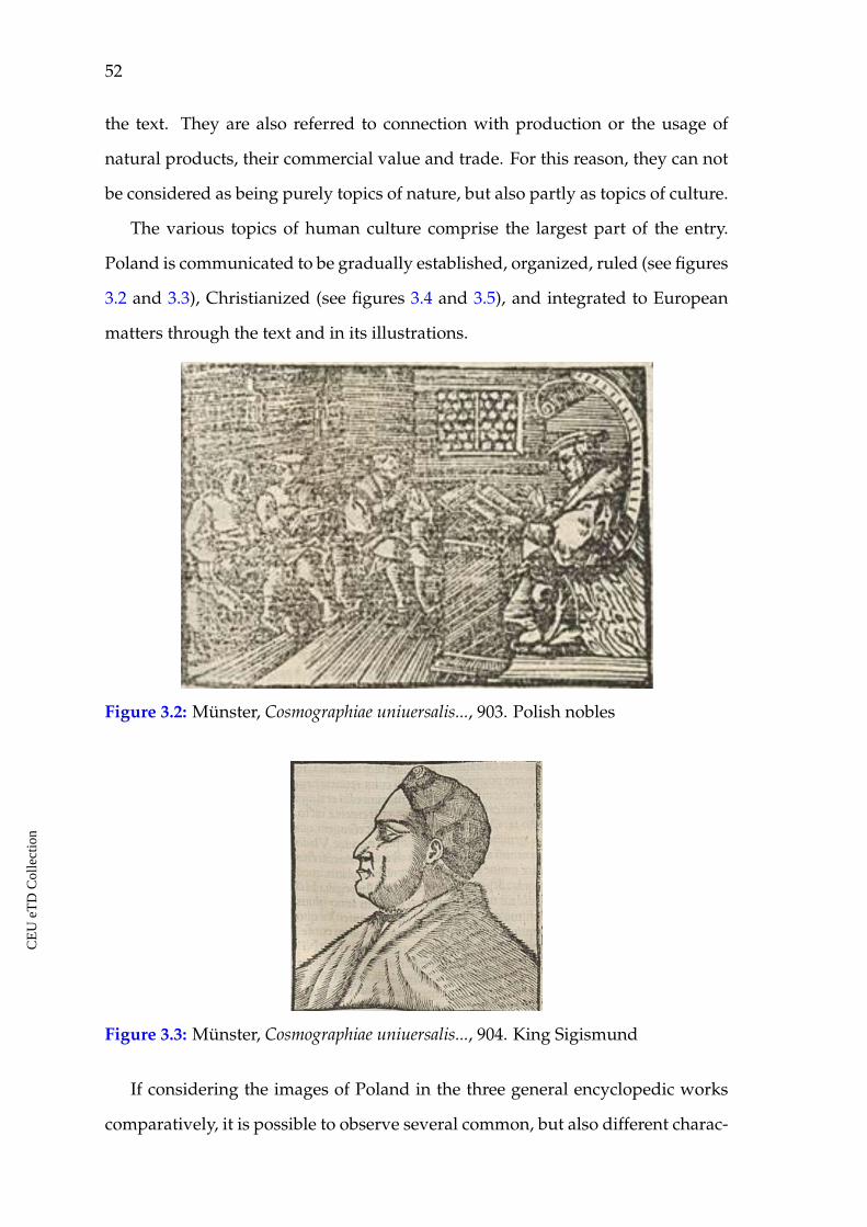
52
the text. They are also referred to connection with production or the usage of
natural products, their commercial value and trade. For this reason, they can not
be considered as being purely topics of nature, but also partly as topics of culture.
The various topics of human culture comprise the largest part of the entry.
Poland is communicated to be gradually established, organized, ruled (see figures
3.2 and 3.3), Christianized (see figures 3.4 and 3.5), and integrated to European
matters through the text and in its illustrations.
Figure 3.2: Münster, Cosmographiae uniuersalis..., 903. Polish nobles
Figure 3.3: Münster, Cosmographiae uniuersalis..., 904. King Sigismund
If considering the images of Poland in the three general encyclopedic works
comparatively, it is possible to observe several common, but also different charac-
CE
UeT
DC
olle
ctio
n
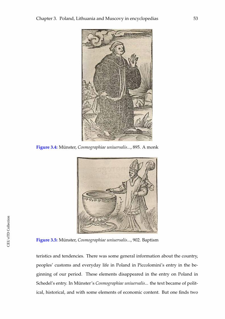
Chapter 3. Poland, Lithuania and Muscovy in encyclopedias 53
Figure 3.4: Münster, Cosmographiae uniuersalis..., 895. A monk
Figure 3.5: Münster, Cosmographiae uniuersalis..., 902. Baptism
teristics and tendencies. There was some general information about the country,
peoples’ customs and everyday life in Poland in Piccolomini’s entry in the be-
ginning of our period. These elements disappeared in the entry on Poland in
Schedel’s entry. In Münster’s Cosmographiae uniuersalis... the text became of polit-
ical, historical, and with some elements of economic content. But one finds two
CE
UeT
DC
olle
ctio
n
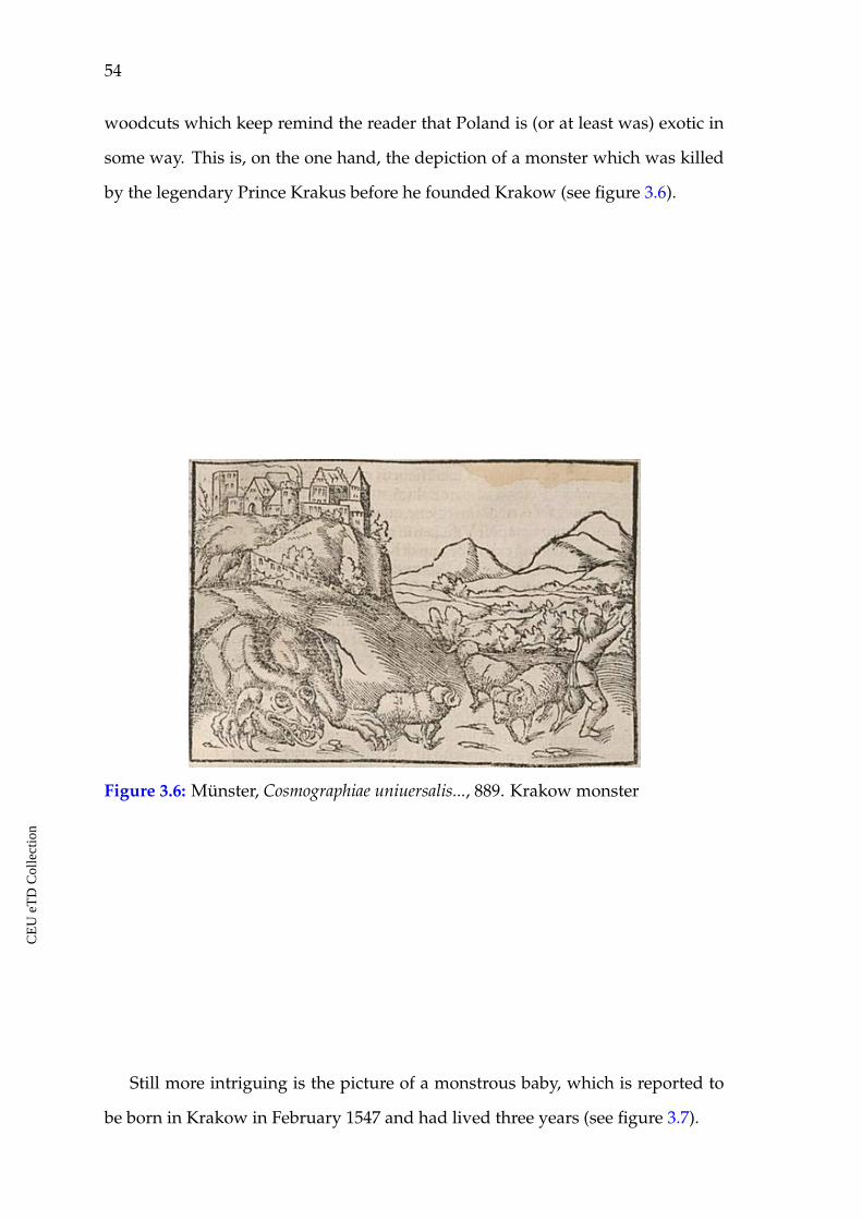
54
woodcuts which keep remind the reader that Poland is (or at least was) exotic in
some way. This is, on the one hand, the depiction of a monster which was killed
by the legendary Prince Krakus before he founded Krakow (see figure 3.6).
Figure 3.6: Münster, Cosmographiae uniuersalis..., 889. Krakow monster
Still more intriguing is the picture of a monstrous baby, which is reported to
be born in Krakow in February 1547 and had lived three years (see figure 3.7).
CE
UeT
DC
olle
ctio
n
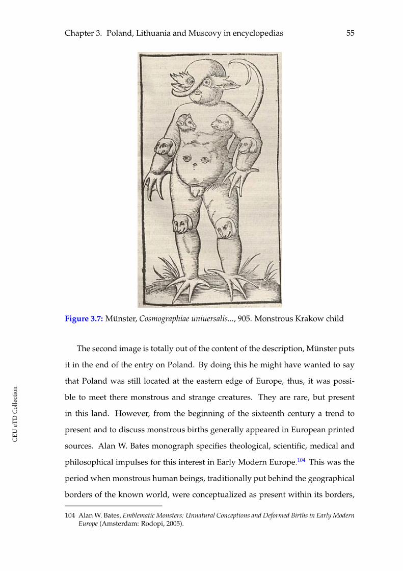
Chapter 3. Poland, Lithuania and Muscovy in encyclopedias 55
Figure 3.7: Münster, Cosmographiae uniuersalis..., 905. Monstrous Krakow child
The second image is totally out of the content of the description, Münster puts
it in the end of the entry on Poland. By doing this he might have wanted to say
that Poland was still located at the eastern edge of Europe, thus, it was possi-
ble to meet there monstrous and strange creatures. They are rare, but present
in this land. However, from the beginning of the sixteenth century a trend to
present and to discuss monstrous births generally appeared in European printed
sources. Alan W. Bates monograph specifies theological, scientific, medical and
philosophical impulses for this interest in Early Modern Europe.104 This was the
period when monstrous human beings, traditionally put behind the geographical
borders of the known world, were conceptualized as present within its borders,
104 Alan W. Bates, Emblematic Monsters: Unnatural Conceptions and Deformed Births in Early ModernEurope (Amsterdam: Rodopi, 2005).
CE
UeT
DC
olle
ctio
n
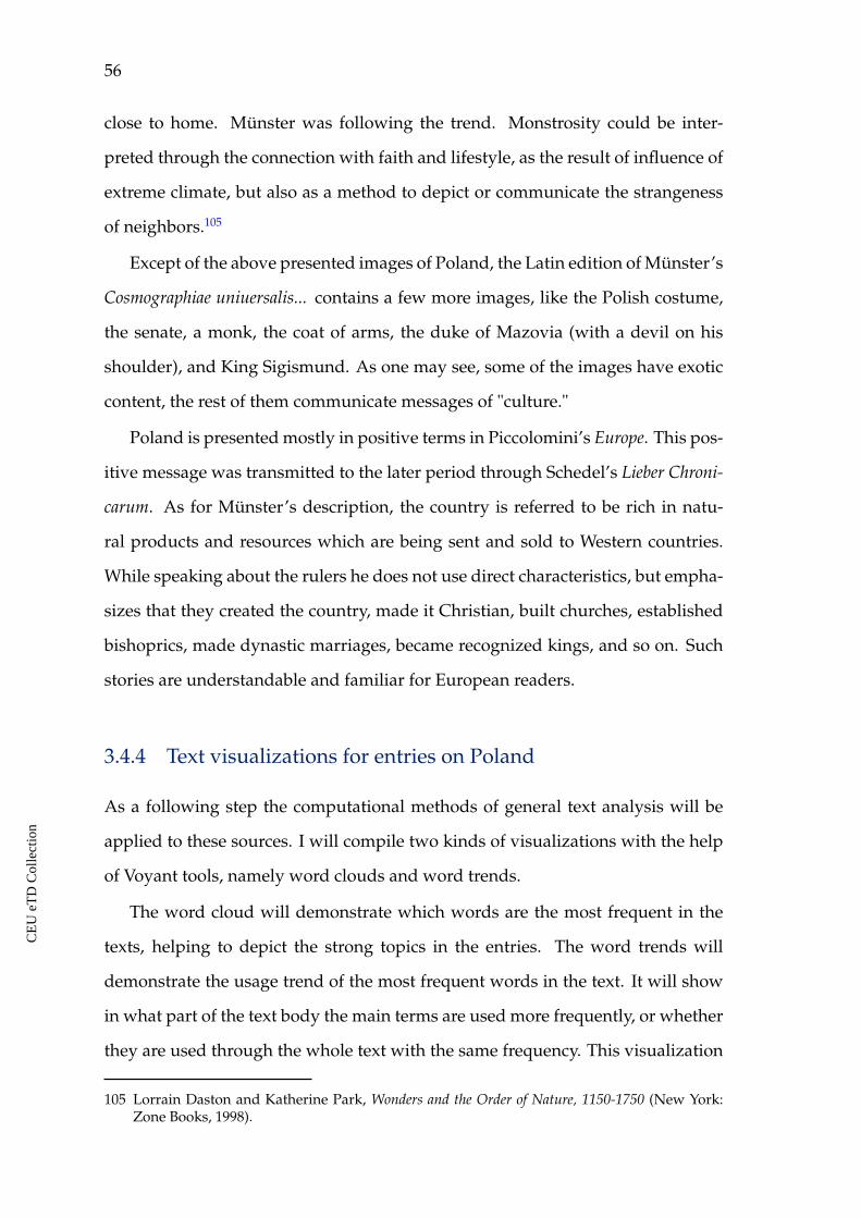
56
close to home. Münster was following the trend. Monstrosity could be inter-
preted through the connection with faith and lifestyle, as the result of influence of
extreme climate, but also as a method to depict or communicate the strangeness
of neighbors.105
Except of the above presented images of Poland, the Latin edition of Münster’s
Cosmographiae uniuersalis... contains a few more images, like the Polish costume,
the senate, a monk, the coat of arms, the duke of Mazovia (with a devil on his
shoulder), and King Sigismund. As one may see, some of the images have exotic
content, the rest of them communicate messages of "culture."
Poland is presented mostly in positive terms in Piccolomini’s Europe. This pos-
itive message was transmitted to the later period through Schedel’s Lieber Chroni-
carum. As for Münster’s description, the country is referred to be rich in natu-
ral products and resources which are being sent and sold to Western countries.
While speaking about the rulers he does not use direct characteristics, but empha-
sizes that they created the country, made it Christian, built churches, established
bishoprics, made dynastic marriages, became recognized kings, and so on. Such
stories are understandable and familiar for European readers.
3.4.4 Text visualizations for entries on Poland
As a following step the computational methods of general text analysis will be
applied to these sources. I will compile two kinds of visualizations with the help
of Voyant tools, namely word clouds and word trends.
The word cloud will demonstrate which words are the most frequent in the
texts, helping to depict the strong topics in the entries. The word trends will
demonstrate the usage trend of the most frequent words in the text. It will show
in what part of the text body the main terms are used more frequently, or whether
they are used through the whole text with the same frequency. This visualization
105 Lorrain Daston and Katherine Park, Wonders and the Order of Nature, 1150-1750 (New York:Zone Books, 1998).
CE
UeT
DC
olle
ctio
n
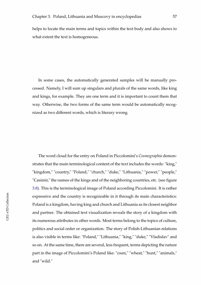
Chapter 3. Poland, Lithuania and Muscovy in encyclopedias 57
helps to locate the main terms and topics within the text body and also shows to
what extent the text is homogeneous.
In some cases, the automatically generated samples will be manually pro-
cessed. Namely, I will sum up singulars and plurals of the same words, like king
and kings, for example. They are one term and it is important to count them that
way. Otherwise, the two forms of the same term would be automatically recog-
nized as two different words, which is literary wrong.
The word cloud for the entry on Poland in Piccolomini’s Cosmographia demon-
strates that the main terminological content of the text includes the words: "king,"
"kingdom," "country," "Poland," "church," "duke," "Lithuania," "power," "people,"
"Casimir," the names of the kings and of the neighboring countries, etc. (see figure
3.8). This is the terminological image of Poland according Piccolomini. It is rather
expressive and the country is recognizable in it through its main characteristics:
Poland is a kingdom, having king and church and Lithuania as its closest neighbor
and partner. The obtained text visualization reveals the story of a kingdom with
its numerous attributes in other words. Most terms belong to the topics of culture,
politics and social order or organization. The story of Polish-Lithuanian relations
is also visible in terms like: "Poland," "Lithuania," "king," "duke," "Vladislav" and
so on. At the same time, there are several, less frequent, terms depicting the nature
part in the image of Piccolomini’s Poland like: "oxen," "wheat," "hunt," "animals,"
and "wild."
CE
UeT
DC
olle
ctio
n
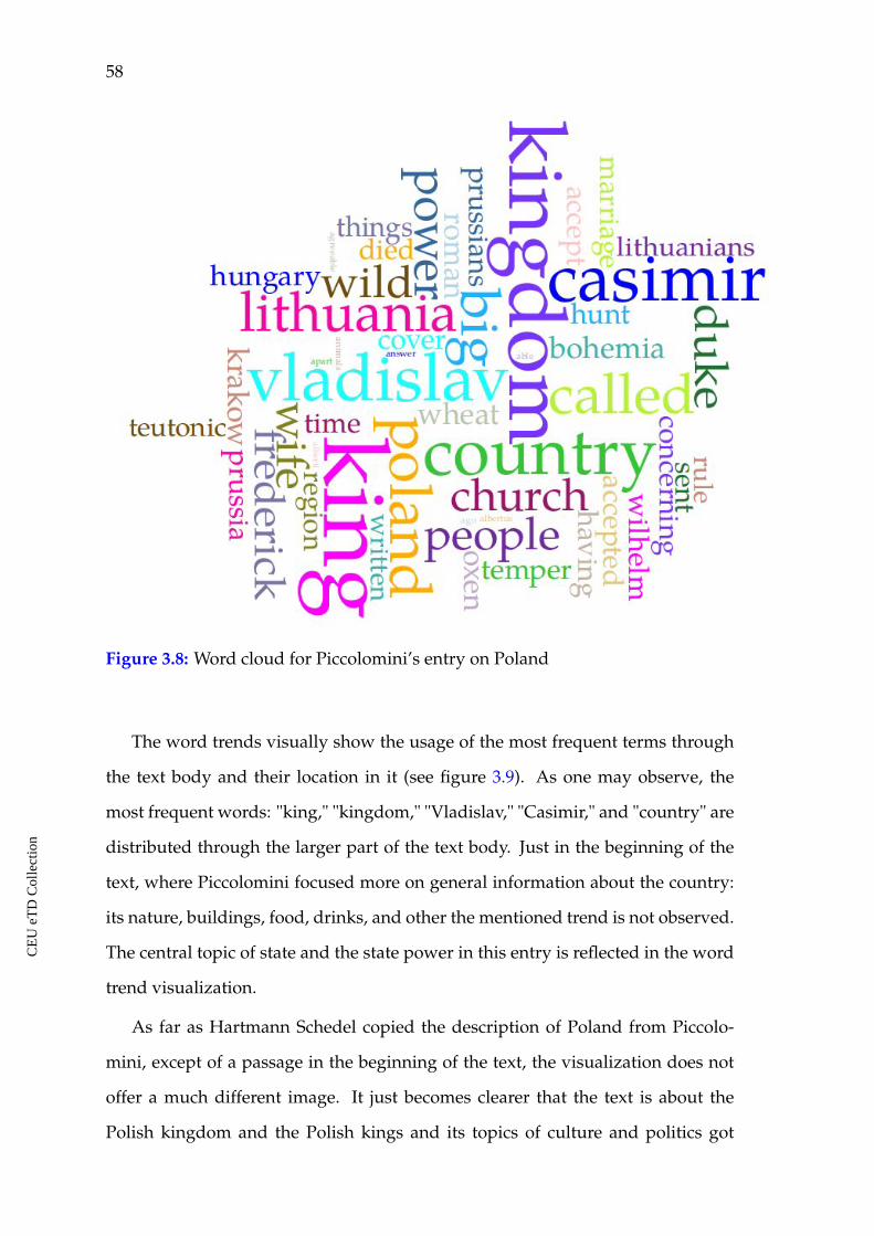
58
Figure 3.8: Word cloud for Piccolomini’s entry on Poland
The word trends visually show the usage of the most frequent terms through
the text body and their location in it (see figure 3.9). As one may observe, the
most frequent words: "king," "kingdom," "Vladislav," "Casimir," and "country" are
distributed through the larger part of the text body. Just in the beginning of the
text, where Piccolomini focused more on general information about the country:
its nature, buildings, food, drinks, and other the mentioned trend is not observed.
The central topic of state and the state power in this entry is reflected in the word
trend visualization.
As far as Hartmann Schedel copied the description of Poland from Piccolo-
mini, except of a passage in the beginning of the text, the visualization does not
offer a much different image. It just becomes clearer that the text is about the
Polish kingdom and the Polish kings and its topics of culture and politics got
CE
UeT
DC
olle
ctio
n
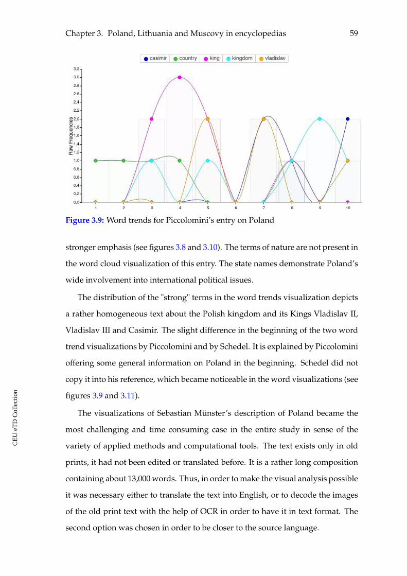
Chapter 3. Poland, Lithuania and Muscovy in encyclopedias 59
Figure 3.9: Word trends for Piccolomini’s entry on Poland
stronger emphasis (see figures 3.8 and 3.10). The terms of nature are not present in
the word cloud visualization of this entry. The state names demonstrate Poland’s
wide involvement into international political issues.
The distribution of the "strong" terms in the word trends visualization depicts
a rather homogeneous text about the Polish kingdom and its Kings Vladislav II,
Vladislav III and Casimir. The slight difference in the beginning of the two word
trend visualizations by Piccolomini and by Schedel. It is explained by Piccolomini
offering some general information on Poland in the beginning. Schedel did not
copy it into his reference, which became noticeable in the word visualizations (see
figures 3.9 and 3.11).
The visualizations of Sebastian Münster’s description of Poland became the
most challenging and time consuming case in the entire study in sense of the
variety of applied methods and computational tools. The text exists only in old
prints, it had not been edited or translated before. It is a rather long composition
containing about 13,000 words. Thus, in order to make the visual analysis possible
it was necessary either to translate the text into English, or to decode the images
of the old print text with the help of OCR in order to have it in text format. The
second option was chosen in order to be closer to the source language.
CE
UeT
DC
olle
ctio
n
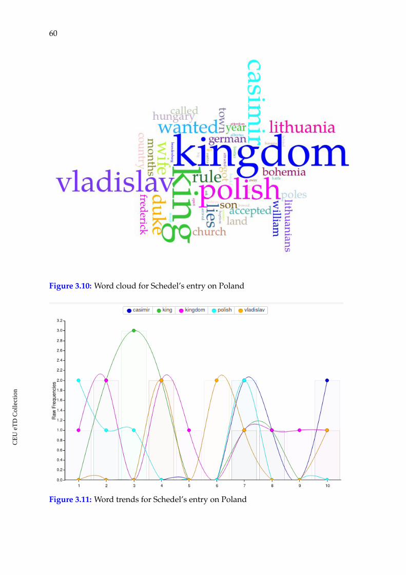
60
Figure 3.10: Word cloud for Schedel’s entry on Poland
Figure 3.11: Word trends for Schedel’s entry on Poland
CE
UeT
DC
olle
ctio
n
Chapter 3. Poland, Lithuania and Muscovy in encyclopedias 61
As already said, the visual text analysis tools are much better developed for
modern languages, the best for English, probably. For Latin texts still additional
manual interaction is necessary in order to receive a reliable result. Latin is a
highly inflected language, as a result the same word with different endings will
be counted as different word cases by the Voyant tools. Here, it was necessary to
manually sum up the words with the same meaning. Among all words compris-
ing the description the most frequently used were identified. Most of these words
were nouns, with very few exceptions of pronouns and verbs. English is not an
inflected language and in such expressions like "son," "with the son," "by the son,"
"to the son" the form of the noun remains unchanged. It is not the case in Latin
and each time it will be a different form of the noun. After the most frequent terms
were translated into English, the Voyant tools recognized them as the same word
form for each case, and not as several different forms of the same word. The most
frequent Latin terms were replaced with their English meanings and this made it
possible to obtain the final result in form of word cloud and word trends. This is
one of the possible solutions to approach rather big Latin texts for such kind of
textual analysis.
As it was said before, Münster’s text is almost totally dedicated to the political
history of the country. The word cloud demonstrates the prevailing terminologi-
cal content of the entry and highlights its important topics (see figure 3.12). The
most frequent words describing Poland in this text in their vast majority repre-
sent the attributes of state and its political ranking. Among the most frequent are
the following terms: "Poland," "kingdom," "king," "duke," "Krakow;" the names of
the kings and dukes: Wladyslaw, Casimir, Boleslav; and the names of the neigh-
boring states Lithuania, Bohemia, Prussia. The term "year" shows that there are
many references to dates within the story, which is typical for texts on history, like
this one by Münster. The names of the states correspond to Poland’s neighbors
and the names of the kings indicate the most influential figures in Polish history.
Thus, the word cloud offers the possibility to get the scope of the main content in
CE
UeT
DC
olle
ctio
n
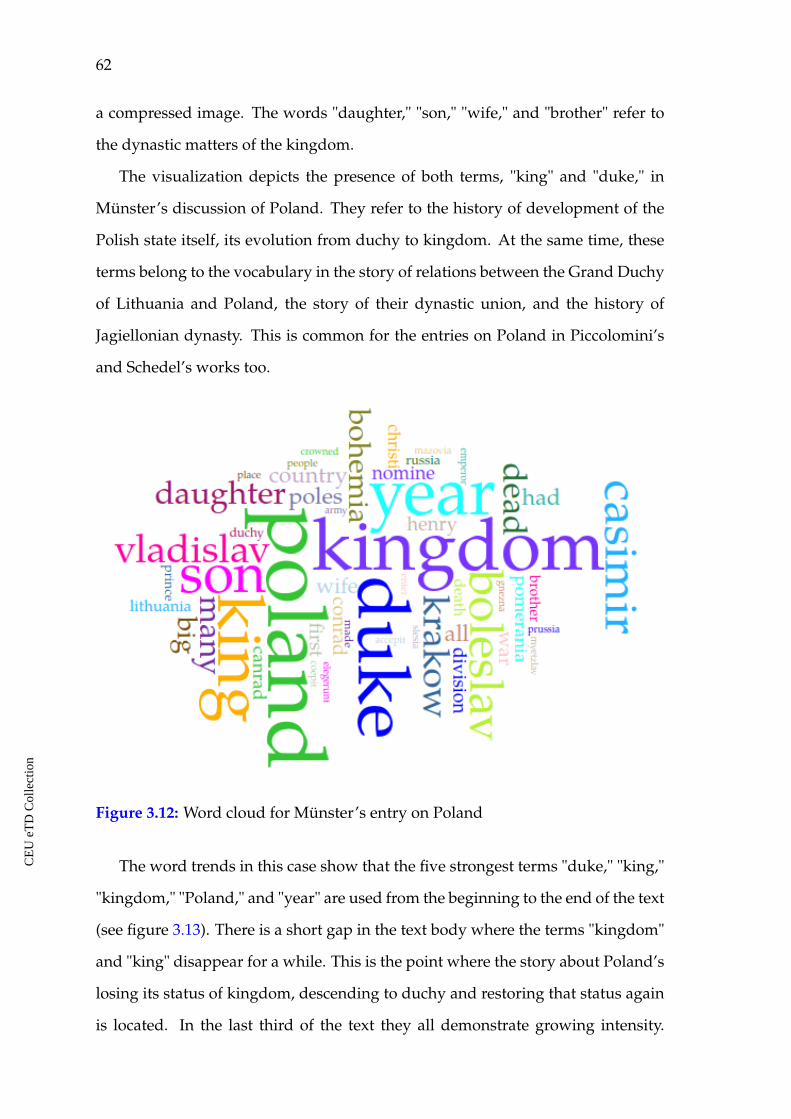
62
a compressed image. The words "daughter," "son," "wife," and "brother" refer to
the dynastic matters of the kingdom.
The visualization depicts the presence of both terms, "king" and "duke," in
Münster’s discussion of Poland. They refer to the history of development of the
Polish state itself, its evolution from duchy to kingdom. At the same time, these
terms belong to the vocabulary in the story of relations between the Grand Duchy
of Lithuania and Poland, the story of their dynastic union, and the history of
Jagiellonian dynasty. This is common for the entries on Poland in Piccolomini’s
and Schedel’s works too.
Figure 3.12: Word cloud for Münster’s entry on Poland
The word trends in this case show that the five strongest terms "duke," "king,"
"kingdom," "Poland," and "year" are used from the beginning to the end of the text
(see figure 3.13). There is a short gap in the text body where the terms "kingdom"
and "king" disappear for a while. This is the point where the story about Poland’s
losing its status of kingdom, descending to duchy and restoring that status again
is located. In the last third of the text they all demonstrate growing intensity.
CE
UeT
DC
olle
ctio
n
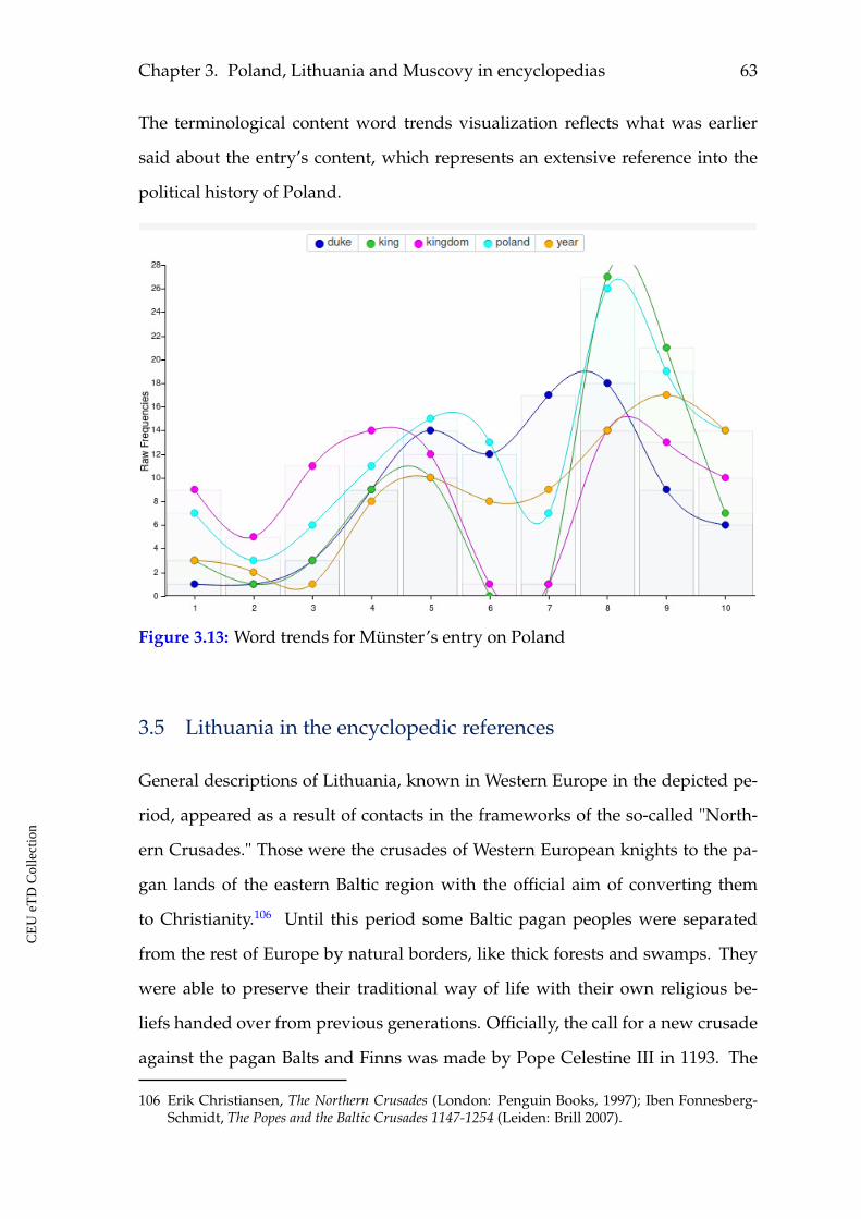
Chapter 3. Poland, Lithuania and Muscovy in encyclopedias 63
The terminological content word trends visualization reflects what was earlier
said about the entry’s content, which represents an extensive reference into the
political history of Poland.
Figure 3.13: Word trends for Münster’s entry on Poland
3.5 Lithuania in the encyclopedic references
General descriptions of Lithuania, known in Western Europe in the depicted pe-
riod, appeared as a result of contacts in the frameworks of the so-called "North-
ern Crusades." Those were the crusades of Western European knights to the pa-
gan lands of the eastern Baltic region with the official aim of converting them
to Christianity.106 Until this period some Baltic pagan peoples were separated
from the rest of Europe by natural borders, like thick forests and swamps. They
were able to preserve their traditional way of life with their own religious be-
liefs handed over from previous generations. Officially, the call for a new crusade
against the pagan Balts and Finns was made by Pope Celestine III in 1193. The
106 Erik Christiansen, The Northern Crusades (London: Penguin Books, 1997); Iben Fonnesberg-Schmidt, The Popes and the Baltic Crusades 1147-1254 (Leiden: Brill 2007).
CE
UeT
DC
olle
ctio
n
64
Baltic Crusades started and their impulses lasted until the fifteenth century, when
the Teutonic Order was defeated in the Battle of Grunwald (also known as Battle
of Žalgiris or Battle of Tannenberg) in 1410.107 Besides the Knights of the Teutonic
Order, who came to fight the pagans that refused to convert, many settlers of Ger-
manic origin, but also from all over the Christian Europe came to that region. As
it was mentioned above, the mission and conversion were the official, but not the
only reason for going there.
The impressions by one of the missionaries, Jerome of Prague (c.1369-c.1440),108
became the source of information for Aeneas Sylvius Piccolomini. In his descrip-
tion of Lithuania Piccolomini presented Jerome’s story of preaching there told to
him personally. This story occupies the larger part of the reference on Lithuania,
and becomes a central topic in the image of this land. It offers the description of
local pagan cults and the ways Jerome tried to fight them.
At the same time, it should be pointed out that the content of the part on reli-
gion in Lithuania and the mission of Jerome is very similar to what Henry of Livo-
nia wrote in his Chronicon Livoniae (1224-27) concerning the mission in the eastern-
Baltic region in the beginning of the thirteenth century.109 The main attributes and
scenes with which the missionaries were confronted in Henry’s Chronicle are iden-
tical to those described by Jerome, namely, the worshiping of snakes and burning
them by missionaries, and the presence of a very big one among others, which was
hard to burn; sacred forests with one very big tree among others and the scene of
cutting that tree by a missionary, and so on. Based on research investigations and
references from the secondary literature dedicated to the conversion and history
of the eastern Baltic region, one observes a connection between these sources.110
107 Zsolt Hunyadi and József Laszlovszky, The Crusades and the Military Orders: Expanding theFrontiers of Medieval Latin Christianity, rev. ed. (Budapest: Central European University Press.2001); Alan V. Murray, Crusade and Conversion on the Baltic Frontier, 1150–1500, rev.ed. (Burling-ton, Vermont: Ashgate. 2001).
108 Jan Stejskal, "De Lituania," Medium Aevum Quotidianum 31 (1994): 45-58.
109 James A. Brundage, The Chronicle of Henry of Livonia, trans. and ed. (Madison: University ofWisconsin Press, 1961).
110 Alan V. Murray, The Clash of Cultures on the Medieval Baltic Frontier, rev. ed. (Farnham: Ash-
CE
UeT
DC
olle
ctio
n
Chapter 3. Poland, Lithuania and Muscovy in encyclopedias 65
It is possible that Piccolomini read the Chronicle and used the scenes from it as a
rhetorical tool and put them to the mouth of Jerome of Prague. It may also mean
that Jerome himself read Henry’s work and used the rhetorical images from there
in order to make an impression of a truthful story. The motif of pagan religion
was incorporated into the description of Lithuania by Aeneas Silvius Piccolomini
and became the central topos of its image for the Western Christian audience.
3.5.1 Aeneas Silvius Piccolomini and Hartmann Schedel on Lithua-
nia
The entries on Lithuania are present in all three mentioned sources by Piccolo-
mini, Schedel and Münster. The text by Piccolomini was copied by Hartmann
Schedel except for some parts. the extended descriptions of each cult. In Schedel’s
entry all Lithuanian cults are listed in the end of the text and it is said that "they
were converted to Christianity by Jerome, a native of Prague, who at the time
that the Hussite heresy originated fled from Bohemia to Poland, and received
from Wladislaus, the Polish king, a letter of recommendation to Vitoldus, the
Lithuanian prince, and rooted out the aforesaid heresies among the people."111
This omission did not affect the general content of the entry in Schedel’s Chronicle,
but it moved its emphasis the cult descriptions. The two entries will be considered
in parallel when dealing with the content of the entries, but text visualizations for
these two entries will be generated separately. Let us consider the content of the
entry by Piccolomini and pick up the descriptions of nature in Lithuania first. The
text starts from the note on the location of the country concerning the neighboring
Poland. It is said that "it adjoins Poland in the east and is almost entirely covered
in bogs and forests."112
It is difficult to reach Lithuania in summertime, when almost the whole area is
gate, 2009), 141-168.
111 Schedel Liber chronicarum, folio CCLXXX verso.
112 Piccolomini, Europe, 141.
CE
UeT
DC
olle
ctio
n
66
surrounded with marshy waters. Winter provides access across the frozen lakes.
Merchants travel over the ice and snow carrying several days’ provisions in their
vehicles. There is no well-defined road, and, as at sea, one steers one’s way by
the course of the stars. Towns are scarce among the Lithuanians, and farms not
numerous.113
The following topic in Piccolomini’s description is dedicated to the images of
two rulers in Lithuania. To site this reference is the best way to communicate the
author’s style and concerns. "The leader of this land was Vytautus, the brother of
Wladyslaw II, who abandoned the cult of many gods and received the sacrament
of Christ along with the throne of Poland. The name of Vytautus was great in his
own time. His subjects feared him so much that, if ordered to hang themselves,
they would rather obey than incur their ruler’s wrath. Those who resisted his
rule he sewed inside a bear skin and threw to living bears, which were kept for
this very purpose, to be torn to pieces; he also inflicted other cruel tortures. While
riding on horseback, he always kept his bow drawn. If he saw anyone walking in
a way that displeased him, he shot him down then and there. This bloodthirsty
butcher also destroyed many men for amusement. In order that there should be
a clear facial distinction between the people and their ruler, he ordered everyone
to shave their beards. When that was unsuccessful (for a Lithuanian would more
readily endure the loss of his neck than his beard), he himself appeared in public
with a shaven chin and head and threatened capital punishment for any of his
subjects who removed the hair from his face or head. Named king of the Lithua-
nians by Emperor Sigismund, he died before the ambassadors who were bringing
the crown arrived to meet him.
His successor, Svitrigaila, kept a bear which used to take bread from his hands
and often wandered into the woods; when it re- turned, all the doors leading
to the prince’s inner chamber were left open for it. There it would rub against
the door and kick it when it was hungry, whereupon the prince would open the
113 Ibid., 142.
CE
UeT
DC
olle
ctio
n
Chapter 3. Poland, Lithuania and Muscovy in encyclopedias 67
door and offer it food. Some young nobles conspired against the prince and, after
arming themselves, rubbed against the door of his bedchamber in imitation of the
bear. Svitrigaila thought it was the bear and opened the door, whereupon he was
stabbed on the spot by the ambushers and killed.” The governance of the country
then passed to Casimir."114
As one may see, the description of Lithuania both as a place for living, but also
as a ruled state does not produce a nice and positive picture. It is hard to travel
there. The offered images of two Lithuanian rulers sound more than terrifying.
It may be supposed that such an image would make an impression of a rather
different, hostile and not friendly remote land according to European standards.
To be more precise, Vitovt was Wladyslaw’s II/Jogaila’s cousin, not brother.
Then one finds that their wealth consists chiefly of the skins of animals known
as "sable" and "ermine." The use of money is unknown, its place being taken by
skins. The country is rich in honey, wax, wild animals, furs and fish. The use of
wine is very rare and their bread is deep black. Cattle provide their sustenance,
and they consume an abundance of milk.115
The author refers to the morals in Lithuania as common on the one hand, but
strange and exotic on the other. Piccolomini says that women in Lithuania are
allowed by their husbands to have lovers, who were called "matrimonial assis-
tants." At the same time, for men, it is shameful to take a mistress in addition to
one’s legitimate spouse. However, marriages are easily dissolved by mutual con-
sent, and they marry again and again.116 It was different and exotic for the author
and his audiences to learn that marriages in Lithuania were broken easily on mu-
tual agreement, that it was possible to get married again as many times as people
wanted and that wives were allowed to have lovers. The language is said to be
Slavic, but it is mentioned that they also had their own language.
The statement concerning the language demonstrates that Piccolomini is writ-
114 Ibid., 141-142.
115 Ibid., 143.
116 Ibid.
CE
UeT
DC
olle
ctio
n
68
ing about Lithuania as a state, not an ethnic Lithuanian area, where they spoke
Lithuanian. Slavic was the official language in the Great Duchy of Lithuania.
The longest part of the text that follows conveys Jerome’s of Prague witness
about his preaching and fighting those who venerated idols in Lithuania follows
after. The story represents a colorful reference to the traditions of worshiping
snakes, sacred fire and sun, sacred trees and forests found among the Lithuani-
ans. It describes Jerome’s attempts to preach and destroy those "sacred places
and objects" and, finally, his leaving the country without success to convert those
people to Christianity.
Let us shortly consider these references. He says that the first Lithuanians
whom he encountered worshiped snakes. Each head of the household kept his
own snake, lying on hay in a corner of the house, to which he gave food and
offered sacrifice. Jerome ordered all these to be killed, brought to the marketplace,
and burned in public.117
Next, he discovered a tribe which worshiped a sacred fire... After convinc-
ing the populace, Jerome destroyed the temple, scattered the fire, and introduced
Christian ways.118
Going further inland, he found another tribe which worshiped the sun and
venerated, with remarkable devotion, an iron hammer of extraordinary size. When
the priests were asked about the meaning of this cult, they replied that once upon
a time the sun disappeared for several months because a mighty king had cap-
tured it and confined it in the dungeon of a strongly fortified tower. A giant had
then come to the help of the sun and smashed the tower with a huge hammer,
releasing the sun and restoring it to humanity... He explained that the sun and
moon and stars are actually creations of almighty God, with which he adorned the
heavens, bidding them shine with everlasting light for the benefit of mankind.119
Finally, he visited other people who worshiped a sacred wood; the taller a tree,
117 Ibid., 144.
118 Ibid., 145.
119 Ibid.
CE
UeT
DC
olle
ctio
n
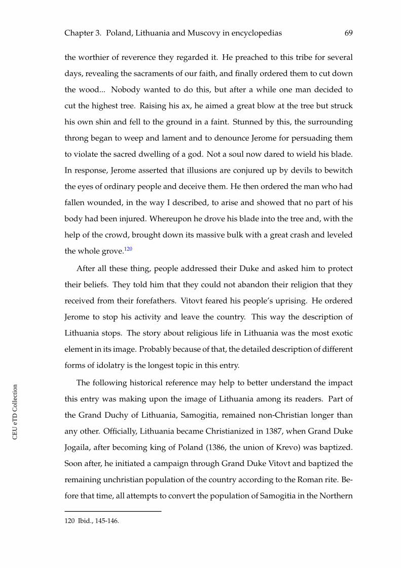
Chapter 3. Poland, Lithuania and Muscovy in encyclopedias 69
the worthier of reverence they regarded it. He preached to this tribe for several
days, revealing the sacraments of our faith, and finally ordered them to cut down
the wood... Nobody wanted to do this, but after a while one man decided to
cut the highest tree. Raising his ax, he aimed a great blow at the tree but struck
his own shin and fell to the ground in a faint. Stunned by this, the surrounding
throng began to weep and lament and to denounce Jerome for persuading them
to violate the sacred dwelling of a god. Not a soul now dared to wield his blade.
In response, Jerome asserted that illusions are conjured up by devils to bewitch
the eyes of ordinary people and deceive them. He then ordered the man who had
fallen wounded, in the way I described, to arise and showed that no part of his
body had been injured. Whereupon he drove his blade into the tree and, with the
help of the crowd, brought down its massive bulk with a great crash and leveled
the whole grove.120
After all these thing, people addressed their Duke and asked him to protect
their beliefs. They told him that they could not abandon their religion that they
received from their forefathers. Vitovt feared his people’s uprising. He ordered
Jerome to stop his activity and leave the country. This way the description of
Lithuania stops. The story about religious life in Lithuania was the most exotic
element in its image. Probably because of that, the detailed description of different
forms of idolatry is the longest topic in this entry.
The following historical reference may help to better understand the impact
this entry was making upon the image of Lithuania among its readers. Part of
the Grand Duchy of Lithuania, Samogitia, remained non-Christian longer than
any other. Officially, Lithuania became Christianized in 1387, when Grand Duke
Jogaila, after becoming king of Poland (1386, the union of Krevo) was baptized.
Soon after, he initiated a campaign through Grand Duke Vitovt and baptized the
remaining unchristian population of the country according to the Roman rite. Be-
fore that time, all attempts to convert the population of Samogitia in the Northern
120 Ibid., 145-146.
CE
UeT
DC
olle
ctio
n
70
part of the Grand Duchy, to Christianity had ended in killings of missionaries or
recalling them from the country, as in case of Jerome of Prague.
By the fifteenth century, the Grand Duchy of Lithuania was a large state, which
reached from Zemaitia/Samogitia in the north to the Black Sea in the south after
the battle at the river of Sinie Vody (Blue Waters) in 1363. In fact, only the eth-
nic Lithuanian lands (Zemaitia/Samogitia) were the object for Christian mission
since 1387, as most of the lands in the duchy were already Christian from the
times of Kievan Rus’. The Polotsk duchy, located close to Zemaitia was, for exam-
ple, a famous Christian center as early as the twelfth century. The same counts for
Grodno (Harodnja). The earliest surviving Boris and Gleb church there dates back
to the twelfth century. Thus, when Piccolomini and Schedel wrote that in Lithua-
nia they worshiped grass snakes, the sun, the fire or anything else, this could be
true in application to the past of the ethnic Lithuanian lands which comprised a
small north-western part of the country’s territory.
How could the extended information about venerating different objects of na-
ture in Lithuania affect the European readers’ image of Lithuania when reading
Piccolomini and Schedel? Probably the message would be applied to Lithuania in
general, and the country could be perceived to be a pagan state. Everything that
was said about Lithuania in the text would be applied to Littav in the map (see
figure 3.14). The colorful, detailed and extended portrayal of numerous cults and
traditions could produce an impression that the country was not Christian as a
whole.
As for the description of the Lithuanian cults, it is interesting to point out
some details with regard to the image of venerated snakes as reported in the story.
For example, their bodies were described as rather exotic, being fat, black and
having four short legs. Based on the Biblical story about the Fall of Adam and
Eve, particularly Genesis 3:14, So the Lord God said to the serpent, “Because you have
done this, cursed are you above all livestock and all wild animals! You will crawl on
your belly and you will eat dust all the days of your life," there is a tradition among
CE
UeT
DC
olle
ctio
n
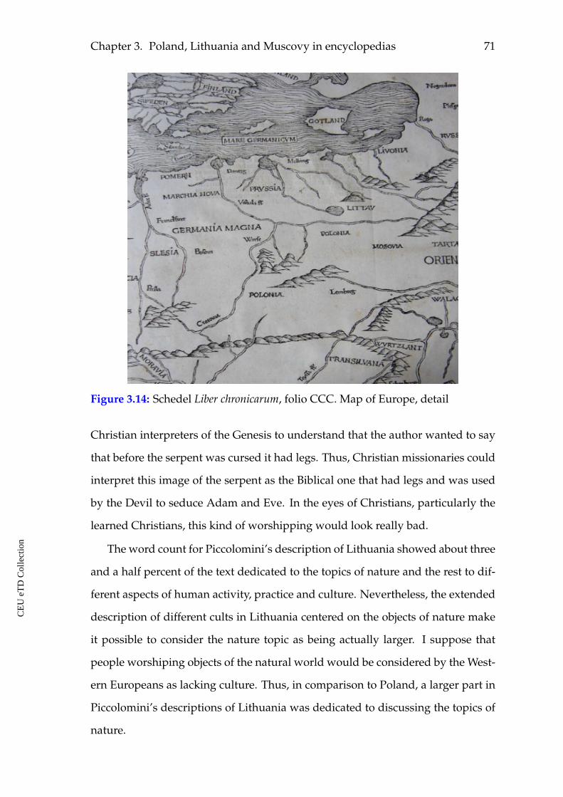
Chapter 3. Poland, Lithuania and Muscovy in encyclopedias 71
Figure 3.14: Schedel Liber chronicarum, folio CCC. Map of Europe, detail
Christian interpreters of the Genesis to understand that the author wanted to say
that before the serpent was cursed it had legs. Thus, Christian missionaries could
interpret this image of the serpent as the Biblical one that had legs and was used
by the Devil to seduce Adam and Eve. In the eyes of Christians, particularly the
learned Christians, this kind of worshipping would look really bad.
The word count for Piccolomini’s description of Lithuania showed about three
and a half percent of the text dedicated to the topics of nature and the rest to dif-
ferent aspects of human activity, practice and culture. Nevertheless, the extended
description of different cults in Lithuania centered on the objects of nature make
it possible to consider the nature topic as being actually larger. I suppose that
people worshiping objects of the natural world would be considered by the West-
ern Europeans as lacking culture. Thus, in comparison to Poland, a larger part in
Piccolomini’s descriptions of Lithuania was dedicated to discussing the topics of
nature.
CE
UeT
DC
olle
ctio
n
72
As noted before, Hartmann Schedel shortened the entry by Piccolomini and
copied it into his Chronicle. He omitted the reference concerning the travel condi-
tions in Lithuania and the extended description of each traditional cult. In his en-
try, all Lithuanian cults are listed in the end of the text, just as in Piccolomini’s text,
but without their detail descriptions. Schedel called them heresies. The omissions
did not affect the general content of the entry in Schedel’s Chronicle in comparison
to Piccolomini’s text, but the emphasis in the image of Lithuania will supposedly
be affected in text visualizations for Schedel’s entry.
Schedel finalized his description of Lithuania by saying that "they were con-
verted to Christianity by Jerome, a native of Prague, who at the time that the Hus-
site heresy originated fled from Bohemia to Poland. He received from Wladislaus,
the Polish king, a letter of recommendation to Vitoldus, the Lithuanian prince, and
rooted out the aforesaid heresies among the people."121 The meaning of the end-
ing sentences is also changed by Schedel. Piccolomini wrote that Jerome fought
against different cults around Lithuania, but people required from their duke to
stop Jerome and send him out of their country in the end, because they could not
abandon their religion that they received from their forefathers. Schedel did not
say in the end that Jerome had to leave Lithuania, because its people wanted to
keep their old religion.
3.5.2 Lithuania by Sebastian Münster
Münster’s description of Lithuania starts with an image of coat of arms of the
Grand Duchy (see figure 3.15).
He was also influenced by Piccolomini’s description, but he involved several
pieces of new information, tried to explain the administrative division of this
state, told about the main cities and rivers there, made comments concerning the
languages spoken in Lithuania, about its religions, and so on. He structured his
entry dividing the information into four sections:
121 Schedel Liber chronicarum, folio CCLXXX.
CE
UeT
DC
olle
ctio
n
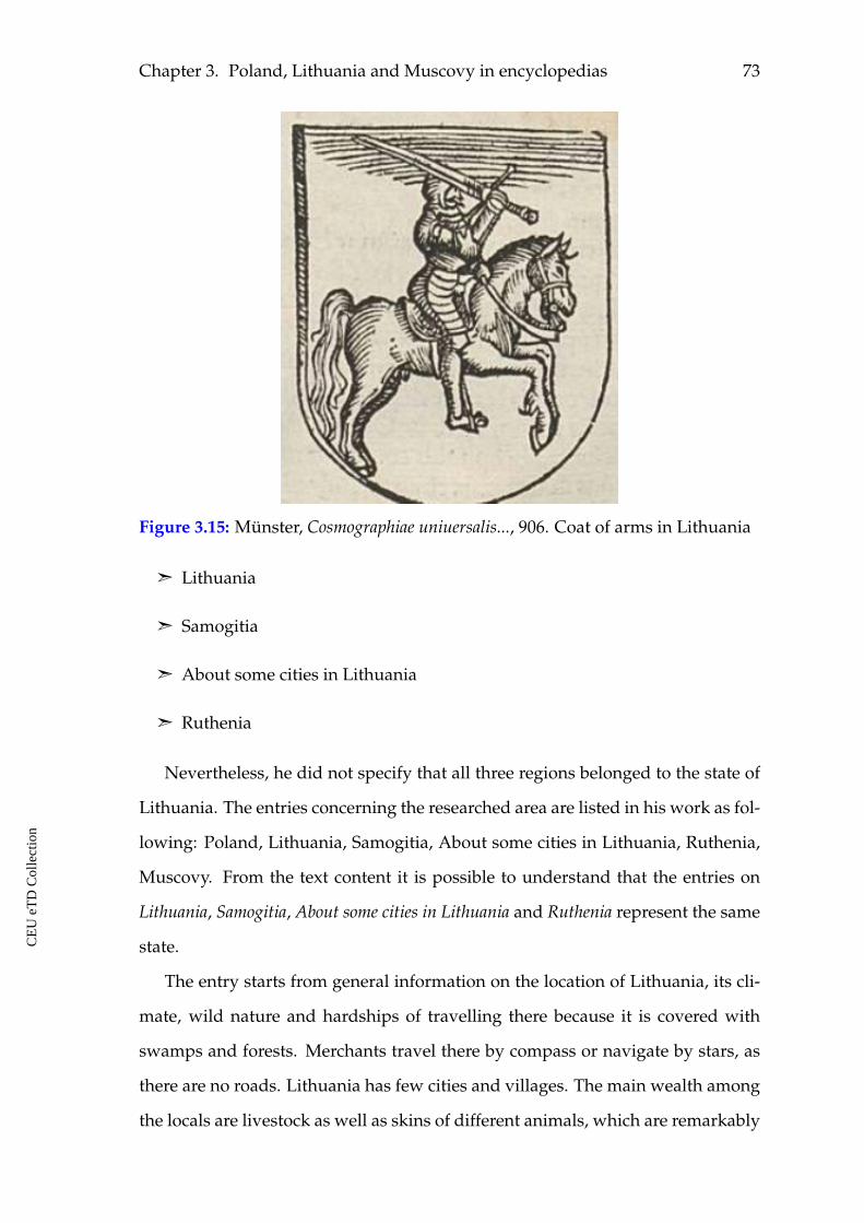
Chapter 3. Poland, Lithuania and Muscovy in encyclopedias 73
Figure 3.15: Münster, Cosmographiae uniuersalis..., 906. Coat of arms in Lithuania
ã Lithuania
ã Samogitia
ã About some cities in Lithuania
ã Ruthenia
Nevertheless, he did not specify that all three regions belonged to the state of
Lithuania. The entries concerning the researched area are listed in his work as fol-
lowing: Poland, Lithuania, Samogitia, About some cities in Lithuania, Ruthenia,
Muscovy. From the text content it is possible to understand that the entries on
Lithuania, Samogitia, About some cities in Lithuania and Ruthenia represent the same
state.
The entry starts from general information on the location of Lithuania, its cli-
mate, wild nature and hardships of travelling there because it is covered with
swamps and forests. Merchants travel there by compass or navigate by stars, as
there are no roads. Lithuania has few cities and villages. The main wealth among
the locals are livestock as well as skins of different animals, which are remarkably
CE
UeT
DC
olle
ctio
n
74
abundant in the region. It is rich in wax and honey. The use of money is unknown
among these people. Men allow their wives to have lovers, whom they call mar-
riage aides. However, if a man has another woman besides his legal wife, this is
considered reprehensible. They very easily break up the marriage with the con-
sent of both and marry others. So, one nation lives in different fashion of morals
than other. Wine is used very rare, their bread is very dark made from coarse
flour...122
This introductory part of Münster’s description of Lithuania has much in com-
mon in its content and in order of offered information with the above consid-
ered description by Piccolomini and Schedel. The country has numerous natural
goods, but sounds rather wild, uncultivated and is hard to be accessed. It is also
different in morals concerning the marriage. As in Poland, they do not have wine
in Lithuania.
The capital of this country is Vilna, and there is also a bishopric there, and this
city is as big as Krakow with its suburbs. However, not a single house stands
next to the others, but all the houses have a garden and a courtyard between
themselves, like in the villages.123 Thus, the looks of the capital city does not
differ from the one the villages have according to Sebastian Münster.
The text informs the reader that some part of the population in Lithuania con-
ducts worship in Greek manner and speak the Slavic language. There is also
a Tartar minority who follow the Mohammedan faith and speak the Tartar lan-
guage. After that, Münster gives a short introduction to the political history and
mentions several dukes of Lithuania. The central figure among them is of Jogaila,
his becoming the king of Poland, his campaign among the infidels of Lithuania,
his fighting and destroying the traditional cults and objects of veneration, con-
verting the population to Christianity and founding a cathedral in Vilna in the
place where the eternal venerated fire was burning previously.
122 Münster Cosmographia universalis..., 906.
123 Ibid.
CE
UeT
DC
olle
ctio
n
Chapter 3. Poland, Lithuania and Muscovy in encyclopedias 75
Then he continues with Samogitia. The land of Samogitia lies in the north,
adjoins Lithuania, Prussia and Livonia, it is surrounded by forests and rivers and
is a cold land. The people there are pretty and tall, but rude and fierce in their
temper. They eat a small amount of food, drink water, occasionally beer or also
a honey beverage "mead." Some time ago they did not know gold, silver, iron, or
even wine. A man can have many wives, and if the father dies, then the son can
take his step-mother, or the wife of his brother. They have poor, miserable houses
made of wood, straw and dung, in the shape of an iron heap, and they have on top
one large, wide window that gives light to the whole house. In the house there is
the father of the family, his wife, children, servants, maids, livestock, grain and all
home appliances. There they also maintain a fire, they sit around it and not only
cook on it, but also defend themselves from the fierce cold, which reigns there for
almost the whole year. The people there are inclined to magic, and among other
things, they worship fire. After all, they believe that it is a sacred and eternal
thing. It was kept on a high tower up the hill by a priest who constantly throws
firewood in it. King Vladislav galloped to the tower in which the fire was kept,
and extinguished it, and he ordered to cut down those trees in the forests that they
worshiped. Because they believed that forest birds and wild animals were sacred
there too.124
Thus, being a country in the north, Lithuania has difficult climate and natural
conditions, people are not kind, houses are not comfortable. As for the worship-
ing fire, one may see that this is what was said generally for Lithuania as well and
in more detail. Münster informs about other traditions in Samogitia as well. He
says that they also had fire stoves in the forests, for each gender separately, on
which they burned the dead with horses, saddles and with better clothes. They
also put chairs there and put baked goods and cheese on them and poured mead
into the oven, in their faith and stupidity, that the souls of the dead come at night
and eat there. If King Vladislav subjugated the Samogitians regarding faith, he
124 Ibid., 907.
CE
UeT
DC
olle
ctio
n
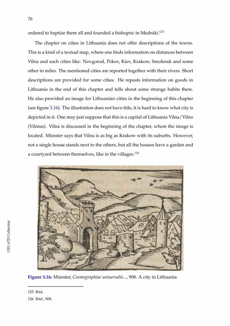
76
ordered to baptize them all and founded a bishopric in Medniki.125
The chapter on cities in Lithuania does not offer descriptions of the towns.
This is a kind of a textual map, where one finds information on distances between
Vilna and such cities like: Novgorod, Pskov, Kiev, Krakow, Smolensk and some
other in miles. The mentioned cities are reported together with their rivers. Short
descriptions are provided for some cities. He repeats information on goods in
Lithuania in the end of this chapter and tells about some strange habits there.
He also provided an image for Lithuanian cities in the beginning of this chapter
(see figure 3.16). The illustration does not have title, it is hard to know what city is
depicted in it. One may just suppose that this is a capital of Lithuania Vilna/Vilno
(Vilnius). Vilna is discussed in the beginning of the chapter, where the image is
located. Münster says that Vilna is as big as Krakow with its suburbs. However,
not a single house stands next to the others, but all the houses have a garden and
a courtyard between themselves, like in the villages.126
Figure 3.16: Münster, Cosmographiae uniuersalis..., 908. A city in Lithuania
125 Ibid.
126 Ibid., 908.
CE
UeT
DC
olle
ctio
n
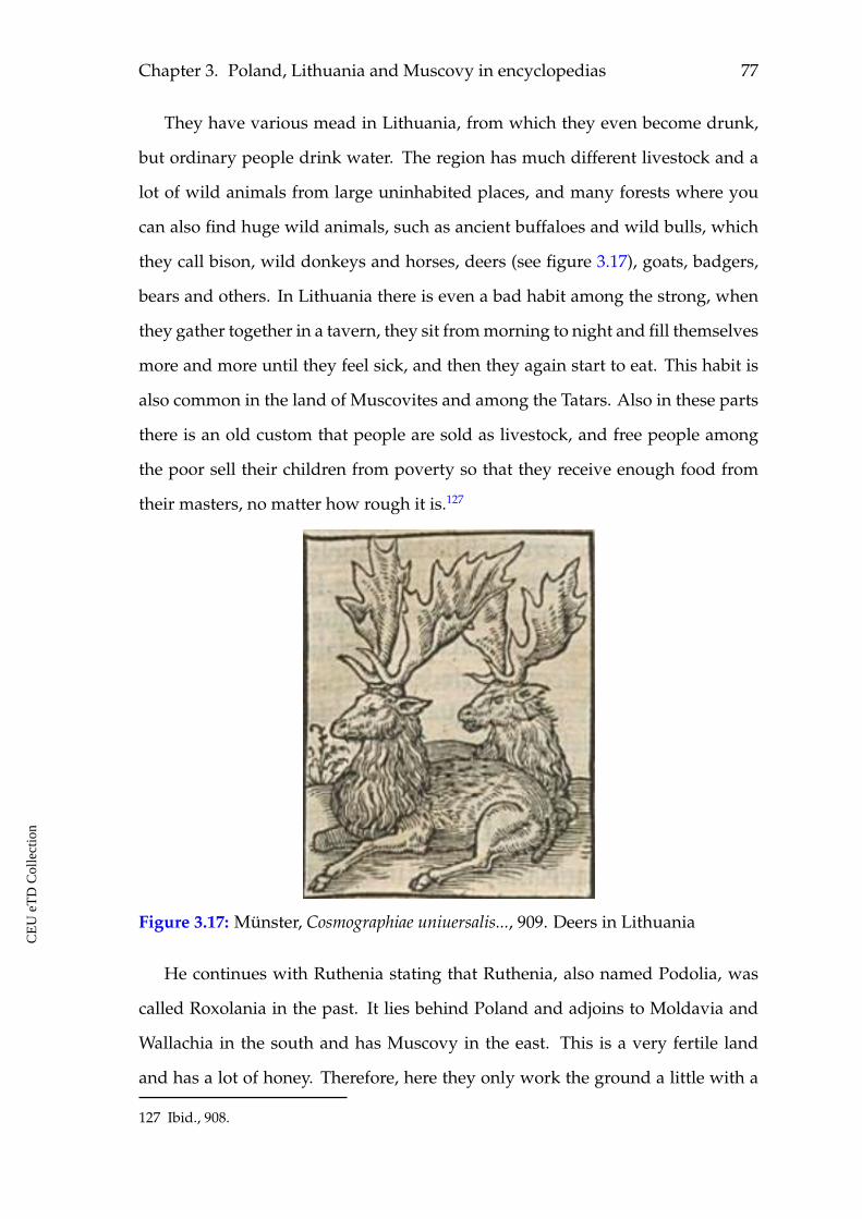
Chapter 3. Poland, Lithuania and Muscovy in encyclopedias 77
They have various mead in Lithuania, from which they even become drunk,
but ordinary people drink water. The region has much different livestock and a
lot of wild animals from large uninhabited places, and many forests where you
can also find huge wild animals, such as ancient buffaloes and wild bulls, which
they call bison, wild donkeys and horses, deers (see figure 3.17), goats, badgers,
bears and others. In Lithuania there is even a bad habit among the strong, when
they gather together in a tavern, they sit from morning to night and fill themselves
more and more until they feel sick, and then they again start to eat. This habit is
also common in the land of Muscovites and among the Tatars. Also in these parts
there is an old custom that people are sold as livestock, and free people among
the poor sell their children from poverty so that they receive enough food from
their masters, no matter how rough it is.127
Figure 3.17: Münster, Cosmographiae uniuersalis..., 909. Deers in Lithuania
He continues with Ruthenia stating that Ruthenia, also named Podolia, was
called Roxolania in the past. It lies behind Poland and adjoins to Moldavia and
Wallachia in the south and has Muscovy in the east. This is a very fertile land
and has a lot of honey. Therefore, here they only work the ground a little with a
127 Ibid., 908.
CE
UeT
DC
olle
ctio
n
78
plow and throw grain in it, and it gives a three-year harvest, but if you leave a
little grain on the ground during grain harvesting, it will grow without any other
cultivation. Bees collect their honey not only in their hives and empty hollow
trees, but everywhere in rock caves, holes in the ground from which people make
tasty mead and large wax circles.128
It is not clear from the description of Ruthenia in this chapter where it be-
longed to. It is mentioned in the part on Lithuania that at some point the Lithua-
nians conquered some Ruthenian lands and made them pay tribute. Actually,
the Grand Duchy of Lithuania included the lands of Lithuania, Samogitia and
Ruthenia in Münster’s time. Lithuania kept most of those territorial possessions
throughout the fifteenth century and possessed the largest territory in Europe. In
the sixteenth century, it went through a number of wars with Muscovy and had
to make large territorial concessions to it.
Münster writes that commerce is well developed and safe in Lemberg (Lviv).
The bishopric there is reported to take care of the safety of the foreign merchants
and their goods, giving them shelter and protection. People speak a Slavic lan-
guage and they are Christians. Some other nations are also represented in Ruthe-
nia, like Tartars, Jews, Germans, and Armenians. Münster mentions the main
rivers of Ruthenia and the main cities with distances between them in miles.
Thus, Münster’s image of Ruthenia is very attractive, positive and promising.
The goods and the fertility of the soil communicate a rich land in terms of natural
resources where many things are literally produced by themselves or with very
little attempt. It is also involved into international commerce and market.
Münster’s map of Poland depicts most of the cities, rivers and other toponyms
mentioned in his entry concerning Lithuania (see figure 3.18). At the same time,
Littaw, as it is visually perceived, does not correspond to its actual size in the
considered period. Again, it gives an impression of a small area in the eastern
Baltic region. The name of Ruthenia is not depicted in it. Thus, on the one hand,
128 Ibid., 909.
CE
UeT
DC
olle
ctio
n
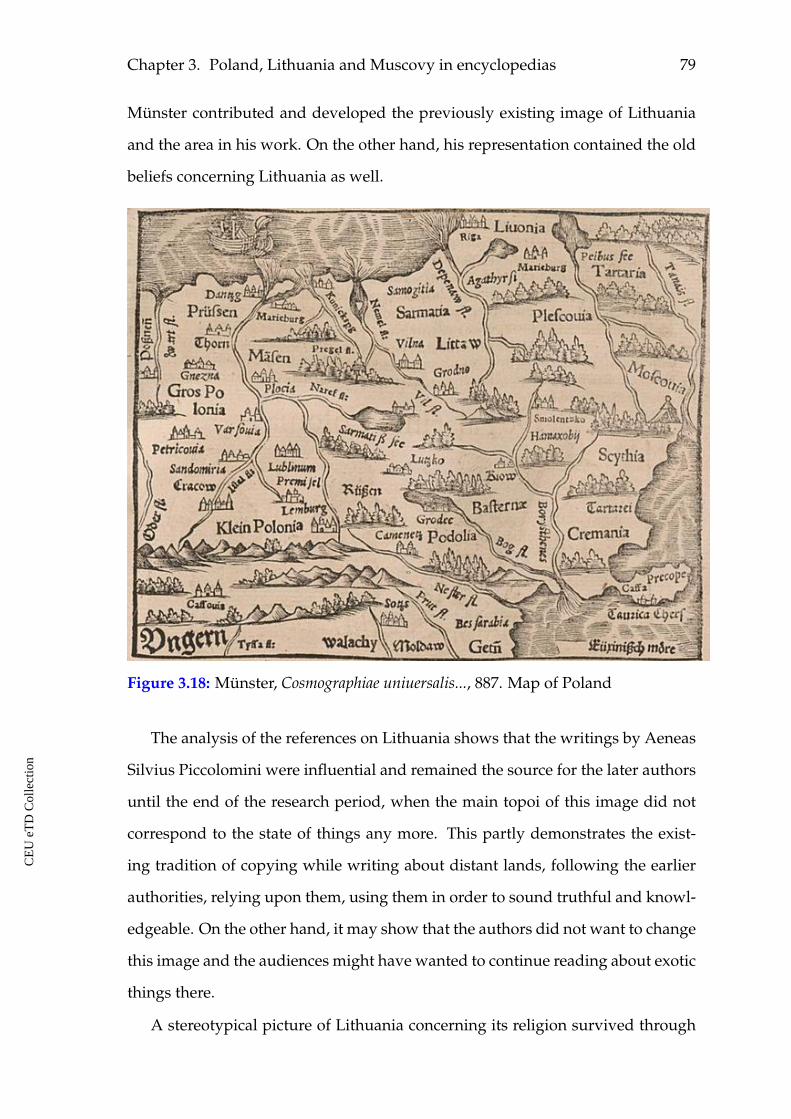
Chapter 3. Poland, Lithuania and Muscovy in encyclopedias 79
Münster contributed and developed the previously existing image of Lithuania
and the area in his work. On the other hand, his representation contained the old
beliefs concerning Lithuania as well.
Figure 3.18: Münster, Cosmographiae uniuersalis..., 887. Map of Poland
The analysis of the references on Lithuania shows that the writings by Aeneas
Silvius Piccolomini were influential and remained the source for the later authors
until the end of the research period, when the main topoi of this image did not
correspond to the state of things any more. This partly demonstrates the exist-
ing tradition of copying while writing about distant lands, following the earlier
authorities, relying upon them, using them in order to sound truthful and knowl-
edgeable. On the other hand, it may show that the authors did not want to change
this image and the audiences might have wanted to continue reading about exotic
things there.
A stereotypical picture of Lithuania concerning its religion survived through
CE
UeT
DC
olle
ctio
n
80
the whole observed period thanks to copying, also thanks to being exotic since
it was first introduced. Possibly, it was useful for some reason to preserve this
image. It is possible that being a partner in the Polish-Lithuanian union in political
terms the Grand Duchy of Lithuania could be perceived by the Western audiences
and authors as one with Poland. Speaking about Lithuania they would often
mean the north-eastern ethnic Lithuanian area. With this, it is also possible to
explain why the, in this period, large state of Lithuania was not properly depicted
in maps, but as a small segment north-east of Poland (see figures 3.14 and 3.18).
In spite of the fact that the borders between the states were not depicted in maps
one observes that Poland looks larger in this particular case. The name of Poland
is depicted twice in the maps both by Schedel and by Münster. In Schedel’s map
one of the depictions of the name of Poland was put very close to Muscovy. It is
hard to talk in terms of accuracy here in any case, but this eastern depiction of the
term of Polonia would better fit for the territory of the Grand Duchy of Lithuania,
its part Ruthenia particularly.
Thus, the Western authors as well as their audiences most probably perceived
Poland and the Grand Duchy of Lithuania as one state. As the main story from the
description of Poland says that the Grand Duke of Lithuania Jogaila had married
the Queen of Poland Jadwiga, was baptized to Christianity and became king of
the Polish-Lithianian union with the name Wladyslaw, it would be natural for
Western Europeans to perceive these two states as one. In this case, by Lithuania
they would understand the ethnic Lithuanian lands, not the state of the Grand
Duchy of Lithuania. This situation most probably affected the stereotypical image
of Lithuania and made it that stable throughout the period. This will be further
discussed in the chapter dedicated to the cartography of the region.
As said, the considered descriptions were a contribution by those who had
never visited the country. The image was rather firm and survived throughout
the fifteenth and the first half of the sixteenth century. The main constitutive top-
ics about Lithuania were copied from author to author and continued making im-
CE
UeT
DC
olle
ctio
n
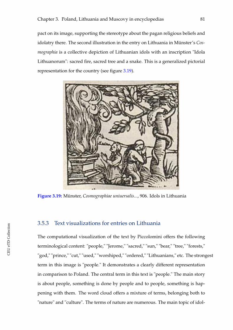
Chapter 3. Poland, Lithuania and Muscovy in encyclopedias 81
pact on its image, supporting the stereotype about the pagan religious beliefs and
idolatry there. The second illustration in the entry on Lithuania in Münster’s Cos-
mographia is a collective depiction of Lithuanian idols with an inscription "Idola
Lithuanorum": sacred fire, sacred tree and a snake. This is a generalized pictorial
representation for the country (see figure 3.19).
Figure 3.19: Münster, Cosmographiae uniuersalis..., 906. Idols in Lithuania
3.5.3 Text visualizations for entries on Lithuania
The computational visualization of the text by Piccolomini offers the following
terminological content: "people," "Jerome," "sacred," "sun," "bear," "tree," "forests,"
"god," "prince," "cut," "used," "worshiped," "ordered," "Lithuanians," etc. The strongest
term in this image is "people." It demonstrates a clearly different representation
in comparison to Poland. The central term in this text is "people." The main story
is about people, something is done by people and to people, something is hap-
pening with them. The word cloud offers a mixture of terms, belonging both to
"nature" and "culture". The terms of nature are numerous. The main topic of idol-
CE
UeT
DC
olle
ctio
n
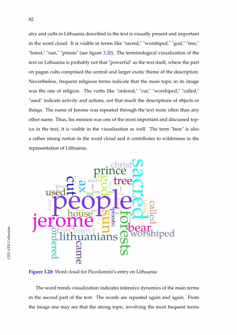
82
atry and cults in Lithuania described in the text is visually present and important
in the word cloud. It is visible in terms like "sacred," "worshiped," "god," "tree,"
"forest," "sun," "priests" (see figure 3.20). The terminological visualization of the
text on Lithuania is probably not that "powerful" as the text itself, where the part
on pagan cults comprised the central and larger exotic theme of the description.
Nevertheless, frequent religious terms indicate that the main topic in its image
was the one of religion. The verbs like "ordered," "cut," "worshiped," "called,"
"used" indicate activity and actions, not that much the descriptions of objects or
things. The name of Jerome was repeated through the text more often than any
other name. Thus, his mission was one of the most important and discussed top-
ics in the text, it is visible in the visualization as well. The term "bear" is also
a rather strong notion in the word cloud and it contributes to wilderness in the
representation of Lithuania.
Figure 3.20: Word cloud for Piccolomini’s entry on Lithuania
The word trends visualization indicates intensive dynamics of the main terms
in the second part of the text. The words are repeated again and again. From
the image one may see that the strong topic, involving the most frequent terms
CE
UeT
DC
olle
ctio
n
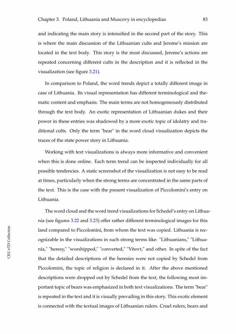
Chapter 3. Poland, Lithuania and Muscovy in encyclopedias 83
and indicating the main story is intensified in the second part of the story. This
is where the main discussion of the Lithuanian cults and Jerome’s mission are
located in the text body. This story is the most discussed, Jerome’s actions are
repeated concerning different cults in the description and it is reflected in the
visualization (see figure 3.21).
In comparison to Poland, the word trends depict a totally different image in
case of Lithuania. Its visual representation has different terminological and the-
matic content and emphasis. The main terms are not homogeneously distributed
through the text body. An exotic representation of Lithuanian dukes and their
power in these entries was shadowed by a more exotic topic of idolatry and tra-
ditional cults. Only the term "bear" in the word cloud visualization depicts the
traces of the state power story in Lithuania.
Working with text visualizations is always more informative and convenient
when this is done online. Each term trend can be inspected individually for all
possible tendencies. A static screenshot of the visualization is not easy to be read
at times, particularly when the strong terms are concentrated in the same parts of
the text. This is the case with the present visualization of Piccolomini’s entry on
Lithuania.
The word cloud and the word trend visualizations for Schedel’s entry on Lithua-
nia (see figures 3.22 and 3.23) offer rather different terminological images for this
land compared to Piccolomini, from whom the text was copied. Lithuania is rec-
ognizable in the visualizations in such strong terms like: "Lithuanians," "Lithua-
nia," "heresy," "worshipped," "converted," "Vitovt," and other. In spite of the fact
that the detailed descriptions of the heresies were not copied by Schedel from
Piccolomini, the topic of religion is declared in it. After the above mentioned
descriptions were dropped out by Schedel from the text, the following most im-
portant topic of bears was emphasized in both text visualizations. The term "bear"
is repeated in the text and it is visually prevailing in this story. This exotic element
is connected with the textual images of Lithuanian rulers. Cruel rulers, bears and
CE
UeT
DC
olle
ctio
n
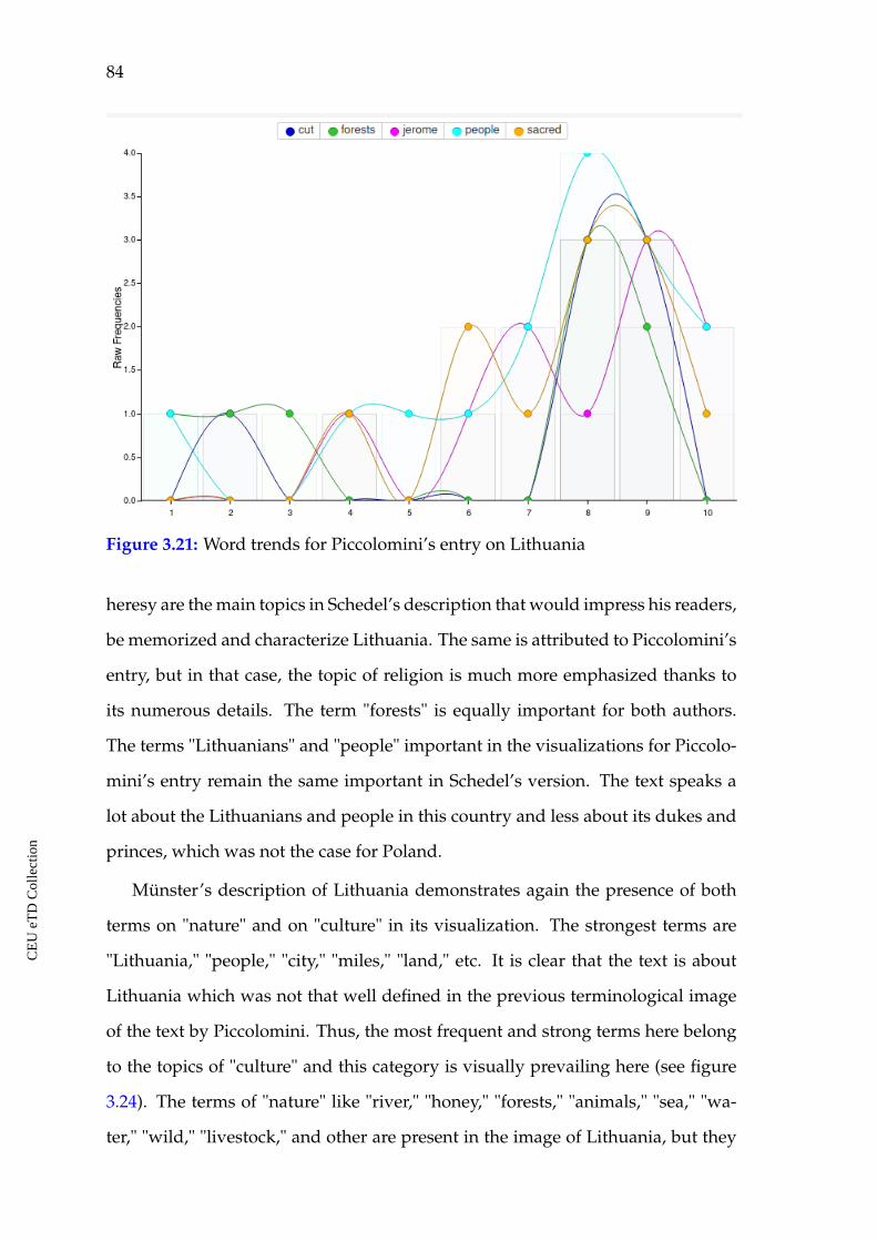
84
Figure 3.21: Word trends for Piccolomini’s entry on Lithuania
heresy are the main topics in Schedel’s description that would impress his readers,
be memorized and characterize Lithuania. The same is attributed to Piccolomini’s
entry, but in that case, the topic of religion is much more emphasized thanks to
its numerous details. The term "forests" is equally important for both authors.
The terms "Lithuanians" and "people" important in the visualizations for Piccolo-
mini’s entry remain the same important in Schedel’s version. The text speaks a
lot about the Lithuanians and people in this country and less about its dukes and
princes, which was not the case for Poland.
Münster’s description of Lithuania demonstrates again the presence of both
terms on "nature" and on "culture" in its visualization. The strongest terms are
"Lithuania," "people," "city," "miles," "land," etc. It is clear that the text is about
Lithuania which was not that well defined in the previous terminological image
of the text by Piccolomini. Thus, the most frequent and strong terms here belong
to the topics of "culture" and this category is visually prevailing here (see figure
3.24). The terms of "nature" like "river," "honey," "forests," "animals," "sea," "wa-
ter," "wild," "livestock," and other are present in the image of Lithuania, but they
CE
UeT
DC
olle
ctio
n
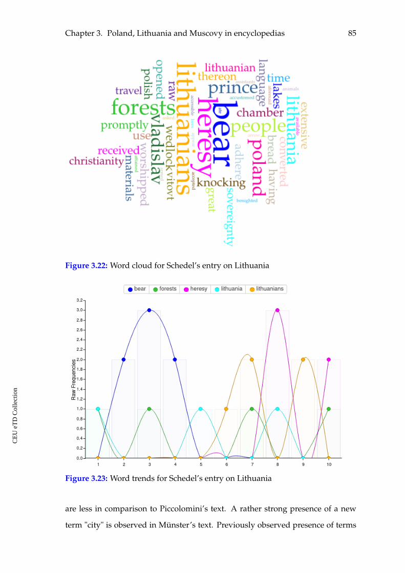
Chapter 3. Poland, Lithuania and Muscovy in encyclopedias 85
Figure 3.22: Word cloud for Schedel’s entry on Lithuania
Figure 3.23: Word trends for Schedel’s entry on Lithuania
are less in comparison to Piccolomini’s text. A rather strong presence of a new
term "city" is observed in Münster’s text. Previously observed presence of terms
CE
UeT
DC
olle
ctio
n
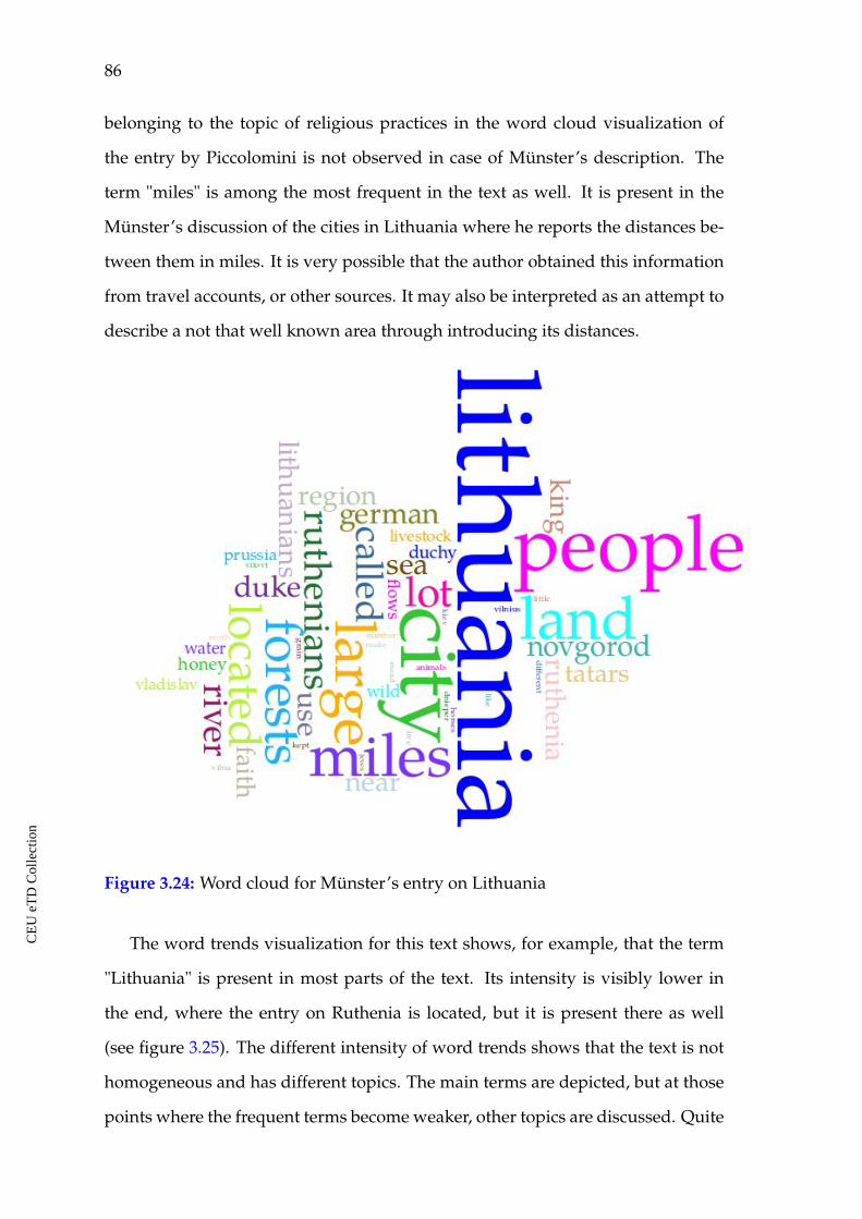
86
belonging to the topic of religious practices in the word cloud visualization of
the entry by Piccolomini is not observed in case of Münster’s description. The
term "miles" is among the most frequent in the text as well. It is present in the
Münster’s discussion of the cities in Lithuania where he reports the distances be-
tween them in miles. It is very possible that the author obtained this information
from travel accounts, or other sources. It may also be interpreted as an attempt to
describe a not that well known area through introducing its distances.
Figure 3.24: Word cloud for Münster’s entry on Lithuania
The word trends visualization for this text shows, for example, that the term
"Lithuania" is present in most parts of the text. Its intensity is visibly lower in
the end, where the entry on Ruthenia is located, but it is present there as well
(see figure 3.25). The different intensity of word trends shows that the text is not
homogeneous and has different topics. The main terms are depicted, but at those
points where the frequent terms become weaker, other topics are discussed. Quite
CE
UeT
DC
olle
ctio
n
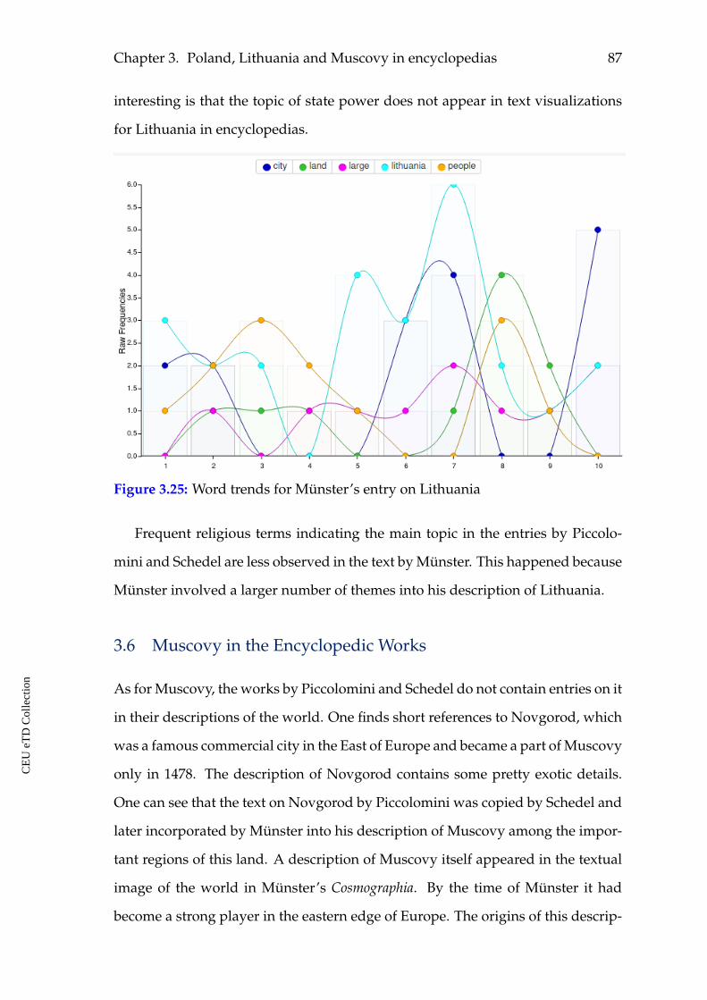
Chapter 3. Poland, Lithuania and Muscovy in encyclopedias 87
interesting is that the topic of state power does not appear in text visualizations
for Lithuania in encyclopedias.
Figure 3.25: Word trends for Münster’s entry on Lithuania
Frequent religious terms indicating the main topic in the entries by Piccolo-
mini and Schedel are less observed in the text by Münster. This happened because
Münster involved a larger number of themes into his description of Lithuania.
3.6 Muscovy in the Encyclopedic Works
As for Muscovy, the works by Piccolomini and Schedel do not contain entries on it
in their descriptions of the world. One finds short references to Novgorod, which
was a famous commercial city in the East of Europe and became a part of Muscovy
only in 1478. The description of Novgorod contains some pretty exotic details.
One can see that the text on Novgorod by Piccolomini was copied by Schedel and
later incorporated by Münster into his description of Muscovy among the impor-
tant regions of this land. A description of Muscovy itself appeared in the textual
image of the world in Münster’s Cosmographia. By the time of Münster it had
become a strong player in the eastern edge of Europe. The origins of this descrip-
CE
UeT
DC
olle
ctio
n
88
tion partly go back to the source, which appeared as a result of contacts between
Pope Clement VII and the prince of the Grand Duchy of Moscow. Pope Clement
VII was looking for alliances against Luther’s movement and sent an embassy to
Moscow. The embassy turned back without a result. Together with it, the Rus-
sian embassy of Dmitry Gerasimov came to Rome. Moscow avoided discussing
the matter of religious union. Paolo Giovio, a contemporary historian, talked
to Dmitry Gerasimov and made a detailed geographical account of Muscovy129
based on the letter’s description. A large part of Münster’s entry on Muscovy in
Cosmographia was borrowed from this source. Among other main sources, from
which Münster borrowed information was also Maciej Miechowita.130 The inter-
esting point about Münster is that, in comparison to Piccolomini and Schedel, he
had a few already existing, printed pieces of information on Muscovy at his dis-
posal. The origins of Münster’s text on Muscovy were rather well investigated in
scholarship, thus just his main sources are being mentioned here. One may notice
that Sebastian Münster composed his entry from pieces of information of different
origin. He did not write his own text based on obtained knowledge. He made a
kind of collage containing parts of different texts and did not structure them. The
same topics were sometimes repeated and the given facts at times contradicted
each other in his text.
3.6.1 Münster about Muscovy
In the first lines of his entry on Muscovy Münster says that this is a large country,
in which the royal town is called Moscow. It is situated at the river having the
same name. No one here uses silver. The title of king is hateful to people, therefore
their ruler more willingly accepts the title of duke, which is more popular. The
one who is ruling is called duke, he has power over all people of the country...
129 Paolo Giovio, Libellus de legatione Basilii magni principis Moschoviae ad Clementem VII (Basel,1527).
130 Maciej Miechowita, Tractatus de duabus Sarmatiis, Asiana et Europiana, et de contentis in eis (Cra-cow: Jo. Haller, 1517).
CE
UeT
DC
olle
ctio
n
Chapter 3. Poland, Lithuania and Muscovy in encyclopedias 89
People are prone to lust as well as drinking, the last they consider worth to praise,
the first is allowed unless it happens without any offense against the marriage. As
for the utmost of the faith they are following the Greeks, by ceremony in worship
and veneration of the saints. They practice agriculture in the town, plow with
horses, the soil is extremely fertile except for wine. They drink beer boiled from
millet, barley and hops, like almost all the north. This region raises different kinds
of animals, big part of them is famous for the value of the skins, fish is also in big
abundance there.131
From the depicted lines in the beginning of the entry one may see that Münster
introduced Muscovy as a large and rich country, but its people do not follow good
morals and the duke has power over all people there.
Now Muscovy is four hundred miles wide, rich in silver, strongly protected
from everywhere, that not only foreigners but also indigenous can not enter or
leave without a permission from the duke. The country is completely flat, not
mountainous, yet woody, and for the most part marshy, watered by many notable
rivers, like Occa, Volga, Dvina, Don and Dnieper, and for this reason it has very
much fish as well as many different wild animals, like Lithuania, from which it
does not differ that much, except that it is colder, because it is more to the North.132
As for the previously considered cases of Poland and Lithuania, one did not
read anything about crossing there borders. In case of Muscovy, the reference is
pretty clear and strong: there is a guided border around Muscovy and it is impos-
sible to just cross it without a permission. This is a totally new element in the im-
age of a considered area, it makes Muscovy different from the beginning. Besides,
in case of Poland and Lithuania the title of king was present in their representa-
tions, but in case of Muscovy it is said that this title is hateful in that country. This
is another element that makes this land different to European readers.
Moscow is the chief town of the region, twice as large as Prague in Bohemia, all
131 Münster Cosmographia universalis..., 910-911.
132 Ibid., 911.
CE
UeT
DC
olle
ctio
n
90
houses are built of wood, as well as other cities, has a lot of streets, but scattered
with vast plains of land, lying in between, and the river Moscow divides it. A
castle is located in the center of the town on the highest place. It has three defense
walls and seventeen towers, so beautiful and strong that one can hardly find such
elsewhere. At this place there are sixteen churches and three huge court build-
ings where the court nobles live. The palace, where the duke lives, is built in the
Italian style, it is extremely beautiful, but not big. The wine and the olive oil are
lacking. The leader of the country does not allow them to get drunk, he prohib-
ited any kind of spirits under the punishment of being beheaded, with exception
of two or three times a year when he permits them to consume such drink. They
have now silver moneta (name of the coins), big and small, not round, but of the
square shape and oblong. They speak Slavic language, although there are blends
of foreign languages, so that one Slav and one Muscovite do not understand each
other.133
Thus, the capital city is said to be beautiful. Münster again repeats about the
habit of drinking in Muscovy. It is also seen as a problem by the rulers of the
state, and it became necessary to prohibit it under the threat of persecution. Af-
ter that, Münster continues his story with telling about the climate, products of
agriculture, discusses numerous rivers and lakes which abound in fish, forests
which abound in wild animals, bears in particular. He also tells about difficulties
of travelling there as well as inside the country in winter, but also in other seasons.
A rather extended topic in his description is the one about bees, honey and
bears. It is said that their largest income consists of honey and wax. The coun-
try abounds in bees that store honey in large amounts in their hives, but also in
the holes of trees in forests. Very often they find hollow trees full of old honey
abandoned by bees who found a new place to live and store their honey. Thus,
people are not able to find all honey in forests. Sometimes, it is possible to find
lakes of honey in dense woods. This prolific land really produces a lot of honey.
133 Ibid.
CE
UeT
DC
olle
ctio
n
Chapter 3. Poland, Lithuania and Muscovy in encyclopedias 91
The theme of honey is connected to the stories about bears. The bears of Muscovy
are referred as being of extraordinary size, of dark color. He retells the story by
Dmitry Gerasimov, a Russian ambassador to Rome about a bear who came to a
tree to eat some honey. Before that a peasant fell into that tree hole and got stuck
to his chest in honey. He could not get out from there for long. When a bear
climbed down into the tree hole the peasant grabbed it and cried out loudly. The
bear got scared and rushed out the tree hole pulling out the man.134 After that he
presented a long story by Pliny and Aristotle on bears giving birth to their babies
and growing them during long cold winter. This story is followed with infor-
mation about precious furs, as object of commerce, Furs are discussed at several
points of the text.
Generally, Muscovy in Münster’s description provides an impression of a land
rich in natural resources. At the same time, at some points the description also
calls forth the images of new promised lands or contains the features of a terres-
trial paradise, like the story about honey abundance, honey lakes, hollow trees
full of honey. The search and the descriptions of remote lands as a kind of ter-
restrial Paradise were a spread practice already among the medieval authors.135
These places were drawn to have everything necessary for good living. The local
people there were often depicted as not able to use all the generous gifts of nature
and to cultivate the land in an appropriate way.
The idea that the terrestrial Paradise, created by the hands of God, still ex-
isted somewhere in the East was widely spread in the European Middle Ages.
Nobody knew where it was located, but the research into the contemporary car-
tography, particularly, demonstrates the attempts to locate the Garden of Eden in
the eastern, not well-known parts of the world.136 It was believed that the ter-
134 Ibid., 912
135 Arthur Percival Newton, Travel and Travellers of the Middle Ages, ed. (London: Routledge andKegan Paul, 1926): 163-164; Sabine Baring-Gould, Curious Myths of the Middle Ages, 2nd ed.(London: Rivingtons, 1868), 250-265, chapter on "The Terrestrial Paradise."
136 Alessandro Scafi, Mapping Paradise: A History of Heaven on Earth, (Chicago: University ofChicago Press, 2006); idem, Maps of Paradise (London: The British Library; Chicago: Univer-
CE
UeT
DC
olle
ctio
n
92
restrial Paradise would look like a place still untouched by humans, a place that
provided everything necessary for living in abundance. During the Renaissance
and in Early Modern time the identification of Earthly Paradise was transformed.
Gradually, a new idea that the terrestrial Garden of Eden disappeared because of
the human sin became prevailing and the search for its location stopped. In my
opinion, the traces of the terrestrial Paradise motifs are still to be found in some
way in Münster’s description of Muscovy. The more to the East, the higher the
possibilities were to find the remnants of an untouched Paradise-like nature.
It looks like Münster on purpose constructed such image of Muscovy. He was
rather well informed about the things in the region, his detailed entry on Poland
shows this. It is also known that he interrogated people coming from Muscovy.
Moreover, Münster met Sigmund von Herberstein in person and one may just
suppose that he hardly could withstand asking and discussing about this country
with the contemporary expert on Muscovite matters. Thus, we may suppose that
he obtained different kinds of information on this duchy, but for some reason
he wrote in his description mostly about its nature, natural resources, the goods
people got from nature and how they interacted with their natural environment.
One of the reasons here could have been his intention to fit to the requirements of
the genre: namely, that such a remote and not well known area at the edge of the
Europe needed to be drawn like that, like something wild and fertile. Quite often
Münster compared Muscovy to other lands of the north, most probably because
of the climate and difficult living conditions.
In comparison to Poland in Münster’s Cosmographia Muscovy provides a to-
tally different image. Poland is presented as a centralized political body, its dy-
nasty has a legitimate nature and history, it is "understandable" and looks familiar
to the Western reader. As for Muscovy, more than a half of the text offers informa-
tion on its natural environment, its natural products that can be gathered, hunted,
obtained, or produced, people trying to cope with nature. Namely, the text is more
sity of Chicago Press, 2013).
CE
UeT
DC
olle
ctio
n
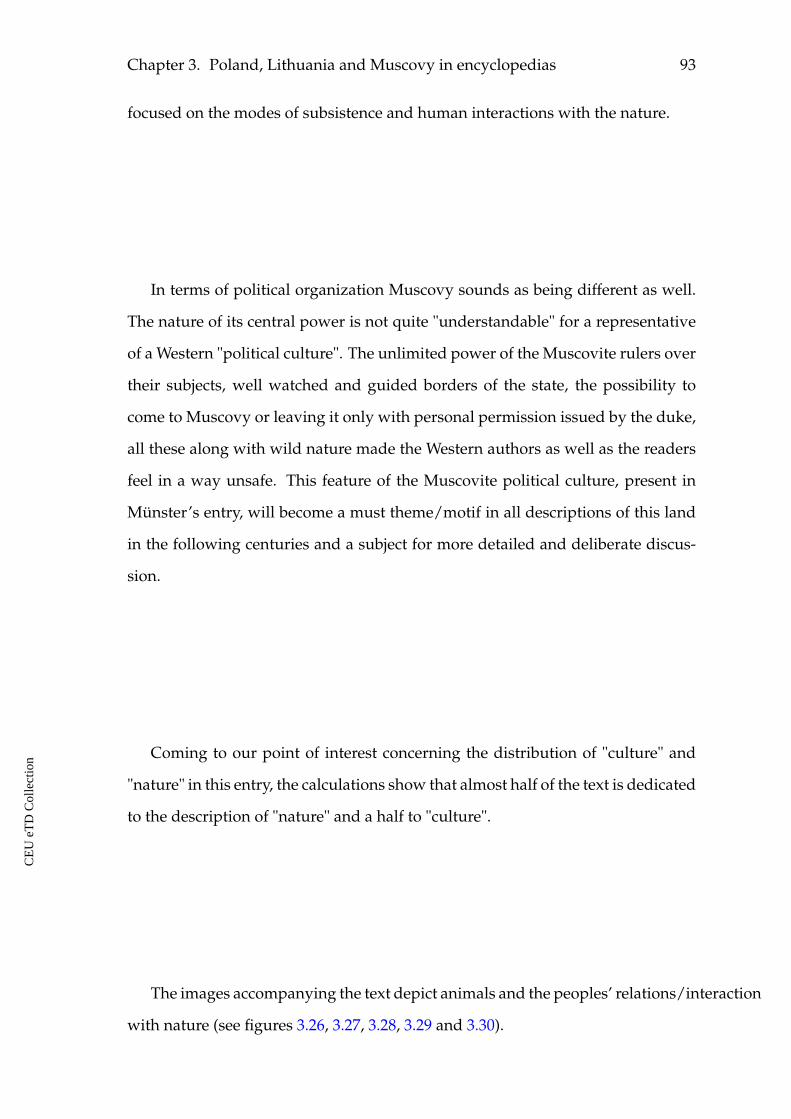
Chapter 3. Poland, Lithuania and Muscovy in encyclopedias 93
focused on the modes of subsistence and human interactions with the nature.
In terms of political organization Muscovy sounds as being different as well.
The nature of its central power is not quite "understandable" for a representative
of a Western "political culture". The unlimited power of the Muscovite rulers over
their subjects, well watched and guided borders of the state, the possibility to
come to Muscovy or leaving it only with personal permission issued by the duke,
all these along with wild nature made the Western authors as well as the readers
feel in a way unsafe. This feature of the Muscovite political culture, present in
Münster’s entry, will become a must theme/motif in all descriptions of this land
in the following centuries and a subject for more detailed and deliberate discus-
sion.
Coming to our point of interest concerning the distribution of "culture" and
"nature" in this entry, the calculations show that almost half of the text is dedicated
to the description of "nature" and a half to "culture".
The images accompanying the text depict animals and the peoples’ relations/interaction
with nature (see figures 3.26, 3.27, 3.28, 3.29 and 3.30).
CE
UeT
DC
olle
ctio
n
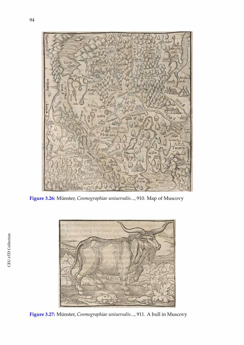
94
Figure 3.26: Münster, Cosmographiae uniuersalis..., 910. Map of Muscovy
Figure 3.27: Münster, Cosmographiae uniuersalis..., 911. A bull in Muscovy
CE
UeT
DC
olle
ctio
n
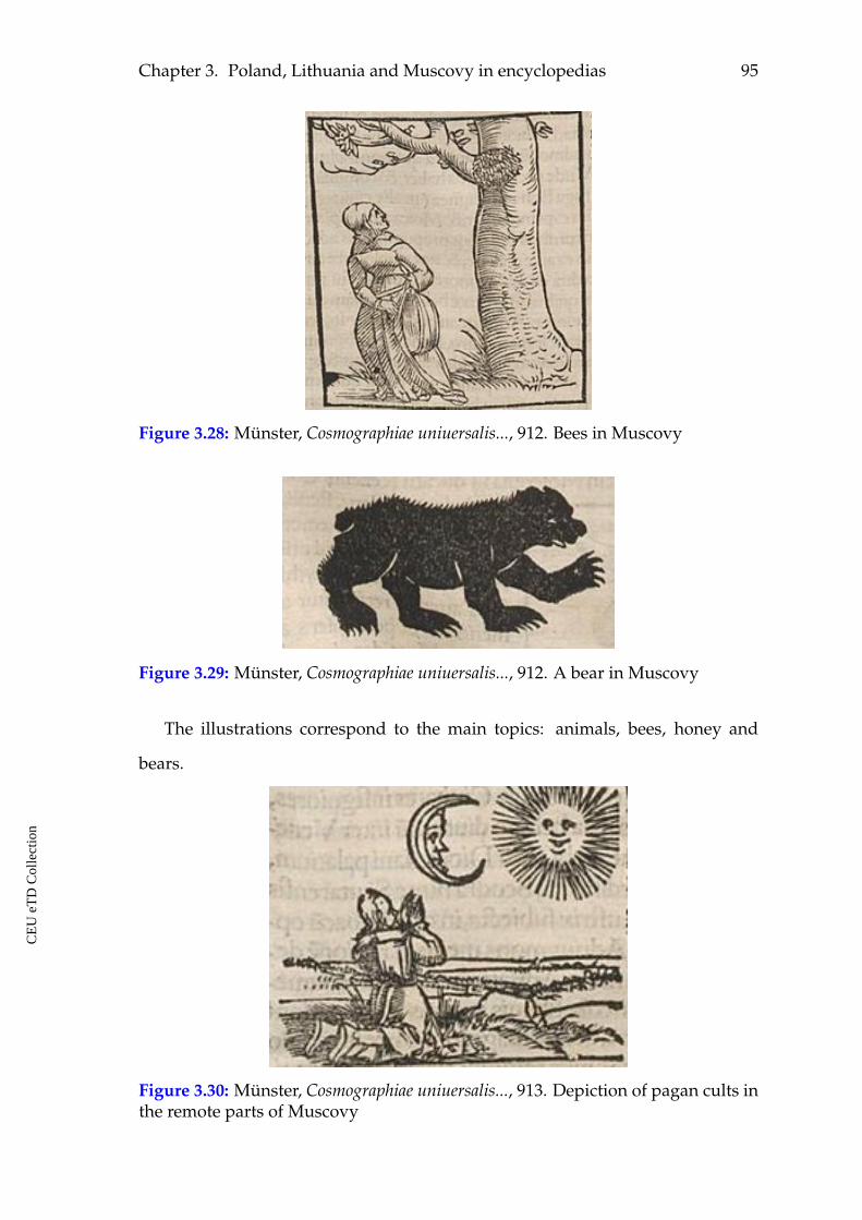
Chapter 3. Poland, Lithuania and Muscovy in encyclopedias 95
Figure 3.28: Münster, Cosmographiae uniuersalis..., 912. Bees in Muscovy
Figure 3.29: Münster, Cosmographiae uniuersalis..., 912. A bear in Muscovy
The illustrations correspond to the main topics: animals, bees, honey and
bears.
Figure 3.30: Münster, Cosmographiae uniuersalis..., 913. Depiction of pagan cults inthe remote parts of Muscovy
CE
UeT
DC
olle
ctio
n
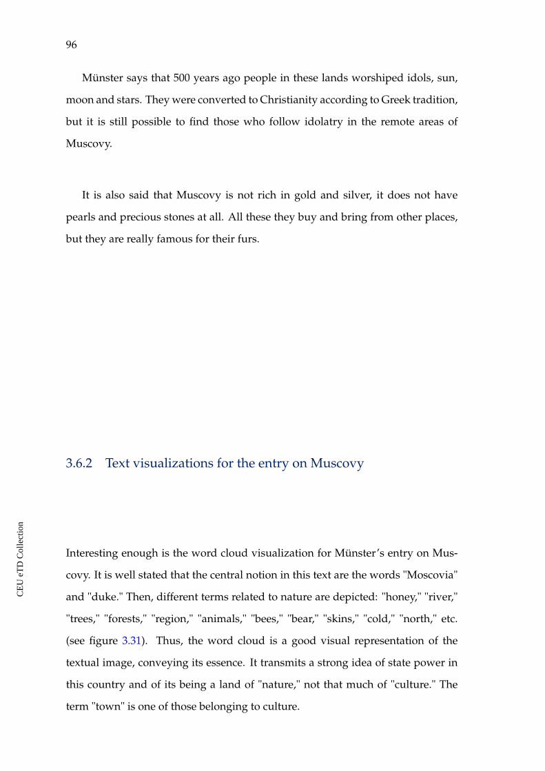
96
Münster says that 500 years ago people in these lands worshiped idols, sun,
moon and stars. They were converted to Christianity according to Greek tradition,
but it is still possible to find those who follow idolatry in the remote areas of
Muscovy.
It is also said that Muscovy is not rich in gold and silver, it does not have
pearls and precious stones at all. All these they buy and bring from other places,
but they are really famous for their furs.
3.6.2 Text visualizations for the entry on Muscovy
Interesting enough is the word cloud visualization for Münster’s entry on Mus-
covy. It is well stated that the central notion in this text are the words "Moscovia"
and "duke." Then, different terms related to nature are depicted: "honey," "river,"
"trees," "forests," "region," "animals," "bees," "bear," "skins," "cold," "north," etc.
(see figure 3.31). Thus, the word cloud is a good visual representation of the
textual image, conveying its essence. It transmits a strong idea of state power in
this country and of its being a land of "nature," not that much of "culture." The
term "town" is one of those belonging to culture.
CE
UeT
DC
olle
ctio
n
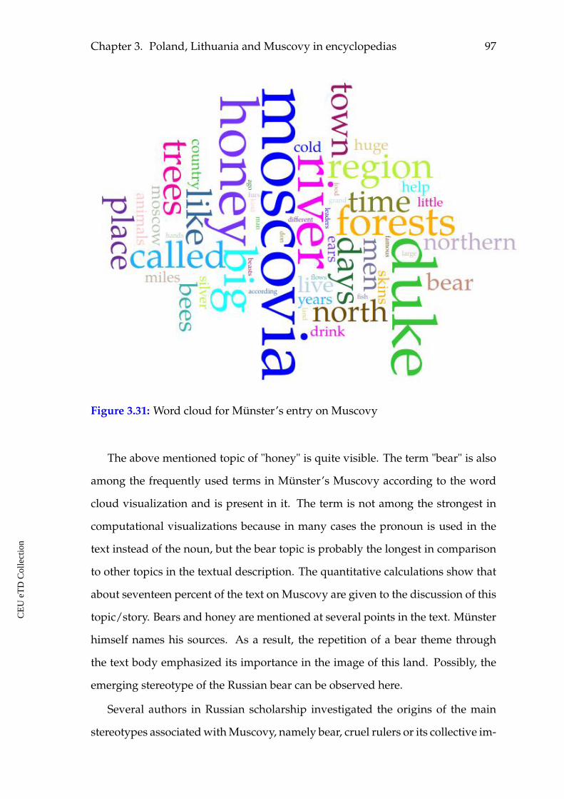
Chapter 3. Poland, Lithuania and Muscovy in encyclopedias 97
Figure 3.31: Word cloud for Münster’s entry on Muscovy
The above mentioned topic of "honey" is quite visible. The term "bear" is also
among the frequently used terms in Münster’s Muscovy according to the word
cloud visualization and is present in it. The term is not among the strongest in
computational visualizations because in many cases the pronoun is used in the
text instead of the noun, but the bear topic is probably the longest in comparison
to other topics in the textual description. The quantitative calculations show that
about seventeen percent of the text on Muscovy are given to the discussion of this
topic/story. Bears and honey are mentioned at several points in the text. Münster
himself names his sources. As a result, the repetition of a bear theme through
the text body emphasized its importance in the image of this land. Possibly, the
emerging stereotype of the Russian bear can be observed here.
Several authors in Russian scholarship investigated the origins of the main
stereotypes associated with Muscovy, namely bear, cruel rulers or its collective im-
CE
UeT
DC
olle
ctio
n
98
age.137 The article by Denis Hrustaliov particularly traced its formation through
the sources. The first half of the sixteenth century was the time when the descrip-
tions of Muscovy start to appear in the West. Bears were mentioned practically
in all of them, but those references did not have any political, stereotypic or stig-
matic character for the country. Inside of Muscovy such an attributive perception
of bears did not exist. The bear topic while talking about Muscovy and later about
Russia was a product of Western perception. In the beginning it was purely an at-
tribute of northern nature, an animal that inhabited those regions and was often
met there. Later, it obtained emotional, political, social and cultural dimensions
characterizing Muscovite civilization.
Münster’s text being partly a compilation of the previously existing sources
and oral interrogation would largely contribute to the formation of the bear topoi
concerning Muscovy. The popularity of Cosmographia and its scholastic authority
all around Europe would definitely help in circulating and in fixation of this bear
stereotype.
The term "like" needs paying a comment. It is well defined in the word cloud
and is used as a preposition in the text. This term is a sign that the author is
talking about something new and not well-known in the text. In order to make
things clearer for the reader he uses a lot of comparisons. For example, "their
drink is like...," "the buildings are like in ..." and so on.
The term "miles" is present in Münster’s entry on Muscovy, just like in his en-
try on Lithuania. It is not observed in case of other authors and not observed in
Münster’s entry on Poland. As I have already mentioned, by giving distances be-
tween the described settlements in Muscovy and Lithuania Münster introduced
unknown or not well known places in his work. This also indicates him using eye-
witness sources. He reports rather long distances in case of Muscovy, for example,
the city of Ustyug is 600 miles far from Moscow.
137 Alexander Filiushkin, "Kak Rossija stala dlja Evropy Asiej?" (How Russia Became Asia for Eu-rope?), Ab Imperio 1 (2004): 191-228; Denis Hrustaliov, "Proishozdenie "russkogo medvedia""(The Origins of the "Russian Bear"), Novoe Literaturnoe Obozrenie 107, (2011): 137-152.
CE
UeT
DC
olle
ctio
n
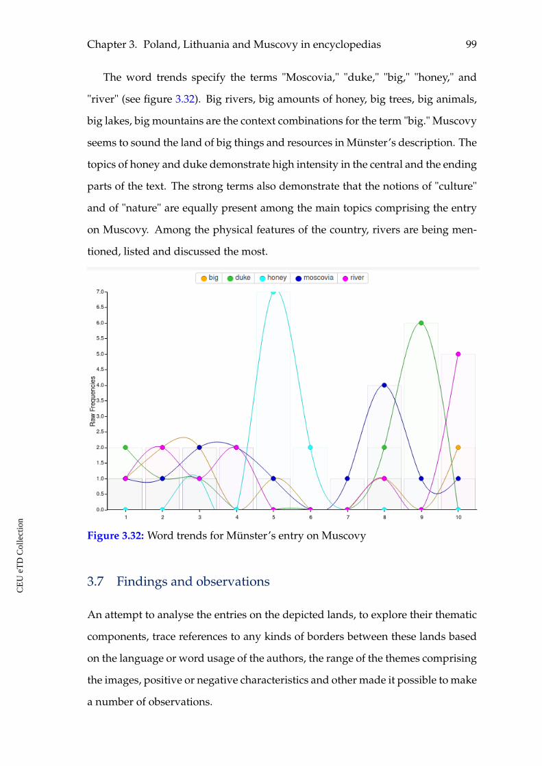
Chapter 3. Poland, Lithuania and Muscovy in encyclopedias 99
The word trends specify the terms "Moscovia," "duke," "big," "honey," and
"river" (see figure 3.32). Big rivers, big amounts of honey, big trees, big animals,
big lakes, big mountains are the context combinations for the term "big." Muscovy
seems to sound the land of big things and resources in Münster’s description. The
topics of honey and duke demonstrate high intensity in the central and the ending
parts of the text. The strong terms also demonstrate that the notions of "culture"
and of "nature" are equally present among the main topics comprising the entry
on Muscovy. Among the physical features of the country, rivers are being men-
tioned, listed and discussed the most.
Figure 3.32: Word trends for Münster’s entry on Muscovy
3.7 Findings and observations
An attempt to analyse the entries on the depicted lands, to explore their thematic
components, trace references to any kinds of borders between these lands based
on the language or word usage of the authors, the range of the themes comprising
the images, positive or negative characteristics and other made it possible to make
a number of observations.
CE
UeT
DC
olle
ctio
n
100
When moving through the research area from Poland to Lithuania and then
to Muscovy as described in the encyclopedic collections, it is noticeable that the
authors provide the reader with more and more information on "nature" and less
on "culture".
The theme of "culture" is larger in Poland than the theme of "nature." In Mus-
covy the picture is opposite. Based on the considered sources it is possible to sup-
pose that this has its meaning and can be explained from the perspective of the
general structure of these works and of the genre. The description of the world
can be seen in these collections as a world textual map. Thus, the phenomena
which were known and considered as familiar, like: climate, nature, landscape,
in some parts of the world may not be paid attention to and not described. To
the contrary, for those places which were not well known, it would be important
to speak in more detail about their climate, nature, or landscape, for example.
On the other hand, the natural environment could be really different, as a result
discussed in more detail.
The study of the content of the three sources containing entries on Poland,
Lithuania and Muscovy shows that these lands represent regions of gradually
growing reference to uncultivated nature regarding time and space. When textu-
ally proceeding from Poland to Lithuania and at last to Muscovy, the feelings of
moving towards the more and more uncultivated, wild, exotic and sparsely pop-
ulated edges of the continent are getting stronger and stronger. The countries in
the East of Europe are gradually presented as still being close to "nature," or they
are at least preserving some space of nature, which needs to be cultivated, or is
waiting for those who can come and cultivate it. Lithuania and Muscovy, how-
ever, represent different cases of being uncultivated: the first one needed to be
cultivated in religious meaning mostly, the second one less, but mainly its nature
sounded like unappropriated, uncultivated, and offering many natural goods.
Another characteristic feature for the genre of encyclopedias was a special dis-
course on the edges or margins of the inhabited world, which was borrowed by
CE
UeT
DC
olle
ctio
n
Chapter 3. Poland, Lithuania and Muscovy in encyclopedias 101
the Renaissance authors from the ancient Greek tradition. One of the attributes of
this discourse is the presence of something exotic, unbelievable about the lands
or people who lived in the edges, or close to the edges of the world. It is hard
to definitely say how far the geographical knowledge of Europeans reached to
the East of Europe, but it was pretty limited and there was no certain opinion
where the eastern border of Europe was located. The considered descriptions of
Poland, Lithuania and Muscovy thus demonstrate that the created images were
getting more and more strange, exotic and different while moving towards the
edges. The comparative analysis shows that content of the entries on the three
depicted lands represented gradual shifting towards the eastern edge of the con-
tinent and their images corresponded to the existing beliefs concerning the edges.
I also suggest that the content of the descriptions was influenced and determined
by the location of each country in the constructed by authors image of the world.
The main observations and conclusions to support this general statement are the
following:
ã The borrowings among the authors and the communication of sources while
creating the images of Poland, Lithuania and Muscovy. This witnesses long-
distance networking of knowledge in Western Europe and the still present
tradition of following authorities.
ã The main topics that comprised images of the depicted eastern lands are,
in different degrees: rulers and political culture, religion, nature, climate,
goods, food and drinks, people and their traditions, descriptions of settle-
ments, natural resources, exotic things. These were the main criteria of eval-
uating "other" lands in that historical period and they demonstrate what was
important while writing about them.
ã The interplay of the topics, focused on "culture" or "nature," resulted in dif-
ferent representations of the depicted lands. This also found its expression
in illustrations to the texts on Poland, Lithuania and Muscovy in Münster’s
CE
UeT
DC
olle
ctio
n
102
Cosmographia. Poland has more illustrations that are not "nature." More il-
lustrations of "nature" are found in the entry on Lithuania. All the visual
images in the entry for Muscovy belong to "nature" and its map has a strong
message of a country covered by forests.
ã Poland is gradually being described as "culture," the motif of "nature" totally
disappeared by the end of the period in its image. Nevertheless, some exotic
element remained in it. It was expressed through the images of the Krakow
monster and the Krakow monster child in Münster’s Cosmographia.
ã Lithuania as well as Muscovy are depicted as large, uncultivated, wooded,
wild, sparsely populated places. In medieval geographical culture, this kind
of uncultivated and wooded landscape is opposed by cultivated, built, in-
habited and urbanized landscape, the world of people who lived in large
groups and populated areas is opposed to the world of those who lived in
"solitude." The opposition is expressed by the contrasting notions of "cul-
ture" and "nature."
ã The descriptions of Lithuania do not demonstrate much dynamics of its im-
age concerning religion through the period. It was mainly associated with
its pagan cults. This topic is emphasised in Piccolomini’s entry particularly.
The theme of cruel rulers and their pet bears is emphasised in Schedel’s
entry on Lithuania thanks to his shortenings of Piccolomini’s text as well.
Sebastian Münster offered new information on Lithuania, its administrative
division, towns, rivers, ethnic groups, languages, and other. This found
its reflection in slight growing tendency towards the terms of "culture" ob-
served both in the text and in text visualizations for his entry.
ã Muscovy is described mostly as "nature" with a Paradise-like motif and in-
dication to centralized power at the same time. The Paradise-like motif and
the extended references to its natural goods and resources may also demon-
strate attempts to textually incorporate Muscovy into the emerging world
CE
UeT
DC
olle
ctio
n
Chapter 3. Poland, Lithuania and Muscovy in encyclopedias 103
market economy context.
ã This motif is to some extent present in the texts about Lithuania as well.
It also seems to have awaited better domestication and cultivation. There,
however, it was the hostile, pagan space that wanted to be converted into a
safe and Christianized land.
ã The entries on Lithuania also demonstrate that the knowledge about the
country was limited in the West and the texts did not give understandable
information on its ethnic, religious, linguistic diversity. The larger part of the
description of Lithuania was dedicated to the pagan religion and the mission
of Jerome of Prague to Lithuania. This meaningful and strong message for
a Western reader was attributed to the whole country. At the same time the
size of the country was not communicated well.
ã There are reasons to suppose that the main topoi for Lithuania find their
roots in the rhetoric of the period of Christianization in the eastern Baltic
region, namely, in the first quarter of the thirteenth century.
ã Forests and marshes to which the authors refer in all sources about Lithuania
and particularly about Muscovy are not just the signs of wild and unculti-
vated landscape. In the Middle Ages they were significant physical internal
frontiers or borders inside Europe. They kept the depicted region difficult
to access and to contact with, as well as difficult to capture.
ã The word cloud visualizations of the considered entries on Poland, Lithua-
nia and Muscovy allowed to generate their terminological images. The ob-
tained visualizations for entries on Poland depicted terms that character-
ize culture as prevailing in the text, namely, political culture and history.
As for Lithuania, the central topics in its early description by Piccolomini
and Schedel depicted by the word clouds are its people, their religion and
Jerome’s of Prague mission. Both terms of culture and nature are present
CE
UeT
DC
olle
ctio
n
104
in visualization. In case of Münster’s entry, its word cloud demonstrates
again presence of both groups of terms, but the terms of culture get stronger
and the terms of nature are less than in visualizations of earlier descriptions.
The word cloud for Münster’s entry on Muscovy depicted among the strong
terms those of culture as well as of nature. The terms of state and of state
power: "duke" and "Moscovia" are dominating on numerous terms of nature
in this visualization.
ã In spite of the fact that observed comprising topics for Poland, Lithuania and
Muscovy in encyclopedias are similar: state power, religion, goods, people
and their activities, nature and natural products, the word trends visual-
izations provided different accents for the considered entries and countries.
In case of Poland, the terms of political power and political content are the
strongest in this kind of visualizations. As for Lithuania, the term "people"
along with the terms of religious cults are among the strongest in early en-
tries. In Münster’s entry on Lithuania one observes the terms like: "Lithua-
nia," "people," "large," and "land." At the same time, a strong element of
culture is entering its image with a term "city." Word trends for the entries
on Lithuania do not depict political content as in case of Poland. Finally, the
word cloud for Münster’s entry on Muscovy demonstrates mixture of terms
belonging to political content: "Moscovia" and "duke," but also belonging to
nature: "honey" and "river."
ã The observed presence of the term "miles" in visualizations for Münster’s
entries on Lithuania and Muscovy indicates that the author is describing
places which were not well described before. The usage of this term can
also be seen as a sign that demarcates the border between the known and
not that well known places in the east of Europe. In this particular case, the
border went between Poland, on the one hand, and Lithuania and Muscovy,
on the other.
CE
UeT
DC
olle
ctio
n
Chapter 3. Poland, Lithuania and Muscovy in encyclopedias 105
ã The available descriptions of rulers and references to political power in the
considered cases made it possible to see that they are referred in positive and
advantageous terms in Poland. As for Lithuania, its rulers in Piccolomini’s
work are rather terrifying. In Muscovy, few references to the duke’s power
convey messages of a strong centralized authority. In this sense, it is possible
to say that Poland was more friendly to the European audiences than the
other two. The nature of state powers in the considered region may also
demarcate, characterize a kind of division, a border. The guided border of
the Muscovite state is another frontier observed.
ã Sebastian Münster employs different narration techniques in his work, namely:
textual, maps and images. In this respect his source is more informative and
expressive.
CE
UeT
DC
olle
ctio
n
CHAPTER 4
Poland, Lithuania and Muscovy in
travelers’ accounts
4.1 Travel narratives
At the depicted period, travel was not recreation. As a rule, travel was done for a
certain professional or religious purpose: may it be commerce, military campaign,
diplomatic mission or pilgrimage, and not for pleasure. Often, it was arduous and
dangerous, the conditions were extremely uncomfortable at times. Besides, it was
costly, risky for sickness and hostility.
Leaving for a distant trip, travelers were usually isolated from their home com-
munities, from their common lifestyle during long periods. They could communi-
cate with the homeland with the help of letters, sent with strangers. Those letters
were often lost on the way and in many cases would never reach the recipient.
These conditions would probably contribute to the travelers’ sense of otherness
and foreignness in places they were visiting. Thus, a travel was an emotional
experience and travelers always were bringing stories back home. There was a
tradition of keeping travel notes too. Those writings offer a context of the travel-
ers’ own language, notions, topics, expectations and focus with the exploration of
the "other."
What distinguishes the travel accounts at the depicted period of the Renais-
sance and the sixteenth century from the ones from before is that more and more
106
CE
UeT
DC
olle
ctio
n
Chapter 4. Poland, Lithuania and Muscovy in travelers’ accounts 107
factual data and elements were entering the texts. The texts of this period still
contained references on exotic marvels and monsters, but the authors were turn-
ing away from those motives more and more. Practical geographical information,
climate conditions, survival tips, travel instructions, listings of local goods, de-
scriptions of foreign religions and traditions, politics, morals, personal feelings,
emotions, etc. comprised these writings and occupied the authors and their audi-
ences.
Three of the selected travel narratives on Poland, Lithuania and Muscovy are
diaries. The most important criterion about this kinds of writings is an eye-
witness story. One of them, namely by Sigismund Herberstein, is an extended
report on his diplomatic visits to Muscovy in which together with notes of his
personal experiences many other sources of information were incorporated. The
term of "travel narratives" unites these sources.
Each of the selected sources contains descriptions of two or all the three lands.
As it was already observed while analyzing the entries in the encyclopedic collec-
tions, the images of Poland, Lithuania and Muscovy differ from each other to a
large extent. Those were the "scientific" descriptions of the lands affected by the
requirements of the genre. In this part of my study, I am interested to see which
images eye-witnesses created of these lands and in what way they differ from
each other. I will also try to depict possible references to any kinds of borders de-
marcated by language or described by the authors. I am interested to see to what
extent these borders demarcate coming to a different reality, to a different culture.
I will also try to find out what was important for the authors to tell about and
whether the thematic range in the stories is similar or different. Are the images
"positive" or "negative"? Can we find references to emotions of people and what
they are?
CE
UeT
DC
olle
ctio
n
108
The Authors
Among the authors, who left accounts of their visiting the research area were
a Flemish military man and diplomat, Gilbert de Lannoy; the Italian diplomat
Ambrogio Contarini and the Italian merchant and diplomat Giosafa Barbaro; and
finally a diplomat and historian of the Holy Roman Empire, Sigismund von Her-
berstein. Chronologically their visits are dated as following:
ã Gilbert de Lannoy, diary of his first trip to the eastern lands of Europe, 1413-
1414;
ã Josafa Barbaro, diary of his diplomatic mission to Persia, 1473;
ã Ambrogio Contarini, diary of his diplomatic mission to Persia 1474-1477;
ã Sigismund von Herberstein, an extended diplomatic report on Muscovy,
visited in 1517 and 1526.
Gilbert de Lannoy was chronologically the first from the period who trav-
eled to Lithuania, Poland and as far as Novgorod and left a diary of his trip. In
the thirteenth century, the lands of Prussia and Livonia became the beachhead
for the Christian mission in the eastern Baltic region that belonged by that time
to the Teutonic Order. Besides the Knights of the Teutonic Order, many others
from all over Christian Europe came to that region to fight the pagans. One such
“adventurous” knight was Gilbert de Lannoy. He was born in 1386 to a noble
Flemish family. From the age of thirteen, he led a knight’s life. He took part in
tournaments, fought the pagans during the crusades and traveled a lot. Besides
for his warrior’s skills he was recognized as a diplomat, and different European
rulers sent him with missions to other countries. He visited France, Spain, Eng-
land, Prussia, Livonia, Greece, Turkey, Egypt, Syria, and Palestine. His two trips
to the lands of Rus’, Lithuania and Poland are of particular interest for this in-
vestigation. The first time he went there in 1413 to participate in the campaign
by Grandmaster Henry von Plauen on the seaboard of Poland. The campaign
CE
UeT
DC
olle
ctio
n
Chapter 4. Poland, Lithuania and Muscovy in travelers’ accounts 109
was not successful, however, because of problems with the Holy See; Henry von
Plauen was dismissed from his post and de Lannoy went on to Livonia. He did
not find the opportunity to fight there and the trip turned out to be more a kind
of an adventurous journey. His route led through Novgorod, Pskov, Duneburg
(Nevhin/Nevgin – a town in Livonia at the Western Dvina River), Vilna (Vilnius),
Troki (Trakai), Kovno (Kaunas), and Mamel (Memmel; modern Klaipeda).). He
also met the Lithuanian Grand Duke Vitovt. Because of his experiences and for
the reason that he met the grand duke personally, the French King Charles IV and
the English King Henry V sent him with missions to eastern rulers: to the Polish
King Jogailo, the Lithuanian Duke Vitovt and the Byzantine Emperor Manuel II
in 1421. De Lannoy met Vitovt in Kamenets and became a witness of the latter
receiving missions from Pskov and Novgorod. Then, after getting precious gifts,
safety conducts, and some errands to the Tartar khan, he continued on his way to
Constantinople through Moldavia and the Crimea.
The aim of the mission was the idea of creating a strong and wide coalition
with England at the head for a crusade against the Ottomans. Thanks to his ac-
counts one has a chance to learn about the details of that trip. He created his
accounts probably after returning home and using the notes he had made while
traveling. His notes became well-known in Western Europe and were cited in
parts or as a whole in various manuscripts.138 The diary itself was first published
in 1840.139 In spite of the fact that his accounts were not that extensive, they com-
municated a lot about what was new for the author and about his attitude to the
things he saw and experienced while traveling. As it was one of the rare writings
of this kind at the beginning of the fifteenth century, it was full of new information
for a contemporary reader. De Lannoy passed through Lithuania.
Another fifteenth-century author who wrote about Lithuania in his accounts
138 Petras Klimas, Gillebert de Lannoy in Medieval Lithuania (New York: The Lithuanian-AmericanInformation Center, 1945), 20-24.
139 Guillebert de Lannoy, Voyages et ambassades de messire Guillebert de Lannoy, 1399-1450 (Mons:Hoyois, 1840).
CE
UeT
DC
olle
ctio
n
110
was Ambrogio Contarini, a representative of one of the oldest noble families in
Venice.140 He was sent with a diplomatic mission to Persia and returned back
from that trip through Moscow, Lithuania and Poland in April 1477. In 1487,
his accounts were published under the title: Questo e el Viazo di misier Ambrosio
Contarin, ambasador de la Illustrissima Signoria de Venesia al signer Uxuncassam re de
Persia.141
Josafa Barbaro was a Venetian merchant, diplomat, and statesman. In the
early period of his career, in 1436, he came to the Venetian colony of Tana and
spent there sixteen years.142 He had a long political career and served Venice in
different positions in Dalmatia, Albania, made numerous trips and diplomatic
missions. In the 1480s, he arranged his accounts of travels to Tana and Persia.
They were published in 1543.143
Sigmund von Herberstein144 was born 1486 in Vipava (German: Wippach) in
the region of Carniola (Krain), modern Slovenia, to a wealthy German family. Not
much is known from his early life, but it was important for his future that from
childhood he became familiar with the Slovene language spoken in the region. In
1499 he entered the University of Vienna to study philosophy and law and at the
age of 16 he got his bachelor’s degree. In 1506, he entered the army and started
his service for the Habsburgs. He took part in a number of military campaigns
and in 1508 was knighted by Emperor Maximilian I. Maximilian perceived in him
140 Nicolò di Lenna, Ambrogio Contarini, Politico e viaggiatore Veneziano del secolo XV (Padua: LuigiPenada, 1921); Marica Milanesi, "Contarini, Ambrogio," in Dizionario Biografico degli Italiani,vol.28 (Rome: Treccani, 1983), 97-100.
141 Ambrogio Contarini, Viaggio al signor Usun Hassan re di Persia (Venice: Annibale Fossi, 1487).
142 Angelo Ventura, “Giosafat Barbaro,” in Dizionario biografico degli Italiani, vol. 6 (Rome: Trec-cani, 1964), 106-13; Ugo Tucci, “I viaggi di Giosafat Barbaro mercante e uomo politico,” inUna famiglia veneziana nella storia: i Barbaro, ed. Michela Marangoni and Manlio Pastore Stoc-chi (Venice: Istituto Veneto di Scienze, Lettere ed Arti, 1996), 117-32.
143 Giosafat Barbaro, Viaggi fatti da Venezia, alla Tana, in Persia, India, e Costantinopoli,... (Venice:Aldus Manutius, 1543-1545).
144 For recent research on Sigmund von Herberstein’s personality and his contribution to theknowledge about Muscovy and the image of Muscovy at his time see: Frank Kämpfer, Rein-hard Frötschner, eds., 450 Jahre Sigismunds von Herbersteins «Rerum Moscoviticarum Commen-tarii», 1549-1999, Schriften zur Geistesgeschichte des östlichen Europa, vol. 24 (Wiesbaden:Harrassowitz, 2002).
CE
UeT
DC
olle
ctio
n

Chapter 4. Poland, Lithuania and Muscovy in travelers’ accounts 111
not only a good warrior, but also a clever and prudent politician. Thus, in 1515, he
became a member of the imperial council and changed from a soldier to a diplo-
mat. Between 1515 and 1553, Herberstein undertook about 69 missions abroad,
traveling throughout much of Europe. He even went to Turkey, where he talked
to Suleiman the Great. His trips to Russia as an Austrian ambassador were one of
the most important experiences for him and brought him great fame. He under-
took two diplomatic journeys to Russia – in 1517 and in 1526. The first one was an
attempt to arrange a truce between Russia and Lithuania, the second one was to
renew a treaty between those countries signed in 1522. The visits were long and
provided him with the chance to study a society relatively unknown for Western
Europeans. Herberstein’s knowledge of Slovene allowed him to communicate
easily with the Russians and other Slav peoples. That was an advantage, which
let him penetrate into many aspects of life there not only through communicat-
ing with locals, but also through examining the existing literature on Russia. The
result was his Rerum Moscovitarum Commentarii, published in 1549. But the first
edition was not a successful enterprise, Herberstein corrected it and the following
Latin edition appeared in 1551.145 It became the main early source of information
about history, geography, religion, customs, administration and other things in
Russia for Western Europe. One of the chapters in this writing is also dedicated
to Lithuania and called "About Lithuania."
4.2 Gilbert de Lannoy in the eastern lands of Europe
One of the first descriptions of the depicted region by a traveler from the research
period was composed by Gilbert de Lannoy. He wrote a diary of his visits to the
eastern parts of Europe, namely, the lands of the Russian duchies of Novgorod
and Pskov, the northern regions of Lithuania and Poland. These were areas not
equally known for Western travelers. Poland had been officially converted to
145 Sigmund Freiherr von Herberstein, Rerum Moscovitarum Commentarii... (Basel: Joannes Opor-inus, 1551.)
CE
UeT
DC
olle
ctio
n
112
the Christian faith in 966 and was in constant political and ecclesiastical contact
with the Western European courts. It was more familiar in this respect. As for
Lithuania, it was a more unknown region. In the fifteenth and sixteenth centuries,
the lands of the Polish kingdom and the Grand Duchy of Lithuania were joined
first in political union (1386) and later in a commonwealth (1569). The fact that
by the time of formation of the Polish-Lithuanian union the Lithuanian ruler and
population in some areas of the country remained pagan also witnesses the lack
of contact with and influence from the rest of Europe. At the same time, one
should remember that the major part of the Grand Duchy of Lithuania adopted
Eastern Orthodoxy since the times of Kievan Rus’. The formation of the dynastic
union and the Christian baptism of Jogaila in 1386, was one of the central topics in
the entries about Poland and Lithuania in world geographies and cosmographies.
This event attracted interest of all authors. When Gilbert de Lannoy visited these
lands, he was one of the first eye-witnesses who made notes of visiting them.
As Oscar Halecki demonstrated in his article, Gilbert de Lannoy’s contribution
to the discovery and introduction of Lithuania and Poland in the examined period
was not that much thanks to his diary, but to his personal opinion dispatched to
the Western European rulers as a result of his diplomatic missions.146
Particularly interesting for the present work are his descriptions made in 1413
as a crusader and private traveler. All travel accounts describing the trips to our
region start from a narration on how hard the travel conditions were. De Lannoy’s
first journey is of particular importance, as he undertook it by his own curiosity
and desire to see new things, a pretty rare motive for that period. His diary on the
first trip to the lands of Poland, Lithuania and the Russian duchies of Pskov and
Novgorod contains his personal observations. The second trip to Lithuania and
Poland, in 1421, he made as a diplomat sent by the courts of France and England.
There is just a short note concerning where and when he met this or that ruler
and what gifts and which papers were dispatched. In this respect, that note in the
146 Oscar Halecki, “Gilbert de Lannoy and his discovery of East Central Europe,” Bulletin of thePolish Institute of Arts and Sciences in America 2, no.2 (1944): 314-331.
CE
UeT
DC
olle
ctio
n
Chapter 4. Poland, Lithuania and Muscovy in travelers’ accounts 113
diary does not provide information for analysing images of the depicted lands.
In March 1412, as he wrote in his diary, he left Flanders and went to Prussia,
from there to Novgorod, and on his way back he passed through Lithuania. As
he mentioned in his diary, he was travelling to those lands as a merchant, most
probably in a company of other merchants. The route of his trip in 1413 is depicted
in figure 4.1.147
147 Inner side of the book cover Guillebert de Lannoy, Cesty a Poselstva [Journeys and messages].Trans. Jaroslav Svátek, ed. idem, Martin Nejedlý, Olivier Marin and Pavel Soukup. (Prague:Scriptorium, 2009).
CE
UeT
DC
olle
ctio
n
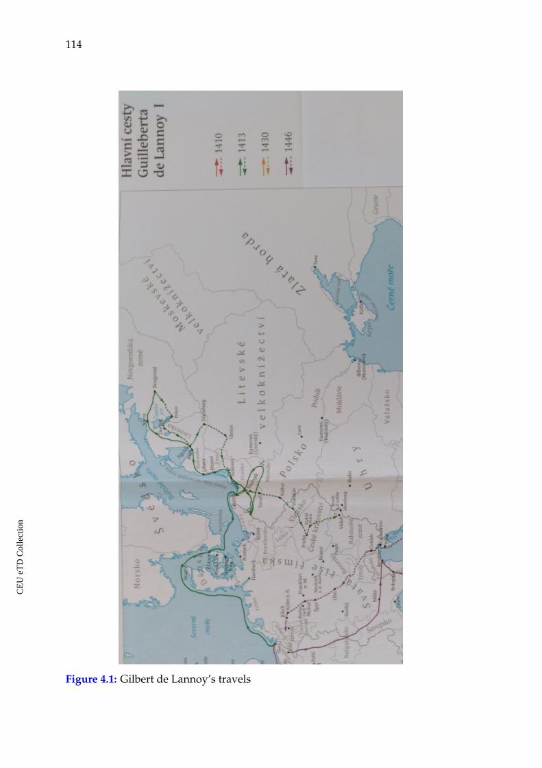
114
Figure 4.1: Gilbert de Lannoy’s travels
CE
UeT
DC
olle
ctio
n
Chapter 4. Poland, Lithuania and Muscovy in travelers’ accounts 115
His vocabulary and the content of the notes vividly reflect his predisposition
to certain topics and themes in the description. This can be well observed while
following him through the narration about passing through the different coun-
tries. Being a knight, he mostly paid attention to how well fortified the towns
were, how strong the walls, what the building materials were, etc.
His way from Flanders first led through Denmark, were he saw among others
the "very beautiful castle of Helsembourg."148 He went through Roskilde "from
there to Rainsted, a good town...; from there to Nestwed, a good town..." Then
he visited Danzig, "Melumghe, a very beautiful town ... From Melumghe, hav-
ing passed through a splendid land I came to Keuniczeberghe... "149 From Prussia
he went to Samogitia. As soon as he had left Prussia and started talking about
Samogitia, the tone of his expressions changed from admiration for the land-
scape and places to more restricted expressions and even very negative ones. He
stopped using expressions like: "a good...," or "a very beautiful... " Instead, he
wrote: "...then one enters the land of Samogitia; but one can travel for as long as
12 leagues in deserted area, without meeting a single sign of human settlement ..."
From Samogitia he went to Riga and from there to Novgorod. The trip was hard
and it was winter, which was the best time to travel there, because all the waters
were frozen and this way it was possible to move rather quickly. According to his
report, Novgorod was a very large city surrounded by vast forests. The city walls
were bad, made of wattle and clay. People were Christians and they followed the
Greek rite.150
He spent nine days in Novgorod, met with the officials there, who invited him
for dinner. Thus, he could receive some basic information about life there. He
wrote that the city had its own elected government, its bishop and many noble
men called boyars. The money used in Novgorod were pieces of silver, no minted
148 V. Emelyanov, "Puteshestvija Gillbera de Lannoa v vostochnye zemli Evropy v 1413-14 i 1421godah" (Travels by Gilbert de Lannoy to the Eastern Lands of Europe in the years 1413-14 and1421), Universitetskie izvestija (Kiev, 1873): 17.
149 Ibid., 19.
150 Ibid., 21-23.
CE
UeT
DC
olle
ctio
n
116
coins or golden coins were used there. He mentioned also that they were selling
frozen meat and fish in winter in the Novgorod market.151
De Lannoy also reported that they had a market in Novgorod, where they sold
and bought wives for themselves, and they bought them one after the other for
a piece of silver or two.152 This statement does not have proof in local historical
sources from the period. At the same time, there was a tradition of paying for
a bride. De Lannoy could most probably have heard of something like this, but
interpreted it in his own way. Besides, very often they called a young man, who
wanted to get married a "merchant" ("kupiets" in Russian) and the bride before she
accepted to get married a "merchandise" ("tovar"). These local marriage traditions
were pretty exotic for him in the way he understood them. It is hard to know what
kind of translation he had at his conversations in Novgorod.
He made a note about extremely cold weather in winter there. While writing
about it he mentioned a few examples that he called wonders. Once he tried to
boil water at a stop in forests. A pot filled with snow was put in fire and the
water started boiling from one side of the pot, but on the other side it remained
frozen. One of the wonders produced by the cold was that, as they moved through
the forests, it was possible to hear the trees crack and split from top to bottom
because of the frost. Another wonder was that if they happened to sleep outside,
the travelers could not open their eyes in the morning because their eyelashes,
eyebrows and beard were covered by ice produced by breathing.153
After Novgorod he visited another large city, Pskov. In order to go there he
travelled through huge forests for thirty German miles. The city is reported to be
fortified by stone walls and towers. There was a large castle and strangers were
not allowed to get in it. The city is said to have an elected government, but being
a vassal of Muscovy.154
151 Ibid., 24.
152 Ibid.
153 Ibid., 26
154 Ibid., 27
CE
UeT
DC
olle
ctio
n
Chapter 4. Poland, Lithuania and Muscovy in travelers’ accounts 117
Then he left Pskov and traveled for four days and nights without seeing a
sign of human settlement. Finally, he came to Derpt, "a very beautiful and a well-
fortified city.” As soon as he had left the lands of Rus’ and entered Livonia his tone
changed and again he started speaking in favorable manner using characteristics
like "a very beautiful." From there he decided to visit Lithuania and meet Duke
Vitovt. According to de Lannoy, from the very beginning when he entered Lithua-
nia, it was "...mostly desolate and had many lakes and large rivers... I entered a
large and uninhabited wood in the Lithuanian state, I traveled for two days and
two nights without finding a single settlement, I also crossed seven or eight large
frozen lakes on ice."155
While staying in Lithuania, he pointed out that the main town there was Vilna,
"where there is a castle, situated high up the sand hill with a fence made of stone,
soil, and bricks, but inside it is all built of wood... The town (itself) is not sur-
rounded by walls... very poorly settled with wooden houses. There is not a single
stone church in it."156 He mentions that people in that land were Christians and
were baptized by the sword of Prussian and Livonian Knights. They built many
churches in good towns and forced people to build churches in villages as well.
They also had twelve bishops in their country.
Thus, de Lannoy pointed out that Lithuania was a Christian land. He had his
own opinion concerning the way one was baptized there, but the fact that he did
not mention anything about the pagan population and religion in Lithuania is
also important. Of course, his visit was short, he could not get much information,
but being a knight he could have heard of such an important issue in Prussia or
in Livonia at least. It looks like the topic of pagan religion was not discussed in
his circles and he did not ask about this issue when he went there.
From Vilna he went to Troki. The town of Troki is also ". . . poorly settled with
houses and is not walled at all. There are two castles, one of which is very bad . . . .
155 Ibid., 28.
156 Ibid., 29.
CE
UeT
DC
olle
ctio
n
118
Another one . . . is new and made of stone bricks according to the French style."157
He characterized Troki as a place where many Tartar, German, Ruthenian, Jewish
and Lithuanian people lived together and everybody spoke his own language. He
also wrote about a fenced park in Troki, where all possible kinds of wild animals
and beasts were gathered.
He praised Vitovt for not taking fees from foreign visitors and for providing
them all with everything necessary while traveling through his land. De Lan-
noy did not write much about people and the everyday life in Lithuania, Rus’ or
Poland. He just described what he saw while passing through these lands: towns,
villages, and landscape. His numerous negative characteristics and comparative
parallels address the cities, towns and their fortifications mostly. The author con-
sidered these lands as underdeveloped in this sense in comparison to their neigh-
bors of Prussia or Bohemia. His usage of vocabulary and terms demonstrates this
vividly. The towns and castles in Prussia, for example, are good, and the land
is beautiful and splendid. Novgorod and Pskov are very large. Pskov had bet-
ter fortifications than Novgorod and both were surrounded by huge forests and
rather isolated. Lithuania is desolate, and the towns, castles and other settlements
are bad, poorly settled, do not have walls or the walls are bad and made of wood
and soil, stone buildings are few, and so on. The only admirable stone castle he
found was built in Troki according to the French style. He came back to favorable
expressions, when he left Lithuania and entered Prussia. He writes: “Then I was
going for long through Prussia up to a very beautiful, rich, and fortified town, a
castle, monastery..., Torn by name."158
From Torn he moved to see Poland. In Poland he went to the fortified town of
Kallish (Kalisz), where he met the king of Poland, stayed for some days with him
and a splendid dinner was given in his honor. From there he went to Bohemia.
The king of Poland sent men to guide de Lannoy and they went with him till Sile-
157 Ibid., 29.
158 Ibid., 31.
CE
UeT
DC
olle
ctio
n
Chapter 4. Poland, Lithuania and Muscovy in travelers’ accounts 119
sia, to the very beautiful, rich and very commercial city of Breslau (Wrocław) at the
western border of Poland. As he was approaching the western border of Poland,
his tone was getting more favorable again. He characterized Kalicz as fortified
and Breslau is said to be very beautiful, very rich and very commercial. When he
came to Prague the admirable characteristics became more numerous. Prague is
said to be very large and very rich, it had many most venerated relics/treasures,
such as the spearhead and a nail of Our Lord’s passion and several heads of saints.
As one may see, towns and cities were the main focus in de Lannoy’s diary.
Being a military man, he had certain criteria concerning the looks and the beauty
of settlements. Strong city walls, a stone castle and stone buildings were the main
attributes of a good city. He also paid attention to markets and commerce.
The word cloud for the diary text, describing his trip in 1413 vividly demon-
strates the high frequency of the term "town" in it (see figures 4.2, and 4.3). This
is the most frequent word in the text. The result was obtained by summing up all
word variations, like: town, towns, town’s, towns’. As for de Lannoy’s personal
perception, one may see that he kept his eye primarily on the military-topographic
characteristics of the places he traveled to, namely, roads, fortifications around
settlements, castles, fortresses and things like that. He hardly mentioned people
and their customs, etc. What attracted his attention was, how strong, protected,
and fortified the country was. His preoccupation about this topic also reveals the
perception by a representative of Western European, urbanized, society. What he
saw in the eastern lands of Europe should have been quite different. But he did
not use analogies and parallels with other European towns while speaking about
the looks of towns in this region.
The most frequent words in the diary of his voyage in 1413 are the following:
"town," "league," "very," "castle," and "river" (see figure 4.3). These terms indicate
the main topics of this diary: castles, towns, rivers, distances which are pretty
homogeneously present and discussed through the text body. In many cases the
term "town" demonstrates higher frequency in the first half of the text. De Lannoy
CE
UeT
DC
olle
ctio
n
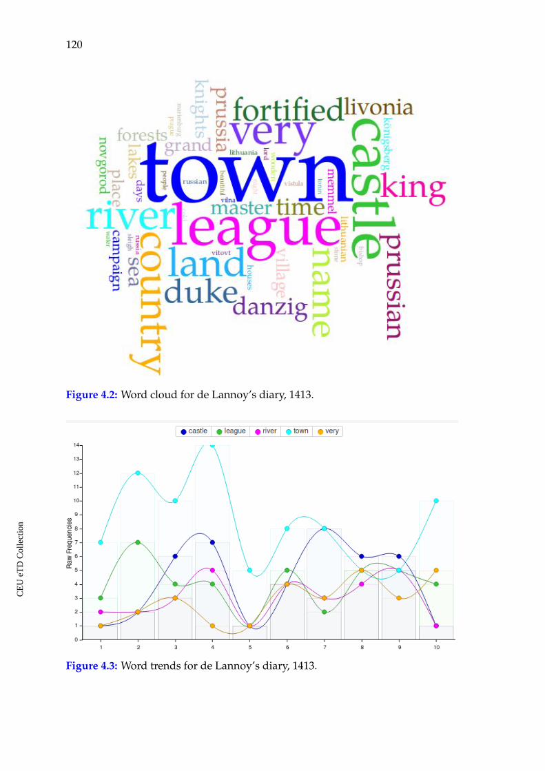
120
Figure 4.2: Word cloud for de Lannoy’s diary, 1413.
Figure 4.3: Word trends for de Lannoy’s diary, 1413.
CE
UeT
DC
olle
ctio
n
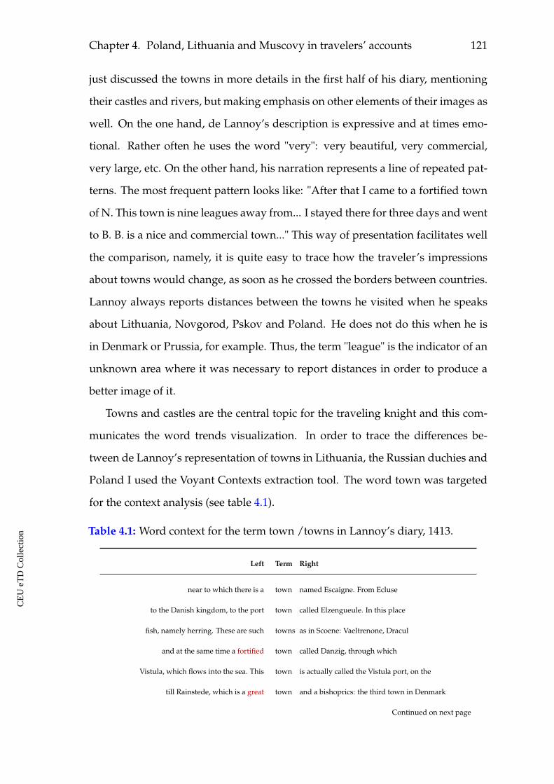
Chapter 4. Poland, Lithuania and Muscovy in travelers’ accounts 121
just discussed the towns in more details in the first half of his diary, mentioning
their castles and rivers, but making emphasis on other elements of their images as
well. On the one hand, de Lannoy’s description is expressive and at times emo-
tional. Rather often he uses the word "very": very beautiful, very commercial,
very large, etc. On the other hand, his narration represents a line of repeated pat-
terns. The most frequent pattern looks like: "After that I came to a fortified town
of N. This town is nine leagues away from... I stayed there for three days and went
to B. B. is a nice and commercial town..." This way of presentation facilitates well
the comparison, namely, it is quite easy to trace how the traveler’s impressions
about towns would change, as soon as he crossed the borders between countries.
Lannoy always reports distances between the towns he visited when he speaks
about Lithuania, Novgorod, Pskov and Poland. He does not do this when he is
in Denmark or Prussia, for example. Thus, the term "league" is the indicator of an
unknown area where it was necessary to report distances in order to produce a
better image of it.
Towns and castles are the central topic for the traveling knight and this com-
municates the word trends visualization. In order to trace the differences be-
tween de Lannoy’s representation of towns in Lithuania, the Russian duchies and
Poland I used the Voyant Contexts extraction tool. The word town was targeted
for the context analysis (see table 4.1).
Table 4.1: Word context for the term town /towns in Lannoy’s diary, 1413.
Left Term Right
near to which there is a town named Escaigne. From Ecluse
to the Danish kingdom, to the port town called Elzengueule. In this place
fish, namely herring. These are such towns as in Scoene: Vaeltrenone, Dracul
and at the same time a fortified town called Danzig, through which
Vistula, which flows into the sea. This town is actually called the Vistula port, on the
till Rainstede, which is a great town and a bishoprics: the third town in Denmark
Continued on next page
CE
UeT
DC
olle
ctio
n
122
Table 4.1 – Continued from previous page
big town and a bishoprics: the third town in Denmark. From here to Rainstede, a good
Denmark. From here to Rainstede, a good town , 4 leagues; then to Naestved
leagues; thence to Naestved, a good town , 5 leagues; then to Werdinghebourgh
in Werdinghebourgh, which is a fortified town and a castle, 6 leagues
I forwarded them to the above-mentioned port town of Danzig, Prussia. From Danzig
in Keuninczeberghe, which is a big town , which lies on the river; in him
Two fortress and a castle. This town belongs to Marshal of Prussia. In him
by force of arms two of the three gates of the town were taken; but the residents
our people to leave, not having taken the town . During this siege, I
several clashes near another fortified town , and from there, having achieved nothing
seniors, and arrived in a town called Live, which lies on the river
Riga in Livonia, through many towns , castles and commanderies, also owned
through Guldinghe, which is a fortified town , then through the castle of Cando
through Cando Castle and other towns and castles in the country of
representing a port, a castle and a fortified town , the capital of the country and the residence of
Livonian
seven miles away, near the town called Segewold, and from there I
went further in Livonia, from town to town , through castles, courtyards and commanderies
passed through the fortified town of Winde, a commandery and a castle
the castle, through Weldemaer, also a fortified town and through Wisteen, which is
a village, and from there to the fortified town , castle and commandery, located at
which is very large; from her the town got its name. This river
and rivers, and then I arrived in the town of Veliky Novgorod. And from it
leagues. Novgorod - a surprisingly large town ; it is located on a large plain
waters and wetlands. In the middle of the said town a great river flows named
great river named Volkhov. The town is surrounded by bad walls made of
whereas the towers are stone. This town is independent and has a board of community
Many great lords live in the said town , who
like merchants in one fortified town of Russian state, on the
without danger of death. This town lies on the mouth of two
Continued on next page
CE
UeT
DC
olle
ctio
n
Chapter 4. Poland, Lithuania and Muscovy in travelers’ accounts 123
Table 4.1 – Continued from previous page
in Novgorod. The Russians in this town have long hair, loose on
from Pskov. Drapt - a very beautiful town and strongly fortified; in it
the security letter. I passed through the town of Winde, Weldemaer, which are fortified
Winde, Weldemaer, which are fortified towns , and through many villages of
and arrived to a fortified town and castle, called Cocquenhause, that
forests and arrived in the main town of Lithuania, called Vilna, in
and its waters through down– town. This river is called Vilna. The town
the city. This river is called Vilna. This town is not walled at all; it is long
rivers. I found in the said town of Vilna two sisters of the mantioned duke’s wife
following roads: first I came to the town of Trancquenne, the town is poorly settled down
first came to the town of Trancquenne, the town is poorly settled down and not walled at all
everyone speaks in its own language. This town belongs to the mentioned duke Witold
It arrived to a large fortified town called Cauve. There is
a big castle and a small town , enclosed in wooden walls, which belongs
a very beautiful, rich and fortified town , encompassing a castle, a monastery
leagues. I moved out of the said town and went, wishing to have some fun
fun, in another Prussian fortified town , named Columiene, which lyes on
have fun in many castles and towns that are located around and belonging
I came to a fortified town , called Kalisch, which
a very rich and very commercial town , situated in the said land and
From the above-mentioned town to Bresseloen, 18 leagues. Of
I came to a fortified town , located in Silesia mentioned at
Bohemian kingdom, drove through many towns and castles, which I
Prague, which is the main town of Bohemia, situated on the river. At
26 leagues. In Prague, there are two towns : the old and the new; Prague - very
Prague - a very large and wealthy town . The new city has a tower
and arrived at a fortified town named Berg, in Bohemia
As it is demonstrated in the table, the general condition of towns, their wealth
and the prevailing building material were the main criteria for de Lannoy to judge
about the country. Most cities he passed on his way from Denmark to Livonia are
CE
UeT
DC
olle
ctio
n
124
said to be nice, good, great, fortified. As soon as he entered the lands of Lithuania
and the Russian duchies, the cities are described as fortified by bad walls, not
walled at all or with wooden walls. When he left these regions, the Polish town of
Kalisz is said to be fortified and Wrocław was already very beautiful, very rich and
very commercial. As he moved to Bohemia and further, he used only favorable
expressions while speaking about towns and cities.
De Lannoy made his second trip to the eastern lands of Europe in 1421 as
an ambassador representing the interests of the English and French courts. This
time he produced a totally different kind of accounts, telling in few lines about
his mission and dispatching documents. It contains no information about his im-
pressions with regard to the visited places. For this reason it is hardly possible
to speak about the images of Poland and Lithuania, as this was not the topic in
the diary. It is a pure report on when and where de Lannoy met this or that king,
duke or other official, which papers were dispatched, what gifts were given and
received.
4.3 Ambrogio Contarini and Josafa Barbaro traveling eastwards
In 1453, Constantinople was conquered by the Ottoman Turks. After that, their
target was to move further to the West. In this situation, the European rulers un-
dertook attempts to find alliances in the East, particularly with Persia. Thus, the
Venetians Josafa Barbaro and Ambrogio Contarini were, in two different journeys,
among those who were sent to Persia with diplomatic missions from European
rulers in order to persuade the Persians to attack the Ottomans in the East. This
way it would be easier to fight them from the West.
Both, Contarini and Barbaro, left accounts of their trips and missions under-
taken in 1473/79 and 1474/77 respectively. The two diaries are often referred
and edited together,159 as the journeys were made chronologically close to each
159 Travels to Tana and Persia by Josafa Barbaro and Ambrogio Contarini, trans. from the Italian byWilliam Thomas and S.A. Roy, ed. Lord Stanley of Alderley (London: Printed for the HakluytSociety, 1873; reprint New York: Burt Franklin, 1968).
CE
UeT
DC
olle
ctio
n
Chapter 4. Poland, Lithuania and Muscovy in travelers’ accounts 125
other, both travelers were Venetians and they had similar diplomatic missions.
The accounts are original writings, depicting the eye-witness experiences of their
authors. Although, the last part of their diaries, namely the description of the
route back from Persia through Muscovy, Lithuania, Poland and Germany are
rather similar, even identical. Because of this closing part, both Barbaro and Con-
tarini are often referred as travelers who visited Moscow and the focus area of the
present research. I will support Elena Skrzhinskaya’s opinion160 who made a pre-
liminary comparative analysis of the final parts in both diaries. She demonstrated
that these parts telling about the return from Persia to Italy through Muscovy,
Lithuania and Poland are almost identical in their content. Contarini as well as
Barbaro composed their narrations in the first person. In his closing part, Barbaro
changed from the first person and started using expressions like "it is known that
Muscovy...," "if one follows this route, then... ." He did not anymore use expres-
sions like "I saw...," "I came..." in this part of his diary. Thus, Skrzhinskaya argues
that Barbaro did not travel by the same route as Contarini and that it looks like
he copied this part from Contarini, whose diary was published earlier. The con-
tent of the text, the order of facts and topics, the distances between settlements
and the market prices in Barbaro’s diary are the same with what Contarini wrote
in his accounts. Thus, in spite of the fact that both authors are often reported as
travelers who left descriptions of Muscovy, Lithuania and Poland, both names
are listed in related bibliography, both accounts are edited, I will focus on the con-
tent of Contarini’s diary, where the depicted region is originally described by an
eyewitness.
On his way to Persia, he traveled from Florence through Germany, Poland,
Lower Rus’, Kiev to Caffa (modern Feodosia in Crimea). On the way back he
returned via Moscow, Lithuania, and Poland. On his way, he had companions,
that is why he often uses the pronoun "we" while telling about his trip. According
160 Barbaro i Kontarini o Rossii. K Istorii Italo Russkih Svyazej v XVv. [Barbaro and Contarini aboutRussia. On the history of Italian-Russian connections in the 15th century], trans. and ed. ElenaSkrzhinskaya (Leningrad: Nauka, 1971).
CE
UeT
DC
olle
ctio
n
126
to his accounts, they made stops in Germany and lodged mostly in very good
towns and fortresses, which were numerous in that country and many of which
were very nice and strong and worthy of being remembered. In the lands of the
Marquis of Branderburg they visited a very nice city fortified with fine walls,
called Frankfurt, close to the border with Poland.
Poznan, the first town belonging to the king of Poland was small, but hand-
some and there was a small castle there. The town had beautiful streets and
houses. On the way further through Poland he said that they found neither towns
nor castles worth mentioning. With regard both to lodgings and other aspects, the
country was very different from Germany. For Contarini, Poland made the gen-
eral impression of not being a rich country. He met the king of Poland, Casimir,
and handed in letters from his lords. The king invited him for dinner twice and
offered him two guides, who would accompany him to Kiev. The last town in
Poland was Lublin, a rather beautiful place with a castle. Then, they left Poland
and entered Lower Russia, the territory of the Grand Duchy of Lithuania. Here,
Contarini started complaining about long traveling through forests, stopping for
rest in small villages and sleeping sometimes in small castles with great discom-
fort... After several days, they came to the town of Lutsk. There was a wooden,
but rather good castle. They stayed there for a few days, but had anxiety all the
time. The reason was a wedding. Because of that, all the population of the town
was drunk and on that account very dangerous. Then they passed the town of
Zhytomyr where all the buildings were built of wood. From there, they travelled
through forests for two days, had no place to sleep and had to spend the night
outdoors without food and kept guards. When they reached Kiev, the governor
provided them with very bad quarters. But Contarini noticed that the house was
as bad as all the other ones in the city. Kiev is depicted as an important com-
mercial center, where merchants from all Russian lands, Tartary and many other
places were bringing their goods, particularly furs and silks, grains and meat.
People usually did their business till late afternoons and then gathered in tav-
CE
UeT
DC
olle
ctio
n
Chapter 4. Poland, Lithuania and Muscovy in travelers’ accounts 127
erns, drank a lot and fought often between themselves. In Kiev, Contarini joined
a Lithuanian ambassador to the Tartar Khan. He traveled with the embassy to the
borders of Tartary, where a Tartar escort came to meet them.161
These were the general impressions about the lands of Poland and Ruthenia
on his way to Caffa. The lodging conditions at the stops along the trip sound
to have been an important criterion of a good trip for Contarini. In this respect,
his expressions change from satisfaction with conditions in Germany and some
places in Poland to sincere complaints in Lower Rus’, where they had to sleep
in bad conditions and often outdoors with great discomfort. He was, however,
nicely accepted in the lands of Poland and the Grand Duchy of Lithuania. The
king’s guides made his trip to Kiev safer and he was provided with all necessary
provisions while staying there. At some points, Contarini wrote about his feelings
and emotions. For example, he was happy and thankful to King Casimir, to the
governor of Kiev, he was scared and anxious while seeing drunk people fighting,
had fear to sleep in the forests and so on.
In 1475–1477, Ambrogio Contarini traveled back from Persia to Venice, but
this time his way led through Moscow, the northern regions of Lithuania and
Poland. He was well accepted in Persia by Shah Uzun Hassan, but the mission
was not successful. On his way back, he joined the ambassador of the grand duke
of Moscow, Marco by name. They went through many hardships and Contarini’s
life was in danger several times before they reached Moscow.
Their journey from Astrakhan, from August 10 to September 22, 1476, when
they entered the lands belonging to the Duke of Muscovy was particularly diffi-
cult. The accounts report that this part of the journey was scary and risky from
the very beginning till the moment they entered Muscovy. They were imperiled
by being captured by the Tartars, to die while crossing the Volga, of food shortage,
of a cold in bad weather conditions, and so on.162
161 Travels to Tana and Persia, 108-14.
162 Ibid., 151-157.
CE
UeT
DC
olle
ctio
n
128
The first town on their way in Muscovy was Ryazan. All buildings and the
town Kremlin were built of wood. There, they found bread and meat in abun-
dance as well as the beverage of apples. Then, after few days of traveling in huge
and endless forests they came to the town of Kolomna. On September 26, 1476,
they entered Moscow praising and thanking God. Contarini was happy and sat-
isfied with the lodgings provided by Marco. The small and cheerless premises
seemed to him a grand palace in comparison to all the extremities of the last
month he had gone through.163
Contarini met the Grand Duke Ivan III. But he wanted to leave as soon as
possible from Moscow and return back to Venice. However, he owed a big sum of
money to Marco, who had given a guarantee to pay ransom to Tartars and also to
some Russians during their journey from Astrakhan to Moscow in order to save
Contarini’s life. Marco said that the money should be paid and did not agree that
Ambrogio could leave. Thus, Contarini had to stay in Moscow, and dispatched
his companion priest Stephano and Nicolo, who was from Lviv and knew the
road very well.164
Contarini stayed in Moscow and finally spent there four months waiting for
the money from Venice. During this time he had a good chance to see the city and
everyday life there. He describes it as a big city, but built entirely of wood, sur-
rounded by forests which, indeed, cover the greater part of the country. The coun-
try abounds in all kinds of grain, meat, poultry, wildfowl, but fruits are rare. All
products were cheap in his opinion. The climate was so excessively cold that peo-
ple stay indoors nine months a year. Winter was the best time for transportation
in Muscovy, because in summer there were no good roads, but much water and
mud around. He noticed that people boasted of being great drunkards and would
often fight being drunk. He gave also a picturesque description of Moscow’s win-
ter market. It was organized on the frozen Moscow river. People were selling
163 Ibid., 158-159
164 Ibid., 159-160.
CE
UeT
DC
olle
ctio
n
Chapter 4. Poland, Lithuania and Muscovy in travelers’ accounts 129
whole animal bodies without skins and it was strange to see so many skinned
animals standing upright on their feet. He says that Muscovy was an important
fur market. Many merchants came there from Poland, Prussia and Flanders for
furs.165
The grand duke returned to Moscow at the end of December and Contarini
asked from noble people he had made friends with during his stay to help him
persuade the duke to let him go home. Finally, the duke gave his permission and
paid for him the ransom he owed. He gave two dinners in Contarini’s honor, gave
him money for the journey, a fur coat and thousand squirrel furs.166
On January 21, 1477, Contarini and his people left for home. He wrote in the
accounts that he knew about the hardships of winter travel in forests, but he did
not pay attention to it. The only thing he was thinking of was to leave those places
and ways of living. This intention is observed in his text, as he did not say a word
about the towns of Vyazma and Smolensk which he passed.167
After Smolensk they entered Lithuania, which belonged to the king of Poland,
Casimir. In the town of Troki they met the king. He writes that from January
21, when they had left Moscow, until February 12, 1477, when they came to Troki,
they traveled through the woods all the time. Sometimes, they would find villages
and had rest there, but usually they had to sleep in the forests and underwent
great suffering. King Casimir was glad to see Contarini. He gave a dinner in his
honor and asked him about his trip with much interest. In the end, he gave him a
guide who should also take care of his safety in all places they were going to pass
in the king’s lands.168
On February 16, they left Troki and came to a town called Slonim. Then they
entered the lands of Poland. He says that Poland was a beautiful country, rich in
food and other provisions, but not in fruits. They saw castles and villages, but
165 Ibid., 161-162.
166 Ibid., 163-164.
167 Ibid., 165-166.
168 Ibid., 166-168.
CE
UeT
DC
olle
ctio
n
130
not worth mentioning. It was said to be a safe country. The last city in Poland
mentioned by Contarini was Warsaw. He writes that they finally had good hous-
ing in that beautiful city, where they could find everything necessary. He and his
people were much fatigued, both on account of the great cold and the other hard-
ships they had endured. Thus, they decided to spend a few days there and make
provisions for the further trip.169
He writes that as they traveled through Germany a continual improvement
was observed, in the villages and castles as well as in the towns and lodgings. In
one of the towns in Germany he met the priest Stephano, who was sent by him
to bring the money to Moscow. The priest Stephano was now traveling back to
Moscow. It is hard to describe how happy both of them were to see each other,
wrote Contarini. He noted that every further day they stayed in most beautiful,
important and worthy cities and also passed many other beautiful ones.170
The word cloud for Contarini’s accouts of Poland, Muscovy and Lithuania
demonstrates a similar tendency to the previous author. The word "town" is the
central term and topic in Contarini’s narration as well (see figure 4.4). Most prob-
ably, Contarini was not able to read de Lannoy’s accounts, because they were not
published yet, but kept in manuscript in his family for several centuries. What is
important here is that the authors from the fifteenth century, whose accounts were
considered until now changed the tone of their expressions from favorable to un-
favorable and vice versa as soon as they would leave or enter the "Germanic"
realm, may it be Germany itself, Bohemia, Livonia, or Prussia. The level of de-
velopment of urban settlements and urban fortifications behind this border were
among the main criteria for the authors. By following the term "town" in the di-
aries, one observes the gradual change of characteristics in sense of beauty, forti-
fications, architecture, building materials, accessibility, comfort, safety, and other.
In case of Contarini’s diary it is also possible to observe how the author’s trip
169 Ibid.
170 Ibid., 169-171.
CE
UeT
DC
olle
ctio
n
Chapter 4. Poland, Lithuania and Muscovy in travelers’ accounts 131
experiences affected his judgement about the same lands. Ambrogio made a long
journey both in terms of time and distance. His impressions of towns when he was
moving through Germany, Poland and Low Russia (Ruthenia) on his way to Per-
sia in the beginning of his mission got gradually unfavorable. On his way back he
passed through numerous hardships, dangerous situations, and hard conditions.
Thus, when he reached Muscovy he immediately felt better, safer and wrote that.
Besides Moscow, he did not make detailed comments concerning other towns in
Muscovy and Lithuania which he passed on his way back home, in most cases
he just mentioned their names. Only in Poland he started speaking again about
the beauty and richness of Warsaw. The text again communicates his admiration
about the looks and comforts of towns in Germany and further on while moving
westwards.
Text visualizations depict the term "town" as the most frequent and strong in
Contarini’s diary (see figures 4.4 and 4.5). Another theme that is reflected in the
terminological depiction of his account is the diplomatic component of the story.
The terms like "king," "duke," "ambassador," "majesty," "highness" are the essential
vocabulary with the help of which he described his mission, his experiences and
his ambassador’s status. Nature and landscape, markets, commerce and local
goods, the way he was accepted and treated by the rulers are the other frequent
themes in his diary. Traveling through huge and endless forests is reported for the
lands of Lithuania and Muscovy. As for the hospitality of the local rulers he met in
different lands, he noted of being well treated, and often above his expectations.
In spite of the references to multiple things and events in Contarini’s diary, the
topic of his mission is visualized in word trends as central (see figure 4.5). The
five strongest terms belong to this theme. Meeting dukes and kings and visiting
different towns were in essence of his ambassador’s duties. The term "town" is the
most stable and frequently present through the whole text body as Contarini all
the time kept notes about the places he visited. In the end of his mission, the diary
contains notes about cities he passed or made stops on his way back home. After
CE
UeT
DC
olle
ctio
n
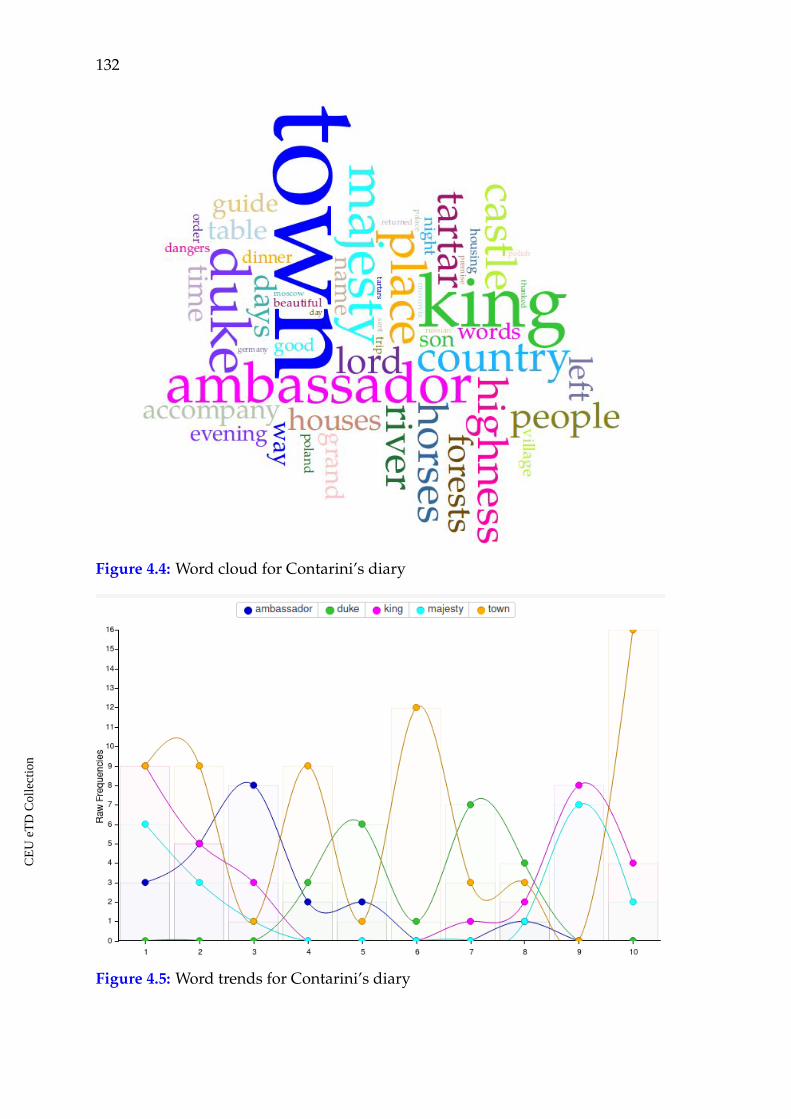
132
Figure 4.4: Word cloud for Contarini’s diary
Figure 4.5: Word trends for Contarini’s diary
CE
UeT
DC
olle
ctio
n
Chapter 4. Poland, Lithuania and Muscovy in travelers’ accounts 133
he met the King of Poland in Troki, he did not have other significant meetings,
thus, the diary contains information on his route mostly.
The terms "king" and "majesty" are connected in the text and in the visualiza-
tion. They correspond to the story of Contarini’s meeting the King of Poland in
the beginning of his trip and on his way beck. In the middle of the story, on his
way back home, he met the Grand Duke of Moscow and spent several months in
this city. The trends correspond to the story. Thus, three main topics found their
reflection in the word trends for Contarini’s diary: meeting the King of Poland,
meeting the Grand Duke of Moscow and the towns he visited.
Contarini’s accounts are the source, which helps us better understand how the
representatives of Western societies perceived the union between Poland and the
Grand Duchy of Lithuania. This issue turned to be also important and decisive
for the image of Lithuania in general encyclopedic works as well as in cartog-
raphy. On his way to Persia Contarini wrote that from Poland they entered the
lands of Lower Russia, which belonged to the king of Poland. On his way back
from Persia, after he had left Muscovy and entered Lithuania, he wrote again that
Lithuania belongs to the king of Poland. For this particular period that was not ex-
actly correct. The Kingdom of Poland and the Grand Duchy of Lithuania formed a
political union after Grand Duke Jogaila of Lithuania had been baptized with the
name Vladislav, married Jadwiga and became king of Poland in 1386. The kings
of Jagiellonian dynasty in most cases were at the same time grand dukes of the
Lithuanian Duchy. It was specified in their titles. King Sigismund’s I (1506-1548)
title was, for example: Sigismundus Dei gratia rex Poloniae, magnus dux Lituaniae,
Russiae, Prussiae Samogitiaeque dominus et haeres.171 The dual state was ruled by a
common monarch, but Lithuania retained its sovereignty, had its own sejm (par-
liament), conducted independent internal and foreign affairs until 1569. It looks
that for Western Europeans both states were perceived as one, the larger part of
the Grand Duchy was attributed to the kingdom of Poland, and the term name
171 Lietuvos Metrika: Užrašymu knyga 22 [Lithuanian Metrica: Book of Inscriptions 22]. Eds. AndrijBlanutsa, Dmitro Vashchuk, and Darius Antanavicius. (Vilnius: LII Leidykla, 2010), 13.
CE
UeT
DC
olle
ctio
n
134
Lithuania was most probably attributed to the ethnic Lithuanian lands.
4.4 Sigismund von Herberstein on Lithuania and Muscovy
4.4.1 Lithuania by Herberstein
The apogee source in this group for the investigated period is Rerum Moscoviticarum
by Sigismund von Herberstein. This description is very different from the previ-
ous ones. If the previous travel accounts are diaries, depicting dates of the trip,
places the authors passed and things they saw, Rerum Moscoviticarum by Herber-
stein is a structured description, telling about many aspects of life in Muscovy,
about its history, religious traditions, everyday life, politics, army, the size of the
country, its legends and myths, and so on. He traveled there personally, spoke
Russian, stayed in Muscovy for quite long, talked to local people and interrogated
them. He read documents and chronicles. From this perspective, his accounts are
seen as a new kind of study about the region. In spite of the fact that he also trav-
eled both to Poland and Lithuania, the largest part of this work was dedicated
to Muscovy. He just mentions that he met the king of Poland and completed
his mission there. No description of the country is offered as a separate chapter.
He will discuss some issues on Poland while writing on Muscovy: the money
in both states, distances between some cities in Poland and Muscovy, and some
common political matters. Most probably, Poland was not that unknown both to
Herberstein and to his audience. As for Lithuania, he wrote a chapter called "On
Lithuania" while telling about the neighbors of Muscovy.
Among the consulted source editions the one by R.H. Major is not complete.
Some chapters on Muscovy are missing in it, but the chapter on Lithuania is
present. For the convenience of the reader I will refer to it only while speaking
about Herberstein’s description of Lithuania.172
172 Sigmund Freiherr von Herberstein, Notes upon Russia, being a Translation of the Earliest Accountof that Country, Entitled Rerum Moscoviticarum Commentarii, trans. and ed. R.H. Major, 2 vols.(London: Hakluyt Society, 1851-1852).
CE
UeT
DC
olle
ctio
n
Chapter 4. Poland, Lithuania and Muscovy in travelers’ accounts 135
It should be pointed out that in the sixteenth century Muscovy attracted much
attention, the writings on it became more and more numerous.173 The western
border of Poland and the north-western border of Lithuania had mattered for the
travelers in the fifteenth century; but for Herberstein it was the border with Mus-
covy which was significant. Muscovy was the land having, probably, stronger
signs of "otherness" and the unknown in this region for him and for the repre-
sentatives of Western societies. On that account it was the land which deserved a
more detailed description. Herberstein did not limit himself in using the previous
travel accounts and the Cosmography by Münster while creating his work.
The influence of information from encyclopedic works is noticeable in Her-
berstein’s chapter "On Lithuania."174 He discusses many common things about
Lithuania that can be found in the encyclopedias, but he did not really copy from
them. Herberstein comments on the previous and widely spread knowledge and
tries to explain or clarify the things which were misleading or those of a general-
ized nature.
He starts the description of Lithuania with specifying what it was like at that
time and where it was located, but he does it from a different perspective, look-
ing from Muscovy which was in focus of his work, saying that the closest land to
Muscovy is Lithuania. He explains that he means not only Lithuania itself, but the
lands attached to it, which are understood under a common name of Lithuania.
So, Lithuania is not a homogeneous state in his account. He lists the main regions
of this country, along with the names of the bishoprics, biggest towns, rivers,
etc. As for the landscape, the land has a great number of large forests, marshes,
rivers, and lakes. According to him, people in Lithuania were in real slavery. The
rulers were very cruel to their subjects. He mentions that from the times of Vi-
tovt/Vytautas (c. 1350–1430) until now they were under terrible slavery to their
rulers. Somebody who was sentenced to death was forced to hang himself. If he
173 Marshall Poe, Foreign Descriptions of Muscovy: An Analytic Bibliography of Primary and SecondarySources. (Columbus, OH: Slavica Publishers, 1995).
174 Sigmund Freiherr von Herberstein, Notes upon Russia, 82-100.
CE
UeT
DC
olle
ctio
n
136
did not obey, he was cruelly tortured and after that hanged. As a result of such vi-
olence it was sometimes enough to say to a person that the lord was angry about
his being slow, and, out of fear to be tortured cruelly, he hanged himself.175 This
motif is identical to what Piccolomini wrote about Vitovt/Vytautas. Thus, the ear-
lier sources made an impact on Herberstein and he borrowed information for his
own description. However, in most cases Herberstein makes explanations and
comments to the previously known facts about Lithuania. The above mentioned
attempt to clarify the previous information concerning the territory of Lithuania
originated from the uncertainty that existed about this issue. Piccolomini, Schedel
and Münster did not clarify it. Another issue that was important, but unclear as
well in the previous descriptions of Lithuania was the language and the ethnic
groups living in Lithuania. Piccolomini wrote that the population was of Slavic
origin and spoke a Slavic language, but also had a language of their own. By
the "language of their own" he meant the language of ethnic Lithuanians, which
is not Slavic. Münster wrote of multiple languages used in Lithuania: Slavic,
Lithuanian, Latvian, Tartar, Jewish, German and Polish. In the first lines of his
text on Lithuania, Herberstein explains that this country along with the Lithua-
nian region itself also included other lands. He listed them and made the issue of
the languages and religion in Lithuania more understandable for the reader. He
wrote that all the nations that spoke Slavic languages and confessed the Chris-
tian religion according to the Greek rite are called Russians. In Samogitia and
Lithuania, Russians are mixed with alien tribes, speaking different languages and
having different religions; but Ruthenians are in majority. Politically this territory
of the Russian nation belongs to two different states: the larger part to the State of
Muscovy, the smaller one to Poland and Lithuania. Thus, in Herberstein’s narra-
tion the nations inhabiting Lithuania were put into geographical context. He also
filled the gap concerning the regions comprising it.
The theme of morals raised in the previously mentioned sources was also
175 Ibid., 94.
CE
UeT
DC
olle
ctio
n
Chapter 4. Poland, Lithuania and Muscovy in travelers’ accounts 137
touched by Herberstein. He wrote that from people deserving trust he heard that
girls in Lithuania rarely preserve their virginity after the age of seven. Those
interlocutors of his give different reasons for that, but none of them satisfied Her-
berstein.176 From his words it is clear that he tried to check this information, but
he was not able to confirm or to prove it.
The narration about wild animals in Lithuania is followed in Herberstein’s ac-
counts by the description of Samogitia. The story about the pagan cults of the
sacred fire, the sun, the moon, trees and snakes was separated from the rest of
Lithuania and clearly attributed to Samogitia (Zemaitia),177 which was not the
case in the previously mentioned sources. The story about worshiping snakes is
very similar to what Piccolomini wrote concerning this phenomenon. The story
does not sound real for Herberstein, but he tells it, probably, in order to follow
the pattern of writing about Lithuania and creating an image not that different
to what was known long before him. He wrote that in Samogitia there are still
many idolaters, who feed in their homes particular snakes which have four short
legs and look like lizards with black fat bodies. After that he added a story told
by a Lithuanian from Troki (Trakai) about a man whose face was disfigured af-
ter he denied idolatry and adopted Christianity. That person was sure that this
happened to him as a result of killing the deity-snake and he was also sure that in
case he did not return to his faith he would suffer even more horrible misfortunes.
Thus, idolatry and paganism were still part of the image of Lithuania by the first
half of the sixteenth century according to Herberstein’s accounts.
Herberstein’s notes on venerating snakes is followed by a few more facts about
Samogitia. It is said to be rich in forests, where even now one could meet ghosts.
Mentioning exotic things, therefore, was also an integral part of his travel ac-
counts to a distant land.
The above discussed issues from Herberstein’s description of Lithuania demon-
176 Ibid., 84
177 Ibid., 97-99.
CE
UeT
DC
olle
ctio
n
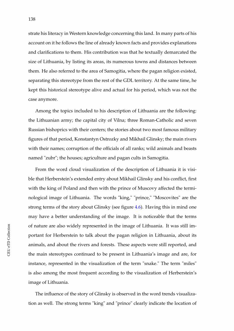
138
strate his literacy in Western knowledge concerning this land. In many parts of his
account on it he follows the line of already known facts and provides explanations
and clarifications to them. His contribution was that he textually demarcated the
size of Lithuania, by listing its areas, its numerous towns and distances between
them. He also referred to the area of Samogitia, where the pagan religion existed,
separating this stereotype from the rest of the GDL territory. At the same time, he
kept this historical stereotype alive and actual for his period, which was not the
case anymore.
Among the topics included to his description of Lithuania are the following:
the Lithuanian army; the capital city of Vilna; three Roman-Catholic and seven
Russian bishoprics with their centers; the stories about two most famous military
figures of that period, Konstantyn Ostrozky and Mikhail Glinsky; the main rivers
with their names; corruption of the officials of all ranks; wild animals and beasts
named "zubr"; the houses; agriculture and pagan cults in Samogitia.
From the word cloud visualization of the description of Lithuania it is visi-
ble that Herberstein’s extended entry about Mikhail Glinsky and his conflict, first
with the king of Poland and then with the prince of Muscovy affected the termi-
nological image of Lithuania. The words "king," "prince," "Moscovites" are the
strong terms of the story about Glinsky (see figure 4.6). Having this in mind one
may have a better understanding of the image. It is noticeable that the terms
of nature are also widely represented in the image of Lithuania. It was still im-
portant for Herberstein to talk about the pagan religion in Lithuania, about its
animals, and about the rivers and forests. These aspects were still reported, and
the main stereotypes continued to be present in Lithuania’s image and are, for
instance, represented in the visualization of the term "snake." The term "miles"
is also among the most frequent according to the visualization of Herberstein’s
image of Lithuania.
The influence of the story of Glinsky is observed in the word trends visualiza-
tion as well. The strong terms "king" and "prince" clearly indicate the location of
CE
UeT
DC
olle
ctio
n
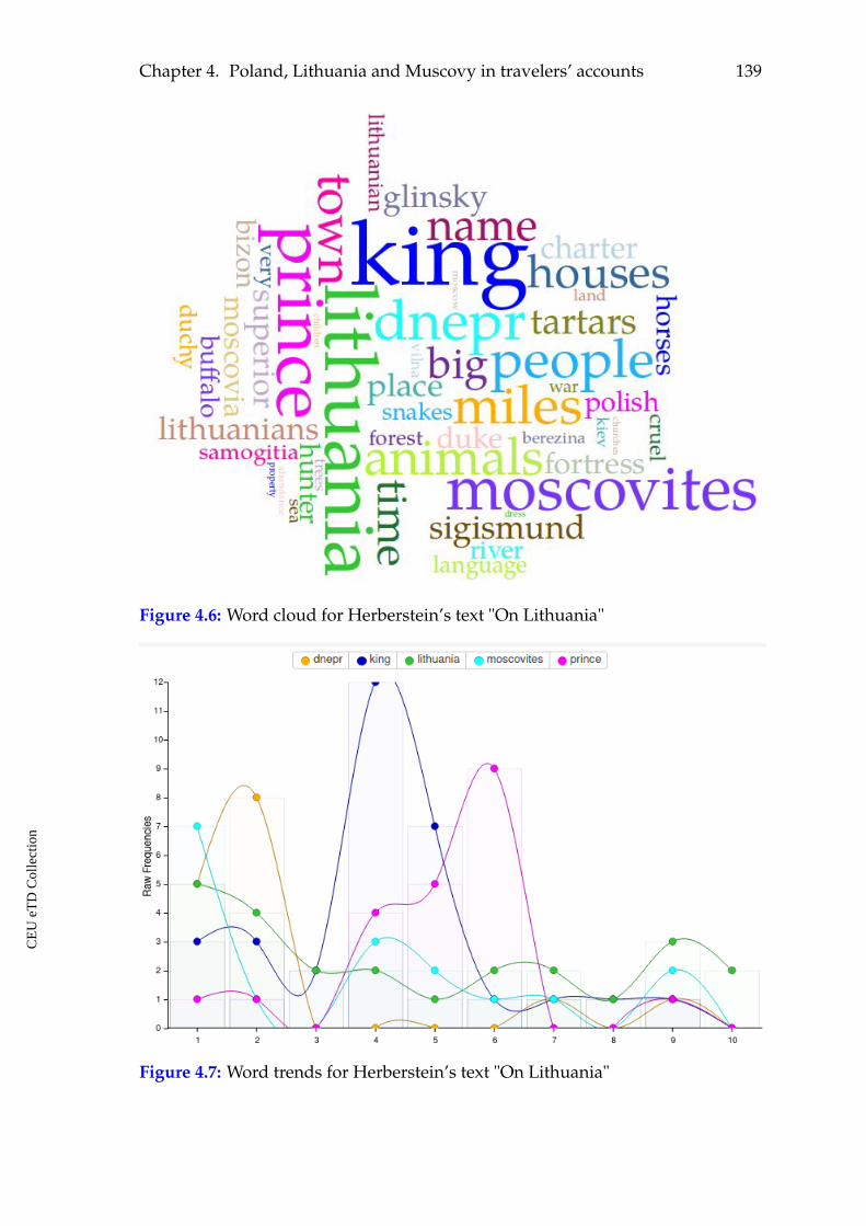
Chapter 4. Poland, Lithuania and Muscovy in travelers’ accounts 139
Figure 4.6: Word cloud for Herberstein’s text "On Lithuania"
Figure 4.7: Word trends for Herberstein’s text "On Lithuania"
CE
UeT
DC
olle
ctio
n

140
the Glinsky story in the text, namely between the 3/10 and the 7/10 parts (see
figure 4.7). They reflect the story of his conflict first with the King of Poland, then
with the Prince of Muscovy. The strong term "Dnepr" and its presence through
the whole text body pays attention to the importance of this river for Lithuania.
It connected the larger part of the country with the Black Sea and was one of
the most important routes of transportation. The important and strong terms in-
dicating Lithuanian neighbors the Muscovites and the Prince of Moscow in this
visualization witness about their intensive contacts of different nature.
4.4.2 Muscovy by Herberstein
The accounts on Muscovy by Sigismund von Herberstein are a rather different
example of a travel account. The previous cases were chronologically structured,
showed the itinerary and contained the authors’ experiences. Only in the final
parts of his work Herberstein notated his route to Muscovy and back listing the
names of the places he passed in chronological order and thoroughly registered
the distances between them.
In order to create his image of Muscovy along to his own observations he in-
volved numerous historical, written and oral sources which he listed in the in-
troductory part. As a result, this work combined features of travel notes, chron-
icles, treaties on geography, topography, ethnology, religion, observations on so-
cial structure and everyday life in Muscovy. In this respect, the present descrip-
tion combines the features of all sources involved to the present investigation in
the most explicit way. As some chapters of the accounts are missing in the edi-
tion by R.H. Major I will also refer to the edition by Khoroshkevich.178 This work
presents parallel texts of the Latin edition (1556) and of the German edition (1557),
along with their Russian translations.
Herberstein starts his description of Muscovy from the etymology of the name
178 Herberstein S., Zapiski o Moskovii, [Notes on Muscovy], in 2 vols, vol. 1: Latin and German texts,trans. from Latin A.I. Malein and A.V. Nazarenko, trans. from early modern high GermanA.V. Nazarenko, ed. A.L. Khoroshkevich (Moscow: Pamiatniki Istoricheskoj Mysli, 2008).
CE
UeT
DC
olle
ctio
n
Chapter 4. Poland, Lithuania and Muscovy in travelers’ accounts 141
Russia. He writes that some people believe that the word comes from the leg-
endary Rus, brother of Lech and Czech. He probably learned this legend from
Western chronicles. The Muscovites themselves do not believe this story and say
that the name of their land comes from the word "rasseyanie," which means "scat-
tering," referring to their peoples who were scattered and are still scattered in
huge territories. Then, he pays attention to the usage of the Slavic languages and
their distribution among the nations of Europe.179
He retells the story of the Rurick dynasty in Rus’ as it is presented in Russian
chronicles and traces the political history of the Muscovite state until his visit
there. Thus, he introduced the genealogy of the Russian state and its political
power to the Western readers. He noticed that all the rulers there had the title of
duke. Only the present Grand Prince of Moscow, Vasili (1505–1533) started calling
himself a tsar.180
Herberstein provided stories about rulers from recent past as well. A pretty
colorful detail of Ivan’s III (1462–1505) portrait. He writes that Ivan "was so
formidable towards women that if any of them came across by chance in his eyes,
then at the sight of him she would almost lose her life... During meals, he mostly
indulged in such drunkenness that he would fell asleep, and all the invitees were
sitting stricken with fear and silent as long as he was sleeping. On waking he
usually rubbed his eyes and then he would begin joking and be cheerful."181
Two separate chapters are dedicated to the account on the coronation customs
of the grand dukes. The description was obtained by him from some official on
his request and was a kind of protocol from one of the previous coronations.
The coronations were held in the Assumption Cathedral of the Moscow Krem-
lin, mostly conducted by the metropolitan, archbishops and other church officials.
Thus, the newly crowned duke was receiving his legitimacy with the holy bless-
ing of the church. The main attribute of the prince’s power in Muscovy was the
179 Herberstein, Zapiski o Moskovii, vol. 1., 34-35.
180 Ibid., 44-111.
181 Ibid., 76-77.
CE
UeT
DC
olle
ctio
n
142
Vladimir Monomakh’s Cap, following the legend that it had been owned by the
Kievan prince Vladimir Monomakh (1053-1125). After the ceremony, the grand
duke passed through a number of other rituals, an official dinner and was orna-
mented with precious elements of clothing. As the lands inhabited by Russians
belonged to three rulers, the grand duke of Moscow, the grand duke of Lithua-
nia and the king of Poland who were connected by relative bonds, Herberstein
decided to write about the genealogy of the dukes of Lithuania. With this he
demonstrated that the Polish crown was taken by the grand duke of Lithuania
Jogailo, and Anastasia (Sofia), a daughter of Grand Duke Vitovt, became wife to
the grand duke of Moscow, Vasili I. She became mother to the following prince of
Muscovy, Vasily II the Blind, grandmother of Ivan III and great-grandmother of
Vasili III to whom Herberstein was sent with his diplomatic mission.182
Herberstein writes a lot about the religion in Muscovy. He begins with the
jurisdiction of the Muscovite metropolitan and points out that originally his ju-
risdiction spread to the lands of Lithuania, where the churches of eastern rite
were in majority to those of the Roman Catholic rite. Vitovt was the one who
rejected to pay church taxes to the metropolitan of Moscow and appointed his
own metropolitan, who was approved by Constantinople. As for the origins of
the Christian faith, Herberstein cited the Russian chronicles, saying that the apos-
tle Andrew traveled as north as Novgorod and the first Christians in these lands
were baptized by him. Herberstein expressed his scepticism concerning this in-
formation. He also gave a rather detailed description of the church hierarchy
in Muscovy. The author concludes, however, that the lay people knew nothing
about the essence of their faith. They could not talk about their creed and beliefs.
At the same time they demonstrated great dedication to church services, rituals,
fasting and all the attributes of religious life. He concludes that he never saw
something like this in any other places in his life. Religious life in Muscovy is
described in much detail and the following matters are discussed: tithing, some
182 Ibid., 111-145.
CE
UeT
DC
olle
ctio
n
Chapter 4. Poland, Lithuania and Muscovy in travelers’ accounts 143
aspects of canon law, baptism, confession, communion, church feasts, attitude to
the purgatory, veneration of saints, fasting, and marriage. 183
Herberstein wrote that all people in Muscovy considered themselves slaves of
the prince and that they find more pleasure in slavery than in freedom. He also
gave a list of public laws according to which the society was functioning. With big
curiosity he described the Muscovite clothing and houses. He was also surprised
to learn that the Muscovites had special rituals on how to enter a house as a visitor
and described those rituals.184 His accounts became a unique source on many
aspects of everyday life in Muscovy. The dress, rituals, etiquette, the way people
spent their feasts, and many other aspects of everyday life were not documented
by the local contemporaries, because they were common, usual and natural. Only
a visitor, a representative of a very different culture could think of making notes
on what he saw. The visitor was judging from a different perspective and had a
different background. His eyes were watching a different picture.
Money and coins that were used in Muscovy are discussed in Herberstein’s
accounts along with those used in Lithuania and Poland. He makes a detailed
account of money used in these lands, costs and rates in relation to other Euro-
pean currencies. The discussion on the coinage is followed by the reference on
commerce. He says that only the merchants from Lithuania and Poland can visit
Moscow without any obstacles for commercial reasons. The merchants from Swe-
den, Livonia and Germany were allowed in Novgorod and the merchants from
Turkey and Tartary were bringing their goods to Chlopigorod. He tells an inter-
esting fact that when the merchants from places which were not allowed to enter
Muscovy learned about a foreign embassy to the Muscovite ruler, they would ask
the embassy to allow them to join and being protected by diplomatic status they
would come to Moscow.185
A separate chapter is dedicated to the description of the way and the protocol
183 Ibid., 146-254.
184 Ibid., 164-169.
185 Ibid., 268-285.
CE
UeT
DC
olle
ctio
n
144
according to which the foreign diplomats and ambassadors entered the country
and were accepted in Moscow. Herberstein describes his own experiences of be-
ing accepted as well as how several other missions were accepted while he was
staying there. This was a detailed practical guide on how to get prepared for a
diplomatic visit to Muscovy.186
He pays much attention to the local goods in Moscow’s and its principalities’
markets, as well as the goods which were imported, their amounts, quality and
prices. This gives a rich picture of what was going on there. This was the data he
obtained as a result of his personal observation and from numerous sources. The
description of Moscow itself is followed by a topographical account of the Mus-
covite principalities.187 Along with the names of towns and other settlements he
provides information on rivers at which they are located. He follows the pattern
of Münster’s depiction of Muscovy with a paradise-like motif. The soil in some
principalities is referred to be extremely fertile, forests and rivers in other areas
abound in wild animals, fish and honey.
In many parts of his account Herberstein sounds exotic, but rational. He de-
scribed what he saw and copied information from local documents. Although,
he remained faithful to the still existing tradition when writing about the remote
edges of the known world. Namely, he could not stand telling a story which
some reliable people told him that monstrous people and creatures can be met
in the most remote eastern regions of Muscovy. He puts these oral stories to the
description of the eastern regions of Pechora and Ugra, which he took from local
documents. He writes that they say that monstrous people live in those regions.
Some of them have hairy bodies, some do not have heads and have their faces on
the chest, some look like fish, but have a human face, hands and legs. He tells as
well about some strange animals that grow like plants.188
As it was said above, the closing chapters of the account represent notes on
186 Ibid., 522-592.
187 Ibid., 286-363, 376-389.
188 Ibid., 364-377.
CE
UeT
DC
olle
ctio
n
Chapter 4. Poland, Lithuania and Muscovy in travelers’ accounts 145
Herberstein’s itineraries to Muscovy and back in chronological order and with
the distances between the places he passed in miles.189
The word cloud visualization for Herberstein’s account of Muscovy depicts
among the most frequent terms the following: "prince," "duke," "town," "river,"
"Moscow," and others (see figure 4.8). The central terms represent well the textual
image of the country for the period. The figure of the Muscovite ruler impressed
all the visitors and they were trying to describe his personality and his power.
Such terms like "town" and "river" turn to be among the top important character-
istics of a remote state and of any state at the research period. A strong presence
of the term "town" in all considered travel accounts indicates the importance the
urban settlements played for a traveler and for the society. At the same time, the
authors payed particular attention to the looks of the cities in the eastern part of
Europe. All of them reported the gradually growing disadvantageous features
about the towns while moving eastwards. Among the most important features
of towns according to the travelers’ and also Herberstein’s opinion were fortifica-
tions, castles, stone buildings, markets. This is what they were used to see in the
western parts of Europe. Herberstein make numerous references to distances in
Muscovy as well and the term "miles" is among the strongest in the image of this
country.
Another strong term being present in this visualization as well as in the visual-
izations of other considered travelers is "river," which comes together with the vi-
sualization of towns. The main towns and cities were located on river banks. The
transportation function played by rivers was intensified in Lithuania and Mus-
covy in winter. Winter was the best season for traveling there.
As for the word trends visualization, one may observe that the intensity and
the distribution of the strong terms within the text body demonstrates fluctuations
(see figure 4.9). The term "prince," which stands for the Prince of Moscow, is
used through the text with steady frequency except for the end. The figure of
189 Ibid., 592-703.
CE
UeT
DC
olle
ctio
n
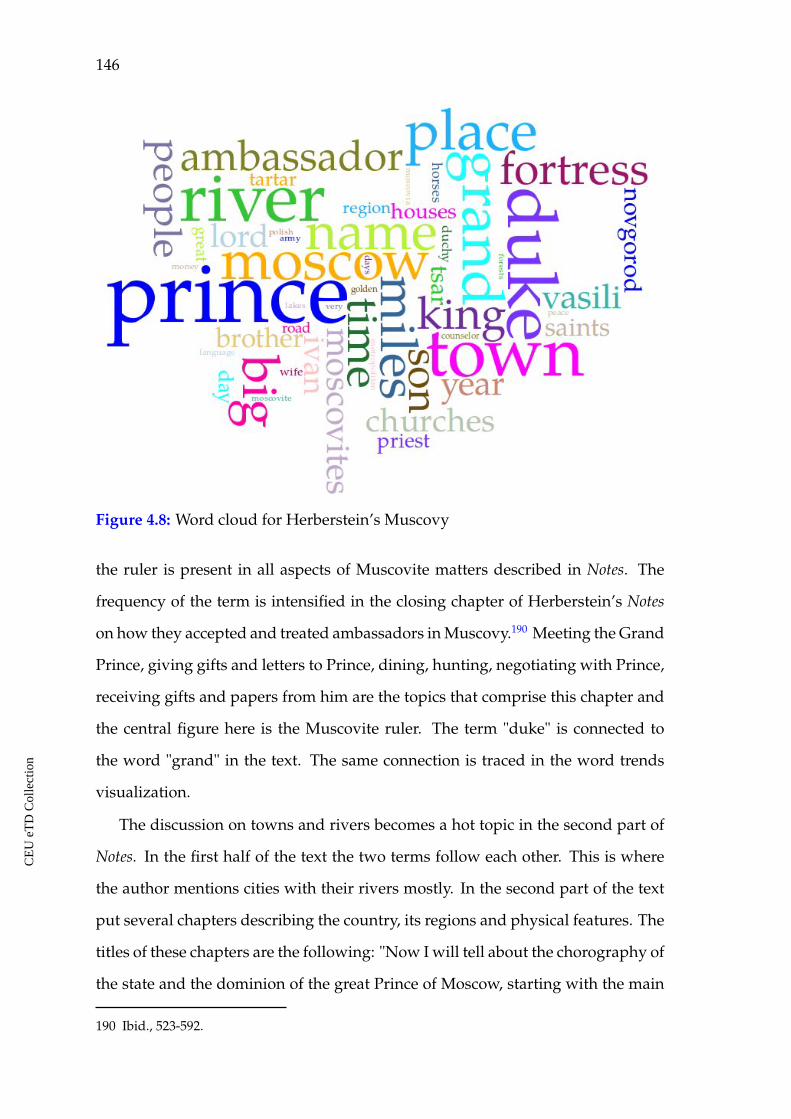
146
Figure 4.8: Word cloud for Herberstein’s Muscovy
the ruler is present in all aspects of Muscovite matters described in Notes. The
frequency of the term is intensified in the closing chapter of Herberstein’s Notes
on how they accepted and treated ambassadors in Muscovy.190 Meeting the Grand
Prince, giving gifts and letters to Prince, dining, hunting, negotiating with Prince,
receiving gifts and papers from him are the topics that comprise this chapter and
the central figure here is the Muscovite ruler. The term "duke" is connected to
the word "grand" in the text. The same connection is traced in the word trends
visualization.
The discussion on towns and rivers becomes a hot topic in the second part of
Notes. In the first half of the text the two terms follow each other. This is where
the author mentions cities with their rivers mostly. In the second part of the text
put several chapters describing the country, its regions and physical features. The
titles of these chapters are the following: "Now I will tell about the chorography of
the state and the dominion of the great Prince of Moscow, starting with the main
190 Ibid., 523-592.
CE
UeT
DC
olle
ctio
n
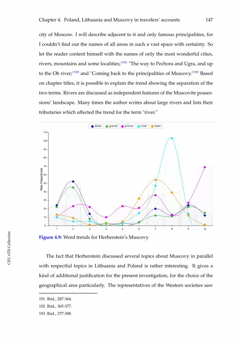
Chapter 4. Poland, Lithuania and Muscovy in travelers’ accounts 147
city of Moscow. I will describe adjacent to it and only famous principalities, for
I couldn’t find out the names of all areas in such a vast space with certainty. So
let the reader content himself with the names of only the most wonderful cities,
rivers, mountains and some localities;"191 "The way to Pechora and Ugra, and up
to the Ob river;"192 and "Coming back to the principalities of Muscovy."193 Based
on chapter titles, it is possible to explain the trend showing the separation of the
two terms. Rivers are discussed as independent features of the Muscovite posses-
sions’ landscape. Many times the author writes about large rivers and lists their
tributaries which affected the trend for the term "river."
Figure 4.9: Word trends for Herberstein’s Muscovy
The fact that Herberstein discussed several topics about Muscovy in parallel
with respectful topics in Lithuania and Poland is rather interesting. It gives a
kind of additional justification for the present investigation, for the choice of the
geographical area particularly. The representatives of the Western societies saw
191 Ibid., 287-364.
192 Ibid., 365-377.
193 Ibid., 377-388.
CE
UeT
DC
olle
ctio
n
148
differences between these three states, but at the same time they were giving ex-
planations for the three. Probably, it was necessary to do so, because some things
about all the three were still not well known in the West.
Besides the cartographic images that will be discussed in the following part of
this work, Herberstein presented several illustrations for Muscovy in his Notes.194
Most of them communicate oriental motives in their ornaments and style. The
looks of the Muscovite ruler (see figures 4.10 and 4.11), people (see figures 4.12
and 4.14) and objects (see figure 4.13) in the images and in Herberstein’s descrip-
tions contrasted to those which were common in Western Europe (see figure 4.17,
4.18, 4.19, and 4.20). It is visible in his depiction of the three rulers he visited dur-
ing his mission (see figure 4.10). He did not specify their names. Nevertheless,
it is possible to recognize the figures of the grand duke of Moscow at the right,
the Roman emperor in the middle and, most probably, the king of Poland at the
left. The figure of the Muscovite ruler is contrasting to the other two. The con-
trast is also obvious when comparing the images of Herberstein’s previous life
experiences and those of Muscovy in his accounts: interior, clothing, ornaments,
weapons, military armor, style and materials.
The two images of a bison and an aurochs are the only images by Herberstein
dedicated purely to animals. He demonstrates the difference between the two
kinds of bulls found in Muscovy (see figures 4.15 and 4.16). These images resem-
ble the one by Sebastian Münster who also discussed this topic in his description
of Muscovy in Cosmographia (see figure 3.27). This may indicate that Herberstein
was influenced by Münster in depicting this animal.
194 Ibid., 706, 711, 720, 721, 722, and 730.
CE
UeT
DC
olle
ctio
n
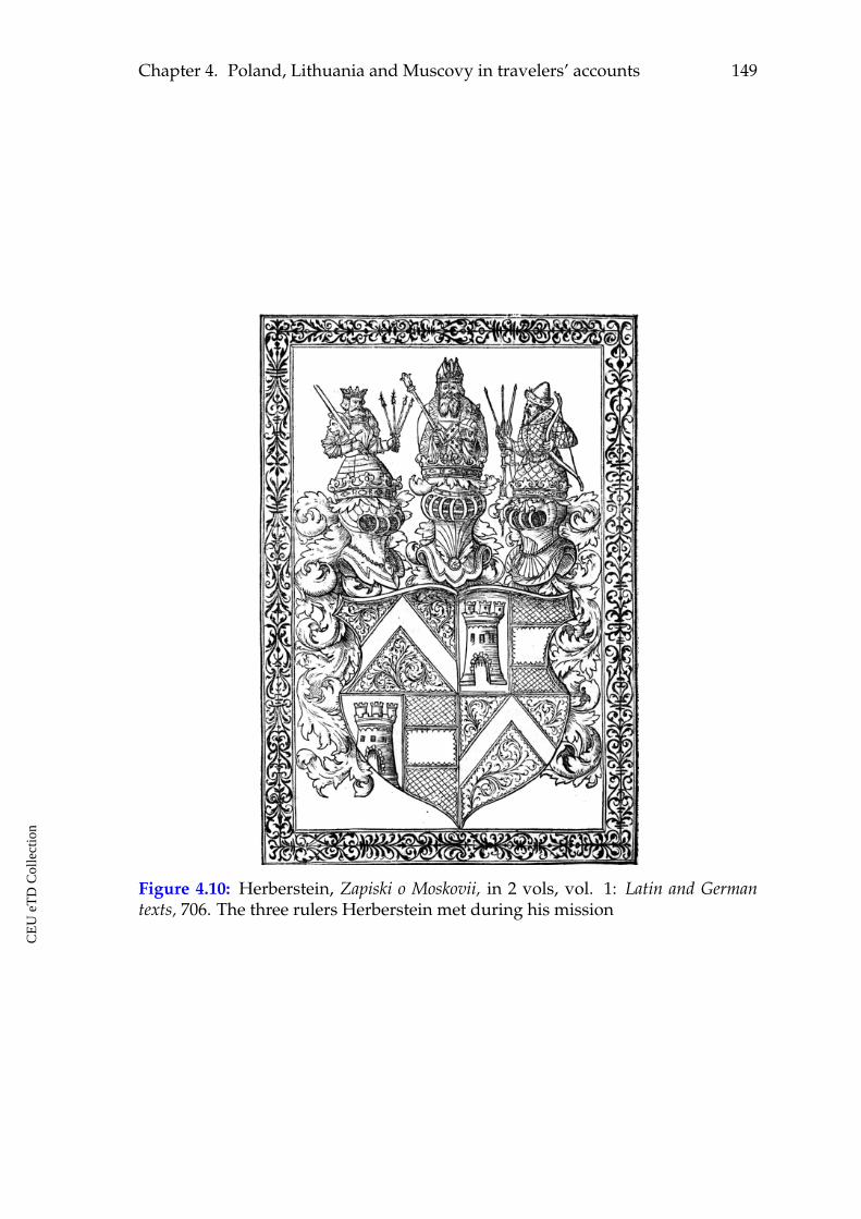
Chapter 4. Poland, Lithuania and Muscovy in travelers’ accounts 149
Figure 4.10: Herberstein, Zapiski o Moskovii, in 2 vols, vol. 1: Latin and Germantexts, 706. The three rulers Herberstein met during his mission
CE
UeT
DC
olle
ctio
n
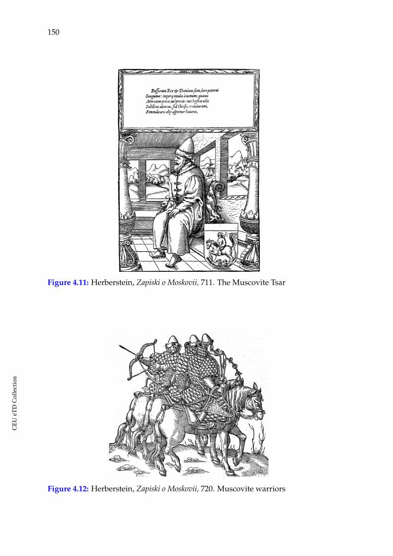
150
Figure 4.11: Herberstein, Zapiski o Moskovii, 711. The Muscovite Tsar
Figure 4.12: Herberstein, Zapiski o Moskovii, 720. Muscovite warriors
CE
UeT
DC
olle
ctio
n
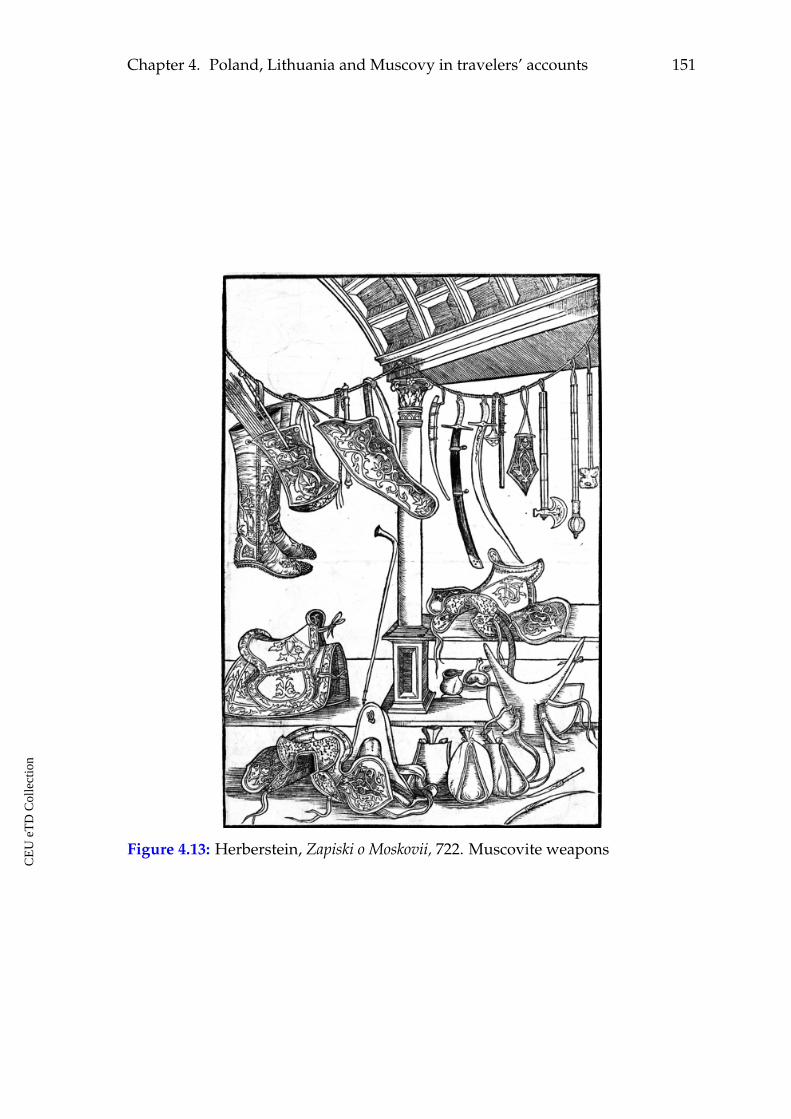
Chapter 4. Poland, Lithuania and Muscovy in travelers’ accounts 151
Figure 4.13: Herberstein, Zapiski o Moskovii, 722. Muscovite weapons
CE
UeT
DC
olle
ctio
n
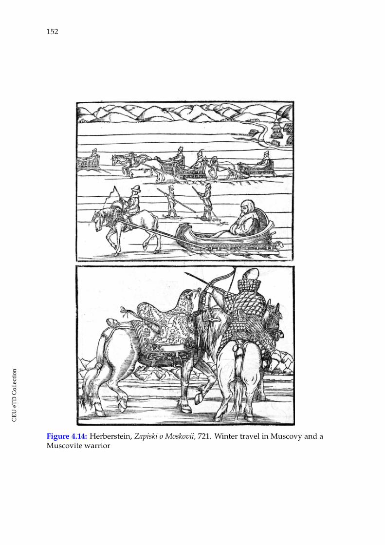
152
Figure 4.14: Herberstein, Zapiski o Moskovii, 721. Winter travel in Muscovy and aMuscovite warrior
CE
UeT
DC
olle
ctio
n
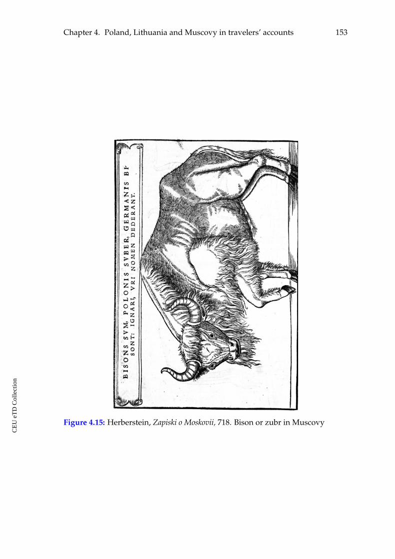
Chapter 4. Poland, Lithuania and Muscovy in travelers’ accounts 153
Figure 4.15: Herberstein, Zapiski o Moskovii, 718. Bison or zubr in Muscovy
CE
UeT
DC
olle
ctio
n
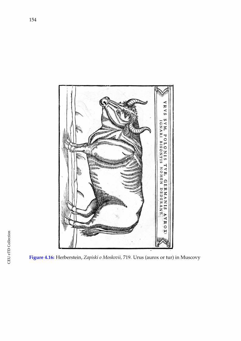
154
Figure 4.16: Herberstein, Zapiski o Moskovii, 719. Urus (aurox or tur) in Muscovy
CE
UeT
DC
olle
ctio
n
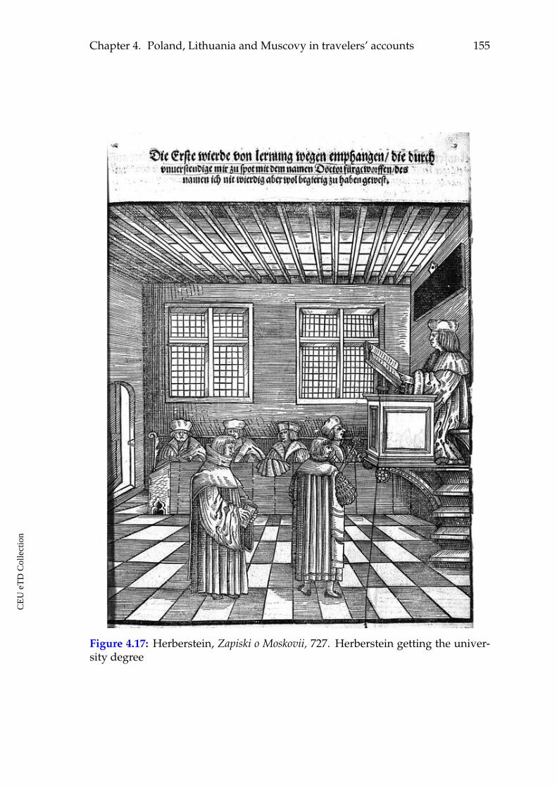
Chapter 4. Poland, Lithuania and Muscovy in travelers’ accounts 155
Figure 4.17: Herberstein, Zapiski o Moskovii, 727. Herberstein getting the univer-sity degree
CE
UeT
DC
olle
ctio
n
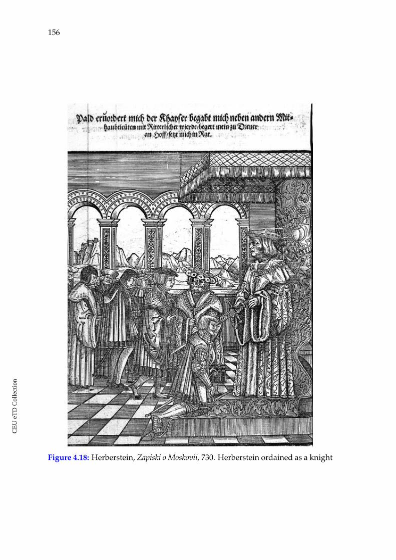
156
Figure 4.18: Herberstein, Zapiski o Moskovii, 730. Herberstein ordained as a knight
CE
UeT
DC
olle
ctio
n
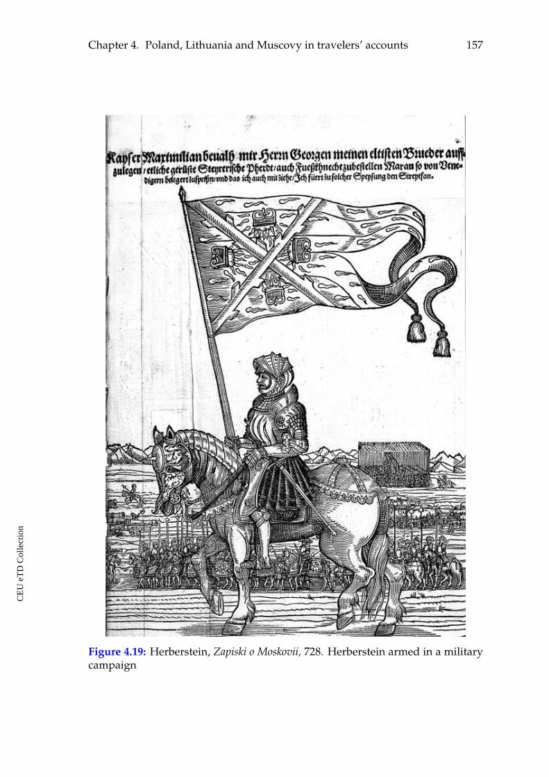
Chapter 4. Poland, Lithuania and Muscovy in travelers’ accounts 157
Figure 4.19: Herberstein, Zapiski o Moskovii, 728. Herberstein armed in a militarycampaign
CE
UeT
DC
olle
ctio
n
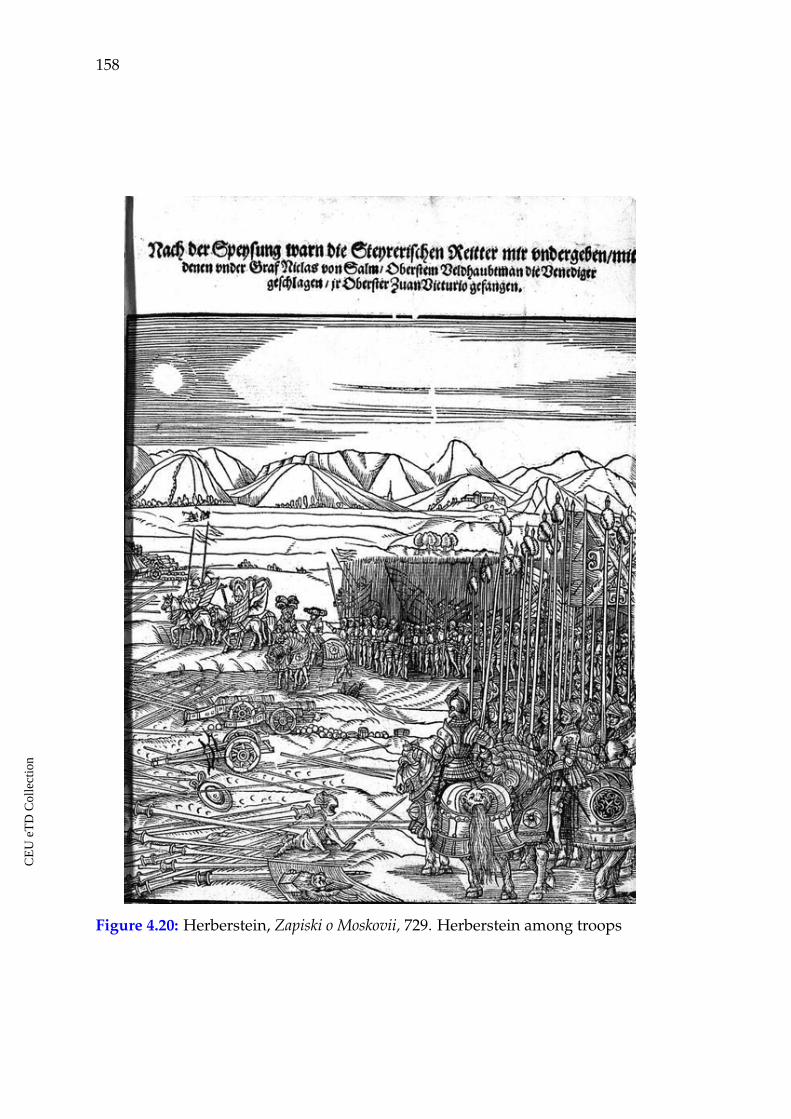
158
Figure 4.20: Herberstein, Zapiski o Moskovii, 729. Herberstein among troops
CE
UeT
DC
olle
ctio
n
Chapter 4. Poland, Lithuania and Muscovy in travelers’ accounts 159
4.5 Findings and observations
The sources involved to this part of investigation represent narratives grounded
in personal, lived experience. Their authors were representatives of different Eu-
ropean societies and they lived in the beginning (de Lannoy), in the middle (Con-
tarini) and in the end (Herberstein) of the research period. Nevertheless, the anal-
ysis shows that the main topics and opinions in these texts have much in common
through the period.
ã The characteristics of urban settlements in the depicted area like: very few
or no stone buildings; prevailing wood, clay, mud, straw as building ma-
terials; poor lodgings and living conditions; mentioning bad wooden city
walls or no walls and fortifications are considered as the main and the most
frequently referred signs that made those places different according to Eu-
ropean travelers in the fifteenth century. All authors reported a gradually
growing presence of unfavorable features about the urban settlements while
they were moving from the western parts of Europe to the eastern. This was
observed as soon as the travelers would enter the lands of Poland, intensi-
fied when writing about Lithuania, Muscovy and the duchies of Novgorod
and Pskov which were included to Muscovite possessions within the inves-
tigated period. The authors pointed out that, in increasing intensity, Poland,
Lithuania and Muscovy were sparsely populated, that villages and towns
were rare. This was a big hardship for those who traveled, as often they
had to sleep outdoors even in winter time, which was the best season for
traveling there. The underdeveloped urban culture in the region in general,
poverty, absence of roads were the main criteria for the fifteenth-century
travelers to judge about the depicted countries.
ã Numerous reports about the hard travel conditions in the region under con-
sideration refer also to the natural obstacles which kept the depicted coun-
tries from contacts with the rest of Europe. Among such factors were the nat-
CE
UeT
DC
olle
ctio
n
160
ural borders like mountains, swamps and marshes, huge forests, big rivers,
extremely cold winters, long distances and rare settlements. These obstacles
isolated some parts of Europe from the rest of the continent, complicating
communication, trade, as well as conquest. When looking at the physical
map of Europe, we may witness that even nowadays many marshes and
forests are preserved in the area of Vistula. In the Middle Ages, they were
larger and there were no roads to pass them. The rivers to the east of Vistula
flow either to north or to south, but not from west to east providing water
roots for communication. This did not help traveling eastwards.
ã The travel accounts demonstrate that the western border of Poland and the
north-western border of Lithuania were a kind of frontier where the authors’
tone and their characteristics concerning what they saw would change. Thus,
Germany, Prussia and Livonia were described in favorable terms, while
Poland, Lithuania and Muscovy in less favorable ones. The latest investi-
gated travel account by Sigismund von Herberstein is focused on Muscovy.
An interesting observation here is the author’s story about the rules of cross-
ing the Lithuanian-Muscovite border. This is the only significant state bor-
der in our region, which is referred to be watched and guarded. It was im-
possible to cross it without a written permission from the Muscovite duke or
other written official document or recommendation. Not all merchants were
allowed to cross it as well. This is not the case with Poland and Lithuania,
nothing is said about crossing their borders. Thus, different frontiers can be
observed while reading travel accounts about the area.
ã Another theme common to all authors is the highest power in the visited
countries: kings, dukes, princes. All authors met with them in Poland,
Lithuania and Muscovy, were accepted by the rulers, invited by them for
dinners, exchanged diplomatic charts and discussed diplomatic issues. The
rulers in Muscovy are described as being crueler to their subjects than those
in Poland.
CE
UeT
DC
olle
ctio
n
Chapter 4. Poland, Lithuania and Muscovy in travelers’ accounts 161
ã Local markets, local goods, local natural resources were another important
topic present in all considered travel accounts. The latest work by Herber-
stein repeated the paradise-like motif for Muscovy, as it was observed in
Münster’s Cosmographia. The authors also provide information on contem-
porary commercial connections for each country.
ã Thus, the considered travel accounts provide us with textual images of Poland,
Lithuania and Muscovy comprising similar sets of topics: the looks of the
towns, traveling conditions, state power, goods and markets, everyday life,
etc. The more to the East, the more information is provided on these subjects
in the travel reports.
ã Travel accounts inform about the roots of communication with Muscovy in
the depicted period and they could also serve as itineraries for other travel-
ers. They provided information about distances from one place to another.
The appearance of this information in the texts is also understood as a sign
defining frontier between the better known, familiar places where the dis-
tances are not reported and the unknown parts of Europe which are being
introduced. The distance was reported in leagues, miles, but also in days
of travel by horse, that is, by time. The terms "league" and "miles" are par-
ticularly used in Lannoy’s and Herberstein’s texts for reporting distances
between the visited places. Thus, it was important for the authors who trav-
eled to these lands with a hundred years difference to report distances this
way.
ã The obtained text visualizations illustrate that the main terminological con-
tent of the travel accounts on Poland, Lithuania and Muscovy reflects well
the main topics and comprising elements of their images. The looks of towns
were the main criteria for the authors to judge about the country. The term
"river" is another strong term in all text visualizations. All more or less im-
portant cities in Europe were situated on river banks. Thus, for an European
CE
UeT
DC
olle
ctio
n
162
traveler the notion of a town or a city was closely bound with the one of a
river. The images of the remote towns, created by travelers, informed their
readers that rivers were important for urban culture in other lands as well.
ã The word trend visualizations depicting and tracing the most frequent terms
through the text body demonstrate presence of common terms in the con-
sidered travel accounts like: "town," "river," "duke," "king," and "prince" in
different combinations. The term "town" is present in all of them. This vi-
sualization tool emphasized the most important topics and elements in the
images of Poland, Lithuania and Muscovy for travelers who had different
diplomatic missions in the area.
ã Herberstein’s illustrations call forth oriental associations and messages. Their
content, that is, clothing, weapons, other material objects and motives are
expected to be different, but they are actually contrasting to their realization
in the home countries of the travelers style.
CE
UeT
DC
olle
ctio
n
CHAPTER 5
Poland, Lithuania and Muscovy in
maps
5.1 General tendencies in cartography of the period and new criti-
cal approaches
A number of the later narrative sources, discussed in this work, contain maps.
Thus, for a better image and a more complete picture of Western representations
of Poland, Lithuania and Muscovy in the fifteenth and the first half of the six-
teenth centuries I consider maps as an indispensable part of this study. Besides
the maps, presented in the narrative sources considered above, I involved also
some examples that do not follow these selection criteria. They were considered
in order to trace contemporary patterns and tendencies in cartography of the re-
gion.
On the one hand, I am interested in the relations between the maps and textual
narratives. On the other hand, the maps are considered as narratives themselves.
They contain their own messages. I also aim to find out whether travel and trav-
elers influenced the narrative content of maps of the investigated region from the
period.
The study period was a transition era for cartography. Map production and
thinking in cartographic terms in general, were transformed by the late fifteenth
163
CE
UeT
DC
olle
ctio
n
164
century to the beginnings of map consciousness as we understand it today. Schol-
arship on medieval cartography agrees that the medieval spatial consciousness
was non-cartographic.195 Geographical information, knowledge, topography, itineraries,
spatial relations were fixed, represented and communicated through narratives,
by the means of telling stories.196
Such historical processes like overseas travel, the great geographical discover-
ies, exploration and the following need to accommodate new geographical knowl-
edge in a synthesized visual manner gave particular impulse to cartography dur-
ing the Renaissance. The practical and theoretical basis for these developments
was found in the beginning of the fifteenth century. A new paradigm and mode
of spatial representation in the form of visual panoptic cartography also appeared
in Western Europe thanks to the rediscovery of Claudius Ptolemy’s Geographia
with its printed edition published in 1477 in Bologna. This was a treatise on car-
tography in its essence. Before him, mankind had been sketching maps for mil-
lennia, but Ptolemy was the first to use mathematics and geometry to work out
a method for how to map the earth. The author also compiled and analyzed all
the geographical knowledge accumulated in the Roman Empire by the second
century and developed a method on visual representation of the world and of its
regions. The Bologna edition was the first printed book with engraved maps and
illustrations. Geographia comprised 3 sections: a cartographic treatise, a gazetteer
and an atlas. The first section of the work contained a detailed methodology and
instructions on how to make maps based on the system of coordinates: the lat-
itudinal and the longitudinal coordinate system. The gazetteer offered coordi-
nates for more than 8000 geographical places and features in Africa, Europe and
195 P.D.A. Harvey, "Medieval Maps: An Introduction", in J.B. Harley and David Woodward, eds.,The History of Cartography, vol. I (Chicago: University of Chicago Press, 1987), 283-286; Nor-man Thrower, Maps and Civilization: Cartography in Culture and Society, 3rd edition (Chicago:University of Chicago Press, 2008), 56-57; Denis Wood, Rethinking the Power of Maps (NewYork: Guilford Press, 2010), 23.
196 Trevor J. Barnes, "Spatial Analysis," in John Agnew and David Livingstone, eds., The SageHandbook of Geographical Knowledge (London: Sage, 2011), 231-232; Michael R. Curry, "Towarda Geography of a World without Maps: Lessons from Ptolemy and Postal Codes," Annals ofthe Association of American Geographers 95, no.3 (2005): 680–691.
CE
UeT
DC
olle
ctio
n
Chapter 5. Poland, Lithuania and Muscovy in maps 165
Asia that were mentioned in his work. The projection was north-oriented and
Mediterranean-focused. The atlas consisted of one general and not detailed world
map and a number of separate and detailed regional maps. All these made this
work particularly popular and influential for the formation of a new cartographic
way of spatial thinking and representation in Renaissance Europe. According
to this method the Renaissance map makers were able to place the known in-
formation about the world within a two-dimensional grid. The Ptolemaic scien-
tific background made the Renaissance cartographers to seek for accuracy and
precision while mapping geographical and administrative features. Since then,
Ptolemy has been considered to be the father of cartography, whose influence in
the field remains to present days.
Ptolemy’s treatises were among the works that inspired Columbus to under-
take a voyage in western direction. What followed after, dramatically changed
perception of the world in general. The challenges in understanding of newly ob-
tained information made the Europeans start thinking in categories of "the West"
and "the rest", or the "Others".197
When speaking about Renaissance maps, their representation does not refer
just to techniques, but to the ways of transmitting abstract ideas and putting them
into a visual material product and visual codes. The symbolic cartographic lan-
guage was being unified through contacts and intellectual exchange within Eu-
rope. Maps enhanced the power and territorial claims. By the seventeenth cen-
tury, maps started to be used in order to graphically demarcate the borders of
territorial possessions.198
This new paradigm gave ground to visually represent the picture of the world
in a certain structure. One of the characteristic features of the cartography in this
197 Denis Cosgrove, Apollo’s Eye: A Cartographic Genealogy of the Earth in the Western Imagination(Baltimore: Johns Hopkins University Press, 2001).
198 Michael Biggs, "Putting the State on the Map: Cartography, Territory, and European StateFormation," Comparative Studies in Society and History 41, no.2 (1999): 374-405; Jordan Branch,"Mapping the Sovereign State: Technology, Authority, and Systemic Change," InternationalOrganization 65, no.1 (2011): 1-36.
CE
UeT
DC
olle
ctio
n
166
period was that this structure accommodated the views about the relationships
between geography and the civility of peoples. Since antiquity, geography and
the geographical position of a certain land were believed to be influential factors
impacting human appearance, culture, temperaments, social and political orga-
nization. Maps and their coordinate system connected with the theory about the
relationship between geographical location, climate and the civilization of human
societies got a visually persuasive form. This way the maps from the period also
depicted one of the debates of the period, namely, the civilization versus/or bar-
barism of societies depicted on maps in relation to their geographical location.199
In the depicted period, maps already represent analytical tools with which
Europeans would interpret and make sense of geographical, ethnological, social,
cultural diversity of the represented areas. They contributed to the development
of comprehension and reasoning about the depicted lands in comparative terms.
The visual codes in maps could support or even justify and stimulate colonial
claims, religious missions, expansion, cultural contacts, territorial claims. They
symbolized power, represented decorative functions, and played an important
educational role.
One of the latest developments in critical cartography is a growing interest in
narrative cartography and the relationship between maps and narratives. Scholar-
ship views the relations between maps and narratives in two ways: first, defining,
deconstructing and interpreting the meta-narratives embedded in maps; second,
approaching maps as form of storytelling.200
The post-representational cartography is another contemporary approach, founded
upon the idea that maps are never finished. Their work and their message is never
199 John Block Friedman, The Monstrous Races in Medieval Art and Thought, 2nd ed. (Syracuse,NY: Syracuse University Press, 2000); Patrick Gautier Dalché, "The Reception of Ptolemy’sGeography (End of the Fourteenth to Beginning of the Sixteenth Century)," in The History ofCartography, Volume 3, ed. David Woodward (Chicago: University of Chicago Press, 2007),285-364.
200 Sébastien Caquard, "Cartography I: Mapping narrative cartography," Progress in Human Ge-ography 37, no.1 (2013): 135-144.
CE
UeT
DC
olle
ctio
n
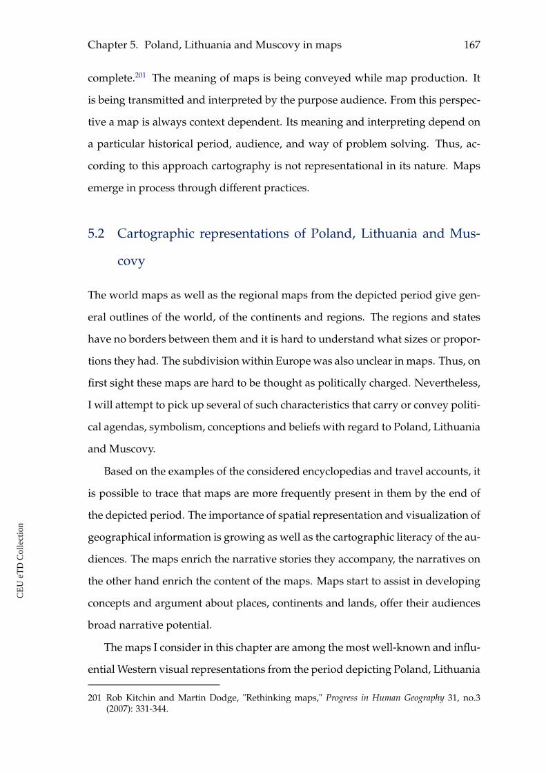
Chapter 5. Poland, Lithuania and Muscovy in maps 167
complete.201 The meaning of maps is being conveyed while map production. It
is being transmitted and interpreted by the purpose audience. From this perspec-
tive a map is always context dependent. Its meaning and interpreting depend on
a particular historical period, audience, and way of problem solving. Thus, ac-
cording to this approach cartography is not representational in its nature. Maps
emerge in process through different practices.
5.2 Cartographic representations of Poland, Lithuania and Mus-
covy
The world maps as well as the regional maps from the depicted period give gen-
eral outlines of the world, of the continents and regions. The regions and states
have no borders between them and it is hard to understand what sizes or propor-
tions they had. The subdivision within Europe was also unclear in maps. Thus, on
first sight these maps are hard to be thought as politically charged. Nevertheless,
I will attempt to pick up several of such characteristics that carry or convey politi-
cal agendas, symbolism, conceptions and beliefs with regard to Poland, Lithuania
and Muscovy.
Based on the examples of the considered encyclopedias and travel accounts, it
is possible to trace that maps are more frequently present in them by the end of
the depicted period. The importance of spatial representation and visualization of
geographical information is growing as well as the cartographic literacy of the au-
diences. The maps enrich the narrative stories they accompany, the narratives on
the other hand enrich the content of the maps. Maps start to assist in developing
concepts and argument about places, continents and lands, offer their audiences
broad narrative potential.
The maps I consider in this chapter are among the most well-known and influ-
ential Western visual representations from the period depicting Poland, Lithuania
201 Rob Kitchin and Martin Dodge, "Rethinking maps," Progress in Human Geography 31, no.3(2007): 331-344.
CE
UeT
DC
olle
ctio
n
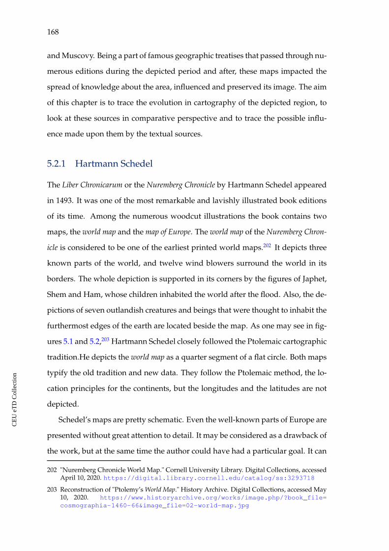
168
and Muscovy. Being a part of famous geographic treatises that passed through nu-
merous editions during the depicted period and after, these maps impacted the
spread of knowledge about the area, influenced and preserved its image. The aim
of this chapter is to trace the evolution in cartography of the depicted region, to
look at these sources in comparative perspective and to trace the possible influ-
ence made upon them by the textual sources.
5.2.1 Hartmann Schedel
The Liber Chronicarum or the Nuremberg Chronicle by Hartmann Schedel appeared
in 1493. It was one of the most remarkable and lavishly illustrated book editions
of its time. Among the numerous woodcut illustrations the book contains two
maps, the world map and the map of Europe. The world map of the Nuremberg Chron-
icle is considered to be one of the earliest printed world maps.202 It depicts three
known parts of the world, and twelve wind blowers surround the world in its
borders. The whole depiction is supported in its corners by the figures of Japhet,
Shem and Ham, whose children inhabited the world after the flood. Also, the de-
pictions of seven outlandish creatures and beings that were thought to inhabit the
furthermost edges of the earth are located beside the map. As one may see in fig-
ures 5.1 and 5.2,203 Hartmann Schedel closely followed the Ptolemaic cartographic
tradition.He depicts the world map as a quarter segment of a flat circle. Both maps
typify the old tradition and new data. They follow the Ptolemaic method, the lo-
cation principles for the continents, but the longitudes and the latitudes are not
depicted.
Schedel’s maps are pretty schematic. Even the well-known parts of Europe are
presented without great attention to detail. It may be considered as a drawback of
the work, but at the same time the author could have had a particular goal. It can
202 "Nuremberg Chronicle World Map." Cornell University Library. Digital Collections, accessedApril 10, 2020. https://digital.library.cornell.edu/catalog/ss:3293718
203 Reconstruction of "Ptolemy’s World Map." History Archive. Digital Collections, accessed May10, 2020. https://www.historyarchive.org/works/image.php/?book_file=cosmographia-1460-66&image_file=02-world-map.jpg
CE
UeT
DC
olle
ctio
n
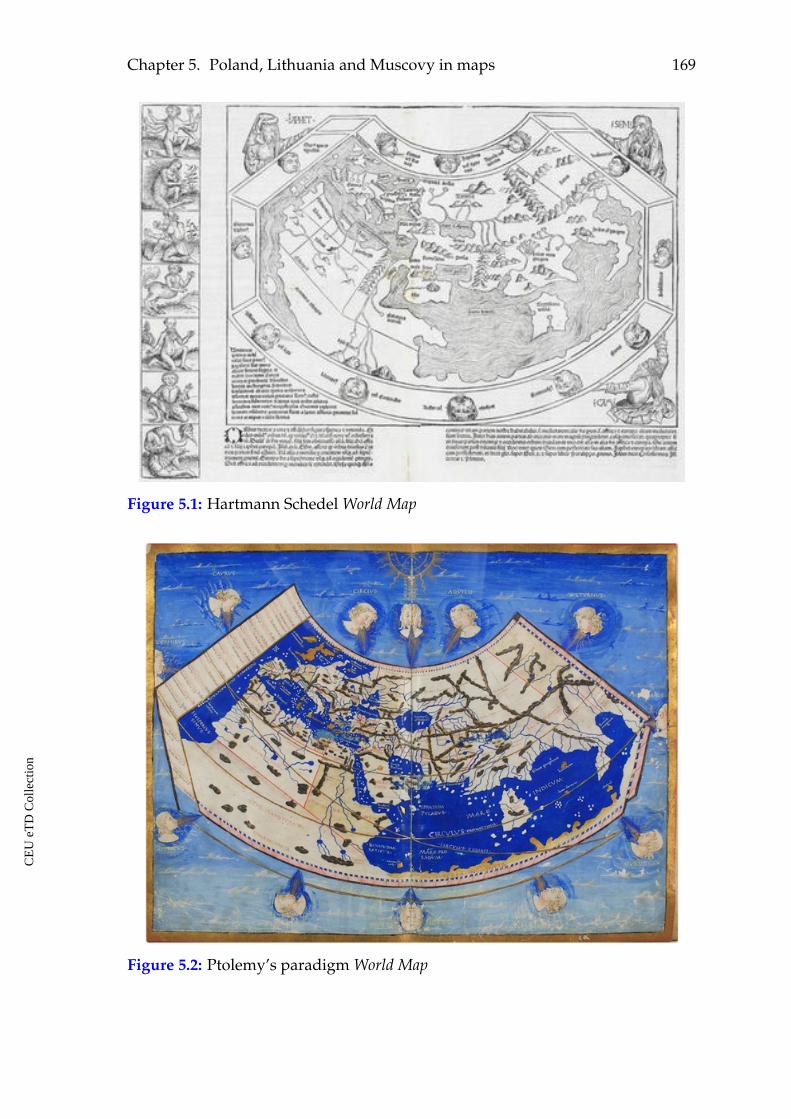
Chapter 5. Poland, Lithuania and Muscovy in maps 169
Figure 5.1: Hartmann Schedel World Map
Figure 5.2: Ptolemy’s paradigm World Map
CE
UeT
DC
olle
ctio
n
170
be suggested that the author’s goal was to put into the map the main distinguish-
ing features in order to orient the reader and to locate the textual information on
described places. State and city names, names of rivers and seas as known at
Schedel’s time are among them (see figures 5.1, 5.3 and 5.5).
Let us see a detail of Schedel’s world map, depicting the considered area (see fig-
ure 5.3). Out of three eastern lands we are interested in, only Poland is presented
by the state name. Muscovy is depicted by its capital Moscow (Mosca). Lithuania
is not mentioned. Nevertheless, the map was helpful for a learned reader. The
textual description of Lithuania begins with reference about its geographical lo-
cation. It is said that Lithuania is situated to the east of neighboring Poland. Thus,
even in such cases the contribution made by the two sources, the textual and the
cartographic ones, would assist in building a more complete picture about the
particular region.
Figure 5.3: Hartmann Schedel World Map, detail
It is worth mentioning that Lithuania was a state large in its size and power
at that period(see figure 1.1). Both Poland and Muscovy were smaller. Maps like
Schedel’s world map, therefore, demonstrate how different factors, may it be the
CE
UeT
DC
olle
ctio
n
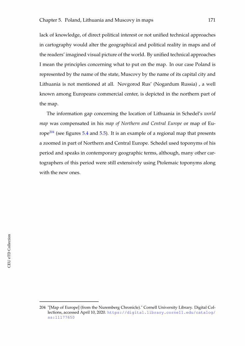
Chapter 5. Poland, Lithuania and Muscovy in maps 171
lack of knowledge, of direct political interest or not unified technical approaches
in cartography would alter the geographical and political reality in maps and of
the readers’ imagined visual picture of the world. By unified technical approaches
I mean the principles concerning what to put on the map. In our case Poland is
represented by the name of the state, Muscovy by the name of its capital city and
Lithuania is not mentioned at all. Novgorod Rus’ (Nogardum Russia) , a well
known among Europeans commercial center, is depicted in the northern part of
the map.
The information gap concerning the location of Lithuania in Schedel’s world
map was compensated in his map of Northern and Central Europe or map of Eu-
rope204 (see figures 5.4 and 5.5). It is an example of a regional map that presents
a zoomed in part of Northern and Central Europe. Schedel used toponyms of his
period and speaks in contemporary geographic terms, although, many other car-
tographers of this period were still extensively using Ptolemaic toponyms along
with the new ones.
204 "[Map of Europe] (from the Nuremberg Chronicle)." Cornell University Library. Digital Col-lections, accessed April 10, 2020. https://digital.library.cornell.edu/catalog/ss:11177650
CE
UeT
DC
olle
ctio
n
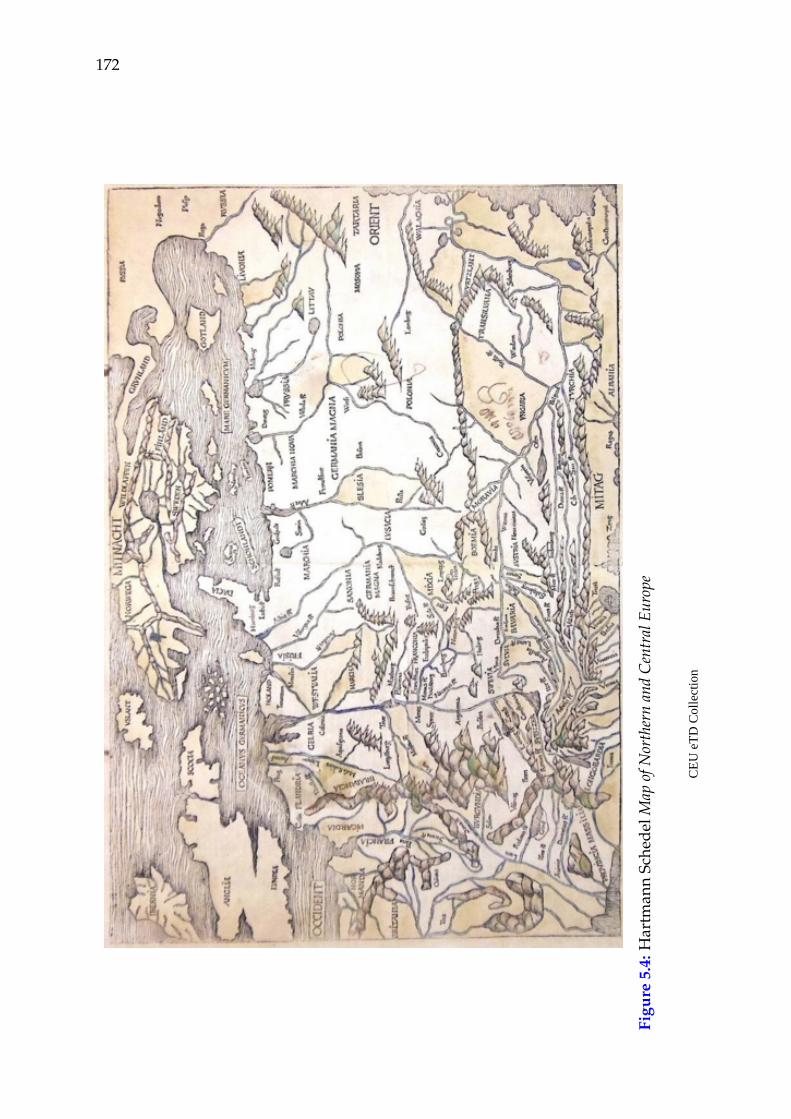
172
Figu
re5.
4:H
artm
ann
Sche
delM
apof
Nor
ther
nan
dC
entr
alEu
rope
CE
UeT
DC
olle
ctio
n
Chapter 5. Poland, Lithuania and Muscovy in maps 173
Figure 5.5: Hartmann Schedel Map of Northern and Central Europe, detail
Schedel probably had more space in this case and depicted Lithuania. All three
states are shown with their names. The reader of the text and of this map would
easily orient him/herself and see where Poland, Lithuania and Muscovy were lo-
cated. Most probably, that was the main utility of this map. It does not offer other
stories, but helps the reader to geographically position the textual descriptions of
the depicted lands. The difference between the studied lands in Schedel’s depic-
tion is that Poland looks larger then the other two. Its name is depicted twice,
its capital Cracouia (Krakow) is specified in this map as well as Warse (Warsaw)
and the Vistula river (Vistula fl.). Muscovy is depicted in the map, but its textual
description is missing in the encyclopedic part of the work. The author also made
CE
UeT
DC
olle
ctio
n
174
a mistake in the name of Moscovia and specified it as Mosovia. I consider it for
Moscovia and not Mazovia, which spelling is also close to the one depicted in the
map. First, Mazovia is one of the central regions of Poland located in the Vistula
basin and having Warsaw as its central city. Both, Warsaw (Warse) and the Vistula
river (Vistula fl.) are depicted in the map. Their location is the location of Ma-
zovia. Second, for MosCovia there is one spelling mistake here, but for MAZovia
there are two spelling mistakes. Third, it is too far to the East and too close to the
Orient for Mazovia. In one of Sebastian Münster’s maps it is possible to see the
name of the Duchy of Mazovia (Ducatus Mazoviae) in the north-western corner
of the map, west of Lithuania (see figures 5.6 and 5.7).
Several cities are depicted in the area under consideration. These are Cra-
couia (Krakow), Warse (Warsaw), Lemberg (Lviv), Nogardum (Novgorod), and
Plesgo (Pskov). Lemberg, Novgorod, Pskov were known as commercial centers
in Europe. Lemberg also had German population. In 1356, the city was granted
Magdeburg law, since then it attracted German, Polish and Czech settlers and
grew into an important trade center in the region. It was probably the most re-
mote eastern European city in the region where communities of Western Euro-
peans were present. References to these commercial cities in encyclopedias and
travel accounts were discussed in the previous chapters.
Schedel depicted Novgorod and Pskov in the North-Eastern edge of his map.
These cities were also known in Europe as stops on the way from the Baltics to
Byzantium since the times of Kievan Rus’. They remained independent duchies
until 1478 and 1510 respectively, when they were conquered by Muscovy.
In his map of Europe Hartmann Schedel uses mountains to depict the border
and separate Poland from Hungary, Transylvania and Walachia. No physical bor-
ders are observed between Poland, Lithuania and Muscovy. The mountain ranges
are depicted eastwards of Muscovy. The accent in this map is made on the border
of the European continent possibly.
CE
UeT
DC
olle
ctio
n
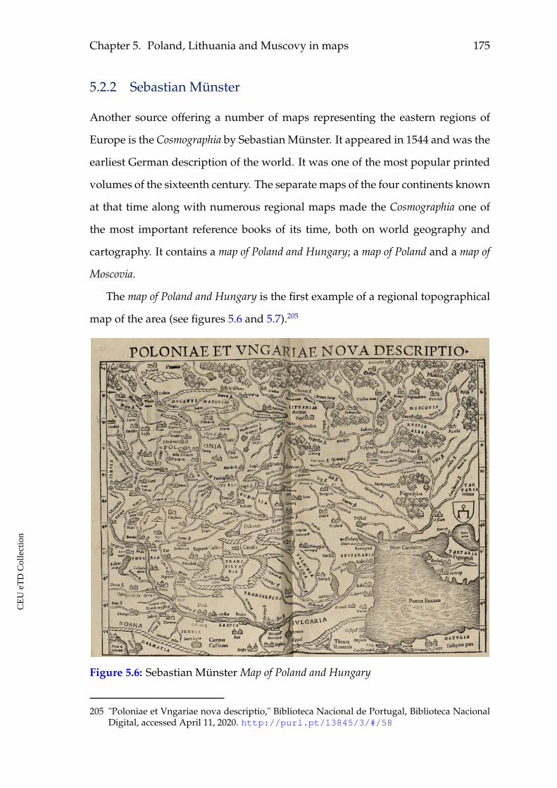
Chapter 5. Poland, Lithuania and Muscovy in maps 175
5.2.2 Sebastian Münster
Another source offering a number of maps representing the eastern regions of
Europe is the Cosmographia by Sebastian Münster. It appeared in 1544 and was the
earliest German description of the world. It was one of the most popular printed
volumes of the sixteenth century. The separate maps of the four continents known
at that time along with numerous regional maps made the Cosmographia one of
the most important reference books of its time, both on world geography and
cartography. It contains a map of Poland and Hungary; a map of Poland and a map of
Moscovia.
The map of Poland and Hungary is the first example of a regional topographical
map of the area (see figures 5.6 and 5.7).205
Figure 5.6: Sebastian Münster Map of Poland and Hungary
205 "Poloniae et Vngariae nova descriptio," Biblioteca Nacional de Portugal, Biblioteca NacionalDigital, accessed April 11, 2020. http://purl.pt/13845/3/#/58
CE
UeT
DC
olle
ctio
n
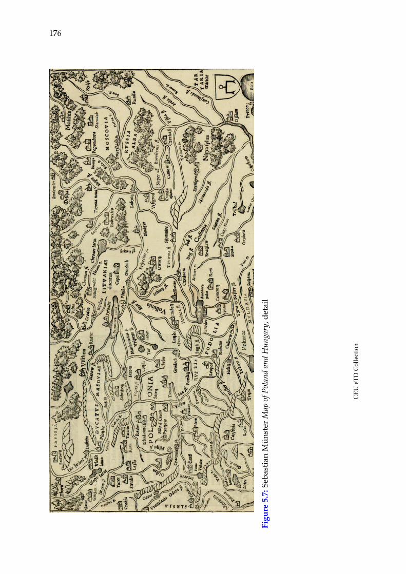
176
Figu
re5.
7:Se
bast
ian
Mün
ster
Map
ofPo
land
and
Hun
gary
,det
ail
CE
UeT
DC
olle
ctio
n
Chapter 5. Poland, Lithuania and Muscovy in maps 177
Numerous settlements of different size and importance with their distinguish-
ing features, like castles and fortifications comprise their visual images. The map
also richly depicts geographical features of these countries: rivers, lakes, moun-
tains and forests. The distribution of topographical as well as geographical fea-
tures varies at different areas presented in the map. Poland (Polonia) and Hun-
gary (Vngaria) make an impression of being more populated and documented,
richer in geographical features. The lands to the eastern edge of the map, Lithua-
nia (Litvaniae) and Muscovy (Moscovia) particularly, look less populated and
covered with forests. They are not equally and as intensively represented in this
map. Thus, one may argue that this was a real situation, that Lithuania and Mus-
covy did not play an important role in the map of Poland and Hungary, or that
Western Europeans did not know much about the topography of Lithuania and
Muscovy in Münster’s time. These factors influenced the produced image in a
sense that Poland occupies a larger territory and looks "stronger" in comparison
to Lithuania and Muscovy.
In this map Münster, in the same way as Schedel, used geographical features,
rivers and mountain ranges, to demarcate borders between regions and countries.
Often, this was really the case that rivers or mountains separated the territorial
possessions of neighboring states. In Münster’s map, mountain ranges separate
Poland from Hungary, mountains circle Transylvania and Mazovia (Ducatus Ma-
zoviae). In the eastern part of the map there is a non-demarcated line, along which
the settlements become rare and behind which thick forests cover the possessions
of Lithuania and Muscovy and separate them from the rest of the depicted part
of Europe. This is a cartographic, visually expressed separation of Lithuania and
Muscovy from the rest of Europe.
Thus, if one considers this representation of the area along with the textual
descriptions of Poland, Lithuania and Muscovy, some narrative analogies can be
observed. For example, the textual reference to Poland in the Cosmographia is
decisively larger than those to Lithuania and Muscovy. The same is observed in
CE
UeT
DC
olle
ctio
n
178
their pictorial depiction in this map: first Poland, then the other two. Poland
is textually described in terms of its history and political life, the descriptions of
Lithuania and Muscovy give mostly general information on their location, nature,
climate, religion, language, goods, and rulership. This analogy is communicated
through the map as well. Poland is larger than Lithuania and a more extensive
presence of "nature" is to be found in Lithuania and Muscovy. Poland gives the
impression of a populated and cultivated land, similar to Hungary, for example.
A general observation for the regional map of Poland and Hungary by Münster is
that it offers richer topographical information on all three lands in comparison to
Hartmann Schedel. There is a visual difference in the frequency of settlements be-
tween Poland, on the one hand, and Lithuania and Muscovy, on the other. Poland
occupies a larger spatial segment in this map as well, producing an impression of
being larger than Lithuania. The architectural signs, depicting town fortifications
and castles, are pretty homogeneous in Poland. The landscape is getting "wilder"
as one moves towards Lithuania and Muscovy with more forests and fewer set-
tlements, with more signs of "nature" and less signs of "culture".
The map of Poland206 also presents a rich topography for this country (see fig-
ure 5.8). It informed the reader on the location of about ten Polish cities and about
the regions’ names. Many of the cities are depicted having stone castles or forti-
fications. The eastern part of Poland has more forests. The map’s layout did not
undergo many changes since the times of Schedel. What is new about Münster’s
representations of the region is that his maps got a stronger narrative perspective
and content. Now the reader could find in the maps not just the names of the
countries, but also cities and towns, could learn about the main physical features
of the depicted lands, like forests, rivers, lakes and mountains. The eastern part
of Europe starts to be better visually documented.
The description of Lithuania (Littaw) is not accompanied by a separate map
of the region. So, the reader would consult the map of Poland (see figure 5.8), or
206 "De regno et tota regione Poloniae," Biblioteca Nacional de Portugal, Biblioteca Nacional Dig-ital, accessed April 11, 2020. http://purl.pt/13845/3/#/919
CE
UeT
DC
olle
ctio
n
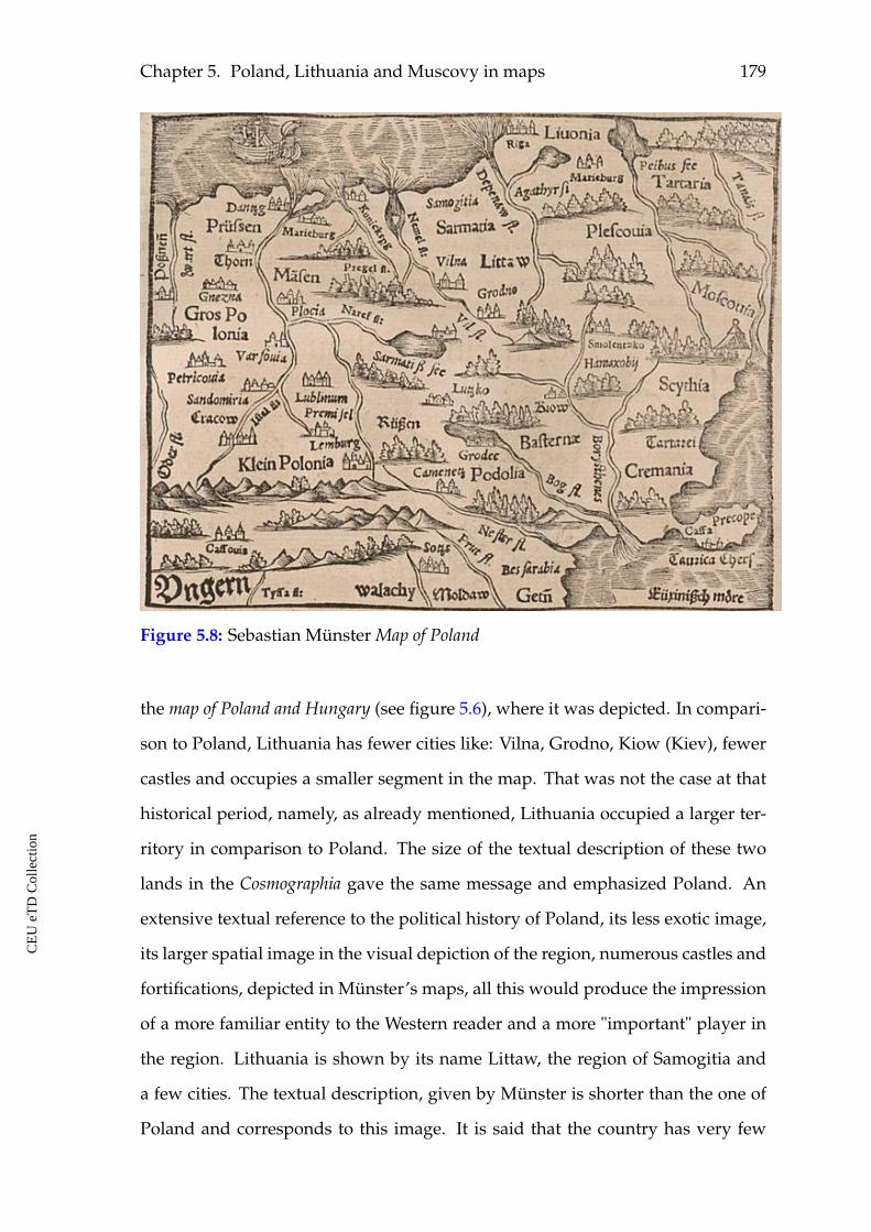
Chapter 5. Poland, Lithuania and Muscovy in maps 179
Figure 5.8: Sebastian Münster Map of Poland
the map of Poland and Hungary (see figure 5.6), where it was depicted. In compari-
son to Poland, Lithuania has fewer cities like: Vilna, Grodno, Kiow (Kiev), fewer
castles and occupies a smaller segment in the map. That was not the case at that
historical period, namely, as already mentioned, Lithuania occupied a larger ter-
ritory in comparison to Poland. The size of the textual description of these two
lands in the Cosmographia gave the same message and emphasized Poland. An
extensive textual reference to the political history of Poland, its less exotic image,
its larger spatial image in the visual depiction of the region, numerous castles and
fortifications, depicted in Münster’s maps, all this would produce the impression
of a more familiar entity to the Western reader and a more "important" player in
the region. Lithuania is shown by its name Littaw, the region of Samogitia and
a few cities. The textual description, given by Münster is shorter than the one of
Poland and corresponds to this image. It is said that the country has very few
CE
UeT
DC
olle
ctio
n
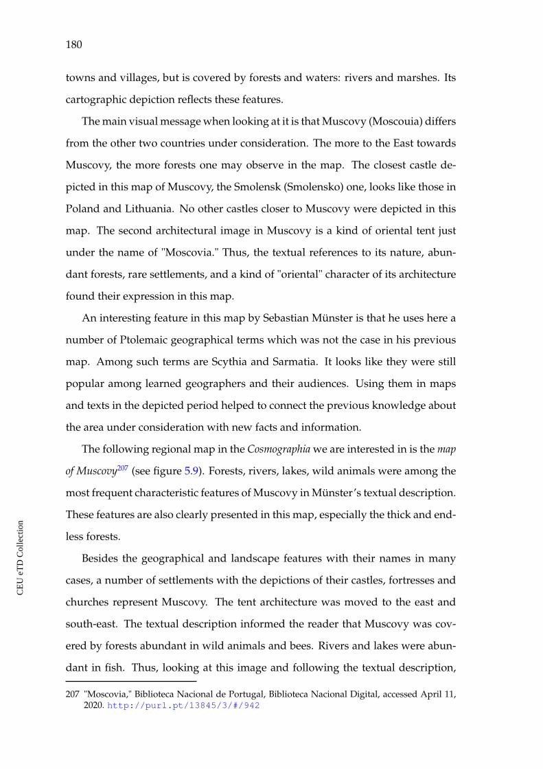
180
towns and villages, but is covered by forests and waters: rivers and marshes. Its
cartographic depiction reflects these features.
The main visual message when looking at it is that Muscovy (Moscouia) differs
from the other two countries under consideration. The more to the East towards
Muscovy, the more forests one may observe in the map. The closest castle de-
picted in this map of Muscovy, the Smolensk (Smolensko) one, looks like those in
Poland and Lithuania. No other castles closer to Muscovy were depicted in this
map. The second architectural image in Muscovy is a kind of oriental tent just
under the name of "Moscovia." Thus, the textual references to its nature, abun-
dant forests, rare settlements, and a kind of "oriental" character of its architecture
found their expression in this map.
An interesting feature in this map by Sebastian Münster is that he uses here a
number of Ptolemaic geographical terms which was not the case in his previous
map. Among such terms are Scythia and Sarmatia. It looks like they were still
popular among learned geographers and their audiences. Using them in maps
and texts in the depicted period helped to connect the previous knowledge about
the area under consideration with new facts and information.
The following regional map in the Cosmographia we are interested in is the map
of Muscovy207 (see figure 5.9). Forests, rivers, lakes, wild animals were among the
most frequent characteristic features of Muscovy in Münster’s textual description.
These features are also clearly presented in this map, especially the thick and end-
less forests.
Besides the geographical and landscape features with their names in many
cases, a number of settlements with the depictions of their castles, fortresses and
churches represent Muscovy. The tent architecture was moved to the east and
south-east. The textual description informed the reader that Muscovy was cov-
ered by forests abundant in wild animals and bees. Rivers and lakes were abun-
dant in fish. Thus, looking at this image and following the textual description,
207 "Moscovia," Biblioteca Nacional de Portugal, Biblioteca Nacional Digital, accessed April 11,2020. http://purl.pt/13845/3/#/942
CE
UeT
DC
olle
ctio
n
Chapter 5. Poland, Lithuania and Muscovy in maps 181
Figure 5.9: Sebastian Münster Map of Muscovy (Moscovia)
the reader would visually perceive Muscovy as rich in any kinds of goods. Its
huge forests, numerous rivers and lakes in maps were supposed to have much
honey, wax, animals with precious furs, fish, wood and other things. At the same
time this land was sparsely populated and uncultivated in comparison to western
parts of Europe.
In comparison to Schedel’s cartography of the depicted region Münster’s to-
pographical and regional maps demonstrate a considerable evolution with regard
to the representation of Poland, Lithuania and Muscovy. One may assume that he
had extensive material on settlements in all three countries. One can also observe
that he tried to be close to the textual descriptions of them.
CE
UeT
DC
olle
ctio
n
182
Let us now concentrate on the famous map of Europe in Münster’s Cosmo-
graphia, where Europe is depicted as a queen, the so-called Europa Regina (see fig-
ures 5.10208 and 5.11209). The genesis of anthropomorphic maps of Europa Regina
in Western Europe and in numerous editions of Münster’s Cosmographia was in-
vestigated by Peter Meurer.210 Not all, but some of the first editions of the Cos-
mographia contained this image of Europe, but, since 1588, the Europa Regina was
always included into the later editions. This is an example of a "story" map. It
is an illustration of mythological, historical, intellectual, political and social pro-
cesses of self-idea and self-image having been created in the West at the Age of
Discovery and the Renaissance. "West" and "Western" are historically self-made
constructs and this map is a great expression of the way the Europeans saw and
positioned themselves at that period. The depiction of the European continent
represents a smart visual solution and conveys a strong narrative power. The title
in the earlier version conveys the main idea behind this unified image, namely,
the idea of the continent united by Christianity (see figure 5.10). The continent
is also presented as the main power in the world. Thus, the map stimulated the
readers’ imagination and challenged different assumptions about Europe itself,
about the Europeans and the rest of the world. This early version also shows
Poland (Polonia) and Muscovy (Moscowiten), but not Lithuania.
From the Western European perspective our region in these anthropomorphic
maps is located in the "very" periphery of the continent. Particularly in the later
editions (see figure 5.11), being put in the gown hem, Muscovy (Moscovia) was
a different kind of periphery in comparison to the one where Sicily, England or
Spain were positioned. An attempt to separate Muscovy by an additional visual
208 "L’Europa cosa comprende ai nostri giorni." Fondazione Istituto Internazionale die Sto-ria Ecomomica "F. Datini," Biblioteca in linea, accessed April 11, 2020. http://www.istitutodatini.it/biblio/images/it/lazzer/munster/dida/dida17.htm
209 "Anthropomorphic map showing Europe as a queen." The Newberry, accessed April11, 2020. http://publications.newberry.org/dig/creating-shakespeare/anthropomorphic-map-showing-europe-as-a-queen
210 Peter Meurer, "Europa Regina: 16th century Maps of Europe in the Form of a Queen," Belgeo3–4 (2008): 355–370.
CE
UeT
DC
olle
ctio
n
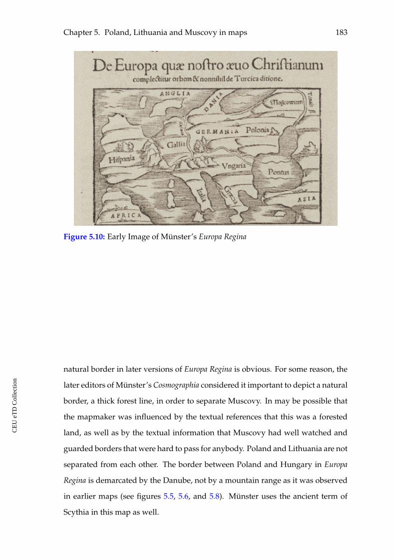
Chapter 5. Poland, Lithuania and Muscovy in maps 183
Figure 5.10: Early Image of Münster’s Europa Regina
natural border in later versions of Europa Regina is obvious. For some reason, the
later editors of Münster’s Cosmographia considered it important to depict a natural
border, a thick forest line, in order to separate Muscovy. In may be possible that
the mapmaker was influenced by the textual references that this was a forested
land, as well as by the textual information that Muscovy had well watched and
guarded borders that were hard to pass for anybody. Poland and Lithuania are not
separated from each other. The border between Poland and Hungary in Europa
Regina is demarcated by the Danube, not by a mountain range as it was observed
in earlier maps (see figures 5.5, 5.6, and 5.8). Münster uses the ancient term of
Scythia in this map as well.
CE
UeT
DC
olle
ctio
n
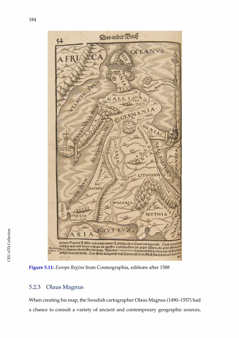
184
Figure 5.11: Europa Regina from Cosmographia, editions after 1588
5.2.3 Olaus Magnus
When creating his map, the Swedish cartographer Olaus Magnus (1490–1557) had
a chance to consult a variety of ancient and contemporary geographic sources,
CE
UeT
DC
olle
ctio
n
Chapter 5. Poland, Lithuania and Muscovy in maps 185
treatises, descriptions of travelers and sailors, as well as oral stories. He stayed
in Rome at that period. The result of his work was the famous illustrated map
known as Carta Marina.211 The first copies of the map were printed in 1539 in
Venice. In 1555, it was published as part of a book named A Description of the
Northern Peoples. It represented a textual explanation of what was depicted in the
map. Thus, the map also became a visual representation of the text. Therefore,
the cartographic depiction of a part of the research area is again a visual represen-
tation of existing Western beliefs, perception, political and ideological confronta-
tion, and agenda towards the considered lands.
Particularly, the visual separation of Muscovy as well as Samogitia and Lithua-
nia is observed and communicated by the Carta Marina (see figures 5.12, and 5.13).
The separation of Samogitia, Lithuania and Muscovy, on the one hand, and Livo-
nia and Finland, on the other, is clearly drawn with a line of trees, gulf waters
and/or by troops facing each other. The reader can observe confrontation of dif-
ferent nature from both sides of this border line. The armed troops face each other
from both sides, the weapons also look towards the border, the rulers of Muscovy
and the Polish-Lithuanian union are facing the West.
211 "Carta marina." World Digital Library, accessed April 10, 2020. https://www.wdl.org/en/item/3037/#q=olaus+magnus&qla=en
CE
UeT
DC
olle
ctio
n
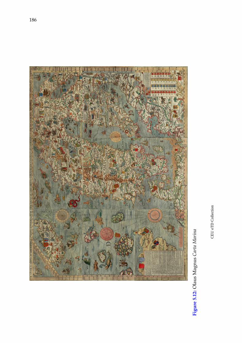
186
Figu
re5.
12:O
laus
Mag
nus
Car
taM
arin
a
CE
UeT
DC
olle
ctio
n
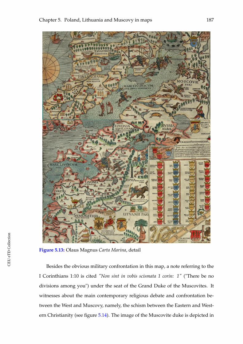
Chapter 5. Poland, Lithuania and Muscovy in maps 187
Figure 5.13: Olaus Magnus Carta Marina, detail
Besides the obvious military confrontation in this map, a note referring to the
I Corinthians 1:10 is cited "Non sint in vobis scismata 1 corin: 1" ("There be no
divisions among you") under the seat of the Grand Duke of the Muscovites. It
witnesses about the main contemporary religious debate and confrontation be-
tween the West and Muscovy, namely, the schism between the Eastern and West-
ern Christianity (see figure 5.14). The image of the Muscovite duke is depicted in
CE
UeT
DC
olle
ctio
n
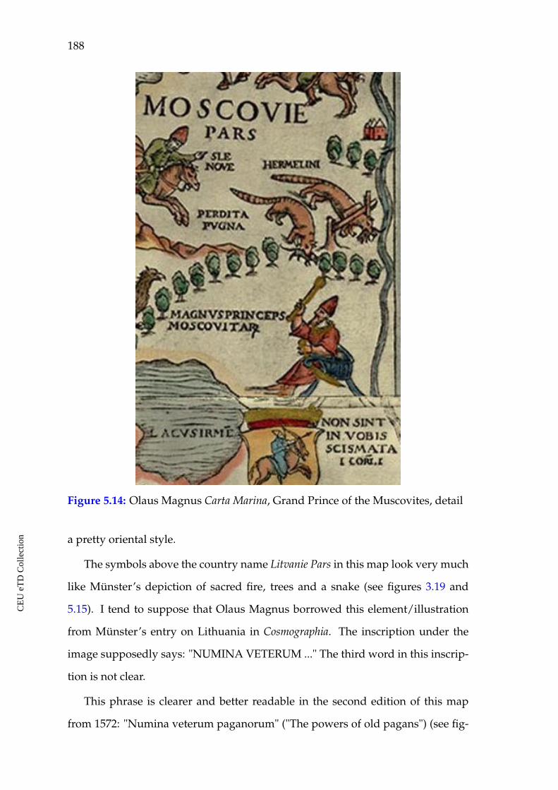
188
Figure 5.14: Olaus Magnus Carta Marina, Grand Prince of the Muscovites, detail
a pretty oriental style.
The symbols above the country name Litvanie Pars in this map look very much
like Münster’s depiction of sacred fire, trees and a snake (see figures 3.19 and
5.15). I tend to suppose that Olaus Magnus borrowed this element/illustration
from Münster’s entry on Lithuania in Cosmographia. The inscription under the
image supposedly says: "NUMINA VETERUM ..." The third word in this inscrip-
tion is not clear.
This phrase is clearer and better readable in the second edition of this map
from 1572: "Numina veterum paganorum" ("The powers of old pagans") (see fig-
CE
UeT
DC
olle
ctio
n
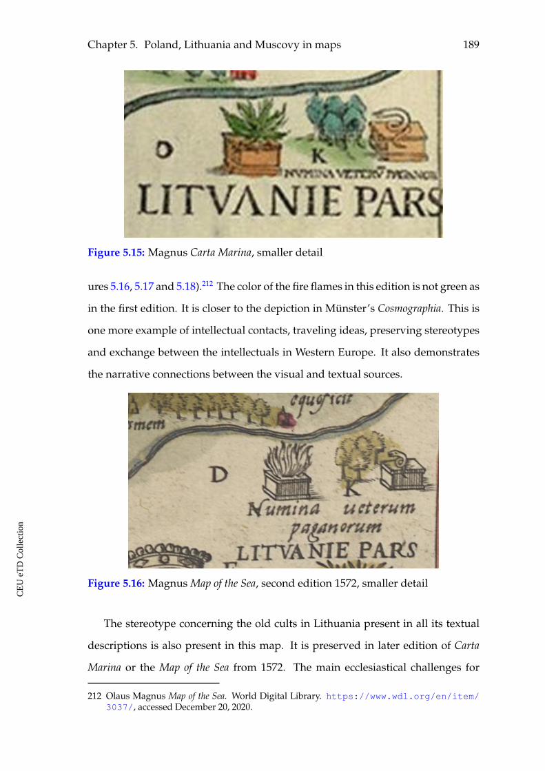
Chapter 5. Poland, Lithuania and Muscovy in maps 189
Figure 5.15: Magnus Carta Marina, smaller detail
ures 5.16, 5.17 and 5.18).212 The color of the fire flames in this edition is not green as
in the first edition. It is closer to the depiction in Münster’s Cosmographia. This is
one more example of intellectual contacts, traveling ideas, preserving stereotypes
and exchange between the intellectuals in Western Europe. It also demonstrates
the narrative connections between the visual and textual sources.
Figure 5.16: Magnus Map of the Sea, second edition 1572, smaller detail
The stereotype concerning the old cults in Lithuania present in all its textual
descriptions is also present in this map. It is preserved in later edition of Carta
Marina or the Map of the Sea from 1572. The main ecclesiastical challenges for
212 Olaus Magnus Map of the Sea. World Digital Library. https://www.wdl.org/en/item/3037/, accessed December 20, 2020.
CE
UeT
DC
olle
ctio
n
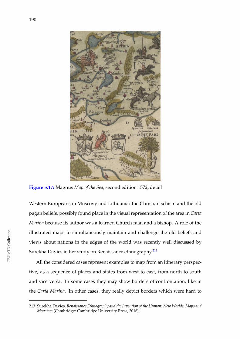
190
Figure 5.17: Magnus Map of the Sea, second edition 1572, detail
Western Europeans in Muscovy and Lithuania: the Christian schism and the old
pagan beliefs, possibly found place in the visual representation of the area in Carta
Marina because its author was a learned Church man and a bishop. A role of the
illustrated maps to simultaneously maintain and challenge the old beliefs and
views about nations in the edges of the world was recently well discussed by
Surekha Davies in her study on Renaissance ethnography.213
All the considered cases represent examples to map from an itinerary perspec-
tive, as a sequence of places and states from west to east, from north to south
and vice versa. In some cases they may show borders of confrontation, like in
the Carta Marina. In other cases, they really depict borders which were hard to
213 Surekha Davies, Renaissance Ethnography and the Invention of the Human: New Worlds, Maps andMonsters (Cambridge: Cambridge University Press, 2016).
CE
UeT
DC
olle
ctio
n
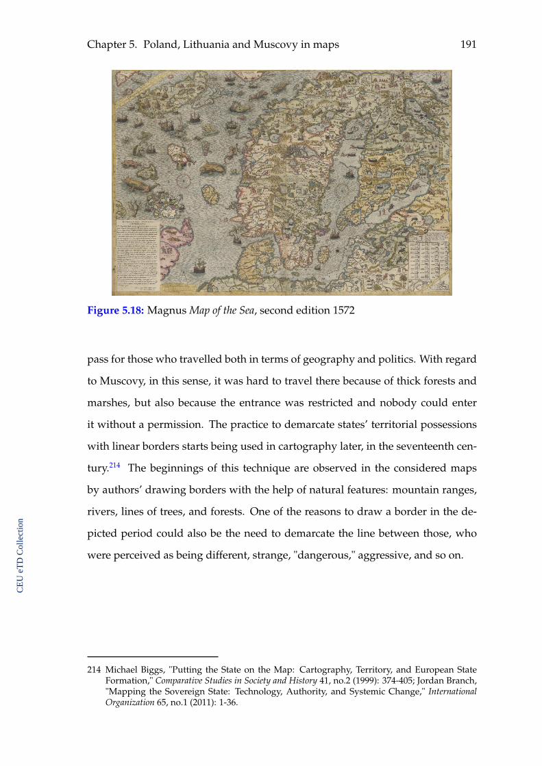
Chapter 5. Poland, Lithuania and Muscovy in maps 191
Figure 5.18: Magnus Map of the Sea, second edition 1572
pass for those who travelled both in terms of geography and politics. With regard
to Muscovy, in this sense, it was hard to travel there because of thick forests and
marshes, but also because the entrance was restricted and nobody could enter
it without a permission. The practice to demarcate states’ territorial possessions
with linear borders starts being used in cartography later, in the seventeenth cen-
tury.214 The beginnings of this technique are observed in the considered maps
by authors’ drawing borders with the help of natural features: mountain ranges,
rivers, lines of trees, and forests. One of the reasons to draw a border in the de-
picted period could also be the need to demarcate the line between those, who
were perceived as being different, strange, "dangerous," aggressive, and so on.
214 Michael Biggs, "Putting the State on the Map: Cartography, Territory, and European StateFormation," Comparative Studies in Society and History 41, no.2 (1999): 374-405; Jordan Branch,"Mapping the Sovereign State: Technology, Authority, and Systemic Change," InternationalOrganization 65, no.1 (2011): 1-36.
CE
UeT
DC
olle
ctio
n
192
5.2.4 Sigismund von Herberstein
The topographical map of Muscovy is one of the illustrations in Herberstein’s Notes.215
It was the first Western map concentrating on the topography of this land. The
earlier maps by Hartmann Schedel pointed out just the location of Muscovy. Se-
bastian Münster’s maps depicted a number of settlements in it, but mostly it was
presented in terms of "nature" with few settlements. Herberstein, however, fo-
cused on the missing part of its image, the topography. His effort to produce
a detailed textual account of Muscovy is also reflected in the map he produced.
Before him, Muscovy was almost blank in terms of a topographical area. Only
Münster’s map of Muscovy depicted a few towns and river names. As for Her-
berstein, he contributed a lot to a better representation of the country. He did not
pay much attention to Lithuania, and did not depict the lands of Poland at all,
but Muscovy in his map became a densely populated region as he described it
in his Notes (see figure 5.19). In this depiction, the land had become occupied by
"culture," namely, by urban culture and smaller settlements.
215 "Moscovia Sigismundi liberi Baronis in Herberstein, Neiperg, et Gutenhag anno M.D. XLIX."Europeana, accessed April 10, 2020. https://www.europeana.eu/el/item/9200517/ark__12148_btv1b55004862g
CE
UeT
DC
olle
ctio
n
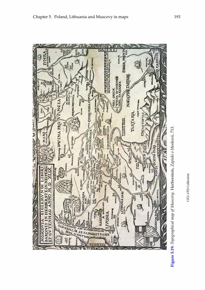
Chapter 5. Poland, Lithuania and Muscovy in maps 193
Figu
re5.
19:T
opog
raph
ical
map
ofM
usco
vy.H
erbe
rste
in,Z
apis
kio
Mos
kovi
i,71
3.
CE
UeT
DC
olle
ctio
n
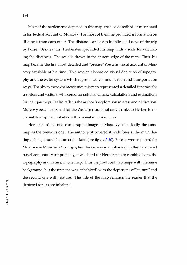
194
Most of the settlements depicted in this map are also described or mentioned
in his textual account of Muscovy. For most of them he provided information on
distances from each other. The distances are given in miles and days of the trip
by horse. Besides this, Herberstein provided his map with a scale for calculat-
ing the distances. The scale is drawn in the eastern edge of the map. Thus, his
map became the first most detailed and "precise" Western visual account of Mus-
covy available at his time. This was an elaborated visual depiction of topogra-
phy and the water system which represented communication and transportation
ways. Thanks to these characteristics this map represented a detailed itinerary for
travelers and visitors, who could consult it and make calculations and estimations
for their journeys. It also reflects the author’s exploration interest and dedication.
Muscovy became opened for the Western reader not only thanks to Herberstein’s
textual description, but also to this visual representation.
Herberstein’s second cartographic image of Muscovy is basically the same
map as the previous one. The author just covered it with forests, the main dis-
tinguishing natural feature of this land (see figure 5.20). Forests were reported for
Muscovy in Münster’s Cosmographia, the same was emphasized in the considered
travel accounts. Most probably, it was hard for Herberstein to combine both, the
topography and nature, in one map. Thus, he produced two maps with the same
background, but the first one was "inhabited" with the depictions of "culture" and
the second one with "nature." The title of the map reminds the reader that the
depicted forests are inhabited.
CE
UeT
DC
olle
ctio
n
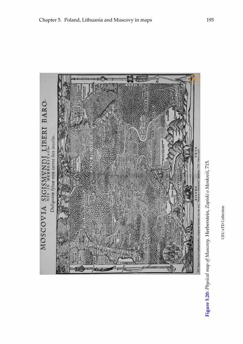
Chapter 5. Poland, Lithuania and Muscovy in maps 195
Figu
re5.
20:P
hysi
calm
apof
Mus
covy
.Her
bers
tein
,Zap
iski
oM
osko
vii,
715.
CE
UeT
DC
olle
ctio
n
196
5.3 Findings and observations
The research period for this investigation embraces 150 years. Nevertheless, the
cartographic data discussed in this chapter come from the period of the 1490s to
the 1550s. During these a bit more than fifty years a significant evolution in the
visual representations of the depicted area can be observed. Along with the grow-
ing cartographic literacy in the West and with the spread of maps and mapping
culture a growing interest for the eastern lands of Europe found its expression in
them. All the discussed maps accompanied textual descriptions of the area, with
one exception, the first Carta Marina by Olaus Magnus. This map was first pub-
lished in 1539 as an independent source and only in 1555 was included into his A
Description of the Northern Peoples. When the book appeared it explained in words
Magnus’s visual language, his cartography, his images, his messages. Thus, in the
end, all the considered visual sources were created to accompany and enrich the
narrative ones.
The first map considered in this chapter, the World map by Hartmann Schedel,
is an example of following the Ptolemaic techniques in cartography. At the same
time, new toponyms were extensively used in this map. All the other considered
examples are regional maps, depicting the continent of Europe or its regions. They
demonstrated extensive developments in their narrative content and techniques.
The main aspects observed in this chapter are the following:
ã The cartographic data accompanies and supplements the textual descrip-
tions of Poland, Lithuania and Muscovy. By the end of the depicted period,
maps became a "must" in encyclopedias containing descriptions of Poland,
Lithuania and Muscovy. In case of Schedel’s maps, their main function was
to locate the textual descriptions of these lands in visual depiction of the
world and of Europe. The more to the east they got, the less informative the
maps became. Among the eastern cities only Lemberg (Lviv), Nogardum
(Novgorod), and Plesgo (Pskov) were put in the map.
CE
UeT
DC
olle
ctio
n
Chapter 5. Poland, Lithuania and Muscovy in maps 197
ã The maps in Sebastian Münster’s Cosmographia from 1544 demonstrate sig-
nificant development in their design, and in narrative content. They reflect
the influence of the text and witnesses. New topographical information was
thoroughly notated at his regional maps, settlements and natural character-
istics of Poland, Lithuania and Muscovy were mapped in their topograph-
ical depiction and in the two regional maps. Sebastian Münster is the one
who keeps using ancient geographic terms in his maps.
ã A tendency to visually separate the region of Poland, Lithuania and Mus-
covy from the rest of Europe, or Lithuania and Muscovy from the Western
neighbors, or finally Muscovy from the rest of Europe is observed in the
cartographic depictions through the period. Drawing a border line in maps
also revealed the need to indicate the separation line to those, who were
different, strange, "dangerous," aggressive, and so on, within the European
community. These are the beginnings of linear border depiction in maps of
later periods. As for Muscovy, several references to its well guarded borders
that nobody could pass without a permission were identified in the textual
sources as well.
ã Among the most frequently used words in the descriptions of Muscovy ac-
cording to the textual visualizations was the word "forest" which is also vi-
sualized in the maps. Forests are depicted in most of the visual images of
Muscovy. It was a forested region, but in the context of the present research
and in comparison to Poland and Lithuania it sounded as the land with
strong element of "nature" in its image.
ã During the depicted period the Grand Duchy of Lithuania possessed the
largest territory in Europe. Nevertheless, it is underrepresented in the con-
sidered maps. Visually, it occupied a small segment in the north-eastern
part of Europe with poorly represented topography in all discussed maps.
Its cartographic image did not undergo significant development through the
CE
UeT
DC
olle
ctio
n
198
period, similarly to its textual description. Among the reasons for its quite
stable and stereotypical image through the whole period one could see the
perception of this state as a part of the Polish-Lithuanian union. A bigger
credit and focus in the West were given to Poland probably thanks to its
longer history of political contact with other European powers. Poland was
better known, it was closer and it was more similar to the rest of Europe.
Lithuania, on the contrary, was less familiar and rather exotic.
It looks like Lithuania, as we see it in maps, does not refer to the state of
the Grand Duchy, but to the ethnic part of it, which was associated with the
exotic religion. The Slavic Christian part of the state could be assumed a
closer part to Poland. In this context, depicting Lithuania in maps as a small
segment in the north-eastern part of Europe had its logic.
The growing curiosity for Muscovy among authors, geographers, cartogra-
phers, travelers and audiences also would move their discovery efforts to
Muscovy. And Lithuania was not that new to "pay much attention" to it.
This could contribute to preserving a stable image of this land in maps.
ã In Schedel’s and Münster’s regional maps Poland is visually represented as
the larger and more important power out of three depicted lands. It is also
the most populated country with stronger representation of "culture" in the
region. In Schedel’s map of Europe it is mentioned twice, which emphasizes
its size. In Münster’s regional map its urbanized and cultivated character is
visually stronger than for Lithuania and Muscovy. Such a disproportion in
the amount of provided information is also observed in the textual descrip-
tions in Münster’s Cosmographia. The description of Poland is much longer
than those of Lithuania and Muscovy, and its image is comprised of political
and historical information.
ã Münster’s map Europa Regina is the example of a map with a strong narra-
tive power, expressing and claiming the Western self-positioning among the
CE
UeT
DC
olle
ctio
n
Chapter 5. Poland, Lithuania and Muscovy in maps 199
other European states and the rest of the world, but also the self-assurance
within one’s own borders.
ã The case of Sigismund Herberstein’s accounts demonstrates that by the mid-
dle of the sixteenth century maps entered the travelers’ notes as well. To-
gether with the textual description and drawings, maps comprise an impor-
tant visual image and representation of the depicted lands. Herberstein’s
maps are an example of sophisticated elaboration of newly obtained geo-
graphical information. They could serve not only as a source of theoretical
knowledge about Muscovy for the learned men, but as a practical informa-
tion guides for travelers, political and military leaders.
ã Several cases of intellectual exchange, "communication" of visual and tex-
tual sources and their impacting each other, cartographic depictions of phe-
nomena described in the previously analysed texts were observed.
ã Thus, a notable development of the narrative content of the maps can be
observed through the period. The maps also reflect the growing knowledge
about the natural geography of Poland, Lithuania and Muscovy. The first
maps mostly informed their readers about the location of these lands and ac-
commodated their textual images. The later examples offer quite rich mate-
rial on their topography and natural geography, depict the existing Western
assumptions about these lands, as well as existing political confrontation.
ã As a general observation it should be pointed out that the above considered
maps of Poland, Lithuania and Muscovy still do not demonstrate a linear
political division of Europe. The authors of the maps do not draw state bor-
ders at their maps yet, but there is a tendency to visually separate the most
"different," "unsafe," "not well known" from the "big powers" of the conti-
nent. It is done with the help of natural borders: rivers, forests, mountains.
It could also be communicated through other symbolical attributes, like the
importance of the body parts of Europa Regina.
CE
UeT
DC
olle
ctio
n
CHAPTER 6
Conclusions
The present research represents a comparative analysis of images of Poland, Lithua-
nia and Muscovy as described and depicted in selected texts, illustrations and
cartographic sources from the fifteenth and the first half of the sixteenth century.
The applied quantitative methods and the methods of basic computational textual
analysis and visualization helped to define the main component criteria of the im-
ages, which enabled the comparison. It should be emphasized that the majority of
the obtained results became possible thanks to data provided by different groups
of sources. The images of Poland, Lithuania and Muscovy in the encyclopedic
collections helped to better interpret their cartographic depictions and to better
understand the messages of the travelers. Considering different source groups
made it possible to observe the communication of sources and their impacting
each other. The comparative analysis of the considered sources also demonstrated
diversity of narrative identities of the authors.
The quantitative methods and close reading applied to the selected textual
sources show that the authors of the considered encyclopedias assigned different
amounts of space to the topics of "culture" and "nature" in their entries on Poland,
Lithuania and Muscovy. The calculations show a growing dynamics for the topics
of "nature" while moving eastwards. The more one moved to the east of Europe in
the texts, the less is said about politics, history, dynasties, etc. and the more is said
about the natural environment, climate, natural resources, animals, wilderness,
and exotic things. Thus, the considered lands represent areas advancing towards
200
CE
UeT
DC
olle
ctio
n
Chapter 6. Conclusions 201
the eastern edges of Europe geographically, but also their textual representations
communicate advancing towards such edges which are less known, less popu-
lated, less cultivated, more exotic, more hostile, more wild, difficult to travel to,
etc.
Textual references to animals, forests, rivers, exotic things, climate, natural
products, as well as visual depictions of such in woodcuts, illustrations and maps
become more frequent while moving towards the eastern border of the continent.
The created images and representations of Poland, Lithuania and Muscovy in dif-
ferent groups of the considered sources demonstrate this tendency.
As for the thematic range comprising the images of Poland, Lithuania and
Muscovy, the dynamics is quite progressive. On the one hand, there is a num-
ber of standard topics that are present in the images of all three lands through
the research period, like the rulers and state power, the main cities, the markets
and goods, the religion and the morals. However, when the reader is textually
moving eastwards, a larger number of themes or topics will comprise the image
of the following land. The farther the described land was situated from the places
of origin of the authors or from Western centers, the more detailed descriptions
in terms of the variety of constitutive topics would be produced. It seems that
the authors’ playing with the thematic range, richness, variety, and the size of the
comprised themes, as well as gradually growing number of references to nature
was the way to textually communicate the motion from the known European cen-
ters eastwards, towards the periphery and the less known edges of the continent.
This can be traced when one takes into consideration the content of sources
on Poland, Lithuania and Muscovy comparatively. In case of Poland the sources
present mostly the information on its rulers, political culture and history. As for
Lithuania, the main focus falls on its religion, rulers, morals, climate and goods in
this country. In case of Muscovy, one finds attempts to describe different aspects
of life, activities, customs, traditions, and the appearance of people, the nature,
the climate, the goods, animals, landscape, and so on.
CE
UeT
DC
olle
ctio
n
202
Computational text visualizations demonstrate their effective possibilities of
presenting "terminological" images of the depicted lands, tracing the main terms
through the text body and offering the basis for comparative analysis. The ob-
tained images differ in their terminological content, but the presence of particular
terms in all obtained results made it possible to talk about a number of topics or
criteria which were a standard set while writing about a country at that period.
Among the most frequent common topics and terms are: "king," "duke," "town,"
"river," "people," and "forest."
The growing tendency of using "nature" terms while moving eastwards is ob-
served with the help of the word clouds for the entries on Poland, Lithuania and
Muscovy in the considered encyclopedias. The textual image of Poland as well
as its terminological depiction demonstrate strong political and historical content
through the period. It is emphasized in the end of the study period, and expressed
by the size of the entry on Poland in Münster’s description and its political and
historical content. Its image lose topics related to "nature."
The textual representation of Lithuania in the considered encyclopedic works
remained rather static concerning its main topic of traditional religious cults. It
is emphasized in text visualizations for earlier encyclopedic entries by Aeneas
Silvius Piccolomini and Hartmann Schedel. The following strongest theme of
Lithuanian cruel rulers and their pet bears is present in the earlier encyclope-
dic references. It is emphasised in Schedel’s entry thanks to his shortenings of
Piccolomini’s text who he copied. Sebastian Münster offered new information
to what was provided before and the visualizations for his entry reflected this
and demonstrated a growing tendency towards the terms of "culture." The sto-
ries about pet bears, cruelty of rulers and detailed descriptions of Lithuanian old
cults are not present in his description, he just point out that in Samogitia they
still worship idols. This static motive of idolatry in encyclopedic representations
of Lithuania provided ground for creating firm, generalizing stereotypes concern-
ing this country, meaning that it would have been considered by readers as pagan
CE
UeT
DC
olle
ctio
n
Chapter 6. Conclusions 203
through the period. According to the obtained text visualizations, a stronger em-
phasis in these texts is made on Lithuanian people and not on its rulers. The
constructed images of Lithuania in encyclopedias were contrasting to those of
Poland.
The image of Muscovy in the entry of Sebastian Münster’s Cosmographia, as
well as the illustrations and maps that accompany the description refer strongly
to notions of "nature" and to human interaction with nature. A paradise-like mo-
tive is one of the features of the image, traced both in the text and the text visual-
izations of the entry on Muscovy. The text communicated messages of its strong
centralized power as well.
Concerning the travelers’ accounts about the depicted lands, the main criteria
to judge about the visited lands were the looks of and the living conditions in their
settlements, particularly their towns. This was a central theme in the writings by
Gilbert de Lannoy, Ambrogio Contarini and Sigismund von Herberstein. The
towns in Poland, Lithuania and Muscovy were said to be not splendid enough;
having bad walls, or no walls at all; bad castles and fortifications; buildings made
of wood and clay, etc. These characteristics had growing intensity in their writing
while moving eastwards. Only a few towns in the western part of Poland, like
Kalisz and Wrocław are said to be good by Gilbert de Lannoy, and Warsaw by
Contarini, all the other were not nice, not well constructed and not worth men-
tioning. In contrast, according to Lannoy, the towns in Livonia, Prussia, Bohemia,
and Germany were beautiful, nice, very good, and very rich. Contarini starts
praising towns on his way back to Italy starting from Warsaw and onward.
The observed strong presence of the two terms "town" and "river" in all word
clouds for travel accounts helps to better understand the important role the rivers
played for urban settlements and humans at that period. The travel accounts and
descriptions by travelers, while talking about a town, regularly refer to its river.
As it was pointed out in the chapter on methodology, the texts on Poland,
Lithuania and Muscovy involved into the present research differ in their size a lot
CE
UeT
DC
olle
ctio
n

204
sometimes. For this reason, the applied methods of visual text analysis are not fo-
cused on their exact numerical characteristics of their terminological and thematic
content. The focus is made on the observed general tendencies, common topics
and the variety of the depicted differences in their textual representations. In this
respect, the word trend visualizations turned to be a useful computational tool
that helped to depict and trace the five main terms/topics in all considered texts
and to see in what way the thematic/terminological representations of Poland,
Lithuania and Muscovy in encyclopedias differ from those in travel accounts. It
is observed that the main criteria and topics comprising the images of the de-
picted lands in travel accounts are more homogeneous and common. The three
considered authors from the beginning, from the middle and from the end of the
depicted period had similar criteria, focused on similar features while speaking
about places they visited: rulers, towns, rivers. The tendency is a bit different
in case of encyclopedias. The mentioned topics and criteria are present in the
descriptions of Poland, Lithuania and Muscovy in the considered encyclopedic
entries, but the main emphasis and focus is different in each case. Poland is pre-
sented in political terms and this feature is getting stronger through the period.
The topic of religious cults is central in early descriptions of Lithuania. Its later im-
age receives new elements, particularly, the term "city" appeared among the five
strongest. The topic of religion is present, but it loses its positions in the later de-
scription from the period. As for the representation of Muscovy in Cosmographia
by Sebastian Münster, the word trends depicted two strong terms belonging to
state and state power: "Moscovia" and "duke." The other three are "honey," "big,"
and "river." Thus, encyclopedias offered a wider range of criteria, and demon-
strated different accents, that showed to be strong while creating the images of
the three depicted lands.
Ambrogio Contarini, together with many complaints concerning accommo-
dation in Poland and Lithuania on his way to Persia, raised the issue of safety,
which one does not see in Gilbert de Lannoy’s accounts that much. For Ambrogio
CE
UeT
DC
olle
ctio
n
Chapter 6. Conclusions 205
Contarini this is a constantly evoking topic. He did not feel safe on his way to
Persia from the moment he entered the lands of Poland, felt even more anxious
in Lithuania and suffered a lot from inconvenient accommodation. The interest-
ing thing is that the tone of his complaints changed, when he traveled back from
Persia to Venice and passed through Muscovy, Lithuania and Poland. As soon
as he entered the Muscovite lands he remarked that he immediately felt safer. He
referred this feeling of getting safer when he was traveling through Lithuania and
Poland towards his homeland. He noted that the accommodations were getting
better and better. Probably, the hardships of the trip and the experiences of trav-
eling further to the east, to Persia, had changed Contarini’s attitude towards the
previously visited lands in the eastern parts of Europe when returning. At last,
when he reached Warsaw and then Germany, he could not stop praising the cities
telling about the advancing improvement in the looks of their villages, castles and
towns and in the living conditions they offered.
The readers find images of cruel rulers in Lithuania and Muscovy, both in the
considered encyclopedic works and in the travelers’ accounts. They treated their
subjects as they wanted, and several cases of their cruel behavior were described
by Aeneas Silvius Piccolomini, Hartmann Schedel, Sebastian Münster and Sigis-
mund von Herberstein.
Another topic common for the descriptions of Lithuania and Muscovy, but not
for Poland are the travel conditions. The combination of the landscape features
and climate made traveling to these regions extremely hard. The best season for
traveling was winter when all waters, marshes and swamps were frozen. Win-
ter traveling, however, offered its own challenges. The travelers pointed out that
these lands were large and sparsely populated, meaning that settlements were not
frequently met while traveling, and these complaints were growing while mov-
ing eastwards. The hardships of winter travel in Lithuania and Muscovy are de-
scribed not only by travelers who went there and often had to make stops for rest
under the open sky, but also by writers of encyclopedias.
CE
UeT
DC
olle
ctio
n
206
Sigismund von Herberstein was most diligent, analytic and sober-minded in
his exploration effort. Discussing Lithuania he elaborated the issue of paganism
in this country and specified the region, where the pagan cults were preserved
longer. Lithuania also got a new image of being multi-ethnic and multicultural,
not just pagan. He was the first to list the main cities and regions that comprised
its territory, he described the country and its size. He made clear that both Ro-
man and Greek Christian traditions were present in there, with the Greek ones in
majority. As for the pagan religion for which Lithuania was known, he specified
Samogitia as the region where it existed longer than in any other part of Europe
and was still preserved there at his time, as some people were saying.
Cases when the lands of Lithuania were contextually attributed to Poland
were observed in all source groups, namely, in encyclopedias, travel accounts and
maps. Sigismund von Herberstein’s accounts on Lithuania in the end of the de-
picted research period contributed to better understanding of its size, its religious
matters and its status. The image of this country created by previous written and
cartographic sources was rather stereotypical and not that clear. There, the in-
formation on pagan cults was associated with the images of the whole country.
It was not clear what language they spoke there. In maps it occupied a smaller
segment than Poland, for example. The fact that Herberstein tried to clarify these
particular issues demonstrates his willingness to better "explain" this territory to
his contemporaries. It shows that he studied what was known about Lithuania
before him and added his own contribution.
It is hard to summarize Sigismund von Herberstein’s contribution with regard
to the image of Muscovy in a few lines. In his time, probably no other European
land was described in such detail. Legends and the history of the state, dynasties,
religion, everyday life, local customs, clothing and houses, topography, nature
and climate and many other compound topics discussed in his report. He intro-
duced the unknown Muscovy to the Western reader. With his account Muscovy
was finally integrated into the image of the European continent. He made an at-
CE
UeT
DC
olle
ctio
n
Chapter 6. Conclusions 207
tempt to describe its size in his maps and by registering distances between its
main cities. He described the Muscovite centers of commercial contact with other
parts of Europe and Asia. By describing the dynastic connections of the Lithua-
nian, Polish and Muscovite ruling families he showed their historical bonds. For
understandable reasons the image was rather exotic for a Western European, but
Herberstein kept the rational tone in what he was writing about Muscovy, namely
the regions west of Moscow. As he approached the lands behind Moscow, further
to the east, he involved the contemporary cultural predispositions and beliefs into
his image. He inhabited the remote eastern principalities of Muscovy with mon-
strous peoples and beasts. He specified that this information was received from
reliable oral sources. He was still influenced by the Western scholastic knowledge,
understanding and beliefs concerning the remote edges of the continent and of the
known world.
The narrative content of the considered maps depicting the region is signifi-
cantly growing throughout the period. The main utility of the earlier maps from
the period, like those by Hartmann Schedel was to orientate the reader and to
locate the story, to point out where the textual image belonged to. Sebastian Mün-
ster, Olaus Magnus and Sigismund von Herberstein enriched the maps of the
region with more informative content in terms of landscape features, toponyms
and illustrations. It was also observed that the cartographic depictions of Poland
and particularly of Muscovy experienced more significant developments through
the period in comparison to Lithuania.
The analysis of different source groups, namely, encyclopedias, travel accounts
and maps provides information on how the borders between countries or larger
areas were textually and visually demarcated. The western border of Poland and
the north-western border of Lithuania mattered for all considered travelers. This
was vividly expressed in their opinions about the towns in Poland, Lithuania,
Muscovy and Russia, the lodgings they offered, the matters of safety, etc. The
prevailing wooden architecture, houses made of straw and mud/clay, not that
CE
UeT
DC
olle
ctio
n
208
well fortified urban settlements or absence of fortifications were important signs
for the images of Poland, Lithuania and Muscovy.
In the end of the research period, the border of the Muscovite state is reported
to be the most significant, guarded and watched according to Sigismund von Her-
berstein’s travelogue. It is said that it was impossible to enter Muscovy without
a proper permission. Similar tendencies were observed in the analysis of the car-
tographic sources. Demarcating state borders was not typical for the period. But
the depictions of particular features of the landscape like mountain ranges, rivers,
forests seem to have been used to draw division lines between areas and states.
Hartmann Schedel, for example, used a depiction of a mountain chain in order to
draw a borderline between Poland and Hungary. No such borderlines between
Poland, Lithuania and Muscovy were observed. Olaus Magnus drew a line of
trees demarcating a borderline between Poland, on the one hand, and Lithuania
and Muscovy, on the other. Numerous images depict the confrontation of military
and religious nature from both sides of the borderline. Finally, Sebastian Münster
drew a thick forest line and decisively separated Muscovy from the rest of Europe
in his map Europa Regina. Thus, by the end of the depicted period, the textual ref-
erences to borders as well as the cartographic depictions of the borderlines follow
the common tendency to declare the importance of the border with Muscovy.
The terms "league" and "miles" were observed as frequently used in the visu-
alizations for Sebastian Münster’s entries on Lithuania and Muscovy, in Gilbert
de Lannoy’s travel accounts and Sigismund von Herberstein’s descriptions of
Lithuania and Muscovy. Distances were also reported in days of travel in travel
accounts. The authors’ references to the distances between towns in the described
countries can be interpreted as a sign of writing about unknown or not well
known places. This information is not provided for the better known countries
in the accounts. Based on this, it is also possible to interpret this pattern as re-
ferring to the notion of frontiers between the more familiar and not very familiar
lands in the east of Europe.
CE
UeT
DC
olle
ctio
n
Chapter 6. Conclusions 209
All illustrations from Sigismund von Herberstein’s Notes upon Russia, the looks
of the Muscovite duke in the Carta marina by Olaus Magnus and several depic-
tions of architecture in Sebastian Münster’s maps communicate strong oriental
elements in the image of Muscovy.
As a closing note to this research it is worth saying that the project has its
further potential. One of the directions could be further computational analysis
involving this time not the separate entries, but the whole corpus of the consid-
ered texts, playing with the dynamics of the image of each country through the
period, or with the image of the whole area. Applying the sentiment analysis com-
putational tools would be another interesting approach to such kinds of textual
sources, particularly the travel accounts.
Information obtained by word clouds and word trends can be also incorpo-
rated in a map visualization with the final goal to distill the information on a
single map. The construction of such maps can be realized with the help of on-
line tools (such as Google maps or Open Street maps). This elaborated technique
will greatly facilitate the implementation of the analyzed data and the results can
be easily embedded into a web-page for wider public access.
CE
UeT
DC
olle
ctio
n
Bibliography
Primary sources
Barbaro, Giosafat. Viaggi fatti da Venezia, alla Tana, in Persia, India, e Costantinopoli...
Venice: Aldus Manutius, 1543-1545.
Barbaro i Kontarini o Rossii. K Istorii Italo Russkih Svyazej v XVv. [Barbaro and
Contarini about Russia. On the history of Italian-Russian connections in the
15th century]. Trans. and ed. Elena Skrzhinskaya. Leningrad: Nauka, 1971.
Contarini, Ambrogio. Viaggio al signor Usun Hassan re di Persia. Venice: Annibale
Fossi, 1487.
De Lannoy, Guillebert. Voyages et ambassades de messire Guillebert de Lannoy, 1399-
1450. Mons: Hoyois, 1840.
De Lannoy, Guillebert. Cesty a Poselstva [Journeys and messages]. Trans. Jaroslav
Svátek, eds. Svátek, Jaroslav, Martin Nejedlý, Olivier Marin and Pavel Soukup.
Prague: Scriptorium, 2009.
Długossi, Ioannis. Historiae Polonicae libri XII. Leipzig: Gleditsch / Weidmann,
1712.
Długosz, Jan. The Annals of Jan Długosz: An English Abridgement. Trans. Maurice
Michael. Chichester: IM, 1997.
Emelyanov V. "Puteshestvija Gillbera de Lannoa v vostochnye zemli Evropy v
1413-14 i 1421 godah" [Travels by Gilbert de Lannoy to the Eastern Lands
of Europe in the years 1413-14 and 1421]. Universitetskie izvestija. 8/V. Kiev,
210
CE
UeT
DC
olle
ctio
n
Chapter 6. Conclusions 211
1873: 1-45.
Herberstein, Sigmund Freiherr von. Rerum Moscovitarum Commentarii... Vienna:
Aegidius Adler and Hans Kohl, 1549.
Herberstein, Sigmund Freiherr von. Rerum Moscovitarum Commentarii. Basel:
Joannes Oporinus, 1551.
Herberstein, Sigmund Freiherr von. Notes upon Russia, being a Translation of the
Earliest Account of that Country, Entitled Rerum Moscoviticarum Commentarii.
Trans. and ed. R.H. Major. Vol.II. London: Hakluyt Society, 1851-1852.
Herberstein, Rerum Moscoviticarum Commentarii. Synoptische Edition der lateinis-
chen und der deutschen Fassung letzter Hand Basel 1556 und Wien 1557. Ed. Her-
mann Beyer-Thoma. München: Osteuropa-Institut Regensburg, 2007.
Herberstein S. Zapiski o Moskovii [Notes on Muscovy] 2 vols. Vol. 1: Latin and
German texts. Trans. from Latin A.I. Malein and A.V. Nazarenko, trans.
from early modern high German A.V. Nazarenko, ed. A.L. Khoroshkevich.
Moscow: Pamiatniki Istoricheskoj Mysli, 2008.
Kadłubconis, Vincentii. Historia Polonica. Dobromyl: Ioannis Szelig, 1612.
Lietuvos Metrika: Užrašymu knyga 22 [Lithuanian Metrica: Book of Inscriptions 22].
Eds. Andrij Blanutsa, Dmitro Vashchuk, and Darius Antanavicius. Vilnius:
LII Leidykla, 2010.
Miechowita, Maciej. Tractatus de duabus Sarmatiis, Asiana et Europiana, et de con-
tentis in eis. Cracow: Jo. Haller, 1517.
Münster, Sebastian. Cosmographiae uniuersalis Lib(ri) VI. in quibus, iuxta certioris
fidei scriptorum traditionem describuntur, Omniu(m) habitabilis orbis partiu(m) si-
tus, propriaeq(ue) dotes. Regionum Topographicae effigies. Terrae ingenia, quibus
fit ut tam differentes et uarias species res, et animatas et inanimatas, ferat. Animal-
ium peregrinorum naturae et picturae. Nobiliorum ciuitatum icones et descriptiones.
Regnorum initia, incrementa et translationes. Omnium gentium mores, leges, reli-
CE
UeT
DC
olle
ctio
n
212
gio, res gestae, mutationes : Item regum et principium genealogiae. Basel: Henrich
Petri, 1552.
Piccolomini, Enea Silvio. Cosmographia Pii papae in Asiae et Europae eleganti descrip-
tione ... Ed. Geoffroy Tory. Paris: Apud Collegium Plesseiacum, 1509.
Piccolomini, Enea Silvio. De Europa. Ed. Adrianus van Heck. Città del Vaticano:
Biblioteca Apostolica Vaticana, 2001.
Piccolomini, Enea Silvio. Europe (c. 1400-1458). Translated Robert Brown, intro-
duced Nancy Bisaha. Washington: The Catholic University of America Press,
2013.
Schedel, Hartmann. Weltchronik. Nuremberg: A. Koberger, 1493, reprint Munich:
Konrad Kölbl, 1975.
Schedel, Hartmann. Liber Chronicarum. Nuremberg: A. Koberger, 1493, reprint
Burgos: Siloé, 2002.
The Chronicle of Henry of Livonia. Trans. and ed. James A. Brundage. Madison:
University of Wisconsin Press, 1961.
Travels to Tana and Persia by Josafa Barbaro and Ambrogio Contarini. Translated from
the Italian by William Thomas and S.A. Roy, ed. Lord Stanley of Alderley.
London: Hakluyt Society, 1873; reprint New York: Burt Franklin, 1968.
Secondary literature
Adams, Colin, Ray Laurence, eds. Travel and Geography in the Roman Empire. Lon-
don and New York: Routledge, 2001.
Adelung, Friedrich von. Kritisch-Literarische Übersicht der Reisenden in Russland bis
1700, 2 vols. St Petersburg, Leipzig: Eggers, 1846.
Anderson, Benedict. Imagined Communities: Reflections on the Origin and Spread of
Nationalism. Rev. ed. London and New York: Verso, 1991.
Anderson, Ian. "History and Computing." In Making History: The Changing Face of
CE
UeT
DC
olle
ctio
n
Chapter 6. Conclusions 213
the Profession in Britain. London: Institute of Historical Research, University
of London, 2008.
Atwood, Christopher Pratt. Encyclopedia of Mongolia and the Mongol Empire. New
York: Facts on File, 2004.
Baring-Gould, Sabine. Curious Myths of the Middle Ages. London: Rivingtons,
1866.
Barnes, Trevor J. "Spatial Analysis." In The Sage Handbook of Geographical Knowl-
edge, edited by John Agnew and David Livingstone, 381-392. London: Sage,
2011.
Bartlett, Robert. The Making of Europe: Conquest, Colonization and Cultural Change,
950-1350. London: Allen Lane, 1993.
Bates, Alan W. Emblematic Monsters: Unnatural Conceptions and Deformed Births in
Early Modern Europe. Amsterdam: Rodopi, 2005.
Berend, Nora, Przemysław Urbanczyk and Przemysław Wiszewski Central Eu-
rope in the High Middle Ages: Bohemia, Hungary and Poland, c.900-c.1300. Cam-
bridge, New York: Cambridge University Press, 2014.
Berend, Nora. Christianization and the Rise of Christian Monarchy: Scandinavia, Cen-
tral Europe and Rus’ c. 900-1200. Rev. ed. Cambridge, UK; New York: Cam-
bridge University Press, 2007.
Biggs, Michael. "Putting the State on the Map: Cartography, Territory, and Eu-
ropean State Formation." Comparative Studies in Society and History 41, no.2
(1999): 374-405.
Blomkvist, Nils. The Discovery of the Baltic: The Reception of a Catholic World-System
in the European North (A.D. 1075-1225). Boston: Brill, 2005.
Bömelburg, Hans J. Frühneuzeitliche Nationen im östlichen Europa: Das polnische
Geschichtsdenken und die Reichweite einer humanistischen Nationalgeschichte (1500-
1700). Wiesbaden: Harrassowitz, 2007.
CE
UeT
DC
olle
ctio
n
214
Branch, Jordan. "Mapping the Sovereign State: Technology, Authority, and Sys-
temic Change." International Organization 65, no.1 (2011): 1-36.
Brotton, Jerry. Trading Territories: Mapping the Early Modern World. Ithaca, NY:
Cornell University Press, 1998.
Buisseret, David. "Spanish Peninsular Cartography, 1500 –1700." In Cartography
in the European Renaissance, edited by David Woodward, 1069–94. Chicago:
University of Chicago Press, 2007.
Burmeister, Karl Heinz. Sebastian Münster – Eine Bibliographie. Wiesbaden: Guido
Pressler, 1964.
Butzer, Karl W. "From Columbus to Acosta: Science, Geography, and the New
World." Annals of the Association of American Geographers 82 (1992): 543-565.
Campbell, Mary. B. The Witness and the Other World: Exotic European Travel Writing,
400-1600. Ithaca NY, London: Cornell University Press, 1988.
Cao, Nan, and Weiwei Cui. Introduction to Text Visualization. Paris: Atlantis Press,
2016.
Cattaneo, Angelo. "European Medieval and Renaissance Cosmography: A Story
of Multiple Voices." Asian Review of World Histories 4, no.1 (2016): 35-81.
Christiansen, Erik. The Northern Crusades. London: Penguin Books, 1997.
Cohen, Daniel J., and Roy Rosenzweig. Digital History: A Guide to Gathering, Pre-
serving, and Presenting the Past on the Web. Philadelphia: University of Penn-
sylvania Press, 2005.
Cooper, David, Christopher Donaldson and Patricia Murrieta-Flores eds. Literary
Mapping in the Digital Age. London: Routledge, 2016.
Cosgrove, Denis. Social Formation and Symbolic Landscape. Totawa, NJ: Barnes and
Noble, 1985.
Cosgrove, Denis. "Geography is Everywhere: Culture and Symbolism in Human
CE
UeT
DC
olle
ctio
n
Chapter 6. Conclusions 215
Landscapes." In Horizons in Human Geography, edited by Derek Gregory, and
Rex Walford, 118-135. London: Macmillan, 1989.
Cosgrove, Denis. Apollo’s Eye: A Cartographic Genealogy of the Earth in the Western
Imagination. Baltimore: Johns Hopkins University Press, 2001.
Cosgrove, Denis. Geographical Imagination and the Authority of Images. Stuttgart:
Steiner, 2006.
Cosgrove, Denis. Geography and Vision: Seeing, Imagining and Representing the
World. London: I. B. Tauris, 2008.
Cox, Edward Godfrey. A Reference Guide to the Literature of Travel: Including Voy-
ages, Geographical Descriptions, Adventures, Shipwrecks and Expeditions. Seattle
and New York: University of Washington and Greenwood Press, 1935.
Coxe, William. Travels into Poland. New York: Arno Press, 1971.
Crompton, Constance, Richard J Lane, and Ray Siemens. Doing Digital Humanities
Practice, Training, Research. Rev. ed. London: Routledge, 2016.
Curry, Michael R. "Toward a Geography of a World without Maps: Lessons from
Ptolemy and Postal Codes." Annals of the Association of American Geographers
95(3) (2005): 680–691.
Dabrowski, Patrice M. The First Thousand Years. DeKalb: Northern Illinois Univer-
sity Press, 2014.
Dalché, Patrick Gautier. "The Reception of Ptolemy’s Geography (End of the
Fourteenth to Beginning of the Sixteenth Century)." In The History of Cartog-
raphy, Volume 3, edited by David Woodward, 285-364. Chicago: University of
Chicago Press, 2007.
Daston, Lorrain, and Katherine Park. Wonders and the Order of Nature, 1150-1750.
New York: Zone Books, 1998.
Davies, Surekha. Renaissance Ethnography and the Invention of the Human: New
CE
UeT
DC
olle
ctio
n
216
Worlds, Maps and Monsters. Cambridge: Cambridge University Press, 2016.
De Ridder-Symoens, Hilde. A History of the University in Europe. Vol. I: Universities
in the Middle Ages. Rev. ed. Cambridge: Cambridge University Press, 1992.
Di Lenna, Nicolò. Ambrogio Contarini, Politico e Viaggiatore Veneziano del Secolo XV.
Padova: Luigi Penada, 1921.
Eisenstein, Elizabeth. The Printing Press as an Agent of Change: Communication and
Cultural Transformations in Early Modern Europe. Cambridge and New York:
Cambridge University Press, 1979.
Elliot, John H. The Old World and the New, 1492–1650. Cambridge: Cambridge
University Press, 1970.
Filiushkin, Alexander. "Kak Rossiya stala dlya Europy Aziej?" [How Russia be-
came Asia for Europe?] Ab Imperio 1 (2004): 191-228.
Fonnesberg-Schmidt, Iben. The Popes and the Baltic Crusades 1147-1254. Leiden:
Brill, 2007.
Friedman, John Block. The Monstrous Races in Medieval Art and Thought. 2nd edi-
tion, Syracuse, NY: Syracuse University Press, 2000.
Friedman, John Block, Kristen Mossler Figg, eds. Trade, Travel, and Exploration in
the Middle Ages: An Encyclopedia. New York and London: Garland, 2000.
Grafton, Antony. New Worlds, Ancient Texts: The Power of Tradition and the Shock
of Discovery. Cambridge, Mass: Belknap Press of Harvard University Press,
1992.
Grafton, Carol Belanger. Medieval Woodcut Illustrations: City Views and Decorations
from the Nuremberg Chronicle. Mineola, NY: Dover Publications, 1998.
Green, Jonathan P. "The Nuremberg Chronicle and Its Readers: The Reception of
Hartmann Schedel’s Liber Cronicarum." PhD diss., University of Illinois at
Urbana-Champaign, 2003.
CE
UeT
DC
olle
ctio
n
Chapter 6. Conclusions 217
Grytskevich, Valiantsin, and Adam Maldis. Shliahi viali praz Belarus [The Routes
Led through Belarus]. Minsk: Mastatskaja Litaratura, 1980.
Halecki, Oscar. "Gilbert de Lannoy and His Discovery of East Central Europe."
Bulletin of the Polish Institute of Arts and Sciences in America 2, no.2 (1944): 314-
331.
Halperin, Charles J. Russia and the Golden Horde: The Mongol Impact on Medieval
Russian History. Bloomington: Indiana University Press, 1987.
Harley, John Brian, and David Woodward, eds. The History of Cartography Vol-
ume 1: Cartography in Prehistoric, Ancient, and Medieval Europe and the Mediter-
ranean. Chicago and London: University of Chicago Press, 1987.
Harvey, P.D.A. "Medieval Maps: An Introduction." In The History of Cartography.
Volume I, edited by J.B. Harley and David Woodward, 283-286. Chicago: Uni-
versity of Chicago Press, 1987.
Hillgarth, Jocelyn N. Christianity and Paganism, 350-750: The Conversion of Western
Europe. Rev. ed. Philadelphia: University of Pennsylvania Press, 1986.
Hofmann, Markus, and Andrew Chisholm. Text Mining and Visualization: Case
Studies Using Open-Source Tools. Boca Raton, FL: CRC Press, 2016.
Hrustaliov, Denis. "Proishozdenie "russkogo medvedia"," [The origins of the "Rus-
sian Bear"]. Novoe Literaturnoe Obozrenie 107 (2011): 137-152.
Hudson, Pat. History by Numbers: An Introduction to Quantitative Approaches. Lon-
don: Bloomsbury Academic, 2000.
Hunyadi, Zsolt; József Laszlovszky. The Crusades and the Military Orders: Expand-
ing the Frontiers of Medieval Latin Christianity. Rev. ed. Budapest: Central
European University Press, 2001.
Jacob, Christian. The Sovereign Map: Theoretical Approaches in Cartography through
History. Trans. Tom Conley. Ed. Edward H. Dahl. Chicago: University of
Chicago Press, 2006.
CE
UeT
DC
olle
ctio
n
218
Jaritz, Gerhard, and Juhan Kreem, eds. The Edges of the Medieval World. Budapest:
CEU Press, 2009.
Johnson, Christine R. "Renaissance German Cosmographers and the Naming of
America," Past and Present 191 (2006): 3-43.
Jones, William R. "The Image of the Barbarian in Medieval Europe," Comparative
Studies in Society and History 13 (1971): 376-407.
Jucas, Mecislovas. Gruenvaldskaja bitva (The Battle of Grunewald). Vilnius: Mosklas,
1990.
Kahle, Paul. Die verschollene Kolumbuskarte von 1498 in einer türkischen Weltkarte
von 1513. Berlin, Leipzig: Walter de Gruyter 1933.
Kitchin, Rob, and Martin Dodge. "Rethinking Maps," Progress in Human Geography
31, no.3 (2007): 331-344.
Klimas, Petras. Gillebert de Lannoy in Medieval Lithuania. New York: The Lithuanian-
American Information Center, 1945.
Kloczowski, Jerzy. A History of Polish Christianity. Cambridge and New York:
Cambridge University Press, 2000.
Klug, Ekkehard. "Das "asiatische" Russland. Über die Entstehung eines europäis-
chen Vorurteils." Historische Zeitschrift 245 (1987): 265-289.
Koch, Peter O. To the Ends of the Earth: The Age of the European Explorers. Jefferson.
NC: McFarland, 2003.
Kriz, Karel, William Cartwright, and Lorenz Hurni. Mapping Different Geographies
(Lecture Notes in Geoinformation and Cartography). Rev. ed. Berlin, Heidelberg:
Springer, 2010.
Lewis, Archibald R. "The Closing of the Mediaeval Frontier 1250–1350." Speculum
33, no.4 (1958): 475-483.
Love, Ronald S. Maritime Exploration in the Age of Discovery, 1415-1800. New York:
CE
UeT
DC
olle
ctio
n
Chapter 6. Conclusions 219
Greenwood Press, 2006.
Malygin, Piotr D. Zapadnoevropeiskie avtory XV - XVII vv. o Rossii [Western Euro-
pean Authors of the XV-XVII Centuries about Russia]. Moscow: IA RAN,
2018.
Mannay, Dawn. Visual, Narrative and Creative Research Methods: Application, Reflec-
tion and Ethics. Abingdon: Routledge, 2015.
Martin, Geoffrey J. All Possible Worlds: A History of Geographical Ideas. New York:
Oxford University Press, 2005.
Matuzova Vera I. Anglijskie srednevekovye istochniki IX-XII vv.: Teksty, perevod, kom-
mentarii [English Medieval Sources of the IX-XII Centuries: Texts, Translation,
Comments.] Moscow: Nauka, 1979.
Mazza, Riccardo. Introduction to Information Visualization. 1st edition, London:
Springer, 2009.
McLean, Matthew. The Cosmographia of Sebastian Münster: Describing the World in
the Reformation. Abingdon: Routledge, 2007.
Meirelles, Isabel. Design for Information: An Introduction to the Histories, Theories,
and Best Practices behind Effective Information Visualizations. Osceola, WI: Rock-
port Publishers, 2013.
Meurer, Peter. "Europa Regina: 16th Century Maps of Europe in the Form of a
Queen." Belgeo 3–4 (2008): 355–370.
Merrills, Andrew H. History and Geography in Late Antiquity. Cambridge: Cam-
bridge University Press, 2005.
Milanesi, Marica. "Contarini, Ambrogio," in Dizionario Biografico degli Italiani,
vol.28 Rome: Treccani, 1983, 97-100.
Monga, Luigi. "A Bibliography of Renaissance Hodoeporics (1500-1700)," Annali
d’italianistica 14 (1996): 645-662.
CE
UeT
DC
olle
ctio
n
220
Morse, Ruth. Truth and Conventions in the Middle Ages: Rhetoric, Representation and
Reality. Cambridge: Cambridge University Press, 1991.
Mukerji, Chandra. "Printing, Cartography and Conceptions of Place in Renais-
sance Europe." Media, Culture and Society 28 (2006): 651-659.
Muldoon, James. Popes, Lawyers, and Infidels: The Church and the Non-Christian
World, 1250–1550. Philadelphia: University of Pennsylvania Press, 1979.
Müller, Stefan. "Equal Representation of Time and Space: Arno Peters’ Universal
History." History Compass 8, no.7 (2010): 718-729.
Murray, Alan V. Crusade and Conversion on the Baltic Frontier, 1150–1500. Rev. ed.
Burlington. Aldershot: Ashgate. 2001.
Murray, Alan V., ed. The Clash of Cultures on the Medieval Baltic Frontier. Farnham:
Ashgate, 2009.
New Catholic Encyclopedia. Vol.12. New York: McGraw-Hill, 1967.
Newitt, Malyn. A History of Portuguese Overseas Expansion 1400–1668. New York
and London: Routledge, 2005.
Newton, Arthur Percival, ed. Travel and Travellers of the Middle Ages. London:
Routledge and Kegan Paul, 1926.
Norwich, John Julius. Absolute Monarchs: A History of the Papacy. New York: Ran-
dom House, 2011.
Ostrowski, Donald, Christian Raffensperger eds. Portraits of Medieval Eastern Eu-
rope, 900–1400. New York: Routledge, 2017.
Pelletier, Monique. "The Cordiform World Maps by Oronce Fine," Cartographica
Helvetica 12 (1995): 27–37.
Penrose, Boies. Travel and Discovery in the Renaissance, 1420-1620. Cambridge,
Mass.: Harvard University Press, 1952.
Poe, Marshall. Foreign descriptions of Muscovy: An Analytic Bibliography of Primary
CE
UeT
DC
olle
ctio
n
Chapter 6. Conclusions 221
and Secondary Sources. Columbus, OH: Slavica Publishers, 1995.
Raffensperger, Christian. “Reimagining Europe: An Outsider Looks at the Me-
dieval East-West Divide.” In Medieval Networks in East Central Europe: Com-
merce, Contacts, Communication, edited by Balázs Nagy, Felicitas Schmieder
and András Vadas, 9-24. New York: Routledge, 2018.
Raffensperger, Christian. "The Place of Rus’ in Medieval Europe." History Compass
12/11 (2014): 853-865.
Riessman, Catherine Kohler. Narrative Methods for the Human Sciences. Thousand
Oaks, CA: Sage, 2008.
Roller, Duane W. Ancient Geography: The Discovery of the World in Classical Greece
and Rome. London: I.B. Tauris, 2015.
Rosenzweig, Roy. "Scarcity or Abundance? Preserving the Past in a Digital Era."
American Historical Review 108, no.3 (2003): 735-762.
Rowell, Stephen C. "Unexpected Contacts: Lithuanians at Western Courts." The
English Historical Review 111 (1996): 557-577.
Rowell, "1386: The Marriage of Jogaila and Jadwiga Embodies the Union of Lithua-
nia and Poland." Lithuanian Historical Studies 11 (2006): 137–144.
Rubies, Joan-Pau. Travel and Ethnology in the Renaissance: South India through Euro-
pean Eyes 1250-1625. Cambridge: Cambridge University Press, 2000.
Rubies, Joan-Pau. "New Worlds and Renaissance Ethnology." History and Anthro-
pology 6 (1993): 157-197.
Rubies, Joan-Pau. "Instructions for Travelers: Teaching the Eye to See." History
and Anthropology 9 (1996): 139-190.
Scafi, Alessandro. Mapping Paradise: A History of Heaven on Earth. Chicago: Uni-
versity of Chicago Press, 2006.
Scafi, Alessandro. Maps of Paradise. London: The British Library; Chicago: Uni-
CE
UeT
DC
olle
ctio
n
222
versity of Chicago Press, 2013.
Schreibman, Susan, Ray Siemens, John Unsworth. A New Companion to Digital
Humanities. Rev. ed. Oxford: Blackwell, 2016.
Springmann, Uwe, Dietmar Najock, Hermann Morgenroth, Helmut Schmid, An-
nette Gotscharek, and Florian Fink. "OCR of historical printings of Latin
texts: problems, prospects, progress." In Proceedings of the First International
Conference on Digital Access to Textual Cultural Heritage (DATeCH ’14). New
York: ACM, May 2014, 71-75.
Stagl, Justin. A History of Curiosity: The Theory of Travel 1550–1800. Chur: Harwood
Academic Publishers, 1995.
Stagl, Justin, Klaus Orda, und Christel Kämpfer. Apodemiken: Eine räsonnierte Bibli-
ographie der reisetheoretischen Literatur des 16., 17. Und 18. Jahrhunderts. Pader-
born: Ferdinand Schöningh, 1983.
Stejskal, Jan. "De Lituania." Medium Aevm Quotidianum 31 (1994): 45-58.
Stone, Daniel Z. The Polish-Lithuanian State, 1386-1795. Seattle: University of Wash-
ington Press, 2001.
Tally, Robert J. Literary Cartographies: Spatiality, Representation, and Narrative (Geo-
criticism and Spatial Literary Studies). New York: Palgrave Macmillan, 2014.
Tally, Robert J. Spatiality. London: Routledge, 2013.
Thomas, William G. "The Promise of the Digital Humanities and the Contested
Nature of Digital Scholarship." In A New Companion to Digital Humanities. 2
edition, edited by Susan Schreibman, Ray Siemens, and John Unsworth, 524-
537. Oxford: Blackwell, 2016.
Thrower, Norman. Maps and Civilization: Cartography in Culture and Society. 3rd
edition, Chicago: University of Chicago Press, 2008.
Tuan, Yi-Fu. Space and Place: The Perspective of Experience. Minneapolis: University
CE
UeT
DC
olle
ctio
n
Bibliography 223
of Minnesota Press, 1977.
Tucci, Ugo. “I viaggi di Giosafat Barbaro mercante e uomo politico.” In Una
famiglia veneziana nella storia: I Barbaro, edited by Michela Marangoni and
Manlio Pastore Stocchi, 117-32. Venice: Istituto Veneto di Scienze, Lettere ed
Arti, 1996.
Urban, Paula. Da pytannia etnichnaj prynaleznastsi starazytnyh Litsvinow [On the
Matter of Ethnicity of the Old Lithuanians]. Minsk: Batskaushchyna, 1994.
Urban, Paula. Starazytnyja Litsviny: Mova, pahodzanne, etnichnaja prynaleznast [The
Old Lithuanians: Language, Origins, Ethnicity]. Minsk: Tehnalogija, 2003.
Ventura, Angelo. “Giosafat Barbaro,” in Dizionario biografico degli Italiani, vol. 6
Rome: Treccani, 1964, 106-13.
Vollmann, Benedict Konrad. "Aeneas Silvius Piccolomini as a Historiographer:
Asia." In Pius II — ’El Pìu Expeditivo Pontifice’, edited by Z.R.W.M. von Martels
and Arjo J. Vanderjagt, 41-54. Leiden and Boston: Brill, 2003.
Wilder, Jan Antoni. Okiem cudzoziemca. Ze wspomnien cudzoziemców o dawnej Polsce
[With the Eyes of a Foreigner. Memoirs of Foreigners about Old Poland].
Warsaw: Arkady, 1959.
Wilson, Adrian and Wilson, Joyce Lancaster. The Making of the Nuremberg Chroni-
cle. Amsterdam: Nico Israel, 1976.
Wolff, Larry. Inventing Eastern Europe: The Map of Civilization on the Mind of the
Enlightenment. Stanford: Stanford University Press, 1994.
Wood, Denis. Rethinking the Power of Maps. New York: Guilford Press, 2010.
CE
UeT
DC
olle
ctio
n
Related Documents