Infrared Downlink www.CourtneyAviation.com [email protected] Columbia, CA 209-532-2345 May 2017 Operate cameras from the ground or in the plane Boots on ground see the fire Fire View Infrared Downlink (FirstNet) Wildland Fire Common Operating Picture and Interactive Drawing by Mark Zaller, [email protected] 408-623-4303 Infrared sensors sees through smoke, improving Air Attack’s situation awareness. Downlinking infrared imagery (IR) to divisions, Incident Command (IC) or any headquarters, all at once, is called Common Operating Picture (COP). COP extends consistent situational awareness across a fire. This translates to less radio chatter, people in the right place sooner and requests fulfilled faster. If a picture is worth a 1000 words, then live video fire wide might be worth 10,000. Fire video plays live on any device and/or overlaid on a moving GIS map. A flight display provides cockpit crew consistent IR of the fire through smoke and at night. Touching the screen points a color and IR camera. Zooming in sees visible details beyond eyesight. Touch Tablet PCs make operation easy in the plane or from the ground. Aerial control is conducted by the ATGS, backseat trainee, or a Courtney operator in the air or on the ground. Ground control is equal to sitting in the plane, even from the Incident Command Post, firecamp, deep wilderness, or an Emergency Operations Center (EOC). FirstNet downlink mesh radios for individuals, vehicles and camps transmit live IR beyond line of sight to backcountry teams anywhere on the fire or across the Internet. Each remote user makes the mesh network stronger, faster, and wider reaching. Relay stations extend the mesh into deep canyons, over millions of acres, and distances beyond a hundred miles; even when the plane is not overhead. When ground operated, the first priority is still tactical air attack. Division Supervisors are a next high-priority. Third are requests from IC Ops, Situations (GIS and Mapping), Fire Behavior, and the Incident Commander, who can watch live or receive a condensed emailable video clip. Everyone can equally draw on the moving map interactively. Live shared whiteboard lets remote teams simultaneously communicate visually. With or without overlaid fire video, shared drawing provides air and ground leadership real- time Common Operating Picture. In addition to suppressing fires faster, COP saves time and radio chatter, gets fire personnel positioned quickly and reduces retardant costs. Each Courtney 690 Aero Commander has a thermal infrared sensor and a color superzoom (26x) camera in an auto tracking gimbal. Color zoom sees ground details from high altitudes. Gyro stabilization locks on and minimizes shake. These Type 1 Air Attack planes also have the second thermal sensor fixed on the right side to provide an Air Tactical Group Supervisor (ATGS) persistent view in the direction they normally look (out the right windows). ‘I know when it’s safe to deploy people’ -Ops Chief

Welcome message from author
This document is posted to help you gain knowledge. Please leave a comment to let me know what you think about it! Share it to your friends and learn new things together.
Transcript
Infrared Downlink www.CourtneyAviation.com [email protected] Columbia, CA 209-532-2345 May 2017
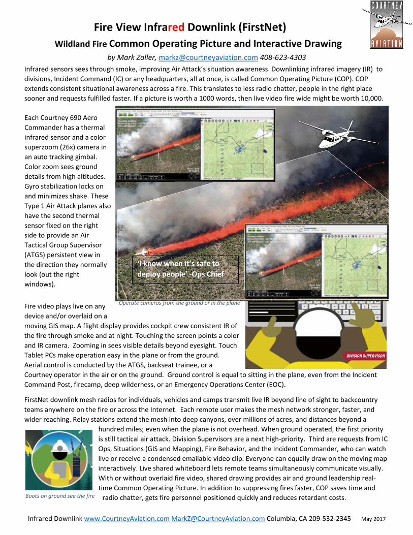
Operate cameras from the ground or in the plane
Boots on ground see the fire
Fire View Infrared Downlink (FirstNet)
Wildland Fire Common Operating Picture and Interactive Drawing by Mark Zaller, [email protected] 408-623-4303
Infrared sensors sees through smoke, improving Air Attack’s situation awareness. Downlinking infrared imagery (IR) to
divisions, Incident Command (IC) or any headquarters, all at once, is called Common Operating Picture (COP). COP
extends consistent situational awareness across a fire. This translates to less radio chatter, people in the right place
sooner and requests fulfilled faster. If a picture is worth a 1000 words, then live video fire wide might be worth 10,000.
Fire video plays live on any
device and/or overlaid on a
moving GIS map. A flight display provides cockpit crew consistent IR of
the fire through smoke and at night. Touching the screen points a color
and IR camera. Zooming in sees visible details beyond eyesight. Touch
Tablet PCs make operation easy in the plane or from the ground.
Aerial control is conducted by the ATGS, backseat trainee, or a
Courtney operator in the air or on the ground. Ground control is equal to sitting in the plane, even from the Incident
Command Post, firecamp, deep wilderness, or an Emergency Operations Center (EOC).
FirstNet downlink mesh radios for individuals, vehicles and camps transmit live IR beyond line of sight to backcountry
teams anywhere on the fire or across the Internet. Each remote user makes the mesh network stronger, faster, and
wider reaching. Relay stations extend the mesh into deep canyons, over millions of acres, and distances beyond a
hundred miles; even when the plane is not overhead. When ground operated, the first priority
is still tactical air attack. Division Supervisors are a next high-priority. Third are requests from IC
Ops, Situations (GIS and Mapping), Fire Behavior, and the Incident Commander, who can watch
live or receive a condensed emailable video clip. Everyone can equally draw on the moving map
interactively. Live shared whiteboard lets remote teams simultaneously communicate visually.
With or without overlaid fire video, shared drawing provides air and ground leadership real-
time Common Operating Picture. In addition to suppressing fires faster, COP saves time and
radio chatter, gets fire personnel positioned quickly and reduces retardant costs.
Each Courtney 690 Aero
Commander has a thermal
infrared sensor and a color
superzoom (26x) camera in
an auto tracking gimbal.
Color zoom sees ground
details from high altitudes.
Gyro stabilization locks on
and minimizes shake. These
Type 1 Air Attack planes also
have the second thermal
sensor fixed on the right
side to provide an Air
Tactical Group Supervisor
(ATGS) persistent view in
the direction they normally
look (out the right
windows).
‘I know when it’s safe to
deploy people’ -Ops Chief
Infrared Downlink www.CourtneyAviation.com [email protected] Columbia, CA 209-532-2345 May 2017
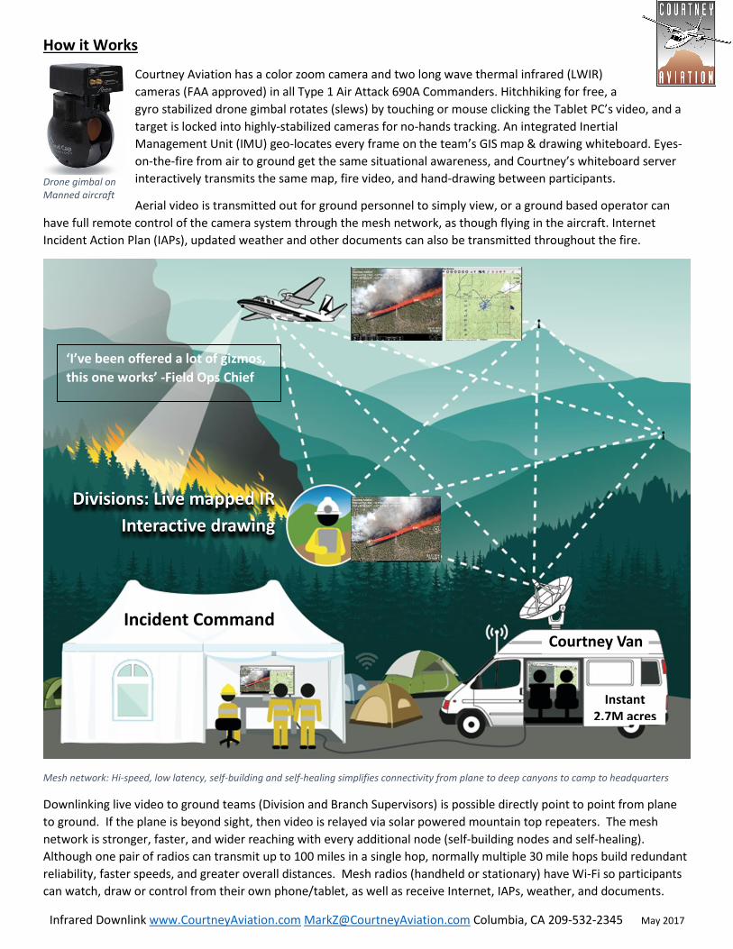
How it Works
Courtney Aviation has a color zoom camera and two long wave thermal infrared (LWIR)
cameras (FAA approved) in all Type 1 Air Attack 690A Commanders. Hitchhiking for free, a
gyro stabilized drone gimbal rotates (slews) by touching or mouse clicking the Tablet PC’s video, and a
target is locked into highly-stabilized cameras for no-hands tracking. An integrated Inertial
Management Unit (IMU) geo-locates every frame on the team’s GIS map & drawing whiteboard. Eyes-
on-the-fire from air to ground get the same situational awareness, and Courtney’s whiteboard server
interactively transmits the same map, fire video, and hand-drawing between participants.
Aerial video is transmitted out for ground personnel to simply view, or a ground based operator can
have full remote control of the camera system through the mesh network, as though flying in the aircraft. Internet
Incident Action Plan (IAPs), updated weather and other documents can also be transmitted throughout the fire.
Mesh network: Hi-speed, low latency, self-building and self-healing simplifies connectivity from plane to deep canyons to camp to headquarters
Downlinking live video to ground teams (Division and Branch Supervisors) is possible directly point to point from plane
to ground. If the plane is beyond sight, then video is relayed via solar powered mountain top repeaters. The mesh
network is stronger, faster, and wider reaching with every additional node (self-building nodes and self-healing).
Although one pair of radios can transmit up to 100 miles in a single hop, normally multiple 30 mile hops build redundant
reliability, faster speeds, and greater overall distances. Mesh radios (handheld or stationary) have Wi-Fi so participants
can watch, draw or control from their own phone/tablet, as well as receive Internet, IAPs, weather, and documents.
Drone gimbal on Manned aircraft
‘I’ve been offered a lot of gizmos,
this one works’ -Field Ops Chief
Incident Command
Instant 2.7M acres
Divisions: Live mapped IR
Interactive drawing
Courtney Van
Infrared Downlink www.CourtneyAviation.com [email protected] Columbia, CA 209-532-2345 May 2017
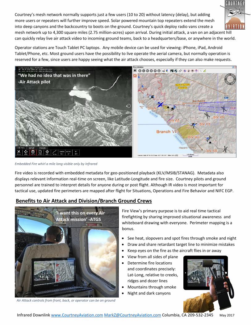
Air Attack controls from front, back, or operator can be on ground
Courtney’s mesh network normally supports just a few users (10 to 20) without latency (delay), but adding
more users or repeaters will further improve speed. Solar powered mountain top repeaters extend the mesh
into deep canyons and the backcountry to boots on the ground. Courtney’s quick deploy radio vans create a
mesh network up to 4,300 square miles (2.75 million-acres) upon arrival. During initial attack, a van on an adjacent hill
can quickly relay live air attack video to incoming ground teams, back to a headquarters/base, or anywhere in the world.
Operator stations are Touch Tablet PC laptops. Any mobile device can be used for viewing: iPhone, iPad, Android
Tablet/Phone, etc. Most ground users have the possibility to live operate the aerial camera, but normally operation is
reserved for a few, since users are happy seeing what the air attack chooses, especially if they can also make requests.
Embedded Fire whirl a mile long visible only by Infrared
Fire video is recorded with embedded metadata for geo-positioned playback (KLV/MSIB/STANAG). Metadata also
displays relevant information real-time on screen, like Latitude-Longitude and fire size. Courtney pilots and ground
personnel are trained to interpret details for anyone during or post flight. Although IR video is most important for
tactical use, updated fire perimeters are mapped after flight for Situations, Operations and Fire Behavior and NIFC EGP.
Benefits to Air Attack and Division/Branch Ground Crews
Fire View’s primary purpose is to aid real time tactical
firefighting by sharing improved situational awareness and
whiteboard drawing with everyone. Perimeter mapping is a
bonus.
• See heat, slopovers and spot fires through smoke and night
• Draw and share retardant target line to minimize mistakes
• Keep eyes on the fire as the aircraft flies in or away
• View from all sides of plane
• Determine fire locations
and coordinates precisely:
Lat-Long, relative to creeks,
ridges and dozer lines
• Mountains through smoke
• Night and dark canyons
“We had no idea that was in there”
-Air Attack pilot
‘I want this on every Air
Attack mission’ -ATGS

Infrared Downlink www.CourtneyAviation.com [email protected] Columbia, CA 209-532-2345 May 2017
Hands-off retardant drop tracking with live mapping
Aggressive fire behavior is seen prior to personnel deployment
Division, Branch & Incident Command live all at once
Air Attack Benefits continued:
• Fire creeping underground
• Retardant burn through
• Tiny spot fires underneath smoke
• New starts around burnouts
• Smokeless smoldering in a snag
• Hand cut line integrity in tall trees
• Fire GIS lines automatically tracked
• Zoom-in, lock-on and Identify Aircraft
• Tankers while dropping retardant, or
dipping for water (hands-off tracked)
• Retardant & Water coverage level
Shared Oversight. Quiet and high
• Draw on moving map live to others
• See retardant drops (and everything else) even
when not aligned out the window
• Thermal footprint of water (cold) visualized
• Drops auto-recorded for mapping
• Mark any spot to revisit easily
• Coordinates emailed or spoken over the radio
• Google Earth photos (KMZ) emailed
• See multiple targets from one location
• Transmit medical or accident incidents
• Increased level of safety
• Transmit and record/map Assets at risk
and Assess burned
• Guard people & vehicles under smoke
• Debrief AirOps/Ops and meetings
Live Mapping
• Live Fire updates to team
• Fire Behavior
• Fresh content to Situations and GIS
• Meteorological winds
“The bowl is full” – IR operator
showing live video to IC asking if
he could only see into a canyon
‘Used live on EOC big screen for planning evacuations’
-Vandenberg Air Force & Spaceport
“Jaw-dropping…immediately
used” -Air Support

Infrared Downlink www.CourtneyAviation.com [email protected] Columbia, CA 209-532-2345 May 2017
Ops desk at Soberanes Fire. Live view for decision makers
62 foot mast van oversees whole fire
Common Operating Picture (COP)
Provide ground teams on the fire and in camp a common real time
situational awareness from the Air Attack’s
aerial fire view.
• Air ground and Ops are synchronized
• Actions happen correctly and faster
• Reduced radio talk - chatter
• Operator interprets IR
• Leadership all have “Eyes on the Fire”
• Informed decision making
• Assist with escape routes
• Safety improved for everyone involved
• Perimeter updated near real time
• Fire dynamics prior to deploying team
• Fire Behavior Analyst data available
nowhere else
• Ops & Supervisors see real time during
issues and crucial areas
• Instant Replay always available
• Perimeter import to FS Pro ignition
• Headquarters, dispatch, NIFC and
forest headquarters, see, all at the same time
• Naturally keeps different teams all on the same page without distraction
• ICS Situations and GIS mapping utilize the Air Attack video (live and recorded)
• Mesh net delivers team GIS maps and IAP to remote teams
• Internet access available to ground teams through self-healing mesh network
• Public Information Officer (PIO) video for community meetings, supporting
government agencies and forest supervisors
• Air attack video is used to brief other agencies like a military EOC, Governor’s
Office of Emergency Services (OES), Headquarters
• No need to depend on TV stations to view fire video
• Geo-video for
BAER teams, and
other post fire
analysis
• Off season team
review and training
Solar powered mountain repeaters run indefinitely & reaches ~1.2 million acres
Infrared Downlink www.CourtneyAviation.com [email protected] Columbia, CA 209-532-2345 May 2017
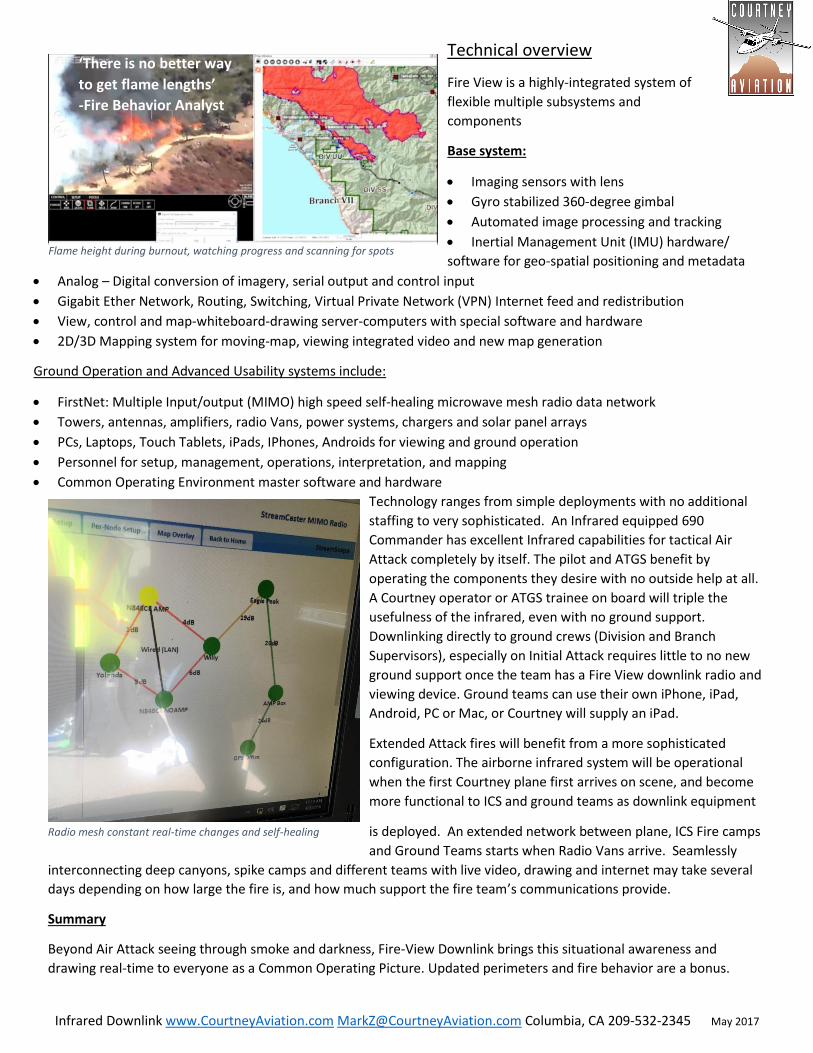
Radio mesh constant real-time changes and self-healing
Flame height during burnout, watching progress and scanning for spots
Technical overview
Fire View is a highly-integrated system of
flexible multiple subsystems and
components
Base system:
• Imaging sensors with lens
• Gyro stabilized 360-degree gimbal
• Automated image processing and tracking
• Inertial Management Unit (IMU) hardware/
software for geo-spatial positioning and metadata
• Analog – Digital conversion of imagery, serial output and control input
• Gigabit Ether Network, Routing, Switching, Virtual Private Network (VPN) Internet feed and redistribution
• View, control and map-whiteboard-drawing server-computers with special software and hardware
• 2D/3D Mapping system for moving-map, viewing integrated video and new map generation
Ground Operation and Advanced Usability systems include:
• FirstNet: Multiple Input/output (MIMO) high speed self-healing microwave mesh radio data network
• Towers, antennas, amplifiers, radio Vans, power systems, chargers and solar panel arrays
• PCs, Laptops, Touch Tablets, iPads, IPhones, Androids for viewing and ground operation
• Personnel for setup, management, operations, interpretation, and mapping
• Common Operating Environment master software and hardware
Technology ranges from simple deployments with no additional
staffing to very sophisticated. An Infrared equipped 690
Commander has excellent Infrared capabilities for tactical Air
Attack completely by itself. The pilot and ATGS benefit by
operating the components they desire with no outside help at all.
A Courtney operator or ATGS trainee on board will triple the
usefulness of the infrared, even with no ground support.
Downlinking directly to ground crews (Division and Branch
Supervisors), especially on Initial Attack requires little to no new
ground support once the team has a Fire View downlink radio and
viewing device. Ground teams can use their own iPhone, iPad,
Android, PC or Mac, or Courtney will supply an iPad.
Extended Attack fires will benefit from a more sophisticated
configuration. The airborne infrared system will be operational
when the first Courtney plane first arrives on scene, and become
more functional to ICS and ground teams as downlink equipment
is deployed. An extended network between plane, ICS Fire camps
and Ground Teams starts when Radio Vans arrive. Seamlessly
interconnecting deep canyons, spike camps and different teams with live video, drawing and internet may take several
days depending on how large the fire is, and how much support the fire team’s communications provide.
Summary
Beyond Air Attack seeing through smoke and darkness, Fire-View Downlink brings this situational awareness and
drawing real-time to everyone as a Common Operating Picture. Updated perimeters and fire behavior are a bonus.
‘There is no better way
to get flame lengths’
-Fire Behavior Analyst
Related Documents