Special Volume 3 (2012), pp.17–24 Henk Weerts – Andrea Otte – Bjørn Smit – Peter Vos – Dimitri Schiltmans – Wouter Waldus – Wil Borst Finding the Needle in the Haystack by Using Knowledge of Mesolithic Human Adaptation in a Drowning Delta in Wiebke Bebermeier – Robert Hebenstreit – Elke Kaiser – Jan Krause (eds.), Landscape Archaeology. Proceedings of the International Conference Held in Berlin, 6th – 8th June 2012 Edited by Gerd Graßhoff and Michael Meyer, Excellence Cluster Topoi, Berlin eTopoi ISSN 2192-2608 http://journal.topoi.org Except where otherwise noted, content is licensed under a Creative Commons Attribution 3.0 License: http://creativecommons.org/licenses/by/3.0

Welcome message from author
This document is posted to help you gain knowledge. Please leave a comment to let me know what you think about it! Share it to your friends and learn new things together.
Transcript
Special Volume 3 (2012), pp. 17–24
Henk Weerts – Andrea Otte – Bjørn Smit – Peter Vos – DimitriSchiltmans – Wouter Waldus – Wil Borst
Finding the Needle in the Haystack by UsingKnowledge of Mesolithic Human Adaptation in aDrowning Delta
in Wiebke Bebermeier – Robert Hebenstreit – Elke Kaiser – Jan Krause (eds.), LandscapeArchaeology. Proceedings of the International Conference Held in Berlin, 6th – 8th June 2012
Edited by Gerd Graßhoff and Michael Meyer,Excellence Cluster Topoi, Berlin
eTopoi ISSN 2192-2608http://journal.topoi.org
Except where otherwise noted,content is licensed under a Creative CommonsAttribution 3.0 License:http://creativecommons.org/licenses/by/3.0

Henk Weerts – Andrea Otte – Bjørn Smit – Peter Vos – DimitriSchiltmans – Wouter Waldus – Wil BorstFinding the Needle in the Haystack by UsingKnowledge of Mesolithic Human Adaptation ina Drowning Delta
Drowned landscapes; Mesolithic; Rhine-Meuse delta; underwater excavation.
IntroductionThe Port of Rotterdam is presently expanding Rotterdam harbour into the North Sea.A new 20m deep harbour canal is being dredged to connect to the existing harbour,thereby destroying buried Early Holocene drowned fluvio-deltaic landscapes. Archaeo-logical research in deposits of the Early Holocene age further upstream in the Rhinedelta have revealed that Mesolithic hunter-gatherers adapted to the drowning landscapeby using the highest parts of Late-Weichselian aeolian dunes for their hunting camps.This combined knowledge led to the challenge of finding such dunes in the harbour.At depths of 17–22m below OD in 17m water depth this was like looking for a needlein a haystack. Remnants of a river dune were indeed found followed by a spectacular—albeit small-scale—underwater investigation in 2011. This was the first time that manyMesolithic remains were encountered this deep and this far west.
Late-Weichselian to Middle-Holocene Landscape EvolutionThe landscape evolution of the Holocene Rhine-Meuse delta in the Netherlands is ex-tremely well-known.1 More recently, the research on landscape evolution of the delta wasextended further to the west and even offshore into the present southern North Sea.2
Meanwhile, the underlying Late-Pleistocene Rhine deposits were studied by Buschers etal.3 Landscape evolution and palaeogeography of the delta are thus very well known inspace and time.
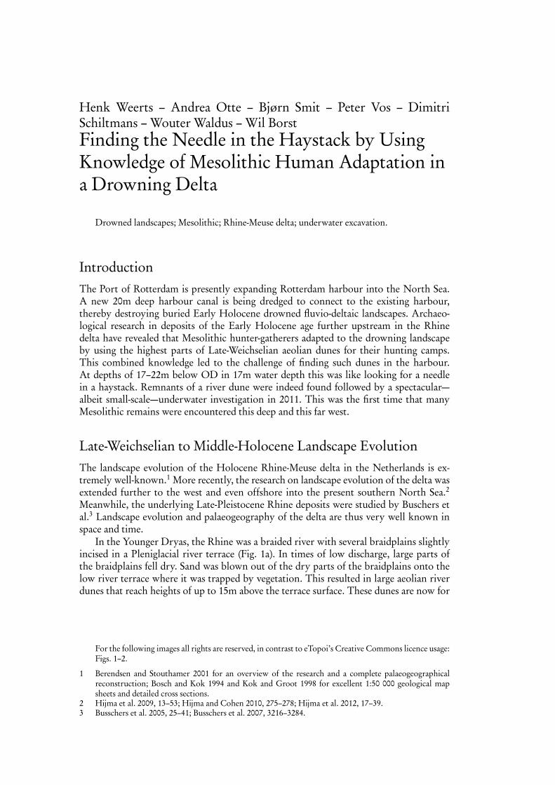
In the Younger Dryas, the Rhine was a braided river with several braidplains slightlyincised in a Pleniglacial river terrace (Fig. 1a). In times of low discharge, large parts ofthe braidplains fell dry. Sand was blown out of the dry parts of the braidplains onto thelow river terrace where it was trapped by vegetation. This resulted in large aeolian riverdunes that reach heights of up to 15m above the terrace surface. These dunes are now for
For the following images all rights are reserved, in contrast to eTopoi’s Creative Commons licence usage:Figs. 1–2.
1 Berendsen and Stouthamer 2001 for an overview of the research and a complete palaeogeographicalreconstruction; Bosch and Kok 1994 and Kok and Groot 1998 for excellent 1:50 000 geological mapsheets and detailed cross sections.
2 Hijma et al. 2009, 13–53; Hijma and Cohen 2010, 275–278; Hijma et al. 2012, 17–39.3 Busschers et al. 2005, 25–41; Busschers et al. 2007, 3216–3284.

18 Henk Weerts et al.
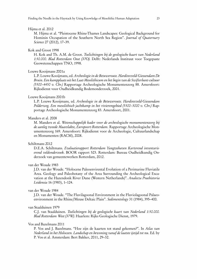
the large part buried under Holocene fluvial deposits and peat. They are present all alongthe former braidplains from Germany to Rotterdam. West of Rotterdam, they seem todisappear. This is in fact a data-artefact: here they are buried too deep for the hand coredrillings to reach them. After the onset of the Holocene, the Rhine became a meanderingriver due to the ameliorating climate and more constant discharge (Fig. 1b). The fastrising sea-level in the Early-Holocene forced the Rhine to aggrade its floodplain. Beforefinal drowning of the western delta in the early Atlantic,4 a freshwater delta existed here(Fig. 1c). In this drowning delta, the tops of the river dunes were present as dry islands.
Dry Islands in the DeltaThe seasonal presence of Mesolithic hunter gatherers on the river dunes is well docu-mented from many sites that have been excavated in the past decades. Several of these well-documented excavations have become famous, e.g. the Hazendonk5 and the Hardinxveldsites.6 The latter two were large excavations prior to the construction of the Betuweroute cargo railway from the Rotterdam harbour to Germany. At Hardinxveld, the old-est Mesolithic inhumation at that time and a dugout-canoe were among the spectacularresults. Mesolithic hunter gatherers used the river dunes for their seasonal hunting camps.They kept coming back to the same locations for many years. This is hardly surprisingbecause the tops of the river dunes were the only dry islands in a very wet swamp. Thatswamp, however, was very rich in food and thus attractive for the Mesolithic huntergatherers. Although these excavations all took place on river dunes further east in thedelta, it is expected that river dunes further to the west may have been used in the sameway. Here the problem is how to find these dunes. Due to the Holocene sea-level rise,the Holocene deposits reach a thickness of up to 20m.7 The discovery of a small riverdune under the Rotterdam city centre in an excavation that was necessary because of theconstruction of a new subway station proved that river dunes are present in the area atstake as well.8 At that Rotterdam river dune location however, no archaeological remainswere found.9
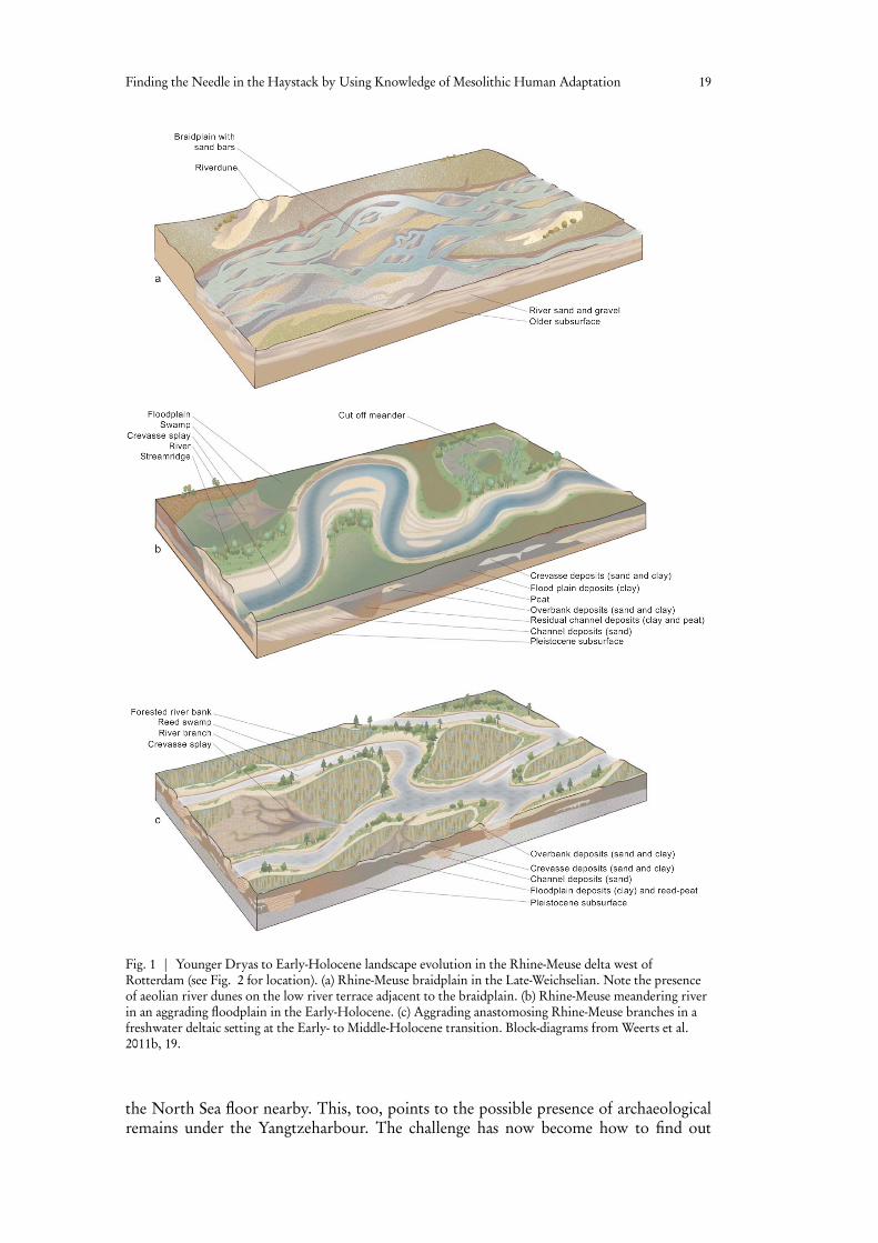
Looking for the Needle in a HaystackThe deepening of the Yangtzeharbour (Fig. 2b) to 22m is part of the Maasvlakte 2 expan-sion of the Rotterdam harbour. In a preliminary desktop survey, the possible presenceof river dunes under the Maasvlakte 2 construction area was noticed (among many otherthings).10 Hence, further archaeological research here was necessary. A special agreementbetween the Port of Rotterdam, the Cultural Heritage Agency of the Netherlands andBOOR (Rotterdam Archaeological Department) in 2008 provided the formal frameworkfor further archaeological research that was necessary because of the construction ofMaasvlakte 2.11 The work in the Yangtzeharbour is part of that research, for whichManders et al.12 provided a scientific framework. Many Mesolithic artefacts have beenfound on the artificial beach of Maasvlakte 1.13 The sand for this beach was dredged from
4 Hijma and Cohen 2010, 275–278; Hijma and Cohen 2011, 1453–1485.5 van der Woude 1983; van der Woude 1984.6 Louwe Kooijmans 2001b; Louwe Kooijmans 2001a.7 van Staalduinen 1979; Vos and Bazelmans 2011, 30.8 Guiran and Moree 2009.9 Guiran and Moree 2009, 33.10 Hessing, Sueur, and Vos 2004, 10.11 Anonymus 2008.12 Manders et al. 2008.13 Manders et al. 2008, 15–16.
Finding the Needle in the Haystack by Using Knowledge of Mesolithic Human Adaptation 19
Fig. 1 | Younger Dryas to Early-Holocene landscape evolution in the Rhine-Meuse delta west ofRotterdam (see Fig. 2 for location). (a) Rhine-Meuse braidplain in the Late-Weichselian. Note the presenceof aeolian river dunes on the low river terrace adjacent to the braidplain. (b) Rhine-Meuse meandering riverin an aggrading floodplain in the Early-Holocene. (c) Aggrading anastomosing Rhine-Meuse branches in afreshwater deltaic setting at the Early- to Middle-Holocene transition. Block-diagrams from Weerts et al.2011b, 19.
the North Sea floor nearby. This, too, points to the possible presence of archaeologicalremains under the Yangtzeharbour. The challenge has now become how to find out
20 Henk Weerts et al.
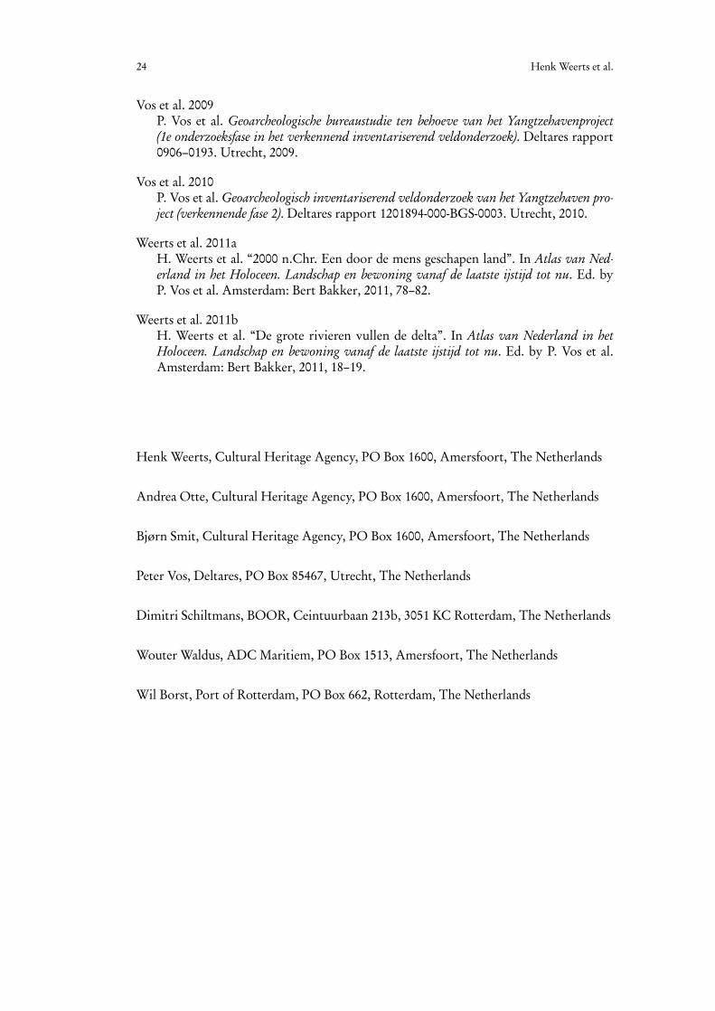
Fig. 2 | The Yangtzeharbour location. (a) Location of the Maasvlakte, Rotterdam and Hardinxveld in theNetherlands. (b) Location of the Yangtzeharbour in the Maasvlakte. (c) Location of the river dune under theYangtzeharbour. (a) and (b) adapted from Weerts et al. 2011a, 81. (c) adapted from Vos et al. 2010 Bijlage 14.
if there is something under there, or not. This is much like looking for a needle in ahaystack. The part of the Yangtzeharbour that has to be deepened is over 3km long and500m wide. Water depth at the time was 17m.
A desktop study based on existing core descriptions and cone penetration tests dealingwith possible Mesolithic archaeology under the Yangtzeharbour was published by Vos etal.14 One of the conclusions was that additional data collecting was necessary. This “field-work” was carried out in 2010 and clearly showed the presence of an intact drowned EarlyHolocene fluvial landscape underneath younger shallow marine deposits.15 Based on shal-low seismics, existing cone penetration tests and 17 new piston cores with a penetrationrange from 2.2–4.5m, three areas with a high archaeological potential were recognised
14 Vos et al. 2009.15 Vos et al. 2010.
Finding the Needle in the Haystack by Using Knowledge of Mesolithic Human Adaptation 21
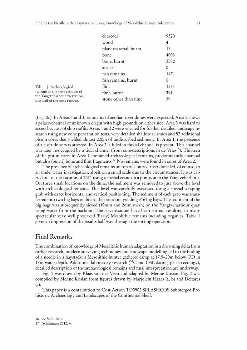
Tab. 1 | Archaeologicalremains in the sieve residues ofthe Yangtzeharbour excavation,first half of the sieve residue.
charcoal 9520wood 4plant material, burnt 15bone 4003bone, burnt 3582antler 0fish remains 147fish remains, burnt 0flint 1371flint, burnt 391stone other than flint 39
(Fig. 2c). In Areas 1 and 3, remnants of aeolian river dunes were expected. Area 2 showsa palaeo-channel of unknown origin with high grounds on either side. Area 3 was hard toaccess because of ship traffic. Areas 1 and 2 were selected for further detailed landscape re-search using new cone penetration tests, very detailed shallow seismics and 52 additionalpiston cores that yielded almost 200m of undisturbed sediment. In Area 1, the presenceof a river dune was attested. In Area 2, a filled-in fluvial channel is present. This channelwas later re-occupied by a tidal channel (from core-descriptions in de Vries16). Thirteenof the piston cores in Area 1 contained archaeological remains, predominantly charcoalbut also (burnt) bone and flint fragments.17 No remains were found in cores of Area 2.
The presence of archaeological remains on top of a buried river dune led, of course, toan underwater investigation, albeit on a small scale due to the circumstances. It was car-ried out in the autumn of 2011 using a special crane on a pontoon in the Yangtzeharbour.On three small locations on the dune, the sediment was removed to just above the levelwith archaeological remains. This level was carefully excavated using a special scrapinggrab with exact horizontal and vertical positioning. The sediment of each grab was trans-ferred into two big bags on board the pontoon, yielding 316 big bags. The sediment of thebig bags was subsequently sieved (10mm and 2mm mesh) on the Yangtzeharbour quayusing water from the harbour. The sieve-residues have been sorted, resulting in manyspectacular very well preserved (Early) Mesolithic remains including organics. Table 1gives an impression of the results half way through the sorting operation.
Final RemarksThe combination of knowledge of Mesolithic human adaptation in a drowning delta fromearlier research, modern surveying techniques and landscape modelling led to the findingof a needle in a haystack: a Mesolithic hunter gatherer camp at 17.5–20m below OD in17m water depth. Additional laboratory research (14C and OSL dating, palaeo-ecology),detailed description of the archaeological remains and final interpretation are underway.
Fig. 1 was drawn by Klaas van der Veen and adapted by Menne Kosian. Fig. 2 wascompiled by Menne Kosian from figures drawn by Marjolein Haars (a, b) and Deltares(c).
This paper is a contribution to Cost Action TD0902 SPLASHCOS Submerged Pre-historic Archaeology and Landscapes of the Continental Shelf.
16 de Vries 2012.17 Schiltmans 2012, 4.

22 Henk Weerts et al.
BibliographyAnonymus 2008
Anonymus. “Samenwerkingsovereenkomst inzake archeologische vondsten tussenHavenbedrijf Rotterdam N.V.”. In Rijksdienst voor de Archeologie, Cultuurlandschapen Monumenten. Rijksdienst voor de Archeologie, Cultuurlandschap en Monumenten.Amersfoort, 2008.
Berendsen and Stouthamer 2001H.J.A. Berendsen and E. Stouthamer. Palaeogeographic Development of the Rhine-MeuseDelta. Amsterdam: Van Gorcum, 2001.
Bosch and Kok 1994J.H.A. Bosch and H. Kok. Toelichtingen bijdegeologische kaart van Nederland 1:50.000.Blad Gorinchem (Gorkum) West (38W). Utrecht: Rijks Geologische Dienst, 1994.
Busschers et al. 2005F.S. Busschers et al. “Sedimentary Architecture and Optical Dating of Middle andLate Pleistocene Rhine-Meuse Deposits – Fluvial Response to Climate Change, Sea-level fluctuation and glaciation”. Netherlands Journal of Geosciences – Geologie en Mi-jnbouw 84 (2005), 25–41.
Busschers et al. 2007F.S. Busschers et al. “Late Pleistocene Evolution of the Rhine-Meuse System in theSouthern North Sea Basin: Imprints of Climate Change, sea-level Oscillation andGlacio-isostacy”. Quaternary Science Reviews 26 (2007), 3216–3248.
de Vries 2012S. de Vries. Boorbeschrijvingen Yangtzehaven Oost. Deltares rapport 1204743-000-BGS-0013. Utrecht, 2012.
Guiran and Moree 2009A.J. Guiran and J.M. Moree. Rotterdam-Randstadrail: Archeologisch onderzoek 6. Sta-tion Blijdorp en de westbuis van de tunnel. BOORrapporten 421. Rotterdam: BureauOudheidkundig Onderzoek van gemeentewerken Rotterdam, 2009.
Hessing, Sueur, and Vos 2004W.A.M. Hessing, C. Sueur, and P.C. Vos. Maasvlakte 2: Archeologisch VooronderzoekFase 1. Bureauonderzoek, Risico-analyse en Aanbevelingen voor vervolgstappen. 175.Amerfoort: Vestigia, 2004.
Hijma and Cohen 2010M. Hijma and K.M. Cohen. “Timing and Magnitude of the Sea-level Jump Preludingthe 8200 yr Event”. Geology 38 (2010), 275–278.
Hijma and Cohen 2011M.P. Hijma and K.M. Cohen. “Holocene Transgression of the Rhine River MouthArea, The Netherlands/Southern North Sea: Palaeogeography and Sequence Strati-graphy”. Sedimentology 58 (2011), 1453–1485.
Hijma et al. 2009M. Hijma et al. “From River Valley to Estuary: the Evolution of the Rhine Mouth inthe Early to Middle Holocene (Western Netherlands, Rhine-Meuse Delta)”. Nether-lands Journal of Geosciences – Geologie en Mijnbouw 88 (2009), 13–53.
Finding the Needle in the Haystack by Using Knowledge of Mesolithic Human Adaptation 23
Hijma et al. 2012M. Hijma et al. “Pleistocene Rhine-Thames Landscapes: Geological Background forHominin Occupation of the Southern North Sea Region”. Journal of QuaternaryScience 27 (2012), 17–39.
Kok and Groot 1998H. Kok and Th. A.M. de Groot. Toelichtingen bij de geologische kaart van Nederland1:50.000. Blad Rotterdam Oost (37O). Delft: Nederlands Instituut voor ToegepasteGeowetenschappen TNO, 1998.
Louwe Kooijmans 2001aL.P. Louwe Kooijmans, ed. Archeologie in de Betuweroute. Hardinxveld-Giessendam DeBruin. Een kampplaats uit het Laat-Mesolithicum en het begin van de Swifterbant-cultuur(5500–4450 v. Chr.) Rapportage Archeologische Monumentenzorg 88. Amersfoort:Rijksdienst voor Oudheidkundig Bodemonderzoek, 2001.
Louwe Kooijmans 2001bL.P. Louwe Kooijmans, ed. Archeologie in de Betuweroute. Hardinxveld-GiessendamPolderweg. Een mesolithisch jachtkamp in het rivierengebied (5500–5000 v. Chr.) Rap-portage Archeologische Monumentenzorg 83. Amersfoort, 2001.
Manders et al. 2008M. Manders et al. Wetenschappelijk kader voor de archeologische monumentenzorg bijde aanleg tweede Maasvlakte, Europoort-Rotterdam. Rapportage Archeologische Mon-umentenzorg 169. Amersfoort: Rijksdienst voor de Archeologie, Cultuurlandschapen Monumenten (RACM), 2008.
Schiltmans 2012D.E.A. Schiltmans. Evaluatierapport Rotterdam Yangtzehaven Karterend inventaris-erend veldonderzoek. BOOR rapport 523. Rotterdam: Bureau Oudheidkundig On-derzoek van gemeentewerken Rotterdam, 2012.
van der Woude 1983J.D. van der Woude. “Holocene Paleoenvirental Evolution of a Perimarine FluviatileArea. Geology and Paleobotany of the Area Surrounding the Archeological Exca-vation at the Hazendonk River Dune (Western Netherlands)”. Analecta PraehistoriaLeidensia 16 (1983), 1–124.
van der Woude 1984J.D. van der Woude. “The Fluvilagoonal Environment in the Fluviolagoonal Palaeo-environment in the Rhine/Meuse Deltaic Plain”. Sedimentology 31 (1984), 395–400.
van Staalduinen 1979C.J. van Staalduinen. Toelichtingen bij de geologische kaart van Nederland 1:50.000.Blad Rotterdam West (37W). Haarlem: Rijks Geologische Dienst, 1979.
Vos and Bazelmans 2011P. Vos and J. Bazelmans. “Hoe zijn de kaarten tot stand gekomen?”. In Atlas vanNederland in het Holoceen. Landschap en bewoning vanaf de laatste ijstijd tot nu. Ed. byP. Vos et al. Amsterdam: Bert Bakker, 2011, 29–32.
24 Henk Weerts et al.
Vos et al. 2009P. Vos et al. Geoarcheologische bureaustudie ten behoeve van het Yangtzehavenproject(1e onderzoeksfase in het verkennend inventariserend veldonderzoek). Deltares rapport0906–0193. Utrecht, 2009.
Vos et al. 2010P. Vos et al. Geoarcheologisch inventariserend veldonderzoek van het Yangtzehaven pro-ject (verkennende fase 2). Deltares rapport 1201894-000-BGS-0003. Utrecht, 2010.
Weerts et al. 2011aH. Weerts et al. “2000 n.Chr. Een door de mens geschapen land”. In Atlas van Ned-erland in het Holoceen. Landschap en bewoning vanaf de laatste ijstijd tot nu. Ed. byP. Vos et al. Amsterdam: Bert Bakker, 2011, 78–82.
Weerts et al. 2011bH. Weerts et al. “De grote rivieren vullen de delta”. In Atlas van Nederland in hetHoloceen. Landschap en bewoning vanaf de laatste ijstijd tot nu. Ed. by P. Vos et al.Amsterdam: Bert Bakker, 2011, 18–19.
Henk Weerts, Cultural Heritage Agency, PO Box 1600, Amersfoort, The Netherlands
Andrea Otte, Cultural Heritage Agency, PO Box 1600, Amersfoort, The Netherlands
Bjørn Smit, Cultural Heritage Agency, PO Box 1600, Amersfoort, The Netherlands
Peter Vos, Deltares, PO Box 85467, Utrecht, The Netherlands
Dimitri Schiltmans, BOOR, Ceintuurbaan 213b, 3051 KC Rotterdam, The Netherlands
Wouter Waldus, ADC Maritiem, PO Box 1513, Amersfoort, The Netherlands
Wil Borst, Port of Rotterdam, PO Box 662, Rotterdam, The Netherlands
Related Documents