Page 1 of 7 FINDING OF NO SIGNIFICANT IMPACT Issuance of a Negotiated Agreement for Use of Outer Continental Shelf Sand from Borrow Area A for the Ponte Vedra Beach, FL, Beach Nourishment Project, St. Johns County, FL Pursuant to the National Environmental Policy Act (NEPA), Council on Environmental Quality (CEQ) regulations implementing NEPA (40 CFR 1500-1508), and Department of the Interior (DOI) regulations implementing NEPA (43 CFR 46), St. Johns County, Florida prepared an Environmental Assessment (EA) that considers the use of Outer Continental Shelf (OCS) sand to rebuild a portion of the beach and dune system along Ponte Vedra Beach (PVB) (hereafter the Project) severely impacted by Hurricanes Matthew and Irma and naturally occurring erosion. The Bureau of Ocean Energy Management (BOEM) contributed to the preparation of the EA, then conducted its own independent review before adopting the document. Proposed Action The purpose of the Project is to restore and maintain the beach and dune system to protect upland infrastructure, enhance and protect the environmental resources of the area, and restore and maintain the recreational amenity value of the beach in northern St. Johns County. The Project would initially place up to 2.0 million cubic yards (Mcy) (2.2 Mcy dredged volume) of sand along approximately 8.9 miles of the northernmost St. Johns County shoreline between Florida Department of Environmental Protection’s (FDEP) control monuments R-1 (the St. Johns/Duval County boundary) and R-46.2 (the Guana-Tolomato-Matanzas National Estuarine Research Reserve (GTMNERR) and the Guana River Marsh Aquatic Preserve). BOEM’s action is to enter a two-party Non-competitive Negotiated Agreement (NNA) with St. Johns County to authorize the use of up to 2.2 Mcy of OCS sand from the Borrow Area A for construction of the Project. The 200-acre Borrow Area A for the initial nourishment project is located about 4.6 miles offshore the southern end of the Project’s fill area (Attachment 1). The beach construction template includes both a dune and beach berm feature. The reconstructed dunes will have a crest height of +13 ft NAVD88 with a varying crest width of up to 40 ft and stabilized with salt-tolerant vegetation. The beach berm will be constructed to a maximum height of +8 ft NAVD88 with a varying width depending on conditions at the time of construction. The beach fill design incorporates the Florida Fish and Wildlife Conservation Commission’s (FWCC) sea turtle friendly berm design with a seaward 1:20 (vertical:horizontal) slope to an elevation of +5 feet NAVD before transitioning to a seaward 1:15 (vertical:horizontal) slope until tying into existing grade. The width of the fill placement, from the vegetation line to the seaward construction toe of fill, varies alongshore between 200 and 400 ft (approximately), inclusive of the new dune feature and in-water placement. The U.S. Army Corps of Engineers (USACE) Jacksonville District also plans to issue a Department of the Army Permit pursuant to Section 404 of the Clean Water Act (33

Welcome message from author
This document is posted to help you gain knowledge. Please leave a comment to let me know what you think about it! Share it to your friends and learn new things together.
Transcript

Page 1 of 7
FINDING OF NO SIGNIFICANT IMPACT
Issuance of a Negotiated Agreement for Use of Outer Continental Shelf Sand from Borrow Area A for the Ponte Vedra Beach, FL, Beach Nourishment Project, St. Johns County, FL
Pursuant to the National Environmental Policy Act (NEPA), Council on Environmental Quality (CEQ) regulations implementing NEPA (40 CFR 1500-1508), and Department of the Interior (DOI) regulations implementing NEPA (43 CFR 46), St. Johns County, Florida prepared an Environmental Assessment (EA) that considers the use of Outer Continental Shelf (OCS) sand to rebuild a portion of the beach and dune system along Ponte Vedra Beach (PVB) (hereafter the Project) severely impacted by Hurricanes Matthew and Irma and naturally occurring erosion. The Bureau of Ocean Energy Management (BOEM) contributed to the preparation of the EA, then conducted its own independent review before adopting the document.
Proposed Action
The purpose of the Project is to restore and maintain the beach and dune system to protect upland infrastructure, enhance and protect the environmental resources of the area, and restore and maintain the recreational amenity value of the beach in northern St. Johns County. The Project would initially place up to 2.0 million cubic yards (Mcy) (2.2 Mcy dredged volume) of sand along approximately 8.9 miles of the northernmost St. Johns County shoreline between Florida Department of Environmental Protection’s (FDEP) control monuments R-1 (the St. Johns/Duval County boundary) and R-46.2 (the Guana-Tolomato-Matanzas National Estuarine Research Reserve (GTMNERR) and the Guana River Marsh Aquatic Preserve).
BOEM’s action is to enter a two-party Non-competitive Negotiated Agreement (NNA) with St. Johns County to authorize the use of up to 2.2 Mcy of OCS sand from the Borrow Area A for construction of the Project. The 200-acre Borrow Area A for the initial nourishment project is located about 4.6 miles offshore the southern end of the Project’s fill area (Attachment 1). The beach construction template includes both a dune and beach berm feature. The reconstructed dunes will have a crest height of +13 ft NAVD88 with a varying crest width of up to 40 ft and stabilized with salt-tolerant vegetation. The beach berm will be constructed to a maximum height of +8 ft NAVD88 with a varying width depending on conditions at the time of construction. The beach fill design incorporates the Florida Fish and Wildlife Conservation Commission’s (FWCC) sea turtle friendly berm design with a seaward 1:20 (vertical:horizontal) slope to an elevation of +5 feet NAVD before transitioning to a seaward 1:15 (vertical:horizontal) slope until tying into existing grade. The width of the fill placement, from the vegetation line to the seaward construction toe of fill, varies alongshore between 200 and 400 ft (approximately), inclusive of the new dune feature and in-water placement. The U.S. Army Corps of Engineers (USACE) Jacksonville District also plans to issue a Department of the Army Permit pursuant to Section 404 of the Clean Water Act (33

Page 2 of 7
U.S.C. §1344) and Section 10 of the Rivers and Harbors Act of 1899 (33 U.S.C. §403) for the Project. Alternatives to the Proposed Action
St. Johns County and BOEM evaluated four alternatives: 1) no action, 2) beach nourishment and dune restoration (proposed action and preferred alternative), 3) dune restoration, and 4) structural stabilization (i.e., revetments, bulkheads). The no action alternative represents the conditions if no future beach nourishment occurred and is a comparison for other alternatives. The dune restoration alternative meets a portion of the proposed action’s objectives by enhancing storm protection, but the absence of a complementary beach component could reduce nesting sea turtles’ and shorebirds’ habitat. The structural stabilization alternative would protect the landward infrastructure and environmental resources, but not the seaward recreational or environmental resources along the beach. Beach habitat would be adversely affected.
Environmental Effects
In May 2021, St. Johns County prepared a Final EA evaluating the potential environmental effects associated with dredging and transporting sand from Borrow Area A, located in the OCS, with placement on PVB. The USACE will issue a separate Statement of Findings in lieu of adopting this EA.
St. Johns County, BOEM, and USACE identified a suite of environmental commitments necessary to avoid, minimize, and/or reduce and track any foreseeable adverse effects that may result from the Project. St. Johns County is responsible for implementing all environmental requirements prior to, during, and after construction, as described in the 2021 EA. BOEM and parties engendering mitigation measures are responsible for enforcing those requirements.
Significance Review
Pursuant to 40 CFR 1501.3(b), BOEM analyzed the significance of potential effects of the proposed action considering both the potentially affected environment and the degree of effects. Connected actions (defined per 40 CFR 1501.9(e)(1)), including on-and-off site mobilization and beach placement activities, were also considered. BOEM considered the affected area and resources potentially present in both spatial and temporal contexts. The proposed action is considered site-specific. The area of direct fill placement includes approximately 143.2 acres of dry, sandy beach, 133.7 acres of intertidal flat/surf zone, and 64.6 acres of shallow, subtidal habitat. Borrow Area A includes approximately 200 acres of similar sandy submerged and subaerial habitat. Effects would be limited to the placement site and the immediate dredging area, both of which are dominated by storms and physical processes of waves and currents. Effects of the Project would generally be limited to the 3-month to 6-month construction window and the time interval associated with equilibration of the placement material, recovery of

Page 3 of 7
the disturbed borrow area, and any habitat change along the beach. BOEM considered the following when evaluating the degree of effects:
(i) Short- and long-term effects
Potential effects associated with the Project would be localized, short-lived, and generally reversible as described below. The only long-term effect within Borrow Area A would be related to physical geomorphologic change due to the removal of OCS sand and limited infilling or reshaping expected. Borrow Area A has never been dredged. Impacts to current patterns or tidal flow are not anticipated, and most effects are expected to be limited to the immediate dredging area. Dredging in the borrow area is likely to permanently reduce its sand resources. However, the removal of sand from Borrow Area A has been designed to minimize long-term impacts to sand ridges and associated habitat. Dredging of Borrow Area A would temporarily impact benthic epifaunal and infaunal organisms and result in the loss of some infaunal species. However, recruitment and recolonization would occur in the short-term after dredging given similar benthic community composition in the surrounding habitat. Further, benthic impacts would be minimized by limiting dredging depths and maintaining consistent pre- and post-dredge sediment characteristics. Recovery of the benthic population is expected within 1 to 2 years after dredging; therefore, the potential for significant or chronic impact would be avoided. Impacts are anticipated to the nearshore and intertidal soft bottom communities of the beach placement site; however, they are expected to recover within a similar timeframe through recruitment from surrounding communities. Current sea turtle nesting opportunities along the Project’s area are diminished because of long-term chronic beach erosion and severe storm damage, resulting in lower-quality habitat. Despite this, loggerhead, green, and leatherback sea turtles nest within the Project’s area. Hawksbill and Kemp’s ridley sea turtles occur in coastal waters off St. Johns County, but do not currently nest within the Project’s area. Borrow Area A sand composition meets the State of Florida’s sediment criteria for native beach compatibility. Construction activities and staging of equipment may affect existing dune vegetation; however, the Project includes revegetation of dune areas that would be disturbed. Nesting habitat may be affected over the short-term, until the beach and dune system equilibrate post-construction and provide improved habitat. The waters adjacent to the project area are designated critical habitat for the loggerhead sea turtle (LOGG-N-14) and the North Atlantic Right Whale (Unit 2) occur in the Project’s area. The beach placement area is south of the critical habitat unit for loggerhead nesting sea turtles (LOGG-T-FL-01). These critical habitats are not likely to be adversely affected. BOEM and USACE will avoid and/or minimize effects to protected species and designated critical habitat in accordance with requirements outlined the U.S. Fish and Wildlife Service (USFWS) Statewide Programmatic Biological Opinion (SPBO) for beach placement activities (2015), the USFWS Piping Plover Programmatic Biological Opinion (P3BO, 2013), and the National Marine Fisheries Service (NMFS) South Atlantic Regional Biological Opinion (SARBO, 2020).

Page 4 of 7
The Project’s area falls under NMFS and the South Atlantic Fisheries Management Council (SAFMC) jurisdiction. NMFS has designated Essential Fish Habitat (EFH) in and adjacent to the Project’s area for various demersal, pelagic, and highly migratory species. The Project will have temporary effects to EFH from dredging and placement activities. St. Johns County will implement avoidance and minimization measures to minimize effects on those fish species and fish habitat including but not limited to: adherence to the State Water Quality Criteria at the edge of the 150-meter mixing zone, avoiding/minimizing construction overlap with peak recruitment windows for benthic infaunal assemblages and federally managed species, and avoidance of hard bottom. The effects would not be significant, as there is comparable, undisturbed habitat adjacent to Borrow Area A. Other expected short-term effects from the Project include interruptions of shorebird foraging and resting at the placement site, noise and beach access closure effects on the local socio-economics and aesthetics, impediments to recreational usage at the placement site, restricted boating navigation at the dredge and placement sites, increases in turbidity at the construction sites, localized and minor noise level increases at the dredge site, and public safety risks posed by the construction equipment. These effects are likely limited to the 3-month to 6-month construction period.
(ii) Beneficial and adverse effects
BOEM considered potential effects to the physical environment, biological resources, cultural resources, and socioeconomic resources. St. Johns County, in coordination with BOEM, developed a borrow area use plan strategy to optimize the use of sand and avoid and/or minimize environmental effects. Some coastal sand dependent species (e.g., native and migratory shorebirds, sea turtles) may experience temporary disruptions to foraging and nesting during and following construction. However, the birds and sea turtles that use the beach for foraging or nesting may benefit in the long-term from higher quality habitat. St. Johns County plans to implement standard shorebird monitoring (as required by the SPBO and P3BO if the project timing overlaps with the nesting season) and sea turtle nesting protocols (if the project construction is delayed thus overlapping nesting season). Dune vegetation would help create higher quality habitat to improve ecosystem function. Dredging activities within Borrow Area A overlap with the distribution of threatened loggerhead (Northwest Atlantic Distinct Populations Segment (DPS)) and green sea turtles (North Atlantic DPS), and endangered leatherback, hawksbill, and Kemps Ridley sea turtles protected under the Endangered Species Act (ESA). Placement of sediment within the designated beach placement site may affect nesting sea turtles (loggerhead, leatherback, and greens) and piping plovers. Adherence to state and federal requirements, including sediment compatibility requirements, dredging operational constraints, endangered species observers, sea turtle nest monitoring, etc. would avoid and/or minimize effects. The Project would not occur in “optimal” piping plover habitat and is not likely to adversely affect the piping plover. The threatened West Indian manatee occurs in coastal and estuarine habitat within St. Johns County where they

Page 5 of 7
primarily use inlet estuaries and shallow coastal waters to migrate and forage. The dredge and support vessels associated with the Project will be operating in deeper waters offshore and not in these migratory and foraging habitats. Therefore, the Project will have no effect on the West Indian manatee. Seafloor-disturbing activities (e.g., dredging, anchoring, pipeline placement, etc.) would occur during proposed construction activities. The USACE and St. Johns County conducted cultural and hard bottom resource clearance surveys in Borrow Area A, nearshore pipeline corridors, and beach placement area. The remote sensing surveys identified 14 magnetic anomalies in the borrow area and 58 in the pipeline corridors; however, most of the magnetic anomalies or targets represent objects of modern origin. Anomalies identified in one pipeline corridor could be associated with a possible shipwreck and would be avoided. No adverse effects to historic or pre-contact resources are expected with implementation of recommended avoidance measures. There are no hard-bottom resources in Borrow Area A, placement area, and pipeline corridors, as verified by resource surveys. Beach placement would not directly bury onshore coquina outcroppings, or indirectly bury nearshore hard bottom inshore of the Equilibration Toe of Fill (ETOF) through beach profile equilibration and along-shore/ cross-shore transport processes. Construction activities are required to meet all state Water Quality Certification conditions, including turbidity monitoring, in accordance with FDEP Joint Coastal Permit (JCP) requirements (Permit No: 0377843-001-JC). Indirect effects are also likely to occur. The Project could increase the capacity for recreational activity (e.g., beach access, surfing, shore fishing, wildlife viewing). The PVB shoreline is already at near maximum capacity, so increased potential for development is not likely.
(iii) Effects on public health or safety
Significant effects to public health and safety are not expected. The Project would provide for increased recreational opportunity from the improved beach and dune habitat. Temporary disruption to recreation would occur in small alongshore stretches as the construction progresses along the placement site. However, the Project would result in long-term recreational improvements. Construction of the dune and beach would provide protection of existing infrastructure. Emissions from construction equipment may temporarily affect air quality in the immediate vicinity of operations. Noise would temporarily increase at the placement locations during construction, and then would return to ambient levels after project completion. The construction equipment at the beach placement site could pose a minor public safety risk. BOEM determined that there are no minority or low-income populations in the Project’s area; therefore, the Project would not disproportionately affect populations outlined in Executive Order 12898.
(iv) Effects that would violate a Federal, State, Tribal, or local law protecting the environment

Page 6 of 7
ESA and Magnuson-Stevens Fishery Management and Conservation Act consultations have been completed. BOEM determined that the Project is within scope of the USFWS SPBO (revised 2015) and the P3BO (2013). St. Johns County will comply with all relevant reasonable and prudent measures (RPMs) and associated terms and conditions (T&Cs). BOEM and USACE have determined that dredging activities associated with the Project are within scope and will operate under the NMFS SARBO (2020). The proposed action complies with the Marine Mammal Protection Act. Marine mammals are not likely to be adversely affected by the project and incorporation of safeguards to protect threatened and endangered species during project construction (i.e., vessel speed requirements, protected species observers, etc.) would also protect non-listed marine mammals in the area. Migratory birds may experience minor, short-term interruptions to foraging or resting activities linked to prey smothering or turbidity increases. St. Johns County will implement measures to avoid effects to migratory birds, hatchlings, or eggs along with pre- and post-project monitoring requirements. The USACE and BOEM coordinated with the Florida Division of Historical Resources and State Historic Preservation Officer (SHPO) and Tribal Historic Preservation Officers (THPOs), as required by Section 106 of the National Historic Preservation Act. The SHPO concurred with the determination that the proposed project would have no adverse effect to historic properties listed, eligible, or potentially eligible for listing in the National Register of Historical Places provided avoidance of the nearshore targets. The USACE and/or BOEM will require St. Johns County to immediately cease operations and notify SHPO if an unexpected discovery occurs. The USACE transmitted tribal consultation letters on February 24, 2021 and received concurrence from the Seminole tribe. No additional correspondence was received from other tribes within the review period. The FDEP provided a consolidated JCP on April 12, 2021. The JCP constitutes a finding of consistency with Florida’s Coastal Management Program, as required by Section 307 of the Coastal Zone Management Act (CZMA); it also constitutes certification of compliance with Florida water quality standards pursuant to Section 401 of the Clean Water Act (CWA) (33 U.S.C. 1341).
Consultations and Public Involvement
The USACE distributed a Public Notice to Federal, state, and local agencies and other interested stakeholders on October 1, 2020 following receipt of St. Johns County’s application for a Department of the Army permit. The Public Notice recognized BOEM’s authority over the use of OCS sand resources under the OCS Lands Act. The USACE and BOEM considered all comments and integrated responses, as appropriate. This Finding will be made available to the public on boem.gov.
Mitigation and Monitoring

Page 7 of 7
St. Johns County is responsible for complying with all environmental mitigation measures and monitoring requirements engendered by Federal, State, Tribal, and local laws, including those identified in the 2021 EA and related consultations (Attachment 2). BOEM will require St. Johns County to prepare an environmental compliance matrix to document and track all environmental mitigation requirements and identify roles and responsibilities for implementation to ensure compliance prior to, during, and after construction. Additionally, the dredging contractor will be required to provide an environmental protection plan that verifies compliance with relevant environmental requirements. Implementation of mitigation measures and monitoring requirements will ensure effects are not significant.
Any mitigation or monitoring uniquely specified by BOEM in its negotiated agreement is done pursuant to the authority established by the Outer Continental Shelf Lands Act and 30 CFR 583. Other Project mitigation is engendered by various authorities, including the ESA, CWA, and CZMA. Other federal or state agencies shall be responsible for enforcement of other mitigation measures. BOEM may terminate its authorization, or refer St. John’s County to enforcing agencies, if the County does not comply with mitigation measures (30 CFR 583).
Conclusion
BOEM considered the consequences of entering into a negotiated agreement authorizing use of OCS sand from Borrow Area A in this project. BOEM contributed to the preparation of and then conducted its own independent review of the 2021 EA prepared by St. Johns County before its adoption (Attachment 3). BOEM finds that the EA complies with the relevant provisions of the CEQ regulations implementing NEPA, DOI regulations implementing NEPA, and other Bureau requirements.
Based on the evaluation of potential effects and associated mitigation measures discussed in the 2021 EA, BOEM finds that entering into a negotiated agreement, with the implementation of the mitigating measures, does not constitute a major Federal action significantly affecting the quality of the human environment, in the sense of NEPA Section 102(2)(C), and would not require preparation of an EIS.
Attachments
Attachment 1 – Project Maps Attachment 2 – Environmental Commitments Attachment 3 – Ponte Vedra Beach, FL, Beach Nourishment Project Environment
Assessment
Jeffrey Reidenauer DateChief, Marine Minerals Division
wismanj
Line
wismanj
Line

Attachment 1-1
ATTACHMENT 1 Project Maps


Attachment 1-3
Figure 2. Detail of Borrow Area A (Olsen Associates, Inc., 2021)

Attachment 2-1
ATTACHMENT 2 Environmental Commitments

Attachment 2-2
St. Johns County and/or its contractor(s) will implement the environmental compliance measures outlined in the EA and associated consultation and permit documents. These requirements will be reflected in the contract plans and specifications as appropriate. St. Johns County will comply with all environmental mitigation requirements prior to, during, and after construction. Before solicitation, St. Johns County will also prepare an Environmental Compliance Matrix (ECM), in coordination with BOEM, documenting how the County and contractor will comply with all environmental compliance measures, including mitigation measures and monitoring requirements, and identifying associated lead Agency roles and responsibilities for implementation and enforcement. The following referenced documents contain all required mitigation measures and monitoring obligations for implementation by St. Johns County, as appropriate. Documents containing BOEM-specific mitigation enforceable through this lease and binding on the County and its contractor(s) are bolded below, including relevant sections and pages; however, St. Johns County and its contractor must implement all relevant mitigation and monitoring mandated by other federal and state agencies.
NATIONAL ENVIRONMENTAL POLICY ACT (NEPA): • 2021. Ponte Vedra Beach, FL Beach Nourishment Project. Final
Environmental Assessment. Prepared by St. Johns County. May2021.
o Section 2.2 (Mitigation); pages 17-18
ENDANGERED SPECIES ACT (ESA): • 2013. U.S. Fish and Wildlife Service Programmatic Piping Plover
Biological Opinion (P3BO) (May 22, 2013).• 2015. U.S. Fish and Wildlife Statewide Programmatic Biological Opinion
(SPBO) (March 13, 2015).• 2020. National Marine Fisheries Service. South Atlantic Regional
Biological Opinion (SARBO) for Dredging and Material PlacementActivities in the Southeastern United States. March 27, 2020.
o Section 2.9.1 (USACE and/or BOEM Project-Specific Reviewfor a Project to be Covered under SARBO); pages 68-69
o 2.9.3 (SARBO Team Communication and Reporting); Section2.9.3.3-2.9.3.5.2 (pages 72-78)
o Appendix A; pages 519-520o Appendix B; Section 1.1 (DREDGE.2; page 522); Section 1.2
(PLACE.2; pages 523-524); Section 1.3 (page 525); Section 2(pages 525-528); Section 3.1 (pages 529-531); Section 3.5 (pages532-533)
o Appendix F; pages 589-596o Appendix H; pages 599-628o Appendix I; pages 629-632

Attachment 2-3
ESSENTIAL FISH HABITAT (EFH): • 2021. USACE EFH consultation email to NMFS HCD (Pace Wilber) dated
April 19, 2021.
STATE HISTORIC PRESERVATION OFFICE (SHPO): • 2020. SHPO Response letter to Gordon Watts, Ph.D, RPA (DHR Project
File No: 2020-6116-A) (Letter dated October 12, 2020). • 2020. SHPO Response letter to USACE (DHR Project File No.: 2020-
5992) (Letter dated October 30, 2020). • 2021. SHPO Response to USACE and BOEM (dated February 10, 2021).
Consultation associated with Project pipeline corridor relocation. • 2021. USACE letter to Tim Parsons, Ph.D., SHPO (dated February 24,
2021). Consultation associated with Borrow Area A and Project pipeline corridors.
• 2021. Updated SHPO Response letter to USACE (DHR Project File No.: 2020-5992-C) (Letter dated April 13, 2021).
FLORIDA DEPARTMENT OF ENVIRONMENTAL PROTECTION (FDEP):
• Consolidated Joint Coastal Permit and Sovereign Submerged Lands Authorization. Permit No. 0377843-001-JC. Issued April 12, 2021.
DEPARTMENT OF THE ARMY(DA) PERMIT:
• Pending

Attachment 3-1
ATTACHMENT 3 Ponte Vedra Beach, FL, Beach Nourishment Project
Environment Assessment

Attachment 3-2
FINAL ENVIRONMENTAL ASSESSMENT
PONTE VEDRA BEACH, FL BEACH NOURISHMENT PROJECT
ST. JOHN’S COUNTY, FL
USACE PERMIT FILE NO. SAJ-2020-03812
FDEP PERMIT FILE NO. 0377843‐001-JC
Prepared for: Olsen Associates Inc.
2618 Herschel St. Jacksonville, FL 32204
Prepared by: Coastal Eco-Group Inc. 665 SE 10th St Suite 104
Deerfield Beach, FL 33441
May 2021

Attachment 3-i
FINAL DRAFT ENVIRONMENTAL ASSESSMENT PONTE VEDRA BEACH, FL, BEACH NOURISHMENT PROJECT
ST. JOHNS COUNTY, FL
TABLE OF CONTENTS
1.0 PROJECT PURPOSE AND NEED ....................................................................... 8
1.1 PROJECT LOCATION ...................................................................................... 8
1.2 PROJECT HISTORY AND NEED ..................................................................... 8 1.2.1 PROJECT HISTORY ..................................................................................... 9 1.2.2 PROPOSED ACTION .................................................................................. 10 1.2.3 PROJECT NEED ......................................................................................... 14
1.3 PROJECT GOALS AND OBJECTIVES ......................................................... 14
1.4 RELATED ENVIRONMENTAL DOCUMENTS ............................................... 14
1.5 DECISIONS TO BE MADE ............................................................................. 15
1.6 SCOPING AND ISSUES ................................................................................. 15
1.7 PERMITS, LICENSES AND ENTITLEMENTS ............................................... 15
2.0 ALTERNATIVES ................................................................................................. 16
2.1 DESCRIPTION OF ALTERNATIVES ............................................................. 16 2.1.1 ALTERNATIVE 1: NO-ACTION ALTERNATIVE (STATUS QUO) .............. 16 2.1.2 ALTERNATIVE 2: PREFERRED ALTERNATIVE: DUNE RESTORATION AND BEACH NOURISHMENT ................................................................................ 16
2.2 MITIGATION ................................................................................................... 17
3.0 AFFECTED ENVIRONMENT .............................................................................. 19
3.1 OCEANOGRAPHIC SETTING ....................................................................... 19 3.1.1 TIDES AND WAVES ................................................................................... 19 3.1.2 WATER CURRENTS ................................................................................... 20
3.2 GEOLOGY AND GEOMORPHOLOGY OF THE STUDY AREA .................... 20 3.2.1 SUBSURFACE CONDITIONS .................................................................... 20 3.2.2 SEDIMENT AND BEACH FILL CHARACTERISTICS ................................. 22
3.3 VEGETATION ................................................................................................. 23 3.3.1 DUNE AND SCRUB COMMUNITIES .......................................................... 23 3.3.2 SEAGRASSES ............................................................................................ 25
3.4 THREATENED AND ENDANGERED SPECIES ............................................ 26

Attachment 3-ii
3.5 FISH AND WILDLIFE RESOURCES .............................................................. 27 3.5.1 BEACH AND DUNE HABITAT .................................................................... 27 3.5.2 OFFSHORE BORROW AREA HABITAT ....................................................... 27 3.5.3 NEARSHORE SOFTBOTTOM COMMUNITY ............................................. 28
3.6 ESSENTIAL FISH HABITAT .......................................................................... 28 3.6.1 MARINE WATER COLUMN ........................................................................ 34 3.6.2 SOFT BOTTOM (SUBTIDAL AND INTERTIDAL NON-VEGETATED FLATS) .................................................................................................................... 38
3.7 COASTAL BARRIER RESOURCES .............................................................. 39
3.8 WATER QUALITY .......................................................................................... 41
3.9 HAZARDOUS, TOXIC AND RADIOACTIVE WASTE .................................... 42
3.10 AIR QUALITY ................................................................................................. 42
3.11 NOISE ............................................................................................................. 42
3.12 AESTHETIC RESOURCES ............................................................................ 43
3.13 RECREATIONAL AND COMMERCIAL RESOURCES .................................. 43
3.14 NAVIGATION .................................................................................................. 44
3.15 HISTORIC RESOURCES ............................................................................... 44
4.0 ENVIRONMENTAL EFFECTS ............................................................................ 45
4.1 GENERAL ENVIRONMENTAL EFFECTS ..................................................... 45
4.2 OCEANOGRAPHIC SETTING AND GEOMORPHOLOGY ........................... 45 4.2.1 NO-ACTION ALTERNATIVE (STATUS QUO) ............................................ 45 4.2.2 PREFERRED ALTERNATIVE: DUNE RESTORATION AND BEACH NOURISHMENT ..................................................................................................... 46
4.3 GEOLOGY ...................................................................................................... 47 4.3.1 NO-ACTION ALTERNATIVE (STATUS QUO) ............................................ 47 4.3.2 PREFERRED ALTERNATIVE: DUNE RESTORATION AND BEACH NOURISHMENT ..................................................................................................... 47
4.4 VEGETATION ................................................................................................. 48 4.4.1 NO-ACTION ALTERNATIVE (STATUS QUO) ............................................ 48 4.4.2 PREFERRED ALTERNATIVE: DUNE RESTORATION AND BEACH NOURISHMENT ..................................................................................................... 48
4.5 THREATENED AND ENDANGERED SPECIES ............................................ 48 4.5.1 NO-ACTION ALTERNATIVE (STATUS QUO) ............................................ 48 4.5.2 PREFERRED ALTERNATIVE: DUNE RESTORATION AND BEACH NOURISHMENT ..................................................................................................... 49

Attachment 3-iii
4.6 FISH AND WILDLIFE RESOURCES .............................................................. 50 4.6.1 NO-ACTION ALTERNATIVE (STATUS QUO) ............................................ 50 4.6.2 PREFERRED ALTERNATIVE: DUNE RESTORATION AND BEACH NOURISHMENT ..................................................................................................... 51
4.7 ESSENTIAL FISH HABITAT ASSESSMENT................................................. 55 4.7.1 NO-ACTION ALTERNATIVE (STATUS QUO) ............................................ 55 4.7.2 PREFERRED ALTERNATIVE: DUNE RESTORATION AND BEACH NOURISHMENT ..................................................................................................... 55
4.8 HISTORIC AND CULTURAL RESOURCES .................................................. 59
4.9 SOCIO-ECONOMIC ........................................................................................ 59
4.10 AESTHETICS .................................................................................................. 60
4.11 RECREATIONAL AND COMMERCIAL RESOURCES .................................. 60
4.12 NAVIGATION .................................................................................................. 60
4.13 COASTAL BARRIER RESOURCES .............................................................. 61
4.14 WATER QUALITY .......................................................................................... 61
4.15 HAZARDOUS, TOXIC, AND RADIOACTIVE WASTE ................................... 65
4.16 AIR QUALITY ................................................................................................. 65
4.17 NOISE ............................................................................................................. 65
4.18 PUBLIC SAFETY ............................................................................................ 67
4.19 ENERGY REQUIREMENTS AND CONSERVATION..................................... 67
4.20 NATURAL OR DEPLETABLE RESOURCES ................................................ 67
4.21 URBAN QUALITY ........................................................................................... 67
4.22 SOLID WASTE ............................................................................................... 67
4.23 DRINKING WATER ........................................................................................ 67
4.24 CUMULATIVE IMPACTS ................................................................................ 67
4.25 IRREVERSIBLE AND IRRETRIEVABLE COMMITMENT OF RESOURCES 70 4.25.1 IRREVERSIBLE ......................................................................................... 70 4.25.2 IRRETRIEVABLE ....................................................................................... 70
4.26 UNAVOIDABLE ADVERSE ENVIRONMENTAL EFFECTS .......................... 70
4.27 LOCAL SHORT-TERM USES AND MAINTENANCE/ENHANCEMENT OF LONG-TERM PRODUCTIVITY ................................................................................... 70

Attachment 3-iv
4.28 INDIRECT EFFECTS ...................................................................................... 70
4.29 COMPATIBILITY WITH FEDERAL, STATE, AND LOCAL OBJECTIVES .... 71
5.0 CONCLUSIONS .................................................................................................. 72
6.0 LIST OF PREPARERS ....................................................................................... 73
7.0 REFERENCES .................................................................................................... 74

Attachment 3-v
FIGURES
Figure 1. Project location map. ..................................................................... ……………11 Figure 2. Cumulative grain size curves for the borrow area and existing beach sediments ........................................................................................................................................ 24 Figure 3. EFH within the PAA for the Local project ........................................................ 30 Figure 4. CBRA OPA Unit FL0P3 within the PAA in relation to the Borrow Area .................................................................................................................... 41 Figure 5. 150 m and 1000 m proposed mixing zones and GTMNERR and Guana River Marsh Aquatic Preserve boundaries. .............................................................................. 64 Figure 6. Background turbidity data collected at the adjacent beach in Duval County between November 5 and November 10, 2018 .............................................................. 65 Figure 7. Background turbidity data collected at the adjacent beach in Duval County between January 5 and January 10, 2019 ...................................................................... 66

Attachment 3-vi
TABLES
Table 1. Tide data from St. Augustine (ocean side) and Vilano Beach (back bay side) of St. Johns County. ............................................................................................................ 19 Table 2. Summary comparison of native beach sediment to the proposed borrow area composite sediment with overfill ratios ............................................................................ 23 Table 3. Fishery Management Plans (FMP) and managed species for the SAFMC (revised 6/2020). A=species managed by the Atlantic States Marine Fisheries Commission ............................................................................................................... 31-32 Table 4. Atlantic Highly Migratory species expected to occur within or offshore of the Ponte Vedra Project Area ............................................................................................... 33 Table 5. Acreage of each habitat type and limits of beach fill and the ETOF ................. 40 Table 6. Sediment compliance specifications. ................................................................ 49 Table 7. Effects conclusions summary table. ................................................................. 51 Table 8. Turbidity mixing zones around each habitat type at the beach fill placement between R-1 and R-36.2, the GTMNERR Aquatic Reserve placement from R-36.2 to R-46 and the offshore borrow area ..................................................................................... 56 Table 9. Summary of Cumulative Effects ....................................................................... 71

Attachment 3-vii
PHOTOS
Photo 1a/b. Staging and access area near the beach access at Mickler’s Landing. ..... 12 Photo 2. Existing dune vegetation at R-26 ..................................................................... 26 Photo 3. Existing beach and dune vegetation and beach face at R-38 .......................... 26
APPENDICES
Appendix I. Final Biological Assessment Appendix II. Final Sediment QA-QC Plan Appendix III. Field Observation Report- July 2020 Benthic habitat verification survey of
the borrow area and submerged pipeline corridors Appendix IV.SHPO Approval Letters

Attachment 3-8
1.0 PROJECT PURPOSE AND NEED
1.1 PROJECT LOCATION St. Johns County is situated between the Florida-Georgia state line and Cape Canaveral on the northeast coast of Florida. Bordered by Duval County to the north and Flagler County to the south, the St. Johns County coastline extends approximately 42 miles along the Atlantic Ocean shoreline. Nearby navigable inlets include the St. Johns River Entrance in Mayport, FL, approximately 10 miles north of the St. Johns/Duval County line, and St. Augustine Inlet, lying in St. Johns County, approximately 24 miles south of the County line. The project limits extend along the northernmost 8.9 miles (14.3 km) of the St. Johns County shoreline from Florida Department of Environmental Protection (FDEP) control monument R-1 at the St. Johns/Duval County boundary southward to R-46.2 at the northern beach boundary of the Guana-Tolomato-Matanzas National Estuarine Research Reserve (GTMNERR) and the Guana River Marsh Aquatic Preserve, which lies within the boundaries of the GTMNERR (Figure 1). A 0.9-mile (1.45 km) segment of the project fill shoreline from R-26 to R-31 is designated as critically eroded by the FDEP. Sand for the beach nourishment project will be excavated from an offshore borrow area lying in Federal waters, approximately 4.0 nautical miles (nm) (7.4 km) offshore of the southern end of the project fill area. Design-level remote sensing surveys have identified an initial borrow area which occupies approximately 200 acres (81 hectares or 0.81 km2) within a roughly shore-parallel sand ridge which is greater than 1,060 acres in size. The borrow area lies in ambient water depths of 40 to 55 ft (12.2 to 16.8m, approx.). Because the borrow area is in Federal waters (more than 3 nm offshore) on the Outer Continental Shelf (OCS), BOEM possesses the authority to authorize use of OCS sand. This Environmental Assessment (EA) was prepared under contract to St. Johns County for adoption by BOEM in support of its decision to authorize use of OCS sand resources.
1.2 PROJECT HISTORY AND NEED The Project Action Area (PAA) is defined as all areas to be affected directly or indirectly by the action and not merely the immediate area involved in the action (50 CFR 402.02). The PAA includes the borrow area (200 acres of greater than 1060 acres available in the offshore sand ridge), the 8.9-mile (14.3 km) long beach fill placement area from R-1 to R-46.2, and unvegetated softbottom habitat within the turbidity mixing zone around the offshore borrow area and beach fill placement areas. The northern 6.5 miles of the project area shoreline lies in Class III waters of the state of Florida in the Atlantic Ocean. The waters along the southern 2.4 miles of the project, south of Mickler’s Landing (R-34 to R-46.2), lie within the Guana River Marsh Aquatic Preserve, located within the limits of the GTMNERR. These waters are classified as Outstanding Florida Waters (OFW) by the State of Florida. The project fill areas include both private and public properties. Private parcels consist of single-family and condominium residences (some publicly available for rental), hotel and resort space.

Attachment 3-9
The primary public beachfront in the area is Mickler’s Landing beachfront park. The initial beach nourishment project is exclusively included in the scope of this proposed action. Future placements will require additional review processes. The initial project proposes dredging up to 2.2 million cubic yards (Mcy) and placement of up to 2.0 Mcy (1.53 Mm3) of sand with an expected nourishment interval of approximately 10 years. The project construction template includes both dune and beach fill berm features. The dune feature shall be constructed along the landward limits of the fill footprint and seaward of existing bulkheads, revetments, and established dune vegetation. Reconstructed dune features will be stabilized with salt-tolerant dune vegetation. The fill berm shall vary alongshore in volume and width depending upon specific volumetric needs. Shoreline erosion in St. Johns County can be attributed to both storms and natural shoreline processes (USACE, 2017). The coast of St. Johns County was damaged by storm surge and erosion during Hurricane Matthew in October 2016 and Hurricane Irma in September 2017 (FEMA, 2019). Shoreline erosion threatens oceanfront infrastructure, such as Ponte Vedra Boulevard and State Road (SR) A1A, which extend along the coast at a distance of approximately 200 to 600 feet inland from the dune system. These roads are the only north-south hurricane evacuation route for communities along this portion of the coastline, and as such, the road is essential for public safety during hurricane evacuation events. Residential homes are generally located about 100 to 400 feet inland (FEMA, 2019). The upland properties along the Ponte Vedra Beach shoreline consist of single-family and condominium residences (some publicly available for rental), hotel/resort space, and Mickler’s Landing beachfront park. Upland uses and activities consist of the private and public uses associated with upland owners and guests (principally residential and tourism). In many sections of the project area shoreline, the entire primary frontal dune was completely lost during Hurricanes Matthew and Irma. Beach erosion and dune loss exposed large areas of upland development and infrastructure to increased threats from future coastal storms. 1.2.1 PROJECT HISTORY The St. Johns County coastline has experienced sporadic accelerated beach erosion rates due to hurricanes and northeaster storms since its earliest development in the early 1900s. In recent years, the coast of St. Johns County was severely damaged by storm surge and erosion during Hurricane Matthew in October 2016 and Hurricane Irma in September 2017 (FEMA, 2019). These storm impacts prompted the first significant shoreline protection measures along this segment of the County shoreline. These initial actions include localized reconstruction of dune features, and construction of individual bulkheads and revetments (typically on a parcel-by-parcel basis). St. Johns County is particularly at risk of damages from high winds and storm inundation caused by hurricanes and tropical storms during the months of June through November. Winter storms, or northeasters, are considered to have a greater impact on shoreline changes than hurricanes as winter storms occur more frequently with longer duration of damaging waves and storm surge (USACE, 2017). St. Johns County beaches are impacted by severe northeaster storm events annually.

Attachment 3-10
Since 1830, an average of one tropical storm system every three years has passed within 50 miles of the PAA (USACE, 2017). Several notable hurricanes that have affected the PAA shoreline are Dora (1964); David (1979); Bob (1985); Dennis, Floyd, Irene (1999); and Frances and Jeanne (2004). A 0.2-mile segment of shoreline in South Ponte Vedra Beach was designated as critically eroded by the FDEP after Hurricanes Frances and Jeanne, followed by a 2.0-mile segment of South Ponte Vedra Beach in 2007. Following Hurricane Sandy in 2012, a 0.7-mile segment of South Ponte Vedra Beach shoreline was added to the critically eroded shoreline designation; an additional 2.2 miles were added in 2015. In 2016, Hurricane Matthew resulted in extension of the critically eroded shoreline designation in South Ponte Vedra Beach by 1.6 miles. The most recent designation was after Hurricane Irma in 2017 with inclusion of an additional 0.9 miles of shoreline in the proposed Ponte Vedra Beach nourishment project area between R-26 and R-31 (FDEP, 2019). 1.2.2 PROPOSED ACTION Initial construction of the Ponte Vedra Beach Nourishment Project will place up to 2.0 Mcy out of a total dredged volume of 2.2 Mcy from a 200-acre borrow area footprint. The construction template includes both dune and beach fill berm features. The dune feature shall be constructed along the landward limits of the fill footprint and seaward of existing bulkheads, revetments, and established dune vegetation. Reconstructed dune features will be stabilized with salt-tolerant dune vegetation. The fill berm shall vary alongshore in volume and width depending upon the specific volumetric needs. The expected project renourishment interval is 10 years. The offshore borrow area has been developed from 40 Vibracores collected in July 2020 by Amdrill, Inc./AVS, Inc., (OAI, 2020a and b). The site was identified by the County via a May 2019 reconnaissance Vibracore collection (Taylor Engineering Inc., 2019). The sand ridge upon which the borrow area lies is comprised of beach-compatible sand with an average thickness of 6 to 12 ft. Typical shell content in the lens is approximately 7% to 9%. Borrow area investigations were completed under BOEM Authorizations E19-005 and E19-006 for geophysical and geotechnical exploration, respectively. The primary construction staging and beach access area is at Mickler’s Landing (Photos 1a/1b). This area was utilized as a construction staging/access area for installation of geotubes to stabilize dunes north of Mickler’s Landing. The area is mostly developed/disturbed upland with sparse dune vegetation along the access pathway through the dune.

Attachment 3-11
Figure 1. Project location map – Ponte Vedra Beach Nourishment Project. Staging site access area is located at Mickler’s Landing.

Attachment 3-12
Photo 1a. Staging and access area near the beach access at Mickler’s Landing (Source: Google Earth).
Photo 1b. Staging and access area near the beach access at Mickler’s Landing (Source: Google Street View).

Attachment 3-13
The borrow area for the initial nourishment project occupies approximately 200 acres (81 hectares or 0.81 km2) and lies atop a large, roughly shore-parallel, sand ridge greater than 1,060 acres in size (Figure 1). The borrow area lies in ambient water depths of 40 to 55 ft (approx.). The approximate design dredge depth is -52 ft NAVD88 with a 2-ft disturbance buffer to -54 ft NADV88. Because the borrow area is located in Federal waters (more than 3 nautical miles offshore) on the OCS, BOEM has the authority to lease sand from Federal waters. BOEM is authorized under Public Law 103-426 [43 United States Code (U.S.C.) 1337(k)(2)] to negotiate on a non-competitive basis the rights to OCS sand resources for shore protection projects. BOEM’s proposed connected action is to issue a non-competitive negotiated agreement (NNA), authorizing use of the sand source areas at the request of St. Johns County. Additional permit drawings of the borrow area and beach fill cross-sections are presented in Appendix 1 of the Biological Assessment (Appendix I). Based on the distance between the offshore borrow area and beach fill placement site, the project will likely be constructed with a trailing-suction hopper dredge with traditional hydraulic sand placement. Excavated sand from a hopper dredge is discharged into hoppers inside the hull and then transported to the pipeline which also serves as a pump-out area. The sediment is then hydraulically unloaded through the pipeline to the fill template. A possible, but unlikely, alternative construction method is excavation with a cutterhead dredge through a spider barge into scow barges. Scows are then towed to the pipeline and hydraulically unloaded to the fill template. Because construction with a hopper dredge presents greater risk for sea turtle take in comparison to a cutterhead dredge, this EA reviews projects effects associated with construction with a hopper dredge. Specific seabed corridors have been identified for pipeline placement from the hopper dredge pump-out locations to the shoreline. Sand will be delivered to the beach from up to eight offshore mooring points through submerged pipelines. The mooring points and pipelines will be deployed along submerged pipeline corridors that have been surveyed and cleared of cultural and hard bottom resources. Construction is expected to begin as early as the Fall of 2021 and will last approximately 3 to 6 months. Effects conclusions contained in this EA are based on avoidance and conservation measures to be implemented if the project is constructed during the Spring and Summer months. The beach berm is expected to equilibrate to a more natural beach shape over the first 12 to 24 months following construction. It is anticipated that the seaward slopes of the equilibrated beach profile will generally replicate those along the existing beach Geotechnical investigations have determined that the sand from the offshore borrow area is compatible with the native beach and will provide suitable habitat for nesting marine turtles, shorebirds, and beach infauna. Geological data used for borrow area design have been provided to BOEM under separate cover.
Attachment 3-14
1.2.3 PROJECT NEED The FDEP designated five coastal reaches located in St. Johns County as critically eroded in 2019 (FDEP, 2019), totaling 8.9 miles of shoreline. Qualitative assessments and quantitative data and analyses are used to recommend a segment of shoreline as critically eroded. The criteria for the critically eroded designation are a threat to, or loss of, one of four specific interests: upland development, recreation, wildlife habitat, or important cultural resources. The list of critically eroded shorelines is updated annually by FDEP. The 2019 report states “Following the impacts of Hurricanes Matthew (2016) and Irma (2017), a 0.9-mile segment of Ponte Vedra (R-26 – R-31) in northern St. Johns County is critically eroded, threatening private development.” (FDEP, 2019). Following Hurricane Matthew, the dune line was pushed back 30 to 40 ft, reaching what is considered a critical condition (Ponte Vedra Recorder, 2019). More recent shoreline and beach volume change analyses associated with the current project development and permitting have documented the erosion and dune damage along the whole of the Ponte Vedra Beach shoreline. These analyses have documented the loss of frontal dune during Hurricanes Matthew and Irma and quantified ongoing erosion along the 8.9-mile project limits.
1.3 PROJECT GOALS AND OBJECTIVES The goal of the proposed project is to restore approximately 8.9 miles (14.3 km) of the eroded beach along the Ponte Vedra shoreline in St. Johns County that was severely impacted by Hurricanes Matthew and Irma. The project will most likely be constructed using a hopper dredge. The project beach/dune fill template will require up to 2.0 Mcy of sand with an expected renourishment interval of approximately 10 years (to be assessed via post-construction monitoring). A dredged volume of 2.2 Mcyis required for initial construction due to anticipated dredging losses and access issues with dredging the borrow area. Subsequent nourishment intervals may include separate NEPA analysis to address new information and update the current analyses. The scope of future renourishment volumes will be based upon project performance. Multiple pipeline corridors are required for project construction (see Figure 1). Construction is expected to begin as early as the fall of 2021 and will last approximately 3 to 6 months.
1.4 RELATED ENVIRONMENTAL DOCUMENTS The USACE Feasibility Study (2017) contains related environmental documents including a Section 404(b) Evaluation, Coastal Zone Management Consistency Determination, an Environmental Assessment, and a Cumulative Effects Assessment for the nearby South Ponte Vedra Beach and Vilano Beach reaches of the St. Johns County Coastal Storm Risk Management Federal Project in St. Johns County, Florida. The FONSI for that Federal project was signed on September 6, 2018. Related previous studies for the St. Johns County shoreline are listed in Section 1.6 of the Feasibility Study (USACE, 2017).

Attachment 3-15
1.5 DECISIONS TO BE MADE This Environmental Assessment (EA) will evaluate whether construction of the proposed Ponte Vedra Beach Nourishment Project will cause any substantial impacts to irreplaceable environmental resources or adverse project-related effects which require mitigation. This document will also aid in BOEM’s decision to authorize the use of OCS sand.
1.6 SCOPING AND ISSUES The proposed project is being coordinated with the following agencies: USACE, FDEP, United States Fish and Wildlife Service (USFWS), National Marine Fisheries Service (NMFS), and the Florida Fish and Wildlife Conservation Commission (FWC). The following resource categories and potential impacts were identified as relevant to the proposed project and appropriate for further evaluation in this EA: cultural resources; threatened and endangered species including sea turtles and whales; turbidity and water quality; fish and wildlife resources and Essential Fish Habitat (EFH); and noise impacts from dredging operations. The waters immediately adjacent to the PAA are critical habitat for the North Atlantic right whale (Unit 2) and loggerhead sea turtle (LOGG-N-14). The beach fill area is immediately south of Critical Habitat Unit LOGG-T-FL-01 for loggerhead nesting sea turtles designated by the USFWS. St. Johns County agrees to implement the Terms and Conditions and/or Project Design Criteria (PDCs) described in the following documents:
• NMFS South Atlantic Regional Biological Opinion (SARBO) 2020 • USFWS Statewide Programmatic Biological Opinion (SPBO) • USFWS Programmatic Biological Opinion (P3BO) Piping Plover Biological
Opinion.
1.7 PERMITS, LICENSES AND ENTITLEMENTS This EA was prepared pursuant to the National Environmental Policy Act (NEPA) (40 CFR 1500-1508 and Department of Interior regulations implementing NEPA (43 CFR 46). This document will also aid in the Essential Fish Habitat (EFH) consultation required by NMFS under the provisions of the Magnuson-Stevens Act for potential effects to EFH. A Biological Assessment (BA) for the project is included as Appendix I of this EA to assist the lead federal agencies in confirming this project is within the scope of and covered by the programmatic Opinions listed above. The proposed project involves discharge of fill material into the waters of the United States and is therefore subject to Section 404 of the Clean Water Act (CWA) and will be performed in compliance with the conditions of FDEP Joint Coastal Permit No. 0377843-001-JC issued on April 12, 2021 and USACE Department of the Army (DA) permit.

Attachment 3-16
2.0 ALTERNATIVES
2.1 DESCRIPTION OF ALTERNATIVES Project objectives are to restore and maintain the beach and dune system along 8.9 miles of Atlantic Ocean shoreline in northern St. Johns County to protect upland infrastructure along the project shoreline, to enhance and protect the environmental resources of the area, and to restore and maintain the recreational amenity value of the beach. Alternatives considered for meeting project objectives are below. 2.1.1 Alternative 1: No-Action Alternative (Status Quo) The No-Action alternative represents future conditions without implementation of a beach nourishment project. This alternative provides a comparison for all other measures. Information to describe this alternative was collected during the inventory of existing conditions. The rate of shoreline change will be assumed to continue over the project life. Under the No-Action scenario, no repairs to the eroded dunes would occur, no historical erosion would be mitigated for, and no existing environmental or recreational resources would be protected or maintained. Ongoing erosion would continue without mitigation. BOEM authorization would not be required under the No-Action alternative. 2.1.2 Alternative 2: Preferred Alternative: Dune Restoration and Beach Nourishment Beach nourishment and dune restoration as described in Section 1 is the preferred alternative. This alternative is dependent on BOEM’s authorization of sand use in the proposed offshore borrow area. 2.1.3 Alternative 3: Dune Restoration
The Dune Restoration alternative meets a portion of the project objectives. Dune Restoration alone would enhance the storm protection afforded to the upland environmental resources and infrastructure. Under current conditions, construction of a dune-only alternative may reduce habitat for nesting sea turtles and shorebirds and may reduce the overall recreational space provided by the sandy open beaches. In that regard, the Dune Restoration alternative does not fully meet project objectives. BOEM would not need to authorize the use of offshore sand resources in the borrow area. 2.1.4 Alternative 4: Structural Stabilization (revetments/bulkheads)
Additional structural stabilization of the project shoreline would protect infrastructure and environmental resources landward of the stabilization works. However, such structures would not enhance either recreational or environmental resources along the beach seaward of the structures and may likely adversely affect sand and beach habitat resources via enhanced scour at the structures. BOEM would not need to authorize the use of sand in the proposed offshore borrow area.

Attachment 3-17
2.2 MITIGATION St. Johns County will comply with the NMFS Sea Turtle and Smalltooth Sawfish Construction Conditions, NOAA Vessel Strike Avoidance Measures, and the PDCs of the 2020 NMFS SARBO, the USFWS SPBO dated March 13, 2015, the Migratory Bird Treaty Act (16 U.S.C. 701 et seq.), and the USFWS Programmatic Biological Opinion for piping plover (P3BO) issued on May 22, 2013. A BA has been prepared to fulfill the requirements as outlined under Section 7(c) of the Endangered Species Act (ESA) of 1973, as amended (Appendix I). The BA evaluates potential impacts of the proposed project on federally listed endangered and threatened species and critical habitat and describes the avoidance, minimization and conservation measures proposed by St. Johns County. The dredge volume and cut depth have been designed to minimize long-term impacts to offshore, beach-compatible sand resources and promote recovery of softbottom communities in the borrow area. Sand will be excavated to an average thickness of approximately 6 to 8 ft with a maximum dredge cut of approximately 10 feet (3 m). Dredge cuts within the initial excavation area will be relatively straight, adjacent runs along the seabed. (Figure 3 of the BA, Appendix I). The shallow dredge cut depths follow guidance from the South Carolina Department of Natural Resources that dredge cuts should not exceed 10 ft (3 m) to promote recovery of the sediment (SCDNR, 2008) and avoid creation of deep pits which have been shown to accumulate fine, muddy material. Hopper dredging will create relatively straight, shallow cuts to remove the upper sediment layer from this peak, avoiding creation of a deep depression which could accumulate fine materials. This method of dredging the elongated shoals allows sediment sources to be left adjacent to and interspersed throughout the dredged cuts, which may lead to a more uniform infilling process by adjacent sediment (CSA et al., 2009). St. Johns County will employ best management practices (BMPs) to minimize turbidity, including construction of a shore-parallel sand dike and a minimum setback between pipeline discharge and open water. The borrow area sand has a similar mean grain size to the native beach and is expected to maintain the general environmental character and functionality of the native beach material. If the project is constructed as proposed during the Fall and Winter months, impacts to EFH would be minimized by avoiding dredging during the peak recruitment windows in the Spring for benthic infaunal assemblages and federally managed fisheries. The proposed sand source is compatible with existing beach sediment and will maintain the beach as suitable sea turtle nesting habitat. The quality of sediment placed on the beach will be visually monitored during project construction by the dredging contractor to ensure that rocky or clay material are not deposited on the beach. Corrective measures will be implemented if any unsuitable areas are encountered, including redirection to a new location and depth within the borrow area. Any unsuitable areas will be recorded and avoided in future passes of the dredge during excavation operations. The compliance specifications consider variability of sediment on the native/existing beach and are values which may reasonably be attained. Beach fill material which falls outside of these limits will be considered unacceptable and subject to remediation. The Final QA/QC plan (Appendix II) and borrow area design provide reasonable assurance

Attachment 3-18
that the mean grain size and carbonate content of the borrow area sand will meet state standards, as outlined in the Fla. Administrative Code 62B-41.007(2)(j). The proposed beach fill design incorporates FWCC’s sea turtle friendly berm design with a dipping 1:20 slope over the seaward 60 feet of the upper berm, +8 ft down to +5 ft. From the +5 ft elevation contour, it then dips to 1:15 on the seaward face through the intertidal zone to the seabed. The seaward-dipping slopes are intended to minimize the potential for escarpment formations, prevent ponding on the new beach berm, and assist in directing hatchlings seaward to the ocean.

Attachment 3-19
3.0 AFFECTED ENVIRONMENT
3.1 OCEANOGRAPHIC SETTING St. Johns County is located on the northeast coast of Florida between the Florida/Georgia state line and Cape Canaveral (Refer to Figure 1). St. Johns County has 42 miles of sandy shoreline along three barrier islands separated by St. Augustine Inlet and Matanzas Inlet (non-navigable). The two closest navigable inlets to the PAA are the St. Johns River Entrance in Mayport, FL, approximately 10 miles to the north of the St. Johns/Duval County line, and St. Augustine Inlet to the south, approximately 24 miles south of the St. Johns/Duval County line. The beaches are typically fronted by steep dune faces. St. Johns County beaches are influenced heavily by wind and wave energy, particularly during storm events. 3.1.1 TIDES AND WAVES St. Johns County beaches have a mean tidal range of 4.61 ft (1.41 m) with semidiurnal tides. Table 1 summarizes tidal data from the nearest tide stations to the PAA on the ocean side [NOS Station 8720587 (St. Augustine Beach)] and on the back-bay side of the barrier island [NOS Station 8720554 (Vilano Beach ICWW)]. Located on the St. Augustine Beach Pier, the St. Augustine Beach water level station represents open ocean water levels while the Vilano Beach station is located in the ICWW on the SR A1A bridge and represents tides affecting the marsh side of the barrier islands.
Table 1. Tide data from St. Augustine (ocean side) and Vilano Beach (back bay side) of St. Johns County.
Tidal Datum Elevation Relative to NAVD88 (feet)
St. Augustine Beach (Open Ocean)
Vilano Beach (Marsh Side)
Mean Higher High Water (MHHW) 2.01 1.86 Mean High Water (MHW) 1.64 1.53 Mean Sea Level (MSL) -0.7 -0.56
Mean Low Water (MLW) -2.97 -2.71 Mean Lower Low Water (MLLW) -3.13 .2.89
Note: Table adapted from USACE, 2017 Final Feasibility Study and EA The project area is fully exposed to the open ocean and is vulnerable to wave energy from both short period wind-waves and longer period open-ocean swells originating predominantly from the northeast during spring, fall, and winter months and from the northeast to the southeast during summer months (USACE, 2017). Large swells from hurricanes and tropical storms moving through the Atlantic can propagate long distances, causing erosion to the beach and dune system present along St. Johns County shoreline. The summer months experience milder wind conditions, thus smaller wave heights, compared to the late fall and winter months which

Attachment 3-20
experience an increase in wave height in response to nor’easter activity. Mean seasonal offshore wave height from WIS hindcast data (1980-2012) ranges from 2.6 ft (0.8 m) in July to 4.9 ft (1.5 m) in November (USACE, 2017). 3.1.2 WATER CURRENTS The Florida Gulf Stream is the primary ocean current in the project area. The current is located approximately 60 miles offshore of St. Johns County and, except for intermittent local reversals, flows northward. Nearshore currents in the vicinity of the project area are not directly influenced by the Gulf Stream, however, interaction with incident waves may indirectly influence these currents. Littoral currents influence the distribution of sediment along the St. Johns County shoreline. Generally, the long-term direction and magnitude of this littoral transport is determined by longshore currents, which are generated by oblique wave energy. Cross-shore currents may have a higher short-term influence but can result in both temporary and permanent erosion of sandy beaches in St. Johns County. The magnitude of these cross-shore currents is determined by wave characteristics, the angle from which the waves are propagating, configuration of the beach, and the nearshore profile. The project beach is considered an open-coast beach situated away from tidal inlets, nearshore shoals, or other significant shore-altering features. The distance between inlets and the PAA is generally greater than the influence of inlet tidal fluctuations. As such, the influence of the ebb and flood currents on local currents is negligible.
3.2 GEOLOGY AND GEOMORPHOLOGY OF THE STUDY AREA Florida currently occupies a portion of the geological unit known as the Floridian Plateau (USACE, 2017). The Floridian Plateau is a partly submerged platform that represents the seaward extension of the coastal plain of Georgia and Florida. The Floridian Plateau is nearly 500 miles long and varies from 250 to 450 miles wide. The submerged portions of the plateau define the broad, shallow continental shelf that extends approximately 80 miles offshore near St. Johns County. (USACE, 2017). Over the previous 200 million years, the plateau has alternated between dry land due to periods of relative drops in sea level and shallow seas during periods of inundation. The core consists of metamorphic rocks buried beneath a thick layer of sedimentary rock composed mostly of limestone (USACE, 2017). A wide variety of mineral deposits left behind during each dry land exposure formed the present-day sandy beaches, offshore bars, and barrier islands in St. Johns County (Randazzo and Jones, 1997; USACE, 2017). The offshore sand borrow area for the proposed Ponte Vedra Beach, FL, Beach Nourishment Project is located in Federal waters approximately 4.0 nautical miles (7.4 km) offshore of the southern end of the beach fill project limits. The geophysical study area for the borrow area occupies an area of approximately 200 acres (81 hectares or 0.81 km2) and lies atop a large, roughly shore-parallel sand ridge greater than 1,060 acres size. The borrow area lies in ambient water depths of approximately 44 to 60 ft. 3.2.1 SUBSURFACE CONDITIONS

Attachment 3-21
A side scan sonar survey of the borrow area and pipeline corridors within the Ponte Vedra Beach PAA was conducted by Sonographics, Inc. from May 2 through 6, 2020 (Figures 2 through 5). The side scan imagery indicates that the offshore borrow area and submerged pipeline corridors are unconsolidated sand bottom. Bathymetric contours and side scan sonar imagery of the borrow area show a relatively uniform depth of 45 ft. with a small mound in the center (44 ft.) and a slight slope on the western (60 ft.) and eastern side (52-54 ft.). Occasional signatures of potential drift algae or other material accumulated between sand ridges in the proposed borrow area are displayed in Figure 4 of Appendix III. In 1999 and 2000, the FDEP released shoreline rate change estimate reports to assist with beach management planning efforts in St. Johns County (Foster, 2000) and adjacent Flagler County (Foster, 1999). These studies suggested the presence of intermittent exposure of rock outcrops along the northern portion of St. Johns County and north of R-50 in Flagler County with possible unconfirmed reports within the Flagler County Beach Nourishment Project area between R-65 to R-71 and R-79 to R-92 (FDEP Permit No. 0379716-00-JC/USACE Permit No. SAJ-2019-02065). These features had been labeled “presumed hardbottom” in the 2012 Flagler County Feasibility Study; however, these signatures were never ground-truthed by divers. A side scan sonar survey was conducted in 2019; features that were similar in appearance to the “presumed hardbottom” signature in previous studies were ground-truthed by Coastal Eco-Group (CEG) marine scientists in July 2019. No hardbottom was found at any of the15 ground-truthing sites (CEG, 2020). In July 2020, CEG marine scientists conducted 21 verification dives in the eight submerged pipeline corridors and offshore borrow area to confirm the absence of rock outcrops or other hardbottom habitat features. Dive sites were placed at slight anomalies in the side scan results or strategically to verify bottom conditions throughout the borrow area and at specific side scan signatures. No hardbottom/reef resources were found in the PAA (Appendix III).

Attachment 3-22
3.2.2 SEDIMENT AND BEACH FILL CHARACTERISTICS The existing beach sediments along the project limits were sampled in detail in February 2020 (OAI, 2020b). A total of 90 samples were collected, 10 samples across the beach profile at 9 beach locations spaced every 5,000 ft along the shoreline. The sampling included collection from the dunes to 20 ft water depths offshore to characterize the entire beach profile at each location. The sampling illustrates the significant alongshore variation in mean grain size and shell content from north to south, caused by the historical influx of fine-grain sand of low carbonate content from the adjacent Duval County Shore Protection Project to the north. OAI (2020b) reports an overall median grain size of 0.23mm (2.12 phi), and an overall mean grain size of 0.36mm (1.47 phi), with the difference being indicative of the larger shell particles in the beach sediments. The average carbonate content of the beach was found to be over 23%, with a profile-to-profile range from 11% near the northern boundary, increasing to 33% near the southern project boundary. Prior studies evaluated existing beach sediment characteristics in the St. Johns County area. The Florida Geological Survey collected beach sand in Duval and St. Johns County in 2002 and 2003 (Phelps et al., 2003), including ten sampling locations in the Ponte Vedra Beach project area (R-1 to R-46) at approximately one-mile intervals. Sampling primarily occurred at the swash zone, mid-beach and back beach. Phelps et al. (2003) reported an average mean grain size of 0.419 mm (1.256 phi), carbonate content of 29.7%, and post-carbonate removal mean grain size of 0.282 mm (1.825 phi) throughout the study’s sampling area (Taylor Engineering, Inc, 2019).
Table 2 and Figure 2 show sediment characteristics of the borrow area in comparison with existing beach sediment from the design-level geotechnical survey for the project. The borrow area was identified from 40 Vibracores collected in July 2020 by Amdrill, Inc./AVS (OAI, 2020a and b) supplemented by several reconnaissance level Vibracores collected in 2019 and earlier (Taylor Engineering Inc., 2019). The geophysical survey and core samples identified a ridge feature with a lens of beach-compatible sand of average thickness between six and ten feet. Design-level geophysical surveys reveal beach-compatible sediment extends as deep as 12 feet in some areas (OAI, 2020b). Shell content across the borrow area ranges from 7 to 9%. The most notable difference between existing beach and borrow area sediments is the higher percentage of shell content in existing beach sediments, which results in a wider range of sediment sizes in comparison to the borrow area material. The borrow area material is slightly finer, on average, than the existing beach due to the lower shell content and appears to have a more uniform population of sediment sizes. The preliminary borrow area composite exhibits a median grain size of 0.25 mm and mean grain size of 0.28mm. The composite sorting value (σ) is 0.81φ. The sorting value provides a description of the degree to which sediments in the composite sample are similarly sized. Smaller values of σ, closer to σ =0.5φ, indicate very poorly graded (or well sorted) samples in which the sediment grains are similarly sized. In this area, low values of σ indicate a lack of coarse shell fragments or shell hash. In those instances, the sediment samples are nearly 100%

Attachment 3-23
quartz sands. Carbonate testing of the borrow area Vibracore samples revealed an average carbonate content of 7.4%, and only 0.56% of the sediment particles are larger than 4.76mm (#4 sieve). Table 2. Summary comparison of existing beach sediment to the proposed borrow area composite sediment with overfill ratios.
Note: Fines are percent material passing No. 230 sieve. Percent shell determined from carbonate burn testing. Source: OAI, 2020b. The overfill ratio estimates the amount of borrow are sand that should be added to a beach fill project to achieve the same stability/ performance characteristics as the existing beach sediment.
3.3 VEGETATION 3.3.1 DUNE AND SCRUB COMMUNITIES The sandy beaches along St. Johns County are typically fronted by a line of dunes characterized by relatively steep faces and are composed primarily of coquina shell hash and fine quartz sand (USACE, 2017). Vegetation on the dune face is regularly exposed to harsh environmental disturbances, including salt spray and sand burial from onshore winds blowing across the ocean and open sand beach (FNAI, 2010; USACE, 2017). In addition to these stressors, plants on the upper beach are also subject to occasional inundation during high seasonal or storm-related tides and periodic destruction by strong wave activity. Due to these persistent stressors, the dune and upper beach vegetation community is typically composed of plants that are able to rapidly re-colonize after disturbances (Myers and Ewel, 1990). The project fill area extends along 8.9 miles (14.3 km) of Atlantic Ocean shoreline in northern St. Johns County. The upland properties along the Ponte Vedra Beach shoreline consist of single-family and condominium residences (some available to the public for rental), hotel and resort space, and Mickler’s Landing beachfront park. Upland uses and activities consist of the private and public uses of those properties, principally recreation and tourism. Approximately 2.4 miles of the project shoreline lies along the beach bordering the GTMNERR ocean property (R-34.2 and R-46.2).
Median (mm)
Median (phi)
Mean (mm)
Mean (phi)
Sorting (phi) Skewness Kurtosis
% Fines (Passing
#230)
% Shell by Visual
Est.
Color Value
Overall Dean (2000)
Native Beach 0.23 2.10 0.36 1.49 1.52 -1.17 3 39 0.69 23.4 5-7Borrow Area 0.25 2.12 0.28 1.84 0.81 -2.42 13.11 1.73 7.4 5-7 1.34

Attachment 3-24
Figure 2. Cumulative grain size curves for borrow area sediments compared to existing beach sediments in the Ponte Vedra Beach Nourishment Project area.

Attachment 3-25
The beach dune vegetation is a predominantly herbaceous plant community consisting of wide-ranging coastal species on the upper beach and foredune. These areas are classified as coastal scrub (FLUCCS 322) (FLUCCS, 1999). This community is dominated by sea oats (Uniola paniculata) and grasses that can tolerate sand burial including bitter panic grass (Panicum amarum) and saltmeadow cordgrass (Spartina patens) (Myers and Ewel, 1990). Camphorweed (Hetrotheca subaxillaris) grows with sea oats often where sand burial is absent or moderate within a disturbed community. Seacoast marsh elder (Iva imbricata), a succulent shrub, is usually found at the seaward base of the foredune. These species may also occupy the face left from dune disturbance due to storm erosion where sand is not yet stabilized by vegetation (Myers and Ewel, 1990). The upper beach area (seaward of the foredune) is less stable and frequently disturbed by high spring or storm tides, and can be continually re-colonized by annual species such as sea rocket (Cakile lanceolata.), crested saltbush (Atriplex cristata), and Dixie sandmat (Chamaesyce bombensis); or by trailing species like railroad vine (Ipomoea pes-caprae), beach morning glory (Ipomoea imperati), and the salt-tolerant grasses seashore paspalum (Paspalum vaginatum) and seashore dropseed (Sporobolus virginicus) (Taylor, 1998). Other species possibly found in the beach dune community include dune sunflower (Helianthus debilis), sand spur (Cenchrus spp.), and shoreline seapurslane (Sesuvium portulacastrum) (USACE, 2017). Photo 2 shows existing dune vegetation conditions at R-26 on November 07, 2019, and Photo 3 shows existing dune vegetation and beach face at R-38 during a site inspection on February 24, 2020. Seaward of the dune vegetation line, the beach fill area is classified as Marine - Unconsolidated Substrate (sand) from the supratidal to subtidal areas. Within this broad unvegetated zone, where the majority of beach nourishment fill will occur, there are several different sub-zones. The area is classified as swimming beach (FLUCCS 181). Seaward thereof is the nearshore open sand/benthic habitat at the shoreline (FLUCCS 652). The remainder of the nourishment project footprint falls into the FLUCCS Water Bodies classification for the sandy/muddy seabed of the Atlantic Ocean (FLUCCS 571).
3.3.2 SEAGRASSES Unvegetated softbottom was observed at the 21 ground-truthing sites in the borrow area (10 sites) and submerged pipeline corridors (11 sites) during the July 2020 survey (Appendix III). The substrate generally consisted of fine grey sand. Two sites in the borrow area had a surface muck layer. The substrate in the pipeline corridors varied from muck to grey or tan fine sand with some coarse shell hash; muck pockets were observed at five (5) sites. Based on the results of the remote-sensing and diver investigations, there are no seagrasses located within or in the vicinity of the PAA.


Attachment 3-27
protected species and critical habitat may be potentially affected by the proposed project [50 CFR 402.12(c)]: • Piping plover (Charadrius melodus) • Rufa red knot (Calidris canuta rufa) • Atlantic loggerhead turtle (Caretta caretta) • Green sea turtle (Chelonia mydas) • Kemp’s ridley turtle (Lepidochelys kempii) • Leatherback sea turtle (Dermochelys coriacea) • Hawksbill sea turtle (Eretmochelys imbricata) • North Atlantic Right Whale (Eubalaena glacialis) • Neritic Critical Habitat Unit LOGG-N-15 for the loggerhead sea turtle
Based on the assessment provided in the BA and the County’s commitment to the PDCs and T&Cs, the project falls within the scope of the SARBO, SPBO, and P3BO.
3.5 FISH AND WILDLIFE RESOURCES 3.5.1 Beach and Dune Habitat Native and migratory shorebirds may occasionally use the project area for foraging and resting. Terns (Sterna spp.), gulls (Larus spp.), sandpipers (Tringa, Calidris and Actitis spp.), plovers (Charadrius spp. and Pluvialis spp.), skimmers (Rynchops niger), turnstones (Arenaria interpres), oystercatchers (Haematopus palliatus), sanderling (Calidria alba), dunlin (Calidris alpine), short-billed and long-billed dowitchers (Limnodromus griseus and L. scolopaceus), and willet (Catoptrophorus semipalmatus) are common shorebirds that utilize Florida’s beaches for resting and feeding (FSA, 2015). 3.5.2 Offshore Borrow Area Habitat The offshore sand ridge proposed as the borrow area does not contain natural hardbottom or artificial hardbottom habitat that is conducive to frequent foraging, resting, or residing of fish or other wildlife resources. Various bird, fish, sea turtle and marine mammal species have the potential to pass through this area. Please see Section 3.5 for a description of potential fish species and Appendix I for federally listed species with the potential to occur in proposed borrow area. In nearby Duval County, softbottom resources were analyzed in a Supplemental Draft Environmental Assessment for a proposed offshore borrow area in 2014 (USACE, 2015). The Duval County borrow area has similar depths (40 to 60 ft.) to the proposed borrow area and is located approximately 8 to 10 miles offshore. Dominate benthos observed in benthic grab samples and video during sampling periods in November 2005 and June 2006 included polychaetes, amphipods, and bivalve mollusks. Epifauna such as sea stars and sand dollars were also present (USACE, 2015). Several sea stars (Astropectan spp.) were observed at two (2) of the ten (10) dive sites in the proposed borrow area in July 2020 (Photo 3 of Appendix III).

Attachment 3-28
3.5.3 Nearshore Softbottom Community Shallow subtidal softbottom habitat [< 3 ft (1 m)] contains a dense population of benthic macroinvertebrates. In Florida, these environments are often dominated by a relatively even mix of polychaetes (primarily spionids), gastropods (Oliva sp., Terebra sp.), portunid crabs (Arenaeus sp., Callinectes sp., and Ovalipes sp.) and burrowing shrimp (Callianassa sp.). In slightly deeper water [3 to 10 ft (1 to 3 m)], the dominant fauna are polychaetes, haustoriid and other amphipod groups, and bivalves (Donax spp. and Tellina sp.) (Marsh et al., 1980; Goldberg,1985; Gorzelany and Nelson, 1987; Nelson, 1985; Dodge et al., 1991). CEG divers observed a colonial tub- building polychaete on shelly substrate and mud at Site 9 (Photo 4 of Appendix III). Three key beach-habitat indicator species are identified by Florida’s Comprehensive Wildlife Conservation Strategy: mole crabs (Emerita talpoida), ghost crabs (Ocypode quadrata), and coquina clams (Donax spp.). Ghost crabs forage and burrow along the upper portion of the beach while the mole crab and coquina clams are suspension feeders that burrow within the swash zone of the beach. All three indicator species are preyed upon by shorebirds and fish and are fundamentally important to the functions of the beach biological community (Peterson et al., 2000).
3.6 ESSENTIAL FISH HABITAT The Magnuson-Stevens Fishery Conservation and Management Act (MSFCMA) requires identification of habitats needed to create sustainable fisheries and comprehensive fishery management plans with habitat inclusions. The Act also requires preparation of an EFH assessment (included in this EA) and coordination with USACE and NMFS when potential impacts to an EFH may occur. EFH is defined by Congress in the MSFCMA as "those waters and substrate necessary to fish for spawning, breeding, feeding, or growth to maturity." The act requires federal agencies to consult on activities that may adversely influence EFH designated in the Fishery Management Plans (FMP). Activities having direct (e.g., physical disruption) or indirect (e.g., loss of prey species) effects on EFH must be addressed, and activities may be site specific or habitat wide. Any adverse result(s) must be evaluated individually and cumulatively.
The Ponte Vedra Beach, FL, Beach Nourishment Project area falls under the jurisdiction of the NMFS and the South Atlantic Fisheries Management Council (SAFMC). The NMFS is responsible for managing Highly Migratory Species (HMS) due to their distribution throughout the Atlantic Ocean, Caribbean Sea, and Gulf of Mexico. Highly Migratory Species such as Atlantic tunas (8 species), swordfish (2 species), sharks (73 species), and billfish (4 species) all have the potential to occur in the PAA, although their highly mobile and migratory nature would make them a transient presence. The SAFMC is responsible for the conservation and management of fish stocks within the federal 200-mile limit of the Atlantic Ocean off the coasts of North Carolina, South Carolina, Georgia, and the Florida Atlantic coast to Key West. The SAFMC currently manages eight fisheries: coastal migratory pelagics, coral and live bottom habitat, Dolphin-Wahoo, golden crab, shrimp, Snapper-Grouper, spiny lobster, and Sargassum; all but the coral and live bottom habitat and the golden crab have the potential to be present in the Ponte Vedra Beach, FL, Beach Nourishment Project area.

Attachment 3-29
The SAFMC broadly defines EFH habitats for all managed fisheries in a generic management plan amendment which contains life stage based EFH information for each of the managed species (SAFMC; NMFS, 2020a). The PAA (project area and borrow area) encompasses only marine/offshore habitats associated with Water Column and Soft bottom Habitats EFH. More specifically, three general habitat types identified as EFH for the fisheries managed by the SAFMC are present within the PAA (NMFS, 2020b). The soft bottom habitat EFH in the PAA includes “subtidal, intertidal non-vegetated flats” which are important for the shrimp FMP. The Water Column EFH in the PAA includes “Ocean-side waters, from the surf to the shelf break zone, including Sargassum” which are important for the Coastal Migratory Pelagic and Snapper-Grouper FMPs and “Pelagic Sargassum” which is important for the Dolphin-Wahoo FMP.
In addition to EFH for each species or group of species, provisions of the MSFCMA also include Habitat Areas of Particular Concern (HAPC). Habitat Areas of Particular Concern are ecologically important subsets of identified EFH and are particularly susceptible to anthropogenic degradation. Habitat Areas of Particular Concern may include highly sensitive intertidal and estuarine habitats, habitats used for migration, spawning and nursery purposes, and offshore areas of high habitat value or vertical relief. No HAPC occur in the PAA.
To ensure the EFH designations that occur in the PAA were accurately described, St. Johns County completed a side-scan survey of the proposed borrow area and nearshore pipeline corridors seaward of the project area beach in May 2020 to investigate the possible presence of hardbottom resources in those areas. The side-scan results were diver-verified by CEG marine scientists in July 2020 (see Section 3.2.1). No hardbottom resources were found in the borrow area or along the nearshore pipeline corridors. The bottom consisted of sand and or shell hash in the nearshore areas (Photos 2-3) and muck in the areas further offshore in the pipeline corridors.
Sand for the project will be excavated from an offshore sand borrow area lying in Federal waters, approximately 4.0 nautical miles (7.4 km) offshore of the southern end of the project limits. The borrow area occupies an area of approximately 200 acres (81 hectares or 0.81 km2) and lies atop a large, roughly shore-parallel sand ridge greater than 1,060 acres size in ambient water depths of 40 to 55 ft (approx.). The borrow area is located within Snapper-Grouper, pelagic Sargassum, coastal migratory pelagics, and spiny lobster EFHs and encompasses elongated unconsolidated sand ridges (Figure 3). In addition to SAFMC designations, the PAA is habitat for the Atlantic Highly Migratory Species which are managed internationally through the International Commission for the Conservation of Atlantic Tunas (ICCAT) and nationally under the Magnuson-Stevens Act through a fisheries management plan (FMP) administered by the NOAA Fisheries, NMFS Office of Sustainable Fisheries. Essential Fish Habitat has been designated and described for over 40 of the Atlantic Highly Migratory Species all of which may occur in the PAA. The Atlantic States Marine Fisheries Commission (ASMFC) manages four species that also may occur in the PAA: Red Drum (Sciaenops ocellatus), Weakfish (Cynoscion regalis), Bluefish (Pomatomus saltatrix) and Summer Flounder (Paralichthys dentatus). Tables 6 and 7 list all NMFS, SAFMC, and ASMFC managed fish species that have the potential to occur in the PAA and their associated Fishery Management Plans.

Attachment 3-30
Figure 3. EFH within the PAA for the Ponte Vedra Beach Nourishment Project.

Attachment 3-31
Table 3. Fishery Management Plans (FMP) and managed species for the SAFMC (revised 3/2021).
Table 3 (cont.). Fishery Management Plans (FMP) and managed species for the SAFMC (revised 3/2021). N=species managed by the National Marine Fisheries Service. A=species
Common Name Scientific NameBank Sea Bass Centropristis ocyurusBlack Grouper Mycteroperca bonaciBlack Sea Bass Centropristis striataConey Cephalopholis fulvaGag Mycteroperca microlepisGoliath Grouper Epinephelus itajaraGraysby Cephalopholis cruentataMisty Grouper Epinephelus mystacinusNassau Grouper Epinephelus striatusRed Grouper Epinephelus morioRed Hind Epinephelus guttatusRock Hind Epinephelus adcensionisRock Sea Bass Centropristis philadelphicaScamp Mycteroperca phenaxSnowy Grouper Epinephelus niveatusSpeckled Hind Epinephelus drummondhayiWarsaw Grouper Epinephelus nigritusYellowedge Grouper Epinephelus flavolimbatusYellowfin Grouper Mycteroperca venenosaYellowmouth Grouper Mycteroperca interstitialisBlackfin Snapper Lutjanus buccanella Black Snapper Apsilus dentatusCubera Snapper Lutjanus cyanopterus Dog Snapper Lutjanus jocuGray Snapper Lutjanus griseus Lane Snapper Lutjanus synagris Mahogony Snapper Lutjanus mahogoniMutton Snapper Lutjanus analis Queen Snapper Etelis oculatus Red Snapper Lutjanus campechanus Schoolmaster Snapper Lutjanus apodusSilk Snapper Lutjanus vivanus Vermilion Snapper Rhomboplites aurorubens Yellowtail Snapper Ocyurus chrysurus Jolthead Porgy Calamus bajonado Knobbed Porgy Calamus nodosus Longspine Porgy Stenotomus caprinusRed Porgy Pagrus pagrus Saucereye Porgy Calamus calamus Scup Stenotomus chrysops Whitebone Porgy Calamus leucosteus Cottonwick Haemulon melanurum Margate Haemulon album Sailor’s Choice Haemulon parra Tomtate Haemulon aurolineatum White Grunt Haemulon plumieri
Snapper-Grouper
FMP
Grunts (Haemulidae) 5 species
Fishery Management Plan
Sea Basses and Groupers
(Serranidae) 20 species
Snappers (Lutjanidae) 13 species
Porgies (Sparidae) 7 species

Attachment 3-32
managed by the Atlantic States Marine Fisheries Commission.
Common Name Scientific NameAlmaco Jack Seriola rivoliana Banded Rudderfish Seriola zonanta Bar Jack Caranx ruber Blue Runner Caranx crysosGreater Amberjack Seriola dumerili Lesser Amberjack Seriola fasciata Blueline Tilefish Caulolatilus microps Golden Tilefish Lopholatilus chamaeleonticeps Sand Tilefish Malacanthus plumierGray Triggerfish Balistes capriscus
Ocean Triggerfish Canthidermis sufflamen Hogfish Lachnolaimus maximus Puddingwife Halichoeres radiates
Spadefishes (Eppiphidae)
1 speciesAtlantic Spadefish Chaetodipterus faber
Wreckfish (Polyprionidae)
1 speciesWreckfish Polyprion americanus
Cero Scomberomorus regalisCobia Rachycentron canadumKing Mackerel Scomberomorus cavallaLittle Tunny Euthynnus alletteratusSpanish Mackerel Scomberomorus maculatusDolphin Fish Coryphaena hippurusWahoo Acanthocybium solanderiBigeye Tuna Thunnus obesusBluefin Tuna Thunnus thynnusBlue Marlin Makaira nigricansSailfish Istiophorus platypterusSwordfish Xiphias gladiusWhite Marlin Tetrapturus albidusYellowfin Tuna Thunnus albacaresSharks-several species (see Table 7)Bluefish Pomatomus saltatrixRed Drum Sciaenops ocellatusSummer Flounder Paralichthys dentatusWeakfish Cynoscion regalisBrown Shrimp Farfantepenaeus aztecusPink Shrimp Farfantepenaeus duorarumRock Shrimp Sicyonia brevirostrisRoyal Red Shrimp Pleoticus robustusWhite Shrimp Litopenaeus setiferusSpiny Lobster Panulirus argus
Sargassum Fluitans Sargassum Natans
Tilefishes (Malacanthidae)
3 speciesTriggerfishes (Balistidae) 2 species
Wrasses (Labridae) 2 species
Fishery Management Plan
Spiny Lobster FMP
Sargassum FMP Sargassum
Snapper-Grouper
FMP
Coastal Migratory Pelagic (Mackerel) FMP
Highly Migratory Species FMP (N)
Dolphin-Wahoo FMP
Bluefish FMP (A)
Summer Flounder FMP (A)
Shrimp FMP
Red Drum FMP (A)
Weakfish FMP (A)
Jacks (Carangidae) 6 species

Attachment 3-33
Table 4. Atlantic Highly Migratory species expected to occur within or offshore of the Ponte Vedra Project Area (NMFS 2014c, 2006, 1999 (revised 8/04)) N=neonate, J=juvenile; A=adult.
Common Name Scientific Name EFH (Near South Amelia Island) EFH Region
Atlantic Sharpnose Shark Rhizoprionodon terraenovae N, J= shallow coastal waters, bays, estuaries to 25m isobath A= 25m isobath to 100m isobath Coastal/Pelagic
Blacknose Shark Carcharhinus acronotus N, J, A= shallow coastal waters to 25m isobath Coastal
Blacktip Shark Carcharhinus limbatus N, J= shoreline to 25m isobath A= shallow coastal waters to 50m isobath Coastal
Bonnethead Shark Sphyrna tiburo N, J, A= shallow coastal waters, inlets, estuaries less than 25m deep CoastalBull Shark Carcharhinus leucas J= shallow coastal waters, inlets, estuaries less than 25m deep Coastal
Dusky Shark Carcharhinus obscurusN= shallow coastal waters, inlets, estuaries and offshore to 90m isobath J= shallow coastal waters, inlets, estuaries to 200m isobath A= coastal waters to 200m isobath
Coastal/Pelagic
Finetooth Shark Carcharhinus isdon N, J, A= shallow coastal waters to 25m isobath Coastal Great Hammerhead Shark Sphyrna mokarran J, A= shallow coastal waters to 100m isobath CoastalLemon Shark Negaprion brevirostris N, J, A= shallow coastal waters, inlets, estuaries to 25m isobath CoastalNurse Shark Ginglymostoma cirratum J, A= shoreline to 25m isobath Coastal Sand Tiger Shark Carcharias taurus N, A= shallow coastal waters to 25m isobath Coastal
Sandbar Shark Carcharhinus plumbeus N, J= shallow coastal waters to 25m isobath A= shallow coastal waters to 50m isobath Coastal
Scalloped Hammerhead Shark Sphyrna lewiniN= shoreline to 25 miles offshore J= shoreline to 200m isobath A= 25m isobath to 200m isobath
Coastal
Spinner Shark Carcharhinus brevipinnaN= shallow coastal waters to 25m isobath J= shallow coastal waters to 200m isobath A= shallow coastal waters to 100m isobath
Coastal
Tiger Shark Galeocerdo cuvierN= shallow coastal waters to 200m isobath J= shallow coastal waters to 100m isobath A= 25m isobath to 200m isobath
Coastal/ Pelagic

Attachment 3-34
3.6.1 MARINE WATER COLUMN
The SAFMC designates the marine water column as EFH. Specific habitats in the water column can best be defined in terms of gradients and discontinuities in temperature, salinity, density, nutrients, light, etc. These ‘structural’ components of the water column environment exhibit spatial and temporal variability. Therefore, there are various and potentially distinct water column habitats for a broad range of species and life stages within species (SAFMC, 2020a). Most marine fish and shellfish broadcast spawn pelagic eggs and therefore most species utilize the marine water column during some portion of their life cycle. Most managed species within the Coastal Migratory Pelagics, Highly Migratory Species, Snapper-Grouper, Dolphin-Wahoo, shrimp, and Sargassum FMP as well as those species managed by the ASMFC have the potential to occur in the water column EFH of the Ponte Vedra Beach, FL, Beach Nourishment Project area.
3.6.1.1 Pelagic Sargassum (Dolphin-Wahoo)
Within warm waters of the western North Atlantic, pelagic brown algae Sargassum natans and S. fluitans form a complex habitat with resident, endemic, and transient species using Sargassum during various stages of their life history (SAFMC, 2002). Sargassum natans is the more prevalent of the two species which live on the surface of the waters between 20°N and 40°N latitudes and 30°W longitude land the western edge of the Florida current/Gulf Stream but are concentrated in the North Atlantic Central Gyre waters that make up the Sargasso Sea (SAFMC, 1998). Both species are sterile and propagation is by vegetative fragmentation. During calm conditions, Sargassum forms large irregular mats or small clusters. Frontal lines aggregate the algae along with other flotsam to long, linear rows collectively referred to as “windrows” (SAFMC, 1998). Pelagic Sargassum supports a diverse assemblage of marine organisms including fungi, micro- and macro-epiphytes, invertebrates, fishes, sea turtles, and marine birds. Fish abundance in particular has been found to be positively correlated with Sargassum biomass (SAFMC, 1998). The Snapper-Grouper complex requires pelagic Sargassum for larval survival and growth up to and including settlement (SAFMC, 1998). Wherever it occurs in the EEZ and state waters is EFH for pelagic Sargassum EFH which is controlled primarily by wind and waves; pelagic Sargassum regularly occurs in the PAA.
Dolphin (Coryphaena hippurus) are fast aggressive predators that feed on actively swimming fish and invertebrates that live on and in pelagic Sargassum. This schooling species is primarily oceanic but may be found on the shelf following their pelagic Sargassum food source and warmer waters. Wahoo (Acanthocybium solandri) are typically an oceanic epipelagic species found solitary or in small loose aggregations. Found in tropical and subtropical waters including the Caribbean, this species feeds on fishes and squids.
3.6.1.2 Coastal Migratory Pelagics (CMP)
Fall and winter are commonly the times of peak activity in the coastal pelagic environment, but species migrate over shelf waters of the nearshore and surf zone throughout the year. The local distribution of most species depends on water temperature and quality, especially turbidity, that fluctuates seasonally (Gilmore, 2001). Rapid drops in air temperature and atmospheric pressure associated with passing cold fronts often initiate southerly migrations of managed Coastal

Attachment 3-35
Migratory Pelagic species such as Spanish Mackerel along the Florida coast. Coastal pelagic fishes typically spawn in open shelf waters that result in planktonic eggs and larvae. As larvae transform into juveniles, some may enter inshore estuarine habitats while others migrate into shallow nearshore where they remain until obtaining a certain size or age (SAFMC, 1998). Most coastal pelagic fishes feed in the water column on nekton (drifting organisms) or plankton. Diets of individual species diversify with size and age based upon the corresponding forage morphology of body shape and jaw mechanism. For example, mackerels change from an early diet of zooplankton-feeding larvae to an opportunistic adult diet consisting of pelagic and benthic organisms. For the coastal pelagic species, EFH includes sandy shoals and offshore bars, high profile rocky bottom, and barrier island ocean-side waters from the surf zone to the shelf break zone, including pelagic Sargassum (SAFMC, 1998).
Coastal pelagic species managed by SAFMC that may occur in the project area include the Cero (Scomberomorus regalis), King Mackerel (S. cavalla), Spanish Mackerel (S. maculates), Cobia (Rachycentron canadum), and Little Tunny (Euthynnus alletteratus) (SAFMC, 2020a). Cero are most abundant in clear waters around coral reefs, occasionally forming schools. This species typically spawns in offshore waters in the midsummer and range from Massachusetts to Brazil including the Bahamas and West Indies. King Mackerel often occur in clear waters over outer reef areas, and inshore and continental shelf waters (Collette and Nauen, 1983). Large schools have been found to migrate over considerable distances along the Atlantic US coast when water temperatures allow. It is an important species for recreational and commercial fisheries throughout its range and is valued as a sport fish year round in Florida.
Spanish Mackerel are epipelagic, typically residing in deeper waters; however, they are often found near the surface in large schools (FLMNH, 2017a). Spanish Mackerel frequently occur around barrier islands and in passes between the islands. The larvae occur offshore with juveniles residing both offshore and nearshore in beach surf. This species is known to migrate in large schools over great distances along the shoreline. While the King Mackerel is valued in sport fishing all year long, the Spanish Mackerel is fished primarily in the winter months. Cobia is distributed worldwide and is abundant in warm waters off the coast of the US from the Chesapeake Bay south and throughout the Gulf of Mexico. During autumn and winter months, Cobia migrate south and offshore to warmer waters. In early spring, migration occurs northward along the Atlantic coast. Cobia often cruise in schools, hunting for food during migrations in shallow water along the shoreline. Cobia form large aggregations, spawning during daylight hours between June and August in the Atlantic Ocean. Cobia have also been observed to spawn in estuaries and shallow bays with the young heading offshore soon after hatching (FLMNH, 2017b).
Little Tunny are the most common tuna in the Atlantic Ocean and tend to come closer to shore than other tuna species. A highly schooling, fast-growing, short-lived species, Little Tunny are found in inshore neritic temperate and tropical waters. Little Tunny are sexually mature in one year at about 14 inches, spawn in offshore waters, and live to be about 5 years old. This species’ preference to relatively warm water leads to southerly migrations in the winter and fall and northerly migrations in the spring.

Attachment 3-36
3.6.1.3 Atlantic Highly Migratory Species (HMS)
Due to their distribution throughout the Atlantic Ocean, Caribbean Sea, and Gulf of Mexico, Highly Migratory Species (HMS) such as Atlantic tunas (8 species), swordfish (2 species), sharks (73 species), and billfish (4 species) are managed on the national level by NMFS, not the SAFMC. Management of these species was combined into a single Consolidated Atlantic Highly Migratory Species Fishery Management Plan (Consolidated HMS FMP) by NMFS in 2006 (NMFS, 2006). EFH for highly migratory species was updated in Amendment 1 in 2009, and the review process was re-initiated in late 2013. On September 6, 2017 a five-year review of the Atlantic Highly Migratory Species became final (NOAA, 2017). Because the HMS FMP is highly diverse and all of the species included have the potential to occur within the PAA, individual species descriptions will not be provided in this EA. The highly mobile and migratory nature of the HMS species make them transient, and individuals have the ability to avoid activity in the project area during project construction.
Coastal sharks commonly occur in inshore or nearshore waters. Table 4 lists the NMFS managed species that may occur in the study area. Sharks and rays reproduce through internal fertilization and bear live young or eggs in shelf or inshore waters (species dependent). Females often seek shallow water before releasing live pups or depositing eggs (NMFS, 1999a). Sharks are opportunistic scavengers for much of their lives, feeding in both the water column and on the bottom. Ideal EFH identified by NMFS (1999a) for shark species include coastal waters within the PAA of less than 82-foot (25 meter) depths (SAFMC, 1998).
3.6.1.4 Snapper-Grouper Complex
The Snapper/Grouper Management Complex has the greatest species richness of the eight managed fisheries with 61 listed species from 10 families (Table 3). The Snapper-Grouper complex was listed as overfished in the original habitat plan for the South Atlantic Region (SAFMC, 2009). As of 2020, the SAFMC states that, because of the mixed species nature of the Snapper-Grouper complex, management of this fishery as a whole is very challenging, and the condition of many species in the complex is unknown (SAFMC, 2020). Additionally, many of the species in the Snapper-Grouper complex are long-lived, slow growing, and late to mature, making this fishery difficult to manage. Recreational and commercial Snapper-Grouper fisheries are highly regulated, and progress continues to be made as more species are removed from the overfished list each year. Several of the species in this complex are estuarine and nearshore dependent for specific life stages. EFH for these species includes the inshore area of the 200 m isobaths. The EFH that occurs in the proposed PAA support various life stages of most species in the snapper-grouper complex. Because the Snapper-Grouper Complex is highly diverse and a majority of the species included have the potential to occur within the project area, individual species descriptions will not be provided in this EA.
Habitats associated with the PAA classified as EFH by SAFMC for early life stages of Snappers and Groupers are unconsolidated sediments and pelagic Sargassum. Exposed hardbottom is an important EFH for the Snapper-Grouper complex but is has not been found in the nearshore zone offshore of the project fill area, within the submerged pipeline corridors, nor in the offshore borrow area. Species in the Snapper-Grouper complex experience developmental migrations by using a continuum of cross-shelf habitats that are an integral part of their life cycle. Many

Attachment 3-37
nearshore snapper-grouper species rely on unconsolidated bottom inshore of the 100-foot contour (SAFMC, 1998). Species migrate across the shelf from shallow nursery areas before returning to offshore spawning grounds (SAFMC, 1998). Most reef fishes begin life feeding on zooplankton but change diet with size and age. Some species are carnivorous from early stages, changing only the size of the food items as they grow, while others feed on zooplankton as juveniles and then switch to benthic prey as they mature (Sweatman, 1993). Consequently, some reef fishes depend on hardbottom for food, whereas many others depend on plankton and nekton across the reef or surrounding soft bottom areas.
3.6.1.5 Atlantic States Marine Fisheries Commission Managed Species
The Atlantic States Marine Fisheries Commission (ASMFC) manages four species that also may occur in the PAA: Red Drum (Sciaenops ocellatus), Weakfish (Cynoscion regalis), Bluefish (Pomatomus saltatrix) and Summer Flounder (Paralichthys dentatus). Red Drum (Sciaenops ocellatus) are distributed on the Atlantic Coast from Massachusetts to Florida. Red Drum spawn in the ocean along beaches so nearshore open water and unconsolidated bottom are important EFH for this species. Red Drum are managed by the Atlantic State Marine Fisheries Commission which sets recreational creel and size limits (ASMFC, 2020a). Weakfish occur in the western Atlantic between Canada and northern Florida in shallow coastal waters over sand and sandy mud bottoms. Bluefish occur in temperate and tropical water from Maine to eastern Florida. Bluefish spawn offshore in the open ocean; the larvae develop in continental shelf water and migrate into nearshore habitats and estuaries (Fishwatch, 2020). Juvenile Bluefish typically inhabit sandy bottoms, and have been observed over muddy bottoms and in vegetated areas. Adult Bluefish reside both inshore and offshore. This species is currently managed under the joint management authority of the Mid-Atlantic Fisheries Management Council and the Atlantic States Marine Fisheries Commission. The Summer Flounder’s range spans from Nova Scotia, Canada in the north along the east coast south to Florida; however this species is most abundant in Mid-Atlantic waters from Massachusetts to North Carolina. Summer Flounder inhabit both inshore and offshore waters throughout their life cycle. This species is currently managed under the joint management authority of the Mid-Atlantic Fisheries Management Council and the Atlantic States Marine Fisheries Commission.
3.6.1.6 Spiny Lobster
The Spiny Lobster (Panulirus argus) ranges along the east coast of the US from North Carolinas to the Dry Tortugas and the Gulf of Mexico but are concentrated in south Florida and the Keys due to favorable habitat. Spiny lobsters occupy three major habitats throughout their life cycle (SAFMC, 1982). Larvae occur in the epipelagic zone of the Caribbean Sea, Gulf of Mexico and Straits of Florida commonly observed in June through August. Settlement of post-larvae occurs primarily in January through March and juveniles occupy shallow coastal waters of bays, lagoons, and reef flats. As size increases, lobsters move towards deeper water in reef and rubble areas, using reefs for shelter during the day and foraging in seagrass and rubble at night (SAMFC, 1982). The open ocean and coastal waters of the PAA are included in the EFH for the developmental stages of the spiny lobster FMP.

Attachment 3-38
3.6.1.7 Penaeid Shrimp
The Penaeid shrimp species managed by the SAFMC and potentially occurring in the study area include white shrimp (Litopenaeus setiferus), brown shrimp (Farfantepenaeus aztecus), pink shrimp (F. duorarum), and white shrimp (Litopenaeus setiferus) (SAFMC, 2020b). The life histories of these four species is relatively similar. For penaeid shrimp, EFH encompasses a series of habitats used throughout their life history with two basic phases: adult and juvenile benthic phase, and planktonic larval and post-larval phase (SAFMC, 1998). Benthic adults aggregate to spawn in shelf waters over coarse calcareous sediments and feed on zooplankton in the water column as they make their way into inshore waters. The PAA contains important EFH for the benthic adult phases of these four shrimp species.
3.6.2 SOFT BOTTOM (Subtidal and Intertidal Non-Vegetated Flats)
Intertidal flats are critical components of coastal habitats, serving as nursery areas, refuges, and feeding grounds for a variety of animals (SAFMC, 1998). An important aspect of ecosystem function in intertidal flats is the ebb and flood of the tide over the flats; the flooding tide brings food and predators onto the flat while the ebbing tide provides residents a period of refuge from mobile predators. This dynamic environment provides EFH including nursery grounds for early life stages of various estuarine dependent, benthic species; refuge and foraging grounds for several forage species and juvenile fishes; and foraging grounds for specialized predators. Important fishes and invertebrates, including commercially important paralichthyid flounders, Red Drum, Spotted Sea Trout, Mullet, Gray Snapper, blue crab, and Penaeid shrimp utilize the intertidal flat as a nursery.
The intertidal flats provide refuge for schools of anchovies, silversides, menhaden, croaker, pinfish, mojarra, Black Seabass, and Gag Grouper. These species seek out intertidal flats as refuge during emigration from estuarine nursery habitats to the sea, as well as utilizing this area to maintain their position within the system as current velocities on the flats area generally lower than deeper in the water column. Intertidal flats also provide a rich and diverse feeding ground for many specialized predators including whelks, blue crabs, oysters and hard clams, predatory fishes, and shorebirds.
The proposed Ponte Vedra Beach and Dune Nourishment Project fill area encompasses approximately 143.2 acres of dry, sandy beach; 133.7 acres of intertidal flat/surf zone; and 64.6 acres of shallow, subtidal habitat within the area of direct fill placement. There are an additional 430.9 acres of shallow, subtidal habitat that will be gradually affected by beach fill equilibration (Table 5). Subtidal areas in the project area include unconsolidated bottom habitat defined by the USGS as all wetland and deep-water habitats with at least 25% cover of particles smaller than stones and vegetative cover less than 30%.
Research has indicated that the surf zone is important nursery habitat for some fish species with high site fidelities (Ross and Lancaster, 1996). Surf zone fishes feed on the same prey invertebrates from the intertidal-shallow habitat as shorebirds (McLachlan, 2001). Therefore, it is reasonable to assume that degradation of foraging habitat due to changes in prey density similarly affects habitat value for surf zone fishes (Peterson et al., 2006). Donax spp., a preferred food source for shorebirds such as sanderlings (Loesch, 1957) and ruddy turnstones (Schneider, 1982), is also targeted by surf fishes such as Florida pompano and flounders

Attachment 3-39
(Leber, 1982). Manning (2003) demonstrated experimentally that feeding on Donax spp. by Florida pompano is inhibited by shell augmentation in surface sediments because the fish are confused by and often ingest surface shell instead of living clams. Amphipods and other small crustaceans represent the sole prey for many post-larval and small juvenile fishes, including juvenile pompano (Bellinger and Avault, 1971), which recruit in the spring to surf zone habitat.
3.7 COASTAL BARRIER RESOURCES The Coastal Barrier Resources Act (CBRA) of 1982 (FWS PL 97-348) dissuades development on largely undeveloped coastal barriers along the Atlantic, Gulf, and Great Lakes coasts by prohibiting use of Federal expenditures. The intent of the Act is to remove the Federal incentive to develop these areas by making them ineligible for Federal expenditure and financial assistance. This promotes conservation of coastal barriers by restricting Federal expenditure in these sensitive habitats. Since the project is funded locally by St. Johns County, CBRA is not applicable to federal investment in the beach fill placement. BOEM does not consider authorization for the use of federal sand as federal assistance which triggers the need for consultation under the CBRA. The CBRA includes both CBRS units and “Otherwise Protected Areas.” CBRS units are any undeveloped coastal barrier, or combination of closely-related, undeveloped coastal barriers, included within the CBRS. Otherwise Protected Areas (OPA) are undeveloped coastal areas established under Federal, State, or local law, or held by a qualified organization, primarily for wildlife refuge, sanctuary, recreational, or natural resource conservation purposes. The CBRS units that currently overlap the GTMNERR include P05AP, P05A, and FL-06P intersecting in the southern portion; and OPA FL-03P intersecting in the northern portion of the reserve. The Ponte Vedra Beach Project area extends from R-1 to R-46.2, terminating north of the boundary of OPA Unit FL-03P (Figure 4). The borrow area is located approximately 3.2 nautical miles waterward of the east limits of Unit FL-03P at the 30-ft bathymetric contour. There is no Federal action related to BOEM’s decision to authorize OCS sand resources.

Attachment 3-40
Table 5. Habitat acreages relative to the mean high water line (MHW), mean low water line (MLW) and Equilibrium toe of fill (ETOF)
Habitat Type Area (ft2)
Acreage of Fill Cover
Hectare of Fill Cover
Landward Limit - Existing MHW
Dry Sandy Beach 6,237,901 143.2 58.0
Existing MHW - Existing MLW
Intertidal/flat surf zone 5,822,231 133.7 54.1
Existing MLW - Construction TOF
Shallow Subtidal habitat
2,813,743 64.6 26.1
Construction TOF - Equilibrated TOF
Shallow Subtidal habitat (Eq.)
18,770,966 430.9 174.4

Attachment 3-41
Figure 4. CBRA OPA Unit FL0P3 in relation to the offshore borrow area.
3.8 WATER QUALITY The waters off St. Johns County within the beach nourishment fill area are listed as Class III waters of the state of Florida under the criterion as “suitable for fish consumption, recreation,

Attachment 3-42
propagation and maintenance of a healthy, well-balanced population of fish and wildlife” (Ch 62-302.400 (1) F.A.C.). Classifications are organized in order of the degree of protection required, with Class I water having generally the most stringent water quality criteria, and Class V the least. Class I, II and III surface waters share water quality criteria established to protect fish consumption, recreation, and the propagation and maintenance of a healthy, well-balanced population of fish and wildlife (Ch. 62-302.400 (4) F.A.C.) (USACE, 2017). The waters along the southern 2.4 miles of the project, south of Mickler’s Landing (R-34 to R46.2), lie within the GTMNERR and the Guana River Marsh Aquatic Preserve and are likewise classified as OFW. The offshore borrow area is located in Federal waters. A key limiting factor for coastal water quality in Florida is turbidity. Turbidity measures the light-scattering properties of the water quantitatively and is expressed in Nephelometric Turbidity Units (NTU). The properties of the material suspended in the water column that create turbid conditions are not reflected well in turbidity measurements. Very fine organic particulate matter, and sand-sized sediments that are re-suspended above the seabed by local waves and currents are major sources of turbidity in coastal areas (Dompe, 1993). Turbidity is usually lowest in the summer months and highest in the winter months, corresponding with winter storm events and the rainy season (USACE, 2017). In Class III waters, which includes the beach fill area, Florida state guidelines limit turbidity values to no greater than 29 NTU above ambient levels outside the turbidity mixing zone during beach nourishment activities.
3.9 HAZARDOUS, TOXIC AND RADIOACTIVE WASTE The side scan survey of the pipeline corridors and borrow area conducted in May 2020 did not detect any signals which suggest the potential presence of materials housing hazardous waste. The risk of encountering Munitions and Explosives of Concern (MEC) or unexploded ordinances (UXO) is low. The area of the coastline in St. Johns County has no history of recovery of these materials.
3.10 AIR QUALITY The popularity and urbanization of the beaches within St. Johns County contribute to a large number of motorized vehicles in the vicinity of the project area at any given time. Sea breezes that are usually present along the shore promote good air quality as airborne pollutants are readily dispersed by the ocean-generated winds (USACE, 2017). Emissions in Florida are continually decreasing and are at the lowest they have ever been on record (https://floridadep.gov/air). St. Johns County is an attainment area, and FDEP does not regulate marine or mobile emissions sources in attainment areas. No air quality permits will be required for the proposed project.
3.11 NOISE St. Johns County passed its most recent revised noise ordinance on October 4, 2011 (NOAA, 2019). Ambient noise levels in St. Johns County are low to moderate and are typical of recreational environments. Major noise producers include breaking surf, adjacent commercial and residential areas, and traffic (boat, vehicular, and airplane). Due to the popularity of

Attachment 3-43
beaches in St. John’s County, noise levels are usually slightly elevated during tourist season (approximately November through April) and on most weekends (USACE, 2017).
3.12 AESTHETIC RESOURCES NEPA, as amended, and USACE Engineering Regulation (ER) 1105-2-100 require consideration of impacts to aesthetic resources.. Aesthetic resources are defined as “the intangible natural qualities of a place that make it appeal to people, such as a sense of solitude, of being in close contact with nature, and of being inspired and emotionally recharged by the experience of being there (Park, 2007). Aesthetic qualities valued by members of the community include some dune naturalized areas with dune grasses, morning glory, and other native, flowering groundcovers (Photos 6 and 7). Due to extreme erosion, sporadic pockets of aesthetically valuable natural conditions remain in the PAA. Because aesthetic values are subjective, it is not possible to effectively quantify these resources (USACE, 2017).
3.13 RECREATIONAL AND COMMERCIAL RESOURCES The project area is a popular spot for sunbathing, swimming, surfing, walking, and fishing, in addition to a variety of other active and passive activities. The recreational capacity of the beach within the PAA is being threatened with ongoing erosion. Summer months comprise peak use period but the Spring and Fall months are also active. Ponte Vedra beaches are generally used by relatively few people during the winter months due primarily to low air temperatures (40°F to 60°F) and frequency of northeast winds which produce strong waves and high tides. Recreational use of the offshore borrow area by fishermen is limited (USACE, 2017). Recreational and commercial fishing are major activities within the GTMNERR with most effort focused on edible game fishes. A visitor survey conducted by GTMNERR staff in 2006 suggested that fishing is the most frequent use of the GTMNERR areas (NOAA, 2019). Species of commercial and recreational importance found within the GTMNERR include tarpon (Tarpon atlanticus), spotted sea trout (Cynoscion nebulosus), weakfish (C. regalis), snook (Centropomus undecimalis), red drum (Sciaenops ocellata), black drum (Pogonias cromis), spot (Leiostomous xanthurus), croaker (Micropogon undulatus), sheepshead (Archosargus probatocephalus), crevalle jack (Carynx hippos), gag grouper (Myctoperca microlepis), black seabass (Centropristis striata), gray snapper (Lutjanus griseus), lane snapper (L. synagris), pinfish (Lagodon rhomboides), whiting (Menticirrus americanus), Florida pompano (Trachinotus carolinus), flounder (Paralichthys spp.), striped mullet (Mugil cephalus), sailor’s choice (Haemulon parri) and Mummichog (Fundulus heteroclitus) (NOAA, 2019). Oceanic sport fishing species include bluefish, sharks, wahoo, barracuda, mackerel, mahi mahi, cobia, snapper and grouper. There is no documentation to suggest that the offshore borrow area is utilized by recreational or commercial fishermen. As of July 2019, the population of St. Johns County was approximately 264,672 and increases seasonally with tourist visits (Census Bureau, 2019). An estimated 6.5 million tourists visit St. Johns County annually, of which a large percentage visit the barrier islands and coastline (USACE, 2017).

Attachment 3-44
3.14 NAVIGATION Recreational boaters frequently use and transit through the offshore waters of St. Johns County in the vicinity of the PAA.
3.15 HISTORIC RESOURCES The coastline of St Johns County has been a center of European maritime activity for over 450 years. In addition, this area was a source of prehistoric populations’ lifeways for over 3,000 years. Cultural resource and historic research surveys have been conducted along the St. Johns County shoreline. Many of the surveys were conducted for USACE-related projects, and several were completed by the St Augustine Lighthouse Archaeological Maritime Program (LAMP) for shipwreck research (USACE, 2017). Archaeological sites in the vicinity of the PAA consist of shipwrecks, coastal infrastructure, prehistoric middens, among other types. A Phase I remote sensing survey of the proposed offshore borrow area and eight submerged pipeline corridors was conducted by Tidewater Atlantic Research, Inc. (TAR) in 2020. Four previously identified archaeological sites along the shoreline in Ponte Vedra Beach were also visited at low tide to determine if any cultural material was exposed. At the time of the survey, no cultural material was exposed at any of the beach sites (TAR, 2020).
The results of the cultural resources survey were coordinated with the Florida State Historic Preservation Office (SHPO) in October 2020. In a letter dated October 12, 2020, the SHPO office concurred with the survey results and found the report complete and sufficient in accordance with Chapter 1A-46, Florida Administrative Code.

Attachment 3-45
4.0 ENVIRONMENTAL EFFECTS
4.1 GENERAL ENVIRONMENTAL EFFECTS The proposed project is expected to have a net beneficial impact to the coastal system through nourishment of the highly eroded beach and dune system. The proposed project contains a critically eroded beach segment and will enhance the shoreline from both a physical and environmental standpoint. The proposed activity will mitigate the effects of long-term chronic beach erosion and severe storm damage that have reduced the level of storm protection to upland infrastructure and available recreational beach and beach habitat. This beneficial impact to the coastal system is a tradeoff for short-term impacts associated with dredging in the offshore borrow area. Sand placement may also increase sea turtle nesting habitat since the beach fill sand is highly compatible with existing beach sediments and compaction and escarpment remediation measures will be incorporated into the project (OAI, 2020b). Bulkheads, revetments, and narrowed beaches have disrupted sea turtle nesting and reduced the quality of the nesting habitat along the project area shoreline. Upon completion of the proposed beach nourishment project, these areas may become more desirable nesting locations. Minor effects on sea turtle nesting may occur as a result of the project; quality and color of the sand could affect the ability of female turtles to nest, suitability of the nest incubation environment, and ability of hatchlings to emerge from the nest. Geotechnical evaluation of the borrow area sand has demonstrated compatibility with existing beach sediments such that the nourished beach will provide suitable nesting substrate for sea turtles. The initial proposed beach project is scheduled to begin in the Fall of 2021. Construction is expected to last approximately three (3) to six (6) months and may be completed outside of sea turtle nesting season. If project construction is delayed and overlaps sea turtle nesting season, conservation measures in the USFWS SPBO, such as nest monitoring and relocation, will be implemented (see Appendix I- BA). Potential effects of increased sand compaction and escarpments can be greatly reduced or eliminated through compaction monitoring, mechanical tilling, leveling escarpments, and grading. The presence of construction equipment and personnel will temporarily reduce the aesthetics of the beach and limit recreational beach activity within areas of direct construction activity. Best management practices will be implemented to minimize the impacts of the extended presence of equipment and personnel in the project area and related habitats. The additional beach width and elevation from project construction (2.0 Mcy placement volume/2.2 Mcy dredged volume) will substantially improve the level of storm protection offered to the upland and shall likewise widen the beach, increasing its recreational amenity value.
4.2 OCEANOGRAPHIC SETTING AND GEOMORPHOLOGY 4.2.1 NO-ACTION ALTERNATIVE (STATUS QUO)

Attachment 3-46
The No-Action Alternative would not alter tides, waves, currents or the impact of storm events. The project area shoreline would be more susceptible to storm damage due to continuing natural and anthropogenic sources of beach erosion. Like most Florida east coast beaches, Ponte Vedra beaches experience seasonal changes associated with cross-shore movement of sand. The “summer” profile typically has a wider upper beach berm while the lower profile bar is absent. This profile configuration is generally a product of smaller waves with longer periods that occur during summer months and typically move sand from offshore to onshore. The “winter” profile typically has a narrow upper beach berm and a lower profile bar. This profile configuration is generated by shorter period waves with higher wave heights that tend to move sand from the upper to lower profile in the onshore to offshore direction. 4.2.2 PREFERRED ALTERNATIVE: DUNE RESTORATION AND BEACH NOURISHMENT The sand ridges in the borrow area are elongated shoals comprised of mostly unconsolidated sandy sediments. These ridges are bathymetric peaks on the seascape rather than level sea bottom. They tend to be semi-permanent features that have slowly formed into linear mounds by currents over time. Hopper dredging will create relatively straight, shallow cuts to remove the upper sediment layer from this peak, avoiding creation of a deep depression which could accumulate fine materials. Sand will be excavated to an average thickness of approximately 6 to 8 ft (2 to 3 m) along relatively straight and adjacent runs along the ridges (see Figure 3 in Appendix I- BA). The shallow dredge cut depths follow guidance from the South Carolina Department of Natural Resources that dredge cuts should not exceed 10 ft (3 m) to promote recovery of the sediment (SCDNR, 2008) and avoid creation of deep pits which have been shown to accumulate fine, muddy material. The dredge volume and cut depth are designed to minimize long term impacts to sand ridges within the borrow area. The elongated shoals will be dredged in such a way that sediment sources will be left adjacent to and interspersed throughout the dredged cuts, which may lead to a more uniform infilling process by adjacent sediment (CSA et al., 2009). Excavation of sand from the borrow area would not alter the current patterns or tidal flow, and removal of the upper portion of the ridge would have a minimal impact on these features. The primary environmental effects of dredging offshore ridges appear to be mostly limited to the immediate dredging area (CSA et al, 2009). Studies on changes in waves and currents relative to dredging of offshore ridges have not found major changes in regional sand transport patterns (Hayes and Nairn, 2004; Kelly et al., 2004). No long-term impacts on the geomorphology of the offshore borrow area are anticipated. Beach sand placement represent an injection of “new” sand into the littoral system. Impacts to coastal processes are principally related to storm protection benefits and diffusion losses from the nourishment project.

Attachment 3-47
4.3 GEOLOGY 4.3.1 NO-ACTION ALTERNATIVE (STATUS QUO) The No-Action Alternative would not alter sediment characteristics of the existing beach or the offshore borrow area. 4.3.2 PREFERRED ALTERNATIVE: DUNE RESTORATION AND BEACH NOURISHMENT The proposed beach nourishment project would have no long-lasting adverse impacts on sediment characteristics of the existing beach. The quality of sediment placed on the beach will be visually monitored during project construction by the dredging contractor to ensure that rocky or clay material are not deposited on the beach. Corrective measures will be implemented if any unsuitable areas are encountered, including redirection to a new location and depth within the borrow area. Any unsuitable areas will be recorded and avoided in future passes of the dredge during excavation operations. See the Final Sediment QA/QC Plan - Appendix II). The composite, or weighted average, grain size information for the existing beach and borrow area are used for the overfill ratio analysis. The intertidal composite is typically coarser, resulting in a higher overfill ratio (more fill is required to achieve the same stability/ performance characteristics as the existing beach material. As shown in Table 2, the overfill ratio for the proposed borrow area sand is 1.34. The borrow area sand is compatible with existing beach sediments in terms of grain size distribution. Visual shell content between the existing beach and borrow area are very similar, and median grain size of the borrow area sand (0.23 mm) is within 0.02 mm of the existing beach sediment (0.25 mm) (Table 2), meeting USACE Coastal Engineering Research Center (CERC) guidance for compatibility. The existing beach contains about 23.4% shell/carbonate material while the borrow area sediments contain about 7.4% shell/carbonate content. The native beach sediments have a wider range of sediment sizes than the proposed borrow area sediment. The borrow area sediment is finer, on average, than the existing beach and appears to have a more uniform population of sediment sizes, principally due to the much lower shell content. All sampled borrow area material fall well within the range of material sizes that occur on the project area beach. These results are derived from detailed surveys of the existing beach and borrow area conducted for project permitting in 20201 (OAI 2020a; 2020b). Placement of borrow area sand on the project area beach will maintain the general character and functionality of sediment on the sea turtle nesting beach and adjacent dune system. Sediment compliance specifications for the proposed borrow area are presented in Table 6. The compliance specifications consider variability of sediment on the native/existing beach and are values which may reasonably be attained. Beach fill material which falls outside of these limits will be considered unacceptable and subject to remediation. The Final Sediment QA/QC plan (Appendix III) and borrow area design provide reasonable assurance that mean grain size and

Attachment 3-48
carbonate content of the borrow area sediment will meet state standards, as outlined in the Florida Administrative Code 62B-41.007(2)(j).
Table 6. Sediment compliance specifications for the proposed beach nourishment project.
*Shell Content is used as the indicator of fine gravel content for the implementation of quality control/quality assurance procedures. **Referring to Rule 62B-41.007(2)(j), “If the natural beach exceeds any of the limiting parameters listed above, then the fill material shall not exceed the naturally occurring level for that parameter.
4.4 VEGETATION 4.4.1 NO-ACTION ALTERNATIVE (STATUS QUO) The No-Action Alternative would be continuation of the existing shoreline condition. Loss of frontal dune vegetation and escarpment formation would be expected during storm events, resulting in the loss of foredune areas along the project area. The storm-protection value of existing dunes within the project area would be reduced by major storm events. 4.4.2 PREFERRED ALTERNATIVE: DUNE RESTORATION AND BEACH NOURISHMENT The proposed beach nourishment project will establish a large dry beach area for protection of existing dune habitat within the project area. The project template includes both dune and beach berm features. The dune will be constructed along the landward limits of beach berm and seaward of existing bulkheads, revetments, and/or established dune vegetation. The dune will have a crest elevation of +13.0 ft, on average. The beach berm will have a crest elevation of +8.0 feet and slope gently from onshore to offshore at a slope of 1:20 + 5 ft V:H before transitioning to the seaward berm slope of 1:15 V:H. Dune vegetation will be planted along the restored dune, as necessary. The nourished sand will provide a source of material for wind-blown accretion of the existing dune system within the project area.
4.5 THREATENED AND ENDANGERED SPECIES 4.5.1 NO-ACTION ALTERNATIVE (STATUS QUO) The No-Action Alternative would maintain the current shoreline condition. Continued shoreline erosion and beach profile deflation may reduce the amount of nesting and foraging habitat available for sea turtles and shorebirds. The level of protection from incident storms would be reduced. Sea turtle nesting and hatching success and shorebird nesting success may be adversely affected due to a higher likelihood of nest inundation during storms. Dredging and

Attachment 3-49
beach placement impacts to listed species and critical habitat would be avoided. The no-action alternative would not adversely affect the North Atlantic right whale or other protected marine mammal species (USACE, 2017). 4.5.2 PREFERRED ALTERNATIVE: DUNE RESTORATION AND BEACH NOURISHMENT Appendix I contains the BA for the proposed project with a detailed evaluation of the status of threatened and endangered species likely to occur in the PAA and an analysis of project-related effects. Table 7 summarizes the effects conclusions for threatened and endangered species in the PAA. St. Johns County has requested concurrence from the USACE, USFWS, and NMFS that the proposed action is covered under the NMFS 2020 SARBO, USFWS SPBO dated March 13, 2015, and USFWS P3BO dated May 22, 2013, assuming adherence to all applicable PDCs, Terms and Conditions, and Reasonable and Prudent Measures. ,

Attachment 3-50
Table 7. Effects conclusions summary table.
Notes: Above table is Table 11 in the BA (Appendix I).
4.5.2.6 Other Protected Marine Mammals Construction activities are not likely to result in any negative effects on other protected marine mammals. The Contractor will be required to implement NOAA’s Vessel Strike Avoidance Measures (Appendix 2 of the BA) to avoid potential encounters with whales.
4.6 FISH AND WILDLIFE RESOURCES 4.6.1 NO-ACTION ALTERNATIVE (STATUS QUO) The No-Action Alternative would maintain the current shoreline condition and would not impact nearshore softbottom communities, offshore softbottom communities, and epifauna and demersal fishes. Continued shoreline erosion and beach profile deflation may reduce the amount of shorebird foraging habitat.

Attachment 3-51
4.6.2 PREFERRED ALTERNATIVE: DUNE RESTORATION AND BEACH NOURISHMENT
4.6.2.1 Shorebirds The disposal of sand on the beach may temporarily interrupt foraging and resting activities of shorebirds on the project area beach. This impact would be limited to the immediate area of beach fill disposal and duration of construction activities. The prey base for many shorebirds will be temporarily reduced in the beach fill placement area for up to two years following fill placement. Continual impacts are expected to be minor and foraging habitat would be available on adjacent beaches. If changes in infaunal community structure persist for a period of years, short-term impacts to the quality of foraging habitat could occur due to loss of specific prey species for shorebirds. Adjacent beaches would provide alternative feeding habitat for birds during infaunal recolonization of the beach fill area and will provide a source of adult infauna for horizontal migration into the beach fill site. Changes in macroinfaunal community assemblages should result in a minimal loss of productivity.
4.6.2.2 Offshore Borrow Area Habitat Various bird, fish, turtle and marine mammal species with the potential to pass through this area may be temporarily disturbed by dredging activities. The dredge cut depth (8-10 ft.) was designed to minimize long-term impacts to an acceptable level by removing elevated sand ridges within the borrow area rather than creation of deep trenches. Possible impacts include temporary and localized decreases in epifaunal/infaunal density, abundance, biomass, diversity, and productivity. Recruitment and recolonization should occur relatively quickly due to similarities in the habitat surrounding the proposed dredge area. Opportunistic species will recolonize first through larval settlement and adult migration. A return to full pre-construction species composition will follow. These impacts are expected to be minor and at an acceptable level due to the high densities and fecundity of infaunal organisms. Future dredging activities conducted at shorter nourishment intervals could prolong recovery.
4.6.2.3 Nearshore Soft Bottom Communities Direct impacts to the surf zone are expected as a result of sand placement on the beach. Continued erosion in the project area has resulted in the reduction in the area of dry beach and expansion of intertidal flats. Restoration of this area through placement of beach-compatible sand will result in the temporary loss of intertidal habitat as the placed beach fill equilibrates. Intertidal flats are an important nursery and refuge area for numerous fishes and invertebrates which contributes to the quality of foraging habitat provided by intertidal areas, particularly for shorebirds during low tide and fish during high tide. Direct placement of sand on the project area shoreline will result in the incremental burial and nearly complete mortality of benthic infauna along the 8.9 miles of project area beach. The majority of infaunal loss will be in the shallow waters of the surf zone. As the project moves along the shoreline, impacted areas will start to recover through recruitment from adjacent un-

Attachment 3-52
impacted areas. Several studies have indicated that the loss of benthic infauna at the beach fill site is temporary, lasting for no longer than two years (Van Dolah, 1984; Peterson et al., 2006; CEG, 2014, 2014a). Burlas et al., (2001) projected between six months and two years for re-establishment of beach macrofauna following sand placement depending on sediment grain size and fill compatibility with the existing beach profile morphology. Several other studies have also investigated the recolonization of intertidal surf zone infauna following nourishment projects and found that nourished beaches exhibit short-term declines in infaunal abundance, biomass, and taxa richness following beach nourishment, recovering to pre-nourishment levels within one year after sand placement (Reilly and Bellis 1983; Gorzelany and Nelson 1987; Hurme and Pullen 1988; Dodge et al., 1991; 1995). Several factors appear to influence recolonization of infauna populations at the beach fill site. These factors include the size and type of the fill sediment and the compatibility of the fill to the existing beach. Coarser grains allow for more efficient burrowing and low content of fines minimizes the effects on feeding efficiency. Some studies have suggested that changes in the geomorphology and sediment characteristics may have a greater influence on the recovery rate of invertebrates than direct burial or mortality (USFWS, 2000). Donoghue (1999) found that the timing of beach fill placement episodes, the size and type of fill, and the compatibility of the fill material to the native sediments is critical to the short-term and long-term impacts to beach invertebrate populations. Peterson et al., (2000) documented a reduction of 86 to 99% in invertebrate populations, five to ten weeks following beach nourishment on Bogue Banks, NC. This extreme decrease in the population of beach infauna following nourishment was attributed to the poor match in grain size between the placed sand and natural beach. The sand source utilized in the Bogue Banks project contained a very high shell content that was not comparable to the natural beach (Peterson et al., 2000). Shorebird use of beaches can be an indication of the presence of intertidal surf zone benthic infauna. Peterson et al. (2006) observed reductions in the use of nourished beaches by shorebirds during the six months following completion of beach nourishment (March through September 2002) on Bogue Banks, NC. The dramatic depression in abundance of feeding shorebirds persisted from March through September, however by November 2002, 7 to 12 months after the completion of nourishment, the difference between counts on filled and controlled beaches was no longer statistically significant. Abundances of Donax spp., the biomass dominant and key prey for higher trophic levels, and haustoriid amphipods averaged less than 10% of control levels following construction during the winter of 2001-2002. Recovery on nourished beaches was not initiated by either taxon during the March to November sampling. Post-construction changes in infaunal community structure are possibly based upon differences in generation time and reproductive strategies of infaunal organisms. For example, failure of haustoriid amphipods to initiate recovery during the first warm season on Bogue Banks was attributed to their lack of pelagic larvae combined with the low long-shore transport rate on Bogue Banks. No significant adverse effects were observed on polychaetes, dominated by Scolelepsis squamata, which experienced a warm-season bloom of equal magnitude on filled and control beaches. Mole crabs (Emerita talpoida) exhibited a pattern of initial depression on

Attachment 3-53
nourished beaches but recovered by mid-summer. Summertime recruitment of predatory ghost crabs appeared inhibited on filled beaches, perhaps by persistent shell hash. Intertidal shell cover on nourished beaches averaged 25% to 50% in mid-summer as compared to 6% to 8% on control beaches (Peterson et al. 2006). Benthic invertebrate studies of two beach nourishment projects in Florida, one project along the west coast in Pinellas County and the second project along the central east coast in Indian River County, found that abundances of mole crabs (E. talpoida) and coquina clams (Donax spp.) were highly spatially and temporally variable; no measurable impacts to these species from beach nourishment projects were observed during the study (Irlandi and Arnold, 2008). A soft bottom macroinvertebrate monitoring program was required by NMFS for the 2011 South Amelia Island Beach Nourishment Project to evaluate impacts to beach macrofauna and recovery time following beach fill placement. The study focused on the effects of fill placement on three macroinvertebrate indicator species for beach habitat in Florida’s Comprehensive Wildlife Conservation Strategy: mole crab (E. talpoida), ghost crab (Ocypode quadrata), and coquina clams (Donax spp.). Several areas within the project fill shoreline contained high densities of coquina clams (Donax spp.) prior to beach nourishment. Ghost crabs forage and burrow along the upper portion of the beach while the mole crab and coquina clams are suspension feeders that burrow within the swash zone of the beach. All three indicator species are preyed upon by shorebirds and surf zone fishes and are fundamentally important to the functions of the beach biological community (Peterson et al., 2000). Results from the 2011 monitoring program study showed there was a clear signal from the beach nourishment project in the ghost crab population. Near complete loss of burrows was documented immediately following beach nourishment in the summer of 2011. Repopulation was observed one year later in the fall of 2012. Donax spp. populations in the high-density areas of the beach nourishment project had not recovered at the 8-month post-construction sampling; but at approximately two years after nourishment in Spring 2013, populations had recovered and exceeded pre-construction abundances. The monitoring program did not document any adverse impacts to mole crab populations following beach nourishment; abundances were higher at both the impact and control stations during the immediate and 8-month post-construction surveys in comparison to pre-construction surveys (CEG, 2014). Given the compatibility of the borrow site sediments with the existing beach and the expected recolonization rate of prey species, it is anticipated that the impacts to the benthic communities at the project fill site will be minimal and short term (less than two years). The borrow area sediments have a low fraction average of fine material (1.73%) and an average mean grain size of 0.28 mm. Repopulation of benthic macrofauna at the beach fill placement sites is likely during the first wintering season following project construction; however, the quality of foraging habitat may be less than optimal due to a temporary reduction in species diversity and abundance/richness of preferred prey taxa.

Attachment 3-54
Additional impacts include a temporary reduction in water quality through suspension of sediments during dredging or sand placement. Increased turbidity may prevent certain fish and invertebrate species from entering the area, causing them to seek alternative habitat as well as altering the diversity of available prey items. Elevated turbidity levels will be limited to the turbidity mixing zone during the 3 to 6-month construction period. The 150-m turbidity mixing zone at the beach fill site encompasses an overall total of approximately 60 acres of intertidal habitat and 327.3 acres of shallow subtidal unvegetated habitat. During active sand placement at the beach site, less than 5% of the 387.3-acre turbidity mixing zone should be affected by elevated turbidity at any one time, and the effects of elevated turbidity will lessen with distance from the disposal location. The 1000-m turbidity mixing zone at the beach fill site located withing the GTMNERR Aquatic Preserve encompasses an overall total of approximately 17.2 acres of intertidal habitat and 1078.4 acres of shallow subtidal unvegetated habitat. The 150-m mixing zone around the 237.2-acre offshore borrow area encompasses 395.5 acres of unvegetated, unconsolidated sandy seabed of the Atlantic Ocean (Table 8).
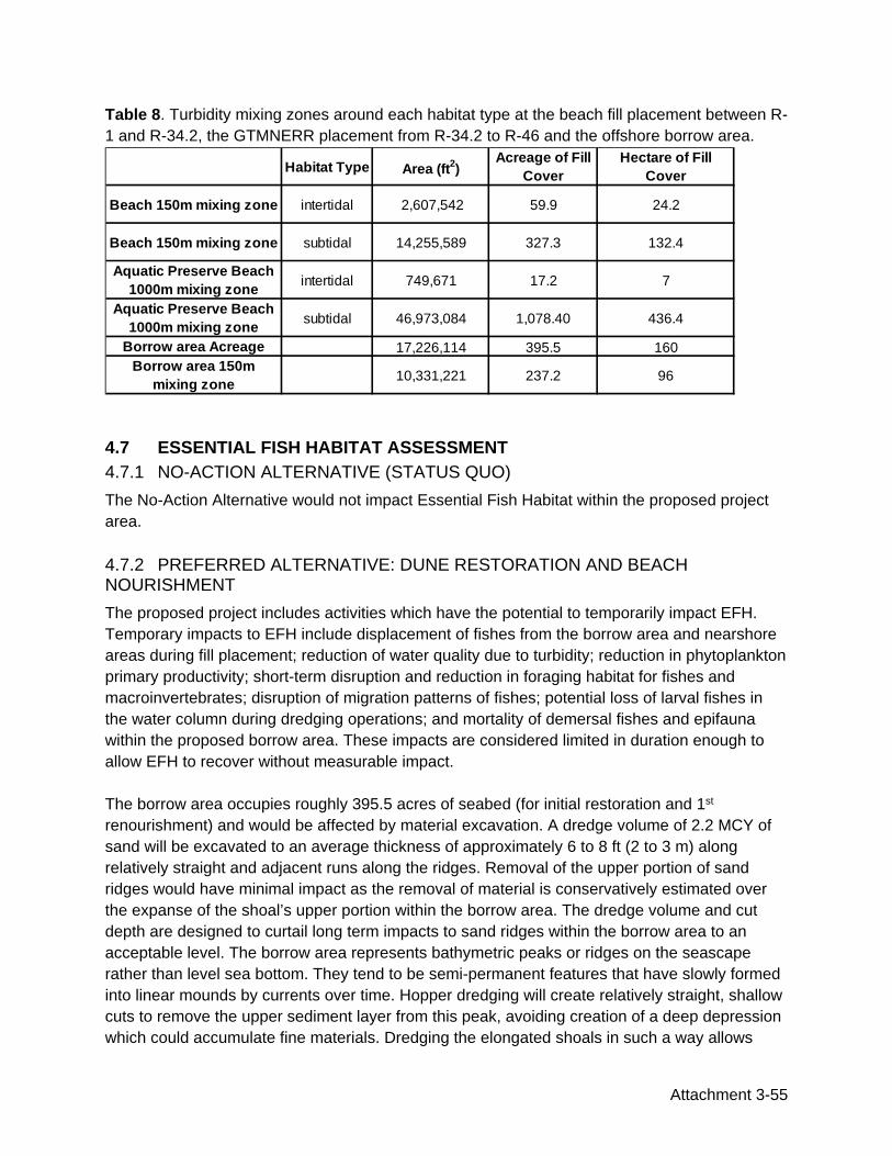
Attachment 3-55
Table 8. Turbidity mixing zones around each habitat type at the beach fill placement between R-1 and R-34.2, the GTMNERR placement from R-34.2 to R-46 and the offshore borrow area.
4.7 ESSENTIAL FISH HABITAT ASSESSMENT 4.7.1 NO-ACTION ALTERNATIVE (STATUS QUO) The No-Action Alternative would not impact Essential Fish Habitat within the proposed project area. 4.7.2 PREFERRED ALTERNATIVE: DUNE RESTORATION AND BEACH NOURISHMENT The proposed project includes activities which have the potential to temporarily impact EFH. Temporary impacts to EFH include displacement of fishes from the borrow area and nearshore areas during fill placement; reduction of water quality due to turbidity; reduction in phytoplankton primary productivity; short-term disruption and reduction in foraging habitat for fishes and macroinvertebrates; disruption of migration patterns of fishes; potential loss of larval fishes in the water column during dredging operations; and mortality of demersal fishes and epifauna within the proposed borrow area. These impacts are considered limited in duration enough to allow EFH to recover without measurable impact. The borrow area occupies roughly 395.5 acres of seabed (for initial restoration and 1st renourishment) and would be affected by material excavation. A dredge volume of 2.2 MCY of sand will be excavated to an average thickness of approximately 6 to 8 ft (2 to 3 m) along relatively straight and adjacent runs along the ridges. Removal of the upper portion of sand ridges would have minimal impact as the removal of material is conservatively estimated over the expanse of the shoal’s upper portion within the borrow area. The dredge volume and cut depth are designed to curtail long term impacts to sand ridges within the borrow area to an acceptable level. The borrow area represents bathymetric peaks or ridges on the seascape rather than level sea bottom. They tend to be semi-permanent features that have slowly formed into linear mounds by currents over time. Hopper dredging will create relatively straight, shallow cuts to remove the upper sediment layer from this peak, avoiding creation of a deep depression which could accumulate fine materials. Dredging the elongated shoals in such a way allows
Habitat Type Area (ft2)Acreage of Fill
CoverHectare of Fill
Cover
Beach 150m mixing zone intertidal 2,607,542 59.9 24.2
Beach 150m mixing zone subtidal 14,255,589 327.3 132.4
Aquatic Preserve Beach 1000m mixing zone intertidal 749,671 17.2 7
Aquatic Preserve Beach 1000m mixing zone subtidal 46,973,084 1,078.40 436.4
Borrow area Acreage 17,226,114 395.5 160Borrow area 150m
mixing zone 10,331,221 237.2 96

Attachment 3-56
sediment sources and associated benthic macroinvertebrate be left adjacent to and interspersed throughout the dredged cuts, which may lead to a more uniform infilling process by adjacent sediment and recovery of the benthic macroinvertebrate populations (CSA et al., 2009). Recovery of the benthic populations is expected within 1 to 2 years based on the borrow area design and shallow dredge cuts. There are no categories of HAPC in the vicinity of the proposed beach and borrow area and no hardbottom or seagrasses in the PAA. Categories of affected marine EFH adjacent to the turbidity mixing zone at the beach fill site and the offshore borrow area include the marine water column, pelagic Sargassum, and soft bottom habitat. The borrow area is located within the pelagic Sargassum, Dolphin-Wahoo, Snapper-Grouper, coastal migratory pelagics, highly migratory species, and Spiny Lobster EFH’s (Figure 3). Impacts to these species would be minor and short-term due to mobility of these species and temporary timeframe of project construction.
4.7.2.1 Impacts to the Water Column Project construction is expected to start in early Fall 2021 (at the earliest) and last approximately 3 to 6 months. Dredging and beach fill placement along the project shoreline will cause temporary impacts in the water column in the turbidity mixing zones around the borrow areas and beach fill site. These impacts include temporary increases in turbidity and sediment loads in the water column as well as release of trace constituents from the sediment into the water column. The selected borrow area contains beach compatible sand with a sediment composition that is expected to reduce turbidity and suspended sediment loads (see Section 3.2.2). Increased turbidity levels can deter certain fish species (e.g. bluefish) from utilizing the area while some fish species (e.g. kingfish) are attracted to higher turbidity waters (Wilber et al., 2003). Wilber et al. (2003) suggest that fish have the ability to select sites based on preferences to environmental conditions, allowing them to avoid areas that are experiencing elevated turbidity as a result of beach nourishment. The study also found that a temporary reduction in benthos did not detrimentally affect prey consumption of foraging fish within the beach nourishment area (Wilber et al., 2003). Ward (1992) found that increased turbidity can cause changes in feeding behavior of fishes because prey are less visible. In some instances, there may be beneficial effects of turbidity for specific sizes and feeding guilds of fishes (e.g. fish larvae and planktivores) due to protection of larvae from large visual predators (Utne-Palm, 2002). Increases in turbidity as a result of beach nourishment were assessed by Van Dolah et al., (1994) at Folly Beach, South Carolina. The study concluded that although dredge effluent increased turbidity in the immediate vicinity of the disposal, the effects were not considerably different from increased turbidity levels associated with local weather and wave energy.

Attachment 3-57
The water column is a habitat used for foraging, spawning, and migration. Temporary impacts on the water column may have localized effects on marine species. Injury or entrainment due to dredging would most likely affect demersal or less mobile species, such as shellfish. Dredging may temporarily affect feeding success of EFH species due to turbidity and loss of benthic organisms; however, adjacent similar habitat is available for feeding. Benthic organisms are expected to recover and inhabit the substrate within the borrow area over time. Recovery of the benthic populations is expected within 1 to 2 years based on the borrow area design and shallow dredge cuts (Kenny and Rees, 1994; 1996; Newell et al., 2004). Water quality concerns are of particular importance in the maintenance of this habitat. During dredging, suspended materials may interfere with the diversity and concentration of phytoplankton and zooplankton, and therefore could affect foraging success and patterns of schooling fishes and other grazers that comprise prey for managed species. Foraging patterns would be expected to return to normal at the end of dredging activities.
4.7.2.2 Impacts to Soft Bottom Habitat Basic biological research strongly suggests that sediment conditions generally dictate softbottom benthic community composition (Gray, 1974). The degree and duration of change in sediment composition has considerable implications for recovery of benthic fauna (Dankers and Beukema 1981; Salzwedel et al. 1985; Kunitzer et al. 1992; Seiderer and Newell 1999; Van Dalfsen 2000). Most studies have documented initial colonization within months of cessation of dredging, but restoration of species richness and biomass can take several years (Kenny and Rees, 1994; 1996; Newell et al., 2004). Recovery of the benthic community does not necessarily lead to a community similar to that which existed before the disturbance (e.g. Seiderer and Newell 1999) and is dependent on the severity of the impact and supply of macrofauna from adjacent habitats. In dredged areas with prolonged effects to the benthic community, traditionally opportunistic species persist (Wilber and Stern, 1992), and later successional stages may not fully recover for two to three years. In unstable environments, benthic recovery does not always follow a successional sequence due to frequent physical disturbances which influence benthic assemblages; a low number of opportunistic species can cyclically dominate the benthic community (Diaz, 1994). Section 4.6.2 provides a detailed analysis of impacts to the soft bottom habitat and infaunal communities following beach nourishment projects.
4.7.2.3 Impacts to Managed Species Managed species that are known to utilize the marine water column habitats within the proposed project area include species of the Snapper-Grouper complex, coastal migratory pelagics, Dolphin-Wahoo, spiny lobster, and shrimp Fishery Management Plans (FMP). Impacts to the water column during dredging at the borrow area will be minimal based on the low level of expected turbidity from the low silt/fine content of the borrow site sand and relatively short duration of project construction (3 to 6 months).

Attachment 3-58
Impacts to coastal migratory species would be minor, and indirect impacts should be temporary. As highly mobile species, Coastal Migratory Pelagics and Dolphin-Wahoo should be able to avoid the areas of disturbance. Some of the prey associated with these species may be temporarily displaced but will likely return following project completion. Coastal Migratory Pelagics Sandy shoals, offshore sand bars, and the intertidal surf zone are EFH for coastal migratory pelagic species. Direct impacts to intertidal surf zone sand and soft bottom are expected within the project area and may include indirect impacts to the marine water column resulting from short-term turbidity caused by project dredging activities and beach fill equilibration. These impacts should be short term and minor. Direct impacts to coastal migratory species are expected to be minor and indirect impacts are expected to be short-term. As Coastal Migratory Pelagics are highly mobile, any species present in the PAA should be able to avoid the area of disturbance. Although some of the prey associated with these species may be temporarily displaced, they should quickly re-colonize the project area during the first one to two years after fill placement. Atlantic Highly Migratory Species and Dolphin-Wahoo The Highly Migratory Species listed in Tables 6 and 7 and Dolphin-Wahoo complex FMP are unlikely to be affected by dredging and sand placement project activities. These species are highly mobile and able to avoid the area of disturbance. In proportion to the oceanic area utilized by these species, the project area is extremely small. Prey items associated with these species may be temporarily displaced, however, prey items will likely recolonize to pre-project levels within one to two years after fill placement. Snapper-Grouper Complex The borrow area is located within EFH for the Snapper-Grouper complex but was determined by remote sensing surveys to be absent of hardbottom and other benthic resources (Figure 3). Many of the species included in the Snapper-Grouper complex utilize habitat within the project area during different stages of their life cycle. The intertidal flats and subtidal soft bottom may provide important nursery habitat, as well as providing high-quality foraging habitat for predators and shorebirds in high-density areas of preferred prey items. Loss of intertidal softbottom habitat as a result of sand placement and expansion of the dry beach will temporarily impact important nursery habitat for managed species within this complex. Increased turbidity levels may deter certain species of fish from utilizing the project area for foraging or refuge or require additional energy expenditure to locate preferred habitats. Limited visibility in the water column as a result of turbidity could affect foraging and predator avoidance, which depending on the species and life stage, could be detrimental or beneficial. Additionally, increased suspended solids in the water column can hinder growth as the fishes divert energy to continually clear their gills of the sediment. These effects will be limited to the 3- to 6-month construction period and will affect less than 10% of the turbidity mixing zone at the beach nourishment site and borrow area site at any one time.

Attachment 3-59
Atlantic States Marine Fisheries Commission Managed Species All four species managed by the ASFCM have the potential for temporary impacts during project construction. Adult and juvenile life stages of Bluefish and the adult, juvenile and larval stages of the Weakfish, Summer Flounder, and Red Drum are common in the coastal and estuarine waters of Florida. The intertidal flats and water column within and adjacent to the project area provide EFH for the four ASMFC fish species that occur in the area. This area is an important nursery habitat for juvenile Bluefish and Summer Flounder as well as providing habitat for larval Summer Flounder. These species are predatory feeders; common prey items for each of these species are typical in the habitats found within the project area. Loss of habitat and reduction in the availability of prey items will temporary impact all life stages of the Bluefish, Red Drum, Weakfish, and Summer Flounder. Spiny Lobster The open ocean and coastal waters of the PAA are included in the EFH for the developmental stages of the spiny lobster FMP. Indirect impacts to the marine water column resulting from short-term turbidity caused by project dredging activities and beach fill equilibration may temporarily impact the spiny lobster EFH. These impacts should be short term and minor. The sand and soft bottom habitats of the project area are not areas where spiny lobster typically reside; therefore, no impacts to other phases of spiny lobster development are anticipated. Penaeid Shrimp Inshore estuarine habitat, particularly tidal marshes and intertidal flats are important nursery areas for these shrimp species. Direct placement of sand and dredging of the borrow site will cause mortality of benthic infauna in the project footprint reducing the quality of foraging habitat on the intertidal flats and subtidal soft bottom. Impacts to intertidal surf zone infauna are expected to be temporary and short-term with recovery in approximately one to two year.
4.8 HISTORIC AND CULTURAL RESOURCES
By letter dated April 13,
2021, SHPO concurred with the Corp’s determination of no effect to historic properties listed or eligible for listing on the National Register of Historic Places, provided compliance with the avoidance and survey measures stated in their approval letter (Appendix IV).
4.9 SOCIO-ECONOMIC Impacts to socio-economic resources such as noise and closure to beach access will be short term and mostly confined to the location of the pump out which will periodically move along the shoreline at approximately 100 to 300 ft. per day. Construction equipment on the beach may have a minor effect on tourism interests at Ponte Vedra Beach and the GTMNERR for the duration of construction (3 to 6 months). Following project construction, the long-term result of dune restoration and beach nourishment will have an overall increased value to properties

Attachment 3-60
abutting the beach. Construction of the dune will may require temporary closures of beach access for safety. The temporary loss of access to the beach may pose an impact or hardship to affected property owners. Dredging and pump out may cause temporary shifts in fishing activities during construction.
4.10 AESTHETICS Construction equipment on the beach will be aesthetically unappealing for the duration of construction, estimated to be 3 to 6 months. Impacts to aesthetic resources such as noise and closure to beach access will be short term and mostly confined to the location of the pump out which will periodically move along the shoreline at approximately 100 to 300 ft. per day. The project will result in a wider, more aesthetically pleasing beach. Also, reconstruction of the dune includes planting native upland dune species that will result in improved aesthetics.
4.11 RECREATIONAL AND COMMERCIAL RESOURCES The use of Ponte Vedra and GTMNERR beaches within the project limits is currently subject to erosion after major storm events. The proposed project would cause a temporary impediment to recreational usage where beach fill placement and distribution of fill material occur within the project limits. The extended beach width and stabilization of the project area beaches would provide greater long-term benefits to recreational opportunities than the current beach and dune systems provide such as beach access, surfing, shore fishing, and wildlife viewing. Preserving recreational opportunities benefits the local economy in St. Johns County (USACE, 2017). The temporary interruption of access should not adversely impact recreational and fishing activities within the 29,000 acres of the GTMNERR as approximately 286 acres of the PAA are located in GTMNERR (186 acres out to the ETOF is located within the GTMNERR as well as 2 pipeline corridors each 50 acres across the GTMNERR). There is no documentation to suggest that Borrow Area is utilized by recreational or commercial fishermen. Recreational use (e.g., boating, kayaking, and windsurfing) at the Borrow Area is minimal, however would be temporarily adversely affected by the dredging operations. Recreational fishermen may be required to alter their fishing locations during dredging; this impact would be short term and limited to the 3 to 6-month period of construction. The temporary interruption of access within the Borrow Area should not adversely impact recreational fishermen. The bottom topography of the Borrow Area extends into surrounding waters, providing similar benthic habitat functions and fishing opportunities. Dredging of the borrow area may result in increased complexity of bottom topography with higher relief/rugosity of ridges within dredged areas and possible remobilization of carbon-rich substrate to the sediment surface (Michel et al., 2013).
4.12 NAVIGATION Boating in the area of active dredging and beach placement will be restricted due to equipment and pipeline activities, but only temporarily during the 3 to 6 month period of active construction. Navigation will resume unhindered upon completion of the beach nourishment project.

Attachment 3-61
4.13 COASTAL BARRIER RESOURCES The proposed project does not include construction of structures that would require Federal Flood Insurance. The borrow area is located approximately 4 miles seaward of Guana River OPA FL03P (Figure 4). Additionally, BOEM does not consider authorization for the use of federal sand as federal assistance which triggers the need for consultation under the CBRA. therefore, there is no federal action related to BOEM’s decision to authorize OCS sand resources.
4.14 WATER QUALITY Temporary increases in turbidity in the immediate vicinity of construction may occur. This will cause short-term impacts to water quality in the PAA. State of Florida water quality regulations require that water quality standards not be violated during construction. The standards state that turbidity shall not exceed 29 NTUs above background. Should turbidity exceed these standards as determined by monitoring, the contractor will be required to cease work until conditions return to normal. Portions of the placement area are within the GTMNERR and the Guana River Marsh Aquatic Preserve (approximately 286 acres) (Figure 5). Dredging projects within or adjacent to OFW must meet antidegradation standards for turbidity. Dredging must not lower existing ambient water quality; and turbidity at the edge of the approved mixing zone cannot exceed natural background levels by more than the range in natural background turbidity levels throughout a normal tidal cycle (Rule 62-4.242(2)(b), F.A.C. A temporary expanded mixing zone of 1,000 m is proposed within the OFW with a maximum allowable turbidity level of 6 Nephelometric Turbidity Units (NTUs) above background when dredging within 1,000 m of the GRMAP. In order to comply with these standards, turbidity will be monitored according to state protocols during the proposed beach placement work. If turbidity standards are exceeded, the activities causing the violation would temporarily cease. Impacts to water quality in both areas are anticipated to be short term in duration and restricted to the period of construction. Best management practices would be implemented to maintain generated turbidity levels at or below the State-required levels. JCP (0377843-001-JC) Specific Conditions 25-27 for water quality monitoring (Appendix I) will be implemented. The proposed mixing zones are shown in Figure 5 and do not extend over any submerged resources (reef, hardbottom, SAV). Based upon the two water classification zones, the following compliance measurements are proposed:
a) Mixing zones terminating outside the Aquatic Preserve boundary: i) 150 meters down current, ii) compliance values no more than 29 NTU above background b) Mixing zones terminating inside the Aquatic Preserve boundary. i) 1,000 meters down current, ii) compliance values no more than 6 NTU above background For mixing zones that terminate within the southern 2.4 miles of the project in the Aquatic Preserve/Outstanding Florida Waters area, an allowance of 6 NTUs above background values

Attachment 3-62
is proposed, along with an expanded mixing zone of 1,000m. The 6 NTUs represents the average of differences between surface samples and mid-depth samples, individual differences may reveal larger values (as described below). These values are based upon data presented by St. Johns County for the proposed South Ponte Vedra Beach Project (0340616-Pending) and upon background turbidity data collected for the recent nourishment of the Duval County Shore Protection Project (SPP) (0228528-005-JC). Both projects lie in the general vicinity of the Ponte Vedra Beach project and experience similar meteorological and oceanographic conditions. Data collected in South Ponte Vedra Beach revealed an ambient turbidity range over a tidal cycle of 0.65 NTU to 5.6 NTU. From those data, a compliance turbidity value of 6 NTU above background has been agreed upon (per permit application response). Along south Jacksonville Beach, background turbidity data were measured as part of the construction of the Duval County SPP in 2018/2019. These data offer a sample of the natural background turbidity levels along adjacent beaches. Figures 10 and 11 plot a representative range of background data collected from surface and mid-depth samples at different times within a tidal cycle, from sampling conducting in November and January, respectively.

Attachment 3-63
Figure 5. 150 m and 1000 m proposed mixing zones and boundaries of the GTMNERR and Guana River Marsh Aquatic Preserve,


Attachment 3-65
The data presented include turbidity measurements within normal tidal cycles and an example of elevated turbidity due to recurring frontal weather systems. The data between 11/6 and 11/7 display higher values due to the passage of a frontal system, all other data are considered “ambient background turbidity” measurements. The difference between samples that share a tidal cycle, within the “ambient background turbidity” data, range between 0.2 NTU and 13.6 NTU. The difference between individual samples within the elevated data can be upward of 15 NTU. The borrow area sand has a low percentage of fine-grained material such that the increased turbidity at the borrow area during excavation should be minimal and less than the turbidity increase along the shore during renourishment (USACE, 2017). During beach construction, St. Johns County will employ best management practices (BMPs) to minimize turbidity, including construction of a shore-parallel sand dike and a minimum setback between pipeline discharge and open water. The sand within the borrow area has a similar mean grain size as the native beach and is expected to maintain the general environmental character and functionality of the material on the native beach (Table 2).
4.15 HAZARDOUS, TOXIC, AND RADIOACTIVE WASTE No known hazardous, toxic, or radioactive wastes occur in the project area. There is a potential for hydrocarbon spills with dredging and construction equipment. Accident and spill prevention plans will be specified in the contract and should prevent the release of any hazardous or toxic waste during dredging activities. The side scan survey of the pipeline corridors and borrow area conducted in May 2020 did not detect any signals which suggest the potential presence of materials housing hazardous waste. Risk of encountering Munitions and Explosives of concern (MEC) or unexploded ordinances (UXO) is low. The area of the coastline in St. Johns County has no history of recovery of these materials.
4.16 AIR QUALITY The short-term impact of emissions by the dredge and other construction equipment associated with the project will not reduce air quality. St. Johns County is an attainment area. FDEP does not regulate marine or mobile emission sources (construction equipment) in attainment areas. No air quality permits will be required for this project (USACE, 2017).
4.17 NOISE Marine mammals, sea turtles, and fisheries may be affected by dredge noise. Effects can vary depending on a variety of internal and external factors and can be divided into masking (obscuring of sounds of interest by interfering sounds, generally at similar frequencies), response, discomfort, hearing loss, and injury (Thomsen et al, 2009). Deeper water operations may propagate sound over greater distances than those in confined nearshore areas (Reine et al., 2014; Hildebrand, 2004; USACE, 2017). Broadband and continuous sound, mainly at lower frequencies is produced by dredging to extract marine aggregates. The small amount of data available indicates that dredging is not as

Attachment 3-66
noisy as seismic surveys, pile driving, and sonar; however, it is louder than most shipping, operating, offshore wind turbines, and drilling (Thomsen et al, 2009). Noise associated with dredging activities can be placed into five categories:
1. Collection: Noise generated from the collection of sea floor material; e.g., the scraping of the buckets on a bucket ladder dredge or the operation of the drag head. This noise is dependent on the structure of the sea floor and type of dredge used.
2. Pump: Noise from the pump driving the suction through the pipe. 3. Transport: Noise of the material being lifted from the sea floor to the dredge. For
trailing suction hopper and cutter suction dredges, the noise of the material as it passes up the suction pipe. For clamshell dredges, it would be the sound of the crane dropping/lifting the bucket.
4. Deposition: Noise associated with material placement within the barge or hopper. 5. Ship/machinery: Noise associated with the dredging ship itself. For stationary
dredges, the primary source is onboard machinery. Mobile dredges will also have propeller and thruster noise (Thomsen et al, 2009; USACE, 2017).
Field investigations to characterize underwater sounds typical of bucket, hydraulic cutterhead, and hopper dredging operations were performed (Dickerson et al., 2001). Preliminary findings indicate that cutterhead dredging operations are relatively quiet compared to other sound sources in aquatic environments. Hopper dredges produce slightly more intense sounds similar to those generated by vessels of comparable size. Bucket dredges create very different sounds and are a more complex spectrum of sounds. Hopper dredges produce engine and propeller noise similar to that of large commercial vessels and create sounds of drag heads moving in contact with the substrate (Reine et al., 2014; USACE, 2017). Source levels reported for dredging operations range from 160 to 180 dB re 1 uPa @ 1 m for 1/3 octave bands (equivalent to the sound wave energy of a killer whale whistle) with peak intensity between 50 and 500 Hz (JASCO, 2011; Greene and Moore, 1995). Dredge types differ greatly in the intensity, periodicity, and spectra of emitted sounds. Underwater sound components produced by each type are influenced by a host of factors including substrate type, geomorphology of the waterway, site-specific hydrodynamic conditions, equipment maintenance status, and skill of the dredge plant operator (Reine et al., 2014; Dickerson et al., 2001; USACE, 2017). Dredge-generated noise will be offshore and will not impact the project area shoreline. The noise from equipment at the beach fill site will be relatively low level and of short duration. Equipment such as booster pumps will be properly maintained to minimize effects of noise. Noise levels will drop back to normal levels for dune and beach areas once dredging and material placement activities have concluded. Noise may temporarily impact some underwater biota but is not anticipated to have an adverse effect since increases to the current noise level from the proposed project will be localized and minor. Construction-related increases in noise are not expected to cause adverse effects to the environment (Reine et al., 2014; USACE, 2017).

Attachment 3-67
4.18 PUBLIC SAFETY Nourishment of the beach and dune will enhance beach recreation. The presence of construction equipment on the beach will create public safety risks at the beach site. Adverse impacts to swimming and surfing are not anticipated due to the narrow scale of beach fill to be placed immediately along the beach face, landward of locations where swimming and surfing occur.
4.19 ENERGY REQUIREMENTS AND CONSERVATION Energy requirements are confined to fuel for the dredge, labor transportation, and other construction equipment.
4.20 NATURAL OR DEPLETABLE RESOURCES Sand is a natural and depleting resource. Using sand from the offshore borrow area will result in localized depletion of mineable sand resources in the offshore borrow area. While the sand will be reduced from the borrow area it will enter the nearshore sand transport system. Sand will eventually return to offshore areas and be redistributed over nearshore areas downdrift of the project. Future projects do need to consider that the borrow area’s overall sand resources will be permanently reduced. Contractors will be required to stay within the limits outlined in Contract Specification and project permits.
4.21 URBAN QUALITY Urban quality would be indirectly positively affected by restoration of lost land due to shoreline recession and an increase in the capacity for recreational beach activity. County Parks, businesses, and residential properties along the project area shoreline will benefit from storm protection afforded by the nourished beach and the risk of property damage reduced. Construction equipment on the beach would temporarily detract from the aesthetics of the environment, thereby possibly temporarily affecting the visual aesthetics associated with urban quality along Ponte Vedra Beach.
4.22 SOLID WASTE No impacts related to solid waste are expected as a result of the proposed project. Precautionary measures, including proper containment and avoidance of overflow conditions by emptying containers on a regular schedule, will be included in contract specifications for proper disposal of solid wastes. Disposal of any solid waste material into Atlantic waters will not be permitted.
4.23 DRINKING WATER No municipal or private water supplies are located in or near the project site; drinking water supplies will not be impacted by implementation of the Preferred Alternative.
4.24 CUMULATIVE IMPACTS Cumulative impact is the "impact on the environment which results from the incremental impact of the action when added to other past, present, and reasonably foreseeable future actions (50 years) regardless of what agency (federal or non-federal) or person undertakes such other

Attachment 3-68
actions" (40 CFR 1508.7). This cumulative impact analysis summarizes the impact of such cumulative action by identifying the impacts of the proposed project in terms of related past, present and reasonably foreseeable future actions that are related to the proposed project either geographically or otherwise impacting the same resources. Cumulative impacts are summarized in Table 9. This table illustrates the with-project and without-project condition (the difference being the incremental impact of the project) and the future condition with any reasonable alternatives (or range of alternatives). Other actions affecting similar resources or ecosystem were considered as part of the evaluation of cumulative impacts pursuant to CEQ 1997 Considering Cumulative Effects under the National Environmental Policy Act. No other projects exist in the region that share a similar ecosystem that could have cumulative impacts on similar resources. There are active beach nourishment projects in Northeast Florida in Nassau, Duval, and Flagler Counties. These projects have separate sufficient sand resources identified, which will not be impacted by the proposed project. South of Cape Canaveral, in the southeast region of Florida, beach nourishments projects will not impact the borrow areas identified for the proposed project. The proposed project will not impact or be impacted by any inlet maintenance project within the region. The closest maintained inlets to the proposed project are the St. Augustine Inlet, located approximately 16 miles south of the project area, and the entrance to the St. Johns River located approximately 10 miles north of the project area.


Attachment 3-70
4.25 IRREVERSIBLE AND IRRETRIEVABLE COMMITMENT OF RESOURCES 4.25.1 IRREVERSIBLE An irreversible commitment of resources is one in which the ability to use and/or enjoy the resource is lost forever. One example of an irreversible commitment might be the mining of a mineral resource. The use of sand from the proposed borrow areas would, for all practical purposes, irreversibly deplete the suitable sand reserves. The sands would not replenish fast enough to be of much value to future nourishment projects. 4.25.2 IRRETRIEVABLE An irretrievable commitment of resources is one in which, due to decisions to manage the resource for another purpose, opportunities to use or enjoy the resource as they presently exist are lost for a period of time. An example of an irretrievable loss might be where a type of vegetation is lost due to armoring. Environmental impacts caused by use of the borrow site for placement on the dune and beach would be minimal as a featureless, unconsolidated sand bottom would be impacted. The sand from the area dredged for this project would be irretrievable for future nourishment projects.
4.26 UNAVOIDABLE ADVERSE ENVIRONMENTAL EFFECTS Relatively non-motile infaunal species that inhabit softbottom habitats at the borrow area and beach fill site will unavoidably be lost during dredging and direct burial during beach sand placement. Common species are expected to re-colonize after project completion.
4.27 LOCAL SHORT-TERM USES AND MAINTENANCE/ENHANCEMENT OF LONG-TERM PRODUCTIVITY Motile epifaunal invertebrate species (benthic animals that live on the substrate surface) may inhabit the borrow area and placement sites. Motile organisms such as fish, crabs, and sand-dwelling organisms should be able to avoid the area during construction. Many species unable to escape the construction area are expected to re-colonize after project completion from adjacent similar habitat.
4.28 INDIRECT EFFECTS A study for the U.S. Army Corps of Engineers Institute for Water Resources in 1995 found no evidence that beach nourishment projects induce development along the protected shoreline (Cordes and Yezer, 1995). Pilkey and Dixon (1996) stated that beach replenishment frequently leads to more development in greater density within shorefront communities, necessitating future replenishment or more drastic stabilization measures. Dean (1999) also noted that beach nourishment projects can encourage more development in coastal areas. Investment in new and updated facilities substantially increased tourism following a beach nourishment project in Miami in 1982 (National Research Council, 1995). Building density increased adjacent to the beach as older buildings were replaced by much larger buildings to accommodate additional beach users.

Attachment 3-71
Increased shoreline development may increase human disturbance to nesting shorebirds by increased recreational pressure on the beach. Shoreline development may support larger populations of mammalian predators, such as foxes and raccoons, and increase the potential for adverse effects to sea turtle nesting habitat due to artificial lighting. Development along the Ponte Vedra Beach project area shoreline is nearly at its maximum capacity. The proposed Ponte Vedra Beach Dune Restoration and Beach Nourishment Project is not expected to increase the potential for new shoreline development along the project area shoreline.
4.29 COMPATIBILITY WITH FEDERAL, STATE, AND LOCAL OBJECTIVES The Preferred Alternative is compatible with Federal, State, and Local objectives of protecting upland properties while maintaining a natural beach. It also provides the most cost-effective option for meeting these objectives. The No-Action Alternative does not meet the Federal, State, and Local objectives.

Attachment 3-72
5.0 CONCLUSIONS
This EA examines the preferred alternative of dune restoration and beach nourishment on Ponte Vedra Beach. This alternative was preferred over no action, dune restoration only, and structural stabilization. Sand for the nourishment project will be excavated from an offshore borrow area lying in Federal waters, approximately 4.0 nautical miles (nm) (7.4 km) offshore of the southern end of the project fill area. Design-level remote sensing surveys have identified an initial borrow area which occupies approximately 200 acres (81 hectares or 0.81 km2) within a large, roughly shore-parallel sand ridge which is greater than 1,060 acres in size. The borrow area lies in ambient water depths of 40 to 55 ft (12.2 to 16.8m, approx.). An analysis of the affected environment and effects findings of threatened and endangered species can be found in the BA in Appendix I. No long-term impacts on the geomorphology of the offshore borrow area are anticipated. The proposed beach nourishment project will have no long-lasting adverse impacts on sediment characteristics of the existing beach and will establish a large dry beach area for protection of existing dune habitat within the project area. Impacts to EFH and other fish and wildlife resources utilizing nearshore unvegetated softbottom and offshore unvegetated softbottom in the borrow area will be minor and are considered temporary as the effects are limited in duration enough to allow for recovery without measurable impact. The proposed action includes the implementation of various mitigation measures (see Section 2.2) in order to avoid and/or minimize impacts. These mitigation measures support the no adverse effects conclusions presented in this document. Temporary increases in turbidity in the immediate vicinity of construction may occur. This will cause short-term impacts to water quality in the PAA. The borrow area sand has a low percentage of fine-grained material such that the increased turbidity at the borrow area during excavation should be minimal. It is possible that some or all of the side scan anomalies identified in submerged pipeline corridor 2 could be associated with the Ponte Vedra Beach Wreck site (Florida Master Site File [FMSF] 8SJ04871). Corridor 2 has been shifted to the north to avoid these anomalies. Socio-economic, aesthetic, and recreation and commercial resources may also experience temporary but ultimately unmeasurable impacts. Construction-related increases in noise are not expected to cause adverse effects to the environment. Air quality, public safety, urban quality, solid waste, and drinking water will not be adversely affected.

Attachment 3-73
6.0 LIST OF PREPARERS Name Affiliate Discipline/Role Adrienne Carter, M.S. Coastal Eco-Group Inc. Senior Scientist /Contributing
Author Cheryl L. Miller, M.S. Coastal Eco-Group Inc. Chief Scientist/Contributing
Author/Principal Reviewer Melissa Sathe, M.S. Coastal Eco-Group Inc. Senior Scientist/Contributing
Author Albert Browder, P.E., Ph.D. Olsen Associates Inc. Project Engineer/Reviewer

Attachment 3-74
7.0 REFERENCES ASMFC. 2020a. Species Profile. Red Drum. http://www.asmfc.org/species/red-drum Date Accessed June 30, 2020.
Bellinger, J.W., and J.W. Avault. 1971. Food habits of juvenile pompano, Trachinotus carolinus, in Louisiana. Transactions of the American Fisheries Society 100: 486–94.
Burlas, M., G.L. Ray, and D. Clarke. 2001. The New York District's biological monitoring program for the Atlantic coast of New Jersey. Asbury Park to Manasquan Section Beach Erosion Control Project: Final Report. U.S. Army Corps of Engineers, Vicksburg, MS.
Census Bureau. 2019. St. Johns County, Florida. https://www.census.gov/quickfacts/fact/table/stjohnscountyflorida/INC110218. Date Accessed July 03, 2020.
Coastal Eco-Group Inc. (CEG). 2014. 2011 South Amelia Island Shore Stabilization Project- Beach Renourishment. Evaluation of beach nourishment impacts to beach indicator species. Spring 2013 Year 2 Post-Construction Final Report. Submitted to Olsen Associates, Inc. Deerfield Beach, FL. 25 pp plus appendices.
CEG. 2014a. 2011 South Amelia Island Shore Stabilization Project- Beach Renourishment. Assessment of dredging impacts to benthic macrofauna at the offshore borrow site. Spring 2013 Year 2 Post-Construction Final Report. Submitted to Olsen Associates, Inc. Deerfield Beach, FL. 30 pp. CEG. 2020. Final Environmental Assessment. Flagler County Beach/Dune Restoration Project. USACE PERMIT NO. SAJ-2019-02065. March 2020. 79 pp plus appendices Collette, B.B. and C.E. Nauen. 1983. FAO species catalogue. Vol. 2. Scombrids of the world. An annotated and illustrated catalogue of tunas, mackerels, bonitos, and related species known to date. No.125, Vol. 2. 137 pp.
CSA International Inc., Applied Coastal Research and Engineering, Inc., Barry A. Vittor & Associates, Inc., C.F. Bean, LLC and Florida Institute of Technology. 2009. Analysis of Potential Biological and Physical Impacts of Dredging on Offshore Ridge and Shoal Features. Prepared for the U.S. Department of the Interior, Minerals Management Service, Leasing Division, Marine Minerals Branch, Herndon, VA. OCS Study MMS 2010-010. 160 pp plus apps. Cordes, J.J. and A.M. Yezer. 1995. Shore Protection and Beach Erosion Control Study: Economic Effects of Induced Development in Corps-Protected Beachfront Communities. IWR Report 95-PS-1. U.S. ACOE, Institute for Water Resources, Alexandria, VA. Dankers, N. and J.J. Beukema. 1981. Distributional patterns of macrozoobenthic species in relation to some environmental factors. In Invertebrates of the Wadden Sea, pp 69-103. N. Dankers, H. Kuhl, and W.J. Wolff (eds.). Balkema, Rotterdam.

Attachment 3-75
Dean, R.G. 1999. Midtown Beach Nourishment Project in Palm Beach, Florida. Monitoring Report. Prepared for: Town of Palm Beach, Palm Beach, Florida. Diaz, R.J. 1994. Response of tidal freshwater macrobenthos to sediment disturbance. Hydrobiologia. 278: 201-212. Dickerson, C., Reine, K.J., and Clarke, D.G. 2001. Characterization of underwater sounds produced by bucket dredging operations, DOER Technical Notes Collection (ERDC TN-DOER-E14), U.S. Army Engineer Research and Development Center, Vicksburg, MS. www.wes.army.mil/el/dots/doer. Dodge, R. E., S. Hess, and C. Messing. January 1991. Final Report: Biological Monitoring of the John U. Lloyd Beach Renourishment: 1989. Prepared for Broward County Board of County Commissioners Erosion Prevention District of the Office of Natural Resource Protection. NOVA University Oceanographic Center: Dania, Florida. 62 pp. plus appendices. Dodge, R. E., W. Goldberg, C. Messing, and S. Hess. 1995. Final Report: Biological Monitoring of the Hollywood-Hallandale Beach Nourishment Project. Prepared for the Broward County Board of County Commissioners Department of Natural Resources Protection, Biological Resources Division. September 1995. Donoghue, C. 1999. The influence of swash processes on Donax variabilis and Emerita talpoida. University of Virginia, Department of Environmental Sciences Ph.D. Dissertation. 197 pp. Dompe, P. E. 1993. Natural Fluctuations in Nearshore Turbidity and the Relative Influences of Beach Renourishment. Master’s Thesis, University of Florida, 101 pp. Fishwatch. 2020. NOAA Fishwatch U.S. Seafood Facts. Species Profile: Bluefish. https://www.fishwatch.gov/profiles/bluefish? ga=2.172853731.1108192399.1593515624-367162589.1589495524. Last updated: 03/25/2020 [Date Accessed June 30, 2020].
Fishwatch. 2019. NOAA Fishwatch U.S. Seafood Facts. Species Profile: Summer Flounder. https://www.fishwatch.gov/profiles/summer-flounder. Last updated: 05/08/2019. Date Accessed June 30, 2020.
Florida Department of Environmental Protection (FDEP). 1999. Shoreline Change Rate Estimates, Flagler County. Florida Department of Environmental Protection Office of Beaches and Coastal Systems. Tallahassee FL Publication No. BCS-99-02.

Attachment 3-76
FDEP. 2019. Critically Eroded Beaches in Florida. Florida Department of Environmental Services, Division of Water Resource Management, Tallahassee, FL. June 2019. https://floridadep.gov/sites/default/files/FDEP-Critically-Eroded-Beaches-2019.pdf
Florida Land Use, Cover and Forms Classification System (FLUCCS). 1999. Department of Transportation Surveying and Mapping Geographic Mapping Section.
Federal Emergency Management Agency (FEMA). 2019. U.S. Department of Homeland Security Environmental Assessment St. Johns County Emergency Beach Berms St. Johns County, Florida FEMA-DR-4283-FL FEMA-DR-4337-FL September 2019 Region IV Atlanta, Georgia
FLMNH. 2017a. University of Florida. Gainesville, Florida. Biological Profile King Mackerel. https://www.floridamuseum.ufl.edu/discover-fish/species-profiles/scomberomorus-cavalla/. Page Last updated: 05/11/2017. Date Accessed June 23, 2020.
FLMNH. 2017b. University of Florida. Gainesville, Florida. Biological Profile Cobia. https://www.floridamuseum.ufl.edu/discover-fish/species-profiles/rachycentron-canadum/. Page Last updated: 05/10/2017. Date Accessed June 23, 2020.
Florida Natural Areas Inventory (FNAI). 2010. Guide to the Natural Communities of Florida – 2010 Edition. Institute of Science and Public Affairs at the Florida State University.
Florida Shorebird Alliance (FSA). 2015. Florida Shorebird Database: Annual Report – 2015. https://flshorebirdalliance.org/media/1010/fsd-annualreport2015.pdf. Date Accessed July 29, 2020.
Foster, E.R., Spurgeon, D.L., and Cheng, J., 2000. “Shoreline Change Rate Estimates St. Johns County.” Florida Department of Environmental Protection. Office of Beaches and Coastal Systems. Report No. BCS-00-03. June 2000. Gilmore, R.G., Jr. 2001. The origin of Florida fish and fisheries. Proc. Gulf Carib. Fish. Inst. 52:713-731.
Goldberg, W. M., 1985. Long Term Effects of Beach Restoration in Broward County, Florida, A Three-Year Overview. Part I: Macrobenthic Community Analysis. Coral Reef Associates, Inc./Florida International University, Miami, Florida. 20 pp. Gulf of Mexico Fishery Management Council and South Atlantic Fishery Management Council (GOMFC and SAFMC) 1982. Fishery management plan environmental impact statement and regulatory impact review for spiny lobster in the Gulf of Mexico and South Atlantic. National Marine Fisheries Service, St. Petersburg, Florida. Gorzelany, J. F. and Nelson, W. G. 1987. The effects of beach nourishment on the benthos of a subtropical Florida beach. Marine Environmental Science 21:75-94.

Attachment 3-77
Gray, J.S. 1974. Animal-sediment relationships. Oceanogr. Mar. Biol. Ann. Rev. 12: 223-261. Greene, C.R.J. and S.E. Moore. 1995. Man-made noise. Pp 101-158 in Marine Mammals and Noise. W.J. Richardson, C.R.J. Greene, C.I. Malme and D.H. Thomson (ed.), Academic Press, San Diego, CA. Hayes, M.O. and R.B. Nairn. 2004. Natural maintenance of sand ridges and linear shoals on the U.S. Gulf and Atlantic Continental Shelves and the potential impacts of dredging. Journal of Coastal Research 20: 138-148. Hildebrand, J. 2004. Sources of anthropogenic sound in the marine environment. In E. Vos and R.R. Reeves (eds.). Report of an International Workshop: Policy on Sound and Marine Mammals, 28–30 September 2004, London, England 23 December 2005. U.S. Marine Mammal Commission, London, England.
Hurme, A.K. and E.J. Pullen. 1988. Biological effects of marine sand mining and fill placement for beach replenishment: lessons for other uses. Marine Mining 7: 123-36.
Irlandi, E. and B. Arnold. 2008. Assessment of nourishment impacts to beach indicator species. Florida Fish and Wildlife Conservation Commission Grant Agreement No. 05042.
JASCO Applied Sciences (JASCO), 2011. Underwater Acoustics: Noise and the Effects on Marine Mammals, 3rd ed. compiled by C. Erbe. Victoria, British Columbia and Dartmouth, Nova Scotia, Canada.
Kelly, S.W., J.S. Ramsey, and M.R. Byrnes. 2004. Evaluating the physical effects of offshore sand dredging for beach nourishment. Journal of Coastal Research 20: 89-100.
Kenny, A.J. and H.L. Rees. 1994. The effects of marine gravel extraction on the macrobenthos; Early post-dredging recolonization. Marine Pollution Bulletin 28: 442-447.
Kenny, A.J. and H.L. Rees. 1996. The effects of marine gravel extraction on the macrobenthos; Results 2 years post-dredging. Marine Pollution Bulletin 32: 615-622.
Kunitzer, A., G.C.A. Duineveld, D. Basford, J.M. Duwaremez, J. Dorjes, A. Elefteriou, C. Heip, P.J.M. Herman, P. Kingston, U. Niermann, H. Rumohr and P.A.J.W. De Wilde. 1992. The benthic infauna of the North Sea: Species distribution and assemblages. ICES Journal of Marine Science 49: 127–143.
Leber, K.M. 1982. Bivalves (Tellinacea: Donacidae) on a North Carolina beach: contrasting population size structures and tidal migrations. Mar. Ecol. Prog. Ser. 7: 297-301.
Lindeman, K.C., R. Pugliese, G.T. Waugh, and J.S. Ault. 2000. Developmental patterns within a multispecies reef fishery: Management applications for essential fish habitats and protected areas. Bull. Mar. Sci. 66(3):929-956.

Attachment 3-78
Loesch, H.C. 1957. Studies of the ecology of two species of Donax on Mustang Island, Texas. Publ. Inst. Mar. Sci., Univ. Tex. 4: 201–227.
Manning, L.M. 2003. Ecology of ocean beaches: the importance of human disturbances and complex biological interactions within a physically rigorous environment. PhD thesis, Univ. of North Carolina, Chapel Hill, NC.
Marsh, G.A., P.R. Bowen, D.R. Deis, D.B. Turbeville, and W.R. Courtenay. 1980. Evaluation of Benthic Communities Adjacent to a Restored Beach, Hallandale (Broward County), FL, Vol. 11, Ecological Evaluation of a Beach Nourishment Project at Hallandale (Broward County), FL, MR 80-1(11), U.S. Army Corps of Engineers, Coastal Engineering Research Center.
McLachlan, A., 2001. Coastal beach ecosystem. In: Lewin, R. (ed.). Encyclopedia of Biodiversity. Academic Press, New York. 741–751. Myers, R. L., J.J. Ewel. 1990. Ecosystems of Florida. University of Central Florida, Orlando, FL. 337 pp. National Oceanic and Atmospheric Administration (NOAA). 2017. Atlantic Highly Migratory Species; Essential Fish Habitat Amendment 10, FR 82 FR 42329 https://www.federalregister.gov/documents/2017/09/07/2017-18961/atlantic-highly-migratory-species-essential-fish-habitat. [Date Accessed: June 26, 2020] NMFS. 1999. Final Fishery Management Plan for Atlantic Tunas, Swordfish, and Sharks. Volumes I and II. National Marine Fisheries Service, Silver Spring, MD. NMFS. 2006. Final Consolidated Atlantic Highly Migratory Species Fishery Management Plan. National Oceanic and Atmospheric Administration, National Marine Fisheries Service, Office of Sustainable Fisheries, Highly Migratory Species Management Division, Silver Spring, MD. Public Document. pp. 1600. NMFS. 2006a. Consolidated Atlantic HMS FMP. Appendix B. Essential Fish Habitat. https://www.fisheries.noaa.gov/management-plan/consolidated-atlantic-highly-migratory-species-management-plan. Date Accessed June 26, 2020
NMFS, 2014. Letter to Colonel Alan M. Dodd dated June 11, 2014. NMFS review of the Flagler County, Florida hurricane and Storm Damage Reduction Project Draft Integrated Feasibility Study and Environmental Assessment.
NMFS. 2014a. Endangered and Threatened Species; Critical Habitat for the Northwest Atlantic Ocean Loggerhead Sea Turtle Distinct Population Segment (DPS) and Determination Regarding Critical Habitat for the North Pacific Ocean Loggerhead DPS. Final Rule. 50 CFR 226 [Docket No. 130513467-4401-02] RIN 0648–BD27.

Attachment 3-79
NMFS. 2016. Endangered and Threatened Species; Critical Habitat for the Endangered North Atlantic Right Whale. FR 2016-01633. National Marine Fisheries Service, Silver Spring, MD.
NMFS. 2017. Essential Fish Habitat – South Atlantic. Habitat Conservation Division, Southeast Regional Office, St. Petersburg, FL. http://sero.nmfs.noaa.gov.
NMFS, South Atlantic Regional Biological Opinion (SARBO). 2020. The 2020 South Atlantic Regional Biological Opinion for Dredging and Material Placement Activities in the Southeast US. 27 March 2020. https://www.fisheries.noaa.gov/content/endangered-species-act-section-7-biological-opinions-southeast
NMFS. 2020a. Species Managed by the South Atlantic Fishery Management Council. https://safmc.net/wp-content/uploads/2016/06/SAFMC_ManagedSpecies_10232012.pdf. [Accessed: June 24, 2020].
NMFS. 2020b. Essential Fish Habitat – South Atlantic. Habitat Conservation Division, Southeast Regional Office, St. Petersburg, FL. http://sero.nmfs.noaa.gov.
NMFS. 2020c. Species of Concern: Dusky Shark https://www.st.nmfs.noaa.gov/Assets/ecosystems/climate/images/species-results/pdfs/Dusky Shark.pdf [Date Accessed June 23, 2020]..
National Oceanic and Atmospheric Administration (NOAA), 2019. Draft Environmental Assessment Guana Tolomato Matanzas National Estuarine Research Reserve Boundary Change St. Johns And Flagler Counties, FL. May 2019. 53 pp.
National Research Council. 1995. Beach Nourishment and Protection. National Academy Press. Washington, DC. 334 pp. Nelson, W.G. 1985. Guidelines for Beach Restoration Projects. Part I – Biological. Florida Sea Grant College. SGGC-76. 66 pp. Newell, R.C., L.J. Seiderer, N.M. Simpson, and J.E. Robinson. 2004. Impacts of marine aggregate dredging on benthic macrofauna of the south coast of the United Kingdom. Journal of Marine Research 20: 115-125. Olsen Associates, Inc. (OAI) 2020a. Characterization of Existing Beach Sediments, Ponte Vedra Beach, St. Johns County, FL, June 2020, Report Submitted to St. Johns County, FL, Olsen Associates, Inc. Jacksonville, FL. 15 p. plus appendices.
OAI. 2020b. Geotechnical Investigation for Borrow Area Development: Ponte Vedra Beach, FL, Beach Nourishment Project, St. Johns County, November 2020, Report Submitted to St. Johns County, FL, Olsen Associates, Inc. Jacksonville, FL. 49 p. plus appendices.
Park, Chris. 2007. A Dictionary of Environment and Conservation (1 ed.), Oxford University Press.

Attachment 3-80
Peterson, C.H., D.H.M. Hickerson, and G.G. Johnson. 2000. Short-term consequences of nourishment and bulldozing on the dominant large invertebrates of a sandy beach. Journal of Coastal Research 16: 368–78.
Peterson, C.H., M.J. Bishop, G.A. Johnson, L.M. D’Anna, and L.M. Manning. 2006. Exploiting beach filling as an unaffordable experiment: benthic intertidal impacts propagating upwards to shorebirds. Journal of Experimental Marine Biology and Ecology. 338: 205-221.
Phelps, D.C., R. Hoenstine, J.H. Balsillie, L.J. Ladner, A. Dabous, M. Lachance, and C. Fischler. 2003. A geological investigation of the offshore area along Florida’s Northeast coast Year 1 Interim report 2002-2003. Report Submitted to the United States Department of the Interior, Minerals Management Service: https://publicfiles.dep.state.fl.us/FGS/Geological_Investigations/Coastal/sandsearch_2002_2003/sandsearch_2002_2003.html.
Pilkey, O.H. and K.L. Dixon. 1996. The Corps and the shore. Island Press; Washington, DC.. Ponte Vedra Recorder. 2019. Ponte Vedra Beach renourishment back on radar. https://pontevedrarecorder.com/stories/ponte-vedra-beach-renourishment-back-on-radar,9741? (Date Accessed June 15, 2020). Randazzo, A.F., and D.S. Jones, eds. 1997. The Geology of Florida, University Press of Florida, Gainesville, FL Reilly, F.J. and V.J, Bellis. 1983. The ecological impact of beach nourishment with dredged materials on the intertidal zone at Bogue Banks, N.C. Miscellaneous Report No 83-3, U.S. Army Corps of Engineers, Coastal Engineering Research Center, now Coastal Hydraulics Laboratory, Vicksburg, MS. Referenced in Nelson, 1988.
Reine, K.J., Clarke, D., Dickerson, C., and Wikel, G. 2014. Characterization of Underwater Sounds Produced by Trailing Suction Hopper Dredges during Sand Mining and Pump-out Operations. U.S. Department of the Interior, Bureau of Ocean Energy Management and U.S. Army Corps of Engineers. ERDC/EL TR 14-3, BOEM 2014-055. Herndon, VA, March 2014
Ross, S.W., and J.E. Lancaster. 1996. Movements of Juvenile Fishes Using Surf Zone Nursery Habitats and the Relationship of Movements to Beach Nourishment Along a North Carolina Beach: Pilot Project. Final Report to NOAA Office of Coastal Resource Management and the U.S. Army Corps of Engineers. 31 p.
Schneider, D., 1982. Predation by ruddy turnstones (Arenaria interpres) on a polymorphic clam (Donax variabilis) at Sanibel Island, Florida. Bulletin of Marine Science 32: 341–344.
South Atlantic Fishery Management Council (SAFMC). 1998. Final Habitat Plan for the South Atlantic Region: Essential Fish Habitat Requirements for Fishery Management Plans of the

Attachment 3-81
SAFMC. https://safmc.net/habitat-and-ecosystems/safmc-habitat-plan. [Date Accessed June 23, 2020]. SAFMC 2002. Second revised final fishery management plan for pelagic Sargassum habitat of the south Atlantic region. National Oceanic and Atmospheric Administration Award No. NA17FC2202. SAFMC. 2009. Fishery Ecosystem Plan of the South Atlantic Region. South Atlantic Fishery Management Council, 4055 Faber Place Drive, Ste 201, North Charleston, SC 29405. SAFMC. 2020. Snapper Grouper Useful Info. http://safmc.net/useful-info/snapper-grouper/. Accessed June 19, 2020. SAFMC. 2020a. South Atlantic Region: Essential Fish Habitat Requirements for Fishery Management Plans of the South Atlantic Fishery Management Council. http://www.safmc.net/resource-library/fishery-management-plans-amendments Accessed June 19, 2020
SAFMC. 2020b. Penaeid Shrimp. https://safmc.net/regulations/regulations-by-species/penaeid-shrimp/. Accessed June 30, 2020
Salzwedel, H., E. Rachor, and D. Gerdes. 1985. Benthic macrofauna communities in the German Bight. Veroffentlichungen des Institut fur Meeresforschung Bremerhaven, 20: 199-267. Seiderer, L.J., and R.C. Newell. 1999. Analysis of the relationship between sediment composition and biological community structure in coastal deposits: Implications for marine aggregate dredging. ICES Journal of Marine Science, 56: 757-765. South Carolina Department of Natural Resources Marine Resources (SCDNR). 2008. Change and recovery of physical and biological characteristics at beach and borrow areas impacted by the 2005 Folly Beach renourishment project. Technical Report Number 102. Submitted to U.S. Army Corps of Engineers. Charleston District. 117 pp.
SCDNR. 2014. Species Gallery: White Shrimp. http://www.dnr.sc.gov/marine/pub/seascience/shrimp.html [Date Accessed June 20, 2020].
Sweatman, H.P.A. 1993. Tropical snapper (Lutjanidae) that is piscivorous at settlement. Copeia 1137-1139.
Taylor Engineering, Inc. 2019. Northern St. Johns County Offshore Sand Source Investigation – Reconnaissance Phase Geotechnical Exploration Report St. Johns County, Florida. 15pp. plus appendices
Tidewater Atlantic Research, (TAR) Inc. 2020. Phase I Submerged Cultural Resource Remote-Sensing Survey of A Potential Offshore Borrow Area, Eight Temporary Pipeline Corridors and Assessment of Previously Identified Terrestrial Sites in the Project Nourishment Area of

Attachment 3-82
Potential Effect, Ponte Vedra Beach, St. Johns County, Florida. Volume I: Technical Assessment Florida Bureau of Archaeological Research Permit No.: 1920.058. September 2020. Thomsen, Frank & S.R., McCully & Wood, Daniel & P., White & Page, F. (2009). A generic investigation into noise profiles of marine dredging in relation to the acoustic sensitivity of the marine fauna in UK waters: PHASE 1 Scoping and review of key issues. Marine Aggregate Levy Sustainability Fund (MALSF) MEPF Ref No: MEPF 08/P21
United States Army Corps of Engineers (USACE). 2015. Final Supplemental Environmental Assessment New Borrow Area Duval County Shore Protection Project Duval County, Florida. September 2015. USACE. 2017. ST. JOHNS COUNTY, FLORIDA. South Ponte Vedra Beach, Vilano Beach, and Summer Haven Reaches COASTAL STORM RISK MANAGEMENT PROJECT Integrated Feasibility Study and Environmental Assessment. March 2017. https://usace.contentdm.oclc.org/digital/collection/p16021coll7/id/8048
USFWS. 2000. Fish and Wildlife Coordination Act Report, Brunswick County Beaches Project. Ecological Services Raleigh Field Office, Raleigh, NC. 175 pp.
USFWS. 2013. Programmatic Piping Plover Biological Opinion for the effects of U.S. Army Corps of Engineers planning and regulatory shore protection activities on the non- breeding piping plover and its designated Critical Habitat. South Florida Ecological Services Office. Vero Beach, FL. May 22, 2013. https://www.saj.usace.army.mil/Portals/44/docs/Planning/EnvironmentalBranch/EnvironmentalDocs/PipingPloverProgrammaticBiologicalOpinion.pdf
USFWS. 2014. Endangered and Threatened Wildlife and Plants; Threatened Species Status for the Rufa Red Knot. Final Rule. 50 CFR Part 17 [Docket No. FWS–R5–ES–2013–0097; 4500030113] RIN 1018–AY17.
USFWS. 2015. Statewide Programmatic Biological Opinion for the effects of U.S. Army Corps of Engineers planning and regulatory shore protection activities on the Northwest Atlantic Ocean distinct population segment (NWAO DPS) of loggerhead (Caretta caretta) and its designated terrestrial critical habitat; green (Chelonia mydas); leatherback (Dermochelys coriacea); hawksbill (Eretmochelys imbricata); and Kemp’s ridley (Lepidochelys kempii) ; and designated Critical Habitat. South Florida Ecological Services Office. Vero Beach, FL. March 13, 2015.
Utne-Palm, AC. 2002. Visual feeding of fish in a turbid environment: physical and behavioral aspects. Mar Freshwater Behavior Physiology 35:111–128.
Van Dalfsen, J.A., K. Essink, H.T. Madsen, J. Birklund, J. Romero and M. Manzanera. 2000. Differential responses of macrozoobenthos to marine extraction in the North Sea and the Western Mediterranean. ICES Journal of Marine Science, 57: 1439-1445.

Attachment 3-83
Van Dolah, R.F., D.R. Calder, and D.M. Knott. 1984. Effects of dredging and open-water disposal on benthic macroinvertebrates in a South Carolina estuary. Estuaries, 7: 28-37.
Ward, N. 1992. The problem of sediment in water for fish. Northwestern Ontario boreal forest management technical notes (TN-21). Ministry of Natural Resources, Ontario.
Wilber, D. H., D.G. Clarke, G.L. Ray and M. Burlas. 2003. Response of surf zone fish to beach nourishment operations on the northern coast of New Jersey, USA. Marine Ecology Progress Series 250: 231-246.
Wilber, P. and M. Stern. 1992. A re-examination of infaunal studies that accompany beach nourishment projects. pp. 242-257. In: New Directions in Beach Management: Proceedings of the 5th Annual National Conference on Beach Preservation Technology, St. Petersburg, FL, February 12-14, 1992. Florida Shore and Beach Preservation Association, Tallahassee, FL.
Related Documents


