FINAL STATEWIDE PROGRAMMATIC BIOLOGICAL ASSESSMENT: BLACK-FOOTED FERRET (Mustela nigripes) United States Department of Interior Bureau of Land Management Wyoming State Office August 25, 2005 NRC-105 Submitted: June 20, 2014

Welcome message from author
This document is posted to help you gain knowledge. Please leave a comment to let me know what you think about it! Share it to your friends and learn new things together.
Transcript

FINAL STATEWIDE PROGRAMMATIC BIOLOGICAL ASSESSMENT:
BLACK-FOOTED FERRET (Mustela nigripes)
United States Department of Interior Bureau of Land Management
Wyoming State Office
August 25, 2005
NRC-105 Submitted: June 20, 2014
STATEWIDE PROGRAMMATIC BIOLOGICAL ASSESSMENT:
BLACK-FOOTED FERRET (Mustela nigripes)
U.S. Bureau of Land Management Wyoming State Office
5353 Yellowstone Road P.O. Box 1828
Cheyenne, Wyoming 82003
August 25, 2005
Lorraine Keith, Bureau of Land Management
TABLE OF CONTENTS 1.0 Introduction......................................................................................................................................... 1-1
Purpose................................................................................................................................................ 1-1 Organization of Report ....................................................................................................................... 1-1 Methods .............................................................................................................................................. 1-2
2.0 Species Information ............................................................................................................................ 2-1 Listing Status ...................................................................................................................................... 2-1
Distribution ............................................................................................................................ 2-1 Ecology ............................................................................................................................................... 2-5
Habitat Description ................................................................................................................ 2-5 Species Description................................................................................................................ 2-5 Threats ................................................................................................................................... 2-5
Environmental Baseline ...................................................................................................................... 2-7 Buffalo Field Office – Buffalo RMP ..................................................................................... 2-7 Casper Field Office – Platte River RMP................................................................................ 2-9 Cody Field Office – Cody RMP ............................................................................................ 2-9 Kemmerer Field Office – Kemmerer RMP ......................................................................... 2-12 Lander Field Office – Lander RMP..................................................................................... 2-12 Newcastle Field Office – Newcastle RMP .......................................................................... 2-12 Pinedale Field Office – Pinedale RMP and Snake River RMP ........................................... 2-14 Rawlins Field Office – Great Divide RMP.......................................................................... 2-14 Rock Springs Field Office – Green River RMP .................................................................. 2-15 Worland Field Office – Grass Creek RMP and Washakie RMP ......................................... 2-16
3.0 Analysis of Resource Management Plans........................................................................................... 3-1 Shirley Basin Nonessential Experimental Population ........................................................... 3-4 Access .................................................................................................................................... 3-4 Air Quality ............................................................................................................................. 3-6 Areas of Critical Environmental Concern.............................................................................. 3-7 Cultural Resources ................................................................................................................. 3-8 Fire ......................................................................................................................................... 3-9 Forest Resources .................................................................................................................. 3-11 Hazardous Materials ............................................................................................................ 3-12 Lands and Realty ................................................................................................................. 3-13 Livestock Grazing................................................................................................................ 3-14 Geology and Minerals Resources ........................................................................................ 3-16 Off-Highway Vehicles ......................................................................................................... 3-21 Paleontological Resources ................................................................................................... 3-22 Recreation Resources........................................................................................................... 3-23 Riparian Areas ..................................................................................................................... 3-25 Special Status Species or Sensitive Plants ........................................................................... 3-26 Soils ..................................................................................................................................... 3-27 Surface Disturbance Restriction Decisions.......................................................................... 3-28 Threatened, Endangered, and Candidate Species Protection ............................................... 3-30 Vegetation Resources .......................................................................................................... 3-30 Visual Resources.................................................................................................................. 3-32 Watershed and Water Resources ......................................................................................... 3-33 Wild and Scenic Rivers........................................................................................................ 3-35 Wild Horse........................................................................................................................... 3-36 Wilderness Resources .......................................................................................................... 3-37
BLACK-FOOTED FERRET Final-BA25Aug05CM.doc i

Wildlife Habitat ................................................................................................................... 3-38 4.0 Conservation Strategies ...................................................................................................................... 4-1
Conservation Measures....................................................................................................................... 4-1 Species Conservation Measures............................................................................................. 4-1 Habitat and Mapping Measures ............................................................................................. 4-2 Recovery/Reintroduction Measures....................................................................................... 4-2
Best Management Practices ................................................................................................................ 4-3 5.0 References........................................................................................................................................... 5-1
TABLES
Table 3-1 Previous RMP Consultation for Black-footed Ferrets ........................................................... 3-1 Table 3-2 Summary of Black-footed Ferret Effects Determinations ................................................... 3-41
MAPS
Map 1 Black-footed Ferret Distribution Records in Wyoming......................................................... 1-3 Map 2 Historic Distribution of White-tailed and Black-tailed Prairie Dogs in Wyoming................ 2-2 Map 3 Significant Prairie Dog Complexes in Wyoming .................................................................. 2-4 Map 4 Black-footed Ferret Distribution Records, Prairie Dog Historic Range, and Significant Prairie
Dog Complexes in Northeastern Wyoming ............................................................................................. 2-8 Map 5 Black-footed Ferret Distribution Records, Prairie Dog Historic Range, and Significant Prairie
Dog Complexes in Southeastern Wyoming ........................................................................................... 2-10 Map 6 Black-footed Ferret Distribution Records, Prairie Dog Historic Range, and Significant Prairie
Complexes in Northwestern Wyoming.................................................................................................. 2-11 Map 7 Black-footed Ferret Distribution Records, Prairie Dog Historic Range and Significant Prairie
Dog Complexes in Southwestern Wyoming.......................................................................................... 2-13
APPENDIX
Appendix A Distribution Records of Black-footed Ferrets in Wyoming, from the Wyoming Natural Diversity Database…………………………………………………………………………….1
.
BLACK-FOOTED FERRET Final-BA25Aug05CM.doc ii

ACRONYMS AND ABBREVIATIONS
ACEC Area of Critical Environmental Concern BA Biological Assessment BAER Burned Area Emergency Rehabilitation BLM Bureau of Land Management BO Biological Opinion BUP Biological Use Proposal CFR Code of Federal Regulations CO Carbon Monoxide EIS Environmental Impact Statement EPA Environmental Protection Agency ESA Endangered Species Act FLPMA Federal Land Policy and Management Act FO Field Office IMP Interim Management Policy MLA Mineral Leasing Act MLAAL Mineral Leasing Act for Acquired Lands NAAQS National Ambient Air Quality Standards NEPA National Environmental Policy Act NO2 Nitrogen Dioxide NRHP National Register of Historic Places NSO No Surface Occupancy OHV Off-Highway Vehicle ORV Off-Road Vehicle PM10 Particulate Matter PSD Prevention of Significant Deterioration PUP Pesticide Use Proposal R&PP Recreation and Public Purpose RMP Resource Management Plan ROD Record of Decision ROW Right-of-Way SDA Surface-Disturbing Activity SO2 Sulfur Dioxide USFWS U.S. Fish and Wildlife Service WAAQS Wyoming Ambient Air Quality Standards WDEQ Wyoming Department of Environmental Quality WGFD Wyoming Game and Fish Department WWHMA Wild Horse Herd Management Area WSA Wilderness Study Area WSR Wild and Scenic River WYNDD Wyoming Natural Diversity Database
BLACK-FOOTED FERRET Final-BA25Aug05CM.doc iii

1.0 INTRODUCTION
PURPOSE
This programmatic biological assessment (BA) assesses the potential effects to the black-footed ferret (Mustela nigripes) from management actions included in Resource Management Plans (RMPs) approved by the Wyoming Bureau of Land Management (BLM). The black-footed ferret is a Federally listed endangered mammal species. The objectives of this BA are to:
1. Summarize the biology of the black-footed ferret, including its known and potential distribution in Wyoming;
2. Review pertinent RMPs and RMP amendments and identify management actions with the potential to affect the black-footed ferret or its habitat;
3. Assess the potential effects of actions proposed in the RMP on the black-footed ferret and its habitat;
4. Prepare an effects determination on the black-footed ferret for each of the proposed actions identified in the RMPs; and
5. Provide conservation measures to reduce or eliminate adverse effects on the species.
The analysis area for each management action is based on the boundaries specified in the individual RMPs. These boundaries are described in the analysis section for each RMP. The determination is based on the nature of each management action as described in the RMP and on the available data for the black-footed ferret in the area that is affected by the management action.
ORGANIZATION OF REPORT
This BA is organized into five sections, as described below:
Introduction – describes the purpose of the analysis, the scope of the biological assessment, the action area, and the methods used for this BA.
Species Information – summarizes the current listing status, species ecology, abundance and distribution in Wyoming, and threats to the black-footed ferret.
Analysis of General Program Descriptions – describes the management actions for the management programs, analyzes the effects from management actions authorized under each program for all field offices combined, and includes an effects determination specific to each management action for all field offices.
Conservation Strategies – provides conservation measures that BLM has agreed to adhere to and that may further reduce potential effects to the black-footed ferret, as well as proactive steps for the recovery effort. These measures were prepared in coordination with the U.S. Fish and Wildlife Service (USFWS) office in Cheyenne, Wyoming.
References – provides a list of documents that are cited in this report.
BLACK-FOOTED FERRET Final-BA25Aug05CM.doc 1-1
1.0 Introduction
METHODS
The methods used in this BA include a review of scientific literature and the relevant RMPs; contacts with numerous biologists in various offices at BLM, U.S. Fish and Wildlife Service (USFWS), U.S. Forest Service (USFS), and Wyoming Game and Fish (WGFD); an analysis of management actions; and a determination of effects. First, literature was reviewed to gather information about the ecology and habitat of the black-footed ferret. Biologists from all Field Offices (FOs) of the BLM in Wyoming were contacted as part of this review. In an effort to collect the most recent information about conservation and reintroduction, personnel were contacted in the Black-footed Ferret Center, USFWS offices, in Laramie, Wyoming (Mike Lockhart, Lockhart 2002, and Paul Marinara); the author of the White-tailed Prairie Dog Conservation Assessment (Amy Seglund, Seglund et al. 2004); and the inter-state coordinator for the black-tailed prairie dog conservation team (Bob Luce; Luce 2002, 2004). The Wyoming Natural Diversity Database (WYNDD) was referenced for species distribution information.
Within Wyoming, the black-footed ferret historically occurred statewide (Map 1). Presently only one population is extant in Wyoming, in the Shirley Basin. This reintroduced population occurs only in the Rawlins FO. The remaining RMPs that cover Wyoming are addressed because potential habitat exists within all of the BLM field offices. RMPs were reviewed, and the proposed actions and minimization measures are summarized.
After the RMPs were reviewed, management actions and Federal actions were analyzed for their potential to directly or indirectly affect the black-footed ferret. These results were used to determine effects on the black-footed ferret for each general program description. A determination was also provided for the specific management action in all of the RMPs statewide. Each determination was based on the management prescription described and on any measures intended to minimize the effects to the species. Existing minimization measures and/or regulatory guidance is presented in the introduction of Chapter 3; these are measures that, while they were added to the RMPs by maintenance action or amendment, were not specific in their protections for the black-footed ferret. As a result, these existing measures do not provide strong minimization of impacts for the black-footed ferret. Specific conservation strategies have been developed and are found in section 4 of this document. These conservation strategies will minimize impacts to the black-footed ferret and will temper the effects determinations for activities affecting the ferret. The following categories are possible effects determinations:
¾ No effect;
¾ May affect, but is not likely to adversely affect due to:
• Beneficial effects, • Discountable effects, or • Insignificant effects;
¾ May affect, is likely to adversely affect.
These determinations are further defined in the USFWS Endangered Species Consultation Handbook (USFWS 1998), as summarized in the following text.
“No effect” means there are absolutely no effects to the species and its critical habitat, either positive or negative. A no effect determination does not include small effects or effects that are unlikely to occur. If effects are insignificant (in size) or discountable (extremely unlikely), a determination of “not likely to adversely affect” is appropriate.
BLACK-FOOTED FERRET Final-BA25Aug05CM.doc 1-2

1.0 Introduction
Map 1 Black-footed Ferret Distribution Records in Wyoming
BLACK-FOOTED FERRET Final-BA25Aug05CM.doc 1-3
1.0 Introduction
“Not likely to adversely affect” means that all effects to the species and its critical habitat are beneficial, insignificant, or discountable. Beneficial effects have contemporaneous positive effects without adverse effects to the species (for example, there cannot be “balancing,” so that the benefits of the action would outweigh the adverse effects). Insignificant effects relate to the size of the impact and should not reach the scale where damage or destruction occurs. Discountable effects are considered extremely unlikely to occur. Based on best judgment, a person would not: (1) be able to meaningfully measure, detect, or evaluate insignificant effects; or (2) expect discountable effects to occur (USFWS 1998). In cases where determinations of “not likely to adversely affect, due to beneficial, insignificant, or discountable effects” are made, BLM must obtain written concurrence from USFWS.
“Likely to adversely affect” means that the action would have an adverse effect on the species. Any action that would result in take of an endangered or threatened species is considered an adverse effect. A combination of beneficial and adverse effects is still considered “likely to adversely affect,” even if the net effect is neutral or positive. Adverse effects are not considered discountable because they are expected to occur. In addition, the probability of occurrence must be extremely small to qualify as discountable effects. Likewise, an effect that can be detected in any way or that can be meaningfully articulated in a discussion of the results of the analysis is not insignificant; it is an adverse affect. Determinations of “likely to adversely affect” for listed species require formal section 7 consultation under the Endangered Species Act (ESA).
General determinations for statewide management programs are provided in Chapter 3. Field-officespecific determinations in this BA are provided for each program type described in the RMPs for all 10 FOs in Table 3-1.
BLACK-FOOTED FERRET Final-BA25Aug05CM.doc 1-4
2.0 Species Information
2.0 SPECIES INFORMATION
LISTING STATUS
The black-footed ferret was first designated as 'endangered' by the Bureau of Sport Fisheries and Wildlife (1966). The species was listed as threatened with extinction (endangered) on March 11, 1967 in the United States (32 FR 4001) and on June 2, 1970 (35 FR 8495) in Canada and the United States by the USFWS under a precursor to the ESA of 1973. States covered by this listing are Colorado, Kansas, Montana, North Dakota, Nebraska, South Dakota, Utah, and Wyoming. Subsequently, nonessential experimental populations have been designated in northwestern Colorado and northeastern Utah, north-central South Dakota, Arizona, Montana, and Wyoming for the purpose of reintroducing populations to those areas. The black-footed ferrets in the Shirley Basin in Wyoming are listed as a nonessential experimental population, pursuant to the ESA; any other black-footed ferrets in the state are endangered. This allows for greater flexibility in management, as they are treated as if they are a proposed species (USFWS 1991b). The Shirley Basin is divided into two management zones: Primary Management Zone 1 and Primary Management Zone 2, due to the extensive size of the overall areas (USFWS 1991a).
On February 2, 2004, a block clearance letter and map were issued by USFWS in which they indicate that ferret surveys are no longer necessary in black-tailed prairie dog (Cynomys ludovicianus) towns statewide or in white-tailed prairie dog (Cynomys leucurus) towns except those noted in an attachment to the letter (USFWS 2004, www.fws.gov). However, USFWS also stated that the clearance from surveys must not be interpreted to mean that the area is free of all value to black-footed ferrets, and coordination with USFWS is necessary to ensure that the most recent information is accessed. This clearance from the need for surveys does not provide insight into an area’s value for recovery of the species through future reintroduction efforts. Thus, while an action proposed in a cleared area needs no survey and is not likely to result in take of individuals, the action could have an adverse effect upon the value of a prairie dog town as a future reintroduction site and should be evaluated to determine the significance of that effect.
Distribution
Historically, the distribution of black-footed ferrets closely matched that of prairie dogs (Maps 1 & 2). Black-footed ferrets occurred throughout the Great Plains, from southern Canada down to Texas, and from Arizona and Montana to eastern Nebraska. By the 1970s, the only known population was in South Dakota, but it soon disappeared. In 1981, another population was discovered in Meeteetse, Wyoming. This population was monitored, and in 1986 and 1987 all animals were brought into captivity because of outbreaks of plague and canine distemper. Currently, no black-footed ferrets occur at the Meeteetse site. White-tailed prairie dogs at this site plummeted from 25,494 in 1988 to 1,299 in 1993, but then increased again and by 1997 numbers were up to 7,095 (Seglund et al. 2004). Biggins (2003) indicated that prairie dogs remained scattered throughout the larger area.
In 1991, the first reintroduction of captive-raised black-footed ferrets occurred in the 2,068 square mile white-tailed prairie dog complex in the Shirley Basin/Medicine Bow Management Area (Shirley Basin). Two hundred and twenty-eight ferrets were released over a four-year period at that site. This population has been designated a nonessential experimental population in accordance with the ESA. Successful
BLACK-FOOTED FERRET Final-BA25Aug05CM.doc 2-1

2.0 Species Information
Map 2 Historic Distribution of White-tailed and Black-tailed Prairie Dogs in Wyoming
2-2
2.0 Species Information
reproduction in the wild has occurred. Reintroduction efforts in Wyoming were suspended in 1995 due to sylvatic plague. The present distribution of known ferrets in Wyoming is limited to the single population in the Shirley Basin. Ferret numbers at this site went from a low of 19 animals in June 2002, to 52 animals and 10 litters in September 2003, and 85-100 animals with 21 litters in September 2004 (Grenier 2004a). This introduced population is located entirely in Albany and Carbon counties, with some animals east of the Medicine Bow River.
The Shirley Basin area includes approximately 729,184 acres of private land, 487,904 acres of public land, and 106,768 acres of state trust lands for a total of 1,323,856 acres in Carbon, Albany, and Natrona Counties (WGFD 1991). Black-footed ferret habitat is associated with 74 of the 121 tracts of private lands. The highest white-tailed prairie dog concentrations in Wyoming since 1989 have been in the Shirley basin area (USFWS 1991a). However, the distribution of white-tailed prairie dogs is dynamic, with occupation shifting on a landscape scale (Seglund et al. 2004). The observed dramatic oscillations in density and shifts in habitat may be due largely to plague.
Subsequent releases to date have been made in five other states: Montana (two sites), South Dakota (two sites), Arizona, and eastern Utah/western Colorado. The USFWS and Black-footed Ferret Recovery and Implementation Team are currently revising recovery goals for the ferret and updating the recovery plan (Grenier 2004a).
At present no new reintroduction sites have been targeted, although work is ongoing to evaluate and select sites and Wyoming could play a significant role as roughly one third the range of black-tailed and white-tailed prairie dog habitat occurs in Wyoming (Grenier 2004a). The recovery plan states that 2 sites are to occur in Wyoming, and therefore at least 1 additional reintroduction site is anticipated. Thunder Basin National Grassland, home to black-tailed prairie dogs, had been targeted as a reintroduction site but these plans were postponed indefinitely because sylvatic plague is still ongoing in this prairie dog complex.
Both species of prairie dog occur in Wyoming (Map 2). Approximately 2.5 million acres of BLM land occur within the historical range of black-tailed prairie dogs. Most of this land is unsuitable because it has soils too friable or too close to bedrock for burrow development, the topography of these caprocks and badlands does not provide security site distances conducive to prairie dog habitation, and the pattern of BLM land ownership is a checkerboard pattern that precludes landscape-level management. An estimate in 2000 found less than 5,000 acres of currently occupied black-tailed prairie dog colonies on BLM land in Wyoming, an area that is likely an overestimate (Wyoming Black-tailed Prairie Dog Working Group 2001). The Multi-state Black-Tailed Prairie Dog Conservation Plan (Luce 2003) lists 158,000 acres of suitable habitat for Wyoming and states the objective is to maintain that acreage (which is considered suspect) or 200,000 acres, whichever is greater. Whereas only 15% of black-tailed prairie dogs in Wyoming are on BLM land, an estimated 70% of the white-tailed prairie dog range occurs on BLM lands (Grenier 2002). Efforts to map black-tailed prairie dogs are currently under way (Grenier 2004a). Significant white-tailed prairie dog complexes in Wyoming have been roughly outlined. These include those complexes listed as not block-cleared in the white-tailed prairie dog block clearance and additional complexes evaluated by Grenier (2004b) (Map 3). An additional complex, Polecat Bench, is mentioned for the Cody FO (CNE 2003) but is not mapped. Because of this pattern of land ownership and prairie dog distribution, BLM can be far more effective in its support of conservation of white-tailed compared to black-tailed prairie dog habitat for ferrets.
BLACK-FOOTED FERRET Final-BA25Aug05CM.doc 2-3

2.0 Species Information
Map 3 Significant Prairie Dog Complexes in Wyoming
BLACK-FOOTED FERRET Final-BA25Aug05CM.doc 2-4
2.0 Species Information
ECOLOGY
Habitat Description
Black-footed ferret habitat overlaps with that of prairie dogs, with which they have co-evolved (Fagerstone 1987). They can occupy shortgrass and midgrass prairie, and also semi-desert shrublands where prairie dogs are present. Black-footed ferrets appear to be entirely dependent upon prairie dogs. They use these rodents’ burrows to live in and rear their young, and prey almost exclusively on prairie dogs. Black-footed ferret attributes can be expressed by prairie dog colony factors such as size and density of occupation (Forrest et al. 1985).
Prairie dog remains were present in over 86% of scats examined (Campbell et al. 1987, Sheets et al. 1972). Other prey items include mice, ground squirrels, lagomorphs, birds, reptiles, and insects. An adult ferret eats a prairie dog every 2 to 6 days on average, which translates to about 19 to 38 ha of prairie dog habitat per ferret (Fagerstone 1987), depending on prairie dog species and density.
The black-tailed prairie dog historically was distributed on the short-grass prairies east of the Rocky Mountain foothills (Clark 1973, Hall 1981) below about 5,500 ft. (1676 m) in elevation. Historic distributions are thought to have encompassed 16 million acres (6.5 million ha) in Wyoming (Knowles 1998). A 1998 distributional estimate was 70,000-180,000 acres (28,000-73,000 ha) (Knowles 1998), and a current estimate is placed at 125,000 acres (51,000 ha) (USFWS 2000). Recent declines, due largely to impacts from sylvatic plague, are likely to continue (USFWS 2000). The white-tailed prairie dog occurs in the intermontane basins in the western portion of the state (Clark and Stromberg 1987, Hall 1981). Both are suitable prey for ferrets, although the latter tend to occur at much lower densities than the former (Forrest et al. 1985).
At Meeteetsee, Wyoming, the density of ferrets ranged from one animal per 49 ha to one per 74 ha (Clark 1989). The smallest prairie dog colony in Meeteetse that supported a litter of black-footed ferrets was 49 ha (Forrest et al. 1988), whereas in South Dakota, five litters of ferrets were reported on black-tailed prairie dog towns smaller than 40 ha (Hillman et al. 1979). Home ranges at Meeteetse averaged 40 to 60 ha (Clark 1989). These sizes for prairie dog colonies do not reflect needs for long-term survival of black-footed ferret populations.
Species Description
The black-footed ferret is a small carnivore in the family Mustelidae with an elongate body and short legs. It is yellow buff with whitish under parts and face, and distinctive black facial mask, feet, and legs. The fur is short and fine textured, and the ears are conspicuous and rounded. For adults, total length is 480567 mm; tail is 114-127 mm; hind foot is 60-73 mm; ear is 29-31; and weight is 530-1300 g (Clark and Stromberg 1987). Females are usually about 10% smaller than males, as is typical of mustelids (Fitzgerald et al. 1994).
Threats
Black-footed ferrets are small, nocturnal, specialized carnivores that are not considered to have been particularly abundant at any time. Their decline and virtual extirpation in the last century is due to impacts to prairie dog complexes and include habitat conversion for farming, prairie dog eradication efforts, sylvatic plague, oil and gas development, recreational shooting, and distemper.
BLACK-FOOTED FERRET Final-BA25Aug05CM.doc 2-5
2.0 Species Information
Habitat conversion eliminates the prairie dogs upon which the ferrets depend, and thus eliminates habitat for the ferret. Although habitat conversion can be for other purposes, conversion to farming has occurred on a large scale. The Great Plains, with its extensive prairie dog colonies, was a prime target for such conversion. With agricultural land use, prairie dogs were seen as rodent pests and funding was allocated to eliminate them. These massive prairie dog eradication efforts, funded by the U.S. Government during the 20th century, succeeded in eliminating prairie dogs from the vast majority of their historic range. Although prairie dog control programs have declined after these earlier control efforts, 95% of Wyoming landowners have been involved in some form of prairie dog control and 54% have attempted to eliminate prairie dogs from their property (Wyoming Black-tailed Prairie Dog Working Group 2001). Most landowner sentiment is well-established and will likely be slow to change.
Sylvatic plague has become a major problem for prairie dog populations. Plague was introduced to San Francisco and other ports from the Old World, probably in the late 1800s, and was first detected around 1900. The disease then spread eastwards across the west during the first half of the 1900s (Antolin et al. 2002). Plague has already jeopardized black-footed ferret reintroduction efforts. The problem may be from loss of prey and/or from directly contracting the disease (Antolin et al. 2002, Williams et al. 1994). In Wyoming, plague epizootics during 2000 and 2001 on the Thunder Basin National Grassland curtailed the planned ferret releases. Plague and canine distemper had disastrous effects on the Meeteetse ferret population. Releases in Shirley Basin, begun in 1991, were halted in 1995 as a result of plague epizootics, which is still ongoing.
Loss of habitat due to oil and gas development appears to present a significant threat (Seglund et al. 2004). Much of the range of the white-tailed prairie dog in Wyoming occurs on BLM land (an estimated 70%) (Grenier 2002). This suggests that the burden of recovery for ferrets may fall in large part to BLM. However, 77% of the white-tailed prairie dog predicted range in Wyoming is being developed at some level for oil and gas (Seglund et al. 2004), which includes every major complex identified in the early 1990s (Grenier 2002).
In recent years, there has been a notable increase in recreational shooting of prairie dogs (Reeve and Vosburgh in preparation, Rothwell 2002), and recreational shooting could greatly increase in Wyoming for a number of reasons (Seglund et al. 2004, Wyoming Black-tailed Prairie dog working Group 2001). Some recreational shooting occurs in the Shirley Basin/Medicine Bow area and increases in recreational shooting have been flagged as a potential problem in the cooperative management plan for black-footed ferrets (Wyoming Game and Fish Department 1991). The effects of recreational shooting are not well known, but may be substantial and include reduction and fragmentation of populations, lower productivity, and the slowing or of recovery rates of colonies impacted by plague or other disturbances (Seglund et al. 2004). In South Dakota, for example, there were 1,186,272 black-tailed prairie dogs killed by recreational shooters in 2000 on non-tribal lands in the state (South Dakota Prairie Dog Work Group 2001). This relatively new development was not mentioned in the Black-footed Ferret Recovery Plan (1978), but is presently an issue of concern for recovery efforts of the black-footed ferret. It appears to be a more significant issue in the eastern part of the state where black-tailed prairie dogs occur, and not as much of an issue in the western portion of the state where white-tailed prairie dogs occur (Wright 2002); the former occur in greater densities and are more visible than the latter, which is why recreational shooters favor them. The size of the prairie dog population is also a significant factor (USFWS 2000). Whereas large populations may be able to withstand recreational shooting, smaller populations already impacted by disease and disturbance may suffer additive losses from recreational shooting (USFWS 2000). Recreational shooting also contributes to population fragmentation which further reduces the habitat quality for black-footed ferrets. Increased access to remote areas by recreational shooters and OHV users occurs as a result of new roads (such as for oil and gas). Recreational shooting pressure was greatest at colonies with easy road access as compared to more remote colonies (Gordon et al. 2003).
BLACK-FOOTED FERRET Final-BA25Aug05CM.doc 2-6
2.0 Species Information
Canine distemper may pose a threat to black-footed ferrets. The demise of the wild Meteetsee population was due in part to canine distemper. This problem can be minimized by ensuring that distemper vaccinations are current on all dogs in the vicinity of ferret sites and that puppies, even if vaccinated, are excluded from any potential black-footed ferret sites. The first couple of doses of distemper vaccination given to puppies is a modified live virus vaccination, which can be shed as live virus in their feces (Vargas 2002) and picked up by ferrets.
ENVIRONMENTAL BASELINE
The environmental baseline describes past and current factors in the area that may have contributed to the current status of the species and protective measures that are currently in place.
Both black-tailed and white-tailed prairie dogs occur in Wyoming and provide habitat and food resources for black-footed ferrets; the former occur in the eastern portions and the latter in the western portions of the state (Map 2). The two species’ historic ranges overlap in the Cody, Worland, Buffalo, Casper, and Rawlins FOs.
The USFWS has determined that, at a minimum, potential habitat for black footed ferrets must include a single white-tailed prairie dog colony of greater than 200 acres, or a complex of smaller colonies within a 4.3 mile (7 km) radius totaling 200 acres (USFWS 1989). The minimum colony size of black-tailed prairie dogs that is considered suitable black-footed ferret habitat is 80 acres. However, biologists have recognized that much larger areas, in the range of 5,000 to 10,000 acres, are needed to support a population of ferrets. A technique has also been developed with procedures for rating a prairie dog complex for the reintroduction of black-footed ferrets (Biggins et al. 1993). It incorporates a numeric rating by energetics of ferrets, and integrates qualitative attributes to form a comprehensive rating.
Historical and recent specimens and sightings of black-footed ferrets in Wyoming have been compiled by the Wyoming Natural Diversity Database (WYNDD) (Map 1). This map also includes the three sites of existing (Shirley Basin), past (Meeteetse), and one potential future (Thunder Basin) ferret populations. Information relating to individual FOs is discussed below.
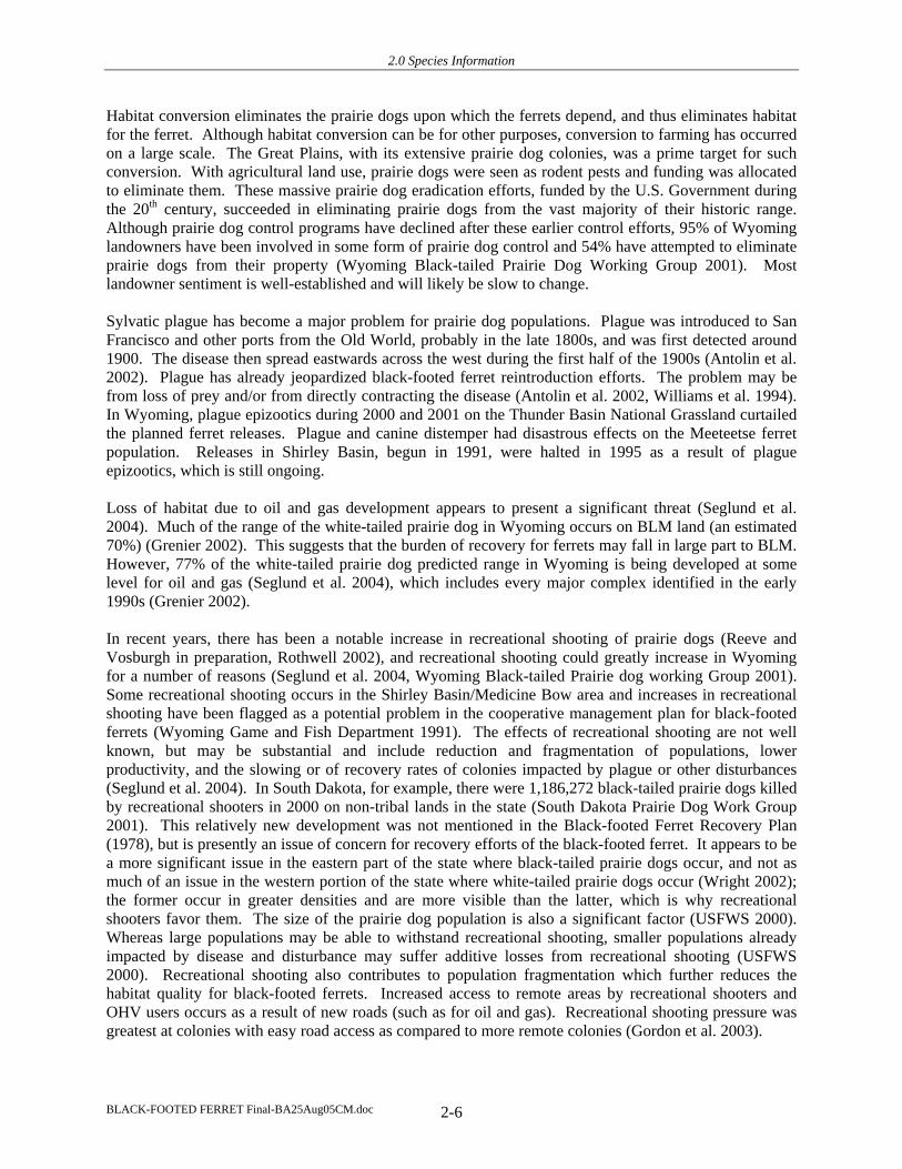
Buffalo Field Office – Buffalo RMP
An area located within the southeast portion of the Buffalo FO is identified as black-footed ferret habitat, in the Thunder Basin National Grasslands (Map 4). The Thunder Basin National Grasslands was a designated black-footed ferret reintroduction site because it contains one of the larger black-tailed prairie dog complexes in North America. However, a plague epizootic decimated the prairie dog population in 2001, and caused an indefinite hold on reintroduction plans. The Thunder Basin National Grassland is under USFS jurisdiction and does not contain any surface ownership lands administered by the BLM, however the BLM does administer the mineral estate under the USFS lands.
Extensive black-footed ferret surveys have been conducted within the Powder River Basin area in conjunction with energy development. No black-footed ferrets have been found in the Powder River Basin, even though it is located within the historic range and includes both black-tailed and white-tailed prairie dog colonies. To date, at least 382 black-tailed prairie dog colonies greater than 80 acres in size have been identified within the Powder River Basin in this FO. Additional colonies are likely present due to the vast aerial extent of short-grass and mixed grass prairie within the Buffalo FO. However, it is possible that overall acreage may be 80-90% less than previously reported (Bills 2004). This is because existing data are from the mid-80s and sylvatic plague and landowner persecution has fragmented many of the large colonies that were present in the 1980s.
BLACK-FOOTED FERRET Final-BA25Aug05CM.doc 2-7
2.0 Species Information
Map 4 Black-footed Ferret Distribution Records, Prairie Dog Historic Range, and Significant Prairie Dog Complexes in Northeastern Wyoming
BLACK-FOOTED FERRET Final-BA25Aug05CM.doc 2-8

2.0 Species Information
The Record of Decision (ROD) and Resource Management Plan Amendments for the Powder River Basin Oil and Gas Project were issued in April 2003. The planning area for this project encompasses almost 8 million acres, of which BLM administers 883,000 (11%) surface and 4.3 million acres (68%) of subsurface mineral rights. Planned resource extraction activities include drilling an estimated 3,200 oil wells and 51,000 coalbed natural gas wells. Although reclamation will be required, the action is anticipated to disturb as much as 212,000 acres temporarily (construction of pipelines and roads) and 109,000 acres over the long term.
Casper Field Office – Platte River RMP
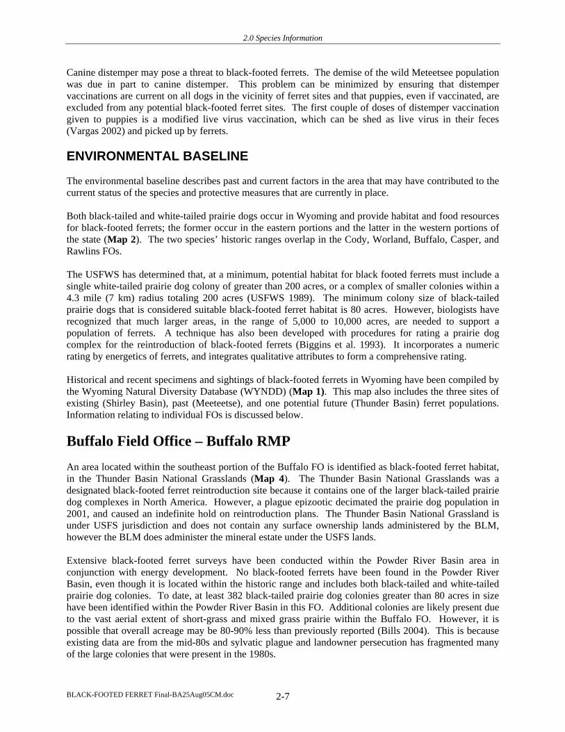
Map 5 shows the occurrence of black-footed ferret historical records and sightings in the Casper FO. Five records of black-footed ferrets are known from the Casper FO: 3 records from Natrona County, all from 1973 and 1974 (circa 20 miles northeast of Lysite, 6 miles east of Casper by the North Platte River, and 5-10 miles east of Powder River, respectively); 1 record from Converse County (a male specimen collected from Douglas in 1917); and 1 record from Platte County in 1964 (10 miles west of Chugwater) (Appendix A). Also of note are two areas of significance for ferrets: Shirley Basin, whose northern extent dips up into Natrona County in the Casper FO, and Thunder Basin National Grasslands, which extends into northeastern Converse County in the Casper FO. Both species of prairie dog occur in the FO, primarily on private lands due to the very fragmented land ownership.
Extensive black-footed ferret surveys have been conducted within the Powder River Basin area in conjunction with energy development. No black-footed ferrets have been found in the Powder River Basin, even though it is located within the historic range and includes both black-tailed and white-tailed prairie dog colonies.
The Record of Decision (ROD) and Resource Management Plan Amendments for the Powder River Basin Oil and Gas Project were issued in April 2003. The planning area for this project encompasses almost 8 million acres, of which BLM administers 883,000 (11%) surface and 4.3 million acres (68%) subsurface mineral rights. Planned resource extraction activities include drilling an estimated 3,200 oil wells and 51,000 coalbed natural gas wells. Although reclamation will be required, the action is anticipated to disturb as much as 212,000 acres temporarily (construction of pipelines and roads) and 109,000 acres over the long term.
Cody Field Office – Cody RMP
Map 6 shows the occurrence of black-footed ferret historical records, and the Meeteetsee site in the Cody FO. The last known wild population of black-footed ferrets was found on a white-tailed prairie dog complex near Meeteetse in 1981. In 1984, this population included 129 wild ferrets. Almost the entire Meeteetse population was eliminated by a prairie dog plague and canine distemper. The last known wild ferrets from this site were captured in February 1987 and brought into captivity. This site, encompassing about 3 Townships, is identified as essential habitat in the Cody RMP. Although this FO historically had both white-tailed and black-tailed prairie dogs, only white-tailed prairie dogs are present now (Seville 2004). Other than the population at Meeteetsee, of which there is one record in the database, there is also a record from 15 miles southeast of Lovell Lake in Bighorn County from 1972 (Appendix A).
BLACK-FOOTED FERRET Final-BA25Aug05CM.doc 2-9
2.0 Species Information
Map 5 Black-footed Ferret Distribution Records, Prairie Dog Historic Range, and Significant Prairie Dog Complexes in Southeastern Wyoming
BLACK-FOOTED FERRET Final-BA25Aug05CM.doc 2-10

2.0 Species Information
Map 6 Black-footed Ferret Distribution Records, Prairie Dog Historic Range, and Significant Prairie Complexes in Northwestern Wyoming
BLACK-FOOTED FERRET Final-BA25Aug05CM.doc 2-11

2.0 Species Information
Kemmerer Field Office – Kemmerer RMP
Map 7 shows the occurrence of black-footed ferret historical records and sightings in the Kemmerer FO. There are two records, one from Lincoln County from 1972 (an observation made circa 20 miles northeast of Lysite) and one from Uinta County (a cranium and mandible collected in 1979) (Appendix A). Only white-tailed prairie dogs occur in Kemmerer FO (Map 2), and there are 3 significant prairie dog complexes: Carter, Cumberland, and Moxa Arch (Map 3). Twenty-seven, 6, and 25 black-footed ferret surveys were conducted in 2002, 2003, and 2004, respectively, for projects in the FO (Oles 2005).
Earlier mapping was conducted (probably 1992-1994) for the Moxa Arch Area Natural Gas Development Project (BLM 1995). The project encompasses 756 square miles, approximately 25% of the entire FO (Wright 2002). One hundred and sixty-one white-tailed prairie dog colonies were mapped, encompassing 47,664 acres (BLM 1995). When the towns were circumscribed according to USFWS guidelines (USFWS 1989), with burrow densities of 8 burrows/acre, 3,982 acres met these criteria, exceeding the 1,000-acre minimum set by USFWS for potential reintroduction sites. Although very large, the Moxa Arch site is not necessarily the best one for black-footed ferret reintroduction due to human activity and disturbance (Oles 2004); other prairie dog complexes in this FO would provide better reintroduction sites (Pils 2002). Cumberland is a good prairie dog area except for the coalbed natural gas leases.
Extensive mapping of prairie dog complexes has recently been conducted by BLM in this FO (Oles 2004). During the summers of 2003 and 2004, interns surveyed 850,000 acres for white-tailed prairie dog activity. The intent of the survey was to map colonies that could provide potential habitat for the black-footed ferret. Colonies of less than 40 acres in size were not mapped. The total number of active colonies mapped over the two years encompassed 51,046 acres. Such acreage estimates are only a snapshot in time of larger landscape-level prairie dog complexes whose dynamics cause ongoing shifting of boundaries. Furthermore, the delineation of boundaries and densities of white-tailed prairie dog colonies is a somewhat subjective process.
Lander Field Office – Lander RMP
Three records of black-footed ferrets are known from the Lander FO (Map 6), all from Fremont County: one record from 1957, 4 miles east of Dubois, and two records from 1973, 7.5 miles south of Jeffrey City (Appendix A). Pathfinder prairie dog complex overlaps Lander and Rawlins FOs, and is the only significant complex in this FO (Map 3).
Newcastle Field Office – Newcastle RMP
Six records of black-footed ferrets are known from the Newcastle FO (Map 4): One from Crook County (Black Hills, Bear Lodge Mountains, reported in 1949); two from Niobrara County (one male specimen collected from Manville in 1916, and one record from 1976 of an animal seen crossing Highway 85 about 36 miles north of Lusk); and three from Weston County (one female specimen collected in 1895 and a male collected in 1910 from Newcastle, and one 1972 record from 5 miles south of U.S. 16 where it enters Wyoming) (Appendix A). Also of note is the Thunder Basin National Grasslands, which extends into southwestern Weston County in the Newcastle RA. Thunder Basin National Grassland was to have a release of ferrets in 2002, but plague decimated a large portion of the core reintroduction area and this plan is presently on hold indefinitely (Grenier 2002).
BLACK-FOOTED FERRET Final-BA25Aug05CM.doc 2-12

2.0 Species Information
Map 7 Black-footed Ferret Distribution Records, Prairie Dog Historic Range and Significant Prairie Dog Complexes in Southwestern Wyoming
BLACK-FOOTED FERRET Final-BA25Aug05CM.doc 2-13

2.0 Species Information
Pinedale Field Office – Pinedale RMP and Snake River RMP
Populations of black-footed ferrets are undetermined in the Pinedale RMP planning area. Two partially buried black-footed ferret skulls were discovered in 2002 on the Anticline Project Area – Natural Gas Project Environmental Impact Statement area (Mesa area), located west of Pinedale (Solberg 2004). In addition, there are 2 records of black-footed ferrets from the WYNDD database for the Pinedale FO (Map 7): One from 3 km south of Cottonwood Road between Daniel and Big Piney off US 189 from 1957, and one is an observation of an animal crossing Highway 187 8 km south of Boulder in 1979 (Appendix A). In addition, there are 2 locations where a skull, possible scat, fur, and trenches were found: 1 in July 2002 in S14, 23, and 24, T31N, R109W; and 1 in September 2002 in S3 and 5 T31N, R109W and S33 and 34, T32N, R109W (Solberg 2004). One significant prairie dog complex, Big Piney, occurs in the FO.
The planning area contained within the Snake River RMP does not presently contain any prairie dog habitat nor has it historically. The surface ownership lands managed by the BLM are small islands in the Snake River which is not black-footed ferret habitat as they are surrounded by water, the substrate is cobble-rocky, and there are no prey species. The decision in the ROD for the subsurface mineral estate lands within the planning area is not to lease for fluid minerals, so no impacts will occur there. In the biological assessment (BA) prepared by the BLM and biological opinion (BO) prepared by the USFWS for the Snake River RMP, the BLM determined that there was no habitat within the planning area and the USFWS concurred with the determination that activities authorized by programs within the Snake River Resource Management Plan will have no effect on the black-footed ferret, because activities authorized by the Snake River RMP will occur outside suitable habitat for ferrets. No further analysis for black-footed ferrets will be conducted for lands within the Snake River RMP within this BA.
Rawlins Field Office – Great Divide RMP
Map 5 shows the location of black-footed ferret historical and recent sightings from the Rawlins FO. Because there are numerous black-footed records from this FO, they are shown in the table below (as well as Appendix A):
County Year Location Comments Albany 1924 5 miles W Laramie Male specimen collected Albany 1935 12 miles NW Laramie Several reported by Frank
Carroll Albany 1948 24 km W of Laramie on the old Jack Markley
Ranch. Albany 1973 0.5 miles NE of city water treatment plant, and
other records in and around Laramie. 1 adult, reported by T. Cram
Albany 1942 Laramie Range, N of Garrett, vicinity of Laramie Peak
1 adult reported by David Prager
Albany 1961 12 miles SW of Laramie 1 adult and 2 young, reported by rancher
Albany 1964 No written description Albany 1964 Medicine Bow Mountain, Vicinity of County
road 47 Albany 1964 Medicine Bow Mountains, Highway 11 near
Albany Carbon 1979 No data Skull collected on white-
tailed prairie dog town
BLACK-FOOTED FERRET Final-BA25Aug05CM.doc 2-14
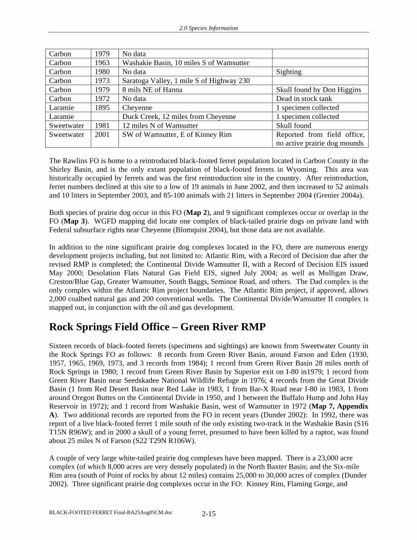
2.0 Species Information
Carbon 1979 No data Carbon 1963 Washakie Basin, 10 miles S of Wamsutter Carbon 1980 No data Sighting Carbon 1973 Saratoga Valley, 1 mile S of Highway 230 Carbon 1979 8 mils NE of Hanna Skull found by Don Higgins Carbon 1972 No data Dead in stock tank Laramie 1895 Cheyenne 1 specimen collected Laramie Duck Creek, 12 miles from Cheyenne 1 specimen collected Sweetwater 1981 12 miles N of Wamsutter Skull found Sweetwater 2001 SW of Wamsutter, E of Kinney Rim Reported from field office,
no active prairie dog mounds
The Rawlins FO is home to a reintroduced black-footed ferret population located in Carbon County in the Shirley Basin, and is the only extant population of black-footed ferrets in Wyoming. This area was historically occupied by ferrets and was the first reintroduction site in the country. After reintroduction, ferret numbers declined at this site to a low of 19 animals in June 2002, and then increased to 52 animals and 10 litters in September 2003, and 85-100 animals with 21 litters in September 2004 (Grenier 2004a).
Both species of prairie dog occur in this FO (Map 2), and 9 significant complexes occur or overlap in the FO (Map 3). WGFD mapping did locate one complex of black-tailed prairie dogs on private land with Federal subsurface rights near Cheyenne (Blomquist 2004), but those data are not available.
In addition to the nine significant prairie dog complexes located in the FO, there are numerous energy development projects including, but not limited to: Atlantic Rim, with a Record of Decision due after the revised RMP is completed; the Continental Divide Wamsutter II, with a Record of Decision EIS issued May 2000; Desolation Flats Natural Gas Field EIS, signed July 2004; as well as Mulligan Draw, Creston/Blue Gap, Greater Wamsutter, South Baggs, Seminoe Road, and others. The Dad complex is the only complex within the Atlantic Rim project boundaries. The Atlantic Rim project, if approved, allows 2,000 coalbed natural gas and 200 conventional wells. The Continental Divide/Wamsutter II complex is mapped out, in conjunction with the oil and gas development.
Rock Springs Field Office – Green River RMP
Sixteen records of black-footed ferrets (specimens and sightings) are known from Sweetwater County in the Rock Springs FO as follows: 8 records from Green River Basin, around Farson and Eden (1930, 1957, 1965, 1969, 1973, and 3 records from 1984); 1 record from Green River Basin 28 miles north of Rock Springs in 1980; 1 record from Green River Basin by Superior exit on I-80 in1979; 1 record from Green River Basin near Seedskadee National Wildlife Refuge in 1976; 4 records from the Great Divide Basin (1 from Red Desert Basin near Red Lake in 1983, 1 from Bar-X Road near I-80 in 1983, 1 from around Oregon Buttes on the Continental Divide in 1950, and 1 between the Buffalo Hump and John Hay Reservoir in 1972); and 1 record from Washakie Basin, west of Wamsutter in 1972 (Map 7, Appendix A). Two additional records are reported from the FO in recent years (Dunder 2002): In 1992, there was report of a live black-footed ferret 1 mile south of the only existing two-track in the Washakie Basin (S16 T15N R96W); and in 2000 a skull of a young ferret, presumed to have been killed by a raptor, was found about 25 miles N of Farson (S22 T29N R106W).
A couple of very large white-tailed prairie dog complexes have been mapped. There is a 23,000 acre complex (of which 8,000 acres are very densely populated) in the North Baxter Basin; and the Six-mile Rim area (south of Point of rocks by about 12 miles) contains 25,000 to 30,000 acres of complex (Dunder 2002). Three significant prairie dog complexes occur in the FO: Kinney Rim, Flaming Gorge, and
BLACK-FOOTED FERRET Final-BA25Aug05CM.doc 2-15

2.0 Species Information
Baxter Basin (Map 7), and portions of Sweetwater, Continental Divide, and Desolation Flats. The Continental Divide complex as been mapped-out in as a result of the Continental Divide/Wamsutter II oil and gas development project.
The Vermillion Basin has been included in the Little Snake Management area that spans Colorado and Wyoming (Dunder 2002). This was planned as a reintroduction site, but plague has postponed this effort. Ferrets released in Colorado as part of this reintroduction effort would be designated an experimental non-essential population, as defined by USFWS, and have less stringent protection guidelines than wild animals. If the ferrets do well with the reintroduction, they may expand across the border into Wyoming.
Worland Field Office – Grass Creek RMP and Washakie RMP
There are 3 records of black-footed ferrets from this FO: One from 25 miles east of Thermopolis in Hot Springs County from in 1972, one from 10 miles north of Tensleep in 1975 and another 20 miles east of Worland in 1974 from Washakie County (Map 6).
Although both prairie dog species occurred in the FO historically (Map 2), recent survey and mapping work have revealed that black-tailed prairie dogs are presently absent from the Worland FO, and have been since extensive mapping was conducted in 1977 and in the mid-80s (Stephens 2004). Two significant white-tailed prairie dog complexes occur in the FO: Manderson and Fifteenmile. Fifteenmile was a very active complex in the 1977 inventory, but plague epizootics in 1981 and 1982 severely reduced the population. New prairie dog inventories were initiated in 1999 and are ongoing, as funding allows.
BLACK-FOOTED FERRET Final-BA25Aug05CM.doc 2-16

3.0 Analysis of Resource Management Plans
3.0 ANALYSIS OF RESOURCE MANAGEMENT PLANS
The programs and proposed actions for the 12 RMPs, covering all 10 field offices, are summarized below, with the exception of the Snake River RMP, which does not have any black-footed ferret habitat and the Newcastle RMP (2004), which analyzed each activity for impacts to the black-footed ferret. The remaining 10 RMPs discussed the black-footed ferret in each specific environmental analysis and biological assessment accompanying the analysis. Specific effects determinations were not made by program and a “no effect” determination was made by the BLM, combining all programs together. A concurrence letter from the USFWS was received for each RMP, with the direction that when an activity occurs within an FO that could impact black-footed ferrets, then specific additional consultation must take place.
TABLE 3-1 PREVIOUS RMP CONSULTATION FOR BLACK-FOOTED FERRETS
Field Office: RMP (ROD) Sect 7 Completed Outcome of Sect 7*
Buffalo Buffalo (1985) May 1984 Concurrence Letter*
Casper Platte River (1985) Sep 1984 Concurrence Letter*
Cody Cody (1990) Mar 1988 Concurrence Letter*
Kemmerer Kemmerer (1986) Mar 1986 Concurrence Letter*
Lander Lander (1987) Dec 1986 Concurrence Letter*
Newcastle Newcastle (2000) Oct 2004 Concurrence Letter*
Pinedale Pinedale (1988) Apr 1987 Concurrence Letter*
Snake River (2004) Jan 2004 Concurrence Letter*(NE)
Rawlins Great Divide (1990) Nov 1987 Concurrence Letter*
Rock Springs Green River (1997) July 1994 Concurrence Letter*
Worland Grass Creek (1998) July 1996 Concurrence Letter*
Washakie (1988) Dec 1886 Concurrence Letter* * - Concurrence Letter - Will Not (or Not Likely To) Adversely Affect T&E Species / no Biological Opinion
The program management actions have been combined across FOs in this section to more efficiently discuss the general types of activities and management actions that occur programmatically throughout the Wyoming BLM field offices. For specific management program information, please refer to each RMP. All 12 RMPs can be reviewed online by accessing the Wyoming BLM Resource Management Plan website (www.blm.gov/rmp/WY). The effects analyses and determinations follow the management actions. Due to variations among FOs in how programs are listed, we have added a section to address FOs that manage the particular program in a different manner or under a different program (“Field Offices that Address Actions Under a Different Program”). At the end of Section 3 there is a table (Table 3-2) summarizing the determinations for all programs separately under each specific FO.
BLACK-FOOTED FERRET Final-BA25Aug05CM.doc 3-1

3.0 Analysis of Resource Management Plans
The BLM, as a Federal agency under the Endangered Species Act, bears responsibility for conservation and recovery of black-footed ferrets and their habitats. In the analysis of determinations, an overarching element is that there are no known wild black-footed ferret populations. The only extant ferrets in the state are a reintroduced population in the Shirley Basin designated as a nonessential experimental population. Thus impacts to ferrets can be by:
• Direct impacts to as yet undiscovered wild black-footed ferrets • Direct loss or fragmentation of habitat (i.e., prairie dog colonies), and • Impacts that cause a loss of size or other value of potential recovery sites
Five sources of guidance that help to minimize adverse impacts on black-footed ferrets and their habitat are presently in place, and are either included in all 12 RMPs, are law, are directed to all FOs through instruction memoranda, or are policy prescribed through a BLM Manual are described below:
1) The Wyoming BLM Mitigation Guidelines for Surface Disturbing and Disruptive Activities serves to attain statewide consistency in requirements for avoiding and mitigating environmental impacts and resource and land use conflicts. This document includes several mitigation guidelines applicable to a variety of resources, including black-footed ferrets. Surface disturbance is restricted within 500 feet of surface water and/or riparian areas. This restriction will limit activities on prairie dog colonies immediately adjacent to lakes, ponds, reservoirs, and riparian areas. Under the wildlife mitigation guideline the following guidance applies to black-footed ferrets:
• No activities or surface use will be allowed on the portion of the authorization area identified within (legal description) for the purpose of protecting (e.g., sage/sharp-tailed grouse breeding grounds, and/or other species/activities) habitats (subpart 2c of Wildlife Mitigation Guideline).
• When the authorized use area contains known or suspected areas essential to the black-footed ferret, which is endangered, the lessee/permittee will be required to conduct inventories or studies in accordance with BLM and USFWS guidelines to verify the presence or absence of this species. Such habitat will be recognized by the presence of prairie dogs. In the event that black-footed ferret occurrence is identified, the lessee/permittee will be required to modify operational plans to include the protection requirements of this species and its habitat (e.g., occupancy limitations, facility design modifications) (subpart 2d of Wildlife Mitigation Guideline).
2) The Standards for Healthy Rangelands and Guidelines for Livestock Grazing Management for Public Lands Administered by the Bureau of Land Management in the state of Wyoming serve to facilitate achievement of rangeland health based on sound scientific principles. These standards include protection of rangelands for special status species protection.
3) As a Federal agency, BLM is required by the Endangered Species Act of 1973 (Section 7 (a)(1) and (2)), as amended, to consult with the USFWS to utilize BLM’s authorities and carry out programs for the conservation of endangered and threatened species. BLM must ensure that any action they authorize will not jeopardize the continued existence a listed species and BLM must consult with the USFWS if any prospective action that they propose may adversely affect a listed species. The 1989 black-footed Ferret Survey Guidelines for Compliance with the Endangered Species Act (USFWS 1989) stipulates that ferret surveys should be conducted in advance of any proposed activity that includes a single black-tailed prairie dog colony of greater than 80 acres or a single white-tailed prairie dog colony of greater than 200 acres. Alternately, a complex of smaller colonies within a 4.3 mile (7-km) radius circle totaling 80 acres for black-tailed prairie dogs, or 200 acres for white-tailed prairie dogs would also provide the minimum
BLACK-FOOTED FERRET Final-BA25Aug05CM.doc 3-2

3.0 Analysis of Resource Management Plans
habitat requirements for the black-footed ferret and should be surveyed (USFWS 1989); and areas with 1,000 acres or more of prairie dog habitat should be evaluated as possible sites for future black-footed ferret reintroduction (USFWS 1989). These guidelines for survey recommendations presently apply only to those areas not block-cleared for black-footed ferrets pursuant to the block clearance letter of February 2, 2004 (USFWS 2004).
In the Memorandum of Understanding on the implementation of the ESA, it is stated that BLM should identify opportunities to conserve listed species and the ecosystems upon which those species depend within existing BLM programs or authorities. Furthermore, BLM policy (BLM Manual 6840) addresses recovery of listed species and states that it shall “ensure that all activities affecting the populations and habitats of listed species are designed to be consistent with recovery needs and objectives” and “ensure that BLM actions will not reduce the likelihood of survival and recovery of listed species.”
Although most black-tailed prairie dog towns are on private land (roughly 75%) and fewer are on BLM land (15%) Grenier 2002), a high proportion of white-tailed prairie dog towns (estimated 70%) are on BLM land. BLM is thus in a position to play a significant role in the recovery of the black-footed ferret in white-tailed prairie dog habitats.
4) A fourth guideline is provided by some policies to protect black-tailed prairie dogs, which will also indirectly benefit the black-footed ferret. These policies are two Instructional Memoranda, Instructional Memorandum (IM) No. 99-146 (BLM 1999) and IM no. 2000-140 (BLM 2000), pursuant to BLM Manual 6840. Under IM No. 99-146, all State Directors within the range of the black-tailed prairie dog are required to ensure that all actions authorized, funded, or carried out by the BLM do not contribute to the need to list the black-tailed prairie dog. On June 22, 2000, the BLM released additional policy directives in IM No. 2000-140 to further restrict activities that could contribute to the need for listing the black-tailed prairie dog. The new directives included the following requirements:
• Ensure there is no unauthorized control of black-tailed prairie dogs on BLM lands; • Notify the public that unauthorized use of poisons for black-tailed prairie dog control is not
allowed on BLM lands; • Ensure that black-tailed prairie dog conservation is being addressed on all livestock permit
renewal evaluations and associated environmental assessments for oil and gas developments, rights-of-way grants, organized recreational events, etc.;
• Consult with appropriate agencies on the need to close or restrict sport hunting of black-tailed prairie dogs;
• Map all known black-tailed prairie dog colonies on lands administered by BLM; • Actively participate in implementation of the Conservation Assessment and Strategy Plan for
Black-tailed Prairie Dogs (Van Pelt 1999); • Provide the Washington Office, Associate Director for Renewable Resources and Planning with a
written summary of actions taken and/or planned in each state to ensure conservation of the black-tailed prairie dog. Where possible, the needs of other species that are dependent on similar habitats, such as the mountain plover and black-footed ferret, and other collaborative conservation efforts should be addressed.
5) Both white-tailed and black-tailed prairie dogs are listed as Wyoming BLM Sensitive Species, which gives them the same protection as Federal candidate listing. BLM Policy Manual 6840 provides policy and guidance for the conservation of all special status species. The potential vulnerability of white-tailed and black-tailed prairie dogs is relevant to black-footed ferret conservation. The white-tailed prairie dog was petitioned for listing under the ESA by the Center for Native Ecosystems and seven other entities in July 2002. The USFWS issued a finding in the Federal Register (volume 49, number 216) not to list the
BLACK-FOOTED FERRET Final-BA25Aug05CM.doc 3-3

3.0 Analysis of Resource Management Plans
species on November 9, 2004. However, the white-tailed prairie dog was already on the BLM Sensitive Species list and remains there. The black-tailed prairie dog was removed as a candidate for listing under the ESA on August 12, 2004. However, BLM policy invokes a 5-year status as a BLM Sensitive Species after any delisting. BLM Policy Manual 6840 dictates that “the protection provided by the policy for candidate species shall be used as the minimum level of protection for BLM sensitive species (p. 10). Refer to the manual for further details.
This reflects a change in BLM policy. When BLM was just protecting black-footed ferrets only, ferret surveys were conducted and if none were found, the habitat was allowed to be disturbed, fragmented, etc. Since the Sensitive Species policy, BLM is protecting prairie dogs for their own sake, which is providing better protection for ferrets.
Shirley Basin Nonessential Experimental Population
For the black-footed ferrets in the Shirley Basin, the analysis of potential impacts of BLM’s ongoing activities is guided by rules published in the Federal Register which designate this population in Wyoming as a nonessential experimental population under Section 10(j) of the ESA. Federal agencies are only required to confer with the USFWS when they determine that an action they authorize, fund, or carry out “is likely to jeopardize the continued existence” of the species. Thus the decision for each management action within the Shirley Basin nonessential experimental population is whether the action:
• Is likely to jeopardize the continued existence of the species – “Jeopardy”
- or
• Is not likely to jeopardize the continued existence of the species – “No Jeopardy”
These determinations are further defined in the U.S. Fish and Wildlife Service (USFWS) Endangered Species Consultation Handbook (USFWS 1998). To “jeopardize the continued existence of” is to engage in an action that reasonably would be expected, directly or indirectly, to reduce appreciably the likelihood of both the survival and recovery of a listed species in the wild by reducing the reproduction, numbers, or distribution of that species (50 CFR §402.02).
The analysis must address whether the activities described in the Great Divide RMP could jeopardize the continued existence of the black-footed ferret, rather than potential impacts to individuals. With this higher threshold, the analysis results in the conclusion that all of the BLM programs evaluated in this document present No Jeopardy to the species, as none of the actions would jeopardize the continued existence of the species. This will serve for the Shirley Basin population of black-footed ferrets, and will not be repeated for each program.
Access
Management Actions
The objective for access management is to provide suitable public access to BLM-administered public lands. This may include acquiring new access where needed, maintaining existing access and expanding existing access facilities, or abandoning and closing access where it is not compatible with resource values and objectives.
Access across private lands will be pursued as needed through a variety of methods including, but not
BLACK-FOOTED FERRET Final-BA25Aug05CM.doc 3-4

3.0 Analysis of Resource Management Plans
limited to, purchase of rights-of-way or easements, land exchange, reciprocal rights-of-way, and other statutory authorities. Specific routes and acquisition procedures for securing access are determined through route analyses and environmental analyses as part of specific project and activity planning. Access acquisition needs (typically for roads) are most commonly identified for public access for recreational use. This may be for hunting, sightseeing, rockhounding or general exploring. Acquisition of access to public lands has been identified in locations that would provide the public with an opportunity to utilize resources that have previously been unavailable because the public lands had no public access. An increase in access could result in an increase in human activity in an area that previously had little activity, development of roads, trails, parking areas and other facilities to enhance the public's use of the area. The construction of access roads, trails, parking areas, and other associated facilities would require the use of heavy equipment and machinery, as well as surface disturbance at the site.
Where appropriate, land exchanges or cooperative agreements are considered to provide access needs.
A detailed evaluation of areas with a high density of roads may be completed to determine needs for specific road closures or rehabilitation. Specific impact minimization measures and design requirements for roads are developed through environmental analyses as part of specific project or activity planning. Access closure, abandonment, and acquisition are considered and established through activity planning and environmental analysis processes. Road or trail closure and abandonment is based on desired road or trail densities, demands for new roads, closure methods (e.g., abandonment and rehabilitation, closures by signing, temporary or seasonal closures), type of access needed, resource development or protection needs, and existing uses.
Effects Analysis
Over the long term road closures would benefit black-footed ferrets by reducing access and associated disturbance such as recreational shooting. Any new access roads through prairie dog colonies may destroy habitat, and could provide access for recreational shooters. BLM will attempt to avoid prairie dog colonies (Conservation Measures, section 4.0) and thereby avoid impacts to the black-footed ferret or potential recovery sites, but sometimes (and in some FOs more than others), it may be preferable to route a road through a large prairie dog colony instead of around it, as this would result in less overall impact for other resources and wildlife. Overall, it is unlikely that one of the few new roads that could not avoid a prairie dog town would lead to sufficient recreational shooting of prairie dogs that either 1) a potential black-footed ferret recovery site could no longer serve that purpose or 2) an undiscovered ferret population would experience sufficient decline in prey to impact them.
Determination
Implementation of access management actions may affect, but is not likely to adversely affect, the black-footed ferret due to insignificant effects. This determination is based on the low potential for a relatively small number of new roads that could not avoid prairie dog colonies to bring recreational shooters or other impacting activities into BFF habitat and cause a loss of prey or modifications to black-footed ferret habitat or impact black-footed ferrets.
Field Offices that Address Actions Under a Different Program
Only Lander and Pinedale (Pinedale RMP) FOs have specifically addressed Access as a decision topic. For the other FOs, the determination stated here will apply to Access Management activities under whichever program they are managed.
BLACK-FOOTED FERRET Final-BA25Aug05CM.doc 3-5
3.0 Analysis of Resource Management Plans
Air Quality
Management Actions
The objective of air quality management is to maintain or enhance air quality, protect sensitive natural resources and public health and safety, and minimize emissions that cause acid rain or degraded visibility. Typical air quality management program activities include dust control, weather monitoring, and air quality data monitoring. The air quality management program may evaluate or restrict surface development activities. The BLM ensures that operators cover conveyors at mine sites, restrict flaring of natural gas, limit emissions, and restrict spacing on projects.
BLM-initiated actions or authorizations are planned in accordance with Wyoming and national air quality standards. This is accomplished through the coordination of activities with the Wyoming Department of Environmental Quality (WDEQ) and the U.S. Environmental Protection Agency. Laws controlling air pollutants in the United States are the Clean Air Act of 1970 and its amendments, and the 1999 Regional Haze Regulations. The concentrations of air contaminants in the planning area need to be within limits of Wyoming ambient air quality standards (WAAQS) and national ambient air quality standards (NAAQS). Both WAAQS and NAAQS are legally enforceable standards for particulate matter (PM10), nitrogen dioxide (NO2), ozone, sulfur dioxide (SO2), and carbon monoxide (CO).
In addition to NAAQS and WAAQS, major new sources of pollutants or modifications to sources must comply with the New Source Performance Standards and Prevention of Significant Deterioration (PSD). The PSD increments measure PM10, SO2, and NO2. The PSD program is used to measure air quality to ensure that areas with clean air do not significantly deteriorate while maintaining a margin for industrial growth.
Air quality program actions consist of installation and maintenance of monitoring equipment. Monitoring station sites generally occupy less than 1 acre, are often fenced off from other activities, with an unimproved, two–track, access trail to the site near a county road or other legal, physical access. Creation of a monitoring station typically takes less than 2 days of construction, and a site may be in continuous operation for many years. Air monitoring stations generally consist of metering equipment contained in a barrel shaped container propped off of the ground on various forms of frame, or small, covered weather station sheds or platforms. In some cases, there may be short towers (approximately 30 ft. or less in height) with cup anemometers and other instruments attached, and solar collectors for power. Air monitoring stations are maintained on-site on a weekly or near weekly basis, with each routine maintenance session usually taking less than two hours to perform. Actual operation of the monitoring equipment is practically unnoticeable. There are numerous monitoring stations of one type or another scattered throughout Wyoming. The majority of these facilities occur on private or state lands, with a few stations on BLM lands, although access to many of these sites is across BLM lands.
Effects Analysis
No wild populations of black-footed ferrets are currently known to occur within Wyoming other than the Shirley Basin nonessential experimental population. Air quality management actions are typically associated with limitation, reduction, and monitoring of pollutants and dust during other BLM management actions. These air quality management actions would not likely affect the black-footed ferret or its habitat. The construction and maintenance of air quality monitoring stations could conceivably cause a direct mortality to ferrets due to collision if they were present at the site, if they were above ground during the action, and if the operators were negligent and unaware in the conduct of their
BLACK-FOOTED FERRET Final-BA25Aug05CM.doc 3-6
3.0 Analysis of Resource Management Plans
activities. It is also conceivable the air monitoring equipment could provide a perch for avian predators of the ferret. The likelihood of all of these situations occurring is so remote as to be discountable.
Determination
Implementation of air quality resource management actions may affect but are not likely to adversely affect the black-footed ferret, due to discountable effects. This determination is based on the avoidance of occupied habitats for surface disturbing air quality resource activities, the conservation measures regulating any surface disturbances within black-footed ferret habitat, and the low likelihood that an air monitoring station would occur or be developed in a prairie dog complex. This determination is also based on the extremely limited potential of direct or indirect effects to suitable black-footed ferret habitat from air quality management actions such as data collection, application of dust control measures, or covering conveyer belts at mine sites.
Field Offices that Address Actions Under a Different Program
Casper, Lander, and Rawlins (Great Divide RMP) FOs co-joined Air Quality Management with Soil and Water Management, and the Worland (Washakie RMP) FO did not specifically address Air Quality as a decision topic. For these RMPs, the determination stated here will apply to their Air Quality management activities under whichever program they are managed.
Areas of Critical Environmental Concern
Management Actions
The objectives of special management areas, such as Areas of Critical Environmental Concern (ACECs) are to ensure continued public use and enjoyment of recreation activities, while protecting and enhancing natural and cultural values; improving opportunities for high quality outdoor recreation; and, improving visitor services related to safety, information, interpretation, and facility development and maintenance.
Special Management Areas are those areas where a decision to focus a special emphasis management of some kind was made in the RMPs. Not all of the RMPs specified in detail the kinds of management needed in the ACECs. For some ACECs a plan was to be developed at a later date that would outline and specify management actions. Activities in each of the ACECs will be similar to those contemplated under the various other management actions, except that additional restrictions on ground disturbance will be applied. Special restrictions will be applied to management actions in ACECs that include cultural and paleontological resources, minerals, fire, ORV, vegetation and soils, and wildlife habitat. None of these additional restrictions is specifically directed toward protecting habitats for prairie dogs or black-footed ferrets, but they may indirectly benefit potential habitat by preventing some disturbances. The designation of ACECs in an RMP is simply a designation, and does not automatically convey specific management or protections, although with designation, some resource management protections are spelled out and implemented. If access roads or other types of facilities are specifically required, then these will be described within the appropriate activity section in this document. If an area is designated as an ACEC, it will require a plan of operations to be completed for any operations causing surface disturbance greater than causal use and a National Environmental Policy Act (NEPA) review before locatable mineral claims can be explored, mined and developed (43 CFR 3809 regulations). Generally, ACEC status is a beneficial impact on wildlife and plant species.
BLACK-FOOTED FERRET Final-BA25Aug05CM.doc 3-7
3.0 Analysis of Resource Management Plans
Effects Analysis
Although black-footed ferrets are not presently known to occur in ACECs in Wyoming, prairie dogs do occur in some of the ACECs. Management of ACECs is restrictive of ground disturbance and generally protects ACEC sites by maintaining them in a natural condition. Many ACECs are managed for wildlife species conservation and would have a beneficial affect on black-footed ferrets. Individual plans may be implemented for each ACEC and specific protection measures will be applied.
Determination
Implementation of ACEC resource management is not likely to adversely affect the black-footed ferret, due to beneficial effects. This determination is based on the beneficial effects of ACEC management to protect wildlife within ACECs. In planning areas without ACECs or that have ACECs, but no established prairie dog towns at this time, the preferred habitat for ferrets, implementation of ACEC resource management will have no effect on black-footed ferrets. If prairie dog towns become established in an ACEC, they would be subject to the same protections provided in non-designated management areas.
Field Offices that Address Actions Under a Different Program
The Buffalo, Cody, and Kemmerer RMPs do not specifically address ACECs as a separate program. For these RMPs, the determination stated here will apply to their ACEC management activities under whichever program they are managed. The two ACECs in the Newcastle FO do not contain prairie dog towns.
Cultural Resources
Management Actions
The objective of cultural resource management is to protect, preserve, interpret, and manage significant cultural resources for their informational, educational, recreational, and scientific values. Site-specific inventories for cultural resources would be required before the start of surface-disturbing activities, or if BLM-administered lands are proposed to be transferred out of Federal ownership.
The BLM performs inventory activities as well as land management activities. During inventory activities, the BLM inventories, categorizes, and preserves cultural resources; conducts field activities; performs excavations; maps and collects surface materials; researches records; and photographs sites and cultural resources. Inventory data collection activities are used for documentation and development of impact minimization plans before other resource program surface-disturbing activities may take place. Inventory activities commonly entail the use of hand tools, power tools, heavy machinery, vehicle use and localized human activity. Inventories are divided into Class I, Class II, and Class III inventories. The BLM does cultural resource inventories normally in response to surface-disturbing projects. Intensity varies between inventories. Inventories may involve 2-7 individuals and trucks, and may last from one day to several weeks.
Cultural resource land management activities involve managing sites for scientific, public, and sociocultural use; developing interpretive sites; restricting certain land uses; closing certain areas to exploration; prohibiting some surface-disturbing activities; preparing interpretive materials; and allowing the collection of certain invertebrate fossils. The cultural resource program may propose installation of protective fencing of trail segments, stabilize deteriorating buildings, acquire access to sites when
BLACK-FOOTED FERRET Final-BA25Aug05CM.doc 3-8

3.0 Analysis of Resource Management Plans
necessary, perform certain surface-disturbing activities, pursue land withdrawals, pursue cooperative agreements, protect sites with avoidance stipulations or conditions of approval, and identify and interpret historic trails. Cultural resource interpretive sites, such as historic trails or rock art sites may be developed to provide public benefits such as scenic overlooks, signs, and walking trails.
Adverse effects on significant cultural resources are mitigated. Surface-disturbing activities are avoided near significant cultural and paleontological resource sites and within ¼ mile or the visual horizon of significant segments of historic trails and canals. Sites listed on, or eligible for, the National Register for Historic Places (NRHP) are protected and would be managed for their local and national significance and in compliance with the National Historic Preservation Act, the Archaeological Resources Protection Act, the American Indians Religious Freedom Act, and the Native American Graves Protection and Repatriation Act, as appropriate.
Effects Analysis
Most activities associated with cultural resource inventories, including surface surveys, record searches, and artifact characterization would not affect black-footed ferrets or prairie dog complexes. More intensive excavation efforts and development of interpretive sites have the potential to disturb prairie dogs if such activities occurred in occupied habitats. As with any surface disturbing activity, a pre-construction assessment of prairie dog presence would be conducted in potentially suitable habitats prior to excavation. Direct and indirect effects to prairie dog habitats would be avoided as a consequence. Development of interpretive sites will, of necessity, occur where the cultural objects and sites themselves are located. If such a site were discovered or occurred in a prairie dog colony, it could create a conflict. However, the likelihood of this event is very low.
Determination
Implementation of cultural resource management actions may affect but are not likely to adversely affect the black-footed ferret, due to discountable effects. This determination is based on the avoidance of occupied habitats for surface disturbing cultural resource activities, the measures BLM currently has in place regarding implementation of cultural resource inventories, and the low likelihood that an interpretive site would occur or be developed in a prairie dog complex.
Fire
Management Actions
The objectives of fire management are to restore the natural role of fire in the ecosystem, and to protect life, property, and resource values from wildfire. The two major activities involved with the BLM’s fire management activities are prescribed burning and wildfire suppression.
Prescribed fire objectives are to restore natural fire regimes and enhance rangeland habitats for livestock and wildlife. The prescribe fire program writes fire plans for prescribed burns and vegetative treatments and coordinates with interested publics. Some prescribed fires are conducted to dispose of slash and residue from timber sales, improve wildlife habitat and grazing potential, or to reduce hazardous fuel loads.
Wildfires threatening higher resource values, including commercial timber areas, developed recreation sites, and areas of wildland/urban interface, or fires with potential to spread to private, state, or other Federal lands are suppressed. Fire suppression activities vary with the intensity of the wildfire and are
BLACK-FOOTED FERRET Final-BA25Aug05CM.doc 3-9
3.0 Analysis of Resource Management Plans
conducted on an emergency basis. However, wildfire planning is done in advance to determine what kinds of suppression activities will be allowed in a planning unit, where they will be allowed, and what kinds of equipment will be used. In the event of a wildfire and immediate suppression is required, as many conservation measures as possible will be applied that do not hinder safety or property protection. The USFWS will be contacted and emergency consultation will take place at the earliest possible time if T&E species or their critical habitats are affected or impacted. Fire plans also identify any special concerns or values that need to be protected. Fire lines are constructed to contain the wildfire. Water is withdrawn from nearby sources to suppress fires. Chemical fire suppression agents containing chemical dyes may be used, if needed. The use of aerial fire retardant is restricted near water resources. After a fire is extinguished, the BLM may use rehabilitation techniques to restore a burned or suppression area to its previous vegetative cover. The BLM uses a technique called Analysis of Burned Area Emergency Rehabilitation (BAER) on all areas damaged by fire. This technique is used to evaluate the impact of restoration efforts on the ecosystems involved.
Activities authorized by this program include tree thinning, construction of roads and fire lines using hand tools to heavy equipment, application of fire-suppressing chemicals by hand and aerial application, and revegetation and mulching stream banks for rehabilitation. Activities often employ the use of off-road vehicles, hand tools, and heavy equipment such as bulldozers.
Effects Analysis
Wildland fires are not expected to directly affect the black-footed ferret because such fires typically do not occur on prairie dog towns where vegetation and fuels to support a fire are limited. For these reasons, prescribed burns are also not common in these types of habitats. In white-tailed prairie dog towns, vegetation can be fairly dense and will carry a fire. Wildland or prescribed fires may improve vegetation vigor, plant composition, and return areas to an earlier seral vegetal stage required for optimal prairie dog habitat.
Heavy machinery associated with fire suppression and fire prevention could potentially destroy habitat and burrows. However, because wildland fires and prescribed burns are considered rare events in these habitats, this type of impact is unlikely to occur.
The ecological role of fire has changed dramatically within sagebrush-steppe habitats and grasslands since the 1860s (Seglund et al. 2004). There has been an increase in non-native annual species and fires at the lower elevations, and a decline in fire frequency at higher elevations resulting in an expansion of shrubs and trees (Crawford et al. in press, as cited in Seglund et al. 2004). The resulting impact on prairie dogs is not known. It is possible that prairie dog colonies, particularly white-tailed prairie dogs, have the ability to withstand fire (Bills 2004). Prairie dog burrows likely provide protection to prairie dogs and ferrets during fire events.
Determination
Implementation of fire management may affect but is not likely to adversely affect the black-footed ferret due to insignificant effects. This determination is based on the low potential for fires (both wildland and prescribed) to occur in habitat for the species, the low probability that fire equipment would be used in prairie dog habitat, and the potential for prairie dogs to withstand fire successfully. Prescribed fires would be analyzed for impacts to prairie dog and black-footed ferret habitats. If a wildland fire were to occur within any known black-footed ferret habitat and immediate suppression is required, as many conservation measures as possible will be applied that do not hinder safety or property protection. The USFWS will be contacted and emergency consultation will take place at the earliest possible time if known black-footed ferret habitat is affected or impacted.
BLACK-FOOTED FERRET Final-BA25Aug05CM.doc 3-10
3.0 Analysis of Resource Management Plans
Forest Resources
Management Actions
The objective of forest management is to maintain and enhance the health, productivity, and biological diversity of forest and woodland ecosystems and to provide a balance of natural resource benefits and uses, including opportunities for commercial forest production. BLM multiple use management prescriptions shall provide for forest products, recreation, livestock grazing, wildlife habitat, as well as the protection and enhancement of other resources.
The forestry program allows the commercial cutting and removal of diseased trees, disease treatment by spraying, herbicidal spraying of grasses and shrubs, and pre-commercial thinning, chaining, and shearing, as well as clearcuts, slash disposal, logging, helicopter logging, and skidder-type and cable yarding may be allowed during timber harvest. Other commercial uses may include post and pole harvest and the removal of wildlings for transplanting purposes. Non-commercial timber harvest under individual permits involves collection and cutting of firewood, Christmas trees, posts, poles, and wildling removal in stands or areas with good public access. The BLM ensures that site regeneration and stand replacement follow timber harvesting. Forest management activities may include conducting surveys; acquiring easements on private, state and other Federal agency lands; designing and developing roads; and installing erosion control, such as drain culverts and water bars.
Timber harvesting occurs on commercial forestlands with slopes less than 45%. Commercial operations are authorized under sale contracts or permits. Individual authorized clearcuts may not exceed 20 acres. Areas within 200 feet of surface water are prohibited from harvest. Slash is to be lopped and scattered, roller chopped, or burned. Regeneration areas are often enclosed by fence to prevent wildlife and livestock from damaging seedlings.
Forest stand inventories are conducted prior to any management activities, and regeneration surveys are performed following stand management activities. During forest management activities for timber harvest, the BLM allows forest stand improvement activities (initial thinning) of young trees (i.e., regeneration growth usually less than 15 feet in height) in forest stands. This activity may or may not require minimal road construction, and the trees are simply laid down with a chainsaw at a set spacing distance and left where they drop to decay. Pre-commercial harvest and removal of diseased trees and pre-commercial thinning of young trees is conducted to reduce the density of smaller trees, and thereby allowing the remaining trees to have better access to available nutrients, water, and light. These activities generally require creation of minimum to light road or two-track trail construction for access, and use of chainsaws and possibly some light yarding equipment for lay down and retrieval of trees. During commercial harvest activities, the BLM allows removal of commercial size trees (i.e., saw logs), ensures slash piling or lop-and-scatter disposal of debris, allows commercial thinning of saw logs under some types of silvicultural treatment, and allows use of both skidder and cable yarding of harvested trees. Generally, light to medium roads are constructed to the harvest stand and yarding areas and load out landings are built in the sale area to facilitate the removal of logs, utilizing heavy equipment. Trees are laid down with chain saws or harvester machines. During restoration efforts following timber harvest activities, the BLM ensures site re-contouring of landings and most roads, and revegetation of the sale area, as needed. All the above activities require the use of vehicles and human presence.
Currently, cottonwood and willow trees are not harvested by the BLM in Wyoming. Non-commercial woodlands (e.g., riparian areas) are managed to optimize cover and enhance habitat for wildlife and to protect the soil and watershed values.
BLACK-FOOTED FERRET Final-BA25Aug05CM.doc 3-11
3.0 Analysis of Resource Management Plans
Effects Analysis
Activities associated with forest resources generally occur on forested lands. Black-footed ferrets and prairie dogs occur on lower-elevation short-grass prairie and semi-desert shrublands, and therefore would not be disturbed by activities associated with forest resource management. However, if roads are developed near prairie dog complexes in order to gain access to adjacent forestland, there could be impacts on prairie dogs from vehicular collision, habitat fragmentation, and recreational shooting. However, the Conservation Measures recommend that new access roads avoid active prairie dog towns. Currently in Wyoming there are only between one to six timber sales on BLM lands each year, and most are less than 40 acres. Minimal to no impacts to prairie dog and black-footed ferret habitat occurs on BLM lands in Wyoming due to forest resource management.
Determination
Implementation of forest resource management actions may affect, but is not likely to adversely affect the black-footed ferret, due to discountable effects. This determination is based on the absence of the species in forested areas, existing Conservation Measures, and the low likelihood that the small number of forest management activities requiring new roads that could not avoid prairie dog colonies to bring in recreational shooters and cause a subsequent loss of prey.
Field Offices that Address Actions Under a Different Program
The Snake River RMP does not manage Forest Resources. Consequently, there is no analysis or determination applicable.
Hazardous Materials
Management Actions
The primary objective of hazardous materials management is to protect public and environmental health and safety on public lands administered by BLM. Hazardous materials management also seeks to comply with Federal and state laws, prevent waste contamination due to any BLM-authorized actions, and to minimize Federal exposure to the liabilities associated with waste management on public lands.
Hazardous materials and waste management policies are integrated into all BLM programs. Public lands contaminated with hazardous wastes are reported, secured, and cleaned according to Federal and state laws, regulations, and contingency plans. The clean-up of hazardous sites generally requires the use of heavy equipment, transport trucks, other vehicles and human presence. Warnings are issued to potentially affected communities and individuals if hazardous material is released on public land. If a spill of hazardous materials occurs, the site will be reported, secured, and cleaned and an emergency consultation conducted with the USFWS.
Effects Analysis
The goal of the hazardous materials program is to protect the environment from these materials. Hazardous material disposal typically is not allowed on BLM lands. The overall program is beneficial to black-footed ferrets and their habitat. If cleanup of a hazardous materials spill resulted in a second spill (while transporting the spilled and cleaned-up material), there could be negative impacts to potential adjacent black-footed ferret habitat. However, it is unlikely that such activity would occur at all, and
BLACK-FOOTED FERRET Final-BA25Aug05CM.doc 3-12
3.0 Analysis of Resource Management Plans
more unlikely that it would occur within or near a prairie dog town inhabited by an undiscovered population of ferrets.
Determination
Implementation of hazardous material management actions may affect, but is not likely to adversely affect, the black-footed ferret due to discountable effects. This determination is based on the low potential for an accidental spill subsequent to an original cleanup operation to occur in an area that contains a black-footed ferret population or prairie dog town.
Field Offices that Address Actions Under a Different Program
The Platte River (Casper FO), Kemmerer, Lander, Pinedale, and Great Divide (Rawlins FO) RMPs do not specifically address Hazardous Materials as a separate program. For these RMPs, the determination stated here will apply to their Hazardous Material management activities under whichever program they are managed.
Lands and Realty
Management Actions
The objective of the lands and realty management program is to support multiple-use management goals of the BLM resource programs; respond to public requests for land use authorizations, sales, and exchanges; and acquire and designate access to serve administrative and public needs.
Public land tracts not critical to current management objectives will be disposed of through the realty management program. Non-Federal lands may be acquired through exchange in areas with potential for recreation development or in areas containing important wildlife, cultural, scenic, natural, open space, or other resource values. Generally lands with special status species (SSS), which includes threatened and endangered species, are not eligible for disposal and are retained in Federal ownership for management of those species. Protective withdrawals from mineral entry may be established to protect and preserve important resource values, but require extensive mineral investigations.
Realty management authorizes occupancy of public lands for roads, power lines, pipelines, communication sites, and irrigation ditches authorized by granting a right-of-way. Rights-of-way management actions respond to public requests for access, land authorizations, sales, and exchanges. These rights-of-way may be temporary or may extend for years. If restricted types of rights of way are required in avoidance areas or when such areas cannot reasonably be avoided, the adverse effects of construction will be intensively mitigated in these areas. Most rights-of-way require the use of medium to heavy equipment, vehicles and human presence during their construction.
The program pursues cooperative agreements and considers and processes proposed withdrawals and temporary use permits. Unauthorized uses are investigated, documented, and steps are taken to resolve the trespass.
Public lands can be considered for sale or disposal on a case-by-case basis when a definite need for the land is identified and the proposal meets the requirements of the Recreation and Public Purpose (R&PP) Act and local land use plans. Leasing public lands for landfills, public recreation facilities, and other uses is allowed under the R&PP Act.
BLACK-FOOTED FERRET Final-BA25Aug05CM.doc 3-13

3.0 Analysis of Resource Management Plans
Effects Analysis
Land disposal and transactions for recreation, exchanges, and disposal and establishment of corridors for utility/transportation systems may negatively impact black-footed ferret habitats if such actions occur near prairie dog towns. Powerline, fence, and pipeline structures provide raptor perches and raptors may prey on black-footed ferrets; this event is very unlikely due to the fact that there are no known non-reintroduced ferret populations. Although allowable under the RMPs, BLM rarely conveys properties with high resource value, such as those with known threatened, endangered, or sensitive species. Conversely, land acquisitions and protective withdrawals may provide benefits to black-footed ferrets by acquiring additional land around prairie dog complexes that could contribute to reintroduction sites for ferrets, as suggested in the Conservation Strategies section. In addition, the Conservation Measures specify that new access roads through prairie dog towns will avoided if possible. It is sometimes preferable to route a road or pipeline through a large prairie dog colony instead of around the colony (or town), resulting in less overall impact for other resources and wildlife. Many times prairie dogs will start new colonies in the ROWs of freshly buried pipeline and utility lines, as these provide loosened soil allowing for easy digging.
Determination
Implementation of actions associated with lands and realty may affect, but is not likely to adversely affect the black-footed ferret, due to insignificant effects. This determination is based on the low potential for land disposal of prairie dog habitat, the existing recommendations in the Conservation Strategies for protection and attempted avoidance of prairie dog towns, the unlikely event that a raptor using a powerline or fence pole would kill a ferret if a new ferret population was discovered, and the low potential for other land management activities to disturb or remove black-footed ferret habitat.
Livestock Grazing
Management Actions
The management objective of livestock grazing management is to maintain or improve forage production and range condition as a sustainable resource base for livestock grazing on the public lands while improving wildlife habitat and watershed condition. Management actions on grazing allotments are prioritized by, and classified into, one of three management categories: maintain (M), improve (I), and custodial (C). Certain areas may be closed to livestock grazing because of conflicts with other resource uses including, but not limited to, timber sale areas being re-harvested, crucial wildlife or endangered species habitat, areas managed for prescribed fire, developed recreation sites, or education areas. Vegetation manipulation to change composition or productivity (including noxious weed control) may be accomplished by the range program by using prescribed fire, mechanical, chemical or biological treatments. Cattle are the predominant class of livestock grazed on Public lands in Wyoming, however, sheep, horses and bison are also authorized. Livestock grazing on Public lands can cause trampling of plants and removal of vegetation to various stubble heights dependent on the number of livestock and the length of time livestock are allowed to graze an allotment.
Fencing activities authorized by the livestock grazing management program may include fence construction and repair, designing and implementing grazing systems, and building livestock exclosures for important riparian habitat. Water management activities associated with range management may include the development of reservoirs, springs, pipelines, and wells, and access authorization. Permit and lease management activities include conducting monitoring studies, performing project work to enhance and improve riparian zones and uplands, managing stock driveways, and developing management plans
BLACK-FOOTED FERRET Final-BA25Aug05CM.doc 3-14

3.0 Analysis of Resource Management Plans
and agreements.
In some cases cross fencing (subdividing an allotment, pasture or ranch by fencing) is used to accomplish management needs or when a parcel is leased by more than one lessee. Temporary fencing, including electric fencing may be authorized to accomplish management goals. Fencing might be used to reduce grazing intensity, distribute grazing away from important resources (streams, springs, riparian areas, wetlands, cottonwood galleries, etc.). When fencing is proposed, either permanent or temporary, fences are built to standards developed in the Fencing BLM Manual Handbook (H-1741-1, Fencing, Rel. 1-1572, 12/6/1989). These standards are required to reduce the amount of restriction or hazards to wildlife. Fence construction and maintenance would likely require access to the site, possible removal of vegetation or uneven surface materials (rocks, trees, sand, etc.), stringing wire, digging postholes, building fence braces, building rock jacks, cutting or removing on or off site building materials (fence posts, rails, gathering rocks, etc.), weed management (spraying, cutting, pulling, etc.), or if the project is large enough, the possibility of camps for workers. The use of corrals for confinement of livestock for various purposes (sheep shearing, overnight holding of livestock, etc.) would require construction and maintenance activities including, hauling building materials, heavy equipment use, access to the corral site, etc.
The livestock grazing program may also include rangeland improvements such as stock water ponds, pits, or reservoirs; pipeline and trough systems; spring developments; storage tanks and troughs; wells; or temporary tanks and water hauling. These off-stream water improvements better distribute the use and intensity of use by livestock away from streams, rivers or wetlands and help protect important riparian areas, but could require the use of hand tools, mechanical or heavy equipment, hauling/transporting materials (gravel, dirt, tanks, etc.), and clearing vegetation. Placement of salt and mineral blocks or riding horseback and physically moving livestock are other forms of livestock distribution.
Rangeland restoration to improve range health is also a part of livestock management. These activities might include aerial seeding and possibly herbicide application, seeding by disking or drilling (using a tractor or other heavy equipment), fertilizing, plowing, chaining, or rangeland pitting.
Most livestock operators use off-highway vehicles (OHVs), i.e.: pick-up trucks; off road vehicles (ORVs), i.e.: motorcycles or “4-wheelers,” or ride horseback or walk to access their allotments. “Herding ” (moving) livestock through walking, horseback riding, and the use of dogs to distribute livestock on allotments or trailing (move them from one location to another - on or off of allotments), and the use of domestic sheep bed grounds (a temporary site to bed down flock(s) of sheep) and associated sheep herder camps are commonly employed methods of livestock operations. Road construction and maintenance, for access to various livestock operations would again require heavy equipment use, possible mechanical vegetation removal or spraying with herbicides, and material hauling.
Forage needs for wildlife and adequate vegetation cover for watershed protection are considered before additional livestock use is authorized. Livestock management includes, authorizing livestock grazing, and adjusting season of use, distribution, kind, and number of livestock. Salt or mineral supplements may be provided, which causes livestock concentrations, but can also move or distribute livestock away from water sources.
Effects Analysis
Livestock grazing in riparian areas may lead to adverse environmental effects, including increased soil erosion, stream bank degradation, and noxious weed introduction. The BLM Standards and Guidelines for Livestock Grazing will reduce these impacts because their guidance calls for support of the hydrologic cycle to allow for stable soils, and for management of riparian vegetation to support native, resilient
BLACK-FOOTED FERRET Final-BA25Aug05CM.doc 3-15

3.0 Analysis of Resource Management Plans
plants, among other things. Close to 100% of the BLM lands in Wyoming are open to livestock grazing, with most livestock operations utilizing vehicles to access their grazing allotments. There is a remote possibility that a ferret could be run over by these vehicles. Dogs used in livestock operations could kill a black-footed ferret or carry distemper and potentially transmit the disease to a ferret. However, this requires the unlikely coincidence of the presence of a dog, with the speed and dexterity to capture a ferret that can readily dodge into a burrow; at night, whereas ranching activities occur during daytime; on a prairie dog colony, whereas grazing lessees attempt to avoid the combination of cows and prairie dog burrows; or a dog infected with distemper, unlikely because a distemper-infected dog would be running a fever and not be able to work effectively (although the dog could be a “carrier” of the disease from vaccinations); and an undiscovered population of ferrets, also an unlikely event given the large number of ferret surveys that have been conducted in Wyoming with no ferrets discovered. Fences used in livestock grazing could provide additional perches for raptors, which could prey on an undiscovered ferret. This is a very unlikely event, and the likelihood of such an event would be evaluated at the project-specific level in order to better assess the risks for occurrence. Grazing potentially reduces vegetation height, thereby improving habitat for prairie dogs. Cows can be considered a substitute for bison, and livestock grazing is generally compatible with prairie dogs and can also provide a positive effect if managed correctly (Luce 2004).
Determination
Implementation of livestock grazing management may affect but is not likely to adversely affect the black-footed ferret, due to insignificant effects. This determination is based on the low likelihood of an undiscovered ferret being killed or infected with canine distemper by a dog, and the unlikely event of an undiscovered ferret being preyed upon by a raptor perched on a fencepost or run over by a livestock operator’s vehicle.
Geology and Minerals Resources
Management Actions
The lands administered by the Wyoming BLM contain some of the most prolific oil, gas, coal and trona producing areas in the Rocky Mountain region. Mineral development is subject to leasing, location, or sale based on the Federal mineral law (such as the Mineral Leasing Acts and amendments) covering a particular commodity. Conditions under which the development of these minerals can occur are determined through land use planning. The planning area will be open to consideration for exploration, leasing, and development of leasable minerals including oil, gas, coal, oil shale, and geothermal.
The objective of minerals management actions is to make public lands and Federal mineral estate available for orderly and efficient development of mineral resources. BLM’s minerals program is divided into salable minerals, leasable minerals and locatable minerals.
Salable Minerals
Deposits of salable minerals are scattered throughout Wyoming. Salable minerals include common varieties of sand, gravel, sandstone, shale, limestone, dolomite, and granite rock. Historical use of these materials includes building materials, road surfaces, and tools. Today salable minerals are mainly used for maintaining roads on public lands and also for activities associated with the oil and gas industry.
BLM provides sand, gravel, and stone from Federal mineral deposits as necessary to meet the needs of Federal, state, and local road construction and maintenance projects in the planning areas. Before issuing
BLACK-FOOTED FERRET Final-BA25Aug05CM.doc 3-16

3.0 Analysis of Resource Management Plans
contracts or free use permits for salable minerals, the BLM conducts the appropriate environmental analyses including special studies or inventories of cultural values, threatened or endangered plant and wildlife species, and other resources. Stipulations or conditions may be included in the terms of the contract or permit to ensure protection of the natural resources present and reclamation of the land following project completion. Sand and gravel, scoria, flagstone, moss rock, and other minerals are available for free use or sale but are subject to conditions and stipulations developed on a case by case basis. Generally salable minerals are extracted using heavy equipment and moved using large haul trucks.
Site reclamation is required following any surface disturbing activity by mining for salable minerals. Reclamation includes removing all surface debris, recontouring, reducing steep slopes, and planting vegetation, all requiring the use of heavy equipment. All reclamation proposals must conform to State agency requirements and must be approved by BLM.
Salable minerals are disposed of (sold) under the Materials Act of 1947, as amended, and are discretionary actions.
Leasable Minerals
Leasable minerals include fluid (oil, gas, geothermal) and solid minerals such as coal, trona, and phosphate. Bentonite and Uranium are leasable on acquired lands.
Current use of coal is primarily for electric generation. Coal in Wyoming is most generally extracted using surface mining methods although in the past some coal was mined underground. Underground mining method is proposed for some future operations. Surface mining requires a Federal coal lease from the BLM, mining permits from the State, mine plans approved by OSM. Surface mining involves the use of large equipment such as draglines, shovels, haul trucks, etc. Small drill rigs are used for exploration to determine the location, thickness, and obtain cores (for determining quality). Extracting coal using surface mining methods often results in large areas of surface disturbance from road construction, removal of topsoil and overburden, and stockpiling of these materials. Once an area is mined out, reclamation begins and includes recontouring as closely to the original landscape as possible the reconstruction of drainages, reseeding and monitoring to assure the habitat is returned to pre-mining vegetative composition and condition. Coal is leased under the Mineral Leasing Act of 1920 and the Federal Coal Leasing Amendments Act of 1976.
Current uses of trona include baking soda, in paints, glass, toothpaste, soaps, ceramic tiles, porcelain fixtures, paper, water softeners and pharmaceuticals. Wyoming is the largest producer of trona in this country and has the largest known reserve of trona in the world. Trona is generally mined underground by the long-wall mining method. Surface facilities are generally processing plants, offices, and maintenance buildings along with associated roads.
Current uses of uranium are as a nuclear fuel for generation of electricity; nuclear explosives; in medicine, agriculture and industry as radiation for diagnostic tools, to detect welding problems, in the manufacture of steel products, or used to reduce the spoilage of certain foods. Uranium is generally categorized as a locatable, but becomes leasable on acquired lands. Uranium is generally mined underground. Surface facilities include processing plants, equipment maintenance buildings, parking areas and offices.
Leasable bentonite also occurs on acquired lands. Bentonite is surface-mined with heavy equipment including: shovels, haul trucks, etc. Drilling is used to locate the bentonite. Large areas of surface disturbance occur through removal of the overburden, overburden stockpiles, surface facilities and roads.
BLACK-FOOTED FERRET Final-BA25Aug05CM.doc 3-17

3.0 Analysis of Resource Management Plans
Surface facilities include processing plants, equipment maintenance buildings, parking areas and offices.
Fluid leasable minerals include oil, gas, and geothermal steam. Leasing of oil and gas resources is under the authority of the Mineral Leasing Act of 1920 as amended. Leasing is administered by the BLM through a competitive and non-competitive system. BLM receives nominations of lands to be put up for sale at the bimonthly competitive oil and gas sales. These nominations are gathered together into a parcel list and are sent to the respective field offices for the attachment of stipulations. These stipulations are derived from the Land Use Plan. The parcel list is returned to the BLM state office and once verified, is put together into the Notice of competitive oil and gas sale booklet. This Notice must be posted for the public 45 days before the lease sale is held. Once the parcel is sold, it is then issued as a lease.
Initial exploration for oil and gas resources is often conducted using geophysical methods. Geophysical exploration involves the use of ATVs and vehicles to lay geophones and drill holes for shot charges, or the use of vibroseis trucks (weighing 50-64,000 lbs.) to create sound waves instead of using charges, and then the removal of the geophones and reclamation of shot holes if used. Exploration for oil and gas (including coal bed natural gas) may also include the drilling of one or more wells to test for a reservoir and its productive viability. During the exploration phase of drilling, surface disturbing activities include the construction of roads, well pads, well drilling, reserve pits, and other facilities.
Prior to conducting site-specific drilling activities, a site specific EA is completed for each APD, or group of APDs. APDs are subject to site-specific conditions of approval which may be more restrictive than lease stipulations. Based on the environmental review, further timing and location restrictions may be added to protect local resources. Once an APD is approved, ground operations may begin. In traditional oil and gas operations, a minimum road capable of handling a well drill rig is constructed to the site. Roads may be two track unimproved roads to crown and ditched roads designed by an engineer. A level 'pad' ranging in size from 1-5 acres is constructed for drill rig and ancillary facility (e.g., pipe racks, production pits, parking areas, etc.) setup. Generally, there is an average of 3 acres of disturbance for each drill pad and 1 mile of road and 1 mile of pipeline for each drill site. This can vary widely with each project. Directional drilling requires a larger pad than required for conventional vertical wells. Size is dependent on the number of wells drilled from each pad.
A drillhole is started (i.e., spudded) and drilling continues until the targeted geologic formation is reached. One day to over a month may be required to drill the well depending on the type of well (vertical or directional), depth and type of rock strata encountered. If a well is not capable of producing economic quantities of oil or gas, it is shut in and plugged and marked and the surface is reclaimed to its previous condition. If a well is a producing well, production facilities (e.g., pipelines and/or storage tanks, water treaters, pipeline compressor stations, powerlines, pumpjacks, fencing, etc.) will be constructed, and road upgrades may occur to accommodate tank trucks used to haul the oil to a terminal or local refinery. Discovery of a producing area may result in additional wells being drilled and a pipeline system established to transport the oil or gas to a storage facility or terminal. Other localized surface uses associated with oil and gas development include construction of storage tank batteries and facilities to separate oil, gas and water. Compressor engines (can be gas/diesel powered or electric) may be required to move gas to a pipeline, and diesel, gas, or electric pumps and other related equipment may be needed to lift the oil, gas, or water from the well to the surface. If extensive reserves of oil are located field development may occur which would result in additional wells and transport systems with well spacing determined by the Wyoming Oil and Gas Conservation Commission. Development of oil and gas fields includes construction of the same types of facilities used during exploration, but in addition it may be necessary to obtain Federal rights of ways for product pipelines and power lines. Drilling and production operations and facilities are inspected and maintained regularly, and varying amounts of human and vehicle activity is present with all the above actions.
BLACK-FOOTED FERRET Final-BA25Aug05CM.doc 3-18

3.0 Analysis of Resource Management Plans
Water is often produced concurrently with oil and gas production and disposal methods can range from subsurface re-injection to direct surface discharge to discharge into a containment pond or pit. Some fields may have large volumes of water or very little water. Water that cannot be discharged to the surface because of its chemical makeup may be treated before surface discharge or may be reinjected.
When oil and gas wells are no longer capable of producing economic quantities of product, the field is closed out and abandoned. At each well location, all the "down-hole" and surface facilities are removed and the drillhole is plugged. The pad and production pits are reclaimed to existing standards, and a hole marker is placed at the well site. Reclamation involves revegetation by reseeding or planting and the recontouring of unneeded roads and unneeded portions of the well pads. Various types of heavy equipment and vehicles are used for these activities. Finally, the site is inspected, bonds are released as appropriate, and the site is declared closed.
Geothermal resources are available for exploration, development, and production and are subject to the same surface disturbing and other restrictions applied to oil and gas exploration, development and production. Similar to oil and gas leasing, the BLM administers geothermal leases through a competitive and non-competitive system. The Geothermal Steam Act of 1970 authorizes leasing. There are currently no geothermal steam leases in Wyoming at this time.
Locatable Minerals
Locatable minerals include gypsum, silver, gold, platinum, cobalt and other precious and base minerals. Bentonite and uranium are also locatable except on acquired lands.
Minerals are locatable under the 1872 Mining Law. Most public lands are open to location with the exception of lands withdrawn for other special management uses. The Mining Law of 1872 sets the requirements for lode claims, placer claims, and mill sites as well as discovery, location, annual filings, assessment work, and mineral examinations to establish validity.
BLM has no jurisdiction (non-discretion) over split estate lands for locatable minerals (private surface, Federal subsurface) in the event the mining claimant receives written permission to proceed with operations from the surface owner, or the mining claimant owns the surface lands and wishes to mine their lands. This exception applies to Stockraising Homestead Act (SRHA) lands. These lands are those patented under the former provisions of the Taylor Grazing Act (TGA), U.S.C. 315 (p) and Homestead Act (HA) lands that were patented under the provisions of the SRHA, as amended.
Effects Analysis
There are 6 major large-scale oil, gas, and coal projects on BLM land in Wyoming: Continental Divide/Wamsutter II, Atlantic Rim, Moxa Arch, Powder River Basin, Pinedale Jonah Infill, and the South Piney which, in their various stages of development, have the potential to affect the Buffalo, Platte River (Casper FO), Kemmerer, Newcastle, Pinedale, Great Divide (Rawlins FO), and Green River (Rock Springs FO) RMPs.
The potential for direct effects to the black-footed ferret may be reduced because of the no surface occupancy (NSO) restriction for threatened and endangered species; however, these restrictions can be waived. Coordination and consultation with USFWS would occur prior to any proposed drilling, sundry activity, or mining for leasable minerals in the white-tailed prairie dog complexes still recommended for black-footed ferret surveys (USFWS 2004) but this does not, in and of itself, preclude take.
BLACK-FOOTED FERRET Final-BA25Aug05CM.doc 3-19
3.0 Analysis of Resource Management Plans
Activities associated with exploration and development of gas reserves may not be entirely incompatible with the continued existence of a black-footed ferret population. A producing oil field was active at Meteetsee since 1948, although there are no data on impacts from the oil fields on the wild ferrets that occurred there. There also may be a threshold beyond which these native populations cannot tolerate further disturbance.
There is a large amount of present and future minerals development throughout the state, and a large portion of the white-tailed prairie dog range is classified as valuable for oil, gas, and coalbed natural gas development (CNE et al. 2002). Although an individual well might not take up a large footprint, the combined surface area of thousands of wells adds substantially to the potential loss of prairie dog habitat and ferret reintroduction sites. The White-tailed Prairie Dog Conservation Assessment (Seglund et al. 2004) has indicated concern that the BLM has not addressed the impact of oil and gas road development with its potential for increased recreational shooting of white-tailed prairie dogs. Although oil and gas fields typically do not offer the most desirable or safe environment for them, recreational shooters may still access dog towns from the edges, shoot in areas without dense development, or access other more desirable sites within oil fields. Recreational shooting can be variable in its impact on prairie dog population numbers, however, recreational shooting of prairie dogs can have a significant additive effect with plague and can slow the recovery of prairie dog complexes and black-footed ferret recovery efforts (Seglund et al. 2004).
Attempts are made for projects to avoid white-tailed and black-tailed prairie dog towns. However, recent work has shown that prairie dogs must be managed on a landscape scale (Luce 2004, Seglund et al. 2004), meaning that complexes can die off at one end and expand at another end and that large areas (greater than 5,000 acres) are involved. Avoidance of existing colonies cannot protect against this landscape factor, because a project could be approved for an area presently absent of prairie dogs but that could otherwise have been colonized at some future time.
The following actions bring human activities that may result in access by potential recreational prairie dog shooters, displacement and killing of prairie dogs, loss of prairie dog habitat in the footprint of the disturbance, and fragmentation of prairie dog towns and complexes: Development, construction, and initial reclamation of oil and gas wells, well pads, access roads, and reserve pits; compressor stations, product enhancement and disposal facilities; power lines and pipelines; and development and construction of coalbed natural gas sites. If an undiscovered ferret population was found to occur, increased traffic could cause vehicle collision (although this is unlikely because ferrets are nocturnal), and noise and activity could harm and displace ferrets (also unlikely because many black-footed ferret surveys have been conducted in the state, but no ferrets have been found). Although attempts are made to locate well pads, roads, and pipelines outside of prairie dog colonies, the complexity of the project, the sheer number of facilities, and the size of prairie dog complexes may make this difficult. Undeveloped roads may be created or used by unauthorized users in powerline and pipeline Rights-of-Way (ROWs) without concern for prairie dog colonies. This may result in vehicle collisions (although very unlikely because of the ferret’s nocturnal habit), loss of habitat for ferret prey, and increased access by recreational shooters. Although very unlikely, people may be accompanied by domestic dogs that could bring distemper to an undiscovered ferret population. The Conservation Strategies will protect against this to some degree. Energy development infrastructure may create perches for raptors and thus increase prairie dog predation and the risk of predation on an undiscovered black-footed ferret (also very unlikely).
Coalbed natural gas and reservoirs associated with water disposal may result in discharge of water, which may increase the presence of big game and result in road kills that attract predators which also may prey on ferrets (unlikely due to the absence of known non-reintroduced ferrets) and prairie dogs; typically there are also impacts to sagebrush steppe due to the high alkalinity of released water, which degrades habitat for prairie dogs.
BLACK-FOOTED FERRET Final-BA25Aug05CM.doc 3-20

3.0 Analysis of Resource Management Plans
Geophysical exploration may affect prairie dogs by collapsing tunnel systems, causing auditory impairment and disrupting social systems (Clark 1986, as cited in Seglund et al. 2004). With 3dimensional geophysical exploration, source lines may be as close as ¼ mile apart with similarly-spaced perpendicular lines, covering areas as much as 150 square miles (Oberlie 2004). Such large-scale activity does not provide the opportunity for avoidance of large prairie dog complexes. This may cause significant damage to vegetation and provide access to recreational shooters who could use these linear corridors for unauthorized access. This has the potential for undermining black-footed recovery efforts by potentially compromising prairie dog complexes in terms of their size and density.
Determination
Implementation of geology and mineral management actions may affect, but is not likely to adversely affect individual black-footed ferrets, due to insignificant effects. Impacts to individual black-footed ferrets would be minimized through the conservation measures found in Section 4.0 below, so that negative impacts to individual ferrets would not occur.
Field Offices with a Different Mineral Resource
The Cody RMP treats geothermal resources management separately. Since there are no geothermal leases in Wyoming at this time, implementation of geothermal resources management would have no effect on the black-footed ferret for the Cody RMP. If geothermal resources are leased in the future and found to impact black-footed ferret habitat, then the effects analysis and determination would need to be revisited.
Off-Highway Vehicles
Management Actions
The objective of OHV management is to offer outdoor recreational opportunities on BLM-administered public land while providing for resource protection, visitor services, and the health and safety of public land visitors. BLM-administered public land is enrolled in the Wyoming State Program Off-Road Vehicle Registration Program. This program requires the purchase of a Wyoming State registration sticker to be displayed on motorized vehicles (four-wheelers, motorcycle, etc.) that are not currently licensed for highway use. The State manages the registration program in cooperation with its partner agencies (BLM, USFS, WGFD, Wyoming State Parks and Cultural Resources). However, the use of OHVs on the BLM administered lands is restricted, depending on the designation contained in the resource management plans for the various field offices (e.g., closed, limited, or open).
Off-Highway Vehicle use on BLM-administered lands is designated by area as either limited to designated roads and travel routes, limited to existing roads and travel routes, or in a few areas, designated as open which allows cross-country travel. Additional restrictions with seasonal closures or restrictions to type of vehicle may also be imposed. Some areas and roads are closed to all OHV use. Over snow vehicles can also be limited in their use by being designated to roads or travel routes or they may be allowed for cross country travel. Off-Highway Vehicle management designates closed, limited, or open areas for OHV use; posts signs, maps, or brochures; permits OHV rallies, cross-country races, and outings; monitors OHV use; and performs necessary tasks requiring OHV use. OHVs can be used off of roads to conduct necessary tasks (i.e.; set up a camp, collect firewood or retrieve a big game animal) or in the performance of authorized activities (i.e.; firefighting, etc.).
BLACK-FOOTED FERRET Final-BA25Aug05CM.doc 3-21

3.0 Analysis of Resource Management Plans
Most BLM lands in Wyoming are managed classifying OHV use as “limited,” so OHV use will only be permitted on existing roads and vehicle routes. Off-Highway Vehicle travel may be prohibited on wet soils and on slopes greater than 25% if damage to vegetation, soils, or water quality would result. Seasonal restrictions may be applied in crucial wildlife habitats or to protect other resources as needed.
Effects Analysis
If OHV use were to occur in an undiscovered black-footed ferret population, there is the possibility of direct vehicle mortality. This is unlikely, because most vehicle use occurs during daylight hours and ferrets are nocturnal. OHV users gain access to remote areas including prairie dog complexes. This access may result in recreational shooting of prairie dogs, which can have an additive effect with plague, distemper, and other diseases, and slow recovery of prairie dog complexes, thus reducing their potential utility for ferret reintroduction and recovery.
Determination
Implementation of OHV resource management may affect, but is not likely to adversely affect the black-footed ferret, due to insignificant effects. This determination is based on the potential for recreational prairie dog shooters to use OHVs for access to prairie dog towns and impact prairie dog numbers in complexes actively experiencing plague, which would slow the recovery of the populations and reduce the utility of the complex for reintroduction of black-footed ferrets and the extremely remote possibility that an undiscovered black-footed ferret might be accidentally killed by an OHV. Impacts to individual black-footed ferrets would be minimized through ORV management restrictions and the conservation measures found in Section 4.0 below, so that negative impacts to individual ferrets, if located on BLM lands, would not occur.
Field Offices that Address Actions Under a Different Program
The Kemmerer RMP lists OHV management under Recreation Management. This determination, for OHV management, will apply to OHV use under Recreation Management in the Kemmerer FO.
Paleontological Resources
Management Actions
The objective of paleontological resources management is to manage paleontological resources that are part of the BLM-administered public land surface estate for their informational, educational, scientific, public, and recreational uses.
Using the land for scientific purposes such as paleontological exploration is authorized through a permit system. Since 1985, 53 permits have been issued, and it was estimated that about 12 more could be issued between 1991 and 2005. Fossils fall under paleontological resources and are part of the surface estate, such that whoever owns the surface consequently owns the fossils. A paleontological collecting permit is required before collecting any fossil vertebrates, significant fossil invertebrates, and plants on BLM-administered public lands.
Potential effects on paleontological resources on BLM-administered public lands will be considered in site-specific environmental analyses before authorizing surface-disturbing activities. Site-specific inventories will be required where significant fossil resources are known or are anticipated to occur. Hobby collection of invertebrate fossils and petrified wood are allowed except in specified areas.
BLACK-FOOTED FERRET Final-BA25Aug05CM.doc 3-22

3.0 Analysis of Resource Management Plans
Excavation or ”digs”, typically involving less than an acre, may be performed with hand tools, power tools, or heavy equipment that could involve intensive human activity at the site by field crews; placement of crew and evaluation facilities; intense, though usually localized, ground disturbance at the immediate site; and periodic use of primitive access roads and trails. Rarely, a site will have in situ interpretive value, and when this takes place, intensive development could occur which might include the construction of permanent access and service roads, power sources, facilities (including protective fencing), and relatively heavy, though usually localized, human use. The closing of BLM-administered public lands or restricting uses to protect paleontological resources are evaluated case-by-case.
Paleontological resource values are managed in much the same manner as cultural resources, and the management activities are also similar, however, the statutory authorities are different.
Effects Analysis
Most activities associated with paleontological resource inventories, including surface surveys, record searches, and fossil characterization would not affect black-footed ferrets or prairie dog complexes. More intensive excavation efforts and development of interpretive sites have the potential to disturb prairie dogs if such activities occurred in occupied habitats. As with any surface disturbing activity, a pre-construction assessment of prairie dog presence would be conducted in potentially suitable habitats prior to excavation. Direct and indirect effects to prairie dog habitats would be avoided as a consequence. Development of interpretive sites will, of necessity, occur where the fossils themselves are located. If such a site were discovered or occurred in a prairie dog colony, it could create a conflict. However, the likelihood of this event is extremely low. Collection of fossils on public land would not include any adverse affects to black-footed ferrets and their habitat.
Determination
Implementation of paleontological resource management actions may affect, but are not likely to adversely affect the black-footed ferret, due to discountable effects. This determination is based on the avoidance of prairie dog complexes for surface disturbing paleontological resource activities, the measures BLM currently has in place regarding implementation of paleontological resource inventories, and the extremely low likelihood that an interpretive site would occur or be developed in a prairie dog complex.
Recreation Resources
Management Actions
The objective of recreation resources management is to offer outdoor recreational opportunities on lands administered by BLM while providing for resource protection, visitor services, and the health and safety of public land visitors.
Categories of activities of the BLM for recreation management include allowing recreational access and use by the public, developing recreational areas, imposing restrictions, acquiring recreational access, and assessing effects of recreational use to the environment. The BLM monitors recreational use, develops management plans, and evaluates and updates recreational potential.
Recreational activities allowed by the BLM include hiking, hunting, mountain biking, boating, and fishing, OHV use (including snowmobiles), horseback riding, and camping. Casual use of BLM-administered public land for hiking, bicycling, hunting, fishing, and similar uses are allowed without charge. Large recreational events may include organized group hikes, motocross competitions, or horse
BLACK-FOOTED FERRET Final-BA25Aug05CM.doc 3-23

3.0 Analysis of Resource Management Plans
endurance rides. The BLM develops recreational and camping sites, and where these take place, intensive development could occur which might include the construction of permanent access and service roads, power sources, facilities (including protective fencing), and relatively heavy, though usually localized, human use. Recreational site development also includes maintaining or developing recreational sites and facilities, developing campgrounds, providing fishing and floating opportunities, maintaining developed and undeveloped recreation sites, adding developments as opportunities arise, adding interpretive markers, and constructing roads and interpretive sites. Most recreation use on Public lands is dispersed human use by low numbers of individuals (i.e.; hiking, hunting, bicycling, horseback riding, etc.), although individuals often concentration during activities such as forming hunting camps in the fall.
The Recreation program may place boundary signs, identify hazards on rivers, restrict recreational uses, limit motorized vehicles to existing trails, designate road use and recreation areas, require facilities to blend with the natural environment, and conduct field inventories. Most Public land recreation use occurs on or near existing trails or roads.
Recreation areas may have specific restrictions to protect other important resources. Development and enforcement of stipulations and protective measures includes designating OHV use, enforcing recreation-oriented regulations, patrolling high-use areas, and contacting users in the field.
Effects Analysis
Recreational sites and activities do not typically occur in prairie dog complexes. Concentrated recreation use may compact or erode soil; however, these activities are usually dispersed over large areas and generally do not occur within prairie dog complexes. Recreational shooting of prairie dogs is an activity that is popular on the public lands. As with most forms of public access for dispersed recreation, recreational prairie dog shooting occurs on the public lands and is allowed without specific permitting or authorization. The WGFD regulates the take of prairie dogs in Wyoming and allows year-round shooting of prairie dogs with no limitations. While recreational shooting of prairie dogs commonly takes place on public lands, BLM staff regularly fields questions from the public about locations for recreational shooting of prairie dogs. In some FOs (Lander and Casper), staff no longer provides locations of prairie dog towns for prospective recreational shooters, and the BLM philosophy is that prairie dog recreational shooting is not encouraged (Roberts 2002); other FOs do provide locations and direct recreational shooters to locations on private, state, and Forest Service lands, which are the best areas for recreational shooting (Bills 2004). Recreational shooting activity can have an additive effect in slowing recovery of prairie dog populations that have been impacted by plague and other disturbances (Seglund et al. 2004). Of 6 papers reviewed in the white-tailed prairie dog Conservation Assessment, 5 found that recreational shooting caused a notable decrease in population numbers or alterations in behavior and breeding. The 6th
paper found no effect, but indicated that there was a decline in recreational shooting activity the year of the study (Gordon et al. 2003). Many people take their dogs with them when they recreate on public lands. These dogs may or may not be current with their vaccinations, and may expose wildlife to diseases. Recreation sports such as game bird hunting and rabbit hunting that use dogs may also provide a vector for the transmittal of distemper.
Determination
Implementation of recreational resource management actions may affect, but is not likely to adversely affect the black-footed ferret, due to insignificant effects. This determination is based on the very limited use of prairie dog complexes by recreationists for camping, hiking, biking, hunting (other than the recreational shooting of prairie dogs), etc., and the conservation measures the BLM currently has in place regarding implementation of surface disturbance avoidances in prairie dog complexes.
BLACK-FOOTED FERRET Final-BA25Aug05CM.doc 3-24

3.0 Analysis of Resource Management Plans
Field Offices that Address Actions Under a Different Program
The Kemmerer and Platte River (Casper) RMPs place OHV management under the Recreation Management program. Implementation of OHV resource management in the Kemmerer and Casper FOs may affect, but is not likely to adversely affect the black-footed ferret, due to insignificant effects. This determination is based on the potential for recreational prairie dog shooters to use OHVs for access to prairie dog towns and impact prairie dog numbers in complexes actively experiencing plague, which would slow the recovery of the populations and reduce the utility of the complex for reintroduction of black-footed ferrets and the extremely remote possibility that an undiscovered black-footed ferret might be accidentally killed by an OHV. Recreational prairie dog shooting is regulated by the WGFD, which allows the take of prairie dogs in Wyoming and allows year-round shooting of prairie dogs with no limitations. Impacts to individual black-footed ferrets would be minimized through ORV management restrictions and the conservation measures found in Section 4.0 below, so that negative impacts to individual ferrets, if located on BLM lands, would not occur. If OHV use were to occur in an undiscovered black-footed ferret population, there is the possibility of direct vehicle mortality. This is unlikely, because vehicle use would occur during daylight hours and ferrets are nocturnal.
Riparian Areas
Management Actions
The objectives for riparian areas management will be to maintain, improve, or restore riparian value to enhance forage, habitat, and stream quality. Priority for riparian areas management will be given to those areas identified as Wyoming BLM sensitive fish species habitat, including habitat for native cutthroat trout.
Riparian areas management is an integral part of all resources and related management programs. Management actions may include reductions in livestock numbers, adjustments in grazing distribution patterns, fencing, herding, and livestock conversions. Riparian area management may require short-term disturbances from construction activities such as fencing or livestock herding. Those activities that affect or are affected by riparian values, will take into account the riparian areas management objectives and direction. Resource values and uses that affect or are affected by riparian values include wildlife and fisheries habitat, forest resources, livestock grazing, OHV use, visual resources, cultural and historical resources, minerals exploration and development activities, lands and realty activities, watershed and soils resources, recreation uses, fire management, and access.
Laws and guidelines abided by during riparian management include Executive Orders 11990 (wetland) and 11988 (floodplain), and section 404 of the Clean Water Act. In addition, there are species-specific management plans for some riparian areas (i.e., Bonneville and Colorado River Cutthroat Trout Strategy and Management Plans).
Effects Analysis
Riparian areas management is not likely to have detrimental effects on the black-footed ferret or its habitat. Prairie dogs will use areas adjacent to river valleys, but usually not close to riparian areas due to high water tables that would flood their burrows. Proper management of these areas would likely improve adjacent habitat for this species. Proper management in riparian areas maintains the health of the system so as to avoid negative effects.
BLACK-FOOTED FERRET Final-BA25Aug05CM.doc 3-25

3.0 Analysis of Resource Management Plans
Determination
Implementation of riparian areas management may affect but is not likely to adversely affect the black-footed ferret, due to beneficial effects. This determination is based on the BLM policy to maintain riparian areas in a condition suitable for wildlife and that prairie dog habitat would not be directly affected by any disturbance activities as they do not occupy riparian areas.
Field Offices that Address Actions Under a Different Program
The Pinedale FO is the only RMP with Riparian Management listed separately. This determination will apply to the other management plans addressing Riparian Management issues in the remaining nine FOs. Most RMPs addressing Riparian Management do so in the Vegetation Management section.
Special Status Species or Sensitive Plants
Management Decisions
The objective for sensitive plants (those plant species designated as such by each respective BLM State Director – see BLM Manual 6840 – Special Status Species Management) management is to maintain and enhance known populations of sensitive plant species within BLM-administered public lands.
Known populations of sensitive plant species will be protected from disturbance by maintaining or establishing fencing around the populations and/or by intensively managing surface-disturbing activities within sensitive plant habitat and in adjacent areas that could affect the populations. Sensitive plant species management may require short-term disturbances from construction activities such as fencing, inventory or monitoring of sensitive plants and their habitats. Case-by-case examination of any proposed surface-disturbing activity will be made to determine potential adverse effects and appropriate impact minimization measures to minimize those effects. Developments, uses, and facilities will be managed temporally and spatially to avoid damage to the sensitive plant species. Sensitive species is beneficial to plant species and usually wildlife.
While Federally listed plant species do not fall under the sensitive designation, protective measures will be developed for their habitats or sites within a FO in consultation with the USFWS.
Effects Analysis
Sensitive plant species management actions could affect the black-footed ferret depending on the protective measures that are implemented. If a population of rare plants was discovered within a prairie dog colony, protection of the plants in the form of fencing would provide raptor perches, allowing the possibility that a raptor might take a black-footed ferret and would definitely take prairie dogs. If a sensitive plant was found in ferret habitat, the reason for the plant’s classification as sensitive could potentially be negatively impacting other plant species in that habitat. Instituting overall protection on rare plant habitat would likely benefit prairie dogs and black-footed ferrets.
Determination
Implementation of sensitive plant management may affect but is not likely to adversely affect black-footed ferrets, due to discountable effects. This determination is based on the fact that prairie dog towns or complexes are not found in most rare plant habitats, protective measures for sensitive plants are
BLACK-FOOTED FERRET Final-BA25Aug05CM.doc 3-26

3.0 Analysis of Resource Management Plans
variable and may provide raptor perches in the form of fencing, and that overall vegetation protection and improvement may benefit black-footed ferrets and prairie dogs.
Field Offices that Address Actions Under a Different Program
The Great Divide (Rawlins FO) and Green River (Rock Springs FO) RMPs are the only RMPs separately listing Special Status Plant programs. For other FOs that conduct these activities, this effect determination will apply to whichever management actions contain Special Status Plant management, typically Vegetation Management.
Soils
Management Actions
The objective for soil resources management is to maintain soil cover and productivity and provide for improvement in areas where soil productivity may be below potential on surface lands administered by BLM.
Activities associated with soil mapping/sampling may include surveying, core drilling, use of pick-up truck mounted soil augers and core samplers (1 ½” to 2” in diameter) and back-hoes (usually around 1224” in width and pits may be up to 6’ deep) for digging soil characterization pits and trenches, using hand held shovels to dig holes or pits, and associated human and vehicle disturbances. These trenches are backfilled and revegetated/reseeded when surveys are complete. Disturbances are usually very small of short duration in nature and will reclaim to the native terrain/vegetation quickly. Surface soil erosion studies may also be conduced. These soil resource related activities in the planning area are mainly in support of other programs. Soil mapping and identification may require the digging of trenches to identify and measure soil horizons below the surface. Formal soil surveys are conducted under a contract with the Natural Resource Conservation Service (NRCS).
Other activities associated with soil resources may include reclamation of abandoned mine lands (AML) and open shafts, removal of waste rock in floodplains or streams, or cleanup of tailings. These reclamation programs are covered under the hazardous materials section of this document.
To keep soil from eroding and to protect the water quality, timber harvest activities will be limited to slopes of 45% or less. OHV travel will be prohibited on wet soils and on slopes greater than 25% if unnecessary damage to vegetation, soils, or water quality would result. Roads and trails will be closed and reclaimed if they are heavily eroded, washed out, or if access roads in better condition are available. No surface disturbance or occupancy will be allowed in areas susceptible to severe erosion between March 1 and June 15.
Effects Analysis
Soil resources management would have minimal impact on black-footed ferrets and their habitat and the secondary benefits from improving habitats through revegetation, reseeding, or other rehabilitation would be beneficial. This program prohibits soil-damaging activities when soils are moist. Protective measures for soils, should they occur in or near prairie dog complexes, would have a beneficial impact on ferrets or prairie dogs and could be positive by preventing compaction and rutting from surface-disturbing activities.
BLACK-FOOTED FERRET Final-BA25Aug05CM.doc 3-27
3.0 Analysis of Resource Management Plans
Determination
Implementation of soils management may affect, but is not likely to adversely affect black-footed ferrets due to insignificant effects. This determination is based on the fact that the actions associated with soils management are of short duration, will be subject to surface disturbance conservation measures and will provide and overall benefit to the soils and vegetation on which prairie dogs occur.
Field Offices that Address Actions Under a Different Program
The Cody, Green River (Rock Springs FO), and Worland RMPs manage Soils under other management programs, and the Pinedale RMP addresses Soils under Soils and Watershed Management. The determination for Soils Management stated here will also apply to those activities under the specific management program addressing soils.
Surface Disturbance Restriction Decisions
Management Actions
Surface disturbance restrictions are necessary to protect certain sensitive resources and areas from adverse affects of surface-disturbing activities and human presence, and are inclusive of the various management actions developed in and analyzed for the approved RMP. These restrictions apply to all types of activities involving surface disturbance or human presence impacts and are applied in accordance with the guidelines described in the BLM Mitigation Guidelines for Surface Disturbing and Disruptive Activities. These guidelines include, where applicable, proposals for waiver, exception, or modification, based on analysis for individual actions. This would allow for situations where a surface-disturbing activity may actually benefit sensitive resources, and allow for those occasions when analysis determines that an activity will not affect those resources.
The Surface Disturbing Guidelines will be used, as appropriate, to condition development activities in all programs where surface-disturbing activities occur and where the objectives of the RMP include the protection of important resource values. On a case-by-case basis, activities will be conditioned by any one or more of the mitigations in the Guidelines to avoid or minimize impacts to other important resource values and sensitive areas. Use restrictions (e.g., dates and distances) may be made more or less stringent, depending on the needs of specific situations. The restrictions identified under the various resource programs are complementary to the standards in the Guidelines and are not all-inclusive. They represent both actual requirements applicable to specific circumstances, and examples of requirements that will be considered and that may be applied, if necessary. Additional restrictions may be placed on surface-disturbing activities as necessary.
The impact minimization measures identified in a particular RMP serve to provide a degree of protection to affected resources, not to unnecessarily restrict activities. The RMP provides the flexibility for modifications or exceptions to restrictions in specific circumstances where a restriction is determined not to apply or is not needed to achieve a desired objective.
Surface disturbance is characterized by the removal of vegetative cover and soil materials. Where actual excavation does not occur, activities may be allowed to occur with less stringent limitations provided that the objectives and purpose for the surface disturbance restrictions are met. Examples where less stringent application of the Guidelines would apply are timber harvesting within 500 feet of streams or riparian areas and on slopes greater than 25%. This would be applicable to those timber harvest activities, such as tree cutting, skidding, and slash disposal that do not fully remove vegetative cover and soil materials. In
BLACK-FOOTED FERRET Final-BA25Aug05CM.doc 3-28

3.0 Analysis of Resource Management Plans
the past, allowing these activities with a 100-foot streamside buffer distance and on slopes greater than 25% did not produce detrimental effects. However, road construction or staging/loading areas for logging equipment would not meet the less stringent definition and would be subject to the standard requirements of 500 feet and 25% slope.
The impact minimization measures prescribed for Federal mineral development on split estate lands (Federal minerals beneath a non-Federal surface) apply only to the development of the Federal minerals. These impact minimization measures do not dictate the surface owner’s management of their lands. The impact minimization measures present restrictions on only those surface activities conducted for purposes of developing the Federal minerals and that are permitted, licensed, or otherwise approved by the BLM.
When the BLM is considering issuing a mineral lease, the agency has a statutory responsibility under the National Environmental Policy Act to assess the potential environmental impacts of the Federal undertaking. It also has the statutory authority under the Mineral Leasing Act (MLA) of 1920, the Mineral Leasing Act for Acquired Lands (MLAAL), and the Federal Land Policy and Management Act (FLPMA) of 1976 to take reasonable measures to avoid or minimize adverse environmental impacts that may result from Federally authorized mineral lease activities. This authority exists regardless of whether or not the surface is Federally owned.
The MLA, the MLAAL, and the FLPMA are not the only statutes that establish such authority. Other statutes that may be applicable include the Clean Water Act, the Clean Air Act, the National Historic Preservation Act, the Endangered Species Act of 1973, the Federal Coal Leasing Amendments Act of 1976, and the Surface Mining Control and Reclamation Act of 1977. Moreover, the recently enacted Federal Onshore Oil and Gas Leasing Reform Act of 1987 specifically requires the BLM to regulate surface disturbance and reclamation on all leases.
Effects Analysis
There is a minimum 100-foot buffer around streams regarding surface disturbance and restrictions on slopes of 25% or greater. Prairie dogs typically occur at greater distances from streams and on more level ground. Other restrictions that may apply would be beneficial in reducing or eliminating surface-disturbing activities in black-footed ferret habitat.
Determination
Implementation of surface disturbance restrictions management may affect, but is not likely to adversely affect the black-footed ferret, due to beneficial effects. This determination is based on the restrictions placed on surface-disturbing activities in prairie dog colonies.
Field Offices that Address Actions Under a Different Program
Management of Surface Disturbance Restrictions is separated out in the Pinedale RMP only, and thus applies only to that FO. The determination stated here will apply to the Wyoming BLM Standard Mitigation Guidelines for Surface-Disturbing Activities as they are applied in all the other RMPs.
BLACK-FOOTED FERRET Final-BA25Aug05CM.doc 3-29

3.0 Analysis of Resource Management Plans
Threatened, Endangered, and Candidate Species Protection
Management Actions
The management objectives of threatened, endangered and candidate (TEC) species protection are to maintain biological diversity of plant and animal species; to support WGFD strategic plan population objective levels to the extent practical and to the extent consistent with BLM multiple use management requirements; to maintain and improve forage production and quality of rangelands, fisheries, and wildlife habitat; and to provide habitat for threatened and endangered and special status plant and animal species on all public lands in compliance with the Endangered Species Act (ESA) and approved recovery plans.
Known populations of threatened and endangered species will be protected, as mandated by law. BLM will not authorize activities or commit resources that may jeopardize the continue existence of a species or population (BLM Manual 6840).
The BLM’s threatened and endangered species management activities include protecting habitat and known populations, enforcing timing stipulations, conducting surveys, and closing known locations of sensitive populations or habitat to surface-disturbing activities.
Most TEC management activities temper other impacting activities. However, if methods required to protect TEC species include fencing, or other construction, then some short-term, low intensity disturbance may occur. TEC management is beneficial to wildlife and plant species.
Effects Analysis
Threatened, endangered, and candidate species protection management actions would likely benefit the black-footed ferret. No detrimental impacts to black-footed ferrets are anticipated under the Threatened, Endangered, and Candidate Species Management program.
Determination
Implementation of threatened, endangered, and candidate species protection actions may affect but is not likely to adversely affect the black-footed ferret, due to beneficial effects. This determination is based on the protection afforded by the ESA as administered by BLM.
Field Offices that Address Actions Under a Different Program
The Buffalo, Green River (Rock Springs FO), and Washakie (Worland FO) RMPs have specific discussions on Threatened and Endangered Species Management. For all other RMPs, this determination will apply to actions under the specific management program addressing T&E management.
Vegetation Resources
Management Actions
The objectives of vegetation resource management are to maintain or improve the diversity of plant communities to support timber production, livestock needs, wildlife habitat, watershed protection, and acceptable visual resources; to enhance essential and important habitats for special status plants species on BLM-administered public land surface and prevent the need for any special status plant species being listed as threatened and endangered; and to reduce the spread of noxious weeds.
BLACK-FOOTED FERRET Final-BA25Aug05CM.doc 3-30
3.0 Analysis of Resource Management Plans
Vegetation treatments, including timber harvesting, sagebrush spraying or burning, will be designed to meet overall resource management objectives. Cooperative integrated weed control programs implement weed control work on adjoining deeded and state lands in cooperation with county weed and pest districts. The three types of control used by the BLM on public lands are chemical, biological, and mechanical. Biological control can involve the use of insects such as weevils or beetles, and herbivores like controlled, high intensity goat grazing. This method may be used in cooperation with mechanical control (e.g., dozing, cutting, chaining, or chopping). Mechanical methods employ the use of a tractor or caterpillar to pull mowers or brush hogs, or to use two caterpillars to pull large chains in a “U” shape to knock down vegetation. Sagebrush control measures are also implemented by the BLM with control methods using primarily chemical, mechanical, or prescribed fire. Prescribed fire is used as a management tool to improve range forage production, wildlife habitat, timber stand improvement, timber sale debris disposal, and to reduce hazardous fuel buildup. Noxious weed control is typically implemented along rights-of-way.
Trees will be planted on timber harvest areas that fail to regenerate naturally in order to achieve minimum stocking levels within five years after completing harvest and rehabilitation activities. Pre-commercial tree thinning will be initiated on overstocked seedling- and sapling-size stands. Temporary use of heavy equipment may be associated with these authorized activities.
If herbicides are proposed for use, minimum-toxicity herbicides will be used with appropriate buffer zones along streams, rivers, lakes, and riparian areas, including those along ephemeral and intermittent streams. Only Federally approved pesticides and biological controls are used. Local restrictions within each county are also followed. Projects that may affect threatened or endangered plants or animals will be modified to protect these species. Pesticide Use Proposals (PUPs) and Biological Use Proposals (BUPs) are developed conjunctively with the County Weed and Pest Districts and the BLM. All PUPs and BUPs are reviewed by the state Noxious Weed Coordinator and approved by the BLM Assistant State Director.
Effects Analysis
Vegetation management on BLM lands would likely improve forage for prairie dogs. Areas becoming unsuitable because of noxious weeds would be treated. Removal of sagebrush in areas potentially occupied by white-tailed prairie dogs could cause disturbance to prairie dogs and alter the quality of the habitat for this prey species. Conversion of habitat from one type to another could benefit or adversely impact prairie dogs, depending on how the conversion was done and to what habitats.
Determination
Implementation of vegetation management may affect, but is not likely to adversely affect the black-footed ferret due to insignificant effects. This determination is based on protection of, and potential improvements to, prairie dog habitat and the limited extent and low likelihood that habitat conversions would reduce prairie dog habitat.
Field Offices that Address Actions Under a Different Program
The Buffalo, Newcastle, Green River (Rock Springs FO), and Grass Creek (Worland FO) RMPs specifically address Vegetation Management. The determination stated here will apply to all other FOs/RMPs under the specific program managing vegetation.
BLACK-FOOTED FERRET Final-BA25Aug05CM.doc 3-31
3.0 Analysis of Resource Management Plans
Visual Resources
Management Actions
Visual resource management classes are the degree of acceptable visual change within a characteristic landscape. A class is based on the physical and sociological characteristics of any given homogeneous area and serves as a management objective. The four classes are described below:
Class I – provides for natural ecological changes only. This class includes primitive areas, some natural areas, some wild and scenic rivers, and other similar areas where landscape modification activities should be restricted.
Class II – areas are those where changes in any of the basic elements (form, line, color, or texture) caused by management activity should not be evident in the characteristic landscape.
Class III – includes areas where changes in the basic elements (form, line, color, or texture) caused by management activities may be evident in the characteristic landscape. However, the changes should remain subordinate to the visual strength of the existing character.
Class IV – applies to areas where changes may subordinate the original composition and character; however, they should reflect what could be a natural occurrence within the characteristic landscape.
The objective of visual resources management is to maintain or improve scenic values and visual quality, and establish visual resources management priorities in conjunction with other resource values. Visual resources are managed in accordance with objectives for visual resources management (VRM) classes that have been assigned to each FO. Visual resource classification inventories have been developed for some, but not all, of the areas in Wyoming. The designation of VRM classes in an RMP is simply a designation, and tempers or stipulates from a visual resource viewpoint, specific protections or management of other BLM authorized actions. VRM classifications, in and of themselves, do not place on-the-ground projects or ground disturbing activities. Examples of the types of actions or projects required to meet VRM criteria are in the following paragraph.
To improve visual resources, the BLM designs facilities to blend in with the surroundings, requires reclamation of watershed projects and water wells, and restricts activities that might degrade visual resources. No activity or occupancy is allowed within 200 feet of the edge of state and Federal highways. Facilities or structures such as power lines, oil wells, and storage tanks are required to be screened, painted, and designed to blend with the surrounding landscape, except where safety indicates otherwise and dependent upon the VRM classification. Any facilities or structures proposed in or near wilderness study areas will be designed so as not to impair wilderness suitability. Generally, VRM classification benefits wildlife and plant species.
Effects Analysis
Because visual resources management or classifications, in and of themselves, do not place on-the-ground projects or ground disturbing activities, affects to the black-footed ferret would be primarily positive. Activities would attempt to keep sites in their natural condition, possibly benefiting the species. Potentially, a request for movement of a structure or project due to VRM classification/management out of a higher classification area to a lesser classified area might move the project into prairies dog habitat. Impacts to black-footed ferrets by such moves would be precluded by the conservation strategies found in this document. The exclusion of some activities and structures from designated view sheds may have a
BLACK-FOOTED FERRET Final-BA25Aug05CM.doc 3-32

3.0 Analysis of Resource Management Plans
secondary positive effect of limiting disturbance of habitats and keeping vertical structures out of prairie dog habitat that may be used as perches for raptor species preying on prairie dogs or black-footed ferrets. Because of the restrictions already in place to minimize impacts to prairie dog colonies, a project could potentially be routed through a prairie dog town if that was the best way to avoid a VRM conflict, but existing protections should minimize impacts to prairie dogs and black-footed ferrets.
Determination
Implementation of visual resources management is not likely to adversely affect the black-footed ferret, due to beneficial effects. This determination is based on the fact that implementation of VRM involves no anticipated disturbance to prairie dog or black-footed ferret habitat and may actually have a secondary positive effect of limiting disturbances by preserving or minimizing disturbance to habitats that may be suitable to black-footed ferrets or their prey. This determination is based on the fact that visual resource management activities are not likely to occur in black-footed ferret habitat and the conservation measures designed to protect ferrets and their habitat.
Field Offices that Address Actions Under a Different Program
The Platte River (Casper FO), Kemmerer, and Lander RMPs do not separate out visual resource management. The determination stated here will also apply to all these three RMPs under other programs managing visual resources.
Watershed and Water Resources
Management Actions
The objective of watershed and water resources management is to maintain or improve surface and groundwater quality consistent with existing and anticipated uses and applicable state and Federal water quality standards, to provide for availability of water to facilitate authorized uses, and to minimize harmful consequences of erosion and surface runoff from BLM-administered public land.
Passing of the Water Resources Research Act, Water Resources Planning Act, and the Water Quality Act of 1965 allowed the BLM to expand its water resources program and increased cooperation with soil conservation districts.
Activities authorized under water resources management may include implementation of watershed plans, identification of heavy sediment loads, monitoring and treating soil erosion, evaluating and restricting surface development activities, and monitoring water quality.
Monitoring of streams and rivers for water quality would be very small and short term in nature (a few hours or less). Monitoring would be done with small, hand held kits on site, or water samples would be collected and analyzed in a laboratory off site. Other activities would be to measure stream channelization and evaluate streambank and riparian conditions. Access for these activities would be primarily by vehicle (pickup truck, etc.) and monitoring would be done by personnel walking into and along streams and rivers. Permanent in-stream flow monitoring and continuous water quality analysis gauging stations would be small structures that would require some construction to build (backhoe, concrete truck or a lift to place a pre-built structure) and some disturbance to streams or rivers during construction and occasional maintenance activities.
Other smaller scale water resource activities would include plugging abandoned wells to prevent
BLACK-FOOTED FERRET Final-BA25Aug05CM.doc 3-33
3.0 Analysis of Resource Management Plans
contamination or cross contamination of water aquifers and reclaiming (recontouring and revegetating) the associated drill pad. This activity would consist of pouring concrete into the well casing to plug the well, requiring: vehicles, concrete trucks, concrete pumper trucks, personnel, etc. Reclamation of the drill pad after plugging would require the use of loaders, backhoes, graders or bulldozers, seeding equipment, and trucks and trailers to haul the equipment. Instream flow control structures such as drop structures (made of logs, rock baskets, or concrete); weirs; revetments (streambank erosion control structures (trees, logs, etc.)); rip-rap (rocks, boulders, logs, etc.); placing gravel or concrete in streams for crossings and fish spawning; culverts, all requiring equipment and personnel to construct. Equipment might include: vehicles, backhoes, bulldozers, skid loaders, concrete trucks, etc. Planting of riparian plant species to reduce erosion and sediment movement along watercourses would be done either using hand held tools (shovels, augers, or just jamming stems into the ground (willows, cottonwoods, etc.)) or with smaller equipment like motorized augers, backhoes, tree spades, etc.).
Water is produced as a bi-product of the extraction process of developing Coal Bed Natural Gas (CBNG), natural gas, and oil. The area has been drilled to try and produce some of these shallow coal seams for CBNG with little success. Most produced water in western Wyoming is cycled back into the ground via re-injection wells. Some produced water could possibly flow down perennial, ephemeral, or dry drainages, increasing flows and changing the dynamics of the drainage systems. Some of this produced water can be high in trace metals and sodium, which may be detrimental to plants. Much of the produced water is more “pure” and can also be beneficial to wildlife and plant species. This produced water may also be stored in ponds or reservoirs, requiring construction (see below) and changes in landscape to the area.
Larger scale activities associated with water resource management would include the construction, maintenance (of existing), and rehabilitation (of failed) of impoundments/reservoirs for salt and sediment control. These impoundments would be constructed using heavy equipment (graders, bulldozers, loaders, backhoes, dump trucks, etc. and the trucks and trailers to haul them). They usually require: the removal of soil and materials for the catchment basin; building of earthen dams and protecting the dam face with vegetation, mesh material, or rock; and hauling, placement and contouring of fill material and possible building of access roads. Maintenance would consist of using loaders, backhoes, bulldozers, etc. to clean out and haul or contour nearby the sediment removed from the catchment basin to increase water holding capacity. Water diversions may be allowed in some situations (livestock or wildlife watering projects, the use of existing water rights by farmers/ranchers, etc.) and while construction of diversion structures may be of small scale, dewatering of streams/rivers may have a long-term affect on aquatic systems. Few of the water resource management projects listed above would be accomplished on public lands in the Wyoming due to limited water courses, the need for improvement, scattered land ownership tracts, and limited budgets to accomplish the work. This trend is expected to continue over the life of the nine RMPs listed in this BA.
No surface disturbance will be allowed within 500 feet of any spring, reservoir, water well, or perennial stream unless waived by the authorized officer. Pollution prevention plans are developed for actions that qualify under the Wyoming Storm Water Discharge Program to reduce the amount of non-point pollution entering waterways. The rights to water-related projects on public lands will be filed with the Wyoming state engineer's office in order to obtain valid water rights.
Effects Analysis
The types of actions described above associated with watershed management would take place very rarely, if at all within any prairie dog or black-footed ferret habitats and would likely have minimal impacts to black-footed ferrets. The activities associated with this management action are infrequent, small in scale, and not likely to occur in lynx habitat. Actions associated with watershed management are
BLACK-FOOTED FERRET Final-BA25Aug05CM.doc 3-34
3.0 Analysis of Resource Management Plans
likely to improve riparian vegetation adjacent to habitat for black-tailed ferrets and prairie dogs. Management actions would prevent or reduce erosion and pollution. A 500-foot buffer preventing surface disturbance on perennial streams could benefit black-tailed prairie dogs that utilize grasslands adjacent to riparian areas.
Determination
Implementation of watershed and water resources management may affect, but is not likely to adversely affect the black-footed ferret due to discountable effects. This determination is based on the conservation measures in place that will preclude adverse effects to the black-footed ferret or its habitat. The activities associated with this management action are very infrequent, localized or small in scale, and generally not likely to occur in prairie dog habitat. Implementation of watershed and water resource management actions may maintain or improve the condition of some habitats and therefore may result in secondary beneficial effects to prairie dog and black-footed ferret habitats.
Field Offices that Address Actions Under a Different Program
Water and Watershed Resource Management are listed in all RMPs except the Platte River (Casper FO), Lander, and Great Divide (Rawlins FO) RMPs where they combine soils, water and air management into one discussion. For these three RMPs, the determination stated here will apply to the specific management program handling water resources and listed in Table 3-2 under Soil, Water & Air. The Pinedale, Green River (Rock Springs FO), Grass Creek (Worland FO) and Washakie (Worland FO) combine water and soil management into one discussion. For these four RMPs, the determination stated here will apply to the specific management program handling water resources and listed in Table 3-2 under Water/Soils.
Wild and Scenic Rivers
Management Actions
The objectives of wild and scenic rivers management for public lands administered by the BLM that meet the wild and scenic rivers suitability factors are to maintain or enhance their outstandingly remarkable values and wild and scenic rivers (WSR) classifications until Congress considers them for possible designation. Wild and Scenic Rivers Management activities of the BLM include studying segments of the river for potential classification by Congress. The suitable determination is based on the uniqueness of the diverse land resources and their regional and national significance, making them worthy of any future consideration for addition to the WSR system
Effects Analysis
The only designated wild and scenic river in the state is Clark’s Fork of the Yellowstone River, on the Shoshone National Forest east of Yellowstone National Park. Pinedale and Buffalo FOs have each proposed a WSR within their borders. In addition, BLM has developed a list of 17 rivers and streams statewide that meet eligibility and suitability for designation as wild, scenic, or recreational under the Act. These include the Middle Fork of the Powder River in the Buffalo FO and a 19-mile segment of the Upper Green River in the Pinedale FO. These are currently managed as WSRs, but are not Federally designated as such. Management of these areas is in accordance with Public Law 90-542. As new RMPs are completed, BLM will either recommend designation under the Act or not recommend designation. RMPs attempt to maintain these rivers as wild, and would not call for alteration to black-footed ferret habitat.
BLACK-FOOTED FERRET Final-BA25Aug05CM.doc 3-35
3.0 Analysis of Resource Management Plans
Because of their isolation, rugged character, and naturalness, designation as a Wild and Scenic River will not be likely to have negative impacts on wildlife. At the time of designation, further consideration of details will be given to potential impacts to black-footed ferrets. The 17 river or stream segments that meet eligibility and suitability standards for WSR status have not been specifically inventoried for prairie dog complexes, but it is believed that none exist within any of the boundaries of these segments that would support habitat for black-footed ferrets. The Platte River (Casper FO), Snake River (Pinedale FO), Grass Creek (Worland FO) and Newcastle RMPs have no eligible or suitable stream or river segments within their boundaries.
Determination
Implementation of wild and scenic rivers management will have no effect on the black-footed ferret. This determination is based on the lack of habitat for black-footed ferrets within stream and river segments that meet the eligibility and suitability criteria for WSR status on BLM land in Wyoming and the fact that ferrets and their prey are not associated with rivers.
Field Offices that Address Actions Under a Different Program
Only the Buffalo and Pinedale RMPs list Wild and Scenic Rivers in their plans. The Platte River (Casper FO), Snake River (Pinedale FO), Grass Creek (Worland FO) and Newcastle RMPs have no eligible or suitable stream or river segments within their boundaries. The determination stated here will also apply to the other six RMPs under other programs managing WSR selection and management.
Wild Horse
Management Actions
The management objective of wild horse management is to maintain a viable herd that will preserve the free-roaming nature of wild horses in a thriving ecological balance and to provide opportunity for the public to view them. The FLPMA amended the Wild and Free Roaming Horse and Burro Act to authorize the use of helicopters in horse and burro roundups. Wild horse and burro numbers on BLM lands in Wyoming were estimated at 37,000 in 2004 (Breckenridge 2004); this compares with 17,000 in the entire West in the late 1960s.
The Wild Horse Program herds, corrals, transports, monitors, and rounds up horses for wild horse management. Herds are monitored by airplane census and counted each year. Helicopters may also be used to round up wild horses. The construction of corrals and capture facilities could cause impacts through ground disturbance and concentrated human presence. Horse round-up generally causes concentrated compaction by horse hooves in corral and load-out areas. Placement of capture corrals and capture facilities outside of special status species habitat is important as the concentrated disturbance could potentially be an adverse affect to these species and/or their habitats.
Land Use Plans are used to plan wild horse management. The BLM decides how many horses to allow on a certain area. This is termed the Approximate Management Level and the BLM can adjust horse numbers as needed. Issues taken into consideration include carrying capacity, trends in utilization, and public input. The BLM’s wild horse management specialists coordinate with wildlife biologists and archaeologists to ensure that wild horse management will not cause adverse impacts to biological or cultural resources. No wild horse herd management areas occur in the Kemmerer or Pinedale FOs, although both FOs have wild horse herd areas that are not currently being managed for wild horses.
BLACK-FOOTED FERRET Final-BA25Aug05CM.doc 3-36
3.0 Analysis of Resource Management Plans
Effects Analysis
Wild horses may occur in black-footed ferret habitat, on both black-tailed and white-tailed prairie dog complexes. Because of their roaming habit, their impact on prairie dog complexes is minimal. Prairie dogs and wild horses are compatible on the landscape.
There is the possibility that, if wing fences and corrals were set up on or near a prairie dog town, there could be some temporary impacts such as collapse of burrow openings and trampling of vegetation. The prairie dogs could easily escape harm in their burrows, and the impacts would be very short-term. Furthermore, biologists would ensure that such intensive activities would avoid prairie dog towns. However, capture facilities would not be set up on or near prairie dog towns because of the danger to wild horses, wrangler’s horses, and wranglers if a horse stepped into a burrow hole. Construction of water troughs to better distribute horses could cause a ferret to drown. This is very unlikely because bird escape/exit ramps are required on all stockwater tanks and it is unlikely that an undiscovered ferret would find itself in a stock tank.
Determination
Implementation of wild horse management may affect but is not likely to adversely affect the black-footed ferret, due to insignificant effects. This determination is based on the avoidance of prairie dog towns for roundup facilities and the protection afforded by escape ramps in water troughs.
Field Offices that Address Actions Under a Different Program
Buffalo, Casper, Kemmerer, Newcastle, and Pinedale do not have or manage Wild Horse herds, and this determination does not affect these FOs. The Lander FO manages Wild Horse herds under their Livestock Grazing Management Program, where the determination stated here would apply to their wild horse management under that program.
Wilderness Resources
Management Actions
Wilderness Study Areas (WSAs) on public lands are single-use resources managed in accordance with decisions issued by the U.S. Congress. The BLM managers ensure that proposed actions are consistent with the land use plan in effect for the area. Absence of roads, total aerial extent, naturalness, solitude, or a primitive and unconfined type of recreation, and other ecological, geological, educational, scenic, or historical features may be considered wilderness values.
Activities associated with this program may include inventories to identify wilderness areas, public involvement with the wilderness study process, authorization of mining claims under unique circumstances, or evaluations of proposed actions to determine potential impacts to known or potential wilderness values.
All WSAs are managed under the Interim Management Policy (IMP) until Congress issues management guidelines. There are three categories of public lands to which the IMP applies: (1) WSAs identified by the wilderness review required by Section 603 of the Federal Land Policy Management Act (FLPMA), (2) legislative WSAs (i.e., WSAs established by Congress, of which there are none administered by the BLM in Wyoming), and (3) WSAs identified through the land-use planning process in Section 202 of the FLPMA.
BLACK-FOOTED FERRET Final-BA25Aug05CM.doc 3-37
3.0 Analysis of Resource Management Plans
A Plan of Operation is prepared by operators before any mining exploration begins. The plan identifies the mining strategy and attempts to minimize environmental impacts. Discovery work for WSAs under Section 603 must be done to non-impairment standards. Only “unnecessary and undue degradation” requirements apply to Section 202 WSAs.
A mining claim may be staked at any time in an existing WSA. National Environmental Policy Act (NEPA) analysis is required, however, before any activity is authorized in a WSA. Environmental Assessments (EAs) or Environmental Impact Statements (EISs) are prepared to determine if a proposal meets non-impairment criteria. The use of categorical exclusion to eliminate this analytical process for uses and facilities on lands under wilderness review is not allowed.
The designation of WSA status is simply a designation, and tempers or stipulates from a WSA viewpoint, specific protections or management of other BLM authorized actions. WSA classifications, in and of themselves, do not place on-the-ground projects or ground disturbing activities. Generally, WSA status is a beneficial impact on wildlife and plant species.
Effects Analysis
There are 42 WSAs in Wyoming. Prairie dog towns occur within WSAs. The designation and management of WSAs would be beneficial in that they would protect prairie dog habitat from most surface disturbing activities.
Determination
Implementation of wilderness resources management may affect but is not likely to adversely affect the black-footed ferret, due to beneficial effects. This determination is based on the protection of NEPA requirements and subsequent measures that would be implemented if prairie dog towns were found within the WSA.
Field Offices that Address Actions Under a Different Program
The Lander, Pinedale, and Green River (Rock Springs FO) RMPs address wilderness management in their respective RMP. For the other FOs, the determination stated here will apply to wilderness management actions under the specific program under which they are managed. The remaining nine RMPs have amended their plans to address wilderness management actions after the original RMP record of decision (ROD) was signed. The Newcastle, Snake River (Pinedale FO) and Platte River (Casper FO) RMP planning areas do not have any WSAs within their boundaries.
Wildlife Habitat Management Actions
The objectives of wildlife habitat management are to maintain the biological diversity of plant and animal species; support the strategic plan population objective levels of the Wyoming Game & Fish Department (WGFD) to the extent practical and to the extent consistent with BLM multiple-use management requirements; maintain and, where possible, improve forage production and quality of rangelands, fisheries, and wildlife habitat; and, to the extent possible, provide habitat for threatened and endangered and special status plant and animal species on all public lands in compliance with the Endangered Species Act (ESA) and approved recovery plans. Habitat management plans are developed with goals and
BLACK-FOOTED FERRET Final-BA25Aug05CM.doc 3-38

3.0 Analysis of Resource Management Plans
objectives specifically aimed at the conservation of special status species and/or their habitats.
Approximately 90% of wildlife program activities are in support of other resource programs such as fuels reductions, density of timber stands in deer and elk winter habitats, oil and gas exploration, timber harvest, or prescribed fires. Specific management goals and actions are for several wildlife groups and habitats including big game ranges, wetland and riparian areas, elk habitat, raptor and grouse breeding areas, and animal and insect damage control. Wildlife management maintains and, where possible, improves forage productions and quality of rangelands, fisheries, and wildlife habitat, and provides habitat for threatened, endangered, and special status animal and plant species on BLM-administered public land surface in compliance with the ESA and approved recovery plans.
Big game and fisheries management levels identified in the WGFD 1990-1995 strategic plan are supported by the BLM. The BLM cooperates with the WGFD in introducing or reintroducing native and acceptable non-native wildlife and fish where potential habitat exists. Wildlife habitat is monitored and population adjustments and habitat improvements are recommended to the WGFD, as appropriate. The BLM works with the U.S. Fish and Wildlife Service and the WGFD in evaluating and designating critical habitat for threatened and endangered species on BLM-administered public lands.
Wildlife program projects may include surveying, monitoring, habitat improvement activities such as developing habitat management plans, and creating cooperative management areas. The categories of wildlife management activity for the BLM include developing stipulations and protective measures, acquiring land, conducting inventories, performing livestock or forestry-related activities, and wildlife and fisheries habitat improvement projects.
Plant and animal resource inventories often include sampling and documenting plant and animal population and habitat occurrence and conditions. Techniques can include anything from satellite imagery mapping and interpretation; to the actual measurement of resource transect parameters on the ground, or the collection of information for laboratory analysis. These activities often include off-road field travel, but generally no significant surface disturbance requiring large reclamation efforts. Many of the same techniques are often used for monitoring management implementation effectiveness following implementation of a set of management projects or actions.
Habitat development and improvement projects may include, but are not limited to; the development of water sources or water regulating structures including spring developments, guzzlers, dikes or water spreading devices, development of islands in ponds and reservoirs, modification of existing projects, construction of artificial waterfowl or raptor nesting structures, construction of small game cover brush piles, and construction and maintenance of fences. Fencing projects in the wildlife program are typically small in area, to create an exclosure or to protect a guzzler or spring development and would usually not exceed 100 to 200 feet on a side. These actions could require the use of hand tools, mechanical or heavy equipment, hauling or transporting materials (gravel, dirt, tanks, etc.), and clearing vegetation. When fencing is proposed, whether permanent, temporary, or electric, they are built to fencing standards developed in the BLM Fencing Manual Handbook (H-1741-1, Fencing, Rel 1-1572, 12/6/1989). These standards are required to reduce the amount of restriction or hazards to wildlife. Fence construction and maintenance would likely require access to the site, possible removal of vegetation or uneven surface materials (rocks, trees, sand, etc.), digging postholes, stringing wire, building fence braces, building fence jacks, cutting or removing building materials on or off site, (fence posts, rails, rocks, etc.) weed management (spraying, cutting, pulling, etc.). Construction of waterfowl ponds and islands typically requires major surface disturbance and earth work with heavy dirt moving equipment like bulldozers and scrapers. Generally, permanent roads are not constructed for access to wildlife program project sites.
The BLM develops stipulations and protective measures to enhance wildlife and fisheries habitat. These
BLACK-FOOTED FERRET Final-BA25Aug05CM.doc 3-39

3.0 Analysis of Resource Management Plans
include authorizing withdrawals of some areas from mineral entry; limiting access of four-wheel drives, snowmobiles, horseback, and pedestrians; prohibiting surface development; and imposing road closures. The BLM may acquire riverfront land or easements, and conducts inventories of potential habitat and occurrences of threatened, endangered, and sensitive species.
Livestock-related wildlife management activities include the development of water sources, construction and maintenance of fences, the management of other resource activities to conserve forage and protect habitat, the improvement of forage production and quality of rangelands, and the improvement of range with mechanical treatment. Forestry-related wildlife management activities include the management of timber and the promotion of cutting, thinning, planting, seeding, and pitting.
Other wildlife management activities for terrestrial species include introducing species, monitoring habitat, fencing modifications for antelope passage, implementing public use closures for wintering elk, development of water areas for waterfowl and shorebirds, development of springs or seeps, rock or manmade catchments for collecting water for wildlife watering, recommending habitat improvement projects, treatment to control exotic plants, prescribed burns, meadow restoration, cabling of junipers, changing types of grazing and season of grazing, prescribed burning, developing islands, allowing farming, managing accesses, authorizing agricultural entry and disposal, and using surface protection impact minimization measures.
Other wildlife management activities for aquatic species include establishing a baseline fisheries inventory, fish habitat improvement, bank stabilization, development of watering sources, modification of barrier fences, exotic fish removal, construction of instream barriers to protect species from non-native invaders, installation of revetments and fish passage structures, installation of log overpours, macroinvertebrate sampling and analysis, installing gabion baskets, and placement of large boulders for instream fish habitat.
Effects Analysis
Wildlife habitat management may influence potential habitats for black-footed ferrets. Protection of grouse breeding areas could benefit ferret prey by protecting their habitat. Limiting access to specific areas by four-wheel-drive vehicles, snowmobiles, equestrians, and hikers; prohibiting surface development; and imposing road closures could benefit ferret prey by protecting prairie dog habitat and reducing human access, which would reduce recreational shooting. Predator control activities may also occur, and if this occurred on a prairie dog town and there was a population of yet undiscovered ferrets, there is the very unlikely potential for a ferret to be a non-target victim. However, the likelihood of this series of occurrences is very low and the USDA – Animal Plant Inspection Service/Wildlife Services is the lead Federal agency conducting animal damage control (ADC) and will consult with the FWS prior to any ADC activities.
Determination
Implementation of wildlife habitat management may affect, but is not likely to adversely affect the black-footed ferret, due to insignificant effects. This determination is based on protection of, and potential improvements to, black-footed ferret habitat. All wildlife habitat improvements require a NEPA analysis and will consider conservation of prairie dog and black-footed ferret habitats. All surface disturbance conservation measures will apply to habitat improvement projects. The secondary benefits from many wildlife habitat improvement projects will benefit prairie dog and black-footed ferret habitats.
BLACK-FOOTED FERRET Final-BA25Aug05CM.doc 3-40

4.0 CONSERVATION STRATEGIES
The national recovery objective developed by the USFWS in 1998 (and currently being updated; Rey, 2002) for this species highlights several actions to ensure the immediate survival of the black-footed ferret. These actions included increasing the captive population of black-footed ferrets to a census size of 200 breeding adults by 1991, establishing a pre-breeding census population of 1,500 free-ranging black-footed ferret breeding adults in 10 or more populations with no fewer than 30 breeding adults in any population by the year 2010, and encouraging the widest possible distribution of reintroduced black-footed ferret populations. BLM has been active in black-footed ferret conservation, producing one of the first Wildlife Technical Bulletins on management and reintroduction considerations (Forrest et al. 1985), and is committed to playing a key role in this recovery effort.
The following binding Conservation Measures (items 1- 8) and recommended Best Management Practices (items 9-19) will reduce potential effects to black-footed ferrets and their habitats and highlight the steps BLM can take to work towards recovery of the species. The Best Management Practices are encouraged, but not binding.
CONSERVATION MEASURES
The Conservation Measures listed below are separated into Species Conservation Measures, which affect the species directly; Habitat and Mapping Measures, which protect habitat and address prairie dog colonies and mapping activities, and Recovery/Reintroduction Measures, which address BLM’s role in and commitment to recovery of the species.
Species Conservation Measures
1. When project proposals are received for areas that still require black-footed ferret surveys (i.e., not block-cleared (Map 3), USFWS letter of February 2, 2004) and meet potential habitat criteria as defined by the USFWS guidelines (USFWS 1989), BLM shall initiate coordination with the USFWS at the earliest possible date so that the USFWS can provide input. This should minimize the need to redesign projects at a later date to include black-footed ferret conservation measures, determined as appropriate by the USFWS.
2. In areas identified in conservation measure number one above (non-block cleared areas), if suitable prairie dog town/complex avoidance is not possible, surveys of towns/complexes for black-footed ferrets shall be conducted in accordance with USFWS guidelines and recommendations. This information shall be provided to the BLM and USFWS in accordance with Section 7 of the Act, and the Interagency Cooperation Regulations.
3. Observations of black-footed ferrets, their sign, or carcasses on a project area and the location of the suspected observation, however obtained, shall be reported within 24 hours to the appropriate local BLM wildlife biologist and Field Supervisor of the USFWS office in Cheyenne, Wyoming, (307) 772-2374. Observations will include a description including what was seen, time, date, exact location, suspected cause of death, and observer’s name and telephone number. Carcasses or other “suspected” ferret remains shall be collected by the BLM or USFWS employees and deposited with the USFWS Wyoming Field Office or USFWS law enforcement office. While BLM employees would not likely have a permit to “collect” a BFF carcass, it is imperative that a carcass be salvaged and immediately transported to the USFWS so that the carcass would not be
BLACK-FOOTED FERRET Final-BA25Aug05CM.doc 4-1

4.0 Conservation Strategies
4. scavenged and as much pertinent information concerning the cause of death be gathered, including photographs, so that an accurate depiction of the fatality would be documented.
5. If black-footed ferrets or their sign are found on public lands outside of the Shirley Basin nonessential experimental population boundary (even within a prairie dog town or complex previously determined to be unsuitable for, or free of ferrets), all previously authorized project-related activities (or actions on any future application that may directly, indirectly, or cumulatively affect the colony/complex) ongoing in such towns or complexes shall be suspended immediately and Section 7 consultation re-initiated with the USFWS. An emergency road closure for other than official travel (official travel would be defined as only those activities that are necessary to evaluate the black-footed ferret find) will be enacted by the BLM within 48 hours of the find to protect newly discovered black-footed ferrets. This emergency road closure would be for all non-paved roads within at least one mile of the find. A task force consisting of at least one member of the BLM, USFWS, WGFD and USGS-BRD will be formed within 48 hours of the find to assess the needs of protecting the newly discovered black-footed ferrets. BLM shall coordinate with these three agencies in ensuring that ferret surveys or other appropriate actions are conducted at such locations.
6. Information shall be provided and posted in common areas and circulated in a memorandum among all employees and service providers. This information shall illustrate the black-footed ferret and its sign; describe morphology, tracks, scat, skull, habitat characteristics, behavior, and current status; and the relationship between project development and impacts to black-footed ferrets, especially regarding canine distemper.
Habitat and Mapping Measures
7. All white-tailed prairie dog towns/complexes greater than 200 acres in size and black-tailed prairie dog towns/complexes greater than 80 acres shall be assessed and mapped for any projects that are proposed within such areas, and associated burrow densities on potentially affected towns shall be determined, when necessary, pursuant to USFWS and BLM approved techniques to determine whether the criteria established for ferret occupancy in the USFWS (1989) guidelines for black-footed ferrets are met.
8. New prairie dog towns shall be allowed to become established on public lands in all circumstances where they would not interfere with other previously established activities.
Recovery/Reintroduction Measures
9. BLM shall work with USFWS and WGFD to identify and select Special Management Areas for potential reintroduction sites for black-footed ferrets. These areas will be selected based upon a number of factors including BLM’s ability to protect and manage them, their size (5,000 to 10,000 acre sites, optimally), and potential utility to black-footed ferrets. Because of the need to manage reintroduction sites (of prairie dog complexes) on a landscape scale, and because plague is a significant but unpredictable event, Special Management Areas may be selected that are currently “plagued out”, but may recover in time. Complexes can be selected from, but not necessarily restricted to, those shown in Map 3. Protective measures shall be drawn up for these Special Management Areas, and may include being withdrawn from leasing and protected from commercial development (i.e., land disposal through R&PP actions, etc.). Examples of protective measures that will be included in these Special Management Areas are:
BLACK-FOOTED FERRET Final-BA25Aug05CM.doc 4-2

4.0 Conservation Strategies
a. Work with WGFD, and other state agencies as appropriate, and respective FWS offices to ensure that enough reintroduction sites are maintained to successfully recover the BFF. If areas available for reintroduction are removed through BLM’s authorized actions below a threshold level, so that the black-footed ferret can no longer be recovered, then those actions reducing availability of reintroduction sites will be modified or discontinued until the black-footed ferret has been recovered.
b. The BLM shall monitor and post restrictions, if necessary, on recreational opportunities and other uses on BLM-administered lands within 1 mile of formally proposed and active reintroduction sites for black-footed ferrets.
c. BLM and operators shall conduct educational outreach to employees regarding the nature, hosts, and symptoms of canine distemper and its effects on black-footed ferrets, focusing attention on why employees should not have pets on work sites during or after hours. BLM shall encourage operators to develop policies to prohibit dogs from operation sites or require current distemper vaccinations within black-footed ferret reintroduction areas. It is recommended that vaccinated puppies shall not be allowed until one month after their final distemper vaccination due to potential effects of the modified live virus vaccine.
BEST MANAGEMENT PRACTICES
10. Develop prairie dog management plans with ongoing monitoring and protection of prairie dog towns and complexes on towns with high priority for black-footed ferret reintroductions.
11. Follow the guidelines outlined in the Wyoming Black-tailed Prairie Dog Management Plan (Wyoming Black-tailed Prairie Dog Working Group 2001) and the White-tailed Prairie Dog Conservation Assessment (Seglund et al. 2004). Encourage the Wyoming Board of Agriculture to give regulatory management of Prairie Dogs to the Wyoming Game and Fish Department to remove unprotected, “pest” status on prairie dogs and provide regulatory mechanisms for recreational shooting of prairie dogs.
12. Establish land stewardship agreements with other agencies and/or private landowners where large (1,000 acres) prairie dog towns or complexes exist. These agreements can control potential uses that may be detrimental to prairie dogs and their habitats, while preserving the landowner’s intent for use.
13. Avoid sale or exchange of lands with the potential for black-footed ferret reintroductions and attempt to acquire parcels with prairie dogs on them, especially those that have potential as part of a black-footed ferret reintroduction effort.
14. Initiate, to the extent feasible, land exchanges in the Thunder Basin and Shirley Basin in areas with potential for black-footed ferrets, in order to increase the land area in Federal ownership.
15. Avoid vegetation stand conversions that have been shown to be detrimental to prairie dogs, and reduce or eliminate any other suspected ecosystem-degrading practices.
16. Encourage, support, and/or establish a prairie dog research program, addressing issues such as the effect of recreational shooting and oil and gas development on prairie dogs, sylvatic plague control, and population viability analysis.
BLACK-FOOTED FERRET Final-BA25Aug05CM.doc 4-3

4.0 Conservation Strategies
17. Because knowledge of the effects of resource extraction on white-tailed prairie dog populations is limited, monitoring at sites before, during, and after energy development is recommended (Seglund et al. 2004).
BLACK-FOOTED FERRET Final-BA25Aug05CM.doc 4-4
5.0 REFERENCES
Antolin, M.F., Gober, P., Luce, B., Biggins, D.E., Van Pelt, W.E., Seery, D.B, Lockhart, M., and M. Ball. 2002. The influence of sylvatic plague on North American Wildlife at the Landscape Level, with special emphasis on black-footed ferret and prairie dog conservation. Transactions of the 67th
North American Wildlife and Natural Resources Conference, Dallas, Texas, April 3-7.
Biggins, D.E., B.J. Miller, L.R. Hanebury, B. Oakleaf, A.H. Farmer, R. Crete, and A. Dood. 1993. A technique for evaluating black-footed ferret habitat. Pp. 73-88 in Proceedings of the symposium on the management of prairie dog complexes for the reintroduction of the black-footed ferret (J.L. Oldemeyer, D.E. Biggins, B.J. Miller, and R.Crete, eds.). Biological Report 13, U.S. Department of the Interior, Fish and Wildlife Service, Washington, D.C.
Biggins, D.E. 2003. Prairie Dog Update #8: decline of white-tailed dog population near Meeteetse, Wyoming. U.S. Geological Survey, Fort Collins Science Center, Colorado.
Bills, T. 2004. Personal Communication with Carron Meaney (11/2004) of Meaney & Company. Tom Bills is a wildlife biologist with BLM in the Buffalo FO.
Black-Footed Ferret Recovery Plan. 1978. Prepared by the Black-footed Ferret Recovery Team. Approved June 14, 1978. Revised August 8, 1988.
Blomquest, F. 2004. Personal Communication with Carron Meaney (on 10/5/04) of Meaney & Company. Frank Blomquest is a wildlife biologist with BLM in the Rawlins FO.
BLM (Bureau of Land Management). 1995. Surveys of prairie dog colonies, sage grouse leks, raptor nests, and Federally-listed species, Expanded Moxa Arch Area Natural Gas Development Project (Sweetwater, Lincoln, and Uinta Counties, Wyoming). Rock Springs District Office/Kemmerer Resource Area. April 1995.
BLM (Bureau of Land Management). 1999 (June 23). Instruction Memorandum No. 99-146. Black-tailed Prairie Dog. BLM MS 6840.
BLM (Bureau of Land Management). 2000. Instruction Memorandum No. 2000-140. Candidate Determination of the Black-tailed Prairie Dog. 6840 (230) P.
Bureau of Sport Fisheries and Wildlife. 1966. U.S. Department of the Interior Resource Publication 34, Washington, D.C. July 1966.
Campbell, T.M., III, T.W. Clark, L. Richardson, S.C. Forrest, and B.R. Houston. 1987. Food habits of Wyoming black-footed ferrets. American Midland Naturalist, 117:208-210.
CNE (Center for Native Ecosystems), Biodiversity Conservation Alliance, Southern Utah Wilderness Alliance, American Lands Alliance, Forest Guardians, Terry Tempest Williams, Ecology Center, and Sinapu. 2002. Petition for a rule to list the white-tailed prairie dog (Sciuridae: Cynomys leucurus) as threatened or endangered under the endangered species act. Submitted to the USFWS 11 July, 2002.
CNE (Center for Native Ecosystems) et al. 2003. Nominations for the designation of areas of critical environmental concern for 25 large white-tailed prairie dog complexes.
BLACK-FOOTED FERRET Final-BA25Aug05CM.doc 5-1

5.0 References
Clark, T.W. 1986. Some guidelines for management of the black-footed ferret. Great Basin Naturalist Memoirs 8:160-168.
Clark, T.W. 1989. Conservation biology of the black-footed ferret Mustela nigripes. Special Scientific Report, Wildlife Preservation Trust, 3:1-175.
Clark, T.W. 1973. Prairie dogs and black-footed ferrets in Wyoming. In R.L. Linder and C.N. Hillman, eds. Black-footed ferret and prairie dog workshop. South Dakota State University, Brookings, South Dakota. Pp. 88-101.
Clark, T.W., and M.R. Stromberg. 1987. Mammals in Wyoming. University of Kansas Museum of Natural History, Lawrence.
Crawford, J.A., R.A. Olson, N.E. West, J.C. Mosley, M.A. Schroeder, T.D. Whitson, R.F. Miller, M.A. Gregg, and C.S. Boyd. In press. Ecology and management of sage-grouse and sage-grouse habitat.
Dunder, J. 2002. Personal communication with Carron Meaney (7/30/02). Jim Dunder is a Wildlife Biologist in the Green River RA.
Fagerstone, K.A. 1987. Black-footed ferret, long-tailed weasel, short-tailed weasel, and least weasel. Pp. 548-573, in Wild furbearer management and conservation in North America (M. Novak, J.A. Baker, M.E. Obbard, and B. Malloch, eds.). Ontario Trappers Association, Toronto, 1150 pp.
Fitzgerald, J., C.A. Meaney, D.M. Armstrong. 1994. Mammals of Colorado. University Press of Colorado and Denver Museum of Natural History, Niwot, Colorado.
Forrest, S.C., et al. 1985. Black-footed ferret habitat: some management and reintroduction considerations. Idaho State University/Biota Research & Consulting, Inc. Wyoming BLM, Wildlife Technical Bulletin No. 2.
Forrest, S.C., et al. 1988. Black-footed ferret (Mustela nigripes) population attributes at Meeteetse, Wyoming, 1981-1985. Journal of Mammalogy, 69:261-273.
Gordon, K.M., Keffer, K.C., and S.H. Anderson. 2003. Impacts of Recreational Shooting on Black-tailed Prairie Dog Behavior, Population, and Physiology. Wyoming Cooperative Fish and Wildlife Research Unit, University of Wyoming, Laramie, Wyoming. Final Report, May 2003.
Grenier, M. 2002. Personal communication on 6/20/02 and 11/18/02 with Carron Meaney, Senior Ecologist with Meaney & Company. Martin Grenier is the Non-game Specialist for the Wyoming Game and Fish Department.
Grenier, M. 2004a. Personal communication on 9/15/04 with Carron Meaney, Senior Ecologist with Meaney & Company. Martin Grenier is the Non-game Specialist for the Wyoming Game and Fish Department.
Grenier, M. 2004b. Evaluation of black-footed ferret block clearances in Wyoming completion report. In Press. Threatened, endangered, and nongame bird and mammal investigation. Wyoming Game and Fish Department, Cheyenne, Wyoming.
Hall, E.R. 1981. The mammals of North America. Second Edition. John Wiley & Sons, New York.
BLACK-FOOTED FERRET Final-BA25Aug05CM.doc 5-2
5.0 References
Hillman, C.N., R.L. Linder, and R.B. Dahlgren. 1979. Prairie dog distributions in areas inhabited by black-footed ferrets. American Midland Naturalist, 102:185-187.
Knowles, C.J. 1998. Availability of black-tailed prairie dog habitat for black-footed ferret recovery. U.S. Fish and Wildlife Service. Unpublished report. 12 pp.
Lockhart, M. 2002. Personal Communication (June 2002) with Carron Meaney. Mike Lockhart is the Black-footed Ferret Coordinator with the U.S. Fish and Wildlife Service.
Luce, R. J. 2003. A Multi-State Conservation Plan For The Black-tailed Prairie Dog, Cynomys ludovicianus, in the United States – an addendum to the Black-tailed Prairie Dog Conservation Assessment and Strategy, November 3, 1999.
Luce, R. 2002. Personal Communication (November 5, 2002) with Carron Meaney. Bob Luce is the Interstate Coordinator for black-tailed prairie dogs, white-tailed prairie dogs, and Gunnison’s prairie dog.
Luce, R. J. 2004. Personal Communication (September 29/ 2004) with Carron Meaney, of Meaney & Company. Bob Luce is the Interstate Coordinator for black-tailed prairie dogs, white-tailed prairie dogs, and Gunnison’s prairie dog.
Oberlie, S. 2004. Personal Communication (10/15/04) with Carron Meaney of Meaney & Company. Sue Oberlie is a Wildlife Biologist with BLM in Lander, Wyoming.
Oles, L. 2004. Personal Communication (10/08/04) with Carron Meaney of Meaney & Company. Lara Oles is a Wildlife Biologist with BLM in Kemmerer, Wyoming.
Oles, L. 2005. Personal Communication (1/12/05) with Carron Meaney of Meaney & Company. Lara Oles is a Wildlife Biologist with BLM in Kemmerer, Wyoming.
Pils, A. 2002. Personal Communication (7/10/02) with Carron Meaney. Andy Pils was a Wildlife Biologist with BLM in the Kemmerer Field Office. He is now with the Forest Service.
Reeve, A.F., and T.C. Vosburgh. In preparation. Recreational Shooting. Chapter 10 in (John Hoogland, editor) Conservation of Black-tailed Prairie Dogs.
Rey, C. 2002. Personal Communication (8/1/02) with Carron Meaney of Meaney & Company. Chris Rey is revising the black-footed ferret recovery plan for USFWS.
Roberts, D. 2002. Personal Communication (6/21/02) with Carron Meaney of Meaney & Company. Dave Roberts is a Wildlife Biologist with BLM in the state office in Cheyenne.
Rothwell, R. 2002. Personal Communication (6/21/02) with Carron Meaney. Reggie Rothwell is with the Wyoming Game and Fish Department and is one of the authors of the black-tailed prairie dog management plan.
Seglund, A.E., A.E. Ernst, M. Grenier, B. Luce, A. Puchniak and P. Schnurr. 2004. White-tailed Prairie Dog Conservation Assessment, 152 pp.
BLACK-FOOTED FERRET Final-BA25Aug05CM.doc 5-3

5.0 References
Seville, D. 2004. Personal Communication (8/26/04) with Carron Meaney of Meaney & Company. Dennis Seville is a wildlife biologist with BLM in the Cody FO.
Sheets, R.G., R.L. Linder, and R.B. Dahlgren. 1972. Food habits of two litters of black-footed ferrets in South Dakota. American Midland Naturalist, 87:249-251.
Solberg, L. 2004. Personal Communication (9/09/04) with Carron Meaney of Meaney & Company. Lisa Solberg is a wildlife biologist with BLM in the Pinedale FO.
South Dakota Prairie Dog Work Group. 2001. South Dakota black-tailed prairie dog management plan. Draft 2 – October 2001. South Dakota Department of Game, Fish and Parks. Pierre, South Dakota.
Stephens, T. 2004. Personal Communication (8/26/04) with Carron Meaney of Meaney & Company. Tim Stephens is a wildlife biologist with BLM in the Worland FO.
USFWS (U.S. Fish and Wildlife Service). 1989. Black-footed ferret survey guidelines for compliance with the Endangered Species Act. U.S. Fish and Wildlife Service, Denver, Colorado, and Albuquerque, New Mexico.
USFWS (U.S. Fish and Wildlife Service). 1991a. Final Environmental Assessment Black-Footed Ferret Reintroduction Shirley Basin/Medicine Bow, Wyoming. Cooperating agency: Bureau of Land Management, Rawlins, Wyoming (Rawlins District).
USFWS (U.S. Fish and Wildlife Service). 1991b. Endangered and Threatened Wildlife and Plants: Establishment of a Nonessential Experimental Population of Black-Footed Ferrets in Southeastern Wyoming. 50 CFR Part 17. Federal Register, Vol. 56, No. 162, Wednesday, August 21, 1991, Rules and Regulations, pages 41473-41489.
USFWS (U.S. Fish and Wildlife Service). 2000. 12-Month Finding for a Petition to List the Black-tailed Prairie Dog. Federal Register (50 CFR Part 17): February 4, 2000, Volume 65, Number 24, pp. 5476-5488.
USFWS (U.S. Fish and Wildlife Service). 2002. Letter to Field Manager, Bureau of Land Management, Buffalo Field Office from Field Supervisor, USFWS, Wyoming Field Office regarding comments of the Draft Environmental Impact Statement and the Draft Planning Amendment for the Powder River Basin Oil and Gas Project.
USFWS (U.S. Fish and Wildlife Service). 2004. Block clearance letter (ES-61411/BFF/WY7746) indicating that black-footed ferret surveys are no longer required in all black-tailed prairie dog colonies statewide or in white-tailed prairie dog towns except those noted in an attachment. February 2, 2004, from the office of Brian T. Kelly, Field Supervisor, Wyoming Field Office.
Van Pelt, W.E. 1999. The black-tailed prairie dog conservation assessment and strategy-fifth draft. Nongame and Endangered Wildlife Program. Arizona Game and Fish Department, Phoenix, Arizona.
Vargas, A. 2002. Personal communication (7/3/02) with Carron Meaney. Astrid Vargas, DVM, Ph.D., Smithsonian Institute Research Associate.
BLACK-FOOTED FERRET Final-BA25Aug05CM.doc 5-4

5.0 References
Williams, E.S., Dr. R. Kwiatkowski, E.T. Thorne, and A. Boerger-Fields. 1994. Plague in a black-footed ferret. Journal of Wildlife Disease, 30:581-585.
Wright, J. 2002. Personal Communication (July 2, 2002). Telephone conversation with Carron Meaney, Biologist, Meaney & Company RE: ferret and prairie dog occurrence in Kemmerer RA. Jim Wright is a wildlife biologist with BLM in the Kemmerer Field Office.
Wyoming Black-tailed Prairie Dog Working Group. 2001. Final Draft, Wyoming Black-tailed Prairie Dog Management Plan. November 13, 2001. Plan was not approved by Wyoming Wildlife Commission, and has been tabled indefinitely.
WGFD (Wyoming Game and Fish Department). 1991. A cooperative management plan for black-footed ferrets, Shirley Basin/Medicine Bow, Wyoming. Prepared by the Shirley Basin/Medicine Bow Black-footed Ferret Working Group.
BLACK-FOOTED FERRET Final-BA25Aug05CM.doc 5-5

Appendix A
APPENDIX A DISTRIBUTION RECORDS OF BLACK-FOOTED FERRETS IN WYOMING, FROM THE WYOMING NATURAL DIVERSITY DATABASE.
COU N TY YE A R LOC A T I ON BIOL O G IC A L ALBA 1924 LARAMIE; 5 MI W 1 male specimen collected ALBA 1935 12 MILES NORTHWEST OF LARAMIE SEVERAL REPORTED BY FRANK CARROLL. POSITIVE ID. ALBA 1948 CA 24 KM WEST OF LARAMIE ON THE OLD JACK MARKLEY RANCH. Not Given
T. CRAM REPORTED 1-ADULT. ATTACHED ARE REPORTS 0.5 MILES NE OF CITY WATER TREATMENT PLANT; AND OTHER RECORDS IN AND FROM CLARK FROM 1923-1973 FOR AREA IN AND AROUND
ALBA 1973 AROUND LARAMIE. LARAMIE. ALBA 1942 LARAMIE RANGE, NORTH OF GARRETT, VICINITY OF LARAMIE PEAK. DAVID PRAGER REPORTED 1 ADULT.
1 ADULT AND 2 YOUNG. REPORT FROM "RANCHER". ALBA 1961 12 MI SOUTHWEST OF LARAMIE. POSITIVE ID. ALBA 1964 No written description provided. POSITIVE ID
ALBA 1964 MEDICINE BOW MOUNTAINS, VICINITY OF ROAD (CO. ROAD 47) TO LAKE OWEN FROM CENTENNIAL VALLEY, SOUTHWEST OF SHEEP MOUNTAIN. POSITIVE ID
ALBA 1964 MEDICINE BOW MOUNTAINS; HIGHWAY 11 NEAR ALBANY. POSITIVE ID BIGH 1972 1.5 MI. S.E. LOVELL LAKE. Not Given
BLACK THUNDER STRIP MINE AREA, CA 9 MILES SOUTHEAST OF RENO JUNCTION, CA CAMP 1976 0.5 MILES SOUTH OF THE LITTLE THUNDER CREEK Not Given
SKULL, CRANIUM ONLY. COLLECTED ON A WHITE-TAILED CARB 1979 No written description provided. PRAIRIE DOG TOWN. CARB 1979 No written description provided. Not Given CARB 1963 WASHAKIE BASIN, 10 MI SOUTH OF WAMSUTTER. Not Given CARB 1980 No written description provided. SIGHTING.
SARATOGA VALLEY, CA 1 MI SOUTH OF HIGHWAY 230 AND 3 MI EAST OF RIVERSIDE-CARB 1973 ENCAMPMENT. Not Given
SKULL FOUND BY DON HIGGINS. HANNA #9 SITE. FRONTAL REGION ONLY. ON WHITE-TAILED PRARIE DOG (W.T.P.D.)
CARB 1979 8 MI. N.E. OF HANNA. TOWN. CARB 1972 No written description provided. DEAD IN STOCK TANK. POSITIVE ID. CONV 1917 DOUGLAS 1 male specimen collected
BLACK HILLS, BEAR LODGE MOUNTAINS, CA 3 MILES SOUTHWEST OF WOODROW CROO 1949 PETERSON RANCH, PRIVATE INHOLDING NEAR SHEEP MOUNTAIN. REPORTED BY GEORGE PRAZMA.
EAST OF LANDER. THERE ARE ALSO A 1920 AND 1940 REPORTS FOR LANDER AREA, BUT SUSPECT AREAS
FREM 1957 LANDER AREA DESTROYED. FREM 1952 20 MILES SOUTHWEST OF THERMOPOLIS BOB MILEK REPORTED 1 ADULT.
BLACK-FOOTED FERRET Final-BA25Aug05CM.doc 1

Appendix A
CLARK CITATION SAYS 7.5 MILES SOUTH JEFFREY CITY. T-R INDICATION CHANGED TO FREM 1973 92W FROM 90W TO COMPLY WITH DIRECTIONS. FREM 1973 4 MI EAST OF DUBOIS.
CLARK CITATION SAYS "25 MI. E. THERMOPOLIS." T-R LOCATION CITED IS 13 MI. S.E.OF HOTS 1972 THERMOPOLIS. EL. OF T-R-S IS 6500. JOHN 1976 No written description provided. LARA 1895 CHEYENNE LARA DUCK CREEK; 12 MI CHEYENNE LINC 1972 Lincoln County, on highway 30 near Opal. NATR 1973 CA 20 MILES NORTHEAST OF LYSITE
NORTH PLATTE RIVER, 6 MI EAST OF CASPER IN THE VICINITY OF PEARSON, AND 12 MI NATR 1974 SOUTHEAST OF CASPER ON HAT SIX ROAD. NATR 1974 FIVE TO TEN MILES EAST OF POWDER RIVER. NIOB 1916 MANVILLE
Eastern plains, "36 mi north of Lusk, crossing Highway 85". Mapped just north of Brewster Draw NIOB 1976 near Old Woman Creek ca 4 mi southeast of confluence with Lance Creek. PARK 1983 10 MI. W. MEETEETSE PLAT 1964 EASTERN PLAINS, 10 MI WEST OF CHUGWATER.
SUBL 1979 CA 8 KM SOUTH OF BOULDER. OBSERVED CROSSING HWY. 187 SUBL 1957 3 KM SOUTH OF COTTONWOOD RD. OFF US 189 BETWEEN DANIEL AND BIG PINEY.
SWEE 1930 Green River Basin, around Farson and Eden in Sublette's Flat, Eden Valley, and Carlson Draw. SWEE 1973 Green River Basin, around Farson and Eden in Sublette's Flat, Eden Valley, and Carlson Draw.
SWEE 1969 Green River Basin, around Farson and Eden in Sublette's Flat, Eden Valley, and Carlson Draw.
SWEE 1957 Green River Basin, around Farson and Eden in Sublette's Flat, Eden Valley, and Carlson Draw.
Great Divide Basin, Red Desert Basin in the vicinity of Red Lake (seasonal lake?); mapped in Sec. SWEE 1983 27 along the Bar-X Road ca 30 mi north of I-80. SWEE 1972 Washakie Basin, Delaney Rim ca 5 mi southwest of Tipton, west of Wamsutter.
SWEE 1980 Green River Basin, near the Boar's Tusk south of the Killpecker Sand Dunes, ca 28 mi north of Rock Springs.
Green River Basin, west of the Green River in the vicinity of Seedskadee National Wildlife Refuge, SWEE 1976 at Whiskey Buttes and ca 2 mi west of Lombard Buttes along Wy Highway 312.
SWEE 1983 Great Divide Basin, "Bar-X Road near I-80"; mapped just north of exit 152, the Bar-X Road, on I-80
Green River Basin, "Superior exit on I-80"; mapped along Bitter Creek where the Horsethief SWEE 1979 Canyon Road to Superior intersects I-80.
Not Given Not Given
Not Given Not Given 1 male specimen collected 1 specimen collected 1972-06-21: Observation (?), unknown number. Not Given 1930: COLLECTION FROM H. LAMB.^1965: REPORTED IN CLARK, 1978.^1974: REPORTED BY WALLACE JOBMAN, PERS.COMM. Not Given 1 male specimen collected
Not Given Specimen(s) collected, collector not given. Not Given OBSERVED CROSSING HWY. 187 WITH GROUND SQUIRREL IN MOUTH. OBSERVED BY B. KIESLING. REPORTED BY C. BALL, RANCHER. 1930: 1 adult caught in a badger trap in T25N R106W S12; data from F. Mayer, reported in Clark (1974). 1973-07: Reported in Clark (1974) for T26N R106W S20. 1969-SPRING: 1 adult, 4 kits in T24N R107W S13; from BLM Jack Morrow Hills CAP. 1957: 3 young along the road, observed by F. Christensen in T25N R106W S12; reported in Clark (1974).
1983-05: 1 adult observed. 1972-07: 2 young reported.
Not Given
1976/1975: Observation? unknown number.
1983-07: 1 adult observed; probable sighting.
1979-SUMMER: 1 adult observed, a probable sighting.
BLACK-FOOTED FERRET Final-BA25Aug05CM.doc 2

Appendix A
SWEE 1981 Great Divide Basin, near Monument Lake (dry lake? seasonal?), 12 mi north of Wamsutter. 1981-08: Skull found; old, half-buried, canines missing. SWEE 1950 Great Divide Basin, around Oregon Buttes on the Continental Divide. 1950: 4 singles reported by D. Henderson. SWEE 1965 Green River Basin, around Farson and Eden in Sublette's Flat, Eden Valley, and Carlson Draw. 1965: Reported in Clark (1974) for T26N R106W S32.
1969-SPRING: 1 adult, 4 kits in T24N R107W S13; from BLM SWEE 1984 Green River Basin, around Farson and Eden in Sublette's Flat, Eden Valley, and Carlson Draw. Jack Morrow Hills CAP. SWEE 1984 Green River Basin, around Farson and Eden in Sublette's Flat, Eden Valley, and Carlson Draw. 1973-07: Reported in Clark (1974) for T26N R106W S20.
SWEE 1984 Green River Basin, around Farson and Eden in Sublette's Flat, Eden Valley, and Carlson Draw. 1984-06: Probable sighting of 1 adult in T26N R105W S36; from BLM Jack Morrow Hills CAP.
SWEE 1972 Great Divide Basin, between the Buffalo Hump and John Hay Reservoir. Not Given TETO 1949 GROS VENTRE RANGE, "AT MOUTH OF COTTONWOOD CREEK, JACKSON HOLE" SEEN BY JOHN AND FRANK CRAIGHEAD.
1979-09: CRANIUM AND MANDIBLE ONLY, COLLECTED BY VICKEY JAMESON IN A WHITE-TAILED PRIAIRE DOG COLONY.^1979-08: PARTIAL CRANIUM ONLY, FOUND BY
OVERTHRUST BELT, CUMBERLAND FLATS EAST OF THE HOGSBACK IN THE VICINITY OF FISH AND WILDLIFE TEAM LED BY MAX SCHROEDER ON NO NAME, TOM'S AND WASMER DRAWS, CA 6 MI NORTH OF I-80 ON OR WITHIN 1 MI OF WHITE-TAILED PRAIRIE DOG TOWN.^ 1978-08: SKULL ONLY;
UINT 1979 HIWAY 189. FOUND IN 147 WASH 1975 10 MI. N. OF TENSLEEP. Not Given WASH 1974 CA 20 MILES EAST OF WORLAND Not Given WEST 1895 NEWCASTLE 1 female specimen collected WEST 1910 NEWCASTLE 1 specimen collected WEST 1972 5 MI SOUTH OF U.S. 16 WHERE IT ENTERS WY. FROM S.D. CON HILLMAN FROM "GOVERNMENT TRAPPER".
1911 BEULAH SPRING; RED WATER CREEK 1 male specimen collected 1911 CLEAR CREEK; ABOVE BIG RED 1 specimen collected
BLACK-FOOTED FERRET Final-BA25Aug05CM.doc 3
Related Documents