Final Report February 2013 July

Welcome message from author
This document is posted to help you gain knowledge. Please leave a comment to let me know what you think about it! Share it to your friends and learn new things together.
Transcript
Final Report
February 2013
July
Planning Department
Agreement No. CE 48/2008
Study on the Enhancement of the Sha Tau Kok Rural Township and Surrounding Areas –
Feasibility Study
Final Report
209564
February 2013
This report takes into account the particular
instructions and requirements of our client.
It is not intended for and should not be relied
upon by any third party and no responsibility is
undertaken to any third party.
Job number 209564
Ove Arup & Partners Hong Kong Ltd
Level 5 Festival Walk
80 Tat Chee Avenue
Kowloon Tong
Kowloon
Hong Kong
+852 2528 3031
www.arup.com
209564 | STK Final Report | Feb 2013
D:\SHA-TAU-KOK-STUDY\STK FOR ADIMIN USE (15.10.13)\FINAL REPORT.DOCX
Document Verification
Job title Agreement No. CE 48/2008 Study on the Enhancement
of the Sha Tau Kok Rural Township and Surrounding
Areas - Feasibility Study
Job number
209564
Document title Final Report File reference
Document ref
Revision Date Filename Sha Tau Kok Final Report
February
2013
Description
Prepared by Checked by Approved by
Name Various Carol KAN Theresa YEUNG
Signature
Filename Description
Prepared by Checked by Approved by
Name
Signature
Filename Description
Prepared by Checked by Approved by
Name
Signature
Filename
Description
Prepared by Checked by Approved by
Name
Signature
Issue Document Verification with Document
Planning Department Agreement No. CE 48/2008 Study on the Enhancement of the Sha Tau Kok Rural Township and Surrounding Areas - Feasibility Study
Final Report
209564 | STK Final Report | Feb 2013 Page i
Contents
Page
1 Introduction 1
1.1 Study Background 1
1.2 Study Objective 1
1.3 Study Area 1
1.4 Work Flow 2
1.5 Structure of the Final Report 2
2 Baseline Conditions of the Study Area and Linkage Area 3
2.1 Broad Land Uses 3
2.2 Socio-Economic Conditions 4
2.3 Urban Design and Landscape 6
2.4 Current Tourism Activities 9
2.5 Land Ownership Pattern 11
2.6 Current Environmental Condition 12
2.7 The Linkage Area 12
2.8 Ecological Resources 12
2.9 Cultural Heritage and Archaeological Resources 15
2.10 Existing Traffic and Transport Conditions 18
2.11 Existing Infrastructure Conditions 18
3 Key Issues and Opportunities and Stage 1 Community Engagement 21
3.1 Key Issues and Opportunities 21
3.2 Public Comments Received at Stage 1 Community Engagement 25
4 Proposed Planning Framework and Integrated Area Improvement Plan (IAIP) and Stage 2 Community Engagement 28
4.1 Proposed Planning Framework 28
4.2 Vision 29
4.3 Guiding Principles 29
4.4 Urban Design and Landscape Framework for STK Town 30
4.5 Integrated Area Improvement Plan 32
4.6 Tourism Proposal 40
4.7 Stage 2 Community Engagement Programme 40
5 Review of the Layout Plan 41
5.1 Background 41
5.2 Proposed Revision 41
5.3 Expansion of Village Development Area 42
6 Technical Assessments 44
6.1 Traffic Impact Assessment 44
Planning Department Agreement No. CE 48/2008 Study on the Enhancement of the Sha Tau Kok Rural Township and Surrounding Areas - Feasibility Study
Final Report
209564 | STK Final Report | Feb 2013 Page ii
6.2 Environmental Assessment 48
6.3 Ecological Impact Assessment 57
6.4 Drainage Impact Assessment 59
6.5 Sewerage Impact Assessment 60
6.6 Water Supply and Utility Impact Assessment 65
6.7 Visual and Landscape Impact Assessment 66
6.8 Cultural Heritage Impact Assessment 79
6.9 Economic Assessment 80
6.10 Sustainability Assessment 81
7 Implementation Arrangements 95
8 Conclusion and Way Forward 103
Figures
Figure 1.1 The Study Area and Linkage Area
Figure 1.2 The Study Programme
Figure 2.1 Existing Broad Land Uses and Vacant Government Site in STK Town
Figure 2.2 Existing Site Context of Promenade District
Figure 2.3 Existing Site Context of Residential District
Figure 2.4 Existing Site Context of Rural District
Figure 2.5 Urban Design Concept of Sha Tau Kok Town
Figure 2.6 Extract of Analysis of Landscape Value
Figure 2.7 Extract of Landscape Character Map of Hong Kong
Figure 2.8 Fung Hang and Kuk Po - Existing Features
Figure 2.9 Yung Shue Au and So Lo Pun - Existing Features
Figure 2.10 Lai Chi Wo and Sam A Tsuen - Existing Features
Figure 2.11 Kat O and Ap Chau - Existing Features
Figure 2.12 Land Ownership Pattern in the Study Area
Figure 2.13 Land Ownership Pattern in the Linkage Area
Figure 2.14 Preliminary Habitat Map - STK
Figure 2.15 Preliminary Habitat Map - Fung Hang and Kuk Po
Figure 2.16 Preliminary Habitat Map - Yung Shue Au
Figure 2.17 Preliminary Habitat Map - So Lo Pun
Figure 2.18 Preliminary Habitat Map - Lai Chi Wo and Siu Tan
Figure 2.19 Preliminary Habitat Map - Sam A Tsuen
Figure 2.20 Preliminary Habitat Map - Ap Chau
Figure 2.21 Preliminary Habitat Map - Kat O (North)
Figure 2.22 Preliminary Habitat Map - Kat O (South)
Figure 2.23 Built Heritage Sites at STK Town
Figure 2.24 Built Heritage Resources at Fung Hang
Figure 2.25 Built Heritage Resources at Kuk Po
Figure 2.26 Built Heritage Resources at Yung Shue Au
Figure 2.27 Built Heritage Resources at Sam A Tsuen
Figure 2.28 Built Heritage Resources at Lai Chi Wo
Figure 2.29 Built Heritage Resources at Kat O
Planning Department Agreement No. CE 48/2008 Study on the Enhancement of the Sha Tau Kok Rural Township and Surrounding Areas - Feasibility Study
Final Report
209564 | STK Final Report | Feb 2013 Page iii
Figure 2.30 Sites of Archaeological Interest at Linkage Area
Figure 2.31 External Transport Network to the Study Area
Figure 2.32 Existing and Planned Drainage System in the Study Area
Figure 2.33 Existing and Planned Sewerage System in the Study Area
Figure 2.34 Existing and Planned Watermain System in the Study Area
Figure 2.35 Existing and Planned Utility Infrastructures in the Study Area
Figure 2.36 Existing and Planned Watermain System in the Linkage Area
Figure 2.37 Existing and Planned Utility Infrastructures in the Linkage Area
Figure 3.1 Stage 1 Community Engagement Exercise
Figure 4.1 Approach to formulate the IAIP
Figure 4.2 Capturing the Social Assets
Figure 4.3 Integrated Area Improvement Plan
Figure 4.4a Improvement Proposals for STK Town
Figure 4.4b Master Urban Design Plan
Figure 4.4c Master Landscape Plan
Figure 4.5a Local Open Space at Market Street – Layout Plan
Figure 4.5b Local Open Space at Market Street – Section
Figure 4.6a Streetscape Enhancement Proposals at San Lau Street – Layout Plan
Figure 4.6b Streetscape Enhancement Proposals at San Lau Street – Section and
Photomontage
Figure 4.6c Indicative Design Guidelines for San Lau Street Shophouses
Figure 4.7 Improvement Works for the Nullah near San Lau Street
Figure 4.8a Local Open Space at Shun Lung Street – Layout Plan
Figure 4.8b Local Open Space at Shun Lung Street – Section
Figure 4.8c Local Open Space at Shun Lung Street – Photomontage
Figure 4.9 The Three-Tier Information System
Figure 4.10 Conceptual Enhancement Proposals for Linkage Area - Overview
Figure 4.11a Proposed Lai Chi Wo Ecological Centre – Indicative Layout Plan
Figure 4.11b Proposed Lai Chi Wo Ecological Centre – Elevation and Photomontage
Figure 4.12a Review of Existing Information Board and Signage in Lai Chi Wo
Figure 4.12b Proposed Way for Consolidation of 2nd-Tier Information Board
Figure 4.12c Proposed Way for Consolidation of Directional Signage
Figure 4.13 Conceptual Enhancement Proposal – Pedestrian Improvement Proposals
Figure 4.14 Conceptual Enhancement Proposal – Coach Pick-up / Drop-off Point
Figure 5.1 Sha Tau Kok Layout Plan No. L/STK/2
Figure 5.2 Proposed Zoning for the Local Open Space at Shun Lung Street
Figure 5.3 Village Expansion for Kong Ha Village
Figure 5.4 Revised Layout Plan
Figure 6.1 External Transport Network to The Study Area
Figure 6.2 Internal Traffic and Transport Facilities in The Study Area
Figure 6.3 Visual Envelope and Visual Sensitive Receivers for the Local Improvement
work in STK Town and Enhancement Proposal in Lai Chi Wo
Figure 6.4a VSR 1a - View from Residential/Retail developments at the junction of Shun
Hing / Shun Ping / Shun Lung Streets
Figure 6.4b VSR 1b - View from Residential/Retail developments and pedestrians along
Che Ping Street
Planning Department Agreement No. CE 48/2008 Study on the Enhancement of the Sha Tau Kok Rural Township and Surrounding Areas - Feasibility Study
Final Report
209564 | STK Final Report | Feb 2013 Page iv
Figure 6.5a VSR 2a - View from Pedestrian walking along San Lau Street from Che Ping
Street/Chung Ying Street areas and the STK Chuen (residential clusters)
towards the Waterfront
Figure 6.5b VSR 2b - View from Shophouses and existing structures along San Lau Street
Figure 6.6a VSR 3a - View from STK Public Pier
Figure 6.6b VSR 3b - View from Existing residential development at Shun Lung Street
(Greenside Paradise)
Figure 6.6c VSR 3c - View form Waterfront Promenade
Figure 6.7 VSR 4c - View from Residential settlements in Lai Chi Wo Village
Figure 6.8 Extract of Landscape Character Map of Hong Kong
Figure 6.9 Extract of Landscape Value
Nomenclature and Abbreviations
AFCD Agriculture, Fisheries and Conservation Department
AMO Antiquities and Monuments Office
BOD Biochemical Oxygen Demand
CAPs Closed Area Permits
CEDD Civil Engineering and Development Department
CP Control Point
DSD Drainage Services Department
DWF Dry Weather Flow
FCA Frontier Closed Area
G/IC Government, Institutional, or Community
HK Hong Kong
HKPF Hong Kong Police Force
HKSAR Hong Kong Special Administrative Region
NENT Northeast New Territories
NNT North New Territories
NT New Territories
PTT Public Transport Terminus
SB Security Bureau
SD Sustainable Development
SS Suspended Solids
SSSI Site of Special Scientific Interest
STK Sha Tau Kok
STKSTW Sha Tau Kok Sewage Treatment Works
SZ Shenzhen
TPDM Transport Planning and Design Manual
WP Working Paper
Bibliography
Appendix
Appendix A Long Term Enhancement Proposals
Planning Department Agreement No. CE 48/2008 Study on the Enhancement of the Sha Tau Kok Rural Township and Surrounding Areas - Feasibility Study
Final Report
209564 | STK Final Report | Feb 2013
Page 1
1 Introduction
1.1 Study Background
Rural townships, as addressed by the Hong Kong 2030: Planning Vision and Strategy (the
HK2030 Study), are important heritage of Hong Kong as they are among the earliest
settlements in the territory. They contain rich landscape as well as ecological and heritage
resources, which may be explored and suitably enhanced to revitalize the rural townships and
sustain the local economy.
Sha Tau Kok (STK) Town is one of the recommended rural townships in the North East New
Territories (NENT) by the HK2030 Study for instigating rural upgrading and enhancement
measures. Over the years, the tranquillity and rural setting of STK Town has been well
retained, which provides a good opportunity for the promotion of eco-tourism and cultural
tourism.
In January 2008, the Security Bureau (SB) announced the finalized plan to reduce in phases
the land coverage of the Frontier Closed Area (FCA) from about 2,800 ha to about 400 ha.
The first phase of reduction commenced on 15.2.2012. STK Town remains within the FCA
due to the security risks associated with the lack of proper boundary control point facilities
and a physical barrier to delineate the boundary between HKSAR and the Mainland at Chung
Ying Street where the problems of illegal immigration and smuggling of illegal drugs and
other issues remain a concern. In response to local requests, SB and the Hong Kong Police
Force (HKPF) had liaised with the locals prior to the commencement of the Study in 2009 on
options for opening up of STK Town for tourism purpose so long as the locals could reach a
consensus on the required security measures. Despite repeated attempts, no agreement could
be reached due to the divided views among the STK community on the proposal to open up
the Town for tourism purpose.
1.2 Study Objective
As one of the rural townships in the NENT, STK Town represents an important cultural
heritage of Hong Kong (HK). The overall objective of the Study is to formulate an Integrated
Area Improvement Plan (IAIP), setting out comprehensive improvement proposals to
enhance the physical environment of the STK Town and its surrounding areas. The tourism
potential of the area has been assessed, and the connection between STK Town and other
possible tourist attractions in the NENT has been accounted for. While attempting to
enhance the existing conditions that cope with the vested interests of various local groups, the
Study strived to strike a balance between nature conservation, cultural heritage protection,
development of tourist destinations and the long-term sustainability of the villages.
Security concerns associated with STK Town should be properly taken into account in the
Study to ensure that boundary security and integrity as well as the law and order situation of
STK Town would not be compromised. The findings and recommendations of the Study
serve as a reference for the preparation and revision of the relevant town plans.
1.3 Study Area
The Study comprises two areas: the Study Area and Linkage Area (Figure 1.1). STK Town is
located within the Study Area, which is bounded by STK River, Chung Ying Street and San
Planning Department Agreement No. CE 48/2008 Study on the Enhancement of the Sha Tau Kok Rural Township and Surrounding Areas - Feasibility Study
Final Report
209564 | STK Final Report | Feb 2013
Page 2
Lau Street to its east, and Sha Ho Road and STK Control Point (CP) to its west. A small
sheltered boat anchorage has also been included in the Study Area. STK Chuen and
associated community facilities are the major developments in the Study Area. Two
recognized villages, namely Shan Tsui Tsuen (part) and Kong Ha Village are located within
the Study Area, and the total land area is about 33 ha.
Some of the coastal areas and major outer islands in the NENT have been included in the
Study under the Linkage Area. These areas include Fung Hang, Kuk Po, Yung Shue Au, So
Lo Pun, Lai Chi Wo, Sam A Tsuen, Ap Chau and Kat O. Village settlements are scattered
within the Linkage Area, which covers about 305 ha. A set of criteria has been formulated to
select the areas with high tourism potential for further examination of linked cultural and eco-
tourism development within the Study Area.
1.4 Work Flow
The Study has taken place in three stages, namely the Baseline Review Stage, the Plan
Formulation Stage and the Final Reporting Stage (Figure 1.2). At the Baseline Review Stage,
key issues and opportunities for enhancing the rural township and exploring tourism and
recreational potential of the STK Town and the Linkage Area have been firstly identified and
examined in the Working Paper No. 1 (WP1) – Key Issues and Opportunities. WP1 provided
a broad appreciation of STK Town and the Linkage Area and formed an inventory of baseline
conditions that facilitated the planning and design works during the subsequent stages of the
Study. Based on the findings of the WP1, the Stage 1 Community Engagement programme
was carried out to solicit the vision and aspiration of the community for the future
development of the Study Area. Comments collected served as important inputs for the
conceptual enhancement proposals as well as the draft IAIP during the Plan Formulation
Stage, which have been included in Working Paper No. 2 (WP2). The Stage 2 Community
Engagement programme was subsequently conducted to gather public views upon the
proposals, which led to the finalization of the recommended IAIP. The associated layout
plans and design drawings were supported by technical assessments in Working Paper No. 3
(WP3). At this stage, the Final Report would bring together the findings of WP1 to WP3 and
incorporate relevant comments gathered from the two-stage community engagement
exercises.
1.5 Structure of the Final Report
This report is structured into eight chapters. Chapter 1 outlines the overall picture of the Study, the background, Study Area, study objective, and the work flow of the Study. Chapter 2 covers the baseline review findings for the Study. Chapter 3 highlights the key issues and opportunities, as well as the key public comments received from the Stage 1 Community Engagement. Chapter 4 summarizes the proposed planning framework and Integrated Area Improvement Plan, along with the key public comments received from the Stage 2 Community Engagement. Based on the proposals, revisions were made to the draft Sha Tau Kok Layout Plan, and details are provided in Chapter 5. Chapter 6 presents the findings of the preliminary technical assessments on the recommended improvement schemes. Implementation arrangements and preliminary cost estimations are presented in Chapter 7, and the conclusion to the report is located in Chapter 8.
Planning Department Agreement No. CE 48/2008 Study on the Enhancement of the Sha Tau Kok Rural Township and Surrounding Areas - Feasibility Study
Final Report
209564 | STK Final Report | Feb 2013
Page 3
2 Baseline Conditions of the Study Area and Linkage Area
2.1 Broad Land Uses
Although the Study Area and part of the Linkage Area are not currently covered by statutory plan or Country Park, there has not been much development pressure that necessitates immediate statutory planning control. This is because access to STK FCA has been restricted for many years and there has been virtually no vehicular access to the Linkage Area. The Linkage Area is immediately surrounded by the Country Park areas where stringent control against development applies. For these reasons, it has remained in a rural and undisturbed state.
2.1.1 The Study Area
The Study Area can be broadly divided into three major districts - the Promenade District, Residential District and Rural District (Figures 2.1).
Promenade District
The Promenade District (Figure 2.2) is located in the southern part of the Study Area. The STK Public Pier at the south-eastern tip of the district provides a gateway to the Linkage Area. In December 2004, the Government decided to reconstruct the Pier and increased the number of berths from two to four, taking into the account the future water transport demand. Currently, the pier is not fully utilized with only one regular ferry service to Kat O via Ap Chau (only 4 scheduled ferries per day). A small sheltered boat anchorage is also located within the Promenade District.
Six vacant Government sites, as shown in Figure 2.1, can be identified in this district: Site 1 - Shun Hing Street zoned ―Residential Zone 1‖ (―R1‖), Site 2 – Shun Hing Street zoned ―Government‖(―G‖), Site 3 – Che Ping Street zoned ―R1‖, Site 4 – Market Street zoned ―Local Open Space‖ (―LO‖), Site 5 – Shun Lung Street zoned ―R1‖ and Site 6 – Shun Lung Street zoned ―Industrial‖ (―I‖). These vacant sites are regarded as solution spaces for future development that can benefit the area.
There are seven outdoor public car/ lorry parks in this district.
The ex-STK Fire Station, located at Shun Ping Street and near the STK town square and the public transport terminus has also been vacant for years.
San Lau Street, to the east of this district, was once a well-patronised area. The 22 two-storey shophouses on San Lau Street are graded as Grade 2 historic buildings by the Antiquities Advisory Board on 14.6.2012.
Residential District
The Residential District (Figure 2.3) is located at the central part of the Study Area. STK Chuen, a low-rise and low-density residential development by the Hong Kong Housing Society (HKHS), forms the major part of this district. STK Chuen was completed in April 1991 with 51 housing blocks of 4-5 storeys. The current population of STK Chuen is about 3,100. Future development in the Promenade District should be compatible with this residential land use and avoid any possible negative impact.
Planning Department Agreement No. CE 48/2008 Study on the Enhancement of the Sha Tau Kok Rural Township and Surrounding Areas - Feasibility Study
Final Report
209564 | STK Final Report | Feb 2013
Page 4
Apart from the STK Chuen, various Government, Institutional, or Community (G/IC) facilities can be found in this district that serve the needs of the local residents, including the STK Fire Station, HKPF Sha Tau Kok Operational Base, STK Community Hall, and the STK Central Primary School.
Rural District
The northern portion of the Study Area has been classified as the Rural District in this Study. Two recognized villages, namely Kong Ha Village and part of Shan Tsui Tsuen (to the east of STK CP) (Figures 2.1 and 2.4), are located within this district. They are mostly village type development of 1 to 3 storeys. According to the ―Survey on Features with Cultural Heritage Value in STK, Ta Kwu Ling and Ma Tso Lung‖, Kong Ha Village contains numerous historic village houses that were built before 1950. At the entrance of the Kong Ha Village, a vacant school named STK Public School can be identified. Adjacent to the village, a Fung Shui woodland can be found in Yuen Tuen Shan with high preservation value.
There is also a fair amount of abandoned agricultural land covered with long grass, which is mainly located at the eastern and southern edges of the district.
Hip Tin Temple, situated in the northern part of the district, is a Grade 1 historic building according to the Assessment of 1,444 Historic Buildings. It is currently partly occupied by the Shan Tsui Public School.
The STK CP along the Sha Ho Road is located at the western part of the district that divides Shan Tsui Tsuen into two halves.
2.1.2 The Linkage Area
The Linkage Area is surrounded by the Plover Cove Country Park and the Plover Cove (Extension) Country Park and partly covered by statutory plans. Fung Hang, Kuk Po, Yung Shue Au, So Lo Pun, Lai Chi Wo and Sam A Tsuen are located within the coastal areas of North East New Territories while Ap Chau and Kat O are islands. At present, the Linkage Area is rural and natural in character. A large portion of the area is covered by vegetation interspersed with agricultural land. Villages
1are found scattered in the Linkage Area, though
some of these village settlements have been abandoned. Generally, the whole Linkage Area (except Kat O and Ap Chau) is linked up by hiking trails. Some of the areas are linked by routes promoted by the Agriculture, Fisheries and Conservation Department (AFCD), such as Lai Chi Wo Nature Trail and Fung Hang Family Walk. Mature mangrove community and fish ponds are significant natural heritage in the Linkage Area including Sam A Tsuen and Lai Chi Wo. These fish ponds are important feeding-ground and natural habitat for birds and other wildlife.
2.2 Socio-Economic Conditions
2.2.1 Demographic Profile
Based on the selected Small Street Block group data in 2011, the population of STK Town and the Linkage Area is 4,200 and 180 respectively with a total of 4,380. Residents of STK Chuen are the major components of the population in STK Town. HKHS advised that the population of STK Chuen in 2009 was about 3,080. Compared with the territory-wide level, the problem of aging population is significant. The population aged 65 or above (1,046)
1 The villages include Fung Hang, Kuk Po, San Uk Ha, Kuk Po Lo Wai, Yi To, Sam To, Sze To, Ng To, Yung Shue Au, So Lo Pun, Lai Chi
Wo, Mui Tsz Lam, Kop Tong, Sam A Tsuen, Ap Chau, Chek Kok Tau, Tung O, Chung Kan O, Sai O, Kat O Sheung Wai and Au Pui Tong.
Planning Department Agreement No. CE 48/2008 Study on the Enhancement of the Sha Tau Kok Rural Township and Surrounding Areas - Feasibility Study
Final Report
209564 | STK Final Report | Feb 2013
Page 5
constitutes 14.4% of the total population of STK Town and the Linkage Area compared to the territorial average of 13.3%. Therefore, the provision of community/social supporting facilities or services in STK Town as well as the Linkage Area, such as open space, community hall and elderly centres, are particularly important.
2.2.2 Education Level
The proportion of the population aged 15 or above in STK Town and the Linkage Area with only up to lower secondary level of education is 63.7%, which is 23% higher than the territory-wide level. In particular, around 12% of the population aged 15 or above in STK Town and the Linkage Area have never received education, or have only attained pre-primary level of education. Post-secondary education level is only 10% compared to the 27.3% for the whole territory.
2.2.3 Occupation and Household
The medium monthly income from main employment of working population of STK Town and the Linkage Area (HK$9,000) is approximately 25% lower than that of the whole territory (HK$12,000). A possible explanation for such conditions could be the lower proportion of persons with occupations such as managers, professionals or associate professionals (19%) in STK Town and the Linkage Area as compared to the territory-wide level (36%), where such kinds of occupation are considered to have higher wages. The low average monthly wage could also be explained by the comparatively low educational level of the STK local community.
In addition, the presence of an aging population has resulted in a relatively small labour force. The working population (3,166) is only 44% of the total population of STK Town and the Linkage Area, which is 6% less than the percentage of the labour force of the whole territory.
Although the average household size of STK Town and the Linkage Area (3.3) is larger than that of the whole territory (2.9), its medium monthly domestic household income is 40% lower than the territorial figure. The lower average household income can be explained by the relatively small working force and the occupation with lower wages.
2.2.4 Economic Activities
The Study Area
Existing major economic activities, such as retailing and catering, are generally concentrated in both Residential and Promenade Districts. Restaurants, supermarkets, grocery stores and banks can be found in these two districts to fulfil the basic needs of the local community.
San Lau Street was once a shopping street for the local community. Nevertheless, people living in STK Town now tend to travel to Sheung Shui or Fanling to purchase their necessities due to the limited choice available at San Lau Street. Chung Ying Street was once a famous shopping street selling local produce to people living in the Mainland. Recently, it has undergone major makeover to become a modernised shopping street.
STK Market located near the Pier mainly sells vegetables and dried seafood products. It also includes a cooked food centre.
Planning Department Agreement No. CE 48/2008 Study on the Enhancement of the Sha Tau Kok Rural Township and Surrounding Areas - Feasibility Study
Final Report
209564 | STK Final Report | Feb 2013
Page 6
The Linkage Area
Some economic activities in the Linkage Area, particularly around major and secondary activity nodes, can be identified. For example, there are villagers living in Lai Chi Wo who sell traditional Hakka snacks and chicken congee during weekends and public holidays. A restaurant is found in Kat O to serve the tourists.
As mentioned before, Kat O is famous for its seafood cuisine. Therefore, seafood dining is one of the key economic activities in the area. Apart from the seafood, a food stall selling soft drinks and snacks can also be identified near the Pier at Kat O.
Fung Hang Family Walk is a trail linking Kai Kuk Shue Ha and Bride‘s Pool Road. A food stall serving as a refreshment kiosk for the hikers can be found in this area. However, the food stall is not opened daily due to the limited number of customers. Similar to Fung Hang, a food stall is also identified in Kuk Po to serve the hikers.
Although Sam A Tsuen is not one of the identified activity nodes, it is a popular and the first stop from areas of Wu Kau Tang and further eastward, thus an overnight accommodation with provision of food and drinks can be found.
2.3 Urban Design and Landscape
2.3.1 The Study Area
Open spaces within the Study Area are abundant but they are very different in nature. Formal
open spaces (i.e. playground, promenade, etc.) are mainly found in the urban living
environment. These spaces are landscaped, generally well maintained and provided with play
equipment for active and passive recreation. Ample local open spaces and landscaping are
also provided within STK Chuen. Informal open spaces are mainly found in the rural living
environment, where these areas are more pastoral and rustic in nature.
Similarly, circulation within the Study Area is distinctly different in the urban living
environment and rural living environment. Proper roads with pavements on both sides are
common in the urban living environment. Street trees are found along all major new roads
and the promenade, and open parking lots that are well utilised can be found in many
locations. On the other hand, there are very few roads in the rural living environment, and
the roads are less organized, with more bends, turns and bumps. Pedestrians move around the
Study Area using pavements along roads, as well as formal and informal footpaths. Due to
the extremely small number of cars on the roads, pedestrians often use carriageways for
walking. Many footpaths in the rural living environment also traverse through abandoned
fields to provide convenient walking routes. Cycling is also quite popular with bicycles
parked around many places in the Study Area.
Building structures in the Study Area can be broadly classified as urban and rural
developments. Nearly all urban developments are reinforced concrete structures ranging
from 2 to 6 storeys, and most of them are in fair conditions.
Rural developments consist of many reinforced concrete 3-storey Small Houses in Kong Ha
Village, as well as a number of traditional Chinese style village houses and ancestral halls.
Many reinforced concrete small houses are quite new. Most of them are in fair conditions,
and many houses are occupied. However, some of the traditional Chinese style village
houses are boarded up and not in good conditions.
Planning Department Agreement No. CE 48/2008 Study on the Enhancement of the Sha Tau Kok Rural Township and Surrounding Areas - Feasibility Study
Final Report
209564 | STK Final Report | Feb 2013
Page 7
The Study Area is rather level in topography, therefore, good sea view can only be found in
the shorefront areas where the magnificent view of Sha Tau Kok Hoi and the green
mountains beyond are visible. There is a view corridor which is a traditional Fung Shui
setting carried from the past, leading from the mountain backdrop to the waterfront of Sha
Tau Kok Hoi. From the traditional Fung Shui sense, no blockage of this corridor is allowed,
and the corridor remains undisrupted. There is also a drainage reserve along this view
corridor. On inland locations, views are limited to the nearby areas. With the STK CP in the
west, an embankment and fence runs along the entire common boundary of the urban and
rural living environment. The unsightly view of the fence and embankment could be a cause
of concern to the residents in the urban and rural living environment (Figure 2.5).
Landscape Character Types and Values of the Study Area (Figure 2.6 & 2.7)
The Landscape Character Type of the northern part of the Study Area is of ―Rural Coastal
Plain‖ which is predominantly low-lying agricultural uses with generally villages or scattered
low-rise building structures. In terms of landscape values, this area is determined as having
―High Value‖ in that it is in good condition and has a high level of visual coherence which
has not been disturbed or altered. Its value is often increased by the presence of natural
resources, heritage features, and water body or by other visual attractors. The southern part of
the Study Area is characterised as ―Rural Township Landscape‖. It typically contains former
fishing villages which have transformed into a small central core dominated by low or
medium-rise developments. The area also contains a diverse mixture of uses, especially of
community facilities such as parks, recreational facilities and waterfront promenade. This
area is classified as being of ―Moderate Landscape Value‖, in that it typically has a limited
relationship between man-made and natural landscape features as well as a preponderance of
generic development types.
2.3.2 The Linkage Area
Fung Hang and Kuk Po
Fung Hang and Kuk Po (Figure 2.8) facing STK Town in the north over the Sha Tau Kok Hoi occupy the more gentle areas before the landscape rises up to the mountains. Close to the sea, the historic Fung Hang Village consists of about fifty village houses of 1 or 2 storeys, arranged generally in two rows facing north. While many of the 2-storey houses seem to be of more recent construction, the single-storey ones are mostly old, traditional Chinese village houses with pitched tiled roofs. These houses are mainly vacant and their conditions vary from fair to poor.
Kuk Po consists of many small villages situated near the shore of STK Hoi, on the vast flat land with slopes on three sides. There is a grocery store and the waterfront promenade that could possibly become a special tourist attraction.
Yung Shue Au and So Lo Pun
Offering a special scenic view, Yung Shue Au (Figure 2.9) includes the level land south of Yung Shue Au Wan, an inlet of the STK Hoi, and extends into a narrow valley in the southwest. So Lo Pun consists of a long stretch of level land extending from Kat O Hoi in the north, reaching inland in a southwest direction. It offers a unique geographical setting. The area is currently lacking maintenance and sufficient tourist facilities. Improvement works are required to increase its attractiveness.
Planning Department Agreement No. CE 48/2008 Study on the Enhancement of the Sha Tau Kok Rural Township and Surrounding Areas - Feasibility Study
Final Report
209564 | STK Final Report | Feb 2013
Page 8
Lai Chi Wo
The historic Lai Chi Wo Village (Figure 2.10) is the largest in area amongst all the villages in the Linkage Area. It is mostly composed of abandoned farmland that spreads below a mountain range. Separated into two portions, the northern half of the eastern portion has been converted into a fish pond. However, these ponds have been abandoned, leaving a large body of fresh water held back by an embankment from the sea. Beyond the freshwater ponds, the landscape extends south until it reaches the mountains, and no activities were observed in this natural setting.
The western portion is mostly abandoned farmland, reaching all the way to the foot of the surrounding mountains. The historic Lai Chi Wo Village faces the sea to the north, and is accessible by trails over land or by the sea.
Sam A Tsuen
Surrounded by wooded hills on all sides, Sam A Tsuen (Figure 2.10) encompasses the flat area on shore on the west side of the scenic Yan Chau Tong Marine Park. It opens to Sam A Bay, a well protected inlet, which in turn opens onto Yan Chau Tong. A large part of this area in the north around Sam A Village is now abandoned farmland. The remaining shore flat land still remains as marine wetland, where wildlife is active and abundant.
The village is located on an elevated terrace in front of a wooded hill. The urban design setting of this village is very scenic and remains unspoiled. With less than 10 village houses and an ancestral hall all arranged in a row, the village faces southwest, directly overlooking the scenic shore flat land with views of Yan Chau Tong‘s islands. While a few of the village houses have recently been refurbished, the remaining village houses remain in their traditional form of tiled roof and grey brick walls. Both the Plover Cove Country Park and Yan Chau Tong are great resources for various kinds of educational and recreational activities.
Kat O
The northern portion of Kat O (Figure 2.11) Island is mostly mountainous terrain with a narrow stretch of developed coastal land. The bay forms a protected harbour with headlands extending out into the sea in the north and south. The mountainous areas are mostly undeveloped virgin land except for trails that extend to the whole of Kat O Island beyond the Linkage Area. Many mature trees are along the Kat O Bay shore, and Kat O is a desirable destination for HKG hikers.
Kat O was one of the important fishing centres in the STK area, having existed 300 years ago. There are 6 villages on the island and most of them contain simple, modest 1 or 2-storey village dwellings with a pitched roof mixed in age. Many of them are vacant with some even collapsed due to disrepair. There are also a few 2-storey shophouses of modern construction on the shore front, and a vacant primary school in deeper inland with a sports field.
The most prominent landmark on Kat O Island is a Tin Hau Temple (Sai O) facing Kat O Bay near the southern end of the bay next to a small concrete pier. In front of the temple, there is an open plaza with a Chinese style gateway. The Kat O public pier is a new and rather substantial facility with a roof to provide shelter from the weather. The Kat O Bay shore is the heart of the island, where most of the social, commercial and religious activities would be held. Other features of historical or urban design interests are also found on the bay shore, including the ancestral halls for the Lam, Tsang and Chau clans, a few small shrines,
Planning Department Agreement No. CE 48/2008 Study on the Enhancement of the Sha Tau Kok Rural Township and Surrounding Areas - Feasibility Study
Final Report
209564 | STK Final Report | Feb 2013
Page 9
two old cannons in front of Kat O Police Station and a bridge that was constructed using charity money raised by local villages.
Ap Chau
Ap Chau is a narrow and long island, with small hills on both ends linked by a small fishing village. A few mature deciduous trees are found in the built-up area of the island. The red soil in Ap Chau is uniquely characteristic of this island, as well as the shape of the northern hill. The panoramic view is quite magnificent, capturing the pristine views of the surrounding areas (Figure 2.11).
Ap Chau used to be among one of the important fishing villages in the Sha Tau Kok area. It used to be mostly inhabited by fishermen who lived in the Government-built fishermen housing that faced Ap Chau Bay. These houses that are mostly vacant now provided the basic living space and facilities. There is also a vacant primary school and ball court centrally located among the housing blocks, and a small fish farm and a public pier are found in Ap Chau Bay.
Landscape Character Types and Values of Linkage Area (Figure 2.6 &2.7)
In terms of landscape values, Kat O is classified as ―Rural Coastal Plain Landscape‖ with
high landscape value. Rural Coastal Plain Landscape is predominantly low-lying agricultural
uses with generally villages or scattered low-rise building structures. High Value landscape
is mostly landscape in good condition with high level of visual coherence which has not been
disturbed or altered. Its value is often increased by the presence of natural resources, heritage
features, and water body or by other visual attractors.
The landscape type of Sam A Tsuen is ―Rural Coastal Plain‖ with ―High (Qualified) Value‖, while the landscape type of the remaining area of Linkage Area is ―Settled Valley‖ with ―High (Qualified) Value‖. Settled Valley Landscape is predominantly lying between spurs or ridges with close proximity to urban areas or to the coast. It often contains active or abandoned farmlands together with village situated around stream or watercourse. Such landscape character is usually possessing strong senses of enclosure while the visual amenity is varied depending on its traditional land uses. High (Qualified) Value landscape has usually been disturbed or altered by incremental changes in land use or development, such as the abandoning of agricultural land use.
2.4 Current Tourism Activities
2.4.1 The Study Area
As the Study Area is currently maintained within the FCA, there is no tourist activity in STK Town and access to the area is controlled by the issue of Closed Area Permits (CAPs). The Police will only issue CAP to applicants who have genuine need to access the FCA. In general, those who live or work within the FCA, or those who need to maintain a traditional link with the local community in the FCA, etc, are considered to have genuine need to access the FCA.
There are some operators in Hong Kong offering one-day tour to visit Shataojiao in the Mainland. Apart from the historical Anglo-Chinese Boundary Stones lying in the middle of Chung Ying Street demarcating the then boundary between China and Hong Kong, there are a number of tourist attractions in the vicinity of Chung Ying Street in the Shataojiao
Planning Department Agreement No. CE 48/2008 Study on the Enhancement of the Sha Tau Kok Rural Township and Surrounding Areas - Feasibility Study
Final Report
209564 | STK Final Report | Feb 2013
Page 10
restricted area such as the Chung Ying Street Historical Museum, Bell for Wakening People and Tin Hau Temple.
2.4.2 The Linkage Area
In contrast with the Study Area, there have been much more tourist activities in the tourism nodes of the Linkage Area. A number of tour operators currently offer various one-day tours and the most popular destinations are Lai Chi Wo, Kat O, Ap Chau and Fung Hang.
Lai Chi Wo
Overlooking Yan Chau Tong Marine Park, Lai Chi Wo has been a popular area for eco-tourism with specially-organised tours which study marine wildlife, as well as landforms, such as bays, projecting headlands and peninsulas.
The Lai Chi Wo Nature Trail, which links up the local coast, village and Fung Shui woodland,
is also known for its wildlife, ecology and rural heritage. A part of the Nature Trail is
adjacent to Yan Chau Tong Marine Park. Some sections have boardwalks and are built along
the coast. Rare species and different shapes of coastal plant life can be found there. Along
the Trail, there are a number of supporting facilities and attractions provided for the visitors,
including public toilets, emergency phones, a shelter, a viewing point and a pavilion.
Access to Lai Chi Wo is relatively easy compared to other parts of the Linkage Area. Public transport to Wu Kau Tang and Bride‘s Pool is available, and from there, Lai Chi Wo can be reached on foot. Tourists could also access Lai Chi Wo from Luk Keng through nature trails via Fung Hang and Kuk Po.
Kat O
Kat O is another important eco-tourism destination in this part of Hong Kong. A traditional fishing village, Kat O is famous for its cultural heritage. There are a number of key attractions on the island, such as Tin Hau Temple, old cannons and the old pearl farm. Another famous attraction on the island is an ancient Banyan Tree, also known as the Tree of Love. The island has also a seafood restaurant and has been known to many as a gourmet destination.
Currently, Kat O can be accessed via a chartered yacht or water taxi from Ma Liu Shui or Wong Shek Pier. Regular ‗kaito‘ ferry service is provided between Kat O and STK Town via Ap Chau. Since STK Town is within the FCA, this service is provided mainly for local residents who possess valid CAPs.
Ap Chau
The main attraction on Ap Chau is its varied rock formation. The most interesting landform is the famous sea arch, locally known as ‗duck eye‘ because of its peculiar shape and similarity to the eye of a duck. It is considered by some as the most ideal place for a close look at a sea arch and this is a popular stop for all the one-day tours offered by operators. Other attractions include a series of small vertical sea cliff and a fishing village.
Similar to Kat O, Ap Chau can be accessed by privately chartered boats or yachts. Regular ‗kaito‘ ferry service is also available between Kat O and STK Town via Ap Chau but CAPs are again required for visitors via STK Town.
Planning Department Agreement No. CE 48/2008 Study on the Enhancement of the Sha Tau Kok Rural Township and Surrounding Areas - Feasibility Study
Final Report
209564 | STK Final Report | Feb 2013
Page 11
Fung Hang and Kuk Po
Off the coast of STK Hoi, Fung Hang has one of the most popular trails for family in the area, which can be easily accessed from Luk Keng minibus terminus. One of the key attractions of this area is the seaside walk with the panoramic view of the STK Hoi and Luk Keng coastal mangroves. Sweeping vista of the area can also be gained at the Trail‘s highest point of Fung Hang Family Walk. There are a number of facilities provided for visitors, including information boards, a shelter, viewing points and an emergency phone. Grocery stores and barbecue areas are also located at the start of the Trail. A Fragrant Garden with more than 100 native shrubs and herbs can also be found at Fung Hang Family Walk.
Kuk Po, on the other hand, has a wide diversity of ecological and natural interests such as Fung Shui woodland, mature shrubland, woodland habitat and freshwater marsh. It also has a number of interesting historical and cultural heritages, and supporting facilities for visitors including signages, pier facilities, information plates and refreshment kiosk.
Remaining Area of the Linkage Area
Outside Lai Chi Wo, Kat O, Ap Chau, Fung Hang and Kuk Po, tourist activities are limited. It is noted that there is a tea-house in Sam A Tsuen offering dining service and overnight accommodations to tourists. However, it is not classified as one of the main tourist destinations due to the lack of other tourist attractions and supporting facilities.
2.5 Land Ownership Pattern
The Study Area, with a total site area of approximately 33 ha, comprises both Government
land and private land. About 12.7 ha (38.5%) is unallocated/unleased Government land, 9.1
ha (27.6%) is under Government Land Allocation (GLA), 8.5 ha (25.8%) is private land, 2 ha
(6%) is under vesting order, 0.6 ha (1.8%) is licensed area and 0.1 ha (0.3%) is burial ground.
Most of the vacant Government land is located at the southern part of STK Town, which
facilitates and enhances the feasibility of the future planning and development of the area
(Figure 2.12).
The Linkage Area is rural in nature. The total area of the Linkage Area is around 305 ha.
About 160.7 ha (52.5%) is unallocated/unleased Government land, 132.7 ha (43.4%) is
private land, 9.4 ha (3.1%) is burial ground, 1.9 ha (0.6%) is licensed area and 1.3 ha is under
GLA (0.4%) (Figure 2.13). Similar to the Study Area, village developments are mainly
found on the private lots.
It is noted that the burial grounds for the villagers are mostly on Government land. Any
impacts on these burial grounds will have to be handled sensitively and should be considered
in future enhancement plans. In addition, land within the village environs are reserved for
village development.
Occupation of private land for any enhancement schemes and improvement plan may create
difficulties in implementation. Any future proposal would have to respect the current private
property rights and also follow the planned development intention of the designated zoning
where appropriate. The use of Government land should be given priority to facilitate the
implementation process.
Planning Department Agreement No. CE 48/2008 Study on the Enhancement of the Sha Tau Kok Rural Township and Surrounding Areas - Feasibility Study
Final Report
209564 | STK Final Report | Feb 2013
Page 12
2.6 Current Environmental Condition
2.6.1 The Study Area
Major air emission sources within the Study Area are vehicular emission from open roads including Sha Ho Road and idling emission from the STK CP (Figure 2.1), which is under Closed Road Restriction. No industrial chimney was observed within 500m of the Study Area during the site inspection and the nearest industrial zone is located at more than 1000m away. Therefore, development constraint due to potential industrial emission is not expected. Odour is not noticeable from sensitive receivers surrounding the Sha Tau Kok Sewage Treatment Works (STKSTW), but two sewage pumping stations at San Lau Street and Shun Lung Street (Figure 2.33) may be potential odour emission sources to any planned sensitive uses.
The ambient noise environment is generally tranquil except at the areas adjacent to the major noise sources. Major noise sources within 300m of the Study Area are road traffic predominantly from Sha Ho Road, and fixed noise source including the Public Address System at STK CP which is currently operating from 0700 to 2200. A helipad at STKSTW, which is near Sha Tau Kok Division Border District Operation Base, is identified within 300m of the Study Area (Figure 2.1). Noise associated with the helipad will be generated during helicopter manoeuvring over the helipad and during lateral flight.
There is no existing Potentially Hazardous Installation (PHI) identified within the Study Area.
2.7 The Linkage Area
For the Linkage Area, the environment is tranquil. There are no noise sources within the Linkage Area, except for a helipad at Kat O south, which is used for both emergency and pre-planned tasks by the Government departments.
There is no existing PHI identified within the Linkage Area.
Desktop review of the historical aerial photographic records between 1978 and 2008 revealed that the lands are mainly covered with trees and shrubs with scattered residential developments. No industrial uses have been sited within the Linkage Area. Hence, there is no potentially contaminated site.
2.8 Ecological Resources
2.8.1 The Study Area
Ecological resources in the Study Area include closed-canopy shrublands, mature secondary woodlands, Fung Shui woodland, marshes, and natural streams. Along the coastlines of these areas, there are intertidal and sub-tidal communities consisting of mangroves, seagrass beds and corals (Figure 2.14).
Most of the Study Area has been developed, with scattered lowland grassland, shrubland and secondary woodland that are of low botanical significance in the northern rural village zone. Given the habitats present and the disturbed nature of the Study Area, it is unlikely that any mammal, fauna and bird populations of significance are present within the Study Area boundary. The predominantly developed land in STK Town is not suitable for most butterfly species, and those species present are likely to be common species tolerant of human activity.
The nearest natural stream is more than 200m to the west of the Study Area at Tam Shui Hang. This stream is considered to be of medium to high ecological value due to presence of
Planning Department Agreement No. CE 48/2008 Study on the Enhancement of the Sha Tau Kok Rural Township and Surrounding Areas - Feasibility Study
Final Report
209564 | STK Final Report | Feb 2013
Page 13
several species of fish. A moderately large fish culture zone operates offshore close to the Study Area. Waters near STK have previously been identified as nursery areas and spawning grounds of commercial fisheries.
Two ponds are located a short distance outside the Study Area. These are considered to be inactive fish ponds which are not currently used for commercial fish culture.
2.8.2 The Linkage Area
Fung Hang
Fung Hang is characterized by an extensive matrix of old-growth secondary forest and Fung Shui woodlands that surrounds the existing abandoned village. Floristic diversity of this woodland matrix is moderate, with the presence of two rare trees that are protected under the Forestry Regulation (Cap. 96). These two woody species are often found in Fung Shui woodlands and lowland forest throughout the territory (Figure 2.15).
Kuk Po
Kuk Po is a relatively large area that contains various villages and comprises a mosaic of secondary forest, Fung Shui woodlands, shrublands, streams, freshwater marshes and mangrove areas. Mature shrubland and woodland habitats are particularly suitable for butterflies, providing a high diversity of potential food sources. Some species of interest include uncommon odonates (dragonflies and demselflies), the Paradise Fish, four native and mammal species are recorded at this site such as the Chestnut Spiny Rat, East Asian Porcupine, Small Indian Civet and Eurasian Wild Pig among others (Figure 2.15).
Yung Shue Au
Yung Shue Au is characterized by Fung Shui woodland, secondary forest, shrubland, freshwater marsh, mangrove, reedbed and an ecologically important stream. The fish Stiphodon atropurpureum found in the Yung Shue Au Stream and the East Asian Porcupine Hystrix brachyura are considered to be of Global Concern. (Figure 2.16).
So Lo Pun
Habitats at So Lo Pun comprise secondary forest, hillside shrubland, abandoned agricultural land, stream, freshwater marsh, mangrove and an ecologically important stream. Some species of interest include crab-eating Mongoose and Yellow-bellied Weasel, both of which are rare in Hong Kong and considered to be of Local Concern. The Greater Bamboo Bat of the area has not been recorded elsewhere in the territory, and amphibian species of conservation concern includes the Big-headed Frog Limnonectes fujianensis (Figure 2.17).
Lai Chi Wo
This area includes many high-profile habitats in and around Lai Chi Wo, as well as other undisturbed terrestrial, hilly habitats and Fung Shui woodlands at Kop Tong and Mui Tsz Lam. Habitats at Lai Chi Wo include Fung Shui woodland, lowland secondary forest, shrubland, stream, coastal mangrove and seagrass bed (Figure 2.18).
Coastal habitats of high ecological and conservation value are represented by the Lai Chi Wo Beach SSSI, mangrove stands, seagrass bed and coral communities within the Yan Chau
Planning Department Agreement No. CE 48/2008 Study on the Enhancement of the Sha Tau Kok Rural Township and Surrounding Areas - Feasibility Study
Final Report
209564 | STK Final Report | Feb 2013
Page 14
Tong Marine Park. Moreover, Lai Chi Wo is the site with best covers of the seagrass Zostera japonica in Hong Kong.
Coral communities offshore within the Yan Chau Tong Marine Park consisted of 11 - 75 % hard coral coverage and predominantly by faviids (Platygyra, Favia, Favites and Leptastrea). The site was recorded with high coral diversity, as well as stands of locally uncommon species.
An ecologically important stream (as recorded by ETWB TC No. 5/2005) is identified between Lai Chi Wo and Kop Tong which supports a high diversity of herpetofauna and dragonflies but is of limited botanical importance. An Archpatch Puffer Takifugu ocellatus in is found in Lai Chi Wo Stream; this species is considered to be of Local Conservation Concern by Fellowes et al. (2002).
Siu Tan
Habitats at Siu Tan include freshwater marsh, secondary forest and abandoned ponds. The secondary forest is a typical lowland forest dominated by common woody species. A seagrass bed is located along the northern coast of Siu Tan. Seagrass species, such as Halophila ovalis, Zostera japonica and Halophila Minor, were recorded; both are rare in Hong Kong and have high conservation value. Coastlines at Siu Tan are included in the Yan Chau Tong Marine Park (Figure 2.18).
Sam A Tsuen
The Sam A Tsuen area supports Fung Shui woodland, secondary forest, stream, freshwater marsh and mangrove. Two butterfly species of Conservation and Local Concern have been recorded at Sam A Tsuen (Lesser Forest Blue Taraka hamada and Grass Jewel Freyeria putli). The Four-spot Midget Mortonagrion hirosei is an uncommon odonate (dragonflies and damselflies) that is considered to be of Global Concern (Figure 2.19).
Coastal habitats of high ecological and conservation value are represented by mangrove stands and patches of the seagrass Zostera Japonica off the coastline of Sam A Tsuen within Yan Chau Tong Marine Park. According to the findings of recent reef check in 2011, coral communities of 50% hard coral coverage was found at sites near Au Tue Tsui in the Yan Chau Tong Marine Park offshore from Sam A Tsuen.
Ap Chau and Kat O
The Kat O formation, containing conglomerate and gravelly coarse-grained sandstone is exposed to the air irregularly and is mostly exposed on Ap Chau. The reddish colour of the rocks on Ap Chau results from oxidation of iron, and erosion of the rock has created different landscapes, including sea caves, cliffs, arches and wave-cut platforms (Figure 2.20 - 22).
Vegetation on the two outlying islands, Ap Chau and Kat O, is relatively impoverished by the harsh conditions present on these islands and is dominated by evergreen/semi-evergreen broadleaved forests, plantation, shrubland, shrubby grassland and coastal vegetation. The diversity and coverage by invasive plants is high on Ap Chau. Kat O is less threatened by invasive species, but no rare plants have been recorded on this island. Coastal vegetation on the islands is dominated by common species.
The sea caves at Kat O support a roost of over 2,000 Leschenault‘s Rousette Bat Rousettus leschenaulti, and these bats are likely to forage at Kat O and adjacent sites in the New Territories. Coral communities surveyed support conspicuously large colonies of slow-

Planning Department Agreement No. CE 48/2008 Study on the Enhancement of the Sha Tau Kok Rural Township and Surrounding Areas - Feasibility Study
Final Report
209564 | STK Final Report | Feb 2013
Page 15
growing species. There is a high abundance of old massive and foliose corals suggesting the long-term stability in the coral community. There are also two fish culture zones off Kat O at Kat O Wan and O Pui Tong and one fish culture zone off Ap Chau. Shallow mudflats and mangrove habitats throughout the area provide nursery grounds for fish.
Given that the linkage areas are largely natural and ecologically sensitive, further habitat mapping and ecological assessments for any proposed works areas should be conducted during the implementation stage.
2.9 Cultural Heritage and Archaeological Resources
2.9.1 Built Heritage Resources
Study Area
There are no declared monuments within the Study Area. Within Shan Tsui Tsuen, the Hip Tin Temple is a rare example of the Kwan Tai Temple and was confirmed as a Grade 1 historic building since April 16, 2010 (Figure 2.23).
Other built heritage of significance without grading in the Study Area includes the Tang Ancestral Hall in Kong Ha Village, the Yim Liu Ha Tin Hau Temple, Tam Shui Hang Tin Hau Temple, the two-storey shophouses along Chung Ying Street, and the 22 two-storey shophouses on San Lau Street. All 22 shophouses at San Lau Street are graded as Grade 2 historic buildings by the Antiquities Advisory Board on 14.6.2012. The 8 boundary stones lying at the middle of Chung Ying Street are Government Historic Sites identified by AMO.
Linkage Area (Figure 2.24-29)
There are no declared monuments within the Linkage Area either. Kai Choi School and Hip Tin Temple, Li Ancestral Hall and Yeung Ancestral Hall at Kuk Po (Figure 2.25), Hip Tin Temple and Hok Shan Monastery in Lai Chi Wo (Figure 2.28) and Tin Hau Temple (Sai O) in Kat O (Figure 2.29) are Grade 3 historic buildings (Figure 2.25).
As for built heritage of significance without grading in the Linkage Area, some examples include the Cheung Ancestral Hall in Fung Hang (Figure 2.24), the four ancestral halls in Kuk Po, Old Village Houses near Plover Cover Country Park, and the Watch Tower in Kuk Po. Other examples in Kuk Po Lo Wai include the Entrance Gate, the Sung Ancestral Hall, the Ho Ancestral Hall, Ji Hei Lau Fong and Li Ancestral Hall (Figure 2.25). The Hakka style houses of Fu On Kui in Yung Shue Au (Figure 2.26), the Tsang Ancestral Hall in Sam A Tsuen (Figure 2.27) are also built heritage of significance in Lai Chi Wo. The South Entrance and East Entrance Gates, the Wong Wai Hing Ancestral Hall, the Wong Ancestral Hall, the Tsang Ancestral Hall, and the Siu Ying School are important built heritages in the area (Figure 2.28). In Kat O, the two old cannons placed on the terrace facing the sea in front of the Tin Hau Temple (Sai O), the Sam Sing Kung Temple, the Sui Yuet Kung Temple, as well as the Lee Ancestral Hall, Lam Ancestral Hall, Law Ancestral Hall, Lau Ancestral Hall, the two Tsang Ancestral Halls, Chung Ancestral Hall, Cheung Ancestral Hall, a different Lau Ancestral Hall (in Chung Sum (Gan) O and Kat O Sheng Wai respectively), and the Chow Ancestral Hall are have high heritage values on the island. Kat O also contains two notable old wells in Au Pui Tong Village and Kat O Sheung Wai (Figure 2.29).
Planning Department Agreement No. CE 48/2008 Study on the Enhancement of the Sha Tau Kok Rural Township and Surrounding Areas - Feasibility Study
Final Report
209564 | STK Final Report | Feb 2013
Page 16
2.9.2 Sites of archaeological interest
The known sites of archaeological interest within the Study Area and Linkage Area are
shown in Figure 2.30. It is emphasised that the boundary of the sites of archaeological
interest delimits an area within each region of both proven and potential archaeology. Sites
of archaeological interest are of varying degree of significance or potential. Further
investigation is required to ascertain the archaeological potential or significance of these
items.
2.9.2.1 The Study Area
There are no recorded sites of archaeological interest within STK Town.
2.9.2.2 Linkage Area
(a) Lai Chi Wo Site of Archaeological Interest
The Lai Chi Wo site of archaeological interest lies to the south of Lai Chi Wo Village
that was found in 1998 (深圳博物館考古調查隊 , 1998). It features prehistoric
(Neolithic) coarse-ware fragments, hard geometric pottery with lattice-pattern dated to
the Warring States-Western Han Dynasty, Song Dynasty celadon and white porcelain
pottery sourced from kilns at Jingde Zhen (古物古蹟辦事處, 2000). Pottery dated to
the Ming Dynasty included celadon porcelain from kilns at Longquan as well as blue
and white porcelain from the local Wun Yiu kilns at Tai Po (古物古蹟辦事處, 2000).
(b) Kat O Island (North) Site of Archaeological Interest
The Kat O Island (North) site of archaeological interest consists of a bay and terraced
slopes filled with colluvial deposit, backing a stabilized sand dune behind a modern
beach at Tung O Wan. According to the Report of the Hong Kong Archaeological
Survey (1985-86), the geomorphology of the site is a strong "contraindication" of any
archaeological potential and the site is recommended to be deleted from the list of
SSAI's after repeated investigations in 1983 and 1985 without discovery of any
archaeological remains (Peacock, B.V. and Nixon T.P., 1986). During the Second
Territory-wide archaeological survey in 1998, the greenish-white porcelain of Song
Dynasty was found (深圳博物館考古調查隊, 1998). In the investigation of 2000, the
brownish sandy clay soil beneath the top soil layer was found to have a rich source of
Song Dynasty ceramic sherds including bowl, pot, can and tile fragments. The area of
the Song Dynasty site is approximately 4500m2. Disturbance to the site was
anticipated as fill was observed in the current soil layer. Song and Qing Dynasty
porcelain pottery was discovered at the top soil layer in 2000 (古物古蹟辦事處,
2000).
(c) Kat O Sheung Wai Site of Archaeological Interest
The Sheung Wai site of archaeological interest occupies the narrow neck of central
Kat O Island. Prehistoric (Late Neolithic) stone artefacts were recovered in the form
of a broken stone adze and pointed stone tool and scraper.
Song Dynasty pottery included celadon bowl fragments with lotus petal pattern as
well as a basin and bowl foot fragment from Longquan. Celadon bowl fragments and
Planning Department Agreement No. CE 48/2008 Study on the Enhancement of the Sha Tau Kok Rural Township and Surrounding Areas - Feasibility Study
Final Report
209564 | STK Final Report | Feb 2013
Page 17
greenish-white porcelain sourced from kilns at Jingde Zhen were recovered in
addition to grayish-yellow and yellow glazed jar fragments from Guangdong.
Ming Dynasty artefacts are represented by celadon porcelain from Longquan and
greenish-white porcelain fragments from Jingde Zhe. Blue and white porcelain from
Wun Yiu and yellow glazed pottery were also recovered.
The Qing Dynasty is represented by blue and white porcelain from Wun Yiu, green
porcelain from Jingde Zhe and a bronze coin from Qinlong (古物古蹟辦事處, 2000).
(d) Kuk Po Site of Archaeological Interest
Kuk Po site of archaeological interest is situated in the infill area between headlands.
This site was recorded by the Hong Kong Archaeological Society and was marked by
the symbol for geometric pottery (prehistoric remains). However, no other records of
this site of archaeological interest can be located (Peacock, B.V. and Nixon T.P.,
1986). Observations made during the field survey conducted for this project in May
2009 included the presence of Qing Dynasty blue and white porcelain and brown
domestic ware (Figure 2.30). Disturbance to the soil layer was observed during the
survey. It was suggested that finds from the surface layer were related to the history of
the villages in Kuk Po.
(e) Fung Hang, Yung Shue Au and Sam A Tsuen
The areas of Fung Hang, Yung Shue Au and Sam A Tsuen were the subject of
archaeological investigation during 1998 as part of the Archaeological Investigation
of the North District in the New Territories by the Shenzhen Museum Archaeological
Investigation Team (深圳博物館考古調查隊,1998). During the Second Territory-
wide Survey of 1998, a pottery sherd, which was related to the history of the village,
was discovered in the surface layer of an auger hole in Sam A Tsuen. No sites of
archaeological interest were recorded within these areas.
(f) Ap Chau and So Lo Pun
Ap Chau is a cluster of small islands situated in Kat O Hoi in the northeastern part of
Hong Kong. There used to be over 1,000 inhabitants called the Tanka, an originally
non Chinese ethnic minority who were classified by the Qing government as "mean"
(疍民). An auger hole (the depth was almost 100cm) was conducted at Ap Chau
during an archaeological survey in 2000 with discovery of Qing ceramic and tile
fragments (古物古蹟辦事處, 2000). According to available data and AMO library
search, Ap Chau has no recorded site of archaeological interest.
So Lo Pun was once the home of generations of the Wong family. Today, the village
is now derelict and is uninhabited. An auger hole (about the depth was 46 cm) was
conducted at So Lo Pun during an archaeological survey in 2000 with no discovery of
cultural remains (古物古蹟辦事處 , 2000). Search of AMO library revealed no
recorded sites of archaeological interest at So Lo Pun.
Planning Department Agreement No. CE 48/2008 Study on the Enhancement of the Sha Tau Kok Rural Township and Surrounding Areas - Feasibility Study
Final Report
209564 | STK Final Report | Feb 2013
Page 18
2.10 Existing Traffic and Transport Conditions
2.10.1 Existing Traffic Conditions
STK Boundary Control Point (Figure 2.1) is located to the north of the Study Area, which handles an average of about 2,000 cross-boundary vehicles per day. STK Chuen is the major residential development in the Study Area, with Sha Tau Kok Road as the main access road connecting the Study Area with urban areas (Figure 2.31).
Under the Road Traffic (Traffic Control) Regulations (Cap. 374G), vehicular access to the FCA is controlled through the issuance of Closed Road Permits by the Police, based on actual needs to enter the FCA. Passengers by public transport accessing the FCA are also required to possess valid CAPs for individuals.
2.10.2 External Transport Network
The main vehicular access to the Study Area is via Sha Tau Kok Road. It is accessible from various primary distributor roads and district distributor roads in Sheung Shui / Fanling area, including Jockey Club Road and Ma Sik Road. These roads also link up Fanling Highway at Wo Hop Shek or So Kwun Po Interchange, forming a comprehensive strategic road link (Figure 2.31).
Sha Tau Kok Road has a total length of about 11km, spanning from Fanling to STK Town. It is divided into four sections with either single or dual-two lane road configurations.
2.11 Existing Infrastructure Conditions
2.11.1 Drainage
STK Town has been provided with a drainage system to convey the storm runoff from the area to the drainage system for its final disposal into Sha Tau Kok Ho (Figure 2.32). DSD has completed the review of the Drainage Master Plans in Yuen Long and North Districts, which also covers STK Town. Therefore, any hydraulic inadequacy of the existing drainage system has been addressed under the Review of Drainage Master Plans in Yuen Long and North Districts—Feasibility Study (DMP Review Study) under Agreement No. CE 46/2007 (DS) and the study has been completed.
2.11.2 Sewerage
Based upon the information from DSD, there is no existing sewerage infrastructure at the Linkage Area except at the Study Area (STK Town) (Figure 2.33). However, the Review of North District and Tolo Harbour Sewerage Master Plans - Feasibility Study proposed sewerage works for Chek Kok Tau and Tung O. The existing sewerage infrastructure in the Study Area is briefly discussed below.
Sewerage System
The sewage generated from STK Town is collected through a gravity system at the STKSTW for treatment and disposal into Sha Tau Kok Hoi. The sewage from STK Town is collected at the main pumping station before being pumped directly to the STKSTW.
Planning Department Agreement No. CE 48/2008 Study on the Enhancement of the Sha Tau Kok Rural Township and Surrounding Areas - Feasibility Study
Final Report
209564 | STK Final Report | Feb 2013
Page 19
Pumping Stations
There are two existing pumping stations in STK Town, one at San Lau Street (called the subsidiary pumping station) and the other on Shun Lung Street (called the main pumping station). The pumping station capacity is approximately 30 L/s.
Dry Weather Flow Interceptors (DWFI)
There is a DWFI located in the eastern boundary nullah which intercepts flows and takes them to the subsidiary pumping station. The interceptor grill is positioned in the centre of the dry weather flow channel, which runs along the middle of the storm water channel between HKG and SZ. Dry weather flow is then pumped from the adjacent pumping station housed in San Lau Street into foul sewer.
STKSTW
The STKSTW is designed to treat 1,660 m3/day Dry Weather Flow (DWF) of sewage containing 230mg/l of Biochemical Oxygen Demand (BOD) and Suspended Solids (SS). Under existing conditions, there may not be enough spare capacity for the existing STKSTW to treat the additional sewage flow generated from the proposed residential developments in STK Town and adjacent villages as the existing incoming sewage flow has already occupied about 60% of the treatment capacity of the existing STKSTW. After completion of the provision of sewerage to 10 villages near STK Town, approximately 5,500 m
3/day would be
conveyed to the treatment works in ultimate case. As a result, the upgrading works on the STKSTW may be required.
2.11.3 Water Supply and Utility
STK Town falls within the supply zone of Ping Che Fresh Water Service Reservoir, which is fed by direct pumping from Sheung Shui Water Treatment Works. The existing water supply system within STK Town is shown in Figure 2.34, where pipe sizes vary from place to place.
2.11.4 Committed and Planned Infrastructure
Drainage (Figure 2.32)
At this stage, there are no planned or committed drainage improvement works within STK Town. However, it is expected that the hydraulic performance of the existing drainage system will be examined under the Review of Drainage Master Plans in Yuen Long and North District (Agreement No: CE 46/2007). Any adverse drainage impact due to the proposed developments under this Study will be mitigated under this Study through appropriate mitigation measures.
Sewerage (Figure 2.33)
The hydraulic performance of existing sewerage system within and outside the Study Area was investigated under the Review of North District and Tolo Harbour Sewerage Master Plans Study (Agreement No : CE 28/99) and a number of sewerage improvement works were recommended. One of the works within the Study Area is related to the main pumping station at Shun Lung Street to be implemented.
Planning Department Agreement No. CE 48/2008 Study on the Enhancement of the Sha Tau Kok Rural Township and Surrounding Areas - Feasibility Study
Final Report
209564 | STK Final Report | Feb 2013
Page 20
However, the existing sewerage works and STKSTW are capacity constrained. The improvements being considered under the FCA Study have no allowance for the sewage impacts due to increased commercial/catering/tourist activities that may be come about under the Integrated Area Improvement Plan to be drawn up in the present study.
Regarding the Linkage Area, the Review of North District and Tolo Harbour Sewerage Master Plans—Feasibility Study recommended sewage improvement works at Kat O. The proposed sewerage facilities include village sewer, trunk sewer, a pumping station and a local sewage treatment plant.
Water Supply and Utility (Figure 2.34 - 37)
As STK Town currently falls within the FCA, there is very limited development in STK Town. Therefore, there is no plan for the provision of new water supply and other utility infrastructure. However, the opening of the FCA to the general public will accelerate development and hence water supply may need to be enhanced.
Regarding the Linkage Area, there is a very small population scattered within the sub-areas of the Linkage Area. The water supply has been provided to the majority of Linkage Area except Yung Shue Au and So Lo Pun. However, the existing water supply system may not be able to support any large scale development.
The power supply has been provided in STK Town and the Linkage Area by China Light and Power (CLP). Regarding communication facilities, the Hutchison Global Communications (HGC) and PCCW are providing communication facilities within STK Town, whereas PCCW is providing communication facilities within the Linkage Area. It is expected that existing utilities will be able to support future tourism development.
Planning Department Agreement No. CE 48/2008 Study on the Enhancement of the Sha Tau Kok Rural Township and Surrounding Areas - Feasibility Study
Final Report
209564 | STK Final Report | Feb 2013
Page 21
3 Key Issues and Opportunities and Stage 1 Community Engagement
3.1 Key Issues and Opportunities
Based on the understanding of the local context and baseline conditions, key issues and constraints on improving the physical environment and promoting tourism for both the Study Area and Linkage Area will be identified and summarized.
3.1.1 Key Issues
3.1.1.1 Regional Context
As compared with other rural townships in the area, STK Town is unique in its location within the FCA. It comprises developed land of low ecological value but is proximate to ecologically important habitats in the area including semi-natural streams with low levels of pollution and offshore habitats in Starling Inlet.
Security Considerations and Local Views : STK Town continues to remain within the FCA after the reduction of the land coverage of the FCA in February 2012. In considering proposals for opening up STK Town for tourism purpose, it is necessary to consider the impact on boundary security. It is also necessary for the STK community to reach a consensus on the security measures required for opening up STK Town for tourism purpose on a limited scale.
Relationship with the Linkage Area: Lai Chi Wo and Kat O are two major activity nodes in the Linkage Area which includes the coastal area of NENT and the outlying islands. STK Town and the Linkage Area are rich in Hakka culture and natural heritage resources, providing a cluster of attractions for tourists to experience.
3.1.1.2 Local Tourism Industry
Because of the richness in culture and natural heritage resources, STK Town and its Linkage Area provide many tourist attractions and popular scenic spots. The Study Area is currently located within the FCA where tourist activity is not encouraged. However, its unique historical background and various heritage and cultural interests could become potential tourist attractions in the future.
Adequacy of Tourist Attractions: Within the Linkage Area, there is a range of tourist attractions and facilities available. For example, Lai Chi Wo offers its cultural heritage as an attraction, such as Fung Shui Piazza, Hip Tin Temple, the village wall and its ecological heritage. These attractions are well maintained and linked by the Lai Chi Wo Nature Trail. Information boards, public toilets, sign posts, rest areas and tea houses are available at a number of locations. Outside Lai Chi Wo, Kat O, Ap Chau, Fung Hang and Kuk Po, the level of tourist attractions and other supporting facilities for visitors are less adequate.
Tourism and Recreational Facilities: The Study Area and the Linkage Area have unique historical backgrounds with heritage and cultural interests, giving them both high potential for tourism development. Future tourism development may be explored if tourist-supporting facilities in both areas are enhanced (including public toilets, information boards, directional signs, etc).
Planning Department Agreement No. CE 48/2008 Study on the Enhancement of the Sha Tau Kok Rural Township and Surrounding Areas - Feasibility Study
Final Report
209564 | STK Final Report | Feb 2013
Page 22
3.1.1.3 Land Uses
The STK Town and the Linkage Area are not currently covered by any statutory plan but is partly covered by the administrative STK Area Layout Plan (LP) No. L/STK/2 released in 1989. Existing land uses are mainly residential developments in STK Chuen and the villages. A wide range of supporting community facilities are provided to serve and support the local community.
Rationalising the Land Use Pattern: Of the Government sites shown on the STK Area Layout Plan, there are six government sites (i.e. Sites 1 - 6 in Figure 2.1) within STK Town which have yet been developed.
For Site (1), it is zoned as ―R1‖ on LP whether it should be retained for housing development is being reviewed under the current study.
For Site (2), DSD in their recent draft TFS submission for Expansion project for STK Sewage Treatment Works - Phase 1 reserves the site as backup site for the sewerage treatment facilities.
Sites (3) & (5) are also zoned as ―R1‖ on the LP and included in List of Sites for Sale by Application 2/2012 to 3/2013 and thus they may not be appropriate to be considered as opportunity space for enhancement proposals.
Other vacant sites (i.e. Sites (4) & (6) in Figure 2.1) may provide opportunity space for enhancement proposals. Land use compatibility between the three districts (Promenade, Residential and Rural Districts) will be considered especially with due regard on mechanisms for achieving a balance between the environmentally sensitive uses and potential nuisances generated from the increased number of visitors.
Public Housing Provision: In the Stage 1 Community Engagement exercise, the District Council members and residents of STK Chuen expressed that there is an overcrowded problem in STK Chuen. The Hong Kong Housing Society (HKHS) pointed out that there is a demand from the residents of STK Chuen for more public housing units to cater for the expansion of their families. Public housing may be built in STK Town, specifically on the vacant residential site at Shun Hing Street.
Provision of Open Space and Supporting Community Facilities: Given the aging population, provision of open space is important in STK Chuen. District and Local Open Space are provided including the STK Recreation Ground and children playground for active recreation and STK promenade and town square for passive recreation. While these open spaces are functional and usable, it is suggested that provision of open space should cater more closely for the special needs of the elderly. In addition, though there are elderly recreational and sports facilities in STK Chuen, the closest day-care centre for the elderly and clinic are located in Sheung Shui.
3.1.1.4 Integrated Planning
Urban Design and Landscape: Parts of Shun Lung Street and Shun Cheong Street in STK Town are dominated by car parking causing obstruction to pedestrians, STK Town Square is lacking in character and, within the Linkage Area, some village paths are in need of repair. With variations in surface paving and provision of street furniture, underutilized public space could be enhanced. Improvements in village paths may allow for more pedestrian-friendly activities. Future demands induced by tourist-related traffic might also be considered in assessing parking requirements.
Planning Department Agreement No. CE 48/2008 Study on the Enhancement of the Sha Tau Kok Rural Township and Surrounding Areas - Feasibility Study
Final Report
209564 | STK Final Report | Feb 2013
Page 23
Socio-economic Conditions: Working and living opportunities for all age groups would be explored in providing community/social supporting facilities or services in STK Town and the Linkage Area. Open space, community hall and elderly centres are important to improve the quality of life of local residents and mobilize local community resources for better social cohesion. Local stakeholders could play a key role in the rural township enhancement and possible tourism development.
Holistic Heritage Conservation: There are currently heritage buildings located on San Lau Street, aligned in a row of two-storey historic shophouses. This row may be improved through beautification which is compatible with the historic buildings so as to provide a landscaped setting for enhancing the appeal and vibrancy of the street. Outstanding merits for conservation and protection include the Hip Tin Temple at Shan Tsui Tsuen. Boundary stones at Chung Ying Street mark the Anglo-Chinese border before 1997 and should be preserved for historic interest.
3.1.1.5 Infrastructure
Improvement of Infrastructure Facilities: Shallow seabeds off the STK Public Pier and other piers in the Linkage Area prevent large boats and ferries from docking. To enhance navigational safety, the STK Public Pier and sheltered boat anchorage may require dredging works in the water area. Since the mouth of the nullah near San Lau Street has experienced flooding and accumulation of rubbish, a sluice gate and a flood gate should be built to prevent such issues.
3.1.1.6 Traffic and Transport
As the STK Town is retained within the FCA, the existing high level of traffic control and management will continue. Vehicular access is restricted to those with Closed Road Permits.
Pedestrian Circulations: Pavements along main roads with some pedestrianized areas, such as on San Lau Street and Chung Ying Street, allow for pedestrian activity. However, parking on footpaths of Shun Hing Street and Shun Lung Street is frequently observed and this causes obstruction to pedestrians. If tourist initiatives are to be introduced to certain parts of STK Town, the existing connectivity between various activity nodes must be enhanced for an improved pedestrian circulation network.
Limited Public Transport Services: Public transport services to STK Town are limited to bus, minibus and ferry, with services to the Linkage Area limited to ferry. Within the STK Town, there is a general lack of transport facilities with one public bus route and one GMB route from Sheung Shui/Fanling. The long service route results in lengthy headways, rendering the service inefficient.
Availability of Car Parking Spaces: It has been observed that use of existing parking spaces has been inefficient. Though more than 160 private car public parking spaces and 80 goods vehicle public parking spaces are available in STK Town, vehicles are not parking at the spaces designated for specific types of vehicles. Even if empty private car spaces are available nearby, it has been observed that private vehicles will park in the spaces designated for goods vehicles.
Accessibility to the Linkage Area: Accessibility to the Linkage Area, except Ap Chau and Kat O, from the Study Area is rather poor. Connectivity between the two is either through hiking trails that allow for access on foot or ferry/boat services mainly organized by tour operators or on an individual appointment basis.
Planning Department Agreement No. CE 48/2008 Study on the Enhancement of the Sha Tau Kok Rural Township and Surrounding Areas - Feasibility Study
Final Report
209564 | STK Final Report | Feb 2013
Page 24
3.1.1.7 Ecology
Conservation of Natural Resources: Resources of high ecological value such as freshwater wetland habitats, marine and terrestrial communities, and mammal communities with rare species, are contained in the Study Area and Linkage Area. Enhancement proposals or works need to be carefully planned to avoid adverse impacts on the natural environment and cultural heritages.
Disturbances arising from works and activities should be avoided with sensitivity to the natural environment. Activities involving ecological attractions may be managed through varying the types of activities, access control and supporting facilities in protection of the environment.
3.1.2 Opportunities for Enhancement
3.1.2.1 Exploring New Tourism and Recreational Activities
Tourism and recreational facilities: For potential increase in visitation, tourist supporting facilities in the Linkage Area, such as public toilets, information boards, directional signs, among others may need enhancement. Existing vacant sites may also provide opportunity space for enhancement proposals, especially for tourism to support the district as well as the STK Public Pier. As STK Town is a residential community without any tourist attractions, some of the vacant sites could be used as part of the initiative to develop STK Town as a gateway to the Linkage Area.
Potential attractions and resources: Lai Chi Wo, along with Kat O, Ap Chau and Fung Hang, can be easily enhanced to become a destination suitable for individuals and families. With carefully planned expansion in appropriate locations, locations within the Linkage Area may be developed into family-friendly attractions with education purposes. Furthermore, there are numerous cultural heritage, ecological, natural and landscape resources in the Linkage Area readily available such as the Hakka village, Lai Chi Wo coast within Yan Chau Tong Marine Park, and geological features at Ap Chau. Vacant houses are found in the Hakka village in Lai Chi Wo, the possibility to convert them to tourist accommodations could be further examined.
Local business activities for tourism: Taking advantage of its rich heritage, opportunities for local business activities exist for promoting tourism development. Local goods such as ―fish lantern‖ and Hakka snacks and local services such as tour visits of the surrounding heritage could be explored. Private initiatives may also be encouraged through upgrading of the supporting infrastructure to enable organic development of local business activities. With the introduction of the STK Town as the tourism gateway to the Linkage Area, it will become a gathering point for tourists.
3.1.2.2 Improving the General Environment of the Township
Public Housing Provision: In the Stage 1 Community Engagement exercise, the District Council members and residents of STK Chuen expressed that there is an overcrowded problem in STK Chuen. HKHS also pointed out that there is a demand from the residents of STK Chuen for more public housing units to cater for the expansion of their families there is a demonstrated need for public housing to accommodate existing residents. Public housing may be built in STK Town, specifically on the vacant residential site at Shun Hing Street.
Enhancing the streetscape: There are currently heritage buildings located on San Lau Street, aligned in a row of two-storey historic shophouses. This row may be improved through
Planning Department Agreement No. CE 48/2008 Study on the Enhancement of the Sha Tau Kok Rural Township and Surrounding Areas - Feasibility Study
Final Report
209564 | STK Final Report | Feb 2013
Page 25
beautification which is compatible with the historic buildings so as to provide a landscaped setting for enhancing the appeal and vibrancy of the street.
3.1.2.3 Improving Connections and Accessibility
Facilitating integration between the Study Area and the Linkage Area: Expanding tourist activities within the Linkage Area calls for the need to improve accessibility, given that attractions within the Linkage Area are scattered with no direct connections. As such, opportunities for linking up these attractions should be further explored. Certain land uses, such as piers, public piazzas, are compatible with tourism and have the potential for consolidation and expansion of tourist activities.
Enhancement of public transport services: Existing public transport services to STK will be reviewed for identifying an enhancement plan providing more frequent services and a larger catchment area.
3.1.2.4 Provision of Supporting Facilities
Enhancement of district and local open space: Provision of open space should cater more closely for the special needs of the elderly. While there is district and local open space provided for both active and passive recreation in STK Town, their functions should appropriately fit their users.
Balancing development and the existing built and natural environment: Conservation of natural and cultural heritage resources is important in proposals to manage the level of use of the natural environment. Varying types of activities, access control, and provisions of supporting facilities will be considered. Opportunities will be explored for eco-tourism and increasing visitors‘ awareness of natural and cultural heritage resources.
3.2 Public Comments Received at Stage 1 Community Engagement
The two-month Stage 1 Community Engagement took place from October 2009 to December 2009 during which a series of consultation activities were undertaken to solicit comments from the public and relevant bodies. The community response was positive and written comments were received. To increase the public awareness of the Study, two exhibitions were held. To facilitate more discussion, a total of 19 consultation meetings/briefing sessions were made to various statutory bodies, professional institutes and other interested organizations, as well as one community engagement forum and liaison with the locals (Figure 3.1).
Public comments/proposals collected through Stage 1 Community Engagement exercise have been taken into account in the formulation of the Conceptual Enhancement Proposals and the draft IAIP. Comments are summarized as below:
(a) Vision
The locals comment that both STK Town and the Linkage Area have potential for
integrated eco/cultural tourism development. It will bring about upgrading of existing
facilities and hence improvement of the physical environment; generate employment
opportunities and hence improvement of people‘s livelihood and local economy.
With its locational advantages, STK Town can serve as a gateway to the Linkage
Planning Department Agreement No. CE 48/2008 Study on the Enhancement of the Sha Tau Kok Rural Township and Surrounding Areas - Feasibility Study
Final Report
209564 | STK Final Report | Feb 2013
Page 26
Area for tourism activities. However, in exploring tourism opportunities, the natural
environment and the historical and cultural heritages should be duly respected and
conserved.
(b) Opening Up Sha Tau Kok Town for Tourism Purpose
There is a general consensus in the local community that STK Town, while being in
the FCA, should be opened for tourism activities, albeit views are different on the
scale of the opening-up and the security measures required. In addition, some suggest
opening up STK Hoi for tour boat operation and provision of ferry services for
tourists. Some also suggest allowing tourists to enter Chung Ying Street for
sightseeing. In this regard, application procedure for Closed Area Permits should be
simplified.
(c) Housing Demand
The Hong Kong Housing Society as the development and management agent of STK
Chuen points out that there are still around 90 families on their waiting list for
allocation to 2 to 3-person flats. The locals have also reflected that there are 340
overcrowded households in STK Chuen and the public rental housing (PRH) demand
could be as high as 500 persons based on their signature campaigns. They request the
Government to reserve the vacant Government sites in STK Town for housing
development, particularly public housing, to meet the local housing demand.
(d) Inadequate Community Facilities
The locals consider that the Government should provide more recreational/sports,
cultural, municipal and social welfare facilities and better elderly service in STK
Town, such as a standard community hall and clinic.
(e) Improvement of Infrastructure Facilities
Dredging works in the water area around STK Public Pier and the sheltered boat
anchorage should be carried out so as to enhance navigational safety. Expansion of
the STK sheltered boat anchorage is suggested for entry and parking of larger boats.
In addition, sluice gate and flood gate should be built at the mouth of the nullah near
San Lau Street to prevent flooding and accumulation of rubbish. The nullah crossing
connecting San Lau Street and the Shenzhen side should also be improved. The
upgrading of some piers in the Linkage Area to allow larger boats to berth is also
suggested.
As emphasized by AFCD, any potential ecological impacts to the marine habitats and
any adverse impact to capture fisheries activities/ resources and fish culture activities
should be avoided/ minimised as far as possible. Relevant fisheries stakeholders
particularly the nearby marine fish culture licensee should be consulted at appropriate
times during the implementation stage.
(f) Enhancement of Tourism Destinations and Supporting Facilities
Planning Department Agreement No. CE 48/2008 Study on the Enhancement of the Sha Tau Kok Rural Township and Surrounding Areas - Feasibility Study
Final Report
209564 | STK Final Report | Feb 2013
Page 27
Vacant Government land and premises in STK Town and the Linkage Area could be
converted to tourism-related uses, such as tourist information centre, thematic park
and overnight accommodation. Abandoned farmland and fish ponds could be
converted to organic farms or recreational fishing ground through private sector
initiatives without compromising the ecological value of the existing habitats.
(g) Improvement of Connectivity and Public Transport Facilities
Public transport services serving STK Town is inadequate. The community has also
raised concern over the traffic congestion and suggested to widen Sha Tau Kok Road.
In strengthening the connection of the remote villages, a circular road to link up the
Linkage Area along the east coasts of the Northern New Territories could be built and
Luk Keng Road be widened. However, green groups have strong reservation on any
road works along the east coasts of Northern New Territories as any construction
works would trigger disastrous impact on the sensitive environment.
There is a shortfall of vehicle and cycle parking spaces in STK Town. Coach parking
spaces should also be required if the Town were partially opened for tourism purpose.
In promoting eco-tourism, a regular ferry service linking STK Public Pier, Lai Chi
Wo, Kat O and Ap Chau could be introduced for sightseeing purpose during
weekends and public holidays.
(h) Conservation of Natural Habitats and Cultural Heritage
The community generally agrees that the natural habitats and cultural heritage in both
STK Town and the Linkage Area should be well preserved. Disturbance arising from
works and activities should be avoided as far as possible. Some green groups propose
to extend the coverage of Development Permission Area Plan to the Linkage Area for
the protection of the ecological value and natural environment of the area.
The key issues identified, as well as the public comments received at the Baseline
Review Stage would be taken into account for preparing the draft IAIP at the Plan
Formulation Stage. The findings were translated into a series of Conceptual
Enhancement Proposals in realizing the tourism and recreation potential of STK
Town and its surrounding areas.
Planning Department Agreement No. CE 48/2008 Study on the Enhancement of the Sha Tau Kok Rural Township and Surrounding Areas - Feasibility Study
Final Report
209564 | STK Final Report | Feb 2013
Page 28
4 Proposed Planning Framework and Integrated Area Improvement Plan (IAIP) and Stage 2 Community Engagement
4.1 Proposed Planning Framework
4.1.1 Approach to formulate the IAIP
STK Town has a community, which rooted there for many decades. The local community possesses very strong local knowledge, including history, network, and dynamics of the area, which are all fundamentals for paving the area‘s future. The partnering approach with the locals could bring together the local knowledge and technical knowledge. Early partnering could ensure the proposed schemes will not be out of context and could also foster local support in its implementation. Partnering in form of dialogue (initial interviews) with stakeholders could help foster a partnering attitude. Comments from stakeholders have been incorporated into the economical, safety, environmental and sustainability assessment for finalizing the recommended schemes. It is hoped that the adoption of the partnering approach would help cultivate and restore civic pride (Figure 4.1).
STK Town is unique as it comprises rich historical, cultural and ecological resources. It is a matter of creating a cohesive and integrated ‗sense of place‘ that fuses these aspects together under ‗heritage‘. Inherently, this captivates the broad attitude of place conservation for both resources that go beyond simply physical connections.
4.1.2 Capturing the Social Assets
Community engagement under this Study had been undertaken in a way to achieve planning with the community and for the community. To increase the level of community participation and the degree of community asset mobilization, a variety of engagement activities such as briefing sessions, focus group meetings, liaison with the locals and community asset mapping were planned and/or conducted. It is targeted that with the infrastructure and facility improvements joint in place by the public sector, the private sector/ local community would be incentivised to continue the rural township enhancement in future. The entire process would encourage the public to participate and give their valuable inputs into the planning proposals, and would let the locals contribute back to the community. The Study would therefore become the catalyst to accumulate social assets in STK Town (Figure 4.2).
4.1.3 Security Measures
Between 2003 –2009, SB and HKPF liaised with the locals for opening up of STK Town. The local community requested the provision of appropriate security measures for the opening up wider area of STK Town instead of only opening up the STK Public Pier to allow in-transit tourists to visit the nearby outlying islands and the coastal area in NENT. In considering the local feedback on those previous opening-up proposals and public comments from the Stage 1 Community Engagement exercise, advice from relevant policy bureau and government departments was sought on different opening-up options for STK Town.
After a series of discussion within the Administration, it was concluded that the STK Public Pier could only be opened up for organised tour groups visiting the Linkage Area at weekends and public holidays when the STK community reach a consensus on the security measures required for the proposal.
Planning Department Agreement No. CE 48/2008 Study on the Enhancement of the Sha Tau Kok Rural Township and Surrounding Areas - Feasibility Study
Final Report
209564 | STK Final Report | Feb 2013
Page 29
The tourism-related proposals associated with opening-up a larger area of STK Town, and the proposals in the Linkage Area are also reviewed. These proposals might be considered as long-term proposals in future if STK Town could potentially be opened-up (Appendix A).
Balancing all relevant considerations, including financial implications, the Administration agreed that the enhancement proposals will cover the following aspects:
new public housing development in STK Town.
STK Public Pier to be opened up as soon as practicable for guided tours at weekends and public holidays for access to the Linkage Area once the STK community reaches a consensus on the proposal.
implementation of a range of improvement proposals.
4.2 Vision
STK Town area is full of opportunities that are built on its uniqueness, it is situated within the FCA at the north eastern corner of HK, and appears to be a mysterious ―Forbidden Town‖ to most of the people in HK. Better ―hard‖ and ―soft‖ connections can promote cultural and eco-tourism opportunities in the STK area, which will serve as a reminder of an important part of our history, as well as the once untouchable natural heritage in the territory.
To ensure the uniqueness of the STK area, the vision of ―Revitalizing Sha Tau Kok Town by Strengthening its Connections with Other Eco-Tourism and Cultural Heritage Opportunities‖ has been formulated and was generally recognized by most of the consultees during the Stage 1 Community Engagement. This vision aims at exploring the opportunities in promoting eco- and cultural- tourism by improving the connections between STK Town and its surrounding areas.
4.3 Guiding Principles
4.3.1 Upgrading Sha Tau Kok Town to Improve the Quality of Life of
Local Residents
The living quality of the STK community should be improved through the enhancement of the physical environment and the provision of inadequate facilities and/or services. Vacant Government land and buildings should be utilized to provide opportunity space for land use restructuring so as to address the issues of future township development comprising housing provision, community uses/facilities and infrastructure development, as well as for other rural township enhancement proposals. Pedestrian enhancement schemes including pedestrianization and circulation schemes, roadside landscape improvements, provision of pedestrian crossing facilities and reservation of spaces for loading/unloading facilities should also be formulated to reduce pedestrian/vehicular conflicts. Streetscape/landscape schemes should be prepared to improve the physical environment through incorporation or upgrading of tree planting, street paving, street furniture and lighting.
4.3.2 Enhancing Eco/Cultural Tourism Opportunities to Promote
Local Economy
Existing natural and cultural resources should be utilized, and new tourism opportunities should be explored to promote eco/cultural tourism in STK Town and its surrounding areas and to generate business opportunities. The relationship and connectivity (land and water-
Planning Department Agreement No. CE 48/2008 Study on the Enhancement of the Sha Tau Kok Rural Township and Surrounding Areas - Feasibility Study
Final Report
209564 | STK Final Report | Feb 2013
Page 30
based linkages) between the historical STK market town and the village hinterland in the Linkage Area should be strengthened to promote tourism. The access to the pier should be improved upon, and coach parking and/or loading/unloading facilities should be provided. There should also be a designated visitor holding area/piazza in STK Town. Tourism-related facilities and supporting infrastructures should be provided and upgraded, such as provision of signage and public toilets, as well as the upgrading of the pier. The accessibility to STK Town should also be improved upon, when the locals reach the consensus on the security measures required for opening up the STK Public Pier for tourism purpose Buildings/structures with historical significance or cultural/historic value in STK Town and Linkage Area should be revitalised and preserved. The pedestrian environment should also be enhanced through the provision of themed signage, street furniture and landscape routes, in order to link up the various tourist attractions and activity nodes for STK Town.
4.3.3 Respecting and Conserving the Natural and Cultural Heritage
Environment
Sustainable tourism that integrates tourism development with the natural and cultural resources in STK without compromising its heritage integrity should be promoted. The conservation value of the sensitive natural environment, including the SSSI, Special Areas, distinctive geological features and the natural coastline should be maintained. The intangible cultural heritage in STK should also be appreciated, through the integration of the Hakka historical and Hoklo cultural background into the formulation of Conceptual Enhancement Proposals. This can reinforce STK‘s cultural identity, and preserve and promote the traditional ceremonies such as the Float Festival (Da Chiu), and dragon boat dance during wedding ceremonies. Small-scale improvement works should be proposed to preserve the unique cultural heritage and conserve areas of high ecological value to enable eco/cultural tourism to be developed in a sustainable way.
4.4 Urban Design and Landscape Framework for STK Town
To the west of STK Town lies the vegetated Shan Tsui Tsuen and Tam Shui Hang area in HK, with dense building blocks situated at Yantian in Shenzhen to the east. The urban living environment is mainly the built-up area around the circular Shun Hing Street area. The waterfront area, with its prominent location as well as the presence of opportunity sites, is easily to be identified as the focal point.
Being one of the earliest settlements, the character of the rural township should be well preserved. The Urban Design and Landscape Framework should therefore be guided under the principle of: preservation; strengthening; and revitalization for different aspects, including identity branding, massing and design, streetscape enhancement, visual enhancement, new focal point, and social harmony and interaction.
4.4.1 Identity Branding
The STK area possesses unique history and culture, which should have developed a strong identity. However, as time goes by, the identity of STK Town has gradually faded out and diminished, mainly because of the demolition of the tangible cultural heritage. Therefore, in order to bring back the history and culture to the community, it is necessary to adopt the identity branding approach by revitalizing and retrofitting the existing worn out heritage. The identity branding would be able to create a sense of place and a new identity for the STK people.
Planning Department Agreement No. CE 48/2008 Study on the Enhancement of the Sha Tau Kok Rural Township and Surrounding Areas - Feasibility Study
Final Report
209564 | STK Final Report | Feb 2013
Page 31
4.4.2 Massing and Design
The existing buildings in STK Town are mainly of low- to medium-rise, but are slightly lower than those in Chung Ying Street on the Shenzhen side. Taller buildings are located in the central part of STK Town in the urban living environment with the tallest building of the STK Central Primary School of 6 storeys. Others are mainly of 2 to 3 storeys tall, e.g. San Lau Street and the village houses. The entire environment demonstrates a strong character of rural setting. Therefore, in pursuing with future development in STK Town, the existing massing and density should be maintained, while at the same time respecting the existing local context and echo with the nature.
4.4.3 Streetscape Enhancement
Currently, the existing streetscape of STK Town is considered to be satisfactory, especially in areas like the waterfront promenade, and the amphitheatre outside the ex-STK fire station. Nevertheless, poor streetscape could still be identified in some potential tourist attractions, such as San Lau Street, Che Ping Street, etc. Hence, further streetscape enhancement is required if STK Town would be promoted to be a tourist destination. A specific design language and guidelines for streetscape enhancement would be useful in creating a strong identity/character for STK Town.
4.4.4 Visual Enhancement
The locals refer specifically to a linear space, as the ―Fung-shui‖ corridor which extends from the former village school west of Kong Ha Village, along the nullah next to STK Central Primary School, through STK Chuen and all the way to the waterfront. It also forms the visual corridor transcending from the central part of STK Town to the waterfront promenade. Therefore, it is very crucial to preserve it to allow the highest permeability to the waterfront.
Since the STK Public Pier is proposed to be a gateway to the Linkage Area, it would be good to open up the view to the waterfront promenade to show the invisible linkage between STK Town and the Linkage Area by proposing new visual corridors in order to ―bring the people to the waterfront and bring the waterfront to the people‖.
4.4.5 New Focal Points
One of the major urban design criteria is to create focal points for people to gather and interact. In order to create an anchoring point for the community and tourists, the waterfront promenade area would be used as the new focal point through restructuring the land use zonings. This area can serve as a focal point to converge people and spaces to revitalize STK Town through activities for tourists and local initiatives. The splendid natural scenery along the waterfront would further attract tourists to stay longer to enrich their travelling experience. Apart from this major focal point, others would also be created at the proposed tourist attractions, such as ex-STK fire station, San Lau Street and Che Ping Street.
4.4.6 Social Harmony and Interaction
To allow better social interaction in achieving social harmony, it is proposed to create a more identifiable public realm for the locals and tourists to communicate and interact, in order to share the local history and culture. In addition, the existing pedestrian linkage would be enhanced by proposing a comprehensive paving and information system, so as to allow the highest connectivity and facilitate people movement.
Planning Department Agreement No. CE 48/2008 Study on the Enhancement of the Sha Tau Kok Rural Township and Surrounding Areas - Feasibility Study
Final Report
209564 | STK Final Report | Feb 2013
Page 32
4.5 Integrated Area Improvement Plan
The Study intends to enhance the living environment without disturbing the local residents‘ daily lives and to restore STK Town as a major rural centre of its prosperous history. To achieve the above objectives, different categories of enhancement proposals would be introduced in STK Town as well as Linkage Area (Figure 4.3).
Housing development as well as local improvements works would be proposed to address the community‘s needs based on comments received during the Stage 1 Community Engagement and the result of the baseline study. The housing development is a planned development and its intention and development parameters are also proposed for assessment purpose. The proposed development parameters may be adjusted at the detailed design stage.
To promote the tourism potential of both STK Town and Linkage Area, a three-tier information system is also proposed in a holistic manner. Secondly, traffic improvements works would be proposed to improve the connectivity and the ease of access for the locals as well as to support tourism. Thirdly, it is proposed to create a new Eco-Cultural Destination in Lai Chi Wo, which is going to offer visitors, both ecological and cultural features. Last but not least, public toilets facilities and improvement works on the information boards for Linkage Area are proposed to enhance the tourism potential of the Linkage Area without compromising the ecologically sensitive natural environment. The improvement proposals are shown in Table 4.1 while the Master Urban Design Plan and Landscape Plan are shown in Figure 4.4a-c:
Table 4.1 Conceptual Enhancement Proposals for STK Town and Linkage Area
Categories Conceptual Enhancement Proposals
Housing Development Proposed Public Rental Housing Development at Shun Hing Street
Local Improvement Works
Local Open Space at Market Street
Streetscape Enhancement at San Lau Street
Improvement Works for the Nullah near San Lau Street
Local Open Space at Shun Lung Street
Transport and Pedestrian Improvement Measures
Traffic Calming and Pedestrian Crossings at Shun Hing Street, STK Road and Shun Hing Street/ Chung Ying Street
Tourism Supporting Facilities in Linkage Area
Proposed Lai Chi Wo Ecological Centre
Proposed Toilet Facilities
Proposed 2nd & 3rd Tier Information Boards
4.5.1 Housing Development
Proposed Public Rental Housing Development at Shun Hing Street
In the Stage 1 Community Engagement exercise, the locals requested the Government to develop public housing in Sha Tau Kok Town so as to meet the housing demand. The vacant residential site at Shun Hing Street which is located next to the HKHS‘s STK Chuen is considered as a suitable site for public rental housing development, particularly if it could be developed as an extension to STK Chuen and supported by some of the existing G/IC
Planning Department Agreement No. CE 48/2008 Study on the Enhancement of the Sha Tau Kok Rural Township and Surrounding Areas - Feasibility Study
Final Report
209564 | STK Final Report | Feb 2013
Page 33
facilities there. (Figure 4.4a). Appropriate development parameters have been formulated to ensure compatibility with the surrounding environment, and subject to further consideration by relevant policy bureaux and departments. For assessment purpose, the maximum plot ratio (i.e. 3.6) and maximum building height (i.e. 6 storeys) imposed in the corresponding Layout Plan are applied, and the indicative development parameters are shown in Table 4.2.
Table 4.2 Development Parameters of the Public Rental Housing Development at Shun Hing Street (subject to detailed design)
Site Area: 3,275 m2 *
Existing Zoning: Residential - Zone 1
Land Status: Government Land
Existing Use: Vacant Land
Proposed Zoning: Special Residential
Plot Ratio 3.6
No. of Storeys 6
Maximum GFA*: 11,790 m2
Estimated No. of Flats: 235
Ancillary Car Parking Spaces: 34
* The site area will be further refined based on the detailed site survey to be conducted. Assuming the average flat size is
approx. 50 m2, it is assumed that this site can provide around 235 units, which would be able to accommodate 698
population with the average household size of 2.97.
Visual impact assessment, environmental assessment and other relevant technical assessments are recommended to be carried out during the detailed investigation of the project by relevant agents.
4.5.2 Local Improvement Works
Local Open Space at Market Street
The piece of vacant Government land of about 300 m2 at the junction of Market Street and
Shun Hing Street is recommended for development of a local open space (―LO‖). In particular as several major circulation pathways converge to this corner site enabling entrance to the site from various directions such as San Lau Street, Sha Tau Kok Chuen and Chung Ying Street, it has good potential to be turned into a focal point as well as the entry plaza to San Lau Street.(Figure 4.5a-b). The open space would provide some sitting-out area for the public and welcome the public to enter into San Lau Street. It would also provide some introductory information about the history of STK Town and San Lau Street for the general public to enhance the sense of belonging and appreciation of historic values of the area. It would also support multi-purpose activities for the community such as gathering, morning exercises etc. Trees will be planted at the local open space to enhance the landscape design of the open space.
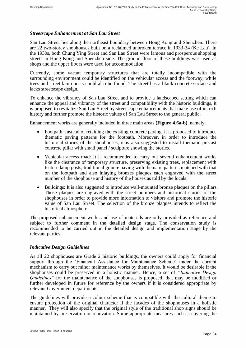
Planning Department Agreement No. CE 48/2008 Study on the Enhancement of the Sha Tau Kok Rural Township and Surrounding Areas - Feasibility Study
Final Report
209564 | STK Final Report | Feb 2013
Page 34
Streetscape Enhancement at San Lau Street
San Lau Street lies along the northeast boundary between Hong Kong and Shenzhen. There are 22 two-storey shophouses built on a reclaimed unbroken terrace in 1933-34 (Ke Lau). In the 1930s, both Chung Ying Street and San Lau Street were famous and prosperous shopping streets in Hong Kong and Shenzhen side. The ground floor of these buildings was used as shops and the upper floors were used for accommodation.
Currently, some vacant temporary structures that are totally incompatible with the surrounding environment could be identified on the vehicular access and the footway; while trees and street lamp posts could also be found. The street has a blank concrete surface and lacks streetscape design.
To enhance the vibrancy of San Lau Street and to provide a landscaped setting which can enhance the appeal and vibrancy of the street and compatibility with the historic buildings, it is proposed to revitalize San Lau Street by streetscape enhancements that make use of its rich history and further promote the historic values of San Lau Street to the general public.
Enhancement works are generally included in three main areas (Figure 4.6a-b), namely:
Footpath: Instead of retaining the existing concrete paving, it is proposed to introduce thematic paving patterns for the footpath. Moreover, in order to introduce the historical stories of the shophouses, it is also suggested to install thematic precast concrete pillar with small panel / sculpture showing the stories.
Vehicular access road: It is recommended to carry out several enhancement works like the clearance of temporary structure, preserving existing trees, replacement with feature lamp posts, traditional granite paving with thematic patterns matched with that on the footpath and also inlaying bronzes plaques each engraved with the street number of the shophouse and history of the houses as told by the locals.
Buildings: It is also suggested to introduce wall-mounted bronze plaques on the pillars. Those plaques are engraved with the street numbers and historical stories of the shophouses in order to provide more information to visitors and promote the historic value of San Lau Street. The selection of the bronze plaques intends to reflect the historical atmosphere.
The proposed enhancement works and use of materials are only provided as reference and subject to further comment in the detailed design stage. The conservation study is recommended to be carried out in the detailed design and implementation stage by the relevant parties.
Indicative Design Guidelines
As all 22 shophouses are Grade 2 historic buildings, the owners could apply for financial support through the ‗Financial Assistance for Maintenance Scheme‘ under the current mechanism to carry out minor maintenance works by themselves. It would be desirable if the shophouses could be preserved in a holistic manner. Hence, a set of “Indicative Design Guidelines” for the maintenance of the shophouses is proposed, that may be modified or further developed in future for reference by the owners if it is considered appropriate by relevant Government departments.
The guidelines will provide a colour scheme that is compatible with the cultural theme to ensure protection of the original character if the facades of the shophouses in a holistic manner. They will also specify that the original style of the traditional shop signs should be maintained by preservation or renovation. Some appropriate measures such as covering the
Planning Department Agreement No. CE 48/2008 Study on the Enhancement of the Sha Tau Kok Rural Township and Surrounding Areas - Feasibility Study
Final Report
209564 | STK Final Report | Feb 2013
Page 35
air-conditioners to beautify and minimise the visual impact, inspecting and repairing cracks, and installing window awnings or canopies to reduce solar heat gain, improve the overall street facades in a harmony way and improve the durability, etc will be recommended. (Figure 4.6c).
Respecting the free choice of the owners of the shophouses, this recommendation of introducing plaques for the shophouses and adherence to the Indicative Design Guidelines for the shophouses along San Lau Street will be implemented on a voluntary basis. They can decide whether to join such project or carry out those suggested enhancement works for their buildings.
Improvement Works for the Nullah near San Lau Street
The existing nullah along San Lau Street, which acts as a boundary between the HK and Shenzhen side, is in poor condition, as the waste materials/rubbish in STK Hoi flow back into the nullah. This leads to the accumulation of waste materials/rubbish that gives rise to noticeable odour.
In order to prevent the accumulation of sediment/rubbish at the nullah along San Lau Street, a total of two trash grilles (one for incoming water flow, one for water outfall) are proposed at the entrance of the nullah (Figure 4.7), and regular dredging/clearance work is also proposed.
Detailed investigation (such as materials, levels, exact locations etc.) of the proposed improvement works of the nullah is subjected to further design in the detailed design and construction stage. Subject to further investigation and discussions, Drainage Services Department (DSD) can also serve as the implementation, management and maintenance agent for the enhancement works.
It is also understood from Lands Department that the boundary of the Hong Kong Special Administrative Region (HKSAR) follows the centre line of the ditch/channel, running along the eastern side of San Lau Street. Therefore, the implementation of setting the trash grilles will be also subject to further liaison with relevant bodies on the Shenzhen side in the future engineering feasibility study. Moreover, the Shenzhen Government has already planned to carry out improvement works on the STK River to increase the existing flood protection level to 1 in 50 years. Therefore, it is anticipated that the flooding problem in the adjoining area of the nullah will be improved.
Local Open Space at Shun Lung Street
Due to its proximity to the waterfront area, it is proposed to transform the piece of vacant government land zoned ―Industrial‖ (―I‖) and ―Amenity‖ (―A‖) with 0.11 ha on Sha Tau Kok Area Layout Plan No. L/STK/2 near the STK Public Pier into a local open space (―LO‖) for the enjoyment of the local residents (Figure 4.8a). Permanent use is subject to confirmation or re-arrangements when the proposal of opening up the STK Town is confirmed later on.
The proposed LO could also serve as a tourist holding area if required. It also provides a central focal point that gives visitors a positive impression when they arrive at STK Town.
A compass motif is adopted in the LO as the paving pattern of the open space, which serves as a direction marker that points visitors to the Linkage Area (Figure 4.8a). To provide an outdoor open-air public space and avoid blocking the seaview, it is recommended that no fencing is introduced to the area. Soft landscape elements such as planters could be introduced to set the boundary and create spatial enclosure for the open space (Figure 4.8a-c).
Planning Department Agreement No. CE 48/2008 Study on the Enhancement of the Sha Tau Kok Rural Township and Surrounding Areas - Feasibility Study
Final Report
209564 | STK Final Report | Feb 2013
Page 36
Three-Tier Information System
The locations of tourist spots in both Study Area and Linkage Area are scattered with limited physical connection among the proposed tourist attractions and locations for tourist activities. A Three-Tier Information System is therefore recommended to establish the connections among these proposals and enhance the presence of the Linkage Area by introducing them in the STK Town (Figure 4.9).
1st Tier – “Welcoming Point” – Understanding of the Indispensable Relationship between STK Town and the Linkage Area: The 1st Tier information would be provided at the Local Open Apace at Shun Lung Street. It is the welcoming point for tourists, as well as the start of the journey. Information panels will be installed to assist tourists in understanding the historic background and appreciate such intangible/invisible linkage between STK Town and the Linkage Area.
2nd Tier – “Arrival Point” at Each Area: The 2nd Tier information would be provided at the ―arrival point‖ of STK Town and Linkage Area to serve as a directional signage to facilitate tourists locating the attractions in each area. At the arrival point at the pier in each Linkage Area, informative display boards with a map showing the location of the tourist attractions would be installed to let tourists get a glimpse of the Linkage Area at the first instance. The content of the display board could include the history and culture of the Linkage Area as well as its ecological or other natural features, if any.
3rd Tier – “Tourist Attractions” at Each Spot: The 3rd Tier information would be placed and located at every tourist attraction in STK Town and the Linkage Area, in order to provide an introduction of the point of interest. It could be in the form of a ―flip book‖ signage for historical images, view compass panel for scenic attractions, stone/bronze plaques on the floor as paving pattern or wall mounted signage for specific tourist attractions, etc. Apart from information plates and panels, some directional sign posts currently provided by the Tourism Commission in other tourist areas would also be integrated in this system, and mainly served as providing directions to tourist attractions or tourism facilities like toilets.
Conceptual Enhancement Proposals in the Linkage Area
The Linkage Area is of high ecological and landscape value, and its tranquil rural setting should be preserved as far as possible for both local residents and visitors. The Linkage Area, which includes the coastal area in NENT and the outlying islands, possesses its own characteristics. It would be appropriate to strengthen their uniqueness in order to offer tourists a variety of activities and experience. Therefore, some small-scale conceptual enhancement proposals with minor construction works are proposed to enhance the tourism potential of the Linkage Area without compromising the ecologically-sensitive environment. The conceptual enhancement proposals for Linkage Area are shown in Figure 4.10 and listed in Table 4.3:
Table 4.3 Conceptual Enhancement Proposals in Linkage Area
Lai Chi Wo Proposed Ecological Centre
Public Toilet
2nd Tier & 3rd Tier Information Board
Fung Hang 2nd Tier Information Board
Kuk Po Public Toilet
2nd Tier Information Board
Planning Department Agreement No. CE 48/2008 Study on the Enhancement of the Sha Tau Kok Rural Township and Surrounding Areas - Feasibility Study
Final Report
209564 | STK Final Report | Feb 2013
Page 37
Yung Shue Au Public Toilet (Movable)
2nd Tier Information Board
So Lo Pun Public Toilet
2nd Tier Information Board
Sam A Tsuen 2nd Tier Information Board
Ap Chau 2nd Tier & 3rd Tier Information Board
Kat O 2nd Tier & 3rd Tier Information Board
4.5.2.1 Tourism Supporting Facilities at Lai Chi Wo
The charm of the Linkage Area is, to a large extent, expressed by its rural settlement which has been changing very gradually in the past decades. As such, the development of the Linkage Area should preferably be more ―organic‖ (i.e. without top-down, heavy-handed intervention from outside). A high degree of local initiation and participation in providing tourism-related services such as restaurants serving Hakka cuisine, overnight accommodations, refreshment kiosks, etc. was observed during our site visits. It is the ―organic‖ happenings that differentiate the sub-areas of the Linkage Area from each other. With the aim of minimizing external intervention, most sub-areas will be provided with basic tourism supporting facilities only.
For Lai Chi Wo, there is great potential of tourism development due to the ecological and cultural/historic value. Therefore, an Ecological Centre at the vacant village school is being proposed to complement the existing Geoheritage Centre in Lai Chi Wo to promote eco-tourism. Improvement works including addition of toilets and information boards are also proposed.
Proposed Ecological Centre in Lai Chi Wo
In addition to its rich ecological and natural resources, Lai Chi Wo is also rich in history and culture. There are 2 historic buildings at the Fung Shui Piazza in Lai Chi Wo Village, namely Hip Tin Temple & Hok Shan Monastery and the disused Siu Ying School. Lai Chi Wo is already a popular tourist destination mainly because of the various kinds of ecological attractions, the Lai Chi Wo Geoheritage Centre in the village and the tourist-supporting facilities by the Hong Kong Tourism Board (HKTB) and AFCD.
To complement the existing Lai Chi Wo Geoheritage Centre at the village house in Lai Chi Wo, it is proposed to create a new Eco-Cultural Destination, Lai Chi Wo Ecological Centre (Figure 4.11a-b), which could provide visitors with information on both the ecological features of the surrounding areas and the coastal, cultural and built heritage in a nice and tranquil environment. Implementation of the ecological centre will be further considered by the relevant Government departments.
Proposed Public Toilet Facilities in Lai Chi Wo
Based on the forecast of visitors to Lai Chi Wo, there is a need to provide one more toilet facility within the area. The proposed location is near the pier where most visitors will pass through. In view of the lack of sewage treatment facilities within some of the Linkage Area, it is recommended to use septic tanks or bio-toilets system to treat the sewage from proposed toilet facilities under this study.
Planning Department Agreement No. CE 48/2008 Study on the Enhancement of the Sha Tau Kok Rural Township and Surrounding Areas - Feasibility Study
Final Report
209564 | STK Final Report | Feb 2013
Page 38
Proposed 2nd & 3rd Tier Information Boards in Lai Chi Wo
Currently, there are several boards included both notice boards and information boards, together with the signage near the pier of Lai Chi Wo (Figure 4.12a). They are provided and installed by various Government departments, including, AFCD, HKTB, etc., which provide 2nd Tier information generally. To provide tourists an overall picture of Lai Chi Wo and avoid any confusion, it is proposed to consolidate the content of the existing information boards installed by AFCD & HKTB at a location near the pier, subject to agreement by the relevant parties (Figure 4.12b-c).
The installation of 3rd Tier information boards outside the Fung Shui Piazza and a graded building is also recommended to provide some historical background and information about the buildings and/or ―Hing Chun Yeuk‖, in order to enrich tourists‘ experience. It could be in the form of a ―flip book‖ signage for history illustration or inlaying bronze or stone plaques on the pavement. The installation of such system or structure should not create visual impact or affect the target objects or structures.
4.5.2.2 Tourism Supporting Facilities at other Linkage Area
Provision of Public Toilet Facilities
In order to cater for the needs of visitors and enhance the tourism activities of the Linkage Area, public toilet facilities, with minor construction works are proposed whenever appropriate. The toilet is a basic tourist-supporting facility and thus it is recommended that public toilets are provided for the visitors in every sub-area. After reviewing the existing toilet facilities and taking into the account of the projected visitors, it is recommended to construct a standard set of new public toilets on Government land in Kuk Po, Yung Shue Au, So Lo Pun, and Lai Chi Wo, which currently lack proper public toilets. The proposed locations would be within a short walking distance (approximately 10 minutes) from the piers or near the village area.
However, potable water supply has not been provided to existing facilities and villages in Yung Shue Au and So Lo Pun. Therefore, further investigation is required for the arrangement of alternative water supply to the proposed toilet facilities in these areas.
Proposed 2nd & 3rd Tier Information Boards
Numerous information boards near the pier of Lai Chi Wo provided maps and regulations for the Country Park and Marine Park, code for visiting the Geopark, and the existing tourist attractions in Lai Chi Wo separately. To provide tourists an overall picture of Lai Chi Wo and avoid confusion, it is proposed to consolidate the content of the existing information boards installed by AFCD & HKTB into 2nd Tier information boards.
Since there is no tourist information boards installed at Fung Hang and Kuk Po, a 2nd Tier information board would be provided at the pier area in each of these two sub-areas of the Linkage Area in order to provide information of the tourist attractions in the area. While keen hikers are usually able to locate themselves at Yung Shue Au and So Lo Pun, those who are not familiar with the areas may require more directional signage. Therefore, it is proposed to install 2nd Tier information boards at the pier area of Yung Shue Au and So Lo Pun as well, where there is currently no provision of tourist information board. Similarly, Sam A Tsuen currently also does not have any tourist information boards. Therefore, it has been proposed to install a 2nd Tier information board at the pier area to provide some general information of

Planning Department Agreement No. CE 48/2008 Study on the Enhancement of the Sha Tau Kok Rural Township and Surrounding Areas - Feasibility Study
Final Report
209564 | STK Final Report | Feb 2013
Page 39
the area to the tourists when they arrive. 2nd Tier information boards are also proposed near the piers in Ap Chau and Kat O, where some tourist attractions are already provided.
Currently, there are no 3rd Tier information boards at the above locations to provide the background and details of tourist attractions. It is therefore recommended that 3rd Tier information boards should be provided in the form of ―flip books‖, or on stone/bronze plaques mounted on walls or the floor at the above locations.
4.5.3 Integrated Vehicular and Pedestrian Improvement Plan
Overview of the transport and pedestrian improvement proposals
The transport and pedestrian improvement proposals associated with the IAIP will firstly
address the pedestrian connectivity such as the pedestrian crossings arrangement across Shin
Hing Street and STK Road as well as Shin Hing Street and Chung Ying Street, then taking
the future tourism opportunities into account to consider the possible enhancement proposals.
The integrated vehicular and pedestrian improvement plan including the following two
components are detailed in the subsequent sections:
Pedestrian improvement proposals; and
Traffic improvement proposals.
Pedestrian Improvement Proposals
Various factors would be taken into account when designing the pedestrian precinct for the
STK Town. They include the nature of activities, the traffic pattern, the level of pedestrian
flow, and the availability of alternative routes to divert traffic when designing pedestrian
precinct. A series of pedestrian facilities are proposed to achieve a pedestrian precinct
environment for the local residents. The proposed pedestrian improvement proposals are
shown in Figure 4.13, which include: implementation of traffic calming measures such as
raised crossing platform with widening of footpath, coloured paving and application of road-
markings and red-tar dressing in the area to alert local residents and tourists. A low speed
limit within the town should also be considered as an added safety measure. These features
are proposed to be implemented at the crossings along Shun Hing Street, STK Road (Shek
Chung Au), and other crossing points at Shun Hing Street / Chung Ying Street. These
facilities would improve safety at crossings by slowing traffic passing through them and also
improve the pedestrian flow. It is anticipated that the implementation of these traffic calming
measures would have minimal impact on vehicular traffic due to the low traffic flow. As STK
Town remains in the Closed Area, the number of vehicles in the Town will also be limited.
Traffic Improvement Proposal
The revised Integrated Area Improvement Plan assumes that the STK Public Pier will be opened up for group tourists during weekends and public holidays only and the maximum number of daily visitors arriving at STK Public Pier is 500 for weekends and public holidays.
In view of the tourism activities at the proposed open space near STK Public Pier, it is proposed to provide an on-street coach pick-up / drop-off point to the east of the open space. The existing kerb will be realigned to provide a 2.0m wide pedestrian footpath for pedestrian access as well as boarding and alighting. The proposed footpath will provide direct connection to the open space as shown in Figure 4.14. The provision of pick-up / drop-off at
Planning Department Agreement No. CE 48/2008 Study on the Enhancement of the Sha Tau Kok Rural Township and Surrounding Areas - Feasibility Study
Final Report
209564 | STK Final Report | Feb 2013
Page 40
the cul-de-sac of Shun Lung Street is anticipated to have minimal impact on the traffic and operation of the existing car park.
4.6 Tourism Proposal
Based on the previous assessment of the opening-up options and discussions with the locals, the STK Public Pier is proposed to be opened up for guided tours at weekends and public holidays to access the Linkage Area for sightseeing. The initial maximum number of tourists allowed per day will be 500 people. The STK community has to reach a consensus on the security measures required for this proposal before it can be taken forward.
4.7 Stage 2 Community Engagement Programme
A 2-month Stage 2 Community Engagement Programme (CEP) of the Study was launched in January 2012 and completed on March 2012 to solicit public views on the conceptual enhancement proposals and Integrated Area Improvement Plan. Valuable comments from rural committee members, district councillors and written comments from general public were received during that period.
Suggestions were sorted into various categories for further analysis, such as rationalising the land use pattern, improvement of infrastructure facilities, adequacy of tourist supporting facilities, as well as the conservation of natural habitats and cultural heritage. There were some requests from the public for rural township enhancement to open up STK Town to enhance the local economy, the quality of life and improve job opportunities. There was a general consensus to develop STK Town by promoting its natural resources through eco-tourism and connection with the Linkage Area.
The Study Area could also serve as a gateway to integrate with the Linkage Area for tourism activities. However, the proposed tourism activities and rural township enhancement should take environmental protection into account so as to retain the natural landscape. Taking into account the public comments, the IAIP was refined as appropriate. Subsequently, briefing sessions were provided to the North District Council and the STK Area Rural Committee for further discussion.
Planning Department Agreement No. CE 48/2008 Study on the Enhancement of the Sha Tau Kok Rural Township and Surrounding Areas - Feasibility Study
Final Report
209564 | STK Final Report | Feb 2013
Page 41
5 Review of the Layout Plan
5.1 Background
A review on the approved Sha Tau Kok Area - Layout Plan No. L/STK/2 (LP) has been
undertaken (Figure 5.1). The review is tasked to examine whether the conceptual
enhancement proposals recommended in Chapter 3 can be taken forward under the current
zonings of the LP and whether amendments to the zonings are required to facilitate future
implementation of the recommended works.
A majority of the Study Area is currently covered by the LP as shown in Figure 5.1. The LP
was prepared with intention of providing a planning framework, within which the future
development of the settlement can take place in a coherent and logical manner. Up till now,
many of the proposals/zonings in the LP are still not yet realised and required to be updated
based on the latest circumstances.
STK Town is located in a sensitive location within the FCA. As stated in the Explanatory
Statement of the LP approved by the then District Planning Committee on 1 November 1989,
the general policy is to discourage any influx of population into the area for commercial or
industrial activities. Substantial private development or investment in the area is not
encouraged. The main objectives of the LP are listed as follows:
To formulate firm proposals for implementation of the development/redevelopment of
the township and to ascertain their engineering feasibility,
To improve the living and working environment of the residents,
To provide the necessary community, educational and recreational facilities, and
To improve the circulation system and to provide parking facilities in the area.
Planned land use zonings within the Study Area under this LP include ―Special Residential‖ (―RS‖), ―Residential Zone 1‖ (―R1‖), ―Village Development Area‖ (―VDA‖), ―Government Reservation‖ (―G‖), ―Institution & Community‖ (―IC‖), ―Educational‖ (―E‖), ―Industrial‖ (―I‖), ―District Open Space‖ (―DO‖), ―Local Open Space‖ (―LO‖), ―Amenity Area‖ (―A‖), ―Other Specified Uses‖ (―OU‖), and ―Countryside Conservation Area‖ (―CCA‖).
The review of the LP is carried out here based on the enhancement proposals for STK Town and the review of the ―V‖ zone expansion by taking into account the 10-year Small House demand of both Shan Tsui and Kong Ha Villages.
5.2 Proposed Revision
Based on the conceptual enhancement proposals, several areas covered by the LP need to be amended. This section proposes zoning amendments where the existing zoning(s) does not reflect the proposed intended uses focusing on areas covered by the conceptual enhancement proposals (Figure 5.4). Planning intention and the associated planning parameters for the proposed zonings are also provided. The relevant amendment is described below:
Planning Department Agreement No. CE 48/2008 Study on the Enhancement of the Sha Tau Kok Rural Township and Surrounding Areas - Feasibility Study
Final Report
209564 | STK Final Report | Feb 2013
Page 42
Amendment related to the proposed Local Open Space at Shun Lung Street
The proposed ―LO‖ would be located at Shun Lung Street near the STK Public Pier. The vacant site is currently zoned as ―I‖ and ―Amenity‖. Due to its proximity to the waterfront area, it is intended to create an open space for public enjoyment. It may also serve as a holding place for tours to wait for the ferry/coach departure if required.
According to the conceptual enhancement proposal in IAIP, it is proposed to re-zone the ―I‖ and ―A‖ sites to ―LO‖. The following table provides the details of the proposed zonings.
Table 5.1 Proposed Zoning for the Local Open Space at Shun Lung Street
Site Area: 844m² 233m²
Existing uses in layout plan: ―Industrial‖ ―Amenity‖
Land Status: Government Land
Existing Use: Vacant Vacant
Existing Site Area: 1077 m²
Proposed Use: Open Space with sitting area, toilet facilities and soft-drink vender machine etc.
Proposed Zoning: ―Local Open Space (LO)‖
Part of the steps along the waterfront promenade and adjoining the ―LO‖ is also be proposed to be constructed and continued to be shown ―Road‖ (Figure 5.2).
The planning intention of ―LO‖ is to provide a sizeable outdoor open-air public space serving the needs of local residents as well as the visitors. A pavilion will also be provided to create more shading area for resting and public toilets are to be included. Landscaping, sitting area and soft drink vending machines are also provided.
The above described amendment is shown in Figure 5.4.
5.3 Expansion of Village Development Area
Two recognized villages, namely Shan Tsui Tsuen (part) and Kong Ha Village are located within the Study Area. Kong Ha Village lies near the Lin Ma Hang Road in STK Town. The existing village falls into the ―VDA‖ on the LP. As only a small portion of the Shan Tsui Tsuen falls within the boundary of the Study Area, the ―VDA‖ of this village will not be reviewed under the Study.
Table 5.2 shows the 10-year Small House demand forecast for Kong Ha Village i.e. 110.
Table 5.2 10-year SH Forecast Demand for Kong Ha Village
Outstanding Small House
Applications 10-year SH Forecast
Demand
Kong Ha Village
2 110
Based on the data on the 10-year SH forecast, this Study has reviewed whether the existing ―VDA‖ zone is sufficiently large enough to accommodate the SH demand in the next 10 years. Assuming 40 Small Houses per hectare, it is estimated that additional land reserve is required to meet the demand as below:
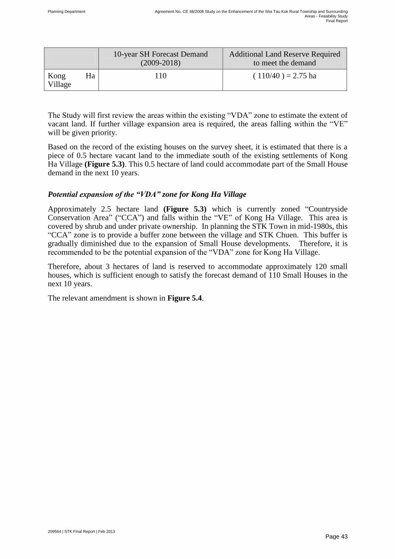
Planning Department Agreement No. CE 48/2008 Study on the Enhancement of the Sha Tau Kok Rural Township and Surrounding Areas - Feasibility Study
Final Report
209564 | STK Final Report | Feb 2013
Page 43
10-year SH Forecast Demand
(2009-2018) Additional Land Reserve Required
to meet the demand
Kong Ha Village
110 ( 110/40 ) = 2.75 ha
The Study will first review the areas within the existing ―VDA‖ zone to estimate the extent of vacant land. If further village expansion area is required, the areas falling within the ―VE‖ will be given priority.
Based on the record of the existing houses on the survey sheet, it is estimated that there is a piece of 0.5 hectare vacant land to the immediate south of the existing settlements of Kong Ha Village (Figure 5.3). This 0.5 hectare of land could accommodate part of the Small House demand in the next 10 years.
Potential expansion of the “VDA” zone for Kong Ha Village
Approximately 2.5 hectare land (Figure 5.3) which is currently zoned ―Countryside Conservation Area‖ (―CCA‖) and falls within the ―VE‖ of Kong Ha Village. This area is covered by shrub and under private ownership. In planning the STK Town in mid-1980s, this ―CCA‖ zone is to provide a buffer zone between the village and STK Chuen. This buffer is gradually diminished due to the expansion of Small House developments. Therefore, it is recommended to be the potential expansion of the ―VDA‖ zone for Kong Ha Village.
Therefore, about 3 hectares of land is reserved to accommodate approximately 120 small houses, which is sufficient enough to satisfy the forecast demand of 110 Small Houses in the next 10 years.
The relevant amendment is shown in Figure 5.4.

Planning Department Agreement No. CE 48/2008 Study on the Enhancement of the Sha Tau Kok Rural Township and Surrounding Areas - Feasibility Study
Final Report
209564 | STK Final Report | Feb 2013
Page 44
6 Technical Assessments
Technical assessments were conducted to ascertain the technical feasibility and environmental acceptability of the proposals, including the urban design aspect. It is understood that existing developments and planned developments on the Layout Plan No. L/STK/2 should have been taken into account during the design and construction of the relevant supporting infrastructure.
The technical assessments have been based on the following factors arising from the recommended conceptual enhancement proposals:
Daily 500 tourists to STK Public Pier and Linkage Area (weekends and public
holidays only)
Not more than 10 additional coaches to have access to STK Public Pier
daily(weekends and public holidays only)
According to the Explanatory Statement of the STK Layout Plan No. L/STK/2, it is stated that the total planned population in Sha Tau Kok upon full development will be in the region of 6,000 people. Taking into account the residential developments at three residential sites and ―VDA‖ zone in Kong Ha, the population will reach to about 7,300.
6.1 Traffic Impact Assessment
According to the overall planning and enhancement framework, a number of conceptual enhancement proposals have been recommended and broad technical assessments have been undertaken to evaluate the impacts of these proposals. The traffic impact assessment (TIA) includes analysis of the existing traffic situation (Figures 6.1 and 6.2) and derivation of future year traffic forecasts as well as junction performance analysis of the existing traffic and future year traffic at key junctions within the Study Area.
The main objective of the traffic impact assessment is to a) assess the existing traffic condition; b) assess the future traffic condition and the anticipated traffic implications from the proposed improvement proposals of the Study Area as well as a preliminary traffic impact assessment on the proposed public housing development
2 in the Study Area; and c) devise
appropriate traffic improvement / management measures / strategies to ameliorate the traffic impact generated from the proposed development.
6.1.1 Future Traffic Condition
Assessment Scenarios
Considering that the proposed population intake year is 2018, the year 2018 was adopted as the design year. Two assessment scenarios were assessed for the design year namely:
2018 Reference Case – 2018 Background Traffic Flows; and
2 The mentioned site here is zoned as ―R1‖ in STK Layout Plan No. L/STK/2 and will still be reserved for residential developments. It is
understood that such planned developments on the Layout Plan No. L/STK/2 should have been taken into account already during the design and construction of the relevant supporting infrastructure. The assessments or estimations here will provide the results of the cumulative
effect of the new proposals under this Study.
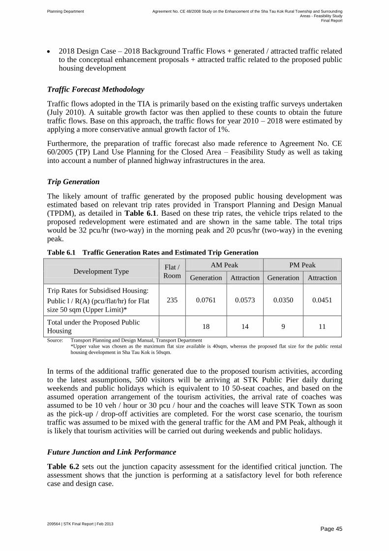
Planning Department Agreement No. CE 48/2008 Study on the Enhancement of the Sha Tau Kok Rural Township and Surrounding Areas - Feasibility Study
Final Report
209564 | STK Final Report | Feb 2013
Page 45
2018 Design Case – 2018 Background Traffic Flows + generated / attracted traffic related to the conceptual enhancement proposals + attracted traffic related to the proposed public housing development
Traffic Forecast Methodology
Traffic flows adopted in the TIA is primarily based on the existing traffic surveys undertaken (July 2010). A suitable growth factor was then applied to these counts to obtain the future traffic flows. Base on this approach, the traffic flows for year 2010 – 2018 were estimated by applying a more conservative annual growth factor of 1%.
Furthermore, the preparation of traffic forecast also made reference to Agreement No. CE 60/2005 (TP) Land Use Planning for the Closed Area – Feasibility Study as well as taking into account a number of planned highway infrastructures in the area.
Trip Generation
The likely amount of traffic generated by the proposed public housing development was estimated based on relevant trip rates provided in Transport Planning and Design Manual (TPDM), as detailed in Table 6.1. Based on these trip rates, the vehicle trips related to the proposed redevelopment were estimated and are shown in the same table. The total trips would be 32 pcu/hr (two-way) in the morning peak and 20 pcus/hr (two-way) in the evening peak.
Table 6.1 Traffic Generation Rates and Estimated Trip Generation
Development Type Flat /
Room
AM Peak PM Peak
Generation Attraction Generation Attraction
Trip Rates for Subsidised Housing:
Public l / R(A) (pcu/flat/hr) for Flat
size 50 sqm (Upper Limit)*
235 0.0761 0.0573 0.0350 0.0451
Total under the Proposed Public
Housing 18 14 9 11
Source: Transport Planning and Design Manual, Transport Department *Upper value was chosen as the maximum flat size available is 40sqm, whereas the proposed flat size for the public rental
housing development in Sha Tau Kok is 50sqm.
In terms of the additional traffic generated due to the proposed tourism activities, according to the latest assumptions, 500 visitors will be arriving at STK Public Pier daily during weekends and public holidays which is equivalent to 10 50-seat coaches, and based on the assumed operation arrangement of the tourism activities, the arrival rate of coaches was assumed to be 10 veh / hour or 30 pcu / hour and the coaches will leave STK Town as soon as the pick-up / drop-off activities are completed. For the worst case scenario, the tourism traffic was assumed to be mixed with the general traffic for the AM and PM Peak, although it is likely that tourism activities will be carried out during weekends and public holidays.
Future Junction and Link Performance
Table 6.2 sets out the junction capacity assessment for the identified critical junction. The assessment shows that the junction is performing at a satisfactory level for both reference case and design case.
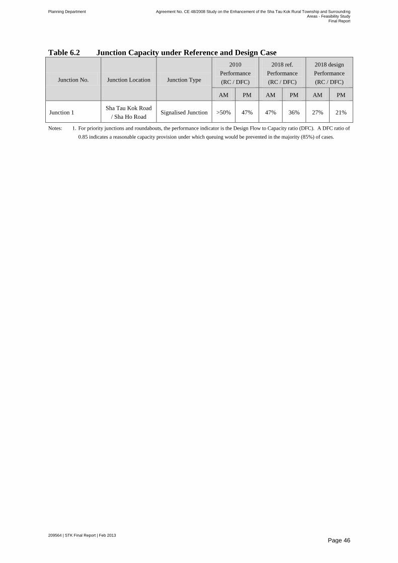
Planning Department Agreement No. CE 48/2008 Study on the Enhancement of the Sha Tau Kok Rural Township and Surrounding Areas - Feasibility Study
Final Report
209564 | STK Final Report | Feb 2013
Page 46
Table 6.2 Junction Capacity under Reference and Design Case
Junction No. Junction Location Junction Type
2010
Performance
(RC / DFC)
2018 ref.
Performance
(RC / DFC)
2018 design
Performance
(RC / DFC)
AM PM AM PM AM PM
Junction 1 Sha Tau Kok Road
/ Sha Ho Road Signalised Junction >50% 47% 47% 36% 27% 21%
Notes: 1. For priority junctions and roundabouts, the performance indicator is the Design Flow to Capacity ratio (DFC). A DFC ratio of
0.85 indicates a reasonable capacity provision under which queuing would be prevented in the majority (85%) of cases.
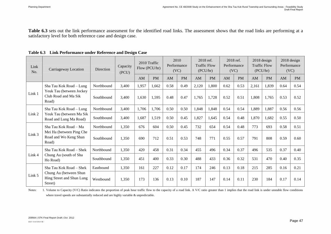
Planning Department Agreement No. CE 48/2008 Study on the Enhancement of the Sha Tau Kok Rural Township and Surrounding Areas - Feasibility Study Draft Final Report
209564 | STK Final Report Draft | Oct 2012
錯誤! 未知的選項引數。 Page 47
Table 6.3 sets out the link performance assessment for the identified road links. The assessment shows that the road links are performing at a satisfactory level for both reference case and design case.
Table 6.3 Link Performance under Reference and Design Case
Link
No. Carriageway Location Direction
Capacity
(PCU)
2010 Traffic
Flow (PCU/hr)
2010
Performance
(VC)
2018 ref.
Traffic Flow
(PCU/hr)
2018 ref.
Performance
(VC)
2018 design
Traffic Flow
(PCU/hr)
2018 design
Performance
(VC)
AM PM AM PM AM PM AM PM AM PM AM PM
Link 1
Sha Tau Kok Road – Lung
Yeuk Tau (between Jockey
Club Road and Ma Sik
Road)
Northbound 3,400 1,957 1,662 0.58 0.49 2,120 1,800 0.62 0.53 2,161 1,839 0.64 0.54
Southbound 3,400 1,630 1,595 0.48 0.47 1,765 1,728 0.52 0.51 1,808 1,765 0.53 0.52
Link 2
Sha Tau Kok Road – Lung
Yeuk Tau (between Ma Sik
Road and Lung Ma Road)
Northbound 3,400 1,706 1,706 0.50 0.50 1,848 1,848 0.54 0.54 1,889 1,887 0.56 0.56
Southbound 3,400 1,687 1,519 0.50 0.45 1,827 1,645 0.54 0.48 1,870 1,682 0.55 0.50
Link 3
Sha Tau Kok Road – Ma
Mei Ha (between Ping Che
Road and Wo Keng Shan
Road)
Northbound 1,350 676 604 0.50 0.45 732 654 0.54 0.48 773 693 0.58 0.51
Southbound 1,350 690 712 0.51 0.53 748 771 0.55 0.57 791 808 0.59 0.60
Link 4
Sha Tau Kok Road – Shek
Chung Au (south of Sha
Ho Road)
Northbound 1,350 420 458 0.31 0.34 455 496 0.34 0.37 496 535 0.37 0.40
Southbound 1,350 451 400 0.33 0.30 488 433 0.36 0.32 531 470 0.40 0.35
Link 5
Sha Tau Kok Road – Shek
Chung Au (between Shun
Hing Street and Shun Lung
Street)
Eastbound 1,350 161 227 0.12 0.17 174 246 0.13 0.18 215 285 0.16 0.21
Westbound 1,350 173 136 0.13 0.10 187 147 0.14 0.11 230 184 0.17 0.14
Notes: 1. Volume to Capacity (V/C) Ratio indicates the proportion of peak hour traffic flow to the capacity of a road link. A V/C ratio greater than 1 implies that the road link is under unstable flow conditions
where travel speeds are substantially reduced and are highly variable & unpredictable.
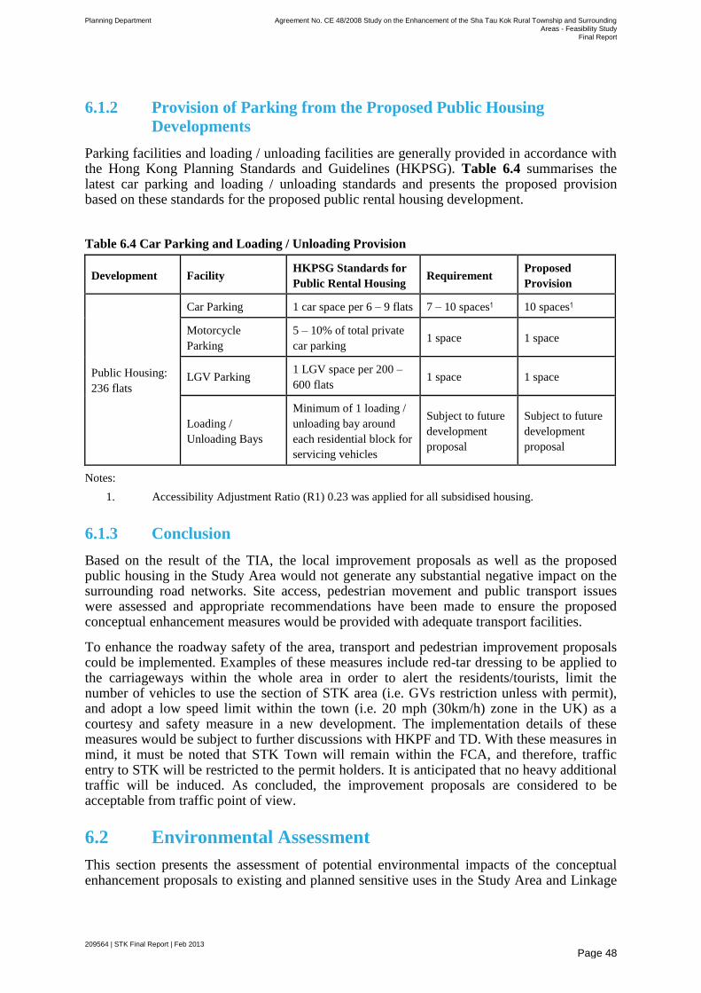
Planning Department Agreement No. CE 48/2008 Study on the Enhancement of the Sha Tau Kok Rural Township and Surrounding Areas - Feasibility Study
Final Report
209564 | STK Final Report | Feb 2013
Page 48
6.1.2 Provision of Parking from the Proposed Public Housing
Developments
Parking facilities and loading / unloading facilities are generally provided in accordance with the Hong Kong Planning Standards and Guidelines (HKPSG). Table 6.4 summarises the latest car parking and loading / unloading standards and presents the proposed provision based on these standards for the proposed public rental housing development.
Table 6.4 Car Parking and Loading / Unloading Provision
Development Facility HKPSG Standards for
Public Rental Housing Requirement
Proposed
Provision
Public Housing:
236 flats
Car Parking 1 car space per 6 – 9 flats 7 – 10 spaces1 10 spaces1
Motorcycle
Parking
5 – 10% of total private
car parking 1 space 1 space
LGV Parking 1 LGV space per 200 –
600 flats 1 space 1 space
Loading /
Unloading Bays
Minimum of 1 loading /
unloading bay around
each residential block for
servicing vehicles
Subject to future
development
proposal
Subject to future
development
proposal
Notes:
1. Accessibility Adjustment Ratio (R1) 0.23 was applied for all subsidised housing.
6.1.3 Conclusion
Based on the result of the TIA, the local improvement proposals as well as the proposed public housing in the Study Area would not generate any substantial negative impact on the surrounding road networks. Site access, pedestrian movement and public transport issues were assessed and appropriate recommendations have been made to ensure the proposed conceptual enhancement measures would be provided with adequate transport facilities.
To enhance the roadway safety of the area, transport and pedestrian improvement proposals could be implemented. Examples of these measures include red-tar dressing to be applied to the carriageways within the whole area in order to alert the residents/tourists, limit the number of vehicles to use the section of STK area (i.e. GVs restriction unless with permit), and adopt a low speed limit within the town (i.e. 20 mph (30km/h) zone in the UK) as a courtesy and safety measure in a new development. The implementation details of these measures would be subject to further discussions with HKPF and TD. With these measures in mind, it must be noted that STK Town will remain within the FCA, and therefore, traffic entry to STK will be restricted to the permit holders. It is anticipated that no heavy additional traffic will be induced. As concluded, the improvement proposals are considered to be acceptable from traffic point of view.
6.2 Environmental Assessment
This section presents the assessment of potential environmental impacts of the conceptual enhancement proposals to existing and planned sensitive uses in the Study Area and Linkage
Planning Department Agreement No. CE 48/2008 Study on the Enhancement of the Sha Tau Kok Rural Township and Surrounding Areas - Feasibility Study
Final Report
209564 | STK Final Report | Feb 2013
Page 49
Area Potential designated projects/elements proposed under the current improvement proposals are identified.
This section will present the relevant environmental legislation and standards, baseline environmental conditions of the Study Area and Linkage Area, identification of any pollution emission sources of the conceptual enhancement proposals on the existing and planned sensitive receivers, identification of any planned sensitive uses of the conceptual enhancement proposals that would be impacted by the existing pollution sources, evaluation of the potential environmental implications arising from the conceptual enhancement proposals , as well as proposals of mitigation measures required to reduce the environmental impacts if any. The environmental aspects covered in this section include air quality, noise, water quality and waste.
6.2.1 Air Quality
A qualitative air quality assessment has been conducted to identify the existing and planned air sensitive receivers (ASRs) and major air pollution sources, assess the vehicular emission and odour impact in the Study Area.
Air Sensitive Receivers
Representative ASRs have been identified in accordance with Annex 12 of the TM-EIAO. Existing ASRs are identified by means of reviewing topographic maps, aerial photos, and site inspections. They mainly include residential buildings, educational institutions, and place of public worship. The ecological centre at disused Siu Ying School in Lai Chi Wo is the only potential air sensitive receiver proposed under the improvement proposals.
Identification and Evaluation of Potential Environmental Impacts
Study Area
The conceptual enhancement proposals in the Study Area include 1) Streetscape Enhancement at San Lau Street; 2) Local Open Space at Market Street; 3) Local Open Space at Shun Lung Street and 4) Improvement Works for the Nullah near San Lau Street.
Construction Phase
The proposed improvement proposals in the Study Area would not involve any dust emitting activities. There are no excavation activities, backfilling, temporary storage of spoil on site, transportation/handling of spoil, etc. The streetscape enhancement would involve refurbishment and beautification works only. There is no change in the land uses for local open spaces at Market Street and Shun Lung Street and hence no construction activities would be involved. Dust emissions are therefore not anticipated during the construction stage.
Operational Phase
There are neither newly planned ASRs nor planned air pollution sources under the improvement proposals within the Study Area. The proposed local open spaces at Market Street and Shun Lung Street will be used by the local community. The future visitors will be transient only. According to HKPSG, a buffer distance is required for active and passive recreational uses for an open space site; where amenity areas are permitted in any situation. Although these two proposed open space sites are not planned for recreational purpose,
Planning Department Agreement No. CE 48/2008 Study on the Enhancement of the Sha Tau Kok Rural Township and Surrounding Areas - Feasibility Study
Final Report
209564 | STK Final Report | Feb 2013
Page 50
should there be any active and passive recreational uses in future plan, a 5m buffer distance shall also be allowed from Shun Hing Street and Shun Lung Street which are both local distributors.
The existing STKSTW, sewage pumping stations at San Lau Street and Shun Lung Street, and the nullah are located at about 530m, 90m, 220m and 55m from the open space at Shun Lung Street respectively; and at about 480m, 110m, 90m and 45m from the open space at Market Street, respectively. The reconnaissance surveys conducted in 2009 and 2010 have revealed that odour was not noticeable at source and sensitive receivers, except there was a faint fishy smell from the STK Hoi barely detectable at location immediately next to the nullah at San Lau Street. Nonetheless, these two proposed open spaces will be used by local community, and they are not planned for any recreational uses under the improvement proposals. Nonetheless, given the setback distance, potential odour impacts are also not anticipated. Improvement works for the nullah at San Lau Street is also recommended to further improve the odour condition.
The proposed streetscape enhancement works at San Lau Street and the improvement works for the nullah would improve the surrounding environment for the local communities. No air pollution sources are expected. Air quality impacts on the sensitive receivers are therefore not anticipated.
It should be noted that the public housing development at the vacant site at Shun Hing Street near STK Chuen is currently zoned as ―Residential-Zone 1‖ on the STK Area – Layout Plan. The future project proponent shall carry out the detailed environmental assessment on this site.
The current proposals would allow a maximum of 500 tourists daily to have access to the STK Public Pier during weekends and public holidays. Tourists will be dropped off at the STK Public Pier which will be opened up for tourists for access to the Linkage Area. It is estimated that it will only induce not more than 10 coaches per day during weekends and public holidays. Given the small number of induced traffic, potential air quality impacts are not anticipated.
Linkage Area
The conceptual enhancement proposals in the Linkage Area include 1) proposed Lai Chi Wo Ecological Centre; 2) Installation of information boards; and 3) provision of new public toilets at Kuk Po, Yung Shue Au, So Lo Pun and Lai Chi Wo.
Construction Phase
The installation of the information boards and renovation of the Siu Ying School in Lai Chi Wo would not involve excavation activities, backfilling, temporary storage of spoil on site, transportation/handling of spoil, etc. The proposed public toilets would involve very minor works only. Potential dust impact would be insignificant.
Operational Phase
There are no planned air pollution sources under the conceptual enhancement proposals within the Linkage Area. The ecological centre at disused Siu Ying School in Lai Chi Wo is the only potential air sensitive receiver proposed under the IAIP.
There will have neither provision of new vehicular access within the Linkage Area nor connections to the existing roads including the Brides Pool Road and Luk Keng Road. Thus,
Planning Department Agreement No. CE 48/2008 Study on the Enhancement of the Sha Tau Kok Rural Township and Surrounding Areas - Feasibility Study
Final Report
209564 | STK Final Report | Feb 2013
Page 51
induced traffic and associated air quality impacts on the existing and planned sensitive receivers are not anticipated. There are also no existing industrial chimneys and air pollution sources located within Lai Chi Wo. Potential air quality impacts on the proposed Ecological Centre at disused Siu Ying School in Lai Chi Wo are therefore not anticipated during operational stage.
Mitigation Measures
Potential air quality impacts are not anticipated during construction and operational stages. However, should there be any active and passive recreational uses for the two proposed open space sites in future plan, a 5m buffer distance shall be allowed from Shun Hing Street and Shun Lung Street according to HKPSG.
6.2.2 Noise
A qualitative noise impact assessment has been conducted to identify the existing, committed and planned noise sensitive receivers (NSRs) and major noise source in the Study Area.
Noise Sensitive Receivers
Representative NSRs have been identified in accordance with Annex 12 of the TM-EIAO. Existing ASRs are identified by means of reviewing topographic maps, aerial photos, and site inspections. They mainly include residential buildings, educational institutions, and place of public worship. The ecological centre at disused Siu Ying School in Lai Chi Wo is the only potential noise sensitive receiver proposed under the improvement proposals.
Identification and Evaluation of Potential Environmental Impacts
Study Area
The improvement proposals in the Study Area include 1) Streetscape Enhancement at San Lau Street; 2) Local Open Space at Market Street; 3) Local Open Space at Shun Lung Street and 4) Improvement Works for the Nullah near San Lau Street.
Construction Phase
The conceptual enhancement proposals in the Study Area would involve very minor works and activities only. There are no excavation activities, backfilling, temporary storage of spoil on site, transportation/handling of spoil, etc. The streetscape enhancement would involve refurbishment and beautification works only. There is no change in the land uses for local open space at Market Street which is zoned ―LO‖ on STK Area - Layout Plan. The proposed Local Open Space site at Shun Lung Street will be rezoned from ―I‖ and ―A‖ to ―LO‖. No construction activities would be involved in these two sites. Potential noise impacts are therefore not anticipated during construction stage.
Operational Phase
There are neither newly planned NSRs nor planned noise sources under the conceptual enhancement proposals within the Study Area. It should be noted that the public housing development at the vacant site at Shun Hing Street near STK Chuen is currently zoned as ―Residential-Zone 1‖ on the STK Area - Layout Plan. This site is not a proposal under the

Planning Department Agreement No. CE 48/2008 Study on the Enhancement of the Sha Tau Kok Rural Township and Surrounding Areas - Feasibility Study
Final Report
209564 | STK Final Report | Feb 2013
Page 52
current improvement plan. The future project proponent shall carry out the detailed environmental assessment on this site.
The current proposals would allow only a maximum of 500 tourists daily to STK Public Pier during weekends and public holidays. Tourists will be dropped off at the STK Public Pier which will be opened up for tourists for access to the Linkage Areas. It is estimated that it will only induce a maximum of 10 coaches per day during weekends and public holidays. Given the small number of induced traffic, potential road traffic noise impacts are not anticipated.
Linkage Area
The proposed improvement proposals in the Linkage Areas include 1) proposed Lai Chi Wo Ecological Centre; 2) Installation of information boards; and 3) provision of new public toilets at Kuk Po, Yung Shue Au, So Lo Pun and Lai Chi Wo.
Construction Phase
The installation of the information boards and renovation of the Siu Ying School in Lai Chi Wo would involve only refurbishment and beautification works. There are no excavation activities, backfilling, temporary storage of spoil on site, transportation/handling of spoil, etc. The proposed public toilets would involve very minor works only. Potential construction noise impact would be insignificant.
Operational Phase
There are no planned noise sources under the conceptual enhancement proposals within the Linkage Area. The Lai Chi Wo Ecological Centre at disused Siu Ying School is the only potential noise sensitive receiver proposed under the IAIP.
There will not be any provision of new vehicular access within Linkage Area nor connections to the existing roads including the Brides Pool Road and Luk Keng Road. Thus, induced traffic and associated road traffic noise impacts on the existing and planned sensitive receivers are not anticipated. There are also no existing noise sources and vehicular roads within Lai Chi Wo. Potential noise impacts on the proposed ecological centre at disused Siu Ying School in Lai Chi Wo are not anticipated during operational stage.
Mitigation Measures
Potential noise impacts are not anticipated during construction and operational stages. No mitigation measures are required.
6.2.3 Water Quality
A qualitative water quality assessment has been conducted to identify the existing and planned water sensitive receivers (WSRs) that are susceptible to water pollution incidences and major water pollution sources in the Study Area.
Water Sensitive Receivers
Potential water sensitive receivers (WSRs), including streams, mangroves, secondary contract zones, fish culture zones, country parks, marine parks, special areas, have been identified.
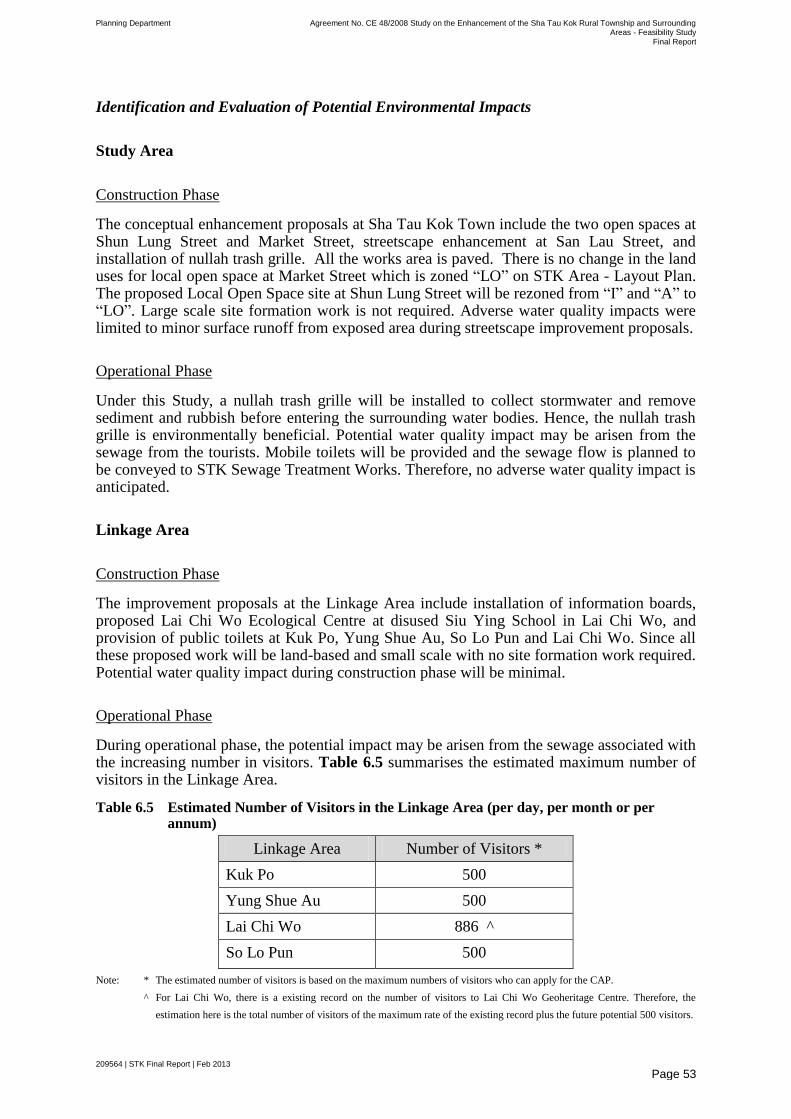
Planning Department Agreement No. CE 48/2008 Study on the Enhancement of the Sha Tau Kok Rural Township and Surrounding Areas - Feasibility Study
Final Report
209564 | STK Final Report | Feb 2013
Page 53
Identification and Evaluation of Potential Environmental Impacts
Study Area
Construction Phase
The conceptual enhancement proposals at Sha Tau Kok Town include the two open spaces at Shun Lung Street and Market Street, streetscape enhancement at San Lau Street, and installation of nullah trash grille. All the works area is paved. There is no change in the land uses for local open space at Market Street which is zoned ―LO‖ on STK Area - Layout Plan. The proposed Local Open Space site at Shun Lung Street will be rezoned from ―I‖ and ―A‖ to ―LO‖. Large scale site formation work is not required. Adverse water quality impacts were limited to minor surface runoff from exposed area during streetscape improvement proposals.
Operational Phase
Under this Study, a nullah trash grille will be installed to collect stormwater and remove sediment and rubbish before entering the surrounding water bodies. Hence, the nullah trash grille is environmentally beneficial. Potential water quality impact may be arisen from the sewage from the tourists. Mobile toilets will be provided and the sewage flow is planned to be conveyed to STK Sewage Treatment Works. Therefore, no adverse water quality impact is anticipated.
Linkage Area
Construction Phase
The improvement proposals at the Linkage Area include installation of information boards, proposed Lai Chi Wo Ecological Centre at disused Siu Ying School in Lai Chi Wo, and provision of public toilets at Kuk Po, Yung Shue Au, So Lo Pun and Lai Chi Wo. Since all these proposed work will be land-based and small scale with no site formation work required. Potential water quality impact during construction phase will be minimal.
Operational Phase
During operational phase, the potential impact may be arisen from the sewage associated with the increasing number in visitors. Table 6.5 summarises the estimated maximum number of visitors in the Linkage Area.
Table 6.5 Estimated Number of Visitors in the Linkage Area (per day, per month or per annum)
Linkage Area Number of Visitors *
Kuk Po 500
Yung Shue Au 500
Lai Chi Wo 886 ^
So Lo Pun 500
Note: * The estimated number of visitors is based on the maximum numbers of visitors who can apply for the CAP.
^ For Lai Chi Wo, there is a existing record on the number of visitors to Lai Chi Wo Geoheritage Centre. Therefore, the
estimation here is the total number of visitors of the maximum rate of the existing record plus the future potential 500 visitors.
Planning Department Agreement No. CE 48/2008 Study on the Enhancement of the Sha Tau Kok Rural Township and Surrounding Areas - Feasibility Study
Final Report
209564 | STK Final Report | Feb 2013
Page 54
Since there is no existing proper toilets at Kuk Po, Yung Shue Au, So Lo Pun, and Lai Chi Wo, additional toilet facilities will be provided to handle the sewage. As there will be no direct sewerage discharge in the Linkage Area, septic tank and soakaway systems will be applied and hence the water quality impact is considered minimal Effluent will be naturally degraded in the soakaway tanks. With the proper design of septic tank and soakaway systems, no adverse water quality impact is anticipated.
If package sewerage treatment facilities were adopted in Lai Chi Wo, discharge of treated effluent to downstream waterbodies will be the key water quality impact. Since the site location is close to or within the Yan Chau Tong Marine Park and the identified SSSIs, the package sewerage treatment facilities might be identified as a designated project under the Schedule 2 of Environmental Impact Assessment Ordinance and an environmental permit is required. The possible Schedule 2 project category includes:
F2: Sewage Treatment Works with an installed capacity of more than 5,000m3 per day and a
boundary of which is less than 200m from the nearest boundary of an existing or planned SSSIs, marine park or marine reserve.
Q1: All projects including new access roads, railways, sewers, sewage treatment facilities, earthworks, dredging works and other building work partly or wholly in an existing or gazetted proposed country park or special area, a conservation area, an existing or gazetted proposed marine park or marine reserve, a site of cultural heritage, and SSSIs.
Mitigation Measures
Study Area
Construction Phase
With the implementation of ProPECC PN 1/94 ―Construction Site Drainage‖ and ―Recommended Pollution Control Clauses for Construction Contracts‖ issued by EPD, the construction phase water quality impact will be fully mitigated. A discharge license, if necessary depending on actual site conditions, will be applied under the requirement of Water Pollution Control Ordinance.
Operational Phase
Adverse water quality impact is not anticipated, and therefore no mitigation measure is required.
Linkage Area
Construction Phase
Adverse water quality impact is not anticipated, and therefore mitigation measure is not required.
Operational Phase
Since the exact locations of septic tank and soakaway systems will only be able to be confirmed at detailed design and construction stage, the design shall comply with the requirements stipulated in the ―Practice Note for Professional Persons (ProPECC Note
Planning Department Agreement No. CE 48/2008 Study on the Enhancement of the Sha Tau Kok Rural Township and Surrounding Areas - Feasibility Study
Final Report
209564 | STK Final Report | Feb 2013
Page 55
PN5/93) on Building (Standards of Sanitary Fitments, Plumbing, Drainage Works and Latrines) Regulations 40(1), 40(2), 41(1) and 90‖. With the proper design of septic tank and soakaway systems, no adverse water quality impact is anticipated.
For adoption of bio-treatment systems, effluents will be discharged into Mirs Bay. The effluent, with high concentration of E. coli and nutrient, may deteriorate the water quality in Mirs Bay. A licence for discharging effluent into Mirs Bay should be required from the Authority. To minimize the potential water quality impact, effluent standards stipulated in the ―Technical Memorandum Standards for Effluents Discharged into Drainage and Sewerage Systems, Inland and Coastal Waters‖ should be met. With this effluent discharge control, no adverse water quality impact is anticipated.
With the proper design of septic tank and soakaway systems, and/or implementation of effluent standards for discharges from any package sewerage treatment facilities, no adverse water quality impact is anticipated.
6.2.4 Waste
Identification and Evaluation of Potential Environmental Impacts
Study Area
The conceptual enhancement proposals in the Study Area include 1) Streetscape Enhancement at San Lau Street; 2) Local Open Space at Market Street; 3) Local Open Space at Shun Lung Street and 4) Improvement Works for the Nullah near San Lau Street.
Construction Phase
The conceptual enhancement proposals in the Study Area would not involve excavation activities. There is no change in the land uses for local open spaces at Market Street and Shun Lung Street and hence no construction activities would be involved. The installation of the trash grille will also not involve any construction activities. Hence generation of wastes is not expected.
The streetscape enhancement would involve refurbishment and beautification works only. Activities will potentially result in generation of C&D wastes arising from demolition and general refuse from workers. However, the quantities are expected to be very small only as the works would be very small-scale and short-term. The C&D wastes are mostly inert materials such as rock, concrete, etc. The Contractor will be responsible for sorting the wastes into inert and non-inert portions. Inert material should be reused on site as far as practicable. Surplus inert C&D material shall be transported to public filling areas depending on the percentage of inert content. Non-inert portion of C&D material shall be reused whenever possible and be disposed of at landfills as a last resort. With implementation of proper waste management strategies, adverse environmental impact is not anticipated during construction stage.
Operational Phase
Tourists‘ rubbish (plastic bottles, paper, food wrapping, etc.) and the periodic clearance of rubbish from nullah are the major waste types generated during operational stage. The current proposal would allow only a maximum of 500 tourists daily to the Study Area and Linkage Areas during weekends and public holidays. Assuming a general refuse generation rate of
Planning Department Agreement No. CE 48/2008 Study on the Enhancement of the Sha Tau Kok Rural Township and Surrounding Areas - Feasibility Study
Final Report
209564 | STK Final Report | Feb 2013
Page 56
0.382 kg per visitor per day, the amount of general refuse to be generated will be about 191 kg per day only.
Recycling bins will be provided throughout the site. Recyclable materials such as plastic bottles, aluminium cans and paper will be collected by separate recycle bins and delivered to recyclers for recycling. The non-recyclable portion of waste generated will be collected and delivered to the designated refuse transfer station or landfill site for disposal by the licensed collector.
The rubbish from grille at nullah near San Lau Street will be collected periodically by licensed collector. They are all non-recyclable and should be properly wrapped in plastic to avoid environmental nuisance. They shall be delivered to the designated refuse transfer station or landfill site for final disposal.
With implementation of proper waste management strategies, adverse environmental impact is not anticipated during operational stage.
Linkage Area
The conceptual enhancement proposals in the Linkage Area include 1) proposed Lai Chi Wo Ecological Centre; 2) Installation of information boards; and 3) provision of new public toilets at Kuk Po, Yung Shue Au, So Lo Pun and Lai Chi Wo.
Construction Phase
The conceptual enhancement proposals in the Linkage Area would involve minor works and activities only. Prefabricated information boards are recommended to avoid generation of waste. The Lai Chi Wo Ecological Centre at disused Siu Ying School would involve refurbishment and beautification works only. The provision of toilets would also be minor works. Activities will result in generation of C&D wastes arising from demolition and general refuse from workers. However, the quantities are expected to be very small only as the works would be very small-scale and short-term. The C&D wastes are mostly inert materials such as soil, rock, concrete, etc. The Contractor will be responsible for sorting the wastes into inert and non-inert portions. Inert material should be reused on site as far as practicable. Surplus inert C&D material shall be transported to public filling areas depending on the percentage of inert content. Non-inert portion of C&D material shall be reused whenever possible and be disposed of at landfills as a last resort. With implementation of proper waste management strategies, adverse environmental impact is not anticipated during construction stage.
Operational Phase
As presented in above, the amount of general refuse to be generated from 500 tourists will be about 191 kg per day only during weekends and public holidays. With implementation of proper waste management strategies, adverse environmental impact is not anticipated during operational stage.
Mitigation Measures
The waste management hierarchy (1) avoidance and minimization; (2) re-use of materials; (3) recovery and recycling; and (4) treatment and disposal should be followed. The following mitigation measures should be implemented by the Contractor during construction stage:
Carry out on-site sorting of wastes into inert and non-inert portions.
Planning Department Agreement No. CE 48/2008 Study on the Enhancement of the Sha Tau Kok Rural Township and Surrounding Areas - Feasibility Study
Final Report
209564 | STK Final Report | Feb 2013
Page 57
Reuse and recycle as much of the C&D materials as possible on-site. Fill and C&D waste would be segregated and stored in different containers or skips to enhance re-use or recycling of materials and their proper disposal. Where practicable, concrete and masonry can be crushed and used as fill.
Implement a trip-ticket system for each works contract to ensure that the disposal of C&D materials are properly documented and verified.
Standard formwork or pre-fabrication would be used as far as practicable in order to minimise the arising of C&D materials. Use of wooden hoardings would not be used. Metal hoarding would be used to enhance the possibility of recycling.
Purchasing of construction materials would be carefully planned in order to avoid over ordering and wastage.
General refuse generated on-site should be stored in enclosed bins or compaction units separately from construction and chemical wastes, and collected by waste collector on a daily basis to minimize odour, pest and litter impacts.
During operational stage, measures would include the provision of recycling bins. Recyclable materials such as plastic bottles, aluminium cans and paper will be collected by separate recycle bins and delivered to recyclers for recycling. The non-recyclable portion of waste generated will be collected for disposal by the licensed collector. The rubbish from nullah collected by licensed collector should be properly wrapped in plastic to avoid environmental nuisance prior to final disposal.
6.2.5 Potential Designated Project
Since the site locations are close to or within the Yan Chau Tong Marine Park and the identified SSSIs, the option of package sewerage treatment facilities recommended under the Study might constitute the following designated projects under the Schedule 2 of Environmental Impact Assessment Ordinance and an environmental permit is required for construction and operation of the following facilities:
Sewage Treatment Works with an installed capacity of more than 5,000m3 per
day and a boundary of which is less than 200m from the nearest boundary of
an existing or planned SSSIs, marine park or marine reserve.
All projects including new access roads, railways, sewers, sewage treatment
facilities, earthworks, dredging works and other building work partly or
wholly in an existing or gazetted proposed country park or special area, a
conservation area, an existing or gazetted proposed marine park or marine
reserve, a site of cultural heritage, and SSSIs.
Designated projects would be subject to the provisions of EIAO and an environmental permit would be required for construction and operation of a designated project.
6.3 Ecological Impact Assessment
6.3.1 STK Town
Those conceptual enhancement proposals in STK Town involve the regeneration of existing urban areas, including the provision of new housing and facilities for residents of the town.
Planning Department Agreement No. CE 48/2008 Study on the Enhancement of the Sha Tau Kok Rural Township and Surrounding Areas - Feasibility Study
Final Report
209564 | STK Final Report | Feb 2013
Page 58
Being a disturbed, urban environment, the ecological value of the developed areas within STK Town is relatively low, and the ecological impact arising from the improvement proposals would be low. As all development proposals are within the terrestrial urban environment, it is not anticipated that the ecological resources of Starling Inlet would be directly impacted by the proposed developments at STK Town. Nevertheless, to minimise any disturbance impacts, good site practices and mitigation measures would be adopted as appropriate.
6.3.2 Linkage Area
Information Boards
It is proposed that information boards would be provided at the Linkage Area (Fung Hang, Kuk Po, Yung Shue Au, So Lo Pun, Lai Chi Wo, Sam A Tsuen, Kat O and Ap Chau). These information boards would be very small in scale and the ecological impacts arising to habitats or other ecological aspects of the sites would be negligible. The provision of information boards regarding the ecological value of the area may provide an ecological benefit for the area by increasing public awareness of the ecological resources present in the Linkage Area.
Proposed Toilet Facilities
Public toilet facilities would be provided at Kuk Po, Yung Shue Au, So Lo Pun and Lai Chi Wo. The coastal environment at Lai Chi Wo includes the Lai Chi Wo SSSI and Yan Chau Tong Marine Park of high ecological value. Ecologically important streams (EIS) are located at Kuk Po, Yung Shue Au, So Lo Pun and Lai Chi Wo. These aquatic habitats would be impacted ecologically by discharge of sewerage or other pollutants into the water. Two options are under consideration for the provision of toilet facilities, these being a septic tank and soakaway system or a package sewerage treatment facility. Septic tank and soakaway systems should avoid impacts to freshwater and marine environments by containing the waste water and preventing direct discharge into habitats of high ecological value. Soakaway systems should follow the guidelines for minimum clearance provided in ―Practice Note for Professional Persons (ProPECC Note PN5/93) on Building (Standards of Sanitary Fitments, Plumbing, Drainage Works and Latrines) Regulations 40(1), 40(2), 41(1) and 90‖, and should also preferably not be located with 30m of an EIS or any part of Yan Chau Tong Marine Park. Effluent discharge from package sewerage treatment facilities should follow the ―Technical Memorandum Standards for Effluents Discharged into Drainage and Sewerage Systems, Inland and Coastal Waters‖, and should avoid direct discharge into any EIS or Yan Chau Tong Marine Park. Other than discharge, ecological impacts arising from these toilet facilities would be very small and would be restricted to a very small amount of direct habitat loss within the footprint of the facilities. Depending upon the design, provision of toilet facilities at Lai Chi Wo may qualify as a designated project requiring Environmental Permit under EIAO if the project impacts directly upon Yan Chau Tong Marine Park.
Proposed Lai Chi Wo Ecological Centre
It is proposed to provide an ecological centre at the vacant school in Lai Chi Wo. The ecological centre would be provided in an existing building, and would therefore not result in a permanent loss of important ecological habitats. There may be some impacts to adjacent habitats, especially during construction, which would be small in scale and consequently have a low ecological impact; appropriate measures should be enforced, however, to ensure that there is no indirect impact to nearby streams, mangroves or fung shui woodland during construction. It is possible that the old school building may support roosting bats; surveys of
Planning Department Agreement No. CE 48/2008 Study on the Enhancement of the Sha Tau Kok Rural Township and Surrounding Areas - Feasibility Study
Final Report
209564 | STK Final Report | Feb 2013
Page 59
the building should be conducted in advance of any development to investigate whether bats are present. If a roost is present, appropriate mitigation measures should be imposed to ensure that this would not be impacted by the development (for example by incorporating the roost into the design of the building or by providing an alternative roost site). The opportunity for environmental education and raising public awareness may have a long-term ecological benefit.
6.3.3 Possible Impacts During Construction
Impacts to freshwater or marine environments may occur during the construction phase as a result of the discharge of pollutants or sediment into these water bodies. This would be of particular importance at Lai Chi Wo, where discharge of pollutants or sediment may affect the Yan Chau Tong Marine Park, or if any construction work was undertaken close to ecologically important streams (EIS). In order to minimise the possible impacts during construction, it is suggested that before commencing construction works all contractors should be reminded about the ecological importance of the sites and measures should be put in place to avoid impacts, for example by avoiding all inappropriate burning on site, by preventing washing of apparatus in any water bodies and by ensuring appropriate waste disposal facilities are in place prior to construction works.
Generally speaking, Linkage Area is rural in nature, comprising ecologically sensitive habitats/features. Detailed ecological assessments would be conducted during the implementation stage of the proposed enhancement works as appropriate.
6.4 Drainage Impact Assessment
6.4.1 Sha Tau Kok Town
STK Town has been provided with a drainage system to convey the storm water runoff from the area to drainage system for its final disposal into STK Hoi. The Drainage Services Department is currently reviewing Drainage Master Plans in Yuen Long and North Districts which will also cover STK Town. Therefore, hydraulic inadequacy of the existing drainage system has been reviewed under Review Study of the Drainage Master Plans in Yuen Long and North District (DMP Review Study) under Agreement No. (CE 46/2007).
One of the key finding from the DMP Review Study is relevant to STK area. It is stated that STK River has a flood protection level of 50 years except the section near Yuen Tuen Shan. In the past, the area near the River was identified as problematic flooding location, therefore, a long term improvement to the area, river upgrading works, have been planned to be implemented at the River by Shenzhen Government to increase the current flood protection level of the river to 50 years. Thus, further drainage improvement works are considered not to be required for the River.
Drainage Impact and Mitigation Measures
The conceptual enhancement proposals in the Study Area include two local open spaces at Market Street and Shun Lung Street, streetscape enhancement at San Lau Street and installation of nullah trash grille and public housing development. The majority of these developments are already paved except site for public housing development. As the proposed public housing development is close to the waterfront and therefore this will not cause any adverse impact on existing drainage system. The discharge from the development site can be directly discharged to STK Hoi without causing any adverse drainage impact to existing drainage system.
Planning Department Agreement No. CE 48/2008 Study on the Enhancement of the Sha Tau Kok Rural Township and Surrounding Areas - Feasibility Study
Final Report
209564 | STK Final Report | Feb 2013
Page 60
The runoff from the proposed public housing development site3 at Shun Hing Street can be
conveyed to sea through existing 450mm drain pipe on its southern boundary and 900mm drain pipe running along the western boundary.
During site visit, lots of rubbish was noticed at interface of nullah at San Lau Street and STK Hoi. In order to improve the visual appearance of waterfront, it is proposed to install a trash grille at interface to nullah and waterfront. The exact location will be determined at the detailed design and construction stage with the objective to minimise any adverse drainage impact on the hydraulic capacity of nullah. Apart from this, it is recommended that rubbish to be removed regularly from trash grille to minimise any chance of blockage.
6.4.2 Linkage Area
Linkage Area spread to number of locations such as Fung Hang, Kuk Po, Lai Chi Wo, Sam A Tsuen, Ap Chau and Kat O, Yung Shue Au and So Lo Pun. Under the existing situation, drainage system is nearly negligible because of lack of development.
Drainage Impact and Mitigation Measures
The proposed planning strategy is only to enhance the area from tourism perspective and no development is proposed except the ecological centre at the vacant Siu Ying School in Lai Chi Wo and additional toilet facilities. As area for proposed toilet facilities is negligible as compared to catchment area for respective drains and therefore no additional runoff will be generated from planning proposals. Therefore, proposed planning proposals in Linkage Area will not cause any adverse drainage impact.
6.5 Sewerage Impact Assessment
6.5.1 STK Town
Based upon the information from DSD, there is no existing sewerage infrastructure at Linkage Area except at the Study Area (STK Town). However, Review of North District and Tolo Harbour Sewerage Master Plans Study proposed sewerage works for Chek Kok Tau and Tung O in Kat O Wan.
Existing Sewerage System
Sewerage System: The sewage generated from STK Town is collected through a gravity system at STK Sewage Treatment Works (STK STW) for treatment and disposal into STK Hoi. The sewage from STK Town is collected at main pumping station before being pumped directly to the STK STW.
Pumping Station: There are two existing pumping stations in STK, one at San Lau Street (called the subsidiary pumping station) and the other on Shun Lung Street (called the main pumping station). SPS is equipped with two submersible pumps (1 duty and 1 standby). The control of the pumps has been modified sometime before present interception of saline water presented in the nullah at high tide.
3 The mentioned site here is zoned ―R1‖ in STK Layout Plan No. L/STK/2 and will still be reserved for residential developments. It is
understood that such planned developments on the Layout Plan No. L/STK/2 should be taken into account already during the design and
construction of the relevant supporting infrastructure. The assessments or estimations here are used as a reference only.
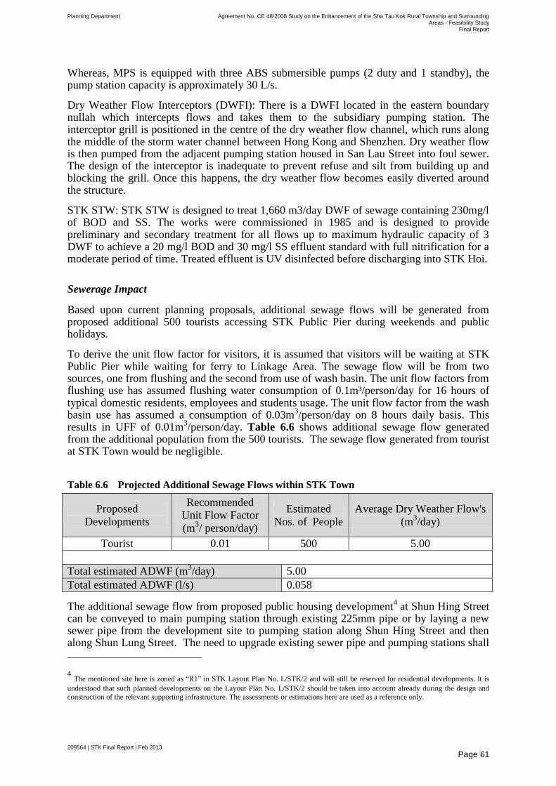
Planning Department Agreement No. CE 48/2008 Study on the Enhancement of the Sha Tau Kok Rural Township and Surrounding Areas - Feasibility Study
Final Report
209564 | STK Final Report | Feb 2013
Page 61
Whereas, MPS is equipped with three ABS submersible pumps (2 duty and 1 standby), the pump station capacity is approximately 30 L/s.
Dry Weather Flow Interceptors (DWFI): There is a DWFI located in the eastern boundary nullah which intercepts flows and takes them to the subsidiary pumping station. The interceptor grill is positioned in the centre of the dry weather flow channel, which runs along the middle of the storm water channel between Hong Kong and Shenzhen. Dry weather flow is then pumped from the adjacent pumping station housed in San Lau Street into foul sewer. The design of the interceptor is inadequate to prevent refuse and silt from building up and blocking the grill. Once this happens, the dry weather flow becomes easily diverted around the structure.
STK STW: STK STW is designed to treat 1,660 m3/day DWF of sewage containing 230mg/l of BOD and SS. The works were commissioned in 1985 and is designed to provide preliminary and secondary treatment for all flows up to maximum hydraulic capacity of 3 DWF to achieve a 20 mg/l BOD and 30 mg/l SS effluent standard with full nitrification for a moderate period of time. Treated effluent is UV disinfected before discharging into STK Hoi.
Sewerage Impact
Based upon current planning proposals, additional sewage flows will be generated from proposed additional 500 tourists accessing STK Public Pier during weekends and public holidays.
To derive the unit flow factor for visitors, it is assumed that visitors will be waiting at STK Public Pier while waiting for ferry to Linkage Area. The sewage flow will be from two sources, one from flushing and the second from use of wash basin. The unit flow factors from flushing use has assumed flushing water consumption of 0.1m³/person/day for 16 hours of typical domestic residents, employees and students usage. The unit flow factor from the wash basin use has assumed a consumption of 0.03m
3/person/day on 8 hours daily basis. This
results in UFF of 0.01m3/person/day. Table 6.6 shows additional sewage flow generated
from the additional population from the 500 tourists. The sewage flow generated from tourist at STK Town would be negligible.
Table 6.6 Projected Additional Sewage Flows within STK Town
Proposed
Developments
Recommended
Unit Flow Factor
(m3/ person/day)
Estimated
Nos. of People
Average Dry Weather Flow's
(m3/day)
Tourist 0.01 500 5.00
Total estimated ADWF (m3/day) 5.00
Total estimated ADWF (l/s) 0.058
The additional sewage flow from proposed public housing development4 at Shun Hing Street
can be conveyed to main pumping station through existing 225mm pipe or by laying a new sewer pipe from the development site to pumping station along Shun Hing Street and then along Shun Lung Street. The need to upgrade existing sewer pipe and pumping stations shall
4 The mentioned site here is zoned as ―R1‖ in STK Layout Plan No. L/STK/2 and will still be reserved for residential developments. It is
understood that such planned developments on the Layout Plan No. L/STK/2 should be taken into account already during the design and
construction of the relevant supporting infrastructure. The assessments or estimations here are used as a reference only.
Planning Department Agreement No. CE 48/2008 Study on the Enhancement of the Sha Tau Kok Rural Township and Surrounding Areas - Feasibility Study
Final Report
209564 | STK Final Report | Feb 2013
Page 62
be identified in implementation stage after considering updated development within the sewage catchment area of sewerage system.
STK Sewerage Treatment Works (STK STW)
Currently, the design capacity of the STK STW is 1,660m3/day and the existing incoming sewage flow has already occupied about 60% of the treatment capacity of the existing STK STW. The maximum of 500 tourists during weekends and public holidays in the Study will generate the estimated sewage flow of about 5m3/day, which is still within the remaining treatment capacity of the STK STW (40% or 664m3/day).
Areas to the south of Sha Tau Kok Control Point will be designated for ‗VDA‘ for Small House development. Those areas all fall within the ―Village Environs‖ designated for the village expansion of Kong Ha. In view of the above, it is assumed that the relevant impact assessments should be conducted already. However, if the provision of sewerage to 10 villages within the FCA but outside STK Town, approximately 5,500 m3/day, would be conveyed to the STK STW in ultimate case, which would exceed its design capacity.
Upgrading works on STK STW, should hence be required in order to accommodate the additional sewage flow. We understand EPD is undertaking a study for the expansion of treatment capacity of STKSTW with tentative commissioning of works by 2018. An additional land within or outside the study area may be required for the expansion of Sha Tau Kok Sewage Treatment Works.
6.5.2 Linkage Area
As mentioned previously, there is no existing sewerage infrastructure at Linkage Area. However, ―Review of North District and Tolo Harbour Sewage Master Plans‖ recommended sewage improvement works in Crooked Island at Kat O (Crooked Island is Kat O). There are mainly two villages namely Chek Kok Tau and Tung O located along the west coast of Kat O Wan which has majority of the population concentration. The proposed sewerage comprises of village sewer, trunk sewer, a pumping station and a local Sewage Treatment Plant. Since the topography of Chek Kok Tau and Tung O is relatively flat, the space next to the existing lavatory at the north of Chek Kok Tau had been recommended for the proposed Sewage Treatment Works in the feasibility study.
The tentative implementation programme is to commence the sewerage works in June 2012 for completion by end of June 2016. The proposed sewerage works will be implemented as part of North District Sewerage Scheme, Stage 3 Package ND 4.
The proposed developments within Linkage Area are mainly to enhance tourism. There are no existing toilet facilities at some of the Linkage Area and therefore new toilet facilities are proposed at Kuk Po, Yung Shue Au, So Lo Pun and Lai Chi Wo. In view of non-availability of water supply at Yung Shue Au and So Lo Pun, mobile toilets are recommended.
To derive the unit flow factor for visitors, it is assumed that visitors will be staying maximum 8 hrs per day within respective location in Linkage Area which seems highly unlikely. The sewage flow will be from two sources, one from flushing and the second from use of wash basin. The unit flow factors from flushing use, has assumed flushing water consumption of 0.1m3/person/day for 16 hours of typical domestic residents, employees and students usage. The unit flow factor from the wash basin use has assumed a consumption of 0.03m3/person/day on 8 hours daily basis. This results in UFF of 0.08m3/person/day.
Planning Department Agreement No. CE 48/2008 Study on the Enhancement of the Sha Tau Kok Rural Township and Surrounding Areas - Feasibility Study
Final Report
209564 | STK Final Report | Feb 2013
Page 63
In view of the lack of sewage treatment facilities in the majority of Linkage Area, it is recommended to use septic tanks or bio-toilets system to treat the sewage from proposed toilet facilities under the Study.
Septic tanks are widely used in places where there are no sewage treatment facilities due to minimum operation and maintenance requirements to treat the waste water from wash basin and WC. However, this takes little larger area as compared to septic tanks or bio-toilets. Bio-toilets are based upon bio-logical treatment and recycle effluent for flushing purpose and a brief description has been provided.
Membrane Bio Reactor (MBR)
MBR is the combination of membrane filtration and bioreactor. Traditional activated sludge process digest organic pollutants by bio and clean water is decanted through sedimentation and clarifier (large space).
MBR also used activated sludge to digest pollutants but it uses membrane to ‗actively‘ filtrate out the clean water without the need of sedimentation. This saves a lot of space and also allows the bioreactor to have high concentration of activated sludge. That means higher efficiency of the bioreactor.
MBR operation of biotoilets
The biotoilets received wastewater from wash basins and WC which is collected at a sump. The sump pumps feed wastewater to the MBR where bioreaction occurs. Air/oxygen required for the aerobic digestion process is supplied by the air blower. Clean water is filtrated out from the bioreactor by permeate pump through membrane (ultra-filtration membrane). The clean water is transferred to flushing water holding tank at R/F. And it requires periodic desludge same as traditional activated sludge process.
As the biotoilets are at remote area only during weekends/holidays will most of them have high usage. That means no organic waste (food) for the bio reaction.
Another problem for membrane is membrane fouling in which clean water flow rate diminishes or need higher energy to produce clean water. Typically the membrane has mechanisms such as periodic chemical cleaning and air scouring to minimise this.
MBR effluent quality
MBR typically produce water clean enough for toilet flushing and irrigation which will minimise the need of water demand. However, water reuse should meet the relevant EIAO and WPCO requirements and subject to demonstration of technical feasibility.
Water Quality, Maintenance Responsibility, Emergency
Emergency discharge will be required in bio-toilets in case of failure of system. In order to prevent and minimise the impact due to emergency discharge, the following precautions measures shall be included in the bio-toilet design:
To facilitate maintenance and repairing of equipment, standby unit should be
provided;

Planning Department Agreement No. CE 48/2008 Study on the Enhancement of the Sha Tau Kok Rural Township and Surrounding Areas - Feasibility Study
Final Report
209564 | STK Final Report | Feb 2013
Page 64
Dual power supply, or back-up power, should be provided, preferably in the
format of ring main or automatic-operated emergency generator with sufficient
capacity to cope with the demand loading of the essential plant equipment;
Telemetry system should be provided to the closest manned plant for unmanned
facilities, such that swift actions could be taken in case of malfunction of
unmanned facilities; and
To prevent the discharge of floating solids, manually cleaned screens should be
provided at the overflow bypass.
Regarding maintenance responsibility, this shall be determined as part of
Engineering Study for proposed works.
The preferred choice between septic tanks and bio-treatment is recommended to be determined as part of detailed design of toilet facilities after considering updating information, operation and maintenance cost.
The following table briefly describe about the advantage and disadvantage of septic tank and bio-toilets for easy understanding and appreciation.
S.N. Description Septic Tanks Bio-toilets
1 Capital Cost The capital cost of
septic tank is lower
than bio-toilets for
design sewage flows.
The capital cost of bio-toilets
is higher than septic tanks for
design sewage flows.
2 Operation Cost Operation cost is
lower with no
inspection or regular
sampling
Operation cost is higher due to
biological process involved
and regular sampling on
effluent quality. In addition,
membrane cleaning is required
from time to time with
membrane life 3-5 years.
3 Operation
system
It is based on
conventional sewage
treatment process and
can be used at any
location.
Being based upon biological
treatment, regular sewage flow
is required.
4 Effluent quality Effluent disposed
using soak away.
Effluent after treatment can be
used for reuse purpose
especially for flushing
purpose.
5 Foot Print Larger footprint as
compared to bio-
toilets due to soak
away.
Smaller footprint as compared
to Septic Tank with excess
effluent can be disposed to
nearby water body depending
upon target water quality
objective.
6 Operating staff There is no need for
any operational staff
and require minimum
Skilled operating staff will be
required for regular monitoring
to achieve the required effluent
Planning Department Agreement No. CE 48/2008 Study on the Enhancement of the Sha Tau Kok Rural Township and Surrounding Areas - Feasibility Study
Final Report
209564 | STK Final Report | Feb 2013
Page 65
operation skill. standard.
7 Design Life Longer design life Smaller design life
8 Capacity Not Specified Minimum 1000 visitors
According to the toilets data from AFCD, the maximum recorded number of daily visitors visiting Lai Chi Wo Geoheritage Centre is 386 during weekends and public holidays, together with the proposed 500 tourists visiting the Lai Chi Wo area, the total number is 886. Lai Chi Wo area, being the most popular visiting spots in the Linkage Area, is expected to have further increase in its tourist potential. However, the existing visitation is not reaching the threshold capacity of a bio-toilet. Therefore, it is recommended that an additional septic tank toilet be provided to meet with the need arising from the CAP. While in the long run, consideration can be given to build a bio-toilet in Lai Chi Wo area, subject to design and construction details.
For other tourist spots in the Linkage Area, which are lacking of toilet facilities, since the visitation is limited, both septic tank toilets and mobile toilets are therefore proposed.
6.6 Water Supply and Utility Impact Assessment
6.6.1 Water Supply System
As STK Town currently fall within FCA, there is very limited development growth in STK Town. Therefore, there is no plan for the provision of new water supply and other utility infrastructure. As additional water demand due to use of proposed toilet facility by visitors in STK Town is very small as compared with its total water demand. It is assumed additional water demand due to visitors already covered in service trade in the water demand with existing developments.
There is very small population scattered within the Linkage Area. The water supply has been provided to the majority of Linkage Area except Yung Shue Au and So Lo Pun. Moreover, the existing water supply system may not be able to support any large scale development.
Regarding additional water demand within Linkage Area, a total of 500 additional tourists are expected. Additional water demand will be arising due to the use of toilet facilities proposed within Linkage Area. To derive the unit water demand factor for visitors, it is assumed that visitors will be staying maximum 8 hrs per day within Linkage Area. The water demand will be from two sources, one from flushing and the second from use of wash basin. The unit flow factors from flushing use, has assumed flushing water consumption of 0.1m3/person/day for 16 hours of typical domestic residents, employees and students usage. The unit flow factor from the wash basin use has assumed a consumption of 0.03m3/person/day on 8 hours daily basis. This results in unit water demand of 0.08m3/person/day. Therefore, total additional water demand with Linkage Area would be approximately 40 m3/day which should have negligible impact on water treatment works and service reservoirs.
6.6.2 Utilities
The power supply has been provided in STK Town and Linkage Area by China Light and Power (CLP). Regarding communication facilities, HGC and PCCW are providing communication facilities within STK Town, whereas PCCW is providing communication facilities within Linkage Area. It is expected that existing utilities will be able to support proposed developments.
Planning Department Agreement No. CE 48/2008 Study on the Enhancement of the Sha Tau Kok Rural Township and Surrounding Areas - Feasibility Study
Final Report
209564 | STK Final Report | Feb 2013
Page 66
It is recommended that CLP and communication providers should take into consideration proposed developments in their future infrastructure planning.
6.7 Visual and Landscape Impact Assessment
The aim of this section is to report on the preliminary Visual Impact Assessment (VIA) and a Landscape Impact Assessment (LIA) for the recommended IAIP within the STK Town and the Linkage Area. The VIA will outline the existing site conditions and visual envelopes, and identify the visual impact that would be brought by the recommended improvement schemes. The LIA will consist of an appraisal of the landscape resources of the STK Town and Linkage Area, focusing mainly on the sensitivity of the landscape character and its ability to accommodate change and assess the potential landscape impact on the landscape resources arising from the implementation of the recommended enhancement proposals. Landscape mitigation measures, where applicable, will be identified with a view to minimize the cumulative landscape impact.
6.7.1 Preliminary Visual Impact Assessment
As part of the VIA, the visual context and envelope of the conceptual enhancement proposals have been defined and the visual sensitive receivers (VSRs) affected have been identified. VSRs are identified as those groups or individuals, who have a view of the proposed developments, are sensitive, and are likely to be subjected to impacts as a result of the development. The sensitivity of a particular VSR is influenced by location (sensitivity tends to decrease with distance from the proposals), direction and nature of the view relative to the proposals (an open and full views will be more sensitive than a partial of glimpsed view), and VSR type. In general, the scale of the conceptual enhancement proposals is kept to a relatively low scale so as to ensure compatibility with the surrounding environment and respect the natural and ecological resources of the Study Area. In this regard, all recommended conceptual enhancement proposals are carefully designed with minimization of any obtrusion to the natural environment and the public as a key priority.
For the recommended conceptual enhancement proposals without new building structures, a general review of the impacts to the overall visual context would be provided in brief. For those proposals proposing new building structures, VIA would be conducted on the broad examinations of their visual context/envelope (Figure 6.3).
Assessment of Visual Impacts
The aim of this section is to report on the VIA for the recommended conceptual enhancement proposals.
Identification of Visual Sensitive Receivers
Based on the assessment area, four visual sensitive receivers have been selected in the visual envelope as shown in Figure 6.3.
6.7.1.1 Local Open Space at Market Street
Identification of Visual Sensitive Receivers
Two visual sensitive receivers have been selected in the visual envelope as shown in Figure 6.4a and Figure 6.4b.
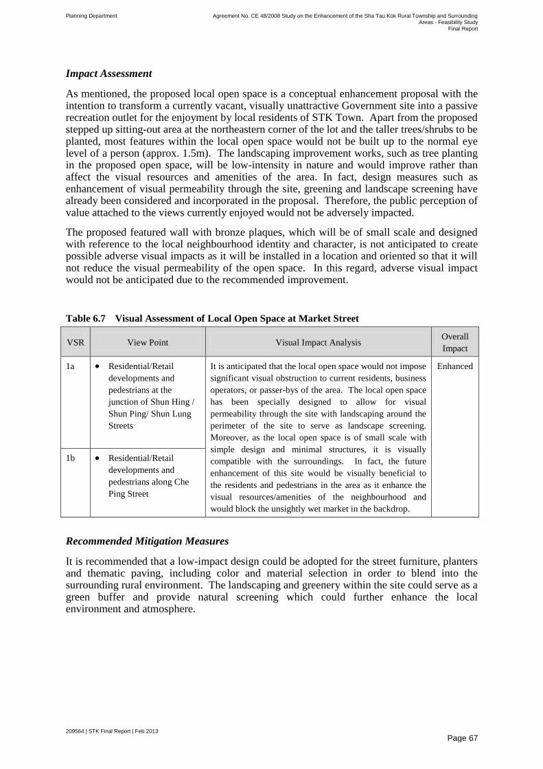
Planning Department Agreement No. CE 48/2008 Study on the Enhancement of the Sha Tau Kok Rural Township and Surrounding Areas - Feasibility Study
Final Report
209564 | STK Final Report | Feb 2013
Page 67
Impact Assessment
As mentioned, the proposed local open space is a conceptual enhancement proposal with the intention to transform a currently vacant, visually unattractive Government site into a passive recreation outlet for the enjoyment by local residents of STK Town. Apart from the proposed stepped up sitting-out area at the northeastern corner of the lot and the taller trees/shrubs to be planted, most features within the local open space would not be built up to the normal eye level of a person (approx. 1.5m). The landscaping improvement works, such as tree planting in the proposed open space, will be low-intensity in nature and would improve rather than affect the visual resources and amenities of the area. In fact, design measures such as enhancement of visual permeability through the site, greening and landscape screening have already been considered and incorporated in the proposal. Therefore, the public perception of value attached to the views currently enjoyed would not be adversely impacted.
The proposed featured wall with bronze plaques, which will be of small scale and designed with reference to the local neighbourhood identity and character, is not anticipated to create possible adverse visual impacts as it will be installed in a location and oriented so that it will not reduce the visual permeability of the open space. In this regard, adverse visual impact would not be anticipated due to the recommended improvement.
Table 6.7 Visual Assessment of Local Open Space at Market Street
VSR View Point Visual Impact Analysis Overall
Impact
1a Residential/Retail
developments and
pedestrians at the
junction of Shun Hing /
Shun Ping/ Shun Lung
Streets
It is anticipated that the local open space would not impose
significant visual obstruction to current residents, business
operators, or passer-bys of the area. The local open space
has been specially designed to allow for visual
permeability through the site with landscaping around the
perimeter of the site to serve as landscape screening.
Moreover, as the local open space is of small scale with
simple design and minimal structures, it is visually
compatible with the surroundings. In fact, the future
enhancement of this site would be visually beneficial to
the residents and pedestrians in the area as it enhance the
visual resources/amenities of the neighbourhood and
would block the unsightly wet market in the backdrop.
Enhanced
1b Residential/Retail
developments and
pedestrians along Che
Ping Street
Recommended Mitigation Measures
It is recommended that a low-impact design could be adopted for the street furniture, planters and thematic paving, including color and material selection in order to blend into the surrounding rural environment. The landscaping and greenery within the site could serve as a green buffer and provide natural screening which could further enhance the local environment and atmosphere.
Planning Department Agreement No. CE 48/2008 Study on the Enhancement of the Sha Tau Kok Rural Township and Surrounding Areas - Feasibility Study
Final Report
209564 | STK Final Report | Feb 2013
Page 68
6.7.1.2 Streetscape Enhancement at San Lau Street
Proposed Development
Currently, there are 22 shophouses at San Lau Street which have been graded as Grade 2 historic buildings. As part of the IAIP, it is proposed to revitalize San Lau Street and turn this area into one of the key interest points and activity nodes in STK Town. Streetscape enhancement works, including re-paving of the existing carriageway/footpath with thematic pavement, clearing of existing temporary structures, preserving existing trees and installing bronze plaques for the shophouses, are recommended in view to showcase the historic value as well as enhance the streetscape of this historical quarter of STK Town.
Visual Context and Visual Envelope
The proposed enhancement works is proposed for San Lau Street which is a historic street lined with shophouses of cultural/historic value and mature trees.
The visual envelope of the proposed streetscape enhancement is rather limited as the enhancement proposals do not constitute a large change to the existing visual openness of San Lau Street. As a major pedestrian routes and activity node within STK Town, San Lau Street can be visible from pedestrian walking between the waterfront, Che Ping Street/Chun Ying Street and the residential clusters within STK Town such as STK Chuen. As the street is on a relatively flat gradient, the visual permeability of the street at its existing condition is high.
Identification of Visual Sensitive Receivers
Three visual sensitive receivers have been selected in the visual envelope. Two of them are shown in Figure 6.5a and Figure 6.5b.
Impact Assessment
As the proposed enhancement works merely constitute streetscape beautification measures such as re-paving of existing carriageway/footpaths, greening/landscaping and installing bronze plaques on the walls of existing shophouses that would not cause visual obstructions on the views currently enjoyed by the public, the enhancement proposals are not anticipated to result in adverse visual impacts to the area. As the paving of thematic pavement is at the ground level, it will not create any blockage to views in its foreground or background. Moreover, the improvement proposals have taken due consideration the importance of visual compatibility. The design of the street paving as well as any street furniture to be installed will be compatible with the historical/cultural ambience of the area. Furthermore, the generous landscaping will soften the appearance of the street and will not block any important views, for example the waterfront/ridgeline of STK Hoi from afar.
The people most likely to be affected by the proposed improvement works would be the passer-bys and human activities at San Lau Street. Owing to the minor nature of the proposals which mainly comprises street repaving that is uniformly proposed along the entire street and beautification works that do not constitute additional obtrusive structures of any kind up to the eye level, regardless from which direction the people may come (either from the waterfront or from the residential clusters, they are likely to experience similar impacts. VSR2a is likely to embody more visual resources as people walking on San Lau Street towards the waterfront will be able to see some seaview. To exemplify that the proposal indeed will not cause adverse visual impacts to major public views, such as views to the STK
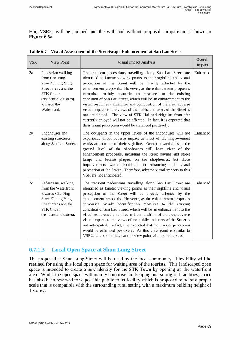
Planning Department Agreement No. CE 48/2008 Study on the Enhancement of the Sha Tau Kok Rural Township and Surrounding Areas - Feasibility Study
Final Report
209564 | STK Final Report | Feb 2013
Page 69
Hoi, VSR2a will be pursued and the with and without proposal comparison is shown in Figure 6.5a.
Table 6.7 Visual Assessment of the Streetscape Enhancement at San Lau Street
VSR View Point Visual Impact Analysis Overall
Impact
2a Pedestrian walking
from Che Ping
Street/Chung Ying
Street areas and the
STK Chuen
(residential clusters)
towards the
Waterfront.
The transient pedestrians travelling along San Lau Street are
identified as kinetic viewing points as their sightline and visual
perception of the Street will be directly affected by the
enhancement proposals. However, as the enhancement proposals
comprises mainly beautification measures to the existing
condition of San Lau Street, which will be an enhancement to the
visual resources / amenities and composition of the area, adverse
visual impacts to the views of the public and users of the Street is
not anticipated. The view of STK Hoi and ridgeline from afar
currently enjoyed will not be affected. In fact, it is expected that
their visual perception would be enhanced positively.
Enhanced
2b Shophouses and
existing structures
along San Lau Street.
The occupants in the upper levels of the shophouses will not
experience direct adverse impact as most of the improvement
works are outside of their sightline. Occupants/activities at the
ground level of the shophouses will have view of the
enhancement proposals, including the street paving and street
lamps and bronze plaques on the shophouses, but these
improvements would contribute to enhancing their visual
perception of the Street. Therefore, adverse visual impacts to this
VSR are not anticipated.
Enhanced
2c Pedestrians walking
from the Waterfront
towards Che Ping
Street/Chung Ying
Street areas and the
STK Chuen
(residential clusters).
The transient pedestrians travelling along San Lau Street are
identified as kinetic viewing points as their sightline and visual
perception of the Street will be directly affected by the
enhancement proposals. However, as the enhancement proposals
comprises mainly beautification measures to the existing
condition of San Lau Street, which will be an enhancement to the
visual resources / amenities and composition of the area, adverse
visual impacts to the views of the public and users of the Street is
not anticipated. In fact, it is expected that their visual perception
would be enhanced positively. As this view point is similar to
VSR2a, a photomontage at this view point will not be pursued.
Enhanced
6.7.1.3 Local Open Space at Shun Lung Street
The proposed at Shun Lung Street will be used by the local community. Flexibility will be retained for using this local open space for waiting area of the tourists. This landscaped open space is intended to create a new identity for the STK Town by opening up the waterfront area. Whilst the open space will mainly comprise landscaping and sitting-out facilities, space has also been reserved for a possible public toilet facility which is proposed to be of a proper scale that is compatible with the surrounding rural setting with a maximum building height of 1 storey.
Planning Department Agreement No. CE 48/2008 Study on the Enhancement of the Sha Tau Kok Rural Township and Surrounding Areas - Feasibility Study
Final Report
209564 | STK Final Report | Feb 2013
Page 70
Visual Context and Visual Envelope
This proposed local open space site is currently vacant, fenced off and overgrown with vegetation at the outskirt of the lot. The visual envelope, being the area from which the proposed local open space will be seen, is shaped by a combination of existing nearby built development and landform. The visual envelope is occupied by different land uses, including residential development (both planned and existing), car/lorry parking lots, small structures and developments along the waterfront (i.e. waterfront promenade and temple), and public facilities (i.e. STK Public Pier).
Currently, this local open space can be viewable from STK Public Pier, Shun Lung Street, Shun Cheong Street, the waterfront promenade, the residential developments (i.e. Greenside Paradise and the planned housing development which is currently vacant) and the STK Market. Upon the completion of the planned residential development at Shun Lung Street, the view to the local open space from the STK Market will likely be blocked. Due to the topography of the site and distance, apart from the abovementioned developments, other developments in the STK Town will not be able to view the local open space.
Identification of Visual Sensitive Receivers
Three visual sensitive receivers have been selected in the visual envelopes as shown in Figure 6.6a, Figure 6.6b, and Figure 6.6c.
Impact Assessment
Currently, the proposed site is a vacant Government lot that is overgrown with vegetation. The proposed local open space at Shun Lung Street would optimize the use of the site and help to improve and enhance the visual amenity for residents of STK Town as well as future tourists who will transit to the Linkage Area via STK Town. In general, the landscape improvement works within the site are low-intensity in nature and are unlikely to have an adverse impact on the immediate locality. Rather, it is anticipated that with the proposal in place, the amenity value of the environment would be enhanced. While some of the trees within the site may indirectly impair the sightline of viewers from certain angles, its intention is to beautify the site with greenery, provide shading opportunities for the users as well as landscape screening for unsightly structures such as the potential public toilet within the site (if this proposal were to be taken up by the respective implementation agent(s)). In general, most of the landscape features (i.e. benches, planters, etc.) within the site would not be built up to the normal eye level of a person (approx. 1.5m).
For such sizable open space area, toilet facilities may be required to cater for the needs of the locals and probably visitors. Such proposal would be subject to further investigation with regards to the implementation/maintenance mechanism. A pavilion can be constructed to cover the public toilet facilities and initially, the facilities are proposed to be located at the north-western corner of the local open space so as to minimize visual impacts on the seaview from the inland areas. It is suggested that the proposed public toilet be in a simple and natural design so as to maximize its visual compatibility with the surrounding areas.
In general, the local open space is relatively low intensity in nature and the design of the open space will be compatible with the surroundings, including the residential development at Shun Lung Street as well as the waterfront promenade. Furthermore, the generous landscaping will enhance the visual amenity of the area. Most importantly, the proposed open space, even with the pavilion, will not block any important views to the ridgeline of the mountains across STK Hoi. Given the above, it is anticipated that only minor visual impact is anticipated at certain locations.
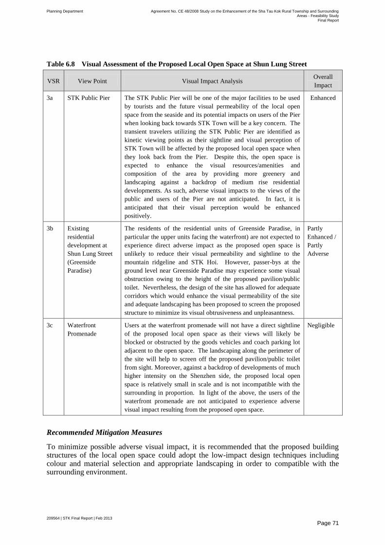
Planning Department Agreement No. CE 48/2008 Study on the Enhancement of the Sha Tau Kok Rural Township and Surrounding Areas - Feasibility Study
Final Report
209564 | STK Final Report | Feb 2013
Page 71
Table 6.8 Visual Assessment of the Proposed Local Open Space at Shun Lung Street
VSR View Point Visual Impact Analysis Overall
Impact
3a STK Public Pier The STK Public Pier will be one of the major facilities to be used
by tourists and the future visual permeability of the local open
space from the seaside and its potential impacts on users of the Pier
when looking back towards STK Town will be a key concern. The
transient travelers utilizing the STK Public Pier are identified as
kinetic viewing points as their sightline and visual perception of
STK Town will be affected by the proposed local open space when
they look back from the Pier. Despite this, the open space is
expected to enhance the visual resources/amenities and
composition of the area by providing more greenery and
landscaping against a backdrop of medium rise residential
developments. As such, adverse visual impacts to the views of the
public and users of the Pier are not anticipated. In fact, it is
anticipated that their visual perception would be enhanced
positively.
Enhanced
3b Existing
residential
development at
Shun Lung Street
(Greenside
Paradise)
The residents of the residential units of Greenside Paradise, in
particular the upper units facing the waterfront) are not expected to
experience direct adverse impact as the proposed open space is
unlikely to reduce their visual permeability and sightline to the
mountain ridgeline and STK Hoi. However, passer-bys at the
ground level near Greenside Paradise may experience some visual
obstruction owing to the height of the proposed pavilion/public
toilet. Nevertheless, the design of the site has allowed for adequate
corridors which would enhance the visual permeability of the site
and adequate landscaping has been proposed to screen the proposed
structure to minimize its visual obtrusiveness and unpleasantness.
Partly
Enhanced /
Partly
Adverse
3c Waterfront
Promenade
Users at the waterfront promenade will not have a direct sightline
of the proposed local open space as their views will likely be
blocked or obstructed by the goods vehicles and coach parking lot
adjacent to the open space. The landscaping along the perimeter of
the site will help to screen off the proposed pavilion/public toilet
from sight. Moreover, against a backdrop of developments of much
higher intensity on the Shenzhen side, the proposed local open
space is relatively small in scale and is not incompatible with the
surrounding in proportion. In light of the above, the users of the
waterfront promenade are not anticipated to experience adverse
visual impact resulting from the proposed open space.
Negligible
Recommended Mitigation Measures
To minimize possible adverse visual impact, it is recommended that the proposed building structures of the local open space could adopt the low-impact design techniques including colour and material selection and appropriate landscaping in order to compatible with the surrounding environment.

Planning Department Agreement No. CE 48/2008 Study on the Enhancement of the Sha Tau Kok Rural Township and Surrounding Areas - Feasibility Study
Final Report
209564 | STK Final Report | Feb 2013
Page 72
6.7.1.4 Proposals in Linkage Area
Proposed Ecological Centre in Lai Chi Wo
Lai Chi Wo is already a popular tourist destination mainly because of the various kinds of ecological attractions, including the Lai Chi Wo Geoheritage Centre and the tourist-supporting facilities by the HKTB and AFCD. To complement the existing Lai Chi Wo Geoheritage Centre at the village house in Lai Chi Wo, it is proposed to set up a Lai Chi Wo Ecological Centre at the currently vacant Siu Ying School. This centre is anticipated to offer visitors both ecological features of the surrounding area and the coastal ecological and cultural and built heritage in a nice and tranquil environment. This Ecological Centre could strengthen the identity of Lai Chi Wo for eco-tourism.
Visual Context and Visual Envelope
The Ecological Centre is proposed to be sited in the vacated Siu Ying School which is located in the Fung Shui Piazza near Lai Chi Wo Village. To access the Piazza, tourists would need to walk southward from the Pier along a seaside trail towards Lai Chi Wo Village. The disused Siu Ying School is currently fenced off from public access.
Identification of Visual Sensitive Receivers
Three visual sensitive receivers have been selected in the visual envelopes. One of them is shown in Figure 6.7.
Impact Assessment
As this proposal involves the adaptive re-use of an existing building and revamping of an already dilapidated structure, it is anticipated that positive visual changes could be achieved. Given the low development intensity of the existing building (1 storey structure), the proposed renovation could help enhance the visual amenity and resources of the area and improve the quality and character of the area by strengthening the visual coherence and compatibility with the semi-rural surroundings. Furthermore, with the renovation, the existing fence which poses as a visual detractor will be removed, thus further beautifying the local environment. Generous landscaping will also help to soften the appearance of the buildings. In addition, the proposed development will not block any important views, for example the ridgeline of the mountain backdrop behind the development, given its low building height.
Table 6.9 Visual Assessment of the Proposed Ecological Centre in Lai Chi Wo
VSR View Point Visual Impact Analysis Overall
Impact
4a (Not
shown on
the
Figure)
The users of the
trail to/from the
mangroves along
the coast of Yan
Chau Tong Marine
Park.
The visitors walk along the seaside trails are identified as
kinetic viewing points as their sightline and visual perception
may be affected by the proposed Ecological Centre. However,
as the proposed development involves only the adaptive re-use
and renovation of an existing structure, adverse visual impact
is not anticipated. In fact, the proposal is expected to have
positive impact as the improved environment with greenery
and landscaping against a mountainous backdrop would
further enhance the visual perception of the
hikers/tourists/villagers as well as contribute to the positive
Enhanced
4b (Not
shown on
The users of the
seaside trail to Lai
Enhanced
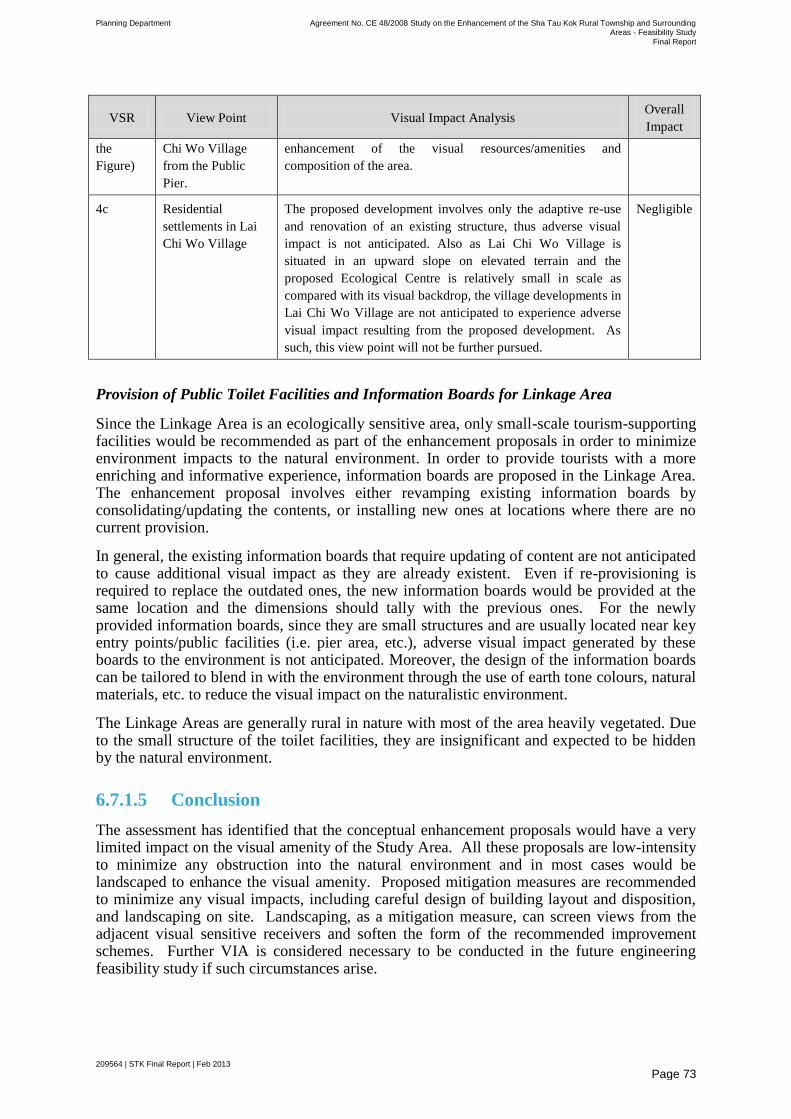
Planning Department Agreement No. CE 48/2008 Study on the Enhancement of the Sha Tau Kok Rural Township and Surrounding Areas - Feasibility Study
Final Report
209564 | STK Final Report | Feb 2013
Page 73
VSR View Point Visual Impact Analysis Overall
Impact
the
Figure)
Chi Wo Village
from the Public
Pier.
enhancement of the visual resources/amenities and
composition of the area.
4c Residential
settlements in Lai
Chi Wo Village
The proposed development involves only the adaptive re-use
and renovation of an existing structure, thus adverse visual
impact is not anticipated. Also as Lai Chi Wo Village is
situated in an upward slope on elevated terrain and the
proposed Ecological Centre is relatively small in scale as
compared with its visual backdrop, the village developments in
Lai Chi Wo Village are not anticipated to experience adverse
visual impact resulting from the proposed development. As
such, this view point will not be further pursued.
Negligible
Provision of Public Toilet Facilities and Information Boards for Linkage Area
Since the Linkage Area is an ecologically sensitive area, only small-scale tourism-supporting facilities would be recommended as part of the enhancement proposals in order to minimize environment impacts to the natural environment. In order to provide tourists with a more enriching and informative experience, information boards are proposed in the Linkage Area. The enhancement proposal involves either revamping existing information boards by consolidating/updating the contents, or installing new ones at locations where there are no current provision.
In general, the existing information boards that require updating of content are not anticipated to cause additional visual impact as they are already existent. Even if re-provisioning is required to replace the outdated ones, the new information boards would be provided at the same location and the dimensions should tally with the previous ones. For the newly provided information boards, since they are small structures and are usually located near key entry points/public facilities (i.e. pier area, etc.), adverse visual impact generated by these boards to the environment is not anticipated. Moreover, the design of the information boards can be tailored to blend in with the environment through the use of earth tone colours, natural materials, etc. to reduce the visual impact on the naturalistic environment.
The Linkage Areas are generally rural in nature with most of the area heavily vegetated. Due to the small structure of the toilet facilities, they are insignificant and expected to be hidden by the natural environment.
6.7.1.5 Conclusion
The assessment has identified that the conceptual enhancement proposals would have a very limited impact on the visual amenity of the Study Area. All these proposals are low-intensity to minimize any obstruction into the natural environment and in most cases would be landscaped to enhance the visual amenity. Proposed mitigation measures are recommended to minimize any visual impacts, including careful design of building layout and disposition, and landscaping on site. Landscaping, as a mitigation measure, can screen views from the adjacent visual sensitive receivers and soften the form of the recommended improvement schemes. Further VIA is considered necessary to be conducted in the future engineering feasibility study if such circumstances arise.
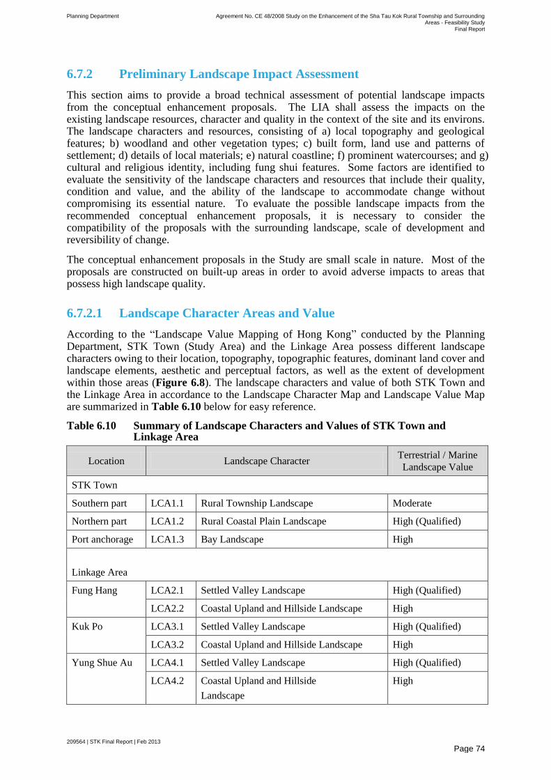
Planning Department Agreement No. CE 48/2008 Study on the Enhancement of the Sha Tau Kok Rural Township and Surrounding Areas - Feasibility Study
Final Report
209564 | STK Final Report | Feb 2013
Page 74
6.7.2 Preliminary Landscape Impact Assessment
This section aims to provide a broad technical assessment of potential landscape impacts from the conceptual enhancement proposals. The LIA shall assess the impacts on the existing landscape resources, character and quality in the context of the site and its environs. The landscape characters and resources, consisting of a) local topography and geological features; b) woodland and other vegetation types; c) built form, land use and patterns of settlement; d) details of local materials; e) natural coastline; f) prominent watercourses; and g) cultural and religious identity, including fung shui features. Some factors are identified to evaluate the sensitivity of the landscape characters and resources that include their quality, condition and value, and the ability of the landscape to accommodate change without compromising its essential nature. To evaluate the possible landscape impacts from the recommended conceptual enhancement proposals, it is necessary to consider the compatibility of the proposals with the surrounding landscape, scale of development and reversibility of change.
The conceptual enhancement proposals in the Study are small scale in nature. Most of the proposals are constructed on built-up areas in order to avoid adverse impacts to areas that possess high landscape quality.
6.7.2.1 Landscape Character Areas and Value
According to the ―Landscape Value Mapping of Hong Kong‖ conducted by the Planning Department, STK Town (Study Area) and the Linkage Area possess different landscape characters owing to their location, topography, topographic features, dominant land cover and landscape elements, aesthetic and perceptual factors, as well as the extent of development within those areas (Figure 6.8). The landscape characters and value of both STK Town and the Linkage Area in accordance to the Landscape Character Map and Landscape Value Map are summarized in Table 6.10 below for easy reference.
Table 6.10 Summary of Landscape Characters and Values of STK Town and Linkage Area
Location Landscape Character Terrestrial / Marine
Landscape Value
STK Town
Southern part LCA1.1 Rural Township Landscape Moderate
Northern part LCA1.2 Rural Coastal Plain Landscape High (Qualified)
Port anchorage LCA1.3 Bay Landscape High
Linkage Area
Fung Hang LCA2.1 Settled Valley Landscape High (Qualified)
LCA2.2 Coastal Upland and Hillside Landscape High
Kuk Po LCA3.1 Settled Valley Landscape High (Qualified)
LCA3.2 Coastal Upland and Hillside Landscape High
Yung Shue Au LCA4.1 Settled Valley Landscape High (Qualified)
LCA4.2 Coastal Upland and Hillside
Landscape
High
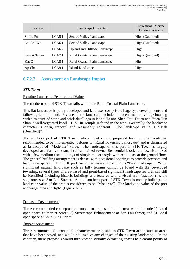
Planning Department Agreement No. CE 48/2008 Study on the Enhancement of the Sha Tau Kok Rural Township and Surrounding Areas - Feasibility Study
Final Report
209564 | STK Final Report | Feb 2013
Page 75
Location Landscape Character Terrestrial / Marine
Landscape Value
So Lo Pun LCA5.1 Settled Valley Landscape High (Qualified)
Lai Chi Wo LCA6.1 Settled Valley Landscape High (Qualified)
LCA6.2 Upland and Hillside Landscape High
Sam A Tsuen LCA7.1 Rural Coastal Plain Landscape High (Qualified)
Kat O LCA8.1 Rural Coastal Plain Landscape High
Ap Chau LCA9.1 Island Landscape High
6.7.2.2 Assessment on Landscape Impact
STK Town
Existing Landscape Features and Value
The northern part of STK Town falls within the Rural Coastal Plain Landscape.
This flat landscape is partly developed and land uses comprise village type developments and fallow agricultural land. Features in the landscape include the recent modern village housing with a mixture of stone and brick dwellings in Kong Ha and Shan Tsui Tsuen and Yuen Tun Shan, a well-vegetated knoll. Hip Tin Temple is found in the area. Generally, the landscape character is open, tranquil and reasonably coherent. The landscape value is ―High (Qualified)‖.
The southern part of STK Town, where most of the proposed local improvements are recommended to be implemented, belongs to ―Rural Township Landscape‖ and is designated as landscape of ―Moderate‖ value. The landscape of this part of STK Town is largely developed and forms the small self-contained town. Residential blocks are low-rise mixed with a few medium rise buildings of simple modern style with retail uses at the ground floor. The general building arrangement is dense, with occasional openings to provide accesses and local open spaces. The STK port anchorage area is classified as ―Bay Landscape‖. While significant natural landscape such as hilly terrains cannot be found with the developed township, several types of area-based and point-based significant landscape features can still be identified, including historic buildings and features with a visual manifestation (i.e. the shophouses at San Lau Street). As the southern part of STK Town is mostly built-up, the landscape value of the area is considered to be ―Moderate‖. The landscape value of the port anchorage area is ―High‖ (Figure 6.9).
Proposed Development
Three recommended conceptual enhancement proposals in this area, which include 1) Local open space at Market Street; 2) Streetscape Enhancement at San Lau Street; and 3) Local open space at Shun Lung Street.
Impact Assessment
Three recommended conceptual enhancement proposals in STK Town are located at areas that have been paved, and would not involve any changes of the existing landscape. On the contrary, these proposals would turn vacant, visually detracting spaces to pleasant points of
Planning Department Agreement No. CE 48/2008 Study on the Enhancement of the Sha Tau Kok Rural Township and Surrounding Areas - Feasibility Study
Final Report
209564 | STK Final Report | Feb 2013
Page 76
attraction and enhance the landscape value of the areas by creating new open spaces with tree planting and compatibly designed paving and landscape features.
The vacant site at Market Street with no vegetation is now paved and fenced off by metal fencing, and is considered to have low landscape value. The local open space at Market Street would increase the landscape value of the site by strengthening the sense of place and the distinctiveness of the local area.
The streetscape enhancement works at San Lau Street, which comprises mainly revamping of existing tree pits, repaving of the carriageway and footpath, installing thematic lamp posts and displaying some decorative sculptures/panels, would not impose adverse impact to the existing landscape as it does not involve any removal of vegetation/trees. Rather, it is anticipated that the beautification works would help to make a special contribution to the landscape by enhancing the visual manifestation and the recognized value/interest of the heritage resources and cultural features of the street (i.e. the shophouses which are considered to be point-based significant landscape features). In this regard, landscape impact is not anticipated.
Regarding the local open space at Shun Lung Street, the site is currently vacant with overgrown vegetation and some concrete paving. The current landscape value of the site is considered as low. The construction of a local open space at the site would help create a more interesting landscape by providing more orderly landscaping/greenery. Moreover, as the local open space has been designed taking into consideration the coastal and ridgeline in the backdrop, the opening up of visual corridors to key landscape features afar would help improve the environment of the waterfront area.
Overall, these proposals would have positive landscape impact on STK Town.
Linkage Area
Existing Landscape Features and Value
The landscape value of Linkage Area is designated either ―High‖ or ―High (Qualified)‖ and it demonstrates a variety of landscape characters, including ―Coastal Upland and Hillside Landscape‖, ―Rural Coastal Plain Landscape‖, ―Upland and Hillside Landscape‖, ―Settled Valley Landscape‖, ―Island Landscape‖ (Figure 6.8). Some identified landscape features include village type developments, farmland, woodland, marine wetland with patches of mangrove growth, abandoned fish ponds as well as upland topography such as mountainous terrain). The undulating landscape against a water and mountainous backdrop form a unique natural landscape that is distinctive in Hong Kong and offer a scenic view for tourist interests. Although part of the Linkage Area are exposed to a certain degree of development (i.e. village dwellings and fish farming, etc.) and have encountered some deterioration (e.g. abandoned farmland and fish ponds) due to human activities, most of the natural landscape features of the sub-areas have remained intact, in particular the elevated terrains, geological features, and the natural coastal areas, providing visual coherence.
Proposed Development
To provide an opportunity for tourists to appreciate and interact with the unique ecological and cultural landscape of the Linkage Area, some tourism-related facilities are recommended in the Linkage Area as part of the IAIP. With the anticipated increase in the number of tourists to the Linkage Area, it is considered necessary to provide adequate essential public facilities, such as public toilets and information boards, in order to facilitate the tourist activities. After reviewing the existing public toilets within the Linkage Area and taking into
Planning Department Agreement No. CE 48/2008 Study on the Enhancement of the Sha Tau Kok Rural Township and Surrounding Areas - Feasibility Study
Final Report
209564 | STK Final Report | Feb 2013
Page 77
the account of allowing 500 visitors per day (weekends and public holidays only), it is proposed to provide public toilets in Kuk Po, So Lo Pun and Lai Chi Wo.
While it is the intention to keep the natural landscape intact and untouched in the majority of Linkage Area, tourism potential has been identified in Lai Chi Wo. It is proposed to convert the existing vacant Siu Ying school located in close proximity to the public pier into an Ecological Centre through adaptive re-use. The proposed Ecological Centre could provide tourists with information on the natural and cultural evolution of Lai Chi Wo and could be a showcase of sustainable eco-tourism/development.
Impact Assessment
Taking into account the high landscape value of the Linkage Area, careful consideration has been given to the location of the proposed public toilets and information boards with a view to minimize the visual disturbance to the landscapes. The public toilets are sited in locations that are considered to impose the least visual and landscape impact, such as within short walking distance from the piers or near the villages, where the landscape amenity and resources are lower. Besides, the proposed toilets will be of relatively small scale (approximately 9m x 4m) and is unlikely to have a significant prejudicial effect on the character of the landscape. Moreover, the design of the toilets are in keeping with the existing patterns of land use and built form in the landscape (i.e. near key developments/public facilities) and are unlikely to change the existing qualities of the landscape. Besides, proper landscape treatment could be incorporated in the surrounding of the public toilets as possible landscape enhancement measures. In general, it is anticipated that the proposed facilities would not generate any negative landscape impact to the area.
Regarding information boards, the improvement works mainly consists of revamping existing ones and installing new ones in part of the Linkage Area where such facilities are not yet available. Landscape impacts resulting from the improvement works on existing information boards are not anticipated as there will not be any impacts/removal of existing vegetation nor will it impose negative effects on the existing quality of the landscape. The newly proposed information boards, which are mostly located near the pier areas, will be very small in scale and are unlikely to affect the integrity of the landscape resources within the adjoining LCAs, in particular the mountain backdrop and the coastal waters. In order to better blend with the existing landscape, it is recommended that the design of the information boards be more naturalistic and eco-friendly, such as the use of wooden and non-reflective materials, so as to maximize the visual coherence. In general, possible adverse landscape impact is not anticipated.
Regarding the proposed Lai Chi Wo Ecological Centre, it involves the adaptive re-use of an existing building and revamping of an already dilapidated structure. It is anticipated that the positive visual changes could be achieved. Given the already low development intensity of the existing building with one storey, the proposed renovation could help enhance the visual amenity and resources of the area and improve the quality and character of the area by strengthening the visual coherence and compatibility with the semi-rural surroundings. Furthermore, with the renovation, the existing fence which poses as a visual detractor will be removed, thus further beautifying the local environment. Generous landscaping will also help to soften the appearance of the buildings. In addition, the proposed development will not block any important views, for example the ridgeline of the mountain backdrop behind the development, given its low building height.
6.7.2.3 Conclusion
The magnitude of change of each LCA is summarized in Table 6.11 below. As one of the major design objectives of the recommended conceptual enhancement proposals is to respect
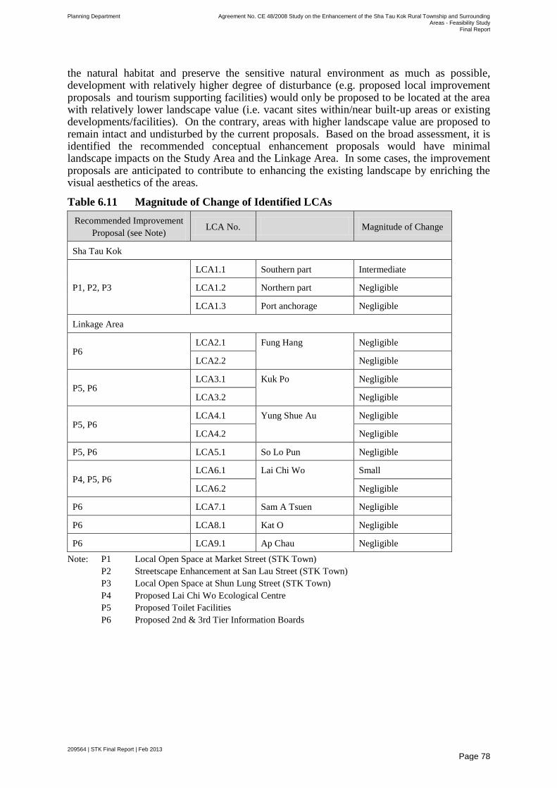
Planning Department Agreement No. CE 48/2008 Study on the Enhancement of the Sha Tau Kok Rural Township and Surrounding Areas - Feasibility Study
Final Report
209564 | STK Final Report | Feb 2013
Page 78
the natural habitat and preserve the sensitive natural environment as much as possible, development with relatively higher degree of disturbance (e.g. proposed local improvement proposals and tourism supporting facilities) would only be proposed to be located at the area with relatively lower landscape value (i.e. vacant sites within/near built-up areas or existing developments/facilities). On the contrary, areas with higher landscape value are proposed to remain intact and undisturbed by the current proposals. Based on the broad assessment, it is identified the recommended conceptual enhancement proposals would have minimal landscape impacts on the Study Area and the Linkage Area. In some cases, the improvement proposals are anticipated to contribute to enhancing the existing landscape by enriching the visual aesthetics of the areas.
Table 6.11 Magnitude of Change of Identified LCAs
Recommended Improvement
Proposal (see Note) LCA No. Magnitude of Change
Sha Tau Kok
P1, P2, P3
LCA1.1 Southern part Intermediate
LCA1.2 Northern part Negligible
LCA1.3 Port anchorage Negligible
Linkage Area
P6 LCA2.1 Fung Hang Negligible
LCA2.2 Negligible
P5, P6 LCA3.1 Kuk Po Negligible
LCA3.2 Negligible
P5, P6 LCA4.1 Yung Shue Au Negligible
LCA4.2 Negligible
P5, P6 LCA5.1 So Lo Pun Negligible
P4, P5, P6 LCA6.1 Lai Chi Wo Small
LCA6.2 Negligible
P6 LCA7.1 Sam A Tsuen Negligible
P6 LCA8.1 Kat O Negligible
P6 LCA9.1 Ap Chau Negligible
Note: P1 Local Open Space at Market Street (STK Town)
P2 Streetscape Enhancement at San Lau Street (STK Town)
P3 Local Open Space at Shun Lung Street (STK Town)
P4 Proposed Lai Chi Wo Ecological Centre
P5 Proposed Toilet Facilities
P6 Proposed 2nd & 3rd Tier Information Boards
Planning Department Agreement No. CE 48/2008 Study on the Enhancement of the Sha Tau Kok Rural Township and Surrounding Areas - Feasibility Study
Final Report
209564 | STK Final Report | Feb 2013
Page 79
6.8 Cultural Heritage Impact Assessment
6.8.1 STK Town
According to the Development Bureau Technical Circular No.6/20095 (DBTC No.6/2009),
once heritage sites are identified within the project boundary or no more 50m from the project boundary, AMO would review if the project will affect the heritage value of the ―heritage sites‖
6 that include all declared monuments, all proposed monuments, all sites and
buildings graded by the AAB, all recorded sites of archaeological interest and Government historic sites, and advise on whether a heritage impact assessment (HIA) is required. Besides, it is assumed that the proponent of enhancement works will submit HIA checklists to AMO for comment in due course, whenever HIA is required.
All 22 shophouses at San Lau Street have been graded as Grade 2 historic buildings. It would be desirable if the shophouses could be preserved in a holistic manner. Hence, a set of “Indicative Design Guidelines” for the maintenance of the shophouses is proposed, that may be modified or further developed in future for reference by the owners if it is considered appropriate by relevant Government departments.
The guidelines comprise retaining the original facades by providing color scheme that is compatible with the cultural heritage to ensure the entirety of the shophouses, maintaining the original style of the traditional shop signs by preservation and renovation. Some appropriate way such as providing coverage to hide the air-conditioners to beautify and minimise the visual impact, inspecting and repairing cracks, and installing window awnings or canopies to reduce solar heat gain, improve the overall street facades in a harmonious way and improve the durability of the buildings, etc. (Figure 4.6c).
Apart from the ―Indicative Design Guidelines‖ proposed to help the private owners of these properties properly maintain and preserve the shophouses, the proposal also suggests enhancement of the streetscape of San Lau Street. The proposal has noted the importance of cultural heritage and proposed the use of street furniture and colour scheme that are compatible with the cultural heritage. The other historic building in STK Town, namely Hip Tin Temple, will not be affected by any tourism activities.
The proposed streetscape enhancement at San Lau Street would improve the surrounding environment. In addition, a number of proposals are brought forward to enhance the living environment for the local communities, for example, pedestrian crossing enhancement and traffic calming measures. These proposals are further away (north or northwest) from the cultural heritage sites, such as the shophouses at San Lau Street. Therefore, no significant impacts on cultural heritage are expected from these proposed works. The visitors to the cultural heritage sites may lead to positive effect such as promoting cultural heritage of STK to the public. However, the visitors need to be educated on how to protect the cultural heritage. Otherwise, increase visitation to the cultural heritage sites may have negative impacts on the historic buildings such as physical damage.
In light of the local demand on provision of new housing units in STK Town, government sites are reserved for the future development. The vacant residential site at Shun Hing Street is located in close proximity to waterfront. However, considering the low-rise and low
5 It is remarked that this Technical Circular is applied to capital works project and thus it is irrelevant to any renovation and repair of graded buildings carried out by private owners.
6 Heritage sites include all declared monuments, all proposed monuments, all sites and buildings graded by the AAB, all recorded sites of archaeological interest and Government historic sites.
Planning Department Agreement No. CE 48/2008 Study on the Enhancement of the Sha Tau Kok Rural Township and Surrounding Areas - Feasibility Study
Final Report
209564 | STK Final Report | Feb 2013
Page 80
density building bulk of the proposed residential development, no significant impacts on cultural heritage is considered likely.
6.8.2 Linkage Area
Fung Hang and Kuk Po: The proposed installation of information boards near the piers at Kuk Po and Fung Hang would help the visitors to understand and appreciate the cultural heritage and have beneficial impacts on cultural heritage. An indirect benefit to cultural heritage in general of a ―positive experience‖ from the sympathetic reuse, management and promotion of heritage in these areas is a raised awareness within the community and therefore enhanced value of cultural heritage throughout the study area and Hong Kong in general. There is no negative impact for the installation of information board. The construction of a toilet near the pier at Kuk Po will not impact on any recorded sites of archaeological interest in the region. From the record of the archaeological investigation (AMO 1998 Record: ND1), there are no sites of archaeological interest in Fung Hang. Although Qing Dynasty blue and white porcelain was found on the surface layer in Kuk Po, the new installation is no negative impact.
Lai Chi Wo and Sam A Tsuen: The proposed installation of information boards and the toilet near the piers at Lai Chi Wo would help the visitors to understand and appreciate the cultural heritage and have beneficial impacts on cultural heritage. Similarly, the proposed conversion of the vacant school structure to Lai Chi Wo Ecological Centre would also help visitors to understand the cultural history of Lai Chi Wo. An archaeological survey should be conducted before the construction of information board. After the enhancement work for the government structure, there is no visual impacts for the Grade 3 historic buildings that were included Hip Tin Temple & Hok Shan Monastery from these proposals. In the ―List of Sites of Archaeological Interest in Hong Kong (as at Nov 2010)‖, Lai Chi Wo was listed as one of the sites of archaeological interest. Archaeological survey may be required prior to commencing any construction works.
Ap Chau and Kat O: The proposed installation of information boards near the piers at Ap Chau and Kat O would help the visitors to understand and appreciate the cultural heritage and have beneficial impacts on cultural heritage. Tin Hau Temple (Sai O) is a Grade 3 historic building identified in Kat O. However, there is no cultural heritage in the vicinity of the proposed works, thus no impacts on cultural heritage are expected.
Yung Shue Au and So Lo Pun: Yung Shue Au and So Lo Pun were proposed to set movable toilets, and permanent toilet would be built in So Lo Pun subject to the water availability. Even if a permanent toilet is built in So Lo Pun, its location should be avoided causing impacts to the potential heritage buildings and its construction will not cause any cultural heritage impact.
The proposed installation of information boards near the piers at Yung Shue Au and So Lo Pun would help the visitors to understand and appreciate the cultural heritage and have beneficial impacts on cultural heritage.
6.9 Economic Assessment
An economic assessment was conducted taken into account the existing social and economic profile of the Study Area and the Linkage Area to estimate the potential economic impacts which the proposals will bring.
Planning Department Agreement No. CE 48/2008 Study on the Enhancement of the Sha Tau Kok Rural Township and Surrounding Areas - Feasibility Study
Final Report
209564 | STK Final Report | Feb 2013
Page 81
6.9.1 Potential Economic Impact in Study Area and Linkage Area
Hong Kong has great potential to develop its own eco-tourism. Due to the insufficient knowledge on this subject and inadequate interest from the tourism industry in the past, the eco-tourism potential in Hong Kong has not been fully explored. In the Hong Kong Policy Address 2009/10, the Chief Executive announced plans to develop the eco-tourism in Hong Kong by adding new attractions.
There is strong potential on tourism development in the Study Area accomplishing with its unique historical background as well as its convenience to the Linkage Area which contain rich natural and cultural resources. Due to the FCA restriction in STK Town, the economic activities are very limited and are only catering for the local residents. Currently, two geoheritage centres are located within the Linkage Area – Lai Chi Wo Geoheritage Centre and Kat O Geoheritage Centre. The rest of the Linkage Area is also presenting rich landscape, ecological and heritage resources. Overall accessibility and connectivity to the Linkage Area are poor which have limited their tourism development.
The proposed IAIP can enhance the tourism development in the Linkage Area by, for instance, encouraging ecological tour. To allow a daily maximum of 500 tourists during weekends and public holidays to access from STK Public Pier to Linkage Area will improve the accessibility and connectivity to the Linkage Area. This can lead to an increase in the number of tourists and will create vibrant ecological areas in the Linkage Area. The eco-tourism development will not only benefit the Linkage Area but will also strengthen and diversify the tourism industry in Hong Kong to further accomplish the reputation of Hong Kong as a popular tourist destination. The employment opportunities created in the Study Area and Linkage Area including lower-skilled jobs which will benefit the local community.
Proposed residential development in the Study Area could meet some of the local housing demand. In addition, the increase of population in the Study Area will generate additional demand for supporting facilities including retail, food and beverage, commercial facilities which can improve vibrancy of the Study Area. The proposed residential development and supporting facilities including open space and recreation facilities in the Study Area will improve liveability of the locality and could also engender a sense of belonging.
6.10 Sustainability Assessment
To ascertain the sustainability of the improvement proposals, a sustainability assessment (SA) has been carried out. The assessment is conducted by using the Computer-Aided Sustainability Evaluation Tool (CASET) Version 2.3 developed under the Study on Sustainable Development in Hong Kong for the 21st Century (SUSDEV21), which incorporates a series of indicators (criteria) under a set of guiding principles for sustainable development (SD). It aims to assist the Government in evaluating proposals from a SD perspective. The CASET procedures involve scenario definition, variation indication, scenario characterization, selecting indicators, indicator evaluation and highlighting non-quantifiable issues. Among other things, it contains information used as input to the CASET evaluation and analysis of the sustainability implications, key sustainability issues identified and conclusion. A list of discarded sustainability indicators will be included with adequate justifications.
In general, it was found from the CASET evaluation that in comparison with the scenario without the implementation of the proposals, the scenario with proposals is more sustainable in terms of small improvements in fixed capital, freshwater supplied and consumed, marine water quality, significant landscape features (point), unemployment rate, social cohesion, as well as leisure and cultural facilities / activities. However, it would also cause some potential impacts on the environment and natural resources, particularly in terms of waste produced.
Planning Department Agreement No. CE 48/2008 Study on the Enhancement of the Sha Tau Kok Rural Township and Surrounding Areas - Feasibility Study
Final Report
209564 | STK Final Report | Feb 2013
Page 82
However, implementation of mitigation measures and appropriate waste management procedures are planned, and at this stage, the proposals are at conceptual stage subject to further detailed feasibility study. It is recommended that in the detailed design and engineering stage, a Sustainability Assessment should be conducted to ascertain the sustainability of the proposals.
6.10.1 Use of CASET and Selection of Project Specific Sustainability Criteria and
Guiding Principles
In running the CASET model, two scenarios were assumed and they form the basis of the sustainability assessment:
(1) Without Scenario
The ―Without Scenario‖ refers to the status quo for STK Town and the Linkage Area, whereby no recommended conceptual enhancement proposals under the IAIP will be implemented in the area. The three vacant government sites in STK Town will still be reserved for residential developments, possibly the options for public housing and private housing kept open. The recognised village expansion of 10-year Small House demand of Shan Tsui and Kong Ha is assumed to be taken into account in this scenario since it is one of the planned population and that is not directly related to the recommended conceptual enhancement proposals.
(2) Variation 1
Variation 1 refers to the scenario where the recommended conceptual enhancement proposals under the IAIP as mentioned in Chapter 3 will be implemented in STK Town and the Linkage Area with the ―Without Scenario‖ as the basis of the assessment. In addition, it is assumed that a daily maximum of 500 tourists will be permitted to travel to STK Public Pier via coaches and transfer to the Linkage Area via boat trips during the weekends and public holidays.
6.10.2 Affected Indicators
Out of the 27 indicators in the CASET model, 8 indicators are considered as ―affected indicators‖. Table 6.12 shoes the affected indicators.
Table 6.12 Affected Indicators
Indicator
(1) Construction waste
(2) Cost-benefit
(3) Fixed capital
(4) Freshwater supplied and consumed
(5) Landfill capacity
(6) Marine water quality
(7) Municipal waste
(8) Significant Landscape Features (Point)
(9) Unemployment rate
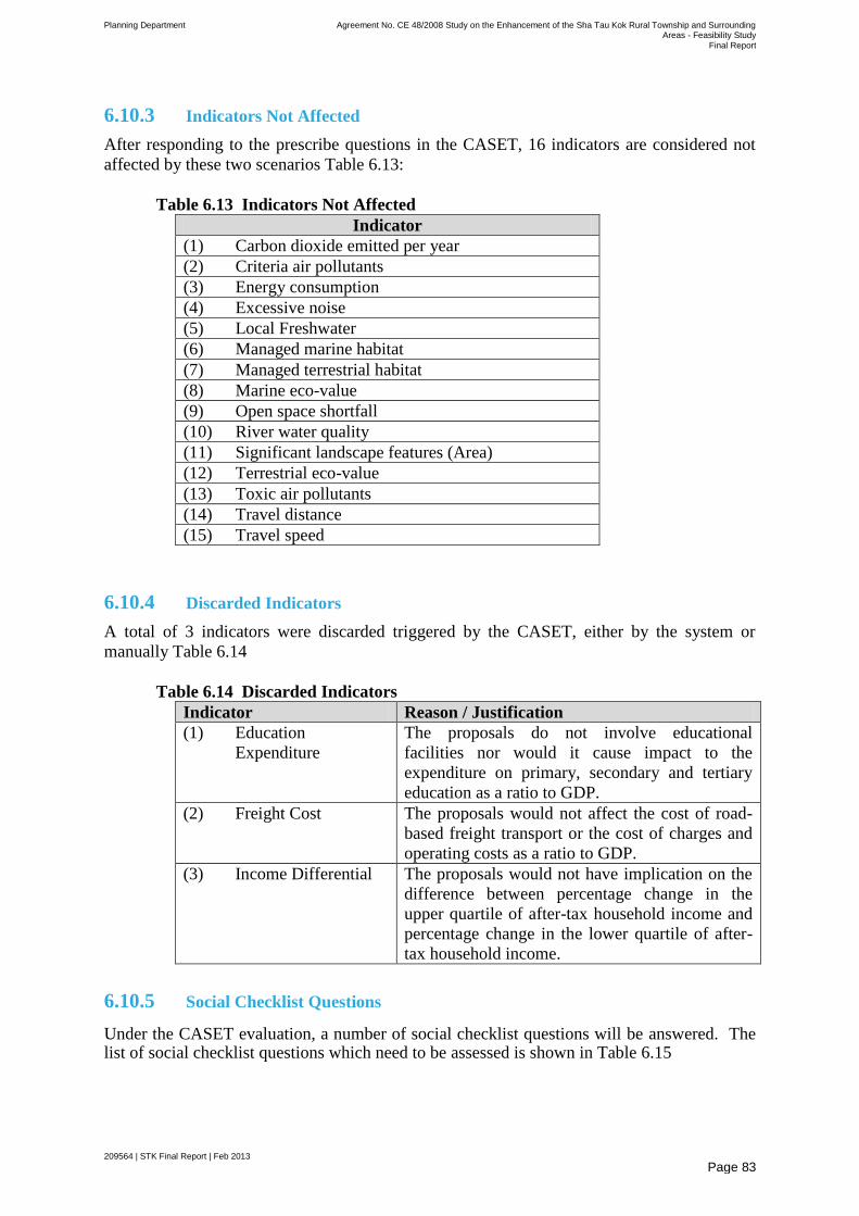
Planning Department Agreement No. CE 48/2008 Study on the Enhancement of the Sha Tau Kok Rural Township and Surrounding Areas - Feasibility Study
Final Report
209564 | STK Final Report | Feb 2013
Page 83
6.10.3 Indicators Not Affected
After responding to the prescribe questions in the CASET, 16 indicators are considered not
affected by these two scenarios Table 6.13:
Table 6.13 Indicators Not Affected
Indicator
(1) Carbon dioxide emitted per year
(2) Criteria air pollutants
(3) Energy consumption
(4) Excessive noise
(5) Local Freshwater
(6) Managed marine habitat
(7) Managed terrestrial habitat
(8) Marine eco-value
(9) Open space shortfall
(10) River water quality
(11) Significant landscape features (Area)
(12) Terrestrial eco-value
(13) Toxic air pollutants
(14) Travel distance
(15) Travel speed
6.10.4 Discarded Indicators
A total of 3 indicators were discarded triggered by the CASET, either by the system or
manually Table 6.14
Table 6.14 Discarded Indicators
Indicator Reason / Justification
(1) Education
Expenditure
The proposals do not involve educational
facilities nor would it cause impact to the
expenditure on primary, secondary and tertiary
education as a ratio to GDP.
(2) Freight Cost The proposals would not affect the cost of road-
based freight transport or the cost of charges and
operating costs as a ratio to GDP.
(3) Income Differential The proposals would not have implication on the
difference between percentage change in the
upper quartile of after-tax household income and
percentage change in the lower quartile of after-
tax household income.
6.10.5 Social Checklist Questions
Under the CASET evaluation, a number of social checklist questions will be answered. The list of social checklist questions which need to be assessed is shown in Table 6.15
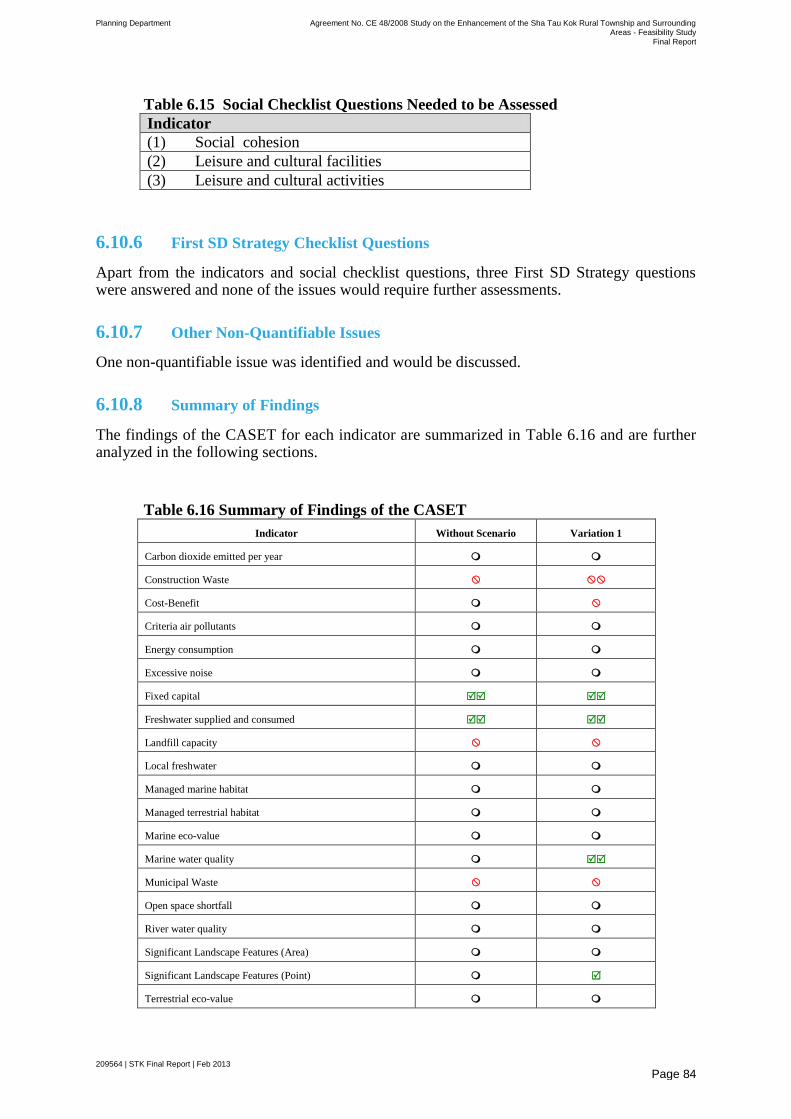
Planning Department Agreement No. CE 48/2008 Study on the Enhancement of the Sha Tau Kok Rural Township and Surrounding Areas - Feasibility Study
Final Report
209564 | STK Final Report | Feb 2013
Page 84
Table 6.15 Social Checklist Questions Needed to be Assessed
Indicator
(1) Social cohesion
(2) Leisure and cultural facilities
(3) Leisure and cultural activities
6.10.6 First SD Strategy Checklist Questions
Apart from the indicators and social checklist questions, three First SD Strategy questions were answered and none of the issues would require further assessments.
6.10.7 Other Non-Quantifiable Issues
One non-quantifiable issue was identified and would be discussed.
6.10.8 Summary of Findings
The findings of the CASET for each indicator are summarized in Table 6.16 and are further analyzed in the following sections.
Table 6.16 Summary of Findings of the CASET
Indicator Without Scenario Variation 1
Carbon dioxide emitted per year
Construction Waste
Cost-Benefit
Criteria air pollutants
Energy consumption
Excessive noise
Fixed capital
Freshwater supplied and consumed
Landfill capacity
Local freshwater
Managed marine habitat
Managed terrestrial habitat
Marine eco-value
Marine water quality
Municipal Waste
Open space shortfall
River water quality
Significant Landscape Features (Area)
Significant Landscape Features (Point)
Terrestrial eco-value
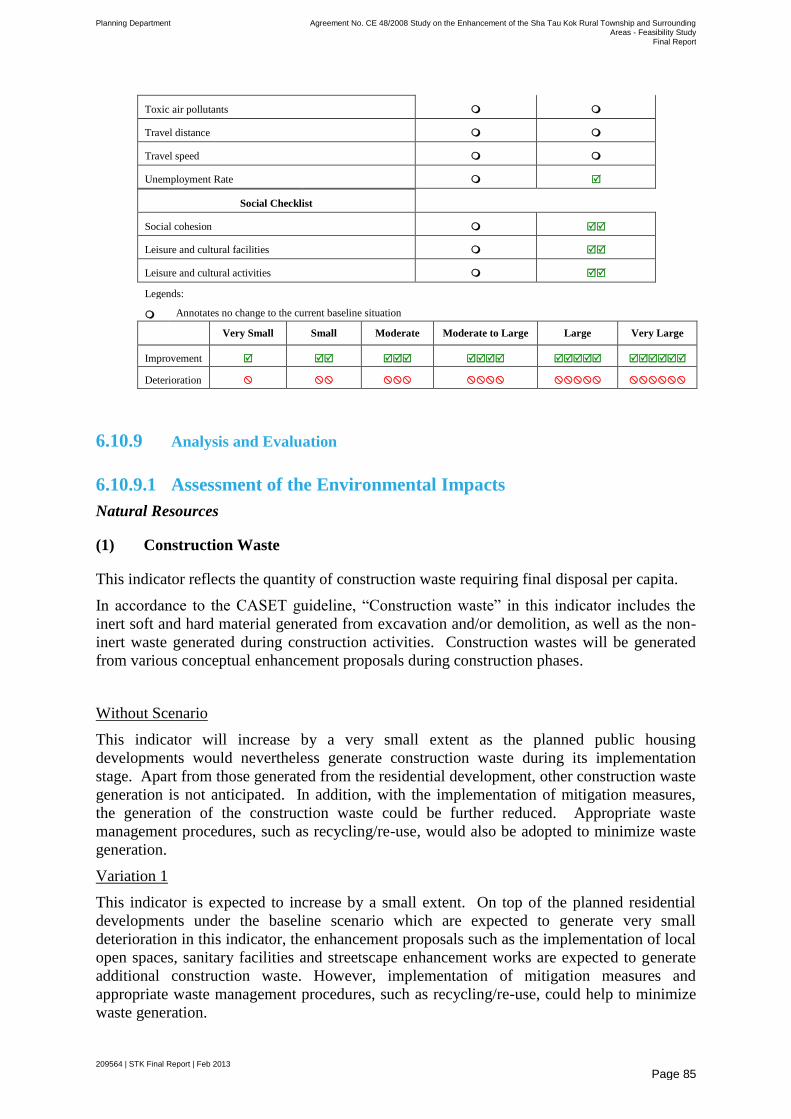
Planning Department Agreement No. CE 48/2008 Study on the Enhancement of the Sha Tau Kok Rural Township and Surrounding Areas - Feasibility Study
Final Report
209564 | STK Final Report | Feb 2013
Page 85
Toxic air pollutants
Travel distance
Travel speed
Unemployment Rate
Social Checklist
Social cohesion
Leisure and cultural facilities
Leisure and cultural activities
Legends:
Annotates no change to the current baseline situation
Very Small Small Moderate Moderate to Large Large Very Large
Improvement
Deterioration
6.10.9 Analysis and Evaluation
6.10.9.1 Assessment of the Environmental Impacts
Natural Resources
(1) Construction Waste
This indicator reflects the quantity of construction waste requiring final disposal per capita.
In accordance to the CASET guideline, ―Construction waste‖ in this indicator includes the
inert soft and hard material generated from excavation and/or demolition, as well as the non-
inert waste generated during construction activities. Construction wastes will be generated
from various conceptual enhancement proposals during construction phases.
Without Scenario
This indicator will increase by a very small extent as the planned public housing
developments would nevertheless generate construction waste during its implementation
stage. Apart from those generated from the residential development, other construction waste
generation is not anticipated. In addition, with the implementation of mitigation measures,
the generation of the construction waste could be further reduced. Appropriate waste
management procedures, such as recycling/re-use, would also be adopted to minimize waste
generation.
Variation 1
This indicator is expected to increase by a small extent. On top of the planned residential
developments under the baseline scenario which are expected to generate very small
deterioration in this indicator, the enhancement proposals such as the implementation of local
open spaces, sanitary facilities and streetscape enhancement works are expected to generate
additional construction waste. However, implementation of mitigation measures and
appropriate waste management procedures, such as recycling/re-use, could help to minimize
waste generation.
Planning Department Agreement No. CE 48/2008 Study on the Enhancement of the Sha Tau Kok Rural Township and Surrounding Areas - Feasibility Study
Final Report
209564 | STK Final Report | Feb 2013
Page 86
(2) Freshwater Supplied and Consumed
This indicator reflects the volume of freshwater supplied (i.e. input to water treatment works)
to the population of Hong Kong.
Without Scenario
This indicator will increase by a very small extent as the new population intake of the
planned residential developments in STK Town and the tourists visiting the Linkage Area via
hiking (i.e. given the Linkage Area is only accessible via hiking without the option of
travelling via STK Town) will lead to a small increase in the volume of freshwater supplied
and consumed per capita and hence a change to this indicator.
Variation 1
With the tourism activities generated by the 500 tourists, water consumption is anticipated to
increase. However, taking into consideration that the daily maximum of 500 tourists allowed
to visit the Linkage Area via STK Public Pier are confined to only during the weekends and
public holidays, this limited number of tourists is not expected to lead to a significant
increase in freshwater consumption. Hence, the change in this indicator will be small.
(3) Local Freshwater
This indicator shows the percentage of demand met by locally-derived fresh water resources
in Hong Kong. In general, the fresh water supplied to Hong Kong is mainly from Dongjiang
in Guangdong, China, which occupies about 70% to 80% of the total fresh water supply7 in
Hong Kong. The remaining 20% to 30% of its fresh water is derived from rainfall from
natural catchment and reservoirs.
Without Scenario
Since the fresh water demand in STK Town are not met by locally-derived fresh water
resources such as rainfall from natural catchment and reservoirs, the new population intake of
the proposed residential development in STK Town will likely not lead to a change in this
indicator. Therefore, this indicator is expected to remain the same.
Variation 1
The tourism activities and sanitary facilities will increase demand of fresh water, that demand
is not likely to be met by locally-derived fresh water resources in Hong Kong. Therefore, this
indicator is expected to remain the same.
(4) Energy Consumption
This indicator reflects the energy consumption per unit of output ($GDP).
Without Scenario
The population intake of the new residential development would not lead to any increase in
consumption of energy per unit of output. Therefore, the indicator is expected to remain the
same.
7 http://www.wsd.gov.hk/en/publications_and_statistics/statistics/key_facts/miscellaneous_data/index.html
Planning Department Agreement No. CE 48/2008 Study on the Enhancement of the Sha Tau Kok Rural Township and Surrounding Areas - Feasibility Study
Final Report
209564 | STK Final Report | Feb 2013
Page 87
Variation 1
The conceptual enhancement proposals, which comprise mainly local improvement works
that do not generate economic output, together with a daily maximum of 500 tourists who
travels only during weekends and public holidays to STK Public Pier and Linkage Area are
anticipated to have insignificant impact on energy consumption and economic output.
Therefore, the energy intensity, i.e. energy consumption per GDP output is not expected to
change.
(5) Landfill Capacity
This indicator reflects the total remaining landfill capacity by volume.
Without Scenario
Waste generated from the construction of the planned residential developments will be
disposed at landfills. Apart from that, during operational stage of the residential
developments, the estimated amount of municipal wastes generated is expected to increase.
Although some of the total waste can be recycled/recovered, the remaining portion will still
be disposed of at the landfill. As such, this indicator is expected to be slightly decreased.
Variation 1
The conceptual enhancement proposals, which are small in nature and mainly local
improvement works, are expected to generate waste, of which some would be disposed of at
the landfill, during the implementation stage. The daily maximum of 500 tourists during the
weekends and public holidays will generate waste, but the extent is expected to be
insignificant. With the tourism-supporting facilities and the tourist activities in addition to
the waste generated from the construction of residential developments under the baseline
scenario, the landfill capacity is expected to decrease slightly with the project. However,
considering these activities and the waste generated from a territorial perspective, a very
small decrease in this indicator is expected. Nevertheless, waste minimization and material
recovery/recycling should be considered to reduce the final disposal.
(6) Significant Landscape Features (Area)
This indicator presents the area of significant landscape features that would be affected under
the scenarios to be assessed.
Without Scenario
No area-based significant landscape features would be affected and hence the indicator is
expected to remain the same.
Variation 1
The conceptual enhancement proposals will not affect any area-based significant landscape
features. Hence, the indicator will remain the same.
(7) Significant Landscape Features (Point)
This indicator reflects the total number of point-based significant landscape features and old
and valuable trees (OVTs) of the Project.
Without Scenario
No point-based significant landscape features would be affected and hence the indicator is
expected to remain the same.
Planning Department Agreement No. CE 48/2008 Study on the Enhancement of the Sha Tau Kok Rural Township and Surrounding Areas - Feasibility Study
Final Report
209564 | STK Final Report | Feb 2013
Page 88
Variation 1
With the implementation of the conceptual enhancement proposals, the conditions of the
shophouses at San Lau Street will be improved when the preservation/refurbishment schemes
are in place. It is envisaged that some point-based significant landscape features, such as
historical landmark buildings in STK Town will face positive improvements. In light of this,
this indicator is expected to have very small positive change.
(8) Municipal Waste
This indicator shows the quantity of municipal solid waste requiring final disposal per capita
in Hong Kong.
Without Scenario
The new population intake of the planned residential developments in STK Town, which will
generate municipal solid waste requiring final disposal, will lead to a very small increase in
this indicator.
Variation1
In addition to the new population intake of the planned residential developments (under
baseline scenario), the activities of the 500 tourists during weekends and public holidays will
likely to produce additional municipal solid waste requiring final disposal. Hence, a small
increase in this indicator is expected.
Biodiversity
(9) Managed Terrestrial Habitat
This indicator refers to the area of terrestrial habitat managed for nature conservation in Hong
Kong.
Without Scenario
The indicator is expected to remain the same without any proposal.
Variation 1
This indicator will remain the same since no managed terrestrial habitat (Lai Chi Wo Special
Area and Plover Cove Country Park) would be affected by the conceptual enhancement
proposals.
(10) Terrestrial Eco-value
This indicator refers to the area of high terrestrial ecological value in Hong Kong.
Without Scenario
The indicator is expected to remain the same without any proposal.
Variation 1
This indicator will remain the same since no area with high terrestrial ecological value, such
as woodland, shrubland, wetland or mangrove, would be affected by those proposals.
(11) Managed Marine Habitat
This indicator indicates the area of managed marine habitat for conservation in Hong Kong,
where exposes to impacts of this Project.
Planning Department Agreement No. CE 48/2008 Study on the Enhancement of the Sha Tau Kok Rural Township and Surrounding Areas - Feasibility Study
Final Report
209564 | STK Final Report | Feb 2013
Page 89
Without Scenario
The indicator is expected to remain the same without any proposal and by assuming no
formal designation of new potential marine parks/marine reserves in Hong Kong.
Variation 1
This indicator is expected to remain the same since no managed marine habitat (Yau Chau
Tong Marine Park) would be affected by the enhancement proposals.
(12) Marine Eco-value
This indicator indicates the area of Hong Kong of high marine ecological value.
Without Scenario
This indicator is expected to remain the same without the proposal and by assuming no
change to the area of high marine ecological value habitat in Hong Kong either through
habitat loss or by affecting the species diversity of the marine communities present in the area.
Variation 1
This indicator is expected to remain the same since no managed marine ecological value area
(Yau Chau Tong Marine Park) would be affected by those proposals.
Environmental Quality
(13) Carbon Dioxide Emitted per Year
This indicator refers to the quantity (tonnes) of carbon dioxide emitted per year.
Without Scenario
The new population intake of the planned residential developments in STK Town will
generate carbon dioxide emission due to the increase in traffic activities and energy use (e.g.
electricity consumption). However, it is anticipated that the carbon dioxide generated will be
low on annual average which is considered insignificant and would likely not lead to any
increase in this indicator.
Variation 1
The carbon dioxide emission generated by the conceptual enhancement proposals and the
activities of the daily maximum of 500 tourists during weekends and public holidays are
expected to be insignificant when compared with the total emission generated in Hong Kong.
The indicator under this scenario is expected to remain the same.
(14) Criteria Air Pollutants
This indicator refers to the composite index for criteria air pollutants based on percentage of
the Air Quality Objectives (AQO). The three indicator pollutants include: respirable
suspended particulates (RSP), nitrogen dioxide (NO2) and sulphur dioxide (SO2). These
pollutants are routinely monitored and primarily sources from industrial activities, power
stations and vehicle combustion engines.
Without Scenario
While the new population intake of the proposed residential developments in STK Town will
possibly generate some increase in traffic, the generation of pollutants from vehicle
combustion engines is not anticipated. Moreover, as there are no industrial activities or
power stations within the STK Town and the Linkage Area, an increase in the composite
Planning Department Agreement No. CE 48/2008 Study on the Enhancement of the Sha Tau Kok Rural Township and Surrounding Areas - Feasibility Study
Final Report
209564 | STK Final Report | Feb 2013
Page 90
index for criteria air pollutants based on percentage of the AQO is not expected. Therefore,
this indicator is expected to remain the same.
Variation 1
Given the baseline scenario together with the activities of the daily maximum of 500 tourists
during weekends and public holidays and the conceptual enhancement proposals in place
would not lead to any increase in the composite index for criteria air pollutants based on
percentage of the AQO. Therefore, this indicator is expected to remain the same.
(15) Excessive Noise
This indicator refers to the percentage of population in Hong Kong exposed to excessive
noise. It is of particular concern in Hong Kong because of the close proximity of noise
sources to sensitive receivers.
Without Scenario
Major noise sources predominantly come from road traffic and fixed noise sources. Whilst
the construction of the planned residential developments may result in some noise impact
during the construction stage, mitigation measures can be implemented to alleviate the noise
impact. Moreover, since the planned residential developments during the operational phase
are not a fixed noise source and there are no other proposals under this scenario, the indicator
is expected to remain the same.
Variation 1
Major noise sources predominantly come from road traffic and fixed noise sources. Whilst
the construction of the conceptual enhancement proposals, such as the local open spaces,
sanitary facilities, repaving of San Lau Street, may result in some noise impact during the
construction stage, mitigation measures can be implemented to alleviate the impact and
disturbance. Since the conceptual enhancement proposals would not generate excessive noise
during the operational phase, this indicator is expected to remain the same.
(16) Marine Water Quality
This indicator refers to the composite index for marine water quality pollutants based on the
percentage of the Water Quality Objectives (WQO).
Without Scenario
The indicator is expected to remain the same without any proposal.
Variation 1
The proposed trash grille and rubbish clearance at the nullah along San Lau Street would help
to improve marine water quality of STK Hoi. Therefore, this indicator is expected to increase
positively.
(17) River Water Quality
This indicator reflects the percentage of EPD‘s river monitoring stations ranked ―Excellent‖
or ―Good‖ using the EPD River Water Quality Index.
Without Scenario
The indicator is expected to remain the same without any proposal.

Planning Department Agreement No. CE 48/2008 Study on the Enhancement of the Sha Tau Kok Rural Township and Surrounding Areas - Feasibility Study
Final Report
209564 | STK Final Report | Feb 2013
Page 91
Variation 1
The indicator is expected to remain the same because there is no impact of the conceptual
enhancement proposals on the river water quality of the inland watercourses in the Linkage
Area.
(18) Toxic Air Pollutants
Toxic air pollutants are substances that generally exist at low concentrations in the ambient
environment. Inhalation of sufficient levels of these pollutants can cause health problems
such as cancer, reproductive disorders and lung damage. The Toxic Air Pollutant (TAP)
indicator was developed in recognition of the health risks associated with exposure to toxic
substances in the air.
This indicator refers to the composite index for toxic air pollutants (TAPs) based on the
percentage of acceptable risk. The three indicator pollutants include: Benzo(a)pyrene,
Benzene and Formaldehyde.
Without Scenario
The new population intake of the planned residential developments in STK Town would not
lead to any increase in this indicator.
Variation 1
The level of TAPs in the STK Town and the Linkage Area is anticipated to be unchanged
since the recommended enhancement proposals do not emit TAPs. Even with the activities
of the daily maximum of 500 tourists during weekends and public holidays would not lead to
any increase in the composite index for toxic air pollutants that based on percentage of
acceptable risk. Therefore, an increase in this indicator is not expected.
Leisure and Cultural Vibrancy
(19) Open Space Shortfall
This indicator measures the percentage of the population living within districts with a
shortfall of required provision of open space.
Without Scenario
Since there is no shortfall of open space in STK Town (District Open Space of 1.95 ha and
Local Open Space of 0.41 ha for the current population of about 5,100 and projected future
population of 7,300 assuming the new population intake of the planned residential
developments), this indicator is expected to remain the same.
Variation 1
Local open spaces will be provided at Market Street and at Shun Lung Street (Waterfront
Piazza) in STK Town. Since there is no shortfall of open space in STK Town (District Open
Space of 1.95 ha and Local Open Space of 0.41 ha for the future population of about 7,300),
this indicator is expected to remain the same.
Planning Department Agreement No. CE 48/2008 Study on the Enhancement of the Sha Tau Kok Rural Township and Surrounding Areas - Feasibility Study
Final Report
209564 | STK Final Report | Feb 2013
Page 92
6.10.9.2 Assessment of the Economic Impacts
Economy
(20) Cost-Benefit
This indicator is the economic return as determined through the cost-benefit analysis.
Without Scenario
The indicator is expected to remain the same without any proposal.
Variation 1
Since STK Town will not be opened up to the public for tourism purpose, the extent of
revitalizing the local economy and additional job opportunities generation will be limited.
The conceptual enhancement proposals, which are mainly communal facilities and not
revenue generating, during the operational phase would likely generate social benefit more
than economic benefit. As such, economic impact in terms of both value added contribution
to GDP and long term employment creation to the Hong Kong economy is not expected.
Whilst there will be a daily maximum of 500 tourists to be allowed to visit the Linkage Area
via STK Public Pier during weekends and public holidays, the job opportunities generated
from limited tourist activities will only bring about a small increase in economic returns.
Despite this, there are also other unquantifiable benefits such as the promotion of eco-tourism
in Hong Kong and city image building that needs to be taken into account. Generally
speaking, changes to this indicator are expected and the extent of such change is qualitatively
considered to be small.
(21) Fixed capital
This indicator refers to the gross domestic fixed capital formation as a ratio to GDP. Gross
domestic fixed capital is the before-allowance capital consumptions within Hong Kong
regardless of ownership.
Without Scenario
This indicator is expected to change as the planned residential developments will likely
attract some fixed capital investment. However, the fixed capital investment of the planned
residential developments in STK Town compared with the annual capital expenditure of
Hong Kong‘s GDP is insignificantly small. In this connection, the change to this indicator is
expected to be very small.
Variation 1
The planned residential developments (under baseline scenario) together with the conceptual
enhancement proposals in STK Town will likely attract more fixed capital investment.
However, the fixed capital investment of these developments compared with the annual
capital expenditure of Hong Kong‘s GDP is still considered small. Therefore, the change to
this indicator is expected to be small.
(22) Unemployment Rate
This indicator refers to the unemployment rate, as published by the Census and Statistics
Department regularly.

Planning Department Agreement No. CE 48/2008 Study on the Enhancement of the Sha Tau Kok Rural Township and Surrounding Areas - Feasibility Study
Final Report
209564 | STK Final Report | Feb 2013
Page 93
Without Scenario
The indicator will remain the same without any proposal.
Variation 1
The tourism activities from the daily maximum of 500 tourists during the weekends and
public holidays will likely generate some job opportunities, but its impact is expected to be
very small. Nevertheless, there is a possibility of a slight decrease in unemployment rate in
the locality.
Mobility
(23) Travel Distance
Without Scenario
The indicator will remain the same in this scenario.
Variation 1
The indicator is expected to remain the same because a daily maximum of 500 tourists will
only visit STK Public Pier during weekends and public holidays, but not during the weekday
morning peak hours. However, tourists could have a shorter route from urban area to STK
Public Pier and then take the return boat trips to the Linkage Area.
(24) Travel Speed
Without Scenario
The indicator is expected to remain the same in this scenario.
Variation 1
The indicator is expected to remain the same since only a daily maximum of 500 tourists will
be allowed to travel to STK Public Pier during weekends and public holidays by coaches.
Limited number of coaches will not affect the traffic flow and network speed of those major
roads. However, tourists could have a faster route from urban area to STK Public Pier and
then take the return boat trips to the Linkage Area.
6.10.9.3 Assessment of Social Impacts
(25) Social Cohesion
This indicator measures whether people‘s (including youth‘s) sense of belonging to society
and/or their involvement in the community (including voluntary work) as well as social
cohesion, mutual support and networking will be affected.
Without Scenario
As STK Town would not be opened for tourism purpose, tourism-related proposals could not
be implemented and the local economy will remain sluggish. The locals‘ discontent with the
government will affect the harmony of the society.
Despite the above, the option for public housing development on residential site is now kept
open in STK Town. This means some residents could possibly live in the Town and a better
living environment is envisaged. The social disgruntlement about the lack of housing units in
Planning Department Agreement No. CE 48/2008 Study on the Enhancement of the Sha Tau Kok Rural Township and Surrounding Areas - Feasibility Study
Final Report
209564 | STK Final Report | Feb 2013
Page 94
STK Town and the possibility of displacing locals because of the housing issue could be
alleviated. Moreover, the living conditions of the congested households in STK Chuen could
be improved. With the public housing development in place, this would strengthen the social
network of the local community, foster closer ties of families and could improve the sense of
belonging to the local community. Balancing the various elements, it is considered that
positive improvement in this indicator is anticipated.
Variation 1
Under this scenario, the conceptual enhancement proposals (i.e. the provision of local open
spaces, streetscape enhancement at San Lau Street, trash grilles at the nullah etc.) undertaken
in STK Town and the Linkage Area, which would improve the attractiveness, the
environment and the living quality of the area. These new facilities could provide better
serve the existing community by providing recreational amenities for the locals such as
gathering places for mingling, which could further strengthen social cohesion. In conclusion,
there would still be improvement to this indicator.
(26) Leisure and Cultural Facilities
This indicator measures whether the Project will affect the level of provision, quality and/or
variety of sports, recreational or cultural facilities.
Without Scenario
The indicator will remain the same without any proposal.
Variation 1
This scenario will bring small improvement because the proposals will provide new leisure
(e.g. new local open spaces at Market Street and Shun Hing Street (Waterfront Piazza) in
STK Town) and tourism facilities (e.g. Proposed Ecological Centre in Lai Chi Wo) in both
Study Area and Linkage Area.
(27) Leisure and Cultural Activities
This indicator measures whether the Project will affect people‘s participation in sports,
recreational or cultural activities.
Without Scenario
The indicator will remain the same without any proposal.
Variation 1
This scenario will bring small improvement because the local improvement works will
provide new leisure (e.g. new local open spaces at Market Street and Shun Hing Street
(Waterfront Piazza) in STK Town) and tourism facilities (e.g. Proposed Ecological Centre in
Lai Chi Wo). This will provide additional recreational opportunities for the locals and tourists.
6.10.9.4 Non-quantifiable Consideration
Visual Impact of the Planned Residential Developments
The height of the planned residential developments and the possible visual impact it might
have on the surrounding context may be a concern of the locals. Therefore, the visual
compatibility and design of these developments with the surrounding developments should be
given due consideration.
Planning Department Agreement No. CE 48/2008 Study on the Enhancement of the Sha Tau Kok Rural Township and Surrounding Areas - Feasibility Study
Final Report
209564 | STK Final Report | Feb 2013
Page 95
7 Implementation Arrangements
The IAIP would mainly concentrate on the available Government land so as to minimize land resumption. In general, the improvement proposals are mainly small in scale and should not have any insurmountable technical problems. These projects could be implemented through the existing mechanism by concerned departments subject to their priority and resource availability. Nevertheless, close liaison amongst concerned departments and further local consultation would be required to ensure these projects could be implemented smoothly. Prior to the implementation of the improvement proposals, detailed engineering feasibility studies and technical assessments, if necessary, should be conducted to ascertain the technical and environmental acceptability of these proposals.
The recommended conceptual enhancement proposals will not involve major works but only minor local enhancement that can be pursued under the existing mechanism. It is expected that most of them, if taken forward, can be implemented through Category D items (i.e. minor works projects costing $21 million or less). Hence, they should have no significant productivity, economic, financial and civil service implications. Additional resources, if required, will be sought in accordance with the established mechanism.
It is also noted that further confirmation with relevant government client departments and implementation parties would be required.
Details of the proposals and the implementation arrangement are elaborated in the following sub-sections.
7.1.1 Local Improvement Works
7.1.1.1 Proposed Public Rental Housing Development
The vacant residential site at Shun Hing Street which is located next to the HKHS‘s STK Chuen is considered will be developed for public rental housing development. The HKHS would be the implementation agent of this public rental housing development.
7.1.1.2 Local Open Space at Market Street
The vacant Government site at Market Street is recommended for community use and create a local open space for use by the local communities.
It is proposed that the provision of a local open space at Market Street can be initiated by the Leisure and Cultural Services Department (LCSD) to take up the construction, management and maintenance responsibilities of this open space.
7.1.1.3 Streetscape Enhancement at San Lau Street
San Lau Street will be revitalised by carrying out extensive streetscape enhancement to improve the current condition:
Re-paving of the footpath along the shophouses: To echo with the abovementioned streetscape design objectives, it is proposed to improve the existing street paving. Instead of retaining the weather-beaten concrete street paving, it is recommended to re-pave the entire San Lau Street with unique decorative paving so as to enrich the users‘ experience. As this enhancement works involves re-paving of public footpath, it is considered that Highways
Planning Department Agreement No. CE 48/2008 Study on the Enhancement of the Sha Tau Kok Rural Township and Surrounding Areas - Feasibility Study
Final Report
209564 | STK Final Report | Feb 2013
Page 96
Department (HyD) can serve as the implementation agent. The future maintenance of the pavement would also be under HyD‘s purview.
Re-paving of vehicular access: Since San Lau Street serves as a servicing road and an EVA for the shophouses, it is necessary to ensure the access road is free of obstruction for the passing of servicing vehicles and emergency vehicles. In view of the overall enhancement proposal for San Lau Street, it is recommended that the vehicular access will be re-paved with decorative paving that echoes with the footpath to ensure visual compatibility and legibility. The road enhancement works could be implemented by HyD. HyD would be responsible for the future maintenance of this vehicular access.
Beautification of the streetscape: San Lau Street is lined by a row of existing trees along the vehicular access which provides shading to the area. As part of the conceptual enhancement proposal, existing trees would be preserved. The existing tree pits will be standardized as part of the landscape treatment and the works. Other works include providing additional landscaping and planting, re-installation of street lamps), and erection of decorative structures (such as the proposed plaques) to introduce the history of the street and shophouses. HyD could take the responsibilities to construct and maintain these works. Advice from AMO should be sought on the erection of decorative structures.
The details of the bronze plaques design and contents are subjected to further discussion and study. For examples, collaborations with local universities can also be sought in the implementation stage. Due to the respect of the ownership, this recommendation of introducing the plaques for the shophouses will be an optional choice for shop owners, who can decide whether to install plaques on their pillars. This recommendation of introducing plagues for the shophouses will be an optional choice for shop owners. If the shopowners wish to install such plagues and give their consent for HAD to carry out the installation, HAD can consider installing the bronze plagues subject to the District Council‘s approval under the District Minor Works programme.
Since all 22 shophouses along San Lau Street are Graded 3 historic buildings, the conservation study is highly recommended to be carried out and which should form part of the implementation programme in the detailed design stage.
7.1.1.4 Improvement Works for the Nullah near San Lau Street
The existing nullah along San Lau Street is poor in condition. In order to improve the overall environment, it is recommended to install trash grille at the entrance of the nullah to prevent waste materials/rubbish back-flow and to carry out periodical clearance/dredging works to tackle the waste/rubbish accumulation and odour problems. Subject to further investigation and discussions, Drainage Services Department (DSD) can serve as the implementation and maintenance agent for the enhancement works. Since the nullah falls between the boundaries of HK and SZ, any improvement works should be handled with care and consensus should be reached among the relevant parties of both sides before proceeding with implementation.
7.1.1.5 Local Open Space at Shun Lung Street
It is proposed that the provision of this open space at Shun Lung Street can be initiated by the LCSD to take up the construction, management and maintenance responsibilities of this open space.
Since there is an area reserved for public toilet within the local open space, FEDH could initiate and ArchSD could take up the role as the works agent for the constructing the public toilet.
Planning Department Agreement No. CE 48/2008 Study on the Enhancement of the Sha Tau Kok Rural Township and Surrounding Areas - Feasibility Study
Final Report
209564 | STK Final Report | Feb 2013
Page 97
7.1.2 Transport and pedestrian Improvement Proposals
Various factors would be taken into account when designing the pedestrian precinct for the Study Area. A series of pedestrian facilities are proposed to achieve a pedestrian precinct environment for the local residents.
7.1.2.1 Traffic Improvement at Pedestrian Crossings
Implementation of traffic calming measures such as raised crossing platform and coloured paving surface with widening of footpath are proposed to be installed at: (1) the crossing points along Shun Hing Street parallel to STK Road (Shek Chung Au) and STK Road (Shek Chung Au); and (2) the crossing points at Shun Hing Street / Chung Ying Street. The implementation of these traffic calming measures could be carried out by the HyD.
7.1.3 Conceptual Enhancement Proposals at Linkage Area
7.1.3.1 Proposed Lai Chi Wo Ecological Centre
AFCD has indicated their interest to renovate the vacant Siu Ying School into an Ecological Centre in Lai Chi Wo. AFCD would likely be the implementation and operation/maintenance agent, while ArchSD would be the agent for the construction of this project. The details of the implementation and would require further discussion with AFCD. The proposed Lai Chi Wo Ecological Centre currently falls within ―V‖ zone on the Approved Lai Chi Wo, Siu Tan and Sam A Tsuen DPA Plan NO. DPA/NE-LCW/2, there is no provision of the DPA Plan to allow the proposed ecological centre development within the ―V‖ zone. There will be an opportunity to review the zoning of the site upon conversion of the DPA Plan into an OZP to facilitate development of the proposed Ecological Centre.
7.1.3.2 Provision of Public Toilet Facilities for Linkage Area
It is proposed that public toilets with the size of approx. 9m x 4m that could meet the latest standard of provision be constructed at locations within short walking distance (approx. 5 mins) from the piers in the Linkage Area. These facilities would be designed with reference to the surrounding context and will not compromise the ecologically sensitive natural environment. These small-scale public toilets are anticipated to be implemented by FEHD with the support of ArchSD as the works agent.
However, it was noted by WSD that potable water supply has not been provided to existing facilities and villages in Yung Shue Au and So Lo Pun. Therefore further investigations are required for the arrangement for water supply to the proposed toilet facilities in these areas.
7.1.3.3 Installation of Information Boards for Linkage Area
There are currently many information boards installed by various Government departments, including, AFCD, HKTB, DO/North etc, in different locations in the Linkage Area. It is proposed to consolidate the content of the existing information boards installed by AFCD, HKTB and DO/North.
DO/North would install the information boards subject to the District Council‘s approval under the District Minor Works programme. It is recommended that AFCD and DO/North could take the lead to consolidate the information of the information boards for the Linkage Area. Sufficient space could be provided for other departments to include other information.

Planning Department Agreement No. CE 48/2008 Study on the Enhancement of the Sha Tau Kok Rural Township and Surrounding Areas - Feasibility Study
Final Report
209564 | STK Final Report | Feb 2013
Page 98
The implementation responsibilities could be shared between AFCD and DO/North. The implementation works could be subject to further liaison and agreement.
7.1.3.4 Overall Broad Cost Estimations for the Proposals on IAIP
Taking into account the capital cost for construction, the overall broad cost estimation of the proposals are summarized in Table 7.2 below. The cost of each project is estimated based on a set of assumptions and only for reference purpose subject to further confirmation at the implementation stage.
Table 7.2 The overall broad cost estimations for the proposals on IAIP
Cost
Streetscape Enhancement at San Lau Street
Repavement (EVA) $2,656,214
Repavement (footpath) $284,304
Bronze plaques (40X40cm@piece) $99,000
Consultants' fees $182,371
Remuneration of resident site staff $303,952
Contingencies $1,234,044
Subtotal $4,759,885
Local open space at Market Street
Site works and site formation (total area) $127,440
Soft Landscaping Works $17,250
External Works $105,000
Furniture and Equipment $7,080
Pavement $92,834
Consultants' fees $20,976
Remuneration of resident site staff $34,960
Contingencies $141,939
Subtotal $547,480
Installation of Trash Grilles at San Lau Street Nullah
Installation of two trash grilles (width 1x0.5m per piece) $60,000
Consultants' fees $3,600
Remuneration of resident site staff $6,000
Contingencies $24,360
Subtotal $93,960
Local open space at Shun Lung Street
Site works and site formation (total area) $1,853,000
Soft Landscaping Works $92,000
External Works $1,165,000
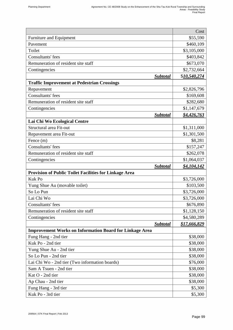
Planning Department Agreement No. CE 48/2008 Study on the Enhancement of the Sha Tau Kok Rural Township and Surrounding Areas - Feasibility Study
Final Report
209564 | STK Final Report | Feb 2013
Page 99
Cost
Furniture and Equipment $55,590
Pavement $460,109
Toilet $3,105,000
Consultants' fees $403,842
Remuneration of resident site staff $673,070
Contingencies $2,732,664
Subtotal $10,540,274
Traffic Improvement at Pedestrian Crossings
Repavement $2,826,796
Consultants' fees $169,608
Remuneration of resident site staff $282,680
Contingencies $1,147,679
Subtotal $4,426,763
Lai Chi Wo Ecological Centre
Structural area Fit-out $1,311,000
Repavement area Fit-out $1,301,500
Fence (m) $8,281
Consultants' fees $157,247
Remuneration of resident site staff $262,078
Contingencies $1,064,037
Subtotal $4,104,142
Provision of Public Toilet Facilities for Linkage Area
Kuk Po $3,726,000
Yung Shue Au (movable toilet) $103,500
So Lo Pun $3,726,000
Lai Chi Wo $3,726,000
Consultants' fees $676,890
Remuneration of resident site staff $1,128,150
Contingencies $4,580,289
Subtotal $17,666,829
Improvement Works on Information Board for Linkage Area
Fung Hang - 2nd tier $38,000
Kuk Po - 2nd tier $38,000
Yung Shue Au - 2nd tier $38,000
So Lo Pun - 2nd tier $38,000
Lai Chi Wo - 2nd tier (Two information boards) $76,000
Sam A Tsuen - 2nd tier $38,000
Kat O - 2nd tier $38,000
Ap Chau - 2nd tier $38,000
Fung Hang - 3rd tier $5,300
Kuk Po - 3rd tier $5,300
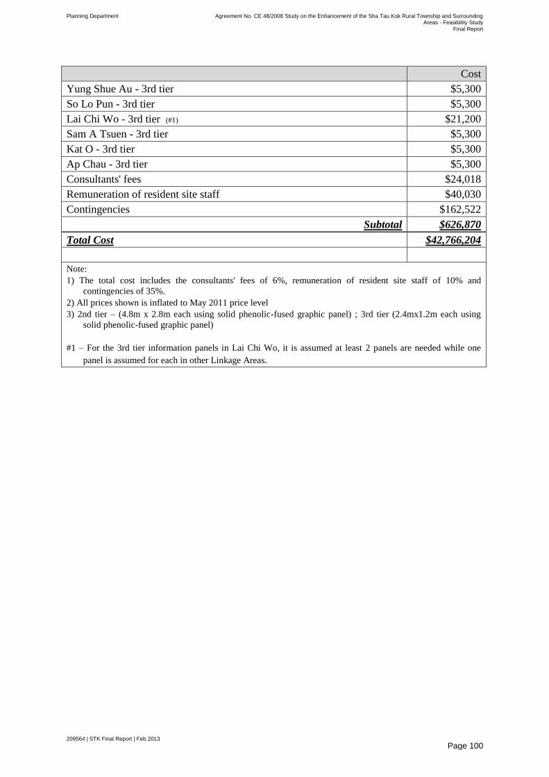
Planning Department Agreement No. CE 48/2008 Study on the Enhancement of the Sha Tau Kok Rural Township and Surrounding Areas - Feasibility Study
Final Report
209564 | STK Final Report | Feb 2013
Page 100
Cost
Yung Shue Au - 3rd tier $5,300
So Lo Pun - 3rd tier $5,300
Lai Chi Wo - 3rd tier (#1) $21,200
Sam A Tsuen - 3rd tier $5,300
Kat O - 3rd tier $5,300
Ap Chau - 3rd tier $5,300
Consultants' fees $24,018
Remuneration of resident site staff $40,030
Contingencies $162,522
Subtotal $626,870
Total Cost $42,766,204
Note:
1) The total cost includes the consultants' fees of 6%, remuneration of resident site staff of 10% and
contingencies of 35%.
2) All prices shown is inflated to May 2011 price level
3) 2nd tier – (4.8m x 2.8m each using solid phenolic-fused graphic panel) ; 3rd tier (2.4mx1.2m each using
solid phenolic-fused graphic panel)
#1 – For the 3rd tier information panels in Lai Chi Wo, it is assumed at least 2 panels are needed while one
panel is assumed for each in other Linkage Areas.
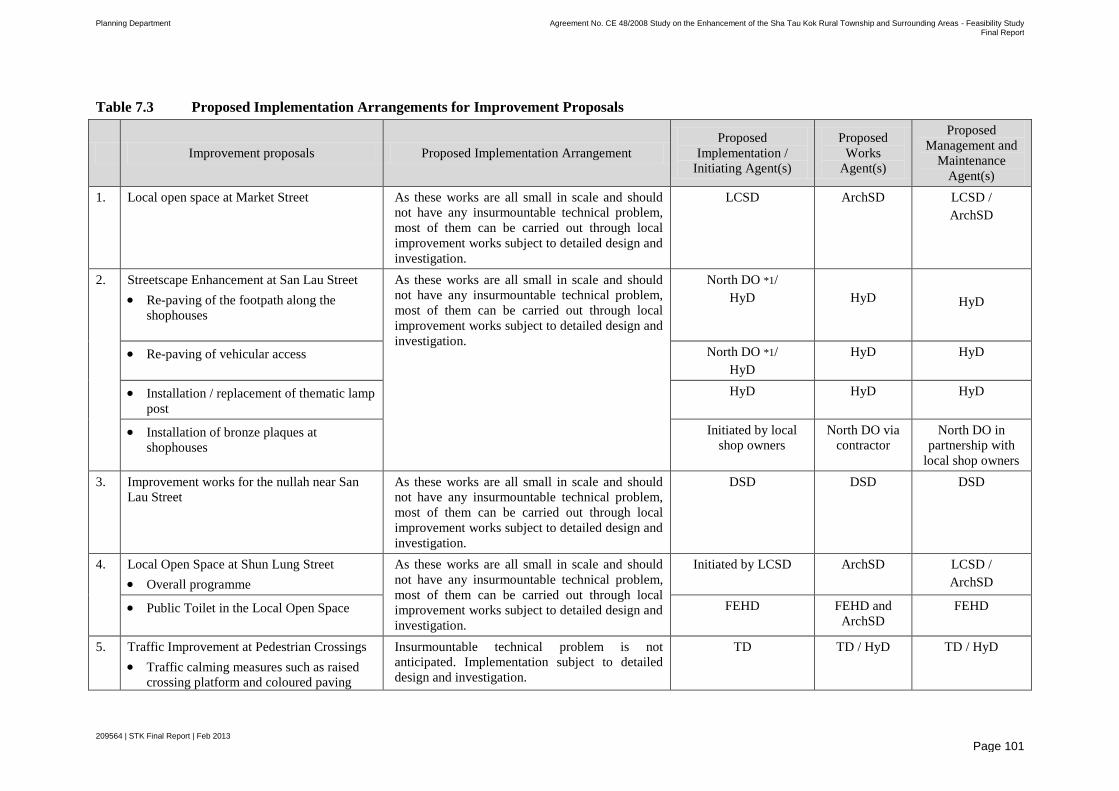
Planning Department Agreement No. CE 48/2008 Study on the Enhancement of the Sha Tau Kok Rural Township and Surrounding Areas - Feasibility Study Final Report
209564 | STK Final Report | Feb 2013
Page 101
Table 7.3 Proposed Implementation Arrangements for Improvement Proposals
Improvement proposals Proposed Implementation Arrangement
Proposed
Implementation /
Initiating Agent(s)
Proposed
Works
Agent(s)
Proposed
Management and
Maintenance
Agent(s)
1. Local open space at Market Street As these works are all small in scale and should
not have any insurmountable technical problem,
most of them can be carried out through local
improvement works subject to detailed design and
investigation.
LCSD ArchSD LCSD /
ArchSD
2. Streetscape Enhancement at San Lau Street
Re-paving of the footpath along the
shophouses
As these works are all small in scale and should
not have any insurmountable technical problem,
most of them can be carried out through local
improvement works subject to detailed design and
investigation.
North DO *1/
HyD
HyD
HyD
Re-paving of vehicular access North DO *1/
HyD
HyD HyD
Installation / replacement of thematic lamp
post
HyD HyD HyD
Installation of bronze plaques at
shophouses
Initiated by local
shop owners
North DO via
contractor
North DO in
partnership with
local shop owners
3. Improvement works for the nullah near San
Lau Street
As these works are all small in scale and should
not have any insurmountable technical problem,
most of them can be carried out through local
improvement works subject to detailed design and
investigation.
DSD DSD DSD
4. Local Open Space at Shun Lung Street
Overall programme
As these works are all small in scale and should
not have any insurmountable technical problem,
most of them can be carried out through local
improvement works subject to detailed design and
investigation.
Initiated by LCSD
ArchSD LCSD /
ArchSD
Public Toilet in the Local Open Space FEHD FEHD and
ArchSD
FEHD
5. Traffic Improvement at Pedestrian Crossings
Traffic calming measures such as raised
crossing platform and coloured paving
Insurmountable technical problem is not
anticipated. Implementation subject to detailed
design and investigation.
TD TD / HyD TD / HyD
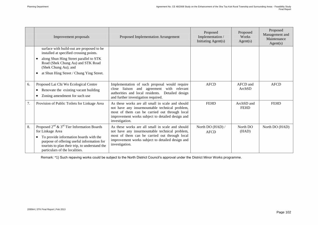
Planning Department Agreement No. CE 48/2008 Study on the Enhancement of the Sha Tau Kok Rural Township and Surrounding Areas - Feasibility Study Final Report
209564 | STK Final Report | Feb 2013
Page 102
Improvement proposals Proposed Implementation Arrangement
Proposed
Implementation /
Initiating Agent(s)
Proposed
Works
Agent(s)
Proposed
Management and
Maintenance
Agent(s)
surface with build-out are proposed to be
installed at specified crossing points.
along Shun Hing Street parallel to STK
Road (Shek Chung Au) and STK Road
(Shek Chung Au); and
at Shun Hing Street / Chung Ying Street.
6. Proposed Lai Chi Wo Ecological Centre
Renovate the existing vacant building
Zoning amendment for such use
Implementation of such proposal would require
close liaison and agreement with relevant
authorities and local residents. Detailed design
and further investigation required.
AFCD AFCD and
ArchSD
AFCD
7. Provision of Public Toilets for Linkage Area
As these works are all small in scale and should
not have any insurmountable technical problem,
most of them can be carried out through local
improvement works subject to detailed design and
investigation.
FEHD ArchSD and
FEHD
FEHD
8. Proposed 2nd
& 3rd
Tier Information Boards
for Linkage Area
To provide information boards with the
purpose of offering useful information for
tourists to plan their trip, to understand the
particulars of the localities.
As these works are all small in scale and should
not have any insurmountable technical problem,
most of them can be carried out through local
improvement works subject to detailed design and
investigation.
North DO (HAD) /
AFCD
North DO
(HAD)
North DO (HAD)
Remark: *1) Such repaving works could be subject to the North District Council’s approval under the District Minor Works programme.
Planning Department Agreement No. CE 48/2008 Study on the Enhancement of the Sha Tau Kok Rural Township and Surrounding Areas - Feasibility Study
Final Report
209564 | STK Final Report | Feb 2013
Page 103
8 Conclusion and Way Forward
Under the existing institutional arrangement, relevant Government departments will play different roles in implementation and maintenance of different conceptual enhancement proposals in the IAIP. With the implementation of the IAIP, some of the local housing demand could be met; the general environment of the STK Town and the tourism potential of the Linkage Area will be further enhanced.
The exact implementation schedule and the detailed design of these improvement proposals would be subject to the priority and resource availability of the implementation agents. The implementation of these conceptual enhancement proposals would greatly benefit the locals by improving the overall living environment and boost the local economy, while paying due respect to the natural and cultural resources of the area.
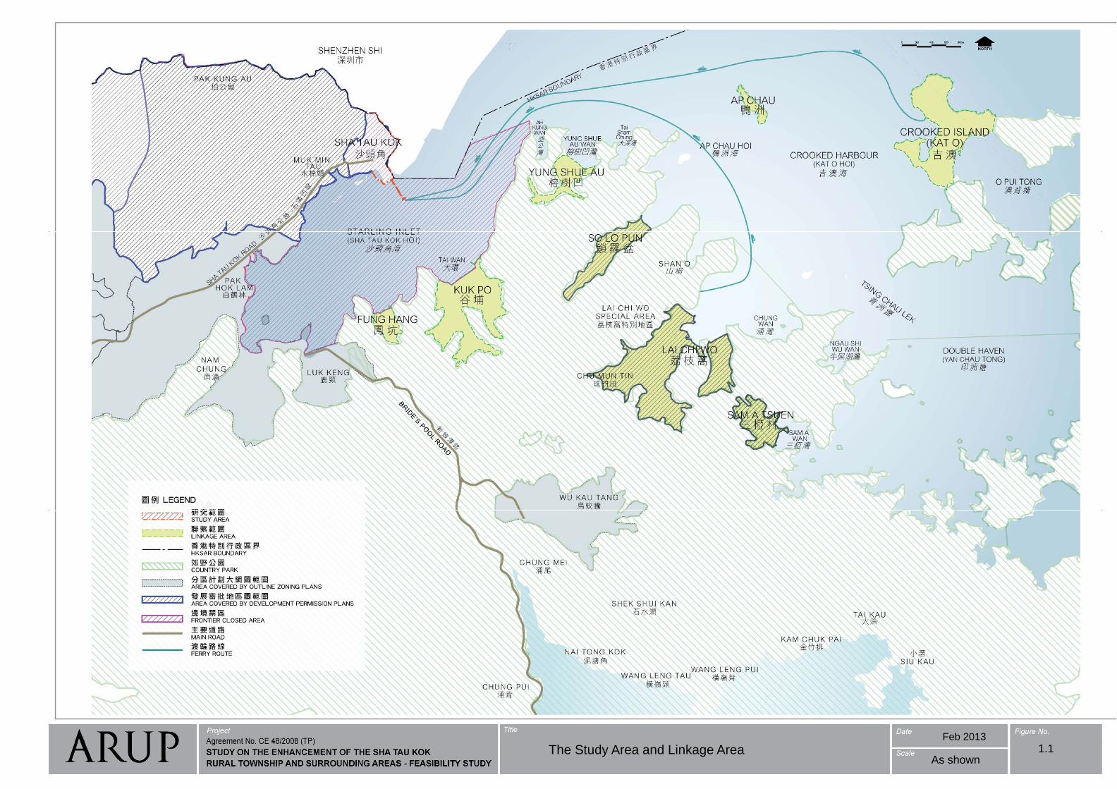
Feb 2013
The Study Area and Linkage Area 1.1As shown
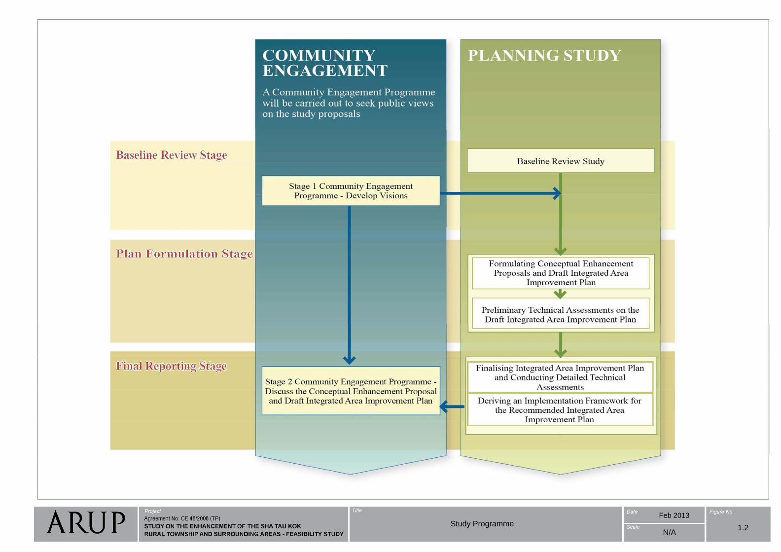
Feb 2013
Study Programme1.2
N/A

STK T E i ti B d L d U V t G t SitSTK Town Existing Broad Land Uses Vacant Government Site
3
12
4Helipad
Location
55
6
Feb 2013
Existing Broad Land Uses and Vacant Government Site in STK Town
As Shown2.1
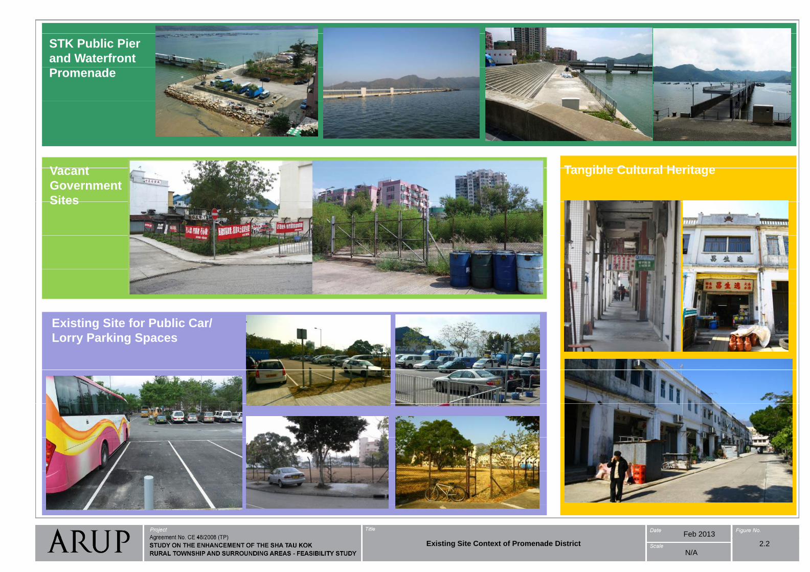
STK Public Pier
and Waterfront
Promenade
Tangible Cultural HeritageV t Tangible Cultural HeritageVacant
Government
SitesSites
Existing Site for Public Car/
Lorry Parking SpacesLorry Parking Spaces
Feb 2013
Existing Site Context of Promenade District
N/A
2.2
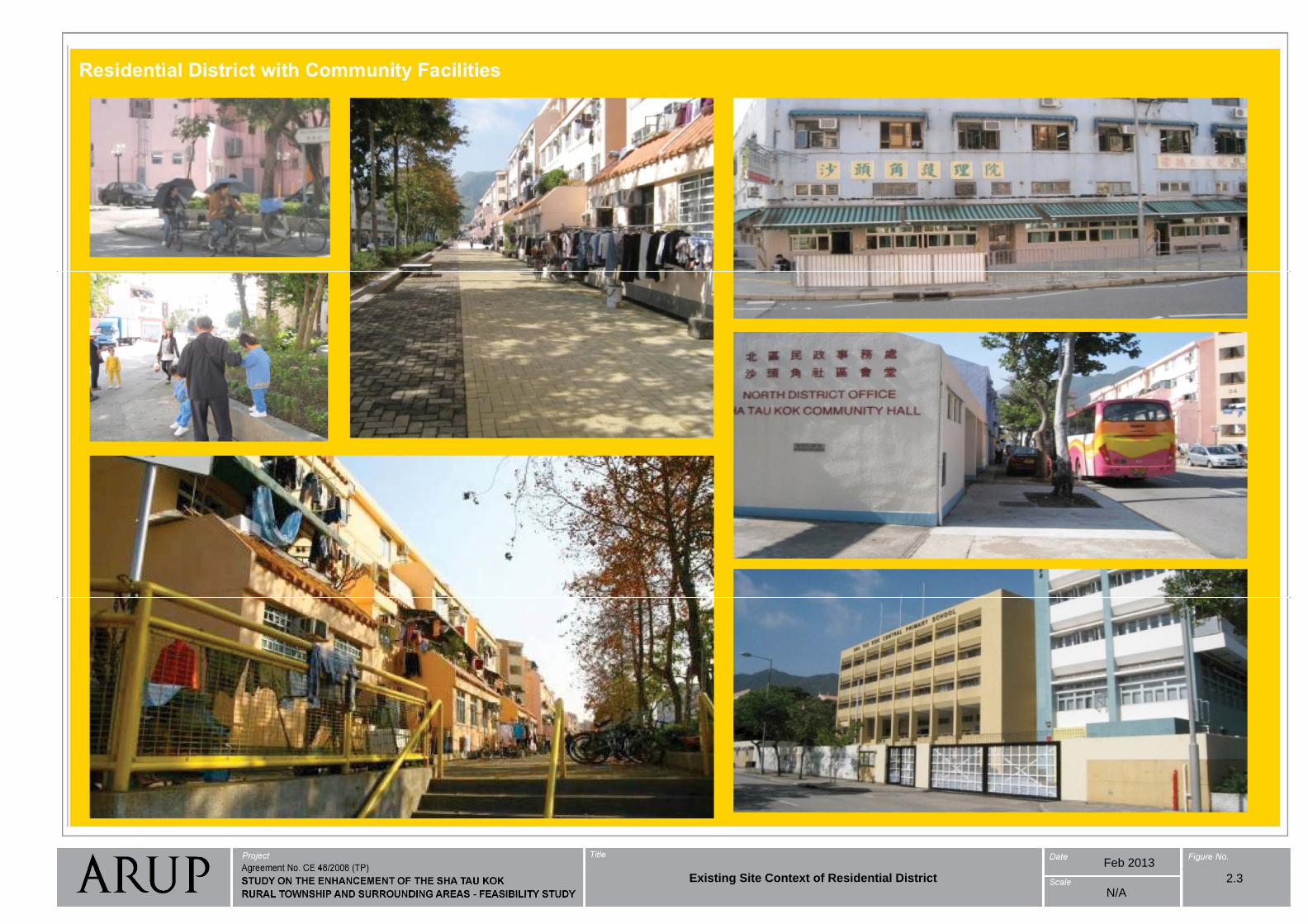
Feb 2013
2.3Existing Site Context of Residential District
N/A
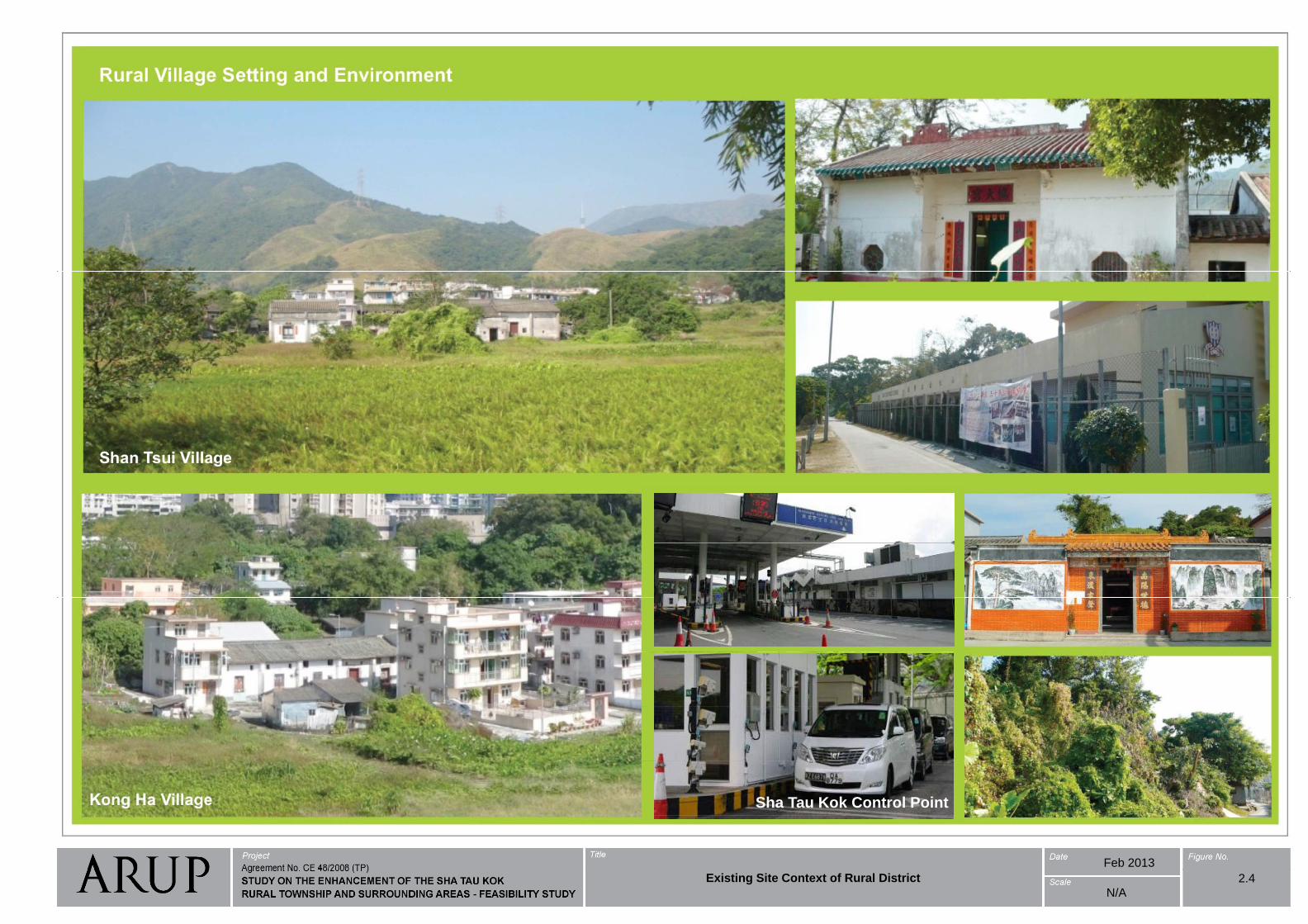
Sha Tau Kok Control Point
Feb 2013
N/A
2.4Existing Site Context of Rural District
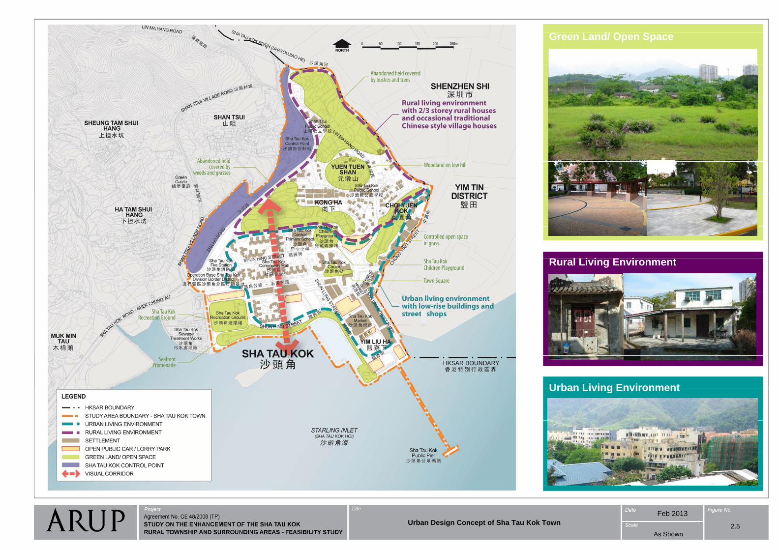
Green Land/ Open Space
Urban Design Concept of Sha Tau Kok Town
R l Li i E i tRural Living Environment
2.5
Urban Living EnvironmentUrban Living Environment
Feb 2013
As Shown
2.5Urban Design Concept of Sha Tau Kok Town
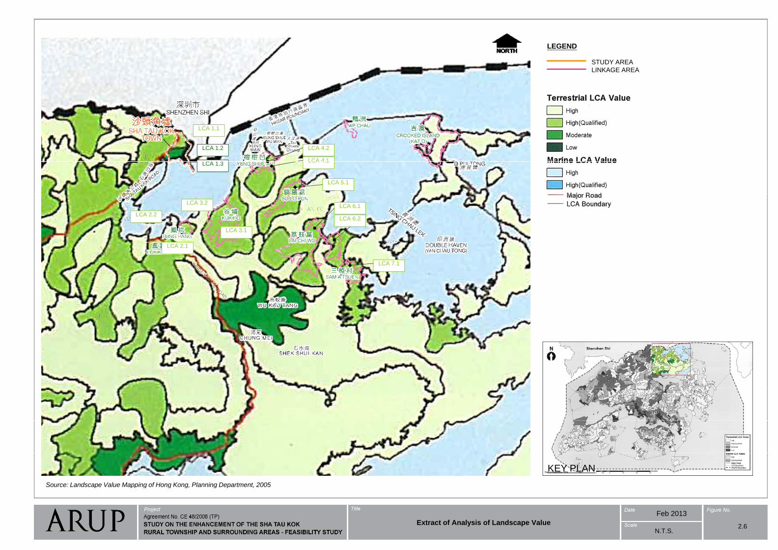
STUDY AREA
LEGEND
LINKAGE AREA
LCA 1 1LCA 1.1
LCA 1.2
LCA 1 3LCA 4 1
LCA 4.2
LCA 1.3LCA 4.1
LCA 5.1
LCA 2.2
LCA 3.2
LCA 6.2
LCA 6.1
Extract of Analysis of Landscape Value
LCA 2.1
LCA 3.1
LCA 7.1
Source: Landscape Value Mapping of Hong Kong Planning Department 2005
KEY PLAN
Feb 2013
Source: Landscape Value Mapping of Hong Kong, Planning Department, 2005
N.T.S.2.6
Extract of Analysis of Landscape Value
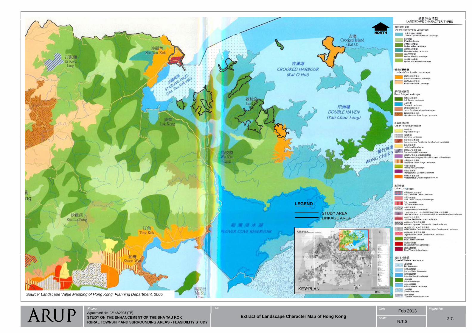
Extract of Landscape Character Map of Hong Kong
2.7
STUDY AREA
LEGEND
LINKAGE AREA
KEY PLAN
Source: Landscape Value Mapping of Hong Kong Planning Department 2005
Feb 2013
Source: Landscape Value Mapping of Hong Kong, Planning Department, 2005
N.T.S.
Extract of Landscape Character Map of Hong Kong2.7.
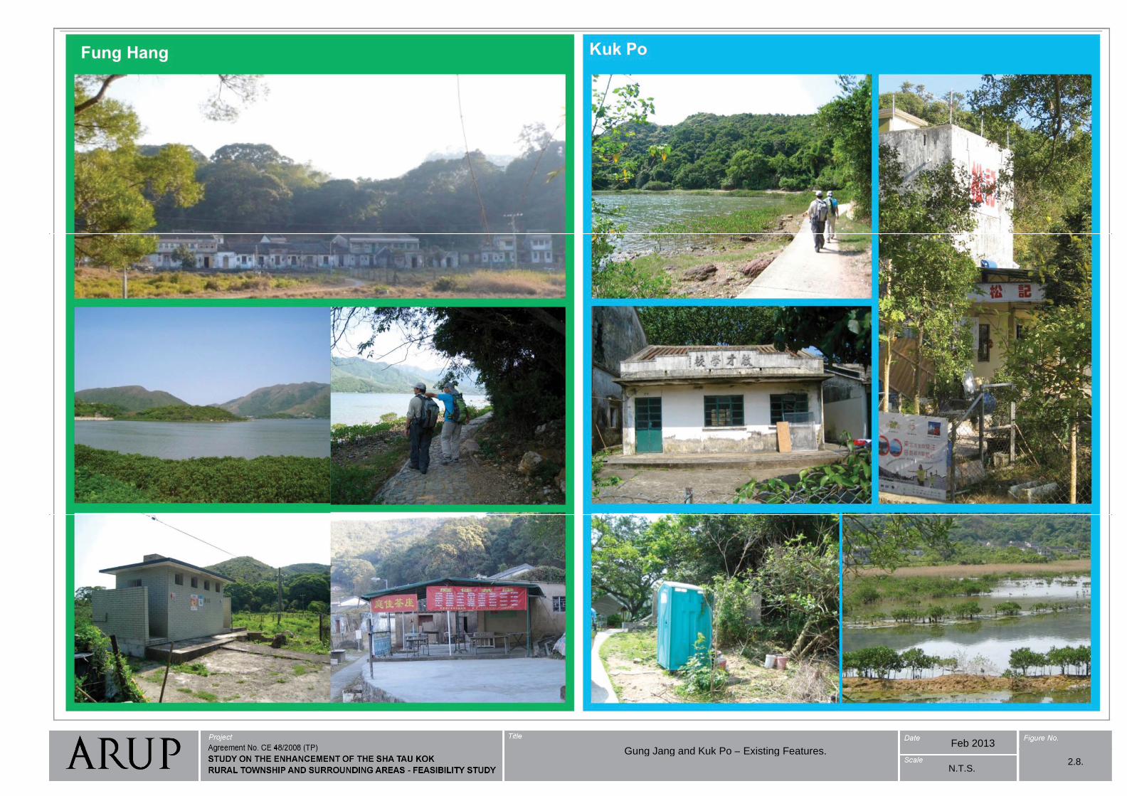
Feb 2013Gung Jang and Kuk Po Existing Features
N.T.S.2.8.
Gung Jang and Kuk Po – Existing Features.
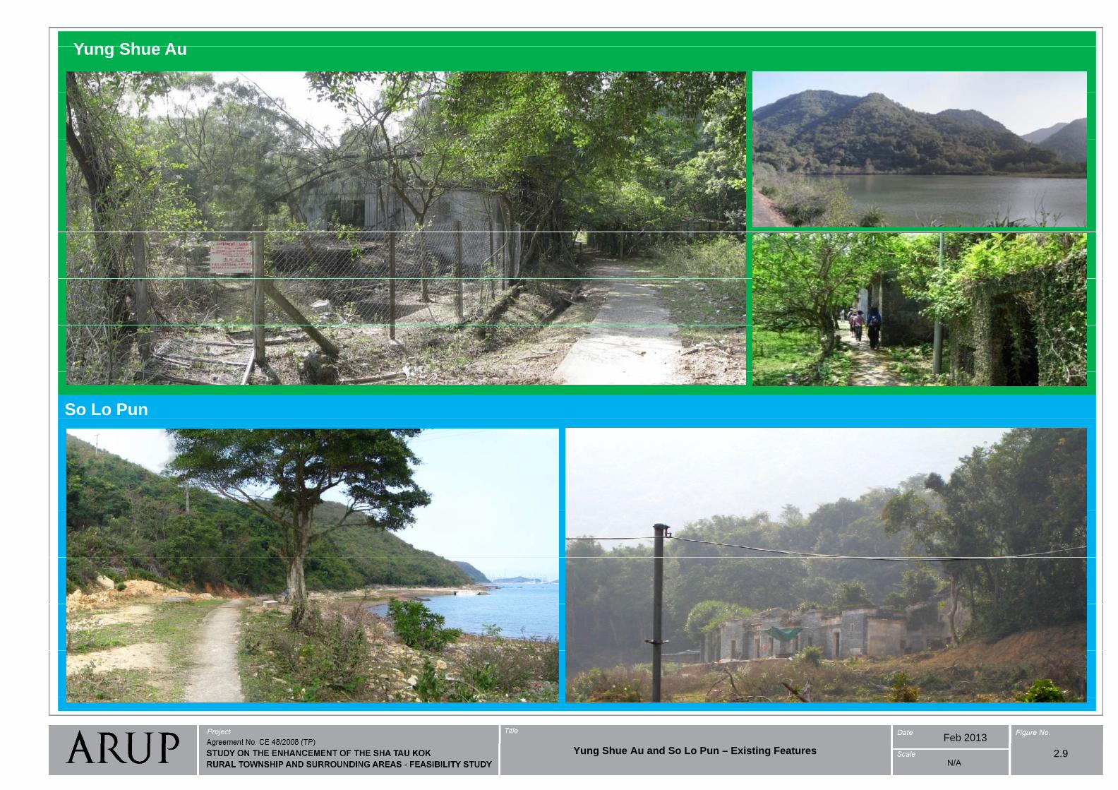
Yung Shue AuYung Shue Au
So Lo Pun
Feb 2013
2.9Yung Shue Au and So Lo Pun – Existing FeaturesN/A

Lai Chi WoLai Chi Wo
View from the Pavilion, a major attraction in Lai
Chi Wo
View from the Pavilion, a major attraction in Lai
Chi Wo
Sam A Tsuen
Feb 2013
2.10Lai Chi Wo and Sam A Tsuen – Existing Features
N/A
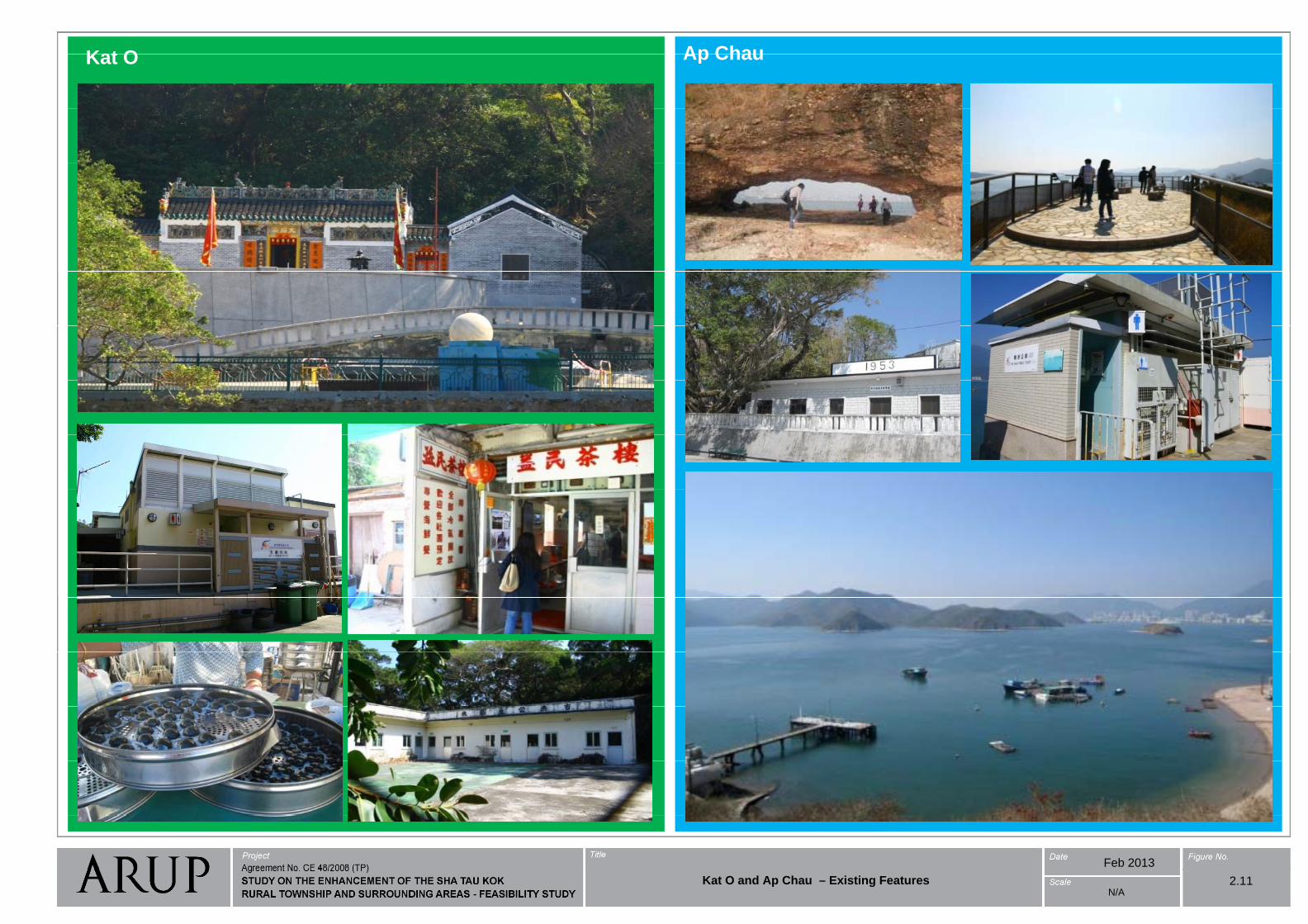
Kat O Ap ChauKat O Ap Chau
Restaurant caters for locals and visitorsRestaurant caters for locals and visitors
Feb 2013
Kat O and Ap Chau – Existing Features 2.11N/A
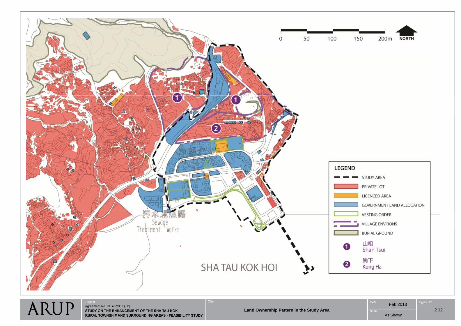
Feb 2013
Land Ownership Pattern in the Study Area 2.12
As Shown
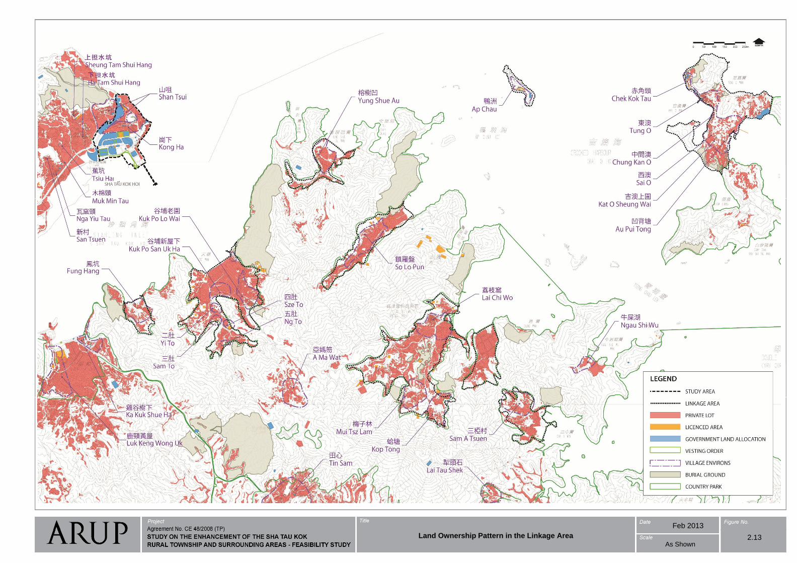
Feb 2013
Land Ownership Pattern in the Linkage Area 2.13As Shown
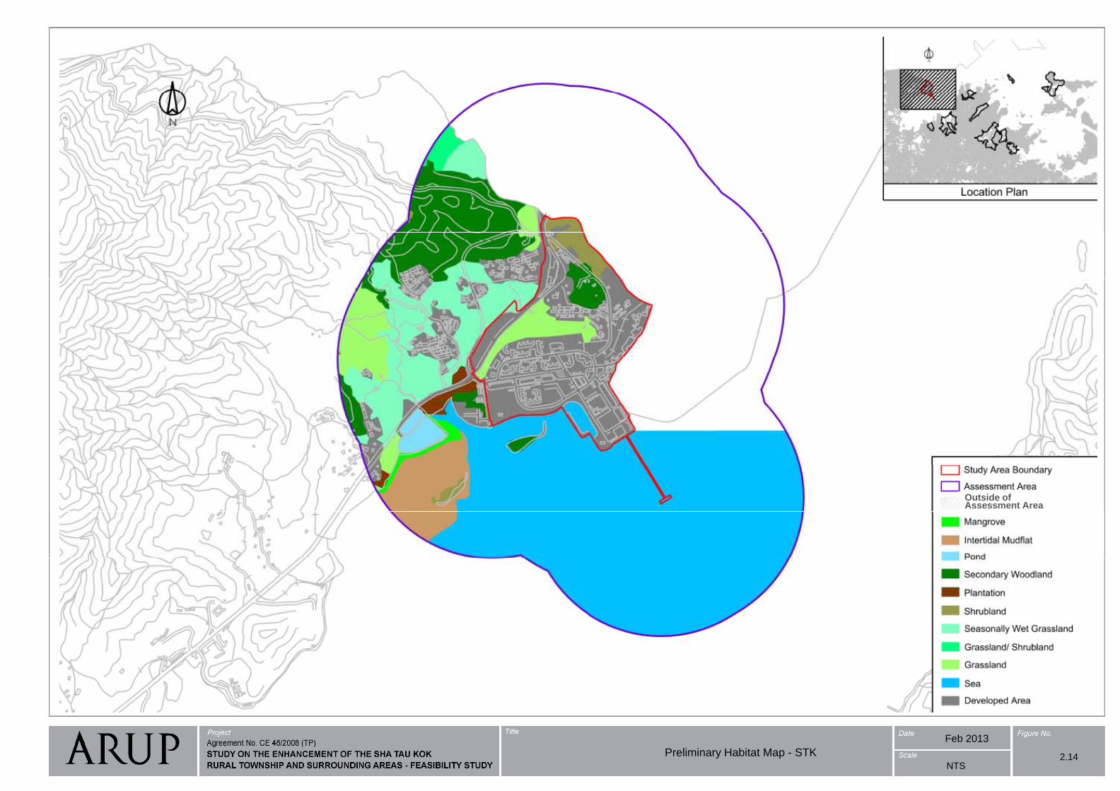
Preliminary Habitat Map - STK
2.14
Outside of Assessment Area
Feb 2013
NTS2.14Preliminary Habitat Map - STK
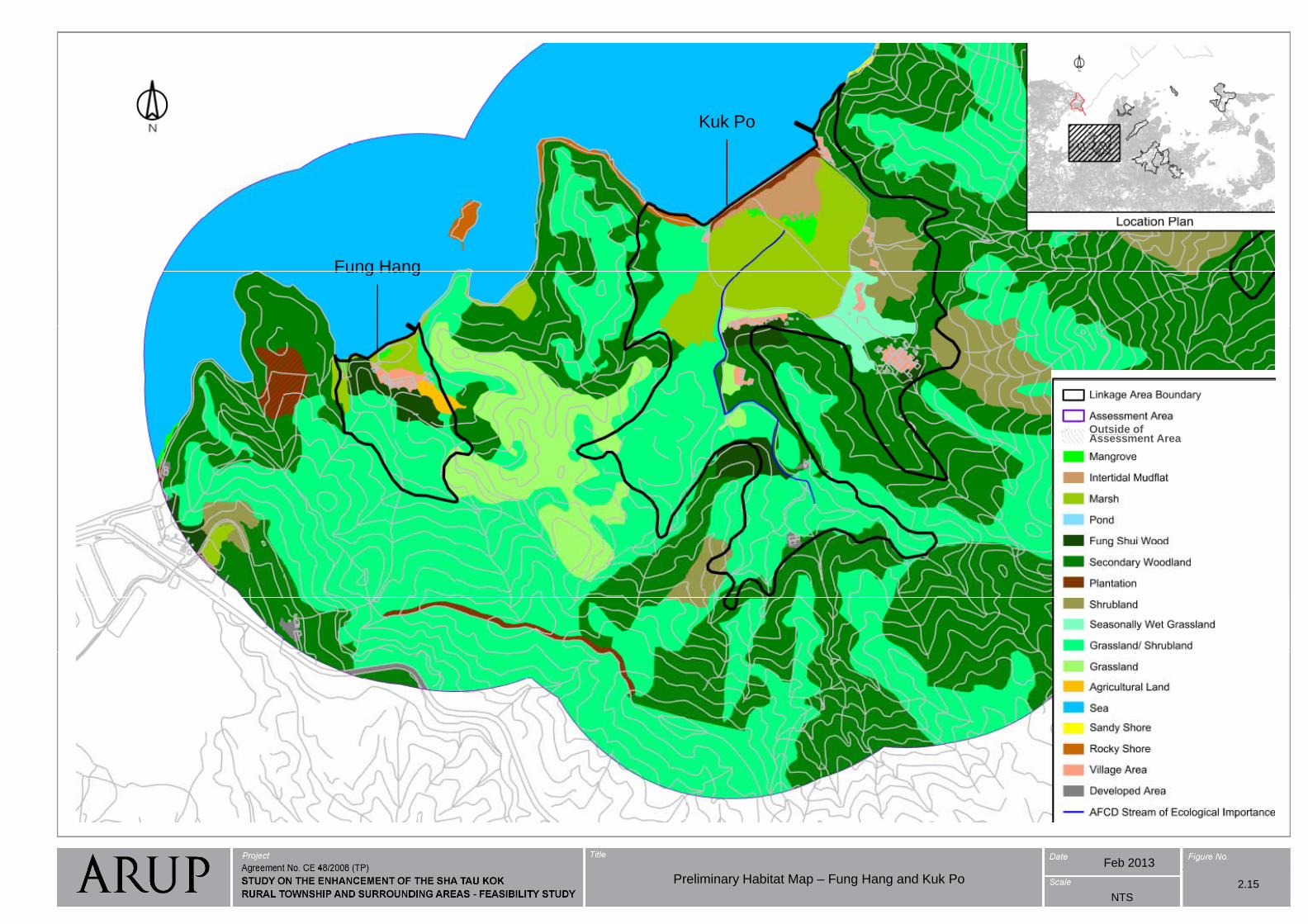
Kuk Po
Fung HangFung Hang
Preliminary Habitat Map - Fung Hang and Kuk Po
Outside of A t AAssessment Area
2.15
Feb 2013
NTS
Preliminary Habitat Map – Fung Hang and Kuk Po 2.15
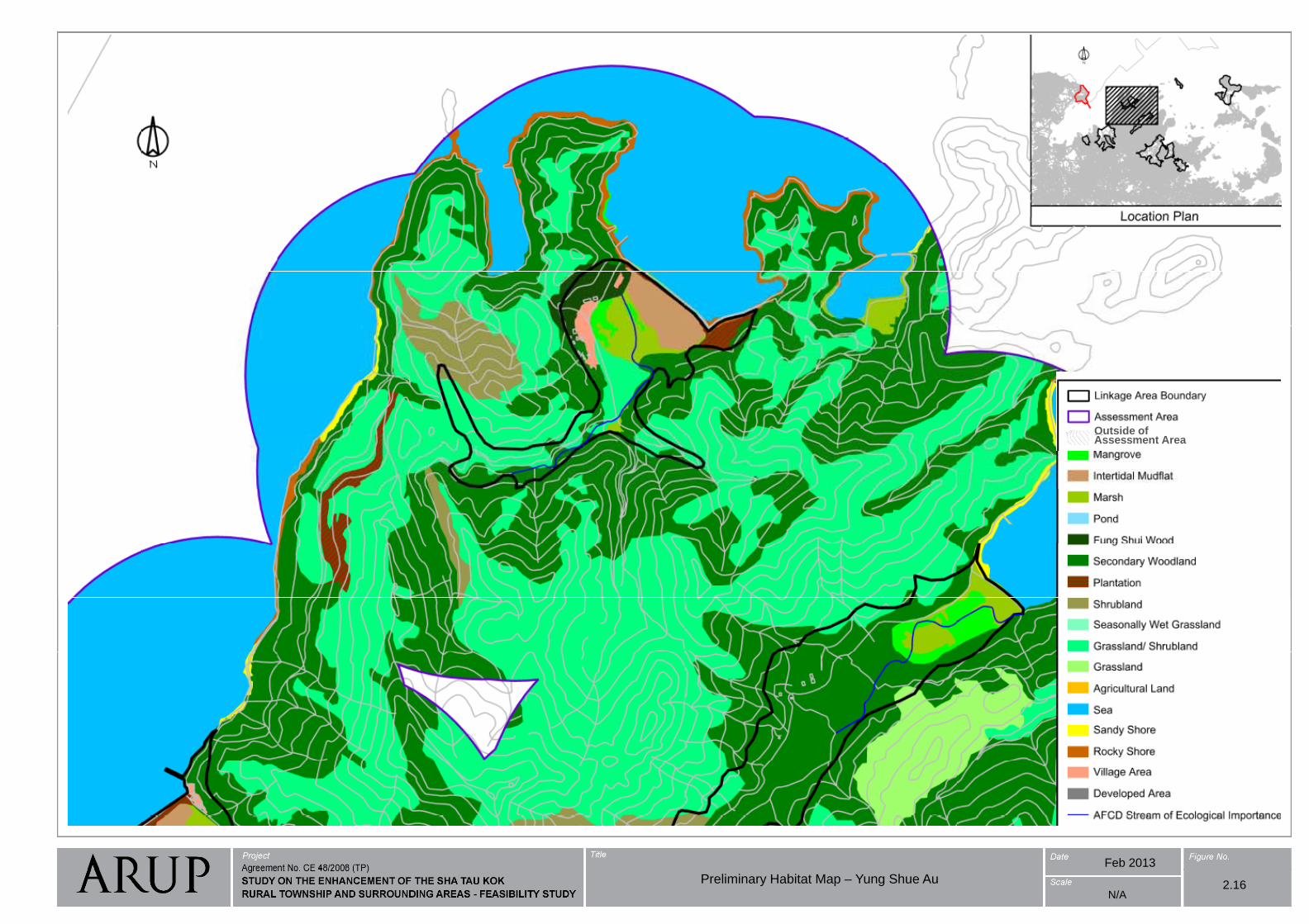
Preliminary Habitat Map - Yung Shue Au
Outside of Assessment Area
Feb 2013
N/A2.16Preliminary Habitat Map – Yung Shue Au
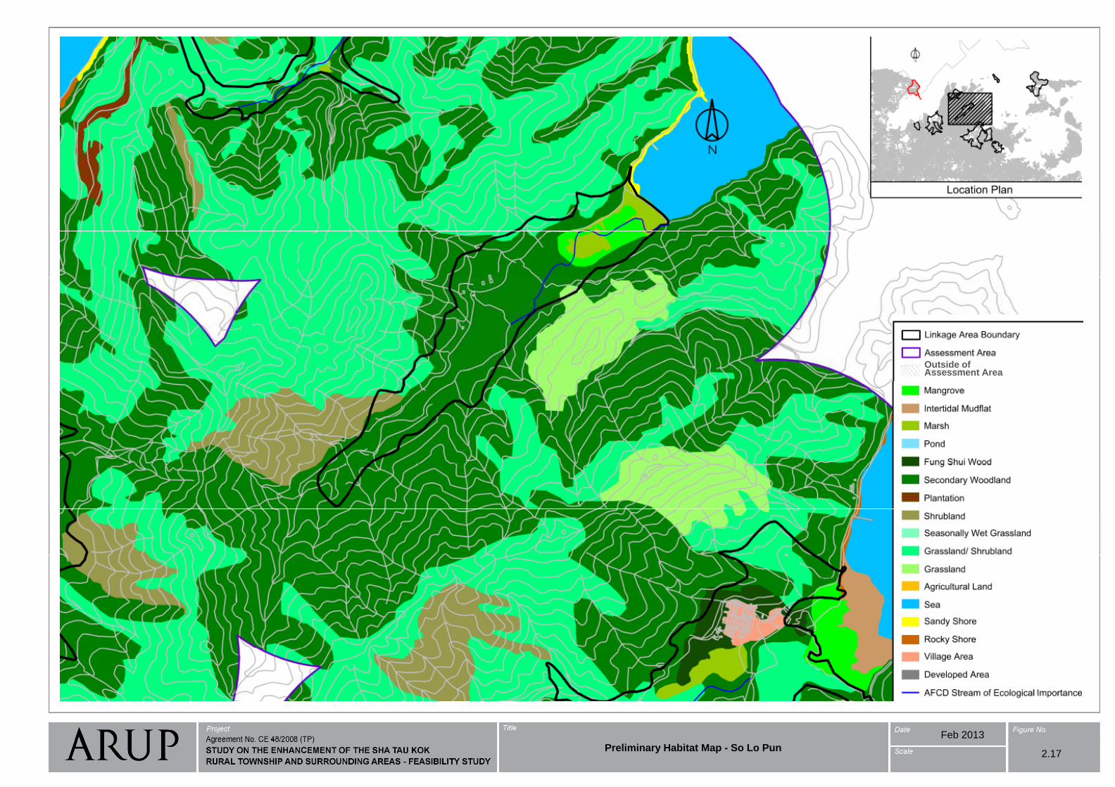
Preliminary Habitat Map - So Lo Pun
Outside of A t AAssessment Area
2.17
Feb 2013
Preliminary Habitat Map - So Lo Pun2.17
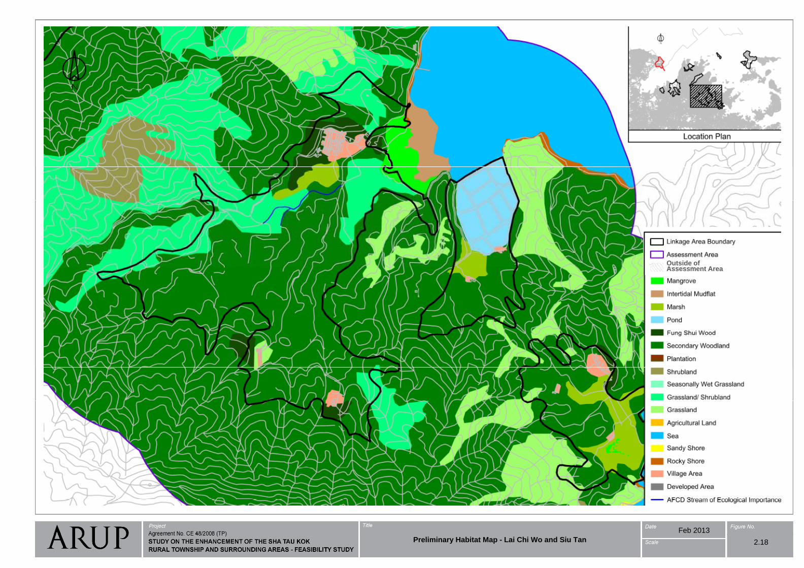
Preliminary Habitat Map - Lai Chi Wo and Siu Tan
Outside of A t AAssessment Area
2.18
Feb 2013
Preliminary Habitat Map - Lai Chi Wo and Siu Tan 2.18
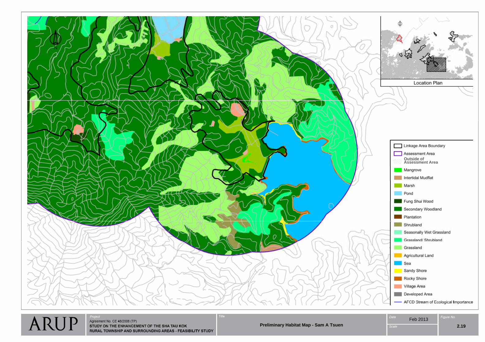
Preliminary Habitat Map - Sam A Tsuen
Outside of A t AAssessment Area
2.19
Feb 2013
Preliminary Habitat Map - Sam A Tsuen 2.19
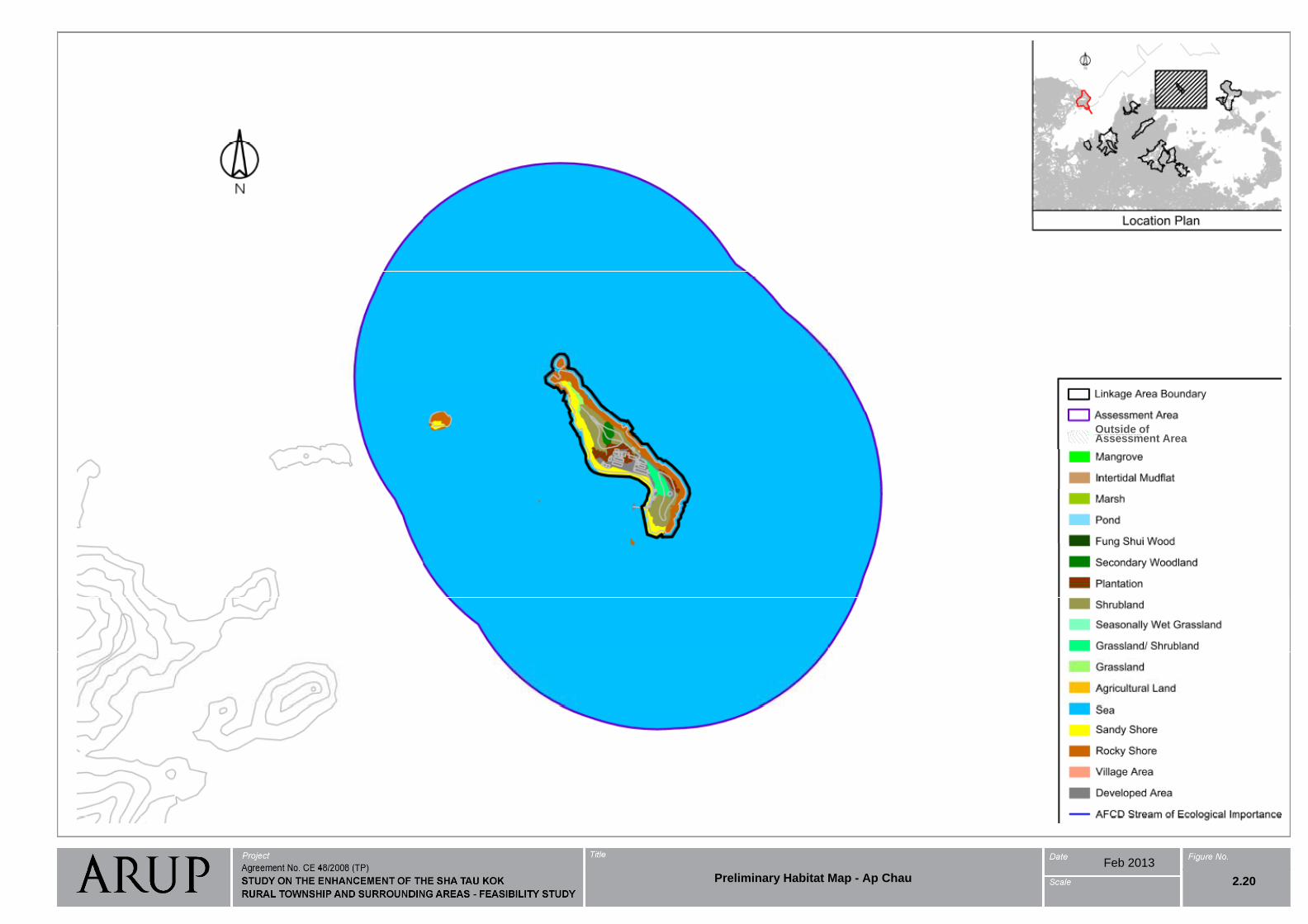
Preliminary Habitat Map - Ap Chau
Outside of A t AAssessment Area
2.20
Feb 2013
Preliminary Habitat Map - Ap Chau 2.20
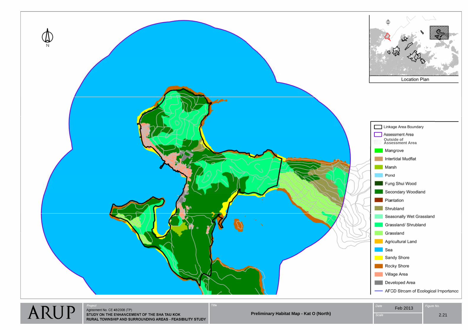
Preliminary Habitat Map - Kat O (North) Outside of Assessment Area
2.21
Feb 2013
Preliminary Habitat Map - Kat O (North) 2.21
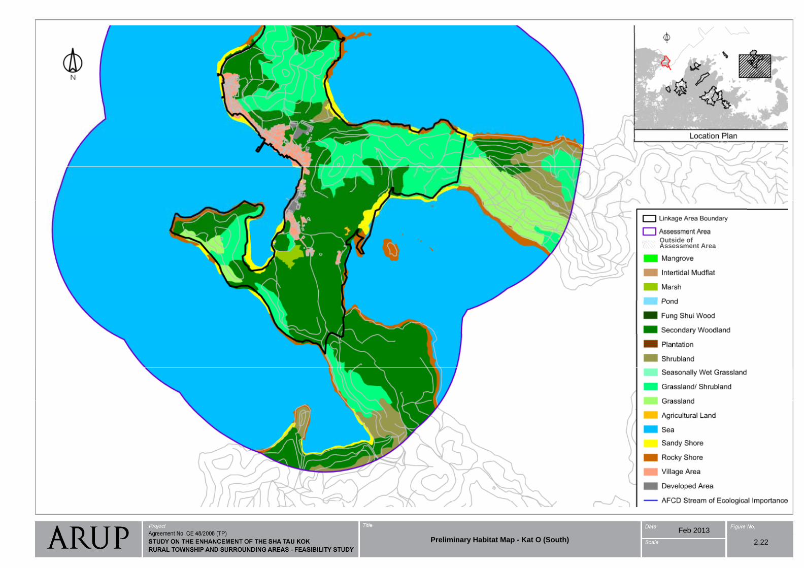
Preliminary Habitat Map - Kat O (South) Outside of Assessment Area
2.22
Feb 2013
Preliminary Habitat Map - Kat O (South) 2.22
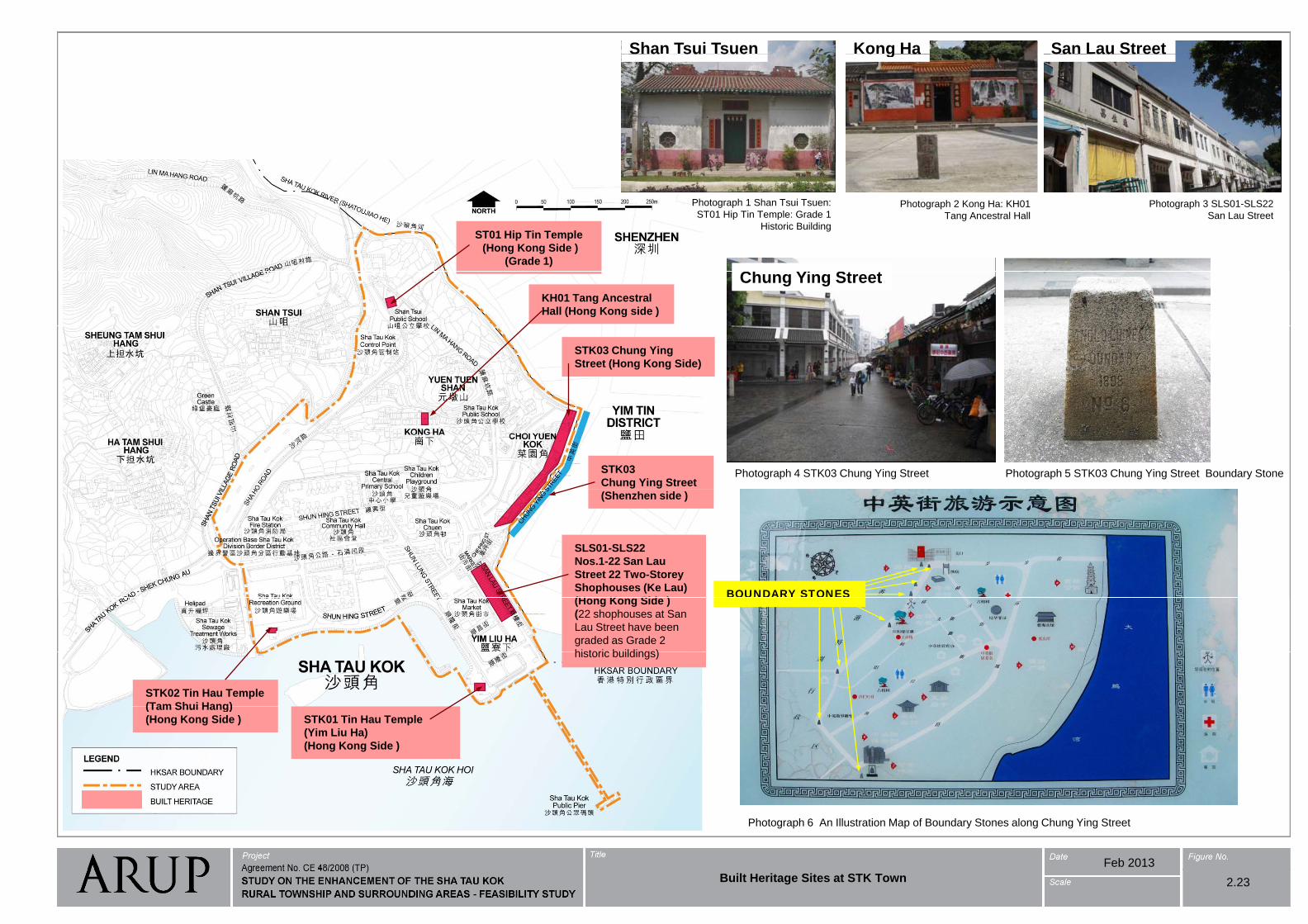
Kong HaShan Tsui Tsuen San Lau Streeto g aS a su sue Sa au St eet
Photograph 1 Shan Tsui Tsuen:
ST01 Hip Tin Temple: Grade 1Photograph 2 Kong Ha: KH01
Tang Ancestral Hall
Photograph 3 SLS01-SLS22
San Lau StreetST01 Hip Tin Temple: Grade 1
Historic BuildingTang Ancestral Hall San Lau Street
Ch Yi St t
ST01 Hip Tin Temple
(Hong Kong Side )
(Grade 1)
Chung Ying StreetKH01 Tang Ancestral
Hall (Hong Kong side )
STK03 Chung Ying
Street (Hong Kong Side)
Photograph 4 STK03 Chung Ying Street Photograph 5 STK03 Chung Ying Street Boundary StoneSTK03
Chung Ying Street
(Shenzhen side )
SLS01-SLS22
Nos.1-22 San Lau
Street 22 Two-Storey
Shophouses (Ke Lau)
(H K Sid )BOUNDARY STONES
(Hong Kong Side )
(22 shophouses at San
Lau Street have been
graded as Grade 2
historic buildings)
OU S O S
STK02 Tin Hau Temple
(Tam Shui Hang)
historic buildings)
(Tam Shui Hang)
(Hong Kong Side ) STK01 Tin Hau Temple
(Yim Liu Ha)
(Hong Kong Side )
Feb 2013
Photograph 6 An Illustration Map of Boundary Stones along Chung Ying Street
Built Heritage Sites at STK Town 2.23
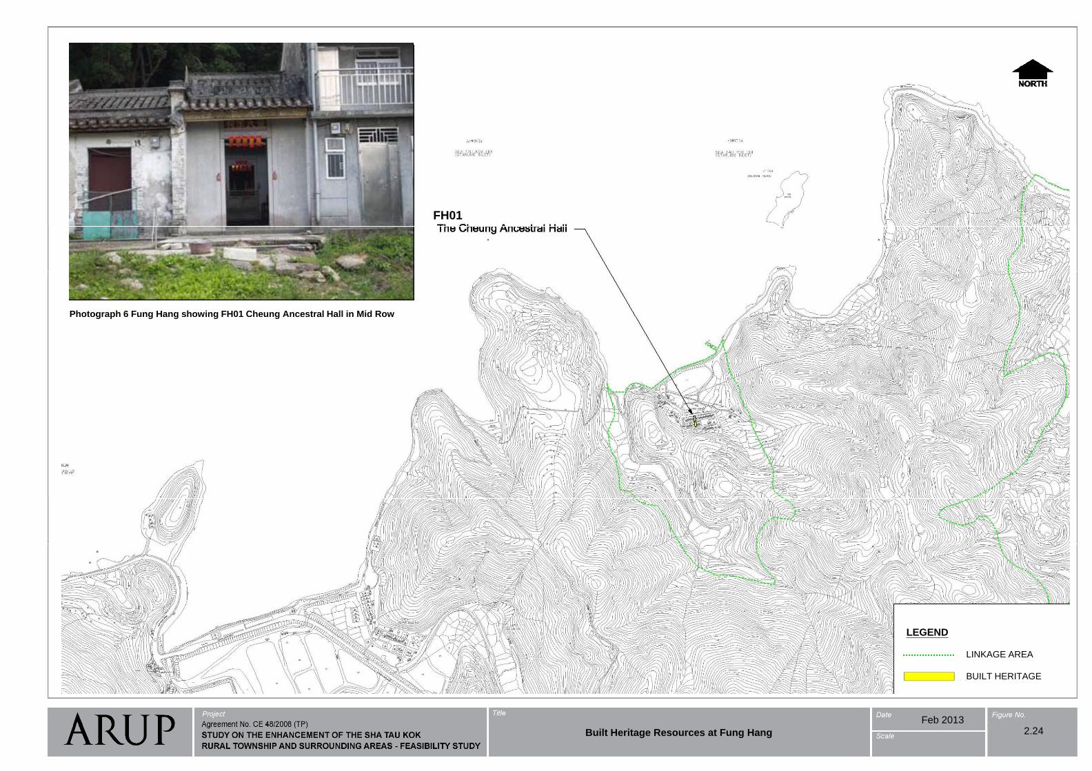
FH01
Photograph 6 Fung Hang showing FH01 Cheung Ancestral Hall in Mid RowBuilt Heritage Resources at Fung Hang
g p g g g g
2.24
LEGEND
LINKAGE AREA
LEGEND
BUILT HERITAGE
Feb 2013
Built Heritage Resources at Fung Hang 2.24
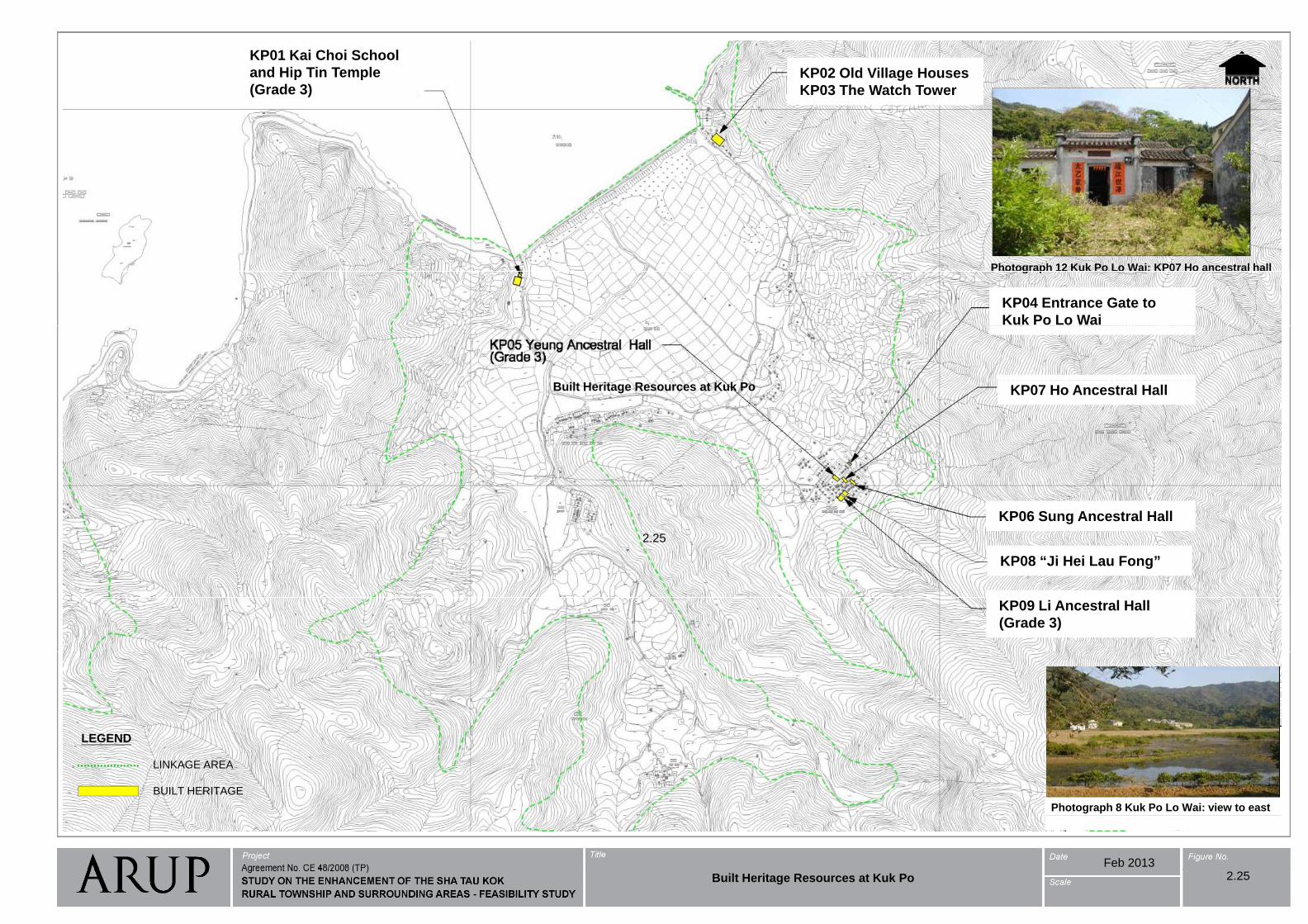
KP01 Kai Choi School
KP02 Old Village Houses
KP03 The Watch Tower
KP01 Kai Choi School
and Hip Tin Temple
(Grade 3)
Photograph 12 Kuk Po Lo Wai: KP07 Ho ancestral hall g p
KP04 Entrance Gate to
Kuk Po Lo Wai
Built Heritage Resources at Kuk Po KP07 Ho Ancestral Hall
2.25
KP06 Sung Ancestral Hall
KP08 “Ji Hei Lau Fong”
(No grade, proposed to beGrade III)
KP09 Li Ancestral Hall
(Grade 3)
LINKAGE AREA
LEGEND
Photograph 8 Kuk Po Lo Wai: view to east
LINKAGE AREA
BUILT HERITAGE
Feb 2013
Built Heritage Resources at Kuk Po 2.25
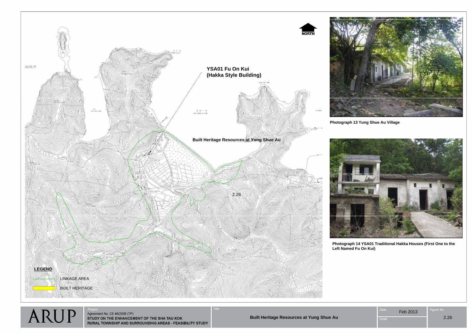
YSA01 Fu On Kui
(Hakka Style Building)
Photograph 13 Yung Shue Au Village
Built Heritage Resources at Yung Shue Au
2.26
Photograph 14 YSA01 Traditional Hakka Houses (First One to the
Left Named Fu On Kui)
LEGEND
LINKAGE AREA
BUILT HERITAGE
Feb 2013
Built Heritage Resources at Yung Shue Au 2.26
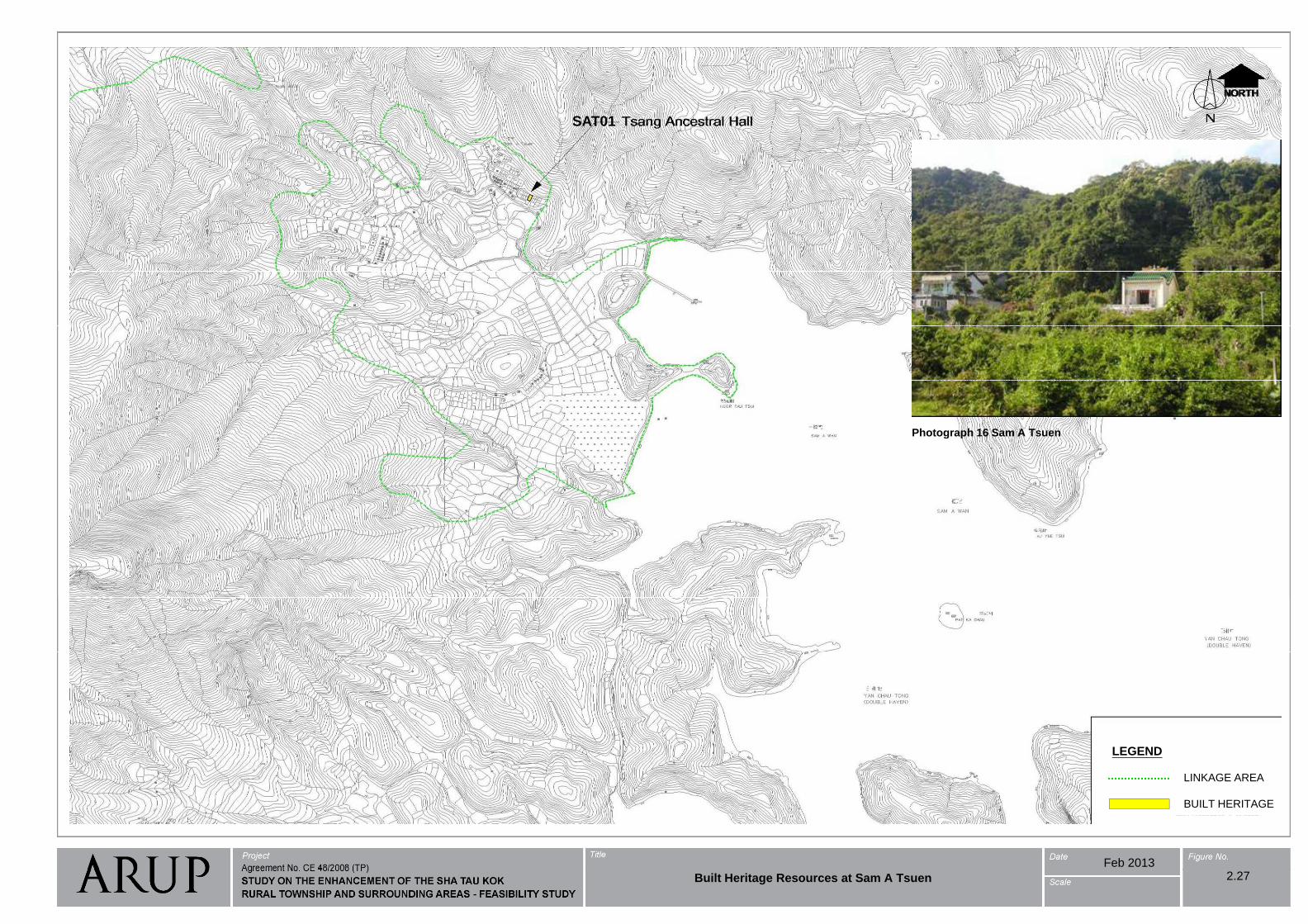
SAT01
Built Heritage Resources at Sam A Tsuen
Photograph 16 Sam A TsuenPhotograph 16 Sam A Tsuen
2.27
LEGEND
LINKAGE AREA
BUILT HERITAGE
Feb 2013
Built Heritage Resources at Sam A Tsuen 2.27
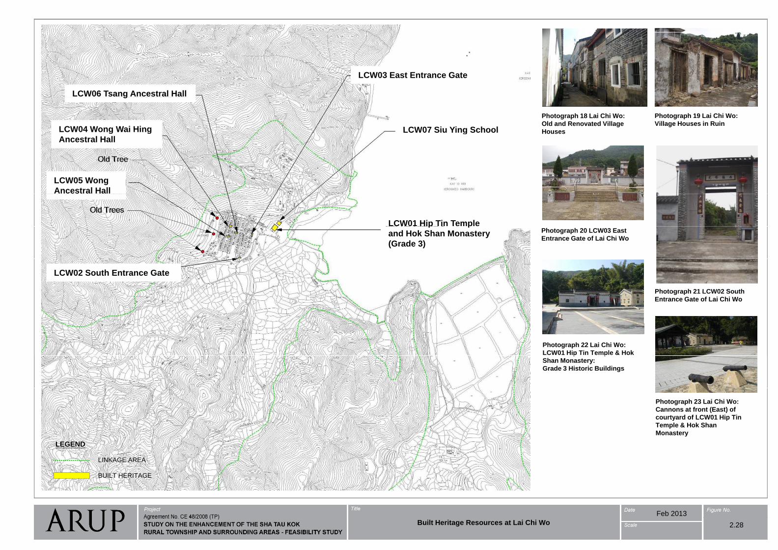
LCW03 East Entrance Gate
LCW06 Tsang Ancestral Hall
Photograph 18 Lai Chi Wo:
Old and Renovated Village
H
Photograph 19 Lai Chi Wo:
Village Houses in RuinLCW07 Siu Ying School
g
LCW04 Wong Wai Hing HousesLCW07 Siu Ying SchoolLCW04 Wong Wai Hing
Ancestral Hall
LCW05 Wong
Ancestral Hall
LCW01 Hip Tin Temple Built Heritage Resources at Lai Chi Wo
(Grade II, proposed to bere-graded to Grade III)
Photograph 20 LCW03 East
Entrance Gate of Lai Chi Wo
p p
and Hok Shan Monastery
(Grade 3)
Photograph 21 LCW02 South
LCW02 South Entrance Gate
2.28
Photograph 21 LCW02 South
Entrance Gate of Lai Chi Wo
Photograph 22 Lai Chi Wo:
LCW01 Hip Tin Temple & Hokp p
Shan Monastery:
Grade 3 Historic Buildings
Photograph 23 Lai Chi Wo:
Cannons at front (East) of
courtyard of LCW01 Hip Tin y p
Temple & Hok Shan
Monastery
LEGENDLEGEND
LINKAGE AREA
BUILT HERITAGE
LINKAGE AREA
BUILT HERITAGE
Feb 2013
Built Heritage Resources at Lai Chi Wo 2.28
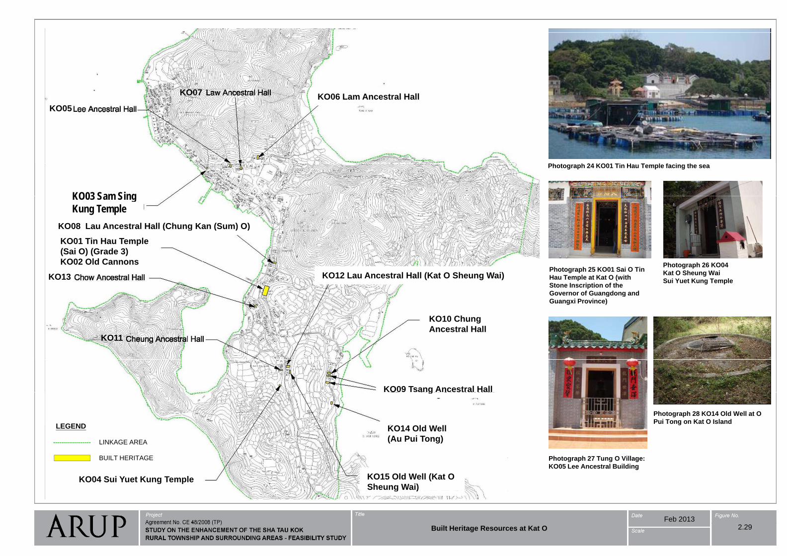
KO07KO06 Lam Ancestral Hall
KO05
KO06 Lam Ancestral Hall
Ph h 24 KO01 Ti H T l f i hPhotograph 24 KO01 Tin Hau Temple facing the sea
KO03 Sam SingKO03
Lau Ancestral Hall (Chung Kan (Sum) O)KO08
KO03 Sam Sing Kung Temple
Built Heritage Resources at Kat O
(Grade I, proposed to bere-graded to Grade III)
KO01 Tin Hau Temple
(Sai O) (Grade 3)
KO02 Old Cannons
Lau Ancestral Hall (Chung Kan (Sum) O)KO08
re-graded to Grade III)Photograph 25 KO01 Sai O Tin
Hau Temple at Kat O (with
Stone Inscription of the
Governor of Guangdong and
Photograph 26 KO04
Kat O Sheung Wai
Sui Yuet Kung TempleKO13 KO12 Lau Ancestral Hall (Kat O Sheung Wai)
KO02 Old Cannons
2.29
Governor of Guangdong and
Guangxi Province)
KO10 Chung
A t l H llKO11
Ancestral Hall
KO09 Tsang Ancestral Hall
Photograph 28 KO14 Old Well at O
Pui Tong on Kat O IslandLEGEND
g
Photograph 27 Tung O Village:
g
LINKAGE AREA
LEGEND
BUILT HERITAGE
KO14 Old Well
(Au Pui Tong)
Photograph 27 Tung O Village:
KO05 Lee Ancestral Building
BUILT HERITAGE
KO15 Old Well (Kat O
Sheung Wai)KO04 Sui Yuet Kung Temple
Feb 2013
g )
Built Heritage Resources at Kat O 2.29
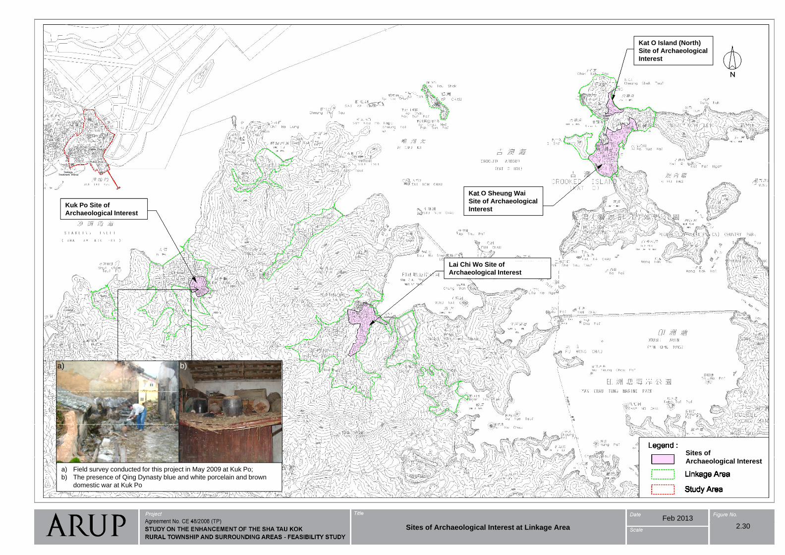
Kat O Island (North)
Site of Archaeological
Interest
Kat O Sheung Wai
Kuk Po Site of
Archaeological Interest
g
Site of Archaeological
Interest
Sites of Archaeological Interest at Linkage Area
Lai Chi Wo Site of
Archaeological Interest
2.30
a) b)
Sites of
Archaeological Interesta) Field survey conducted for this project in May 2009 at Kuk Po;
b) The presence of Qing Dynasty blue and white porcelain and brown
domestic war at Kuk Po
Feb 2013
Sites of Archaeological Interest at Linkage Area 2.30
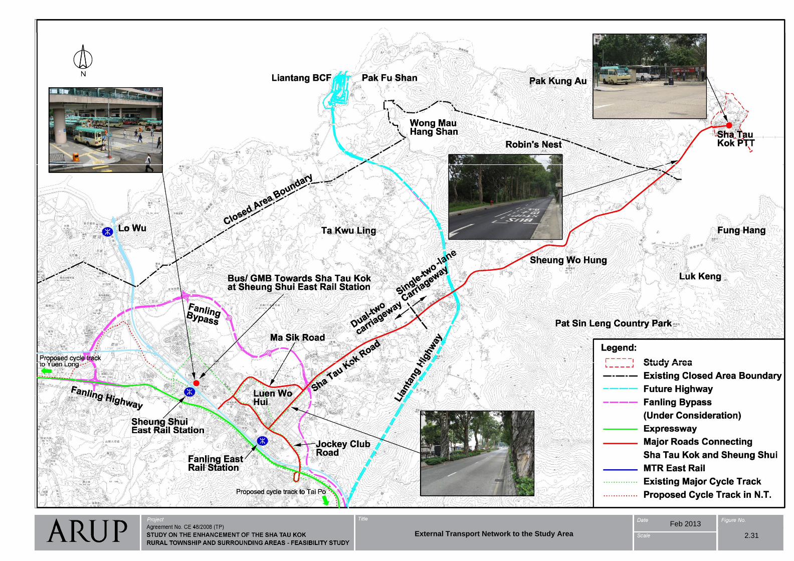
A KMB 78K -A. KMB 78K -Sheung Shui Sha Tau Kok
B. Minibus 55K -Sheung Shui Sha Tau KokSheung Shui Sha Tau Kok
External Transport Network to the Study Area
2.31
Feb 2013
External Transport Network to the Study Area 2.31
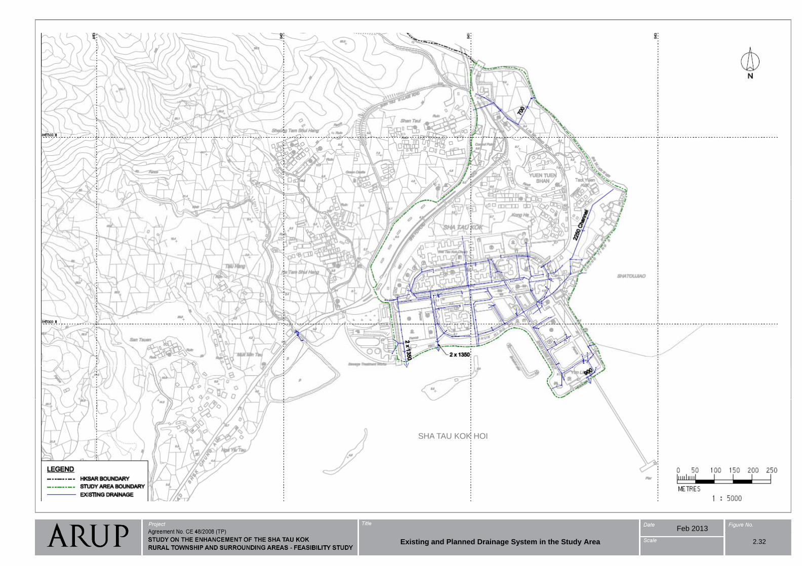
SHA TAU KOK HOI
Feb 2013
Existing and Planned Drainage System in the Study Area 2.32
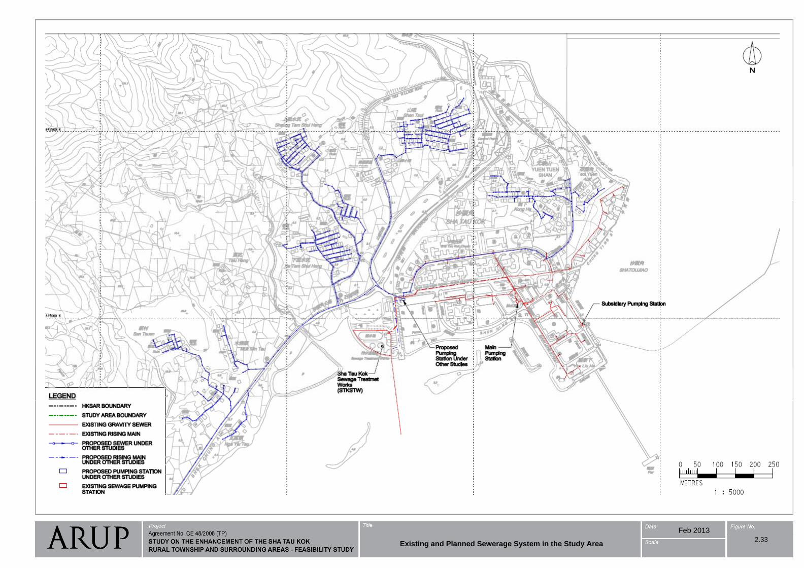
Feb 2013
Existing and Planned Sewerage System in the Study Area2.33
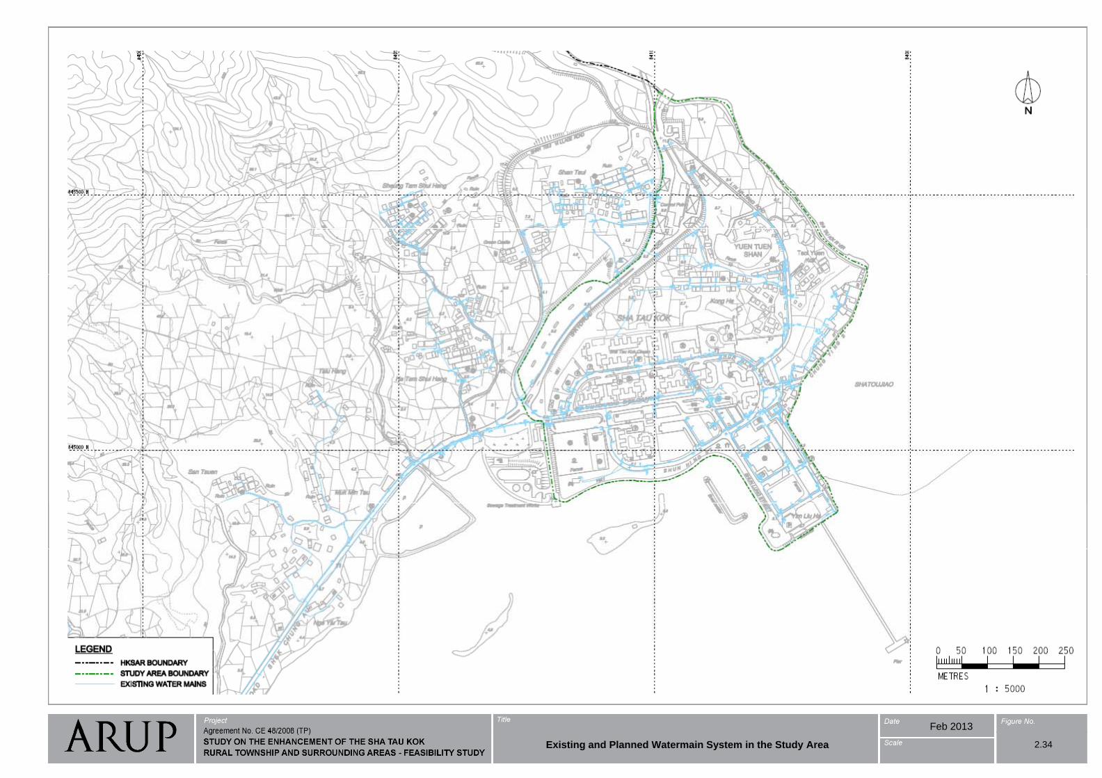
Feb 2013
Existing and Planned Watermain System in the Study Area 2.34
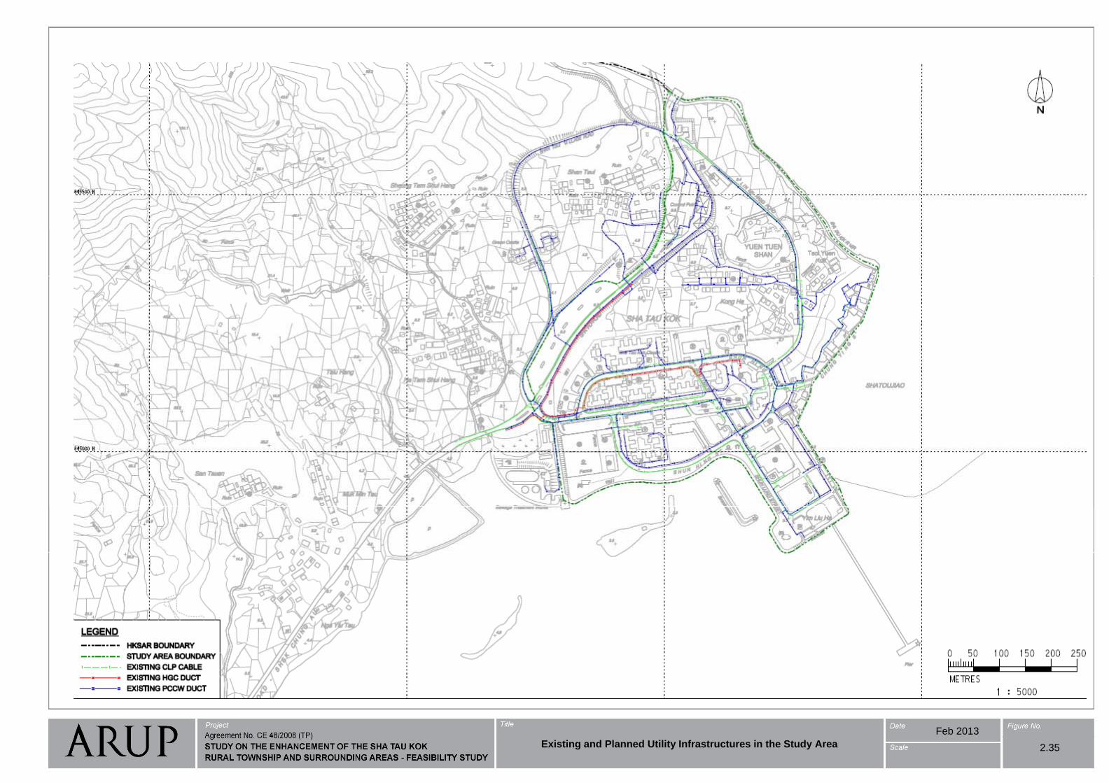
Existing and Planned Utility Infrastructures in the Study Area
2.35
Feb 2013
Existing and Planned Utility Infrastructures in the Study Area 2.35
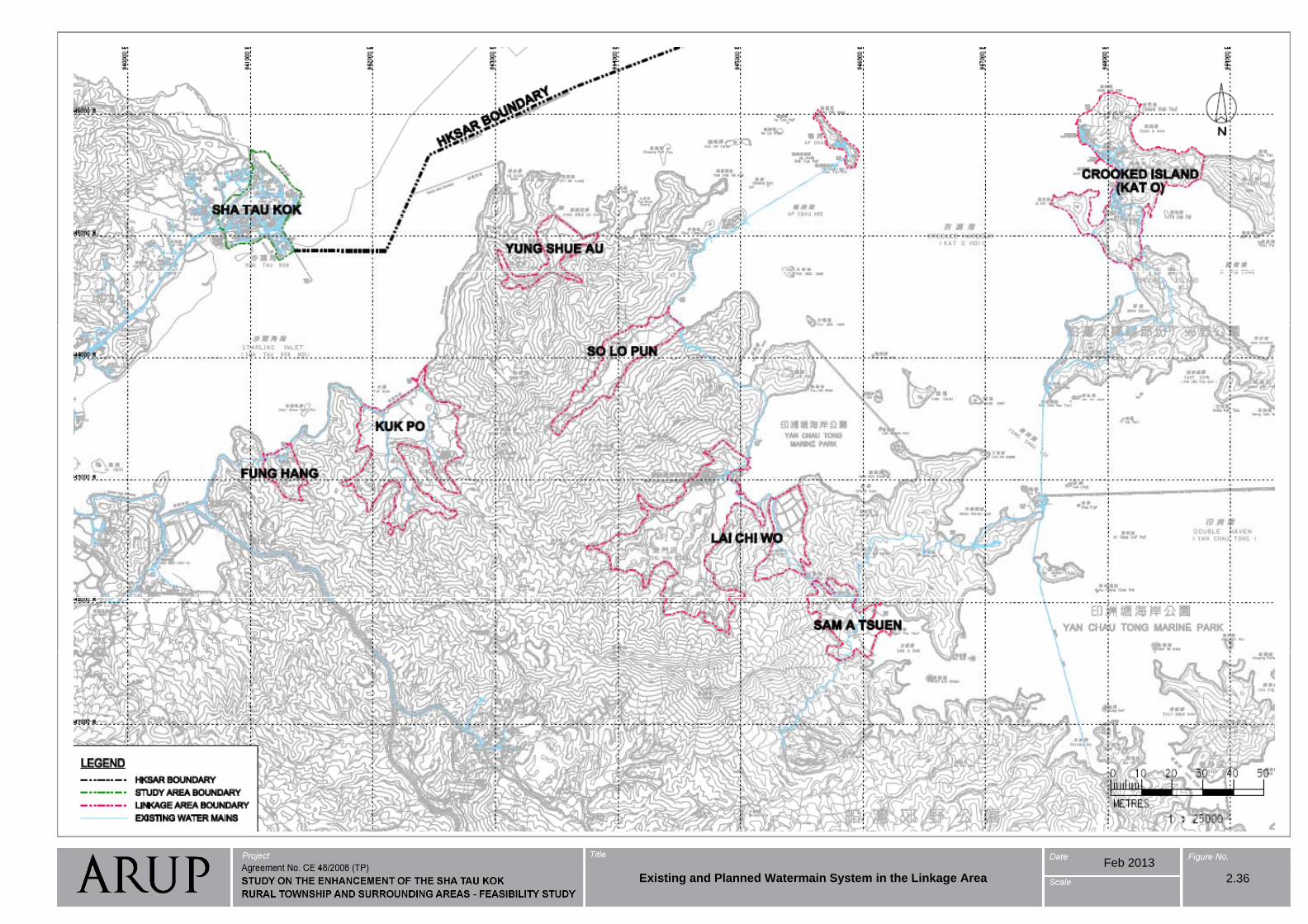
Existing and Planned Watermain System in the Linkage Area
2.36
Feb 2013
Existing and Planned Watermain System in the Linkage Area 2.36
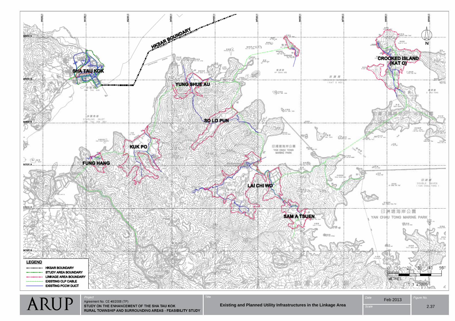
Existing and Planned Utility Infrastructures in the Linkage Area
2.37
Feb 2013
Existing and Planned Utility Infrastructures in the Linkage Area 2.37
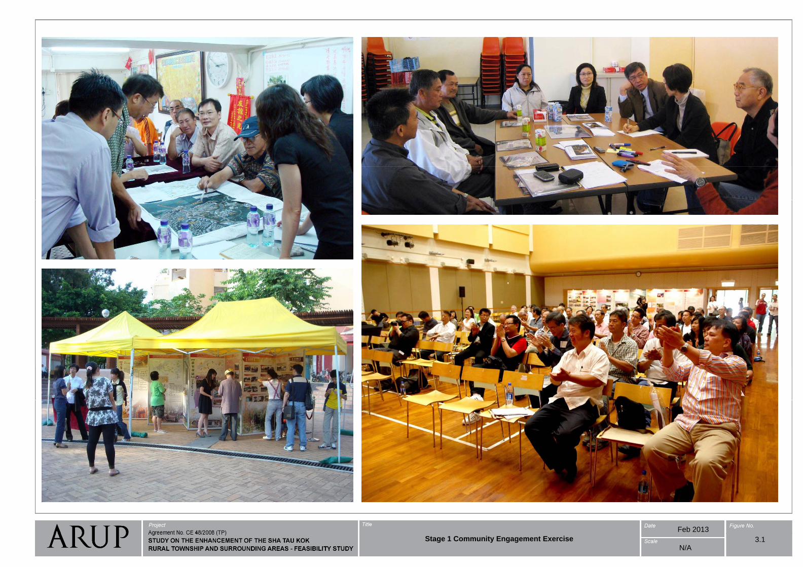
Feb 2013
Stage 1 Community Engagement Exercise 3.1N/A
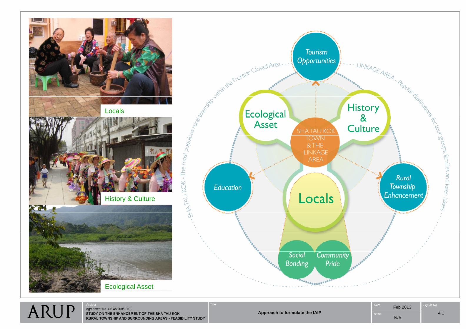
Locals
History & Culture
Ecological Asset
Feb 2013
Approach to formulate the IAIP 4.1N/A
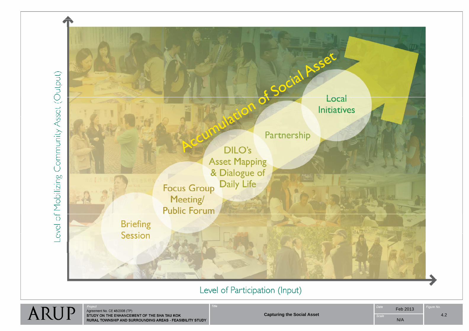
Feb 2013
Capturing the Social Asset 4.2N/A
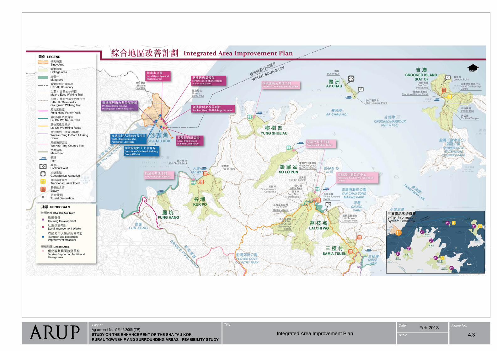
Feb 2013
4.3Integrated Area Improvement Plan
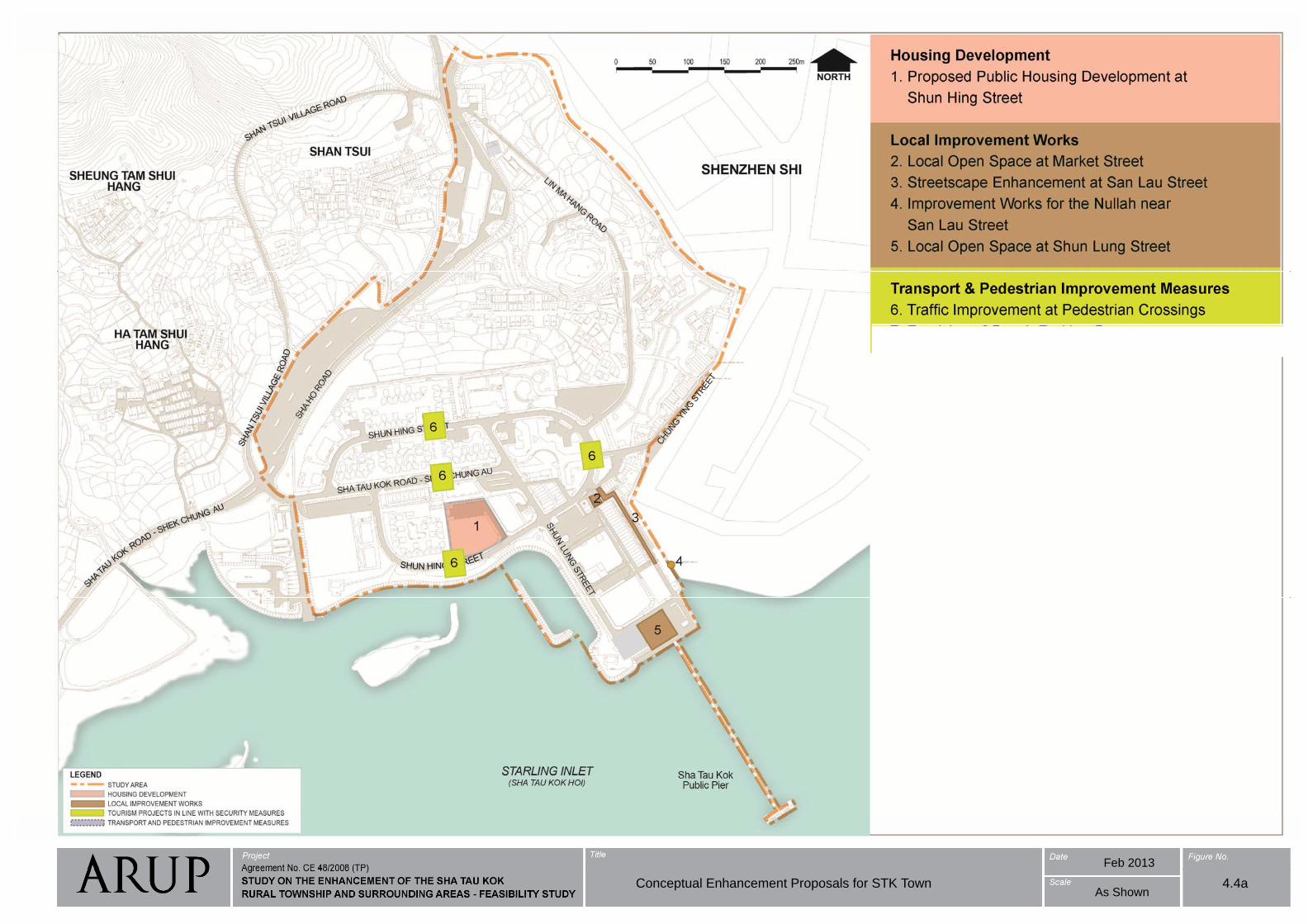
Feb 2013
Conceptual Enhancement Proposals for STK Town 4.4aAs Shown

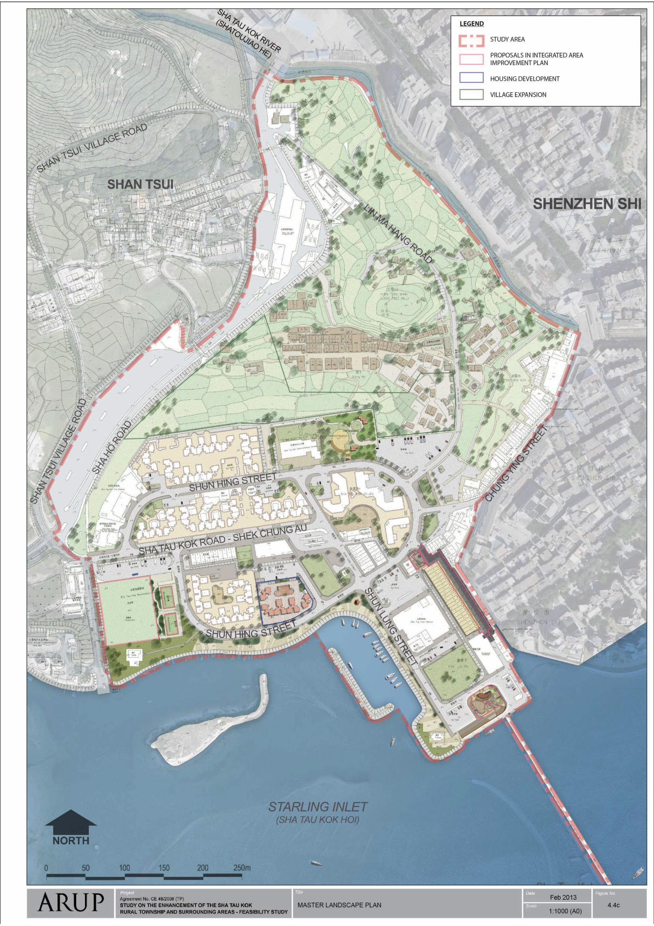
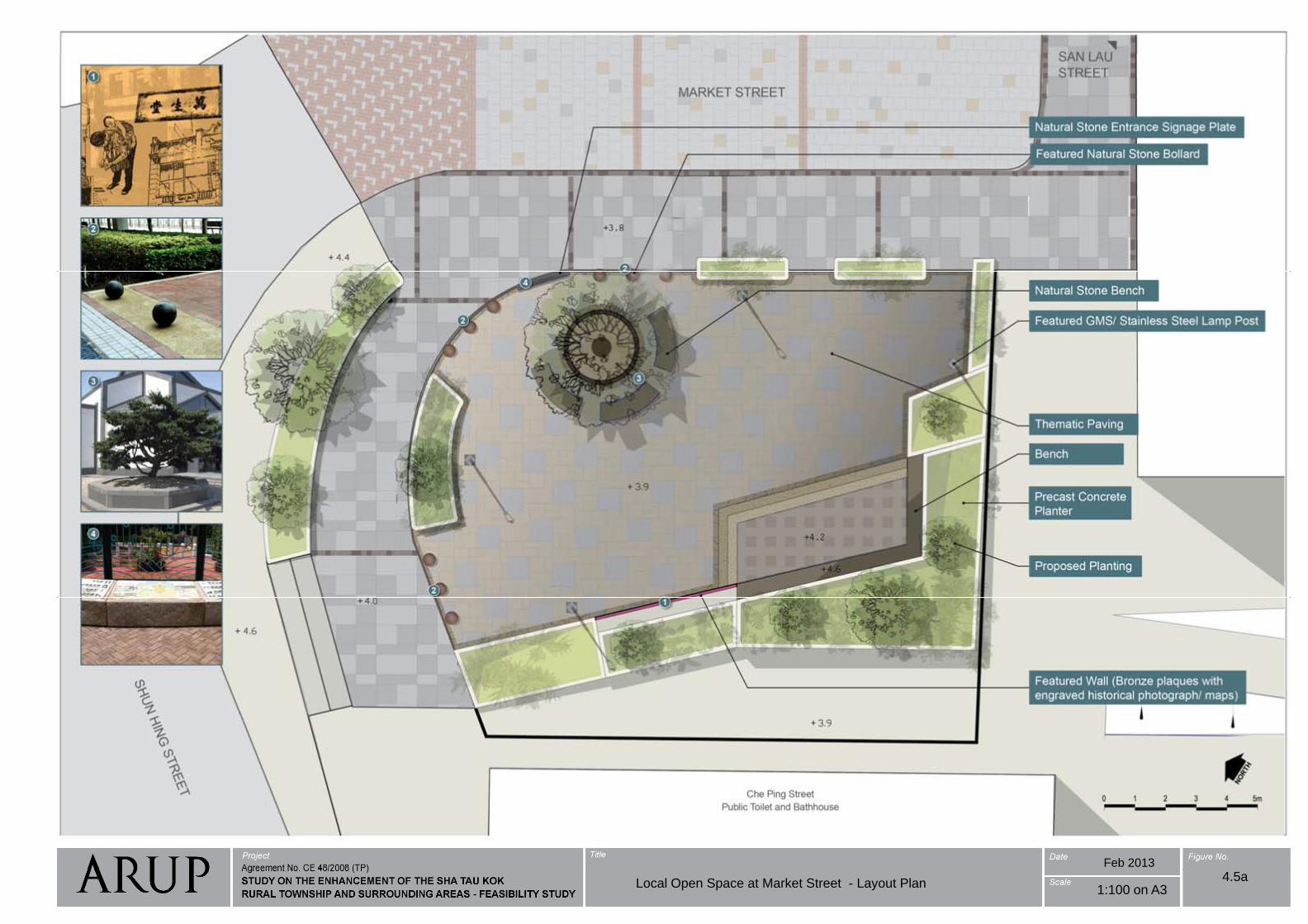
Feb 2013
Local Open Space at Market Street - Layout Plan4.5a
1:100 on A3
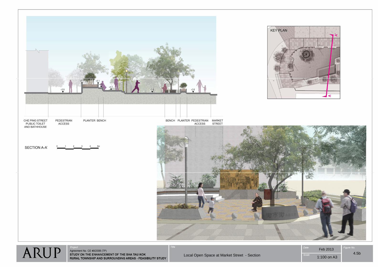
Feb 2013
Local Open Space at Market Street - Section4.5b
1:100 on A3
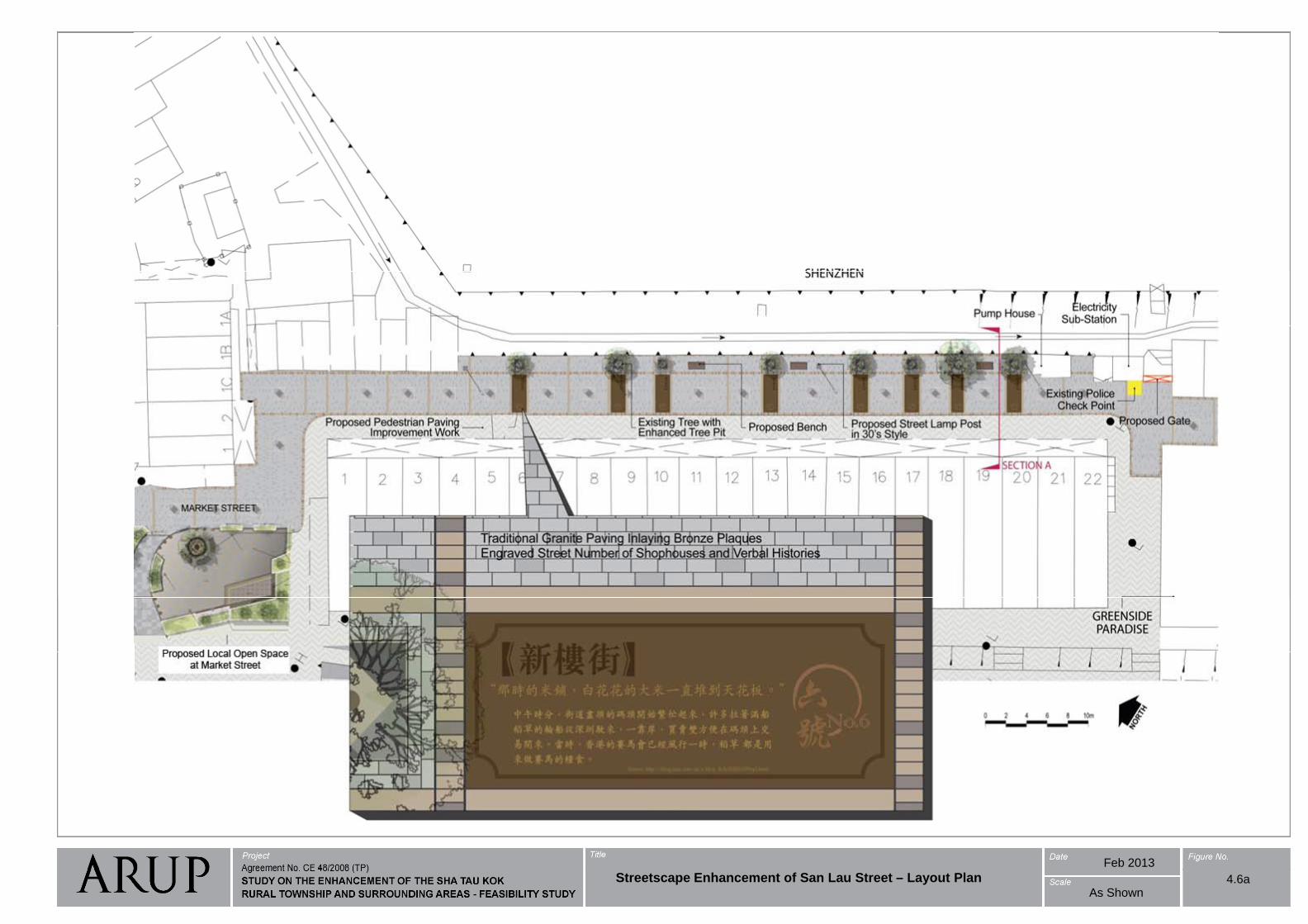
Feb 2013
4.6aStreetscape Enhancement of San Lau Street – Layout PlanAs Shown
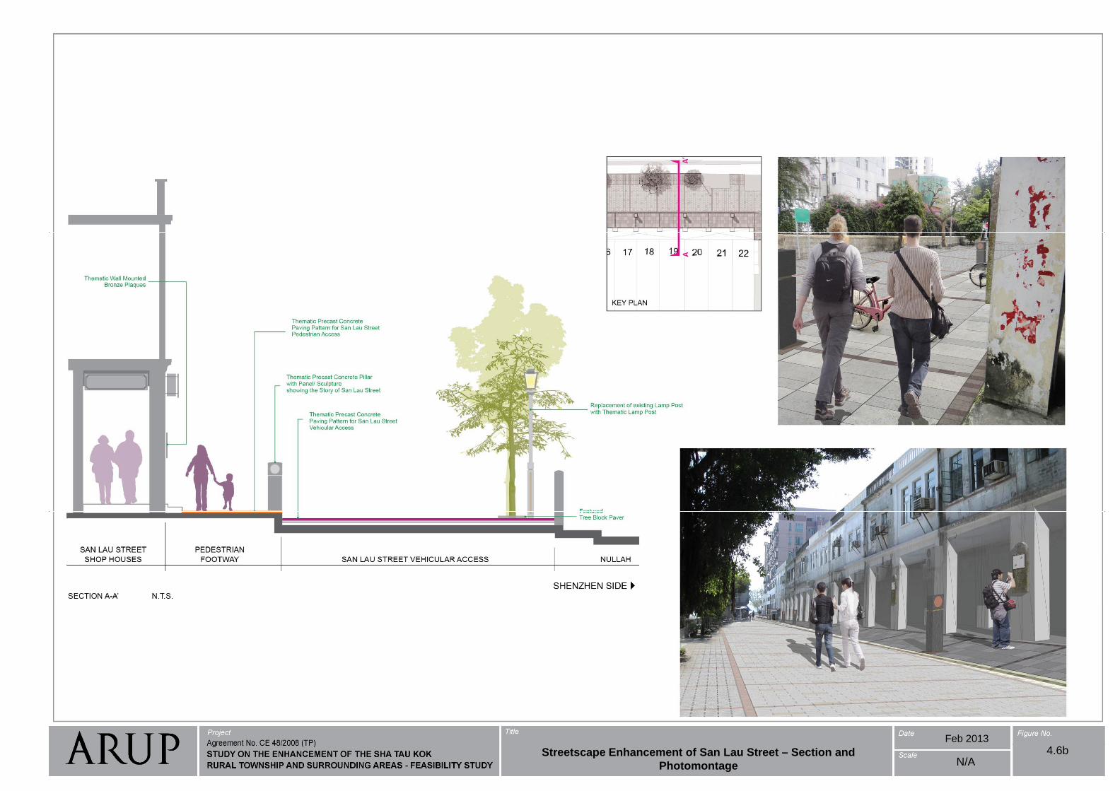
Feb 2013
4.6bN/A
Streetscape Enhancement of San Lau Street – Section and
Photomontage
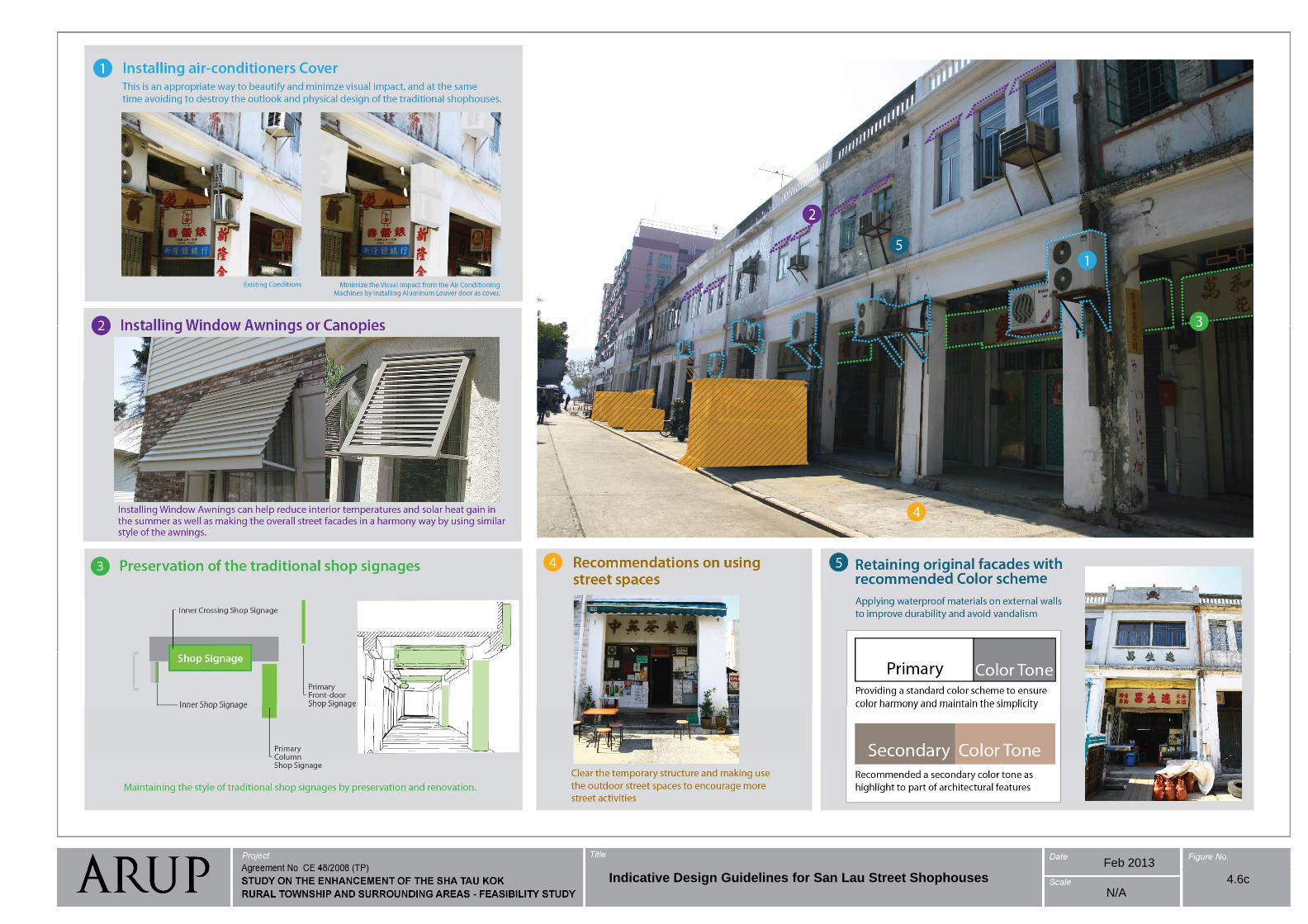
Feb 2013
4.6cIndicative Design Guidelines for San Lau Street ShophousesN/A
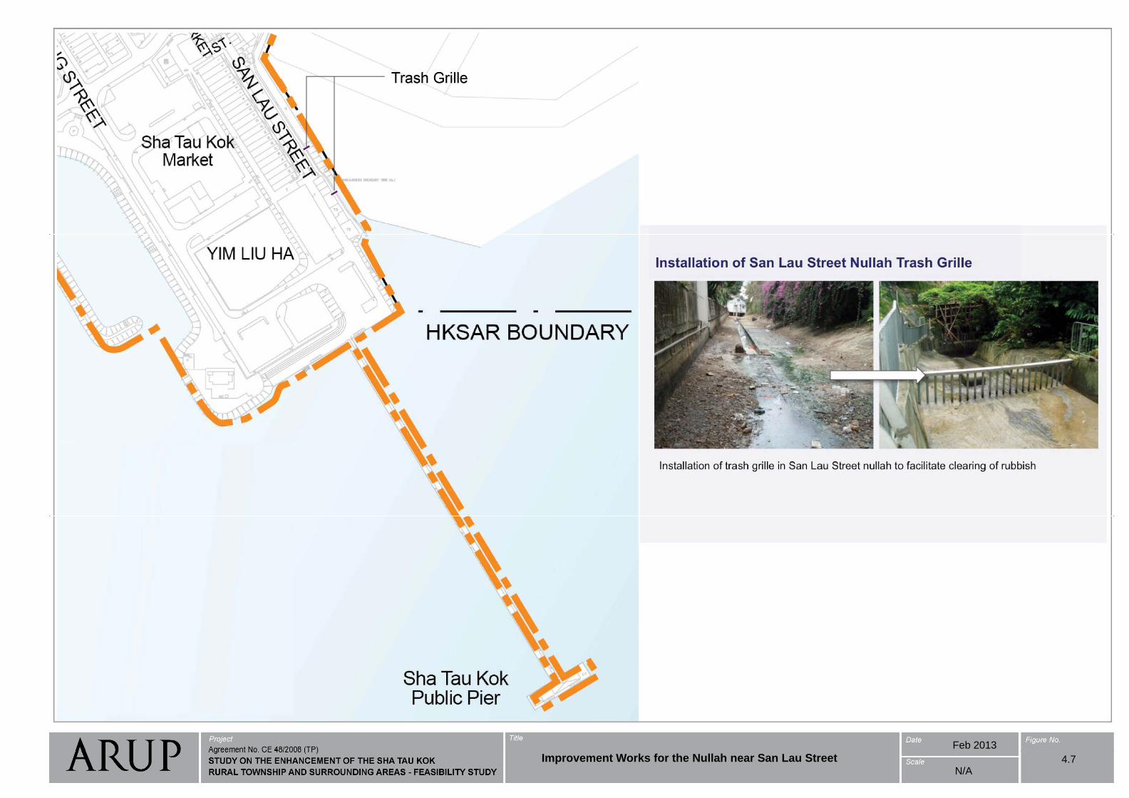
Feb 2013
4.7Improvement Works for the Nullah near San Lau StreetN/A
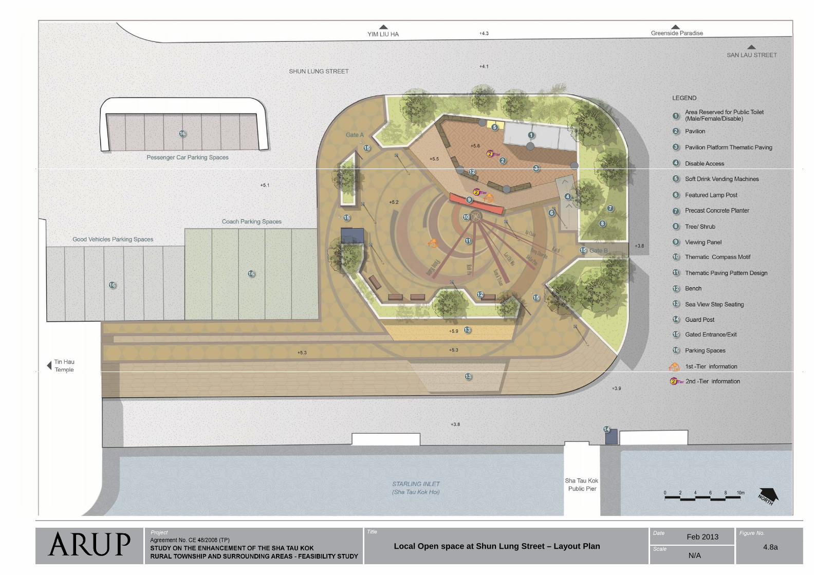
Feb 2013
4.8aLocal Open space at Shun Lung Street – Layout PlanN/A
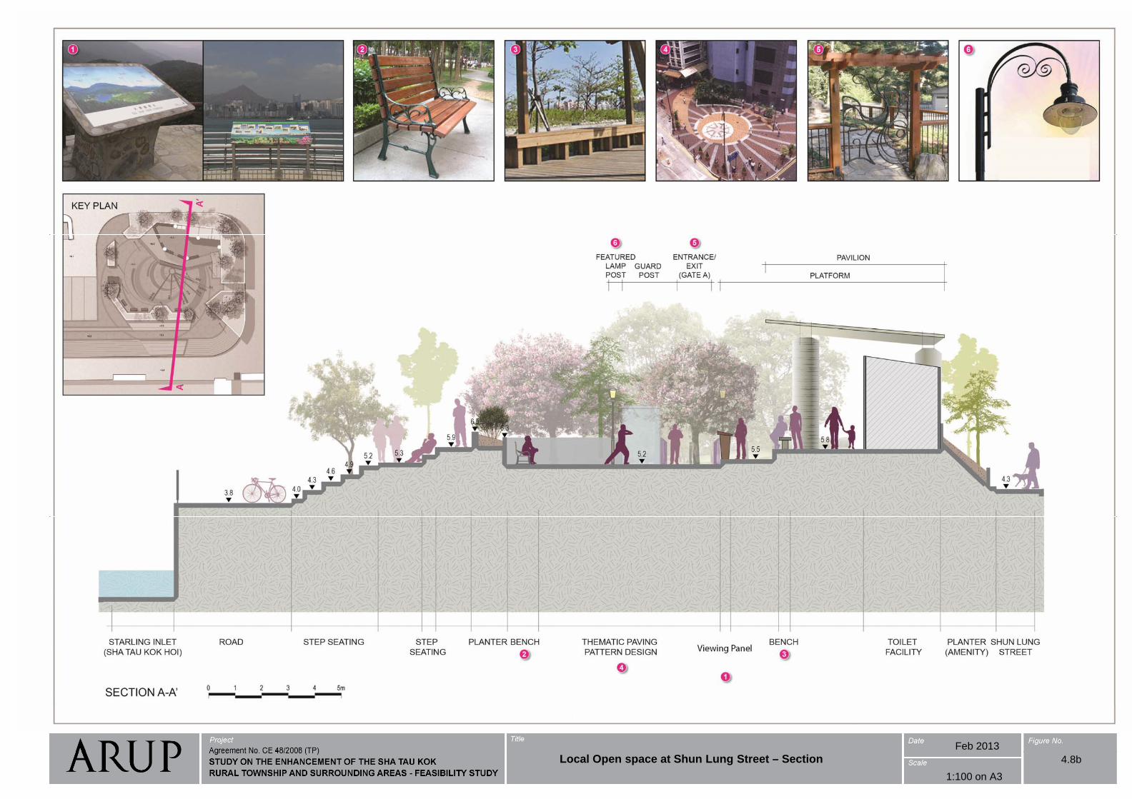
Feb 2013
4.8b
1:100 on A3
Local Open space at Shun Lung Street – Section
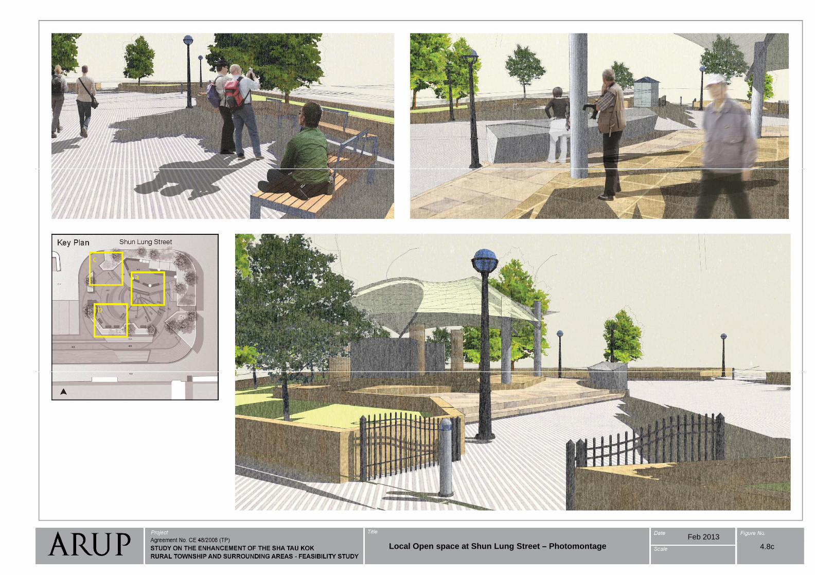
Feb 2013
4.8cLocal Open space at Shun Lung Street – Photomontage
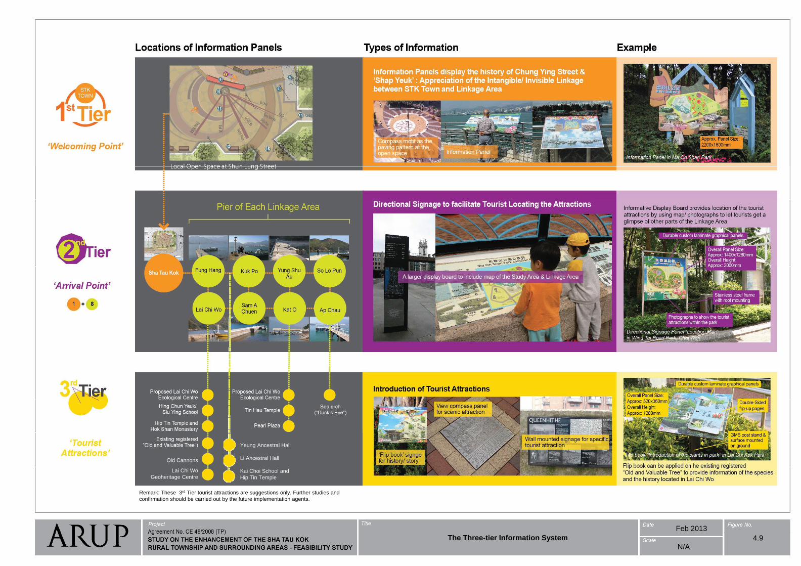
The Three-tier Information System
Old Cannons
Yeung Ancestral Hall
Li Ancestral Hall
Lai Chi Wo
Geoheritage CentreKai Choi School and
Hip Tin Temple
Remark: These 3rd Tier tourist attractions are suggestions only. Further studies and
confirmation should be carried out by the future implementation agents
Feb 2013
confirmation should be carried out by the future implementation agents.
N/A
The Three-tier Information System 4.9
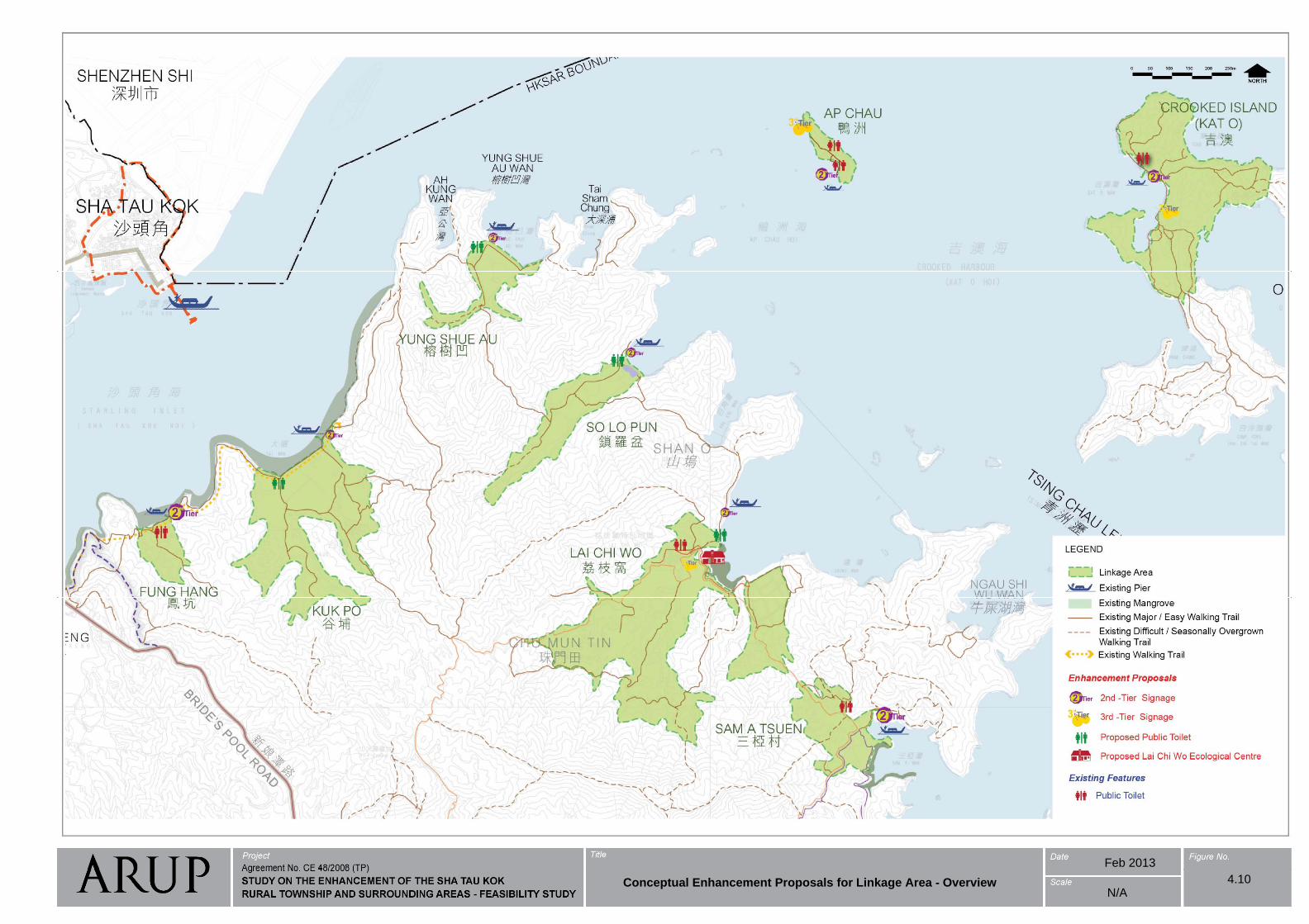
Feb 2013
Conceptual Enhancement Proposals for Linkage Area - Overview 4.10N/A
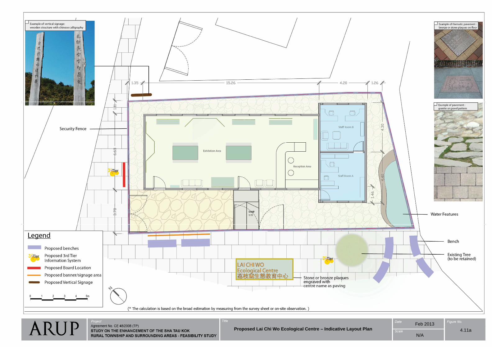
Feb 2013Proposed Lai Chi Wo Ecological Centre – Indicative Layout Plan 4.11a
N/A
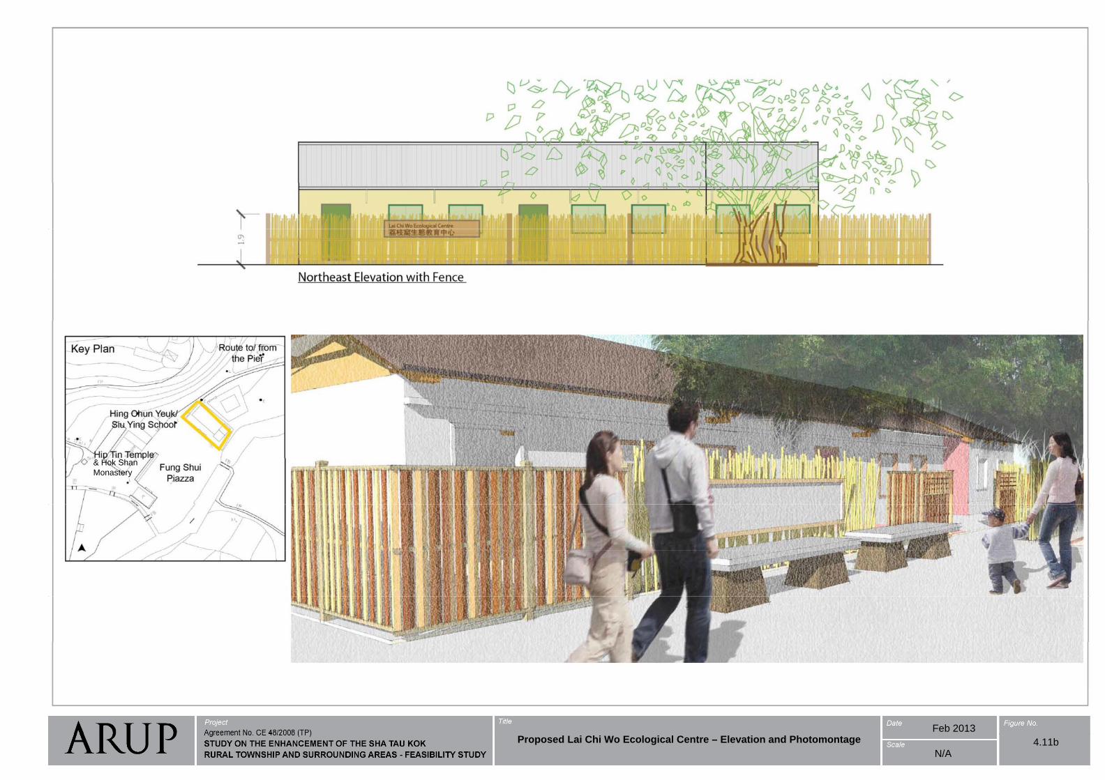
& Hok Shan
Monastery
Feb 2013
4.11bN/A
Proposed Lai Chi Wo Ecological Centre – Elevation and Photomontage
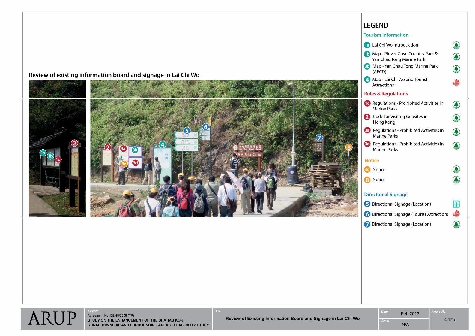
Feb 2013Review of Existing Information Board and Signage in Lai Chi Wo 4.12a
N/A
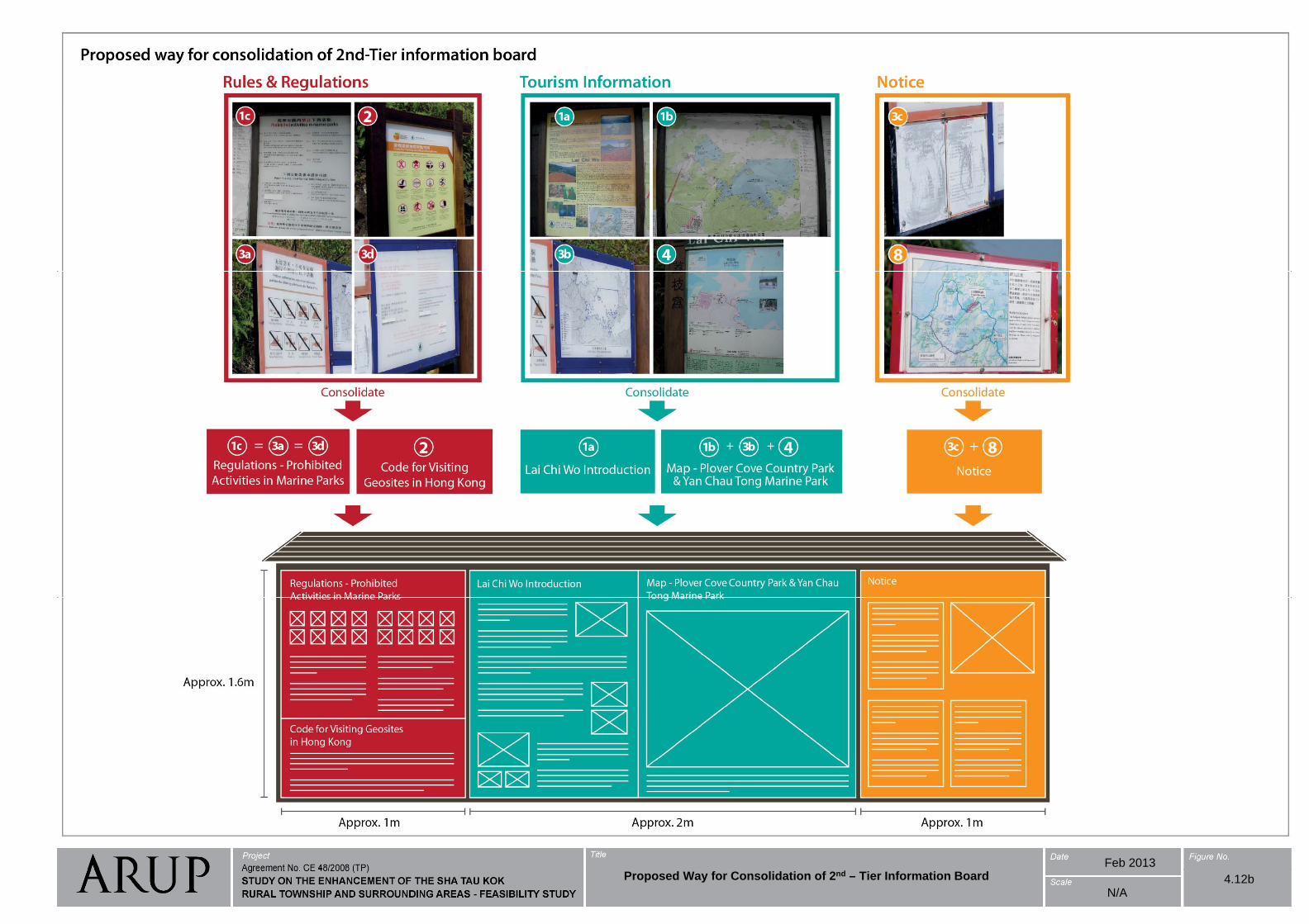
Feb 2013Proposed Way for Consolidation of 2nd – Tier Information Board 4.12b
N/A
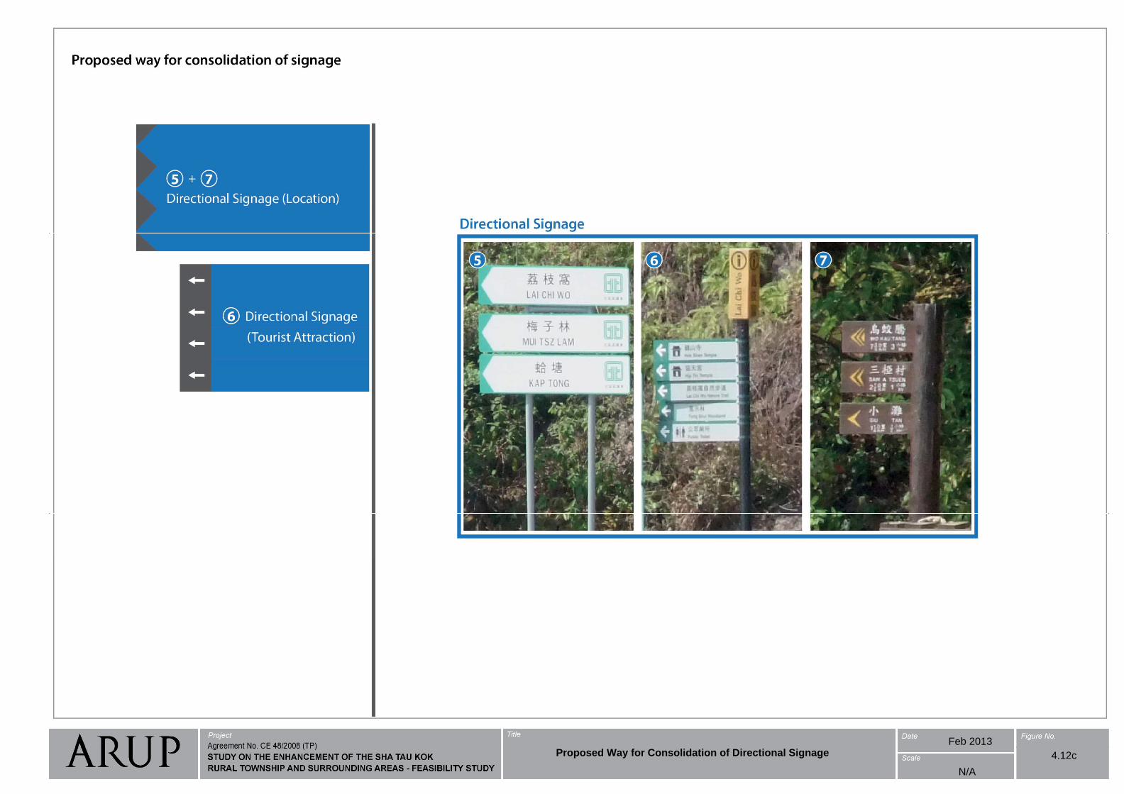
Feb 2013Proposed Way for Consolidation of Directional Signage 4.12c
N/A
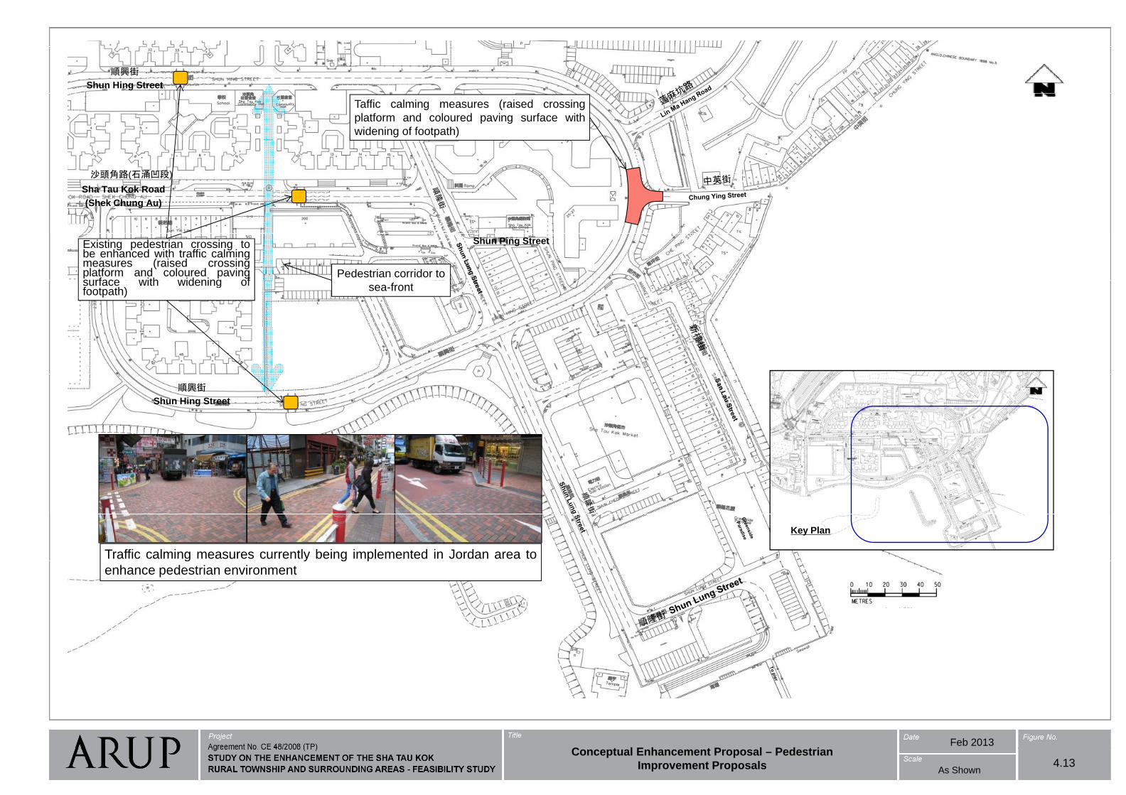
順興街
Shun Hing Street
Taffic calming measures (raised crossing
platform and coloured paving surface with
widening of footpath)
Sh T K k R d
沙頭角路(石涌凹段)
Sha Tau Kok Road
(Shek Chung Au)
Shun Ping StreetExisting pedestrian crossing tobe enhanced with traffic calmingmeasures (raised crossingplatform and coloured pavingsurface with widening of
Pedestrian corridor to surface with widening offootpath) sea-front
順興街
Shun Hing Street
Traffic calming measures currently being implemented in Jordan area to
Key Plan
g y g p
enhance pedestrian environment
Feb 2013C t l E h t P l P d t iConceptual Enhancement Proposal – Pedestrian
Improvement Proposals 4.13As Shown

Feb 2013C t l E h t P l C h Pi k U / 4.14Conceptual Enhancement Proposal – Coach Pick Up /
Drop-off Point As Shown
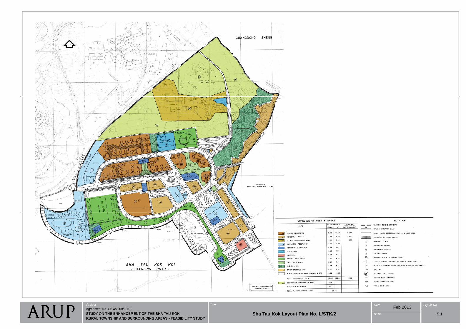
Feb 2013
Sha Tau Kok Layout Plan No. L/STK/2 5.1
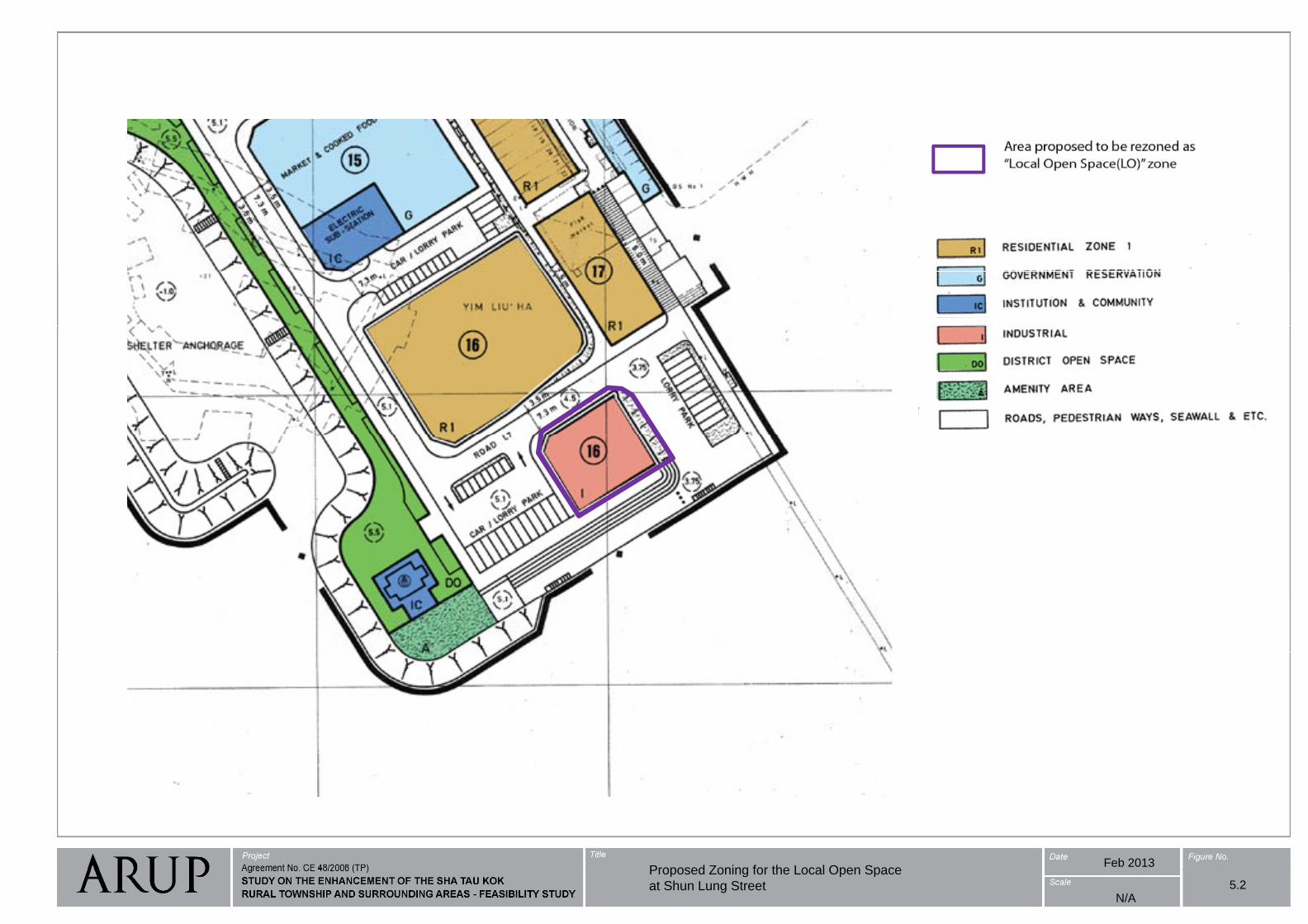
Feb 2013Proposed Zoning for the Local Open SpaceProposed Zoning for the Local Open Space
at Shun Lung Street 5.2N/A
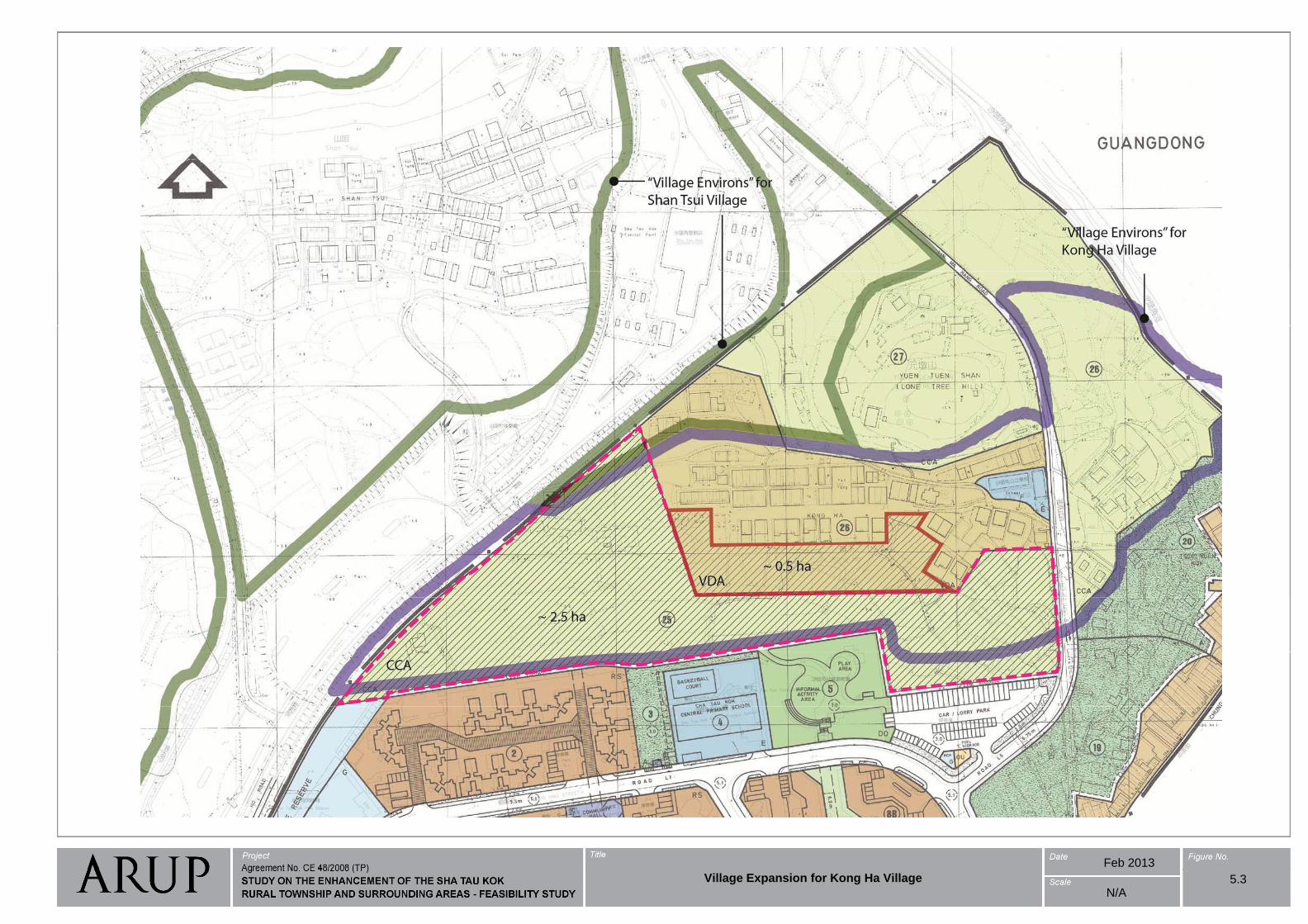
Feb 2013
Village Expansion for Kong Ha Village 5.3N/A
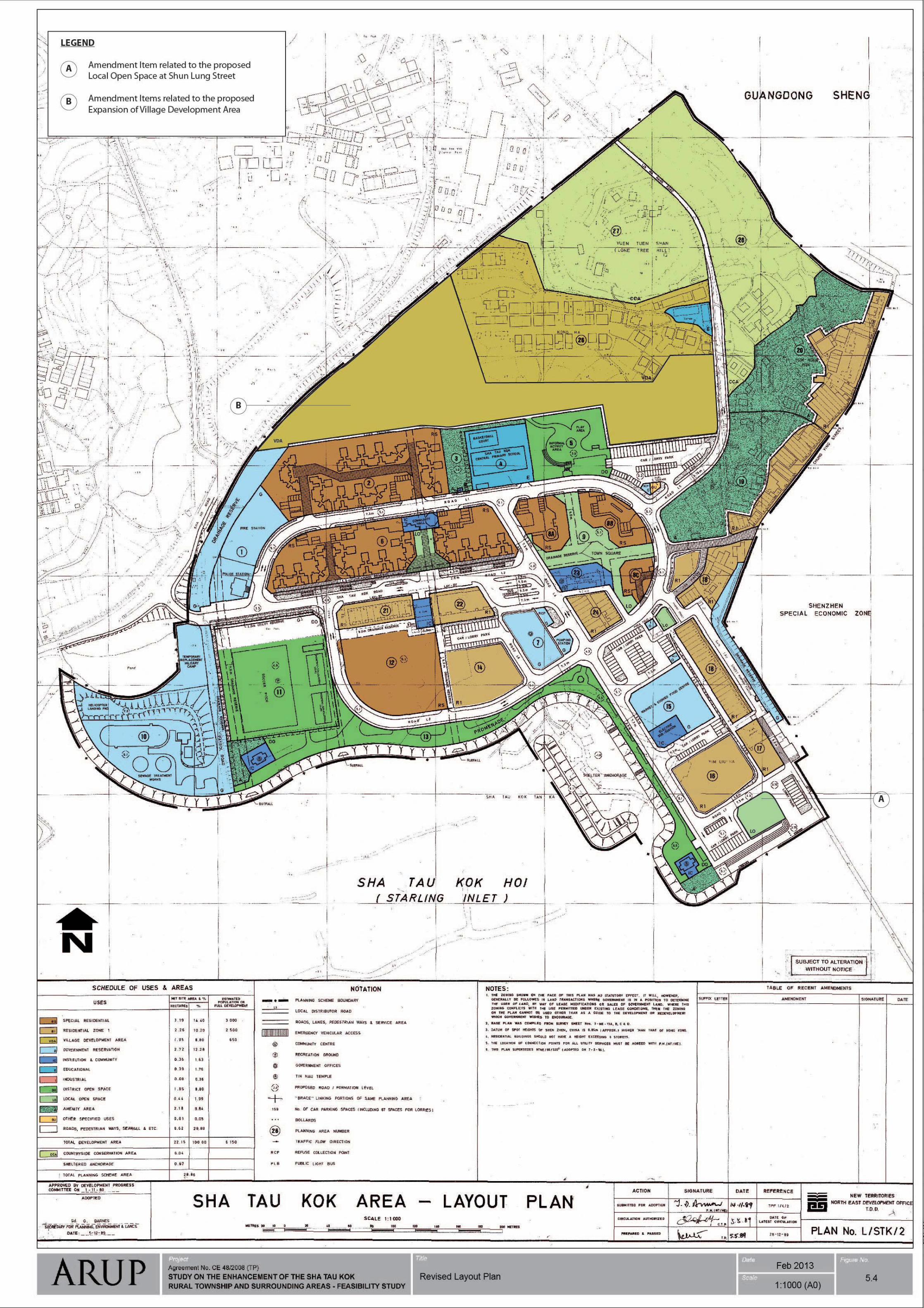
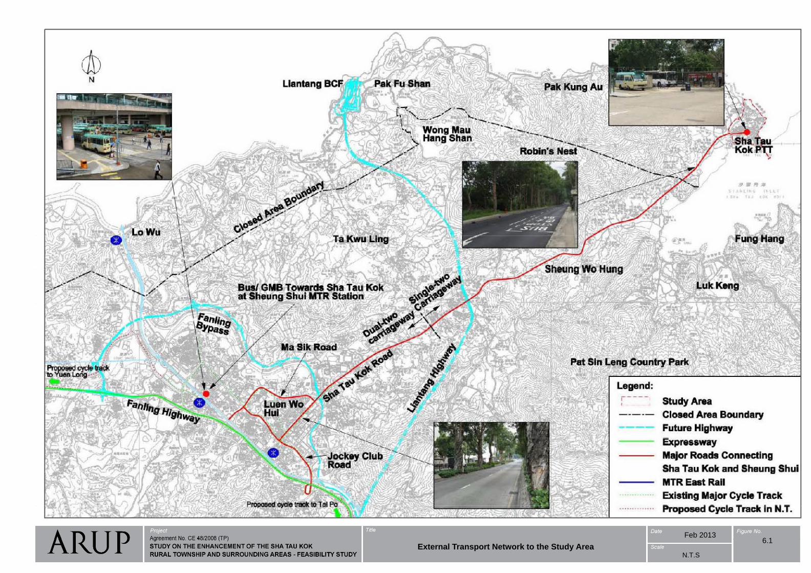
Feb 20136 16.1
External Transport Network to the Study AreaN.T.S
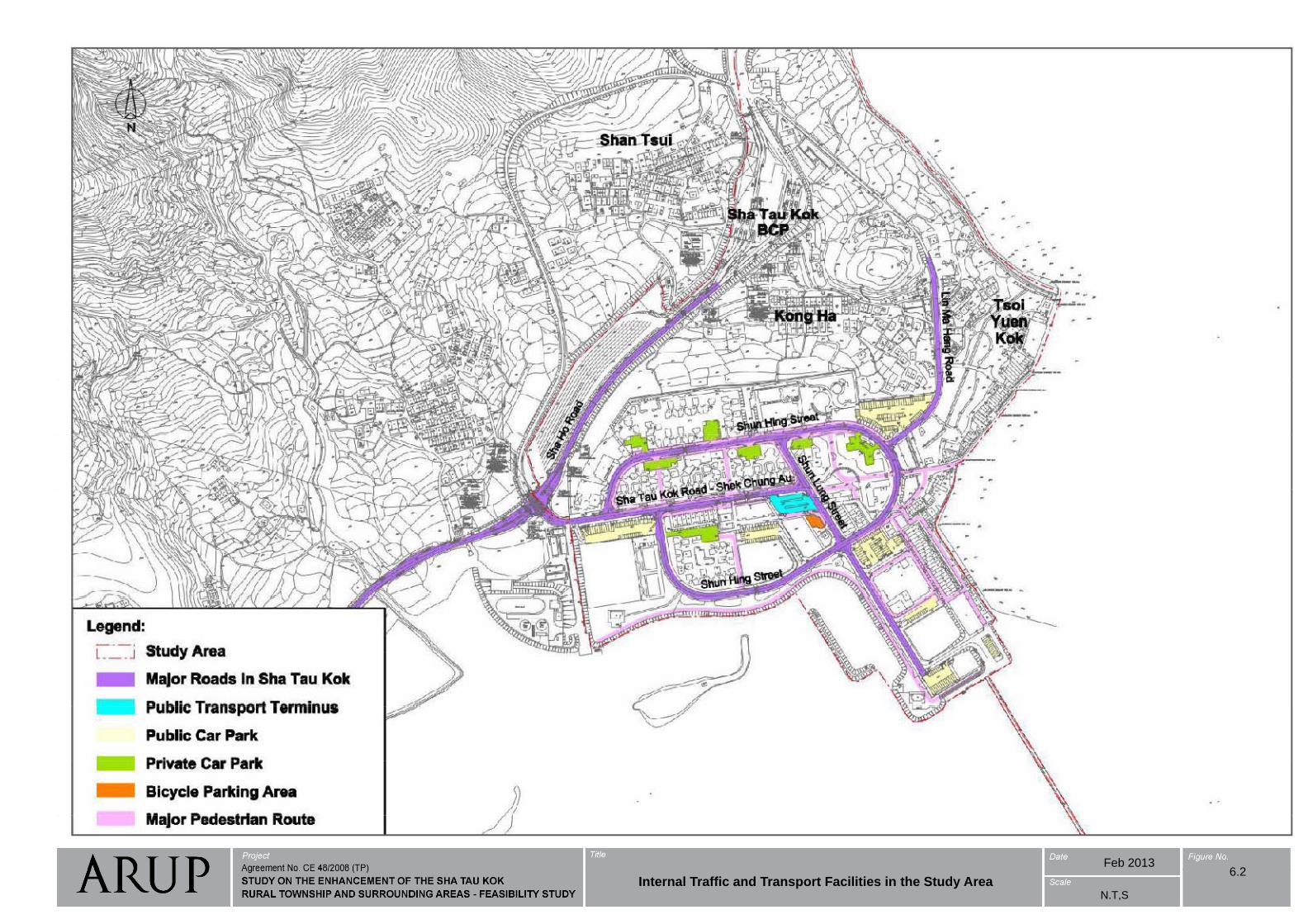
Feb 20136 26.2
Internal Traffic and Transport Facilities in the Study AreaN.T,S
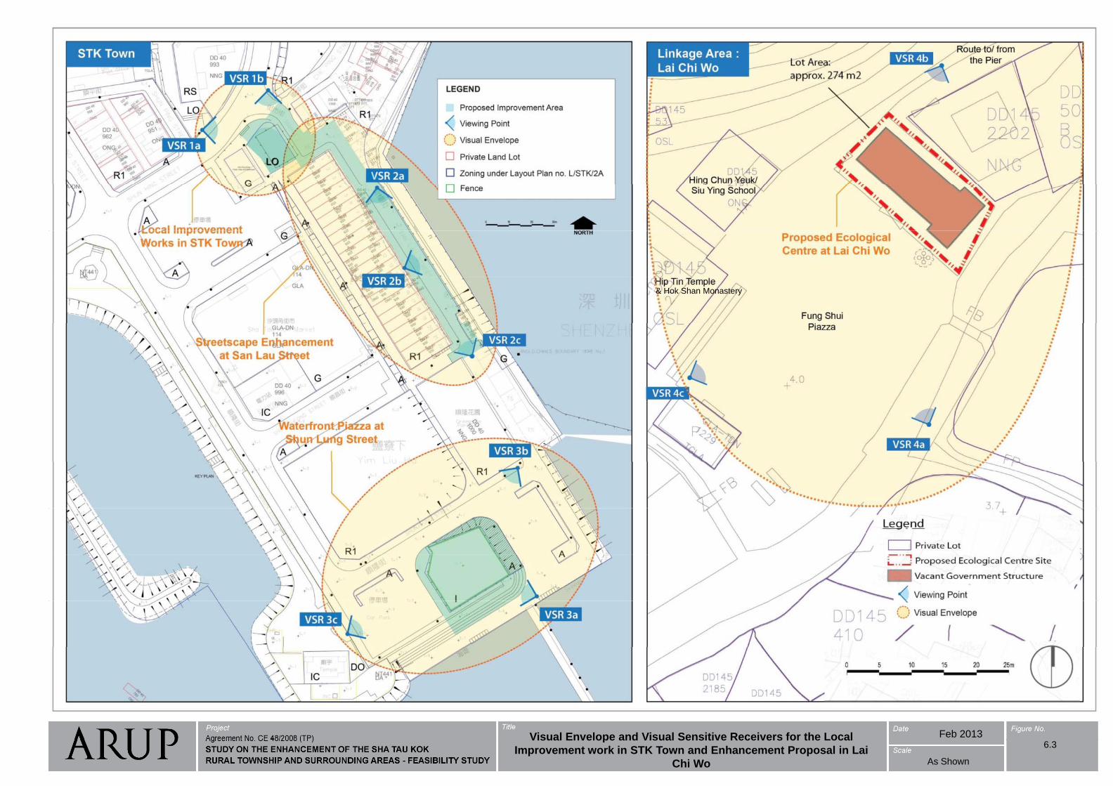
& Hok Shan Monastery
Feb 2013Visual Envelope and Visual Sensitive Receivers for the LocalVisual Envelope and Visual Sensitive Receivers for the Local
Improvement work in STK Town and Enhancement Proposal in Lai
Chi Wo As Shown
6.3
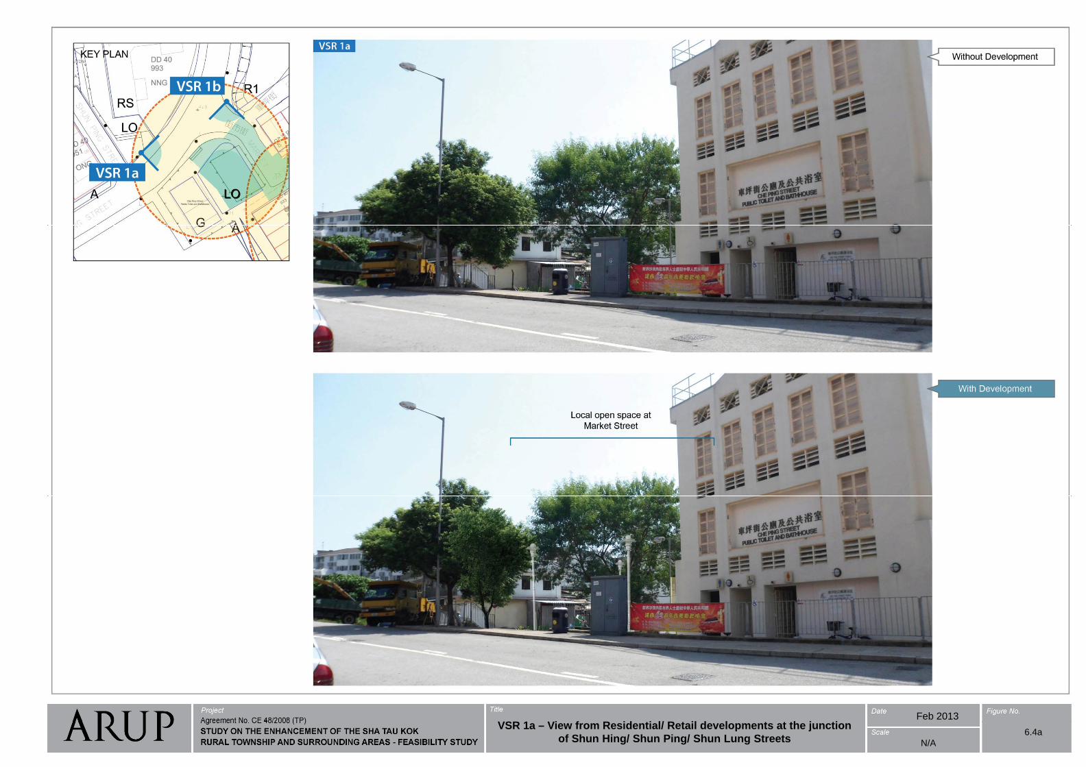
Feb 2013VSR 1 Vi f R id ti l/ R t il d l t t th j ti
N/A
VSR 1a – View from Residential/ Retail developments at the junction
of Shun Hing/ Shun Ping/ Shun Lung Streets6.4a
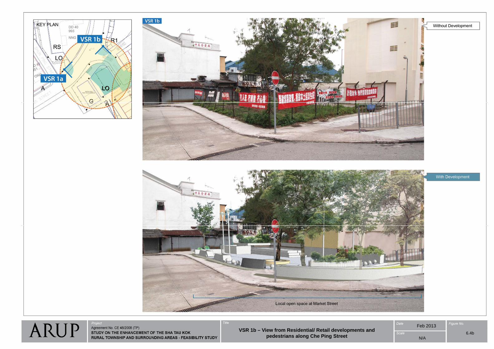
Feb 2013VSR 1b Vi f R id ti l/ R t il d l t d
N/A
VSR 1b – View from Residential/ Retail developments and
pedestrians along Che Ping Street6.4b
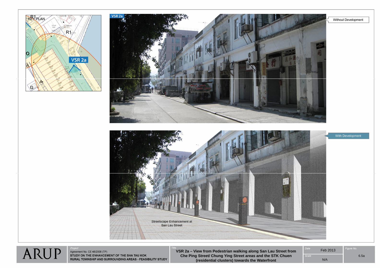
Feb 2013VSR 2a – View from Pedestrian walking along San Lau Street from
N/A
VSR 2a View from Pedestrian walking along San Lau Street from
Che Ping Street/ Chung Ying Street areas and the STK Chuen
(residential clusters) towards the Waterfront
6.5a
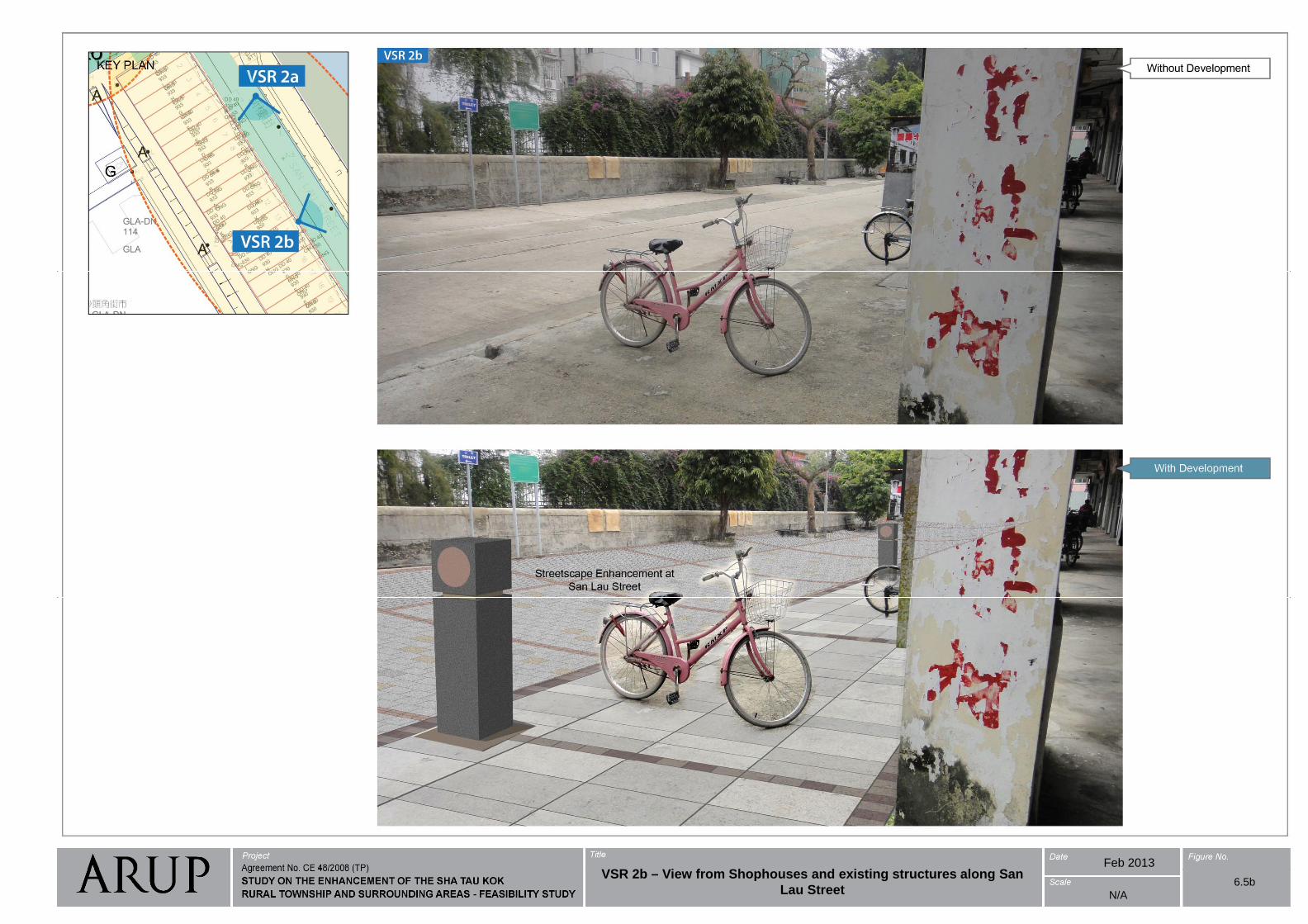
Feb 2013VSR 2b Vi f Sh h d i ti t t l S
N/A
VSR 2b – View from Shophouses and existing structures along San
Lau Street 6.5b
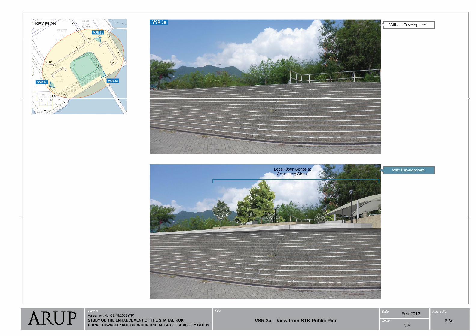
Feb 2013
6.6aN/A
VSR 3a – View from STK Public Pier
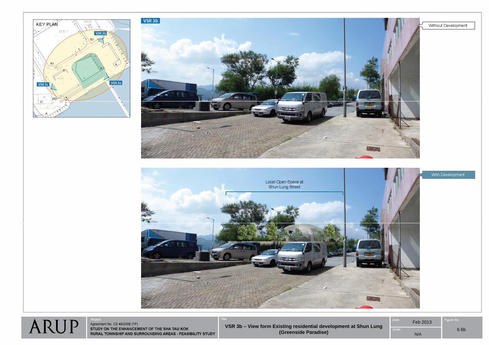
Feb 2013VSR 3b Vi f E i ti id ti l d l t t Sh L
6.6bN/A
VSR 3b – View form Existing residential development at Shun Lung
(Greenside Paradise)
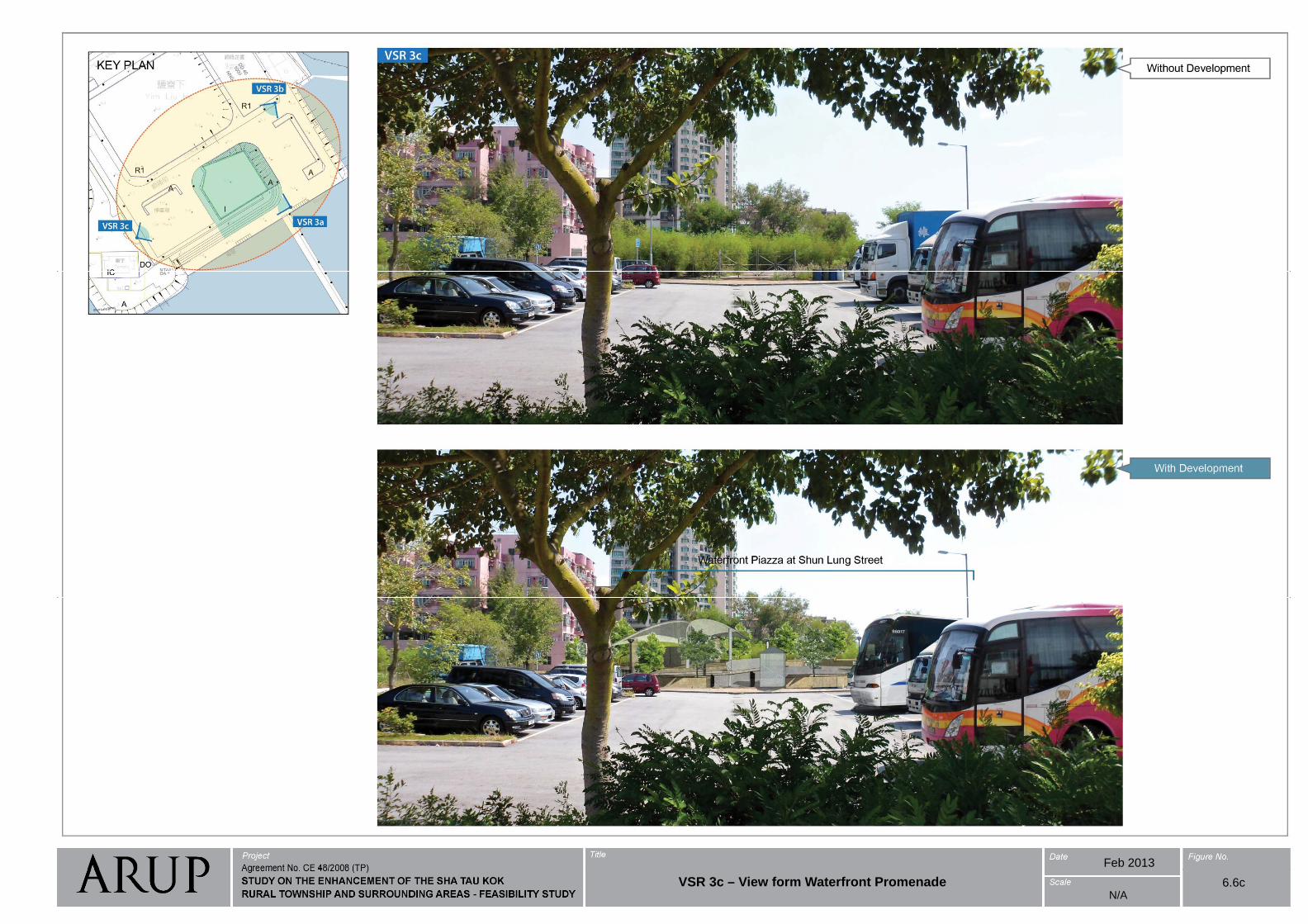
Feb 2013
6.6cN/A
VSR 3c – View form Waterfront Promenade
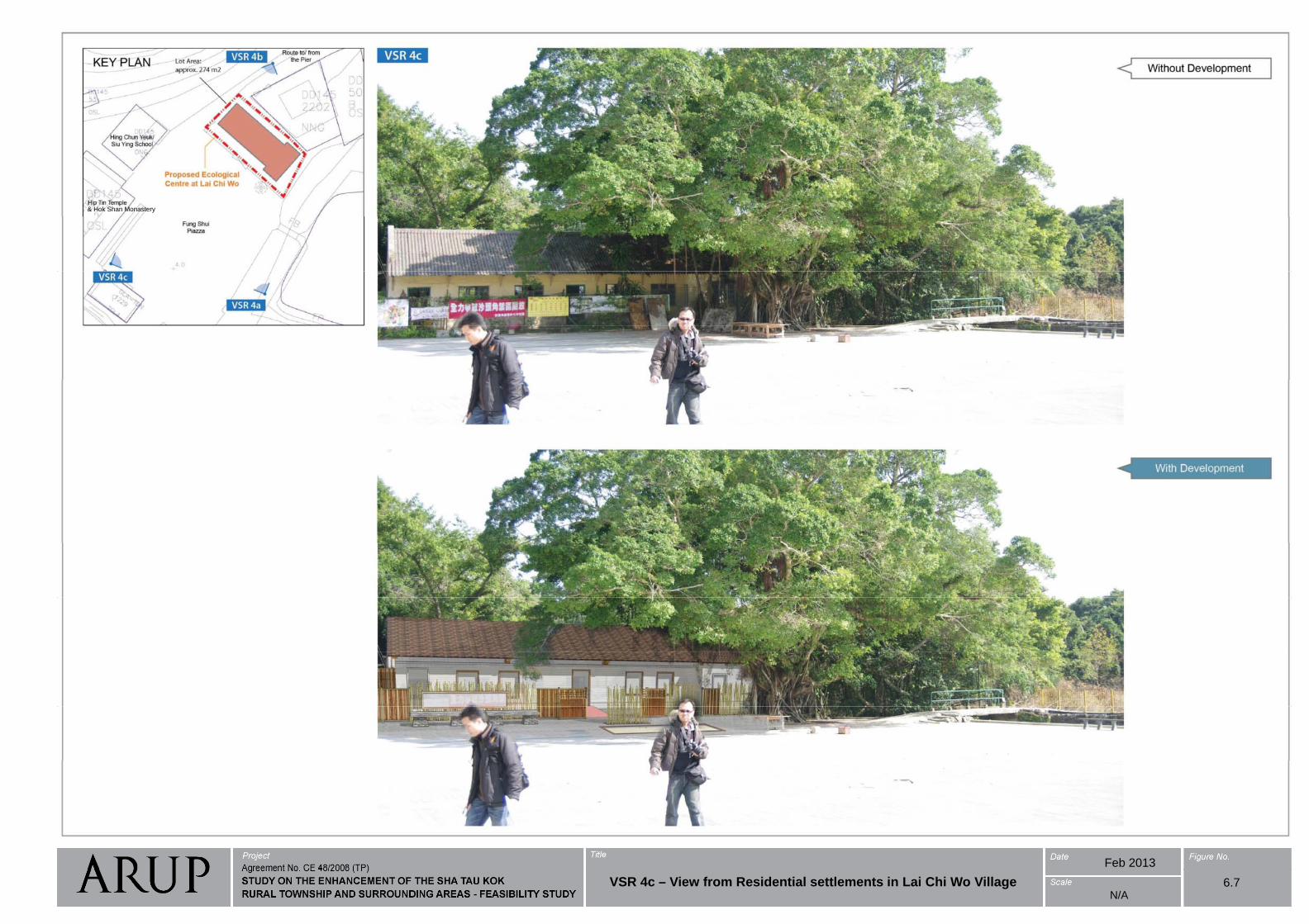
& Hok Shan Monastery
Feb 2013
6.7N/A
VSR 4c – View from Residential settlements in Lai Chi Wo Village
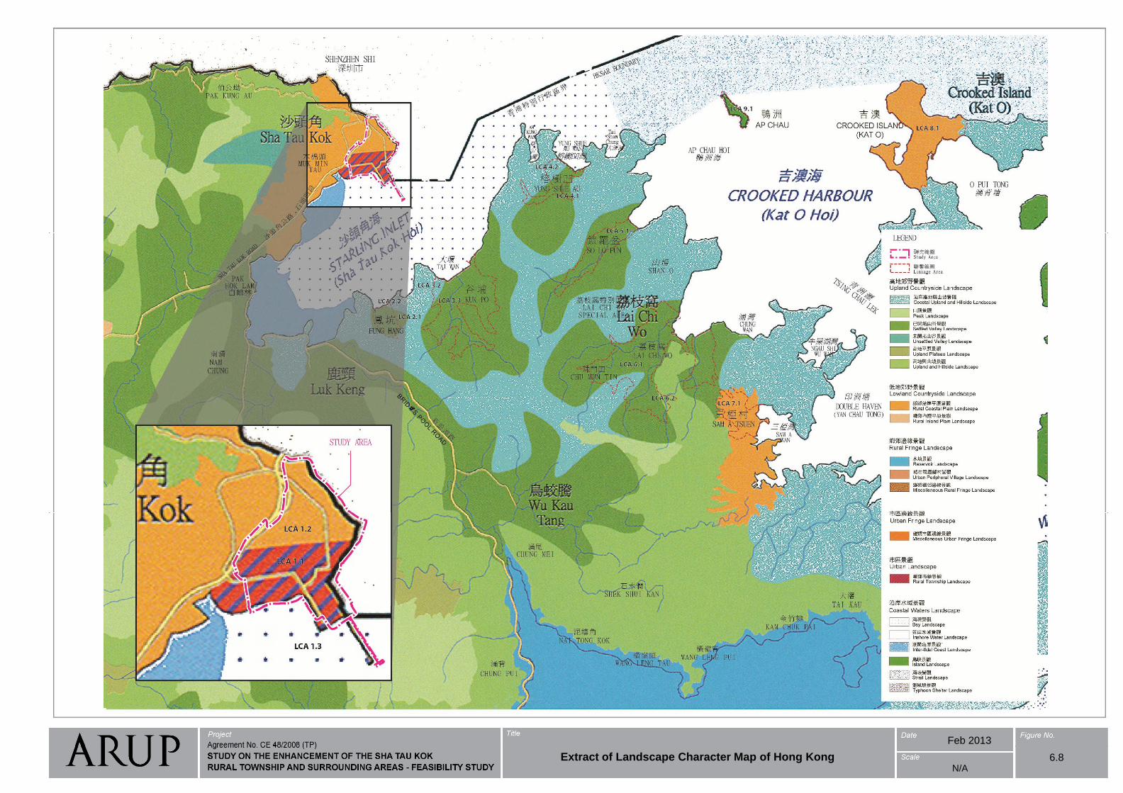
Feb 2013
6.8N/A
Extract of Landscape Character Map of Hong Kong
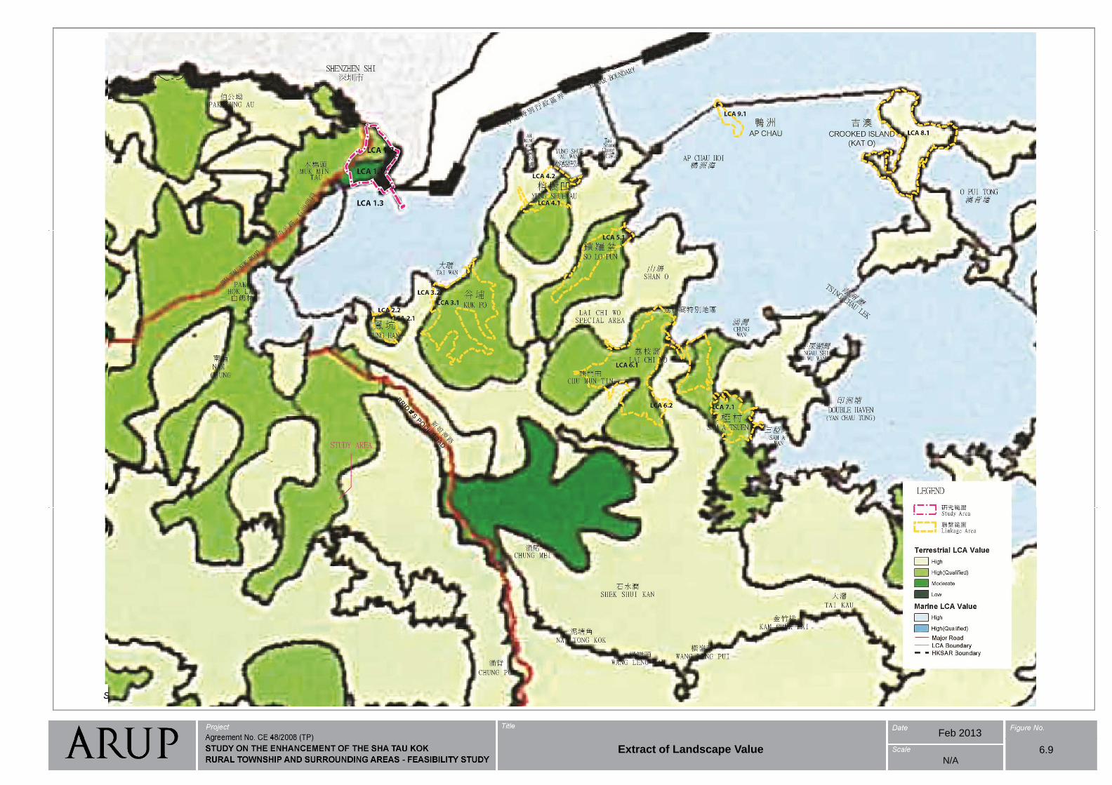
Feb 2013
6.9N/A
Extract of Landscape Value
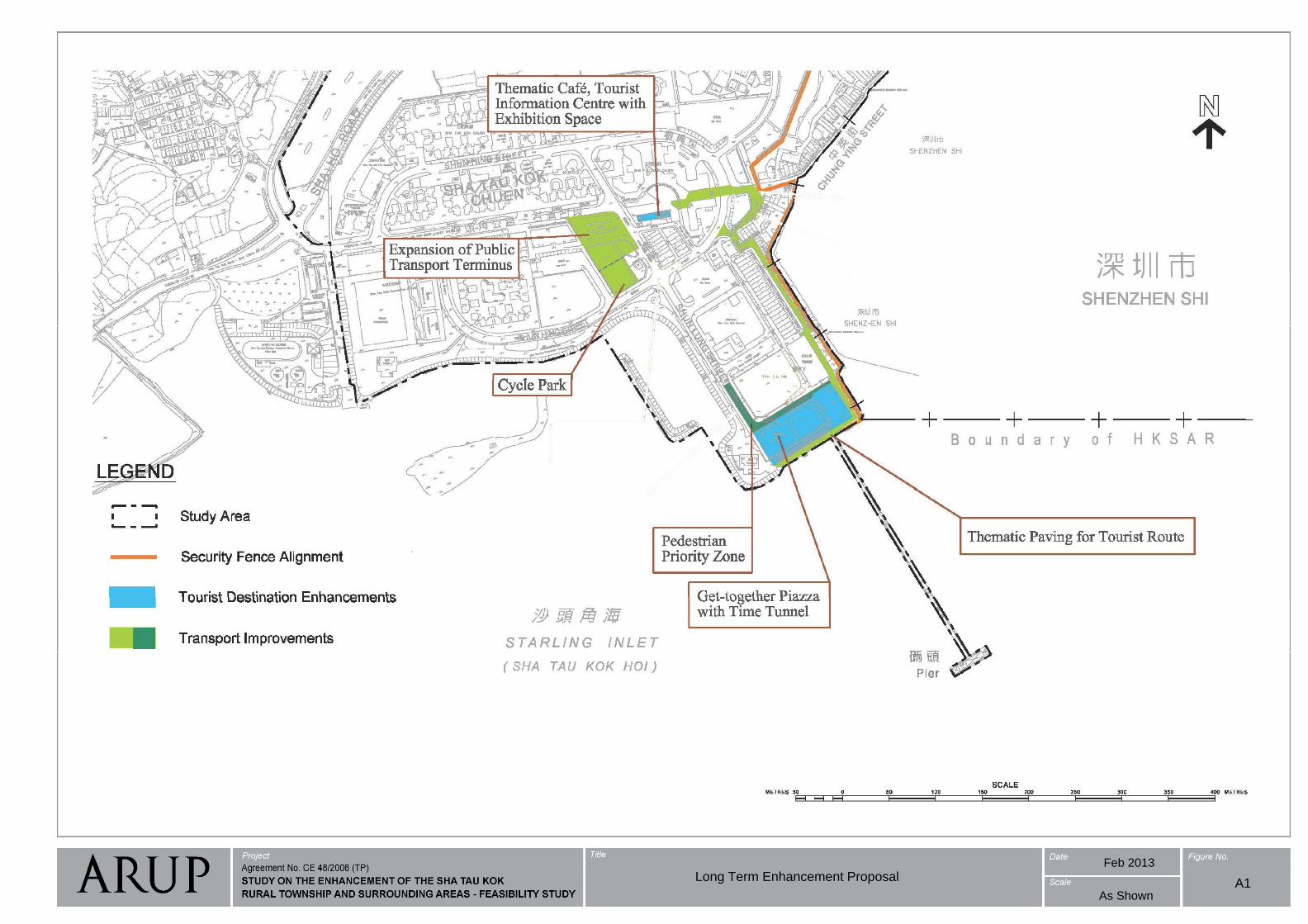
Feb 2013
Long Term Enhancement Proposal
As ShownA1
Related Documents