1 FINAL REGIONAL SESA FOR OECS CROP Public Disclosure Authorized Public Disclosure Authorized Public Disclosure Authorized Public Disclosure Authorized

Welcome message from author
This document is posted to help you gain knowledge. Please leave a comment to let me know what you think about it! Share it to your friends and learn new things together.
Transcript
1
FINAL REGIONAL SESA FOR OECS CROP
Pub
lic D
iscl
osur
e A
utho
rized
Pub
lic D
iscl
osur
e A
utho
rized
Pub
lic D
iscl
osur
e A
utho
rized
Pub
lic D
iscl
osur
e A
utho
rized
2
FINAL REGIONAL SESA FOR OECS CROP
CONTENTS
1.0 EXECUTIVE SUMMARY ......................................................................................................... 6
1.1 Scope ................................................................................................................................ 6
1.2 Background ....................................................................................................................... 6
1.3 Legal Framework for Coastal and Marine Resources Management ................................ 6
1.4 Objectives of the SESA ..................................................................................................... 7
1.5 Critical Factors for Decision-Making for CSMP .............................................................. 11
1.6 Program 1 - Mitigation Measures for Vulnerability Reduction...................................... 13
1.7 Program 2 - Good Governance Framework for CMSP ................................................... 18
1.8 Regional Priority Areas for Action .................................................................................. 19
1.8.1 Immediate to Short Term Actions (2018-2020) ...................................................... 19
1.8.2 Medium to Long Term Actions (2020-2022) ........................................................... 19
1.9 National Priorities for Action ......................................................................................... 20
1.9.1 Legal and Regulatory Framework ........................................................................... 21
1.9.2 Planning and Decision-making process .................................................................. 22
1.9.3 Implementation, Monitoring and Compliance ....................................................... 23
2.0 SCOPE ................................................................................................................................. 24
3.0 BACKGROUND .................................................................................................................... 25
3.1 Sector Programme justification and purpose ................................................................ 25
3.2 Coastal and Marine Spatial Plans in the OECS ............................................................... 26
3.3 Environmental policy, legislative and planning framework........................................... 31
Decision makers, planners, policies .......................................................................................... 31
(a) International & Regional Laws and Agreements for CMSP .............................................. 32
.(c) National policies, legislation, and regulations for CMSP ............................................ 34
3.2.2 Legal Framework to protect Land tenure and resource rights ....................................... 35
3.2.3 Broader Development Policies Integrated with Coastal & Marine Policies ........... 36
3.2.4 Institutional Framework ......................................................................................... 38
3.2.5 Financial Incentives, economic instruments & benefits sharing ............................ 39
3.2.6 Kalinago Territory Dominica ................................................................................... 40
4.0 APPROACH AND METHODOLOGY ...................................................................................... 43
4.1 General approach ........................................................................................................... 43
3
FINAL REGIONAL SESA FOR OECS CROP
4.2 What is Strategic Environment and Social Impact Assessment ..................................... 43
4.3 SESA Methodology ......................................................................................................... 45
4.3.1 Tasks of the Consultancy ........................................................................................ 46
4.4 PHASE ONE SCOPING ..................................................................................................... 47
4.4.1 Four Broad Themes of Inquiry ................................................................................ 47
4.4.2 Literature Review .................................................................................................... 48
4.4.3 One-to-one Interviews and Consultations .............................................................. 49
4.4.4 Expert Judgment ..................................................................................................... 50
4.5 Geographical or environmental mapping units ............................................................. 51
4.6 Assumptions, uncertainties and constraints .................................................................. 51
4.6.1 Assumptions ............................................................................................................ 51
4.6.2 Uncertainties ........................................................................................................... 53
4.6.3 Constraints .............................................................................................................. 53
5.0 ENVIRONMENTAL BASELINE STUDY .................................................................................. 54
5.1 Socio-Economic Drivers and Pressures .......................................................................... 54
5.2 Environmental Pressures ............................................................................................... 55
5.2.1 Cross sectoral Issues ............................................................................................... 57
5.2.2 Sector Specific Considerations ................................................................................ 58
5.3 Policy Responses ............................................................................................................ 61
5.4 Summary ........................................................................................................................ 62
6.0 IMPACT IDENTIFICATION & EVALUATION ......................................................................... 64
6.1 Base-case Scenario – Situation in OECS States .............................................................. 64
7.0 ANALYSIS OF ALTERNATIVES .............................................................................................. 73
8.0 MITIGATION OR OPTIMISING MEASURES ......................................................................... 76
Critical Risks and Mitigation Standards for Future Scenario ................................................. 76
9.0 INDICATORS, INSTITUTIONAL CAPACITIES AND GAP ANALYSIS ........................................ 83
9.1 Indicators ........................................................................................................................ 83
9.2 Framework for Good Governance ................................................................................. 84
9.3 Regional Gap Analysis - Political Economy Constraints ................................................. 85
9.3.1 Independent Small Island States ............................................................................ 85
9.3.2 Governance arrangements ..................................................................................... 86
9.3.2.1 Legal and Regulatory Framework ................................................................................... 86
4
FINAL REGIONAL SESA FOR OECS CROP
9.3.2.2 Planning and Decision-Making Process .......................................................................... 87
9.3.2.4 Implementation, Monitoring and Compliance ............................................................... 87
9.4 National Gap Assessment............................................................................................... 88
9.4.1 Component 1: Policy, Legal, Institutional and Regulatory Framework .................. 88
9.4.2 Component 2: Planning and Decision-making Process ................................................ 91
9.4.3 Component 3: Implementation, monitoring and compliance ................................ 93
10.0 CONCLUSIONS AND RECOMMENDATIONS ........................................................................ 96
10.1 General Conclusion ........................................................................................................ 96
10.2 Program 2 - Priority Areas for Action to improve Governance in OECS MS .................. 96
10.2.1 Recommendations– Policy, Legal, Institutional and Regulatory Framework ......... 97
10.2.2 Recommendations – Planning and Decision-making process ................................ 99
10.2.3 Recommendations – Implementation, Monitoring and Compliance ................... 101
10.3 General Recommendations for Implementation of CROP ........................................... 102
10.3.1 Stakeholder Participation ..................................................................................... 102
10.3.2 Planning Context and Decision-making Process ................................................... 102
10.3.3 Regional Cooperation and Coordination .............................................................. 103
10.3.4 Project Implementation ............................................................................................... 104
10.3.5 Policy Legal and Regulatory .................................................................................. 105
10.3.6 Inter-sectoral coordination .......................................................................................... 105
10.3.7 Data Collection ...................................................................................................... 106
10.3.8 Monitoring and Evaluation ........................................................................................... 106
11.0 ACTION PLAN FOR IMPLEMENTATION OF THE SESA ....................................................... 107
11.1 Priorities for action at the regional level ..................................................................... 107
11.1.1 Immediate to Short Term Actions (2018-2020) .................................................... 108
11.1.2 Medium to Long Term Actions (2020-2022) ......................................................... 109
11.2 National Priority 1: Immediate Action (2018-2019) .................................................... 110
11.2.1 Legal, Policy, Institutional and Regulatory Framework ........................................ 110
11.2.2 Planning and Decision-making Process ................................................................ 110
11.2.3 Implementation, Compliance and Monitoring ..................................................... 111
11.3 Priority 2: Short-term Action (2019-2020) ................................................................... 112
11.3.1 Legal, Policy, Institutional and Regulatory Framework ........................................ 112
5
FINAL REGIONAL SESA FOR OECS CROP
11.3.2 Planning and Decision-making Process ................................................................ 112
11.3.3 Implementation, Compliance and Monitoring ..................................................... 113
11.4 National Priority 3: Medium to long term (2019-2022) ............................................... 113
11.4.1 Planning and Decision-making Process ................................................................ 113
11.4.2 Implementation, Compliance and Monitoring ..................................................... 113
12 REFERENCES ..................................................................................................................... 123
ANNEX I – ENVIRONMENTAL POLICY AND REGULATORY FRAMEWORK IN OECS STATES ......... 127
ANNEX II – FRAMEWORK FOR INVOLUNTARY SETTLEMENT ...................................................... 139
A2.1 Objectives for Involuntary Resettlement Framework ................................................. 139
A2.2 Existing Legislation and Policy ...................................................................................... 139
A2.3 Recommended Procedure for Involuntary Resettlement .................................... 140
A2.4 Recommended Procedure for Compensation ...................................................... 140
A2.4.1 Compensation for Land ......................................................................................... 140
A2.4.2 Compensation for Crops ....................................................................................... 141
A2.5 Guidelines for Involuntary Resettlement Plan ............................................................. 141
A2. 6 Grenada Land Acquisition Act No. 159, 1990 .............................................................. 142
ANNEX III – Record of Stakeholder Consultations ...................................................................... 155
ANNEX IV GRENADA .................................................................................................................... 183
Grenada Stakeholder Consultation July 24 2018 .................................................................... 183
ANNEX V – ST KITTS & NEVIS ...................................................................................................... 189
St Kitts Stakeholder Consultation July 27 2018 ....................................................................... 189
ANNEX VI – ST LUCIA ................................................................................................................... 196
St Lucia Stakeholder Consultation – July 26, 2018 .................................................................. 196
ANNEX VII .................................................................................................................................... 201
St Vincent & the Grenadines Stakeholder Consultation ......................................................... 201
July 25, 2018 ............................................................................................................................ 201
OECS CARIBBEAN REGIONAL OCEANSCAPE PROJECT ................................................................ 201
ANNEX IV ..................................................................................................................................... 204
September 20, 2018 Regional Consultation ........................................................................... 204
6
FINAL REGIONAL SESA FOR OECS CROP
1.0 EXECUTIVE SUMMARY
1.1 Scope While the outcomes of Component 1(a) of the CROP are spatial plans, large emphasis is
placed on the planning process itself. Planning as a process involves participation across
sectors and interests and is multi-objective and multi-dimensional.
The CMS planning process results in the identification of areas most suitable for various
types or classes of activities to reduce conflicts among uses, reduce environmental
impacts, facilitate compatible uses, and preserve critical ecosystems. It is therefore a
public policy process for society to better determine how marine and coastal resources
are sustainably used and protected now and for future generations.
1.2 Background In response to the outcomes of the ECROP, the OECS with the World Bank have prepared
the Caribbean Regional Oceanscape Project (CROP) that responds to such demand for
spatial planning initiatives, through the adoption of coastal and marine spatial plans to
coordinate management across sectors and resources and integrate environmental
management directly with economic development. These plans will build upon early
national marine planning efforts1 and will help Eastern Caribbean countries better
understand and then reform governance of the diversity of ocean uses and economic
activities, resulting in a more secure framework for sustained investment in the blue
economy.
CROP is being implemented in five participating OECS Member States (MS): Dominica,
Grenada, St. Kitts and Nevis, Saint Lucia, St Vincent and the Grenadines. As a precursor to
the development of Marine and Coastal Spatial Plans to improve ocean governance, a
Regional Strategic Environmental and Social Assessment (SESA) is required. Each CROP
country, except for Grenada, has yet to clearly articulate their own vision and national
policy direction for coastal and marine spatial plans for their country, which will align with
the regional project vision.
1.3 Legal Framework for Coastal and Marine Resources Management The policy, legal, institutional and regulatory framework for coastal and marine spatial
planning in the OECS was analysed across several levels of influence, international,
regional, national and sub-national.
1 National Ocean Policies in St. Vincent and the Grenadines, and St. Kitts and Nevis (draft); Integrated Coastal Zone Management (ICZM) policies in Grenada and St. Lucia
7
FINAL REGIONAL SESA FOR OECS CROP
• From the review it can be concluded that there is a robust regulatory framework for
Caribbean ocean’s governance at the international and regional level. There is a lack
of clarity or coherence in some of the conventions and in many cases repetition of
provisions.
• States have been slow in ratifying agreements after signing and even slower in
effecting implementation at the national level. It is noted that independent States are
quicker to ratify agreements than dependent territories who are lagging behind. The
recommendation is made for a common legal framework for Caribbean oceans
governance, to rationalize the various MEAs and develop coordinating mechanisms
for their implementation
• Annex I provides a comprehensive listing of all the policies, legislation, regulations,
conventions and MEAs for coastal and marine spatial planning in OECS MS.
• National policies, strategies and programs of action for emerging environmental
management issues such as climate change, conservation of biological diversity and
marine resources are influenced by international conventions and multi-lateral
environmental agreements. Most of the national laws pre-date these international
agreements.
• The legal framework for management of the Kalinago Territory is a vertical hierarchy
of government with power aligned accordingly. The rights of the Kalinago Community
are not provided for at the level of the Constitution of Dominica. Their rights to
participation is the same as for all people of the Commonwealth of Dominica. While
Section 29 of the By-Laws of the Kalinago Territory Act provides responsibilities to the
Council for the management of the territory, according to Section 48 of the same Act,
the overall responsibility for development and planning in the Territory is retained by
the Government of Dominica.
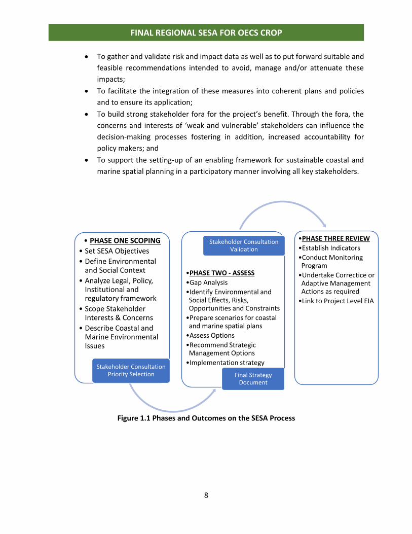
1.4 Objectives of the SESA In keeping with the terms of reference (TOR) for this consultancy, the main objectives of
this Strategic Environmental and Social Assessment are:
• To support the understanding and further inclusion of priority environmental and
social considerations in Coastal and Marine Spatial Planning (CMSP) in the CROP
and contribute relevant information to Component 1 of the CROP.
• To provide specific inputs for the implementation of the regional Strategic
Environmental and Social Assessment (SESA).
• To further examine the vulnerabilities as well as opportunities for the Kalinago
indigenous community of Dominica as related to CMSP. An Indigenous People’s
Planning Framework (IPPF) will therefore need to be embedded into the SESA.
8
FINAL REGIONAL SESA FOR OECS CROP
• To gather and validate risk and impact data as well as to put forward suitable and
feasible recommendations intended to avoid, manage and/or attenuate these
impacts;
• To facilitate the integration of these measures into coherent plans and policies
and to ensure its application;
• To build strong stakeholder fora for the project’s benefit. Through the fora, the
concerns and interests of ‘weak and vulnerable’ stakeholders can influence the
decision-making processes fostering in addition, increased accountability for
policy makers; and
• To support the setting-up of an enabling framework for sustainable coastal and
marine spatial planning in a participatory manner involving all key stakeholders.
Figure 1.1 Phases and Outcomes on the SESA Process
• PHASE ONE SCOPING
• Set SESA Objectives
• Define Environmental and Social Context
• Analyze Legal, Policy, Institutional and regulatory framework
• Scope Stakeholder Interests & Concerns
• Describe Coastal and Marine Environmental Issues
Stakeholder Consultation Priority Selection
•PHASE TWO - ASSESS
•Gap Analysis
•Identify Environmental and Social Effects, Risks, Opportunities and Constraints
•Prepare scenarios for coastal and marine spatial plans
•Assess Options
•Recommend Strategic Management Options
•Implementation strategy
Stakeholder Consultation Validation
•PHASE THREE REVIEW
•Establish Indicators
•Conduct Monitoring Program
•Undertake Correctice or Adaptive Management Actions as required
•Link to Project Level EIA
Final Strategy Document
9
FINAL REGIONAL SESA FOR OECS CROP
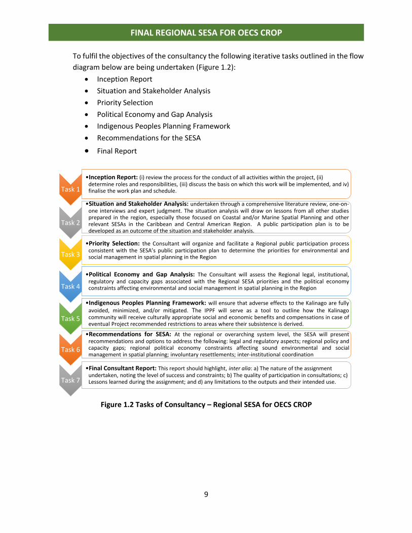
To fulfil the objectives of the consultancy the following iterative tasks outlined in the flow
diagram below are being undertaken (Figure 1.2):
• Inception Report
• Situation and Stakeholder Analysis
• Priority Selection
• Political Economy and Gap Analysis
• Indigenous Peoples Planning Framework
• Recommendations for the SESA
• Final Report
Figure 1.2 Tasks of Consultancy – Regional SESA for OECS CROP
Task 1
•Inception Report: (i) review the process for the conduct of all activities within the project, (ii) determine roles and responsibilities, (iii) discuss the basis on which this work will be implemented, and iv) finalise the work plan and schedule.
Task 2
•Situation and Stakeholder Analysis: undertaken through a comprehensive literature review, one-on-one interviews and expert judgment. The situation analysis will draw on lessons from all other studiesprepared in the region, especially those focused on Coastal and/or Marine Spatial Planning and otherrelevant SESAs in the Caribbean and Central American Region. A public participation plan is to bedeveloped as an outcome of the situation and stakeholder analysis.
Task 3
•Priority Selection: the Consultant will organize and facilitate a Regional public participation processconsistent with the SESA’s public participation plan to determine the priorities for environmental andsocial management in spatial planning in the Region
Task 4
•Political Economy and Gap Analysis: The Consultant will assess the Regional legal, institutional,regulatory and capacity gaps associated with the Regional SESA priorities and the political economyconstraints affecting environmental and social management in spatial planning in the Region
Task 5
•Indigenous Peoples Planning Framework: will ensure that adverse effects to the Kalinago are fullyavoided, minimized, and/or mitigated. The IPPF will serve as a tool to outline how the Kalinagocommunity will receive culturally appropriate social and economic benefits and compensations in case ofeventual Project recommended restrictions to areas where their subsistence is derived.
Task 6
•Recommendations for SESA: At the regional or overarching system level, the SESA will presentrecommendations and options to address the following: legal and regulatory aspects; regional policy andcapacity gaps; regional political economy constraints affecting sound environmental and socialmanagement in spatial planning; involuntary resettlements; inter-institutional coordination
Task 7
•Final Consultant Report: This report should highlight, inter alia: a) The nature of the assignment undertaken, noting the level of success and constraints; b) The quality of participation in consultations; c) Lessons learned during the assignment; and d) any limitations to the outputs and their intended use.
10
FINAL REGIONAL SESA FOR OECS CROP
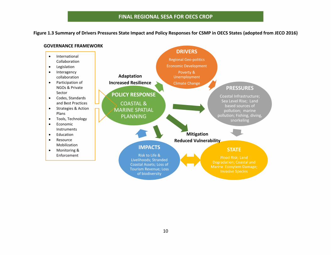
Figure 1.3 Summary of Drivers Pressures State Impact and Policy Responses for CSMP in OECS States (adopted from JECO 2016)
DRIVERS
Regional Geo-politics
Economic Development
Poverty & Unemployment
Climate Change
PRESSURES
Coastal Infrastructure; Sea Level Rise; Land
based sources of pollution; marine
pollution; Fishing, diving, snorkeling
STATE
Flood Risk; Land Degradation; Coastal and
Marine Ecosytem Damage; Invasive Species
IMPACTS
Risk to Life & Livelihoods; Stranded Coastal Assets; Loss of Tourism Revenue; Loss
of biodiversity
POLICY RESPONSE
COASTAL & MARINE SPATIAL
PLANNING
• International Collaboration
• Legislation
• Interagency collaboration
• Participation of NGOs & Private Sector
• Codes, Standards and Best Practices
• Strategies & Action Plans
• Tools, Technology
• Economic Instruments
• Education
• Resource Mobilization
• Monitoring & Enforcement
Adaptation
Increased Resilience
Mitigation
Reduced Vulnerability
GOVERNANCE FRAMEWORK
11
FINAL REGIONAL SESA FOR OECS CROP
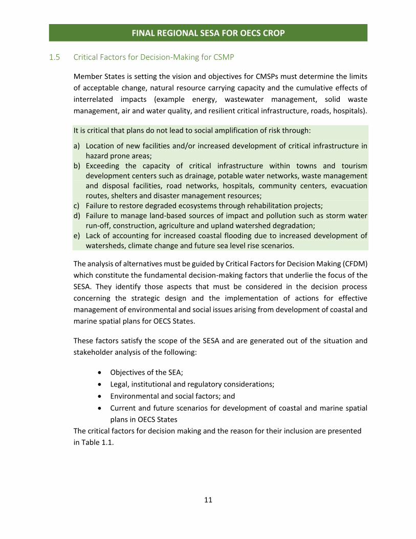
1.5 Critical Factors for Decision-Making for CSMP
Member States is setting the vision and objectives for CMSPs must determine the limits
of acceptable change, natural resource carrying capacity and the cumulative effects of
interrelated impacts (example energy, wastewater management, solid waste
management, air and water quality, and resilient critical infrastructure, roads, hospitals).
It is critical that plans do not lead to social amplification of risk through:
a) Location of new facilities and/or increased development of critical infrastructure in hazard prone areas;
b) Exceeding the capacity of critical infrastructure within towns and tourism development centers such as drainage, potable water networks, waste management and disposal facilities, road networks, hospitals, community centers, evacuation routes, shelters and disaster management resources;
c) Failure to restore degraded ecosystems through rehabilitation projects; d) Failure to manage land-based sources of impact and pollution such as storm water
run-off, construction, agriculture and upland watershed degradation; e) Lack of accounting for increased coastal flooding due to increased development of
watersheds, climate change and future sea level rise scenarios.
The analysis of alternatives must be guided by Critical Factors for Decision Making (CFDM)
which constitute the fundamental decision-making factors that underlie the focus of the
SESA. They identify those aspects that must be considered in the decision process
concerning the strategic design and the implementation of actions for effective
management of environmental and social issues arising from development of coastal and
marine spatial plans for OECS States.
These factors satisfy the scope of the SESA and are generated out of the situation and
stakeholder analysis of the following:
• Objectives of the SEA;
• Legal, institutional and regulatory considerations;
• Environmental and social factors; and • Current and future scenarios for development of coastal and marine spatial
plans in OECS States The critical factors for decision making and the reason for their inclusion are presented
in Table 1.1.
12
FINAL REGIONAL SESA FOR OECS CROP
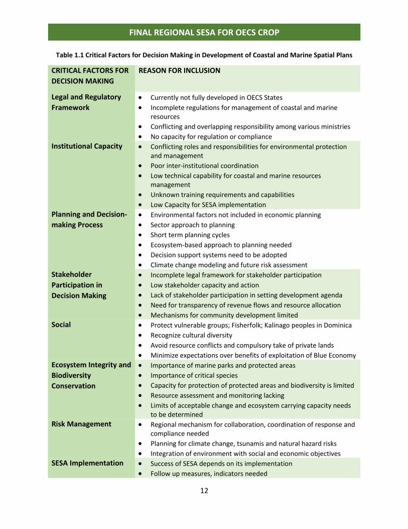
Table 1.1 Critical Factors for Decision Making in Development of Coastal and Marine Spatial Plans
CRITICAL FACTORS FOR
DECISION MAKING
REASON FOR INCLUSION
Legal and Regulatory
Framework
• Currently not fully developed in OECS States
• Incomplete regulations for management of coastal and marine resources
• Conflicting and overlapping responsibility among various ministries
• No capacity for regulation or compliance Institutional Capacity • Conflicting roles and responsibilities for environmental protection
and management
• Poor inter-institutional coordination
• Low technical capability for coastal and marine resources management
• Unknown training requirements and capabilities
• Low Capacity for SESA implementation
Planning and Decision-
making Process
• Environmental factors not included in economic planning
• Sector approach to planning
• Short term planning cycles
• Ecosystem-based approach to planning needed
• Decision support systems need to be adopted
• Climate change modeling and future risk assessment Stakeholder
Participation in
Decision Making
• Incomplete legal framework for stakeholder participation
• Low stakeholder capacity and action
• Lack of stakeholder participation in setting development agenda • Need for transparency of revenue flows and resource allocation
• Mechanisms for community development limited Social • Protect vulnerable groups; Fisherfolk; Kalinago peoples in Dominica
• Recognize cultural diversity
• Avoid resource conflicts and compulsory take of private lands
• Minimize expectations over benefits of exploitation of Blue Economy Ecosystem Integrity and
Biodiversity
Conservation
• Importance of marine parks and protected areas
• Importance of critical species
• Capacity for protection of protected areas and biodiversity is limited
• Resource assessment and monitoring lacking • Limits of acceptable change and ecosystem carrying capacity needs
to be determined Risk Management • Regional mechanism for collaboration, coordination of response and
compliance needed
• Planning for climate change, tsunamis and natural hazard risks • Integration of environment with social and economic objectives
SESA Implementation • Success of SESA depends on its implementation
• Follow up measures, indicators needed
13
FINAL REGIONAL SESA FOR OECS CROP
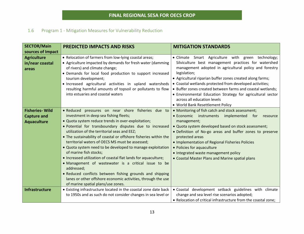
1.6 Program 1 - Mitigation Measures for Vulnerability Reduction
SECTOR/Main sources of Impact
PREDICTED IMPACTS AND RISKS MITIGATION STANDARDS
Agriculture in/near coastal areas
• Relocation of farmers from low-lying coastal areas;
• Agriculture impacted by demands for fresh water (damming of rivers) and climate change;
• Demands for local food production to support increased tourism development;
• Increased agricultural activities in upland watersheds resulting harmful amounts of topsoil or pollutants to flow into estuaries and coastal waters
• Climate Smart Agriculture with green technology; Silviculture best management practices for watershed management adopted in agricultural policy and forestry legislation;
• Agricultural riparian buffer zones created along farms;
• Coastal wetlands protected from developed activities;
• Buffer zones created between farms and coastal wetlands;
• Environmental Education Strategy for agricultural sector across all education levels
• World Bank Resettlement Policy
Fisheries- Wild Capture and Aquaculture
• Reduced pressures on near shore fisheries due to investment in deep sea fishing fleets;
• Quota system reduce trends in over-exploitation;
• Potential for transboundary disputes due to increased utilization of the territorial seas and EEZ;
• The sustainability of coastal or offshore fisheries within the territorial waters of OECS MS must be assessed;
• Quota system need to be developed to manage exploitation of marine fish stocks;
• Increased utilization of coastal flat lands for aquaculture;
• Management of wastewater is a critical issue to be addressed;
• Reduced conflicts between fishing grounds and shipping lanes or other offshore economic activities, through the use of marine spatial plans/use zones.
• Monitoring of fish catch and stock assessment;
• Economic instruments implemented for resource management;
• Quota system developed based on stock assessment;
• Definition of No-go areas and buffer zones to preserve protected areas
• Implementation of Regional Fisheries Policies
• Policies for aquaculture
• Integrated waste management policy
• Coastal Master Plans and Marine spatial plans
Infrastructure • Existing infrastructure located in the coastal zone date back to 1950s and as such do not consider changes in sea level or
• Coastal development setback guidelines with climate change and sea level rise scenarios adopted;
• Relocation of critical infrastructure from the coastal zone;
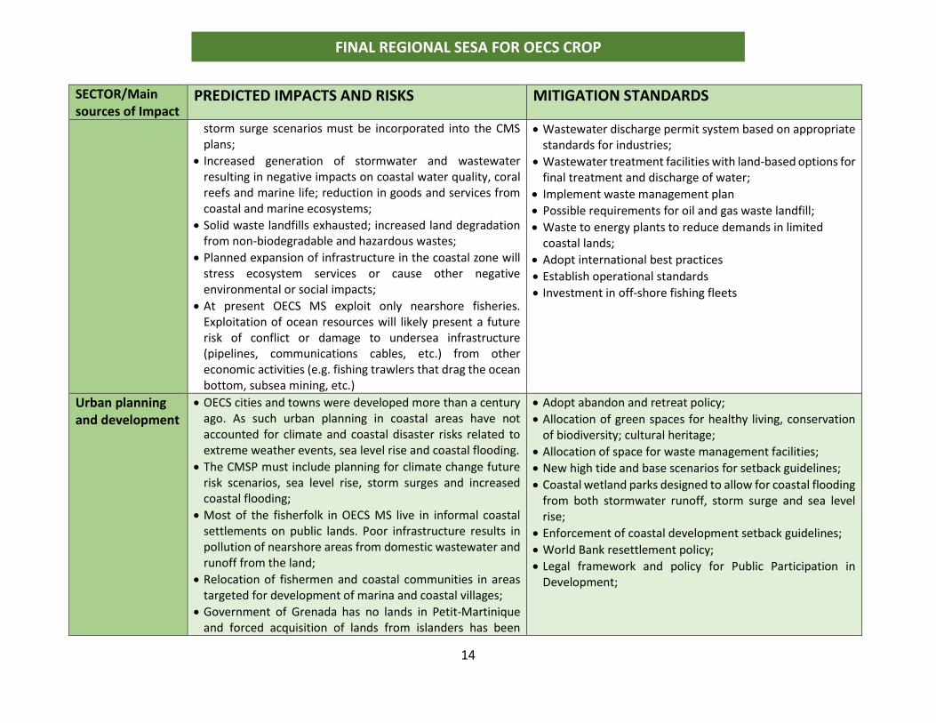
14
FINAL REGIONAL SESA FOR OECS CROP
SECTOR/Main sources of Impact
PREDICTED IMPACTS AND RISKS MITIGATION STANDARDS
storm surge scenarios must be incorporated into the CMS plans;
• Increased generation of stormwater and wastewater resulting in negative impacts on coastal water quality, coral reefs and marine life; reduction in goods and services from coastal and marine ecosystems;
• Solid waste landfills exhausted; increased land degradation from non-biodegradable and hazardous wastes;
• Planned expansion of infrastructure in the coastal zone will stress ecosystem services or cause other negative environmental or social impacts;
• At present OECS MS exploit only nearshore fisheries. Exploitation of ocean resources will likely present a future risk of conflict or damage to undersea infrastructure (pipelines, communications cables, etc.) from other economic activities (e.g. fishing trawlers that drag the ocean bottom, subsea mining, etc.)
• Wastewater discharge permit system based on appropriate standards for industries;
• Wastewater treatment facilities with land-based options for final treatment and discharge of water;
• Implement waste management plan
• Possible requirements for oil and gas waste landfill;
• Waste to energy plants to reduce demands in limited coastal lands;
• Adopt international best practices
• Establish operational standards
• Investment in off-shore fishing fleets
Urban planning and development
• OECS cities and towns were developed more than a century ago. As such urban planning in coastal areas have not accounted for climate and coastal disaster risks related to extreme weather events, sea level rise and coastal flooding.
• The CMSP must include planning for climate change future risk scenarios, sea level rise, storm surges and increased coastal flooding;
• Most of the fisherfolk in OECS MS live in informal coastal settlements on public lands. Poor infrastructure results in pollution of nearshore areas from domestic wastewater and runoff from the land;
• Relocation of fishermen and coastal communities in areas targeted for development of marina and coastal villages;
• Government of Grenada has no lands in Petit-Martinique and forced acquisition of lands from islanders has been
• Adopt abandon and retreat policy;
• Allocation of green spaces for healthy living, conservation of biodiversity; cultural heritage;
• Allocation of space for waste management facilities;
• New high tide and base scenarios for setback guidelines;
• Coastal wetland parks designed to allow for coastal flooding from both stormwater runoff, storm surge and sea level rise;
• Enforcement of coastal development setback guidelines;
• World Bank resettlement policy;
• Legal framework and policy for Public Participation in Development;
15
FINAL REGIONAL SESA FOR OECS CROP
SECTOR/Main sources of Impact
PREDICTED IMPACTS AND RISKS MITIGATION STANDARDS
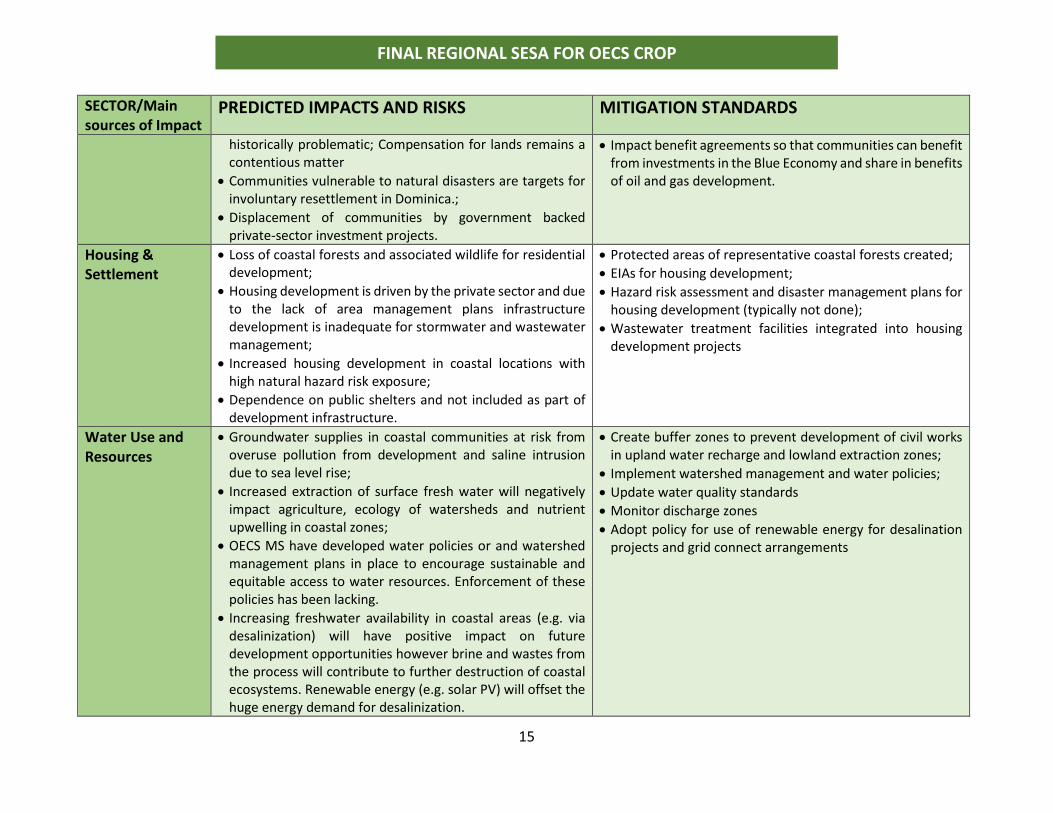
historically problematic; Compensation for lands remains a contentious matter
• Communities vulnerable to natural disasters are targets for involuntary resettlement in Dominica.;
• Displacement of communities by government backed private-sector investment projects.
• Impact benefit agreements so that communities can benefit from investments in the Blue Economy and share in benefits of oil and gas development.
Housing & Settlement
• Loss of coastal forests and associated wildlife for residential development;
• Housing development is driven by the private sector and due to the lack of area management plans infrastructure development is inadequate for stormwater and wastewater management;
• Increased housing development in coastal locations with high natural hazard risk exposure;
• Dependence on public shelters and not included as part of development infrastructure.
• Protected areas of representative coastal forests created;
• EIAs for housing development;
• Hazard risk assessment and disaster management plans for housing development (typically not done);
• Wastewater treatment facilities integrated into housing development projects
Water Use and Resources
• Groundwater supplies in coastal communities at risk from overuse pollution from development and saline intrusion due to sea level rise;
• Increased extraction of surface fresh water will negatively impact agriculture, ecology of watersheds and nutrient upwelling in coastal zones;
• OECS MS have developed water policies or and watershed management plans in place to encourage sustainable and equitable access to water resources. Enforcement of these policies has been lacking.
• Increasing freshwater availability in coastal areas (e.g. via desalinization) will have positive impact on future development opportunities however brine and wastes from the process will contribute to further destruction of coastal ecosystems. Renewable energy (e.g. solar PV) will offset the huge energy demand for desalinization.
• Create buffer zones to prevent development of civil works in upland water recharge and lowland extraction zones;
• Implement watershed management and water policies;
• Update water quality standards
• Monitor discharge zones
• Adopt policy for use of renewable energy for desalination projects and grid connect arrangements
16
FINAL REGIONAL SESA FOR OECS CROP
SECTOR/Main sources of Impact
PREDICTED IMPACTS AND RISKS MITIGATION STANDARDS
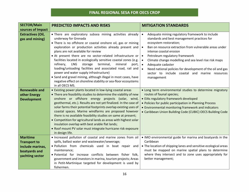
Extractives (Oil, gas and mining)
• There are exploratory subsea mining activities already underway for Grenada
• There is no offshore or coastal onshore oil, gas or mining exploration or production activities already present and plans are not available for review
• At present there are no sector-related infrastructure or facilities located in ecologically sensitive coastal zones (e.g. refinery, LNG storage terminal, mineral port, loading/unloading facilities and associated road, rail and power and water supply infrastructure)
• Sand and gravel mining, although illegal in most cases, have negative effect on shoreline stability or sea-floor ecosystems in all OECS MS.
• Adequate mining regulatory framework to include standards and best management practices for ecosystem restoration;
• Ban on resource extraction from vulnerable areas under intense coastal erosion
• Petroleum regulatory framework
• Climate change modelling and sea level rise risk maps
• Adequate cadaster
• Need national policies for development of the oil and gas sector to include coastal and marine resources management
Renewable and other Energy Development
• Existing power plants located in low-lying coastal areas
• There are feasibility studies to determine the viability of new onshore or offshore energy projects (solar, wind, geothermal, etc.). Results are not yet finalized. In the case of solar farms their potential footprints overlap existing uses of coastal spaces. Marine windfarms are proposed however there is no available feasibility studies on same at present;
• Competition for agricultural lands as areas with highest solar insulation overlap with best arable flat lands;
• Roof mount PV solar must integrate hurricane risk exposure in design life.
• Long term environmental studies to determine migratory routes of faunal species;
• EIAs regulatory framework developed
• Policies for public participation in Planning Process
• Environmental monitoring framework and indicators
• Caribbean Union Building Code (CUBIC) OECS Building Code
Maritime Transport to include marinas, boatyards and yachting sector
• Increased pollution of coastal and marine zones from oil spills, ballast water and wastewater/sewerage;
• Pollution from chemicals used in boat repair and maintenance;
• Potential for increase conflicts between fisher folk, government and investors in marina, tourism projects; Areas in Petit-Martinique targeted for development is used by fishermen.
• IMO environmental guide for marina and boatyards in the Caribbean
• The location of shipping lanes and sensitive ecological areas must be mapped on marine spatial plans to determine where they intersect and to zone uses appropriately for better management;
17
FINAL REGIONAL SESA FOR OECS CROP
SECTOR/Main sources of Impact
PREDICTED IMPACTS AND RISKS MITIGATION STANDARDS
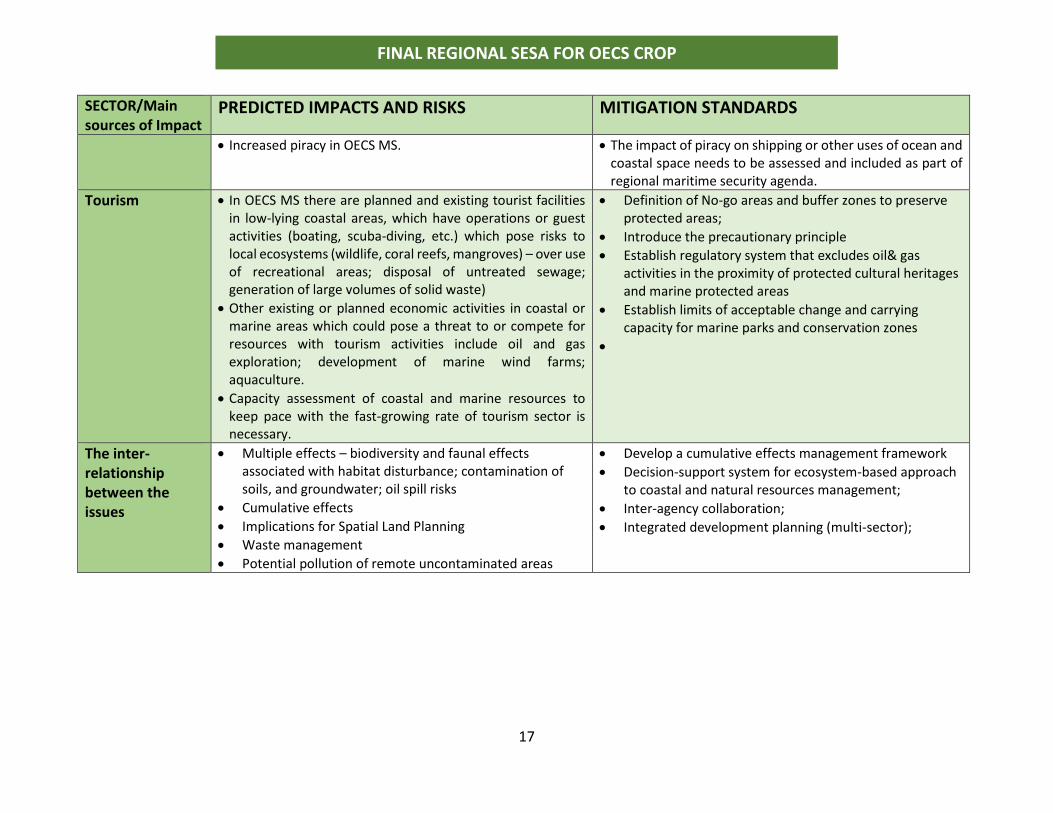
• Increased piracy in OECS MS. • The impact of piracy on shipping or other uses of ocean and coastal space needs to be assessed and included as part of regional maritime security agenda.
Tourism • In OECS MS there are planned and existing tourist facilities in low-lying coastal areas, which have operations or guest activities (boating, scuba-diving, etc.) which pose risks to local ecosystems (wildlife, coral reefs, mangroves) – over use of recreational areas; disposal of untreated sewage; generation of large volumes of solid waste)
• Other existing or planned economic activities in coastal or marine areas which could pose a threat to or compete for resources with tourism activities include oil and gas exploration; development of marine wind farms; aquaculture.
• Capacity assessment of coastal and marine resources to keep pace with the fast-growing rate of tourism sector is necessary.
• Definition of No-go areas and buffer zones to preserve protected areas;
• Introduce the precautionary principle
• Establish regulatory system that excludes oil& gas activities in the proximity of protected cultural heritages and marine protected areas
• Establish limits of acceptable change and carrying capacity for marine parks and conservation zones
•
The inter-relationship between the issues
• Multiple effects – biodiversity and faunal effects associated with habitat disturbance; contamination of soils, and groundwater; oil spill risks
• Cumulative effects
• Implications for Spatial Land Planning
• Waste management
• Potential pollution of remote uncontaminated areas
• Develop a cumulative effects management framework
• Decision-support system for ecosystem-based approach to coastal and natural resources management;
• Inter-agency collaboration;
• Integrated development planning (multi-sector);
18
FINAL REGIONAL SESA FOR OECS CROP
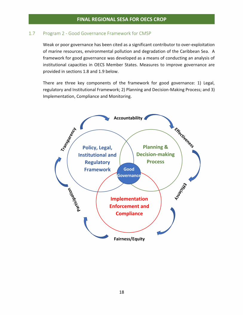
1.7 Program 2 - Good Governance Framework for CMSP
Weak or poor governance has been cited as a significant contributor to over-exploitation
of marine resources, environmental pollution and degradation of the Caribbean Sea. A
framework for good governance was developed as a means of conducting an analysis of
institutional capacities in OECS Member States. Measures to improve governance are
provided in sections 1.8 and 1.9 below.
There are three key components of the framework for good governance: 1) Legal,
regulatory and Institutional Framework; 2) Planning and Decision-Making Process; and 3)
Implementation, Compliance and Monitoring.
Good
Governance
Implementation
Enforcement and
Compliance
Policy, Legal,
Institutional and
Regulatory
Framework
Planning &
Decision-making
Process
Accountability
Fairness/Equity
19
FINAL REGIONAL SESA FOR OECS CROP
1.8 Regional Priority Areas for Action
While the outcomes of the CROP CMSP are specific, to ensure success in implementation
action is needed to improve governance as well as to mitigate impacts of environmental
degradation. Several priorities to improve the governance framework for management of
marine and coastal resources at the regional level, were among the key findings of the
situation and stakeholder analysis and the recommendations from the CROP feasibility
study. They include:
1.8.1 Immediate to Short Term Actions (2018-2020)
o The terms of reference and composition of the regional Ocean’s Governance Team
must be reviewed to ensure that there is full stakeholder participation in MSP
processes;
o For a regional MSP to be effective, the World Bank and the OECS Commission must
solicit the buy-in and participation from as many countries sharing the island chain as
possible;
o Regional agencies and projects should be engaged to help encourage participation
from non-CROP countries;
o The regional Ocean Governance Team should play a key role in guiding the work of
the national and regional MSP to ensure that decisions are aligned with international
best practice;
o A regional data base of persons qualified in MSP relevant fields should be created to
allow for exchange and utilization of national and regional technical experts in the
planning and implementation of MSP;
o The key activities that should be completed prior to the final approval by the GEF and
project kick-off include concluding boundary delimitation discussions with
neighboring countries, soliciting buy-in and participation from other countries that
are not part of the CROP, and mobilizing additional financial resources;
o A regional Legal Advisory Task Force with representation by the Attorney General
from each OECS country should be created very early in the process to provide legal
guidance for the MSP.
1.8.2 Medium to Long Term Actions (2020-2022)
o Collaboration mechanisms with potential regional partners should be promoted as
there are several ways that they can support CROP implementation including
mobilizing finances, providing training, undertaking project work, supporting
stakeholder participation, and guiding the development of the required legislative and
operational framework;
20
FINAL REGIONAL SESA FOR OECS CROP
o Establish a regional environmental protection agency to provide support for national
agencies in areas such as monitoring, baseline ecosystems surveys and assessments,
research, environmental information management systems and data management;
o Establish a regional environmental commission, tribunal or court at the CCJ to address
matters related to management of the Caribbean Sea, territorial boundaries and EEZ,
compliance with regional environmental standards and laws;
o Develop regional oversight mechanism for public authorities with responsibility for
environment, coastal and marine resources management;
o Develop regional oversight mechanism for transparency, accountability and
combating corruption in allocation of resources from exploitation of natural
resources;
1.9 National Priorities for Action
The areas for action are grouped based on the findings presented for analysis of the
Governance Framework in Section 2 above. Separate attention is also given to prioritizing
action for reducing the environmental pressures that result in degradation of the coastal
and marine resources in OECS MS. A general requirement is the need to develop
indicators for tracking progress in governance of coastal and marine resources.
Each member state was required to provide national priority selection to feed in the SESA
process. Responses were provided by Dominica, Grenada and St. Lucia and these are
attached as annexes to the report. The following is the ranking developed by the
consultant which will apply for St. Kitts and Nevis and St. Vincent and the Grenadines, as
informed by the situation analysis.
Priority 1: Immediate Action (2019-2019)
Priority 2: Short-term Action (2020-2020)
Priority 3: Medium to long term (2020-2022)
21
FINAL REGIONAL SESA FOR OECS CROP
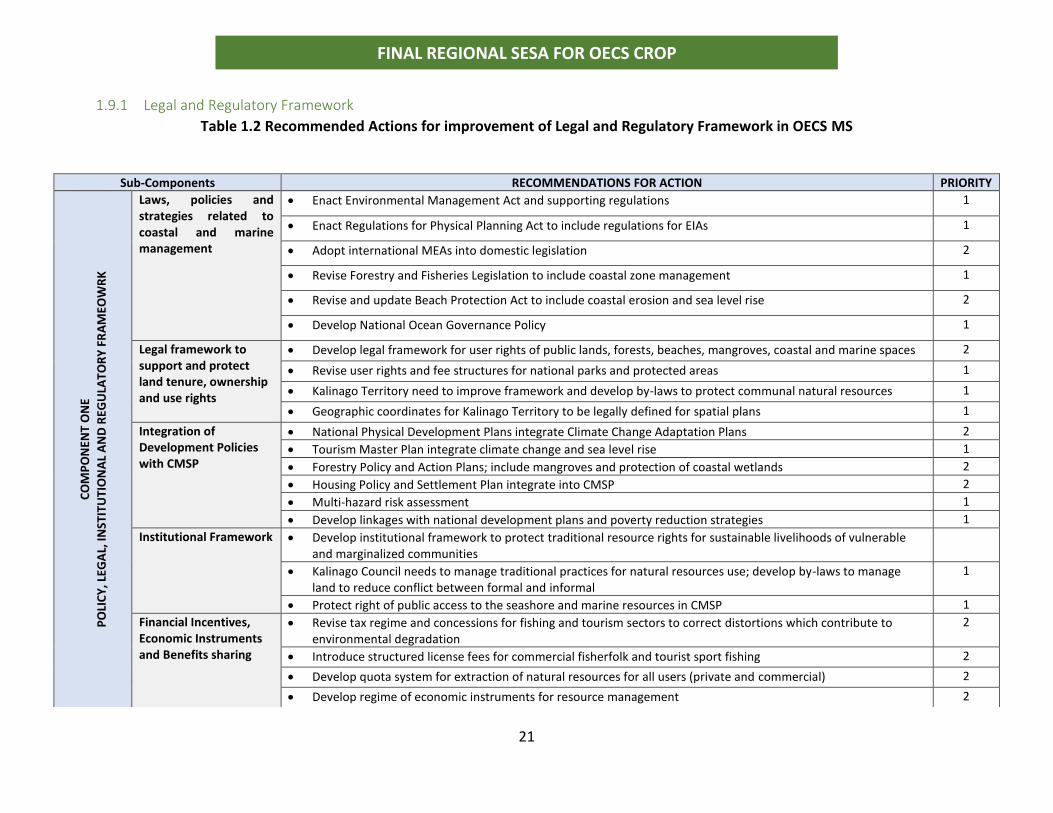
1.9.1 Legal and Regulatory Framework
Table 1.2 Recommended Actions for improvement of Legal and Regulatory Framework in OECS MS
Sub-Components RECOMMENDATIONS FOR ACTION PRIORITY
CO
MP
ON
ENT
ON
E
PO
LIC
Y, L
EGA
L, IN
STIT
UTI
ON
AL
AN
D R
EGU
LAT
OR
Y F
RA
MEO
WR
K
Laws, policies and strategies related to coastal and marine management
• Enact Environmental Management Act and supporting regulations 1
• Enact Regulations for Physical Planning Act to include regulations for EIAs 1
• Adopt international MEAs into domestic legislation 2
• Revise Forestry and Fisheries Legislation to include coastal zone management 1
• Revise and update Beach Protection Act to include coastal erosion and sea level rise 2
• Develop National Ocean Governance Policy 1
Legal framework to support and protect land tenure, ownership and use rights
• Develop legal framework for user rights of public lands, forests, beaches, mangroves, coastal and marine spaces 2
• Revise user rights and fee structures for national parks and protected areas 1
• Kalinago Territory need to improve framework and develop by-laws to protect communal natural resources 1
• Geographic coordinates for Kalinago Territory to be legally defined for spatial plans 1
Integration of Development Policies with CMSP
• National Physical Development Plans integrate Climate Change Adaptation Plans 2
• Tourism Master Plan integrate climate change and sea level rise 1
• Forestry Policy and Action Plans; include mangroves and protection of coastal wetlands 2
• Housing Policy and Settlement Plan integrate into CMSP 2
• Multi-hazard risk assessment 1
• Develop linkages with national development plans and poverty reduction strategies 1
Institutional Framework • Develop institutional framework to protect traditional resource rights for sustainable livelihoods of vulnerable and marginalized communities
• Kalinago Council needs to manage traditional practices for natural resources use; develop by-laws to manage land to reduce conflict between formal and informal
1
• Protect right of public access to the seashore and marine resources in CMSP 1
Financial Incentives, Economic Instruments and Benefits sharing
• Revise tax regime and concessions for fishing and tourism sectors to correct distortions which contribute to environmental degradation
2
• Introduce structured license fees for commercial fisherfolk and tourist sport fishing 2
• Develop quota system for extraction of natural resources for all users (private and commercial) 2
• Develop regime of economic instruments for resource management 2
22
FINAL REGIONAL SESA FOR OECS CROP
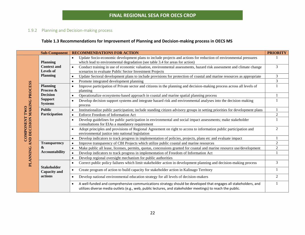
1.9.2 Planning and Decision-making process
Table 1.3 Recommendations for Improvement of Planning and Decision-making process in OECS MS
Sub-Component RECOMMENDATIONS FOR ACTION PRIORITY
CO
MP
ON
EN
T T
WO
P
LA
NN
ING
AN
D D
EC
ISIO
N M
AK
ING
PR
OC
ES
S
Planning
Context and
Levels of
Planning
• Update Socio-economic development plans to include projects and actions for reduction of environmental pressures
which lead to environmental degradation (see table 3.4 for areas for action) 1
• Conduct training in use of economic valuation, environmental assessments, hazard risk assessment and climate change
scenarios to evaluate Public Sector Investment Projects
3
• Update Sectoral development plans to include provisions for protection of coastal and marine resources as appropriate 3
• Promote integrated development planning 3
Planning
Process &
Decision
Support
Systems
• Improve participation of Private sector and citizens in the planning and decision-making process across all levels of
planning 1
• Operationalize ecosystems-based approach in coastal and marine spatial planning process 1
• Develop decision support systems and integrate hazard risk and environmental analyses into the decision-making
process
1
Public
Participation
• Institutionalize public participation; include standing citizen advisory groups in setting priorities for development plans 1
• Enforce Freedom of Information Act 2
• Develop guidelines for public participation in environmental and social impact assessments; make stakeholder
consultations for EIAs a mandatory requirement 1
• Adopt principles and provisions of Regional Agreement on right to access to information public participation and
environmental justice into national legislation
2
• Develop indicators to track progress in implementation of policies, projects, plans etc and evaluate impact 1
Transparency
&
Accountability
• Improve transparency of CBI Projects which utilize public coastal and marine resources 2
• Make public all lease, licenses, permits, quotas, concessions granted for coastal and marine resource use/development 2
• Develop indicators to track progress in implementation of Freedom of Information Act 1
• Develop regional oversight mechanism for public authorities
Stakeholder
Capacity and
actions
• Correct public policy failures which limit stakeholder action in development planning and decision-making process 3
• Create program of action to build capacity for stakeholder action in Kalinago Territory 1
• Develop national environmental education strategy for all levels of decision-makers 2
• A well-funded and comprehensive communications strategy should be developed that engages all stakeholders, and utilizes diverse media outlets (e.g., web, public lectures, and stakeholder meetings) to reach the public.
1
23
FINAL REGIONAL SESA FOR OECS CROP
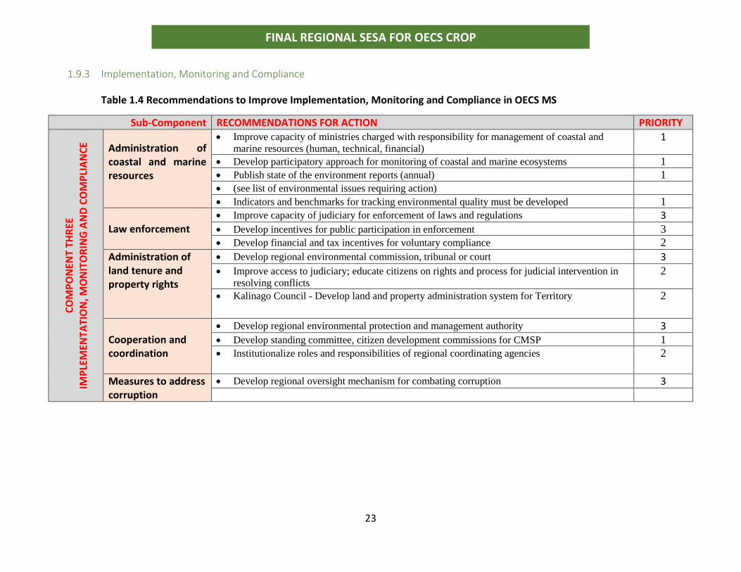
1.9.3 Implementation, Monitoring and Compliance
Table 1.4 Recommendations to Improve Implementation, Monitoring and Compliance in OECS MS
Sub-Component RECOMMENDATIONS FOR ACTION PRIORITY
CO
MP
ON
ENT
THR
EE
IMP
LEM
ENTA
TIO
N, M
ON
ITO
RIN
G A
ND
CO
MP
LIA
NC
E
Administration of coastal and marine resources
• Improve capacity of ministries charged with responsibility for management of coastal and
marine resources (human, technical, financial) 1
• Develop participatory approach for monitoring of coastal and marine ecosystems 1
• Publish state of the environment reports (annual) 1
• (see list of environmental issues requiring action)
• Indicators and benchmarks for tracking environmental quality must be developed 1
Law enforcement
• Improve capacity of judiciary for enforcement of laws and regulations 3 • Develop incentives for public participation in enforcement 3
• Develop financial and tax incentives for voluntary compliance 2
Administration of land tenure and property rights
• Develop regional environmental commission, tribunal or court 3
• Improve access to judiciary; educate citizens on rights and process for judicial intervention in
resolving conflicts 2
• Kalinago Council - Develop land and property administration system for Territory 2
Cooperation and coordination
• Develop regional environmental protection and management authority 3 • Develop standing committee, citizen development commissions for CMSP 1
• Institutionalize roles and responsibilities of regional coordinating agencies 2
Measures to address corruption
• Develop regional oversight mechanism for combating corruption 3
24
FINAL REGIONAL SESA FOR OECS CROP
2.0 SCOPE While the outcomes of Component 1(a) of the CROP are spatial plans, large emphasis is
placed on the planning process itself. Planning as a process involves participation across
sectors and interests and is multi-objective and multi-dimensional.
Coastal and marine spatial (CMS) planning is a comprehensive, adaptive, integrated,
ecosystem-based, and transparent spatial planning process, based on sound science, for
analyzing current and anticipated uses of marine and coastal, areas.
An ecosystem-based approach to planning requires systems thinking be applied to the
decision-making process. Decision support systems have been developed for integrated
coastal zone management (ICZM) and are applicable for the CROP project.
The CMS planning process results in the identification of areas most suitable for various
types or classes of activities to reduce conflicts among uses, reduce environmental
impacts, facilitate compatible uses, and preserve critical ecosystems. It is therefore a
public policy process for society to better determine how marine and coastal resources
are sustainably used and protected now and for future generations.
It involves the basic difficulty, even impossibility, of predicting future events; the
interaction of decisions made in different policy spheres; conflicts of values which cannot
be fully resolved by rational decision or by calculation; the clash of organized pressure
groups and the defence of vested interests; and the inevitable confusions that arise from
the complex interrelationships between decisions at different levels and at different
scales, at different points in time.
25
FINAL REGIONAL SESA FOR OECS CROP
3.0 BACKGROUND
3.1 Sector Programme justification and purpose To promote a common approach to ocean governance (i.e.: pursue a blue economy), the
OECS has taken a first step through the adoption of the Eastern Caribbean Regional Ocean
Policy (ECROP) and its Strategic Action Plan. Endorsed by the OECS’ Heads of Government
in 2013, ECROP guides the future use of the region’s marine waters and provides a basis
for enhanced coordination and management of ocean resources within the Eastern
Caribbean. The OECS Commission operates within the regional mandate of ECROP which
encourages the collaborative formulation of well-integrated governance frameworks
capable of addressing marine user conflicts and protect the fragile legacy of their marine
environment. With few spatial planning initiatives of smaller scale adopted so far, ECROP
calls for multiple-use ocean planning and integrated management techniques for better
decision-making over transboundary marine systems.
In response to the outcomes of the ECROP, the OECS with the World Bank have prepared
the Caribbean Regional Oceanscape Project (CROP) that responds to such demand for
spatial planning initiatives, through the adoption of coastal and marine spatial plans to
coordinate management across sectors and resources and integrate environmental
management directly with economic development. These plans will build upon early
national marine planning efforts2 and will help Eastern Caribbean countries better
understand and then reform governance of the diversity of ocean uses and economic
activities, resulting in a more secure framework for sustained investment in the blue
economy.
CROP is being implemented in five participating OECS Member States (MS): Dominica,
Grenada, St. Kitts and Nevis, Saint Lucia, St Vincent and the Grenadines.
As a precursor to the development of Marine and Coastal Spatial Plans to improve ocean
governance, a Regional Strategic Environmental and Social Assessment (SESA) is
2 National Ocean Policies in St. Vincent and the Grenadines, and St. Kitts and Nevis (draft); Integrated Coastal Zone Management (ICZM) policies in Grenada and St. Lucia
26
FINAL REGIONAL SESA FOR OECS CROP
required. The SESA will facilitate the incorporation of priority environmental and social
considerations into CROP outputs and outcomes particularly as related to indigenous
communities where relevant, and to concerns associated with natural habitats, especially
mangroves, coral reefs and sea grass beds and their associated biodiversity at a Regional
level. The SESA will identify environmental investment opportunities and promote
environmentally sustainable and socially responsible development from a regional
perspective. In this way, the Regional SESA is expected to promote long-term integrated
development planning for sustainable economic growth and poverty reduction within the
region.
3.2 Coastal and Marine Spatial Plans in the OECS Each CROP country, except for Grenada, has yet to clearly articulate their own vision and
national policy direction for coastal and marine spatial plans for their country, which will
align with the regional project vision. This vision statement should be realistic, credible,
and attractive such that it attracts commitment and energizes people, while creating
meaning to stakeholders.
It is recognized that broad-based stakeholder participation is a critical aspect to the
planning process to achieve consensus and ensure that plans are sustainable, can lead to
economic growth and equitably share those benefits.
Examples of stakeholder action to formulate coastal and marine spatial plans can be
found in Dominica and St. Kitts and Nevis. In the case of Dominica stakeholder action led
to the creation of the Portsmouth Citizens Planning Commission to resolve problems with
rapid unplanned development of the town.
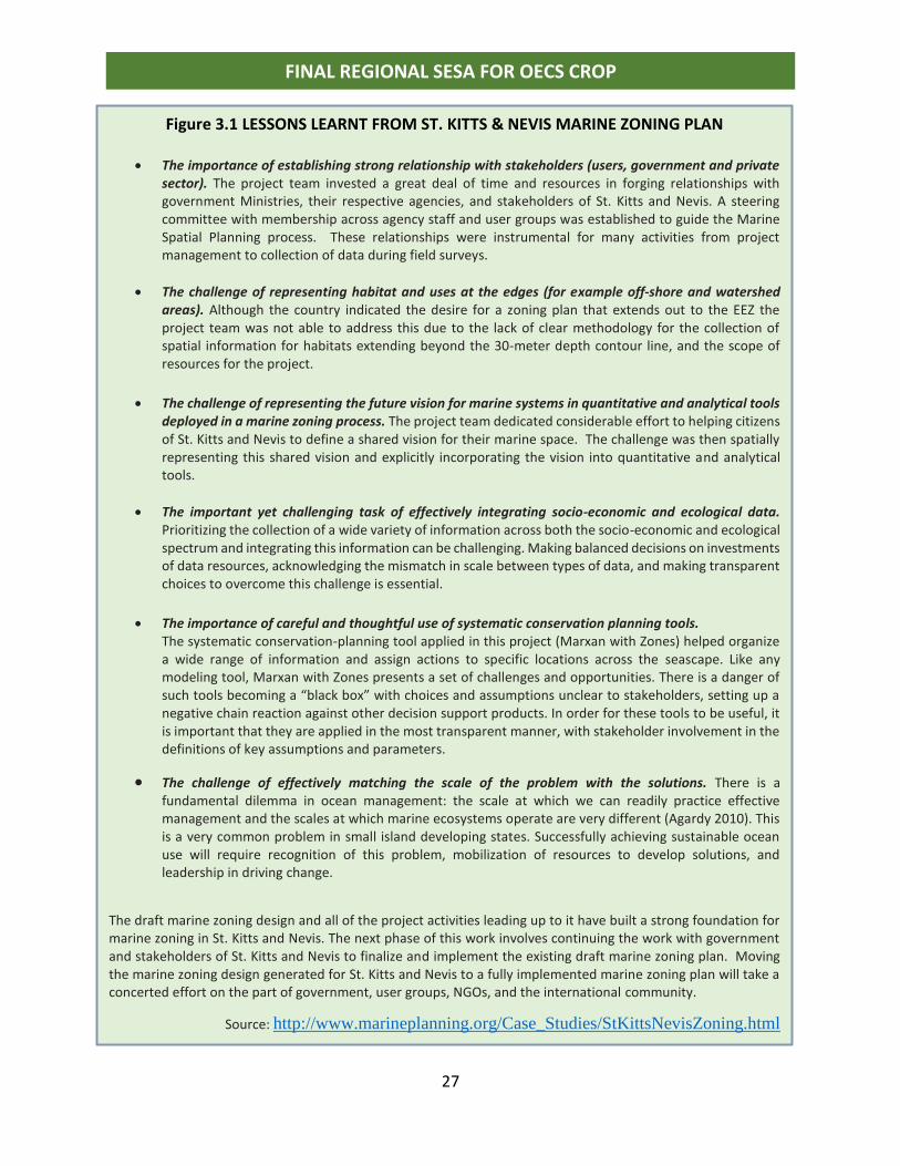
For St Kitts and Nevis, stakeholders participated in developing the first marine spatial plan
in the region. Figure 3.1 presents a summary of the main lessons learnt from the process.
27
FINAL REGIONAL SESA FOR OECS CROP
Figure 3.1 LESSONS LEARNT FROM ST. KITTS & NEVIS MARINE ZONING PLAN
• The importance of establishing strong relationship with stakeholders (users, government and private sector). The project team invested a great deal of time and resources in forging relationships with government Ministries, their respective agencies, and stakeholders of St. Kitts and Nevis. A steering committee with membership across agency staff and user groups was established to guide the Marine Spatial Planning process. These relationships were instrumental for many activities from project management to collection of data during field surveys.
• The challenge of representing habitat and uses at the edges (for example off-shore and watershed areas). Although the country indicated the desire for a zoning plan that extends out to the EEZ the project team was not able to address this due to the lack of clear methodology for the collection of spatial information for habitats extending beyond the 30-meter depth contour line, and the scope of resources for the project.
• The challenge of representing the future vision for marine systems in quantitative and analytical tools deployed in a marine zoning process. The project team dedicated considerable effort to helping citizens of St. Kitts and Nevis to define a shared vision for their marine space. The challenge was then spatially representing this shared vision and explicitly incorporating the vision into quantitative and analytical tools.
• The important yet challenging task of effectively integrating socio-economic and ecological data. Prioritizing the collection of a wide variety of information across both the socio-economic and ecological spectrum and integrating this information can be challenging. Making balanced decisions on investments of data resources, acknowledging the mismatch in scale between types of data, and making transparent choices to overcome this challenge is essential.
• The importance of careful and thoughtful use of systematic conservation planning tools. The systematic conservation-planning tool applied in this project (Marxan with Zones) helped organize a wide range of information and assign actions to specific locations across the seascape. Like any modeling tool, Marxan with Zones presents a set of challenges and opportunities. There is a danger of such tools becoming a “black box” with choices and assumptions unclear to stakeholders, setting up a negative chain reaction against other decision support products. In order for these tools to be useful, it is important that they are applied in the most transparent manner, with stakeholder involvement in the definitions of key assumptions and parameters.
• The challenge of effectively matching the scale of the problem with the solutions. There is a fundamental dilemma in ocean management: the scale at which we can readily practice effective management and the scales at which marine ecosystems operate are very different (Agardy 2010). This is a very common problem in small island developing states. Successfully achieving sustainable ocean use will require recognition of this problem, mobilization of resources to develop solutions, and leadership in driving change.
The draft marine zoning design and all of the project activities leading up to it have built a strong foundation for marine zoning in St. Kitts and Nevis. The next phase of this work involves continuing the work with government and stakeholders of St. Kitts and Nevis to finalize and implement the existing draft marine zoning plan. Moving the marine zoning design generated for St. Kitts and Nevis to a fully implemented marine zoning plan will take a concerted effort on the part of government, user groups, NGOs, and the international community.
Source: http://www.marineplanning.org/Case_Studies/StKittsNevisZoning.html
28
FINAL REGIONAL SESA FOR OECS CROP
“Toward a Blue Economy: A promise for Sustainable Growth in the Caribbean” provides a
framework within which OECS States can articulate their vision and national policy
direction.
The Grenada Blue Growth Master Plan is considered an exemplar and therefore used as
the future scenario upon which to provide environmental and social guidelines for the
SESA on coastal and marine spatial planning in OECS States. The CROP CMSP will also
develop a refined Grenada Blue Growth Master Plan which is a desired outcome of the
Planning process.
Annex 3 of “Towards a Blue Economy: A Promise of a Sustainable Caribbean” present a
detailed overview, spatial representation and portrayal of a future scenario for
marine/coastal development in Grenada, Carriacou and Petit Martinique.
The key features of the coastal and marine spatial plans are summarized on the following
page (excerpt from document). This information on Grenada’s Blue Growth Master Plan
(BGMP) is based on what has been made available to the consultant from the OECS
Commission for use in the SESA. The consultant has no other knowledge of any updates
or changes to the BGMP.
:
29
FINAL REGIONAL SESA FOR OECS CROP
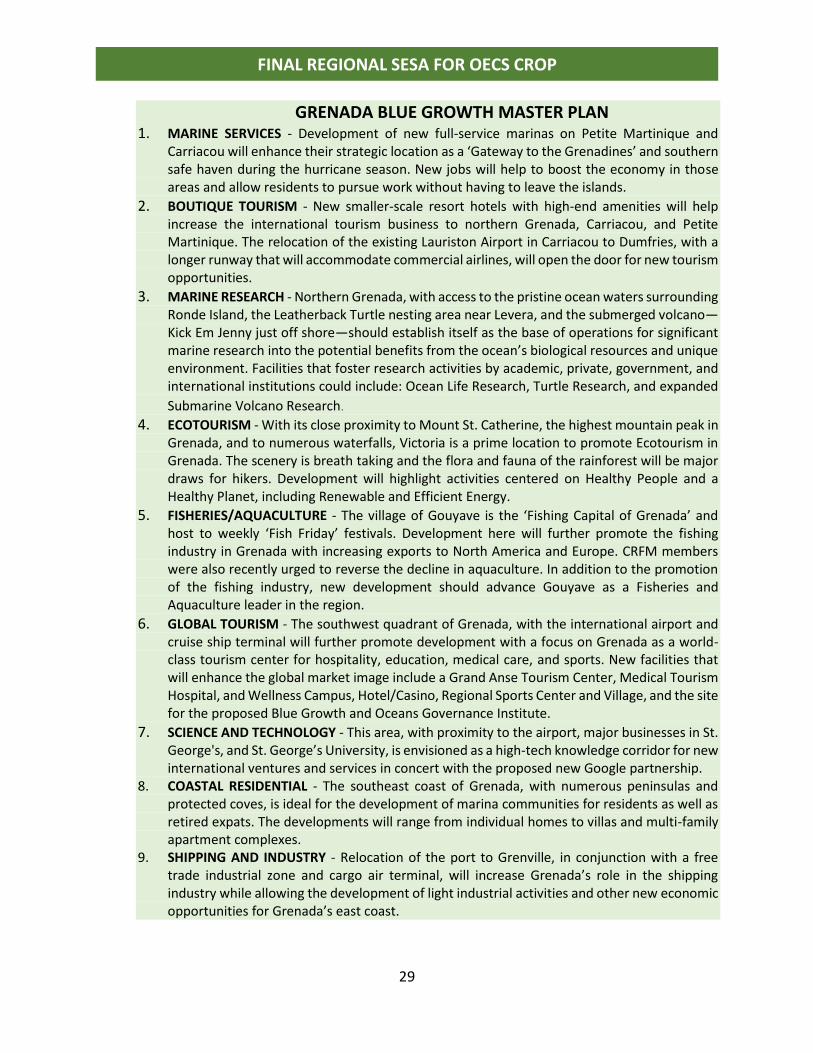
GRENADA BLUE GROWTH MASTER PLAN 1. MARINE SERVICES - Development of new full-service marinas on Petite Martinique and
Carriacou will enhance their strategic location as a ‘Gateway to the Grenadines’ and southern safe haven during the hurricane season. New jobs will help to boost the economy in those areas and allow residents to pursue work without having to leave the islands.
2. BOUTIQUE TOURISM - New smaller-scale resort hotels with high-end amenities will help increase the international tourism business to northern Grenada, Carriacou, and Petite Martinique. The relocation of the existing Lauriston Airport in Carriacou to Dumfries, with a longer runway that will accommodate commercial airlines, will open the door for new tourism opportunities.
3. MARINE RESEARCH - Northern Grenada, with access to the pristine ocean waters surrounding Ronde Island, the Leatherback Turtle nesting area near Levera, and the submerged volcano—Kick Em Jenny just off shore—should establish itself as the base of operations for significant marine research into the potential benefits from the ocean’s biological resources and unique environment. Facilities that foster research activities by academic, private, government, and international institutions could include: Ocean Life Research, Turtle Research, and expanded
Submarine Volcano Research.
4. ECOTOURISM - With its close proximity to Mount St. Catherine, the highest mountain peak in Grenada, and to numerous waterfalls, Victoria is a prime location to promote Ecotourism in Grenada. The scenery is breath taking and the flora and fauna of the rainforest will be major draws for hikers. Development will highlight activities centered on Healthy People and a Healthy Planet, including Renewable and Efficient Energy.
5. FISHERIES/AQUACULTURE - The village of Gouyave is the ‘Fishing Capital of Grenada’ and host to weekly ‘Fish Friday’ festivals. Development here will further promote the fishing industry in Grenada with increasing exports to North America and Europe. CRFM members were also recently urged to reverse the decline in aquaculture. In addition to the promotion of the fishing industry, new development should advance Gouyave as a Fisheries and Aquaculture leader in the region.
6. GLOBAL TOURISM - The southwest quadrant of Grenada, with the international airport and cruise ship terminal will further promote development with a focus on Grenada as a world-class tourism center for hospitality, education, medical care, and sports. New facilities that will enhance the global market image include a Grand Anse Tourism Center, Medical Tourism Hospital, and Wellness Campus, Hotel/Casino, Regional Sports Center and Village, and the site for the proposed Blue Growth and Oceans Governance Institute.
7. SCIENCE AND TECHNOLOGY - This area, with proximity to the airport, major businesses in St. George's, and St. George’s University, is envisioned as a high-tech knowledge corridor for new international ventures and services in concert with the proposed new Google partnership.
8. COASTAL RESIDENTIAL - The southeast coast of Grenada, with numerous peninsulas and protected coves, is ideal for the development of marina communities for residents as well as retired expats. The developments will range from individual homes to villas and multi-family apartment complexes.
9. SHIPPING AND INDUSTRY - Relocation of the port to Grenville, in conjunction with a free trade industrial zone and cargo air terminal, will increase Grenada’s role in the shipping industry while allowing the development of light industrial activities and other new economic opportunities for Grenada’s east coast.
30
FINAL REGIONAL SESA FOR OECS CROP
Notes on the Plan (excerpt from document)
Land within each of the proposed development zones was identified along with a list of
potential projects that would be provided special Blue Growth Incentive Packages by the
government.
Potential strategic projects were discussed based on the following criteria:
• The plan must consider conservation and protection of the environment.
• The plan must reflect the ‘Pure Grenada’ brand.
• The plan must integrate with Grenada’s strategic plan and coastal zone management plan.
• The plan should be ‘transformative’ and address the economic, environmental, and social impact.
• The plan should allow opportunities for local investment.
From the list of strategic projects, the following criteria was used to determine priority projects:
• The project is sustainable.
• The project promotes economic, environmental, and social goals.
• The project addresses a global and/or Caribbean market.
• The project does NOT require a government infrastructure investment.
• The project has a high potential for private investment.
• The project creates both short-term and long-term jobs.
• The project is likely to create ‘spin-off’ projects and opportunities.
Preliminary design concepts were developed for the priority projects to best convey the vision to investors. These diagrams and benchmark images are indicative of the desired project scope and scale but are not final designs. The investor is invited to discuss alternative concept plans and/or a project scale that may better meet the investor's financial pro forma.
31
FINAL REGIONAL SESA FOR OECS CROP
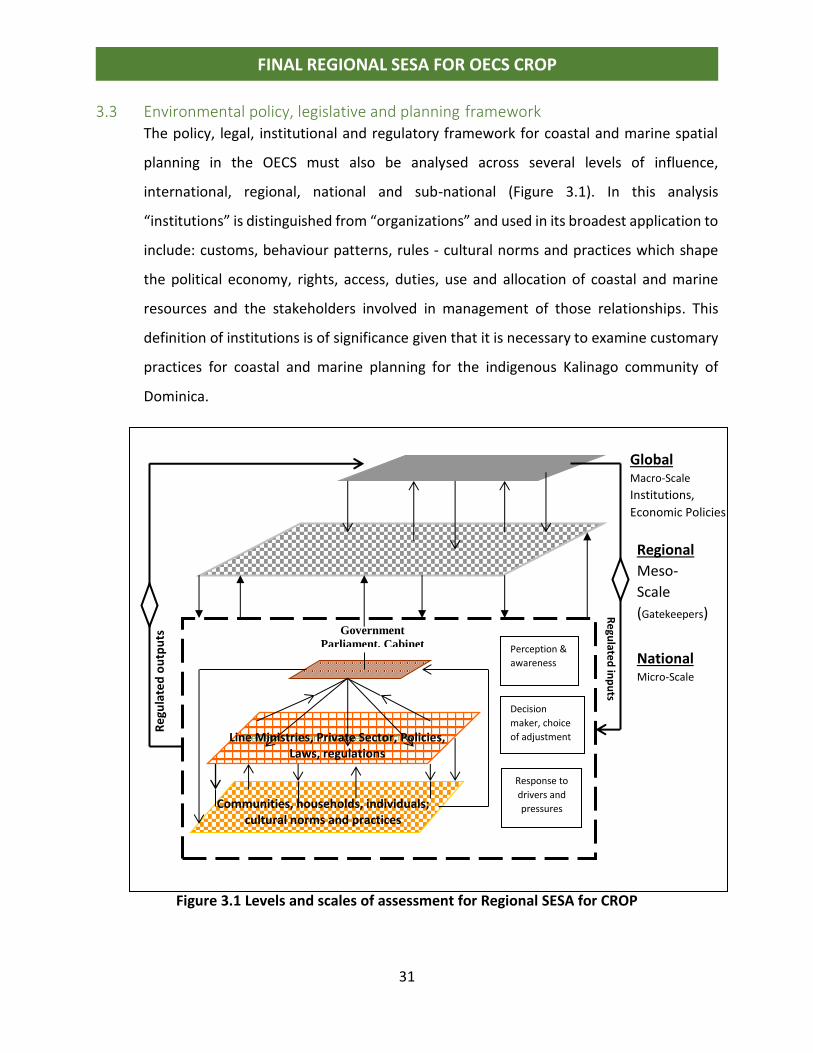
3.3 Environmental policy, legislative and planning framework The policy, legal, institutional and regulatory framework for coastal and marine spatial
planning in the OECS must also be analysed across several levels of influence,
international, regional, national and sub-national (Figure 3.1). In this analysis
“institutions” is distinguished from “organizations” and used in its broadest application to
include: customs, behaviour patterns, rules - cultural norms and practices which shape
the political economy, rights, access, duties, use and allocation of coastal and marine
resources and the stakeholders involved in management of those relationships. This
definition of institutions is of significance given that it is necessary to examine customary
practices for coastal and marine planning for the indigenous Kalinago community of
Dominica.
Figure 3.2. Levels of Analysis and Interactions for CMSP (after Jessamy, 2003; JECO,
2011)
Figure 3.1 Levels and scales of assessment for Regional SESA for CROP
Regional
Meso-
Scale
(Gatekeepers)
Global Macro-Scale
Institutions,
Economic Policies
National Micro-Scale
Government
Parliament, Cabinet
Decision makers, planners, policies
Communities, households, individuals; cultural norms and practices
Re
gulate
d in
pu
ts
Re
gula
ted
ou
tpu
ts
Perception &
awareness
Decision
maker, choice
of adjustment
Response to
drivers and
pressures
Line Ministries, Private Sector, Policies, Laws, regulations
32
FINAL REGIONAL SESA FOR OECS CROP
(a) International & Regional Laws and Agreements for CMSP
Singh (2008) conducted a comprehensive review of the policy, legal and regulatory
framework for governance in the Caribbean Sea at the international and regional level
but did not delve into the national level (Figure 3.1). The review provides a thorough
treatment of international conventions and laws, multilateral environmental agreements,
UN general agreements, regional treaties and agreements and “soft laws”, resolutions
and diplomatic agreements. Dr. Singh provided details on the provisions of the various
conventions across three themes, pollution, sustainable management of living resources
and sustainable management of non-living resources. From the review it can be
concluded that there is a robust regulatory framework for Caribbean ocean’s governance
at the international level (Figure 3.2; Annex I).
A work plan was formulated by the Association of Caribbean States (ACS) and UNECLAC
to track progress in implementation of the obligations under the various resolutions and
agreements. Following from the work of the ACS, Singh concludes that “large cohort of
responses have been undertaken by States and it shows that actions are being taken in
the region. For example, projects were undertaken to address integrated coastal zone
management, upgrading contingency plans for port States, addressing oil pollution and
information and training for oil spill response among others”. Singh notes however that
there is a lack of clarity or coherence in some of the conventions and in many cases
repetition of provisions. States have been slow in ratifying agreements after signing and
even slower in effecting implementation at the national level. It is noted that independent
States are quicker to ratify agreements than dependent territories who are lagging
behind. The recommendation is made for a common legal framework for Caribbean
oceans governance, to rationalize the various MEAs and develop coordinating
mechanisms for their implementation.
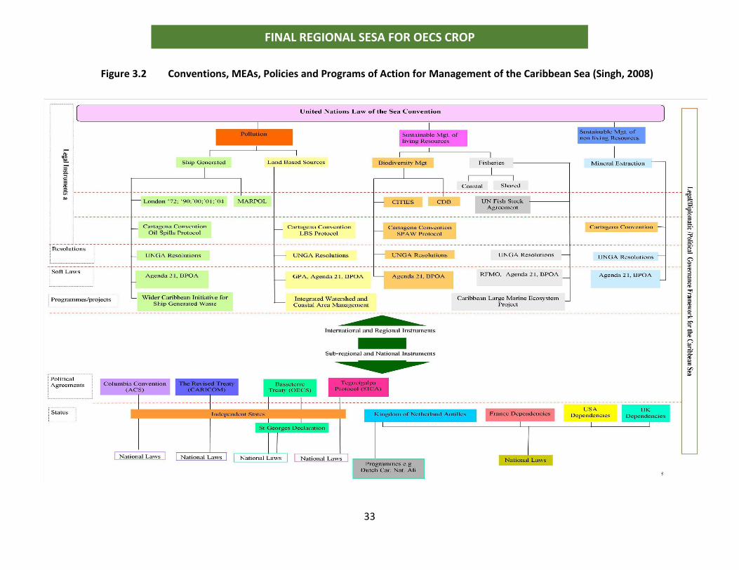
33
FINAL REGIONAL SESA FOR OECS CROP
Figure 3.2 Conventions, MEAs, Policies and Programs of Action for Management of the Caribbean Sea (Singh, 2008)
August, 2018 34
FINAL REGIONAL SESA FOR OECS CROP
.(c) National policies, legislation, and regulations for CMSP
• Annex I provide a comprehensive listing of all the policies, legislation, regulations,
conventions and MEAs for coastal and marine spatial planning in OECS MS.
• National policies, strategies and programs of action for emerging environmental
management issues such as climate change, conservation of biological diversity
and marine resources are influenced by international conventions and multi-
lateral environmental agreements. Most of the national laws’ pre-date these
international agreements.
• A striking observation is the fact that despite the signing or ratification of several
of the international and regional conventions and agreements, countries have
been slow in adopting them into national legislation to effect implementation. The
ability to translate global, regional and national policies all the way through to the
community and individual level where actual resource utilization takes place,
explains the ongoing challenge for achieving sustainable development in the
region.
• OECS MS are presently taking action to legally define their territorial boundary
and there are boundary conflicts to be resolved. This is of critical significance given
the wealth of marine resources to be exploited. In addition to fisheries, whaling,
recreation, tourism and yachting there are potential petroleum and other
geological natural resources.
• The OECS Marine Research Strategy is designed to allow MS take advantage of this
wealth of resources including the potential for marine medicine and ocean energy.
It is clear though that these resources are presently undervalued and under-
utilized, and the policy framework must be updated to fill this gap. As is the case
for their territorial boundary, the exclusive economic zone (EEZ) is not yet legally
defined for all OECS MS.
35
FINAL REGIONAL SESA FOR OECS CROP
3.2.2 Legal Framework to protect Land tenure and resource rights
• In OECS MS the upper watersheds and catchments are typically Crown lands (state
owned) with very limited area being privately owned. These have been declared
as protected watersheds or national parks and managed by the Forestry or
National Park Departments. Privately owned lands in upper watersheds are
utilized mainly for agriculture and to a lesser extent residential purpose
• In most States there are customary resource use rights such that resources on
state lands are considered de facto common property except in the case of
Dominica where natural resources are legislated as property of the State and
every person requires a permit or license to extract resources (fish, hunt, gather).
• In other territories licenses and permits are required only where resource
extraction is for commercial purposes. Marine resources are also customary de
facto common property and people have rights for access to the coast and marine
space.
• The OECS Protected Areas and Associated Livelihoods Project (OPAAL, 2004-2010)
resulted in the development of management plans for protected watersheds in
Member States. Economic valuation was undertaken for some watersheds. There
has been a trend to establish marine parks and protected areas in OECS MS and
each island now has at least two areas formally declared and managed.
• Protected watersheds are forested areas and the non-timber forest products
including eco-tourism services have traditionally been treated as de facto
common property resources. The impact of the trend [to apply market
36
FINAL REGIONAL SESA FOR OECS CROP
mechanisms to manage traditional common property assets] on the sustainable
livelihoods of natural resource dependent communities has yet to be assessed.
• One of the most successful MPA has been the Soufriere MPA in St. Lucia. The
lessons learnt from this management regime informed the development of a
similar arrangement for Grand Anse Beach Grenada. Only St. Kitts and Nevis has
a Marine Zoning Policy for the entire Island. This policy was formulated based on
a combination of natural resource assessment and trade-off analysis among
various stakeholders.
• The marine policy does not include a seamless database integrating the land with
the sea and no clear pathway for management of land-based sources of pollution.
3.2.3 Broader Development Policies Integrated with Coastal & Marine Policies
• OECS Member States have recently participated in a regional Integrated
Watershed and Coastal Area Management Project (IWCAM) which resulted in the
formulation of draft watershed management strategies and water resources
management policies for participating member states. Implementation of these
strategies and policies has not yet fully commenced and there remains the need
for both protection of water production regions and for managing the yield of
water for human consumption.
• In the drier low-lying islands in the Northern Caribbean this is of crucial
importance as groundwater reserves must also be protected and managed as well.
A good database is now available of the natural resources and institutional
framework for watershed management (Annex VII) The challenges with
management of small steep watersheds with relatively high rainfall frequencies
are well documented in the list of country reports reviewed for this synthesis. (See
Section 5).
37
FINAL REGIONAL SESA FOR OECS CROP
• All of the OECS MS have developed National Land Policies and Zoning Plans which
are in various stages of implementation and or formal approval by the Cabinet of
Ministers and adoption into the legal framework. St. Lucia proposed a revised
National Land Policy in 2015; St. Kitts and Nevis has several national Physical
Development Zones and accompanying plans; Dominica in 2016 formulated a
National Physical Development Plan which takes into account the impacts of
Hurricane Erica in 2015. This plan must be revisited to account for the lessons
learnt from the impacts of Hurricane Maria; St. Vincent and the Grenadines in
2014 formulated a National Physical Development Plan; in 2016 Grenada
formulated a national land policy which has been approved by the Cabinet of
Ministers.
• The ECROP provides a framework for redressing these challenges.
Implementation has not yet begun as the recommended action plans have not yet
been fully translated into national programs of action.
• The OECS Oceans Governance and Fisheries Unit is presently developing codes
and policies for data management and marine research that will drive action at
the national level. It is envisaged that implementation of the Strategic Action Plan
of the ECROP will lead to a transition in integrated management of new marine
resources which are currently to some extent un-assessed and under-utilized.
• In all OECS Member States over 70% of human settlement and development
activities take place within the narrow low-lying coastal belt. Most of these lands
are privately owned and because of market forces this zone is mainly targeted for
tourism, commercial development, fisheries infrastructure and high-income
residential neighborhoods.
• Tourism development policies favor coastal, beach tourism and the trend for the
OECS is that most of the infrastructure for this sector is located within the direct
impact zone for storm surge, tsunamis, coastal erosion and sea level rise. In
writing this report (August 2018) the consultant’s work was interrupted by an
earthquake originating of the coast of Venezuela (7.9 lasting for 60 seconds with
38
FINAL REGIONAL SESA FOR OECS CROP
impact zone radiating 200 miles outward from the epicenter) A tsunamis alert was
issued for Venezuela, Trinidad and Grenada. This makes urgent the proposal for a
for a regional response mechanism to the threats (Robin 2007).
3.2.4 Institutional Framework
An historical analysis will reveal that most of the national legislation pre-date the OECS
Member States achieving independence from Britain in the 1970s. There are no
provisions in the constitutions of any of the OECS MS for environmental and natural
resource rights and for citizens participation in protection of those rights. In most cases
the laws are not supported by regulations and rules to allow for implementation,
monitoring and compliance. Traditional norms and cultural practices influence the
manner in which resources are utilized resulting in conflicts, exploitation of resources and
environmental degradation.
Empirical work undertaken by Jessamy (2003, 2005, 2006) reveals that the interaction of
formal and informal institutions and organizations often leads to conflict situations and
poor governance. Informal institutions and organizations predominate at the micro-level,
the policy space referred to as social capital. These relationships are played out in the
case of the Kalinago Territory where there are no regulations for utilization of forest
resources and traditional “slash and burn” practices have resulted in resource
exploitation and land degradation.
The Kalinago Territory in Dominica was established by an Act of Parliament and the rights
of the people are not enshrined in the constitution of Dominica. Laws and regulations for
natural resource management such as the Fisheries Act and Forest Act do not include any
provisions for the management of the resources of the Territory by the Kalinago Council.
Given that the policy process is driven from the Organizational/ministerial level, there are
inadequate formal provisions for the empowerment and inclusion of resource users in
the management of natural resources. As a result, informal cultural norms and practices
predominate and there are limited procedures for regulating natural resource use
39
FINAL REGIONAL SESA FOR OECS CROP
resulting in environmental degradation in most cases. There is a historical vector to the
social context as exemplified by present circumstances, which were set by repetitive
patterns over time. As such customary norms and traditional practices often dominate
individual options and decision making in the absence of rules, codes of practice and
guidelines for land, coastal and marine resource management. The role that social,
institutional and political factors play in determining resource use and adoption of best
management practices is paramount.
3.2.5 Financial Incentives, economic instruments & benefits sharing
• The private sector in the OECS MS are provided with duty free concessions and tax
holidays as incentives to operate businesses. Tourism investment laws, Fisheries
Legislation, Custom Tariffs for Agriculture, Manufacturing and Industrial Sectors
have been developed to facilitate economic development.
• There are few quota systems or fees for resource extraction and there are few
economic instruments or tradeable permits for managing user rights. Markets are
therefore able to exploit natural resource assets for capital gains with the benefits
flowing largely to private individuals. Social benefits is mainly through job creation
which means civil society carries the bulk of the weight for paying taxes on income
and for goods and services. There are no financial incentives or requirements for
environmental protection measures to manage the externalities of economic
development such as wastewater management. This burdens rests with the
government and civil society as a whole.
• After a thorough search of the existing literature only limited information was
gathered on the economic valuation of marine ecosystems in OECS MS (WRI,
2008). There is evidence that fisheries are important for sustainable livelihoods
and make a significant contribution to national GDP (ECCB).
40
FINAL REGIONAL SESA FOR OECS CROP
• The externalities of tourism and human development activities are not included
in assessments of the economic benefits of that sector and no one accounts for
the cost of environmental degradation. There are only limited examples of use of
economic instruments such as licenses, user fees and tradeable permits to
manage protected watersheds in OECS Member States (St. Kitts and Nevis
Dominica, St. Lucia, Bequia, Grenada – have limited user fee system for tourists to
access national parks, eco-trails and attractions).
3.2.6 Kalinago Territory Dominica
During consultations members of the Kalinago Council expressed the strong view that the
Territory is an autonomous government on the same level as the Government of
Dominica and not subservient to the Government and Ministry of Kalinago Affairs. To the
Council, the Ministry of Kalinago Affairs is viewed as a liaison between the two entities.
The relationship as explained by Councilman Hill, is shown in Figure 3.4.
In reality the legal framework for management of the territory is different, a vertical
hierarchy of government with power aligned accordingly. As noted earlier the rights of
the Kalinago Community are not provided for at the level of the Constitution of Dominica.
Their rights to participation is the same as for all people of the Commonwealth of
Dominica. While Section 29 of the By-Laws of the Kalinago Territory Act provides
responsibilities to the Council for the management of the territory, according to Section
48 of the same Act, the overall responsibility for development and planning in the
Territory is retained by the Government of Dominica.
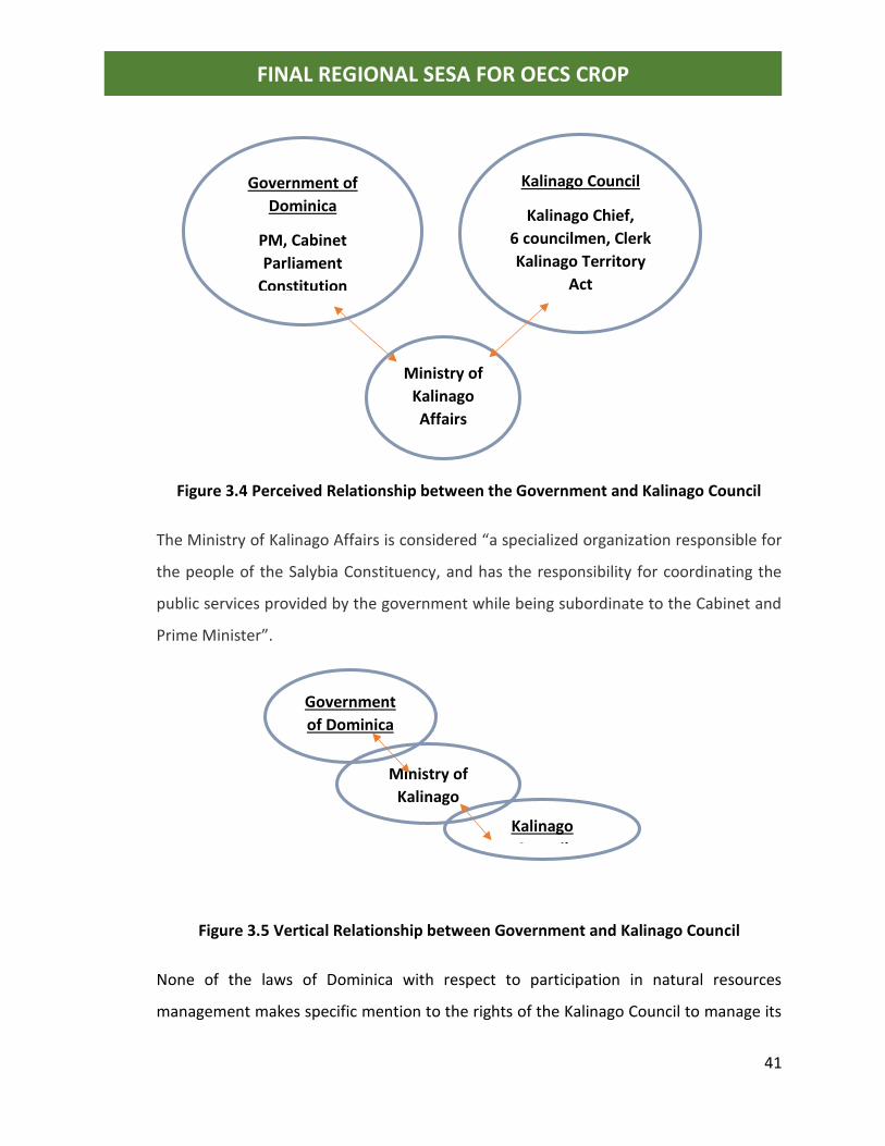
41
FINAL REGIONAL SESA FOR OECS CROP
Figure 3.4 Perceived Relationship between the Government and Kalinago Council
The Ministry of Kalinago Affairs is considered “a specialized organization responsible for
the people of the Salybia Constituency, and has the responsibility for coordinating the
public services provided by the government while being subordinate to the Cabinet and
Prime Minister”.
Figure 3.5 Vertical Relationship between Government and Kalinago Council
None of the laws of Dominica with respect to participation in natural resources
management makes specific mention to the rights of the Kalinago Council to manage its
Government of
Dominica
PM, Cabinet
Parliament
Constitution
Kalinago Council
Kalinago Chief,
6 councilmen, Clerk
Kalinago Territory
Act
Ministry of
Kalinago
Affairs
Government
of Dominica
Kalinago
Council
Ministry of
Kalinago
Affairs
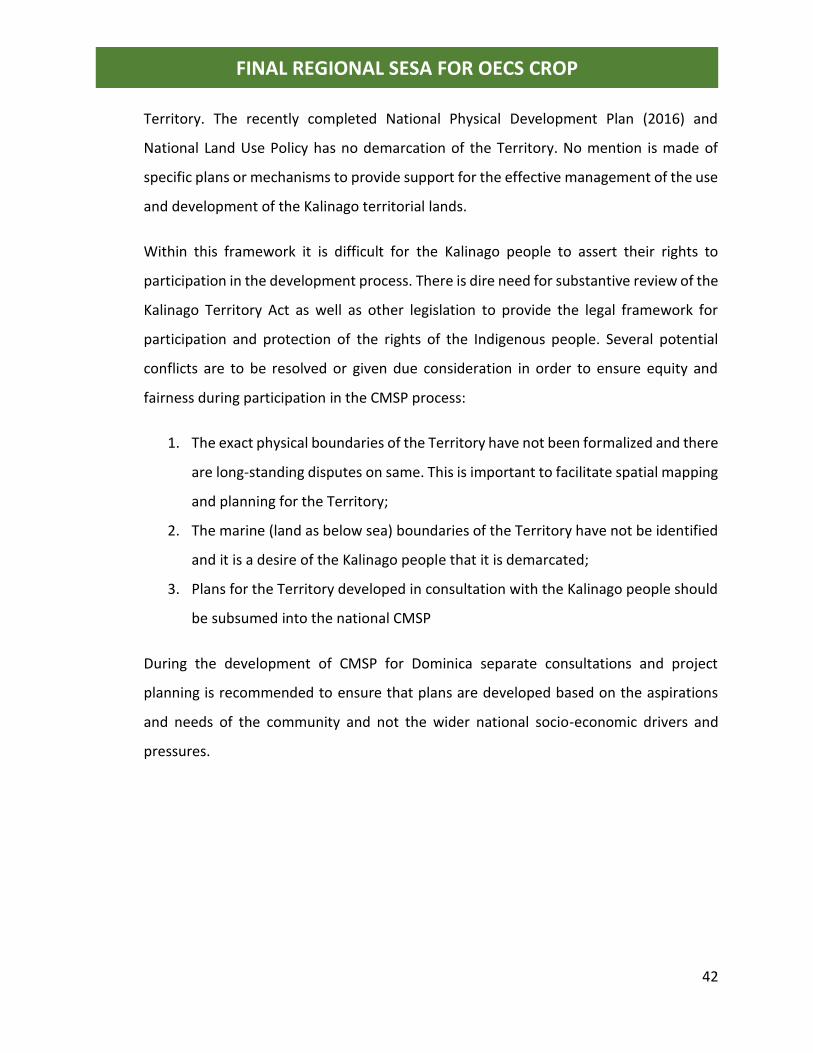
42
FINAL REGIONAL SESA FOR OECS CROP
Territory. The recently completed National Physical Development Plan (2016) and
National Land Use Policy has no demarcation of the Territory. No mention is made of
specific plans or mechanisms to provide support for the effective management of the use
and development of the Kalinago territorial lands.
Within this framework it is difficult for the Kalinago people to assert their rights to
participation in the development process. There is dire need for substantive review of the
Kalinago Territory Act as well as other legislation to provide the legal framework for
participation and protection of the rights of the Indigenous people. Several potential
conflicts are to be resolved or given due consideration in order to ensure equity and
fairness during participation in the CMSP process:
1. The exact physical boundaries of the Territory have not been formalized and there
are long-standing disputes on same. This is important to facilitate spatial mapping
and planning for the Territory;
2. The marine (land as below sea) boundaries of the Territory have not be identified
and it is a desire of the Kalinago people that it is demarcated;
3. Plans for the Territory developed in consultation with the Kalinago people should
be subsumed into the national CMSP
During the development of CMSP for Dominica separate consultations and project
planning is recommended to ensure that plans are developed based on the aspirations
and needs of the community and not the wider national socio-economic drivers and
pressures.
43
FINAL REGIONAL SESA FOR OECS CROP
4.0 APPROACH AND METHODOLOGY
4.1 General approach
In keeping with the terms of reference (TOR) for this consultancy, the main objectives of
this Strategic Environmental and Social Assessment are:
• To support the understanding and further inclusion of priority environmental and
social considerations in Coastal and Marine Spatial Planning (CMSP) in the CROP
and contribute relevant information to Component 1 of the CROP.
• To provide specific inputs for the implementation of the regional Strategic
Environmental and Social Assessment (SESA).
• To further examine the vulnerabilities as well as opportunities for the Kalinago
indigenous community of Dominica as related to CMSP. An Indigenous People’s
Planning Framework (IPPF) will therefore need to be embedded into the SESA.
• To gather and validate risk and impact data as well as to put forward suitable and
feasible recommendations intended to avoid, manage and/or attenuate these
impacts;
• To facilitate the integration of these measures into coherent plans and policies
and to ensure its application;
• To build strong stakeholder for a for the project’s benefit. Through the for a, the
concerns and interests of ‘weak and vulnerable’ stakeholders can influence the
decision-making processes fostering in addition, increased accountability for
policy makers; and
• To support the setting-up of an enabling framework for sustainable coastal and
marine spatial planning in a participatory manner involving all key stakeholders.
4.2 What is Strategic Environment and Social Impact Assessment
Several key stakeholders in participating member states requested clarifications on what
is a strategic environment and social assessment (SESA) and how it differs from an
environmental impact assessment (EIA).
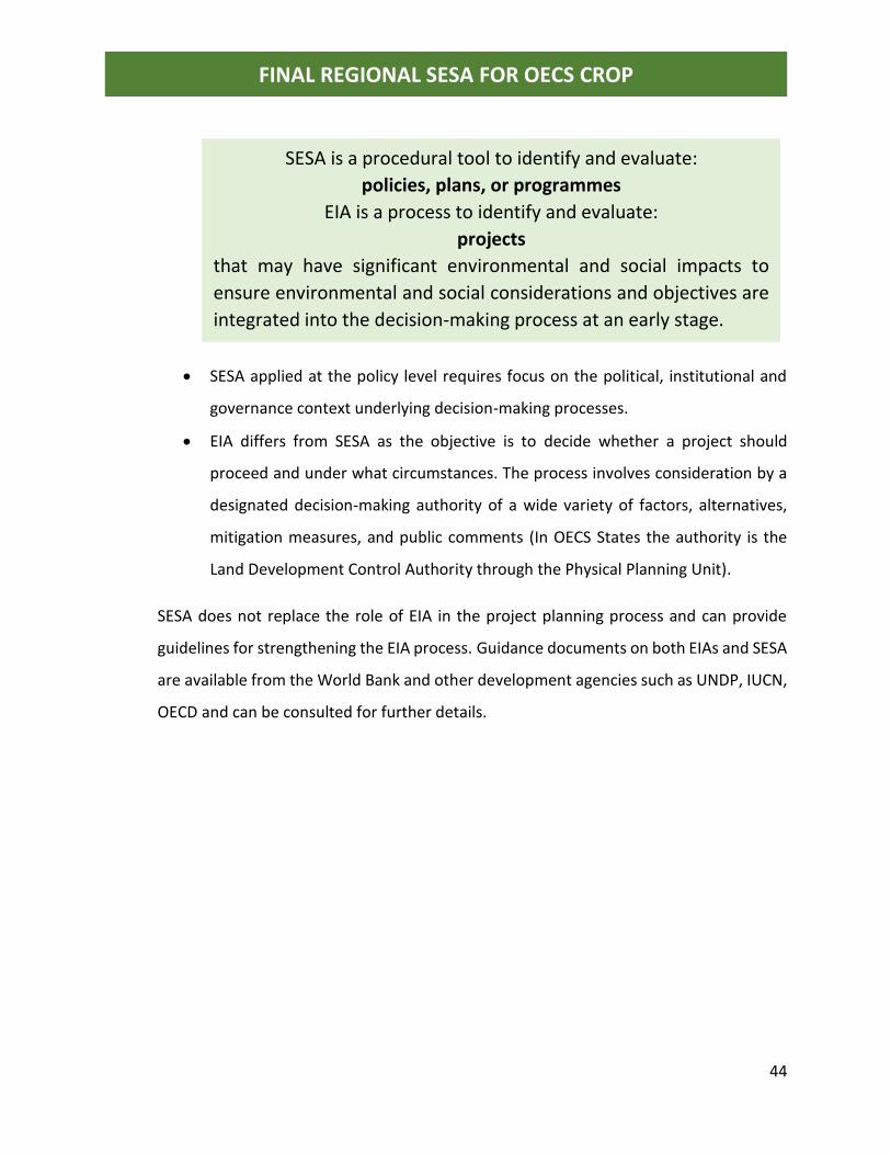
44
FINAL REGIONAL SESA FOR OECS CROP
• SESA applied at the policy level requires focus on the political, institutional and
governance context underlying decision-making processes.
• EIA differs from SESA as the objective is to decide whether a project should
proceed and under what circumstances. The process involves consideration by a
designated decision-making authority of a wide variety of factors, alternatives,
mitigation measures, and public comments (In OECS States the authority is the
Land Development Control Authority through the Physical Planning Unit).
SESA does not replace the role of EIA in the project planning process and can provide
guidelines for strengthening the EIA process. Guidance documents on both EIAs and SESA
are available from the World Bank and other development agencies such as UNDP, IUCN,
OECD and can be consulted for further details.
SESA is a procedural tool to identify and evaluate:
policies, plans, or programmes
EIA is a process to identify and evaluate:
projects
that may have significant environmental and social impacts to
ensure environmental and social considerations and objectives are
integrated into the decision-making process at an early stage.
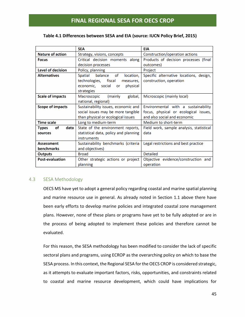
45
FINAL REGIONAL SESA FOR OECS CROP
Table 4.1 Differences between SESA and EIA (source: IUCN Policy Brief, 2015)
4.3 SESA Methodology
OECS MS have yet to adopt a general policy regarding coastal and marine spatial planning
and marine resource use in general. As already noted in Section 1.1 above there have
been early efforts to develop marine policies and integrated coastal zone management
plans. However, none of these plans or programs have yet to be fully adopted or are in
the process of being adopted to implement these policies and therefore cannot be
evaluated.
For this reason, the SESA methodology has been modified to consider the lack of specific
sectoral plans and programs, using ECROP as the overarching policy on which to base the
SESA process. In this context, the Regional SESA for the OECS CROP is considered strategic,
as it attempts to evaluate important factors, risks, opportunities, and constraints related
to coastal and marine resource development, which could have implications for
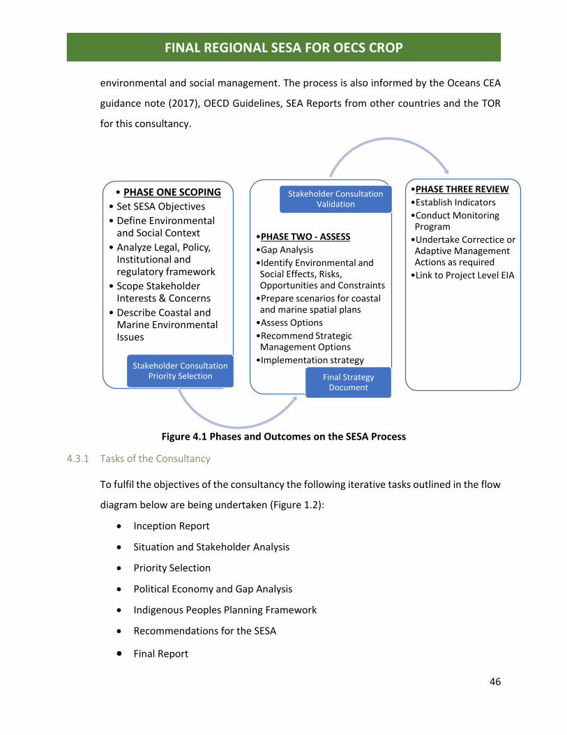
46
FINAL REGIONAL SESA FOR OECS CROP
environmental and social management. The process is also informed by the Oceans CEA
guidance note (2017), OECD Guidelines, SEA Reports from other countries and the TOR
for this consultancy.
Figure 4.1 Phases and Outcomes on the SESA Process
4.3.1 Tasks of the Consultancy
To fulfil the objectives of the consultancy the following iterative tasks outlined in the flow
diagram below are being undertaken (Figure 1.2):
• Inception Report
• Situation and Stakeholder Analysis
• Priority Selection
• Political Economy and Gap Analysis
• Indigenous Peoples Planning Framework
• Recommendations for the SESA
• Final Report
• PHASE ONE SCOPING
• Set SESA Objectives
• Define Environmental and Social Context
• Analyze Legal, Policy, Institutional and regulatory framework
• Scope Stakeholder Interests & Concerns
• Describe Coastal and Marine Environmental Issues
Stakeholder Consultation Priority Selection
•PHASE TWO - ASSESS
•Gap Analysis
•Identify Environmental and Social Effects, Risks, Opportunities and Constraints
•Prepare scenarios for coastal and marine spatial plans
•Assess Options
•Recommend Strategic Management Options
•Implementation strategy
Stakeholder Consultation Validation
•PHASE THREE REVIEW
•Establish Indicators
•Conduct Monitoring Program
•Undertake Correctice or Adaptive Management Actions as required
•Link to Project Level EIA
Final Strategy Document
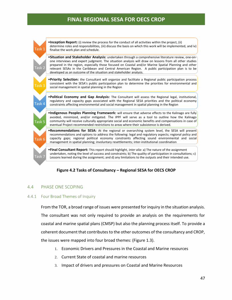
47
FINAL REGIONAL SESA FOR OECS CROP
Figure 4.2 Tasks of Consultancy – Regional SESA for OECS CROP
4.4 PHASE ONE SCOPING
4.4.1 Four Broad Themes of Inquiry
From the TOR, a broad range of issues were presented for inquiry in the situation analysis.
The consultant was not only required to provide an analysis on the requirements for
coastal and marine spatial plans (CMSP) but also the planning process itself. To provide a
coherent document that contributes to the other outcomes of the consultancy and CROP,
the issues were mapped into four broad themes: (Figure 1.3).
1. Economic Drivers and Pressures in the Coastal and Marine resources
2. Current State of coastal and marine resources
3. Impact of drivers and pressures on Coastal and Marine Resources
Task 1
•Inception Report: (i) review the process for the conduct of all activities within the project, (ii) determine roles and responsibilities, (iii) discuss the basis on which this work will be implemented, and iv) finalise the work plan and schedule.
Task 2
•Situation and Stakeholder Analysis: undertaken through a comprehensive literature review, one-on-one interviews and expert judgment. The situation analysis will draw on lessons from all other studiesprepared in the region, especially those focused on Coastal and/or Marine Spatial Planning and otherrelevant SESAs in the Caribbean and Central American Region. A public participation plan is to bedeveloped as an outcome of the situation and stakeholder analysis.
Task 3
•Priority Selection: the Consultant will organize and facilitate a Regional public participation processconsistent with the SESA’s public participation plan to determine the priorities for environmental andsocial management in spatial planning in the Region
Task 4
•Political Economy and Gap Analysis: The Consultant will assess the Regional legal, institutional,regulatory and capacity gaps associated with the Regional SESA priorities and the political economyconstraints affecting environmental and social management in spatial planning in the Region
Task 5
•Indigenous Peoples Planning Framework: will ensure that adverse effects to the Kalinago are fullyavoided, minimized, and/or mitigated. The IPPF will serve as a tool to outline how the Kalinagocommunity will receive culturally appropriate social and economic benefits and compensations in case ofeventual Project recommended restrictions to areas where their subsistence is derived.
Task 6
•Recommendations for SESA: At the regional or overarching system level, the SESA will presentrecommendations and options to address the following: legal and regulatory aspects; regional policy andcapacity gaps; regional political economy constraints affecting sound environmental and socialmanagement in spatial planning; involuntary resettlements; inter-institutional coordination
Task 7
•Final Consultant Report: This report should highlight, inter alia: a) The nature of the assignment undertaken, noting the level of success and constraints; b) The quality of participation in consultations; c) Lessons learned during the assignment; and d) any limitations to the outputs and their intended use.
48
FINAL REGIONAL SESA FOR OECS CROP
4. Policy Responses:
a. Governance Framework for CMSP
i. Legal and regulatory framework (global/regional/national;
MEAs etc.)
ii. Formal and informal organizational arrangements and
coordinating mechanisms
iii. Informal Customary Planning processes
iv. Institutional frameworks including indigenous people’s
governance structure, monitoring and enforcement, public
participation
b. Tools and resource capacity for CMSP;
c. Development planning, level of awareness, disaster risk reduction and
climate change.
4.4.2 Literature Review
Commencing June 2018 and continuing, the consultant reviewed more than 150 relevant
documents spanning a period over twenty-five years. Documents included legislation,
policies, strategies and action plans, consultant project reports, and news articles from
open online sources, focal points, OECS and the library of JECO Caribbean.
From the review it is evident that a large body of information exists on the framework for
management of coastal and marine resources in the region. As such no attempt is made
in this assessment to repeat this process or repeat the findings of previous studies.
Instead this assessment offers a deeper insight into the multi-dimensional and multi-
objective planning process required for the CROP by focusing on the governance
framework, political economy and public participation plan.
49
FINAL REGIONAL SESA FOR OECS CROP
4.4.3 One-to-one Interviews and Consultations
Following from the outcome of the comprehensive literature review, the consultant
began engagement with key stakeholders with a clear understanding of the imperatives
operating at the regional and national levels with regard coastal and marine spatial
planning. The purpose of the stakeholder interactions was therefore to elicit responses
on the TOR inquiry into the level of awareness of decision-makers on the need for spatial
planning in the development process, and requirements for the public participation plan.
A listing of stakeholders, meeting agenda, power point presentation and comments from
the various interactions are provided in Annex II to VI of the full report on the Situation
and Stakeholder Analysis.
The engagements were undertaken during the period July 16 to 27 2018 as follows:
• Dominica July 16 – 20, 2018
• Grenada July 24, 2018
• St Vincent & the Grenadines July 25, 2018
• St. Lucia July 26, 2018
• St Kitts and Nevis July 27, 2018
Key documents that provide up-to-date background information on
coastal and marine resources management in the Caribbean Sea
• The Caribbean Region Oceanscape Project (CROP). Assessment of Marine Spatial Planning Feasibility Report. The Nature Conservancy. World Bank Group, 2017.
• Caribbean Fisheries Legal and Institutional Study: Findings of the Comparative Assessment and Country
Reports Food and Agriculture Organization of the United Nations Bridgetown, Barbados, 2016
• CLME+ : Catalyzing Implementation of the Strategic Action Programme for the Sustainable Management of shared Living Marine Resources in the Caribbean and North Brazil Shelf Large Marine Ecosystems (2015-2025), UNDP
• Governance arrangements for marine ecosystems of the Wider Caribbean Region. Mahon et al, 2013. Centre for Resource Management and Environmental Studies (CERMES), Caribbean Sea Large Marine Ecosystem (CLME) and Adjacent Regions (CLME Project).
• Situational Analysis: Development of OECS Model Coastal Zone Management Policy and Model Coastal Development Setback Guidelines. JECO Caribbean Inc, 2016 OECS Commission USAID Funded RRACC Project
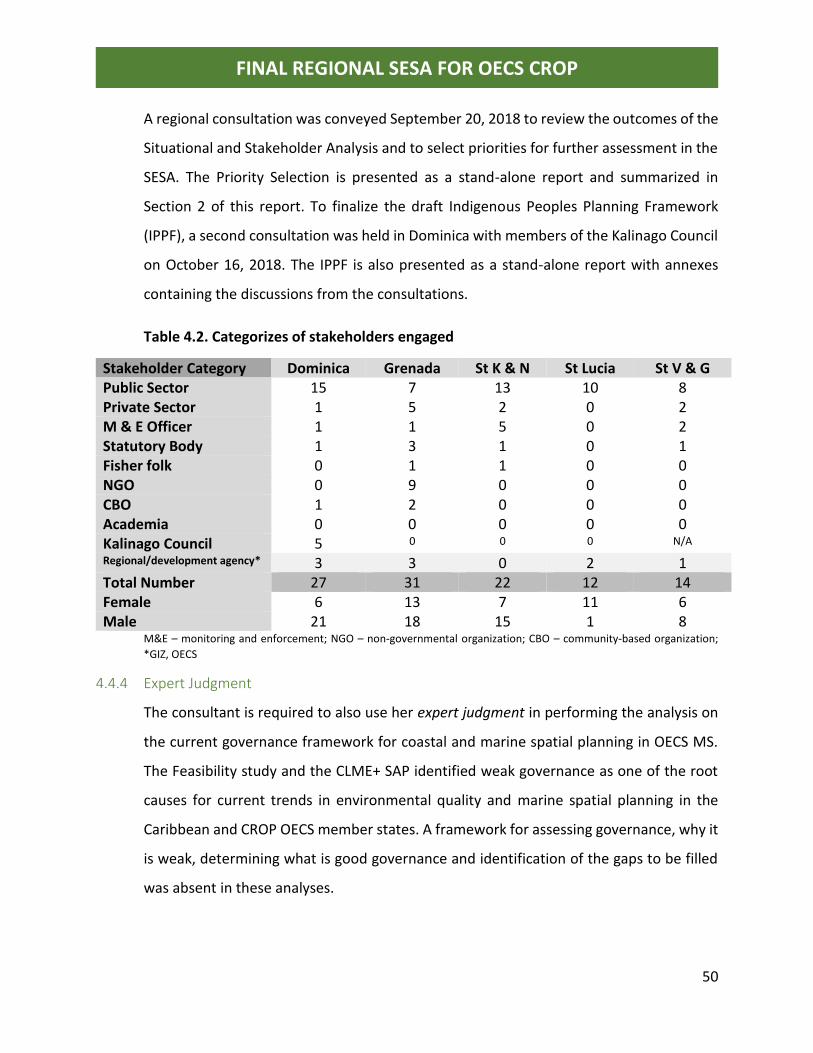
50
FINAL REGIONAL SESA FOR OECS CROP
A regional consultation was conveyed September 20, 2018 to review the outcomes of the
Situational and Stakeholder Analysis and to select priorities for further assessment in the
SESA. The Priority Selection is presented as a stand-alone report and summarized in
Section 2 of this report. To finalize the draft Indigenous Peoples Planning Framework
(IPPF), a second consultation was held in Dominica with members of the Kalinago Council
on October 16, 2018. The IPPF is also presented as a stand-alone report with annexes
containing the discussions from the consultations.
Table 4.2. Categorizes of stakeholders engaged
Stakeholder Category Dominica Grenada St K & N St Lucia St V & G Public Sector 15 7 13 10 8 Private Sector 1 5 2 0 2 M & E Officer 1 1 5 0 2 Statutory Body 1 3 1 0 1 Fisher folk 0 1 1 0 0 NGO 0 9 0 0 0 CBO 1 2 0 0 0 Academia 0 0 0 0 0 Kalinago Council 5 0 0 0 N/A
Regional/development agency* 3 3 0 2 1 Total Number 27 31 22 12 14 Female 6 13 7 11 6 Male 21 18 15 1 8
M&E – monitoring and enforcement; NGO – non-governmental organization; CBO – community-based organization;
*GIZ, OECS
4.4.4 Expert Judgment
The consultant is required to also use her expert judgment in performing the analysis on
the current governance framework for coastal and marine spatial planning in OECS MS.
The Feasibility study and the CLME+ SAP identified weak governance as one of the root
causes for current trends in environmental quality and marine spatial planning in the
Caribbean and CROP OECS member states. A framework for assessing governance, why it
is weak, determining what is good governance and identification of the gaps to be filled
was absent in these analyses.
51
FINAL REGIONAL SESA FOR OECS CROP
From the literature reviewed there is consensus on key attributes and processes which
constitute “good governance” both in general and for natural resources sectors (forest,
fisheries, marine etc). Therefore, to fulfil the TOR requirements of this situational analysis
and to perform the gap analysis, a framework for assessing governance in coastal and
marine spatial planning was developed.
4.5 Geographical or environmental mapping units
Spatial management of coastal and marine resources also requires that the geographic
boundaries or limits be defined. The OECS MS have made significant progress in recent
times towards formalization of their maritime boundaries and exclusive economic zones
(EEZ).
The feasibility study for the CROP presented the results from inquiry amongst a wide
range of stakeholders in the OECS on the definition of the geographic boundaries for
coastal and marine spatial planning. There was unanimous agreement among
stakeholders that planning should encompass the entire coastal zone, that is the coastal
catchment continuum, out to the limits of the EEZ.
Figure 4.1 presents a map of the Caribbean region showing the EEZ (established and
virtual boundaries) for the various jurisdictions.
4.6 Assumptions, uncertainties and constraints
4.6.1 Assumptions
Several underlying key assumptions were made at the initiation of the SESA process as
follows:
1. Strategic objectives and priorities for the SESA have been agreed by key
stakeholders;
2. There is willingness and commitment by stakeholders to participate in the SESA
process;
3. The implementation and follow-up of SESA recommendations will be critical to the
success of its adoption by OECS participating States.
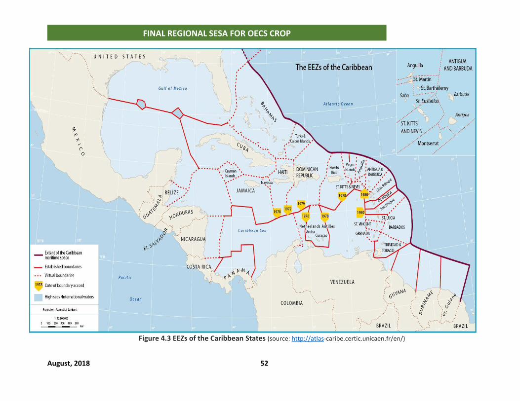
August, 2018 52
FINAL REGIONAL SESA FOR OECS CROP
Figure 4.3 EEZs of the Caribbean States (source: http://atlas-caribe.certic.unicaen.fr/en/)
August, 2018 Final edit November 2018 53
FINAL REGIONAL SESA FOR OECS CROP
4.6.2 Uncertainties
Member States have yet to clearly articulate the national vision for coastal and marine
spatial planning. The frameworks utilized in the SESA provide the tools for continuous
assessment as the planning process evolves.
Given that the GBGMP is an investment promotion tool and not the national development
strategy for 2030, no particular aspects are assessed as their implementation will be
driven by private investments and likely to change in scope and location. Further
development of these proposals for actual implementation must be guided by detailed
environmental and social impact assessments, including scenarios for climate change, sea
level rise and natural hazard risk exposure.
The environmental, social risk and development scenarios for exploitation of oil/gas
sector in the OECS are purely speculative.
4.6.3 Constraints
This assessment is informed by a companion situation and stakeholder analysis report.
The study is informed largely by literature review of secondary data with consultations
limited to key stakeholders from national focal point agencies, organized groups,
community based and non-governmental organizations. Further engagement with wider
stakeholder audiences will be required during the implementation of the CROP so that
priorities can be further streamlined to suit specific issues and interest groups. Also, as
national objectives for coastal and marine spatial plans become finalized, it will be
necessary to use the mitigation standards to finalize projects for implementation.
Investments will be required for both short term mitigation measures and programs to
improve the governance framework for natural resources management in OECS States.
National governments will be required to integrate the recommendations into their
medium to long term socio-economic development strategies.
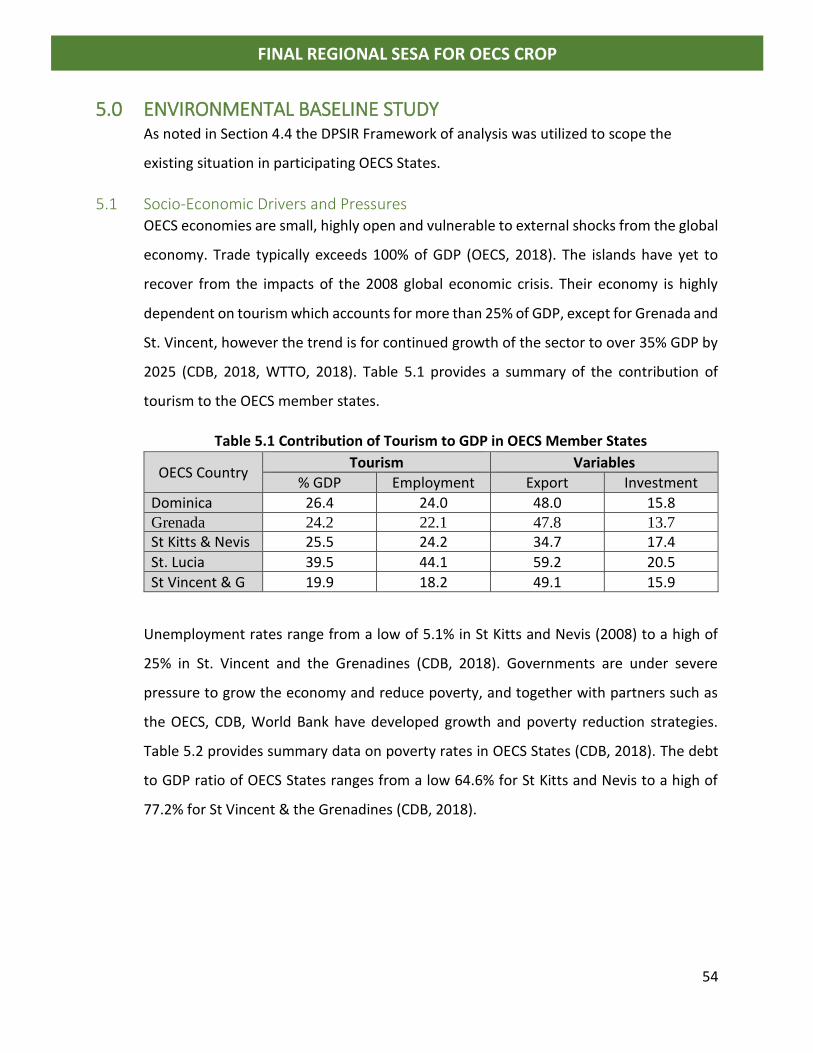
54
FINAL REGIONAL SESA FOR OECS CROP
5.0 ENVIRONMENTAL BASELINE STUDY As noted in Section 4.4 the DPSIR Framework of analysis was utilized to scope the
existing situation in participating OECS States.
5.1 Socio-Economic Drivers and Pressures OECS economies are small, highly open and vulnerable to external shocks from the global
economy. Trade typically exceeds 100% of GDP (OECS, 2018). The islands have yet to
recover from the impacts of the 2008 global economic crisis. Their economy is highly
dependent on tourism which accounts for more than 25% of GDP, except for Grenada and
St. Vincent, however the trend is for continued growth of the sector to over 35% GDP by
2025 (CDB, 2018, WTTO, 2018). Table 5.1 provides a summary of the contribution of
tourism to the OECS member states.
Table 5.1 Contribution of Tourism to GDP in OECS Member States
OECS Country Tourism Variables
% GDP Employment Export Investment
Dominica 26.4 24.0 48.0 15.8 Grenada 24.2 22.1 47.8 13.7
St Kitts & Nevis 25.5 24.2 34.7 17.4
St. Lucia 39.5 44.1 59.2 20.5
St Vincent & G 19.9 18.2 49.1 15.9
Unemployment rates range from a low of 5.1% in St Kitts and Nevis (2008) to a high of
25% in St. Vincent and the Grenadines (CDB, 2018). Governments are under severe
pressure to grow the economy and reduce poverty, and together with partners such as
the OECS, CDB, World Bank have developed growth and poverty reduction strategies.
Table 5.2 provides summary data on poverty rates in OECS States (CDB, 2018). The debt
to GDP ratio of OECS States ranges from a low 64.6% for St Kitts and Nevis to a high of
77.2% for St Vincent & the Grenadines (CDB, 2018).
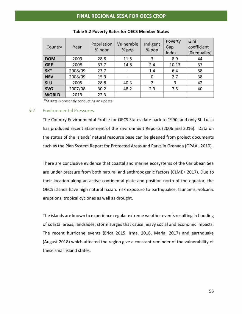
55
FINAL REGIONAL SESA FOR OECS CROP
Table 5.2 Poverty Rates for OECS Member States
Country Year Population
% poor Vulnerable
% pop Indigent % pop
Poverty Gap Index
Gini coefficient (0=equality)
DOM 2009 28.8 11.5 3 8.9 44
GRE 2008 37.7 14.6 2.4 10.13 37
SK* 2008/09 23.7 - 1.4 6.4 38
NEV 2008/09 15.9 - 0 2.7 38
SLU 2005 28.8 40.3 2 9 42
SVG 2007/08 30.2 48.2 2.9 7.5 40
WORLD 2013 22.3
*St Kitts is presently conducting an update
5.2 Environmental Pressures
The Country Environmental Profile for OECS States date back to 1990, and only St. Lucia
has produced recent Statement of the Environment Reports (2006 and 2016). Data on
the status of the Islands’ natural resource base can be gleaned from project documents
such as the Plan System Report for Protected Areas and Parks in Grenada (OPAAL 2010).
There are conclusive evidence that coastal and marine ecosystems of the Caribbean Sea
are under pressure from both natural and anthropogenic factors (CLME+ 2017). Due to
their location along an active continental plate and position north of the equator, the
OECS islands have high natural hazard risk exposure to earthquakes, tsunamis, volcanic
eruptions, tropical cyclones as well as drought.
The islands are known to experience regular extreme weather events resulting in flooding
of coastal areas, landslides, storm surges that cause heavy social and economic impacts.
The recent hurricane events (Erica 2015, Irma, 2016, Maria, 2017) and earthquake
(August 2018) which affected the region give a constant reminder of the vulnerability of
these small island states.
56
FINAL REGIONAL SESA FOR OECS CROP
The main anthropogenic factors that contribute to environmental degradation include:
• Overfishing – according to an FAO report (2009) fisher folk in OECS States tend to
exploit mainly nearshore and reef fisheries and only few islands have long-line
fisher folk who exploit pelagic stocks. None of the islands have home-based high
seas fishing fleet. During consultations in St Kitts and Nevis fisherfolk expressed
grave concern about the declining status of the fish stock and the fact that the
effort has increased considerably to catch fish. He noted “I now have to go out
more than 30 miles to fish and sometimes I don’t catch the same amount. It is now
a free for all and too many persons have license to fish. On an island of 15,000
people we have 400 licensed fisherfolk” There was also great concern that there
are no barriers for entry into the sector as licenses are free, there are no quotas
and tax-free concessions are given on all fishing gear, equipment and fuel. This
trend has been observed throughout the region.
• Coastal development – more than 80% of the population in the OECS States live
in coastal areas and the economic infrastructure is located within the coastal zone.
Mangroves, coastal wetlands and flats are being transformed into major hotel
development projects and marinas despite the commitment made by
governments to protect these habitats. Beaches and coral reefs are also under-
pressure from extensive use for cruise and dive tourism. For the 2017/2018 cruise
tourism season St Kitts and Nevis celebrated the milestone of having accepted
1,000,000 cruise visitors to the Island. A senior official in the Ministry of Tourism
participating in the stakeholder consultation noted “We had intense erosion of the
beach at Frigate Bay so everyone is now going to Cockshell Beach. This beach is
also showing signs of stress as all the cruise tourists go to that beach; it is full when
the ships are in. We are looking for assistance to do a beach restoration project. I
need help to make argument about carrying capacity of natural resources.”
57
FINAL REGIONAL SESA FOR OECS CROP
• Pollution from both marine and land-based sources – in OECS States there is
urgent need to regulate the fast-growing yachting sector and treatment facilities
are needed to manage sewage from both land and sea sources. Non-point sources
of pollution from drainage, agriculture, industries, stormwater runoff continues to
be a huge challenge and the negative impact of these on the coastal and marine
ecosystems has been documented (IWCAM, 2016; CLME, 2014). Stakeholders
from St Kitts and Nevis and Grenada discussed the current situation with
management of sewage from yachts. In St Kitts only one marina has the facility to
accept and treat waste, recycling the water for irrigation.
• Climate change and ocean acidification – the CARIBSAVE Climate Change Risk
Atlas for each OECS State provides assessment and baseline for climate and sea-
level rise data. While the impacts are not yet clear there is evidence of increased
variability in weather patterns in the region. OECS States have developed climate
change adaptation strategies and are working to become climate resilient
countries.
• Invasive species and exotics: New and emerging trends such as the invasion of
Caribbean coral reef fisheries by the “lionfish” and pollution of excessive growth
of marine algae (seaweed) are major issues that Caribbean States must address.
5.2.1 Cross sectoral Issues
There are several cross-sectoral environmental issues which must be taken into
consideration during the development of coastal and marine spatial plans:
• Watershed Management
o Land clearing for agriculture
o Housing development, particularly on steep slopes
o Water production (quantity and quality)
• Stormwater management
o Drains and outfalls
o Detention systems; swales, infiltration trenches
o Retention systems, ponds and wetlands
58
FINAL REGIONAL SESA FOR OECS CROP
• Wastewater management
o Collection systems
o Treatment systems (primary, secondary, tertiary)
• Space allocation for:
o Sanitary and hazardous waste landfills
o Wastewater treatment plants
o Cemetery and burial grounds
o Parks and green spaces
o Parking
• Protected Areas and seascapes
o Mangroves and wetlands
o Littoral woodlands and dry forests
• Marine Protected Areas
o (impact of land-based sources of pollution)
o Management of multiple stakeholder uses
o Traditional use
o Algal growth; seaweed management
• Ship generated waste
o Solid waste
o Liquid waste
o Ballast water and exotic species
• Oil spill Prevention and management
5.2.2 Sector Specific Considerations
SECTOR ENVIRONMENTAL ISSUES AND CHALLENGES
Agriculture
in/near coastal
areas
• Coastal forests are being replaced with formal or informal agricultural activities in low lying areas.
• The OECS Ministries of Agriculture, as part of national climate change adaptation plans, have begun initiatives to climate proof farmland and crops; Lessons learnt needs to be replicated by farmers.
• Current agricultural activities in upland watersheds cause harmful amounts of topsoil or pollutants to flow into estuaries and coastal waters
Fisheries- Wild
Capture and
Aquaculture
• Fisherfolk receive tax free incentives to invest in the sector. There is no quota systems and licenses are free in most OECS states. Fisherfolk pay for registration of their fishing vessel.
• The sustainability of coastal or offshore fisheries within the territorial waters of OECS MS must be assessed;
59
FINAL REGIONAL SESA FOR OECS CROP
SECTOR ENVIRONMENTAL ISSUES AND CHALLENGES
• Quota system need to be developed to manage exploitation of marine fish stocks.
• There are policies for aquaculture, however no largescale projects have been undertaken as yet; lessons from past projects in Telescope Grenada suggests that management of wastewater is a critical issue to be addressed;
• There any potential conflicts between fishing grounds and shipping lanes or other offshore economic activities, and these must be resolved through the use of marine spatial plans/use zones.
Infrastructure • Existing infrastructure located in the coastal zone date back to 1950s and as such do not consider changes in sea level or storm surge.
• Predictions for sea level rise and future storm surge scenarios must be incorporated into the CMS plans;
• There is evidence that the current practice of disposal of pollutants from stormwater and wastewater marine outfall negatively impacts coastal water quality, coral reefs and marine life; reduction in goods and services from coastal and marine ecosystems;
• Planned expansion of infrastructure in the coastal zone will stress ecosystem services or cause other negative environmental or social impacts;
• At present OECS MS exploit only nearshore fisheries. Exploitation of ocean resources will likely present a future risk of conflict or damage to undersea infrastructure (pipelines, communications cables, etc.) from other economic activities (e.g. fishing trawlers that drag the ocean bottom, subsea mining, etc.)
Urban
planning and
development
• OECS cities and towns were developed more than a century ago. As such urban planning in coastal areas has not taken into account climate and coastal disaster risks related to extreme weather events, sea level rise and coastal flooding.
• The CMSP must include planning for climate change future risk scenarios, sea level rise, storm surges and increased coastal flooding;
• Most of the fisherfolk in OECS MS are from informal coastal settlements on public lands. Poor infrastructure results in pollution of nearshore areas from domestic wastewater and runoff from the land. There have been efforts to formalize these settlements through land titling. Communities vulnerable to natural disasters are targets for involuntary resettlement in Dominica.
Housing &
Settlement
• Loss of coastal forests and associated wildlife for residential development;
• Housing development is driven by the private sector and due to the lack of area management plans infrastructure development is inadequate for stormwater and wastewater management;
Water Use and
Resources
• Groundwater supplies in coastal communities at risk from overuse pollution from development and saline intrusion due to sea level rise;
60
FINAL REGIONAL SESA FOR OECS CROP
SECTOR ENVIRONMENTAL ISSUES AND CHALLENGES
• OECS MS have developed water policies or and watershed management plans in place to encourage sustainable and equitable access to water resources. Enforcement of these policies has been lacking.
• Increasing freshwater availability in coastal areas (e.g. via desalinization) will have positive impact future development opportunities however brine and wastes from the process will contribute to further destruction of coastal ecosystems. Renewable energy (e.g solar PV) will offset the huge energy demand for desalinization.
Extractives
(Oil, gas and
mining)
• Are there coastal or subsea mining activities planned or already underway?
• Are there offshore or coastal onshore oil, gas or mining exploration or production activities planned or already present?
• Are there sector-related infrastructure or facilities located in ecologically sensitive coastal zones (e.g. refinery, LNG storage terminal, mineral port, loading/unloading facilities and associated road, rail and power and water supply infrastructure)
• Sand and gravel mining, although illegal in most cases, have negative effect on shoreline stability or sea-floor ecosystems in all OECS MS.
Renewable
and other
Energy
Development
• Existing power plants are located in low-lying coastal areas
• There are feasibility studies to determine the viability of new onshore or offshore energy projects (solar, wind, geothermal, etc.). Results are not yet finalized. In the case of solar farms their potential footprints overlap existing uses of coastal spaces. Marine windfarms are proposed however there is no available feasibility studies on same at present.
Maritime
Transport
• The location of shipping lanes and sensitive ecological areas must be mapped on marine spatial plans to determine where they intersect and to zone uses appropriately for better management;
• There is anecdotal information on piracy in OECS MS. The impact on shipping or other uses of ocean and coastal space needs to be assessed.
Tourism • In OECS MS there are planned and existing tourist facilities in low-lying coastal areas, which have operations or guest activities (boating, scuba-diving, etc.) which pose risks to local ecosystems (wildlife, coral reefs, mangroves) – over use of recreational areas; disposal of untreated sewage; generation of large volumes of solid waste)
• Other existing or planned economic activities in coastal or marine areas which could pose a threat to or compete for resources with tourism activities include oil and gas exploration; development of marine wind farms; aquaculture.
• Capacity assessment of coastal and marine resources to keep pace with the fast-growing rate of the tourism sector is necessary.
61
FINAL REGIONAL SESA FOR OECS CROP
5.4 Policy Responses Recently OECS states have developed long-term national development plans in keeping
within the UN 2030 global agenda - 17 sustainable development goals (SDGs). Although
there exists public sector driven regional development plans in the OECS MS, there are
no examples of any of these plans having been executed in the OECS. New developments
are driven by private sector projects in the tourism and residential sectors (hotels,
marinas, golf course, sub-divisions). Public sector socio-economic development
objectives are delivered on a project by project basis financed largely by grants, overseas
development assistance and concessionary loans. Considering the socio-economic
drivers, OECS governments, except for St. Vincent & the Grenadines, have also developed
investment promotion strategies largely led by citizen by investment (CBI) programs with
the aim of providing jobs for nationals. Current national plans include:
• Dominica’s development agenda is driven by recovery following the passage of
Hurricanes Erica is 2015 and Hurricane Maria in 2016 which had a significant
impact on GDP and setback progress for more than a decade. The Government
sees this however as an opportunity to build back better and has set a trajectory
to become the first climate resilient country in the world. Backed by donor and
development agencies, reconstruction will be coordinated through the Climate
Resilient Execution Agency for Dominica (CREAD).
• Grenada has developed a National 2030 development plan as well as a Blue
Growth Master Plan with the intention of becoming a center of excellence for the
blue economy. The Government of Grenada, with support of US$300 million from
the Global Climate Fund, is also pursuing plans to become the home of the first
climate resilient city in the world.
• St Kitts and Nevis has aligned its development agenda with the SDGs and has
completed a national adaptation strategy in 2016 which provides the framework
for sustainable development of the twin island state. The Government is in the
process of finalizing a post 2017 development agenda.
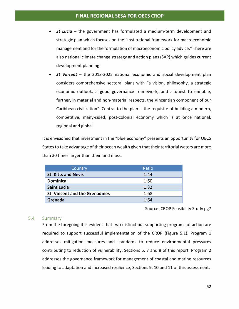
62
FINAL REGIONAL SESA FOR OECS CROP
• St Lucia – the government has formulated a medium-term development and
strategic plan which focuses on the “institutional framework for macroeconomic
management and for the formulation of macroeconomic policy advice.” There are
also national climate change strategy and action plans (SAP) which guides current
development planning.
• St Vincent – the 2013-2025 national economic and social development plan
considers comprehensive sectoral plans with “a vision, philosophy, a strategic
economic outlook, a good governance framework, and a quest to ennoble,
further, in material and non-material respects, the Vincentian component of our
Caribbean civilization”. Central to the plan is the requisite of building a modern,
competitive, many-sided, post-colonial economy which is at once national,
regional and global.
It is envisioned that investment in the “blue economy” presents an opportunity for OECS
States to take advantage of their ocean wealth given that their territorial waters are more
than 30 times larger than their land mass.
Source: CROP Feasibility Study pg7
5.4 Summary From the foregoing it is evident that two distinct but supporting programs of action are
required to support successful implementation of the CROP (Figure 5.1). Program 1
addresses mitigation measures and standards to reduce environmental pressures
contributing to reduction of vulnerability, Sections 6, 7 and 8 of this report. Program 2
addresses the governance framework for management of coastal and marine resources
leading to adaptation and increased resilience, Sections 9, 10 and 11 of this assessment.
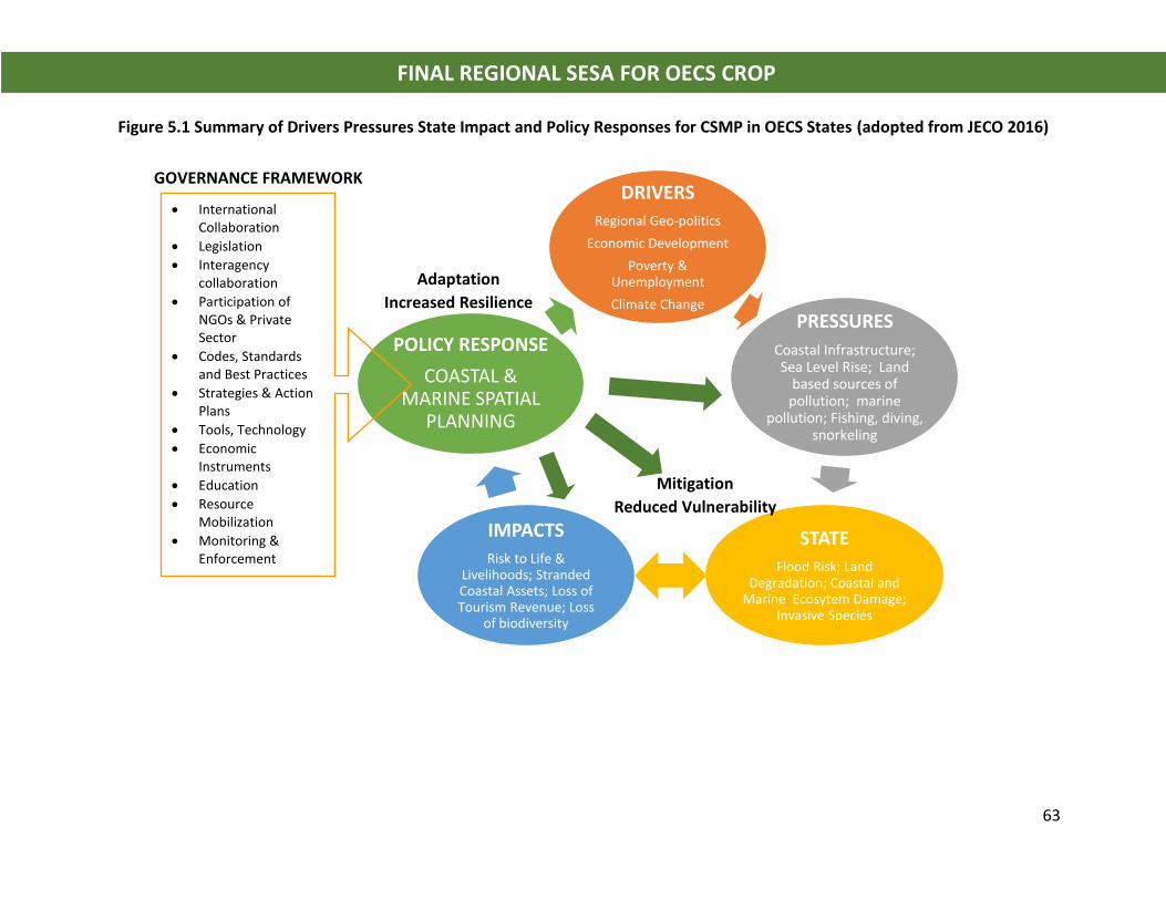
63
FINAL REGIONAL SESA FOR OECS CROP
Figure 5.1 Summary of Drivers Pressures State Impact and Policy Responses for CSMP in OECS States (adopted from JECO 2016)
DRIVERS
Regional Geo-politics
Economic Development
Poverty & Unemployment
Climate Change
PRESSURES
Coastal Infrastructure; Sea Level Rise; Land
based sources of pollution; marine
pollution; Fishing, diving, snorkeling
STATE
Flood Risk; Land Degradation; Coastal and
Marine Ecosytem Damage; Invasive Species
IMPACTS
Risk to Life & Livelihoods; Stranded Coastal Assets; Loss of Tourism Revenue; Loss
of biodiversity
POLICY RESPONSE
COASTAL & MARINE SPATIAL
PLANNING
• International Collaboration
• Legislation
• Interagency collaboration
• Participation of NGOs & Private Sector
• Codes, Standards and Best Practices
• Strategies & Action Plans
• Tools, Technology
• Economic Instruments
• Education
• Resource Mobilization
• Monitoring & Enforcement
Adaptation
Increased Resilience
Mitigation
Reduced Vulnerability
GOVERNANCE FRAMEWORK
64
FINAL REGIONAL SESA FOR OECS CROP
6.0 IMPACT IDENTIFICATION & EVALUATION
6.1 Base-case Scenario – Situation in OECS States
From the review of socio-economic drivers and environmental pressures operating within
OECS Member States it is critical that existing challenges be addressed as these have
implications for development of the Blue Economy. The base case scenario is assessed for
key sectors and coastal management zones.
These challenges can potentially have large negative impacts if proper management
actions are not adopted in a timely manner. Mitigation measures to reduce the impacts
are presented for each sector and for coastal management zone in Tables 6.1 and 6.2
respectively. Priority ranking of the issues and mitigation standards in Table 6.2 were
provided by key stakeholders from Grenada and St. Lucia and provided in the SESA
consultancy report on priority selection. The situational and stakeholder analysis must
also be consulted as this report presents additional information on the capacity of
environmental management agencies in member states to effectively manage coastal and
marine resources.
It must be noted that mitigation standards must be further developed based on the actual
spatial plans which are created for each member state and must be guided by detailed
assessments at the project implementation level. Assessments should include resource
and stock assessments, ESIAs, natural hazard risk assessment (tropical cyclones, wind
exposure, flooding, landslides, storm surges, earthquakes, volcanoes, tsunamis etc),
climate change modelling and sea level rise scenarios.
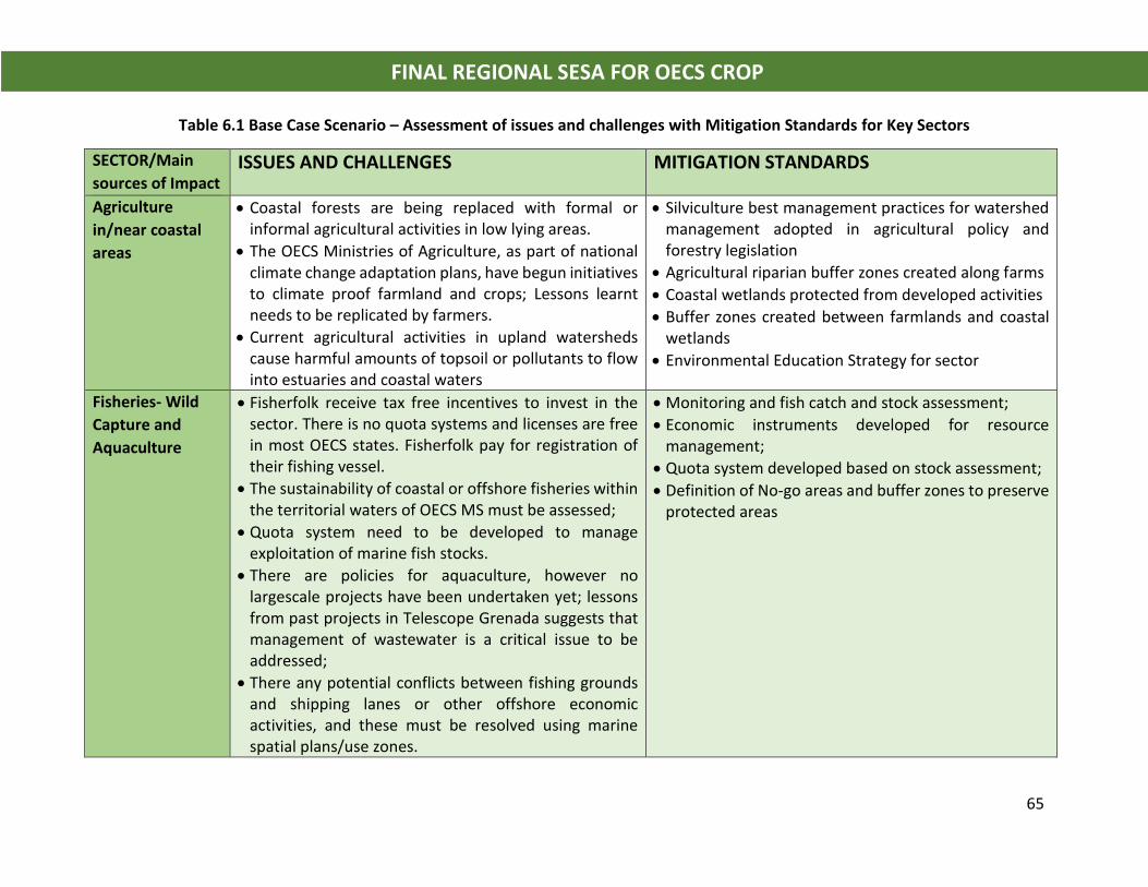
65
FINAL REGIONAL SESA FOR OECS CROP
Table 6.1 Base Case Scenario – Assessment of issues and challenges with Mitigation Standards for Key Sectors
SECTOR/Main
sources of Impact ISSUES AND CHALLENGES MITIGATION STANDARDS
Agriculture
in/near coastal
areas
• Coastal forests are being replaced with formal or informal agricultural activities in low lying areas.
• The OECS Ministries of Agriculture, as part of national climate change adaptation plans, have begun initiatives to climate proof farmland and crops; Lessons learnt needs to be replicated by farmers.
• Current agricultural activities in upland watersheds cause harmful amounts of topsoil or pollutants to flow into estuaries and coastal waters
• Silviculture best management practices for watershed management adopted in agricultural policy and forestry legislation
• Agricultural riparian buffer zones created along farms
• Coastal wetlands protected from developed activities
• Buffer zones created between farmlands and coastal wetlands
• Environmental Education Strategy for sector
Fisheries- Wild
Capture and
Aquaculture
• Fisherfolk receive tax free incentives to invest in the sector. There is no quota systems and licenses are free in most OECS states. Fisherfolk pay for registration of their fishing vessel.
• The sustainability of coastal or offshore fisheries within the territorial waters of OECS MS must be assessed;
• Quota system need to be developed to manage exploitation of marine fish stocks.
• There are policies for aquaculture, however no largescale projects have been undertaken yet; lessons from past projects in Telescope Grenada suggests that management of wastewater is a critical issue to be addressed;
• There any potential conflicts between fishing grounds and shipping lanes or other offshore economic activities, and these must be resolved using marine spatial plans/use zones.
• Monitoring and fish catch and stock assessment;
• Economic instruments developed for resource management;
• Quota system developed based on stock assessment;
• Definition of No-go areas and buffer zones to preserve protected areas
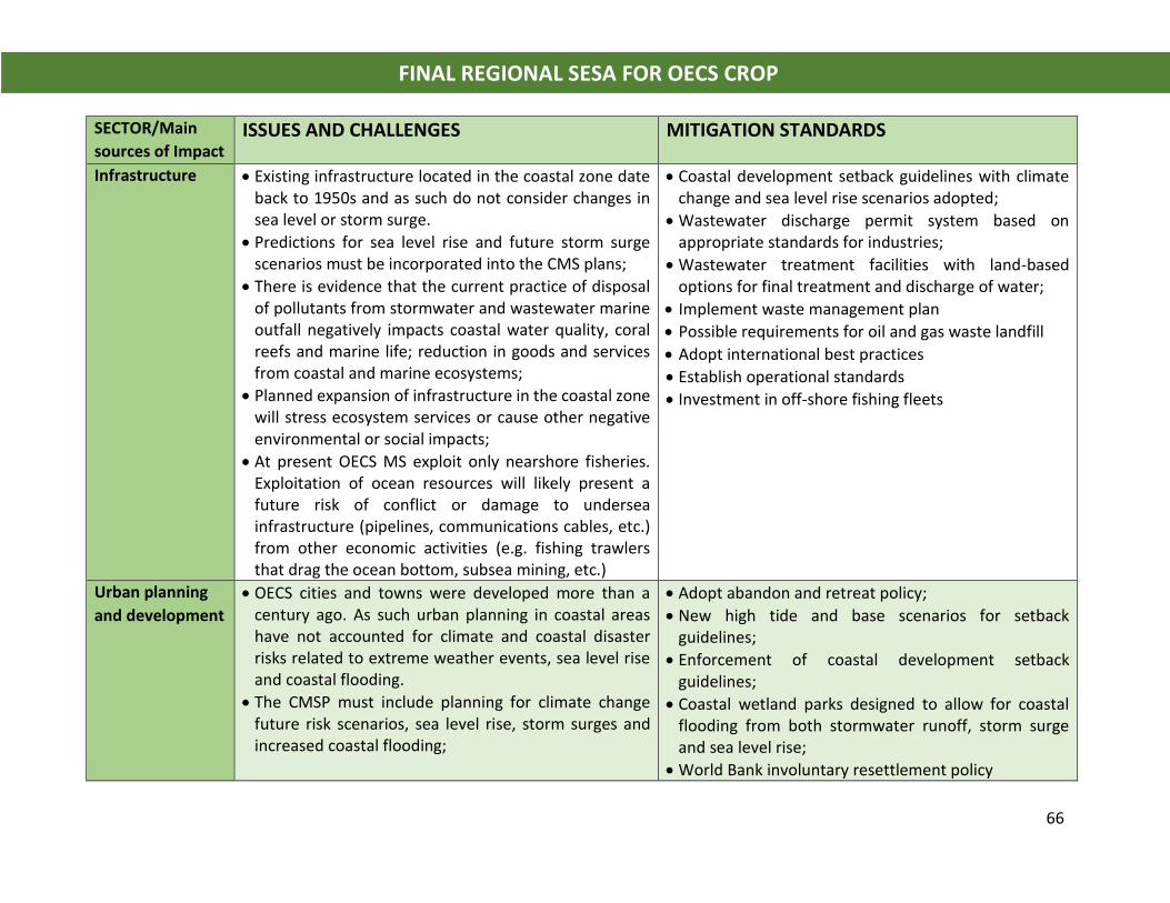
66
FINAL REGIONAL SESA FOR OECS CROP
SECTOR/Main
sources of Impact ISSUES AND CHALLENGES MITIGATION STANDARDS
Infrastructure • Existing infrastructure located in the coastal zone date back to 1950s and as such do not consider changes in sea level or storm surge.
• Predictions for sea level rise and future storm surge scenarios must be incorporated into the CMS plans;
• There is evidence that the current practice of disposal of pollutants from stormwater and wastewater marine outfall negatively impacts coastal water quality, coral reefs and marine life; reduction in goods and services from coastal and marine ecosystems;
• Planned expansion of infrastructure in the coastal zone will stress ecosystem services or cause other negative environmental or social impacts;
• At present OECS MS exploit only nearshore fisheries. Exploitation of ocean resources will likely present a future risk of conflict or damage to undersea infrastructure (pipelines, communications cables, etc.) from other economic activities (e.g. fishing trawlers that drag the ocean bottom, subsea mining, etc.)
• Coastal development setback guidelines with climate change and sea level rise scenarios adopted;
• Wastewater discharge permit system based on appropriate standards for industries;
• Wastewater treatment facilities with land-based options for final treatment and discharge of water;
• Implement waste management plan
• Possible requirements for oil and gas waste landfill
• Adopt international best practices
• Establish operational standards
• Investment in off-shore fishing fleets
Urban planning
and development
• OECS cities and towns were developed more than a century ago. As such urban planning in coastal areas have not accounted for climate and coastal disaster risks related to extreme weather events, sea level rise and coastal flooding.
• The CMSP must include planning for climate change future risk scenarios, sea level rise, storm surges and increased coastal flooding;
• Adopt abandon and retreat policy;
• New high tide and base scenarios for setback guidelines;
• Enforcement of coastal development setback guidelines;
• Coastal wetland parks designed to allow for coastal flooding from both stormwater runoff, storm surge and sea level rise;
• World Bank involuntary resettlement policy
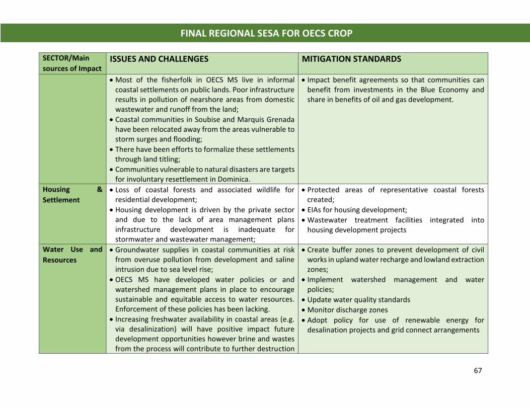
67
FINAL REGIONAL SESA FOR OECS CROP
SECTOR/Main
sources of Impact ISSUES AND CHALLENGES MITIGATION STANDARDS
• Most of the fisherfolk in OECS MS live in informal coastal settlements on public lands. Poor infrastructure results in pollution of nearshore areas from domestic wastewater and runoff from the land;
• Coastal communities in Soubise and Marquis Grenada have been relocated away from the areas vulnerable to storm surges and flooding;
• There have been efforts to formalize these settlements through land titling;
• Communities vulnerable to natural disasters are targets for involuntary resettlement in Dominica.
• Impact benefit agreements so that communities can benefit from investments in the Blue Economy and share in benefits of oil and gas development.
Housing &
Settlement
• Loss of coastal forests and associated wildlife for residential development;
• Housing development is driven by the private sector and due to the lack of area management plans infrastructure development is inadequate for stormwater and wastewater management;
• Protected areas of representative coastal forests created;
• EIAs for housing development;
• Wastewater treatment facilities integrated into housing development projects
Water Use and
Resources
• Groundwater supplies in coastal communities at risk from overuse pollution from development and saline intrusion due to sea level rise;
• OECS MS have developed water policies or and watershed management plans in place to encourage sustainable and equitable access to water resources. Enforcement of these policies has been lacking.
• Increasing freshwater availability in coastal areas (e.g. via desalinization) will have positive impact future development opportunities however brine and wastes from the process will contribute to further destruction
• Create buffer zones to prevent development of civil works in upland water recharge and lowland extraction zones;
• Implement watershed management and water policies;
• Update water quality standards
• Monitor discharge zones
• Adopt policy for use of renewable energy for desalination projects and grid connect arrangements
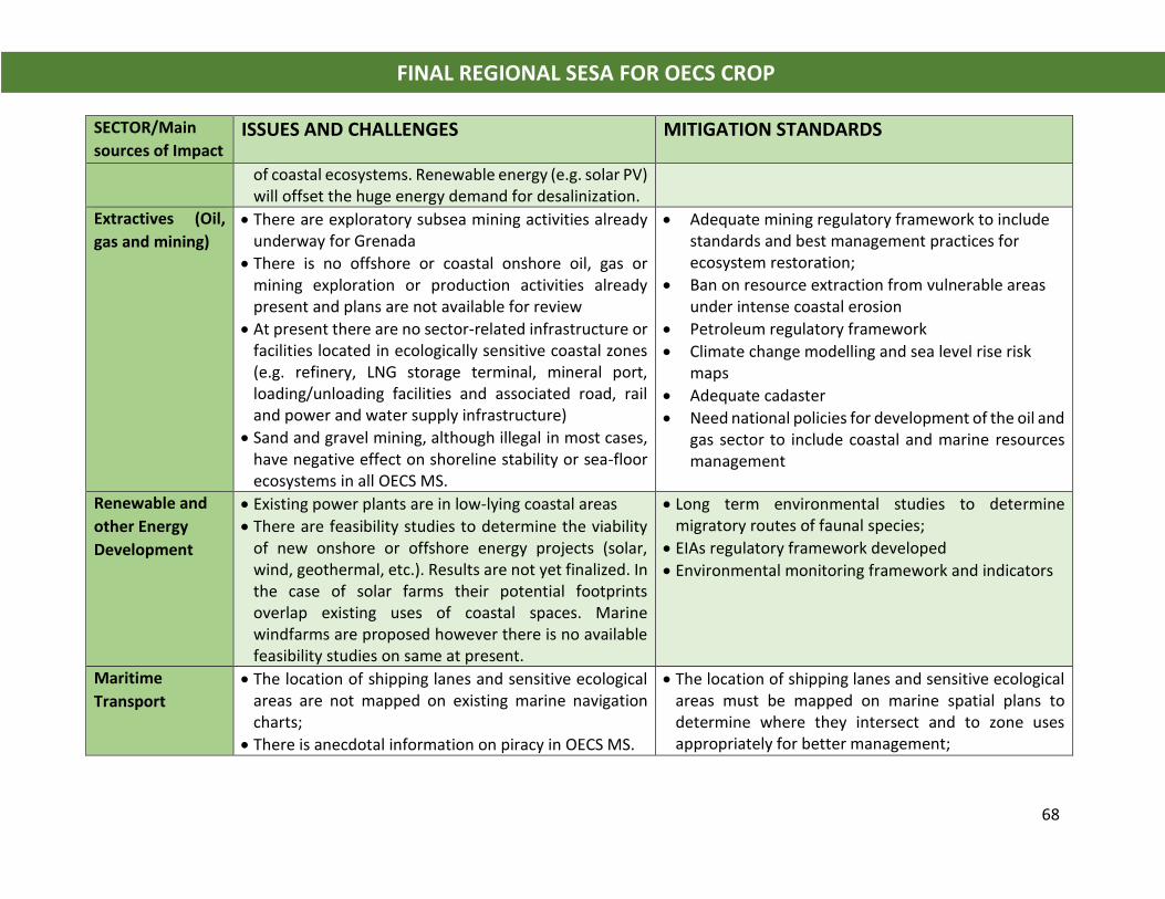
68
FINAL REGIONAL SESA FOR OECS CROP
SECTOR/Main
sources of Impact ISSUES AND CHALLENGES MITIGATION STANDARDS
of coastal ecosystems. Renewable energy (e.g. solar PV) will offset the huge energy demand for desalinization.
Extractives (Oil,
gas and mining)
• There are exploratory subsea mining activities already underway for Grenada
• There is no offshore or coastal onshore oil, gas or mining exploration or production activities already present and plans are not available for review
• At present there are no sector-related infrastructure or facilities located in ecologically sensitive coastal zones (e.g. refinery, LNG storage terminal, mineral port, loading/unloading facilities and associated road, rail and power and water supply infrastructure)
• Sand and gravel mining, although illegal in most cases, have negative effect on shoreline stability or sea-floor ecosystems in all OECS MS.
• Adequate mining regulatory framework to include standards and best management practices for ecosystem restoration;
• Ban on resource extraction from vulnerable areas under intense coastal erosion
• Petroleum regulatory framework
• Climate change modelling and sea level rise risk maps
• Adequate cadaster
• Need national policies for development of the oil and gas sector to include coastal and marine resources management
Renewable and
other Energy
Development
• Existing power plants are in low-lying coastal areas
• There are feasibility studies to determine the viability of new onshore or offshore energy projects (solar, wind, geothermal, etc.). Results are not yet finalized. In the case of solar farms their potential footprints overlap existing uses of coastal spaces. Marine windfarms are proposed however there is no available feasibility studies on same at present.
• Long term environmental studies to determine migratory routes of faunal species;
• EIAs regulatory framework developed
• Environmental monitoring framework and indicators
Maritime
Transport
• The location of shipping lanes and sensitive ecological areas are not mapped on existing marine navigation charts;
• There is anecdotal information on piracy in OECS MS.
• The location of shipping lanes and sensitive ecological areas must be mapped on marine spatial plans to determine where they intersect and to zone uses appropriately for better management;
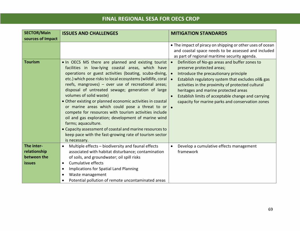
69
FINAL REGIONAL SESA FOR OECS CROP
SECTOR/Main
sources of Impact ISSUES AND CHALLENGES MITIGATION STANDARDS
• The impact of piracy on shipping or other uses of ocean and coastal space needs to be assessed and included as part of regional maritime security agenda.
Tourism • In OECS MS there are planned and existing tourist facilities in low-lying coastal areas, which have operations or guest activities (boating, scuba-diving, etc.) which pose risks to local ecosystems (wildlife, coral reefs, mangroves) – over use of recreational areas; disposal of untreated sewage; generation of large volumes of solid waste)
• Other existing or planned economic activities in coastal or marine areas which could pose a threat to or compete for resources with tourism activities include oil and gas exploration; development of marine wind farms; aquaculture.
• Capacity assessment of coastal and marine resources to keep pace with the fast-growing rate of tourism sector is necessary.
• Definition of No-go areas and buffer zones to preserve protected areas;
• Introduce the precautionary principle
• Establish regulatory system that excludes oil& gas activities in the proximity of protected cultural heritages and marine protected areas
• Establish limits of acceptable change and carrying capacity for marine parks and conservation zones
•
The inter-relationship between the
issues
• Multiple effects – biodiversity and faunal effects associated with habitat disturbance; contamination of soils, and groundwater; oil spill risks
• Cumulative effects
• Implications for Spatial Land Planning
• Waste management
• Potential pollution of remote uncontaminated areas
• Develop a cumulative effects management framework
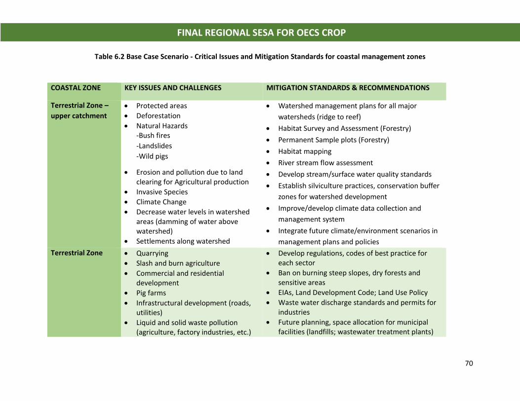
70
FINAL REGIONAL SESA FOR OECS CROP
Table 6.2 Base Case Scenario - Critical Issues and Mitigation Standards for coastal management zones
COASTAL ZONE KEY ISSUES AND CHALLENGES MITIGATION STANDARDS & RECOMMENDATIONS
Terrestrial Zone –
upper catchment
• Protected areas
• Deforestation
• Natural Hazards -Bush fires
-Landslides
-Wild pigs
• Erosion and pollution due to land clearing for Agricultural production
• Invasive Species
• Climate Change
• Decrease water levels in watershed areas (damming of water above watershed)
• Settlements along watershed
• Watershed management plans for all major
watersheds (ridge to reef)
• Habitat Survey and Assessment (Forestry)
• Permanent Sample plots (Forestry)
• Habitat mapping
• River stream flow assessment
• Develop stream/surface water quality standards
• Establish silviculture practices, conservation buffer
zones for watershed development
• Improve/develop climate data collection and
management system
• Integrate future climate/environment scenarios in
management plans and policies
Terrestrial Zone • Quarrying
• Slash and burn agriculture
• Commercial and residential development
• Pig farms
• Infrastructural development (roads, utilities)
• Liquid and solid waste pollution (agriculture, factory industries, etc.)
• Develop regulations, codes of best practice for each sector
• Ban on burning steep slopes, dry forests and sensitive areas
• EIAs, Land Development Code; Land Use Policy
• Waste water discharge standards and permits for industries
• Future planning, space allocation for municipal facilities (landfills; wastewater treatment plants)
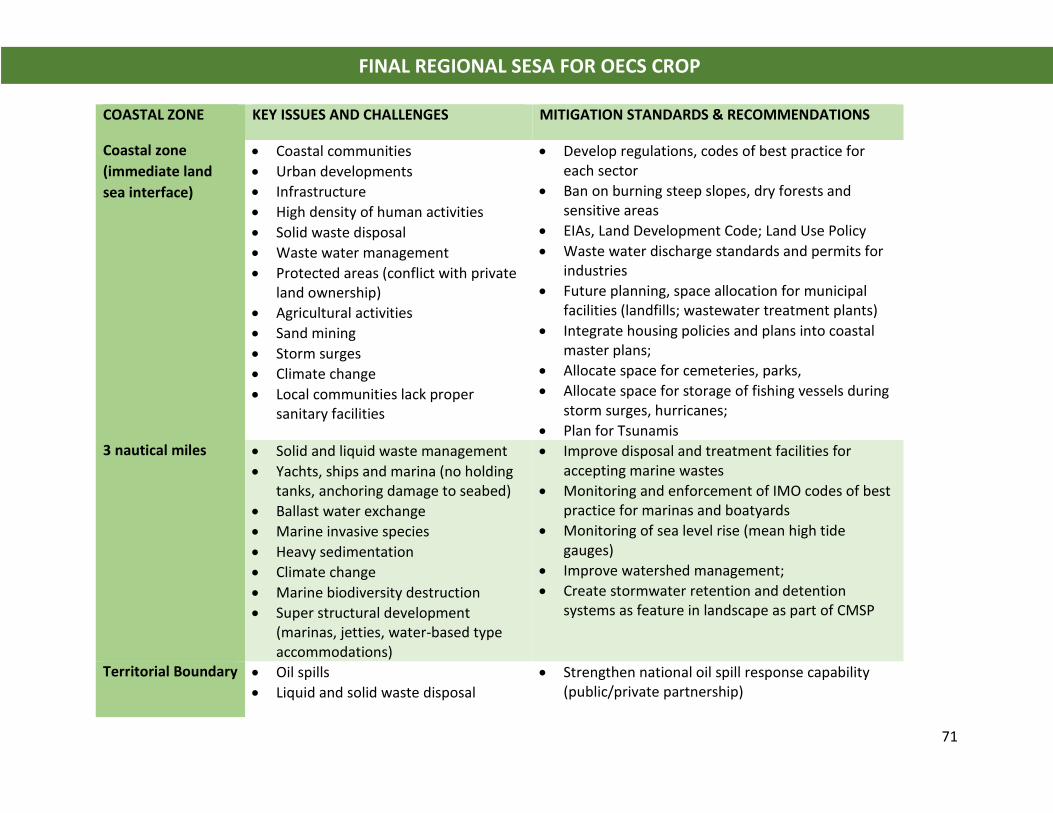
71
FINAL REGIONAL SESA FOR OECS CROP
COASTAL ZONE KEY ISSUES AND CHALLENGES MITIGATION STANDARDS & RECOMMENDATIONS
Coastal zone
(immediate land
sea interface)
• Coastal communities
• Urban developments
• Infrastructure
• High density of human activities
• Solid waste disposal
• Waste water management
• Protected areas (conflict with private land ownership)
• Agricultural activities
• Sand mining
• Storm surges
• Climate change
• Local communities lack proper sanitary facilities
• Develop regulations, codes of best practice for each sector
• Ban on burning steep slopes, dry forests and sensitive areas
• EIAs, Land Development Code; Land Use Policy
• Waste water discharge standards and permits for industries
• Future planning, space allocation for municipal facilities (landfills; wastewater treatment plants)
• Integrate housing policies and plans into coastal master plans;
• Allocate space for cemeteries, parks,
• Allocate space for storage of fishing vessels during storm surges, hurricanes;
• Plan for Tsunamis 3 nautical miles • Solid and liquid waste management
• Yachts, ships and marina (no holding tanks, anchoring damage to seabed)
• Ballast water exchange
• Marine invasive species
• Heavy sedimentation
• Climate change
• Marine biodiversity destruction
• Super structural development (marinas, jetties, water-based type accommodations)
• Improve disposal and treatment facilities for accepting marine wastes
• Monitoring and enforcement of IMO codes of best practice for marinas and boatyards
• Monitoring of sea level rise (mean high tide gauges)
• Improve watershed management;
• Create stormwater retention and detention systems as feature in landscape as part of CMSP
Territorial Boundary • Oil spills
• Liquid and solid waste disposal
• Strengthen national oil spill response capability (public/private partnership)
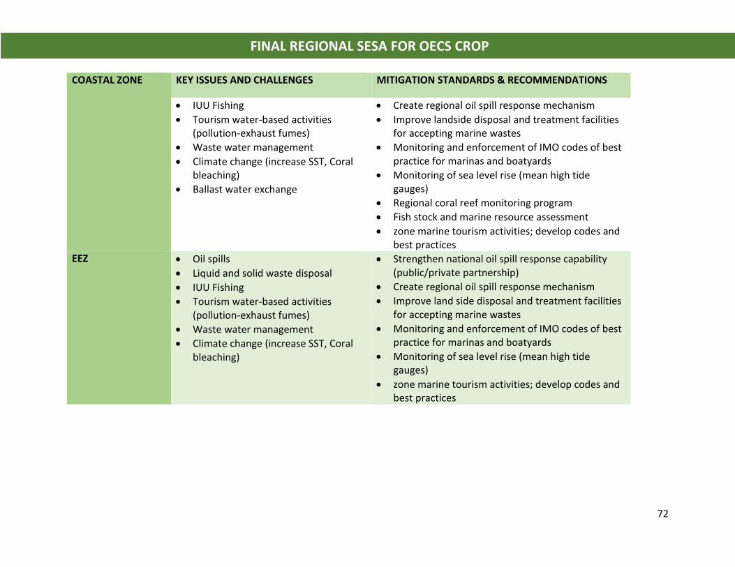
72
FINAL REGIONAL SESA FOR OECS CROP
COASTAL ZONE KEY ISSUES AND CHALLENGES MITIGATION STANDARDS & RECOMMENDATIONS
• IUU Fishing
• Tourism water-based activities (pollution-exhaust fumes)
• Waste water management
• Climate change (increase SST, Coral bleaching)
• Ballast water exchange
• Create regional oil spill response mechanism
• Improve landside disposal and treatment facilities for accepting marine wastes
• Monitoring and enforcement of IMO codes of best practice for marinas and boatyards
• Monitoring of sea level rise (mean high tide gauges)
• Regional coral reef monitoring program
• Fish stock and marine resource assessment
• zone marine tourism activities; develop codes and best practices
EEZ • Oil spills
• Liquid and solid waste disposal
• IUU Fishing
• Tourism water-based activities (pollution-exhaust fumes)
• Waste water management
• Climate change (increase SST, Coral bleaching)
• Strengthen national oil spill response capability (public/private partnership)
• Create regional oil spill response mechanism
• Improve land side disposal and treatment facilities for accepting marine wastes
• Monitoring and enforcement of IMO codes of best practice for marinas and boatyards
• Monitoring of sea level rise (mean high tide gauges)
• zone marine tourism activities; develop codes and best practices
73
FINAL REGIONAL SESA FOR OECS CROP
7.0 ANALYSIS OF ALTERNATIVES As noted in Section 3.2, the participating OECS Member States have yet to clearly define
their national objectives for coastal and marine spatial plans. The Grenada Blue Growth
Master Plan is an investment promotion strategy and does not represent the national
2030 development strategy which is still in the formulation stage. Further, public
consultation was limited to selected stakeholder groups and did not involve those
communities or stakeholder groups who are most likely to be directly affected by the
proposals.
Increased socio-economic development through increased utilization of coastal and
marine resources will result in negative externalities that must be managed. Member
States in setting the vision and objectives for the Blue Economy and CMSPs must
determine the limits of acceptable change, natural resource carrying capacity and the
cumulative effects of interrelated impacts (example energy, wastewater management,
solid waste management, air and water quality, and resilient critical infrastructure, roads,
hospitals).
It is critical that plans do not lead to social amplification of risk through:
f) Location of new facilities and/or increased development of critical infrastructure in
hazard prone areas;
g) Exceeding the capacity of critical infrastructure within towns and tourism
development centers such as drainage, potable water networks, waste management
and disposal facilities, road networks, hospitals, community centers, evacuation
routes, shelters and disaster management resources;
h) Failure to restore degraded ecosystems through rehabilitation projects;
i) Failure to manage land-based sources of impact and pollution such as storm water
run-off, construction, agriculture and upland watershed degradation;
j) Lack of accounting for increased coastal flooding due to increased development of
watersheds, climate change and future sea level rise scenarios.
74
FINAL REGIONAL SESA FOR OECS CROP
For instance, in a practical way the GBGMP should be revisited accounting for the above
factors. Plans for development of coastal marine villages at the mouth of the St. John’s
River and the Victoria Town should consider integration of soft ecological engineering
design approaches such as coastal wetland parks that can mitigate the impact of coastal
flooding and protect marine resources.
As noted in the CROP Feasibility Study “the goals for the MSP should be guided by:
1. The possible threats to the marine environment in the country;
2. The social, environmental, economic, and cultural policy direction of the country;
3. Build upon national policies and regional and international commitments; and
4. Be guided by proposed future uses of the marine space”.
The analysis of alternatives must be guided by Critical Factors for Decision Making (CFDM)
which constitute the fundamental decision-making factors that underlie the focus of the
SESA. They identify those aspects that must be considered in the decision process
concerning the strategic design and the implementation of actions for effective
management of environmental and social issues arising from development of coastal and
marine spatial plans for OECS States. These factors satisfy the scope of the SESA and are
generated out of the situation and stakeholder analysis of the following:
• Objectives of the SEA;
• Legal, institutional and regulatory considerations;
• Environmental and social factors; and
• Current and future scenarios for development of coastal and marine spatial
plans in OECS States
The critical factors for decision making and the reason for their inclusion are presented in
Table 7.1 on the following page.
75
FINAL REGIONAL SESA FOR OECS CROP
Table 7.1 Critical Factors for Decision Making in Development of Coastal and Marine Spatial Plans
CRITICAL FACTORS FOR
DECISION MAKING
REASON FOR INCLUSION
Legal and Regulatory
Framework
• Currently not fully developed in OECS States
• Incomplete regulations for management of coastal and marine resources
• Conflicting and overlapping responsibility among various ministries
• No capacity for regulation or compliance Institutional Capacity • Conflicting roles and responsibilities for environmental protection
and management
• Poor inter-institutional coordination
• Low technical capability for coastal and marine resources management
• Unknown training requirements and capabilities
• Low Capacity for SESA implementation
Planning and Decision-
making Process
• Environmental factors not included in economic planning
• Sector approach to planning
• Short term planning cycles
• Ecosystem-based approach to planning needed
• Decision support systems need to be adopted
• Climate change modeling and future risk assessment Stakeholder
Participation in
Decision Making
• Incomplete legal framework for stakeholder participation
• Low stakeholder capacity and action
• Lack of stakeholder participation in setting development agenda
• Need for transparency of revenue flows and resource allocation
• Mechanisms for community development limited Social • Protect vulnerable groups; Fisherfolk; Kalinago peoples in Dominica
• Recognize cultural diversity
• Avoid resource conflicts and compulsory take of private lands
• Minimize expectations over benefits of exploitation of Blue Economy Ecosystem Integrity and
Biodiversity
Conservation
• Importance of marine parks and protected areas
• Importance of critical species
• Capacity for protection of protected areas and biodiversity is limited
• Resource assessment and monitoring lacking • Limits of acceptable change and ecosystem carrying capacity needs
to be determined Risk Management • Regional mechanism for collaboration, coordination of response and
compliance needed
• Planning for climate change, tsunamis and natural hazard risks • Integration of environment with social and economic objectives
SESA Implementation • Success of SESA depends on its implementation
• Follow up measures, indicators needed
76
FINAL REGIONAL SESA FOR OECS CROP
8.0 MITIGATION OR OPTIMISING MEASURES Critical Risks and Mitigation Standards for Future Scenario
Under the future scenario, critical risks and mitigation standards are provided for the key
sectors which were identified in the base-case scenario in Tables 6.1 and 6.2. Feedback
from stakeholders at the Grenada SESA Stakeholder Consultation on July 23, 2018 as well
as those from previous consultations are also utilized in this assessment.
Given that the GBGMP is an investment promotion tool and not the national development
strategy for 2030, no particular aspects are assessed as their implementation will be
driven by private investments and likely to change in scope and location. Further
development of these proposals for actual implementation must be guided by detailed
environmental and social impact assessments, including scenarios for climate change, sea
level rise and natural hazard risk exposure.
The environmental, social risk and development scenarios for exploitation of oil/gas
sector in the OECS are purely speculative due to the following reasons:
o There is a lack of a clear understanding of actual and proposed government
programs with regard development of the sector (Grenada in particular);
o Unavailability of official or other scientific public data concerning the hydrocarbon
potential estimates of both onshore basin and coastal basin in terms of hydrocarbon
generation potential, expected products (liquid vs. gaseous hydrocarbons), possible
field size distribution (from other play type analogue studies);
o At present there is no license offshore acreage or areas identified for oil and gas
exploration in the OECS States;
o There are no indications where future activities are likely to develop; and
o There are no policies for development of the oil and gas sector in OECS States.
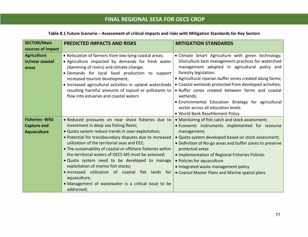
77
FINAL REGIONAL SESA FOR OECS CROP
Table 8.1 Future Scenario – Assessment of critical impacts and risks with Mitigation Standards for Key Sectors
SECTOR/Main
sources of Impact PREDICTED IMPACTS AND RISKS MITIGATION STANDARDS
Agriculture
in/near coastal
areas
• Relocation of farmers from low-lying coastal areas;
• Agriculture impacted by demands for fresh water (damming of rivers) and climate change;
• Demands for local food production to support increased tourism development;
• Increased agricultural activities in upland watersheds resulting harmful amounts of topsoil or pollutants to flow into estuaries and coastal waters
• Climate Smart Agriculture with green technology; Silviculture best management practices for watershed management adopted in agricultural policy and forestry legislation;
• Agricultural riparian buffer zones created along farms;
• Coastal wetlands protected from developed activities;
• Buffer zones created between farms and coastal wetlands;
• Environmental Education Strategy for agricultural sector across all education levels
• World Bank Resettlement Policy
Fisheries- Wild
Capture and
Aquaculture
• Reduced pressures on near shore fisheries due to investment in deep sea fishing fleets;
• Quota system reduce trends in over-exploitation;
• Potential for transboundary disputes due to increased utilization of the territorial seas and EEZ;
• The sustainability of coastal or offshore fisheries within the territorial waters of OECS MS must be assessed;
• Quota system need to be developed to manage exploitation of marine fish stocks;
• Increased utilization of coastal flat lands for aquaculture;
• Management of wastewater is a critical issue to be addressed;
• Monitoring of fish catch and stock assessment;
• Economic instruments implemented for resource management;
• Quota system developed based on stock assessment;
• Definition of No-go areas and buffer zones to preserve protected areas
• Implementation of Regional Fisheries Policies
• Policies for aquaculture
• Integrated waste management policy
• Coastal Master Plans and Marine spatial plans
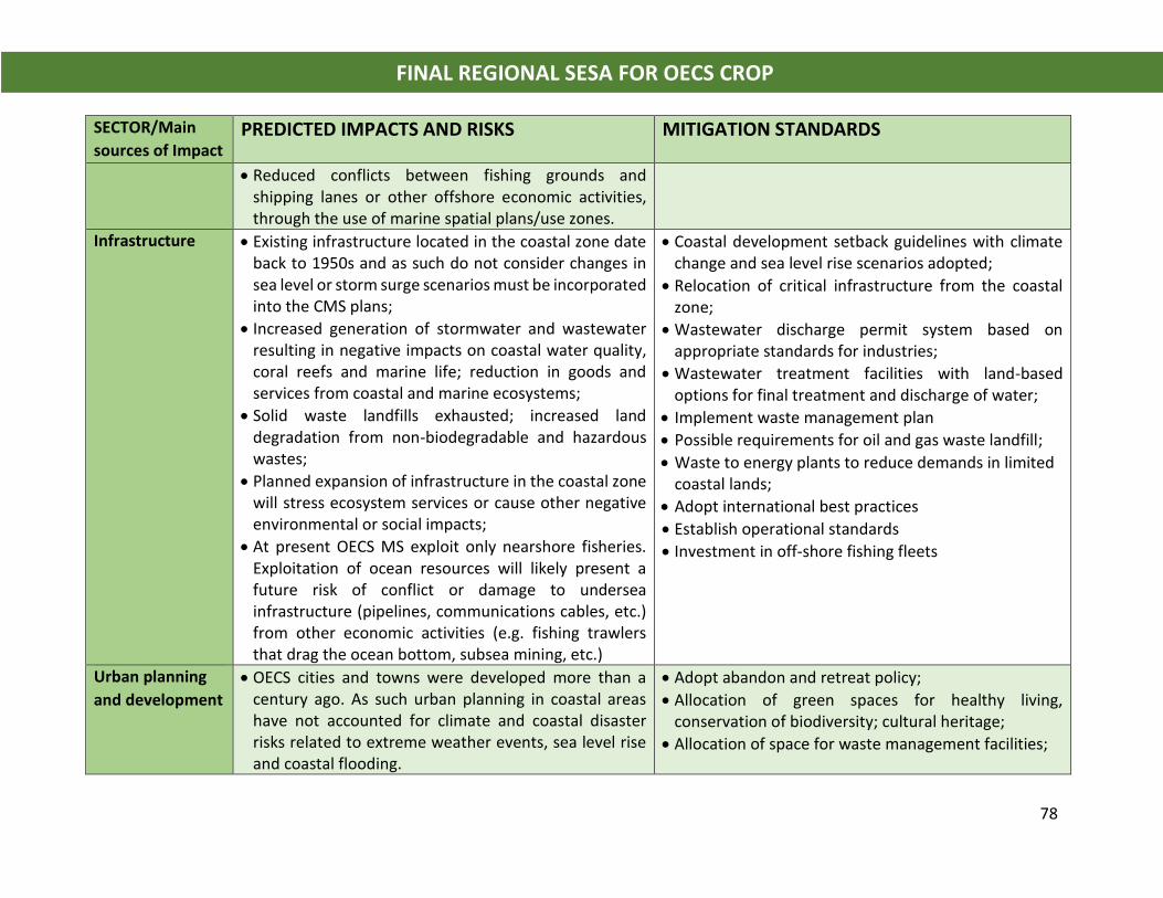
78
FINAL REGIONAL SESA FOR OECS CROP
SECTOR/Main
sources of Impact PREDICTED IMPACTS AND RISKS MITIGATION STANDARDS
• Reduced conflicts between fishing grounds and shipping lanes or other offshore economic activities, through the use of marine spatial plans/use zones.
Infrastructure • Existing infrastructure located in the coastal zone date back to 1950s and as such do not consider changes in sea level or storm surge scenarios must be incorporated into the CMS plans;
• Increased generation of stormwater and wastewater resulting in negative impacts on coastal water quality, coral reefs and marine life; reduction in goods and services from coastal and marine ecosystems;
• Solid waste landfills exhausted; increased land degradation from non-biodegradable and hazardous wastes;
• Planned expansion of infrastructure in the coastal zone will stress ecosystem services or cause other negative environmental or social impacts;
• At present OECS MS exploit only nearshore fisheries. Exploitation of ocean resources will likely present a future risk of conflict or damage to undersea infrastructure (pipelines, communications cables, etc.) from other economic activities (e.g. fishing trawlers that drag the ocean bottom, subsea mining, etc.)
• Coastal development setback guidelines with climate change and sea level rise scenarios adopted;
• Relocation of critical infrastructure from the coastal zone;
• Wastewater discharge permit system based on appropriate standards for industries;
• Wastewater treatment facilities with land-based options for final treatment and discharge of water;
• Implement waste management plan
• Possible requirements for oil and gas waste landfill;
• Waste to energy plants to reduce demands in limited coastal lands;
• Adopt international best practices
• Establish operational standards
• Investment in off-shore fishing fleets
Urban planning
and development
• OECS cities and towns were developed more than a century ago. As such urban planning in coastal areas have not accounted for climate and coastal disaster risks related to extreme weather events, sea level rise and coastal flooding.
• Adopt abandon and retreat policy;
• Allocation of green spaces for healthy living, conservation of biodiversity; cultural heritage;
• Allocation of space for waste management facilities;
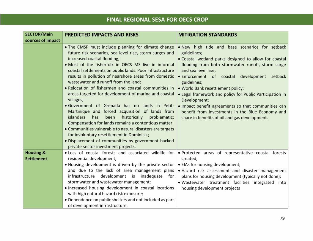
79
FINAL REGIONAL SESA FOR OECS CROP
SECTOR/Main
sources of Impact PREDICTED IMPACTS AND RISKS MITIGATION STANDARDS
• The CMSP must include planning for climate change future risk scenarios, sea level rise, storm surges and increased coastal flooding;
• Most of the fisherfolk in OECS MS live in informal coastal settlements on public lands. Poor infrastructure results in pollution of nearshore areas from domestic wastewater and runoff from the land;
• Relocation of fishermen and coastal communities in areas targeted for development of marina and coastal villages;
• Government of Grenada has no lands in Petit-Martinique and forced acquisition of lands from islanders has been historically problematic; Compensation for lands remains a contentious matter
• Communities vulnerable to natural disasters are targets for involuntary resettlement in Dominica.;
• Displacement of communities by government backed private-sector investment projects.
• New high tide and base scenarios for setback guidelines;
• Coastal wetland parks designed to allow for coastal flooding from both stormwater runoff, storm surge and sea level rise;
• Enforcement of coastal development setback guidelines;
• World Bank resettlement policy;
• Legal framework and policy for Public Participation in Development;
• Impact benefit agreements so that communities can benefit from investments in the Blue Economy and share in benefits of oil and gas development.
Housing &
Settlement
• Loss of coastal forests and associated wildlife for residential development;
• Housing development is driven by the private sector and due to the lack of area management plans infrastructure development is inadequate for stormwater and wastewater management;
• Increased housing development in coastal locations with high natural hazard risk exposure;
• Dependence on public shelters and not included as part of development infrastructure.
• Protected areas of representative coastal forests created;
• EIAs for housing development;
• Hazard risk assessment and disaster management plans for housing development (typically not done);
• Wastewater treatment facilities integrated into housing development projects
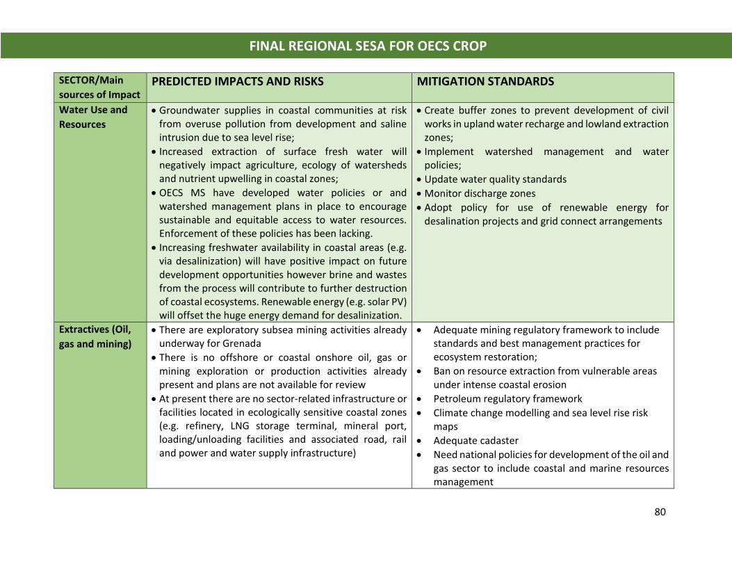
80
FINAL REGIONAL SESA FOR OECS CROP
SECTOR/Main
sources of Impact PREDICTED IMPACTS AND RISKS MITIGATION STANDARDS
Water Use and
Resources
• Groundwater supplies in coastal communities at risk from overuse pollution from development and saline intrusion due to sea level rise;
• Increased extraction of surface fresh water will negatively impact agriculture, ecology of watersheds and nutrient upwelling in coastal zones;
• OECS MS have developed water policies or and watershed management plans in place to encourage sustainable and equitable access to water resources. Enforcement of these policies has been lacking.
• Increasing freshwater availability in coastal areas (e.g. via desalinization) will have positive impact on future development opportunities however brine and wastes from the process will contribute to further destruction of coastal ecosystems. Renewable energy (e.g. solar PV) will offset the huge energy demand for desalinization.
• Create buffer zones to prevent development of civil works in upland water recharge and lowland extraction zones;
• Implement watershed management and water policies;
• Update water quality standards
• Monitor discharge zones
• Adopt policy for use of renewable energy for desalination projects and grid connect arrangements
Extractives (Oil,
gas and mining)
• There are exploratory subsea mining activities already underway for Grenada
• There is no offshore or coastal onshore oil, gas or mining exploration or production activities already present and plans are not available for review
• At present there are no sector-related infrastructure or facilities located in ecologically sensitive coastal zones (e.g. refinery, LNG storage terminal, mineral port, loading/unloading facilities and associated road, rail and power and water supply infrastructure)
• Adequate mining regulatory framework to include standards and best management practices for ecosystem restoration;
• Ban on resource extraction from vulnerable areas under intense coastal erosion
• Petroleum regulatory framework
• Climate change modelling and sea level rise risk maps
• Adequate cadaster
• Need national policies for development of the oil and gas sector to include coastal and marine resources management
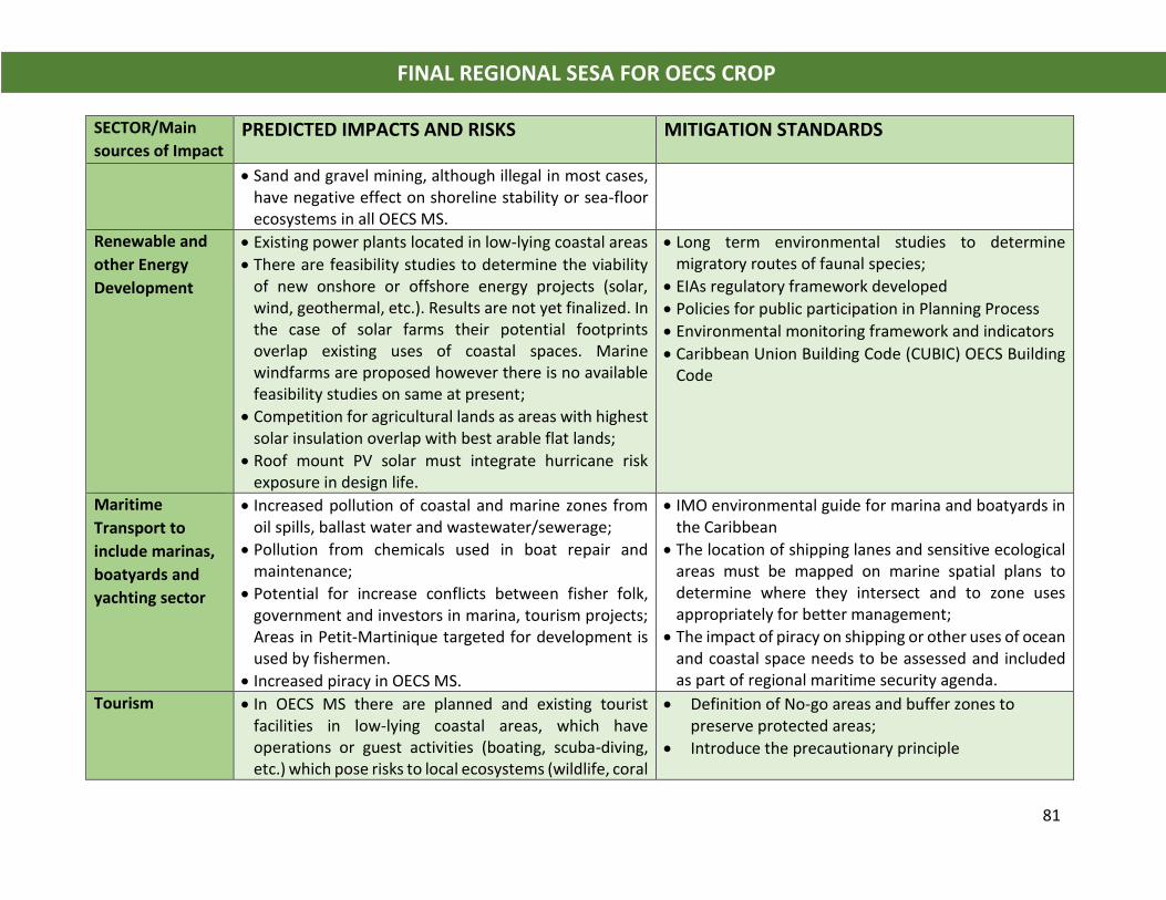
81
FINAL REGIONAL SESA FOR OECS CROP
SECTOR/Main
sources of Impact PREDICTED IMPACTS AND RISKS MITIGATION STANDARDS
• Sand and gravel mining, although illegal in most cases, have negative effect on shoreline stability or sea-floor ecosystems in all OECS MS.
Renewable and
other Energy
Development
• Existing power plants located in low-lying coastal areas
• There are feasibility studies to determine the viability of new onshore or offshore energy projects (solar, wind, geothermal, etc.). Results are not yet finalized. In the case of solar farms their potential footprints overlap existing uses of coastal spaces. Marine windfarms are proposed however there is no available feasibility studies on same at present;
• Competition for agricultural lands as areas with highest solar insulation overlap with best arable flat lands;
• Roof mount PV solar must integrate hurricane risk exposure in design life.
• Long term environmental studies to determine migratory routes of faunal species;
• EIAs regulatory framework developed
• Policies for public participation in Planning Process
• Environmental monitoring framework and indicators
• Caribbean Union Building Code (CUBIC) OECS Building Code
Maritime
Transport to
include marinas,
boatyards and
yachting sector
• Increased pollution of coastal and marine zones from oil spills, ballast water and wastewater/sewerage;
• Pollution from chemicals used in boat repair and maintenance;
• Potential for increase conflicts between fisher folk, government and investors in marina, tourism projects; Areas in Petit-Martinique targeted for development is used by fishermen.
• Increased piracy in OECS MS.
• IMO environmental guide for marina and boatyards in the Caribbean
• The location of shipping lanes and sensitive ecological areas must be mapped on marine spatial plans to determine where they intersect and to zone uses appropriately for better management;
• The impact of piracy on shipping or other uses of ocean and coastal space needs to be assessed and included as part of regional maritime security agenda.
Tourism • In OECS MS there are planned and existing tourist facilities in low-lying coastal areas, which have operations or guest activities (boating, scuba-diving, etc.) which pose risks to local ecosystems (wildlife, coral
• Definition of No-go areas and buffer zones to preserve protected areas;
• Introduce the precautionary principle
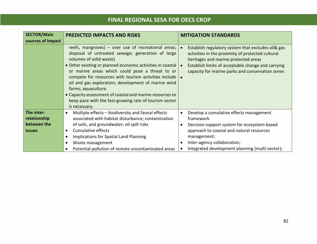
82
FINAL REGIONAL SESA FOR OECS CROP
SECTOR/Main
sources of Impact PREDICTED IMPACTS AND RISKS MITIGATION STANDARDS
reefs, mangroves) – over use of recreational areas; disposal of untreated sewage; generation of large volumes of solid waste)
• Other existing or planned economic activities in coastal or marine areas which could pose a threat to or compete for resources with tourism activities include oil and gas exploration; development of marine wind farms; aquaculture.
• Capacity assessment of coastal and marine resources to keep pace with the fast-growing rate of tourism sector is necessary.
• Establish regulatory system that excludes oil& gas activities in the proximity of protected cultural heritages and marine protected areas
• Establish limits of acceptable change and carrying capacity for marine parks and conservation zones
•
The inter-relationship between the
issues
• Multiple effects – biodiversity and faunal effects associated with habitat disturbance; contamination of soils, and groundwater; oil spill risks
• Cumulative effects
• Implications for Spatial Land Planning
• Waste management
• Potential pollution of remote uncontaminated areas
• Develop a cumulative effects management framework
• Decision-support system for ecosystem-based approach to coastal and natural resources management;
• Inter-agency collaboration;
• Integrated development planning (multi-sector);
August, 2018 Final edit November 2018 83
FINAL REGIONAL SESA FOR OECS CROP
9.0 INDICATORS, INSTITUTIONAL CAPACITIES AND GAP ANALYSIS
9.1 Indicators
Weak or poor governance has been cited as a significant contributor to over-exploitation
of marine resources, environmental pollution and degradation of the Caribbean Sea. A
framework for good governance was developed as a means of conducting an analysis of
institutional capacities in OECS Member States. An indicator is a quantitative, qualitative
or descriptive attribute that, if measured or monitored periodically, could indicate the
direction of change in governance.
There are three key components of the framework for good governance: 1) Legal,
regulatory and Institutional Framework; 2) Planning and Decision-Making Process; and 3)
Implementation, Compliance and Monitoring. The principles which underpin these
components or pillars of good governance are:
• Transparency
• Accountability
• Fairness/Equity
• Participation
• Effectiveness
• Efficiency
The framework utilized in this assessment does not specify indicators since they are
necessarily country, context and situation-specific. Instead, a structure for contextualizing
the many governance indicators already in existence or under development and the areas
where there are constraints or gaps to be filled, is provided. According to their aims and
areas of interest and the constraints they face concerning data and resource availability,
stakeholders in OECS Member States are encouraged and expected to choose from the
Framework’s subcomponents and develop new indicators or adopt or modify existing
indicators for the subcomponents as needed and appropriate.

84
FINAL REGIONAL SESA FOR OECS CROP
9.2 Framework for Good Governance The three main components of good governance were applied in the Situation and
Stakeholder Analysis:
Figure 9.1 Components and Principles for Good governance (compiled/drawn by author)
• Component 1: Policy, Legal, Institutional and regulatory frameworks. This
considers the long-term systems of policies, laws, rules and regulations for
management of coastal and marine resources within the various sectors that
impinge upon the coastal zone. An analysis of this component of good governance
must address the clarity and coherence of these frameworks and how they
interact to define the overall context for use, management and decision-making
with regards resources in the coastal zone.
• Component 2: Planning and Decision-making processes: is concerned with the
degree of transparency, accountability and inclusiveness of key natural resources
management process and institutions. This component of good governance
Good
Governance
Implementation
Enforcement and
Compliance
Policy, Legal,
Institutional and
Regulatory
Framework
Planning &
Decision-making
Process
Accountability
Fairness/Equity
85
FINAL REGIONAL SESA FOR OECS CROP
explores the characteristics of these process and institutions, the operation of key
agencies, the space they create for the participation of stakeholders, the
accountability of power holders and decision makers.
• Component 3: Implementation, enforcement and compliance. This component of
good governance examines the extent to which the policy, legal, institutional and
regulatory frameworks are implemented. It further considers the level of
effectiveness, efficiency and equitability of implementation.
These three components are mutually exclusive yet re-enforcing of each other so that
failure across one component will affect effective governance, maintaining
environmental quality and sustainable development. They are underpinned by the
principles of accountability, effectiveness, efficiency, fairness/equity, participation and
transparency.
9.3 Regional Gap Analysis - Political Economy Constraints
9.3.1 Independent Small Island States
o Regional treaties and agreements have no direct effect at the national level and must
first be adopted into domestic legislation and policies to enter into force.
o Spatial management of coastal and marine resources also requires that the
geographic boundaries or limits of territories be defined. The OECS MS have made
significant progress in recent times towards formalization of their maritime
boundaries and exclusive economic zones (EEZ).
o All the territories within the marine space do not belong to the OECS Union which
introduces another layer of complexity for negotiating transboundary matters.
Dominica for instance shares its EEZ boundaries with Martinique and Guadeloupe
which are both French overseas territories. On issues related to fisheries and ocean
governance directives of the European Union take effect.
o The disparity in political and economic status thus means that small states are often
disadvantaged in negotiations on trade.
86
FINAL REGIONAL SESA FOR OECS CROP
o Competition among territories for trade, tourism arrivals and private sector
investment opportunities. Each OECS Member State has some form of citizen by
investment (CBI) program.
o OECS States are required to meet standards which when compared to larger states do
not have the human, technical and financial resources to enable their compliance.
However, there is progress towards improving transboundary management of the
common marine space as Martinique has achieved observer status within the OECS Union
and Guadeloupe has indicated interest to follow. Other territorial interest in the eastern
Caribbean region include the USA, Britain, the Netherlands, Trinidad and Tobago,
Barbados and Venezuela. OECS States have common economic and social partnership
with Barbados, Trinidad and Tobago through their membership in CARICOM, ACS and
OAS.
9.3.2 Governance arrangements
9.3.2.1 Legal and Regulatory Framework
From the review conducted by Singh 2008, it can be concluded that there is a robust
regulatory framework for Caribbean ocean’s governance at the international level (See
Figure 3.1 and Annex I this Report). A work plan was formulated by the Association of
Caribbean States (ACS) and UNECLAC to track progress in implementation of the
obligations under the various resolutions and agreements. Following from the work of the
ACS, Singh concludes that “large cohort of responses have been undertaken by States and
it shows that actions are being taken in the region.
For example, projects were undertaken to address integrated coastal zone management,
upgrading contingency plans for port States, addressing oil pollution and information and
training for oil spill response among others”.
There is need for a common legal framework for Caribbean oceans governance, to
rationalize the various MEAs and develop coordinating mechanisms for their
implementation.
87
FINAL REGIONAL SESA FOR OECS CROP
9.3.2.2 Planning and Decision-Making Process
Regional planning is sectoral and there is no lead regional environmental management or
protection agency to coordinate planning across sectors and organizations. With few
exceptions, planning results in policy and strategy formulation with limited direct
implementation of results-oriented pilot projects. There is need for greater involvement
in stakeholder participation in development planning and decision-making process. OECS
States have yet to fully implement policies and legal framework for public participation.
They have recently agreed to/signed the “Regional Agreement on Access to Information,
Participation and Justice in Environmental Matters”. However, there is no clear regional
mechanism for implementation of this agreement which must first be adopted into
domestic legislation to take effect.
9.3.2.4 Implementation, Monitoring and Compliance
Implementation of regional policies, programs of action and or projects takes place at the
national level. This is often delivered in collaboration with public sector ministries or
through direct contracting with private sector consultants, non-governmental and
community-based organizations. Regional organisations therefore tend to operate in a
project management mode coordinating delivery of outcomes to national stakeholders.
The framework for regional corporation for fisheries is provided for in the various
Fisheries Regulations of the individual Member States. The project document for the
CLME+ provides a thorough situation and baseline analysis on the regional mechanisms
for CSMP in the Caribbean (2015). A regional Transboundary Diagnostic Analysis (TDA)
was also undertaken for Caribbean Large Marine Ecosystems in 2011. These reports
present details on the nature of the regional mechanisms, mainly advisory, which are
important for marine resources management especially fisheries.
In addition to OECS and CARICOM, the regional arrangements which support efforts at
the national level through collaboration on training, research, monitoring and other areas
of technical cooperation include:
• UNEP Caribbean Environment Programme (UNEP CEP)
88
FINAL REGIONAL SESA FOR OECS CROP
• Western Central Atlantic Fisheries Commission (FAO-WECAFC)
• Caribbean Community Common Fisheries Policy (CARICOM-CCCFP) and CARICOM
Regional Fisheries Mechanism (CRFM)
• OSPESCA Regional Fisheries & Aquaculture Policy
• CRFM-OSPESCA Memorandum of Understanding (MoU) and Joint Action Plan
• Regional Environmental Framework Strategy for Central America (ERAM-CCAD)
• European Marine Strategy Framework Directive (MSFD)
• European Water Framework Directive (WFD)
• USA Ocean Policy and Implementation Plan
• NOAA Caribbean Strategy
There is no regional mechanism for monitoring and ensuring compliance with
environmental conventions, treatise and multi-lateral environmental agreements.
9.4 National Gap Assessment
9.4.1 Component 1: Policy, Legal, Institutional and Regulatory Framework
The policy legal, institutional and regulatory framework for coastal and marine spatial
planning addresses five key issues or sub-components:
1. Laws, policies and strategies related to coastal and marine management
2. Legal framework to support and protect land tenure, ownership and use rights
3. Broader development policies integrated with coastal and marine policies
4. Institutional frameworks
5. Financial incentives, economic instruments and benefits sharing
Table 9.1 provides the findings of the Situation and Stakeholder Analysis on the five sub-
components above. The main recommendations are:
• Outdated legislation which must be modernized to suit current and emerging trends
in resource management. Annex I provides a comprehensive listing of the legal
framework for each participating OECS Member State.
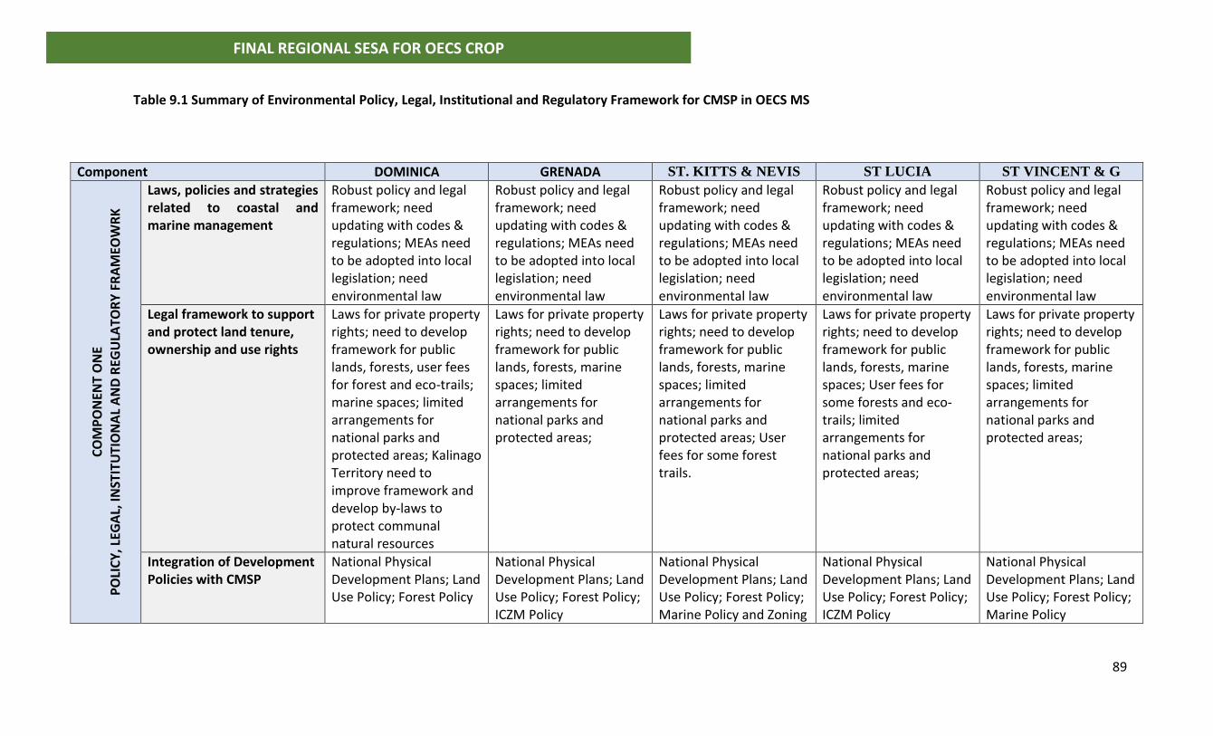
89
FINAL REGIONAL SESA FOR OECS CROP
Table 9.1 Summary of Environmental Policy, Legal, Institutional and Regulatory Framework for CMSP in OECS MS
Component DOMINICA GRENADA ST. KITTS & NEVIS ST LUCIA ST VINCENT & G
CO
MP
ON
ENT
ON
E
PO
LIC
Y, L
EGA
L, IN
STIT
UTI
ON
AL
AN
D R
EGU
LATO
RY
FR
AM
EOW
RK
Laws, policies and strategies related to coastal and marine management
Robust policy and legal framework; need updating with codes & regulations; MEAs need to be adopted into local legislation; need environmental law
Robust policy and legal framework; need updating with codes & regulations; MEAs need to be adopted into local legislation; need environmental law
Robust policy and legal framework; need updating with codes & regulations; MEAs need to be adopted into local legislation; need environmental law
Robust policy and legal framework; need updating with codes & regulations; MEAs need to be adopted into local legislation; need environmental law
Robust policy and legal framework; need updating with codes & regulations; MEAs need to be adopted into local legislation; need environmental law
Legal framework to support and protect land tenure, ownership and use rights
Laws for private property rights; need to develop framework for public lands, forests, user fees for forest and eco-trails; marine spaces; limited arrangements for national parks and protected areas; Kalinago Territory need to improve framework and develop by-laws to protect communal natural resources
Laws for private property rights; need to develop framework for public lands, forests, marine spaces; limited arrangements for national parks and protected areas;
Laws for private property rights; need to develop framework for public lands, forests, marine spaces; limited arrangements for national parks and protected areas; User fees for some forest trails.
Laws for private property rights; need to develop framework for public lands, forests, marine spaces; User fees for some forests and eco-trails; limited arrangements for national parks and protected areas;
Laws for private property rights; need to develop framework for public lands, forests, marine spaces; limited arrangements for national parks and protected areas;
Integration of Development Policies with CMSP
National Physical Development Plans; Land Use Policy; Forest Policy
National Physical Development Plans; Land Use Policy; Forest Policy; ICZM Policy
National Physical Development Plans; Land Use Policy; Forest Policy; Marine Policy and Zoning
National Physical Development Plans; Land Use Policy; Forest Policy; ICZM Policy
National Physical Development Plans; Land Use Policy; Forest Policy; Marine Policy
90
FINAL REGIONAL SESA FOR OECS CROP
Institutional Framework Cultural norms and practices influence the use of natural resources; Kalinago Territory traditional practices determine how natural resources are managed
Cultural norms and practices influence the use of natural resources; Conflict with implementation of formal rules and regulations for natural resources management
Cultural norms and practices influence the use of natural resources; Conflict with implementation of formal rules and regulations for natural resources management,
Cultural norms and practices influence the use of natural resources; Conflict with implementation of formal rules and regulations for natural resources management
Cultural norms and practices influence the use of natural resources; Conflict with implementation of formal rules and regulations for natural resources management
Financial Incentives, Economic Instruments and Benefits sharing
Tax free concessions fishing and tourism sector; no license fees; no quotas; limited use of economic instruments for resource management
Tax free concessions fishing and tourism sector; no license fees; no quotas; limited use of economic instruments for resource management
Tax free concessions fishing and tourism sector; no license fees; no quotas; limited use of economic instruments for resource management
Tax free concessions fishing and tourism sector; no license fees; no quotas; limited use of economic instruments for resource management
Tax free concessions fishing and tourism sector; no license fees; no quotas; limited use of economic instruments for resource management
91
FINAL REGIONAL SESA FOR OECS CROP
• International conventions and MEAs must be incorporated into national legislation
during the process of modernization.
• Framework for public participation needs to be developed with the entry into force of
Freedom of Information Act and supporting legislation.
• Financial incentives such as concessions are distortionary resulting in over-
exploitation of natural resources; there is need for review and overhaul of
Government duty free and tax incentive regimes;
• Economic instruments must be used to manage coastal and marine resources.
9.4.2 Component 2: Planning and Decision-making Process
To provide an analysis of the second component of governance, five sub-components
were considered:
1. The Planning Context and Levels of Planning
2. Planning Process
3. Stakeholder Participation
4. Transparency and accountability
5. Stakeholder capacity and action
Table 9.2 provides a summary of the assessment of the five-subcomponents. The key
findings and recommendations from the Situation and Stakeholder Analysis are:
• Planning in the OECS MS is driven by current socio-economic factors so that planning
is focused on short term responses to provide jobs, reduce the debt to GDP ratio and
sustain economic growth. Environmental considerations are not factored into the
planning context resulting in degradation of natural assets. OECS MS must integrate
natural resources management into the economic planning context to achieve
sustainable development.
• The planning process needs to evolve to include decision support systems to make
operational an ecosystems-based approach to coastal and marine spatial planning;
• The legal framework for stakeholder participation must be improved to allow for
meaningful participation in the planning and development process.
92
FINAL REGIONAL SESA FOR OECS CROP
Table 9.2 Component 2 Governance Framework – Planning and Decision-Making Process for CMSP in OECS MS
Component Dominica Grenada St. Kitts and Nevis St Lucia St. Vincent & Grenadines
CO
MP
ON
ENT
TWO
P
LAN
NIN
G A
ND
DEC
ISIO
N M
AK
ING
PR
OC
ESS
Planning Context and Levels of Planning
Socio-economic drivers (job creation and economic growth); project driven; sectoral development plans
Socio-economic drivers (job creation and economic growth); project driven
Sector and project basis in response to socio-economic drivers (job creation and economic growth)
Sector and project basis in response to socio-economic drivers (job creation and economic growth)
Sector and project basis in response to socio-economic drivers (job creation and economic growth)
Planning Process & Decision Support Systems
Public sector; lack of decision support systems and integration of hazard risk and environmental analysis
Public sector; lack of decision support systems and integration of hazard risk and environmental analysis
Public sector; Private active; lack of decision support systems and integration of hazard risk and environmental analysis
Public sector; lack of decision support systems and integration of hazard risk and environmental analysis
Public sector; lack of decision support systems and integration of hazard risk and environmental analysis
Public Participation
Low participation on setting objectives for development; Legal framework needs improvement; EIA, Fisheries Committee, no mechanism to track implementation and evaluate impact
Low participation on setting objectives for development; Legal framework needs improvement; EIA, Fisheries Committee, no mechanism to track implementation and evaluate impact
Low participation on setting objectives for development; Legal framework needs improvement; EIA, Fisheries Committee, no mechanism to track implementation and evaluate impact
Low participation on setting objectives for development; Legal framework needs improvement; EIA, Fisheries Committee, no mechanism to track implementation and evaluate impact
Low participation on setting objectives for development; Legal framework needs improvement; EIA, Fisheries Committee, no mechanism to track implementation and evaluate impact
Transparency & Accountability
No publication of CBI data; indicators need to be developed to track progress; No Freedom of Information Act (draft)
No publication of CBI data; Investigations into mis-management of statutory bodies; indicators need to be developed to track progress; No Freedom of Information Act (draft)
Low; Issues with CBI and management of Frigate bay development funds; Sugar diversification funds; indicators need to be developed to track progress; No Freedom of Information Act enforced
Moderate and improving; indicators need to be developed to track progress; No Freedom of Information Act enforced.
Low-stakeholders demanding information on large projects; indicators need to be developed to track progress; No Freedom of Information Act enforced
Stakeholder Capacity and actions
High capacity: low action Constrained by public policy and lack of financial capital to undertake development projects; Low capacity and action in Kalinago Community
High capacity: low action Constrained by public policy and lack of financial capital to undertake development projects
High capacity: low action Constrained by public policy and lack of financial capital to undertake development projects
High capacity: low action Constrained by public policy and lack of financial capital to undertake development projects
High capacity: low action Constrained by public policy and lack of financial capital to undertake development projects
93
FINAL REGIONAL SESA FOR OECS CROP
• Greater transparency and accountability are needed in the planning and decision-
making process. Oversight mechanisms must be developed at the national and
regional level to control allocation and use of coastal and marine resource rights.
• Stakeholder capacity (private sector/civil society) and action needs to be encouraged
and strengthened in the planning and decision-making process, to achieve
sustainable development;
9.4.3 Component 3: Implementation, monitoring and compliance
The third component of governance relates to implementation, monitoring and
compliance with the policy, legal and regulatory framework for coastal and marine
resources management. There are five areas of analysis in determining adequacy of
governance with respect to this component:
1. Administration of coastal and marine resources
2. Law enforcement
3. Administration of land tenure and property rights
4. Cooperation and coordination
5. Measures to address corruption
• Administrative arrangements for natural resources management are disjointed and
there is need for a central coordinating environmental management and protection
agency to act as a network administrative organization. This NAO can be a regional
body which will function to:
o Serve as a commission or authority staffed with the region’s best professionals
to provide independent oversight,
o Conduct research, provide support to formulate policies, legislation and
management strategies,
o Monitor and track progress in implementation.
• The authority will reduce the need to deliver technical support to member states
through short term disjointed consulting engagements;The NAO will improve the law
94
FINAL REGIONAL SESA FOR OECS CROP
enforcement capabilities in OECS member states, reduce duplication of efforts and
strengthen national capacity for environmental management;
• Legal land registry needs to be improved; a system for benefits sharing of public
natural resource rights must be developed to avoid conflict especially with marine
spatial planning;
• A regional oversight mechanism is needed to provide measures for dealing with
corruption. Arrangements made with private interests’ groups and CBI investors to
use public lands for development must be made transparent.
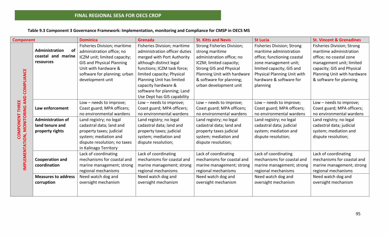
95
FINAL REGIONAL SESA FOR OECS CROP
Table 9.3 Component 3 Governance Framework: Implementation, monitoring and Compliance for CMSP in OECS MS
Component Dominica Grenada St. Kitts and Nevis St Lucia St. Vincent & Grenadines
CO
MP
ON
ENT
THR
EE
IMP
LEM
ENTA
TIO
N, M
ON
ITO
RIN
G A
ND
CO
MP
LIA
NC
E
Administration of coastal and marine resources
Fisheries Division; maritime administration office; no ICZM unit; limited capacity; GIS and Physical Planning Unit with hardware & software for planning; urban development unit
Fisheries Division; maritime administration officer duties merged with Port Authority although distinct legal functions; ICZM task force; limited capacity; Physical Planning Unit has limited capacity hardware & software for planning; Land Use Dept has GIS capability
Strong Fisheries Division; strong maritime administration office; no ICZM; limited capacity; Strong GIS and Physical Planning Unit with hardware & software for planning; urban development unit
Fisheries Division; Strong maritime administration office; functioning coastal zone management unit; limited capacity; GIS and Physical Planning Unit with hardware & software for planning
Fisheries Division; Strong maritime administration office; no coastal zone management unit; limited capacity; GIS and Physical Planning Unit with hardware & software for planning
Law enforcement
Low – needs to improve; Coast guard; MPA officers; no environmental wardens
Low – needs to improve; Coast guard; MPA officers; no environmental wardens
Low – needs to improve; Coast guard; MPA officers; no environmental wardens
Low – needs to improve; Coast guard; MPA officers; no environmental wardens
Low – needs to improve; Coast guard; MPA officers; no environmental wardens
Administration of land tenure and property rights
Land registry; no legal cadastral data; land and property taxes; judicial system; mediation and dispute resolution; no taxes in Kalinago Territory
Land registry; no legal cadastral data; land and property taxes; judicial system; mediation and dispute resolution;
Land registry; no legal cadastral data; land and property taxes judicial system; mediation and dispute resolution;
Land registry; no legal cadastral data; judicial system; mediation and dispute resolution;
Land registry; no legal cadastral data; judicial system; mediation and dispute resolution;
Cooperation and coordination
Lack of coordinating mechanisms for coastal and marine management; strong regional mechanisms
Lack of coordinating mechanisms for coastal and marine management; strong regional mechanisms
Lack of coordinating mechanisms for coastal and marine management; strong regional mechanisms
Lack of coordinating mechanisms for coastal and marine management; strong regional mechanisms
Lack of coordinating mechanisms for coastal and marine management; strong regional mechanisms
Measures to address corruption
Need watch dog and oversight mechanism
Need watch dog and oversight mechanism
Need watch dog and oversight mechanism
Need watch dog and oversight mechanism
Need watch dog and oversight mechanism
96
FINAL REGIONAL SESA FOR OECS CROP
10.0 CONCLUSIONS AND RECOMMENDATIONS
10.1 General Conclusion From the strategic assessment of current trends in governance and management of
coastal and marine resources in OECS States, two programs of actions are required to
enable successful implementation of the CROP. Section 8 of this report provides Program
1 - mitigation measures and standards to address the existing and predicted pressures
contributing to vulnerability reduction.
Program 2 addresses the CMS planning process which will be constrained by the existing
weak governance framework for coastal and marine resources management in OECS
States. Member States are at various points along the continuum from weak to good
governance therefore different priorities are given to the areas requiring action.
Recommendations are provided in sections 10.2 to address the gaps and constraints
identified in Section 9 of this report. These policy responses or “soft approaches” address
factors operating at the level of the political economy, contribute to adaptation and
building resilience. A combination of both Program 1 and Program 2 responses are
therefore required for successful CMSP in OECS States.
10.2 Program 2 - Priority Areas for Action to improve Governance in OECS MS
The areas for action are grouped based on the findings presented for analysis of the
Governance Framework in Section 2 above. Separate attention is also given to prioritizing
action for reducing the environmental pressures that result in degradation of the coastal
and marine resources in OECS MS. A general requirement is the need to develop
indicators for tracking progress in governance of coastal and marine resources.
Each member state was required to provide national priority selection to feed in the SESA
process. Responses were provided by Dominica, Grenada and St. Lucia and these are
attached as annexes to the report. The following is the ranking developed by the
consultant which will apply for St. Kitts and Nevis and St. Vincent and the Grenadines, as
informed by the situation analysis:
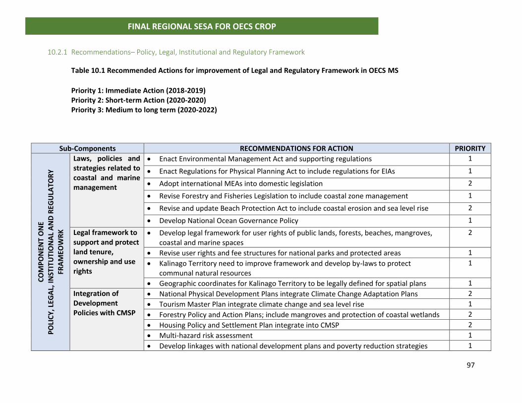
97
FINAL REGIONAL SESA FOR OECS CROP
10.2.1 Recommendations– Policy, Legal, Institutional and Regulatory Framework
Table 10.1 Recommended Actions for improvement of Legal and Regulatory Framework in OECS MS
Priority 1: Immediate Action (2018-2019) Priority 2: Short-term Action (2020-2020) Priority 3: Medium to long term (2020-2022)
Sub-Components RECOMMENDATIONS FOR ACTION PRIORITY
CO
MP
ON
ENT
ON
E
PO
LIC
Y, L
EGA
L, IN
STIT
UTI
ON
AL
AN
D R
EGU
LATO
RY
FR
AM
EOW
RK
Laws, policies and strategies related to coastal and marine management
• Enact Environmental Management Act and supporting regulations 1
• Enact Regulations for Physical Planning Act to include regulations for EIAs 1
• Adopt international MEAs into domestic legislation 2
• Revise Forestry and Fisheries Legislation to include coastal zone management 1
• Revise and update Beach Protection Act to include coastal erosion and sea level rise 2
• Develop National Ocean Governance Policy 1
Legal framework to support and protect land tenure, ownership and use rights
• Develop legal framework for user rights of public lands, forests, beaches, mangroves, coastal and marine spaces
2
• Revise user rights and fee structures for national parks and protected areas 1
• Kalinago Territory need to improve framework and develop by-laws to protect communal natural resources
1
• Geographic coordinates for Kalinago Territory to be legally defined for spatial plans 1
Integration of Development Policies with CMSP
• National Physical Development Plans integrate Climate Change Adaptation Plans 2
• Tourism Master Plan integrate climate change and sea level rise 1
• Forestry Policy and Action Plans; include mangroves and protection of coastal wetlands 2
• Housing Policy and Settlement Plan integrate into CMSP 2
• Multi-hazard risk assessment 1
• Develop linkages with national development plans and poverty reduction strategies 1
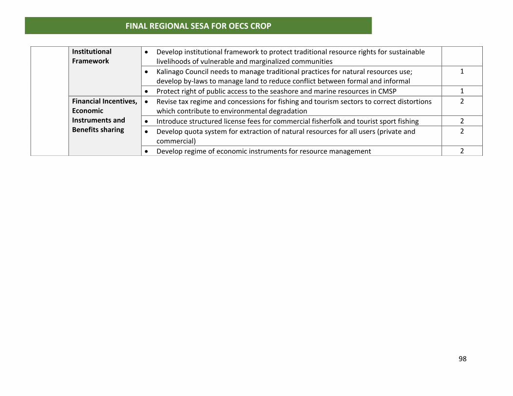
98
FINAL REGIONAL SESA FOR OECS CROP
Institutional Framework
• Develop institutional framework to protect traditional resource rights for sustainable livelihoods of vulnerable and marginalized communities
• Kalinago Council needs to manage traditional practices for natural resources use; develop by-laws to manage land to reduce conflict between formal and informal
1
• Protect right of public access to the seashore and marine resources in CMSP 1
Financial Incentives, Economic Instruments and Benefits sharing
• Revise tax regime and concessions for fishing and tourism sectors to correct distortions which contribute to environmental degradation
2
• Introduce structured license fees for commercial fisherfolk and tourist sport fishing 2
• Develop quota system for extraction of natural resources for all users (private and commercial)
2
• Develop regime of economic instruments for resource management 2
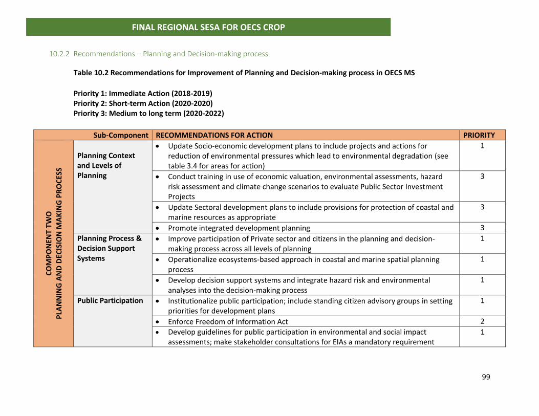
99
FINAL REGIONAL SESA FOR OECS CROP
10.2.2 Recommendations – Planning and Decision-making process
Table 10.2 Recommendations for Improvement of Planning and Decision-making process in OECS MS
Priority 1: Immediate Action (2018-2019) Priority 2: Short-term Action (2020-2020) Priority 3: Medium to long term (2020-2022)
Sub-Component RECOMMENDATIONS FOR ACTION PRIORITY
CO
MP
ON
ENT
TWO
P
LAN
NIN
G A
ND
DEC
ISIO
N M
AK
ING
PR
OC
ESS
Planning Context and Levels of Planning
• Update Socio-economic development plans to include projects and actions for reduction of environmental pressures which lead to environmental degradation (see table 3.4 for areas for action)
1
• Conduct training in use of economic valuation, environmental assessments, hazard risk assessment and climate change scenarios to evaluate Public Sector Investment Projects
3
• Update Sectoral development plans to include provisions for protection of coastal and marine resources as appropriate
3
• Promote integrated development planning 3
Planning Process & Decision Support Systems
• Improve participation of Private sector and citizens in the planning and decision-making process across all levels of planning
1
• Operationalize ecosystems-based approach in coastal and marine spatial planning process
1
• Develop decision support systems and integrate hazard risk and environmental analyses into the decision-making process
1
Public Participation
• Institutionalize public participation; include standing citizen advisory groups in setting priorities for development plans
1
• Enforce Freedom of Information Act 2
• Develop guidelines for public participation in environmental and social impact assessments; make stakeholder consultations for EIAs a mandatory requirement
1
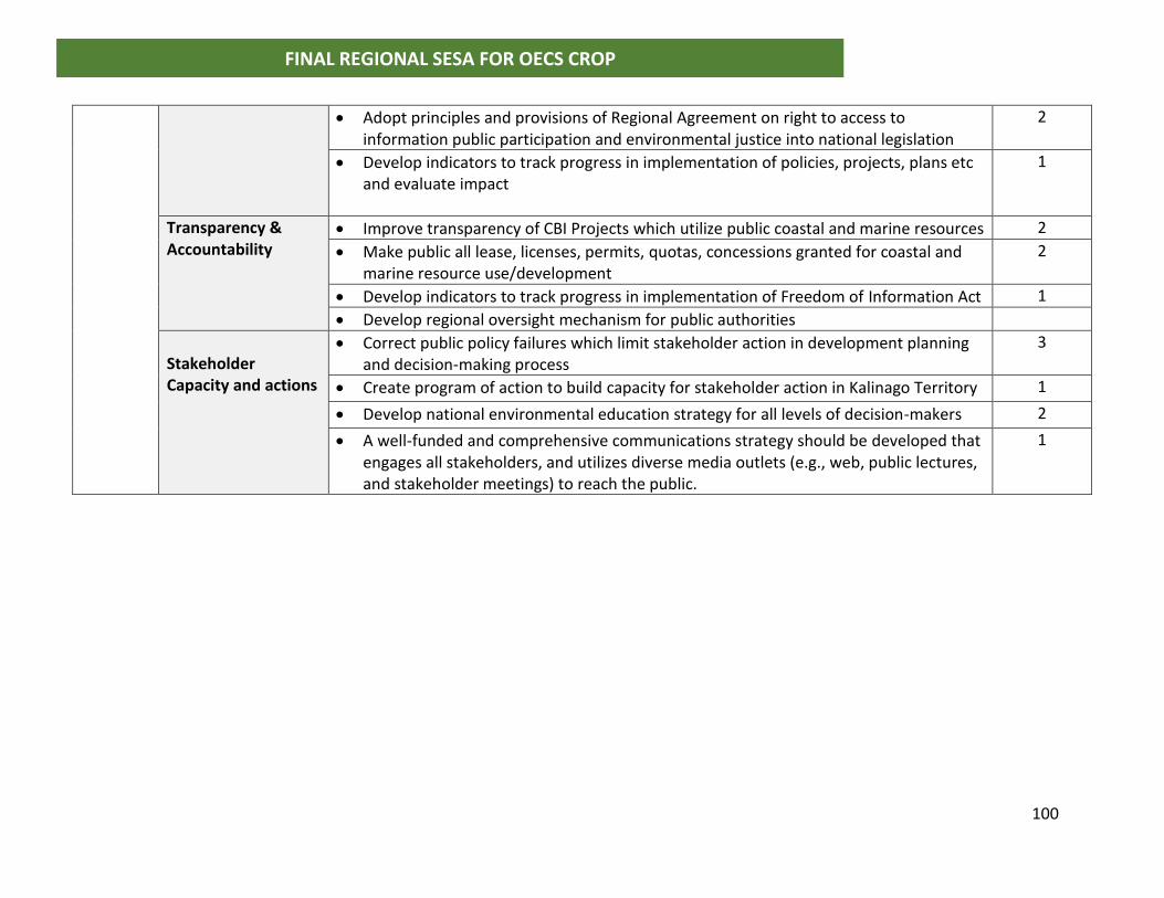
100
FINAL REGIONAL SESA FOR OECS CROP
• Adopt principles and provisions of Regional Agreement on right to access to information public participation and environmental justice into national legislation
2
• Develop indicators to track progress in implementation of policies, projects, plans etc and evaluate impact
1
Transparency & Accountability
• Improve transparency of CBI Projects which utilize public coastal and marine resources 2
• Make public all lease, licenses, permits, quotas, concessions granted for coastal and marine resource use/development
2
• Develop indicators to track progress in implementation of Freedom of Information Act 1
• Develop regional oversight mechanism for public authorities
Stakeholder Capacity and actions
• Correct public policy failures which limit stakeholder action in development planning and decision-making process
3
• Create program of action to build capacity for stakeholder action in Kalinago Territory 1
• Develop national environmental education strategy for all levels of decision-makers 2
• A well-funded and comprehensive communications strategy should be developed that engages all stakeholders, and utilizes diverse media outlets (e.g., web, public lectures, and stakeholder meetings) to reach the public.
1
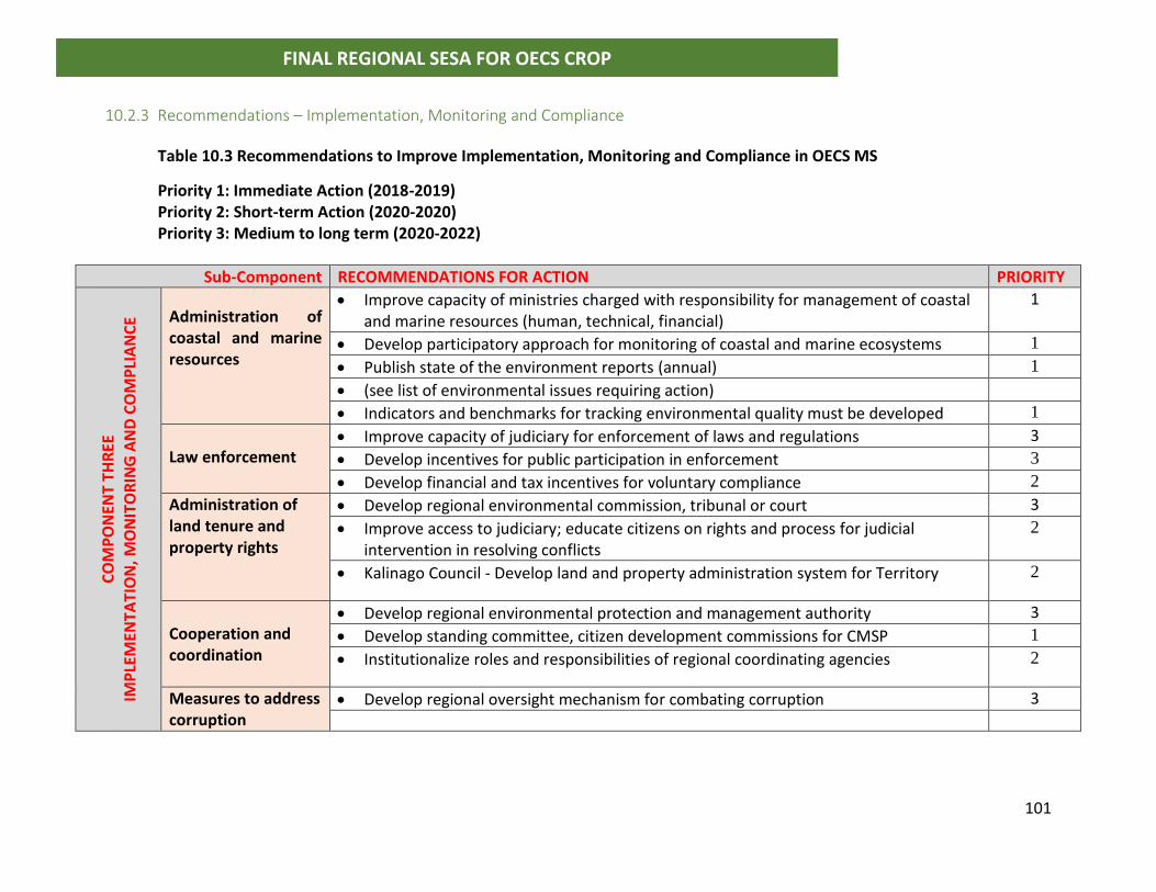
101
FINAL REGIONAL SESA FOR OECS CROP
10.2.3 Recommendations – Implementation, Monitoring and Compliance
Table 10.3 Recommendations to Improve Implementation, Monitoring and Compliance in OECS MS
Priority 1: Immediate Action (2018-2019) Priority 2: Short-term Action (2020-2020) Priority 3: Medium to long term (2020-2022)
Sub-Component RECOMMENDATIONS FOR ACTION PRIORITY
CO
MP
ON
ENT
THR
EE
IMP
LEM
ENTA
TIO
N, M
ON
ITO
RIN
G A
ND
CO
MP
LIA
NC
E Administration of
coastal and marine resources
• Improve capacity of ministries charged with responsibility for management of coastal and marine resources (human, technical, financial)
1
• Develop participatory approach for monitoring of coastal and marine ecosystems 1
• Publish state of the environment reports (annual) 1
• (see list of environmental issues requiring action)
• Indicators and benchmarks for tracking environmental quality must be developed 1
Law enforcement
• Improve capacity of judiciary for enforcement of laws and regulations 3
• Develop incentives for public participation in enforcement 3
• Develop financial and tax incentives for voluntary compliance 2
Administration of land tenure and property rights
• Develop regional environmental commission, tribunal or court 3
• Improve access to judiciary; educate citizens on rights and process for judicial intervention in resolving conflicts
2
• Kalinago Council - Develop land and property administration system for Territory 2
Cooperation and coordination
• Develop regional environmental protection and management authority 3
• Develop standing committee, citizen development commissions for CMSP 1
• Institutionalize roles and responsibilities of regional coordinating agencies 2
Measures to address corruption
• Develop regional oversight mechanism for combating corruption 3
102
FINAL REGIONAL SESA FOR OECS CROP
10.3 General Recommendations for Implementation of CROP Recommendations to guide the development of marine spatial plans were an output from
the CROP Feasibility Study. Despite not being ranked in order of priority by Member States
they are relevant and should be taken on board during the implementation of the five-
year project. The recommendations, which have been incorporated into this SESA, are
provided under the following categories below:
10.3.1 Stakeholder Participation
• To help strengthen support and buy-in for MSP, each CROP country should clearly
articulate their own country needs for MSP and the benefits it will provide.
• A stakeholder analysis should be completed at the start of the process to determine who
should be involved, the best ways to communicate with them, and when they should be
brought into the process.
• A well-funded and comprehensive communications strategy should be developed that
engages all stakeholders, and utilizes diverse media outlets (e.g., web, public lectures, and
stakeholder meetings) to reach the public.
• A regional Stakeholder Advisory Committee should be created to provide guidance and
recommendations to ensure full stakeholder participation in MSP processes.
10.3.2 Planning Context and Decision-making Process
• Each CROP country should clearly articulate their own vision for their country that will
align with the regional project vision and match the national policy direction of their
country. This vision statement should be realistic, credible, and attractive such that it
attracts commitment and energizes people, while creating meaning to stakeholders.
• The guiding principles of the MSP should be: equitable, adaptive, holistic, transparent,
knowledge driven, public and political buy-in and accountability, sustainability,
ecosystem-based management, precautionary principle, integrated management, duty of
care and accountability, multi-stakeholder participation, user pays and other economic
instruments, and simplicity.
103
FINAL REGIONAL SESA FOR OECS CROP
• The goals for the MSP should be guided by the possible threats to the marine environment
in the country; the social, environmental, economic, and cultural policy direction of the
country; build upon national policies and regional and international commitments; and
be guided by proposed future uses of the marine space.
• The objectives of the MSP must be SMART and lead to the development of strategies that
are clear, realistic, pragmatic, measurable, match the unique situation with the country,
and should consider what worked and didn’t under similar and related projects and
initiatives.
• The geographic area of coverage should be from the coastal watershed / catchment area
out to the furthest seaward boundary under the jurisdiction of the country.
10.3.3 Regional Cooperation and Coordination
• For a regional MSP to be effective, the World Bank and the OECS Commission must solicit
the buy-in and participation from as many countries sharing the island chain as possible.
• Regional agencies and projects should be engaged to help encourage participation from
non-CROP countries.
• The regional Ocean Governance Team should play a key role in guiding the work of the
national and regional MSP to ensure that decisions are aligned with international best
practice.
• A regional data base of persons qualified in MSP relevant fields should be created to allow
for exchange and utilization of national and regional technical experts in the planning and
implementation of MSP.
• Collaboration mechanisms with potential regional partners should be promoted as there
are several ways that they can support CROP implementation including mobilizing
finances, providing training, undertaking project work, supporting stakeholder
participation, and guiding the development of the required legislative and operational
framework.
• The key activities that should be completed prior to the final approval by the GEF and
project kick-off include concluding boundary delimitation discussions with neighboring
104
FINAL REGIONAL SESA FOR OECS CROP
countries, soliciting buy-in and participation from other countries that are not part of the
CROP, and mobilizing additional financial resources.
10.3.4 Project Implementation
• A financial management plan should be developed for the CROP that identifies the
resources available, the funding gaps, and articulates a plan on how these gaps can be
filled.
• The OECS Commission, the World Bank, and the governments of the CROP countries
should work collectively to raise additional resources for the project from direct
allocations from government budgets, bilateral and multilateral donors, private sector,
and collaborations with other regional projects and initiatives.
• Considering the limited funding available, The World Bank, the OECS Commission, and the
governments of the OECS countries must work assiduously to get additional project
funding in a timely manner so that there are sufficient funds to do the required work and
there is continuity to the CROP activities after the initial 4 years.
• The timeline for the planning stage of the MSP (CROP project timeline) should be a
minimum of 3 – 5 years, but with the understanding that in some countries it may take
longer (a phased-in approach may be needed in these countries).
• Although boundary delamination will not be a central theme during the implementation
of CROP, it is critically important and should be conducted in parallel to CROP’s
implementation. Clearly defined boundaries will (i) allow countries jurisdiction to enforce
legislation governing activities within their waters, (ii) help transboundary issues, and (iii)
help assess the geographic area available for marine activities that extend beyond the
12nm territorial sea (aligned with ECROP Policy 1).
• A phased-in approach should be followed for MSP planning in the CROP countries.
• The decision of which of the 5 options (pilot CROP in 2 or 3 OECS countries; complete the
MSP process for only certain areas in each country; allow the MSP to extend out only to
the 200m depth contour; design data collection activities to suit the available time and
funding resources; and focus the MSP efforts on only a few key marine uses) to allow for
105
FINAL REGIONAL SESA FOR OECS CROP
the implementation of a phased-in approach should be based on the amount of time and
finances available for the CROP implementation and the current enabling conditions
present in each country .
• Two implementation models are recommended for the CROP - one model proposing
completion of most of the national level project activities by consultants and the other
one proposing implementation of activities through local agencies with support from
consultants.
10.3.5 Policy Legal and Regulatory
• A regional Legal Advisory Task Force with representation by the Attorney General from
each OECS country should be created very early in the process to provide legal guidance
for the MSP.
• New legislation should be created early in the MSP process to provide the authority to
make the spatial management plans, which will be the outputs of the MSP, binding.
However, in cases where the legislative process will be too lengthy, existing legislation
should be used if available so as not to delay project activities.
• Institutional and legislative review will be needed to determine the most appropriate
agency to lead the planning for MSP. For Saint Lucia and Grenada, the CZMUs should be
strengthened to serve in this role. For Dominica, St. Kitts and Nevis and St. Vincent and
the Grenadines creation of a new agency is advised but this may have to be conducted in
parallel to the CROP.
10.3.6 Inter-sectoral coordination
• There are existing intersectoral committees present in Saint Lucia (Coastal Zone
Management Advisory Committee), Grenada (Coastal Zone Task Force) that can be used
to oversee the MSP. St. Vincent and the Grenadines (Ocean Governance Coordination
Committee) and St. Kitts and Nevis (National Maritime Coordination Committee) once
endorsed by cabinet can serve as this coordinating body. For Dominica, since there is no
106
FINAL REGIONAL SESA FOR OECS CROP
clear coordination committee that can serve in this role the Cabinet should appoint a new
committee.
• Assessments should be completed to determine best practice for collaborative
mechanisms among organizations in each country and this should be used to support MSP
efforts in the countries.
10.3.7 Data Collection
• Objectives for data collection should be well articulated at the start of the MSP planning
process to help streamline data collection and management.
• The MSP process in the countries should rely on the best available science and
information that is collected through well tested and documented methodologies that
support data comparisons and sharing across countries.
• A regional Science Advisory Committee that informs data decisions should be constituted.
• MSP data collection activities must be guided by both current and future uses of the
ocean.
• A comprehensive knowledge management system should be created to document best
practices and pits falls of the CROP implementation at the national and regional levels.
10.3.8 Monitoring and Evaluation
• Monitoring and evaluation will be a critical process that should be completed throughout
the MSP planning processes and should be implemented by an external monitoring and
evaluation team.
• The MSP base year should be determined early in the process and should be based on the
national goals and objectives of each country MSP effort and should be taken as the date
when implementation starts.
• Contingencies must be built into CROP planning to allow the team to adapt to changing
situations.
107
FINAL REGIONAL SESA FOR OECS CROP
11.0 ACTION PLAN FOR IMPLEMENTATION OF THE SESA
The following are direct recommendations for consultants undertaking the preparation
of ocean policies and strategies, and coastal and marine spatial plans to guide their
activities. Several of these recommendations have already been brought out in previous
deliverables including the IPPF for the Kalinago Territory in Dominica. Potential conflicts
which may arise during implementation of the CMSP include:
• Vision for CMSP – Member States have yet to clearly articulate their vision for coastal
and marine spatial planning and this is a critical precursor to shape the outcomes of
CROP. The Grenada Blue Growth Master Plan is an investment promotion strategy
and needs to be aligned with national vision for coastal and marine resources
management;
• National Physical Development Plan – These may be outdated or do not include
provisions for coastal zone management and therefore must be aligned with the
coastal spatial plans to be developed under this project;
• National Socio-Economic Development Plan – The 2030 development agenda for
Member States must provide guidance for developing the overall vision for CMSP. This
requires broad based involvement in shaping the outcomes of spatial plans that are
socially acceptable and economically feasible.
11.1 Priorities for action at the regional level
Several priorities requiring action at the regional level were among the key findings of the
situation and stakeholder analysis and the recommendations from the CROP feasibility
study. They include:
108
FINAL REGIONAL SESA FOR OECS CROP
11.1.1 Immediate to Short Term Actions (2018-2020)
o The terms of reference and composition of the regional Ocean’s Governance Team
must be reviewed to ensure that there is full stakeholder participation in MSP
processes;
o For a regional MSP to be effective, the World Bank and the OECS Commission must
solicit the buy-in and participation from as many countries sharing the island chain as
possible;
o Regional agencies and projects should be engaged to help encourage participation
from non-CROP countries;
o The regional Ocean Governance Team should play a key role in guiding the work of
the national and regional MSP to ensure that decisions are aligned with international
best practice;
o A regional data base of persons qualified in MSP relevant fields should be created to
allow for exchange and utilization of national and regional technical experts in the
planning and implementation of MSP;
o The key activities that should be completed prior to the final approval by the GEF and
project kick-off include concluding boundary delimitation discussions with
neighboring countries, soliciting buy-in and participation from other countries that
are not part of the CROP, and mobilizing additional financial resources;
o A regional Legal Advisory Task Force with representation by the Attorney General
from each OECS country should be created very early in the process to provide legal
guidance for the MSP.
109
FINAL REGIONAL SESA FOR OECS CROP
11.1.2 Medium to Long Term Actions (2020-2022)
o Collaboration mechanisms with potential regional partners should be promoted as
there are several ways that they can support CROP implementation including
mobilizing finances, providing training, undertaking project work, supporting
stakeholder participation, and guiding the development of the required legislative and
operational framework;
o Establish a regional environmental protection agency to provide support for national
agencies in areas such as monitoring, baseline ecosystems surveys and assessments,
research, environmental information management systems and data management;
o Establish a regional environmental commission, tribunal or court at the CCJ to address
matters related to management of the Caribbean Sea, territorial boundaries and EEZ,
compliance with regional environmental standards and laws;
o Develop regional oversight mechanism for public authorities with responsibility for
environment, coastal and marine resources management;
o Develop regional oversight mechanism for transparency, accountability and
combating corruption in allocation of resources from exploitation of natural
resources;
110
FINAL REGIONAL SESA FOR OECS CROP
11.2 National Priority 1: Immediate Action (2018-2019)
The stakeholders from Member States have placed heavy emphasis on the planning and
decision-making component of the governance framework, with more than 14 actions
recommended for immediate action. These areas of attention are considered critical for
successful coastal and marine spatial planning.
11.2.1 Legal, Policy, Institutional and Regulatory Framework
o Enact Environmental Management Act and supporting regulations;
o Enact Regulations for Physical Planning Act to include regulations for EIAs;
o Revise Forestry and Fisheries Legislation to include coastal zone management
(Grenada already completed);
o Develop National Ocean Governance Policy (completed for SVG; draft in SKN);
o Revision and enforcement of Fisheries marine related laws;
o Revise user rights and fee structures for national parks and protected areas;
o Kalinago Territory need to improve framework and develop by-laws to protect
communal natural resources;
o Protect right of public access to the seashore and marine resources in CMSP.
11.2.2 Planning and Decision-making Process
o Tourism Master Plan integrate climate change and sea level rise;
o Multi-hazard risk assessment for coastal development;
o Update Socio-economic development plans to include projects and actions for
reduction of environmental pressures which lead to environmental degradation;
o Improve participation of Private sector and citizens in the planning and decision-
making process across all levels of planning;
o Operationalize ecosystems-based approach in coastal and marine spatial planning
process;
o Develop decision support systems and integrate hazard risk and environmental
analyses into the decision-making process;
111
FINAL REGIONAL SESA FOR OECS CROP
o Institutionalize public participation; include standing citizen advisory groups in
setting priorities for development plans;
o Develop guidelines for public participation in environmental and social impact
assessments; make stakeholder consultations for EIAs a mandatory requirement
o Develop indicators to track progress in implementation of policies, projects, plans
etc and evaluate impact;
o Develop participatory approach in monitoring of coastal and marine ecosystem;
o Develop framework for engagement of CBI developers/business operators with local
MPAs for conservation and preservation actions in Marine Protected Areas;
o Create program of action to build capacity for stakeholder action in Kalinago
Territory;
o A well-funded and comprehensive communications strategy should be developed
that engages all stakeholders, and utilizes diverse media outlets (e.g., web, public
lectures, and stakeholder meetings) to reach the public;
o Develop capacity development program action for all communities and MPAs
engaged in EbA (DOM)
11.2.3 Implementation, Compliance and Monitoring
o Improve capacity of ministries and MPAs charged with responsibility for
management of coastal and marine resources (human, technical, financial);
o Develop participatory approach for monitoring of coastal and marine ecosystems
o Publish state of the environment reports (annual); SLU most recent report 2016;
o Indicators and benchmarks for tracking environmental quality must be developed;
o Develop indicators to track progress in implementation of policies, projects, plans,
etc and to evaluate impacts;
o Develop data collection and management systems;
o Training and capacity building of fisheries staff in news and developing technologies;
o Coral reef and fish stock monitoring .
112
FINAL REGIONAL SESA FOR OECS CROP
11.3 Priority 2: Short-term Action (2019-2020)
11.3.1 Legal, Policy, Institutional and Regulatory Framework
o Adopt international MEAs into domestic legislation
o Revise and update Beach Protection Act to include coastal erosion and sea level rise
o Develop legal framework for user rights of public lands, forests, beaches,
mangroves, coastal and marine spaces
o National Physical Development Plans integrate Climate Change Adaptation Plans
o Forestry Policy and Action Plans; include mangroves and protection of coastal
wetlands
o Housing Policy and Settlement Plan integrate into CMSP
o Revise tax regime and concessions for fishing and tourism sectors to correct
distortions which contribute to environmental degradation
o Revise the structure of license fees for fisher folk and marine related tourism
o Develop quota system for extraction of natural resources for all users (private and
commercial)
o Develop regime of economic instruments for resource management
o Waiver of Custom duties, and Vat on boats, equipment, machinery, hardware,
software, for MPAs, CSOs and NGOs that are engaged in environmental,
conservation and preservation efforts
11.3.2 Planning and Decision-making Process
o Enforce Freedom of Information Act
o Adopt principles and provisions of Regional Agreement on right to access to
information public participation and environmental justice into national legislation;
o Improve transparency of CBI Projects which utilize public coastal and marine
resources
o Conduct training in use of economic valuation, environmental assessments, hazard
risk assessment and climate change scenarios to evaluate Public Sector Investment
Projects
o Develop national environmental education strategy for all levels of decision-makers
113
FINAL REGIONAL SESA FOR OECS CROP
11.3.3 Implementation, Compliance and Monitoring
o Develop financial and tax incentives for voluntary compliance
o Make provision for MPAs, NGOs and CSOs engaged in environment conservation and
preservation to place fines, penalties and other enforcement measures;
o Improve access to judiciary; educate citizens on rights and process for judicial
intervention in resolving conflicts;
o Kalinago Council - Develop land and property administration system for Territory
11.4 National Priority 3: Medium to long term (2019-2022)
11.4.1 Planning and Decision-making Process
o Conduct training in use of economic valuation, environmental assessments, hazard
risk assessment and climate change scenarios to evaluate Public Sector Investment
Projects
o Update Sectoral development plans to include provisions for protection of coastal
and marine resources as appropriate
o Promote integrated development planning
o Correct public policy failures which limit stakeholder action in development planning
and decision-making process;
11.4.2 Implementation, Compliance and Monitoring
o Improve capacity of judiciary for enforcement of laws and regulations
o Develop incentives for public participation in enforcement
o Develop regional environmental commission, tribunal or court
114
FINAL REGIONAL SESA FOR OECS CROP
Table 11.1a Action Plan for Priority One: Immediate (2018-2019)
Governance Component
Strategic Objectives Implementation Actions Responsible Agency
Time Frame
LEG
ISLA
TIV
E FR
AM
EWO
RK
To modernize Laws, policies and strategies related to coastal and marine management
To develop a robust legal framework to support and protect land tenure, ownership and use rights
To integrate broader development policies i with coastal and marine policies
To create pathways for recognition of cultural norms and traditional rights in Institutional frameworks
To develop financial incentives, economic instruments and benefits sharing
• Enact Environmental Management Act and supporting regulations;
Legal Affairs; Min of Environment; Sus Dev
6 months (in draft)
• Enact Regulations for Physical Planning Act to include regulations for EIAs;
Legal Affairs; Physical Planning
6 months (in draft)
• Revise Forestry and Fisheries Legislation to include coastal zone management (Grenada already completed);
Legal Affairs; Forestry; Fisheries
1 year
• Develop National Ocean Governance Policy (completed for SVG; draft in SKN);
National Committee; all sectors participate
6 months
• Revision [and enforcement] of Fisheries marine related laws;
Legal Affairs; fisheries 6 months (in draft)
• Revise user rights and fee structures for national parks and protected areas;
Fisheries; National Parks; Min of Finance
1 year
• Kalinago Territory need to improve framework and develop by-laws to protect communal natural resources;
Kalinago Council 1 year
• Protect right of public access to the seashore and marine resources in CMSP;
National CMSP Committee
Immediate and ongoing
• Legally define geographical coordinates for Kalinago Territory to facilitate spatial planning.
Kalinago Council; Ministry of Kalinago Affairs; Legal Affairs
Immediate to 6 months
115
FINAL REGIONAL SESA FOR OECS CROP
Governance Component
Strategic Objectives Implementation Actions Responsible Agency
Time Frame
Table 11.1b Action Plan for Priority One: Immediate (2018-2019)
Go
ver
nan
ce
Co
mp
on
en
t Strategic Objectives Recommended Actions for Implementation
Responsible Agency
Time Frame
PLA
NN
ING
AN
D
DEC
ISIO
N M
AK
ING
To integrate planning across all levels, national, regional (area), sectoral, projects
To utilize decision-support systems into planning framework
To increase Stakeholder Participation
• Tourism Master Plan integrate climate change and sea level rise;
Min of Tourism; Environment; Sus Dev
1 year
• Multi-hazard risk assessment for coastal development;
Physical Planning; Disaster Management
6 months
• Update Socio-economic development plans to include projects and actions for reduction of environmental pressures which lead to environmental degradation
Economic Planning; Finance; Environment;
6 months; part of budget cycle
• Improve participation of Private sector and citizens in the planning and decision-making process across all levels of planning
All sectors; Economic planning; budget process
Immediate and Ongoing
• Operationalize ecosystems-based approach in coastal and marine spatial planning process
Fisheries and marine management agency; environment dept
Immediate and ongoing
116
FINAL REGIONAL SESA FOR OECS CROP
Go
ver
nan
ce
Co
mp
on
en
t Strategic Objectives Recommended Actions for Implementation
Responsible Agency
Time Frame
To improve transparency and accountability
To increase stakeholder capacity and action
• Develop decision support systems and integrate hazard risk and environmental analyses into the decision-making process
Economic & Finance; 6 months-1 year & ongoing
• Institutionalize public participation; include standing citizen advisory groups in setting priorities for development plans
Ministry of Finance; Economic Planning; all sectors
Immediate & ongoing
• Develop guidelines for public participation in environmental and social impact assessments; make stakeholder consultations for EIAs a mandatory requirement
Physical Planning 3-6 months
• Develop indicators to track progress in implementation of policies, projects, plans etc and evaluate impact
Ministry of Environment
Immediate and ongoing
• Develop participatory approach in monitoring of coastal and marine ecosystem
Ministry of Environment; Fisheries; NGOs
1 year
• Develop framework for engagement of CBI developers/business operators with local MPAs for conservation and preservation actions in Marine Protected Areas. (DOM)
Economic Planning; Fisheries
1 year
• Create program of action to build capacity for stakeholder action in Kalinago Territory
Kalinago Council & Ministry
Immediate & ongoing
• A well-funded and comprehensive communications strategy should be developed that engages all stakeholders, and utilizes diverse media outlets (e.g.,
Sus Dev; Ministry of Environment; Economic Planning, Finance;
Immediate and ongoing
117
FINAL REGIONAL SESA FOR OECS CROP
Go
ver
nan
ce
Co
mp
on
en
t Strategic Objectives Recommended Actions for Implementation
Responsible Agency
Time Frame
web, public lectures, and stakeholder meetings) to reach the public
• Develop capacity development program action for all communities and MPAs engaged in EbA (DOM)
Fisheries; Ministry of Environment
1 year
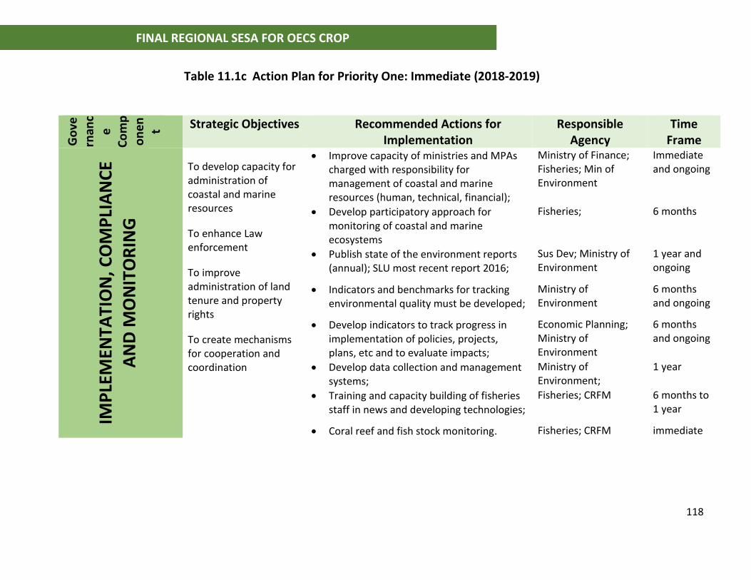
118
FINAL REGIONAL SESA FOR OECS CROP
Table 11.1c Action Plan for Priority One: Immediate (2018-2019)
Go
vern
anc
e
Co
mp
on
en
t Strategic Objectives Recommended Actions for Implementation
Responsible Agency
Time Frame
IMP
LEM
ENTA
TIO
N, C
OM
PLI
AN
CE
AN
D M
ON
ITO
RIN
G
To develop capacity for administration of coastal and marine resources
To enhance Law enforcement
To improve administration of land tenure and property rights
To create mechanisms for cooperation and coordination
• Improve capacity of ministries and MPAs charged with responsibility for management of coastal and marine resources (human, technical, financial);
Ministry of Finance; Fisheries; Min of Environment
Immediate and ongoing
• Develop participatory approach for monitoring of coastal and marine ecosystems
Fisheries; 6 months
• Publish state of the environment reports (annual); SLU most recent report 2016;
Sus Dev; Ministry of Environment
1 year and ongoing
• Indicators and benchmarks for tracking environmental quality must be developed;
Ministry of Environment
6 months and ongoing
• Develop indicators to track progress in implementation of policies, projects, plans, etc and to evaluate impacts;
Economic Planning; Ministry of Environment
6 months and ongoing
• Develop data collection and management systems;
Ministry of Environment;
1 year
• Training and capacity building of fisheries staff in news and developing technologies;
Fisheries; CRFM 6 months to 1 year
• Coral reef and fish stock monitoring. Fisheries; CRFM immediate
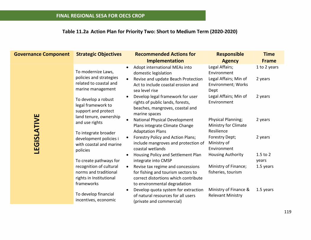
119
FINAL REGIONAL SESA FOR OECS CROP
Table 11.2a Action Plan for Priority Two: Short to Medium Term (2020-2020)
Governance Component Strategic Objectives Recommended Actions for Implementation
Responsible Agency
Time Frame
LEG
ISLA
TIV
E
To modernize Laws, policies and strategies related to coastal and marine management
To develop a robust legal framework to support and protect land tenure, ownership and use rights
To integrate broader development policies i with coastal and marine policies
To create pathways for recognition of cultural norms and traditional rights in Institutional frameworks
To develop financial incentives, economic
• Adopt international MEAs into domestic legislation
Legal Affairs; Environment
1 to 2 years
• Revise and update Beach Protection Act to include coastal erosion and sea level rise
Legal Affairs; Min of Environment; Works Dept
2 years
• Develop legal framework for user rights of public lands, forests, beaches, mangroves, coastal and marine spaces
Legal Affairs; Min of Environment
2 years
• National Physical Development Plans integrate Climate Change Adaptation Plans
Physical Planning; Ministry for Climate Resilience
2 years
• Forestry Policy and Action Plans; include mangroves and protection of coastal wetlands
Forestry Dept; Ministry of Environment
2 years
• Housing Policy and Settlement Plan integrate into CMSP
Housing Authority 1.5 to 2 years
• Revise tax regime and concessions for fishing and tourism sectors to correct distortions which contribute to environmental degradation
Ministry of Finance; fisheries, tourism
1.5 years
• Develop quota system for extraction of natural resources for all users (private and commercial)
Ministry of Finance & Relevant Ministry
1.5 years
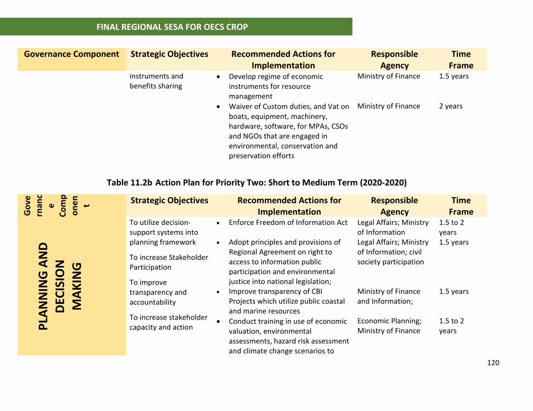
120
FINAL REGIONAL SESA FOR OECS CROP
Governance Component Strategic Objectives Recommended Actions for Implementation
Responsible Agency
Time Frame
instruments and benefits sharing
• Develop regime of economic instruments for resource management
Ministry of Finance 1.5 years
• Waiver of Custom duties, and Vat on boats, equipment, machinery, hardware, software, for MPAs, CSOs and NGOs that are engaged in environmental, conservation and preservation efforts
Ministry of Finance 2 years
Table 11.2b Action Plan for Priority Two: Short to Medium Term (2020-2020)
Go
vern
anc
e
Co
mp
on
en
t Strategic Objectives Recommended Actions for Implementation
Responsible Agency
Time Frame
PLA
NN
ING
AN
D
DEC
ISIO
N
MA
KIN
G
To utilize decision-support systems into planning framework
To increase Stakeholder Participation
To improve transparency and accountability
To increase stakeholder capacity and action
• Enforce Freedom of Information Act Legal Affairs; Ministry of Information
1.5 to 2 years
• Adopt principles and provisions of Regional Agreement on right to access to information public participation and environmental justice into national legislation;
Legal Affairs; Ministry of Information; civil society participation
1.5 years
• Improve transparency of CBI Projects which utilize public coastal and marine resources
Ministry of Finance and Information;
1.5 years
• Conduct training in use of economic valuation, environmental assessments, hazard risk assessment and climate change scenarios to
Economic Planning; Ministry of Finance
1.5 to 2 years
121
FINAL REGIONAL SESA FOR OECS CROP
evaluate Public Sector Investment Projects
• Develop national environmental education strategy for all levels of decision-makers
Ministry of Environment and Education
2 years
Table 11.2c Action Plan for Priority Two: Short to Medium Term (2020-2020)
Governance Component Strategic Objectives Recommended Actions for Implementation
Responsible Agency
Time Frame
IMP
LEM
ENTA
TIO
N,
CO
MP
LIA
NC
E A
ND
MO
NIT
OR
ING
To develop capacity for administration of coastal and marine resources
To enhance Law enforcement
To create mechanisms for cooperation and coordination
To establish measures to address corruption
• Develop financial and tax incentives for voluntary compliance
Ministry of Finance; min of environment
2 years
• Make provisions for MPAs, NGOs and CSOs engaged in environment conservation and preservation to place fines, penalties and other enforcement measures;
Legal Affairs; Fisheries;
2 years
• Improve access to judiciary; educate citizens on rights and process for judicial intervention in resolving conflicts;
NGOs, CBOs, Bar Association; Mediation Project
2 years
• Kalinago Council - Develop land and property administration system for Territory
Kalinago Council 2 years
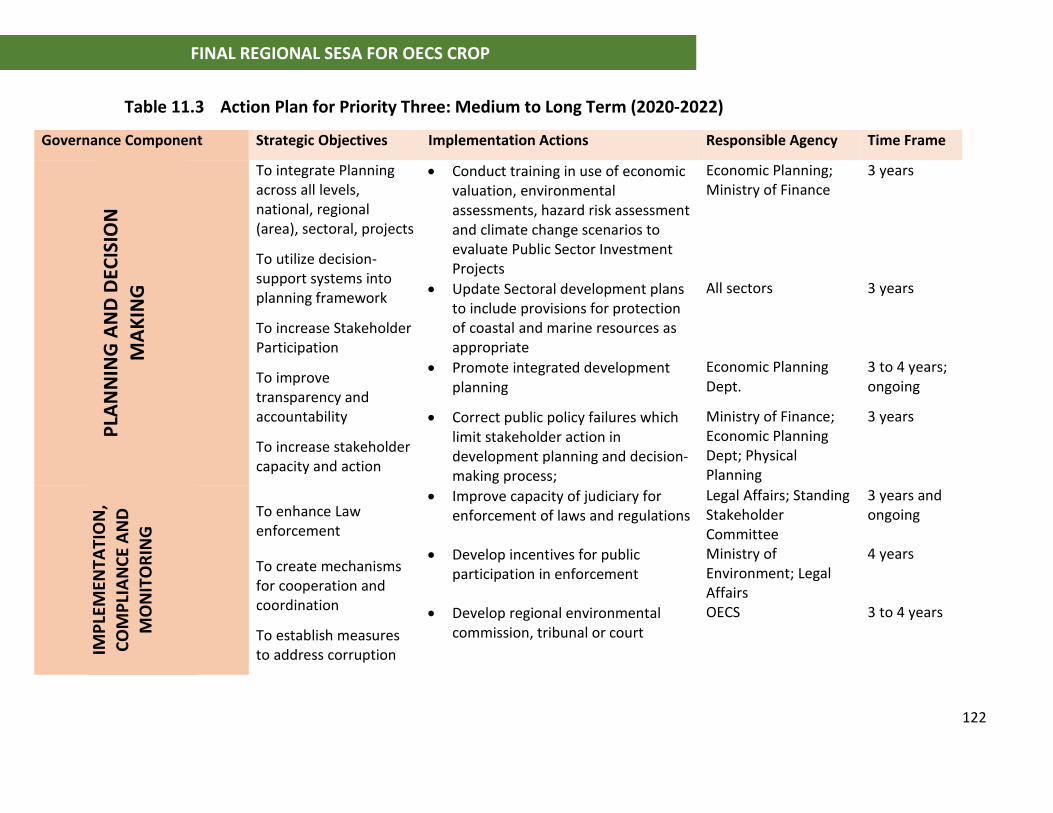
122
FINAL REGIONAL SESA FOR OECS CROP
Table 11.3 Action Plan for Priority Three: Medium to Long Term (2020-2022)
Governance Component Strategic Objectives Implementation Actions Responsible Agency Time Frame
PLA
NN
ING
AN
D D
ECIS
ION
M
AK
ING
To integrate Planning across all levels, national, regional (area), sectoral, projects
To utilize decision-support systems into planning framework
To increase Stakeholder Participation
To improve transparency and accountability
To increase stakeholder capacity and action
• Conduct training in use of economic valuation, environmental assessments, hazard risk assessment and climate change scenarios to evaluate Public Sector Investment Projects
Economic Planning; Ministry of Finance
3 years
• Update Sectoral development plans to include provisions for protection of coastal and marine resources as appropriate
All sectors 3 years
• Promote integrated development planning
Economic Planning Dept.
3 to 4 years; ongoing
• Correct public policy failures which limit stakeholder action in development planning and decision-making process;
Ministry of Finance; Economic Planning Dept; Physical Planning
3 years
IMP
LEM
ENTA
TIO
N,
CO
MP
LIA
NC
E A
ND
M
ON
ITO
RIN
G
To enhance Law enforcement
To create mechanisms for cooperation and coordination
To establish measures to address corruption
• Improve capacity of judiciary for enforcement of laws and regulations
Legal Affairs; Standing Stakeholder Committee
3 years and ongoing
• Develop incentives for public participation in enforcement
Ministry of Environment; Legal Affairs
4 years
• Develop regional environmental commission, tribunal or court
OECS 3 to 4 years
123
FINAL REGIONAL SESA FOR OECS CROP
12 REFERENCES (A Detailed list of documents and country reports are provided in the report of the Situation
and Stakeholder Analysis for this SESA)
Caribbean Fisheries Legal and Institutional Study: Findings of the Comparative Assessment and Country Reports Food and Agriculture Organization of the United Nations Bridgetown, Barbados, 2016 CCCCC (2012) DELIVERING TRANSFORMATIONAL CHANGE 2011-21: Implementing the CARICOM ‘Regional Framework for Achieving Development Resilient to Climate Change. Caribbean Community Climate Change Centre, Belize, March 2012. Developing a framework for a comprehensive marine multi-use zoning plan for The Grenadine Islands Final report for NOAA Federal Grant: na10nos4630054 Sustainable Grenadines Inc October 2012 EU 1999, Towards a European Integrated Coastal Zone Management (ICZM) Strategy: General Principles and Policy Options. A reflection Paper EU Demonstration Programme on Integrated Coastal Zone Management 1997-1999 Governance arrangements for marine ecosystems of the Wider Caribbean Region. Mahon et al, 2013. Centre for Resource Management and Environmental Studies (CERMES), Caribbean Sea Large Marine Ecosystem (CLME) and Adjacent Regions (CLME Project). Government of Trinidad and Tobago, 2014. Integrated Coastal Zone Management Policy Framework (draft). Ministry of Environment and Water Resources ICZM Steering Committee Haines-Young, R. and M. Potschin, 2011. Integrated Coastal Zone Management and the Ecosystem Approach CEM Working Paper No 7 Center for Environmental Management University of Nottingham. Huber, R.M , Meganck, R (1990). The Management Challenge of Grand Anse Beach Erosion, Grenada West Indies. Ocean and Shoreline Management 13 (1990) 99-109. (Received 14 September 1988, accepted 11 November 1988)
IUCN, 2015. Policy Brief: An International Instrument on Conservation and Sustainable Use of Biodiversity in Marine Areas beyond National Jurisdiction Exploring Different Elements to Consider. PAPER VII Relation between Environmental Impact Assessments, Strategic Environmental Assessments and Marine Spatial Planning. By Thomas Greiber and Marissa Knodel, with comments from Robin Warner Commissioned by the German Federal Agency for Nature Conservation with funds from The German Federal Ministry for the Environment, Nature Conservation, Building and Nuclear Safety.
124
FINAL REGIONAL SESA FOR OECS CROP
K C Komsary, W P Tarigan and T Wiyana, 2018. Limits of acceptable change as tool for tourism development sustainability in Pangandaran West Java. Published under licence by IOP Publishing LtdIOP Conference Series: Earth and Environmental Science, Volume 126, conference 1 Limits in the Seas No. 133 Antigua and Barbuda Archipelagic and other maritime claims and boundaries March 28, 2014 Office of Ocean and Polar Affairs Bureau of Oceans and International Environmental and Scientific Affairs U.S. Department of State M., Sim, R.,Lizcano, G., Wilson, M., Rutty, M., Stager, H., Oldham, J., New, M., Clarke, J., Day, O.J., Fields, N., Georges, J., Waithe, R., McSharry, P. (2010) Quantification and Magnitude of Losses and Damages Resulting from the Impacts of Climate Change: Modelling the Transformational Impacts and Costs of Sea Level Rise in the Caribbean. United Nations Mee, L.D. (2012). Between the devil and the deep blue sea: The coastal zone in an era of
globalisation. Estuarine, Coastal and Shelf Science, 96, 1-8.
McCool, Stephen, 1996. Limits of Acceptable Change: A Framework for Managing National Protected Areas: Experiences from the United States. Paper Presented at Workshop on Impact Management in Marine Parks, Maritime Institute of Malaysia
Millennium Ecosystem Assessment (MEA) (2005). Millennium Ecosystem Assessment:
Ecosystems and human wellbeing: Synthesis. Washington DC: Island Press.
OECS 2006, St. George’s Declaration of Principles of Environmental Sustainability in OECS 2001 (Revised 2006) OECS 2010, Revised Treaty of Basseterre – Protocol of Organisation of Easter Caribbean States Economic Union OECS 2016, Final Background Synthesis Report on Integrated Coastal Zone Management (ICZM) in OECS Member States Principles for Stakeholder Involvement in Coastal and Marine Spatial Planning. Prepared by the U.S. Institute for Environmental Conflict Resolution of the Morris K Udall and Stewart L. Udall Foundation. December 2011
Roman GS, Dearden P, Rollins R, 2007. Application of zoning and "limits of acceptable change" to manage snorkelling tourism. . Environ Manage. 2007 Jun;39(6):819-30. Epub 2007 Apr 19
Saffache & Angelelli , 2010. Integrated Coastal Zone Management in small islands: A comparative outline of some islands of the Lesser Antilles. Journal of Integrated Coastal Zone Management 10(3):255-279 (2010)
125
FINAL REGIONAL SESA FOR OECS CROP
Simpson, M. C., Clarke, J. F., Scott, D. J., New, M., Karmalkar, A., Day, O. J., Taylor, M., Gossling, S., Wilson, M., Chadee, D., Stager, H., Waithe, R., Stewart, A., Georges, J., Hutchinson, N., Fields, N., Sim, R., Rutty, M., Matthews, L., and Charles, S. (2012b). CARIBSAVE Climate Change Risk Atlas (CCCRA) - Dominica. DFID, AusAID and The CARIBSAVE Partnership, Barbados, West Indies Simpson, M. C., Clarke, J. F., Scott, D. J., New, M., Karmalkar, A., Day, O. J., Taylor, M., Gossling, S., Wilson, M., Chadee, D., Stager, H., Waithe, R., Stewart, A., Georges, J., Hutchinson, N., Fields, N., Sim, R., Rutty, M., Matthews, L., and Charles, S. (2012c). CARIBSAVE Climate Change Risk Atlas (CCCRA) - Grenada. DFID, AusAID and The CARIBSAVE Partnership, Barbados, West Indies. Simpson, M. C., Clarke, J. F., Scott, D. J., New, M., Karmalkar, A., Day, O. J., Taylor, M., Gossling, S., Wilson, M., Chadee, D., Stager, H., Waithe, R., Stewart, A., Georges, J., Hutchinson, N., Fields, N., Sim, R., Rutty, M., Matthews, L., and Charles, S. (2012d). CARIBSAVE Climate Change Risk Atlas (CCCRA) – St. Kitts. DFID, AusAID and The CARIBSAVE Partnership, Barbados, West Indies. Simpson, M. C., Clarke, J. F., Scott, D. J., New, M., Karmalkar, A., Day, O. J., Taylor, M., Gossling, S., Wilson, M., Chadee, D., Stager, H., Waithe, R., Stewart, A., Georges, J., Hutchinson, N., Fields, N., Sim, R., Rutty, M., Matthews, L., and Charles, S. (2012e). CARIBSAVE Climate Change Risk Atlas (CCCRA) - Nevis. DFID, AusAID and The CARIBSAVE Partnership, Barbados, West Indies. Simpson, M. C., Clarke, J. F., Scott, D. J., New, M., Karmalkar, A., Day, O. J., Taylor, M., Gossling, S., Wilson, M., Chadee, D., Stager, H., Waithe, R., Stewart, A., Georges, J., Hutchinson, N., Fields, N., Sim, R., Rutty, M., Matthews, L., and Charles, S. (2012f). CARIBSAVE Climate Change Risk Atlas (CCCRA) – St Lucia. DFID, AusAID and The CARIBSAVE Partnership, Barbados, West Indies. Simpson, M. C., Clarke, J. F., Scott, D. J., New, M., Karmalkar, A., Day, O. J., Taylor, M., Gossling, S., Wilson, M., Chadee, D., Stager, H., Waithe, R., Stewart, A., Georges, J., Hutchinson, N., Fields, N., Sim, R., Rutty, M., Matthews, L., and Charles, S. (2012g). CARIBSAVE Climate Change Risk Atlas (CCCRA) – St Vincent and the Grenadine. DFID, AusAID and The CARIBSAVE Partnership, Barbados, West Indies. The Valuation of Marine Ecosystem Goods and Services in the Wider Caribbean Region. Peter SCHUHMANN, 2012 Caribbean Sea Large Marine Ecosystem (CLME) and Adjacent Regions (CLME Project). The Caribbean Region Oceanscape Project (CROP). Assessment of Marine Spatial Planning Feasibility Report. The Nature Conservancy. World Bank Group, 2017. Robin, 2007. Final Report: OECS Audit of Maritime Agencies.
Turner and Schaafsma, 2015 Coastal Zones Ecosystem Services: From Science to Values and Decision Making. Springer Studies in Ecological Economics
WEBSITES

126
FINAL REGIONAL SESA FOR OECS CROP
http://www.marbef.org/wiki/The_Integrated_approach_to_Coastal_Zone_Management(ICZM)
http://ec.europa.eu/environment/iczm/home.htm
http://wiomsa.org/mpatoolkit/Themesheets/A5_Integrated_coastal_management.pdf
http://www.prm.nau.edu/prm300-old/LAC_article.htm
Australia Caribbean Coral Reef Collaboration
http://climateandreefs.org/new-page
Sea around us project: Fisheries, Ecosystems & Biodiversity
http://aerl06.aerl.ubc.ca/eez/28.aspx
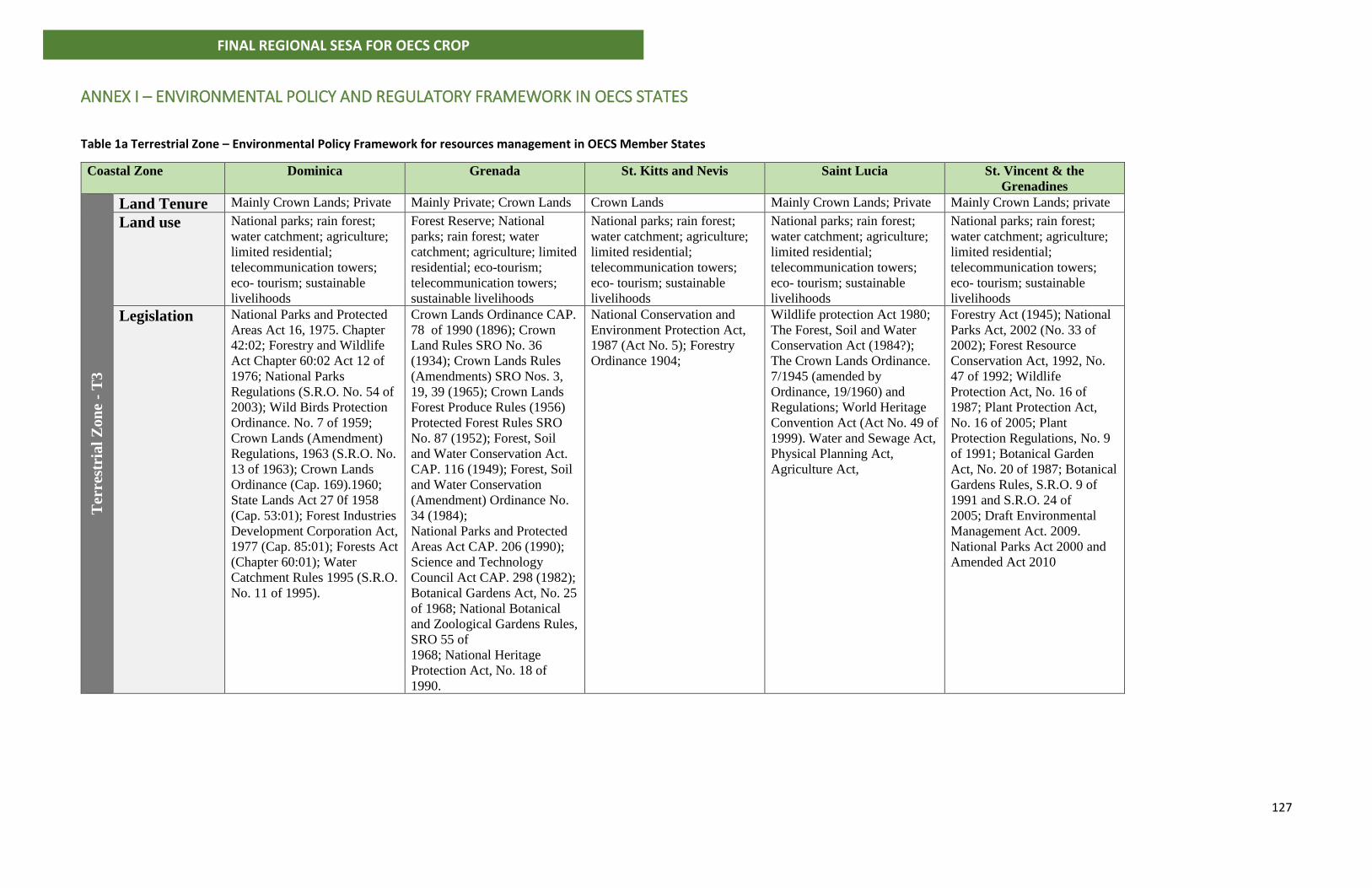
127
FINAL REGIONAL SESA FOR OECS CROP
ANNEX I – ENVIRONMENTAL POLICY AND REGULATORY FRAMEWORK IN OECS STATES
Table 1a Terrestrial Zone – Environmental Policy Framework for resources management in OECS Member States
Coastal Zone
Dominica Grenada St. Kitts and Nevis Saint Lucia St. Vincent & the
Grenadines
Ter
rest
rial
Zon
e -
T3
Land Tenure Mainly Crown Lands; Private Mainly Private; Crown Lands Crown Lands Mainly Crown Lands; Private Mainly Crown Lands; private
Land use National parks; rain forest;
water catchment; agriculture;
limited residential;
telecommunication towers;
eco- tourism; sustainable
livelihoods
Forest Reserve; National
parks; rain forest; water
catchment; agriculture; limited
residential; eco-tourism;
telecommunication towers;
sustainable livelihoods
National parks; rain forest;
water catchment; agriculture;
limited residential;
telecommunication towers;
eco- tourism; sustainable
livelihoods
National parks; rain forest;
water catchment; agriculture;
limited residential;
telecommunication towers;
eco- tourism; sustainable
livelihoods
National parks; rain forest;
water catchment; agriculture;
limited residential;
telecommunication towers;
eco- tourism; sustainable
livelihoods
Legislation National Parks and Protected
Areas Act 16, 1975. Chapter
42:02; Forestry and Wildlife
Act Chapter 60:02 Act 12 of
1976; National Parks
Regulations (S.R.O. No. 54 of
2003); Wild Birds Protection
Ordinance. No. 7 of 1959;
Crown Lands (Amendment)
Regulations, 1963 (S.R.O. No.
13 of 1963); Crown Lands
Ordinance (Cap. 169).1960;
State Lands Act 27 0f 1958
(Cap. 53:01); Forest Industries
Development Corporation Act,
1977 (Cap. 85:01); Forests Act
(Chapter 60:01); Water
Catchment Rules 1995 (S.R.O.
No. 11 of 1995).
Crown Lands Ordinance CAP.
78 of 1990 (1896); Crown
Land Rules SRO No. 36
(1934); Crown Lands Rules
(Amendments) SRO Nos. 3,
19, 39 (1965); Crown Lands
Forest Produce Rules (1956)
Protected Forest Rules SRO
No. 87 (1952); Forest, Soil
and Water Conservation Act.
CAP. 116 (1949); Forest, Soil
and Water Conservation
(Amendment) Ordinance No.
34 (1984);
National Parks and Protected
Areas Act CAP. 206 (1990);
Science and Technology
Council Act CAP. 298 (1982);
Botanical Gardens Act, No. 25
of 1968; National Botanical
and Zoological Gardens Rules,
SRO 55 of
1968; National Heritage
Protection Act, No. 18 of
1990.
National Conservation and
Environment Protection Act,
1987 (Act No. 5); Forestry
Ordinance 1904;
Wildlife protection Act 1980;
The Forest, Soil and Water
Conservation Act (1984?);
The Crown Lands Ordinance.
7/1945 (amended by
Ordinance, 19/1960) and
Regulations; World Heritage
Convention Act (Act No. 49 of
1999). Water and Sewage Act,
Physical Planning Act,
Agriculture Act,
Forestry Act (1945); National
Parks Act, 2002 (No. 33 of
2002); Forest Resource
Conservation Act, 1992, No.
47 of 1992; Wildlife
Protection Act, No. 16 of
1987; Plant Protection Act,
No. 16 of 2005; Plant
Protection Regulations, No. 9
of 1991; Botanical Garden
Act, No. 20 of 1987; Botanical
Gardens Rules, S.R.O. 9 of
1991 and S.R.O. 24 of
2005; Draft Environmental
Management Act. 2009.
National Parks Act 2000 and
Amended Act 2010
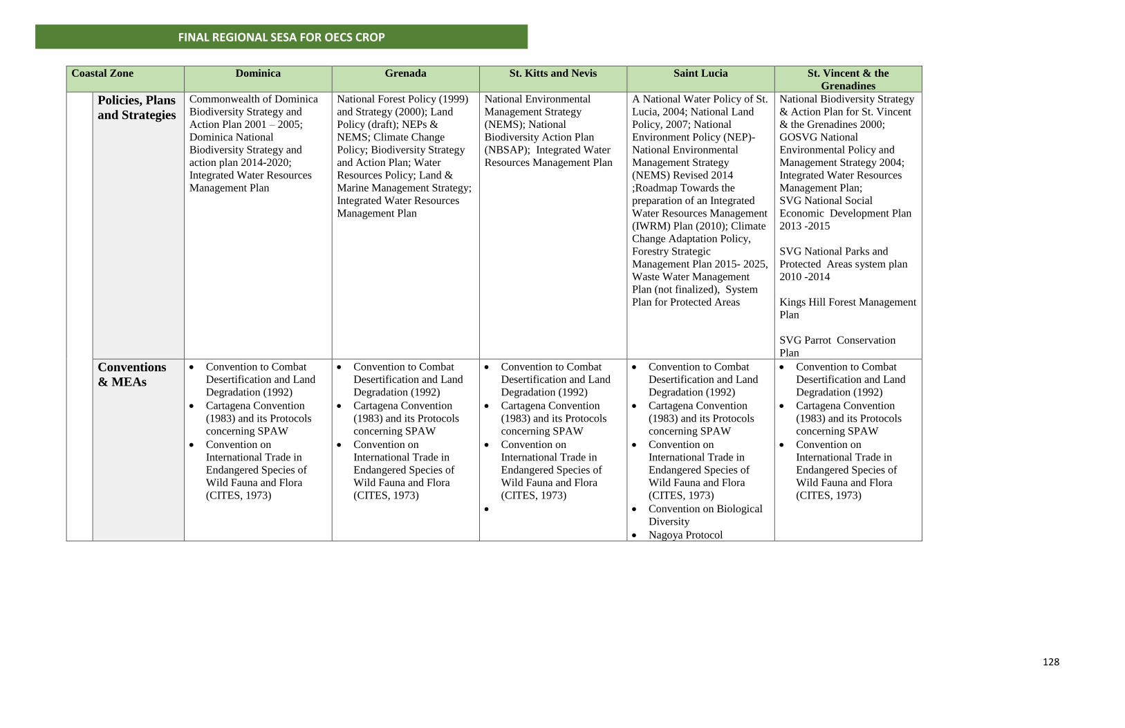
128
FINAL REGIONAL SESA FOR OECS CROP
Coastal Zone
Dominica Grenada St. Kitts and Nevis Saint Lucia St. Vincent & the
Grenadines
Policies, Plans
and Strategies
Commonwealth of Dominica
Biodiversity Strategy and
Action Plan 2001 – 2005;
Dominica National
Biodiversity Strategy and
action plan 2014-2020;
Integrated Water Resources
Management Plan
National Forest Policy (1999)
and Strategy (2000); Land
Policy (draft); NEPs &
NEMS; Climate Change
Policy; Biodiversity Strategy
and Action Plan; Water
Resources Policy; Land &
Marine Management Strategy;
Integrated Water Resources
Management Plan
National Environmental
Management Strategy
(NEMS); National
Biodiversity Action Plan
(NBSAP); Integrated Water
Resources Management Plan
A National Water Policy of St.
Lucia, 2004; National Land
Policy, 2007; National
Environment Policy (NEP)-
National Environmental
Management Strategy
(NEMS) Revised 2014
;Roadmap Towards the
preparation of an Integrated
Water Resources Management
(IWRM) Plan (2010); Climate
Change Adaptation Policy,
Forestry Strategic
Management Plan 2015- 2025,
Waste Water Management
Plan (not finalized), System
Plan for Protected Areas
National Biodiversity Strategy
& Action Plan for St. Vincent
& the Grenadines 2000;
GOSVG National
Environmental Policy and
Management Strategy 2004;
Integrated Water Resources
Management Plan;
SVG National Social
Economic Development Plan
2013 -2015
SVG National Parks and
Protected Areas system plan
2010 -2014
Kings Hill Forest Management
Plan
SVG Parrot Conservation
Plan
Conventions
& MEAs
• Convention to Combat
Desertification and Land
Degradation (1992)
• Cartagena Convention
(1983) and its Protocols
concerning SPAW
• Convention on
International Trade in
Endangered Species of
Wild Fauna and Flora
(CITES, 1973)
• Convention to Combat
Desertification and Land
Degradation (1992)
• Cartagena Convention
(1983) and its Protocols
concerning SPAW
• Convention on
International Trade in
Endangered Species of
Wild Fauna and Flora
(CITES, 1973)
• Convention to Combat
Desertification and Land
Degradation (1992)
• Cartagena Convention
(1983) and its Protocols
concerning SPAW
• Convention on
International Trade in
Endangered Species of
Wild Fauna and Flora
(CITES, 1973)
•
• Convention to Combat
Desertification and Land
Degradation (1992)
• Cartagena Convention
(1983) and its Protocols
concerning SPAW
• Convention on
International Trade in
Endangered Species of
Wild Fauna and Flora
(CITES, 1973)
• Convention on Biological
Diversity
• Nagoya Protocol
• Convention to Combat
Desertification and Land
Degradation (1992)
• Cartagena Convention
(1983) and its Protocols
concerning SPAW
• Convention on
International Trade in
Endangered Species of
Wild Fauna and Flora
(CITES, 1973)
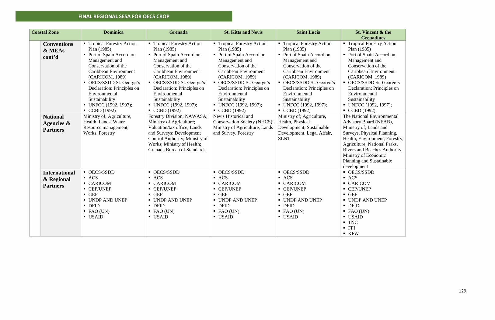
129
FINAL REGIONAL SESA FOR OECS CROP
Coastal Zone
Dominica Grenada St. Kitts and Nevis Saint Lucia St. Vincent & the
Grenadines
Conventions
& MEAs
cont’d
▪ Tropical Forestry Action
Plan (1985)
▪ Port of Spain Accord on
Management and
Conservation of the
Caribbean Environment
(CARICOM, 1989)
▪ OECS/SSDD St. George’s
Declaration: Principles on
Environmental
Sustainability
▪ UNFCC (1992, 1997);
▪ CCBD (1992)
▪ Tropical Forestry Action
Plan (1985)
▪ Port of Spain Accord on
Management and
Conservation of the
Caribbean Environment
(CARICOM, 1989)
▪ OECS/SSDD St. George’s
Declaration: Principles on
Environmental
Sustainability
▪ UNFCC (1992, 1997);
▪ CCBD (1992)
▪ Tropical Forestry Action
Plan (1985)
▪ Port of Spain Accord on
Management and
Conservation of the
Caribbean Environment
(CARICOM, 1989)
▪ OECS/SSDD St. George’s
Declaration: Principles on
Environmental
Sustainability
▪ UNFCC (1992, 1997);
▪ CCBD (1992)
▪ Tropical Forestry Action
Plan (1985)
▪ Port of Spain Accord on
Management and
Conservation of the
Caribbean Environment
(CARICOM, 1989)
▪ OECS/SSDD St. George’s
Declaration: Principles on
Environmental
Sustainability
▪ UNFCC (1992, 1997);
▪ CCBD (1992)
▪ Tropical Forestry Action
Plan (1985)
▪ Port of Spain Accord on
Management and
Conservation of the
Caribbean Environment
(CARICOM, 1989)
▪ OECS/SSDD St. George’s
Declaration: Principles on
Environmental
Sustainability
▪ UNFCC (1992, 1997);
▪ CCBD (1992)
National
Agencies &
Partners
Ministry of; Agriculture,
Health, Lands, Water
Resource management,
Works, Forestry
Forestry Division; NAWASA;
Ministry of Agriculture;
Valuation/tax office; Lands
and Surveys; Development
Control Authority; Ministry of
Works; Ministry of Health;
Grenada Bureau of Standards
Nevis Historical and
Conservation Society (NHCS);
Ministry of Agriculture, Lands
and Survey, Forestry
Ministry of; Agriculture,
Health, Physical
Development; Sustainable
Development, Legal Affair,
SLNT
The National Environmental
Advisory Board (NEAB),
Ministry of; Lands and
Surveys, Physical Planning,
Health, Environment, Forestry,
Agriculture; National Parks,
Rivers and Beaches Authority,
Ministry of Economic
Planning and Sustainable
development
International
& Regional
Partners
▪ OECS/SSDD
▪ ACS
▪ CARICOM
▪ CEP/UNEP
▪ GEF
▪ UNDP AND UNEP
▪ DFID
▪ FAO (UN)
▪ USAID
▪ OECS/SSDD
▪ ACS
▪ CARICOM
▪ CEP/UNEP
▪ GEF
▪ UNDP AND UNEP
▪ DFID
▪ FAO (UN)
▪ USAID
▪ OECS/SSDD
▪ ACS
▪ CARICOM
▪ CEP/UNEP
▪ GEF
▪ UNDP AND UNEP
▪ DFID
▪ FAO (UN)
▪ USAID
▪ OECS/SSDD
▪ ACS
▪ CARICOM
▪ CEP/UNEP
▪ GEF
▪ UNDP AND UNEP
▪ DFID
▪ FAO (UN)
▪ USAID
▪ OECS/SSDD
▪ ACS
▪ CARICOM
▪ CEP/UNEP
▪ GEF
▪ UNDP AND UNEP
▪ DFID
▪ FAO (UN)
▪ USAID
▪ TNC
▪ FFI
▪ KFW
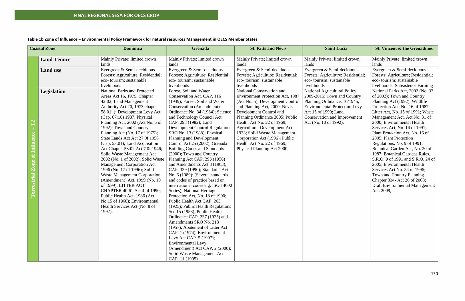
130
FINAL REGIONAL SESA FOR OECS CROP
Table 1b Zone of Influence – Environmental Policy Framework for natural resources Management in OECS Member States
Coastal Zone
Dominica Grenada St. Kitts and Nevis Saint Lucia St. Vincent & the Grenadines
Ter
rest
rial
Zon
e of
Infl
uen
ce –
T2
Land Tenure Mainly Private; limited crown
lands
Mainly Private; limited crown
lands
Mainly Private; limited crown
lands
Mainly Private; limited crown
lands
Mainly Private; limited crown
lands
Land use Evergreen & Semi-deciduous
Forests; Agriculture; Residential;
eco- tourism; sustainable
livelihoods
Evergreen & Semi-deciduous
Forests; Agriculture; Residential;
eco- tourism; sustainable
livelihoods
Evergreen & Semi-deciduous
Forests; Agriculture; Residential;
eco- tourism; sustainable
livelihoods
Evergreen & Semi-deciduous
Forests; Agriculture; Residential;
eco- tourism; sustainable
livelihoods
Evergreen & Semi-deciduous
Forests; Agriculture; Residential;
eco- tourism; sustainable
livelihoods; Subsistence Farming
Legislation National Parks and Protected
Areas Act 16, 1975. Chapter
42:02; Land Management
Authority Act 20, 1973 chapter
58:01; ); Development Levy Act
(Cap. 67:10) 1987; Physical
Planning Act, 2002 (Act No. 5 of
1992); Town and Country
Planning Act (No. 17 of 1975);
State Lands Act Act 27 0f 1958
(Cap. 53:01); Land Acquisition
Act Chapter 53:02 Act 7 0f 1946;
Solid Waste Management Act
2002 (No. 1 of 2002); Solid Waste
Management Corporation Act
1996 (No. 17 of 1996); Solid
Waste Management Corporation
(Amendment) Act, 1999 (No. 10
of 1999); LITTER ACT
CHAPTER 40:61 Act 4 of 1990;
Public Health Act, 1986 (Act
No.15 of 1968); Environmental
Health Services Act (No. 8 of
1997).
Forest, Soil and Water
Conservation Act. CAP. 116
(1949); Forest, Soil and Water
Conservation (Amendment)
Ordinance No. 34 (1984); Science
and Technology Council Act
CAP. 298 (1982); Land
Development Control Regulations
SRO No. 13 (1988); Physical
Planning and Development
Control Act 25 (2002); Grenada
Building Codes and Standards
(2000); Town and Country
Planning Act CAP. 293 (1958)
and Amendments Act 3 (1963),
CAP. 339 (1990); Standards Act
No. 6 (1989); (Several standards
and codes of practice based on
international codes e.g. ISO 14000
Series); National Heritage
Protection Act, No. 18 of 1990;
Public Health Act CAP. 263
(1925); Public Health Regulations
Sec.15 (1958); Public Health
Ordinance CAP. 237 (1925) and
Amendments SRO No. 218
(1957); Abatement of Litter Act
CAP. 1 (1974); Environmental
Levy Act CAP. 5 (1997);
Environmental Levy
(Amendment) Act CAP. 2 (2000);
Solid Waste Management Act
CAP. 11 (1995)
National Conservation and
Environment Protection Act, 1987
(Act No. 5); Development Control
and Planning Act, 2000; Nevis
Development Control and
Planning Ordinance 2005; Public
Health Act No. 22 of 1969;
Agricultural Development Act
1973; Solid Waste Management
Corporation Act (1996); Public
Health Act No. 22 of 1969;
Physical Planning Act 2000;
National Agricultural Policy
2009-2015; Town and Country
Planning Ordinance, 10/1945;
Environmental Protection Levy
Act 15 of 1999; Land
Conservation and Improvement
Act (No. 10 of 1992).
National Parks Act, 2002 (No. 33
of 2002); Town and Country
Planning Act (1992); Wildlife
Protection Act, No. 16 of 1987;
Litter Act, No. 15 of 1991; Waste
Management Act, Act No. 31 of
2000; Environmental Health
Services Act, No. 14 of 1991;
Plant Protection Act, No. 16 of
2005; Plant Protection
Regulations, No. 9 of 1991;
Botanical Garden Act, No. 20 of
1987; Botanical Gardens Rules,
S.R.O. 9 of 1991 and S.R.O. 24 of
2005; Environmental Health
Services Act No. 34 of 1996;
Town and Country Planning
Chapter 334- Act 26 of 2008;
Draft Environmental Management
Act. 2009;
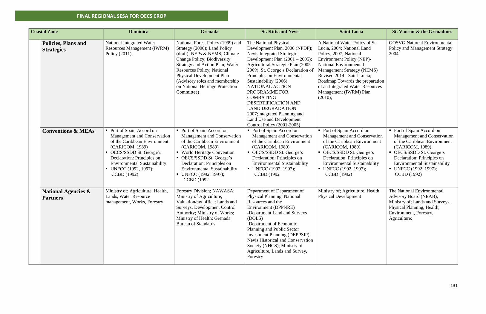
131
FINAL REGIONAL SESA FOR OECS CROP
Coastal Zone
Dominica Grenada St. Kitts and Nevis Saint Lucia St. Vincent & the Grenadines
Policies, Plans and
Strategies
National Integrated Water
Resources Management (IWRM)
Policy (2011);
National Forest Policy (1999) and
Strategy (2000); Land Policy
(draft); NEPs & NEMS; Climate
Change Policy; Biodiversity
Strategy and Action Plan; Water
Resources Policy; National
Physical Development Plan
(Advisory roles and membership
on National Heritage Protection
Committee)
The National Physical
Development Plan, 2006 (NPDP);
Nevis Integrated Strategic
Development Plan (2001 – 2005);
Agricultural Strategic Plan (2005-
2009); St. George’s Declaration of
Principles on Environmental
Sustainability (2006);
NATIONAL ACTION
PROGRAMME FOR
COMBATING
DESERTIFICATION AND
LAND DEGRADATION
2007;Integrated Planning and
Land Use and Development
Control Policy (2001-2005)
A National Water Policy of St.
Lucia, 2004; National Land
Policy, 2007; National
Environment Policy (NEP)-
National Environmental
Management Strategy (NEMS)
Revised 2014 - Saint Lucia;
Roadmap Towards the preparation
of an Integrated Water Resources
Management (IWRM) Plan
(2010);
GOSVG National Environmental
Policy and Management Strategy
2004
Conventions & MEAs ▪ Port of Spain Accord on
Management and Conservation
of the Caribbean Environment
(CARICOM, 1989)
▪ OECS/SSDD St. George’s
Declaration: Principles on
Environmental Sustainability
▪ UNFCC (1992, 1997);
CCBD (1992)
▪ Port of Spain Accord on
Management and Conservation
of the Caribbean Environment
(CARICOM, 1989)
▪ World Heritage Convention
▪ OECS/SSDD St. George’s
Declaration: Principles on
Environmental Sustainability
▪ UNFCC (1992, 1997);
CCBD (1992
▪ Port of Spain Accord on
Management and Conservation
of the Caribbean Environment
(CARICOM, 1989)
▪ OECS/SSDD St. George’s
Declaration: Principles on
Environmental Sustainability
▪ UNFCC (1992, 1997);
CCBD (1992
▪ Port of Spain Accord on
Management and Conservation
of the Caribbean Environment
(CARICOM, 1989)
▪ OECS/SSDD St. George’s
Declaration: Principles on
Environmental Sustainability
▪ UNFCC (1992, 1997);
CCBD (1992)
▪ Port of Spain Accord on
Management and Conservation
of the Caribbean Environment
(CARICOM, 1989)
▪ OECS/SSDD St. George’s
Declaration: Principles on
Environmental Sustainability
▪ UNFCC (1992, 1997);
CCBD (1992)
National Agencies &
Partners
Ministry of; Agriculture, Health,
Lands, Water Resource
management, Works, Forestry
Forestry Division; NAWASA;
Ministry of Agriculture;
Valuation/tax office; Lands and
Surveys; Development Control
Authority; Ministry of Works;
Ministry of Health; Grenada
Bureau of Standards
Department of Department of
Physical Planning, National
Resources and the
Environment (DPPNRE)
-Department Land and Surveys
(DOLS)
-Department of Economic
Planning and Public Sector
Investment Planning (DEPPSIP);
Nevis Historical and Conservation
Society (NHCS); Ministry of
Agriculture, Lands and Survey,
Forestry
Ministry of; Agriculture, Health,
Physical Development
The National Environmental
Advisory Board (NEAB),
Ministry of; Lands and Surveys,
Physical Planning, Health,
Environment, Forestry,
Agriculture;
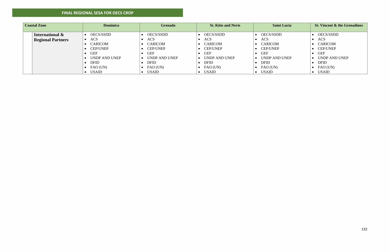
132
FINAL REGIONAL SESA FOR OECS CROP
Coastal Zone
Dominica Grenada St. Kitts and Nevis Saint Lucia St. Vincent & the Grenadines
International &
Regional Partners
• OECS/SSDD
• ACS
• CARICOM
• CEP/UNEP
• GEF
• UNDP AND UNEP
• DFID
• FAO (UN)
• USAID
• OECS/SSDD
• ACS
• CARICOM
• CEP/UNEP
• GEF
• UNDP AND UNEP
• DFID
• FAO (UN)
• USAID
• OECS/SSDD
• ACS
• CARICOM
• CEP/UNEP
• GEF
• UNDP AND UNEP
• DFID
• FAO (UN)
• USAID
• OECS/SSDD
• ACS
• CARICOM
• CEP/UNEP
• GEF
• UNDP AND UNEP
• DFID
• FAO (UN)
• USAID
• OECS/SSDD
• ACS
• CARICOM
• CEP/UNEP
• GEF
• UNDP AND UNEP
• DFID
• FAO (UN)
• USAID
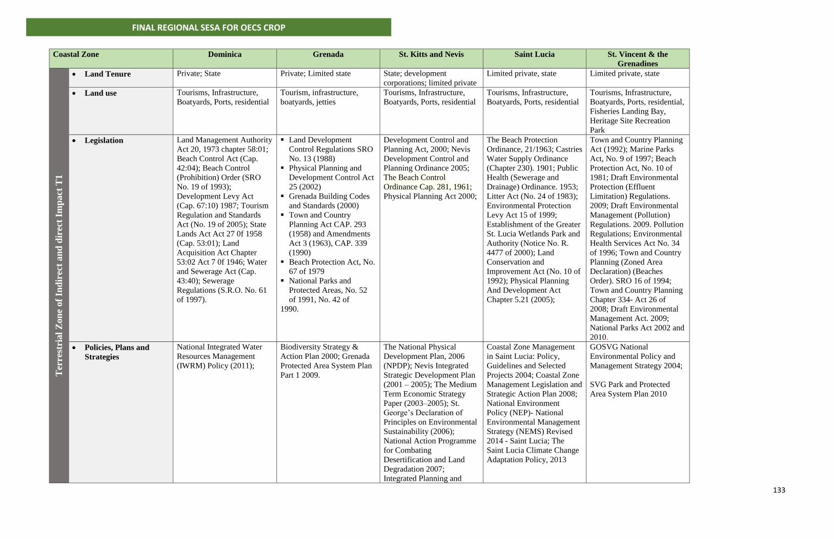
133
FINAL REGIONAL SESA FOR OECS CROP
Coastal Zone
Dominica Grenada St. Kitts and Nevis Saint Lucia St. Vincent & the
Grenadines T
erre
stri
al
Zon
e of
Ind
irec
t a
nd
dir
ect
Imp
act
T1
• Land Tenure Private; State Private; Limited state State; development
corporations; limited private
Limited private, state Limited private, state
• Land use Tourisms, Infrastructure,
Boatyards, Ports, residential
Tourism, infrastructure,
boatyards, jetties
Tourisms, Infrastructure,
Boatyards, Ports, residential
Tourisms, Infrastructure,
Boatyards, Ports, residential
Tourisms, Infrastructure,
Boatyards, Ports, residential,
Fisheries Landing Bay,
Heritage Site Recreation
Park
• Legislation Land Management Authority
Act 20, 1973 chapter 58:01;
Beach Control Act (Cap.
42:04); Beach Control
(Prohibition) Order (SRO
No. 19 of 1993);
Development Levy Act
(Cap. 67:10) 1987; Tourism
Regulation and Standards
Act (No. 19 of 2005); State
Lands Act Act 27 0f 1958
(Cap. 53:01); Land
Acquisition Act Chapter
53:02 Act 7 0f 1946; Water
and Sewerage Act (Cap.
43:40); Sewerage
Regulations (S.R.O. No. 61
of 1997).
▪ Land Development
Control Regulations SRO
No. 13 (1988)
▪ Physical Planning and
Development Control Act
25 (2002)
▪ Grenada Building Codes
and Standards (2000)
▪ Town and Country
Planning Act CAP. 293
(1958) and Amendments
Act 3 (1963), CAP. 339
(1990)
▪ Beach Protection Act, No.
67 of 1979
▪ National Parks and
Protected Areas, No. 52
of 1991, No. 42 of
1990.
Development Control and
Planning Act, 2000; Nevis
Development Control and
Planning Ordinance 2005;
The Beach Control
Ordinance Cap. 281, 1961;
Physical Planning Act 2000;
The Beach Protection
Ordinance, 21/1963; Castries
Water Supply Ordinance
(Chapter 230). 1901; Public
Health (Sewerage and
Drainage) Ordinance. 1953;
Litter Act (No. 24 of 1983);
Environmental Protection
Levy Act 15 of 1999;
Establishment of the Greater
St. Lucia Wetlands Park and
Authority (Notice No. R.
4477 of 2000); Land
Conservation and
Improvement Act (No. 10 of
1992); Physical Planning
And Development Act
Chapter 5.21 (2005);
Town and Country Planning
Act (1992); Marine Parks
Act, No. 9 of 1997; Beach
Protection Act, No. 10 of
1981; Draft Environmental
Protection (Effluent
Limitation) Regulations.
2009; Draft Environmental
Management (Pollution)
Regulations. 2009. Pollution
Regulations; Environmental
Health Services Act No. 34
of 1996; Town and Country
Planning (Zoned Area
Declaration) (Beaches
Order). SRO 16 of 1994;
Town and Country Planning
Chapter 334- Act 26 of
2008; Draft Environmental
Management Act. 2009;
National Parks Act 2002 and
2010.
• Policies, Plans and
Strategies
National Integrated Water
Resources Management
(IWRM) Policy (2011);
Biodiversity Strategy &
Action Plan 2000; Grenada
Protected Area System Plan
Part 1 2009.
The National Physical
Development Plan, 2006
(NPDP); Nevis Integrated
Strategic Development Plan
(2001 – 2005); The Medium
Term Economic Strategy
Paper (2003–2005); St.
George’s Declaration of
Principles on Environmental
Sustainability (2006);
National Action Programme
for Combating
Desertification and Land
Degradation 2007;
Integrated Planning and
Coastal Zone Management
in Saint Lucia: Policy,
Guidelines and Selected
Projects 2004; Coastal Zone
Management Legislation and
Strategic Action Plan 2008;
National Environment
Policy (NEP)- National
Environmental Management
Strategy (NEMS) Revised
2014 - Saint Lucia; The
Saint Lucia Climate Change
Adaptation Policy, 2013
GOSVG National
Environmental Policy and
Management Strategy 2004;
SVG Park and Protected
Area System Plan 2010
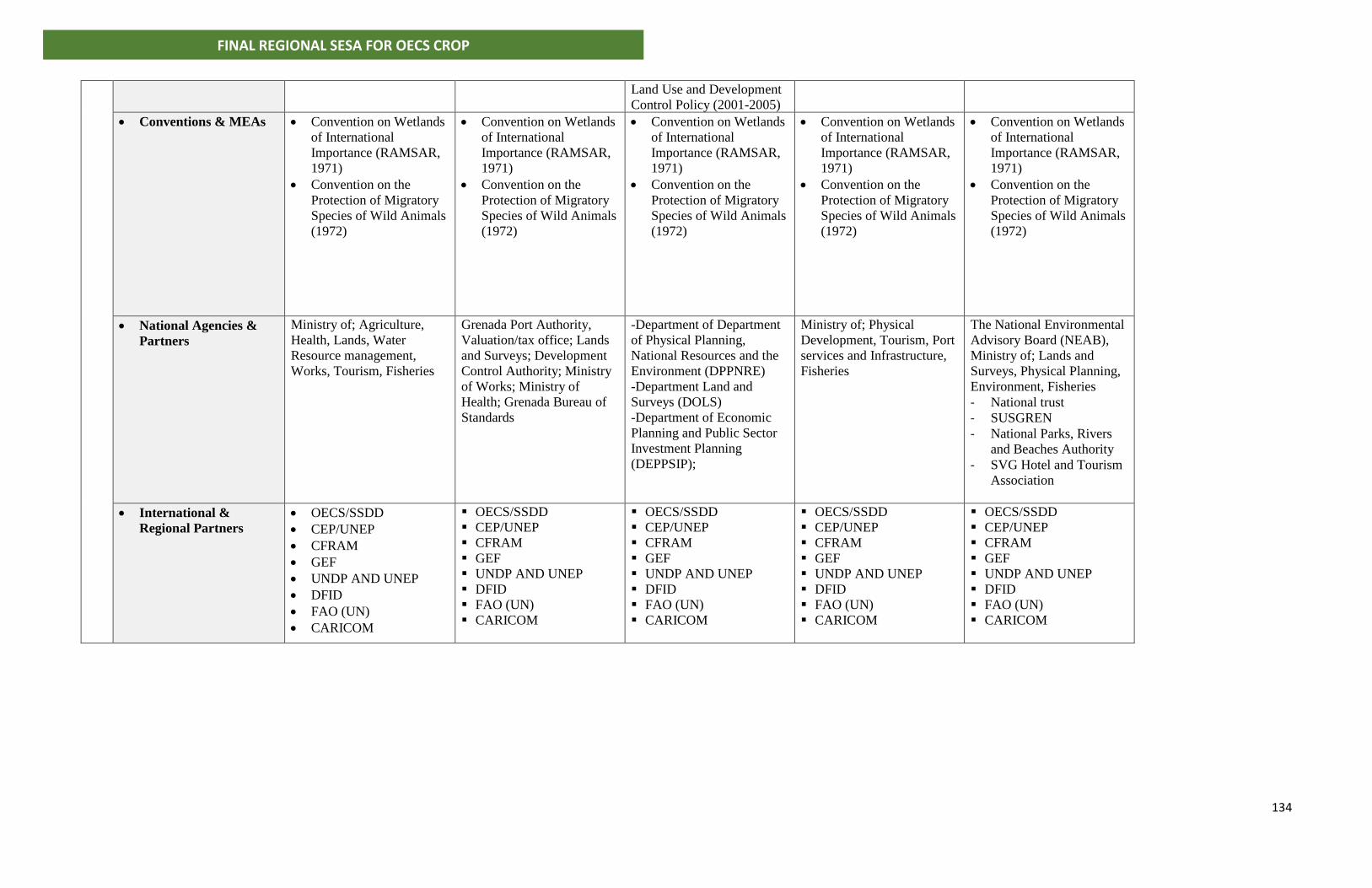
134
FINAL REGIONAL SESA FOR OECS CROP
Land Use and Development
Control Policy (2001-2005)
• Conventions & MEAs • Convention on Wetlands
of International
Importance (RAMSAR,
1971)
• Convention on the
Protection of Migratory
Species of Wild Animals
(1972)
• Convention on Wetlands
of International
Importance (RAMSAR,
1971)
• Convention on the
Protection of Migratory
Species of Wild Animals
(1972)
• Convention on Wetlands
of International
Importance (RAMSAR,
1971)
• Convention on the
Protection of Migratory
Species of Wild Animals
(1972)
• Convention on Wetlands
of International
Importance (RAMSAR,
1971)
• Convention on the
Protection of Migratory
Species of Wild Animals
(1972)
• Convention on Wetlands
of International
Importance (RAMSAR,
1971)
• Convention on the
Protection of Migratory
Species of Wild Animals
(1972)
• National Agencies &
Partners
Ministry of; Agriculture,
Health, Lands, Water
Resource management,
Works, Tourism, Fisheries
Grenada Port Authority,
Valuation/tax office; Lands
and Surveys; Development
Control Authority; Ministry
of Works; Ministry of
Health; Grenada Bureau of
Standards
-Department of Department
of Physical Planning,
National Resources and the
Environment (DPPNRE)
-Department Land and
Surveys (DOLS)
-Department of Economic
Planning and Public Sector
Investment Planning
(DEPPSIP);
Ministry of; Physical
Development, Tourism, Port
services and Infrastructure,
Fisheries
The National Environmental
Advisory Board (NEAB),
Ministry of; Lands and
Surveys, Physical Planning,
Environment, Fisheries
- National trust
- SUSGREN
- National Parks, Rivers
and Beaches Authority
- SVG Hotel and Tourism
Association
• International &
Regional Partners
• OECS/SSDD
• CEP/UNEP
• CFRAM
• GEF
• UNDP AND UNEP
• DFID
• FAO (UN)
• CARICOM
▪ OECS/SSDD
▪ CEP/UNEP
▪ CFRAM
▪ GEF
▪ UNDP AND UNEP
▪ DFID
▪ FAO (UN)
▪ CARICOM
▪ OECS/SSDD
▪ CEP/UNEP
▪ CFRAM
▪ GEF
▪ UNDP AND UNEP
▪ DFID
▪ FAO (UN)
▪ CARICOM
▪ OECS/SSDD
▪ CEP/UNEP
▪ CFRAM
▪ GEF
▪ UNDP AND UNEP
▪ DFID
▪ FAO (UN)
▪ CARICOM
▪ OECS/SSDD
▪ CEP/UNEP
▪ CFRAM
▪ GEF
▪ UNDP AND UNEP
▪ DFID
▪ FAO (UN)
▪ CARICOM
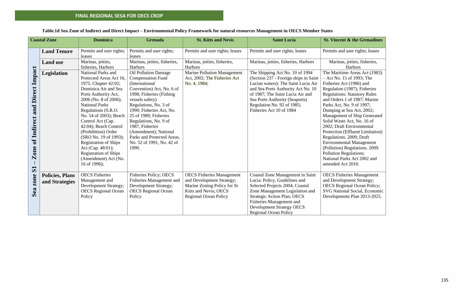
135
FINAL REGIONAL SESA FOR OECS CROP
Table.1d Sea Zone of Indirect and Direct Impact – Environmental Policy Framework for natural resources Management in OECS Member States
Coastal Zone
Dominica Grenada St. Kitts and Nevis Saint Lucia St. Vincent & the Grenadines
Sea
zo
ne
S1
– Z
on
e o
f In
dir
ect
an
d D
irec
t Im
pa
ct
Land Tenure Permits and user rights;
leases
Permits and user rights;
leases
Permits and user rights; leases Permits and user rights; leases Permits and user rights; leases
Land use Marinas, jetties,
fisheries, Harbors
Marinas, jetties, fisheries,
Harbors
Marinas, jetties, fisheries,
Harbors
Marinas, jetties, fisheries, Harbors Marinas, jetties, fisheries,
Harbors
Legislation National Parks and
Protected Areas Act 16,
1975. Chapter 42:02;
Dominica Air and Sea
Ports Authority Act,
2006 (No. 8 of 2006);
National Parks
Regulations (S.R.O.
No. 54 of 2003); Beach
Control Act (Cap.
42:04); Beach Control
(Prohibition) Order
(SRO No. 19 of 1993);
Registration of Ships
Act (Cap. 48:01);
Registration of Ships
(Amendment) Act (No.
16 of 1996);
Oil Pollution Damage
Compensation Fund
(International
Convention) Act, No. 6 of
1998; Fisheries (Fishing
vessels safety)
Regulations, No. 3 of
1990; Fisheries Act, No.
25 of 1989; Fisheries
Regulations, No. 9 of
1987, Fisheries
(Amendment); National
Parks and Protected Areas,
No. 52 of 1991, No. 42 of
1990.
Marine Pollution Management
Act, 2002; The Fisheries Act
No. 4, 1984;
The Shipping Act No. 10 of 1994
(Section 237 - Foreign ships in Saint
Lucian waters); The Saint Lucia Air
and Sea Ports Authority Act No. 10
of 1987; The Saint Lucia Air and
Sea Ports Authority (Seaports)
Regulation No. 92 of 1985;
Fisheries Act 10 of 1984
The Maritime Areas Act (1983)
– Act No. 15 of 1993; The
Fisheries Act (1986) and
Regulation (1987); Fisheries
Regulations: Statutory Rules
and Orders 1 of 1987; Marine
Parks Act, No. 9 of 1997;
Dumping at Sea Act, 2002;
Management of Ship Generated
Solid Waste Act, No. 16 of
2002; Draft Environmental
Protection (Effluent Limitation)
Regulations. 2009; Draft
Environmental Management
(Pollution) Regulations. 2009.
Pollution Regulations;
National Parks Act 2002 and
amended Act 2010.
Policies, Plans
and Strategies
OECS Fisheries
Management and
Development Strategy;
OECS Regional Ocean
Policy
Fisheries Policy; OECS
Fisheries Management and
Development Strategy;
OECS Regional Ocean
Policy
OECS Fisheries Management
and Development Strategy;
Marine Zoning Policy for St
Kitts and Nevis; OECS
Regional Ocean Policy
Coastal Zone Management in Saint
Lucia: Policy, Guidelines and
Selected Projects 2004; Coastal
Zone Management Legislation and
Strategic Action Plan; OECS
Fisheries Management and
Development Strategy OECS
Regional Ocean Policy
OECS Fisheries Management
and Development Strategy;
OECS Regional Ocean Policy;
SVG National Social, Economic
Developments Plan 2013-2025.
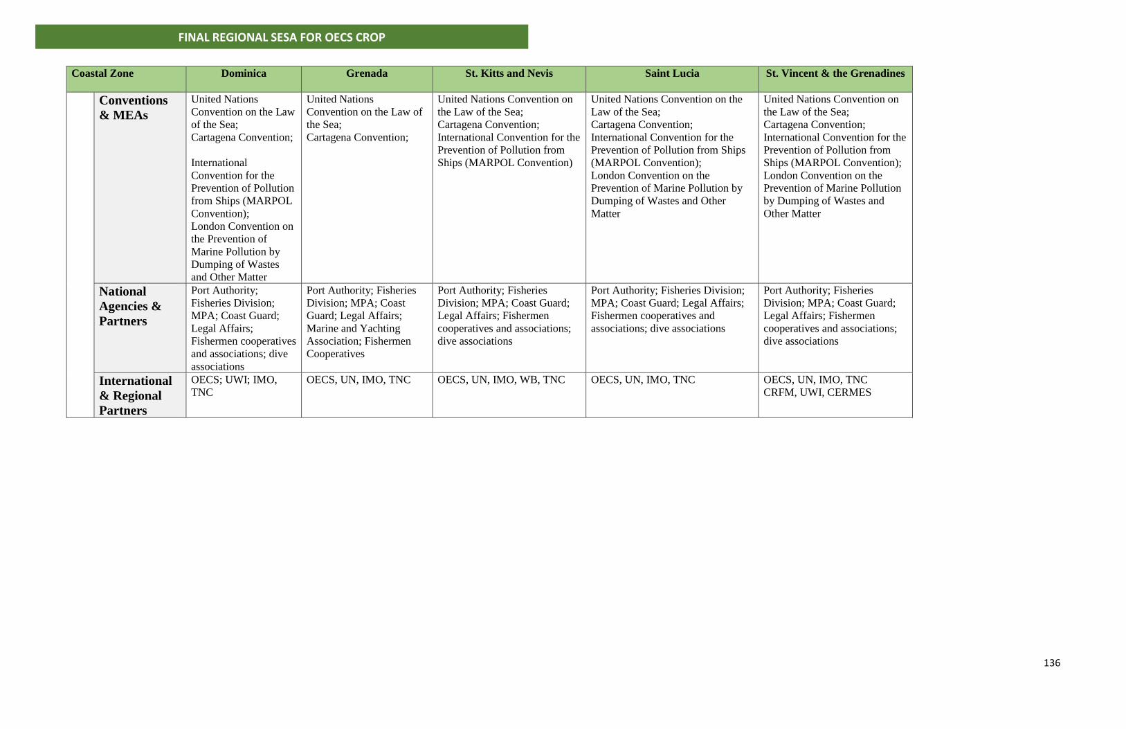
136
FINAL REGIONAL SESA FOR OECS CROP
Coastal Zone
Dominica Grenada St. Kitts and Nevis Saint Lucia St. Vincent & the Grenadines
Conventions
& MEAs
United Nations
Convention on the Law
of the Sea;
Cartagena Convention;
International
Convention for the
Prevention of Pollution
from Ships (MARPOL
Convention);
London Convention on
the Prevention of
Marine Pollution by
Dumping of Wastes
and Other Matter
United Nations
Convention on the Law of
the Sea;
Cartagena Convention;
United Nations Convention on
the Law of the Sea;
Cartagena Convention;
International Convention for the
Prevention of Pollution from
Ships (MARPOL Convention)
United Nations Convention on the
Law of the Sea;
Cartagena Convention;
International Convention for the
Prevention of Pollution from Ships
(MARPOL Convention);
London Convention on the
Prevention of Marine Pollution by
Dumping of Wastes and Other
Matter
United Nations Convention on
the Law of the Sea;
Cartagena Convention;
International Convention for the
Prevention of Pollution from
Ships (MARPOL Convention);
London Convention on the
Prevention of Marine Pollution
by Dumping of Wastes and
Other Matter
National
Agencies &
Partners
Port Authority;
Fisheries Division;
MPA; Coast Guard;
Legal Affairs;
Fishermen cooperatives
and associations; dive
associations
Port Authority; Fisheries
Division; MPA; Coast
Guard; Legal Affairs;
Marine and Yachting
Association; Fishermen
Cooperatives
Port Authority; Fisheries
Division; MPA; Coast Guard;
Legal Affairs; Fishermen
cooperatives and associations;
dive associations
Port Authority; Fisheries Division;
MPA; Coast Guard; Legal Affairs;
Fishermen cooperatives and
associations; dive associations
Port Authority; Fisheries
Division; MPA; Coast Guard;
Legal Affairs; Fishermen
cooperatives and associations;
dive associations
International
& Regional
Partners
OECS; UWI; IMO,
TNC
OECS, UN, IMO, TNC OECS, UN, IMO, WB, TNC OECS, UN, IMO, TNC OECS, UN, IMO, TNC
CRFM, UWI, CERMES
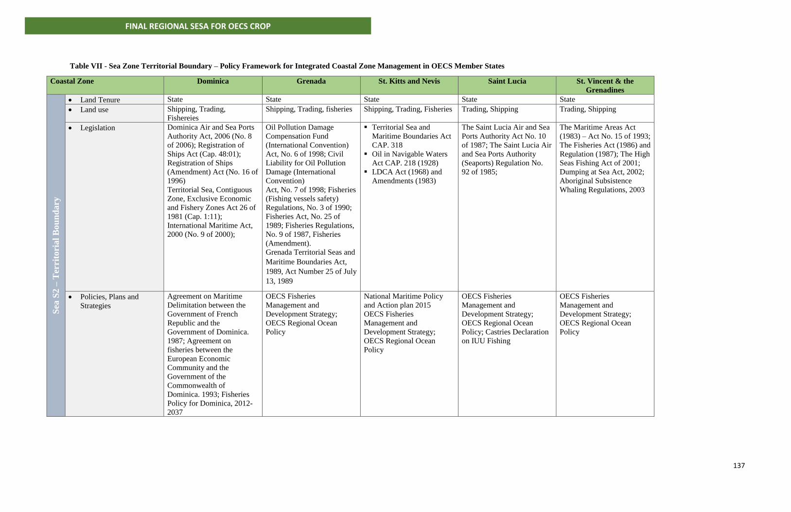
137
FINAL REGIONAL SESA FOR OECS CROP
Table VII - Sea Zone Territorial Boundary – Policy Framework for Integrated Coastal Zone Management in OECS Member States
Coastal Zone
Dominica Grenada St. Kitts and Nevis Saint Lucia St. Vincent & the
Grenadines
Sea
S2
– T
erri
tori
al
Bo
un
da
ry
• Land Tenure State State State State State
• Land use Shipping, Trading,
Fishereies
Shipping, Trading, fisheries Shipping, Trading, Fisheries Trading, Shipping Trading, Shipping
• Legislation Dominica Air and Sea Ports
Authority Act, 2006 (No. 8
of 2006); Registration of
Ships Act (Cap. 48:01);
Registration of Ships
(Amendment) Act (No. 16 of
1996)
Territorial Sea, Contiguous
Zone, Exclusive Economic
and Fishery Zones Act 26 of
1981 (Cap. 1:11);
International Maritime Act,
2000 (No. 9 of 2000);
Oil Pollution Damage
Compensation Fund
(International Convention)
Act, No. 6 of 1998; Civil
Liability for Oil Pollution
Damage (International
Convention)
Act, No. 7 of 1998; Fisheries
(Fishing vessels safety)
Regulations, No. 3 of 1990;
Fisheries Act, No. 25 of
1989; Fisheries Regulations,
No. 9 of 1987, Fisheries
(Amendment).
Grenada Territorial Seas and
Maritime Boundaries Act,
1989, Act Number 25 of July
13, 1989
▪ Territorial Sea and
Maritime Boundaries Act
CAP. 318
▪ Oil in Navigable Waters
Act CAP. 218 (1928)
▪ LDCA Act (1968) and
Amendments (1983)
The Saint Lucia Air and Sea
Ports Authority Act No. 10
of 1987; The Saint Lucia Air
and Sea Ports Authority
(Seaports) Regulation No.
92 of 1985;
The Maritime Areas Act
(1983) – Act No. 15 of 1993;
The Fisheries Act (1986) and
Regulation (1987); The High
Seas Fishing Act of 2001;
Dumping at Sea Act, 2002;
Aboriginal Subsistence
Whaling Regulations, 2003
• Policies, Plans and
Strategies
Agreement on Maritime
Delimitation between the
Government of French
Republic and the
Government of Dominica.
1987; Agreement on
fisheries between the
European Economic
Community and the
Government of the
Commonwealth of
Dominica. 1993; Fisheries
Policy for Dominica, 2012-
2037
OECS Fisheries
Management and
Development Strategy;
OECS Regional Ocean
Policy
National Maritime Policy
and Action plan 2015
OECS Fisheries
Management and
Development Strategy;
OECS Regional Ocean
Policy
OECS Fisheries
Management and
Development Strategy;
OECS Regional Ocean
Policy; Castries Declaration
on IUU Fishing
OECS Fisheries
Management and
Development Strategy;
OECS Regional Ocean
Policy
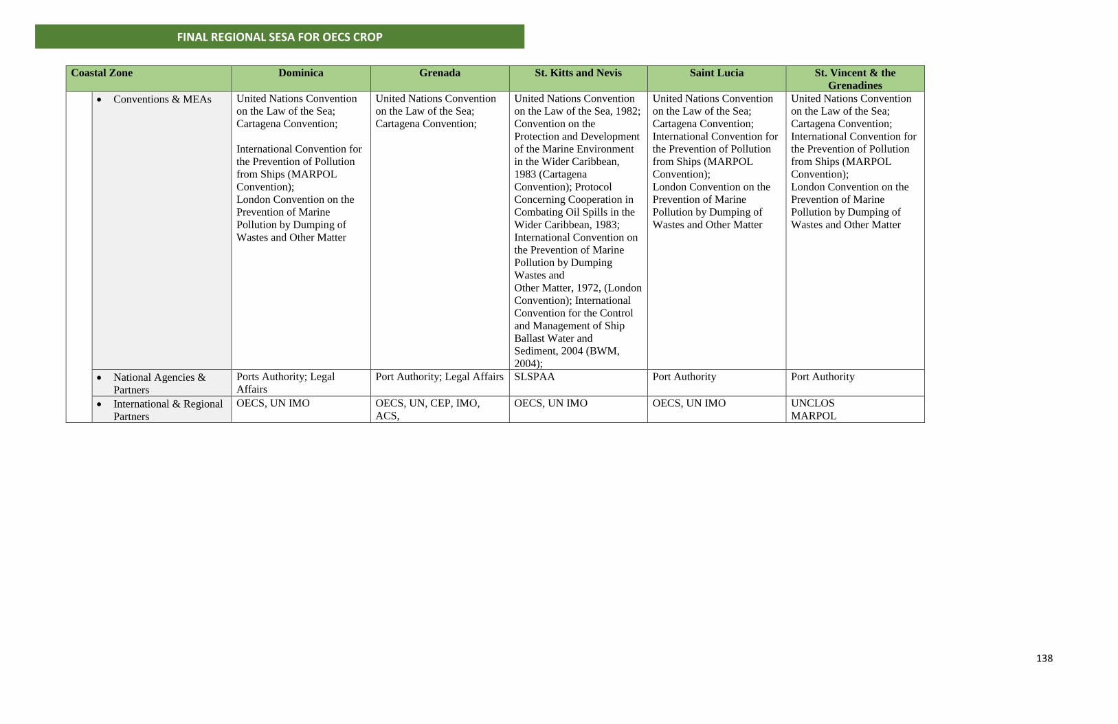
138
FINAL REGIONAL SESA FOR OECS CROP
Coastal Zone
Dominica Grenada St. Kitts and Nevis Saint Lucia St. Vincent & the
Grenadines
• Conventions & MEAs United Nations Convention
on the Law of the Sea;
Cartagena Convention;
International Convention for
the Prevention of Pollution
from Ships (MARPOL
Convention);
London Convention on the
Prevention of Marine
Pollution by Dumping of
Wastes and Other Matter
United Nations Convention
on the Law of the Sea;
Cartagena Convention;
United Nations Convention
on the Law of the Sea, 1982;
Convention on the
Protection and Development
of the Marine Environment
in the Wider Caribbean,
1983 (Cartagena
Convention); Protocol
Concerning Cooperation in
Combating Oil Spills in the
Wider Caribbean, 1983;
International Convention on
the Prevention of Marine
Pollution by Dumping
Wastes and
Other Matter, 1972, (London
Convention); International
Convention for the Control
and Management of Ship
Ballast Water and
Sediment, 2004 (BWM,
2004);
United Nations Convention
on the Law of the Sea;
Cartagena Convention;
International Convention for
the Prevention of Pollution
from Ships (MARPOL
Convention);
London Convention on the
Prevention of Marine
Pollution by Dumping of
Wastes and Other Matter
United Nations Convention
on the Law of the Sea;
Cartagena Convention;
International Convention for
the Prevention of Pollution
from Ships (MARPOL
Convention);
London Convention on the
Prevention of Marine
Pollution by Dumping of
Wastes and Other Matter
• National Agencies &
Partners
Ports Authority; Legal
Affairs
Port Authority; Legal Affairs SLSPAA Port Authority Port Authority
• International & Regional
Partners
OECS, UN IMO OECS, UN, CEP, IMO,
ACS,
OECS, UN IMO OECS, UN IMO UNCLOS
MARPOL
139
FINAL REGIONAL SESA FOR OECS CROP
ANNEX II – FRAMEWORK FOR INVOLUNTARY SETTLEMENT
A2.1 Objectives for Involuntary Resettlement Framework As noted in the assessment of critical impacts and risks for the Grenada Blue Growth
Future Scenario, it is likely that households and businesses will need to be resettled to
facilitate re-development of the coastal areas. This will trigger the World Bank’s (WB)
Involuntary Resettlement Policy (OP 4.12). The policy objectives of OP 4.12 are to assist
affected persons in their efforts to improve their standards of living or at least to restore
them, in real terms, to pre-displacement levels or to levels prevailing prior to the
beginning of project implementation, whichever is higher. The policy specifically covers
direct economic and social impacts that result from WB assisted investment projects that
are caused by: -
(a) The involuntary taking of land resulting in:-
1. Relocation or loss of shelter
2. Loss of assets or access to assets
3. Loss of income sources or means of livelihood, whether the affected person
must move to another location
(b) The involuntary restriction of access to legally designated parks and protected
areas resulting in adverse impacts on the livelihoods of the displaced persons.
A2.2 Existing Legislation and Policy There is not a comprehensive written policy on standard procedures for resettling and
compensating persons who are affected by development projects such as marine villages
and resorts. However, OECS Governments have had to resettle and compensate persons
affected by public development projects in the past. There is no legal basis for
resettlement of communities to facilitate private sector investment projects such as those
proposed in the Grenada Blue Growth Master Plan. Legal guidance for the acquisition of
lands is provided in the Land Acquisition Act No. 159 in the Revised Laws of Grenada,
1990.
140
FINAL REGIONAL SESA FOR OECS CROP
This Act has similar provisions to that for land acquisition legislation in other OECS
Territories which allows the Government to exercise its rights of compulsory purchase of
property where negotiations with private land owners prove futile. Compensation for
lands is guided by negotiations between the private party and the government. A "Crop
Compensation Schedule" is available for compensation of crops cleared from an area
which will be used to facilitate a development project.
A2.3 Recommended Procedure for Involuntary Resettlement
There are no case studies of incidences where households were relocated to facilitate
coastal master plans. Based on information gathered from interviews with Government
Ministries and literature review, the following is recommended: 1) The consultant during
finalization of project and detailed design work must identify households to be relocated;
2) owners of households must be approached by representatives from the Government
(Ministry of Works in this case) for discussions on the proposal for relocation. Both
owners and the government will identify locations where the households will be
resettled. Where there are disagreements a compromise must be reached between both
parties on the cost for relocation and sites where households will be resettled; 3)
Householders must be restored to similar or better conditions to that which they
previously enjoyed.
A2.4 Recommended Procedure for Compensation
There are two levels at which compensation will be necessary:
A2.4.1 Compensation for Land
The first is compensation for lands which must be acquired for a) road widening; b) to
obtain aggregates and stones for road work; and c) to set up construction site and storage
sheds. It is the responsibility of the consultant and contractors to identify lands which
will be needed during road improvement and rehabilitation. The Chief Technical Officer
(CTO) in the Ministry of Works, Physical Planning Unit, Lands Division or Ministry of
Agriculture will review the recommendations. Land ownership must be legally vetted and
private owners contacted for purchase or lease of property. If owners are not
cooperative, compulsory purchase of the land can take place under provisions set forth
141
FINAL REGIONAL SESA FOR OECS CROP
in the Land Acquisition Act. In such case this action for compulsory purchase of land must
be gazetted.
Negotiations between land owners and the government will result in the determination
of a price for the property. There are no set standards on the price of lands in OECS States.
Real Estate Prices are determined by market forces and land owners have the right and
freedom to set land prices during a sale. However, the Ministry of Agriculture, Valuations
and Lands Departments typically have guidelines on the price of agricultural and state-
owned (crown) lands.
A2.4.2 Compensation for Crops
The second level at which compensation takes place is for crops which must be cleared
to facilitate road works or similar types of infrastructural development. After identifying
areas to be cleared, the consultant must provide this information to the Extension Office
of the Ministry of Agriculture. An Extension Officer will accompany the consultant and the
landowner to examine the plot which must be cleared. The Officer will examine the plot,
not the type and number of trees, their age, fruit bearing potential and health condition.
A listing of plants and their associated costs will be developed by the Extension Officer.
The Contractor is then responsible to pay the land owner the amount determined to be
the fair value after the field survey. Reimbursement is provided to the Contractor after
presentation of invoices and bills to the Government.
A2.5 Guidelines for Involuntary Resettlement Plan The plan should provide details on the following: 1. Details of events leading to activation of OP 4.12
2. Census survey of project affected people (PAP);
3. Inventory of adverse impacts on PAP’s assets;
4. Description of compensation packages offered to PAP and option selected by PAP;
5. Consultations with PAP about acceptable compensation alternatives;
6. Institutional responsibilities for implementation of Resettlement Action Plan (RAP);
and timetable for implementing RAP;
7. Arrangements and timetable for monitoring and implementation of RAP;
142
FINAL REGIONAL SESA FOR OECS CROP
8. Procedures for grievance redress;
9. Source of funding and estimated cost for implementation of RAP.
A2. 6 Grenada Land Acquisition Act No. 159, 1990 Arrangement of Sections Section
1 Short title 2. Interpretation
ACQUISITION OF LAND AND ABANDONMENT OF ACQUISITION 3. Acquisition of land 4. Preliminary notification and power to enter land 5. Power to apply land to purposes of acquisition without waiting for formal vesting 6. Authorized officer to treat with landowner 7. Boundaries of land and issue of notice of acquisition 8. Authorized officer to treat with landowner 9. Claim of person interested to have land acquired or abandoned
10. Abandonment of acquisition
APPOINTMENT AND POWER OF BOARD OF ASSESSMENT
11. Determination of questions by Board of Assessment 12. Appointment of Board of Assessment 13. Documents, etc., to be forwarded to the Board 14. Inquiry by Board 15. Procedure at inquiry 16. Power of entry for purpose of inquiry 17. Award of Board
DETERMINATION OF SMALL CLAIMS FOR COMPENSATION
18. Procedure where claim for compensation does not exceed certain amounts Section PROVISIONS GOVERNING ASSESSMENT OF COMPENSATION
19. Rules for assessment of compensation 20. Special rule as to severance 21. Interest 22. Rules as to costs
143
FINAL REGIONAL SESA FOR OECS CROP
MISCELLANEOUS
23. Absentee owners 24. Compensation to persons interested in adjacent land 25. Special provisions as to leases 26. Persons in possession to be deemed owners 27. Fees and expenses of Board 28. Conveyancing, etc., costs to be paid by authorized officer 29. Payment of compensation, etc. 30. Exemption from stamp duty and fees 31. Limitation of time for making claims 32. Assaulting or obstructing authorized officer, etc.
CHAPTER 159
AN ACT to authorize the acquisition of land for public purposes
[6th October, 1945]
1. This Act may be cited as the
LAND ACQUISITION ACT.
2. (1) In this Act-
"authorized officer" means any person who may from time to time be appointed as such
by Governor General for the purposes of this Act;
"person interested" means every person claiming, or entitled to claim, compensation
under this Act:
(2) In this Act, every function to be performed by the Governor-General (whether or not
expressly or by implication its due performance by him requires an exercise of discretion
or judgement or the formation of an opinion) shall be deemed to require for its due
performance that he shall act in accordance with the advice of the Cabinet except
where otherwise provided.
ACQUISITION OF LAND AND ABANDONMENT OF ACQUISITION
3. (1) If the Governor-General considers that any land should be acquired for a public
purpose he may cause a declaration to that effect to be made in the manner provided by
this section and the declaration shall be conclusive evidence that the land to which it
relates is required for a public purpose.
144
FINAL REGIONAL SESA FOR OECS CROP
(2) Every declaration shall be published in two ordinary issues of the Gazette and copies
thereof shall be posted on one of the buildings (if any) on the land or exhibited at
suitable places in the locality in which the land is situate, and in the declaration shall be
specified the following particulars relating to the land which is to be acquired -
(a) the parish or district in which the land is situate;
(b) a description of the land, giving the approximate area and such other particulars as
are necessary to identify the land;
(c) in case where a plan has been prepared, the place where, and the time when, a plan
of the land can be inspected;
(d) the public purpose for which the land is required.
(3) Upon the second publication of the declaration in the Gazette as aforesaid the land
shall vest absolutely in the Crown.
(4) Nothing in this section shall be deemed to prevent the acquisition of lands for public
purposes by private treaty.
4. If it appears to the Governor-General that any land is likely to be required for any
purpose which in the opinion of the Governor-General a public purpose and it is
necessary to make a preliminary survey or other investigation of the land, he may
cause a notification to that effect to be published in the Gazette and thereupon it shall
be lawful for the authorized officer (and his agents, assistants and workmen) to do all
or any of the following things, that is to say-
(a) to enter upon and survey and take levels of any land in any locality to which the
notification relates;
(b) to dig or bore into the sub-soil of such land;
(c) to do all other acts necessary to ascertain whether the land is adapted to such purpose;
(d) to set out the boundaries of the land intended to be taken, and the intended line of
the work, if any, proposed to be done thereon;
(e) to mark levels and lines by placing marks and cutting trenches;
(f) where otherwise the survey cannot be completed, the levels taken or the boundaries
or line of the work set out, to cut down and clear away any standing crop, fence, tree or
bush;
145
FINAL REGIONAL SESA FOR OECS CROP
(g) to do all such other acts as may be incidental to, or necessary for, any of the
purposes aforesaid:
Provided that the authorized officer shall not enter into any building, or into or upon
any enclosed , court, or garden attached to a dwelling-house, except at all
reasonablehours and, except with the consent of the occupier thereof, without previously
giving to such occupier at least seven days notice in writing of his intention to do so:
Provided further that compensation shall be paid to the persons interested in the land
so entered for any actual damage or injury resulting to them by reason of the exercise of
the powers conferred by his section and shall be assessed and paid-
(i) in so far as it relates to land the acquisition of which is subsequently deemed to
be abandoned under section 9 or under section 10, as though it were
compensation payable under this Act for the acquisition of the land;
(ii) in so far as it related to land the compulsory acquisition of which is
subsequently complete under section 3, as though it were part of the
compensation for the acquisition of the land.
5. If, at any time after the publication of a notification in accordance with the provisions
of section 4, it appears to the Governor-General that the land or some parcel of the land
to which it refers should be acquired but that for any reason it not possible to make an
immediate declaration to that effect, it shall be lawful for the Governor-General to direct
the authorized officer to do any work on the land is intended to be put on it acquisition,
and thereupon the authorized officer may proceed with the execution of the work:
Provided that compensation shall be paid to the persons interested for any actual
damage or injury resulting to them by reason of the exercise of the powers conferred by
this section and shall be determined in the same way as compensation for actual damage
or injury resulting from the exercise of the powers conferred by section 4.
6. (1) As soon as a declaration has been published in accordance with the provisions of
section 3, the authorized officer shall, without delay, enter into negotiations (or further
negotiations) for the purchase of the land to which the declaration relates upon
reasonable terms and conditions, and by voluntary agreement with the owner of the land.
(2) It shall not be necessary for the authorized officer to await the publication of the
declaration before the endeavours to ascertain from the owner the terms and conditions
on which he is willing to sell the land, but no negotiations or agreement shall be deemed
146
FINAL REGIONAL SESA FOR OECS CROP
to be concluded unless and until the conditions of sale and acquisition have been
approved in writing by the Governor-General.
7. (1) As soon as may be after land has been acquired compulsorily, the authorized
officer shall, if the boundaries of the land have not been set out or if they cannot be
identified by reference to a plan, cause the same to be set out, and he shall also issue a
notice of acquisition in accordance with the provisions of this section.
(2) Every notice of acquisition under this section shall-
(a) state the decision of the Governor-General to acquire and take possession of the
land compulsorily;
(b) contain the particulars which, in relation to the land, were included in the declaration
provided for by subsection (2) of section 3; and
(c) require all persons interested, as soon as is reasonably practicable, either -
(i) to appear personally or by attorney or agent before the authorized officer to
state the nature of their respective interests in the land and the amounts and full
particulars of their claims to compensation in respect of those interests,
distinguishing the amounts under separate heads and showing how the amount
claimed under each head is calculated; or
(ii) to render to the authorized officer a statement in writing, signed by them or
by their attorneys or agents, setting for the like matters.
(3) The authorized officer shall cause a copy of the notice of acquisition to be served
either personally on, or by post addressed to the land known place of abode or business
of, every person who is known or believed by the authorized officer to be entitled to
compensation in respect of the acquisition, and whose whereabouts are known to the
authorized officer:
Provided that where the whereabouts of any such person are not known, the
authorized officer shall cause copies of such notice to be posted on one of the buildings
(if any) on the land or exhibited at suitable places in the locality in which the land is
situated.
(4) A person who, without lawful authority or excuse, removes or destroys any landmark
placed, or removes or defaces or destroys any notice posted or exhibited, by the
authorized officer in or upon the land or any building thereon in accordance with the
provisions of this Act, shall be guilty of an offence and liable, on summary conviction, to
a fine of one thousand dollars and to imprisonment for three months.
147
FINAL REGIONAL SESA FOR OECS CROP
8. (1) The authorized officer may, by notice served personally, or by post addressed to
the last known place of abode or business of the person concerned, require the owner or
occupier of, or any person interested in, any land, or in any part thereof, in respect of
which a declaration or a notification has been published in the Gazette under section 3 or
section 4 respectively, to deliver to him within a time to be specified in the notice, a
statement in writing containing, so far as may be within his own knowledge, the name of
every person possessing any interest in the land, or any part thereof, whether as partner,
mortgagee, lessee, tenant or otherwise, and the nature of such interest.
(2) Every person who is required to make and deliver a statement under this section and
who, without reasonable excuse, refuses to make or deliver such statement, or wilfully
makes any such statement which is false or incomplete in any material particular, shall be
guilty of an offence and liable, on summary conviction, to a fine of one thousand dollars
and to imprisonment for three months.
9. If within three months after entry has been made on any land under the provisions
of section 4 such land shall not be acquired or abandoned, any person interested in the
land or any part thereof may serve a notice on the authorized officer requiring that the
acquisition of the land or part thereof be completed or abandoned, and, if within one
month thereafter, the acquisition of such land or part thereof be not completed or
abandoned in accordance with the provisions of this Act, the acquisition of the land or
part thereof shall be deemed to have bee abandoned.
10. (1) At any time before land has been acquired compulsorily the Governor-General
may, by notification published in the Gazette, declare that the intended acquisition of
such land is abandoned.
(2) When the acquisition of land is abandoned in accordance with the provisions of this
section, or in deemed to have been of this Act shall, in default of agreement, be assessed
as though it was compensation payable under this Act for the acquisition of land.
(3) No compensation shall be payable in any such case for loss of bargain or for damages
for breach of contract.
APPOINTMENT AND POWERS OF BOARD OF ASSESSMENT
11. (1) All questions and claims relating to the payment of compensation under this Act
and to the appointment of such compensation shall, save as is hereinafter provided, by
submitted to a Board of Assessment to be appointed in each case in accordance with the
provisions of section 12.
(2) A Board of Assessment shall have full power to assess, award and apportion
compensation in such cases, in accordance with the provisions of this Act.
148
FINAL REGIONAL SESA FOR OECS CROP
12. (1) As soon as it becomes necessary to do so the Governor-General shall cause a
Board of Assessment (hereinafter referred to as "a Board" or "the Board") to be
appointed.
(2) A Board for the purpose of this Act shall in every case consist of-
(a) a Judge of the High Court who shall be the chairman of the Board (hereinafter referred
to as "the chairman");
(b) a member to be appointed by the Governor-General; and
(c) a member to be nominated by the owner of the land to be acquired:
Provided that where in any case the Governor-General is satisfied that the owner of the
land has refused to exercise his right to nominate a member of the Board, or has
unreasonably delayed such nomination, or where the persons interested in the land have
failed to agree upon such nomination, the Governor-General, by order in writing, may
direct the chairman to proceed with the inquiry notwithstanding that there has been no
such nomination by the owner, and in every such case the Board shall be deemed to be
lawfully constituted without the presence of such member, and, if there is any difference
of opinion as to the amount of compensation that should be awarded, the decision of the
chairman shall be deemed to be the decision of the Board.
13. (1) Upon the appointment of a Board, or where proceedings are taken before a
magistrate for the determination of any question relating to the payment of
compensation, the authorized officer shall forward to the chairman, or to the magistrate,
as the case may be, those of the following documents and particulars which relate to the
acquisition or the intended acquisition of the land, as the case may be-
(a) a copy of any notification and declaration which has been published in the
Gazette;
(b) a copy of the notice of acquisition;
(c) a copy of any notice issued or received by him;
(d) a copy of all statements received by him in compliance with any notice issued
by him;
(e) the names and addresses of the persons whom the authorized officer has
reason to believe are interested in the land; and
(f) a copy of the report required by this section.
(2) The report to be sent to the Board shall state the opinion of the authorized officer,
and his reasons for such opinion, upon each of the following matters-
(a) what is a fair and proper description of the land acquired, including particulars of any
building, tree or standing crops thereon;
149
FINAL REGIONAL SESA FOR OECS CROP
(b) the approximate acreage of the land;
(c) the value of the land, for the purposes of compensation under this Act;
(d) the amount of provisional compensation which should be paid for the land, including
any damage payable in respect of entry into possession;(e) the apportionment of the
provisional compensation among the persons interested in the land, in respect of their
interests.
(3) The authorized officer, in assessing the amount of any compensation for the purpose
of a report under this section, shall have regard to the rules prescribed by this Act which
may or may not be taken into consideration in assessing compensation.
14. Where a Board has been appointed under this Act, the Board shall hold an inquiry
at a place, date and time to be fixed by the chairman, of which not less than fourteen
clear days' notice shall be given to the parties concerned, and every such inquiry shall be
conducted in public.
15. The procedure at an inquiry before a Board, the summoning and remuneration of
witness for attendance thereat, and all questions incidental to the inquiry shall be
governed by the provisions of the Civil Procedure Act, and the procedure of the High Court
in civil proceedings, so far as the same are applicable, shall apply to such inquiry:
16. The Board, or any person authorized by them, may at any time before, during or after
an inquiry under this Act, enter upon and inspect any land for any purpose connected
with such inquiry.
17. (1) At the conclusion of the inquiry the Board shall decide upon the claims for
compensation and apportionments submitted to them and shall make an award under
the hand of the chairman who shall cause the same to be filed in the High Court.
(2) The decision of the majority of the members of the Board with respect to the
compensation to be paid shall be deemed to be the decision of the Board and, if all the
members of the Board differ, the mean between the amount decided upon by the
chairman and that one of the amounts decided upon by the two other members of the
Board which approximates most nearly to the amount decided upon by the chairman shall
be deemed to be the compensation awarded by the Board.
(3) An appeal shall lie against a decision of the Board to the Court of Appeal.
DETERMINATION OF SMALL CLAIMS FOR COMPENSATION
18. (1) Anything in any Act to the contrary notwithstanding, in any case in which the
compensation claimed does not exceed two hundred and fifty dollars, and in any case in
150
FINAL REGIONAL SESA FOR OECS CROP
which the compensation claimed does not exceed five hundred dollars and, in the latter
case, the parties agree in writing to the settlement of the claim by a magistrate, the
amount of the compensation to be paid in any such case shall be determined by a
magistrate.
(2) It shall be lawful for any magistrate, upon the application of either party with respect
to any question of disputed compensation in either of the cases mentioned in the
proceeding subsection, to summon the other party to appear before him at a time and
place be named in such summons and to hear and determine such question of disputed
compensation.
(3) For the purposes of any proceeding under this section-
(a) the procedure to be followed thereat, the summonding and remuneration of
witnesses and all questions incidental to such proceeding shall be governed by any
Act for the time being in force relating to the recovery of claims before a magistrate
and all the provisions of any such Act shall apply mutatis mutandis to any such
proceeding; and
(b) the provisions of sections 103 to 121 of the Civil Procedure Act shall apply with
such verbal alteration (not affecting the substance)as may be necessary to make the
same applicable.
(4) An appeal shall lie against the determination by a magistrate of any question of
disputed compensation under this section in like manner as if such determination was
given in the exercise of the summary jurisdiction of a magistrate in a civil matter under
the provisions of the Magistrates Judgements (Appeals) Act, and for the purposes of such
appeal the determination of the magistrate under this section shall be deemed to be a
judgement of the magistrate within the meaning of section 2 of the same Act.
PROVISIONS GOVERNING ASSESSMENT OF COMPENSATION
19. Subject to the provisions of this Act, the following rules shall apply to the
assessment and award of compensation by a Board for the compulsory acquisition of
land-
(a) the value of the land shall, subject as hereinafter provided, be taken to be the amount
which the land, if sold in the open market by a willing seller, might have been expected
to have realized at a date twelve months prior to the date of the second publication in
the Gazette of the declaration under section 3:
Provided that this rule shall not affect the assessment of compensation for any damage
sustained by the person interested by reason of severance, or by reason of the acquisition
injuriously affecting his other property or his earnings, or for disturbance, or any other
property or his earnings or for disturbance, or any other matter not directly based on the
value of the land;
151
FINAL REGIONAL SESA FOR OECS CROP
(b) the special suitability or adaptability of the land for any purpose to which the land
could be applied only in pursuance of statutory powers, or for which there is no market
apart from the special needs of a particular purchase or the requirements of any Ministry
or Government department;
(c) where the value of the land is increased by reason of the use thereof or of any premises
thereon in a manner which could be restrained by any court, or is contrary to law, or is
detrimental to the health of the inmates of the premises or to public health, the amount
of that increase shall not be taken into account;
(d) where land is, and but for the compulsory acquisition would continue to be, devoted
to a purpose of such a nature that there is no general demand or market for land for that
purpose, the compensation may, if the Board is satisfied that reinstatement in some other
place is bona fide intended, be assessed on the basis of the reasonable cost of equivalent
reinstatement;
(e) no allowance shall be made on account of-
(i) the acquisition being compulsory or the degree or urgency or necessity which
has led to the acquisition;
(ii) any disinclination of the person interested to part with the land acquired;
(iii) any damage sustained by the person interested which, if caused by a private
person, would not render such person liable to an action;
(iv) any damage, not being in the nature of deprivation of or interference with a
easement or legal right, which, after the time of awarding compensation, is likely
to be caused by or in consequence of the use to which the land acquired will be
put;
(v) any increase in the value of the land acquired likely to accrue from the use to
which the land acquired will be put;
(vi) any outlay or improvement of such land which shall have been made,
commenced or effected within twelve months before the publication of the
declaration under section 3 with the intention of enhancing the compensation to
be awarded therefor in the event of such land being acquired for public purposes.
20. As to severance, compensation may be assessed on the footing that any specified
works, crossings, or access agreed to shall be erected, provided, and allowed, and any
such agreement shall be reduced into writing and be signed by the chairman and shall be
valid and effectual and binding on the parties.
21. The Board, in awarding compensation, may add thereto interest at the rate of five per
cent per annum, calculated from the date upon which the authorized officer entered into
152
FINAL REGIONAL SESA FOR OECS CROP
possession of the land acquired until the date of the payment of the compensation
awarded by the Board.
22. (1) The authorized officer shall pay to the claimant the reasonable costs incurred by
him in or about the preparation and submission of his claim, unless the chairman
considers that the claimant has failed to put forward a proper claim within a reasonable
time after the service of the notice under section 7 or that the claim put forward is grossly
excessive or that he has been a party to some deceit or fraud in respect of his claim.
(2) Subject to the provisions of subsection (1), where as unconditional offer in writing
of any amount as compensation has been made to any claimant by or on behalf of the
authorized officer and the sum awarded as compensation does not exceed the amount
offered, the chairman shall, unless for special reasons he thinks it proper not to do so,
order the claimant to bear his own costs and to pay the costs of the authorized officer so
far as the costs of the authorized officer were incurred after the offer was made, and,
where the claimant has failed to put forward a proper claim in sufficient time to enable
the authorized officer to make a proper offer, the foregoing provisions of this section shall
apply as if an unconditional offer has been made by or on behalf of the authorized officer
at the time when, in the opinion of the chairman, a proper claim should have been put
forward and the claimant had been awarded a sum not exceeding the amount of such
offer.
(3) Subject to the provisions of subsection (1), where a claimant has made an
unconditional offer in writing to accept in sufficient time to enable the authorized officer
to make a proper offer, and the sum awarded in equal to or exceeds that amount, the
chairman shall, unless for special reasons he thinks it proper not to do so, order the
authorized officer to bear his own costs and to pay the costs of the claimant so far as the
cost of the claimant were incurred after the offer was made.
(4) Subject to the provisions of the preceding subsections of this section, the costs shall
be in the discretion of the chairman who may direct to any by whom and in what manner
those costs or any part thereof shall be paid, and he may in any case direct such costs to
be taxed by the Registrar of the Supreme Court.
(5) The mode of enforcing an order as to costs shall be in the manner prescribed by the
practice of the High Court.
(6) Where the chairman orders the claimant to pay the costs or any part of the costs of
the authorized officer, the authorized officer may deduct the amount so payable by the
claimant from the amount of any compensation which may be payable to him.
153
FINAL REGIONAL SESA FOR OECS CROP
MISCELLANEOUS
23. (1) Where there is no person competent to alienate land or to receive or to give a
sufficient discharge for any compensation awarded, or where any person interested in
land, by reason of his absence from Grenada and of his not being represented therein by
a duly authorized attorney, does not submit a statement to or appear before the
authorized officer as required by section 7 and where such a person, after diligent injury,
cannot be found, the authorized officer may pay the compensation into the High Court to
the credit of the person entitled thereto.
(2) Any compensation paid into the High Court by virtue of this section may, on the
subsequent application of a person claiming to be entitled thereto, be paid out to such
person on the order of a Judge of the Court.
(3) All moneys paid into the High Court under the provisions of this section which remain
unclaimed for twelve years after such payment shall be transferred to the Consolidated
Fund, and all claims thereto shall be forever barred.
24. A person interested in any land which, without any portion thereof being
compulsorily acquired, has been injuriously affected by the erection or construction on
land compulsorily acquired of any works in respect of which the land was acquired, shall
be entitled to compensation in respect of such injurious affection:
Provided that compensation shall not be payable under this section in respect of any
injurious affection which, if caused by a private person, would not render such person
liable to an action.
25. (1) If any land shall be comprised in a lease for a term of years unexpired and part
only of such land shall be acquired compulsorily, the rent payable in respect of the
land comprised in such lease may, on the application of the lessor or the lessee to a Judge
of the High Court, be appointed between the land acquired and the residue of the land.
(2) After such apportionment the lessee shall, as to all future accruing rent, be liable to
pay only so much of the rent as shall be so apportioned in respect of the residue of the
land, and as to the residue of the land, and as against the lessee, the lessor shall have all
the same rights and remedies for the recovery of such portion of the rent as previously to
such apportionment he had for the recovery of the whole rent reserved by such lease,
and all the covenants, conditions an agreements of such lease, except as to the amount
of rent to be paid, shall remain in force with regard to the residue of the land in the same
manner as they would have done in case the residue of the land only had been included
in the lease.
26. Where any question shall arise touching the title of any person to any land which
may be entered upon or acquired for the purposes of this Act or touching any estate or
interest therein, the person having the ostensible possession or enjoyment of the rents
154
FINAL REGIONAL SESA FOR OECS CROP
and profits of such land shall, for the purposes of this Act, be deemed to be the owner of
the same until the contrary is proved.
27. (1) Every assessor shall receive for his services such fee as the Governor-General on
the recommendation of the chairman, may direct.
(2) The Governor-General may authorize the reimbursement of the travelling and
subsistence expense incurred by the chairman and members of a Board appointed under
this Act.
28. All reasonable costs, charges, and expenses incurred by the owners of lands or
persons interested therein for all conveyances, and assurances of any lands purchased or
acquired, and of any outstanding terms of interest therein, and of deducing, evidencing
and producing title to such lands, terms or interest, and of making out such abstracts and
attested copies as the authorized officer may require, shall be paid by the authorized
officer.
29. All amounts which have been awarded by way of compensation under this Act,
including interest and costs to be paid by the authorized officer, and all other costs,
charges and expenses which shall be incurred under the authority of this Act shall be
charged upon the Consolidated Fund.
30. Anything in any Act to the contrary notwithstanding, no instrument or document
relating to anything lawfully done under, or for the purposes of, this Act shall be
chargeable with any stamp duty, registration or recording fee.
31. Except with the approval of the Governor-General in any case in which he considers
that injustice may otherwise be done, no claim for compensation which may be made
under the provisions of this Act shall be admitted or entertained unless on which entry
has been made on the land under section 4 a similar period after the date of the second
publication of such declaration.
32. A person who-
(a) assault or obstructs or aids and abets any person in assaulting or obstructing the
authorized officer or any of his agents, assistants or workmen in the execution of his or
their duty under this Act; or
(b) Opposes or impedes the lawful occupation or taking of possession of any land under
the provisions of this Act, shall be guilty of an offence and liable, on summary conviction,
to a fine of three thousand dollars and to imprisonment for three months.
155
FINAL REGIONAL SESA FOR OECS CROP
ANNEX III – Record of Stakeholder Consultations
NOTES FROM DOMINICA (JULY 15-20, 2018)
Day 1 - July 15, 2018
3:00pm - Arrive in Dominica
7:30 pm – Meeting with National Focal Point, Mr Sebastien, OECS Team – David Robin and Susanna Scott, Valma Jessamy
Discuss plans for one-to-one interviews with key stakeholders Meetings arranged with:
• Dr. Reginald Thomas, Permanent Secretary, Ministry of Fisheries and Agriculture; senior officers of Fisheries
• Senior officers of fisheries
• Lloyd Pascal Director Environmental Coordinating Unit (ECU) Comments from focal point: LAMA – local area management authority, manage marine reserves
Water sports associations involved in management in marine reserves Cabrits National Park Comments from VJ– Persons of interest to meet:
• Coreen Prevost, PS Environment
• Physical Planning re Physical Development Plan: o Ms Lyn Baron and Mrs Annie Edwards o Need copies of final documents 2017: National Physical Development
Plan and National Land Use Policy
Comments from DRobin:
• OECS Council of Ministers meeting recently concluded
• OECS “on the front lines of climate change”
• CROP project – unlocking ocean wealth
• Formalized boundaries/treaty Need to visit:
• OECS Commissioner
• Coast Guard, Inspector Simon Edwards
Sebastien on lessons learnt post hurricane Maria
• Need to ID places for fishing boat storage during hurricanes
• ICE/storage of fish: Space; Availability – where to put what
• food security; loss of earners
• Insurance needed; put money in a fund
156
FINAL REGIONAL SESA FOR OECS CROP
Day 2 - Monday 7/16/2018
#1 - Meeting with PS Ministry of Agriculture
Introductions by David Robin
• Theme of recnet Meeting of OECS Ministers of Environment sets context for our work
• Recent hurricane events;
• Overview on CROP - $6.3 million for 5 participating states - World Bank/GEF, OECS Commission; consent of member states for project - Mrs Scott/project coordinator - Dr Jessamy/consultant for SESA
Food production } tremendous resilience post hurricane Lots of fish }
• Interesting to note that Dominica had 160,000 seedlings pre hurricane to donate to another island
• Owe it to farmers & fisher folk /facilitating role of Min of Agric
• CROP: Focus on planning in the marine space (similar to what is done in lands);
• 2 countries have ocean governance policies; project will assist other MS to develop national ocean policies;
• Producing coastal master plan & marine spatial plans for MS
• Plans have ability to assist with spatial planning/ places to store vessels etc
• Capacity building to update & maintain plans’
• Blue economy / think blue (virtual education) [presently empty]….will put info onto that platform
• Mapping ocean wealth/TNC –built platform
PS Agriculture Question re governance policies -developing plans/policies or going through entire system, taking it all the way; -road map to take it through to adoption & implementation “Bring people in pay them well & then?”
Robin answer:
“do not be weary in well doing” -full engagement, what turns out will be as good as national input -national ocean governance committee needs to be established
- ECROP will be aligned with 2030 development agenda
157
FINAL REGIONAL SESA FOR OECS CROP
Eg St. Vincent: 20+agencies 44+ legislation re oceans sectoral approach
• Linkage of CROP with resilience e.g. issue with storage of vessels PS Agriculture
• “has to be another way” o Every event boats are moved etc o Why not move inland? Ocean is there but risky; o **issue of micro insurance o 5% of food security & put inland aquaculture
Robin: -CREF/ COAST regional insurance “from the frontlines of climate change” Comments by Hon R. Skeritt to the UN
Consultant Observation: Need to Document Lessons Learned from recent hurricane events PS Agriculture: Move inland?
- Where would these lands be? - Near to the coast? - Environmental /social issues
Robin - ECROP –project implementing a small part of the policy
-land based planning -orderly development
Comments by PS Agriculture
▪ -tamarind trees & skin-up trees } can withstand impact of hurricanes ▪ used before along banks of rivers ▪ pattern interventions before to rebuild houses on banks of rivers ▪ dredging rivers ; risk reduction point of view makes sense ▪ removing stones – open up self for greater risk
Comment by consultant VJ
▪ UWI –volcanic hazard maps; seismic unit; available for Dominica
158
FINAL REGIONAL SESA FOR OECS CROP
#2 Meeting with Maritime Administration Office
Harold Guiste, Albert Peter} Maritime Administration Officer, Assistant Maritime
Officer(accredit surveyor Masters level)
David Robins Overview
▪ ECROP: integrated approach to dealing with ocean
▪ 2013 received approval by Heads of Govt
▪ UN – 15 areas identified under ocean affairs including shipping
▪ Migration at sea, security
▪ Protection of the marine environment
IMO Audit – Mandatory for compliance with 29 IMO mandatory list 4 conventions; 6 Protocols; 19 Codes Responsibility in 3 areas; objective evidence of its compliance in these 3 areas:
• Ocean state;
• Coastal state;
• Port state IMO implementation Code
IMO Regional Advisor to Caribbean: Colin Young TNT }
• Dominica in need of support
• Measures to ensure full compliance Managing relationship/ flight risk
Dominica Maritime Registry Inc / contribute to effort of resilience building 2016 amendment to IMO facilitator conference
–electronic window for clearing of ships & provision for info on ships International Technical Corporation Training Initiative
• Antigua & Barbuda – leading prototype tested for use by other states;
• Funded by Norway – only developing states where it is being tested –rolled out globally
• need cruise ships to be coming; may want to bypass if there are no measures in place for e-clearance etc
**project support for Dominica in light of recent events Mandatory by 19th April 2019 *tacit acceptance of regulations
• Formation of National Ocean governance committees Draft TOR; Composition (High Level)
• Integrated / inter sectoral; coordinated approach
• Sargassum plan for region
• Oil spill response plan
159
FINAL REGIONAL SESA FOR OECS CROP
Lessons learnt from passage of Hurricane Marina
• catrotrostrophic unprecedented *LAND Management & how it affects the coast & marine space Tonnes of virgin forest slide down slopes Millions of tons of wood; bed of ocean
• Several rivers become great cause of concern; volume of water - Severe erosion of rivers; - Silt, new beaches - Ocean currents carried away - Flooding in places where never expected - State of reefs - dredging of rivers as far up as possible to increase carrying capacity
Peter comment ▪ DVRP doing lydar/coastal mapping
• What kind of mitigation measures should be put in place? e-mail address: [email protected]; [email protected]
#3 Meeting with Michael Savrin – Ministry of Planning & Economic
Development Planning (impromptu brief in hallway)
▪ Low carbon climate resilient development Strategy-NDC;
▪ Integrated Coastal management Framework (ICMF): GCF funding for project
-specific request for ICMF
*[email protected] 767-265-3027
▪ Relevant past/present, planned - plans & projects
▪ Concept note stage
▪ Need info on scope/focal points output reports etc for CROP
#4 Meeting with Physical Planning Department:
Shillingford and Kelvin Rolle [email protected]
Website: physicalplanning.gov.dm
▪ National Physical Development Plan (NPDP) informed by Erica of 2015
▪ National physical development plan (very general); local area plans needed
▪ Interior/ safer zones:
▪ more flooding than ever previously
160
FINAL REGIONAL SESA FOR OECS CROP
▪ Only 12% of land available for development; based on composite hazard risk assessment in
NPDP; rest of land include:
• Buffers;
• slope;
• protected areas
• Mountains
• Government has no lands
• 72 / 73 divided into estates
• Always looking for lands; but none available
▪ Private lands
• Cannot control legal subdivision of land
• -nothing to prevent sale & subdivision and passing of title
▪ Development Planning Corporation Board approves application for development
▪ Ministry of Planning & Economic Development (Physical planning part of ministry)
▪ Building Code 2015 Revised OECS
• Can’t implement physical planning Act
o -procedure too long
o -stop orders
o -issues fines
o Can’t do preventive measures *49 days
o Change of use
• Banks - check for planning permission to build
• Other agencies linked in implementation of Act
o Need trigger mechanism across agencies
o services, water, electricity etc
o ownership of land requirement for services
• Link to other licenses
-fisheries harmonized legislation
-enforcement officers of other agencies
• flooding risk maps available; will look at more closely for planning approval of
development applications
161
FINAL REGIONAL SESA FOR OECS CROP
o Ministry of Housing aware of maps
o Lands & Survey has Cadastral data for island; physical planning does not have GIS
for cadastral
• Quarries present environmental problems in the marine space
o Quarry Regulations not yet approved
o VJ question: Any rehabilitation/restoration of quarries?
▪ Most quarries not yet exhausted
o Legislation & regulations in draft
o Private ownership monitoring team every 3 months
o Reports on quarry
o Legislation & Regulations
o Planning permission and EIAs: use as guidelines for monitoring
o sedimentation ponds/protect siltation of marine space
o Igneous rocks; Dominica export stones
o Note: French group with better management practice;
• Government looking to develop large estate (for public servants?)
o Moderately sloping
o 1.5 acre minimum lot size
o -protect water quality [safe from flooding]
o beginning to look inward; looking for land inland
#5 2:00 p.m. Meeting with Kalingo Development Officer
Introduction by David Robin
• Intersectoral approach to ocean governance
Government sanctioned process
1. Identify the users
2. What are the uses
3. Optimize benefits for this and future generations
Comments from Kalinago Officer
• familiar with World Bank process for development of indigenous people’s plan
▪ geographical designed spaces
▪ marine space of territory not mapped out
▪ We see foreign traffic and fishing in their space
162
FINAL REGIONAL SESA FOR OECS CROP
Note: at least 50% of fish at largest lending site come from Kalinago fishers
- Kalinago fisherfolk land greater than 250,000 lbs per year
-what are the areas of the Kalinago fishing
-under water artefacts – heritage
Points of Interest of Kalingo Council
▪ Trade across borders “coastal seaborne empire”
▪ Kalinago Mariner document from chief has permission to trade with other territory
▪ 40 years ago affected by independence viz sovereign state; crushed the Kalinago
spirit
▪ international borders with navigational rights
▪ 92% of households impacted
▪ “vernacular” architecture; Kalinago model designs survived hurricane Maria
Observation by David Robin:
▪ CERMES, CLME+, OECS - part of inter governmental governance framework]
▪ ECROP – international best practice for regional ocean governance]
▪ EC ocean governance team; has national committees; need representation from
Kalinago people
#6 - 5:30pm Meeting with Coreen Prevost - PS Tourism & Urban Renewal,
Environment, Climate Resilience & Disaster Management
David Robin
Intro CROP
▪ Requirements for SESA
▪ Coastal Master Plan; Marine Spatial Plan
Comments by Susanna Scott
▪ Tourism part of national ocean governance committee –not yet established
▪ Revised tourism master plan “trade off” –stakeholder engagement needed
Comments by PS
163
FINAL REGIONAL SESA FOR OECS CROP
Tourism master plan, policy up to 2022 ministries strategic action plan Post-hurricane Maria Vision to be 1st climate resilient country
New approach for –coastal & marine tourism
▪ GOV of DOM/Min of Tourism had PSIP for yachting sector; -used budget for
coastal clean-up, removal of debris from coral reef
▪ coastal protection verses product development
▪ Coast heavy impact from hurricane
-
**support to communities to ensure proper coastal development
▪ planning comes in for Infrastructure development along the coastline
▪ Issues such as waste management in communities
▪ Drainage
Review Master Plan
- Climate resilience & coastal and marine integrated
- Renamed yachting project to Coastal & marine tourism development projects
- Butting heads with fisheries in communities with strong fisheries activities;
fight two cannot go together
- User conflict resolution needed
- Communities that depend on both need to co-exist e.g. Mayarou &
Plymouth
o –technical officer to deal with coastal & marine tourism (dive,
yachting sector fisheries, community engagement) zoning of uses
share space
e.g. Mayaro
- Community engagement
▪ Beach enhancement plan
▪ proper drainage, waste management
PLAN FOR A MODEL COMMUNITY
▪ need for support – no technical expertise
Dive Sector (dive festival; women’s dive day)
▪ Dive not heavily affected; reef above 40 feet
▪ Audit of main dive sites/Sebastien
▪ Whale Watching, universities
164
FINAL REGIONAL SESA FOR OECS CROP
o Larger discussion with fisheries
o Swim with whales?
o Carrying capacity
o Permits
o Footage video
▪ Yachting
▪ Dom water sports association/Investigations after hurricane
o Dive show in US
o Promotion open & ready for business
▪ CROP
National ocean policy & action plan aligned with 2030 development agenda
PS Comment on Ministry of Environment
▪ Draft environment climate & national resource management Bill
▪ re-designation of portfolios
o Beach control where it fits in
George Maxwell Technical Officer Coastal & Marine
Pascal GEF OP Focal Point
165
FINAL REGIONAL SESA FOR OECS CROP
Day 3 - TUESDAY JULY 17, 2018
#7 Meeting with Lloyd Pascal – Director ECU
1st 2 wks of budget
Social living conditions from Maria
[like the hyena – self-preservation]
▪ Unlocking Ocean Wealth
▪ WB package of loans & grants } to rebuild after hurricane/unacceptable to be offering
loans at this time; each WB project have PMU
NGOs & UN Agencies UNDP } creation of another Haiti – lots of disenchantment
If disaster hits again country will no longer be viable i.e. failed state
UNEP (no show)
Social context: UNDB Barbados, Panama (Mr King) - to head
New Ministry of Environment Climate Resilience Disaster Management Urban Renewal
▪ Environment Department includes:
o Met Services
o Forestry
o Wildlife
o National Parks
▪ Department coordinated Post Maria debris management & clean-up
Prime Minister Office : CREAD (Climate Resilience Execution Agency for Dominica)
• To manage big moneys for reconstruction
Transition Team for CREAD –
▪ Minister of Foreign Affairs
▪ PS Planning
▪ PM Advisor
▪ Persaud, Economist Chief Advisor on Climate Resilience (from Barbados)
▪ Cabinet Secretary
▪ Financial Sec (Accounting Officer)
Dominica selected as one of 16 most vulnerable countries in the world for implementation of a
pilot climate resilient program
166
FINAL REGIONAL SESA FOR OECS CROP
GCF provides assistance to:
▪ Dominica Haiti Jamaica St. Vincent St. Lucia Grenada
▪ made request for assistance to CDB to prepare climate resilience project document
for pilot
▪ Prepared 2012 low carbon development plan/strategy climate resilience strategy -
$16m for:
o legislation to establish department
o retrofitting of hurricane shelters
o building of model hurricane shelters
▪ Gov of Dominica asked WB to be implementing agency
WB turned project into DVRP
{ Intestinal fortitude}
▪ Dom got US $38m Climate Investment Fund
• inventory of water resources
▪ funds from donors
▪ lydar *monitoring *prediction
David comment: OECS DGA leading on climate resilience strategy for OECS/Caricom
▪ private sector interest (Richard Branson); need marshal plan for the Caribbean
Pascal continued:
▪ disaster management & climate resilience needs to be linked
o Inter-agency
o Petit Savrin relocation from 2015 not yet completed
o October 2017 20,000 persons left Dominica after the hurricane
o 2015 –Erica * 9 communities declared disaster risk
History of Environment Coordinating Unit: Ministry Health & Environment, then Ministry of
Environment and Planning, Back to Ministry of Health & Environment, now new Ministry of
Environment, Climate Change, disaster, urban renewal etc
o Manage natural resources,
o Land use is with Ministry of Housing
o Physical Planning with Economic Planning
o Fisheries → Agriculture
o Water → Public Workers, Ports, Energy
o
167
FINAL REGIONAL SESA FOR OECS CROP
David comment:
[As GEF Focal Point gave Pascal official copy of project document; pages 35-45]
*donor driven projects (guidelines for reports)
*Modules for training for decision making → part of CROP project
#8 - Meeting with Ambassador to CARICOM & OECS
David comments:
▪ Over view on project
▪ July 2018 Council of Ministers (COMs) meeting → urge accelerated Implementation
of National ocean governance Committees
▪ Introduction of project coordinator and consultant
▪ Project aligned with 2030 development agenda
Comments by Ambassador:
▪ Scott’s head; severely damaged by hurricane Maria
▪ New environmental Bill to be promulgated
▪ Great speed in reconstructing & rehabilitation post Maria
▪ CREAD – all positions outlined to be filled
o funded by Canada?
o law & legislation to be passed (for CREAD)
o coordination of Infrastructure development projects etc; national program
managed
▪ Cultural issues as well very important/ paradigm shift / visualization of new future
▪ What you build?
o maybe not residential; can’t abandon areas
168
FINAL REGIONAL SESA FOR OECS CROP
#9 Meeting with Kalinago Council
Chaired by Councilman Hill (in absence of the Chief Mr Charles Williams)
Comments from Councilman Hill
Effects of Hurricane Maria
▪ housing damage
▪ farming
▪ fisheries
▪ livelihoods
▪ housing stock less damage for David →
More relief after David than post-Maria
Dissatisfied with relief
e.g. family of 6 with one day supply of food
Persons still in Shelter
Not self-motivated/dependent on government for relief
High Level of Dependency on Government
▪ Council needs to sit down and develop a plan of action; positive action
▪ The right assistance needed for community to be productive
▪ Services in Community
o schools
o resource center
▪ Activities engaged in: farming, tourism, fishing not on a commercial basis
Comments from David Robin
Intro on project →overview on OECS Ocean governance project
Questions from consultant:
1) What is the Institutional Framework for the Kalinago Territory
Answer from Councilman Hill: (see diagrammatic representation)
▪ The Kalinago Council is separate from the Government of Dominica; not below but
autonomous
Government of Dominica
▪ Now have a Ministry of Kalinago Affairs (MKA) which serves as a link to the government
▪ The ministry is fulfilling all the responsibility of the Council;
▪ MKA has parliamentary representative and staff
▪ Kalinago Development Officer/ Govt Employee
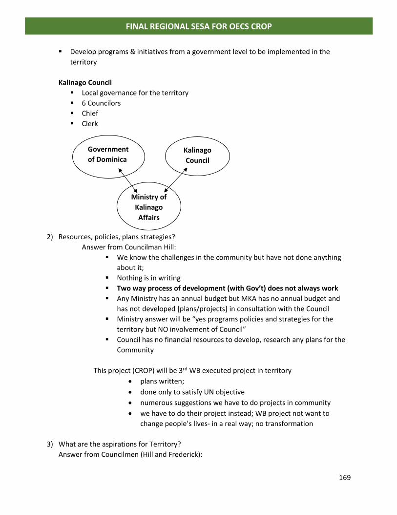
169
FINAL REGIONAL SESA FOR OECS CROP
▪ Develop programs & initiatives from a government level to be implemented in the
territory
Kalinago Council
▪ Local governance for the territory
▪ 6 Councilors
▪ Chief
▪ Clerk
2) Resources, policies, plans strategies?
Answer from Councilman Hill:
▪ We know the challenges in the community but have not done anything
about it;
▪ Nothing is in writing
▪ Two way process of development (with Gov’t) does not always work
▪ Any Ministry has an annual budget but MKA has no annual budget and
has not developed [plans/projects] in consultation with the Council
▪ Ministry answer will be “yes programs policies and strategies for the
territory but NO involvement of Council”
▪ Council has no financial resources to develop, research any plans for the
Community
This project (CROP) will be 3rd WB executed project in territory
• plans written;
• done only to satisfy UN objective
• numerous suggestions we have to do projects in community
• we have to do their project instead; WB project not want to
change people’s lives- in a real way; no transformation
3) What are the aspirations for Territory?
Answer from Councilmen (Hill and Frederick):
Government
of Dominica Kalinago
Council
Ministry of
Kalinago
Affairs
170
FINAL REGIONAL SESA FOR OECS CROP
▪ “lands” owned by Council; title for lands in the name of Council
▪ Seascape not demarcated
Five major aspirations:
1. Want to maintain the integrity of lands & tribe as a distinct territory in the country
2. Want to develop an education system; curriculum, that is appropriate traditionally,
culturally; with physical infrastructure in the territory (that is schools)
a. No high schools in territory
b. Youth are desensitized in process of education out of territory/assimilation
3. Health Services – 2 clinics in territory
a. Territory categorized as its own health district –doctor; ambulance
4. Better protect forest, rivers, water, catchment areas (territorial lands)
5. Active economic base where commerce can be generated
a. See community as attraction for tourism but NOT as a commodity to put on
show for tourists; people see the way “we live not something that is put on
show” i.e. not Disney World Style
b. Agriculture (8 persons in territory are trained agronomist)
c. Construction company/best builders on island in territory; no capital or collateral
to start business; empower people and then they can help themselves
e.g. project funded by development agency in Kalinago territory; local builders
were not able to qualify to do project; only 4 pers were hired paid @ minimum
wage at $40 per day (by contractor not from territory)
d. Make territory a tax & duty free zone/raising issue
Councilmen highlighted major Issues/challenges for Kalinago Territory:
• institutional arrangement needed to access credit → communal lands
• In Dominica /Public workers once appointed can go to financial institution and
obtain a loan; not so for Kalinago people working in the public service
• Banks & none of financial/institutional agencies will not give a loan to a Kalinago
person
• Government can amend Act to give commercial application (for land)
• Health Services in Territory is [under resourced]
Clinic has potential /built for full primary health care
• Clinic built by private NGO funds space for pharmacy /private
[building leased to government for $1 per year; for 10 years; need to re-
negotiate]
→ government pharmacy →prescription drugs only
→room for private pharmacy vacant government stop use for private pharmacy
• Entrepreneur to operate/ business person from community
171
FINAL REGIONAL SESA FOR OECS CROP
o People have to travel to Roseau for basic over the counter medication such
as cough medicine; non sold in territory
• Kalinago people do not have the capacity to negotiate
• NGO Donated two dental chairs to facility took 3 yrs to set up and have a dentist in
territory
• Government has a forestry department for policing forest reserves and protected areas
o No rules for forest use in territory; indiscriminate use of forest cutting lumber etc
▪ Furniture makers; joiners etc
o most of water catchment areas deforested for agriculture
o Need for serious reforestation of watersheds
▪ Bois revier; balata, gommier, lowea (VJ check spelling/scientific names)
o No resources to enforce protection of forest
• Gommier tree → used for boat building →bleed for gum→incense
o Sold to Guadeloupe and subsistence revenue;
o no protection of those trees and they will disappear in 20 years unless they are
protected
• Wrote GEF grant $25,000
→propagate Gommier plants [4,000] but destroyed by Maria
Tourism
• Visual only
• government recognized there is a benefit to market Dominica with image of
Kalinago people
• economic benefits from tourism not felt in territory
• Government make investments that allow for overnight in territory
• agriculture always subsistence farming never on a commercial basis
• massive deforestation most of the trees cleared from the area
• Slash & burn practice of agriculture with negative impacts
→ need to move away from subsistence farming to applying technology
and science in farming
• Kalinago tradition more a seafaring people
*not a traditional farming people → normally performed by women
Became a necessity of life (in the name of development have to move away,
deviate from certain things)
• 8 agronomists within the territory (degreed/qualified)
o →unemployed
o →working fields
172
FINAL REGIONAL SESA FOR OECS CROP
o with government
• no database on community
• 3,000 people more than 20 years ago
• No real census on the number of persons
• Approximately 800 houses in territory [Mr Frederick Kalinago Development Officer
should have better information]
2 primary schools (one destroyed by Maria)
1 of which is outside territory that serves children
• Kindergarten to Grade 6
• Secondary School is out of territory [200 students government pays for buses]
• Several Churches in territory; main religions:
o Catholic,
o SDA, Adventist
o Muslim,
o Church of Jesus Christ Nazarene
o Christian church of SDA
o Jehovah Witnesses,
o Bahia.
• Kalinago people are traditionally nature worshippers: Sun, Moon, Earth, Winds (1600+)
• Parliamentary Representative is Kalinago: for both Atkinson (nearby community) and
Kalinago Territory (people in territory vote for parliamentarian in national elections)
• Opposition Candidate is not Kalinago
• Kalinago Minister “comes in and does what he wants”
o Building 10 concrete houses without consulting the Kalinago Council; desecrated
sacred site; tourism site
o Fishing complex built in Marigot; Majority of fishing fleet more than 70% of
fishermen come from Kalinago territory (no facility in territory).
o Process of engagement lacking
• Hurricane Maria has exacerbated relationship between Government and Council
173
FINAL REGIONAL SESA FOR OECS CROP
Wednesday July 18 2018
#10 Meeting with Forestry Officer and Coast Guard
Bradley Guye –Head of Forestry Management forestry engineer; acting research officer;
[Director of Forestry Minchinton Burton.]
• Dominica still young and growing
9 active volcanoes
Have expended with certain phenomenon on the coast
- South east community after Tropical storm Erica (2015) significant amount of
rock and debris caused expansion of coastline;
- Layou mouth of longest river significant land changed and coastline extended
o consecutive build up
o Lenny 1999
o Trough in 2013
▪ Forest debris washed out
▪ Vines covering trees
- Pioneer species; larger trees expelled them
- wildings exposed.
- Pruning of forest (balance between old and young)
▪ Wildlife feeding on farms:
- crop degradation
▪ Certain observations in forests
- Large trees not fruiting properly/hallow seeds
- Older trees;
▪ Maria opened forests for new growth
▪ Planting important species to help build back habitat
IMO/DOMINICA
▪ -draft legislation to be promulgated
▪ Oil spill clear water program (CEO of Dominica Port Authority)
▪
Impact of Hurricane Maria continued
▪ Access to eco-tourism sites difficult
▪ trees on ground every where; access difficult to do assessment
▪ GIS Unit for forestry under the disaster project
[have hardware software]
Lydar fly over after Maria
o Geospatial committee
o Forest resource assessment for FAO
o NO ICZM policy for Dominica
o National report on climate change (Third Report to be done)
174
FINAL REGIONAL SESA FOR OECS CROP
Comments on forestry in Kalinago Territory
-There are methods to bleed gommier (best practices) which do not affect:
a) Integrity of wood
b) life of the tree
- NEP (national employment program) used to assist/training
-need to take ownership of what they have re forest resources (Kalinago people)
LEGAL AFFAIRS
RED + agenda
o Reduction of emissions from deforestation and degradation
o Carbon Sequestration process;
o Draft Strategy data collection & resources for the protection of forests
▪ Mapping of marine resources – Mr Defoe
▪ Belfast – waste to energy plant (soaps and alcohol); most waste oil on island/pick-up
[solid waste authority –non-biodigestable waste]
Copy of Oil spill response plan provided to consultant
175
FINAL REGIONAL SESA FOR OECS CROP
#11 Meeting at Physical Planning
Lyn Baron - GIS specialist
Annie Edwards - Physical Planner
Question from consultant on use of GIS Maps for planning
Answer:
▪ people aware of it but not sure if they are using it/them
▪ development agencies use maps in their reporting
▪ have not revisited national physical development plan (NPDP) post hurricane Maria
▪ used disaster risk management approach in developing plan
▪ need coastal master plan in light of climate change; most of costal infrastructure and
assets are located in coastal zone
▪ coastal zone management planning needed
o areas need to be relocated due to land degradation
o Govt engaged in coastal zone dumping debris from hurricane clean-up
o natural coastal expansion; especially around major events/major storm event may
remove or bring landwards
-Layou
-Grand Bay
-North East
-St. Joseph
o can be stabilized with built structures; significant along the coastline and
outwards from coast to sea.
o 2011 collapse of major dam contributed significant debris deposits on:
o Fishing villages;
- Lots of coastal erosion
- Need projects to reclaim beachstabilize
o Potential for development of built up areas for economic activities
- People playing volleyball on it
o Portsmouth will be enhanced
-different type of businesses;
-water sports
-limited flat land
o North East coastline wall from airport resulted in large expanse of beach
build up after Maria.
o Shift of activities to other areas
Mayorou expansion of beach; Small shops; part of tourist tours
Cabrits
o Very vulnerable to wind but not to flooding etc
Marine reserve in Sourth/Soufriere;
176
FINAL REGIONAL SESA FOR OECS CROP
o communities restricted in use of resources;
o need to sensitize and assist to maximize use of resources; CATS [GTZ
funded] training with community persons; scuba diving etc [own
business]
Environmental Issues
o Dumping v proper reclamation of the shoreline; Impact of silt on marine
environment and coral reefs
o Dumping of solid waste [landfill capacity]
Wastewater treatment by WASCO
Secondary treatment of waste; Water quality of coastline improved after
installation of plant
Everywhere else (on island) use of septic tanks to treat wastewater
High water table in Portsmouth
Kalinago Territory: Question – maps of territory
o Have something that can work with for CROP project
o Still conquering lands? Questions about boundary disputes
o Unresolved issues regarding boundaries
o Project: delimited boundaries of territory about 3 years ago; specifically for the
Kalinago territory
Post Maria issues/coastal hazard risk and development:
o Insurance not reinsuring in hazard zone; high insurance premiums
Write of as losses; difficulty with recovering loss
Banks should be encouraged to also write off debt
o Note: Petit Savan residents are returning; government stp paying rent for persons; loss
result in people moving
o Relocation within constituency; difficulty to find new communities
o land ownership/ title approved sub-division; loss of assets;
o Squatters on fringes of government land e.g. Canefield, Bene Ravine;
o 50 years on private lands; Government regularized areas which are very susceptible to
damage/vulnerable
o need data to inform plans e.g. sea level rise input; modelling studies, engineering;
coastal engineers, hydrographers, coastal currents etc, bathymetric data;
Need integrated coastal zone management unit
[USAID Study on Portsmouth available online]
177
FINAL REGIONAL SESA FOR OECS CROP
#12 Meeting at Ministry of Economic Development Michael Savarin
o national designated authority for GCF
NDA (low carbon strategy))
-Project Coordinator Manager for GCF Programs – Implementing agency ECU
National Climate Change Committee
ↆ [sub-committee on ocean governance] → preparatory support programs –
capacity building
-ocean governance
-requested details on CROP national coastal and marine spatial plans
- Consultant provided project document
Thursday July 19, 2018
#13 Meeting at National Water Authority
Consultant Inquiry on Waste water treatment in Dominica
Answer: WASCO Chief Engineer
o Collection systems for 3 areas
- -Roseau & environs
- Canefield
- -Gimmit
Baytown Treatment Plant – only 1o treatment
Treated waste pipe out to sea, pipe 200 ft deep and 1200 ft offshore
Anchored pipe on sea bed
HDPE line with concrete anchors
Communal septic tank – water discharged at coast
Onsite treatment/rest of country?
Some consideration given for package plants for some development
PPU in granting approval for development –contact Ministry of Health and the Environment
Public Works – water resources management and ports
Plans for comprehensive collection system for Portsmouth & environs
-soil, hydrogeologic factors makes on-site treatment undesirable
-H20 quality in coast affected
-3o level treatment plant, disposal of effluent back into environment
-West Coast water project (2009)
178
FINAL REGIONAL SESA FOR OECS CROP
EU Project: $25m; design done/ final designs cost more than scope; water component
done (2015 completed) but waste H20 not done
-seeking funding from GCF to do wastewater component
-completing a component with storage tanks funding from WB →completion by
Sept 2018 with additional extensions
▪ Recommendations given for more robust treatment rather than septic systems; package
plants etc
▪ Studies available for the west coast
▪ Cartegena Convention (land based sources of pollution)
o Dominica wants to ratify
o Type of water and classes of water waste; standards used as a guide to prevent
pollution of the environment
▪ Roseau plant 1o treatment → removal of solids, debris, grits, gravel fats and oils etc
o Plant commissioned about 2002 – no biological or chemical; level of aeration
o Monitoring of BOD & COD, bacteria conducted annually by lab –
Question consultant: is there independent verification?
Answer: No
o Solids deposited automatically into large barrels
▪ landfill disposal
▪ small volumes
▪ sludge removal
o 3 pumps in wetwell →fail safe mechanism
o Main line to plant broken after Erica and Maria;
o emergency situation/direct outfall; need to repair lines
o Under UNIDO –energy audit – too much energy used; renewal energy to run
Roseau
▪ PV solar - 75 kw system
▪ About 60% energy demand;
▪ pilot; hope to replicate for most of pumping systems
▪ Grid tied with battery backup
▪ CCCCC funded; mini hydro power
179
FINAL REGIONAL SESA FOR OECS CROP
Impact of wastewater treatment plant
→positive impact, vast improvement in water quality at the coast
o -only at 50% capacity (design could accept more)
o -can upgrade system and increase level of treatment
o -more space needed at existing site
o -need to relocate or reassign space [river and sea on either sides]
▪ Will use some of available space for ground mount of PV system;
▪ Roof can only take 50kw
Portsmouth
o More extensive/comprehensive treatment will need more space
▪ waste stabilization ponds
▪ constructed wetlands
▪ uv treatment/disinfection
o Quality of effluent; at present discharge into a tributary that goes into river
o Concerns of Town Council; physical development plan for Portsmouth
o Feasibility study and EIA for Portsmouth waste water
o Part of west coast project
#14 Meet with Dr Lennox Honychurch at Cabrits National Park
o Chairperson Portsmouth Citizen Dev Committee Master Plan
o Glad that plan is being looked at; thought forgotten
o Committee was approved by Prime Minister
o Presentation of plan was made to Cabinet
o Should consider as part of project to develop CSMP for Dominica
#15 Meet with Developer of new CBI hotel project at Portsmouth/Cabrits National Park
▪ Providing assistance with rehabilitation of nature trails in area
▪ community rebuilding assistance
▪ eco-friendly project; using best practices; will treat wastewater etc
180
FINAL REGIONAL SESA FOR OECS CROP
Dominica Stakeholder Consultations July 16 – July 20, 2018
Regional Strategic Environment and Social Assessment OECS Caribbean Regional Oceanscape Project
Name Title/Department Telephone E-mail Signature
Dr. Reginald Thomas Permanent Secretary Ministry of Agriculture, Food & Fisheries
[email protected] [email protected]
Harold Guiste Maritime Administration Office
[email protected] [email protected]
Peter Albert MAO Same as above
Michael Savarin Ministry of Planning & Economic Development
(767) 265-3027 [email protected]
Kelvin Rolle Head Physical Planning Department
[email protected] website: physicalplanning.gov.dm
Shillingford Senior Planner PPD Same as above
Cozier P Frederick Kalinago Development Officer
(767) 266-3377/ 266-3556
[email protected] [email protected]
Coreen Prevost Permanent Secretary Ministry of Tourism & Urban Renewal; Ministry of Environment
Lloyd Pascal Director - ECU
767-266-5256 [email protected]
Simon Edwards
Commander Coast Guard
767 225 1380 [email protected]
Lyn Baron
GIS Specialist – Physical Planning Department
767 277 3244 767 266 3752/3138
181
FINAL REGIONAL SESA FOR OECS CROP
Name Title/Department Telephone E-mail Signature
Mrs Annie Edwards Physical Planner – Physical Planning Department
Bradly Guye
Forestry Department Acting Research Officer
Williams, M Chief Engineer/WASCO
Lennox Honychurch Cabrits National Park Chairperson Portsmouth Development Committee
Kamila Ordrackova Range Developments
Stakeholder Consultations at Kalinago Council
182
FINAL REGIONAL SESA FOR OECS CROP
183
FINAL REGIONAL SESA FOR OECS CROP
ANNEX IV GRENADA
Grenada Stakeholder Consultation July 24 2018 Situation and Stakeholder Analysis
Regional Strategic Environment and Social Assessment Caribbean Regional Oceanscape Project
Introduction and over view on CROP by Commander David Robins and Mrs Susanna Scott from
OECS Oceans Governance and Fisheries Unit.
(other notes on priority areas and critical issues for attention added to power point
presentation)
Consultant: Four dimensions and layers to consider (Geography of place – climate change & risk
scenarios; Ecology of place; Human Ecology; Political Economy) plus external forces climate
change and global economy
Comments on Blue Economy Master Plan (BGMP)
• Is plan law or already approved for implementation? What is it?
• Housing not addressed in plan
• Status of National Development Strategy 2030 and how it fit into BGMP
• Blue Growth
o Resources coming from where?
o For Investors
• Top down: Architects vision and senior advisors; selective consultation
• Should be peoples plan from the bootm up
• Coastal zone task force has comments on BGMP; no evidence that comments were
considered as no change to plan
• Absence of data to advise BGMP
• GIS, mapping lydar bathymetrty
• Ecosystems
• Lack of awarenedd
• All agencies asked to review document and give feedback
o CSO/social compact
• Historical/heritage not considered
• National discussions needed
• Land use policy and BGMP
• Public participation PROCESS needs to be looked at
• GOG has US$20M loan from World Bank to advance BGMP agenda (under very
concessionary terms)
• Communications strategy needed for BGMP
184
FINAL REGIONAL SESA FOR OECS CROP
o Villages etc to be affected must now more
• How much flexibility with plan?
• BGMP will be driven by market forces
• Economic assessment on yachting needed; Linkages with other sectors must be
considered
• TOO Grand
• Targets only investors into Grenada
• Rep from Economic affairs department:
o 2 consultations were held with select interest groups
o Comments received from 60 stakeholders
o Focus groups were consulted on aspects of the document
• Wide cross section of stakeholders were not consulted
• No update of the document to reflect consultation
• Status of reports from consultations?
• Foreign Affairs coordinated the efforts on the BGMP; needs a home and agency to
coordinate
• Input from Environmental Officer
o Coastal zone task force reviewed report
o Working on sediment transport project with support from CEFAS
o Gouyave and Levera Marine Protected Area proposed; to be launched soon
• Wider stakeholder engagement needed
• OCES comment:
o CSMP team with have a social safeguard specialist to ensure that social issues
are taken on board in developing plans
185
FINAL REGIONAL SESA FOR OECS CROP
186
FINAL REGIONAL SESA FOR OECS CROP
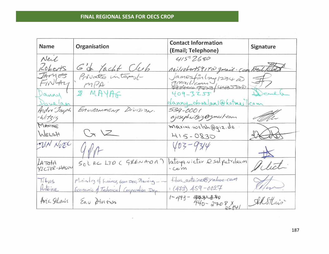
187
FINAL REGIONAL SESA FOR OECS CROP
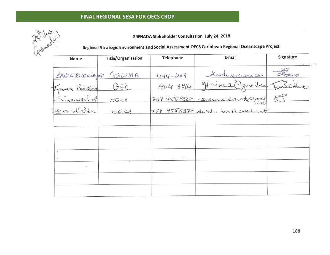
188
FINAL REGIONAL SESA FOR OECS CROP
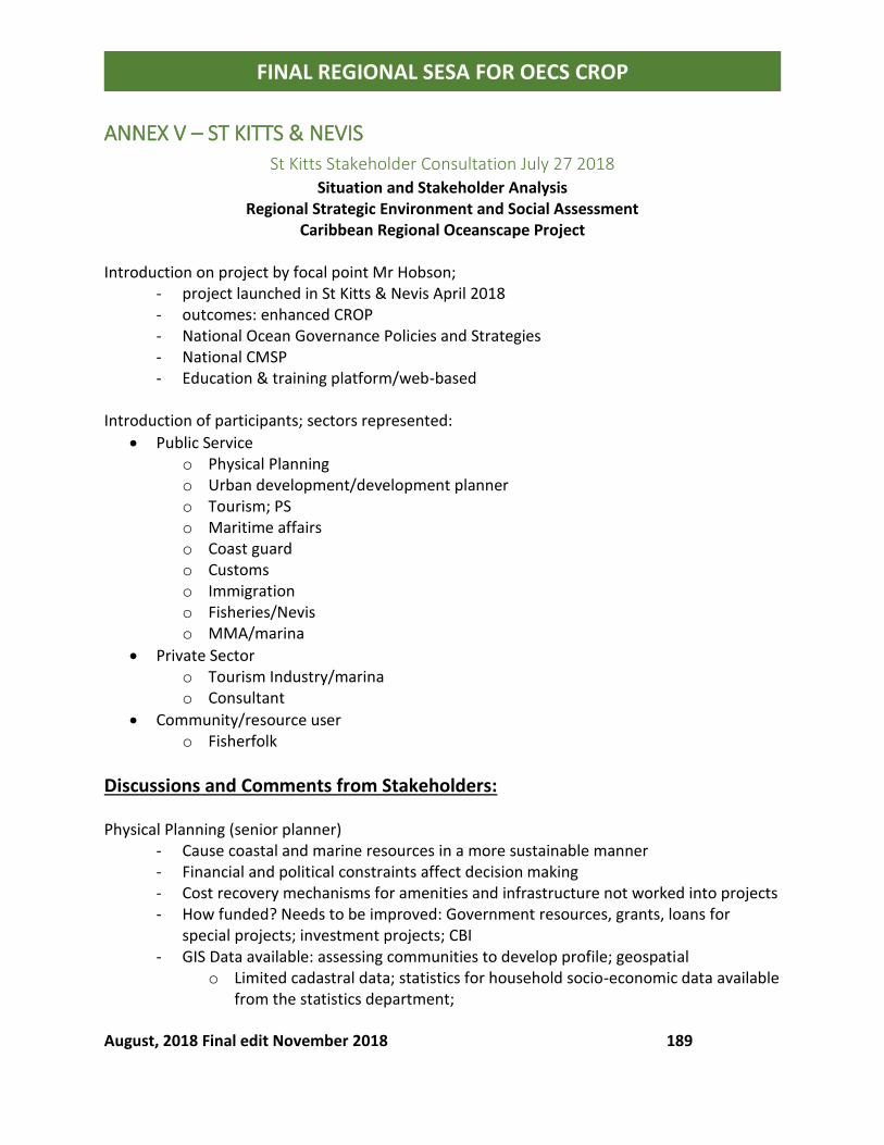
August, 2018 Final edit November 2018 189
FINAL REGIONAL SESA FOR OECS CROP
ANNEX V – ST KITTS & NEVIS
St Kitts Stakeholder Consultation July 27 2018
Situation and Stakeholder Analysis Regional Strategic Environment and Social Assessment
Caribbean Regional Oceanscape Project
Introduction on project by focal point Mr Hobson; - project launched in St Kitts & Nevis April 2018 - outcomes: enhanced CROP - National Ocean Governance Policies and Strategies - National CMSP - Education & training platform/web-based
Introduction of participants; sectors represented:
• Public Service o Physical Planning o Urban development/development planner o Tourism; PS o Maritime affairs o Coast guard o Customs o Immigration o Fisheries/Nevis o MMA/marina
• Private Sector o Tourism Industry/marina o Consultant
• Community/resource user o Fisherfolk
Discussions and Comments from Stakeholders: Physical Planning (senior planner)
- Cause coastal and marine resources in a more sustainable manner - Financial and political constraints affect decision making - Cost recovery mechanisms for amenities and infrastructure not worked into projects - How funded? Needs to be improved: Government resources, grants, loans for
special projects; investment projects; CBI - GIS Data available: assessing communities to develop profile; geospatial
o Limited cadastral data; statistics for household socio-economic data available from the statistics department;
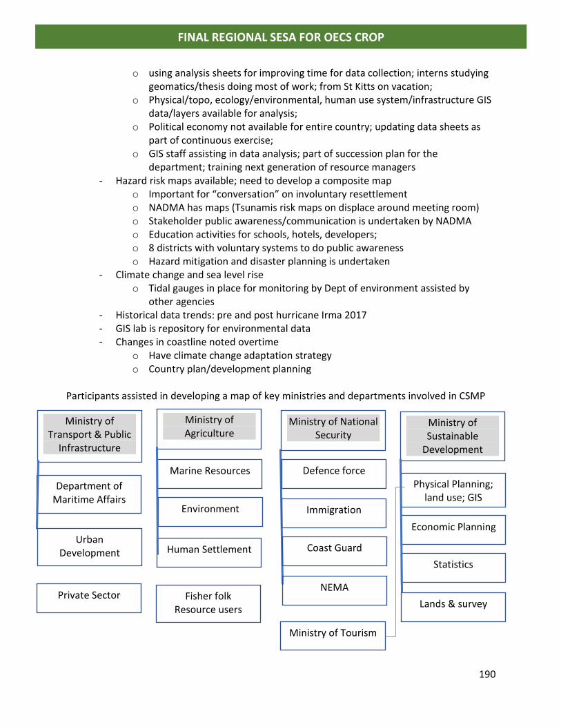
190
FINAL REGIONAL SESA FOR OECS CROP
o using analysis sheets for improving time for data collection; interns studying geomatics/thesis doing most of work; from St Kitts on vacation;
o Physical/topo, ecology/environmental, human use system/infrastructure GIS data/layers available for analysis;
o Political economy not available for entire country; updating data sheets as part of continuous exercise;
o GIS staff assisting in data analysis; part of succession plan for the department; training next generation of resource managers
- Hazard risk maps available; need to develop a composite map o Important for “conversation” on involuntary resettlement o NADMA has maps (Tsunamis risk maps on displace around meeting room) o Stakeholder public awareness/communication is undertaken by NADMA o Education activities for schools, hotels, developers; o 8 districts with voluntary systems to do public awareness o Hazard mitigation and disaster planning is undertaken
- Climate change and sea level rise o Tidal gauges in place for monitoring by Dept of environment assisted by
other agencies - Historical data trends: pre and post hurricane Irma 2017 - GIS lab is repository for environmental data - Changes in coastline noted overtime
o Have climate change adaptation strategy o Country plan/development planning
Participants assisted in developing a map of key ministries and departments involved in CSMP
Ministry of Transport & Public
Infrastructure
Department of Maritime Affairs
Urban Development
Ministry of Agriculture
Marine Resources
Environment
Human Settlement
Ministry of National Security
Defence force
Immigration
Coast Guard
NEMA
Ministry of Sustainable
Development
Physical Planning; land use; GIS
Economic Planning
Statistics
Lands & survey Private Sector Fisher folk
Resource users
Ministry of Tourism
191
FINAL REGIONAL SESA FOR OECS CROP
Development Planner - Urban development implement challenges and issues with respect to:
o transport/traffic, o open spaces, o derelict and abandoned property; o street vending; o sewerage treatment; other agencies involved Ministry of Health; Planning;
water; solid waste o septic systems; on-site treatment plants encouraged; large septic systems
with disposal fields o Frigate Bay:
▪ Stormwater runoff major issue ▪ Primary treatment/re-use water for irrigation ▪ Sewerage from yachts major issue (supposed to go out to 12Nmiles to
empty holding tanks) o Parts of Basseterre below sea level o Impact of pollution on nearshore marine resources; fisherfolk now have to go
up to 30 miles to fish Comments by Maritime Officers
- Yachts pump out waste: MARPOL requires must go out >3 mils is treatment plant on vessel; no treatment of sewerage out to 12 Nmiles
- Maritime authority inspection of vessel logs to tell it they are going out to pump out sewerage
Marine Resource officer - Management strategy (fisheries)
o FAD o Conservation zones
Private Sector - International LEGISLATION has not kicked in at the national/local level - Christophe harbour still developing - Have contingency plans for handling fires; spills; CSR plans; garbage; MARPOL, oils
dust, paint - Use USA guidelines/certification
Charlestown fisherfolk and Fisheries Officer
- Issues with jetty etc (competition with other users) - No license - Register fishing vessel; fees based on length
o 0-10 feet $0 o 10-30 feet $25 o 30-60 feet $50
- Log book on fisheries catch (information collected by fisherfolk) - New fisheries Act (Fisheries Aquaculture and Marine Act of 2016)
192
FINAL REGIONAL SESA FOR OECS CROP
o Duty free on gear and equipment; o No business license; no taxation on fish and food caught locally o Training to get license for fisherfolk; no fee up until January 2019 o FREE FOR ALL (concern of fisherfolk from Charlestown) o Fishing for tourists/sport fishing on the rise; company/tour operator needs
permit (NO quota on fish catch); issue temporary fishing license to customers
- Christophe Harbour o MOU with DMR (department of marine resources) for sports fishing licenses; pay fee o Register boats and individual fishing interests; o Rules published for tourist fishers/ease to understand; size of catch and species not
to take etc; PS Min of Tourism
- Concerned about losing beaches especially Frigate Bay - Beaches have reached/exceeded carrying capacity - Government is looking at initiating a beach nourishment/restoration project - Scientific data shows destruction; - New pier has implications - SKN reached 1 million cruise tourists in 2017/2018 season - >250,000 stay over visitors per year
o Christophe Marina had >5000 vessels 2017/2018 season - Ships can recycle some wastes; problem with solid waste what they take from cruise
ships is selective; - Water shortages - International waste MARPOL bins and data sheets at Port (IMO); reception receipt
must be issues Maritime boundaries an issue
- Sharing marine space with many countries - Creates conflicts with other territories - SKN fisherfolk have problems with fishing in territory of St Eus. Saba and nearby
islands; yellow card from EU [other OECS state has red card from EU] - When negotiating issues it is not with other small territory it is with the EU therefore
issues of equity and power! Public participation
- Consultations for development planning; responsibility of developer - Public concerns change project; public access to EIAs - Information access needs to improve/duty to publish and freedom of information
Act - NO demand and strong public interest for data - Mechanisms to make information available/easily accessible needs to be improved - Voluntary publication
193
FINAL REGIONAL SESA FOR OECS CROP
- Consultations sometimes only with specific stakeholders - DMR is using social media to communicate info to stakeholders; radio and TV - Get feedback from social media; monthly reporting is done
Major issues:
- Illegal dumping of solid waste on beaches, coastal areas, ghauts and storm drains ending up in the sea
- National trust made tunnel with garbage from the sea as a public awareness/education campaign
- Sand mining - Plastic free July campaign in SKN - Abandoned sugar plantations; no maintenance of waterways and drainage
system resulting in siltation of coastal zone - Development planning and control board has representation from different parts of
society Tourism
- Sustainable destination council; multi-sectoral arrangement Fisheries Act, advisory committee with fisherfolk
EIA vs ESIA – focus on jobs and economic; number of persons employed by project; not driven
by environmental impact.
For eg 1,000,000 cruise tourists leads to problems with wastes; problems for new beach COCKSHELL - No cost benefit analysis of projects - Discharge permits are not required for industries; hotels, marinas etc - US$10 million wastewater treatment plant; capital cost; maintenance cost verses no
treatment and waste into environment (value of ecosystem services); untreated waste has negative impact on environment.
Comment by PS of Tourism - Islands are competition with each other for investors therefore relax environmental
regulations; want to be able to grab investors so that they get them first; know that environment is being impacted negatively
- Need help to make argument on carrying capacity of natural resources; - Need to educate next generation; this one already gone!!!
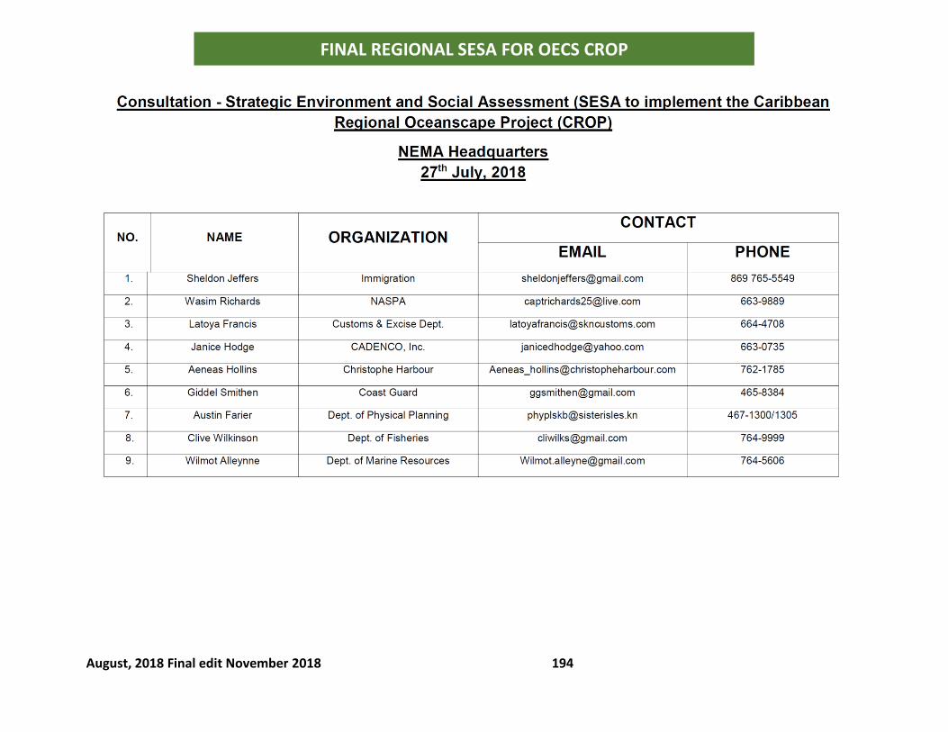
August, 2018 Final edit November 2018 194
FINAL REGIONAL SESA FOR OECS CROP
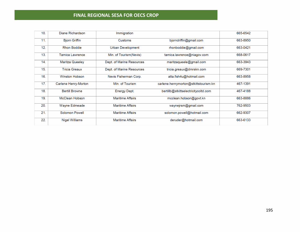
195
FINAL REGIONAL SESA FOR OECS CROP
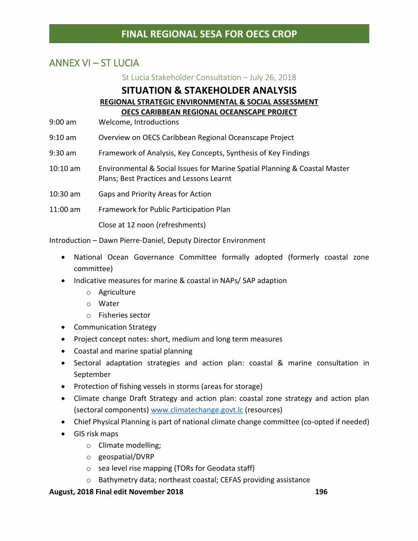
August, 2018 Final edit November 2018 196
FINAL REGIONAL SESA FOR OECS CROP
ANNEX VI – ST LUCIA
St Lucia Stakeholder Consultation – July 26, 2018
SITUATION & STAKEHOLDER ANALYSIS
REGIONAL STRATEGIC ENVIRONMENTAL & SOCIAL ASSESSMENT OECS CARIBBEAN REGIONAL OCEANSCAPE PROJECT
9:00 am Welcome, Introductions
9:10 am Overview on OECS Caribbean Regional Oceanscape Project
9:30 am Framework of Analysis, Key Concepts, Synthesis of Key Findings
10:10 am Environmental & Social Issues for Marine Spatial Planning & Coastal Master Plans; Best Practices and Lessons Learnt
10:30 am Gaps and Priority Areas for Action
11:00 am Framework for Public Participation Plan
Close at 12 noon (refreshments)
Introduction – Dawn Pierre-Daniel, Deputy Director Environment
• National Ocean Governance Committee formally adopted (formerly coastal zone
committee)
• Indicative measures for marine & coastal in NAPs/ SAP adaption
o Agriculture
o Water
o Fisheries sector
• Communication Strategy
• Project concept notes: short, medium and long term measures
• Coastal and marine spatial planning
• Sectoral adaptation strategies and action plan: coastal & marine consultation in
September
• Protection of fishing vessels in storms (areas for storage)
• Climate change Draft Strategy and action plan: coastal zone strategy and action plan
(sectoral components) www.climatechange.govt.lc (resources)
• Chief Physical Planning is part of national climate change committee (co-opted if needed)
• GIS risk maps
o Climate modelling;
o geospatial/DVRP
o sea level rise mapping (TORs for Geodata staff)
o Bathymetry data; northeast coastal; CEFAS providing assistance
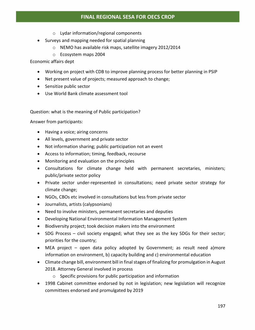
197
FINAL REGIONAL SESA FOR OECS CROP
o Lydar information/regional components
• Surveys and mapping needed for spatial planning
o NEMO has available risk maps, satellite imagery 2012/2014
o Ecosystem maps 2004
Economic affairs dept
• Working on project with CDB to improve planning process for better planning in PSIP
• Net present value of projects; measured approach to change;
• Sensitize public sector
• Use World Bank climate assessment tool
Question: what is the meaning of Public participation?
Answer from participants:
• Having a voice; airing concerns
• All levels, government and private sector
• Not information sharing; public participation not an event
• Access to information; timing, feedback, recourse
• Monitoring and evaluation on the principles
• Consultations for climate change held with permanent secretaries, ministers;
public/private sector policy
• Private sector under-represented in consultations; need private sector strategy for
climate change;
• NGOs, CBOs etc involved in consultations but less from private sector
• Journalists, artists (calypsonians)
• Need to involve ministers, permanent secretaries and deputies
• Developing National Environmental Information Management System
• Biodiversity project; took decision makers into the environment
• SDG Process – civil society engaged; what they see as the key SDGs for their sector;
priorities for the country;
• MEA project – open data policy adopted by Government; as result need a)more
information on environment, b) capacity building and c) environmental education
• Climate change bill, environment bill in final stages of finalizing for promulgation in August
2018. Attorney General involved in process
o Specific provisions for public participation and information
• 1998 Cabinet committee endorsed by not in legislation; new legislation will recognize
committees endorsed and promulgated by 2019
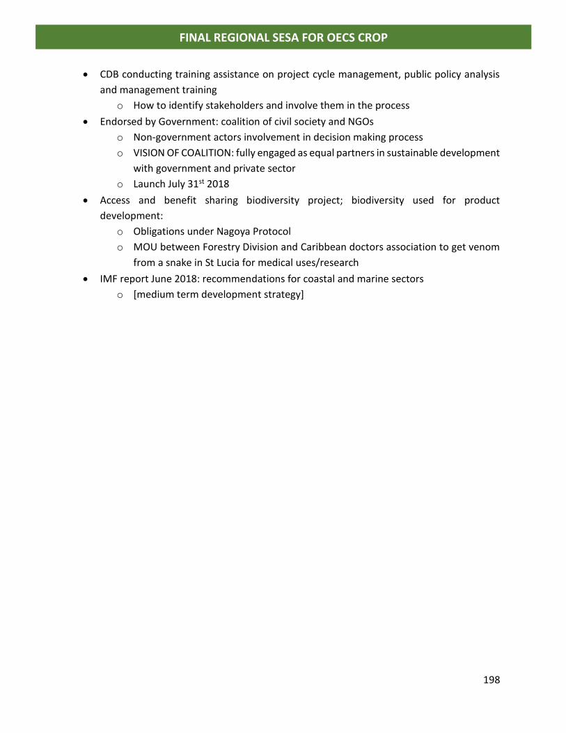
198
FINAL REGIONAL SESA FOR OECS CROP
• CDB conducting training assistance on project cycle management, public policy analysis
and management training
o How to identify stakeholders and involve them in the process
• Endorsed by Government: coalition of civil society and NGOs
o Non-government actors involvement in decision making process
o VISION OF COALITION: fully engaged as equal partners in sustainable development
with government and private sector
o Launch July 31st 2018
• Access and benefit sharing biodiversity project; biodiversity used for product
development:
o Obligations under Nagoya Protocol
o MOU between Forestry Division and Caribbean doctors association to get venom
from a snake in St Lucia for medical uses/research
• IMF report June 2018: recommendations for coastal and marine sectors
o [medium term development strategy]

August, 2018 Final edit November 2018 199
FINAL REGIONAL SESA FOR OECS CROP
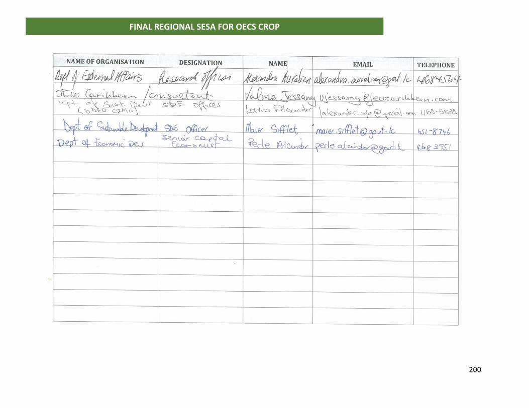
200
FINAL REGIONAL SESA FOR OECS CROP
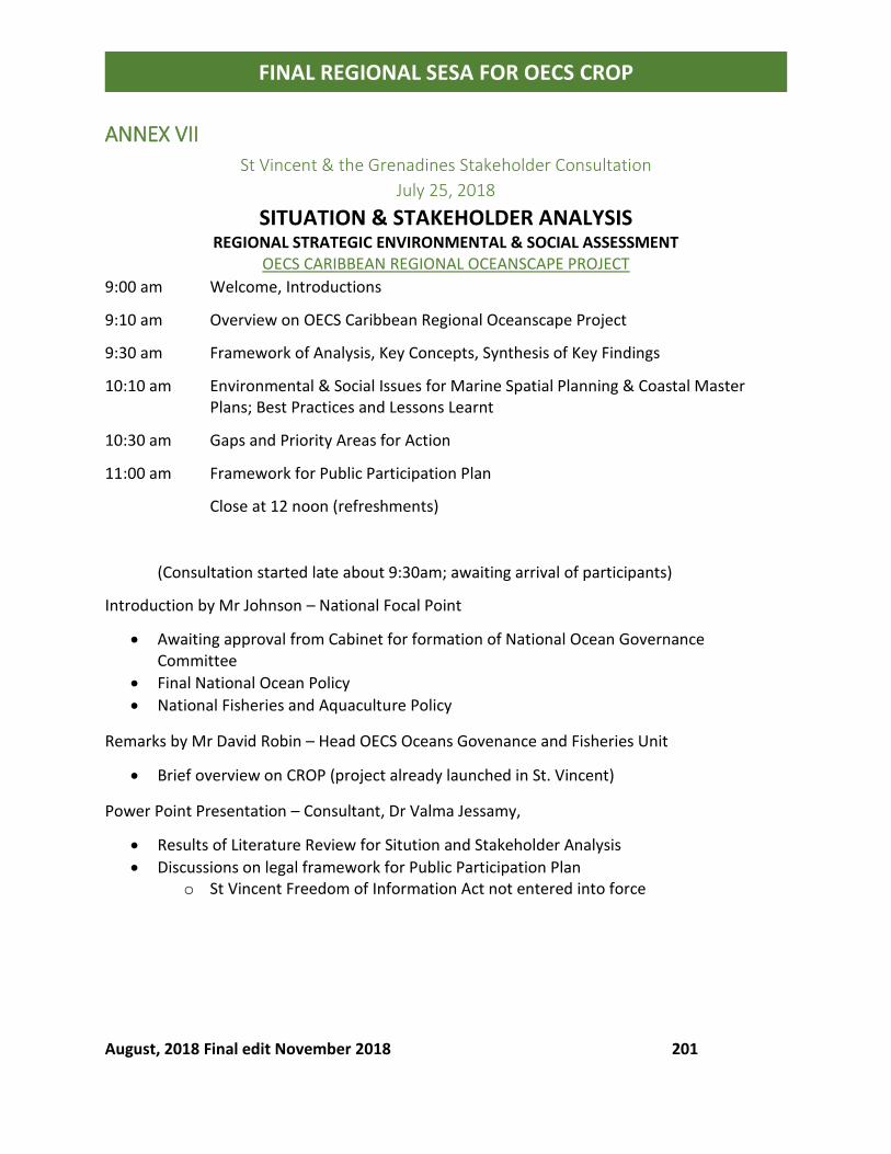
August, 2018 Final edit November 2018 201
FINAL REGIONAL SESA FOR OECS CROP
ANNEX VII
St Vincent & the Grenadines Stakeholder Consultation
July 25, 2018
SITUATION & STAKEHOLDER ANALYSIS
REGIONAL STRATEGIC ENVIRONMENTAL & SOCIAL ASSESSMENT OECS CARIBBEAN REGIONAL OCEANSCAPE PROJECT
9:00 am Welcome, Introductions
9:10 am Overview on OECS Caribbean Regional Oceanscape Project
9:30 am Framework of Analysis, Key Concepts, Synthesis of Key Findings
10:10 am Environmental & Social Issues for Marine Spatial Planning & Coastal Master Plans; Best Practices and Lessons Learnt
10:30 am Gaps and Priority Areas for Action
11:00 am Framework for Public Participation Plan
Close at 12 noon (refreshments)
(Consultation started late about 9:30am; awaiting arrival of participants)
Introduction by Mr Johnson – National Focal Point
• Awaiting approval from Cabinet for formation of National Ocean Governance Committee
• Final National Ocean Policy
• National Fisheries and Aquaculture Policy
Remarks by Mr David Robin – Head OECS Oceans Govenance and Fisheries Unit
• Brief overview on CROP (project already launched in St. Vincent)
Power Point Presentation – Consultant, Dr Valma Jessamy,
• Results of Literature Review for Sitution and Stakeholder Analysis
• Discussions on legal framework for Public Participation Plan o St Vincent Freedom of Information Act not entered into force
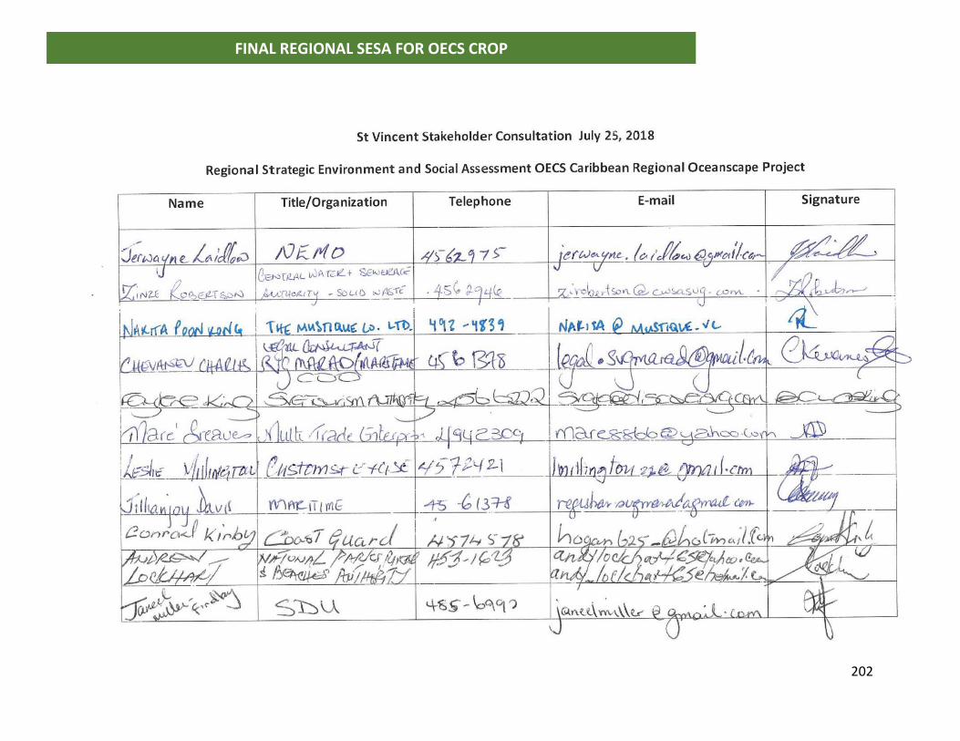
202
FINAL REGIONAL SESA FOR OECS CROP
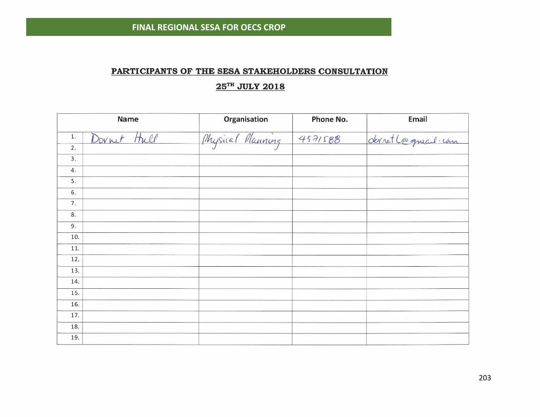
203
FINAL REGIONAL SESA FOR OECS CROP
204
FINAL REGIONAL SESA FOR OECS CROP
ANNEX IV September 20, 2018 Regional Consultation –
Situation and Stakeholder Analysis, Priority Selection
[Zoom meeting 9:00am – 1:00pm]
1. Introductions by Mr David Robin, Head OECS Oceans Governance and Fisheries Unit
2. Introduction of Participants from Member States, OECS, CRFM, World Bank (see participant
list attached)
3. Presentation by consultant: Key findings of Situation and Stakeholder Analysis (see power
point)
4. Comments on presentation of situation and stakeholder analysis by participants:
Participant from Grenada (Ian Noel – OECS Focal person on Oceans Governance Committee):
• Clarification provided, Maritime Administration is separated legally from the
management of Grenada Ports Authority although the same person functions in both
roles (Carl Felix – Director of Maritime Affairs)
Participant from Montserrat:
• Oceans Governance
o What is national priority?
o Should take into consideration other activities
o What is the priority of each member of the committee
o Modelling needed from the regional ocean governance committee all the way
down to the national
• Fisheries, Data
o How accurate is information?
o Are we going to take this into consideration/climate change, invasive species?
o We are using literature that is questionable
o Academia doing research; how accurate is the information?
o Need for knowledge sharing
World Bank Environmental Specialist:
• Very comprehensive overview
• General observations:
o Common strategy across countries
205
FINAL REGIONAL SESA FOR OECS CROP
o Focus on low hanging fruits/no brainers, policy change that can create early wins
for the project [CROP]
o Best practices sharing and adoption; knowledge products needed
o Institutional strengthening
o Barriers to implementing existing regulations, habitat protection policies
o Fish stock assessment on a regional basis
o Tourism sector not pulling their weight; opportunities to engage better
World Bank Safeguard Specialist (Ramon):
• Important information on the Kalinago people in Dominica
• Recommendations for future action
• Discrepancies [between perceived and existing governance framework] want to clarify
that;
• Safe guard; more robust analysis required
• Involuntary resettlement policy
o Pre-caution; protected areas, coastal or marine, that may inhibit access to
people
• Process framework
• Grievance redress mechanism
o PPU, information officer/ministry (freedom of information act)
o Grievance register for the project; part of the responses for social impact (TOR)
Caribbean Regional Fisheries Mechanism (CRFM) – Dr Singh:
• Fisheries is a sector not often given priority attention
• There is low investment in the industry
• Policies are not implemented
• Need holistic approach to get attention; linkages to other sectors e.g tourism
• Fish stock assessment needed
o Progress is slow
o Information systems needed to produce quantitative assessment reports
• When it reaches management level social and economic issues to be considered
o Decision making, ideal trade-off
o Decision support systems; trade-off scenarios
o There are challenges with information base
OECS Comments:
• Time constraints to complete assignment
• Need feedback and comments from stakeholders on situation analysis and priority
selection by September 20th;
• Feedback to be provided to OECS Commission who will then pass on to consultant.
206
FINAL REGIONAL SESA FOR OECS CROP
• NOTE: limited documentation, no maps of Kalinago Territory in Dominica
• Robust participation needed; ocean governance committees to be established in
member states;
• Follow categories of stakeholders for consultations;
• Review questions, legal input from various sectors/coordination needed
• E.g SVG 29 agencies, 44 pieces of legislation
Dominica participant:
• Clarification needed: elaborate on reviewing basic legislation with garbage etc; no
commercial fishers/small scale fishers mainly
World Bank Specialist:
• Robust gap analysis needed
o Government owned lands and squatting; Land title
o Involuntary resettlement assistance (informal settlements and squatters)
o Compensation; World Bank safeguards supersedes local requirements (as it
relates to the project)
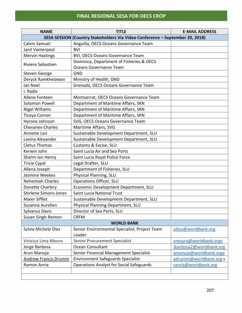
207
FINAL REGIONAL SESA FOR OECS CROP
NAME TITLE E-MAIL ADDRESS
SESA SESSION (Country Stakeholders Via Video Conference – September 20, 2018)
Calvin Samuel Anguilla, OECS Oceans Governance Team
Janil Vanterpool BVI
Mervin Hastings BVI, OECS Oceans Governance Team
Riviere Sebastien Dominica, Department of Fisheries & OECS Oceans Governance Team
Steven George GND
Deryck Ramkhelawan Ministry of Health, GND
Ian Noel Grenada, OECS Oceans Governance Team
I. Radix
Allene Fonteen Montserrat, OECS Oceans Governance Team
Solomon Powell Department of Maritime Affairs, SKN
Nigel Williams Department of Maritime Affairs, SKN
Ticoya Conner Department of Maritime Affairs, SKN
Hyrone Johnson SVG, OECS Oceans Governance Team
Chevanev Charles Maritime Affairs, SVG
Annette Leo Sustainable Development Department, SLU
Lavina Alexander Sustainable Development Department, SLU
Cletus Thomas Customs & Excise, SLU
Kerwin John Saint Lucia Air and Sea Ports
Sharm-ion Henry Saint Lucia Royal Police Force
Tricia Cypal Legal Drafter, SLU
Allena Joseph Department of Fisheries, SLU
Jasmine Weekes Physical Planning, SLU
Nehemiah Charles Operations Officer, SLU
Donette Charlery Economic Development Department, SLU
Shirlene Simons-Jones Saint Lucia National Trust
Maier Sifflet Sustainable Development Department, SLU
Suzanna Aurelien Physical Planning Department, SLU
Sylvanus Davis Director of Sea Ports, SLU
Susan Singh-Renton CRFM
WORLD BANK
Sylvia Michele Diez Senior Environmental Specialist, Project Team Leader
Vinicius Lima Moura Senior Procurement Specialist [email protected]
Jorge Barbosa Ocean Consultant [email protected]
Arun Manuja Senior Financial Management Specialist [email protected]
Andrew Francis Drumm Environment Safeguards Specialist [email protected] s
Ramon Anria Operations Analyst for Social Safeguards [email protected]

208
FINAL REGIONAL SESA FOR OECS CROP
Related Documents