District 3 – County of Sacramento City of Sacramento December 2014 Project Study Report Vehicular & Pedestrian Access from Midtown Sacramento to the A Street Bridge entering McKinley Village APPROVAL RECOMMENDED: ______________________________________________ Jeffrey Rud II, PROJECT MANAGER APPROVED: _______________________________________ __________________ Jeff Werner, City of Sacramento DATE

Welcome message from author
This document is posted to help you gain knowledge. Please leave a comment to let me know what you think about it! Share it to your friends and learn new things together.
Transcript
District 3 – County of Sacramento City of Sacramento
December 2014
Project Study Report
Vehicular & Pedestrian Access from Midtown Sacramento to the A Street Bridge entering
McKinley Village
APPROVAL RECOMMENDED:
______________________________________________
Jeffrey Rud II, PROJECT MANAGER
APPROVED:
_______________________________________ __________________ Jeff Werner, City of Sacramento DATE

District 3 – County of Sacramento – 28th & A Street – McKinley Village Development
i
Vicinity Map
Project Location: 28th and A Street access for McKinley Village

District 3 – County of Sacramento – 28th & A Street – McKinley Village Development
ii
Contents
1. Introduction ............................................................................................................................1
2. Background .............................................................................................................................3
3. Purpose and Need ...................................................................................................................4
4. Deficiencies ..............................................................................................................................5
5 Design Alternatives .................................................................................................................7
5.1 Community Involvement .................................................................................................................... 7
5.2 Rejected Alternatives .......................................................................................................................... 7
5.3 Viable Alternative ............................................................................................................................... 8
5.4 Design Exceptions ............................................................................................................................. 10
5.5 Solves Purpose & Need ..................................................................................................................... 10
5.6 Traffic Analysis .................................................................................................................................. 11
6. Environmental Impact ............................................................................................................12
6.1 Biological Resources ...................................................................................................................... 12
6.2 Air Quality ..................................................................................................................................... 13
6.3 Community Impact ........................................................................................................................ 14
7. Right of Way Impacts ..............................................................................................................15
8. Constructability .......................................................................................................................16
9. Schedule ....................................................................................................................................17
10. Appendix ............................................................................................................................... A-i
District 3 – County of Sacramento – 28th & A Street – McKinley Village Development
1
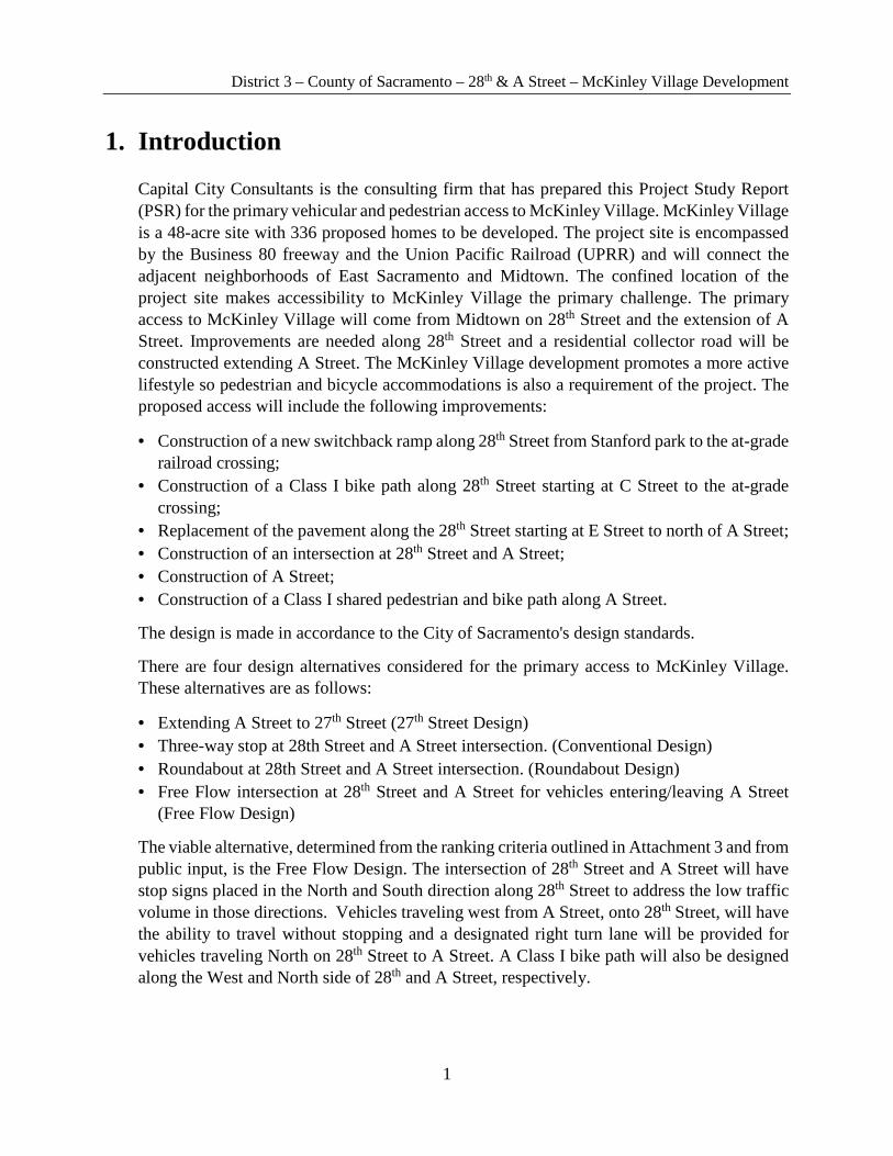
1. Introduction
Capital City Consultants is the consulting firm that has prepared this Project Study Report (PSR) for the primary vehicular and pedestrian access to McKinley Village. McKinley Village is a 48-acre site with 336 proposed homes to be developed. The project site is encompassed by the Business 80 freeway and the Union Pacific Railroad (UPRR) and will connect the adjacent neighborhoods of East Sacramento and Midtown. The confined location of the project site makes accessibility to McKinley Village the primary challenge. The primary access to McKinley Village will come from Midtown on 28th Street and the extension of A Street. Improvements are needed along 28th Street and a residential collector road will be constructed extending A Street. The McKinley Village development promotes a more active lifestyle so pedestrian and bicycle accommodations is also a requirement of the project. The proposed access will include the following improvements:
• Construction of a new switchback ramp along 28th Street from Stanford park to the at-grade railroad crossing;
• Construction of a Class I bike path along 28th Street starting at C Street to the at-grade crossing;
• Replacement of the pavement along the 28th Street starting at E Street to north of A Street; • Construction of an intersection at 28th Street and A Street; • Construction of A Street; • Construction of a Class I shared pedestrian and bike path along A Street.
The design is made in accordance to the City of Sacramento's design standards.
There are four design alternatives considered for the primary access to McKinley Village. These alternatives are as follows:
• Extending A Street to 27th Street (27th Street Design) • Three-way stop at 28th Street and A Street intersection. (Conventional Design) • Roundabout at 28th Street and A Street intersection. (Roundabout Design) • Free Flow intersection at 28th Street and A Street for vehicles entering/leaving A Street
(Free Flow Design)
The viable alternative, determined from the ranking criteria outlined in Attachment 3 and from public input, is the Free Flow Design. The intersection of 28th Street and A Street will have stop signs placed in the North and South direction along 28th Street to address the low traffic volume in those directions. Vehicles traveling west from A Street, onto 28th Street, will have the ability to travel without stopping and a designated right turn lane will be provided for vehicles traveling North on 28th Street to A Street. A Class I bike path will also be designed along the West and North side of 28th and A Street, respectively.
District 3 – County of Sacramento – 28th & A Street – McKinley Village Development
2
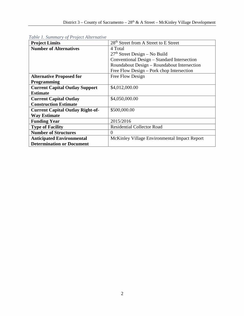
Table 1. Summary of Project Alternative Project Limits 28th Street from A Street to E Street Number of Alternatives 4 Total
27th Street Design – No Build Conventional Design – Standard Intersection Roundabout Design – Roundabout Intersection Free Flow Design – Pork chop Intersection
Alternative Proposed for Programming
Free Flow Design
Current Capital Outlay Support Estimate
$4,012,000.00
Current Capital Outlay Construction Estimate
$4,050,000.00
Current Capital Outlay Right-of-Way Estimate
$500,000.00
Funding Year 2015/2016 Type of Facility Residential Collector Road Number of Structures 0 Anticipated Environmental Determination or Document
McKinley Village Environmental Impact Report

District 3 – County of Sacramento – 28th & A Street – McKinley Village Development
3
2. Background
The McKinley Village development is an urban village development that will consist of 336 homes. It is located on a 48-acre site adjacent to East Sacramento and will be connected to Midtown, Sutter’s Landing Dog Park, and the American River Parkway. The development is bounded by UPRR and the Business 80 freeway, which creates limited opportunities to provide access to the new development.
McKinley Village will have two access points, one from the west and the other from the southeast. The west access will be provided by 28th and A Street, while the southeast access will be provided by 40th and C Street. Based on a traffic studies report completed by Fehr and Peers, it is expected that 52% of the population of McKinley Village will use the 28th and A Street access. Since 28th Street connects to the Business 80 freeway at E Street, this ensures that 28th Street is the primary access to McKinley Village.
McKinley Village promotes an active lifestyle within the development. To stay consistent with this goal and the City of Sacramento Bikeway Program, the proposed design for the primary access will incorporate pedestrian and bicycle accessibility. All pedestrian and bicycle paths will be American Disability Act (ADA) complaint, while also meeting City of Sacramento Design Standards. Each alternative considered addresses pedestrian and bicycle access as a key component of the design.
Figure 1. McKinley Village Plan View

District 3 – County of Sacramento – 28th & A Street – McKinley Village Development
4
3. Purpose and Need
The project purpose and need statements were prepared by Capital City Consultants for the PSR phase.
Purpose
The purpose of this project is to provide the primary access point to McKinley Village and to meet all City of Sacramento Design Standards. The primary access will come from the west side of the development across the A Street Bridge, thus creating the need to develop A Street and the intersection at 28th Street. The active lifestyle that McKinley Village is promoting creates the need for the pedestrian and bicycle access. It is expected that this access point will serve approximately 52% of the population of McKinley Village since 28th Street connects the development to Business 80 and the American River Parkway.
Need
McKinley Village has limited opportunities to provide access points. City of Sacramento Standards requires two access points for any development for emergency use; one of the viable options for access is A Street from 28th Street. With freeway access at 28th and E Street, 28th street represents the most attractive access point to McKinley Village, thus making it the primary access point. An intersection must be constructed at 28th and A Street for vehicles accessing A Street from Midtown Sacramento. A Street must also be extended to the A Street Bridge overcrossing Business 80. To meet the active transportation goals of the development and to provide connectivity to existing bicycle and pedestrian facilities in the area, the new access must also accommodate all modes of transportation.
District 3 – County of Sacramento – 28th & A Street – McKinley Village Development
5
4. Deficiencies
Traffic
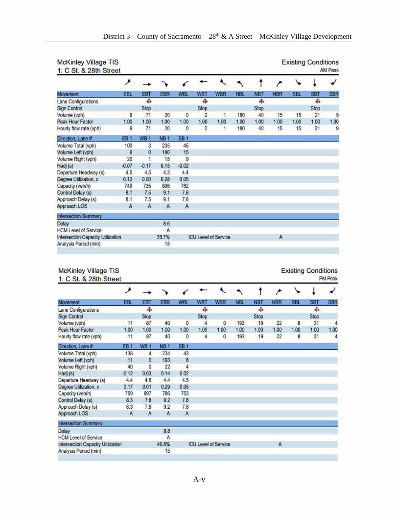
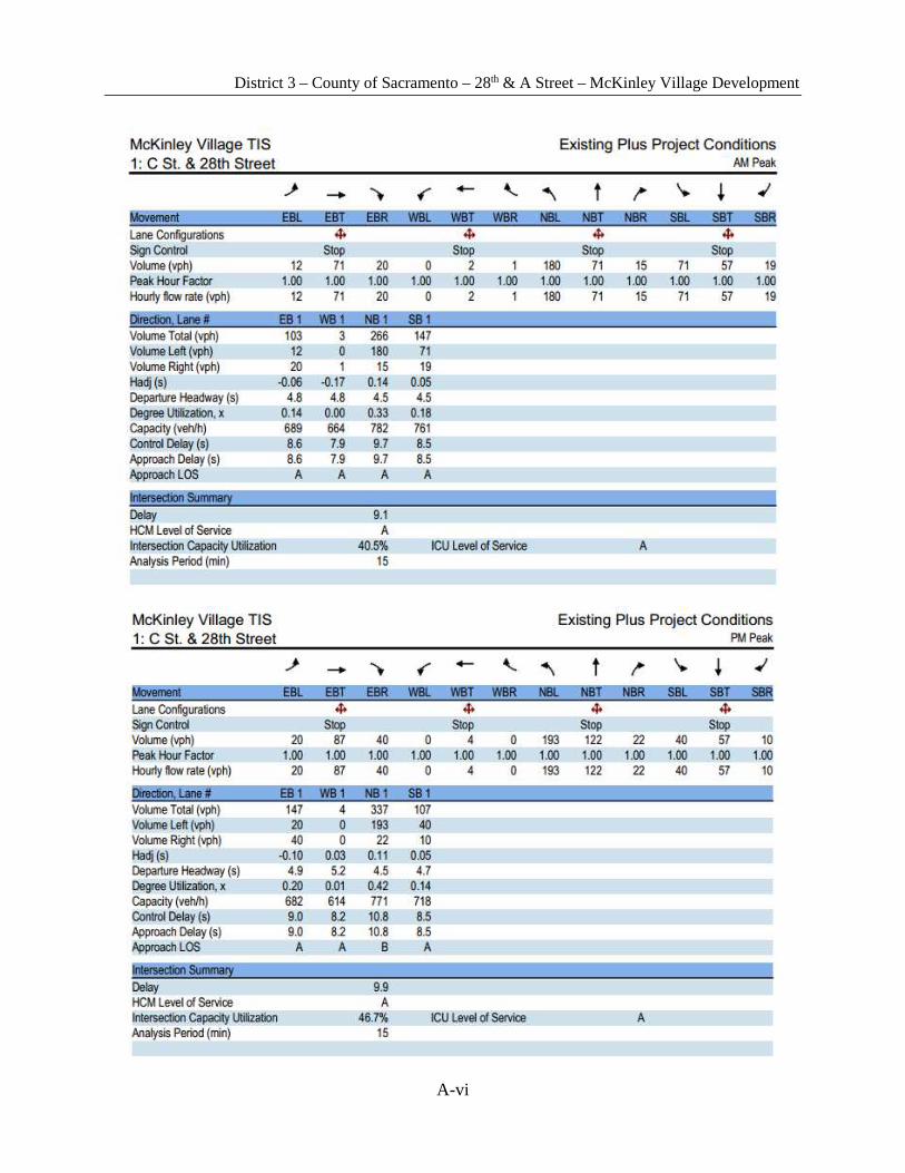
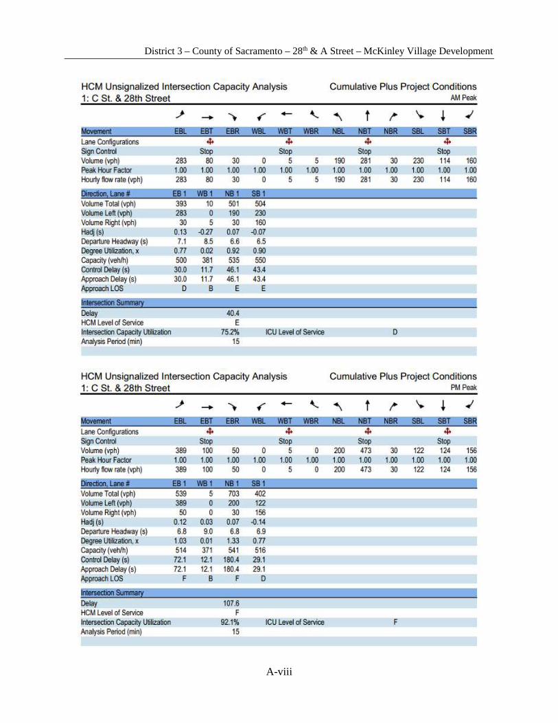
Roadway Capacity Utilization traffic studies were conducted by Fehr and Peers to determine the existing conditions, existing plus project conditions, cumulative conditions, and cumulative plus project conditions; the results of the studies are included in Attachment 1 of the Appendix. The traffic studies focused on several road segments that will be affected by the McKinley Village project; the roadway segment of concern for the primary access connecting Midtown and the A Street Bridge was 28th Street from C Street to E Street and the intersection of 28th Street and C Street. The traffic studies indicated that the level of service (LOS) of the existing conditions at the locations of concern are acceptable; however, the increase of traffic volume generated from the McKinley Village project will degrade the LOS to unacceptable conditions. The results of the traffic study are further detailed and analyzed in the Traffic Analysis section of this PSR.
The locations of access points for McKinley Village project need to efficiently distribute traffic entering and exiting the housing developments, be placed in potential locations of high traffic density, and allow easier access to major vehicular facilities and developments of Sacramento. City Standards also require two access points for emergency vehicles to ensure accessibility in the case where one of the access points is congested or inaccessible.
The proposed project will provide one of the required access points for the McKinley Village project. The proposed project will also provide upgrades to 28th Street and an intersection utilizing free flow design that will address future traffic conditions to improve the LOS.
Pedestrian Facilities and Safety
The location of the proposed project site contains several public and pedestrian facilities including Sutter’s Landing Dog Park, 28th and B Skate Park, Stanford Park, and American River Parkway north of A Street. However, the existing public and pedestrian facilities are disconnected, currently causing pedestrians to travel on the edge of the pavement and share the road with vehicular traffic on 28th Street from north of A Street to C Street to reach the public facilities and Midtown. A map of the current conditions of the proposed project site is contained in Attachment 2.
The increase in vehicular and pedestrian traffic generated from the McKinley Village project will be a safety risk for pedestrians if they have to continue to share the road with vehicles. The proposed project will include upgrades to the pedestrian facilities that meet the applicable standards to ensure pedestrian safety.
At-grade Crossing
The current at-grade crossing of the UPRR and 28th Street has a grade of 9%; however, the required grade to meet ADA compliance is 5%. Pedestrians with disabilities will currently have difficulty and discomfort traveling on 28th Street at the at-grade crossing, possibly discouraging the use of public facilities adjacent to 28th Street.
District 3 – County of Sacramento – 28th & A Street – McKinley Village Development
6
It is infeasible to change the profile grade of 28th Street to meet ADA standards. The proposed project implements an ADA compliant switchback ramp to mitigate the issue.
A Street Current Conditions
A Street, east of 28th Street, is currently an unpaved road that connects 28th Street with the existing A Street Bridge overcrossing Business 80. The unpaved road currently serves a low traffic volume and is only accessible to construction and maintenance crews. The unpaved road does not include vehicular lanes, sidewalks, or bike lanes, making it unsuitable for a larger volume of vehicular and pedestrian traffic.
For the consideration of future development and accessibility to Midtown, A Street must be updated and equipped with the appropriate vehicular and pedestrian facilities to accommodate higher vehicular and pedestrian traffic volumes produced by the McKinley Village project. The proposed project will construct a newly paved, two lane road that will feature a Class I shared pedestrian/bike path with adequate street lighting and a planter box-buffer separating vehicular and pedestrian traffic.
District 3 – County of Sacramento – 28th & A Street – McKinley Village Development
7
5 Design Alternatives
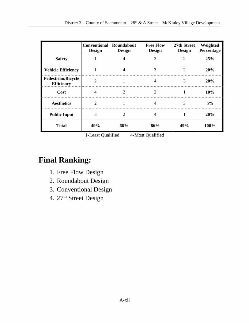
Capital City Consultants formulated four different design alternatives for the primary access to McKinley Village. Reducing traffic congestion for vehicles, creating pedestrian and bicycle access, and pedestrian safety were the primary concerns in drafting the designs. Using the ranking system outlined in Attachment 3 of the Appendix, the Free Flow Design was determined to be the viable alternative for the main access point to McKinley Village from Midtown Sacramento. The Free Flow Design alternative was also recommended for further consideration by the City of Sacramento.
5.1 Community Involvement
The public comments from the McKinley Village Draft EIR were considered for each of the four design alternatives. A public meeting was held in coordination with the Sacramento City Council on October 17, 2014 to present the four design alternatives to council members and the public that were present. The project team, led by Jeffrey Rud II, addressed all questions and concerns regarding the design alternatives. The feedback from the council members and public were highly regarded and public input was addressed in the ranking table in Attachment 3 of the Appendix.
5.2 Rejected Alternatives
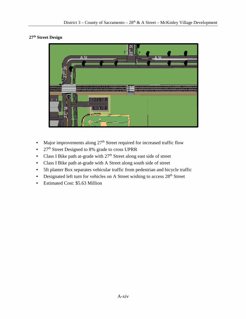
27th Street Design
The 27th Street Design incorporates removing the current at-grade railroad crossing at 28th Street and constructing a new at-grade railroad crossing at 27th Street. Relocating the at-grade railroad crossing to 27th Street makes A Street the through street, thus allowing traffic entering and leaving McKinley Village to have no traffic controls between the A Street Bridge and 27th Street. For this alternative, 27th Street would need major improvements to accommodate the proposed traffic volume for McKinley Village. This design alternative was rejected due to cost of relocating the at-grade railroad crossing and can be seen in Attachment 4.
Conventional Design
The conventional design incorporates keeping the current at-grade railroad crossing at 28th Street and constructing a new three-way stop controlled intersection at A Street. A switchback ramp will connect Stanford Park to the at-grade railroad crossing along the west side of 28th Street. A bike lane with a separated sidewalk at-grade with 28th Street will follow along the east side of 28th Street. A Street will have sidewalks and bike lanes along each side of the roadway. This design alternative was rejected due to lack of safety for pedestrians and bicyclists, as well as not efficiently transporting vehicles through the intersection. This design alternative can be seen in Attachment 4.

District 3 – County of Sacramento – 28th & A Street – McKinley Village Development
8
Roundabout Design
The Roundabout Design utilizes the current at-grade railroad crossing at 28th Street. The intersection of 28th Street and A Street will contain a roundabout allowing yield controlled movement of all vehicles approaching the intersection. A switchback ramp will be provided along the west side of 28th Street and a Class I bike path will follow the grade of 28th Street. The Class I bike path will continue along the west side of 28th Street and cross 28th Street north of A Street. The bike path will then travel along the north side of A Street. This design was rejected due to pedestrian and bicycle inefficiency and can be seen in Attachment 4.
5.3 Viable Alternative
Free Flow Design
This design provides free flow movement at the intersection of 28th Street and A Street where vehicles traveling east and west on A Street have the right of way, while vehicles traveling north and south on 28th Street are controlled. Both 28th and A Street will be two lane roadways with pedestrian facilities located on the west and north sides of the road, respectively. The pedestrian facilities will tie into the existing American River Parkway north of A Street. Currently 28th Street is 48 feet wide shoulder to shoulder with a 9% grade to the at-grade railroad crossing. Beyond the railroad tracks, 28th street stays at-grade with the railroad and leads to Sutter’s Landing Dog Park. A Street does not currently exist.
Vehicular traffic will travel on a two lane roadway with 11 ft. lanes. On street parking will still be provided along the east side of 28th Street between C Street and B Street. The railroad crossing arms for the railroad track will be extended to 45 ft. apart (currently 36 ft. apart) to allow for the bike path and roadway to be between the crossing arms.
Upon reaching the intersection of 28th Street and the extension of A Street, traffic traveling north and south along 28th Street will be required to stop at the A Street intersection. Vehicles traveling north on 28th Street who wish to turn east onto A Street will have a designated right turn lane where traffic can flow freely from 28th Street to A Street in this direction. Vehicles traveling west along A Street onto 28th Street will not be required to stop or yield before making the left turn onto 28th Street. Figure 2 is an orthographic view of this intersection. This residential collector roadway will be designed to City of Sacramento Standards.
Figure 2. 28th & A Street intersection

District 3 – County of Sacramento – 28th & A Street – McKinley Village Development
9
The proposed alternative entails adding a switchback ramp from Stanford Park and the B Street Theatre to the at-grade railroad crossing. As seen in Figure 3, the switchback ramp includes two turns with level landing at each turn. The crossing of the tracks will contain precast concrete track infill for the width of the sidewalk and bike path, 13 feet total. The sidewalk will be designed to ADA Compliance standards.
An 8 foot wide bike path starting at C Street will run along the sidewalk at the same grade as the existing roadway of 28th Street. After the rail road tracks, the
sidewalk and bike path will merge into a 10 ft. wide Class I bike path. Separating the bike path from the vehicular traffic will be 5 foot wide planter box-buffer, also starting at C Street. The planter box will contain trees, bushes, and other plants for aesthetic purposes.
The Class I bike path will follow along the west side of 28th Street, where a crosswalk will be provided 25 feet north of A Street. By moving the crosswalk north of the intersection, pedestrians and bicyclists crossing 28th Street will not conflict with traffic traveling through the intersection. This also makes the crosswalk safer for pedestrians as there is a lower traffic volume traveling north of the intersection on 28th Street. Once on the west side of 28th Street, the Class I bike path will continue north along 28th Street to the existing American River Parkway and also to A Street. The Class I bike path will follow along the north side of A Street where it will connect to a pedestrian bridge crossing Business 80 freeway. The pedestrian bridge design was completed by Pacific Valley Consultants. Figure 4 shows a cross section of A Street with a 5 foot wide planter box-buffer consisting of trees, bushes, and plants separating the bike path from the vehicular roadway. The Class I bike path will be designed to meet standards addressed in the Highway Design Manual (HDM).
This design does not require the relocation of existing utilities.
Figure 3. Switchback Ramp
Figure 4. Cross section of A Street

District 3 – County of Sacramento – 28th & A Street – McKinley Village Development
10
5.4 Design Exceptions
Standard for which exception is requested
Chapter 200 in the HDM, Geometric Design and Structure Standards: HDM 201.7 Decision Sight Distance, states “At certain locations, sight distance greater than stopping sight distance is desirable to allow drivers time for decisions without making last minute erratic maneuvers.”
Reason for requesting exception
Based on the existing conditions for the at-grade railroad crossing at 28th Street, the current grade does not provide adequate stopping sight distance for vehicles traveling at 25 miles per hour (mph). Southbound traffic on 28th Street turning east on B Street would be most affected by the short stopping sight distance; however, it is expected that most vehicular traffic accessing B Street will come from south of B Street. Changing the grade to meet current standards for adequate stopping sight distance will not only increase the cost of the project, but also require the grade of B Street to be redesigned. The change would make the roadway ADA compliant; however, compliance is met with the switchback pedestrian ramp.
5.5 Solves Purpose & Need
The viable design solves the purpose and need presented for the project. The primary access point of 28th street serves emergency vehicles, as well as daily vehicles, pedestrians and bicycles. The intersection at 28th and A Street in the Free Flow Design allows for the free flow movement of vehicles accessing McKinley Village, lowering traffic congestion entering and leaving the development. The pedestrian facilities provide both a safe and efficient paths for pedestrians and bicyclists, allowing them to connect to Midtown and the American River Parkway promoting the active lifestyle of the McKinley Village development.

District 3 – County of Sacramento – 28th & A Street – McKinley Village Development
11
5.6 Traffic Analysis
The traffic analysis report was completed by Fehr and Peers and is provided as Attachment 1 in the Appendix. This section describes the potential impacts to the transportation system near the proposed McKinley Village project. The traffic analysis report analyzes the roadway, transit, bicycle, pedestrian, and construction component of the system into four different scenarios: Existing, Existing Plus Project, Cumulative, and Cumulative Plus Project. The study area for this traffic analysis report includes 32 study intersections, 19 roadway segments, and 8 freeway facilities selected for analysis. For the proposed project, as shown in Table 2 the intersection of C Street and 28th Street and roadway segment of 28th Street between C Street and E Street will be considered.
Looking at the data provided in Table 3, the LOS for 28th Street is acceptable under current conditions, but with the additional traffic volume generated from the McKinley Village project, the LOS will be unacceptable. The proposed project of a vehicular and pedestrian primary access at 28th and A Street will alleviate traffic volumes produced from the McKinley Village project and have a positive impact on the LOS
Table 2. 28th Street/C Street Intersection Traffic Analysis.
Project Conditions Level of Service (AM)
Level of Service (PM)
Delay Time (s)
(AM)
Delay Time (s)
(PM)
Peak Hour Volume (veh)
(AM)
Peak Hour Volume (veh)
(PM)
Existing A A 8.6 8.8 383 419
Existing Plus Project A A 9.1 9.9 519 595
Cumulative D F 26.5 69.2 1,290 1,485
Cumulative Plus Project E F 40.4 107.6 1,408 1,649
Table 3. 28th Street from C Street to E Street Roadway Segment
Project Conditions Level
of Service
Average Daily Traffic Volume
(veh)
Existing C 3,850
Existing Plus Project E 4,972
Cumulative F 6,500
Cumulative Plus Project F 7,616
It is the objective of this project to improve the LOS and decrease delay times of the specified intersection and roadway segment in order to allow for free flow conditions, to and from Midtown and McKinley Village, for the residents of this community.
28th Street is currently a two-lane local roadway located west of the McKinley Village project site with on-street parking south of B Street and Class II bike lanes, which currently operates at LOS A. As shown from the traffic analysis in Attachment 1, the LOS for this road segment and intersection operates at LOS A for the majority of the day. During peak hour operation times, for both AM and PM peak hours, this road segment and intersection operates at LOS F
District 3 – County of Sacramento – 28th & A Street – McKinley Village Development
12
for the cumulative plus project conditions. In order to improve LOS for these locations, improvements need to be made on 28th Street to improve the LOS to an acceptable standard.
The existing 28th Street at-grade railroad crossing is equipped with overhead flashing lights, crossing arms, and bells, sharing characteristics with many other railroad crossings in Midtown Sacramento. There are up to 40 total trains per day that pass by the project site. Homeland Security concerns prevent UPRR from releasing any specific information pertaining to train schedules or frequency of train travel. Based on the traffic analysis, the project is not expected to create any additional vehicle impacts at this location; additional lanes will not be required for this area. However, as documented previously, the project is expected to increase pedestrian and bicycle travel at this crossing, which has no pedestrian or bicycle amenities. For this reason, it is recommended that the project applicant coordinate with the City and the California Public Utilities Commission (CPUC) to design and implement appropriate bicycle and pedestrian improvements at the 28th Street railroad crossing.
6. Environmental Impact
The key environmental impacts that have been identified for the proposed project include the preservation of biological resources, the degradation of air quality due to increased vehicular traffic, noise issues due to increased vehicular traffic, and aesthetics.
6.1 Biological Resources
Valley Elderberry Longhorn Beetle
The Valley Elderberry Longhorn Beetle (VELB) is listed as a threatened species and is fully protected under the Endangered Species Act of 1973. The VELB is entirely dependent on the host plant, the elderberry, which is common in riparian forests and upland habitats of California’s Central Valley. Commonly, the only physical evidence of the habitation of the elderberry is an exit hole created by the larva prior to the pupal stage. The animal spends a majority of its life in the larval stage and living within the stems of an elderberry plant.
The project site is within the vicinity of the VELB and its elderberry host plant, requiring the project site to be surveyed by a qualified biologist. Elderberry plants with one or more stems measuring 1.0 inch or greater in diameter located on ground level of the project site or located where they may be directly or indirectly affected by the project require minimization measures which include planting replacement habitat. The specified plants will be thoroughly investigated for beetle exit holes.
Projects sites that do not contain beetle habitat are preferred. Complete avoidance of beetle habitat may be assumed when a 100-foot (or wider) buffer is established and maintained around elderberry plants containing stems measuring 1.0 inch or greater in diameter at ground level. Qualified biologists surveyed the foraging area north of A Street and the A Street Bridge that is 100-feet within the project site for potential habitat of the elderberry plant. Biologists found no Elderberry plants in the specified foraging area; all other foraging areas and
District 3 – County of Sacramento – 28th & A Street – McKinley Village Development
13
elderberry plants are greater than 100-feet from the project site. No mitigation action for the elderberry plant is necessary for the project.
Swainson’s hawk
Swainson’s hawk is considered a threatened species and is protected by legislative, commission policies, and legal mandates and standards such as Fish and Game Section 2051, Section 2053, Section 2054, and Section 2080. Swainson’s hawk nests in the Central Valley of California in scattered trees and adjacent to riparian systems. Suitable foraging habitat for Swainson’s hawk contain major prey items such as small rodents, reptiles, and insects.
The project site is in the vicinity of Swainson’s hawk nests and foraging areas, requiring surveys for a half mile radius around project activities to meet the Department of Fish and Game’s recommendations. The survey periods for the presence of hawks and/or nests were defined by the timing of migration, courtship, and nesting in a typical year for the majority of Swainson’s hawk. The project must not cause nest site disturbance which results in nest abandonment, loss of young, and reduced health and vigor of eggs and/or nestlings. The project must also not cause a loss or alteration of foraging habitat causing the reduction of prey or adults traveling long distances from the nest site.
The Department of Fish and Wildlife will consider whether a proposed project will adversely affect suitable foraging habitat within a ten (10) mile radius of an active (used during one or more of the last 5 years) Swainson’s hawk nest(s). The only foraging area that may be affected by the project is north of A Street and the A Street Bridge. Residents and people of interest are concerned that the introduction of vehicles, noise, and lights will be detrimental to the surrounding species and the hawk; however, surrounding species and the hawk have adapted to the urban environment which is in the proximity of the Business 80 freeway and the UPRR. The introduction of vehicles, noise, and lights on A Street will not be distinguishable from the noise generated from the freeway and the proposed project will not introduce any activities that are already present in the larger, surrounding area. Therefore, it was determined by surveyors that the foraging area will not be adversely affected by the project as the inhabiting mammals, insects, and vegetation will remain in place and the environment will not be adversely affected. No mitigation actions for Swainson’s hawk are necessary for the project.
6.2 Air Quality
The degradation of air quality due to gas emissions from an increase of vehicular traffic on 28th and A Street is of concern for the public that utilizes the adjacent area of Stanford Park, Sutter’s Landing Dog Park, and the 28th and B Skate Park. The project was designed to minimize the emissions produced from vehicular traffic by promoting the use of pedestrian facilities and designing the intersection to exhibit free flow conditions.
The project consists of several pedestrian facilities to enhance pedestrian and bicycle access from Midtown to the A Street Bridge. The pedestrian facilities were intentionally placed on the west side of 28th Street to allow easier pedestrian access to Sutter’s Landing Dog Park and

District 3 – County of Sacramento – 28th & A Street – McKinley Village Development
14
Stanford Park, and on the north side of A Street to connect to the A Street bridge and the American River Parkway north of A Street. Connecting the pedestrian facilities with existing facilities will promote pedestrians and bicyclists to use the project’s facilities and can potentially decrease vehicular use, lowering gas emissions.
The intersection of 28th and A Street will have the majority of the vehicular traffic volume traveling east and west on A Street (entering and leaving the McKinley Park Village housing developments) and a low vehicular traffic volume traveling north and south on 28th Street. The intersection was designed to have no traffic control devices in the east and west directions to allow the high traffic volume to move freely without interruption of other vehicular traffic or pedestrians crossing. The promotion of free flow conditions with the lack of traffic control devices significantly lowers the amount of “stop-and-go traffic”, which lowers the gas emissions that are produced by vehicles.
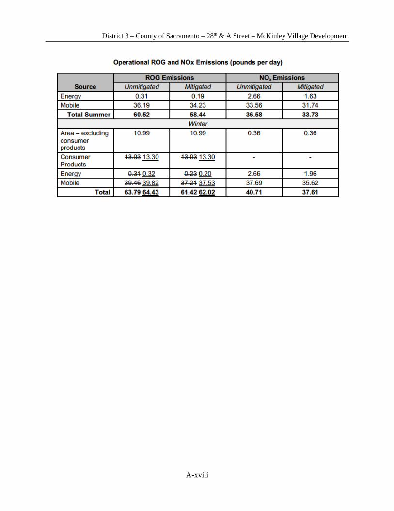
In a larger scope, the degradation of air quality due to emissions produced from the operational impacts of the McKinley Village project and from vehicular traffic on the Business 80 freeway are also large concerns for the nearby residents. Air quality modeling and roadway protocol was conducted by the Sacramento Metropolitan Air Quality Management District (SMAQMD) to determine the impacts of reactive organic gases (ROGs), mono-nitrogen oxides (NOXs), and diesel particulate matter (DPM) emissions. The results of the air quality modeling are included in Attachment 5.
The air quality monitoring modeling for ROG and NOX emissions produced by the operational impact of McKinley Park Village project show that they are still below the thresholds so the operational impact remains less than significant. Construction emissions would essentially be the same as operational emissions.
SMAQMD developed roadway protocol to evaluate the cancer risk due to DPM emissions for vehicles traveling on the nearby, high traffic Business 80 freeway. The estimated cancer risk due to emissions from the freeway are 200 in 1 million, which is less than the criteria for SMAQMD.
6.3 Community Impact
Noise Residents of neighboring communities are concerned with noise generated from the proposed project effecting the appeal of conveniently located parks such as Sutter’s Landing Park and the American River Parkway. However, the noise generated from increased traffic and activity from the proposed project will be insignificant in comparison to the noise generated from the Business 80 freeway and UPRR.
A Noise Report was conducted by the noise consultant to evaluate both freeway traffic and railroad noise exposure at the adjacent park locations. The Noise Report determined that the noise generated from the Business 80 freeway and the UPRR would be 10 dB below the City’s noise standard applicable to park residents of 70 dB. The predicted noise environment within

District 3 – County of Sacramento – 28th & A Street – McKinley Village Development
15
the park areas is only 60 dB, large in part due to the shielding of noise provided by design features and noise barriers in the McKinley Village project.
Aesthetics Residents strongly commented that the landscape of the proposed project and the McKinley Village project should share common characteristics with neighboring residential areas, specifically in regards to the planting of trees. The proposed project implements a planter box-buffer containing trees, shrubs, and other plants, separating the road and the pedestrian facilities to maintain aesthetic value and for pedestrian safety. For the McKinley Village project, the proposed landscaping plan calls for the planting of 2,000 trees within the project site and adjacent neighborhoods.
7. Right of Way Impacts
The proposed project of a primary vehicular and pedestrian access from Midtown to the A Street Bridge will have a UPRR right of way impact. The right of way for Kinder Morgan Energy petroleum pipeline, A Street, and lands adjacent to 28th Street will not have to be obtained due to the avoidance of utilities and the ownership of lands belonging to the City of Sacramento and the State of California.
UPRR The sidewalk and Class I bike path crossing the Union Pacific Railroad will consist of precast concrete track infill; however, UPRR holds the right of way and has several construction guidelines and requirements when constructing or modifying the railroad. Prior to performing any track construction on Union Pacific property, a fully executed Industry Track Agreement is in effect, a designated Railroad representative must be notified in writing at least fifteen days prior to ensure the appropriate safety precautions are taken, and the Union Pacific Telecommunication Operation Center must be contacted for fiber optic information.
Kinder Morgan Energy Petroleum Pipelines A major utility that exists within the proposed project location is the underground Kinder Morgan Energy petroleum pipelines that run parallel to 28th Street. The alternative that was chosen for the proposed project does not require any excavation that would interfere with the existing utility. A right of way does not need to be obtained to proceed with the project; however, Kinder Morgan will be involved and present during the construction over the existing pipelines to ensure compliance with their guidelines.
Road Construction on A Street The proposed project requires the construction of a new road on A Street to connect 28th Street with the A Street Bridge. The right of way for the location of A Street is owned by the City of Sacramento so there will be no costs for land acquisition; however, there will be support costs to transfer the land from its current right of way to a public right of way.
District 3 – County of Sacramento – 28th & A Street – McKinley Village Development
16
Land Acquisition for 28th Street The proposed project will require upgrades on 28th Street extending from north of A Street to the edge of Stanford Park at C Street. An upgrade to 28th Street will be widening the roadway to meet design criteria, which will cause the road to overlap several feet into adjacent properties. Geographical Information System (GIS) data was provided by ParcelQuest to determine the right of way for the adjacent properties on 28th street that would be affected by the widening of the roadway. It was determined that all of the parcels in question were owned by the City of Sacramento and the State of California; therefore, there will be no costs for obtaining the right of way to widen 28th Street. However, there will be support costs to transfer the adjacent lands from the current right of ways to a public right of way.
8. Constructability
Upon approval of the application submitted to UPRR for the track improvements, the railroad crossing at 28th Street will be closed while improvements are made. Improvements include track infill for the pedestrian/bicycle crossing and extending the railroad crossing arms to 43 feet apart. UPRR will control how long the closure is in place, but the public can be assured that closure will be for as short duration as possible. The only vehicular route for the facilities north of the railroad tracks will be temporarily closed and this closure will be coordinated with UPRR and the impacted facilities. The train service will not be interrupted as the track infill will be installed a track at a time. These installations will depend on the schedule of UPRR trains.
During the resurfacing phase of construction, 28th Street will be shut down to one lane starting at C Street. Construction of the intersection of 28th and A Street will take place while the required lane is closed. Since UPRR will close the at-grade railroad crossing, construction will start during the closure and improvements will be made to 28th street first. Access will be provided to the A Street Bridge during construction of A Street via a temporary dirt side road that will be put in place before construction begins. A Street will also be inaccessible via 28th Street during the UPRR track improvement;
For all instances while 28th Street is restricted to one lane, flaggers will be provided to ensure the safety of both workers and vehicles. Pedestrian traffic will not be permitted during the above phases to protect the safety of pedestrians. Bicycle traffic will be expected to follow the same rules as vehicular traffic.
District 3 – County of Sacramento – 28th & A Street – McKinley Village Development
17
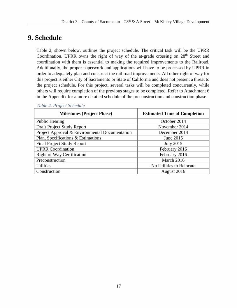
9. Schedule
Table 2, shown below, outlines the project schedule. The critical task will be the UPRR Coordination. UPRR owns the right of way of the at-grade crossing on 28th Street and coordination with them is essential to making the required improvements to the Railroad. Additionally, the proper paperwork and applications will have to be processed by UPRR in order to adequately plan and construct the rail road improvements. All other right of way for this project is either City of Sacramento or State of California and does not present a threat to the project schedule. For this project, several tasks will be completed concurrently, while others will require completion of the previous stages to be completed. Refer to Attachment 6 in the Appendix for a more detailed schedule of the preconstruction and construction phase.
Table 4. Project Schedule
Milestones (Project Phase) Estimated Time of Completion
Public Hearing October 2014 Draft Project Study Report November 2014 Project Approval & Environmental Documentation December 2014 Plan, Specifications & Estimations June 2015 Final Project Study Report July 2015 UPRR Coordination February 2016 Right of Way Certification February 2016 Preconstruction March 2016 Utilities No Utilities to Relocate Construction August 2016
District 3 – County of Sacramento – 28th & A Street – McKinley Village Development
A-i
10. Appendix
List of Attachments: Traffic Studies ........................................................................................................................... A-ii
Project Site Current Conditions Overview ........................................................................... A-ix
Alternative Ranking System ................................................................................................... A-xi
Rejected Alternatives Plan View .......................................................................................... A-xiii
Air Quality Modeling ........................................................................................................... A-xvii
Preconstruction & Construction Schedule Breakdown ..................................................... A-xix
Cost Estimate ......................................................................................................................... A-xxi
Preliminary Drawings ......................................................................................................... A-xxix

District 3 – County of Sacramento – 28th & A Street – McKinley Village Development
A-ii
Attachment 1 Traffic Studies
Completed by Fehr and Peers – only pages relevant to this project are provided in this Appendix. For a full report
please see Appendix O in McKinley Village Draft. EIR.

District 3 – County of Sacramento – 28th & A Street – McKinley Village Development
A-iii

District 3 – County of Sacramento – 28th & A Street – McKinley Village Development
A-iv
District 3 – County of Sacramento – 28th & A Street – McKinley Village Development
A-v
District 3 – County of Sacramento – 28th & A Street – McKinley Village Development
A-vi

District 3 – County of Sacramento – 28th & A Street – McKinley Village Development
A-vii
District 3 – County of Sacramento – 28th & A Street – McKinley Village Development
A-viii
District 3 – County of Sacramento – 28th & A Street – McKinley Village Development
A-ix
Attachment 2 Project Site Current Conditions Overview

District 3 – County of Sacramento – 28th & A Street – McKinley Village Development
A-x
District 3 – County of Sacramento – 28th & A Street – McKinley Village Development
A-xi
Attachment 3 Alternative Ranking System
District 3 – County of Sacramento – 28th & A Street – McKinley Village Development
A-xii
Conventional
Design Roundabout
Design Free Flow
Design 27th Street
Design Weighted
Percentage
Safety 1 4 3 2 25%
Vehicle Efficiency 1 4 3 2 20%
Pedestrian/Bicycle Efficiency
2 1 4 3 20%
Cost 4 2 3 1 10%
Aesthetics 2 1 4 3 5%
Public Input 3 2 4 1 20%
Total 49% 66% 86% 49% 100%
1-Least Qualified 4-Most Qualified
Final Ranking: 1. Free Flow Design 2. Roundabout Design 3. Conventional Design 4. 27th Street Design

District 3 – County of Sacramento – 28th & A Street – McKinley Village Development
A-xiii
Attachment 4 Rejected Alternatives Plan View
District 3 – County of Sacramento – 28th & A Street – McKinley Village Development
A-xiv
27th Street Design
• Major improvements along 27th Street required for increased traffic flow • 27th Street Designed to 8% grade to cross UPRR
• Class I Bike path at-grade with 27th Street along east side of street • Class I Bike path at-grade with A Street along south side of street
• 5ft planter Box separates vehicular traffic from pedestrian and bicycle traffic • Designated left turn for vehicles on A Street wishing to access 28th Street • Estimated Cost: $5.63 Million
A St A St
28
th S
t
27
th S
t 2
7th
St
District 3 – County of Sacramento – 28th & A Street – McKinley Village Development
A-xv
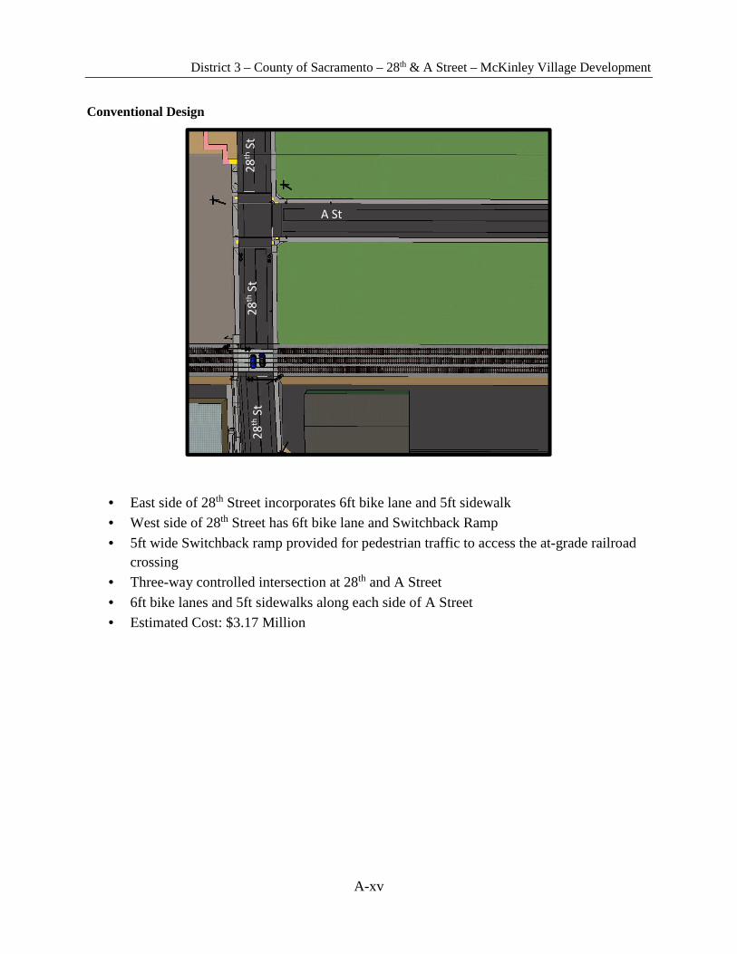
Conventional Design
• East side of 28th Street incorporates 6ft bike lane and 5ft sidewalk • West side of 28th Street has 6ft bike lane and Switchback Ramp
• 5ft wide Switchback ramp provided for pedestrian traffic to access the at-grade railroad crossing
• Three-way controlled intersection at 28th and A Street
• 6ft bike lanes and 5ft sidewalks along each side of A Street • Estimated Cost: $3.17 Million
A St
28
th S
t 2
8th
St
28
th S
t
District 3 – County of Sacramento – 28th & A Street – McKinley Village Development
A-xvi
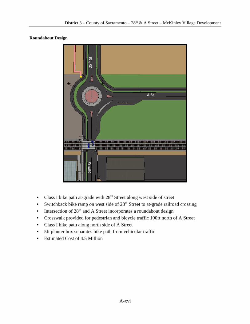
Roundabout Design
• Class I bike path at-grade with 28th Street along west side of street • Switchback bike ramp on west side of 28th Street to at-grade railroad crossing
• Intersection of 28th and A Street incorporates a roundabout design • Crosswalk provided for pedestrian and bicycle traffic 100ft north of A Street
• Class I bike path along north side of A Street • 5ft planter box separates bike path from vehicular traffic • Estimated Cost of 4.5 Million
A St
28
th S
t 2
8th
St

District 3 – County of Sacramento – 28th & A Street – McKinley Village Development
A-xvii
Attachment 5 Air Quality Modeling
Completed by the Sacramento Metropolitan Air Quality Management District – only table relevant to this project is provided in this Appendix. For a full report, please see
McKinley Village Draft EIR.
District 3 – County of Sacramento – 28th & A Street – McKinley Village Development
A-xviii

District 3 – County of Sacramento – 28th & A Street – McKinley Village Development
A-xix
Attachment 6 Preconstruction & Construction Schedule
Breakdown
District 3 – County of Sacramento – 28th & A Street – McKinley Village Development
A-xx
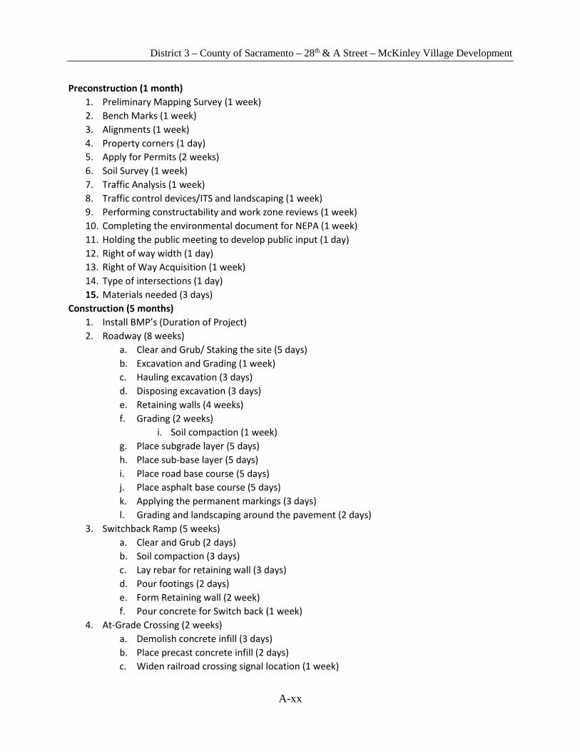
Preconstruction (1 month)
1. Preliminary Mapping Survey (1 week)
2. Bench Marks (1 week)
3. Alignments (1 week)
4. Property corners (1 day)
5. Apply for Permits (2 weeks)
6. Soil Survey (1 week)
7. Traffic Analysis (1 week)
8. Traffic control devices/ITS and landscaping (1 week)
9. Performing constructability and work zone reviews (1 week)
10. Completing the environmental document for NEPA (1 week)
11. Holding the public meeting to develop public input (1 day)
12. Right of way width (1 day)
13. Right of Way Acquisition (1 week)
14. Type of intersections (1 day)
15. Materials needed (3 days)
Construction (5 months)
1. Install BMP’s (Duration of Project)
2. Roadway (8 weeks)
a. Clear and Grub/ Staking the site (5 days)
b. Excavation and Grading (1 week)
c. Hauling excavation (3 days)
d. Disposing excavation (3 days)
e. Retaining walls (4 weeks)
f. Grading (2 weeks)
i. Soil compaction (1 week)
g. Place subgrade layer (5 days)
h. Place sub-base layer (5 days)
i. Place road base course (5 days)
j. Place asphalt base course (5 days)
k. Applying the permanent markings (3 days)
l. Grading and landscaping around the pavement (2 days)
3. Switchback Ramp (5 weeks)
a. Clear and Grub (2 days)
b. Soil compaction (3 days)
c. Lay rebar for retaining wall (3 days)
d. Pour footings (2 days)
e. Form Retaining wall (2 week)
f. Pour concrete for Switch back (1 week)
4. At-Grade Crossing (2 weeks)
a. Demolish concrete infill (3 days)
b. Place precast concrete infill (2 days)
c. Widen railroad crossing signal location (1 week)

District 3 – County of Sacramento – 28th & A Street – McKinley Village Development
A-xxi
Attachment 7 Cost Estimate
District 3 – County of Sacramento – 28th & A Street – McKinley Village Development
A-xxii
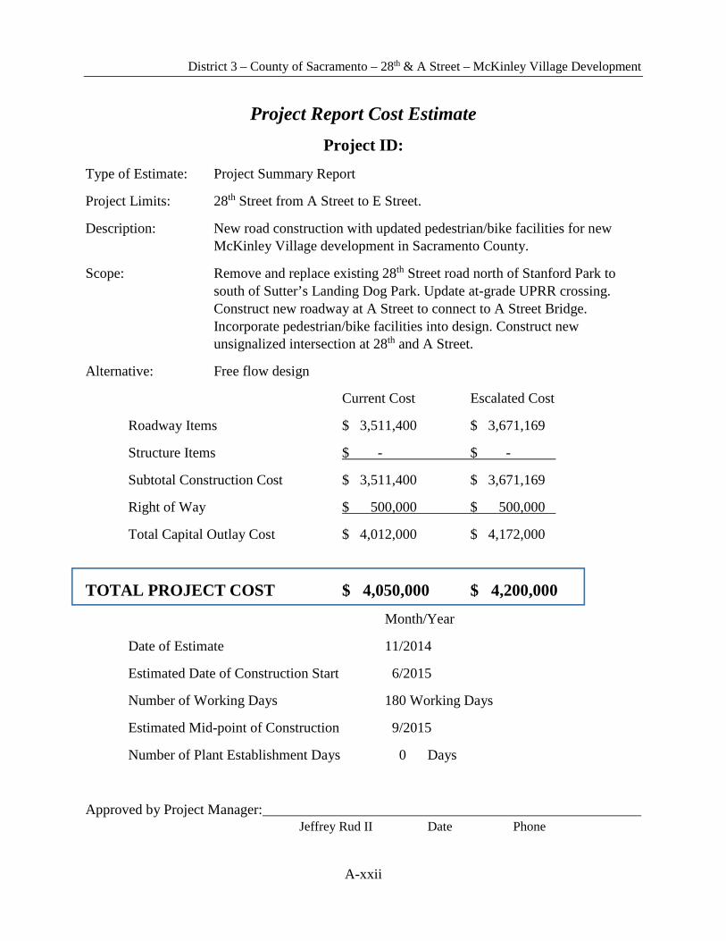
Project Report Cost Estimate Project ID:
Type of Estimate: Project Summary Report
Project Limits: 28th Street from A Street to E Street.
Description: New road construction with updated pedestrian/bike facilities for new McKinley Village development in Sacramento County.
Scope: Remove and replace existing 28th Street road north of Stanford Park to south of Sutter’s Landing Dog Park. Update at-grade UPRR crossing. Construct new roadway at A Street to connect to A Street Bridge. Incorporate pedestrian/bike facilities into design. Construct new unsignalized intersection at 28th and A Street.
Alternative: Free flow design
Current Cost Escalated Cost
Roadway Items $ 3,511,400 $ 3,671,169
Structure Items $ - $ -
Subtotal Construction Cost $ 3,511,400 $ 3,671,169
Right of Way $ 500,000 $ 500,000
Total Capital Outlay Cost $ 4,012,000 $ 4,172,000
TOTAL PROJECT COST $ 4,050,000 $ 4,200,000
Month/Year
Date of Estimate 11/2014
Estimated Date of Construction Start 6/2015
Number of Working Days 180 Working Days
Estimated Mid-point of Construction 9/2015
Number of Plant Establishment Days 0 Days
Approved by Project Manager: Jeffrey Rud II Date Phone

District 3 – County of Sacramento – 28th & A Street – McKinley Village Development
A-xxiii
I. Roadway Items Summary
Section Cost
1. Earthwork $ 160,100 2. Pavement Structural Section $ 809,200 3. Drainage $ 363,400 4. Specialty Items $ 63,900 5. Environmental $ 339,600 6. Traffic Items $ 484,300 7. Detours $ - 8. Minor Items $ 222,100 9. Roadway Mobilization $ 244,300 10. Supplemental Work $ 122,200 11. State Furnished $ - 12. Contingencies $ 702,300 13. Overhead $ -
TOTAL ROADWAY ITEMS $ 3,511,400
Estimate Prepared By: Humberto Negrete Date Phone
Estimate Reviewed By: Jeffrey Rud II Date Phone
By signing this estimate you are attesting that you have discussed your project with all functional units and have incorporated all their comments or have discussed with them why they will not be incorporated.
District 3 – County of Sacramento – 28th & A Street – McKinley Village Development
A-xxiv
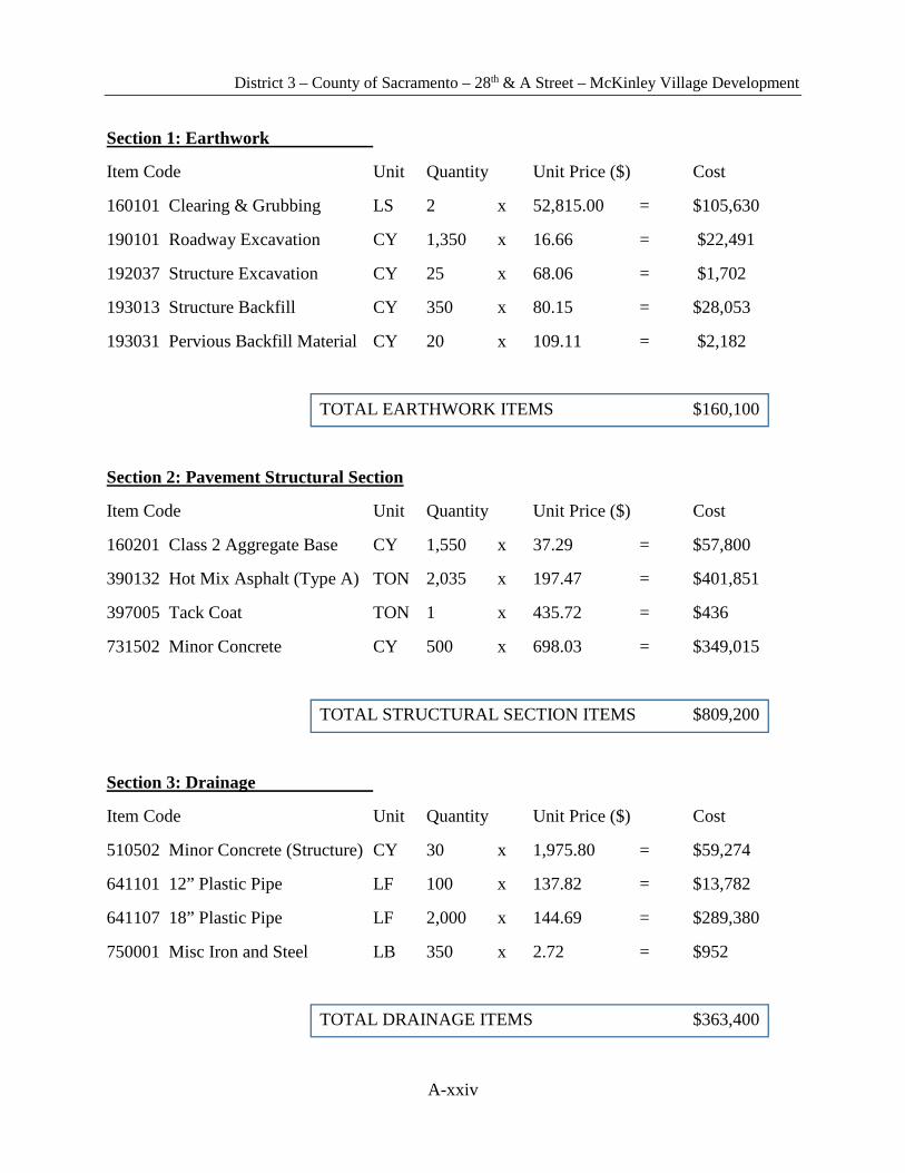
Section 1: Earthwork
Item Code Unit Quantity Unit Price ($) Cost
160101 Clearing & Grubbing LS 2 x 52,815.00 = $105,630
190101 Roadway Excavation CY 1,350 x 16.66 = $22,491
192037 Structure Excavation CY 25 x 68.06 = $1,702
193013 Structure Backfill CY 350 x 80.15 = $28,053
193031 Pervious Backfill Material CY 20 x 109.11 = $2,182
TOTAL EARTHWORK ITEMS $160,100
Section 2: Pavement Structural Section
Item Code Unit Quantity Unit Price ($) Cost
160201 Class 2 Aggregate Base CY 1,550 x 37.29 = $57,800
390132 Hot Mix Asphalt (Type A) TON 2,035 x 197.47 = $401,851
397005 Tack Coat TON 1 x 435.72 = $436
731502 Minor Concrete CY 500 x 698.03 = $349,015
TOTAL STRUCTURAL SECTION ITEMS $809,200
Section 3: Drainage
Item Code Unit Quantity Unit Price ($) Cost
510502 Minor Concrete (Structure) CY 30 x 1,975.80 = $59,274
641101 12” Plastic Pipe LF 100 x 137.82 = $13,782
641107 18” Plastic Pipe LF 2,000 x 144.69 = $289,380
750001 Misc Iron and Steel LB 350 x 2.72 = $952
TOTAL DRAINAGE ITEMS $363,400
District 3 – County of Sacramento – 28th & A Street – McKinley Village Development
A-xxv
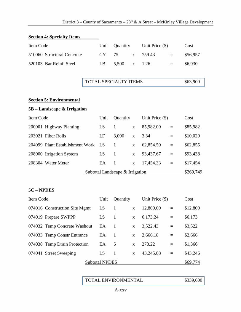
Section 4: Specialty Items
Item Code Unit Quantity Unit Price ($) Cost
510060 Structural Concrete CY 75 x 759.43 = $56,957
520103 Bar Reinf. Steel LB 5,500 x 1.26 = $6,930
TOTAL SPECIALTY ITEMS $63,900
Section 5: Environmental
5B – Landscape & Irrigation
Item Code Unit Quantity Unit Price ($) Cost
200001 Highway Planting LS 1 x 85,982.00 = $85,982
203021 Fiber Rolls LF 3,000 x 3.34 = $10,020
204099 Plant Establishment Work LS 1 x 62,854.50 = $62,855
208000 Irrigation System LS 1 x 93,437.67 = $93,438
208304 Water Meter EA 1 x 17,454.33 = $17,454
Subtotal Landscape & Irrigation $269,749
5C – NPDES
Item Code Unit Quantity Unit Price ($) Cost
074016 Construction Site Mgmt LS 1 x 12,800.00 = $12,800
074019 Prepare SWPPP LS 1 x 6,173.24 = $6,173
074032 Temp Concrete Washout EA 1 x 3,522.43 = $3,522
074033 Temp Constr Entrance EA 1 x 2,666.18 = $2,666
074038 Temp Drain Protection EA 5 x 273.22 = $1,366
074041 Street Sweeping LS 1 x 43,245.88 = $43,246
Subtotal NPDES $69,774
TOTAL ENVIRONMENTAL $339,600

District 3 – County of Sacramento – 28th & A Street – McKinley Village Development
A-xxvi
Section 6: Traffic Items
6A – Traffic Electrical
Item Code Unit Quantity Unit Price ($) Cost
560209 Install Sign Structure LB 150 x 1.22 = $183
860604 Flashing Beacon System LS 1 x 48,101.18 = $48,101
860401 Lighting LS 1 x 129,877.53 = $129,878
Subtotal Traffic Electrical $178,162
6B – Traffic Signing & Striping
Item Code Unit Quantity Unit Price ($) Cost
120090 Construction Area Signs LS 1 x 16,990.60 = $16,991
566011 Roadside Sign (1 post) EA 25 x 327.41 = $8,185
Permanent Pavement Delineation LS 1 x 75,000.00 = $75,000
Subtotal Traffic Signing & Striping $100,176
6C – Stage Construction & Traffic Handling
Item Code Unit Quantity Unit Price ($) Cost
120100 Traffic Control System LS 1 x 166,496.51 = $166,497
120120 Type III Barricade EA 50 x 115.69 = $5,785
128650 Changeable Message Sign EA 2 x 15,391.83 = $30,784
129000 Temp Railing (Type K) LF 200 x 14.35 = $2,870
Subtotal Stage Construction & Traffic Handling $205,935
TOTAL TRAFFIC ITEMS $484,300
District 3 – County of Sacramento – 28th & A Street – McKinley Village Development
A-xxvii
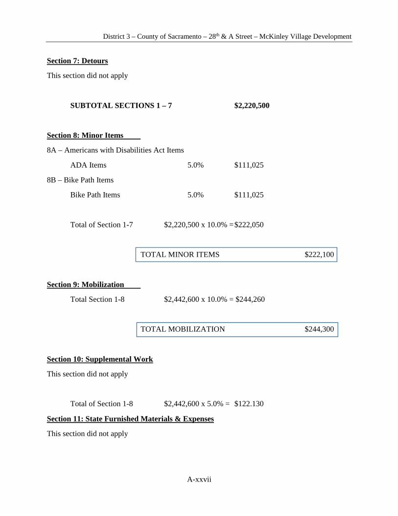
Section 7: Detours
This section did not apply
SUBTOTAL SECTIONS 1 – 7 $2,220,500
Section 8: Minor Items
8A – Americans with Disabilities Act Items
ADA Items 5.0% $111,025
8B – Bike Path Items
Bike Path Items 5.0% $111,025
Total of Section 1-7 $2,220,500 x 10.0% = $222,050
TOTAL MINOR ITEMS $222,100
Section 9: Mobilization
Total Section 1-8 $2,442,600 x 10.0% = $244,260
TOTAL MOBILIZATION $244,300
Section 10: Supplemental Work
This section did not apply
Total of Section 1-8 $2,442,600 x 5.0% = $122.130
Section 11: State Furnished Materials & Expenses
This section did not apply
District 3 – County of Sacramento – 28th & A Street – McKinley Village Development
A-xxviii
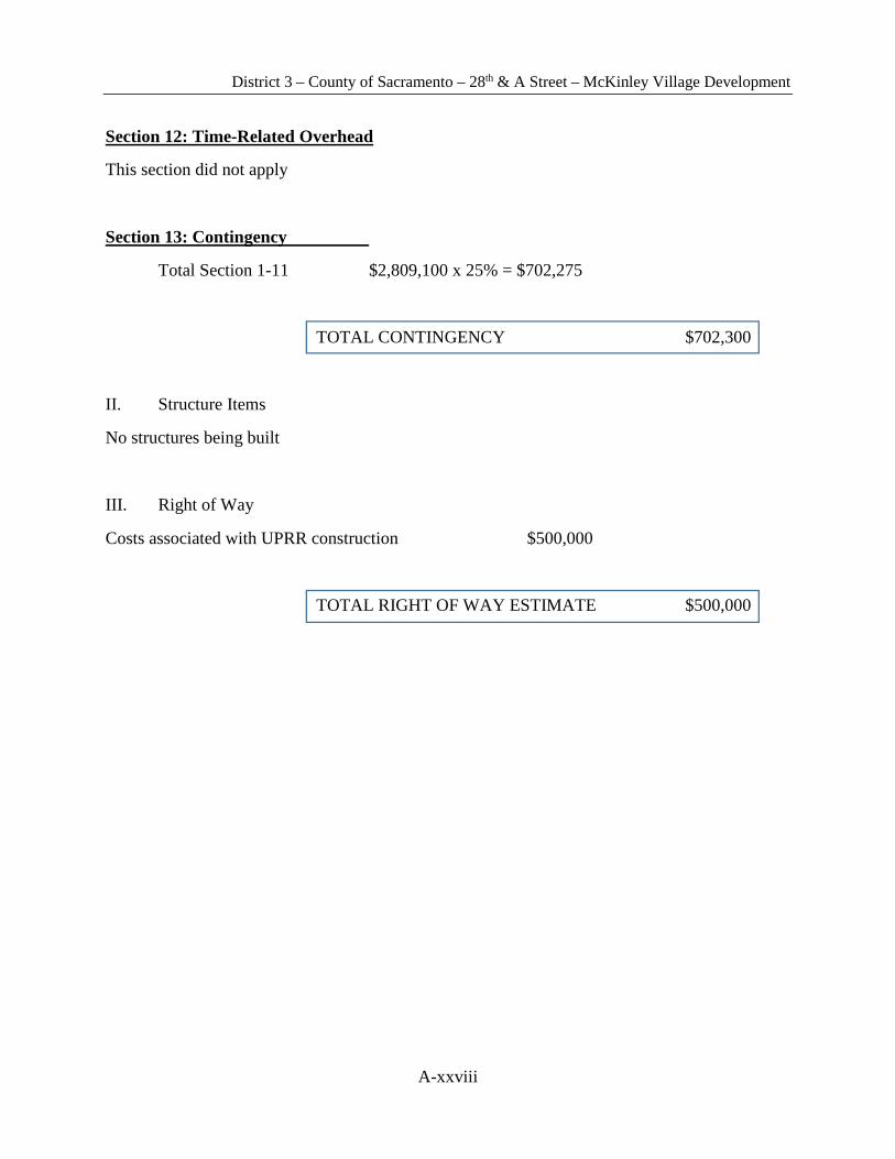
Section 12: Time-Related Overhead
This section did not apply
Section 13: Contingency
Total Section 1-11 $2,809,100 x 25% = $702,275
TOTAL CONTINGENCY $702,300
II. Structure Items
No structures being built
III. Right of Way
Costs associated with UPRR construction $500,000
TOTAL RIGHT OF WAY ESTIMATE $500,000

District 3 – County of Sacramento – 28th & A Street – McKinley Village Development
A-xxix
Attachment 8 Preliminary Drawings
Related Documents