Welcome message from author
This document is posted to help you gain knowledge. Please leave a comment to let me know what you think about it! Share it to your friends and learn new things together.
Transcript


M/S THE RAMCO CEMENTS LIMITED
(EXTENT– 98.62 HA)
APRIL - 2017
FINAL EIA / EMP REPORT FOR
MELAVENKATESWARAPURAM
LIMESTONE MINE
Creative Engineers & ConsultantsNABET ACCREDITED, NABL ACCREDITED TESTING LABORATORY &
ISO 9001: 2008 CERTIFIED COMPANY
Chennai–600 059
Ph: 044-22395170, Cell: 09444133619
Email:[email protected], Web:www.creativeengineers.co.in
(PRODUCTION - FROM 0.101MTPA TO 0.50 MTPA (0.72 MTPA OF ROM))


EIA Consultant Undertaking
[In compliance with MoEF Office Memorandum No. J-11013/41/2006-IA.II (I) dated 04.08.2009]
Creative Engineers & Consultants (CEC) is an ISO 9001-2008 certified company with
NABL accredited testing Laboratory, and also NABET accredited Category – A environment
consultancy organization for preparing EIA/EMP reports for the sectors Mining, Power plant,
Cement plant & Mineral Beneficiation including pelletisation.
M/s. The Ramco Cements Limited received TOR under EIA Notification, 2006 from
MOEF vide their letter No. J-11015/136/2013-IA.II(M) dated 9th September 2013 for their
Melavenkateswarapuram Limestone mine located in Sennayampatti, Pudur & Nadukattur
villages, Vilathikulam Taluk, Thoothukudi District, Tamilnadu state, to increase the production
from 0.101MTPA to 0.50 MTPA (0.72MTPA of ROM) in the lease area of 103.53 Ha.
Subsequently, Amendment in the TOR also obtained from MOEF vide their letter No.
J-11015/136/2013-IA.II(M) dated 12th June, 2015 for the revised lease area of 98.62 Ha for the
above said project due to reduction of Mine lease area during lease renewal. Extension for
validity of amended TOR also obtained vide J-11015/136/2013-IA.II (M) dated 17.09.2015.
The work of undertaking field studies and preparation of EIA / EMP report, has been
assigned to M/S. Creative Engineers & Consultants (CEC), Chennai by the project
proponent. CEC has been provisionally accredited by the National Accreditation Board for
Education & Training (NABET), Quality Council of India for empanelment of EIA Consultants
vide its 33rd AC Meeting for Re-Accreditation held on 26th Nov 2014, Continuation of
Accreditation Certificate after Reaccreditation Assessment was issued on 17.04.15 and listed
under serial No. 27 of List of Accredited Organizations Revised on 07.11.2016.
The Awarded TORs are complied with and incorporated in the EIA Report and
submitted.
This report is based on the information and data obtained from records, data provided
by project proponent and carried out during the field study by CEC. The data generated and
given in the EIA/EMP Report are factually correct. The sample analysis are carried out through
CEC’s laboratory.
(P.Giri)
Chief Executive & EIA Coordinator
Creative Engineers & Consultants


FINAL EIA/EMP REPORT FOR MELAVENKATESWARAPURAM LIMESTONE MINE OF
M/S. THE RAMCO CEMENTS LIMITED, EXTENT – 98.62 HA.
Creative Engineers & Consultants 1-1
CONTENTS
CHAPTER NO
PARTICULARS PAGE NO
I INTRODUCTION 1-1
II PROJECT DESCRIPTION 2-1
III EXISTING ENVIRONMENTAL SCENARIO 3-1
IV ANTICIPATED ENVIRONMENTAL IMPACTS AND
MITIGATION MEASURES
4-1
V ANALYSIS OF ALTERNATIVES 5-1
VI ENVIRONMENTAL MONITORING PROGRAMME 6-1
VII ADDITIONAL STUDIES 7-1
VIII PROJECT BENEFITS 8-1
IX ENVIRONMENTAL MANAGEMENT PLAN 9-1
X SUMMARY & CONCLUSION 10-1
XI DISCLOSURE OF CONSULTANTS ENGAGED 11-1
PROFORMA FOR ENVIRONMENTAL APPRAISAL OF
MINING PROJECTS
ANNEXURES A - 1

FINAL EIA/EMP REPORT FOR MELAVENKATESWARAPURAM LIMESTONE MINE OF
M/S. THE RAMCO CEMENTS LIMITED, EXTENT – 98.62 HA.
Creative Engineers & Consultants 1-2
LIST OF FIGURES
FIGURE NO PARTICULARS PAGE NO
1.1 LOCATION PLAN 1-6
1.2 LEASE PLAN 1-7
1.3 SATELLITE IMAGERY SHOWING CORNER CO-
ORDINATES OF THE LEASE AREA
1-8
2.1 GEOLOGICAL PLAN 2-4
2.2 GEOLOGICAL CROSS SECTION 2-5
2.3 SURFACE PLAN 2-8
2.4 MINE POSITION – END OF SCHEME PERIOD 2-12
2.5 CONCEPTUAL PLAN 2-16
2.6 CONCEPTUAL CROSS SECTION – WESTERN BLOCK 2-17
3.1 INDEX PLAN 3-3
3.2 POPULATION BREAKUP - BUFFER ZONE 3-6
3.3 LITERACY LEVEL - BUFFER ZONE 3-6
3.4 SC, ST AND OTHER POPULATION – BUFFER ZONE 3-6
3.5 OCCUPATIONAL STRUCTURE IN THE BUFFER ZONE 3-6
3.6 LOCATION OF MICRO METEOROLOGICAL STATION 3-41
3.7 AVERAGE WIND ROSE 3-42
3.8 AMBIENT AIR QUALITY STUDY STATIONS 3-44

FINAL EIA/EMP REPORT FOR MELAVENKATESWARAPURAM LIMESTONE MINE OF
M/S. THE RAMCO CEMENTS LIMITED, EXTENT – 98.62 HA.
Creative Engineers & Consultants 1-3
FIGURE NO PARTICULARS PAGE NO
3.9 AMBIENT AIR QUALITY- PM10, PM2.5, SO2, NO2 3-47
3.10 LOCATION OF WATER SAMPLING STATIONS 3-49
3.11 LOCATION OF NOISE SAMPLING STATIONS 3-53
3.12 NOISE LEVEL DATA 3-54
3.13 LOCATION OF SOIL SAMPLING STATIONS 3-56
3.14 REMOTE SENSING SATELLITE IMAGE OF MV PURAM &
ITS ENVIRON
3-68
3.15 LANDUSE MAP OF 10 KM RADIAL BUFFER AROUND MV
PURAM LIMESTONE ML AREA
3-75
3.16 DRAINAGE PATTERN OF CORE & BUFFER ZONE 3-90
3.17 WATER TABLE CONTOUR MAP 3-91
3.18 WATER LEVEL –MV PURAM OBSERVATION BORE WELL 3-92
4.1 ISOPLETH OF GLC PREDICTION FOR PM10 4-10
4.2 WATER BALANCE DIAGRAM 4-12
4.3 SURFACE RUN OFF MANAGEMENT 4-15
4.4 SCHEMATIC SKETCH OF THE PROPOSED RECHARGE
POND CUM SHAFT
4-22
4.5A -B RESULT OF THE BLAST MONITORING REPORT 4-28 & 29
4.6 MINE CLOSURE PLAN 4-32
6.1 ORGANISATIONAL CHART 6-4

FINAL EIA/EMP REPORT FOR MELAVENKATESWARAPURAM LIMESTONE MINE OF
M/S. THE RAMCO CEMENTS LIMITED, EXTENT – 98.62 HA.
Creative Engineers & Consultants 1-4
LIST OF TABLES
TABLE
NO
PARTICULARS PAGE- NO
3.1 POPULATION BREAKUP & LITERACY LEVEL WITHIN THE
BUFFER ZONE AS PER 2011 CENSUS
3-7
3.2 OCCUPATIONAL STRUCTURE WITHIN THE BUFFER ZONE AS
PER 2011 CENSUS
3-9
3.3 EDUCATIONAL FACILITIES AND CBO'S WITH IN THE STUDY
AREA
3-13
3.4 MEDICAL FACILITIES WITHIN THE STUDY AREA 3-15
3.5 OTHER INFRASTRUCTURAL FACILITIES AVAILABLE IN THE
STUDY AREA
3-17
3.6 VILLAGE WISE LAND USE PATTERN AVAILABLE IN THE STUDY
AREA
3-19
3.7 TABLE SHOWING THE DETAILS OF DISEASES OBSERVED IN
THE PHC PANDALGUDI
3-34
3.8 METEOROLOGICAL DATA 3-40
3.9 AMBIENT AIR QUALITY DATA 3-46
3.10 WATER QUALITY DATA 3-51
3.11 AMBIENT NOISE LEVEL IN THE STUDY AREA 3-54
3.12 SOIL QUALITY DATA 3-57

FINAL EIA/EMP REPORT FOR MELAVENKATESWARAPURAM LIMESTONE MINE OF
M/S. THE RAMCO CEMENTS LIMITED, EXTENT – 98.62 HA.
Creative Engineers & Consultants 1-5
TABLE
NO
PARTICULARS PAGE- NO
3.13 LIST OF FLORA IN STUDY AREA 3-59
3.14 LIST OF FAUNA IN STUDY AREA 3-66
3.15 LAND USE CATEGORIES WITHIN THE CORE ZONE AND THEIR
SPATIAL EXTENT
3-87
4.1 CONCENTRATIONS OF PM10 AFTER PROJECT
IMPLEMENTATION
4-11
4.2 MAIN SOURCES OF NOISE 4-23
4.3 IMPACT OF NOISE LEVELS 4-23
4.4 BUDGET FOR INTERVENTION OF SCHEDULE - I SPECIES
(Pavo cristatus)
4-41
4.5 CSR ACTIVITIES CARRIED OUT BY TRCL 4-45
4.6 MISCELLANEOUS CSR ACTIVITIES 4-46
4.7 CSR ACTIVITIES UNDER MELAVENKALESWARAPURAM
LIMESTONE MINE LEASE
4-47
4.8 ANNUAL BUDGET FOR SOCIO-ECONOMIC WORKS 4-53
6.1 NATIONAL AMBIENT AIR QUALITY STANDARDS 6-6
6.2 NOISE LEVEL STANDARDS 6-8
6.3 ENVIRONMENTAL CONTROL COST 6-10

FINAL EIA/EMP REPORT FOR MELAVENKATESWARAPURAM LIMESTONE MINE OF
M/S. THE RAMCO CEMENTS LIMITED, EXTENT – 98.62 HA.
Creative Engineers & Consultants 1-6
LIST OF ANNEXURES
ANNEXTURE
NO
PARTICULARS
PAGE NO
1 MINE LEASE RENEWAL A-1
2 COPY OF PRESENT MODIFIED MINING SCHEME APPROVAL
LETTER
A-10
3 ENVIRONMENTAL CLEARANCE FROM MOEF & CC FOR
EXPANSION OF M.V. PURAM LIMESTONE MINE
A-12
4 TOR FOR MELAVENKATESWARAPURAM LIMESTONE MINE
LEASE AREA - 103.53 HA
A-16
5 AMENDED TOR FOR MELAVENKATESWARAPURAM
LIMESTONE MINE, LEASE AREA – 98.62 HA
A-23
5A EXTENSION FOR VALIDITY OF TOR FOR MELAVENKATESWARAPURAM LIMESTONE MINE, LEASE AREA – 98.62 HA
A-25
6 CONSENT ORDER FROM TNPCB A-27
7 COPY OF EXPLOSIVE LICENSE A-31
8 ENVIRONMENTAL STATEMENT FORM A-41
9 CERTIFIED COMPLIANCE FOR THE EC OBTAINED FROM
MOEF & CC
A-46
10 APPLICATION TO PWD FOR GROUND WATER A-53
11 COMPLIANCE STATUS FOR CONSENT TO OPERATE ORDER OF TNPCB
A-58
12 MICRO-METEOROLOGICAL DATA A-60
13 AMBIENT AIR QUALITY DATA A-63

FINAL EIA/EMP REPORT FOR MELAVENKATESWARAPURAM LIMESTONE MINE OF
M/S. THE RAMCO CEMENTS LIMITED, EXTENT – 98.62 HA.
Creative Engineers & Consultants 1-7
14 REPORT OF MEDICAL EXAMINATION IN “FORM O” A-69
15 MINUTES OF PUBLIC HEARING A-79
16 NO FOREST LAND CERTIFICATE FROM TAMIL NADU FOREST DEPARTMENT
A-105
17 CERTIFIED PEAFOWL CONSERVATION PLAN A-106

FINAL EIA/EMP REPORT FOR MELAVENKATESWARAPURAM LIMESTONE MINE OF
M/S. THE RAMCO CEMENTS LIMITED, EXTENT – 98.62 HA.
Creative Engineers & Consultants 1-1
CHAPTER – I
INTRODUCTION
1.1 GENERAL:
M/s The Ramco Cements Limited – TRCL (Erstwhile Madras Cements Ltd.,) a flag
ship company of Ramco Group of Industries in southern India, has diversified industrial products
like textiles, information technology, asbestos, etc. besides cement. This Rs.6200/- crores group
has achieved international recognition for its quality products and services, with good brand
name acceptable to the consumers.
M/s. TRCL has cement units in Tamil Nadu, Andhra Pradesh and Karnataka States.
Limestone needs of these plants are mostly met by nearby captive limestone mines.
The project proponent has good entrepreneurial, financial and technical competency
gained over more than 5 decades, to develop and operate cement plants, limestone mines, etc.
as can be seen from its past track record of successful and profitable operation of its cement
plants.
M/s. TRCL is having its corporate office in Chennai, Tamil Nadu and Registered office in
Rajapalayam, Tamilnadu. TRCL is presently producing 14.45 MTPA cement from its different
cement units situated in Tamilnadu, Andhra Pradesh and Karnataka.
M/s. The Ramco Cements Limited (TRCL) is operating a cement plant with 2.0 MTPA
capacity at Ramasamyraja Nagar in Virudhunagar District of Tamil Nadu.
The raw material for this cement plant is met from the following mines:
Melavenkateswarapuram mines (M.V.Puram)
Pandalgudi
Maravarperungudi
Sivalarpatti
The Limestone from Sivalarpatti and Pandalgudi deposits is marginally above cement
grade and the Maravarperungudi and Melavenkateswarapuram deposits are of low grade. In
order to meet the quantitative and qualitative requirements, all the four mines are operated
simultaneously.
Melavenkateswarapuram limestone mine is in operation since year 1985 and is presently
worked at a planned capacity of 0.101 MTPA.

FINAL EIA/EMP REPORT FOR MELAVENKATESWARAPURAM LIMESTONE MINE OF
M/S. THE RAMCO CEMENTS LIMITED, EXTENT – 98.62 HA.
Creative Engineers & Consultants 1-2
However due to quality constraint in the limestone of the region, the limestone
consumption in the cement plant has increased. To meet this additional requirement, now it is
proposed to expand the mine production capacity from Melavenkateswarapuram limestone mine
from the present 0.101 MTPA to 0.50 MTPA Capacity (0.726 MTPA of ROM).
Under the above circumstances TRCL has initiated action towards obtaining
environmental clearance for this expansion project.
1.2 STATUS OF LEGISLATORY APPROVALS:
1.2.1 MINING LEASE:
Initially mining lease was granted for the area of 103.53 Ha for a period of 5 years vide
G.O.Ms.No.1033 dated 28.07.1982 and the lease deed was executed on 29.07.1983.
Subsequently, the same lease was extended for periods of 20 years from 29.07.1983 vide
G.O.Ms.No.497 dated 23.03.1988 and lease deed for the same was executed on 23.03.1988.
The mining lease is valid upto 28.07.2003 and the renewal application applied vide our letter
dated 22.07.2002. The same was renewed vide G.O. (Ms).No.168 dated 17.11.2014 for a period
of 20 years (from 29.07.2003 to 28.07.2023) for an area of 98.62 Ha as against the earlier
granted lease area of 103.53 Ha (for which renewal was sought), after excluding 4.905 Ha of
land comprising 0.275 Ha of poramboke land and 4.63 Ha of patta dry land (Refer Annexure - 1)
As per MMDR Amendment Act, 2015 the Mining Lease is valid up to 28.07.2033. [Clause
8A(3) & 8A (5)]
1.2.2 DETAILS OF MINING PLAN/SCHEME OF MINING APPROVALS:
Initial mining scheme approved vide Indian Bureau of Mines approval No.
TN/VOC/LST/Ms-32-MDS dated 01.08.1997 valid up to 2001.
Mining plan for renewal of mining lease approval no TN/TTK/MP/LST/1438-SZ vide
Indian Bureau of mines letter dated 18.02.2003 for the block period of 2003-2008.
Mining Scheme and progressive mine closure plan for the period 2008-2013 approved
vide IBM letter no. TN/TTK/LST/MS-484-SZ dated 26.09.2008.
Scheme Of Mining and Progressive Mine Closure Plan for the scheme period 2013-2014
to 2017-2018 for the enhanced limestone production capacity of 0.50 MTPA approved
vide IBM letter no TN/TKD/LST/MS-808-SZ/714 dated 06.06.2013. However, because of
change in Extent, Modified Mine plan was prepared for 98.62 Ha and the same was
approved vide Letter TN/TKD/MP/LST-1949MDS dated 20.05.2015. (Annexure – 2).

FINAL EIA/EMP REPORT FOR MELAVENKATESWARAPURAM LIMESTONE MINE OF
M/S. THE RAMCO CEMENTS LIMITED, EXTENT – 98.62 HA.
Creative Engineers & Consultants 1-3
1.2.3. DETAILS OF ENVIRONMENTAL CLEARANCE:
Environmental Clearance obtained from Ministry of Environment & Forest vide their letter
No-J-11015/6/99-IA-II(M) dated 22.11.1999 for Melavenkateswarapuram mines expansion from
1,01,500 TPA from the 103.53 ha lease area of 4,06,300 TPA involving additional lease area of
150.10 ha. (i.e. 1, 01,500 TPA from 103.53 ha of Melavenkateswarapuram lease area and
additional 3, 04,800 TPA from Sivalarpatti Mines of 150.10 Ha) (Annexure – 3)
Subsequently, amended EC for Sivalarpatti limestone mine expansion from 0.304 MTPA
to 0.69 MTPA was obtained from MOEF&CC vide letter No. J-11015/192/2005-IA.II(M) dated
02.02.2006.
EC for expansion of Melavenkateswarapuram limestone mines from 1, 01,500 TPA to
0.50 MTPA for the lease area of 103.53 ha was initially applied. The TOR for the same was
obtained vide J-11015/136/2013-IA.II (M) dated 09.09.2013 (Refer Annexure – 4). Due to the
reduction in lease area from 103.53 Ha to 98.62 Ha during the lease renewal, the lessee has
applied for amendment in the TOR for the revised extent of 98.62 Ha and hence the revised
feasibility report and Terms of Reference is also submitted as per MOEF&CC requirement. Then
the amendment in TOR for the reduced Mine lease area of 98.62 Ha was obtained vide J-
11015/136/2013-IA.II (M) dated 12.06.2015 (Annexure - 5) and extension for validity of
amended TOR also obtained vide J-11015/136/2013-IA.II (M) dated 17.09.2015, which is
extended upto 08.09.2016 (Annexure – 5 A).
1.2.4 OTHER APPROVALS:
Consent order from TNPCB which is Valid upto 31.03.2017 (Annexure – 6). Further
renewal applied.
Copy of explosive license.(Annexure – 7)
Environmental Statement Form-V (Annexure – 8)
Latest Certified compliance for the EC obtained from MOEF& CC – Regional office
vide letter no. EP/12.1/173/TN/0590 dated 12.04.2017. (Annexure – 9)
Although this block comes under safe zone, application to PWD is already made for
Ground Water Clearance (Annexure - 10)
Compliance status for consent to operate order of TNPCB (Annexure - 11)
No Forest Land Certificate from Forest Department (Annexure – 16)
Certified Pea fowl conservation plan (Annexure – 17)

FINAL EIA/EMP REPORT FOR MELAVENKATESWARAPURAM LIMESTONE MINE OF
M/S. THE RAMCO CEMENTS LIMITED, EXTENT – 98.62 HA.
Creative Engineers & Consultants 1-4
1.3 PURPOSE OF THIS REPORT:
As per MOEF&CC notification, it is mandatory for expansion and modernization of
existing projects or activities to obtain environmental clearance. As already mentioned, there is a
proposal to increase the production in this lease area from 0.101MTPA to 0.50 MTPA
(0.726MTPA of ROM). Under above circumstances, proponent has initiated action towards
obtaining environmental clearance.
TOR for this project has been conveyed by MOEF&CC, New Delhi, vide their letter No.
J-11015/136/2013-IA.II(M) dated 9th September 2013 as per Annexure -4 and amendment in the
TOR for reduction of Mine lease area from 103.53 Ha to 98.62 ha was obtained vide
J-11015/136/2013-IA.II(M) dated 12.06.2015, given in Annexure – 5. And extension for validity
of amended TOR also obtained vide J-11015/136/2013-IA.II (M) dated 17.09.2015, which is
extended upto 08.09.2016 and given in Annexure – 5 A. Compliance report of the TOR is given
vide Enclosure – 1.1 at the end of Chapter - I.
The work of undertaking detailed studies and preparation of EIA / EMP report has been
assigned to M/s. Creative Engineers & Consultants (CEC), Chennai-59 by the project
proponent. Existing environmental data and other data collection for the project has been
undertaken by CEC for winter season (Dec 2013 – Feb 2014).
Draft EIA/EMP report for the enhanced production capacity was prepared in conformity
with the conditions laid down in TOR and the generic pro-forma prescribed by MOEF&CC in their
notification of September 2006. As mandated and indicated above, the following salient features
are covered in the report.
Introduction
Project Description
Existing Environmental Status of the project area (Core zone) and the surrounding 10Km
radius (buffer zone) from the periphery of the project with regard to air, water quality, soil
status, noise& vibration levels, Socio economic, health environment, flora, fauna, land
use, etc.
Anticipated impacts and mitigation measures on various environmental parameters like
Air, Noise, Water including, geo hydrological aspects, Land environment, Biological
environment, Socio-economic environment, waste management.
Environmental monitoring programme on post expansion basis.
Additional studies including public consultation, Risk Assessment and Disaster
Management plan, Natural resource conservation, R& R Action plan etc.

FINAL EIA/EMP REPORT FOR MELAVENKATESWARAPURAM LIMESTONE MINE OF
M/S. THE RAMCO CEMENTS LIMITED, EXTENT – 98.62 HA.
Creative Engineers & Consultants 1-5
Project Benefits
Summary and Conclusion
The draft EIA/EMP report was subjected to public hearing / Consultation Process on
25.02.2016 at T.R.Subbaraj Kalyana Mahal, Paralachi Road, Pudur, Villathikulam Taluk,
Thoothukudi District through District Collector -Thoothukudi, District Environmental Engineer -
Tamil Nadu Pollution Control Board along with the representatives from M/s. The Ramco
Cements Limited, the consultants, press fraternity and the public after following mandatory
procedures.
This Final EIA/EMP report is prepared incorporating the public hearing
proceedings. The elaborate details of public hearing along with proceedings and minutes of
Public Hearing are furnished in Para 7.1 in Chapter-VII and Annexure - 15.
1.4 LOCATION OF THE PROJECT:
Melavenkateswarapuram mining lease is located in Pudur, Nadukattur, and
Sennayampatti villages, Vilathikulam Taluk, Thoothukudi District, Tamilnadu State. The mining
lease area is mostly private Patta land owned by the lessee. The mine site is at a distance of
0.50 km East of Pudur – Melavenkateswarapuram road. Melarunachalapuram Village is at a
distance of 1.0 km to the North of this area. The area lies in Survey of India Toposheet No.58 K /
3 between coordinates Latitude N90 17 31.5 - N90 18 08.1 and Longitude E780 09 48.7 - E780 11
04.0.
The location Map attached as Figure No-1.1.
Land details of the mining lease area are as follows:
District & State
Taluk Village Extent in
Classification acres Hectares
Thoothukudi Vilathikulam Sennayampatti 183.37 74.195 Patta dry
Tamilnadu
Pudur 47.05 19.035 Patta dry
1.96 0.795 Poramboke
Nadukattur 11.36 4.595 Patta dry
243.74 98.620
Lease map is given as Figure No-1.2.

FINAL EIA/EMP REPORT FOR MELAVENKATESWARAPURAM LIMESTONE MINE OF
M/S. THE RAMCO CEMENTS LIMITED, EXTENT – 98.62 HA.
Creative Engineers & Consultants 1-6
Figure No.1.1

FINAL EIA/EMP REPORT FOR MELAVENKATESWARAPURAM LIMESTONE MINE OF
M/S. THE RAMCO CEMENTS LIMITED, EXTENT – 98.62 HA.
Creative Engineers & Consultants 1-7
LEASE PLAN
Figure No 1.2

FINAL EIA/EMP REPORT FOR MELAVENKATESWARAPURAM LIMESTONE MINE OF M/S. THE RAMCO CEMENTS
LIMITED, EXTENT – 98.62 HA.
Creative Engineers & Consultants 1-8
Figure No 1.3 SATELLITE IMAGERY SHOWING CORNER CO-ORDINATES OF THE LEASE AREA

FINAL EIA/EMP REPORT FOR MELAVENKATESWARAPURAM LIMESTONE MINE OF
M/S. THE RAMCO CEMENTS LIMITED, EXTENT – 98.62 HA.
Creative Engineers & Consultants 1-9
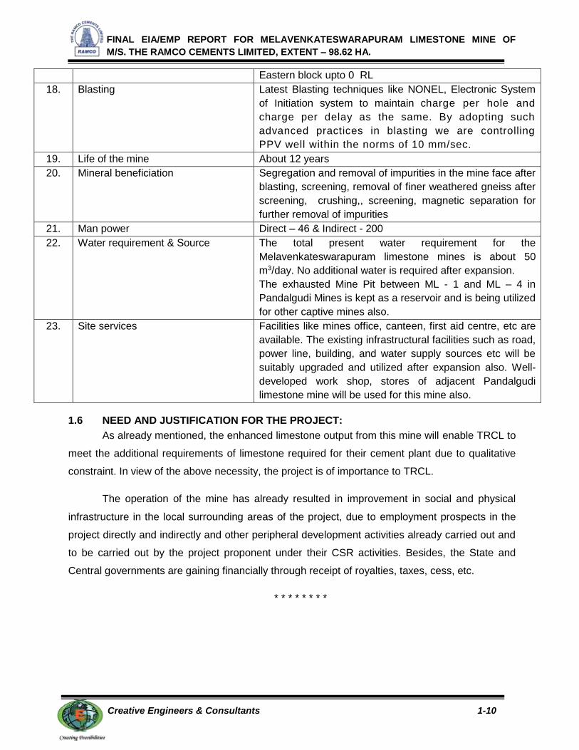
1.5 BRIEF PROJECT PROFILE:
S.No PROJECT PROFILE & SALIENT ASPECTS
1. Name of the Project Melavenkateswarapuram Limestone Mines
2. Project Proponent M/s The Ramco Cements Limited. "Auras Corporate Centre" V Floor, 98-A Radhakrishnan Road, Mylapore, Chennai -600 004. Pho No- 044 - 28478666 , 28478656 Fax no.: 044 – 28478676. Email: [email protected]
3. ML area 98.62 Ha
4. Land use About 97.82.5 ha of land are private land owned by lessee
& the remaining 0.795 Ha is Government land and in
TRCL’s possession.
5. Production Capacity 726950 MTPA of ROM / annum of which clean limestone
will be 500000 tonnes / annum (0.5 MTPA)
6. Mine site topography 53 to 60 above MSL
7. Nearest Road Pudur-Melavenkateswarapuram road
8. Nearest Railway station Aruppukottai – 30 km
9. Nearest Airport Madurai – 75 km (from the mines)
10. Nearest major water bodies Uppu Odai – 5 km
11. Nearest villages Melavenkateswarapuram – 0.7 km (N)
12. Geological reserves 9496199 T
13. Mineable reserves 7409807 T
14. Waste management, Backfilling &
reclamation
It is estimated that around 18.19 million tonnes of side
burden waste and interstitial reject will be generated till the
life of the mine in both the blocks. Out of the above, 9.71
million tonnes of developmental waste will be generated
from the western block, of which about 8.25 million tonnes
will be dumped Southern side of eastern block along ML –
4.5 to ML – 10 and the rest 1.46 million tonnes will be
utilised for road and bund making along mine periphery).
The rest 8.47 million tonnes of development waste from
Eastern block will be utilized for refilling the worked out pit
between ML 12.40 to 15.00 (western pit) upto the surface
after exhausting all the reserves in the western pit area.
The total area reclaimed by refilling will be 3.897 Ha
The area between ML 1.0 to 10.00 & 16.00 – 20.00 will be
left as water reservoir. An area of 5.95 Ha will be left as
water reservoir
15. Method of mining Open Cast fully mechanized – Drilling and Blasting
16. Bench Height & width Height – 9m, Width – more than the height of the bench
17. Depth of mining Western block upto -10 RL
FINAL EIA/EMP REPORT FOR MELAVENKATESWARAPURAM LIMESTONE MINE OF
M/S. THE RAMCO CEMENTS LIMITED, EXTENT – 98.62 HA.
Creative Engineers & Consultants 1-10
Eastern block upto 0 RL
18. Blasting Latest Blasting techniques like NONEL, Electronic System
of Initiation system to maintain charge per hole and
charge per delay as the same. By adopting such
advanced practices in blasting we are controlling
PPV well within the norms of 10 mm/sec.
19. Life of the mine About 12 years
20. Mineral beneficiation Segregation and removal of impurities in the mine face after
blasting, screening, removal of finer weathered gneiss after
screening, crushing,, screening, magnetic separation for
further removal of impurities
21. Man power Direct – 46 & Indirect - 200
22. Water requirement & Source The total present water requirement for the
Melavenkateswarapuram limestone mines is about 50
m3/day. No additional water is required after expansion.
The exhausted Mine Pit between ML - 1 and ML – 4 in
Pandalgudi Mines is kept as a reservoir and is being utilized
for other captive mines also.
23. Site services Facilities like mines office, canteen, first aid centre, etc are
available. The existing infrastructural facilities such as road,
power line, building, and water supply sources etc will be
suitably upgraded and utilized after expansion also. Well-
developed work shop, stores of adjacent Pandalgudi
limestone mine will be used for this mine also.
1.6 NEED AND JUSTIFICATION FOR THE PROJECT:
As already mentioned, the enhanced limestone output from this mine will enable TRCL to
meet the additional requirements of limestone required for their cement plant due to qualitative
constraint. In view of the above necessity, the project is of importance to TRCL.
The operation of the mine has already resulted in improvement in social and physical
infrastructure in the local surrounding areas of the project, due to employment prospects in the
project directly and indirectly and other peripheral development activities already carried out and
to be carried out by the project proponent under their CSR activities. Besides, the State and
Central governments are gaining financially through receipt of royalties, taxes, cess, etc.
* * * * * * * *

FINAL EIA/EMP REPORT FOR MELAVENKATESWARAPURAM LIMESTONE MINE OF
M/S. THE RAMCO CEMENTS LIMITED, EXTENT – 98.62 HA.
Creative Engineers & Consultants 1-11
Enclosure – 1.1
TOR COMPLIANCE FOR MoEF&CC TOR LETTER No. J– 11015/136/2013-IA-II(M)
DATED - 09 09.2013, 12.06.2015 & 17.09.2015
TOR NO
QUESTIONS REPLY PAGE
NO
1 Year-wise production details since 1994 should be given, clearly stating the highest production achieved in any one year prior to 1994. It may also be categorically informed whether there had been any increase in production after the EIA Notification, 1994 came into force w.r.t. the highest production achieved prior to 1994.
The highest production achieved prior to year 1994 and Year wise production details since year 1994 to 2016 are furnished in para 2.6.1 in chapter II.
From the details it can be seen that there is no increase in production
2-10
2 A copy of the document in support of the fact that the Proponent is the rightful lessee of the mine should be given
Mining lease document is enclosed as Annexure- 1 A-1
3 All documents including approved mine plan, EIA and public hearing should be compatible with one another in terms of the mine lease area, production levels, waste generation and its management and mining technology and should be in the name of the lessee.
All the documents like mining plan approval, EIA, Public hearing, etc., are compatible with one another and are in the name of lessee.
-
4 All corner coordinates of the mine lease area, superimposed on a High Resolution Imagery/ topo sheet should be provided. Such an Imagery of the proposed area should clearly show the land use and other ecological features of the study area (core and buffer zone)
All corner coordinates of the mine lease area, superimposed on a High Resolution Imagery is given in Figure No. 1.3, Chapter-I. Land use and other ecological features of the study area for both core and buffer zone is given in Figure – 3.14 of chapter III.
1 - 8
3 - 86
5 Does the company have a well laid down Environment Policy approved by its Board of Directors? If so, it may be spelt out in the EIA report with description of the prescr ibed operat ing process/procedures to br ing into focus any Infringement / deviation/violation of the environmental or forest norms/ conditions? The hierarchical system or administrative order of the Company to deal with the environmental issues and for ensuring compliance with the EC conditions may also be given. The system of reporting of non-compliances /violations of environmental norms to the Board of Directors of the Company and/or shareholders or stakeholders at large may also be detailed in the EIA report.
Yes, Comprehensive and effective environmental policy are laid down so as to detect promptly departures or violations of environmental standards and to take immediate corrective actions to set right the environmental status within statutory standards and the same is detailed in para 6.2 in Chapter VI of EIA.
6-1
6 Issues relat ing to Mine Safety, including subsidence study in case of underground mining and slope study in case of open cast
Subsidence factor does not apply to this project. However, all safety precautions in regard to
4 – 53

FINAL EIA/EMP REPORT FOR MELAVENKATESWARAPURAM LIMESTONE MINE OF
M/S. THE RAMCO CEMENTS LIMITED, EXTENT – 98.62 HA.
Creative Engineers & Consultants 1-12
TOR NO
QUESTIONS REPLY PAGE
NO
mining, blasting study etc. should be detailed. The proposed safeguard measures in each case should also be provided.
regulatory standards are strictly observed and practiced, as shown in para 4.8 in chapter IV of EIA.
Blasting in Melavenkateswarapuram Limestone is practiced using the Latest Blasting techniques like NONEL, Electronic System of Initiation system. Scientific studies conducted through the Department of Mining Engineering, College of Engineering, Guindy, Anna University to study the influence of Blast Induced Ground vibrations on the residential and other buildings of the Neighboring. The study revealed that the ground vibrations generated by the method of controlled Blasting practiced in the mines were well within the permissible levels and hence is not affecting the structures in the neighboring villages.
As suggested by National Institute of Rock Mechanics, KGF, a minimum berm width of 2.5 meters in the final benches, with a safety bench of 8 meters wide for every three benches, taking into consideration of an overall pit slope angle of 43.5° on footwall side and 43° on hang wall will be kept.
4-25
2-9
7 The study area will comprise of 10 km zone around the mine lease from lease periphery and the data contained in the EIA such as waste generation etc should be for the life of the mine / lease period
The existing environmental scenario is provided for covering 10 km radial distance from the project periphery. Index plan is shown in Figure no. 3.1 in Chapter III.
All the data such as waste generation furnished are for the life period of the lease.
3 – 3
2-14
8 Land use of the study area delineating forest area, agricultural land, grazing land, wildlife sanctuary, national park, migratory routes of fauna, water bodies, human settlements and other ecological features should be indicated. Land use plan of the mine lease area should be
Land use of the study area is studied through satellite imagery to demarcate forest area, agricultural land, grazing land, wildlife sanctuary and national park in the study area and the details are
3 - 67

FINAL EIA/EMP REPORT FOR MELAVENKATESWARAPURAM LIMESTONE MINE OF
M/S. THE RAMCO CEMENTS LIMITED, EXTENT – 98.62 HA.
Creative Engineers & Consultants 1-13
TOR NO
QUESTIONS REPLY PAGE
NO
prepared to encompass preoperational, operational and post operational phases and submitted. Impact, if any, of change of land use should be given.
given in Paras 3.8 in Chapter III of EIA Report.
Land use Categories within 10 Km Buffer zone and their Spatial Extent are given below.
Land use Area (Sq.Km) %
Crop Land 40.795 10.96
Fallow Land 295.224 79.29
Plantation 1.290 0.35
Land with Scrub 20.317 5.46
Land without Scrub 1.779 0.48
Barren Area 0.698 0.19
Mines / Mining Dumps 1.877 0.50
Waterbodies 1.625 0.44
Settlement 7.428 1.99
River 1.313 0.35
Total 372.347 100.00
The details of Land use in the lease area are given in Paras 4.5 in Chapter IV of EIA Report. Out of 98.62 Ha of mine lease area 79.12 Ha will be utilized and the rest will remain untouched.
Out of 41.72 Ha of mined out area an extent of 3.897 Ha will be refilled, about 5.95 ha will be left as water reservoir and the remaining area of 31.87 Ha will have bench plantation
3-81
4 - 30
9 Details of the land for any Over Burden Dumps outside the mine lease, such as extent of land area, distance from mine lease, its land use, R&R issues, if any, should be given
As in the recent approved scheme of mining report, there will not be any waste dumping outside the lease area.
-
10 A Certificate from the Competent Authority in the State Forest Department should be provided, confirming the involvement of forest land, if any, in the project area. In the event of any contrary claim by the Project Proponent regarding the status of forests, the site may be inspected by the State Forest Department along with the Regional Office of the Ministry to ascertain the status of forests, based on which, the Certificate in this regard as mentioned above be issued. In all such cases, it would be
No forest land is involved in the project area.
Based on the site inspection of DFO on 25.01.2017, Certificate in this regard is obtained from State Forest Department and given as Annexure - 16
A-104
16

FINAL EIA/EMP REPORT FOR MELAVENKATESWARAPURAM LIMESTONE MINE OF
M/S. THE RAMCO CEMENTS LIMITED, EXTENT – 98.62 HA.
Creative Engineers & Consultants 1-14
TOR NO
QUESTIONS REPLY PAGE
NO
desirable for representative of the State Forest Department to assist the Expert Appraisal Committees
11 Status of forestry clearance for the broken up area and virgin forestland involved in the Project including deposition of net present value (NPV) and compensatory afforestation (CA) should be indicated. A copy of the forestry clearance should also be furnished
As no forest land is involved in lease area, the details required in this para are not applicable for this project.
12 Implementation status of recognition of forest rights under the Scheduled Tribes and other Traditional Forest Dwellers (Recognition of Forest Rights) Act, 2006 should be indicated
Not applicable, as such no forest land is involved in this lease area.
-
13 The vegetation in the RF / PF areas in the study area, with necessary details, should be given
Not applicable as no forest land is involved in lease area. However, flora and faunal composition of 10 km buffer zone area around project area are fully studied and details are given in para 3.7 of Chapter III.
3 - 58
14 A study shall be got done to ascertain the
impact of the Mining Project on wildlife of the
study area and details furnished. Impact of the
project on the wildlife in the surrounding and any
other protected area and accordingly detailed
mitigative measures required, should be worked
out with cost implications and submitted
The faunal studies in buffer zone are furnished in para 3.7 of Chapter III which shows no wild life areas, protected forest, etc in buffer zone within 10 kms of project area. Hence cost implications for wild life protection do not apply in this case.
3 - 66
15 Location of National Parks, Sanctuaries, Biosphere Reserves, Wildlife Corridors, Tiger/Elephant Reserves/(existing as well as proposed), if any, within 10 km of the mine lease should be clearly indicated, supported by a location map duly authenticated by Chief Wildlife Warden. Necessary clearance, as may be applicable to such projects due to proximity of the ecologically sensitive areas as mentioned above, should be obtained from the State Wildlife Department/Chief Wildlife Warden under the Wildlife (Protection) Act, 1972 and copy furnished
No national parks, Sanctuaries, wild life corridors, Biospheres, etc occur either in core or buffer zone.
-
16 A detailed biological study of the study area [core zone and buffer zone (10 km radius of the periphery of the mine lease)] shall be carried out. Details of flora and fauna, duly authenticated, separately for core and buffer zone should be furnished based on such primary field survey, clearly indicating the Schedule of the
Detailed biological studies for core and buffer zone areas are conducted and furnished fully in para 3.7 in Chapter III of EIA.
In the study area the schedule – I species, Indian Pea Fowl (Pavo Cristatus) are found.
3-58

FINAL EIA/EMP REPORT FOR MELAVENKATESWARAPURAM LIMESTONE MINE OF
M/S. THE RAMCO CEMENTS LIMITED, EXTENT – 98.62 HA.
Creative Engineers & Consultants 1-15
TOR NO
QUESTIONS REPLY PAGE
NO
fauna present. In case of any scheduled-I fauna found in the study area, the necessary plan for their conservation should be prepared in consultation with State Forest and Wildlife Department and details furnished. Necessary allocation of funds for implementing the same should be made as part of the project cost
Conservation Plan for Indian Pea Fowl (Pavo Cristatus) is prepared in consultation with the forest department and financial provision of Rs. 5.0 Lakhs is provided on a combined basis for all the leases of TRCL and its cement plant in the region. Certified Pea Fowl conservation plan along with flora and fauna details in the study area is given as Annexure – 17.
4-39
A-105
17 Proximity to Areas declared as 'Critically Polluted' or the Project areas likely to come under the `Aravali Range', (attracting court restrictions for mining operations), should also be indicated and where so required, clearance certifications from the prescribed Authorities, such as the SPCB or State Mining Dept. Should be secured and furnished to the effect that the proposed mining activities could be considered
The lease area is not in critically polluted areas or anywhere near to it.
-
18 Similarly, for coastal Projects, A CRZ map duly authenticated by one of the authorized agencies demarcating LTL. HTL, CRZ area, location of the mine lease w.r.t CRZ, coastal features such as mangroves, if any, should be furnished. (Note: The Mining Projects falling under CRZ would also need to obtain approval of the concerned Coastal Zone Management Authority)
Not applicable as this is not a coastal project.
-
19 R&R Plan/compensation details for the Project Affected People (PAP) should be furnished. While preparing the R&R Plan, the relevant State/National Rehabilitation & Resettlement Policy should be kept in view. In respect of SCs /STs and other weaker sections of the society in the study area, a need based sample survey, family-wise, should be undertaken to assess their requirements, and action programmes prepared and submitted accordingly, integrating the sectoral programmes of line departments of the State Government. It may be clearly brought out whether the village located in the mine lease area will be shifted or not. The issues relating to shifting of Village including their R&R and socio-economic aspects should be discussed in the report
As no (R & R) is involved in this project this does not apply to this case.
-

FINAL EIA/EMP REPORT FOR MELAVENKATESWARAPURAM LIMESTONE MINE OF
M/S. THE RAMCO CEMENTS LIMITED, EXTENT – 98.62 HA.
Creative Engineers & Consultants 1-16
TOR NO
QUESTIONS REPLY PAGE
NO
20 One season (non-monsoon) primary baseline data on ambient air quality (PM10, SO2 and NOx), water quality, noise level, soil and flora and fauna shall be collected and the AAQ and other data so compiled presented date-wise in the EIA and EMP Report. Site-specific meteorological data should also be collected. The location of the monitoring stations should be such as to represent whole of the study area and justified keeping in view the pre-dominant downwind direction and location of sensitive receptors. There should be at least one monitoring station within 500 m of the mine lease in the pre-dominant downwind direction. The mineralogical composition of PM10, particularly for free silica, should be given
The baseline data on micro- meteorology, Air, Water, Noise & Soil has been generated during winter season (Dec 2013 – Feb 2014) and detailed in para 3.3 to 3.6 of Chapter – III. Monitoring stations was selected taking into account of pre dominant wind direction and sensitive receptors. Free silica composition in PM10 sample has been done and the values are found to be Below Detectable Limit (Detection limit – 0.05mg/m3) which is well within the prescribed limit of 5mg/m3.
3 – 39 to
3-66
21 Air quality modeling should be carried out for prediction of impact of the project on the air quality of the area. It should also take into account the impact of movement of vehicles for transportat ion of mineral. The details of the model used and input parameters used for model l ing should be provided. The air quality contours may be shown on a location map clearly indicating the location of the site, location of sensitive receptors, if any, and the habitation. The wind roses showing pre-dominant wind direction may also be indicated on the map.
Air quality modelling details are fully furnished in para 4.2.1.1 and its continuous sub paras in Chapter IV of EIA report.
4 - 6
22 The water requirement for the Project, its availabil ity and source should be furnished. A detai led water balance should also be provided. Fresh water requirement for the Project should be indicated.
The total seepage water generation from the mine pit is 90m3/day. The total water requirement for the mine is 50.0 KLD comprising 3.0 KLD for Domestic Sanitary needs and 47.0 KLD for Industrial purposes such as Water sprinkling and dust suppression etc and the required water met from mine sump pit. No additional water is required after expansion. Remaining 40 m3/day used for recharge purpose.
The exhausted Mine Pit between ML - 1 and ML – 4 in Pandalgudi Mines at distance - 8.9 km (NW) is kept as a reservoir and is being utilized for other captive
4 - 11

FINAL EIA/EMP REPORT FOR MELAVENKATESWARAPURAM LIMESTONE MINE OF
M/S. THE RAMCO CEMENTS LIMITED, EXTENT – 98.62 HA.
Creative Engineers & Consultants 1-17
TOR NO
QUESTIONS REPLY PAGE
NO
mines also TRCL has established water treatment plant in Pandalgudi to treat the mine water for drinking purposes for both colony and other mines work sites and the same is detailed in para 4.3 along with water balance diagram.
23 Necessary clearance f rom the Competent Author i ty for drawl of requisi te quantity of water for the Project should be provided
Most of the water requirements for the project are drawn from mine sump water.
Although this block comes under safe zone, application to PWD is already made for Ground Water Clearance (Annexure - 10)
A - 53
24 Descr ipt ion of water conservat ion measures proposed to be adopted in the Project should be given. Details of rainwater harvesting proposed in the Project, if any, should be provided
Rainwater harvesting is already being done by collecting all garland drain out flows and mine water in settling tanks. The settling tanks are desilted frequently and water conservation measures are detailed in 4.3.4 of in Chapter IV of EIA report.
4 - 21
25 Impact of the project on the water quality, both surface and groundwater should be assessed and necessary safeguard measures, if any required, should be provided
Impact of project on surface and ground water qualities and its control measures are described in paras 4.3.0 to 4.3.4 of Chapter IV of EIA report.
4 -11
26 Based on actual monitored data, it may clearly be shown whether working will intersect groundwater. Necessary data and documentation in this regard may be provided. In case the working will intersect groundwater table, a detailed Hydro Geological Study should be undertaken and Report furn ished. Necessary permission from Central Ground Water Authority for working below ground water and for pumping of ground water should also be obtained and copy furnished
Detailed hydrogeological studies have been undertaken and described in paras 3.9 in Chapter III and paras 4.3.2 & 4.3.3 in Chapter IV.
In state of Tamil nadu, the Ground water permissions are not regulated by CGWA as per the website Notice issued by CGWB. The State Govt of Tamil Nadu is yet to formulate guidelines for issuance of NOC for Mine dewatering. Although this block comes under safe zone, application to PWD is already made for Ground Water Clearance and frequent follow ups are made (Annexure - 10). TRCL have received reply letters twice in this regard (Letter No. OT7/AG-IV/F4A/2015/dt.13.05.2015, and
3 - 89
4 – 18
A - 53

FINAL EIA/EMP REPORT FOR MELAVENKATESWARAPURAM LIMESTONE MINE OF
M/S. THE RAMCO CEMENTS LIMITED, EXTENT – 98.62 HA.
Creative Engineers & Consultants 1-18
TOR NO
QUESTIONS REPLY PAGE
NO
Letter No.OT9/AG3/Mining Project/2016 dt 08.12.2016) from PWD dept regarding the same. Copy of NOC shall be submitted to on receipt of the same.
27 Details of any stream, seasonal or otherwise, passing through the lease area and modification / diversion proposed, if any, and the impact of the same on the hydrology should be brought out
No stream passes through lease area and no diversion of water bodies is required. -
28 Information on site elevation, working depth, groundwater table etc. Should be provided both in AMSL and bgl. A schematic diagram may also be provided for the same
Detailed hydrogeological studies have been undertaken and described in paras 3.9 and the water table contour is shown in Figure No. 3.16 in Chapter III.
3 – 89
3 - 90
29 A time bound Progressive Greenbelt Development Plan shall be prepared in a tabular form (indicating the linear and quantitative coverage, plant species and time frame) and submitted, keeping in mind, the same will have to be executed up front on commencement of the project
Presently about 9.175 Ha of area are covered with around 10100 nos of plantation / green belt, of which 2.90 Ha are within the lease area and the remaining 6.275 Ha are outside the lease area.
In the scheme period about 1.40 Ha within the lease area will be developed with plantation / Green belt. Every year on average 750 saplings will be planted. It is planned to plant Neem, Tamarind, Pungai, Naval, Jetropha, Mango etc.
In ultimate stage Green belt over an area of 14.13Ha will be carried out along mine periphery, virgin area and along the mine hauling roads in the lease area.
This details are given in para 4.6.4 to 4.6.6 in Chapter IV.
4 - 37
30 Impact on local transport infrastructure due to the Project should be indicated. Projected increase in truck traffic as a result of the Project in the present road network ( including those outside the Project area) should be worked out, indicating whether it is capable of handling the incremental load. Arrangement for improving the infrastructure, if contemplated (including action to be taken by other agencies such as State Government) should be covered
The changes in present logistical system will be insignificant due to negligible expanded production from the lease area as logistical transport roads are dedicated and belong to TRCL. The details in this respect are furnished in para 4.9 in Chapter IV of the report.
4 - 56

FINAL EIA/EMP REPORT FOR MELAVENKATESWARAPURAM LIMESTONE MINE OF
M/S. THE RAMCO CEMENTS LIMITED, EXTENT – 98.62 HA.
Creative Engineers & Consultants 1-19
TOR NO
QUESTIONS REPLY PAGE
NO
31 Details of the onsite shelter and facilit ies to be provided to the mine workers should be included in the EIA report.
The facilities provided to mine workers are provided in para 2.14 in Chapter II.
2 - 19
32 Conceptual post mining land use and Reclamation and Restoration of mined out areas (with plans and with adequate number of sections) should be given in the EIA report.
Out of 98.62 Ha of mine lease area 79.12 Ha will be utilized and the rest will remain untouched.
In the post mining stage, Out of 41.72 Ha of mined out area an extent of 3.897 Ha will be refilled, about 5.95 ha will be left as water reservoir and the remaining area of 31.87 Ha will have bench plantation. Besides, 16.72 Ha of Dump area & Topsoil storage area of 3.70 Ha will also be covered with plantation.
In the ultimate stage, plantation / bench plantation will be carried out in 35.77 Ha mined out area including 3.897 Ha of backfilled area. Besides, 16.72 Ha. of Dump area & Topsoil storage area of 3.70 Ha will also be covered with plantation. Besides, Green belt over an area of 14.13Ha will be carried out along mine periphery, virgin area and along the mine hauling roads. Thus about 70.32 Ha covered under Green Belt/ Bench Plantation in the total lease area of 96.82 Ha in post operational period.
The conceptual post mining landuse plan along with reclamation systems are described in paras 4.5, 4.5.1 and 4.5.2 in chapter IV of EIA and also shown in Figure No. 4.6.
4 – 30 to
4 - 32
33 A time bound Progressive Greenbelt Development Plan shall be prepared in a tabular form (indicating the linear and quantitative coverage, plant species and time frame) and submitted, keeping in mind, the same will have to be executed up front on commencement of the project. Phase-wise plan of plantation and compensatory afforestation should be charted clearly indicating the area to be covered under plantation and the species to be planted. The
The time bound greenbelt development plan is furnished in paras 4.6.5 and 4.6.6 in Chapter IV.
Question of compensatory
afforestation does not arise, as no forest lands are involved in lease area or buffer zone areas.
4 -36
to 4 - 38

FINAL EIA/EMP REPORT FOR MELAVENKATESWARAPURAM LIMESTONE MINE OF
M/S. THE RAMCO CEMENTS LIMITED, EXTENT – 98.62 HA.
Creative Engineers & Consultants 1-20
TOR NO
QUESTIONS REPLY PAGE
NO
details of plantation already done should be given
34 Occupational Health impacts of the Project should be anticipated and the proposed preventive measures spelt out in detail. Details of pre-placement medical examination and periodical medical examination schedules should be incorporated in the EMP
Elaborate details in this respect are furnished in para 4.8 and its sub paras in Chapter IV.
Copy of Report of Medical Examination in “Form O” enclosed in Annexure – 14 of EIA/EMP report.
4 - 53
A – 69
35 Public health implications of the Project and related activities for the population in the impact zone should be systematically evaluated and the proposed remedial measures should be detailed along with budgetary allocations
The health status of the area is deciphered from the discussion and data collection from the nearby Primary Health Centre at Pandalgudi, Virudhunagar District, Health care services of TRCL and discussion with locals.
These details are given in para 3.2.5 and its sub paras.
3-33
36 Measures of socio economic significance and influence to the local community proposed to be provided by the Project Proponent should be indicated. As far as possible, quantitative dimensions may be given with time frames for implementation
TRCL has undertaken elaborate social outreach programmes to improve the social and physical infrastructure of local community and local areas taking into account the need based aspirations of local community concerned under their ‘CSR” initiatives.
‘CSR” activities are carried out by TRCL with a missionary approach and motto with strategic planning with involvement of Board of Directors as well as senior concerned officers and also local community members.
TRCL on the whole has spent Rs.7.80 crores during the year 2014-15 under various social welfare measures like donation and repair to temples, school room construction as addition, up gradation of youth skills of local community, sponsorship for sports and cultural activities etc. TRCL is spending around Rs.172.88 lakhs (Year 2014 - 2015) towards CSR in R.R Nagar unit cement plant & its captive mines.
Rs.21.96 lakhs was spent in year 2015 – 2016 for CSR activities
4 - 44

FINAL EIA/EMP REPORT FOR MELAVENKATESWARAPURAM LIMESTONE MINE OF
M/S. THE RAMCO CEMENTS LIMITED, EXTENT – 98.62 HA.
Creative Engineers & Consultants 1-21
TOR NO
QUESTIONS REPLY PAGE
NO
under lease area of Melavenkateswarapuram Limestone Mine alone.
They have further planned for every year from this mine lease, Rs. 20 lakhs will be spent under CSR. The breakup of the same will be decided based on the immediate need and priority. The elaborate details on above aspects are furnished in para 4.7 in Chapter IV of EIA.
37 Detailed environmental management plan to mitigate the environmental impacts which, should inter-alia include the impacts of change of land use, loss of agricultural and grazing land, if any, occupational health impacts besides other impacts specific to the proposed Project
Detailed environmental management plan for implementation of various measure to abate impacts in the project within sustainable statutory limits is provided in Chapter IX of EIA.
9-1
38 Public hearing points raised and commitment of the project proponent on the same along with time bound action plan to implement the same should be provided and also incorporated in the final EIA/EMP Report of the Project
Public hearing for this project was held on 25.02.2016 at T.R.Subbaraj Kalyana Mahal, Paralachi Road, Pudur, Villathikulam Taluk, Thoothukudi District through District Collector-Thoothukudi,District Environmental Engineer - Tamil Nadu Pollution Control Board after following mandatory procedures.
The elaborate details of public hearing points along with proponent commitment are furnished in Para 7.1 in Chapter-VII and Annexure-15.
A-79
39 Details of litigation pending against the project, if any, with direction /order passed by any Court of Law against the project should be given
No litigation is pending against this project. -
40 The cost of the project (capital cost and recurring cost) as well as the cost towards implementation of EMP should clearly-be spelt out
The capital cost of this project is about Rs. One crore. The recurring costs will be varying and will be reviewed from year to year. The probable cost of recurring environmental control cost for the Melavenkateswarapuram lease are calculated as 56 lakhs.
However the production cost of limestone will be on commensurate basis to provide normal profit margins from realized
6 - 9

FINAL EIA/EMP REPORT FOR MELAVENKATESWARAPURAM LIMESTONE MINE OF
M/S. THE RAMCO CEMENTS LIMITED, EXTENT – 98.62 HA.
Creative Engineers & Consultants 1-22
TOR NO
QUESTIONS REPLY PAGE
NO
cement prices.
41 Details of Transportation of mined materials as per the Indian Road Congress for both the ways (loaded as well as unloaded trucks) and its impact on Environment be provided
These conditions are already being and will be enforced during transportation of mined out limestone. Details given in Para 4. 9 of Chapter IV of EIA/EMP report.
4 -56
42 Studies by any reputed Institute on Cumulative impacts due to simultaneous mining by all the operating Mines in the Study area be conducted and a Report submitted
The study has been carried out by Manonmanium Sundaranar University, Tirunelveli for cumulative impacts due to simultaneous mining by all operating mines covering in the study area.
-
43 Status of the required Compliance Report from the Regional Office of MoEF
Cerified Compliance report for Environmental Clearance vide letter No.J-11015/6/99-1A.II(M) of 22.11.1999 from MOEF&CC is given in Annexure – 9 as mentioned in para 1.2.4 of Chapter I of EIA.
A - 46
*********

FINAL EIA/EMP REPORT FOR MELAVENKATESWARAPURAM LIMESTONE MINE OF
M/S. THE RAMCOCEMENTS LIMITED, EXTENT – 98.62 HA.
Creative Engineers & Consultants 2-1
CHAPTER – II
PROJECT DESCRIPTION
2.1 GENERAL:
This expansion project is planned to produce 0.5 million tonnes (0.726 MTPA of ROM)
from existing 0.101 MTPA of limestone to meet the captive needs of 2 MTPA capacity
Ramasamyraja Nagar Cement plant of TRCL. As such, this project will help to ensure
continuous and steady supply of qualitative and quantitative requirements of TRCL’s captive
cement unit at R.R Nagar in future from their nearby mining leases.
2.2 SITE DESCRIPTION:
The entire lease area is situated in Pudur, Nadukattur & Sennayanpatti Villages of
Vilathikulam Taluk, Thoothukudi District, Tamil Nadu.
The mine site is well connected and is at a distance of 0.50 km East of Pudur –
Melavenkateswarapuram road which in turn is connected to NH – 45(B). Nearest rail head
Aruppukottai is 30km away.
The lease area or surrounding 10km buffer zone area does not include any forest lands
nor do any natural sensitive features like water bodies, national parks, wild life sanctuary etc.
The area does not come under CRZ category.
The study area has got good basic amenities like education, medical, drinking water and
approach roads. All the villages have good connectivity through good tar roads and
telecommunication facilities and public transport. Some of the villages have piped water supply.
Postal and electricity facilities are available in all villages.
2.3 TOPOGRAPHY AND DRAINAGE:
The area is generally flat topography with an elevation of about 53 to 60 meters above
MSL. There is no prominent river or stream running in this area. The surrounding lands are of
dry type with seasonal crops and devoid of perennial vegetation.

FINAL EIA/EMP REPORT FOR MELAVENKATESWARAPURAM LIMESTONE MINE OF
M/S. THE RAMCOCEMENTS LIMITED, EXTENT – 98.62 HA.
Creative Engineers & Consultants 2-2
2.4 GEOLOGY AND RESERVES:
2.4.1 GEOLOGY OF THE LEASE AREA:
The entire area comprises of archaean formations completely covered by 0.40 to
1.00 metre thick black cotton soil. Below this soil cover, the rocks, namely, Charnockite,
granite, granulite, limestone and pegmatite occur. The charnockite and pyroxene granulite occur
as hang wall and footwall of limestone band and they are as follows:
Formation Age
Black cotton soil - Recent
Charnockite, granulite,
granite, pegmatite, Achaean
Limestone, pink granitic gneiss
The aforesaid formations are illustrated below as a schematic section.
Surface
Recent Black cotton soil
Footwall Hang-wall
Charnockite, Crystalline Charnockite, granulite,
Granulite, Limestone Granite, pegmatite.
The rocks have undergone repeated folding as seen from the existing quarry faces. The
crystalline limestone band occurs as a linear band within the Archaean rock which has also
undergone folding and recrystallization. This is evident from the mine faces and irregular
behavior of the hang wall and foot wall contact of the limestone band on the surface. Lot of
intrusions and inclusions viz., granulite, granites, charnockites, pegmatite, and pyroxene
patches etc., occur within the limestone band. The hanging wall and foot rocks are weathered
up to about 15 to 20 meters depth and become harder below this depth.
The limestone is bouldery at the top for 3 to 4 metres and become massive below with
joints. There is a small discontinuity in the band near ML-11. The deposit is divided into two
blocks namely western and eastern block with respect to this discontinuity. The area between
ML 0 –11 named as ‘Eastern Block’ and the area between ML 12 to 22 is named as ‘Western

FINAL EIA/EMP REPORT FOR MELAVENKATESWARAPURAM LIMESTONE MINE OF
M/S. THE RAMCOCEMENTS LIMITED, EXTENT – 98.62 HA.
Creative Engineers & Consultants 2-3
Block’. The strike is almost East-West and the strike length of the deposit is about 2.1km with
width varying from 40 meters to 90 meters. The dip varies from 300 to 500 towards north.
The hanging wall and foot wall contacts have different dips with footwall contact having
gentler dip than that of hanging wall which has resulted in narrow width of the band at bottom
levels. Geological plan & Cross section is given as Figure No - 2.1& 2.2.

FINAL EIA/EMP REPORT FOR MELAVENKATESWARAPURAM LIMESTONE MINE OF M/S. THE RAMCOCEMENTS
LIMITED, EXTENT – 98.62 HA.
Creative Engineers & Consultants 2-4
GEOLOGICAL PLAN Figure No. 2-1

FINAL EIA/EMP REPORT FOR MELAVENKATESWARAPURAM LIMESTONE MINE OF
M/S. THE RAMCOCEMENTS LIMITED, EXTENT – 98.62 HA.
Creative Engineers & Consultants 2-5
GEOLOGICAL CROSS SECTION
Figure No. 4 Figure No. 2-2

FINAL EIA/EMP REPORT FOR MELAVENKATESWARAPURAM LIMESTONE MINE OF
M/S. THE RAMCOCEMENTS LIMITED, EXTENT – 98.62 HA.
Creative Engineers & Consultants 2-6
2.4.2 Reserves Estimation:
2.4.2.1 Exploration:
The Melavenkateswarapuram limestone deposit has been prospected fully by means of
72 numbers of diamond drill holes with a total metreage of 2998.15 meters. Based on the
exploration so far carried out all the reserves are in proved category and hence no further
drilling is proposed.
2.4.2.2 Method of estimation of Reserves:
Geological cross sectional method was adopted for estimation of reserves after leaving
certain extent for safety distance and also for systematic mining. The Limestone band falling
between ML 0 to ML-22.00 has been proved in detail and the exploration data were sufficient to
calculate the reserves under proved reserves.
a) Eastern Block
Based on the intensity of exploration carried out prior to the scheme period, the reserves
were classified under measured category. All the reserves falling within sections 0 to 11.00 were
"proved" category.
b) Western Block
The limestone reserves between sections ML 11.00 to ML-22.00 fall under "measured
category that is "proved" category.
Since sufficient bore holes have been drilled in both the blocks to prove the deposit.
The intersectional area between two consecutive cross sections for a particular unit was
computed by averaging the cross sectional areas on the two consecutive section lines. The
average intersectional area thus obtained was multiplied by the mean distance between two
consecutive cross sections to give the volume of that particular unit (for e.g. limestone or waste
rock or soil) between these two sections.
This volume in cubic meters was then converted into weight in tonnes by applying the
volume to weight ratio also referred to as the tonnage conversion factor. A bulk density of 2.5 for
limestone and 2.86 for hang wall, Footwall and intrusive rocks, were taken for calculation.
2.4.2.3 Geological Reserves:
The reserves as per UNFC classification is as follows:

FINAL EIA/EMP REPORT FOR MELAVENKATESWARAPURAM LIMESTONE MINE OF
M/S. THE RAMCOCEMENTS LIMITED, EXTENT – 98.62 HA.
Creative Engineers & Consultants 2-7
ABSTRACT
CLASSIFICATION OF RESERVES FOR G.O.Ms-168 TONS
Proved Mineral Reserve (111) 7409807
Sub Total Reserves 7409807
Feasibility Mineral Resource (211) Locked up Ore 941360
Inferred Mineral Resource (333) Locked up Ore 1145032
Sub Total Resources 2086392
2.4.2.4 Mineable Reserves:
The entire proved mineral reserves of 7.409 Million tonnes are considered as mineable
reserves.
2.5 Mining scheme:
Mechanized open cast mining is adopted in Melavenkateswarapuram mines using heavy
earth moving machinery; right from the inception of the mine in 1985. The same will be
continued after expansion also.
The mine workings are divided in to two blocks namely West block and east block.
Presently mining operations are carried out in the west block only.
Surface layout plan depicting the present mine position is given as Figure No 2.3.

FINAL EIA/EMP REPORT FOR MELAVENKATESWARAPURAM LIMESTONE MINE OF M/S. THE RAMCOCEMENTS
LIMITED, EXTENT – 98.62 HA.
Creative Engineers & Consultants 2-8
SURFACE PLAN Figure No – 2.3

FINAL EIA/EMP REPORT FOR MELAVENKATESWARAPURAM LIMESTONE MINE OF
M/S. THE RAMCOCEMENTS LIMITED, EXTENT – 98.62 HA.
Creative Engineers & Consultants 2-9
Out of the total length of 2.1 kilometers of the deposit, the western block of about 1.1
kilometer length from ML 12 to ML 22 will be taken up for mining in the present scheme period.
It is envisaged to remove around 500000 tons of clean limestone (7, 26,950 tons of ROM) per
annum during the remaining 3 years of Modified Mining plan period (2015-16 to 2017-18).
After exhaustion of western block, the eastern block between ML 11 and ML 0 will be
taken up for mining. Waste to be generated from eastern block will be used for refilling the
mined out void in western block area between ML 12.40 and 15.00 upto surface. Top soil will be
spread over the area and it will be suitably reclaimed.
Based on the cost economics, the overall waste ratios has to be restricted with in 1:2.73,
hence ultimate depth has reduced to -10 RL in western block and 0 RL in eastern block. After
exhausting all the limestone upto the economic level, the ML area between ML 1.0 to 10.00 &
16.00 – 20.00 in eastern and western blocks will be left as water reservoir.
The bench height is maintained at 9 meters commensurating the digging height of the
shovel. The bench width of more than the bench height will be considered. Latest Blasting
techniques like NONEL, Electronic System of Initiation system to maintain charge per hole and
charge per delay as the same. By adopting such advanced practices in blasting we are
controlling PPV well within the norms of 10 mm/sec.
Rock breakers would be utilized for breaking of large boulders generated during primary
blasting and thereby secondary blasting would not be adopted. No of trials has been
undertaken in the adjacent other deposits successfully and hence this system is also being
utilized in Melavenkateswarapuram Mines.
Considering the geological nature of the deposit, viz, the inherent quality of
crystalline limestone associated with granulite and charnockites, the conventional system of
mining, involving drilling, blasting and deployment of Heavy Earth moving Equipments will be
continued at Melavenkateswarapuram mine for both Development and Production.
In the ultimate stage, as suggested by National Institute of Rock Mechanics, KGF, a
minimum berm width of 2.5 meters in the final benches, with a safety bench of 8 meters wide for
every three benches, taking into consideration of an overall pit slope angle of 43.5° on footwall
side and 43° on hang wall will be kept.

FINAL EIA/EMP REPORT FOR MELAVENKATESWARAPURAM LIMESTONE MINE OF
M/S. THE RAMCOCEMENTS LIMITED, EXTENT – 98.62 HA.
Creative Engineers & Consultants 2-10
2.6 PRODUCTION DETAILS AND LIFE OF MINE:
2.6.1 EARLIER PRODUCTION DETAILS:
Prior to 1994 the highest production of 147004 Tonnes achieved in the year1992 -
1993.EC for 0.101 MTPA capacity obtained in year 1999.
The year wise production from Melavenkateswarapuram lease since year 1994 onwards
to 2014 is given below:
YEARWISE PRODUCTION DETAILS FOR G.O.MS.NO –168
Year Production in Tonnes
Prior Year 1994 (1992-1993) 147004
1994-1995 100812.59
1995-1996 98112.00
1996-1997 2228.34
1997-1998 1907.27
1998-1999 1143.87
1999-2000 0.00
2000-2001 3768.91
2001-2002 18306.45
2002-2003 48267.56
2003-2004 100517.35
2004-2005 100066.00
2005-2006 81579.39
2006-2007 92406.00
2007-2008 97304.04
2008-2009 96958.75
2009-2010 88451.93
2010-2011 79923.04
2011-2012 53936.73
2012-2013 52253.11
2013-2014 84328.61
2014-2015 92300.11
2015-2016 99782.05
2016-2017 100727.42
From the above details it can be seen that there is no increase in production.
2.6.2 PLANNED PRODUCTION DETAILS:
As already mentioned, after expansion the yearly limestone production from this mine
will be 500000 tonnes (0.50 MTPA).

FINAL EIA/EMP REPORT FOR MELAVENKATESWARAPURAM LIMESTONE MINE OF
M/S. THE RAMCOCEMENTS LIMITED, EXTENT – 98.62 HA.
Creative Engineers & Consultants 2-11
Year wise production of limestone and waste during the Modified Mine plan are as
follows:
S.No Year ROM
Limestone
Clean
Limestone Reject
Side burden
Development
Waste
Total
Waste Ore :OB
(Tonnes) (Tonnes) (Tonnes) (Tonnes) (Tonnes)
1 2015-16 719625 500000 219625 954811 1174436 1:2.34
2 2016-17 723000 500000 223000 1174030 1397030 1:2.79
3 2017-18 726950 500000 227000 1097811 1324811 1:2.64
Total 2169575 1500000 669625 3226652 3896277 1 : 2.60
The production details of the conceptual stage are as follows:
S.No Year Limestone Total Waste Ore: O.B
1 2018-19 to 2022-23 2725199 5823342 1 : 2.14
2 2023-24 to 2026-27 2514985 8475795 1 : 3.37
5240184 14299137 1 : 2.73
Considering the present proved reserves and average production quantity of 0.5 MTPA
(0.726 MTPA ROM) the life of the mine will be 12 years.
The mine position at the end of the scheme period is enclosed as Figure No -2.4.

FINAL EIA/EMP REPORT FOR MELAVENKATESWARAPURAM LIMESTONE MINE OF M/S. THE RAMCOCEMENTS
LIMITED, EXTENT – 98.62 HA.
Creative Engineers & Consultants 2-12
Figure No –2.4 MINE POSITION - END OF SCHEME PERIOD

FINAL EIA/EMP REPORT FOR MELAVENKATESWARAPURAM LIMESTONE MINE OF
M/S. THE RAMCOCEMENTS LIMITED, EXTENT – 98.62 HA.
Creative Engineers & Consultants 2-13
2.7 EXTENT OF MECHANIZATION:
The availability of machinery is around 75 to 80%. It is proposed to mine 726950 tons
(maximum) of ROM limestone (500000 tons of Clean Limestone) a year from this mine.
During the remaining three years of the Modified Mining plan period i. e from 2015-16 to
2017-18 the production will be between coordinates ML – 14.50 to ML – 21.50. The production
for the years 2015-16, 2016-17 & 2017-18 will be 50000 T of clean limestone/ 7, 26,950 tons of
ROM in each of the years for which a development of 1174436, 1397030 & 1324811 Tonnes
respectively will have to be carried out. The overall Ore: O.B ratio during the modified Mining
plan period comes to 1: 2.60. (T: T)
The following machineries are proposed exclusively for the development and production
works at this mine to achieve the above said production:
Name of Machinery H.P Make/Model Capacity Numbers
Excavator 330 TATA Hitachi 3.3 Cu.m 1
Backhoe loader 250 L&T komatsu 0.9 Cu.m 3
Air Compressor
Diesel 350
Atlas Copco 400 cfm 2
BVB 25 drill Atlas Copco 112mm dia 2
Dewatering pump 75 9000 lpm 1
Rock Breaker for Secondary breaking
200
100 TPH 1
Primary Breaker/X centric Breaker
314
300 TPH 1
Taurus for production transport & Development
120 Volvo /AMW
/MAN 30 T 14
Jeeps Mahindra 1
Water Sprinkler
10000
Escorts
Tractor with
tanker
mounted
- 1
Explosive van 88 TATA 702 3T 1
2.8 BLASTING:
Blasting in Melavenkateswarapuram Limestone is practiced using the latest method of
blasting techniques like NONEL, Electronic system of initiation to maintain charge per hole and
charge per delay as the same. By adopting such advanced practices in blasting we are
controlling PPV well within the norms of 10 mm/sec. This system forms a part of Controlled
Blasting system wherein the amount of Explosives blasted in a fraction of time is controlled by
introduction of delay timings between the holes so as to reduce the ground vibrations induced
due to blasting. The Firing sequence of the blast hole column is also designed to be Bottom to

FINAL EIA/EMP REPORT FOR MELAVENKATESWARAPURAM LIMESTONE MINE OF
M/S. THE RAMCOCEMENTS LIMITED, EXTENT – 98.62 HA.
Creative Engineers & Consultants 2-14
top so that the blasted rock immediately falls down due to gravity and has no Fly rock. Slurry
explosives or Emulsion explosives in combination with Ammonium Nitrate Fuel oil explosives
are used for charging the Explosive column. The usage of Shock Tube detonators for initiation
provides for Bottom Initiation of the Hole thereby reducing the Fly rock, minimal ground vibration
and increased safety.
Advantages:
1. Perfect bottom initiation which controls the fly rock.
2. Accurate timing to keep the initiation sequence precisely and helps to control blast induced
vibration.
3. Helps to maintain precise blast mass heaps and quality control of the blast material.
The Management has conducted scientific studies through the Department of Mining
Engineering, College of Engineering, Guindy, Anna University to study the influence of Blast
Induced Ground vibrations of the Melavenkateswarapuram Limestone Mines on the residential
and other buildings of the Neighboring villages in December 2012. The study revealed that the
ground vibrations generated by the method of controlled Blasting practiced in the mines were
well within the permissible levels and hence is not affecting the structures in the neighboring
villages. Precautionary measures against Fly rock, Ground Vibrations & Noise are strictly taken
care during blasting operations. The Blasting operations are placed under the direct supervision
of the Mines Manager who is a qualified Mining Engineer & possesses Mine Manager’s First
class certificate of competency issued by Directorate General of Mines safety, Govt of India and
is assisted by adequate statutorily qualified personnel. Copy of explosive license is given vide
Annexure – 7.
2.9 WASTE MANAGEMENT:
The dumps presently located are well within the lease area and also proposed dumping
is also within the Mining Lease area.
The height of present dump yards is 15 to 20 meters. Ultimate height will be about 30m.
A new dump yard is proposed on the Southern side of eastern block along ML – 4.5 to
ML – 10 during the modified mine plan period.
It is estimated that around 18.19 million tonnes of side burden waste and interstitial
reject will be generate till the life of the mine in both the blocks. Out of the above, 9.71 million
tonnes of waste will be generated from west block, of which about 8.25 million tonnes will be
dumped Southern side of eastern block along ML – 4.5 to ML – 10 and the rest 1.46 million
tonnes will be utilised for road and bund making along mine periphery). The rest 8.47 million
tonnes of development waste from Eastern block will be utilized for refilling the worked out pit
between ML 12.40 to 15.00 (western pit) upto the surface after exhausting all the reserves in the

FINAL EIA/EMP REPORT FOR MELAVENKATESWARAPURAM LIMESTONE MINE OF
M/S. THE RAMCOCEMENTS LIMITED, EXTENT – 98.62 HA.
Creative Engineers & Consultants 2-15
western pit area. The total area reclaimed by refilling will be 3.897 Ha. The area between ML
1.0 to 10.00 & 16.00 – 20.00 will be left as water reservoir. An area of 5.95 Ha will be left as
water reservoir.
Top Soil
As per the proposed mining programme, there is no likely hood of generation of top soil
during scheme period as working will be carried out only in the already opened up pit.
If any topsoil will be generated in future stacked separately and kept as dumps which
utilized for future reclamation after exhaustion of mineral reserve.
2.10 LAND USE PATTERN:
The mine lease area of 98.62 Ha is mostly dry waste private patta land /Government
land owned/leased to The Ramco Cements Limited. There is no major vegetation except for
some thorny bushes. Out of 98.62 Ha of mine lease area 79.12 Ha will be utilized and the rest
will remain untouched.
Sl No
Head At Present
(Area in Ha) End of 5th year
(Area in Ha) Life of the mine
(Area in Ha)
1 Area of excavation 20.35 24.97 41.72
2 Storage of top soil 1.03 3.70 3.70
3 Overburden/dump 2.95 10.33 16.72
4 Mineral Storage - Nil Nil
5 Infrastructure(Workshop / Building)
0.05 0.05 0.05
6 Roads 0.20 0.20 0.20
7 Railways - Nil Nil
8 Green belt / Afforestation 2.90 4.30 14.13
9 Tailing pond - Nil Nil
10 Effluent treatment plant - Nil Nil
11 Mineral Separation plant - Nil Nil
12 Town ship area - Nil Nil
13 Others 2.20 2.40 2.60
Total 29.68 45.95 79.12
Unused land 68.94 52.67 19.5
Grand Total 98.62 98.62 98.62
Out of 41.72 Ha of mined out area an extent of 3.897 Ha will be refilled, about 5.95 ha will be left as water reservoir and the remaining area of 31.87 Ha will have bench plantation.
The post mining land use plan / Conceptual plan along and cross section is shown as Figure No. 2-5 & 2-6.

FINAL EIA/EMP REPORT FOR MELAVENKATESWARAPURAM LIMESTONE MINE OF M/S. THE RAMCOCEMENTS
LIMITED, EXTENT – 98.62 HA.
Creative Engineers & Consultants 2-16
CONCEPTUAL PLAN Figure No. 2- 5

FINAL EIA/EMP REPORT FOR MELAVENKATESWARAPURAM LIMESTONE MINE OF
M/S. THE RAMCOCEMENTS LIMITED, EXTENT – 98.62 HA.
Creative Engineers & Consultants 2-17
CONCEPTUAL CROSS SECTION – WESTERN BLOCK
Figure No - 2.6

FINAL EIA/EMP REPORT FOR MELAVENKATESWARAPURAM LIMESTONE MINE OF
M/S. THE RAMCOCEMENTS LIMITED, EXTENT – 98.62 HA.
Creative Engineers & Consultants 2-18
2.11 MINERAL BENEFICIATION:
Even though the Melavenkateswarapuram limestone deposit quality of pure limestone is
good, the contaminants like granulites charnockites, etc mentioned above substantially dilute
the quality of limestone produced. This varies from 70 to 74% TCo3. Since the requirement
from Melavenkateswarapuram mine is plus 74%. Total Carbonate with a size of minus 25 mm.
No beneficiation process is involved in this lease area. The ROM limestone production of
0.726 MTPA from this lease is taken to the nearby Pandalgudi Crusher house for further size
reduction in the crusher arrangement and sorting of contaminants using Optical Sorter
arrangement provided in Pandalgudi crusher house.
2.12 USE OF LIMESTONE:
Limestone from this mine will be utilised for manufacture of cement. This cement plant of
TRCL is located at R.R.Nagar in Virudhunagar district of Tamilnadu with a capacity of 3200 TPD
of clinker. The lessee is proposing to produce 0.50 MTPA (0.726 MTPA ROM) from this lease
and the balance limestone quantity for the plant will come from other leases of the company.
2.13 REQUIREMENTS:
2.13.1 Man Power:
The mining operation in Melavenkateswarapuram has provided direct employment for
about 46 persons. Besides, about 200 persons are indirectly employed in allied services like
logistics, etc.
2.13.2 Water:
The total present water requirement for the Melavenkateswarapuram limestone mines is
50 m3/day. The water requirement for the mine is as follows:
o For domestic sanitary needs - 3.0 KLD
o For dust suppression and green belt development etc - 47.0 KLD
Total - 50.0 KLD
No additional water is required after expansion.
The exhausted Mine Pit between ML - 1 and ML – 4 in Pandalgudi Mines at distance -
8.9 km (NW) is kept as a reservoir and is being utilized for other captive mines also. TRCL has
established water treatment plant in Pandalgudi to treat the mine water for drinking purposes for
both colony and other mines work sites.

FINAL EIA/EMP REPORT FOR MELAVENKATESWARAPURAM LIMESTONE MINE OF
M/S. THE RAMCOCEMENTS LIMITED, EXTENT – 98.62 HA.
Creative Engineers & Consultants 2-19
2.13.3 ELECTRICITY REQUIREMENT:
415 Volt (LT) state grid supply is available in the mines site to meet the quarry load. A
standby 63 KVA Generator has been installed to meet the contingency requirements.
2.14 SITE SERVICES:
In the Melavenkateswarapuram mines facilities like mines office, canteen, first aid
centre, etc are available. The existing infrastructural facilities such as road, power line, building,
and water supply sources, etc will be suitably upgraded and utilized after expansion also.
A well-equipped garage is established at Pandalgudi to repair and maintain the fleet of
heavy earth moving equipments. Any major over hauling will be carried out in Pandalgudi Auto
Garage. A sub – store is maintained at Pandalgudi for storing the machinery spare parts. A
diesel storage tank is maintained at Pandalgudi for supply of diesel through a diesel bowser to
machines.
All the employees have been provided with housing accommodations built by the
Company near Pandalgudi.
2.15 ENVIRONMENTAL MANAGEMENT BEING AND TO BE ADOPTED IN THE MINE:
Good environmental preservation of their mines and linked cement plants has been
strategically given great importance as one of TRCL’s corporate policy and accordingly the
present environmental equilibrium in the area is being maintained within statutory standards. In
future workings like in this proposed expansion project, the same strategic importance will be
given for good environmental preservation.
Following are in brief, the control measures being and to be adopted in their mining
operations for this project.
Maintenance of AAQ levels within standards through dust suppression by water
sprinkling, dust extraction system in drilling machines, dense afforestation in and around
mine area, proper management of dumps by vegetation growth on slopes and
construction of retaining walls and garland drains around dump areas, etc.
Proper water management practices with domestic effluents outlets in septic tanks with
pits, creation of garland drains around mine workings and dumps, construction of settling
tanks of 2 numbers for collection of storm water, mine water, rainwater, etc, construction
of check dams, etc, good rainwater harvesting practices, supply of mine pit water for
dust suppression, green belt, etc.

FINAL EIA/EMP REPORT FOR MELAVENKATESWARAPURAM LIMESTONE MINE OF
M/S. THE RAMCOCEMENTS LIMITED, EXTENT – 98.62 HA.
Creative Engineers & Consultants 2-20
Noise control measures includes good preventive maintenance practices for all
machineries, good greenbelt creation, controlled blasting with Shock tube detonating
system and Non Electric surface blasting system for reducing vibration levels, prevent fly
rocks, effective sorting of blasted stones, etc for vibration.
Good dump management practices by proper angle of repose maintenance, terracing of
dump top and creating masonry channels for regulating water flow through slopes,
construction of garland drains, etc at dump bottom to arrest soil erosion, plantation on
inactive dumps etc.
Good land restoration methodologies adopted with good afforestation / plantation,
growth in all possible, areas in as around the lease, including backfilling waste into
3.897Ha of mined out area, leaving a water reservoir in mine voids (the area between
ML 13.50 to ML 21.00) to help recharge groundwater potential as well as for supply of
water to nearby area.
As a good corporate citizen, M/s.TRCL has carried out extensive and far reaching social
and physical infrastructural improvement in the area on need based aspirations of local
community. The Company had spent Rs.7.80 crores during the year 2014-15 towards
Corporate Social Responsibility (CSR) through various community welfare measures
including donations to temple, renovation of schools, construction of roads, sponsorship
for sports and cultural activities cyclone / Tsunami donation etc. From
Melavenkateswarapuram mine lease, during the year 2015-16 the Company had spent
about Rs.21.96 lakhs for CSR activities and Rs. 20 lakhs per annum will allotted for the
forthcoming years. The project also provides direct employment to 46 and indirectly to
200 persons for allied services.
All above mitigative measures are elaborately described in Chapter IV later.
*********

FINAL EIA/EMP REPORT FOR MELAVENKATESWARAPURAM LIMESTONE MINE OF M/S. THE RAMCO CEMENTS LIMITED, EXTENT – 98.62 HA.
Creative Engineers & Consultants 3-1
CHAPTER-III
EXISTING ENVIRONMENTAL SCENARIO
3.1 GENERAL:
The existing environmental data for the following Environmental components were
collected in the study area:
i. Socio-economic study
ii. Micro-meteorological monitoring in one of the representative location
iii. Ambient air quality study comprising gaseous, particulate matter at 6
different locations.
iv. Water quality analysis in 5 different locations consisting of 4 Ground
water (Bore wells) & one Mine Pit water
v. Noise levels monitoring in 6 different locations
vi. Soil quality analysis in 4 locations.
vii. Flora & Fauna status.
viii. Land use pattern study.
ix. Hydrological profile.
The above mentioned studies have been carried out systematically and meticulously as
per relevant IS codes, CPCB, MOEF&CC guidelines during Winter season (Dec 2013 – Feb
2014). The details of study are given in this chapter.
For the purpose of this study, the area has been divided into two zones, namely, core
and buffer zones. Core zone is considered as the total lease area of Melavenkateswarapuram
mines, while buffer zone encompasses an area of 10 km radius distance from the periphery of
core zone.
The details of villages falling in the study area and other features are given in Index Plan
in Figure No- 3.1

FINAL EIA/EMP REPORT FOR MELAVENKATESWARAPURAM LIMESTONE MINE OF M/S. THE RAMCO CEMENTS LIMITED, EXTENT – 98.62 HA.
Creative Engineers & Consultants 3-2
3.1.1 Environment Setting of the Study Area – 10 Km Radius:
SL.No PARTICULARS DETAILS
1. Mine site topography 53 to 60 above MSL
2. Nearest Road Pudur-Melavenkateswarapuram road
3. Nearest highway NH-45B (Madurai-Thoothukodi) 10.50 km NW
4. Nearest Railway station Aruppukottai (30 km)
5. Nearest Airport Madurai (75 Kms. From the Mines)
6. Nearest major water bodies Uppu Odai – 5 km
7. Nearest town/City Pudur
8. Notified Archaeologically important
places, Monuments
Nil within 10km radius
9. Local Places of Historical and
Tourism Interest
Nil within 10km radius
10. Environmental sensitive areas,
Protected areas as per Wildlife
Protection Act, 1972 (Tiger reserve,
Elephant reserve, Biospheres,
National parks, Wildlife sanctuaries,
community reserves and
conservation reserves)
Nil within 10km radius
11. Reserved / Protected Forests Nil
12. Defence Installations Nil within 10km radius
13. Seismic Zone Zone – II (Least Active)
14. Other Industries in the area Sivalarpatti mines – NW & S, M.P Gudi mines - N;
Lovely Mines - NW. Pandalgudi Mines – NW & ICL
Mines – N.

FINAL EIA/EMP REPORT FOR MELAVENKATESWARAPURAM LIMESTONE MINE OF M/S. THE RAMCO CEMENTS LIMITED, EXTENT – 98.62 HA.
Creative Engineers & Consultants 3-3
Figure No- 3.1 INDEX PLAN

FINAL EIA/EMP REPORT FOR MELAVENKATESWARAPURAM LIMESTONE MINE OF M/S. THE RAMCO CEMENTS LIMITED, EXTENT – 98.62 HA.
Creative Engineers & Consultants 3-4
3.2. SOCIO-ECONOMIC CONFIGURATIONS OF THE AREA:
3.2.1 General:
The Socio-Economic details of the study area are gathered through:
Identification of villages falling from the study area map with combined Taluk
map.
Collection of primary data through sample survey, village meetings and focused
group discussion etc
Collection of the demographic pattern of villages falling in the area through NIC
2011 census data.
Occupational structure of villages falling in the study area through NIC 2011
census data.
Details of the amenities available in villages falling in the study area through NIC
2001 census data.
The study details are given below.
3.2.2 Secondary Data Description
Melavenkateswarapuram limestone mine is situated in Vilathikuam taluk, Thoothukkudi
district, Tamilnadu state. Based on 2011 census, 37 rural villages including 1 town (V.Pudur)
are falling within 10-km radius of this limestone mine. The 10-km radius study area is falling in
Thoothukkudi and Virudhunagar districts and its details are given below:
Sl.No KM. Radius No. of Villages
falling
Name of Taluk District State
1 0-2 KM 3 Vilathikulam Thoothukkudi Tamilnadu
2 2-5 KM. 4 Vilathikulam Thoothukkudi Tamilnadu
3 5-10 KM. 17 Vilathikulam Thoothukkudi Tamilnadu
3 Ettayapuram Thoothukkudi Tamilnadu
10 Aruppukkottai Virudhunagar Tamilnadu
4 Total 37 3 Taluks 2 districts 1 State

FINAL EIA/EMP REPORT FOR MELAVENKATESWARAPURAM LIMESTONE MINE OF M/S. THE RAMCO CEMENTS LIMITED, EXTENT – 98.62 HA.
Creative Engineers & Consultants 3-5
Population:
The total population of these 37 villages is 60898 in which the male population is 49.7%
(30282) and the female population is 50.3% (30616). This shows that the male and
female population ratio is almost equal.
Among the total population 0.01% (6) consists of Scheduled Tribes, 17.5% (10644) are
of the Scheduled Caste population and 82.5% (50248) people belong to other castes
mainly the Most Backward Communities and Backward Communities.
Among the total population, 70.9% (43191) of the people are literate and 29.1% (17707)
of the people are illiterate. This shows that nearly above 1/3 of the population is illiterate
Among the literates 39.2% (23852) are males and 31.8% (19339) are females. This
shows that the male literates are more than the female literates.
Totally the illiterate constitute 29.1% (17707) of which the female cover 18.5% (11277)
and the male 10.6% (6430). This shows that the female illiterates are more than the
male illiterates.
Average Household Size
The study area had an average family size of 3.7 persons per house hold on 2011. This
is moderate family size and is in comparison with the other part of the district.
Population Density
The density of population of the study area works out to about 220 persons per km2.
The village-wise population, literacy levels and occupational structure details are given in
Table No- 3.1 & 3.2. The demographic structure within buffer zone is shown
diagrammatically in Figure No- 3.2 to 3.5.

FINAL EIA/EMP REPORT FOR MELAVENKATESWARAPURAM LIMESTONE MINE OF M/S. THE RAMCO CEMENTS LIMITED, EXTENT – 98.62 HA.
Creative Engineers & Consultants 3-6
MALEPOPULA
TION49.7%
FEMALEPOPULA
TION50.3%
POPULATION BREAKUP-IN THE BUFFER ZONE
MALELITE
39.2%
FEMALELITE
31.8%
MALEILL-LITE10.6%
FEMALEILL-LITE18.5%
LITERACY LEVELS-BUFFER ZONE
SCMALE8.7%
SCFEMALE
8.8%ST
MALE0.005%
STFEMALE0.005%
OTHERMALE41.1%
OTHERFEMALE41.5%
SC, ST AND OTHER POPULATION
MAINWORKERS
46.6%
MARGINALWORKERS
10%
NON WORKERS
43.4%
OCCUPATIONAL STRUCTURE IN THE BUFFER ZONE
Figure No- 3.4 Figure No- 3.5
Figure No- 3.2 Figure No- 3.3

FINAL EIA/EMP REPORT FOR MELAVENKATESWARAPURAM LIMESTONE MINE OF M/S. THE RAMCO CEMENTS LIMITED, EXTENT – 98.62 HA.
Creative Engineers & Consultants 3-7
POPULATION BREAKUP & LITERACY LEVELS OF THE 10-KM RADIUS STUDY AREA OF THE PROJECT, AS PER 2011 CENCUS Sl.No. Name of Village TRU
No_ HH
TOT_P TOT_M
TOT_F P_06 M_06
F_ 06
P_ SC M_SC F_SC
P_ST
M_ST
F_ ST P_LIT M_LIT F_LIT P_ILL M_ILL F_ILL
0-2 km. Vilathikulam sub-district, Thoothukkudi district
1 Vannipatti Rural 185 575 296 279 49 24 25 1 0 1 0 0 0 401 239 162 174 57 117
2 Nadukattur Rural 461 1565 769 796 149 72 77 187 91 96 0 0 0 1084 603 481 481 166 315
3 Sennampatti Rural 147 548 284 264 40 15 25 7 6 1 0 0 0 405 233 172 143 51 92
Sub Total 793 2688 1349 1339 238 111 127 195 97 98 0 0 0 1890 1075 815 798 274 524
2-5 km. Vilathikulam sub-district, Thoothukkudi district
4 Muthusamypuram Rural 496 1645 808 837 150 79 71 461 233 228 0 0 0 1126 618 508 519 190 329
5 Sivalarpatti Rural 685 2430 1223 1207 223 122 101 431 221 210 0 0 0 1764 969 795 666 254 412
6 Madalapuram Rural 573 2310 1150 1160 249 128 121 74 32 42 0 0 0 1518 868 650 792 282 510
7 V. Pudur (TP) Urban 2369 8891 4382 4509 950 472 478 1150 564 586 0 0 0 6413 3402 3011 2478 980 1498
Sub Total 4123 15276 7563 7713 1572 801 771 2116 1050 1066 0 0 0 10821 5857 4964 4455 1706 2749
5-10 km. Vilathikulam sub-district, Thoothukkudi district
8 Mettilpatti Rural 768 2696 1364 1332 178 89 89 223 113 110 0 0 0 2020 1121 899 676 243 433
9 Maniakaranpatti Rural 325 1028 505 523 81 38 43 73 31 42 0 0 0 658 376 282 370 129 241
10 Pattithevanpatti Rural 270 974 492 482 103 57 46 83 41 42 0 0 0 689 391 298 285 101 184
11 Shencottai Rural 208 676 333 343 66 37 29 128 64 64 0 0 0 461 255 206 215 78 137
12 Kumaralingapuram Rural 40 181 89 92 24 10 14 0 0 0 0 0 0 110 65 45 71 24 47
13 P.Jagaveerapuram Rural 73 281 131 150 24 12 12 1 0 1 0 0 0 198 104 94 83 27 56
14 Kandasamypuram Rural 317 1184 592 592 133 60 73 97 48 49 0 0 0 746 430 316 438 162 276
15 N.Jagaveerapuram Rural 373 1461 745 716 175 84 91 125 61 64 0 0 0 1021 588 433 440 157 283
16 Boothalapuram Rural 486 1637 806 831 151 87 64 319 163 156 0 0 0 1219 662 557 418 144 274
17 Melakallurani Rural 281 1076 527 549 90 47 43 59 32 27 0 0 0 781 425 356 295 102 193
18 Shankaralinapuram Rural 988 3801 1865 1936 386 189 197 445 220 225 0 0 0 2494 1418 1076 1307 447 860
19 Goundampatti Rural 620 2260 1104 1156 231 107 124 854 405 449 2 2 0 1613 865 748 647 239 408
20 Vowalthothi Rural 673 2351 1163 1188 190 96 94 1190 612 578 0 0 0 1652 930 722 699 233 466
Table: 3.1

FINAL EIA/EMP REPORT FOR MELAVENKATESWARAPURAM LIMESTONE MINE OF M/S. THE RAMCO CEMENTS LIMITED, EXTENT – 98.62 HA.
Creative Engineers & Consultants 3-8
Sl.No. Name of Village TRU
No_ HH
TOT_P TOT_M
TOT_F P_06 M_06
F_ 06
P_ SC M_SC F_SC
P_ST
M_ST
F_ ST P_LIT M_LIT F_LIT P_ILL M_ILL F_ILL
21 Nagalapuram Rural 1212 4552 2310 2242 480 260 220 1774 876 898 4 1 3 3467 1891 1576 1085 419 666
22 M.Kodangipatti Rural 388 1300 633 667 102 50 52 102 49 53 0 0 0 953 529 424 347 104 243
23 K.Duraisamipuram Rural 450 1653 826 827 142 79 63 311 156 155 0 0 0 1300 706 594 353 120 233
24 Mavilodai Rural 171 665 319 346 73 35 38 124 55 69 0 0 0 398 217 181 267 102 165
Ettayapuram sub-district, Thoothukkudi district
25 Kodangipatti (Vembur) Rural 80 295 154 141 32 17 15 0 0 0 0 0 0 180 112 68 115 42 73
26 Vembur Rural 688 2359 1182 1177 250 129 121 512 249 263 0 0 0 1528 865 663 831 317 514
27 Keelakarandai Rural 317 1049 514 535 103 55 48 312 161 151 0 0 0 781 419 362 268 95 173
Aruppukkottai sub-district, Virudhunagar district
28 Maravarperungudi Rural 430 1971 988 983 210 100 110 46 20 26 0 0 0 1395 807 588 576 181 395
29 Velayudhapuram Rural 427 1553 784 769 105 60 45 122 70 52 0 0 0 1192 656 536 361 128 233
30 Thirumalaipuram Rural 161 617 319 298 60 32 28 206 107 99 0 0 0 406 256 150 211 63 148
31 Salukkuvarpatti Rural 230 896 475 421 75 44 31 114 58 56 0 0 0 645 370 275 251 105 146
32 Suthamadam Rural 321 1161 571 590 116 61 55 94 51 43 0 0 0 882 488 394 279 83 196
33 Thoppalakarai Rural 463 1899 925 974 226 124 102 256 119 137 0 0 0 1227 675 552 672 250 422
34 Rajagopalapuram Rural 201 919 469 450 120 74 46 31 20 11 0 0 0 692 377 315 227 92 135
35 Pullanaickenpatti Rural 239 870 433 437 88 51 37 95 45 50 0 0 0 682 358 324 188 75 113
36 Vadakkunatham Rural 239 901 426 475 109 58 51 158 74 84 0 0 0 627 317 310 274 109 165
37 Therkunatham Rural 206 668 326 342 60 34 26 479 231 248 0 0 0 463 247 216 205 79 126
Sub Total 11645 42934 21370 21564 4183 2176 2007 8333 4131 4202 6 3 3 30480 16920 13560 12454 4450 8004
0-10 km. Grand Total 16561 60898 30282 30616 5993 3088 2905 10644 5278 5366 6 3 3 43191 23852 19339 17707 6430 11277
Source: District Primary Census Abstracts-2011, Thoothukkudi and Virudhunagar districts of Tamilnadu State.

FINAL EIA/EMP REPORT FOR MELAVENKATESWARAPURAM LIMESTONE MINE OF M/S. THE RAMCO CEMENTS LIMITED, EXTENT – 98.62 HA.
Creative Engineers & Consultants 3-9
OCUPATIONAL STRUCTURE OF THE 10-KM RADIUS STUDY AREA OF THE PROJECT, AS PER 2011 CENCUS
Sl.No. NAME OF VILLAGE TRU No_HH TOT_P
TOT_M TOT_F
TOT_WORK_P
TOT_WORK_M
TOT_WORK_F
MAINWORK_P
MAINWORK_M
MAINWORK_F
MARGWORK_P
MARGWORK_M
MARGWORK_F
NON_WORK_P
NON_WORK_M
NON_WORK_F
0-2 km. Vilathikulam Taluk, Thoothukkudi district.
1 Vannipatti Rural 185 575 296 279 332 184 148 231 134 97 101 50 51 243 112 131
2 Nadukattur Rural 461 1565 769 796 935 493 442 790 476 314 145 17 128 630 276 354
3 Sennampatti Rural 147 548 284 264 313 179 134 248 164 84 65 15 50 235 105 130
Sub Total 793 2688 1349 1339 1580 856 724 1269 774 495 311 82 229 1108 493 615
2-5 km. Vilathikulam Taluk, Thoothukkudi district.
4 Muthusamypuram Rural 496 1645 808 837 1009 554 455 472 323 149 537 231 306 636 254 382
5 Sivalarpatti Rural 685 2430 1223 1207 1560 839 721 1174 653 521 386 186 200 870 384 486
6 Madalapuram Rural 573 2310 1150 1160 1449 753 696 511 340 171 938 413 525 861 397 464
7 V. Pudur (TP) Urban 2369 8891 4382 4509 4036 2694 1342 3656 2574 1082 380 120 260 4855 1688 3167
Sub Total 4123 15276 7563 7713 8054 4840 3214 5813 3890 1923 2241 950 1291 7222 2723 4499
5-10 km. Vilathikulam Taluk, Thoothukkudi district.
8 Mettilpatti Rural 768 2696 1364 1332 1688 907 781 1602 888 714 86 19 67 1008 457 551
9 Maniakaranpatti Rural 325 1028 505 523 623 344 279 529 283 246 94 61 33 405 161 244
10 Pattithevanpatti Rural 270 974 492 482 498 279 219 472 269 203 26 10 16 476 213 263
11 Shencottai Rural 208 676 333 343 332 189 143 328 188 140 4 1 3 344 144 200
12 Kumaralingapuram Rural 40 181 89 92 110 54 56 110 54 56 0 0 0 71 35 36
13 P.Jagaveerapuram Rural 73 281 131 150 182 88 94 181 87 94 1 1 0 99 43 56
14 Kandasamypuram Rural 317 1184 592 592 728 386 342 720 384 336 8 2 6 456 206 250
15 N.Jagaveerapuram Rural 373 1461 745 716 902 502 400 840 499 341 62 3 59 559 243 316
16 Boothalapuram Rural 486 1637 806 831 1081 543 538 1009 511 498 72 32 40 556 263 293
17 Melakallurani Rural 281 1076 527 549 739 368 371 392 206 186 347 162 185 337 159 178
18 Shankaralinapuram Rural 988 3801 1865 1936 2329 1203 1126 2215 1177 1038 114 26 88 1472 662 810
19 Goundampatti Rural 620 2260 1104 1156 1270 676 594 949 626 323 321 50 271 990 428 562
20 Vowalthothi Rural 673 2351 1163 1188 1218 671 547 1194 664 530 24 7 17 1133 492 641
Table: 3.2

FINAL EIA/EMP REPORT FOR MELAVENKATESWARAPURAM LIMESTONE MINE OF M/S. THE RAMCO CEMENTS LIMITED, EXTENT – 98.62 HA.
Creative Engineers & Consultants 3-10
Sl.No. NAME OF VILLAGE TRU No_HH TOT_P
TOT_M TOT_F
TOT_WORK_P
TOT_WORK_M
TOT_WORK_F
MAINWORK_P
MAINWORK_M
MAINWORK_F
MARGWORK_P
MARGWORK_M
MARGWORK_F
NON_WORK_P
NON_WORK_M
NON_WORK_F
21 Nagalapuram Rural 1212 4552 2310 2242 2152 1315 837 1509 1012 497 643 303 340 2400 995 1405
22 M.Kodangipatti Rural 388 1300 633 667 646 400 246 568 378 190 78 22 56 654 233 421
23 K.Duraisamipuram Rural 450 1653 826 827 1131 587 544 907 514 393 224 73 151 522 239 283
24 Mavilodai Rural 171 665 319 346 423 215 208 352 198 154 71 17 54 242 104 138
Ettayapuram Taluk, Thoothukkudi district.
25 Kodangipatti (Vembur) Rural 80 295 154 141 166 91 75 165 91 74 1 0 1 129 63 66
26 Vembur Rural 688 2359 1182 1177 1348 722 626 1219 677 542 129 45 84 1011 460 551
27 Keelakarandai Rural 317 1049 514 535 611 348 263 580 335 245 31 13 18 438 166 272
Aruppukkottai Taluk, Virudhunagar district.
28 Maravarperungudi Rural 430 1971 988 983 1236 642 594 1226 636 590 10 6 4 735 346 389
29 Velayudhapuram Rural 427 1553 784 769 986 523 463 362 183 179 624 340 284 567 261 306
30 Thirumalaipuram Rural 161 617 319 298 332 172 160 329 170 159 3 2 1 285 147 138
31 Salukkuvarpatti Rural 230 896 475 421 538 298 240 531 295 236 7 3 4 358 177 181
32 Suthamadam Rural 321 1161 571 590 671 345 326 658 338 320 13 7 6 490 226 264
33 Thoppalakarai Rural 463 1899 925 974 1051 555 496 1036 550 486 15 5 10 848 370 478
34 Rajagopalapuram Rural 201 919 469 450 577 291 286 477 245 232 100 46 54 342 178 164
35 Pullanaickenpatti Rural 239 870 433 437 419 234 185 122 93 29 297 141 156 451 199 252
36 Vadakkunatham Rural 239 901 426 475 379 254 125 280 188 92 99 66 33 522 172 350
37 Therkunatham Rural 206 668 326 342 456 223 233 427 207 220 29 16 13 212 103 109
Sub Total 11645 42934 21370 21564 24822 13425 11397 21289 11946 9343 3533 1479 2054 18112 7945 10167
0-10 km. Grand Total 16561 60898 30282 30616 34456 19121 15335 28371 16610 11761 6085 2511 3574 26442 11161 15281
Source: District Primary Census Abstracts-2011, Thoothukkudi and Virudhunagar districts of Tamilnadu State.

FINAL EIA/EMP REPORT FOR MELAVENKATESWARAPURAM LIMESTONE MINE OF M/S. THE RAMCO CEMENTS LIMITED, EXTENT – 98.62 HA.
Creative Engineers & Consultants 3-11
3.2.3 Occupational structure in the buffer zone:
Among the total population nearly half of them are non-workers that is 43.4% (26442) and
remaining half of them constitute the working population i.e. 56.6% (34456).
Even among the working population 46.6% (28371) are main workers and 10% (6085) are
marginal workers.
Educational Facilities:
Regarding the educational facilities, among the 36 villages (except V.Pudur town), 35 villages
have the educational facilities and only one village (Kumaralinga puram) don’t have this facility,
the children of this village have to travel a distance of 4 kms for getting educational facility from its
neighborhood village.
There are totally 80 Primary Schools functioning in these 36 villages. Among them 11 villages
have one primary school, 3 villages namely Sivalarpatti, Vowalthothi and Nagalapuram each
village have 4 primary schools, one village that Shankarlina puram have 5 primary schools and
another one Velayudhapuram has 6 primary schools.
Regarding the Middle school facility among these 36 villages, 17 villages have this facility and 19
villages do not have this facility.
Similarly 6 villages have the high school facility; two villages Goundampatti and Nagalapuram
have the higher secondary school in the area. For getting the vocational education and for
college, they have to go to the nearby town that likes V.Pudur, Aruppukkottai and Virudhunagar.
Instead of these Muthusamy puram village has one Industrial school, and no other educational
facilities/schools covered the 10-km radius of the project. Education facilities details are given in
Table No- 3.3
Details of primary schools in the buffer zone villages.
S.No Villages Number of primary schools Totals
1 1 0 0
2 11 1 11
3 11 2 22
4 8 3 24
5 3 4 12
6 1 5 5
7 1 6 6
Total 36 80
Medical facilities:
Among 36 villages, 29 villages (rural) has the medical facilities in 10-km radius of the study area,
and the urban towns namely V.Pudur (3-km.), Aruppukkottai (22-km.) and Virudhunagar district centre
(within the 10-km radius study area) having the good medical facilities.
There is no Ayurvedic, Unony and Homeopathic hospital in all the 36 rural villages, but
Nagalapuram village has one Allopathic hospital and V.Pudur town has good mediacl facilities.

FINAL EIA/EMP REPORT FOR MELAVENKATESWARAPURAM LIMESTONE MINE OF M/S. THE RAMCO CEMENTS LIMITED, EXTENT – 98.62 HA.
Creative Engineers & Consultants 3-12
Out of 36 rural villages no Allopathic, Ayurvedic and Unony dispensaries, but the Muthusamy
puram has one Homeopathic dispensary.
Boothalapuram and Nagalapuram villages has maternity and child welfare centre (MCW) and
these facilities does not available in 34 villages, all the villages has it in ranging villages, and one village
(Muthusamy puram) has the Child welfare centre (CWC) from all 36 villages.
Primary Health Centre facilities are available in Boothalapuram, Nagalapuram and
Thooppalakarai villages, and it is not available in 33 rural villages. The medical facilities details are given
in Table No- 3.4.
Primary Health Sub centres are available in 10 villages and not available in 26 villages. And
Family welfare centre (FWC), TB Clinic, Nursing home, Registered Medical Practitioners (RMP),
Subsideised Medica Practitioners (SMP) are does not available in all the 10-km radius area of the project.
The community health worker centres facility has 26 villages and 10 villages don’t have these facility.
Infrastructure Facilities:
All 36 rural villages have the drinking facility, Drinking water with tap facility also available in 33
rural villages. As per the secondary data, 19 villages have wells and 3 villages
(Muthusamypuram, Kumaralinga puram and P.Jagaveera puram) have the tank facility, but in
sample survey maximum villages have the tank facility. At village level water tanks are need to be
desilted and renovated (Refer Table No- 3.5).
As far as tube well facility is concerned, all villages don’t have this facility. Similarly 28 villages
have hand pump facility and 8 villages do not have this facility, but recent survey shown all the
villages have this facility. The secondary data shows that no river, canal, lake, spring and other
facility in the study area.
Post office:
Among the 36 villages 34 villages have post office facility and 2 villages (Vannipatti and
Sennampatti) do not have this facility.
Telephone facilities
As per the secondary data 34 villages have phone facility and 2 villages do not have the phone
facility. But the primary data collection shows all the villages have mobile services.
Bus Facility
Among 36 rural villages only 29 villages have Bus facilities, and 7 villages not have these facility.
Railway services
The secondary data showing none of the village have the railway services. But during the sample
survey observation, all the 36 villages (within the 10-km radius of the project) have the railway
services within 40-km of the distance from each village. The study area is not covering any of the
village the navigable waterways.
Banks
Out of 36 the rural villages (within 10-km radius of project) 4 villages have the commercial
banking facilities, and 11 villages have the Co-operative Bank service within the study area.

FINAL EIA/EMP REPORT FOR MELAVENKATESWARAPURAM LIMESTONE MINE OF M/S. THE RAMCO CEMENTS LIMITED, EXTENT – 98.62 HA.
Creative Engineers & Consultants 3-13
EDUCATIONAL FACILITIES AND CBOS WITHIN THE STUDY AREA
Sl. No.
Name of the Village
EDU_FAC
Primary School
Middle School
Secondary
School
Senior Seconda
ry School
College
Industrial
School Training School
Adult Literacy Centre
Other Educatio
nal Facilities
0-2 km. Vilathikulam Taluk, Thoothukkudi district.
1 Vannipatti 1 2 0 0 0 0 0 0 0 0
2 Nadukattur 1 3 1 0 0 0 0 0 0 0
3 Sennampatti 1 2 0 0 0 0 0 0 0 0
Sub Total
7 1 0 0 0 0 0 0 0
2-5 km. Vilathikulam Taluk, Thoothukkudi district.
4 Muthusamypuram 1 2 1 0 0 0 1 0 0 0
5 Sivalarpatti 1 4 1 0 0 0 0 0 0 0
6 Madalapuram 1 3 1 0 0 0 0 0 0 0
7 V. Pudur (TP) * Town data not available
Sub Total
9 3 0 0 0 1 0 0 0
5-10 km. Vilathikulam Taluk, Thoothukkudi district.
8 Mettilpatti 1 2 1 1 0 0 0 0 0 0
9 Maniakaranpatti 1 3 0 0 0 0 0 0 0 0
10 Pattithevanpatti 1 1 0 0 0 0 0 0 0 0
11 Shencottai 1 1 1 1 0 0 0 0 0 0
12 Kumaralingapuram 2 0 0 0 0 0 0 0 0 0
13 P.Jagaveerapuram 1 1 0 0 0 0 0 0 0 0
14 Kandasamypuram 1 2 0 0 0 0 0 0 0 0
15 N.Jagaveerapuram 1 2 1 0 0 0 0 0 0 0
16 Boothalapuram 1 3 1 0 0 0 0 0 0 0
17 Melakallurani 1 3 0 0 0 0 0 0 0 0
18 Shankaralinapuram 1 5 1 0 0 0 0 0 0 0
19 Goundampatti 1 2 2 2 1 0 0 0 0 0
20 Vowalthothi 1 4 1 0 0 0 0 0 0 0
21 Nagalapuram 1 4 3 2 1 0 0 0 0 0
22 M.Kodangipatti 1 3 1 0 0 0 0 0 0 0
23 K.Duraisamipuram 1 2 1 0 0 0 0 0 0 0
24 Mavilodai 1 1 0 0 0 0 0 0 0 0
Ettayapuram Taluk, Thoothukkudi district.
25 Kodangipatti (Vembur) 1 1 0 0 0 0 0 0 0 0
26 Vembur 1 2 1 1 0 0 0 0 0 0
27 Keelakarandai 1 1 0 0 0 0 0 0 0 0
Aruppukkottai Taluk, Virudhunagar district.
28 Maravarperungudi 1 3 1 0 0 0 0 0 0 0
Table: 3.3

FINAL EIA/EMP REPORT FOR MELAVENKATESWARAPURAM LIMESTONE MINE OF M/S. THE RAMCO CEMENTS LIMITED, EXTENT – 98.62 HA.
Creative Engineers & Consultants 3-14
Sl. No.
Name of the Village
EDU_FAC
Primary School
Middle School
Secondary
School
Senior Seconda
ry School
College
Industrial
School Training School
Adult Literacy Centre
Other Educatio
nal Facilities
29 Velayudhapuram 1 6 2 2 0 0 0 0 0 0
30 Thirumalaipuram 1 1 0 0 0 0 0 0 0 0
31 Salukkuvarpatti 1 3 0 0 0 0 0 0 0 0
32 Suthamadam 1 1 0 0 0 0 0 0 0 0
33 Thoppalakarai 1 1 0 0 0 0 0 0 0 0
34 Rajagopalapuram 1 2 0 0 0 0 0 0 0 0
35 Pullanaickenpatti 1 2 0 0 0 0 0 0 0 0
36 Vadakkunatham 1 1 0 0 0 0 0 0 0 0
37 Therkunatham 1 1 0 0 0 0 0 0 0 0
Sub Total
64 17 9 2 0 0 0 0 0
0-10 km. Grand Total
80 21 9 2 0 1 0 0 0
Source: District Primary Census Abstracts-2001, Thoothukkudi and Virudhunagar districts of Tamilnadu State.
*EDU_FAC
1:Available
2:Not available

FINAL EIA/EMP REPORT FOR MELAVENKATESWARAPURAM LIMESTONE MINE OF M/S. THE RAMCO CEMENTS LIMITED, EXTENT – 98.62 HA.
Creative Engineers & Consultants 3-15
MEDICAL FACILITIES WITHIN THE STUDY AREA
Sl.No. Name of the Village M_F
A_H AY_H UN_H
HO_H
AL_DIS AY_DIS
UN_DIS
HOM_DIS
M CTR
M H CWC
H CNT
PH CNT
PHS CT
FWC CT
TB C
N H RMP SMP
CHW
OT CT
0-2 km. Vilathikulam Taluk, Thoothukkudi district.
1 Vannipatti 1 0 0 0 0 0 0 0 0 0 0 0 0 0 1 0 0 0 0 0 1 0
2 Nadukattur 1 0 0 0 0 0 0 0 0 0 0 0 0 0 0 0 0 0 0 0 1 0
3 Sennampatti 1 0 0 0 0 0 0 0 0 0 0 0 0 0 0 0 0 0 0 0 1 0
Sub Total 0 0 0 0 0 0 0 0 0 0 0 0 0 1 0 0 0 0 0 3 0
2-5 km. Vilathikulam Taluk, Thoothukkudi district.
4 Muthusamypuram 1 0 0 0 0 0 0 0 1 0 0 1 0 0 0 0 0 0 0 0 1 0
5 Sivalarpatti 1 0 0 0 0 0 0 0 0 0 0 0 0 0 0 0 0 0 0 0 1 0
6 Madalapuram 1 0 0 0 0 0 0 0 0 0 0 0 0 0 0 0 0 0 0 0 1 0
7 V. Pudur (TP) * Town data not available
Sub Total 0 0 0 0 0 0 0 1 0 0 1 0 0 0 0 0 0 0 0 3 0
5-10 km. Vilathikulam Taluk, Thoothukkudi district.
8 Mettilpatti 1 0 0 0 0 0 0 0 0 0 0 0 0 0 2 0 0 0 0 0 1 0
9 Maniakaranpatti 1 0 0 0 0 0 0 0 0 0 0 0 0 0 0 0 0 0 0 0 1 0
10 Pattithevanpatti 1 0 0 0 0 0 0 0 0 0 0 0 0 0 0 0 0 0 0 0 1 0
11 Shencottai 1 0 0 0 0 0 0 0 0 0 0 0 0 0 0 0 0 0 0 0 1 0
12 Kumaralingapuram 1 0 0 0 0 0 0 0 0 0 0 0 0 0 0 0 0 0 0 0 1 0
13 P.Jagaveerapuram 1 0 0 0 0 0 0 0 0 0 0 0 0 0 0 0 0 0 0 0 1 0
14 Kandasamypuram 1 0 0 0 0 0 0 0 0 0 0 0 0 0 0 0 0 0 0 0 1 0
15 N.Jagaveerapuram 1 0 0 0 0 0 0 0 0 0 0 0 0 0 0 0 0 0 0 0 1 0
16 Boothalapuram 1 0 0 0 0 0 0 0 0 1 0 0 0 1 1 0 0 0 0 0 1 0
17 Melakallurani 1 0 0 0 0 0 0 0 0 0 0 0 0 0 0 0 0 0 0 0 1 0
18 Shankaralinapuram 1 0 0 0 0 0 0 0 0 0 0 0 0 0 1 0 0 0 0 0 1 0
19 Goundampatti 1 0 0 0 0 0 0 0 0 0 0 0 0 0 0 0 0 0 0 0 1 0
20 Vowalthothi 1 0 0 0 0 0 0 0 0 0 0 0 0 0 1 0 0 0 0 0 1 0
21 Nagalapuram 1 1 0 0 0 0 0 0 0 1 0 0 0 1 1 0 0 0 0 0 1 0
22 M.Kodangipatti 1 0 0 0 0 0 0 0 0 0 0 0 0 0 0 0 0 0 0 0 1 0
23 K.Duraisamipuram 1 0 0 0 0 0 0 0 0 0 0 0 0 0 1 0 0 0 0 0 1 0
24 Mavilodai 1 0 0 0 0 0 0 0 0 0 0 0 0 0 0 0 0 0 0 0 1 0
Ettayapuram Taluk, Thoothukkudi district.
25 Kodangipatti (Vembur) 1 0 0 0 0 0 0 0 0 0 0 0 0 0 0 0 0 0 0 0 1 0
26 Vembur 1 0 0 0 0 0 0 0 0 0 0 0 0 0 0 0 0 0 0 0 1 0
27 Keelakarandai 1 0 0 0 0 0 0 0 0 0 0 0 0 0 1 0 0 0 0 0 1 0
Aruppukkottai Taluk, Virudhunagar district.
28 Maravarperungudi 1 0 0 0 0 0 0 0 0 0 1 0 0 0 0 0 0 0 0 0 0 0
29 Velayudhapuram 2 0 0 0 0 0 0 0 0 0 0 0 0 0 0 0 0 0 0 0 0 0
30 Thirumalaipuram 2 0 0 0 0 0 0 0 0 0 0 0 0 0 0 0 0 0 0 0 0 0
31 Salukkuvarpatti 2 0 0 0 0 0 0 0 0 0 0 0 0 0 0 0 0 0 0 0 0 0
32 Suthamadam 2 0 0 0 0 0 0 0 0 0 0 0 0 0 0 0 0 0 0 0 0 0
33 Thoppalakarai 1 0 0 0 0 0 0 0 0 0 0 0 0 1 1 0 0 0 0 0 0 0
Table: 3.4

FINAL EIA/EMP REPORT FOR MELAVENKATESWARAPURAM LIMESTONE MINE OF M/S. THE RAMCO CEMENTS LIMITED, EXTENT – 98.62 HA.
Creative Engineers & Consultants 3-16
M-F : Medical Facilities HO_DIS : Homeopathic Dispensary FWC CNT : Family Welfare centre
AL_H : Allopathic Hospital M_CTR : Maternity & Child Care centre TB CLN : TB Clinic
AY_H : Ayurvedic Hospital M -HM : Maternity Home N-HO : Nursing Home
UN_H : Unani Hospital CWC : Child Welfare centre RMP : Registered Medical Pratitioners
HO_H : Homeopathic Hospital H CNT : Health centre SMP : Subsidized Medical Practitioners
AL_DIS : Allopathic Dispensary PH CNT : Primary Health centre CHW : Community Health Workers
AY_DIS : Ayurvedic Dispensary PH CNT : Primary Health Sub centre O-CNT : Other centres
UN_DIS : Unani Dispensary
Sl.No. Name of the Village M_F
A_H AY_H UN_H
HO_H
AL_DIS AY_DIS
UN_DIS
HOM_DIS
M CTR
M H CWC
H CNT
PH CNT
PHS CT
FWC CT
TB C
N H RMP SMP
CHW
OT CT
34 Rajagopalapuram 2 0 0 0 0 0 0 0 0 0 0 0 0 0 0 0 0 0 0 0 0 0
35 Pullanaickenpatti 2 0 0 0 0 0 0 0 0 0 0 0 0 0 0 0 0 0 0 0 0 0
36 Vadakkunatham 1 0 0 0 0 0 0 0 0 0 0 0 0 0 1 0 0 0 0 0 0 0
37 Therkunatham 2 0 0 0 0 0 0 0 0 0 0 0 0 0 0 0 0 0 0 0 0 0
Sub Total 1 0 0 0 0 0 0 0 2 1 0 0 3 10 0 0 0 0 0 20 0
0-10 km. Grand Total 1 0 0 0 0 0 0 1 2 1 1 0 3 11 0 0 0 0 0 26 0
Source: District Primary Census Abstracts-2001, Thoothukkudi and Virudhunagar districts of Tamilnadu State.
*Note:
*MEDI_FAC 1:Available
2:Not available

FINAL EIA/EMP REPORT FOR MELAVENKATESWARAPURAM LIMESTONE MINE OF M/S. THE RAMCO CEMENTS LIMITED, EXTENT – 98.62 HA.
Creative Engineers & Consultants 3-17
OTHER INFRASTRUCTURAL FACILITIES AVAILABLE IN THE STUDY AREA
Sl.No. Name of the Village DWF Tp W TK TW HP R C L S O
P O TO PT P B RS NW CB COB
0-2 km. Vilathikulam Taluk, Thoothukkudi district.
1 Vannipatti 1 1 2 0 2 1 0 0 0 0 0 0 0 0 13 1 2 2 0 0
2 Nadukattur 1 1 2 0 2 1 0 0 0 0 0 1 0 0 3 1 2 2 0 1
3 Sennampatti 1 2 2 0 2 1 0 0 0 0 0 0 0 0 10 1 2 2 0 0
Sub Total
0 0 0 0 0 1 0 0 26 2-5
km. Vilathikulam Taluk, Thoothukkudi district.
4 Muthusamypuram 1 1 1 1 2 1 0 0 0 0 0 1 0 1 16 1 2 2 0 0
5 Sivalarpatti 1 1 1 0 2 2 0 0 0 0 0 1 0 0 42 1 2 2 0 2
6 Madalapuram 1 1 1 0 2 1 0 0 0 0 0 1 0 0 20 1 2 2 0 1
7 V. Pudur (TP) * Town data not available
Sub Total
0 0 0 0 0 3 0 1 78 5-10
km. Vilathikulam Taluk, Thoothukkudi district.
8 Mettilpatti 1 1 1 0 2 1 0 0 0 0 0 2 0 0 40 1 2 2 1 0
9 Maniakaranpatti 1 1 1 0 2 1 0 0 0 0 0 1 0 0 10 1 2 2 0 0
10 Pattithevanpatti 1 1 1 0 2 1 0 0 0 0 0 1 0 0 4 1 2 2 0 0
11 Shencottai 1 1 2 0 2 1 0 0 0 0 0 1 0 0 14 1 2 2 1 0
12 Kumaralingapuram 1 2 1 1 2 1 0 0 0 0 0 1 0 0 1 2 2 2 0 0
13 P.Jagaveerapuram 1 1 1 1 2 1 0 0 0 0 0 1 0 0 3 1 2 2 0 0
14 Kandasamypuram 1 1 2 0 2 2 0 0 0 0 0 1 0 0 4 1 2 2 0 0
15 N.Jagaveerapuram 1 1 1 0 2 2 0 0 0 0 0 1 0 0 1 2 2 2 0 1
16 Boothalapuram 1 1 2 0 2 1 0 0 0 0 0 1 0 0 11 1 2 2 0 1
17 Melakallurani 1 1 1 0 2 1 0 0 0 0 0 1 0 0 6 2 2 2 0 0
18 Shankaralinapuram 1 1 2 0 2 2 0 0 0 0 0 1 0 0 35 2 2 2 0 1
19 Goundampatti 1 1 2 0 2 2 0 0 0 0 0 1 0 0 20 2 2 2 1 0
20 Vowalthothi 1 1 2 0 2 2 0 0 0 0 0 1 0 0 46 1 2 2 0 1
21 Nagalapuram 1 1 2 0 2 2 0 0 0 0 0 1 0 1 159 1 2 2 1 1
22 M.Kodangipatti 1 1 2 0 2 1 0 0 0 0 0 1 0 0 10 1 2 2 0 0
23 K.Duraisamipuram 1 1 2 0 2 1 0 0 0 0 0 1 0 0 12 1 2 2 0 0
24 Mavilodai 1 2 1 0 2 1 0 0 0 0 0 1 0 0 0 1 2 2 0 0
Ettayapuram Taluk, Thoothukkudi district.
25 Kodangipatti (Vembur) 1 1 1 0 2 1 0 0 0 0 0 1 0 0 1 1 2 2 0 0
26 Vembur 1 1 1 0 2 1 0 0 0 0 0 1 0 0 23 1 2 2 0 1
27 Keelakarandai 1 1 2 0 2 2 0 0 0 0 0 1 0 0 27 1 2 2 0 1
Aruppukkottai Taluk, Virudhunagar district.
28 Maravarperungudi 1 1 2 0 2 1 0 0 0 0 0 1 0 0 10 1 2 2 0 1
29 Velayudhapuram 1 1 2 0 2 1 0 0 0 0 0 1 0 0 14 1 2 2 0 0
30 Thirumalaipuram 1 1 2 0 2 1 0 0 0 0 0 1 0 0 3 1 2 2 0 0
Table: 3.5

FINAL EIA/EMP REPORT FOR MELAVENKATESWARAPURAM LIMESTONE MINE OF M/S. THE RAMCO CEMENTS LIMITED, EXTENT – 98.62 HA.
Creative Engineers & Consultants 3-18
*Note :
*DWF_FAC
1:Available
2:Not available
DWF : Drinking Water Facility C : Canal P : Phone
Tp : Tap L : Lake B : Bus
W : Well S : Spring RS : Railway Service
TK : Tank O : Others NW : Navigable Waterways
TW : Tube Well PO : Post Office CB Commercial Bank
HP : Hand Pump TO : Telegraph Office CoB Co-operative Bank
R : River PT : Post & Telegraph Offices
Sl.No. Name of the Village DWF Tp W TK TW HP R C L S O
P O TO PT P B RS NW CB COB
31 Salukkuvarpatti 1 1 1 0 2 1 0 0 0 0 0 1 0 0 0 1 2 2 0 0
32 Suthamadam 1 1 1 0 2 1 0 0 0 0 0 1 0 0 2 1 2 2 0 0
33 Thoppalakarai 1 1 1 0 2 1 0 0 0 0 0 1 0 0 20 1 2 2 0 0
34 Rajagopalapuram 1 1 1 0 2 1 0 0 0 0 0 1 0 0 2 2 2 2 0 0
35 Pullanaickenpatti 1 1 2 0 2 1 0 0 0 0 0 1 0 0 7 2 2 2 0 0
36 Vadakkunatham 1 1 1 0 2 1 0 0 0 0 0 1 0 0 3 1 2 2 0 0
37 Therkunatham 1 1 1 0 2 1 0 0 0 0 0 1 0 0 1 1 2 2 0 0
Sub Total
0 0 0 0 0 31 0 1 489 0-10
km. Grand Total
0 0 0 0 0 35 0 2 593 Source: District Primary Census Abstracts-2001, Thoothukkudi and Virudhunagar districts of Tamilnadu State.

FINAL EIA/EMP REPORT FOR MELAVENKATESWARAPURAM LIMESTONE MINE OF M/S. THE RAMCO CEMENTS LIMITED, EXTENT – 98.62 HA.
Creative Engineers & Consultants 3-19
VILLAGE-WISE LAND USE PATTERN AVAILABLE IN THE STUDY AREA
Sl.No. VILL_NAME AREA Forest Land
Total Irrigated
Land
Un-Irrigated
Land
Cultivable Waste Land
Area not Available
for Cultivation
Total Land
0-2 km. Vilathikulam Taluk, Thoothukkudi distrct
1 VANNIPATTI 925.36 0.00 0.00 735.59 139.14 50.63 925.36
2 NADDUKATTUR 1076.05 0.00 0.00 848.25 160.95 66.85 1076.05
3 CHENNAMPATTI 925.22 0.00 0.00 767.45 118.55 39.22 925.22
Sub Total 0.00 0.00 2351.29 418.64 156.70 2926.63
2-5 km. Vilathikulam Taluk, Thoothukkudi distrct
4 MUTHUSAMYPURAM 757.92 0.00 1.73 589.96 40.97 125.26 757.92
5 SIVALARPATTI 1490.89 0.00 15.00 990.97 356.42 128.50 1490.89
6 MADALAPURAM 1537.97 0.00 2.81 1083.61 263.40 188.15 1537.97
7 V.PUDUR (TP) 0 0.00
Sub Total 0 0.00 19.54 2664.54 660.79 441.91 3786.78
5-10 km. Vilathikulam Taluk, Thoothukkudi distrct
8 METTIPATTI 2289.73 0.00 118.27 1596.04 464.92 110.50 2289.73
9 MANIYAKANANPATTI 938.27 0.00 0.00 699.68 206.57 32.02 938.27
10 PATTITHEVAR PATTI 365.58 0.00 25.90 265.72 38.83 35.13 365.58
11 SENKOTTAI 1097.98 0.00 68.22 283.64 606.61 139.51 1097.98
12 KUMARALINGAPURAM 107.86 0.00 0.00 61.69 0.00 46.17 107.86
13 JAGAVEERAPURAM 946.96 0.00 0.00 563.04 340.50 43.42 946.96
14 KANDASAMYPURAM 971.92 0.00 0.00 782.82 135.68 53.42 971.92
15 JEEGAVEERAPURAM 1043.28 0.00 0.00 66.73 305.52 671.03 1043.28
16 BOOTHALAPURAM 1378.92 0.00 0.00 935.39 293.74 149.79 1378.92
17 MELAKKALLARANI 1398.38 0.00 0.00 1117.23 211.36 69.79 1398.38
18 SANKARALINGAPURAM 1098.21 0.00 30.61 779.31 220.21 68.08 1098.21
19 GOUNDANPATTI 903.04 0.00 43.30 514.65 187.21 157.88 903.04
20 VOWALTHOTHI 1010.24 0.00 55.29 314.11 532.54 108.30 1010.24
21 NAGALAPURAM 680.35 0.00 9.78 370.82 215.59 84.16 680.35
22 KODANGIPATTI 1119.07 0.00 36.75 969.43 76.18 36.71 1119.07
23 DURAICHAMYPURAM 1204.92 0.00 0.00 810.20 321.19 73.53 1204.92
24 MAVILODAI 1044.75 0.00 35.95 763.70 92.17 152.93 1044.75
Ettayapuram Taluk, Thoothukkudi distrct
25 KODANGIPATTI 186.60 0.00 11.80 52.01 70.60 52.19 186.60
26 VEMBOOR 1368.37 0.00 52.99 710.56 455.35 149.47 1368.37
27 KEELAKKARANDAI 1004.92 0.00 4.88 308.81 575.19 116.04 1004.92
Aruppukkottai Taluk, Virudhunagar distrct
28 MARAVARPERUNGUDI 1454.04 0.00 0.00 0.00 5.26 5.26
29 VELAYUTHAPURAM 1697.54 0.00 0.00 0.00 0.94 0.94
30 THIRUMALAIPURAM 545.41 0.00 0.00 0.00 162.99 162.99
31 SALUKKUVARPATTI 1177.40 0.00 0.00 0.00 34.16 34.16
32 SUTHAMADAM 1463.79 0.00 0.00 0.00 156.28 156.28
33 THOPPALAKKARAI 1076.72 0.00 0.00 0.00 102.40 102.40
34 RAJAGOPALAPURAM 706.83 0.00 0.00 0.00 136.86 136.86
35 PULLANAICKENPATTI 843.02 0.00 0.00 0.00 128.46 128.46
36 VADAKKUNATHAM 1023.54 0.00 0.00 0.00 4.04 4.04
37 THERKUNATHAM 1008.63 0.00 0.00 0.00 0.00 0.00
Sub Total 0.00 493.74 11965.58 5349.96 3081.46 20890.74
0-10 km. Grand Total 0.00 513.28 16981.41 6429.39 3680.07 27604.15
Table: 3.6

FINAL EIA/EMP REPORT FOR MELAVENKATESWARAPURAM LIMESTONE MINE OF M/S. THE RAMCO CEMENTS LIMITED, EXTENT – 98.62 HA.
Creative Engineers & Consultants 3-20
3.2.4 SAMPLE SURVEY:
3.2.4.1 OBJECTIVE:
Keeping in view the commitment of the organization towards social responsibility as well
as to honor the sentiments and developmental needs of the local population, TRCL had planned
to collect socio economic environment of the area adjoining its mine lease.
3.2.4.2 APPROACH:
In order to prepare a complete and comprehensive report, few villages were visited for
conducting sample survey and a questionnaire on all socio-economic aspects was canvassed,
including questions on the aspirations and requirements of the people for a better living.
Apart from this, village schedule was filled in order to capture the overall condition of the
village with respect to community land, major crops produced, sources of irrigation, availability
of potential earning opportunities in the vicinity, community institutions (schools, Anganwadi
center, health sub-center, community center, places of worship, etc.), availability of electricity,
provision of drainage and toilet facility etc.
3.2.4.3 COVERAGE:
Primary Data collection;
District: Thoothukkudi
Taluk: Vilathikulam
Panchayats: Sivalarpatti and Sennampatti,
Villages and hamlets visited: Kambattupatti (Sivalarpatti Panchayat), Ramalingapuram
(Sennampatti Panchayat), and Melavekateshwarapuram (Sennampatti Pancayat).
Secondary data of the visited villages
Panchayat : villages HH Total
Population
Male Female 0-6
years
age
SC
Total
ST
Total
SC&ST
Total
Sennampatti 147 548 284 264 40 7 0 7
Sivalarpatti 685 2430 1223 1207 223 431 0 431
Total 832 2978 1507 1471 263 438 0 438

FINAL EIA/EMP REPORT FOR MELAVENKATESWARAPURAM LIMESTONE MINE OF M/S. THE RAMCO CEMENTS LIMITED, EXTENT – 98.62 HA.
Creative Engineers & Consultants 3-21
3.2.4.4 RESEARCH INSTRUMENTS USED:
It was a descriptive type of research study. Three types of research instruments were
used in this study.
Field Visit
Village Survey Schedule
Village meetings and Focused Group Discussion on the environment and CSR
activities
The village visits, survey and discussions were carried out by CEC, collected the
relevant data and also conducted Focus Group Discussions.
Two village panchayats for primary data collection, namely Sennampatti and Sivalarpatti
and three hamlet villages, namely Kambattupatti (Sivalarpatti Panchayat), Ramalingapuram
(Sennampatti Panchayat) and Melavekateshwarapuram (Sennampatti Pancayat) were selected.
Total 48 families were taken up for sample survey from four villages and the villagewise
sample survey conducted families & their socio-economic profile as given below.
Sl.No. Name of the village No.of families Total Population
1 Kambattupatti 12 51
2 Ramalinga puram 12 36
3 Sivalarpatti 12 40
4 Melavekateshwarapuram 12 36
Total 48 (families) 163
Socio-economic analysis of the villages namely Kambattupatti, Ramalinga puram,
Sivalarpatti and Melavekateshwarapuram were taken up as a part of the study. The data is
based on the collection of village level information in sampled villages through primary data to
understand the social conditions, the needs and aspiration of the people and to draw a
programme for development.
These village panchayats are (within 0-5-km of the project) near by the mines and
survey details are given below.
Demography Population distribution
Village OC %.
BC %
SC %
ST %
Total %
Kambattupatti 6.3 18.8 0 0 100
Ramalinga puram 0 25.0 0 0 100
Sivalarpatti 0 18.8 6.3 0 100
Melavenkateshwarapuram 0 25.0 0 0 100
Total 6.3 87.4 6.3 0 100

FINAL EIA/EMP REPORT FOR MELAVENKATESWARAPURAM LIMESTONE MINE OF M/S. THE RAMCO CEMENTS LIMITED, EXTENT – 98.62 HA.
Creative Engineers & Consultants 3-22
Description of Primary Data
Towards Primary data collection, four panchayat villages namely Kambattupatti,
Ramalinga puram, Sivalarpatti and Melavekateshwarapuram villages, were respectively
covered. The data collected were from panchayat leaders and the village people.
Community :
Regarding the religion in these villages, majority of these villagers are Hindus, none of
Christian community or Muslim community family was found during the sample survey.
Regarding the community all the villages have OBC, SC and General. The backward
community is represented by Reddiyar (kanjan), Nayakar, Devar, Vadagan, Kammar and
Maravan etc. The villages have more OBC’s and General Caste’s they belong to Reddiyar,
Vadagan, Kammar, maravan and Devar caste. Four villages have more than 18% of Back word
communities which include mainly Reddiyar (kanjan), Nayakar, Vadagan, kammar and
maravan. Only Sivalarpatti village has 6.3% Scheduled Caste community, namely
Arundhathiyar community, there are nearly 200 people altogether in these villages.
In all the villages, on an average the BC family consists of 87.4% while the schedule
community people consist of 6.3% and the General Caste’s constitute 6.3%.
Kambattupatti has 18.8%, Ramalinga puram has 25%, Sivalarpatti has 18.8% and
Melavekateshwarapuram has 25% Backword Castes, and no ST community observed during
the sample survey in four villages.
In Ramalinga puram and Melavekateshwarapuram villages have majority back word
communities 25% and 25% and about schedule caste Sivalarpatti has 6.3%, instead of these
Kambattupatti village only has 26.7% General caste community.
Village Name OC OBC SC ST
Kambattupatti Devar Nayakar - -
Ramalinga puram - Reddiyar (kanjan), Asari
- -
Sivalarpatti - Vadagan, Kammalar, Maravan
Arundhathiyar -
Melavekateshwarapuram - Nayakar, Devar - -
Occupation:
Village Agriculture
Industrial Labours
Labours Others Govt Sec
Private sec
Total %.
Kambattupatti 16 0 0 34 0 1 51
% 31.4 0.0 0.0 66.7 0.0 2.0 100
Ramalinga puram 5 1 0 25 1 4 36
% 13.9 2.8 0.0 69.4 2.8 11.1 100
Sivalarpatti 2 0 1 31 3 3 40
% 5 0 2.5 77.5 7.5 7.5 100

FINAL EIA/EMP REPORT FOR MELAVENKATESWARAPURAM LIMESTONE MINE OF M/S. THE RAMCO CEMENTS LIMITED, EXTENT – 98.62 HA.
Creative Engineers & Consultants 3-23
Village Agriculture
Industrial Labours
Labours Others Govt Sec
Private sec
Total %.
Melavekateshwarapuram 7 0 0 23 1 5 36
% 19.4 0.0 0.0 63.9 2.8 13.9 100
Total 30 1 1 113 5 13 163
Average total% 18.4 0.6 0.6 69.3 3.1 8.0 100
Agriculture is the main occupation in Indian villages. But in the studied area, only 18.4%
of the people are involved in agriculture having lands in the nearby villages over an extent of 1-2
acres of land. 0.6% form Agriculture labourers in these villages.
Similarly 8% of people are engaged in private services which include staff and officers in
the nearby mines. The number of people working in government services is 3.1% and the
people working as others include house-hold workers, business, driving, child, old aged, un-
employed and students are 69.3%.
Thus it is clear that the limestone mines provide the small employment opportunities to
the people in the study area.
Income:
In all the villages, 30% of the people are living below poverty line, 35% of the people fall
in low income group while only 35% of the people come under middle income group.
Education:
Village Name Anganwadis P.S M.S High School
Kambattupatti 1 1 - -
Ramalinga puram - 1 - -
Sivalarpatti 1 1 1 -
Melavekateshwarapuram - - - -
There are 2 Anganwadi’s in the studied villages which are functioning for the children in
the age group of 0-5years. Ramalinga puram and Melavekateshwarapuram don’t have
Anganwadis, Sivalarpatti village and Kambattupatti each have 1 Anganwadi centre.
There are 3 primary schools functioning in three villages each namely, Kambattupatti,
Ramalinga puram and Sivalarpatti villages. There is middle level government school present in
Sivalarpatti. It is observed no high school in the surveyed four villages. For vocational, higher
secondary and college educations, students go to V.Pudur, Aruppukkottai and Virudhunagar
towns etc.

FINAL EIA/EMP REPORT FOR MELAVENKATESWARAPURAM LIMESTONE MINE OF M/S. THE RAMCO CEMENTS LIMITED, EXTENT – 98.62 HA.
Creative Engineers & Consultants 3-24
Health:
Village RMP PHC/dispensary Village Range ANM
Kambattupatti 1 - V. Pudur 6 km available
Ramalinga puram 1 - Chidambara
puram
1 km available
Sivalarpatti 1 - V.Pudur 1.5 km available
Melavekateshwarapuram - - Melarunachala
puram
1 km available
Health:
Health care facility is mainly lacking in the studied area, none of the village have the
dispensaries Primary Health Care Centre (PHC) among in these 4 villages.
For medical facility people living in Kambattupatti, Ramalinga puram, Sivalarpatti and
Melavekateshwarapuram villages have to go to V.Pudur, Chidambara puram and
Melarunachala puram PHC (1-6-km). In all four villages the ANM is visiting, three Registered
Medical Practitioners used to come to Kambattupatti, Chettipati and Sivalarpatti, but in
Melavekateshwarapuram village no RMP’s visiting.
Infra structure Facilities
Sl.No
Kambattupatti Ramalinga puram
Sivalarpatti Melavekateshwarapuram
1 Post Office No No Yes No
2 Electricity Yes Yes Yes Yes
3 Source of Drinking Water
OTH, hand pump, Bore well
OTH, hand pump, Bore well & pond
OTH, hand pump, Bore well & wells
OTH, hand pump, Bore well &pond
4 No. of Borewell, OHT& Tap Village Tank
1-OTH with 40 public taps, 2 small tanks & 3 hand pumps (not working)
1-OTH with 15 public taps,1 small tank, 4 hand pumps &1 pond
4-OTH with 45 private taps, 75 public taps, 2 small tanks & 8 hand pumps
1-OTH with 2 public taps, 3 hand pumps, 2 wells & 2 ponds
5 Transport (bus facility)
No (4-km range) Sivalarpatti
Bus facility available within the village
Bus facility available within the village
Bus facility available within the village
6 Cremation ground Yes Yes Yes (2 places) Yes
7 Community Hall Yes (2) Yes (1) Yes (1) No
8 Industries /Mines Jayalakshmi spinning mill, jaya match works, muttukumar match works, Roja match (fire) works and
Jayalakshmi spinning mill, jaya match works, muttukumar match works, Roja match (fire)
Jayalakshmi spinning mill, jaya match works, muttukumar match works,
Jayalakshmi spinning mill, jaya match works, muttukumar match works, Roja match (fire) works and
FINAL EIA/EMP REPORT FOR MELAVENKATESWARAPURAM LIMESTONE MINE OF M/S. THE RAMCO CEMENTS LIMITED, EXTENT – 98.62 HA.
Creative Engineers & Consultants 3-25
Sl.No
Kambattupatti Ramalinga puram
Sivalarpatti Melavekateshwarapuram
Cenchuri match works
works and Cenchuri match works
Roja match (fire) works and Cenchuri match works
Cenchuri match works
9 Recreational facility
No Yes (1-play ground in school)
Yes (1-library & 1 play ground)
No
10 Temples 1 Kali, 3 Ganesh & 1 Sivan
1 Kali, 1Vinayaka, 1 Ayyanar
Yes 11-hindu, 2-church
3 Perumal, 1 Vinayaga, 1 Mariamman
11 Banks No. 6-km. range No. 6-km. range Yes (co-operative bank)
No. 4-km. range
12 Toilet No No No No
Infrastructure Facilities:
Post offices are present in 1 village, but there is no post office in Kambattupatti,
Ramalinga puram and Melavekateshwarapuram. All the four villages have electricity facilities.
Overhead tank (OTH), hand pump and bore well is the main source of drinking water in
Kambattupatti and Melavekateshwarapuram villages, where as in Sivalarpatti, the source of
water is OTH, mini tanks, hand pump bore wells and wells.
Regarding water facility with taps, Kambattupatti 40, Ramalinga puram 15, Sivalarpatti
has 120, and Melavekateshwarapuram has 2 public tap facilities. Regarding the availability of
bore wells, Kambattupatti and Ramalinga puram have 1 & 2 bore wells respectively. Regarding
the OHT (overhead tank) & Tap facility, Kambattupatti has 1 OHT with 40 taps, Ramalinga
puram has 1 OHT &1 pond with 15 public taps, Sivalarpatti has 4 OHT with 75 public & 45
private taps and Melavekateshwarapuram has 1 OHT (overhead tank) with 2 public tap facility.
Sivalarpatti has 2 mini tanks with 75 public taps, Ramalinga puram has 1 mini tank with 15
public taps, Kambattupatti has 2 mini tanks but Melavekateshwarapuram don’t have this facility;
but has 2 wells & 2 ponds.
Regarding the availability of village OHT & Mini tanks, Kambattupatti has 3, Ramalinga
puram 2, Sivalarpatti has 6, and Melavekateshwarapuram has 1 OHT village tanks. Most of the
tanks need desilting.
Transport Facility:
Among four villages three villagers have good transport facility through bus, but are
inadequate because the bus comes only 3 trips per a day. Bus connecting to bigger towns like
Thoothukkudi, Auppukkottai, and Madhurai are nonfunctional. In Kambattupatti villagers, they
have to go 6-km range (Sivalarpatti) for bus service.

FINAL EIA/EMP REPORT FOR MELAVENKATESWARAPURAM LIMESTONE MINE OF M/S. THE RAMCO CEMENTS LIMITED, EXTENT – 98.62 HA.
Creative Engineers & Consultants 3-26
Cremation Ground:
The entire sample surveyed villages, Kambattupatti, Ramalinga puram, and
Melavekateshwarapuram has the cremation ground facility, but Sivalarpatti village has 2, it is
different for different community people. People also burn the dead bodies in the village rivulets
bed, and their own lands.
Community Hall;
Melavekateshwarapuram village only don’t have the Community Hall, Ramalinga puram
and Sivalarpatti have this facility and Kambattupatti village has 2 community halls for different
communities and the Melavekateshwarapuram villagers stressed the need for this facility.
Industries /Mines:
Jayalakshmi spinning mill, jaya match works, muttukumar match works, Roja match (fire)
works and Cenchuri match works are functioning, in the nearby area.
Recreational Facility:
From four surveyed villages’ two villages namely Kambattupatti and
Melavekateshwarapuram don’t have the recreational facility like library or village level
playground, but Ramalinga puram has 1 play ground in school and Sivalarpatti has 1 library and
1 playground.
Temples:
As majority of the people belong to Hindu religion, the villages have 24 Hindu temples
altogether, in which Kambattupatti panchayat has 5 temples. Ramalinga puram Panchayat has
3 temples, Melavekateshwarapuram has 5 Hindu temples and Sivalarpatti village has 11 Hindu
temples and 2 churches for different community people. The villagers celebrate the village
temple function during August and April.
Banks:
Regarding bank facility, 1 Co-operative Bank facility is available in Sivalarpatti village,
the surveyed four villages, two villagers have to go Sivalarpatti, It is distance for Kambattupatti
6-km, and for Melavekateshwarapuram 2-km.
Lavatory Facility:
Lavatory facility is not at all available in all the villages. Even through some major
villages like Sivalarpatti has the public lavatory facility, but it is not functioning and is under
repair. As there is no water facility available in these lavatories and there are no proper persons
appointed for clearing or maintaining, the lavatories are not functional. This is the most basic felt
need of the people, which needs to be addressed immediately.

FINAL EIA/EMP REPORT FOR MELAVENKATESWARAPURAM LIMESTONE MINE OF M/S. THE RAMCO CEMENTS LIMITED, EXTENT – 98.62 HA.
Creative Engineers & Consultants 3-27
Cropping Pattern:
Among the 4 studied villages, villages namely Kambattupatti, Sivalarpatti and
Melavekateshwarapuram villages have block soil and Ramalinga puram village has red soil.
Regarding the cropping pattern, it was observed that cultivating land is available and it
was totally single crop land, all the four villages some people are cultivating green vegetable,
Jawar, Mize, paddy and cotton.
The farmers are using chemical fertilizers, insecticides and pesticides. They use meager
amount of natural manure.
Food Pattern:
In all the villages, generally they cook food two times, that is in the morning and evening
and the food consists of mainly of rice (Semi solid watery dish with dhal and vegetables in it).
Only 40% of the people consume Tiffin items – such as idly, dose, poory and vada etc.
Regarding the fuel use pattern 70% of the people are using firewood, 10% of the people
use kerosene and 20% of the people use the LPG.
Livestock details:
The types of livestock common in these villages are cows, buffaloes, goats, sheep, and
chicken. There are 799 live stocks present in these villages in which 65 (8.1%) are the cows and
buffaloes: 582 (72.8%) are goats and sheep’s: none of pig found in during the sample survey
and the chicken constitute 152 (19%).
The common diseases for the animals are Komari, Anthrox, foot and mouth diseases
etc. The government veterinary hospitals are in V.Pudur and Vilathikulam which are about 4-17-
kms distance from the studied villages. On request, veterinary camp is arranged in the villages
once in a year with a help of government doctor. Often on phone request, private doctor used to
visit & treat the animals during the urgent need.
S.No
Type of live stock
Total
Kambattupatti
Ramalinga puram
Sivalarpatti
Melavekateshwarapuram
1 Cows/buffaloes
65 53 6 0 6
% 8.1 81.5 9.2 0.0 9.2
2 Goat/Sheep 582 446 72 24 40
% 72.8 76.6 12.4 4.1 6.9
3 Pig 0 0 0 0 0
% 0 0 0 0 0
4 Chicken 152 57 95 0 0
% 19 37.5 62.5 0 0
5 Total 799 556 173 24 46
% 100 69.6 21.7 3.0 5.8

FINAL EIA/EMP REPORT FOR MELAVENKATESWARAPURAM LIMESTONE MINE OF M/S. THE RAMCO CEMENTS LIMITED, EXTENT – 98.62 HA.
Creative Engineers & Consultants 3-28
Employment opportunities:
Though agriculture is the main occupation, in the studied villages it has provided
employment opportunities to 60-70% of the families.
The remaining population is depending on the other type of employment opportunities
mainly as labourers. These opportunities are provided by surrounding industries are
Jayalakshmi spinning mill, jaya match works, muttukumar match works, Roja match (fire) works
and Cenchuri match works, Melavenkateswarapuram and Sivalarpatti mines.
In each village about 10 people are getting employment opportunities as daily wage
earners in TRCL mines and allied operations.
Social services needed:
The following are the needs felt by the people.
Kambattupatti:
Drinking water facility in school, village level playground,
Drinking water facility in village, install drinking water plant in the village
Provide the bus facility for transportation.
Repair the village hand pumps & construct a pond for livestock drinking water purpose.
Up gradation of school from primary to middle school, construction of new school
building, playground, library, computers and playing things for the school.
Educational drawing should be done on the compound wall. Village roads need to be
improved further for better transport services.
Lavatory facility for all houses.
Drinking water through another OHT (overhead tank) Taps.
Arrange for public lavatory facility & Taps.
Need PHC (primary health centre)
Ramalinga puram:
Health facility either through regular or through mobile health services.
Need Anganwadi centre for below 5 years children
Irrigation facility need for agriculture.
Veterinary health services for the livestock
Providing proper drinking water facility with house hold taps.
Toilet facility with water facility separate for ladies and gents.
Need health care centre.

FINAL EIA/EMP REPORT FOR MELAVENKATESWARAPURAM LIMESTONE MINE OF M/S. THE RAMCO CEMENTS LIMITED, EXTENT – 98.62 HA.
Creative Engineers & Consultants 3-29
Providing road and transport facility.
Need village library and postal services.
Sivalarpatti:
Electricity facility, drinking water, fans and kids playing things for Anganwadi centre,
Up gradation middle school to high school.
Separate public toilets for ladies and gents
Another cremation ground, community hall and OTH
New panchayat building and Gym
Renovate of agriculture canal
Provide additional overhead tanks (OTH) with taps.
Lavatories with water facility for all houses.
Providing proper drinking water facility with house hold taps.
Professional training centres for women & un employed youth
Need cement roads and village level playground.
Melavenkateshwara puram:
Community hall, Water facility for school, Toilets in villages,
Need Anganwadi centre for below 5 years children
Up gradation of school from primary school to high school, playground for the school.
New school building.
Need renovation for village pond.
Educational drawing should be done on the compound wall. A village road needs to be
improved further for better transport services.
Need another OHT (overhead tank) with tap connections.
Toilet with water facility for all houses.
FOCUSSED GROUP DISCUSSION
Two village meetings were conducted for Kambattupatti, Ramalinga puram, Sivalarpatti
and Melavenkateshwarapuram. Focused Group discussion was held for Kambattupatti and
Ramalinga puram panchayat people. Nearly 20-30 people from each village including the
panchayat president, village women, youth, elders, school teachers had participated and
discussed.

FINAL EIA/EMP REPORT FOR MELAVENKATESWARAPURAM LIMESTONE MINE OF M/S. THE RAMCO CEMENTS LIMITED, EXTENT – 98.62 HA.
Creative Engineers & Consultants 3-30
Kambattupatti:
People living in Kambattupatti reported that TRCL are carrying out CSR activities in
their villages, but it’s not enough, people are suffering from unsafe drinking water
facility and improper transportation facility.
The village has received medical camps and educational support from TRCL project
proponents.
Health Care is lacking and the nearby PHC is 2-Kms away from this village. Similarly
health awareness meetings and training are needed for the people, particularly health
awareness, reproductive child health and gynecological problems of the women need
to be addressed.
There are no toilets at least common toilets with water facilities. Hence, common
toilets with water facilities are also the felt needs of the people, which should be
addressed.
People informed that the present school building condition is in very poor and need
new building for student.
The village has one primary school with no adequate transport facility presently
available. The people desired that the existing Primary school needs to be upgraded to
middle school level. The school building needs renovation and also basic facilities are
to be made available within the school for children.
The village water tanks needs be renovated or desilted to improve the water storage
and usability of these tanks which would address the water scarcity problems of these
villages.
People reported that due to mining blast their houses are patricianly damaged.
Ramalinga puram:
The people also said that the company has conducted medical camps, provided
educational assistance to school children and generous donations for the temple
festival.
Due to mining activity. The people have reported Asthma and other respiratory
complaints.
People informed that due to mining, the ground water level is decreased.
People requested for repair of village roads, as the same is getting damaged due to
transport activities of both the companies

FINAL EIA/EMP REPORT FOR MELAVENKATESWARAPURAM LIMESTONE MINE OF M/S. THE RAMCO CEMENTS LIMITED, EXTENT – 98.62 HA.
Creative Engineers & Consultants 3-31
People reported for road, drinking water facility, and need recreational facility within
the village, and school is essential upgrade to high school.
Focussed Group Discussion in Sivalarpatti and Melavenkateshwarapuram village
panchayats.
Focused Group Discussion was held in two village panchayats namely Sivalarpatti and
Melavenkateshwarapuram.
Sivalarpatti:
The people have reported that the mining companies have improved their employment
and trade opportunities.
Due to of mining, villagers reported that income and the revenue generation in the
village have improved.
Water Facility :The company has helped them to improve the water facilities by
providing bore wells, hand pumps & OHT in all the hamlets of Sivalarpatti
Education: The Company is providing notebooks to school going students. It has also
helped to upgrade the primary school to middle school and also constructed compound
wall and provided gate in the school.
Health: The people of Sivalarpatti informed that it is a major village panchayat and
covering 3 hamlet villages namely Kambattupatty, Subbulapuram and Melapuram; and
they need primary Health Care Centre within the village presently people are going to
V.Pudur (1.5-km) for medical facilities. TRCL is conducting medical camps once a
month. It is also conducting free eye camp for the people once in a year; more than 400
people are getting benefited through this arrangement.
Further CSR activities requested:
In Sivalarpatti people reported that the coming years, they wanted the company to help
them to upgrade their middle school to High or Higher secondary school, to improve the
water facilities in the toilet, to provide play ground in the school, construction of
compound wall for the school, additional community hall construction, to provide more
number of toilets with water facility and also to improve the overall health and hygiene of
the village.
Melavenkateshwarapuram village:
Melavenkateshwarapuram people acknowledged that TRCL has helped for primary
school providing chairs, play material and uniforms to children.
Not satisfied with the education provided in the Government school of their village.

FINAL EIA/EMP REPORT FOR MELAVENKATESWARAPURAM LIMESTONE MINE OF M/S. THE RAMCO CEMENTS LIMITED, EXTENT – 98.62 HA.
Creative Engineers & Consultants 3-32
The people requested for more developmental services from the management like
provision of hand pumps in the panchayat, especially in Melavenkateshwarapuram
village.
They don’t have library, community hall and playground facilities. The people have
stressed that they are in need of public toilets with water facility, better roads, and up
gradation of primary school to middle school.
Regarding the health care, Since the existing health care centre is not functioning they
requested for frequent mobile clinics visits from the Company
CSR works already carried out.
TRCL limestone mines have been involved in doing excellent Social Service in and
around the villages of its mines and factory. It has been involved in developing health,
education, skill development, environment and spiritual development of the society.
Suggestions for improvement of CSR activities:
The future CSR activities can be planned based on the need of the locals assessed
during the survey. Some of the salient activities are listed below:
Desilting of village level tanks which give sustainable use of water to the villagers and to
their livestock.
Instead of regular health camps, among them, one in each quarter can be changed to
health camp particularly for women alone, with particular focus on identification of
reproductive tract infections and identification of uterus cancer and others. This will help
a lot for a family to identify the cancer or other infections in the earlier stage and avoid
bigger health and economic risks at a later stage.
Similarly health awareness meetings for women on the reproductive health and anemia
will give lot of qualitative improvement in the health of women.
The social investment on providing capacity building trainings and strengthening of
CBO’s activities.
The present health care and village camps which are conducted in the mornings can be
conducted in the evening then lot of people including school going children and working
people and women will get benefitted.
Distribution of vitamin and de worming tablets to Anganwadi and school going children,
distribution of iron tablets to women will bring a tremendous change in the health of
women and children.

FINAL EIA/EMP REPORT FOR MELAVENKATESWARAPURAM LIMESTONE MINE OF M/S. THE RAMCO CEMENTS LIMITED, EXTENT – 98.62 HA.
Creative Engineers & Consultants 3-33
Fruit distribution to Anganwadi children on certain days in a week, construction of baby
friendly toilet with water facility in the Anganwadi etc will have positive impact.
Providing skill trainings in greeting card making, Jam, squash, pickle, basket making for
the rural women and then purchasing the products for company’s canteen after quality
checks will improve the skill and provide employment opportunity of the rural women &
adolescent girls.
Further improvements in the infrastructural and other amenities provided to the locals.
3.2.5 HEALTH CARE:
The health status of the area is deciphered from the discussion and data collection from
the nearby Primary Health Centre at Pandalgudi, Virudhunagar District, Health care services of
TRCL and discussion with locals.
Pandalgudi PHC, Aruppukottai Block, Virudhunagar District has been catering to the
health service needs of 32 villages in 12 Panchayats. 5 Health sub-centres operate under this
PHC. 30 Community Nutrition Centres, 30 Chief Minister Noon Meal Centres and 35 Schools
(which includes 25 Primary Schools, 3 Middle Schools, 3 High Schools, 3 Higher Secondary
Schools and 1 College) have been benefited under this PHC.
Apart from the PHCs, private clinics are also functioning in the village. There are
adequate medical shops in the village. Apart from PHC, one G.H. at Aruppukottai has been
functioning efficiently to address the health care needs of mother and child.
Details of diseases observed in the Pandalgudi PHC is given in Table 3.7.
From the table and the discussion with the locals and the medical attendants the following are
observed:
Only common ailments like cold, cough are prevalent.
Pandalgudi unit is equipped with two dedicated staff for treatment of T.B which is mainly
due to usage of tobacco. Patients number has drastically come down probably due to
awareness amongst the locals.
Public also registered their views that their health has not been affected largely by
mining activities.
The health care for pre-schoolers has been adequately attended to and taken care by
Child Welfare Centres.
Locals especially elderly women are poor in maintaining the personnel hygiene.

FINAL EIA/EMP REPORT FOR MELAVENKATESWARAPURAM LIMESTONE MINE OF M/S. THE RAMCO CEMENTS LIMITED, EXTENT – 98.62 HA.
Creative Engineers & Consultants 3-34
Table showing the details of diseases observed in the PHC Pandalgudi
Table: 3.7

FINAL EIA/EMP REPORT FOR MELAVENKATESWARAPURAM LIMESTONE MINE OF M/S. THE RAMCO CEMENTS LIMITED, EXTENT – 98.62 HA.
Creative Engineers & Consultants 3-35
Medical Camps for Villagers:
Medical camps are conducted by TRCL periodically in the nearby villages. The medical
team comprises atleast 1 medical officer, 1 lady doctor from PHC, 1 pharmacist, 1 staff nurse
and about 15 volunteers.
Details of medical camps conducted are given below:
Year 2012
S.No
Dates Village Patients Attended
Type of Camp
Diagnosis
1. 20.01.2012 Pandalgudi 308 Eye Camp 29 diagnosed with Cataract
2. 06.03.2012 Maravarperungudi 256 General Camp
--
3. 05.05.2012 Keelaarunachalapuram 178 General Camp
--
4. 29.07.2012 Pudhur 311 General Camp
5. 09.09.2012 Chennareddipatti 157 General Camp
3 Cataract, 7 B.P. and 1 Hernia patient identified
6. 07.10.2012 Subbalapuram 139 General Camp
3 Diabetics and 3 Cataract patients identified
7. 02.11.2012 Melachakkannapuram 159 General Camp
4 Cataract and 2 persons with Heart ailments identified
Total 1508
Year 2013
S.No
Dates Village Patients Attended
Type of Camp Diagnosis
1. 10.01.2013 Chennampatti 162 General Camp 2. 06.03.2013 Maravarperungudi
(surrounding villages) 252 General Camp
3. 28.04.2013 Kambathupatti 114 General camp 4. 29.06.2013 Muthusamypuram 101 General Camp 4 cataract, 1 cancer
patient identified 5. 13.07.2013 Pandalgudi 140 Eye Camp&
General Camp -
6. 28.09.2013 Suddhamadam 105 Eye Camp 4 Cataract and 2 persons with Heart ailments identified
7. 28.12.2013 Kasilingapuram 112 General camp
Total 986

FINAL EIA/EMP REPORT FOR MELAVENKATESWARAPURAM LIMESTONE MINE OF M/S. THE RAMCO CEMENTS LIMITED, EXTENT – 98.62 HA.
Creative Engineers & Consultants 3-36
Year 2014
S.No
Dates Village Patients Attended
Type of Camp
Diagnosis
1. 18.01.2014 Kilaarunachapuram 140 General Camp
9 Cataract Eye, 12 Diabetic, 8 BP, 2 Fungal infection & 1 Hernia
2. 15.03.2014 Kurundamadam 190 General Camp
4 Vision problems, 10 Diabetic, 13 BP 2 Skin rashes & 1 Septic abscess
3. 07.06.2014 Vadakkumuthyapuram 125 General camp 4 Cataract Eye, 8 Diabetic & 9 BP
4. 19.07.2014 Pudur 210 Eye Camp 9 Cataract Eye, 2 Squint, 19 Refraction & 6 Infection BE
5. 09.08.2014 Koppuchitampatti 131 General Camp
9 Diabetic Noticed, 19 HT noticed, 1 Appendicitis, 2 Chronic ulcer Stomach and 16 Cataract
6. 30.09.2014 Periyathummakundu 142 Eye Camp 18 Cataract Eye, 6 Refraction, 3 DM & 11 HT
Total 938
Year 2015
S.No
Dates Village Patients Attended
Type of Camp
Diagnosis
1. 14.02.2015 Ramconagar, Pandalgudi 180 General camp Dengue fever awareness program
2. 28.04.2015 Andipatti 75 General camp 16 Cataract Eye & 4 Refraction
3. 27.05.2015 Melaarunachapuram 96 General camp 5 Cataract Eye, 21 HT, 13 DM & 1 Septic wound
4. 20.06.2015 Sivalarpatti 125 General camp 17 DM, 13 HT, 6 Cataract Eye, & 1 Chronic vertigo
5. 25.07.2015 Kulakattankurichi 111 General camp 14 DM, 10 HT, 1 Squint & 1 Hearing loss
6. 22.08.2015 Melavenkateswarapuram 95 General camp 10 DM, 9 HT, & 6 Cataract
7. 15.09.2015 Senniyampatti 110 General camp 8 DM, 13 HT, 3 Dental Caris, 2 Skin infection,

FINAL EIA/EMP REPORT FOR MELAVENKATESWARAPURAM LIMESTONE MINE OF M/S. THE RAMCO CEMENTS LIMITED, EXTENT – 98.62 HA.
Creative Engineers & Consultants 3-37
S.No
Dates Village Patients Attended
Type of Camp
Diagnosis
3 Tonsillitis & 6 Cataract
22.11.2015 Pudur 60 Eye Camp 23 Cataract Eye, 18 Refraction & 1 Fondus
Total 852
Year 2016
S.No
Dates Village Patients Attended
Type of Camp
Diagnosis
1. 29.03.2016 Muthupatti 82 General camp 18 DM, 17 HT, 3 Septic wound, 1 & 12 Vision problem
2. 04.05.2016 Maniyakaranpatti 113 General camp 12 DM, 10 HT, 4 Cataract Eye & 1 Infection eye
3. 20.05.2016 Thavasilingapuram 135 General camp 11 DM, 14 HT, & 5 Cataract Eye
4. 27.05.2016 Melakumarasakkanapuram 103 General camp 9 DM, 13 HT, 4 Cataract Eye & 1 Clubbed Lips
5. 22.06.2016 Mettilpatti 156 General camp 6 Cataract, 17 DM, 15 HT, 1 Cellulites & 1 Septic Wound
6. 24.06.2016 Chennamareddipatti 152 General camp 12 DM, 17 HT, 8 Poor vision, 2 Piles and 1 Skin allergy
7. 31.07.2016 Pandalgudi 122 General camp 8 DM, 12 HT, 6 vision issues and 1 Hearing loss
8. 01.09.2016 Velayuthapuram 119 General camp 9 DM, 16 HT, 3 Refraction, 2 Tonsillitis and 7 Cataract
9. 09.09.2016 Udayanathapuram 116 General camp 8 DM, 13 HT, 5 Cataract Eye & 3 Fever
Total 1098
From the above it could be seen that about 1000 locals were benefitted every year due
to the medical camps conducted by TRCL. These camps were conducted in different villages on
a rotational basis.

FINAL EIA/EMP REPORT FOR MELAVENKATESWARAPURAM LIMESTONE MINE OF M/S. THE RAMCO CEMENTS LIMITED, EXTENT – 98.62 HA.
Creative Engineers & Consultants 3-38
Medical Aid from TRCL:
After medical camps, the diagnosed persons were also provided with other help based
on the need like:
Patients identified with Cataract would be getting treatment free of cost i.e. cost of eye
operation, food, transport and other medical expenses will also be free of cost.
60 % of treatment cost would be borne by TRCL for needy patients identified with major
diseases.
More than 5300 locals have benefitted in last 5 years
Suggestions:
Medical camps can be arranged in the evening to facilitate the needs of working
population and school going children.
Mobile medical camps may be introduced which can address the health issues of many
villages.
Health awareness and education programmes may be conducted
Special screening camps to identify Breast and Cervical Cancer may be organized for
women.
Special Eye Camps for school children may also be organized.
Health Care Services by The Ramco Cements Limited::
TRCL has been operating a dispensary in the factory for supporting the health care
needs of employees and their families. Staff support ably provided by one medical officer, and a
pharmacist and other supporting staff. Periodic Health tests (Pulmonary test, Audiometric test,
blood test, chest x-ray examination etc.) have been conducted every year for 20% of TRCL
employees. Supported by test observations, adequate and need based treatment has been
offered to employees. No incidence of occupational related diseases observed during the
observation of staff so far.

FINAL EIA/EMP REPORT FOR MELAVENKATESWARAPURAM LIMESTONE MINE OF M/S. THE RAMCO CEMENTS LIMITED, EXTENT – 98.62 HA.
Creative Engineers & Consultants 3-39
3.3 PRESENT ENVIRONMENTAL QUALITY:
3.3.1 MICRO-METEOROLOGY:
3.3.1.1 GENERAL:
The meteorological conditions in an area regulate the transport and diffusion of air
pollutants released into the atmosphere. The principal variables include horizontal convective
transport i.e. wind speed and direction; vertical convective transport i.e. mixing height, stability
class and topography of the area. Hence, these data are very important for proper interpretation
of the baseline information as well as for input prediction for air quality prediction models. Hence
the site specific details are collected and the details are as below:
3.3.1.2 HISTORICAL AND SITE SPECIFIC METEOROLOGICAL DATA:
a. HISTORICAL DATA:
The nearest Rainfall gauge station is located at Aruppukottai which is at a
distance of about 25 km on the North from the Melavenkateswarapuram Mine. The Fifty
years of Normal Rainfall recorded is 769 mm out of which, normal NE Monsoon Rainfall is
392.0 mm (Oct-Dec) Normal SW Monsoon Rainfall is 184.0 mm (Jun-Sep) Transit period rainfall
from Jan to May is 193.0 m.
The rainfall data monitored near the mine site shows that the average rainfall
between 2008- 2014 is 460 mm only.
0
5
10
15
20
25
30
JAN FEB MAR APR MAY JUN JUL AUG SEP OCT NOV DEC
RA
IN F
ALL
IN
CM
RAINFALL - 2008 to 2013
2008
2009
2010
2011
2012
2013

FINAL EIA/EMP REPORT FOR MELAVENKATESWARAPURAM LIMESTONE MINE OF M/S. THE RAMCO CEMENTS LIMITED, EXTENT – 98.62 HA.
Creative Engineers & Consultants 3-40
b. SITE SPECIFIC METEOROLOGICAL DATA:
The micrometeorology and microclimatic parameters were recorded by installing a
weather monitoring station near pudur village at about 8 m height. Data on wind velocity, wind
direction, ambient temperature and relative humidity were recorded at hourly intervals
throughout the monitoring period.
Location of micro-meteorological station is shown in Figure No- 3.6
3.3.1.3 DATA ANALYSIS:
The temperature in the area during the study period ranged from 19.0oC to 42.0oC while
the relative humidity varied between 28.0 % and 96.0%. The wind speed during the study period
ranged from <1.8 to 20.4 Km/hr. The predominant wind direction is from NE. The meteorological
data are presented in Table No- 3.8. The average wind rose is shown in
Figure No – 3.7. Daily meteorological data during the study period is given in Annexure -
12
Table No – 3.8
METEOROLOGICAL DATA
PROJECT : MELAVENKATESWARAPURAM LIMESTONE MINE
LOCATION : Near Puthur Village
SEASON :
WINTER 2013-2014
PARAMETERS MINIMUM MAXIMUM
Temperature in oC 19.0 42.0
Humidity in % 28.0 96.0
Wind speed km/hr <1.8 20.4
Predominant wind direction NE
Rainfall in mm NIL

FINAL EIA/EMP REPORT FOR MELAVENKATESWARAPURAM LIMESTONE MINE OF M/S. THE RAMCO CEMENTS LIMITED, EXTENT – 98.62 HA.
Creative Engineers & Consultants 3-41
LOCATION OF MICRO-METEOROLOGICAL STATION Figure No 3.6

FINAL EIA/EMP REPORT FOR MELAVENKATESWARAPURAM LIMESTONE MINE OF M/S. THE RAMCO CEMENTS LIMITED, EXTENT – 98.62 HA.
Creative Engineers & Consultants 3-42
AVERAGE WIND ROSE Figure No- 3.7

FINAL EIA/EMP REPORT FOR MELAVENKATESWARAPURAM LIMESTONE MINE OF M/S. THE RAMCO CEMENTS LIMITED, EXTENT – 98.62 HA.
Creative Engineers & Consultants 3-43
3.3.2 AIR ENVIORNMENT:
3.3.2.1 GENERAL:
The principal objective of the Ambient Air Quality Monitoring (AAQM) is to assess the
existing levels of ambient air quality in and around the project area.
The ambient air quality (AAQ) depends upon emission scenario, meteorological
conditions and background concentration of specific pollutants. With the above objective, the
following parameters were analyzed at the sampling locations established in the study area.
Particulate Matter (PM10 )
Particulate Matter (PM2.5)
Sulphur Dioxide
Nitrogen Dioxide
Carbon Monoxide
Silica
Besides, the silica content in the core zone and buffer zone was also evaluated.
3.3.2.2 DESIGN CRITERIA FOR AMBIENT AIR QUALITY MONITORING STUDY NETWORK:
The monitoring stations are selected in such a way that they represent the mine and its
related operations, other mines and industrial activities nearby, traffic pollution in the National
Highway 45B and nearby Roads, etc. Other factors like topography/terrain, prevailing
meteorological conditions like predominant wind direction, etc, play a vital role in selection of air
sampling stations. Based on these criteria, 6 air sampling stations were selected in the area as
shown below:
The location map, as above, for Ambient Air Quality study stations are shown in
Figure No- 3.8.
S. NO CODE LOCATION DISTANCE FROM
CORE ZONE in KMs DIRECTION
1 MVA1 MINE LEASE AREA MV PURAM - -
2 MVA2 KAMBATTU PATTI 1.5 N
3 MVA3 MELVENKATESWARAPURAM 1.7 NE
4 MVA4 PUDUR <1.0 SW
5 MVA5 SIVALARPATTI 2.1 NW
6 MVA6 MUTHUPATTI 1.0 SE

FINAL EIA/EMP REPORT FOR MELAVENKATESWARAPURAM LIMESTONE MINE OF M/S. THE RAMCO CEMENTS LIMITED, EXTENT – 98.62 HA.
Creative Engineers & Consultants 3-44
AMBIENT AIR QUALITY STUDY STATIONS Figure No- 3.8

FINAL EIA/EMP REPORT FOR MELAVENKATESWARAPURAM LIMESTONE MINE OF M/S. THE RAMCO CEMENTS LIMITED, EXTENT – 98.62 HA.
Creative Engineers & Consultants 3-45
3.3.2.3 SAMPLING AND ANALYTICAL METHODOLOGIES:
Standard monitoring, and analytical procedures, as prescribed by CPCB, MOEF&CC
and Bureau of Indian Standards was adopted for sampling systems as well as for analytical
procedures for determining various air quality parameters. The methodology adopted is briefly
described here under:
Respirable Particulate Matter (PM10) - Gravimetric (IS 5182: Part 23:2006)
Particulate Matter PM2.5 - Gravimetric (Fine particulate matter)
Sulphur Dioxide - Calorimetric (West & Gaeke Method)
(IS 5182: Part 02: 2001)
Nitrogen Dioxide - Calorimetric (Modified Jacob & Hocheiser
Method) (IS 5182: Part 06:2006).
Carbon Monoxide - CO Monitor
Silica -Calorimetric (Molybdate Method)
3.3.2.4 DATA ANALYSIS:
The AAQ monitored data for all locations for above parameters are shown in
Table No-3.9 and in Figure No- 3.9. Ambient Air Quality data during the study period is given in
Annexure – 13.
From the table it is seen that, during winter 2013-2014 season, the SO2 levels in all the
six studied locations ranged from <3.0 µg/m3 to 6.2 µg/m3. The NO2 concentrations varied from
6.4 µg/m3 to 13.4 µg/m3. The PM10 levels varied from 45.4 µg/m3 to 86.6 µg /m3, PM2.5 levels
varied from 18.3 µg /m3 to 34.7 µg /m3 .The CO values in the all locations were found to be
below detectable limit. Silica values in the study area are found to be below detectable limit.
(Detection limit – 0.05mg/m3) which is well within the prescribed limit of 5mg/m3.
The existing Ambient Air Quality levels for SO2, NO2, PM10 and PM2.5 are within the
prescribed CPCB limits for “Industrial, Residential, Rural & other areas”.

FINAL EIA/EMP REPORT FOR MELAVENKATESWARAPURAM LIMESTONE MINE OF M/S. THE RAMCO CEMENTS LIMITED, EXTENT – 98.62 HA.
Creative Engineers & Consultants 3-46
AMBIENT AIR QUALITY DATA Table No - 3.9
PROJECT: MELAVENKATESWARAPURAM LIMESTONE MINE OF TRCL SEASON: WINTER - 2013-2014
VALUES IN µg/m3
SL: NO
PARAMETERS Cat.* PM10 PM2.5 SO2 NO2
LOCATIONS (R, I, S) Min. Avg Max Min. Avg Max Min. Avg Max Min. Avg Max
1 MINE LEASE AREA MV PURAM
R 65.6 73.6 86.6 25.8 29.0 34.7 3.6 4.9 6.2 8.1 10.4 13.4
2 KAMBATTU PATTI
R 50.9 58.4 68.2 20.0 22.8 26.4 BDL
(D.L-3.0) 3.7 4.6 6.7 8.7 10.8
3 MELVENKATESWARAPURAM
R 48.7 57.8 69.2 18.9 22.3 26.8 BDL
(D.L-3.0) 3.7 4.6 7.2 9.0 11.4
4 PUDUR
R 55.7 62.4 72.3 22.4 26.2 30.4 3.2 4.2 5.2 7.7 9.9 12.6
5 SIVALARPATTI
R 59.0 65.8 76.2 23.0 26.4 31.5 3.3 4.4 5.6 7.7 9.9 12.8
6 MUTHUPATTI
R 45.4 52.9 61.3 18.3 21.0 24.5 BDL
(D.L-3.0) 3.6 4.5 6.4 8.3 10.7
CPCB LIMITS PM10 PM2.5 SO2 NO2
2009 Notification I & R
100 60 80 80
S 100 60 80 80
* Note: Category - R - Residential, I - Industrial, S – Sensitive
BDL- Below Detectable Limit, DL- Detectable Limit.

FINAL EIA/EMP REPORT FOR MELAVENKATESWARAPURAM LIMESTONE MINE OF M/S. THE RAMCO CEMENTS LIMITED, EXTENT – 98.62 HA.
Creative Engineers & Consultants 3-47
0.0
20.0
40.0
60.0
80.0
100.0
MVA1 MVA2 MVA3 MVA4 MVA5 MVA6
Val
ue
in µ
g/m
3
LOCATION
AMBIENT AIR QUALITY PM 10
Min. Avg Max.
0.0
10.0
20.0
30.0
40.0
MVA1 MVA2 MVA3 MVA4 MVA5 MVA6
Val
ue
in µ
g/m
3
LOCATION
AMBIENT AIR QUALITY PM 2.5
Min. Avg Max.
0.0
5.0
10.0
15.0
MVA1 MVA2 MVA3 MVA4 MVA5 MVA6
Val
ue
in µ
g/m
3
LOCATION
AMBIENT AIR QUALITY NO2
Min. Avg Max.
Figure No - 3.9

FINAL EIA/EMP REPORT FOR MELAVENKATESWARAPURAM LIMESTONE MINE OF M/S. THE RAMCO CEMENTS LIMITED, EXTENT – 98.62 HA.
Creative Engineers & Consultants 3-48
3.4. WATER ENVIRONMENT:
3.4.1 GENERAL:
Assessment of baseline data on water environment includes:
Identification water resources
Collection of water samples
Analyzing water samples collected for physical -chemical parameters as per
standards.
3.4.2 LOCATION OF SAMPLING STATIONS:
Ground water samples from 4 locations and one mine pit water were collected and
analyzed for physical-chemical parameters. The locations are shown below
Location of Water Sampling Stations
S. No Code Location
1 MVW1 Mel Venkateshwara Puram Mine (Pit Water)
2 MVW2 Mel Venkateshwara Puram Village (Bore Well)
3 MVW3 Pudur Village (Bore Well)
4 MVW4 Muthupatti Village ( Bore Well)
5 MVW5 Kambathupatti Village (Bore Well)
The map showing above locations is given in Figure No- 3.10.

FINAL EIA/EMP REPORT FOR MELAVENKATESWARAPURAM LIMESTONE MINE OF M/S. THE RAMCO CEMENTS LIMITED, EXTENT – 98.62 HA.
Creative Engineers & Consultants 3-49
Figure No - 3.10 LOCATION OF WATER SAMPLING STATIONS

FINAL EIA/EMP REPORT FOR MELAVENKATESWARAPURAM LIMESTONE MINE OF M/S. THE RAMCO CEMENTS LIMITED, EXTENT – 98.62 HA.
Creative Engineers & Consultants 3-50
3.4.3 SAMPLING METHODOLOGY:
Water samples were collected in 2 litre fresh cans as per IS 3025 Part - I and
transported to the laboratory in Ice boxes.
3.4.4 DATA ANALYSIS AND INTER PRETATION:
The results of the ground water and mine pit water quality analysis are shown in
Table No-3.10 respectively.
Water quality studies have been conducted in 5 locations comprising 4 Ground water
and one Mine pit water. In case of the 4 ground water samples, the pH values were ranging in
between 7.38- 8.14, Turbidity values were found to be less than 1 NTU, TDS values ranged
between 263 - 1542 mg/l, Chloride values were found to be 55.1 – 546.3 mg/L, Total hardness
values were found to be 87.4 – 285 mg/l, total alkalinity values were found to be 141.4 – 420.2
mg/l, sulphate values were found to be 41.7 – 384.1 mg/l, iron values were found to be BDL to
0.25 mg/l, Nitrate values were found to be 0.74 to 14.3 mg/l and Fluoride values found to be
0.8– 1.1 mg/L respectively. The water quality of ground water samples were found to be within
the prescribed IS: 10500 Norms for Drinking in the absence of an alternative source.
In case of the mine pit water, the pH value is found to be 8.19. TDS and Chloride values
were found to be 1930 mg/l and 479.8 mg/l respectively. Total hardness value found to be 712.5
mg/l, total alkalinity value found to be 260 mg/l, sulphate values were found to be 791.7 mg/l ,
Iron value found to be 0.01 mg/L , Nitrate value found to be 7.7 mg/L, Manganese value found
to be less than 0.05 mg/L , Fluoride value found to be 1.27 mg/l, Total Suspended Solids Value
found to be 2.0 mg/L, COD value found to be 96 mg/L, BOD value is found to be less than 27
mg/l. The pit water quality is found to be within the prescribed TNPCB Norms.
.
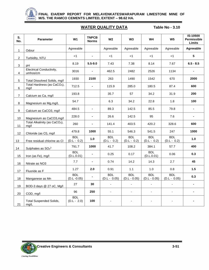
FINAL EIA/EMP REPORT FOR MELAVENKATESWARAPURAM LIMESTONE MINE OF M/S. THE RAMCO CEMENTS LIMITED, EXTENT – 98.62 HA.
Creative Engineers & Consultants 3-51
WATER QUALITY DATA Table No - 3.10
S. No.
Parameter W1 TNPCB Norms
W2 W3 W4 W5 IS:10500
Permissible Limits
1 Odour Agreeable Agreeable Agreeable Agreeable Agreeable Agreeable
2 Turbidity, NTU <1 - <1 <1 <1 <1 5
3 pH 8.19 5.5-9.0 7.43 7.38 8.14 7.67 6.5 - 8.5
4 Electrical Conductivity, umhos/cm
3016 - 462.5 2482 2526 1134 -
5 Total Dissolved Solids, mg/l 1930 2100 263 1490 1542 670 2000
6 Total Hardness (as CaCO3), mg/l
712.5 - 115.9 285.0 180.5 87.4 600
7 Calcium as Ca, mg/l 193.8 35.7 57 34.2 31.9 200
8 Magnesium as Mg,mg/L 54.7 6.3 34.2 22.8 1.8 100
9 Calcium as CaCO3, mg/l 484.5 - 89.3 142.5 85.5 79.8 -
10 Magnesium as CaCO3,mg/l 228.0 - 26.6 142.5 95 7.6 -
11 Total Alkalinity (as CaCO3), mg/l
260 - 141.4 403.5 420.2 328.6 600
12 Chloride (as Cl), mg/l 479.8 1000 55.1 546.3 541.5 247 1000
13 Free residual chlorine as Cl
BDL (D.L - 0.2)
1.0 BDL
(D.L - 0.2) BDL
(D.L - 0.2) BDL
(D.L - 0.2) BDL
(D.L - 0.2) 1.0
14 Sulphates as SO42-
791.7 1000 41.7 108.2 384.1 57.7 400
15 Iron (as Fe), mg/l
BDL (D.L.0.01)
- 0.25 0.17 BDL
(D.L.0.01) 0.06 0.3
16 Nitrate as NO3 7.7 - 0.74 14.2 14.3 2.7 45
17 Fluoride as F 1.27 2.0 0.91 1.1 1.0 0.8 1.5
18 Manganese as Mn
BDL (D.L -0.05)
- BDL
(D.L - 0.05) BDL
(D.L - 0.05) BDL
(D.L - 0.05) BDL
(D.L - 0.05) 0.3
19 BOD-3 days @ 27 oC, Mg/l 27 30 - - - - -
20 COD, mg/l 96 250 - - - - -
21 Total Suspended Solids, mg/L
BDL (D.L - 2.0)
100 - - - - -

FINAL EIA/EMP REPORT FOR MELAVENKATESWARAPURAM LIMESTONE MINE OF M/S. THE RAMCO CEMENTS LIMITED, EXTENT – 98.62 HA.
Creative Engineers & Consultants 3-52
3.5 NOISE ENVIRONMENT:
3.5.1 GENERAL:
Sound can be defined as atmospheric or air vibration perceptible to ear. Noise is usually
unwanted or undesired sound. Consequently, particular sound can be noise to one person and
not to others or noise at one time and not at other time. Hence sound loud enough to be
harmful is called noise without regard to its characteristics. Noise is a form of pollution because
it can cause hearing impairment and psychological stresses.
3.5.2 MONITORING LOCATIONS & METHODOLOGY:
Noise measurements were carried out for a day once in a Season at about 6 locations.
The locations are indicated below
Location of Noise Monitoring Stations
S. No Code Location Direction Distance in km
Ambient noise level
1 MVN1 MEL VENKATESWARAPURAM MINE LEASE AREA
- -
2 MVN2 KAMBATTUPATTI VILLAGE 1.5 N
3 MVN3 MEL VENKATESWARAPURAM VILLAGE 1.7 NE
4 MVN4 PUDUR VILLAGE <1.0 SW
5 MVN5 SIVALAR PATTI VILLAGE 2.1 NW
6 MVN6 MUTHUPATTI VILLAGE 1.0 SE
These Locations are shown in Figure No-3.11.
3.5.3 DATA ANALYSIS AND INTERPRETATION:
The results of hourly background noise levels for all 6 locations are given in Table No-
3.11. The noise values for all above locations are shown in a comparative chart given in
Figure No- 3.12.
From the table it is found that, the day, night equivalent of existing noise level in the core
zone area (MVN1) are 56.0 dB(A), 42.8 dB(A) respectively which are below the work zone
exposure limit of 90 dB(A). In the buffer zone, day Equivalent Noise (Leq-d) noise levels were
ranging from 45.2 dB(A) to 49.9 dB(A) and night Equivalent Noise (Leq-d) levels ranged between
38.2 dB(A) to 39.0 dB(A). While comparing with the MOEF&CC Norm of 55 dB(A) for day time
and 45 dB(A) for night time, the monitored ambient noise levels were within the limit values for
Residential areas.

FINAL EIA/EMP REPORT FOR MELAVENKATESWARAPURAM LIMESTONE MINE OF M/S. THE RAMCO CEMENTS LIMITED, EXTENT – 98.62 HA.
Creative Engineers & Consultants 3-53
Figure No-3.11
LOCATION OF NOISE SAMPLING STATIONS

FINAL EIA/EMP REPORT FOR MELAVENKATESWARAPURAM LIMESTONE MINE OF M/S. THE RAMCO CEMENTS LIMITED, EXTENT – 98.62 HA.
Creative Engineers & Consultants 3-54
0
10
20
30
40
50
60
MVN1 MVN2 MVN3 MVN4 MVN5 MVN6
LEV
EL I
N d
B(A
)
LOCATION
NOISE LEVEL DATA
DAY EQUIVALENT NIGHT EQUIVALENT DAY & NIGHT EQUIVALENT
AMBIENT NOISE LEVELS- (in dB(A)) Table No-3.11
Time in hrs MVN1 MVN2 MVN3 MVN4 MVN5 MVN6
6 45.2 39.1 38.8 42.2 40.8 39.6
7 44.7 43.8 39.1 48.5 46.7 46.7
8 47.8 47.6 45.5 50.2 51.1 45.5
9 52.9 48.8 50.6 50.8 48.9 47.4
10 56.6 50.1 48.8 51.2 49.2 49.8
11 57.1 47.7 47.6 52.2 50.6 48.1
12 59.8 48.9 46.5 50.5 51.3 47.6
13 59.6 51.2 50.7 49.9 52.7 45.2
14 58.6 50.6 51.1 46.1 49.6 44.3
15 54.5 51.1 52.8 47.4 50.5 42.2
16 59.1 50.8 54.4 48.8 47.7 44.8
17 58.8 48.6 51.1 50.6 48.2 41.9
18 57.2 49.1 48.6 52.1 49.1 40.7
19 48.8 46.7 47.7 50.7 50.4 41.1
20 47.9 46.5 44.4 49.4 43.7 39.8
21 45.8 45.5 40.2 48.8 45.5 37.5
22 47.2 42.1 40.1 40.5 40.8 40.6
23 45.5 40.7 38.2 37.5 39.9 36.8
24 41.1 38.1 36.5 37.9 38.1 37.4
1 40.7 37.6 38.1 38.8 37.6 36.5
2 39.1 36.9 37.9 37.9 38.4 37.3
3 38.8 36.8 37.2 37.5 39.5 36.8
4 40.2 37.9 38.8 39.4 37.6 38.4
5 41.6 38.8 40.1 40.2 39.3 39.9
DAY EQUIVALENT
56.0 48.7 49.3 49.9 49.3 45.2
NIGHT EQUIVALENT
42.8 39 38.5 38.9 39 38.2
DAY & NIGHT EQUIVALENT
54.4 47.1 47.7 48.3 47.7 43.8
Figure No- 3.12

FINAL EIA/EMP REPORT FOR MELAVENKATESWARAPURAM LIMESTONE MINE OF M/S. THE RAMCO CEMENTS LIMITED, EXTENT – 98.62 HA.
Creative Engineers & Consultants 3-55
3.6 SOIL CHARACTERISTICS:
3.6.1 GENERAL:
Soil is defined as the naturally deposited, unconsolidated material which covers the
earth’s surface, whose chemical, physical properties are capable of plant growth. Soil itself is
very complex. Soil contains mineral particles, air, water and organic matter.
Soil pH supports a number of inorganic and organic chemical reactions. Soil fertility is
directly influenced by pH through the solubility of many nutrients. Maximum soil fertility occurs in
the range 6.0 – 7.2
Soil texture has an important role in nutrient management and the size distribution of the
mineral particles (sand, silt, clay). Depending on the size of the particles in the soil, it can be
classified in to sandy, silty, clay, loamy, peaty and chalky soils.
For sustained growth plants absorbing nutrients (macro nutrients, micro nutrients) from
soil. Macro nutrients include nitrogen, phosphorus, potassium, calcium, magnesium and
sulphur. Micro nutrients are trace metals. The soil nitrogen which is responsible for strong stem
and foliage growth, phosphorus which aids in healthy root growth and flower and seed
production and potassium, which is responsible for improving overall health and disease
resistance of a plant. Among all soil cations sodium is not essential for plant elements but
effects soil pH.
Soil sampling locations are shown in Figure No 3.13.
The four locations are:
MVS1 - Mine Lease Area
MVS2 - Melavekateshwarapuram Village
MVS3 - Pudur Village
MVS4 - Muthupatti Village

FINAL EIA/EMP REPORT FOR MELAVENKATESWARAPURAM LIMESTONE MINE OF M/S. THE RAMCO CEMENTS LIMITED, EXTENT – 98.62 HA.
Creative Engineers & Consultants 3-56
Figure No – 3.13
LOCATION OF SOIL SAMPLING STATIONS

FINAL EIA/EMP REPORT FOR MELAVENKATESWARAPURAM LIMESTONE MINE OF M/S. THE RAMCO CEMENTS LIMITED, EXTENT – 98.62 HA.
Creative Engineers & Consultants 3-57
3.6.2 DATA ANALYSIS:
Results of the soil samples show that the pH values were ranging between 8.59 –8.84
and Electrical Conductivity values were ranging between 65.52 - 152 µs/cm. Soils are generally
Silt loam type.
Organic matter content were ranging between 1.06 – 9.29 %. Total Nitrogen values were
less than BDL(D.L-2.0) – 344.7 mg/kg. Phosphorus values were ranging between 0.2 – 1.8
g/g. Potassium values were ranging between 707.9– 4894.4 mg/kg. Sodium values were
ranging between 606 to 1514.1mg/kg.
The soil quality data for the 4 samples collected and analyzed are provided in
Table no – 3.12.
SOIL QUALITY DATA
Table No – 3.12
Sl. No.
Parameter Location
MVS1 MVS2 MVS3 MVS4
1 pH at 25o C 8.76 8.84 8.6 8.59
2 Electrical Conductivity, µmhos/cm
152 65.52 85.22 75.21
3 Dry Matter Content, % 95.89 97.69 85.84 94.51
4 Water Content 4.1 2.3 14.16 5.49
5 Organic Matter, % 1.06 4.46 9.29 6.87
6 Soil Texture, CLAY CLAY LOAM SANDY CLAY CLAY
7 Grain Size Distribution :i. Sand, %
20.26
26.16
45.09
26.53
Silt, % 25.02 35.66 17.42 27.85
Clay, % 54.72 38.19 37.49 45.62
8 Phosphorous, g/g 0.2 1.8 1.4 1.66
9 Sodium, mg/kg 1514.1 827.1 606 1032.3
10 Potassium, mg/kg 707.9 4894.4 2354.5 2161.1
11 Total Nitrogen, mg/kg BDL
(D.L – 2.0) 220 332.2 344.7
12 Total Sulphur,% BDL
(D.L – 0.02) BDL
(D.L – 0.02) BDL
(D.L – 0.02) BDL
(D.L – 0.02)

FINAL EIA/EMP REPORT FOR MELAVENKATESWARAPURAM LIMESTONE MINE OF M/S. THE RAMCO CEMENTS LIMITED, EXTENT – 98.62 HA.
Creative Engineers & Consultants 3-58
3.7 BIOLOGICAL ENVIRONMENT:
The details of Biological Environment comprising Flora and Fauna have been collected
through field visits and from various Government agencies. The study details are given below:
3.7.1 FLORA:
CORE ZONE:
The ML area is mostly barren rocky ground. Therefore, there exists no specific flora &
fauna within the ML area. There are small shrubs and trees in the area. The flora in the area is
generally common variety of trees like Prosopis juliflora, Acacia nilotica, Albizia amara,
Azadirachta indica etc., shrubs namely Morinda tinctoria, Calotropis gigantea, Jatropha sps.,
Ziziphus jujube, Adhatoda vasica etc., and herbs like Achyranthes aspera, Sida acuta,
Corchorus sps., Tridax procumbens, , Tephrosia purpurea etc., and grasses are Cynodon
dactylon, Commelina clavata, Juncus bufonius, Kyllinga Sp, Pycreus globosus, Pycreus
unioloides, Fimbristylis kingii, Fimbristylis uliginosa, Carex nubigena, Carex phacota, Carex
filicina, Oplismenus undulatifolius, Arundinella fuscata, Setaria glauca, Andropogon foulkesii,
Chrysopogon zeylanicus, Heteropogon contortus, Cymbopogon polyneuros, Tripogon
bromoides, Eragrostis sps, etc.,
BUFFER ZONE:
The region has vast stretches of fallow land, mostly dry land. The lands with dry
scattered bushes and wild growth support goat rearing in the area. There are no forest areas
within the buffer zone.
Limitation exhibited by soil condition also imposes certain constraint in landuse and
hence, dry crop is predominantly seen. But in some places, near tanks and stream courses,
paddy cultivation is also observed. Seasonal crops such as Ragi, Sorghum and gram varieties
such as black gram, horse gram etc are grown along with fodder grass. Sunflower is also grown
in some parts.
Trees like Azadirachta indica (neem), Prosophis Juliflora, Acacia Sp, Moringa oleifera,
Albizza sp, Cocos nucifera, etc. are commonly seen.
The dominant shrubs consists of Adhatoda vasica, Cassia auriculata, Calotropis
gigantea, Datura metel, Lantana camara, Lawsonia inermis, Nerium oleander, Hibiscus rosa-
sinensis Zizyphus Sp etc. The climbers consists of Coccinia indica , Cissus quadrangularis, ,
Abrus precatorius and prominent herbs are Acalypha indica, Sida cordifolia.

FINAL EIA/EMP REPORT FOR MELAVENKATESWARAPURAM LIMESTONE MINE OF M/S. THE RAMCO CEMENTS LIMITED, EXTENT – 98.62 HA.
Creative Engineers & Consultants 3-59
A consolidated list of flora species in the study area are given in Table No – 3.13
Table No- 3.13
LIST OF FLORA SPECIES IN THE STUDY AREA
Sl.NO BOTANICAL NAME TAMIL NAME FAMILY NAME
Trees
1 Azadirachta indica Vembu Meliaceae
2 Peltophorum pterocarpum Kilukiluppai Fabaceae
3 Prosopis juliflora Fabaceae
4 Tamarindus indica Puli Fabaceae
5 Tectona grandis Tekku Lamiaceae
6 Pongamia pinnata Pungai Fabaceae
7 Pongamia glabra Kattu pungai Fabaceae
8 Moringa oleifera Murungai Moringaceae
9 Eucalyptus lanciolatus Thailamaram Myrtaceae
10 Phoenix sylvestris Eeachamaram Arecaceae
11 Albizia amara Vagai Fabaceae
12 Acacia nilotica Karuvelan Fabaceae
13 Polyalthia longifolia Nietilingam Annonaceae
14 Psidium guajava Koyya Myrtaceae
15 Cocos nucifera Tennai Arecaceae
16 Ficus benghalensis Aalamaram Moraceae
17 Ficus religiosa Poarasamaram Moraceae
18 Ficus hispida Aarasu Moraceae
19 Pithecellobium dulce Kodukkapuli Fabaceae
20 Delonix regia Gulmohar Fabaceae
21 Casuarina equisetifolia Savukku Causuarinaceae
22 Mangifera indica Maamaram Amacardiaceae
23 Artocarpus heterophyllus Palamaram Moraceae

FINAL EIA/EMP REPORT FOR MELAVENKATESWARAPURAM LIMESTONE MINE OF M/S. THE RAMCO CEMENTS LIMITED, EXTENT – 98.62 HA.
Creative Engineers & Consultants 3-60
24 Murraya koenigii Curry leaf Rutaceae
25 Citrus medica Lemon Rutaceae
26 Plumeria acuminata Alari Apocyanaceae
27 Carica papaya Pappali Caricaceae
28 Odina wodier Oodiyan Anacardiaceae
29 Tecoma strans Yellow trumpetbush Bignoniaceae
30 Samanea saman Rain tree Fabaceae
31 Pheonix Sp Panai Arecaceae
32 Bougainvilla sps Nyctaginaceae
33 Sterculia foetida Malvaceae
34 Caesalpinia pulcherrima Mayilkondrai Fabaceae
35 Pterospermum acerifolium Poovarasoo Malvaceae
36 Achras sapota Sappota Sapotaceae
37 Phyllanthus emblica Nelli Phyllanthaceae
38 Anacardium occidentale Munthiri Anacordiaceae
39 Annona squamosa Siththa Annonaceae
40 Musa × paradisiaca Valzhlai Musaceae
41 Syzygium cumini Naval Myrtaceae
Shrubs
1 Sida cordifolia Sida plant Malvaceae
2 Sida acuata Malvaceae
3 Ziziphus jujuba Elanthai Rhamnaceae
4 Cassia auriculata Aavarampoo Fabaceae
5 Datura metel Oomaththai Solanaceae
6 Calotropis gigantea Earukku Apocynaceae
7 Caesalpinia bonducella Caesalpiniaceae
8 Jatropha glandulifera Oil plant Euphorbiaceae
9 Adhatoda vasica Adathoda Acanthaceae

FINAL EIA/EMP REPORT FOR MELAVENKATESWARAPURAM LIMESTONE MINE OF M/S. THE RAMCO CEMENTS LIMITED, EXTENT – 98.62 HA.
Creative Engineers & Consultants 3-61
10 Hibiscus rosa-sinensis Semparuthi Malvaceae
11 Nerium oleander Arali Apocynaceae
12 Lantana camara Putus Verbinaceae
13 Ixora casei Idlipoo Rubiaceae
14 Lagerstroemia indica Crape myrtle Lythraceae
15 Lawsonia inermis Maruthani Lythraceae
16 Jasminum grandiflorum Malligai Oleaceae
17 Parthenium hysterophorus Parthenium Asteraceae
18 Rosa indica Rose Rosaceae
19 Solanum xanthocarpum Kandangkattari Solanaceae
Cactus
1 Opuntia dilleni Sappathikalli Cactaceae
2 Agave americana Kaththalzhi Asparagaceae
3 Cereus peruvianus Kalli Cactaceae
4 Cereus trifolia Thirukkalli Cactaceae
Herbs
1 Acalypha indica Kupaimeni keeri Euphorbiaceae
2 Acanthospermum hispidum Gokul kanta Asteraceae
3 Achyranthes aspera Nayuruvi Amaranthaceae
4 Andrographis echioides . Birkubat Acanthaceae
5 Andrographis paniculata Kirayt Acanthaceae
6 Amaranthus viridis Creen amaranth Amaranthaceae
7 Argemone mexicana Mexican poppy Papaveraceae
8 Atylosia scarabaeoides Venkulthi Fabaceae
9 Boerhavia erecta Erect spiderling Nyctaginaceae
10 Cleome viscosa Naai velai Cleomaceae
11 Coleus amboinicus Indian borage Lamiaceae
12 Cosmos caudata Ulam raja Compositae

FINAL EIA/EMP REPORT FOR MELAVENKATESWARAPURAM LIMESTONE MINE OF M/S. THE RAMCO CEMENTS LIMITED, EXTENT – 98.62 HA.
Creative Engineers & Consultants 3-62
13 Croton sparsiflorus Poodu sedi Euphorbiaceae
14 Cuphea hyssopifolia Elfin herb Lythraceae
15 Digera muricata False amaranth Amaranthaceae
16 Gynandropsis pentaphylla Nalla velai Cleomaceae
17 Kalanchoe blossfeldiana Kalanchoes Crassulaceae
18 Leucas aspera Thumbai Lamiaceae
19 Mimosa pudica Touch me not Fabaceae
20 Phyllanthus niruri Keelzhaneeli Phyllanthaceae
21 Polycarpaea corymbosa Old man's cap Carryophyllaceae
22 Solanum nigrum Manatthakalli Solanaceae
23 Sphaeranthus indicus Indian globe thisle Asteraceae
24 Tephrosia purpurea Vayal poondu Fabaceae
25 Tridax procumbens Vettukai poondu Asteraceae
26 Glandularia bipinnatifida Purple praire Verbanaceae
27 Vinca rosea Nithiyakalyani Apocynaceae
28 Wedelia calendulacea Aster Asteraceae
29 Xanthium strumarium Rough cocklebur Asteraceae
Climbers
1 Abrus precatorius . Indian licorice Fabaceae
2 Cardiospermum halicacabum Ballon plant Sapindaceae
3 Coccinia indica Kovai Cucubitaceae
4 Convolvulus sps - Covolvulaceae
5 Ipomia carnea Pink morning glory Convolvulaceae
6 Luffa cylindrica Peirkkai Cucurbitaceae
7 Cissus quadrangularis Pirandai Vitaceae
8 Asparagus racemosus Shatawari plant Asparagaceae
GRASSES:
Sl.NO Species Name Family Name
1 Commelina clavata Commelinaceae

FINAL EIA/EMP REPORT FOR MELAVENKATESWARAPURAM LIMESTONE MINE OF M/S. THE RAMCO CEMENTS LIMITED, EXTENT – 98.62 HA.
Creative Engineers & Consultants 3-63
2 Aneilema lanuginosum Commelinaceae
3 Cyanotis pilosa Commelinaceae
4 Juncus glaucus Juncaceae.
5 Juncus prismatocarpus Juncaceae.
6 Juncus bufonius Juncaceae.
7 Luzula campestris Juncaceae.
8 Eriocaulon brownianum Eriocaulaceae
9 Eriocaulon collinum Eriocaulaceae
10 Kyllinga melanosperma Cyperaceae
11 Kyllinga cylindrica Cyperaceae
12 Pycreus globosus Cyperaceae
13 Pycreus unioloides Cyperaceae
14 Mariscus cyperinus Cyperaceae
15 Fimbristylis kingii Cyperaceae
16 Fimbristylis uliginosa Cyperaceae
17 Carex nubigena Cyperaceae
18 Carex phacota Cyperaceae
19 Carex filicina Cyperaceae
20 Carex myosurus Cyperaceae
21 Isachne australis Poaceae
22 Panicum villosum Poaceae
23 Oplismenus undulatifolius Poaceae
24 Arundinella fuscata Poaceae
25 Setaria glauca Poaceae
26 Cyanodon dactylon Poaceae
27 Pollinia quadrinervis Poaceae
28 Andropogon Sp Poaceae
29 Chrysopogon zeylanicus Poaceae

FINAL EIA/EMP REPORT FOR MELAVENKATESWARAPURAM LIMESTONE MINE OF M/S. THE RAMCO CEMENTS LIMITED, EXTENT – 98.62 HA.
Creative Engineers & Consultants 3-64
30 Heteropogon contortus Poaceae
31 Cymbopogon polyneuros Poaceae
32 Cymbopogon sp Poaceae
33 Calamagrostis pilosula Poaceae
34 Zenkeria elegans Poaceae
35 Tripogon bromoides Poaceae
36 Eragrostis amabilis Poaceae
37 Eragrostis sp Poaceae
38 Festuca bromoides Poaceae
CULTIVATED CROPS:
Sl.No Species Name Local Name Family Name
1 Vigna mungo Vulunthu Fabaceae
2 Sorghum vulgare Solam Poaceae
3 Musa × paradisiaca Valzhai Musaceae
4 Cocos nucifera Tennai Arecaceae
5 Gossypium hirsutum Paruththi Malvaceae
6 Ricinus communis Aamanakku Euphorbiaceae
7 Helianthus annuus Sun flower Asteraceae
8 Pisum sativum Avarai Fabaceae
9 Cyamopsis tetragonoloba Koththavarai Fabaceae
10 Pennisetum glaucum Kampuo Poaceae
11 Solanum melongena Kaththarii Solanaceae
12 Capsicum annuum Red chilli Solanaceae

FINAL EIA/EMP REPORT FOR MELAVENKATESWARAPURAM LIMESTONE MINE OF M/S. THE RAMCO CEMENTS LIMITED, EXTENT – 98.62 HA.
Creative Engineers & Consultants 3-65
PLANTATION/ VEGETATION SEEN AROUND THE LEASE AREA Photo 3.1

FINAL EIA/EMP REPORT FOR MELAVENKATESWARAPURAM LIMESTONE MINE OF M/S. THE RAMCO CEMENTS LIMITED, EXTENT – 98.62 HA.
Creative Engineers & Consultants 3-66
Table No- 3.14
3.7.2 FAUNA:
There is no Wild Life Sanctuary or National Park or Biosphere within the study area of 10
km. The fauna species found in the buffer zone are Hare, Three stripped palm squirrel. The
avifauna found is Peafowl, Patridge, Parrot, Cuckoo, Owl, King fisher, Dove, Egret, Parakeets,
Myna, etc. Other than Peafowl there are no schedule – I items in the study area. However,
least disturbance and impact on its existence is ensured, as the mining operations are
conducted at deeper level and the blasting noise, etc., will be at minimal quantum.
Besides, all environmental protection measures for mining impacts are properly
implemented. There will be only insignificant impact on the movement factors of Peafowl
species.
The mining personal and others in the area are also properly cautioned to
cause least disturbance to this species and its existence and movements.
A consolidated list of fauna species in the study area are given in Table No – 3.14.
LIST OF FAUNA SPECIES IN THE STUDY AREA
MAMMALS Schedule
Palm civet Paradoxurus hermaphroditus SCH – II
Hare Lepus nigricollis SCH – IV
Three stripped palm squirrel Funambulus palmarum SCH - IV
BIRDS
Dove Chalcophaps indica SCH – IV
Cuckoo Cuculus micropterus SCH – IV
Egret Egretta garzetta SCH – IV
Common Myna Acridotheres tristis SCH – IV
King fisher Alcedo atthis SCH – IV
Owl Tyto alba SCH – IV
Parakeets Psittacula krameri SCH – IV
Partridge Francolinus pondicerianus SCH – IV
Quail Perdicula asiatica SCH – IV
Peafowl Pavo cristatus SCH – I
REPTILES
Cobra Naja naja SCH – II
Ground lizard Mabuya carinata
Krait Bungarus caeruleus SCH – IV
Lizard Calotes versicolor
* - Schedule not specified in Wild Life Protection Act - 1972

FINAL EIA/EMP REPORT FOR MELAVENKATESWARAPURAM LIMESTONE MINE OF M/S. THE RAMCO CEMENTS LIMITED, EXTENT – 98.62 HA.
Creative Engineers & Consultants 3-67
3.8 LANDUSE PATTERN OF MELAVENKATESWARAPURAM LIMESTONE MINES
USING REMOTE SENSING SATELLITE DATA
3.8.1. Introduction:
It is known that landuse of an area is controlled by the environment setting of an area. It
is constrained by the inherent characteristics of a terrain such as lithology, landform, soil, slope
and drainage. Any disturbance beyond a sustainable level affects the local environment which in
turn exerts influence on the existing landuse pattern. The changes in the pattern of existing
resources are always changing, which either may be due to natural or human activities. The
applicability of landuse information in very wide and there may be many inferences vital for
various developmental activities that could be obtained from the study of landuse pattern and its
periodical changes over time. The pattern emerging from the landuse study throws light on the
demographic, socio-economic and prevailing condition of natural resources in an area. Also,
landuse data is requisite for water resources inventory, flood control and is used for
environmental impact assessment of an area. An increase or decrease of specific landuse
category or change in the use of land parcels always indicates both economic as well
environmental condition of an area. Collecting such dynamic information in a standardized
format is an arduous task.
Remote sensing satellite data would assist in obtaining such valuable and formidable
information with respect to landuse environment of an area. The synoptic view under uniform
illumination and its repetitive coverage allows employing RSI (remote sensing satellite image) to
generate landuse information of an area at a periodical interval. Change of both macro and
micro-level (soil and water condition) reflected by landuse induced by developmental activities
could be mapped and relevant mitigation measures could be implemented.
3.8.2 Remote sensing satellite data used for the study
In the present study, remote sensing satellite data LISS IV of Resourcesat2 acquired on
30th July 2013 has been used (Figure 3.14). A landuse map showing 10 Km radial buffer with
MV Puram limestone ML area of M/s The Ramco cements Limited, Chennai having 98.62 Ha
spatial extent at its center is carried out. The geographical coordinates of the mining lease (ML)
area may be given as 78⁰04’ 21” E to 78⁰ 16’ 34” E longitude and 9⁰ 12’ 07” N to 9⁰ 23’ 31” N”
latitude. The 10 Km radial buffer constructed for the above ML area and the radial buffer around
the ML is 372.347 sq.km.

FINAL EIA/EMP REPORT FOR MELAVENKATESWARAPURAM LIMESTONE MINE OF M/S. THE RAMCO CEMENTS LIMITED, EXTENT – 98.62 HA.
Creative Engineers & Consultants 3-68
Figure No. 3.14
Remote sensing satellite image (LISS IV July 2013) of MV Puram and its environ
Selection of remote sensing satellite image (RSI) is on the availability of cloud free data
and interpretability of predominant landuse and land cover (LULC) category. The examination of
satellite data showed that the region is always covered by clouds with lesser percentage during
summer. But rainfed crops are cultivated during southwest monsoon and hence a data acquired

FINAL EIA/EMP REPORT FOR MELAVENKATESWARAPURAM LIMESTONE MINE OF M/S. THE RAMCO CEMENTS LIMITED, EXTENT – 98.62 HA.
Creative Engineers & Consultants 3-69
during first onset of precipitation is preferred so as to delineate crop and fallow land parcels of
agricultural category.
Delineation of scrub land is also possible since land with scrub could be easily
distinguished from crop vegetation and separated. This may be an arduous task during
monsoon since the entire area would be witnessed with sudden sprout of lush natural
vegetation, mostly prosopis, with first onset of precipitation. Moreover, data acquired during
January is completely obscured by clouds. Considering all these factors, a larger resolution
LISS IV data acquired on 30thJuly 2013 has been selected. Besides, LISS III data of relatively
smaller resolution than that of LISS IV has also been studied to delineate the landuse pattern.
To compare the seasonal influence as well as for impact assessment around 2 Km buffer
around the ML (any abrupt change in landuse pattern owing to mining activities) has been
carried out using LISS III acquired on 30th Dec 2009. Data used for the present study is listed in
Table given below:
Details of satellite data used for the Landuse study
S.No Satellite image Date Generated LU map
1.
2.
3.
R2 LISS III
R2 LISS III
R2 LISS IV
30th December 2009
30th July 2013
30th July 2013
LU map for 2 Km Buffer area
LU map for 10 and 2 Km Buffer area
LU map for 10 and 2 Km Buffer area
LU within the Core zone
3.8.3. Methdology adopted for the landuse study of mv puram limestone ml area
Present study involves regional analysis of landuse pattern showing 10 km buffer area,
secondly changes in landuse pattern using temporal satellite data and lastly, landuse within the
core zone of the ML area. This necessitates a careful analysis of satellite data adopting a well
defined methodology.
To cater the requirement, a preliminary assessment of terrain using digital analysis
helping to infer relationship between terrain and landuse has been carried out. Temporal
historical data comparing data acquired on 2009 and 2013 to assess the impact. Such an
approach provides lucid understanding of landuse units and enhances the knowledge on the
landuse pattern assisting in impact assessment.
The knowledge base thus generated is used to delineate various landuse units while
carrying out interpretation of the satellite image. The derived landuse information is transformed
into a GIS based spatial database using geo-referencing techniques. Besides, a limited but well
focused field investigation also carried out and coordinates of significant landuse units using
handheld GPS (Global Positioning System) are gathered to be used as control points for geo-

FINAL EIA/EMP REPORT FOR MELAVENKATESWARAPURAM LIMESTONE MINE OF M/S. THE RAMCO CEMENTS LIMITED, EXTENT – 98.62 HA.
Creative Engineers & Consultants 3-70
referencing. Interpreted landuse units are verified in the field to carryout necessary corrections
wherever is required before preparing final landuse map.
Flow chart showing nature of work flow in Landuse analysis of the study area
Using the image elements such as color, tone, texture, size, shape and associated
elements various landuse units are delineated following the categorization and nomenclature
adopted for the national level landuse classification system as recommended by National
Remote Sensing Centre (NRSC), Department of Space, Government of India. Some of the
landuse units that are identified in the study area are listed in Table given below.
Major Landuse units of the study area
S.No Major Category Landuse unit
1 Built-up Land Village / Town / Industries
2 Agricultural Land Crop land Fallow land Plantation
3 Waste Land
Mining area
Land without scrub Land with Scrub Barren / Stony waste Mines / dumps / Abandoned quarries
4 Waterbodies Rivers / Streams Tanks / Reservoirs
REMOTE SENISG SATELLITE IMAGE (RSI)
LISS IV DATA LISS III – Date2 LISS III – Date 1
Image Analysis
Field visit &
Corrections
LU Maps – Date 1 &
2 ( 2 Km Buffer
area)
Preliminary LU Map
(10 Km Buffer area)
Final Maps:
1. Landuse Map of 10 Km Buffer area
2. Landuse Maps of 2 Km– 2009 & 2013
3. Map showing change in Landuse
4. Report generation

FINAL EIA/EMP REPORT FOR MELAVENKATESWARAPURAM LIMESTONE MINE OF M/S. THE RAMCO CEMENTS LIMITED, EXTENT – 98.62 HA.
Creative Engineers & Consultants 3-71
Before visually analyzing the RSI for the preparation of landuse maps, image analysis of
the digital data of the RSI is carried out and the results and observations are discussed in the
following section.
3.8.4. Digital image analysis of mv puram environ for land use pattern
RSI is the image representation of digital value numbers (DN) which could be enhanced,
reduced and clustered using various mathematical computations. DN values are the spectral
representation of objects on the earth’s surface measured and stored in different spectral
wavelength. Hence, each object displays different spectral properties at different spectral
wavelength and shows unique behavior called as spectral signature. In the digital analysis of the
RSI, such spectral values are used to group similar pixels on the basis of color (RGB), intensity
and distance among similar pixels. Applying some simple techniques could bring out information
about the terrain which is otherwise impossible to derive. Moreover, inherent terrain
characteristics could be highlighted leading to understanding of structural control, lithological
condition, landforms and drainage characteristics of the terrain. By collating with other data
information on micro-level information such as soil condition and water quality could also be
derived. A similar exercise using simple analytical techniques – PCA, NDVI, color inversion and
textural enhancement - on digital data is implemented in the present study so as to generate
basic knowledge on the terrain environment, which could be used while generating landuse
information.
3.8.4.1 Principal Component Analysis (PCA) of the RSI
Principal component analysis (PCA) may be explained as dimension reduction technique
to compute the common occurrence in a data set using eigen vector. In RSI, it reduces and
compresses a multi-spectral image so that maximum amount of pixel information is obtained in
the first band itself. This dimension reduction may bring out significant information about subtle
terrain features – structures, rocks, soil, drainage and landforms. Implementation of similar
technique is applied on the RSI of the study area and the resultant output is depicted in Photo
3.2.
A clear separation of a major litho-unit at the center is observed from the other area. Similarly, a
well-defined unit in pink color in the northeastern part of the study area is also segregated
emphasizing a different litho-unit. Similarly, dark blue color and pinkish red color in the
southwestern part may indicate presence of natural vegetation and crop respectively. All the
linear features because of their association with natural vegetation, shown in blue color, are
clearly brought out from the image. Light blue color with a well-defined shape lead to inference

FINAL EIA/EMP REPORT FOR MELAVENKATESWARAPURAM LIMESTONE MINE OF M/S. THE RAMCO CEMENTS LIMITED, EXTENT – 98.62 HA.
Creative Engineers & Consultants 3-72
of the presence of mining activities within the buffer area. Such delineation of major terrain
pattern would help to delineate associated landuse pattern in the study area.
3.8.4.2 Edge detection of the study area
Edge detection analysis of the RSI would help to enhance the linear features and
boundaries and even called as boundary detection algorithm. A kernel with weightage values of
1, -1 and 0 is applied on the digital image and the product value would result in either increase
or decrease in DN values. In this way, the pixels would be enhanced or suppressed leading to a
growth of pattern showing similar pixels. Features like roads, railways, urban settlement, water
bodies, streams and land parcels are extracted using this technique. A similar technique applied
on RSI showing the study area is carried out and the resultant output image is shown in Photo-
3.3.
Examination of the figure showed that linear features such as roads including minor
roads are clearly brought out. Stream course in the eastern part of the area could be observed
distinctly. Boundaries of innumerable land parcels could be seen including presence of existing
vegetation pattern. Another interesting pattern has also emerged showing distinct separation of
various lithounits and landforms, which could be useful while interpreting the image for landuse
study. Settlements have been brought out very distinctly and seen on the resultant image as
bright specks. In short, linear features and boundaries of major terrain units and field boundaries
could be extracted using such technique.
3.8.4.3 Textural enhancement of the RSI
Another method of enhancement of RSI is textural enhancement that could help in
enhancing the interpretability of the image and bring out patterns showing similar pixels. Texture
may be defined as tonal frequency and qualitatively termed as “fine”, “medium” and “coarse”.
Depending upon the frequency of occurrence of pixel values, they grouped as clusters leading
to the emergence of pattern. Such pattern would throw light on the terrain and landuse
environment of an area. The resultant image as obtained from such analysis of the study area
is shown in Photo- 3.4.
The resultant output image obtained from textural analysis showed almost similar terrain
pattern and LULC pattern as seen in the edge detection and PCA techniques. Separation of
three major terrain units – one at the center, second at the northeastern part and the third at the
southwestern parts – could be observed. Presence of settlements and distribution of roads
could be seen clearly in the image. Water channels and streams have also been brought out in
the analysis. Intermittent red color patches may indicate presence of vegetation and could be

FINAL EIA/EMP REPORT FOR MELAVENKATESWARAPURAM LIMESTONE MINE OF M/S. THE RAMCO CEMENTS LIMITED, EXTENT – 98.62 HA.
Creative Engineers & Consultants 3-73
identified as natural vegetation or crop by their association. Grouping of pixels based on the
similarity in the occurrence of spectral values have resulted in enhancement of features such as
fallow land, crop land, natural vegetation, roads, streams and settlements beside mining area at
the center of the image.
3.8.4.4 Normalized Difference Vegetation Index (NDVI) of the study area
Lastly, vegetation index obtained by the ratio of additive spectral values (DN) of red (R)
and near-infrared (NIR) spectral region and their differences. This gives out a normalized
vegetation index indicating the status of vegetation such their density, stages of growth, their
spatial presence along with soil moisture condition, waterbodies and clouds. Since, vegetation
has high spectral reflectance value at R and NIR region, DN values of pixels of this region would
provide meaningful information on the status of vegetation. Information extracted using NDVI
technique would be meaningful while examining the RSI for landuse pattern of the study area
and a resultant output image is shown in photo-3.5.
From the figure it could be observed that most of the land parcels in the buffer area are
“fallow” followed by scattered distribution of vegetation – both crop land and land with scrub.
Fallow land because of soil condition shows light grey to medium grey color implying negative
value. Similarly, vegetation showed positive values ranging from 0.247 to 0.317. The resultant
NDVI modified pixel values indicate that the vegetative cover is poorly represented. The values
obtained from NDVI analysis range from -1 to +1 with “zero” as intermediate value. Generally,
cloud and snow show “zero” value with water bodies showing negative values and vegetative
cover showing positive values. A larger positive value indicates (above .45) a healthier and
dense vegetative cover and lesser values indicate their sporadic presence. The statistical
values obtained from the NDVI computation showed value ranging from -0.22727 to maximum
value of 0.67826. Statistical parameters such as mean, median, mode and standard deviation
showed 0.111, 0.08754, 0.07339 and 0.069 respectively. These values may lead to the
inference of less vegetative cover with more frequent barren land, in this case identified as
“fallow” land. These techniques – PCA, edge detection, texture and NDVI – have provided
meaningful insight with respect to the landuse pattern and its relation with terrain environment.

FINAL EIA/EMP REPORT FOR MELAVENKATESWARAPURAM LIMESTONE MINE OF M/S. THE RAMCO CEMENTS LIMITED, EXTENT – 98.62 HA.
Creative Engineers & Consultants 3-74
Photo 3.2. PCA of the RSI Photo 3.3. Edge Detection output of the RSI
Photo 3.4. Textural enhancement of the
RSI
Photo 3.5.NDVI analysis of the RSI
With the information extracted from the digital analysis of the image relationship between
terrain and landuse pattern could be well established. Also, separation of various landuse and
terrain units would help in better understanding of the landuse pattern help in delineating
various landuse categories present in the study area. A general view on the mining area and its
environ could be perceived which would form a valuable knowledge base in the preparation of
regional landuse map and landuse pattern within the core zone of the ML area using satellite
data of larger resolution.

FINAL EIA/EMP REPORT FOR MELAVENKATESWARAPURAM LIMESTONE MINE OF M/S. THE RAMCO CEMENTS LIMITED, EXTENT – 98.62 HA.
Creative Engineers & Consultants 3-75
Landuse map of 10 Km radial buffer around MV Puram Limestone ML area Figure No. 3.15

FINAL EIA/EMP REPORT FOR MELAVENKATESWARAPURAM LIMESTONE MINE OF M/S. THE RAMCO CEMENTS LIMITED, EXTENT – 98.62 HA.
Creative Engineers & Consultants 3-76
3.8.5. Landuse pattern of 10 km radial buffer area of mv puram ml area
The general landuse pattern of the buffer may be broadly classified into four major types
– settlement, agriculture, wasteland and water bodies. In the settlement, villages, town and
infrastructure facilities are considered. The second category agriculture consists of crop land,
fallow land and plantation. Under the wasteland category, units such as and with scrub, land
without scrub, barren area, mining area and abandoned quarries is interpreted. Lastly,
waterbodies such as tanks, ponds and streams are interpreted under this category. These
categories are delineated from the selected satellite image using image elements such as color,
tone, texture, size, shape and associated elements. The delineated landuse units are
transformed into a spatial database in GIS environment. The map thus generated in GIS as
shown in Figure 3.15 is estimated for area and representation of each category in the study
area. The total area of LULC in the study area is calculated as 372.347 sq.km and spatial
distribution of various LULC categories within buffer area are discussed below.
3.8.5.1 Built-up / Settlements
Settlements in the study area are generally small in stature and area scattered. Vembur
and Pudur are the two relatively larger settlements observed at the western part of the study
area. Settlements such as Kallupatti, Melavenkatasapuram, Krishnapuram, Pungamarathupatti,
Ramachandrapuram, Nadukattur, Sivalarpatti, Mettilpatti, Salukuvarpatti and Kmbathupatti are
delineated within the buffer area (Photo 3.6 and 3.7).
Photo 3.6. A major settlement - Vembur Photo 3.7. Kambathupatti village

FINAL EIA/EMP REPORT FOR MELAVENKATESWARAPURAM LIMESTONE MINE OF M/S. THE RAMCO CEMENTS LIMITED, EXTENT – 98.62 HA.
Creative Engineers & Consultants 3-77
Interpretation of settlement from the satellite image is based upon the image elements
such as color, tone, texture and association. It is delineated by their typical grey color mixed
with intermittent brownish red color due to vegetation. Such spectral signatures are seen
scattered indicating their nature and extent. This is also corroborated from the digital analysis as
well as field checks. Association with linear features such as roads reaffirmed the presence of
delineation of settlements. The spatial extent of settlement is estimated as 7.428 sq.km
representing 1.99% of the study area.
3.8.5.2 Agricultural Land
Under the broad category of agriculture crop land, fallow land and plantation is
delineated. Cultivation is mostly dependent upon monsoon rainfall of both southwest and
northeast monsoon and irrigational activities are rarely seen. This may be due to poor
groundwater and surface drainage owing to the prevailing soil condition. Black cotton soil is the
predominant type in the study area and with its poor infiltration capacity encourages poor
degree of groundwater storage. Ponds and tanks in each village act as rainwater storage units
and do support domestic requirement and even cultivation to some extent. Because of these
conditions, minimal water requiring crops such as corn, sunflower, oil seeds, grams, millets and
coriander are cultivated (Photo 3.8 and 3.9).Corn is the most predominant crop cultivated and
even if it failed their stalks are used as fodder for cattle.
During northeast monsoon, sunflower is cultivated predominantly in the entire buffer
area. Interestingly, prosopis, a thorny scrub plant that grows as thorny natural vegetation is also
grown in field. They are used for fuel wood and used to make wood charcoal benefitting the
local community economically (Photo 3.10). This type of cultivation owing to terrain constraints
could sometime lead to confusion among crop area and land with scrub.
Red color, smooth to medium tone, medium texture, geometrical shape and association
with fallow land has helped to delineate crop land. Patches of crop land are seen around
Vadakunatham, Krishnasamypuram, Madhalapuram, Jegaveerapuram, Pudur and Vembur.
Spatial pattern of crop land suggest their existence along the streams and water channels. The
pattern reiterates the influence of terrain condition in the agricultural activity.
Spatial extent of crop land is estimated at 40.794 Sq.km representing 10.96% of the total
buffer area.
Fallow land are interpreted using their image elements such as light to dark grey,
smooth to medium tone, smooth to medium texture and their typical geometrical shape. They
are the most predominant landuse category delineated in the buffer area. As explained earlier,

FINAL EIA/EMP REPORT FOR MELAVENKATESWARAPURAM LIMESTONE MINE OF M/S. THE RAMCO CEMENTS LIMITED, EXTENT – 98.62 HA.
Creative Engineers & Consultants 3-78
cultivation mostly depends upon rainfall, and majority of the land parcels are tilled and ready for
cultivation with even a scanty rainfall. Hence, fallow is the predominant category estimated at
295.224 Sq.km representing 79.29% of the buffer area (Photo-3.11).
Photo 3.8 Crop land near Nadukattur Photo 3.9 Coriander and Corn near
Sudhamadam
Photo 3.10 Charcoal making from Prosopis Photo 3.11 Fallow land near Vadakkunatham
The land parcels under “fallow” suddenly sprouts into life with crops and natural
vegetation during monsoon with local community using the rainfall available during the season
to practice agriculture. Similarly, plantation is rarely seen in the buffer area and seen as a small
patch near Mel Karandai. They are identified by their typical brown color and association with

FINAL EIA/EMP REPORT FOR MELAVENKATESWARAPURAM LIMESTONE MINE OF M/S. THE RAMCO CEMENTS LIMITED, EXTENT – 98.62 HA.
Creative Engineers & Consultants 3-79
crop land and waterbodies. They represent an area of 1.290 sq.km covering 0.35% of the total
buffer area. The total area estimated under this category is 337.301 sq.km representing 90.59
% of the total buffer area (372.347 sq.km).
3.8.5.3 Wasteland
The last category of the landuse units In the study area is “wasteland”, which denotes
land parcels that could not be utilized for cultivation even after conservation measures – such as
land with scrub, land without scrub and barren / stony area and abandoned mines and quarries,
and mining area.
Next to agricultural area, natural vegetation such as land with scrub forms the
predominant LULC category of the buffer area. Land with scrub is sparse and delineated as
patches scattered in all the parts of the buffer area. The spatial pattern of scrub suggests it is
closely associated with water courses. A linear patch in the eastern periphery is closely
identified with some minor nallas in that area. A large patch in the northeastern periphery (near
Maravarperungudi) showing a geometrical pattern indicated presence of high density of natural
vegetation such as prosopis, acacia and other wild shrubs and bushes. A vast stretch of land
covered with scrub is also seen around the mining area near Melavekateshwarapuram.
Separating land with scrub is tedious since they show identical pattern with agricultural
vegetation but their typical color and tone have helped to differentiate and interpret them. They
show red color, smooth to medium one and medium texture and closely associated with
settlements and waterbodies. Almost all the dry beds of waterbodies are observed with scrub
plants. Scrub is also observed along the waterbodies near Vembar, Mettilpatti, Mel karandai and
Pillayarnatham in the northeastern periphery (Photo 3.12 and Photo 3.13). This category
occupies an area of 20.317 sq.km representing 5.46% of the total buffer area.
Land without scrub, on the other hand is interpreted using brown to yellowish white
color, medium tone and medium texture and is generally restricted around land covered with
scrub and fallow land (Photo 3.14). Absence of red color indicating absence of vegetation and
their presence as intermittent patches with in scrub land has helped to interpret and delineate
this category. They occur as small patches and very minimal area covering 1.779 sq.km
representing 0.48% of the buffer area. Similar to that, barren area is also interpreted by their
image elements such as white color, smooth tone, medium texture and close association with
mining area . It is very meager in spatial extent and covers an area of 0.698 sq.km (0.19%) and
mostly confined around mining area.

FINAL EIA/EMP REPORT FOR MELAVENKATESWARAPURAM LIMESTONE MINE OF M/S. THE RAMCO CEMENTS LIMITED, EXTENT – 98.62 HA.
Creative Engineers & Consultants 3-80
Lastly, mining area covers a spatial extent of 1.877 sq.km representing 0.50% of the
buffer area. Limestone mine near Melavekateshwarapuram is interpreted by their bright white
color, smooth tone, smooth texture and having a definite shape (Photo 3.15). Dumps are
interpreted mostly by their association with mines and they show image characteristics such as
light grey color, smooth tone, medium texture and are often covered with shrubs and plants.
Photo 3.12 Land with Scrub near
Pillayarnatham
Photo 3.13 Land with scrub near Mettilpatti
Photo 3.14 Land without scrub near
Maravarperungudi
Photo 3.15 L.st mine near
Melavenkatesapuram
3.8.5.4 Water bodies
Many small and big water bodies are seen in the study area distributed all over the study
area. Water bodies are the storage units for water act as rainwater harvesting structures. They

FINAL EIA/EMP REPORT FOR MELAVENKATESWARAPURAM LIMESTONE MINE OF M/S. THE RAMCO CEMENTS LIMITED, EXTENT – 98.62 HA.
Creative Engineers & Consultants 3-81
support the domestic water requirements and for cattle (Photo 3.16). At some places, they may
also use for irrigation purpose and are very limited. Few dry stream courses are also seen in the
study area. In the satellite image, water bodies are interpreted by their light blue to greyish blue
color, smooth tone and smooth texture. They show an arcuate to curvi-linear shape. Their dry
beds are covered with vegetation such as prosopis and acacia. Hence a dark red color tone and
medium tone and texture are also associated with the image characteristics of waterbodies.
Photo 3.16. A pond near Pillayarnatham Photo 3.17. A dried up tank near
Vadakkunatham
Most of the waterbodies retain water for a shorter period after precipitation due to the
soil constraint and hence go dry soon (Photo 3.17). Spatial extent of stream and waterbodies is
estimated at 1.313 sq.km and 1.625 sq.km respectively. The area of various landuse categories
as derived from the satellite data within the buffer area is given below:
Landuse Categories within 10 Km Buffer zone and their Spatial Extent
S.No Landuse Units Area (Sq.Km) Percentage
1 Crop Land 40.795 10.96
2 Fallow Land 295.224 79.29
3 Plantation 1.290 0.35
4 Land with Scrub 20.317 5.46
5 Land without Scrub 1.779 0.48
7 Barren Area 0.698 0.19
8 Mines / Mining Dumps 1.877 0.50
9 Waterbodies 1.625 0.44
10 Settlement 7.428 1.99
11 River 1.313 0.35
Total 372.347 100.00
16

FINAL EIA/EMP REPORT FOR MELAVENKATESWARAPURAM LIMESTONE MINE OF M/S. THE RAMCO CEMENTS LIMITED, EXTENT – 98.62 HA.
Creative Engineers & Consultants 3-82
The regional study covering 10 km radial buffer is further carried out to understand the
changes in the spatial pattern of landuse by comparing historical 2009 data with current data
(2013) around 2 Km buffer around the ML area. To carry out such study, IRS R1 LISS III data
acquired on 30th December 2009 has been compared with recent data using R2 LISS IV data
acquired on 30th July 2013 around 2Km radial buffer of Ml area.
3.8.6. LANDUSE PATTERN WITHIN 2 KM BUFFER AROUND MV PURAM ML AREA
Landuse pattern within 2 Km buffer area could be meaningful to generate a spatial
database on landuse so that any changes within the buffer may be periodically monitored for
impact assessment and proper mitigation or conservation measures could be implemented. In
the present study, satellite data of 2009 (Photo 3.18) has been compared with satellite data
acquired on 2013 (Photo 3.19), and the resultant observations are discussed below.
3.8.6.1 Landuse Pattern around the ML area during 2009
Landuse pattern within 2 Km radial buffer area around the MV Puram limestone ML area
using IRS R1 LISS III has been interpreted similar to the landuse map generated for 10 Km
buffer area. Similar landuse categories and nomenclature are adopted to delineate various
landuse units within the buffer area.
Photo 3.18. RSI Data of R1 LISS III (Dec 2009) Photo 3.19. RSI Data of R2 LISS IV (July 2013)
Image characteristics of landuse units such as color, tone, texture, shape and
association are almost identical showing similar pattern and hence, interpreting landuse units
with the knowledge derived from digital analysis and field check has become easier. The total
area for 2Km buffer around the ML area is estimated at 25.255 sq.km. Major landuse categories
that are identified include 2 Km buffer around the ML covers an area 28.669 sq.km and

FINAL EIA/EMP REPORT FOR MELAVENKATESWARAPURAM LIMESTONE MINE OF M/S. THE RAMCO CEMENTS LIMITED, EXTENT – 98.62 HA.
Creative Engineers & Consultants 3-83
interpreted with landuse categories such as crop land, fallow land, plantation, land with scrub,
land without scrub, mines / mining dumps, waterbodies and settlements.
The landuse map derived from the remote sensing satellite acquired on December 2009
is shown in Photo 3.20. The spatial pattern suggests a predominant presence of crop land
within the buffer area. This may be owing to the occurrence of monsoon with cultivation
practiced earnestly despite soil limitation. Moreover, large patch of natural vegetation also
sprouts up leading to mixing of spectral signatures which is difficult to separate due to the
resolution of the data. But still, it could be visibly seen that agriculture activities take place in a
full swing during this period and allows understanding the dynamism of landuse pattern.
Crops such as corn, sunflower, cotton, coriander, ragi, bajra, other millets and grams are
cultivated. Paddy cultivation is very negligible and almost absent in this part. The area estimated
from the spatial analysis indicate that crop land and fallow land are present equally representing
42.32% and 42.88% of the total buffer area respectively. This again leads to inference of
landuse constraints within the buffer area. This category is followed by land with scrub
representing 9.58% of the 2 Km buffer area.
3.8.6.2 Landuse Pattern around the ML area during 2013
Similar to the historical data, landuse map derived from the remote sensing satellite
acquired on July 2013 is shown in Photo 3.21. During this period, the spatial pattern shows a
predominant present fallow land and crop is almost absent. This may be due to seasonal effect
since the data represents southwest monsoon period. The comparative analysis of these two
data has brought not only the temporal changes among landuse pattern but has highlighted
seasonal changes as well. Upon examining the landuse map, it could be seen that the entire
2Km buffer area is under “fallow” land category suggesting a dynamic oscillation of land parcels
between “crop” and “fallow” land. But interestingly, the spatial pattern shown by land with scrub
remains almost unchanged reiterating the climatic influence and terrain constraints for
cultivation in the study area.

FINAL EIA/EMP REPORT FOR MELAVENKATESWARAPURAM LIMESTONE MINE OF M/S. THE RAMCO CEMENTS LIMITED, EXTENT – 98.62 HA.
Creative Engineers & Consultants 3-84
Photo 3.20. Landuse Map of 2 Km Buffer around the ML area – 2009
Photo 3.21. Landuse Map of 2 Km Buffer around the ML area – 2013
Photo 3.22. Landuse Change Map of MV Puram Limestone ML area

FINAL EIA/EMP REPORT FOR MELAVENKATESWARAPURAM LIMESTONE MINE OF M/S. THE RAMCO CEMENTS LIMITED, EXTENT – 98.62 HA.
Creative Engineers & Consultants 3-85
During this period, few land parcels are also seen cultivated with dry crop, which may be with oil
seeds and millets. Waterbodies remain same and a slight increase in the spatial extent of
settlements is observed. Spatial estimation of some of the common landuse categories such as
crop land, fallow land, scrub, and mining area as derived from GIS analysis may be 0.285
sq.km, 21.21 sq.km, 2.102 sq.km and 1.115 sq.km respectively. The landuse pattern suggests
changes within the agricultural category only, that too due to the constraints of soil and water
availability. Area of various landuse categories estimated for both the periods (2009 and 2013)
is tabulated in given below:
Landuse units within 2 Km Buffer zone and their Spatial Extent
S.No Landuse Categories
Area
(2013) % of Area
Area
(2009) % of Area Difference
1 Crop Land 0.285 1.13 10.689 42.32 -41.20
2 Fallow Land 21.210 83.99 10.829 42.88 +41.11
3 Plantation 0.063 0.25 0.046 0.18 +0.07
4 Land with scrub 2.102 8.32 2.420 9.58 -1.26
5 Land without Scrub 0.040 0.16 --- --- +0.16
6 Mines / Mining Dumps 1.115 4.42 0.874 3.46 +0.95
7 Waterbodies 0.023 0.09 0.023 0.09 0.00
8 Settlements 0.417 1.65 0.374 1.48 +0.17
Total 25.255 100 25.255 100
The spatial pattern of comparison of both the periods is shown as landuse change map
in Photo 3.22. The spatial pattern revealed that the “fallow” land parcels are very dynamic and
changes into “crop” land with season as the area receives heavy rainfall during monsoon period.
The area of different landuse categories also suggest that there is no marked change in the
agricultural area as a whole combining crop, fallow and plantation.
The analysis of studying landuse pattern within 2 Km buffer area is significant in the
following ways:
meaningful monitoring of landuse pattern which would reflect on environmental issues
helpful in assessing the impact around the ML area
to identify the causative factors for environmental impact such as either due to mining
activities or natural or man-made

FINAL EIA/EMP REPORT FOR MELAVENKATESWARAPURAM LIMESTONE MINE OF M/S. THE RAMCO CEMENTS LIMITED, EXTENT – 98.62 HA.
Creative Engineers & Consultants 3-86
Hence, it would be more meaningful to annually update the spatial data at a definite periodic
interval so as to enhance the landuse monitoring system and in turn the environmental condition
around the ML area.
3.8.7. Study of landuse pattern within mv puram core zone using liss iv data
The landuse analysis study of MV Puram limestone ML area, at its last phase, induct the
utility of generating landuse database in GIS format showing core zone landuse details using
larger resolution satellite image.
Photo 3.23. LISS IV Data showing MV Puram Limestone ML Area
Photo 3.24. Landuse Map from LISS IV Data of MV Puram Limestone ML Area

FINAL EIA/EMP REPORT FOR MELAVENKATESWARAPURAM LIMESTONE MINE OF M/S. THE RAMCO CEMENTS LIMITED, EXTENT – 98.62 HA.
Creative Engineers & Consultants 3-87
The boundary condition of ML using its coordinates is transformed on to the larger
resolution satellite data LISS IV image of 5.6m resolution (Photo 3.23) in GIS environment and
interpreted for generation of Landuse map for the ML area (Photo 3.24).
A near accurate real time condition is generated so that the image elements exactly
match with the terrain elements. The interpretation of the image has led to the delineation of
various landuse categories such as fallow land, plantation, land with scrub and land with scrub,
mines and dumps along with water storage pit, infrastructure and road. Spatial pattern and
estimation of these categories as derived from GIS analysis of the satellite data suggest
predominance of land with scrub within the ML area covering 63.235 Ha representing 64.12
percentage of the ML area. This is followed by presence of “fallow” land parcels (5.858 Ha) and
plantation. Two small pits are seen within the ML area and are identified as water storage units
with the aid of collateral data. Table 3.15 shows are of various landuse units delineated within
the ML area and their respective spatial representation.
Table 3.15. Landuse Categories within the Core Zone and their Spatial Extent
S.No Landuse Categories Area
(in Sq.km)
Area
(in Ha )
Area %
1.
2.
3.
4.
5.
6.
7.
8.
Fallow Land
Plantation
Land with Scrub
Land without Scrub
Mines / mining Dumps
Water pit
Infrastructure
Road
0.05858
0.02839
0.63235
0.01423
0.23094
0.00526
0.00563
0.01082
5.858
2.839
63.235
1.423
23.094
0.526
0.563
1.082
5.94
2.88
64.12
1.44
23.42
0.53
0.57
1.1
Total 0.9862 98.62 100.00
3.8.8. Recommendations
With the observations and inferences from the above detailed analysis using remote
sensing satellite data around 10 km buffer of the ML area, the following recommendation may
be made with respect to monitoring landuse pattern around the ML area.
1. A periodical monitoring and updating of landuse pattern at an annual interval within
the ML and around 2Km buffer of the ML area using large resolution (LISS IV) satellite data.
2. Generation of landuse information using larger resolution (LISS IV) satellite to update
extent of changes within the ML area.

FINAL EIA/EMP REPORT FOR MELAVENKATESWARAPURAM LIMESTONE MINE OF M/S. THE RAMCO CEMENTS LIMITED, EXTENT – 98.62 HA.
Creative Engineers & Consultants 3-88
3. A holistic spatial database comprising terrain parameters such as lithology, landform,
soil, slope, drainage along with climatic condition including groundwater fluctuation would
provide valuable information on the landuse pattern and in turn impact assessment as well as
causative factors.
3.8.9 Conclusion
The study may be concluded with following observations and inferences from the analysis of
remote sensing satellite data.
1. The study area is predominantly covered by agricultural land – crop, fallow and plantation
and dependent mostly upon the monsoon rainfall.
2. The digital analysis of the satellite data has helped to appreciate the intricacies of terrain
parameters in controlling landuse pattern of the study area.
3. Landuse pattern shows constraints in crop cultivation in term of land capability, soil and
water availability and mostly left as “fallow”.
4. Rainfed crops such as oil seeds, sunflower, ragi, maize, millets, grams, coriander and corn
are cultivated. The stalks of corn are used as fodder when crop failed due to paucity of
sufficient rainfall.
5. Most of the land parcels are kept as “fallow” and readied for cultivation during monsoon
periods – both southwest and northeast monsoon.
6. Interestingly, naturally growing thorny scrub, prosopis, is also cultivated in the field. It is
used as fuel wood and burnt to produce charcoal. This lead to the inference on the severe
limitation imposed on the cultivation practice.
7. Multi-temporal analysis comparing landuse pattern generated from temporal data (2009 and
2013) has brought out the dynamism of landuse units emphasizing the dependence of
landuse on rainfall, with limited irrigational facilities available in the buffer area including
groundwater resources.
8. Larger resolution data (LISS IV) has helped to separate various landuse classes and
delineate them more accurately. The spatial database generated using GIS have helped to
estimate the spatial extent of these landuse units and their representation in the study area.
9. Use of LISS IV to generate various landuse categories within the core zone and estimating
their spatial extent using GIS has helped to construct a valid landuse database of ML area.
10. Finally, the study could be concluded with a suggestion to monitor landuse pattern of 2 Km
buffer around the ML area and landuse within the ML area at a periodical interval, annually,
enabling more meaningful impact assessment and causative factors and plan for effective
remedial measures.

FINAL EIA/EMP REPORT FOR MELAVENKATESWARAPURAM LIMESTONE MINE OF M/S. THE RAMCO CEMENTS LIMITED, EXTENT – 98.62 HA.
Creative Engineers & Consultants 3-89
3.9 HYDROLOGICAL CONFIGURATIONS:
Detailed Hydro-geological assessment studies carried out at the
Melavenkateswarapuram mining lease area and its details are given below:
3.9.1 PHYSIOGRAPHY AND DRAINAGE:
The surface elevation of the study area encompassing 10 km radius buffer zone varies
from 75m to 45m msl with a general slope from NW to SE.
In the mining block, the elevation range is from 53 to 60m msl.
There is no major or minor river flowing in the area, with only small seasonal streams
draining in to Vaippar River during monsoon periods.
However, some minor and major nallahs are seen on the eastern and southeastern
sides. The nallahs traverse the buffer zone area from NW to SE. Apart from the above, there is
no major drainage course in the mining lease area.
The surrounding land areas are mostly of dry type with seasonal crops raised in there.
. The Drainage Pattern of Core Zone & Buffer Zone area is enclosed as Figure no 3.16
3.9.2 WATER LEVEL DATA:
Detailed inventory of dug wells and bore wells are carried out in the core and buffer zone
areas and this survey includes 6 nos of drinking water dug wells and 20 nos of agriculture
dugwells as well as 28 nos of borewells fitted with hand pump. In all 54 ground water wells are
covered. Based on the details, the water table contour is presented in Figure-3.17 which shows
that the regional flow direction of water table is NW to SE.

FINAL EIA/EMP REPORT FOR MELAVENKATESWARAPURAM LIMESTONE MINE OF M/S. THE RAMCO CEMENTS LIMITED, EXTENT – 98.62 HA.
Creative Engineers & Consultants 3-90
Figure No. 3.16DRAINAGE PATTERN OF CORE & BUFFER ZONE

FINAL EIA/EMP REPORT FOR MELAVENKATESWARAPURAM LIMESTONE MINE OF M/S. THE RAMCO CEMENTS LIMITED, EXTENT – 98.62 HA.
Creative Engineers & Consultants 3-91
Figure No. 3.17
WATER TABLE CONTOUR MAP

FINAL EIA/EMP REPORT FOR MELAVENKATESWARAPURAM LIMESTONE MINE OF M/S. THE RAMCO CEMENTS LIMITED, EXTENT – 98.62 HA.
Creative Engineers & Consultants 3-92
Hydrograph based on the Water levels data recorded in the Observation well which is
located near the Mines area is given in Figure No.3.18 below:
Figure No. 3.18
From the above it is seen that there is no major change in the water level throughout the
year.
3.9.3 HYDROLOGICAL FEATURES OF MINE PIT AREA:
Within the mine pit, the ground water occurrence zones could be traced to the wetted
surfaces on the freshly exposed mine faces at certain levels.
During the initial phase of mine excavation, ground water was intersected at about 12m
depth with small quantity seeping in to the mine floor.
But with deepening of the mine and formation of lower benches, this seepage gradually
diminished and the next intersection of around water zone occurred in the limestone formations
at depths of 25 to 28m. This seepage water from this zone is also not occurring for the entire
length of the mine face and in the vertical section, this seepage is limited to certain depths and
at certain longitudinal section in the exposed limestone bench.
The water bearing zone contained in the limestone beds is mostly confined to cracks,
fissures and crevices within the limestone. This has a limited areal extent and thickness and its
lateral continuity is also restricted to the width of limestone bed up to its contact with hard rock
at the mine lease boundary.
0
2
4
6
8
10
12
14
Dec/12 Jan/13 Mar/13 May/13 Jun/13 Aug/13 Oct/13 Nov/13 Jan/14
DEP
TH I
N M
ETER
WATER LEVEL - M V PURAM OBSERVATION BORE WELL

FINAL EIA/EMP REPORT FOR MELAVENKATESWARAPURAM LIMESTONE MINE OF M/S. THE RAMCO CEMENTS LIMITED, EXTENT – 98.62 HA.
Creative Engineers & Consultants 3-93
Generally, in hard rock component comprising fractures and the matrix rocks, fractures
only serve as higher conductivity conduits for flow of ground water. Such flows through fracture
are also controlled by their width, horizontal continuity and size as well as vertical connection
with other fractures/cracks above and below. The matrix rocks may hold water but they are
seldom permeable. They do not also generally release water unless they also contain smaller
fracture for flow of water.
When these saturated zones are freshly intersected, seepage of water could be seen with
diminishing quantity with time of exposure and progressive removal of limestone.
This seepage is not also uniform in all directions and it is finally collected in the sump at the
mine floor for pumping out on to the surface. However, seepage water flow is noticed from the
joint planes at the contact zones of limestone beds with pyroxine granite.
In the above hydrological scenario, the ground water zones in the limestone are not
homogeneous and non-isotropic with limited areal extent. Their vertical and horizontal continuity
is also limited to the size, scale, length and width of the cracks.
With progressive removal of limestone, water bearing section is also removed both
vertically and laterally with corresponding significant reduction in the seepage volume from
limestone beds. The lateral continuity of the zone is also limited to the width of the limestone
bed up to its contact with hard rock.
Further, the pumping test conducted at Pandalgudi mine site has also shown a very low ‘T’
value of 0.38m2/day and ‘k’ of 0.06 m/day. The average discharge obtained from the pumpwell
was also as low as 5 litres/minute under a very steep drawdown of 26.84m. There was also no
measurable drawdown in the close by observation well indicating a steep vertical cone of
depression in the pumpwell with no lateral extension due to poor permeability.
Another pump test conducted at the north-west corner of the mining lease area to the depth
of 120m indicated a low ‘T’ value of 0.71m2/day. In this borewell also, a fracture was
encountered at 44m depth and below this depth, only very few small fractures could be
expected.
This borewell intersected limestone between 2 and 18m and again from 24 to 51m with inter
bed of weathered gneissic rock at 18 to 24m.
Also surface geophysical resistivity survey conducted outside the mineralized zone
generally indicated fractures with groundwater potentials at depths below 80m.
A random geophysical resistivity survey conducted close to M. V. Puram site also indicates
occurrence of more hard and compact nature at depths. Probably, the lower limestone beds

FINAL EIA/EMP REPORT FOR MELAVENKATESWARAPURAM LIMESTONE MINE OF M/S. THE RAMCO CEMENTS LIMITED, EXTENT – 98.62 HA.
Creative Engineers & Consultants 3-94
below the present working level may be more compact, consolidated and hard than the upper
zones. Hence seepage volume from these lower horizons should also be correspondingly less.
Even as of now, the seepage volume from the limestone beds in the second and third
benches is observed to be generally about 10 to 20m3/day.
Hence even with deepening of the mine, the seepage quantum is expected to be within
20m3/day and may even get gradually reduced in flow quantum.
However, it is observed, that there is almost continuous flow of seepage from the contact
joints between limestone beds and the adjacent pyroxine granitic rocks. This seepage from the
first such joint plane at limestone & rock intersection flows down through freshly exposed joints
at the subsequently formed lower limestone benches.
It is also observed that the water level in an observation located near the mine area, shows
fluctuations of lower level in summer and higher level in the monsoon period.
Such seepage flow quantity finally flowing down to the mine floor at the deeper limestone
formations is now observed to be varying between 60 and 80 m3/day.
Hence, this seepage flow of 60 to 80m3/day from contact zones together with earlier
identified 10 to 20m3/day flow of seepage water from exposed limestone faces, results in around
90m3/day of total flow in to the mine pit and expected to remain same for further future depth
conditions also.
* * * * * * * * *

FINAL EIA/EMP REPORT FOR MELAVENKATESWARAPURAM LIMESTONE MINE OF
M/S. THE RAMCO CEMENTS LIMITED, EXTENT – 98.62 HA.
Creative Engineers & Consultants 4-1
CHAPTER – IV
ANTICIPATED ENVIRONMENTAL IMPACTS AND MITIGATIVE MEASURES
4.1 GENERAL:
Opencast mechanized mining operation in Melavenkateswarapuram lease is in progress
for past many years smoothly technically and efficiently so as to meet the limestone needs of
TRCL’s own captive cement plant situated close by at Ramasamy Raja Nagar.
The existing environmental status in the area is so far devoid of any adverse impacts
due to the following reasons:
Deployment of 10.0 KLD mobile water tanker for fugitive dust suppression in
haul roads
Periodical maintenance of plant & machinery
All the internal roads are mostly made pukka
Transportation of limestone from the mine to the Ramasamy Raja Nagar cement
plant through dedicated pukka road.
2 nos of settling / recharge pond has been constructed with the size of 90m x
50m x 3.0 m and 60m x 40m x 3.0 m dimension & Garland drains for a length of
1.2 km x 2 m x 2m to arrest siltation and channelizing storm run-off water.
One settling / recharge pond proposed to be constructed with the size of 100m x
40m x 2.5 m after expansion
Plantation of about 10100 saplings in and around MV Puram mines area.
Good blasting practices with use of Latest Blasting techniques like NONEL,
Electronic System of Initiation system to maintain charge per hole and charge per
delay as the same.
Avoiding blasting by using Primary Breaker and secondary breaker wherever
possible
This is amply supported by the fact that the regular monitored data of all the
environmental components are within the permissible / acceptable limits.
Besides TRCL has established sound corporate environmental management system
along with occupational health and safety management systems in all their mines and Cement
plants.
Further it is relevant to mention that in appreciation of good environment and safety
management, TRCL has received the following awards for their mines catering the needs of

FINAL EIA/EMP REPORT FOR MELAVENKATESWARAPURAM LIMESTONE MINE OF
M/S. THE RAMCO CEMENTS LIMITED, EXTENT – 98.62 HA.
Creative Engineers & Consultants 4-2
R.R.Nagar mines in the year 2016-2017 (Refer Photo 4.1& 4.2). Besides, every year TRCL has
been receiving prizes in both Mines Safety week and Mines Environmental Week (MEMC week)
Celebration.
LIST OF PRIZES - ME & MC WEEK CELEBRATION -2016 South Zone A – CATEGORY MINE
S. No. Category PRIZE NAME OF THE MINE
1 Afforestation & Plantation Second Pandalgudi Limestone Mines
2 Air Pollution control Second Sivalarpatti Limestone Mines
3 Management of Sub Grade Mineral First Pandalgudi Limestone Mines
4 Management of Sub Grade Mineral Second Melavenkateswarapuram Mines
5 Publicity & Propaganda First Pandalgudi Limestone Mines
6 Overall Performance Second Pandalgudi Limestone Mines
LIST OF PRIZES - ME & MC WEEK CELEBRATION -2017 South Zone
A-Category Mines
S.NO. CATEGORY PRIZE MINE
1 Afforestation First Pandalgudi Limestone Mine
2 Waste dump management Second Sivalarpatti Limestone Mine
3 Mineral Conservation Second MV Puram Limestone Mine
4 Reclamation & Rehabilitation First Pandalgudi Limestone Mine
5 Mineral Conservation Second Pandalgudi Limestone Mine
6 Publicity & Propaganda Second Pandalgudi Limestone Mine
7 Overall Performance Second Pandalgudi Limestone Mine
Safety Week Celebration – 2016 (A – Category Mines)
S. No. Category PRIZE MINE
1 Face working condition and face machinery FIRST Pandalgudi Limestone Mine
2 Ore handling & workshop facilities FIRST Pandalgudi Limestone Mine
3 Worker’s Participation in Safety Mgmt. FIRST Sivalarpatti Limestone Mine
4 Personnel protective equipments FIRST M V Puram Limestone Mine
5 Transport/ workshop facilities FIRST Pandalgudi Limestone Mine
6 Injury rate performance SECOND M V Puram Limestone Mine
7 Vocational Training & Training Centre SECOND Pandalgudi Limestone Mine
8 Electrical Installations SECOND Pandalgudi Limestone Mine
9 Blasting, storage & use of Explosives SECOND Sivalarpatti Limestone Mine
10 OVERALL PERFORMANCE FIRST Pandalgudi Limestone Mine
Photo 4.1-Mines Environment & Mineral Conservation week Celebrations 2016 South
Zone
Photo 4.2-Safety Week Celebration – 2016 (A – Category Mines)

FINAL EIA/EMP REPORT FOR MELAVENKATESWARAPURAM LIMESTONE MINE OF
M/S. THE RAMCO CEMENTS LIMITED, EXTENT – 98.62 HA.
Creative Engineers & Consultants 4-3
This is a testimony of the corporate policy of TRCL in the sustainable development of the
region.
There are about 6 mining leases, working in buffer zone area of this mine. The combined
impact of various environmental attributes like Air quality, Water quality, noise status, etc are
also reflected in the presently monitored Environmental scenario, described in Chapter III which
shows that all monitored parameters are well within statutory standards prescribed by
MOEF,CPCB,TNPCB, etc. This reveals that proper enforcement of various regulations like MCR
1960, Mines Act 1952, etc are properly observed in mining and that proper implementation of
various control measures for preservation of environment are carried out promptly and aptly.
This proposed expansion of MV Puram Limestone mine from 0.101 MTPA to 0.5 million
tonnes (0.72MTPA of ROM) will be carried out within the existing lease area only and as such
no additional land is required.
However, due to expansion of mining activities there may be some additional impacts on
various environmental attributes. As such, detailed impact assessment studies and planning of
appropriate control measures have been undertaken for the proposed expansion project. The
study details are elaborately described below.
4.2 AIR ENVIRONMENT:
4.2.1 Impacts due to project operation:
The existing ambient air quality in the area has been described in Chapter-III. The
enhanced mining and allied operations in this mining block may result in deterioration of air
quality due to pollution arising from the project operation if prompt care is not taken. The
principal sources of air pollution in the area due to mining and allied activities will be:
Dust generation in the mine due to:
Extraction of overburden and limestone.
Movement of HEMM such as shovels dumpers etc.
Drilling and blasting operation
Loading and unloading operation
Overburden & ore conveying
Wind erosion of dumps
Besides, Gas emission can occur as a result of operation of diesel driven mining
equipments, compressors, transporting vehicles, etc.
Particulate matter smaller than 10 microns, referred to as PM10, can settle in the bronchi
and lungs and cause health problems like Bronchitis, Emphysema, Bronchial Asthma, Irritation
of mucus membranes of eyes, etc. Particles smaller than 2.5 micrometers (PM2.5), tend to

FINAL EIA/EMP REPORT FOR MELAVENKATESWARAPURAM LIMESTONE MINE OF
M/S. THE RAMCO CEMENTS LIMITED, EXTENT – 98.62 HA.
Creative Engineers & Consultants 4-4
penetrate into the lungs and very small particles (< 100 nanometers) may pass through the
lungs to affect other organs.
Besides, larger particles (greater than 10 microns in diameter) tend to settle to the
ground by gravity in a matter of hours whereas the smallest particles (less than 1 micron) can
stay in the atmosphere for weeks and are mostly removed by precipitation.
The following measures are being and will be adopted to control impact on the air quality
in the MV Puram lease area:
a) Drilling:
Usage of Drill bits of good condition
Drilling with dust extractors, usage of sharp drill bits and use of water jet for
dousing the cuttings(Photo 4.3 A)
b) Blasting:
Well-designed blast by effective stemming and every blast is properly designed
to see that the optimum breakage occurs without generating fines.
Avoiding blasting during high wind periods where the fine dust is carried out
away easily affecting the ambient air quality.
Adopting controlled blasting techniques and using of Latest Blasting techniques
like NONEL, Electronic System of Initiation system to maintain charge per hole
and charge per delay as the same. By adopting such advanced practices in
blasting we are controlling PPV well within the norms of 10 mm/sec.
Avoiding blasting by using Primary Breaker wherever possible (Photo 4.3 B)
c) Excavation and hauling:
Proper maintenance of HEMM which avoids excessive noise and vibration
Acoustic enclosures for operator cabin.
Imparting sufficient training to operators on safety and environmental parameters
Proper maintenance of hauling equipment.
d) Transportation:
Proper maintenance of haul road and other roads (Photo 4.3 C)
Black topping of road wherever possible. In fact, Limestone from the mine to the
cement plant is being transported through dedicated black top road of 37 kms
length.
Ore transportation by tarpaulin covered trucks (Photo 4.3D)
Mobile water tankers have been deployed for fugitive dust suppression in haul
roadsand dumping sites. Water sprinkling through mobile tankers system at

FINAL EIA/EMP REPORT FOR MELAVENKATESWARAPURAM LIMESTONE MINE OF
M/S. THE RAMCO CEMENTS LIMITED, EXTENT – 98.62 HA.
Creative Engineers & Consultants 4-5
permanent haul road.(Photo 4.3 E)
Provision of afforestation, along inactive OB dumps.
Development of green belt/ barriers around mine, along the roads, overburden
dump etc. Already more than 10100 trees have been planted in the mine lease
areas, office, dump site etc,
Due to adoption of all these measures, presently no major impact on air quality has been
caused. This is amply corroborated from the evaluation of the latest values obtained from the
environmental monitoring of air quality undertaken in the mine area and nearby villages which
show that the values for all ambient air quality parameters are within statutory limits.
After enhancement, increase in limestone production to 0.5 million tonnes (0.726MTPA
of ROM) will be achieved by improving the operating efficiency and increasing the size of the
shovels and dumpers than its fleet. Due to above factors and continuation of various effective
mitigative measures as explained earlier, there will be no major impact on air quality due to
opencast mining enhancement and allied activities.
EXISTING MITIGATIVE MEASURES FOR AIR QUALITY
Photo – 4.3
DRILLINGMACHINE FITTED WITH WATER TANKER FOR DUST SUPPRESSION
A
PRIMARY BREAKER INSTEAD OF BLASTING SECONDARY BREAKER
B

FINAL EIA/EMP REPORT FOR MELAVENKATESWARAPURAM LIMESTONE MINE OF
M/S. THE RAMCO CEMENTS LIMITED, EXTENT – 98.62 HA.
Creative Engineers & Consultants 4-6
IN ROADS WITHIN THE MINE
Impact on air quality due to fugitive emissions consequent to this expansion project
operation was estimated based on the latest computer model – ISCST (Industrial Source
Complex Short Term Model). Details of this modeling study / estimation including the modeling
technique and post project air quality values are elaborated in the following paragraphs.
4.2.1.1 Air Pollution Modeling:
Air quality models are the primary tools for relating emissions to air quality impacts.
Models, in turn, require acceptable input data for emissions, surface topography,
meteorological parameters, receptor configurations, baseline air quality, and initial and
boundary conditions for each modeling scenario. Since the quality and reliability of model
outputs can never be any better than the inputs, quality control of the input data is important.
Prediction of impacts on air environment has been carried out using mathematical
model based on a steady state Gaussian plume dispersion model designed for area sources for
short term. In the present case, Industrial Source Complex [ISC3] 1993 dispersion model
based on steady state Gaussian plume dispersion, designed for area sources for short term
E
MAINTENANCE OF HAUL ROAD WITHIN THE MINE
D C
ORE TRANSPORTATION BY TARPAULIN COVERED TRUCKS FROM M.V.PURAM
WATER SPRINKLING BY WATER TANKERS
IN ROADS AROUND THE MINE

FINAL EIA/EMP REPORT FOR MELAVENKATESWARAPURAM LIMESTONE MINE OF
M/S. THE RAMCO CEMENTS LIMITED, EXTENT – 98.62 HA.
Creative Engineers & Consultants 4-7
and developed by United States Environmental Protection Agency [USEPA] has been used for
simulations from point sources.
4.2.1.2 Pollutants Considered For Computation:
The model simulations are done for the air pollutant arising from the mining operations,
namely, PM10.
4.2.1.3 Emission Sources:
Pollution from the proposed project will arise manly on account of mining and allied
operations:
ACTIVITY SOURCE TYPE
A. Excavation of waste and limestone Open pit
B. Limestone and waste transportation Line
EMISSION RATES
Quantification of particulate emissions has been carried out by the emission factor
technique. Emission factor is a statistical average of the rate at which a pollutant is released
during an activity. This factor when multiplied by the level of that activity in a given situation will
give the overall effect. Fugitive emissions have been predicted by using standard equations
given in “Indian Mine and Engineering Journal” and suggested by USEPA for mining & allied
activities. The modelling is done for the entire production and not for the increase in production
just to know the worst scenario.
Equations for various activities are:
Activity Equation
A. Excavation of Waste & Limestone 23.6 kg/hr particulate matter for every 1000
Tonnes per hour material handling
B. Limestone & Waste transportation 0.2 kg/vehicle/km.
C. Drilling 0.6kg/hole
A. Excavation of Waste & Limestone
Sl.no Particulars Existing
(Million Tonnes)
After expansion
(Million Tonnes)
Additional after expansion
(Million Tonnes)
1 Waste & Ore 0.3 1.8 1.5
a) Core zone: Dust emission due to excavation
Dust emission: Pa x 23.6 / Wd x Wh x 1000
Particulars of activity Proposed levels
Production in TPA 1.5 Million Tonnes
Material excavated/tph**(300 days x 8hrs/day) 625 tons/hr
DUST EMISSION KG/HR DURING EXCAVATION 14.75kgs/hr 4.10 g/sec.

FINAL EIA/EMP REPORT FOR MELAVENKATESWARAPURAM LIMESTONE MINE OF
M/S. THE RAMCO CEMENTS LIMITED, EXTENT – 98.62 HA.
Creative Engineers & Consultants 4-8
B. Ore & Waste transportation
Dust emission from the transport vehicles plying for the movement of Limestone &
waste are estimated using the empirical value of 0.2 kg/vehicle/km.
DT = Tv x 0.2 x d
DT = Dust emission in kg/hr
Tv = No. of transport vehicles plying in one hour
Waste & Ore - 625 TPH
Dumpers
Waste & Limestone - 30/ 40 T Dumpers
Lead - 2.0 km
Maximum no of Trips per hour - 17
Dust emission due to transport: - 3.40 kg/hr or 0.94 g/sec.
C. Drilling:
Maximum no of holes per day - 10
Dust emission due to drilling - 6.00 kg/day or 0.21 g/sec.
The above mentioned emission rates are uncontrolled emissions. Due to installation and
operation of dust control measures at mining site, emission sources at different elevations, the
emissions will be far less than the established emissions.
The emission rates and conditions have been summarized below.
EMISSION RATE AND EMISSION SOURCES
Dust Emission Rate
A. Due to excavation
B.Due to transport
C. Due to drilling
=
=
4.10 g/sec
0.94g/sec
0.21 g/sec
Size of the pit = 750m X 250m
4.2.1.4 Emission Source Coordinates:
The center of mine was assumed (0, 0) in the mathematical modeling.
4.2.1.5 Mathematical Model for Pollutants Dispersion:
In the present case ISCST (Industrial Source Complex-Short Term ISC-3) model has
been used to predict the impacts. This ISC model for area sources uses the steady state
Gaussian plume equation for a continuous source.
Further the model has following specialties:
- Simulates dispersion from single/multiple/area/line/volume sources.

FINAL EIA/EMP REPORT FOR MELAVENKATESWARAPURAM LIMESTONE MINE OF
M/S. THE RAMCO CEMENTS LIMITED, EXTENT – 98.62 HA.
Creative Engineers & Consultants 4-9
- Allows calculations to be made at a user specified regular rectangular/radial
grid or at specified special receptors.
- Provides estimates of concentrations for any averaging time period for the
entire period of input meteorology.
- Allows calculations to be underwritten for source groups as selected by the
user.
- Uses Pasquill-Gifford or Briggs dispersion curves (for urban areas) as
selected by the user, to derive the plume spread parameters.
- Adjusts dispersion curves to account for user specified information on
aerodynamic roughness.
- Adjusts for wind speed variation with height, using user specified default
urban/rural power law coefficients.
- Simulates dispersion frombuoyant, non-buoyant point sources, non-buoyant
area, non-buoyant volume sources and non-buoyant line sources.
- Simulates dry deposition using a simple tilted plume model with user
specified reflection coefficients.
- Simulates building wake effects.
- Can include the effects of exponential decay.
- Uses Briggs’ 1975 plume rise algorithm to calculate plume height.
4.2.1.6 Meteorological Conditions used in Predictions:
The hourly meteorological data has been generated at the site for winter season (Dec
2013 – Feb 2014) and the same has been used in the predictions.
4.2.1.7 Results and Discussions:
Peak hourly incremental concentrations have been computed using hourly
meteorological data and from the study it is observed that the peak incremental 24 hourly PM
concentration under worst scenario works out to 10.91µg/m3which is occurring very near the
source. However at away from the source the values are getting reduced.
The Isopleths of various concentrations have also been drawn and these are given in
Figure No – 4.1. The incremental and predicted concentrations at the locations of ambient air
quality have been discussed in the following section.

FINAL EIA/EMP REPORT FOR MELAVENKATESWARAPURAM LIMESTONE MINE OF
M/S. THE RAMCO CEMENTS LIMITED, EXTENT – 98.62 HA.
Creative Engineers & Consultants 4-10
Isopleth of GLC Prediction for PM10 Figure No – 4.1

FINAL EIA/EMP REPORT FOR MELAVENKATESWARAPURAM LIMESTONE MINE OF
M/S. THE RAMCO CEMENTS LIMITED, EXTENT – 98.62 HA.
Creative Engineers & Consultants 4-11
4.2.1.8 Predicted Ambient Air Quality:
With a wide fluctuation in meteorological parameters it is a complex task to predict post
project ambient air quality. The cumulative Ground Level Concentration of (GLC)
(base line + incremental) under worst scenario is given in Table No 4.1.
Concentrations of PM10 after Project implementation Table No-4.1
S.
NO LOCATION
BACKGROUND
CONCENTRATION
OF PM10 (g/m3)
PREDICTED
INCREMENTAL
CONCENTRATION
OF PM10(g/m3)
POST PROJECT
CONCENTRATION
(g/m3)
1 MINE LEASE AREA MV
PURAM 86.6 2.4 89.0
2 KAMBATTU PATTI 68.2 <1.0 69.2
3 MELVENKATESWARAPURAM 69.2 <1.0 70.2
4 PUDUR 72.3 1.0 73.3
5 SIVALARPATTI 76.2 <1.0 77.2
6 MUTHUPATTI 61.3 <1.0 61.3
It can be seen that the resultant added concentrations with baseline figures even at
worst scenario, show values of ambient air quality in the range of 61.3g/m3 to 89.0 g/m3
which are within the NAAQ limits. For preservation of environment in this mine as well as the
other working mines, strict enforcement of management schemes and regular air quality
monitoring will be undertaken for taking corrective actions, as needed. By continuing the
effective implementation of all the mitigative measures no adverse impact on Air quality is
expected.
4.3.0 WATER ENVIRONMENT:
The total seepage water generation from the mine pit is 90 m3/day out of which the
maximum water requirement for the Melavenkateswarapuram limestone mines after expansion
is 50 m3/day with the following breakup:
o For domestic sanitary needs - 3.0 m3/day
o For dust suppression and green belt development etc - 47.0 m3/day
Total water requirement - 50.0 m³/day
o Recharge purpose - 40.0 m3/day
Total availability (seepage water) - 90.0 m3/day
The exhausted Mine Pit between ML - 1 and ML – 4 in Pandalgudi Mines at distance -
8.9 km (NW) is kept as a reservoir and is being utilized for other captive mines also. TRCL has

FINAL EIA/EMP REPORT FOR MELAVENKATESWARAPURAM LIMESTONE MINE OF
M/S. THE RAMCO CEMENTS LIMITED, EXTENT – 98.62 HA.
Creative Engineers & Consultants 4-12
established water treatment plant in Pandalgudi to treat the mine water for drinking purposes for
both colony and other mines work sites. (Figure No – 4.2)
4.3.1 Sources of Water Pollution:
The existing water environment showing water quality at different sampling stations in
the area has been described in Chapter-III.
Direct impact on human beings due to poor water quality consequent to mining operation
can lead to various water borne diseases like diarrhea, jaundice, dysentery, typhoid, etc.
Besides, the polluted water may not be useful for animal or human consumption, vegetation and
may affect aquatic life, if effluents are not properly treated to remove the harmful pollutants.
The major sources of water pollution normally associated due to mining and allied
operations are:
a. Generation of industrial effluent water from workshop, service building.
b. Disturbance to drainage course in the project area.
c. Domestic effluent.
d. Washouts from waste dump.
e. Mine discharge water pumped out from opencast mines.
f. Effect on ground water table.
Figure No – 4-2

FINAL EIA/EMP REPORT FOR MELAVENKATESWARAPURAM LIMESTONE MINE OF
M/S. THE RAMCO CEMENTS LIMITED, EXTENT – 98.62 HA.
Creative Engineers & Consultants 4-13
The treatment schemes of each of the above source of water pollution are given below:
A. WORK SHOP EFFLUENT:
This being a mining project, there are no process effluent. Common workshop at
Pandalgudi is used for this mine also and as such there will not be any workshop effluent from
this lease area.
B. DISTURBANCE TO DRAINAGE COURSE IN THE PROJECT AREA:
There are no drainage courses near the mine lease and as such no impact on the
surface water courses envisaged.
C. DOMESTIC EFFLUENT.
Domestic effluent is mainly sewage only. Septic tank with soak pit arrangement is
provided at the mine site.
D. WASHOUTS FROM WASTE DUMPS, STOCKPILES:
The impact on water quality from this mining operation is mainly expected due to wash
out of waste dumps during monsoon which may carry silt and contaminating nearby agricultural
lands on the southern side and pumping of water from the mines.
The following mitigative measures are being implemented in the inactive waste dumps
and these remedial steps will be enforced rigorously in future also to control the post-expansion
water environment in the area, by making improvements appropriately.
Providing dump tops with inner slopes and through a system of drains and
channels, water will be allowed to descent into surrounding drains, so as to
minimize the effects of erosion arising out of uncontrolled descent of water.
The dump tops and sides of inactive areas will be progressively reclaimed with
grasses and shrubs like Agave, Nuna, grasses to arrest and prevent erosion.
Construction of garland drains of suitable size around mine area and external
dump with proper gradients to prevent rain water descent into active mine area.
Garland drains & sedimentation ponds have been made already to arrest siltation
and channelizing storm runoff water. 3 garland drains, two along dump bottoms
and one along lease boundary have been made which measure 1.2 km x 2m x
2m in all three cases.
The material removed from the drain is dumped on the periphery and an earthern
embankment / retaining wall is made to prevent any runoff or wash off from the
dump reaching the nearby private lands.

FINAL EIA/EMP REPORT FOR MELAVENKATESWARAPURAM LIMESTONE MINE OF
M/S. THE RAMCO CEMENTS LIMITED, EXTENT – 98.62 HA.
Creative Engineers & Consultants 4-14
The garland drains are connected to two settling tanks of sizes 90m x 50m x 3.0
m and 60m x 40m x 3.0 m are created in lease area to collect surface runoff and
mine water.
One settling / recharge pond proposed to be constructed with the size of 100m x
40m x 2.5 m after expansion
A safety distance of 10m will be left from the nearby private land on the western
side and the toe of the dump and this area will be planted with local native
species.
It is proposed to leave a 50m barrier on the South western side from the dump
toe to a small tank located just outside the lease. This area can also be planted
with native trees.
The surface run off management details are shown in Figure no–4.3 & Photos
4.4 A-D.
Presently there is some seepage of water into the mine. The seepage water is being
collected in the existing sump at the floor of the mine of adequate dimension considering the
monsoon rainfall and the seepage quantity for other season. Water flowing during monsoon or
regular seepage if any will be diverted to this mine pit sump by maintaining proper gradient on
the bench floors and construction of water drains at the bench periphery.
Mine sump water conforming to discharging standards can be directly used for dust
suppression on roads, in the green belt areas, domestic needs etc. Besides, water meant for
drinking/human consumption is being supplied from centralized mines office.
In view of the above, it can be stated that the impact on water environment are
insignificant. This is corroborated by the fact that inspite of more than 3 decades of mining
operations no siltation or allied problems on water environment has been observed so far.

FINAL EIA/EMP REPORT FOR MELAVENKATESWARAPURAM LIMESTONE MINE OF
M/S. THE RAMCO CEMENTS LIMITED, EXTENT – 98.62 HA.
Creative Engineers & Consultants 4-15
SURFACE RUN OFF MANAGEMENT
Figure no – 4.3

FINAL EIA/EMP REPORT FOR MELAVENKATESWARAPURAM LIMESTONE MINE OF
M/S. THE RAMCO CEMENTS LIMITED, EXTENT – 98.62 HA.
Creative Engineers & Consultants 4-16
SURFACE RUNOFF STRUCTURES Photo 4.4
CHECK DAM CONSTRUCTED IN M.V.PURAM GARLAND DRAIN
A B
Settling Tank -2
Settling Tank -1 Garland drains connected to settling tanks from dump
C SATELLITE VIEW OF MELAVENKATESWARAPURAM MINE –
GARLAND DRAIN & SETTLING POND

FINAL EIA/EMP REPORT FOR MELAVENKATESWARAPURAM LIMESTONE MINE OF
M/S. THE RAMCO CEMENTS LIMITED, EXTENT – 98.62 HA.
Creative Engineers & Consultants 4-17
SETTLING POND
E
WATER FROM GARLAND DRAIN TO SETTLING POND
D
DUMP TOP PLANTATION
F

FINAL EIA/EMP REPORT FOR MELAVENKATESWARAPURAM LIMESTONE MINE OF
M/S. THE RAMCO CEMENTS LIMITED, EXTENT – 98.62 HA.
Creative Engineers & Consultants 4-18
4.3.2 Impact of Mining on Ground Water:
The rainfall is the major source of ground water recharge in the study area / buffer zone.
Estimation of ground water resources and stage of development in the buffer zone as per GEC
norms show that Pudur Block of Vilathikulam taluk of Thoothukudi where the mines area
Melavenkateswarapuram, Pudur, Nadukattur and Sennayampatti villages, the stage of ground
water development in the year 2012 has been categorised by CGWB as Safe Block. The total
annual replishnableRecharge (Mm3 / year) is assessed by the following two methods.
I. BY GROUND WATER FLUCTUATION METHOD
Water table fluctuation (H) = 5 m
Specific Yield for Limestone as per GEC Norm = 1.5 %
10 Sq .km from around mines Buffer zone = 31400 HA
Area (Ha) x Water level fluctuation (m) x Specific yield (%)
31400 x 5 x 1.5 %
=
2355 ha-m
say = 23.55 Mm3
II. BY RAINFALL INFILTRATION / RECHARGE METHOD
Buffer Zone area = 31400 ha
Rainfall /year
(Aruppukottai R.G. Station for 50 years)
= 460mm
Infiltration Factor = 10%
Area (Ha) x Rainfall (m) x Infiltration Factor (%)
31400 x 0.460 x 10 %
=
1445 ha-m
Say
Average of I & II
=
=
14.45 Mm3
(23.55+14.45)/2
19 Mm3
III. RECHARGE FROM SURFACE SOURCES
III) Recharge through seepage from water bodies (Tanks/Kere)
Water Spread area of the tanks in the project area : 2905 Ha (2.9 Sq. km)
The seepage from the tanks for total water spread
Area – GEC Norms : 44 to 60 cm per year
: 50cm, taken for the project area
: 290 Ha X 0.5 m = 145 Ha-m
Recharge through seepage from the surface
Storage Factor : 145 Ha-m

FINAL EIA/EMP REPORT FOR MELAVENKATESWARAPURAM LIMESTONE MINE OF
M/S. THE RAMCO CEMENTS LIMITED, EXTENT – 98.62 HA.
Creative Engineers & Consultants 4-19
Total Recharge = (I + II / 2) + III = 1900 + 145 = 2045 Ha-m
= 20.45 Mm3
IV. ANNUAL GROUND WATER DRAFT
a) Total number of Dug wells /borewell used = 864
b) Unit draft/year = 0.4 ha-m
Gross yearly draft Through wells = 864 x 0.4
= 345.6 or 346 ham
GROUND WATER DRAFT BY POPULATION
Population of the area = Say 65000
Water consumption per capita per day = 100 litres
Total consumption = 65000 x 100 x 365 /1000 /10000
= 237.25 ham
say = 240 ham or 2.4 Mm3
V. DEWATERING OF MINE WATER (AVERAGE DAILY MINE WATER)
From the evaluation and study of the pumping pattern of
the M. V. Puram mine pit water it is observed that about
90 Cu.m of water is seepage Ground water.
From other mines combinedly around 200 Cu.m/day of
Groundwater is pumped.
Thus the annual quantity that will be committed during
mining will be = 90+200 X 365 days
= 10.60 ham
Net annual Draft = 346 + 240 + 10.60
= 596.6 ham or 5.96 Mm3
VI. GROUND WATER BALANCE
VII. CATEGORY OF AREA
a) Present stage of groundwater Development = Net annual draft / Net annual
Recharge X 100
Groundwater balance = Net annual recharge available for
(Development – Net annual Draft)
= 20.45– 5.96
= 14.49 Mm3

FINAL EIA/EMP REPORT FOR MELAVENKATESWARAPURAM LIMESTONE MINE OF
M/S. THE RAMCO CEMENTS LIMITED, EXTENT – 98.62 HA.
Creative Engineers & Consultants 4-20
= 5.96 / 20.45 X 100
= 29.14%
Say = 30%
b) Stage of development at year 5 (as on) 2014
Yearly rate of ground water development (%) = 0.6
Stage of development at Year 5 (as on)2014 = Present stage + (5 x yearly rate)
= 30 + (5 x 0.6)
= 33%
CATEGORY OF AREA = SAFE
4.3.3.EFFECT OF MINING ON WATER ENVIRONMENT:
Continuous survey, study and monitoring of the seepage zones inside the mine pit and
the volume of seepages, show that around 70 to 80m3/day of groundwater from the joint planes
at the intersection of limestone beds with granitic rocks, together with another 10 to 20m3/day
from the exposed mine faces, flow down in to the mine pit floor.
The above integrated study together with a review of pumping details of evacuation of
water from the mine pit indicates availability of around 90m3/day for different uses.
Even though some seepage of water from the joint planes are observed in the mine pit, it
is localized insitu seepages as limestone is having low permeability and hydraulic conductivity,
hence there is no effect on the nearby irrigation wells. This levels very clearly indicates that
there is no hydraulic continuity between the limestone and to the country rocks in the adjoining
core and buffer zone areas & this is due to the fact that the limestone is an intrusive body and
acts as a ground water barrier which arrests the occurrence movement and distribution of the
groundwater either from the limestone to country rock or vice versa.
However, the above availability does not take into account the rain water falling directly
in to the mines. The quantity from this source depends mainly on the intensity of rainfall and the
open surface area of exposure of the mine.
The Melavenkateswarapuram mine site experiences an annual average rainfall of about
460mm (Source: Rain gauge at mine site in 7 year period 2008 – 2014), out of which, nearly
63% occurs during the north-east monsoon period of October to December.
However, the actual quantum of evacuation of the rainfall collection component inside
the mine pit is also regulated according to the pondage area that can be provided, mining status
& advance and also maintaining near uniform rate of pumping for ensuring optimum availability
even in summer months.

FINAL EIA/EMP REPORT FOR MELAVENKATESWARAPURAM LIMESTONE MINE OF
M/S. THE RAMCO CEMENTS LIMITED, EXTENT – 98.62 HA.
Creative Engineers & Consultants 4-21
The study and evaluation of the pumping details over the period 2012 – 2014 indicate a
rainwater component pumping rate of 80 to 120m3/day during January to May, mostly 60 to
80m3/day for the period June to September and 250 to 390 m3/day for the north-east monsoon
period of October to December.
Hence, this periodical and seasonal availability of rainwater together with more or less
consistent availability of seepage groundwater is pumped out in to two percolation/recharge
ponds constructed on the eastern side of the mine area.
One more pond is proposed at the south eastern corner of the lease area. If one is filled
up, the surplus will over flow in to the next pond. These ponds are connected in series. This
will be the points of recharge to the aquifers.
4.3.4 Rainwater Harvesting:
Rainwater harvesting is already being done by collecting all garland drain out flows and
mine water in settling tanks as stated above. The settling tanks are desilted frequently and
neutralized if need. Besides, TRCL is maintaining a mined out void in Pandalgudi lease as a
good rainwater harvesting reservoir. This pond caters the needs of the entire TRCL mines,
cement plant and colony potable water requirements. Besides, roof top harvesting measures in
the colony, administrative buildings are also created.
Two numbers of storage cum percolation / recharge ponds are already constructed on
the eastern side of the mine area. One more pond is proposed at the south-eastern corner of
the lease area. If one is filled up, the surplus will over flow to the second pond. These ponds
are connected in series.
Pond Size in metres Volume in m3
Pond – 1
Pond – 2
Pond – 3
[Proposed]
100 X 40 X 2.5
125 X 50 X 2.5
100 X 40 X 2.5
10,000
15,625
10,000
Total 35,625
Schematic sketch of the proposed recharge pond cum shaft is given in Figure No 4.4.
It is proposed to construct to two recharge bore wells inside pond 1 & 2 to facilitate
downward percolation of water.
In addition to the above, the desilting and cleaning of feeding channel of
Melavenkateswarapuram village ponds / Ooranies is facilitated under Ramco Social Service
scheme. This helps to prolong water availability for public use.

FINAL EIA/EMP REPORT FOR MELAVENKATESWARAPURAM LIMESTONE MINE OF
M/S. THE RAMCO CEMENTS LIMITED, EXTENT – 98.62 HA.
Creative Engineers & Consultants 4-22
Figure No.4.4
SCHEMATIC SKETCH OF THE PROPOSED RECHARGE POND CUM SHAFT

FINAL EIA/EMP REPORT FOR MELAVENKATESWARAPURAM LIMESTONE MINE OF
M/S. THE RAMCO CEMENTS LIMITED, EXTENT – 98.62 HA.
Creative Engineers & Consultants 4-23
4.4 NOISE & VIBRATION LEVELS:
4.4.1 Noise Environment:
The ambient noise levels in the study area have been discussed in Chapter-III. The
data shows the existing noise levels are within statutory limits. The impact prediction and control
measure for noise environment due to mining and allied activities is described below:
4.4.1.1 Impact prediction due to noise:
Noise is one of the inevitable causes of pollution in mining operations, largely due to the
extensive mechanization adopted. Besides, other operations such as, drilling, blasting,
movement of vehicles, etc. also produce noise of considerable magnitude in mining operations.
The main sources of noise and expected levels are given below in Table No – 4.2:
Main Sources of Noise Table No – 4.2
Sl. Source Noise level at dB(A)
No. Inside 10 m. from source
Cabin
1 Shovel 84-91 59-68
2. Dumpers/Tippers 87-96 75-85
3. Water truck 82-92 74-82
Prolonged exposure to a high noise level is harmful to the human auditory system and
can create mental fatigue, rebellious attitude, annoyance and carelessness, which may lead to
neglect of work and also result in accidents.
The impact of noise level as per World Health Organization’s 1986 notification is given
below in Table No-4.3:
IMPACT OF NOISE LEVELS Table No-4.3
NOISE LEVELS ADVERSE EFFECTS
20-50 dB(A) Speech impairment and annoyance
50-90 dB(A) Hearing impairment for eight hour exposures
90-115 dB(A) Partial deafness and nervous irritability
> 115 dB(A) Permanent deafness
Impulsive noise (>90dB) Frightens livestock grazing in the nearby areas

FINAL EIA/EMP REPORT FOR MELAVENKATESWARAPURAM LIMESTONE MINE OF
M/S. THE RAMCO CEMENTS LIMITED, EXTENT – 98.62 HA.
Creative Engineers & Consultants 4-24
OSHA (Occupational Safety and Health Administration), USA and other similar
organisations stipulate that noise level up to 90 dBA is acceptable for eight hours exposure Leq
(Equivalent sound level) (8hrs) per day.
The Directorate General of Mines Safety, in circular No. DG (Tech)/18 of 1975, has
prescribed the noise level in mining occupations (TLV) for workers, in an 8 hour shift period with
unprotected ear as 90 dBA or less.
However, the noise will be felt only near the active sources. There will be considerable
reduction in the noise level due to the absorption factor, environmental surroundings and other
attenuation factors. As far as absorption factor is concerned, If the ground cover is vegetated or
has a soft texture, sound will decrease at the rate of 4.5dB(A) every time the distance between
the source and the observer is doubled. Besides, there will be shielding factor, which takes into
account the environmental surroundings. With every 30m of dense land scape vegetation,
5dB(A) of additional attenuation can be obtained upto a maximum of 10 dB(A).As such at away
places the effect of noise will not be felt.
4.4.1.2 Control measures for noise environment:
As already mentioned, open cast mining activity in this block is in place for the last so
many years. In the present mine workings, periodical monitoring of noise level in the mine and
the nearby areas are being done and reported to statutory authorities. All the observed values
show that the values are well within statutory limits.
Hence, by continuing the following mitigative measures already being adopted for noise
control, the impact on noise levels will continue to be insignificant:
1. Planting rows of native trees along roads, around mine area and other noise
generating centers to act as acoustic barriers.
2. Sound proof operator’s cabin for equipments like dumpers, shovel, tippers, etc.
3. Proper and regular maintenance of equipments may lead to less noise
generation.
4. Providing in-built mechanism for reducing sound emissions.
5. Providing earmuffs to workers exposed to higher noise level.
6. Conducting regular health check-up of workers including Audiometry test for the
workers engaged in noise prone area.
7. Displaying the noise level status of operational machinery on the machines to
know the extent of noise level and to control the time to which the worker is
exposed to higher noise levels.
8. Noise levels from blasting are reduced due to Latest Blasting techniques like

FINAL EIA/EMP REPORT FOR MELAVENKATESWARAPURAM LIMESTONE MINE OF
M/S. THE RAMCO CEMENTS LIMITED, EXTENT – 98.62 HA.
Creative Engineers & Consultants 4-25
NONEL, Electronic System of Initiation system to maintain charge per hole and
charge per delay as the same. By adopting such advanced practices in blasting
we are controlling PPV well within the norms of 10 mm/sec.
9. Avenue plantations already exist along haul roads and along peripheral portions
of the mining lease areas. Further green belt and afforestation will be planned
and executed in future to abate noise and dust propagation in the area.
4.4.2 Impacts due to ground vibrational effects due to blasting:
The vibration due to blasting can cause damage to the nearby structures if appropriate
technology and control measures are not adopted in the blasting operation. Fly rock is another
possible damage causing outcome of blasting. There are many factors which influence fly rock
during blasting. Most important of these factors are long explosive column with little stemming
column, improper burden, loose material or pebbles near the holes and long water column in the
hole.
In the present mine workings, blasting & vibration effects are well controlled by following
measures.
a) Optimum design for burden and spacing.
b) Inclined drilling practice, whenever necessary.
c) Reducing explosive charge to minimum.
d) Proper deck charging practices, looking to consolidation and hardness of strata
conditions.
e) Using ordinary electric milli second delay detonators, in combination with \
denoting fuse etc. This sequence of blasting reduces vibration to a large extent,
thereby minimizing propagation of shock waves.
Blasting in Melavenkateswarapuram Limestone is practiced using the Latest Blasting
techniques like NONEL, Electronic System of Initiation system to maintain charge per hole and
charge per delay as the same. By adopting such advanced practices in blasting we are
controlling PPV well within the norms of 10 mm/sec. This system forms a part of Controlled
Blasting system wherein the amount of Explosives blasted in a fraction of time is controlled by
introduction of delay timings between the holes so as to reduce the ground vibrations induced
due to blasting. The Firing sequence of the blast hole column is also designed to be Bottom to
top so that the blasted rock immediately falls down due to gravity and has no Fly rock. Slurry
explosives or Emulsion explosives in combination with Ammonium Nitrate Fuel oil explosives
are used for charging the Explosive column.

FINAL EIA/EMP REPORT FOR MELAVENKATESWARAPURAM LIMESTONE MINE OF
M/S. THE RAMCO CEMENTS LIMITED, EXTENT – 98.62 HA.
Creative Engineers & Consultants 4-26
The usage of Shock Tube detonators for initiation provides for Bottom Initiation of the
Hole thereby reducing the Fly rock, minimal ground vibration and increased safety.
Advantages:
1. Perfect bottom initiation which controls the fly rock.
2. Accurate timing to keep the initiation sequence precisely and helps to control blast
induced vibration.
3. Helps to maintain precise blast mass heaps and quality control of the blast material.
The Management has conducted scientific studies through the Department of Mining
Engineering, College of Engineering, Guindy, Anna University to study the influence of Blast
Induced Ground vibrations of the Melavenkateswarapuram Limestone Mines on the residential
and other buildings of the Neighboring villages in December 2012. The study revealed that the
ground vibrations generated by the method of controlled Blasting practiced in the mines were
well within the permissible levels and hence is not affecting the structures in the neighboring
villages. Precautionary measures against Fly rock, Ground Vibrations & Noise are strictly taken
care during blasting operations. The Blasting operations are placed under the direct supervision
of the Mines Manager who is a qualified Mining Engineer & possesses Mine Manager’s First
class certificate of competency issued by Directorate General of Mines safety, Govt Of India and
is assisted by adequate statutorily qualified personnel.
The permissible peak particle velocity (PPV) in ground vibration are shown in following
table, as per circulars from DGMS in this respect.
Permissible peak particle velocity (mm/s) as per DGMS (Tech)(S&T) Circular No. 7 dated
29/8/1997
Type of structure Dominant excitation frequency, Hz <8 Hz 8-25 Hz >25 Hz
A. Buildings/structures not belonging to the owner
Domestic houses /structures (Kuchha brick and cement)
5 10 15
Industrial buildings (RCC and framed structures) 10 20 25 Objects of historical importance and sensitive structures
2 5 10
B. Building belonging to owner with limited span of life Domestic houses/structures (Kuchha brick and cement)
10 15 25
Industrial buildings (RCC and framed structures) 15 25 50

FINAL EIA/EMP REPORT FOR MELAVENKATESWARAPURAM LIMESTONE MINE OF
M/S. THE RAMCO CEMENTS LIMITED, EXTENT – 98.62 HA.
Creative Engineers & Consultants 4-27
Periodical Ground vibrational studies conducted by TRCL (Refer Photo No. 4.5) with
Mine mate in this mining site shows that the PPV levels at 250m distance is in the range of
0.635mm / sec for Limestone (Refer Figure no 4.5A) and for Development the PPV levels at
300m distance is in the range of 0.794 mm / sec which are generally found to be within limits
(Refer Figure no 4.5 B)
Photo 4.5 BLASTING VIBRATION MEASUREMENT

FINAL EIA/EMP REPORT FOR MELAVENKATESWARAPURAM LIMESTONE MINE OF
M/S. THE RAMCO CEMENTS LIMITED, EXTENT – 98.62 HA.
Creative Engineers & Consultants 4-28
RESULT OF THE BLAST MONITORING REPORT
Figure No. 4.5A

FINAL EIA/EMP REPORT FOR MELAVENKATESWARAPURAM LIMESTONE MINE OF
M/S. THE RAMCO CEMENTS LIMITED, EXTENT – 98.62 HA.
Creative Engineers & Consultants 4-29
RESULT OF THE BLAST MONITORING REPORT
Figure No. 4.5B

FINAL EIA/EMP REPORT FOR MELAVENKATESWARAPURAM LIMESTONE MINE OF
M/S. THE RAMCO CEMENTS LIMITED, EXTENT – 98.62 HA.
Creative Engineers & Consultants 4-30
4.5 IMPACT ON LAND ENVIRONMENT:
Out of 98.62 Ha of mine lease area about 97.825 ha of land are private land and the
remaining 0.795 Ha are Government land. TRCL is having lease and in possession of the entire
lands. There are no forest land in the core zone and no forest land certificate is obtained from
DFO, Tamil Nadu Forest Department and given as Annexure – 16.
The lease area consists of only bushes at pre-mining stage. Due to mining operations
land status changes on account of below stated reasons:
1. Overburden / waste extraction to reach the Limestone.
2. Dumping of overburden / waste in the initial period as well as limestone.
3. Construction of infrastructure facilities such as, office, road etc.
Presently mining operations are carried out in the western block only. About 20.35 Ha
&2.95 Ha are covered under mining & dumping respectively. This is likely to go up to 24.97 Ha
& 10.33 Ha under mining & dumping respectively at the end of present Mine Scheme period.
In the ultimate stage about 41.72 Ha of land area will be covered under mining and
16.72 Ha will be under dumps. Besides, 14.13 Ha of land area will be covered under green belt /
plantation.
To minimize land degradation, it is proposed to work only one pit at a time. After
exhaustion of western block which is worked presently, the eastern block between ML 11 and
ML 0 will be taken up for mining. Entire waste removed from eastern block will be used for filling
of part of mined out western block.
Out of 41.72 Ha of mined out area an extent of 3.897 Ha will be refilled, about 5.95 ha will
be left as water reservoir and the remaining area of 31.87 Ha will have bench plantation.
4.5.1 Land use pattern:
The mine lease area of 98.62 Ha is mostly dry waste private patta land /Government
land owned/leased to The Ramco Cements Limited. There is no major vegetation except for
some thorny bushes.
Out of 98.62 Ha of mine lease area 79.12 Ha will be utilized and the rest will remain
untouched.

FINAL EIA/EMP REPORT FOR MELAVENKATESWARAPURAM LIMESTONE MINE OF
M/S. THE RAMCO CEMENTS LIMITED, EXTENT – 98.62 HA.
Creative Engineers & Consultants 4-31
Sl No Head At Present
End of 5th year
Life of the mine
(Area in Ha) (Area in Ha) (Area in Ha)
1 Area of excavation 20.35 24.97 41.72
2 Storage of top soil 1.03 3.70 3.70
3 Overburden/dump 2.95 10.33 16.72
4 Mineral Storage - Nil Nil
5 Infrastructure(Workshop / Building)
0.05 0.05 0.05
6 Roads 0.20 0.20 0.20
7 Railways - Nil Nil
8 Green belt / Afforestation 2.90 4.30 14.13
9 Tailing pond - Nil Nil
10 Effluent treatment plant - Nil Nil
11 Mineral Separation plant - Nil Nil
12 Town ship area - Nil Nil
13 Others 2.20 2.40 2.60
Total 29.68 45.95 79.12
Unused land 68.94 52.67 19.5
Grand Total 98.62 98.62 98.62
Out of 41.72 Ha of mined out area an extent of 3.897 Ha will be refilled, about 5.95 ha will
be left as water reservoir and the remaining area of 31.87 Ha will have bench
plantation.Besides, 16.72 Ha of Dump area & Topsoil storage area of 3.70 Ha will also be
covered with plantation.The land use post operational period is given below:
Land Use during Post Operational Period
S. No Description Land use (Ha.)
Plantation Water body
Public use
Undisturbed/ Unused area
Total
1. Mine Area 35.77 5.95 - - 41.72
2. Overburden / Dumps
16.72 - - - 16.72
3. Roads - - 0.20 - 0.20
4. Infrastructure - - 0.05 0.05
5. Green Belt/Plantation
14.13 14.13
6. Other (Specify) /Topsoil storage
3.70 2.60 6.30
7. Unused area 19.5 19.5
TOTAL 70.32 5.95 0.25 22.1 98.62

FINAL EIA/EMP REPORT FOR MELAVENKATESWARAPURAM LIMESTONE MINE OF
M/S. THE RAMCO CEMENTS LIMITED, EXTENT – 98.62 HA.
Creative Engineers & Consultants 4-32
The mine closure plan and cross section is shown as Figure No. 4.6.
MINE CLOSURE PLAN
Figure No – 4.6

FINAL EIA/EMP REPORT FOR MELAVENKATESWARAPURAM LIMESTONE MINE OF
M/S. THE RAMCO CEMENTS LIMITED, EXTENT – 98.62 HA.
Creative Engineers & Consultants 4-33
4.5.2 Disposal of waste and land reclamation:
a) Top Soil
There is no likely hood of generation of top soil during scheme period as working will be
carried out only in the already opened up pit.
Topsoil to be generated in future will be stacked separately and utilized for future
reclamation purposes.
b) Waste Disposal and reclamation of backfilled areas:
Presently 5 dumps are located within the ML area and its details are:
Dump No Dump W L Height
(m)
RL (m)
Dump - 1 Dump yard 98 91 10 69.0
Dump - 2 B.C. Soil dump 118 61 10.5 68.5
Dump - 3 Dump yard 142 43 15.5 73.5
Dump - 4 Reject dump 131 56 12.5 69.5
Dump - 5 Top soil dump 196 53 19.0 75.0
Location of the existing dumps are shown in Figure 4.3
The dumps presently located are well within the lease area and also proposed dumping
is also within the Mining Lease area. No material will be dumped outside the lease area and so
far all the reject generated as well as top soil generated were dumped in separate dumps
located inside the lease only.
Presently, there are 5 no of dumps located within the lease area. The height of present
dump yards is 10 to 20 meters. If necessary, the height of the dump yards will be increased to a
maximum of 30 meters.
In future, It is estimated that around 18.19 million tonnes of side burden waste and
interstitial reject will be generate till the life of the mine in both the blocks. Out of the above, 9.71
million tonnes of developmental waste will be generated from west block, of which about 8.25
Mil.T will be dumped in the proposed dump on the Southern side of eastern block along ML –
4.5 to ML – 10 and the rest 1.46 Mil.T will be utilised for road and bund making along mine
periphery. The rest 8.47 Mil.T of development waste from Eastern block will be utilized for
refilling the worked out pit between ML 12.40 to 15.00 (western pit) upto the surface after
exhausting all the reserves in the western pit area. The total area reclaimed by refilling will be
3.897 Ha.

FINAL EIA/EMP REPORT FOR MELAVENKATESWARAPURAM LIMESTONE MINE OF
M/S. THE RAMCO CEMENTS LIMITED, EXTENT – 98.62 HA.
Creative Engineers & Consultants 4-34
c) Dump Management:
Details of solid waste management are already given in para 4.3.1D above. As already
mentioned, the inactive waste dumps and mine boundary are provided with 3 garland drains,
two along dump bottoms and one along lease boundary. The garland drains are connected to
two settling tanks created in lease area to collect surface runoff and mine water. It is also
proposed to construct garland drain for the proposed dump south of the eastern block. This
garland drain will be connected to the settling pond of adequate capacity on the southern side of
East block. (Refer Figure No 4.3)
Due to systematic and well planned designing of dump management on above lines, soil
erosion from dumps and land degradation resulting therefrom will be minimal. Good
afforestation measures along dump slopes, etc will result in slight improvement in environmental
betterment and sustainability to great extent.
In the ultimate stage, plantation / bench plantation will be carried out in 35.77 Ha mined
out area including 3.897 Ha of backfilled area. Besides,16.72 Ha. of Dump area & Topsoil
storage area of 3.70 Ha will also be covered with plantation. Besides, Green belt over an area
of 14.13Ha will be carried out along mine periphery, virgin area and along the mine hauling
roads. Thus about 70.32 Ha covered under Green Belt/ Bench Plantation in the total lease area
of 96.82 Ha in post operational period.
4.6 BIOLOGICAL ENVIRONMENT:
4.6.1 Existing Flora and Fauna:
Other than thorny bushes and few plantations done by the company the core zone is
free from any natural vegetation.
4.6.2 Impact of Mining on Biological Environment:
The impact on Biological environment due to mining will be mainly due to: Noise
generation from mine may affect fauna.
Clearance of land for mining.
Impact on the trees like retardation of tree growth, tip burning, etc, due to
deposition of dust and the suspended Particulate matter generated from the mining operation
Impact on growth of vegetation in case of lowering of water table.
In case of this mine this does not arise, as the area is devoid of any major natural vegetation.
There are no forest lands in this area having biodiversity, wildlife habitats, migratory
corridors, migratory avi-fauna, rare endemic and endangered species and medicinal plants.

FINAL EIA/EMP REPORT FOR MELAVENKATESWARAPURAM LIMESTONE MINE OF
M/S. THE RAMCO CEMENTS LIMITED, EXTENT – 98.62 HA.
Creative Engineers & Consultants 4-35
Other Indian Pea Fowl (Pavo Cristatus) no other schedule – I species are found in the study
area. Due to systematic and scientific mining operations of TRCL and adoption of various
mitigative measures no impacts due to mining activity is observed on this front.
4.6.3 Control Measures for Biological Aspects:
To reduce the adverse effects on flora/fauna status of the area due to deposition of dust
generated from mining operations, water sprinkling and water spraying systems will be ensured
in all dust prone areas to arrest dust generation.
Methodical and well-planned plantation scheme is being carried out depending upon the
immediate need, priority and availability of land which will be continued in future also. The
plantation is being done in multiple rows in a staggered way to cover the area to give the
desired stratified appearance of multi tiers. More than 10100 plantations of native species have
been raised in this area so far.
The objectives of the green belt cover will cover the following:
Noise abatement
Reuse of waste water to the extent possible
Prevention of soil erosion
Ecological restoration
Aesthetic, biological and visual improvement of area due to improved vegetative
and plantations cover.
The different areas where green belts are already developed (Refer Photo 4.6A-F) are:
1) Peripheral portions of the mine lease area.
2) All along the roads in the project area.
3) Around infrastructure area
During plantation development, the following aspects are considered in different areas:
A) Green belt around mine dumps, etc.:
Tall growing, closely spaced, evergreen trees native to the area.
Easy, quick early growth and establishment.
Uniform spreading of crown habit.
Timber trees having long gestation period.
Trees with high foliage density, leaves with larger leaf area.
Attractive appearance with both good flowering and fruit bearing.

FINAL EIA/EMP REPORT FOR MELAVENKATESWARAPURAM LIMESTONE MINE OF
M/S. THE RAMCO CEMENTS LIMITED, EXTENT – 98.62 HA.
Creative Engineers & Consultants 4-36
Bird and insect attracting species.
Suitable green cover with minimal maintenance.
B) Avenue Trees:
Trees with conical canopy and with attractive flowering.
Trees with medium spreading branches to avoid obstruction to the traffic.
Trees with branching at 10 feet and above.
Planning the mining sequence has been done so as to have the least requirement of the
land and take necessary steps for ultimate reclamation of the mined out land so that the land
after is brought under afforestation programme.
With the provision of retention walls, garland drains and vegetation of dumped areas
there shall be reduction in soil erosion. This in turn will improve the natural vegetation growth by
improving the species density.
In the mine closure stage, the project authorities intends to reclaim about 70.32 Ha in
mining lease area with better environmental quality indices due to raising of good green cover
with creation of water body in mine voids which can improve the floral content and attract fauna
to the mined out area. Thus the project shall ultimately leave a congenial environment for
improvement of floral and faunal population.
The final selection of species will be done as per advice of local forest department. Thus
every effort will be made for regeneration of biodiversity of the mined out area in a scientific way
to better the land status.
4.6.4 Green Belt Status:
Presently about 9.175 ha of land are covered with greenery. Trees already planted
include Neem, Eucalyptus, Naval, Tamarind, Teak, Aval Vagai, Mango, Guava, Kodikai,
Nettilingam, Coconut, Pungai, Mangium, Casurina, Arasa, Murungai, Banana, Seetha, Vanni,
Yellow Arali etc.
In the present scheme period about 1.40 ha of land will be covered with plantation. This
systematic plantation will be continued upto life of mine. Besides, finally the backfilled mined
out area of western block will be reclaimed with spreading of top soil over it and plantation will
be carried out over this area.

FINAL EIA/EMP REPORT FOR MELAVENKATESWARAPURAM LIMESTONE MINE OF
M/S. THE RAMCO CEMENTS LIMITED, EXTENT – 98.62 HA.
Creative Engineers & Consultants 4-37
4.6.5 Existing Plantation:
Presently about 9.175 Ha of area are covered with plantation / green belt, of which
2.90 Ha are within the lease area and the remaining 6.275 Ha are outside the lease area. The
details of existing Plantation are given below:
Place of afforestation Nos of Plants
Survival Percentage
Area covered (Ha.)
ML- 21.00 to 22.00 North side/ Footwall side
1400 74 % 1.400
ML- 15.00 to 18.00 North side/ Footwall side
1550 70 % 1.500
Out Side Lease area 7150
65% 6.275
Total 10100 9.175
Trees already planted include Neem, Eucalyptus, Naval, Tamarind, Teak, Aval Vagai,
Mango, Guava, Kodikai, Nettilingam, Coconut, Pungai, Mangium, Casurina, Arasa, Murungai,
Banana, Seetha, Vanni, Yellow Arali etc.
GREEN BELT IN & AROUND THE LEASE AREA Photo 4.6
AFFORESTATION NEAR HAUL ROAD M.V.PURAM
TOP SOIL DUMP SURROUNDED BY
PLANTATION IN M.V.PURAM
A B
A
GREEN BELT DEVELOPMENT NEAR MINE OFFICE
C
A

FINAL EIA/EMP REPORT FOR MELAVENKATESWARAPURAM LIMESTONE MINE OF
M/S. THE RAMCO CEMENTS LIMITED, EXTENT – 98.62 HA.
Creative Engineers & Consultants 4-38
AVENUE PLANTATION ALONG ROAD-
BLOCK TOPPED TO M.V.PURAM
F
4.6.6 Proposed Plantation:
In the scheme period about 1.40 Ha within the lease area will be developed with
plantation /Green belt. While the species chosen for green belt are fast growing with good
canopy and dense leaf density, the avenue plantation shall have fruit and flower bearing and
some ornamental plants to give good aesthetic look. Every year on average 750 saplings will
be planted. It is planned to plant Neem, Tamarind, Pungai, Naval, Jatropha, Mango etc.
In the ultimate stage, plantation / bench plantation will be carried out in 35.77 Ha mined
out area including 3.897 Ha of backfilled area. Besides, 16.72 Ha of Dump area & Topsoil
storage area of 3.70 Ha will also be covered with plantation. Besides, Green belt over an area
of 14.13Ha will be carried out along mine periphery, virgin area and along the mine hauling
roads. Thus about 70.32 Ha covered under Green Belt/ Bench Plantation in the total lease area
of 96.82 Ha in post operational period.
PLANTATION ALONG ROAD TO MINE PLANTATION NEAR SETLING POND
D E

FINAL EIA/EMP REPORT FOR MELAVENKATESWARAPURAM LIMESTONE MINE OF
M/S. THE RAMCO CEMENTS LIMITED, EXTENT – 98.62 HA.
Creative Engineers & Consultants 4-39
4.6.7 CONSERVATION PLAN:
As mentioned in Para 3.7.2, Chapter – III, Schedule – 1 species Indian Pea Fowl (Pavo
Cristatus) is commonly found in the region. The birds are observed to be socially moving in
these areas along the human population and all the areas. There are no major threats identified
in this area due to mining and industrial activity in the region. However, Conservation Plan for
Indian Pea Fowl (Pavo cristatus) is prepared in consultation with the Forest Ranger,
Villathikulam range on a combined basis for all the leases of TRCL and its cement plant in the
region. This conservation plan was submitted and approved by District Forest Officer-
Thoothukudi and the copy of the same is enclosed vide Annexure – 17.
Salient aspects of the plan are given below:
4.6.7.1 MAJOR THREATS IN THE STUDY AREA:
4.6.7.1.1 IMPACT WITHIN THE LEASE:
In active project area there is no observation of Peafowl because of the project
activities, open land and less vegetation Many activities like direct mining operation involving
blasting, drilling excavation, transportation, dumping etc., clearance of vegetation, road making,
lighting are likely to affect the species in the area. Their impact is indicated below to help plan
for minimizing them to the extent possible.
4.6.7.1.2 PERCEIVED THREAT IN THE STUDY AREA:
Direct observations of Pea fowl were recorded around the project area because of scrub
vegetation, agriculture land, water bodies etc. The birds are observed to be socially moving in
these areas along the human population and all the areas. There are no major threats identified
in this area due to mining and industrial activity in the region. The local village people have good
information about the movement of peafowl and their habitats. During discussion with local
village people, many of them were saying that it normally found within the scrub thorny
vegetation and rarely coming to village area. During the drought season the sighting was more
in the agricultural fields and near water bodies of buffer zone. Peafowl uses agriculture and
various rural habitats as a feeding ground during day time while during night time they take
shelter on the trees as well as on the roof of the houses. It clearly indicates peafowl normally
uses habitats adjacent to village.
During the survey, it was observed that there is no major threat in the buffer zone. But in
the drought season, the movement of Peafowl from one place to another place for their food,

FINAL EIA/EMP REPORT FOR MELAVENKATESWARAPURAM LIMESTONE MINE OF
M/S. THE RAMCO CEMENTS LIMITED, EXTENT – 98.62 HA.
Creative Engineers & Consultants 4-40
water requirement makes them in trouble. Poaching of peacocks is mainly for their meat and
feathers and unintentional killing by feeding on pesticide treated seeds are known threats
4.6.7.2 CONSERVATION AND IMPROVEMENT OF HABITAT:
The following measures are proposed for conservation of the species:
i. Control of Air Pollution, water pollution, noise and other environmental parameters.
ii. Habitat improvement
iii. Garbage Management
iv. Conservation education
i) CONTROL OF ENVIRONMENTAL POLLUTION:
Various environmental mitigative measures are and will be implemented in the mining
and cement plant areas to prevent any adverse impact on the environment and ecology as
described in the EIA / EMP report and in the approved conservation plan report given vide
Annexure – 17.
ii) HABITAT IMPROVEMENT:
Towards habitat improvement the following measures are suggested:
(a) Plantation: It is therefore necessary to take up plantation of suitable species for
providing adequate cover and fodder for the animals. Its details are given in the EIA /
EMP report and also in the approved conservation plan report given vide Annexure
– 17.
(b) Conserving or Restoring water bodies:
Scarcity of water is main issues in the summer for movement of Peafowl during
summer. Creating small water body at random places in their habitat at regular interval
in buffer zone with the help of Forest Department shall be carried out.
ii) GARBAGE MANAGEMENT:
The following measures will be taken to manage the same.
Entries of non-biodegradable materials which are likely to produce Garbage such as
Polythene bags, Aluminium foils, Tin foils etc. are restricted in the Mining area.
The Garbage generated in the Mining area is regularly collected and segregated in-
to Bio-degradable and non-degradable materials.
The non-degradable materials if any are sent for recycling.
The Bio-degradable substances after segregation will be put in the Compost pits for
conversion in-to manure. The Manure obtained from these pits will be utilised for
plantation purpose.

FINAL EIA/EMP REPORT FOR MELAVENKATESWARAPURAM LIMESTONE MINE OF
M/S. THE RAMCO CEMENTS LIMITED, EXTENT – 98.62 HA.
Creative Engineers & Consultants 4-41
iv) CONSERVATION EDUCATION:
To create awareness among the public, especially the students, youth, farmers, &
women and involve them in conservation by motivating them with the help of forest department.
Conducting Awareness for school children by direct contact, posters, organizing
seminars, related to the conservation etc., educating & creating awareness among the local
villagers to enhance conservation ethic among locals.
4.6.7.3 BUDGET:
The proposed combined budget for all the leases of TRCL and its cement plant for
conservation plan of Schedule - I Species (Pea fowl) are given below
Table No – 4.4
Budget for Intervention of Schedule - I Species (Pavo cristatus)
Activity Rs in Lakhs
1st Year 2nd Year 3rd Year 4th Year 5th Year Total
1. Environmental control
measures in the lease
area
In built in the respective operating cost of the project
2. Habitat Improvement 0.75 0.75 0.75 0.75 0.75 3.75
3. Conservation
education 0.25
0.25 0.25 0.25 0.25 1.25
Total 1.00 1.00 1.00 1.00 1.00 5.00
Though the budget forecast is fixed for 5 years it may be reviewed every
financial year in consultation with concerned forest official based on the
prevailing inflation rates,
Cost towards item 1 will be spent directly by the company, whereas for 2
and 3 it will be done in consultation with the forest department.
4.6.7.4 APPROACHES FOR IMPLEMENTATION OF PLAN
This plan will be executed and implemented through the Plant head of RR Nagar cement
works & Sr. DGM (Mines). Necessary guidance from forest officials will also be taken. After 5
years, the budget may be reviewed in the field based on rates prevailing at that time and other

FINAL EIA/EMP REPORT FOR MELAVENKATESWARAPURAM LIMESTONE MINE OF
M/S. THE RAMCO CEMENTS LIMITED, EXTENT – 98.62 HA.
Creative Engineers & Consultants 4-42
conditions. Proactive approach of The Ramco Cements Limited in these aspects will ensure
habitat restoration, biodiversity conservation in the region.
4.6.7.5 CONCLUSION:
Based on the study, peafowls were encountered in the buffer zone only for feeding and
in the core zone there is no suitable habitat for peafowl. Based on this it is very clear that project
operations are not affecting the peafowl population, habitat and other activities. But still it is
necessary to take some conservation measure like habitat restoration in the buffer zone to
ensure the future of Indian peafowl.
The Ramco Cements Limited is very active in related to biodiversity and conservation.
The company is working very closely to address conservation issues; in past also they worked
in the area of green belt development, habitat restoration and biodiversity assessment for
various projects and programs.
This report on Conservation Plan for Pea fowl recommends several prevention and
mitigation measures as well as habitat improvement programs planned to protect biodiversity in
the study area. This plan has covered important aspects such as habitat restoration, biodiversity
conservation and conservation measures and eco-development to address social and
conservation issues. It also provides financial outlay of its implementation cost. All these
measures will be strictly enforced and the conservation of the Peafowl will be ensured.
Apart from the pea fowl conservation, Ramco cements Limited understood the prevailing
Act and Rules such as Wild Life (Protection) Act 1972, Environment (Protection) Act 1986, The
Water (Prevention and Control of pollution) Act 1974, The Air (Prevention and Control of
pollution) Act 1981, Tamilnadu Forest Act 1882 etc, and will ensure the strict adherence of all
such related acts and rules.
The report of adherence of Pea fowl conservation plan shall be submitted annually to
The District Forest Officer Thoothukudi.
4.7 SOCIO-ECONOMIC FACTORS:
As there are no habitations or hutments in the core zone area, no rehabilitation or
resettlement problems will arise here. The predicted pollution scenario in respect of ambient air
quality , Noise levels, water aspects, biological aspects etc. have been described earlier in this
chapter, which show that all these environmental parameters, even after expansion of the

FINAL EIA/EMP REPORT FOR MELAVENKATESWARAPURAM LIMESTONE MINE OF
M/S. THE RAMCO CEMENTS LIMITED, EXTENT – 98.62 HA.
Creative Engineers & Consultants 4-43
project, will be well within the statutorily prescribed levels. As such, impact due to the project will
be positive on socio-economic aspects.
It will be ensured that the buffer zone of the Mines will be properly preserved
environmentally in all respects within sustainable limits through necessary monitoring. The
project is being operated with due care for minimizing environmental impacts with proper EMP
measures for pollution control which will be continued in future also.
The project operation has resulted in direct employment opportunities for about 46
persons. Besides, indirectly about 200 persons are benefited by gainful indirect employment
opportunities through various service related activities connected with the project operations as
shown under.
o Project related ancillary services
o Project related logistical operations for transport of limestone to cement plant,
etc, bringing various materials for project operations, etc.
o Various trading services for consumer goods, spare parts, sundry items, etc.
o Contractual services connected with the project.
o Green belt and horticultural works in the project.
o Casual labor needs for various activities.
Besides, there is marked improvement of various facilities in the local areas due to
project operation. The salient features of which are listed below:
Improvement in medical and health care system
Improvement in educational services
Infrastructural betterment through better roads, lighting and communicational
Systems
Betterment of drinking water facilities.
Vocational training facilities for local eligible youth of local community to enable
them to seek employment in suitable project operations and elsewhere.
Benefit to the State and the Central governments through financial revenues by
way of royalty, tax, duties, etc from this project directly and also indirectly.
From above details, it is clear that the project operations have highly beneficial positive
impact in the area.

FINAL EIA/EMP REPORT FOR MELAVENKATESWARAPURAM LIMESTONE MINE OF
M/S. THE RAMCO CEMENTS LIMITED, EXTENT – 98.62 HA.
Creative Engineers & Consultants 4-44
4.7.1 CSR Activities:
Implementation of benevolent social welfare measures by TRCL under their ‘CSR’
initiatives:
TRCL has adopted proper implementation of their corporate social Responsibility (CSR)
programmes as a strategic and prime corporate motto. The company treats CSR as not only
philanthropy, but as an important Corporate Mission and have carried out socially beneficial
developmental activities in all peripheral areas of local community near to all their operating
industrial ventures. In this project also, which is being operated for past many years, the project
proponent have carried out extensive and beneficial social welfare activities to greatly improve
the social and physical infrastructure of the local area. Elaborate details in this respect are
profiled below. Many of the under mentioned welfare measures are also being implemented
presently in a progressive manner from the past. The measures are largely designed on need
based aspirations of local villagers. Some of the salient CSR activity carried out by TRCL (Refer
Photo 4.7) is listed below
The local people especially the women from the downtrodden community and women self-
help group are involved in social forestry and avenue plantation program, fruit orchid, fodder
farms, vocational training in tailoring, embroidery, other cottage industries etc. This will
provide the local people regular source of income in the long run.
Women, in the neighboring villages are provided with sewing machines.
Classes were conducted to teach sewing, embroidery, doll making by employing qualified
teachers.
Only local women folk were deployed in the afforestation work and in the nursery developed
by the company.
Financial assistance is being regularly provided by the Company Social welfare services
wing for conducting local sports, religious and cultural activities.
Renovation of schools, temples and roads is a regular affair.
The mined out area water reservoir which is now catering the needs of the local villagers will
be utilized for pisiculture by local people.
TRCL provided Rs.2 crores to Chief Minister’s Relief Fund for flood relief in Tamilnadu
In Vilathikulam Taluk, provided about 9.0 Lakhs for construction of Vilathikulam Park
TRCL involved in flood relief at Kurinchinagar in Thoothukudi
TRCL on the whole has spent Rs.7.80 crores during the year 2014-15 under various
social welfare measures like donation and repair to temples, school room construction as

FINAL EIA/EMP REPORT FOR MELAVENKATESWARAPURAM LIMESTONE MINE OF
M/S. THE RAMCO CEMENTS LIMITED, EXTENT – 98.62 HA.
Creative Engineers & Consultants 4-45
addition, up gradation of youth skills of local community, sponsorship for sports and cultural
activities etc. Salient points of CSR activities carried out is listed below in Table No – 4.5 & 4.6
R.R Nagar unit of TRCL has spent around Rs.172.88 lakhs towards CSR for year
2014 – 15. Rs. 21.96 lakhs was spent in year 2015 – 2016 for CSR activities under
Melavenkaleswarapuram Limestone Mine lease head. Its break up is given in Table No – 4.7
Table No – 4.5
CSR ACTIVITIES CARRIED OUT BY TRCL
S.No MOU
Classification Year 1
(2011-12) Year 2
(2012-13) Year 3
(2013-14) Year 4
(2014-15) Year 5
2015-16
CSR As per MOU with District Collector
1 a) Scholarship 100000 100000 50000 0 19161
1 b) Vocational 0 204457 159132 158442 114717
2 a) Medical Camp 67348 49279 25000 28500 516171
2 b) RO Plant 0 1685596.75 186517 345030 0
3 Solar Light 0 395100 500888 0 0
4 Tree 464552 3835903 663916 8020 41750
5 E-Village 0 48000 50000 0 0
6 Namakku 0 1073336 267000 250000 0
7 Infrastructure 0 798557 682805 6220000 5960632
Other than MOU
8 RSSL 424474 657453 8212537 1709439 1388786
9 Other CSR 1436361 6109098 1245731 3664532 591173
Total 2492735 14956779 12043525 12383963 8632390

FINAL EIA/EMP REPORT FOR MELAVENKATESWARAPURAM LIMESTONE MINE OF
M/S. THE RAMCO CEMENTS LIMITED, EXTENT – 98.62 HA.
Creative Engineers & Consultants 4-46
Table No – 4.6
MISCELLANEOUS CSR ACTIVITIES
Medical services
External medical aids 660 Persons
General medical camps(4/year) 20,000 Persons
Eye camps (3/year) 10,000 Persons
Selected for operation 1,800 Persons
Polio eradication camp 3/year) 500 Persons/Camp
Educational Services
Free note books (To poor & orphanage students) 10,000 Persons
Free uniform dresses (To poor & orphanage students) 200 Persons
Financial aid for higher studies (For dipoloma, degree students) 300 Persons
Sweets & flags for schools (on 15th August & 26th january) 20 Schools/Function
Tricycle, blind stick, artificial limb and polio caliper for handicapped 100 Persons
Dresses for poor people 2000 Persons
Dresses, bedsheets and sweets on function days 10 Orphanage
Social Welfare Services
Prizes for handicapped school students 800 persons
Dress, plates, tumblers and water drum for balvadi schools 60 villages
Guiding people for getting government aids like tricycle, blind stick, artificial limb & polio caliper etc. for handicapped 680 persons
Awareness Services
Motivational services
Tuition Centres 10 villages
Self-development Services
Tailoring schools in 2 Villages 320 persons
Environmental Services
Tree Plantation 15,000 Plants
As a result of various ‘CSR’ activities as above, the social and physical infrastructure of
the local community and local area have improved greatly in respect of income level increases,
betterment of educational knowledge skill upgradation of local youth through training, health
case improvement through frequent medical check-ups and supply of free medicines etc. This
being an interior rural area with no other major industries, the CSR activities of TRCL have
increased the Human Development index of the area.

FINAL EIA/EMP REPORT FOR MELAVENKATESWARAPURAM LIMESTONE MINE OF
M/S. THE RAMCO CEMENTS LIMITED, EXTENT – 98.62 HA.
Creative Engineers & Consultants 4-47
Table No. 4.7
CSR activities under Melavenkaleswarapuram Limestone Mine lease (Year 2015- 2016)
S.No Particulars Amount in Rs.
1. Scholarship 20,000
2. Educational Training – KelArunachalapuram 18,000
3. Distribution of Notes & Books 15,000
4. General Medical Camp - Mel Arunachalapuram 25,000
5. General Medical Camp – Sivalarpatti 45,000
6. General Medical Camp – Kullakatankuruchi 3,000
7. Medical aids – Pudur 5,000
8. Construction of Handpumps – Melavenkateswarapuram, Senayampatti, Madathupatti& 4nos in Pudur,
3,50,000
9. Renovation of Pond & Rainwater drainage channel in Melavenkateswarapuram
60722
10. Fund to Temples in Pudur, Melavenkateswarapuram, Madathupatti
15,30,000
11. Marriage Hall in Muthuswamipuram 1,25,000
Total 21,96,722
CSR ACTIVITIES CARRIED BY TRCL
Photo 4.7
PROVIDED FUND OF RS. 9.0 LAKHS FOR CONSTRUCTION PARK IN VILATHIKULAM

FINAL EIA/EMP REPORT FOR MELAVENKATESWARAPURAM LIMESTONE MINE OF
M/S. THE RAMCO CEMENTS LIMITED, EXTENT – 98.62 HA.
Creative Engineers & Consultants 4-48
PUMPING OUT OF WATER IN FLOOD AREAS
INVOLVED IN FLOOD RELIEF AT THOOTHUKUDI
PROVIDED RS. 2 CRORES TO CHIEF MINISTER’S RELIEF FUND FOR FLOOD

FINAL EIA/EMP REPORT FOR MELAVENKATESWARAPURAM LIMESTONE MINE OF
M/S. THE RAMCO CEMENTS LIMITED, EXTENT – 98.62 HA.
Creative Engineers & Consultants 4-49
DISTRIBUTION OF NOTES & BOOKS TO SCHOOL STUDENTS
PROVISIONS TO BALWADI FOR CHILDRENS SAPLINGS FOR SCHOOL

FINAL EIA/EMP REPORT FOR MELAVENKATESWARAPURAM LIMESTONE MINE OF
M/S. THE RAMCO CEMENTS LIMITED, EXTENT – 98.62 HA.
Creative Engineers & Consultants 4-50
TRAINING FOR TAILORING – MELA ARUNACHALAPURAM
DISTRIBUTION OF CLOTHES TO ELDER PROVIDED FUND OF RS. 9.0 LAKHS FOR
CONSTRUCTION OF PARK IN VILATHIKULAM
MEDICAL CAMP FOR EYES & AWARENESS PROGRAMME FOR DONATION OF EYES

FINAL EIA/EMP REPORT FOR MELAVENKATESWARAPURAM LIMESTONE MINE OF
M/S. THE RAMCO CEMENTS LIMITED, EXTENT – 98.62 HA.
Creative Engineers & Consultants 4-51
IN PUDUR IN MELAVENKATESWARAPURAM
IN SENAYAMPATTI
CONSTRUCTION OF HAND PUMP FOR DRINKING WATER
GENERAL MEDICAL CAMP

FINAL EIA/EMP REPORT FOR MELAVENKATESWARAPURAM LIMESTONE MINE OF
M/S. THE RAMCO CEMENTS LIMITED, EXTENT – 98.62 HA.
Creative Engineers & Consultants 4-52
The future proposals in the local area will be as under.
Future Proposal:
Based on the needs of the people as given in para 3.2.4, chapter – III, in future the
following social welfare activities will also be undertaken by project authorities to improve the
physical and social infrastructures of the local community.
Roads in the villages shall be repaired and maintained.
Educational facilities shall be improved.
Implementation of effective rainwater harvesting system.
School books & uniforms for poor people shall be provided. Meritorious poor
children shall be provided scholarships.
Financial assistance for conducting local sports, religious and cultural activities.
Proper drinking water supply shall be provided and regular chlorination of
drinking water shall be done..
Frequent Medical camps will be conducted for the benefit of villagers.
Awareness programme for the villagers on sanitation, improvement in health
standards, birth control. Malaria eradication, HIV prevention, etc, shall be conducted.
Details of annual budgetary proposal for various socio-economic works are given below
in Table No 4.8:
PROVIDING VEHICLES TO PHYSICALLY CHALLENGED PERSONS IN PUDUR & OTHER VILLAGES
CONSTRUCTION OF ROAD FROM PUDUR –
MV PURAM

FINAL EIA/EMP REPORT FOR MELAVENKATESWARAPURAM LIMESTONE MINE OF
M/S. THE RAMCO CEMENTS LIMITED, EXTENT – 98.62 HA.
Creative Engineers & Consultants 4-53
Annual Budget for Socio – Economic Works Table No 4.8
Particulars Expenditure
Education 1. School books, uniforms, to school children
2. Scholarships, Repairs and Maintenance of school buildings
Rs.2.00 lakhs Rs.3.00 lakhs
Health camps Rs. 4.00 lakhs
Water supply & sanitation in villages and maintenance of village roads Rs. 1.50 lakhs
Sanitation in villages Rs. 1.50 lakhs
Maintenance of village roads Rs. 3.00 lakhs
Training of village women Rs. 3.00 lakhs
Plantation in villages Rs. 2.00 lakhs
Total Rs. 20.00 lakhs
4.8 Impact and remedial measures for occupational health and safety aspects:
4.8.1 Baseline Status:
The mining operation in this area is going on from 1985 onwards and no construction of
any occupational disease due to mining operations have been noticed either amongst workers
or amongst nearby village population.
Primary data collection through field survey conducted in the locality reveal that there is
no reported incidents of any occupational diseases in the area. Good medical services for local
areas and their workers are rendered by TRCL through their Dispensary and small hospitals
established in the area.
Hazardous jobs like blasting, loading, etc. are planned to be executed safely and with all
precautionary measures as prescribed in Metalliferous Mines Regulations of 1960, so as to
minimize hazards and incidences of health problems.
4.8.2 Impacts on occupational health due to project operations:
Anticipated occupational illness sequel to mining activities can be as follows:
Dust related pneumonia
Tuber culosis
Rheumatic arthritis
Segmental vibration
Miner’s Nystagamus.
4.8.3 Mitigative measures for occupational health:
To reduce pollution emanation from the project, following measures are being and will be taken:
Water sprinkling on haul roads and dumping yards, etc.

FINAL EIA/EMP REPORT FOR MELAVENKATESWARAPURAM LIMESTONE MINE OF
M/S. THE RAMCO CEMENTS LIMITED, EXTENT – 98.62 HA.
Creative Engineers & Consultants 4-54
Wide green belt barrier creation to arrest dust and reduce noise propagation.
Acceptance of good control measures for reducing air pollution, as mentioned
earlier in the chapter.
Control of noise levels through good preventive maintenance of machineries, green
belt creation, provision of ear muffs to workers, etc.
In addition to above measures, the following remedial steps are being and will be
enforced to ensure minimization of occupational health and safety problems.
Medical examination at pre-entry level stage of workers, etc, by qualified doctors, with
periodical examination of all workers/staff at least once a year, as per DGMS circulars.
Last year 118 employees of TRCL including the contract employees were covered for
medical checkup. Recently Medical examination for both contract & company employees
were carried out during June 2015 and a copy of “Form O” is attached as Annexure –
13.
Tests to be conducted on staff/workers will include spirometry, audiometry, vision test, x-
ray, ECG, etc.
Regular awareness campaigns amongst staff and workers about AIDS, Malaria, etc.,
Provision of ambulance and First aid facility with complement strength of Doctors,
nurses, etc, as necessary.
Organization of fortnightly medical camps at local areas for treatment of patients,
especially senior citizens, children and ladies.
All staff and workers will be provided with PPE to guard against excess noise levels,
Dust generation and inhalation, etc., as per standards prescribed by DGMS.
Occupational health checks up and assessment will be done by trained Doctors from
Government Hospital for Occupational Health. Their advice will also be sought frequently
in this respect. Health report will be given to employees regularly after health checkups.
Vocational training will be imparted to all workers/ staff before induction, to make then
familiar with jobs and the safety precautions to be taken while doing the jobs. Refresher
training will also be arranged as per statutes.
Provisions of regular records of health checkups, etc. A total budgetary recurring
provision of Rs. 6.0 lakhs is envisaged for occupational health management, towards
financial outlays for ambulance, doctors, staff, medicines, health camps and checkups,
etc.,

FINAL EIA/EMP REPORT FOR MELAVENKATESWARAPURAM LIMESTONE MINE OF
M/S. THE RAMCO CEMENTS LIMITED, EXTENT – 98.62 HA.
Creative Engineers & Consultants 4-55
4.8.4 Details of infrastructural facilities provided to workers:
TRCL has provided following infrastructural facilities for workers.
Residences for workers in colony.
Provision of personal protective devices like earmuffs, gloves, helmets safety boots,
goggles, etc., so as to serve as safety devices to prevent injury, accident, etc during
operational periods.
Provision of site services like office, first aid room, toilets, rest shelter drinking water
arrangements, etc.
Workers are provided medical and health care assistance through approved and
qualified doctors of company.
In case of hospital treatments at specialized hospitals, enough medical assistance is
provided to staff and workers for full treatment.
Educational services in schools of company and provision of scholarships, etc.
Regular checkup of workers for defecting occupational health problems promptly for
prompt treatment.
4.8.5 Mitigative measures for safety aspects:
These measures which are being and will be enforced are as under.
- Formation of safety committee under assistant mines manager, with representation such
as mines foreman, engineers, Doctor and workers representatives. They will meet at
least once a month to over view all safety aspects and corrective measures
enforcement.
- Before commencement of any new mine section, the committee will meet to review the
safety measures to be adopted in the scheme.
- Organization of safety contests and safety campaigns regularly to update knowledge of
safe operational procedures, etc.
- Frequent review of accident cases to ensure initiation of prompt measures to avoid or
reduce accidents.
- Provision of safety Helmets, goggles, safety boots, ear muffs, gas masks, etc. to workers
/staff to protect them against pollutional aspects and to minimize accident rates.
In view of above mentioned mitigation measures to minimize impacts on occupational
and safety aspects, the impact on these aspects due to project operations will be insignificant
and minimal, as is evidenced by study of past incidences on these aspects.

FINAL EIA/EMP REPORT FOR MELAVENKATESWARAPURAM LIMESTONE MINE OF
M/S. THE RAMCO CEMENTS LIMITED, EXTENT – 98.62 HA.
Creative Engineers & Consultants 4-56
4.9 IMPACT ON LOCAL LOGISTICAL SYSTEM DUE TO PROJECT:
The expansion project involves the following production figures with supporting
machinery for achieving target.
In the present workings, the ROM limestone despatchers are made to the crusher
system at Pandalgudi about 14 kms away through dedicated black topped roads.
The transport details are as follows:
Sl.no Particulars Existing After Expansion
1 Production in MTPA 0.101 0.50
2 No of working days in a year 300 300
3 Daily transport capacity from this mine 340 1670
4 No of Transport hours per day 6 8
5 Truck capacity in T 30 30
6 No of trips per day 12 56
7 No of trips per hour 2 7
Since the transportation from the Melavenkateswarapuram limestone mine to the
Crusher plant and subsequently to the RR Nagar cement plant is through dedicated road of
TRCL only and the increase in number of trips per hour is just marginally higher, the dedicated
black topped road maintained by TRCL can easily absorb the tolerable increase of about 5 trips
of trucks per hour without causing significant impact on logistical system in the area. Besides,
the road system will be frequently maintained to make it easily and smoothly motorable.
***********

FINAL EIA/EMP REPORT FOR MELAVENKATESWARAPURAM LIMESTONE MINE OF
M/S. THE RAMCO CEMENTS LIMITED, EXTENT – 98.62 HA.
Creative Engineers & Consultants 5-1
CHAPTER – V
ANALYSIS OF ALTERNATIVES
5.1 Alternate Technology:
This is an ongoing mining project for past 38 years, in which Open Cast mining
technology of shovel-Dumper and Tipper combination has already been selected after a
thorough examination of various techno-economic factors. As the Open Cast mining operations
are going on smoothly and efficiently, consideration of an alternate technology is not warranted
for this expansion proposal.
5.2 Alternative Site:
After obtaining necessary statutory clearances, mining operations in this ML area is in
progress for the last so many years. So the question of seeking alternate site does not arise.
*************

FINAL EIA/EMP REPORT FOR MELAVENKATESWARAPURAM LIMESTONE MINE OF
M/S. THE RAMCO CEMENTS LIMITED, EXTENT – 98.62 HA.
Creative Engineers & Consultants 6-1
CHAPTER – VI
ENVIRONMENTAL MONITORING PROGRAMME
6.1 General:
In this ongoing project, appropriate environmental monitoring programme is already in
place. Regular, systematic and sustained programme schedules for implementation and
monitoring of various control measures are devised with clear cut guidelines of various
concerned plans for keeping a continuous surveillance on the various environmental quality
parameters in the area.
The monitoring schedules are planned to aim at regular and systematic study of various
pollution levels with respect to air and water quality, noise levels etc., to ensure that they
conform to the standards laid down by the Environment Protection Act, 1986 and various
Central and State Pollution Control Board Limits.
The various methodologies and frequency of studies of all environmental quality
parameters will be as per prescribed norms laid down by MOEF&CC and State Pollution Control
Board.
Environmental control measures include components like land degradation, air, water
and soil quality, noise levels, effective land reclamation for excavated areas and solid waste
dumps, afforestation measures, etc. For monitoring of environment over the life of the mine, a
set of stations for study of quality parameters are fixed as per the actual requirements and
prevailing conditions of environmental factors, as dictated from time to time, depending on the
prevailing pollution levels.
6.2 Environmental Policy:
TRCL is operating various limestone mines and linked cement plants in Tamil Nadu,
Andhra Pradesh and Karnataka. The total installed capacity for their cement plants in various
states, as above, is about 14.45 million tonnes.
TRCL has been operating the above mentioned limestone mines for more than 5
decades.
Hence, as mentioned in Chapter I earlier, TRCL is an experienced and expert company
for exploitation of Limestone mines in an efficiently, systematically and technically scientific
manner, with proper preservation of environmental attributes of various projects through
strategic and environment friendly operational modes.
FINAL EIA/EMP REPORT FOR MELAVENKATESWARAPURAM LIMESTONE MINE OF
M/S. THE RAMCO CEMENTS LIMITED, EXTENT – 98.62 HA.
Creative Engineers & Consultants 6-2
Because of their technical expertise, TRCL has laid out a comprehensive and effective
environmental policy so as to detect promptly departures or violations of environmental
standards and to take immediate corrective actions to set right the environmental status within
statutory standards.
The company has a well laid out and integrated Environmental policy, with corporate
motto for environmental preservation in its mines and cement plants, etc a strategically
important objective, and which has been approved by Board of Directors. Salient features of this
policy are profiled below.
The company and its board of Directors aims to ensure environmental preservation of
the area ideally at statutory and superior levels, with adoption of remedial measures for
control of air, water quality, noise status, biological improvements, green belt creation,
etc, for the life of the project.
The company has adopted ‘CSR’ activities as one of its prime corporate motto for
everlasting and continues improvement of physical and social infrastructures for the
welfare of local community. Financial outlays have already been incurred and in future
also it will be continued. The aspirational needs of local people will be sought in this
respect, before implementation of welfare measures.
All the workers and staff should ensure that all mining operations such as deployment of
HEMM, conduct of drilling and blasting operations, etc are strictly conducted (in keeping
with regulatory standards maintain a safe working environment in the area, without any
unforeseen mishaps, etc.
All rules and conditions prescribed in the Indian mines Act, Metalliferrous Mining
Regulation, Mineral Conservation and Development Rules, etc, should be adopted to
ensure risks-free and safe mining operations. All personal protective devices supplied to
workers and staff should be used while they work in the mines sand any violation in this
respect will be dealt with INFLICT of warnings first, followed subsequently by punitive
punishments including fines and ultimately dismissal, if repeated continuously.
All drilling and blasting operations, involve risk, the former due to re-drilling in hole
sockets unknowingly and the later due to handling and transport of explosives and
detonators, making lapses carelessly, while loading, tamping, etc, resulting in accidents,
disasters, etc.

FINAL EIA/EMP REPORT FOR MELAVENKATESWARAPURAM LIMESTONE MINE OF
M/S. THE RAMCO CEMENTS LIMITED, EXTENT – 98.62 HA.
Creative Engineers & Consultants 6-3
All employers and staff should attend compulsorily the vocational training and first aid
classes frequently held. Safety classes and campaigns should also be attended by them.
Any infringement / violation of any rule or unsafe mining operations should be reported
mines manager, should be reported by the foremen, blaster, mate etc, who will take
immediate corrective measures for avoiding major disasters. The report will ultimately
reach the Board of Directors through upwardly hierarchical communicative channels
from the lowest level to superior levels in quick time bound duration.
The mines manager duly assisted by Environmental Engineer should exercise overall
control over entire mining and connected operations and all infringements / violations on
any count pertaining to unsafe operations, environmental degradation, etc, should be
brought to the notice of the Board of Directors. Remedial measures for such violations
and deviations should be take care by the mines manager to avoid any hazards or
disasters in the mine and nearby areas. The persons responsible for such violations will
be punished through appropriate disciplinarily penal actions.
The EC conditions and stipulations will be strictly observed by all supervisory staff of the
mine and connected works, in various issues like prescribed environmental monitoring
schedules conducting of vibratory studies due to blasting, creation of green belt,
management of dumps, occupational health review, etc.
The strict compliance of EC conditions should be ensured by frequent checks by the in
charge of mining operations of the company. Any departures of operational mode from
such conditions should be overseen by the entire Board of Directors, for proper
redressal measures for complying with the EC stipulations.
Penalty actions will be taken by the company in cases of continuous negligence resulting
in violations deviations in this respect.
A time schedule of once in 15 days for review of all operational factors as mentioned
above is enforced, for proper and quick corrective actions needed in the matter.
For achieving above schedules in time and taking corrective step forthwith formation of an
environmental cell has already been done and it is functioning effectively to oversee and
regulate environmental functions, including proper monitoring of various parameters. Thereby, it
is ensured that all measures of EMP are properly implemented in respect of air quality, water
quality, noise control plantation programmes, reclamation of dumps and backfilled areas,
execution of social development schemes, etc.

FINAL EIA/EMP REPORT FOR MELAVENKATESWARAPURAM LIMESTONE MINE OF
M/S. THE RAMCO CEMENTS LIMITED, EXTENT – 98.62 HA.
Creative Engineers & Consultants 6-4
The organizational chart for this cell is given below in Figure No 6.1 From this chart, it can
be seen that top echelons at Directorial levels in Board also play a great role in environmental
control as they frequently review and oversee the control schemes for taking necessary action
in cases of lapses on this front from any functional staff.
The organizational chart for above environmental cell is given below:
Figure No 6.1
The Sr.DGM (Mines) / AGM-Geology / AGM-Horticulture at the mine project site will be
directly responsible for various environmental activities in the mine. At the Headquarters, the
board director and advisor in-charge of mining will correlate and oversee the environmental
activities and their effective implementation in consonance with the guidelines in the EMP. The
Unit head at Pandalgudi will oversee the environmental administration at the mine, through the
Sr.DGM (Mines) / AGM-Geology / AGM-Horticulture, who will directly, supervise all activities of
environmental administration. Manager, Dy. Manager can give staff support to mine staff on
environmental issues.
In addition to the above explanations, regarding the executive level, staff support has to
be provided by way of employing unskilled workers for carrying out various activities.
The Environmental policy also lays down that there should be regular communication
channels between different functional staff on upward and downward directions. In case of any
violation or departure of any environmental attribute from standards, the functional divisional
head should immediately communicate the facts to mines manager who will interact with
Asst.General Manager (Mines) and ultimately unit Head the matter to Director in Boards about
such happenings and they will immediately in consultation with Sr.DGM (Mines) decide own
immediate action to be taken in the matter. If any carelessness is observed on part of any
functional staff, punitive actions such as warning, fining and suspension or in extreme cases
dismissal will be resorted to. The protocols to be followed in above happenings are well
delineated in the policy.
Unit Head
Sr.DGM (Mines)
AGM – Geology
AGM – Horticulture &
Deputy Manager -Environment

FINAL EIA/EMP REPORT FOR MELAVENKATESWARAPURAM LIMESTONE MINE OF
M/S. THE RAMCO CEMENTS LIMITED, EXTENT – 98.62 HA.
Creative Engineers & Consultants 6-5
In case of small lapses, the control measures can be reinforced immediately by giving
proper directions to the staff.
In case of all departures and violations which are of grave nature and adversely affect
the operation, thorough probe will be made by a committee consisting of a Director of Board,
Sr.DGM (Mines) and AGM-Geology. The AGM-Horticulture & Dy.Manager (Horticulture) may
also be associated in the matter.
Depending on probe findings, necessary actions will be initiated against erring personnel
and punitive punishments will be awarded to them. To prevent future occurrences of such
violations, advance steps will be planned and incorporated in the control measure system
adopted for environmental control. Such major violations will also be informed to shareholders
through appropriate communicational mode like letters, calling special meeting of shareholders,
etc.
Elaborate description about risk and disaster management, emergency situations control
for both onsite and offsite emergencies, etc are spelt out in Chapter VII.
From above, it can be seen that TRCL has a well laid out Environmental Policy defining
norms for dealing with violation of environmental standards and indicating hierarchical channel
communication system in case of violations and redressal of same as well as the involvement of
Board of Directors and shareholders in such processes.
6.3 Environmental Monitoring schedules:
6.3.1 AIR ENVIRONMENT:
The following monitoring schedule is given for ambient air quality.
Parameters:
Sulphur dioxide (SO2), Oxides of Nitrogen (NOx), Suspended Particulate Matter (SPM),
Respirable Particulate (PM- 2.5/10).
Frequency of Monitoring:
2 days in a week in a month in each location.
Location:
5 locations in the buffer zone and 2 work zone locations.
The environmental standards for Ambient air quality prescribed by
CPCB/MOEF&CC/SPCB given vide Table No 6.1 will be enforced in this mine.

FINAL EIA/EMP REPORT FOR MELAVENKATESWARAPURAM LIMESTONE MINE OF
M/S. THE RAMCO CEMENTS LIMITED, EXTENT – 98.62 HA.
Creative Engineers & Consultants 6-6
Table No - 6.1

FINAL EIA/EMP REPORT FOR MELAVENKATESWARAPURAM LIMESTONE MINE OF
M/S. THE RAMCO CEMENTS LIMITED, EXTENT – 98.62 HA.
Creative Engineers & Consultants 6-7
6.3.2 WATER ENVIRONMENT:
Water quality monitoring regularly from 3 ground water and mine pit water
sample.General, Physical, chemical parameters to beanalysed.
6.3.3 NOISE ENVIRONMENT:
Noise monitoring carried at 2 work zone locations inside the mine lease area and in 4
locations in the nearby areas. Besides, vibration studies in the nearby villages are to periodically
carried out.
The noise level standards as given by CPCB / MOEF given in Table No - 6.2 to be
enforced in the mine.

FINAL EIA/EMP REPORT FOR MELAVENKATESWARAPURAM LIMESTONE MINE OF
M/S. THE RAMCO CEMENTS LIMITED, EXTENT – 98.62 HA.
Creative Engineers & Consultants 6-8
Table No - 6.2
NOISE LEVEL STANDARDS
THE ENVIRONMENT (PROTECTION) RULES, 1986
Area Code Category of Area Limits in dB(A) Leq
Day Time Night Time
(A) Industrial area 75 70
(B) Commercial area 65 55
(C) Residential area 55 45
(D) Silence Zone 50 40
Note :
1. Day time shall mean from 6 a.m. and 10.0 p.m.
2. Night time shall mean from 10.0 p.m. and 6 a.m.
3. Silence zone is an area comprising not less than 100 meters around hospitals,
educational institutions, courts, religious places or any other area which is
declared as such by the competent authority.
4. Mixed categories of areas may be average as one of the four above mentioned
categories by the competent authority.
* dB(A) Leq denotes the time weighted average of the level of sound in decibels on scale A
which is relatable to human hearing.
A “decibel” is a unit in which noise is measured.
“A”, in dB(A) Leq, denotes the frequency weighting in the measurement of noise and
corresponds to frequency response characteristics of the human ear.
Leq: It is an energy mean of the noise level over a specified period.
Guidelines for permissible noise for industrial workers as laid down by Central Pollution Control Board
Exposure time (in hr. per day) Limit in dB(A)
8 90
4 93
2 96
1 99
½ 102
¼ 105
1/8 108
1/16 111
1/32 114

FINAL EIA/EMP REPORT FOR MELAVENKATESWARAPURAM LIMESTONE MINE OF
M/S. THE RAMCO CEMENTS LIMITED, EXTENT – 98.62 HA.
Creative Engineers & Consultants 6-9
6.3.4 SOCIO – ECONOMIC ENVIRONMENT:
Detailed socio economic studies have been already carried out. Similar studies will be
carried out every 5years to ensure that the planned improvements in various services, as
mentioned in chapter IV, accrue to the local community and to make up for deficiencies if any.
6.3.5 OCCUPATIONAL HEALTH:
Occupational health survey of staff and workers is being undertaken to detect early
incidence of diseases and for prompt remedial medical follow up in the matter. Audiometry test
for the workers will be done at regular interval for workers of the noise prone area. Safety
matters are also be reviewed periodically by safety in charge.
6.3.6 GREEN BELT STATUS:
The proponent has already carried out extensive green belt development in the ML area
and in surrounding areas. To carry on the good work, it should be ensured that the quality and
quantity of green belt is maintained as per planned schedule through frequent checks and
prompt measure for rectifications if required. Good survival rates (more than 85%) are being
achieved to sustain the ecological balance of the area.
The location and the frequency of monitoring shall be suitably modified in consultation
with the nodal agency as per the actual requirements and prevailing conditions of the mine and
environmental factors, as dictated from time to time, depending on the prevailing pollution
levels, if required.
6.3.7 LABORATORY SERVICES:
Presently monitoring is carried out through external agencies. The same can be
continued in future also. Else a full-fledged laboratory can be created to take care of the
environment monitoring requirement of the cements plant and all the working mines of TRCL in
the Melavenkateswarapuram region.
6.4 ENVIRONMENTAL CONTROL COST ESTIMATE:
These being a working mine various environmental control measures like water
sprinklers, locating crusher in closed shed, etc are already in place. Expenses incurred towards
environmental control measures are met from revenue expenses. The probable cost of recurring
environmental control cost for the Melavenkateswarapuram leases are calculated and given
below Table No – 6.3:

FINAL EIA/EMP REPORT FOR MELAVENKATESWARAPURAM LIMESTONE MINE OF
M/S. THE RAMCO CEMENTS LIMITED, EXTENT – 98.62 HA.
Creative Engineers & Consultants 6-10
Environmental Control Cost Table No – 6.3
Rs.in lakhs
Sl. No. Activity Recurring Cost /Annum
1 Dust suppression 6.00
2 Construction of garland drains, retention Walls around dumps, check dams etc. desilting and maintenance
9.00
3 Green belt and afforestation 9.00
4 Monitoring of Environmental quality 6.00
5 Occupational Health & Hygiene 6.00
6 CSR Activities 20.00
56.00
In case of any further necessity for funds for implementation of control measures arises,
these will be met without any constraint as and when required.
* * * * * * * * *

FINAL EIA/EMP REPORT FOR MELAVENKATESWARAPURAM LIMESTONE MINE OF
M/S. THE RAMCO CEMENTS LIMITED, EXTENT – 98.62 HA.
Creative Engineers & Consultants 7-1
CHAPTER – VII
ADDITIONAL STUDIES
7.1 GENERAL:
The additional studies covered for this EIA / EMP report are:
1. Public consultation of the project as per MoEF&CC mandates.
2. Risk Assessment and Disaster Management Plan in connection with mining and
allied operations of the project will be spelt out in detail to cover possible dangers
/ risks / explosions / accidents, etc. likely to arise from the project operations,
including onsite and off-site emergency plans to meet the disastrous situations if
any.
3. Mine closure planning and various advance actions and finalization of plan to
effect closure/abandonment of the mine at the end of mine life.
7.2 PUBLIC CONSULTATION:
MoEF&CC in the TOR had directed the project proponent to conduct Public
Hearing/Consultation as per EIA Notification dated 14.09.2006. Accordingly, Tamil Nadu
Pollution Control Board had issued Public Notices in major dailies (namely Indian Express and
Dhinamani) on 21.01.2016 disclosing the details of the Public Hearing scheduled for this project.
The Public Hearing / Consultation was conducted on 25.02.2016 at T.R.Subbaraj
Kalyana Mahal, Paralachi Road, Pudur, Villathikulam Taluk, Thoothukudi District through District
Collector -Thoothukudi, District Environmental Engineer - Tamil Nadu Pollution Control Board
along with the representatives from M/s. The Ramco Cements Limited, the consultants, press
fraternity and the public.
At the outset, the District Environmental Engineer, Tamilnadu Pollution Control Board,
Thoothukudi welcomed the District Collector, Thoothukudi District and the public, he briefed the
requirement of conducting this public hearing in accordance with the Environmental Impact
Assessment Notification, dated 14.09.2006 of Ministry of Environment, Forests& Climate
Change (MoEF&CC), Government of India, New Delhi.
The District Collector welcomed the gathering present at the public hearing and informed
that the existing limestone mine of M/s. The Ramco Cements Limited, at Pudur, Nadukattur, and
Sennayampatti villages, Vilathikulam Taluk, Thoothukudi District, Tamilnadu State has applied

FINAL EIA/EMP REPORT FOR MELAVENKATESWARAPURAM LIMESTONE MINE OF
M/S. THE RAMCO CEMENTS LIMITED, EXTENT – 98.62 HA.
Creative Engineers & Consultants 7-2
for renewal of lease and also for Enhance the production capacity from 0.101 MTPA to
0.5MTPA of clean limestone for which the project proponent will now explain about the project
and requested the public to express their views.
Thiru.Thevaraja, AGM, M/s. The Ramco Cements Limited, gave an introduction of their
Mines & Cement factories which are functioning in the State and explained the need for their
expansion activity of this Lime Stone Mine.
Then, Mr.Giri Padmanabhan, Consultant, Creative Engineers and Consultants made a
presentation highlighting the details of extent of mining, details of mining lease, locations of the
mines, land use pattern of the mines, details of existing environmental scenario, impact and
mitigative measures with respect to air, water, noise, blasting vibration, hydrology etc., number
of persons employed, usage of water in the mines, future reclamation plans of the mines, green
belt development, financial commitment on pollution control, established social welfare
measures and CSR commitment for future years and concluded that the proposed activity will
safeguard the interest of Environment as a whole and necessary social welfare activities will
also be taken.
Their objections and supporting views were all well heard and recorded as minutes of
the public hearing. (Details are given in Annexure – 15)
Totally about 228 numbers of people were present for public hearing, of which about 16
persons expressed their views.
The public hearing went on smoothly. Most of the speakers expressed their sincere
gratitude for various CSR activities carried out by TRCL and almost all the speakers were in
favour of this expansion.

FINAL EIA/EMP REPORT FOR MELAVENKATESWARAPURAM LIMESTONE MINE OF
M/S. THE RAMCO CEMENTS LIMITED, EXTENT – 98.62 HA.
Creative Engineers & Consultants 7-3
PUBLIC HEARING PHOTOS

FINAL EIA/EMP REPORT FOR MELAVENKATESWARAPURAM LIMESTONE MINE OF
M/S. THE RAMCO CEMENTS LIMITED, EXTENT – 98.62 HA.
Creative Engineers & Consultants 7-4
Salient details of issue raised in the public hearing and the response from the proponent
are given below:
OPINION BY THE PUBLIC COMMITMENT OF THE PROJECT PROPONENT
The opinions of the public given in the
public hearing meeting are as follows:
General View:
People appreciated and mentioned that
TRCL management is doing many welfare
measures such as conducted health
camps, 24 hrs water supply to the nearby
villages, laid roads in the surrounding
Villages, installed bore well with hand
pumps and dug more than 20 Nos of bore
wells for the drinking needs of the people
in surrounding villages.
People expressed that due to the mining
activities of M/s. The Ramco Cements
Limited, there were no harms to the Public
or to the farmers.
M/s. TRCL’s conducting Mining activity
more than 40 years in this region
however this does not affect and interfere
the agricultural land/ farmers
Due to this mining operation by TRCL, the
surrounding people get income by way of
employments.
Issues
Ramco management carries out many
welfare measures to nearby village,
however, in the villages near the existing
mines, some people felt during blasting
operations causes vibration in the mines.
Hence, the management has to do the
blasting activities by using modern blasting
techniques.
.
Mentioned that Trial blasting activity was already
conducted in the surrounding Villages in the presence of
the Village Presidents and the Public to assess the
vibration levels, and in all the cases the Peak Particle
Velocity (PPV) is well within the norms of 10 mm/sec.
As PPV is directly proportional to the charge per delay, we
have adopted latest blasting techniques like NONEL,

FINAL EIA/EMP REPORT FOR MELAVENKATESWARAPURAM LIMESTONE MINE OF
M/S. THE RAMCO CEMENTS LIMITED, EXTENT – 98.62 HA.
Creative Engineers & Consultants 7-5
Management shall carryout blasting in the
mines without causing Vibrations in the
vicinity.
Mines are very deep and hence, the
Management should fill the mining
completed pits with gravel soil.
Demands
Check dams to provide water for the cattle
in Pudur village
Upgradation of Education facility in the
Pudur village
Construction of compound wall to school in
KeelaArunachalapuram
Existing RamcoVidyalaya School at
Pandalgudi is to be upgraded from V std to
VIII std, so that children can study higher
classes in the Ramco School itself.
Water tank may be constructed to cater the
needs of drinking water in Kambathupatti.
Employment opportunity to youth in
surrounding villages shall be provided
Women college for Pudur &Pandalgudi
areas shall be developed
Request to continue their welfare
measures in nearby villages
Electronic system of initiation to maintain charge per hole
and charge per delay as the same. By adopting such
advanced practices in blasting we are controlling PPV well
within the norms of 10 mm/sec.
Informed that the controlled blasting is carried out as per
the rules only after following all the statutory norms and
monitoring is also carried out by the approved agencies
regularly.
At the end of mine life proper backfilling, bench
plantation and fencing will be carried out.
TRCL on the whole has spent Rs.7.80 crores during the
year 2014-15 under various social welfare measures like
donation and repair to temples, school room construction
as addition, up gradation of youth skills of local
community, sponsorship for sports and cultural activities
etc. TRCL is spending around Rs.172.88 lakhs towards
CSR in R.R Nagar unit.
Rs.21.96 lakhs was spent in year 2015 – 2016 for CSR
activities of lease area of Melavenkateswarapuram
Limestone Mine alone.
Well planned CSR activities are will be continued in
future also. M/s. The Ramco Cements Limited,
Management will allot Rs. 20/- Lakhs per Annum
exclusively for the CRS activities, in and around the
villages.
The meeting came to an end with thanks expressed by the District collector to all the
participants.

FINAL EIA/EMP REPORT FOR MELAVENKATESWARAPURAM LIMESTONE MINE OF
M/S. THE RAMCO CEMENTS LIMITED, EXTENT – 98.62 HA.
Creative Engineers & Consultants 7-6
7.3 RISK ASSESSMENT:
7.3.1 Risk analysis and control measures:
Risk assessment is a process whereby risks are analysed, assessed and risk
management priorities are evaluated. It is defined as the characterization of the potential
adverse effect to human health & environment due to environmental hazards.
Objectives of risk assessment are:-
Identifying hazardous activities
Assessment of risk level and severity in different operations
Identification of control measures
Setting monitoring process
Reduce the impact of mishaps of all kinds
Reduce the inherent potential for major accidents
Methodology of Risk assessment:-
Collection of information & identification of hazard
Classify their severity and probability of occurrence
Identification of exposed risks
Assess the risk and risk rating based on
Probability
Exposure
Consequence
Prioritization of the risks
Implementation of control measures
Monitoring risk assessment
Evaluation and correction
Factors of risks involved due to human induced activities in connection with mining
operations are 1) removal of O.B and side burden 2) drilling 3) blasting 4) excavation of ore and
5) transportation of ore.
Other risk factors due to natural activities are 1) fire 2) water inundation 3) electricity
and 4) natural calamities.
For the various risks, likely to arise, as above, detailed analysis of causes and control
measures is given in below:

FINAL EIA/EMP REPORT FOR MELAVENKATESWARAPURAM LIMESTONE MINE OF
M/S. THE RAMCO CEMENTS LIMITED, EXTENT – 98.62 HA.
Creative Engineers & Consultants 7-7
S.No Factors Causes of risks Control measures
1 Removal of O.B a)Top soil & O.B bench may
slide due to its
unconsolidated nature.
b) Vibration due to
movement of vehicles in the
O.B benches .
- Over all O.B bench slope angle will be
maintained not more than 45°
- Bench width will be 1.5 times more
than the Bench height
2 Drilling a)Due to high pressure of
compressed air hoses may
burst
b)Jack hammer rod may
break due to improper
maintenance of the rod
-Periodical preventive maintenance and
replacement of worn out accessories in
the compressor and drill equipment
-As per manufacturers recommendation
rod to be replaced and bits will be
changed
3 Blasting a) Fly rock, ground vibration
and noise etc.,
b) Improper charging of
explosives
- Burden and spacing will be kept
optimum on trail basis.
- Explosive charge per delay will be
minimized.
- Shock tube detonating system and
Non Electric surface blasting system is
practiced which reduces vibration
levels, improves heaving, improves
fragmentation of rocks and also
reduces fly rocks, etc.
- Delay detonators will be used
4 Excavation of Ore a)Hauling and loading
equipment are in such
proximity while excavation
b)Swinging of bucket over
the body of tipper
c) Driving of unauthorised
person
- Operator shall not operate the
machine when person & vehicles are in
such proximity
- Shall not swing the bucket over the
cab and operator leaves the machine
after ensuring the bucket is on ground
-Shall not allow any unauthorized
person to operate the machine by
effective supervision
7.3.2 Disaster Management Plan:
The complete mining operation is carried out under the management control and
direction of a qualified mine manager holding a First Class Manager’s certificate of competency.

FINAL EIA/EMP REPORT FOR MELAVENKATESWARAPURAM LIMESTONE MINE OF
M/S. THE RAMCO CEMENTS LIMITED, EXTENT – 98.62 HA.
Creative Engineers & Consultants 7-8
The DGMS have been issuing a number of standing orders, model standing orders and circulars
to be followed by the mine management in case of disaster, if any. Moreover, mining staff is
being sent to refresher courses from time to time to keep them alert. However, following
natural/industrial hazards may occur during normal operation.
Inundation of mine pit due to flood/excessive rains :
Slope failure of the pit and waste dumps
Accident due to heavy mining equipment and
Blasting and use of Explosives
In order to take care of above hazard / disasters the following control measures have
been adopted.
Checking and regular maintenance of garland drains and earthen bunds to
avoid any inflow of surface water in the mine pit.
Provision of high capacity standby pumps with generator sets with sufficient
quantity of diesel for emergency pumping especially during monsoon.
All safety precautions and provisions of metalliferous mine regulation 1961 is
strictly followed during all mining operations
Entry of unauthorized persons is prohibited.
Firefighting and first-aid provisions in the mines office complex and mining area
are provided.
Provisions of all the safety appliances such as safety boot, helmets, goggles,
dust masks, ear plugs and ear muffs etc. are made available to the employees
for their use.
Training and refresher courses for all the employees working in hazardous
premises
Observance of all safety precautions for blasting and storage of explosives as
per MMR 1961.
Working of mine, as per approved plans and regularly updating the mine plans
Cleaning of mine faces is regularly done

FINAL EIA/EMP REPORT FOR MELAVENKATESWARAPURAM LIMESTONE MINE OF
M/S. THE RAMCO CEMENTS LIMITED, EXTENT – 98.62 HA.
Creative Engineers & Consultants 7-9
Regular maintenance and testing of all mining equipment as per manufacturers
guidelines
Suppression of dust on the haulage roads with frequent water sprinkling, etc.
Increasing the awareness of safety and disaster through competitions, posters
and annual safety weeks and environmental weeks, encouraged through
suitable rewards and other similar drives.
The management is able to deal with the situations efficiently keeping in view of the
likely sources of dangers in the mine.
7.3.2.1 STRUCTURE OF DISASTER MANAGEMENT PLAN:
The structure of the DMP is described below.
7.3.2.2. OUTLINE OF DISASTER MANAGEMENT PLAN:
The purpose of disaster management plan is to restore the normalcy for early
resumption of mining operation due to an unexpected, sudden occurrence resulting to
abnormalities in the course of mining activity leading to a serious danger to workers or any
machinery or the environment.
7.3.2.3. SYSTEM OF COMMUNICATION:
Having an internal communication system for the department head and to their line of
command is essential. The telephone Nos. and addresses of adjoining mines, rescue station,
police station, fire service station, local hospital, electricity supply agency and standing
consultative committee members are to be maintained by the incharge of the first aid room.
7.3.2.4. CONSULTATIVE COMMITTEE:
A standing consultative committee will be formed under the head of Mines manager. The
members consist of safety officer/medical officer (full time or part time) /Asst.manager
(designated as in charge of environmental management & pollution control) / public relation
officer/foreman. This team prepares the emergency plan.

FINAL EIA/EMP REPORT FOR MELAVENKATESWARAPURAM LIMESTONE MINE OF
M/S. THE RAMCO CEMENTS LIMITED, EXTENT – 98.62 HA.
Creative Engineers & Consultants 7-10
7.3.2.5. EMERGENCY PLAN:
The emergency plans, adopted and to be adopted to deal with any emergency situation
are described below:
Organization Plan:
Organization plan includes a clear statement on the line of command and the
responsibilities of each person involved in case of emergency situation.
Equipment Plan:
Equipment plan includes clearly stipulating make and type of machinery, capacity of
machinery, location of operations and field of operations. Emergency plan includes Emergency
Preparedness Plan and the standing orders will be prepared and displayed at all conspicuous
places.
Functions of the emergency consultative committee:
1. The team shall meet once in six months to discuss the possible or probable
causes/ instances leading to any disaster that may occur in and around the
mines.
2. The team shall assess the required resources to deal with the situation that may
be identified as above.
3. The team leader shall lay down a detailed procedure or oral information to each
member to follow in case of any impending or possible or actual disaster.
4. The team shall conduct mock drill once in a year to understand the practical
problems that may arise while implementing the Emergency Preparedness
Action Plan including the response time and take necessary steps to make the
system effective.
5. The team shall make necessary recommendations/suggestions to the
Management for identifying / monitoring/ dealing with any possible or probable
disaster.
6. The minutes of the meeting of team shall be prepared including the probable
cause of incident, response time and corrective and preventive actions required
to be taken to avoid the reoccurrences of the same and kept as record.
7. The team may draw an Action Plan and modify the same from time to time based
on changed circumstances.

FINAL EIA/EMP REPORT FOR MELAVENKATESWARAPURAM LIMESTONE MINE OF
M/S. THE RAMCO CEMENTS LIMITED, EXTENT – 98.62 HA.
Creative Engineers & Consultants 7-11
8. The Emergency Preparedness team shall come into action immediately in case
of any disaster by establishing the control room at an appropriate place nearer to
the affected area.
9. The team shall record the actual performance/procedure followed/short comings
while dealing with any actual disaster which will be discussed at various levels to
strengthen the plan and approach.
10. Mines Manager shall inspect all the places where disaster occurred, along with
Emergency Preparedness Team to give further instructions.
11. Mines Manager shall ensure that all affected places are safe to resume the
normal works and then only shall give permission to start the operations.
Facilities and Accommodation:
Accommodation and facilities for medical centre, rescue room and for various working
groups will be provided. Regular checking of these facilities shall be under taken by the
Asst.Manager.
First Aid and Medical Facilities:
The mine management is having first aid / medical centre for use in emergency situation.
All casualties would be registered and will be given first aid. The centre will have facilities for
first aid and minor treatment resuscitation, ambulance and transport. It will have proper
telephone/wireless set for quick communication with hospitals where the complicated cases are
to be referred. Regular checking of these facilities shall be under taken by the doctor and the
incharge of the first aid room.
Store and Equipment:
A detailed list of equipment available, its type and capacity and items reserved for
emergency will be maintained by the foremen and Asst.Manager.
Transport Services:
A well-defined transport control system will be provided to deal with the situation.
Foremen shall be made incharge for these services.
Functions of Public Relations Group:
It is essential to keep cordial relation with government officials and other social service
organization and working groups. Liaison with representatives of the mine workers is required to

FINAL EIA/EMP REPORT FOR MELAVENKATESWARAPURAM LIMESTONE MINE OF
M/S. THE RAMCO CEMENTS LIMITED, EXTENT – 98.62 HA.
Creative Engineers & Consultants 7-12
ameliorate the situation of panic, tension, sentiments, grievances and misgivings created by any
disaster. Management is required to ameliorate the injured, survivors and family members of
affected persons by providing material, finance, moral support and establishing contact with
relatives of victims. The consultative committee formed, especially the nominated public relation
officer shall look into these aspects.
Security:
Manning of security posts is very essential during the disaster management. This shall
be undertaken by the foremen.
Catering and Refreshment:
Arrangements are to be made for the victims, rescue teams and others. The nominated
public relation officer shall look into these aspects.
Care and Maintenance during Temporary discontinuance:
If the mine is discontinued temporarily for more than 120 days, notice will be given 30
days before the date of such discontinuance to the concerned authorities. During
discontinuance period safety arrangement and fencing will be provided to avoid the entry of
unauthorized persons. The accessibility to the mine from the surface will be prevented by
providing security guards and fencing arrangements. The mines manager shall take all the
steps required for the care and maintenance during temporary discontinuance.
7.3.2.6 Executional procedures for emergency plan:
The following procedural methodologies will be adopted for proper execution of
emergency plan.
On realizing anything serious occurrence happened anywhere in the mine,
immediate information has to be passed on to the nearest available mining
official and the mine management.
On being informed about the emergency it will be verified for its correctness by
the mining official who will telephone in particular to the Manager and supervisors
of other parts/operations of the mine and managers of adjoining mine so that
persons may be withdrawn.
On receiving information of emergency intimation, it will be sent to the
consultative committee, already formed by the mines manager. The mines
manager shall also inform about the disaster to the police, nearest office of mines

FINAL EIA/EMP REPORT FOR MELAVENKATESWARAPURAM LIMESTONE MINE OF
M/S. THE RAMCO CEMENTS LIMITED, EXTENT – 98.62 HA.
Creative Engineers & Consultants 7-13
safety, office of pollution control board, District Collector in charge of emergency
plan of the district and other required statutory bodies of State and Central
Government. Shift in-charge will ensure that all the materials and transport
system to deal with emergency situation are made available at the site.
First aid facilities and ambulance to be made ready for providing to the victims.
The Doctor should be immediately called upon.
In case of likelihood of any possible risks or disasters, pertaining to the mine workings
such as inundation consequences, etc, spreading to outside peripheral areas, an “Off-site
Emergency Plan” has to be properly planned and documented in consultation with Collector,
Thoothukudi District and other concerned Government Officials. In case of any unfortunate
happening of an emergency in off-site areas, prompt execution of various action plans as laid
down in the offsite Emergency plan has to be carried out with the help of the concerned
Government officials and local people.
7.4 MINE CLOSURE PLAN:
7.4.1 General:
Mine closure has been planned on a progressive basis concurrent with the ongoing mine
operations so that necessary financial outlays are also incurred partly. This will regulate the
monetary needs for closure on a progressive basis.
7.4.2 Economic and social repercussions of mine closure:
These factors are profiled below.
7.4.2.1 Retrenchments:
Does not arise, since the proposal is for progressive mine closure plan. After closure the
manpower will be shifted to the other mines of the same organization or their other business.
7.4.2.2 Compensation given to employees on permanent roll:
For the employees in our permanent roll, they will be given alternate employment for the
sustenance of themselves and family members even if this mine is closed.
7.4.2.3 Connected satellite occupations:
Auto Workshops have come up in the village nearer to the mine to attend the break
down / repair work on private trucks / tippers. Nearly 30 persons are working in the workshops.
Since the Auto Workshops are situated on the NH 45-B, these workshops not only attend the
break down / maintenance work on contract vehicles which are being used in the mines but also

FINAL EIA/EMP REPORT FOR MELAVENKATESWARAPURAM LIMESTONE MINE OF
M/S. THE RAMCO CEMENTS LIMITED, EXTENT – 98.62 HA.
Creative Engineers & Consultants 7-14
to the vehicles plying on the NH 45-B. Hence the running of the workshops will not be affected
even after the mine is closed.
7.4.2.4 Societal expectations and repercussions:
There will not be any major repercussions on the expectations of society around the
mine due to closure. In fact, there are positive impacts like direct and indirect employment due
to this mine. People around are getting good educational facilities and medical facilities due to
our schools and dispensary.
7.4.2.5Progressive reclamation Plan:
7.4.2.5.1. Mined-Out Land:
At the commencement of the year 2014-15 no mineral bearing area is exhausted within
the mining lease. The mined out land will be available for backfilling only at the beginning of
2023 onwards i.e during the conceptual period
No reclamation is proposed during the remaining period of the scheme period.
During the remaining 3 years of the scheme period a total of 2.16 Mil.tonnes of ROM
limestone (1.50 Mil.t of clean limestone) and 3.89 Mil.tonnes of waste are proposed to be
generated. The waste generated will be dumped in the suitable ear marked places.
Reclamation of the worked out pit by way of backfilling will be carried out during the
conceptual period. The waste dumps will be stabilised by suitable afforestation techniques.
Reclamation will be carried out by backfilling the part of western block (Eastern side of western
block) over an area of 3.897Ha. Part of the pit 3.44 Ha will be left as water reservoir and
remaining part of 17.633 Ha will be covered by bench plantation. In the eastern pit 2.50Ha will
be left as water reservoir and 14.25Ha will be covered by bench plantation.
Hence at the end of life of mine, an extent of 3.897 Ha will be refilled, about 5.95 ha will
be left as water reservoir and the remaining area of 31.87 Ha will be under bench plantation.
The area that will be backfilled is as follows
S.No Period Location Area(In ha)
1 Conceptual period
from 2023 onwards
Eastern side of western pit
between ML – 12.4 to ML - 15
3.897
TOTAL 3.897

FINAL EIA/EMP REPORT FOR MELAVENKATESWARAPURAM LIMESTONE MINE OF
M/S. THE RAMCO CEMENTS LIMITED, EXTENT – 98.62 HA.
Creative Engineers & Consultants 7-15
The area that will be left as water reservoir is as follows
S.No Period Location Area(In ha)
1 Conceptual period
from 2023 onwards
Between ML – 1 to ML - 10 3.44
2 Conceptual period
from 2028 onwards
Between ML – 16 to ML - 20 2.50
TOTAL 5.94
Green belt over an area of 14.13 Ha will be carried out along mine periphery, virgin area
and along the mine hauling roads.
Afforestation will be carried out in the backfilled area of 3.897 Ha, besides bench
plantation of 31.87 ha will also be taken up in the post operational period.
About 16.72 Ha of external dump will be afforested after stabilizing with local species by
suitable afforestation techniques.
Backfilling will be carried out up to the original ground level.
Part of the worked out area will be left as water reservoir and it will be properly fenced to
avoid un-authorized entry in to the pit.
7.4.2.6 Abandonment cost:
This does not arise since the proposal is for progressive closure. The board activities
that area involved in abandonment of the mine are:
- Refilling
- Reclamation
- Afforestation
- dismantling, maintenance and monitoring program
Afforestation activities are carried out simultaneously with mining protection,
maintenances and monitoring program is also done simultaneously and also will go on
envisaged cost for various activities of abandonment of mine.
The abandonment cost will be discussed in the final closure plan and is not applicable
for the present.

FINAL EIA/EMP REPORT FOR MELAVENKATESWARAPURAM LIMESTONE MINE OF
M/S. THE RAMCO CEMENTS LIMITED, EXTENT – 98.62 HA.
Creative Engineers & Consultants 7-16
7.4.2.7 Financial Assurance:
The extent used for mining and allied activities during the plan period is given below
Sl
No
Head Area put on
use at start
of plan (Ha)
Additional
requirement
during plan
period (Ha)
Total
(Ha)
Area considered
as fully
reclaimed &
rehabilitated (Ha)
Net area
considered
for
calculation
(Ha)
1 Area of excavation 20.35 4.62 24.97 Nil 24.97
2 Storage of top soil 1.03 2.67 3.70 Nil 3.70
3 Overburden/dump 2.95 7.38 10.33 Nil 10.33
4 Mineral Storage - Nil Nil Nil Nil
5 Infrastructure(Works
hop / Building)
0.05 0 0.05 Nil 0.05
6 Roads 0.20 Nil 0.20 Nil 0.20
7 Railways - Nil Nil Nil Nil
8 Green belt 2.90 1.40 4.30 Nil 4.30
9 Tailing pond - Nil Nil Nil Nil
10 Effluent treatment
plant
- Nil Nil Nil Nil
11 Mineral Separation
plant
- Nil Nil Nil Nil
12 Town ship area - Nil Nil Nil Nil
13 Others 2.20 0.20 2.40 Nil 2.40
GRAND TOTAL A B C=A+B D E=C-D
29.68 16.27 45.95 Nil 45.95
Unused area 68.94 52.67 52.67
Grand Total 98.62 98.62 98.62
As per Mineral Conservation and Development (Amendment) Rules – 2003 under Rule
23 (F) the lessee will have to provide financial assurance of Rs.25,000 / ha for the area utilized
since the area falls in A-Category mine. The financial assurance for 45.95 Ha works out to
Rs.1148750/- (Rupees Eleven lakhs forty eight thousand seven hundred and fifty only).
Financial Assurance in the form of Bank Guarantee has been submitted to Indian Bureau of
Mines.
*************

FINAL EIA/EMP REPORT FOR MELAVENKATESWARAPURAM LIMESTONE MINE OF
M/S. THE RAMCO CEMENTS LIMITED, EXTENT – 98.62 HA.
CREATIVE ENGINEERS & CONSULTANTS 8-1
CHAPTER – VIII
PROJECT BENEFITS
The working Melavenkateswarapuram Limestone mine of TRCL has brought about
transformational prosperity and improvements in physical and social infrastructures in the area
like:
Direct employment to about 46 persons
Indirect employment to more than 200 persons
Improvements in infrastructure in the area like Provision of drinking water supply,
approach road etc to nearby villages.
Financial gains for the state and central governments, through collection of various
taxes like royalty, cess, central excise/VAT by sale of cement , etc
Improvement of Educational Facilities in the Surrounding Area.
Increase in General Awareness of the People.
Increase in Competitive Spirit Among Youths
Improvement of the General Living Standard of the People in the Vicinity
Overall Improvement in HDI (Human Development Index)
Growth of Allied Industries in the Area.
Generation of self-employment through self-help groups.
Reduction in migration of local people and at the same time increase in Inflow from
outside.
Improvement in Per Capita Income.
Providing certain facilties for the local schools and panchyats
In short, the working mining project has benefitted this region in the fields of potential
employment opportunities, improved per capita income for local people, improved social welfare
facilities in respect of education, medical healthcare systems, communicational aspects,
infrastructural build-up, etc.
The project proponent has already incurred an expense of Rs.7.80 crores during the
year 2014-15 towards ‘CSR’ activities as stated in para 4.7 in Chapter IV earlier. For future
need-based CSR activities, Rs.20 lakh each year from Melavenkateswarapuram mine lease is
earmarked by TRCL to improve the social and physical infrastructures considerably in this
backward rural area.
********

FINAL EIA/EMP REPORT FOR MELAVENKATESWARAPURAM LIMESTONE MINE OF
M/S. THE RAMCO CEMENTS LIMITED, EXTENT – 98.62 HA.
CREATIVE ENGINEERS & CONSULTANTS 9-1
CHAPTER – IX
ENVIRONMENTAL MANAGEMENT PLAN
9.1 INTROUDCTION:
For the present working Melvenkeswarapuram mine, good practices of Environmental
Management plan are ensured to keep all the environmental parameters of the project in
respect of ambient air quality, water quality, socio-economic improvement standards, biological
quality of the area, etc, well within statutory sustainable limits prescribed by CPCB, MOEF&CC
and SPCB. Regular periodical returns on above aspects, as required by them, are being
furnished regularly.
9.2 ENVIRONMENTAL MANAGEMENT PLAN:
9.2.1 Brief:
In future also, well planned and systematic monitoring systems and well-conceived and
efficient Environment Management Plan will be continued promptly and attentively to ensure
that during the project operations, the various environmental parameters, as described above,
are well within the statutorily sustainable limits. Its details are briefly given below:
9.2.2 Air Quality:
Frequent water spraying and sprinkling is being and will be done in areas of OB dump
formation, along haul roads and other dust generation areas. The ore stack yard will be wetted
frequently for fugitive dust suppression.
Elaborate green belt cover is already developed and will be further created along with
roads, around mine periphery, around OB dumps, etc. as described in Chapter-IV. Overloading
of dumpers, etc, will be avoided to stop spillages. Good preventive maintenance will be
practiced in case of HEMM to reduce gaseous pollutants.
9.2.3 Water Environment:
Various mitigative measures practiced and planned to be continued in this respect will
include following:
Provision of settling ponds to collect mine discharge waters to settle
suspended solids, etc,
Desilting of settling ponds will be done regularly

FINAL EIA/EMP REPORT FOR MELAVENKATESWARAPURAM LIMESTONE MINE OF
M/S. THE RAMCO CEMENTS LIMITED, EXTENT – 98.62 HA.
CREATIVE ENGINEERS & CONSULTANTS 9-2
Construction of garland drains around open pit areas, stock yard, OB
dumps, etc.
Further details are given in this respect in Chapter-IV.
9.2.4 Noise Environment:
Control measures adopted and to be continued is as follows:
Noise protectors, insulation of operator cabins, installation of silencers in
machineries, etc.
Provision of ear plugs to workers in higher noise prone areas, etc.
Provision of adequate green belt around mine areas, along roads, etc. to
prevent noise propagation. More details in this connection are given in
Chapter-IV.
9.2.5 Biological Environment:
Good green belt cover as described in Chapter-IV, has been and will be created in
various areas around mine, OB dumps, along roads, etc. to boost the biological, visual and
aesthetic outlook of the area. The green belt plans are furnished in paras 4.6.5 and 4.6.6 in
Chapter IV.
9.2.6 Socio-Economic Environment:
The ongoing project operations have already bestowed positive impacts in the region on
the employment arena as well as on physical and social infrastructural status. Many other
tangible benefits have been gained by the local people in the surrounding areas due to ancillary
units, trading operations, contractual needs, casual labor, green belt development, etc. Financial
gains have also been derived by Panchayats, State and Central Governments due to collection
of royalties, cess / VAT, taxes, etc. Under their CSR programmes the project proponent has
already spent about Rs. 7.80 Crores during the year 2014-15 for providing various services to
local community as mentioned in para 4.7 in chapter IV earlier.
Various facilities in the area will be further improved in great measure in different
spheres like education, medical health care, infrastructural development, communication,
drinking water supply, vocational training, etc. after enhancement.
Elaborate details in this respect are given in chapter -IV.

FINAL EIA/EMP REPORT FOR MELAVENKATESWARAPURAM LIMESTONE MINE OF
M/S. THE RAMCO CEMENTS LIMITED, EXTENT – 98.62 HA.
CREATIVE ENGINEERS & CONSULTANTS 9-3
9.3 ENVIRONMENTAL MONITORING AND ADMINISTRATIVE ASPECTS:
A properly planned post-project environmental monitoring schedule forms an essential
part of the Environmental Management Plan of a project and has a vital role in its success. In
this project, environmental monitoring is accorded a prime position, details of which are given in
chapter -VI, along with its organizational structure, monitoring schedule, Cost structure etc. The
prime objectives addressed under environmental monitoring include
Monitoring pollutant discharges from the project within standard limits set by
MOEF&CC / CPCB/SPCB.
Assessment of environmental impacts continuously, which ensures
effectiveness of mitigation measures during operational stage, with
maintenance of proper records for each division of the project.
The action plan for monitoring consists of monitoring of following environmental
components.
Ambient air quality comprising fugitive and gaseous components.
Quality of liquid effluents from the project.
Ground water quality and behavior.
Ambient noise levels in mine area and vicinity
Monitoring of green belt cover growth and assessing survival rates especially in
the initial three years of plantation
Monitoring of occupational health of staff and workers once a year for routine
checking of diseases like bronchitis, asthma, tuberculosis, eye diseases, etc. and
for taking prompt action immediately if warranted.
Monitoring of socio-economic profiles of areas surrounding the project for
assessing any deficiencies and departures from planned objectives for service
deliveries and to make up these deficiencies immediately. This assessment will
be done once in 5 years.
9.4 ENVIRONMENTAL MONITORING AND MANAGEMENT DIVISION:
The environmental monitoring and management cell, as detailed in chapter -VI, shall
oversee and implement meticulously various functions as detailed below to ensure that the
environmental status of the area remains well within the statutory standards of
MOEF&CC/SPCB, etc.

FINAL EIA/EMP REPORT FOR MELAVENKATESWARAPURAM LIMESTONE MINE OF
M/S. THE RAMCO CEMENTS LIMITED, EXTENT – 98.62 HA.
CREATIVE ENGINEERS & CONSULTANTS 9-4
Monitoring pollutant discharges from the project within standard limits set
by MOEF&CC/ CPCB/SPCB.
Assessment of environmental impacts continuously, which ensures
effectiveness of mitigation measures during operational stage, with
maintenance of proper records for each division of the project.
Compliance to Statutory regulations and requirements by sending
necessary periodical returns to authorities, etc.
Providing environmental management information to top management
Carry out pro-active environmental studies and observe all precautions
necessary to avert disasters and emergencies in the project operations as
well as nearby areas.
All firefighting equipments, etc, will be kept in ‘ready- to – fight’ status to
deal with emergencies.
Undertake relevant ecological impact studies.
Undertake occupational health surveys as scheduled
Fugitive dust control system monitoring
Liquid discharge monitoring, Ground water quality and behavior.
Ambient noise level monitoring
Management of waste disposal system
Horticulture and green belt development
Conducting regular environmental audits.
Conducting regular training programmes on various environmental
requirement, especially for fire-fighting, etc.
Monitoring of occupational health of staff and workers once a year for
routine checking of diseases like bronchitis, asthma, tuberculosis, eye
diseases, etc. and for taking prompt action immediately if warranted.
Monitoring of socio-economic profiles of areas surrounding the project for
assessing any deficiencies and departures from planned objectives for

FINAL EIA/EMP REPORT FOR MELAVENKATESWARAPURAM LIMESTONE MINE OF
M/S. THE RAMCO CEMENTS LIMITED, EXTENT – 98.62 HA.
CREATIVE ENGINEERS & CONSULTANTS 9-5
service deliveries and to make up these deficiencies immediately. This
assessment will be done once in 5 years.
9.5 CONCLUSION:
A meticulously well planned Environmental Management Plan, with various programme
schedules and timely execution objectives, as above, will ensure that the future environmental
quality in the area will be maintained within statutory limits.
The environmental management strategy as explained above will prove that industrial
growth, if properly planned with all environmental concerns and appropriate remedial measures
can go a long way to improve life pattern and living conditions of the local community around the
project.
**********

FINAL EIA/EMP REPORT FOR MELAVENKATESWARAPURAM LIMESTONE MINE OF M/S. THE RAMCO CEMENTS LIMITED, EXTENT – 98.62 HA.
Creative Engineers & Consultants 10-1
CHAPTER X
SUMMARY & CONCLUSION
10.1.1 GENERAL:
M/s The Ramco Cements Limited – TRCL (Erstwhile Madras Cements Ltd.,) a flag
ship company of Ramco Group of Industries in southern India, has cement units in Tamil Nadu,
Andhra Pradesh and Karnataka States. Limestone needs of these plants are mostly met by
nearby captive limestone mines. TRCL is presently producing 14.45 MTPA cement from its
different cement units situated in Tamilnadu, Andhra Pradesh and Karnataka.
M/s. The Ramco Cements Limited (TRCL) is operating a cement plant with 2.0 MTPA
capacity at Ramasamyraja Nagar in Virudhunagar District of Tamil Nadu.
The raw material for this cement plant is met from the following mines:
Melavenkateswarapuram mines (MV Puram)
Pandalgudi
Maravarperungudi
Sivalarpatti
The Limestone from Sivalarpatti and Pandalgudi deposits is marginally above cement
grade and the Maravarperungudi and Melavenkateswarapuram deposits are of low grade. In
order to meet the quantitative and qualitative requirements all the four mines are operated
simultaneously.
Melavenkateswarapuram limestone mine is in operation since year 1985 and is
presently worked at a planned capacity of 0.101 MTPA.
However due to quality constraint in the limestone of the region, the limestone
consumption in the cement plant has increased. To meet this additional requirement, now it is
proposed to expand the mine production capacity from Melavenkateswarapuram limestone
mine from the present 0.101 MTPA to 0.50 MTPA capacity (0.726 MTPA of ROM).
Under the above circumstances TRCL has initiated action towards obtaining
environmental clearance for this expansion project.
10.1.2 STATUS OF LEGISLATORY APPROVALS:
Initially mining lease was granted for the area of 103.53 Ha for a period of 5 years vide
G.O.Ms.No.1033 dated 28.07.1982 and the lease deed was executed on 29.07.1983.
Subsequently, the same lease was extended for periods of 20 years from 29.07.1983
vide G.O.Ms.No.497 dated 23.03.1988 and lease deed for the same was executed on

FINAL EIA/EMP REPORT FOR MELAVENKATESWARAPURAM LIMESTONE MINE OF M/S. THE RAMCO CEMENTS LIMITED, EXTENT – 98.62 HA.
Creative Engineers & Consultants 10-2
23.03.1988. The mining lease is valid upto 28.07.2003 and the renewal application
applied vide our letter dated 22.07.2002. The same was renewed vide G.O.(Ms).No.168
dated 17.11.2014 for a period of 20 years (from 29.07.2003 to 28.07.2023) for an area of
98.62 Ha as against the earlier granted lease area of 103.53 Ha, (for which renewal was
sought), after excluding 4.905 ha of land comprising 0.275 ha of poramboke land and
4.63 ha of patta dry land (Refer Annexure - 1).
As per MMDR Amendment Act, 2015 the Mining Lease is valid up to 28.07.2033.
[Clause 8A(3) & 8A (5)]
Scheme Of Mining and Progressive Mine Closure Plan for the scheme period 2013-2014
to 2017-2018 for the enhanced limestone production capacity of 0.50 MTPA approved
vide IBM letter no TN/TKD/LST/MS-808-SZ/714 dated 06.06.2013. However, because of
change in Extent, Modified Mine plan was prepared for 98.62 Ha and the same was
approved vide Letter TN/TKD/MP/LST-1949MDS dated 20.05.2015. (Annexure – 2).
Environmental clearance obtained from Ministry of Environment & Forest vide their letter
No-J-11015/6/99-IA-II(M) dated 22.11.1999 for Melavenkateswarapuram mines
expansion from 1,01,500 TPA from the 103.53 ha of lease area to 4,06,300 TPA
involving additional lease area of 150.10 ha. (i.e. 1,01,500 TPA from the 103.53 ha of
Melavenkateswarapuram limestone mines and additional 3,04,800 TPA from Sivalarpatti
Mines of 150.10 Ha) (Annexure – 3)
Subsequently, amended EC for Sivalarpatti limestone mine expansion from 0.304 MTPA
to 0.69 MTPA was obtained from MOEF&CC vide letter No. J-11015/192/2005-IA.I(M)
dated 9.1.2007.
EC for expansion of Melavenkateswarapuram limestone mines from 1,01,500 TPA to
0.50 MTPA for the lease area of 103.53 ha was initially applied. The TOR for the same was
obtained vide J-11015/136/2013-IA.II (M) dated 09.09.2013 Refer Annexure - 4. Due to the
reduction in lease area from 103.53 Ha to 98.62 Ha during the lease renewal, the lessee has
applied for amendment in the TOR for the revised extent of 98.62 Ha and hence the revised
feasibility report and Terms of Reference is also submitted as per MOEF&CC requirement.
Then the amendment in TOR for the reduced Mine lease area of 98.62 ha was obtained vide J-
11015/136/2013-IA.II(M) dated 12.06.2015. (Annexure - 5). And extension for validity of
amended TOR also obtained vide J-11015/136/2013-IA.II (M) dated 17.09.2015, which is
extended upto 08.09.2016 (Annexure – 5A).

FINAL EIA/EMP REPORT FOR MELAVENKATESWARAPURAM LIMESTONE MINE OF M/S. THE RAMCO CEMENTS LIMITED, EXTENT – 98.62 HA.
Creative Engineers & Consultants 10-3
Other Approvals
Consent order from TNPCB which is Valid upto 31.03.2017 (Annexure – 6).
Further renewal applied.
Copy of explosive license.(Annexure – 7)
Environmental Statement Form-V (Annexure – 8)
Latest Certified compliance for the EC obtained from MOEF&CC – Regional
office vide letter no EP/12.1/173/TN/0590 dated 12.04.2017. (Annexure – 9)
Although this block comes under safe zone, application to PWD is already made
for Ground Water Clearance (Annexure - 10)
Compliance status for consent to operate order of TNPCB (Annexure - 11)
No Forest Land Certificate from Forest Department (Annexure – 16)
Certified Pea fowl conservation plan (Annexure – 17)
TOR for this project has been conveyed by MOEF&CC, New Delhi, vide their letter No.
J-11015/136/2013-IA.II (M) dated 9th September 2013 and amendment in the TOR for reduced
Mine lease area from 103.53 Ha to 98.62 ha was obtained vide J-11015/136/2013-IA.II(M)
dated 12.06.2015. And extension for validity of amended TOR also obtained vide J-
11015/136/2013-IA.II (M) dated 17.09.2015, which is extended upto 08.09.2016.
The Draft EIA/EMP report for the enhanced production capacity is prepared in
conformity with the conditions laid down in TOR and the generic pro-forma prescribed by
MOEF&CC in their notification of September 2006 for based on Winter season (Dec 2013 –
Feb 2014) data collection.
Then the draft EIA/EMP report was subjected to public hearing / Consultation Process
on 25.02.2016 at T.R.Subbaraj Kalyana Mahal, Paralachi Road, Pudur, Villathikulam Taluk,
Thoothukudi District through District Collector -Thoothukudi, District Environmental Engineer -
Tamil Nadu Pollution Control Board along with the representatives from M/s. The Ramco
Cements Limited, the consultants, press fraternity and the public after following mandatory
procedures.
This Final EIA/EMP report is prepared incorporating the public hearing
proceedings. The elaborate details of public hearing along with proceedings and minutes of
Public Hearing are furnished in Para 7.1 in Chapter-VII and Annexure - 15.

FINAL EIA/EMP REPORT FOR MELAVENKATESWARAPURAM LIMESTONE MINE OF M/S. THE RAMCO CEMENTS LIMITED, EXTENT – 98.62 HA.
Creative Engineers & Consultants 10-4
10.2 BRIEF PROJECT PROFILE:
S.No PROJECT PROFILE & SALIENT ASPECTS
1. Name of the Project Melavenkateswarapuram Limestone Mines
2. Project Proponent
M/s The Ramco Cements Limited.
"Auras Corporate Centre"
V Floor, 98-A Radhakrishnan Road,
Mylapore, Chennai -600 004.
Pho No- 044 - 28478666 , 28478656
Fax no.: 044 – 28478676.
Email: [email protected]
3. ML area 98.62 Ha
4. Location & Approachability
Project Site is Located in Pudur, Nadukattur and
Sennayampatti villages, Vilathikulam Taluk, Thoothukudi
District, Tamilnadu State.
The mine site is well connected and is at a distance of
0.50 km east of Pudur – Melavenkateswarapuram road
which in turn is connected to NH – 45(B).
5. Toposheet No And Latitude &
Longitude
Latitude N90 17 31.5 - N90 18 08.1
Longitude E780 09 48.7 - E780 11 04.0
Survey of India Toposheet No.58 K / 3
6. Land use
About 97.82.5 ha of land are private land owned by
lessee & the remaining 0.795 Ha is Government land
and in TRCL’s possession.
7. Production Capacity 726950 MTPA of ROM / annum of which clean
limestone will be 500000 tonnes / annum (0.5 MTPA)
8. Mine site topography 53 to 60 above MSL
9. Nearest Road Pudur-Melavenkateswarapuram road
10. Nearest Railway station Virudhunagar – 50 km
11. Nearest Airport Madurai – 75 km (from the mines)
12. Nearest major water bodies Uppu Odai – 5 km

FINAL EIA/EMP REPORT FOR MELAVENKATESWARAPURAM LIMESTONE MINE OF M/S. THE RAMCO CEMENTS LIMITED, EXTENT – 98.62 HA.
Creative Engineers & Consultants 10-5
13. Nearest villages Melarunachalapuram – 1.0 km (N)
14. Geological reserves 9496199 T
15. Mineable reserves 7409807 T
16. Waste management,
Backfilling & reclamation
It is estimated that around 18.19 million tonnes of side
burden waste and interstitial reject will be generate till
the life of the mine in both the blocks. Out of the above
9.71 million tonnes of developmental waste generated
will be used for external dumping and road/bund
formation in western block, (Out of 9.71 Mil.T, about 8.25
Mil.T will be dumped Southern side of eastern block
along ML – 4.5 to ML – 10 and the rest 1.46 Mil.T will be
utilised for road and bund making along mine periphery).
The rest 8.47 Mil.T of development waste from Eastern
block will be utilized for refilling the worked out pit
between ML 12.40 to 15.00 (western pit) upto the
surface after exhausting all the reserves in the western
pit area. The total area reclaimed by refilling will be
3.897 Ha.
The area between ML 1.0 to 10.00 & 16.00 – 20.00 will
be left as water reservoir. An area of 5.95 Ha will be left
as water reservoir.
17. Method of mining Open Cast fully mechanized – Drilling and Blasting
18. Bench Height & width Height – 9m, Width – more than the height of the bench
19. Depth of mining Western block upto -10 RL & Eastern block upto 0 RL
20. Blasting
Latest Blasting techniques like NONEL, Electronic
System of Initiation system to maintain charge per hole
and charge per delay as the same. By adopting such
advanced practices in blasting we are controlling PPV
well within the norms of 10 mm/sec.
21. Life of the mine About 12 years
22. Mineral beneficiation Segregation and removal of impurities in the mine face

FINAL EIA/EMP REPORT FOR MELAVENKATESWARAPURAM LIMESTONE MINE OF M/S. THE RAMCO CEMENTS LIMITED, EXTENT – 98.62 HA.
Creative Engineers & Consultants 10-6
after blasting, screening, removal of finer weathered
gneiss after screening, crushing,, screening, magnetic
separation for further removal of impurities
23. Man power Direct – 46 & Indirect - 200
24. Water requirement & Source
The total present water requirement for the
Melavenkateswarapuram limestone mines is about 50
m3/day. No additional water is required after expansion.
The exhausted Mine Pit between ML - 1 and ML – 4 in
Pandalgudi Mines at distance - 8.8 km (NW) is kept as a
reservoir and is being utilized for other captive mines
also.
25. Site services
Facilities like mines office, canteen, first aid centre, etc
are available. The existing infrastructural facilities such
as road, power line, building, and water supply sources
etc will be suitably upgraded and utilized after expansion
also. Well-developed work shop, stores of adjacent
Pandalgudi limestone mine will be used for this mines
also.
10.3.0 EXISTING ENVIRONMENTAL SCENARIO:
10.3.1 GENERAL:
Base line environmental data for various Environmental components were collected
in the study area systematically and meticulously as per relevant IS codes, CPCB,
MOEF&CC guidelines and as per approved TOR during Winter season (Dec 2013 – Feb
2014). For the purpose of this study, the area has been divided into two zones, namely, core
and buffer zones. The entire mine lease area 98.62 Ha represents the core zone, while buffer
zone encompasses an area of 10 km radius distance from the periphery of core zone.
10.3.2 SOCIO-ECONOMIC STATUS:
10.3.2.1 Core Zone:
Mining operations in this lease area is in progress for the last 38 years. The lease area
comprises a small part of government land and the remaining entire land is private land owned
by the lessee. As such there is no population in the core zone or land loosers.
10.3.2.2 Buffer Zone:

FINAL EIA/EMP REPORT FOR MELAVENKATESWARAPURAM LIMESTONE MINE OF M/S. THE RAMCO CEMENTS LIMITED, EXTENT – 98.62 HA.
Creative Engineers & Consultants 10-7
Melavenkateshwarapuram limestone mine is situated in Vilathikuam Taluk,
Thoothukkudi District of Tamilnadu state. Based on 2011 census, 37 rural villages including 1
town (V.Pudur) are falling within 10-km radius of this limestone mine. The demographic profile
details are as follows:
The distribution of population is as below:
Male - 30282 (49.70%)
Female - 30616 (50.30%)
Total - 60898
Scheduled caste - 10644 (17.5%)
Scheduled tribes - 6 (0.01%)
Total literacy rate in the area - 70.9%
Male literacy rate is 39.2 % & Female literacy rate is 31.8% of the total Population.
The occupational structure of the area is as below:
Total main workers - 28371 (46.6%)
Male main workers - 16610
Female main workers - 11761
Total marginal workers - 6085 (10%)
Total non-workers - 26442 (43.4%)
10.3.2.3 SAMPLE SURVEY:
In order to prepare a complete and comprehensive report, a few villages were visited for
conducting sample Village survey containing questions on all socio-economic aspects, including
questions on the aspirations and requirements of the people for a better living.
Apart from this, Focused Group Discussion (FGD) were conducted with leading opinion
makers in the village in order to capture the overall scenario of the village including the
aspirations and desires of the community in overall terms. The study details are given in Para
3.2.4, Chapter – III.
10.3.3 EXISTING ENVIRONMENTAL QUALITY:
The micrometeorological study show that the temperature in the area during the study
period ranged from 19.0oC to 42.0oC while the relative humidity varied between 28.0 % and
96.0%. The wind speed during the study period ranged from <1.8 to 20.4 Km/hr. The
predominant wind direction is from NE.
The ambient air quality data for PM10, PM2.5, SO2 ,NO2 and CO studied at
6 locations during Winter season show that the SO2 levels in all the six studied locations
FINAL EIA/EMP REPORT FOR MELAVENKATESWARAPURAM LIMESTONE MINE OF M/S. THE RAMCO CEMENTS LIMITED, EXTENT – 98.62 HA.
Creative Engineers & Consultants 10-8
ranged from <3.0 µg/m3 to 6.2 µg/m3. The NO2 concentrations varied from 6.4µg/m3 to 13.4
µg/m3. The PM10 levels varied from 45.4 µg /m3 to 86.6 µg /m3, PM2.5 levels varied from 18.3
µg /m3 to 34.7 µg /m3. The CO values in the all locations found to be below detectable limit.
Silica values in the study area are found to be below detectable limit. (Detection limit –
0.05mg/m3) which is well within the prescribed limit of 5mg/m3.
The existing Ambient Air Quality levels for PM10, PM2.5, SO2 & NO2 are within the prescribed
CPCB limits for “Industrial, Residential, Rural & other areas” and Co found to be below
detectable limit in all locations.
The ground waters in the 4 bore wells were found to be good. pH values were ranging in
between 7.38 - 8.14. TDS values ranged between 263- 1542 mg/L, Chloride values were
found to be 55.1 – 546.3mg/L, Total hardness values were ranging from 87.4 to 285 mg/L,
Total alkalinity values were found to be 141.4 – 420.2 mg/L, Sulphate values were found to
be 41.7 – 384.1 mg/L, Iron values were found to be BDL to 0.25 mg/L, Nitrate values were
found to be 0.74 to 14.3 mg/l and Fluoride values found to be 0.8– 1.1 mg/L respectively.
The water quality of ground waters were found to be within the prescribed IS: 10500 Norms
for Drinking in the absence of an alternative source.
In case of the mine pit water, the pH value is found to be 8.19. TDS and Chloride values
were found to be 1930 mg/l and 479.8 mg/l respectively. Total hardness value found to be
712.5 mg/l, total alkalinity value found to be 260 mg/l , sulphate values were found to be
791.7 mg/l, Iron value found to be 0.01 mg/L, Nitrate value found to be 7.7 mg/L,
Manganese value found to be less than 0.05 mg/L , Fluoride value found to be 1.27 mg/l,
Total Suspended Solids Value found to be 2.0 mg/L, COD value found to be 96 mg/L, BOD
value is found to be less than 27 mg/l. The pit water quality is found to be within the
prescribed TNPCB Norms.
Noise level measurement in the 6 locations show that the day, night equivalent of noise
level in the core zone area (MVN1) are 56.0 dB(A), 42.8 dB(A) respectively which are below
the work zone exposure limit of 90 dB(A). In the buffer zone, day Equivalent Noise (Leq-d)
noise levels were ranging from 45.2 dB(A) to 49.9 dB(A) and night Equivalent Noise (Leq-d)
levels ranged between 38.2 dB(A) to 39.0 dB(A). While comparing with the MOEF&CC Norm

FINAL EIA/EMP REPORT FOR MELAVENKATESWARAPURAM LIMESTONE MINE OF M/S. THE RAMCO CEMENTS LIMITED, EXTENT – 98.62 HA.
Creative Engineers & Consultants 10-9
of 55 dB(A) for day time and 45 dB(A) for night time, the monitored ambient noise levels were
within the limit values for Residential areas.
Soil samples collected from 4 locations show that the pH values were ranging between 8.59
– 8.84 and Electrical Conductivity values were ranging between 65.52 - 152 µs/cm. Soils are
generally Silt loam type.
10.3.4 FLORA/FAUNA STATUS OF STUDY AREA:
10.3.4.1 FLORA:
CORE ZONE:
The ML area is mostly barren rocky ground. Therefore, there exists no specific flora &
fauna within the ML area. There are small shrubs and trees in the area. The flora in the area is
generally common variety of trees like Prosopis juliflora, Accasia nilotica, Albizzia amera,
Azadirachta indica etc.
However, this scenario has changed with extensive greenery due to plantation
programme of TRCL in and around the lease area to the tune of more than 10100 trees with
dominant species like Neem, Eucalyptus, Naval, Tamarind, Teak, Aval Vagai, Mango, Guava,
Kodikai, Nettilingam, Coconut, Pungai, Mangium, Casurina, Arasa, Murungai, Banana, Seetha,
Vanni, Yellow Arali etc in and around the ML area.
BUFFER ZONE:
The region has vast stretches of fallow land, mostly dry land. The lands with dry
scattered bushes and wild growth support goat rearing in the area. There are no forest areas
within the buffer zone.
Limitation exhibited by soil condition also imposes certain constraint in landuse and
hence, dry crop is predominantly seen. But in some places, near tanks and stream courses,
paddy cultivation is also observed. Seasonal crops such as Ragi, Sorghum and gram varieties
such as black gram, horse gram etc are grown along with fodder grass. Sunflower is also grown
in some parts.
Trees like Azadirachta indica (neem), Prosophis Juliflora, Acacia Sp, Moringa oleifera,
Albizza sp, Cocos nucifera, etc. are commonly seen.
The dominant shrubs consists of Adhatoda vasica, Cassia auriculata, Calotropis
gigantea, Datura metel, Lantana camara, Lawsonia inermis, Nerium oleander, Hibiscus rosa-

FINAL EIA/EMP REPORT FOR MELAVENKATESWARAPURAM LIMESTONE MINE OF M/S. THE RAMCO CEMENTS LIMITED, EXTENT – 98.62 HA.
Creative Engineers & Consultants 10-10
sinensis Zizyphus Sp etc. The climbers consists of Coccinia indica , Cissus quadrangularis, ,
Abrus precatorius and prominent herbs are Acalypha indica, Sida cordifolia.
The details are given in Para 3.7, Chapter – III.
10.3.4.2 FAUNA:
There is no Wild Life Sanctuary or National Park or Biosphere or Hotspots within the
study area of 10 km. The fauna species found in the buffer zone are Hare, Three stripped palm
squirrel. The avifauna found is Peafowl, Patridge, Parrot, Cuckoo, Owl, King fisher, Dove, Egret,
Parakeets, Myna, etc.
Other than Peafowl there is no schedule – I species in the study area.
10.3.5 LAND EVIRONMENT:
In the present study, remote sensing satellite data LISS IV of Resources at 2 acquired
on 30th July 2013 has been used. Present study involves regional analysis of land use pattern
showing 10 km buffer area, secondly changes in landuse pattern using temporal satellite data
and lastly, landuse within the core zone of the ML area. This necessitates a careful analysis of
satellite data adopting a well-defined methodology.
Land use and land cover (LULC) area in the buffer zone using satellite data is studied as
372.347 sq.km and spatial distribution of various LULC category show that about 79.29% of the
area is fallow land and only 10.96% of the study area is crop land. Multi-temporal analysis
comparing landuse pattern generated from temporal data (2009 and 2013) has brought out the
dynamism of landuse units emphasizing the dependence of landuse on rainfall, with limited
irrigational facilities available in the buffer area including groundwater resources.
10.3.6 HYDROLOGICAL STUDY:
A detailed hydrological study comprising Reconnaissance survey followed by
groundwater monitoring was carried out and its details are elaborated in para 3.9, Chapter – III.
From the study it is found that within the mine pit, the ground water occurrence zones
could be traced to the wetted surfaces on the freshly exposed mine faces at certain levels.
During the initial phase of mine excavation, ground water was intersected at about 12m
depth with small quantity seeping in to the mine floor. But with deepening of the mine and
formation of lower benches, this seepage gradually diminished and the next intersection of
around water zone occurred in the limestone formations at depths of 25 to 28m. This seepage
water from this zone is also not occurring for the entire length of the mine face and in the
vertical section, this seepage is limited to certain depths and at certain longitudinal section in the
exposed limestone bench. In the above hydrological scenario, the ground water zones in the

FINAL EIA/EMP REPORT FOR MELAVENKATESWARAPURAM LIMESTONE MINE OF M/S. THE RAMCO CEMENTS LIMITED, EXTENT – 98.62 HA.
Creative Engineers & Consultants 10-11
limestone are not homogeneous and non-isotropic with limited areal extent. Their vertical and
horizontal continuity is also limited to the size, scale, length and width of the cracks.
A random geophysical resistivity survey conducted close to M. V. Puram site also
indicates occurrence of more hard and compact nature at depths. Probably, the lower
limestone beds below the present working level may be more compact, consolidated and hard
than the upper zones. Hence seepage volume from these lower horizons should also be
correspondingly less. Even as of now, the seepage volume from the limestone beds in the
second and third benches is observed to be generally about 10 to 20m3/day. Hence even with
deepening of the mine, the seepage quantum is expected to be within 20m3/day and may even
get gradually reduced in flow quantum.
It is also observed that the water level in an observation located near the mine area,
shows fluctuations of lower level in summer and higher level in the monsoon period.
Such seepage flow quantity finally flowing down to the mine floor at the deeper
limestone formations is now observed to be varying between 60 and 80 m3/day.
Hence, this seepage flow of 60 to 80m3/day from contact zones together with earlier
identified 10 to 20m3/day flow of seepage water from exposed limestone faces, results in around
90m3/day of total flow in to the mine pit and expected to remain same for further future depth
conditions also.
The stage of ground water development of the block in which Melavenkateswarapuram
mines is located is under ‘SAFE’ category.
10.4.0 ANTICIPATED ENVIRONMENTAL IMPACTS AND MITIGATION MEASURES
10.4.1 GENERAL:
Opencast mechanized mining operation in Melavenkateswarapuram lease is in progress
for past many years smoothly technically and efficiently so as to meet the limestone needs of
TRCL’s own captive cement plant situated close by at Ramasamy Raja Nagar.
The existing environmental status in the area is so far devoid of any adverse impacts
due to the following reasons:
Deployment of 10.0 KLD mobile water tanker for fugitive dust suppression in
haul roads
Periodical maintenance of plant & machinery
All the internal roads are mostly made pukka
Transportation of limestone from the mine to the Ramasamy Raja Nagar cement

FINAL EIA/EMP REPORT FOR MELAVENKATESWARAPURAM LIMESTONE MINE OF M/S. THE RAMCO CEMENTS LIMITED, EXTENT – 98.62 HA.
Creative Engineers & Consultants 10-12
plant through dedicated pukka road.
2 nos of settling / recharge pond has been constructed with the size of 90m x
50m x 3.0 m and 60m x 40m x 3.0 m dimension & Garland drains for a length of
1.2 km x 2 m x 2m to arrest siltation and channelizing storm run-off water.
One settling / recharge pond proposed to be constructed with the size of 100m x
40m x 2.5 m after expansion
Plantation of about 10100 saplings in and around Melavenkateswarapuram
mines area. Good blasting practice with use of Latest Blasting techniques
like NONEL, Electronic System of Initiation system to maintain charge per hole
and charge per delay as the same
Avoiding blasting by using Primary Breaker and secondary breaker wherever
possible
This is amply supported by the fact that the regular monitored data of all the
environmental components are within the permissible / acceptable limits.
Besides TRCL has established sound corporate environmental management system
along with occupational health and safety management systems in all their mines and Cement
plants.
However, due to expansion of mining activities there may be some additional impacts on
various environmental attributes. As such, detailed impact assessment studies and planning of
appropriate control measures have been undertaken for the proposed expansion project. Salient
details are elaborately described below.
10.4.2 AIR ENVIRONMENT
Mining and allied operations may result in deterioration of air quality due to pollution
arising from the project operation if appropriate measures are not taken. The principal sources
of air pollution in the area due to mining and allied activities are:
Dust generation in the mine due to:
a) Extraction of overburden and limestone.
b) Movement of HEMM such as shovels dumpers etc.
c) Drilling and blasting operation
d) Loading and unloading operation
e) Overburden & ore conveying
f) Wind erosion of dumps

FINAL EIA/EMP REPORT FOR MELAVENKATESWARAPURAM LIMESTONE MINE OF M/S. THE RAMCO CEMENTS LIMITED, EXTENT – 98.62 HA.
Creative Engineers & Consultants 10-13
Besides, Gas emission can occur as a result of operation of diesel driven mining
equipments, compressors, transporting vehicles, etc.
Particulate matter smaller than 10 microns, referred to as PM10, can settle in the bronchi
and lungs and cause health problems like Bronchitis, Emphysema, Bronchial Asthma, Irritation
of mucus membranes of eyes, etc. Particles smaller than 2.5 micrometers (PM2.5), tend to
penetrate into the lungs and very small particles (< 100 nanometers) may pass through the
lungs to affect other organs.
Besides, larger particles (greater than 10 microns in diameter) tend to settle to the
ground by gravity in a matter of hours whereas the smallest particles (less than 1 micron) can
stay in the atmosphere for weeks and are mostly removed by precipitation.
Impact on air quality due to fugitive emissions consequent to expansion was estimated
based on the latest computer model – ISCST (Industrial Source Complex Short Term
Model).
Peak hourly incremental concentrations have been computed using hourly
meteorological data and from the study it is observed that the peak incremental 24 hourly PM
concentration under worst scenario works out to 10.91µg/m3 that too near the source of
pollution only.
In the existing mine workings, to avoid or eliminate airborne dust, development of
extensive green barrier around mine, workshop, along roads, along periphery of mine, dumps,
embankments, etc, avoiding overloading of dumpers, frequent water spraying / sprinkling on
the roads, stock-piles, OB dumps and transfer points where dust is produced, wet drilling etc
is ensured so that the impact on air quality due to this mining operation will not be appreciable.
Due to adoption of all these measures, no significant adverse impact on air quality has
been observed. This is amply corroborated from the evaluation of the results of the regular
environmental monitoring of air quality undertaken in the mine area and nearby villages.
By vigorous continuation of various above said mitigative measures, there will be no
major impact on air quality due to this expansion project also.
10.4.3 WATER ENVIRONMENT
The total seepage water generation from the mine pit is 90 m3/day out of which the
maximum water requirement for the Melavenkateswarapuram limestone mines after expansion
is 50 m3/day which comprises 3.0 m3/day for domestic sanitary needs, 47 m3/day for dust
suppression & green belt development and the remaining 40 m3/day used for Recharge
purpose. No additional water is required after expansion.

FINAL EIA/EMP REPORT FOR MELAVENKATESWARAPURAM LIMESTONE MINE OF M/S. THE RAMCO CEMENTS LIMITED, EXTENT – 98.62 HA.
Creative Engineers & Consultants 10-14
The exhausted Mine Pit between ML - 1 and ML – 4 in Pandalgudi Mines at distance -
8.8 km (NW) is kept as a reservoir and is being utilized for other captive mines also. TRCL has
established water treatment plant in Pandalgudi to treat the mine water for drinking purposes for
both colony and other mines work sites.
This being a mining project, there are no process effluent. Common workshop at
Pandalgudi is used for this mine also and as such there will not be any workshop effluent from
this lease area. There are no drainage courses near the mine lease and hence no impact on the
surface water courses. The domestic effluents are treated through septic tank with soak pit
arrangement.
The following mitigative measures are being implemented in the inactive waste dumps
and these remedial steps will be enforced rigorously in future also to control the post-expansion
water environment in the area, by making improvements appropriately.
Providing dump tops with inner slopes and through a system of drains and
channels, water will be allowed to descent into surrounding drains, so as to
minimize the effects of erosion arising out of uncontrolled descent of water.
The dump tops and sides of inactive areas will be progressively reclaimed with
grasses and shrubs like Agave, Nuna, grasses to arrest and prevent erosion.
Construction of garland drains of suitable size around mine area and external
dump with proper gradients to prevent rain water descent into active mine area.
Garland drains & sedimentation ponds have been made already to arrest siltation
and channelizing storm runoff water. 3 garland drains, two along dump bottoms
and one along lease boundary have been made which measure 1.2 km x 2m x
2m in all three cases.
The material removed from the drain is dumped on the periphery and an earthern
embankment / retaining wall is made to prevent any runoff or wash off from the
dump reaching the nearby private lands.
The garland drains are connected to two settling tanks of sizes 90m x 50m x 3.0
m and 60m x 40m x 3.0 m are created in lease area to collect surface runoff and
mine water.
One settling / recharge pond proposed to be constructed with the size of 100m x
40m x 2.5 m after expansion

FINAL EIA/EMP REPORT FOR MELAVENKATESWARAPURAM LIMESTONE MINE OF M/S. THE RAMCO CEMENTS LIMITED, EXTENT – 98.62 HA.
Creative Engineers & Consultants 10-15
A safety distance of 10m will be left from the nearby private land on the western
side and the toe of the dump and this area will be planted with local native
species.
It is proposed to leave a 50m barrier on the South western side from the dump
toe to a small tank located just outside the lease. This area can also be planted
with native trees.
Presently there is some seepage of water into the mine. The seepage water is being
collected in the existing sump at the floor of the mine of adequate dimension considering the
monsoon rainfall and the seepage quantity for other season. Water flowing during monsoon or
regular seepage if any will be diverted to this mine pit sump by maintaining proper gradient on
the bench floors and construction of water drains at the bench periphery.
Mine sump water conforming to discharging standards can be directly used for dust
suppression on roads, in the green belt areas, domestic needs etc. Besides, water meant for
drinking/human consumption is being supplied from centralized mines office
In view of the above, it can be stated that the impact on water environment are
insignificant. This is corroborated by the fact that inspite of more than 3 decades of mining
operations no siltation or allied problems on water environment has been observed so far.
10.4.3.1 IMPACT ON HYDROLOGY:
The rainfall is the major source of ground water recharge in the study area / buffer zone.
Estimation of ground water resources and stage of development in the buffer zone as per GEC
norms show that Pudur Block of Vilathikulam taluk of Thoothukudi where the mines area
Melavenkateswarapuram, Pudur, Nadukattur and Sennayampatti villages are falls, the stage of
ground water development in the year 2012 has been categorised by CGWB as Safe Block.
Continuous survey, study and monitoring of the seepage zones inside the mine pit and
the volume of seepages show that around 70 to 80 m3/day of groundwater from the joint planes
at the intersection of limestone beds with granitic rocks, together with another 10 to 20m3/day
from the exposed mine faces, flow down in to the mine pit floor.
The above integrated study together with a review of pumping details of evacuation of
water from the mine pit indicates availability of around 90m3/day for different uses.
Even though some seepage of water from the joint planes are observed in the mine pit,
it is localized insitu seepages as limestone is having low permeability and hydraulic conductivity,
hence there is no effect on the nearby irrigation wells. This levels very clearly indicates that

FINAL EIA/EMP REPORT FOR MELAVENKATESWARAPURAM LIMESTONE MINE OF M/S. THE RAMCO CEMENTS LIMITED, EXTENT – 98.62 HA.
Creative Engineers & Consultants 10-16
there is no hydraulic continuity between the limestone and to the country rocks in the adjoining
core and buffer zone areas & this is due to the fact that the limestone is an intrusive body and
acts as a ground water barrier which arrests the occurrence movement and distribution of the
groundwater either from the limestone to country rock or vice versa.
10.4.4 NOISE & VIBRATION LEVELS:
10.4.4.1 NOISE ENVIRONMENT:
During mining operation there will be noise generation due to working of shovels,
drilling, blasting, movement of vehicles etc. Except the active mine area, the noise level in the
other areas say at a distance of 10m or so, will be less and within the tolerance limits. The
Directorate General of Mines Safety, in circular No. DG (Tech)/18 of 1975, has prescribed the
noise level in mining occupations (TLV) for workers, in an 8 hour shift period with unprotected
ear as 90 dBA or less
However, the noise will be felt only near the active sources. There will be considerable
reduction in the noise level due to the absorption factor, environmental surroundings and other
attenuation factors. As far as absorption factor is concerned, If the ground cover is vegetated or
has a soft texture, sound will decrease at the rate of 4.5 dB(A) whenever time the distance
between the source and the observer is doubled. Besides, there will be shielding factor, which
takes into account the environmental surroundings. With every 30m of dense land scape
vegetation, 5dB (A) of additional attenuation can be obtained upto a maximum of 10 dB(A). As
such at away places the effect of noise will not be felt.
Hence, by continuing the following mitigative measures already being adopted for noise
control, the impact on noise levels will continue to be insignificant:
1. Planting rows of native trees along roads, around mine area and other noise
generating centers to act as acoustic barriers.
2. Sound proof operator’s cabin for equipments like dumpers, shovel, tippers, etc.
3. Proper and regular maintenance of equipments may lead to less noise
generation.
4. Providing in-built mechanism for reducing sound emissions.
5. Providing earmuffs to workers exposed to higher noise level.
6. Conducting regular health check-up of workers including Audiometry test for the
workers engaged in noise prone area.

FINAL EIA/EMP REPORT FOR MELAVENKATESWARAPURAM LIMESTONE MINE OF M/S. THE RAMCO CEMENTS LIMITED, EXTENT – 98.62 HA.
Creative Engineers & Consultants 10-17
7. Displaying the noise level status of operational machinery on the machines to
know the extent of noise level and to control the time to which the worker is exposed to higher
noise levels.
10.4.4.2 Impacts due to ground vibrational effects due to blasting:
The vibration due to blasting can cause damage to the nearby structures if appropriate
technology and control measures are not adopted in the blasting operation. Fly rock is another
possible damage causing outcome of blasting. There are many factors which influence fly rock
during blasting. Most important of these factors are long explosive column with little stemming
column, improper burden, loose material or pebbles near the holes and long water column in the
hole.
In the present mine workings, blasting & vibration effects are well controlled by following
measures.
a) Optimum design for burden and spacing.
b) Inclined drilling practice, whenever necessary.
c) Reducing explosive charge to minimum.
d) Proper deck charging practices, looking to consolidation and hardness of
strata conditions.
e) Using ordinary electric milli second delay detonators, in combination with \
denoting fuse etc. This sequence of blasting reduces vibration to a large extent,
thereby minimizing propagation of shock waves.
Blasting in Melavenkateswarapuram Limestone is practiced using the latest method of
Non- Electric system using Shock tube detonators & Noiseless Trunk line delays as initiation
system/ Electronic Detonator & Non Electric Initiation System. This system forms a part of
Controlled Blasting system wherein the amount of Explosives blasted in a fraction of time is
controlled by introduction of delay timings between the holes so as to reduce the ground
vibrations induced due to blasting.
Periodical Ground vibrational studies conducted by TRCL with Mine mate in this mining
site shows that the PPV levels at 250m distance is in the range of 0.635 mm / sec for Limestone
and for Development the PPV levels at 300m distance is in the range of 0.794 mm / sec which
are generally found to be within limits.
By continuation of above measures, it will be ensured that the ground level vibration
due to blasting is maintained within the prescribed limits.

FINAL EIA/EMP REPORT FOR MELAVENKATESWARAPURAM LIMESTONE MINE OF M/S. THE RAMCO CEMENTS LIMITED, EXTENT – 98.62 HA.
Creative Engineers & Consultants 10-18
10.4.5 IMPACT ON LAND ENVIRONMENT:
In the pre mining stage, out of 98.62 Ha of mine lease area about 97.825 ha of land are
private land and the remaining 0.795 Ha are Government land. TRCL is having lease and in
possession of the entire lands. There are no forest land in the core zone and no forest land
certificate is obtained from DFO, Tamil Nadu Forest Department and given as Annexure – 16.
The lease area consists of only bushes at pre-mining stage. Due to mining operations
land status changes on account of below stated reasons:
1. Overburden / waste extraction to reach the Limestone.
2. Dumping of overburden / waste in the initial period as well as limestone.
3. Construction of infrastructure facilities such as, office, road etc.
Presently mining operations are carried out in the western block only. About 20.35 Ha &
2.95 Ha are covered under mining & dumping respectively. This is likely to go up to 24.97 Ha &
10.33 Ha under mining & dumping respectively at the end of present Mine Scheme period.
In the ultimate stage about 41.72 Ha of land area will be covered under mining and
16.72 Ha will be under dumps. Besides, 14.13 Ha of land area will be covered under green belt /
plantation.
To minimize land degradation, it is proposed to work only one pit at a time. After
exhaustion of western block which is worked presently, the eastern block between ML 11 and
ML 0 will be taken up for mining. Entire waste removed from eastern block will be used for
filling of part of mined out western block.
Out of 41.72 Ha of mined out area an extent of 3.897 Ha will be refilled, about 5.95 ha
will be left as water reservoir and the remaining area of 31.87 Ha will have bench plantation.
10.4.5.1 Disposal of waste and land reclamation:
i. Top Soil
There is no likely hood of generation of top soil during scheme period as working will be
carried out only in the already opened up pit. Topsoil to be generated in future will be stacked
separately and utilized for future reclamation purposes
ii. Waste Disposal and reclamation of backfilled areas
Presently 5 dumps are located within the ML area. The dumps presently located are well
within the lease area and also proposed dumping is also within the Mining Lease area. No
material will be dumped outside the lease area and so far the entire reject generated as well as
top soil generated were dumped in separate dumps located inside the lease only.

FINAL EIA/EMP REPORT FOR MELAVENKATESWARAPURAM LIMESTONE MINE OF M/S. THE RAMCO CEMENTS LIMITED, EXTENT – 98.62 HA.
Creative Engineers & Consultants 10-19
The height of present dump yards is 10 to 20 meters. If necessary, the height of the
dump yards will be increased to a maximum of 30 meters.
In future, It is estimated that around 18.19 million tonnes of side burden waste and
interstitial reject will be generate till the life of the mine in both the blocks. Out of the above, 9.71
million tonnes of developmental waste will be generated from west block, of which about 8.25
Mil.T will be dumped in the proposed dump on the Southern side of eastern block along ML –
4.5 to ML – 10 and the rest 1.46 Mil.T will be utilised for road and bund making along mine
periphery. The rest 8.47 Mil.T of development waste from Eastern block will be utilized for
refilling the worked out pit between ML 12.40 to 15.00 (western pit) upto the surface after
exhausting all the reserves in the western pit area. The total area reclaimed by refilling will be
3.897 Ha.
Dump Management:
The inactive waste dumps and mine boundary are provided with 3 garland drains, two
along dump bottoms and one along lease boundary. The garland drains are connected to two
settling tanks created in lease area to collect surface runoff and mine water. It is also proposed
to construct garland drain for the proposed dump south of the eastern block. This garland drain
will be connected to the settling pond of adequate capacity on the southern side of East block.
Due to systematic and well planned designing of dump management on above lines, soil
erosion from dumps and land degradation resulting therefrom will be minimal. Good
afforestation measures along dump slopes, etc will result in slight improvement in environmental
betterment and sustainability to great extent.
10.4.6 BIOLOGICAL ENVIRONMENT:
Other than thorny bushes and few plantations done by the company the core zone is
free from any natural vegetation. To reduce the adverse effects on flora/fauna status of the area
due to deposition of dust generated from mining operations, water sprinkling and water spraying
systems will be ensured in all dust prone areas to arrest dust generation.
Methodical and well-planned plantation scheme is being carried out depending upon the
immediate need, priority and availability of land which will be continued in future also. The
plantation is being done in multiple rows in a staggered way to cover the area to give the
desired stratified appearance of multi tiers.
Presently about 9.175 Ha of area are covered with plantation / green belt, of which 2.90Ha
are within the lease area and the remaining 6.275 Ha are outside the lease area. Trees already
planted include Neem, Eucalyptus, Naval, Tamarind, Teak, Aval Vagai, Subabul, Mango, Guava,

FINAL EIA/EMP REPORT FOR MELAVENKATESWARAPURAM LIMESTONE MINE OF M/S. THE RAMCO CEMENTS LIMITED, EXTENT – 98.62 HA.
Creative Engineers & Consultants 10-20
Kodikai, Panner, Nettilingam, Coconut, Pungai, Northai, Mangium, Elavam, Aala, Casurina,
Arasa, Murungai, Banana, Seetha, Vanni, Yellow Arali and Bamboo etc.
In the scheme period about 1.40 Ha within the lease area will be developed with
plantation / Green belt. While the species chosen for green belt are fast growing with good
canopy and dense leaf density, the avenue plantation shall have fruit and flower bearing and
some ornamental plants to give good aesthetic look. Every year on average 750saplings will be
planted. It is planned to plant Neem, Tamarind, Pungai, Naval, Jetropha, Mango etc.
In the ultimate stage, plantation / bench plantation will be carried out in 35.77 Ha mined
out area including 3.897 Ha of backfilled area. Besides, 16.72 Ha. of Dump area & Topsoil
storage area of 3.70 Ha will also be covered with plantation. Besides, Green belt over an area
of 14.13Ha will be carried out along mine periphery, virgin area and along the mine hauling
roads. Thus about 70.32 Ha covered under Green Belt/ Bench Plantation in the total lease area
of 96.82 Ha in post operational period.
Thus every effort will be made for regeneration of biodiversity of the mined out area in a
scientific way to better the land status.
10.4.6.1 CONSERVATION PLAN
As mentioned in Para 3.7.2, Chapter – III, Schedule – 1 species Indian Pea Fowl (Pavo
Cristatus) is commonly found in the region. The birds are observed to be socially moving in
these areas along the human population and all the areas. There are no major threats identified
in this area due to mining and industrial activity in the region. However, Conservation Plan for
Indian Pea Fowl (Pavo cristatus) is prepared in consultation with the Forest Ranger,
Villathikulam range on a combined basis for all the leases of TRCL and its cement plant in the
region. This conservation plan was submitted and approved by District Forest Officer-
Thoothukudi and the copy of the same is enclosed vide Annexure – 17.
Objective of the conservation plan is as follows:
To help protect the Schedule‐I species and their habitats
To create awareness among the public, especially the students, youth, farmers,
& women and involve them in conservation by motivating them
Following short term and long term measures for management of natural and biological
resources were suggested in the conservation report:
Improvement of Plantation in the area and Construction of few artificial pond

FINAL EIA/EMP REPORT FOR MELAVENKATESWARAPURAM LIMESTONE MINE OF M/S. THE RAMCO CEMENTS LIMITED, EXTENT – 98.62 HA.
Creative Engineers & Consultants 10-21
Conducting Awareness by direct contact, posters, organizing seminars,
related to the conservation etc., educating& creating awareness among the
local villagers to enhance conservation ethic among locals.
The proposed combined budget for all the leases of TRCL and its cement plant for
conservation plan of Schedule - I Species (Pea fowl) for first 5 years are 5.00 Lakhs.
10.4.7 SOCIO ECONOMIC ENVIRONMENT:
As there are no habitations or hutments in the core zone area, no rehabilitation or
resettlement problems will arise here. The predicted pollution scenario in respect of ambient air
quality, Noise levels, water aspects, biological aspects etc. have been described earlier in this
chapter, which show that all these environmental parameters, even after expansion of the
project, will be well within the statutorily prescribed levels. As such, impact due to the project will
be positive on socio-economic aspects.
The project operation has resulted in direct employment opportunities for about 46
persons. Besides, indirectly about 200 persons are benefited by gainful indirect employment
opportunities through various service related activities like ancillary services , Project related
logistical operations for transport of limestone to cement plant, etc, bringing various materials for
project operations, etc, various trading services for consumer goods, spare parts, sundry items,
etc., Contractual services connected with the project, Green belt and horticultural works in the
project, Casual labor needs for various activities.
Besides, there is marked improvement of various facilities in the local areas due to
project operation like Improvement in medical and health care system, Improvement in
educational services, Infrastructural betterment through better roads, lighting and
communicational systems, Betterment of drinking water facilities, Vocational training facilities for
local eligible youth of local community to enable them to seek employment in suitable project
operations and elsewhere, Benefit to the State and the Central governments through financial
revenues by way of royalty, tax, duties, etc from this project directly and also indirectly.
From above details, it is clear that the project operations have highly beneficial positive
impact in the area.
TRCL on the whole has spent Rs.7.80 crores during the year 2014-15 under various
social welfare measures like donation and repair to temples, school room construction as
addition, up gradation of youth skills of local community, sponsorship for sports and cultural
activities etc. R.R Nagar unit of TRCL has spent around Rs.172.88 lakhs towards CSR for year

FINAL EIA/EMP REPORT FOR MELAVENKATESWARAPURAM LIMESTONE MINE OF M/S. THE RAMCO CEMENTS LIMITED, EXTENT – 98.62 HA.
Creative Engineers & Consultants 10-22
2014 – 15. Rs.21.96 lakhs was spent in year 2015 – 2016 for CSR activities under
Melavenkaleswarapuram Limestone Mine lease head.
Based on the needs of the people expressed during Focused Group Discussion, in
future, the following social welfare activities will also be undertaken by project authorities to
improve the physical and social infrastructures of the local community.
Roads in the villages shall be repaired and maintained.
Educational facilities shall be improved.
Implementation of effective rainwater harvesting system.
School books & uniforms for poor people shall be provided. Meritorious poor
children shall be provided scholarships.
Financial assistance for conducting local sports, religious and cultural activities.
Proper drinking water supply shall be provided and regular chlorination of
drinking water shall be done.
Frequent Medical camps will be conducted for the benefit of villagers.
Awareness programme for the villagers on sanitation, improvement in health
standards, birth control. Malaria eradication, HIV prevention, etc, shall be conducted.
Every year from this mine lease, Rs. 20 lakhs will be spent under CSR. The
breakup of the same will be decided based on the immediate need and priority.
10.4.8 OCCUPATIONAL HEALTH AND SAFETY ASPECTS:
Hazardous jobs like blasting, loading, etc. are planned to be executed safely and with all
precautionary measures as prescribed in Metalliferrous Mines Regulations of 1961, so as to
minimize hazards and incidences of health problems.
To reduce pollution emanation from the project various mitigative measures as explained
above are being and will be taken:
The following remedial steps are being and will be enforced to ensure minimization of
occupational health and safety problems.
Medical examination at pre-entry level stage of workers, etc, by qualified doctors, with
periodical examination of all workers/staff at least once a year, as per DGMS circulars.
Last year 118 employees of TRCL including the contract employees were covered for
medical checkup. Recently Medical examination for both contract & company employees
were carried out during June 2015 and a copy of “Form O” is attached as Annexure –
13.

FINAL EIA/EMP REPORT FOR MELAVENKATESWARAPURAM LIMESTONE MINE OF M/S. THE RAMCO CEMENTS LIMITED, EXTENT – 98.62 HA.
Creative Engineers & Consultants 10-23
Conducting tests on staff / workers which include spirometry, audiometry, vision
test, x-ray, ECG, etc.
Regular awareness campaigns amongst staff and workers about AIDS, Malaria,
etc.,
Provision of ambulance and First aid facility as necessary,
Organizing of medical camps at local areas for treatment of patients, especially
senior citizens, children and ladies.
All staff and workers will be provided with PPE to guard against excess noise
levels, Dust generation and inhalation, etc., as per standards prescribed by DGMS.
Occupational health checks up and assessment will be done by trained Doctors
from Government Hospital for Occupational Health. Their advice will also be sought frequently
in this respect. Health report will be given to employees regularly after health checkups.
Vocational training will be imparted to all workers/ staff before induction, to make
then familiar with jobs and the safety precautions to be taken while doing the jobs. Refresher
training will also be arranged as per statutes.
Provisions of regular records of health checkups, etc. A total budgetary provision
of Rs.6.0 lakhs is envisaged for occupational health management, towards financial outlays
medicines, health camps and checkups, etc.,
10.4.9 IMPACT ON LOCAL LOGISTICAL SYSTEM DUE TO PROJECT:
The expansion project involves the following production figures with supporting
machinery for achieving target.
In the present workings, the ROM limestone dispatches are made to the crusher system
at Pandalgudi about 14 kms away through dedicated black topped roads.
The transport details are as follows:
Sl.no Particulars Existing After Expansion
1 Production in MTPA 0.101 0.50
2 No of working days in a year 300 300
3 Daily transport capacity from this mine 340 1670
4 No of Transport hours per day 6 8
5 Truck capacity in T 30 30
6 No of trips per day 12 56
7 No of trips per hour 2 7

FINAL EIA/EMP REPORT FOR MELAVENKATESWARAPURAM LIMESTONE MINE OF M/S. THE RAMCO CEMENTS LIMITED, EXTENT – 98.62 HA.
Creative Engineers & Consultants 10-24
Since the transportation from the Melavenkateswarapuram limestone mine to the
Crusher plant and subsequently to the RR Nagar cement plant is through dedicated road of
TRCL only and the increase in number of trips per hour is just marginally higher, the dedicated
black topped road maintained by TRCL can easily absorb the tolerable increase of about 5 trips
of trucks per hour without causing significant impact on logistical system in the area. Besides,
the road system will be frequently maintained to make it easily and smoothly motorable.
10.5.0 ENVIRONMENTAL MONITORING PROGRAMME:
TRCL has formulated well laid-out Environmental Policy, wherein preservation of
environment has been accorded a most strategic and prime position. The various protocol
procedures in connection with communication channels upwards and downwards, for dealing
with violations or departures in environmental standards involvement of Board of Directors as
well as shareholders about such incidences, etc, have been described in detail in chapter VI.
Regular monitoring of implementation of various control measures in respect of air
quality, meteorology, water quality, noise levels, biological status, land environment, socio-
economic factors, occupational health, etc. is most important to ensure that the project
operations do not deteriorate the environmental status of the area at any point of time and
environmental quality in respect of above parameters are kept well within the statutorily
sustainable levels, as prescribed by CPCB, MOEF&CC and State Pollution Control Board.
A full-fledged environment cell is operating in the Pandalgudi area. This cell will
undertake effective monitoring and implementation of various environmental control measures
promptly and effectively and to oversee various environmental management schemes for air
quality control, water quality status, noise level control, plantation programmes, social
development schemes, construction of garland drains, etc. in the cement plant and all the
working mines in the area.
The organizational pattern for this cell is shown in para- 6.1 in Chapter-VI. The total
recurring costs per annum for environmental control, excluding man power cost, work out to
Rs.56 lakhs. In case of any further necessity for funds for implementation of control measures
arises, these will be met without any constraint as and when required.
10.6 ADDITIONAL STUDIES:
The additional studies covered for this EIA / EMP report are:
1. Public consultation of the project as per MoEF&CC mandates.

FINAL EIA/EMP REPORT FOR MELAVENKATESWARAPURAM LIMESTONE MINE OF M/S. THE RAMCO CEMENTS LIMITED, EXTENT – 98.62 HA.
Creative Engineers & Consultants 10-25
2. Risk Assessment and Disaster Management Plan in connection with mining and
allied operations of the project will be spelt out in detail to cover possible dangers
/ risks / explosions / accidents, etc. likely to arise from the project operations,
including onsite and off-site emergency plans to meet the disastrous situations if
any.
3. Mine closure planning and various advance actions and finalization of plan to
effect closure/abandonment of the mine at the end of mine life.
MoEF&CC in the TOR had directed the project proponent to conduct Public
Hearing/Consultation as per EIA Notification dated 14.09.2006. Accordingly, Tamil Nadu
Pollution Control Board had issued Public Notices in major dailies (namely Indian Express and
Dhinamani) on 21.01.2016 disclosing the details of the Public Hearing scheduled for this project.
The Public Hearing / Consultation was conducted on 25.02.2016 at T.R.Subbaraj
Kalyana Mahal, Paralachi Road, Pudur, Villathikulam Taluk, Thoothukudi District through District
Collector -Thoothukudi, District Environmental Engineer - Tamil Nadu Pollution Control Board
along with the representatives from M/s. The Ramco Cements Limited, the consultants, press
fraternity and the public.
At the outset, the District Environmental Engineer, Tamilnadu Pollution Control Board,
Thoothukudi welcomed the District Collector, Thoothukudi District and the public, he briefed the
requirement of conducting this public hearing in accordance with the Environmental Impact
Assessment Notification, dated 14.09.2006 of Ministry of Environment, Forests & Climate
Change (MoEF&CC), Government of India, New Delhi.
Totally about 228 numbers of people were present for public hearing, of which about 16
persons expressed their views. Salient details of issue raised in the public hearing and the
response from the proponent are given in Para 7.2 in Chapter VII.
The public hearing went on smoothly. Most of the speakers expressed their sincere
gratitude for various CSR activities carried out by TRCL and almost all the speakers were in
favour of this expansion.
Elaborate description in respect of Risk Assessment & Disaster Management plan, Mine
closure plan are given in CHAPTER-VII.
10.7 PROJECT BENEFITS:
As mentioned in CHAPTER-VIII in the report, the working Melavenkateswarapuram
Limestone mine of TRCL has brought about transformational prosperity and improvements in
physical and social infrastructures in the area like:

FINAL EIA/EMP REPORT FOR MELAVENKATESWARAPURAM LIMESTONE MINE OF M/S. THE RAMCO CEMENTS LIMITED, EXTENT – 98.62 HA.
Creative Engineers & Consultants 10-26
Direct employment to about 46 persons
Indirect employment to more than 200 persons
Improvements in infrastructure in the area like Provision of drinking water supply,
approach road etc to nearby villages.
Financial gains for the state and central governments, through collection of various
taxes like royalty, cess, central excise/VAT by sale of cement , etc
Improvement of Educational Facilities in the Surrounding Area.
Increase in General Awareness of the People.
Increase in Competitive Spirit Among Youths
Improvement of the General Living Standard of the People in the Vicinity
Overall Improvement in HDI (Human Development Index)
Growth of Allied Industries in the Area.
Generation of self-employment through self-help groups.
Reduction in migration of local people and at the same time increase in Inflow from
outside.
Improvement in Per Capita Income.
Providing certain facilties for the local schools and panchyats
In short, the working mining project has benefitted this region in the fields of potential
employment opportunities, improved per capita income for local people, improved social welfare
facilities in respect of education, medical healthcare systems, communicational aspects,
infrastructural build-up, etc.
The project proponent has already incurred an expense of Rs.7.80 crores during the
year 2014 - 2015 for various beneficial social outreach programmes under their ‘CSR’ initiatives,
as stated in para 4.7 in Chapter IV earlier. For future need-based CSR activities, Rs.20 lakh
each year from Melavenkateswarapuram mine lease is earmarked by TRCL to improve the
social and physical infrastructures considerably in this backward rural area.
Due to well-conceived and well directed CSR activities executed by the company the
surrounding population is greatly benefitted. Future CSR activities identified by the company will
greatly help the local population. Industrial progress will be achieved at state and National levels
due to increase in steel production, for which iron ore is the main constituent additive. This will
also help further employment generation, revenue growth, infrastructural growth, GDP growth
and precious foreign exchange income for the nation.

FINAL EIA/EMP REPORT FOR MELAVENKATESWARAPURAM LIMESTONE MINE OF M/S. THE RAMCO CEMENTS LIMITED, EXTENT – 98.62 HA.
Creative Engineers & Consultants 10-27
It can be seen that the project has bestowed positive tangible benefits both at Macro and
Micro levels on account of its contribution to cement production, industrial and infrastructural
growth, etc which will be continued in future also.
10.8 CONCLUSION: A meticulously well planned Environmental Management Plan, with various programme
schedules and timely execution objectives, as mentioned above, will ensure that the future
environmental quality in the area will be maintained within statutory limits.
The environmental management strategy as explained above will prove that industrial
growth, if properly planned with all environmental concerns and appropriate remedial measures
can go a long way to improve life pattern and living conditions of the local community around the
project.
* * * * * * * * *

FINAL EIA/EMP REPORT FOR MELAVENKATESWARAPURAM LIMESTONE MINE OF
M/S. THE RAMCO CEMENTS LIMITED, EXTENT – 98.62 HA.
Creative Engineers & Consultants 11-1
CHAPTER XI
DISCLOSURE OF CONSULTANTS ENGAGED
Creative Engineers & Consultants, Chennai – 600 059, is an ISO 9001:2008 certified
organization with NABL accredited testing laboratory and NABET accredited consultancy organization.
Team of people involved in EIA/EMP report preparation for this project is given below:
EXPERT NAME QUALIFICATION POSITION EXPERIENCE
Mr. P. Giri AMIE (Mining) EIA Coordinator &
Functional area Expert.
Over 25 years of experience in
EIA/EMP report, mine plan
preparation, including modeling
Mr. P.P. Unny
B.E(Mining &
Metallurgy), P.G
Diploma in Business
Management
Ex- Joint Director Dept. of
Geology & Mining of
Gujarat Government.- EIA
Coordinator & Functional
area Expert
Over 30 years experience in
EIA/EMP report, mine plan
preparation
Mr.M.S.Jayaram
M.Sc (Geology) Ex- Joint Director Dept. of
Geology & Mining of Andhra
Pradesh Government.-
Expert (Geology,
Mining & Environment)
Over 40 years experience in
EIA/EMP report, Mine plan ,
hydrological report preparation,
Mr. K. Shankar M.Sc (Geology). PGMEMG
Expert in Geology, Hydrology, Solid waste Management etc. IBM approved RQP also.
Over 20 years’ experience in EIA/EMP report, Mine plan, hydrological report preparation
Dr. N. Radhakrishnan
M.Sc., M.Tech.,
Ph.D
Specialized in Spatial
Information Technology and
Applications (remote
sensing, GIS) – Expert
(Land use)
Over 20 years experience in using
the advanced spatial analysis
techniques in GIS environment.
Dr. BVS. Gurunadha
Rao M.E, Ph.D Expert – Water pollution
Over 30 years of experience in
Environmental field
Mr. K Nanaji M.A (Sociology) Expert - Socio-economy
More than 10 years of experience in
preparation of socio-economy
report, R&R survey as part of
EIA/EMP study.

FINAL EIA/EMP REPORT FOR MELAVENKATESWARAPURAM LIMESTONE MINE OF
M/S. THE RAMCO CEMENTS LIMITED, EXTENT – 98.62 HA.
Creative Engineers & Consultants 11-2
EXPERT NAME QUALIFICATION POSITION EXPERIENCE
K. Saraswathy M.Sc – Home
Science Expert - Socio-economy
Over 19 years of work experience in
Sociologist.
Mr. S.Saravanan M.Phil - Botany Expert (Ecology & Bio
diversity)
Over 10 years of work experience in
ecology.
Mr.S.S.Rajendran
M.Sc.
(Pharmaceutical
Chemistry )
Lab Head More than 7 years of experience in
Environmental laboratory.
Ms. V. Sivaranjani M.Sc.(Env. Sci.) Functional Area Expert More than 6 years of experience in
preparation of EIA / EMP reports
Ms.K.Abirami M.Phil
(Env. Toxicology.) Expert
More than 5 years experience in
Environment field.
Mr. J. Suresh DEE Manager - Field Over 20 years of field monitoring
experience
Mr. R. Gunasekharan ITI Sr. Field Technician Over 15 years of field monitoring
experience
Mr. R. Babu raj
M.A (Sociology),
B.Com(Y.L&Cost),
ITI, Advance
Diploma in
Computer
application
Specialised in CAD and
computer software,
applications – Sr.
Technician (EIA/EMP)
Over 10 years of experience in
dispersion modeling, computer
applications.
Mr. B. Govindaraman B.Sc. Field technician Over 18 years of field monitoring &
data collection experience
Ms. R. Dhanalakshmi
M.Tech Environmental Science & Technology
Functional Area Associate -
Ms. P. Bhavani
M.Tech Environmental Science & Technology
Functional Area Associate -
* * * * * * * *

FINAL EIA/EMP REPORT FOR MELAVENKATESWARAPURAM LIMESTONE MINE OF M/S. THE RAMCO CEMENTS LIMITED, EXTENT – 98.62 HA.
Creative Engineers & Consultants Q-1
PROFORMA FOR ENVIRONMENTAL APPRAISAL OF MINING PROJECTS (MINING SECTOR PROJECTS)
1. General Information 1. General Information
(a) Name of the project : Melavenkateswarapuram Limestone Mine
Extent – 98.62 Ha
(i) Name of the proponent : M/s. The Ramco Cements Limited
Mailing Address : M/s. The Ramco Cements Limited "Auras Corporate Centre"
V Floor, 98-A Radhakrishnan Road, Mylapore, Chennai - 600 004.
E-mail : [email protected]
Telephone : 044 - 28478666, 28478656
Fax No. : 044 – 28478676
(b) Objective of the project : Increase the production in this lease area from 0.101MTPA to 0.50 MTPA (0.726MTPA of ROM).
(c) Location of mine (s)
Village(s) Tehsil District State
Pudur, Nadukattur,
Senayyampatti (b)
Vilathikulam Thoothukudi Tamil Nadu
Note 1: All information to be given in the form of Annex/s should be properly numbered and form part of reply to this proforma.
Note 2: Please enter √ in appropriate box where answer is Yes / No
Note 3: No abbreviation to be used - Not available or Not applicable should be clearly mentioned.
Note 4: Core zone is the mining lease area. Buffer zone in case of ML area up to 25 ha. is to be considered as 5 km all
around the periphery of the core zone and for ML area above 25 ha. an area 10 km all around the periphery of the core zone.
Note 5: Adopt Scoping process in carrying out EIA study. Note 6: Please indicate source of data.

FINAL EIA/EMP REPORT FOR MELAVENKATESWARAPURAM LIMESTONE MINE OF M/S. THE RAMCO CEMENTS LIMITED, EXTENT – 98.62 HA.
Creative Engineers & Consultants Q-2
(d) Does the proposal relate to
(i) New mine Yes No
(ii) Expansion Yes No
Increase in ML area Yes No
Increase in annual production Yes No
(iii) Renewal of ML Yes No
(iv) Modernization Yes No
(e) Site Information
(i) Geographical Location
Latitude
Longitude
Survey of India Topo sheet number
Elevation above Mean Sea Level
Total mining lease area (in Ha.)
(ii) Dominant nature of terrain
Flat Yes No
Undulated Yes No
Hilly Yes No 2. Land usage of the mining lease area (in ha.) (a) Agricultural (b) Forest (c) Waste land (Government Land) (d) Grazing (e) Surface water bodies (f) Others (Private Land)
Total
-
N90 17 31.5 - N90 18 08.1
-
0.795 Ha
-
-
97.825 Ha
98.62 Ha
E780 09 48.7 - E780 11 04.0
No. 58 K/3
+53m to +60m 98.62 Ha

FINAL EIA/EMP REPORT FOR MELAVENKATESWARAPURAM LIMESTONE MINE OF M/S. THE RAMCO CEMENTS LIMITED, EXTENT – 98.62 HA.
Creative Engineers & Consultants Q-3
3. Indicate the seismic zone in which ML area falls. In case of zone IV & V, details of earth quakes in last 10 years.
The area is situated in Seismic Zone II of Intensity indicating seismically least
active.
(a) Severity (Richter Scale) (b) Impact i.e. Damage to
Life Yes No
Property Yes No
Existing mine Yes No

FINAL EIA/EMP REPORT FOR MELAVENKATESWARAPURAM LIMESTONE MINE OF M/S. THE RAMCO CEMENTS LIMITED, EXTENT – 98.62 HA.
Creative Engineers & Consultants Q-4
4. Break-up of mining lease area (in ha.) as per approved conceptual plan:
Purpose Mining Lease Area Total Area acquired Area to be acquired
Government Private Government Private Government Private
Forest Others Agri. Others Forest Others Agri. Others Forest Others Agri. Others
1. Area under mining --- 0.795 --- 40.925 41.72 --- 0.795 --- 40.925 --- --- --- ---
2. Storage for top soil --- --- --- 3.70 3.70 --- --- --- 3.70 --- --- --- ---
3. Overburden / Dumps --- --- --- 16.72 16.72 --- --- --- 16.72 --- --- --- ---
4. Mineral storage --- --- --- Nil Nil --- --- --- Nil --- --- --- ---
5. Infrastructure (Workshop,
Administrative Building)
--- --- --- 0.05 0.05 --- --- --- 0.05 --- --- --- ---
6. Roads --- --- --- 0.20 0.20 --- --- --- 0.20 --- --- --- ---
7. Railways --- --- --- Nil Nil --- --- --- Nil --- --- --- ---
8. Green Belt --- --- --- 14.13 14.13 --- --- --- 14.13 --- --- --- ---
9.Tailings pond --- --- --- Nil Nil --- --- --- Nil --- --- --- ---
10.Effluent treatment plant --- --- --- Nil Nil --- --- --- Nil --- --- --- ---
11.Coal handling plant /
mineral separation plant
--- --- --- Nil Nil --- --- --- Nil --- --- --- ---
12. Township area --- --- --- Nil Nil --- --- --- Nil --- --- --- ---
13.Other (Virgin & Unused
land)
--- --- --- 22.10 22.10 --- --- --- 2.60 --- --- --- ---
TOTAL --- 0.795 --- 97.825 98.62 --- 0.795 --- 97.825 --- --- --- ---

FINAL EIA/EMP REPORT FOR MELAVENKATESWARAPURAM LIMESTONE MINE OF M/S. THE RAMCO CEMENTS LIMITED, EXTENT – 98.62 HA.
Creative Engineers & Consultants Q-5
5. Township (outside mining Lease) Existing township of TRCL to be utilised
(a) Total area (in ha.) --
(b) No. of dwelling units --
(c) Distance from mine site --
6.
Distance of water bodies (in km)
Distance from
River Bank*
Other Water Bodies* Sea / creek / lake / nalla etc. (specify)
Mine lease boundary -
Uppu Odai – 5 km
[* From highest flood line / high tide line] 7. For projects falling within the Coastal Regulation Zone (CRZ) - Not Applicable
Whether the mineral to be mined is of rare
nature and not available outside CRZ? Yes --- No ---
[If yes, annex a scaled location map showing low tide line (LTL), high tide line (HTL)
duly demarcated by one of the authorized agencies* [*Director, Space Application
Centre, Ahmedabad; Centre for Earth Sciences Studies, Thiruvananthapuram;
Institute of Remote Sensing, Anna University, Chennai; Institute of Wetland
Management & Ecological Designs, Kolkata; Naval Hydrographer’s Office,
Dehradun; National Institute of Oceanography, Panjim, Goa; and National Institute
of Ocean Technology, Chennai], boundary of mining lease area, distance of ML
area from LTL and HTL, CRZ boundary and CRZ classification of the project area
as per the approved Coastal Zone Management Plan, and settlements, sand
dunes, mangroves, forest land / patches, turtle breeding and nesting sites etc., if
any, in the project area.]
8.
Indicate aerial distance from the periphery of core zone / area from the periphery
of buffer zone to the boundary of following
(Buffer zone up to 10 km from lease boundary) :
Sl. No. Areas Name Aerial Distance (km)
Core Zone* Buffer Zone*
1 National Park / Sanctuary Nil
2 Biosphere Reserve / Tiger
Reserve / Elephant Reserve /
any other Reserve
Nil - -
3 Forest (RF / PF / unclassified) Nil - -
4 Habitat for migratory birds Nil - -

FINAL EIA/EMP REPORT FOR MELAVENKATESWARAPURAM LIMESTONE MINE OF M/S. THE RAMCO CEMENTS LIMITED, EXTENT – 98.62 HA.
Creative Engineers & Consultants Q-6
5 Corridor for animals of
schedule I & II of the Wildlife
(Protection) Act, 1972
Nil - -
6 Archaeological sites
* Notified
* Others
Nil - -
7 Defence Installation Nil - -
8 Industries /
Thermal Power Plants
Nil -
9 Other Mines Sivalarpatti mines South - 0.84 km - NW
Sivalarpatti mines North - 3.3 km - NW
M.P Gudi mine - 8.2 km - N
Lovely Mines - 2.0 km - NW
Pandalgudi Mines - 8.9 Km - NW
ICL Mines - 6.5km &
10.50 km - N
10 Airport
Madurai -
75 Kms.
(From the
Mines)
11 Railway Lines Aruppukottai - 30 km
12 National / State Highways NH - 45B
(Madurai-Thoothukodi) - 10.5km - NW
[* Buffer zone in case of ML area up to 25 ha. is to be considered as 5 km all around the periphery of the core zone and for ML area above 25 ha. an area 10 km all around the periphery of the core zone]. 9. Description of flora & fauna separately in the core and buffer zones*
[* Consult the Wildlife (Protection) Act, 1972 as amended subsequently and list species with (1) Common name (2) Scientific name and (3) under which schedule of the Wildlife (Protection) Act the identified species fall. Get the list authenticated by an Expert in the field / credible scientific institute / University / Chief Wildlife Warden office. Information to be based on field survey.
A. Flora Core Zone Buffer Zone
1. Agricultural crops
-
Near tanks and stream courses, paddy cultivation is observed. Seasonal crops such as Ragi, Sorghum and gram varieties such as black gram, horse gram etc are grown along with fodder grass. Sunflower is also grown in some parts.
2. Commercial crops - Sunflower

FINAL EIA/EMP REPORT FOR MELAVENKATESWARAPURAM LIMESTONE MINE OF M/S. THE RAMCO CEMENTS LIMITED, EXTENT – 98.62 HA.
Creative Engineers & Consultants Q-7
A. Flora Core Zone Buffer Zone
3. Plantation The ML area is mostly barren land with few small shrubs and trees
Common variety of trees like Prosopis juliflora, Accasia nilotica, Albizzia amera, Azadirachta indica etc., shrubs namely Morinda tinctoria, Calotrophis gigantica, Jatropha sps., Zizypus jujuba etc.,
Herbs like Achyranthus aspera, sida aquata, Corchorus sps., Tridax procumbens, Adathoda versica, Tephrosia purpuria etc., are found.
Grasses are Cyanodon dactylon, Commelina clavata, Juncus bufonicus, Kyllinga cylindrica, Pycreus globosus, Pycreus unioloides, Fimbristylis kingii, Fimbristylis uliginosa, Carex nubigena, Carex phacota, Carex filicina, Oplismenus undulatifolius, Arundinella fuscata, Setaria glauca, Andropogon foulkesii, Chrysopogon zeylanicus, Heteropogon contortus, Cymbopogon polyneuros, Tripogon bromoides, Eragrostis nigira, etc.,
4. Natural vegetation/forest type
No forest areas within the buffer zone.
Trees like Azadirachta indica (neem), Prosophis Juliflora, Acacia auriculiformis, Morinda Tinctoria, Acacia Leucopholea, Albizza lebbeck, Cocus nucifera, etc. are commonly seen.
Dominant shrubs consists of Atlantica monophylea, Cassia auriculata, Carissa carandas, Dichroalchys cinerea, Dodones viscosa, Euphorbia antiquorum, Fluggea leusopyrus, Gmelina, Randia

FINAL EIA/EMP REPORT FOR MELAVENKATESWARAPURAM LIMESTONE MINE OF M/S. THE RAMCO CEMENTS LIMITED, EXTENT – 98.62 HA.
Creative Engineers & Consultants Q-8
A. Flora Core Zone Buffer Zone
dumetorum etc.
Climbers consists of Acacia instia, Pterolobium indicum, Zizyphus oenoplia, Abrus precatorius
Prominent herbs are Aera lanata, Sida cordifolia
5. Grass lands -- --
6. Endangered species Nil
7. Endemic species
8. Others (Specify) (Refer Table 3.13 of EIA report)
B. Fauna
1. Total listing of faunal elements
- (Refer Table 3.14 of EIA report)
2. Endangered species -
Schedule – I species: Pavo cristatus (Peafowl) is present in
the buffer zone
3. Endemic species Nil
4. Migratory species
5. Details of aquatic fauna, if applicable
-
10. Details of mineral reserves (as per approved Mining Plan)
Quantity (in Tonnes) (a) Proved (b) Indicated
(c) Inferred (d) Mineable reserves (Proved)
11. Major geological formation / disturbances in the mining lease area (a) Geological maps submitted Yes No
Refer Figure No – 2.1
(b) Geological sections submitted Yes No
Refer Figure No – 2.2
(c) Contour map submitted Yes No
Refer Figure No – 2.3
(d) Whether the presence, if any, noted of (i) Faults Yes No
(ii) Dykes Yes No
(iii) Shear Zone Yes No
(iv) Folds Yes No
7409807
941360
1145032
7409807

FINAL EIA/EMP REPORT FOR MELAVENKATESWARAPURAM LIMESTONE MINE OF M/S. THE RAMCO CEMENTS LIMITED, EXTENT – 98.62 HA.
Creative Engineers & Consultants Q-9
(v) Other weak zones Yes No
(e) Source of data (Indicate)
12. Production of mineral(s) and life of mine
(a) Rated capacity of mine mineral wise (Tonnes / annum)
(b) Life of mine at proposed capacity (Years)
(c) Lease period (Years)
(d) Date of expiry of lease (D /M /Y)
(e) Indicate in case of existing mines
(i) Date of opening of mine (ii) Production in the last 5
years from year 2011 to year 2016 in million tonnes.
(iii) Projected production for the next 5 years from year 2016 to year 2021 in tonnes.
(iv) Whether mining was suspended after Yes No opening of the mine? If yes, details thereof including last production figure and reason for the same.
(f) Whether plans & sections provided? Yes No 13. Type and method of mining operations
TYPE METHOD
Opencast Manual
Underground Semi-mechanised
Both Mechanised
Year Production (in Metric Tonnes)
2011-12 53936.73
2012-13 52253.11
2013-14 84328.61
2014-15 92300.11
2015-16 99782.05
Year Production in Tonnes
2016-17 723000
2017-18 726950
2018-19 720000
2019-20 720000
2020-21 720000
0.50 Million
✓
12 years
Valid up to 28.07.2023 as per recent ordinance
Up to 28.07.2023
Year 1985
Mining plan report
✓
FINAL EIA/EMP REPORT FOR MELAVENKATESWARAPURAM LIMESTONE MINE OF M/S. THE RAMCO CEMENTS LIMITED, EXTENT – 98.62 HA.
Creative Engineers & Consultants Q-10
14. Details of ancillary operations for mineral processing (a) Existing
(b) Additional
15. Mine details (a) Opencast mine (i) Stripping ratio (mineral in tonnes to over burden in m3) (ii) Ultimate working depth (in m bgl) (iii) Indicate present working depth in case of
existing mine (in m bgl) (iv) Thickness of top soil (in m.)
Minimum
Maximum
Average
(v) Thickness of overburden (in m.) - Side burden waste and interstitial reject will be generated
Minimum
Maximum
Average
(vi) Mining Plan
Height and width of the bench in overburden / waste.
Height & width of the bench in ore body / coal seam.
Proposed inclination / slope of the sides of the opencast mine (separately for overburden, coal / ore and overall slope of the pit sides) both while operating the mine as well as at the time of closure of the mine.
Whether transverse sections across the Yes No opencast mine at the end of fifth year
and at the end of the life of the mine have been submitted? (Refer Figure No – 2.4 & 2.5 in Chapter - II)
-10 RL in western block and 0 RL in eastern block
- -
-
1: 2.45 (T: T)
+26 RL
-
-
1.5m
Nil
There is no proposal for mineral processing.
Max. Height – 9 m Width – more than height
Max. Height – 9m Width – more than height
UPS – 45°

FINAL EIA/EMP REPORT FOR MELAVENKATESWARAPURAM LIMESTONE MINE OF M/S. THE RAMCO CEMENTS LIMITED, EXTENT – 98.62 HA.
Creative Engineers & Consultants Q-11
(vii) Type of blasting, if any, to be adopted.
(b) Underground mine Not Applicable
(i) Seam / Ore body In-depth (m) Max. Depth (m) Avg. thickness (m)
Rate of dip Direction of dip in degree
(ii) Mode of entry into the mine
Shaft
Adit
Incline
(iii) Details of machinery
On surface
At Face
For transportation
Others
(iv) Method of stoping (metalliferrous mines)
Open
Filled
Shrinkage
Caving
Combination of above
Others (Specify)
Latest Blasting techniques like NONEL, Electronic System of Initiation system to maintain charge per hole and charge per delay as the same. By adopting such advanced practices in blasting we are controlling PPV well within the norms of 10 mm/sec.

FINAL EIA/EMP REPORT FOR MELAVENKATESWARAPURAM LIMESTONE MINE OF M/S. THE RAMCO CEMENTS LIMITED, EXTENT – 98.62 HA.
Creative Engineers & Consultants Q-12
(v) Extraction method
Caving
Stowing
Partial extraction
(vi) Subsidence
Predicted max. subsidence (in m)
Max. value of tensile strain (in mm/m)
Max. slope change (in mm/m)
Whether identified possible subsidence area(s) superimposed on Surface Yes No
Plan has been submitted?
Major impacts on surface features like natural drainage pattern, houses, buildings, water bodies, roads, forest, etc.
Salient features of subsidence management (monitoring and control).
16. Surface drainage pattern at mine site
(a) Whether the pre-mining surface drainage plan Yes No submitted? (Refer Figure No – 3.16 of Drainage Pattern of Core & Buffer Zone)
(b) Do you propose any modification / diversion Yes No in the existing natural drainage pattern at any stage? If yes, when. Provide location map indicating contours, dimensions of water body to be diverted, direction of flow of water and proposed route / changes, if any i.e. realignment of river / nallah / any other water body falling within core zone and
its impact. 17. Embankment and / or weir construction (a) Do you propose, at any stage, construction of (i) Embankment for protection against flood? Yes No
(ii) Weir for water storage for the mine? Yes No (b) If so, provide details thereof.
Details are given in Chapter – 4.3.1 D in chapter - IV
(b) Impact of embankment on HFL and settlement Not Applicable
around.

FINAL EIA/EMP REPORT FOR MELAVENKATESWARAPURAM LIMESTONE MINE OF M/S. THE RAMCO CEMENTS LIMITED, EXTENT – 98.62 HA.
Creative Engineers & Consultants Q-13
(d) Impact of weir on down stream users of water. Not Applicable
18. Vehicular traffic density (outside the ML area)
In the present workings, the ROM limestone despatchers are made to the
crusher system at Pandalgudi about 14 kms away through dedicated black topped
roads.
Type of vehicles No. of vehicles per day
(a) Existing
(b) After the proposed activity
(c) Whether the existing road Yes No
network is adequate? If no, provide details of alternative proposal?
19. Loading, transportation and unloading of mineral and waste rocks on surface: (a) Manual Yes No (b) Tubs, mine cars, etc. Yes No (c) Scraper, shovels, dumpers / trucks. Yes No (d) Conveyors (belt, chain, etc.) Yes No (e) Others (specify).
20. Mineral(s) transportation outside the ML area
Qty. (in TPD) Percentage (%) Length (in km)
(a) Road
(b) Rail
(c) Conveyors
(d) Rope way
(e) Water ways
(f) Pipeline
(g) Others (Specify)
Total
Truck
1670
-
1670
-
-
-
-
-
14
1444
56
Truck
100
-
100
-
-
-
-
-
-
-
-
-
-
-
-
14

FINAL EIA/EMP REPORT FOR MELAVENKATESWARAPURAM LIMESTONE MINE OF M/S. THE RAMCO CEMENTS LIMITED, EXTENT – 98.62 HA.
Creative Engineers & Consultants Q-14
21. Baseline Meteorological and Air Quality data (a) Micro-meteorological data
[Continuous monitoring through autographic instrument for one full season other than monsoon]
(i) Wind rose pattern for one full season (16 points of compass i.e. N, NNE, NE, ---) based on 24-hourly data. For coastal area also furnish day-time and night time data.
Day time
Night time
24 – hours period Season: Winter 2013-2014, for wind rose Refer Figure No 3.7
(ii) Site specific monitored data
Month Wind Speed (kmph) Temperature (0C) Relative Humidity (%) Rain Fall * (mm) Cloud Cover** (Octas of sky)
Mean Max. % of calm
Mean (Dry Bulb)
Highest Lowest Mean Highest Lowest Total 24-hours Highest
No, of rainy days
Mean
<1.8 20.4 - - 42.0 19.0 - 96.0 28.0 - - - -
Predominant wind direction - NE
* 24-hours rainfall should be reported from 08:30 hrs. IST of previous day to 08:30 hrs. IST of the day. * Rainy day is considered when 24 hrs. ** Visual observations of cloud cover should be recorded four times a day at regular intervals.
(iii) Indicate name and distance of the nearest IMD meteorological station from which climatological data have been obtained for reporting in the EIA report, if any. - Site specific data was collected (b) Ambient air quality data* (RPM, SPM, SO2, and NOx)
[*Monitoring should be carried out covering one full season except monsoon – same season as in 21 (a) (i)] [*Frequency of sampling: Sampling to be done twice a week for the entire season 24 hourly for SPM & RPM. For gaseous
pollutants 24- hourly data be given irrespective of the sampling period.] (i) Season and period for which monitoring has been carried out. Winter season (Dec 2013 – Feb 2014)
(ii) No. of samples collected at each monitoring station: 24 no. of samples from each station

FINAL EIA/EMP REPORT FOR MELAVENKATESWARAPURAM LIMESTONE MINE OF M/S. THE RAMCO CEMENTS LIMITED, EXTENT – 98.62 HA.
Creative Engineers & Consultants Q-15
SEASON: WINTER - 2013-2014
VALUES IN µg/m3
S.NO
PARAMETERS Cat.* PM10 PM2.5 SO2 NO2
LOCATIONS (R, I, S)
Min. Avg Max. Min. Avg Max. Min. Avg Max. Min. Avg Max.
1 MINE LEASE AREA MV PURAM
R 65.6 73.6 86.6 25.8 29.0 34.7 3.6 4.9 6.2 8.1 10.4 13.4
2 KAMBATTU PATTI R 50.9 58.4 68.2 20.0 22.8 26.4 BDL (D.L-3.0)
3.7 4.6 6.7 8.7 10.8
3 MELVENKATESWARAPURAM
R 48.7 57.8 69.2 18.9 22.3 26.8 BDL (D.L-3.0)
3.7 4.6 7.2 9.0 11.4
4 PUDUR R 55.7 62.4 72.3 22.4 26.2 30.4 3.2 4.2 5.2 7.7 9.9 12.6
5 SIVALARPATTI R 59.0 65.8 76.2 23.0 26.4 31.5 3.3 4.4 5.6 7.7 9.9 12.8
6 MUTHUPATTI R 45.4 52.9 61.3 18.3 21.0 24.5 BDL (D.L-3.0)
3.6 4.5 6.4 8.3 10.7
CPCB LIMITS PM10 PM2.5 SO2 NO2
2009 Notification I & R 100 60 80 80
S 100 60 80 80
* Note: Category - R - Residential, I - Industrial, S – Sensitive BDL- Below Detectable Limit, DL- Detectable Limit.

FINAL EIA/EMP REPORT FOR MELAVENKATESWARAPURAM LIMESTONE MINE OF M/S. THE RAMCO CEMENTS LIMITED, EXTENT – 98.62 HA.
Creative Engineers & Consultants Q-16
22. Stack and emission details , if any* - Not Applicable
Sl. No.
Process / unit of operation (e.g. DG Set, Boiler)
Height of stack (m)
Internal top dia. (m)
Flue gas exit velocity (m/sec)
Emission rate (kg/hr) Heat emission rate from top of stack (K.cal/hr)
Exhaust / Flue gas
SPM SO2 NOx CO Temp
OC Densit
y Specific
Heat Volumetric flow rate (m3/hr.)
23. Details of fugitive emissions during mining operations*
The fugitive emissions during mining operations are mostly the dust from various sources such as drilling, blasting, excavation and movement of vehicles. Please refer Para 4.2.1 of Chapter –IV of EIA/EMP report.

FINAL EIA/EMP REPORT FOR MELAVENKATESWARAPURAM LIMESTONE MINE OF M/S. THE RAMCO CEMENTS LIMITED, EXTENT – 98.62 HA.
Creative Engineers & Consultants Q-17
24. Air Quality Impact Prediction (AQIP)*
(a) Details of model(s) used for AQIP including grid size, terrain features, and input meteorological data.
Model Used - ISCST3 Grid Size - 500 m Terrain features - Plain terrain Meteorological data - Meteorological data generated at mine site for Winter season – 2013 - 2014
(b) Maximum incremental GLC values of pollutants based on prediction exercise
(in μg/m3)
S. NO
LOCATION
BACKGROUND CONCENTRATION
OF PM10 (g/m3)
PREDICTED INCREMENTAL
CONCENTRATION
OF PM10(g/m3)
POST PROJECT CONCENTRATION
(g/m3)
1 MINE LEASE AREA MV PURAM 86.6 2.4 89.0
2 KAMBATTU PATTI 68.2 <1.0 69.2
3 MELVENKATESWARAPURAM 69.2 <1.0 70.2
4 PUDUR 72.3 1.0 73.3
5 SIVALARPATTI 76.2 <1.0 77.2
6 MUTHUPATTI 61.3 <1.0 61.3
[* Question Number 22, 23 & 24 need not be filled-in for mines having ML area of 25 ha. or less.] [**Information on item no. 2 & 3 to be provided in cases with captive power generation of 500 KVA and above] 25. Water requirement (m3/day)
o For domestic sanitary needs - 3.0 m3/day
o For dust suppression and green belt development etc - 47.0 m3/day
Total water requirement - 50.0 m³/day
o Recharge purpose - 40.0 m3/day
o Total availability (seepage water) - 90.0 m3/day
26. Source of water supply*
S. No. Source m3/day
1 River (name) NIL 2 Ground water(from Bore Well) NIL 3 Mine water (sump / pit) 90 4 Other surface water bodies (specify) NIL
[*Annex a copy of sanction letter / permission from the concerned authority (Central Ground Water Authority in case of ground water abstraction is from notified area / State Ground Water Board in case of non-notified area / State Irrigation Department for surface water pumping) for drawing water.]

FINAL EIA/EMP REPORT FOR MELAVENKATESWARAPURAM LIMESTONE MINE OF M/S. THE RAMCO CEMENTS LIMITED, EXTENT – 98.62 HA.
Creative Engineers & Consultants Q-18
The exhausted Mine Pit between ML - 1 and ML – 4 in Pandalgudi Mines
is kept as a reservoir and is being utilized for other captive mines also. TRCL
has established water treatment plant in Pandalgudi to treat the mine water for
drinking purposes for both colony and other mines work sites.
27. Lean season flow in case of pumping from river / nalla (cumecs)
28. Ground water potential of the study area
28.1. Ground water availability
(a) Range of water table (m bgl)
(i) Pre-monsoon
Core Zone
Buffer zone
(ii) Post-monsoon
Core Zone
Buffer zone
(b) Total annual replenishable recharge (million m3/ year) of the block
By ground water table fluctuation method
By rainfall infiltration factor method
Total Recharge
(c) Annual draft excluding estimated draft through mine discharge (million m3/ year)
(d) Estimated draft through mine discharge (million m3/ year)
(e) Net annual ground water availability (million m3/ year)
(f) Stage of ground water development is %
28.2. Water demand - Mentioned above
S. No.
Usage Present Consumption (m3/day)
Additional proposed as per local plan
(m3/day)
Total (m3/day)
Surface Ground Surface Ground Surface
Ground
1 Domestic - 3.0 - - - 3.0
2 Irrigation - - - - - -
3 Industry - - - - - -
4 Mining - - - - -
5 Others (specify) Water sprinkling / dust suppression/ Green Belt/ Workshop
- 47.0 - - - 47.0
Total - 50.0 - - - 50.0
5.93
NA
10 to 12 m
9 to 14 m
8 to 10 m
3 to 6 m
23.55
14.45
14.49
30%
0.03
20.45

FINAL EIA/EMP REPORT FOR MELAVENKATESWARAPURAM LIMESTONE MINE OF M/S. THE RAMCO CEMENTS LIMITED, EXTENT – 98.62 HA.
Creative Engineers & Consultants Q-19
29. Water quality*
(a) Annex physico -chemical analysis of water at intake point **
Ground water quality of the region is given in Table – 3.10 of EIA Report (b) In case of existing mine, annex report on quality of water discharge
i.e. complete physico - chemical analysis** Mine pit water quality is given in Table – 3.10 of EIA Report [*For non-discharging mines at least four ground water samples to be taken preferably from downstream direction of the mine in pre-monsoon and post-monsoon periods and analysed. For discharging mines six samples are to be analysed]
**All parameters as per BIS 10500. Indicate name of Methodology, Equipment used for analysis, and Detection Level (DL) for each parameter.
*** Wherever any analytical parameter is below detection level, “BDL” (Below Detection Level) should be written instead of ‘NIL’.
30. Impact on ground water regime / stream / lake / springs due to mine dewatering *
(a) Radius of influence (in m) - Insignificant due to hard rock terrain
and seepage in the faces and Flore
[To be estimated based on analysis of pumping test data and application of empirical formula]
(b) Whether saline water ingress will take place? Yes No (applicable to coastal areas)
(c) Impact on stream / lake / springs - Nil
[* Provide a comprehensive hydro-geological assessment report if the average mine dewatering is more than 100 m3/day and or going below water table in non-monsoon period. The report should be based on preferably latest one year pre-monsoon and post-monsoon baseline data covering information on ground water situation, aquifer characteristics, water level conditions (April – May and November), estimate of ground water resources, predicted impact of the project on ground water regime and detailed remedial / conservation measures such as artificial recharge of ground water etc. The report should be based on actual field inventory out of existing wells, at least 30 observation wells in the buffer zone with supplementary information from secondary sources (mention name). For estimation** of ground water resource (refer question no. 28 above) be designated study area of the buffer zone may be sub-divided into command and non-command areas, watershed-wise (in case of hard rock / consolidated formations) / block-wise / mandal-wise in case of alluvial / unconsolidated formations)] [**For estimating ground water resources in the area follow the Ground Water
Estimation Committee recommendations of 1997]

FINAL EIA/EMP REPORT FOR MELAVENKATESWARAPURAM LIMESTONE MINE OF M/S. THE RAMCO CEMENTS LIMITED, EXTENT – 98.62 HA.
Creative Engineers & Consultants Q-20
31. Waste Water Management
Mine
(a) Daily average discharge (m3/day) from different sources
(i) Mine water discharge during
Lean period
Monsoon period
Depends on rainfall
(ii) Workshop
(iii) Domestic (mine site)
(iv) Beneficiation / Washeries
(v) Coal Handling Plant
(vi) Tailings pond
(vii) Others (Specify)
Total
(b) Waste water treatment plant; flow
sheet for treatment process attached. Yes No
TRCL has established water treatment plant in Pandalgudi to treat the mine water for drinking purposes for both colony and other mines work sites.
(c) Quantity of water recycled / reused / to be recycled in (i) Percentage - 100%
(ii) m3 /day - 90
(d) Point of final discharge : Not applicable
Final Point Quantity discharged (in m3/day)
1. Surface (i) Agricultural land (ii) Waste land (iii) Forest land (iv) Green belt
-
2. River / nallah -
3. Lake -
-
Nil
Nil
-
Negligible
Nil
Nil
Nil
Nil

FINAL EIA/EMP REPORT FOR MELAVENKATESWARAPURAM LIMESTONE MINE OF M/S. THE RAMCO CEMENTS LIMITED, EXTENT – 98.62 HA.
Creative Engineers & Consultants Q-21
4. Sea -
5. Others (specify) -
Total -
(e) Users of discharge water
(i) Human Yes No
(ii) Livestock Yes No
(iii) Irrigation Yes No
(iv) Industry Yes No
(v) Others (specify)
(f) Details of the river / nalla, if final effluent is / will be discharged (cumecs)
Not applicable as no effluent will be discharged outside
(i) Average flow rate
(ii) Lean season flow rate
(iii) Aquatic life
(iv) Analysis of river water 100 meters Yes No upstream and 100 meters downstream of discharge point submitted.
Township (a) Waste water generation from
township (m3/day) (b) Are you planning to provide sewage Yes No
treatment plant? (c) Usage of treated water Yes No
-
Nil

FINAL EIA/EMP REPORT FOR MELAVENKATESWARAPURAM LIMESTONE MINE OF M/S. THE RAMCO CEMENTS LIMITED, EXTENT – 98.62 HA.
Creative Engineers & Consultants Q-22
32. Attach water balance statement in the form of a flow diagram indicating source(s), consumption (Section-wise) and output.
33. Ambient noise level leq dB(A) : Details are given in Para 3.5, Table No – 3.11, Chapter – III of EIA/EMP Report
Date and time of
monitoring MVN1 MVN2 MVN3 MVN4 MVN5 MVN6
Day Equivalent 56.0 48.7 49.3 49.9 49.3 45.2
Night Equivalent 42.8 39 38.5 38.9 39 38.2
Day & Night
Equivalent 54.4 47.1 47.7 48.3 47.7 43.8
MIN 38.8 36.8 36.5 37.5 37.6 36.5
MAX 59.8 51.2 54.4 52.2 52.7 49.8
34. Solid Waste
(a) Top soil and Solid waste quantity and quality
Name (Lump/fines/slurry
/ Sludge/others)
Composition Quantity (m3/month)
Method of disposal
Mining activity* a. Top Soil b. Over burden
a. There is no likely hood of generation of top soil
b. Side burden
Negligible
a. If any Top soil will be generated which will be used for afforestation purposes
b. Out of the 18.19milion tonnes, 9.71 million tonnes of waste will

FINAL EIA/EMP REPORT FOR MELAVENKATESWARAPURAM LIMESTONE MINE OF M/S. THE RAMCO CEMENTS LIMITED, EXTENT – 98.62 HA.
Creative Engineers & Consultants Q-23
c. Others (specify)
waste and interstitial reject
About 18.19
Mil.Tonne
be generated from west block, of which about 8.25 Mil.T will be dumped Southern side of eastern block along ML – 4.5 to ML – 10 and the rest 1.46 Mil.T will be utilised for road and bund making along mine periphery. The rest 8.47 Mil.T of development waste from Eastern block will be utilized for refilling the worked out pit between ML 12.40 to 15.00 (western pit) upto the surface after exhausting all the reserves in the western pit area. The total area reclaimed by refilling will be 3.897 Ha. The area between ML 1.0 to 10.00 & 16.00 – 20.00 will be left as water reservoir. An area of 5.95 Ha will be left as water reservoir.
Effluent Treatment Plant (sludge)
Nil Nil Nil
Total About 18.19
Mil.Tonne
[* Annex layout plan indicating the dump sites.]
(b) (i) Does waste (s) contain any hazardous/toxic substance/
radioactive materials or Yes No heavy metals?
(ii) If yes, whether details and Yes No precautionary measures
provided?
(c) Recovery and recycling possibilities. Not Applicable (d) Possible user(s) of the solid waste. Will be dumped in the waste
dump (e) (i) Is the solid waste suitable for
backfilling? Yes No
(ii) If yes, when do you propose to start backfilling.
activi
ty* [ a.
Top
Soil [ b.
Over
burd
en [ c.
Othe
rs
(spec
ify)
Development waste from Eastern block will be utilized for refilling the worked out pit between ML 12.40 to 15.00 (western pit) upto the surface after exhausting all the reserves in the western pit area. The total area reclaimed by refilling will be 3.897 Ha.
a
c
t
i
v
i
t
y
* [ a.
Top
Soil [ b.
Over
burd
en [ c.
Othe
activi
ty* [ a.
Top
Soil [ b.
Over
burd
en [ c.
Othe
rs
(spec
ify)
activi
ty* [ a.
Top
Soil [ b.
Over
burd
en [ c.
Othe
rs
(spec
ify)

FINAL EIA/EMP REPORT FOR MELAVENKATESWARAPURAM LIMESTONE MINE OF M/S. THE RAMCO CEMENTS LIMITED, EXTENT – 98.62 HA.
Creative Engineers & Consultants Q-24
(in million m3)
Solid waste (s) Already accumulated
(A)
To be generated (B)
% of A & B to be backfilled
A B
Over burden
- About 18.19 million Tonnes
Nil 46.56% (8.47 million
tonnes)
Others (specify)
- - - -
Land reclamation Plan
(f) In case waste is to be dumped on the ground, indicate (i) Associated environmental problems
Given in Para 4.5.1, Chapter - IV
(ii) Number & type of waste dumps
No. of external dumps
Max. projected height of dumps (in m)
No. of terraces and height of each stage
Overall slope of the dump (degree)
Proposed reclamation measures
(iii) Section of the waste dump in relation to the adjacent ground profile attached. Yes No
Presently – 5 Proposed- - 1
30
Terrace for 10 m each
28°
The inactive waste dumps and mine boundary are provided with 3 garland drains, two along dump bottoms and one along lease boundary. The garland drains are connected to two settling tanks created in lease area to collect surface runoff and mine water. It is also proposed to construct garland drain for the proposed dump south of the eastern block. This garland drain will be connected to the settling pond of adequate capacity on the southern side of East block.

FINAL EIA/EMP REPORT FOR MELAVENKATESWARAPURAM LIMESTONE MINE OF M/S. THE RAMCO CEMENTS LIMITED, EXTENT – 98.62 HA.
Creative Engineers & Consultants Q-25
35. (a) Total power requirement
(in MW)
S. No Mine Site Township Others (specify)
Total
1 Present 1,00,000 units / annum
- - 1,00,000 units / annum
2 Proposed / additional
- - -
Total 1,00,000 units / annum
1,00,000 units / annum
(b) Source of power (in MW)
S. No. SEB/Grid* Captive power plant DG Sets
1 Present Yes No Emergency
purpose
only
2 Proposed - -
Total Yes
[* Annex a copy of the sanction letter from the concerned authority] (c) Details of fuels
S.No. Fuel Daily Consumption (TPD)
Calorific value
(Kcals/kg)
% Ash % Sulphur
Existing Proposed
1
2
3
HSD LSHS Other (specify)
0.7 KLD - -
3.5 KLD - -
As per - -
IOC - -
Supplies - -
36. Storage of inflammable / explosive materials
S. No. Name Number of Storages
Consumption (in TPD)
Maximum Quantity at any point of time
1 Fuels - - -
2 Explosives 2 permanent 1 TPD 2.5 TPD

FINAL EIA/EMP REPORT FOR MELAVENKATESWARAPURAM LIMESTONE MINE OF M/S. THE RAMCO CEMENTS LIMITED, EXTENT – 98.62 HA.
Creative Engineers & Consultants Q-26
37. Human Settlement
Core Zone Buffer Zone
Population*
- 60898
No. of villages
- 37
Number of
households village-
wise
- 16561
[* As per 2011 census record or actual survey] As per 2011 census record
38. Rehabilitation & Resettlement (R&R) Plan* - Not Applicable [*Provide a comprehensive rehabilitation plan, if more than 1000 people are likely to be displaced, other-wise a summary plan]
(a) Villages falling within the study area
Villages
Number Name
Core zone
Nil --
500 m from the blasting site (s)
Nil --
Buffer zone
37 Given in Table No – 3.1 of EIA Report
Township site
(b) Details of village(s) in the core zone: Not Applicable
S. No.
Village name
Population* Average Annual Income Tribal Others
No Villages as the project is within the ML area
[*As per 2001 census / actual survey] As per 2011 census record
(c) Population to be displaced and / or Land oustees – Not Applicable
Name of village(s) falling within Number of oustees
Land (only)
Homestead (only)
Land and Homestead (both)
Mining Lease
Township Site
(d) Whether R&R package has been finalised? Not Applicable
If yes, salient features of R&R plan for oustees.

FINAL EIA/EMP REPORT FOR MELAVENKATESWARAPURAM LIMESTONE MINE OF M/S. THE RAMCO CEMENTS LIMITED, EXTENT – 98.62 HA.
Creative Engineers & Consultants Q-27
(i) Site details where the people are proposed to be resettled & facilities existing / to be created.
(ii) Funds earmarked for compensation package.
(iii) Agency /Authority responsible for their
resettlement. (iv) Time of commencement of resettlement
of Project Affected People (PAP). (v) Period by which resettlement of PAP will
be over. 39. Lease -wise plantation details (a) Lease area (in ha.) Existing mine New mine
(i) Area broken up
(ii) To be broken up
(iii) Area not to be broken-up
(b) Township area (in ha.) (c) Area afforested and proposed (in ha.)
Peripheral Dumps Roads Township Others
(i) Existing 2.90 - - - 6.275*
(ii) Proposed 14.13 16.72 - - 39.47**
*- Plantation in Outside the lease area
**- Plantation in Mined area & Topsoil storage area
(d) No. and type of trees planted and proposed
(i) Existing
When plantation was started? Month / Year
No.of plant species planted Number saplings (per ha.)
10100 nos (9.175 Ha) 1000
Survival rate % ● Avg. height
(ii) Proposed
No. of plant species to be planted Number of saplings (per ha.)
Region specific plantation will be carried out as per suggestion of forest department officials.
1600
20.35 -
21.37 -
56.9
-
1985
2-3 m 70 %
- -

FINAL EIA/EMP REPORT FOR MELAVENKATESWARAPURAM LIMESTONE MINE OF M/S. THE RAMCO CEMENTS LIMITED, EXTENT – 98.62 HA.
Creative Engineers & Consultants Q-28
40. Environmental health and safety (a) What major health and safety hazards are anticipated?
The main health hazards associated in the mining activity are:
1. Respiratory problems due to air borne dust.
2. Hearing loss due to noise level.
The safety hazards associated with the mining activity are:
1. Mishaps due to human errors.
2. Fall from the heights.
3. Operation of HEMM.
(b) What provisions have been made/proposed to be made to conform to health and safety requirements? To reduce pollution emanation from the project, following measures are being
and will be taken:
a. Water sprinkling on haul roads and dumping yards, etc.
b. Wide green belt barrier creation to arrest dust and reduce noise propagation.
c. Acceptance of good control measures for reducing air pollution, as mentioned
earlier in the chapter.
d. Control of noise levels through good preventive maintenance of machineries,
green belt creation, provision of ear muffs to workers, etc.
Health:
All the work men and staff are medically examined as per DGMS circular
applicable to occupational health. Air borne dust is suppressed by regular water
sprinkling. Heavy machineries is provided with airtight AC cabins. Personal protective
equipment like earmuff / plug, safety shoes, helmets, dust masks are provided as per
provisions of Mines Act, 1952.
Medical examination at pre-entry level stage of workers, etc, by qualified
doctors, with periodical examination of all workers/staff at least once a year, as per
DGMS circulars. Last year 118 employees of TRCL including the contract employees
were covered for medical checkup. Recently Medical examination for both contract &
company employees were carried out during June 2015 and a copy of “Form O” is
attached as Annexure – 14.
Provisions of regular records of health checkups, etc. A total budgetary
recurring provision of Rs.6.0 lakhs is envisaged for occupational health management,
towards financial outlays for ambulance, doctors, staff, medicines, health camps and
checkups, etc.,

FINAL EIA/EMP REPORT FOR MELAVENKATESWARAPURAM LIMESTONE MINE OF M/S. THE RAMCO CEMENTS LIMITED, EXTENT – 98.62 HA.
Creative Engineers & Consultants Q-29
Safety:
1. Personal protective equipment will be provided to the employees
2. All electric equipment will be provided with proper earthling
3. Regular training programme for the workers will be conducted
All the safety measures will be taken as per the Mines Act 1952 and rules &
regulations made there under
(c) In case of an existing mine
(i) Comprehensive report on health status of the workers as under the Mines Act annexed. Yes No
(Refer a copy of “Form O” attached as Annexure – 13 in EIA report)
(ii) Mineralogical composition of RPM (dust) -
Free silica
Chromium* (Total as well as Hexavalent)
Lead**
[* Only for Chromite mines]
[**Only for Base Metal mines] - Silica values are BDL (DL-0.05mg/m3)
(d) Information on radiation protection measures, if applicable. - Not Applicable
41. Environmental Management Plan Salient features of environmental protection measures
S. No.
Environmental issues*
Already practiced, if applicable
Proposed
1 Air pollution
Drilling with dust extractors, usage of sharpened drill bits and Deployment of mobile water tanker for fugitive dust suppression in haul roads
Well-designed blasting Frequent water sprinkling
on haul roads and active mine face using Mobile tankers
Regular maintenance of vehicles
Extensive greenbelt in the mine area
‘
Domestic effluent from the mines is collected in septic tank with soak pit arrangement
The domestic effluents from the mines are collected in septic tank with soak pit arrangement.

FINAL EIA/EMP REPORT FOR MELAVENKATESWARAPURAM LIMESTONE MINE OF M/S. THE RAMCO CEMENTS LIMITED, EXTENT – 98.62 HA.
Creative Engineers & Consultants Q-30
2
Water pollution
2 nos of settling / recharge pond has been constructed & Garland drainsto arrest siltation and channelizing storm run-off water.
Mine sump water conforming to discharging standards can be directly used for dust suppression on roads, in the green belt areas, domestic needs etc.
Besides, water meant for drinking/human consumption is being supplied from centralized mines office.
The following mitigative measures will be implemented for prevention of silt being carried away into nearby water bodies / land and control water environment in the area. Providing dump tops with inner
slopes and through a system of drains and channels, water will be allowed to descent into surrounding drains, so as to minimize the effects of erosion arising out of uncontrolled descent of water.
The dump tops and sides of inactive areas will be progressively reclaimed with grasses and shrubs like Agave, Nuna, grasses to arrest and prevent erosion.
Construction of garland drains of suitable size around mine area and external dump with proper gradients to prevent rain water descent into active mine area. Garland drains & sedimentation ponds have been made already to arrest siltation and channelizing storm runoff water. 3 garland drains, two along dump bottoms and one along lease boundary have been made which measure 1.2 km x 2m x 2m in all three cases.
The material removed from the drain is dumped on the periphery and an earthern embankment / retaining wall is made to prevent any runoff or wash off from the dump reaching the nearby private lands.
One settling / recharge pond proposed to be constructed with the size of 100m x 40m x 2.5 m after expansion
A safety distance of 10m will be left from the nearby private land on the western side and the toe of the dump and this area will be planted with local native species.
It is proposed to leave a 50m
FINAL EIA/EMP REPORT FOR MELAVENKATESWARAPURAM LIMESTONE MINE OF M/S. THE RAMCO CEMENTS LIMITED, EXTENT – 98.62 HA.
Creative Engineers & Consultants Q-31
barrier on the South western side from the dump toe to a small tank located just outside the lease. This area can also be planted with native trees.
3. Water conservation
Water sump, and water pond in the mined out area helps in recharge groundwater level and rainwater harvesting in mined area.
TRCL is maintaining a mined out void in Pandalgudi lease as a good rainwater harvesting reservoir. This pond caters the needs of the entire TRCL mines, cement plant and colony potable water requirements.
Besides, roof top harvesting measures in the colony, administrative buildings are also created.
4. Noise pollution Development of green barrier, periodical maintenance of HEMM etc.,
Sound proof operator’s cabin for equipments like dumpers, shovel, tippers, etc.,
Providing in-built mechanism for reducing sound emissions.
5. Solid waste / Tailings
Dumping in dumping yard and stabilisation. Re-vegetation to be undertaken on the inactive slopes and benches.
The inactive waste dumps and mine boundary are provided with 3 garland drains, two along dump bottoms and one along lease boundary. The garland drains are connected to two settling tanks created in lease area to collect surface runoff and mine water. It is also proposed to construct garland drain for the proposed dump south of the eastern block. This garland drain will be connected to the settling

FINAL EIA/EMP REPORT FOR MELAVENKATESWARAPURAM LIMESTONE MINE OF M/S. THE RAMCO CEMENTS LIMITED, EXTENT – 98.62 HA.
Creative Engineers & Consultants Q-32
pond of adequate capacity on the southern side of East block.
6. Land degradation
Presently mining operations are carried out in the western block only. About 20.35 Ha & 2.95 Ha are covered under mining & dumping respectively. This is likely to go up to 24.97 Ha & 10.33 Ha under mining & dumping respectively at the end of present Mine Scheme period.
In the ultimate stage about 41.72 Ha of land area will be covered under mining and 16.72 Ha will be under dumps. Besides, 14.13 Ha of land area will be covered under green belt / plantation.
Out of 41.72 Ha of mined out area an extent of 3.897 Ha will be refilled, about 5.95 ha will be left as water reservoir and the remaining area of 31.87 Ha will have bench plantation.
7. Erosion & Sediment
By proper stabilisation of dumps.
8. Top soil Top soil will be preserved and used for plantation on waste dumps.
9.
Ground vibration
Use of non-electric detonators along with delays Controlled blasting techniques. Carrying out vibration studies and following the recommendations of blasting studies. Periodic monitoring by blast mates
10. Others (specify)
Regular monitoring of environmental parameters and implementation of various environmental control measures. Please refer Chapter-6, of EIA/EMP report.
[* As applicable] 42. Compliance with environmental safeguards (For existing units) (a) Status of the compliance of conditions of
Environmental clearance issued by MoEF, Yes No if any, enclosed.
Refer Annexure – 9 in EIA report
(b) Status of the compliance of ‘Consent to
Operate’ issued by SPCB, if any, enclosed. Yes No
Refer Annexure – 11 in EIA report
✓

FINAL EIA/EMP REPORT FOR MELAVENKATESWARAPURAM LIMESTONE MINE OF M/S. THE RAMCO CEMENTS LIMITED, EXTENT – 98.62 HA.
Creative Engineers & Consultants Q-33
(c) Latest 'environmental statement' enclosed. Yes No
Refer Annexure – 8 in EIA report
43. Scoping of EIA
Whether environmental impact assessment of the project has been carried out by Yes No following scoping process? Not given in TOR issued by MOEF If yes, a copy of scoping of EIA Yes No annexed.
44. Mine closure
(a) Have you planned mine closure? Yes No (b) Submitted a conceptual mine Yes No
closure plan. (c) If yes, indicate estimated amount for implementing the same (in Rs. lakhs)
45. Capital cost of the project (in Rs. Lakh) (Based on latest estimate) The capital cost of this project
is about Rs. One crore.
46. Cost of environmental protection measures
(in Rs. Lakh)
47. Amount earmarked for socio-economic welfare measures for the nearby villages
other than R&R plans.
48. Public Hearing (a) Date of Advertisement (b) Newspapers in which the advertisement appeared (c) Date of public hearing (DD/MM/YYYY)
(d) Public Hearing Panel chaired by & members present
Rs. 11,48,750 Financial Assurance Submitted.
District Collector, District Environmental Engineer- Tamil Nadu Pollution Control Board, Representatives from TRCL, the consultants, Press fraternity and the public.
Dhinamani
The Indian Express
21/01/2016
25/02/20166
Every year from this mine lease, Rs. 20 lakhs will be spent under CSR.
Rs.56.00 Lakhs; (Recurring Cost) Refer Table 6.3 of EIA report

FINAL EIA/EMP REPORT FOR MELAVENKATESWARAPURAM LIMESTONE MINE OF M/S. THE RAMCO CEMENTS LIMITED, EXTENT – 98.62 HA.
Creative Engineers & Consultants Q-34
(e) No. of people attended the public hearing meeting
and number of people from the lease area.
(f) Summary/details of public hearing in tabular form.
Enclosed as Annexure – 15 at the end of the report and para 7.2, Chapter - VII 49. Whether the following approvals* (wherever applicable) have been obtained?
(i) Site clearance from MoEF Yes No (TOR issued by MOEF which is enclosed as Enclosure 1.1 in Chapter – I)
(ii) ‘Consent for Establishment’ from the
State Pollution Control Board Yes No
(Refer Annexure – 6 in EIA report)
(iii) NOC from Atomic Mineral Division Yes No
(iv) Mining plan approval from IBM /
Ministry of Coal Yes No (v) In case of existing mines, mining Yes No
scheme approval from IBM
(Refer Annexure - 2 in EIA report)
(vi) Forestry clearance under FCA, 1980 Yes No
(vii) NOC from Chief Controller of Explosives Yes No
(Refer Annexure – 7 in EIA report)
(viii) Commitment regarding availability /
pumping of water from the concerned Yes No Authorities (Refer Annexure – 10 in EIA report)
As per CGWB direction in the month of March 2015 to approach State
PWD related to all type of groundwater NOC. Based on which, we have
submitted application on 6.4.2015 to sate PWD, Taramni for MV. Puram mine
Ground water NOC. PWD reply letter received on 13.05.2015, mentioning that
NOC related clarification sought from govt.
228 30

FINAL EIA/EMP REPORT FOR MELAVENKATESWARAPURAM LIMESTONE MINE OF M/S. THE RAMCO CEMENTS LIMITED, EXTENT – 98.62 HA.
Creative Engineers & Consultants Q-35
So far, this issue is not formulated by PWD for sanctioning ground water NOC mines.
(ix) In case of ML area falling in notified areas of the Central Ground Water Authority, Yes No
NOC from them. [* Annex copies of approvals and number them]
50. Was / is there any court case relating
to the project or related activities? Yes No If so, provide details present status.
Verification: The data and information given in this proforma are true to the best of my
knowledge and belief.
Date: Signature of the applicant* with full name & address Place: [* Owner or his authorized signatory]
Given under the seal of organisation on behalf of whom the applicant is signing

FINAL EIA/EMP REPORT FOR MELAVENKATESWARAPURAM LIMESTONE MINE OF
M/S. THE RAMCO CEMENTS LIMITED, EXTENT – 98.62 HA.
Creative Engineers & Consultants A-1
MINE LEASE RENEWAL
Annexure - 1

FINAL EIA/EMP REPORT FOR MELAVENKATESWARAPURAM LIMESTONE MINE OF
M/S. THE RAMCO CEMENTS LIMITED, EXTENT – 98.62 HA.
Creative Engineers & Consultants A-2

FINAL EIA/EMP REPORT FOR MELAVENKATESWARAPURAM LIMESTONE MINE OF
M/S. THE RAMCO CEMENTS LIMITED, EXTENT – 98.62 HA.
Creative Engineers & Consultants A-3

FINAL EIA/EMP REPORT FOR MELAVENKATESWARAPURAM LIMESTONE MINE OF
M/S. THE RAMCO CEMENTS LIMITED, EXTENT – 98.62 HA.
Creative Engineers & Consultants A-4

FINAL EIA/EMP REPORT FOR MELAVENKATESWARAPURAM LIMESTONE MINE OF
M/S. THE RAMCO CEMENTS LIMITED, EXTENT – 98.62 HA.
Creative Engineers & Consultants A-5

FINAL EIA/EMP REPORT FOR MELAVENKATESWARAPURAM LIMESTONE MINE OF
M/S. THE RAMCO CEMENTS LIMITED, EXTENT – 98.62 HA.
Creative Engineers & Consultants A-6

FINAL EIA/EMP REPORT FOR MELAVENKATESWARAPURAM LIMESTONE MINE OF
M/S. THE RAMCO CEMENTS LIMITED, EXTENT – 98.62 HA.
Creative Engineers & Consultants A-7

FINAL EIA/EMP REPORT FOR MELAVENKATESWARAPURAM LIMESTONE MINE OF
M/S. THE RAMCO CEMENTS LIMITED, EXTENT – 98.62 HA.
Creative Engineers & Consultants A-8

FINAL EIA/EMP REPORT FOR MELAVENKATESWARAPURAM LIMESTONE MINE OF
M/S. THE RAMCO CEMENTS LIMITED, EXTENT – 98.62 HA.
Creative Engineers & Consultants A-9

FINAL EIA/EMP REPORT FOR MELAVENKATESWARAPURAM LIMESTONE MINE OF
M/S. THE RAMCO CEMENTS LIMITED, EXTENT – 98.62 HA.
Creative Engineers & Consultants A-10
Annexure - 2 COPY OF PRESENT MODIFIED MINING SCHEME
APPROVAL LETTER

FINAL EIA/EMP REPORT FOR MELAVENKATESWARAPURAM LIMESTONE MINE OF
M/S. THE RAMCO CEMENTS LIMITED, EXTENT – 98.62 HA.
Creative Engineers & Consultants A-11

FINAL EIA/EMP REPORT FOR MELAVENKATESWARAPURAM LIMESTONE MINE OF
M/S. THE RAMCO CEMENTS LIMITED, EXTENT – 98.62 HA.
Creative Engineers & Consultants A-12
Annexure - 3
ENVIRONMENTAL CLEARANCE FROM MOEF&CC FOR
EXPANSION OF M.V. PURAM LIMESTONE MINE

FINAL EIA/EMP REPORT FOR MELAVENKATESWARAPURAM LIMESTONE MINE OF
M/S. THE RAMCO CEMENTS LIMITED, EXTENT – 98.62 HA.
Creative Engineers & Consultants A-13

FINAL EIA/EMP REPORT FOR MELAVENKATESWARAPURAM LIMESTONE MINE OF
M/S. THE RAMCO CEMENTS LIMITED, EXTENT – 98.62 HA.
Creative Engineers & Consultants A-14

FINAL EIA/EMP REPORT FOR MELAVENKATESWARAPURAM LIMESTONE MINE OF
M/S. THE RAMCO CEMENTS LIMITED, EXTENT – 98.62 HA.
Creative Engineers & Consultants A-15

FINAL EIA/EMP REPORT FOR MELAVENKATESWARAPURAM LIMESTONE MINE OF
M/S. THE RAMCO CEMENTS LIMITED, EXTENT – 98.62 HA.
Creative Engineers & Consultants A-16
Annexure - 4 TOR FOR MELAVENKATESWARAPURAM LIMESTONE MINE,
LEASE AREA - 103.53 HA

FINAL EIA/EMP REPORT FOR MELAVENKATESWARAPURAM LIMESTONE MINE OF
M/S. THE RAMCO CEMENTS LIMITED, EXTENT – 98.62 HA.
Creative Engineers & Consultants A-17

FINAL EIA/EMP REPORT FOR MELAVENKATESWARAPURAM LIMESTONE MINE OF
M/S. THE RAMCO CEMENTS LIMITED, EXTENT – 98.62 HA.
Creative Engineers & Consultants A-18

FINAL EIA/EMP REPORT FOR MELAVENKATESWARAPURAM LIMESTONE MINE OF
M/S. THE RAMCO CEMENTS LIMITED, EXTENT – 98.62 HA.
Creative Engineers & Consultants A-19

FINAL EIA/EMP REPORT FOR MELAVENKATESWARAPURAM LIMESTONE MINE OF
M/S. THE RAMCO CEMENTS LIMITED, EXTENT – 98.62 HA.
Creative Engineers & Consultants A-20

FINAL EIA/EMP REPORT FOR MELAVENKATESWARAPURAM LIMESTONE MINE OF
M/S. THE RAMCO CEMENTS LIMITED, EXTENT – 98.62 HA.
Creative Engineers & Consultants A-21

FINAL EIA/EMP REPORT FOR MELAVENKATESWARAPURAM LIMESTONE MINE OF
M/S. THE RAMCO CEMENTS LIMITED, EXTENT – 98.62 HA.
Creative Engineers & Consultants A-22

FINAL EIA/EMP REPORT FOR MELAVENKATESWARAPURAM LIMESTONE MINE OF
M/S. THE RAMCO CEMENTS LIMITED, EXTENT – 98.62 HA.
Creative Engineers & Consultants A-23
Annexure - 5 AMENDED TOR FOR MELAVENKATESWARAPURAM LIMESTONE
MINE, LEASE AREA – 98.62 HA

FINAL EIA/EMP REPORT FOR MELAVENKATESWARAPURAM LIMESTONE MINE OF
M/S. THE RAMCO CEMENTS LIMITED, EXTENT – 98.62 HA.
Creative Engineers & Consultants A-24

FINAL EIA/EMP REPORT FOR MELAVENKATESWARAPURAM LIMESTONE MINE OF
M/S. THE RAMCO CEMENTS LIMITED, EXTENT – 98.62 HA.
Creative Engineers & Consultants A-25
Annexure – 5A EXTENSION FOR VALIDITY OF TOR FOR MELAVENKATESWARAPURAM
LIMESTONE MINE, LEASE AREA – 98.62 HA

FINAL EIA/EMP REPORT FOR MELAVENKATESWARAPURAM LIMESTONE MINE OF
M/S. THE RAMCO CEMENTS LIMITED, EXTENT – 98.62 HA.
Creative Engineers & Consultants A-26

FINAL EIA/EMP REPORT FOR MELAVENKATESWARAPURAM LIMESTONE MINE OF
M/S. THE RAMCO CEMENTS LIMITED, EXTENT – 98.62 HA.
Creative Engineers & Consultants A-27
Annexure - 6 CONSENT ORDER FROM TNPCB

FINAL EIA/EMP REPORT FOR MELAVENKATESWARAPURAM LIMESTONE MINE OF
M/S. THE RAMCO CEMENTS LIMITED, EXTENT – 98.62 HA.
Creative Engineers & Consultants A-28

FINAL EIA/EMP REPORT FOR MELAVENKATESWARAPURAM LIMESTONE MINE OF
M/S. THE RAMCO CEMENTS LIMITED, EXTENT – 98.62 HA.
Creative Engineers & Consultants A-29

FINAL EIA/EMP REPORT FOR MELAVENKATESWARAPURAM LIMESTONE MINE OF
M/S. THE RAMCO CEMENTS LIMITED, EXTENT – 98.62 HA.
Creative Engineers & Consultants A-30

FINAL EIA/EMP REPORT FOR MELAVENKATESWARAPURAM LIMESTONE MINE OF
M/S. THE RAMCO CEMENTS LIMITED, EXTENT – 98.62 HA.
Creative Engineers & Consultants A-31
COPY OF EXPLOSIVE LICENSE
Annexure - 7

FINAL EIA/EMP REPORT FOR MELAVENKATESWARAPURAM LIMESTONE MINE OF
M/S. THE RAMCO CEMENTS LIMITED, EXTENT – 98.62 HA.
Creative Engineers & Consultants A-32

FINAL EIA/EMP REPORT FOR MELAVENKATESWARAPURAM LIMESTONE MINE OF
M/S. THE RAMCO CEMENTS LIMITED, EXTENT – 98.62 HA.
Creative Engineers & Consultants A-33

FINAL EIA/EMP REPORT FOR MELAVENKATESWARAPURAM LIMESTONE MINE OF
M/S. THE RAMCO CEMENTS LIMITED, EXTENT – 98.62 HA.
Creative Engineers & Consultants A-34

FINAL EIA/EMP REPORT FOR MELAVENKATESWARAPURAM LIMESTONE MINE OF
M/S. THE RAMCO CEMENTS LIMITED, EXTENT – 98.62 HA.
Creative Engineers & Consultants A-35

FINAL EIA/EMP REPORT FOR MELAVENKATESWARAPURAM LIMESTONE MINE OF
M/S. THE RAMCO CEMENTS LIMITED, EXTENT – 98.62 HA.
Creative Engineers & Consultants A-36

FINAL EIA/EMP REPORT FOR MELAVENKATESWARAPURAM LIMESTONE MINE OF
M/S. THE RAMCO CEMENTS LIMITED, EXTENT – 98.62 HA.
Creative Engineers & Consultants A-37

FINAL EIA/EMP REPORT FOR MELAVENKATESWARAPURAM LIMESTONE MINE OF
M/S. THE RAMCO CEMENTS LIMITED, EXTENT – 98.62 HA.
Creative Engineers & Consultants A-38

FINAL EIA/EMP REPORT FOR MELAVENKATESWARAPURAM LIMESTONE MINE OF
M/S. THE RAMCO CEMENTS LIMITED, EXTENT – 98.62 HA.
Creative Engineers & Consultants A-39

FINAL EIA/EMP REPORT FOR MELAVENKATESWARAPURAM LIMESTONE MINE OF
M/S. THE RAMCO CEMENTS LIMITED, EXTENT – 98.62 HA.
Creative Engineers & Consultants A-40

FINAL EIA/EMP REPORT FOR MELAVENKATESWARAPURAM LIMESTONE MINE OF
M/S. THE RAMCO CEMENTS LIMITED, EXTENT – 98.62 HA.
Creative Engineers & Consultants A-41
ENVIRONMENTAL STATEMENT FORM Annexure- 8

FINAL EIA/EMP REPORT FOR MELAVENKATESWARAPURAM LIMESTONE MINE OF
M/S. THE RAMCO CEMENTS LIMITED, EXTENT – 98.62 HA.
Creative Engineers & Consultants A-42

FINAL EIA/EMP REPORT FOR MELAVENKATESWARAPURAM LIMESTONE MINE OF
M/S. THE RAMCO CEMENTS LIMITED, EXTENT – 98.62 HA.
Creative Engineers & Consultants A-43

FINAL EIA/EMP REPORT FOR MELAVENKATESWARAPURAM LIMESTONE MINE OF
M/S. THE RAMCO CEMENTS LIMITED, EXTENT – 98.62 HA.
Creative Engineers & Consultants A-44

FINAL EIA/EMP REPORT FOR MELAVENKATESWARAPURAM LIMESTONE MINE OF
M/S. THE RAMCO CEMENTS LIMITED, EXTENT – 98.62 HA.
Creative Engineers & Consultants A-45

FINAL EIA/EMP REPORT FOR MELAVENKATESWARAPURAM LIMESTONE MINE OF
M/S. THE RAMCO CEMENTS LIMITED, EXTENT – 98.62 HA.
Creative Engineers & Consultants A-46
CERTIFIED COMPLIANCE FOR THE EC OBTAINED FROM MOEF&CC Annexure- 9

FINAL EIA/EMP REPORT FOR MELAVENKATESWARAPURAM LIMESTONE MINE OF
M/S. THE RAMCO CEMENTS LIMITED, EXTENT – 98.62 HA.
Creative Engineers & Consultants A-47

FINAL EIA/EMP REPORT FOR MELAVENKATESWARAPURAM LIMESTONE MINE OF
M/S. THE RAMCO CEMENTS LIMITED, EXTENT – 98.62 HA.
Creative Engineers & Consultants A-48

FINAL EIA/EMP REPORT FOR MELAVENKATESWARAPURAM LIMESTONE MINE OF
M/S. THE RAMCO CEMENTS LIMITED, EXTENT – 98.62 HA.
Creative Engineers & Consultants A-49

FINAL EIA/EMP REPORT FOR MELAVENKATESWARAPURAM LIMESTONE MINE OF
M/S. THE RAMCO CEMENTS LIMITED, EXTENT – 98.62 HA.
Creative Engineers & Consultants A-50

FINAL EIA/EMP REPORT FOR MELAVENKATESWARAPURAM LIMESTONE MINE OF
M/S. THE RAMCO CEMENTS LIMITED, EXTENT – 98.62 HA.
Creative Engineers & Consultants A-51

FINAL EIA/EMP REPORT FOR MELAVENKATESWARAPURAM LIMESTONE MINE OF
M/S. THE RAMCO CEMENTS LIMITED, EXTENT – 98.62 HA.
Creative Engineers & Consultants A-52

FINAL EIA/EMP REPORT FOR MELAVENKATESWARAPURAM LIMESTONE MINE OF
M/S. THE RAMCO CEMENTS LIMITED, EXTENT – 98.62 HA.
Creative Engineers & Consultants A-53
APPLICATION TO PWD FOR GROUND WATER
CLEARANCE
Annexure - 10

FINAL EIA/EMP REPORT FOR MELAVENKATESWARAPURAM LIMESTONE MINE OF
M/S. THE RAMCO CEMENTS LIMITED, EXTENT – 98.62 HA.
Creative Engineers & Consultants A-54

FINAL EIA/EMP REPORT FOR MELAVENKATESWARAPURAM LIMESTONE MINE OF
M/S. THE RAMCO CEMENTS LIMITED, EXTENT – 98.62 HA.
Creative Engineers & Consultants A-55

FINAL EIA/EMP REPORT FOR MELAVENKATESWARAPURAM LIMESTONE MINE OF
M/S. THE RAMCO CEMENTS LIMITED, EXTENT – 98.62 HA.
Creative Engineers & Consultants A-56

FINAL EIA/EMP REPORT FOR MELAVENKATESWARAPURAM LIMESTONE MINE OF
M/S. THE RAMCO CEMENTS LIMITED, EXTENT – 98.62 HA.
Creative Engineers & Consultants A-57

FINAL EIA/EMP REPORT FOR MELAVENKATESWARAPURAM LIMESTONE MINE OF
M/S. THE RAMCO CEMENTS LIMITED, EXTENT – 98.62 HA.
Creative Engineers & Consultants A-58
COMPLIANCE STATUS FOR CONSENT TO OPERATE ORDER OF TNPCB
Annexure - 11

FINAL EIA/EMP REPORT FOR MELAVENKATESWARAPURAM LIMESTONE MINE OF
M/S. THE RAMCO CEMENTS LIMITED, EXTENT – 98.62 HA.
Creative Engineers & Consultants A-59
\

FINAL EIA/EMP REPORT FOR MELAVENKATESWARAPURAM LIMESTONE MINE OF
M/S. THE RAMCO CEMENTS LIMITED, EXTENT – 98.62 HA.
Creative Engineers & Consultants A-60
MICRO- METEOROLOGICAL DATA Annexure - 12

FINAL EIA/EMP REPORT FOR MELAVENKATESWARAPURAM LIMESTONE MINE OF
M/S. THE RAMCO CEMENTS LIMITED, EXTENT – 98.62 HA.
Creative Engineers & Consultants A-61

FINAL EIA/EMP REPORT FOR MELAVENKATESWARAPURAM LIMESTONE MINE OF
M/S. THE RAMCO CEMENTS LIMITED, EXTENT – 98.62 HA.
Creative Engineers & Consultants A-62

FINAL EIA/EMP REPORT FOR MELAVENKATESWARAPURAM LIMESTONE MINE OF
M/S. THE RAMCO CEMENTS LIMITED, EXTENT – 98.62 HA.
Creative Engineers & Consultants A-63
Annexure - 13 AMBIENT AIR QUALITY DATA

FINAL EIA/EMP REPORT FOR MELAVENKATESWARAPURAM LIMESTONE MINE OF
M/S. THE RAMCO CEMENTS LIMITED, EXTENT – 98.62 HA.
Creative Engineers & Consultants A-64

FINAL EIA/EMP REPORT FOR MELAVENKATESWARAPURAM LIMESTONE MINE OF
M/S. THE RAMCO CEMENTS LIMITED, EXTENT – 98.62 HA.
Creative Engineers & Consultants A-65

FINAL EIA/EMP REPORT FOR MELAVENKATESWARAPURAM LIMESTONE MINE OF
M/S. THE RAMCO CEMENTS LIMITED, EXTENT – 98.62 HA.
Creative Engineers & Consultants A-66

FINAL EIA/EMP REPORT FOR MELAVENKATESWARAPURAM LIMESTONE MINE OF
M/S. THE RAMCO CEMENTS LIMITED, EXTENT – 98.62 HA.
Creative Engineers & Consultants A-67

FINAL EIA/EMP REPORT FOR MELAVENKATESWARAPURAM LIMESTONE MINE OF
M/S. THE RAMCO CEMENTS LIMITED, EXTENT – 98.62 HA.
Creative Engineers & Consultants A-68

FINAL EIA/EMP REPORT FOR MELAVENKATESWARAPURAM LIMESTONE MINE OF
M/S. THE RAMCO CEMENTS LIMITED, EXTENT – 98.62 HA.
Creative Engineers & Consultants A-69
Annexure - 14 REPORT OF MEDICAL EXAMINATION IN “FORM O”

FINAL EIA/EMP REPORT FOR MELAVENKATESWARAPURAM LIMESTONE MINE OF
M/S. THE RAMCO CEMENTS LIMITED, EXTENT – 98.62 HA.
Creative Engineers & Consultants A-70

FINAL EIA/EMP REPORT FOR MELAVENKATESWARAPURAM LIMESTONE MINE OF
M/S. THE RAMCO CEMENTS LIMITED, EXTENT – 98.62 HA.
Creative Engineers & Consultants A-71

FINAL EIA/EMP REPORT FOR MELAVENKATESWARAPURAM LIMESTONE MINE OF
M/S. THE RAMCO CEMENTS LIMITED, EXTENT – 98.62 HA.
Creative Engineers & Consultants A-72

FINAL EIA/EMP REPORT FOR MELAVENKATESWARAPURAM LIMESTONE MINE OF
M/S. THE RAMCO CEMENTS LIMITED, EXTENT – 98.62 HA.
Creative Engineers & Consultants A-73

FINAL EIA/EMP REPORT FOR MELAVENKATESWARAPURAM LIMESTONE MINE OF
M/S. THE RAMCO CEMENTS LIMITED, EXTENT – 98.62 HA.
Creative Engineers & Consultants A-74

FINAL EIA/EMP REPORT FOR MELAVENKATESWARAPURAM LIMESTONE MINE OF
M/S. THE RAMCO CEMENTS LIMITED, EXTENT – 98.62 HA.
Creative Engineers & Consultants A-75

FINAL EIA/EMP REPORT FOR MELAVENKATESWARAPURAM LIMESTONE MINE OF
M/S. THE RAMCO CEMENTS LIMITED, EXTENT – 98.62 HA.
Creative Engineers & Consultants A-76

FINAL EIA/EMP REPORT FOR MELAVENKATESWARAPURAM LIMESTONE MINE OF
M/S. THE RAMCO CEMENTS LIMITED, EXTENT – 98.62 HA.
Creative Engineers & Consultants A-77

FINAL EIA/EMP REPORT FOR MELAVENKATESWARAPURAM LIMESTONE MINE OF
M/S. THE RAMCO CEMENTS LIMITED, EXTENT – 98.62 HA.
Creative Engineers & Consultants A-78

FINAL EIA/EMP REPORT FOR MELAVENKATESWARAPURAM LIMESTONE MINE OF
M/S. THE RAMCO CEMENTS LIMITED, EXTENT – 98.62 HA.
Creative Engineers & Consultants A-79
Annexure – 15 Minutes of Public Hearing

FINAL EIA/EMP REPORT FOR MELAVENKATESWARAPURAM LIMESTONE MINE OF
M/S. THE RAMCO CEMENTS LIMITED, EXTENT – 98.62 HA.
Creative Engineers & Consultants A-80

FINAL EIA/EMP REPORT FOR MELAVENKATESWARAPURAM LIMESTONE MINE OF
M/S. THE RAMCO CEMENTS LIMITED, EXTENT – 98.62 HA.
Creative Engineers & Consultants A-81

FINAL EIA/EMP REPORT FOR MELAVENKATESWARAPURAM LIMESTONE MINE OF
M/S. THE RAMCO CEMENTS LIMITED, EXTENT – 98.62 HA.
Creative Engineers & Consultants A-82

FINAL EIA/EMP REPORT FOR MELAVENKATESWARAPURAM LIMESTONE MINE OF
M/S. THE RAMCO CEMENTS LIMITED, EXTENT – 98.62 HA.
Creative Engineers & Consultants A-83

FINAL EIA/EMP REPORT FOR MELAVENKATESWARAPURAM LIMESTONE MINE OF
M/S. THE RAMCO CEMENTS LIMITED, EXTENT – 98.62 HA.
Creative Engineers & Consultants A-84

FINAL EIA/EMP REPORT FOR MELAVENKATESWARAPURAM LIMESTONE MINE OF
M/S. THE RAMCO CEMENTS LIMITED, EXTENT – 98.62 HA.
Creative Engineers & Consultants A-85

FINAL EIA/EMP REPORT FOR MELAVENKATESWARAPURAM LIMESTONE MINE OF
M/S. THE RAMCO CEMENTS LIMITED, EXTENT – 98.62 HA.
Creative Engineers & Consultants A-86

FINAL EIA/EMP REPORT FOR MELAVENKATESWARAPURAM LIMESTONE MINE OF
M/S. THE RAMCO CEMENTS LIMITED, EXTENT – 98.62 HA.
Creative Engineers & Consultants A-87

FINAL EIA/EMP REPORT FOR MELAVENKATESWARAPURAM LIMESTONE MINE OF
M/S. THE RAMCO CEMENTS LIMITED, EXTENT – 98.62 HA.
Creative Engineers & Consultants A-88

FINAL EIA/EMP REPORT FOR MELAVENKATESWARAPURAM LIMESTONE MINE OF
M/S. THE RAMCO CEMENTS LIMITED, EXTENT – 98.62 HA.
Creative Engineers & Consultants A-89

FINAL EIA/EMP REPORT FOR MELAVENKATESWARAPURAM LIMESTONE MINE OF
M/S. THE RAMCO CEMENTS LIMITED, EXTENT – 98.62 HA.
Creative Engineers & Consultants A-90

FINAL EIA/EMP REPORT FOR MELAVENKATESWARAPURAM LIMESTONE MINE OF
M/S. THE RAMCO CEMENTS LIMITED, EXTENT – 98.62 HA.
Creative Engineers & Consultants A-91

FINAL EIA/EMP REPORT FOR MELAVENKATESWARAPURAM LIMESTONE MINE OF
M/S. THE RAMCO CEMENTS LIMITED, EXTENT – 98.62 HA.
Creative Engineers & Consultants A-92

FINAL EIA/EMP REPORT FOR MELAVENKATESWARAPURAM LIMESTONE MINE OF
M/S. THE RAMCO CEMENTS LIMITED, EXTENT – 98.62 HA.
Creative Engineers & Consultants A-93

FINAL EIA/EMP REPORT FOR MELAVENKATESWARAPURAM LIMESTONE MINE OF
M/S. THE RAMCO CEMENTS LIMITED, EXTENT – 98.62 HA.
Creative Engineers & Consultants A-94

FINAL EIA/EMP REPORT FOR MELAVENKATESWARAPURAM LIMESTONE MINE OF
M/S. THE RAMCO CEMENTS LIMITED, EXTENT – 98.62 HA.
Creative Engineers & Consultants A-95

FINAL EIA/EMP REPORT FOR MELAVENKATESWARAPURAM LIMESTONE MINE OF
M/S. THE RAMCO CEMENTS LIMITED, EXTENT – 98.62 HA.
Creative Engineers & Consultants A-96

FINAL EIA/EMP REPORT FOR MELAVENKATESWARAPURAM LIMESTONE MINE OF
M/S. THE RAMCO CEMENTS LIMITED, EXTENT – 98.62 HA.
Creative Engineers & Consultants A-97

FINAL EIA/EMP REPORT FOR MELAVENKATESWARAPURAM LIMESTONE MINE OF
M/S. THE RAMCO CEMENTS LIMITED, EXTENT – 98.62 HA.
Creative Engineers & Consultants A-98

FINAL EIA/EMP REPORT FOR MELAVENKATESWARAPURAM LIMESTONE MINE OF
M/S. THE RAMCO CEMENTS LIMITED, EXTENT – 98.62 HA.
Creative Engineers & Consultants A-99

FINAL EIA/EMP REPORT FOR MELAVENKATESWARAPURAM LIMESTONE MINE OF
M/S. THE RAMCO CEMENTS LIMITED, EXTENT – 98.62 HA.
Creative Engineers & Consultants A-100

FINAL EIA/EMP REPORT FOR MELAVENKATESWARAPURAM LIMESTONE MINE OF
M/S. THE RAMCO CEMENTS LIMITED, EXTENT – 98.62 HA.
Creative Engineers & Consultants A-101

FINAL EIA/EMP REPORT FOR MELAVENKATESWARAPURAM LIMESTONE MINE OF
M/S. THE RAMCO CEMENTS LIMITED, EXTENT – 98.62 HA.
Creative Engineers & Consultants A-102

FINAL EIA/EMP REPORT FOR MELAVENKATESWARAPURAM LIMESTONE MINE OF
M/S. THE RAMCO CEMENTS LIMITED, EXTENT – 98.62 HA.
Creative Engineers & Consultants A-103

FINAL EIA/EMP REPORT FOR MELAVENKATESWARAPURAM LIMESTONE MINE OF
M/S. THE RAMCO CEMENTS LIMITED, EXTENT – 98.62 HA.
Creative Engineers & Consultants A-104

FINAL EIA/EMP REPORT FOR MELAVENKATESWARAPURAM LIMESTONE MINE OF
M/S. THE RAMCO CEMENTS LIMITED, EXTENT – 98.62 HA.
Creative Engineers & Consultants A-105
NO FOREST LAND CERTIFICATE FROM TAMIL NADU FOREST
DEPARTMENT
ANNEXURE - 16

FINAL EIA/EMP REPORT FOR MELAVENKATESWARAPURAM LIMESTONE MINE OF
M/S. THE RAMCO CEMENTS LIMITED, EXTENT – 98.62 HA.
Creative Engineers & Consultants A-106
CERTIFIED PEAFOWL CONSERVATION PLAN ANNEXURE - 17

FINAL EIA/EMP REPORT FOR MELAVENKATESWARAPURAM LIMESTONE MINE OF
M/S. THE RAMCO CEMENTS LIMITED, EXTENT – 98.62 HA.
Creative Engineers & Consultants A-107
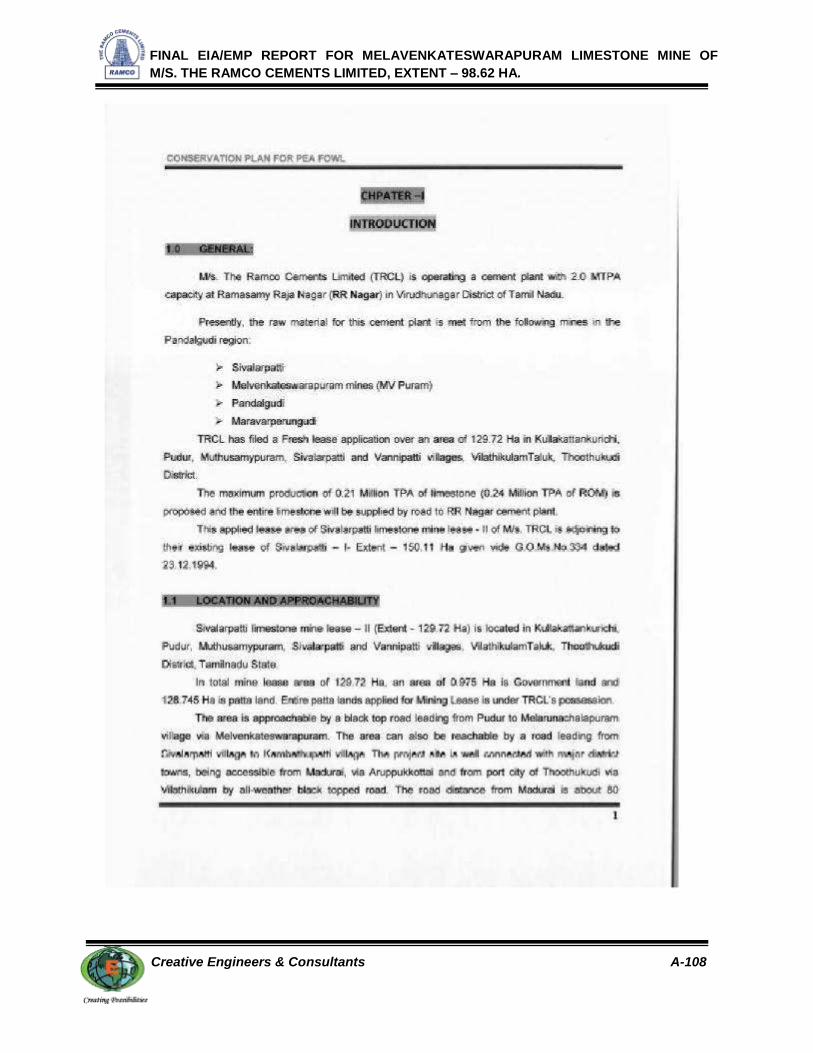
FINAL EIA/EMP REPORT FOR MELAVENKATESWARAPURAM LIMESTONE MINE OF
M/S. THE RAMCO CEMENTS LIMITED, EXTENT – 98.62 HA.
Creative Engineers & Consultants A-108

FINAL EIA/EMP REPORT FOR MELAVENKATESWARAPURAM LIMESTONE MINE OF
M/S. THE RAMCO CEMENTS LIMITED, EXTENT – 98.62 HA.
Creative Engineers & Consultants A-109

FINAL EIA/EMP REPORT FOR MELAVENKATESWARAPURAM LIMESTONE MINE OF
M/S. THE RAMCO CEMENTS LIMITED, EXTENT – 98.62 HA.
Creative Engineers & Consultants A-110

FINAL EIA/EMP REPORT FOR MELAVENKATESWARAPURAM LIMESTONE MINE OF
M/S. THE RAMCO CEMENTS LIMITED, EXTENT – 98.62 HA.
Creative Engineers & Consultants A-111

FINAL EIA/EMP REPORT FOR MELAVENKATESWARAPURAM LIMESTONE MINE OF
M/S. THE RAMCO CEMENTS LIMITED, EXTENT – 98.62 HA.
Creative Engineers & Consultants A-112

FINAL EIA/EMP REPORT FOR MELAVENKATESWARAPURAM LIMESTONE MINE OF
M/S. THE RAMCO CEMENTS LIMITED, EXTENT – 98.62 HA.
Creative Engineers & Consultants A-113

FINAL EIA/EMP REPORT FOR MELAVENKATESWARAPURAM LIMESTONE MINE OF
M/S. THE RAMCO CEMENTS LIMITED, EXTENT – 98.62 HA.
Creative Engineers & Consultants A-114

FINAL EIA/EMP REPORT FOR MELAVENKATESWARAPURAM LIMESTONE MINE OF
M/S. THE RAMCO CEMENTS LIMITED, EXTENT – 98.62 HA.
Creative Engineers & Consultants A-115

FINAL EIA/EMP REPORT FOR MELAVENKATESWARAPURAM LIMESTONE MINE OF
M/S. THE RAMCO CEMENTS LIMITED, EXTENT – 98.62 HA.
Creative Engineers & Consultants A-116

FINAL EIA/EMP REPORT FOR MELAVENKATESWARAPURAM LIMESTONE MINE OF
M/S. THE RAMCO CEMENTS LIMITED, EXTENT – 98.62 HA.
Creative Engineers & Consultants A-117

FINAL EIA/EMP REPORT FOR MELAVENKATESWARAPURAM LIMESTONE MINE OF
M/S. THE RAMCO CEMENTS LIMITED, EXTENT – 98.62 HA.
Creative Engineers & Consultants A-118

FINAL EIA/EMP REPORT FOR MELAVENKATESWARAPURAM LIMESTONE MINE OF
M/S. THE RAMCO CEMENTS LIMITED, EXTENT – 98.62 HA.
Creative Engineers & Consultants A-119

FINAL EIA/EMP REPORT FOR MELAVENKATESWARAPURAM LIMESTONE MINE OF
M/S. THE RAMCO CEMENTS LIMITED, EXTENT – 98.62 HA.
Creative Engineers & Consultants A-120

FINAL EIA/EMP REPORT FOR MELAVENKATESWARAPURAM LIMESTONE MINE OF
M/S. THE RAMCO CEMENTS LIMITED, EXTENT – 98.62 HA.
Creative Engineers & Consultants A-121

FINAL EIA/EMP REPORT FOR MELAVENKATESWARAPURAM LIMESTONE MINE OF
M/S. THE RAMCO CEMENTS LIMITED, EXTENT – 98.62 HA.
Creative Engineers & Consultants A-122

FINAL EIA/EMP REPORT FOR MELAVENKATESWARAPURAM LIMESTONE MINE OF
M/S. THE RAMCO CEMENTS LIMITED, EXTENT – 98.62 HA.
Creative Engineers & Consultants A-123

FINAL EIA/EMP REPORT FOR MELAVENKATESWARAPURAM LIMESTONE MINE OF
M/S. THE RAMCO CEMENTS LIMITED, EXTENT – 98.62 HA.
Creative Engineers & Consultants A-124

FINAL EIA/EMP REPORT FOR MELAVENKATESWARAPURAM LIMESTONE MINE OF
M/S. THE RAMCO CEMENTS LIMITED, EXTENT – 98.62 HA.
Creative Engineers & Consultants A-125

FINAL EIA/EMP REPORT FOR MELAVENKATESWARAPURAM LIMESTONE MINE OF
M/S. THE RAMCO CEMENTS LIMITED, EXTENT – 98.62 HA.
Creative Engineers & Consultants A-126
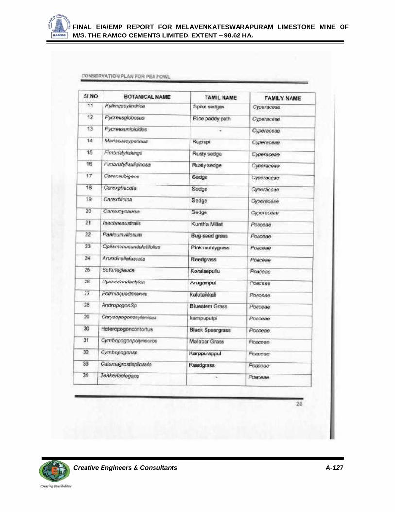
FINAL EIA/EMP REPORT FOR MELAVENKATESWARAPURAM LIMESTONE MINE OF
M/S. THE RAMCO CEMENTS LIMITED, EXTENT – 98.62 HA.
Creative Engineers & Consultants A-127

FINAL EIA/EMP REPORT FOR MELAVENKATESWARAPURAM LIMESTONE MINE OF
M/S. THE RAMCO CEMENTS LIMITED, EXTENT – 98.62 HA.
Creative Engineers & Consultants A-128

FINAL EIA/EMP REPORT FOR MELAVENKATESWARAPURAM LIMESTONE MINE OF
M/S. THE RAMCO CEMENTS LIMITED, EXTENT – 98.62 HA.
Creative Engineers & Consultants A-129

FINAL EIA/EMP REPORT FOR MELAVENKATESWARAPURAM LIMESTONE MINE OF
M/S. THE RAMCO CEMENTS LIMITED, EXTENT – 98.62 HA.
Creative Engineers & Consultants A-130

FINAL EIA/EMP REPORT FOR MELAVENKATESWARAPURAM LIMESTONE MINE OF
M/S. THE RAMCO CEMENTS LIMITED, EXTENT – 98.62 HA.
Creative Engineers & Consultants A-131

FINAL EIA/EMP REPORT FOR MELAVENKATESWARAPURAM LIMESTONE MINE OF
M/S. THE RAMCO CEMENTS LIMITED, EXTENT – 98.62 HA.
Creative Engineers & Consultants A-132

FINAL EIA/EMP REPORT FOR MELAVENKATESWARAPURAM LIMESTONE MINE OF
M/S. THE RAMCO CEMENTS LIMITED, EXTENT – 98.62 HA.
Creative Engineers & Consultants A-133

FINAL EIA/EMP REPORT FOR MELAVENKATESWARAPURAM LIMESTONE MINE OF
M/S. THE RAMCO CEMENTS LIMITED, EXTENT – 98.62 HA.
Creative Engineers & Consultants A-134

FINAL EIA/EMP REPORT FOR MELAVENKATESWARAPURAM LIMESTONE MINE OF
M/S. THE RAMCO CEMENTS LIMITED, EXTENT – 98.62 HA.
Creative Engineers & Consultants A-135

FINAL EIA/EMP REPORT FOR MELAVENKATESWARAPURAM LIMESTONE MINE OF
M/S. THE RAMCO CEMENTS LIMITED, EXTENT – 98.62 HA.
Creative Engineers & Consultants A-136

FINAL EIA/EMP REPORT FOR MELAVENKATESWARAPURAM LIMESTONE MINE OF
M/S. THE RAMCO CEMENTS LIMITED, EXTENT – 98.62 HA.
Creative Engineers & Consultants A-137

FINAL EIA/EMP REPORT FOR MELAVENKATESWARAPURAM LIMESTONE MINE OF
M/S. THE RAMCO CEMENTS LIMITED, EXTENT – 98.62 HA.
Creative Engineers & Consultants A-138

FINAL EIA/EMP REPORT FOR MELAVENKATESWARAPURAM LIMESTONE MINE OF
M/S. THE RAMCO CEMENTS LIMITED, EXTENT – 98.62 HA.
Creative Engineers & Consultants A-139

FINAL EIA/EMP REPORT FOR MELAVENKATESWARAPURAM LIMESTONE MINE OF
M/S. THE RAMCO CEMENTS LIMITED, EXTENT – 98.62 HA.
Creative Engineers & Consultants A-140

FINAL EIA/EMP REPORT FOR MELAVENKATESWARAPURAM LIMESTONE MINE OF
M/S. THE RAMCO CEMENTS LIMITED, EXTENT – 98.62 HA.
Creative Engineers & Consultants A-141

FINAL EIA/EMP REPORT FOR MELAVENKATESWARAPURAM LIMESTONE MINE OF
M/S. THE RAMCO CEMENTS LIMITED, EXTENT – 98.62 HA.
Creative Engineers & Consultants A-142

FINAL EIA/EMP REPORT FOR MELAVENKATESWARAPURAM LIMESTONE MINE OF
M/S. THE RAMCO CEMENTS LIMITED, EXTENT – 98.62 HA.
Creative Engineers & Consultants A-143

FINAL EIA/EMP REPORT FOR MELAVENKATESWARAPURAM LIMESTONE MINE OF
M/S. THE RAMCO CEMENTS LIMITED, EXTENT – 98.62 HA.
Creative Engineers & Consultants A-144
Related Documents