ESKOM TRANSMISSION PROPOSED ARIADNE - EROS 400 KV/132 KV MULTI-CIRCUIT TRANSMISSION LINE ENVIRONMENTAL AUTHORISATION (EIA: 12/12/20/1272 AND 12/12/20/1277) DRAFT SCOPING REPORT 46 Figure 15 Map showing areas of potential collisions of birds with the proposed power lines as well as crane nesting and flocking sites (EWT, 2009)

Welcome message from author
This document is posted to help you gain knowledge. Please leave a comment to let me know what you think about it! Share it to your friends and learn new things together.
Transcript

ESKOM TRANSMISSION PROPOSED ARIADNE - EROS 400 KV/132 KV MULTI-CIRCUIT TRANSMISSION LINE
ENVIRONMENTAL AUTHORISATION (EIA: 12/12/20/1272 AND 12/12/20/1277) DRAFT SCOPING REPORT
46
Figure 15 Map showing areas of potential collisions of birds with the proposed power lines as well as crane nesting and flocking sites (EWT, 2009)
ESKOM TRANSMISSION PROPOSED ARIADNE - EROS 400 KV/132 KV MULTI-CIRCUIT TRANSMISSION LINE
ENVIRONMENTAL AUTHORISATION (EIA: 12/12/20/1272 AND 12/12/20/1277) DRAFT SCOPING REPORT
47
5.3.2 Upgrading existing transmission lines The upgrading of the existing inland Ariadne-Eros 400 kV transmission power line was considered by Eskom Transmission. However, this option would not address the need and purpose of the project. The added benefit of building a new transmission coastal power line is the establishment of a closed circuit, therefore improving the reliability of electricity supply. In addition, by making the proposed new line a multi-circuit line, Eskom is able to better serve its distribution needs. With respect to upgrading other existing power lines, larger towers would be required, as existing towers would not be tall or strong enough to carry larger conductors carrying a higher voltage. Added to this is the complication associated with the temporary decommissioning of a power line for a significant period of time to carry out the upgrade. The supply/demand scenario for the KZN region is such that all existing lines are needed at any one time to meet the current power needs. The upgrade of existing lines is not seen as optimising existing infrastructure. However, Eskom cannot continue to erect lines, acquire servitudes and visually scar the landscape. In time, when the KZN Strengthening Project has been completed and there is sufficient capacity in the system, it may be possible to decommission some older and smaller lines with a view to using these now vacant servitudes for new and larger lines into the future.
5.4 Micro alternatives
5.4.1 Tower positions
Towers are placed between 300-500 m apart. This enables the micro-positioning of towers along the transmission line, and enables Eskom to avoid environmentally sensitive sites, infrastructure, and the like. Micro-positioning usually occurs following the completion of the EIA and after the issue of the Environmental Authorisation, and forms part of the negotiation process between Eskom and affected landowners. Specialist input (for example, cultural heritage, botanical, wetland and avi-fauna) is obtained where required to minimise environmental impacts.
5.4.2 Tower types
The amount of steel and the footprint requirements on a tower varies depending on the choice of tower (Section 2.3.2). Towers with less steel are less visible at a distance. With regards to footprint requirements, a Self-supporting/Strain tower will require a larger working area as compared to a Guyed V tower.
This option will not be considered further in this EIA, but will continue to be considered as part of the overall KZN Strengthening Project.
Micro-positioning will continue to receive attention in this EIA for the purpose of identifying environmentally sensitive sites.

ESKOM TRANSMISSION PROPOSED ARIADNE - EROS 400 KV/132 KV MULTI-CIRCUIT TRANSMISSION LINE
ENVIRONMENTAL AUTHORISATION (EIA: 12/12/20/1272 AND 12/12/20/1277) DRAFT SCOPING REPORT
48
This EIA will comprehensively consider the effects of the different tower types with the view to minimising negative impacts on the environment, particularly in visually sensitive areas (such as areas near conservation areas and areas of scenic beauty) and ecologically sensitive areas (such wilderness and natural forest areas).
5.4.3 Construction camp locations The number of construction camps that will be required will be a factor of the number of contractors appointed to construct the transmission line. This will be determined by the actual amount of time that Eskom has available to construct the line. This EIA will attempt to identify suitable sites for the siting of construction camps, with a focus on using existing facilities and previously disturbed areas.
The consideration of different tower types will continue to receive attention in this EIA.
To the extent that suitable construction camp sites will be identified during the EIA, these issues will continue to receive attention in this EIA.

ESKOM TRANSMISSION PROPOSED ARIADNE - EROS 400 KV/132 KV MULTI-CIRCUIT TRANSMISSION LINE
ENVIRONMENTAL AUTHORISATION (EIA: 12/12/20/1272 AND 12/12/20/1277) DRAFT SCOPING REPORT
49
6. DESCRIPTION OF THE RECEIVING ENVIRONMENT
6.1 Introduction This chapter provides a description of the key characteristics of the physical, biological, social, economic and cultural aspects of the potentially affected area. The study area has been defined as a broad development corridor within which three main alternatives, five minor alternatives and four 132 kV substation connection alternatives have been identified for the proposed transmission line from the Ariadne Substation to the Eros Substation. For this project, the study area has been defined as the development corridor and its immediate surrounds, as well as the broader district and local municipal areas.
6.2 Location of the study area The broader study area is located in the southern part of KZN and extends from near Pietermaritzburg (Ariadne substation) in a south-easterly direction to Port Shepstone (Oribi Substation) and then westerly to Harding (Eros substation). It falls within two district municipalities, uMgungundlovu District Municipality (DC22) and Ugu District Municipality (DC21). Within these district municipalities, a number of local municipalities are affected by the proposed development (Figure 16): Within the uMgungundlovu District Municipality: Richmond Local Municipality (KZ227). Mkhambathini Local Municipality (KZ226).
Within the Ugu District Municipality: Vulamehlo Local Municipality (KZ211). uMdoni Local Municipality (KZ212). uMzumbe Local Municipality (KZ213). uMuziwabantu Local Municipality (KZ214). Ezingolweni Local Municipality (KZ215). Hibiscus Coast Local Municipality (KZ216).
6.3 The Biophysical Environment
6.3.1 Terrain, Geology and Soils The terrain morphology within the development corridor is typical for KwaZulu-Natal, in that it is diverse and varied. The Drakensberg mountain range inland and to the west has a multitude of rivers that drain from its watershed into river catchments that follow an easterly course dissecting the corridor and emptying into the Indian Ocean on the KZN South Coast. The river catchments dominate the landscape creating a terrain of closed hills and mountains, with a moderate to high relief, deep valleys and hilltop plains with a moderate relief. It is further characterised by extensive river gorges and hilly areas, for example, the Oribi Gorge in the south of the development corridor.

ESKOM TRANSMISSION PROPOSED ARIADNE - EROS 400 KV/132 KV MULTI-CIRCUIT TRANSMISSION LINE
ENVIRONMENTAL AUTHORISATION (EIA: 12/12/20/1272 AND 12/12/20/1277) DRAFT SCOPING REPORT
50
Figure 16 Local and district municipalities that comprise the study area

ESKOM TRANSMISSION PROPOSED ARIADNE - EROS 400 KV/132 KV MULTI-CIRCUIT TRANSMISSION LINE
ENVIRONMENTAL AUTHORISATION (EIA: 12/12/20/1272 AND 12/12/20/1277) DRAFT SCOPING REPORT
51
The geology of the study area is equally diverse and influences the topography and scenery of the area (Figure 17). From a provincial perspective, the geological foundation comprises two distinct geological units: the Kaapvaal Craton (a composition of early granite greenstone terrains, older gneisses and granitic plutons) and the Natal Metamorphic Group (deep mountain roots of granite and gneiss). The latter gives rise to impressive folded rock forms as is found in the Oribi Gorge. The following groups overlay the aforementioned geological foundation: The Natal Group (sandstone). The Dywka Group (tillite rocks). The Ecca Group (shale and sandstones).
Major soil forms within the study area are the Glenrosa, which occurs near the coastline (Port Shepstone-Amanzimtoti) and in the hinterland zones (reaching towns of Kokstad in the south and Eston in the north), and Pinedene, which occurs in continuous bands in the hinterland zone (Figure 18).
6.3.2 Climate A temperate, sub-tropical climate with warm temperatures and summer rainfall is typical of this region. Summers are hot and humid with an average temperature of 20-30o C and regular rain showers (MAP – 500 to 1,000 mm). Winters are milder and drier with an average temperature of 12-24 o C. The more inland sections of the study area towards Ariadne (Pietermaritzburg) and Eros (Harding) experience lower winter temperatures due to increased altitude and greater distance from the coast. Frost and occasional light snowfalls are regular in the winter months. Snowfalls in the Harding area have on occasion been severe and could affect the transmission lines and supportive infrastructure. Lightning storms are frequent in the summer months, particularly in the Ariadne (Pietermaritzburg) area, but generally occur throughout the study area.
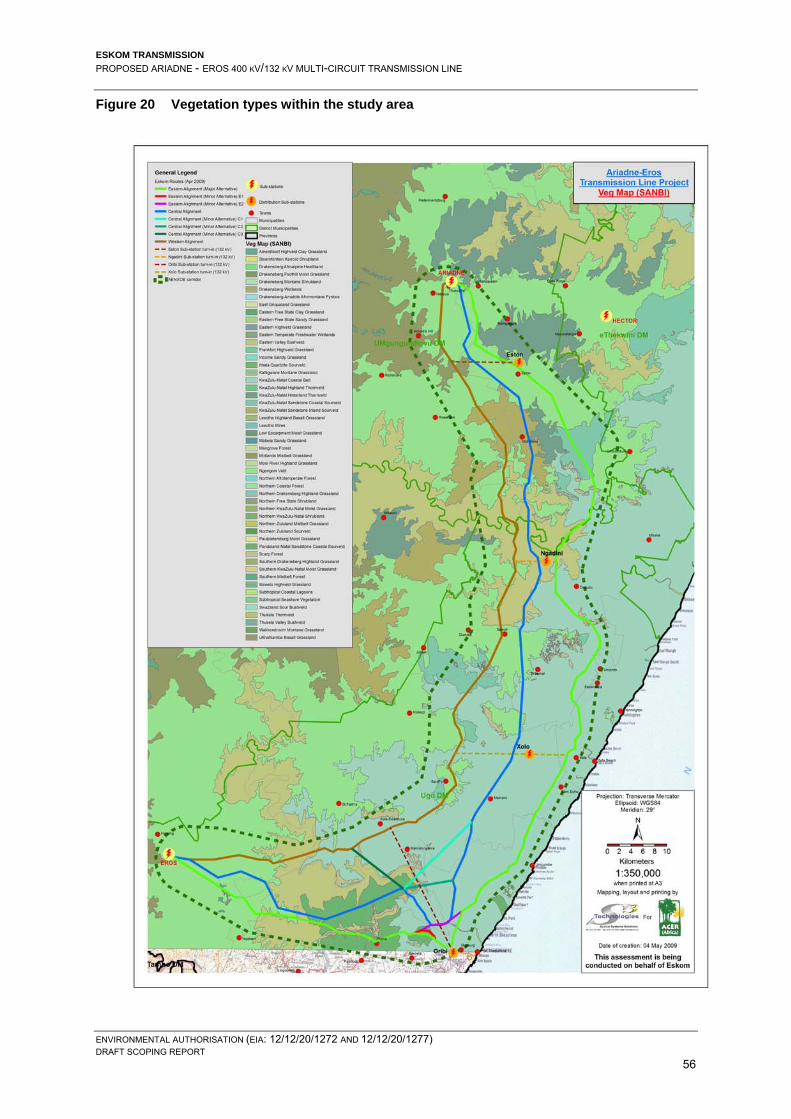
6.3.3 Flora The study area is rich in biodiversity, with numerous different ecosystems, habitat types and topographical features. Mucina and Rutherford (2006) provide a classification of the vegetation occurring in the study area. Table 6 provides a list of vegetation units and types including the conservation status thereof.

ESKOM TRANSMISSION PROPOSED ARIADNE - EROS 400 KV/132 KV MULTI-CIRCUIT TRANSMISSION LINE
ENVIRONMENTAL AUTHORISATION (EIA: 12/12/20/1272 AND 12/12/20/1277) DRAFT SCOPING REPORT
52
Figure 17 Geology of the study area

ESKOM TRANSMISSION PROPOSED ARIADNE - EROS 400 KV/132 KV MULTI-CIRCUIT TRANSMISSION LINE
ENVIRONMENTAL AUTHORISATION (EIA: 12/12/20/1272 AND 12/12/20/1277) DRAFT SCOPING REPORT
53
Figure 18 Soils within the study area

ESKOM TRANSMISSION PROPOSED ARIADNE - EROS 400 KV/132 KV MULTI-CIRCUIT TRANSMISSION LINE
ENVIRONMENTAL AUTHORISATION (EIA: 12/12/20/1272 AND 12/12/20/1277) DRAFT SCOPING REPORT
54
Table 6 List of the vegetation types that occur within the study area
Bioregion Name Vegetation Type Conservation Status Sub-Escarpment Grassland Midlands Mistbelt Grassland Endangered
Ngongoni Veld Vulnerable Southern Mistbelt Forest Vulnerable Eastern Valley Bushveld Least Threatened KwaZulu-Natal Sandstone Sourveld Endangered
Sub-Escarpment Savanna
KwaZulu-Natal Hinterland Thornveld Vulnerable KwaZulu-Natal Coastal Belt Endangered Indian Ocean Coastal Belt Pondoland-Ugu Sandstone Coastal Sourveld Vulnerable
Zonal & Intrazonal Forests
Scarp Forest
Least threatened in protected areas, but exposed to over-exploitation elsewhere.
Figures 19 and 20 show the Bioregions and Vegetation Types within the study area, respectively.
6.3.4 Conservation areas, fauna and avifauna
The study area comprises areas of conservation-worthy and biologically diverse ecosystems, which are made up of both protected and unprotected areas: provincial nature reserves (Figure 21), indigenous forest areas, grasslands, and private game reserves. A number of conservancies are also functional within the area. A diversity of birdlife (recorded bird species are in the hundreds) and wildlife (predominantly in the protected areas) is found in the study area. The South Coast region is a regular destination for birdwatchers. There are two protected nature reserves within the study area, which are administered by Ezemvelo KZN Wildlife. The largest and most prominent is the Oribi Gorge Nature Reserve, which is located near Port Shepstone within the Hibiscus Coast Municipality. The reserve encompasses scarp forests, rivers and narrow valleys. High sandstone cliffs dominate the gorge carved out by the Umzimkulu River. The reserve is home to a number of species including: leopards, common reedbuck, oribi, blue duiker, grey duiker, baboons, birdlife (including five species of kingfisher and seven species of eagle) and various small antelope. Cape Vultures (endemic and vulnerable) nest on the sandstone cliffs and are extremely prone to collisions with transmission lines. The Oribi Gorge and its surrounding areas have been flagged as having high sensitivity regarding avi-faunal activity.

ESKOM TRANSMISSION PROPOSED ARIADNE - EROS 400 KV/132 KV MULTI-CIRCUIT TRANSMISSION LINE
ENVIRONMENTAL AUTHORISATION (EIA: 12/12/20/1272 AND 12/12/20/1277) DRAFT SCOPING REPORT
55
Figure 19 Bioregions within the study area
ESKOM TRANSMISSION PROPOSED ARIADNE - EROS 400 KV/132 KV MULTI-CIRCUIT TRANSMISSION LINE
ENVIRONMENTAL AUTHORISATION (EIA: 12/12/20/1272 AND 12/12/20/1277) DRAFT SCOPING REPORT
56
Figure 20 Vegetation types within the study area

ESKOM TRANSMISSION PROPOSED ARIADNE - EROS 400 KV/132 KV MULTI-CIRCUIT TRANSMISSION LINE
ENVIRONMENTAL AUTHORISATION (EIA: 12/12/20/1272 AND 12/12/20/1277) DRAFT SCOPING REPORT
57
Figure 21 Conservation areas within the study area

ESKOM TRANSMISSION PROPOSED ARIADNE - EROS 400 KV/132 KV MULTI-CIRCUIT TRANSMISSION LINE
ENVIRONMENTAL AUTHORISATION (EIA: 12/12/20/1272 AND 12/12/20/1277) DRAFT SCOPING REPORT
58
Vernon Crookes Nature Reserve, a smaller reserve, is located near uMzinto within the Vulamehlo Municipality. The reserve encompasses open grassland (Ngongoni Veld and KZN Coastal Belt), rolling hills, small pockets of scarp forest and ocean views. It is home to a range of wildlife including zebra, blue wildebeest, bushbuck, blesbok, oribi, reedbuck, blue and grey duiker, black-backed jackal, vervet monkeys, rock hyrax, tree hyrax, caracal, slender mongoose, white tailed mongoose, Egyptian mongoose, banded mongoose and porcupine, and an abundance of birdlife. The latter includes raptors such as the Crowned and Martial Eagle. This area is a high sensitivity zone regarding avi-faunal activity. The Eros Substation falls within an area where the rare Blue Swallow has its habitat and, thus, this region is classed as having medium to high sensitivity. The turn-in from the transmission line has to feed into the Eros Substation and it is inevitable that this habitat will be disturbed. Figure 15 highlights the areas of potential collision of birds with the proposed power lines, as well as crane nesting and flocking sites, as identified from existing EWT data. Further investigation of the flora and fauna that occur in the area will be required during the EIA Phase.
6.3.5 Hydrology The study area falls within two key KZN catchments, viz. the uMzimkulu and Mkhomazi catchments. Medium sized catchments include (from south to north), IlLovo and Umlazi, and smaller catchments include Mzumbe, Mtwalume, Ifafa and Mpambanyoni. The catchments drain in an east to south-easterly direction and empty into the Indian Ocean. The surface hydrology (Figure 22) is characterised by different river types, from large, perennial rivers that rise from the Drakensberg (uMzimkulu and Mkhomazi Rivers) to medium-sized rivers found in the hinterland area (Illovo and uMlazi Rivers), to several coastal, sandy rivers. The larger perennial rivers have a range of perennial and non-perennial rivers and streams that feed into them. The non-perennial streams usually dry up in the drier winter months. The overall gradient of the rivers in KZN is generally steep and this increases the erosion potential of these rivers. The rugged landscape in the study area is largely a result of river/water erosion. A diversity of flora species is supported and sustained by these riverine environments. They also provide habitat and migratory corridors for a number of faunal species. Of importance economically, is that these rivers also sustain agriculture and industry in the area.

ESKOM TRANSMISSION PROPOSED ARIADNE - EROS 400 KV/132 KV MULTI-CIRCUIT TRANSMISSION LINE
ENVIRONMENTAL AUTHORISATION (EIA: 12/12/20/1272 AND 12/12/20/1277) DRAFT SCOPING REPORT
59
Figure 22 Map of the study area showing major rivers within the study area

ESKOM TRANSMISSION PROPOSED ARIADNE - EROS 400 KV/132 KV MULTI-CIRCUIT TRANSMISSION LINE
ENVIRONMENTAL AUTHORISATION (EIA: 12/12/20/1272 AND 12/12/20/1277) DRAFT SCOPING REPORT
60
6.3.6 Cultural heritage resources Heritage KwaZulu Natal (Amafa aKwaZulu-Natali) is the provincial heritage authority for KwaZulu Natal, including archaeological resources. In terms of the National Heritage Resources Act, 1999 (Act No 25 of 1999), Heritage KwaZulu Natal has a mandate to protect these resources acting as the provincial heritage management organisation. Section 38(1) of the National Heritage Resources Act indicates that a Heritage Impact Assessment is required in the case of the following: Construction of a road, power line, pipeline, canal or other similar form of linear
development or barrier exceeding 300 m in length. Within the study area, it is unknown what surveys of archaeological sites or research projects have been undertaken. Only one site is known in the vicinity of the study area, viz. the Ndongeni Ka Xoki's Grave on the farm Ndongeni, near the convergence of the uMzimkhulu and uMzimkhulwana rivers. Ndongeni accompanied Dick King on his famous ride in 1842, as far as Mgazi in Pondoland. Ndongeni was given a farm here after the event. It is also believed that King Shaka passed through this area en route to the Eastern Cape. Also noteworthy is the town of Port Shepstone that was founded in 1867. Up until the 1900s, Port Shepstone was a busy port handling sugar, lime and marble. However, with the completion of the South Coast Railway, which linked Port Shepstone with Durban, in 1901 the use of the port fell away. Further research will be undertaken into the cultural heritage resources of the study area during the Impact Assessment Phase of the EIA.
6.4 Social environment
6.4.1 Infrastructure TRANSPORT The transport infrastructure network within the study area comprises road, rail and air, allowing for generally good access and the mobility of goods and people. Within the greater area the national roads (N2 coastal road and N3 (Durban – Pietermaritzburg)) create a good link between the Ariadne and Eros Substations. Within the study area the main roads, namely the R56, R102, R612, R624 and various secondary roads allow access to large parts of the area. However, the inland road system is still at a level where most secondary roads are gravel and impassable in the wet season. Within the Mkomazi and Mzimkulu Valley areas, roads are generally built on ridges/spurs and along the main river courses. A rail line runs from Durban to Port Shepstone and from Port Shepstone to Harding. There is an international airport in Durban and a light aircraft airport south of Port Shepstone in Margate.
ELECTRICITY There is a demand and need for electricity on the south coast of KZN. Within the Ugu DM alone there are approximately 134,461 households of which 99,608 are not electrified. Coverage of the Ugu DM sits at approximately 58% with the Umdoni LM receiving 94% coverage while the more dispersed and larger Umzumbe LM receives only 36% coverage. This is typical and to be expected as most development, commerce, industry and tourism activities are located along the coastal strip (Ugu, Electricity Sector Development Plan, 2004).

ESKOM TRANSMISSION PROPOSED ARIADNE - EROS 400 KV/132 KV MULTI-CIRCUIT TRANSMISSION LINE
ENVIRONMENTAL AUTHORISATION (EIA: 12/12/20/1272 AND 12/12/20/1277) DRAFT SCOPING REPORT
61
Increased electricity supply to the area will be a catalyst for local economic development through opportunities that will be created when low cost, clean and reliable electrical energy is made accessible for people in the rural areas. Computers (internet), radios, television and telephones are mediums that will have a profound impact on the development of opportunities for people in the rural areas. Establishing electrical supplies to schools will not only create opportunities for the education department to establish modern teaching mediums for children but also create a more comfortable and improved learning environment. Electricity is a cheap and reliable energy source well suited to driving electric pumps on water schemes. Access to electricity will enable the water authorities to establish reliable running water schemes, which will greatly improve the quality of life and improve health conditions for the people in rural areas. Establishing electrical supplies to clinics will create opportunities for the medical authorities to install more sophisticated medical equipment thereby improving the quality of medical care (Ugu, Electricity Sector Development Plan, 2004). POTABLE WATER In general, coastal areas have a higher level of service provision when compared to inland rural areas. Potable water originates from dams, rivers, ground water and bulk purchases, which is then distributed to consumers (landowners, local residents, business and industry) via bulk and household connections and communal stand taps. The latter is found mainly in the inland rural areas.
6.4.2 Land use and settlements Land use and settlements within the study area are varied and will influence the ultimate route that the transmission line will follow. During an aerial survey of the study area, photographs were taken of the general study area corridor. These provide a good representation of land use throughout the study area. In describing the study area corridor, reference is made to these plates/photographs (Appendix 4). Starting at the Ariadne Substation (Plates 1-17) and heading south-east towards Mid-Illovo, the study area corridor comprises smallholdings that are close together, making it difficult to find a passage through them. The study area corridor then covers intensive commercial agricultural lands, where sugar cane and timber farms/forestry dominate, including the small town of Eston (Plate 10) and its sugar mill. Continuing (Plates 11-17) the study area corridor comprises intensive sugar cane lands.
Thereafter, the study area corridor passes through communal land held in trust by the Ingonyama Trust Board (Plates 18-35) where scattered homesteads, comprising residential houses with stock pens, granaries, subsistence farming (mostly maize, vegetables and in some cases sugar cane), bananas, and grazing land are dispersed over the rugged hilly landscape. The study area corridor then passes over the Mkomazi River (Plate 31), which has no noteworthy developments and is largely rural and well vegetated. Heading out of the Mkomazi Valley through the Mid-Illovo area towards Port Shepstone (Plate 33 – 51), the study area corridor comprises a mixture of communal land (Plate 37), where settlement nodes are around churches, missions and schools, and where there are homesteads scattered throughout the landscape. It will be difficult to acquire a servitude that does not impact on one or more homestead. This will require resettlement, the biggest challenge being the identification of resettlement land that does not have some or other land use right associated with it. As currently indicated, the potential transmission line routes avoid impacting on the Vernon Crookes Nature Reserve. Sugar cane plantations (Plate 44), commercial forestry (Plate 39) and banana plantations (Plate 45) make up the privately owned land use practices within the area
ESKOM TRANSMISSION PROPOSED ARIADNE - EROS 400 KV/132 KV MULTI-CIRCUIT TRANSMISSION LINE
ENVIRONMENTAL AUTHORISATION (EIA: 12/12/20/1272 AND 12/12/20/1277) DRAFT SCOPING REPORT
62
and developing a servitude through this area will impact on the individual landowners, especially in the case of forestry, where no trees can be grown within the servitude. Outside Port Shepstone (Plate 50), informal settlements make it difficult to get the 132 kV line into and out of Oribi Substation, again requiring resettlement. The formal town of Port Shepstone is also built up around the Oribi Substation (Plate 52). Thus, research with Eskom is necessary in order to locate registered servitudes that could potentially be used. From Port Shepstone, the study area corridor takes a westerly course (Plates 55-60), the exact alignment hinging on whether it by-passes the Oribi Gorge Nature Reserve to the north or skirts around it to the south. Apart from conservation and associated eco-tourism, land use in the area is a mixture of communal land (Plate 56), settlements (Plate 58) and commercial agriculture (Plate 60), predominantly sugar cane. The Oribi Flats to the south of Oribi Gorge are under intense sugar cane production. Oribi Gorge (Plate 62) is a deeply incised valley, and a notable conservation area and will, thus, need to be avoided as far as is practically possible. From west of Oribi Gorge, the study area corridor heads towards the Eros Substation near Harding (Plate 63-71). Land use varies from commercial sugar cane production (Plate 64), communal land, indigenous Scarp Forest and Eastern Valley Bushveld (Plate 66), betterment planning settlements (Plate 68) and intensive commercial forestry (Plate 70). Once again, the ultimate alignment of the transmission line will require investigations in order to minimise impacts on these land users.
6.4.3 Visual and aesthetics Much of the study area is managed for purposes of conservation, agriculture, forestry or is communal land devoid of any imposing infrastructure such as transmission lines. The natural landscapes of much of the study area are sensitive and important to preserve for their aesthetics. It is, thus, necessary to maintain a near natural visual landscape, with limited aesthetic affects, to enable the continuation of nature-based economic activities such as eco-tourism. In this regard, it is an imperative that Eskom be sensitive from a visual impact perspective, to the requirements of the local people, notably rural communities, farmers, conservationists and operators involved in eco-tourism activities. Many topographical features influence this environment and these features will need to be utilised when selecting an alignment so as to minimise visual impacts and intrusions.
6.4.4 HIV/AIDS pandemic The HIV/AIDS pandemic in South Africa is likely to have profound negative, long-term impacts on the socio-economic environment. In 2006, statistics showed that approximately 18.34% of the country’s population between the ages of 15 and 49 years, and 10.8% of the South African population over the age of 2, is living with HIV (www.avert.org/safricastats.htm). It has been reported that KZN and Gauteng are the regions most affected by the AIDS pandemic. This is partly due to high rates of urbanisation and high mobility among the residents in these provinces (Amajuba District Municipality, 2002). It has been reported that in KZN, 39.1% of pregnant women are living with HIV, the highest rate out of all nine provinces in South Africa (www.avert.org/safricastats.htm).

ESKOM TRANSMISSION PROPOSED ARIADNE - EROS 400 KV/132 KV MULTI-CIRCUIT TRANSMISSION LINE
ENVIRONMENTAL AUTHORISATION (EIA: 12/12/20/1272 AND 12/12/20/1277) DRAFT SCOPING REPORT
63
The pandemic is also likely to cause a slowing of the population growth rate in municipal areas (Indaka Local Municipality, IDP) and alter the demographic profile of municipalities. Women are particularly susceptible to the HIV/AIDS epidemic and the burden of AIDS related illnesses and deaths would be felt not only by infected individuals but also their families. Households will suffer a loss of income when economically active family members are unable to work. It is anticipated that the HIV/AIDS pandemic will affect medium and long-term development planning at a district and local municipal level in all municipalities. The HIV/AIDS pandemic will, therefore, affect infrastructure planning by reducing the projected number of people for which infrastructure will be required. Consideration must be given to the impacts of HIV/AIDS on the ability of households to pay for services and the potential increase in demand for health care facilities and social services. Within the communal areas for this proposed project, it would appear that some homesteads are abandoned or are being headed by the youth or elderly as a result of HIV/AIDs causing deaths or terminal illness of the middle age groups and young adults. These elderly or young people are vulnerable and, in light of this, could make any resettlement processes complicated. Further investigation into this sad and difficult reality of this scenario is required in the EIA phase of this study.
6.4.5 Economic profile and tourism ECONOMIC PROFILE The study area is characterised by a dual space economy with an urbanised coastal zone with large commercial farms (sugar cane, banana and forestry) and a largely impoverished rural hinterland with small-scale and subsistence farmers. In the Ugu District Municipality, the biggest contributors to the district economy are: Tourism-related trade, catering and accommodation services (16.1%). Manufacturing (15.4%). Finance and business services (15.6%). General government services (14.8%). Agriculture (12.5%). Transport and communication (8.5%). Community, social and other personal services (8.4%).
(Ugu District Municipality: 2008/09 Integrated Development Plan Review) The smallest contributors to the district economy include mining (1.5%), utilities (electricity and water) (4.4%) and construction (2.6%). In the uMgungundlovu District Municipality, particularly in the Richmond and Mkhambathini Local Municipalities, commercial agriculture and manufacturing dominate the economic sector. Agriculture, particularly large-scale sugar cane cultivation, dominate the landscape and is also the largest employer in these municipalities. Commercial afforestation is also a large contributor to the agricultural sector. Manufacturing activities, which are mainly located in main towns (Richmond and Camperdown), comprise of light industry and agri-processing such as the Sugar Mill in Eston.

ESKOM TRANSMISSION PROPOSED ARIADNE - EROS 400 KV/132 KV MULTI-CIRCUIT TRANSMISSION LINE
ENVIRONMENTAL AUTHORISATION (EIA: 12/12/20/1272 AND 12/12/20/1277) DRAFT SCOPING REPORT
64
The increase in electricity availability in the southern region of KZN will undoubtedly be advantageous to the overall economy of the region, however, with this increased electricity supply, comes the potential negative impact on primary sectors on the economy (commercial and subsistence agriculture), secondary (manufacturing) and tertiary (services) sectors. These aspects will be considered in detail in this EIA. TOURISM A combination of environmental attributes contribute to a thriving tourism industry within the study area, from rolling hills in the hinterland that offer tranquil and scenic country drives, to sandy coastal rivers, and the beaches and warm coastal waters of the Indian Ocean. . The South Coast offers a variety of activities for the tourist, ranging from urban based entertainment, various beach and marine based activities, and extreme sports, to more relaxed activities such as sight-seeing. A number of tourist facilities (hotels and resorts) offer amenities such as golfing, game viewing and hiking. Again, the increase in electricity availability to the South Coast will undoubtedly be advantageous to the tourism industry. However, with this increased electricity supply, comes the potential visual intrusion of the transmission line infrastructure. Depending on the final alignment, the visual impact could be intrusive. The coastal area is a corridor of tourism developments that prefer unspoilt scenery. If the transmission line were to take the eastern alignment (for a part or the whole alignment), it is likely that it would be visible from the coast even though it will be no less than 4 km away from the coast at any time.
6.5 Institutional environment A range of formal institutions are found within the study areas including conservation organisations, tourism organisations, residents’ associations, farmers’ associations, industrial and business organisations, and traditional authorities. A select few of these are described below.
6.5.1 Ezemvelo KwaZulu-Natal Wildlife
Ezemvelo KwaZulu-Natal Wildlife (EKZNW) is a provincial conservation body that manages KZN’s natural resources. Their aim is to ensure effective management and sustainable use of KZN's biodiversity and protected areas, in collaboration with the community. Within the study area, there are two conservation areas managed by EKZNW, namely Oribi Gorge and Vernon Crookes Nature Reserves.
6.5.2 Farmers’ Associations
There are several farmers’ associations that fall within the study area. The membership of these organisations is comprised of farmers and its main function is to serve as a representative body, which looks after the interests of its members.

ESKOM TRANSMISSION PROPOSED ARIADNE - EROS 400 KV/132 KV MULTI-CIRCUIT TRANSMISSION LINE
ENVIRONMENTAL AUTHORISATION (EIA: 12/12/20/1272 AND 12/12/20/1277) DRAFT SCOPING REPORT
65
6.5.3 Endangered Wildlife Trust
The Endangered Wildlife Trust (EWT) is a non-profit organisation which works towards saving and protecting threatened species, their habitats and ecosystems, and the role of surrounding communities and landowners. The EWT fills the key niche of conservation action, through applied fieldwork, research, and direct engagement with stakeholders. Specialist Working Groups, such as the Crane Working Group, support the conservation of threatened species and ecosystems throughout Southern Africa. The priority focus is on identifying the key factors threatening biodiversity, and developing mitigating measures to reduce risks and reverse the drivers of species extinction and ecosystem degradation. Eskom has a close working relationship with the EWT in minimising the impact that transmission lines and associated infrastructure have on various endangered bird species, such as cranes and vultures.

ESKOM TRANSMISSION PROPOSED ARIADNE - EROS 400 KV/132 KV MULTI-CIRCUIT TRANSMISSION LINE
ENVIRONMENTAL AUTHORISATION (EIA: 12/12/20/1272 AND 12/12/20/1277) DRAFT SCOPING REPORT
66
7. ENVIRONMENTAL ISSUES, IMPACTS AND SPECIALIST STUDIES
7.1 Issues The key issues identified during Scoping have been formulated as ten questions: What economic and socio-economic benefits will the transmission line have (locally and
regionally)? What effects will the proposed transmission line have on existing residential settlements
and infrastructure including telecommunication structures? Will the transmission line result in the loss of use of productive agricultural land
(commercial and subsistence) and associated economic opportunities? How will the visual changes to the landscape affect the social and socio-economic
environment? Are the proposed route alignments compatible with town planning initiatives (Integrated
Development Plans, Spatial Development Plans and other initiatives)? What effects will the transmission line have on the natural environment (flora and fauna)
and natural areas worthy of protection and conservation? What effects will the transmission line have on avi-fauna (birds)? What effects will the transmission line have on cultural and heritage resources? What technical constraints will the biophysical environment place on the routing,
construction and operation of the transmission line? Can the transmission line be detrimental to the health and safety of local communities?
For each of the above issues, potential cumulative effects need to be identified, considered and assessed. These issues reflect the concerns and values of a range of different people, groups and organisations, special interest groups, private individuals, various authorities, Eskom and the EIA Team. It is important to note that, for some of the issues and associated potential impacts, it is not a given that potential impacts will actually occur. However, they need to be identified to inform decision-making and to enable the relevant parties to proactively address them should they occur. To investigate and understand the above key issues, consideration was given to a range of disciplines: Social and socio-economic. Settlement and infrastructure. Agriculture. Visual and aesthetics. Land use and town planning. Flora and fauna. Avifauna. Cultural and heritage resources. Technical aspects. Health, safety and security.

ESKOM TRANSMISSION PROPOSED ARIADNE - EROS 400 KV/132 KV MULTI-CIRCUIT TRANSMISSION LINE
ENVIRONMENTAL AUTHORISATION (EIA: 12/12/20/1272 AND 12/12/20/1277) DRAFT SCOPING REPORT
67
Through the integration of discipline-specific information (positive and negative aspects), the key issues are described below. Potential positive and negative impacts are discussed for each phase of the project. The nature of the activity is such that most impacts will be realised during construction. However, some of these impacts may extend into the operational phase, most significantly, visual and aesthetic effects, and the loss of use of productive agricultural land. For purposes of the DSR, issues and associated potential impacts are described but with no assessment of significance (this will be done during the Impact Assessment, once discipline-specific specialist studies have been completed).
7.2 What economic and socio-economic benefits will the transmission line have (locally and regionally)?
7.2.1 Reliability and quality of electricity supply Presently, the southern part of KZN receives bulk electricity supply via one 400 kV transmission line, which runs between the Ariadne (south of Pietermaritzburg) and Eros (near Harding) Substations, and on from Harding to East London. This line is vulnerable to over-usage and breakdowns. To improve reliability and overall power supplied, Eskom proposes to construct a second 400 kV transmission line running from Ariadne Substation to the vicinity of the Oribi Substation (in Port Shepstone) and on to the Eros Substation. This will create a circuit linking the existing 400 kV inland transmission line with a 400 kV coastal transmission line (Pietermaritzburg - Port Shepstone – Harding - Pietermaritzburg). In the case of a supply problem on one line, Eskom will be able to supply power via the other line and, thus, maintain electricity supply to affected areas. In addition, Eskom proposes to run a new 132 kV distribution line in the same servitude and on the same tower infrastructure to be used for the 400 kV line, between Ariadne and Oribi Substations. This will be used by Eskom Distribution to supply electricity to communities (in particular, rural communities) along the south coast and its hinterland who presently do not have electricity. En route, the 132 kV distribution line will also link with the existing 132 Eston kV Substation and the proposed new 132 kV Ngadini and Xolo Substations, thereby significantly enhancing electricity distribution within the KZN south-east coast hinterland.
7.2.2 Enhancement in quality of life Electrification has significant positive benefits from a socio-economic and ecological perspective. The provision of electricity leads to a number of social benefits for organs of state, and individuals and communities, viz. For organs of state: Electrification of educational and training facilities (schools and the like). Electrification of health facilities (clinics, hospitals and the like). Electrification of security facilities (police stations, court houses and the like). Electrification for the provision of essential services (water supply pumps and the like). Electrification of religious and cultural facilities. Enables rural development. Enables the provision of lightning, thereby vastly improving the safety and security of
communities.

ESKOM TRANSMISSION PROPOSED ARIADNE - EROS 400 KV/132 KV MULTI-CIRCUIT TRANSMISSION LINE
ENVIRONMENTAL AUTHORISATION (EIA: 12/12/20/1272 AND 12/12/20/1277) DRAFT SCOPING REPORT
68
For individuals and communities: Electrification of homes (for cooking, heating and lighting of homes which improves the
lives of the individuals within the home). Encourages small and medium enterprise development, and as a result, contributes to a
rise in disposable income. From an ecological perspective, the availability of electricity can lead to a decrease in the harvesting of firewood with resultant biodiversity benefits. This also leads to a decrease in respiratory disease due to a reduction of biomass burning. The relative efficiency of using electricity will reduce overall air emissions and can lead to an improved quality of life. The anticipated benefits of the proposed transmission and distribution lines will be confirmed during the Impact Assessment via an Economic Overview and a Social and Socio-Economic Assessment.
7.3 What effects will the proposed transmission line have on existing residential settlements and infrastructure including telecommunication structures?
7.3.1 Existing residential settlements The proposed transmission line transverses a range of settlements, namely: urban, densely populated settlements (Port Shepstone area), semi-urban settlements comprising of small- holdings and farmland (Paddock, Plains, Oribi Flats, Hibberdene, Mid Illovo and Eston) and rural settlements and tribal homesteads. No permanent residence is allowed within the servitude of the transmission line. Even so, it is likely that the final route alignment will impact one or more houses, in particular in rural settlements where the homesteads tend to be scattered on the landscape. In the event that a homestead will require resettlement, Eskom will negotiate with the affected homeowner and, as standard practice, Eskom will ensure that affected homeowners are not worse off and preferably better off than prior to resettlement. With regard to parts of the study area, great care will need to be exercised when undertaking resettlement. This is because some homesteads appear abandoned, possibly as a consequence of the HIV/AIDS pandemic. This could mean that there are households headed either by elderly citizens, by children or by ill citizens. Extra effort will be required to support these vulnerable individuals and groups. Potential impacts on existing residential settlements will be investigated during the Impact Assessment via a Social and Socio-Economic Assessment.
7.3.2 Existing infrastructure Typical impacts on infrastructure are mainly related to access to transmission lines during construction and operation/maintenance activities (by both vehicles and helicopter). For the most part, telecommunications infrastructure can co-exist with transmission lines, usually with minor realignment of the transmission line. With respect to the crossing of roads, the standard requirement is that the crossing must be at a right angle, with scaffolding used so that the road can continue to be used while the transmission line infrastructure is constructed. Overall, the impact on infrastructure is envisaged to be relatively low.

ESKOM TRANSMISSION PROPOSED ARIADNE - EROS 400 KV/132 KV MULTI-CIRCUIT TRANSMISSION LINE
ENVIRONMENTAL AUTHORISATION (EIA: 12/12/20/1272 AND 12/12/20/1277) DRAFT SCOPING REPORT
69
Nevertheless, potential impacts on existing infrastructure will be investigated during the Impact Assessment via a Town and Regional Planning Overview.
7.4 Will the transmission line result in the loss of use of productive agricultural land (commercial and subsistence) and associated economic opportunities?
7.4.1 Agricultural crops that will be negatively affected The proposed transmission line transverses prime commercial agricultural land that is cultivated with sugar cane and forestry in semi-urban area such as Eston, Hibberdene, Plains, Paddock and Harding. The transmission line also transverse small-scale, communal sugar cane farmland in rural areas (this is mainly within tribal land). Subsistence agriculture?? For sugar cane, the main affect on landowners is that they are not permitted to burn their sugar cane within the transmission line servitude. This places restrictions on the method of sugar cane harvesting. For forestry areas, due to the risk of fire, the servitude needs to be larger, potentially sterilising significant tracts of land. This could result in the loss of use of productive agricultural land and, therefore, negatively affect the income and livelihoods of landowners. Where Eskom requires land for the transmission line, Eskom will acquire a 55 m wide servitude, and 76 m wide servitude for commercial forestry, at the current land value of the affected land (as determined by an Eskom appointed property valuator). The land remains in the ownership of the landowner, with Eskom’s servitude giving Eskom the right to convey electricity across the land. In order to address this issue, an Agricultural Potential and Agricultural Economic Assessment will be undertaken during the Impact Assessment. Aspects of this subject will also be investigated within the Social and Socio-Economic Assessment.
7.4.2 Agricultural crops that will not be affected Apart from timber, the cultivation of crops (for example, macadamias, citrus, bananas and vegetables) is allowed within the servitude of the transmission line. There is, however, a crop and tree height restriction of 4.3 m within the servitude. Eskom is ultimately responsible for the maintenance of the servitude with respect to maintenance of the centre line track and the pruning of vegetation and crops. This responsibility can, however, be contracted out to landowners subject to negotiations between Eskom and landowners.
7.4.3 Irrigation A transmission line of this size impacts on irrigation systems, in particular, centre pivots, and limits the potential for future development (irrigation and other infrastructure). Compensation is of concern particularly in areas where the cumulative impact of the proposed transmission line with existing infrastructure would affect large sections of cultivated or grazing land. If crops and infrastructure are damaged during construction and operation, Eskom will take full responsibility and compensate the affected landowner.

ESKOM TRANSMISSION PROPOSED ARIADNE - EROS 400 KV/132 KV MULTI-CIRCUIT TRANSMISSION LINE
ENVIRONMENTAL AUTHORISATION (EIA: 12/12/20/1272 AND 12/12/20/1277) DRAFT SCOPING REPORT
70
These aspects will be investigated as part of the Agricultural Potential and Agricultural Economic Assessment to be commissioned during the Impact Assessment.
7.5 How will the visual changes to the landscape affect the social and socio-economic environment?
7.5.1 Visual and aesthetics Visual impacts are arguably one of the most significant impacts that are associated with transmission lines. For this study area, this is mainly due to factors such as: The rugged, hilly terrain of the receiving environment. The sensitivity of the receiving environment. The high visibility of transmission line infrastructure (towers, conductors, etc).
From an eco-tourism perspective, a number of eco-tourist attractions occur within the study area, namely (but not limited to): Oribi Gorge Nature Reserve (a scenic landscape and conservation area). Oribi Gorge Hotel and surrounds (a scenic landscape). Oribi Plains (a scenic landscape). Oribi Flats (a scenic landscape). Mzimkulwana River (a scenic landscape and conservation area). Mzimkulu River (a scenic landscape). Mkomazi River (a scenic landscape). Mid Illovo Hills (a scenic landscape dotted with private nature and game reserves). Vernon Crookes Nature Reserve (a scenic landscape and conservation area).
From an ecological and socio-economic perspective, the above attractions contribute towards the conservation of flora and fauna species (some of which are threatened and endangered), and the economy of the southern part of KZN, respectively. Therefore, the visual qualities of these attractions need to be preserved as far as is practically possible. This can be done through the careful placement of towers and power lines against the landscape, avoiding mountain tops, and using valley bottoms. From the point of view of receptors (local residents and visitors such as tourists), the presence of a transmission line may negatively affect the sense of place of natural areas, potentially negatively affecting eco-tourism attractions such scenic hiking trails, eco-adventures, and the like. This could have negative social and economic consequences, such as loss of revenue for business enterprises, loss of employment and reduced economic contributions to GGP and GDP. This issue will be addressed via a Visual Impact Assessment and a Social and Socio-Economic Assessment to be undertaken during the Impact Assessment.

ESKOM TRANSMISSION PROPOSED ARIADNE - EROS 400 KV/132 KV MULTI-CIRCUIT TRANSMISSION LINE
ENVIRONMENTAL AUTHORISATION (EIA: 12/12/20/1272 AND 12/12/20/1277) DRAFT SCOPING REPORT
71
7.6 Are the proposed route alignments compatible with town planning initiatives (Integrated Development Plans, Spatial Development Plans and other initiatives)
7.6.1 Town and regional planning initiatives It is considered necessary to undertake an investigation to identify any existing plans for future land uses and developments in order to determine the effect of the proposed transmission line on these planned land uses and vice versa. Future planned land uses can vary from residential, commercial, and industrial development or conservation use. In order to address this concern, a Town and Regional Planning Overview will be undertaken as part of the Impact Assessment.
7.7 What effects will the transmission line have on the natural environment (flora and fauna) and natural areas worthy of protection and conservation?
7.7.1 Flora Parts of the study area comprise threatened bushveld (Eastern Valley Bushveld) and endangered sour veld (KwaZulu-Natal Sandstone Sourveld). The largest impact on flora species will result from construction activities associated with the establishment of access roads, the centre line track, towers and power line stringing due to the clearing and cutting of vegetation. Construction camps can also lead to the loss of flora and, therefore, their siting requires careful consideration. Other major issues include the potential for the poaching of plants and occasional veld fires particularly in rural areas where there are many scattered homesteads. During operations, the largest effect on floral habitat and flora is likely to be that of the access roads. The maintenance of the servitude (centre line track) may also result in the creation of a vegetation structure and composition, which differs from the surrounding landscape. This is because maintenance activities may influence the re-establishment of certain species over others. In this regard, particular care will need to be taken to prevent the colonisation of alien invasive plants. In order to address these concerns, a Flora Assessment will be undertaken as part of the Impact Assessment.
7.7.2 Fauna Irreversible habitat destruction associated with construction activities (access roads, tower feet positions and the clearing of vegetation for conductor stringing) is the largest source of risk to faunal communities in the study area (a number of these fauna species are threatened and endangered). Construction activities could potentially result in the following negative impacts: Soil erosion. Habitat fragmentation or loss. Surface and groundwater pollution. Accidental injury or fatality to wildlife, game and livestock. Accidental veld fires. Poaching.

ESKOM TRANSMISSION PROPOSED ARIADNE - EROS 400 KV/132 KV MULTI-CIRCUIT TRANSMISSION LINE
ENVIRONMENTAL AUTHORISATION (EIA: 12/12/20/1272 AND 12/12/20/1277) DRAFT SCOPING REPORT
72
During the operational phase of the project, the largest effect on faunal habitat is likely to arise from access roads and general maintenance activities. Another potential impact relates to the use of helicopters during construction and operation (routine inspections and maintenance). This is likely to negatively affect livestock and wildlife, causing panic amongst animals, possibly resulting in injury or death. Some animals are more sensitive than others, for example, ostriches.(do ostriches occur in this area)Nevertheless, general care is required when flying helicopters in areas where there are animals. In order to address these concerns, a Faunal Assessment will be undertaken as part of the Impact Assessment.
7.7.3 Conservation-worthy areas A number for conservation areas (public and privately-owned) occur within the study area. Two formal, public-owned protected areas occur within the study, namely: Oribi Gorge and Vernon Crookes Nature Reserve. With respect to Vernon Crookes Nature Reserve, all three alternative alignments (Eastern, Central and Western) run outside the reserve. At Oribi Gorge Nature Reserve, all but the Eastern Alternative runs outside the reserve. Particular care will need to be taken with the alignment of the 132 kV distribution line into the Oribi Substation. A potential negative impact on the above areas relates to the use of helicopters during construction and operation (routine inspections and maintenance). Apart from the noise from helicopters, as discussed above, animals may become frightened and panic, running into fences injuring or even killing themselves. This issue will need to be carefully considered in the Faunal Assessment.
7.8 What effects will the transmission line have on avi-fauna? A number of important bird areas occur within the study area. Due to their size and prominence, infrastructure associated with transmission lines constitutes an important interface between wildlife and man. Negative interactions between wildlife and electricity infrastructure take many forms, but common problems in Southern Africa are birth fatalities as a result of the following: Collisions with the earth wires on the transmission line. Electrocutions (through birds causing short circuits).
Collisions are the biggest single threat posed by electrical infrastructure to birds in Southern Africa. Most heavily impacted upon are cranes and various species of water birds. These species are mostly heavy-bodied birds with limited manoeuvrability, which makes it difficult for them to take the necessary evasive action to avoid colliding with power lines. Many of these heavy-bodied, long-living and slow reproducing species are threatened in southern Africa. Electrocution occurs when a bird attempts to perch on an electrical structure and causes an electrical short circuit by bridging the gap between live components (called phases). Birds commonly use transmission towers and substations for perching, roosting and hunting. Birds could be at electrocution risk on smaller power lines (such distribution lines where the voltage ranges from 132 kV – 33 kV) and in substations where the electric phases are closer together, rather than on larger transmission structures (voltage range: 220 kV – 765 kV) where they are

ESKOM TRANSMISSION PROPOSED ARIADNE - EROS 400 KV/132 KV MULTI-CIRCUIT TRANSMISSION LINE
ENVIRONMENTAL AUTHORISATION (EIA: 12/12/20/1272 AND 12/12/20/1277) DRAFT SCOPING REPORT
73
further apart. A bird is at electrocution risk if it contacts two energized components or an energized component and a grounded component. Other problems are electrical faults caused by bird excreta when roosting or nesting on electrical infrastructure and disturbance and habitat destruction during construction and maintenance activities (EWT, 2006). A preliminary Avi-Faunal Assessment was undertaken during Scoping, in which bird sensitive areas were identified (Figure 15). This gave rise to the identification of additional alternatives to avoid these areas (Figure 4). Nevertheless, avi-faunal aspects will be confirmed during the Impact Assessment via and Avi-Faunal Assessment.
7.9 What effects will the transmission line have on cultural and heritage resources? It is likely that the transmission line could have impacts on heritage and cultural resources in the study area. A heritage resource is defined in the National Heritage Resources Act (Act 25 of 1999) and includes places and objects such as buildings, settlements, landscapes, townscapes, geological sites, archaeological sites, graves and burial grounds, battlefields and objects of art. Potential impacts on the above-said resources are associated with construction and operational activities of the transmission line. Construction phase activities could cause damage to buildings and infrastructure (for example, structural damage to a historic church building by a construction vehicle, the looting of a heritage resource by construction personnel, and similar instances). These impacts can be avoided through final route alignment, the micro-positioning of towers and the careful siting of construction camps. Impacts from operational activities are anticipated to be lower by comparison, however, great care is still required from the operational/maintenance teams. For this particular transmission line little is known about existing cultural and heritage resources. Only one heritage site, is known in the vicinity of the study area. The Ndongeni Ka Xoki's Grave is on the farm Ndongeni, near the convergence of the Umzimkhulu and Umzimkhulwana Rivers. More information on cultural and heritage resources is expected to emerge during a detailed heritage specialist study. A Heritage Impact Assessment will be undertaken as part of the Impact Assessment in order to address the above issues.
7.10 What technical constraints will the biophysical environment place on the routing, construction and operation of the transmission line? Eskom Transmission has considered the following aspects during the determination of the three alternative alignments: Technical feasibility (road access and links with/proximity to distribution substations). Environmental feasibility (topography, soils, geology, conservation areas, sensitive areas
(rivers, etc.) and built-up areas (settlements, industry, towns)).

ESKOM TRANSMISSION PROPOSED ARIADNE - EROS 400 KV/132 KV MULTI-CIRCUIT TRANSMISSION LINE
ENVIRONMENTAL AUTHORISATION (EIA: 12/12/20/1272 AND 12/12/20/1277) DRAFT SCOPING REPORT
74
It is important to note that these aspects will influence the final route alignment with respect to: Tower spacing. Tower type. Access, including the establishment of the centre line track.
A Technical Overview will be undertaken as part of the Impact Assessment to ascertain constraints of the environment on the proposed transmission line. This study will consider aspects such as topography, soil conditions and susceptibility to erosion, geotechnical conditions, in particular how these affect the anchoring of towers, side slopes, and climatic conditions.
7.11 Can the transmission line be detrimental to the health and safety of local communities?
7.11.1 Health aspects and Electro-magnetic Fields (EMFs) An EMF is the electric field generated around conductors through which alternating electric current is flowing. The field is at its maximum closest to the conductor and the intensity drops away with distance from the conductor. Apart from the magnitude of the voltage and current applied to a conductor, the intensity of an EMF depends on the height of the conductors above ground and the spacing between the conductors. Eskom is guided by exposure guidelines for electric and magnetic fields as given by the International Commission on Non-Ionising Radiation Protection. Furthermore, transmission lines are designed in accordance with standards of the International Radioactive Protection Agency. Added to this, Eskom adopts the precautionary principle in the control and restriction of activities taking place within the transmission servitude, in particular, no permanent residence is allowed within the servitude. A number of concerns exist regarding the impact of exposure of humans and animals to EMFs from electrical equipment. In this regard, EMFs are perceived as a threat to humans and animals. A number of studies have been undertaken internationally on the biological impact of EMF fields. To date, no conclusive evidence of any health-related impacts has been advanced. After more than 20 years of research undertaken by Eskom, it has not been conclusively demonstrated that detrimental human and animal health effects exist with the exposure to EMFs. Studies on the effects of EMFs on farm animals have also concluded that they have no influence on the reproduction, meat, milk and egg production or the development of offspring. This has been verified recently by an independent research study commissioned by Eskom and internationally peer reviewed. Therefore, it is the opinion of the EIA Team that, for purposes of the proposed transmission line, there is no need for a specific specialist study to be commissioned in order to address concerns and matters pertaining to EMFs. Nevertheless, an EMF Overview will be provided in the Impact Assessment to address concerns that have been raised by I&APs.
ESKOM TRANSMISSION PROPOSED ARIADNE - EROS 400 KV/132 KV MULTI-CIRCUIT TRANSMISSION LINE
ENVIRONMENTAL AUTHORISATION (EIA: 12/12/20/1272 AND 12/12/20/1277) DRAFT SCOPING REPORT
75
7.11.1 Safety aspects The presence of construction personnel, the establishment of new access roads and the centre line track during construction could invite criminal elements into an area, and also open up an area for plant and animal poaching. Other safety aspects include the in-migration of people during construction and the potential increase in the spread of diseases (HIV/AIDS is of particular concern). These aspects will be addressed in the Social and Socio-Economic Assessment that will be undertaken as part of the Impact Assessment.
7.12 Cumulative impacts A cumulative impact is an incremental impact on the environment that results from the impact of a proposed action when added to existing, and reasonably foreseeable future actions. Cumulative effects can be both positive and negative. Also, the nature of cumulative impacts can be both temporary in nature (restricted to the construction phase) and permanent (occurring in both the construction and operation phases). Positive or beneficial cumulative impacts to the social environment include: the availability of electricity to many more people, income derived from business enterprises, improved and better community security due to lighting and improved social infrastructure and services. Some of the negative cumulative impacts includes a loss of use of agricultural land, damage to habitat and fauna, the displacement of wildlife, erosion due to loss of ground cover and the transformation of sensitive areas such as rivers, wetlands and streams. Potential cumulative impacts will be addressed in each of the Specialist Studies.
ESKOM TRANSMISSION PROPOSED ARIADNE - EROS 400 KV/132 KV MULTI-CIRCUIT TRANSMISSION LINE
ENVIRONMENTAL AUTHORISATION (EIA: 12/12/20/1272 AND 12/12/20/1277) DRAFT SCOPING REPORT
76
8. PLAN OF STUDY FOR IMPACT ASSESSMENT This section outlines the Plan of Study for the Environmental Impact Assessment (PoS EIA) for the proposed Ariadne-Eros Transmission line Project. In this regard, it must be noted that the environmental authorisation process that is being followed for this proposed project conforms to the requirements of the National Environmental Management Act (No 107 of 1998) (as amended) and the EIA Regulations of 2006, viz. Pre-application meeting with the Competent Authority (National and Provincial). Submission of an Application for Environmental Authorisation to the Competent Authority. Scoping Study and preparation of a Draft Scoping Report and PoS EIA for comment by
I&APs. Submission of a Final Scoping Report and PoS EIA to the Competent Authority. Undertaking an Impact Assessment, comprising Specialist Studies. Compilation of a Draft Environmental Impact Assessment Report (Draft EIAR) and
Environmental Management Plan (EMP) for comment by I&APs. Submission of a Final Environmental Impact Assessment Report and EMP to the
Competent Authority. Environmental Authorisation from the Competent Authority either approving or declining
the Application for Environmental Authorisation.
Assuming the proposed Ariadne-Eros Transmission line is granted authorisation, Eskom will be required to undertake environmental compliance monitoring consistent with the provisions of the EMP. This Scoping Phase is nearing completion. This PoS EIA outlines the focus and process for the Impact Assessment Phase. The aim of the Impact Assessment Phase is to investigate the environmental issues and concerns that have been identified during Scoping. The technical and public participation processes will continue to interact at important stages to ensure that both processes build towards a comprehensive investigation of the issues identified. The main activities during this phase will be to: Undertake focused scientific studies to assess the issues of concern. Maintain ongoing communication and participation with stakeholders. Integrate the findings into a comprehensive and objective EIAR, inclusive of mitigation
measures to ameliorate the affects of negative impacts and optimise positive ones. Prepare an EMP.
8.1 Proposed technical process
In order to provide scientifically sound information with regard to the various issues raised, a number of Specialist Studies will be undertaken. It is important to note that these Specialists will not work in isolation but will be required to interact and discuss aspects during their investigations. An integrated approach will be adopted to consider direct, secondary and cumulative impacts wherever applicable. In order to address some of the broader key issues, each Specialist will be tasked with assessing the possible impact from the angle of their area of expertise, thereafter, the findings will be integrated by the EIA Team to provide a comprehensive understanding of the issue.
ESKOM TRANSMISSION PROPOSED ARIADNE - EROS 400 KV/132 KV MULTI-CIRCUIT TRANSMISSION LINE
ENVIRONMENTAL AUTHORISATION (EIA: 12/12/20/1272 AND 12/12/20/1277) DRAFT SCOPING REPORT
77
Importantly, information on certain project components and activities will be fed into this EIA process from other project team members that do not necessarily form part of the EIA specialist study group, for example, the Technical Overview and matters pertaining to EMFs.
8.1.1 Specialists Studies
The Specialist Studies that the EIA Team believe should be carried out during the Impact Assessment Phase will be undertaken by professionals regarded as specialists in their specific disciplines. Arising from Scoping, and the refinement of issues and associated potential impacts, the need for the following Specialist Studies has been identified: Floral impact assessment. Faunal impact assessment. Avi-faunal impact assessment. Agricultural potential and agricultural economic impact assessment. Visual and aesthetics assessment. Social and socio-economic impact assessment. Heritage impact assessment. Economic overview. Town and regional planning overview. Technical overview. Electro-magnetic field (EMF) overview.
The results of the Specialist Studies will be used by the EIA Team when carrying out the integrated assessment of the proposed transmission line. The outcomes of integration and assessment will be documented in an Environmental Impact Assessment Report, which will be released in the public domain for comment at the appropriate time. Following the EIAR, based on the findings of the EIA, a comprehensive EMP will be prepared. The EMP will outline the mitigation and monitoring measures for avoiding or minimising negative impacts and optimising benefits during project implementation and operation. The EMP will provide a critical link between mitigation measures described in the EIAR and their actual implementation. The Specialist Studies that are proposed and key aspects of their respective terms of reference are detailed below. The Specialist Reports will comply with Section 33 of GN R385: Specialist reports and reports on specialised processes 33. (1) An applicant or the EAP managing an application may appoint a person who is
independent to carry out a specialist study or specialised process. (2) A specialist report or a report on a specialised process prepared in terms of these
Regulations must contain – (a) details of – (i) the person who prepared the report, and (ii) the expertise of that person to carry out the specialist study or
specialised process; (b) a declaration that the person is independent in a form as may be specified
by the competent authority; (c) an indication of the scope of, and the purpose for which, the report was
prepared;

ESKOM TRANSMISSION PROPOSED ARIADNE - EROS 400 KV/132 KV MULTI-CIRCUIT TRANSMISSION LINE
ENVIRONMENTAL AUTHORISATION (EIA: 12/12/20/1272 AND 12/12/20/1277) DRAFT SCOPING REPORT
78
(d) a description of the methodology adopted in preparing the report or carrying out the specialised process;
(e) a description of any assumptions made and any uncertainties or gaps in knowledge;
(f) a description of the findings and potential implications of such findings on the impact of the proposed activity, including identified alternatives, on the environment;
(g) recommendations in respect of any mitigation measures that should be considered by the applicant and the competent authority;
(h) a description of any consultation process that was undertaken during the course of carrying out the study;
(i) a summary and copies of any comments that were received during any consultation process; and
(j) any other information requested by the competent authority.
FLORA IMPACT ASSESSMENT
The floral assessment will cover the following key aspects: A description of the current state of the flora in the study area, outlining important
characteristics and components thereof, which may be influenced by the proposed project or which may influence the proposed project during construction and operation. Please make use of annotated maps where appropriate.
The identification of existing and future planned conservation areas. The identification and categorisation of Red Data species potentially affected by the
proposed project. The identification of potential impacts (positive and negative, including cumulative
impacts) of the proposed project on vegetation, and vice versa, during construction and operation.
Address issues that have been specifically raised by the Ezemvelo KZN Wildlife: Query the EKZNW Systematic Conservation Plan, EKZNW Species Database and
EKZNW SEA Database in order to inform the route selection. Establish whether the proposed project falls within a Strategic Environmental
Assessment (SEA), Environmental Management Framework (EMF), a Special Case Area Plan (SCAP), World Heritage Site (WHS) buffer, a 10km radius of a Protected Area (PA) or within the viewshed of the WHS or PA.
Map all sensitive features (including inter alia wetlands, drainage lines, habitats for threatened specifies and other areas of conservation significance) and superimposed these on the proposed alternative routes.
Recommendations on route alternatives, and additional alternatives should they be identified, to avoid negative impacts.
The identification of mitigation measures for enhancing benefits and avoiding or mitigating negative impacts and risks (to be implemented during design, construction and operation of the proposed project).
The provision of clear guidelines to reduce the damage and loss of vegetation, and to assist with rehabilitation where damage and loss are unavoidable, and to reduce the risk of the spread of alien vegetation.
The formulation of a clear and simple system to monitor impacts, and their management, based on key indicators.
To aid in the integration of findings, this study must involve close collaboration with the Faunal and Avi-faunal Impact Assessments.

ESKOM TRANSMISSION PROPOSED ARIADNE - EROS 400 KV/132 KV MULTI-CIRCUIT TRANSMISSION LINE
ENVIRONMENTAL AUTHORISATION (EIA: 12/12/20/1272 AND 12/12/20/1277) DRAFT SCOPING REPORT
79
FAUNAL IMPACT ASSESSMENT
The faunal assessment will cover the following key aspects:
A description of the current state of fauna in the study area, outlining important characteristics and components thereof, including species-specific habitats, which may be influenced by the proposed project or which may influence the proposed project during construction and operation. Please make use of annotated maps where appropriate.
The identification of Red Data species potentially affected by the proposed project. The identification of potential impacts (positive and negative, including cumulative
impacts) of the proposed project on fauna during construction and operation. Recommendations on route alternatives, and additional alternatives should they be
identified, to avoid negative impacts. The identification of mitigation measures for enhancing benefits and avoiding or mitigating
negative impacts and risks (to be implemented during design, construction and operation of the proposed project).
The formulation of a clear and simple system to monitor impacts, and their management, based on key indicators.
To aid in the integration of findings, this study must involve close collaboration with the Avi-Faunal and Floral Impact Assessments.
AVI-FAUNAL IMPACT ASSESSMENT
The avi-faunal assessment will cover the following key aspects:
A description of the current state of avi-fauna in the study area, outlining important characteristics and components thereof, including species-specific habitats and roosting/nesting sites, which may be influenced by the proposed project or which may influence the proposed project during construction and operation. Please make use of annotated maps where appropriate.
The identification of Red Data and vulnerable species potentially affected by the proposed project.
The identification of potential impacts (positive and negative, including cumulative impacts) of the proposed project on fauna during construction and operation.
Recommendations on route alternatives, and additional alternatives should they be identified, to avoid negative impacts.
The identification of mitigation measures for enhancing benefits and avoiding or mitigating negative impacts and risks (to be implemented during design, construction and operation of the proposed project).
The formulation of a clear and simple system to monitor impacts, and their management, based on key indicators.
To aid in the integration of findings, this study must involve close collaboration with the Faunal and Floral Impact Assessments.
AGRICULTURAL POTENTIAL AND AGRICULTURAL ECONOMIC IMPACT ASSESSMENT This assessment will cover the following key aspects:
An overview of current and potential agricultural production (commercial and subsistence)
in the study area.

ESKOM TRANSMISSION PROPOSED ARIADNE - EROS 400 KV/132 KV MULTI-CIRCUIT TRANSMISSION LINE
ENVIRONMENTAL AUTHORISATION (EIA: 12/12/20/1272 AND 12/12/20/1277) DRAFT SCOPING REPORT
80
An overview of the agricultural economy of the study area (commercial agriculture and an understanding of the importance (economic and food security of subsistence agriculture), outlining important characteristics and components thereof, which may be influenced by the proposed project or which may influence the proposed project during construction and operation.
The identification of potential impacts (positive and negative, including cumulative impacts) of the proposed project during construction and operation.
Recommendations on route alternatives, and additional alternatives should they be identified, to avoid negative impacts.
The identification of mitigation measures for enhancing benefits and avoiding or mitigating negative impacts and risks (to be implemented during design, construction and operation of the proposed project).
The formulation of a clear and simple system to monitor impacts, and their management, based on key indicators.
To aid in the integration of findings, this study must involve close collaboration with the Social and Socio-Economic Assessment and Economic Overview Study.
VISUAL AND AESTHETICS IMPACT ASSESSMENT The visual and aesthetics assessment will cover the following key aspects:
Description of the visual landscape of the study area with specific focus on topographical
features that offer impact mitigation opportunities and constraints. Description of key areas from which the proposed transmission lines will be seen (the
view shed) as well as the viewing distance. An assessment of the visual absorption capacity of the landscape (i.e. the capacity of the
landscape to visually absorb structures and forms placed upon it). An assessment of the visual intrusiveness of different tower designs (viz. Strain towers,
Guyed-V towers and cross-roped towers) from important or critical viewpoints within established and existing planned land uses/activities. Particular attention must be paid to conservation, tourism, eco-tourism and associated activities, and potential effects on sense of place.
The identification of potential impacts (positive and negative, including cumulative impacts if relevant) of the proposal on the visual landscape during construction and operation.
Recommendations on route alternatives, and additional alternatives should they be identified, to avoid negative impacts.
The identification of mitigation measures for enhancing benefits and avoiding, reducing or mitigating negative impacts and risks (to be implemented during design, construction and operation of the proposed project).
The formulation of a clear and simple system to monitor impacts, and their management, based on key indicators.
To aid in the integration of findings, this study must involve close collaboration with the Social and Socio-Economic Impact Assessment.
SOCIAL AND SOCIO-ECONOMIC IMPACT ASSESSMENT The social and socio-economic assessment will cover the following key aspects: Description of the current social and socio-economic environments within the study area,
outlining important characteristics and components thereof, which may be influenced by the proposed project or which may influence the proposed project during construction and operation.

ESKOM TRANSMISSION PROPOSED ARIADNE - EROS 400 KV/132 KV MULTI-CIRCUIT TRANSMISSION LINE
ENVIRONMENTAL AUTHORISATION (EIA: 12/12/20/1272 AND 12/12/20/1277) DRAFT SCOPING REPORT
81
The identification of potential impacts (positive and negative, local and regional, including cumulative impacts) of the proposed project on the social and socio-economic environments during construction and operation. This aspect of the study must consider potential impacts on existing infrastructure, in particular, homesteads (and the need for resettlement), nuisance impacts, possible traffic effects, the transmission of diseases, in particular, HIV/AIDS, and health and safety impacts (including poaching and stock theft).
Recommendations on route alternatives, and additional alternatives should they be identified, to avoid negative impacts.
The identification of mitigation measures for enhancing benefits and avoiding or mitigating negative impacts and risks (to be implemented during design, construction and operation of the proposed project).
The formulation of a clear and simple system to monitor impacts, and their management, based on key indicators.
To aid in the integration of findings, this study must involve close collaboration with the Agricultural Economic Assessment and Economic Overview Study.
HERITAGE IMPACT ASSESSMENT The heritage impact assessment will cover the following key aspects:
The identification and assessment of potential impacts on cultural heritage resources,
including historical sites arising from the construction and operation of the proposed project.
Information must be provided on the following: Results of an overview survey of the transmission line routes and the identification of
cultural heritage resources that may be affected by the proposed infrastructure or which may affect the proposed infrastructure during construction and operation.
Recommendations on route alternatives, and additional alternatives should they be identified, to avoid negative impacts.
Recommended mitigation measures for enhancing positive impacts and avoiding or minimizing negative impacts and risks (to be implemented during design, construction and operation).
Formulation of a protocol to be followed by Eskom for the identification, protection or recovery of cultural heritage resources during construction and operation, including a list of all necessary permit applications, which may be required.
Heritage resources that may be impacted on by the proposed project must be identified according to the following specified process (as per the KwaZulu Natal Heritage Act, 1997). This requires a Level 1 Heritage Resources Assessment to attend to the following:
The identification and mapping of all heritage resources in the area affected, as defined in
Section 2 of the National Heritage Resources Act, 1999, including archaeological and palaeontological sites on or close (within 100 m) of the proposed developments.
The assessment of the significance of such resources in terms of the heritage assessment criteria as set out in the regulations.
An assessment of the impact of development on such heritage resources. An evaluation of the impact of the development on heritage resources relative to the
sustainable social and economic benefits to be derived from the development. The identification of heritage resources that will be adversely affected by the proposed
development.

ESKOM TRANSMISSION PROPOSED ARIADNE - EROS 400 KV/132 KV MULTI-CIRCUIT TRANSMISSION LINE
ENVIRONMENTAL AUTHORISATION (EIA: 12/12/20/1272 AND 12/12/20/1277) DRAFT SCOPING REPORT
82
ECONOMIC OVERVIEW The economic overview will cover the following key aspects:
Provide a broad understanding of the economic profile of the study area, which outlines
the key components, characteristics and drivers thereof, which may be influenced by the proposal or which may influence the proposal during construction and operation. This must be done in close collaboration with the Agricultural Economic and Social and Socio-Economic Assessments.
The identification and mapping of geographic areas of economic importance (such as areas of important tourism, areas of recreation value, areas of important agriculture). Identify those geographic areas where the proposed project would be incompatible with existing and future planned developments.
The identification of potential impacts (positive and negative, local and regional, including cumulative impacts) of the proposed project on the economic environment during construction and operation.
Recommendations on route alternatives, and additional alternatives should they be identified, to avoid negative impacts.
To aid in the integration of findings, this study must involve close collaboration with the Social and Socio-Economic Assessment, the Town and Regional Planning Overview and the Agricultural Potential and Economic Impact Assessment.
TOWN AND REGIONAL PLANNING OVERVIEW The town and regional planning overview will cover the following key aspects: The identification, description and mapping of all relevant existing and future planned
developments within the study area. Please make use of annotated maps where appropriate.
The identification and mapping of land claims and land reform initiatives in the study area (if possible).
The identification of geographic areas where the proposed project would be incompatible with existing and future planned developments and the land reform programme.
Recommendations on route alternatives, and additional alternatives should they be identified, to avoid negative impacts.
TECHNICAL OVERVIEW A Technical Overview will be undertaken as part of the Impact Assessment to ascertain constraints of the environment on the proposed transmission line routes. This study will consider aspects such as topography, soil conditions and susceptibility to erosion, geotechnical conditions, in particular how these affect access, the establishment of the centre line track, the anchoring of towers and side slopes, and climatic conditions.
ELECTRO-MAGNETIC FIELD (EMF) OVERVIEW
No separate EMF study will be commissioned as part of this EIA. This is because Eskom has previously completed a detailed study on the effects of EMFs on people, plants and animals, which was externally reviewed by international specialists. The EIA Team will use the findings of this study to inform this EIA in answering EMF issues raised by I&APs.
ESKOM TRANSMISSION PROPOSED ARIADNE - EROS 400 KV/132 KV MULTI-CIRCUIT TRANSMISSION LINE
ENVIRONMENTAL AUTHORISATION (EIA: 12/12/20/1272 AND 12/12/20/1277) DRAFT SCOPING REPORT
83
OTHER INFORMATION In addition to the above Specialist Studies, the EIA Team will make use of existing information to address subjects such as the establishment of construction camps, waste management, stormwater control, dust suppression, noise minimisation and designing for and managing emergency situations.
8.1.2 Integration and impact description Once the specialist investigations and integration have been undertaken, an Environmental Impact Assessment Report will be prepared in accordance with Section 32 of GN R385 to cover the following: Details and expertise of the EAP who conducted the EIA and compiled the report. A detailed description of the proposed activity. A description of the routes of the proposed transmission lines. A description of the environment that may be affected by the activity and the manner in
which the physical, biological, social, economic and cultural aspects of the environment may be affected by the proposed activity.
Details of the public participation process conducted. A description of the need and desirability of the proposed activity and identified potential
alternatives to the proposed activity, including advantages and disadvantages that the proposed activity or alternatives may have on the environment and the community that may be affected by the activity.
An indication of the methodology used in determining significance of potential environmental impacts. In this regard, Table 7 provides a list of conventions that will be used by Specialists when undertaking their discipline-specific assessments. The EIA Team will also use these conventions for purposes of the integrated assessment of potential impacts, and the determination of impact significance.
A description and comparative assessment of all alternatives identified during the EIA process.
A summary of the findings and recommendations of any specialist report or report on a specialised process.

ESKOM TRANSMISSION PROPOSED ARIADNE - EROS 400 KV/132 KV MULTI-CIRCUIT TRANSMISSION LINE
ENVIRONMENTAL AUTHORISATION (EIA: 12/12/20/1272 AND 12/12/20/1277) DRAFT SCOPING REPORT
84
Table 7 Conventions that will be applied for the impact assessment
Notation Description Nature An impact is either positive or negative. Importantly, even after mitigation, few
negative impacts become positive. Most negative impacts will remain as negative impacts. However, after mitigation, significance should reduce.
Extent Describes the spatial scale of the impact: Local – limited to the immediate area(s) around the project site. Regional – extends over a larger area that would include a major portion of an
area or province. National/International – an even wider area that would have national or
international implications. Duration Provides a prediction of whether the duration of the impact would be:
Short-term (0 to 3 years) – or confined to the construction period. Medium-term (3 to 10 years). Long-term (> 10 years). Permanent (beyond the anticipated lifetime of the project).
Intensity This provides an order of magnitude of whether or not the intensity (magnitude/size/frequency) of the impact would be high, medium, low or negligible (no impact).
Frequency This provides a description of any repetitive, continuous or time-linked characteristics of the impact(s) as: Continuous (i.e. without interruption). Intermittent (occurring from time to time, without specific periodicity). Periodic (occurring at more or less regular intervals).
Probability This provides a description of the probability of the impact actually occurring as: Improbable (very low to low likelihood). Probable (distinct possibility). Highly probable (most likely). Definite (the impact would occur regardless of prevention or mitigation measures).
Significance
The significance of the identified impacts on components of the affected environment (and where relevant, with respect to potential legal infringement) will be described as: Low, where the impact will not have a significant influence on the environment,
and, thus, will not be required to be significantly accommodated in the project design. Medium, where it could have an adverse influence on the environment, which
would require modification of the project design or alternative mitigation actions. High, where it could block the project regardless of any possible mitigation.
Confidence Provides a measure of confidence in the assessment expressed as low, medium or high.
A description of all environmental issues that were identified during the EIA process, an
assessment of the significance of each issue and an indication of the extent to which the issue could be addressed by the adoption of mitigation measures.
An assessment of each identified potentially significant impact. A description of any assumptions, uncertainties and gaps in knowledge. An opinion as to whether the activity should or should not be authorised, and if the
opinion is that it should be authorised, any conditions that should be made in respect of that authorisation.
An environmental impact assessment statement. A draft EMP. Copies of any specialist reports and reports on specialised processes.

ESKOM TRANSMISSION PROPOSED ARIADNE - EROS 400 KV/132 KV MULTI-CIRCUIT TRANSMISSION LINE
ENVIRONMENTAL AUTHORISATION (EIA: 12/12/20/1272 AND 12/12/20/1277) DRAFT SCOPING REPORT
85
An EMP will be incorporated into the EIAR. The EMP will be prepared in accordance with Section 34 of GN R385 to cover the following: Details and expertise of the person who prepared the EMP. Information on any proposed management or mitigation measures that will be taken to
address the environmental impacts that have been identified in the EIAR, including environmental impacts or objectives in respect of planning and design, pre-construction and construction activities, operation or undertaking of the activity, rehabilitation of the environment, and closure (where relevant).
A detailed description of the aspects of the activity that are covered by the draft EMP. An identification of the persons who will be responsible for the implementation of the
measures. Where appropriate, time periods within which the measures contemplated in the draft
EMP must be implemented. Proposed mechanisms for monitoring compliance with the EMP and reporting thereon.
8.2 Public participation during the Impact Assessment I&APs will continue to be informed of progress with the Specialist Studies and the EIA, and will be requested for their inputs on an ongoing basis up to the submission of the Final EIAR to the Competent Authority for consideration and decision-making. During the Impact Assessment, I&APs will receive correspondence (via mail and/or electronic mail) advising them of progress and the opportunity to comment when reports are available. I&APs will be advised in good time of the availability of reports, how to obtain them, and the dates and venues of public and/or other meetings where the contents of the reports will be presented for comment. The availability of reports will be advertised in the appropriate media. Public participation during the Impact Assessment Phase of the EIA will also involve preparing a review of the findings of the EIA, presented in the Draft EIAR and the volume of Specialist Study Reports. The findings of the EIA will be presented in a Draft EIAR. The Issues and Response Report listing all issues raised, together with an indication of how they were considered and/or addressed, will be appended to the Draft EIAR. This will enable I&APS to verify that the issues they raised during Scoping have been considered and/or how they have been addressed. In addition to continued contact with I&APs, members of the EIA Team will meet with key authorities at local, provincial and national government at necessary times throughout the process to facilitate discussion and understanding. Once the Competent Authority has issued an Environmental Authorisation (EA) on the proposed project, this will be conveyed to members of the public via advertisements and personalized letters. I&APs will receive correspondence (via mail and/or electronic mail) at the end of the EIA notifying them of the EA and detailing the appeal procedure.
8.3 Programme Eskom Transmission’s target is to commence with the construction of the transmission power line in 2012. This EIA is being managed with a target date for the issuing of an Environmental Authorisation by DEAT in June 2010.

ESKOM TRANSMISSION PROPOSED ARIADNE - EROS 400 KV/132 KV MULTI-CIRCUIT TRANSMISSION LINE
ENVIRONMENTAL AUTHORISATION (EIA: 12/12/20/1272 AND 12/12/20/1277) DRAFT SCOPING REPORT
86
Key activities and anticipated time frames for the EIA are shown in Table 8.
Table 8 Key EIA activities and anticipated time frames
Activity Anticipated Dates Submit Final Scoping Report and Plan of Study for the Impact Assessment to the Competent Authority
Late August 2009
Specialist Study Investigations July - August 2009 Preparation of Draft Environmental Impact Assessment Report
September – November 2009
Submit Draft Environmental Impact Assessment Report for Public Review
Late November 2009 – Mid February 2010
Submit Final Environmental Impact Assessment Report to the Competent Authority
March 2010
Issuing of Environmental Authorisation June 2010

ESKOM TRANSMISSION PROPOSED ARIADNE - EROS 400 KV/132 KV MULTI-CIRCUIT TRANSMISSION LINE
ENVIRONMENTAL AUTHORISATION (EIA: 12/12/20/1272 AND 12/12/20/1277) DRAFT SCOPING REPORT
87
9. CONCLUDING REMARKS The EIA Team is of the opinion that a due environmental process has been followed during the undertaking of this Scoping process and associated public participation programme. The analysis of key issues during Scoping has shown that there are no negative impacts that can be classified as fatal flaws. However, a number of impacts have been identified as significant and have been highlighted for further investigation in order to assess their significance and to determine the kinds of mitigation measures required for their management and minimisation. Following the comment period for the Draft Scoping Report, the issues raised by stakeholders, together with those of technical specialists and the regulatory authorities, will be captured in a Final Scoping Report. This report will be submitted to the Competent Authority, DEAT, for consideration and acceptance. Thereafter, if DEAT accepts the report, the Impact Assessment Phase will be undertaken. The proposed programme for the Impact Assessment Phase takes into account the technical and the public participation processes, and their interaction. A detailed EMP for construction and operation, incorporating all recommended mitigation measures and conditions contained within the Environmental Authorisation, will be compiled. The EMP will cover the construction and operation phase of the project and will include a monitoring programme. The EMP will be submitted to the Competent Authority for approval and, once approved, will become legally binding on Eskom Transmission and its contractors.

ESKOM TRANSMISSION PROPOSED ARIADNE - EROS 400 KV/132 KV MULTI-CIRCUIT TRANSMISSION LINE
ENVIRONMENTAL AUTHORISATION (EIA: 12/12/20/1272 AND 12/12/20/1277) DRAFT SCOPING REPORT
88
10. REFERENCES
Barnes. The Eskom Red Data Book of Birds of South Africa, Lesotho and Swaziland, Birdlife South Africa. 2000.
Camp, K.G.T. The Bioresource Units of KwaZulu-Natal. Cedara Report No. N/A/95/32, KwaZulu-Natal Department of Agriculture, Pietermaritzburg. 1998.
Department of Water Affairs and Forestry: Resource Quality Services. A Level 1 River Ecoregional Classification System for South Africa, Lesotho and Swaziland. 2005.
EWT. Araidne-Eros 400/132 kV Multi-circuit Transmission line. Preliminary summary of avifaunal impacts, 2009.
Low, A.B. & Rebelo, A.G. (eds.). Vegetation of South Africa, Lesotho and Swaziland. Department of Environmental Affairs & Tourism, Pretoria. 1996.
Mintek. A Scan of Building Sector Minerals and related products in KwaZulu-Natal. 2007. (Report compiled for: Trade and Investment KwaZulu-Natal).
Mintek. A Survey of Precious Metals, Base metals, Nuclear sector minerals, Ferrous minerals and selected Industrial minerals in KwaZulu-Natal (“other minerals”). 2007. (Report compiled for: Trade and Investment KwaZulu-Natal).
Mkhambathini IDP (2006).
Mucina, L., Rutherford, M.C. & Powrie, L.W. Vegetation Map of South Africa, Lesotho and Swaziland. South African National Biodiversity Institute. 2005.
Richmond IDP Review (2006/7).
UKZN. Richmond, Preliminary Economic Review (2006).
UKZN. UMDM LED Assessment Report (2006).
uMgungundlovu IDP (2006).
uMgungundlovu IDP Review (2006/7).
uMgungundlovu District Municipality- Draft Final Integrated LED Strategy (2007).
uMgungundlovu Integrated Electrification Plan (2002)
uMgungundlovu Integrated Environmental Management Plan (2004).
uMgungundlovu WSDP (2004).
uMgungundlovu Economic Overview (2006).
Ugu Annual Report (2007/2008).
Ugu IDP (2008-2012).
Ugu LED Strategy (2007).
Van Riet, W., Claassen, P., Van Rensburg, J., Van Viegen, T. & Du Plessis, L. Environmental Potential Atlas for South Africa. Pretoria: J.L. van Schaik Publishers. 2007.

ESKOM TRANSMISSION PROPOSED ARIADNE - EROS 400 KV/132 KV MULTI-CIRCUIT TRANSMISSION LINE
ENVIRONMENTAL AUTHORISATION (EIA: 12/12/20/1272 AND 12/12/20/1277) DRAFT SCOPING REPORT
89
APPENDIX 1
APPLICATION FOR AUTHORISATION

ESKOM TRANSMISSION PROPOSED ARIADNE - EROS 400 KV/132 KV MULTI-CIRCUIT TRANSMISSION LINE
ENVIRONMENTAL AUTHORISATION (EIA: 12/12/20/1272 AND 12/12/20/1277) DRAFT SCOPING REPORT
90
APPENDIX 2
PUBLIC PARTICIPATION PROCESS
ESKOM TRANSMISSION PROPOSED ARIADNE - EROS 400 KV/132 KV MULTI-CIRCUIT TRANSMISSION LINE
ENVIRONMENTAL AUTHORISATION (EIA: 12/12/20/1272 AND 12/12/20/1277) DRAFT SCOPING REPORT
91
APPENDIX 3
ISSUES AND RESPONSE REPORT

ESKOM TRANSMISSION PROPOSED ARIADNE - EROS 400 KV/132 KV MULTI-CIRCUIT TRANSMISSION LINE
ENVIRONMENTAL AUTHORISATION (EIA: 12/12/20/1272 AND 12/12/20/1277) DRAFT SCOPING REPORT
92
APPENDIX 4
I&AP DATABASE
Related Documents


