FIELD EXPERIMENT FIELD EXPERIMENT NSF-PREDICT 2010 NSF-PREDICT 2010 Saint Croix Saint Croix , , U.S. Virgin Islands U.S. Virgin Islands , , August 15 August 15 – – September September 30 30, 2010 2010 GOAL of EXPERIMENT GOAL of EXPERIMENT : : Testing the “Marsupial Paradigm”- - a series of hypotheses on tropical cyclogenesis in a critical layer of tropical easterly waves. Dunkerton, Montgomery, Wang, 2009, Atmos. Chem. Phys., 9, 5587-5646. Presentation by Galina Levina Presentation by Galina Levina – PREDICT – PREDICT participant participant Russian Academy of Sciences Russian Academy of Sciences Lead Principal Investigator – Dr. Lead Principal Investigator – Dr. M.T. Montgomery M.T. Montgomery 1 Naval Postgraduate School, Monterey, CA, USA 2 NOAA/Hurricane Research Division, Miami, FL, USA

Welcome message from author
This document is posted to help you gain knowledge. Please leave a comment to let me know what you think about it! Share it to your friends and learn new things together.
Transcript
FIELD EXPERIMENTFIELD EXPERIMENT NSF-PREDICT 2010NSF-PREDICT 2010Saint CroixSaint Croix, , U.S. Virgin IslandsU.S. Virgin Islands, , August 15 August 15 – – September September 3030,, 2010 2010
GOAL of EXPERIMENT GOAL of EXPERIMENT ::Testing the “Marsupial Paradigm”- - a series of hypotheses on tropical cyclogenesis in a critical layer of tropical easterly waves. Dunkerton, Montgomery, Wang, 2009,Atmos. Chem. Phys., 9, 5587-5646.
Presentation by Galina LevinaPresentation by Galina Levina – PREDICT – PREDICT participantparticipant
Russian Academy of SciencesRussian Academy of Sciences
Lead Principal Investigator – Dr.Lead Principal Investigator – Dr. M.T. MontgomeryM.T. Montgomery 1 Naval Postgraduate School, Monterey, CA, USA
2 NOAA/Hurricane Research Division, Miami, FL, USA
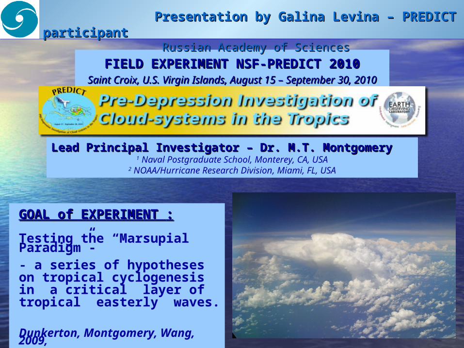
I AM DEEPLY GRATEFUL TO: I AM DEEPLY GRATEFUL TO:
MY COLLABORATOR AND CO-AUTHOR MIKE MONTGOMERY MIKE MONTGOMERY FOR HIS INVITATION TO PARTICIPATE IN PREDICT MY COLLEAGUES AND SUPERIORS IN RUSSIA G.S. GOLITSYN G.S. GOLITSYN and O.G. CHKHETIANI O.G. CHKHETIANI
((MOSCOWMOSCOW),), V.P. MATVEENKO V.P. MATVEENKO and P.G. FRICK P.G. FRICK
((PERMPERM)) FOR THEIR IMPORTANT SUPPORT
FIELD EXPERIMENTFIELD EXPERIMENT NSF-PREDICTNSF-PREDICT 20102010 Saint Croix, U.S. Virgin Islands, August 15 – September 30, 2010
My participation was aimed at studying modern tools of hurricane investigations My participation was aimed at studying modern tools of hurricane investigations and forecasting in order to define a place for and forecasting in order to define a place for analysis of helicityanalysis of helicity
in procedures for forecasting tropical cyclogenesisin procedures for forecasting tropical cyclogenesis
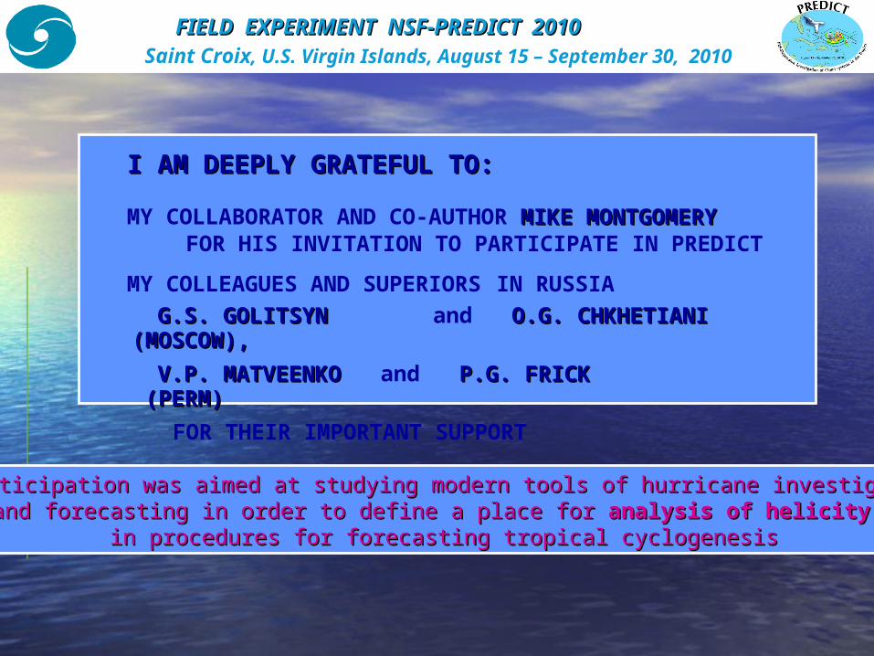
HELICITY IN TROPICAL CYCLONESHELICITY IN TROPICAL CYCLONES
–– integral integral helicityhelicity
Hypothesis on a specific role of helicity in tropical cyclone Hypothesis on a specific role of helicity in tropical cyclone formationformation
was first proposed at the Space Research Institute (Moscow)was first proposed at the Space Research Institute (Moscow) in in 1983-1988 – 1983-1988 –
by S.S. Moiseevby S.S. Moiseev, , P.B. RutkevichP.B. Rutkevich, , R.Z. SagdeevR.Z. Sagdeev, , A.V. TurA.V. Tur, , G.A. G.A. KhomenkoKhomenko, , A.M. ShukurovA.M. Shukurov
G.V. Levina, and M.T. Montgomery. A first examination of the helical nature of tropical cyclogenesis.
Doklady Earth Sciences. 2010. Vol. 434, Part 1, pp. 1285-1289.
rdVcurlVH
Only in the 2000s has it become possible to test this hypothesis by using Only in the 2000s has it become possible to test this hypothesis by using high horizontal resolution (1-3 km)high horizontal resolution (1-3 km) numerical simulations of tropical cyclone formationnumerical simulations of tropical cyclone formation
Here the horizontal resolution is 3 km :
integral helicity of the vortex system can serve as
an indicator of large-scale vortex
instability
Н
OUTLINE:
1. 1. Three field campaigns in the Tropical AtlanticThree field campaigns in the Tropical Atlantic: : hurricane seasonhurricane season 2010 2010
•• PREDICT, GRIP, IFEX. Goals and Coordination of Work.
Aircraft-participants
•• PREDICT, the research aircraft NSF-NCAR Gulfstream V
2.2. Scientific basis ofScientific basis of PREDICTPREDICT –– Marsupial Marsupial ParadigmParadigm – – Tropical cyclogenesis in easterly Tropical cyclogenesis in easterly waveswaves
•• Statistics for the Atlantic hurricane season on 31.10.2010
• • Preliminary results 3.3. Our Our visitors on Saint Croix Island visitors on Saint Croix Island :: •• August 30, 2010 •• September 11, 2010 4.4. Witnesses of TC birthWitnesses of TC birth. . Research flight RF19Research flight RF19. .
FIELD EXPERIMENT FIELD EXPERIMENT NSF-PREDICTNSF-PREDICT 20102010 Saint Croix, U.S. Virgin Islands, August 15 – September 30, 2010
PERSPECTIVESPERSPECTIVES
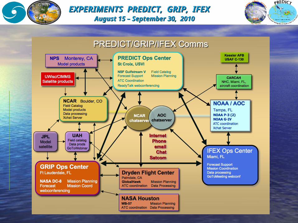
EXPERIMENTS PREDICT,EXPERIMENTS PREDICT, GRIP, GRIP, IFEXIFEX August 15August 15 – – September September 3030, , 2010 2010
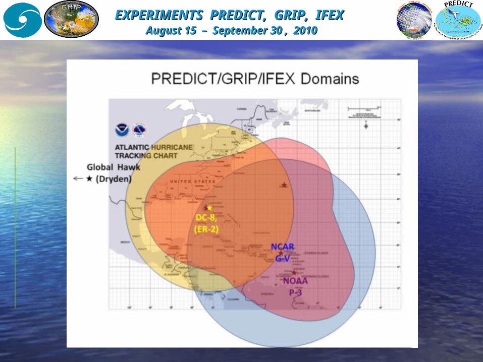
EXPERIMENTS PREDICT, EXPERIMENTS PREDICT, GRIP, GRIP, IFEXIFEX August 15 August 15 – – September September 30 30 , , 2010 2010
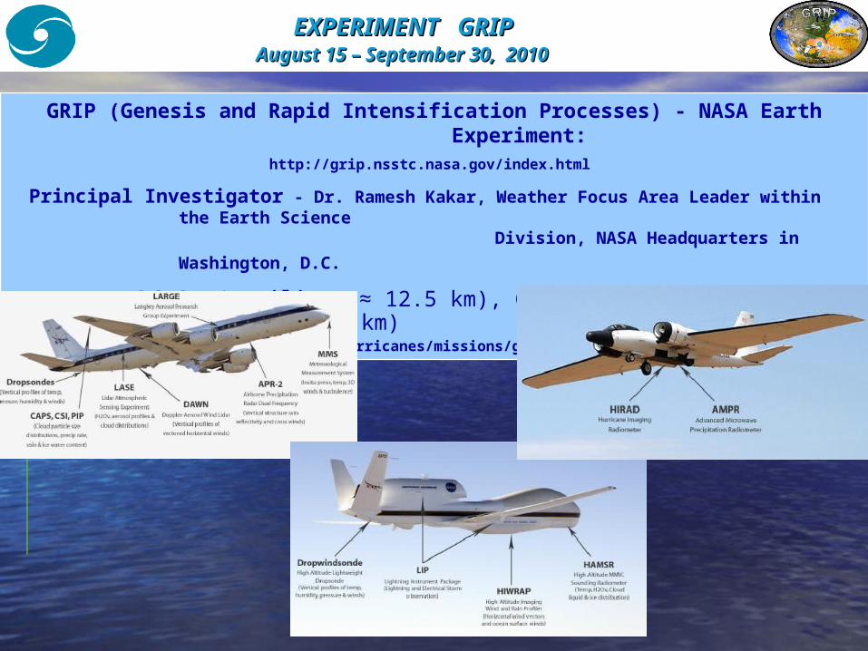
EXPERIMENT EXPERIMENT GRIPGRIP August 15August 15 – – September September 3030, , 2010 2010
GRIP (Genesis and Rapid Intensification Processes) - NASA Earth Experiment:
http://grip.nsstc.nasa.gov/index.html
Principal Investigator - Dr. Ramesh Kakar, Weather Focus Area Leader within the Earth Science
Division, NASA Headquarters in Washington, D.C.
Aircraft: DC-8 («ceiling» ≈ 12.5 km), Global Hawk (≈ 20 km) , WB-57 (≈ 21.5 km)
http://www.nasa.gov/mission_pages/hurricanes/missions/grip/instruments/index.html
EXPERIMENT IFEX EXPERIMENT IFEX August 15August 15 – – September September 3030,, 2010 2010
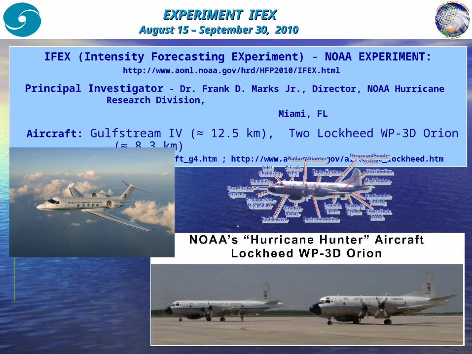
IFEX (Intensity Forecasting EXperiment) - NOAA EXPERIMENT:http://www.aoml.noaa.gov/hrd/HFP2010/IFEX.html
Principal Investigator - Dr. Frank D. Marks Jr., Director, NOAA Hurricane Research Division,
Miami, FL Aircraft: Gulfstream IV (≈ 12.5 km), Two Lockheed WP-3D Orion
(≈ 8.3 km) http://www.aoc.noaa.gov/aircraft_g4.htm ; http://www.aoc.noaa.gov/aircraft_lockheed.htm
EXPERIMENT PREDICTEXPERIMENT PREDICT August 15August 15 – – September September 3030, , 2010 2010
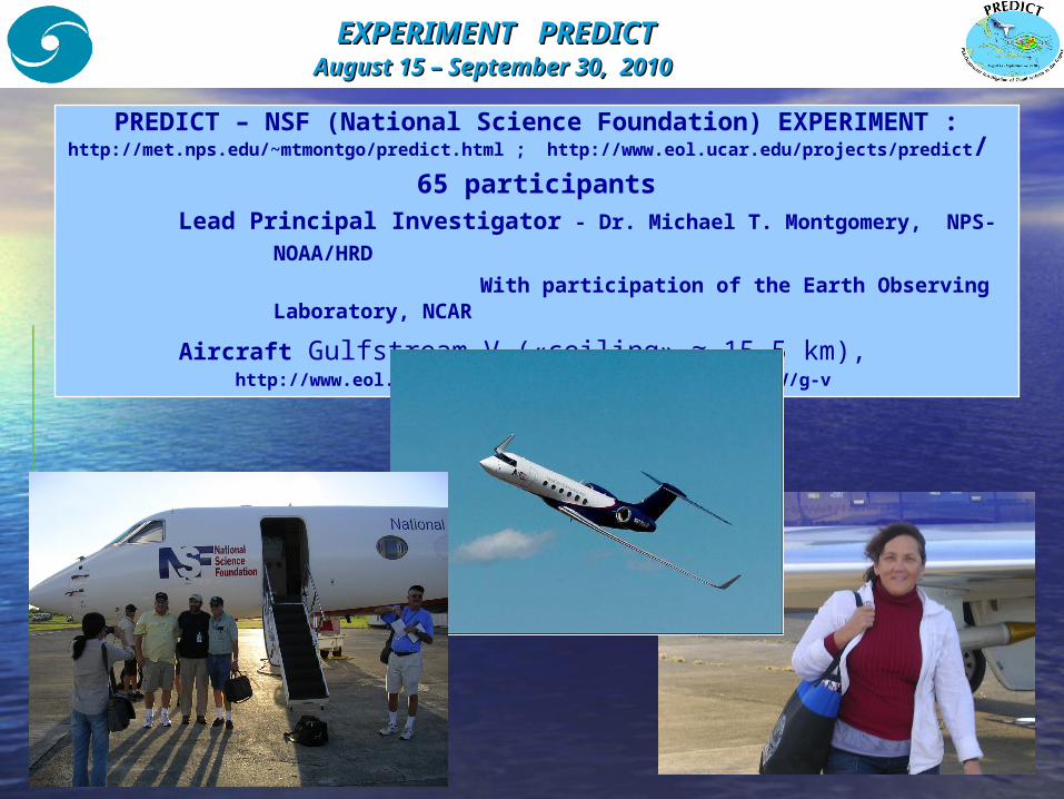
PREDICT – NSF (National Science Foundation) EXPERIMENT :http://met.nps.edu/~mtmontgo/predict.html ; http://www.eol.ucar.edu/projects/predict/
65 participants Lead Principal Investigator - Dr. Michael T. Montgomery, NPS-
NOAA/HRD With participation of the Earth Observing
Laboratory, NCAR Aircraft Gulfstream V («ceiling» ≈ 15.5 km), http://www.eol.ucar.edu/instrumentation/aircraft/G-V/g-v
FIELD EXPERIMENTFIELD EXPERIMENT NSF-PREDICTNSF-PREDICT August 15August 15 – – September September 3030, , 2010 2010
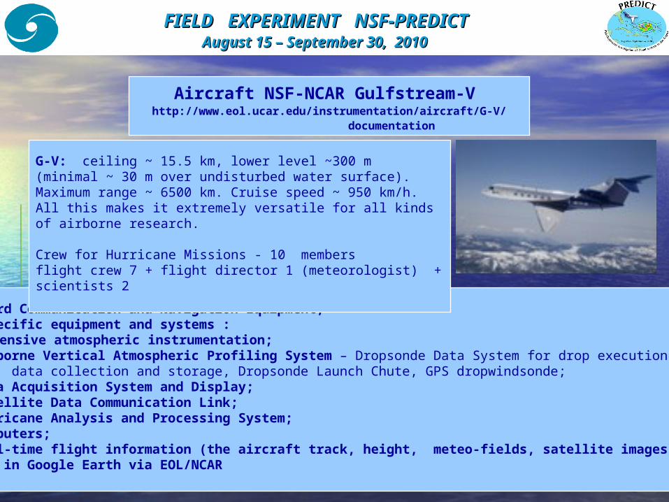
Aircraft NSF-NCAR Gulfstream-V http://www.eol.ucar.edu/instrumentation/aircraft/G-V/
documentation
Standard Communication and Navigation Equipment;The specific equipment and systems : Extensive atmospheric instrumentation; Airborne Vertical Atmospheric Profiling System – Dropsonde Data System for drop execution, data collection and storage, Dropsonde Launch Chute, GPS dropwindsonde; Data Acquisition System and Display; Satellite Data Communication Link; Hurricane Analysis and Processing System; Computers; Real-time flight information (the aircraft track, height, meteo-fields, satellite images, etc) in Google Earth via EOL/NCAR
G-V: ceiling ~ 15.5 km, lower level ~300 m (minimal ~ 30 m over undisturbed water surface). Maximum range ~ 6500 km. Cruise speed ~ 950 km/h. All this makes it extremely versatile for all kinds of airborne research.
Crew for Hurricane Missions - 10 membersflight crew 7 + flight director 1 (meteorologist) + scientists 2
FIELD EXPERIMENT FIELD EXPERIMENT NSF-PREDICTNSF-PREDICT August 15 August 15 – – September September 3030, , 2010 2010
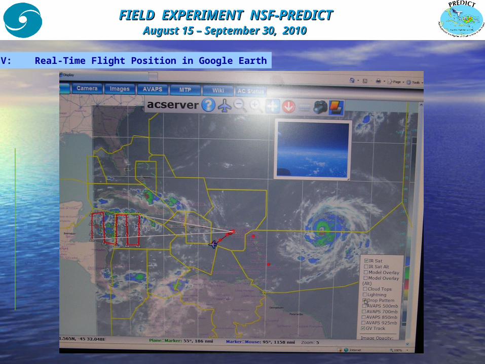
G-V: Real-Time Flight Position in Google Earth
SCIENTIFIC BASIS OF NSF-PREDICTSCIENTIFIC BASIS OF NSF-PREDICT
TROPICAL CYCLOGENESIS IN EASTERLY WAVESTROPICAL CYCLOGENESIS IN EASTERLY WAVES
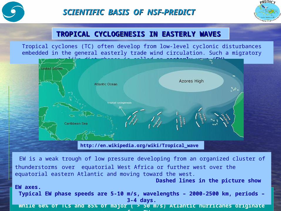
Only 20% of EWs result in TCs, е.g. formation of a tropical depression, storm or hurricane.
While 60% of TCs and 85% of major ( > 50 m/s) Atlantic hurricanes originate from EWs.
Tropical cyclones (TC) often develop from low-level cyclonic disturbances embedded in the general easterly trade wind circulation. Such a migratory
wavelike disturbance is called an easterly wave (EW).
EW is a weak trough of low pressure developing from an organized cluster of thunderstorms over equatorial West Africa or further west over the equatorial eastern Atlantic and moving toward the west. Dashed lines in the picture show EW axes.Typical EW phase speeds are 5-10 m/s, wavelengths – 2000-2500 km, periods –
3-4 days.
http://en.wikipedia.org/wiki/Tropical_wave
SCIENTIFIC SCIENTIFIC BASIS OF BASIS OF NSF-PREDICTNSF-PREDICT
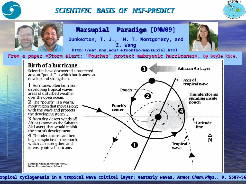
Marsupial ParadigmMarsupial Paradigm [DMW09]Dunkerton, T. J., M. T. Montgomery, and
Z. Wanghttp://met.nps.edu/~mtmontgo/marsupial.html
From a paperFrom a paper « «Storm alert: ‘Pouches’ protect embryonic hurricanesStorm alert: ‘Pouches’ protect embryonic hurricanes». ». ByBy Doyle Rice, Doyle Rice, USA TODAYUSA TODAY, August 18, 2008, August 18, 2008..
DMW09: TDMW09: Tropical cyclogenesis in a tropical wave critical layer: ropical cyclogenesis in a tropical wave critical layer: eeasterly waves, asterly waves, AtmosAtmos.. Chem Chem. . PhysPhys., ., 9, 5587-56469, 5587-5646,, 2009 2009..
FORECASTING TROPICAL CYCLOGENESIS LOCATIONFORECASTING TROPICAL CYCLOGENESIS LOCATION
Marsupial Marsupial Pouch TrackingPouch Tracking [WMD09]Wang, Z., M.T. Montgomery, and T.J. Dunkerton
http://met.nps.edu/~mtmontgo/marsupial.html
To apply and test the Marsupial Paradigm : - a dynamically-based method for forecasting tropical cyclogenesis location in the Atlantic sector using global model products has been developed; - field experiment NSF-PREDICT 2010 has been prepared and carried out in the Caribbean Sea.
WMD09: A dynamically-based method for forecasting tWMD09: A dynamically-based method for forecasting tropical cyclogenesis ropical cyclogenesis location in the Atlantic sector using global model productslocation in the Atlantic sector using global model products, , Geophys. Res. LettGeophys. Res. Lett., ., 36, L03801, doi:10.1029/2008GL035586: 200936, L03801, doi:10.1029/2008GL035586: 2009..
During PREDICT-experiment locations of ‘pouches’ and their traveling with easterly waves were calculating by use of a number of global models (ECMWF, GFS, UKMET, NOGAPS and others),
with space resolution 1°х1° and 0.5°х0.5° ++
A detailed analysis of common forecast data (NCEP, ECMWF, GFDL, GFS, HWRF, UKMET, NOGAPS, CMC) and satellite imagery.
All this allowed predicting the genesis location up to 3 days with an error < 200 km and accurate targeting research flights into these areas.
Coordination of research flights of PREDICT, GRIP and IFEX into the ‘pouches’ with taking into account research facilities of each group allowed collecting a versatile amount of data.
FORECASTING TROPICAL CYCLOGENESIS LOCATIONFORECASTING TROPICAL CYCLOGENESIS LOCATION
Marsupial Marsupial Pouch TrackingPouch Tracking [WMD09]
Wang, Z., M.T. Montgomery, and T.J. Dunkerton
http://met.nps.edu/~mtmontgo/marsupial.html
WMD09: A dynamically-based method for forecasting tWMD09: A dynamically-based method for forecasting tropical cyclogenesis ropical cyclogenesis location in the Atlantic sector using global model productslocation in the Atlantic sector using global model products, , Geophys. Res. LettGeophys. Res. Lett., ., 36, L03801, doi:10.1029/2008GL035586: 200936, L03801, doi:10.1029/2008GL035586: 2009..
- National Center for Atmospheric Reasearch, Boulder, CO - EOL/PREDICT Field Catalog;- National Science Foundation;- National Oceanic and Atmospheric Administration/Hurricane Research Division, Miami, FL ;- National Aeronautics and Space Administration;- Naval Reasearch Laboratory, Monterey, CA - Navy/NRL PREDICT 2010 Page; - Cooperative Institute for Meteorological Satellite Studies (CIMSS) Space Science and Engineering Center/University of Wisconsin-Madison;- California Institute of Technology, JPL Tropical Cyclone System;- Rosenstiel School of Marine and Atmospheric Science, University of Miami, FL, - Global Model Ensemble Products (Majumdar/RSMAS);- University at Albany(SUNY), New York, - WRF Ensemble Forecasts (Torn/UAlbany), - PREDICT Forecast Maps (Griffin/UAlbany);- Pennsylvania State University - ENkF WRF Ensemble Forecasts (Zhang/Penn State)
Collaborators of Montgomery Group in PREDICT
http://met.nps.edu/~mtmontgo/storms2010.html
FORECASTING TROPICAL CYCLOGENESIS LOCATIONFORECASTING TROPICAL CYCLOGENESIS LOCATION
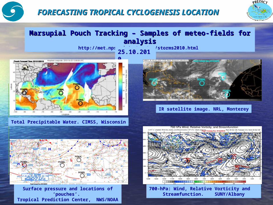
Marsupial Pouch TrackingMarsupial Pouch Tracking – – Samples of meteo-fields for Samples of meteo-fields for analysisanalysis
http://met.nps.edu/~mtmontgo/storms2010.html 25.10.2010
Total Precipitable Water. CIMSS, Wisconsin
IR satellite image. NRL, Monterey
Surface pressure and locations of ‘pouches’.
Tropical Prediction Center, NWS/NOAA
700-hPa: Wind, Relative Vorticity and Streamfunction. SUNY/Albany
FIELD EXPERIMENTFIELD EXPERIMENT NSF-PREDICTNSF-PREDICT August 15August 15 – – September September 3030, , 20102010
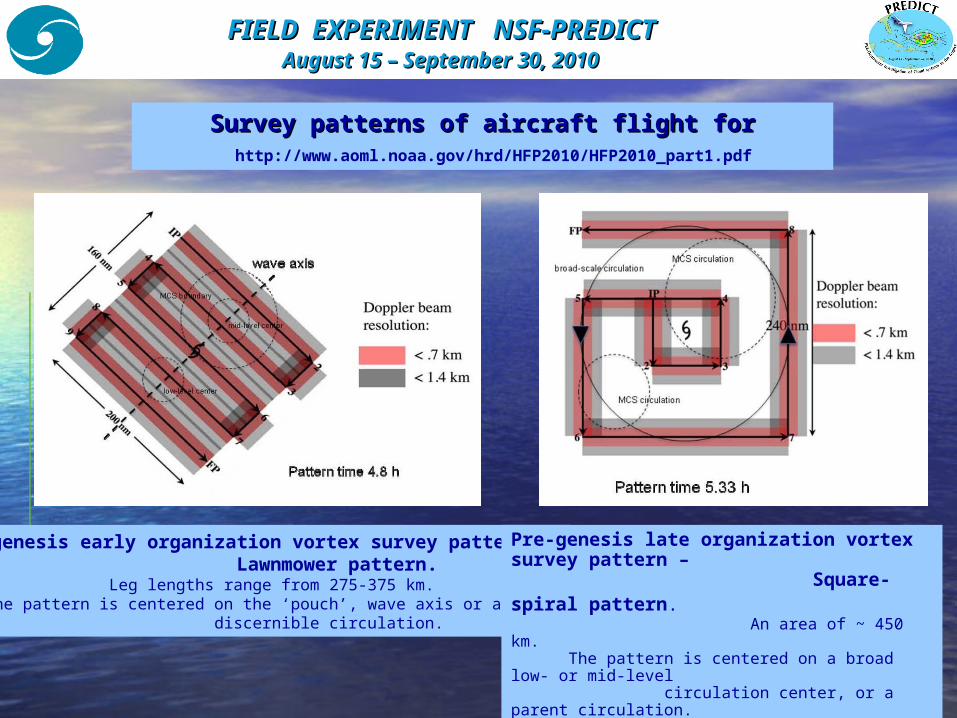
Survey patterns of aircraft flight for Survey patterns of aircraft flight for incipient systemsincipient systems
Pre-genesis early organization vortex survey pattern – Lawnmower pattern. Leg lengths range from 275-375 km. The pattern is centered on the ‘pouch’, wave axis or any discernible circulation.
http://www.aoml.noaa.gov/hrd/HFP2010/HFP2010_part1.pdf
Pre-genesis late organization vortex survey pattern – Square-spiral pattern. An area of ~ 450 km. The pattern is centered on a broad low- or mid-level circulation center, or a parent circulation.
FIELD EXPERIMENT NSF-PREDICTFIELD EXPERIMENT NSF-PREDICT August 15August 15 – – September September 30 30 , , 20102010
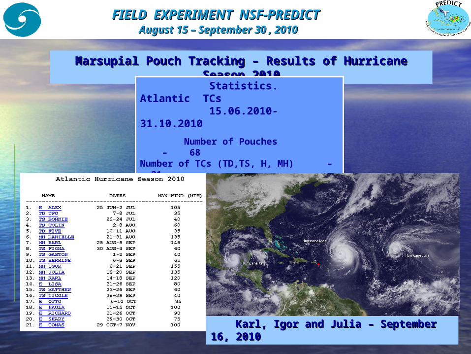
Marsupial Pouch TrackingMarsupial Pouch Tracking – – Results of Hurricane Results of Hurricane SeasonSeason 2010 2010
Statistics. Atlantic TCs 15.06.2010-31.10.2010 Number of Pouches – 68Number of TCs (TD,TS, H, MH) – 21 Major Hurricanes (MH) – 5 Number of TCsNumber of TCs from from PouchesPouches –– 2 211 MHs from Pouches MHs from Pouches – 5 – 5
Karl, IgorKarl, Igor and Julia – September and Julia – September 1616, , 20102010
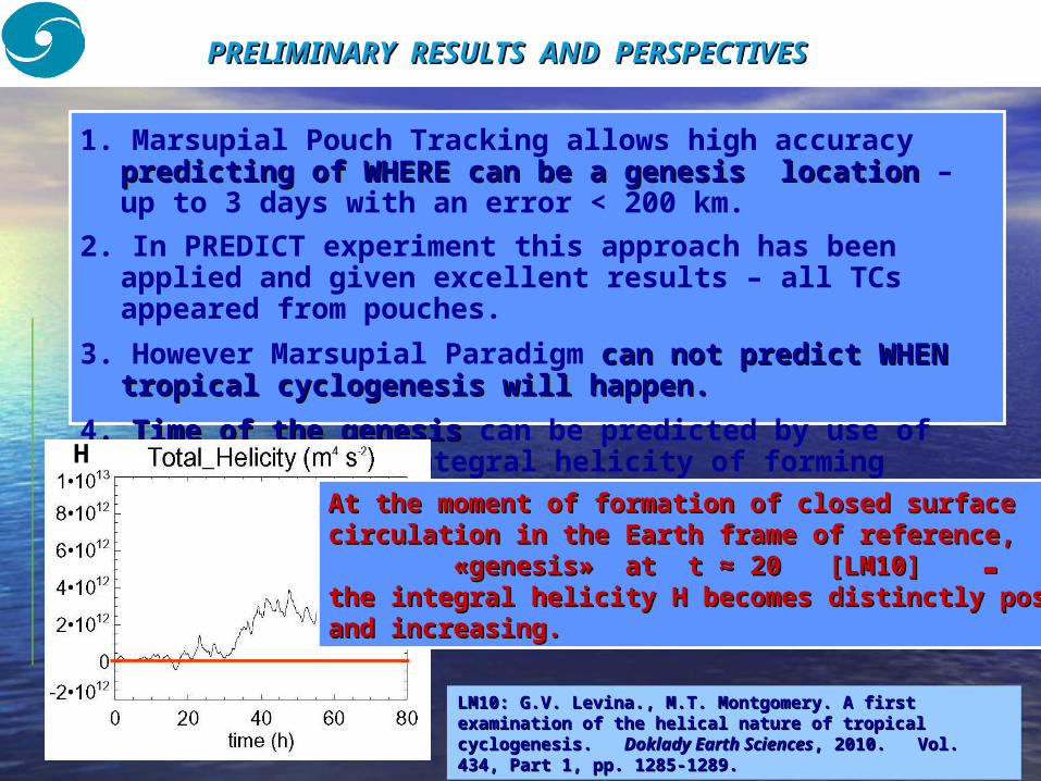
1. Marsupial Pouch Tracking allows high accuracy predicting ofpredicting of WHEREWHERE can becan be a genesis a genesis locationlocation – up to 3 days with an error < 200 km.
2. In PREDICT experiment this approach has been applied and given excellent results – all TCs appeared from pouches.
3. However Marsupial Paradigm can notcan not predictpredict WHEN WHEN tropical cyclogenesistropical cyclogenesis will happenwill happen..
4. Time of the genesis Time of the genesis can be predicted by use of
analysis of the integral helicity of forming vortex system.
PRELIMINARY RESULTS AND PRELIMINARY RESULTS AND PERSPECTIVESPERSPECTIVES
At the moment of formation of closed surface At the moment of formation of closed surface circulation in the Earth frame of referencecirculation in the Earth frame of reference, , ▬▬ ««genesisgenesis» » at at t t ≈ 20 ≈ 20 [LM10][LM10] ▬▬the integral helicity the integral helicity Н Н becomes distinctly positive becomes distinctly positive and increasingand increasing..
Н
LM10: G.V. LevinaLM10: G.V. Levina., ., M.T. MontgomeryM.T. Montgomery. . A first A first examination of theexamination of the helical nature of tropical helical nature of tropical cyclogenesiscyclogenesis. . Doklady Earth SciencesDoklady Earth Sciences, 2010. , 2010. VolVol. . 434, 434, Part 1Part 1, , pppp. . 12851285--12891289..
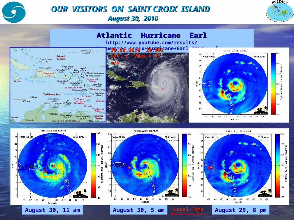
OUR VISITORS ON SAINT CROIX ISLAND OUR VISITORS ON SAINT CROIX ISLAND August August 3030, , 2010 2010
Atlantic Hurricane EarlAtlantic Hurricane Earlhttp://www.youtube.com/results?
search_query=St.Croix+Hurricane+Earl+2010&aq=f 30.030.088.2010.2010 20:00 20:00ZZCat. 2, Vmax = 57 Cat. 2, Vmax = 57 mm//ss
Local TimeLocal Time August 29, 8 pmAugust 30, 5 amAugust 30, 11 am
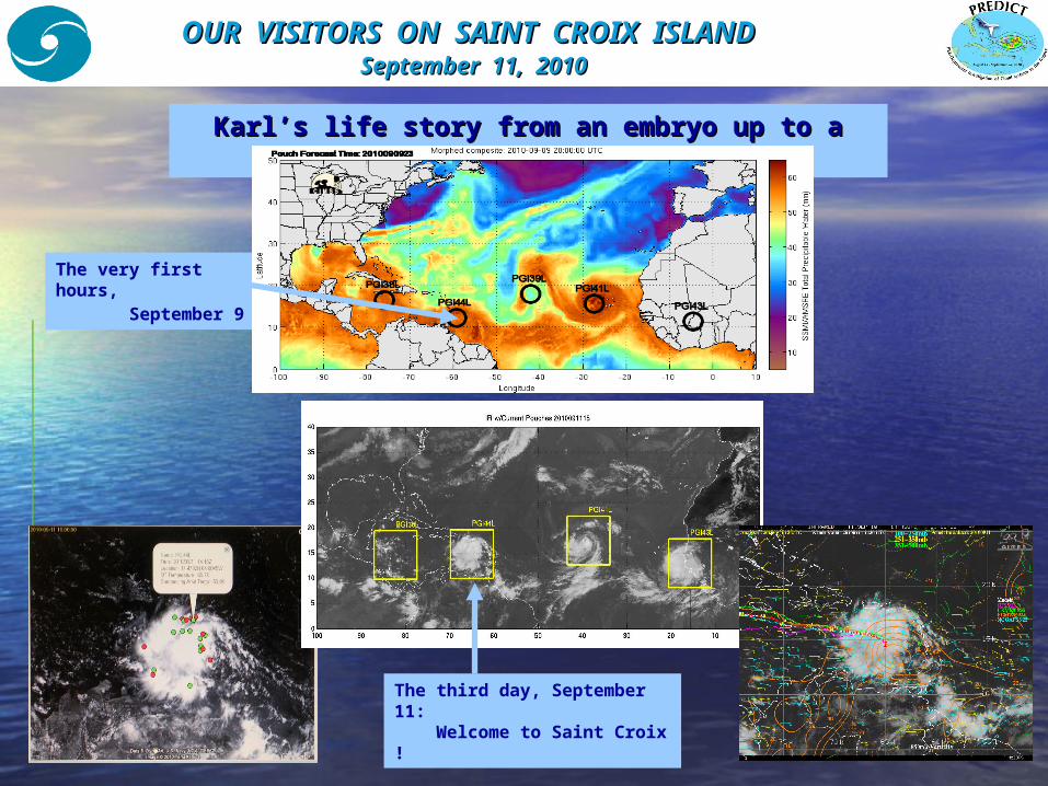
OUR VISITORS ON SAINT CROIX ISLAND OUR VISITORS ON SAINT CROIX ISLAND September 11, September 11, 2010 2010
Karl’s life story from an embryo up to a Karl’s life story from an embryo up to a HurricaneHurricane
The very first hours, September 9
The third day, September 11: Welcome to Saint Croix !
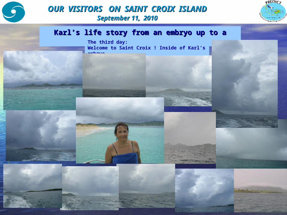
OUR VISITORS ON SAINT CROIX ISLANDOUR VISITORS ON SAINT CROIX ISLAND September 11, September 11, 2010 2010
Karl’s life story from an embryo up to a Karl’s life story from an embryo up to a HurricaneHurricaneThe third day:
Welcome to Saint Croix ! Inside of Karl’s embryo
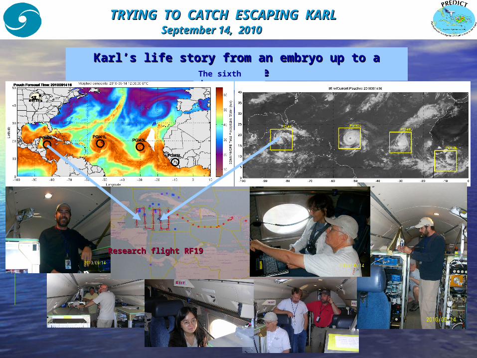
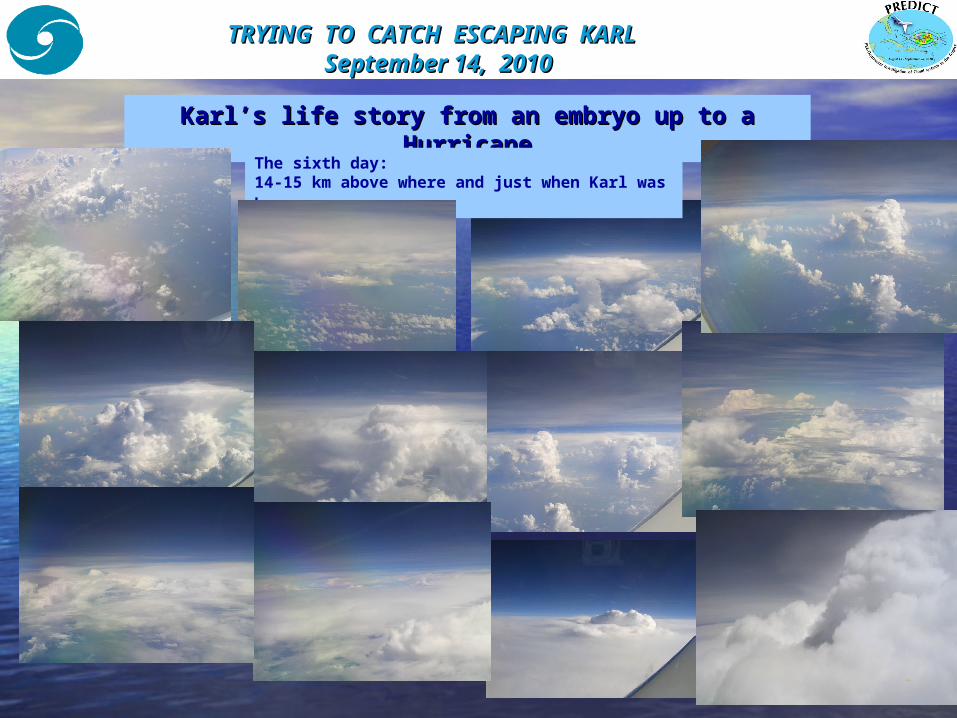
TRYING TO CATCH ESCAPING KARLTRYING TO CATCH ESCAPING KARL September 14, September 14, 2010 2010
Karl’s life story from an embryo up to aKarl’s life story from an embryo up to a HurricaneHurricaneThe sixth
day :
Исследовательский полет RF19 в PGI44
Research flight RF19Research flight RF19
TRYING TO CATCH ESCAPING KARLTRYING TO CATCH ESCAPING KARL September 14, September 14, 2010 2010
Karl’s life story from an embryo up to aKarl’s life story from an embryo up to a HurricaneHurricane
The sixth day: 14-15 km above where and just when Karl was born
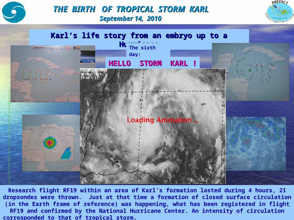
THE BIRTH OF TROPICAL STORM KARLTHE BIRTH OF TROPICAL STORM KARL September 14, September 14, 2010 2010
Karl’s life story from an embryo up to a Karl’s life story from an embryo up to a HurricaneHurricaneThe sixth
day:
Research flight RF19 within an area of Karl’s formation lasted during 4 hours, 21 dropsondes were thrown. Just at that time a formation of closed surface circulation (in the Earth frame of reference) was happening, what has been registered in flight RF19 and confirmed by the National Hurricane Center. An intensity of circulation
corresponded to that of tropical storm.
HELLO STORM HELLO STORM KARLKARL ! !
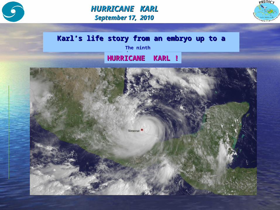
HURRICANE KARL HURRICANE KARL September 17, September 17, 2010 2010
Karl’s life story from an embryo up to a Karl’s life story from an embryo up to a HurricaneHurricaneThe ninth day:
HURRICANE KARLHURRICANE KARL ! !
CONCLUSIONS CONCLUSIONS
1. Data collected during PREDICT campaign will be processed and analyzed.
2. However, preliminary estimations show a
HUGE SUCCESS OF HUGE SUCCESS OF RESEARCHERSRESEARCHERS !!! !!!
FIELD EXPERIMENT FIELD EXPERIMENT NSF-PREDICTNSF-PREDICT August 15August 15 – – September 3September 300, , 20102010
1. Calculations and analysis of helicity in a ‘pouch’.1. Calculations and analysis of helicity in a ‘pouch’.2. 2. Analysis of helical characteristics for TCs observed Analysis of helical characteristics for TCs observed
duringduring PREDICT.PREDICT.3. 3. Introduction of helicity analysis into forecasting of Introduction of helicity analysis into forecasting of
tropical cyclogenesis tropical cyclogenesis using global model productsusing global model products..
Perspectives for helicity analysis :Perspectives for helicity analysis :
THANK YOU THANK YOU FOR YOUR ATTENTIONFOR YOUR ATTENTION ! !
ATLANTIC HURRICANE FIELD EXPERIMENTSATLANTIC HURRICANE FIELD EXPERIMENTS August 15August 15 – – September September 30 30 , , 20102010
Related Documents