Field calibration of sediment flux dependent river incision Daniel E. J. Hobley, 1,2 Hugh D. Sinclair, 1 Simon M. Mudd, 1,3 and Patience A. Cowie 4 Received 22 November 2010; revised 22 August 2011; accepted 24 August 2011; published 3 November 2011. [1] Bed erosion and sediment transport are ubiquitous and linked processes in rivers. Erosion can either be modeled as a “detachment limited” function of the shear stress exerted by the flow on the bed, or as a “transport limited” function of the sediment flux capacity of the flow. These two models predict similar channel profiles when erosion rates are constant in space in time, but starkly contrasting behavior in transient settings. Traditionally detachment limited models have been used for bedrock rivers, whereas transport limited models have been used in alluvial settings. In this study we demonstrate that rivers incising into a substrate of loose, but very poorly sorted relict glacial sediment behave in a detachment limited manner. We then develop a methodology by which to both test the appropriate incision model and constrain its form. Specifically we are able to tightly constrain how incision rates vary as a function of the ratio between sediment flux and sediment transport capacity in three rivers responding to deglaciation in the Ladakh Himalaya, northwest India. This represents the first field test of the so‐called “tools and cover” effect along individual rivers. Citation: Hobley, D. E. J., H. D. Sinclair, S. M. Mudd, and P. A. Cowie (2011), Field calibration of sediment flux dependent river incision, J. Geophys. Res., 116, F04017, doi:10.1029/2010JF001935. 1. Introduction [2] River dynamics in upland settings are a key element in the Earth surface system, redistributing large volumes of sediment into basins [Milliman and Syvitski, 1992], coupling climate and tectonic processes [Molnar and England, 1990; Willett and Brandon, 2002], transmitting information from downstream into highlands [Rodríguez‐Iturbe et al., 1992], and controlling the form of mountain belts themselves [Burbank, 2002; Zeitler et al., 2001]. However, significant uncertainty still remains over how real river systems are likely to evolve through time. Numerous models of river erosion have been proposed [see, e.g., Tucker and Hancock, 2010], but much doubt remains over how we should distinguish between these models and whether factors such as thresholds and sediment flux dependent incision are important in real settings. This is vital to establish, since the long term tempo, style and patterns of landscape evolution under each model- ing approach can be very different [e.g., Whipple and Tucker, 2002]. [3] In all incising channels, sediment flux is likely to be of key importance in controlling erosion processes. Where the bed of a channel is entirely composed of loose, readily transportable particles, the divergence of sediment flux capacity of the flow above determines the rate of bed elevation change, as described by a mass balance (i.e., the Exner equation) [e.g., Paola and Voller, 2005]. In bedrock channels, where the channel bed resists detachment into the flow, authors have also drawn attention to sediment flux dependent incision. Here, sediment is likely to create a strongly nonlinear erosional response, as it may both pro- mote incision by acting as tools and inhibit it by covering the bed [Cowie et al., 2008; Gilbert, 1877; Sklar and Dietrich, 2001; Turowski et al., 2007]. However, it has proven diffi- cult to unequivocally demonstrate the form of this effect in real environments, and in particular to prove the existence of positive feedbacks between sediment flux and incision rates. [4] We set out both to discriminate between incision models and also to assess the role of sediment flux in catchments in Ladakh, northwest Indian Himalaya, the upper reaches of which have been significantly resculpted by glacial processes [Hobley et al., 2010]. This location is ideal for such a study as we may tightly constrain through time both total incision at a point and sediment fluxes down- stream as the channels respond. The incised substrate in these valleys is very poorly sorted, thick, relict glacial sed- iment, with subangular clasts and grain sizes ranging from silts through to meter‐scale boulders (Figure 1). It might be expected that since the substrate is composed of individual clasts, many of which are ostensibly ready for transport, its erosion would be controlled by the carrying capacity of the stream. Set against this, field observations suggest that the coarse, angular, poorly sorted texture of the glacial sedi- ment can lead to a partly locked texture of cobble grade and coarser clasts on the bed once part of the fine fraction has been winnowed away, and qualitative interpretation of the beds of the modern streams suggest that the coarser (boulder) fraction in the substrate may play a disproportionate role in 1 School of GeoSciences, University of Edinburgh, Edinburgh, UK. 2 Department of Environmental Sciences, University of Virginia, Charlottesville, Virginia, USA. 3 Earth Research Institute, University of California, Santa Barbara, California, USA. 4 Department of Earth Science, University of Bergen, Bergen, Norway. Copyright 2011 by the American Geophysical Union. 0148‐0227/11/2010JF001935 JOURNAL OF GEOPHYSICAL RESEARCH, VOL. 116, F04017, doi:10.1029/2010JF001935, 2011 F04017 1 of 18

Welcome message from author
This document is posted to help you gain knowledge. Please leave a comment to let me know what you think about it! Share it to your friends and learn new things together.
Transcript
Field calibration of sediment flux dependent river incision
Daniel E. J. Hobley,1,2 Hugh D. Sinclair,1 Simon M. Mudd,1,3 and Patience A. Cowie4
Received 22 November 2010; revised 22 August 2011; accepted 24 August 2011; published 3 November 2011.
[1] Bed erosion and sediment transport are ubiquitous and linked processes in rivers.Erosion can either be modeled as a “detachment limited” function of the shear stressexerted by the flow on the bed, or as a “transport limited” function of the sediment fluxcapacity of the flow. These two models predict similar channel profiles when erosionrates are constant in space in time, but starkly contrasting behavior in transient settings.Traditionally detachment limited models have been used for bedrock rivers, whereastransport limited models have been used in alluvial settings. In this study wedemonstrate that rivers incising into a substrate of loose, but very poorly sorted relictglacial sediment behave in a detachment limited manner. We then develop amethodology by which to both test the appropriate incision model and constrain its form.Specifically we are able to tightly constrain how incision rates vary as a function of the ratiobetween sediment flux and sediment transport capacity in three rivers responding todeglaciation in the Ladakh Himalaya, northwest India. This represents the first field test ofthe so‐called “tools and cover” effect along individual rivers.
Citation: Hobley, D. E. J., H. D. Sinclair, S. M. Mudd, and P. A. Cowie (2011), Field calibration of sediment flux dependentriver incision, J. Geophys. Res., 116, F04017, doi:10.1029/2010JF001935.
1. Introduction
[2] River dynamics in upland settings are a key elementin the Earth surface system, redistributing large volumes ofsediment into basins [Milliman and Syvitski, 1992], couplingclimate and tectonic processes [Molnar and England, 1990;Willett and Brandon, 2002], transmitting information fromdownstream into highlands [Rodríguez‐Iturbe et al., 1992],and controlling the form of mountain belts themselves[Burbank, 2002; Zeitler et al., 2001]. However, significantuncertainty still remains over how real river systems are likelyto evolve through time. Numerous models of river erosionhave been proposed [see, e.g., Tucker and Hancock, 2010],but much doubt remains over how we should distinguishbetween these models and whether factors such as thresholdsand sediment flux dependent incision are important in realsettings. This is vital to establish, since the long term tempo,style and patterns of landscape evolution under each model-ing approach can be very different [e.g.,Whipple and Tucker,2002].[3] In all incising channels, sediment flux is likely to be
of key importance in controlling erosion processes. Wherethe bed of a channel is entirely composed of loose, readilytransportable particles, the divergence of sediment fluxcapacity of the flow above determines the rate of bed
elevation change, as described by a mass balance (i.e., theExner equation) [e.g., Paola and Voller, 2005]. In bedrockchannels, where the channel bed resists detachment into theflow, authors have also drawn attention to sediment fluxdependent incision. Here, sediment is likely to create astrongly nonlinear erosional response, as it may both pro-mote incision by acting as tools and inhibit it by covering thebed [Cowie et al., 2008; Gilbert, 1877; Sklar and Dietrich,2001; Turowski et al., 2007]. However, it has proven diffi-cult to unequivocally demonstrate the form of this effect inreal environments, and in particular to prove the existence ofpositive feedbacks between sediment flux and incision rates.[4] We set out both to discriminate between incision
models and also to assess the role of sediment flux incatchments in Ladakh, northwest Indian Himalaya, the upperreaches of which have been significantly resculpted byglacial processes [Hobley et al., 2010]. This location is idealfor such a study as we may tightly constrain through timeboth total incision at a point and sediment fluxes down-stream as the channels respond. The incised substrate inthese valleys is very poorly sorted, thick, relict glacial sed-iment, with subangular clasts and grain sizes ranging fromsilts through to meter‐scale boulders (Figure 1). It might beexpected that since the substrate is composed of individualclasts, many of which are ostensibly ready for transport, itserosion would be controlled by the carrying capacity of thestream. Set against this, field observations suggest that thecoarse, angular, poorly sorted texture of the glacial sedi-ment can lead to a partly locked texture of cobble grade andcoarser clasts on the bed once part of the fine fraction hasbeen winnowed away, and qualitative interpretation of thebeds of the modern streams suggest that the coarser (boulder)fraction in the substrate may play a disproportionate role in
1School of GeoSciences, University of Edinburgh, Edinburgh, UK.2Department of Environmental Sciences, University of Virginia,
Charlottesville, Virginia, USA.3Earth Research Institute, University of California, Santa Barbara,
California, USA.4Department of Earth Science, University of Bergen, Bergen, Norway.
Copyright 2011 by the American Geophysical Union.0148‐0227/11/2010JF001935
JOURNAL OF GEOPHYSICAL RESEARCH, VOL. 116, F04017, doi:10.1029/2010JF001935, 2011
F04017 1 of 18
limiting channel downcutting [Hobley et al., 2010]. Such asystem could be argued to be more akin to a bedrock channelundergoing erosion by plucking than a true alluvial river.This kind of behavior may be widespread in upland envir-onments where channels are loaded directly by unsortednon‐fluvial sediment, for example, in bedrock landslides ordebris flows.[5] The key point is that in this type of setting the basic
distinction of erosion style as either transport limited (erosioncontrolled by carrying capacity) or detachment limited(erosion controlled by shear stress on the bed) is unclear fromqualitative field observations. Hence, before we can analyzethe role of sediment flux in modulating incision rates, wemust choose between these two mutually exclusive optionsfor building the incision law. Firstly, we present an analysisof the detachment and transport limited frameworks forfluvial erosion. We use the downstream distribution of shearstress to demonstrate that, despite the clastic nature of thesubstrate, the channels in this study are responding in asediment flux dependent, detachment limited manner abovean incision threshold. We are able to rule out a transportlimited interpretation. Secondly, we use field observationsto constrain the resulting sediment flux functions for eachanalyzed catchment using a Monte Carlo Markov Chainmodel. The resulting curves show the operation of bothpositive and negative feedbacks on erosion rate with varyingsediment flux and allow investigation of the factors control-ling their expression.
2. Modeling Framework
[6] The long term evolution of fluvial systems has oftenbeen described as either detachment limited (DL), governedby resistance of the bed to erosion, or transport limited (TL),governed by capacity of the flow to carry away materialwhich is freely available on the bed [Anderson, 1994;Beaumont et al., 1992; Howard, 1994; Kooi and Beaumont,1994; Tucker and Bras, 1998; Whipple and Tucker, 1999,
2002; Willgoose et al., 1991]. These mutually exclusivedescriptions of incision are advantageous as they allowmodeling of channels in mountain belts across geologicallyrelevant timescales (>104 years), and represent relativelysimple approaches which allow us to approximate the firstorder kinematics of such systems through time. They do notrequire a full description of the hydrology of the catchment orthe hydraulics of the sediment mobilization processes, whichmay not be available on long timescales. Both have beenshown to produce realistic results when compared to reallandscapes [Attal et al., 2008, 2011; Cowie et al., 2006; Kooiand Beaumont, 1994; Loget et al., 2006; Snyder et al., 2000;Stock and Montgomery, 1999; Valla et al., 2010; van derBeek and Bishop, 2003; Whittaker et al., 2008].
2.1. Detachment Limited and Transport LimitedRiver Incision
[7] Many different formulations of the detachment limitedapproach exist in the literature; the most general of these hasbeen outlined by Whipple [2004], as
E ¼ krkck�cf qs; qcð ÞAmSn ð1Þ
where E is bed erosion rate, kr, kc and ktc are parametersreflecting bed erodibility, erosivity of the climate, andthreshold of incision, respectively, f (qs, qc) is a parameterreflecting the influence of sediment load which we shallterm the sediment flux function, A and S are the upstreamdrainage area and local channel slope, and m and n aredimensionless parameters reflecting incision process in thechannel, basin hydrology and channel hydraulic geometry.This equation can also be stated explicitly in terms of meanbed shear stress, t, giving
E ¼ Kf qs; qcð Þ � � �cð Þa ð2Þ
where a is thought to reflect the dominant incision process[Whipple et al., 2000], tc is a threshold below which noincision occurs, and K is a parameter reflecting the com-bined influences of bed erodibility, climatic influence anderosion process [Hancock et al., 1998; Howard and Kerby,1983]. Note that K is not necessarily a constant, with factorssuch as spatial and temporal variations in climate likely tocause its value to evolve. Despite the existence of numerousforms of the basic law, all preserve this power law depen-dence of erosion rate on shear stress or a direct equivalent toit, and it is widely recognized that all generally acceptedforms of the model can give rise to effectively indistin-guishable topographic outputs, given tuning of parameterswhich cannot be directly measured [e.g., Tucker andHancock, 2010].[8] Situations where the term f(qs, qc) is assumed to be
unity can be termed “pure” detachment limited models, andhave been deployed extensively in the study of bedrockrivers [Howard, 1994] (see also Whipple [2004] and Tuckerand Hancock [2010] for reviews). Importantly, however,real‐world tests of the detachment limited model explicitlydesigned to probe this assumption indicate that this f (qs, qc)term is in fact likely to be strongly non‐linear, allowing forboth promotion and/or inhibition of erosion by sedimentflux [Cowie et al., 2008; Sklar and Dietrich, 2001; Turowskiand Rickenmann, 2009; Valla et al., 2010;Whittaker, 2007].
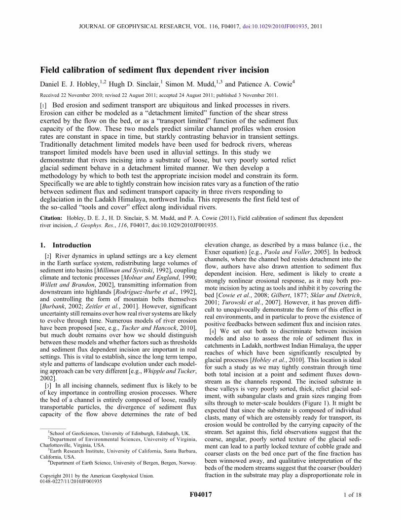
Figure 1. Typical view of an incising trunk channel in theLadakh catchments. The very poorly sorted substrate of gla-cial sediment is visible in the sidewall on the left bank. Thechannel itself contains numerous large boulders but is dom-inated by imbricated, subangular cobbles.
HOBLEY ET AL.: SEDIMENT FLUX DEPENDENT RIVER INCISION F04017F04017
2 of 18
In bedrock rivers, this is because sediment acts as tools todetach bed material, but increasing quantities of bedloadsediment in transport will act to cover a greater proportionof the bed, reducing the likelihood of impact against the bed.The ratio of sediment flux, qs, to carrying capacity of thechannel, qc, appears to control the variation in erosionalefficiency [e.g., Johnson and Whipple, 2010; Sklar andDietrich, 2004]. This “tools and cover” effect should pro-duce a humped form of f(qs, qc) when plotted against qs/qc,where the maximum value of f(qs, qc) = 1 occurs at inter-mediate values of relative sediment flux within the availablerange qs/qc = 0 to 1. However, no actual example of thisrelation has been well constrained either experimentally or inthe field, with authors tending to assume a parabolic oralmost parabolic form based on consideration of kineticenergy flux normal to the bed and a static bed cover pro-portion [Gasparini et al., 2006; Sklar and Dietrich, 1998,2004]. Turowski et al. [2007], in contrast, noted that para-bolic‐type forms do not match laboratory studies of bedabrasion. They showed that allowing for dynamic covering ofthe bed by sediment and spatial heterogeneity of the armoringof the bed creates an exponential decrease for the cover term.Such an adjustment allowed them to more accurately modelthe original Sklar and Dietrich [2001] experimental results.
[9] The transport limited model (here used synonymouslywith Lague’s [2010] “transport capacity limited model”terminology) in contrast postulates that rates of incision in achannel depend on divergence of sediment carrying capacity,qc, in the channel, and thus assumes that enough sediment isalways available on the channel bed to be incorporated intothe flow as required [e.g., Tucker and Bras, 1998; Willgooseet al., 1991]. Such models may be written in general form as
E ¼ 1
1� �p
d
dxqc ð3Þ
where lp is sediment porosity (which, for simplicity, weshall treat as constant), x is the downstream direction, and qcis the sediment carrying capacity per unit width in thechannel [Whipple and Tucker, 2002]. If sediment transportcapacity, qc, in the channel is some function of bed shearstress or a close equivalent, as it is in very many publishedderivations [see, e.g., Bagnold, 1977, 1980; Einstein, 1950;Fernandez Luque and van Beek, 1976; Meyer‐Peter andMuller, 1948; Parker et al., 1982; Schoklitsch, 1962; Yalin,1963], then we may simply use the chain rule to expressthe transport limited equation (3) as
E ¼ 1
1� �p
� � dqcd�
� d�dx
� �: ð4Þ
We can now see the relative effects of variation in each of theprimary controlling variables of transport capacity and shearstress separately. This proves useful in distinguishing theerosion models as described in section 2.3.
2.2. Hybrid Erosion Models
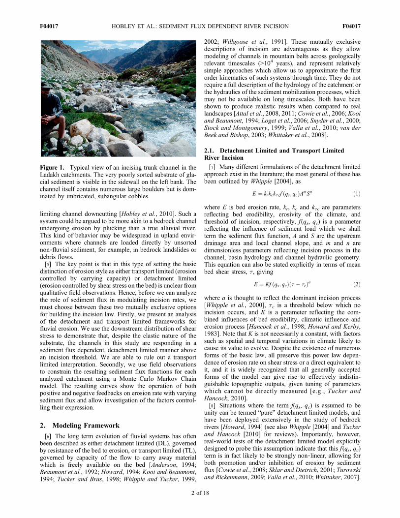
[10] Figure 2 shows the position of the pure detachmentlimited (i.e., equations (1) and (2)) and transport limited(i.e., equations (3) and (4)) erosion laws plotted in terms ofsediment flux and efficiency of erosion. The detachmentlimited model occurs when erosion is not inhibited bysediment cover, and the transport limited condition occurswhen the river is not undersupplied with sediment (i.e. it hasas much or more sediment than it can transport). The shadedsquare area bounded by these two erosion models corre-sponds to systems where interplay of sediment flux andcarrying capacity can control erosion rates, which are fre-quently termed “hybrid” erosional models. Such models canbe thought of as representing situations where neither clasttransport downstream nor clast detachment from the bed canhappen at a rate much faster than the other. Several existingsuggested forms of hybrid models are shown within thisdomain in Figure 2. Note that these all treat the hybriddomain within the detachment limited erosion law asdescribed in section 2.1: the f(qs/qc) term in equations (1)and (2) models the effects of the sediment in the channelby modulating a direct function of shear stress on the bed, asopposed to its divergence downstream.[11] Other authors have also approached the problem of
describing sediment flux and capacity dependent river sys-tems without employing the DL‐TL framework describedhere. Such models [e.g., Beaumont et al., 1992; Braun andSambridge, 1997; Coulthard et al., 1999, 2002; Davy andLague, 2009; Hancock and Anderson, 2002] treat erosionand deposition in the stream as independent but linked
Figure 2. Model space for stream power‐based incisionlaws. Hybrid models shown are (i) linear decline (pure cover)[Beaumont et al., 1992] and three versions of “tools andcover”‐type models: (ii) parabolic [Sklar and Dietrich,2004], (iii) almost parabolic [Gasparini et al., 2006], and(iv) Turowski et al. [2007] dynamic cover models. All threeare based upon detachment limited‐type assumptions (i.e.,equations (1) and (2)). Note that the pure detachment (red)and transport limited (green) domains are orthogonal.Transport limited conditions are not simply the “end‐point”of a pure detachment limited system, and all efficienciesof incision are possible in a sediment‐saturated channel(depending on sediment flux divergence downstream, asopposed to its magnitude). Note that values of relative sed-iment flux greater than 1 are forbidden for incising channels.Small arrows indicate that it is possible to consider the spacewhere incision efficiency is controlled by relative sedimentflux (yellow; the main body of the diagram) both from thetraditional hybrid detachment limited perspective (A) butalso potentially from a modified transport limited perspec-tive (B).
HOBLEY ET AL.: SEDIMENT FLUX DEPENDENT RIVER INCISION F04017F04017
3 of 18
processes, many using a characteristic travel length for aparticle once it is in transit. We acknowledge the potential ofsuch methods to describe these intermediate cases, but donot consider them here. We make this decision partly on thegrounds of frequent difficulty in replicating scaling relations(particularly channel concavity) seen in natural systemsusing such approaches (e.g., Whipple [2004], though thisissue has now been addressed by Davy and Lague [2009]),and partly as such models tend to require parameters (e.g.,particle step lengths) which may be challenging to derive forreal field data. However, these alternative methods should beseen as complementary to the DL‐TL system: the samekinematics can arise from both treatments, and they representcontrasting idealized descriptions of the same underlyingreal processes. We anticipate that a better understanding ofchannel response within one framework will lead to betterunderstanding of the mechanics of the other.
2.3. Discrimination Between Models
[12] Authors have tended to use qualitative observations ofchannel properties to distinguish incision models [e.g.,Anderson, 1994; Kirby and Whipple, 2001; Snyder et al.,2000; Whittaker et al., 2008]. Typically “bedrock” riversare described as detachment limited systems, as the rock’scohesion is likely to make it harder to detach particles thanto transport them. The opposite rationale is often applied toclastic substrates: since the bed is already composed ofparticles, it is likely to be easier to make them mobile than totransport them. This line of logic may be treacherous; bed-rock may be highly fractured, and sediment may still resistmobilization at any given transport stage due to particle‐particle interactions. It is important to be able to testexplicitly the applicability of each of these models to realriver systems.[13] Previous authors have treated the problem of distin-
guishing between incision models by discriminating betweenchannel long profile form (and its evolution) resulting fromeach model type [see, e.g., Whipple, 2004; Attal et al., 2011;Valla et al., 2010]. Under equilibrium conditions in whichchannel erosion is everywhere equal to uplift in the land-scape, the pure detachment limited and transport limitederosion laws (and indeed hybrid cases [e.g., Turowski et al.,2007]) give rise to indistinguishable longitudinal channelprofiles. However, they lead to fundamentally distinctresponse styles as landscapes undergo transient response tochanges in boundary conditions, such as in climatic or tec-tonic forcing [e.g., Whipple and Tucker, 2002]. This isimportant, since these transient conditions are those whichhold promise for reconstructing past conditions affecting alandscape, and moreover the recent, Plio‐Pleistocene sedi-mentary record may be dominated by sediment export fromtransiently responding systems [Zhang et al., 2001]. Tran-sient conditions also underpin predictions of landscaperesponse to future climate change. When perturbed by a stepdisplacement at the foot of a channel network, pure detach-ment limited models of incision where f(qs, qc) = 1 and whereany thresholds are negligible typically lead to a wave‐likeresponse that propagates upstream. A sharp break in channelslope demarks a boundary between a downstream reachwhere the channel is fully adjusted to the new boundaryconditions and an upstream reach where the channel remainsunaffected. This outcome contrasts with the predictions of
the transport limited end member model wherein all pointsin the network respond gradually and together to a changein boundary conditions [Whipple and Tucker, 2002; Wobuset al., 2006]. Less work has focused on the definingdynamics, response characteristics and long profile forms ofhybrid, detachment limited systems where f(qs, qc) ≠ 1. Anexception is the work of Gasparini et al. [2006, 2007], whohave explored the transient dynamics of such a system inwhich f (qs, qc) is allowed to vary, modeling both just thecover effect in isolation (linearly falling f (qs, qc) with qs/qc)and an almost‐parabolic form of the function incorporatingboth tools and cover. They demonstrated more complexresponses combining elements of both diffusive and advec-tive behavior. Similar combined diffusive/advective respon-ses were also shown by Kooi and Beaumont [1994] andDavy and Lague [2009] using particle step models withvariable transport distances analogous to the hybrid modelsdiscussed in this work.[14] However, with access to good quality field data, dis-
crimination between models for an incising channel systemneed not be based on qualitative assessment of channel form.Rather, it is possible to examine the primary driving para-meters (shear stresses, sediment fluxes) and channel response(spatial and temporal variation of incision rate) directly. For agiven pattern of shear stress distribution downstream, the twoincision rules, equations (2) and (4), predict quite differentdistributions of channel incision (Figure 3). This is trueregardless of the forms of the sediment flux dependent termsf(qs, qc) and dqc/dt, neither of which is well establishedacross timescales of landscape evolution. In other words,shear stress distribution downstream is a key discriminatorfor which erosion law is appropriate for a given setting, if itserosion history is known or can be inferred.[15] We illustrate this idea by a hypothetical example
(Figure 3). We consider two possible contrasting channelshear stress distributions (Figures 3a and 3b), then illustrateschematically possible instantaneous incision responsesexpected under detachment and transport limited models(Figures 3c–3f), including possible sediment flux effects(see Figure 3 caption). The form of each instantaneousincision response shown by the curves in Figures 3c–3f isuniquely associated with the shear stresses producing it(Figures 3a and 3b). This uniqueness is due to the contrastbetween the power function of shear stress shown in thedetachment limited equation (2) and the differential of shearstress shown in the transport limited equation (4). Therefore,locations where either (t − t0) = 0 or dt/dx = 0 must recordzero incision in the detachment limited and transport limitedlaws respectively. Varying the sediment flux dependentterm ( f (qs, qc)) in the detachment limited law allows for theincision maxima to be translated up or downstream (e.g.,solid arrows), but cannot translate these zero points upstreamor downstream.[16] Thus comparison between positions of maxima,
minima and zero points in the downstream distributions ofincision and shear stress in natural channels forms a keydiagnostic tool for differentiating between these two inci-sion models. While Figure 3 presents only an instantaneouschannel response under each of these models, as long asthe cumulative incision remains relatively small (i.e., littlechange in long profile form since incision began, and theconsidered shear stress still reflects its time integrated
HOBLEY ET AL.: SEDIMENT FLUX DEPENDENT RIVER INCISION F04017F04017
4 of 18
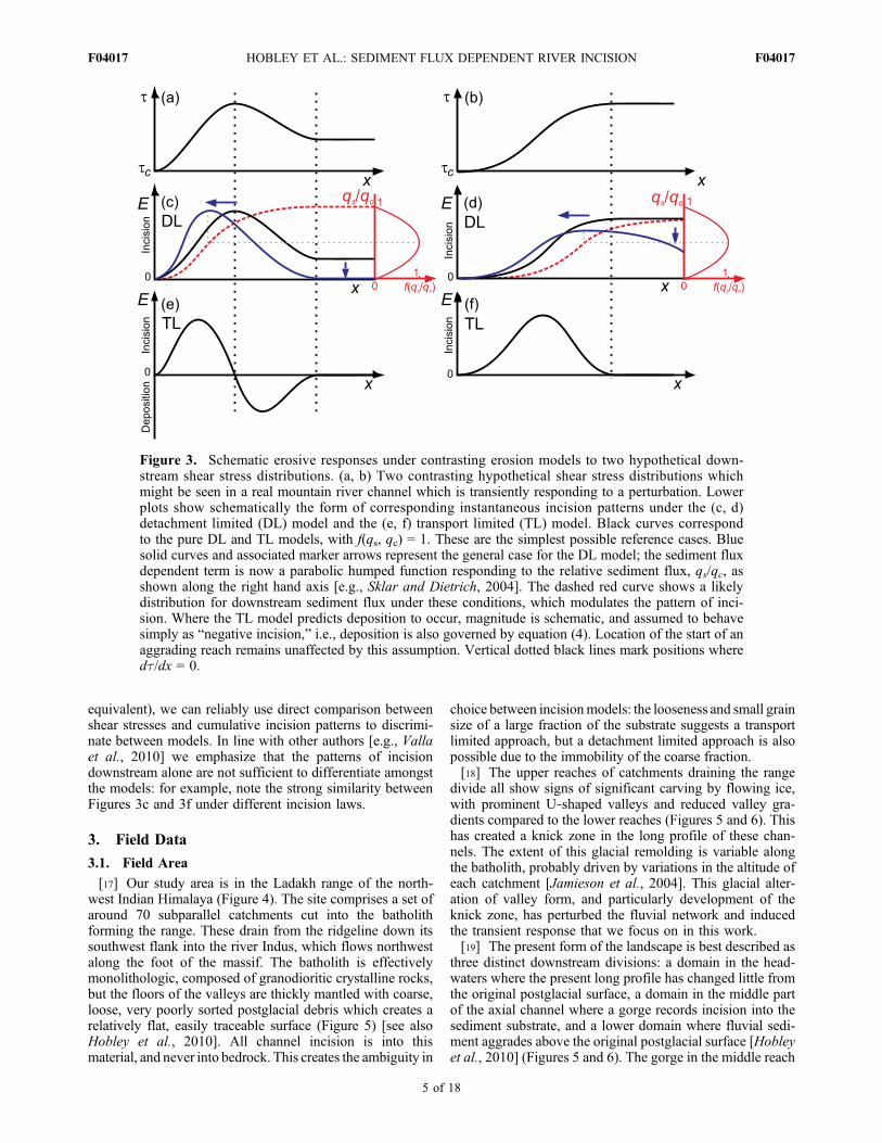
equivalent), we can reliably use direct comparison betweenshear stresses and cumulative incision patterns to discrimi-nate between models. In line with other authors [e.g., Vallaet al., 2010] we emphasize that the patterns of incisiondownstream alone are not sufficient to differentiate amongstthe models: for example, note the strong similarity betweenFigures 3c and 3f under different incision laws.
3. Field Data
3.1. Field Area
[17] Our study area is in the Ladakh range of the north-west Indian Himalaya (Figure 4). The site comprises a set ofaround 70 subparallel catchments cut into the batholithforming the range. These drain from the ridgeline down itssouthwest flank into the river Indus, which flows northwestalong the foot of the massif. The batholith is effectivelymonolithologic, composed of granodioritic crystalline rocks,but the floors of the valleys are thickly mantled with coarse,loose, very poorly sorted postglacial debris which creates arelatively flat, easily traceable surface (Figure 5) [see alsoHobley et al., 2010]. All channel incision is into thismaterial, and never into bedrock. This creates the ambiguity in
choice between incisionmodels: the looseness and small grainsize of a large fraction of the substrate suggests a transportlimited approach, but a detachment limited approach is alsopossible due to the immobility of the coarse fraction.[18] The upper reaches of catchments draining the range
divide all show signs of significant carving by flowing ice,with prominent U‐shaped valleys and reduced valley gra-dients compared to the lower reaches (Figures 5 and 6). Thishas created a knick zone in the long profile of these chan-nels. The extent of this glacial remolding is variable alongthe batholith, probably driven by variations in the altitude ofeach catchment [Jamieson et al., 2004]. This glacial alter-ation of valley form, and particularly development of theknick zone, has perturbed the fluvial network and inducedthe transient response that we focus on in this work.[19] The present form of the landscape is best described as
three distinct downstream divisions: a domain in the head-waters where the present long profile has changed little fromthe original postglacial surface, a domain in the middle partof the axial channel where a gorge records incision into thesediment substrate, and a lower domain where fluvial sedi-ment aggrades above the original postglacial surface [Hobleyet al., 2010] (Figures 5 and 6). The gorge in the middle reach
Figure 3. Schematic erosive responses under contrasting erosion models to two hypothetical down-stream shear stress distributions. (a, b) Two contrasting hypothetical shear stress distributions whichmight be seen in a real mountain river channel which is transiently responding to a perturbation. Lowerplots show schematically the form of corresponding instantaneous incision patterns under the (c, d)detachment limited (DL) model and the (e, f) transport limited (TL) model. Black curves correspondto the pure DL and TL models, with f(qs, qc) = 1. These are the simplest possible reference cases. Bluesolid curves and associated marker arrows represent the general case for the DL model; the sediment fluxdependent term is now a parabolic humped function responding to the relative sediment flux, qs/qc, asshown along the right hand axis [e.g., Sklar and Dietrich, 2004]. The dashed red curve shows a likelydistribution for downstream sediment flux under these conditions, which modulates the pattern of inci-sion. Where the TL model predicts deposition to occur, magnitude is schematic, and assumed to behavesimply as “negative incision,” i.e., deposition is also governed by equation (4). Location of the start of anaggrading reach remains unaffected by this assumption. Vertical dotted black lines mark positions wheredt/dx = 0.
HOBLEY ET AL.: SEDIMENT FLUX DEPENDENT RIVER INCISION F04017F04017
5 of 18
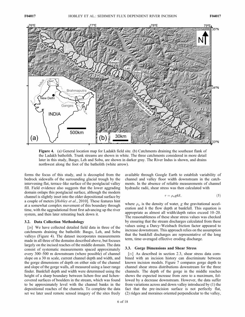
forms the focus of this study, and is decoupled from thebedrock sidewalls of the surrounding glacial trough by theintervening flat, terrace‐like surface of the postglacial valleyfill. Field evidence also suggests that the lower aggradingdomain onlaps this postglacial surface, although the modernchannel is slightly inset into the older depositional surface bya couple of meters [Hobley et al., 2010]. These features hintat a somewhat complex movement of this boundary throughtime, with the aggradational front first advancing up the riversystem, and then later retreating back down it.
3.2. Data Collection Methodology
[20] We have collected detailed field data in three of thecatchments draining the batholith: Basgo, Leh, and Sobuvalleys (Figure 4). The dataset incorporates measurementsmade in all three of the domains described above, but focuseslargely on the incised reaches of the middle domain. The dataconsist of systematic measurements spaced approximatelyevery 300–500 m downstream (where possible) of channelslope on a 30 m scale, current channel depth and width, andthe gorge dimensions of depth on either side of the channeland slope of the gorge walls, all measured using a laser rangefinder. Bankfull depth and width were determined using theheight of a sharp boundary between lichen‐free and lichen‐covered surfaces of boulders in the stream, which was foundto be approximately level with the channel banks in thedepositional reaches of the channels. To complete the dataset we later used remote sensed imagery of the sites freely
available through Google Earth to establish variability ofchannel and valley floor width downstream in the catch-ments. In the absence of reliable measurements of channelhydraulic radii, shear stress was then calculated with
� ¼ �wghS; ð5Þ
where rw is the density of water, g the gravitational accel-eration and h the flow depth at bankfull. This equation isappropriate as almost all width/depth ratios exceed 10–20.The reasonableness of these shear stress values was checkedby ensuring that the stream discharges calculated from thesevalues using a Darcy‐Weisbach friction factor appeared toincrease downstream. This approach relies on the assumptionthat the bankfull discharges are representative of the longterm, time‐averaged effective eroding discharge.
3.3. Gorge Dimensions and Shear Stress
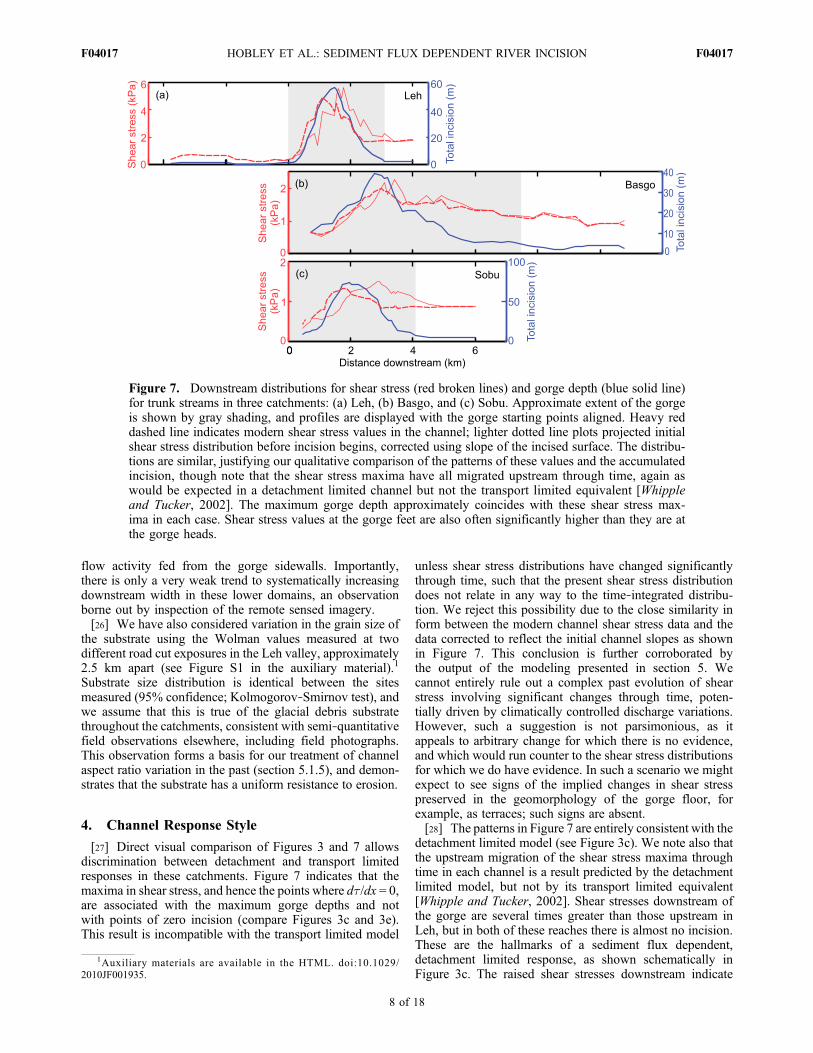
[21] As described in section 2.3, shear stress data com-bined with an incision history can discriminate betweenknown incision models. Figure 7 compares gorge depth tochannel shear stress distributions downstream for the threechannels. The depth of the gorge in the middle reachesshows the expected increase from zero to a maximum, fol-lowed by a decrease downstream. However, the data sufferfrom variations across and down valley introduced by (1) thefact that the pre‐incision surface is not perfectly flat,(2) ridges and moraines oriented perpendicular to the valley,
Figure 4. (a) General location map for Ladakh field site. (b) Catchments draining the southeast flank ofthe Ladakh batholith. Trunk streams are shown in white. The three catchments considered in more detaillater in this study, Basgo, Leh and Sobu, are shown in darker gray. The River Indus is shown, and drainsnorthwest along the foot of the batholith (white arrow).
HOBLEY ET AL.: SEDIMENT FLUX DEPENDENT RIVER INCISION F04017F04017
6 of 18
and (3) locations where the gorge sidewalls coincide withthe rock walls of the glacial trough. To reduce the impactof these variations, we present gorge depth as a five pointmoving average downstream of the maximum gorge depthpresent at each site (Figure 7). This also has the advantage ofsmoothing the data to an appropriate level to stabilize thenumerical simulations performed subsequently.[22] Calculated shear stresses (equation (5)) are plotted
alongside gorge depth data (Figure 7) and are also smoothedwith a five point moving average to allow direct comparisonbetween the datasets. Figure 7 displays both shear stressesderived for the modern channel and values corrected for thechange in bed gradient since incision began. We derive thesecorrected values by substituting the slope of the incisedsurface for that of the modern channel in equation (5). Inboth cases, shear stresses rise from a roughly constant valuein the headwaters (only seen in Leh), and return to a roughlyconstant value around or just before the end of the gorge,but the stable value of shear stress is approximately fourtimes higher downstream of the gorge than the valuesupstream (see Leh). The peaks are broadly coincident forboth the initial and modern values, indicating there has notbeen a profound change in the distribution through time forthe region within the gorge, although for each channel the
modern shear stress maximum is marginally (<1 km) furtherupstream than its initial position. In all the valleys, maxi-mum shear stresses broadly coincide with maximum gorgedepth.[23] We have also analyzed data describing the gorge
sidewall angles, focusing on Basgo and Leh valleys, anddiscarding any measurements taken where bedrock wasknown to be exposed in these slopes. These data (N = 54)have a mean of 31.4° and a median of 32.3°, and these valuesare indistinguishable between valleys. Similarly, analysis ofremotely sensed imagery suggests that the width of thevalley floor within the gorge does not evolve with distancedownstream, and is approximately 40 m in all cases, thoughwith some variation (±10 m) around this value both down-stream and between valleys.[24] In the Leh and Sobu valleys, shear stress becomes
almost constant (dt/dx → 0) in the modern values approx-imately 1 km before the end of the modern gorge (Figure 7).This change is less extreme, but still present for Basgo. Weinfer that this change is related to the onset of aggradation inthe channel and associated changes in channel dynamics,and the position of this point is consistent with field evi-dence that the postglacial surface is onlapped by the fluvialsediments.
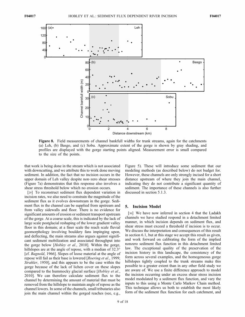
3.4. Channel Width and Substrate Grain Size
[25] The distribution of channel widths varies markedlybetween the three process domains (glacial, incisional andaggradational) outlined above (Figure 8). In the upper gla-cial domain large variation is present, reflecting changingsubstrate grain size as the channel passes over and betweendebris flow fans [cf. Hobley et al., 2010]. In the aggrada-tional domain and within the gorge, channel width is moreuniform, with occasional high outliers. Qualitative fieldobservations indicate that localized width maxima within thegorge are sometimes associated with recent localized debris
Figure 6. Present long profile form for Leh valley, asexample of general form. The three domains are illustrated(Roman numerals), with black arrows indicating sense ofmotion of the river through time. Dark shading in the middlereaches indicates material removed, and picks out the gorgeincised below the postglacial surface. Light shading in thelower reaches indicates material deposited above the origi-nal postglacial valley floor (dotted line, shown schemati-cally); likely complexity in the motion of the boundarybetween these two domains through time is not shown here.Little change through time in the long profile occurs in theupper reaches.
Figure 5. Panoramic view of Leh catchment, lookingnorthwest, taken from Google Earth (© Mapabc.com, Goo-gle; images © Cnes/Spot Image, DigitalGlobe). Colorationchange in the lower right corner of the image is due to stitch-ing of two images and can be ignored. Field of view isroughly 6 km across. Trunk stream drains southwards (left).The postglacial sediment surface described in the main textis clear, running down from the upper reaches in the U‐shaped valley (top right) round the dogleg, through the mid-dle reaches of the valley and disappearing under the broadalluvial depositional domain just after the rock spur whichcreates a kink in the river planform (lower arrow). Note thatthis depositional domain now fills the prominent terminalmoraine complex in this valley (bottom left corner, down-stream of lower arrow). The incised gorge surrounding thetrunk stream which we primarily focus on in this work is vis-ible cutting into the postglacial surface in the middlereaches, the start and end of which are marked by the arrows.
HOBLEY ET AL.: SEDIMENT FLUX DEPENDENT RIVER INCISION F04017F04017
7 of 18
flow activity fed from the gorge sidewalls. Importantly,there is only a very weak trend to systematically increasingdownstream width in these lower domains, an observationborne out by inspection of the remote sensed imagery.[26] We have also considered variation in the grain size of
the substrate using the Wolman values measured at twodifferent road cut exposures in the Leh valley, approximately2.5 km apart (see Figure S1 in the auxiliary material).1
Substrate size distribution is identical between the sitesmeasured (95% confidence; Kolmogorov‐Smirnov test), andwe assume that this is true of the glacial debris substratethroughout the catchments, consistent with semi‐quantitativefield observations elsewhere, including field photographs.This observation forms a basis for our treatment of channelaspect ratio variation in the past (section 5.1.5), and demon-strates that the substrate has a uniform resistance to erosion.
4. Channel Response Style
[27] Direct visual comparison of Figures 3 and 7 allowsdiscrimination between detachment and transport limitedresponses in these catchments. Figure 7 indicates that themaxima in shear stress, and hence the points where dt/dx = 0,are associated with the maximum gorge depths and notwith points of zero incision (compare Figures 3c and 3e).This result is incompatible with the transport limited model
unless shear stress distributions have changed significantlythrough time, such that the present shear stress distributiondoes not relate in any way to the time‐integrated distribu-tion. We reject this possibility due to the close similarity inform between the modern channel shear stress data and thedata corrected to reflect the initial channel slopes as shownin Figure 7. This conclusion is further corroborated bythe output of the modeling presented in section 5. Wecannot entirely rule out a complex past evolution of shearstress involving significant changes through time, poten-tially driven by climatically controlled discharge variations.However, such a suggestion is not parsimonious, as itappeals to arbitrary change for which there is no evidence,and which would run counter to the shear stress distributionsfor which we do have evidence. In such a scenario we mightexpect to see signs of the implied changes in shear stresspreserved in the geomorphology of the gorge floor, forexample, as terraces; such signs are absent.[28] The patterns in Figure 7 are entirely consistent with the
detachment limited model (see Figure 3c). We note also thatthe upstream migration of the shear stress maxima throughtime in each channel is a result predicted by the detachmentlimited model, but not by its transport limited equivalent[Whipple and Tucker, 2002]. Shear stresses downstream ofthe gorge are several times greater than those upstream inLeh, but in both of these reaches there is almost no incision.These are the hallmarks of a sediment flux dependent,detachment limited response, as shown schematically inFigure 3c. The raised shear stresses downstream indicate
Figure 7. Downstream distributions for shear stress (red broken lines) and gorge depth (blue solid line)for trunk streams in three catchments: (a) Leh, (b) Basgo, and (c) Sobu. Approximate extent of the gorgeis shown by gray shading, and profiles are displayed with the gorge starting points aligned. Heavy reddashed line indicates modern shear stress values in the channel; lighter dotted line plots projected initialshear stress distribution before incision begins, corrected using slope of the incised surface. The distribu-tions are similar, justifying our qualitative comparison of the patterns of these values and the accumulatedincision, though note that the shear stress maxima have all migrated upstream through time, again aswould be expected in a detachment limited channel but not the transport limited equivalent [Whippleand Tucker, 2002]. The maximum gorge depth approximately coincides with these shear stress max-ima in each case. Shear stress values at the gorge feet are also often significantly higher than they are atthe gorge heads.
1Auxiliary materials are available in the HTML. doi:10.1029/2010JF001935.
HOBLEY ET AL.: SEDIMENT FLUX DEPENDENT RIVER INCISION F04017F04017
8 of 18
that work is being done in the stream which is not associatedwith downcutting, and we attribute this to work done movingsediment. In addition, the fact that no incision occurs in theupper domain of Leh valley despite non‐zero shear stresses(Figure 7a) demonstrates that this response also involves ashear stress threshold below which no erosion occurs.[29] To reconstruct sediment flux dependent variation in
incision rates, we also need to constrain the magnitude of thesediment flux as it evolves downstream in the gorge. Sedi-ment flux in the channel can be supplied from upstream andfrom valley sidewalls and floor. There is no evidence forsignificant amounts of erosion or sediment transport upstreamof the gorge. At a coarse scale, this is indicated by the lack oflarge scale postglacial reshaping of the lower gradient valleyfloor in this domain; at a finer scale the reach scale fluvialgeomorphology involving bouldery fans impinging upon,and deflecting, the main streams also argues against signifi-cant sediment mobilization and associated throughput intothe gorge below [Hobley et al., 2010]. Within the gorge,hillslopes are at the angle of repose, with a median of 32.3°[cf. Bagnold, 1966]. Slopes of loose material at the angle ofrepose will fail as their base is lowered [Roering et al., 1999;Strahler, 1950], and this appears to be the case within thegorge because of the lack of lichen cover on these slopescompared to the hummocky glacial surface [Hobley et al.,2010]. We can therefore calculate sediment flux to thechannel by determining the amount of material that must beremoved from the hillslope to maintain angle of repose as thechannel lowers. In some of the channels, small tributaries alsojoin the main channel within the gorged reaches (see, e.g.,
Figure 5). These will introduce some sediment that ourmodeling methods (as described below) do not budget for.However, these channels are only strongly incised for a shortdistance upstream of where they join the main channel,indicating they do not contribute a significant quantity ofsediment. The importance of these channels is also furtherdiscussed in section 5.1.3.
5. Incision Model
[30] We have now inferred in section 4 that the Ladakhchannels we have studied respond in a detachment limitedmanner, in which incision depends on sediment flux, andshear stress must exceed a threshold if incision is to occur.We discuss the interpretation and consequences of this resultin section 6.1, but at this stage we accept this result as given,and work forward on calibrating the form of the impliednonzero sediment flux function in this detachment limitedlaw. The exceptional quality of the preservation of theincision history in this landscape, the consistency of theform across several examples, and the homogeneous gorgehillslopes tightly coupled to the trunk streams make thispossible to a greater extent than in any other field study weare aware of. We use a finite difference approach to modelthe incision occurring under an excess shear stress incisionmodel modulated by a sediment flux function, and vary theinputs to this using a Monte Carlo Markov Chain method.This technique allows us both to establish the most likelyform of the sediment flux function for each catchment, and
Figure 8. Field measurements of channel bankfull widths for trunk streams, again for the catchments(a) Leh, (b) Basgo, and (c) Sobu. Approximate extent of the gorge is shown by gray shading, andprofiles are displayed with the gorge starting points aligned. Measurement error is small comparedto the size of the points.
HOBLEY ET AL.: SEDIMENT FLUX DEPENDENT RIVER INCISION F04017F04017
9 of 18
to rigorously assess the uncertainties associated with thesesolutions.
5.1. Approach
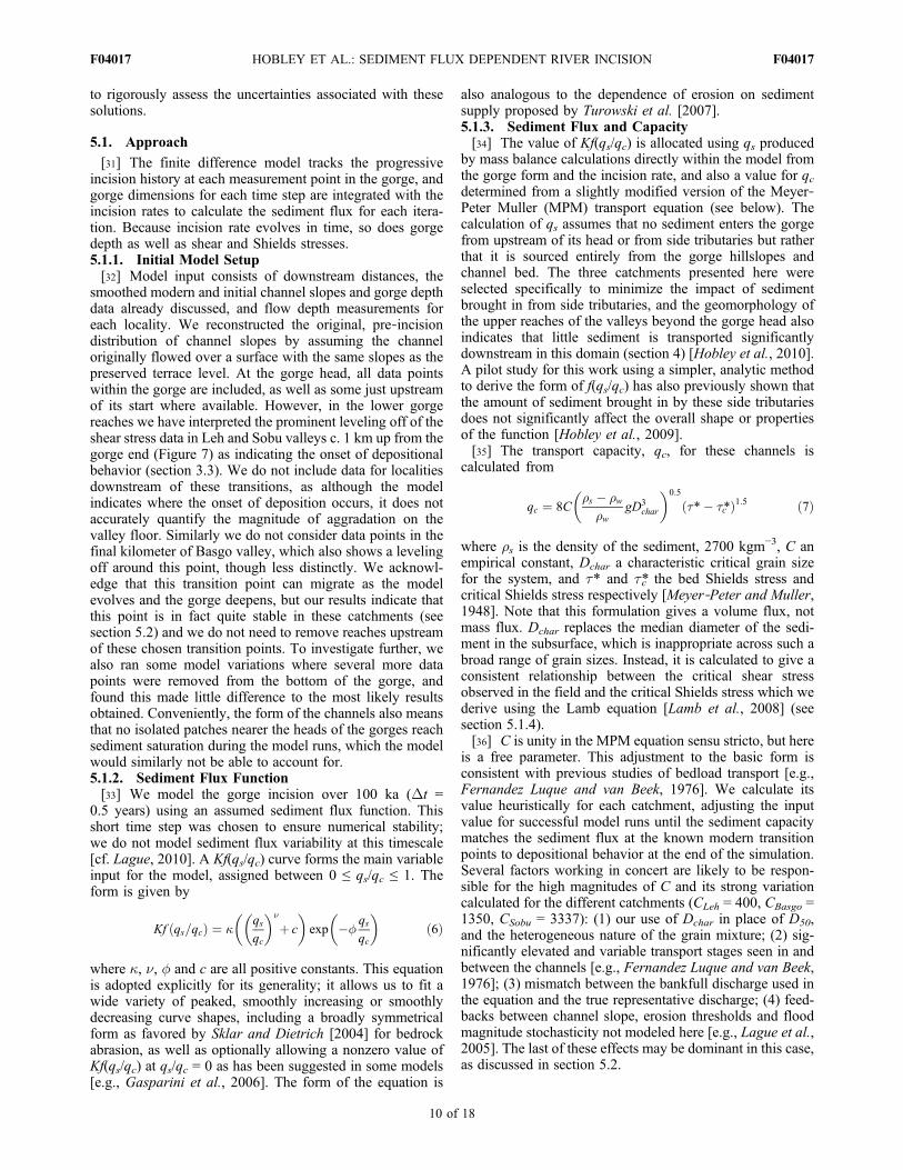
[31] The finite difference model tracks the progressiveincision history at each measurement point in the gorge, andgorge dimensions for each time step are integrated with theincision rates to calculate the sediment flux for each itera-tion. Because incision rate evolves in time, so does gorgedepth as well as shear and Shields stresses.5.1.1. Initial Model Setup[32] Model input consists of downstream distances, the
smoothed modern and initial channel slopes and gorge depthdata already discussed, and flow depth measurements foreach locality. We reconstructed the original, pre‐incisiondistribution of channel slopes by assuming the channeloriginally flowed over a surface with the same slopes as thepreserved terrace level. At the gorge head, all data pointswithin the gorge are included, as well as some just upstreamof its start where available. However, in the lower gorgereaches we have interpreted the prominent leveling off of theshear stress data in Leh and Sobu valleys c. 1 km up from thegorge end (Figure 7) as indicating the onset of depositionalbehavior (section 3.3). We do not include data for localitiesdownstream of these transitions, as although the modelindicates where the onset of deposition occurs, it does notaccurately quantify the magnitude of aggradation on thevalley floor. Similarly we do not consider data points in thefinal kilometer of Basgo valley, which also shows a levelingoff around this point, though less distinctly. We acknowl-edge that this transition point can migrate as the modelevolves and the gorge deepens, but our results indicate thatthis point is in fact quite stable in these catchments (seesection 5.2) and we do not need to remove reaches upstreamof these chosen transition points. To investigate further, wealso ran some model variations where several more datapoints were removed from the bottom of the gorge, andfound this made little difference to the most likely resultsobtained. Conveniently, the form of the channels also meansthat no isolated patches nearer the heads of the gorges reachsediment saturation during the model runs, which the modelwould similarly not be able to account for.5.1.2. Sediment Flux Function[33] We model the gorge incision over 100 ka (Dt =
0.5 years) using an assumed sediment flux function. Thisshort time step was chosen to ensure numerical stability;we do not model sediment flux variability at this timescale[cf. Lague, 2010]. A Kf(qs/qc) curve forms the main variableinput for the model, assigned between 0 ≤ qs/qc ≤ 1. Theform is given by
Kf qs=qcð Þ ¼ �qsqc
� ��
þ c
� �exp �f
qsqc
� �ð6Þ
where �, n, f and c are all positive constants. This equationis adopted explicitly for its generality; it allows us to fit awide variety of peaked, smoothly increasing or smoothlydecreasing curve shapes, including a broadly symmetricalform as favored by Sklar and Dietrich [2004] for bedrockabrasion, as well as optionally allowing a nonzero value ofKf(qs/qc) at qs/qc = 0 as has been suggested in some models[e.g., Gasparini et al., 2006]. The form of the equation is
also analogous to the dependence of erosion on sedimentsupply proposed by Turowski et al. [2007].5.1.3. Sediment Flux and Capacity[34] The value of Kf(qs/qc) is allocated using qs produced
by mass balance calculations directly within the model fromthe gorge form and the incision rate, and also a value for qcdetermined from a slightly modified version of the Meyer‐Peter Muller (MPM) transport equation (see below). Thecalculation of qs assumes that no sediment enters the gorgefrom upstream of its head or from side tributaries but ratherthat it is sourced entirely from the gorge hillslopes andchannel bed. The three catchments presented here wereselected specifically to minimize the impact of sedimentbrought in from side tributaries, and the geomorphology ofthe upper reaches of the valleys beyond the gorge head alsoindicates that little sediment is transported significantlydownstream in this domain (section 4) [Hobley et al., 2010].A pilot study for this work using a simpler, analytic methodto derive the form of f(qs/qc) has also previously shown thatthe amount of sediment brought in by these side tributariesdoes not significantly affect the overall shape or propertiesof the function [Hobley et al., 2009].[35] The transport capacity, qc, for these channels is
calculated from
qc ¼ 8C�s � �w
�wgD3
char
� �0:5
�*� �c*ð Þ1:5 ð7Þ
where rs is the density of the sediment, 2700 kgm−3, C anempirical constant, Dchar a characteristic critical grain sizefor the system, and t* and t*c the bed Shields stress andcritical Shields stress respectively [Meyer‐Peter and Muller,1948]. Note that this formulation gives a volume flux, notmass flux. Dchar replaces the median diameter of the sedi-ment in the subsurface, which is inappropriate across such abroad range of grain sizes. Instead, it is calculated to give aconsistent relationship between the critical shear stressobserved in the field and the critical Shields stress which wederive using the Lamb equation [Lamb et al., 2008] (seesection 5.1.4).[36] C is unity in the MPM equation sensu stricto, but here
is a free parameter. This adjustment to the basic form isconsistent with previous studies of bedload transport [e.g.,Fernandez Luque and van Beek, 1976]. We calculate itsvalue heuristically for each catchment, adjusting the inputvalue for successful model runs until the sediment capacitymatches the sediment flux at the known modern transitionpoints to depositional behavior at the end of the simulation.Several factors working in concert are likely to be respon-sible for the high magnitudes of C and its strong variationcalculated for the different catchments (CLeh = 400, CBasgo =1350, CSobu = 3337): (1) our use of Dchar in place of D50,and the heterogeneous nature of the grain mixture; (2) sig-nificantly elevated and variable transport stages seen in andbetween the channels [e.g., Fernandez Luque and van Beek,1976]; (3) mismatch between the bankfull discharge used inthe equation and the true representative discharge; (4) feed-backs between channel slope, erosion thresholds and floodmagnitude stochasticity not modeled here [e.g., Lague et al.,2005]. The last of these effects may be dominant in this case,as discussed in section 5.2.
HOBLEY ET AL.: SEDIMENT FLUX DEPENDENT RIVER INCISION F04017F04017
10 of 18
[37] We have chosen to use the MPM relation instead ofone of the very many alternative sediment capacity equa-tions since (1) it is of simple form, (2) it makes predictionsbased on a small set of variables, predictable back throughtime, and (3) most previous studies of the tools and covereffect have used this formulation. We recognize that we areusing the MPM relation under a circumstance it was notderived to explicitly describe, that of a heterogeneous grainmixture. However, we note that most other transport lawswhich we could have selected [e.g., Bagnold, 1977; Bagnold,1980; Einstein, 1950; Fernandez Luque and van Beek,1976; Meyer‐Peter and Muller, 1948; Parker et al., 1982;Schoklitsch, 1962; Yalin, 1963] rely on a similar form,analogous to excess shear stress raised to a power of 1.5. Themultiplier in front of this tends to be only a weak function ofvariables which we expect may evolve downstream in ourchannels. Thus we expect a similar downstream form frommany of the relations, and since we can reliably infer theabsolute value of sediment flux at the point of sedimentsaturation from our field observations, we can independentlycalibrate the function magnitude at capacity. This means thechoice of specific function is not critical to the outcome ofthis study.5.1.4. Thresholds[38] We require threshold values for both shear stress and
Shields’ stress for our equations. We use the Lamb equation[Lamb et al., 2008] to derive the critical Shields stress,which makes this value a weak function of slope:
�*c ¼ 0:15S0:25 ð8Þ
We derive values for tc for our channels based on consid-eration of past values of shear stress in the channels, but alsoincorporating this threshold sensitivity to slope, sinceShields stress is given by
�* ¼ �
g �s � �wð ÞDcharð9Þ
We thus calculated the shear stresses that would have beenpresent in the gorge head at the start of its evolution using thecalculated initial values of channel slope, correcting for thisslope sensitivity, and adjusted the value of Dchar uniformlyfor all streams in order to allow incision everywhere withinall gorges but forbid it at all points upstream. The criticalvalue of Dchar was calculated as 0.229 m, which seemsfeasible based on the known caliber of the bed sediment atthe gorge head. In fact, without this slope sensitivity, it is notpossible to select a single value to predict tc everywhere atonce, providing support for our use of equation (8).5.1.5. Model Output[39] The model output is determined by a slightly modi-
fied version of equation (2), the general detachment limitederosion equation:
dZ 1þ 2H
WV tan 32�
� �¼ Kf qs=qcð Þ � � �cð Þdt ð10Þ
where dZ is the incremental incision across a time step,H is the total accumulated gorge depth,WV is the gorge floorwidth, and dt the length of a short time step. This equationsolves to give the value of the combined expression Kf(qs/qc).Since the standard sediment flux dependent detachment
limited model treats 0 < f (qs/qc) < 1, we can then rescale thesolution to give both K, presumed constant within eachvalley, and f(qs/qc) separately. Note that we assume a = 1 inequation (2) to derive equation (10): this is the value theo-retically associated with erosion proceeding by plucking ofclasts from the bed [Whipple et al., 2000] as we hypothesizeis appropriate here, and authors using higher values in theincision law tend to be aiming to implicitly incorporatesediment or threshold effects which we treat here explicitly[Whipple and Tucker, 2002]. The variable t evolves as afunction of S throughout the run, which assumes constancyof discharge and channel aspect ratio through time, the latterbeing a reasonable assumption given the uniform grain sizedistribution in the glacial substrate [Finnegan et al., 2005].We take t = 100,000 years based on the age of the postglacialvalley floor [Owen et al., 2006]. This value has a largeuncertainty, but as long as the glacier retreat time is the samein each valley, the absolute value is of little importance asfractional error will be subsumed into the erodibilityparameter K. The term inside the brackets on the left handside of the equation reflects the complexity that as we cutdown in a v‐shaped gorge, for a unit of downwards incisionwe must also simultaneously mobilize all the material shedinto the channel from the angle of repose hillslopes. We treatthe addition of this material as instantaneous and assume it iseffectively spread evenly across the valley floor. The uni-formity of the substrate, demonstrated 32° hillslopes(sections 3.3 and 3.4) and long time scale considered serveto make these assumptions reasonable.5.1.6. Optimal Solutions[40] Our goal is to determine the form of equation (6), or in
other words to constrain the coefficients �, n, � and c. Wetreat these coefficients as unknown, and determine theirvalues and the uncertainties in their values using a MonteCarlo Markov Chain MCMC) method. Values of the coef-ficients are changed after each iteration of the MCMC‘chain’ and then accepted or rejected using an acceptancecriterion (see below). For each iteration the parameter valuesdeviate from the last accepted parameter value, and thisdeviation is selected from a Gaussian probability distributionthat is bounded by minimum and maximum parametervalues. Following standard practice, the standard deviationof the Gaussian distribution of each parameter is set so thatthe acceptance rate of each iteration is ∼33% [Gelman et al.,2004]. This process is iterated upon several thousand times inorder to constrain the posterior distribution of the modelcoefficients [e.g., Berg, 2004]. The acceptance criterion isbased on the Metropolis‐Hastings algorithm [Hastings,1970]. The proposed values of the model coefficients areused to drive the finite difference model of channel evolutionacross the 100,000 year span of gorge development. Themodel predicts the depth of gorge incision. This modelprediction is then compared to the measured gorge todetermine the likelihood of the coefficients in equation (6),based on a maximum likelihood estimator (MLE) of the form
MLE ¼Yni¼1
exp � Hmeasi � Hmod
i
� �22�H
" #ð11Þ
where n is the number of data points, H is the depth of thegorge, the superscripts meas and mod indicate measured and
HOBLEY ET AL.: SEDIMENT FLUX DEPENDENT RIVER INCISION F04017F04017
11 of 18
modeled values, respectively, and sH is an estimate of thevariability of the gorge depth, although the value of this hasno effect on the outcome of the method (i.e., this value doesnot change the most likely parameter values or their credi-bility bounds). The likelihood of the current iteration iscompared to the previous iteration. If the ratio likelihood ofthe new iteration to the previous iteration is >1, then the newcoefficient values are accepted. If this ratio is <1, then thenew coefficients are accepted with a probability equal to theratio. To generate the posterior distribution of coefficientvalues, each iteration in the Markov Chain is weighted by thelikelihood of the combination of parameter values, creating aprobability distribution of each coefficient. This can be usedto determine both mean and 95% credibility limits on theparameter values (Figure 9).
5.2. Optimal Results From the Forward Model
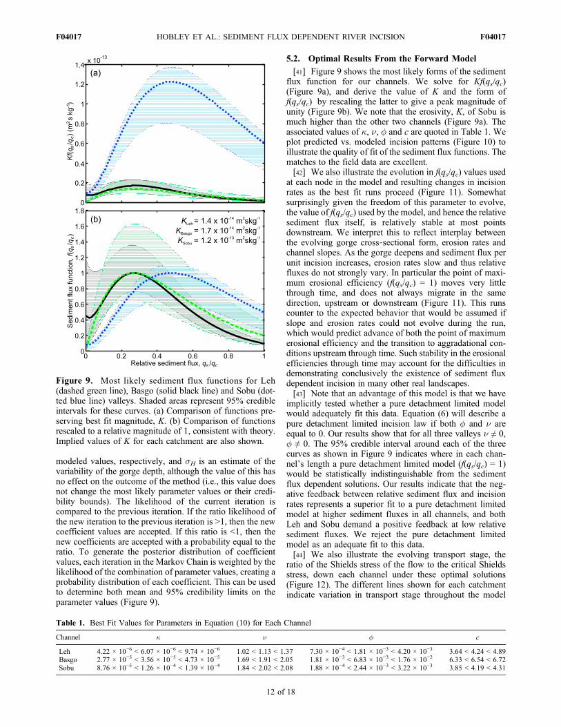
[41] Figure 9 shows the most likely forms of the sedimentflux function for our channels. We solve for Kf(qs/qc)(Figure 9a), and derive the value of K and the form off(qs/qc) by rescaling the latter to give a peak magnitude ofunity (Figure 9b). We note that the erosivity, K, of Sobu ismuch higher than the other two channels (Figure 9a). Theassociated values of �, n, � and c are quoted in Table 1. Weplot predicted vs. modeled incision patterns (Figure 10) toillustrate the quality of fit of the sediment flux functions. Thematches to the field data are excellent.[42] We also illustrate the evolution in f(qs/qc) values used
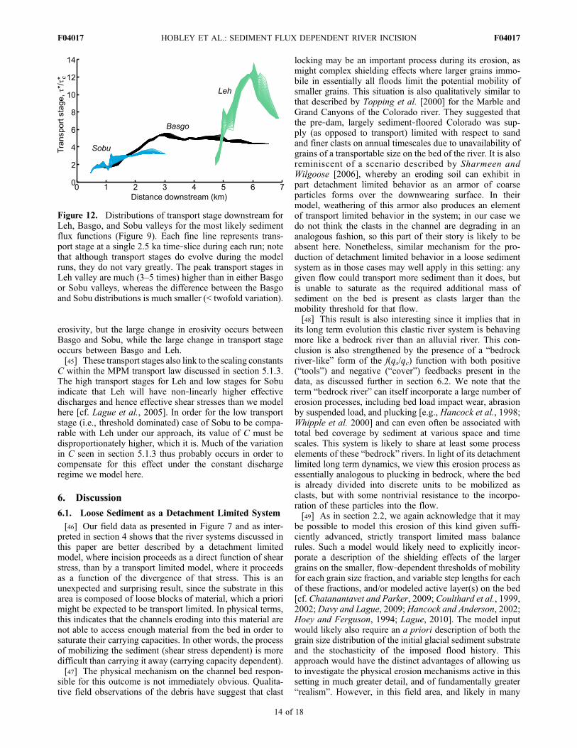
at each node in the model and resulting changes in incisionrates as the best fit runs proceed (Figure 11). Somewhatsurprisingly given the freedom of this parameter to evolve,the value of f(qs/qc) used by the model, and hence the relativesediment flux itself, is relatively stable at most pointsdownstream. We interpret this to reflect interplay betweenthe evolving gorge cross‐sectional form, erosion rates andchannel slopes. As the gorge deepens and sediment flux perunit incision increases, erosion rates slow and thus relativefluxes do not strongly vary. In particular the point of maxi-mum erosional efficiency (f(qs/qc) = 1) moves very littlethrough time, and does not always migrate in the samedirection, upstream or downstream (Figure 11). This runscounter to the expected behavior that would be assumed ifslope and erosion rates could not evolve during the run,which would predict advance of both the point of maximumerosional efficiency and the transition to aggradational con-ditions upstream through time. Such stability in the erosionalefficiencies through time may account for the difficulties indemonstrating conclusively the existence of sediment fluxdependent incision in many other real landscapes.[43] Note that an advantage of this model is that we have
implicitly tested whether a pure detachment limited modelwould adequately fit this data. Equation (6) will describe apure detachment limited incision law if both � and n areequal to 0. Our results show that for all three valleys n ≠ 0,� ≠ 0. The 95% credible interval around each of the threecurves as shown in Figure 9 indicates where in each chan-nel’s length a pure detachment limited model (f(qs/qc) = 1)would be statistically indistinguishable from the sedimentflux dependent solutions. Our results indicate that the neg-ative feedback between relative sediment flux and incisionrates represents a superior fit to a pure detachment limitedmodel at higher sediment fluxes in all channels, and bothLeh and Sobu demand a positive feedback at low relativesediment fluxes. We reject the pure detachment limitedmodel as an adequate fit to this data.[44] We also illustrate the evolving transport stage, the
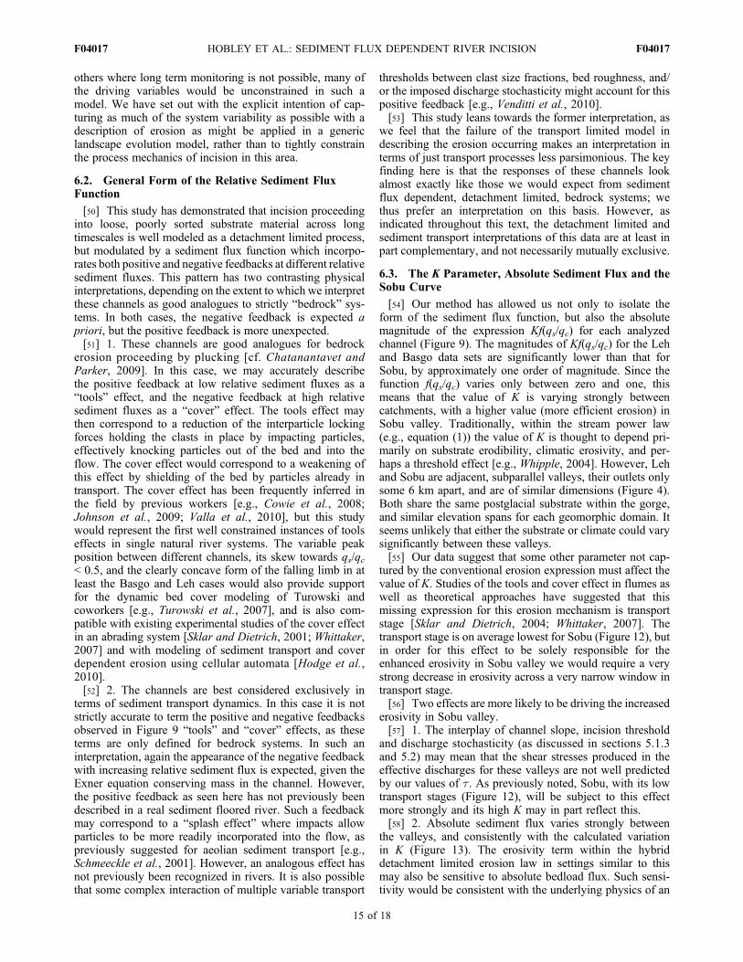
ratio of the Shields stress of the flow to the critical Shieldsstress, down each channel under these optimal solutions(Figure 12). The different lines shown for each catchmentindicate variation in transport stage throughout the model
Figure 9. Most likely sediment flux functions for Leh(dashed green line), Basgo (solid black line) and Sobu (dot-ted blue line) valleys. Shaded areas represent 95% credibleintervals for these curves. (a) Comparison of functions pre-serving best fit magnitude, K. (b) Comparison of functionsrescaled to a relative magnitude of 1, consistent with theory.Implied values of K for each catchment are also shown.
Table 1. Best Fit Values for Parameters in Equation (10) for Each Channel
Channel � n � c
Leh 4.22 × 10⁻⁶ < 6.07 × 10⁻⁶ < 9.74 × 10⁻⁶ 1.02 < 1.13 < 1.37 7.30 × 10⁻⁴ < 1.81 × 10⁻³ < 4.20 × 10⁻³ 3.64 < 4.24 < 4.89Basgo 2.77 × 10⁻⁵ < 3.56 × 10⁻⁵ < 4.73 × 10⁻⁵ 1.69 < 1.91 < 2.05 1.81 × 10⁻³ < 6.83 × 10⁻³ < 1.76 × 10⁻² 6.33 < 6.54 < 6.72Sobu 8.76 × 10⁻⁵ < 1.26 × 10⁻⁴ < 1.39 × 10⁻⁴ 1.84 < 2.02 < 2.08 1.88 × 10⁻⁴ < 2.44 × 10⁻³ < 3.22 × 10⁻³ 3.85 < 4.19 < 4.31
HOBLEY ET AL.: SEDIMENT FLUX DEPENDENT RIVER INCISION F04017F04017
12 of 18
runs as slope and sediment load evolve, but overall thesevalues are relatively stable. There is no simple link to thedrainage areas of the catchments (ALeh = 123 km2; ABasgo =117 km2; ASobu = 73 km2). These transport stages are
important since relative stage is also thought to play a role incontrolling erosivity in sediment flux dependent incisingsystems [Sklar and Dietrich, 2004; Whittaker, 2007], andwe go on to discuss its possible effects in sections 6.1 and6.2. We note that Basgo has slightly higher peak transportstages than Sobu, and Leh has much higher values thanboth of these. This ordering is consistent with the idea thatlower transport stages can be associated with increased
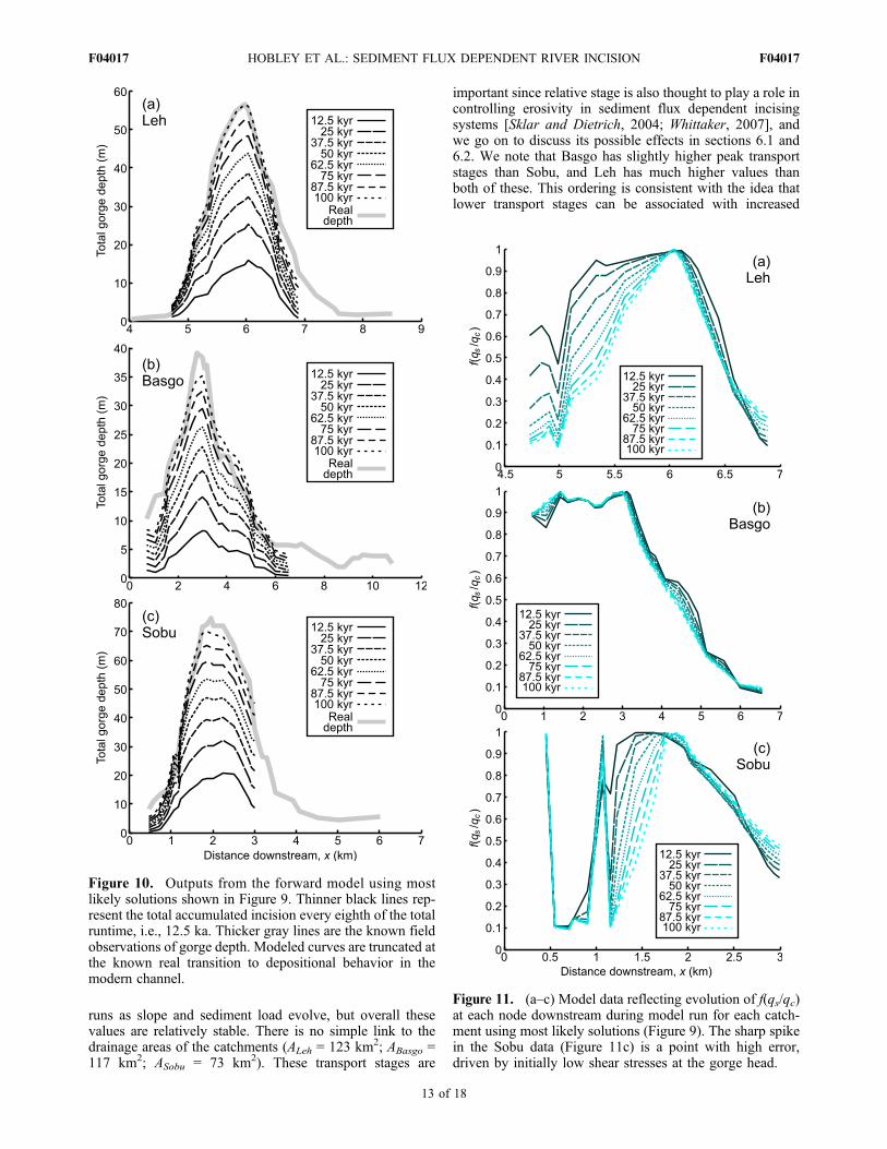
Figure 10. Outputs from the forward model using mostlikely solutions shown in Figure 9. Thinner black lines rep-resent the total accumulated incision every eighth of the totalruntime, i.e., 12.5 ka. Thicker gray lines are the known fieldobservations of gorge depth. Modeled curves are truncated atthe known real transition to depositional behavior in themodern channel.
Figure 11. (a–c) Model data reflecting evolution of f(qs/qc)at each node downstream during model run for each catch-ment using most likely solutions (Figure 9). The sharp spikein the Sobu data (Figure 11c) is a point with high error,driven by initially low shear stresses at the gorge head.
HOBLEY ET AL.: SEDIMENT FLUX DEPENDENT RIVER INCISION F04017F04017
13 of 18
erosivity, but the large change in erosivity occurs betweenBasgo and Sobu, while the large change in transport stageoccurs between Basgo and Leh.[45] These transport stages also link to the scaling constants
C within the MPM transport law discussed in section 5.1.3.The high transport stages for Leh and low stages for Sobuindicate that Leh will have non‐linearly higher effectivedischarges and hence effective shear stresses than we modelhere [cf. Lague et al., 2005]. In order for the low transportstage (i.e., threshold dominated) case of Sobu to be compa-rable with Leh under our approach, its value of C must bedisproportionately higher, which it is. Much of the variationin C seen in section 5.1.3 thus probably occurs in order tocompensate for this effect under the constant dischargeregime we model here.
6. Discussion
6.1. Loose Sediment as a Detachment Limited System
[46] Our field data as presented in Figure 7 and as inter-preted in section 4 shows that the river systems discussed inthis paper are better described by a detachment limitedmodel, where incision proceeds as a direct function of shearstress, than by a transport limited model, where it proceedsas a function of the divergence of that stress. This is anunexpected and surprising result, since the substrate in thisarea is composed of loose blocks of material, which a priorimight be expected to be transport limited. In physical terms,this indicates that the channels eroding into this material arenot able to access enough material from the bed in order tosaturate their carrying capacities. In other words, the processof mobilizing the sediment (shear stress dependent) is moredifficult than carrying it away (carrying capacity dependent).[47] The physical mechanism on the channel bed respon-
sible for this outcome is not immediately obvious. Qualita-tive field observations of the debris have suggest that clast
locking may be an important process during its erosion, asmight complex shielding effects where larger grains immo-bile in essentially all floods limit the potential mobility ofsmaller grains. This situation is also qualitatively similar tothat described by Topping et al. [2000] for the Marble andGrand Canyons of the Colorado river. They suggested thatthe pre‐dam, largely sediment‐floored Colorado was sup-ply (as opposed to transport) limited with respect to sandand finer clasts on annual timescales due to unavailability ofgrains of a transportable size on the bed of the river. It is alsoreminiscent of a scenario described by Sharmeen andWilgoose [2006], whereby an eroding soil can exhibit inpart detachment limited behavior as an armor of coarseparticles forms over the downwearing surface. In theirmodel, weathering of this armor also produces an elementof transport limited behavior in the system; in our case wedo not think the clasts in the channel are degrading in ananalogous fashion, so this part of their story is likely to beabsent here. Nonetheless, similar mechanism for the pro-duction of detachment limited behavior in a loose sedimentsystem as in those cases may well apply in this setting: anygiven flow could transport more sediment than it does, butis unable to saturate as the required additional mass ofsediment on the bed is present as clasts larger than themobility threshold for that flow.[48] This result is also interesting since it implies that in
its long term evolution this clastic river system is behavingmore like a bedrock river than an alluvial river. This con-clusion is also strengthened by the presence of a “bedrockriver‐like” form of the f(qs/qc) function with both positive(“tools”) and negative (“cover”) feedbacks present in thedata, as discussed further in section 6.2. We note that theterm “bedrock river” can itself incorporate a large number oferosion processes, including bed load impact wear, abrasionby suspended load, and plucking [e.g., Hancock et al., 1998;Whipple et al. 2000] and can even often be associated withtotal bed coverage by sediment at various space and timescales. This system is likely to share at least some processelements of these “bedrock” rivers. In light of its detachmentlimited long term dynamics, we view this erosion process asessentially analogous to plucking in bedrock, where the bedis already divided into discrete units to be mobilized asclasts, but with some nontrivial resistance to the incorpo-ration of these particles into the flow.[49] As in section 2.2, we again acknowledge that it may
be possible to model this erosion of this kind given suffi-ciently advanced, strictly transport limited mass balancerules. Such a model would likely need to explicitly incor-porate a description of the shielding effects of the largergrains on the smaller, flow‐dependent thresholds of mobilityfor each grain size fraction, and variable step lengths for eachof these fractions, and/or modeled active layer(s) on the bed[cf. Chatanantavet and Parker, 2009; Coulthard et al., 1999,2002; Davy and Lague, 2009; Hancock and Anderson, 2002;Hoey and Ferguson, 1994; Lague, 2010]. The model inputwould likely also require an a priori description of both thegrain size distribution of the initial glacial sediment substrateand the stochasticity of the imposed flood history. Thisapproach would have the distinct advantages of allowing usto investigate the physical erosion mechanisms active in thissetting in much greater detail, and of fundamentally greater“realism”. However, in this field area, and likely in many
Figure 12. Distributions of transport stage downstream forLeh, Basgo, and Sobu valleys for the most likely sedimentflux functions (Figure 9). Each fine line represents trans-port stage at a single 2.5 ka time‐slice during each run; notethat although transport stages do evolve during the modelruns, they do not vary greatly. The peak transport stages inLeh valley are much (3–5 times) higher than in either Basgoor Sobu valleys, whereas the difference between the Basgoand Sobu distributions is much smaller (< twofold variation).
HOBLEY ET AL.: SEDIMENT FLUX DEPENDENT RIVER INCISION F04017F04017
14 of 18
others where long term monitoring is not possible, many ofthe driving variables would be unconstrained in such amodel. We have set out with the explicit intention of cap-turing as much of the system variability as possible with adescription of erosion as might be applied in a genericlandscape evolution model, rather than to tightly constrainthe process mechanics of incision in this area.
6.2. General Form of the Relative Sediment FluxFunction
[50] This study has demonstrated that incision proceedinginto loose, poorly sorted substrate material across longtimescales is well modeled as a detachment limited process,but modulated by a sediment flux function which incorpo-rates both positive and negative feedbacks at different relativesediment fluxes. This pattern has two contrasting physicalinterpretations, depending on the extent to which we interpretthese channels as good analogues to strictly “bedrock” sys-tems. In both cases, the negative feedback is expected apriori, but the positive feedback is more unexpected.[51] 1. These channels are good analogues for bedrock
erosion proceeding by plucking [cf. Chatanantavet andParker, 2009]. In this case, we may accurately describethe positive feedback at low relative sediment fluxes as a“tools” effect, and the negative feedback at high relativesediment fluxes as a “cover” effect. The tools effect maythen correspond to a reduction of the interparticle lockingforces holding the clasts in place by impacting particles,effectively knocking particles out of the bed and into theflow. The cover effect would correspond to a weakening ofthis effect by shielding of the bed by particles already intransport. The cover effect has been frequently inferred inthe field by previous workers [e.g., Cowie et al., 2008;Johnson et al., 2009; Valla et al., 2010], but this studywould represent the first well constrained instances of toolseffects in single natural river systems. The variable peakposition between different channels, its skew towards qs/qc< 0.5, and the clearly concave form of the falling limb in atleast the Basgo and Leh cases would also provide supportfor the dynamic bed cover modeling of Turowski andcoworkers [e.g., Turowski et al., 2007], and is also com-patible with existing experimental studies of the cover effectin an abrading system [Sklar and Dietrich, 2001; Whittaker,2007] and with modeling of sediment transport and coverdependent erosion using cellular automata [Hodge et al.,2010].[52] 2. The channels are best considered exclusively in
terms of sediment transport dynamics. In this case it is notstrictly accurate to term the positive and negative feedbacksobserved in Figure 9 “tools” and “cover” effects, as theseterms are only defined for bedrock systems. In such aninterpretation, again the appearance of the negative feedbackwith increasing relative sediment flux is expected, given theExner equation conserving mass in the channel. However,the positive feedback as seen here has not previously beendescribed in a real sediment floored river. Such a feedbackmay correspond to a “splash effect” where impacts allowparticles to be more readily incorporated into the flow, aspreviously suggested for aeolian sediment transport [e.g.,Schmeeckle et al., 2001]. However, an analogous effect hasnot previously been recognized in rivers. It is also possiblethat some complex interaction of multiple variable transport
thresholds between clast size fractions, bed roughness, and/or the imposed discharge stochasticity might account for thispositive feedback [e.g., Venditti et al., 2010].[53] This study leans towards the former interpretation, as
we feel that the failure of the transport limited model indescribing the erosion occurring makes an interpretation interms of just transport processes less parsimonious. The keyfinding here is that the responses of these channels lookalmost exactly like those we would expect from sedimentflux dependent, detachment limited, bedrock systems; wethus prefer an interpretation on this basis. However, asindicated throughout this text, the detachment limited andsediment transport interpretations of this data are at least inpart complementary, and not necessarily mutually exclusive.
6.3. The K Parameter, Absolute Sediment Flux and theSobu Curve
[54] Our method has allowed us not only to isolate theform of the sediment flux function, but also the absolutemagnitude of the expression Kf(qs/qc) for each analyzedchannel (Figure 9). The magnitudes of Kf(qs/qc) for the Lehand Basgo data sets are significantly lower than that forSobu, by approximately one order of magnitude. Since thefunction f(qs/qc) varies only between zero and one, thismeans that the value of K is varying strongly betweencatchments, with a higher value (more efficient erosion) inSobu valley. Traditionally, within the stream power law(e.g., equation (1)) the value of K is thought to depend pri-marily on substrate erodibility, climatic erosivity, and per-haps a threshold effect [e.g., Whipple, 2004]. However, Lehand Sobu are adjacent, subparallel valleys, their outlets onlysome 6 km apart, and are of similar dimensions (Figure 4).Both share the same postglacial substrate within the gorge,and similar elevation spans for each geomorphic domain. Itseems unlikely that either the substrate or climate could varysignificantly between these valleys.[55] Our data suggest that some other parameter not cap-
tured by the conventional erosion expression must affect thevalue of K. Studies of the tools and cover effect in flumes aswell as theoretical approaches have suggested that thismissing expression for this erosion mechanism is transportstage [Sklar and Dietrich, 2004; Whittaker, 2007]. Thetransport stage is on average lowest for Sobu (Figure 12), butin order for this effect to be solely responsible for theenhanced erosivity in Sobu valley we would require a verystrong decrease in erosivity across a very narrow window intransport stage.[56] Two effects are more likely to be driving the increased
erosivity in Sobu valley.[57] 1. The interplay of channel slope, incision threshold
and discharge stochasticity (as discussed in sections 5.1.3and 5.2) may mean that the shear stresses produced in theeffective discharges for these valleys are not well predictedby our values of t. As previously noted, Sobu, with its lowtransport stages (Figure 12), will be subject to this effectmore strongly and its high K may in part reflect this.[58] 2. Absolute sediment flux varies strongly between
the valleys, and consistently with the calculated variationin K (Figure 13). The erosivity term within the hybriddetachment limited erosion law in settings similar to thismay also be sensitive to absolute bedload flux. Such sensi-tivity would be consistent with the underlying physics of an
HOBLEY ET AL.: SEDIMENT FLUX DEPENDENT RIVER INCISION F04017F04017
15 of 18
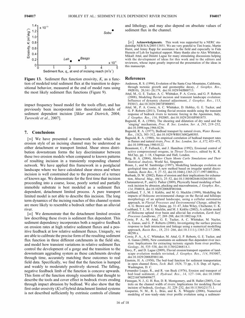
impact frequency based model for the tools effect, and haspreviously been incorporated into theoretical models ofsediment dependent incision [Sklar and Dietrich, 2004;Turowski et al., 2007].
7. Conclusions
[59] We have presented a framework under which theerosion style of an incising channel may be understood aseither detachment or transport limited. Shear stress distri-bution downstream forms the key discriminator betweenthese two erosion models when compared to known patternsof resulting incision in a transiently responding channelnetwork. We have applied this framework in a postglaciallandscape where we have calculated shear stress and whereincision is well constrained due to the presence of a terraceof known age. We demonstrate for the first time that incisionproceeding into a coarse, loose, poorly sorted and partiallyimmobile substrate is best modeled as a sediment fluxdependent, detachment limited process. A pure transportlimited model is not able to describe this incision. The longterm dynamics of the incising reaches of this channel systemare more likely to resemble a bedrock rather than an alluvialriver.[60] We demonstrate that the detachment limited erosion
law describing these rivers is sediment flux dependent. Thissediment dependency incorporates both a negative feedbackon erosion rates at high relative sediment fluxes and a pos-itive feedback at low relative sediment fluxes. Uniquely, weare able to calibrate the precise form of the resulting sedimentflux function in three different catchments in the field site,and model how transient variations in relative sediment fluxcontrol the development of a gorge and the transition to thedownstream aggrading system as these catchments developthrough time, accurately matching these outcomes to realfield data. Specifically, we find that the function is humpedand weakly to moderately positively skewed. The falling,negative feedback limb of the function is concave upwards.This form of the function strongly resembles that thought todescribe the tools and cover effect in bedrock rivers erodingthrough impact abrasion by bedload. We also show that thefirst order erosivity (K) of hybrid detachment limited systemsis not described sufficiently by extrinsic controls of climate
and lithology, and may also depend on absolute values ofsediment flux in the channel.
[61] Acknowledgments. This work was supported by a NERC stu-dentship NER/S/A/2005/13851. We are very grateful to Tim Ivanic, MartinHurst, and Jenny Rapp for assistance in the field and especially to FidaHussein of Leh for logistical support. Many thanks also to Alex Whittaker,Mikaël Attal, and Dimitri Lague for many stimulating discussions helpingwith the development of ideas for this work and to the editors andreviewers, whose input greatly improved the presentation of the ideas inthis manuscript.
ReferencesAnderson, R. S. (1994), Evolution of the Santa Cruz Mountains, California,through tectonic growth and geomorphic decay, J. Geophys. Res.,99(B10), 20,161–20,179, doi:10.1029/94JB00713.
Attal, M., G. E. Tucker, A. C. Whittaker, P. A. Cowie, and G. P. Roberts(2008), Modeling fluvial incision and transient landscape evolution:Influence of dynamic channel adjustment, J. Geophys. Res., 113,F03013, doi:10.1029/2007JF000893.
Attal, M., P. A. Cowie, A. C. Whittaker, D. Hobley, G. E. Tucker, andG. P. Roberts (2011), Testing fluvial erosion models using the transientresponse of bedrock rivers to tectonic forcing in the Apennines, Italy,J. Geophys. Res., 116, F02005, doi:10.1029/2010JF001875.
Bagnold, R. A. (1966), The shearing and dilatation of dry sand and the‘singing’ mechanism, Proc. R. Soc. London, Ser. A, 295, 219–232,doi:10.1098/rspa.1966.0236.
Bagnold, R. A. (1977), Bedload transport by natural rivers, Water Resour.Res., 13(2), 303–312, doi:10.1029/WR013i002p00303.
Bagnold, R. A. (1980), An empirical correlation of bedload transport ratesin flumes and natural rivers, Proc. R. Soc. London, Ser. A, 372, 453–473,doi:10.1098/rspa.1980.0122.
Beaumont, C., P. Fullsack, and J. Hamilton (1992), Erosional control ofactive compressional orogens, in Thrust Tectonics, edited by K. R.McClay, pp. 1–18, Chapman and Hall, London.
Berg, B. A. (2004), Markov Chain Monte Carlo Simulations and TheirStatistical Analysis, World Sci, Singapore.
Braun, J., and M. Sambridge (1997), Modelling landscape evolution ongeological time scales: A new method based on irregular spatial discre-tization, Basin Res., 9, 27–52, doi:10.1046/j.1365-2117.1997.00030.x.
Burbank, D. W. (2002), Rates of erosion and their implications for exhuma-tion, Mineral. Mag., 66(1), 25–52, doi:10.1180/0026461026610014.
Chatanantavet, P., and G. Parker (2009), Physically based modeling of bed-rock incision by abrasion, plucking and macroabrasion, J. Geophys. Res.,114, F04018, doi:10.1029/2008JF001044.
Coulthard, T. J., M. J. Kirkby, and M. G. Macklin (1999), Modelling theimpacts of Holocene environmental change on the fluvial and hillslopemorphology of an upland landscape, using a cellular automatonapproach, in Fluvial Processes and Environmental Change, edited byA. G. Brown and T. M. Quine, pp. 31–47, John Wiley, Chichester, U. K.
Coulthard, T. J., M. G. Macklin, and M. J. Kirkby (2002), A cellular modelof Holocene upland river basin and alluvial fan evolution, Earth Surf.Processes Landforms, 27, 269–288, doi:10.1002/esp.318.
Cowie, P. A., M. Attal, G. E. Tucker, A. C. Whittaker, M. Naylor,A. Ganas, and G. P. Roberts (2006), Investigating the surface processresponse to fault interaction and linkage using a numerical modellingapproach, Basin Res., 18, 231–266, doi:10.1111/j.1365-2117.2006.00298.x.
Cowie, P. A., A. C. Whittaker, M. Attal, G. P. Roberts, G. E. Tucker, andA. Ganas (2008), New constraints on sediment‐flux dependent river inci-sion: Implications for extracting tectonic signals from river profiles,Geology, 36, 535–538, doi:10.1130/G24681A.1.
Davy, P., and D. Lague (2009), Fluvial erosion/transport equation of land-scape evolution models revisited, J. Geophys. Res., 114, F03007,doi:10.1029/2008JF001146.
Einstein, H. A. (1950), The bed‐load function for sediment transportationin open channel flows, Tech. Bull. 1026, 73 pp., U.S. Dep. of Agric.,Washington, D. C.
Fernandez Luque, R., and R. van Beek (1976), Erosion and transport ofbed‐load sediment, J. Hydraul. Res., 14, 127–144, doi:10.1080/00221687609499677.
Finnegan, N. J., G. H. Roe, D. R. Montgomery, and B. Hallet (2005), Con-trols on the channel width of rivers: Implications for modeling fluvialincision of bedrock, Geology, 33, 229–232, doi:10.1130/G21171.1.
Gasparini, N. M., R. L. Bras, and K. X. Whipple (2006), Numericalmodeling of non–teady‐state river profile evolution using a sediment‐
Figure 13. Sediment flux function erosivity, K, as a func-tion of modeled total sediment flux at the transition to depo-sitional behavior, measured at the end of model runs usingthe most likely sediment flux functions (Figure 9).
HOBLEY ET AL.: SEDIMENT FLUX DEPENDENT RIVER INCISION F04017F04017
16 of 18
flux‐dependent incision model, in Tectonics, Climate, and LandscapeEvolution, edited by S. D. Willett et al., Spec. Pap. Geol. Soc. Am.,398, 127–141, doi:10.1130/2006.2398(08).
Gasparini, N. M., K. X. Whipple, and R. L. Bras (2007), Predictions ofsteady state and transient landscape morphology using sediment‐flux‐dependent river incision models, J. Geophys. Res., 112, F03S09,doi:10.1029/2006JF000567.
Gelman, A., J. B. Carlin, H. S. Stern, D. B. Rubin, and D. B. Dunson(2004), Bayesian Data Analysis, 2nd ed., Chapman and Hall, London.
Gilbert, G. K. (1877), Report on the Geology of the Henry Mountains, Dep.of the Inter., Gov. Print. Off., Washington, D. C.
Hancock, G. S., and R. S. Anderson (2002), Numerical modeling of fluvialstrath‐terrace formation in response to oscillating climate, Geol. Soc. Am.Bull., 114(9), 1131–1142.
Hancock, G. S., R. S. Anderson, and K. X. Whipple (1998), Beyond power:Bedrock river incision process and form, in Rivers Over Rock: FluvialProcesses in Bedrock Channels, Geophys. Monogr. Ser, vol. 107, editedby K. J. Tinkler and E. E. Wohl, pp. 35–60, AGU, Washington, D. C.
Hastings, W. K. (1970), Monte Carlo sampling methods using MarkovChains and their applications, Biometrika, 57(1), 97–109, doi:10.1093/biomet/57.1.97.
Hobley, D. E. J., H. D. Sinclair, and P. A. Cowie (2009), How should wemodel incision into coarse, loose, heterogeneous grain mixtures in moun-tain catchments?, Eos Trans. AGU, 90(52), Fall Meet. Suppl., AbstractEP53E‐02.
Hobley, D. E. J., H. D. Sinclair, and P. A. Cowie (2010), Processes, ratesand time scales of fluvial response in an ancient post‐glacial landscape ofthe northwest Indian Himalaya, Geol. Soc. Am. Bull., 122, 1569–1584,doi:10.1130/B30048.1.
Hodge, R. A., T. B. Hoey, and L. S. Sklar (2010), A theoretical model ofgrain mobility in bedrock rivers, paper presented at William Smith Meet-ing: Landscapes into Rock, Geol. Soc. of London, London.
Hoey, T. B., and R. Ferguson (1994), Numerical simulation of downstreamfining by selective transport in gravel bed rivers: Model development andillustration, Water Resour. Res., 30(7), 2251–2260, doi:10.1029/94WR00556.
Howard, A. D. (1994), A detachment‐limited model of drainage basin evo-lution, Water Resour. Res., 30(7), 2261–2285, doi:10.1029/94WR00757.
Howard, A. D., and G. Kerby (1983), Channel changes in badlands, Geol.Soc. Am. Bull., 94, 739–752, doi:10.1130/0016-7606(1983)94<739:CCIB>2.0.CO;2.
Jamieson, S. S. R., H. D. Sinclair, L. A. Kirstein, and R. S. Purves (2004),Tectonic forcing of longitudinal valleys in the Himalaya: Morphologicalanalysis of the Ladakh Batholith, North India, Geomorphology, 58(1–4),49–65, doi:10.1016/S0169-555X(03)00185-5.
Johnson, J. P. L., and K. X. Whipple (2010), Evaluating the controls ofshear stress, sediment supply, alluvial cover and channel morphologyon experimental bedrock incision rate, J. Geophys. Res., 115, F02018,doi:10.1029/2009JF001335.
Johnson, J. P. L., K. X. Whipple, L. S. Sklar, and T. C. Hanks (2009),Transport slopes, sediment cover, and bedrock channel incision in theHenry Mountains, Utah, J. Geophys. Res., 114, F02014, doi:10.1029/2007JF000862.
Kirby, E., and K. X. Whipple (2001), Quantifying differential rock‐upliftrates via stream profile analysis, Geology, 29(5), 415–418, doi:10.1130/0091-7613(2001)029<0415:QDRURV>2.0.CO;2.
Kooi, H., and C. Beaumont (1994), Escarpment evolution on high‐elevationrifted margins: Insights derived from a surface processes model that com-bines diffusion, advection and reaction, J. Geophys. Res., 99(B6),12,191–12,209, doi:10.1029/94JB00047.
Lague, D. (2010), Reduction of long‐term bedrock incision efficiency byshort‐term alluvial cover intermittency, J. Geophys. Res., 115, F02011,doi:10.1029/2008JF001210.
Lague, D., N. Hovius, and P. Davy (2005), Discharge, discharge variability,and the bedrock channel profile, J. Geophys. Res., 110, F04006,doi:10.1029/2004JF000259.
Lamb, M. P., W. E. Dietrich, and J. G. Venditti (2008), Is the criticalShields stress for incipient sediment motion dependent on channel‐bedslope?, J. Geophys. Res., 113, F02008, doi:10.1029/2007JF000831.
Loget, N., P. Davy, and J. Van Den Driessche (2006), Mesoscale fluvialerosion parameters deduced from modeling the Mediterranean sea leveldrop during the Messinian (late Miocene), J. Geophys. Res., 111,F03005, doi:10.1029/2005JF000387.
Meyer‐Peter, E., and R. Muller (1948), Formulas for bedload transport, inProceedings of the 2nd Meeting of the International Association forHydraulic Structures Research, pp. 39–64, Int. Assoc. for Hydraul.Res., Delft, Netherlands.
Milliman, J. D., and J. P. M. Syvitski (1992), Geomorphic/tectonic controlof sediment transport to the ocean: The importance of small mountainousrivers, J. Geol., 100, 525–544, doi:10.1086/629606.
Molnar, P., and P. England (1990), Late Cenozoic uplift of mountainranges and global climate change: Chicken or egg?, Nature, 346,29–34, doi:10.1038/346029a0.
Owen, L. A., M. W. Caffee, K. R. Bovard, R. C. Finkel, and M. C. Sharma(2006), Terrestrial cosmogenic nuclide surface exposure dating of theoldest glacial successions in the Himalayan orogen: Ladakh Range,northern India, Geol. Soc. Am. Bull., 118, 383–392, doi:10.1130/B25750.1.
Paola, C., and V. R. Voller (2005), A generalized Exner equation for sed-iment mass balance, J. Geophys. Res., 110, F04014, doi:10.1029/2004JF000274.
Parker, G., P. C. Klingeman, and D. G. McLean (1982), Bedload and sizedistribution in paved gravel‐bed streams, J. Hydraul. Div. Am. Soc. Civ.Eng., 108, 544–571.
Rodríguez‐Iturbe, I., A. Rinaldo, R. Rigon, R. L. Bras, A. Marani, andE. Ijjász‐Vásquez (1992), Energy dissipation, runoff production, and thethree‐dimensional structure of river basins, Water Resour. Res., 28(4),1095–1103, doi:10.1029/91WR03034.
Roering, J. J., J. W. Kirchner, and W. E. Dietrich (1999), Evidence fornonlinear, diffusive sediment transport on hillslopes and implicationsfor landscape morphology, Water Resour. Res., 35(3), 853–870,doi:10.1029/1998WR900090.
Schmeeckle, M. W., J. M. Nelson, J. Pitlick, and J. P. Bennett (2001), Inter-particle collision of natural sediment grains in water, Water Resour. Res.,37(9), 2377–2391, doi:10.1029/2001WR000531.
Schoklitsch, A. (1962), Handbuch des Wasserbaues, 3rd ed., Springer,Vienna.
Sharmeen, S., and G. R. Wilgoose (2006), The interaction between armour-ing and particle weathering for eroding landscapes, Earth Surf. Process.Landf., 31(10), 1195–1210, doi:10.1002/esp.1397.
Sklar, L. S., and W. E. Dietrich (1998), River Longitudinal Profiles andBedrock Incision Models: Strem Power and the Influence of SedimentSupply, in Rivers Over Rock: Fluvial Processes in Bedrock Channels,Geophys. Monogr. Ser, vol. 107, edited by K. J. Tinkler and E. E. Wohl,pp. 237–260, AGU, Washington, D. C.
Sklar, L. S., and W. E. Dietrich (2001), Sediment and rock strength controlson river incision into bedrock, Geology, 29, 1087–1090, doi:10.1130/0091-7613(2001)029<1087:SARSCO>2.0.CO;2.
Sklar, L. S., and W. E. Dietrich (2004), A mechanistic model for river inci-sion into bedrock by saltating bed load,Water Resour. Res., 40, W06301,doi:10.1029/2003WR002496.
Snyder, N. P., K. X. Whipple, G. E. Tucker, and D. J. Merritts (2000),Landscape response to tectonic forcing: Digital elevation model analysisof stream profiles in the Mendocino triple junction region, northern Cali-fornia, Geol. Soc. Am. Bull., 112(8), 1250–1263, doi:10.1130/0016-7606(2000)112<1250:LRTTFD>2.0.CO;2.
Stock, J. D., and D. R. Montgomery (1999), Geologic constraints onbedrock river incision using the stream power law, J. Geophys. Res.,104(B3), 4983–4993, doi:10.1029/98JB02139.
Strahler, A. N. (1950), Equilibrium theory of erosional slopes approached byfrequency distribution analysis, Am. J. Sci., 248, 673–696, doi:10.2475/ajs.248.10.673.
Topping, D. J., D. M. Rubin, and L. E. Vierra Jr. (2000), Colorado Riversediment transport 1. Natural sediment supply limitation and the influenceof Glen Canyon Dam, Water Resour. Res., 36(2), 515–542, doi:10.1029/1999WR900285.
Tucker, G. E., and R. L. Bras (1998), Hillslope processes, drainage density,and landscape morphology, Water Resour. Res., 34(10), 2751–2764,doi:10.1029/98WR01474.
Tucker, G. E., and G. S. Hancock (2010), Modelling landscape evolution,Earth Surf. Processes Landforms, 35, 28–50, doi:10.1002/esp.1952.
Turowski, J. M., and D. Rickenmann (2009), Tools and cover effects inbedload transport observations in the Pitzbach, Austria, Earth Surf. Pro-cesses Landforms, 34, 26–37, doi:10.1002/esp.1686.
Turowski, J. M., D. Lague, and N. Hovius (2007), Cover effect in bedrockabrasion: A new derivation and its implications for the modeling of bed-rock channel morphology, J. Geophys. Res., 112, F04006, doi:10.1029/2006JF000697.
Valla, P. G., P. A. van der Beek, and D. Lague (2010), Fluvial incision intobedrock: Insights from morphometric analysis and numerical modelingof gorges incising glacial hanging valleys (western Alps, France), J. Geo-phys. Res., 115, F02010, doi:10.1029/2008JF001079.
van der Beek, P. A., and P. Bishop (2003), Cenozoic river profile develop-ment in the Upper Lachlan catchment (SE Australia) as a test of quanti-tative fluvial incision models, J. Geophys. Res., 108(B6), 2309,doi:10.1029/2002JB002125.
HOBLEY ET AL.: SEDIMENT FLUX DEPENDENT RIVER INCISION F04017F04017
17 of 18
Venditti, J. G., W. E. Dietrich, P. A. Nelson, M. A. Wydzga, J. Fadde, andL. S. Sklar (2010), Effect of sediment pulse grain size on sediment trans-port rates and bed mobility in gravel bed rivers, J. Geophys. Res., 115,F03039, doi:10.1029/2009JF001418.
Whipple, K. X. (2004), Bedrock rivers and the geomorphology of activeorogens, Annu. Rev. Earth Planet. Sci., 32(1), 151–185, doi:10.1146/annurev.earth.32.101802.120356.
Whipple, K. X., and G. E. Tucker (1999), Dynamics of the stream‐powerriver incision model: Implications for height limits of mountain ranges,landscape response timescales and research needs, J. Geophys. Res.,104(B8), 17,661–17,674, doi:10.1029/1999JB900120.
Whipple, K. X., and G. E. Tucker (2002), Implications of sediment‐flux‐dependent river incision models for landscape evolution, J. Geophys.Res., 107(B2), 2039, doi:10.1029/2000JB000044.
Whipple, K. X., G. S. Hancock, and R. S. Anderson (2000), River incisioninto bedrock: Mechanics and relative efficacy of plucking, abrasion, andcavitation, Geol. Soc. Am. Bull., 112(3), 490–503, doi:10.1130/0016-7606(2000)112<490:RIIBMA>2.0.CO;2.
Whittaker, A. C. (2007), Investigating controls on bedrock river incisionusing natural and laboratory experiments, Ph.D. thesis, 188 pp, Univ.of Edinburgh, Edinburgh, U. K.
Whittaker, A. C., M. Attal, P. A. Cowie, G. E. Tucker, and G. P. Roberts(2008), Decoding temporal and spatial patterns of fault uplift using tran-sient river long profiles, Geomorphology, 100, 506–526, doi:10.1016/j.geomorph.2008.01.018.
Willett, S. D., and M. T. Brandon (2002), On steady states in mountainbelts, Geology, 30, 175–178, doi:10.1130/0091-7613(2002)030<0175:OSSIMB>2.0.CO;2.
Willgoose, G., R. L. Bras, and I. Rodriguez‐Iturbe (1991), A coupled chan-nel network growth and hillslope evolution model: 1. Theory, WaterResour. Res., 27(7), 1671–1684, doi:10.1029/91WR00935.
Wobus, C. W., B. T. Crosby, and K. X. Whipple (2006), Hanging valleysin fluvial systems: Controls on occurrence and implications for landscapeevolution, J. Geophys. Res., 111, F02017, doi:10.1029/2005JF000406.
Yalin, M. S. (1963), An expression for bed bed‐load transportation,J. Hydraul. Div. Am. Soc. Civ. Eng., 89(3), 221–250.
Zeitler, P. K., et al. (2001), Erosion, Himalayan geodynamics, and thegeomorphology of metamorphism, GSA Today, 11(1), 4–9, doi:10.1130/1052-5173(2001)011<0004:EHGATG>2.0.CO;2.
Zhang, P., P. Molnar, and W. R. Downs (2001), Increased sedimentationrates and grain sizes 2–4 Myr ago due to the influence of climate changeon erosion rates, Nature, 410, 891–897, doi:10.1038/35073504.
P. A. Cowie, Department of Earth Science, University of Bergen,PO Box 7803, Bergen N‐5020, Norway.D. E. J. Hobley, Department of Environmental Sciences, University of
Virginia, Clark Hall, 291 McCormick Rd., Charlottesville, VA 22904,USA. ([email protected])S. M. Mudd and H. D. Sinclair, School of GeoSciences, University of
Edinburgh, Drummond Street, Edinburgh EH8 9XP, UK.
HOBLEY ET AL.: SEDIMENT FLUX DEPENDENT RIVER INCISION F04017F04017
18 of 18
Related Documents


