FEMAplan Defining Funconal Economic Market Areas

Welcome message from author
This document is posted to help you gain knowledge. Please leave a comment to let me know what you think about it! Share it to your friends and learn new things together.
Transcript

FEMAplanDefining Functional Economic Market Areas

nlpplanning.com
When planning for economic growth, the Government states through its Planning Practice Guidance (PPG) that economic needs should be assessed in relation to relevant Functional Economic Market Areas (FEMAs), that is, the spatial level at which local economies and markets actually operate. This reflects the practical way in which labour, housing, property and consumer markets function across administrative boundaries and the recognition that economic markets and flows operate across a much wider geography.
This guidance places a specific requirement and duty upon local planning authorities and their partners to consider the most appropriate spatial scale across which to assess and plan to meet economic needs. This requires a clear understanding of the economic geography within which local economies operate and compete.
Whilst there is no ‘standard’ approach to defining a FEMA, the PPG identifies a number of factors or ‘themes’ to take into account and Nathaniel Lichfield & Partners (NLP) has drawn upon this guidance to develop the FEMAplan framework for assessing the scope and nature of FEMAs (see Figure 1).
This has been applied through a number of post PPG studies across the country and incorporates a comprehensive range of indicators including:
• Spatial economic profile, to explore the clustering of business sectors.
• Labour market and travel-to-work flows, to examine the relationship between where people live and work.
• Commercial property markets with their clustering of customers, supply chains, competitors and proximity to key transport infrastructure.
• Housing markets as geographical areas sharing similar housing characteristics and patterns of demand.
• Consumer and service markets as the spatial area from which users of goods and services are drawn.
• Transport and connectivity and their important influence upon travel to work, housing and property market relationships.
• Economic governance, much of which has been established on the basis of strategic linkages and historic economic relationships.
FEMAplan builds upon NLP’s strong track record and market leading expertise in assessing local economic needs and analysing complex economic intelligence and trends to help our clients develop robust, evidence-driven strategy and policy.
Figure 1: NLP FEMAplan Framework
Defining Functional Economic Market Areas
How FEMAplan can help
Indi
cato
rs &
Inpu
tsPP
G T
hem
e
• Employment and sector mix
• Productivity and innovation
• Population growth
• Labour market and skills
• Business and sector clustering
• Commuting flows
• Resident and workplace population
• ONS travel to work areas
• Labour self containment
• Type and distribution of space
• Development rates and trends
• Vacancy and rents• Occupier ‘area
of search’• Competitor
locations
• Migration and commuting flows
• Housing market signals
• Existing housing evidence (e.g. SHMA)
• Population growth
• Retail and leisure catchments
• Cultural participation
• Existing retail and leisure evidence/study
• Audit of infrastructure
• Strategic and local transport connections
• Journey times• Transport
investment• Broadband
connectivity
• Local Authority boundaries
• Local Plan and policy areas
• Local Enterprise Partnerships
• Other economic partnerships and bodies
“Needs should be assessed in relation to the relevant functional area, i.e. the functional economic area in relation to economic uses”
Planning Practice Guidance para. 008
“There is no universal approach to defining FEMAs. Ideally, FEMAs would be defined on the basis of several markets or catchment areas which best reflect the drivers of the local economy”
CLG Functional Economic Market Areas: An Economic Note (2010)
Functional Economic Market Areas
Spatial Economic Profile
Travel to Work Areas
Commercial Property
Market Areas
Housing Market Areas
Consumer Market Areas
Transport and Infrastructure
Networks
Economic Governance and
Partnership Areas
Sta
ge in
Evi
denc
e B
ase
Dev
elop
men
t
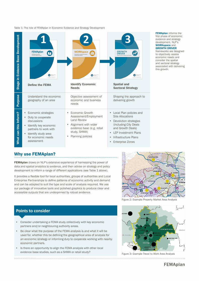
Define the FEMA Identify Economic Needs
Spatial and Sectoral Strategy
Pur
pose Understand the economic
geography of an areaObjective assessment of economic and business needs
Shaping the approach to delivering growth
Wha
t ca
n th
is In
form
? • Economic strategies
• Duty to cooperate discussions
• Identify key economic partners to work with
• Identify study area for economic needs assessment
• Economic Growth Assessment/Employment Land Review
• Alignment with wider evidence base (e.g. retail study, SHMA)
• Planning policies
• Local Plan policies and Site Allocations
• Devolution strategies (including City Deals and Growth Deals)
• LEP Investment Plans
• Infrastructure Plans
• Enterprise Zones
FEMAplan
FEMAplan informs the first phase of economic evidence and strategy development. NLP’s WORKspace and GROWTH DRIVER frameworks are designed to objectively assess economic needs and consider the spatial and sectoral strategy associated with delivering this growth.
Why use FEMAplan?
FEMAplan draws on NLP’s extensive experience of harnessing the power of data and spatial analytics to evidence, and then advise on strategy and policy development to inform a range of different applications (see Table 1 above).
It provides a flexible tool for local authorities, groups of authorities and Local Enterprise Partnerships to define patterns of economic activity and demand and can be adapted to suit the type and scale of analysis required. We use our package of innovative tools and polished graphics to produce clear and accessible outputs that are underpinned by robust evidence.
GROWTH DRIVERSupport for LEPs to Realise their Potential
• Consider undertaking a FEMA study collectively with key economic partners and/or neighbouring authority areas.
• Be clear what the purpose of the FEMA analysis is and what it will be used for, whether this be defining the geographical area of analysis for an economic strategy or informing duty to cooperate working with nearby economic partners.
• Is there an opportunity to align the FEMA analysis with other local evidence base studies, such as a SHMA or retail study?
Points to consider
3
Figure 3: Example Travel to Work Area Analysis
Figure 2: Example Property Market Area Analysis
Table 1: The role of FEMAplan in Economic Evidence and Strategy Development
FEMAplanDefining Functional Economic Market Areas
1WORKspacePlanning for Employment Space and Business Needs
2

This publication has been written in general terms and cannot be relied on to cover specific situations. We recommend that you obtain professional advice before acting or refraining from acting on any of the contents of this publication. NLP accepts no duty of care or liability for any loss occasioned to any person acting or refraining from acting as a result of any material in this publication. Nathaniel Lichfield & Partners is the trading name of Nathaniel Lichfield & Partners Limited. Registered in England, no.2778116. Registered office: 14 Regent’s Wharf, All Saints Street, London N1 9RL © Nathaniel Lichfield & Partners Ltd 2016. All rights reserved.
nlpplanning.com
FEMAplan Project
Experience
“The NLP team were highly professional and maintained good communication with officers throughout. We found their final study to be clear, comprehensive and easy to digest. We would certainly recommend them to other local planning authorities.”
Stevenage Borough Council
“We have been impressed with the understanding and analysis of issues across local authority boundaries…we are confident that the final report represents a robust evidence base that will support preparation of our Local Plans.”
Sheffield City Council and Rotherham Metropolitan Borough Council
Contact Us
Read More: You can find out more about NLP and our tools and methodologies at: nlpplanning.com/nlp-insight
BristolAndy Cockett [email protected] 0117 403 1980
LondonCiaran [email protected] 020 7837 4477
CardiffGareth Williams [email protected] 029 2043 5880
ManchesterMichael Watts [email protected] 0161 837 6130
EdinburghNicola Woodward [email protected] 0131 285 0670
NewcastleHarvey [email protected] 0191 261 5685
LeedsJustin Gartland [email protected] 0113 397 1397
Thames ValleyDaniel Lampard [email protected] 0118 334 1920
Berkshire Functional Economic Market Area Study
Sheffield and Rotherham Joint Economic Needs Assessment
Client: Sheffield City Council and Rotherham Metropolitan Borough Council
Luton Functional Economic Market Area Study
Client: Luton Borough Council
Greater Brighton Economic Profiling and Strategy
Client: Greater Brighton Economic Board and Coastal West Sussex Partnership
London Heathrow
London Stansted
London City
Biggin Hill
M25
A22
M26
A24
A26
A27
M3
A3
A23
M23
M4
A272
Cranleigh
Sutton
Greater London
Royal Tunbridge Wells
Tonbridge
Sevenoaks
Brighton
Lewes
Uckfield
East Grinstead
CrawleyHorsham
Burgess Hill
Haywards Heath
Dorking
ReigateRedhill
Horley
Caterham
CroydonEpsom
Ewell
Guildford
Worthing
Shoreham
Woking
Leatherhead
Banstead
Coast to Capital Local Enterprise Partnership Area
London Gatwick
M3 Corridor
M4 Corridor
London to Brighton Corridor
M25/23 Corridor
Eastbourne
Bognor Regis
Reigate and Banstead Stategic Employment Options Study
Client: Reigate and Banstead Borough Council
Nottingham Core and Outer HMA Employment Study
Client: Nottingham City Region Authorities
Hertfordshire and Bedfordshire Functional Economic Market Area Study
Client: Stevenage, North Hertfordshire and Central Bedfordshire Councils
M25
M3
M4
A3A339
A34
A4
A322
WOKINGHAM
BASINGSTOKE
READING
NEWBURY
GUILDFORD
WINDSORHEATHROW
LONDONSLOUGH
MAIDENHEAD
FARNBOROUGH
WOKING
Thames ValleyBerkshire LEP
AONB
Greenbelt
Railway
A-Roads
Motorways
University of Reading
Existing Employment Area
Proposed Employment Area
Key Property Market Areas
Town Centre Development
Airport
North ↑
Legend
& READINGNEWBURY
BASINGSTOKE& ANDOVER
BLACKWATERVALLEY
GUILDFORD& WOKING
UPPER M3
UPPER M4
WEST LONDONSLOUGH &
BRACKNELL
A404
A329
Bracknell Forest Functional Economic Area Study
Client: Bracknell Forest Council
nlpplanning.com @nlpplanning @NLP_analysis
© Ian Miles-Flashpoint Pictures / Alamy Stock Photo
Front Cover Image Credit: © Sandy Young / Alamy Stock Photo
Client: Thames Valley Berkshire Local Enterprise Partnership
A1(M)
A1(M)
A1
A1
A1
A10
A10
A10
A10
A10
A600
A600
A507
A507
A505
A505 A507
A505A421
A421
A421
A418
A4146
A1081
A1081
A505
A5
A5
M1
M1
A5120
A5120
A4012
A4012
A4146
A4146
A5134
A120
A602
A119
A1184
A414
A1198
A1301
A1134
M11
A509
A509
A428
A428
A421
A422
A422
A5
A5
A505
Bedford
Letchworth Garden City
Legend
Main Employment Sites
Principal Study Area
Key Property Market Areas
Motorways
A-Roads
Rail
Airports
Key Settlements
Key Office Areas
Key Industrial Areas
Welwyn Garden City
Gunnels Wood
Pin Green
Works Road Employment Area
York Road
Stratton Business Park
Middlefield Industrial Estate
Blackhorse Road Industrial Estate
Wilbury WayHitchin
Shefford
Arlesey Stotfold
Biggleswade
Royston
Stevenage
Luton
Sandy
Related Documents


