SFWMD Land Assessment Exhibits for District Fee Owned Properties Recommended for Further Evaluation for Potential Exchange or Surplus Note: Region 1: Upper Lakes (No exchange or surplus lands) Region 2: Kissimmee / Okeechobee Region 3: East Coast Region 4: West Coast Region 5: Everglades

Welcome message from author
This document is posted to help you gain knowledge. Please leave a comment to let me know what you think about it! Share it to your friends and learn new things together.
Transcript

SFWMD Land Assessment
Exhibits for
District Fee Owned Properties
Recommended for
Further Evaluation for
Potential Exchange or Surplus
Note: Region 1: Upper Lakes (No exchange or surplus lands) Region 2: Kissimmee / Okeechobee Region 3: East Coast Region 4: West Coast Region 5: Everglades
Region 2 - EXHIBIT A-1
Tiger Lake (~31.71 acres) The District acquired flowage easement interests below the 54 foot contour around most of Tiger Lake to support the goal of raising water stages for the benefit of the Kissimmee River Restoration. The subject tracts represent the only four tracts where the fee simple interest was acquired. The acquisition of the fee-simple interest satisfied the needs of the restoration project, but it is likely that the acquisition of a flowage easement, consistent with the rest of Tiger Lake, would have been adequate as well. The further evaluation of these tracts will consider the exchange or surplus of the District’s fee-simple interest and the retention of a flowage and/or conservation easement over the portion of the property lying below the 54-foot contour.
18403-006 18403-008 18403-033 18403-034

Region 2 -EXHIBIT A-2
Pool E Spoil Sites (~69.15 acres) These two tracts are isolated parcels on the western spoil bank of the C-38 canal, north of State Road 70. They were acquired before overall plans for the Kissimmee River had been established. The areas consist of highly disturbed ground with covered by pasture grasses, Brazilian pepper and cabbage palms. The District’s mission is better served by focusing management and restoration activities on areas of regional significance, rather than having limited management and restoration funding diluted by small isolated sites with limited resource value.
The further evaluation of these tracts will consider exchange or surplus subject to an acceptable conservation easement along the bank of the oxbow channel on the southern tract.
19104-026
19104-025
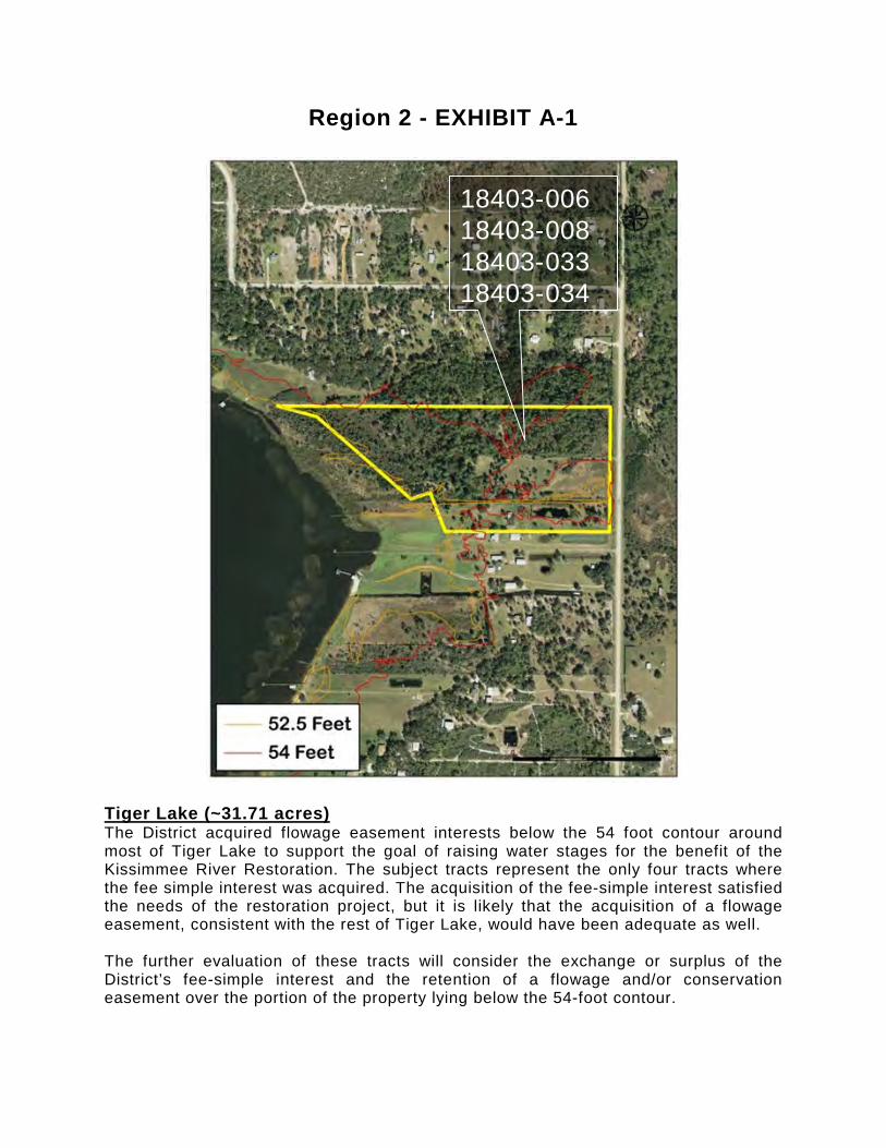
Region 2 - EXHIBIT A-3
St. Cloud Field Station (~20.41 acres) This tract was acquired as a site on which a field station (a large regional maintenance and staging facility) was to be constructed, but was not used for that purpose. The field station facility was ultimately constructed at its present location on Old Canoe Creek Road. Consideration will be given to the fact that within one of the pine trees on the site, an eagle’s nest has been utilized in recent nesting seasons. The further evaluation of this tract will consider exchange or surplus of the property.
AG100-008

Region 2 -EXHIBIT A-4
4Es, South of 98 (~15 acres) The entire tract 19103-183 containing 29.3 acres and lying on both sides of U.S. 98, was purchased in 1997. The evaluation of potential surplus is with respect to the approximately 15 acre portion lying south of U.S. 98, which is effectively an outparcel lying separate and apart from any other land. The District’s mission is best served by focusing management and restoration activities on landscape-scale areas of regional significance, rather than having limited management and restoration funding diluted by small isolated sites with limited resource value. Approximately 5 acres of the 15-acre parcel is outside of and above the 100-year floodplain and therefore not necessary for the Kissimmee River Restoration Project. The District’s mission objectives would be adequately served with a flowage and/or conservation easement on the 10-acre portion within the 100-year floodplain. The further evaluation of this tract will consider exchange or surplus of the District’s fee-simple interest and the retention of a flowage and/or conservation easement over the portion lying within the 100-year floodplain.
19103-183 19103-183

Region 2 - EXHIBIT A-5
Pearce-Lockett Estate (~16.65 acres) In 1993 the District acquired the Pearce-Lockett Estate through a donation as part of the Kissimmee River Restoration Project. The site was donated by the family with the understanding that the property and certain on site historic structures would be open to the public and maintained as a cultural/historic site. Since then the District has provided maintenance to sustain the property in its current condition. There have been several attempts to find a management partner for the site and there have been many interested parties that expressed an interest in developing some sort of historic or public use facility on the property. These have included: a state park, a county park, a historic museum, an agricultural museum, a hostel for hikers using the Florida Trail, and a visitor/research center associated with the Kissimmee River Restoration. Unfortunately none of these proposals have ever come to pass. The District has neither the funding available nor the specialized expertise necessary to restore the historic buildings to a condition suitable to public use, and the site deteriorates further every year that a willing partner is not found. The further evaluation of this tract will consider the exchange or surplus of the tract and its on-site structures with a reservation of a flowage easement over a 2.73 acre portion lying within of the 100-year floodplain and with restrictive covenants regarding maintaining it as a historic and educational site open to the public over the entire property.
19103-654 19103-837
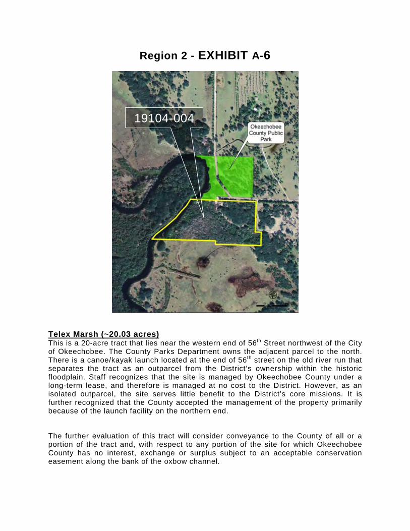
Region 2 - EXHIBIT A-6
Telex Marsh (~20.03 acres) This is a 20-acre tract that lies near the western end of 56th Street northwest of the City of Okeechobee. The County Parks Department owns the adjacent parcel to the north. There is a canoe/kayak launch located at the end of 56th street on the old river run that separates the tract as an outparcel from the District’s ownership within the historic floodplain. Staff recognizes that the site is managed by Okeechobee County under a long-term lease, and therefore is managed at no cost to the District. However, as an isolated outparcel, the site serves little benefit to the District’s core missions. It is further recognized that the County accepted the management of the property primarily because of the launch facility on the northern end.
The further evaluation of this tract will consider conveyance to the County of all or a portion of the tract and, with respect to any portion of the site for which Okeechobee County has no interest, exchange or surplus subject to an acceptable conservation easement along the bank of the oxbow channel.
19104-004
Region 2 -EXHIBIT A-7
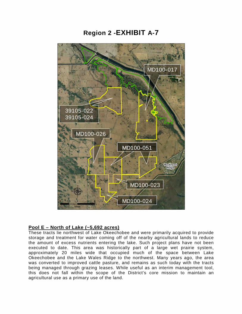
Pool E – North of Lake (~5,692 acres) These tracts lie northwest of Lake Okeechobee and were primarily acquired to provide storage and treatment for water coming off of the nearby agricultural lands to reduce the amount of excess nutrients entering the lake. Such project plans have not been executed to date. This area was historically part of a large wet prairie system, approximately 20 miles wide that occupied much of the space between Lake Okeechobee and the Lake Wales Ridge to the northwest. Many years ago, the area was converted to improved cattle pasture, and remains as such today with the tracts being managed through grazing leases. While useful as an interim management tool, this does not fall within the scope of the District’s core mission to maintain an agricultural use as a primary use of the land.
39105-022 39105-024
MD100-017
MD100-024
MD100-051
MD100-023
MD100-026
MD100-051

Region 2 - EXHIBIT A-7 (cont) There are several other relevant factors associated with these tracts. Staff recognizes that there are water-treatment, storage, and habitat restoration needs within the Lake Okeechobee watershed. The current watershed planning initiatives, such as Basin Management Action Plan and the Northern Everglades, are expected to identify those needs. The sale or exchange of this land could provide the financial resource to develop the necessary projects where they most-needed to be developed. Another alternative, proposed by several commenters at the land assessment public meeting, would be the sale of these lands to fund the acquisition of land in support of restoration of the Paradise Run/Pool E floodplain and historic river system. Therefore, the further evaluation of these tracts will consider exchange or surplus of the District’s fee-simple interest on those southernmost parcels in this assessment area, and also consider opportunities to exchange lands in the northernmost parcels not needed for either the implementation of Basin Management Action Plan or other Kissimmee River related plans.

Region 2 -EXHIBIT A-8
Nubbin Slough (~385 acres) This 1,957.69 acre tract lies northeast of Lake Okeechobee. It was acquired to provide treatment for water coming off of the nearby agricultural lands to reduce the amount of excess nutrients entering the lake. The southeastern portion of the site is being managed as a water quality treatment cell under final stages of construction. There is an area of improved pasture containing approximately 305 acres north of the treatment cell that is currently under a cattle lease. There has been no public use on any portion of the site due to the construction of the treatment cell and associated water control structures. Planning for facilitating public use within certain portions of the tract is underway. The site could potentially support the same kind of popular recreational uses as the Taylor Creek stormwater treatment area. The further evaluation of this tract will include continued development of dispersed water management and public recreation features on the northern portion of the site and the exchange or surplus of the other portions of the property outside of the project footprint that do not contribute to the District’s core mission.
C1100-036

Region 3 - EXHIBIT A-1
Kanner Highway (~19.48 acres) This parcel was acquired as a potential dredge spoil site for the U.S. Army Corps of Engineers. The District holds the title to this property and the Army Corps has no longer needs it for dredge spoil storage. This isolated parcel lies across Kanner Highway from the river floodplain. The continued ownership of this parcel does not support any District mission objective. The further evaluation of these tracts will consider the exchange or surplus of the District’s fee-simple interest in the site.
FF100-007
Region 3 - EXHIBIT A-2
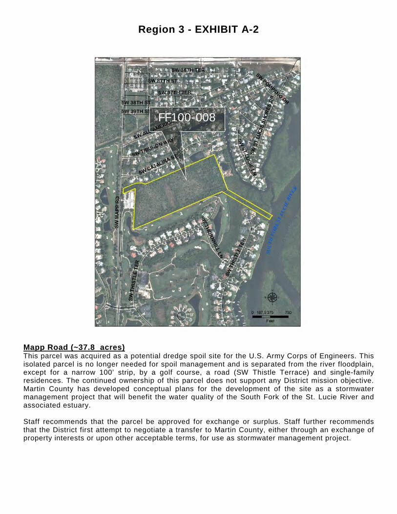
Mapp Road (~37.8 acres) This parcel was acquired as a potential dredge spoil site for the U.S. Army Corps of Engineers. This isolated parcel is no longer needed for spoil management and is separated from the river floodplain, except for a narrow 100’ strip, by a golf course, a road (SW Thistle Terrace) and single-family residences. The continued ownership of this parcel does not support any District mission objective. Martin County has developed conceptual plans for the development of the site as a stormwater management project that will benefit the water quality of the South Fork of the St. Lucie River and associated estuary. Staff recommends that the parcel be approved for exchange or surplus. Staff further recommends that the District first attempt to negotiate a transfer to Martin County, either through an exchange of property interests or upon other acceptable terms, for use as stormwater management project.
FF100-008
Region 3 - EXHIBIT A-3
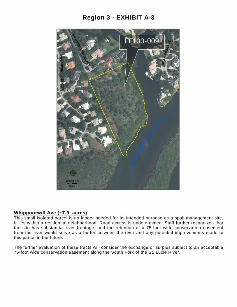
Whippoorwill Ave (~7.9 acres) This small isolated parcel is no longer needed for its intended purpose as a spoil management site. It lies within a residential neighborhood. Road access is undetermined. Staff further recognizes that the site has substantial river frontage, and the retention of a 75-foot wide conservation easement from the river would serve as a buffer between the river and any potential improvements made to this parcel in the future. The further evaluation of these tracts will consider the exchange or surplus subject to an acceptable 75-foot wide conservation easement along the South Fork of the St. Lucie River.
FF100-009

Region 3 - EXHIBIT A-4
Indian River Lagoon South (CERP) – C23/24 Component (~585.51 acres) KE100-209 (~146.25 acres); KE100-197 (~153.52 acres); KE100-234 (~157.11 acres); KE100-236 (~23.74 acres); KE100-235 (~100.15 acres); D0100-004 (~4.74 acres) The continued ownership of these parcels do not support any District mission objective because they are areas of agricultural production (citrus and improved pasture) and a former field station that have been determined to not be necessary for the development of the reservoir/STA project. The further evaluation of these tracts will consider the exchange or surplus of the District’s fee-simple interest in the site.
KE100-209
KE100-234
KE100-197
KE100-235
KE100-236
D0100-004

Region 3 - EXHIBIT A-5
Indian River Lagoon South (CERP) – C-44 Component (~1,072.22 acres) The C-44 project is currently under construction, and this area was excluded from the project development plans. There may be opportunities for dispersed water management activities that could benefit the District’s core mission objectives, even in private ownership. The further evaluation of this parcel will consider the exchange or surplus of the District’s fee-simple interest in the site with such deed restrictions as necessary to be compatible with its proximity to the reservoir and the County facility on Citrus Blvd.
JE100-065

Region 4 - EXHIBIT A-1
34100-066 Robb Road (~40.14 acres) all in Hendry County 34100-067 Caloosa Shores (~26.95 acres) 34100-093 Quail Run (~24.79 acres) These parcels were acquired for potential dredge spoil sites for the USACE (U.S. Army Corps of Engineers). The District holds title to these properties and the Army Corps no longer needs them for dredge spoil storage. These isolated parcels lie north of the C-43 Canal. The continued ownership of these parcels does not support any District mission objective. The further evaluation of these tracts will consider the exchange or surplus of the District’s fee-simple interest in the sites.

Region 4 - EXHIBIT A-2
34T544 Kirby Thompson Road (~77.5 acres) Hendry County This parcel was acquired as a potential dredge spoil site for the U.S. Army Corps of Engineers. This isolated parcel is no longer needed for spoil management and is separated from the river floodplain. The continued ownership of this parcel does not support any District mission objective. The further evaluation of these tracts will consider the exchange or surplus of the District’s fee-simple interest in the site.

Region 4 - EXHIBIT A-3
34100-095 North River Road (~412.06 acres) all in Lee County 34T892 Spanish Creek Drive (~2.9 acres) 34100-060 Center Street (~5.36 acres) 34100-061 Lippincott Street (~11.63 acres) 34100-094 Goggin Road (~24.22 acres) These parcels were acquired for potential dredge spoil sites for the USACE (U.S. Army Corps of Engineers). The District holds title to these properties and the Army Corps no longer needs them for dredge spoil storage. These isolated parcels lie north of the C-43 Canal in rural Lee County. The continued ownership of these parcels does not support any District mission objective. The further evaluation of these tracts will consider the exchange or surplus of the District’s fee-simple interest in the sites.

Region 4 - EXHIBIT A-4
34100-088 Lyndhurst Lane (~85.22 acres) Lee County This parcel was acquired as a potential dredge spoil site for the U.S. Army Corps of Engineers. This isolated parcel is no longer needed for spoil management and is separated from the river floodplain. The continued ownership of this parcel does not support any District mission objective. The further evaluation of these tracts will consider the exchange or surplus of the District’s fee-simple interest in the site.

Region 4 - EXHIBIT A-5
34100-062 Trout Creek and Havens Island (~28.1 acres) Lee County This parcel was acquired for a potential dredge spoil site for the USACE (U.S. Army Corps of Engineers). The District holds title to this property and the Army Corps no longer needs it for dredge spoil storage. This site is divided into two parts; an island portion and a mainland segment. The location and character of this property may fit well as a Lee County park or the USFWS refuge. The continued ownership of these parcels does not support any District mission objective. The further evaluation of this tract will consider the possible interest by Lee County or the U.S. Fish and Wildlife Service to acquire the site for a public purpose; if not, consideration can be given to the exchange or surplus of the District’s fee-simple interest in the site.
Region 4 - EXHIBIT A-6
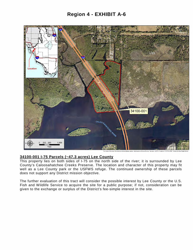
34100-001 I-75 Parcels (~47.3 acres) Lee County This property lies on both sides of I‐75 on the north side of the river; it is surrounded by Lee County’s Caloosahatchee Creeks Preserve. The location and character of this property may fit well as a Lee County park or the USFWS refuge. The continued ownership of these parcels does not support any District mission objective. The further evaluation of this tract will consider the possible interest by Lee County or the U.S. Fish and Wildlife Service to acquire the site for a public purpose; if not, consideration can be given to the exchange or surplus of the District’s fee-simple interest in the site.
Region 4 - EXHIBIT A-7
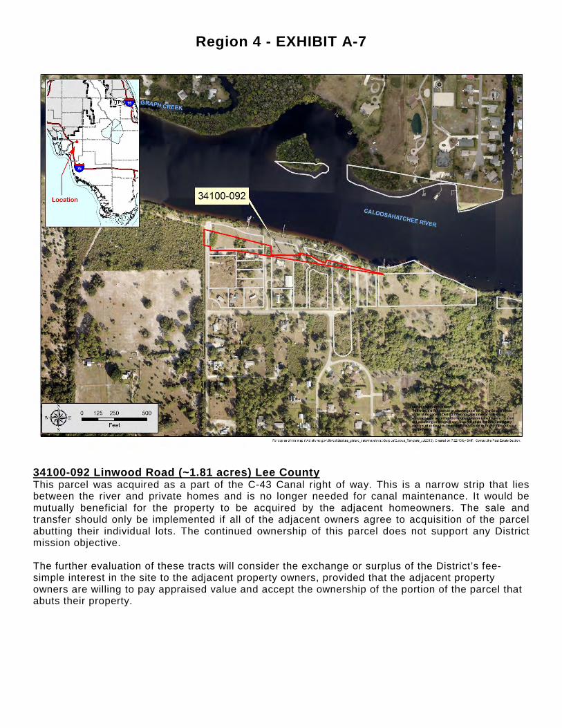
34100-092 Linwood Road (~1.81 acres) Lee County This parcel was acquired as a part of the C-43 Canal right of way. This is a narrow strip that lies between the river and private homes and is no longer needed for canal maintenance. It would be mutually beneficial for the property to be acquired by the adjacent homeowners. The sale and transfer should only be implemented if all of the adjacent owners agree to acquisition of the parcel abutting their individual lots. The continued ownership of this parcel does not support any District mission objective. The further evaluation of these tracts will consider the exchange or surplus of the District’s fee-simple interest in the site to the adjacent property owners, provided that the adjacent property owners are willing to pay appraised value and accept the ownership of the portion of the parcel that abuts their property.
Region 4 - EXHIBIT A-8
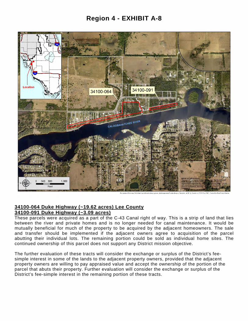
34100-064 Duke Highway (~19.62 acres) Lee County 34100-091 Duke Highway (~3.09 acres) These parcels were acquired as a part of the C-43 Canal right of way. This is a strip of land that lies between the river and private homes and is no longer needed for canal maintenance. It would be mutually beneficial for much of the property to be acquired by the adjacent homeowners. The sale and transfer should be implemented if the adjacent owners agree to acquisition of the parcel abutting their individual lots. The remaining portion could be sold as individual home sites. The continued ownership of this parcel does not support any District mission objective. The further evaluation of these tracts will consider the exchange or surplus of the District’s fee-simple interest in some of the lands to the adjacent property owners, provided that the adjacent property owners are willing to pay appraised value and accept the ownership of the portion of the parcel that abuts their property. Further evaluation will consider the exchange or surplus of the District’s fee-simple interest in the remaining portion of these tracts.

Region 4 - EXHIBIT A-9
CREW (~24,972 acres) Lee and Collier Counties CREW is a regionally significant wetland system. It lies in a large topographic basin and serves as the headwaters to the Imperial River and to Picayune Strand. The Southern CREW critical project is intended to aid water storage, natural systems restoration and flood control. Staff recognizes the benefits that the property has contributed towards the District’s core missions, as evident from the comments, and the value as a popular public use area. There are a few small parcels that lie outside the project boundary that do not support the project mission. Staff recommends that the use and management of the property within the project boundaries continue as-is. The further evaluation of those few small parcels lying outside the project boundary will consider the exchange or surplus of the District’s fee interest in those sites.

Region 4 - EXHIBIT A-10
KC100-013 Caloosahatchee Water Quality Facility (~237 acres) This tract was initially acquired to test nutrient removal technologies to help clean water flowing into the Caloosahatchee River. Most of the road frontage area along SR 80 is intended to be made available for surplus in the near future pursuant to the terms of the acquisition. Staff recommends that the use and management of the property continue as-is, with the exception of the road frontage along SR 80 which will be released as surplus pursuant to the terms of the acquisition.

Region 5 - EXHIBIT A-1
Palm Beach County East Coast Buffer - Palm Beach County Ag. Reserve Reservoir W9100-176 (~570.77 acres) W9100-177 (~10.47 acres) W9100-178 (~313.37 acres) W9100-170 (~2.6 acres) W9100-179 (~97.01 acres) There are three leases on this site: (W9100-176) a pepper farm operation, (W9100-179) an equestrian training facility, and (W9100-178) a lease to Palm Beach County for the operation of the West Delray Regional Park. Due to proximity to the Loxahatchee Wildlife Refuge, staff recognizes that there may be an interest by either the County or USFWS to acquire the property from the District. The District no longer has an interest in the property for water management purposes, and has no other planned use for the property.
The further evaluation of these tracts will determine if there is an interest on the part of Palm Beach County or the U.S. Fish and Wildlife Service to acquire the land, and if not, staff will consider the exchange or surplus of the District’s fee-simple interest in the sites.
Region 5 - EXHIBIT A-2
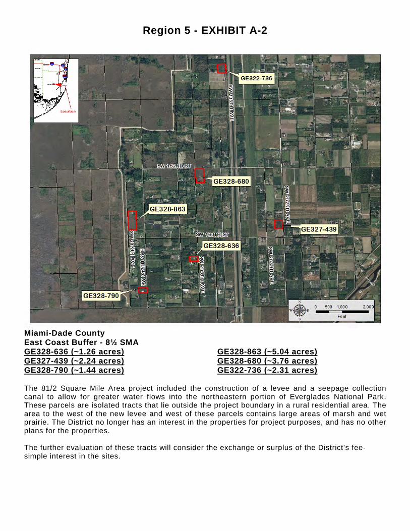
Miami-Dade County East Coast Buffer - 8½ SMA GE328-636 (~1.26 acres) GE328-863 (~5.04 acres) GE327-439 (~2.24 acres) GE328-680 (~3.76 acres) GE328-790 (~1.44 acres) GE322-736 (~2.31 acres) The 81/2 Square Mile Area project included the construction of a levee and a seepage collection canal to allow for greater water flows into the northeastern portion of Everglades National Park. These parcels are isolated tracts that lie outside the project boundary in a rural residential area. The area to the west of the new levee and west of these parcels contains large areas of marsh and wet prairie. The District no longer has an interest in the properties for project purposes, and has no other plans for the properties. The further evaluation of these tracts will consider the exchange or surplus of the District’s fee-simple interest in the sites.
Region 5 - EXHIBIT A-3
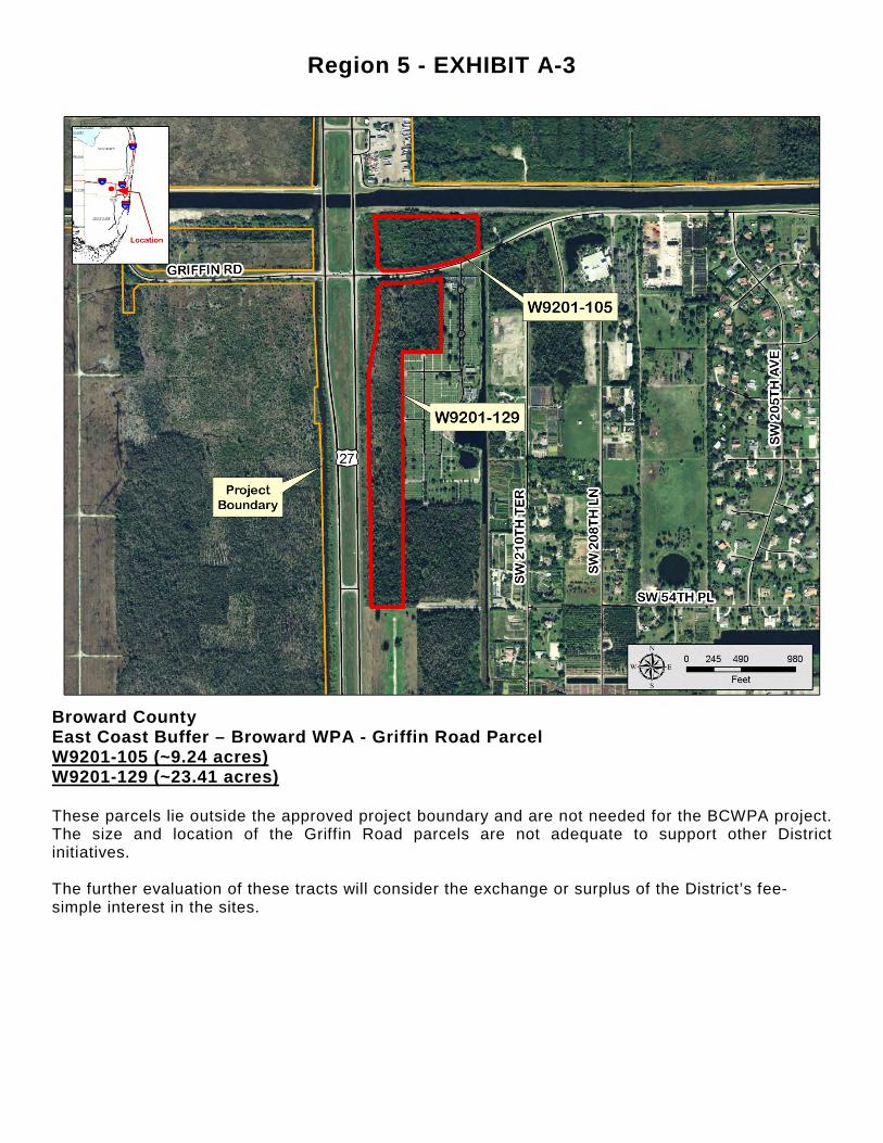
Broward County East Coast Buffer – Broward WPA - Griffin Road Parcel W9201-105 (~9.24 acres) W9201-129 (~23.41 acres) These parcels lie outside the approved project boundary and are not needed for the BCWPA project. The size and location of the Griffin Road parcels are not adequate to support other District initiatives. The further evaluation of these tracts will consider the exchange or surplus of the District’s fee-simple interest in the sites.
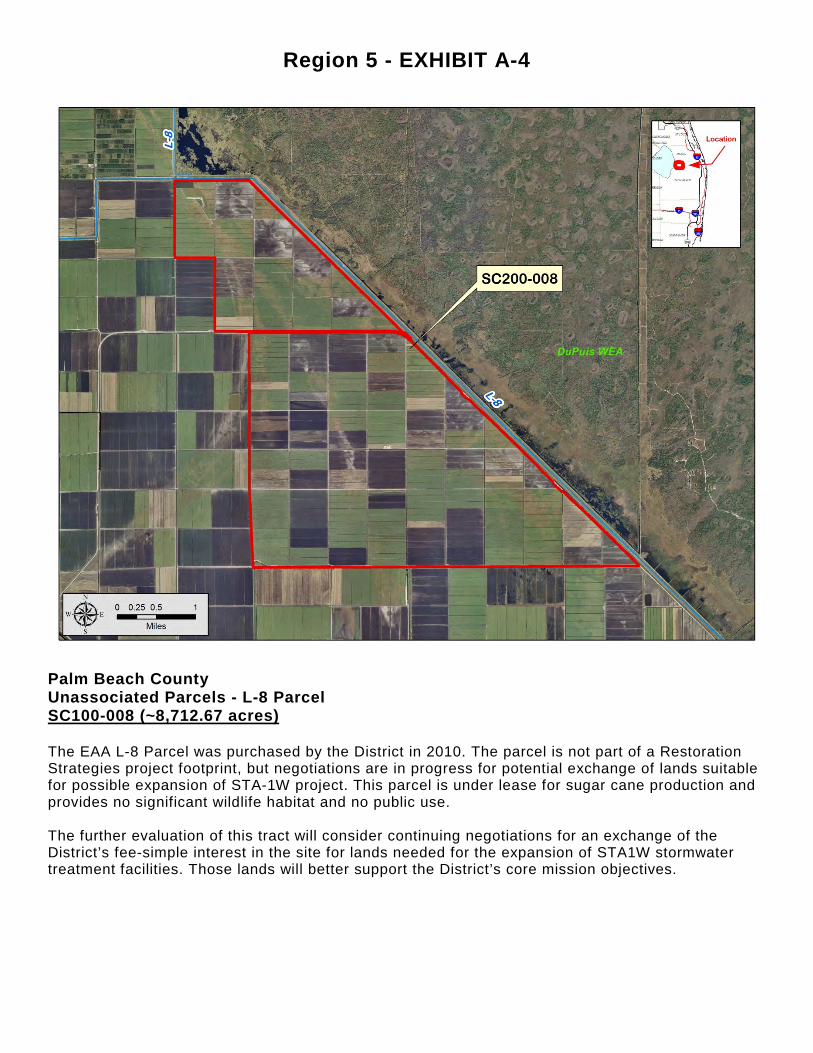
Region 5 - EXHIBIT A-4
Palm Beach County Unassociated Parcels - L-8 Parcel SC100-008 (~8,712.67 acres) The EAA L-8 Parcel was purchased by the District in 2010. The parcel is not part of a Restoration Strategies project footprint, but negotiations are in progress for potential exchange of lands suitable for possible expansion of STA-1W project. This parcel is under lease for sugar cane production and provides no significant wildlife habitat and no public use. The further evaluation of this tract will consider continuing negotiations for an exchange of the District’s fee-simple interest in the site for lands needed for the expansion of STA1W stormwater treatment facilities. Those lands will better support the District’s core mission objectives.

Region 5 - EXHIBIT A-5
Palm Beach County 50100-010 Strazzulla parcel (~2,585.12 acres) The wetlands on this site serve as an important buffer between urban uses and the Loxahatchee wildlife Refuge. The site provides water quality, flood protection, and natural systems management benefits. This area marked a transition from the flatwood-associated wet prairies and the Everglades mosaic. The District has been negotiating a transfer of ownership to the U.S. Fish and Wildlife Service for inclusion in the Refuge. A proposed exchange of lands on terms acceptable to both parties would be beneficial to both the Department of the Interior and to the District’s core mission objectives. The further evaluation of this tract will consider continuing negotiations with the Department of Interior for an exchange of the District’s fee-simple interest in the site for lands within the EAA that will better support the District’s core mission objectives while ensuring that this property remain in conservation.
Related Documents