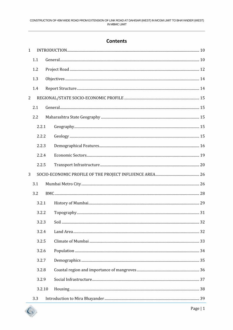
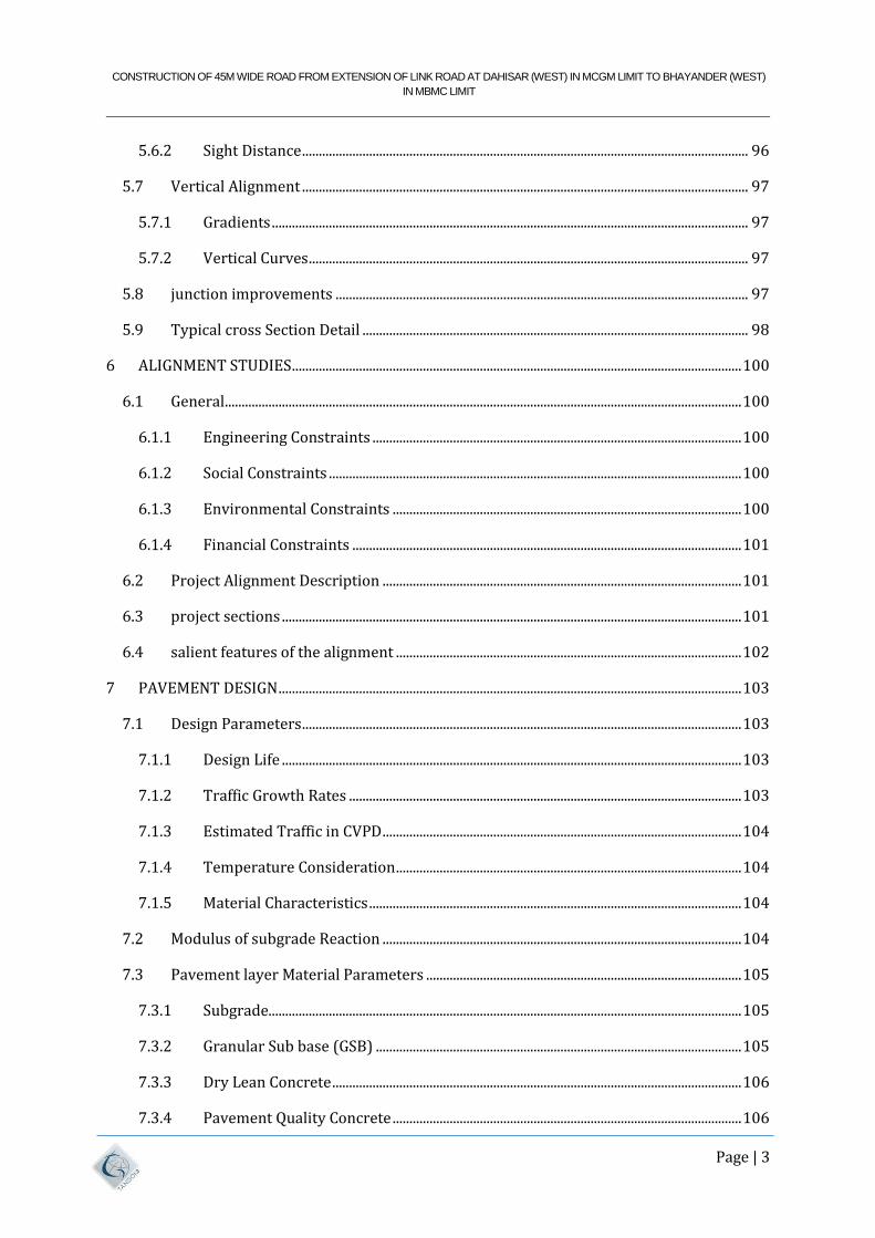
Feasibility Study Volume-I Main Report Brihanmumbai Municipal Corporation (BMC) Consultancy Services for Construction of 45m wide road from Extension of Link Road at Dahisar (west) in MCGM Limit to Bhayander (West) in MBMC Limit Tandon Urban Solutions Pvt. Ltd. (TUSPL), 701, Harbhajan Building, Kalina, Santacruz (East), Mumbai – 400098 Telefax: +91 22 26655335 Website: www.tandonassociates.com

Welcome message from author
This document is posted to help you gain knowledge. Please leave a comment to let me know what you think about it! Share it to your friends and learn new things together.
Transcript
Feasibility Study
Volume-I Main Report
Brihanmumbai Municipal Corporation (BMC)
Consultancy Services for Construction of 45m wide road from
Extension of Link Road at Dahisar (west) in MCGM Limit to
Bhayander (West) in MBMC Limit
Tandon Urban Solutions Pvt. Ltd. (TUSPL),701, Harbhajan Building,Kalina, Santacruz (East),
Mumbai – 400098Telefax: +91 22 26655335
Website: www.tandonassociates.com
CONSTRUCTION OF 45M WIDE ROAD FROM EXTENSION OF LINK ROAD AT DAHISAR (WEST) IN MCGM LIMIT TO BHAYANDER (WEST)
IN MBMC LIMIT
Page | 1
Contents
1 INTRODUCTION .................................................................................................................................................... 10
1.1 General ............................................................................................................................................................ 10
1.2 Project Road ................................................................................................................................................. 12
1.3 Objectives ...................................................................................................................................................... 14
1.4 Report Structure ......................................................................................................................................... 14
2 REGIONAL/STATE SOCIO-ECONOMIC PROFILE .................................................................................... 15
2.1 General ............................................................................................................................................................ 15
2.2 Maharashtra State Geography .............................................................................................................. 15
2.2.1 Geography ............................................................................................................................................ 15
2.2.2 Geology ................................................................................................................................................. 15
2.2.3 Demographical Features ................................................................................................................ 16
2.2.4 Economic Sectors .............................................................................................................................. 19
2.2.5 Transport Infrastructure ............................................................................................................... 20
3 SOCIO-ECONOMIC PROFILE OF THE PROJECT INFLUENCE AREA ................................................. 26
3.1 Mumbai Metro City .................................................................................................................................... 26
3.2 BMC .................................................................................................................................................................. 28
3.2.1 History of Mumbai ............................................................................................................................ 29
3.2.2 Topography ......................................................................................................................................... 31
3.2.3 Soil .......................................................................................................................................................... 32
3.2.4 Land Area ............................................................................................................................................. 32
3.2.5 Climate of Mumbai ........................................................................................................................... 33
3.2.6 Population ........................................................................................................................................... 34
3.2.7 Demographics .................................................................................................................................... 35
3.2.8 Coastal region and importance of mangroves ...................................................................... 36
3.2.9 Social Infrastructure ........................................................................................................................ 37
3.2.10 Housing ................................................................................................................................................. 38
3.3 Introduction to Mira Bhayander .......................................................................................................... 39
CONSTRUCTION OF 45M WIDE ROAD FROM EXTENSION OF LINK ROAD AT DAHISAR (WEST) IN MCGM LIMIT TO BHAYANDER (WEST)
IN MBMC LIMIT
Page | 2
3.3.1 History of Mira Bhayander ........................................................................................................... 40
3.3.2 Topography ......................................................................................................................................... 41
3.3.3 Meterology .......................................................................................................................................... 41
3.3.4 Rainfall .................................................................................................................................................. 42
3.3.5 Humudity ............................................................................................................................................. 42
3.3.6 Demography ....................................................................................................................................... 42
3.3.7 Land Use Pattern ............................................................................................................................... 42
3.3.8 Accessibility ........................................................................................................................................ 44
3.4 Socio Economic profile of MMR ............................................................................................................ 46
3.5 MMR Plan ....................................................................................................................................................... 46
3.5.1 Comprehensive Traffic & Transport Study (CTTS) ............................................................ 47
3.5.2 Introduction to Updation of CTS for MMR study ................................................................. 59
4 METHODOLOGY ADOPTED FOR STUDY .................................................................................................... 92
4.1 General ............................................................................................................................................................ 92
4.1.1 Collection and Review of Secondary Data .............................................................................. 92
4.1.2 Reconnaissance Survey .................................................................................................................. 92
4.1.3 Field Investigations.......................................................................................................................... 92
4.1.4 Design Standards and Methodology ......................................................................................... 93
5 DESIGN STANDARDS AND SPECIFICATIONS ........................................................................................... 94
5.1 General ............................................................................................................................................................ 94
5.2 Design Speed ................................................................................................................................................ 94
5.3 Right - of – Way (RoW) ............................................................................................................................ 95
5.4 Lane Width of Carriageway .................................................................................................................... 95
5.5 Median ............................................................................................................................................................ 95
5.5.1 side strips ............................................................................................................................................. 95
5.5.2 Cross fall ............................................................................................................................................... 95
5.6 Horizontal Alignment ............................................................................................................................... 96
5.6.1 Super elevation .................................................................................................................................. 96
CONSTRUCTION OF 45M WIDE ROAD FROM EXTENSION OF LINK ROAD AT DAHISAR (WEST) IN MCGM LIMIT TO BHAYANDER (WEST)
IN MBMC LIMIT
Page | 3
5.6.2 Sight Distance ..................................................................................................................................... 96
5.7 Vertical Alignment ..................................................................................................................................... 97
5.7.1 Gradients .............................................................................................................................................. 97
5.7.2 Vertical Curves ................................................................................................................................... 97
5.8 junction improvements ........................................................................................................................... 97
5.9 Typical cross Section Detail ................................................................................................................... 98
6 ALIGNMENT STUDIES ...................................................................................................................................... 100
6.1 General .......................................................................................................................................................... 100
6.1.1 Engineering Constraints .............................................................................................................. 100
6.1.2 Social Constraints ........................................................................................................................... 100
6.1.3 Environmental Constraints ........................................................................................................ 100
6.1.4 Financial Constraints .................................................................................................................... 101
6.2 Project Alignment Description ........................................................................................................... 101
6.3 project sections ......................................................................................................................................... 101
6.4 salient features of the alignment ....................................................................................................... 102
7 PAVEMENT DESIGN .......................................................................................................................................... 103
7.1 Design Parameters ................................................................................................................................... 103
7.1.1 Design Life ......................................................................................................................................... 103
7.1.2 Traffic Growth Rates ..................................................................................................................... 103
7.1.3 Estimated Traffic in CVPD ........................................................................................................... 104
7.1.4 Temperature Consideration ....................................................................................................... 104
7.1.5 Material Characteristics ............................................................................................................... 104
7.2 Modulus of subgrade Reaction ........................................................................................................... 104
7.3 Pavement layer Material Parameters .............................................................................................. 105
7.3.1 Subgrade............................................................................................................................................. 105
7.3.2 Granular Sub base (GSB) ............................................................................................................. 105
7.3.3 Dry Lean Concrete .......................................................................................................................... 106
7.3.4 Pavement Quality Concrete ........................................................................................................ 106
CONSTRUCTION OF 45M WIDE ROAD FROM EXTENSION OF LINK ROAD AT DAHISAR (WEST) IN MCGM LIMIT TO BHAYANDER (WEST)
IN MBMC LIMIT
Page | 4
7.4 Pavement Design for side strips......................................................................................................... 106
8 DESIGN BASIC FOR BRIDGE WORKS ......................................................................................................... 107
8.1 General Requirements ........................................................................................................................... 107
8.2 Restrictions on types of structures ................................................................................................... 107
8.3 Specifications for design and codes to be followed ................................................................... 107
8.4 Obligatory Provisions on Roadway on the bridge and Alignment Geometry etc. ......... 109
8.4.1 Alignment and Location ............................................................................................................... 109
8.4.2 Bridge .................................................................................................................................................. 109
8.4.3 Durability of Structure ................................................................................................................. 109
8.4.4 Design for Durability ..................................................................................................................... 110
8.4.5 Durability Provisions .................................................................................................................... 110
8.4.6 Design loads ...................................................................................................................................... 111
8.4.7 Soil Properties .................................................................................................................................. 114
8.4.8 Load combinations ......................................................................................................................... 114
8.5 Boring data and Investigations at site ............................................................................................. 114
8.6 Foundations ................................................................................................................................................ 115
8.6.1 Foundation of Piers/Abutments .............................................................................................. 115
8.6.2 Pile foundations: ............................................................................................................................. 115
8.7 Approaches/Retaining walls ............................................................................................................... 115
8.8 Substructure & foundation ................................................................................................................... 115
8.9 Superstructure .......................................................................................................................................... 116
8.10 Bearings ....................................................................................................................................................... 117
8.11 Expansion joints ....................................................................................................................................... 117
8.12 Railings/parapets & Crash Barriers. ................................................................................................ 117
8.13 Water Spouts .............................................................................................................................................. 117
8.14 Wearing coat .............................................................................................................................................. 118
8.15 Materials ...................................................................................................................................................... 118
8.15.1 Concrete Grades for various structural elements. ............................................................ 118
CONSTRUCTION OF 45M WIDE ROAD FROM EXTENSION OF LINK ROAD AT DAHISAR (WEST) IN MCGM LIMIT TO BHAYANDER (WEST)
IN MBMC LIMIT
Page | 5
8.15.2 Steel ...................................................................................................................................................... 118
8.16 Anticorrosive Treatment to Concrete and Reinforcement ..................................................... 119
9 CONSTRUCTION METHODOLOGY .............................................................................................................. 120
9.1 Methodology of Construction in Creek and Salt Pan Areas. ................................................... 120
9.2 Preparation of Casting Yard and Casting of Pre-Cast Segments ........................................... 120
9.3 Preparation of stacking yard ............................................................................................................... 121
9.3.1 Transportation of precast segments to Erection site: ..................................................... 121
9.3.2 Erection of precast segments using launcher moving from one end to other ...... 122
9.4 Methodology for Construction in Mangroves area: ................................................................... 123
9.5 Construction Methodology of Foundation and Substructure: ............................................... 123
9.6 Ground Improvement Techniques for embankment- ............................................................... 124
9.6.1 Band Drains or Prefabricated Vertical Drains (PVD)....................................................... 124
9.6.2 Stone Columns ................................................................................................................................. 125
9.6.3 Basal Reinforcement (Use of Geogrids / Geotextiles) ..................................................... 125
9.6.4 Excavation & Replacement ......................................................................................................... 125
9.6.5 Dynamic Compaction .................................................................................................................... 125
9.6.6 Excavation & Replacement with CNS Soil............................................................................. 126
10 ENVIRONMENT IMPACT ASSESSMENT .............................................................................................. 127
10.1 Alignment Overview ............................................................................................................................... 127
10.2 Applicable Environment Policies and Law .................................................................................... 127
10.2.1 The applicable Indian Legislation related to Environment: ......................................... 127
10.3 Impact on the Environment. ................................................................................................................ 129
10.3.1 Costal Regulation Zone ................................................................................................................. 129
10.3.2 Mangroves Eco System ................................................................................................................. 131
10.3.3 Wildlife and Eco Sensitive Zone................................................................................................ 136
10.4 Environment Management Plan ........................................................................................................ 136
10.4.1 Methodology for minimization of impact on mangroves ............................................... 136
10.4.2 Environment Management Plan ............................................................................................... 138
CONSTRUCTION OF 45M WIDE ROAD FROM EXTENSION OF LINK ROAD AT DAHISAR (WEST) IN MCGM LIMIT TO BHAYANDER (WEST)
IN MBMC LIMIT
Page | 6
11 COST ESTIMATE ............................................................................................................................................ 140
11.1 General .......................................................................................................................................................... 140
11.2 Estimation of Quantities and Cost ..................................................................................................... 140
12 CONCLUSIONS AND RECOMMENDATIONS ....................................................................................... 142
12.1 General .......................................................................................................................................................... 142
12.2 Project Constraints/Bottlenecks ........................................................................................................ 142
12.3 NOCs to be obtained from the following concerned Government authorities:- ............. 142
12.3.1 Traffic Dispersal .............................................................................................................................. 142
12.3.2 Pavement ........................................................................................................................................... 143
12.3.3 technical Feasiblity ........................................................................................................................ 143
CONSTRUCTION OF 45M WIDE ROAD FROM EXTENSION OF LINK ROAD AT DAHISAR (WEST) IN MCGM LIMIT TO BHAYANDER (WEST)
IN MBMC LIMIT
Page | 7
LIST OF FIGURES
Figure 1-1: Alignment for proposed dp road with row ................................................................................. 11
Figure 1-2: Pictorial Representation of Dahisar (W) – Mira Bhayandar (W) DP Link Road .......... 13
Figure 3-1: map of mumbai ....................................................................................................................................... 27
Figure 3-2: location of bmc ........................................................................................................................................ 28
Figure 3-3: map of mumbai, 1900 century ......................................................................................................... 31
Figure 3-4: contour map of mumbai ...................................................................................................................... 32
Figure 3-5: Recommended Highway Network for the Horizon Year 2016 ........................................... 55
Figure 3-6: Recommended Sub-urban & Metro Network for the Horizon Year 2016 ...................... 56
Figure 3-7: Recommended Highway Network for the Horizon Year 2021 ........................................... 57
Figure 3-8: Recommended Sub-urban & Metro Network for the Horizon Year 2021 ...................... 58
Figure 3-9: SUBURBAN Corridors Implementation for 2021 ..................................................................... 66
Figure 3-10: MONORAIL Corridors Implementation for 2021 ................................................................... 67
Figure 3-11: HIGHWAY Network Plan implemented by 2021.................................................................... 69
Figure 3-12: PROPOSED Metro Corridors for Horizon year 2026 ............................................................ 71
Figure 3-13: PROPOSED Suburban Corridors for Horizon year 2026 ..................................................... 73
Figure 3-14: Proposed Highways/ road Corridors for Horizon year 2026 ........................................... 75
Figure 3-15: PROPOSED Metro Corridors for Horizon year 2031 ............................................................ 78
Figure 3-16: PROPOSED Suburban Corridors for Horizon year 2031 ..................................................... 80
Figure 3-17: PROPOSED Metro Corridors for Horizon year 2041 ............................................................ 83
Figure 3-18: PROPOSED Suburban Corridors for Horizon year 2031 ..................................................... 85
Figure 3-19: PROPOSED Highways/ Road Corridors for Horizon year 2031 ...................................... 88
FIGURE 3-20: PROPOSED HIGHWAYS/ ROAD CORRIDORS FOR HORIZON YEAR 2041 .. 91
Figure 5-1: TYPICAL Cross Section for 4+4 Lanes Road for at-grade (Type-01) ................................ 98
Figure 5-2: TYPICAL Cross Section for 4+4 Lanes Road for Reinforced SOil Ramp (Type-02) .... 98
Figure 5-3: TYPICAL Cross Section of road on stilt and Elevated Road over salt pan (Type-03) 99
Figure 5-4: TYPICAL Cross Section of Elevated Road across creek (Type-04) .................................... 99
Figure 10-1: Alignment Superimposed on the CZMP Map 2011. ............................................................ 129
CONSTRUCTION OF 45M WIDE ROAD FROM EXTENSION OF LINK ROAD AT DAHISAR (WEST) IN MCGM LIMIT TO BHAYANDER (WEST)
IN MBMC LIMIT
Page | 8
LIST OF TABLES
Table 2-1: Gross Domestic Product of Maharashtra State ............................................................................ 17
Table 2-2: Sector wise GSDP for Maharashtra ................................................................................................... 17
Table 2-3PCI for Maharashtra .................................................................................................................................. 18
Table 2-4: Category wise Road Lengths ............................................................................................................... 20
Table 2-5: Category wise Vehicles .......................................................................................................................... 22
Table 2-6: Status of Ongoing Railway Projects in Maharashtra ................................................................. 23
Table 2-7: Airports ........................................................................................................................................................ 24
Table 2-8: Major Ports in Maharashtra ................................................................................................................ 24
Table 2-9: Cargo Handling by Non Major Ports ................................................................................................ 25
Table 3-1: Mumbai Population as per census of India 2011 ....................................................................... 34
Table 3-2: Mira - Bhayandar Population as per census of India 2011..................................................... 34
Table 3-3 Thane Population as per census of India 2011 ............................................................................. 35
Table 3-4: Climatic Condition of Mira Bhainder ............................................................................................... 42
Table 3-5: Land Use Details of Study Area .......................................................................................................... 43
Table 3-6: Passenger O-D Characteristics of Passengers with in MMR (No. of Persons) ................ 54
Table 3-7: ULB wise traffic engineering measures are also proposed and presented below. ....... 59
Table 3-8: Passenger Travel Demand for MMR- Base Year 2017, Morning Peak Period (6:00 to
11:00Hrs.) ......................................................................................................................................................................... 61
Table 3-9: Goods Travel Demand (in vehicle trips) for MMR- Base Year 2017, Morning Peak
Period (6:00 to 11:00Hrs.) ......................................................................................................................................... 61
Table 3-10: External Travel in vehicles (MMR - Outside of MMR and vice versa) - Base Year
2017, Morning Peak Period (6:00 to 11:00 Hrs.) ............................................................................................. 61
Table 3-11: Planning CRITERIA FOR the Base and Horizon Years ........................................................... 62
Table 3-12: Daily Passenger Travel Demand within MMR- Horizon Period 2021-41, in million
Vehicle Type .................................................................................................................................................................... 62
Table 3-13: GOODS Travel Demand (in vehicle trips) for MMR- Horizon Period 2021-41,
Morning Peak Period (6:00 to 11:00 Hrs.) .......................................................................................................... 63
Table 3-14: EXTERNAL Travel in PCUs (MMR to Outside of MMR and vice versa) - Horizon
Period 2021-41, Morning Peak Period (6:00 to 11:00 Hrs.) ....................................................................... 63
Table 3-15: DAILY Mode split, Mumbai Metropolitan Region .................................................................... 64
Table 3-16: DAILY Mode Split, Mumbai Metropolitan Region Comparison: CTS for MMR Study
(2005-08) and CTS Updating STUDY (2017)2005 (CTS for MMR Study) CTS Updating study
(2017) ................................................................................................................................................................................. 65
CONSTRUCTION OF 45M WIDE ROAD FROM EXTENSION OF LINK ROAD AT DAHISAR (WEST) IN MCGM LIMIT TO BHAYANDER (WEST)
IN MBMC LIMIT
Page | 9
Table 3-17: SUBURBAN Corridors Implementation for 2021 .................................................................... 66
Table 3-18: FLYOVER Implemented by 2021 .................................................................................................... 68
Table 3-19: Elevated Roads Implemented by 2021 ........................................................................................ 68
Table 3-20: ROBS IMPLEMENTED by 2021 ........................................................................................................ 69
Table 3-21: PROPOSED Metro Corridors for Horizon year 2026 .............................................................. 70
Table 3-22: PROPOSED Suburban Corridors for Horizon year 2026 ...................................................... 72
Table 3-23: PROPOSED Highways/ road Corridors for Horizon year 2026 ......................................... 74
Table 3-24: PROPOSED Metro Corridors for Horizon year 2031 .............................................................. 76
Table 3-25: PROPOSED Suburban Corridors for Horizon year 2031 ...................................................... 79
Table 3-26: PROPOSED Metro Corridors for Horizon year 2041 .............................................................. 81
Table 3-27: Proposed Suburban Corridors for Horizon year 2041 .......................................................... 84
Table 3-28: PROPOSED Highways/ road Corridors for Horizon year 2031 ......................................... 86
Table 3-29: PROPOSED Highways/ road Corridors for Horizon year 2041 ......................................... 89
Table 5-1: Design Speed as per IRC-86-2018 .................................................................................................... 94
Table 5-2: Right of Way in Plain / Rolling Terrain .......................................................................................... 95
Table 5-3: CROSSFALL on Different Surfaces .................................................................................................... 96
Table 5-4: Safe Sight Distance .................................................................................................................................. 97
Table 7-1: Estimated Traffic Growth Rates ...................................................................................................... 103
Table 7-2: Temperature Differential, 0C in Slabs ............................................................................................ 104
Table 7-3: Relation between ΄K΄value and CBR value for homogenous soil sub-grade.................. 105
Table 7-4: K΄ value for Dry Lean Concrete Sub base ..................................................................................... 105
Table 7-5: Properties of PQC ................................................................................................................................... 106
Table 11-1: List of Major Items of work ............................................................................................................. 140
Table 11-2: cost abstract .......................................................................................................................................... 141

CONSTRUCTION OF 45M WIDE ROAD FROM EXTENSION OF LINK ROAD AT DAHISAR (WEST) IN MCGM LIMIT TO BHAYANDER (WEST)
IN MBMC LIMIT
Page | 10
1 INTRODUCTION
1.1 GENERAL
Mumbai is considered the financial capital of India. It houses a population of 12.4million with a
large floating population within in a small area of 437sqkm. It is surrounded by sea on three
sides and hence has no place to expand. The constraints of the geography and the inability of
the city to expand have already made the city one of the densest Metropolis of the world.
Mumbai city has seen an increase in the number of vehicles during the last 20 years which has
resulted in extreme traffic congestion everywhere. This has led to more commuting time
and a serious impact on the productivity in the city as well as the quality of life of its citizens.
Mira Bhayandar Municipal Corporation is one of the fastest growing satellite cities in Mumbai
with a population in excess of 1.50 Millions in the Mumbai Metropolitan Region (MMR). The
economic activity in the Mumbai Metropolitan Region is interconnected with the economic
activity in the Greater Mumbai Region. As a result thereof, there is constant and continuous
movement of people between the two cities and it is estimated that almost 10 lakhs people
commute from Mumbai to Mira Bhayandar and vice-versa, every day.
At the moment, there are only two modes of connectivity to the Mira Bhayandar Municipal
Corporation with the Greater Mumbai Region. The western express highway (NH8) and western
railway lines, both serve as the primary connectivity's through road and rail respectively. As a
result of this, the primary development of Mira-Bhayandar Municipal Corporation is
concentrated around these two arteries of connectivity. This has also resulted in the western
part of Mira Bhayandar Municipal Corporation, which has largest land mass being almost left
undeveloped.
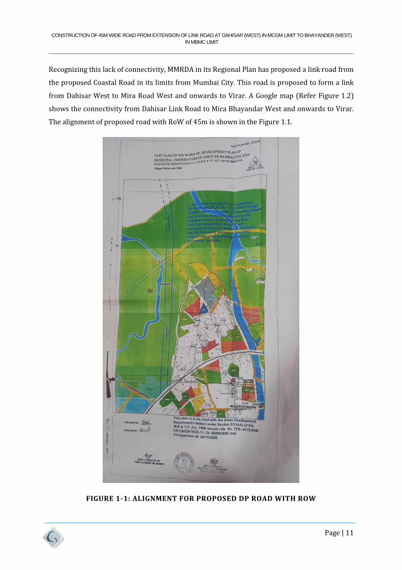
As per the Development Plan of MBMC, the western part of Mira Road and Bhayandar is entirely
under Residential Zone. Due to lack of connectivity the entire western part of MBMC is
undeveloped. An extract of the DP of the western parts of MBMC clearly shows the Residential
Zone. (Refer Figure 1.1) shows that the same is still not developed despite being in the
Residential Zone and therefore it is imperative that additional arterial connectivity by road
needs to be created between Greater Mumbai and Mira Bhayandar Municipal Corporation on its
western part.
CONSTRUCTION OF 45M WIDE ROAD FROM EXTENSION OF LINK ROAD AT DAHISAR (WEST) IN MCGM LIMIT TO BHAYANDER (WEST)
IN MBMC LIMIT
Page | 11
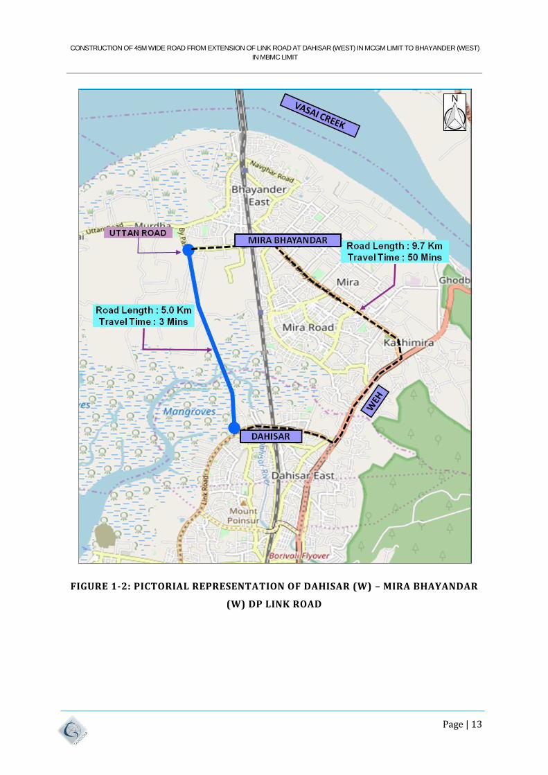
Recognizing this lack of connectivity, MMRDA in its Regional Plan has proposed a link road from
the proposed Coastal Road in its limits from Mumbai City. This road is proposed to form a link
from Dahisar West to Mira Road West and onwards to Virar. A Google map (Refer Figure 1.2)
shows the connectivity from Dahisar Link Road to Mira Bhayandar West and onwards to Virar.
The alignment of proposed road with RoW of 45m is shown in the Figure 1.1.
FIGURE 1-1: ALIGNMENT FOR PROPOSED DP ROAD WITH ROW
CONSTRUCTION OF 45M WIDE ROAD FROM EXTENSION OF LINK ROAD AT DAHISAR (WEST) IN MCGM LIMIT TO BHAYANDER (WEST)
IN MBMC LIMIT
Page | 12
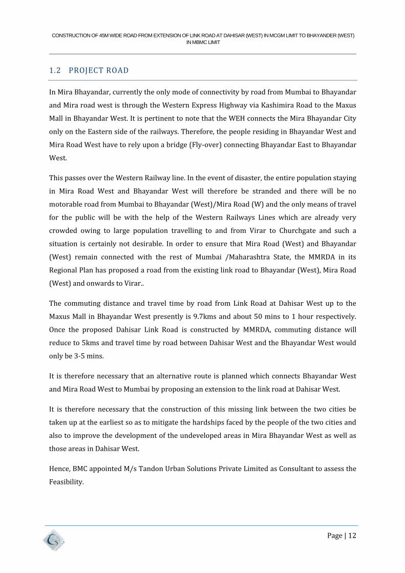
1.2 PROJECT ROAD
In Mira Bhayandar, currently the only mode of connectivity by road from Mumbai to Bhayandar
and Mira road west is through the Western Express Highway via Kashimira Road to the Maxus
Mall in Bhayandar West. It is pertinent to note that the WEH connects the Mira Bhayandar City
only on the Eastern side of the railways. Therefore, the people residing in Bhayandar West and
Mira Road West have to rely upon a bridge (Fly-over) connecting Bhayandar East to Bhayandar
West.
This passes over the Western Railway line. In the event of disaster, the entire population staying
in Mira Road West and Bhayandar West will therefore be stranded and there will be no
motorable road from Mumbai to Bhayandar (West)/Mira Road (W) and the only means of travel
for the public will be with the help of the Western Railways Lines which are already very
crowded owing to large population travelling to and from Virar to Churchgate and such a
situation is certainly not desirable. In order to ensure that Mira Road (West) and Bhayandar
(West) remain connected with the rest of Mumbai /Maharashtra State, the MMRDA in its
Regional Plan has proposed a road from the existing link road to Bhayandar (West), Mira Road
(West) and onwards to Virar..
The commuting distance and travel time by road from Link Road at Dahisar West up to the
Maxus Mall in Bhayandar West presently is 9.7kms and about 50 mins to 1 hour respectively.
Once the proposed Dahisar Link Road is constructed by MMRDA, commuting distance will
reduce to 5kms and travel time by road between Dahisar West and the Bhayandar West would
only be 3-5 mins.
It is therefore necessary that an alternative route is planned which connects Bhayandar West
and Mira Road West to Mumbai by proposing an extension to the link road at Dahisar West.
It is therefore necessary that the construction of this missing link between the two cities be
taken up at the earliest so as to mitigate the hardships faced by the people of the two cities and
also to improve the development of the undeveloped areas in Mira Bhayandar West as well as
those areas in Dahisar West.
Hence, BMC appointed M/s Tandon Urban Solutions Private Limited as Consultant to assess the
Feasibility.
CONSTRUCTION OF 45M WIDE ROAD FROM EXTENSION OF LINK ROAD AT DAHISAR (WEST) IN MCGM LIMIT TO BHAYANDER (WEST)
IN MBMC LIMIT
Page | 13
FIGURE 1-2: PICTORIAL REPRESENTATION OF DAHISAR (W) – MIRA BHAYANDAR
(W) DP LINK ROAD
CONSTRUCTION OF 45M WIDE ROAD FROM EXTENSION OF LINK ROAD AT DAHISAR (WEST) IN MCGM LIMIT TO BHAYANDER (WEST)
IN MBMC LIMIT
Page | 14
1.3 OBJECTIVES
The objective of this assignment is to give feasible solution for smooth traffic dispersal and
reduce the congestion of traffic on WEH (NH-8) by connecting a link road from Dahisar West to
Mira Road (West).
1.4 REPORT STRUCTURE
In view of the above, Consultant has completed the study of alignment and obtained approval in
principle from the authority. Thereafter, we as Consultants have collected various data, carried
out various investigations and studied various available reports and on the basis of which the
Feasibility is prepared for submission to BMC.
The DPR contains the following documents:
• Volume I: Main Report.
• Volume II: Design Report.
1. Alignment Report
2. Pavement Report
3. Bridge Report
4. Construction Methodology Report
• Volume – III: Materials Report
• Volume IV: Engineering Report.
1. Geo-Technical Report
2. Topography & Bathymetry Survey Report
• Volume V: Drainage Design Report
• Volume VI: Cost Estimate & Rate Analysis
• Volume VII: Drawings
CONSTRUCTION OF 45M WIDE ROAD FROM EXTENSION OF LINK ROAD AT DAHISAR (WEST) IN MCGM LIMIT TO BHAYANDER (WEST)
IN MBMC LIMIT
Page | 15
2 REGIONAL/STATE SOCIO-ECONOMIC PROFILE
2.1 GENERAL
Mumbai is the capital of Maharashtra state. This chapter presents Socio-Economic profile of the
State of Maharashtra, as the growth of Mumbai is largely dependent on it.
2.2 MAHARASHTRA STATE GEOGRAPHY
2.2.1 GEOGRAPHY
The dominant physical trait of the State is its plateau character. Maharashtra is a plateau of
plateaus, its western upturned rims rising form the Sahyadri Range parallel to the sea-coast and
its slopes gently descending towards the East and South-east. Satpuda ranges cover the
Northern part of the State, while Ajanta and Satmala ranges run through Central part of the
State.
Arabian Sea guards the western boundary of Maharashtra while Gujarat and Madhya Pradesh
are on its northern side. The State receives its rainfall mainly from south-west monsoon.
Running north to south, throughout its length are the steeply rising Western Ghats. The foothills
of the ghats sometimes approach the seashore and sometimes withdraw 40 or 50 km away.
Nestling in these mountains at an altitude of 2000 meters are the hill stations of Maharashtra.
These towns offer clean, calm and a thoroughly refreshing alternative to city life. Mumbai,
India's commercial capital, and easily the most accessible city in this country, is the perfect
gateway to Maharashtra's hill country, with convenient and comfortable links by road, rail, and
air.
2.2.2 GEOLOGY
Except around Mumbai, and along the eastern limits, the State of Maharashtra presents a
monotonously uniform, flat-topped skyline. This topography of the state is the outcome of its
geological structure. The state area, barring the extreme eastern Vidarbha region, Parts of
Kolhapur and Sindhudurg, is practically co-terminus with the Deccan Traps. Roughly 60 to 90
million years ago, the outpouring of Basic Lava, through fissures formed horizontally bedded
basalt over large areas. Variations in their composition and structure have resulted in massive,
CONSTRUCTION OF 45M WIDE ROAD FROM EXTENSION OF LINK ROAD AT DAHISAR (WEST) IN MCGM LIMIT TO BHAYANDER (WEST)
IN MBMC LIMIT
Page | 16
well –jointed steel-gray cliff faces alternating with structural benches of vesicular amygdaloidal
lava and ash layers, all of which contribute to the pyramid-shaped hills and crest – level plateau
or mesas. Earth sculpturing under the tropical climate completed the panorama – sharply
defining the landform features in the semi – arid conditions, and rounding the hilltops under
wetter condition.
2.2.3 DEMOGRAPHICAL FEATURES
2.2.3.1 POPULATION
As per the population Census 2011, Maharashtra’s population was 11.23 crores, which was 9.28
% of India’s population. Maharashtra is the second largest State in India in respect of population
after Uttar Pradesh. During the decade 1991-2001, the population of the State increased by
15.99%. The corresponding growth during the earlier decade was 22.57 %. The decadal growth
rate in 2001-2011 was more by 6.6%. As per Census, the population of India was 1,119,477.
2.2.3.2 POPULATION DENSITY
As per 2001 Population Census the density of population in the State was 322.5. During 2001-
2011 there was an addition of 42.5 people per 1sq.km. As per Population Census 2011, the
density of population of the State is 365 per sq.km. as compared to that of India (382). Mumbai
has become the most populated city and world’s fifth. In 2011, Mumbai’s average density was
30,000 persons per sq.km.
Urban Population
According to 2011 Population Census, 45.23 %( 42.4% in 2001) of the State’s population was in
urban areas as against 27.8% at All-India level. Thus, the proportion in the state is substantially
higher than that for India.
2.2.3.3 STATE OF THE ECONOMY
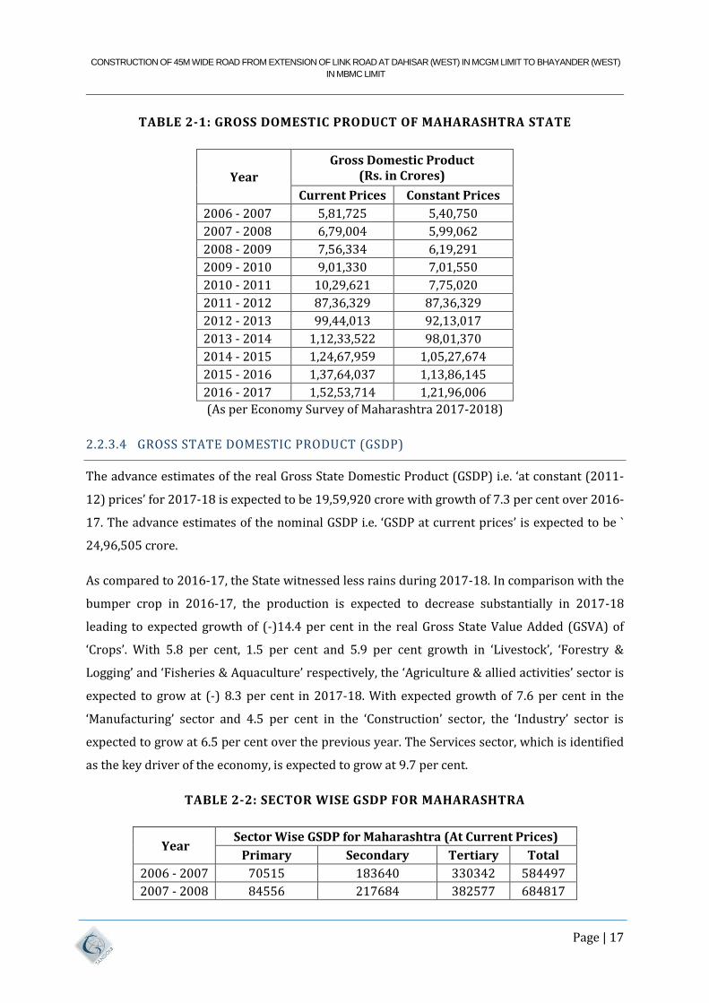
Maharashtra state has highest Gross State Domestic product (GSDP) in India. The statistical data
is presented in Table 2.1 below at current prices and constant prices.
CONSTRUCTION OF 45M WIDE ROAD FROM EXTENSION OF LINK ROAD AT DAHISAR (WEST) IN MCGM LIMIT TO BHAYANDER (WEST)
IN MBMC LIMIT
Page | 17
TABLE 2-1: GROSS DOMESTIC PRODUCT OF MAHARASHTRA STATE
Year
Gross Domestic Product (Rs. in Crores)
Current Prices Constant Prices
2006 - 2007 5,81,725 5,40,750
2007 - 2008 6,79,004 5,99,062
2008 - 2009 7,56,334 6,19,291
2009 - 2010 9,01,330 7,01,550
2010 - 2011 10,29,621 7,75,020
2011 - 2012 87,36,329 87,36,329
2012 - 2013 99,44,013 92,13,017
2013 - 2014 1,12,33,522 98,01,370
2014 - 2015 1,24,67,959 1,05,27,674
2015 - 2016 1,37,64,037 1,13,86,145
2016 - 2017 1,52,53,714 1,21,96,006
(As per Economy Survey of Maharashtra 2017-2018)
2.2.3.4 GROSS STATE DOMESTIC PRODUCT (GSDP)
The advance estimates of the real Gross State Domestic Product (GSDP) i.e. ‘at constant (2011-
12) prices’ for 2017-18 is expected to be 19,59,920 crore with growth of 7.3 per cent over 2016-
17. The advance estimates of the nominal GSDP i.e. ‘GSDP at current prices’ is expected to be `
24,96,505 crore.
As compared to 2016-17, the State witnessed less rains during 2017-18. In comparison with the
bumper crop in 2016-17, the production is expected to decrease substantially in 2017-18
leading to expected growth of (-)14.4 per cent in the real Gross State Value Added (GSVA) of
‘Crops’. With 5.8 per cent, 1.5 per cent and 5.9 per cent growth in ‘Livestock’, ‘Forestry &
Logging’ and ‘Fisheries & Aquaculture’ respectively, the ‘Agriculture & allied activities’ sector is
expected to grow at (-) 8.3 per cent in 2017-18. With expected growth of 7.6 per cent in the
‘Manufacturing’ sector and 4.5 per cent in the ‘Construction’ sector, the ‘Industry’ sector is
expected to grow at 6.5 per cent over the previous year. The Services sector, which is identified
as the key driver of the economy, is expected to grow at 9.7 per cent.
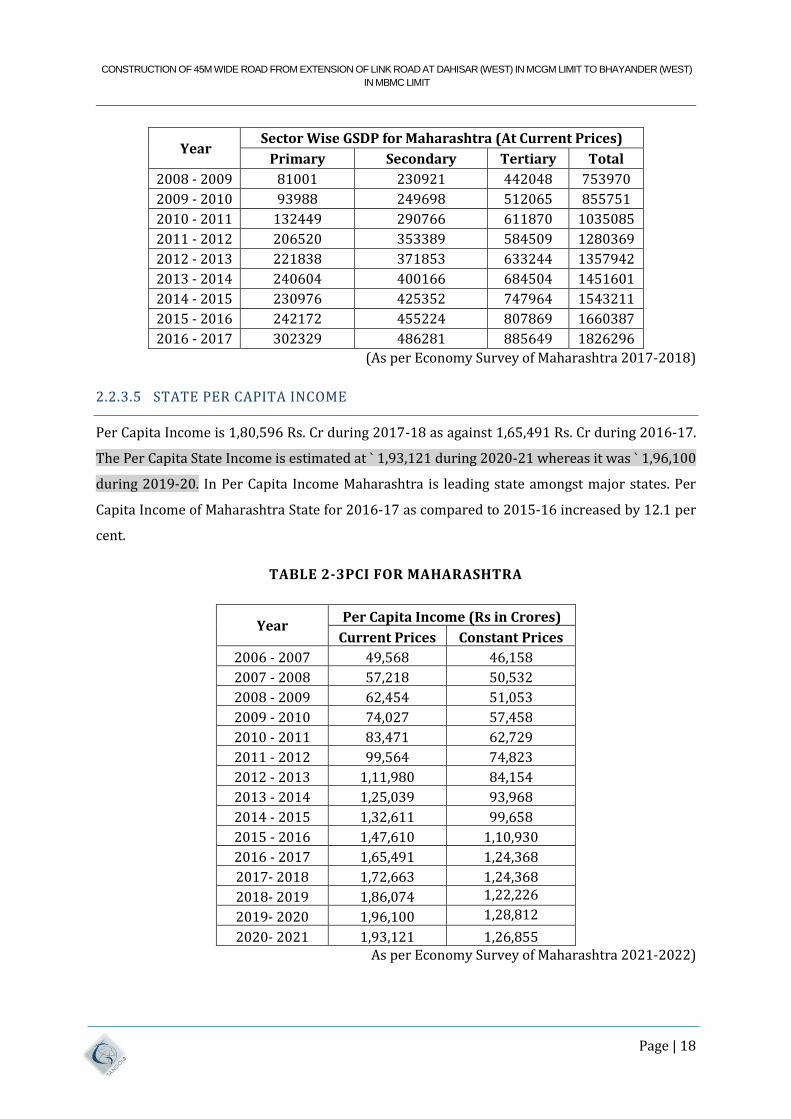
TABLE 2-2: SECTOR WISE GSDP FOR MAHARASHTRA
Year Sector Wise GSDP for Maharashtra (At Current Prices)
Primary Secondary Tertiary Total
2006 - 2007 70515 183640 330342 584497
2007 - 2008 84556 217684 382577 684817
CONSTRUCTION OF 45M WIDE ROAD FROM EXTENSION OF LINK ROAD AT DAHISAR (WEST) IN MCGM LIMIT TO BHAYANDER (WEST)
IN MBMC LIMIT
Page | 18
Year Sector Wise GSDP for Maharashtra (At Current Prices)
Primary Secondary Tertiary Total
2008 - 2009 81001 230921 442048 753970
2009 - 2010 93988 249698 512065 855751
2010 - 2011 132449 290766 611870 1035085
2011 - 2012 206520 353389 584509 1280369
2012 - 2013 221838 371853 633244 1357942
2013 - 2014 240604 400166 684504 1451601
2014 - 2015 230976 425352 747964 1543211
2015 - 2016 242172 455224 807869 1660387
2016 - 2017 302329 486281 885649 1826296
(As per Economy Survey of Maharashtra 2017-2018)
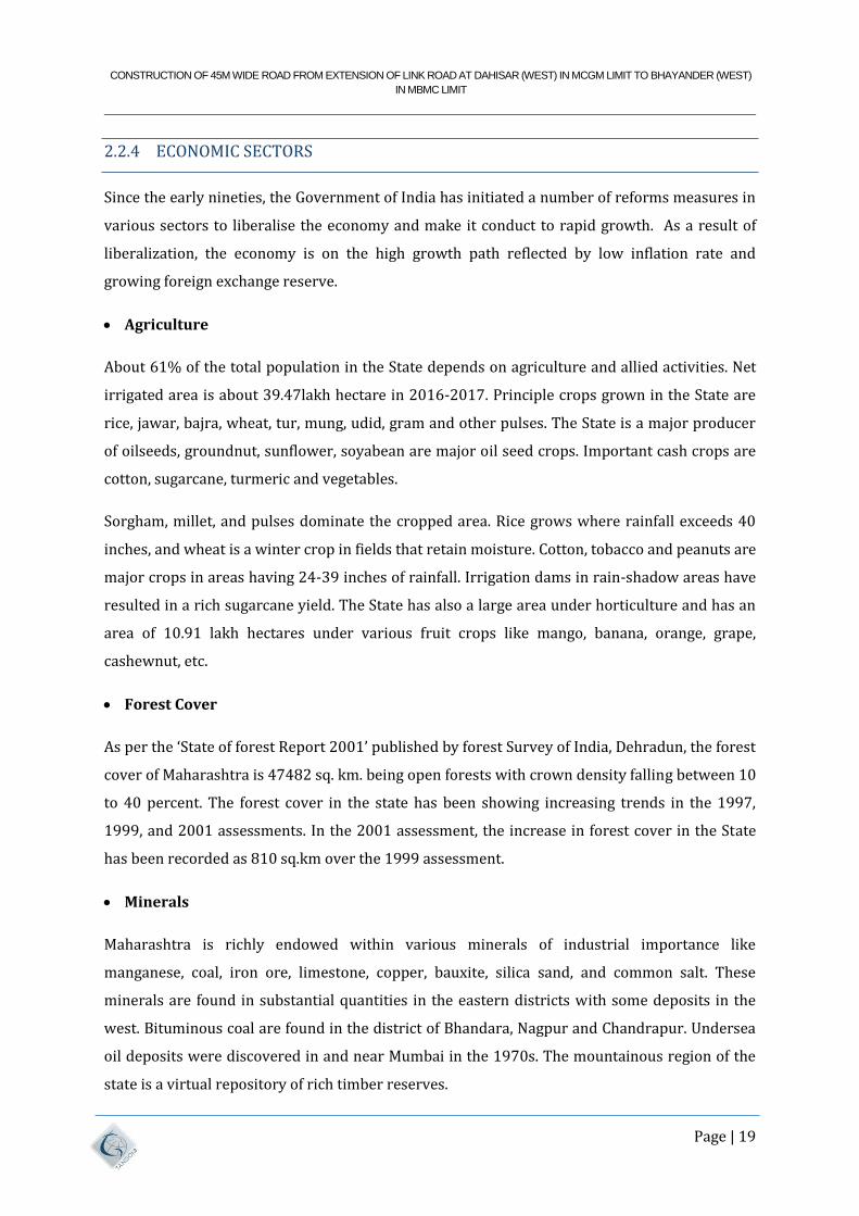
2.2.3.5 STATE PER CAPITA INCOME
Per Capita Income is 1,80,596 Rs. Cr during 2017-18 as against 1,65,491 Rs. Cr during 2016-17.
The Per Capita State Income is estimated at ` 1,93,121 during 2020-21 whereas it was ` 1,96,100
during 2019-20. In Per Capita Income Maharashtra is leading state amongst major states. Per
Capita Income of Maharashtra State for 2016-17 as compared to 2015-16 increased by 12.1 per
cent.
TABLE 2-3PCI FOR MAHARASHTRA
Year Per Capita Income (Rs in Crores)
Current Prices Constant Prices
2006 - 2007 49,568 46,158
2007 - 2008 57,218 50,532
2008 - 2009 62,454 51,053
2009 - 2010 74,027 57,458
2010 - 2011 83,471 62,729
2011 - 2012 99,564 74,823
2012 - 2013 1,11,980 84,154
2013 - 2014 1,25,039 93,968
2014 - 2015 1,32,611 99,658
2015 - 2016 1,47,610 1,10,930
2016 - 2017 1,65,491 1,24,368
2017- 2018 1,72,663 1,24,368
2018- 2019 1,86,074 1,22,226
2019- 2020 1,96,100 1,28,812
2020- 2021 1,93,121 1,26,855 As per Economy Survey of Maharashtra 2021-2022)
CONSTRUCTION OF 45M WIDE ROAD FROM EXTENSION OF LINK ROAD AT DAHISAR (WEST) IN MCGM LIMIT TO BHAYANDER (WEST)
IN MBMC LIMIT
Page | 19
2.2.4 ECONOMIC SECTORS
Since the early nineties, the Government of India has initiated a number of reforms measures in
various sectors to liberalise the economy and make it conduct to rapid growth. As a result of
liberalization, the economy is on the high growth path reflected by low inflation rate and
growing foreign exchange reserve.
Agriculture
About 61% of the total population in the State depends on agriculture and allied activities. Net
irrigated area is about 39.47lakh hectare in 2016-2017. Principle crops grown in the State are
rice, jawar, bajra, wheat, tur, mung, udid, gram and other pulses. The State is a major producer
of oilseeds, groundnut, sunflower, soyabean are major oil seed crops. Important cash crops are
cotton, sugarcane, turmeric and vegetables.
Sorgham, millet, and pulses dominate the cropped area. Rice grows where rainfall exceeds 40
inches, and wheat is a winter crop in fields that retain moisture. Cotton, tobacco and peanuts are
major crops in areas having 24-39 inches of rainfall. Irrigation dams in rain-shadow areas have
resulted in a rich sugarcane yield. The State has also a large area under horticulture and has an
area of 10.91 lakh hectares under various fruit crops like mango, banana, orange, grape,
cashewnut, etc.
Forest Cover
As per the ‘State of forest Report 2001’ published by forest Survey of India, Dehradun, the forest
cover of Maharashtra is 47482 sq. km. being open forests with crown density falling between 10
to 40 percent. The forest cover in the state has been showing increasing trends in the 1997,
1999, and 2001 assessments. In the 2001 assessment, the increase in forest cover in the State
has been recorded as 810 sq.km over the 1999 assessment.
Minerals
Maharashtra is richly endowed within various minerals of industrial importance like
manganese, coal, iron ore, limestone, copper, bauxite, silica sand, and common salt. These
minerals are found in substantial quantities in the eastern districts with some deposits in the
west. Bituminous coal are found in the district of Bhandara, Nagpur and Chandrapur. Undersea
oil deposits were discovered in and near Mumbai in the 1970s. The mountainous region of the
state is a virtual repository of rich timber reserves.
CONSTRUCTION OF 45M WIDE ROAD FROM EXTENSION OF LINK ROAD AT DAHISAR (WEST) IN MCGM LIMIT TO BHAYANDER (WEST)
IN MBMC LIMIT
Page | 20
Irrigation and Power
By the end of June 1998, 33 major, 177 medium and about 1.835 state sector minor irrigation
projects have been completed. Another 27 major, 86 medium and 263 minor irrigation projects
were under construction. The gross irrigated area at the end of June 1998 was nearly 1997-98.
Tourist Centre
The important Tourist Centres in the state include Ajanta, Ellora, Elephanta, Kanheri and Karla
caves, Mahabaleshwar, Matheran and Panchgani, Jawhar, Malshejghat, Amboli, chikaldara,
Panhala hill Stations and religious places at Pandharpur, Nasik, Nanded, Audhanagnath.
Trimbakeshwar, Tuljapur, Ganpatipule, Bhimashankar, Harihareshwar and Shegaon.
Social and Community Services
Social development in Maharashtra has attained satisfactory level of success. Successive
government of the state has followed a development strategy by consciously investing in social
development sector like education, medical and public health. The social security measures
introduced by the state government were directed towards reducing income disparities and
uplifting weaker segments.
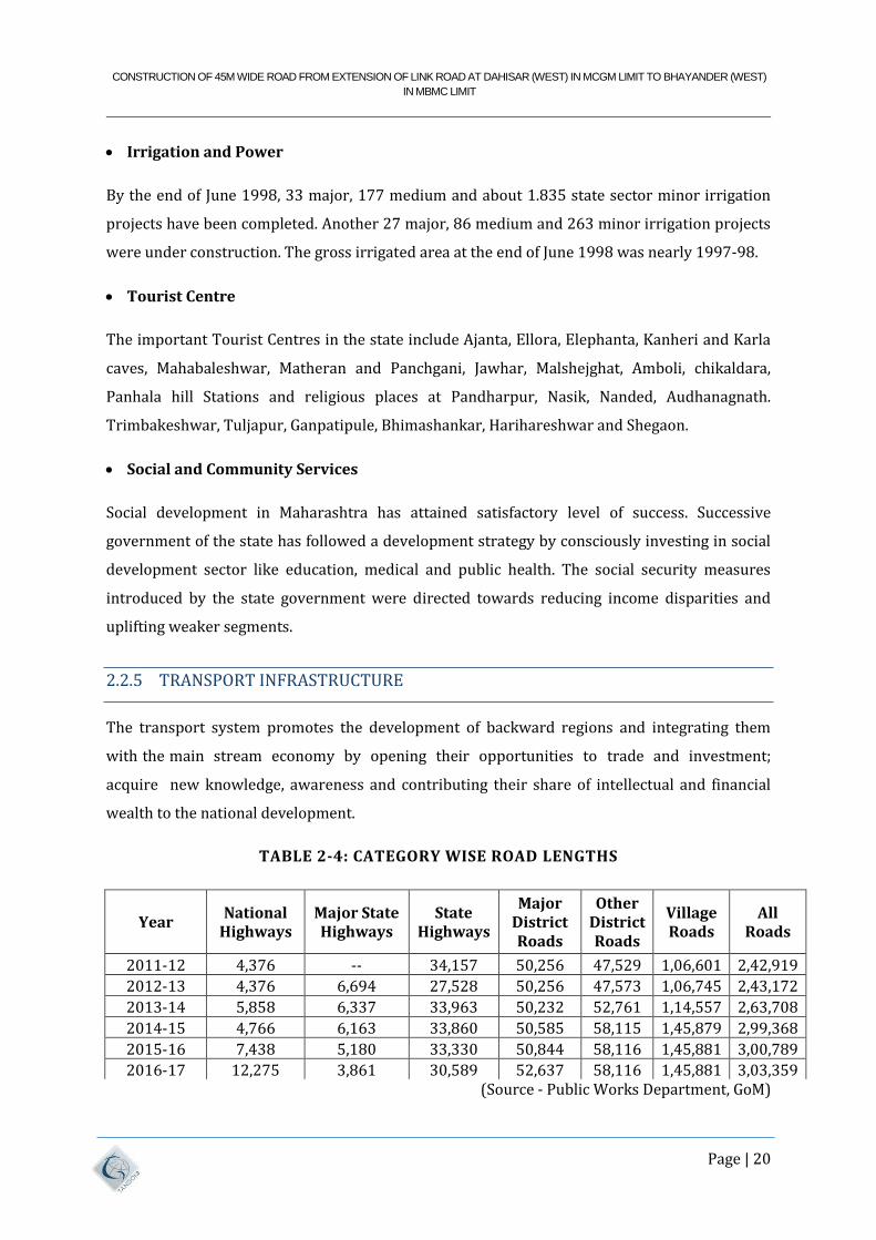
2.2.5 TRANSPORT INFRASTRUCTURE
The transport system promotes the development of backward regions and integrating them
with the main stream economy by opening their opportunities to trade and investment;
acquire new knowledge, awareness and contributing their share of intellectual and financial
wealth to the national development.
TABLE 2-4: CATEGORY WISE ROAD LENGTHS
Year National
Highways Major State Highways
State Highways
Major District Roads
Other District Roads
Village Roads
All Roads
2011-12 4,376 -- 34,157 50,256 47,529 1,06,601 2,42,919
2012-13 4,376 6,694 27,528 50,256 47,573 1,06,745 2,43,172
2013-14 5,858 6,337 33,963 50,232 52,761 1,14,557 2,63,708
2014-15 4,766 6,163 33,860 50,585 58,115 1,45,879 2,99,368
2015-16 7,438 5,180 33,330 50,844 58,116 1,45,881 3,00,789
2016-17 12,275 3,861 30,589 52,637 58,116 1,45,881 3,03,359 (Source - Public Works Department, GoM)
CONSTRUCTION OF 45M WIDE ROAD FROM EXTENSION OF LINK ROAD AT DAHISAR (WEST) IN MCGM LIMIT TO BHAYANDER (WEST)
IN MBMC LIMIT
Page | 21
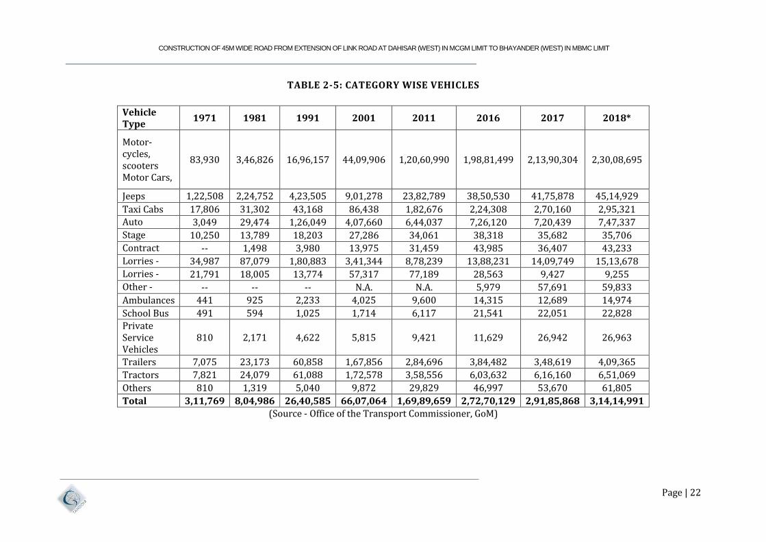
Maharashtra state has seen rapid growth in vehicle population in all categories due to rapid
economic growth. Numbers of vehicles registered in the state are presented in table below.
CONSTRUCTION OF 45M WIDE ROAD FROM EXTENSION OF LINK ROAD AT DAHISAR (WEST) IN MCGM LIMIT TO BHAYANDER (WEST) IN MBMC LIMIT
Page | 22
TABLE 2-5: CATEGORY WISE VEHICLES
Vehicle Type
1971 1981 1991 2001 2011 2016 2017 2018*
Motor- cycles, scooters Motor Cars,
83,930 3,46,826 16,96,157 44,09,906 1,20,60,990 1,98,81,499 2,13,90,304 2,30,08,695
Jeeps 1,22,508 2,24,752 4,23,505 9,01,278 23,82,789 38,50,530 41,75,878 45,14,929
Taxi Cabs 17,806 31,302 43,168 86,438 1,82,676 2,24,308 2,70,160 2,95,321
Auto Rickshaws
3,049 29,474 1,26,049 4,07,660 6,44,037 7,26,120 7,20,439 7,47,337
Stage Carriages
10,250 13,789 18,203 27,286 34,061 38,318 35,682 35,706
Contract Carriages
-- 1,498 3,980 13,975 31,459 43,985 36,407 43,233
Lorries - Diesel
34,987 87,079 1,80,883 3,41,344 8,78,239 13,88,231 14,09,749 15,13,678
Lorries - Petrol
21,791 18,005 13,774 57,317 77,189 28,563 9,427 9,255
Other - CNG, LPG, etc.
-- -- -- N.A. N.A. 5,979 57,691 59,833
Ambulances 441 925 2,233 4,025 9,600 14,315 12,689 14,974
School Bus 491 594 1,025 1,714 6,117 21,541 22,051 22,828 Private Service Vehicles
810 2,171 4,622 5,815 9,421 11,629 26,942 26,963
Trailers 7,075 23,173 60,858 1,67,856 2,84,696 3,84,482 3,48,619 4,09,365
Tractors 7,821 24,079 61,088 1,72,578 3,58,556 6,03,632 6,16,160 6,51,069
Others 810 1,319 5,040 9,872 29,829 46,997 53,670 61,805
Total 3,11,769 8,04,986 26,40,585 66,07,064 1,69,89,659 2,72,70,129 2,91,85,868 3,14,14,991
(Source - Office of the Transport Commissioner, GoM)
CONSTRUCTION OF 45M WIDE ROAD FROM EXTENSION OF LINK ROAD AT DAHISAR (WEST) IN MCGM LIMIT TO BHAYANDER (WEST)
IN MBMC LIMIT
Page | 23
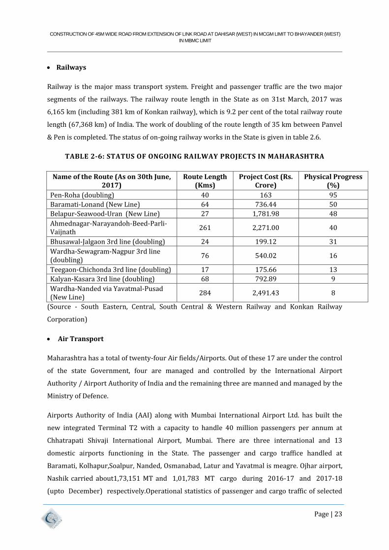
Railways
Railway is the major mass transport system. Freight and passenger traffic are the two major
segments of the railways. The railway route length in the State as on 31st March, 2017 was
6,165 km (including 381 km of Konkan railway), which is 9.2 per cent of the total railway route
length (67,368 km) of India. The work of doubling of the route length of 35 km between Panvel
& Pen is completed. The status of on-going railway works in the State is given in table 2.6.
TABLE 2-6: STATUS OF ONGOING RAILWAY PROJECTS IN MAHARASHTRA
Name of the Route (As on 30th June, 2017)
Route Length (Kms)
Project Cost (Rs. Crore)
Physical Progress (%)
Pen-Roha (doubling) 40 163 95
Baramati-Lonand (New Line) 64 736.44 50
Belapur-Seawood-Uran (New Line) 27 1,781.98 48
Ahmednagar-Narayandoh-Beed-Parli-Vaijnath
261 2,271.00 40
Bhusawal-Jalgaon 3rd line (doubling) 24 199.12 31
Wardha-Sewagram-Nagpur 3rd line (doubling)
76 540.02 16
Teegaon-Chichonda 3rd line (doubling) 17 175.66 13
Kalyan-Kasara 3rd line (doubling) 68 792.89 9
Wardha-Nanded via Yavatmal-Pusad (New Line)
284 2,491.43 8
(Source - South Eastern, Central, South Central & Western Railway and Konkan Railway
Corporation)
Air Transport
Maharashtra has a total of twenty-four Air fields/Airports. Out of these 17 are under the control
of the state Government, four are managed and controlled by the International Airport
Authority / Airport Authority of India and the remaining three are manned and managed by the
Ministry of Defence.
Airports Authority of India (AAI) along with Mumbai International Airport Ltd. has built the
new integrated Terminal T2 with a capacity to handle 40 million passengers per annum at
Chhatrapati Shivaji International Airport, Mumbai. There are three international and 13
domestic airports functioning in the State. The passenger and cargo traffice handled at
Baramati, Kolhapur,Soalpur, Nanded, Osmanabad, Latur and Yavatmal is meagre. Ojhar airport,
Nashik carried about1,73,151 MT and 1,01,783 MT cargo during 2016-17 and 2017-18
(upto December) respectively.Operational statistics of passenger and cargo traffic of selected
CONSTRUCTION OF 45M WIDE ROAD FROM EXTENSION OF LINK ROAD AT DAHISAR (WEST) IN MCGM LIMIT TO BHAYANDER (WEST)
IN MBMC LIMIT
Page | 24
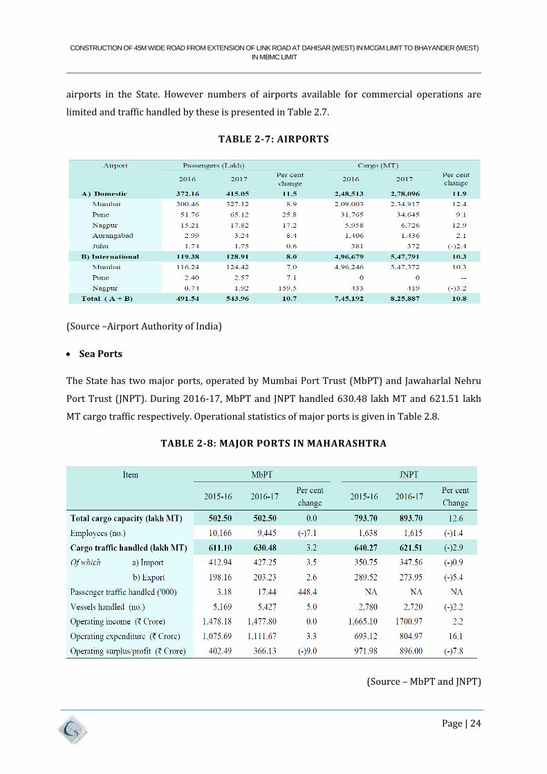
airports in the State. However numbers of airports available for commercial operations are
limited and traffic handled by these is presented in Table 2.7.
TABLE 2-7: AIRPORTS
(Source –Airport Authority of India)
Sea Ports
The State has two major ports, operated by Mumbai Port Trust (MbPT) and Jawaharlal Nehru
Port Trust (JNPT). During 2016-17, MbPT and JNPT handled 630.48 lakh MT and 621.51 lakh
MT cargo traffic respectively. Operational statistics of major ports is given in Table 2.8.
TABLE 2-8: MAJOR PORTS IN MAHARASHTRA
(Source – MbPT and JNPT)
CONSTRUCTION OF 45M WIDE ROAD FROM EXTENSION OF LINK ROAD AT DAHISAR (WEST) IN MCGM LIMIT TO BHAYANDER (WEST)
IN MBMC LIMIT
Page | 25
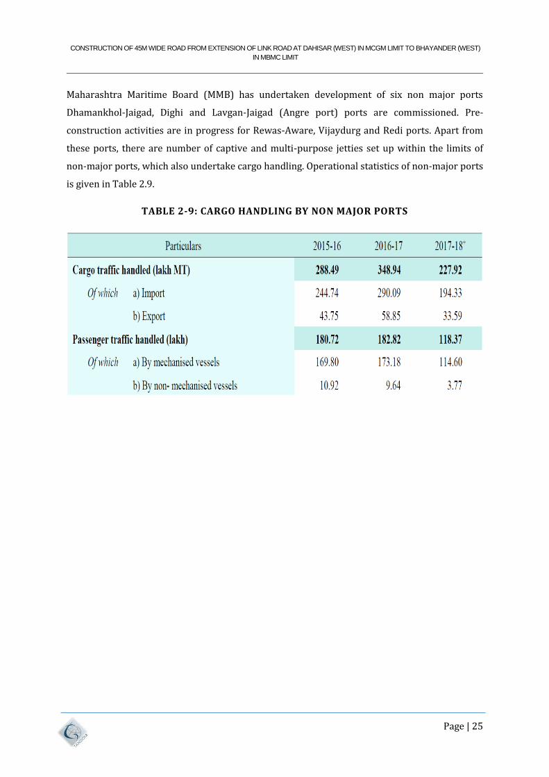
Maharashtra Maritime Board (MMB) has undertaken development of six non major ports
Dhamankhol-Jaigad, Dighi and Lavgan-Jaigad (Angre port) ports are commissioned. Pre-
construction activities are in progress for Rewas-Aware, Vijaydurg and Redi ports. Apart from
these ports, there are number of captive and multi-purpose jetties set up within the limits of
non-major ports, which also undertake cargo handling. Operational statistics of non-major ports
is given in Table 2.9.
TABLE 2-9: CARGO HANDLING BY NON MAJOR PORTS
CONSTRUCTION OF 45M WIDE ROAD FROM EXTENSION OF LINK ROAD AT DAHISAR (WEST) IN MCGM LIMIT TO BHAYANDER (WEST)
IN MBMC LIMIT
Page | 26
3 SOCIO-ECONOMIC PROFILE OF THE PROJECT INFLUENCE
AREA
3.1 MUMBAI METRO CITY
Mumbai, the capital of Maharashtra, is considered the financial capital of India with the
headquarters of almost all major banks, financial institutions, insurance companies and mutual
funds being based in the city. India's largest stock exchange Bombay Stock Exchange, the oldest
in Asia, is also located in the city. More than 41% of the S&P CNX 500 conglomerates have
corporate 1 office in Maharashtra. Mumbai (formerly known as Bombay) is located on the
western seacoast of India on the Arabian Sea at 180 53’ N to 190 16’ N latitude and 720 E to
720 59’ E longitude.
Mumbai was originally a cluster of seven islands inhabited by fishermen, which were later
joined to form the present city. Mumbai was ruled by various Hindu dynasties till 1348 when
the Muslims took over. In 1534 Mumbai was handed over to the Portuguese who offered the
city as dowry to Charles II of England in May 1664. In 1668, the East India Company took over
Mumbai and started developing it as a firm base of their commercial activities. Land
reclamation was started.
It is well known that Mumbai city is comprised of seven islands till 1857. Gradually with
invasion the islands were merged by the invaders and now the entire city is one big island. The
island city has a rich heritage of natural resources like the forests, lakes mangroves, etc. Greater
Mumbai Region consists of 7 islands in the city area and 4 islands in the suburbs. The present
day city is divided into two revenue districts, Mumbai City District, i.e., the island city in the
South and Mumbai Suburban District comprising the Western and Eastern suburbs. Mumbai
occupies an area of 468 square kilometers (sq. km.) and its width is 17 km. east to west and 42
km. north to south. The entire region encompasses rich natural heritage, such as, hills, lakes,
coastal water, forests, and mangroves, alongside built areas. The coastline of Mumbai has been
reclaimed for development purposes; e.g., areas like Cuff Parade and Mahim creek were
wetlands, later reclaimed for residential and commercial uses.
The residents drew water from wells and tanks which were, before long, inadequate for the
growing needs. In the absence of Perennial River, harnessing of surface water was the only
feasible solution. Search for a suitable site for impounding the monsoon runs-offs was started
in 1845.
CONSTRUCTION OF 45M WIDE ROAD FROM EXTENSION OF LINK ROAD AT DAHISAR (WEST) IN MCGM LIMIT TO BHAYANDER (WEST)
IN MBMC LIMIT
Page | 27
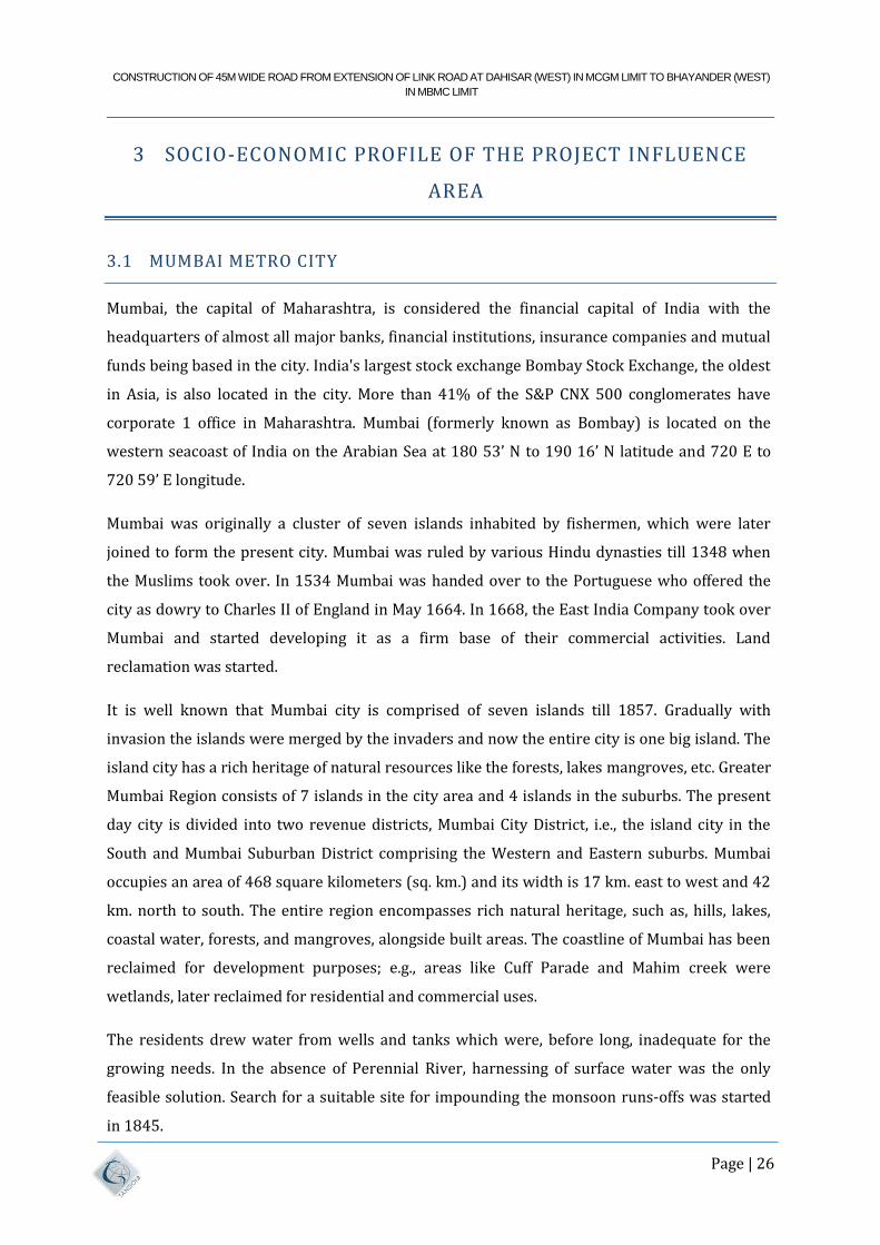
FIGURE 3-1: MAP OF MUMBAI
CONSTRUCTION OF 45M WIDE ROAD FROM EXTENSION OF LINK ROAD AT DAHISAR (WEST) IN MCGM LIMIT TO BHAYANDER (WEST)
IN MBMC LIMIT
Page | 28
3.2 BMC
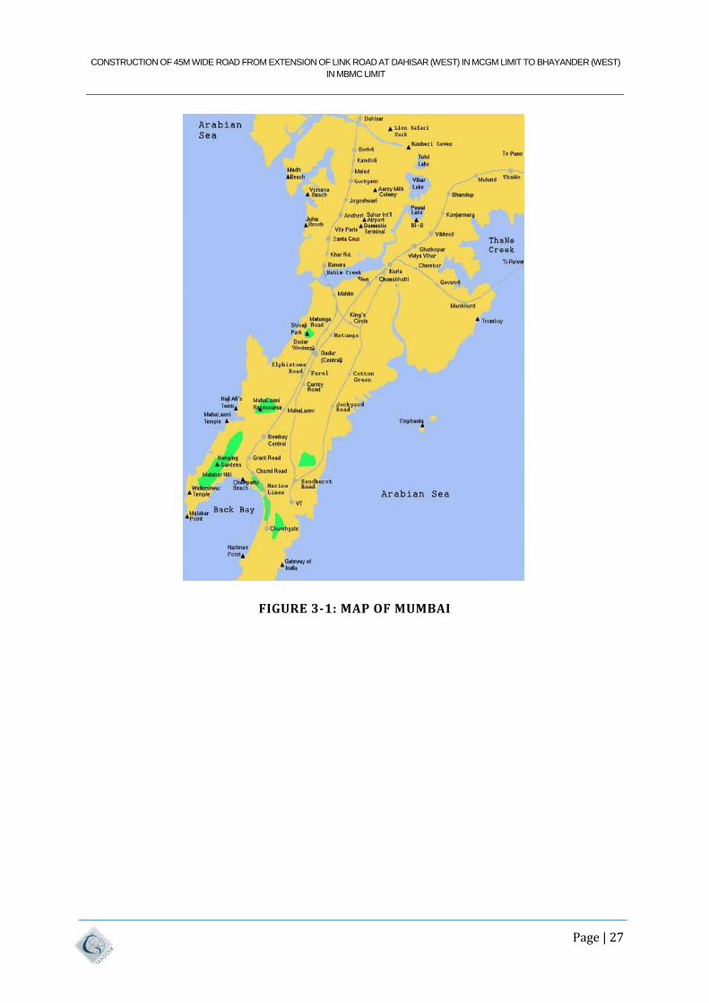
FIGURE 3-2: LOCATION OF BMC
Brihan Mumbai Municipal Corporation was formed way back in the year 1865 as Mumbai’s
civic body. The BMC is variably the cradle of Local Self Government of India. It embodies the
principle of democracy of “Governance of the People, by the people, for the people”.
Through the multifarious civic and recreational services that it provides, the BMC has always
been committed to improve the quality of life of Mumbai. BMC covers an area over 437.71
square Kilometres, catering to the civic needs of over 1.25 crores Citizens. The Corporation
operates an annual utilization outlay of more than Rs. 9,000/- crores. Most of the functions
carried out by this Corporation are service oriented. The service offered includes Sanitation,
Health (Public Health Care and Secondary Health Care Services through its Hospitals, Maternity,
Child Health Care Units, Dispensaries and Field Services) Water, Community service, Primary
Education and Town Planning etc.
CONSTRUCTION OF 45M WIDE ROAD FROM EXTENSION OF LINK ROAD AT DAHISAR (WEST) IN MCGM LIMIT TO BHAYANDER (WEST)
IN MBMC LIMIT
Page | 29
3.2.1 HISTORY OF MUMBAI
The Koli, an indigenous tribe of fishermen, were the city's first recorded occupants, while
Paleolithic stone tools discovered in Greater Mumbai's Kandivli district suggest that people had
lived there for hundreds of thousands of years. In 1000 BCE, the city served as a major port for
marine trade between Persia and Egypt. In the second century CE, Ptolemy, an ancient Egyptian
astronomer and geographer of Greek heritage, referred to it as Heptanesia. It was a part of
Ashoka's empire in the third century BCE.
The Chalukyas, who dominated the city between the sixth and eighth centuries, left their mark
on Elephanta Island (Gharapuri). The Walkeswar Temple at Malabar Point was most likely
constructed between the ninth and thirteenth centuries, under the control of Shilahara lords
from the Konkan coast. The town of Mahikavati (Mahim) on Mumbai Island was established by
the Yadavas of Devagiri (later Daulatabad; 1187–1318) in reaction to incursions from the north
by the Khalji kingdom of Hindustan in 1294. Present-day Mumbai is home to Yadava
descendants, and the majority of the place names on the island originate from that time period.
The island was taken over by Muslim invaders in 1348 and incorporated into the Gujarati
kingdom. Mahim was unsuccessfully invaded by the Portuguese in 1507, but Sultan Bahdur
Shah, the governor of Gujarat, gave the island to them in 1534. As a result of the marriage
agreement between King Charles II of England and Catherine of Braganza, the Portuguese
monarch's sister, it came under British rule in 1661. In 1668, the East India Company received a
cession from the crown.
In contrast to Calcutta (now Kolkata) and Madras (now Chennai), Bombay, as it was known to
the British, did not initially prove to be a valuable asset to the East India company; rather, it
served to preserve a foothold on the west coast. On the mainland, the Marathas (led by the
legendary leader Chhatrapati Shivaji) were more powerful than the territorial rulers in Gujarat
to the northwest, the Mughals in the north, and the Marathas in the territory around and
extending from Bombay. The Mughals, Marathas, Portuguese, and Dutch, who all had interests
in the area, were stronger than even British naval strength. But at the start of the 19th century,
outside factors had influenced the city's expansion.
The decline of Mughal control in Delhi, Mughal-Maratha conflicts, and Gujarat's instability
forced craftsmen and traders to the islands for refuge, and Mumbai began to flourish. With the
fall of Maratha rule, commerce and links to the mainland were restored, existing ties to Europe
were expanded, and Mumbai began to develop.
CONSTRUCTION OF 45M WIDE ROAD FROM EXTENSION OF LINK ROAD AT DAHISAR (WEST) IN MCGM LIMIT TO BHAYANDER (WEST)
IN MBMC LIMIT
Page | 30
The first spinning and weaving mill was founded in 1857, and by 1860, the city had grown to
become India's largest cotton market. The American Civil War (1861-65) and the subsequent
limitation of cotton supply to Britain resulted in a significant economic boom in Mumbai. Cotton
prices plummeted after the Civil War, and the bubble burst. However, at that time, the
hinterland had been opened, and Mumbai had established itself as a major centre of import
commerce. The Suez Canal, which opened in 1869 and substantially improved trade with Britain
and continental Europe, also contributed to Mumbai's success.
However, as the population grew, messy, overcrowded, and unclean circumstances became
more common. In 1896, for example, the plague came out. In response to these issues, the City
Improvement Trust was formed to open additional areas for settlement and to build homes for
the artisan classes. An ambitious plan to build a seawall in Back Bay to reclaim 1,300 acres (525
hectares) of land was proposed in 1918, but it was not completed until the completion of Netaji
Subhas Chandra Bose Road (Marine Drive) from Nariman Point to Malabar Point—first India's
two-way highway—after World War II (1939-45).
After the world war II, the building of residential quarters in suburban regions began, and the
administration of Mumbai city was extended to the suburbs of Greater Mumbai via a municipal
corporation.
From 1956 to 1960, Mumbai was the site of severe Maratha protests over the state's two-
language (Marathi-Gujarati) constitution (of which Mumbai remained the capital), a relic of
British imperialism. These protests resulted in the state's separation into the present states of
Gujarat and Maharashtra in 1960, with Mumbai designated as Maharashtra's capital that year.
Mumbai grew and prospered throughout the twenty-first century, owing to technological
breakthroughs. Greater Mumbai's population had surpassed 20 million by the second decade of
the twentieth century. The city's infrastructure has been significantly enhanced with the
building of new highways and bridges, the development of port facilities, and the launch of new
public-transit systems. However, overcrowding, traffic congestion, pollution, and pervasive
poverty were serious ongoing issues.
CONSTRUCTION OF 45M WIDE ROAD FROM EXTENSION OF LINK ROAD AT DAHISAR (WEST) IN MCGM LIMIT TO BHAYANDER (WEST)
IN MBMC LIMIT
Page | 31
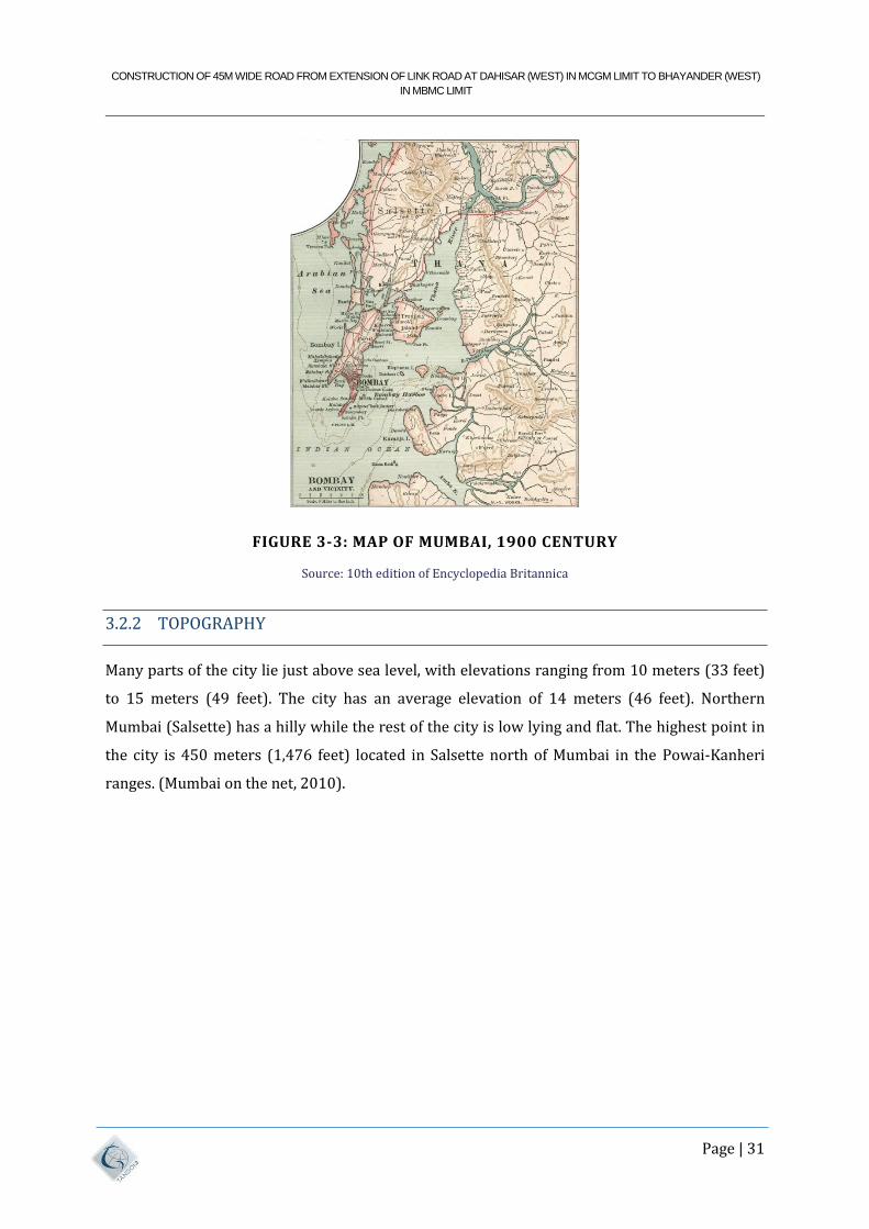
FIGURE 3-3: MAP OF MUMBAI, 1900 CENTURY
Source: 10th edition of Encyclopedia Britannica
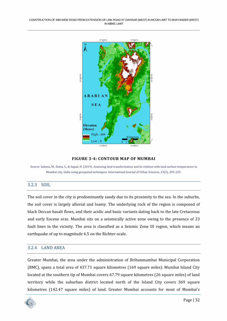
3.2.2 TOPOGRAPHY
Many parts of the city lie just above sea level, with elevations ranging from 10 meters (33 feet)
to 15 meters (49 feet). The city has an average elevation of 14 meters (46 feet). Northern
Mumbai (Salsette) has a hilly while the rest of the city is low lying and flat. The highest point in
the city is 450 meters (1,476 feet) located in Salsette north of Mumbai in the Powai-Kanheri
ranges. (Mumbai on the net, 2010).
CONSTRUCTION OF 45M WIDE ROAD FROM EXTENSION OF LINK ROAD AT DAHISAR (WEST) IN MCGM LIMIT TO BHAYANDER (WEST)
IN MBMC LIMIT
Page | 32
FIGURE 3-4: CONTOUR MAP OF MUMBAI
Source: Sahana, M., Dutta, S., & Sajjad, H. (2019). Assessing land transformation and its relation with land surface temperature in
Mumbai city, India using geospatial techniques. International Journal of Urban Sciences, 23(2), 205-225.
3.2.3 SOIL
The soil cover in the city is predominantly sandy due to its proximity to the sea. In the suburbs,
the soil cover is largely alluvial and loamy. The underlying rock of the region is composed of
black Deccan basalt flows, and their acidic and basic variants dating back to the late Cretaceous
and early Eocene eras. Mumbai sits on a seismically active zone owing to the presence of 23
fault lines in the vicinity. The area is classified as a Seismic Zone III region, which means an
earthquake of up to magnitude 6.5 on the Richter-scale.
3.2.4 LAND AREA
Greater Mumbai, the area under the administration of Brihanmumbai Municipal Corporation
(BMC), spans a total area of 437.71 square kilometres (169 square miles). Mumbai Island City
located at the southern tip of Mumbai covers 67.79 square kilometres (26 square miles) of land
territory while the suburban district located north of the Island City covers 369 square
kilometres (142.47 square miles) of land. Greater Mumbai accounts for most of Mumbai's
CONSTRUCTION OF 45M WIDE ROAD FROM EXTENSION OF LINK ROAD AT DAHISAR (WEST) IN MCGM LIMIT TO BHAYANDER (WEST)
IN MBMC LIMIT
Page | 33
territory. Mumbai, as an urban entity however, spans a bigger total area of 603.4 square
kilometres (233 square miles) including some regions such as Defence lands, Mumbai Port
Trust lands, and the Borivali National Park area, which are outside the administrative
jurisdiction of MCGM. The bigger Mumbai Metropolitan Region covers an extensive area of
about 4,355 square kilometres (1,681 square miles) (Mumbai on the net, 2010).
3.2.5 CLIMATE OF MUMBAI
Mumbai has a tropical climate, specifically a tropical wet and dry climate (Aw) under the
Köppen climate classification. It varies between a dry period extending from October to May
and a wet period peaking in June. The cooler season from December to February is followed by
the hotter season from March to May. The period from June to about the end of September
constitutes the south west monsoon season, and October and November form the post-monsoon
season.
Flooding during monsoon is a major problem for Mumbai. Between June and September, the
south west monsoon rains lash the city. Pre-monsoon showers are received in May.
Occasionally, north-east monsoon showers occur in October and November. The maximum
annual rainfall ever recorded was 3,452 mm (136 in) for 1954. The highest rainfall recorded in
a single day was 944 mm (37 in) on 26 July 2005. The average total annual rainfall is
2,146.6 mm (85 in) for the Island City, and 2,457 mm (97 in) for the suburbs.
The average annual temperature is 27°C (81°F), and the average annual precipitation is
2,167 mm (85 in). In the Island City, the average maximum temperature is 31°C (88°F), while
the average minimum temperature is 24°C (75°F). In the suburbs, the daily mean maximum
temperature ranges from 29°C (84°F) to 33°C (91°F), while the daily mean minimum
temperature ranges from 16°C (61°F) to 26°C (79°F). The record high is 42.2°C (108 °F) set on
14 April 1952, and the record low is 7.4°C (45°F) set on 27 January 1962.
Tropical Cyclones are rare in the city, the worst Cyclone to ever impact Mumbai was the 1948
Mumbai Cyclone where gusts reached 151 km/h (94 mph) in Juhu, the storm left 38 people
dead and 47 missing, the storm reportedly impacted Mumbai for 20 hours and left the city
devastated.
CONSTRUCTION OF 45M WIDE ROAD FROM EXTENSION OF LINK ROAD AT DAHISAR (WEST) IN MCGM LIMIT TO BHAYANDER (WEST)
IN MBMC LIMIT
Page | 34
3.2.6 POPULATION
Mumbai's urban population is estimated to be over 22 million, and the densely populated city is
the largest in India in terms of population, trade activity and business. The metropolitan
area has experienced an rapid in growth over the past 20 years, a common occurrence with
metropolitan areas in India. The rapid population growth is attributed to migration from other
regions in the country, with migrants seeking business and employment opportunities.
The number of people living in slums is estimated at 9 million, which is up from 6 million just a
decade ago. That means about 62% of all Mumbaikar’s live in slums. Dharavi, the second largest
slum in Asia, is located in central Mumbai and is home to 800,000 to 1 million people in just 2.39
square kilometers (or 0.92 square miles). This makes it one of the most densely populated areas
on the planet with a density of a minimum of 334,728 people per square kilometer. It's also the
most literate slum in India with a literacy rate of 69%.
Because land is at such a premium, residents of Mumbai frequently live in cheap, cramped
housing far from work, so there are usually long commutes necessary on its busy mass transit
system.
TABLE 3-1: MUMBAI POPULATION AS PER CENSUS OF INDIA 2011
Mumbai Metropolitan Total Male Female
Population 18,394, 912 98,72,271 85,22,641
Literates 1,48,54,433 82,42,697 66,11,736
Children (0-6) 18,49,849 9,68,584 8,81,310
Average Literacy (%) 89.78 92.58 86.53
Sex Ratio 863
Child Sex Ratio 910
TABLE 3-2: MIRA - BHAYANDAR POPULATION AS PER CENSUS OF INDIA 2011
Mumbai metropolitan Total Male Female
Population 809,378 429,260 380,118
Literates 656,293 356,434 299,859
Children (0-6) 88,015
46,375 41,640
Average Literacy (%) 90.98 93.09 88.59
Sex Ratio 886
Child Sex Ratio 898

CONSTRUCTION OF 45M WIDE ROAD FROM EXTENSION OF LINK ROAD AT DAHISAR (WEST) IN MCGM LIMIT TO BHAYANDER (WEST)
IN MBMC LIMIT
Page | 35
TABLE 3-3 THANE POPULATION AS PER CENSUS OF INDIA 2011
Mumbai Metropolitan Total Male Female
Population 18,41,488 9,75,399 8,66,089
Literates 14,58,796 7,97,342 6,61,454
Children (0-6) 2,09,879 1,10,004 99,875
Average Literacy (%) 89.41 92.14 86.33
Sex Ratio 888
Child Sex Ratio 908
3.2.7 DEMOGRAPHICS
According to the 2011 census, the population of Mumbai city was 12,479,608. The population
density is estimated to be about 20,482 persons per square kilometre. The living space is 4.5
square meters per person. Mumbai Metropolitan Region was home to 20,748,395 people by
2011. Greater Mumbai, the area under the administration of the MCGM, has a literacy rate of
94.7%, higher than the national average of 86.7%. The number of slum-dwellers in the Mumbai
Metropolitan Region is estimated to be 90 lakh (9 million), up from 60 lakh (6 million) in 2001
which constitutes approximately 41.8% of the region.
The sex ratio in 2011 was 838 females per 1,000 males in the island city, 857 in the suburbs,
and 848 as a whole in Greater Mumbai, all numbers lower than the national average of 914
females per 1,000 males. The low sex ratio is partly because of the large number of male
migrants who come to the city to work
"Parsis of Bombay", a wood engraving, ca. 1878. Mumbai is home to the largest population
of Parsis in the world.
Residents of Mumbai call themselves Mumbaikar, Mumbaiite, Bombayite or Bombaiite.
Mumbai suffers from the same major urbanization problems seen in many fast growing cities
in developing countries: poverty and unemployment. With available land at a premium, Mumbai
residents often reside in cramped, relatively expensive housing, usually far from workplaces,
and therefore requiring long commutes on crowded mass transit, or clogged roadways. Many of
them live in close proximity to bus or train stations although suburban residents spend
significant time travelling southward to the main commercial district. Dharavi, Asia's second
largest slum (if Karachi's Orangi Town is counted as a single slum) is located in central Mumbai
and houses between 800,000 and 10 lakh (one million) people in 2.39 square kilometres
CONSTRUCTION OF 45M WIDE ROAD FROM EXTENSION OF LINK ROAD AT DAHISAR (WEST) IN MCGM LIMIT TO BHAYANDER (WEST)
IN MBMC LIMIT
Page | 36
(0.92 sq. mi), making it one of the most densely populated areas on Earth with a population
density of at least 334,728 persons per square kilometre.
The number of migrants to Mumbai from outside Maharashtra during the 1991–2001 decade
was 11.2 lakh (1.12 million), which amounted to 54.8% of the net addition to the population of
Mumbai
The number of households in Mumbai is forecast to rise from 42 lakh (4.2 million) in 2008 to
66 lakh (6.6 million) in 2020. The number of households with annual incomes of 20 lakh
(2 million) rupees will increase from 4% to 10% by 2020, amounting to 660,000 families. The
number of households with incomes from 10-20 lakh (1–2 million) rupees is also estimated to
increase from 4% to 15% by 2020. According to the 2016 report of the Central Pollution Control
Board, Mumbai is the noisiest city in India, ahead of Lucknow, Hyderabad and Delhi.
3.2.8 COASTAL REGION AND IMPORTANCE OF MANGROVES
The Mumbai city boasts a 149-kilometer coastline and almost 16 kilometres of beaches running
from Colaba in the south to Madh and Marve in the north. The zone between sea and land is
quite an inhospitable place for life to thrive. The water is salty, substratum is anoxic and the soil
is alternately exposed and submerged due to tidal action. The only species of trees that can
thrive in this volatile environment are the mangroves, which have developed special adaptation
for this purpose. Every mangrove tree is an ecosystem in itself. Its roots act as substrate for
sessile organisms like oysters and barnacles, its crown a rookery for swamp birds and the
flowers are a good source of honey. The leaves are raw material for ants engaged in nest
building and when they fall, they form the basis of food chain in the surrounding waters.
Mangroves confer a variety of benefits to mankind. They are natural barriers against sea
intrusion, as demonstrated well during the Tsunami that hit our coast in 2004. By breaking up
large storm surges and strong tidal currents they protect sea coast from erosion. They are
important land builders which filter sediments from land and expand the extent of land towards
sea. The enormous productivity of mangrove swamps enables them to support a rich faunal
diversity. The unique habitat act as nursery grounds for many species of fish and shell fish and
offer protection to many juveniles against predators. This way, the lives of millions of fishermen
in our country are linked directly to the existence of healthy mangroves. Scientific studies prove
that the ability of mangrove forest to absorb carbon dioxide from atmosphere and bury it in the
soil is six times that of Amazon rain forest. This shows how important mangroves are in our to
fight climate change and sea level rise.
CONSTRUCTION OF 45M WIDE ROAD FROM EXTENSION OF LINK ROAD AT DAHISAR (WEST) IN MCGM LIMIT TO BHAYANDER (WEST)
IN MBMC LIMIT
Page | 37
According to forest survey of India, the total extent of mangroves in Maharashtra is 186 sq.km
distributed along its six coastal districts. The thickly populated city of Mumbai alone has about
6000 hectares of mangroves, which is perhaps the largest extend of mangroves for any
metropolitan city in the world. Mangroves are the green lungs for the city, which ensures
abundant supply of oxygen to us. They also maintain the stability of the shoreline and prevent
release of toxic wastes into the waters around Mumbai, thus playing a silent life supporting role.
Their ability to absorb large volumes of water is a great boon to a city, which is prone to heavy
rains and flooding from time to time. The rate of reduction in mangrove cover is a matter of
great concern and the alarm bells are loud and clear.
On 6th October 2005, the High Court of Bombay issued a landmark to save the mangroves of
Maharashtra coast. This judgment mandated that on government land be declared as Protected
Forests and those on private lands as “Forests". The Hon'ble High Court prohibited any
construction within 50 m from the boundary of the mangroves and also put a ban on dumping of
debris in the mangrove areas. Following this order, 5469 hectares of mangroves in government
land in Mumbai was notified as Protected Forest under Sec 29 of the Indian Forest Act. To
improve the protection status of mangroves on government land, the state has decided to notify
all such areas as Reserve Forest. Accordingly, 3998 hectares of mangroves in Mumbai has been
declared as Reserved Forests.
In order to protect, conserve and manage the mangroves of the State, a "Mangrove Cell" was
created by the government. The Cell is headed by a Chief Conservator of forest and is
functioning from its office in Bandra, Mumbai. To give further fillip to the mangrove
conservation efforts in Mumbai region a 'Mumbai Mangrove Conservation Unit' (MMCU) has
been created on 17th May 2013.
3.2.9 SOCIAL INFRASTRUCTURE
Until the advent of mechanized transport, the size of a town was usually limited by how far
people could walk to / from work, shops and in many larger towns, this leads to high residential
densities and unhealthy living conditions. With the advent of increasing affluence and urban
transport in the mid-19th century, people began to spread themselves and residential densities
began to fall, although the towns continued to grow due to the migration from countryside.
In a developing region, economic development essentially means production and distribution of
finished goods and also the availability of raw materials. Adequate transport facilities are
CONSTRUCTION OF 45M WIDE ROAD FROM EXTENSION OF LINK ROAD AT DAHISAR (WEST) IN MCGM LIMIT TO BHAYANDER (WEST)
IN MBMC LIMIT
Page | 38
therefore one of the essential initial triggers for economic development and is accordingly
considered as the infrastructure needed for any development.
The Municipal Corporation would need to make reservations for the additional facilities
required for the projected population. The construction and management of primary health and
education, entertainment & other social facilities is the responsibility of the Municipal
Corporation.
3.2.10 HOUSING
The population of Mumbai is more than 12 million, out of which 60% of the population resides
in the hutments. It creates burden on environment and many health problems. Mumbai Slum
Improvement Board provides amenities in various slums in Mumbai city and suburbs. Majority
of the people residing in the hutments are from economically and socially weaker stratum. Span
of slum redevelopment plan of State Government is extended to provide permanent residence
and civic amenities. The main purpose of this project is to provide residence, basic amenities
and other related civic amenities.
Mumbai Slum Development Board has planned construction program regarding basic amenities
for the year 2015-16 as given below.
Construction of protection wall.
Improvement plan for civic backward colony.
Development plan for slum area.
Plan for beautification.
Development plan for crematorium.
To provide facilities to citizens in area under MCGM.
Member of parliament/MLA/Apposite party members.
Development of tourist places.
New plans/ Ladies saving group/ Water tank protection/ Bore well.
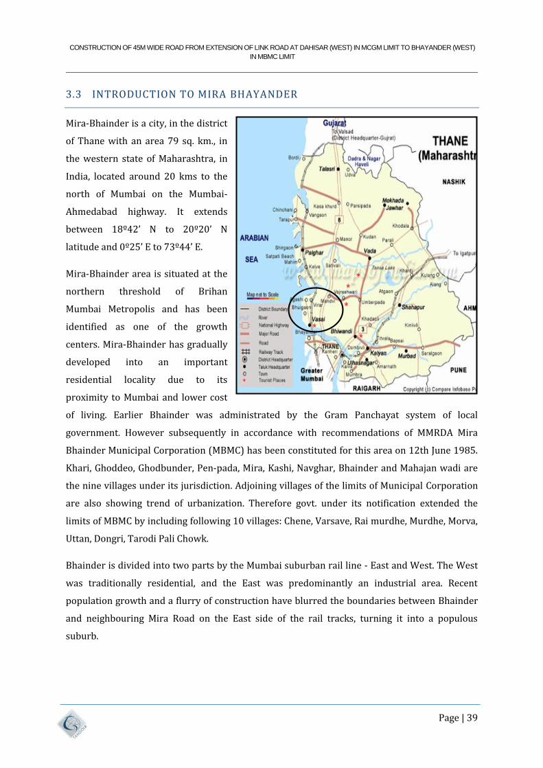
CONSTRUCTION OF 45M WIDE ROAD FROM EXTENSION OF LINK ROAD AT DAHISAR (WEST) IN MCGM LIMIT TO BHAYANDER (WEST)
IN MBMC LIMIT
Page | 39
3.3 INTRODUCTION TO MIRA BHAYANDER
Mira-Bhainder is a city, in the district
of Thane with an area 79 sq. km., in
the western state of Maharashtra, in
India, located around 20 kms to the
north of Mumbai on the Mumbai-
Ahmedabad highway. It extends
between 18º42’ N to 20º20’ N
latitude and 0º25’ E to 73º44’ E.
Mira-Bhainder area is situated at the
northern threshold of Brihan
Mumbai Metropolis and has been
identified as one of the growth
centers. Mira-Bhainder has gradually
developed into an important
residential locality due to its
proximity to Mumbai and lower cost
of living. Earlier Bhainder was administrated by the Gram Panchayat system of local
government. However subsequently in accordance with recommendations of MMRDA Mira
Bhainder Municipal Corporation (MBMC) has been constituted for this area on 12th June 1985.
Khari, Ghoddeo, Ghodbunder, Pen-pada, Mira, Kashi, Navghar, Bhainder and Mahajan wadi are
the nine villages under its jurisdiction. Adjoining villages of the limits of Municipal Corporation
are also showing trend of urbanization. Therefore govt. under its notification extended the
limits of MBMC by including following 10 villages: Chene, Varsave, Rai murdhe, Murdhe, Morva,
Uttan, Dongri, Tarodi Pali Chowk.
Bhainder is divided into two parts by the Mumbai suburban rail line - East and West. The West
was traditionally residential, and the East was predominantly an industrial area. Recent
population growth and a flurry of construction have blurred the boundaries between Bhainder
and neighbouring Mira Road on the East side of the rail tracks, turning it into a populous
suburb.
CONSTRUCTION OF 45M WIDE ROAD FROM EXTENSION OF LINK ROAD AT DAHISAR (WEST) IN MCGM LIMIT TO BHAYANDER (WEST)
IN MBMC LIMIT
Page | 40
3.3.1 HISTORY OF MIRA BHAYANDER
Mira Bhainder is a city which has its own Historic value. It was an important port for business
during past. This port has seen some most important Historic Legends right from Alexander to
Peshwas and some great kings who have travelled through this port. The city is surrounded by
big mountains on both the side boundaries along with Arabian Sea guarding the west side of the
city. The North side of the city is surrounded by Vasai (Basin) Creek. So is the city of Bhainder
Situated at the Heart of the Nature.
As we all know that India was governed by British. British also came to Bhainder but it was far
time after as Bhainder and Vasai were governed by Portuguese. Portuguese were the first one to
rule on this part. But British also ruled over Bhainder for quite some time. The example of
British existence can be seen by the Railway Bridge over Vasai (Basin) Creek.
A large estate of 3688 acres, exclusive of salt marsh was granted by deed dated 1870 to
Ramchandra Laxmanji of Bombay, on a lease of 999 years, in the village of Ghodbunder,
Bhainder and Mira. The condition attaching to this grant were that the lessee should pay a
yearly rent of Rs. 6790/-; that he should keep the embankments, dams, and sluic s in repair; that
he should demand no rent from Inamdars; that he should demand only survey rates for Suti and
Varkas lands; that he should keep boundary marks in repair; that he should pay Patil’s and
hereditary officers’ claims and allowances; that he should not interfere with the rights of way;
that he should surrender land free of cost for the Bhainder Railway Station; that he should give
the Notice for the assignment of the lands; that he should not assign lands without leave; and
that the salt marsh lands were liable for resumption if not reclaimed within twenty years. This
estate has been the cause of much litigation, owing to an attempt of the leaseholder to levy from
the yearly tenants one-half instead of one-third of the produce. The District court and the High
Court on appeal (appeal 292 and 1880) have decided that the leaseholder’s claim to levy one-
half is contrary to the custom of the country. (Source: Gazetteer Of The Bombay Presidency,
Volume XIII, Part II, Chapter VIII).
The Devnar Estate includes five villages: Devnar, Borla, Kirol, Chene and Varsava Borbhat. It was
granted in perpetual lease to Mr. Dhakji Dadaji in 1809 on a rental of Rs. 5180. In addition to
this a sum of Rs. 390/- is paid for lands held by husbandmen direct from Government. Only two
of the villages Chene and Varsava Borbhat remain in the family of the original grantee. The other
three have been sold to different buyers. (Source: Gazetteer of The Bombay Presidency, Volume
XIII, Part II, Chapter VIII).
CONSTRUCTION OF 45M WIDE ROAD FROM EXTENSION OF LINK ROAD AT DAHISAR (WEST) IN MCGM LIMIT TO BHAYANDER (WEST)
IN MBMC LIMIT
Page | 41
Formation of Mira Bhainder as a City:
Being a neighbouring city of Mumbai, the growth of the city is tremendous still the city has
managed to keep its originality like small scale industries, farming, fishing, sand and salt
cultivation as its major business. The small scale industry situated in Bhainder (E) rank Third in
Asia. Agri and Koli are the original residents of this city, but there are people of all
other Religion and casts.
On 12th June 1985, five Grampanchayats naming Bhainder, Kashi, Mira, Navghar and
Ghodbunder were integrated to form Mira Bhainder Municipal Council. In 1990 the Council got
extended by including 4 other Grampanchayats naming Chena, Varsova, Rai – Murdhe, Dongri –
Uttan. Thus this corporation is made up of 9 Grampanchayats, hence the Mira Bhainder Logo
has 9 stars on it.
In 1990 the Council conducted its first election. Mr. Gilbert John Mendonsa was the first
President. On 28th February 2002 the Council was declared as Corporation on the basis of its
population. On 11th August 2002 the Corporation conducted its first election which gave 79
elected and 5 Cops members. Mrs. Mayra Gilbert Mendonsa was the first Female Mayor of the
city.
3.3.2 TOPOGRAPHY
It is located in the northern part of the Konkan region to the west of sahyadri hill ranges. The
whole town is on a plain level land. The vasai creek surrounds the city from east to north,
followed by the Arabian Sea, till the west. The Mumbai city is situated on the southwest. To the
south is the Sanjay Gandhi national park and on the southeast thane city. Geographically the city
falls in the Deccan lava terrain. Geologically the city falls in lava terrain. Uttan and Ghodbunder
are hilly regions. The plain terrain forms a wide area of water logged and marshy land.
3.3.3 METEROLOGY
The climate in the month of October is wet and hot followed by cool and pleasant weather from
December to February and dry and hot weather from March to June. The climate of Mira-
Bhainder is typically coastal, sultry and not really hot. There are virtually two distinct seasons,
namely Monsoon and dry season. The later covers both summer and winter.
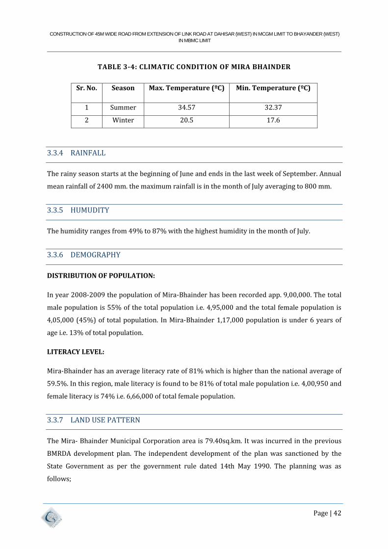
CONSTRUCTION OF 45M WIDE ROAD FROM EXTENSION OF LINK ROAD AT DAHISAR (WEST) IN MCGM LIMIT TO BHAYANDER (WEST)
IN MBMC LIMIT
Page | 42
TABLE 3-4: CLIMATIC CONDITION OF MIRA BHAINDER
3.3.4 RAINFALL
The rainy season starts at the beginning of June and ends in the last week of September. Annual
mean rainfall of 2400 mm. the maximum rainfall is in the month of July averaging to 800 mm.
3.3.5 HUMUDITY
The humidity ranges from 49% to 87% with the highest humidity in the month of July.
3.3.6 DEMOGRAPHY
DISTRIBUTION OF POPULATION:
In year 2008-2009 the population of Mira-Bhainder has been recorded app. 9,00,000. The total
male population is 55% of the total population i.e. 4,95,000 and the total female population is
4,05,000 (45%) of total population. In Mira-Bhainder 1,17,000 population is under 6 years of
age i.e. 13% of total population.
LITERACY LEVEL:
Mira-Bhainder has an average literacy rate of 81% which is higher than the national average of
59.5%. In this region, male literacy is found to be 81% of total male population i.e. 4,00,950 and
female literacy is 74% i.e. 6,66,000 of total female population.
3.3.7 LAND USE PATTERN
The Mira- Bhainder Municipal Corporation area is 79.40sq.km. It was incurred in the previous
BMRDA development plan. The independent development of the plan was sanctioned by the
State Government as per the government rule dated 14th May 1990. The planning was as
follows;
Sr. No. Season Max. Temperature (ºC) Min. Temperature (ºC)
1 Summer 34.57 32.37
2 Winter 20.5 17.6
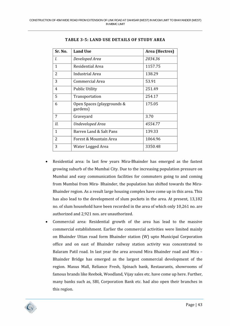
CONSTRUCTION OF 45M WIDE ROAD FROM EXTENSION OF LINK ROAD AT DAHISAR (WEST) IN MCGM LIMIT TO BHAYANDER (WEST)
IN MBMC LIMIT
Page | 43
TABLE 3-5: LAND USE DETAILS OF STUDY AREA
Sr. No. Land Use Area (Hectres)
I. Developed Area 2034.36
1 Residential Area 1157.75
2 Industrial Area 138.29
3 Commercial Area 53.91
4 Public Utility 251.49
5 Transportation 254.17
6 Open Spaces (playgrounds & gardens)
175.05
7 Graveyard 3.70
II. Undeveloped Area 4554.77
1 Barren Land & Salt Pans 139.33
2 Forest & Mountain Area 1064.96
3 Water Logged Area 3350.48
Residential area: In last few years Mira-Bhainder has emerged as the fastest
growing suburb of the Mumbai City. Due to the increasing population pressure on
Mumbai and easy communication facilities for commuters going to and coming
from Mumbai from Mira- Bhainder, the population has shifted towards the Mira-
Bhainder region. As a result large housing complex have come up in this area. This
has also lead to the development of slum pockets in the area. At present, 13,182
no. of slum household have been recorded in the area of which only 10,261 no. are
authorized and 2,921 nos. are unauthorized.
Commercial area: Residential growth of the area has lead to the massive
commercial establishment. Earlier the commercial activities were limited mainly
on Bhainder Uttan road form Bhainder station (W) upto Municipal Corporation
office and on east of Bhainder railway station activity was concentrated to
Balaram Patil road. In last year the area around Mira Bhainder road and Mira –
Bhainder Bridge has emerged as the largest commercial development of the
region. Maxus Mall, Reliance Fresh, Spinach bank, Restaurants, showrooms of
famous brands like Reebok, Woodland, Vijay sales etc. have come up here. Further,
many banks such as, SBI, Corporation Bank etc. had also open their branches in
this region.
CONSTRUCTION OF 45M WIDE ROAD FROM EXTENSION OF LINK ROAD AT DAHISAR (WEST) IN MCGM LIMIT TO BHAYANDER (WEST)
IN MBMC LIMIT
Page | 44
Industrial area: This user covers around 1.59% of the total area. As per the latest
records of MBMC there are around 383 industrial estates with around 5000
industrial galas are existing in the area. It is estimated that around 20,000
workers are working in this industrial area.
Land under Public and Semi public Use : This category includes areas occupied by
Educational institutions such primary and secondary schools, Religious places
such as temple, church, mosque etc, Government and semi-government offices. It
covers nearly 0.151% of the total area.
Land under open spaces: Mira-Bhainder is bounded by natural water tanks
scattered in various parts of the town. The municipal corporation has developed
three lakes enriched with proper landscaping viz. MBMC Main Office Lake, Goddeo
lake and Shivar lake wherein boating activity is also available for citizens. The
open spaces and recreational grounds are lungs of the town and they cater active
and passive recreation needs of the city.
There are several salt pans in Mira-Bhainder region. These Salt pans are shallow
manmade ponds designed to produce salt from sea water. The seawater is fed into
large pans and water is drawn out through natural evaporation which allows the
salt to be subsequently harvested.
3.3.8 ACCESSIBILITY
3.3.8.1 RAIL
The Western Railway of the Mumbai Suburban Railway is the lifeline of the western and
extended suburbs of Mumbai. Mira Road & Bhainder are the railway stations on this line. Mira
Road is one station after Dahisar. After Bhainder is the Vasai (Bassein) Creek bridge followed by
Naigaon. Slow and fast trains between Churchgate, Dadar, Andheri & Borivali and Vasai
Road/Virar operate from Mira Road & Bhainder stations. Bhainder is also a terminal for a few
trains, a convenience to residents here. Number of trains starting from Bhainder has been
considerably increased in recent times after the deployment of 4 railway tracks between
Borivali and Virar. This has been a crucial step to make train journeys safer and comfortable for
the residents of Mira-Bhainder and the rapidly increasing population of Bhainder.
3.3.8.2 ROAD NETWORK
The Western Express Highway, as termed in Mumbai leaves the city as the NH 8 (National
Highway) linking Mumbai with the west and north-west of India. Important cities covered on
CONSTRUCTION OF 45M WIDE ROAD FROM EXTENSION OF LINK ROAD AT DAHISAR (WEST) IN MCGM LIMIT TO BHAYANDER (WEST)
IN MBMC LIMIT
Page | 45
the NH 8 are Vapi (for Daman & Silvassa), Surat, Baroda, Ahmedabad, Udaipur, Ajmer, Jaipur
and Delhi. On the NH 8, just beyond the Ghodbunder area is the Virar-Vasai area. Ghodbunder is
also linked to Thane by a highway.
Kashimira is a point falling between Dahisar Check Naka and Ghodbunder, from which a main
road arise that leads to Mira Road, Bhainder & the coastal villages of Uttan, Gorai, Manori & the
heavily marketed Amusement Parks – Essel World & Water Kingdom.
3.3.8.3 BUS SERVICES
The BEST Undertaking has been the longest provider of services to the area with services to
Mira Road Station, Shrusti Complex, Bhainder Railway Station (East), Kashimira & Ghodbunder
from points in Borivali, Kandivali, Marol, Mulund, Santacruz, Mahim & Sion. Several Western
and central suburbs are thus conveniently connected. The BEST operates these buses under the
700 number series.
BEST have introduced AC Express Bus services from MIRA ROAD RAILWAY STATION EAST to
NEHRU PLANETARIUM (A-70EXP) via S.K. Stone Police Chowkey. This route is operated
between Mira Road Station (East), and Nehru Planetarium. The itinerary of this route is via
Mira-Bhainder Road, Kashimira, Western Express Highway through all the Flyover Bridges, and
also through Bandra-Worli Sea Link. BEST AC services AS 458 and AS 700 to Thane pass
through Mira road.
BEST has also introduced AC Bus service from GOLDEN NEST Bhainder East (Fatak) to
SANTACRUZ DEPOT (AS707) via Mindspace and Juhu. Now it’s extended up to MAXUS MALL.
BHAINDER (WEST)
BEST has also introduced the Corridor (Express) bus Service from Mira Road to Mahim (C-71),
Mira Road to Mulund Check naka (C-61) and Bhainder to Sion (C-72), this buses offers rapid
connectivity to Mumbai and Thane. C-71 & C-72 passes through important commercial locations
of Mumbai on Western Express highway, like Borivali, Andheri, Bandra and so on while C-61
offers great connectivity to Thane & Mulund areas.
MSRTC operates frequent services from Bhainder Station W to Thane Railway Station West ST
Stand via Kashimira, Ghodbunder Road, Owale & Eastern Express Highway. A few services now
commence from Bhainder Station E. Frequency of the buses is quite good from Bhainder W with
buses running every 15th minute between Bhainder and Thane during rush hours.
CONSTRUCTION OF 45M WIDE ROAD FROM EXTENSION OF LINK ROAD AT DAHISAR (WEST) IN MCGM LIMIT TO BHAYANDER (WEST)
IN MBMC LIMIT
Page | 46
The Thane Municipal Transport (TMT) operates the very popular routes 57, 58 & 75 between
Thane Railway Station West & Mira Road Railway Station. TMT AC 65 service passes through
Mira Road.
The Navi Mumbai Municipal Transport (NMMT) has introduced its new service route from Vashi
to Bhainder (East). The new route no. 70 will travel from Bhainder (East) to Vashi Depot, and
there will be 23 bus services during the day with a frequency of one approximately every 30
minutes.
The Mira-Bhainder Municipal Transport (MBMT) has local bus services connecting
interconnecting various places in the Mira-Bhainder area.
MBMT bus services are available from Mira Road Stn E, Bhainder Railway Stn E, Bhainder
Railway Stn W & Dahisar Check Naka parts of this city. Recently they have also started the new
bus between Western Park (Kashimira) to Behram Baugh (Jegeshwari). These buses are run on
contract basis by MBMC.
Apart from this government transportation, Private vehicles (Call Center Vehicles) are also
easily available from Mira-Bhainder Road for Andheri and Thane at very cheap rates as low as
Rs. 40; office going people during morning peak hours easily gets these vehicles popularly from
Golden Nest Circle and other important Bus Stops through Mira Bhainder Road.
3.4 SOCIO ECONOMIC PROFILE OF MMR
MMR is highly urbanized area with more than 90% of the total population of 11.9 million as per
2001 census and 12.4 million as per 2011 census is concentrated in cities and towns. The urban
population is however confined to 8 Municipal Corporations, 11 Municipal Councils and 10 Non
Municipal Towns. Total area under these urban units is about 1,500 sq. km. In the rest of the
region, about 1 million population is spread over 950 village settlements. The demographic
census gives population and worker details according to 88 census sections in Greater Mumbai,
for suitably defined wards in other urban centres and for village as a whole in MMR.
3.5 MMR PLAN
The sanctioned Regional Plan for MMR 1996-2011, specifies the land-use for different parts of
the region. In this plan, urban development is categorized under two classes namely, U1 and U2
zone. U1 zone, constituting 19% of the total land denotes intensive and high density urban
CONSTRUCTION OF 45M WIDE ROAD FROM EXTENSION OF LINK ROAD AT DAHISAR (WEST) IN MCGM LIMIT TO BHAYANDER (WEST)
IN MBMC LIMIT
Page | 47
development, whereas, U2 zone, constituting 5% of the total envisages relatively low density
urban development. U1 zone largely covers the existing Municipal Corporations, Municipal
Councils and a few Non Municipal Towns. U2 zone is generally showing the possible outgrowth
of the cities and towns. Further, 3% of the land is placed under Industrial Zone, 1% under Port
and Airport and 6% under Recreation & Tourism Development Zone and National Park. The rest
of the 66% of land-use is distributed among Forest Zone (23%), Green Zone (39%), Coastal
Wetland (3%) and Water body (1%). The Regional Plan also provides estimates of population
and its distribution in different parts of MMR for the year 2011. Corresponding projections for
the year 2021 and 2031 are also made by MMRDA.
Under the notification dated 4th February, 2003, Matheran Municipal Council area and
the surrounding region are declared as Eco-Sensitive Zone (ESZ) imposing restriction on
industries and development activities in the said zone. The ESZ covers an area of 215 sq. Km.
area and its Zonal Master Plan is to be prepared to guide the development.
Dronagiri Node in Navi Mumbai developed by CIDCO is designated as a Special Economic Zones
(SEZ) and its plan is currently under preparation. There is a proposal to establish
domestic/international airport near Panvel town in Navi Mumbai.
The Region has a fairly well developed rail and road network. The rail network consists of
suburban and main line sections. The rail network connects most of the important urban areas.
The road network comprises Expressways, National Highways, State Highways, Major District
Roads, other District Roads and Village Roads. The village settlements are largely served by the
road network and state road bus transport services.
3.5.1 COMPREHENSIVE TRAFFIC & TRANSPORT STUDY (CTTS)
MMRDA with technical assistance from World Bank under Mumbai Urban Transport Project
embarked on the Comprehensive Transportation Study for MMR with prime objective of
identifying travel pattern of residents in MMR and recommending long term comprehensive
transportation strategy for MMR up to 2031. The Comprehensive Transportation Study for the
Mumbai Metropolitan Region carried out by M/s Lea & Associates is given the acronym
or Transportation Study for Mumbai. Mira Bhainder region being part of MMR
was covered under this study.
The Comprehensive Transport Study for MMR was conducted in 2008 with objective to ensure
adequate levels of accessibility in the expanding urban areas and to assist the economic
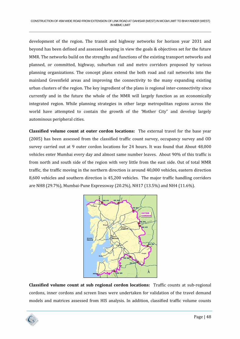
CONSTRUCTION OF 45M WIDE ROAD FROM EXTENSION OF LINK ROAD AT DAHISAR (WEST) IN MCGM LIMIT TO BHAYANDER (WEST)
IN MBMC LIMIT
Page | 48
development of the region. The transit and highway networks for horizon year 2031 and
beyond has been defined and assessed keeping in view the goals & objectives set for the future
MMR. The networks build on the strengths and functions of the existing transport networks and
planned, or committed, highway, suburban rail and metro corridors proposed by various
planning organizations. The concept plans extend the both road and rail networks into the
mainland Greenfield areas and improving the connectivity to the many expanding existing
urban clusters of the region. The key ingredient of the plans is regional inter-connectivity since
currently and in the future the whole of the MMR will largely function as an economically
integrated region. While planning strategies in other large metropolitan regions across the
world have attempted to contain the growth of the ‘Mother City” and develop largely
autominous peripheral cities.
Classified volume count at outer cordon locations: The external travel for the base year
(2005) has been assessed from the classified traffic count survey, occupancy survey and OD
survey carried out at 9 outer cordon locations for 24 hours. It was found that About 48,000
vehicles enter Mumbai every day and almost same number leaves. About 90% of this traffic is
from north and south side of the region with very little from the east side. Out of total MMR
traffic, the traffic moving in the northern direction is around 40,000 vehicles, eastern direction
8,600 vehicles and southern direction is 45,200 vehicles. The major traffic handling corridors
are NH8 (29.7%), Mumbai-Pune Expressway (20.2%), NH17 (13.5%) and NH4 (11.6%).
Classified volume count at sub regional cordon locations: Traffic counts at sub-regional
cordons, inner cordons and screen lines were undertaken for validation of the travel demand
models and matrices assessed from HIS analysis. In addition, classified traffic volume counts
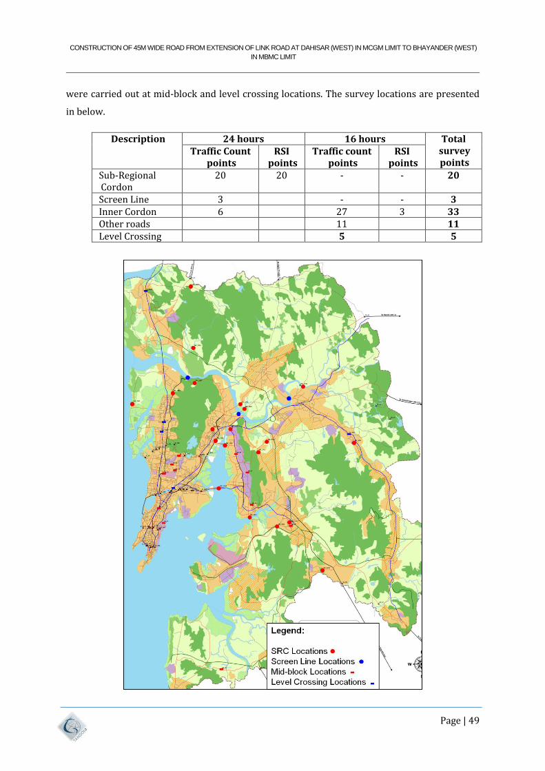
CONSTRUCTION OF 45M WIDE ROAD FROM EXTENSION OF LINK ROAD AT DAHISAR (WEST) IN MCGM LIMIT TO BHAYANDER (WEST)
IN MBMC LIMIT
Page | 49
were carried out at mid-block and level crossing locations. The survey locations are presented
in below.
Description 24 hours 16 hours Total survey points
Traffic Count points
RSI points
Traffic count points
RSI points
Sub-Regional Cordon
20 20 - - 20
Screen Line 3 - - 3 Inner Cordon 6 27 3 33 Other roads 11 11 Level Crossing 5 5
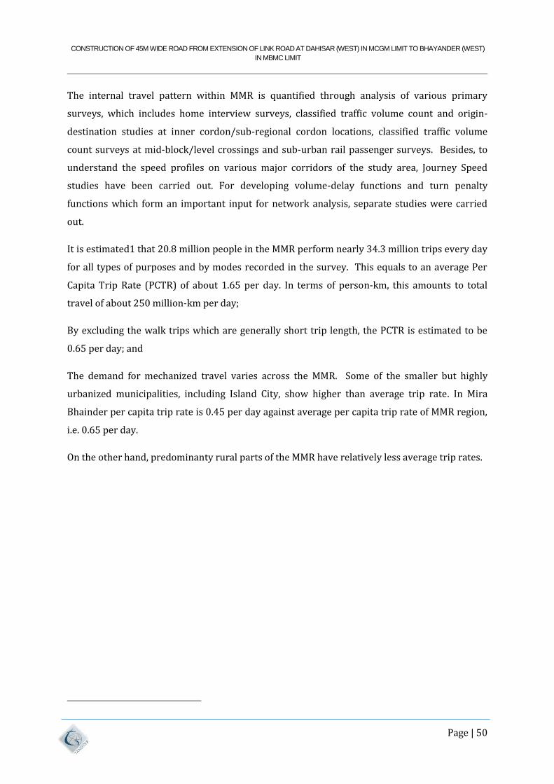
CONSTRUCTION OF 45M WIDE ROAD FROM EXTENSION OF LINK ROAD AT DAHISAR (WEST) IN MCGM LIMIT TO BHAYANDER (WEST)
IN MBMC LIMIT
Page | 50
The internal travel pattern within MMR is quantified through analysis of various primary
surveys, which includes home interview surveys, classified traffic volume count and origin-
destination studies at inner cordon/sub-regional cordon locations, classified traffic volume
count surveys at mid-block/level crossings and sub-urban rail passenger surveys. Besides, to
understand the speed profiles on various major corridors of the study area, Journey Speed
studies have been carried out. For developing volume-delay functions and turn penalty
functions which form an important input for network analysis, separate studies were carried
out.
It is estimated1 that 20.8 million people in the MMR perform nearly 34.3 million trips every day
for all types of purposes and by modes recorded in the survey. This equals to an average Per
Capita Trip Rate (PCTR) of about 1.65 per day. In terms of person-km, this amounts to total
travel of about 250 million-km per day;
By excluding the walk trips which are generally short trip length, the PCTR is estimated to be
0.65 per day; and
The demand for mechanized travel varies across the MMR. Some of the smaller but highly
urbanized municipalities, including Island City, show higher than average trip rate. In Mira
Bhainder per capita trip rate is 0.45 per day against average per capita trip rate of MMR region,
i.e. 0.65 per day.
On the other hand, predominanty rural parts of the MMR have relatively less average trip rates.
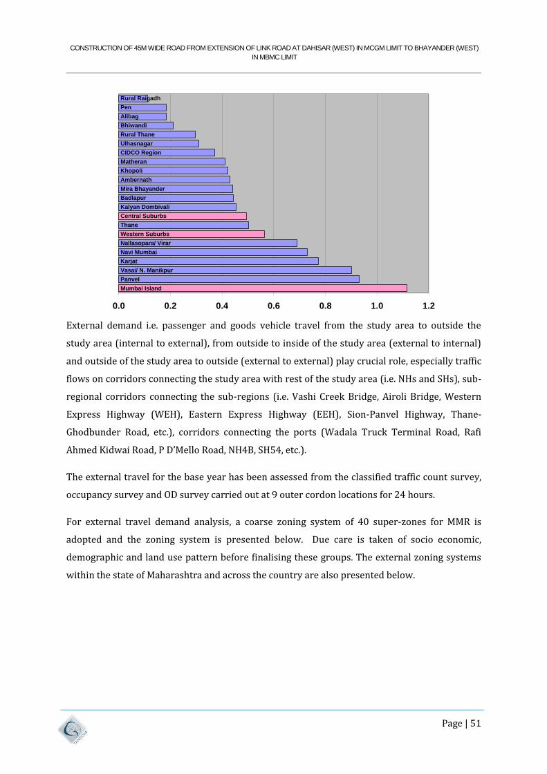
CONSTRUCTION OF 45M WIDE ROAD FROM EXTENSION OF LINK ROAD AT DAHISAR (WEST) IN MCGM LIMIT TO BHAYANDER (WEST)
IN MBMC LIMIT
Page | 51
External demand i.e. passenger and goods vehicle travel from the study area to outside the
study area (internal to external), from outside to inside of the study area (external to internal)
and outside of the study area to outside (external to external) play crucial role, especially traffic
flows on corridors connecting the study area with rest of the study area (i.e. NHs and SHs), sub-
regional corridors connecting the sub-regions (i.e. Vashi Creek Bridge, Airoli Bridge, Western
Express Highway (WEH), Eastern Express Highway (EEH), Sion-Panvel Highway, Thane-
Ghodbunder Road, etc.), corridors connecting the ports (Wadala Truck Terminal Road, Rafi
Ahmed Kidwai Road, P D’Mello Road, NH4B, SH54, etc.).
The external travel for the base year has been assessed from the classified traffic count survey,
occupancy survey and OD survey carried out at 9 outer cordon locations for 24 hours.
For external travel demand analysis, a coarse zoning system of 40 super-zones for MMR is
adopted and the zoning system is presented below. Due care is taken of socio economic,
demographic and land use pattern before finalising these groups. The external zoning systems
within the state of Maharashtra and across the country are also presented below.
Mumbai Island
Panvel
Karjat
Navi Mumbai
Nallasopara/ Virar
Western Suburbs
Thane
Central Suburbs
Kalyan Dombivali
Badlapur
Mira Bhayander
Ambernath
Khopoli
Matheran
CIDCO Region
Ulhasnagar
Rural Thane
Bhiwandi
Alibag
Pen
Rural Raigadh
Vasai/ N. Manikpur
0.0 0.2 0.4 0.6 0.8 1.0 1.2
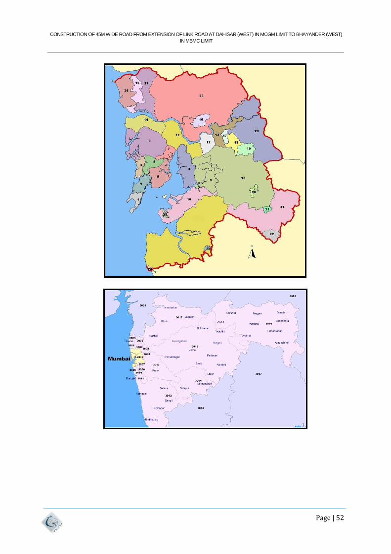
CONSTRUCTION OF 45M WIDE ROAD FROM EXTENSION OF LINK ROAD AT DAHISAR (WEST) IN MCGM LIMIT TO BHAYANDER (WEST)
IN MBMC LIMIT
Page | 52
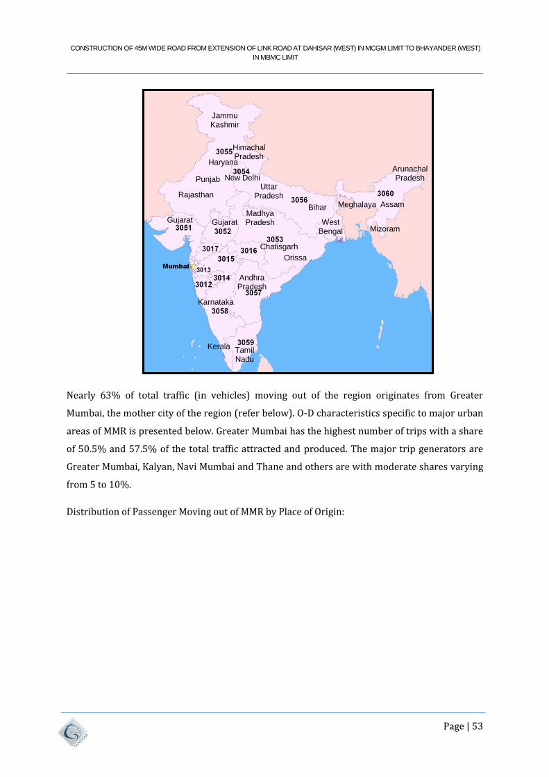
CONSTRUCTION OF 45M WIDE ROAD FROM EXTENSION OF LINK ROAD AT DAHISAR (WEST) IN MCGM LIMIT TO BHAYANDER (WEST)
IN MBMC LIMIT
Page | 53
Nearly 63% of total traffic (in vehicles) moving out of the region originates from Greater
Mumbai, the mother city of the region (refer below). O-D characteristics specific to major urban
areas of MMR is presented below. Greater Mumbai has the highest number of trips with a share
of 50.5% and 57.5% of the total traffic attracted and produced. The major trip generators are
Greater Mumbai, Kalyan, Navi Mumbai and Thane and others are with moderate shares varying
from 5 to 10%.
Distribution of Passenger Moving out of MMR by Place of Origin:
Jammu Kashmir
Himachal Pradesh
New Delhi
Rajasthan
Gujarat
Uttar Pradesh
Bihar Madhya Pradesh
Chatisgarh
Orissa
Andhra Pradesh
Karnataka
Kerala Tamil Nadu
Assam
Arunachal Pradesh
Mizoram West
Bengal
Meghalaya
Haryana
Punjab
Gujarat
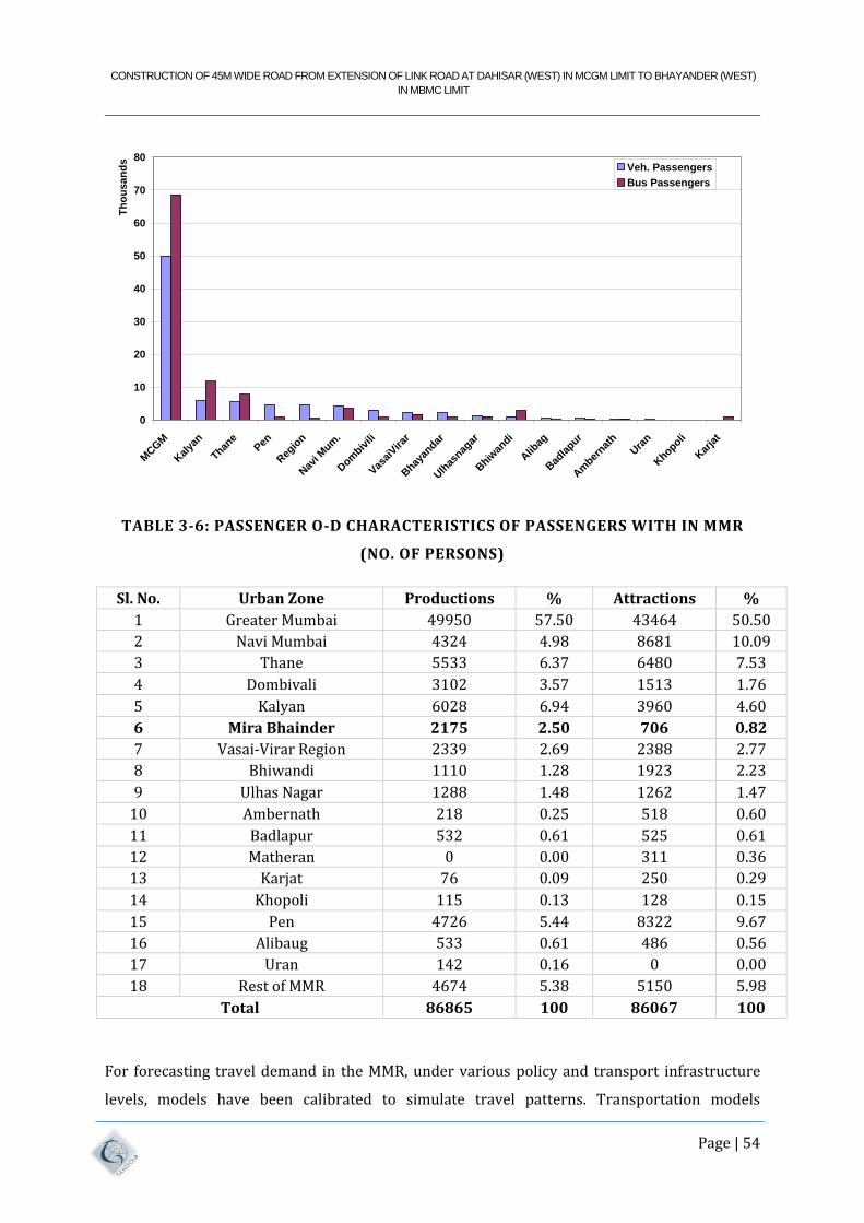
CONSTRUCTION OF 45M WIDE ROAD FROM EXTENSION OF LINK ROAD AT DAHISAR (WEST) IN MCGM LIMIT TO BHAYANDER (WEST)
IN MBMC LIMIT
Page | 54
TABLE 3-6: PASSENGER O-D CHARACTERISTICS OF PASSENGERS WITH IN MMR
(NO. OF PERSONS)
Sl. No. Urban Zone Productions % Attractions %
1 Greater Mumbai 49950 57.50 43464 50.50
2 Navi Mumbai 4324 4.98 8681 10.09
3 Thane 5533 6.37 6480 7.53
4 Dombivali 3102 3.57 1513 1.76
5 Kalyan 6028 6.94 3960 4.60
6 Mira Bhainder 2175 2.50 706 0.82
7 Vasai-Virar Region 2339 2.69 2388 2.77
8 Bhiwandi 1110 1.28 1923 2.23
9 Ulhas Nagar 1288 1.48 1262 1.47
10 Ambernath 218 0.25 518 0.60
11 Badlapur 532 0.61 525 0.61
12 Matheran 0 0.00 311 0.36
13 Karjat 76 0.09 250 0.29
14 Khopoli 115 0.13 128 0.15
15 Pen 4726 5.44 8322 9.67
16 Alibaug 533 0.61 486 0.56
17 Uran 142 0.16 0 0.00
18 Rest of MMR 4674 5.38 5150 5.98
Total 86865 100 86067 100
For forecasting travel demand in the MMR, under various policy and transport infrastructure
levels, models have been calibrated to simulate travel patterns. Transportation models
0
10
20
30
40
50
60
70
80
MCGM
Kal
yan
Thane
Pen
Reg
ion
Nav
i Mum
.
Dom
bivili
Vas
aiVirar
Bhay
andar
Ulh
asnag
ar
Bhiw
andi
Alib
ag
Bad
lapur
Am
bernat
h
Ura
n
Khopoli
Kar
jat
Th
ou
sa
nd
s
Veh. Passengers
Bus Passengers
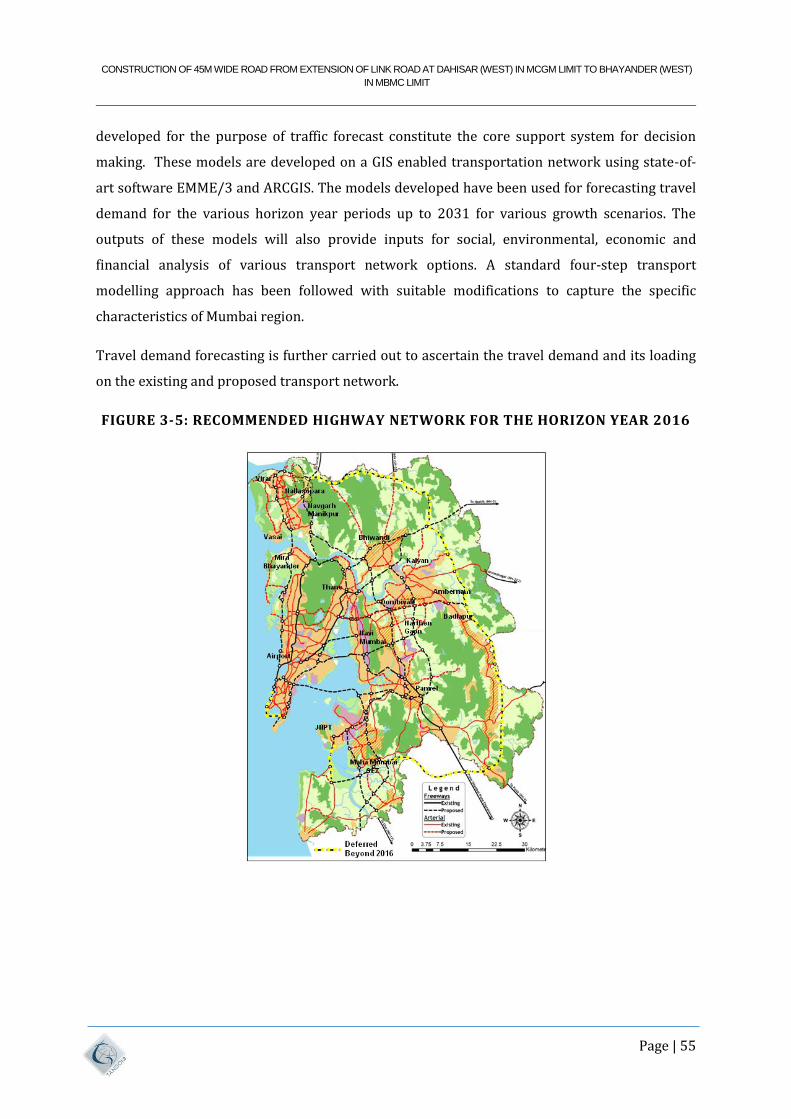
CONSTRUCTION OF 45M WIDE ROAD FROM EXTENSION OF LINK ROAD AT DAHISAR (WEST) IN MCGM LIMIT TO BHAYANDER (WEST)
IN MBMC LIMIT
Page | 55
developed for the purpose of traffic forecast constitute the core support system for decision
making. These models are developed on a GIS enabled transportation network using state-of-
art software EMME/3 and ARCGIS. The models developed have been used for forecasting travel
demand for the various horizon year periods up to 2031 for various growth scenarios. The
outputs of these models will also provide inputs for social, environmental, economic and
financial analysis of various transport network options. A standard four-step transport
modelling approach has been followed with suitable modifications to capture the specific
characteristics of Mumbai region.
Travel demand forecasting is further carried out to ascertain the travel demand and its loading
on the existing and proposed transport network.
FIGURE 3-5: RECOMMENDED HIGHWAY NETWORK FOR THE HORIZON YEAR 2016
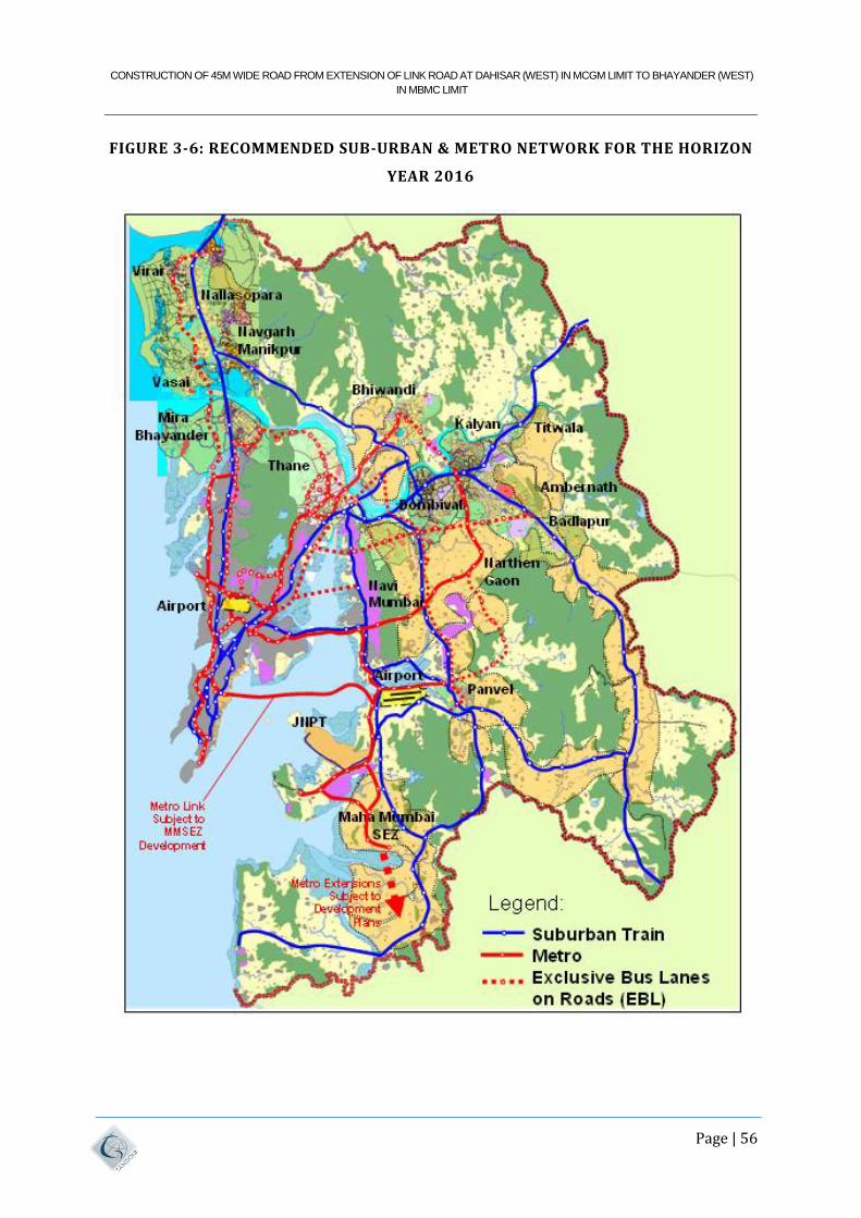
CONSTRUCTION OF 45M WIDE ROAD FROM EXTENSION OF LINK ROAD AT DAHISAR (WEST) IN MCGM LIMIT TO BHAYANDER (WEST)
IN MBMC LIMIT
Page | 56
FIGURE 3-6: RECOMMENDED SUB-URBAN & METRO NETWORK FOR THE HORIZON
YEAR 2016
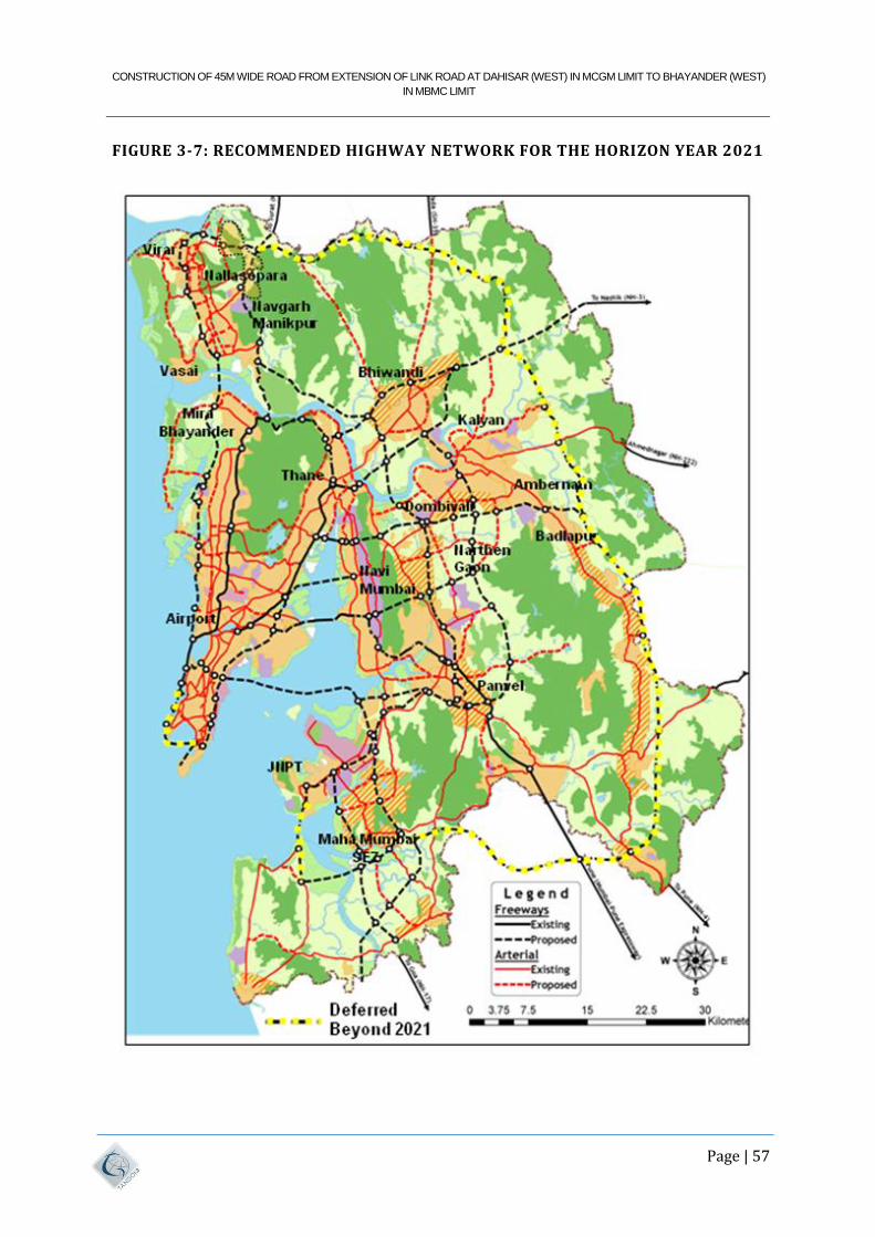
CONSTRUCTION OF 45M WIDE ROAD FROM EXTENSION OF LINK ROAD AT DAHISAR (WEST) IN MCGM LIMIT TO BHAYANDER (WEST)
IN MBMC LIMIT
Page | 57
FIGURE 3-7: RECOMMENDED HIGHWAY NETWORK FOR THE HORIZON YEAR 2021
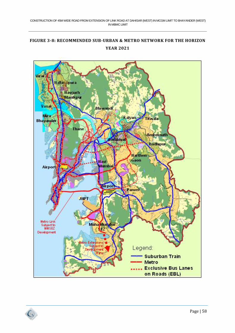
CONSTRUCTION OF 45M WIDE ROAD FROM EXTENSION OF LINK ROAD AT DAHISAR (WEST) IN MCGM LIMIT TO BHAYANDER (WEST)
IN MBMC LIMIT
Page | 58
FIGURE 3-8: RECOMMENDED SUB-URBAN & METRO NETWORK FOR THE HORIZON
YEAR 2021
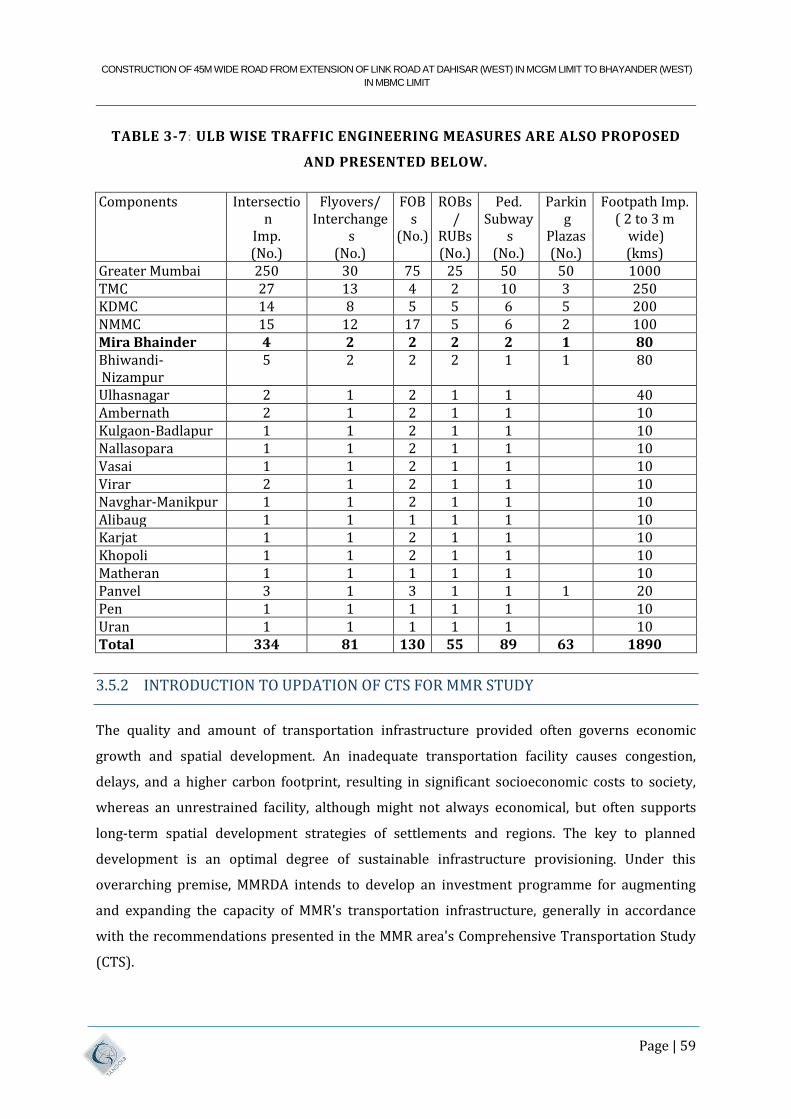
CONSTRUCTION OF 45M WIDE ROAD FROM EXTENSION OF LINK ROAD AT DAHISAR (WEST) IN MCGM LIMIT TO BHAYANDER (WEST)
IN MBMC LIMIT
Page | 59
TABLE 3-7: ULB WISE TRAFFIC ENGINEERING MEASURES ARE ALSO PROPOSED
AND PRESENTED BELOW.
Components Intersection
Imp. (No.)
Flyovers/ Interchange
s (No.)
FOBs
(No.)
ROBs/
RUBs (No.)
Ped. Subway
s (No.)
Parking
Plazas (No.)
Footpath Imp. ( 2 to 3 m
wide) (kms)
Greater Mumbai 250 30 75 25 50 50 1000 TMC 27 13 4 2 10 3 250 KDMC 14 8 5 5 6 5 200 NMMC 15 12 17 5 6 2 100 Mira Bhainder 4 2 2 2 2 1 80 Bhiwandi-Nizampur
5 2 2 2 1 1 80
Ulhasnagar 2 1 2 1 1 40 Ambernath 2 1 2 1 1 10 Kulgaon-Badlapur 1 1 2 1 1 10 Nallasopara 1 1 2 1 1 10 Vasai 1 1 2 1 1 10 Virar 2 1 2 1 1 10 Navghar-Manikpur 1 1 2 1 1 10 Alibaug 1 1 1 1 1 10 Karjat 1 1 2 1 1 10 Khopoli 1 1 2 1 1 10 Matheran 1 1 1 1 1 10 Panvel 3 1 3 1 1 1 20 Pen 1 1 1 1 1 10 Uran 1 1 1 1 1 10 Total 334 81 130 55 89 63 1890
3.5.2 INTRODUCTION TO UPDATION OF CTS FOR MMR STUDY
The quality and amount of transportation infrastructure provided often governs economic
growth and spatial development. An inadequate transportation facility causes congestion,
delays, and a higher carbon footprint, resulting in significant socioeconomic costs to society,
whereas an unrestrained facility, although might not always economical, but often supports
long-term spatial development strategies of settlements and regions. The key to planned
development is an optimal degree of sustainable infrastructure provisioning. Under this
overarching premise, MMRDA intends to develop an investment programme for augmenting
and expanding the capacity of MMR's transportation infrastructure, generally in accordance
with the recommendations presented in the MMR area's Comprehensive Transportation Study
(CTS).
CONSTRUCTION OF 45M WIDE ROAD FROM EXTENSION OF LINK ROAD AT DAHISAR (WEST) IN MCGM LIMIT TO BHAYANDER (WEST)
IN MBMC LIMIT
Page | 60
During the recent decade, MMRDA and other MMR partners began several transportation
infrastructure projects, including metro, monorail, highway, and suburban rail projects. In
addition, the MMRDA wants to improve the MMR transportation network. Furthermore, after
the completion of CTS, MMR has seen significant land area expansion during the previous
decade. As a result, it is deemed that the TRANSFORM: 2011-31 should be updated. (MMR Study
CTS 2005-08). Hence there was need to carry out updation of CTS for MMR study.
The CTS study looked at the major elements that affect traveling, such as the changing economic
and social circumstances in the region. The study also assessed the difficulties and opportunities
that must be identified and handled. The study's findings will be valuable in developing
suggestions for the MMRDA, CIDCO, MRVC, MSRDC, PWD, ULBS, and Municipal Transport
divisions. The proposals will be valuable to the Traffic Police and other organisations involved
in day-to-day traffic operations as well as future traffic and transportation infrastructure
development within MMR.
3.5.2.1 OBJECTIVE OF UPDATION OF CTS FOR MMR STUDY
The MMRDA has launched Updating CTS for MMR Study with the following key goals
a) To update the CTS study (2005-08) and Travel Demand Model using recent census 2011,
Economic Census, and major developments in MMR;
b) To assess the mode wise travel demand for metro rail, suburban rail, bus system, and
road/highway corridors for horizon years 2021, 2031, and 2041;
c) To update and prioritise metro rail, suburban rail, and highway corridors for horizon
years 2021, 2031, and 2041; and
d) To prepare phase wise investment plans for prioritised metro rail, suburban rail and
highway.
3.5.2.2 TRAVEL DEMAND FOR MMR- BASE YEAR 2017
Updation CTS study also includes studying on traveling behaviour and pattern for base year of
2017 was carried. This study includes assessing the passenger travel demand and goods travel
demand for morning peak period. The following table shows the estimated Passenger and goods
travel demand for MMR- Base Year 2017.
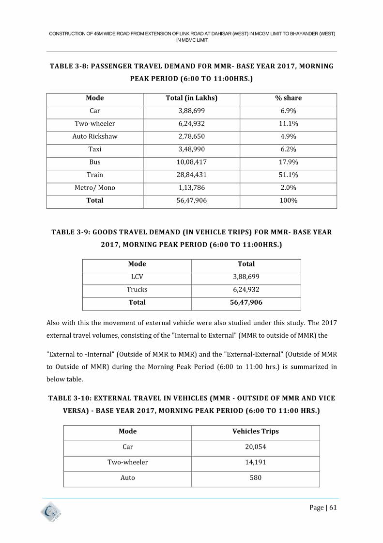
CONSTRUCTION OF 45M WIDE ROAD FROM EXTENSION OF LINK ROAD AT DAHISAR (WEST) IN MCGM LIMIT TO BHAYANDER (WEST)
IN MBMC LIMIT
Page | 61
TABLE 3-8: PASSENGER TRAVEL DEMAND FOR MMR- BASE YEAR 2017, MORNING
PEAK PERIOD (6:00 TO 11:00HRS.)
Mode Total (in Lakhs) % share
Car 3,88,699 6.9%
Two-wheeler 6,24,932 11.1%
Auto Rickshaw 2,78,650 4.9%
Taxi 3,48,990 6.2%
Bus 10,08,417 17.9%
Train 28,84,431 51.1%
Metro/ Mono 1,13,786 2.0%
Total 56,47,906 100%
TABLE 3-9: GOODS TRAVEL DEMAND (IN VEHICLE TRIPS) FOR MMR- BASE YEAR
2017, MORNING PEAK PERIOD (6:00 TO 11:00HRS.)
Mode Total
LCV 3,88,699
Trucks 6,24,932
Total 56,47,906
Also with this the movement of external vehicle were also studied under this study. The 2017
external travel volumes, consisting of the "Internal to External" (MMR to outside of MMR) the
"External to -Internal" (Outside of MMR to MMR) and the "External-External" (Outside of MMR
to Outside of MMR) during the Morning Peak Period (6:00 to 11:00 hrs.) is summarized in
below table.
TABLE 3-10: EXTERNAL TRAVEL IN VEHICLES (MMR - OUTSIDE OF MMR AND VICE
VERSA) - BASE YEAR 2017, MORNING PEAK PERIOD (6:00 TO 11:00 HRS.)
Mode Vehicles Trips
Car 20,054
Two-wheeler 14,191
Auto 580
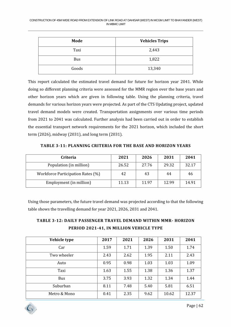
CONSTRUCTION OF 45M WIDE ROAD FROM EXTENSION OF LINK ROAD AT DAHISAR (WEST) IN MCGM LIMIT TO BHAYANDER (WEST)
IN MBMC LIMIT
Page | 62
Mode Vehicles Trips
Taxi 2,443
Bus 1,822
Goods 13,340
This report calculated the estimated travel demand for future for horizon year 2041. While
doing so different planning criteria were assessed for the MMR region over the base years and
other horizon years which are given in following table. Using the planning criteria, travel
demands for various horizon years were projected. As part of the CTS Updating project, updated
travel demand models were created. Transportation assignments over various time periods
from 2021 to 2041 was calculated. Further analysis had been carried out in order to establish
the essential transport network requirements for the 2021 horizon, which included the short
term (2026), midway (2031), and long term (2031).
TABLE 3-11: PLANNING CRITERIA FOR THE BASE AND HORIZON YEARS
Criteria 2021 2026 2031 2041
Population (in million) 26.52 27.76 29.32 32.17
Workforce Participation Rates (%) 42 43 44 46
Employment (in million) 11.13 11.97 12.99 14.91
Using those parameters, the future travel demand was projected according to that the following
table shows the travelling demand for year 2021, 2026, 2031 and 2041.
TABLE 3-12: DAILY PASSENGER TRAVEL DEMAND WITHIN MMR- HORIZON
PERIOD 2021-41, IN MILLION VEHICLE TYPE
Vehicle type 2017 2021 2026 2031 2041
Car 1.59 1.71 1.39 1.50 1.74
Two wheeler 2.43 2.62 1.95 2.11 2.43
Auto 0.95 0.98 1.03 1.03 1.09
Taxi 1.63 1.55 1.38 1.36 1.37
Bus 3.75 3.93 1.32 1.34 1.44
Suburban 8.11 7.48 5.40 5.81 6.51
Metro & Mono 0.41 2.35 9.62 10.62 12.37
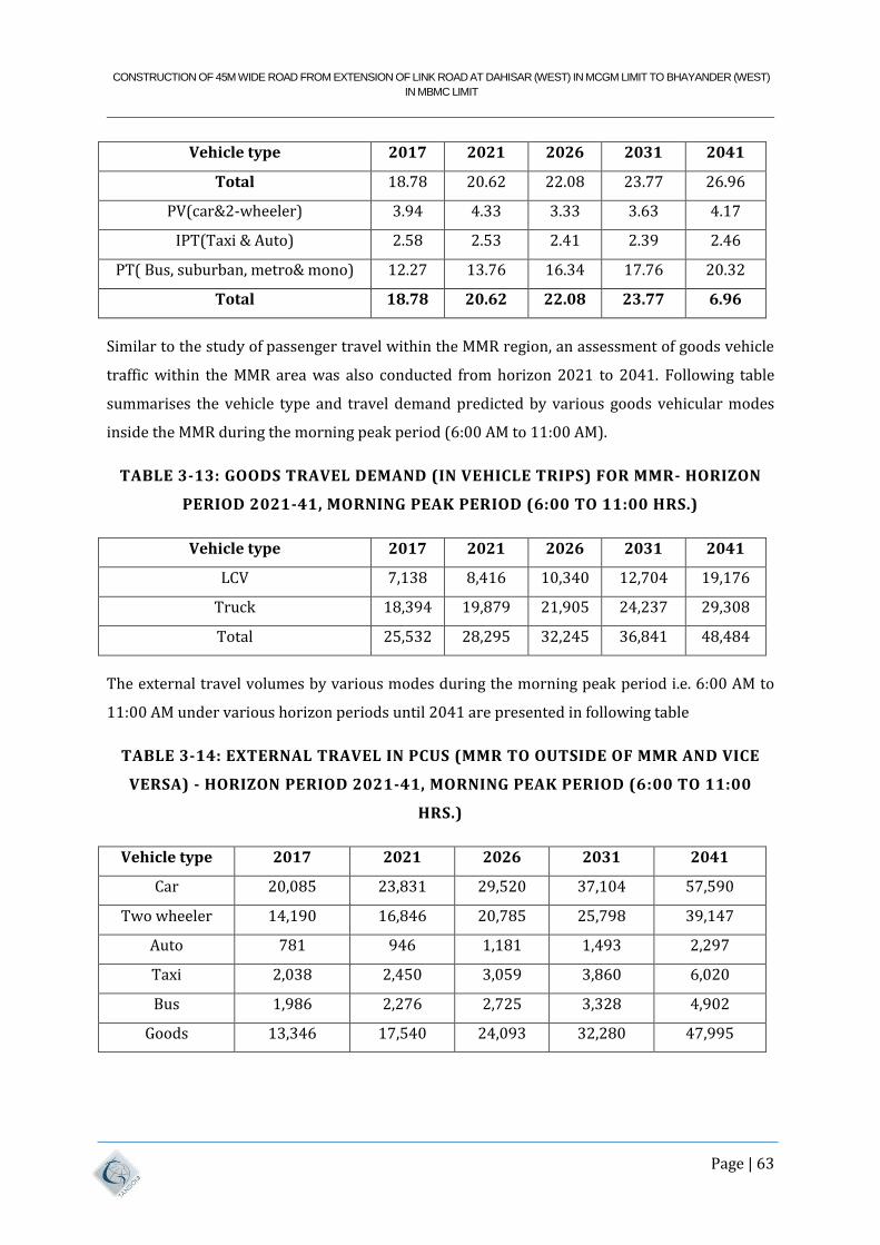
CONSTRUCTION OF 45M WIDE ROAD FROM EXTENSION OF LINK ROAD AT DAHISAR (WEST) IN MCGM LIMIT TO BHAYANDER (WEST)
IN MBMC LIMIT
Page | 63
Vehicle type 2017 2021 2026 2031 2041
Total 18.78 20.62 22.08 23.77 26.96
PV(car&2-wheeler) 3.94 4.33 3.33 3.63 4.17
IPT(Taxi & Auto) 2.58 2.53 2.41 2.39 2.46
PT( Bus, suburban, metro& mono) 12.27 13.76 16.34 17.76 20.32
Total 18.78 20.62 22.08 23.77 6.96
Similar to the study of passenger travel within the MMR region, an assessment of goods vehicle
traffic within the MMR area was also conducted from horizon 2021 to 2041. Following table
summarises the vehicle type and travel demand predicted by various goods vehicular modes
inside the MMR during the morning peak period (6:00 AM to 11:00 AM).
TABLE 3-13: GOODS TRAVEL DEMAND (IN VEHICLE TRIPS) FOR MMR- HORIZON
PERIOD 2021-41, MORNING PEAK PERIOD (6:00 TO 11:00 HRS.)
Vehicle type 2017 2021 2026 2031 2041
LCV 7,138 8,416 10,340 12,704 19,176
Truck 18,394 19,879 21,905 24,237 29,308
Total 25,532 28,295 32,245 36,841 48,484
The external travel volumes by various modes during the morning peak period i.e. 6:00 AM to
11:00 AM under various horizon periods until 2041 are presented in following table
TABLE 3-14: EXTERNAL TRAVEL IN PCUS (MMR TO OUTSIDE OF MMR AND VICE
VERSA) - HORIZON PERIOD 2021-41, MORNING PEAK PERIOD (6:00 TO 11:00
HRS.)
Vehicle type 2017 2021 2026 2031 2041
Car 20,085 23,831 29,520 37,104 57,590
Two wheeler 14,190 16,846 20,785 25,798 39,147
Auto 781 946 1,181 1,493 2,297
Taxi 2,038 2,450 3,059 3,860 6,020
Bus 1,986 2,276 2,725 3,328 4,902
Goods 13,346 17,540 24,093 32,280 47,995
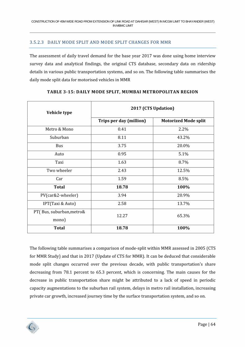
CONSTRUCTION OF 45M WIDE ROAD FROM EXTENSION OF LINK ROAD AT DAHISAR (WEST) IN MCGM LIMIT TO BHAYANDER (WEST)
IN MBMC LIMIT
Page | 64
3.5.2.3 DAILY MODE SPLIT AND MODE SPLIT CHANGES FOR MMR
The assessment of daily travel demand for the base year 2017 was done using home interview
survey data and analytical findings, the original CTS database, secondary data on ridership
details in various public transportation systems, and so on. The following table summarises the
daily mode split data for motorised vehicles in MMR
TABLE 3-15: DAILY MODE SPLIT, MUMBAI METROPOLITAN REGION
Vehicle type 2017 (CTS Updation)
Trips per day (million) Motorized Mode split
Metro & Mono 0.41 2.2%
Suburban 8.11 43.2%
Bus 3.75 20.0%
Auto 0.95 5.1%
Taxi 1.63 8.7%
Two wheeler 2.43 12.5%
Car 1.59 8.5%
Total 18.78 100%
PV(car&2-wheeler) 3.94 20.9%
IPT(Taxi & Auto) 2.58 13.7%
PT( Bus, suburban,metro&
mono) 12.27 65.3%
Total 18.78 100%
The following table summarises a comparison of mode-split within MMR assessed in 2005 (CTS
for MMR Study) and that in 2017 (Update of CTS for MMR). It can be deduced that considerable
mode split changes occurred over the previous decade, with public transportation's share
decreasing from 78.1 percent to 65.3 percent, which is concerning. The main causes for the
decrease in public transportation share might be attributed to a lack of speed in periodic
capacity augmentations to the suburban rail system, delays in metro rail installation, increasing
private car growth, increased journey time by the surface transportation system, and so on.
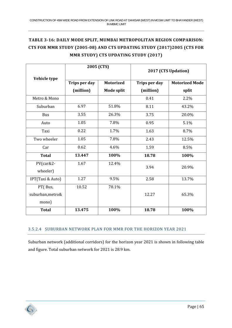
CONSTRUCTION OF 45M WIDE ROAD FROM EXTENSION OF LINK ROAD AT DAHISAR (WEST) IN MCGM LIMIT TO BHAYANDER (WEST)
IN MBMC LIMIT
Page | 65
TABLE 3-16: DAILY MODE SPLIT, MUMBAI METROPOLITAN REGION COMPARISON:
CTS FOR MMR STUDY (2005-08) AND CTS UPDATING STUDY (2017)2005 (CTS FOR
MMR STUDY) CTS UPDATING STUDY (2017)
Vehicle type
2005 (CTS) 2017 (CTS Updation)
Trips per day
(million)
Motorized
Mode split
Trips per day
(million)
Motorized Mode
split
Metro & Mono 0.41 2.2%
Suburban 6.97 51.8% 8.11 43.2%
Bus 3.55 26.3% 3.75 20.0%
Auto 1.05 7.8% 0.95 5.1%
Taxi 0.22 1.7% 1.63 8.7%
Two wheeler 1.05 7.8% 2.43 12.5%
Car 0.62 4.6% 1.59 8.5%
Total 13.447 100% 18.78 100%
PV(car&2-
wheeler)
1.67 12.4% 3.94 20.9%
IPT(Taxi & Auto) 1.27 9.5% 2.58 13.7%
PT( Bus,
suburban,metro&
mono)
10.52 78.1%
12.27 65.3%
Total 13.475 100% 18.78 100%
3.5.2.4 SUBURBAN NETWORK PLAN FOR MMR FOR THE HORIZON YEAR 2021
Suburban network (additional corridors) for the horizon year 2021 is shown in following table
and figure. Total suburban network for 2021 is 28.9 km.
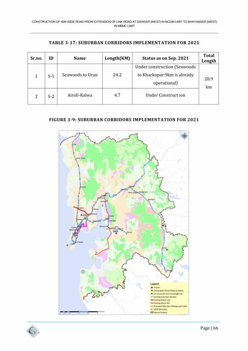
CONSTRUCTION OF 45M WIDE ROAD FROM EXTENSION OF LINK ROAD AT DAHISAR (WEST) IN MCGM LIMIT TO BHAYANDER (WEST)
IN MBMC LIMIT
Page | 66
TABLE 3-17: SUBURBAN CORRIDORS IMPLEMENTATION FOR 2021
Sr.no. ID Name Length(KM) Status as on Sep. 2021 Total
Length
1 S-1 Seawoods to Uran 24.2
Under construction (Seawoods
to Kharkopar:9km is already
operational) 28.9
km
2 S-2 Airoli-Kalwa 4.7 Under Construct ion
FIGURE 3-9: SUBURBAN CORRIDORS IMPLEMENTATION FOR 2021
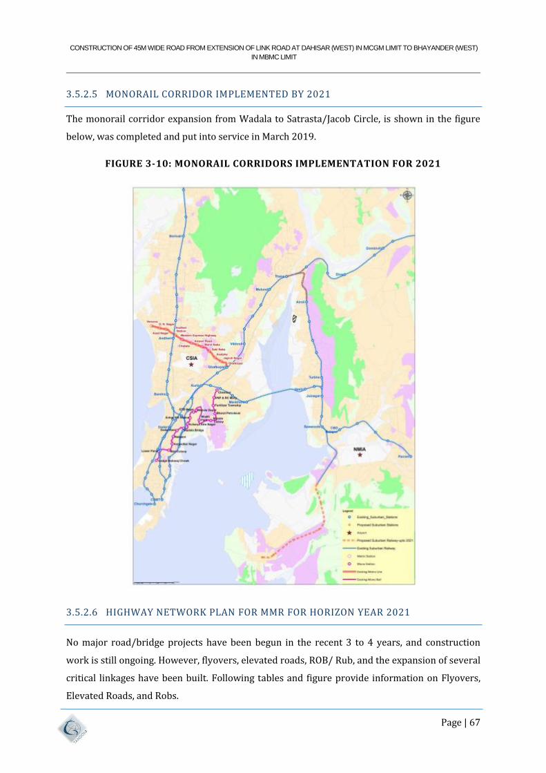
CONSTRUCTION OF 45M WIDE ROAD FROM EXTENSION OF LINK ROAD AT DAHISAR (WEST) IN MCGM LIMIT TO BHAYANDER (WEST)
IN MBMC LIMIT
Page | 67
3.5.2.5 MONORAIL CORRIDOR IMPLEMENTED BY 2021
The monorail corridor expansion from Wadala to Satrasta/Jacob Circle, is shown in the figure
below, was completed and put into service in March 2019.
FIGURE 3-10: MONORAIL CORRIDORS IMPLEMENTATION FOR 2021
3.5.2.6 HIGHWAY NETWORK PLAN FOR MMR FOR HORIZON YEAR 2021
No major road/bridge projects have been begun in the recent 3 to 4 years, and construction
work is still ongoing. However, flyovers, elevated roads, ROB/ Rub, and the expansion of several
critical linkages have been built. Following tables and figure provide information on Flyovers,
Elevated Roads, and Robs.
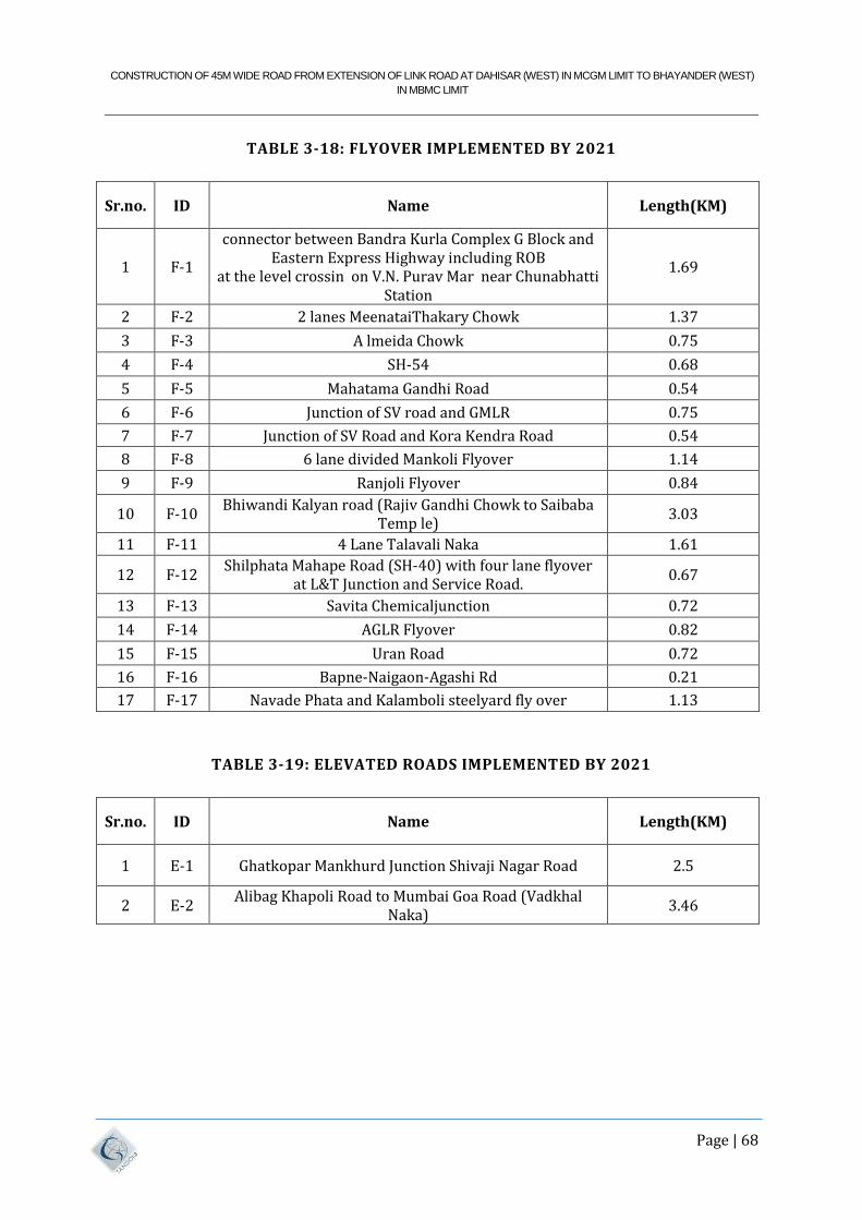
CONSTRUCTION OF 45M WIDE ROAD FROM EXTENSION OF LINK ROAD AT DAHISAR (WEST) IN MCGM LIMIT TO BHAYANDER (WEST)
IN MBMC LIMIT
Page | 68
TABLE 3-18: FLYOVER IMPLEMENTED BY 2021
Sr.no. ID Name Length(KM)
1 F-1
connector between Bandra Kurla Complex G Block and Eastern Express Highway including ROB
at the level crossin on V.N. Purav Mar near Chunabhatti Station
1.69
2 F-2 2 lanes MeenataiThakary Chowk 1.37
3 F-3 A lmeida Chowk 0.75
4 F-4 SH-54 0.68
5 F-5 Mahatama Gandhi Road 0.54
6 F-6 Junction of SV road and GMLR 0.75
7 F-7 Junction of SV Road and Kora Kendra Road 0.54
8 F-8 6 lane divided Mankoli Flyover 1.14
9 F-9 Ranjoli Flyover 0.84
10 F-10 Bhiwandi Kalyan road (Rajiv Gandhi Chowk to Saibaba
Temp le) 3.03
11 F-11 4 Lane Talavali Naka 1.61
12 F-12 Shilphata Mahape Road (SH-40) with four lane flyover
at L&T Junction and Service Road. 0.67
13 F-13 Savita Chemicaljunction 0.72
14 F-14 AGLR Flyover 0.82
15 F-15 Uran Road 0.72
16 F-16 Bapne-Naigaon-Agashi Rd 0.21
17 F-17 Navade Phata and Kalamboli steelyard fly over 1.13
TABLE 3-19: ELEVATED ROADS IMPLEMENTED BY 2021
Sr.no. ID Name Length(KM)
1 E-1 Ghatkopar Mankhurd Junction Shivaji Nagar Road 2.5
2 E-2 Alibag Khapoli Road to Mumbai Goa Road (Vadkhal
Naka) 3.46
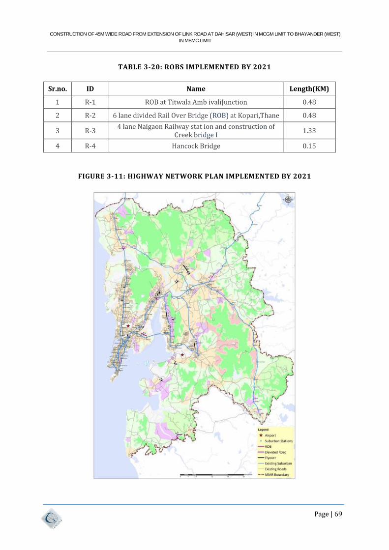
CONSTRUCTION OF 45M WIDE ROAD FROM EXTENSION OF LINK ROAD AT DAHISAR (WEST) IN MCGM LIMIT TO BHAYANDER (WEST)
IN MBMC LIMIT
Page | 69
TABLE 3-20: ROBS IMPLEMENTED BY 2021
Sr.no. ID Name Length(KM)
1 R-1 ROB at Titwala Amb ivaliJunction 0.48
2 R-2 6 lane divided Rail Over Bridge (ROB) at Kopari,Thane 0.48
3 R-3 4 lane Naigaon Railway stat ion and construction of
Creek bridge I 1.33
4 R-4 Hancock Bridge 0.15
FIGURE 3-11: HIGHWAY NETWORK PLAN IMPLEMENTED BY 2021
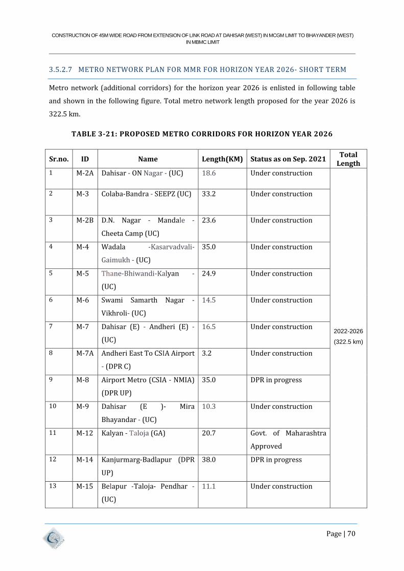
CONSTRUCTION OF 45M WIDE ROAD FROM EXTENSION OF LINK ROAD AT DAHISAR (WEST) IN MCGM LIMIT TO BHAYANDER (WEST)
IN MBMC LIMIT
Page | 70
3.5.2.7 METRO NETWORK PLAN FOR MMR FOR HORIZON YEAR 2026- SHORT TERM
Metro network (additional corridors) for the horizon year 2026 is enlisted in following table
and shown in the following figure. Total metro network length proposed for the year 2026 is
322.5 km.
TABLE 3-21: PROPOSED METRO CORRIDORS FOR HORIZON YEAR 2026
Sr.no. ID Name Length(KM) Status as on Sep. 2021 Total
Length
1 M-2A Dahisar - ON Nagar - (UC) 18.6 Under construction
2022-2026
(322.5 km)
2 M-3 Colaba-Bandra - SEEPZ (UC) 33.2 Under construction
3 M-2B D.N. Nagar - Mandale -
Cheeta Camp (UC)
23.6 Under construction
4 M-4 Wadala -Kasarvadvali-
Gaimukh - (UC)
35.0 Under construction
5 M-5 Thane-Bhiwandi-Kalyan -
(UC)
24.9 Under construction
6 M-6 Swami Samarth Nagar -
Vikhroli- (UC)
14.5 Under construction
7 M-7 Dahisar (E) - Andheri (E) -
(UC)
16.5 Under construction
8 M-7A Andheri East To CSIA Airport
- (DPR C)
3.2 Under construction
9 M-8 Airport Metro (CSIA - NMIA)
(DPR UP)
35.0 DPR in progress
10 M-9 Dahisar (E )- Mira
Bhayandar - (UC)
10.3 Under construction
11 M-12 Kalyan - Taloja (GA) 20.7 Govt. of Maharashtra
Approved
12 M-14 Kanjurmarg-Badlapur (DPR
UP)
38.0 DPR in progress
13 M-15 Belapur -Taloja- Pendhar -
(UC)
11.1 Under construction
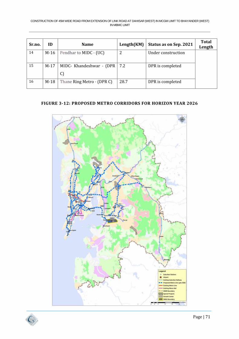
CONSTRUCTION OF 45M WIDE ROAD FROM EXTENSION OF LINK ROAD AT DAHISAR (WEST) IN MCGM LIMIT TO BHAYANDER (WEST)
IN MBMC LIMIT
Page | 71
Sr.no. ID Name Length(KM) Status as on Sep. 2021 Total
Length
14 M-16 Pendhar to MIDC - (UC) 2 Under construction
15 M-17 MIDC- Khandeshwar - (DPR
C)
7.2 DPR is completed
16 M-18 Thane Ring Metro - (DPR C) 28.7 DPR is completed
FIGURE 3-12: PROPOSED METRO CORRIDORS FOR HORIZON YEAR 2026
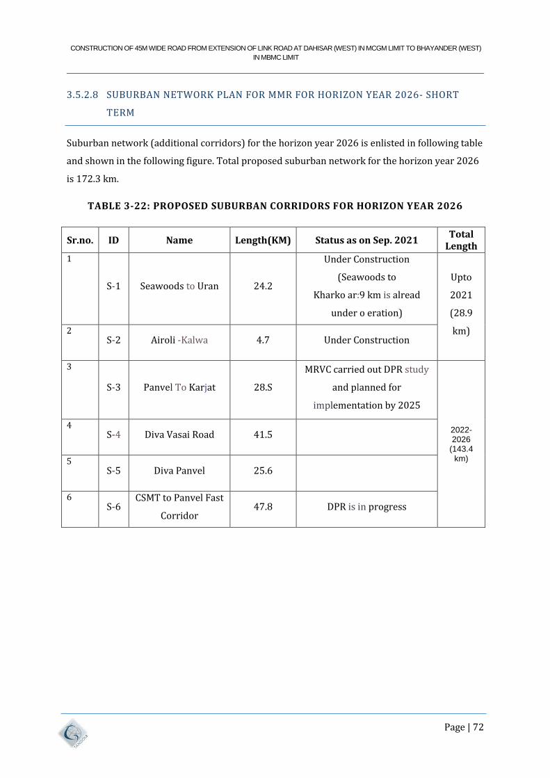
CONSTRUCTION OF 45M WIDE ROAD FROM EXTENSION OF LINK ROAD AT DAHISAR (WEST) IN MCGM LIMIT TO BHAYANDER (WEST)
IN MBMC LIMIT
Page | 72
3.5.2.8 SUBURBAN NETWORK PLAN FOR MMR FOR HORIZON YEAR 2026- SHORT
TERM
Suburban network (additional corridors) for the horizon year 2026 is enlisted in following table
and shown in the following figure. Total proposed suburban network for the horizon year 2026
is 172.3 km.
TABLE 3-22: PROPOSED SUBURBAN CORRIDORS FOR HORIZON YEAR 2026
Sr.no. ID Name Length(KM) Status as on Sep. 2021 Total
Length
1
S-1 Seawoods to Uran 24.2
Under Construction
(Seawoods to
Kharko ar:9 km is alread
under o eration)
Upto
2021
(28.9
km) 2 S-2 Airoli -Kalwa 4.7 Under Construction
3
S-3 Panvel To Karjat 28.S
MRVC carried out DPR study
and planned for
implementation by 2025
2022-2026
(143.4 km)
4 S-4 Diva Vasai Road 41.5
5 S-5 Diva Panvel 25.6
6 S-6
CSMT to Panvel Fast
Corridor 47.8 DPR is in progress
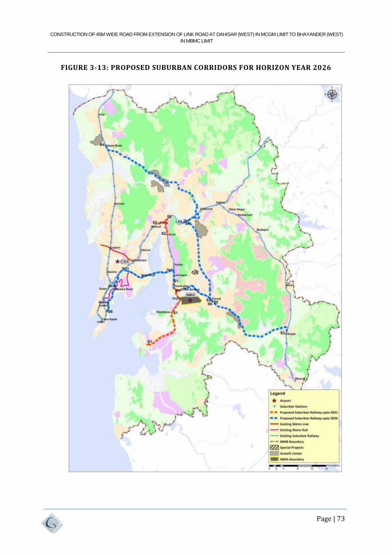
CONSTRUCTION OF 45M WIDE ROAD FROM EXTENSION OF LINK ROAD AT DAHISAR (WEST) IN MCGM LIMIT TO BHAYANDER (WEST)
IN MBMC LIMIT
Page | 73
FIGURE 3-13: PROPOSED SUBURBAN CORRIDORS FOR HORIZON YEAR 2026
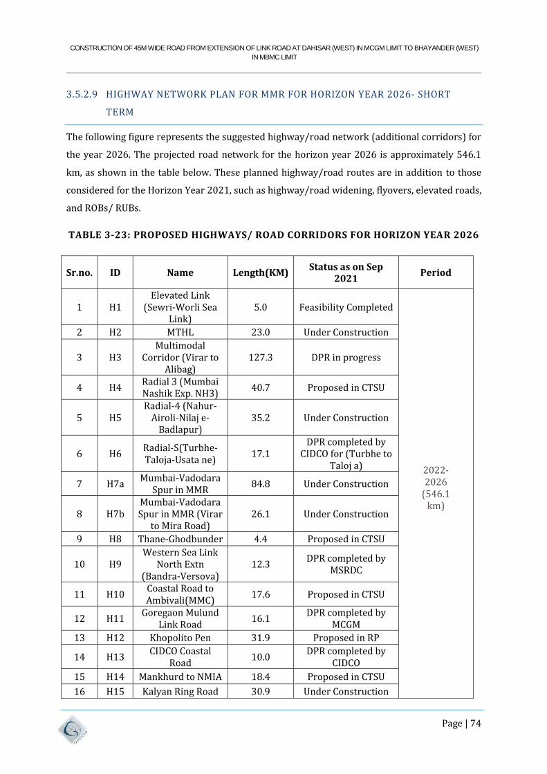
CONSTRUCTION OF 45M WIDE ROAD FROM EXTENSION OF LINK ROAD AT DAHISAR (WEST) IN MCGM LIMIT TO BHAYANDER (WEST)
IN MBMC LIMIT
Page | 74
3.5.2.9 HIGHWAY NETWORK PLAN FOR MMR FOR HORIZON YEAR 2026- SHORT
TERM
The following figure represents the suggested highway/road network (additional corridors) for
the year 2026. The projected road network for the horizon year 2026 is approximately 546.1
km, as shown in the table below. These planned highway/road routes are in addition to those
considered for the Horizon Year 2021, such as highway/road widening, flyovers, elevated roads,
and ROBs/ RUBs.
TABLE 3-23: PROPOSED HIGHWAYS/ ROAD CORRIDORS FOR HORIZON YEAR 2026
Sr.no. ID Name Length(KM) Status as on Sep
2021 Period
1 H1 Elevated Link
(Sewri-Worli Sea Link)
5.0 Feasibility Completed
2022- 2026
(546.1 km)
2 H2 MTHL 23.0 Under Construction
3 H3 Multimodal
Corridor (Virar to Alibag)
127.3 DPR in progress
4 H4 Radial 3 (Mumbai Nashik Exp. NH3)
40.7 Proposed in CTSU
5 H5 Radial-4 (Nahur-
Airoli-Nilaj e-Badlapur)
35.2 Under Construction
6 H6 Radial-S(Turbhe-Taloja-Usata ne)
17.1 DPR completed by
CIDCO for (Turbhe to Taloj a)
7 H7a Mumbai-Vadodara
Spur in MMR 84.8 Under Construction
8 H7b Mumbai-Vadodara Spur in MMR (Virar
to Mira Road) 26.1 Under Construction
9 H8 Thane-Ghodbunder 4.4 Proposed in CTSU
10 H9 Western Sea Link
North Extn (Bandra-Versova)
12.3 DPR completed by
MSRDC
11 H10 Coastal Road to Ambivali(MMC)
17.6 Proposed in CTSU
12 H11 Goregaon Mulund
Link Road 16.1
DPR completed by MCGM
13 H12 Khopolito Pen 31.9 Proposed in RP
14 H13 CIDCO Coastal
Road 10.0
DPR completed by CIDCO
15 H14 Mankhurd to NMIA 18.4 Proposed in CTSU
16 H15 Kalyan Ring Road 30.9 Under Construction
CONSTRUCTION OF 45M WIDE ROAD FROM EXTENSION OF LINK ROAD AT DAHISAR (WEST) IN MCGM LIMIT TO BHAYANDER (WEST)
IN MBMC LIMIT
Page | 75
Sr.no. ID Name Length(KM) Status as on Sep
2021 Period
17 H16 Thane Coastal
Road (Gaimukh to Saket)
11.0 DPR completed by
TMC
18 H17 Panvel Matheran
Road 10.2 Proposed in CTSU
19 H18 Nariman Point to
Colaba 1.3
Feasibility is in progress
20 H19 Anand Nagar Toll Naka (Kopri) to
Saket Road 6.3
Proposed in TIA Thane
21 H20 Kalyan to Bapgaon 2.4 Proposed in TIA
Thane
FIGURE 3-14: PROPOSED HIGHWAYS/ ROAD CORRIDORS FOR HORIZON YEAR
2026
CONSTRUCTION OF 45M WIDE ROAD FROM EXTENSION OF LINK ROAD AT DAHISAR (WEST) IN MCGM LIMIT TO BHAYANDER (WEST)
IN MBMC LIMIT
Page | 76
3.5.2.10 METRO NETWORK PLAN FOR MMR FOR HORIZON YEAR 2031- - MEDIUM
TERM
Metro network (additional corridors) for the horizon year 2032 is enlisted in following table
and shown in the following figure. Total metro network length proposed for the year 2031 is
423.2 km.
TABLE 3-24: PROPOSED METRO CORRIDORS FOR HORIZON YEAR 2031
Sr.no. ID Name Length(KM) Status as on Sep.
2021 Total Length
1 M-2A Dahisar - ON Nagar
- (UC) 18.6 Under construction
2022-2026
(322.S km)
2 M-3 Colaba-Bandra -
SEEPZ (UC) 33.2 Under construction
3 M-2B
D.N. Nagar -
Mandale - Cheeta
Camp (UC)
23.6 Under construction
4 M-4
Wadala -
Kasarvadva li-
Gaimukh - (UC)
35.0 Under construction
5 M-5 Thane-Bhiwandi-
Kalyan - (UC) 24.9 Under construction
6 M-6
Swami Samarth
Nagar - Vikhroli -
(UC)
14.S Under construction
7 M-7 Dahisar (E) -
Andher i (E) - (UC) 16.S Under construction
8 M-7A
Andher i East To
CSIA Airport - (DPR
C)
3.2 Under construction
9 M-8
Airport Metro
(CSIA - NMIA)
(DPR UP)
35.0 DPR in progress
10 M-9 Dahisar (E )- Mira
Bhayandar - (UC) 10.3 Under construction
CONSTRUCTION OF 45M WIDE ROAD FROM EXTENSION OF LINK ROAD AT DAHISAR (WEST) IN MCGM LIMIT TO BHAYANDER (WEST)
IN MBMC LIMIT
Page | 77
Sr.no. ID Name Length(KM) Status as on Sep.
2021 Total Length
11 M-12 Kalyan - Taloja
(GA) 20.7
Govt. of Maharashtra
Approved
12 M-14 Kanjurmarg-
Badlapur (DPR UP) 38.0 DPR in progress
13 M-15 Belapur -Taloja-
Pendhar - (UC) 11.1 Under construction
14 M-16 Pendhar to MIDC -
(UC) 2 Under construction
15 M-17
MIDC-
Khandeshwar -
(DPR C)
7.2 DPR is completed
16 M-18 Thane Ring Metro -
(DPR C) 28.7 DPR is completed
17 M-11(M
4 Ext)
Wadala-CSMT -
(GA) 12.7
Govt. of Maharashtra
Approved
2027-2031
(100.7 km)
18 M-19
Prabhadevi-Sewri -
NMIA (MTHL) -
(DPR C)
26.S DPR is completed
19 M-13
Shivaji Chowk
(Mira Road) - Virar
(DPR UP)
23.0 DPR in progress
20 M-10
Gaimukh to Shivaji
Chowk (Mira Road)
- (GA)
9.2 Govt. of Maharashtra
Approved
21 M-20 Khandeshwar to
NMIA - (DPR C) 3.7 DPR is completed
22 M-21
MTHL Spur to
Jambhulpada -
(DPR C)
5.0 DPR is completed
23 M-22 Thane to Juinagar 20.6 Proposed in CTSU
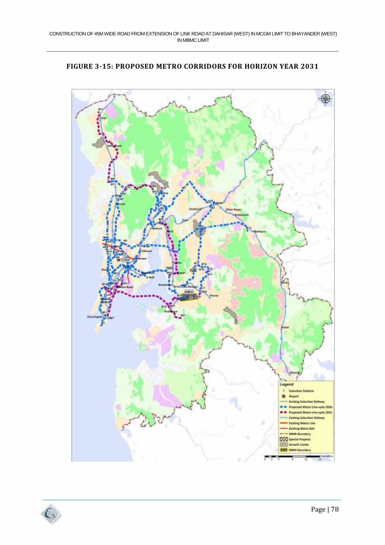
CONSTRUCTION OF 45M WIDE ROAD FROM EXTENSION OF LINK ROAD AT DAHISAR (WEST) IN MCGM LIMIT TO BHAYANDER (WEST)
IN MBMC LIMIT
Page | 78
FIGURE 3-15: PROPOSED METRO CORRIDORS FOR HORIZON YEAR 2031
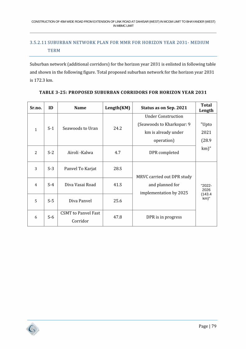
CONSTRUCTION OF 45M WIDE ROAD FROM EXTENSION OF LINK ROAD AT DAHISAR (WEST) IN MCGM LIMIT TO BHAYANDER (WEST)
IN MBMC LIMIT
Page | 79
3.5.2.11 SUBURBAN NETWORK PLAN FOR MMR FOR HORIZON YEAR 2031- MEDIUM
TERM
Suburban network (additional corridors) for the horizon year 2031 is enlisted in following table
and shown in the following figure. Total proposed suburban network for the horizon year 2031
is 172.3 km.
TABLE 3-25: PROPOSED SUBURBAN CORRIDORS FOR HORIZON YEAR 2031
Sr.no. ID Name Length(KM) Status as on Sep. 2021 Total
Length
1 S-1 Seawoods to Uran 24.2
Under Construction
(Seawoods to Kharkopar: 9
km is already under
operation)
"Upto
2021
(28.9
km)" 2 S-2 Airoli -Kalwa 4.7 DPR completed
3 S-3 Panvel To Karjat 28.S
MRVC carried out DPR study
and planned for
implementation by 2025
"2022-2026
(143.4 km)"
4 S-4 Diva Vasai Road 41.S
5 S-5 Diva Panvel 25.6
6 S-6 CSMT to Panvel Fast
Corridor 47.8 DPR is in progress
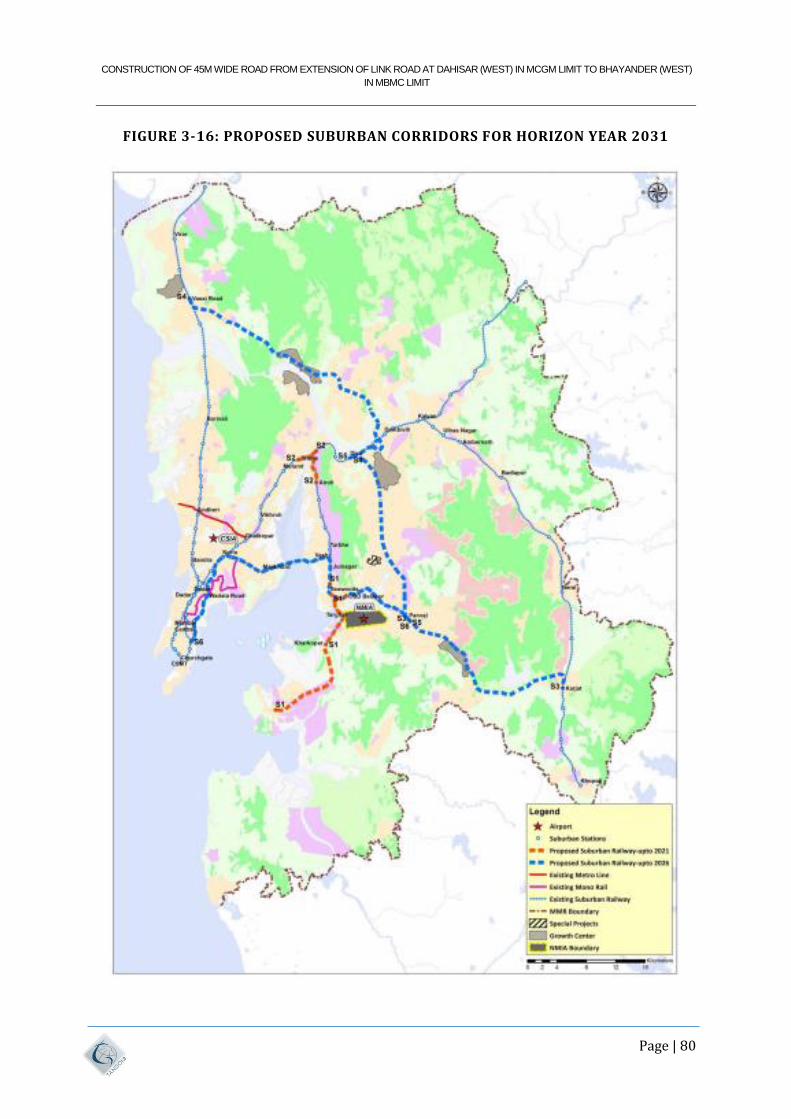
CONSTRUCTION OF 45M WIDE ROAD FROM EXTENSION OF LINK ROAD AT DAHISAR (WEST) IN MCGM LIMIT TO BHAYANDER (WEST)
IN MBMC LIMIT
Page | 80
FIGURE 3-16: PROPOSED SUBURBAN CORRIDORS FOR HORIZON YEAR 2031
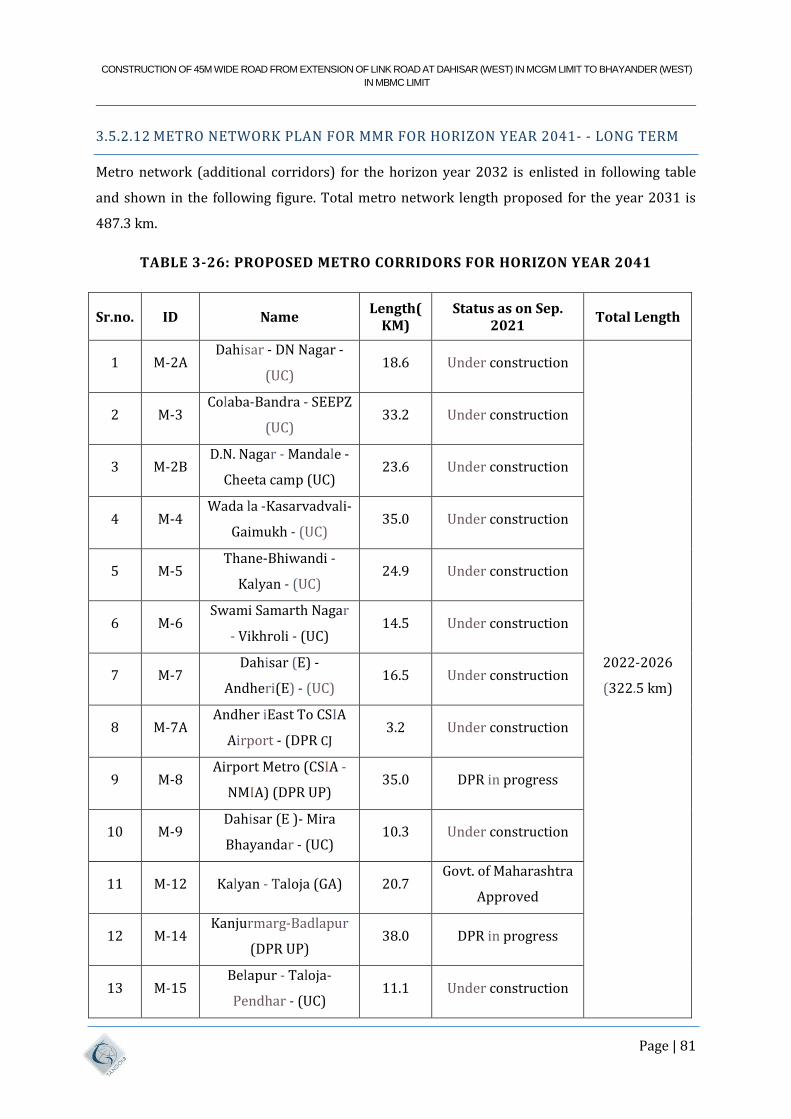
CONSTRUCTION OF 45M WIDE ROAD FROM EXTENSION OF LINK ROAD AT DAHISAR (WEST) IN MCGM LIMIT TO BHAYANDER (WEST)
IN MBMC LIMIT
Page | 81
3.5.2.12 METRO NETWORK PLAN FOR MMR FOR HORIZON YEAR 2041- - LONG TERM
Metro network (additional corridors) for the horizon year 2032 is enlisted in following table
and shown in the following figure. Total metro network length proposed for the year 2031 is
487.3 km.
TABLE 3-26: PROPOSED METRO CORRIDORS FOR HORIZON YEAR 2041
Sr.no. ID Name Length(
KM) Status as on Sep.
2021 Total Length
1 M-2A Dahisar - DN Nagar -
(UC) 18.6 Under construction
2022-2026
(322.5 km)
2 M-3 Colaba-Bandra - SEEPZ
(UC) 33.2 Under construction
3 M-2B D.N. Nagar - Mandale -
Cheeta camp (UC) 23.6 Under construction
4 M-4 Wada la -Kasarvadvali-
Gaimukh - (UC) 35.0 Under construction
5 M-5 Thane-Bhiwandi -
Kalyan - (UC) 24.9 Under construction
6 M-6 Swami Samarth Nagar
- Vikhroli - (UC) 14.5 Under construction
7 M-7 Dahisar (E) -
Andheri(E) - (UC) 16.5 Under construction
8 M-7A Andher iEast To CSIA
Airport - (DPR CJ 3.2 Under construction
9 M-8 Airport Metro (CSIA -
NMIA) (DPR UP) 35.0 DPR in progress
10 M-9 Dahisar (E )- Mira
Bhayandar - (UC) 10.3 Under construction
11 M-12 Kalyan - Taloja (GA) 20.7 Govt. of Maharashtra
Approved
12 M-14 Kanjurmarg-Badlapur
(DPR UP) 38.0 DPR in progress
13 M-15 Belapur - Taloja-
Pendhar - (UC) 11.1 Under construction
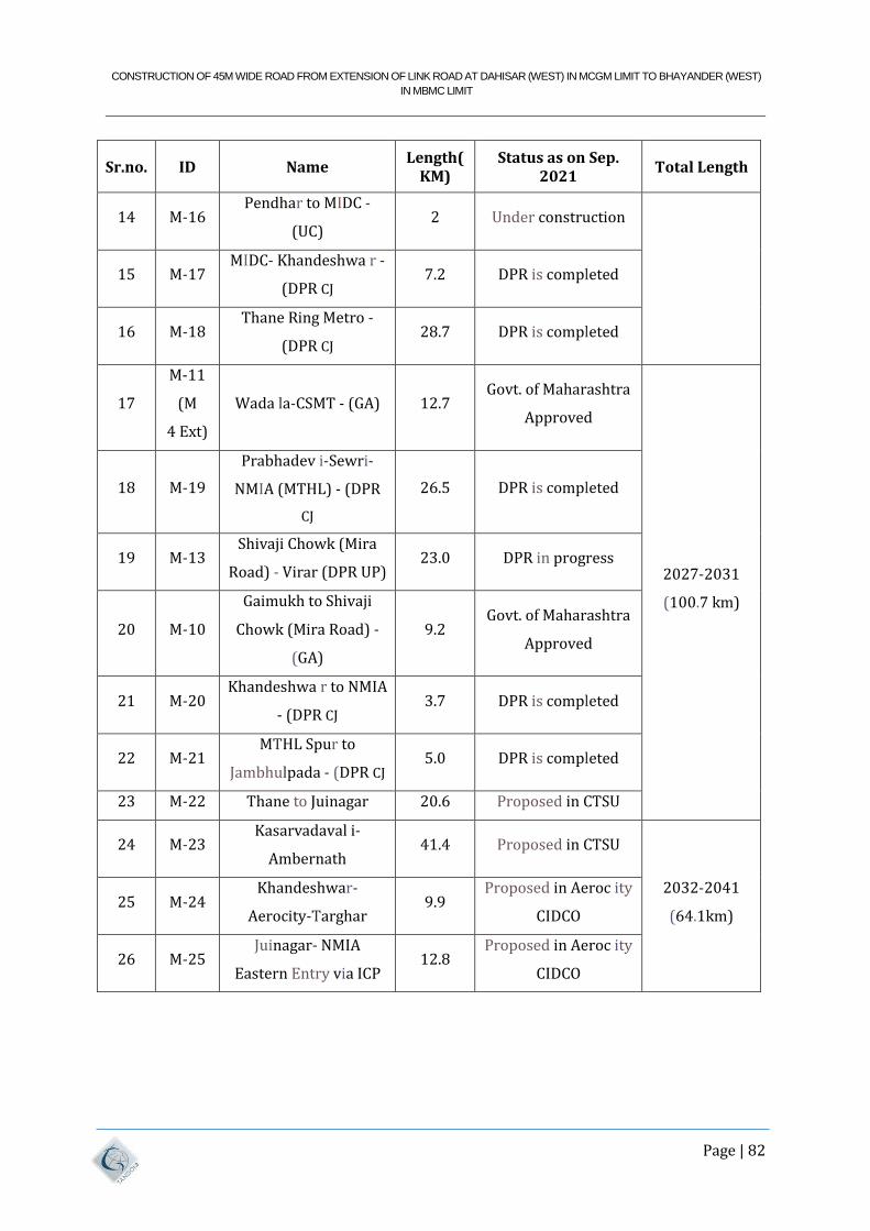
CONSTRUCTION OF 45M WIDE ROAD FROM EXTENSION OF LINK ROAD AT DAHISAR (WEST) IN MCGM LIMIT TO BHAYANDER (WEST)
IN MBMC LIMIT
Page | 82
Sr.no. ID Name Length(
KM) Status as on Sep.
2021 Total Length
14 M-16 Pendhar to MIDC -
(UC) 2 Under construction
15 M-17 MIDC- Khandeshwa r -
(DPR CJ 7.2 DPR is completed
16 M-18 Thane Ring Metro -
(DPR CJ 28.7 DPR is completed
17
M-11
(M
4 Ext)
Wada la-CSMT - (GA) 12.7 Govt. of Maharashtra
Approved
2027-2031
(100.7 km)
18 M-19
Prabhadev i-Sewri-
NMIA (MTHL) - (DPR
CJ
26.5 DPR is completed
19 M-13 Shivaji Chowk (Mira
Road) - Virar (DPR UP) 23.0 DPR in progress
20 M-10
Gaimukh to Shivaji
Chowk (Mira Road) -
(GA)
9.2 Govt. of Maharashtra
Approved
21 M-20 Khandeshwa r to NMIA
- (DPR CJ 3.7 DPR is completed
22 M-21 MTHL Spur to
Jambhulpada - (DPR CJ 5.0 DPR is completed
23 M-22 Thane to Juinagar 20.6 Proposed in CTSU
24 M-23 Kasarvadaval i-
Ambernath 41.4 Proposed in CTSU
2032-2041
(64.1km) 25 M-24
Khandeshwar-
Aerocity-Targhar 9.9
Proposed in Aeroc ity
CIDCO
26 M-25 Juinagar- NMIA
Eastern Entry via ICP 12.8
Proposed in Aeroc ity
CIDCO
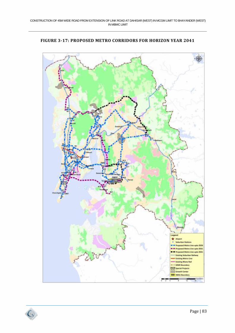
CONSTRUCTION OF 45M WIDE ROAD FROM EXTENSION OF LINK ROAD AT DAHISAR (WEST) IN MCGM LIMIT TO BHAYANDER (WEST)
IN MBMC LIMIT
Page | 83
FIGURE 3-17: PROPOSED METRO CORRIDORS FOR HORIZON YEAR 2041
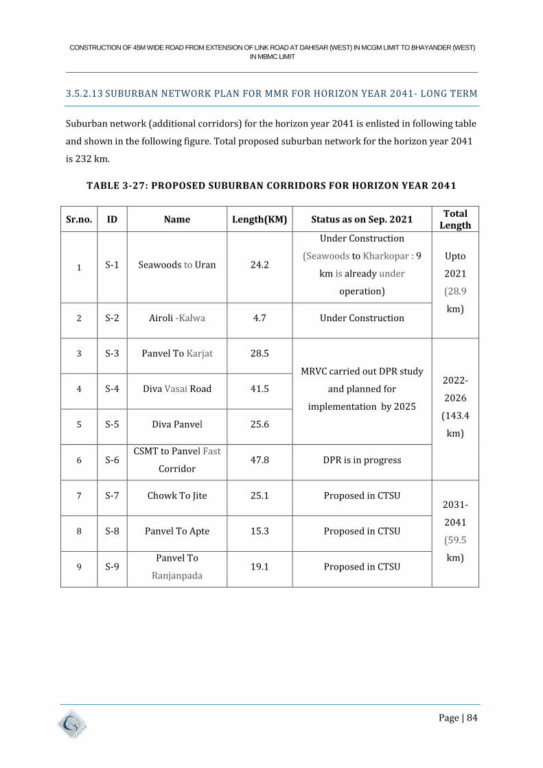
CONSTRUCTION OF 45M WIDE ROAD FROM EXTENSION OF LINK ROAD AT DAHISAR (WEST) IN MCGM LIMIT TO BHAYANDER (WEST)
IN MBMC LIMIT
Page | 84
3.5.2.13 SUBURBAN NETWORK PLAN FOR MMR FOR HORIZON YEAR 2041- LONG TERM
Suburban network (additional corridors) for the horizon year 2041 is enlisted in following table
and shown in the following figure. Total proposed suburban network for the horizon year 2041
is 232 km.
TABLE 3-27: PROPOSED SUBURBAN CORRIDORS FOR HORIZON YEAR 2041
Sr.no. ID Name Length(KM) Status as on Sep. 2021 Total
Length
1 S-1 Seawoods to Uran 24.2
Under Construction
(Seawoods to Kharkopar : 9
km is already under
operation)
Upto
2021
(28.9
km) 2 S-2 Airoli -Kalwa 4.7 Under Construction
3 S-3 Panvel To Karjat 28.5
MRVC carried out DPR study
and planned for
implementation by 2025
2022-
2026
(143.4
km)
4 S-4 Diva Vasai Road 41.5
5 S-5 Diva Panvel 25.6
6 S-6 CSMT to Panvel Fast
Corridor 47.8 DPR is in progress
7 S-7 Chowk To Jite 25.1 Proposed in CTSU 2031-
2041
(59.5
km)
8 S-8 Panvel To Apte 15.3 Proposed in CTSU
9 S-9 Panvel To
Ranjanpada 19.1 Proposed in CTSU
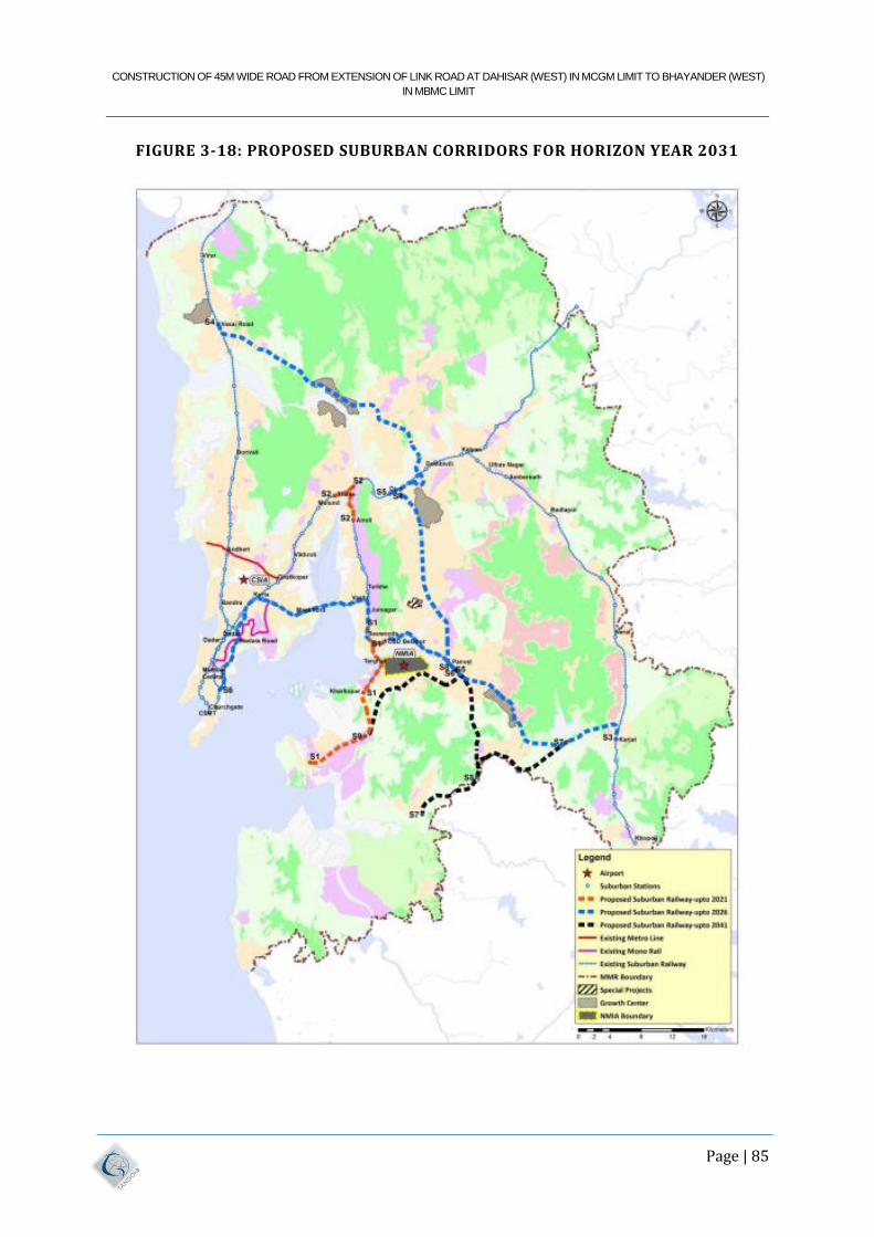
CONSTRUCTION OF 45M WIDE ROAD FROM EXTENSION OF LINK ROAD AT DAHISAR (WEST) IN MCGM LIMIT TO BHAYANDER (WEST)
IN MBMC LIMIT
Page | 85
FIGURE 3-18: PROPOSED SUBURBAN CORRIDORS FOR HORIZON YEAR 2031
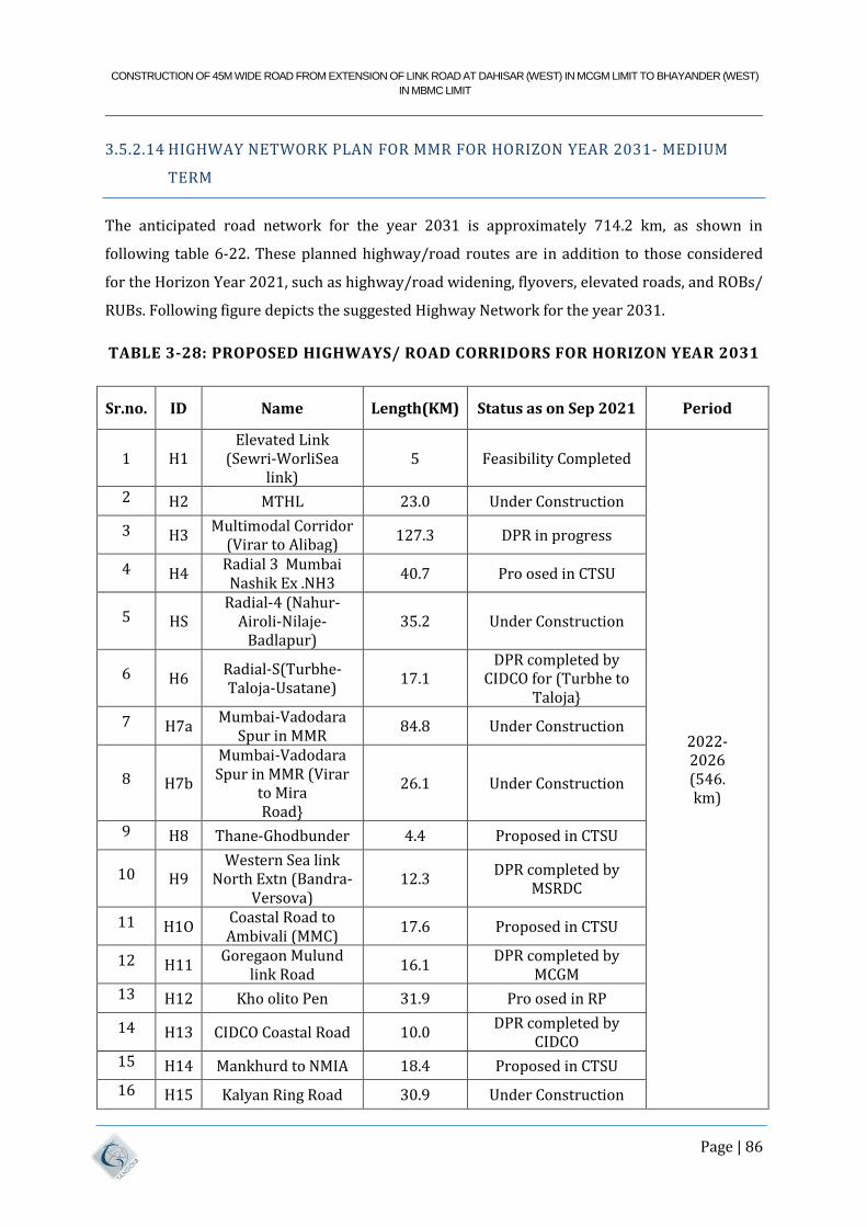
CONSTRUCTION OF 45M WIDE ROAD FROM EXTENSION OF LINK ROAD AT DAHISAR (WEST) IN MCGM LIMIT TO BHAYANDER (WEST)
IN MBMC LIMIT
Page | 86
3.5.2.14 HIGHWAY NETWORK PLAN FOR MMR FOR HORIZON YEAR 2031- MEDIUM
TERM
The anticipated road network for the year 2031 is approximately 714.2 km, as shown in
following table 6-22. These planned highway/road routes are in addition to those considered
for the Horizon Year 2021, such as highway/road widening, flyovers, elevated roads, and ROBs/
RUBs. Following figure depicts the suggested Highway Network for the year 2031.
TABLE 3-28: PROPOSED HIGHWAYS/ ROAD CORRIDORS FOR HORIZON YEAR 2031
Sr.no. ID Name Length(KM) Status as on Sep 2021 Period
1 H1 Elevated Link
(Sewri-WorliSea link)
5 Feasibility Completed
2022- 2026 (546. km)
2 H2 MTHL 23.0 Under Construction
3 H3 Multimodal Corridor
(Virar to Alibag) 127.3 DPR in progress
4 H4 Radial 3 Mumbai Nashik Ex .NH3
40.7 Pro osed in CTSU
5 HS Radial-4 (Nahur-
Airoli-Nilaje-Badlapur)
35.2 Under Construction
6 H6 Radial-S(Turbhe-Taloja-Usatane)
17.1 DPR completed by
CIDCO for (Turbhe to Taloja}
7 H7a Mumbai-Vadodara
Spur in MMR 84.8 Under Construction
8 H7b
Mumbai-Vadodara Spur in MMR (Virar
to Mira Road}
26.1 Under Construction
9 H8 Thane-Ghodbunder 4.4 Proposed in CTSU
10 H9 Western Sea link
North Extn (Bandra-Versova)
12.3 DPR completed by
MSRDC
11 H1O Coastal Road to Ambivali (MMC)
17.6 Proposed in CTSU
12 H11 Goregaon Mulund
link Road 16.1
DPR completed by MCGM
13 H12 Kho olito Pen 31.9 Pro osed in RP
14 H13 CIDCO Coastal Road 10.0 DPR completed by
CIDCO 15 H14 Mankhurd to NMIA 18.4 Proposed in CTSU
16 H15 Kalyan Ring Road 30.9 Under Construction
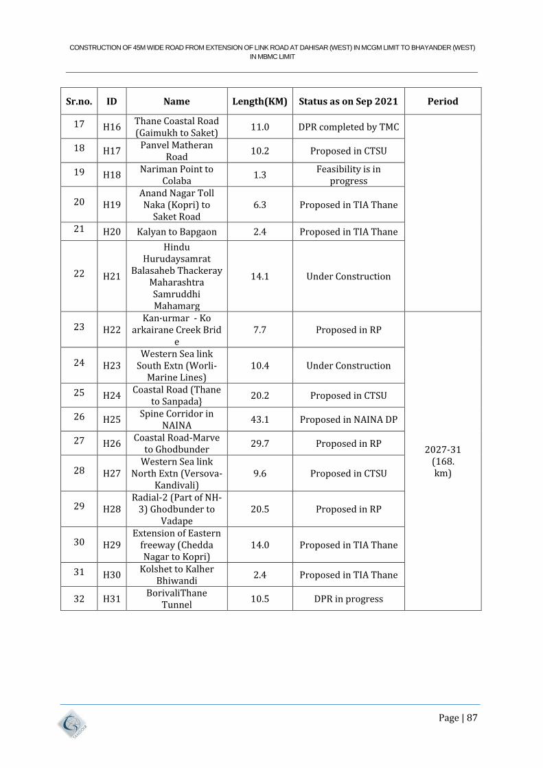
CONSTRUCTION OF 45M WIDE ROAD FROM EXTENSION OF LINK ROAD AT DAHISAR (WEST) IN MCGM LIMIT TO BHAYANDER (WEST)
IN MBMC LIMIT
Page | 87
Sr.no. ID Name Length(KM) Status as on Sep 2021 Period
17 H16 Thane Coastal Road (Gaimukh to Saket)
11.0 DPR completed by TMC
18 H17 Panvel Matheran
Road 10.2 Proposed in CTSU
19 H18 Nariman Point to
Colaba 1.3
Feasibility is in progress
20 H19 Anand Nagar Toll Naka (Kopri) to
Saket Road 6.3 Proposed in TIA Thane
21 H20 Kalyan to Bapgaon 2.4 Proposed in TIA Thane
22 H21
Hindu Hurudaysamrat
Balasaheb Thackeray Maharashtra Samruddhi Mahamarg
14.1 Under Construction
23 H22 Kan·urmar - Ko
arkairane Creek Brid e
7.7 Proposed in RP
2027-31 (168. km)
24 H23 Western Sea link
South Extn (Worli-Marine Lines)
10.4 Under Construction
25 H24 Coastal Road (Thane
to Sanpada} 20.2 Proposed in CTSU
26 H25 Spine Corridor in
NAINA 43.1 Proposed in NAINA DP
27 H26 Coastal Road-Marve
to Ghodbunder 29.7 Proposed in RP
28 H27 Western Sea link
North Extn (Versova-Kandivali)
9.6 Proposed in CTSU
29 H28 Radial-2 (Part of NH-
3) Ghodbunder to Vadape
20.5 Proposed in RP
30 H29 Extension of Eastern
freeway (Chedda Nagar to Kopri)
14.0 Proposed in TIA Thane
31 H30 Kolshet to Kalher
Bhiwandi 2.4 Proposed in TIA Thane
32 H31 BorivaliThane
Tunnel 10.5 DPR in progress
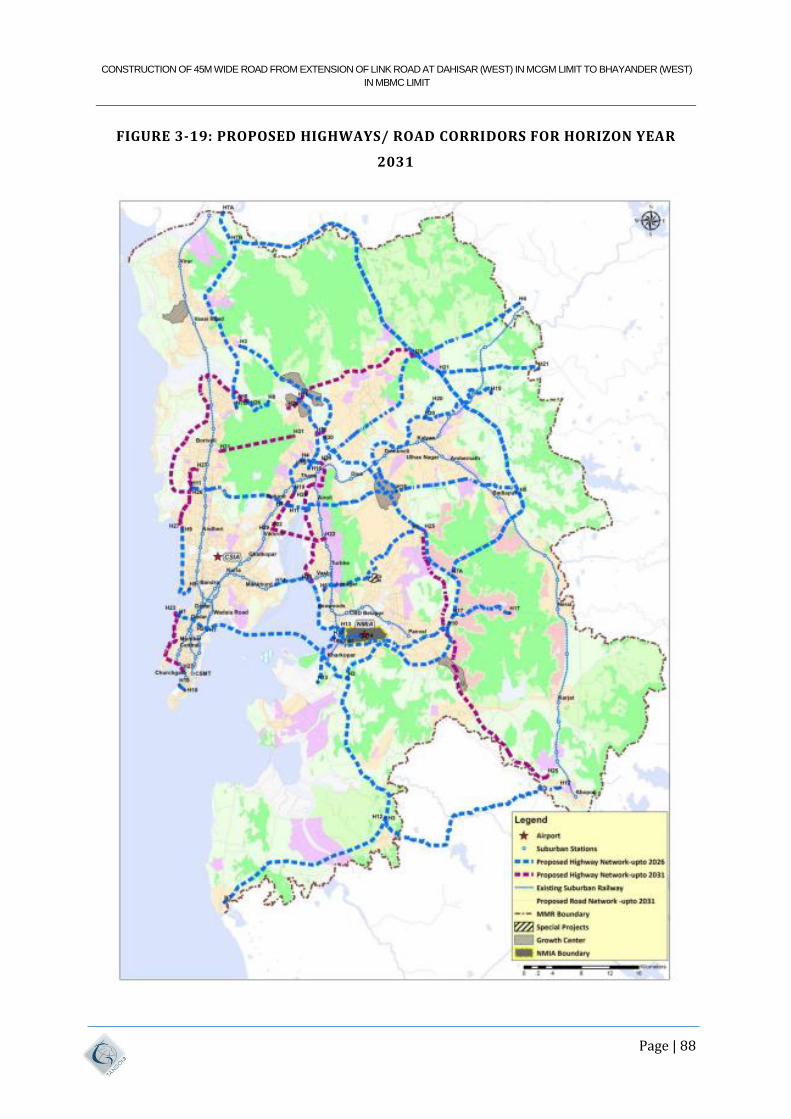
CONSTRUCTION OF 45M WIDE ROAD FROM EXTENSION OF LINK ROAD AT DAHISAR (WEST) IN MCGM LIMIT TO BHAYANDER (WEST)
IN MBMC LIMIT
Page | 88
FIGURE 3-19: PROPOSED HIGHWAYS/ ROAD CORRIDORS FOR HORIZON YEAR
2031
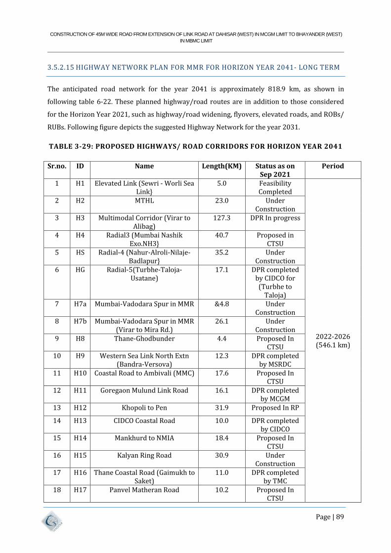
CONSTRUCTION OF 45M WIDE ROAD FROM EXTENSION OF LINK ROAD AT DAHISAR (WEST) IN MCGM LIMIT TO BHAYANDER (WEST)
IN MBMC LIMIT
Page | 89
3.5.2.15 HIGHWAY NETWORK PLAN FOR MMR FOR HORIZON YEAR 2041- LONG TERM
The anticipated road network for the year 2041 is approximately 818.9 km, as shown in
following table 6-22. These planned highway/road routes are in addition to those considered
for the Horizon Year 2021, such as highway/road widening, flyovers, elevated roads, and ROBs/
RUBs. Following figure depicts the suggested Highway Network for the year 2031.
TABLE 3-29: PROPOSED HIGHWAYS/ ROAD CORRIDORS FOR HORIZON YEAR 2041
Sr.no. ID Name Length(KM) Status as on Sep 2021
Period
1 H1 Elevated Link (Sewri - Worli Sea Link}
5.0 Feasibility Completed
2022-2026 (546.1 km)
2 H2 MTHL 23.0 Under Construction
3 H3 Multimodal Corridor (Virar to Alibag)
127.3 DPR In progress
4 H4 Radial3 (Mumbai Nashik Exo.NH3}
40.7 Proposed in CTSU
5 HS Radial-4 (Nahur-Alroli-Nilaje-Badlapur}
35.2 Under Construction
6 HG Radial-5(Turbhe-Taloja-Usatane)
17.1 DPR completed by CIDCO for (Turbhe to
Taloja) 7 H7a Mumbai-Vadodara Spur in MMR &4.8 Under
Construction 8 H7b Mumbai-Vadodara Spur in MMR
(Virar to Mira Rd.) 26.1 Under
Construction 9 H8 Thane-Ghodbunder 4.4 Proposed In
CTSU 10 H9 Western Sea Link North Extn
(Bandra-Versova) 12.3 DPR completed
by MSRDC 11 H10 Coastal Road to Ambivali (MMC) 17.6 Proposed In
CTSU 12 H11 Goregaon Mulund Link Road 16.1 DPR completed
by MCGM 13 H12 Khopoli to Pen 31.9 Proposed In RP
14 H13 CIDCO Coastal Road 10.0 DPR completed by CIDCO
15 H14 Mankhurd to NMIA 18.4 Proposed In CTSU
16 H15 Kalyan Ring Road 30.9 Under Construction
17 H16 Thane Coastal Road (Gaimukh to Saket)
11.0 DPR completed by TMC
18 H17 Panvel Matheran Road 10.2 Proposed In CTSU
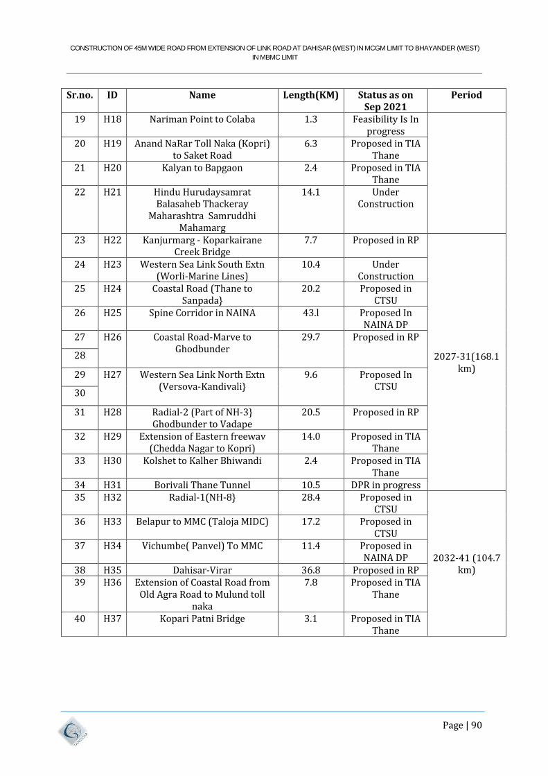
CONSTRUCTION OF 45M WIDE ROAD FROM EXTENSION OF LINK ROAD AT DAHISAR (WEST) IN MCGM LIMIT TO BHAYANDER (WEST)
IN MBMC LIMIT
Page | 90
Sr.no. ID Name Length(KM) Status as on Sep 2021
Period
19 H18 Nariman Point to Colaba 1.3 Feasibility Is In progress
20 H19 Anand NaRar Toll Naka (Kopri) to Saket Road
6.3 Proposed in TIA Thane
21 H20 Kalyan to Bapgaon 2.4 Proposed in TIA Thane
22 H21 Hindu Hurudaysamrat Balasaheb Thackeray
Maharashtra Samruddhi Mahamarg
14.1 Under Construction
23 H22 Kanjurmarg - Koparkairane Creek Bridge
7.7 Proposed in RP
2027-31(168.1 km)
24 H23 Western Sea Link South Extn (Worli-Marine Lines)
10.4 Under Construction
25 H24 Coastal Road (Thane to Sanpada}
20.2 Proposed in CTSU
26 H25 Spine Corridor in NAINA 43.l Proposed In NAINA DP
27 H26 Coastal Road-Marve to Ghodbunder
29.7 Proposed in RP
28
29 H27 Western Sea Link North Extn (Versova-Kandivali}
9.6 Proposed In CTSU
30
31 H28 Radial-2 (Part of NH-3} Ghodbunder to Vadape
20.5 Proposed in RP
32 H29 Extension of Eastern freewav (Chedda Nagar to Kopri)
14.0 Proposed in TIA Thane
33 H30 Kolshet to Kalher Bhiwandi 2.4 Proposed in TIA Thane
34 H31 Borivali Thane Tunnel 10.5 DPR in progress 35 H32 Radial-1(NH-8} 28.4 Proposed in
CTSU
2032-41 (104.7 km)
36 H33 Belapur to MMC (Taloja MIDC) 17.2 Proposed in CTSU
37 H34 Vichumbe( Panvel) To MMC 11.4 Proposed in NAINA DP
38 H35 Dahisar-Virar 36.8 Proposed in RP 39 H36 Extension of Coastal Road from
Old Agra Road to Mulund toll naka
7.8 Proposed in TIA Thane
40 H37 Kopari Patni Bridge 3.1 Proposed in TIA Thane
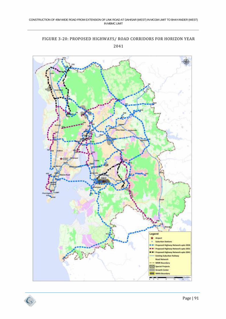
CONSTRUCTION OF 45M WIDE ROAD FROM EXTENSION OF LINK ROAD AT DAHISAR (WEST) IN MCGM LIMIT TO BHAYANDER (WEST)
IN MBMC LIMIT
Page | 91
FIGURE 3-20: PROPOSED HIGHWAYS/ ROAD CORRIDORS FOR HORIZON YEAR
2041
CONSTRUCTION OF 45M WIDE ROAD FROM EXTENSION OF LINK ROAD AT DAHISAR (WEST) IN MCGM LIMIT TO BHAYANDER (WEST)
IN MBMC LIMIT
Page | 92
4 METHODOLOGY ADOPTED FOR STUDY
4.1 GENERAL
Alignment selection methodology is based on the five aspects, viz. Engineering, Environment,
Social, Traffic and Road Usability.
4.1.1 COLLECTION AND REVIEW OF SECONDARY DATA
The secondary data required for the development of study was collected from various sources
primarily from MMRDA. The secondary data includes:
CTS & CTS UPDATION for MMR,
Details of Proposed/Ongoing Infrastructure Projects in and around the project corridor.
The data collected was reviewed to understand the project and the project influenced
areas.
4.1.2 RECONNAISSANCE SURVEY
The detailed ground reconnaissance was undertaken by TUSPL’s team and BMC’s officers.
Identified alignment was visited to carry out ground reconnaissance survey. The data collected
from the reconnaissance survey has been done for planning and programming the detailed
surveys and investigations. All field studies were undertaken on the basis of information
derived from the reconnaissance surveys.
4.1.3 FIELD INVESTIGATIONS
The field investigations were conducted on the approved alignment. Following surveys have
been conducted in the area:
• Stage 1:
i. Topography Survey,
ii. Bathymetry Survey,
iii. Geo-technical investigation,
CONSTRUCTION OF 45M WIDE ROAD FROM EXTENSION OF LINK ROAD AT DAHISAR (WEST) IN MCGM LIMIT TO BHAYANDER (WEST)
IN MBMC LIMIT
Page | 93
Various permits necessary for carrying out Engineering surveys and investigations were
obtained. The process of obtaining such permissions was taken up immediately after
project inception.
4.1.4 DESIGN STANDARDS AND METHODOLOGY
Primary objective of highway engineering is to design the project road as per the
recommendations provided in the Indian Road Congress (IRC) guidelines and International best
practices. Proposed design standards for the project road were presented at inception stage of
the project and approved from BMC.
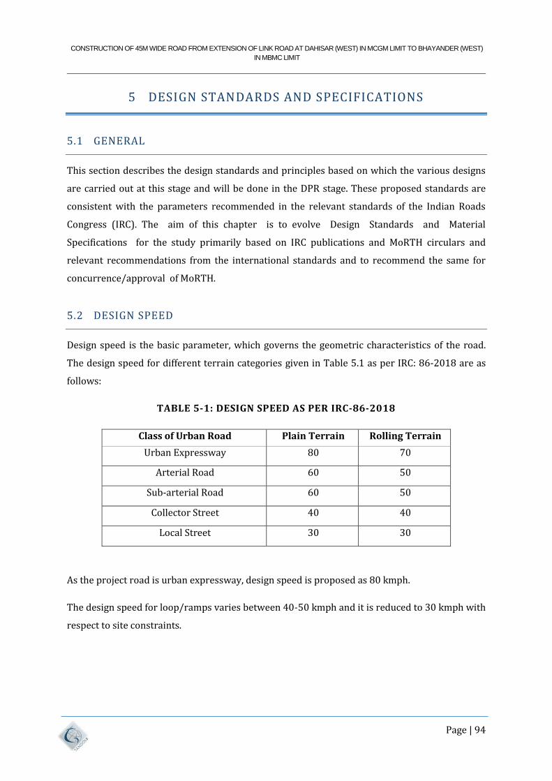
CONSTRUCTION OF 45M WIDE ROAD FROM EXTENSION OF LINK ROAD AT DAHISAR (WEST) IN MCGM LIMIT TO BHAYANDER (WEST)
IN MBMC LIMIT
Page | 94
5 DESIGN STANDARDS AND SPECIFICATIONS
5.1 GENERAL
This section describes the design standards and principles based on which the various designs
are carried out at this stage and will be done in the DPR stage. These proposed standards are
consistent with the parameters recommended in the relevant standards of the Indian Roads
Congress (IRC). The aim of this chapter is to evolve Design Standards and Material
Specifications for the study primarily based on IRC publications and MoRTH circulars and
relevant recommendations from the international standards and to recommend the same for
concurrence/approval of MoRTH.
5.2 DESIGN SPEED
Design speed is the basic parameter, which governs the geometric characteristics of the road.
The design speed for different terrain categories given in Table 5.1 as per IRC: 86-2018 are as
follows:
TABLE 5-1: DESIGN SPEED AS PER IRC-86-2018
Class of Urban Road Plain Terrain Rolling Terrain
Urban Expressway 80 70
Arterial Road 60 50
Sub-arterial Road 60 50
Collector Street 40 40
Local Street 30 30
As the project road is urban expressway, design speed is proposed as 80 kmph.
The design speed for loop/ramps varies between 40-50 kmph and it is reduced to 30 kmph with
respect to site constraints.
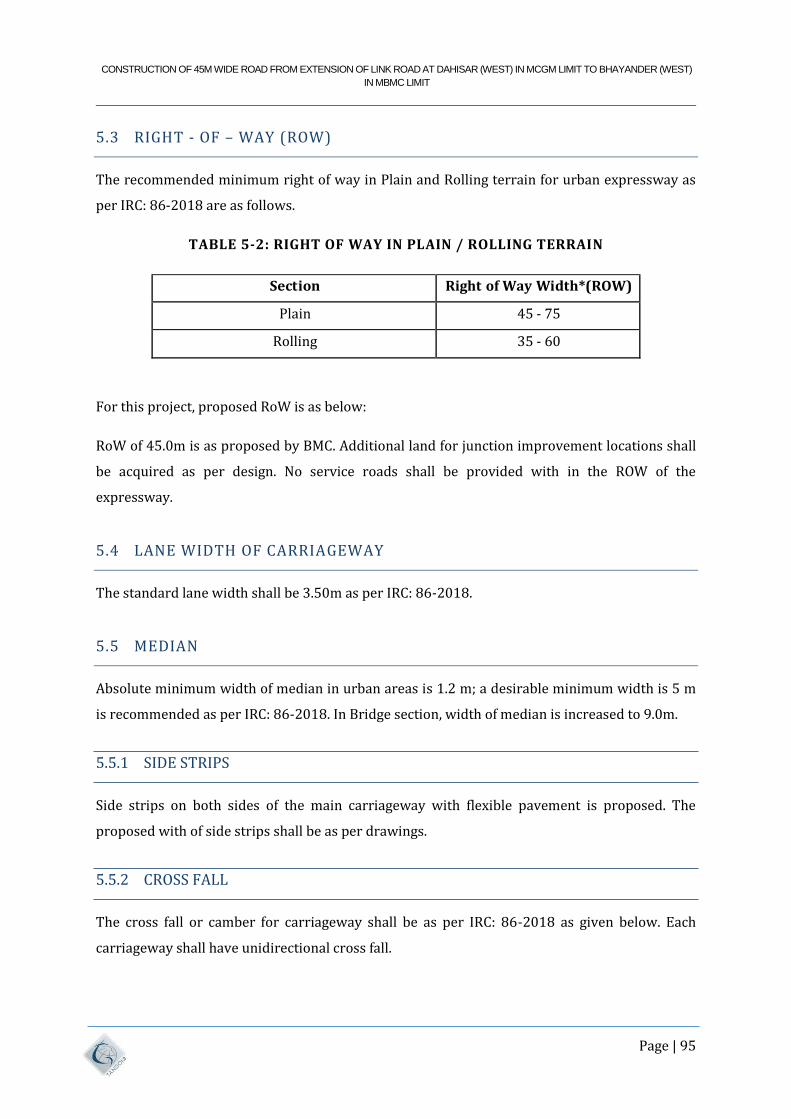
CONSTRUCTION OF 45M WIDE ROAD FROM EXTENSION OF LINK ROAD AT DAHISAR (WEST) IN MCGM LIMIT TO BHAYANDER (WEST)
IN MBMC LIMIT
Page | 95
5.3 RIGHT - OF – WAY (ROW)
The recommended minimum right of way in Plain and Rolling terrain for urban expressway as
per IRC: 86-2018 are as follows.
TABLE 5-2: RIGHT OF WAY IN PLAIN / ROLLING TERRAIN
Section Right of Way Width*(ROW)
Plain 45 - 75
Rolling 35 - 60
For this project, proposed RoW is as below:
RoW of 45.0m is as proposed by BMC. Additional land for junction improvement locations shall
be acquired as per design. No service roads shall be provided with in the ROW of the
expressway.
5.4 LANE WIDTH OF CARRIAGEWAY
The standard lane width shall be 3.50m as per IRC: 86-2018.
5.5 MEDIAN
Absolute minimum width of median in urban areas is 1.2 m; a desirable minimum width is 5 m
is recommended as per IRC: 86-2018. In Bridge section, width of median is increased to 9.0m.
5.5.1 SIDE STRIPS
Side strips on both sides of the main carriageway with flexible pavement is proposed. The
proposed with of side strips shall be as per drawings.
5.5.2 CROSS FALL
The cross fall or camber for carriageway shall be as per IRC: 86-2018 as given below. Each
carriageway shall have unidirectional cross fall.
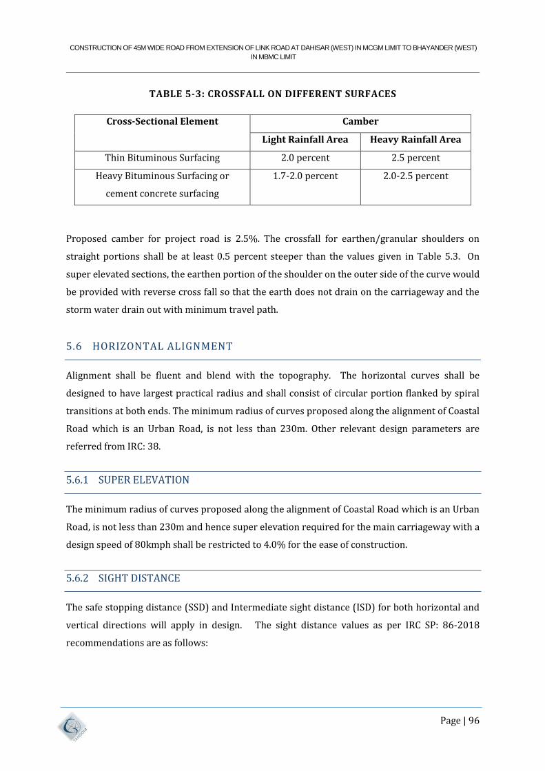
CONSTRUCTION OF 45M WIDE ROAD FROM EXTENSION OF LINK ROAD AT DAHISAR (WEST) IN MCGM LIMIT TO BHAYANDER (WEST)
IN MBMC LIMIT
Page | 96
TABLE 5-3: CROSSFALL ON DIFFERENT SURFACES
Cross-Sectional Element Camber
Light Rainfall Area Heavy Rainfall Area
Thin Bituminous Surfacing 2.0 percent 2.5 percent
Heavy Bituminous Surfacing or
cement concrete surfacing
1.7-2.0 percent 2.0-2.5 percent
Proposed camber for project road is 2.5%. The crossfall for earthen/granular shoulders on
straight portions shall be at least 0.5 percent steeper than the values given in Table 5.3. On
super elevated sections, the earthen portion of the shoulder on the outer side of the curve would
be provided with reverse cross fall so that the earth does not drain on the carriageway and the
storm water drain out with minimum travel path.
5.6 HORIZONTAL ALIGNMENT
Alignment shall be fluent and blend with the topography. The horizontal curves shall be
designed to have largest practical radius and shall consist of circular portion flanked by spiral
transitions at both ends. The minimum radius of curves proposed along the alignment of Coastal
Road which is an Urban Road, is not less than 230m. Other relevant design parameters are
referred from IRC: 38.
5.6.1 SUPER ELEVATION
The minimum radius of curves proposed along the alignment of Coastal Road which is an Urban
Road, is not less than 230m and hence super elevation required for the main carriageway with a
design speed of 80kmph shall be restricted to 4.0% for the ease of construction.
5.6.2 SIGHT DISTANCE
The safe stopping distance (SSD) and Intermediate sight distance (ISD) for both horizontal and
vertical directions will apply in design. The sight distance values as per IRC SP: 86-2018
recommendations are as follows:
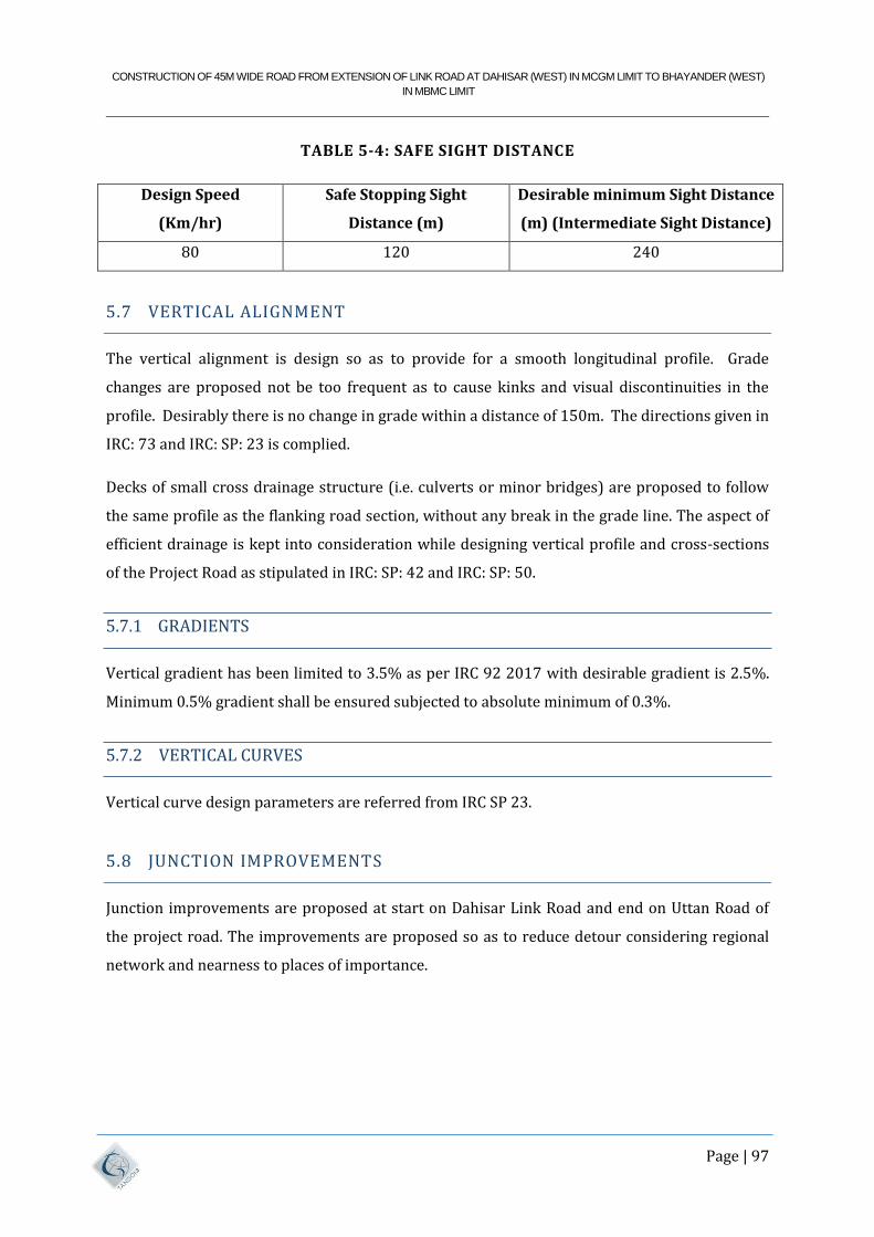
CONSTRUCTION OF 45M WIDE ROAD FROM EXTENSION OF LINK ROAD AT DAHISAR (WEST) IN MCGM LIMIT TO BHAYANDER (WEST)
IN MBMC LIMIT
Page | 97
TABLE 5-4: SAFE SIGHT DISTANCE
Design Speed
(Km/hr)
Safe Stopping Sight
Distance (m)
Desirable minimum Sight Distance
(m) (Intermediate Sight Distance)
80 120 240
5.7 VERTICAL ALIGNMENT
The vertical alignment is design so as to provide for a smooth longitudinal profile. Grade
changes are proposed not be too frequent as to cause kinks and visual discontinuities in the
profile. Desirably there is no change in grade within a distance of 150m. The directions given in
IRC: 73 and IRC: SP: 23 is complied.
Decks of small cross drainage structure (i.e. culverts or minor bridges) are proposed to follow
the same profile as the flanking road section, without any break in the grade line. The aspect of
efficient drainage is kept into consideration while designing vertical profile and cross-sections
of the Project Road as stipulated in IRC: SP: 42 and IRC: SP: 50.
5.7.1 GRADIENTS
Vertical gradient has been limited to 3.5% as per IRC 92 2017 with desirable gradient is 2.5%.
Minimum 0.5% gradient shall be ensured subjected to absolute minimum of 0.3%.
5.7.2 VERTICAL CURVES
Vertical curve design parameters are referred from IRC SP 23.
5.8 JUNCTION IMPROVEMENTS
Junction improvements are proposed at start on Dahisar Link Road and end on Uttan Road of
the project road. The improvements are proposed so as to reduce detour considering regional
network and nearness to places of importance.
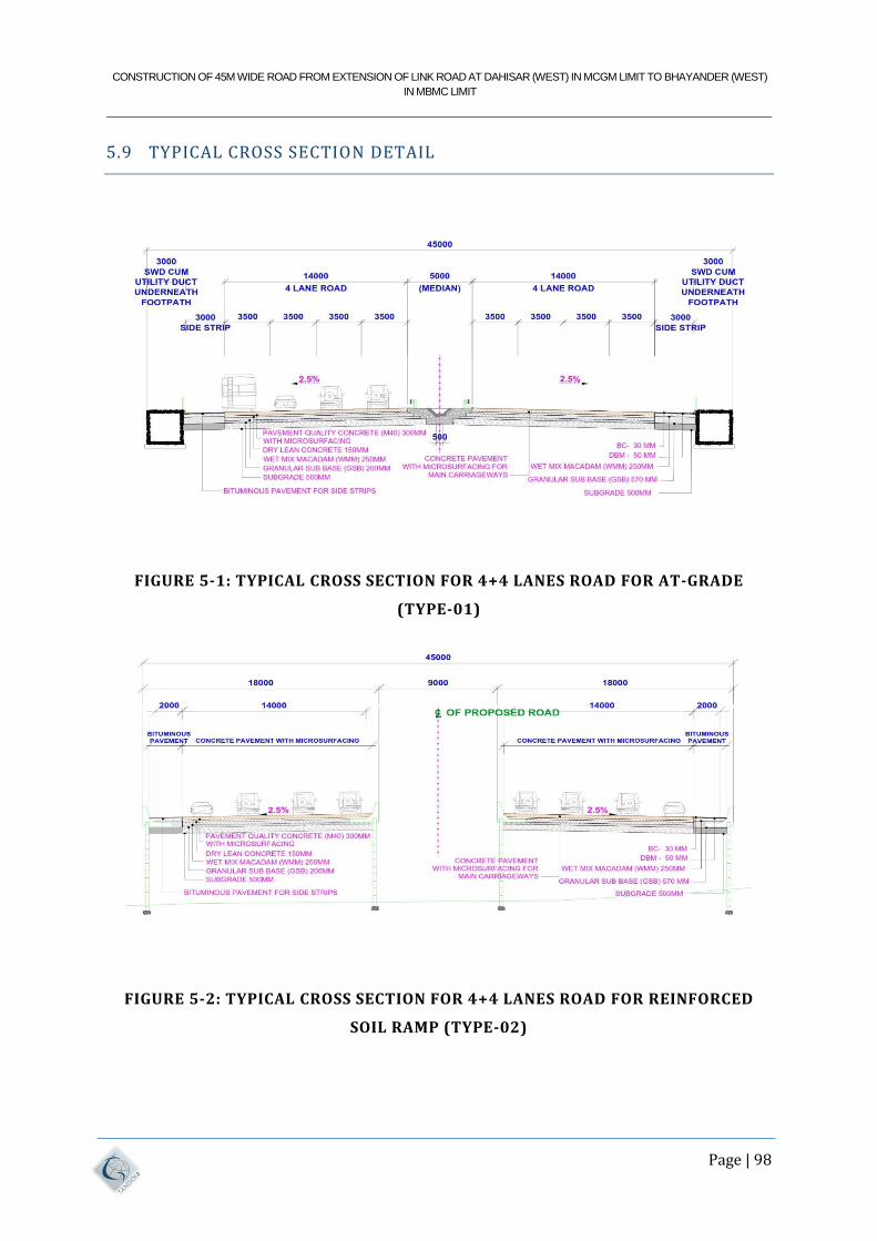
CONSTRUCTION OF 45M WIDE ROAD FROM EXTENSION OF LINK ROAD AT DAHISAR (WEST) IN MCGM LIMIT TO BHAYANDER (WEST)
IN MBMC LIMIT
Page | 98
5.9 TYPICAL CROSS SECTION DETAIL
FIGURE 5-1: TYPICAL CROSS SECTION FOR 4+4 LANES ROAD FOR AT-GRADE
(TYPE-01)
FIGURE 5-2: TYPICAL CROSS SECTION FOR 4+4 LANES ROAD FOR REINFORCED
SOIL RAMP (TYPE-02)
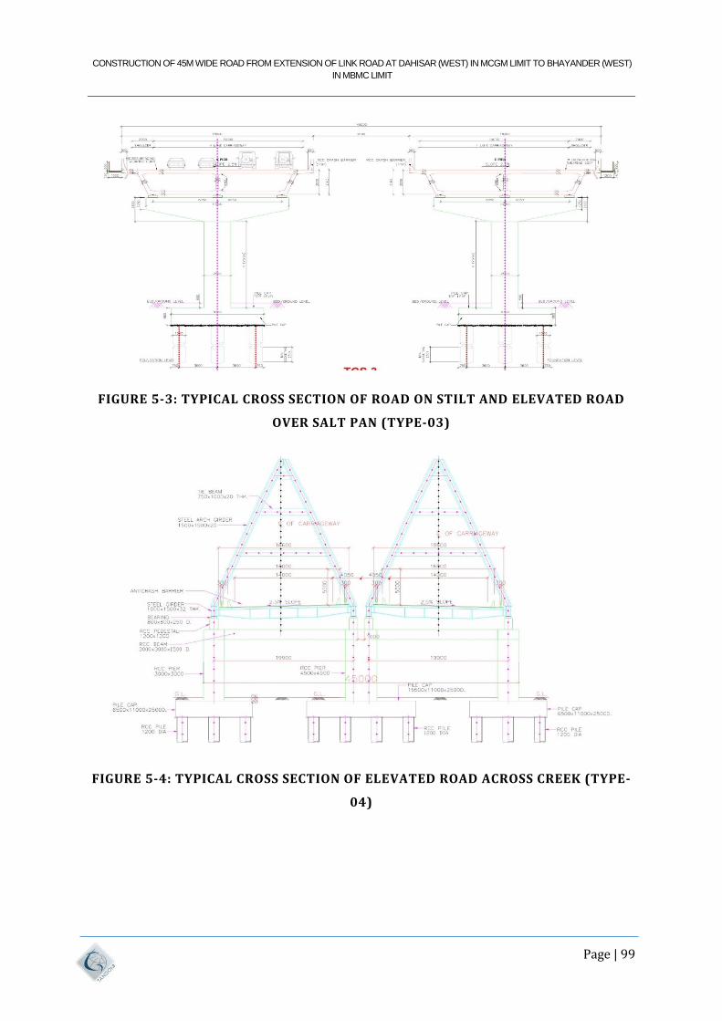
CONSTRUCTION OF 45M WIDE ROAD FROM EXTENSION OF LINK ROAD AT DAHISAR (WEST) IN MCGM LIMIT TO BHAYANDER (WEST)
IN MBMC LIMIT
Page | 99
FIGURE 5-3: TYPICAL CROSS SECTION OF ROAD ON STILT AND ELEVATED ROAD
OVER SALT PAN (TYPE-03)
FIGURE 5-4: TYPICAL CROSS SECTION OF ELEVATED ROAD ACROSS CREEK (TYPE-
04)
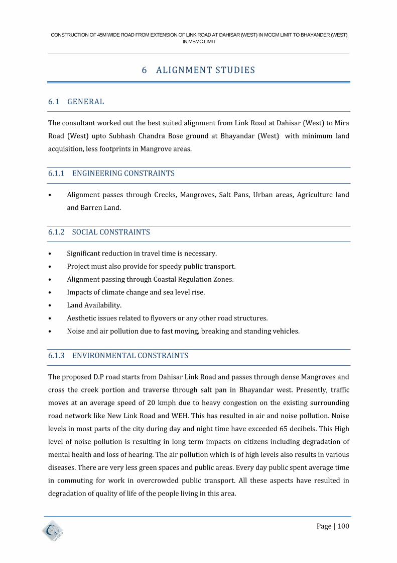
CONSTRUCTION OF 45M WIDE ROAD FROM EXTENSION OF LINK ROAD AT DAHISAR (WEST) IN MCGM LIMIT TO BHAYANDER (WEST)
IN MBMC LIMIT
Page | 100
6 ALIGNMENT STUDIES
6.1 GENERAL
The consultant worked out the best suited alignment from Link Road at Dahisar (West) to Mira
Road (West) upto Subhash Chandra Bose ground at Bhayandar (West) with minimum land
acquisition, less footprints in Mangrove areas.
6.1.1 ENGINEERING CONSTRAINTS
• Alignment passes through Creeks, Mangroves, Salt Pans, Urban areas, Agriculture land
and Barren Land.
6.1.2 SOCIAL CONSTRAINTS
• Significant reduction in travel time is necessary.
• Project must also provide for speedy public transport.
• Alignment passing through Coastal Regulation Zones.
• Impacts of climate change and sea level rise.
• Land Availability.
• Aesthetic issues related to flyovers or any other road structures.
• Noise and air pollution due to fast moving, breaking and standing vehicles.
6.1.3 ENVIRONMENTAL CONSTRAINTS
The proposed D.P road starts from Dahisar Link Road and passes through dense Mangroves and
cross the creek portion and traverse through salt pan in Bhayandar west. Presently, traffic
moves at an average speed of 20 kmph due to heavy congestion on the existing surrounding
road network like New Link Road and WEH. This has resulted in air and noise pollution. Noise
levels in most parts of the city during day and night time have exceeded 65 decibels. This High
level of noise pollution is resulting in long term impacts on citizens including degradation of
mental health and loss of hearing. The air pollution which is of high levels also results in various
diseases. There are very less green spaces and public areas. Every day public spent average time
in commuting for work in overcrowded public transport. All these aspects have resulted in
degradation of quality of life of the people living in this area.
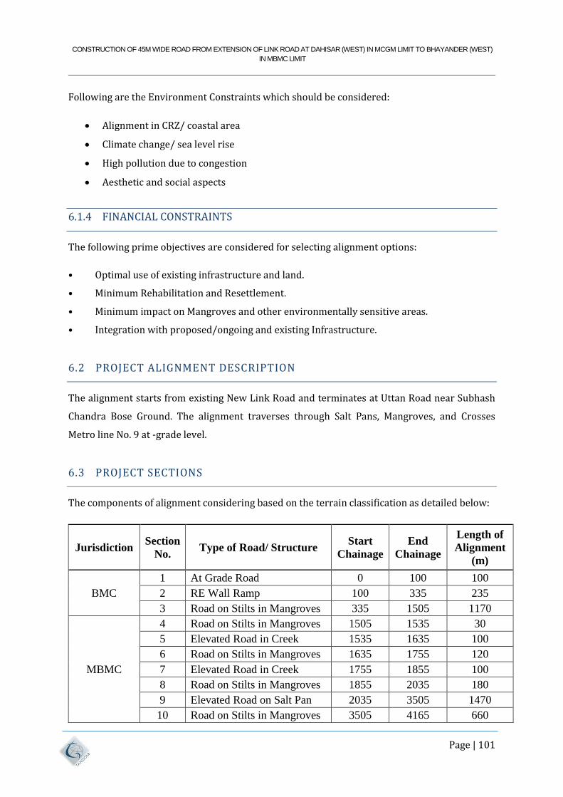
CONSTRUCTION OF 45M WIDE ROAD FROM EXTENSION OF LINK ROAD AT DAHISAR (WEST) IN MCGM LIMIT TO BHAYANDER (WEST)
IN MBMC LIMIT
Page | 101
Following are the Environment Constraints which should be considered:
Alignment in CRZ/ coastal area
Climate change/ sea level rise
High pollution due to congestion
Aesthetic and social aspects
6.1.4 FINANCIAL CONSTRAINTS
The following prime objectives are considered for selecting alignment options:
• Optimal use of existing infrastructure and land.
• Minimum Rehabilitation and Resettlement.
• Minimum impact on Mangroves and other environmentally sensitive areas.
• Integration with proposed/ongoing and existing Infrastructure.
6.2 PROJECT ALIGNMENT DESCRIPTION
The alignment starts from existing New Link Road and terminates at Uttan Road near Subhash
Chandra Bose Ground. The alignment traverses through Salt Pans, Mangroves, and Crosses
Metro line No. 9 at -grade level.
6.3 PROJECT SECTIONS
The components of alignment considering based on the terrain classification as detailed below:
Jurisdiction Section
No. Type of Road/ Structure
Start
Chainage
End
Chainage
Length of
Alignment
(m)
BMC
1 At Grade Road 0 100 100
2 RE Wall Ramp 100 335 235
3 Road on Stilts in Mangroves 335 1505 1170
MBMC
4 Road on Stilts in Mangroves 1505 1535 30
5 Elevated Road in Creek 1535 1635 100
6 Road on Stilts in Mangroves 1635 1755 120
7 Elevated Road in Creek 1755 1855 100
8 Road on Stilts in Mangroves 1855 2035 180
9 Elevated Road on Salt Pan 2035 3505 1470
10 Road on Stilts in Mangroves 3505 4165 660
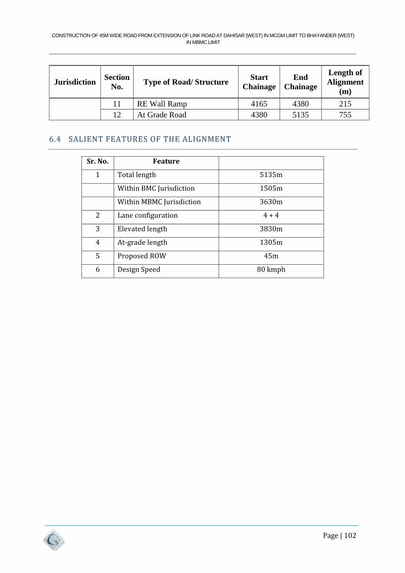
CONSTRUCTION OF 45M WIDE ROAD FROM EXTENSION OF LINK ROAD AT DAHISAR (WEST) IN MCGM LIMIT TO BHAYANDER (WEST)
IN MBMC LIMIT
Page | 102
Jurisdiction Section
No. Type of Road/ Structure
Start
Chainage
End
Chainage
Length of
Alignment
(m)
11 RE Wall Ramp 4165 4380 215
12 At Grade Road 4380 5135 755
6.4 SALIENT FEATURES OF THE ALIGNMENT
Sr. No. Feature
1 Total length 5135m
Within BMC Jurisdiction 1505m
Within MBMC Jurisdiction 3630m
2 Lane configuration 4 + 4
3 Elevated length 3830m
4 At-grade length 1305m
5 Proposed ROW 45m
6 Design Speed 80 kmph
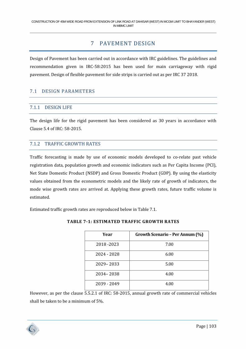
CONSTRUCTION OF 45M WIDE ROAD FROM EXTENSION OF LINK ROAD AT DAHISAR (WEST) IN MCGM LIMIT TO BHAYANDER (WEST)
IN MBMC LIMIT
Page | 103
7 PAVEMENT DESIGN
Design of Pavement has been carried out in accordance with IRC guidelines. The guidelines and
recommendation given in IRC-58:2015 has been used for main carriageway with rigid
pavement. Design of flexible pavement for side strips is carried out as per IRC 37 2018.
7.1 DESIGN PARAMETERS
7.1.1 DESIGN LIFE
The design life for the rigid pavement has been considered as 30 years in accordance with
Clause 5.4 of IRC: 58-2015.
7.1.2 TRAFFIC GROWTH RATES
Traffic forecasting is made by use of economic models developed to co-relate past vehicle
registration data, population growth and economic indicators such as Per Capita Income (PCI),
Net State Domestic Product (NSDP) and Gross Domestic Product (GDP). By using the elasticity
values obtained from the econometric models and the likely rate of growth of indicators, the
mode wise growth rates are arrived at. Applying these growth rates, future traffic volume is
estimated.
Estimated traffic growth rates are reproduced below in Table 7.1.
TABLE 7-1: ESTIMATED TRAFFIC GROWTH RATES
Year Growth Scenario – Per Annum (%)
2018 -2023 7.00
2024 - 2028 6.00
2029– 2033 5.00
2034– 2038 4.00
2039 - 2049 4.00
However, as per the clause 5.5.2.1 of IRC: 58-2015, annual growth rate of commercial vehicles
shall be taken to be a minimum of 5%.
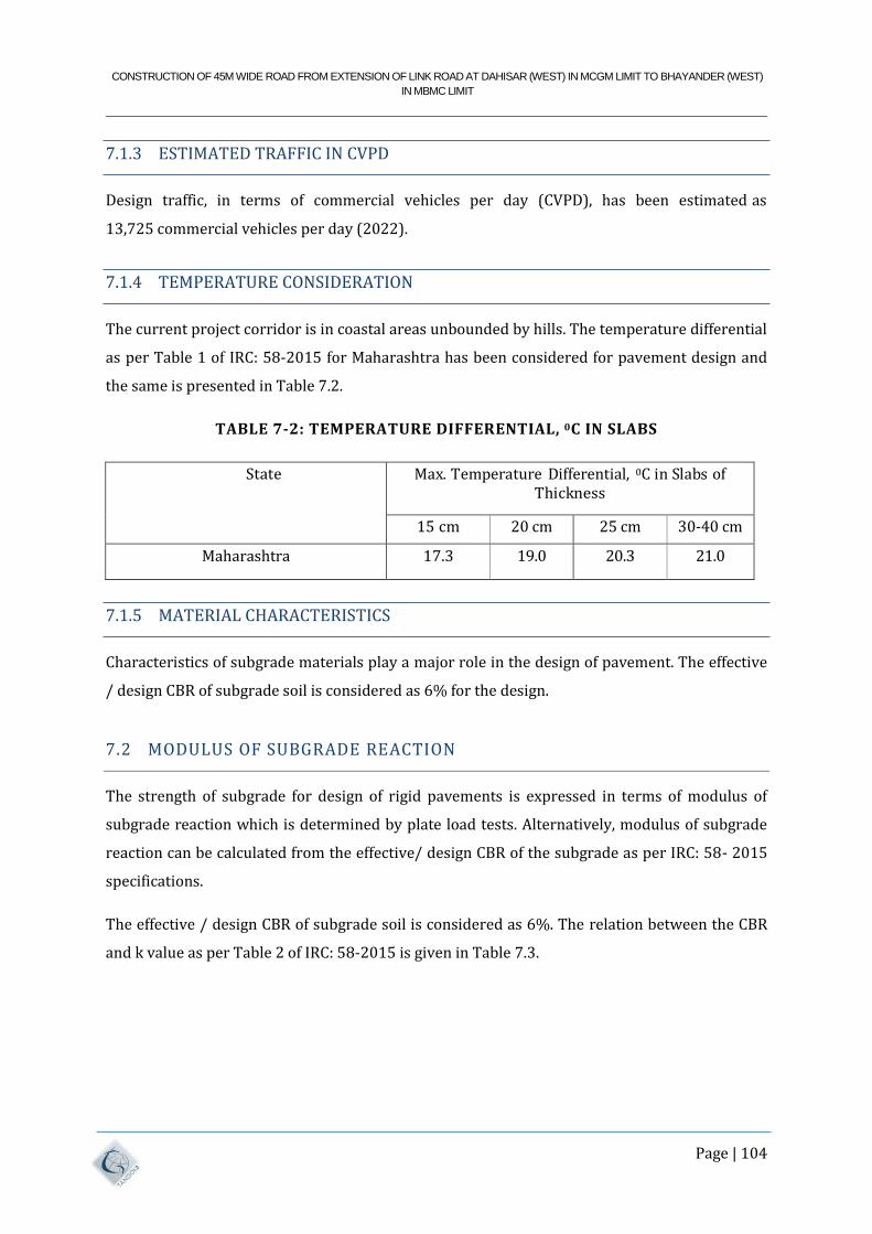
CONSTRUCTION OF 45M WIDE ROAD FROM EXTENSION OF LINK ROAD AT DAHISAR (WEST) IN MCGM LIMIT TO BHAYANDER (WEST)
IN MBMC LIMIT
Page | 104
7.1.3 ESTIMATED TRAFFIC IN CVPD
Design traffic, in terms of commercial vehicles per day (CVPD), has been estimated as
13,725 commercial vehicles per day (2022).
7.1.4 TEMPERATURE CONSIDERATION
The current project corridor is in coastal areas unbounded by hills. The temperature differential
as per Table 1 of IRC: 58-2015 for Maharashtra has been considered for pavement design and
the same is presented in Table 7.2.
TABLE 7-2: TEMPERATURE DIFFERENTIAL, 0C IN SLABS
State Max. Temperature Differential, 0C in Slabs of Thickness
15 cm 20 cm 25 cm 30-40 cm
Maharashtra 17.3 19.0 20.3 21.0
7.1.5 MATERIAL CHARACTERISTICS
Characteristics of subgrade materials play a major role in the design of pavement. The effective
/ design CBR of subgrade soil is considered as 6% for the design.
7.2 MODULUS OF SUBGRADE REACTION
The strength of subgrade for design of rigid pavements is expressed in terms of modulus of
subgrade reaction which is determined by plate load tests. Alternatively, modulus of subgrade
reaction can be calculated from the effective/ design CBR of the subgrade as per IRC: 58- 2015
specifications.
The effective / design CBR of subgrade soil is considered as 6%. The relation between the CBR
and k value as per Table 2 of IRC: 58-2015 is given in Table 7.3.
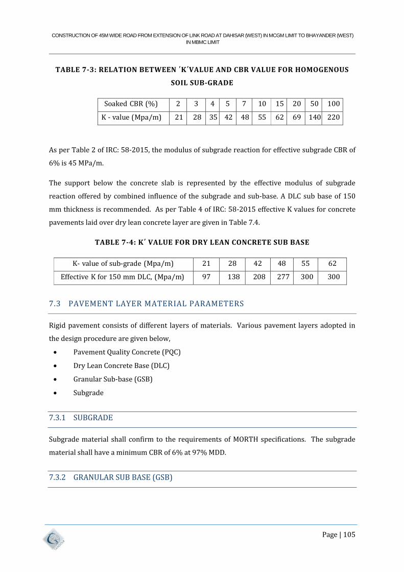
CONSTRUCTION OF 45M WIDE ROAD FROM EXTENSION OF LINK ROAD AT DAHISAR (WEST) IN MCGM LIMIT TO BHAYANDER (WEST)
IN MBMC LIMIT
Page | 105
TABLE 7-3: RELATION BETWEEN ΄K΄VALUE AND CBR VALUE FOR HOMOGENOUS
SOIL SUB-GRADE
Soaked CBR (%) 2 3 4 5 7 10 15 20 50 100
K - value (Mpa/m) 21 28 35 42 48 55 62 69 140 220
As per Table 2 of IRC: 58-2015, the modulus of subgrade reaction for effective subgrade CBR of
6% is 45 MPa/m.
The support below the concrete slab is represented by the effective modulus of subgrade
reaction offered by combined influence of the subgrade and sub-base. A DLC sub base of 150
mm thickness is recommended. As per Table 4 of IRC: 58-2015 effective K values for concrete
pavements laid over dry lean concrete layer are given in Table 7.4.
TABLE 7-4: K΄ VALUE FOR DRY LEAN CONCRETE SUB BASE
K- value of sub-grade (Mpa/m) 21 28 42 48 55 62
Effective K for 150 mm DLC, (Mpa/m) 97 138 208 277 300 300
7.3 PAVEMENT LAYER MATERIAL PARAMETERS
Rigid pavement consists of different layers of materials. Various pavement layers adopted in
the design procedure are given below,
Pavement Quality Concrete (PQC)
Dry Lean Concrete Base (DLC)
Granular Sub-base (GSB)
Subgrade
7.3.1 SUBGRADE
Subgrade material shall confirm to the requirements of MORTH specifications. The subgrade
material shall have a minimum CBR of 6% at 97% MDD.
7.3.2 GRANULAR SUB BASE (GSB)
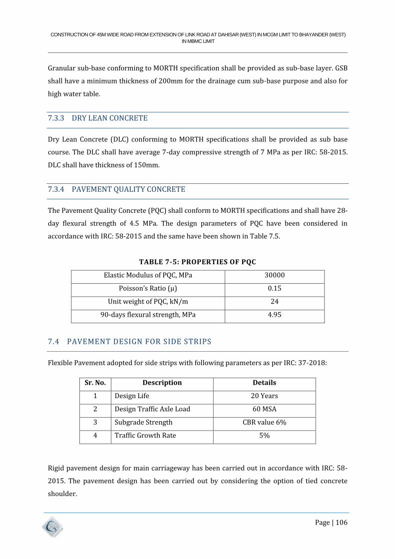
CONSTRUCTION OF 45M WIDE ROAD FROM EXTENSION OF LINK ROAD AT DAHISAR (WEST) IN MCGM LIMIT TO BHAYANDER (WEST)
IN MBMC LIMIT
Page | 106
Granular sub-base conforming to MORTH specification shall be provided as sub-base layer. GSB
shall have a minimum thickness of 200mm for the drainage cum sub-base purpose and also for
high water table.
7.3.3 DRY LEAN CONCRETE
Dry Lean Concrete (DLC) conforming to MORTH specifications shall be provided as sub base
course. The DLC shall have average 7-day compressive strength of 7 MPa as per IRC: 58-2015.
DLC shall have thickness of 150mm.
7.3.4 PAVEMENT QUALITY CONCRETE
The Pavement Quality Concrete (PQC) shall conform to MORTH specifications and shall have 28-
day flexural strength of 4.5 MPa. The design parameters of PQC have been considered in
accordance with IRC: 58-2015 and the same have been shown in Table 7.5.
TABLE 7-5: PROPERTIES OF PQC
Elastic Modulus of PQC, MPa 30000
Poisson’s Ratio (µ) 0.15
Unit weight of PQC, kN/m 24
90-days flexural strength, MPa 4.95
7.4 PAVEMENT DESIGN FOR SIDE STRIPS
Flexible Pavement adopted for side strips with following parameters as per IRC: 37-2018:
Sr. No. Description Details
1 Design Life 20 Years
2 Design Traffic Axle Load 60 MSA
3 Subgrade Strength CBR value 6%
4 Traffic Growth Rate 5%
Rigid pavement design for main carriageway has been carried out in accordance with IRC: 58-
2015. The pavement design has been carried out by considering the option of tied concrete
shoulder.
CONSTRUCTION OF 45M WIDE ROAD FROM EXTENSION OF LINK ROAD AT DAHISAR (WEST) IN MCGM LIMIT TO BHAYANDER (WEST)
IN MBMC LIMIT
Page | 107
8 DESIGN BASIC FOR BRIDGE WORKS
8.1 GENERAL REQUIREMENTS
It shall ensure soundness of the structure and durability.
It shall ensure speedy construction and lead to appreciable economy.
It shall be accompanied by preliminary but fairly detailed drawings and detailed
description of work and specifications of materials and items. The detailed design
assumptions and method statement shall also be given.
Due importance shall be given to aesthetics of piers and superstructure, the shape of
structure should give pleasing appearance and architectural beauty as a whole in
harmony with the surroundings. The bridge shall have uniform aesthetical appearance
to enhance the overall look and thereby the vicinity.
8.2 RESTRICTIONS ON TYPES OF STRUCTURES
The following types of structural arrangements shall not be permitted:
• Superstructure resting on approach embankments.
• Superstructures with joints at the tip of the long cantilevers with hinges, gap slab and
short suspended spans.
• Unprotected hollow piers for spans, which are susceptible for impact of vessels.
• Dead man anchors or friction slabs shall not be accepted behind abutment for relieving
earth pressure movement and moment.
8.3 SPECIFICATIONS FOR DESIGN AND CODES TO BE FOLLOWED
The design of structural components shall conform to the criteria laid down in the latest
editions of the applicable IRC codes / Special Publications of Practice and Standard
Specifications.
The Codes, Standards and Specifications applicable for the design of the Project Bridge and
Project Facilities shall be as under:
The design of structural components shall conform to the criteria laid down in the latest
editions of the following codes of Practice and Standard specifications published.
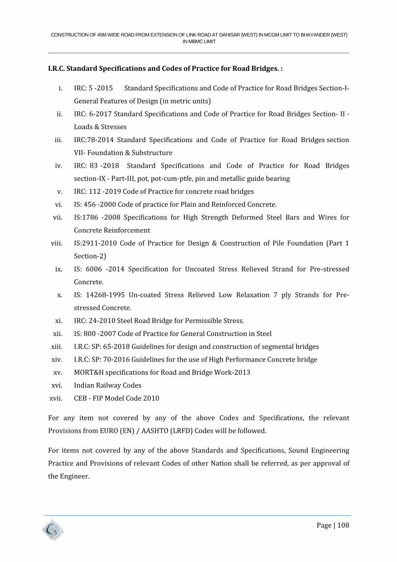
CONSTRUCTION OF 45M WIDE ROAD FROM EXTENSION OF LINK ROAD AT DAHISAR (WEST) IN MCGM LIMIT TO BHAYANDER (WEST)
IN MBMC LIMIT
Page | 108
I.R.C. Standard Specifications and Codes of Practice for Road Bridges. :
i. IRC: 5 -2015 Standard Specifications and Code of Practice for Road Bridges Section-I-
General Features of Design (in metric units)
ii. IRC: 6-2017 Standard Specifications and Code of Practice for Road Bridges Section- II -
Loads & Stresses
iii. IRC:78-2014 Standard Specifications and Code of Practice for Road Bridges section
VII- Foundation & Substructure
iv. IRC: 83 -2018 Standard Specifications and Code of Practice for Road Bridges
section-IX - Part-III, pot, pot-cum-ptfe, pin and metallic guide bearing
v. IRC: 112 -2019 Code of Practice for concrete road bridges
vi. IS: 456 -2000 Code of practice for Plain and Reinforced Concrete.
vii. IS:1786 -2008 Specifications for High Strength Deformed Steel Bars and Wires for
Concrete Reinforcement
viii. IS:2911-2010 Code of Practice for Design & Construction of Pile Foundation (Part 1
Section-2)
ix. IS: 6006 -2014 Specification for Uncoated Stress Relieved Strand for Pre-stressed
Concrete.
x. IS: 14268-1995 Un-coated Stress Relieved Low Relaxation 7 ply Strands for Pre-
stressed Concrete.
xi. IRC: 24-2010 Steel Road Bridge for Permissible Stress.
xii. IS: 800 -2007 Code of Practice for General Construction in Steel
xiii. I.R.C: SP: 65-2018 Guidelines for design and construction of segmental bridges
xiv. I.R.C: SP: 70-2016 Guidelines for the use of High Performance Concrete bridge
xv. MORT&H specifications for Road and Bridge Work-2013
xvi. Indian Railway Codes
xvii. CEB - FIP Model Code 2010
For any item not covered by any of the above Codes and Specifications, the relevant
Provisions from EURO (EN) / AASHTO (LRFD) Codes will be followed.
For items not covered by any of the above Standards and Specifications, Sound Engineering
Practice and Provisions of relevant Codes of other Nation shall be referred, as per approval of
the Engineer.
CONSTRUCTION OF 45M WIDE ROAD FROM EXTENSION OF LINK ROAD AT DAHISAR (WEST) IN MCGM LIMIT TO BHAYANDER (WEST)
IN MBMC LIMIT
Page | 109
8.4 OBLIGATORY PROVISIONS ON ROADWAY ON THE BRIDGE AND
ALIGNMENT GEOMETRY ETC.
8.4.1 ALIGNMENT AND LOCATION
The alignment and location of the bridge shall be as shown on the General arrangement
Drawing.
8.4.2 BRIDGE
The following Criteria shall be followed.
• The centre line of the corridor shown on the GAD should not be changed, except
under unavoidable circumstances with approval from Engineer.
• Maximum height at abutment location shall not be more than those shown in drawings.
• Longitudinal gradient shall be in accordance with those shown in drawings. The
vertical and horizontal curves should be smooth and shock free.
• Restrictions on terminal points if specially mentioned in drawings.
• Any other criteria shown on the drawings / supplementary data.
• Overall length of Bridge proper shall not be less than the length shown in drawings.
• The horizontal and vertical clearances at obligatory locations shall be as per drawings.
• Locations of Navigational spans as shown in the drawings are mandatory.
• Bridge superstructure shall be precast segmental for creek portion.
• Foundation system shall be piles resting on rock.
• Abutments shall be retaining type RCC structure and not as RE Wall.
• Road Level on the Bridge and Roadway Particulars
• Roadway particulars and carriageway widths shall be as per relevant drawings.
• The vertical geometry of the finished surface of deck slab and wearing course shall be in
the form of a smooth curve where change in gradient occurs. The design of curves shall
be got approved from the Engineer. Super-elevation, camber & widening on curves shall
be suitably considered. The design of curves shall comply with relevant IRC Codes /
Guidelines. The design speed on curve shall be as stipulated in Design Data.
8.4.3 DURABILITY OF STRUCTURE
CONSTRUCTION OF 45M WIDE ROAD FROM EXTENSION OF LINK ROAD AT DAHISAR (WEST) IN MCGM LIMIT TO BHAYANDER (WEST)
IN MBMC LIMIT
Page | 110
Section 14 of IRC: 112-2019 shall be considered during design and construction of structure.
The factor influencing durability of concrete includes:
(a) The environment
(b) The cover to embedded steel
(c) The type and quality of constituent materials
(d) The cement content and water/cement ratio
(e) Workmanship to obtain full compaction and efficient curing
(f) The shape and size of the member
8.4.4 DESIGN FOR DURABILITY
Basic steps in designing for durability are:
a) To establish the aggressiveness of the service environment (exposure condition), with
respect to the various mechanisms of deterioration. Different components of the
structure can be exposed to different service environments.
b) To select the type of structure suitable for the service environment.
c) To select the appropriate materials, mix proportions, workmanship, design and
detailing, including minimum cover to steel.
8.4.5 DURABILITY PROVISIONS
a) Concrete mix proportions and cover
b) Table 14.2 of IRC: 112-2019 shall be considered for concrete mix proportions (20mm
aggregate) and clear concrete cover to reinforcement for service life of at least 100
years.
c) Adjustments for other aggregate sizes
d) Table 14.3 of IRC: 112-2019 shall be considered for adjustments in cement content for
aggregates of size other than 20mm size.
e) Chloride content - As per cl. 14.3.2.3 of IRC:112
f) Sulphate content - As per cl. 14.3.2.4 of IRC: 112
g) Maximum cement content -
h) Cement content (excluding fly ash, GGBS or Silica Fume) shall not exceed 450 kg/m3.
i) Corrosion of reinforcement
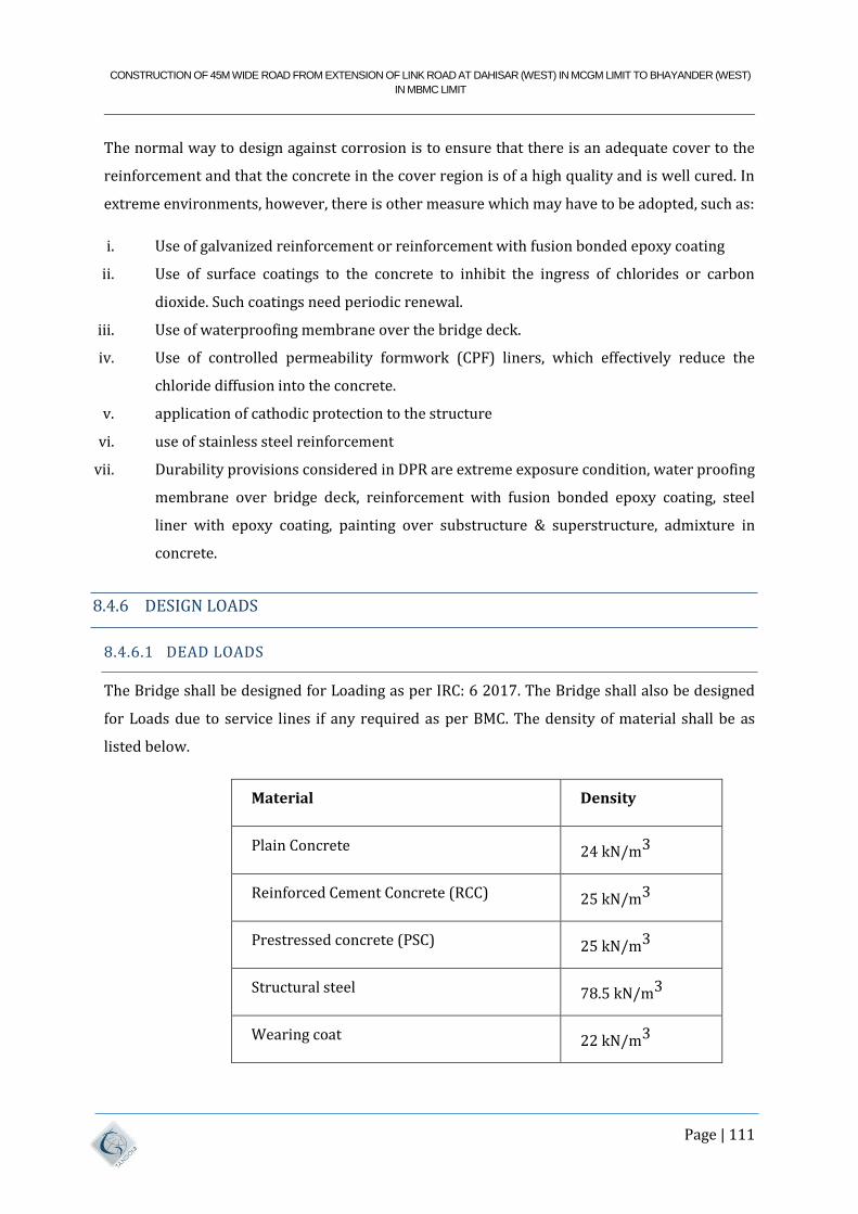
CONSTRUCTION OF 45M WIDE ROAD FROM EXTENSION OF LINK ROAD AT DAHISAR (WEST) IN MCGM LIMIT TO BHAYANDER (WEST)
IN MBMC LIMIT
Page | 111
The normal way to design against corrosion is to ensure that there is an adequate cover to the
reinforcement and that the concrete in the cover region is of a high quality and is well cured. In
extreme environments, however, there is other measure which may have to be adopted, such as:
i. Use of galvanized reinforcement or reinforcement with fusion bonded epoxy coating
ii. Use of surface coatings to the concrete to inhibit the ingress of chlorides or carbon
dioxide. Such coatings need periodic renewal.
iii. Use of waterproofing membrane over the bridge deck.
iv. Use of controlled permeability formwork (CPF) liners, which effectively reduce the
chloride diffusion into the concrete.
v. application of cathodic protection to the structure
vi. use of stainless steel reinforcement
vii. Durability provisions considered in DPR are extreme exposure condition, water proofing
membrane over bridge deck, reinforcement with fusion bonded epoxy coating, steel
liner with epoxy coating, painting over substructure & superstructure, admixture in
concrete.
8.4.6 DESIGN LOADS
8.4.6.1 DEAD LOADS
The Bridge shall be designed for Loading as per IRC: 6 2017. The Bridge shall also be designed
for Loads due to service lines if any required as per BMC. The density of material shall be as
listed below.
Material
Density
Plain Concrete
24 kN/m3
Reinforced Cement Concrete (RCC)
25 kN/m3
Prestressed concrete (PSC)
25 kN/m3
Structural steel
78.5 kN/m3
Wearing coat
22 kN/m3
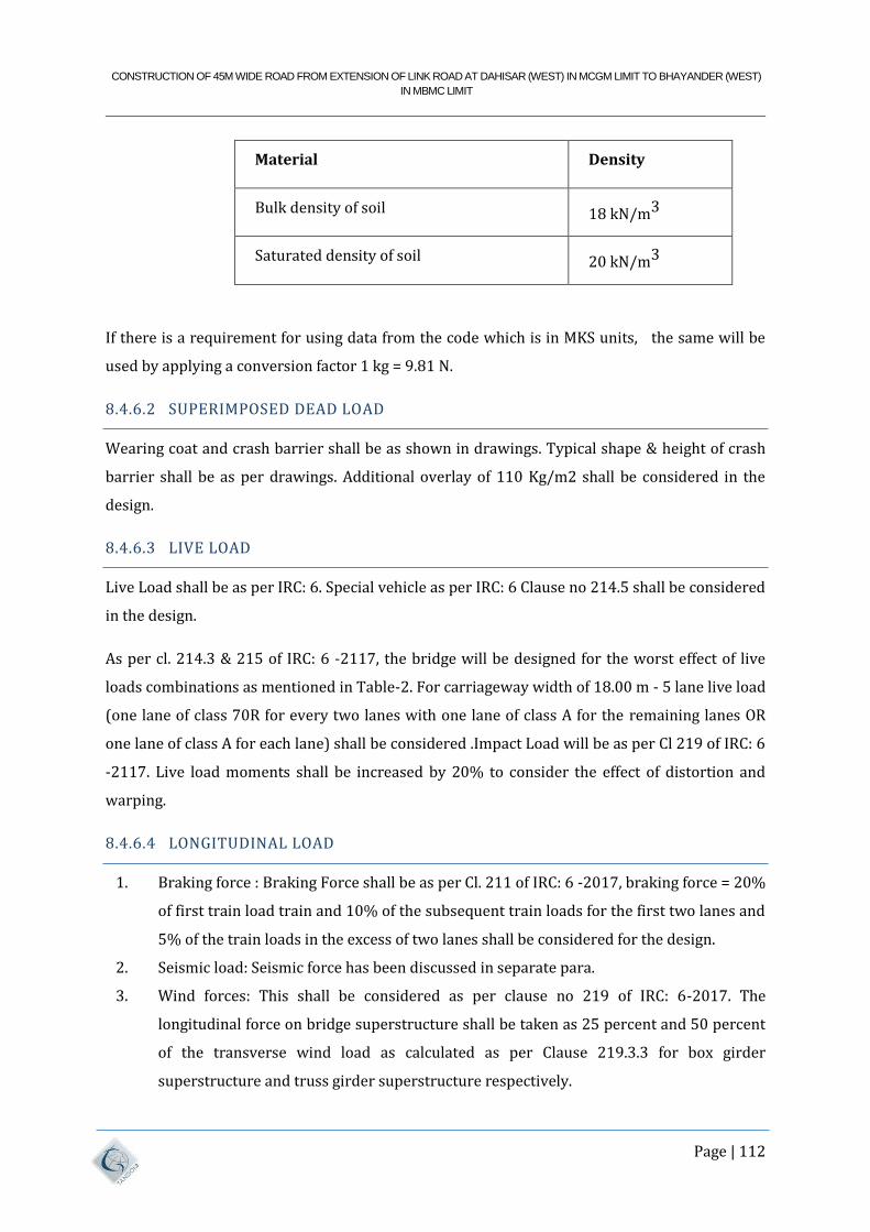
CONSTRUCTION OF 45M WIDE ROAD FROM EXTENSION OF LINK ROAD AT DAHISAR (WEST) IN MCGM LIMIT TO BHAYANDER (WEST)
IN MBMC LIMIT
Page | 112
Material
Density
Bulk density of soil
18 kN/m3
Saturated density of soil
20 kN/m3
If there is a requirement for using data from the code which is in MKS units, the same will be
used by applying a conversion factor 1 kg = 9.81 N.
8.4.6.2 SUPERIMPOSED DEAD LOAD
Wearing coat and crash barrier shall be as shown in drawings. Typical shape & height of crash
barrier shall be as per drawings. Additional overlay of 110 Kg/m2 shall be considered in the
design.
8.4.6.3 LIVE LOAD
Live Load shall be as per IRC: 6. Special vehicle as per IRC: 6 Clause no 214.5 shall be considered
in the design.
As per cl. 214.3 & 215 of IRC: 6 -2117, the bridge will be designed for the worst effect of live
loads combinations as mentioned in Table-2. For carriageway width of 18.00 m - 5 lane live load
(one lane of class 70R for every two lanes with one lane of class A for the remaining lanes OR
one lane of class A for each lane) shall be considered .Impact Load will be as per Cl 219 of IRC: 6
-2117. Live load moments shall be increased by 20% to consider the effect of distortion and
warping.
8.4.6.4 LONGITUDINAL LOAD
1. Braking force : Braking Force shall be as per Cl. 211 of IRC: 6 -2017, braking force = 20%
of first train load train and 10% of the subsequent train loads for the first two lanes and
5% of the train loads in the excess of two lanes shall be considered for the design.
2. Seismic load: Seismic force has been discussed in separate para.
3. Wind forces: This shall be considered as per clause no 219 of IRC: 6-2017. The
longitudinal force on bridge superstructure shall be taken as 25 percent and 50 percent
of the transverse wind load as calculated as per Clause 219.3.3 for box girder
superstructure and truss girder superstructure respectively.
CONSTRUCTION OF 45M WIDE ROAD FROM EXTENSION OF LINK ROAD AT DAHISAR (WEST) IN MCGM LIMIT TO BHAYANDER (WEST)
IN MBMC LIMIT
Page | 113
8.4.6.5 CENTRIFUGAL LOAD
The structure on curves shall be designed considering the centrifugal force as per Cl. 212 of IRC:
6 -2017. General design speed considered shall be 80 kmph. But this shall specifically be
reviewed case to case as per the geometric design of highway.
8.4.6.6 CONSTRUCTIONAL LOAD
Construction Equipment load shall be considered in the design as per launching system. Class-A
one lane load shall be considered as static load acting on superstructure.
8.4.6.7 WIND LOAD
Wind forces shall be considered as per cl. 209 of IRC: 6 -2017.
8.4.6.8 SEISMIC LOAD
Seismic force shall be considered as per IRC: SP: 114-2018. Seismic zone to be considered shall
be III. Importance factor of 1.2 shall be considered in seismic force calculations. To cater for the
effect of seismic force, specifically detailed ductility provision shall be applied to all structural
components as per IRC: 112-2019.
8.4.6.9 WATER CURRENT LOAD
Water current forces shall be considered as per cl. 210 of IRC: 6 -2017. Maximum mean velocity
of water current shall be considered as 3.5m/sec.
8.4.6.10 TEMPERATURE LOAD
Temperature loads shall be considered as per Cl. No. 215 of IRC: 6 -2017.
8.4.6.11 BARGE IMPACT LOAD
Barge impact loads shall be considered as per Cl. No. 220 of IRC: 6 -2017
Barge impact load shall be considered as an accidental load and load combination shall confirm
to provision of Annexure B of IRC: 6-2017.Barge impact load shall be considered only under
ultimate limit state. For working load/allowable stress condition, allowable stress may be
increased by 50 percent.
The probability of simultaneous occurrence of a barge collision together with maximum flood
shall not be considered. Point of impact shall be assumed to act on pile cap top.
CONSTRUCTION OF 45M WIDE ROAD FROM EXTENSION OF LINK ROAD AT DAHISAR (WEST) IN MCGM LIMIT TO BHAYANDER (WEST)
IN MBMC LIMIT
Page | 114
8.4.6.12 FATIGUE LOAD
Fatigue loads shall be considered as per Clause No 214.6 of IRC: 6 -2017.
8.4.6.13 BUOYANCY LOAD
Buoyancy loads shall be considered as per Clause No 213 of IRC: 6 -2017.
8.4.6.14 EARTH PRESSURE LOAD
Earth pressure loads shall be considered as per Clause No 213 of IRC: 6 -2017.
8.4.7 SOIL PROPERTIES
The properties of back fill material shall not be less than the values given below for design
purposes:
• Dry Density of Soil - 1.8 T/Cum.
• Saturated Density - 2.0 T/Cum.
•
• C = 0
8.4.8 LOAD COMBINATIONS
For checking vertical and lateral pile capacity of piles, design load combinations as provided in
Table 1 of IRC: 6-2017 shall be adopted. The load combination as shown in Annexure B shall be
adopted for limit state design approach.
8.5 BORING DATA AND INVESTIGATIONS AT SITE
• The details of the borings, their locations and tentative rock levels and founding levels
are shown in general arrangement drawing / geotechnical investigation report.
• The samples from the bore taken at each foundation shall be tested and analyzed in the
laboratory approved by the Employer for establishing design parameters. Tests such as
standard penetration test, compression and shear test on undisturbed soil samples, UCS,
water absorption on rock samples etc., shall be carried out in conformity with the
specifications.
CONSTRUCTION OF 45M WIDE ROAD FROM EXTENSION OF LINK ROAD AT DAHISAR (WEST) IN MCGM LIMIT TO BHAYANDER (WEST)
IN MBMC LIMIT
Page | 115
8.6 FOUNDATIONS
8.6.1 FOUNDATION OF PIERS/ABUTMENTS
• The pile foundation shall be provided as foundation for piers, abutment piers and
columns.
• Temporary works such as sheet pile, concrete casing, earthwork islands, temporary
bridges etc. may require.
• Buoyancy to be considered shall be 100% for open foundation.
• No passive pressure shall be considered for the design of abutment.
• Effects of surcharge, if any, shall be suitably considered in the design.
8.6.2 PILE FOUNDATIONS:
Pile foundations shall be designed and provided as per the provision as specified in IRC: 78-
2014.
Pile capacity shall be confirmed by pile load test as per IS: 2911 Part – IV
The design capacity assumed for the piles shall be verified by the initial load testing of test piles
in non- working areas, in the vicinity of the bridge site. These piles shall be tested for 2.5 times
the design load and number of such tests shall be one per diameter. Additional one pile per
diameter which is actually going to be used for piers and abutments shall be tested for 1.5 times
the design load. These tests and the routine tests shall be as per IRC: 78- 2014.
8.7 APPROACHES/RETAINING WALLS
The solid approach shall be provided at end of the bridge.
8.8 SUBSTRUCTURE & FOUNDATION
• The minimum diameter of piles shall be 1200 mm. Permanent minimum 6 mm thick M.S.
liner shall be provided from HHW to level of refusal.
• The height of pedestals shall be at least 150mm and shall not be more than 500mm
including bearing.
• All the piers in the Navigational zone shall be designed for a barge impact load as
specified in loadings.
CONSTRUCTION OF 45M WIDE ROAD FROM EXTENSION OF LINK ROAD AT DAHISAR (WEST) IN MCGM LIMIT TO BHAYANDER (WEST)
IN MBMC LIMIT
Page | 116
• Scope for accessibility for Inspection and arrangement for lifting of the Superstructure
for future replacement of Bearings shall be provided for in the design of Substructure.
The positions of jacks shall be distinctly shown on the drawing and also prominently
marked on the structure. The shape of substructure shall be such that it shall not add to
the turbulence of flowing water. It shall not create large obstructions to the flow of
water. The debris shall not get entangled into the substructure.
8.9 SUPERSTRUCTURE
Generally superstructure shall be PSC box girder Segmental construction as shown in
General Arrangement Drawing.
• Deck slab thickness shall not be less than 200 mm.
• Minimum thickness of intermediate diaphragm where provided shall be 300 mm and
that of end diaphragm shall be 500 mm. Manholes shall kept at a spacing not more than
150 m with arrangement for access inside the box.
• The minimum thickness of web of “I” Girder or the thickness of web in box girder shall
not be less than 200 mm.
• In the absence of rigorous analysis for torsional and distorsional moments and forces
due to warping torsion at ends, the design live load moments and shear force in
the longitudinal direction shall be increased by 20% and transverse reinforcement by
5%.
• Deck continuity is permitted for box superstructures. All box superstructures shall be of
uniform depth.
• The design of superstructure shall be as per the provisions of IRC: 112.
Both superstructures and piers for the main carriageway of each direction shall be
structurally independent from the other in order to meet the security requirements.
Where possible, an abutment for a ramp bridge for interchange shall be set as lower
as possible unless the girder depth of the superstructure does not disturb the
finishing ground level around the abutment.
Over the inter-tidal zones, the construction of the superstructure shall be by
overhead gantry methods only in order to avoid or minimize disturbance to the mud
flats and the marine ecology
Facilities for inspection and maintenance activities shall be included in the bridge
design. Access to the inside of the box girders for main carriageway and ramps shall
CONSTRUCTION OF 45M WIDE ROAD FROM EXTENSION OF LINK ROAD AT DAHISAR (WEST) IN MCGM LIMIT TO BHAYANDER (WEST)
IN MBMC LIMIT
Page | 117
be located in the soffit of the box girders and shall be provided at minimum intervals
of 1.0 km.
8.10 BEARINGS
• Spherical type bearings shall be permitted. These bearings shall be got manufactured
from MORT&H approved manufacturers.
• The bearings shall be easily accessible for inspection.
• Scope for lifting the superstructure for future replacement of bearings shall be provided
for in the design of bearing.
• The contact surface of superstructure shall project beyond the edge of the bearing plate
by a minimum distance of 100 mm at any location.
8.11 EXPANSION JOINTS
• Only strip seal / modular strip seal joints shall be permitted. These shall conform to
modified interim specifications for expansion joints.
• The expansion joints shall conform to M.O.R.T. & H. Specifications. The detailed working
drawing for the joint shall be in conformity with overall geometry of deck. Geometrical
profile shall be achieved by adjusting the dimensions of Superstructure. The joint shall
be jerk free. Differential deflection in bearings shall be considered in design.
• The expansion joints shall be leak proof. The joint shall be provided for the full width of
the bridge.
8.12 RAILINGS/PARAPETS & CRASH BARRIERS.
Railing/Crash barrier shall be provided as indicated in the Drawing.
8.13 WATER SPOUTS
Waterspouts shall be as per MOST Type design. The water spouts shall be provided @ 3m C/C
along the bridge and the top portion of water spout should be 500 mm X 500 mm at deck level.
ble
diameter (Minimum 150 mm) and taken down by down take HDPE pipes of suitable diameter at
approved locations. Arrangement for clean out plug shall be made.
CONSTRUCTION OF 45M WIDE ROAD FROM EXTENSION OF LINK ROAD AT DAHISAR (WEST) IN MCGM LIMIT TO BHAYANDER (WEST)
IN MBMC LIMIT
Page | 118
8.14 WEARING COAT
A wearing coat shall be as shown in the drawings.
8.15 MATERIALS
8.15.1 CONCRETE GRADES FOR VARIOUS STRUCTURAL ELEMENTS.
Grade of concrete in various structural elements shall be for extreme exposure conditions of
exposure. High performance concrete with micro silica may be recommended.
• Superstructure:
PSC Superstructure M60
Deck Slab M60
RCC Crash Barriers/Kerb M40
• Substructure:
RCC Pier /Pier cap M50
RCC pile cap and foundations M40
All PCC members M15
Pedestals M50
8.15.2 STEEL
• Reinforcement Steel
Fe 500D HYSD bars conforming to IS: 1786 having minimum elongation 14.5%. Reinforcing bars
shall be coated by fusion bonded epoxy conforming to IS: 13621
• Prestressing Steel
The pre-stressing strands shall conform to IS: 14268
System: 19T13 or 19T15 low relaxation multiple strands system
Cables: low relaxation with strands of 12.7mm or 15.2mm nominal diameters. Sheathing: HDPE
sheathing duct
• Structural steel
This shall conform to IS: 2162 of grade E350 (Fe 490)
CONSTRUCTION OF 45M WIDE ROAD FROM EXTENSION OF LINK ROAD AT DAHISAR (WEST) IN MCGM LIMIT TO BHAYANDER (WEST)
IN MBMC LIMIT
Page | 119
8.16 ANTICORROSIVE TREATMENT TO CONCRETE AND REINFORCEMENT
(Applicable in case of marine and severe environment.)
The entire structure shall be given anticorrosive protection, which shall be got tested from
approved laboratory and shall be of approved quality, colour and shade.
Protection for Steel composite superstructure shall be provided as per Annexure D of IRC: 24-
2010
The protection shall consist of:
• Over mild steel liner: One coat of Zinc-rich Epoxy primer and two coats of Coal Tar
Epoxy. (Total dry film thickness 50 + 80 + 80 = 210 microns) to outside surface.
Aluminium based paints shall be prohibited as they have deleterious influence on the
concrete surface.
• Part of Substructure in contact with earth and up to (H.T.L.+0.9m) / H.F.L. (whichever is
higher) - One coat of primer and two coats of Coal Tar Epoxy. Part of Substructure
exposed to atmosphere - water proof cement paint.
• Parapets: Waterproof cement based paint in three coats of approved quality and colour.
• Deck/Girder/Box: All outside faces - Epoxy based paint with one primer and further two
coats. The inside faces will be painted in cement paint of approved colour and shade in
three coats.
CONSTRUCTION OF 45M WIDE ROAD FROM EXTENSION OF LINK ROAD AT DAHISAR (WEST) IN MCGM LIMIT TO BHAYANDER (WEST)
IN MBMC LIMIT
Page | 120
9 CONSTRUCTION METHODOLOGY
9.1 METHODOLOGY OF CONSTRUCTION IN CREEK AND SALT PAN AREAS.
The proposal for structures in the Creek areas and Salt Pans consists of 30m span Pre-cast
Segmental Box Girder Superstructure arrangement and 100m obligatory spans with steel
superstructure resting on Piers with Pile Foundations. Segmental Construction in General
involves Construction of precast Box Girder elements which are transported to the site and
stitched together. The methodology proposed for execution of these spans is explained
hereunder in brief,
Following main operations are involved in the precast segmental construction of
Bridge superstructure.
i. Preparation of casting yard for casting of precast segments.
ii. Preparation of stacking yard for Stacking.
iii. Transportation of precast segments to erection the site.
iv. Erection of precast segments by using launcher.
9.2 PREPARATION OF CASTING YARD AND CASTING OF PRE-CAST
SEGMENTS
• Casting of segments is done in the Pre-casting yard using long line method. In this
method, the bed is prepared for the full length of the span.
• Outer side shuttering is prepared in single panel for the length of the segment.
• Inner formwork is collapsible type shutter.
• After levelling and aligning the bed, outer forms are positioned properly and aligned.
Reinforcement is placed for the segment after application of remoulding agent.
Reinforcement can be made in pre-fabricated cages, which can be lifted by Gantry and
placed in position.
• Outer & Inner forms are removed after the concrete achieves sufficient strength.
• Clean & move the outer forms to next segment location. Fix and align the same. Apply
wax or few coats of wax based curing compound to the end surface of already concreted
segment. Fix reinforcement and sheathing ducts in place. The connection of sheathing
duct to the sheathing of previous segment is made perfect so that it does not get dislodged
during concreting and grout is not enter into the duct.
CONSTRUCTION OF 45M WIDE ROAD FROM EXTENSION OF LINK ROAD AT DAHISAR (WEST) IN MCGM LIMIT TO BHAYANDER (WEST)
IN MBMC LIMIT
Page | 121
• Rest of the sequence is same as 1st segment till all the segments are concreted.
• The segments are lifted up from the bed after the concrete has achieved strength of
approx. 300 kg/cm². Minimum two adjoining segments are left on bed for the alignment
of segment to be concreted. Lifting of segments is done in such a way that no jerk is
imparted and the shear keys also do not break.
9.3 PREPARATION OF STACKING YARD
The preparation in stacking yard is as follows:
• Lightly sand blast the end surface to remove laitance from the face and to remove any
loose particles. During this process, it is advisable to plug the cable holes so that no sand
enters the cable ducts.
• Clean the cable holes by blowing air through the cable duct and ensure that the ducts are
free by passing a dummy cable through the hole.
• Repair the concrete wherever required. This should preferably be done immediately after
the shutter is opened so that the curing of the repair is carried out along with the curing of
the segment itself. The repairs are done by dry packing method or using available high
strength mortars.
• Fix foam rubber rings (5 mm to 10 mm thick depending on the quality of foam around the
cable holes to avoid epoxy entering the holes when temporary prestressing is being done
(to avoid problems later while threading the cables)
• Attach connection beams to all segments in the span using Dywidag thread bar and nut.
• Fix temporary stressing brackets to all segments by stressing vertical stress bars in the
casting yard. Stress vertical bars of bracket to required force using central hole jacks
operated simultaneously using manifold.
• Cure the segments in stacking yard using sprinklers for minimum 14days from the date of
casting.
9.3.1 TRANSPORTATION OF PRECAST SEGMENTS TO ERECTION SITE:
• The transportation of the segment is proposed to be done by use of trailers.
• The segment is tied down to the trailer positively to prevent toppling and sliding.
• The Transportation of the Segments will be done right upto the point where it is lifted by
the Launcher i.e. on a span preceeding/succeeding to the Span under construction. This is
CONSTRUCTION OF 45M WIDE ROAD FROM EXTENSION OF LINK ROAD AT DAHISAR (WEST) IN MCGM LIMIT TO BHAYANDER (WEST)
IN MBMC LIMIT
Page | 122
done as there is very less possibility to float the Segments in the Creek owing to zero draft
in low tide.
9.3.2 ERECTION OF PRECAST SEGMENTS USING LAUNCHER MOVING FROM ONE END
TO OTHER
The step by step operations at site is as below:
i. Setting of launcher for erection of segments:
ii. Erect Launcher on piers
iii. Place and fix longitudinal and transverse shifting arrangement and for alignment of
precast segments.
Erection of segments:
Lift the precast segments directly from Trailer. Start the erection of precast segments from one
end, proceeding towards the other end of span.
Alignment of segment:
Following steps are followed for alignment of segments
• Align first segment true to line and level keeping a gap of about 10 mm between top of
bearing and soffit level. Restrain this segment from shifting from its place by providing
ties etc. from pier cap / previous span.
• Fix the balance fixtures i.e. horizontal stress bar for temporary stressing of 1st joint.
• Align second segment to line and dry match it to first segment.
• Repeat steps at (b) & (c) for alignment of balance segments.
• Verify the alignment of span as a whole.
• Separate the segments starting from the last segment. Keep gap of about 200 mm between
the segment faces where epoxy is to be applied.
• Check that there is no disturbance to the first segment.
• Apply epoxy glue as per specification between 1st & 2nd segment interface within pot lift
of epoxy.
• Join the segments together by moving the second segment.
• Apply temporary prestress simultaneously to all the bars. Use separate hydraulic pump +
manifold unit for application of prestess at Deck & Soffit slab bars.
CONSTRUCTION OF 45M WIDE ROAD FROM EXTENSION OF LINK ROAD AT DAHISAR (WEST) IN MCGM LIMIT TO BHAYANDER (WEST)
IN MBMC LIMIT
Page | 123
Prestressing of segments:
• Thread the permanent cables.
• Fill the gap between top of bearing & soffit of segment using high strength non shrink
cementations grout and allow it to cure for 12 hours. After achieving a strength of 200
kg/cm², stressing can be started.
• Prestress permanent cables to take dead weight of superstructure in the sequence so that
load transfer takes place from staging support to bearing. .
• Distress all temporary stressing bars and detach temporary stressing brackets, vertical
stressing bars & send to casting yard.
• The above methodology can be adopted for construction of typical superstructure box
girder span in creek area and salt pans.
9.4 METHODOLOGY FOR CONSTRUCTION IN MANGROVES AREA:
• First temporary bridge shall be constructed at one side of the carriageway for carrying
out materials and equipments.
• From temporary bridge platform on temporary pile arrangement shall be constructed.
• Then working piles shall be constructed.
• Brackets shall be connected with piles and shuttering will be placed. Then casting of
deck slab will be done.
• On completion of the superstructure, balance miscellaneous activities shall be
completed.
9.5 CONSTRUCTION METHODOLOGY OF FOUNDATION AND
SUBSTRUCTURE:
• For construction of pile foundation in creek area, jack up platform is most suited.
Construction materials and equipments will be transported through barge at pier
locations during high tides. Temporary bridge also can be constructed from accessible
shorelines where mangroves are not affected. Through temporary bridge construction
materials and equipments will be reached at pier locations.
• Construction stages are below:
• Steel liner will be installed upto top of rock level in pile location.
• Boring will be done.
• Caging will be laid inside.
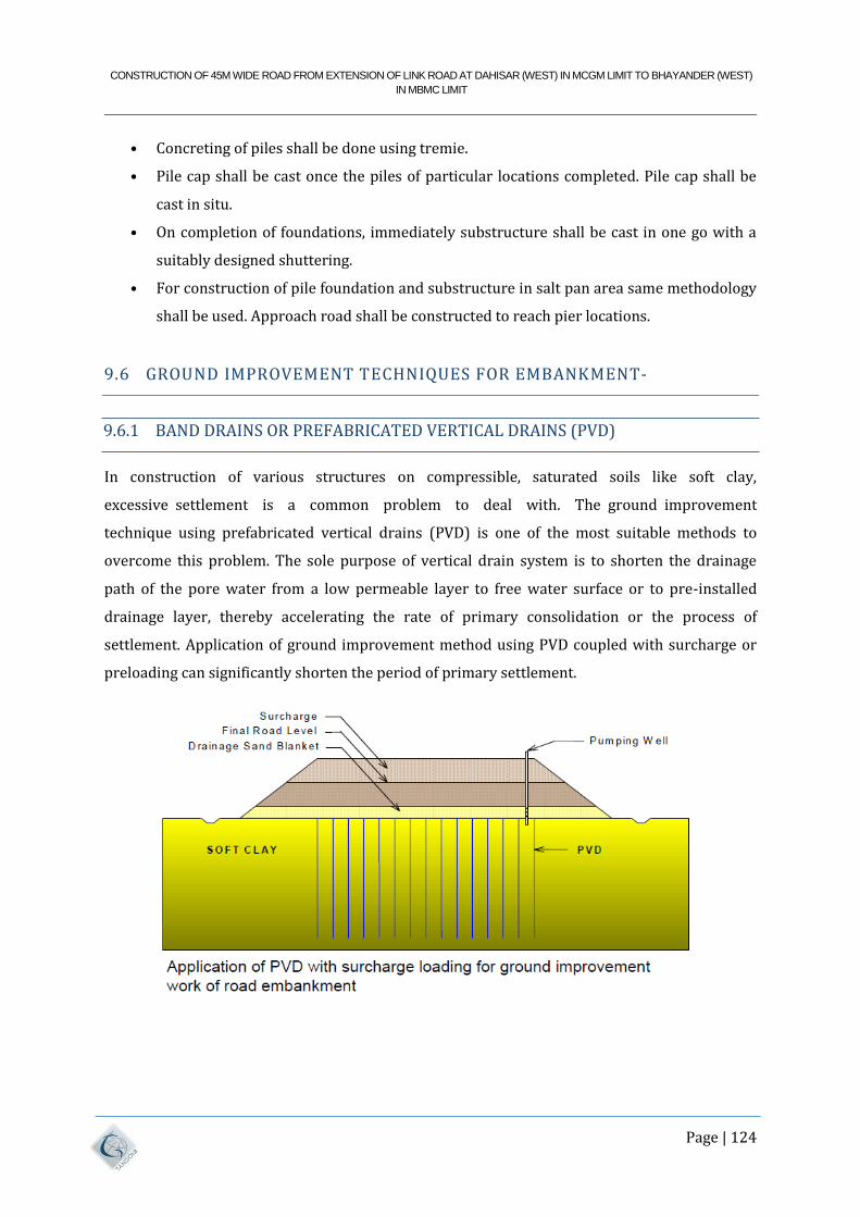
CONSTRUCTION OF 45M WIDE ROAD FROM EXTENSION OF LINK ROAD AT DAHISAR (WEST) IN MCGM LIMIT TO BHAYANDER (WEST)
IN MBMC LIMIT
Page | 124
• Concreting of piles shall be done using tremie.
• Pile cap shall be cast once the piles of particular locations completed. Pile cap shall be
cast in situ.
• On completion of foundations, immediately substructure shall be cast in one go with a
suitably designed shuttering.
• For construction of pile foundation and substructure in salt pan area same methodology
shall be used. Approach road shall be constructed to reach pier locations.
9.6 GROUND IMPROVEMENT TECHNIQUES FOR EMBANKMENT-
9.6.1 BAND DRAINS OR PREFABRICATED VERTICAL DRAINS (PVD)
In construction of various structures on compressible, saturated soils like soft clay,
excessive settlement is a common problem to deal with. The ground improvement
technique using prefabricated vertical drains (PVD) is one of the most suitable methods to
overcome this problem. The sole purpose of vertical drain system is to shorten the drainage
path of the pore water from a low permeable layer to free water surface or to pre-installed
drainage layer, thereby accelerating the rate of primary consolidation or the process of
settlement. Application of ground improvement method using PVD coupled with surcharge or
preloading can significantly shorten the period of primary settlement.
CONSTRUCTION OF 45M WIDE ROAD FROM EXTENSION OF LINK ROAD AT DAHISAR (WEST) IN MCGM LIMIT TO BHAYANDER (WEST)
IN MBMC LIMIT
Page | 125
9.6.2 STONE COLUMNS
Stone column ground improvement involves adding vertical columns of stone into the ground to
depth of at least 4m below the ground surface. The construction of stone columns involves
partial replacement of weak soil with the stones (aggregates). The stones are compacted by
ramming or vibrations. General practice is to replace 15 – 35 % of weak soil by stones. Design
loads of stone columns typically vary from 20 to 50 T. The installation of stone column creates a
composite material of overall lower compressibility and higher shear strength than the virgin
weak soil. Also as stones are free draining material helps to drain the pore water and reduces
the possibility of liquefaction. Stone columns technique is suitable for carrying out ground
improvement of soft to medium stiff cohesive soil or loose cohesion less soil.
9.6.3 BASAL REINFORCEMENT (USE OF GEOGRIDS / GEOTEXTILES)
When the depth of treatment i.e. depth of the weak soil is small, the Geotextiles or Geogrids can
be used to increase the Safe Bearing Capacity by way of load dispersion. For achieving the
required factor of safety for Global Stability of embankments to be constructed on weak
stratum, basal reinforcement in the form of high strength geogrids/ geotextiles can be
considered.
9.6.4 EXCAVATION & REPLACEMENT
If the embankment is failing in global stability or the estimated settlement of the embankment
post construction is more than the allowable limit, the weak layer of soil can be excavated and
replaced with suitable soil meeting the specifications of embankment fill. The thickness of
replacement shall be identified by iterative method, to achieve required factor of safety for
global stability and/ or reduce the post construction settlement within allowable limits.
9.6.5 DYNAMIC COMPACTION
The densification of weak soil increases the ability of soils to carry the loads safely. The
Dynamic Compaction is method which can be adopted to increase the safe bearing capacity of
the existing soil and reduce the post construction settlement. Dynamic Compaction also helps
to reduce the liquefaction Potential. Dynamic Compaction is useful in silty / sandy deposits
present up to a depth of 5 to 7 m. Dynamic Compaction involves the application of high levels of
impact energy at the ground surface. The energy is applied by raising and dropping a dead
CONSTRUCTION OF 45M WIDE ROAD FROM EXTENSION OF LINK ROAD AT DAHISAR (WEST) IN MCGM LIMIT TO BHAYANDER (WEST)
IN MBMC LIMIT
Page | 126
weight of 10 to 50 T from heights of 5 to 30 m. The energy is applied in grid pattern and
alternate passes are given to achieve the required densification.
9.6.6 EXCAVATION & REPLACEMENT WITH CNS SOIL
Expansive soils are inorganic clays exhibiting high compressibility and characterized by high
shrinkage and swelling properties due to changes in moisture content. The expansive soil shall
be identified based on following basic (prime) parameters:
a) Swelling pressure (Sw) > 0.5 kg/cm2
b) Clay content (< 2µ) > 25%
c) Differential Free Swell (DFS) Index > 30%
The thickness of cohesive non-swelling soil (CNS) layer shall be decided giving due
consideration to the overall height of embankment and swelling pressure of expansive soil.
Refer Table for CNS layer thickness for given swell pressure.
CONSTRUCTION OF 45M WIDE ROAD FROM EXTENSION OF LINK ROAD AT DAHISAR (WEST) IN MCGM LIMIT TO BHAYANDER (WEST)
IN MBMC LIMIT
Page | 127
10 ENVIRONMENT IMPACT ASSESSMENT
10.1 ALIGNMENT OVERVIEW
This 45 m wide DP Road is much necessary to public as an alternative route for entering in
Mumbai, and save time of transport. Currently only entrance to Mumbai from north India is
located at Dahisar Check Naka through Western Express Highway. The Proposed 45m wide road
from extension of link road at Dahisar (west) in Brihanmumbai Municipal Corporation Limit to
Bhayander (west) in Mira Bhayander Municipal Corporation Limit. The DP Road would
decongest the Dahisar Check Naka, the entry point of the Mumbai. The construction of the road
will relieve traffic congestion in inner areas of Mira Bhayander and to improve the mobility of
Mira Bhayander and Dahisar area.
The proposed 45 DP road will create an environmental impact and change in the physical-
chemical, biological, cultural and/or socioeconomic system of the Western Mumbai Suburbs and
Mira Bhayander. The DP Road will impact on the CRZ notified area and mangroves Eco system
as the proposed alignment passes through the Dahisar Creek.
10.2 APPLICABLE ENVIRONMENT POLICIES AND LAW
10.2.1 THE APPLICABLE INDIAN LEGISLATION RELATED TO ENVIRONMENT:
Environmental (Protection) Act, 1986 and applicable prescribed rules and notifications
under the Act.
The Maharashtra (Urban Areas) Preservation of Trees Act, 1975.
Air (control of pollution) Act, 1981 and
Water (control of pollution) Act, 1974
Coastal Regulation Zone Notification 2019.
Forest Conservation Act 1980
Forest (Recognition) Act 2006.
Maharashtra Maritime Board Act, 1996
The Following table presents the applicable rules and regulations and how they are applicable
in implementation of this project.
CONSTRUCTION OF 45M WIDE ROAD FROM EXTENSION OF LINK ROAD AT DAHISAR (WEST) IN MCGM LIMIT TO BHAYANDER (WEST)
IN MBMC LIMIT
Page | 128
Applicable Regulations & Status of Compliance
Applicable Regulations Status of Compliance
Forest Conservation Act 1980 and
Hon High Court Permission
As the proposed alignment passes through mangroves
area notified as forest. The Forest diversion is
mandatory as per the section 2 of Forest Conservation
Act 1980 to carry Non Forest Activity in forest area.
Also, as per PIL No.87 of 2006, a Prior High Court
Permission needs to be taken while working in
mangrove areas.
Coastal Regulation Zone Notification
2011.
The proposed alignment passes through CRZ notified
area hence CRZ Clearance shall be taken from
Maharashtra Coastal Zone Management Authority
(MCZMA) and further from State Environment Impact
Assessment Authority (SEIAA)
Environmental (Protection) Act, 1986
and applicable prescribed rules and
notifications under the Act
This is an umbrella act for environment protection.
Various standards in terms ambient air, noise are given
in this act.
The proposed road is not covered ambit of the EIA
Notification 2006
A rapid Environmental Impact Assessment is required
to prepare for envisaging the impact on environment
and covering mitigation measures.
Air (control of pollution) Act, 1981
and Water (control of pollution) Act,
1974
Implementing Agency needs to obtain the consent-to-
establish and consent-to-operate for the batching/hot
mix plants to be erected/commissioned
The Maharashtra (Urban Areas)
Preservation of Trees Act, 1975
As per this act no tree can be felled without the
permission of local tree authority. Trees in the
premises of schools can be removed with the
permission of tree authority which may prescribe
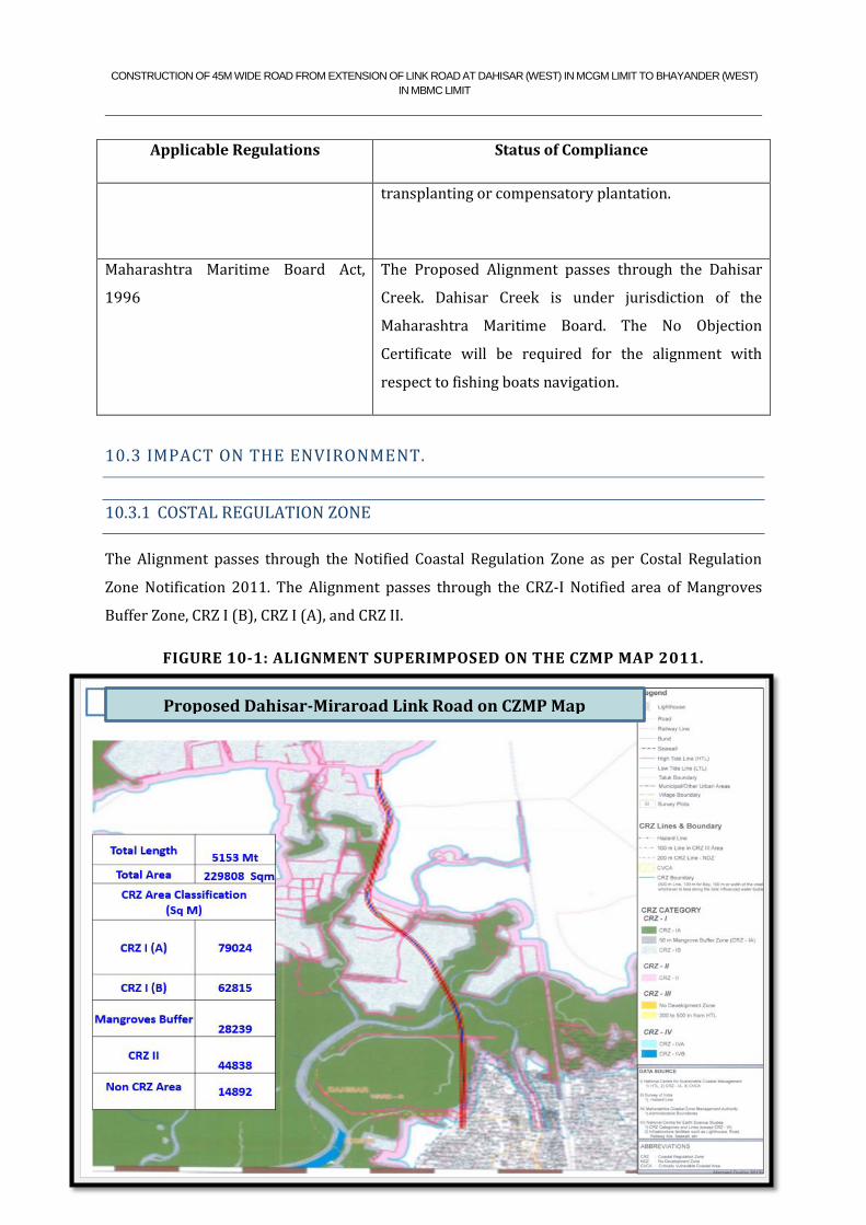
CONSTRUCTION OF 45M WIDE ROAD FROM EXTENSION OF LINK ROAD AT DAHISAR (WEST) IN MCGM LIMIT TO BHAYANDER (WEST)
IN MBMC LIMIT
Page | 129
Applicable Regulations Status of Compliance
transplanting or compensatory plantation.
Maharashtra Maritime Board Act,
1996
The Proposed Alignment passes through the Dahisar
Creek. Dahisar Creek is under jurisdiction of the
Maharashtra Maritime Board. The No Objection
Certificate will be required for the alignment with
respect to fishing boats navigation.
10.3 IMPACT ON THE ENVIRONMENT.
10.3.1 COSTAL REGULATION ZONE
The Alignment passes through the Notified Coastal Regulation Zone as per Costal Regulation
Zone Notification 2011. The Alignment passes through the CRZ-I Notified area of Mangroves
Buffer Zone, CRZ I (B), CRZ I (A), and CRZ II.
FIGURE 10-1: ALIGNMENT SUPERIMPOSED ON THE CZMP MAP 2011.
Proposed Dahisar-Miraroad Link Road on CZMP Map
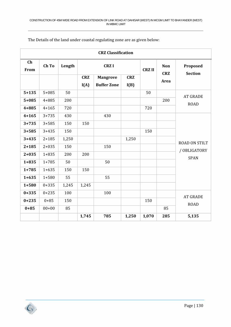
CONSTRUCTION OF 45M WIDE ROAD FROM EXTENSION OF LINK ROAD AT DAHISAR (WEST) IN MCGM LIMIT TO BHAYANDER (WEST)
IN MBMC LIMIT
Page | 130
The Details of the land under coastal regulating zone are as given below:
CRZ Classification
Ch
From Ch To Length CRZ I
CRZ II
Non
CRZ
Area
Proposed
Section
CRZ
I(A)
Mangrove
Buffer Zone
CRZ
I(B)
5+135 5+085 50
50 AT GRADE
ROAD 5+085 4+885 200
200
4+885 4+165 720
720
4+165 3+735 430
430
ROAD ON STILT
/ OBLIGATORY
SPAN
3+735 3+585 150 150
3+585 3+435 150
150
3+435 2+185 1,250
1,250
2+185 2+035 150
150
2+035 1+835 200 200
1+835 1+785 50
50
1+785 1+635 150 150
1+635 1+580 55
55
1+580 0+335 1,245 1,245
0+335 0+235 100
100 AT GRADE
ROAD 0+235 0+85 150
150
0+85 00+00 85
85
1,745 785 1,250 1,070 285 5,135

CONSTRUCTION OF 45M WIDE ROAD FROM EXTENSION OF LINK ROAD AT DAHISAR (WEST) IN MCGM LIMIT TO BHAYANDER (WEST)
IN MBMC LIMIT
Page | 131
The alignment passes through the mangroves and CRZ-I are designed on Stilt.
10.3.2 MANGROVES ECO SYSTEM
The alignment passes through the mangroves Patches. Around 20 out of the 35 species of true
mangroves found in India have been identified along the Maharashtra coast and 15 species of
these are found in Mumbai. The Alignment is passing through mangroves patch in three village
viz Bhayander, Dahisar, and Penpada.
Along the alignment, species of mangroves are found. The details of mangroves species in
alignment as below
Sr. No. Botanical Name Common Name Image
1 Rhizophora
mucronata Red mangrove
2 Avicennia marina Tivar
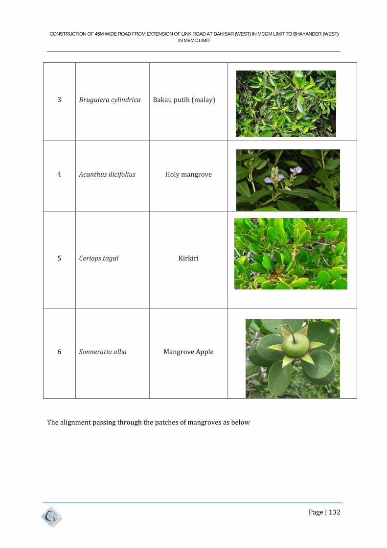
CONSTRUCTION OF 45M WIDE ROAD FROM EXTENSION OF LINK ROAD AT DAHISAR (WEST) IN MCGM LIMIT TO BHAYANDER (WEST)
IN MBMC LIMIT
Page | 132
3 Bruguiera cylindrica Bakau putih (malay)
4 Acanthus ilicifolius Holy mangrove
5 Ceriops tagal Kirkiri
6 Sonneratia alba Mangrove Apple
The alignment passing through the patches of mangroves as below
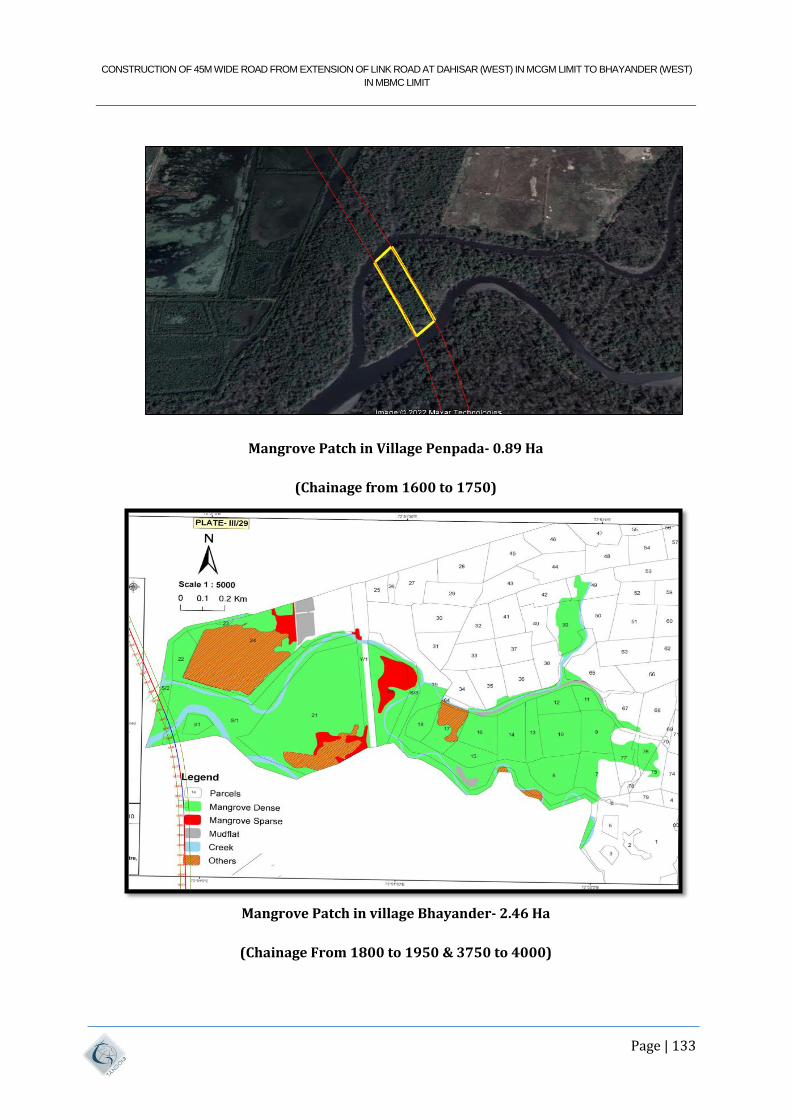
CONSTRUCTION OF 45M WIDE ROAD FROM EXTENSION OF LINK ROAD AT DAHISAR (WEST) IN MCGM LIMIT TO BHAYANDER (WEST)
IN MBMC LIMIT
Page | 133
Mangrove Patch in Village Penpada- 0.89 Ha
(Chainage from 1600 to 1750)
Mangrove Patch in village Bhayander- 2.46 Ha
(Chainage From 1800 to 1950 & 3750 to 4000)
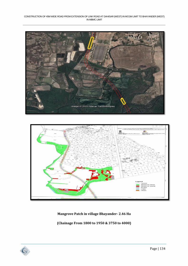
CONSTRUCTION OF 45M WIDE ROAD FROM EXTENSION OF LINK ROAD AT DAHISAR (WEST) IN MCGM LIMIT TO BHAYANDER (WEST)
IN MBMC LIMIT
Page | 134
Mangrove Patch in village Bhayander- 2.46 Ha
(Chainage From 1800 to 1950 & 3750 to 4000)
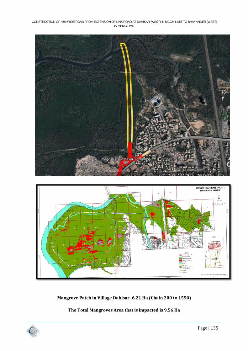
CONSTRUCTION OF 45M WIDE ROAD FROM EXTENSION OF LINK ROAD AT DAHISAR (WEST) IN MCGM LIMIT TO BHAYANDER (WEST)
IN MBMC LIMIT
Page | 135
Mangrove Patch in Village Dahisar- 6.21 Ha (Chain 200 to 1550)
The Total Mangroves Area that is impacted is 9.56 Ha
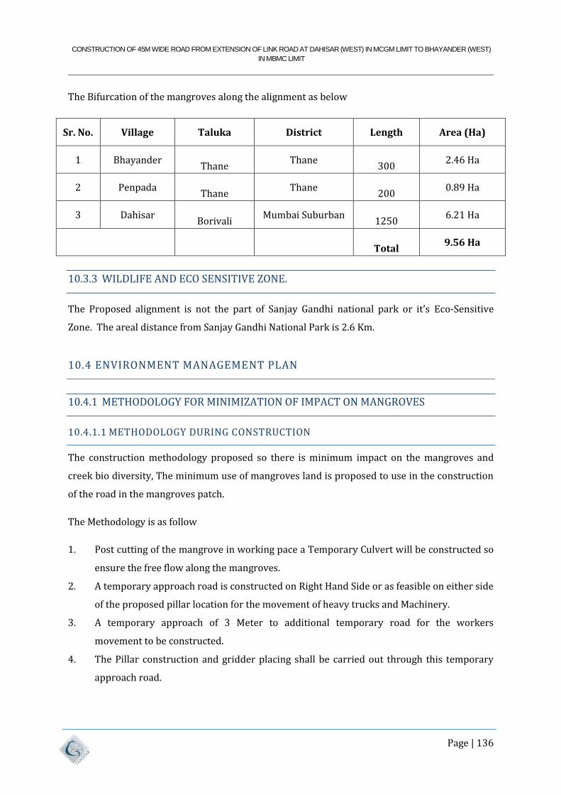
CONSTRUCTION OF 45M WIDE ROAD FROM EXTENSION OF LINK ROAD AT DAHISAR (WEST) IN MCGM LIMIT TO BHAYANDER (WEST)
IN MBMC LIMIT
Page | 136
The Bifurcation of the mangroves along the alignment as below
Sr. No. Village Taluka District Length Area (Ha)
1 Bhayander
Thane Thane
300
2.46 Ha
2 Penpada
Thane Thane
200
0.89 Ha
3 Dahisar
Borivali Mumbai Suburban
1250
6.21 Ha
Total 9.56 Ha
10.3.3 WILDLIFE AND ECO SENSITIVE ZONE.
The Proposed alignment is not the part of Sanjay Gandhi national park or it’s Eco-Sensitive
Zone. The areal distance from Sanjay Gandhi National Park is 2.6 Km.
10.4 ENVIRONMENT MANAGEMENT PLAN
10.4.1 METHODOLOGY FOR MINIMIZATION OF IMPACT ON MANGROVES
10.4.1.1 METHODOLOGY DURING CONSTRUCTION
The construction methodology proposed so there is minimum impact on the mangroves and
creek bio diversity, The minimum use of mangroves land is proposed to use in the construction
of the road in the mangroves patch.
The Methodology is as follow
1. Post cutting of the mangrove in working pace a Temporary Culvert will be constructed so
ensure the free flow along the mangroves.
2. A temporary approach road is constructed on Right Hand Side or as feasible on either side
of the proposed pillar location for the movement of heavy trucks and Machinery.
3. A temporary approach of 3 Meter to additional temporary road for the workers
movement to be constructed.
4. The Pillar construction and gridder placing shall be carried out through this temporary
approach road.
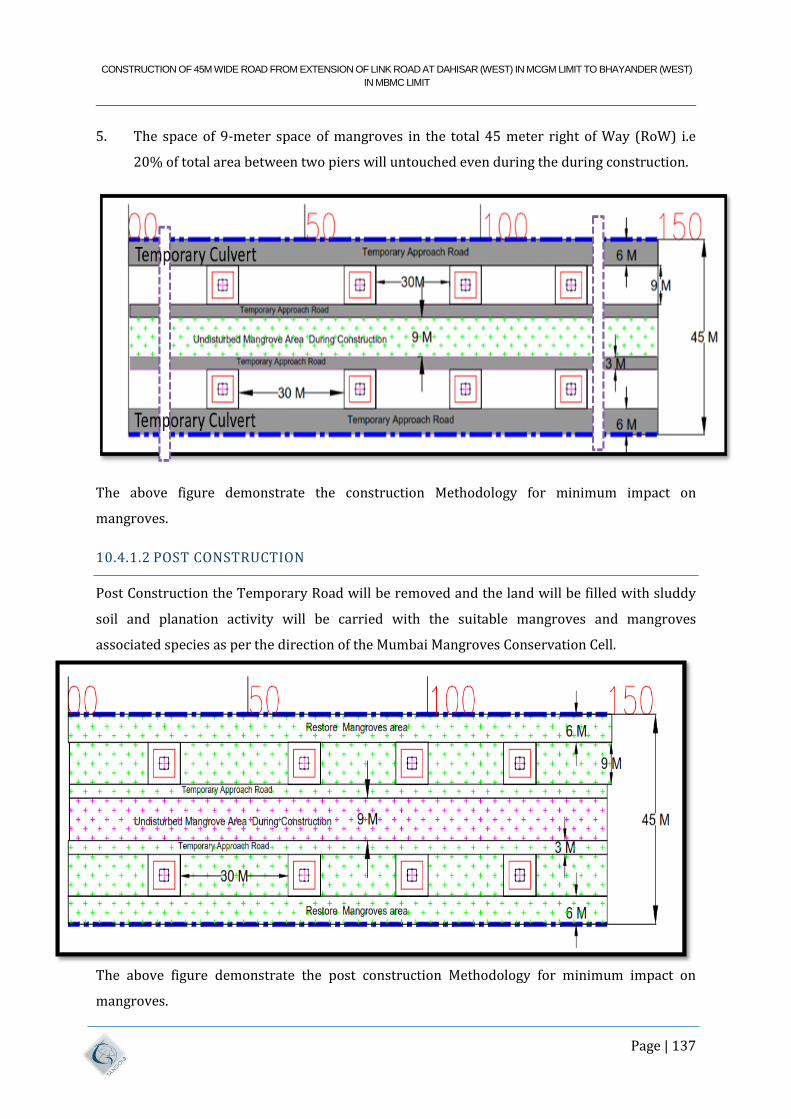
CONSTRUCTION OF 45M WIDE ROAD FROM EXTENSION OF LINK ROAD AT DAHISAR (WEST) IN MCGM LIMIT TO BHAYANDER (WEST)
IN MBMC LIMIT
Page | 137
5. The space of 9-meter space of mangroves in the total 45 meter right of Way (RoW) i.e
20% of total area between two piers will untouched even during the during construction.
The above figure demonstrate the construction Methodology for minimum impact on
mangroves.
10.4.1.2 POST CONSTRUCTION
Post Construction the Temporary Road will be removed and the land will be filled with sluddy
soil and planation activity will be carried with the suitable mangroves and mangroves
associated species as per the direction of the Mumbai Mangroves Conservation Cell.
The above figure demonstrate the post construction Methodology for minimum impact on
mangroves.
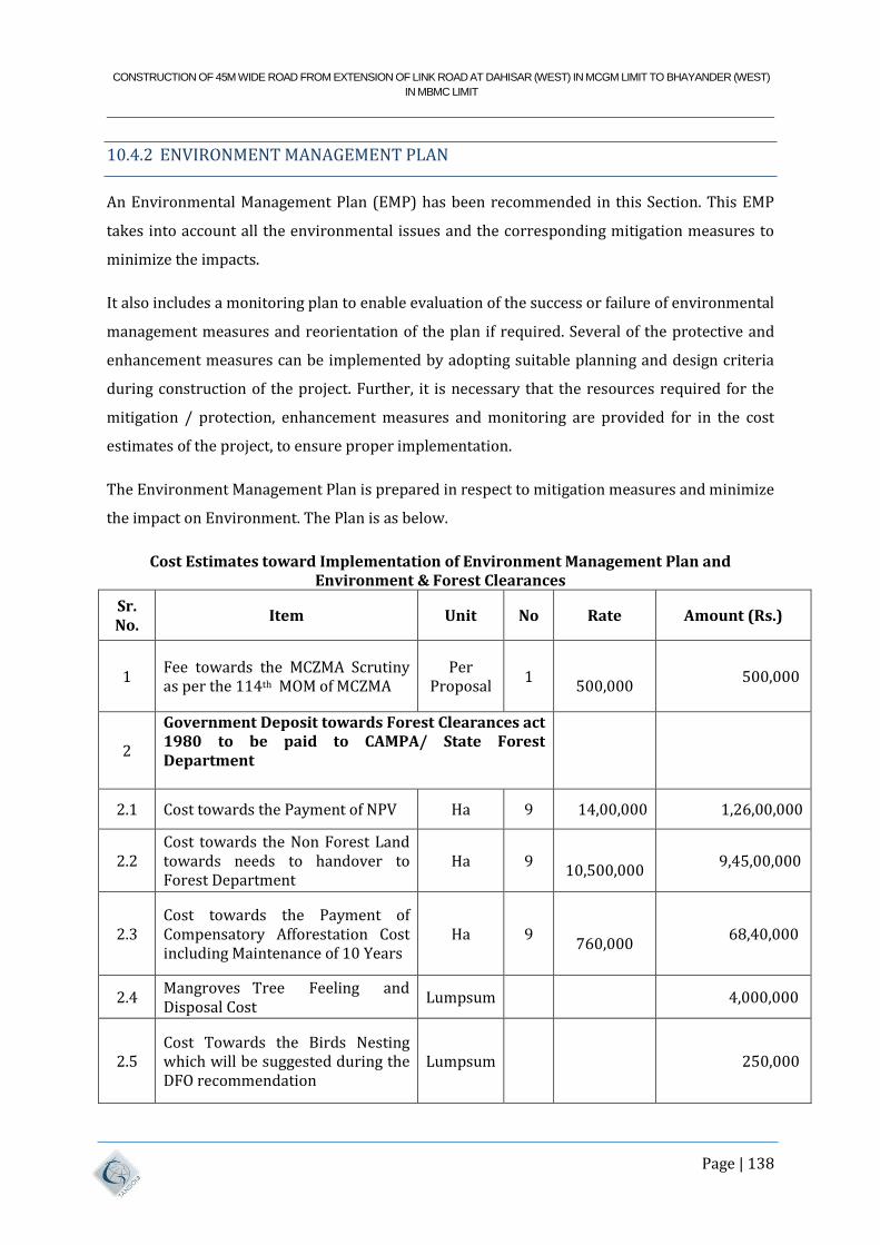
CONSTRUCTION OF 45M WIDE ROAD FROM EXTENSION OF LINK ROAD AT DAHISAR (WEST) IN MCGM LIMIT TO BHAYANDER (WEST)
IN MBMC LIMIT
Page | 138
10.4.2 ENVIRONMENT MANAGEMENT PLAN
An Environmental Management Plan (EMP) has been recommended in this Section. This EMP
takes into account all the environmental issues and the corresponding mitigation measures to
minimize the impacts.
It also includes a monitoring plan to enable evaluation of the success or failure of environmental
management measures and reorientation of the plan if required. Several of the protective and
enhancement measures can be implemented by adopting suitable planning and design criteria
during construction of the project. Further, it is necessary that the resources required for the
mitigation / protection, enhancement measures and monitoring are provided for in the cost
estimates of the project, to ensure proper implementation.
The Environment Management Plan is prepared in respect to mitigation measures and minimize
the impact on Environment. The Plan is as below.
Cost Estimates toward Implementation of Environment Management Plan and Environment & Forest Clearances
Sr. No.
Item Unit No Rate Amount (Rs.)
1 Fee towards the MCZMA Scrutiny as per the 114th MOM of MCZMA
Per Proposal
1
500,000 500,000
2
Government Deposit towards Forest Clearances act 1980 to be paid to CAMPA/ State Forest Department
2.1 Cost towards the Payment of NPV Ha 9 14,00,000 1,26,00,000
2.2 Cost towards the Non Forest Land towards needs to handover to Forest Department
Ha 9
10,500,000 9,45,00,000
2.3 Cost towards the Payment of Compensatory Afforestation Cost including Maintenance of 10 Years
Ha 9
760,000 68,40,000
2.4 Mangroves Tree Feeling and Disposal Cost
Lumpsum 4,000,000
2.5 Cost Towards the Birds Nesting which will be suggested during the DFO recommendation
Lumpsum 250,000
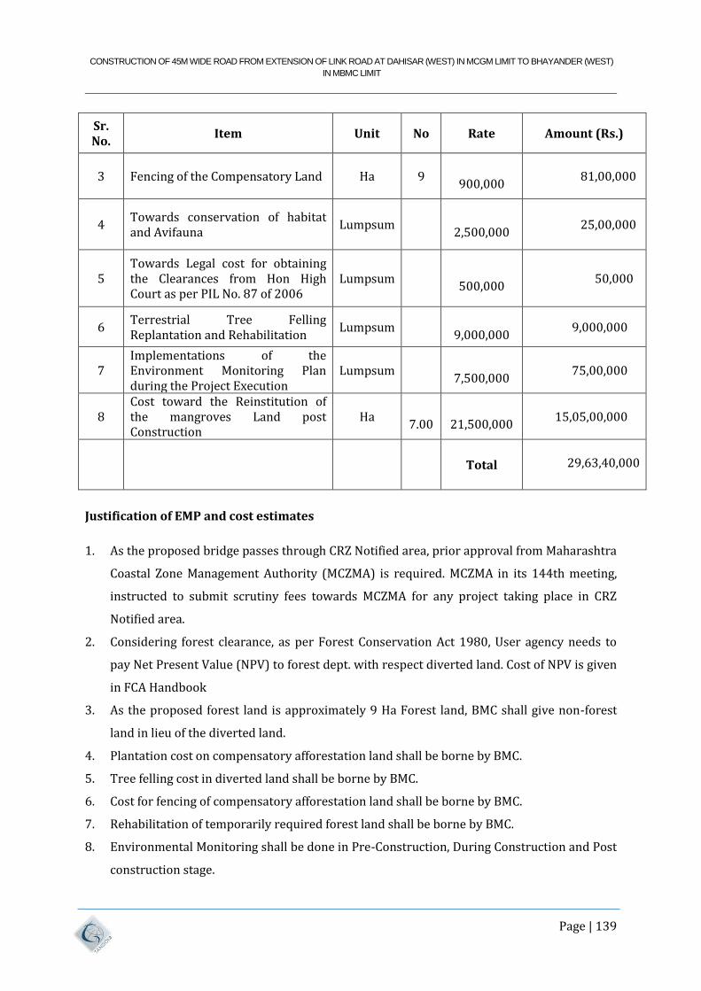
CONSTRUCTION OF 45M WIDE ROAD FROM EXTENSION OF LINK ROAD AT DAHISAR (WEST) IN MCGM LIMIT TO BHAYANDER (WEST)
IN MBMC LIMIT
Page | 139
Sr. No.
Item Unit No Rate Amount (Rs.)
3 Fencing of the Compensatory Land Ha 9
900,000 81,00,000
4 Towards conservation of habitat and Avifauna
Lumpsum
2,500,000 25,00,000
5 Towards Legal cost for obtaining the Clearances from Hon High Court as per PIL No. 87 of 2006
Lumpsum
500,000 50,000
6 Terrestrial Tree Felling Replantation and Rehabilitation
Lumpsum
9,000,000 9,000,000
7 Implementations of the Environment Monitoring Plan during the Project Execution
Lumpsum
7,500,000 75,00,000
8 Cost toward the Reinstitution of the mangroves Land post Construction
Ha
7.00
21,500,000 15,05,00,000
Total
29,63,40,000
Justification of EMP and cost estimates
1. As the proposed bridge passes through CRZ Notified area, prior approval from Maharashtra
Coastal Zone Management Authority (MCZMA) is required. MCZMA in its 144th meeting,
instructed to submit scrutiny fees towards MCZMA for any project taking place in CRZ
Notified area.
2. Considering forest clearance, as per Forest Conservation Act 1980, User agency needs to
pay Net Present Value (NPV) to forest dept. with respect diverted land. Cost of NPV is given
in FCA Handbook
3. As the proposed forest land is approximately 9 Ha Forest land, BMC shall give non-forest
land in lieu of the diverted land.
4. Plantation cost on compensatory afforestation land shall be borne by BMC.
5. Tree felling cost in diverted land shall be borne by BMC.
6. Cost for fencing of compensatory afforestation land shall be borne by BMC.
7. Rehabilitation of temporarily required forest land shall be borne by BMC.
8. Environmental Monitoring shall be done in Pre-Construction, During Construction and Post
construction stage.
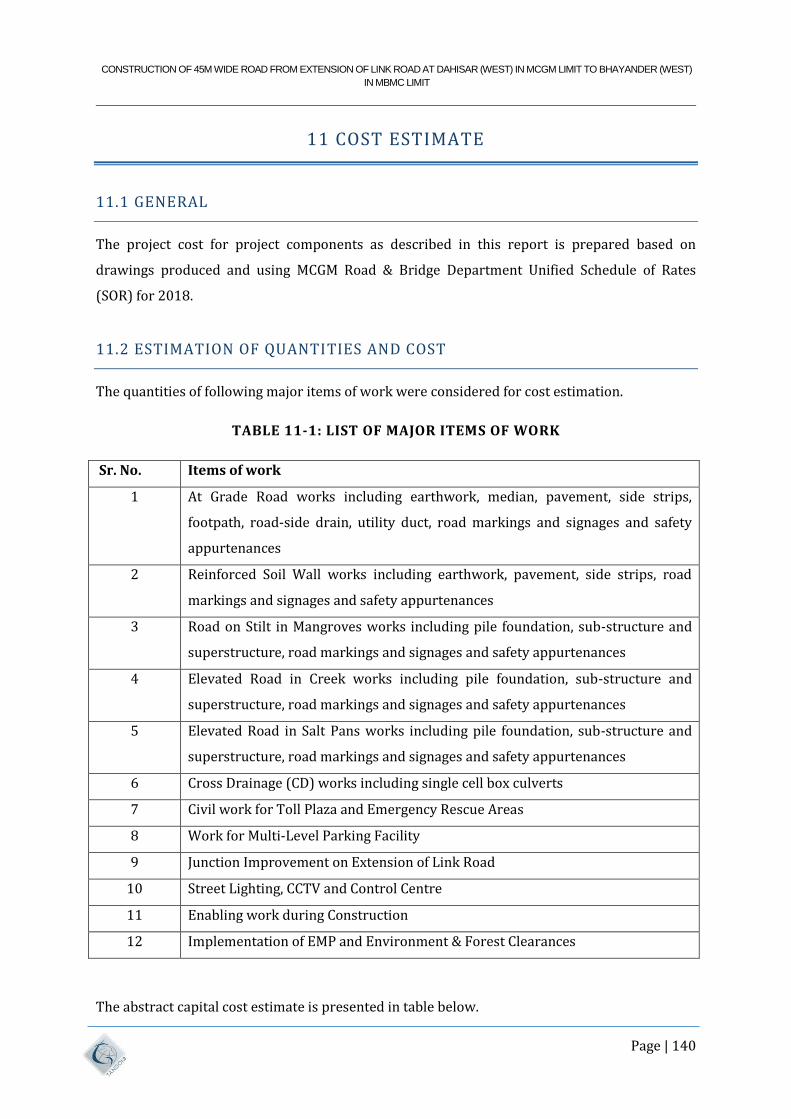
CONSTRUCTION OF 45M WIDE ROAD FROM EXTENSION OF LINK ROAD AT DAHISAR (WEST) IN MCGM LIMIT TO BHAYANDER (WEST)
IN MBMC LIMIT
Page | 140
11 COST ESTIMATE
11.1 GENERAL
The project cost for project components as described in this report is prepared based on
drawings produced and using MCGM Road & Bridge Department Unified Schedule of Rates
(SOR) for 2018.
11.2 ESTIMATION OF QUANTITIES AND COST
The quantities of following major items of work were considered for cost estimation.
TABLE 11-1: LIST OF MAJOR ITEMS OF WORK
Sr. No. Items of work
1 At Grade Road works including earthwork, median, pavement, side strips,
footpath, road-side drain, utility duct, road markings and signages and safety
appurtenances
2 Reinforced Soil Wall works including earthwork, pavement, side strips, road
markings and signages and safety appurtenances
3 Road on Stilt in Mangroves works including pile foundation, sub-structure and
superstructure, road markings and signages and safety appurtenances
4 Elevated Road in Creek works including pile foundation, sub-structure and
superstructure, road markings and signages and safety appurtenances
5 Elevated Road in Salt Pans works including pile foundation, sub-structure and
superstructure, road markings and signages and safety appurtenances
6 Cross Drainage (CD) works including single cell box culverts
7 Civil work for Toll Plaza and Emergency Rescue Areas
8 Work for Multi-Level Parking Facility
9 Junction Improvement on Extension of Link Road
10 Street Lighting, CCTV and Control Centre
11 Enabling work during Construction
12 Implementation of EMP and Environment & Forest Clearances
The abstract capital cost estimate is presented in table below.
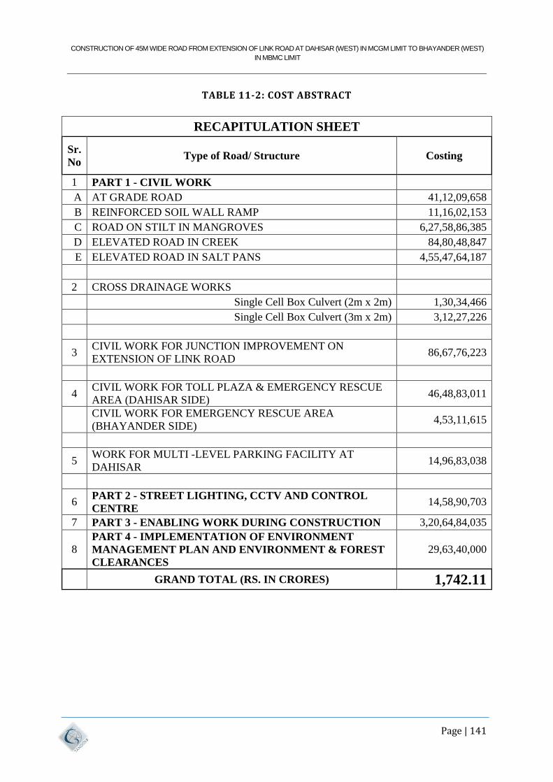
CONSTRUCTION OF 45M WIDE ROAD FROM EXTENSION OF LINK ROAD AT DAHISAR (WEST) IN MCGM LIMIT TO BHAYANDER (WEST)
IN MBMC LIMIT
Page | 141
TABLE 11-2: COST ABSTRACT
RECAPITULATION SHEET
Sr.
No Type of Road/ Structure Costing
1 PART 1 - CIVIL WORK
A AT GRADE ROAD 41,12,09,658
B REINFORCED SOIL WALL RAMP 11,16,02,153
C ROAD ON STILT IN MANGROVES 6,27,58,86,385
D ELEVATED ROAD IN CREEK 84,80,48,847
E ELEVATED ROAD IN SALT PANS 4,55,47,64,187
2 CROSS DRAINAGE WORKS
Single Cell Box Culvert (2m x 2m) 1,30,34,466
Single Cell Box Culvert (3m x 2m) 3,12,27,226
3 CIVIL WORK FOR JUNCTION IMPROVEMENT ON
EXTENSION OF LINK ROAD 86,67,76,223
4 CIVIL WORK FOR TOLL PLAZA & EMERGENCY RESCUE
AREA (DAHISAR SIDE) 46,48,83,011
CIVIL WORK FOR EMERGENCY RESCUE AREA
(BHAYANDER SIDE) 4,53,11,615
5 WORK FOR MULTI -LEVEL PARKING FACILITY AT
DAHISAR 14,96,83,038
6 PART 2 - STREET LIGHTING, CCTV AND CONTROL
CENTRE 14,58,90,703
7 PART 3 - ENABLING WORK DURING CONSTRUCTION 3,20,64,84,035
8 PART 4 - IMPLEMENTATION OF ENVIRONMENT
MANAGEMENT PLAN AND ENVIRONMENT & FOREST
CLEARANCES
29,63,40,000
GRAND TOTAL (RS. IN CRORES) 1,742.11
CONSTRUCTION OF 45M WIDE ROAD FROM EXTENSION OF LINK ROAD AT DAHISAR (WEST) IN MCGM LIMIT TO BHAYANDER (WEST)
IN MBMC LIMIT
Page | 142
12 CONCLUSIONS AND RECOMMENDATIONS
12.1 GENERAL
The preceding chapters of this report give detailed discussions on the various aspects of the
study carried out by the Consultant for construction of project road.
12.2 PROJECT CONSTRAINTS/BOTTLENECKS
Various constraints have been studied while finalizing the alignment (Minimum
Rehabilitation and Resettlement, Minimum impact on Mangroves and other
environmentally sensitive areas, etc.). After finalizing the alignment, BMC to obtain
various clearances as detailed below:
CRZ clearance from MCZMA and MoEF, GoI.
Environmental clearance from MoEF, GoI.
Forest Clearance from Forest Department/MoEF, GoI.
Land Acquisition.
Clearances from Hon High Court Bombay as per Judgement in PIL 87 of 2006.
12.3 NOCS TO BE OBTAINED FROM THE FOLLOWING CONCERNED
GOVERNMENT AUTHORITIES:-
MSETCL
Fisheries Department
Salt Pan Commissioner
MMRCL
12.3.1 TRAFFIC DISPERSAL
In order to cater to proper traffic dispersals and connectivity to proposed/ongoing roads or
existing roads we have studied various options and recommending junction improvements as
shown in Drawings.
CONSTRUCTION OF 45M WIDE ROAD FROM EXTENSION OF LINK ROAD AT DAHISAR (WEST) IN MCGM LIMIT TO BHAYANDER (WEST)
IN MBMC LIMIT
Page | 143
12.3.2 PAVEMENT
We have recommended rigid pavement for "At grade" road main carriageway with bituminous
pavement for side strips which is a small component of total project length. The major length of
project comprises of structures. Microsurfacing is proposed as wearing coat over bridge deck.
12.3.3 TECHNICAL FEASIBLITY
From the above report, it may be concluded that the construction of the proposed Dahisar
Bhayander Link road is considered as Technically Feasible.
Related Documents