FEASIBILITY STUDY REPORT NOVEMBER, 2017

Welcome message from author
This document is posted to help you gain knowledge. Please leave a comment to let me know what you think about it! Share it to your friends and learn new things together.
Transcript

FEASIBILITY STUDY REPORT NOVEMBER, 2017


Central Midlands Regional Intermodal
Transportation Center Feasibility Study
1
EXECUTIVE SUMMARY
In September of 2016, the Central Midlands Council of Governments (CMCOG) initiated a
study to examine the opportunities that a Regional Intermodal Transportation Center located
in or around downtown Columbia would bring to the Central Midlands area. It was expected
that such a facility not only would enhance the traveler experience and the efficiency of
transportation service operators in Columbia, but also would attract transit oriented
development (TOD). Such development would be attracted because of its transportation
access advantages and would be supportive of the transportation services found at the
Center. Opportunities for transit oriented design and joint development were examined in
the study.
The purpose of this study was to look at what an Intermodal Transportation Center for
Central Midlands might include, how it might serve various modes of transportation and
impact development, and where it might be located. This study is a first step in the process
set out by the Federal Transit Administration for advancing public transportation facility
projects. Regarding when the project might happen, the actual design and construction of a
Regional Intermodal Transportation Center is subject to future funding and approval by local,
regional, state, and federal agencies. Depending on how aggressively approvals and
funding are pursued and secured, the construction of a Regional Intermodal Transportation
Center could occur in as few as two to three years or as late as five to ten years.
The study was directed by a Steering Committee made up of representatives from CMCOG,
the City of Columbia, Richland County, and the Central Midlands Regional Transit Authority
(CMRTA which runs the COMET bus system). The Steering Committee was chaired by
CMCOG.
Additional stakeholders that were consulted during the study included elected and
appointed officials from the City and CMRTA and representatives from the University of
South Carolina, South Carolina Department of Transportation, Amtrak, Greyhound Bus Lines,
and Megabus. To evaluate market demand and economic conditions, interviews were held
with numerous local and regional real estate developers, brokers, economic development
entities and civic/cultural representatives.
A proactive plan to obtain public input for the study was undertaken. A public information
meeting was held and a free standing website was established for this study. The website
included an overview of the plan, project documents and updates, meeting notices and
reports and an email address for submitting comments. The public was able to contact the
Wendel team through the website, ask questions, submit opinions and/or provide
information. A public outreach questionnaire was posted on the website to solicit ideas,
opinions and information relative to the project from the general public. This questionnaire
also was made available to transit riders and people attending the public meetings. A
separate questionnaire was used to solicit input from Amtrak and Greyhound riders.

Central Midlands Regional Intermodal
Transportation Center Feasibility Study
2
The study was performed by a team of consultants led by Wendel and including Kimley-Horn
& Associates for environmental analysis, Flock and Rally for public participation, Willdan
Financial Services for economic benefits analysis, Jones Worley Design, Inc. for wayfinding
signage recommendations and Costing Services Group for cost estimating. The study was
undertaken in seven phases:
1. Analysis of Current Services, Operational Conditions And Needs
2. Facility Needs Assessment
3. Location and Site Evaluation
4. Public Involvement
5. Environmental Analysis
6. Markets and Opportunities Analysis
7. Conceptual Design
The findings of the study were as follows:
The current transfer station operated by the COMET needs significant renovation and
expansion in order to attract choice riders to COMET transit services.
The current transfer station is heavily utilized and serves an important function for
COMET services with 19 bus routes connecting at the facility and over 3,000
passengers using the station each day.
Public opinion supports the creation of a new Regional Intermodal Transportation
Center. Respondents to a public opinion questionnaire indicated that 75% believe
that a new Intermodal Transportation Center is needed and 64% indicated that they
were either very likely or likely to utilize a new Transportation Center.
The COMET would like to be able to schedule more buses to arrive together for
convenient passenger transfers than they currently are able to accommodate at the
transfer station.
The operators of Greyhound Bus service and Megabus service in Columbia would
prefer to operate service from downtown and would welcome the opportunity to serve
an Intermodal Transportation Center.
Proximity to the Columbia Amtrak station is desirable for an Intermodal
Transportation Center but direct physical connectivity is not essential. Current Amtrak
service to Columbia operates at times considerably outside service hours of local and
intercity bus service. New passenger rail service that could serve Columbia is being
studied for the Southeast High Speed Rail Corridor, and there is interest in passenger
rail service between Columbia and Charlotte, North Carolina. It has not been
determined whether new passenger rail service under either scenario would operate
from the current Columbia Amtrak Station. The South Carolina Department of
Transportation (SCDOT) does not anticipate additional passenger rail service coming
to Columbia in the near term (5 years).
A new Intermodal Transportation Center for Columbia should be served by the
COMET, Southeastern Stages and Greyhound, Megabus, other private intercity bus
Central Midlands Regional Intermodal
Transportation Center Feasibility Study
3
carriers, possible bus links to Columbia Metropolitan Airport and Charlotte Douglas
International Airport, Uber and/or Lyft type serviced, taxi service, and bike sharing
service. The Center should have plentiful parking, and safe access for bicyclists and
pedestrians, carpoolers, and people driving their own cars.
A new Intermodal Transportation Center for Columbia functionally could support as
many as 20 bus bays for COMET and intercity bus operations. The bus bays should
be constructed in a saw tooth configuration for safe operations and the Center
should have multiple points of bus ingress and egress to the facility.
The Intermodal Transportation Center should include a building of approximately
12,000 square feet. The building should include a passenger waiting area, public
restrooms, break rooms and facilities for COMET drivers, office space for certain
COMET functions, employee and baggage handling rooms for Greyhound, and a
space for public meetings.
The Intermodal Transportation Center should be a modern, spacious facility and
should have vending machines or food service carts, real time bus information
displays, ticketing machines, a lost and found, rest rooms and personal electronic
device charging stations among other amenities. Safety and security will be of
paramount importance at a new Transportation Center.
The facility program that was developed for the Transportation Center indicates that
a site with approximately 2.5 acres will be needed for a new facility.
The study identified 22 potential sites for a new Transportation Center in the City of
Columbia. These 22 locations were examined by the Study Steering Committee and
using a pre-defined set of site evaluation criteria, the sites were analyzed and the
highest ranking site was identified.
An environmental analysis was performed for the top four ranking potential sites. No
“fatal flaws” from an environmental perspective were found at any of the sites.
The highest ranked, or preferred site was identified for further study. The preferred
site was the location of the current COMET bus transfer station and would extend
from Laurel Street to Blanding Street along Sumter Street.
Late in the conduct of this study, the City of Columbia issued a Request for
Qualifications for developers or development teams that would propose a public
private partnership undertaking to develop portions of the 1700 and 1800 blocks of
Main Street. The proposed development undertaking is to accompany a municipal
complex being planned for the site and the development site would include the
property which has been identified as the preferred site for the Regional Intermodal
Transportation Center. The prospective developer(s) were to consider “intermodal
transit opportunities” as part of the program for the development. The process for
qualifying developer teams, soliciting and reviewing proposals and selecting a
successful proposal is to extend beyond the timeline of this study. While the potential
public private partnership could become the means to advance a regional intermodal
transportation center, there is still much uncertainty at this early time in the
development of that initiative. The decision was made by CMCOG not to alter the
course of this study.

Central Midlands Regional Intermodal
Transportation Center Feasibility Study
4
Documentation was prepared that can be used to support a request to the Federal
Transit Administration (FTA) for a Categorical Exclusion finding under the National
Environmental Policy Act (NEPA). Such a finding will permit the project to advance to
property acquisition and design/construction without further environmental analysis
– if and when the project is selected for advancement by the CMRTA. In addition, a
Title VI Equity Analysis was prepared for submission to the FTA. This analysis ensures
compliance with FTA requirements that the location of the new Transportation Center
meets the Title VI requirements and will not create adverse Civil Rights impacts.
A conceptual site plan and conceptual architectural plan were developed for a
Regional Intermodal Transportation Center. A base program site plan that shows the
Transportation Center constructed to serve transportation purposes only is shown
along with conceptual drawings of what the transportation center might look like with
full build out of transportation oriented development on the site. The base program
for the Center as shown in the conceptual site plan is expected to cost approximately
$14.7M to construct.
An analysis of the development potential at the site was prepared as well as an
analysis of the economic impacts of the Regional Intermodal Transportation Center.
This analysis determined that a total of 435,000 square feet of mixed-use
development could accompany the development of the Regional Intermodal
Transportation Center including 155 units of multifamily rental housing, 571 shared-
use parking spaces and ancillary retail space to serve as an amenity to the
Transportation Center.
If the full development potential is realized then employment from ongoing
residential and commercial operations is expected to generate nominal jobs (6 to 10
full-time equivalent (“FTE”) multifamily jobs, 16 FTE retail jobs, and between 40 to 80
office jobs. The total combined payroll from private sector jobs is approximately
$5.35 million annually. The residential and commercial uses could be expected to
generate approximately $6.42 million in direct, indirect and induced spending in the
local and regional economy. Ongoing taxes related to the multifamily and commercial
uses are expected to be nominal – the project is expected to generate approximately
$26,000 in annual real property tax revenues and approximately $259,000 in state
and local retail sales tax revenues.
In summary, the Regional Intermodal Transportation Center is a viable project for the Central
Midlands Region. It has strong public support and would produce clear benefits for COMET
operations and for Southeastern Stages and Greyhound as well as Megabus operations.
Significant benefits would be produced for the patrons of the local and intercity bus
operations as well as the Columbia community in general. A state of the art, attractive
transportation center would provide safe and convenient access and connectivity to local
bus, intercity bus and other modes of transportation for the citizens of Columbia and would
support transit oriented mixed use development at the site of the center.
Next Steps – If the CMRTA and the City of Columbia concur that a Regional Intermodal
Transportation Center would be beneficial to the COMET and concur with a selected site, this

Central Midlands Regional Intermodal
Transportation Center Feasibility Study
5
project can be advanced towards implementation. Initial efforts would include working with
CMCOG to place the project in the Regional Transportation Improvement Program and then
with the South Carolina Department of Transportation to include the project in the Statewide
Transportation Improvement Program. This is in accordance with the US Department of
Transportation planning and programming guidelines and regulations. The CMRTA would
then submit a request to the FTA for an evaluation of the project to determine its eligibility
for a finding of a Categorical Exclusion (Cat Ex) from additional environmental study under
the NEPA provisions. The information provided in the environmental analysis and equity
analysis section of this study will support the Cat Ex request. The award of a Cat Ex finding
by the FTA will permit the project to advance to the acquisition of property and final design
stages of the project.
The CMRTA will need to seek federal and state funding support for the design and
construction expenses of the Regional Intermodal Transportation Center. The information
contained in this report will support the preparation of grant applications. Upon receiving
federal and state funding for the project, the CMRTA – working closely with the City of
Columbia will be the lead agency to acquire property, contract for the design of the facility,
conduct construction bidding and oversee the construction and eventual operation of the
Regional Intermodal Transportation Center.

Central Midlands Regional Intermodal
Transportation Center Feasibility Study
6
TABLE OF CONTENTS
LIST OF FIGURES ............................................................................................................................ 7
LIST OF TABLES .............................................................................................................................. 8
INTRODUCTION AND BACKGROUND ........................................................................................... 10
ANALYSIS OF CURRENT SERVICES, OPERATIONAL CONDITIONS AND NEEDS ........................ 11
Transit Service Baseline .......................................................................................................... 12
Amtrak/Greyhound/Megabus ................................................................................................. 13
Future Passenger Rail Service to Columbia ........................................................................... 14
Multi-modal Opportunities ....................................................................................................... 17
FACILITY NEEDS ASSESSMENT ................................................................................................... 18
Facility Program ........................................................................................................................ 18
LOCATION AND SITE EVALUATION ............................................................................................... 21
Site Selection Criteria .............................................................................................................. 22
Optimal Geographic Location .................................................................................................. 24
Inventory of Potential Sites ...................................................................................................... 25
Evaluations of Potential Sites .................................................................................................. 26
PUBLIC INVOLVEMENT ................................................................................................................. 29
Public Meeting .......................................................................................................................... 34
Public Input Questionnaire ...................................................................................................... 38
Amtrak and Greyhound Passengers Response ...................................................................... 42
Public Input Questionnaire Results ......................................................................................... 44
ENVIRONMENTAL ANALYSIS ....................................................................................................... 58
Site Overview and Environmental Assessment ...................................................................... 58
Table 5: Summary of Environmental Findings ....................................................................... 61
Equity Analysis .......................................................................................................................... 61 Title VI Compliance ............................................................................................................... 62
Analysis Methodology ........................................................................................................... 63
Populations and Geographies .............................................................................................. 63
Benefits and Burdens Analysis ............................................................................................ 69
Equity Analysis Conclusions ................................................................................................. 71
MARKETS AND OPPORTUNITIES ANALYSIS ................................................................................ 72
Introduction and Executive Summary ..................................................................................... 72
Summary of Financial Feasibility and Economic Benefits ..................................................... 72
Central Midlands Regional Intermodal
Transportation Center Feasibility Study
7
Site Characteristics and Market Potential .............................................................................. 75
Site Competitive Context ...................................................................................................... 75
Demographic and Economic Indicators .............................................................................. 77
Key Demographic Findings .................................................................................................. 78
Real Estate Market Economics ............................................................................................... 80
Downtown Columbia Market Overview................................................................................ 81
Multifamily Development Trends ......................................................................................... 81
Office Market Development Trends .................................................................................... 83
Retail Market Trends ............................................................................................................ 85
Retail Spending Power Analysis ........................................................................................... 88
Parking .................................................................................................................................. 89
Recommended Development Opportunities .......................................................................... 89
Conditions of Mixed-Use Development Financial Feasibility ............................................. 90
Real Estate Market Findings and Recommendations ........................................................ 92
Financial Feasibility and Economic Benefits .......................................................................... 94
Introduction and Overview ................................................................................................... 94
Summary of Supportable Investment ................................................................................. 95
Fiscal and Economic Benefits .............................................................................................. 96
Conclusion ................................................................................................................................ 98
CONCEPTUAL PLANS FOR THE CENTRAL MIDLANDS REGIONAL INTERMODAL
TRANSPORTATION CENTER ......................................................................................................... 99
Initial Master Plan Site Concepts ............................................................................................ 99
Three Dimensional Studies for the Preferred Site Plan ...................................................... 104
Refinement of the Preferred Three Dimensional Conceptual Plan ................................... 106
Conceptual Level Construction Cost Estimate for Transit Components Only ................... 116
LIST OF FIGURES
Figure 1: Example Site Plan for the Regional Intermodal Transportation Center ................................. 21
Figure 2: Optimal Geographic Location .................................................................................................... 25
Figure 3: Sites Evaluated for the Location of the Regional Transportation Center ............................... 26
Figure 4: Project Information Sheet ......................................................................................................... 32
Figure 5: Project Website .......................................................................................................................... 33
Figure 6: Facebook Post ........................................................................................................................... 34

Central Midlands Regional Intermodal
Transportation Center Feasibility Study
8
Figure 7: Public Meeting Notification ....................................................................................................... 35
Figure 8: Public Information Meeting Poster ........................................................................................... 36
Figure 9: Sample Public Meeting Information Board .............................................................................. 37
Figure 10: Public Comment Questionnaire .............................................................................................. 39
Figure 11: Public Input Questionnaire Responses .................................................................................. 57
Figure 12: CMCOG RITC Site Market Area – 30-Minute Drive Time from Proposed Site ..................... 76
Figure 13: City of Columbia, SC Demographic Snapshot, 2017 ............................................................ 80
Figure 14: Columbia, SC Retail Submarkets Map ................................................................................... 87
Figure 15: Test Fit Site Option A .............................................................................................................100
Figure 16: Test Fit Site Option B .............................................................................................................101
Figure 17: Test Fit Site Option C .............................................................................................................102
Figure 18: Test Fit Site Option D ............................................................................................................103
Figure 19: Option 1 Conceptual Plan .....................................................................................................104
Figure 20: Option 2 Conceptual Plan .....................................................................................................105
Figure 21: Option 3 Conceptual Plan .....................................................................................................105
Figure 22: Regional Transportation Center Conceptual Site Plan – Base Program ...........................108
Figure 23: Regional Transportation Center Conceptual Site Plan with TOD – 1st Level .....................109
Figure 24: Regional Transportation Center Conceptual Site Plan with TOD – 2nd Level ....................110
Figure 25: Regional Transportation Center Conceptual Site Plan with TOD – 3rd Level Up ...............111
Figure 26: Regional Transportation Center Conceptual Plan with Full TOD Buildout .........................112
Figure 27: Regional Transportation Center Conceptual Plan with Full TOD Buildout .........................113
Figure 28: Regional Transportation Center Conceptual Plan Signage .................................................114
Figure 29: Regional Transportation Center Conceptual Plan Signage Detail ......................................115
LIST OF TABLES
Table 1: Regional Intermodal Transportation Center Facility Program .................................................. 20
Table 2: Site Evaluation Criteria Weightings and Rankings .................................................................... 24
Table 3: Site Evaluation Criteria Spreadsheet – Scoring of Top Four Sites........................................... 28
Table 4: Amtrak and Greyhound Passenger Survey Responses ............................................................ 43
Table 5: Summary of Environmental Findings ......................................................................................... 61
Table 6: Environmental Analysis - Equity Analysis Findings.................................................................... 71
Table 7: CMCOG RITC Site Recommended Development Program and Target Revenue .................... 72
Table 8: City of Columbia & CMCOG RITC Site 30-Minute Drive Time, 2010-2017-2022 ................... 77
Table 9: Columbia Multifamily Submarket – Pipeline and Absorption Trends (Q4 2016) ................... 82
Table 10: Columbia Submarket Multifamily Trends – Rent and Vacancy Rates (Q4 2016) ................ 83
Table 11: Columbia Office Market Statistics ........................................................................................... 84
Table 12: Columbia Retail Market Trends (Q4 2016) ............................................................................. 86
Table 13: Retail Spending Power Analysis, RITC Site Regional Market Area (2017-2022) ................. 88
Central Midlands Regional Intermodal
Transportation Center Feasibility Study
9
Table 14: CMCOG RITC Site Recommended Development Program and Target Revenue .................. 94
Table 15: Summary of CMCOG RITC Site Private Development Financial Feasibility ........................... 95
Table 16: RITC Commercial & Public Use Development (One-Time Construction Benefits) ................ 97
Table 17: CMCOG RITC Fiscal Benefits – Annual Ongoing Real Property Taxes (Stabilized Year) ....... 98
Table 18: CMCOG RITC Fiscal Benefits – Annual Ongoing Sales Taxes (Stabilized Year) .................... 98
Table 19: Conceptual Level Construction Estimate for the Regional Transportation Center .............116
Central Midlands Regional Intermodal
Transportation Center Feasibility Study
10
INTRODUCTION AND BACKGROUND
In September of 2016, the Central Midlands Council of Governments (CMCOG) initiated a
study to examine the opportunities that a Regional Intermodal Transportation Center located
in or around downtown Columbia would bring to the Central Midlands area. It was expected
that such a facility would not only enhance the traveler experience and the efficiency of
transportation service operators in Columbia, but also would attract development that would
be drawn to the location because of its transportation advantages. Such development would
be supportive of the transportation services found at the Center and opportunities for transit
oriented design and joint development were examined in the study.
The purpose of this study was to look at what an Intermodal Transportation Center for Central
Midlands might include, how it might serve various modes of transportation, how it might
impact development, and where it might be located. This study is a first step in the process
set out by the Federal Transit Administration for advancing public transportation facility
projects. Regarding when the project might happen, the actual design and construction of a
Regional Intermodal Transportation Center is subject to future funding and approval by local,
regional, state, and federal agencies. Depending on how aggressively approvals and funding
are pursued and secured, the construction of a Regional Intermodal Transportation Center
could occur in as few as two to three years or as late as five to ten years.
The study was directed by a Steering Committee made up of representatives from CMCOG, the
City of Columbia, Richland County, and the Central Midlands Regional Transit Authority
(CMRTA which runs the COMET bus system). The Steering Committee was chaired by CMCOG.
What is an Intermodal Transportation Center? An Intermodal Transportation Center is a multi-
purpose building located within a designated area of a city, in which several types of
transportation come together to create a hub of accessible, connected transportation
services. Depending on the modes of transportation that are in use in a region, the following
may be brought together at a single location: local bus service, paratransit, intercity bus
service, taxis, Ubers, rail connections, automobile parking, flex car or rental car service,
bicycles, pedestrian walkways and more.
Bringing these modes of transportation together creates an opportunity for people to more
easily travel and connect to destinations both near and far through a variety of transportation
choices. Bringing these modes together also increases their efficiency and effectiveness and
improves mobility and accessibility within the community.
In the building you will find comfortable passenger waiting areas, restrooms, ticketing and
travel information – often including real-time information on the arrival and departure of
buses. The building also may include many other features, such as storage areas for bicycles,
coffee shops, bank branches, retail spaces, meeting rooms for community functions,
administrative offices for the transit system and/or break areas for bus drivers. Intermodal
Transportation Centers become activity centers for their community and usually attract other
development around or nearby them.
Central Midlands Regional Intermodal
Transportation Center Feasibility Study
11
Structure of the Study – The Central Midlands Regional Intermodal Transportation Center
Feasibility Study was conducted to look at the feasibility of such a transportation facility in
Columbia and included seven distinct elements. These include:
1. Analysis of Current Services, Operational Conditions And Needs
2. Facility Needs Assessment
3. Location and Site Evaluation
4. Public Involvement
5. Environmental Analysis
6. Markets and Opportunities Analysis
7. Conceptual Design
The following report sets out the findings of the Study for each of these elements.
ANALYSIS OF CURRENT SERVICES, OPERATIONAL CONDITIONS AND NEEDS
To start the analysis, sixteen planning documents were reviewed and pertinent data and/or
information were noted as they pertained to this study. These planning documents included
the following:
CMRTA 2020 Vision Plan
2040 COATS Long Range Transportation Plan
Regional Transit Development Plan
CMCOG Human Services Coordination Plan
CMCOG Congestion Management Plan
City of Columbia Comprehensive Land Use Plan
Richland County Comprehensive Land Use Plan
Richland County Long Range Transportation Plan
Lexington County Comprehensive Land Use Plan
2040 Multimodal Statewide Plan
Walk Bike Columbia
Imagine Mill District
Amtrak Charlotte – Columbia Study
Central Midlands Commuter Rail Feasibility Study
South Carolina Statewide Rail Plan (2014)
South Carolina Department of Transportation 2016 Rail Plan Implementation Update,
January 2017
Central Midlands Regional Intermodal
Transportation Center Feasibility Study
12
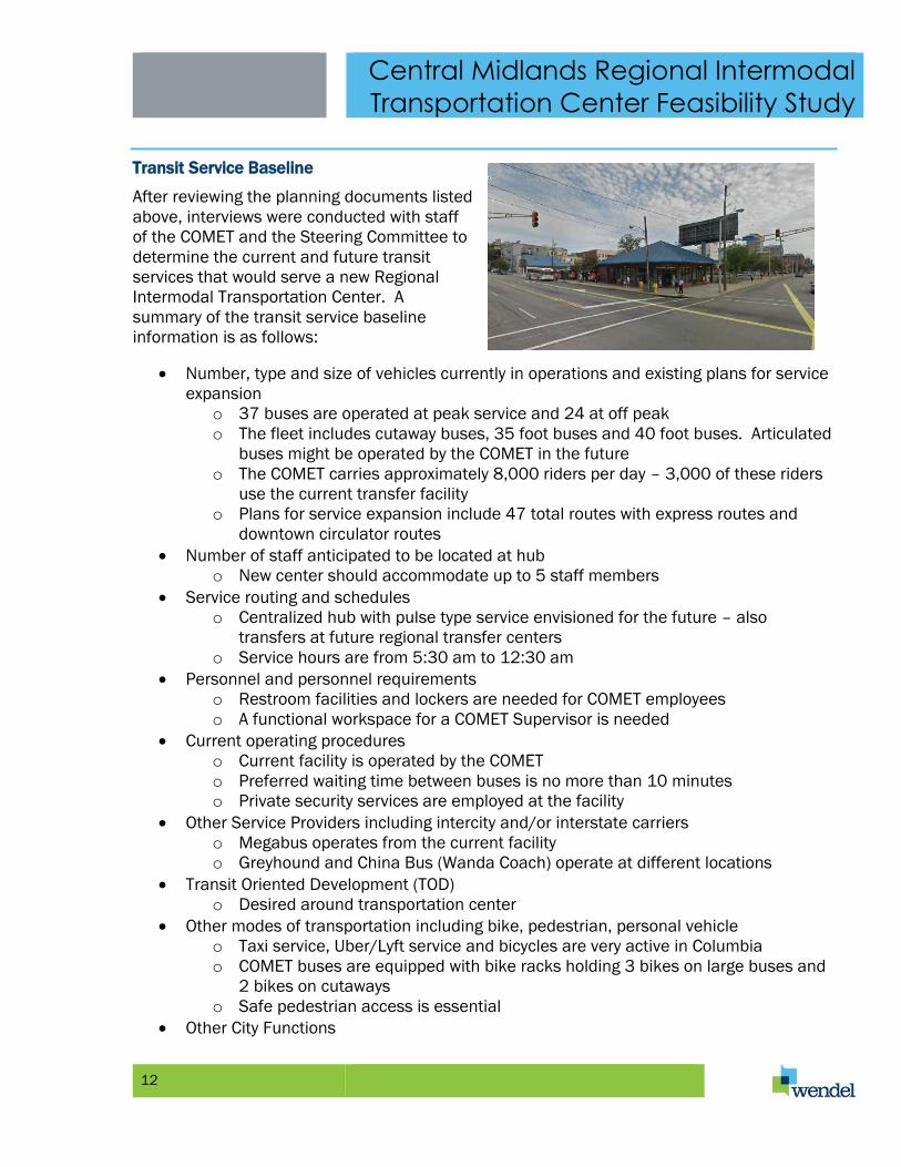
Transit Service Baseline
After reviewing the planning documents listed
above, interviews were conducted with staff
of the COMET and the Steering Committee to
determine the current and future transit
services that would serve a new Regional
Intermodal Transportation Center. A
summary of the transit service baseline
information is as follows:
Number, type and size of vehicles currently in operations and existing plans for service
expansion
o 37 buses are operated at peak service and 24 at off peak
o The fleet includes cutaway buses, 35 foot buses and 40 foot buses. Articulated
buses might be operated by the COMET in the future
o The COMET carries approximately 8,000 riders per day – 3,000 of these riders
use the current transfer facility
o Plans for service expansion include 47 total routes with express routes and
downtown circulator routes
Number of staff anticipated to be located at hub
o New center should accommodate up to 5 staff members
Service routing and schedules
o Centralized hub with pulse type service envisioned for the future – also
transfers at future regional transfer centers
o Service hours are from 5:30 am to 12:30 am
Personnel and personnel requirements
o Restroom facilities and lockers are needed for COMET employees
o A functional workspace for a COMET Supervisor is needed
Current operating procedures
o Current facility is operated by the COMET
o Preferred waiting time between buses is no more than 10 minutes
o Private security services are employed at the facility
Other Service Providers including intercity and/or interstate carriers
o Megabus operates from the current facility
o Greyhound and China Bus (Wanda Coach) operate at different locations
Transit Oriented Development (TOD)
o Desired around transportation center
Other modes of transportation including bike, pedestrian, personal vehicle
o Taxi service, Uber/Lyft service and bicycles are very active in Columbia
o COMET buses are equipped with bike racks holding 3 bikes on large buses and
2 bikes on cutaways
o Safe pedestrian access is essential
Other City Functions

Central Midlands Regional Intermodal
Transportation Center Feasibility Study
13
o No other City functions operate at the current facility
Amtrak/Greyhound/Megabus
In parallel with a survey of the public and COMET riders, a survey was conducted with patrons
of Amtrak and Greyhound to understand their needs, desires, and other information that
pertains to a new Intermodal Facility. In addition, the station managers for Amtrak and
Greyhound were interviewed to ascertain their interest or concerns regarding a new
Intermodal Facility. The regional manager for Megabus also was contacted for input to the
study.
Amtrak - Amtrak currently operates two trains per day that serve Columbia. These trains
operate on their Silver Star route that connects with Tampa and Miami, Florida in the south
and all of the cities in the Northeast Corridor in the north terminating in New York City. The
local Amtrak station is located at 850 Pulaski Street in Columbia. A southbound train departs
the station at 1:43 am and a northbound train departs the station at 4:01 am. Amtrak sees
around 38,000 boardings and alightings per year in Columbia. This is the third highest in the
state behind Charleston with around 85,000 and Florence with around 52,000.
An interview with the station manager for Amtrak indicated that there are no current plans to
expand or improve the station. Further, Amtrak does not have any plans to alter passenger
rail service to the Columbia station. The station manager indicated that the concept of
connectivity between the Amtrak station and other modes of transportation was logical and
attractive – however the current schedule of passenger rail service makes the concept
impractical. With the exception of Uber/Lyft and taxi service, other modes of public
transportation in the Central Midlands region do not operate at the hours that the trains serve
the station.
A survey of rail passengers at the Columbia Amtrak station was conducted to ascertain the
interests or concerns of current Amtrak patrons in Columbia. The results of this survey are
shown in Table 4 included in the Public Involvement section of this report.
Greyhound – Intercity bus service for Columbia is operated by Southeastern Stages for
Greyhound Bus Lines. The intercity bus station is located at 710 Buckner Road in Columbia.
Buses leave the station 11 times a day to connecting to destinations all over the east coast.
The station is open from 12:00 am to 2:30 am and then from 6:30 am until 11:59 pm.
An interview with the station manager revealed that there is great interest in moving the
intercity bus station back to downtown Columbia. Operating out of an intermodal
transportation center is highly desirable for the intercity bus operator and strong support for
this study and the establishment of a Regional Intermodal Transportation Center was
expressed by the intercity bus operator.

Central Midlands Regional Intermodal
Transportation Center Feasibility Study
14
A survey of intercity bus passengers at the Greyhound Bus station was conducted to ascertain
the interests or concerns of current intercity bus patrons in Columbia. The results of this
survey are shown in Table 4 included in the Public Involvement section of this report.
Megabus – Megabus operates four trips daily out of Columbia serving Atlanta, Georgia,
Durham and Fayetteville, North Carolina, Richmond, Virginia, Washington, D.C., Philadelphia,
Pennsylvania, and New York City, New York. The buses depart from Columbia at 3:00 am,
3:35 am, 2:00 pm, and 5:25 pm. Previously, Megabus operated out of the COMET transfer
center on Sumter Street. Effective Monday April 3rd, 2017, the Megabus stop for arrivals and
departures in Columbia relocated to the parking lot between McDonalds and the Wells Fargo
Bank, at 1278 Dutch Square Blvd., near the intersection of Broad River Rd. The regional
manager for Megabus was contacted by the Wendel team to discuss the planned Regional
Intermodal Transportation Center. Megabus was supportive of this study and expressed
interest in serving a new, safe and attractive regional transportation center.
Future Passenger Rail Service to Columbia
The City of Columbia serves as a hub to a network of rail lines owned by both Norfolk Southern
Railway and CSX Transportation. Amtrak service to Columbia is operated over the rail lines
owned by CSX Transportation. Perhaps because of Columbia’s history as a railroad hub, there
has been and continues to be great interest in new or expanded passenger rail service to the
City. Any new passenger rail service to Columbia most likely would come either as an initiative
to construct high speed rail in the Southeastern United States or as an initiative to establish
commuter rail to Charlotte, North Carolina. There have been and continue to be studies
conducted to examine bring new passenger rail service to Columbia.
High Speed Rail – Georgia DOT, in partnership with South Carolina DOT and North Carolina
DOT, are leading development of a Tier I Environmental Impact Study (EIS) for a high speed
rail corridor between Charlotte and Atlanta that passes through the state’s Upstate region
roughly parallel to I‐85. This Passenger Rail Corridor Investment Plan (PRCIP) is part of a
larger high‐speed rail initiative on the behalf of the Federal Railroad Administration (FRA) that
extends north to Washington, DC and is commonly referred to as the Southeast High Speed
Rail (SEHSR) Corridor.
The purpose of the Atlanta to Charlotte PRCIP is to improve intercity travel and mobility
between Atlanta and Charlotte by expanding the region’s transportation capacity and reliable
mode choices through improvements in passenger rail services. This corridor also will be an
important extension to the planned SEHSR Corridor system developing important linkages to
other metropolitan areas along the East Coast (Washington, D.C., New York and Boston).
Two of the alignments being evaluated in the Charlotte to Atlanta PRCIP study connect
Charlotte, NC with Columbia. One proposed alignment follows an existing CSX freight line,
while the other is a Greenfield alignment roughly parallel to I‐77. The Atlanta to Charlotte

Central Midlands Regional Intermodal
Transportation Center Feasibility Study
15
Passenger Rail Corridor Investment Plan is 85% completed with full completion anticipated in
early 2018.
Also related to the Charlotte to Atlanta PRCIP, FRA selected the Southeast region for a fully-
funded, USDOT-led, Southeast Multi-State Rail Planning Study in July 2015. This effort
continues and will facilitate coordination with neighboring states and will assist with funding
for freight and passenger rail projects in the Southeast. SCDOT serves as a member of the
project Steering Committee, and hosted the first meeting for the Southeast Regional Rail
Planning Study in Columbia in September 2016. The anticipated completion date for the Plan
is late 2017.
Independent of the studies to determine whether high‐speed rail service will be feasible,
interest has been expressed in passenger rail service between Charlotte, North Carolina and
Columbia that would connect to the expanding passenger rail network being developed in the
Charlotte region.
Commuter Rail - The Central Midland Council of Governments (CMCOG) has been exploring
commuter rail service since 2000 when it completed its first study. The results of that study,
which assessed nine corridors, identified three that possessed characteristics that would
benefit from commuter rail service. They were: Columbia to Newberry; Columbia to Camden;
and, Columbia to Batesburg‐ Leesville.
Another Commuter Rail Feasibility Study was conducted in 2006 by CMCOG to further
evaluate the three corridors previously identified. Of the three corridors, the Columbia‐Camden corridor was the clear choice receiving the highest ranking overall in four of the five
criteria. It also compared favorably with the peer corridors in Albuquerque, Charlotte and
Nashville. Ridership was estimated to range between 1,900‐2,300 per day and the capital
cost estimated at $80 million.
As a follow-up to the 2006 Commuter Rail Feasibility Study, in May of 2011, CMCOG
completed its Camden / Columbia Alternatives Analysis Study. Three “build” alternatives were
identified: one commuter rail and two bus rapid transit (BRT). Ultimately, however, the study
found that the three build alternatives were too costly relative to the need for transit service at
the time. Instead, low cost investments enhancing mobility options for traveling within
Columbia were recommended, as well as between suburban areas and downtown Columbia.
Challenges for New or Expanded Passenger Rail Service to Columbia – If any new or expanded
passenger rail service is to occur for Columbia, it will be up to the State of South Carolina to
make it happen. The Federal Railroad Administration and Amtrak look to the states to plan,
organize and finance passenger rail improvements. Federal funding for rail passenger
improvements has been made available in the past and may become available again in the
future, but the vast majority of the financial burden for passenger rail improvements in South
Carolina will rest on the state.

Central Midlands Regional Intermodal
Transportation Center Feasibility Study
16
The South Carolina Department of Transportation (SCDOT) is South Carolina’s “State Rail
Transportation Authority” as defined by the federal Passenger Rail Investment and
Improvement Act of 2008 (PRIIA). The South Carolina Statewide Rail Plan (SRP) was approved
by the SCDOT Commission as part of the South Carolina Multimodal Transportation Plan on
December 4, 2014. SCDOT ensures that the SRP documents the state’s policy on freight and
passenger rail transportation within the State’s boundaries, establishes priorities and
implementation strategies to enhance rail service in the public interest, and serves as the
basis for Federal and State rail investment. The SRP was approved by the Federal Railroad
Administration (FRA) on April 13, 2015. SCDOT continues to work on implementation of the
SRP to enhance the overall passenger and freight rail services in South Carolina
South Carolina currently does not have any state revenue source dedicated for passenger or
freight rail, nor any grant or loan programs for rail projects. The state does have public‐private
partnership (P3) legislation for highway projects; however, the current P3 law does not include
either passenger or freight rail projects. State support for rail transportation currently exists
only as some limited opportunities for state and local financial assistance for Class I and
Short Line freight rail companies and passenger rail initiatives that include South Carolina
Department of Commerce grants for infrastructure improvements tied to job creation and
assistance from the South Carolina Transportation Infrastructure Bank.
Therefore the next steps or tasks that need to be achieved to bring new or expanded
passenger rail service to Columbia include:
The selection of one of the alignments that serve Columbia in the Charlotte to Atlanta
PRCIP or a finding of feasibility in a separate Charlotte to Columbia passenger rail
study.
The conduct and approval by FRA of a Tier II Environmental Impact Study for an
alignment serving Columbia.
The establishment of a passenger rail operating and capital funding program by the
State of South Carolina.
The selection of passenger rail service to Columbia for state sponsorship by SCDOT
among other statewide needs and priorities.
The conduct of a patronage and scheduling study by the operating entity (Amtrak or
other) or SCDOT.
The negotiation of access and operating agreements by SCDOT with the host railroad
and passenger rail operating entity (Amtrak or other).
The funding and construction of freight rail improvements required by the host
railroad.
The funding and construction of passenger rail improvements and/or purchase of
required equipment.
Central Midlands Regional Intermodal
Transportation Center Feasibility Study
17
Multi-modal Opportunities
After reviewing the current services, operational conditions and needs of public transportation
in the Central Midlands region, it is apparent that a Regional Intermodal Transportation Center
would create an opportunity for significant improvement for several modes. The core need is
for a new, improved and expanded transfer center for the COMET. The current facility is
heavily utilized, undersized and in poor condition. Buses stop on Laurel and Sumter Streets
and the mix of buses, automobiles and pedestrians is unsafe.
An intermodal transportation center in Columbia will present an opportunity to connect
COMET operations with Greyhound and Megabus operations. Both intercity operators
expressed an interest and willingness to serve transportation center. Such a connection will
benefit both local bus and intercity bus operators by providing access to expanded markets. A
direct connection between COMET services and Greyhound and Megabus services also will
provide much better access to local and regional transportation services for the people of the
Central Midlands Region.
Taxi service and Uber are very active in the Columbia area. Providing safe and convenient
access for taxis and Uber operators to a transportation center where local and intercity bus
services connect also will expand markets to the bus operators and provide improved
connectivity to transportation services for area residents.
The regional plan for bicycle and pedestrian access, Walk Bike Columbia, “envisions and
expanded and ADA – accessible network of transit, sidewalks, greenways, trails, and on-street
bicycle connections linking people to jobs, schools, destinations, adjacent communities, and
one another.” The plan goes on to state that “Walking, biking, and transit are an integral part
of City projects, policies and programs and are perceived as routine, efficient, safe, and
comfortable options for both transportation and recreation.” The regional intermodal
transportation center must have excellent pedestrian and bicycle access and storage facilities
for bicycles. Designed accordingly, the transportation center will serve as a key component of
the Walk Bike Columbia initiative.
Discussions with the Steering Committee and transportation providers suggested little need
other than taxi and Uber service to connect to Columbia Metropolitan Airport. However,
interest was expressed in a bus connection between the regional intermodal transportation
center and Charlotte Douglas International Airport in Charlotte, North Carolina. Such a service
would be operated by a private provider such as Groome or a charter company and might be
financially viable with the connectivity and customer amenities that would be available at the
transportation center.
Connectivity to passenger rail service also is seen as an important feature of a regional
intermodal transportation center for Central Midlands. The hours of Amtrak service to
Columbia today make this more of a long term goal since only taxi service is operating when
the trains currently arrive and depart. Future passenger rail plans could dictate a new
location for a train station for Columbia since multiple service alignments currently are being

Central Midlands Regional Intermodal
Transportation Center Feasibility Study
18
examined in state sponsored studies. It is not possible at this point in time to predict if a new
station will be required and if so, where it might be located. That decision likely will rest
largely with the host railroad and the operator of the new passenger rail service – influenced
by the state and the City of Columbia. Therefore to plan a regional intermodal transportation
center it is not possible to look for adjacency to future rail service for the intermodal
transportation center. Instead, the ability to support efficient connectivity via a shuttle or
circulator bus will be a goal for this study. It is likely that over the long term, the opportunities
for expanded services will become increasingly important.
FACILITY NEEDS ASSESSMENT
Facility Program
Interviews were conducted with selected staff members of CMCOG and CMRTA including
representatives of administration, operations and maintenance. A preliminary functional
program was developed that was presented to the stakeholders in a Facility Program
Charrette. The relevant information that was discussed included:
- Current and projected vehicle inventory of CMRTA, including use (current or future) of
alternative fuels
- Prospective users of the facility (if any) in addition to CMRTA such as intercity or
commuter bus operations, community transit, car sharing or bicycle programs
- Desirability to co-locate the passenger rail (Amtrak) with the RITC
- Daily administrative, operations and any maintenance functions that may be
conducted at the facility
- Identification of sizes and square-foot area requirements for each functional and
operational area that will be part of the facility
- Juxtaposition of key spaces to facilitate work flow, supervision, security and safety
- Identification of public space and access, including adjacent street network as well as
the existing overhead utility lines present along the site boundaries
- Plans for future growth and expansion for the next 20 years
- Short term and long term parking needs for the facility
- City of Columbia or other (CMCOG) design requirements
- Applicable federal and state requirements
- Site requirements that included: ingress and egress; turning radii; road dimensions;
pavement construction for all vehicles using the facility; parking areas; bus circulation
zones; pedestrian requirements; universal accessibility requirements; and
environmental impact of noise, lights, and drainage.
- Security zones from public to highly restrictive were discussed to help organize spaces
in the facility
- New technologies and their appropriateness for inclusion in the facility
As the space program was developed, additional functional design criteria and standards also
were reviewed. This information formed the basis for the subsequent conceptual “test-fits” as
part of the site selection process.

Central Midlands Regional Intermodal
Transportation Center Feasibility Study
19
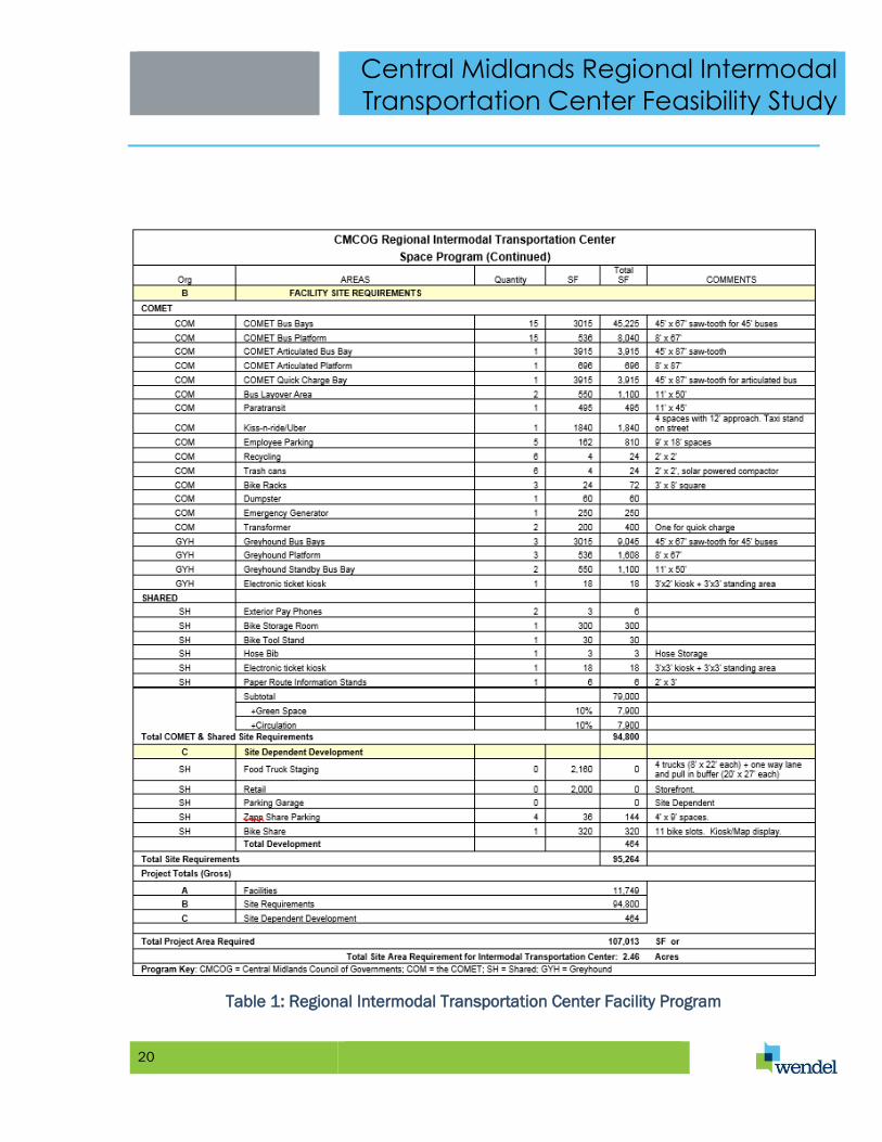
The facility program that was developed called for a transportation center building of
approximately 12,000 square feet. The total site requirements for the transportation center
came to just under 2.5 acres. This number is an approximation of how much land prospective
sites should offer in order to accommodate the facility envisioned by the Steering Committee.
The facility program that was developed for the study is shown below in Table 1 over the next
2 pages.
Central Midlands Regional Intermodal
Transportation Center Feasibility Study
20
Table 1: Regional Intermodal Transportation Center Facility Program

Central Midlands Regional Intermodal
Transportation Center Feasibility Study
21
Based on the facility program, the Wendel Team prepared an example site plan for a facility
with the characteristics set out by the Steering Committee. The example site plan assumed a
rectangular parcel with potential ingress/egress access on all four sides. This configuration
will allow the most compact placement of the building facility and bus slips and would require
the least amount of land to accommodate the full facility program. The example site plan is
shown below in Figure 1.
Figure 1: Example Site Plan for the Regional Intermodal Transportation Center
The example site plan served as a tool to use to begin the search for prospective sites in the
Columbia area on which to locate the Regional Intermodal Transportation Center. It was not
expected that a parcel or combination of parcels would be found to match the exact
configuration of the example site plan. Rather the size, access points and general
configuration of the example site plan were used as criteria to begin the search for possible
locations for the Regional Intermodal Transportation Center.
LOCATION AND SITE EVALUATION
The identification, evaluation and selection of a preferred site for the Regional Intermodal
Transportation Center was a principal goal of this study. To achieve this, a structured process

Central Midlands Regional Intermodal
Transportation Center Feasibility Study
22
was conducted that follows the guidelines set out by the Federal Transit Administration and
complies with the National Environmental Policy Act (NEPA) regulations. The process
consisted of four steps:
The development of selection criteria for use in evaluating the potential sites
The identification of an optimal geographic area or location for the facility
The development of an inventory of potential sites for the facility
The evaluation and ranking of the potential sites using the selection criteria
Site Selection Criteria
Prior to the discussion of any potential sites for the Regional Intermodal Transportation
Center, the Steering Committee prepare a list of criteria to use in evaluating potential sites.
These criteria represented the considerations that would be used to measure the suitability of
each site and lead to the selection of the best suited or preferred site.
Eleven criteria were identified as listed below.
1. Site Availability:
a. Each site will be reviewed for ownership by private and public entities. (Sites owned
by public entities will score higher)
b. Sites also will be reviewed to confirm if there are current tenants operating on the
property and for existing valued site architecture.
c. The site should not interfere with other proposed or future City or Economic
Development projects.
2. Site Size/Land Configuration:
a. Site topography meets minimum size and road access for the required facility
program.
b. Site is served by adequate utilities. (Water/Sewer/Storm sewer)
3. Access: (Pass/Fail requirement)
a. Site must have a minimum of two ingress/egress points - one of each onto singular
streets. (sites with access to two separate streets would score higher and sites with
two access points to the same street score lower)
b. The preferred site should facilitate buses, pedestrians bicycles, and other
sustainable transportation modes (existing bike routes, sidewalks and
signalization)
4. Compatibility: (Pass/Fail requirement)
a. Sites will be reviewed to verify if the surrounding neighborhoods are compatible
with a transit use.
b. The cities master plan will be reviewed to verify a site is appropriate for
consideration.
c. Community context will be reviewed in the design of the facility.
d. Sites should have appropriate zoning to accommodate the transportation center or
should be appropriate for rezoning.

Central Midlands Regional Intermodal
Transportation Center Feasibility Study
23
5. Traffic Impact:
a. The preferred site should minimize impact on the surrounding area traffic through
access points and adjacency to arterial streets. (Access to arterial streets would
score high while access to collector and secondary streets would score lower)
b. During the site evaluation, mitigation measures will be identified to minimize the
traffic impact. Examples of mitigation may include removing on-street parking,
signal coordination, conversion of one lane streets.
c. Determine opportunity to upgrade surrounding streets to “Complete Streets”
6. Relative Location:
a. Preferred Site Location should be near the center of current and future transit
ridership activity.
b. The preferred site should have good proximately to major activity centers
7. Economic Development:
a. The site and design should promote economic development opportunities to
improve the surrounding area and potential revenue generation for the facility.
b. The preferred site should provide an attractive location and facility to stimulate
Transit Oriented Development
c. The preferred site and design should promote transit ridership
8. Environmental:
a. The design will incorporate sustainable design (LEED) principles.
b. Each site will be reviewed at a high level for all environmental concerns and other
requirements identified in the NEPA process.
c. The visual impact to existing historic resources will be an important component for
the preferred site. Sites that are part of or immediately adjacent to historic
resources will score lower than sites not in the Area of Potential Effect (APE)
9. COMET Operations:
a. Preferred Site should have a minimum impact to operational costs for safety,
security and deadhead (non-revenue) mileage for bus routes. (sites further from
node of current operations would score lower)
b. Site should be located within current service area of the Comet. (no site will be
considered outside the service area)
10. Inter-modality:
a. The site should accommodate and encourage multiple modes of transportation
other than buses.
b. Examples include a bike share program, sidewalk connectivity, and possible rail
connection.
c. Preferred should provide facilities for alternative transportation (electric charging
stations)
11. Intermodal Connectivity:
a. The extent to which the site connects to other modal networks such as intercity rail,
bike lanes or bikeways, etc.
Two of the criteria developed by the Steering Committee, Access and Compatibility, were
identified by the Committee as pass/fail criteria. This means that any site that did not

Central Midlands Regional Intermodal
Transportation Center Feasibility Study
24
adequately address either of these measures of suitability were eliminated for further
consideration.
After identifying the evaluation criteria to be used for site selection, the Steering Committee
then determined how important each of the criteria would be to the evaluation. This was
achieved by having each member of the Steering Committee assign points to the 9 criteria
that were not identified as pass/fail requirements. Each committee member was asked to
divide up a total of 100 points among the nine criteria by assigning the most points to what
they considered to be most important criteria. The average number of points assigned by the
committee members for each criteria was determined and this became a weighting factor for
the criteria. The results of the criteria weighting by the Steering Committee are shown in the
table below.
Criteria Assigned
Weight
Relative
Ranking
1. Site Availability 11.14 5th (Tie)
2. Site Size/Land Configuration 14.00 1st (Tie)
3. Access Pass/Fail
4. Compatibility Pass/Fail
5. Traffic Impact 11.14 5th (Tie)
6. Relative Location 11.86 4th
7. Economic Development 9.29 7th
8. Environmental 7.57 9th
9. COMET Operations 14.00 1st (Tie)
10. Inter-Modality 12.00 3rd
11. Intermodal Connectivity 9.0 8th
Table 2: Site Evaluation Criteria Weightings and Rankings
Optimal Geographic Location
Based upon an examination of the current routes operated by CMRTA and the plans for future
service, the multi-modal functionality anticipated for the RITC, the opportunity for economic
development in the Columbia region and input from the Steering Committee, a generalized
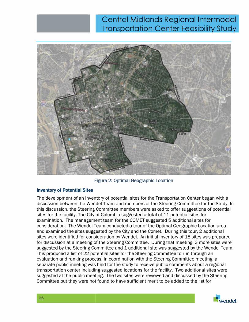
optimal geographic location for the RITC was identified. The Optimal Geographic Location was
established as a target area to use for searching for potential sites – not as a limiting
boundary. Sites suggested for consideration that were located outside the area would be
considered and evaluated. The location identified was large enough to include multiple
potential sites for the facility but refined enough to focus the location site evaluation phase of
this project. It was expected that this effort could yield as few as 3-4 sites but as many as 12.
Figure 2 shows the Optimal Geographic Location that was identified for the purpose of this
study.
Central Midlands Regional Intermodal
Transportation Center Feasibility Study
25
Figure 2: Optimal Geographic Location
Inventory of Potential Sites
The development of an inventory of potential sites for the Transportation Center began with a
discussion between the Wendel Team and members of the Steering Committee for the Study. In
this discussion, the Steering Committee members were asked to offer suggestions of potential
sites for the facility. The City of Columbia suggested a total of 11 potential sites for
examination. The management team for the COMET suggested 5 additional sites for
consideration. The Wendel Team conducted a tour of the Optimal Geographic Location area
and examined the sites suggested by the City and the Comet. During this tour, 2 additional
sites were identified for consideration by Wendel. An initial inventory of 18 sites was prepared
for discussion at a meeting of the Steering Committee. During that meeting, 3 more sites were
suggested by the Steering Committee and 1 additional site was suggested by the Wendel Team.
This produced a list of 22 potential sites for the Steering Committee to run through an
evaluation and ranking process. In coordination with the Steering Committee meeting, a
separate public meeting was held for the study to receive public comments about a regional
transportation center including suggested locations for the facility. Two additional sites were
suggested at the public meeting. The two sites were reviewed and discussed by the Steering
Committee but they were not found to have sufficient merit to be added to the list for

Central Midlands Regional Intermodal
Transportation Center Feasibility Study
26
evaluation and ranking. Figure 3 shows the locations of the 22 sites that were evaluated by the
Steering Committee.
Figure 3: Sites Evaluated for the Location of the Regional Transportation Center
Evaluations of Potential Sites
Each of the potential sites identified for the Intermodal Center was reviewed and discussed by
the Steering Committee. The Steering Committee first examined each site using the two
pass/fail criteria. Any site that was determined to fail either of these two criteria was dropped
from further consideration and evaluation. All sites that were determined to pass these two
criteria were advanced for further evaluation. Then working collectively, the Steering
Committee assigned a score to each site for every one of the nine evaluation criteria that were
not designated as pass/fail criteria. A value between zero (0) and four (4.0) was awarded to
Central Midlands Regional Intermodal
Transportation Center Feasibility Study
27
each of the criteria using half point increments (0, 0.5, 1.0, 1.5, 2.0, 2.5, 3.0, 3.5, and 4.0). If
a site was a poor match for the criteria, a value of zero was assigned. If a site was an
excellent match for the criteria, a value of four was assigned. These scores then were entered
onto a spreadsheet and the weightings for each of the selection criteria were applied to
produce a weighted score for each of the criteria. The weighted scores for the nine evaluation
criteria were summed for each site and a total weighted score was calculated for each site.
The sites then were ranked with the site that had the highest weighted score being ranked
first and the site with the lowest ranked score being ranked last.
The spreadsheet that was used by the Steering Committee for site evaluations is shown below
in Table 3. The top 4 sites were identified from the spreadsheet based on the highest
weighted score and then discussed by the Steering Committee. The Steering Committee
agreed with the quantitative findings and validated the selection of the preferred site and the
next three highest ranking sites.
All four top ranked sites were advanced for environmental analysis. Four sites were evaluated
to ensure that an acceptable site will be found in the event that environmental issues were
discovered among any of the top ranked sites.
Table 3 shows the values awarded to the top 4 ranked sites under each of the eleven
evaluation criteria. The total weighted score for a site is calculated as follows:
Total Weighted Score = Sum ((Site Score for Criteria 1 x Weight of Criteria 1) + (Site
Score for Criteria 2 x Weight of Criteria 2) + …….. (Site Score for
Criteria 11 x Weight of Criteria 11)).
The highest score that a site could achieve with an excellent (4.0 value) score for all criteria
was 369.71.

Central Midlands Regional Intermodal
Transportation Center Feasibility Study
28
Central Midlands Regional Transportation Center Site Selection - Sites Evaluated
Scoring: 0 = poor; 1 = fair; 2 = good; 3 = very good; 4 = excellent
Weight
Site Evaluation Criteria SITE 4 -
LAUREL & SUMTER
SITE 21 - MAIN &
ANTHONY
SITE 22 - MAIN & SCOTT
SITE 14 - TAYLOR & HARDEN
11.14 1 SITE AVAILABILITY
Vacant or for sale; City or County owned; fits with City Economic Development Plan; Total Price of Parcels Required
SITE SCORE 3.5 3.0 3.5 3.0
SITE SCORE X WEIGHT 39.00 33.43 39.00 33.43
14.00 2 SITE SIZE/LAND CONFIGURATION
Adequate utilities; Topography; Parcel Size 2 acres 6.4 acres 5.2 acres 3.5 acres
SITE SCORE 4.0 4.0 3.0 4.0
SITE SCORE X WEIGHT 56.00 56.00 42.00 56.00
0.00 3 ACCESS
PA
SS F
AIL
Minimum of 2 points for ingress/egress; Adequate bus access; Adequate pedestrian access PASS PASS PASS PASS
SITE SCORE 0 0 0 0
SITE SCORE X WEIGHT 0.00 0.00 0.00 0.00
0.00 4 COMPATIBILITY
PA
SS F
AIL
Surrounding neighborhoods; Fits with City Comprehensive Plan; Appropriate Zoning PASS PASS PASS PASS
SITE SCORE 0 0 0 0
SITE SCORE X WEIGHT 0.00 0.00 0.00 0.00
11.14 5 TRAFFIC IMPACT
Mid-block ingress/egress; Nearby signalized intersection; Current congestion levels on access roads; Two way traffic on access roads
SITE SCORE 4.0 3.0 3.0 2.5
SITE SCORE X WEIGHT 44.57 33.43 33.43 27.86
11.86 6 RELATIVE LOCATION
Near center of transit ridership; Proximity to activity centers (walking distance); Proximity to dense residential/commercial areas
SITE SCORE 3.5 2.0 2.5 2.0
SITE SCORE X WEIGHT 41.50 23.71 29.64 23.71
9.29 7 ECONOMIC DEVELOPMENT
Promotes economic development; Surrounding area suitable for transit oriented development; Site will promote multimodal ridership
SITE SCORE 4.0 3.5 4.0 2.5
SITE SCORE X WEIGHT 37.14 32.50 37.14 23.21
7.57 8 ENVIRONMENTAL
Potential environmental concerns (ex. hazmat); Site can incorporate LEED principals; Visual impact to historic areas; Community disruption and environmental justice
SITE SCORE 4.0 2.5 2.0 2.0
SITE SCORE X WEIGHT 30.29 18.93 15.14 15.14
14.00 9 COMET OPERATIONS
Proximity to multiple bus routes; Increase to vehicle miles operated; Increase to vehicle hours operated
SITE SCORE 4.0 3.0 3.0 3.0
SITE SCORE X WEIGHT 56.00 42.00 42.00 42.00
12.00 # INTER-MODALITY
Attractiveness of site for intercity bus service; Ability of site to accommodate multiple modes; Attractiveness of site for bicycle/pedestrian use
SITE SCORE 3.5 3.0 3.0 3.0
SITE SCORE X WEIGHT 42.00 36.00 36.00 36.00
9.00 11 INTERMODAL CONNECTIVITY
Connectivity to bike trails or bike lanes; Connectivity to pedestrian walkways; Connectivity to intercity passenger rail service
SITE SCORE 3.0 4.0 3.0 3.5
SITE SCORE X WEIGHT 27.00 36.00 27.00 31.50
100.00 WEIGHTED SCORE: 343.21 293.07 286.21 273.71
SCORE AS A PERCENTAGE OF MAXIMUM SCORE (369.71): 0.93 0.79 0.77 0.74
SITE RANKINGS: 1 2 3 4
Table 3: Site Evaluation Criteria Spreadsheet – Scoring of Top Four Sites

Central Midlands Regional Intermodal
Transportation Center Feasibility Study
29
The top ranked site and preferred location for the Regional Intermodal Transportation Center
was Site 4 – Laurel Street and Sumter Street. This site extends along Sumter Street from
Laurel Street to Blanding Street. This is the location of
the current transfer center for the COMET and
includes the property already owned by the CMRTA.
There are 4 other parcels on this site – two of which
are owned by the City. This site was rated as very
good for site availability since 3 of the 5 parcels are
already publicly owned. The size and rectangular
shape of the combined parcels and the flat
topography resulted in an excellent rating for site size
and land configuration. All of the other 4 parcels are
used for parking, and therefore would not require the
relocation of any business or residence. This plus the
fact that the COMET bus routes already serve the site and therefore no new noise or air
quality impacts would result produced an excellent rating for this site for environmental
concerns. Traffic impacts of locating the Intermodal Transportation Center on this site would
be minimal since the COMET buses already meet at this site for transfers and therefore this
site was found to be excellent for traffic impacts. This site would serve existing COMET
operations best since it is the location of the existing transfer station and therefore it would
not require any significant changes to current bus routes. This site was rated as excellent for
COMET operations. This site was awarded a weighted score of 343.21 – a full 50 points
higher than the second ranked site. The weighted score was 93% of the maximum possible
score indicating that the selected site comes very close to excelling under all of the evaluation
criteria.
PUBLIC INVOLVEMENT
At the very start of the Regional Intermodal Transportation Center Feasibility Study, a plan for
public involvement was developed by the Steering Committee and initiated by Flock and Rally,
the sub-consultant responsible for this task. The Wendel Team initiated a proactive plan for
notifying and involving interested parties including current rail and public transportation users,
community businesses or individuals, city officials, and others to ensure a representative
sample of affected persons who will know about and be afforded the opportunity to provide
input for the study.
A study Stakeholder list was developed that included 85 groups that were targeted with
information about the study and invited to provide input to the study. The types of groups on
the list included:
Environmental/Preservation/Progressive Non-Profit Organizations
Local and Regional Governments
Transportation Operators
Merchants Associations and Business Groups
Chambers of Commerce
Central Midlands Regional Intermodal
Transportation Center Feasibility Study
30
Neighborhood Groups
Universities
Young Professional Groups.
Additional stakeholders that were consulted during the study included elected and
appointed officials from the City and CMRTA and representatives from the University of
South Carolina, South Carolina Department of Transportation, Amtrak, Greyhound Bus
Lines, and Megabus. To evaluate market demand and economic conditions, interviews
were held with numerous local and regional real estate developers, brokers, economic
development entities and civic/cultural representatives.
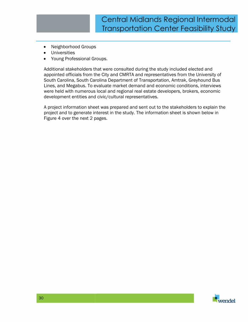
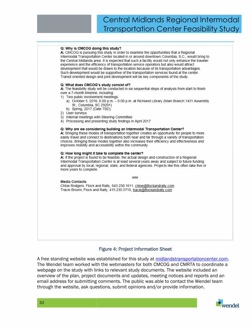
A project information sheet was prepared and sent out to the stakeholders to explain the
project and to generate interest in the study. The information sheet is shown below in
Figure 4 over the next 2 pages.

Central Midlands Regional Intermodal
Transportation Center Feasibility Study
31
Central Midlands Regional Intermodal
Transportation Center Feasibility Study
32
Figure 4: Project Information Sheet
A free standing website was established for this study at midlandstransportationcenter.com.
The Wendel team worked with the webmasters for both CMCOG and CMRTA to coordinate a
webpage on the study with links to relevant study documents. The website included an
overview of the plan, project documents and updates, meeting notices and reports and an
email address for submitting comments. The public was able to contact the Wendel team
through the website, ask questions, submit opinions and/or provide information.
Central Midlands Regional Intermodal
Transportation Center Feasibility Study
33
Figure 5: Project Website
A public outreach questionnaire was posted on the website to solicit ideas, opinions and
information relative to the project from the general public.
In addition to the website, a Facebook post was set up to notify interested parties about the
project and to provide another means to ask questions, express opinions and to obtain
information. The Facebook post also was used to notify people about the public meeting that
was held for the project. The Facebook post is shown below in Figure 6.

Central Midlands Regional Intermodal
Transportation Center Feasibility Study
34
What is the feasibility of a regional transportation center in the
Midlands? Be a part of the conversation at a public meeting on
Wed., October 5, 2016, 6-8 p.m. at the @Richland Library, 1431
Assembly St., Columbia, S.C. 29201.
Figure 6: Facebook Post
Public Meeting
A public meeting was held early in the project to let people know about the vision for a
regional intermodal transportation center and to obtain their input about the project. The
meeting originally was scheduled for October 5, 2016 from six to eight in the evening and was
to be held at the Richland Library on Assembly Street in the City of Columbia. The arrival of a
hurricane on that date forced a postponement of the meeting to November 2, 2016 from five
until seven in the evening at the same location. Notifications about the meeting were placed
in newspapers and were sent out to stakeholders. In addition, posters were placed on the
Comet buses and at the transfer center to let riders know about the meeting. A copy of the
notification that was sent out is shown below in Figure 7 and the poster that was used is
shown in Figure 8.

Central Midlands Regional Intermodal
Transportation Center Feasibility Study
35
Figure 7: Public Meeting Notification

Central Midlands Regional Intermodal
Transportation Center Feasibility Study
36
Figure 8: Public Information Meeting Poster
Consultant team staff, Comet staff and CMCOG staff all were present at the meeting to talk to
people and answer questions about the project. Thirteen project boards were displayed that
addressed the following topics:
What is a Multi-modal Facility?
Project Opportunity and Purpose
Transportation Benefits
Community Benefits
The Preliminary Program for the Facility
The Study Area Boundary
Photos of the Existing Transfer Site
Photos of Project Examples
Current Progress of the Study
Next Steps
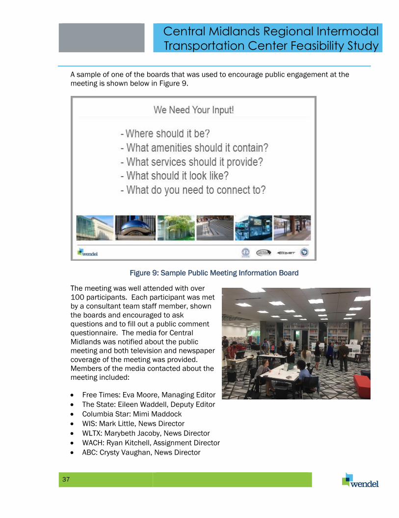
Central Midlands Regional Intermodal
Transportation Center Feasibility Study
37
A sample of one of the boards that was used to encourage public engagement at the
meeting is shown below in Figure 9.
Figure 9: Sample Public Meeting Information Board
The meeting was well attended with over
100 participants. Each participant was met
by a consultant team staff member, shown
the boards and encouraged to ask
questions and to fill out a public comment
questionnaire. The media for Central
Midlands was notified about the public
meeting and both television and newspaper
coverage of the meeting was provided.
Members of the media contacted about the
meeting included:
Free Times: Eva Moore, Managing Editor
The State: Eileen Waddell, Deputy Editor
Columbia Star: Mimi Maddock
WIS: Mark Little, News Director
WLTX: Marybeth Jacoby, News Director
WACH: Ryan Kitchell, Assignment Director
ABC: Crysty Vaughan, News Director
Central Midlands Regional Intermodal
Transportation Center Feasibility Study
38
Cola Daily: Brindy McNair, Editor
Midlands Anchor: Allen Wallace, Reporter
Radio: Cynthia Hardy, Cumulus (Tony Lype)
Columbia Regional Business Report and SCBIZ: Licia Jackson, Publisher
The Minority Eye: Michael Bailey, Publisher
Millennium Magazine, Calvin Reese
Public Input Questionnaire
At the public meeting, participants were encouraged to complete a questionnaire. This
questionnaire also was made available to transit riders and was posted on the project
website.
The questionnaire included 19 questions and an area for general comments. The first 10
questions collected demographic information from the responders. This information allowed
the reviewers to understand the age, ethnic mix, general income, and home/work locations of
the responders. Collecting this information ensured that a cross section of the Central
Midlands Community had been reached and was responding to the questionnaire.
The next five nine questions collected information about the current travel modes and the
travel preferences of the responders. This information allowed the reviewers to know whether
the responders were largely current transit riders, automobile drivers or shared ride users and
how their current travel means compared to their preferred travel modes.
The final four questions asked responders questions about their ideas for a new Central
Midlands Regional Intermodal Transportation Center. This provided the reviewers with
information about what amenities people were interested in for the center and the level of
interest in the project.
A separate, abbreviated version of the questionnaire was used by the consultant team to poll
riders at the Columbia Amtrak station and the Greyhound Bus station. An abbreviated
questionnaire was used to be less intrusive since passengers were waiting for trains or buses
and they were asked the questions verbally.
The full questionnaire that was used on the website, on the buses, and at the public meeting
is shown below in Figure 10 contained in the next four pages.

Central Midlands Regional Intermodal
Transportation Center Feasibility Study
39
Figure 10: Public Comment Questionnaire
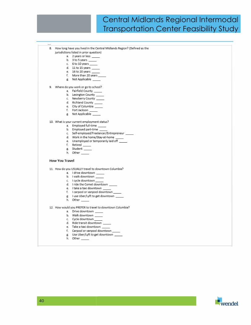
Central Midlands Regional Intermodal
Transportation Center Feasibility Study
40

Central Midlands Regional Intermodal
Transportation Center Feasibility Study
41
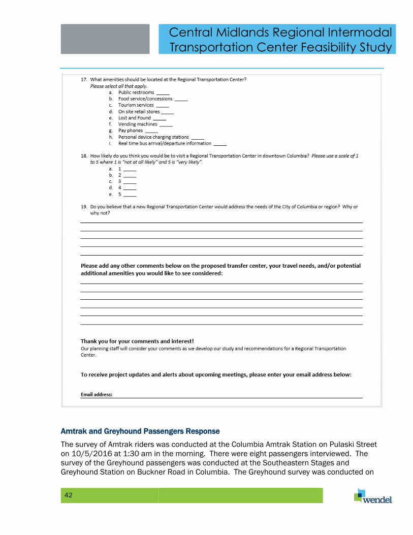
Central Midlands Regional Intermodal
Transportation Center Feasibility Study
42
Amtrak and Greyhound Passengers Response
The survey of Amtrak riders was conducted at the Columbia Amtrak Station on Pulaski Street
on 10/5/2016 at 1:30 am in the morning. There were eight passengers interviewed. The
survey of the Greyhound passengers was conducted at the Southeastern Stages and
Greyhound Station on Buckner Road in Columbia. The Greyhound survey was conducted on

Central Midlands Regional Intermodal
Transportation Center Feasibility Study
43
October 5, 2016 at 9:30 in the morning. Twenty two passengers were interviewed. The
results of the Amtrak and Greyhound surveys are shown in Table 4 below.
Question Amtrak Passenger Responses Greyhound Passenger
Responses
Gender Male: 50%, Female 50% Male: 45%, Female: 55%
Year of Birth 1945 or Earlier 0%
1946 – 1964 62%
1965 – 1982 25%
1983 – 2001 13%
After 2001 0%
1945 or Earlier 0%
1946 – 1964 36%
1965 – 1982 18%
1983 – 2001 41%
After 2001 5%
Travel to the Station Drive Myself 12%
Ride with Others 63%
Taxi 25%
Ride with Others 41%
Taxi 32%
Other (Uber) 27%
Travel from the
Station
Drive Myself 12%
Ride with Others 50%
Taxi 38%
Ride with Others 46%
Taxi 27%
Bus 9%
Other (Uber) 18%
Desired Connectivity
to the Station
Personal Car 5 Respondents
Plane 0 Respondents
Amtrak Train 3 Respondents
Bike 0 Respondents
Taxi 6 Respondents
Uber/Lyft 1 Respondents
The Comet 4 Respondents
Greyhound 1 Respondents
Megabus 1 Respondents
Personal Car 9 Respondents
Plane 1 Respondents
Amtrak Train 11 Respondents
Bike 10 Respondents
Taxi 17 Respondents
Uber/Lyft 17 Respondents
The Comet 19 Respondents
Greyhound 17 Respondents
Megabus 9 Respondents
Importance of Station
Amenities
Very Important:
Public Restrooms
Lost and Found
Vending Machines
Safe Environment
Charging Stations
Real Time Information
Important:
Food Service/Concessions
Not Important:
Tourism Services
On Site Retail
Pay Phones
Very Important:
Public Restrooms
Lost and Found
Safe Environment
Charging Stations
Real Time Information
Important:
Vending Machines
Food Service/Concessions
Not Important:
Tourism Services
On Site Retail
Pay Phones
Table 4: Amtrak and Greyhound Passenger Survey Responses
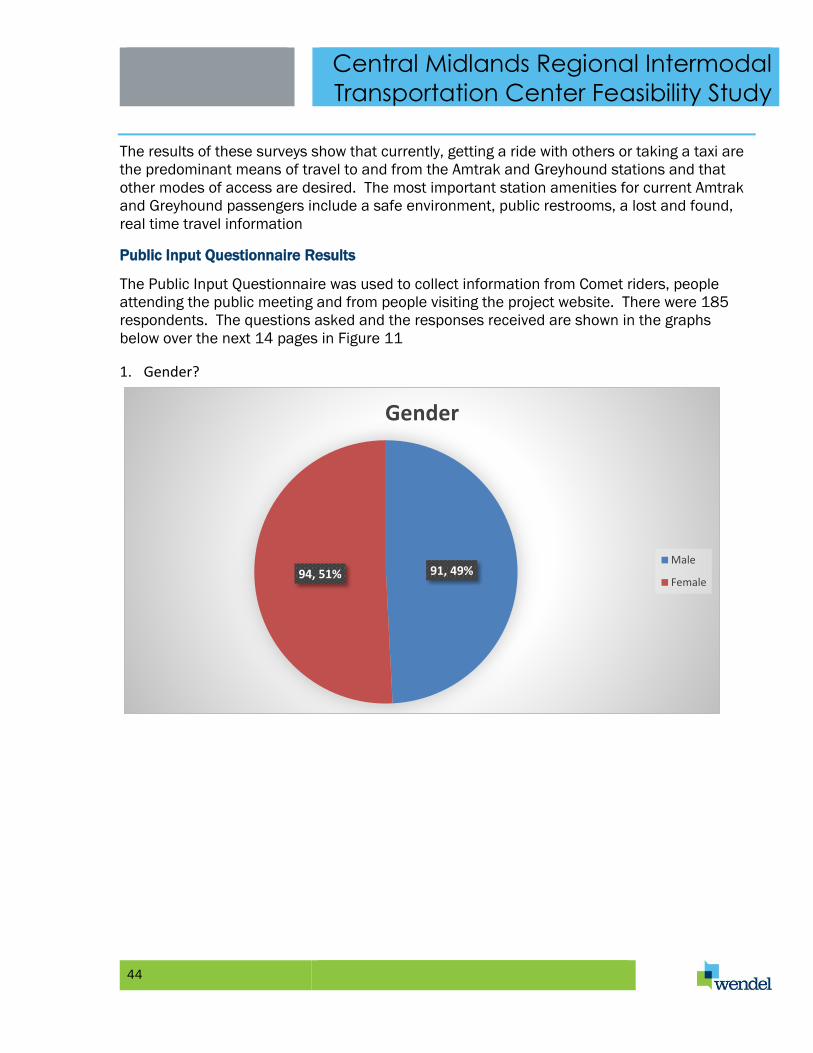
Central Midlands Regional Intermodal
Transportation Center Feasibility Study
44
The results of these surveys show that currently, getting a ride with others or taking a taxi are
the predominant means of travel to and from the Amtrak and Greyhound stations and that
other modes of access are desired. The most important station amenities for current Amtrak
and Greyhound passengers include a safe environment, public restrooms, a lost and found,
real time travel information
Public Input Questionnaire Results
The Public Input Questionnaire was used to collect information from Comet riders, people
attending the public meeting and from people visiting the project website. There were 185
respondents. The questions asked and the responses received are shown in the graphs
below over the next 14 pages in Figure 11
1. Gender?
91, 49%94, 51%
Gender
Male
Female

Central Midlands Regional Intermodal
Transportation Center Feasibility Study
45
2. In which block of years were you born?
3. Which of these do you consider yourself to be? (Optional)
135, 77%
32, 18%
2, 1%
1, 1%4, 2%
Ethnicity
White
Black or African American
Asian (0)
American Indian or Alaska Native
Hispanic or Latino Descent
Other
5, 3%
56, 30%
70, 38%
54, 29%
Year of Birth
1945 or Earlier (0)
1946-64 Baby Boomers
1965-82 Gen X
1983-2001 Millennials
After 2001

Central Midlands Regional Intermodal
Transportation Center Feasibility Study
46
4. What is your marital status?
5. Are there any children under the age of 18 who currently live in your household?
81, 44%
70, 38%
18, 10%
2, 1%
3, 1%
11, 6% Marital Status
Married
Single
Divorced
Widowed
Separated
Living with partner
47, 25%
138, 75%
Dependents
Yes
No
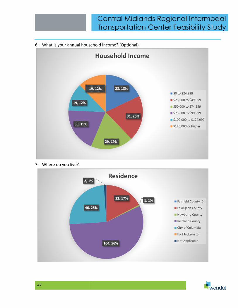
Central Midlands Regional Intermodal
Transportation Center Feasibility Study
47
6. What is your annual household income? (Optional)
7. Where do you live?
28, 18%
31, 20%
29, 19%
30, 19%
19, 12%
19, 12%
Household Income
$0 to $24,999
$25,000 to $49,999
$50,000 to $74,999
$75,000 to $99,999
$100,000 to $124,999
$125,000 or higher
32, 17%1, 1%
104, 56%
46, 25%
2, 1%Residence
Fairfield County (0)
Lexington County
Newberry County
Richland County
City of Columbia
Fort Jackson (0)
Not Applicable

Central Midlands Regional Intermodal
Transportation Center Feasibility Study
48
8. How long have you lived in the Central Midlands Region?
9. Where do you work or go to school?
17, 9%
22, 12%
20, 11%
25, 13%
18, 10%
80, 43%
3, 2%
Length of Residence in Region
2 years or less
3 to 5 years
6 to 10 years
11 to 15 years
16 to 20 years
More than 20 years
Not Applicable
1, 1%
16, 9%1, 0%
81, 44%58, 31%
1, 1%
27, 15%
Location of Work or School
Fairfield County
Lexington County
Newberry County
Richland County
City of Columbia
Fort Jackson
Not Applicable

Central Midlands Regional Intermodal
Transportation Center Feasibility Study
49
10. What is your current employment status?
113, 61%
7, 4%
13, 7%
4, 2%
7, 4%
24, 13%
14, 7%
3, 2%
Employment Status
Employed full time
Employed part-time
Self-employed/Freelance/Entrepreneur
Work in the home/Stay-at-home
Unemployed or termorarily laid off
Retired
Student
Other

Central Midlands Regional Intermodal
Transportation Center Feasibility Study
50
11. How do you usually travel to downtown Columbia? Please select all that apply
150
37
2429
8
10
30
4
I drivedowntown
I walkdowntown
I cycledowntown
I ride theComet
downtown
I take a taxidowntown
I carpool orvanpool
downtown
I useUber/Lyft
Other
Current Travel Downtown

Central Midlands Regional Intermodal
Transportation Center Feasibility Study
51
12. How would you prefer to travel downtown? Please select all that apply.
69
5660
129
4 16
25
7
Drivedowntown
Walkdowntown
Cycledowntown
Ride transitdowntown
Take a taxidowntown
Carpool orvanpool
downtown
UseUber/Lyft
Other
Preferred Travel Downtown
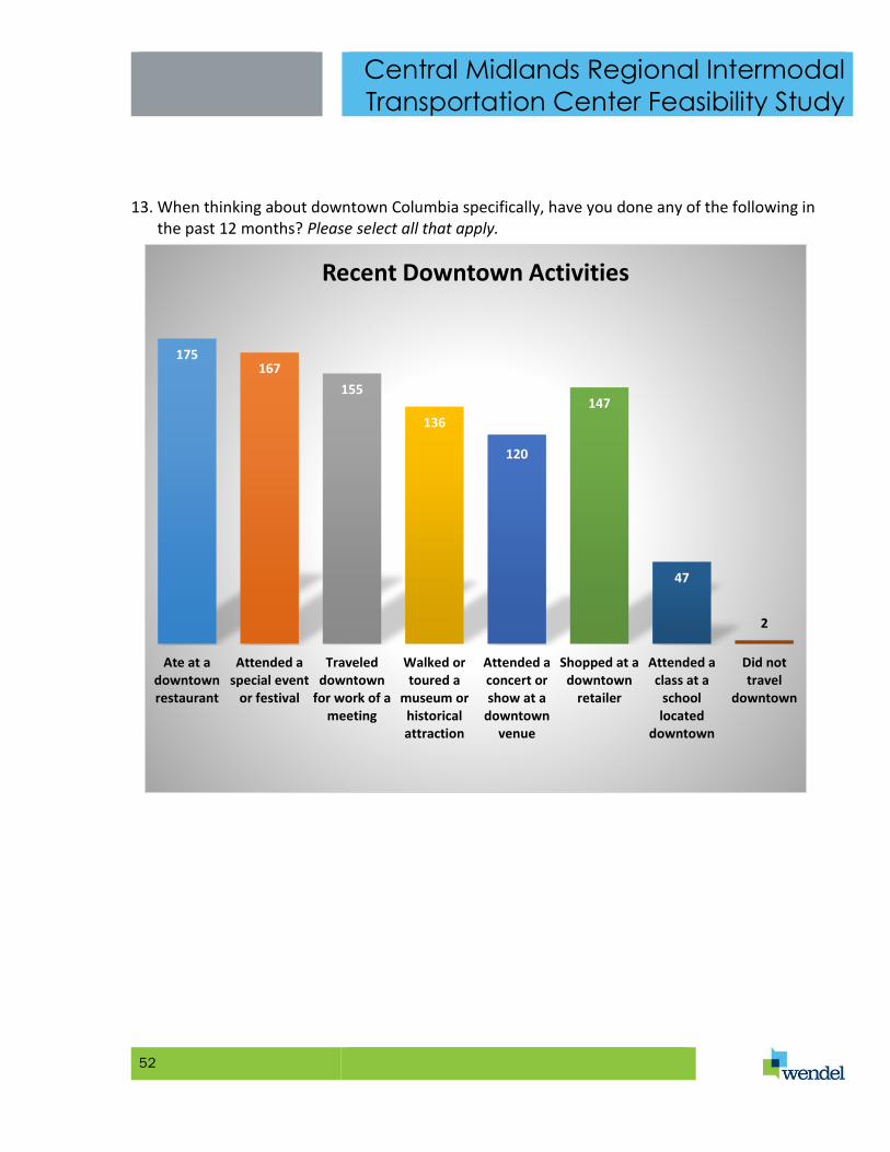
Central Midlands Regional Intermodal
Transportation Center Feasibility Study
52
13. When thinking about downtown Columbia specifically, have you done any of the following in the past 12 months? Please select all that apply.
175167
155
136
120
147
47
2
Ate at adowntownrestaurant
Attended aspecial event
or festival
Traveleddowntown
for work of ameeting
Walked ortoured a
museum orhistoricalattraction
Attended aconcert orshow at a
downtownvenue
Shopped at adowntown
retailer
Attended aclass at a
schoollocated
downtown
Did nottravel
downtown
Recent Downtown Activities
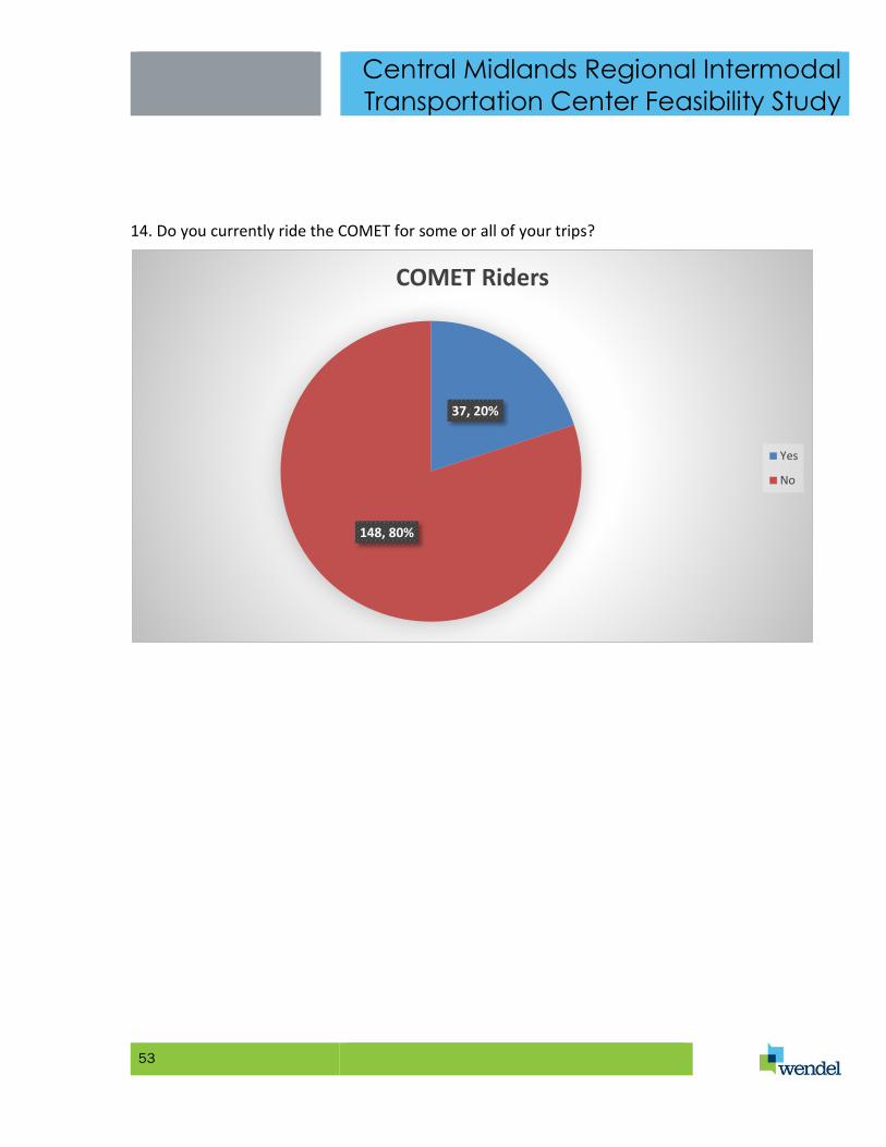
Central Midlands Regional Intermodal
Transportation Center Feasibility Study
53
14. Do you currently ride the COMET for some or all of your trips?
37, 20%
148, 80%
COMET Riders
Yes
No

Central Midlands Regional Intermodal
Transportation Center Feasibility Study
54
15. Which of the following transportation modes have you used in the past two years either within the region or traveling away from the Columbia area? Please select all that apply.
168
120
28
73
62
72
48
11
2328
Recent Regional Travel Modes Utilized

Central Midlands Regional Intermodal
Transportation Center Feasibility Study
55
16. Which transportation services would you like to have access to from a regional transportation center?
Please select all that apply.
90
46
135
147
66
87
7580
125
80 81
35
Modes Preferred to Serve a Regional Transportation Center
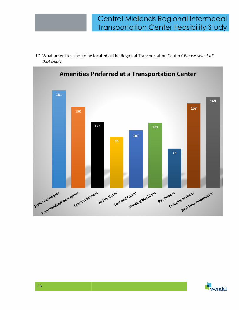
Central Midlands Regional Intermodal
Transportation Center Feasibility Study
56
17. What amenities should be located at the Regional Transportation Center? Please select all that apply.
181
150
123
95
107
121
73
157
169
Amenities Preferred at a Transportation Center

Central Midlands Regional Intermodal
Transportation Center Feasibility Study
57
18. How likely do you think you would be to visit a Regional Transportation Center in downtown Columbia?
19. Do you believe that a Regional Transportation Center addresses the needs of the city or region?
Figure 11: Public Input Questionnaire Responses
3, 2%8, 4%
55, 30%
47, 25%
72, 39%
Likelihood of Utilization
Not at all likely
Not likely
Somewhat likely
Likely
Very likely
139, 75%
14, 8%
24, 13%
8, 4%
Transportation Center Needed?
Yes
No
Maybe
Don't know
Central Midlands Regional Intermodal
Transportation Center Feasibility Study
58
The most notable responses to the survey included the following:
Most respondents indicated that they currently drive to travel downtown but would prefer
to take transit downtown.
Only 20% of the respondents currently ride the Comet.
Most people would like to see a Regional Transportation Center that is served by a train
to Charlotte or Amtrak service and Comet bus service.
The most important amenities at the Center would include:
o Public Restrooms
o Real Time Travel Information
o Charging Stations
o Food Service/Concessions
When asked how likely they would be to visit a Regional Transportation Center in
downtown Columbia 64% of respondents indicated that they would be likely or very likely
to do so.
When asked if they believed that a Regional Transportation Center would address the
needs of the City or region, 75% of the respondents indicated that they did.
ENVIRONMENTAL ANALYSIS
Site Overview and Environmental Assessment
Building a new regional intermodal transit facility (RITC) will require the acquisition of property
or a long-term lease. The purpose of the environmental analysis is to analyze the top four RITC
locations identified in the RITC Feasibility Study to ensure the locations were selected without
regard to race, color, or national origin. This study also compares the equity impacts of four
siting alternatives. The CMRTA is the entity whom will be charged with submitting
environmental documentation to the Federal Transit Administration if this project is advanced
to property acquisition, design and construction.
Sites have been evaluated and ranked as part of the RITC Feasibility Study process and the
CMRTA has been involved in the initial site selection, ranking of the initial 22 properties for
preliminary evaluation, as well as the selection of the top four siting alternatives and the
preferred site.
Twenty-two potential properties were initially evaluated with members of the steering
committee comprised of leadership from CMCOG, CRMTA, the City of Columbia, and Richland
County. Site selection criteria included property ownership, adjacent street connectivity,
access to major thoroughfares, relative congestion, and proximity to the current location of
the RITC. From the original twenty-two sites, four were selected to move forward through a
preliminary equity analysis and environmental evaluation. The four sites selected to move
forward included the following:
Existing Site – 1745 Sumter Street (Site 4)
Alternative Site 1 – 2805 N. Main Street (Site 21)
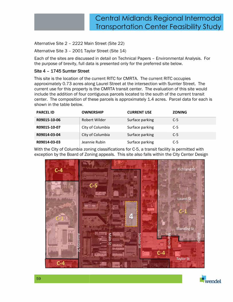
Central Midlands Regional Intermodal
Transportation Center Feasibility Study
59
Alternative Site 2 – 2222 Main Street (Site 22)
Alternative Site 3 – 2001 Taylor Street (Site 14)
Each of the sites are discussed in detail on Technical Papers – Environmental Analysis. For
the purpose of brevity, full data is presented only for the preferred site below.
Site 4 – 1745 Sumter Street
This site is the location of the current RITC for CMRTA. The current RITC occupies
approximately 0.73 acres along Laurel Street at the intersection with Sumter Street. The
current use for this property is the CMRTA transit center. The evaluation of this site would
include the addition of four contiguous parcels located to the south of the current transit
center. The composition of these parcels is approximately 1.4 acres. Parcel data for each is
shown in the table below.
PARCEL ID OWNERSHIP CURRENT USE ZONING
R09015-10-06 Robert Wilder Surface parking C-5
R09015-10-07 City of Columbia Surface parking C-5
R09014-03-04 City of Columbia Surface parking C-5
R09014-03-03 Jeannie Rubin Surface parking C-5
With the City of Columbia zoning classifications for C-5, a transit facility is permitted with
exception by the Board of Zoning appeals. This site also falls within the City Center Design

Central Midlands Regional Intermodal
Transportation Center Feasibility Study
60
District requiring additional requirements for the building’s façade. Existing zoning for the site
and adjacent properties are shown on the graphic above.
The subject properties indicate, based on known and available data sources as a part of this
preliminary evaluation, that the subject property is not currently located within a flood plain.
The subject parcels do not contain any known streams or the presence of wetlands. The
presence of hazardous materials was not determined to be on the subject parcels based on
available data. The subject parcels are currently paved and serve as surface parking for the
adjacent buildings within their vicinity.
A review of available historic places and districts for the subject parcels indicates that seven
historic properties are within immediate proximity of the subject parcels. The locations of
these historic places are shown on the graphic below.
As shown above, there are no historically registered buildings or places located on the subject
parcels. No direct impact to the adjacent historic buildings or districts is envisioned with the
RITC on this site.

Central Midlands Regional Intermodal
Transportation Center Feasibility Study
61
The following table summarizes the environmental findings for each of the four sites examined
in this environmental analysis.
Criteria Site
4 14 21 22
Air Quality Conformity
Yes Yes Yes Yes
Current Zoning C5 M1 & C-3 MX-1 MX-1
Allowable Use
Permitted with exception by
board of zoning appeals
M1- Permitted; C-
3 permitted with
exception
Permitted with
exception by
board of zoning
appeals
Permitted with
exception by
board of zoning
appeals
Historic Resources Adjacent Adjacent Adjacent Adjacent
Acquisitions Required
Yes Yes Yes Yes
Relocation Required
No Yes No No
Hazardous Materials Present
Not Present Present Not Present Present
Parks No No Adjacent* No
Wetlands (on site) Not Present Not Present Not Present Not Present
100 Yr Floodplain Not Present Not Present Not Present Not Present
Water Quality Impacts
None known None known None known None known
*The North Main Community Garden is presently on the subject property. While not specifically a park it is a
community gather space in addition to being adjacent to Earlewood Park.
Table 5: Summary of Environmental Findings
Equity Analysis
Executive Order 12898 requires federal agencies to identify and address disproportionately
high and adverse human health or environmental effects of their programs or projects on
minority and/or low-income populations. As per FTA C 4702.1B, Title VI equity analyses for
the location of facilities must occur in the planning stage before a preferred site has been
selected. Sites have been evaluated and ranked as part of the RITC Feasibility Study process
and the CMRTA has been involved in the initial site selection, ranking of the initial 22
properties for preliminary evaluation, as well as the selection of the top four siting
alternatives. Site 4 – the current location of the CMRTA transfer facility emerged as the
preferred location from this study.
Central Midlands Regional Intermodal
Transportation Center Feasibility Study
62
Equity (also called justice and fairness) is referred to the distribution of impacts and whether
that distribution is considered fair and appropriate. Transportation planning decisions can
have significant and diverse equity impacts:
The quality of transportation available affects people’s economic and social
opportunities.
Transport facilities, activities and services impose various indirect and external costs,
such as congestion delay and accident risk imposed on other road users.
Infrastructure costs not funded through user fees, pollution, and undesirable land use
impacts.
Transport expenditures represent a major share of most household, business and
government expenditures.
Transport facilities require significant public resources (tax funding and road rights of
way), the allocation of which can favor some people over others.
Transport planning decisions can affect development location and type, and therefore
accessibility, land values and local economic activity.
Transport planning decisions can affect employment and economic development
which have distributional impacts.
Title VI Compliance
Central Midlands Regional Transit Authority is committed to ensuring that no person is
excluded from participation in, or denied the benefits of its transit services on the basis of
race, color, or national origin, as protected by Title VI in Federal Transit Administration (FTA)
Circular 4702.1.B. The public can find CMRTA’s current Title VI Program/Plan that includes
steps for submitting a Title VI complaint on the web at: http://catchthecomet.org/civil-
rights/
Title VI of the Civil Rights Act of 1964 states that “[n]o person in the United States shall, on
the grounds of race, color, or national origin, be excluded from participation in, be denied the
benefits of, or be subjected to discrimination under any program or activity receiving Federal
financial assistance.”2 Title VI further authorizes federal agencies that make grants (for
example, the U.S. Department of Transportation [DOT]) to develop compliance guidance for
its recipients.
Title 49 CFR Section 21.9(b)(3) states, “In determining the site of location of facilities, a
recipient or applicant may not make selections with the purpose or effect of excluding
persons from, denying them the benefits of, or subjecting them to discrimination under any
program to which this regulation applies, on the grounds of race, color, or national origin; or
with the purpose or effect of defeating or substantially impairing the accomplishment of the
objectives of the Act or this part.” Title 9 CFR part 21, Appendix C, Section (3)(iv) provides,
“The location of projects requiring land acquisition and the displacement of persons from
their residences and businesses may not be determined on the basis of race, color, or
national origin.”

Central Midlands Regional Intermodal
Transportation Center Feasibility Study
63
CMRTA is required to conduct a Title VI equity analysis to ensure the location is selected
without regard to race, color, or national origin. Per guidance in the circular, this analysis
must:
Include outreach to persons potentially impacted by the siting of the facility;
Compare impacts of various siting alternatives;
Determine if cumulative adverse impacts might result due to the presence of
other facilities with similar impacts in the area; and
Occur before the selection of the preferred site.
Analysis Methodology The primary purpose of this equity analysis is to estimate the distribution of benefits and
burdens of the proposed land use and transportation impacts on disadvantaged communities,
and to assess whether these benefits and burdens are shared equitably across all population
groups. This memo summarizes the various elements evaluated in this analysis. This
analysis has been developed for the evaluation of potential impacts associated with the
potential relocation/expansion of the CMRTA RITC on disadvantage communities.
Populations and Geographies The underlying methodology for conducting and equity analysis for the transit feasibility study
relies on a comparison of benefits and burdens on different population groups (minority vs
non-minority and low-income vs non-low income populations), and across different
geographies (communities of concern vs the reminder of the region). 2011-2015 American
Community Survey 5-Year estimates includes poverty and race and ethnicity information at
the block group level. It is important to note that block groups are the smallest geography for
which income data is available.
The following graphics depict the income and race and ethnicity for the four (4) sites being
considered. The Table below summarizes the income and race and ethnicity demographics
for each site.
The City of Columbia, South Carolina, for which each of the considered sites are within the
corporate limits of, has a percent below poverty of 24.2% and is 51.9% of the population
identifies as a minority.
Site Block
Group
Census
Tract
Percent Below
Poverty Level
Difference
from City
Poverty
Level
Percent
Minorty
Difference from
City Minority
Level
4 2 31 44.5% +20.8% 30.7% -21.2%
14 1 31 58.0% +33.8% 70.3% +18.3%
21 2 7 14.1% -10.1% 28.7% -23.2%
22 1 7 6.4% -17.8% 23.2% -28.7%

Central Midlands Regional Intermodal
Transportation Center Feasibility Study
64
2011-2015 Low-Income Populations
Source: ACS Data
2011-2015 Minority Populations
Source: ACS Data
In addition to the American Community Survey information compiled on income and race and
ethnicity, 2010 Census data was also reviewed for race and ethnicity. In the 2010 Census
the City of Columbia is listed as 48.3% minority. It is important to note that the 2010 census
data did not include income data at the block level.

Central Midlands Regional Intermodal
Transportation Center Feasibility Study
65
2010 Census Race & Ethnicity data
Source(s): ACS/2010 Census data
Race and ethnicity for each of the four subject sites is depicted graphically on the following
pages.
SITE NUMBER OF BLOCKS
WITHIN OR ADJACENT TO SITE
NUMBER OF BLOCKS WITH RESIDENTS
NUMBER OF BLOCKS WITH MINORITY PERCENTAGE
ABOVE CITY PERCENTAGE
4 9 3 1
14 9 3 3
21 13 6 4
22 10 8 3

Central Midlands Regional Intermodal
Transportation Center Feasibility Study
66
2010 US Census Data: Site 4
SITE 4
TOTAL POPULATION 106
MINORITY 35
WHITE 71
PERCENT MINORITY 33%

Central Midlands Regional Intermodal
Transportation Center Feasibility Study
67
2010 US Census Data: Site 14
SITE 14
TOTAL POPULATION 624
MINORITY 624
WHITE 0
PERCENT MINORITY 100%

Central Midlands Regional Intermodal
Transportation Center Feasibility Study
68
2010 US Census Data: Site 21
SITE 21
TOTAL POPULATION 120
MINORITY 43
WHITE 77
PERCENT MINORITY 36%
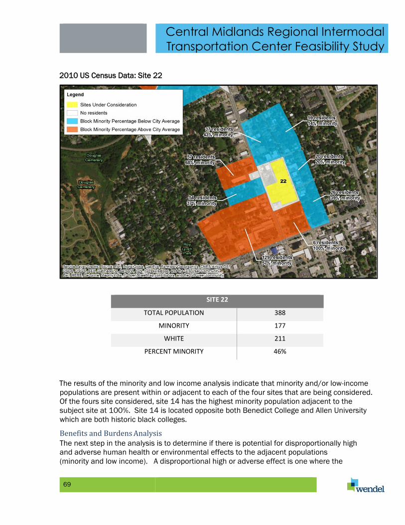
Central Midlands Regional Intermodal
Transportation Center Feasibility Study
69
2010 US Census Data: Site 22
The results of the minority and low income analysis indicate that minority and/or low-income
populations are present within or adjacent to each of the four sites that are being considered.
Of the fours site considered, site 14 has the highest minority population adjacent to the
subject site at 100%. Site 14 is located opposite both Benedict College and Allen University
which are both historic black colleges.
Benefits and Burdens Analysis The next step in the analysis is to determine if there is potential for disproportionally high
and adverse human health or environmental effects to the adjacent populations
(minority and low income). A disproportional high or adverse effect is one where the
SITE 22
TOTAL POPULATION 388
MINORITY 177
WHITE 211
PERCENT MINORITY 46%
Central Midlands Regional Intermodal
Transportation Center Feasibility Study
70
impact is greater to the minority or low-income population as compared to the non-
minority population and/or the non-low-income population. Stated simply, the impact is
one that would be borne predominately by a minority or low-income population.
These impacts for each of the sites are evaluated by examining the changes in land use
and noise levels, other environmental impacts, and any off-setting project benefits. Each
of the sites are discussed in greater detail below.
At the community level, the biggest change between each of the sites is the relocation of
the current CMRTA to one of the other three sites from its current location (site 4). This
relocation will impact each of the current 28 routes the CRMTA operates in Columbia
and has the potential to either increase or decrease the length or the route which could
increase the ride times. It is important to note that the majority of the current routes (4
of 28) are located to the east of the City of Columbia and therefore, would likely increase
the overall route length for the majority of routes. However, all four of the sites being
considered are located adjacent to an existing route Site 4 (current location of transit
center – all routes), Site 14 (routes 12 & 22), Site 21 (Routes 31 & 101), and Site 22
(Routes 31 & 101). Therefore, potentially no new streets would be required to access
the proposed transit facilities or for circulation around the sites.
At the site level, with any new development that serves large motor vehicles on a high
frequency basis, there is the concern for noise impacts, increased traffic volumes, and
air and light pollution. For site 4, the current transit center is an adjacent land use and
the parcels to be includes current serve as parking lots. The site is also bordered by
multi-lane streets with significant peak hour and daily traffic volumes. The increase in
bus traffic is likely to not have a significant impact on the adjacent properties.
Site 14 is currently being utilized as a ready-mix cement plant with heavy truck traffic
access both Taylor and Harden streets. The site is also bordered by an active railroad
line. Both Harden Street and Taylor Street serve as major thoroughfares for the City of
Columbia. The increase in bus traffic will likely have minimal impact on the operations of
adjacent streets.
Sites 21 and 22 are both located along N. Main Street, north of Elmwood Avenue. While
a commercial area, significant residential housing is located adjacent to the corridor.
The increase in traffic has the potential to elevate noise levels to adjacent properties.
The degree of noise impact cannot be substantiated now without a concept plan. Main
Street is a major thoroughfare in the City of Columbia providing north-south connectivity
through the city. Increases in traffic are not intended to have a significant impact on
Main Street.
The table below summarizes the findings for Equity Analysis performed for this study.

Central Midlands Regional Intermodal
Transportation Center Feasibility Study
71
Table 6: Environmental Analysis - Equity Analysis Findings
Equity Analysis Conclusions All locations identified and evaluated for the potential CMRTA transit facility were selected
without regard to race, color, or national origin. An evaluation of the poverty rate and
minority population rate in the vicinities of the top four sites indicate that there are low-
COMMUNITY IMPACTS SUMMARY
SITE 4
POTENTIAL POSTIVE COMMUNITY IMPACTS (BENEFITS)
POTENTIAL ADVERSE COMMUNITYU IMPACTS (BURDENS)
Absence of residential properties Potential increase in bus traffic (expansion)
Current location of Transit center
Minimal impact to current bus route layout
SITE 14
Adjacent to current service routes
Two historic minority colleges adjacent to site
Located to the east of downtown – higher density of bus routes
Increase in bus traffic at intersection of Harden and Taylor Streets
Corner parcel – access to two major thoroughfares (N/S & E/W)
Potential increase in noise levels to adjacent properties
SITE 21
Located along a major thoroughfare
Adjacent to minority and low-income residents
Adjacent to an active rail line – potential to intermodal connectivity
Increase in bus traffic along Main Street and River Road
Potential increase in noise levels to adjacent properties
Requires several commercial and one residential taking.
Further west of current transit center and proximity of majority of bus service routes.
SITE 22
Located along a major thoroughfare
Adjacent to minority and low-income residents
Increase in bus traffic along Main Street
Potential increase in noise levels to adjacent properties
Further west than current transit center
and proximity of majority of bus service routes.

Central Midlands Regional Intermodal
Transportation Center Feasibility Study
72
income and minority populations present and adjacent to eh proposed sites. Based on the
available information and without full conceptual site plans for each of the four sites, a direct
evaluation of the quantitative impacts cannot be completed for traffic, noise, and other direct
environmental impacts. However, a qualitative assessment of these impacts has been
prepared. Based on this assessment, the potential exists for greater impact at sites 14, 21
and 22 to low income and minority populations at these sites as compared to site 4. Based
on this evaluation, site 4 has the least impact to low-income and minority populations.
MARKETS AND OPPORTUNITIES ANALYSIS
Introduction and Executive Summary
To evaluate the market demand for all uses, the Wendel Team reviewed readily available
economic and market data for the Columbia Metropolitan Statistical Area (MSA) and conducted
interviews with local and regional real estate developers, brokers, economic development
entities, and civic/cultural representatives.
In addition, the Wendel Team analyzed the potential fiscal and economic benefits of the
proposed redeveloped and expanded transit center to test the capacity of the residential and
commercial uses to generate one-time and ongoing jobs, payroll and taxes to justify public
funding in infrastructure and public realm improvement components of the project. Following
is a summary of findings and recommendations to date.
Summary of Financial Feasibility and Economic Benefits
Based on the results of the real estate market analysis and a test-fit of site capacity according
to Wendel’s engineering planning and design evaluation, it is recommended that the near-term
development strategy target approximately 435,000 square feet of mixed-use development
including office, a public transit center, 155 units of multifamily rental housing, 571 shared-use
parking spaces, and a nominal amount of ancillary retail to serve as an amenity to the
Transportation Center tenants and visitors (7,200 square feet). A summary of the conceptual
development program and assumed revenue targets is provided in the following Table 77.
Square Feet
SF/ Unit Units
Revenue Targets Assumptions
Office 20,100 $24.00 Class A Columbia CBD, Colliers
Public Transit Center 10,500 n/a
Retail 7,200 $22.00 Class A Columbia CBD, Colliers
Multifamily Residential /1 155,400 1,000 155 $1.10 Average CBD/submarket ($1.38, $0.94)/SF
Parking Structure/ 2 242,000 350 576 $95.00 Columbia Parking Report, Colliers
Total Square Feet 435,200
1/ Assumes rental product and gross square feet for construction cost estimates/ 975 sq. ft. net for rent).
2/ Assumes 3 stories; $95/space/month.
Source: Colliers Market Insights - Columbia, SC, Q4 2016; Willdan, 2017
Table 7: CMCOG RITC Site Recommended Development Program and Target Revenue

Central Midlands Regional Intermodal
Transportation Center Feasibility Study
73
There are several conditions of financial feasibility that will ultimately drive the market demand
required to support a high-density mixed-use concept. These considerations include:
Site capacity (net of all transit operations)
Efficient and compatible adjacencies of uses
Entrances and egress locations
Dedicated and shared parking capacity
Transit center design and programming that will serve to improve the center’s perception
of safety and efficiency
Enhanced involvement of the Center City Partnership to address the prevalent vagrancy
surrounding the site (panhandling, public urination, etc.)
Each of these factors are critical to assessing the actual potential for success of market rate
uses at the site. The success of the center and any ancillary real estate uses depends upon the
actual and perceived safety and security of the transit center area. Operations must achieve a
significantly higher level of safety and security, perception of “clean and safe” than currently
provided. The Wendel Team’s market analysis concluded that a project incorporating high
density mixed use product could successfully attract private investment interest in a downtown
transit center location with certain caveats.
A summary of the financial feasibility and economic benefits findings that could be expected to
result from a multifamily rental-anchored mixed-use development ah the CMCOG RITC Site is
provided in the following discussion.
The financial feasibility analysis assumes a minimum target return (hurdle rate) of 7.5%,
a maximum target return (hurdle rate) of 15%, and an average target multifamily rental
rate of $1.27 per square foot.
Taking these development costs and revenue assumptions into consideration, the
Residual Land Value Analysis (“RLV”) indicates that the total estimated capitalized
market value (project revenues) at reversion (the year the project is stabilized) are
estimated to be $38.32 million for multifamily apartment, office, and retail operations
(private sector development component only).
Total estimated project costs for the commercial and residential components are
estimated to be $33.88 million (excluding the cost of land, the public transit center, and
parking).
Assuming a targeted return on investment of $2.87 million (7.5% hurdle rate) to $5.75
million (15% hurdle rate), the maximum supported investment is $32.57 million (15%
hurdle rate) to $35.45 million (7.5% hurdle rate).
The Residual Land Value (“RLV”) per square foot is positive assuming the minimum
target hurdle rate at $14.41 per square foot and negative assuming the maximum target
hurdle rate ($-11.98 per square foot) indicating that the project would be considered
financially feasible only if assuming:

Central Midlands Regional Intermodal
Transportation Center Feasibility Study
74
o Publicly subsidized land and parking costs;
o Minimum threshold multifamily rental rates of $1.27 per square foot; and
o The developer is willing to accept a lower threshold for return on investment
closer to 7.5% as opposed to 15%.
The combined public transit and private residential/commercial uses would require
approximately $48.58 million in construction investment.
Assuming 60% of construction costs are attributable to construction materials,
approximately $29.15 million of spending on construction materials could be expected
to occur in the local and regional market.
It is estimated that the CMCOG project could be expected to generate approximately
$19.43 million in construction wages (40% of total development costs). Assuming an
average annual construction wage of $38,950, the project could be expected to create
approximately 499 total construction jobs (or 249 full-time equivalent construction
workers assuming a 24-month construction timeframe). Direct construction wages are
expected to generate indirect and induced spin-off spending in the local and regional
market in the range of 1.58 times direct spending ($5.1 million in indirect spending,
$6.04 million in induced spending, or total direct, indirect and induced payroll spending
equal to $30.62 million)1.
Assuming a state and local tax rate of 8%, spending on construction materials could be
expected to generate approximately $2.3 million in sales taxes (although the sourcing
of materials is unknown and some portion of sales tax benefits are expected to occur
outside the State of South Carolina).
Employment from ongoing residential and commercial operations is expected to
generate nominal jobs (6 to 10 full-time equivalent (“FTE”) multifamily jobs, 16 FTE retail
jobs, and between 40 to 80 office jobs. The total combined payroll from private sector
jobs is approximately $5.35 million annually. Assuming an industry average indirect and
induced multiplier of 1.2 times direct payroll impacts, the residential and commercial
uses could be expected to generate approximately $6.42 million in direct, indirect and
induced spending in the local and regional economy.
Ongoing taxes related to the multifamily and commercial uses are expected to be
nominal. Assuming the construction investment value of $33.88 million (in Year 1, prior
to establishing assessed value), the project is expected to generate approximately
$26,000 in annual real property tax revenues2 and approximately $259,000 in state
and local retail sales tax revenues.
1 IMPLAN Group LLC’s Input-Output (I/O) model is the industry standard quantitative economic methodology for calculating
interdependencies between industries in local and regional economies. http://implan.com/
2 Assumes City of Columbia, Richland County and Richland County School District 1 Mill Levy Rate = 0.5367 per
$1,000 of assessed value.

Central Midlands Regional Intermodal
Transportation Center Feasibility Study
75
The underlying rationale in support of the proposed CMCOG RITC Site’s financial feasibility and
potential fiscal and economic benefits is provided in the following discussion.
Site Characteristics and Market Potential
This market and opportunities findings and recommendations detailed in this executive
summary are based on an evaluation of the project site, the competitive context of the regional
market area, a demographic and economic analysis, and review of primary real estate data
(rents, absorption rates, occupancy rates, sales prices per square foot) and other factors. The
detailed real estate market analysis supporting these findings is provided in the following
section.
Site Competitive Context Following the selection of the Central Midlands Regional Intermodal Transportation Center
preferred site (“CMCOG RITC Site”) located at 1225 Laurel St, Columbia, South Carolina
(intersection of Laurel Street and Sumter Street), the Project Team conducted a real estate
market analysis to evaluate the potential for ancillary commercial uses with the project site in
the context of the Downtown Columbia submarket and its competitive position within the
Columbia Metropolitan area.
The proposed CMCOG RITC Site is well located in a strong submarket and can provide the
ridership with linkages to area employment in two potential submarkets. Downtown’s current
highest-density area and the longer-term built out of The Commons at Bull Street, which is
expected to evolve into its own submarket over the next 20 to 30 years.
As context, Downtown is fortunate to be located at the center of the Columbia Metropolitan
Statistical Area (“MSA”), which boasts a high-quality workforce and an affordable cost of living
attractive to corporate and retiree relocations. These factors continue to drive employment and
population growth in the Columbia MSA.
Data informing the demographic analysis is based on the following two market areas to evaluate
trends in population growth, household income, retail spending, employment, and other factors:
City of Columbia, SC – defined as within the city limits.
CMCOG RITC Site Regional Market Area (defined as within a 30-minute drive-time of the
project site and including the City of Columbia and parts of Richland and Lexington
Counties, SC)
The following Error! Reference source not found.2: CMCOG RITC Site Market Area – City of
Columbia, Richland & Lexington Counties, & 30-Minute Drive Time from Proposed Site provides
an illustrative of the assumed primary and secondary market area relevant to future
redevelopment of the CMCOG RITC Site.

Central Midlands Regional Intermodal
Transportation Center Feasibility Study
76
Figure 12: CMCOG RITC Site Market Area – 30-Minute Drive Time from Proposed Site

Central Midlands Regional Intermodal
Transportation Center Feasibility Study
77
Demographic and Economic Indicators The commercial development strategy related to the CMCOG RITC Site is informed by a primary
real estate market analysis to define the conditions of feasibility for mixed- and multi-use
redevelopment within Downtown Columbia submarket.
The demand for new real estate development investment is further tested against the following
baseline demographic and economic profile that analyzes the City of Columbia and its economic
relationships to the region.
The detailed profile of the City of Columbia’s current economy and forecast trends for the short-
term (5 years from 2017 to 2022) in the following Table 8 include a variety of site selection
factors: population growth trends by age and income; household income and retail spending
power; household tenure; poverty rates, unemployment, educational attainment; and labor
force characteristics including number and types of businesses, employment by sector, and
annual payroll; and economic vitality rankings.
Trends & Projections
Household Growth 2010 Census 2017 2022 Change 2010-2022
No. CAGR
City of Columbia 45,932 49,508 52,227 2,719 1.1%
CMCOG 30-Min Drive Time 212,701 228,254 242,095 13,841 1.2%
2017 Comparative Demographic Factors
City of Columbia
CMCOG 30-Min Drive Time
Population 136,866 228,254
Families 23,888 135,487
Average Household Size 2.18 2.46
Owner Occupied Housing Units 22,493 149,315
Renter Occupied Housing Units 27,015 85,455
Median Age 29.5 36.2
Median Household Income $42,312 $53,953
Average Household Income $67,493 $72,803
Source: ESRI Business Analyst; Willdan, 2017.
Table 8: City of Columbia & CMCOG RITC Site 30-Minute Drive Time, 2010-2017-2022

Central Midlands Regional Intermodal
Transportation Center Feasibility Study
78
Key Demographic Findings
Population Growth Tends: While the City of Columbia’s population is projected to grow
at a modest rate of 1.1% annually (increasing by approximately 2,720 households from
2017-2022), there is substantial household growth projected for the CMCOG RITC Site
regional market area (defined as a 30-minute drive time from 1225 Laurel St, Columbia,
South Carolina, 29201). Approximately 13,840 households are expected to locate
within this market area over the next five years. Based on data provided by the City of
Columbia, there are multiple residential projects in the development pipeline that
planned or under construction over the next five years. It will be important to track
construction and absorption of residential development to determine if there is sufficient
near-term demand for additional residential product not already in the planning stages.
Household Characteristics: Average household size in the City of Columbia is 2.18,
increasing to 2.46 persons per household in the CMCOG regional market area indicating
a higher predominance of families in the suburbs. The median age in Columbia is 29.5
years old, increasing to 36.2 years in the CMCOG regional market area. The regional
market area also offers a healthy population base in the prime workforce age (25 and
54 years old) of 36% of total population.
Housing Tenure Characteristics: Currently in the CMCOG regional market area, 33.1%
of housing is occupied by renters, 57.8% is owner-occupied and 9.1% of housing stock
is vacant. Notably, rental housing stock is expected to maintain the same share of total
occupied housing stock through 2022. According to Trulia, the rate of homeownership
nationally declined by 5% from 2006 to 2014, and the trend of an increasing share of
housing renters over buyers is expected to continue.
Household Income: In the CMCOG regional market area, 31.5% of households earn less
than $35,000 annually; 14.2% of households earn between $35,000 to $50,000
annually; 15.4% earn 50,000 to $75,000 annually; and 19.4% earn more than $75,000.
Notably, the households earning more than $50,000 annually within the CMCOG RITC
Site regional market are expected to increase to from 54.2% to 60.4% of the total market
by 2022 (approximately 23,100 new households in the $50,000+ income bracket
targeted for new residential construction). This growth is due to a combination of new
household formation and increasing household incomes within the existing population.
Educational Attainment: The following provides a snapshot of educational attainment
in County. As of 2016, 12% of residents held no high school diploma. Approximately
27% of residents reported some college, and 41% of residents hold a bachelor’s,
graduate, or professional degree as compared to the U.S. average of 33% of adults
holding a bachelor’s degree or higher. The rate of educational attainment is an
important metric in site selection for business expansions and locations.
Businesses and Employment: The City of Columbia is home to 6,902 businesses and
121,302 employees. Employment is projected to grow by 1.75% over the next five years
as is evidenced by stakeholder interviews with area businesses who have indicated
employment expansion plans. Approximately 66% of employees are white collar or

Central Midlands Regional Intermodal
Transportation Center Feasibility Study
79
professional, 13% are blue collar, and 20% are employed in the service sector. The
current unemployment rate in the City of Columbia is 6.7% as compared to the U.S.
average of 4.9%. Relatively higher unemployment is a challenging metric when
attracting new housing development to a market.
Economic Vitality Rankings: According to US News and World Report, the State of South
Carolina is ranked 45th of 50 states as a composite score of: health care; education;
crime; infrastructure; opportunity; economy; and government. However, the score tied
to the “Economy” of South Carolina is ranked 16th of 50 states. Unemployment is lower
than the US average and the population statewide has grown by 40% since 2000 – all
factors that are supportive of new development activity.
Investment Outlook: Generally, Columbia MSA boasts a high-quality workforce and an
affordable cost of living attractive to corporate and retiree relocations. These factors
continue to drive employment and population growth. Investors view the market as
stable: This is further supported by Columbia’s significant state government anchor and
the University of South Carolina, with its downtown enrollment of 33,575. These
conditions have insulated Columbia’s economy and made Columbia a solid real estate
investment market both regionally and increasingly nationally. Investors view the market
as “stable”. The macroeconomic outlook for Columbia and for Downtown Columbia are
reported by local and national real estate brokers and developers to be “strong”.
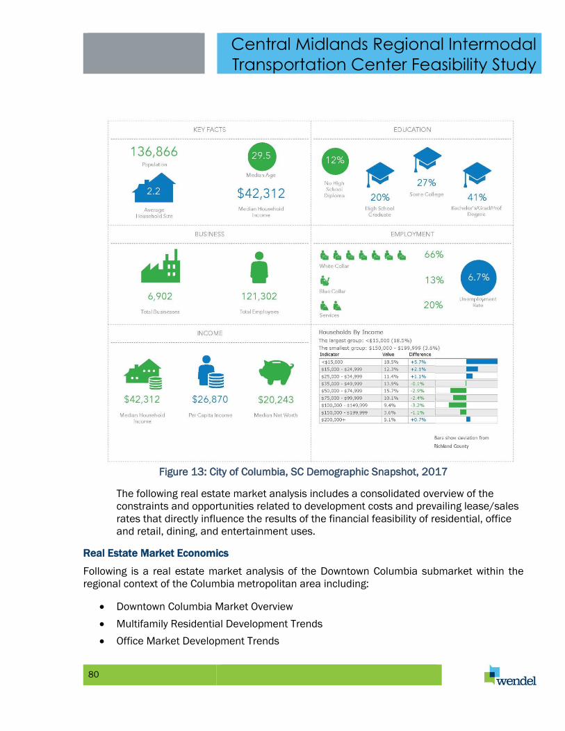
Central Midlands Regional Intermodal
Transportation Center Feasibility Study
80
Figure 13: City of Columbia, SC Demographic Snapshot, 2017
The following real estate market analysis includes a consolidated overview of the
constraints and opportunities related to development costs and prevailing lease/sales
rates that directly influence the results of the financial feasibility of residential, office
and retail, dining, and entertainment uses.
Real Estate Market Economics
Following is a real estate market analysis of the Downtown Columbia submarket within the
regional context of the Columbia metropolitan area including:
Downtown Columbia Market Overview
Multifamily Residential Development Trends
Office Market Development Trends
Central Midlands Regional Intermodal
Transportation Center Feasibility Study
81
Retail Market Trends
Parking Capacity Assessment
These findings are based on market data reported by Colliers International Market Insights
Report – Columbia, SC (2016 data) 3.
Following the real estate market analysis, an evaluation of mixed-use development
opportunities at the CMCOG RITC Site is provided.
Downtown Columbia Market Overview Downtown Columbia currently boasts 4.8 million square feet of office (2.3 million square feet
of Class A, 1.6 million square feet of Class B and 870,000 square feet of Class C), and 420,000
SF retail.
There are 1,250 people living in the Columbia City Center Partnership area alone, and many
more when the wider downtown housing market is considered. The downtown submarket is a
leader in all asset classes in terms of low vacancy and high rents within the Columbia MSA.
Columbia is experiencing unprecedented redevelopment activity. The Commons at Bull Street
is the redevelopment of the 180-acre South Carolina State Hospital Campus into a large scale
mixed-used community. Located at the intersection of I-26 and I-77, it is envisioned as
Columbia’s “next great neighborhood.”
The Commons is approved for 3,500 residential units, more than 400,000 SF retail, 1.3 million
square feet of office and a 170-room hotel. To date, the 8,500-seat Spirit Communications
Park, a multi-purpose sports and entertainment venue, and the 105,000 SF First Base Building,
a spec office building with ground floor retail have been developed. The Spirit Communications
Park project is expected to have a 20 to 30 year build out and must be taken into consideration
when planning any additional new mixed-use development activity in the Columbia submarket
to mitigate the potential risk of market over-supply.
Multifamily Development Trends The Central multifamily submarket, which includes downtown and USC-related development is
among the strongest in the MSA. While only representing 10% of the MSA apartment market,
the Central submarket leads the MSA in development activity, rent, rent per SF and absorption.
The multifamily sector has been very active in this submarket with over 3,000 units delivered
in the last 5-years (Table 9). Despite this large new inventory of both student housing beds and
rental apartments, the multifamily market has continued to experience rent increases.
Residential demand is driven by students and young professionals, primarily in immediate
proximity to the University. Market conditions for near and mid-term indicate significant
multifamily pipeline will take at least 18 months to absorb.
3 http://www.colliers.com/en-us/southcarolina/insights/columbia
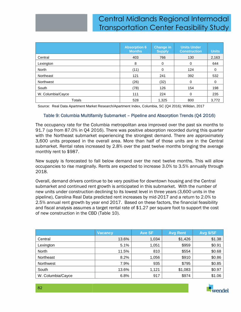
Central Midlands Regional Intermodal
Transportation Center Feasibility Study
82
Absorption 6 Months
Change in Supply
Units Under Construction Units
Central 403 766 130 2,163
Lexington 8 0 0 644
North (11) 0 124 0
Northeast 121 241 392 532
Northwest (26) (32) 0 0
South (78) 126 154 198
W. Columbia/Cayce 111 224 0 235
Totals 528 1,325 800 3,772
Source: Real Data Apartment Market Research/Apartment Index, Columbia, SC (Q4 2016); Willdan, 2017
Table 9: Columbia Multifamily Submarket – Pipeline and Absorption Trends (Q4 2016)
The occupancy rate for the Columbia metropolitan area improved over the past six months to
91.7 (up from 87.0% in Q4 2016). There was positive absorption recorded during this quarter
with the Northeast submarket experiencing the strongest demand. There are approximately
3,600 units proposed in the overall area. More than half of those units are in the Central
submarket. Rental rates increased by 2.8% over the past twelve months bringing the average
monthly rent to $987.
New supply is forecasted to fall below demand over the next twelve months. This will allow
occupancies to rise marginally. Rents are expected to increase 3.0% to 3.5% annually through
2018.
Overall, demand drivers continue to be very positive for downtown housing and the Central
submarket and continued rent growth is anticipated in this submarket. With the number of
new units under construction declining to its lowest level in three years (3,600 units in the
pipeline), Carolina Real Data predicted rent increases by mid-2017 and a return to 2.0% to
2.5% annual rent growth by year end 2017. Based on these factors, the financial feasibility
and fiscal analysis assumes a target rental rate of $1.27 per square foot to support the cost
of new construction in the CBD (Table 10).
Vacancy Ave SF Avg Rent Avg $/SF
Central 13.6% 1,034 $1,426 $1.38
Lexington 5.1% 1,051 $959 $0.91
North 11.5% 810 $554 $0.68
Northeast 8.2% 1,056 $910 $0.86
Northwest 7.9% 935 $795 $0.85
South 13.6% 1,121 $1,083 $0.97
W. Columbia/Cayce 6.8% 917 $974 $1.06

Central Midlands Regional Intermodal
Transportation Center Feasibility Study
83
Total/Weighted Ave 9.0% 1,011 $953 $0.94
Source: Real Data Apartment Market Research/Apartment Index, Columbia, SC; Willdan, November 2016
Table 10: Columbia Submarket Multifamily Trends – Rent and Vacancy Rates (Q4 2016)
Office Market Development Trends Downtown is the strongest MSA office submarket with 10.9% overall vacancy (Q3 2016 Colliers)
and little new supply contemplated in the short term. The overall market vacancy is 16.6% (Q3
2016 Colliers) with some submarkets approaching 23%. With downtown’s increased
desirability, Class B and C office buildings are seeing greater interest in redevelopment activity.
Downtown real estate brokers report that Class A users are moving to open floor plans to
maximize space efficiency.
The following Table 11 illustrates that with more than 4.8 million square feet, the Downtown
office submarket is the largest submarket in the MSA and continues to be one of the
strongest. With 12.0% vacancy in its Class A space; 9.4% in its Class B space and 10.8% in
Class C space, downtown’s vacancy is among the lowest in the MSA, according to Colliers
market data. Overall market vacancy rate is 16.6% with some submarkets with greater
obsolete space experiencing as much as 24% vacant for A, B and C Classes combined.
Downtown asking rents at $23.96 per square foot for Class A; $18.78 per square foot for
Class B and $16.54 per square foot for Class C are higher than the MSA average in every
class. (Compared to average asking rents across the market of $22.01 per square foot for
Class A, $17.15 per square foot for Class B and $13.62 per square foot for Class C,
respectively.)
Market Rentable Area (SF)
Total Vacant ($)
Average Asking Rent
($/RSF)
Net Absorption
(SF)
Downtown District (CBD)
Class A 2,324,922 12.0% 23.96 38,592
Class B 1,650,023 9.4% 18.78 10,486
Class C 879,336 10.8% 16.45 -19,095
Downtown CBD Total 4,854,281 10.9% 21.03 29,983
Cayce/West Columbia
Class A 63,000 5.2% 20.67 -3,300
Class B 152,700 1.5% 16.00 517
Class C 302,954 21.1% 12.15 7,004
East Columbia
Class A - - - -
Class B - - - -
Class C 86,183 3.7% 14.55 0

Central Midlands Regional Intermodal
Transportation Center Feasibility Study
84
Forest Acres
Class A 23,700 2.5% 15.00 -600
Class B 305,725 28.7% 16.27 -8,705
Class C 549,573 23.6% 13.50 15,440
Northeast Columbia
Class A 512,760 16.6% 17.35 -22,176
Class B 428,174 14.8% 15.66 8,000
Class C 336,652 48.3% 11.17 -852
St. Andrews
Class A 402,512 9.2% 18.94 1,968
Class B 680,056 24.3% 16.32 0
Class C 1,092,784 26.8% 14.68 15,932
Suburban Total
Class A 1,001,972 12.6% 17.91 -24,108
Class B 1,566,725 20.3% 16.21 -188
Class C 2,368,146 27.6% 13.18 37,524
Suburban Markets Total 4,936,843 22.2% 14.64 13,228
Market
Class A 3,326,894 12.2% 22.01 14,484
Class B 3,216,748 14.7% 17.15 10,298
Class C 3,247,482 23.0% 13.62 18,429
Market Total 9,791,124 16.6% 16.83 43,211
Source: Colliers International, Columbia Office (Q3 2016); Willdan, 2017
Table 11: Columbia Office Market Statistics
With downtown’s increasing desirability as live-work-play neighborhood, Class B and C office
buildings are seeing greater interest from buyers as well as repositioning by current owners.
The low vacancy rates for B and C class properties relative to the wider market especially
underscore the desirability of the submarket: Class B is 9.4% vs 14.7% market average, and C
at 10.8% versus market average of 23.2%.
There is a sense of constrained supply downtown. Downtown real estate brokers report that
Class A users are moving to open floor plans to maximize space efficiency. Increases in
construction costs for high-rise construction relative to current rents, as well as downtown
parking costs and constraints, continue to make new speculative construction downtown
unlikely. These conditions will continue to place upward pressure on downtown rents and
especially increase the desirability of Class B and C properties downtown.

Central Midlands Regional Intermodal
Transportation Center Feasibility Study
85
Based on these factors, the financial feasibility and fiscal analysis assumes a target office rental
rate of $25.00 per square foot (triple net) to support the cost of new construction in the CBD.
Retail Market Trends The following Table 12 illustrates that as compared to the Columbia region, Downtown is a very
strong retail submarket with retail space at 4.0% vacancy in a market with 9.4% average
vacancy that ranges to 23% in some submarkets.
Downtown retail is comprised of 400,000 square feet of space in anchored centers and 19,000
square feet of small shop spaces (shops less than 10,000 square feet). There is no effective
vacancy in the anchored centers and $21.93 per square foot asking rent for small spaces per
Colliers Q3 2016 report. Demand for ground floor retail is expected to entice some owners to
convert ground floor office space to retail in the near term.
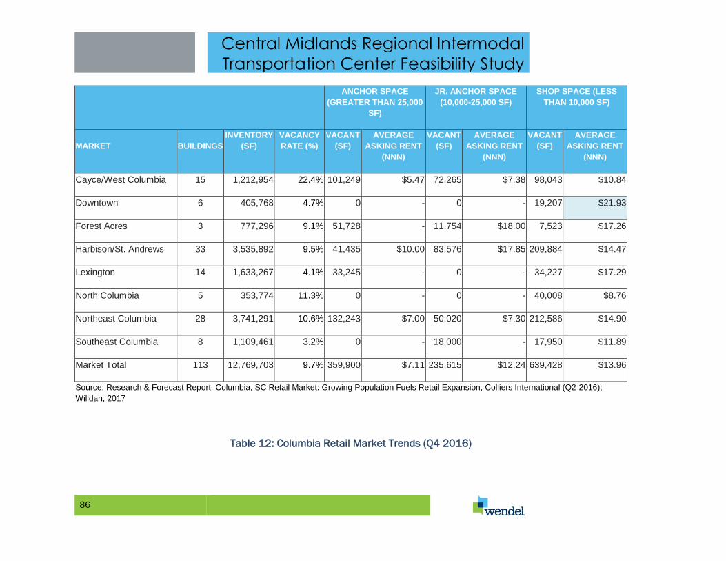
Central Midlands Regional Intermodal
Transportation Center Feasibility Study
86
ANCHOR SPACE
(GREATER THAN 25,000
SF)
JR. ANCHOR SPACE
(10,000-25,000 SF)
SHOP SPACE (LESS
THAN 10,000 SF)
MARKET BUILDINGS
INVENTORY
(SF)
VACANCY
RATE (%)
VACANT
(SF)
AVERAGE
ASKING RENT
(NNN)
VACANT
(SF)
AVERAGE
ASKING RENT
(NNN)
VACANT
(SF)
AVERAGE
ASKING RENT
(NNN)
Cayce/West Columbia 15 1,212,954 22.4% 101,249 $5.47 72,265 $7.38 98,043 $10.84
Downtown 6 405,768 4.7% 0 - 0 - 19,207 $21.93
Forest Acres 3 777,296 9.1% 51,728 - 11,754 $18.00 7,523 $17.26
Harbison/St. Andrews 33 3,535,892 9.5% 41,435 $10.00 83,576 $17.85 209,884 $14.47
Lexington 14 1,633,267 4.1% 33,245 - 0 - 34,227 $17.29
North Columbia 5 353,774 11.3% 0 - 0 - 40,008 $8.76
Northeast Columbia 28 3,741,291 10.6% 132,243 $7.00 50,020 $7.30 212,586 $14.90
Southeast Columbia 8 1,109,461 3.2% 0 - 18,000 - 17,950 $11.89
Market Total 113 12,769,703 9.7% 359,900 $7.11 235,615 $12.24 639,428 $13.96
Source: Research & Forecast Report, Columbia, SC Retail Market: Growing Population Fuels Retail Expansion, Colliers International (Q2 2016);
Willdan, 2017
Table 12: Columbia Retail Market Trends (Q4 2016)
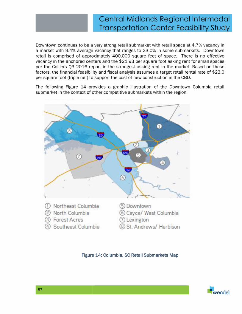
Central Midlands Regional Intermodal
Transportation Center Feasibility Study
87
Downtown continues to be a very strong retail submarket with retail space at 4.7% vacancy in
a market with 9.4% average vacancy that ranges to 23.0% in some submarkets. Downtown
retail is comprised of approximately 400,000 square feet of space. There is no effective
vacancy in the anchored centers and the $21.93 per square foot asking rent for small spaces
per the Colliers Q3 2016 report in the strongest asking rent in the market. Based on these
factors, the financial feasibility and fiscal analysis assumes a target retail rental rate of $23.0
per square foot (triple net) to support the cost of new construction in the CBD.
The following Figure 14 provides a graphic illustration of the Downtown Columbia retail
submarket in the context of other competitive submarkets within the region.
Figure 14: Columbia, SC Retail Submarkets Map
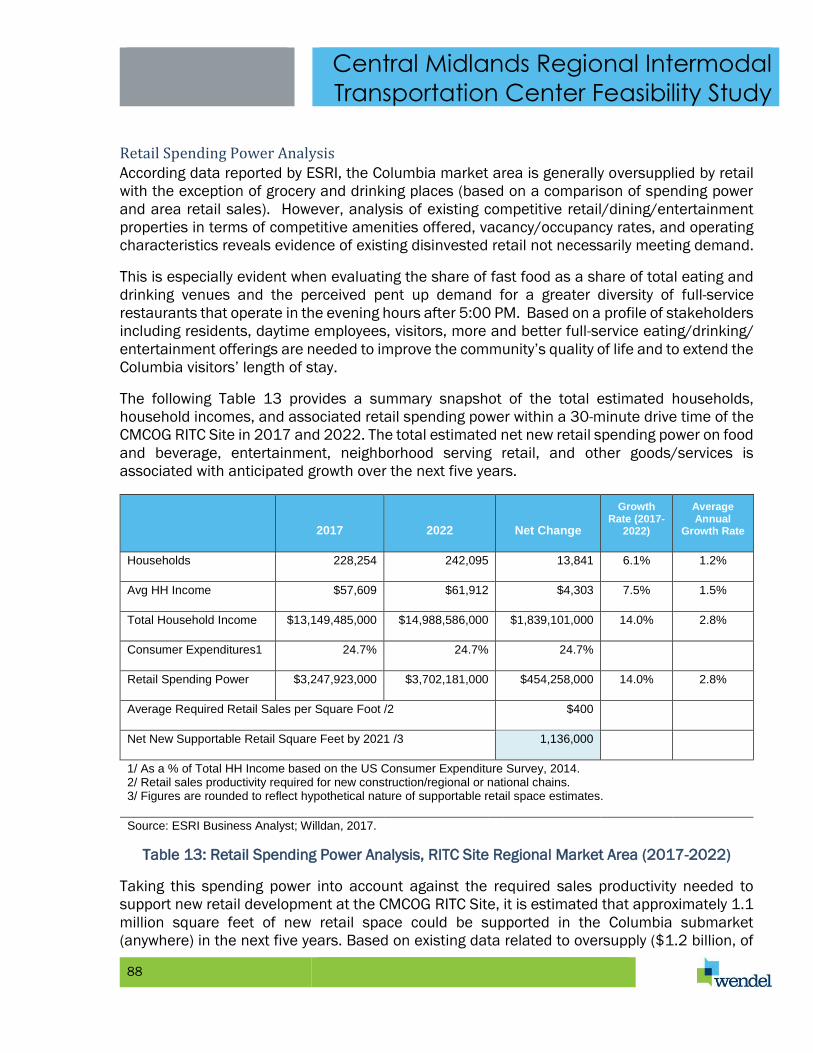
Central Midlands Regional Intermodal
Transportation Center Feasibility Study
88
Retail Spending Power Analysis According data reported by ESRI, the Columbia market area is generally oversupplied by retail
with the exception of grocery and drinking places (based on a comparison of spending power
and area retail sales). However, analysis of existing competitive retail/dining/entertainment
properties in terms of competitive amenities offered, vacancy/occupancy rates, and operating
characteristics reveals evidence of existing disinvested retail not necessarily meeting demand.
This is especially evident when evaluating the share of fast food as a share of total eating and
drinking venues and the perceived pent up demand for a greater diversity of full-service
restaurants that operate in the evening hours after 5:00 PM. Based on a profile of stakeholders
including residents, daytime employees, visitors, more and better full-service eating/drinking/
entertainment offerings are needed to improve the community’s quality of life and to extend the
Columbia visitors’ length of stay.
The following Table 13 provides a summary snapshot of the total estimated households,
household incomes, and associated retail spending power within a 30-minute drive time of the
CMCOG RITC Site in 2017 and 2022. The total estimated net new retail spending power on food
and beverage, entertainment, neighborhood serving retail, and other goods/services is
associated with anticipated growth over the next five years.
2017 2022 Net Change
Growth Rate (2017-
2022)
Average Annual
Growth Rate
Households 228,254 242,095 13,841 6.1% 1.2%
Avg HH Income $57,609 $61,912 $4,303 7.5% 1.5%
Total Household Income $13,149,485,000 $14,988,586,000 $1,839,101,000 14.0% 2.8%
Consumer Expenditures1 24.7% 24.7% 24.7%
Retail Spending Power $3,247,923,000 $3,702,181,000 $454,258,000 14.0% 2.8%
Average Required Retail Sales per Square Foot /2 $400
Net New Supportable Retail Square Feet by 2021 /3 1,136,000
1/ As a % of Total HH Income based on the US Consumer Expenditure Survey, 2014. 2/ Retail sales productivity required for new construction/regional or national chains. 3/ Figures are rounded to reflect hypothetical nature of supportable retail space estimates.
Source: ESRI Business Analyst; Willdan, 2017.
Table 13: Retail Spending Power Analysis, RITC Site Regional Market Area (2017-2022)
Taking this spending power into account against the required sales productivity needed to
support new retail development at the CMCOG RITC Site, it is estimated that approximately 1.1
million square feet of new retail space could be supported in the Columbia submarket
(anywhere) in the next five years. Based on existing data related to oversupply ($1.2 billion, of

Central Midlands Regional Intermodal
Transportation Center Feasibility Study
89
which $222,000 is associated with food and beverage establishments), only those projects with
clear market support or a niche target would likely attract private sector investment (or
substitution of existing retail with new product).
For example, it is expected that grocery growth in the region will remain strong, with Trader
Joe’s, Whole Foods and Fresh Market adding stores. Stakeholder interviews indicate that
residents are seeking additional whole foods type-healthy grocery store type chains. Downtown
is currently served by Publix in The Vista subarea. There has been some discussion of the need
for a second grocery store as 4,000 residents will be increasing to 6,000 in next few years.
Parking With 1,760 available spaces in downtown garages as well as surface lots and street parking,
market participant consensus is that the city is over parked in general but under-parked in
certain subareas that lack convenient garage parking.
Construction of parking garages is an extraordinary cost in the Columbia region and would likely
require city subsidy. Such subsidy may theoretically be possible through city contribution of
land, tax abatement or other government programs for projects with sufficient community
support.
The current range for monthly garage parking is $65 to $150, with median rate of $95 per
month. For the purpose of the financial feasibility and fiscal analysis, parking revenue is
excluded to reflect conservative revenue assumptions.
Recommended Development Opportunities
The following provides a summary of the CMCOG RITC Site’s redevelopment potential including
its strengths, barriers and opportunities including locational, physical, financial, market,
regulatory, and political, its competitive market position in the region, and strategies to
overcome issues identified as constraints.
As the market data demonstrate, downtown is outperforming most MSA submarkets. Driven by
the desirability of the downtown office location to high-wage employers, Downtown’s office,
residential base and retail offerings have expanded. In addition, the desire by area employers
to offer a unique, walkable urban work environment have fueled the downtown renaissance. In
spite of these indicators, however, increases in high-rise construction costs and real and
perceived downtown parking constraints make true new mixed-use speculative construction,
especially those coupled with the complexities of transit center, unlikely unless mid-rise and
carefully planned and/or supported by subsidies.
To evaluate the development opportunities associated with the CMCOG RITC Site
redevelopment, an evaluation of the following factors was conducted based on primary real
estate market stakeholder research in the Columbia area:
Competitive/strategic sites for smart growth (re)development (area supply
proposed/planned/under construction and impact on future absorption of CMCOG RITC
Site,
Central Midlands Regional Intermodal
Transportation Center Feasibility Study
90
Demand for a mix of uses (e.g. housing, office, retail, recreational, institutional)
Economic viability of existing retail and service businesses in the area
Recommendations for any changes that will enhance market appeal and viability for
identified (re)development opportunities will be outlined.
Strategies to enhance their competitive market position, including marketing of the area to
potential new residents and businesses and reducing development costs (i.e., construction
costs, air rights construction and shared parking.
Potential impacts of TOD on existing area development and land use activities.
Together with the primary real estate market research (rents, vacancy rates, other competitive
development in the pipeline), the following discussion provides the rationale for determining
the conditions of financial feasibility for mixed-use development at the CMCOG RITC Site.
Conditions of Mixed-Use Development Financial Feasibility
Grocery/Pharmacy Opportunity: A second downtown grocery store would likely find support
given the increasing downtown employment and number of housing units; more research
would be required as to best location. However, market experience suggests that a location
near Laurel and Sumter could be feasible with significant parking and attractive offerings
(Trader Joe’s type selection, fresh foods focus, etc.). Similarly, other service retail such as
a pharmacy could achieve success at the transit center site.
Creative Mix of Uses: Consideration should be given to uses that expand the hours of activity
in a new mixed-use development. Some suggested that this may mean thinking outside the
box to find users that will bring a variety of animation to the area for hours outside the 9-to-
5 workday. Potential uses included education/learning providers with longer hours of
operation, theater or other entertainment uses, office share providers. Also, office space for
active not-for-profits. Office that offers bike storage may appeal to younger demographic
was also mentioned as was incubator space.
Affordable Housing: There was a consensus across all stakeholders that that the current
transit center site is terribly stigmatized by the perception of crime and vagrancy. If
considering a scenario anchored by affordable housing, this use (coupled with bus activity)
would limit private sector interest in market rate ground floor retail or other uses.
Perception of Crime/Safety: Currently, Columbia’s transit system is viewed as transportation
of last resort, for those without choices. It was pointed out by all interviewees that the
downtown transit center (due to its location) is a billboard for the system. The widespread
observation of panhandling and loitering there lead to perception of lack of safety/fear of
crime surrounding transit uses in general. Given current perceptions of the downtown
transit center, it will be very difficult politically to sell its replacement with the same program
or level of operation. Emphatically, interviewees did not think a downtown transit center
would find political support if it were to be pitched as “just a cleaned-up version of what is
there now.”
Transit Center Design/Programming Targets: Many interviewees felt that to be successful a
new transit center would need to be very well lit, clean and safe, well policed, ideally with
Central Midlands Regional Intermodal
Transportation Center Feasibility Study
91
frontage on a major arterial such as Bull St or Elmwood. Design must be open and airy with
clear sight lines so that riders could see where they are going and feel safe
entering/interacting with the building. Ideally, a mix of uses, especially high traffic uses
active day and evening in the immediately surrounding area would be needed to reinforce
safety in the area around the center.
Significant Pipeline Development Activity: The transit center site is competing to attract
private investment during a residential building boom in the City of Columbia (Bull Street,
Main Street, West End Alley, Gervais Street, etc.). Many real estate professionals felt it would
be very difficult, if not impossible, to attract market rate developer interest in co-locating
with truly non-subsidized market driven uses (especially new office or market rate
residential) assuming a bus transfer center with a program like what is currently provided.
Parking Garage: Although some interviewees relayed that downtown has sufficient parking
in terms of lots, garages and street parking spaces, many expressed that garage parking
does not conveniently serve downtown destinations. Although by the numbers there are
enough parking spaces, the perception of safely and security for visitors coming and going
from their cars seems to override the reality of available space. Many believed that new
mixed-use development would need a significant garage to be successful.
Other Infrastructure Economic Development Priorities: Funding Several interviewees voiced
skepticism regarding the potential for a new transit center to secure needed funding given
the City’s large EPA-required drainage improvements and commitment to infrastructure at
the Bull Street Commons redevelopment. In short, the City of Columbia is supporting several
major infrastructure improvement programs to either support specific development projects
or critical public service needs. These priorities must be reconciled with the needs of the
proposed transit center and it is unknown whether the City or other State, Federal or private
sources would be available to fully fund the required capital investment.
Coordination with Main Street Redevelopment Activity: Some expressed concern that while
the Main Street redevelopment is advancing, side street retail is still struggling. They asked:
Why should/would the city allow a bus transfer station that could go anywhere to impede
the progress of this redevelopment? Why not locate a new facility even a few blocks north
or east to allow Main street to continue to prosper? Does it have to be downtown at all to
satisfy the transit operators need to transfer passengers between routes?
Opportunity to Connect Downtown Nodes: Of those who saw the need for transit or viewed
transit as an asset, many supported the idea of a circulator system for Main St/Vista/5-
Points/Downtown/Bull Street—or longer haul full-service bus routes to key regional
destinations such as Charlotte Airport, Greenville and Charleston. Bus service such as the
clean, safe, convenient service that Mega Bus and Concord Trailways operate in the
Northeast Corridor were mentioned as potential models for regional travel. Interviewees
saw a downtown transit center as a potential positive for co-locating these other (non-local
bus) transit services.
Impact of Driverless Technology on Public Transit: The future impact of driverless cars,
buses and taxis should be taken into consideration in any long-term transit planning
initiative. For example, the transit center could shift some element of operations to
Central Midlands Regional Intermodal
Transportation Center Feasibility Study
92
minibuses on the major routes with better technology to deliver transit capacity on demand.
However, low income riders do not own the technology to implement that system. Comet
should consider evaluating low tech paging technology to improve efficiencies and the
utilization of the transit center.
Expand City Center Partnership Services to Support the Transit Center: It is recommended
by several interviewees that the City of Columbia should expand clean/safe initiatives
throughout the Downtown to better support for continued revitalization and successful new
mixed-use redevelopment. Main Street redevelopment has diverted public resources from
the Central Business District (CBD). For example, there is significant lack of functioning
street lights throughout downtown, contributing to a serious safety/perception of safety
issue that impedes Downtown’s progress. As another example, poor sidewalk infrastructure
in some connecting areas was noted as detracting from the pedestrian experience and a
high-quality sense of place in the Downtown.
City of Columbia Municipal Complex Redevelopment Opportunity: The City of Columbia is
currently undertaking a Master Developer RFP process for the redevelopment of a new
municipal administration complex located adjacent to the current transit center. This large-
scale public/private redevelopment of an entire city block in proximity to the transit center
site provides an opportunity to approach the planning and design process as a cohesive,
integrated development. This approach could further support the potential of the site to
support a successful mixed-use product type. Furthermore, if city took vested interested,
figuratively and literally, a new mixed-use center would be much more likely to succeed
economically and operationally.
Horizontal vs. Vertical Mixed-Use Alternatives: It is important to note that the transit center
project is initiating planning late in the current real estate cycle. Interest rates and labor
costs are rising, depressing return on investment for developers. Vertically integrated mixed
use is very expensive from a construction cost standpoint, and it may be necessary to design
the transit center as a multi-use or horizontal mixed-use concept in the near-term as
Columbia rents currently do not appear to justify the costs of new high-rise without subsidy.
Opportunity to Enhance City Livability: Bicycle and pedestrian advocates indicated that the
effort to advance trail systems development (3 Rivers Greenway) and bike share/increased
bike use are ongoing. These are considered key quality of life enhancements that Columbia
needs to make to be competitive within its peer group in attracting new workforce and
employers. Trail systems are often tied into transit in other areas of the county to facilitate
easy access and connection. Comet already offers bike racks, but bicycle parking and
bicycle share stations should be planned for the transit center at a minimum.
Real Estate Market Findings and Recommendations Through desirable for place making, true large-scale mixed-use development has not been
required in many markets with significant availability of land. Columbia has demonstrated some
mixed-use development downtown and in new development associated with the University of
South Carolina and, in the planning for horizontal mixed-use at Bull Street Redevelopment;
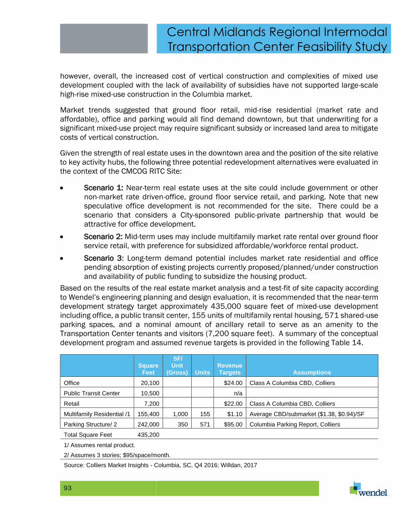
Central Midlands Regional Intermodal
Transportation Center Feasibility Study
93
however, overall, the increased cost of vertical construction and complexities of mixed use
development coupled with the lack of availability of subsidies have not supported large-scale
high-rise mixed-use construction in the Columbia market.
Market trends suggested that ground floor retail, mid-rise residential (market rate and
affordable), office and parking would all find demand downtown, but that underwriting for a
significant mixed-use project may require significant subsidy or increased land area to mitigate
costs of vertical construction.
Given the strength of real estate uses in the downtown area and the position of the site relative
to key activity hubs, the following three potential redevelopment alternatives were evaluated in
the context of the CMCOG RITC Site:
Scenario 1: Near-term real estate uses at the site could include government or other
non-market rate driven-office, ground floor service retail, and parking. Note that new
speculative office development is not recommended for the site. There could be a
scenario that considers a City-sponsored public-private partnership that would be
attractive for office development.
Scenario 2: Mid-term uses may include multifamily market rate rental over ground floor
service retail, with preference for subsidized affordable/workforce rental product.
Scenario 3: Long-term demand potential includes market rate residential and office
pending absorption of existing projects currently proposed/planned/under construction
and availability of public funding to subsidize the housing product.
Based on the results of the real estate market analysis and a test-fit of site capacity according
to Wendel’s engineering planning and design evaluation, it is recommended that the near-term
development strategy target approximately 435,000 square feet of mixed-use development
including office, a public transit center, 155 units of multifamily rental housing, 571 shared-use
parking spaces, and a nominal amount of ancillary retail to serve as an amenity to the
Transportation Center tenants and visitors (7,200 square feet). A summary of the conceptual
development program and assumed revenue targets is provided in the following Table 14.
Square Feet
SF/ Unit
(Gross) Units Revenue Targets Assumptions
Office 20,100 $24.00 Class A Columbia CBD, Colliers
Public Transit Center 10,500 n/a
Retail 7,200 $22.00 Class A Columbia CBD, Colliers
Multifamily Residential /1 155,400 1,000 155 $1.10 Average CBD/submarket ($1.38, $0.94)/SF
Parking Structure/ 2 242,000 350 571 $95.00 Columbia Parking Report, Colliers
Total Square Feet 435,200
1/ Assumes rental product.
2/ Assumes 3 stories; $95/space/month.
Source: Colliers Market Insights - Columbia, SC, Q4 2016; Willdan, 2017
Central Midlands Regional Intermodal
Transportation Center Feasibility Study
94
Table 14: CMCOG RITC Site Recommended Development Program and Target Revenue
The following section further tests the preferred development program against the financial
feasibly factors of development costs and targeted project revenues.
Financial Feasibility and Economic Benefits
Introduction and Overview To evaluate the potential financial feasibility of the proposed ancillary residential and
commercial uses at the CMCOG RITC Site, the Wendel Team undertook a residual land value
analysis.
In addition, an analysis of one-time economic benefits of the initial public and private
investment CMCOG RITC Site was conducted. Due to the preliminary planning status of the
transportation center redevelopment project, insufficient data is available to evaluate the
potential impact from transit center operations; economic impacts from ongoing operations are
therefore excluded from this analysis.
The financial feasibility and economic impacts analysis is based on the preferred development
program detailed in the prior discussion including 435,000 square feet of mixed-use
development on a 2.5-acre site including office, a public transit center, 155 units of multifamily
rental housing, 571 shared-use parking spaces, and a nominal amount of ancillary retail to
serve as an amenity to the Transportation Center tenants and visitors (7,200 square feet).
The financial feasibility and economic benefits analysis is structured inform public deliberations
regarding the return on public investment related to redevelopment of the transit center and
CMCOG’s overarching goals:
Foster economic sustainability in the Columbia, SC metropolitan area.
Activate underutilized public property to diversify municipality revenues;
Achieve the revitalization of the current Columbia Transportation Center through high
quality mixed- or multi-use development activity;
Attract private investment and development activity to Downtown Columbia;
Promote economic opportunities, attract new business formation, and create permanent
jobs.
To test the feasibility of the mixed-use development program concept and its ability to attract
interest by a private developer/investor through a PPP or other Master Developer RFP process,
the Wendel Team conducted an analysis to test the order-of-magnitude “Residual Land Value”
or “Supported Investment” related to redevelopment of the CMCOG RITC Site. Following is a
summary of financial feasibility findings, and a description of the methodology and approach to
the analysis. The detailed assumptions and calculations supporting these findings are provided
in the Appendix to this report.
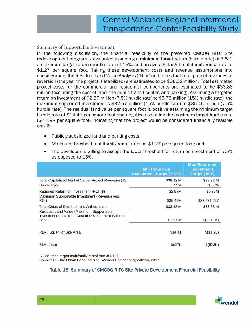
Central Midlands Regional Intermodal
Transportation Center Feasibility Study
95
Summary of Supportable Investment In the following discussion, the financial feasibility of the preferred CMCOG RITC Site
redevelopment program is evaluated assuming a minimum target return (hurdle rate) of 7.5%,
a maximum target return (hurdle rate) of 15%, and an average target multifamily rental rate of
$1.27 per square foot. Taking these development costs and revenue assumptions into
consideration, the Residual Land Value Analysis (“RLV”) indicates that total project revenues at
reversion (the year the project is stabilized) are estimated to be $38.32 million. Total estimated
project costs for the commercial and residential components are estimated to be $33.88
million (excluding the cost of land, the public transit center, and parking). Assuming a targeted
return on investment of $2.87 million (7.5% hurdle rate) to $5.75 million (15% hurdle rate), the
maximum supported investment is $32.57 million (15% hurdle rate) to $35.45 million (7.5%
hurdle rate). The residual land value per square foot is positive assuming the minimum target
hurdle rate at $14.41 per square foot and negative assuming the maximum target hurdle rate
($-11.98 per square foot) indicating that the project would be considered financially feasible
only if:
Publicly subsidized land and parking costs;
Minimum threshold multifamily rental rates of $1.27 per square foot; and
The developer is willing to accept the lower threshold for return on investment of 7.5%
as opposed to 15%.
Min Return on Investment Target (7.5%)
Max Return on Investment
Target (15%)
Total Capitalized Market Value (Project Revenues) /1 $38.32 M $38.32 M
Hurdle Rate 7.5% 15.0%
Required Return on Investment -ROI ($) $2.87M $5.75M
Maximum Supportable Investment (Revenue less ROI) $35.45M $32,571,227
Total Costs of Development Without Land $33.88 M $33.88 M
Residual Land Value (Maximum Supportable Investment Less Total Cost of Development Without Land $1.57 M $(1.30 M)
RLV / Sq. Ft. of Site Area $14.41 $(11.98)
RLV / Acre $627K $(522K)
1/ Assumes target multifamily rental rate of $127. Source: ULI-the Urban Land Institute; Wendel Engineering; Willdan, 2017
Table 15: Summary of CMCOG RITC Site Private Development Financial Feasibility
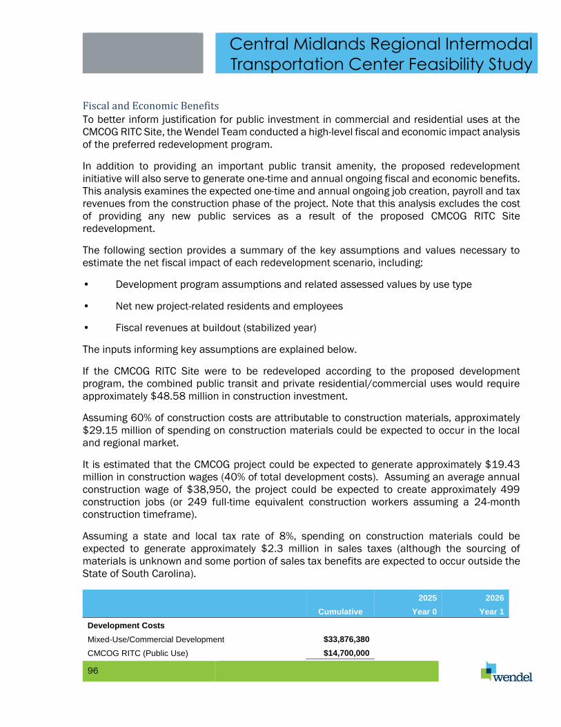
Central Midlands Regional Intermodal
Transportation Center Feasibility Study
96
Fiscal and Economic Benefits To better inform justification for public investment in commercial and residential uses at the
CMCOG RITC Site, the Wendel Team conducted a high-level fiscal and economic impact analysis
of the preferred redevelopment program.
In addition to providing an important public transit amenity, the proposed redevelopment
initiative will also serve to generate one-time and annual ongoing fiscal and economic benefits.
This analysis examines the expected one-time and annual ongoing job creation, payroll and tax
revenues from the construction phase of the project. Note that this analysis excludes the cost
of providing any new public services as a result of the proposed CMCOG RITC Site
redevelopment.
The following section provides a summary of the key assumptions and values necessary to
estimate the net fiscal impact of each redevelopment scenario, including:
• Development program assumptions and related assessed values by use type
• Net new project-related residents and employees
• Fiscal revenues at buildout (stabilized year)
The inputs informing key assumptions are explained below.
If the CMCOG RITC Site were to be redeveloped according to the proposed development
program, the combined public transit and private residential/commercial uses would require
approximately $48.58 million in construction investment.
Assuming 60% of construction costs are attributable to construction materials, approximately
$29.15 million of spending on construction materials could be expected to occur in the local
and regional market.
It is estimated that the CMCOG project could be expected to generate approximately $19.43
million in construction wages (40% of total development costs). Assuming an average annual
construction wage of $38,950, the project could be expected to create approximately 499
construction jobs (or 249 full-time equivalent construction workers assuming a 24-month
construction timeframe).
Assuming a state and local tax rate of 8%, spending on construction materials could be
expected to generate approximately $2.3 million in sales taxes (although the sourcing of
materials is unknown and some portion of sales tax benefits are expected to occur outside the
State of South Carolina).
2025 2026
Cumulative Year 0 Year 1
Development Costs
Mixed-Use/Commercial Development $33,876,380
CMCOG RITC (Public Use) $14,700,000

Central Midlands Regional Intermodal
Transportation Center Feasibility Study
97
Total Construction Investment (Hard Costs) /1, 2, 3 $48,576,380 $36,432,285 $12,144,095
Construction Materials / 4 $29,145,828 $21,859,371 $7,286,457
Construction Wages /5 $19,430,552 $14,572,914 $4,857,638
Total Construction Wages $19,430,552
Divided by Median Annual Construction Wage /6 $38,950
Person Years of Construction Employment = 499
Divided by Construction Years /7 2
Estimated Average Annual FTE Construction Jobs 249
Sales Taxes from Construction Materials Purchases /8 $2,331,666
1/ Construction value based on private mixed-use construction (excluding parking costs) + public CMCOG RITC costs (including parking structure costs).
2/ Year 1 construction (as % of total development costs) 75%
3/ Year 2 construction (% of total development costs) 25%
4/ South Carolina State Occupational Employment and Wage Estimates (May 2016)
5/ Construction materials as % of hard construction costs = 60%
6/ Construction wages as % of hard construction costs = 40%
7/ Assumed construction timeframe subject to change.
8/ NY State & Local Sales Tax Rate (Richland County) 8.000%
Source: RS Means Construction Cost Estimators; US Department of Labor; Wendel; Willdan, 2017
Table 16: RITC Commercial & Public Use Development (One-Time Construction Benefits)
In terms of ongoing operations, it is expected that the residential and commercial uses could
generate approximately $26,000 in annual real property tax revenues and approximately
$259,000 in state and local retail sales tax revenues.
The following Table 17 and Table 18 provide the detailed assumptions and calculations
supporting these order-of-magnitude findings regarding the CMCOG RITC Site’s potential fiscal
benefits.
Multifamily Apartment, Office & Retail Uses Rate/ $1,000 Value
County Millage Rate = 0.1246
Richland County School District 1 = 0.3160
City of Columbia = 0.0961
Total County, School & City Millage 0.5367
Total Estimated Project Value (100% of Market)/1 $48,576,380

Central Midlands Regional Intermodal
Transportation Center Feasibility Study
98
Estimated Annual Real Property Taxes $26,071
1/ Based on construction cost value, subject to adjustment based on real property assessment.
Source: Richland County Assessor; Willdan, 2017
Table 17: CMCOG RITC Fiscal Benefits – Annual Ongoing Real Property Taxes (Stabilized Year)
CMCOG RITC Retail Uses
Retail Uses (Sq. Ft.) 7,200
Estimated Annual Retail Sales Productivity/ Sq. Ft $450
Total Annual Retail Sales $3,240,000
State & Local Sales Tax Rate 8%
Annual State & Local Sales Tax Revenues $259,200
Source: City of Columbia, SC; Willdan, 2017
Table 18: CMCOG RITC Fiscal Benefits – Annual Ongoing Sales Taxes (Stabilized Year)
In terms of job generation, it is not expected that the multifamily, office and retail operations
would be expected to generate substantial employment. First, multifamily operations do not
tend to generate substantial employment activity (approximately 6 to 10 full-time equivalent
jobs per project, depending on project size and amenities).
Likewise, the retail operations could be expected to generate approximately 1 full-time
employee for every 450 square feet of retail, or 16 FTEs. The average annual retail wage is
$35,700, with the potential to generate approximately $571,200 in new local payroll from retail
operations.
Finally, the office component includes approximately 20,100 square feet. Assuming an industry
average of between 250 to 500 square feet per office worker, the office component could be
expected to house between 40 to 80 full-time office workers (depending on the industry and
office space strategy of individual tenants). Given relatively high office vacancy rates reported
in the Columbia, SC regional market, the analysis does not presume that developing office
space necessarily equates to creating new office employment (as new space could be occupied
by existing office workers relocating from older/obsolete space).
For those reasons, an estimate of fiscal and economic benefits generated by office worker
payroll is expected to be in the range of $4.5 million (60 FTEs and $75,000 in annual payroll)
but is not recommended to be included in ongoing fiscal benefits until a new build-to-suit office
tenant is secured for the project.
Conclusion

Central Midlands Regional Intermodal
Transportation Center Feasibility Study
99
The proposed CMCOG RITC Site redevelopment strategy includes approximately 435,000
square feet of mixed-use development including office, a public transit center, 155 units of
multifamily rental housing, 571 shared-use parking spaces, and a nominal amount of ancillary
retail to serve as an amenity to the Transportation Center tenants and visitors (7,200 square
feet).
Based on the market findings in this analysis, if the project were to meet the conditions of
feasibility outlined in this study, the project could potentially attract a private sector developer
to enter into a PPP (land sale or long-term ground lease) to construct and operate the
residential, office, and retail components of the project while achieving a minimum threshold
return on investment of 7.5%.
The one-time construction activity and ongoing operations are anticipated to generate fiscal
and economic benefits in the form of jobs, payroll and taxes that could justify public funding in
infrastructure and public realm improvement components of the project.
CONCEPTUAL PLANS FOR THE CENTRAL MIDLANDS REGIONAL INTERMODAL
TRANSPORTATION CENTER
Initial Master Plan Site Concepts
After identifying the program and the locally preferred site, the design team began to perform
test fits on the preferred site. This process consists of preparing diagrams that show how
different facility configurations the support the desired program will fit on a chosen site. The
initial focus of the test fits was to look at the relationship between the large number of bus
bays, safe pedestrian circulation, and the potential for Transit Oriented Development on the
site. The design team explored multiple bus bay configurations and associated street level
circulation patterns. Efforts were made to prepare site plan options that included bus bays
located off of the city streets. Under such options, sawtooth bus slips along with bus
circulation occupy the site’s interior and strategic access points are provided to the street
frontage. Considerable space was necessary to accommodate the preferred twenty (20) bus
bays with adequate bus and pedestrian circulation space. Additionally, priority was placed on
cultivating pedestrian and bike activity while creating a strong street presence, specifically
along Laurel Street and Sumter Street. The design team recognized opportunities along
Laurel Street to integrate with future development and opportunities along Sumter Street to
incorporate a possible commercial component.
Using these criteria, four (4) test fit options were developed for discussion. Diagrams were
created that showed bus movement simulation using Auto Turn software. All of the bus
movements in all of the options were analyzed to ensure the development of a transit center
proposal that works for COMET bus turning radii, verifying the necessary space to create a
safe and functional transfer center. In keeping with providing two bus circulation access
points, the options explored Blanding Street and Sumter Street as the primary bus entry-exit
point. Below are the test fit options that were discussed.

Central Midlands Regional Intermodal
Transportation Center Feasibility Study
100
Figure 15: Test Fit Site Option A
Three bus entry-exit points for dual bus islands - two located are located along
Blanding Street and one located along Sumter Street
Sawtooth bus bay configuration accommodating twenty (20) buses, preferred for bus
operations flexibility
Expansive street presence along Sumter Street, providing strong commercial
component opportunity
Drop-off area located to the north of the project near the Laurel Street, providing easy
pedestrian access to bus platform
Two platforms separate transit riders and require transferring between platforms at
safe pedestrian crossing points.

Central Midlands Regional Intermodal
Transportation Center Feasibility Study
101
Figure 16: Test Fit Site Option B
Two bus entry and exit points for the dual bus islands - both located along Blanding
Street, with an additional one-way bus entry point located along Laurel Street.
Sawtooth bus bay configuration accommodate eighteen (18) buses, preferred for bus
operations flexibility
Pedestrian activity majority isolated to the perimeter of the bus circulation area. Two
platforms separate transit riders and require transferring between platforms at safe
pedestrian crossing points.
Drop-off area located to the east of the project along Sumter Street, providing easy
pedestrian access to bus platform

Central Midlands Regional Intermodal
Transportation Center Feasibility Study
102
Figure 17: Test Fit Site Option C
Two bus entry-exit points - one located along Blanding Street and one located along
Sumter Street
Sawtooth bus bay configuration accommodating eleven (11) buses, preferred for bus
operations flexibility
Expansive street presence along Sumter Street, providing a strong commercial
component opportunity
Large, central platform for pedestrian activity in the bus circulation area. Pedestrians
do not need to cross bus traffic in this configuration.
Drop-off area located to the north of the project along Laurel Street, providing easy
pedestrian access to bus platform
Two standard bays for Greyhound or quick-charge operations are located separately
from the main bus island allowing further flexibility.

Central Midlands Regional Intermodal
Transportation Center Feasibility Study
103
Figure 18: Test Fit Site Option D
One primary bus entry-exit point located along Sumter, with an additional bus entry
point located along Sumter Street and a bus exit point located along Blanding Street
Sawtooth bus bay configuration accommodating fifteen (15) buses, preferred for bus
operations flexibility
Large, central platform for pedestrian activity in the bus circulation area. Two bus
islands require transferring between platforms at safe pedestrian crossing points.
Drop-off area located to the north of the project along Laurel Street, providing easy
pedestrian access to bus platform
Following a review and evaluation of the four (4) master plan site options by the Steering
Committee, Option D was identified as the preferred option. This option emphasizes the large,
central platform – allowing for accessibility and transferability between buses for pedestrians.
Furthermore, the consolidation of pedestrian activity allows limited instances of pedestrian-

Central Midlands Regional Intermodal
Transportation Center Feasibility Study
104
bus crossings. Additionally, this option offers the opportunity to construct the bus bays in
phases, beginning with the inner circle and expanding with additional bus bays as necessary.
The primary bus entry-exit points located along Sumter Street provide an opportunity for the
Transit Center to become a prominent, visible part of the project, while still maintaining
consistent building frontage along Laurel Street.
Three Dimensional Studies for the Preferred Site Plan
Moving forward with Option D, the design team developed three conceptual design options for
the buildings. Each option included a site plan and conceptual three-dimensional massing
images. This approach provided the Steering Committee the ability to visualize the full growth
possibilities through massing, and allowed the design team to further study the relationships
between parts of the project.
Figure 19: Option 1 Conceptual Plan
Option 1 seeks to actively relate to the surrounding neighborhood by focusing on traditional
architectural forms and details. The simple geometries maximize views throughout the site.
Particularly, the anchoring corners maximize street frontage and establish a strong street
presence. The Laurel Street façade invites pedestrians into the Transit Center through a
covered courtyard. Additionally, the courtyard provides safe access to the bus platform,
controlling pedestrian crossing points. In keeping with the surrounding neighborhood, the
facades employ brick masonry with concrete accents. Window lintels, rectilinear shapes, and
pronounced columns contribute to the traditional forms; while, angled roof slopes and varying
roof heights introduce a slight, modern touch. Figure 19 shows a perspective of Option 1
looking at the corner of Sumter Street and Laurel Street

Central Midlands Regional Intermodal
Transportation Center Feasibility Study
105
Figure 20: Option 2 Conceptual Plan
Option 2 aims to capture the site’s inherit activity and movement through employing modern
forms and architectural elements. The design utilizes strong angles and layered planes to
form compelling spatial arrangements, to introduce natural light into the interior of the site,
and to create opportunities for green spaces. A terraced bridge over the Sumter Street bus
entry-exit point undulates, opening the facade, showcasing the bus activity beyond. Further,
the Laurel Street façade rises, providing pedestrian access to the Transit Center. Figure 20
shows a perspective of Option 2 looking at the corner of Sumter Street and Laurel Street.
Figure 21: Option 3 Conceptual Plan

Central Midlands Regional Intermodal
Transportation Center Feasibility Study
106
Option 3 utilizes multiple scales along with modern and historic architectural gestures to
highlight the various programmatic spaces in the project. The design creates an open street
level plan to introduce natural light into the interior of the site and to stimulate pedestrian
activity from the street to move throughout the project. Additionally, the open street level plan
allows views of the Transit Center and bus activity through the screen of the development
along the street. The combination of traditional and modern elements remain sensitive to the
established surroundings while motioning to the progressive culture of the city, a concept
further conveyed through facades of brick masonry, metal panel, and wood accents. Figure 21
shows a perspective of Option 3 looking at the corner of Sumter Street and Laurel Street
Refinement of the Preferred Three Dimensional Conceptual Plan
During a review and discussion of the three conceptual design options, the Steering
Committee indicated a preference for Option 3. They preferred the approach of using
traditional and modern elements to create an architectural expression of distinct
programmatic spaces along with the convenient pedestrian access to the bus platforms along
the Laurel Street façade.
However, a review of the three-dimensional studies by the City stimulated a re-evaluation of
the test fit plan site option initially chosen, Option D. Particularly, the city wanted to re-
evaluate the impact of the open street level and the bus entry-exit point located along Sumter
Street. Concerns were raised for pedestrian/ bike safety and potentially lost opportunities for
street level development on the Sumter Street façade. Through further discussions, it was
decided that bus activity should be less visible from the street and the addition of more
commercial components should be explored. As a result of these discussions, the Steering
Committee decided that street level development should be prioritized over maximizing the
number of bus bays. The required number of bus bays was reduced from twenty (20) to fifteen
(15). It was decided to generate final massing with a modified version of Site Option B.
Beginning with Master Plan Site Option B, the primary bus entry-exit point is located along
Blanding Street, with an alternative exit located along Laurel Street. The eighteen (18) bus
bays shown in Master Plan Option B is reduced to fifteen (15) to accommodate additional
commercial space along Sumter Street. The reduction of bus bays allows for an increase in
usable ground square footage for development along Sumter Street. The location of the
Transit Center is along Sumter Street close to the corner of Laurel Street. The angled façades
of the adjacent massing leads into the transit area. The massing of the proposed transit
development allows for the incorporation of a four-story parking structure accessed from
Laurel Street. The parking component is intended to complement the future City Hall
development and further accommodate vehicle parking access. The pedestrian access to the
bus platforms is along the Laurel Street and Sumter Street façades, as first shown in Master
Plan Site Option D and as desired by the client.
The revised conceptual design distinguishes various programmatic spaces through definition
of various masses while still offering a cohesive architectural gesture. The commercial
component along Sumter Street conceals bus activity and activates the city’s pedestrian and
Central Midlands Regional Intermodal
Transportation Center Feasibility Study
107
bike activity. The additional commercial components include office, retail, and hospitality
uses along Laurel Street and Sumter Street. A large residential component adds another layer
of density over the parking garage.
The bus activity on Blanding Street reactivates the old greyhound station across the street.
While, the alternative bus exit point located on Laurel Street acts as an architectural point of
separation, creating two (2) three-story buildings of approximately 13,500 square feet/ floor
and 6,600 square feet/ floor. The façade is imagined as a composition of brick, metal panel
rain screen, wood, and glazing.
The Transit Center is a two-story structure with approximately 10,500 square feet/ floor and
located on along of Sumter Street near the corner of Laurel Street. It bridges between the
various programmatic spaces while providing a covered entry to the bus platform. The two-
story mass is envisioned as a glazed exterior with a large, angled relief offering a modern
element without compromising the integrity of the Sumter Street façade.
Garage parking, located above the bus bays, allows maximum circulation on the street level.
Parking is anticipated to be used by the future City Hall development, nearby businesses, and
surrounding commercial components. The mass accommodates three levels of parking,
totaling approximately 242,000 square feet/ floor.
In response to the Steering Committee’s desire for a residential component, the revised
conceptual design incorporates residential programmatic space above the parking levels. The
residential component addresses the street with a lobby on the corner of Sumter Street and
Blanding Street, and grows to address both street facades. The “U” shape design provides an
opportunity for a private pool area or outdoor green space on the interior of the site, away
from street activity. The associated residential massing steps back to provide relief to the
façade and opportunities for terraces and green roofs. The mass totals five stories,
approximately 155,400 square feet/ floor, and incorporates wood details into the exterior
façade, in addition to masonry and metal panel. The final conceptual site plan is shown below
in Figures 22 through 27.
Another important aspect of the design of the Transit Center will be wayfinding and signage
for the facility. Information must be provided for pre-trip planning and on-route as well. This
information will inform the traveler of the location, schedule and real-time status of the
services, as well as an understanding of the amenities and services that are offered in each
part of the intermodal center. Information for the user will be located at several locations and
cover all modes. The design approach to signage and wayfinding will be two-fold: (1) Signs will
be used to orient people only when absolutely necessary. Architecture, architectural symbols,
streetscape, and clear unobstructed sightlines between destination points will be the
backbone of a wayfinding system. (2) The wayfinding/signage system will be inclusive and
should employ graphic symbols as well as lettering and directional arrows. In final design,
historic sites and major regional destinations should be folded into the wayfinding/signage
system along with the multiple transportation modes. Preliminary wayfinding and signage
plans are shown in Figures 28 and 29.

108
Figure 22: Regional Transportation Center Conceptual Site Plan – Base Program
EXIT ONLY TO LAUREL
ENTER/EXIT TO BLANDING
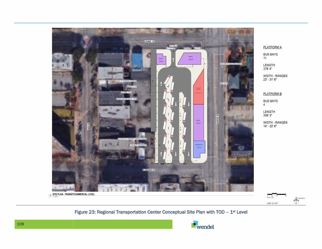
109
Figure 23: Regional Transportation Center Conceptual Site Plan with TOD – 1st Level
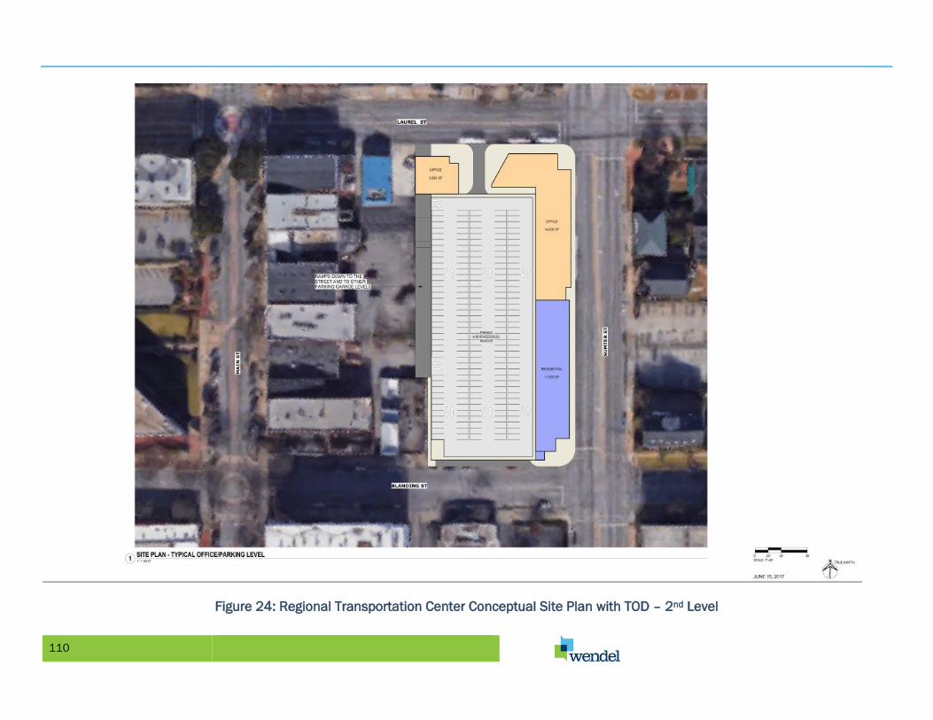
110
Figure 24: Regional Transportation Center Conceptual Site Plan with TOD – 2nd Level

111
Figure 25: Regional Transportation Center Conceptual Site Plan with TOD – 3rd Level Up
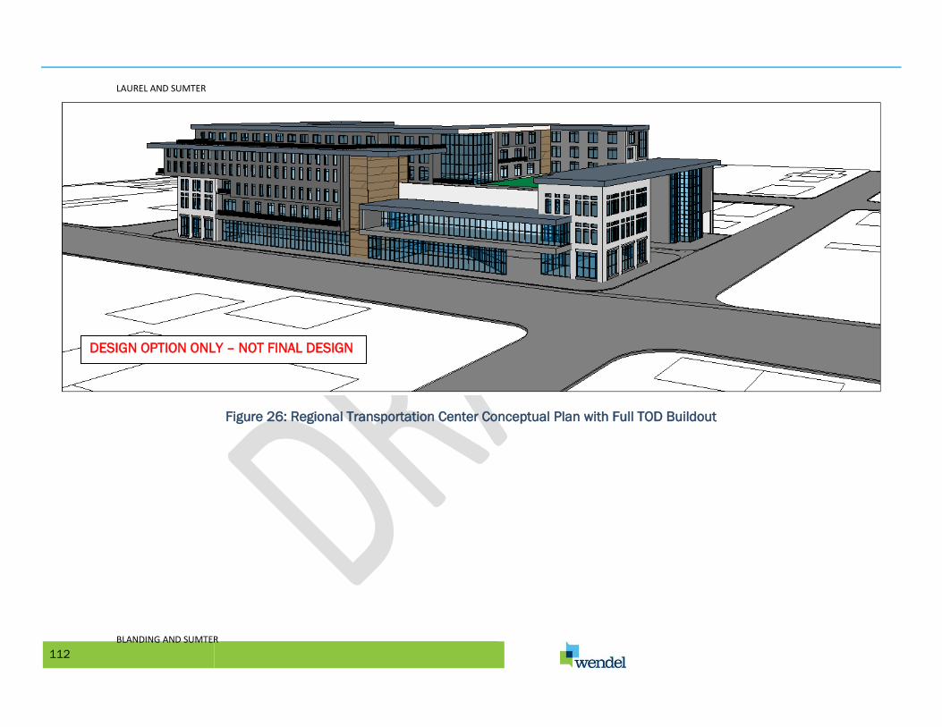
112
Figure 26: Regional Transportation Center Conceptual Plan with Full TOD Buildout
LAUREL AND SUMTER
BLANDING AND SUMTER
DESIGN OPTION ONLY – NOT FINAL DESIGN
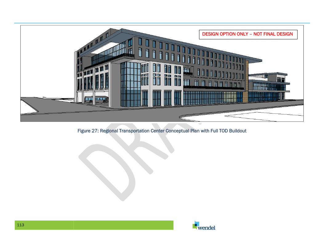
113
Figure 27: Regional Transportation Center Conceptual Plan with Full TOD Buildout
DESIGN OPTION ONLY – NOT FINAL DESIGN

114
Figure 28: Regional Transportation Center Conceptual Plan Signage
DESIGN OPTION ONLY – NOT FINAL DESIGN
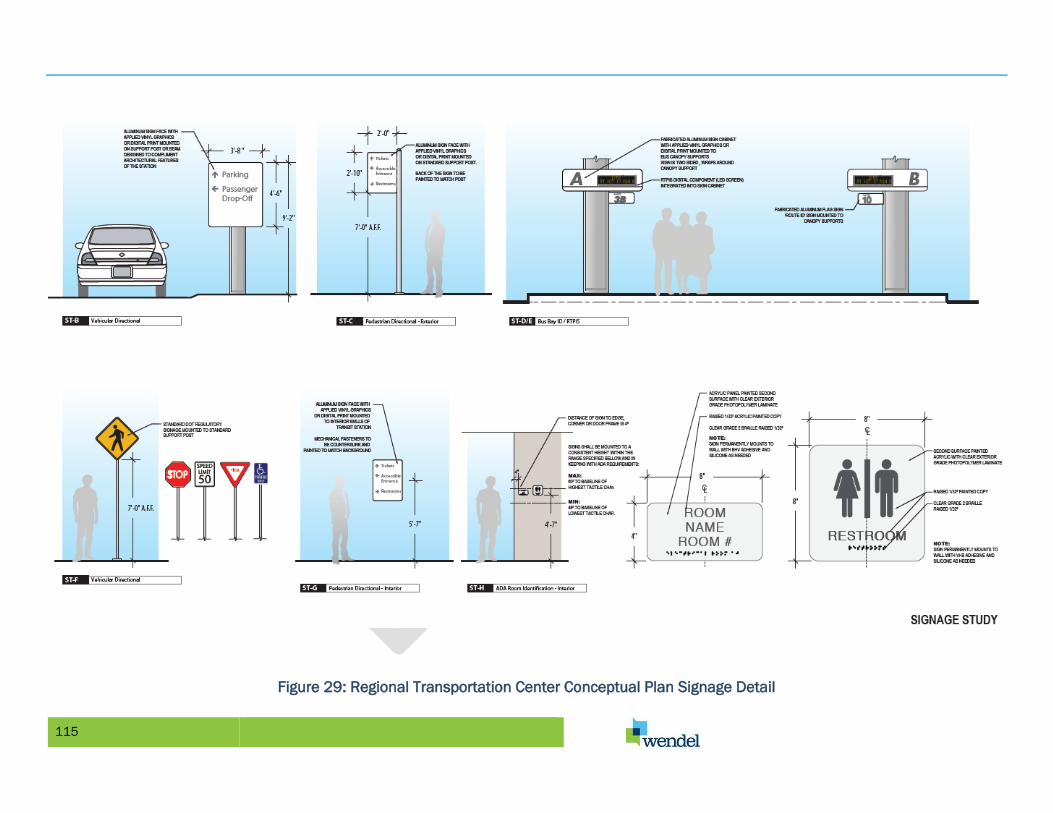
115
Figure 29: Regional Transportation Center Conceptual Plan Signage Detail

116
Conceptual Level Construction Cost Estimate for Transit Components Only
For use with DOT project programming, the Wendel Team prepared an order of magnitude cost
estimate for the transit components only of the conceptual design. The estimate was prepared
using real data including labor and material costs from the Central Midlands region to accurately
reflect actual construction estimates. Because the design is at a very early stage, we include
contingency costs on many components of the estimate and calculate an expected inflation
factor. Including these estimating variables early in the costing cycle, provide more realistic
requirement for funding accrual and avoid “Sticker Shock” when the project goes to
construction.
Table 19: Conceptual Level Construction Estimate for the Regional Transportation Center

117
The transit components included in the construction cost estimate encompass all site work,
construction of bus bays and ingress/egress to the site, canopies over the bays and the Transit
Center building. The estimate was based on a Transit Center occupying the site with only the
facility, bus bays, ingress and egress as shown in the conceptual site plan (Figure 22). Canopies
over the bus bays were included in the estimate since a transit only facility would not have a
parking facility over the bus bay area. Not included in the estimate are the TOD portions shown in
the conceptual plan as retail space, office space, residential space and the parking structure.
Land acquisition cost are not included in the construction cost estimate.
Related Documents