Fayetteville-Manlius Road/Route 257 Pedestrian Accommodation Feasibility Study Final Report November 2007 Syracuse Metropolitan Transportation Council 126 N. Salina Street, Suite 100 Syracuse, NY 13202 Phone: 315-422-5716 Fax: : 315-422-7753

Welcome message from author
This document is posted to help you gain knowledge. Please leave a comment to let me know what you think about it! Share it to your friends and learn new things together.
Transcript
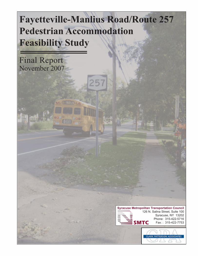
Fayetteville-Manlius Road/Route 257 Pedestrian Accommodation Feasibility Study
Final ReportNovember 2007
Syracuse Metropolitan Transportation Council126 N. Salina Street, Suite 100
Syracuse, NY 13202Phone: 315-422-5716
Fax: : 315-422-7753

Fayetteville-Manlius Road/Route 257
Pedestrian Accommodation Feasibility Study
Final Report November 2007
This document was prepared with financial assistance from the Federal Highway Administration and the Federal Transit Administration of the U.S. Department of Transportation through the New York State Department of Transportation. The Syracuse Metropolitan Transportation Council (with assistance from Clark Patterson Associates) is solely responsible for its contents.
For further information contact: Danielle Krol, Senior Transportation Planner/Project Manager James D’Agostino, Director Syracuse Metropolitan Transportation Council 126 N. Salina Street, 100 Clinton Square, Suite 100 Syracuse, New York 13202 Phone: (315) 422-5716; Fax: (315) 422-7753 www.smtcmpo.org

ii
Table of Contents ........................................................................................................... ii Executive Summary ........................................................................................................v
TABLE OF CONTENTS F-M Rd/Rt 257 Pedestrian Accommodation Feasibility Study
Chapter 1 - Introduction ......................................................................................................1 1.1 Purpose of Study ......................................................................................................1 1.2 Study Process ...........................................................................................................1 1.3 Public Involvement Plan ..........................................................................................2
Study Advisory Committee...................................................................................2 Stakeholders Group...............................................................................................2 Public Meetings ....................................................................................................2 Gauging Public Sentiment ....................................................................................4
1.4 Study Area Boundaries ............................................................................................5 Figure 1-1 (Study Area)
Chapter 2 – Previously Examined Pedestrian Connections..............................................7
2.1 Ledyard Canal Trail Proposal ..................................................................................7 2.2 Other Previously Examined Connections ................................................................7
Chapter 3 – Existing Transportation Conditions ..............................................................8 3.1 Transportation Network ...........................................................................................8 3.1.1 History of Route 257/Fayetteville Manlius Road ....................................................8 3.1.2 Roadway ..................................................................................................................9 3.1.3 Transit ....................................................................................................................10
Centro..................................................................................................................10 Figure 3.1.3-1 (Centro Route 162) Figure 3.1.3-2 (Centro Route 262) Figure 3.1.3-3 (Centrol Route 262X Express) Figure 3.1.3-4 (Centro Bus Stop Locations) School Buses.......................................................................................................15
3.1.4 Bicycle/Pedestrian Facilities and Curbs/Curb Ramps ...........................................16 Bicycle Facilities.................................................................................................16 Pedestrian Facilities ............................................................................................16
3.2 Existing Traffic Conditions....................................................................................19 3.2.1 Traffic Volumes and Speed Data...........................................................................19
AADT Volumes and Speed ................................................................................19 Figure 3.2.1-1 (Traffic Volume and Speed Data) Vehicle Classification .........................................................................................21 Turning Movement Counts .................................................................................22
3.2.2 Traffic Control Devices .........................................................................................26 Speed Limit Signs ...............................................................................................26 Traffic Signals and Stop Signs............................................................................26 Pavement Markings ............................................................................................27
iii
3.2.3 Accident Analysis ..................................................................................................28 3.3 Existing Facility Conditions ..................................................................................29 Illustration I (Sheet Index Map) .........................................................................31
Figure 3.3-1 Figure 3.3-2 Figure 3.3-3
3.3.1 Pavement................................................................................................................35 Drainage Facilities ..............................................................................................35
3.3.2 Pavement Markings ...............................................................................................35 3.3.3 Type and Condition of Bus Stops ..........................................................................36 3.3.4 Sidewalks/Curb Ramps/Curbs ...............................................................................37
Chapter 4 – Demographics and Land Use .......................................................................38
4.1 Demographics ........................................................................................................38 Quarter-Mile Buffer Zone...................................................................................39 Half-Mile Buffer Zone........................................................................................39 Summary/Results ................................................................................................39
Figure 4.1-1 (Population within a Quarter Mile of Study Area) Figure 4.1-2 (Senior Citizens within a Quarter Mile of Study Area) Figure 4.1-3 (Population of Workers within a Quarter Mile of Study Area) Figure 4.1-4 (Population of Workers with < 10 Min. Commute to Work within a Quarter Mile of Study Area) Figure 4.1-5 (Population of School Aged Children within a Quarter Mile of Study Area) Figure 4.1-6 (Population within a Half Mile of Study Area) Figure 4.1-7 (Senior Citizens within a Half Mile of Study Area) Figure 4.1-8 (Population of Workers within a Half Mile of Study Area) Figure 4.1-9 (Population of Workers with < 10 Min. Commute to Work within a Half Mile of Study Area) Figure 4.1-10 (Population of School Aged Children within a Half Mile of Study Area)
4.2 Land Use ................................................................................................................50 Figure 4.2-1 (Assessed Land Use Classifications)
Chapter 5 – Existing Regulations, Development Controls, and Guidance ....................52
5.1 Zoning ....................................................................................................................52 Town of Manlius Zoning ....................................................................................52 Figure 5.1-1 (Generalized Zoning Classifications) Village of Manlius Zoning..................................................................................55 Village of Fayetteville Zoning ............................................................................56
5.2 Historic Sites..........................................................................................................59 5.3 SMTC Bicycle and Pedestrian Plan.......................................................................59 5.4 Onondaga County 2010 Development Guide ........................................................59 5.5 Onondaga County Settlement Plan ........................................................................60
Chapter 6 – Planned Improvements or Development .....................................................61 6.1 Transportation Improvements................................................................................61

iv
Chapter 7 - Issues................................................................................................................62 7.1 Introduction............................................................................................................62 7.2 Vehicular Travel Issues..........................................................................................62 7.3 Pedestrian and Bicycle Travel Issues.....................................................................63 7.4 Transit Travel Issues ..............................................................................................64 7.5 Other Issues............................................................................................................64
Chapter 8 – Alternatives Analysis and Recommendations .............................................65 8.1 Analysis of Alternatives.........................................................................................66
Important Considerations....................................................................................66 Review of Existing Pedestrian Network .............................................................67 Alternative 0........................................................................................................69 Alternative 1........................................................................................................69 Alternative 2........................................................................................................72 Alternative 2A.....................................................................................................73 Alternative 2B.....................................................................................................74 Alternative 3........................................................................................................76 Alternative 4........................................................................................................76 Alternative 5........................................................................................................77
8.2 Recommendations..................................................................................................77 8.2.1 Alternatives Recommended for Further Consideration .........................................79
Alternative 1........................................................................................................79 Alternative 2A.....................................................................................................80 Alternative 4........................................................................................................80 Illustration I (Sheet Index Map) ..........................................................................82 Map S-01 Map S-02 Map S-03 Cross Section Locations Cross Sections
Chapter 9 – Preliminary Implementation Plan................................................................91
Chapter 10 – General Funding Opportunities .................................................................94 Transportation Improvement Program............................................................................94 Transportation Enhancement Program ...........................................................................94 Safe Routes to School .....................................................................................................95 Locally Funded ...............................................................................................................96
Appendices A. Public Involvement B. Correspondence and Comments Received C. Traffic Counts (AADT, Speed and Turning Movement) D. Accident Summary Sheets and Diagrams E. Cost Estimate Details
v
Fayetteville-Manlius Road/Route 257 Pedestrian Accommodation Feasibility Study
EXECUTIVE SUMMARY
Introduction As part of the 2005-2006 Unified Planning Work Program (UPWP), the Syracuse Metropolitan Transportation Council (SMTC) agreed to complete the Fayetteville-Manlius Road/Route 257 Pedestrian Accommodation Feasibility Study on behalf of the Town of Manlius. The purpose of this project was to determine the feasibility of installing a pedestrian facility or accommodation along Fayetteville-Manlius Road/Route 257 between the Villages of Fayetteville and Manlius. The project would also establish cost estimates of said facility and gauge the local public sentiment on its appropriateness for this corridor. The study area for this project ran along Fayetteville-Manlius Road (Route 257) between the Village line of Fayetteville in the north, and the Village line of Manlius in the south. More specifically, the study area primarily lies between Franklin Street along Route 257 in the Village of Fayetteville moving south to where the sidewalk begins in the Village of Manlius (0.1 miles south of Kelly Drive). For the purpose of this study, those parcels that front Route 257 between the two village lines define the width of the study area. Two schools are located at the northern end of the study area (Fayetteville Elementary and Wellwood Middle Schools). The study area is depicted in Figure 1-1 in Chapter 1. A Public Involvement Plan (PIP) was developed for this study, as engaging the public early and often in the planning process is critical to the success of any transportation plan or program, and is required by numerous state and federal laws that apply to Metropolitan Planning Organizations such as the SMTC. The PIP for this project included three main components: 1) establishing a Study Advisory Committee (SAC) that provided input and guidance to the study overall; 2) establishment of a stakeholders list to keep those living along the corridor informed regarding study progress; and 3) informing and soliciting comments/suggestions from the stakeholders and general public through two public meetings held on November 1, 2005 and June 26, 2007. All input/comments received from the stakeholders and general public throughout the study has been documented within this final report. Gauging Public Sentiment Through public meetings, comments received, and newspaper editorials reviewed, the SMTC ascertained the varying public opinions surrounding the possible development of a pedestrian connection between the Villages of Fayetteville and Manlius. In general, the SMTC has found that the majority of individuals that live directly on F-M Road are opposed to installing a pedestrian facility along F-M Road. There is a small handful of those also residing directly on F-M Road that are supportive of installing some type of pedestrian accommodation along F-M Road. However, in general, most Town residents that support the building of some type of

vi
pedestrian facility on Route 257 reside off of Route 257 on its side streets, or within one of the villages. Existing Transportation Conditions To gain a complete understanding of the Route 257 corridor, existing transportation conditions data were collected (and analyzed). Information on the roadway itself, transit (both Centro and school bus), and an inventory of bicycle and pedestrian facilities was compiled and reviewed. Roadway Route 257 within the study area is functionally classified as an urban minor arterial. There are fifteen (15) intersecting streets within the study area, which extends approximately 1.3 miles. In addition, there are numerous driveways along the study area, which are primarily residential in nature. Transit Centro, a subsidiary of the Central New York Regional Transportation Authority (CNYRTA), provides transit services within the study area. The three routes that travel Fayetteville-Manlius Road (Route 257) within the study area are 162, 262 and 262X Express. There are twenty-three (23) Centro bus stops within the study area (between Franklin Street in the north and 0.1 mile south of Kelly Drive); all designated with a blue Centro sign. All of the bus stops within the study area are unsheltered. In addition, all of the bus stop locations lack a lead walk paved surface and the majority are located on grass or gravel surfaces. As a result, individuals are often forced to walk and/or stand within the road shoulder or on muddy, wet or snow-covered ground. Two schools in the Fayetteville-Manlius (F-M) school district are located on Route 257 within the project study area, Fayetteville Elementary and Wellwood Middle Schools. The school district provides buses to these schools, as well as to students attending Immaculate Conception School, a private school located just east of the study area. As of spring 2007, the school district does not have a record of how many children walk or bike to Fayetteville Elementary and Wellwood Middle Schools. Bicycle/Pedestrian Facilities There are seven bicycle route signs posted along Route 257 within the study area. The corridor is not a designated/specific bike route; however, the signs have been posted by the New York State Department of Transportation primarily for safety reasons to remind motorists that bicyclists are allowed to travel on Route 257. In addition, there is shoulder space on each side of Route 257 in which bicyclists may travel. There are limited sidewalks available to pedestrians in the study area. Sidewalks are only present on the east side of Route 257 between Franklin Street and Sheffield Lane. The sidewalk in this block was evaluated in May 2006 as being in good condition as it showed few signs of wear. There are no sidewalks that run along Route 257 between Sheffield Lane to just south of Kelly Drive in Manlius. Sidewalks begin again south of the project study area on the east side of Route 257 (just south of Kelly Drive), and are available into the Village of Manlius. North of the project study area sidewalks are present from the Village of Fayetteville heading south towards

vii
the school grounds on the west side of Route 257. Just south of the intersection of Route 257 and Lincoln Avenue, students have the option of continuing on the sidewalk that runs between Lincoln Avenue and Franklin Street, or continuing on the sidewalk that runs through Beard Park. In addition, after students cross Route 257 from the east to west side at the Franklin Street crosswalk, a sidewalk is then available to take students onto school property. The sidewalk that runs between Lincoln Avenue and Franklin Street is paved and in fair condition, meaning it is showing signs of wear such as pitting and unevenness. The sidewalks that run through Beard Park towards school property, and from the west side of the Route 257/Franklin Street intersection onto school property, are in good condition and showing few signs of wear. An informal/unofficial cut-through and pathway also exists, both of which are utilized by students to reach school property. There are also two crosswalks within the study area, at Route 257 with Franklin Street, and Route 257 with Wheeler Avenue. Although there is a crosswalk at Wheeler Avenue, there is no sidewalk connecting to the crosswalk on either side of Route 257 at Wheeler Avenue. There is no crossing guard present at this location. The crosswalk at Franklin Street is primarily utilized by students that want to reach Fayetteville Elementary and Wellwood Middle Schools. A crossing guard is present at the Franklin Street intersection in the AM and PM hours when school is in session. A crossing guard is also stationed at the intersection of the school entrance/Sheffield Lane with Route 257. This crossing guard focuses on stopping traffic to enable the buses to enter and exit the school property. Existing Traffic Conditions Existing traffic conditions were also studied, including traffic volumes and speed. The New York State Department of Transportation (NYSDOT) provided Annual Average Daily Traffic (AADT) volumes, including vehicle classification, at three locations along the study area in late March/early April 2006. Speed data was also collected at these locations. Chapter 3 of the report provides the details of the traffic volume and speed data. Vehicle classification was also recorded while AADT volumes were collected along Route 257. Vehicle classification counts examine and record the difference between specific vehicle types, such as motorcycles; cars; pick-up trucks; and heavy vehicles, including buses and larger trucks (larger trucks are those that have 2 axles with 6-tires; or 3-axles and above). According to the NYSDOT, the average percentage of heavy vehicles in the NYSDOT Region 3 urban area for minor arterial highways is 5.6%. The percentages determined for the Route 257 study area compare directly to the Regional average. The NYSDOT also completed turning movement counts, including pedestrian and bicycle counts (which were counted together -- bicycles plus pedestrians), at two locations in May 2006: the intersections of Route 257 with Franklin Street, and Route 257 with Sheffield Lane/school entrance. The counts were taken during the AM peak (between 7:00 a.m. and 9:00 a.m.) and PM peak (between 2:30 p.m. and 4:30 p.m.) while school was in session to be certain that school traffic was accounted for.

viii
A complete set of the AADT volumes (including classification counts), turning movement counts, and speed counts for the study area are included in Appendix C. Traffic Control Devices An examination of Traffic Control Devices was also completed as part of this study. Speed limit signs, traffic signals and stop signs and pavement markings were reviewed. There are several speed limit signs posted throughout the length of the Route 257 corridor. The speed limit varies from 30 to 40 miles per hour (MPH) within the study area, with the exception of the area near Fayetteville Elementary and Wellwood Middle Schools where the speed limit is 20 MPH on school days from 7:00 a.m. until 6:00 p.m. There are no signalized intersections within the study area, and no stop signs that control traffic traveling north and south along Route 257. However there are stop signs that control traffic moving from the east and west onto Route 257 from all of the fifteen (15) intersecting streets within the study area Pavement markings within the study area consist of lane and centerline markings, crosswalks and stopbars (at each of the 15 intersecting streets). Route 257 is striped as a two-lane street with passing allowed along some segments. Accident Analysis The SMTC also completed an accident analysis for the Route 257 corridor using accident reports for the years 1999 through 2004. Due to difficulty in obtaining all the necessary accident reports from the Department of Motor Vehicles in a timely fashion, the SMTC requested the actual accident reports from the local police entities that have jurisdiction over Route 257 within the study area. The majority of accident reports received were obtained from the Town of Manlius Police Department, as they typically respond to the majority of calls along Route 257. Upon receipt of the accident reports, each location for which complete reports were available was analyzed. Accident summary sheets and diagrams were prepared for each of the locations analyzed and are included in Appendix D. A total of 40 reported accidents for the period of January 1999 through December 2004 were examined. The analysis revealed that the most frequently occurring accident types were as follows:
1. Collisions with animals – 47.5%; 2. Rear end – 20%; 3. Fixed object/out of control – 15%; 4. Left turn – 10%.
Based on the SMTC’s analyses of the accident reports, the presence of deer was the major contributing factor in the majority of the accidents that occurred along Route 257. Out of the 40 collisions analyzed, 8 (20%) were rear end collisions. These rear end collisions primarily

ix
occurred at intersecting streets along the study area where vehicles were stopped in the travel lane waiting to make a turn off of Route 257 and were hit from behind. The fixed object/out of control accidents occurred when a vehicle slid out of control (most of these accidents occurred in snowy weather) and hit either a fixed object (a sign or fence) or another vehicle. Left turn accidents primarily occurred for motorists turning into or out of the side streets along Route 257 and did not leave enough time or room to make the turn. Almost half of the accidents analyzed between 1999 and 2004 involved collisions with deer. None of the collisions that occurred during this time frame were fatal, and there were no reported vehicle/pedestrian collisions during this time frame. Existing Facility Conditions As part of the study process, SMTC retained assistance from Clark Patterson Associates (CPA) to complete several key components of the study. The first task undertaken by CPA was to diagram/map the existing Right-of-Way (ROW) along the Route 257 study area for possible infringements to the ROW and diagram it accordingly. In the summer of 2006, the consultants performed a series of site visits to gather information in the corridor. Geographic Information System (GIS) data, such as property boundaries, road centerlines and shoulders, aerial photographs, and municipal boundaries were collected from various sources for the study area. This data was then field checked to more accurately determine the dimensions and location of the public ROW. Features in or near the edge of the ROW were identified and organized into a series of corridor maps. These features included trees, driveways, utility poles, posted signage, fences, and stone walls.1 Figures 3.3-1 through 3.3-3 within the report depict the existing facilities and features along the Route 257 corridor. A preliminary analysis involved the documentation of all objects2 within the entire ROW corridor along Route 257. These objects are summarized in Table 3.3-1 within the report. Pavement Pavement conditions of State owned facilities are assessed using the NYSDOT Pavement Condition Rating Manual. The surface rating scale ranges from very poor to excellent. According to New York State’s 2005 Highway Sufficiency Ratings Manual for Region 3, the asphalt pavement of Route 257 between Route 92 in the Village of Manlius and the Fayetteville Village Line is rated as being 7, meaning it is in good condition however distress symptoms are beginning to show. The dominant distress located along this corridor is isolated alligator cracking (less than 20% gets an “isolated” description). The majority of the study area falls within this section of pavement. Route 257 from the Fayetteville village line to Route 5 is rated as being 6, meaning it is in fair condition and distress is clearly visible. The dominant distress located along this corridor is isolated alligator cracking (less than 20% gets an “isolated” description). The portion of the study area that falls within this section of road (from the Fayetteville village line to Route 5) includes the area between Sheffield Lane and Franklin Street.
1 Fayetteville-Manlius Road/Route 257 Pedestrian Accommodation Feasibility Study, Clarke Patterson Associates (with SRF Associates) for the Syracuse Metropolitan Transportation Council, February 2007, p. 1. 2 Mailboxes and driveway markers were not included. No underground utilities were identified.

x
Drainage Facilities Existing visible drainage facilities in the study area include sewer grates. The sewer grates are located in the shoulders of Route 257. A concern noted via public comments is the potential for any new facilities (including pedestrian accommodations) to impact the drainage on various properties along F-M Road/Route 257. Although detailed discussion and evaluation of drainage facilities is beyond the scope of this study, drainage issues could be a key concern along this corridor. Should the Town of Manlius or NYSDOT choose to implement any type of new facility along Route 257 between the Villages of Fayetteville and Manlius, the SMTC highly recommends that these entities undertake the necessary steps to research any potential drainage impacts and complete the appropriate engineering analyses relative to drainage. Pavement Markings Pavement markings within the study area were evaluated by the SMTC to determine whether they were in good, fair or poor condition. A good rating indicates that the markings are intact, reflective, and easy to comprehend. A fair rating indicates that the markings are intact but are faded, and a poor rating indicates that the markings are not intact, faded, and difficult to comprehend. The markings, including lane markings (centerline and shoulder), crosswalks (hatched) and stop bars were evaluated in late May 2006. The rating represents the overall worst condition for each location. The crosswalk markings at the intersections of Franklin Street with Route 257 and Wheeler Avenue with Route 257 were in fair condition. The centerline and shoulder markings along the length of the study area were in good to fair condition. They were intact, but did not appear to be very reflective. Overall, the stop bars on twelve (12) of the fifteen (15) intersecting streets were considered to be in fair condition. Stop bars at the intersections of Sheffield Lane and Franklin Street (on the east side of Route 257) were considered to be in poor condition because they were not visible. Demographics and Land Use When planning for new bicycle and pedestrian facilities, or upgrading or reconstructing existing roadways to accommodate bicyclists and pedestrians, one of the items for transportation planners and engineers to consider is the typical trip length of pedestrians and bicyclists. With the majority of bicycle and pedestrian trips covering short distances, land use patterns play a critical role in the current and future development and use of bicycle and pedestrian facilities. As noted within the Final Report, because pedestrians will typically travel one-quarter to one-half mile, the SMTC chose to buffer the centerline of the road by both one-quarter, and one-half mile. The census block groups within this buffered area were then selected for demographic analysis (because the SMTC generated buffer area does not correspond exactly to Census geography, block group data was interpolated to develop the demographic information that falls within the buffer area). This results in the population of people that are potential pedestrians on the Route 257 corridor. This method yields synthesized results that may be in error.

xi
The SMTC examined the following demographics for this study within both a quarter-mile and half-mile of the study area: population, senior citizen population (those individuals 65 years of age and older), population of workers (16 years of age and older), population of workers with less than a 10 minute commute to work, and the population of school aged children (children between 5 years of age and 18 years of age). The demographic review (using 2000 Census data) noted above examined the number of residents living with a quarter mile and half mile of the study area. The SMTC choose these parameters because most people will walk up to a half mile for transportation purposes. This review resulted in the number of people that are potential pedestrians on Route 257. There is a population of nearly 4,500 people living within a half mile of the project study area. From this analysis, it is evident that there is enough of a population base within the study area to justify some type of pedestrian facility for transportation purposes along Route 257. The maps can be found in Chapter 4. Assessed land use within the study area and surrounding areas was examined and is primarily residential with business and commercial districts located on either end of the corridor (to the north and south) in the villages. There are a few scattered smaller businesses along the study area itself. In addition, two schools front Route 257 between the Villages of Fayetteville and Manlius with a third school located just east of the corridor. Town and village offices and park areas can be found on either end of the Route 257 corridor. Assessed land use to both the east and west of the study area is mostly residential. Existing Regulations, Development Controls, and Guidance There are a variety of methods used to regulate and control what property owners are allowed to do with their land. Discussed within the report are zoning and other pertinent documents (the SMTC Bicycle and Pedestrian Plan, Onondaga County 2010 Development Guide, and the Onondaga County Settlement Plan) created for Onondaga County to assist with development guidance. Planned Improvements or Development There are minimal planned improvements and/or developments scheduled for planning, design or construction along Route 257 between the Villages of Fayetteville and Manlius. As far as transportation improvements are concerned, the NYSDOT is scheduled to complete a paving project on Route 257 between Routes 92 and 290 in 2010. This paving project would “restore the pavement to a good condition with milling of 40 mm and a single course overlay of 40 mm.”3 The NYSDOT also plans to reconstruct the Route 5 and Route 257 intersection, located north of the study area in the Village of Fayetteville in 2010. Issues Through the course of completing the existing conditions inventory and analysis, and the public involvement process, several transportation issues were identified along the Route 257 corridor 3 New York State Department of Transportation, 2007-2012 TIP Highway Project Application, 11/14/2006.

xii
study area. This task involved reporting known transportation issues facing those who utilize Route 257 between the Villages of Fayetteville and Manlius. In general, pedestrian access is limited to on-road travel within the shoulders of the roadway between the two villages, and this was the underlying issue examined within this study. The following vehicular travel issues were identified along the Route 257 study area:
• One of the travel issues noted along the corridor is the queue of vehicles created along Franklin Street that extends onto Route 257 by parents and guardians trying to access the Wellwood Middle School parking lot to pick up their children after school. In addition, sometimes vehicles coming from the south become queued so that these vehicles cannot make a left hand turn onto Franklin Street. At times, this causes traffic to queue a block or more south (past Henschke Drive) making it very difficult for the crossing guard located at Sheffield Lane/Route 257 to move the busses out of the school grounds.
• Although the speeds recorded along the Route 257 corridor indicate that on average, vehicles were traveling below the speed limit, speeding vehicles were present along the corridor. In some instances, motorists were traveling 10 miles over the speed limit. A summarization of speeding vehicles is noted below:
o Between Route 5 and Henschke Drive where the speed limit is 30 miles per hour (MPH), approximately 26.5% of northbound vehicles and 20% of southbound vehicles were traveling between 30.1 and 35.0 MPH. Approximately 6% of northbound and southbound vehicles were traveling between 35.1 and 45.0 MPH.
o From Henschke Drive to Marangale Lane where the speed limit is 40 MPH, approximately 21% of northbound vehicles, and 17% of southbound vehicles were traveling between 40.1 and 45.0 MPH. Approximately 2% of northbound vehicles and 1.5% of southbound vehicles were traveling between 45.1 and 50 MPH.
o Between Marangale Lane and Route 92 where the speed limit is 40 MPH, approximately 43% of northbound vehicles and 27% of southbound vehicles were traveling between 40.1 and 45.0 MPH. Approximately 12% of northbound vehicles and 4% of southbound vehicles were traveling between 45.1 and 50.0 MPH.
• One unpredictable safety issue at hand within this corridor involves vehicle/deer collisions. Almost half of the 40 accidents analyzed between 1999 and 2004 involved collisions with deer. The breakdown of accident types is as follows:
1. Collisions with animals – 47.5%; 2. Rear end – 20%; 3. Fixed object/out of control – 15%; 4. Left turn – 10%.
• The pavement between Sheffield Lane and Franklin Street within the study area was rated as being “6” by NYSDOT, meaning it is in fair condition and distress is clearly visible. The 2004 Highway Sufficiency Manual indicates that the dominant distress at this location is isolated alligator cracking (less than 20% gets an “isolated” description).
• Some pavement markings within the corridor are in fair to poor condition. A fair rating indicates that the markings are intact but are faded, and a poor rating indicates that the markings are not intact, faded, and difficult to comprehend (the rating represents the

xiii
overall worst condition for each location). The specific locations of the pavement markings that are in fair to poor condition are as follows:
o Crosswalk markings at the intersections of Franklin Street with Route 257 and Wheeler Avenue with Route 257 were in fair condition.
o Centerline and shoulder markings along the length of the study area were in good to fair condition. They were intact, but did not appear to be very reflective.
o Stop bars on twelve (12) of the fifteen (15) intersecting streets were in fair condition.
o Stop bars at the intersections of Sheffield Lane and Franklin Street (on the east side of Route 257) were considered to be in poor condition because they were not visible.
The following pedestrian and bicycle travel issues were identified within the Route 257 study area:
• Although there is a crosswalk at the intersection of Wheeler Avenue with Route 257, the safety of pedestrians crossing at this location is called into concern as there is no sidewalk connecting to the crosswalk on either side of Route 257 at Wheeler Avenue. Additionally, there is no crossing guard present at this location during school arrival/dismissal times to assist children crossing the street at this location.
• There are no sidewalks or specific pedestrian accommodations from Sheffield Lane to just south of Kelly Drive in Manlius (across from the driveway into Bank of America) on either side of Route 257. The majority of the study area is lacking pedestrian accommodations, which poses safety concerns for individuals currently using the roadway shoulders for walking. The lack of pedestrian accommodations also presents safety concerns for the children that attend either Fayetteville Elementary School or Wellwood Middle School at the northern end of the study area.
• The sidewalk that runs between Lincoln Avenue and Franklin Street (one block north of the study area) is in fair condition, meaning it is showing signs of wear such as pitting and unevenness.
• The sidewalk ramp located on one corner of the intersection of Franklin Street/Route 257 is in fair condition, meaning it is showing signs of wear, such as pitting and unevenness.
• Sewer grates located in the shoulders of Route 257 have drainage holes that run parallel to the direction of travel, which can make it difficult for bicyclists traveling in the shoulder. Their bicycle tires can get wedged or stuck in the grates causing a possible accident.
• The corridor is not a designated specific bike route; however, bike route signs have been posted by the NYSDOT primarily for safety reasons to remind motorists that bicyclists are allowed to travel on Route 257. This can provide confusion for bicyclists as this stretch of road is not an officially designated bike route.
The following transit travel issues were identified within the Route 257 study area:
• There are numerous (23) Centro bus stops within study area, which seems excessive given the 1.3 mile length of the study area.
• All of the bus stops within the study area are unsheltered. In addition, all of the bus stop locations lack a lead walk paved surface and the majority are located on grass or gravel

xiv
surfaces. As a result, individuals are often forced to walk and/or stand within the road shoulder or on muddy, wet or snow-covered ground.
Another concern noted through public comments is the potential impact that any new facilities (including pedestrian accommodations) could have on drainage to various properties along F-M Road/Route 257. According to public comment, in the past, modifications to embankments have caused the creek to overflow. Although detailed discussion and evaluation of drainage facilities is beyond the scope of this study, drainage issues could be a key concern along this corridor. Should the Town of Manlius or NYSDOT choose to implement any type of new facility along Route 257 between the Villages of Fayetteville and Manlius, the SMTC highly recommends that these entities undertake the necessary steps to research any potential drainage impacts and complete the appropriate engineering analyses relative to drainage. Alternatives Analysis and Recommendations Chapter 8 of the Final Report presents a series of preliminary pedestrian accommodation alternatives for the F-M Road/Route 257 study area. The alternatives discussed were derived from an assessment of baseline information collected, noted public comments, and discussions amongst the hired consultant, and the member’s of the project’s SAC (including the Town of Manlius, the SMTC, and the NYSDOT) regarding the overall reasonableness of design concepts and possible courses of action for improvements. The preliminary alternatives listed were not intended to represent an exhaustive compilation of fully developed designs or approaches for pedestrian improvements along Route 257 within the study area. They served as a starting point of discussion for determining the resulting recommendations. The recommended alternatives include planning level cost estimates, right-of-way acquisition costs (if/where necessary), and estimated maintenance costs. As the SMTC is not an implementing agency, it is the sponsor’s (Town of Manlius) responsibility along with consultation from the New York State Department of Transportation (Route 257 is a State Route and NYSDOT owns Route 257 within the project study area) to implement report recommendations if deemed necessary and as appropriate. The alternatives and recommendations examined are preliminary planning level recommendations, which could potentially improve pedestrian safety and mobility along the corridor. Please note that the majority of alternatives and recommendations would require further engineering analysis prior to implementation. Final report recommendations also include suggestions to alleviate additional transportation issues noted along the corridor. Seven preliminary alternatives for accommodating pedestrians in the study area were developed and examined. These alternatives were developed by the Study Advisory Committee (SAC) and the consultant team. The SAC consisted of several agencies lending their expertise in the field of transportation, planning, and land use, including the NYSDOT, OCDOT, SOCPA, and the SMTC. Additionally, the SAC included local Town and municipal representatives, as well as an F-M School District representative. All of the SAC representatives shared their expertise and guidance in developing and choosing the best and most appropriate set of alternatives to examine in further detail based on the nature of the Route 257 corridor. Please note that the examination

xv
of accommodations off Route 257 (i.e., not along Route 257) were not within the scope of this study. The seven alternatives included: Alternative 0: No new installation of pedestrian facilities. Keep current conditions. Alternative 1: Sidewalks on both sides of the road along entire length of study area. Alternative 2A: Sidewalk on the west side of the road along entire length of study area with
increased shoulder space on the east side. Alternative 2B: Sidewalk on the east side of the road along entire length of study area with
increased shoulder space on the west side. Alternative 3: Shared use path on both or one side of Route 257 along entire length of
corridor. Alternative 4: Stone dust path on both or one side of Route 257 along entire length of
corridor. Alternative 5: Increased shoulder space on both sides of Route 257. Detailed explanations of the seven alternatives are included within the Final Report. Of the seven alternatives identified, three have been recommended to the Town of Manlius for further consideration (1, 2A, and 4 both sides/west side). Brief summaries and cost estimates for each of the recommended alternatives follow. Cross sections and maps that show the potential locations of the facilities are included within the Final Report. Alternative 1: Sidewalks on both sides of the road along entire length of study area. This alternative addresses pedestrian safety by creating a comfortable buffer from vehicular traffic. Therefore placing sidewalks on both sides of Route 257 is seen as a feasible and prudent option, as well as the safest option. It also provides ample access for people walking to residences, businesses, and other pedestrian generators. A field survey and GIS analysis revealed that there is ample room for a sidewalk within the ROW throughout the corridor. A certain number of objects will be impacted, and this would have to be weighed against the benefits of having the pedestrian facility on both sides of Route 257 to serve the community. There was only one instance where an easement onto private property would need to be considered. The case involves the preservation of two large, mature trees, and would require an easement onto the Wellwood Middle School property. Approximately 347 square feet of space would need to be negotiated, a relatively small area considering it is located in an open field. Additionally, it was determined that there is only one instance where a stone wall would need to be reset out of the public ROW to accommodate the sidewalk. Approximately 125 feet of the wall would need to be moved. Cost Estimate: The total estimated project cost for placing sidewalks on both sides of Route 257

xvi
is $869,069.50. Details of the breakdown of this cost can be found in Appendix E. Sidewalk Maintenance Cost Estimate: Assuming 50 days per year for snow removal at $75 a day, the annual cost for sidewalk maintenance would be $3,750. Annual sidewalk repairs would cost approximately $1,500. Right-of-Way Acquisition Fees (for Wellwood School property): The only portion of the corridor that would potentially require the negotiation of ROW acquisition is located in front of the school property (on the west side of Route 257) across the street from Sheffield Lane. Approximately 347 square feet would need to be acquired from the school in order to build a seven-foot wide sidewalk around two large mature trees. There are no structures on this part of the school property, as it is part of the front lawn that is often used as a recreational space for the schools. Land values in the Town of Manlius and the Villages of Fayetteville and Manlius typically range from $10,000 to $75,000 per acre. Conversations with local realtors indicated that a more precise range is $30,000 to $60,000. This range is based on properties that have sold recently, properties that are for sale, and the professional experience of the realtors. For the purposes of estimating ROW acquisition fees in the Route 257 corridor, a median figure of $45,000 per acre was used. This translates to $1.03 per square foot. Based on a rate of $1.03 per square foot, the 347 square feet of school property would be priced at about $358. A more conservative estimate would round that figure to $400. Alternative 2A: Sidewalk on the west side of the road along entire length of study area with
increased shoulder space on the east side. Although other alternatives are feasible and should remain considerations, a sidewalk on the west side of the roadway represents the preferred recommendation. There is ample space to support the walkway, it provides a necessary transportation option for area residents, and it would be less expensive and have less of an impact on existing objects than a sidewalk on the east side. Also, increased shoulder width on the side opposite the sidewalk is not recommended. There is one instance where an easement onto private property would need to be considered. The case involves the preservation of two large, mature trees, and would require an easement onto the Wellwood Middle School property. Approximately 347 square feet of space would need to be negotiated, a relatively small area considering it is located in an open field. Cost Estimate: The total estimated project cost for placing sidewalks on the west side of Route 257 is $424,082.75. Details of the breakdown of this cost can be found in Appendix E. Sidewalk Maintenance Cost Estimate: Assuming 50 days per year for snow removal at $75 a day, the annual cost for sidewalk maintenance would be $3,750. Annual sidewalk repairs would cost approximately $1,500. Right-of-Way Acquisition Fees (for Wellwood School property): See narrative under same
xvii
heading for Alternative 1 above. Alternative 4: Stone dust path on both or the west side of Route 257 along entire length of
corridor. Construction of a stone dust path is a common alternative to a concrete or asphalt sidewalk. It is sometimes used for aesthetic reasons, as it has a more rural or rustic appearance. Similar to sidewalks, a stone dust path designed to accommodate two-way pedestrian traffic should be five feet wide or seven feet wide in school zones. Per the analysis presented in Alternatives 1, 2A and 2B, a stone dust path on both sides of the road would be the safest and would accommodate the most users. If it were necessary to choose one side or the other, installation on the west side of Route 257 would be less expensive and have fewer impacted objects than the east side. Stone dust paths in general require regular maintenance as the surface material is subject to erosion and greater wear and tear than a standard sidewalk. This alternative is recommended for further consideration, although cost and regular maintenance may prove to offset any aesthetic advantages. The additional investment provides limited advantages over sidewalks in the context of Route 257. Cost Estimate (both sides): The total estimated project cost for placing a stone dust path on the both sides of Route 257 is $448,033.27. This figure includes ADA-compliant stone dust. Cost Estimate (west side): The total estimated project cost for placing a stone dust path on the west side of Route 257 is $199,321.67. This figure includes ADA-compliant stone dust. Details of the breakdown of the costs for a stone dust path can be found in Appendix E. Stone Dust Maintenance Cost Estimate: Assuming approximately 5% of stone dust material would need replacement/rehabilitation every year, maintenance costs would be $20,678.46 per year. Some savings can be achieved by performing maintenance every 3-4 years vs. every year. Snow removal is not typically done on stone dust paths, hence this path would become seasonal if the Town decided to install a stone dust path. Right-of-Way Acquisition Fees (for Wellwood School property): See narrative under same heading for Alternative 1 above. Each of these aforementioned alternatives identifies either a sidewalk or stone dust path on one or both sides of Route 257. The potential locations for each of the three alternatives for further consideration can be found within the Final Report along with cross sections of two specific locations that show more detail for these potential alternatives. Preliminary Implementation Plan Alternative pedestrian options recommended from Chapter 8 are included on the next pages in a tabular format (Table 9-1) including some corridor wide improvements based on the issues noted within Chapter 7 as well as public input. This preliminary implementation plan of the study’s recommendations includes potential time frames (i.e., short and medium/long term) for completion, potential range of costs and potential responsible agencies.

xviii
Programmed short-term actions (0-5 years) would include additional planning, community education, and enforcement activities along the corridor, as well as lower cost capital projects to improve mobility and access along Route 257. Medium/long-term actions (5-10 years and beyond), if determined to be financially feasible, would focus on installation of a pedestrian accommodation and associated upgrades/maintenance efforts. A range of recommendations was developed for addressing the various items identified. Where applicable and appropriate, these recommendations are grouped/classified according to the associated level of effort and/or capital investment necessary for implementation, as follows:
• Low, meaning items primarily associated with management, enforcement, or procedures; • Medium, indicating a middle range of effort, such as larger measures of management or
enforcement, possible further examination through more detailed or focused future studies, and/or lower cost capital investments; and
• High, indicating a major change of policy, regulations, and/or high level of capital investment and time for approvals/funding.
Table 9-1 Preliminary Implementation Plan
Action Range of
Costs Potential Responsible
Agencies Short-Term (0 to 5 years)
Refresh corridor-wide pavement markings (Route 257 and side streets)
Low NYSDOT, Town of Manlius
Replace existing school pedestrian signage with bright yellow green fluorescent signs to improve visibility
Low NYSDOT
Improve existing pavement, sidewalks, and the ramp that are in fair condition
Low NYSDOT, Town of Manlius
Establish a priority list of potential projects for Safe Routes to Schools funding and/or establish a Safe Routes to School Program
Low Town of Manlius, F-M School District
Consider establishing a school Transportation Safety Committee to work on transportation issues/concerns of students and their parents
Low F-M School District
Continued monitoring of speed and education of motorists relative to speeding, especially during school year
Low Town of Manlius Police Department
Examine the possibility of constructing lead walks & shelters at key locations
Medium CNYRTA
Examine possibility of consolidation of transit stops Medium CNYRTA Consider installation of Deer Warning signs (over half of the reported accidents were vehicle/deer collisions)
Low NYSDOT

xix
Action
Range of Costs
Potential Responsible Agencies
Consider installation of sign at Wheeler Ave./Route 257 pointing children to school crosswalk/crossing guard at intersection of Franklin St./Route 257
Low NYSDOT
Replace Bike Route signs with Share the Road signs along the corridor
Low NYSDOT
Replacement of sewer grates so that the grooves run perpendicular to bicycle travel
Low NYSDOT
Conduct a study to examine the traffic flow during school arrival/dismissal times (queued traffic is created along Franklin Street and extends onto Route 257 by parents/guardians trying to access the school parking lot to pick up their children at Wellwood Middle School)
Medium F-M School District, Town of Manlius, NYSDOT, SMTC
Medium/Long Term (5 to 10 years and beyond) Thoroughly examine drainage implications to any potential construction projects completed within corridor
Medium NYSDOT
Maintain and upgrade pedestrian facilities as necessary
Low-Medium NYSDOT, Town of Manlius
Pedestrian Accommodation Alt. 1: Install sidewalks on both sides of the road along entire length of study area
High NYSDOT, Town of Manlius
Pedestrian Accommodation Alt. 2A: Sidewalk on the west side of the road along entire length of study area with increased shoulder space on the east side
High NYSDOT, Town of Manlius
Pedestrian Accommodation Alt. 2B: Sidewalk on the east side of the road along entire length of study area with increased shoulder space on west side
High NYSDOT, Town of Manlius
Pedestrian Accommodation Alt. 4: Stone dust path on both or one side of Route 257 along entire length of corridor
High NYSDOT, Town of Manlius
Various monetary resources for assisting a community with the development of a pedestrian accommodation are briefly mentioned in the final chapter of this document, including the Transportation Improvement Program (TIP), Transportation Enhancement Program (TEP), Safe Routes to School Funding (SRTS), and local funding options. Further research by the Town of Manlius may show that other funding sources beyond those highlighted are available for pedestrian related projects, such as community development grants and other state or federal grants.

1
Chapter 1 – Introduction
1.1 Purpose of Study As part of the 2005-2006 Unified Planning Work Program (UPWP), the Syracuse Metropolitan Transportation Council (SMTC) agreed to complete the Fayetteville-Manlius Road/Route 257 Pedestrian Accommodation Feasibility Study on behalf of the Town of Manlius. The purpose of this project is to determine the feasibility of installing a pedestrian facility or accommodation along Fayetteville-Manlius Road/Route 257 between the Villages of Fayetteville and Manlius. The project will also establish cost estimates of said facility and gauge the local public sentiment on its appropriateness for this corridor. The goals and objectives for this study are limited to establishing the feasibility of a pedestrian connection between these two villages along Route 257 only. Alternative corridors or pedestrian routes will not be examined as part of this study. Fayetteville-Manlius Road (Route 257) runs in a north-south direction and provides a direct connection between the Villages of Fayetteville and Manlius in the Town of Manlius. This section of Route 257 is primarily residential, with business and commercial districts located on either end of the corridor in the villages. In addition, two schools front Route 257 between the Villages of Fayetteville and Manlius with a third school located just east of the corridor. The study has a multi-modal perspective with a primary goal of determining the best alternatives for developing a pedestrian connection between the Villages of Fayetteville and Manlius. 1.2 Study Process The following tasks were finished in order to complete this study: Task 1: Define the study’s purpose; Task 2: Establish a Study Advisory Committee (SAC)/Public Involvement Plan (PIP); Task 3: Establish study area limits and identify relevant networks (roadways, sidewalks, etc.); Task 4: Complete data collection and analysis; Task 5: Identify existing conditions; Task 6: Identify transportation issues; Task 7: Develop and evaluate alternative solutions; and Task 8: Prepare recommendation and implementation plan This report is generated to document the efforts of this study. Upon completion, the report will be submitted to the SMTC Planning and Policy Committees for their acknowledgement that staff has completed the task.
2
1.3 Public Involvement Plan Engaging the public early and often in the planning process is critical to the success of any transportation plan or program, and is required by numerous state and federal laws that apply to Metropolitan Planning Organizations such as the SMTC. The goals of the Fayetteville-Manlius Road/Route 257 Pedestrian Accommodation Feasibility Study Public Involvement Plan (PIP) are to:
• Create public awareness relative to the study goal(s), objectives, and process, as well as publicize the public participation opportunities and activities throughout the study; and
• Involve the public throughout the planning process. As detailed below, the PIP included the formation of two groups to assist the SMTC in completing the project as well as identify various outreach activities to be undertaken. A copy of the PIP for the Fayetteville-Manlius Road/Route 257 Pedestrian Accommodation Feasibility Study is included in Appendix A. In addition, copies of news articles, press releases and materials sent to stakeholders throughout this study can be found in Appendix A. Study Advisory Committee (SAC) A Study Advisory Committee (SAC) consisting of selected representatives from affected local and state governments and agencies met several times throughout the project. The SAC provided input and guidance to the SMTC Project Manager, the study process, study documentation and public meetings. See Appendix A for a listing of the SAC members and the agencies and/or organizations they are affiliated with. Stakeholders Group In addition to the SAC, a list of interested “Stakeholders” (individuals having significant interest in the study) has been maintained by the SMTC. The Stakeholders were sent pertinent study information, kept apprised of significant study developments, and were notified of all public meetings (see Appendix A for copies of pertinent study materials sent to the stakeholders throughout this study). As a stakeholder, an individual may provide general information to the SMTC, such as their viewpoint(s) relative to the study. A stakeholder may also have provided suggestions to the SMTC, which may then have been acted upon per SAC recommendation. All input/suggestions from the stakeholders have been documented as part of the final document. This will assist the Town of Manlius in gauging the public sentiment towards the possibility of constructing a pedestrian facility along Route 257 between the Villages of Fayetteville and Manlius. Public Meetings Throughout the course of the project, two public meetings were held. The public meetings were held either within the study area itself, or within close proximity to the study area.

3
Public Meeting #1: November 2005 The first public meeting for this project was held on November 1, 2005 at Wellwood Middle School, located at the northern end of the study area on Route 257, to introduce the Fayetteville-Manlius Road/Route 257 Pedestrian Accommodation Feasibility Study to the public. There were approximately one-hundred individuals in attendance. The SMTC presented an outline of the Route 257 Pedestrian Study process and solicited public input. The minutes from this meeting document the input received and can be found in Appendix A. As indicated in the minutes, many individuals expressed their concerns about installing a sidewalk along Route 257. The most often stated comment was that residents did not want a sidewalk placed along Route 257. They felt that the removal of trees and old stone fences would have to occur in order for a sidewalk to be placed along the corridor. The SMTC pointed out numerous times that this study was looking at more than just sidewalks and that the agency would examine several pedestrian accommodation options. Public Meeting #2: June 2007 A second and final public meeting for this project was held on June 26, 2007 in the Matt Tardio Community Room at the Village of Manlius Offices in Manlius, NY. As with the first public meeting, approximately one-hundred individuals were in attendance. At this meeting, the SMTC shared an overview of the existing conditions and analyses as well as the issues within the study area. All of the alternatives that were developed in tandem with the consultant were reviewed within the SMTC’s presentation. The SMTC also identified the study’s preferred alternatives and provided cost estimates for construction, snow removal and maintenance for the preferred alternatives. The meeting also afforded the public the opportunity to once again share their comments and voice their concerns relative to the study. Following the presentation, the Project Manager invited those in attendance to express their concerns, ask questions, and provide comments. The Town Supervisor was also available to answer questions relative to the Town, while SMTC staff answered study-pertinent questions. As indicated in the minutes (see Appendix A), many individuals expressed their concerns about installing a pedestrian facility on one or both sides of F-M Road. Several residents were concerned about busing children to school and whether this option would continue to be available if a pedestrian accommodation is built. Many questions were directed toward the Town of Manlius, including those relating to snow removal, maintenance costs, whether or not sidewalk districts would be developed, drainage concerns and liability. Some residents also inquired as to who would be responsible for relocating existing stone walls and removing/replanting trees should a pedestrian accommodation be constructed. Many individuals that are opposed to a pedestrian facility are primarily concerned with these items. A handful of residents also spoke in support of a sidewalk. A few individuals noted that a pedestrian facility would benefit all and would not be utilized solely by school children. The SMTC also reminded the audience that in addition to supporting good transportation planning practices, the agency plans for all modes of transportation and all types of users. In addition,
4
much of the public that is supportive of adding a pedestrian accommodation along F-M Road believes that it would provide a necessary connection between two villages that are about 1.5 miles apart, noting that people in either village could walk to various businesses if a pedestrian connection was made. Some residents also felt a pedestrian accommodation would be an asset to the community that could potentially increase property values along Route 257. Gauging Public Sentiment Through this study the SMTC was also charged by the Town of Manlius with assessing the public sentiment regarding the possibility of constructing a sidewalk or other pedestrian facility along Route 257 between the Villages of Fayetteville and Manlius. Through public meetings and comments received, the SMTC ascertained the varying public opinions surrounding the possible development of a pedestrian connection between the two villages. In addition, the SMTC has fielded phone calls relative to the study. Correspondence received from stakeholders and other interested individuals regarding this study can be found in Appendix B. Through review of the comments received and newspaper editorials reviewed, in general, the SMTC has found that the majority of individuals that live directly on F-M Road are opposed to installing a pedestrian facility along F-M Road. There is a small handful of those also residing directly on F-M Road that are supportive of installing some type of pedestrian accommodation along F-M Road between the Villages of Fayetteville and Manlius. However, in general, most Town residents that support the building of some type of pedestrian facility on Route 257 reside off of Route 257 on its side streets, or within one of the villages. One of the more prominent concerns voiced at the second public meeting (of those individuals opposed to a pedestrian facility being built) for this study is the relative safety of busing students versus allowing students to walk or bike to school. Many residents attending the second public meeting believed that transporting students by bus is safer than biking or walking. The SMTC noted that the F-M School District was represented on the Study Advisory Committee for this study. The SMTC and the SAC (including the F-M School District) did not examine if the school district’s policy of busing children would change should a pedestrian facility be built.1 The SMTC indicated that this would have to be a school district decision. Many of the questions and concerns about potentially installing a sidewalk along Route 257 between the two villages would have to be answered by the Town of Manlius. These concerns include snow removal, such as who (the property owner, the Town or another entity) is
1 If the F-M School District desires to change the distance(s) used for determining school bus pick-up eligibility, it would have to be done via vote: “In all school districts, except Buffalo, Rochester, Syracuse, Yonkers and New York City, the distances used for determining eligibility can only be changed by a separate proposition, passed by a majority of the voters of the district. In the above five cities, the board of education itself has the authority to change the distances.” University of the State of New York State Education Department: Elementary, Middle, Secondary, and Continuing Education. School Operations and Management Services, Parents/Citizen Information, Changing A School District's Transportation Policy <http://www.emsc.nysed.gov/schoolbus/Parents/htm/changing_a_school_district_transportation_policy.htm> (August 6, 2007).

5
responsible for completing the removal and who will pay for it; maintenance costs, such as who is responsible for maintaining the facility and who pays for it; whether or not sidewalk districts would be developed and how these districts would work (how is it determined which property owners are included within the sidewalk district and who pays for maintaining the sidewalks, etc.); the potential relocating of stone walls and removing/replanting trees (who pays for this and how will it work); drainage issues; and liability (who is responsible should someone get injured on the sidewalk in front of my house). Many individuals that are opposed to a pedestrian facility are primarily concerned with these items. As noted previously, the majority of Town residents that support the installation of some type of pedestrian facility along Route 257 do not reside directly on Route 257 itself. Several of these individuals have noted that a pedestrian facility would benefit all - not just those living directly on Route 257, and not just school children. At the second public meeting, the SMTC also reminded the audience that in addition to supporting good transportation planning practices, the agency plans for all modes of transportation and all types of users. Much of the public that is supportive of adding a pedestrian accommodation along F-M Road believes that a pedestrian connection is long overdue between two villages that are approximately 1.5 miles apart. Those that support a pedestrian accommodation feel it would be an asset to the community that could increase property values. 1.4 Study Area Boundaries The study area for this project is in the Town of Manlius along Fayetteville-Manlius Road (Route 257) between the Village line of Fayetteville in the north, and the Village line of Manlius in the south. More specifically, the study area primarily lies between Franklin Street along Route 257 in the Village of Fayetteville moving south to where the sidewalk begins in the Village of Manlius (0.1 miles south of Kelly Drive across from the Bank of America driveway). For the purpose of this study, those parcels that front Route 257 between the two village lines define the width of the study area. However, it is fully understood that other Town of Manlius property owners will be interested parties in this study. Their input will also be captured throughout the study process. This stretch of Route 257 is located in a residential area consisting of old growth trees lining the street, along with old field stone fences differentiating some properties. See Figure 1-1 for a map of the study area.

Manlius
Fayetteville
FAYETTEVILLE MANLIUS RD
HUNT LA
STONEHEDGE LAHIGH BRIDGE RD
TROOP K RD
DU
GU
ID R
D
CAHILL RD
HOAG LA
Route 257 Study Area100 Clinton Square126 North Salina St, Suite 100Syracuse, NY 13202(315) 422-5716Fax: (315) 422-7753www.smtcmpo.org
0 0.1 0.2 Miles
This map is for presentation purposes only. The SMTC does not guarantee the accuracy or completeness of this map.Basemap Copyrighted by NYSDOTData Sources: SMTC, NYSDOT, 2001Prepared by SMTC, 08/2006
FM Rd/Rt. 257 Pedestrian Accommodation Feasibility StudyFigure 1-1
Locator Map
General Study Location
VillagesTown of Manlius
WaterRoadsStudy Area

7
Chapter 2 - Previously Examined Pedestrian Connections 2.1 Ledyard Canal Trail Proposal
In December 1995, the Villages of Manlius and Fayetteville applied for funding through the Intermodal Surface Transportation Efficiency Act (ISTEA) Transportation Enhancement Program in an effort to obtain financing to assist in the development of the Ledyard Canal Trail, connecting the Limestone Creek Greenway Trail and the Fayetteville Heritage Trail. This proposed project was to provide a pedestrian walkway and bikeway along Limestone Creek and the Ledyard Canal between the Villages of Manlius and Fayetteville. The completed trail was planned to be over four miles long directly linking numerous destinations including schools, ball fields, village parks, village offices, libraries, residential housing, and business and industrial districts. Destinations beyond Fayetteville, such as Green Lakes State Park, would have become more accessible, as the proposed trail would provide a connection with the existing Feeder Canal and the Erie Canal State Park trails. The proposed trail paralleled Route 257, which would have provided alternative access to the two villages by area residents.2 The proposed trail was designed to predominately follow along Limestone Creek and the Village of Manlius streets south of Route 92 and the Ledyard Canal north of Route 92. In Manlius, the trail would have extended the existing Limestone Creek Greenway Trail, which originates in Mill Run Park. In anticipation of the Greenway Trail extension, a pedestrian crossing light was installed where the trail was to cross Route 173. The trail would then pass through Centre Pond Park and Candy Lane Park. The trail would head north and cross Route 92 using guidelines as required by the NYSDOT. From this point the trail would have encountered a widewaters area and follow the banks of the Ledyard Canal into Fayetteville. The trail would have passed through the school property of the Fayetteville-Manlius School District and through Beard Park. From the park, the trail was to follow the Ledyard Canal using Fayetteville Village sidewalks to Limestone Creek, joining the Feeder Canal and the Erie Canal trail system.3 This enhancement project was selected and did receive funding in 1996. However, the project was withdrawn because of public opposition to it, and the two Villages returned the funds to New York State. 2.2 Other Previously Examined Connections The Route 257 corridor between the Villages of Fayetteville and Manlius has been previously examined for possible sidewalk connections via cursory reviews by the New York State Department of Transportation. No formal study resulted from these reviews.
2 Villages of Manlius and Fayetteville, NY, Ledyard Canal Trail Connecting the Limestone Creek Greenway Trail and the Fayetteville Heritage Trail Application for Funding – New York State ISTEA Enhancement Program, December 1995, excerpt from application. 3 Ibid.
8
Chapter 3 – Existing Transportation Conditions This chapter examines the existing transportation conditions within the study area. 3.1 Transportation Network 3.1.1 History of Route 257/Fayetteville-Manlius Road The following is a summary of the history of the Route 257/Fayetteville-Manlius Road corridor provided by the Manlius Town Historian for this study: The Route 257 corridor is part of the oldest north-south connecting road in the Town of Manlius. It has been the route for the settlers and early commerce, eventually being used by the electric trolley, bus, and today’s automobiles. It is known by a variety of names – in Manlius Village it is the Fayetteville Road, in Fayetteville, it is South Manlius Street and the Fayetteville-Manlius Road, as well as the State’s designation of Route 257. The short southern section in the Village of Manlius is Fayette Street, which carries the State designation of Route 92. The basic route was described in 1794 on page five of the first Manlius Town road book describing a road going from “Mr. Cunningham’s house” (Manlius Village) to “the Salt Springs Road south of Cyrus Kinney, Esq.” (Fayetteville) – from the Seneca Turnpike (Route 173) north to Manlius Four Corners (Fayetteville) at Salt Springs Street. The right of way was 66 feet wide in this southern section and narrowed to 49 feet for the northern section from Manlius Four Corners (Fayetteville) north to Oneida Lake at Bridgeport on what has become North Manlius Road. There were slight alterations to the 1794 route between Manlius and Fayetteville in 1818 and 1847, but the corridor remained essentially the same. For most of its years, this road had an unpaved, rutted, dirt surface – muddy in rain and dusty in summer’s dry spells. As a public road, it was the responsibility of the town to annually call on adjoining property owners to “work off” their share of road maintenance costs with physical labor or by providing shovels and/or horses. To improve the early road conditions, private investors formed companies to grade, ditch and maintain turnpike or toll roads that frequently paralleled a public road. In the 1850s, the turnpike section along this route became a plank road for about 10 years. The turnpike right-of-way evolved into the route for the electric trolley in 1898 with tracks on the north side of the unpaved highway. This eventually was absorbed into the public highway, but remains the regular route for buses that followed the trolley line.

9
Route 257 became a State road around 19184 and may have been paved at that time. Parts of several of the houses along the Manlius to Fayetteville portion of Route 257 date at least back to the 1840s when the countryside was rural and farm homesteads clung to the road. The limestone walls along the road in 2006 are similar to the earlier farm stone walls. Other landmarks along Route 257 are Hoag Lane and McDermott Road which once led to limestone quarries on the hillside to the east. The streets in Cherry Manor – Burlington, Sherbrook, Adah, Eaton and Cherry – are part of the Oliver Hazard Perry Cherry Orchard, New York State’s largest in 1912. Berkshire and Somerset lanes fill the farm fields where once asparagus, beans and other table crops grew. The Perry canning factory was on the east side of F-M Road near McDermott. The early turnpike toll collector’s gate and house, once near Hunt Lane, was moved to the side of the road around 1900 and enlarged for a residence. In 1852, the New York State Legislature authorized the Highway Commissioners of the Town of Manlius “should they deem it expedient” to build sidewalks for a mile outside the village limits on highways leading to Fayetteville which had plank roads in use. There is no record of the impact of this law.5 3.1.2 Roadway Fayetteville-Manlius Road (F-M Road), designated State Touring Route 257 within the study area, is a two-lane paved roadway that runs in a north-south direction. In the Village of Fayetteville, Route 257 is known as South Manlius Street, and in the Village of Manlius, as Fayette Street. Route 257 provides a direct connection between the Villages of Fayetteville and Manlius. Route 257 is owned and maintained by the New York State Department of Transportation (NYSDOT). The NYSDOT Right-of-Way (ROW) width is 66 feet for the entire corridor based on the Highway Center Line (HCL). Each side of the HCL consists of 33 feet consisting of an 11 foot travel lane, approximately 6 foot wide shoulder, and 16 feet from the edge of pavement to the ROW extent. However, after years of paving, the existing HCL may not match up to the original HCL and could be off by up to two feet. The original road dates back to 1794, formerly known as Manlius Plank Road (ROW being 4 rods at that time). The road came into the NYS system in 1918 (the most thorough ROW maps/plan date to 1918). It was repaved in the 1980’s as a Maintenance by Contract (MBC) project. According to the NYSDOT’s Highway Sufficiency Rating manual, the last pavement work was completed in 1995 and consisted of a single course overlay (from 1”-1 1⁄2”). This may have included Micro-Surfacing and thin coat paving applications. Route 257 within the study area is functionally classified as an urban minor arterial. The purpose of urban minor arterials is to connect and augment the principal arterials that serve major traffic flows between important activity centers. Although Route 257 provides a major
4 Date (1918) provided by NYSDOT, April 2006. 5 Barbara Rivette, Manlius Town Historian, July 12, 2006.

10
Centro Bus Traveling on Rt. 257
connection between residential and commercial land uses that exist along Routes 5 and 92, it also serves local land uses throughout the corridor and at the corridor’s terminuses. There are fifteen (15) intersecting streets within the study area, which extends approximately 1.3 miles. In addition, there are numerous driveways along the study area, which are primarily residential in nature. 3.1.3 Transit Centro Centro, a subsidiary of the Central New York Regional Transportation Authority (CNYRTA), provides transit services within the study area. The transit system is primarily based on a hub and spoke system where the bus service originates and ends in downtown Syracuse. The Fayetteville-Manlius bus routes travel between Downtown Syracuse, DeWitt, Fayetteville, and Manlius. Many trips now extend beyond Downtown to the Regional Transportation Center and Carousel Center. The three routes that travel Fayetteville-Manlius Road (Route 257) within the study area are 162, 262 and 262X Express. The bus routes are shown in Figures 3.1.3-1, 3.1.3-2, and 3.1.3-3, respectively.
Bus Stop Locations There are twenty-three (23) Centro bus stops within the study area (between Franklin Street in the north and 0.1 mile south of Kelly Drive); all designated with a blue Centro sign. Eleven stops are located on the west side of Route 257 and twelve stops are located on the east side. Centro bus stop locations are shown in Figure 3.1.3-4. Ridership Information Centro operates 18 bus trips per weekday in each direction (to Syracuse & to Manlius) on Route 257 between the Villages. There are 77 boardings or alightings on those 36 trips per weekday. On Saturdays, Centro operates 9 bus trips in each direction (18 total bus trips) and there were 18 boardings or alightings and on Sundays there are 4 bus trips in each direction (8 total bus trips) and 16 boardings or alightings. On a weekly basis, there are 111 boardings or alightings on Centro services on Route 257.6
6 Centro, 2006.
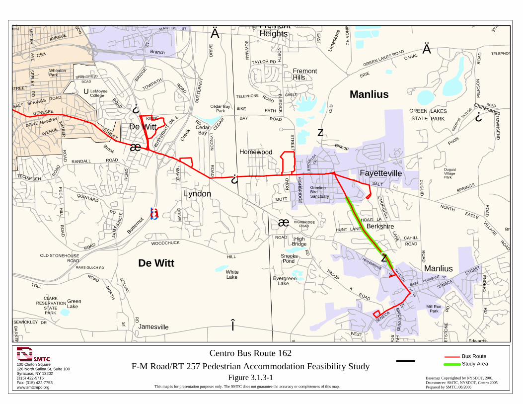
Y¿
Yæ
[Ä
[Ä
[z
Y¿
bad
bafYæ
[Î
Y¿
[z
U
CLARKRESERVATION
STATEPARK
Mill RunPark
Cedar BayPark GREEN LAKES
STATE PARK
GrimlienBirdSanctuary
Sunnycrest
OLD
ERIE
CANAL
STAT
E
WheatonPark
DuguidVillagePark
SEWICKLEY
SOLV
AY
RD
TA
YLO
R
BR
ICK
YAR
DF
ALLS
RO
AD
WH
ET
ST
ON
ER
D
TROOP
K
BA
RK
ER
WEST
SENECA
ST
SW
EE
T
NO
RTH
ST
ROAD
RO
AD
PIE
RS
ON
RO
AD
ROADRO
AD
ROAD
GEO
RG
E
TAYLO
R
ROAD
SALT
SPRINGS
VILLAGE
EAGLE
NORTH
DU
GU
ID
CAHILL
CH
UR
CH
ILL
LAN
E
HOAG
LANEHUNT
ROAD
EA
ST
NO
RT
HB
UR
DIC
K
ROAD
RO
AD
TAYLOR RD
BO
WM
AN
BAY
LYN
DO
N
KINNE
MOTT
RO
AD
ROAD
WOODCHUCK
HILL
MA
PLE
DR
IVE
ROAD
ROAD
ROAD
RO
AD
RANDALL
QUINTARD
AVENUEDRIVE
STREET
ROADTOWPATH
BU
TT
ER
NU
T
DR
IVE
AVENUE
SE
ELE
Y
ROAD
SALT
MID
LER
AV
E
BRID
GE
BUTT
ERN
UT
DR
S
EASTPLEASANT ST
STREETFAYETTE
ST
LA
BIKE PATH
SENECA
EN
DE
RS
RD
HIGHBRIDGE
RD
TO
WN
SE
ND
RO
AD
CEDARH
IGH
BR
IDG
EHIGHBRIDGE
ROAD
RD
ROAD
RO
AD
TOLL
RAMS GULCH RD
PE
CK
HILL
RO
AD
RO
AD
STREET
GENESEE
STREET RD
SPRINGS
KIMB
ERTH
OM
PS
ON
ROAD
ST
STM AN LIUS
E
ST
RE
ET
BR
OO
KLEA
DR
RD
JAM
ESV
ILLE
RD
LeMoyneCollege
TECU M SEH
RO
AD
SPRINGFIELD
ROAD
TELEPHONE
TELEPHONE CABLE
GreenLake
BranchB
rook
WhiteLake Evergreen
Lake
SnooksPond
Brook
PoolsBishop
Lim
esto
ne
CedarBay
Cre
ek
Butte
rnut
Brook
Meadow
Edwards
Jamesville
Berkshire
De Witt
Fayetteville
Homewood
Lyndon
Manlius
FremontHeights
FremontHills
HighBridge
DR
MIN
OA
RD
CSX
GREEN LAKES ROAD
OLD STONEHOUSEROAD
Chittenango
De Witt
Manlius
Centro Bus Route 162
F-M Road/RT 257 Pedestrian Accommodation Feasibility StudyBasemap Copyrighted by NYSDOT, 2001Datasources: SMTC, NYSDOT, Centro 2005Prepared by SMTC, 08/2006This map is for presentation purposes only. The SMTC does not guarantee the accuracy or completeness of this map.
100 Clinton Square126 North Salina St, Suite 100Syracuse, NY 13202(315) 422-5716Fax: (315) 422-7753www.smtcmpo.org
¯Bus Route
Figure 3.1.3-1
Study Area

Y¿
Yæ
[Ä
[Ä
[z
Y¿
bad
bafYæ
[Î
Y¿
[z
U
CLARKRESERVATION
STATEPARK
Mill RunPark
Cedar BayPark GREEN LAKES
STATE PARK
GrimlienBirdSanctuary
Sunnycrest
OLD
ERIE
CANAL
STAT
E
WheatonPark
DuguidVillagePark
SEWICKLEY
SOLV
AY
RD
TA
YLO
R
BR
ICK
YAR
DF
ALLS
RO
AD
WH
ET
ST
ON
ER
D
TROOP
K
BA
RK
ER
WEST
SENECA
ST
SW
EE
T
NO
RTH
ST
ROAD
RO
AD
PIE
RS
ON
RO
AD
ROADRO
AD
ROAD
GEO
RG
E
TAYLO
R
ROAD
SALT
SPRINGS
VILLAGE
EAGLE
NORTH
DU
GU
ID
CAHILL
CH
UR
CH
ILL
LAN
E
HOAG
LANEHUNT
ROAD
EA
ST
NO
RT
HB
UR
DIC
K
ROAD
RO
AD
TAYLOR RD
BO
WM
AN
BAY
LYN
DO
N
KINNE
MOTT
RO
AD
ROAD
WOODCHUCK
HILL
MA
PLE
DR
IVE
ROAD
ROAD
ROAD
RO
AD
RANDALL
QUINTARD
AVENUEDRIVE
STREET
ROADTOWPATH
BU
TT
ER
NU
T
DR
IVE
AVENUE
SE
ELE
Y
ROAD
SALT
MID
LER
AV
E
BRID
GE
BUTT
ERN
UT
DR
S
EASTPLEASANT ST
STREETFAYETTE
ST
LA
BIKE PATH
SENECA
EN
DE
RS
RD
HIGHBRIDGE
RD
TO
WN
SE
ND
RO
AD
CEDARH
IGH
BR
IDG
EHIGHBRIDGE
ROAD
RD
ROAD
RO
AD
TOLL
RAMS GULCH RD
PE
CK
HILL
RO
AD
RO
AD
STREET
GENESEE
STREET RD
SPRINGS
KIMB
ERTH
OM
PS
ON
ROAD
ST
STM AN LIUS
E
ST
RE
ET
BR
OO
KLEA
DR
RD
JAM
ESV
ILLE
RD
LeMoyneCollege
TECU M SEH
RO
AD
SPRINGFIELD
ROAD
TELEPHONE
TELEPHONE CABLE
GreenLake
BranchB
rook
WhiteLake Evergreen
Lake
SnooksPond
Brook
PoolsBishop
Lim
esto
ne
CedarBay
Cre
ek
Butte
rnut
Brook
Meadow
Edwards
Jamesville
Berkshire
De Witt
Fayetteville
Homewood
Lyndon
Manlius
FremontHeights
FremontHills
HighBridge
DR
MIN
OA
RD
CSX
GREEN LAKES ROAD
OLD STONEHOUSEROAD
Chittenango
De Witt
Manlius
Centro Bus Route 262
F-M Road/RT 257 Pedestrian Accommodation Feasibility StudyBasemap Copyrighted by NYSDOT, 2001Datasources: SMTC, NYSDOT, Centro 2005Prepared by SMTC, 08/2006This map is for presentation purposes only. The SMTC does not guarantee the accuracy or completeness of this map.
100 Clinton Square126 North Salina St, Suite 100Syracuse, NY 13202(315) 422-5716Fax: (315) 422-7753www.smtcmpo.org
¯Bus Route
Figure 3.1.3-2
Study Area

Y¿
Yæ
[Ä
[Ä
[z
Y¿
bad
bafYæ
[Î
Y¿
[z
U
CLARKRESERVATION
STATEPARK
Mill RunPark
Cedar BayPark GREEN LAKES
STATE PARK
GrimlienBirdSanctuary
Sunnycrest
OLD
ERIE
CANAL
STAT
E
WheatonPark
DuguidVillagePark
SEWICKLEY
SOLV
AY
RD
TA
YLO
R
BR
ICK
YAR
DF
ALLS
RO
AD
WH
ET
ST
ON
ER
D
TROOP
K
BA
RK
ER
WEST
SENECA
ST
SW
EE
T
NO
RTH
ST
ROAD
RO
AD
PIE
RS
ON
RO
AD
ROADRO
AD
ROAD
GEO
RG
E
TAYLO
R
ROAD
SALT
SPRINGS
VILLAGE
EAGLE
NORTH
DU
GU
ID
CAHILL
CH
UR
CH
ILL
LAN
E
HOAG
LANEHUNT
ROAD
EA
ST
NO
RT
HB
UR
DIC
K
ROAD
RO
AD
TAYLOR RD
BO
WM
AN
BAY
LYN
DO
N
KINNE
MOTT
RO
AD
ROAD
WOODCHUCK
HILL
MA
PLE
DR
IVE
ROAD
ROAD
ROAD
RO
AD
RANDALL
QUINTARD
AVENUEDRIVE
STREET
ROADTOWPATH
BU
TT
ER
NU
T
DR
IVE
AVENUE
SE
ELE
Y
ROAD
SALT
MID
LER
AV
E
BRID
GE
BUTT
ERN
UT
DR
S
EASTPLEASANT ST
STREETFAYETTE
ST
LA
BIKE PATH
SENECA
EN
DE
RS
RD
HIGHBRIDGE
RD
TO
WN
SE
ND
RO
AD
CEDARH
IGH
BR
IDG
EHIGHBRIDGE
ROAD
RD
ROAD
RO
AD
TOLL
RAMS GULCH RD
PE
CK
HILL
RO
AD
RO
AD
STREET
GENESEE
STREET RD
SPRINGS
KIMB
ERTH
OM
PS
ON
ROAD
ST
STM AN LIUS
E
ST
RE
ET
BR
OO
KLEA
DR
RD
JAM
ESV
ILLE
RD
LeMoyneCollege
TECU M SEH
RO
AD
SPRINGFIELD
ROAD
TELEPHONE
TELEPHONE CABLE
GreenLake
BranchB
rook
WhiteLake Evergreen
Lake
SnooksPond
Brook
PoolsBishop
Lim
esto
ne
CedarBay
Cre
ek
Butte
rnut
Brook
Meadow
Edwards
Jamesville
Berkshire
De Witt
Fayetteville
Homewood
Lyndon
Manlius
FremontHeights
FremontHills
HighBridge
DR
MIN
OA
RD
CSX
GREEN LAKES ROAD
OLD STONEHOUSEROAD
Chittenango
De Witt
Manlius
Centro Bus Route 262X
F-M Road/RT 257 Pedestrian Accommodation Feasibility StudyBasemap Copyrighted by NYSDOT, 2001Datasources: SMTC, NYSDOT, Centro 2005Prepared by SMTC, 08/2006This map is for presentation purposes only. The SMTC does not guarantee the accuracy or completeness of this map.
100 Clinton Square126 North Salina St, Suite 100Syracuse, NY 13202(315) 422-5716Fax: (315) 422-7753www.smtcmpo.org
¯Bus Route
Figure 3.1.3-3
Study Area

MCDERMOTT RD
MANLIUS
BERKSHIRE PKWY
MARANGALE LA
SHERBROOK RD
HUNT LA
HOAG LA
WH
EE
LE
R AVE
HENSCHKE DR
SHEFFIELD LA
FAYETTEVILLE
FRANKLIN ST
Centro Bus Stop Locations100 Clinton Square126 North Salina St, Suite 100Syracuse, NY 13202(315) 422-5716Fax: (315) 422-7753www.smtcmpo.org
0 0.06 0.12 Miles
This map is for presentation purposes only. The SMTC does not guarantee the accuracy or completeness of this map.
Basemap Copyrighted by NYSDOTData Sources: SMTC, NYSDOT, 2001Prepared by SMTC, 08/2006
Villages
Roads
Bus Stop
F-M RD/Rt 257 Pedestrian AccommodationFeasibility StudyFigure 3.1.3-4
Study Area
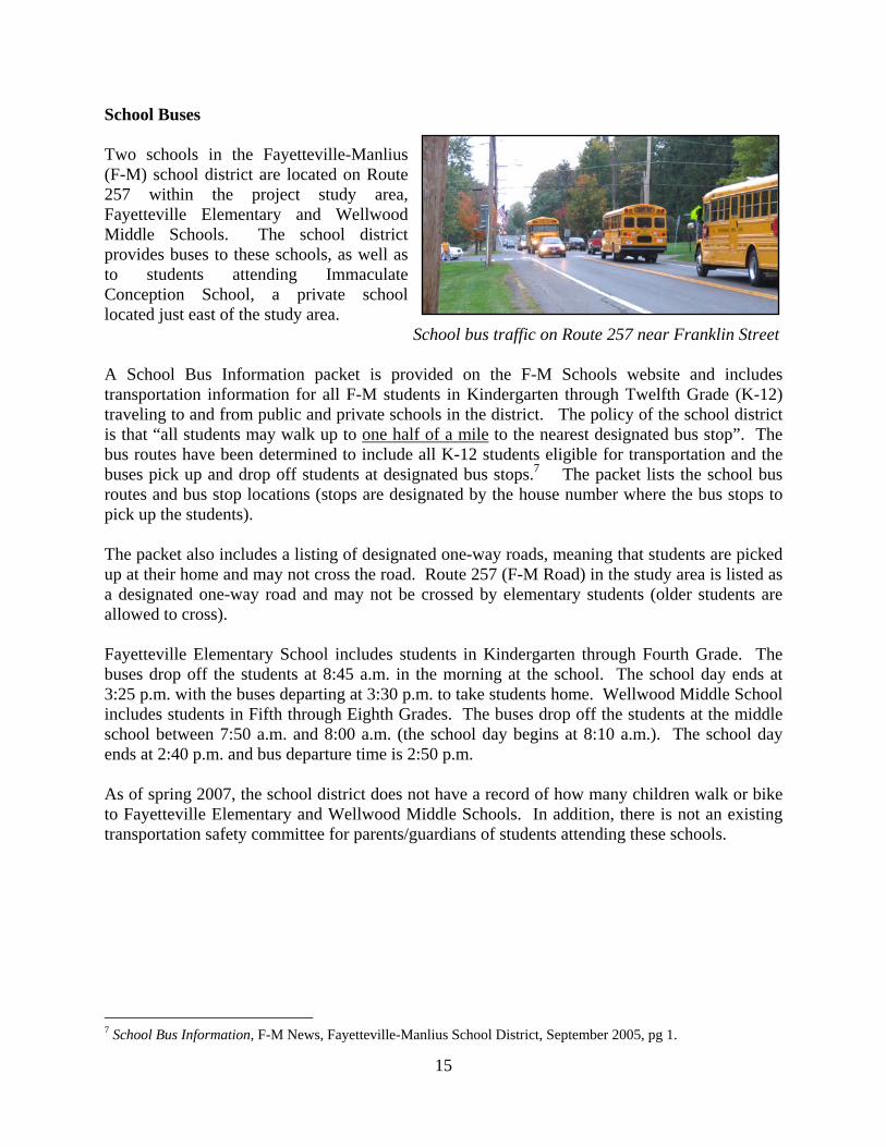
15
School Buses Two schools in the Fayetteville-Manlius (F-M) school district are located on Route 257 within the project study area, Fayetteville Elementary and Wellwood Middle Schools. The school district provides buses to these schools, as well as to students attending Immaculate Conception School, a private school located just east of the study area. School bus traffic on Route 257 near Franklin Street A School Bus Information packet is provided on the F-M Schools website and includes transportation information for all F-M students in Kindergarten through Twelfth Grade (K-12) traveling to and from public and private schools in the district. The policy of the school district is that “all students may walk up to one half of a mile to the nearest designated bus stop”. The bus routes have been determined to include all K-12 students eligible for transportation and the buses pick up and drop off students at designated bus stops.7 The packet lists the school bus routes and bus stop locations (stops are designated by the house number where the bus stops to pick up the students). The packet also includes a listing of designated one-way roads, meaning that students are picked up at their home and may not cross the road. Route 257 (F-M Road) in the study area is listed as a designated one-way road and may not be crossed by elementary students (older students are allowed to cross). Fayetteville Elementary School includes students in Kindergarten through Fourth Grade. The buses drop off the students at 8:45 a.m. in the morning at the school. The school day ends at 3:25 p.m. with the buses departing at 3:30 p.m. to take students home. Wellwood Middle School includes students in Fifth through Eighth Grades. The buses drop off the students at the middle school between 7:50 a.m. and 8:00 a.m. (the school day begins at 8:10 a.m.). The school day ends at 2:40 p.m. and bus departure time is 2:50 p.m. As of spring 2007, the school district does not have a record of how many children walk or bike to Fayetteville Elementary and Wellwood Middle Schools. In addition, there is not an existing transportation safety committee for parents/guardians of students attending these schools.
7 School Bus Information, F-M News, Fayetteville-Manlius School District, September 2005, pg 1.

16
3.1.4 Bicycle/Pedestrian Facilities and Curbs/Curb Ramps Bicycle Facilities
There are seven bicycle route signs posted along Route 257 within the study area (photo left: typical bike route sign on Route 257). Three signs are located on the west side of Route 257, while four signs are located on the east side. The corridor is not a designated/specific bike route; however, the signs have been posted by the New York State Department of Transportation primarily for safety reasons to remind motorists that bicyclists are allowed to travel on Route 257. In addition, there is shoulder space on each side of Route 257 in which bicyclists may travel. According to New York State Vehicle and Traffic Law, cyclists and in-line skaters can ride in the shoulder, as well as the travel lane itself:
“Upon all roadways, any bicycle or in-line skate shall be driven either on a usable bicycle or in-line skate lane or, if a usable bicycle or in-line skate lane has not been provided, near the right-hand curb or edge of the roadway or upon a usable right-hand shoulder in such a manner as to prevent undue interference with the flow of traffic except when preparing for a left turn or when reasonably necessary to avoid conditions that would make it unsafe to continue along near the right-hand curb or edge. Conditions to be taken into consideration include, but are not limited to, fixed or moving objects, vehicles, bicycles, in-line skates, pedestrians, animals, surface hazards or traffic lanes too narrow for a bicycle or person on in-line skates and a vehicle to travel safely side-by-side within the lane.”8
It is also important to point out that the law requires that bicyclists and in-line skaters ride with traffic. “Bicycling and skating against traffic are leading causes of crashes. Moving with traffic makes bicyclists and in-line skaters more visible, and their movements more predictable to motorists. Riding or gliding with traffic also prevents interference with the flow of traffic and pedestrians.”9 Pedestrian Facilities Prior to discussing existing pedestrian facilities within the study area, it is important to define what a pedestrian is. According to Designing Sidewalks and Trails for Access, the Best Practices Design Guide developed by the United States Department of Transportation’s Federal Highway Administration; a pedestrian is defined as “a person who travels on foot or who uses assistive devices, such as a wheelchair, for mobility.”10 Detailed on the following page are the definitions for various pedestrian facilities, as noted by the aforementioned Best Practices Design Guide: 8 Article 34 Operation of Bicycles and Play Devices, New York State Vehicle and Traffic Law, Section 1234 (a), 2003-2004, p. 535. 9 Bikes and Wheel Sport Safety- Frequently Asked Questions, NYS Department of Motor Vehicles, Governor’s Traffic Safety Committee <http://www.nysgtsc.state.ny.us/bike-faq.htm> Revised: March 03, 2006, Accessed July 18, 2006. 10 Beneficial Designs, Inc., Designing Sidewalks and Trails for Access, Part I of II: Review of Existing Guidelines and Practices, U.S. Department of Transportation Federal Highway Administration, July 1999, p. 13.

17
Curb Ramp: A combined ramp and landing to accomplish a change in level at a curb. This element provides street and sidewalk access to pedestrians using wheelchairs. Ramp: A slope transition between two elevation levels. Sidewalk: The portion of a highway, road, or street intended for pedestrians. Shared Use Path: A trail that permits more than one type of user, such as a trail designated for use by both pedestrians and bicyclists. Trail: A path of travel for recreation and/or transportation within a park, natural environment, or designated corridor that is not classified as a highway, road, or street.11 The above definitions are the basic pedestrian facilities that are discussed in this F-M Road/Route 257 Pedestrian Accommodation Feasibility Study. For definitions of more specific and detailed pedestrian facilities, please refer to the Glossary in the Designing Sidewalks and Trails for Access, the Best Practices Design Guide developed by the United States Department of Transportation’s Federal Highway Administration. This document can be found via the following web address: http://www.fhwa.dot.gov/environment/bikeped/access-1.htm. Sidewalks separate pedestrians from the roadway and are associated with reductions in pedestrian collisions with motor vehicles. There are limited sidewalks available to pedestrians in the study area. Along the corridor within the study area, sidewalks are only present on the east side of Route 257 between Franklin Street and Sheffield Lane (photo at right). There are no sidewalks that run along Route 257 between Sheffield Lane to just south of Kelly Drive in Manlius (across from the driveway into Bank of America). Sidewalks begin again south of the project study area on the east side of Route 257 (just south of Kelly Drive), and are available into the Village of Manlius.
North of the project study area sidewalks are present from the Village of Fayetteville heading south towards the school grounds on the west side of Route 257. Just south of the intersection of Route 257 and Lincoln Avenue, students have the option of continuing on the sidewalk that runs between Lincoln Avenue and Franklin Street, or continuing on the sidewalk that runs through Beard Park (see photo left – sidewalk to the left runs along Route 257; sidewalk to the right travels through Beard
11 Beneficial Designs, Inc., Designing Sidewalks and Trails for Access, Part I of II: Review of Existing Guidelines and Practices, U.S. Department of Transportation Federal Highway Administration, July 1999,Glossary pp. 113-20.

18
Photo: Pedestrian crossing guard at Franklin Street/Route 257
Park). In addition, after students cross Route 257 from the east to west side at the Franklin Street crosswalk, there is then a sidewalk available to take students onto school property (see photo of Pedestrian crossing guard, at bottom of this page, to see this sidewalk). An informal/unofficial cut-through and pathway also exists, both of which are utilized by students to reach school property. The first is a small cut-through (shown right) that is found on the west side of Route 257 between Sheffield Lane and Henschke Drive. Students utilize this path as a short-cut to school property when coming from the south to attend school. Photo: Cut-through to school property from Route 257. In addition, a pathway leading to Fayetteville Elementary exists off of the bend in Wheeler Avenue. Wheeler Avenue extends west off of Route 257, and bends south to connect with Hunt Lane. This is another shortcut utilized by students as they travel to and from school. The path is primarily worn grass and is not paved. One side is lined with a chain link fence. The pathway is not kept clear in the winter.
Looking from school grounds towards Wheeler Avenue (left). Looking onto school grounds from pathway (right). There are also two crosswalks within the study area, at Route 257 with Franklin Street, and Route 257 with Wheeler Avenue. Although there is a crosswalk at Wheeler Avenue, there is no sidewalk connecting to the crosswalk on either side of Route 257 at Wheeler Avenue. There is no crossing guard present at this location. The crosswalk at Franklin Street is primarily utilized by students that want to reach Fayetteville Elementary and Wellwood Middle Schools. A crossing guard is present at the Franklin Street intersection in the AM and PM

19
hours when school is in session. A crossing guard is also stationed at the intersection of the school entrance/Sheffield Lane with Route 257. This crossing guard focuses on stopping traffic to enable the buses to enter and exit the school property. The crossing guard stationed at the intersection of Route 257 and the school entrance/Sheffield Lane is employed by the Town of Manlius. This guard is stationed at this location on school day afternoons from approximately 2:00 p.m. until almost 4:00 p.m. and is there primarily to stop traffic so that school buses can move in/out of the school entrance. Occasionally the crossing guard will assist an adult pedestrian that is trying to cross Route 257. However, if a student approaches, the guard will send the student to the intersection of Franklin Street and Route 257 where the crosswalk and another crossing guard are located, for safe crossing. The crossing guard indicated that a few people jog through the area while he is stationed there, but does not typically see adults just walking from one place to another. The bus crossing guard believes that the biggest issue at this location is speeding. Another issue noted by the crossing guard is the queuing of vehicles along Franklin Street that extends onto Route 257 by parents and guardians trying to get into the school parking lot to pick up students at Wellwood Middle School. The guard noted that sometimes vehicles coming from the south are queued so that the vehicles cannot make a left hand turn onto Franklin. This sometimes causes traffic to queue a block or more south (past Henschke Drive) behind the guard making it very difficult for him to get the busses out of the school grounds. The guard suggests that perhaps Franklin could be made a one-way street out (towards Route 257) and the next street up one-way in, at least during school hours. Or, perhaps not allow any left-hand turns onto Franklin at all. Curbs/Curb Ramps There are no curbs that exist within the study area. For the sidewalk that meets the road at the corners of Franklin Street with Route 257, the sidewalk is flush with the road surface, as there is no curb. There is a slight ramp up to the sidewalk located on one corner of this intersection, to the east of Route 257 on the southern side of Franklin Street. 3.2 Existing Traffic Conditions 3.2.1 Traffic Volumes and Speed Data AADT Volumes and Speed The New York State Department of Transportation (NYSDOT) provided Annual Average Daily Traffic (AADT) volumes, including vehicle classification, at three locations along the study area in late March/early April 2006. Speed data was also collected at these locations. The chart on the following page broadly summarizes the traffic and speed data, and Figure 3.2.1-1 (Traffic Volume and Speed Data) shows the traffic volume and average speed for the various segments. Overall, approximately 8,000 vehicles (bi-directional) are traveling daily along Route 257. In 2003, approximately 6,000 vehicles (bi-directional: 3,052 northbound and 2,949 southbound) traveled daily along Route 257. The SMTC did not research why the average number of daily vehicles has increased since 2003.

MANLIUS
MARANGALE LA
STONEHEDGE LA
HUNT LA
HOAG LA
WH
EE
LER AVE
HENSCHKE DR
SHEFFIELD LA
FAYETTEVILLE
FRANKLIN ST
AADT: 8,773
Avg Speed North: 26.5Avg Speed South: 23.2
AADT: 7,935
Avg Speed North: 36.3Avg Speed South: 36.0
AADT: 7,426
Avg Speed North: 38.5Avg Speed South:36.6
SHERBROOK RD
MCDERMOTT RD
Traffic Volume and Speed Data100 Clinton Square126 North Salina St, Suite 100Syracuse, NY 13202(315) 422-5716Fax: (315) 422-7753www.smtcmpo.org
0 0.06 0.12 Miles
This map is for presentation purposes only. The SMTC does not guarantee the accuracy or completeness of this map.
Basemap Copyrighted by NYSDOTData Sources: SMTC, NYSDOT, 2006Prepared by SMTC, 08/2006
Villages
RoadsFM RD/Rt 257 Pedestrian Accommodation Feasibility Study
Route 5 - Henschke Dr.
Henschke Dr. - Marangale La.
Marangale La. - Route 92
Figure 3.2.1-1
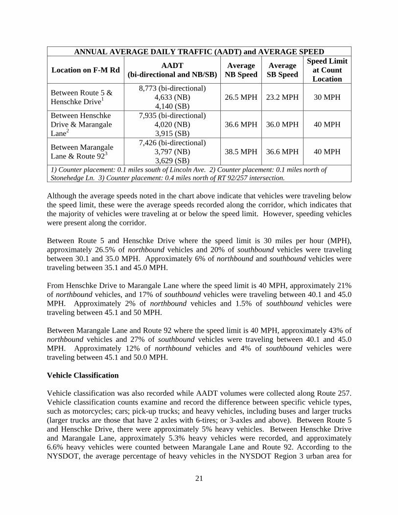
21
ANNUAL AVERAGE DAILY TRAFFIC (AADT) and AVERAGE SPEED
Location on F-M Rd AADT
(bi-directional and NB/SB)Average
NB Speed Average SB Speed
Speed Limit at Count Location
Between Route 5 & Henschke Drive1
8,773 (bi-directional) 4,633 (NB) 4,140 (SB)
26.5 MPH 23.2 MPH 30 MPH
Between Henschke Drive & Marangale Lane2
7,935 (bi-directional) 4,020 (NB) 3,915 (SB)
36.6 MPH 36.0 MPH 40 MPH
Between Marangale Lane & Route 923
7,426 (bi-directional) 3,797 (NB) 3,629 (SB)
38.5 MPH 36.6 MPH 40 MPH
1) Counter placement: 0.1 miles south of Lincoln Ave. 2) Counter placement: 0.1 miles north of Stonehedge Ln. 3) Counter placement: 0.4 miles north of RT 92/257 intersection.
Although the average speeds noted in the chart above indicate that vehicles were traveling below the speed limit, these were the average speeds recorded along the corridor, which indicates that the majority of vehicles were traveling at or below the speed limit. However, speeding vehicles were present along the corridor. Between Route 5 and Henschke Drive where the speed limit is 30 miles per hour (MPH), approximately 26.5% of northbound vehicles and 20% of southbound vehicles were traveling between 30.1 and 35.0 MPH. Approximately 6% of northbound and southbound vehicles were traveling between 35.1 and 45.0 MPH. From Henschke Drive to Marangale Lane where the speed limit is 40 MPH, approximately 21% of northbound vehicles, and 17% of southbound vehicles were traveling between 40.1 and 45.0 MPH. Approximately 2% of northbound vehicles and 1.5% of southbound vehicles were traveling between 45.1 and 50 MPH. Between Marangale Lane and Route 92 where the speed limit is 40 MPH, approximately 43% of northbound vehicles and 27% of southbound vehicles were traveling between 40.1 and 45.0 MPH. Approximately 12% of northbound vehicles and 4% of southbound vehicles were traveling between 45.1 and 50.0 MPH. Vehicle Classification Vehicle classification was also recorded while AADT volumes were collected along Route 257. Vehicle classification counts examine and record the difference between specific vehicle types, such as motorcycles; cars; pick-up trucks; and heavy vehicles, including buses and larger trucks (larger trucks are those that have 2 axles with 6-tires; or 3-axles and above). Between Route 5 and Henschke Drive, there were approximately 5% heavy vehicles. Between Henschke Drive and Marangale Lane, approximately 5.3% heavy vehicles were recorded, and approximately 6.6% heavy vehicles were counted between Marangale Lane and Route 92. According to the NYSDOT, the average percentage of heavy vehicles in the NYSDOT Region 3 urban area for

22
minor arterial highways is 5.6%. The percentages determined for the Route 257 study area compare directly to the Regional average. Turning Movement Counts The NYSDOT also completed turning movement counts, including pedestrian and bicycle counts (which were counted together, bicycles plus pedestrians), at two locations in May 2006: the intersections of Route 257 with Franklin Street, and Route 257 with Sheffield Lane/school entrance. The counts were taken during the AM peak (between 7:00 a.m. and 9:00 a.m.) and PM peak (between 2:30 p.m. and 4:30 p.m.) while school was in session to be certain that school traffic was accounted for. Figure 3.2.1-2 indicates that approximately 762 vehicles (both cars and heavy vehicles) traveled through this intersection at the AM peak hour (i.e., 7:30-8:30) on the day the count was taken. Thirty-five (35) bicyclists and pedestrians in the AM peak hour traveled from the Route 257 northbound approach, while 10 bicyclists and pedestrians traveled from the southbound approach. Twenty-four (24) heavy vehicles were observed moving through this intersection during the AM peak hour. Figure 3.2.1-2 (RT 257/Franklin Street AM Peak Hour Data)
Top Number = Cars Middle Number = Heavy Vehicles Bottom Number = Cars + Heavy Vehicles

23
Figure 3.2.1-3 indicates that during the PM peak hour (i.e., 3:15-4:15) a total of 847 vehicles (cars and heavy vehicles) traveled through the intersection. Based on the PM peak hour data, the West Franklin Street approach had 68 bicyclists and pedestrians entering the intersection, with another 9 bicyclists/pedestrians entering the intersection from the remaining approaches. Note that this is the intersection where the crosswalk is located for the elementary and middle schools. According to the field technician, the vehicle and bussing traffic were “typical for a school setting with all general traffic following posted speed limits.”12 He further noted that there is one crosswalk at the intersection “while .2 miles south on Rte 257 there was no crosswalk forcing students to walk .2 miles north” to the crosswalk at Franklin Street. Figure 3.2.1-3 (RT 257/Franklin Street PM Peak Hour Data)
12 Field technician correspondence, 5/12/2006
Top Number = Cars Middle Number = Heavy Vehicles Bottom Number = Cars + Heavy Vehicles

24
Figure 3.2.1-4 indicates that 845 vehicles (both cars and heavy vehicles) traveled through this intersection during the AM peak hour (i.e., 7:45-8:45) on the day the count was gathered. The majority of vehicles entering the intersection came from the Route 257 northbound approach (395). Six (6) pedestrians and bicyclists were observed traveling through this intersection during the AM peak. Figure 3.2.1-4 (RT 257/Sheffield La/entrance to school AM Peak Hour Data)
Top Number = Cars Middle Number = Heavy Vehicles Bottom Number = Cars + Heavy Vehicles
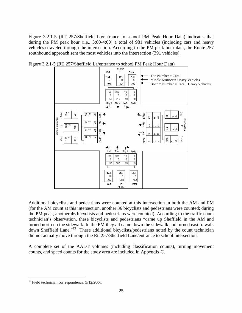
25
Figure 3.2.1-5 (RT 257/Sheffield La/entrance to school PM Peak Hour Data) indicates that during the PM peak hour (i.e., 3:00-4:00) a total of 981 vehicles (including cars and heavy vehicles) traveled through the intersection. According to the PM peak hour data, the Route 257 southbound approach sent the most vehicles into the intersection (391 vehicles). Figure 3.2.1-5 (RT 257/Sheffield La/entrance to school PM Peak Hour Data)
Additional bicyclists and pedestrians were counted at this intersection in both the AM and PM (for the AM count at this intersection, another 36 bicyclists and pedestrians were counted; during the PM peak, another 46 bicyclists and pedestrians were counted). According to the traffic count technician’s observation, these bicyclists and pedestrians “came up Sheffield in the AM and turned north up the sidewalk. In the PM they all came down the sidewalk and turned east to walk down Sheffield Lane.”13 These additional bicyclists/pedestrians noted by the count technician did not actually move through the Rt. 257/Sheffield Lane/entrance to school intersection. A complete set of the AADT volumes (including classification counts), turning movement counts, and speed counts for the study area are included in Appendix C.
13 Field technician correspondence, 5/12/2006.
Top Number = Cars Middle Number = Heavy Vehicles Bottom Number = Cars + Heavy Vehicles

26
Photo: School Speed Limit sign near Franklin St.
3.2.2 Traffic Control Devices Speed Limit Signs There are several speed limit signs posted throughout the length of the Route 257 corridor. The speed limit varies from 30 to 40 miles per hour (MPH) within the study area, with the exception of the area near Fayetteville Elementary and Wellwood Middle Schools where the speed limit is 20 MPH on school days from 7:00 a.m. until 6:00 p.m. Traveling south along Route 257 and approaching the intersection of Franklin Street, just prior to reaching Fayetteville Elementary and Wellwood Middle Schools, there is a posted speed limit sign that notes “School 20 MPH 7:00AM – 6PM School Days”. This same sign also exits for northbound motorists at the intersections of Henschke Drive and Franklin Street with Route 257, prior to reaching school grounds. In addition, a “School Speed Zone Ahead” is located for northbound motorists at the intersection of Wheeler Avenue and Route 257.
Once past the F-M School grounds, the speed limit becomes 30 MPH at the intersection of Route 257 with Henschke Drive and stays at 30 MPH until the intersection with Old Farm Road. Between Old Farm Road and the Village of Manlius line, the speed limit is 40 MPH. Once in the Village of Manlius, the speed once again returns to 30 MPH. Speed zone information is summarized in the table below:
SPEED ZONES IN STUDY AREA (ROUTE 257)
SPEED LIMIT FROM TO 20
MPH*30
MPH 40
MPH Fayetteville Village Line Franklin St X Franklin St Henschke Dr X Henschke Dr Old Farm Rd X Old Farm Rd Manlius Village Line X Manlius Village Line Into Village of Manlius X *The 20 MPH speed limit is in effect between 7:00 a.m. and 6:00 p.m. on school days. During non-school hours the speed limit is 30 MPH.
Traffic Signals and Stop Signs There are no signalized intersections within the study area, and no stop signs that control traffic traveling north and south along Route 257. However there are stop signs that control traffic moving from the east and west onto Route 257 from all of the fifteen (15) intersecting streets
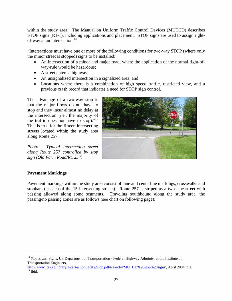
27
within the study area. The Manual on Uniform Traffic Control Devices (MUTCD) describes STOP signs (R1-1), including applications and placement. STOP signs are used to assign right-of-way at an intersection.14 “Intersections must have one or more of the following conditions for two-way STOP (where only the minor street is stopped) signs to be installed:
• An intersection of a minor and major road, where the application of the normal right-of-way-rule would be hazardous;
• A street enters a highway; • An unsignalized intersection in a signalized area; and • Locations where there is a combination of high speed traffic, restricted view, and a
previous crash record that indicates a need for STOP sign control. The advantage of a two-way stop is that the major flows do not have to stop and they incur almost no delay at the intersection (i.e., the majority of the traffic does not have to stop).”15 This is true for the fifteen intersecting streets located within the study area along Route 257. Photo: Typical intersecting street along Route 257 controlled by stop sign (Old Farm Road/Rt. 257) Pavement Markings Pavement markings within the study area consist of lane and centerline markings, crosswalks and stopbars (at each of the 15 intersecting streets). Route 257 is striped as a two-lane street with passing allowed along some segments. Traveling southbound along the study area, the passing/no passing zones are as follows (see chart on following page):
14 Stop Signs, Signs, US Department of Transportation - Federal Highway Administration, Institute of Transportation Engineers, http://www.ite.org/library/IntersectionSafety/Stop.pdf#search='MUTCD%20stop%20signs', April 2004, p.1. 15 Ibid.

28
Pavement markings are discussed further in Section 3.3.2, Pavement Markings. 3.2.3 Accident Analysis A request was made through the NYSDOT to obtain actual Department of Motor Vehicle (DMV) Police Accident Reports for the years 1999 through 2004 for Route 257 (Fayetteville-Manlius Road) between Franklin Street and Kelly Drive in the Town of Manlius within Onondaga County. The SMTC requested both reportable and non-reportable accident data over the listed years. At the time of the request (December 2005) the complete set (including non-reportable accidents) was only available through May 2002, while those that were reportable were available through mid-2004. Due to difficulty in obtaining all the necessary reports in a timely fashion, the SMTC requested the actual accident reports from the local police entities that have jurisdiction over Route 257 within the study area: the Onondaga County Sheriff’s Office, New York State Police, and the Town of Manlius Police Department. Consequently, Police Accident Reports were received and evaluated for the period January 1999 through December 2004 from these police agencies. The majority of accident reports received were obtained from the Town of Manlius Police Department, as they typically respond to the majority of calls along Route 257. Upon receipt of the accident reports, each location for which complete reports were available was analyzed. Accident summary sheets and diagrams were prepared for each of the locations analyzed and are included in Appendix D. A total of 40 reported accidents for the period of January 1999 through December 2004 were examined. The analysis revealed that the most frequently occurring accident types were as follows:
1. Collisions with animals – 47.5%; 2. Rear end – 20%; 3. Fixed object/out of control – 15%; 4. Left turn – 10%.
PASSING ZONES IN STUDY AREA (ROUTE 257)
PASSING ALLOWED FOR
FROM TO NB/SB Traffic
NB Traffic
SB Traffic
NO PASSING
ZONE
Franklin St South of Henschke Dr X South of Henschke Dr Old Farm Rd X Old Farm Rd South of Hoag Ln X Hoag Ln Hunt La X Hunt Ln Stonehedge La X Stonehedge Ln McDermott Rd X McDermott Rd Manlius Village Line X Manlius Village Line Kelly Drive X

29
Franklin St./Wheeler Ave. 6 1 0 7 0 4 0 0 2 0 0 1 0 0 0 0 0 7
Wheeler Ave./Hunt Ln. 12 1 0 13 0 0 0 1 2 0 0 5 0 0 5 0 0 13
Hunt Ln./Sherbrooke Rd. 9 1 0 10 0 2 1 0 0 0 0 6 0 0 1 0 0 10
Sherbrooke Rd./Kelly Dr. 10 0 0 10 0 2 0 0 0 0 0 7 0 0 0 1 0 10
Totals 37 3 0 40 0 8 1 1 4 0 0 19 0 0 6 1 0 40
Accident Type Summary by Road Segment
BackingUn-
knownLeft Turn
Right Turn
Over-taking
Head On
Total
Town of Manlius Police Department,Onondaga County Sheriff's Office, New York State Police Department
AnimalInjury
Fixed Object/Out of
Control
Fatal TotalRight Angle
Rear End
Property Damage
OnlyBike
Side Swipe
PedRoad Segments
Source: SMTC compiled data from:
The Institute of Transportation Engineers (ITE) Traffic Engineering Handbook states that while human error contributes to 70% - 90% of all accidents, road and vehicle improvements can greatly reduce the likelihood of human error or the consequences of the accident. Based on the SMTC’s analyses of the accident reports, the presence of deer was the major contributing factor in the majority of the accidents that occurred along Route 257. However, as noted above, human error as well as street geometry and physical features can play a role. Out of the 40 collisions analyzed, 8 (20%) were rear end collisions. These rear end collisions primarily occurred at intersecting streets along the study area where vehicles were stopped in the travel lane waiting to make a turn off of Route 257 and were hit from behind. The fixed object/out of control accidents occurred when a vehicle slid out of control (most of these accidents occurred in snowy weather) and hit either a fixed object (a sign or fence) or another vehicle. Left turn accidents primarily occurred for motorists turning into or out of the side streets along Route 257 and did not leave enough time or room to make the turn. Almost half of the accidents analyzed between 1999 and 2004 involved collisions with deer. None of the collisions that occurred during this time frame were fatal, and there were no reported vehicle/pedestrian collisions during this time frame. Table 3.2.3-1 provides a summary of the type of road segment accidents.
3.3 Existing Facility Conditions As part of the study process, SMTC retained assistance from Clark Patterson Associates (CPA) to complete several key components of the study. The first task undertaken by CPA was to diagram/map the existing Right-of-Way (ROW) along the Route 257 study area for possible infringements to the ROW and diagram it accordingly. In the summer of 2006, the consultants performed a series of site visits to gather information in the corridor. Geographic Information System (GIS) data, such as property boundaries, road centerlines and shoulders, aerial photographs, and municipal boundaries were collected from various sources for the study area. This data was then field checked to more accurately determine the dimensions and location of the public ROW. Features in or near the edge of the ROW were identified and organized into a series of corridor maps. These features included trees, driveways, utility poles, posted signage, fences, and stone walls.16 Figures 3.3-1 through 3.3-3
16 Fayetteville-Manlius Road/Route 257 Pedestrian Accommodation Feasibility Study, Clarke Patterson Associates (with SRF Associates) for the Syracuse Metropolitan Transportation Council, February 2007, p. 1.
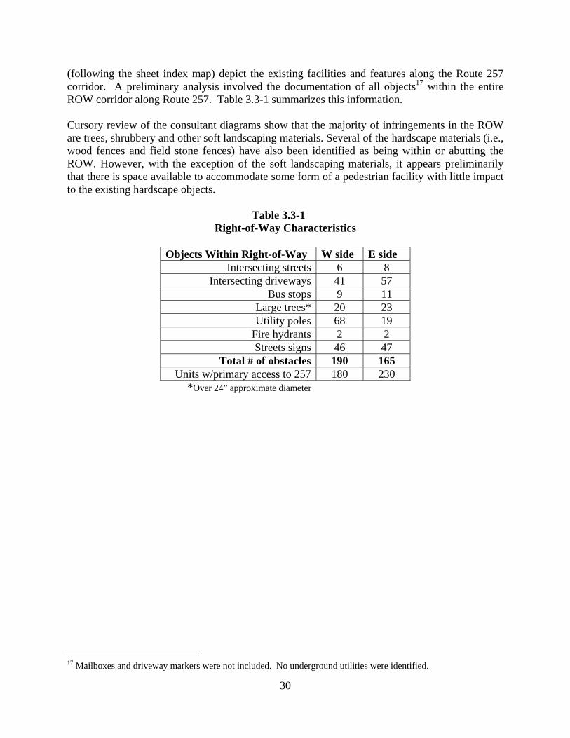
30
(following the sheet index map) depict the existing facilities and features along the Route 257 corridor. A preliminary analysis involved the documentation of all objects17 within the entire ROW corridor along Route 257. Table 3.3-1 summarizes this information. Cursory review of the consultant diagrams show that the majority of infringements in the ROW are trees, shrubbery and other soft landscaping materials. Several of the hardscape materials (i.e., wood fences and field stone fences) have also been identified as being within or abutting the ROW. However, with the exception of the soft landscaping materials, it appears preliminarily that there is space available to accommodate some form of a pedestrian facility with little impact to the existing hardscape objects.
Table 3.3-1 Right-of-Way Characteristics
Objects Within Right-of-Way W side E side
Intersecting streets 6 8 Intersecting driveways 41 57
Bus stops 9 11 Large trees* 20 23 Utility poles 68 19
Fire hydrants 2 2 Streets signs 46 47
Total # of obstacles 190 165 Units w/primary access to 257 180 230
*Over 24” approximate diameter
17 Mailboxes and driveway markers were not included. No underground utilities were identified.

31
Illustration I (Sheet Index Map)

8' SIDEWALK
5'S
IDE
WA
LKW.FRANKLINST
VILLAGE OFFAYETTEVILLE
FAYETTEVILLEELEMENTARY
SCHOOL
TOWN OFMANLIUS
APPROX.BOUNDARY
VILLAGE OFFAYETTEVILLE
TOWN OFMANLIUS
APPROX.BOUNDARY
GRANITECURBS
LIGHTPOLE
WHEELER
AVE
HENSCHKEDR
MA
TC
HT
OB
EL
OW
4' SIDEWALK
E.FRANKLINST
HEAVY BRUSH
12"
24"
SC
HO
OL
M.M
.
SC
HO
OL
Lion
sIn
tern
atio
nal
Vill
age
ofF
aye
ttevi
lle18
44
60"
36"
36"
36"
12"
SC
HO
OL
Transportation
Dept.
2' HIGH STONE WALL 2' HIGH STONE WALL
M.M
.
24" 24" 24"
36"
OLDFARMRD
24"
TREE
CLUMP24"36"
TREE
CLUMP
STONE WALL(HEIGHT VARIES) LINED WITH HEAVY BRUSH
36"
48"
12"
36"
M.M
.
36" 36"
STONE
PEDESTAL
TREE
LIN
E
Do
NotD
riveO
nS
houlder
LINED WITH HEAVY BRUSH2' HIGH STONE WALL
2' HIGH STONE WALL
HOAGRD
M.M
.
HEAVY BRUSH
2' HIGH STONE WALL
2' HIGH STONE WALL LINED WITH TREES
STONE
PEDESTALS
6"4"4"
24"
MA
TC
HT
OS
-02T
OP
MA
TC
HT
OA
BO
VE
Deciduous Tree(w/ approx. trunk radius)
Coniferous Tree(w/ approx. trunk radius)
Shrub/Hedge
MiscellaneousLandscaping
Utility Pole
Fire Hydrant
Sign Post(w/ Sign Type)
36"
24"
Mailbox Design Professionals186 North Water St
Rochester, NY 14604
011050.00
LE
GE
ND Right of Way
Road Centerline
Lane Stripe
Lane StripeEdge of Pavement
MunicipalBoundary
TYPICAL DIMENSIONS
16'
6'
22'
6'
16'
66'
M.M
.
Building Granite Curb
Sidewalk Stone Wall
Fence
Crosswalk
StopLineStreet Name
SignCentro Bus Stop
Mile MarkerSign
DrivewayPost
(Shoulder Width Varies)
LINE TYPES
Right of Way
Edge of Pavement
MA
TC
HL
INE
SYRACUSE METROPOLITAN
TRANSPORTATION COUNCIL
ROUTE 257 PEDESTRIAN ACCOMMODATION STUDY
TOWNOF MANLIUS, NEW YORK
NO SIDEWALKON EAST SIDE OFNY257 BETWEEN
FRANKLIN STAND CLINTON ST
SIDEWALKSTO SCHOOL
20%
GRADE
10% GRADE
HEAVY BRUSH
4' HIGH
BERM WITH
HEAVY BRUSH48"
24" 24"
24" 24"
24"
24"
TREE
CLUMP
TREE
LIN
E
SHEFFIELDLA
0 100 200 300 400 50050Feet
Figure 3.3-1
dkrol
Text Box
Figure 3.3-1
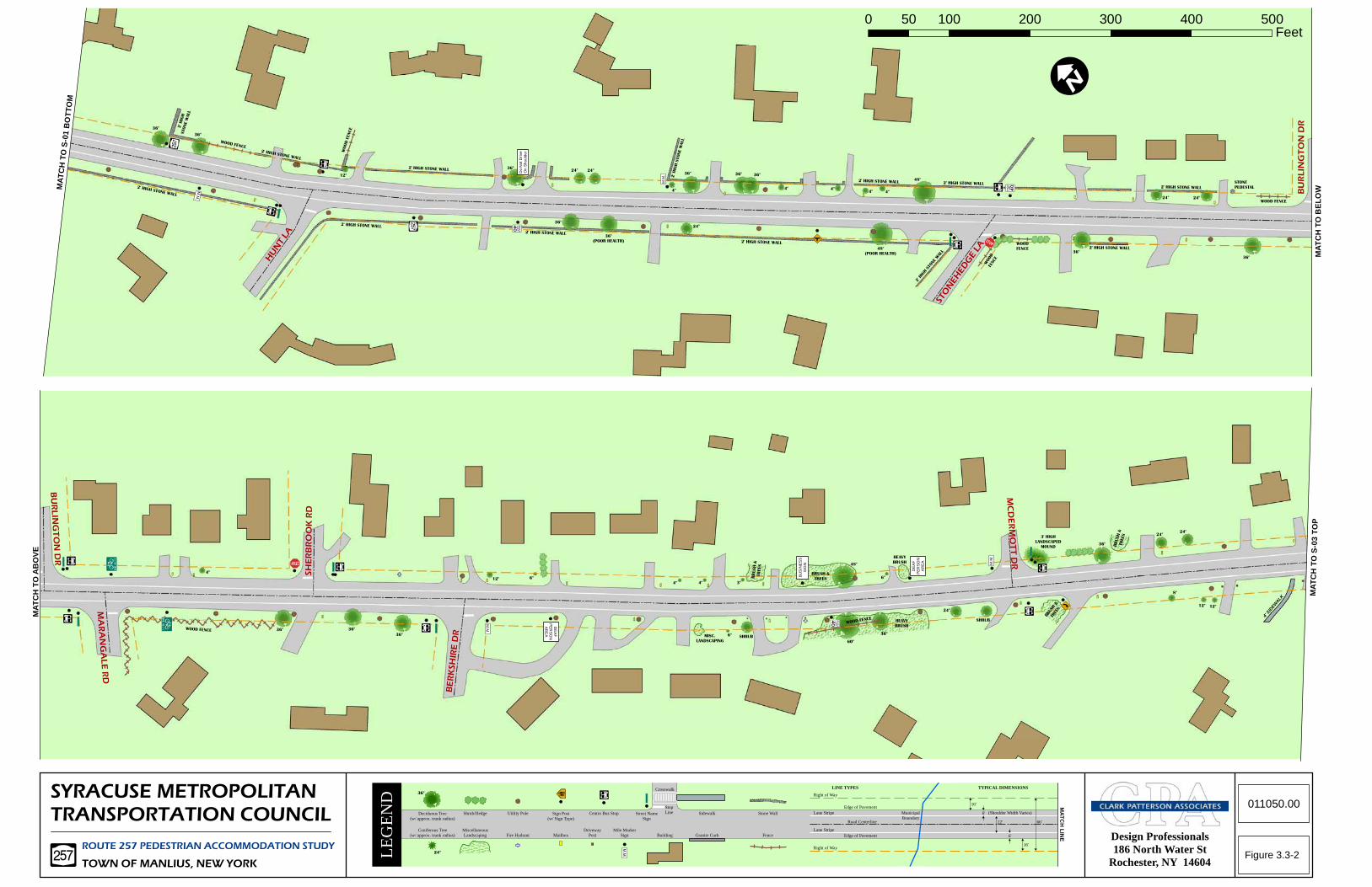
MA
TC
HT
OB
EL
OW
MA
TC
HT
OS
-03
TO
P
MA
TC
HT
OA
BO
VE
SYRACUSE METROPOLITAN
TRANSPORTATION COUNCIL Deciduous Tree(w/ approx. trunk radius)
Coniferous Tree(w/ approx. trunk radius)
Shrub/Hedge
MiscellaneousLandscaping
Utility Pole
Fire Hydrant
Sign Post(w/ Sign Type)
36"
24"
Mailbox Design Professionals186 North Water St
Rochester, NY 14604
LE
GE
ND Right of Way
Road Centerline
Lane Stripe
Lane StripeEdge of Pavement
MunicipalBoundary
TYPICAL DIMENSIONS
16'
6'
22'
6'
16'
66'
M.M
.
Building Granite Curb
Sidewalk Stone Wall
Fence
Crosswalk
StopLineStreet Name
SignCentro Bus Stop
Mile MarkerSign
DrivewayPost
(Shoulder Width Varies)
LINE TYPES
Right of Way
Edge of Pavement
MA
TC
HL
INE
ROUTE 257 PEDESTRIAN ACCOMMODATION STUDY
TOWNOF MANLIUS, NEW YORK
011050.00
MA
TC
HT
OS
-01
BO
TT
OM
HUNTLA
2' H
IGH
STONE
WALL
36"
36"
WOOD FENCE
2' HIGH STONE WALL
M.M
.
12"
WOOD
FENCE
2' HIGH STONE WALL
2' HIGH STONE WALL
2' HIGH STONE WALL
36"
Do
Not
Driv
eO
nS
houl
der
2' HIGH STONE WALL
36"
36"
(POOR HEALTH)
24" 24"
2' HIGH STONE WALL
2' H
IGH
STONE
WALL
24"
4"
36" 36" 36"
M.M
.
48"
(POOR HEALTH)
48"
4" 4"4" 4"
2' HIGH STONE WALL
STONEHEDGELA
2' H
IGH
STONEWAL
L
WOOD
FENCE
WOOD
FENCE
2' HIGH STONE WALL
36"2' HIGH STONE WALL
2' HIGH STONE WALL
36"
24" 24"
STONE
PEDESTAL
WOOD FENCE
BURLINGTONDR
BURLINGTONDR
MARANGALERD
4"
36"WOOD FENCE
SHERBROOKRD
36"
36"
12" 6"
M.M
.
BERKSHIREDR
DE
AF
PE
RS
ON
AR
EA
DE
AF
PE
RS
ON
AR
EA
MISC.
LANDSCAPING
6" SHRUB
BRUSH
&TREES
BRUSH &
TREES4" 4" 3"
BU
SIN
ES
SS
IGN 48"
HEAVY
BRUSH
6"
60"
36"
WOOD FENCE
24"
SHRUBHEAVY
BRUSH
M.M
.
MCDERMOTTDR
3' HIGH
LANDSCAPED
MOUND BRUSH
&TREES
36"
BRUSH
&TR
EES
24"24"
12" 12"
8"
4'SID
EWALK
0 100 200 300 400 50050Feet
Figure 3.3-2
dkrol
Text Box
Figure 3.3-2
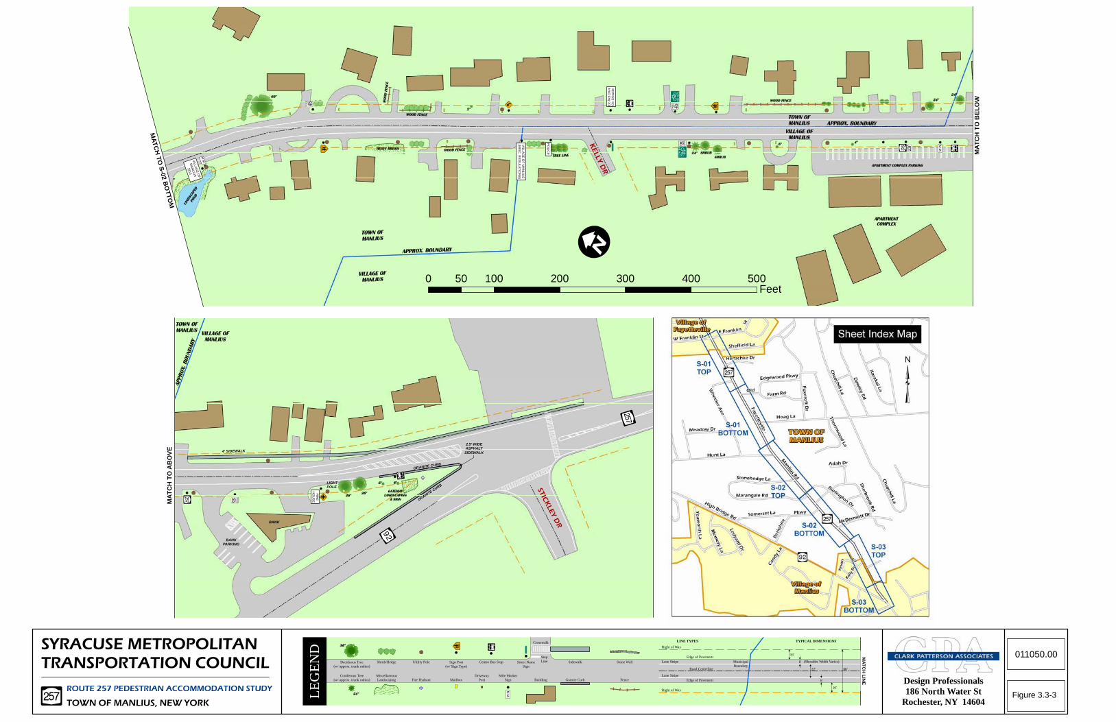
MA
TC
HT
OB
EL
OW
MA
TC
HT
OA
BO
VE
MA
TC
HTO
S-02
BO
TTOM
LANDSCAPED
POND
VILLA
GE
OF
MA
NLIU
S
1813
M.M
.
60"
HEAVY BRUSHWOOD FENCE
WOOD FENCE
WOOD
FENCE
2"
TREE LINE
VILL
AG
EO
FM
AN
LIUS
(MIS
C.R
EG
ULA
TIO
NS
)
PO
LICE
KELLYDR
Do
Not
Driv
eO
nS
houl
der
24" SHRUB
SHRUB
6"
WOOD FENCE 24"
24"
M.M
.
4"
VILLAGE OF
MANLIUS
TOWN OF
MANLIUS APPROX. BOUNDARY
VILLAGE OF
MANLIUS
TOWN OF
MANLIUS
APPROX. BOUNDARY
APARTMENT COMPLEX PARKING
APARTMENT
COMPLEX
BANK
BANKPARKING
VILLAGE OF
MANLIUS
TOWN OF
MANLIUS
APPROX.BOUNDARY
FIR
EH
OU
SE
LIGHTPOLE
36"36"
6"
GATEWAY
LANDSCAPING
& SIGN
6"
STICKLEYDR
2.5' WIDEASPHALT
SIDEWALK4' SIDEWALK
SYRACUSE METROPOLITAN
TRANSPORTATION COUNCIL Deciduous Tree(w/ approx. trunk radius)
Coniferous Tree(w/ approx. trunk radius)
Shrub/Hedge
MiscellaneousLandscaping
Utility Pole
Fire Hydrant
Sign Post(w/ Sign Type)
36"
24"
Mailbox Design Professionals186 North Water St
Rochester, NY 14604
LE
GE
ND Right of Way
Road Centerline
Lane Stripe
Lane StripeEdge of Pavement
MunicipalBoundary
TYPICAL DIMENSIONS
16'
6'
22'
6'
16'
66'
M.M
.
Building Granite Curb
Sidewalk Stone Wall
Fence
Crosswalk
StopLineStreet Name
SignCentro Bus Stop
Mile MarkerSign
DrivewayPost
(Shoulder Width Varies)
LINE TYPES
Right of Way
Edge of Pavement
ROUTE 257 PEDESTRIAN ACCOMMODATION STUDY
TOWNOF MANLIUS, NEW YORK
011050.00MA
TC
HL
INE
GRANITE CURB
GRANITE CURB
0 100 200 300 400 50050Feet
Figure 3.3-3
dkrol
Text Box
Figure 3.3-3

35
3.3.1 Pavement Pavement conditions of State owned facilities are assessed using the NYSDOT Pavement Condition Rating Manual. The surface rating scale ranges from very poor to excellent. According to New York State’s 2005 Highway Sufficiency Ratings Manual for Region 3, the asphalt pavement of Route 257 between Route 92 in the Village of Manlius and the Fayetteville Village Line is rated as being 7, meaning it is in good condition however distress symptoms are beginning to show. Although not noted in the 2005 Highway Sufficiency Manual, the 2004 Manual indicates that the dominant distress located along this corridor is isolated alligator cracking (less than 20% gets an “isolated” description). The majority of the study area falls within this section of pavement. Route 257 from the Fayetteville village line to Route 5 is rated as being 6, meaning it is in fair condition and distress is clearly visible. Once again, although not noted in the 2005 Highway Sufficiency Manual, the 2004 Manual indicates that the dominant distress located along this corridor is isolated alligator cracking (less than 20% gets an “isolated” description). The portion of the study area that falls within this section of road (from the Fayetteville village line to Route 5) includes the area between Sheffield Lane and Franklin Street. Drainage Facilities Existing visible drainage facilities in the study area include sewer grates. The sewer grates are located in the shoulders of Route 257. The sewer grate drainage holes run parallel to the direction of travel, which can make it difficult for bicyclists as their tires can get stuck in the grates (Photo right: typical drainage grate on Rt. 257). A concern noted via public comments is the potential for any new facilities (including pedestrian accommodations) to impact the drainage on various properties along F-M Road/Route 257. According to public comment, in the past, modifications to embankments have caused the creek to overflow. Although detailed discussion and evaluation of drainage facilities is beyond the scope of this study, drainage issues could be a key concern along this corridor. Should the Town of Manlius or NYSDOT choose to implement any type of new facility along Route 257 between the Villages of Fayetteville and Manlius, the SMTC highly recommends that these entities undertake the necessary steps to research any potential drainage impacts and complete the appropriate engineering analyses relative to drainage. 3.3.2 Pavement Markings Pavement markings within the study area were evaluated by the SMTC to determine whether they were in good, fair or poor condition. A good rating indicates that the markings are intact, reflective, and easy to comprehend. A fair rating indicates that the markings are intact but are

36
Photo: Typical Centro Bus Stop
faded, and a poor rating indicates that the markings are not intact, faded, and difficult to comprehend. The markings, including lane markings (centerline and shoulder), crosswalks (hatched) and stop bars were evaluated in late May 2006. The rating represents the overall worst condition for each location. The crosswalk markings at the intersections of Franklin Street with Route 257 and Wheeler Avenue with Route 257 were in fair condition. The centerline and shoulder markings along the length of the study area were in good to fair condition. They were intact, but did not appear to be very reflective. Overall, the stop bars on twelve (12) of the fifteen (15) intersecting streets were considered to be in fair condition. Stop bars at the intersections of Sheffield Lane and Franklin Street (on the east side of Route 257) were considered to be in poor condition because they were not visible.
Photos: Crosswalks in fair condition at Wheeler Ave. (top left) and Franklin St. (top right). Stop bars in fair condition at Old Farm Rd. (bottom left) and poor condition at Sheffield Ln. bottom (right). 3.3.3 Type and Condition of Bus Stops There are twenty-three (23) Centro bus stops within the study area that are designated with a blue Centro sign. All of the bus stops within the study area are unsheltered. In addition, all of the bus stop locations lack a lead walk paved surface and the majority are located on grass or gravel surfaces. As a result, individuals are often forced to walk and/or stand within

37
the road shoulder or on muddy, wet or snow-covered ground. 3.3.4 Sidewalks/Curb Ramps/Curbs There is one small area of sidewalk that exists within the corridor on the east side of Route 257 between Franklin Street and Sheffield Lane. The sidewalk in this block was evaluated in May 2006 as being in good condition as it showed few signs of wear (Photo right: sidewalk discontinuity; where the sidewalk ends at Sheffield Lane looking south). From Sheffield Lane to just south of Kelly Drive in Manlius (across from the driveway into Bank of America) there are no sidewalks. South of the study area, sidewalks begin again on the east side of Route 257 just south of Kelly Drive, and are present into the Village of Manlius. This stretch of sidewalk is located outside the project study area and was therefore not evaluated.
The sidewalk that runs between Lincoln Avenue and Franklin Street is just one block north of the study area (Photo at left). This sidewalk is paved and is in fair condition, meaning it is showing signs of wear such as pitting and unevenness. The sidewalks that run through Beard Park towards school property, and from the west side of the Route 257/Franklin Street intersection onto school property, are in good condition and showing few signs of wear. As noted previously, there are no existing curbs within
the study area. However, there is a slight sidewalk ramp located on one corner of the intersection of Franklin Streets with Route 257, to the east of Route 257 on the southern side of Franklin Street. Evaluated in May 2006, this small sidewalk ramp was in fair condition, meaning it was beginning to show signs of wear, such as pitting or unevenness.

38
Chapter 4 - Demographics and Land Use 4.1 Demographics When planning for new bicycle and pedestrian facilities, or upgrading or reconstructing existing roadways to accommodate bicyclists and pedestrians, one of the items for transportation planners and engineers to consider is the typical trip length of pedestrians and bicyclists. According to the Transportation Planning Handbook, published by the Institute of Transportation Engineers, “bicycle and pedestrian trips are typically characterized by short trip distances: approximately one-quarter mile to one mile for pedestrian trips and one quarter-mile to three miles for bicycle trips.”18 In addition, the American Association of State Highway and Transportation Officials (AASHTO) A Policy on Geometric Design of Highways and Streets notes that “the pedestrian most likely will not walk over 1 mile to work or over 0.5 mile to catch a bus, and about 80% of the distances traveled by the pedestrian will be less than 0.5 mile.”19 With the majority of bicycle and pedestrian trips covering short distances, land use patterns play a critical role in the current and future development and use of bicycle and pedestrian facilities. The following demographic maps and information are based on Summary Files from the 2000 Census. As noted above, because pedestrians will typically travel one-quarter to one-half mile, the SMTC chose to buffer the centerline of the road by both one-quarter, and one-half mile. The census block groups within this buffered area were then selected for demographic analysis (because the SMTC generated buffer area does not correspond exactly to Census geography, block group data was interpolated to develop the demographic information that falls within the buffer area). This results in the population of people that are potential pedestrians on the Route 257 corridor. This method yields synthesized results that may be in error. The SMTC examined the following demographics for this study within both a quarter-mile and half-mile of the study area: population, senior citizen population (those individuals 65 years of age and older), population of workers (16 years of age and older), population of workers with less than a 10 minute commute to work, and the population of school aged children (children between 5 years of age and 18 years of age). According to the 2000 US Census the total population of the Town of Manlius is approximately 31,872 persons. The population within the Village of Manlius is 4,819, while the population in the Village of Fayetteville is 4,190. Fiscal Year 2005 population estimates are as follows: 1) Town of Manlius: 32,431 persons, 2) Village of Manlius: 4,695 persons and 3) Village of Fayetteville: 4,171 persons.20 Note that these are population estimates only; the growth or decline in population cannot be verified without a complete and accurate census of the town.
18 John D. Edwards, Jr., P.E., Editor, Transportation Planning Handbook, 2d ed., Institute of Transportation Engineers, Washington, D.C., 1999, p. 604. 19American Association of State Highway and Transportation Officials, A Policy on Geometric Design of Highways and Streets, AASHTO, Washington, D.C., 2001, p. 96. 20 US Census Bureau 2000 Census.
39
Quarter-Mile Buffer Zone The following figures represent data summarized at a quarter mile of the study area. Overall, 5 partial block groups were analyzed according to the quarter mile buffer. Figure 4.1-1 displays the approximate total population of each block group within a quarter mile of the study area. Population values range from 90 persons in the southwest block group to a high value of 623 persons in the southeast block group. Figure 4.1-2 shows the approximate senior citizen population within a quarter mile of the study area. A low value of 9 is located in the southwest block group while an upper value of 129 is located in the southeast block group aggregate. Figure 4.1-3 (Population of Workers within a Quarter Mile of Study Area) has a low value of 46 in the southwest aggregate and a high value of 314 in the southeast aggregate. Figure 4.1-4 (Population of Workers with less than a 10 minute Commute to Work) indicates that the southwest aggregate has the lowest value (i.e., 9), while the southeast aggregate has the highest value (i.e., 58). Figure 4.1-5 shows the approximate school aged children population within a quarter mile buffer of the study area. The southwest aggregate contains the smallest number of 5-18 year olds (i.e., 15) while the southeast geography contains the largest number of 5-18 year olds (i.e., 99). Note that the same geographic locations (i.e., southwest and southeast) at the quarter mile buffer consistently contained the low and high values. Half Mile Buffer Zone The following figures were created utilizing a half mile buffer around the study area. Six (6) partial block groups were analyzed at the half mile buffer. Figure 4.1-6 depicts the total population of each block group within a half mile of the study area. The northeast partial block group in the Village of Fayetteville contains the smallest number of persons (i.e., 209) while the southwest aggregate contains the largest number of persons (i.e., 1,259). Figure 4.1-7 shows the senior citizen population within the half mile buffer. The northeast location has the low value with 20 senior citizens, while the southeast locality has the high value with 214 senior citizens. Figure 4.1-8 displays the number of workers. The low value is located within the northeast block group while the upper value of 664 workers is located in the southwest block group. Figure 4.1-9 portrays that the highest value of workers with less than a 10 minute commute to work is located within the southwest location. The low of 9 workers is located in the partial block group immediately north of the upper value. Figure 4.1-10 shows the number of children between 5 and 18 years of age within a half mile of the study area. The small value of 41 children between the ages of 5 and 18 is located in the northeast area, while the large value of 217 is located in the southwest area. Summary/Results The demographic review (using 2000 Census data) noted above examined the number of residents living with a quarter mile and half mile of the study area. The SMTC choose these parameters because most people will walk up to a half mile for transportation purposes. This review resulted in the number of people that are potential pedestrians on Route 257. There is a population of nearly 4,500 people living within a half mile of the project study area. From this analysis, it is evident that there is enough of a population base within the study area to justify some type of pedestrian facility for transportation purposes along Route 257.

Quarter Mile Buffer Line
Manlius
Fayetteville
90
436
623
279
370
FAYETTEVILLE MANLIUS RD
HUNT LA
STONEHEDGE LAHIGH BRIDGE RD
TROOP K RD
DU
GU
ID R
D
CAHILL RD
HOAG LA
Population within a Quarter Mile of Study Area100 Clinton Square126 North Salina St, Suite 100Syracuse, NY 13202(315) 422-5716Fax: (315) 422-7753www.smtcmpo.org
0 0.1 0.2 Miles
This map is for presentation purposes only. The SMTC does not guarantee the accuracy or completeness of this map.
Basemap Copyrighted by NYSDOTData Sources: SMTC, NYSDOT, 2001 Census 2000Prepared by SMTC, 09/2006
FM Rd/Rt. 257 Pedestrian Accommodation Feasibility StudyNumber of People
Quarter Mile BufferVillages
90279370436623
* The demographic information displayed on this map is based on Summary Files (SF1) from the 2000 Census. Because the SMTC generated buffer area does not correspond to Census geography, block group data was interpolated to develop the demographic information that falls within the buffer area. These data are an approximation only and cannot be guaranteed for accuracy.
Roads
Figure 4.1-1

Quarter Mile Buffer Line
Manlius
Fayetteville
9
61
129
27
93
FAYETTEVILLE MANLIUS RD
HUNT LA
STONEHEDGE LAHIGH BRIDGE RD
TROOP K RD
DU
GU
ID R
D
CAHILL RD
HOAG LA
Senior Citizens (65+) within a Quarter Mile of Study Area100 Clinton Square126 North Salina St, Suite 100Syracuse, NY 13202(315) 422-5716Fax: (315) 422-7753www.smtcmpo.org
0 0.1 0.2 Miles
This map is for presentation purposes only. The SMTC does not guarantee the accuracy or completeness of this map.
Basemap Copyrighted by NYSDOTData Sources: SMTC, NYSDOT, 2001 Census 2000Prepared by SMTC, 09/2006
FM Rd/Rt. 257 Pedestrian Accommodation Feasibility Study
* The demographic information displayed on this map is based on Summary Files (SF1) from the 2000 Census. Because the SMTC generated buffer area does not correspond to Census geography, block group data was interpolated to develop the demographic information that falls within the buffer area. These data are an approximation only and cannot be guaranteed for accuracy.
Figure 4.1-2
Number of People
Quarter Mile BufferVillages
9276193129
Roads
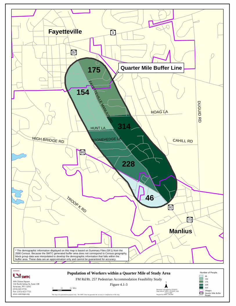
Quarter Mile Buffer Line
Manlius
Fayetteville
46
228
314
154
175
FAYETTEVILLE MANLIUS RD
HUNT LA
STONEHEDGE LAHIGH BRIDGE RD
TROOP K RD
DU
GU
ID R
D
CAHILL RD
HOAG LA
Population of Workers within a Quarter Mile of Study Area100 Clinton Square126 North Salina St, Suite 100Syracuse, NY 13202(315) 422-5716Fax: (315) 422-7753www.smtcmpo.org
0 0.1 0.2 Miles
This map is for presentation purposes only. The SMTC does not guarantee the accuracy or completeness of this map.
Basemap Copyrighted by NYSDOTData Sources: SMTC, NYSDOT, 2001 Census 2000Prepared by SMTC, 09/2006
FM Rd/Rt. 257 Pedestrian Accommodation Feasibility StudyNumber of People
Quarter Mile BufferVillages
46154175228314
* The demographic information displayed on this map is based on Summary Files (SF1) from the 2000 Census. Because the SMTC generated buffer area does not correspond to Census geography, block group data was interpolated to develop the demographic information that falls within the buffer area. These data are an approximation only and cannot be guaranteed for accuracy.
Roads
Figure 4.1-3
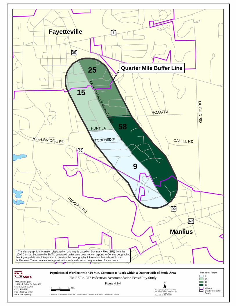
Quarter Mile Buffer Line
Manlius
Fayetteville
9
58
15
25
FAYETTEVILLE MANLIUS RD
HUNT LA
STONEHEDGE LAHIGH BRIDGE RD
TROOP K RD
DU
GU
ID R
D
CAHILL RD
HOAG LA
Population of Workers with <10 Min. Commute to Work within a Quarter Mile of Study Area
100 Clinton Square126 North Salina St, Suite 100Syracuse, NY 13202(315) 422-5716Fax: (315) 422-7753www.smtcmpo.org
0 0.1 0.2 Miles
This map is for presentation purposes only. The SMTC does not guarantee the accuracy or completeness of this map.
Basemap Copyrighted by NYSDOTData Sources: SMTC, NYSDOT, 2001 Census 2000Prepared by SMTC, 09/2006
FM Rd/Rt. 257 Pedestrian Accommodation Feasibility StudyNumber of People
Quarter Mile BufferVillages
9152558
* The demographic information displayed on this map is based on Summary Files (SF1) from the 2000 Census. Because the SMTC generated buffer area does not correspond to Census geography, block group data was interpolated to develop the demographic information that falls within the buffer area. These data are an approximation only and cannot be guaranteed for accuracy.
Roads
Figure 4.1-4

Quarter Mile Buffer Line
Manlius
Fayetteville
15
97
99
56
67
FAYETTEVILLE MANLIUS RD
HUNT LA
STONEHEDGE LAHIGH BRIDGE RD
TROOP K RD
DU
GU
ID R
D
CAHILL RD
HOAG LA
Population of School Aged Children within a Quarter Mile of Study Area100 Clinton Square126 North Salina St, Suite 100Syracuse, NY 13202(315) 422-5716Fax: (315) 422-7753www.smtcmpo.org
0 0.1 0.2 Miles
This map is for presentation purposes only. The SMTC does not guarantee the accuracy or completeness of this map.
Basemap Copyrighted by NYSDOTData Sources: SMTC, NYSDOT, 2001 Census 2000Prepared by SMTC, 09/2006
FM Rd/Rt. 257 Pedestrian Accommodation Feasibility StudyNumber of People
Quarter Mile BufferVillages
1556679799
* The demographic information displayed on this map is based on Summary Files (SF1) from the 2000 Census. Because the SMTC generated buffer area does not correspond to Census geography, block group data was interpolated to develop the demographic information that falls within the buffer area. These data are an approximation only and cannot be guaranteed for accuracy.
Roads
Figure 4.1-5
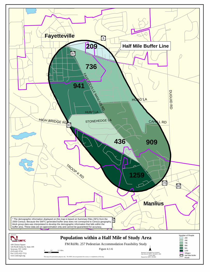
Manlius
Fayetteville
1259
436 909
941
736
FAYETTEVILLE MANLIUS RD
HUNT LA
STONEHEDGE LAHIGH BRIDGE RD
TROOP K RD
DU
GU
ID R
D
CAHILL RD
HOAG LA
209 Half Mile Buffer Line
* The demographic information displayed on this map is based on Summary Files (SF1) from the 2000 Census. Because the SMTC generated buffer area does not correspond to Census geography, block group data was interpolated to develop the demographic information that falls within the buffer area. These data are an approximation only and cannot be guaranteed for accuracy.
Population within a Half Mile of Study Area100 Clinton Square126 North Salina St, Suite 100Syracuse, NY 13202(315) 422-5716Fax: (315) 422-7753www.smtcmpo.org
0 0.1 0.2 Miles
This map is for presentation purposes only. The SMTC does not guarantee the accuracy or completeness of this map.
Basemap Copyrighted by NYSDOTData Sources: SMTC, NYSDOT, 2001 Census 2000Prepared by SMTC, 09/2006
FM Rd/Rt. 257 Pedestrian Accommodation Feasibility Study
Number of People
1259
209436736909941
Half Mile BufferVillages
Roads
Figure 4.1-6

Manlius
Fayetteville
210
61 214
138
198
FAYETTEVILLE MANLIUS RD
HUNT LA
STONEHEDGE LAHIGH BRIDGE RD
TROOP K RD
DU
GU
ID R
D
CAHILL RD
HOAG LA
20 Half Mile Buffer Line
Senior Citizens (65+) within a Half Mile of Study Area100 Clinton Square126 North Salina St, Suite 100Syracuse, NY 13202(315) 422-5716Fax: (315) 422-7753www.smtcmpo.org
0 0.1 0.2 Miles
This map is for presentation purposes only. The SMTC does not guarantee the accuracy or completeness of this map.
Basemap Copyrighted by NYSDOTData Sources: SMTC, NYSDOT, 2001 Census 2000Prepared by SMTC, 09/2006
FM Rd/Rt. 257 Pedestrian Accommodation Feasibility Study
* The demographic information displayed on this map is based on Summary Files (SF1) from the 2000 Census. Because the SMTC generated buffer area does not correspond to Census geography, block group data was interpolated to develop the demographic information that falls within the buffer area. These data are an approximation only and cannot be guaranteed for accuracy.
Figure 4.1-7
Number of People
214
2061138198210
Half Mile BufferVillages
Roads
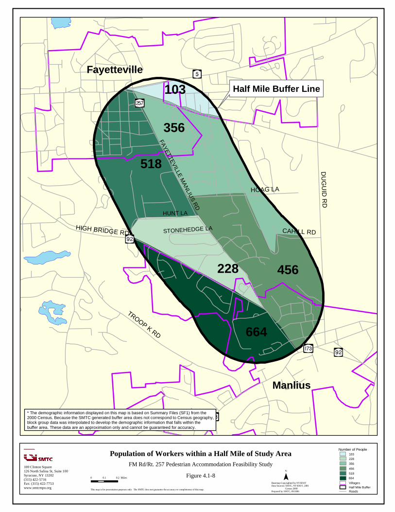
Manlius
Fayetteville
664
228 456
518
356
FAYETTEVILLE MANLIUS RD
HUNT LA
STONEHEDGE LAHIGH BRIDGE RD
TROOP K RD
DU
GU
ID R
D
CAHILL RD
HOAG LA
103 Half Mile Buffer Line
Population of Workers within a Half Mile of Study Area100 Clinton Square126 North Salina St, Suite 100Syracuse, NY 13202(315) 422-5716Fax: (315) 422-7753www.smtcmpo.org
0 0.1 0.2 Miles
This map is for presentation purposes only. The SMTC does not guarantee the accuracy or completeness of this map.
Basemap Copyrighted by NYSDOTData Sources: SMTC, NYSDOT, 2001 Census 2000Prepared by SMTC, 09/2006
FM Rd/Rt. 257 Pedestrian Accommodation Feasibility Study
Number of People
* The demographic information displayed on this map is based on Summary Files (SF1) from the 2000 Census. Because the SMTC generated buffer area does not correspond to Census geography, block group data was interpolated to develop the demographic information that falls within the buffer area. These data are an approximation only and cannot be guaranteed for accuracy.
664
103228356456518
Half Mile BufferVillages
Roads
Figure 4.1-8

Manlius
Fayetteville
136
9 85
50
FAYETTEVILLE MANLIUS RD
HUNT LA
STONEHEDGE LAHIGH BRIDGE RD
TROOP K RD
DU
GU
ID R
D
CAHILL RD
HOAG LA
18 Half Mile Buffer Line
Population of Workers with <10 Min. Commute to Work within a Half Mile of Study Area
100 Clinton Square126 North Salina St, Suite 100Syracuse, NY 13202(315) 422-5716Fax: (315) 422-7753www.smtcmpo.org
0 0.1 0.2 Miles
This map is for presentation purposes only. The SMTC does not guarantee the accuracy or completeness of this map.
Basemap Copyrighted by NYSDOTData Sources: SMTC, NYSDOT, 2001 Census 2000Prepared by SMTC, 09/2006
FM Rd/Rt. 257 Pedestrian Accommodation Feasibility StudyNumber of People
* The demographic information displayed on this map is based on Summary Files (SF1) from the 2000 Census. Because the SMTC generated buffer area does not correspond to Census geography, block group data was interpolated to develop the demographic information that falls within the buffer area. These data are an approximation only and cannot be guaranteed for accuracy.
9185085136
Half Mile BufferVillages
Roads
Figure 4.1-9

Manlius
Fayetteville
217
97 143
189
136
FAYETTEVILLE MANLIUS RD
HUNT LA
STONEHEDGE LAHIGH BRIDGE RD
TROOP K RD
DU
GU
ID R
D
CAHILL RD
HOAG LA
41 Half Mile Buffer Line
* The demographic information displayed on this map is based on Summary Files (SF1) from the 2000 Census. Because the SMTC generated buffer area does not correspond to Census geography, block group data was interpolated to develop the demographic information that falls within the buffer area. These data are an approximation only and cannot be guaranteed for accuracy.
Population of School Aged Children within a Half Mile of Study Area100 Clinton Square126 North Salina St, Suite 100Syracuse, NY 13202(315) 422-5716Fax: (315) 422-7753www.smtcmpo.org
0 0.1 0.2 Miles
This map is for presentation purposes only. The SMTC does not guarantee the accuracy or completeness of this map.
Basemap Copyrighted by NYSDOTData Sources: SMTC, NYSDOT, 2001 Census 2000Prepared by SMTC, 09/2006
FM Rd/Rt. 257 Pedestrian Accommodation Feasibility Study
Number of People
217
4197136143189
Half Mile BufferVillages
Roads
Figure 4.1-10
50
4.2 Land Use
Assessed land use within the study area and surrounding areas is shown in Figure 4.2-1 (Assessed Land Use Classifications). Assessed land use within the study area is primarily residential with business and commercial districts located on either end of the corridor (to the north and south) in the villages. There are a few scattered smaller businesses along the study area itself. In addition, two schools front Route 257 between the Villages of Fayetteville and Manlius with a third school located just east of the corridor. Town and village offices and park areas can be found on either end of the Route 257 corridor. Assessed land use to both the east and west of the study area is mostly residential.
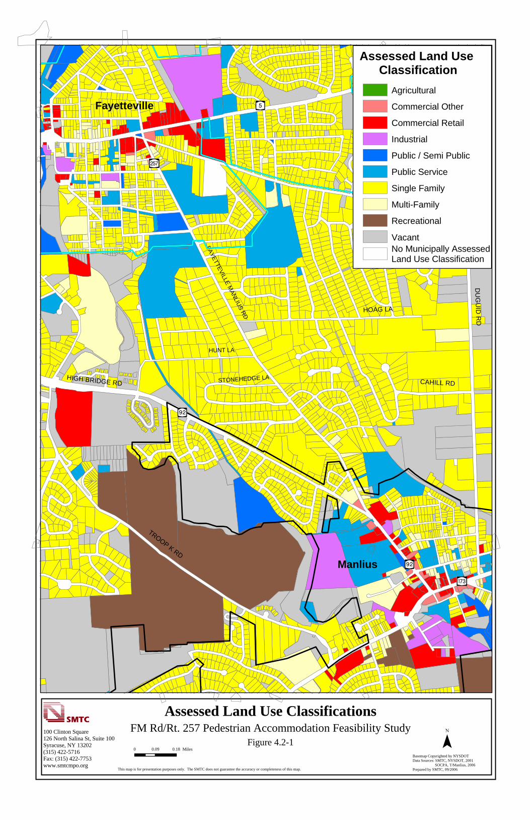
Y¿
[z
Yæ
Yæ
[Î
Fayetteville
FAYETTEVILLE MANLIUS RD
HUNT LA
STONEHEDGE LAHIGH BRIDGE RD
TROOP K RD
DU
GU
ID R
D
CAHILL RD
HOAG LA
Manlius
Assessed Land Use Classifications
¯100 Clinton Square126 North Salina St, Suite 100Syracuse, NY 13202(315) 422-5716Fax: (315) 422-7753www.smtcmpo.org
0 0.09 0.18 Miles
This map is for presentation purposes only. The SMTC does not guarantee the accuracy or completeness of this map.
Basemap Copyrighted by NYSDOTData Sources: SMTC, NYSDOT, 2001 SOCPA, T/Manlius, 2006Prepared by SMTC, 09/2006
FM Rd/Rt. 257 Pedestrian Accommodation Feasibility StudyFigure 4.2-1
Assessed Land Use Classification
Agricultural
Commercial Other
Commercial Retail
Industrial
Public / Semi Public
Public Service
Single Family
Multi-Family
Recreational
No Municipally Assessed Land Use Classification
Vacant

52
Chapter 5 - Existing Regulations, Development Controls, and Guidance
There are a variety of methods used to regulate and control what property owners are allowed to do with their land. Discussed below are zoning and other pertinent documents created for Onondaga County to assist with development guidance. 5.1 Zoning One of the most well known forms of land-use control is zoning. All properties within the Town of Manlius are subject to zoning ordinances, with those parcels contained in the three villages (Fayetteville, Manlius, and Minoa) subject to village ordinances. For each of the different zone districts there are controls over allowable uses of the property, such as parking, signs, location of buildings on the lot, fences, swimming pools, garages, and home occupations. The Route 257 corridor is primarily zoned residential with commercial districts located on either end in the Villages of Manlius and Fayetteville. Zoning along the corridor is shown in Figure 5.1-1 (Zoning Classifications), and a description of each of the zoning types represented in Figure 5.1-1 follows. The Town of Manlius, Village of Fayetteville and Village of Manlius each have their own classes of use districts or zones. More detail on each zoning district can be found by contacting the appropriate municipality. TOWN of MANLIUS ZONING: Residential District R-1 (R1) Residential District R-1 provides for areas with single-family dwellings. In additional, certain home occupations are allowed in the R-1 district. Bed-and-breakfast establishments are also permitted in certain instances with an accessory use permit. Residential District R-2 (R2) This district provides for similar uses as the R-1 district, however, bed-and-breakfast establishments are not permitted. The minimum frontages and yard depths are smaller than what is required within R-1 districts, making this district slightly higher in density than R-1. Residential District R-3 (R3) Residential District R-3 allows any use permitted in the R-1 district, but with smaller minimum frontages and lot sizes required. Two-family dwellings are also permitted in this district, as are public/private schools, churches and other places of worship, public libraries, municipal buildings, parks, playgrounds, community centers or recreational grounds. Upon special permit of the Town Board, these uses may be allowed: hospitals, hospices, homes for elderly adults, convalescent homes, nursing homes and similar facilities, as well as cemeteries, landing fields and greenhouses.

Fayetteville
FAY
ETTE
VILLE
MA
NLIU
S R
D
HUNT LA
STONEHEDGE LAHIGH BRIDGE RD
TROOP K RD
DU
GU
ID R
D
CAHILL RD
HOAG LA
Manlius
I
R1
RA
RA
R1
RA
C
RA
R1
R1
R1
R1
IND
RA
R1
RA
R1
R1
R5
R1
R1
RA
C
R1
R1
PRD
R1
R1
RA
R1
O
PRD
R1
R1
RA
O
R1
R1
R1
RA
R1
PRD
R1
I
R1
I
R2
RA
R1
R2
I
R1
R1
R1
RA
R1
R1
R1
R1
RA
P
R1
R3
R1
R3
R4
R1
R1
R1
R1
R1
R1
R1
R4
RA
CA
O
R1
R1
R1
R1
R1
R1
R1
R2
RA
R1
CA
RA
RA
R2
R1
R1
R3
R1
R1
RA
R1
R1
R1
R3
R2
R1
R3
R1
R2
C1
R1
R2
R2
C1
R1
R1
RA
RA
R3
R1
RA
RA
R5
R3
R4
R2
O
R1
R1
I
R2
R1
R1
TB
R1
R1
R2
RA
R2
R1
R3
R3
RARA
R1R1
R1
R3
R1
R1
R3
R1
P
CB
R1
RA
RB
R2
RA
R3
C1
P
R2
RA
R3
R1
RA
R1
R2
R2
RA
R1
RA
L
RA
R1
R1
O
R1
R1
TB
R2
R2
R2
R2
R1
RA
L
R3
R1
R3
R1
R3
R1
R1
P
R1
R1
R1
R2
R3
RA
C
R2
R1
R1
R1
R3
R3 R2
R3
R3
R1
RB
R3
RA
R2
R2
R1
R2
R1
RA
R1
R3
R1
R3
RB
R1
R1
R3
RA
R2
R3
TB
RA
R2
CA
C
RA
RA
R1
R1
RB
R1RA
C1
P
P
IND
RA
R2 R2
R3
RA
P
PRD
RB
C
RA
RA
*****
O
R2
R2R2
C
C
L
R1
R1 02
R1
R1
C
RARA
RA
R2
O
R3
P
R1
*****
R2
R1
RB
R2
R1
R2
R1
RB
*****
P
R1
R1
RA
*****
*****
B2
R2
RA
R1
Generalized Zoning Classifications100 Clinton Square126 North Salina St, Suite 100Syracuse, NY 13202(315) 422-5716Fax: (315) 422-7753www.smtcmpo.org
0 0.1 0.2 Miles
This map is for presentation purposes only. The SMTC does not guarantee the accuracy or completeness of this map.
Basemap Copyrighted by NYSDOTData Sources: SMTC, NYSDOT, 2001 T/Manlius, V/Fayetteville, 2006Prepared by SMTC, 08/2006
FM Rd/Rt. 257 Pedestrian Accommodation Feasibility StudyVillages
Zoning Classification
B2
C
C1
CA
CB
I
IND
L
O
P
PRD
R1
R1 02
R2
R3
R4
R4RA
R5
RA
RB
TB
Figure 5.1-1
UNKNOWN*****
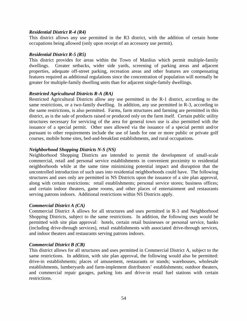
54
Residential District R-4 (R4) This district allows any use permitted in the R3 district, with the addition of certain home occupations being allowed (only upon receipt of an accessory use permit). Residential District R-5 (R5) This district provides for areas within the Town of Manlius which permit multiple-family dwellings. Greater setbacks, wider side yards, screening of parking areas and adjacent properties, adequate off-street parking, recreation areas and other features are compensating features required as additional regulations since the concentration of population will normally be greater for multiple-family dwelling units than for adjacent single-family dwellings. Restricted Agricultural Districts R-A (RA) Restricted Agricultural Districts allow any use permitted in the R-1 district, according to the same restrictions, or a two-family dwelling. In addition, any use permitted in R-3, according to the same restrictions, is also permitted. Farms, farm structures and farming are permitted in this district, as is the sale of products raised or produced only on the farm itself. Certain public utility structures necessary for servicing of the area for general town use is also permitted with the issuance of a special permit. Other uses allowed via the issuance of a special permit and/or pursuant to other requirements include the use of lands for one or more public or private golf courses, mobile home sites, bed-and-breakfast establishments, and rural occupations. Neighborhood Shopping Districts N-S (NS) Neighborhood Shopping Districts are intended to permit the development of small-scale commercial, retail and personal service establishments in convenient proximity to residential neighborhoods while at the same time minimizing potential impact and disruption that the uncontrolled introduction of such uses into residential neighborhoods could have. The following structures and uses only are permitted in NS Districts upon the issuance of a site plan approval, along with certain restrictions: retail establishments; personal service stores; business offices; and certain indoor theaters, game rooms, and other places of entertainment and restaurants serving patrons indoors. Additional restrictions within NS Districts apply. Commercial District A (CA) Commercial District A allows for all structures and uses permitted in R-3 and Neighborhood Shopping Districts, subject to the same restrictions. In addition, the following uses would be permitted with site plan approval: hotels, certain retail businesses or personal service, banks (including drive-through services), retail establishments with associated drive-through services, and indoor theaters and restaurants serving patrons indoors. Commercial District B (CB) This district allows for all structures and uses permitted in Commercial District A, subject to the same restrictions. In addition, with site plan approval, the following would also be permitted: drive-in establishments; places of amusement, restaurants or stands; warehouses, wholesale establishments, lumberyards and farm-implement distributors’ establishments; outdoor theaters, and commercial repair garages, parking lots and drive-in retail fuel stations with certain restrictions.

55
Industrial District ID (ID) This district allows for all structures and uses permitted in Commercial District B. However, no residential use is allowed in an ID without a special permit. In addition, certain manufacturing, industrial establishments and uses are permitted only after issuance of a special permit. The Town of Manlius Office of Building and Zoning is responsible for administering and enforcing New York State Uniform Fire Prevention and Building Code, local zoning laws, flood plain regulations, and sign regulations; Issuing permits for any new construction, alteration, demolition, signs, swimming pools; Carrying out inspections to insure compliance with all applicable codes and laws; Investigating all complaints concerning building code, zoning, or local law violations; Issuing Notice of Violation and Court Appearance tickets when necessary; Processing applications for Zoning Variances, Special Use Permits, Flood Plain Permits, and Accessory Use Permits and submitting same to appropriate boards; Inspecting industrial and commercial sites, daycare centers, multiple dwellings, hotels, and places of public assembly for fire safety compliance with the New York State Uniform Fire Prevention and Building Code; Responding to structure fires and other emergency situations.21 VILLAGE of MANLIUS ZONING: Residential District R-1 (R1) Permitted uses in Residential District R-1 include one-family dwellings, accessory uses or buildings or other structures (including swimming pools) upon approval, churches, public elementary and high schools, and public parks and playgrounds. Upon the issuance of a special permit, the following uses are permitted: private elementary and high schools; home occupations; parks, playgrounds, private recreational clubs/swimming pools maintained by homeowners associations; utilities’ substations; and garages for public/private schools accessory to school property. Residential District R-2 (R2) The following uses are permitted in R-2 Districts: all uses permitted in R-1 Districts and two-family dwellings. With a special use permit, the following uses are also allowed: multiple dwellings and accessory uses; membership clubs operated by membership organizations; philanthropic and not-for-profit institutions; nursery schools; hospitals, sanatoriums, nursing homes and housing for the well aged; public service structures; and boarding houses. Residential Multiple Use District R-M (RM) The Residential Multiple Use District is designed to retain the existing residential character of established neighborhoods while permitting unobtrusive uses of a commercial nature. All uses permitted in an R-2 District are allowed in an R-M District. The following uses are also permitted in an R-M District upon receipt of site development plan approval by the Planning Board: Offices of religious and educational institutions; offices of physicians, surgeons, dentists, lawyers, architects, engineers, accountants, planners, real estate agents, public stenographers and mailing services; daycare center; community residence; teaching of music, dance or similar types of instruction when limited to five pupils at a time; bed-and-breakfast accommodations;
21 Town of Manlius Website, Office of Building and Zoning <http://www.townofmanlius.org/Manlius_BuildingZoning.html>, 2004.
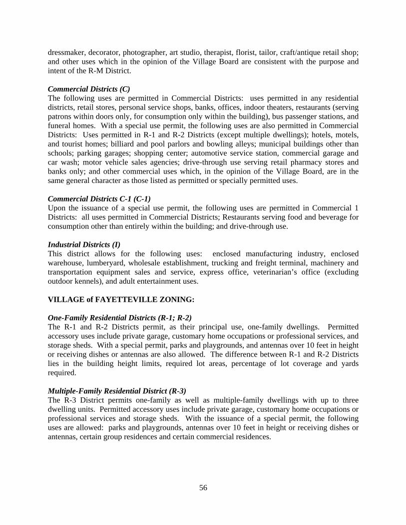
56
dressmaker, decorator, photographer, art studio, therapist, florist, tailor, craft/antique retail shop; and other uses which in the opinion of the Village Board are consistent with the purpose and intent of the R-M District. Commercial Districts (C) The following uses are permitted in Commercial Districts: uses permitted in any residential districts, retail stores, personal service shops, banks, offices, indoor theaters, restaurants (serving patrons within doors only, for consumption only within the building), bus passenger stations, and funeral homes. With a special use permit, the following uses are also permitted in Commercial Districts: Uses permitted in R-1 and R-2 Districts (except multiple dwellings); hotels, motels, and tourist homes; billiard and pool parlors and bowling alleys; municipal buildings other than schools; parking garages; shopping center; automotive service station, commercial garage and car wash; motor vehicle sales agencies; drive-through use serving retail pharmacy stores and banks only; and other commercial uses which, in the opinion of the Village Board, are in the same general character as those listed as permitted or specially permitted uses. Commercial Districts C-1 (C-1) Upon the issuance of a special use permit, the following uses are permitted in Commercial 1 Districts: all uses permitted in Commercial Districts; Restaurants serving food and beverage for consumption other than entirely within the building; and drive-through use. Industrial Districts (I) This district allows for the following uses: enclosed manufacturing industry, enclosed warehouse, lumberyard, wholesale establishment, trucking and freight terminal, machinery and transportation equipment sales and service, express office, veterinarian’s office (excluding outdoor kennels), and adult entertainment uses. VILLAGE of FAYETTEVILLE ZONING: One-Family Residential Districts (R-1; R-2) The R-1 and R-2 Districts permit, as their principal use, one-family dwellings. Permitted accessory uses include private garage, customary home occupations or professional services, and storage sheds. With a special permit, parks and playgrounds, and antennas over 10 feet in height or receiving dishes or antennas are also allowed. The difference between R-1 and R-2 Districts lies in the building height limits, required lot areas, percentage of lot coverage and yards required. Multiple-Family Residential District (R-3) The R-3 District permits one-family as well as multiple-family dwellings with up to three dwelling units. Permitted accessory uses include private garage, customary home occupations or professional services and storage sheds. With the issuance of a special permit, the following uses are allowed: parks and playgrounds, antennas over 10 feet in height or receiving dishes or antennas, certain group residences and certain commercial residences.

57
Multiple-Family Residential District (R-4) The R-4 District allows for one-family and two-family dwellings, as well as multiple-family dwellings. The permitted accessory uses are the same as those for R-3 Districts. With the issuance of a special permit, the following uses are allowed: parks and playgrounds; antennas over 10 feet in height or receiving dishes or antennas; certain group residences and certain commercial residences; nursing/convalescent homes; private and public nursery, daycare centers, schools and public libraries; and churches and similar places of worship. Residential-Business Districts (R-B) Residential-Business Districts allow a certain range of business uses within a residentially compatible setting. One- and two-family dwellings are permitted in the R-B District. Permitted accessory uses include private garage, customary home occupations for professional services, and storage sheds. Upon issuance of a site plan approval by the Planning Board, multiple-family dwellings and offices are permitted. Upon issuance of a special permit by the Planning Board, retail and personal services as well as certain commercial residences are permitted. Prohibited uses include drive-in services, gasoline service facilities, motor vehicle sales and services and restaurants. There are also supplemental design standards for the R-B District. Limestone Plaza District (L) This district is intended to promote and encourage the continued use of the nineteenth century commercial core of the Village and to ensure that redevelopment activities are compatible to the existing building patterns. Permitted uses with site plan approval by the Planning Board include apartment dwelling units, multiple-family dwellings, offices, retail and personal services, and mixed use occupancy. With a special use permit granted by the Planning Board, the following are permitted: religious institutions, restaurants, hotels, and membership clubs. Prohibited uses include one- or two-family dwellings; manufacturing, assembly, or storage; drive-in service facilities; gasoline service facilities; and motor vehicle sales and services. There are also supplemental design standards for the L District. Traditional Business District (TB) The purpose of the TB District is to provide for a variety of business, residential and community uses in a relatively dense setting that maintains and enhances typical building development and pedestrian and vehicular circulation patterns characteristic to a Village core. The following uses are permitted with site plan approval by the Planning Board: multiple-family dwellings, retail/personal services, office, religious institutions, membership clubs, libraries, and mixed use occupancy. By special permits issued from the Planning Board, the following are allowed: residential uses in combination with a nonresidential use, certain commercial residences, restaurants, theaters, health-care facilities, shopping centers, and storage sheds. Prohibited uses include drive-in services; motor vehicle sales, service or repair; hotel/motel; manufacturing, assembly or storage; and gasoline service facilities. There are also supplemental design standards for this district. Contemporary Business District (CB) The purpose of this district is to provide for contemporary business activities and community uses generally dependent upon access to and visibility from major roads. These uses and activities shall be designed to minimize impacts upon surrounding properties and upon the safe

58
and efficient movement of traffic. Permitted uses with site plan approval by the Planning Board include: retail or personal services, religious institutions, membership clubs, libraries, cemeteries, commercial residences, restaurants, theaters, health care facilities, shopping centers, and mixed use occupancy. With a special permit from the Planning Board, drive-in services; motor vehicle sales, service or repair; hotels/motels; and gasoline service facilities are allowed. Prohibited uses include residential uses and manufacturing, assembly and storage of products. There are also supplemental design standards for this district. Industrial Districts (I) With a special permit and site plan approval, the following uses are permitted: uses permitted in TB and CB districts (except residential uses); industrial uses employing electric power or utilizing hand labor for fabrication or assembly and which cause or omit no objectionable odors, fumes, dirt, vibration, glare, electrical interference or noise beyond the immediate site of the building(s) in which such uses are conducted; warehousing facilities; and wholesale businesses. When adjacent to a residential district, a buffer zone is required. There are several uses that are prohibited in this district. Planned Residential Development Districts (PRD) The intent of the PRD is to develop flexible land use and design regulations through the use of performance criteria so that small-to-large scale neighborhoods or portions thereof may be developed within the Village that incorporate residential land uses and contain both individual building site and common property which are planned and developed as a unit. Under normal circumstances, the minimum area required to qualify for a PRD is 50 contiguous acres. Permitted uses include single-family detached dwelling units, townhouses or cluster units. Customary accessory uses (private garages, storage sheds/spaces, recreational/community structures, churches, schools, parks, and playgrounds) shall be permitted as appropriate to the PRD. Certain lot areas, coverage, yards, and open space are required. Open Land Districts (O) This district represents land so located as to be subject to flooding conditions or other special ecological considerations and shall have no structures of a permanent nature erected on them. Public or Municipal Lands Districts (P) This district represents those lands located within the Village and owned by the Village or another municipality for municipal or park purposes.

59
5.2 Historic Sites: According to the Town of Manlius there are no known historic sites within the study area.
5.3 SMTC Bicycle and Pedestrian Plan The 2005 Bicycle and Pedestrian Plan was designed as a policy level plan that seeks to preserve and enhance the area’s bicycling and pedestrian network and to improve the safety, attractiveness, and overall viability of cycling and walking as legitimate transportation options within the transportation network in the SMTC MPA. The document identifies policies and guidelines to guide future bicycle and pedestrian facilities and amenities in the MPA. Key goals of the study were:
1. To encourage the use of bicycling and walking as legitimate modes of transportation;
2. To improve the safety of bicyclists and pedestrians; 3. To educate bicyclists, pedestrians, motorists, law enforcement officers, and others
regarding traffic laws and safety measures; 4. To promote the improvement of travel and tourism and business opportunities along
bicycle and pedestrian infrastructure; and 5. To encourage planners and municipalities to develop bicycle and pedestrian resources.
The document includes numerous recommendations for implementation by municipalities to better improve the bicycle and pedestrian network in their respective communities. The recommendations are categorized by type of facility (bicycle or pedestrian) and further sub-categorized into the “E’s” of planning (i.e., economic development, encouragement, education, enforcement and engineering). The report is non-location specific so that it can be applied to the MPO region’s varied communities. A copy of the final document can be viewed at www.smtcmpo.org/bike-ped. 5.4 Onondaga County 2010 Development Guide In 1998, the Syracuse-Onondaga County Planning Agency (SOCPA) presented an update to its 2010 Development Guide for Onondaga County. The 2010 Plan’s vision, goals and policies are intended to guide future individual government decisions on land use, transportation and infrastructure development, utilizing balanced goals that include economic growth, creating an attractive community, encouraging diversity and choice, and enhanced fiscal strength.22 In furthering those goals, Onondaga County’s Policies for Investment and Land Use, as defined in the 2010 Plan, call for investment in existing communities, preservation of existing infrastructure and transportation assets, sustainable urban and suburban settlement patterns, and protection of the rural economy, agricultural land, and access to natural resources. The 2010 Plan encourages the public and private sector to make funding, permitting, and planning decisions utilizing these guiding principles, and to be cognizant of individual projects’ effects on the quality of life of all residents.23
22 Syracuse Metropolitan Transportation Council, LRTP 2004 Update, pp. 92. 23 Ibid. pp. 93.

60
5.5 Onondaga County Settlement Plan In 1999, SOCPA enlisted the services of a nationally recognized firm in new urbanism practices to prepare the Onondaga County Settlement Plan. New Urbanism celebrates traditional neighborhood development patterns from a century ago for its efficiency of land use, transportation opportunities, social interaction and mix of incomes. The Settlement Plan for Onondaga County was designed to present a comprehensive “toolbox” of strategies to encourage the traditional neighborhood development patterned outline by New Urbanism, as an alternative to conventional zoning and suburban development patterns which many deem an inefficient use of land and a burden on transportation facilities. Created to assist in implementing the goals of Onondaga County’s 2010 Development Guide – to reinforce urban centers and neighborhoods and promote efficient expansion of infrastructure – the Settlement Plan both illustrates the possible utilization of New Urbanism development principles at several existing Onondaga County locations, and also provides the regulatory framework and planning tools (including transportation policies) for municipalities to foster desired development patterns. Critical to the Plan and New Urbanism is the creation and reinforcement of walkable, mixed-use, and transit supportive neighborhoods and urban centers. Although the Settlement Plan has not been officially adopted, the policies and practices noted within the three documents serve as a tool kit to assist Onondaga County in “returning to the traditional neighborhood pattern of growth.”24
24 Duany Plater-Zyberk & Company, Onondaga County Settlement Plan, Onondaga County, New York, February 2001, Executive Summary.

61
Chapter 6 – Planned Improvements or Development
6.1 Transportation Improvements There are minimal planned improvements and/or developments scheduled for planning, design or construction along Route 257 between the Villages of Fayetteville and Manlius. As far as transportation improvements are concerned, the NYSDOT is scheduled to complete a paving project on Route 257 between Routes 92 and 290 in 2010. This paving project would “restore the pavement to a good condition with milling of 40 mm and a single course overlay of 40 mm.”25 The NYSDOT also plans to reconstruct the Route 5 and Route 257 intersection, located north of the study area in the Village of Fayetteville in 2010. At this time, other than the transportation projects noted above, there are no known Town or private projects proposed along the Route 257 corridor that were examined for this study.
25 New York State Department of Transportation, 2007-2012 TIP Highway Project Application, 11/14/2006.

62
Chapter 7 – Issues
7.1 Introduction Through the course of completing the existing conditions inventory documented in the previous chapters, and the public involvement process, several transportation issues were identified along the Route 257 corridor study area. These issues are outlined below. This task involved reporting known transportation issues facing those who utilize Route 257 between the Villages of Fayetteville and Manlius. This task does not involve the SMTC making any judgment of those issues nor does it involve the SMTC drawing conclusions from those issues. This task is merely the summation of perceived and known bicycle, pedestrian, and vehicular issues reported to the SMTC directly or found via the study review process. In general, pedestrian access is limited to on-road travel within the shoulders of the roadway between the two villages, and this was the underlying issue examined within this study. 7.2 Vehicular Travel Issues The following vehicular travel issues were identified along the Route 257 study area:
• One of the travel issues noted along the corridor is the queue of vehicles created along Franklin Street that extends onto Route 257 by parents and guardians trying to access the Wellwood Middle School parking lot to pick up their children after school. In addition, sometimes vehicles coming from the south become queued so that these vehicles cannot make a left hand turn onto Franklin Street. At times, this causes traffic to queue a block or more south (past Henschke Drive) making it very difficult for the crossing guard located at Sheffield Lane/Route 257 to move the busses out of the school grounds.
• Although the speeds recorded along the Route 257 corridor indicate that on average, vehicles were traveling below the speed limit, speeding vehicles were present along the corridor. In some instances, motorists were traveling 10 miles over the speed limit. A summarization of speeding vehicles is noted below:
o Between Route 5 and Henschke Drive where the speed limit is 30 miles per hour (MPH), approximately 26.5% of northbound vehicles and 20% of southbound vehicles were traveling between 30.1 and 35.0 MPH. Approximately 6% of northbound and southbound vehicles were traveling between 35.1 and 45.0 MPH.
o From Henschke Drive to Marangale Lane where the speed limit is 40 MPH, approximately 21% of northbound vehicles, and 17% of southbound vehicles were traveling between 40.1 and 45.0 MPH. Approximately 2% of northbound vehicles and 1.5% of southbound vehicles were traveling between 45.1 and 50 MPH.
o Between Marangale Lane and Route 92 where the speed limit is 40 MPH, approximately 43% of northbound vehicles and 27% of southbound vehicles were traveling between 40.1 and 45.0 MPH. Approximately 12% of northbound

63
vehicles and 4% of southbound vehicles were traveling between 45.1 and 50.0 MPH.
• One unpredictable safety issue at hand within this corridor involves vehicle/deer collisions. Almost half of the 40 accidents analyzed between 1999 and 2004 involved collisions with deer. The breakdown of accident types is as follows:
1. Collisions with animals – 47.5%; 2. Rear end – 20%; 3. Fixed object/out of control – 15%; 4. Left turn – 10%.
• The pavement between Sheffield Lane and Franklin Street within the study area was rated as being “6” by NYSDOT, meaning it is in fair condition and distress is clearly visible. The 2004 Highway Sufficiency Manual indicates that the dominant distress at this location is isolated alligator cracking (less than 20% gets an “isolated” description).
• Some pavement markings within the corridor are in fair to poor condition. A fair rating indicates that the markings are intact but are faded, and a poor rating indicates that the markings are not intact, faded, and difficult to comprehend (the rating represents the overall worst condition for each location). The specific locations of the pavement markings that are in fair to poor condition are as follows:
o Crosswalk markings at the intersections of Franklin Street with Route 257 and Wheeler Avenue with Route 257 were in fair condition.
o Centerline and shoulder markings along the length of the study area were in good to fair condition. They were intact, but did not appear to be very reflective.
o Stop bars on twelve (12) of the fifteen (15) intersecting streets were in fair condition.
o Stop bars at the intersections of Sheffield Lane and Franklin Street (on the east side of Route 257) were considered to be in poor condition because they were not visible.
7.3 Pedestrian and Bicycle Travel Issues The following pedestrian and bicycle travel issues were identified within the Route 257 study area:
• Although there is a crosswalk at the intersection of Wheeler Avenue with Route 257, the safety of pedestrians crossing at this location is called into concern as there is no sidewalk connecting to the crosswalk on either side of Route 257 at Wheeler Avenue. Additionally, there is no crossing guard present at this location during school arrival/dismissal times to assist children crossing the street at this location.
• There are no sidewalks or specific pedestrian accommodations from Sheffield Lane to just south of Kelly Drive in Manlius (across from the driveway into Bank of America) on either side of Route 257. The majority of the study area is lacking pedestrian accommodations, which poses safety concerns for individuals currently using the roadway shoulders for walking. The lack of pedestrian accommodations also presents safety concerns for the children that attend either Fayetteville Elementary School or Wellwood Middle School at the northern end of the study area.

64
• The sidewalk that runs between Lincoln Avenue and Franklin Street (one block north of the study area) is in fair condition, meaning it is showing signs of wear such as pitting and unevenness.
• The sidewalk ramp located on one corner of the intersection of Franklin Street/Route 257 is in fair condition, meaning it is showing signs of wear, such as pitting and unevenness.
• Sewer grates located in the shoulders of Route 257 have drainage holes that run parallel to the direction of travel, which can make it difficult for bicyclists traveling in the shoulder. Their bicycle tires can get wedged or stuck in the grates causing a possible accident.
• The corridor is not a designated specific bike route; however, bike route signs have been posted by the NYSDOT primarily for safety reasons to remind motorists that bicyclists are allowed to travel on Route 257. This can provide confusion for bicyclists as this stretch of road is not an officially designated bike route.
7.4 Transit Travel Issues The following transit travel issues were identified within the Route 257 study area:
• There are numerous (23) Centro bus stops within study area, which seems excessive given the 1.3 mile length of the study area.
• All of the bus stops within the study area are unsheltered. In addition, all of the bus stop locations lack a lead walk paved surface and the majority are located on grass or gravel surfaces. As a result, individuals are often forced to walk and/or stand within the road shoulder or on muddy, wet or snow-covered ground.
7.5 Other Issues Another concern noted through public comments is the potential impact that any new facilities (including pedestrian accommodations) could have on drainage to various properties along F-M Road/Route 257. According to public comment, in the past, modifications to embankments have caused the creek to overflow. Although detailed discussion and evaluation of drainage facilities is beyond the scope of this study, drainage issues could be a key concern along this corridor. Should the Town of Manlius or NYSDOT choose to implement any type of new facility along Route 257 between the Villages of Fayetteville and Manlius, the SMTC highly recommends that these entities undertake the necessary steps to research any potential drainage impacts and complete the appropriate engineering analyses relative to drainage.

65
Chapter 8 – Alternatives Analysis and Recommendations This chapter presents a series of preliminary pedestrian accommodation alternatives for the F-M Road/Route 257 study area. The alternatives discussed were derived from an assessment of baseline information collected, noted public comments, and discussions amongst the hired consultant, and the member’s of the project’s SAC (including the Town of Manlius, the SMTC, and the NYSDOT) regarding the overall reasonableness of design concepts and possible courses of action for improvements. The preliminary alternatives listed were not intended to represent an exhaustive compilation of fully developed designs or approaches for pedestrian improvements along Route 257 within the study area. They served as a starting point of discussion for determining the resulting recommendations. The recommended alternatives include planning level cost estimates, right-of-way acquisition costs (if necessary), and estimated maintenance costs. As the SMTC is not an implementing agency, it is the sponsor’s (Town of Manlius) responsibility along with consultation from the New York State Department of Transportation (Route 257 is a State Route and NYSDOT owns Route 257 within the project study area) to implement the ensuing recommendations if deemed necessary and as appropriate. The following alternatives and recommendations are preliminary planning level recommendations, which could potentially improve pedestrian safety and mobility along the corridor. Please note that the majority of alternatives and recommendations would require further engineering analysis prior to implementation. Final recommendations also include suggestions to alleviate additional transportation issues (noted in Chapter 7) noted along the corridor. These recommended roadway improvements are noted in Chapter 9 - Implementation Plan.

66
8.1 Analysis of Alternatives Many factors were considered in the development of the seven preliminary alternatives for accommodating pedestrians in the study area, including public input, physical characteristics of the corridor, and guidelines provided by relevant local, state, and federal agencies. Important Considerations
It is imperative to note there are two schools located at the north end of the study area, Fayetteville Elementary School and Wellwood Middle School; the schools are located on the west side of Route 257. Schools are major pedestrian generators and any recommendations should aim to coincide with a Safe Routes to School (SRTS) Program. The Fayetteville-Manlius School District does not yet have a SRTS plan in place. In August 2005, federal transportation legislation devoted $612 million for the National Safe Routes to School Program from 2005 through 2009 in which school districts can apply for grants to develop a plan. Elements of this plan aim to improve the physical walking/biking conditions to and from school, provide encouragement to the student population (and their guardians), as well as resources for marketing the SRTS plan. The goal is to increase the number of children walking/biking to school, thus decreasing the need for bus transportation. Some of the benefits of a SRTS program include:
• Decreasing transportation costs, potentially decreasing school budgets and taxpayer costs; • Improving air quality in the vicinity of the schools, providing a healthier learning
environment. Air pollutants such as carbon monoxide not only have a negative impact on the environment, but may reduce one’s ability to learn; and
• Offering students a healthier means of getting to school while preparing their minds to learn. Physical exercise is known to improve brain functioning.
It is highly recommended that the Fayetteville-Manlius School District look into the possibility of developing a SRTS Plan while funding assistance is available from the State Department of Transportation and the Federal Highway Administration. Another important consideration is the historic neighborhood characterized by stately homes, two-foot high stone walls (some possibly 200 years old), and mature trees lining Route 257. These unique characteristics contribute to the visual character and overall quality of life for this area. Pedestrian and bicycle accommodations also contribute to quality of life. It is challenging to balance factors such as walkability, historical character, and aesthetics in existing urban communities. Creative solutions should be sought that truly represent the community’s priorities. This section provides a rationale for selecting the alternative that balances these factors in a cost-effective fashion.

67
Photo: Cut-through to school property from Route 257.
Looking from school grounds towards Wheeler Avenue (left). Looking onto school grounds from pathway (right).
Review of Existing Pedestrian Network Currently, only 811 feet of sidewalk exist along Route 257 from East Franklin Street to the intersection of Route 257 and 92, a corridor that is approximately 7,229 feet (1.4 miles) in length. An eight foot sidewalk is also located along Route 257 north of the elementary school and ends at the intersection with another sidewalk along West Franklin Street. However, these are not connected with the sidewalks that lead to the school, nor the sidewalk located on the east side of Route 257 between East Franklin Street and Sheffield Lane. The existing sidewalks are located at the northern and southern portions of the study area and are four feet in width. Between Sheffield Lane and East Gate Apartments, located just south of Kelly Drive, pedestrians and bicyclists use the six foot asphalt shoulder, which varies in width along the corridor. In addition, students are currently walking to the schools even though there are minimal sidewalks present, as evidenced by the two worn paths leading to school property within the study area. The first is a small cut-through that is found on the west side of Route 257 between Sheffield Lane and Henschke Drive. Students utilize this path as a short-cut to school property when coming from the south to attend school. In addition, a pathway leading to Fayetteville Elementary exists off of the bend in Wheeler Avenue. Wheeler Avenue extends west off of Route 257, and bends south to connect with Hunt Lane. This is another shortcut utilized by students as they travel to and from school. The path is primarily worn grass and is not paved. One side is lined with a chain link fence. The pathway is not kept clear in the winter.
68
The following section provides an analysis of the seven preliminary alternatives for accommodating pedestrians in the study area. These alternatives were developed by the Study Advisory Committee (SAC) and the consultant team. The SAC consisted of several agencies lending their expertise in the field of transportation, planning, and land use, including the NYSDOT, OCDOT, SOCPA, and the SMTC. Additionally, the SAC included local Town and municipal representatives, as well as an F-M School District representative. All of the SAC representatives shared their expertise and guidance in developing and choosing the best and most appropriate set of alternatives to examine in further detail based on the nature of the Route 257 corridor. Please note that the examination of accommodations off Route 257 (i.e., not along Route 257) were not within the scope of this study. The seven alternatives are: Alternative 0: No new installation of pedestrian facilities. Keep current conditions. Alternative 1: Sidewalks on both sides of the road along entire length of study area. Alternative 2A: Sidewalk on the west side of the road along entire length of study area with
increased shoulder space on the east side. Alternative 2B: Sidewalk on the east side of the road along entire length of study area with
increased shoulder space on the west side. Alternative 3: Shared use path on both or one side of Route 257 along entire length of
corridor. Alternative 4: Stone dust path on both or one side of Route 257 along entire length of
corridor. Alternative 5: Increased shoulder space on both sides of Route 257. Detailed explanations of the seven alternatives are included on the following pages.

69
Alternative 0: No new installation of pedestrian facilities. Keep current conditions. No analysis of physical conditions is required for this option. Regulatory agencies (NYSDOT, FHWA) agree that all arterial streets should have sidewalks along both sides of a developed or populated roadway. Users of the transportation system should have safe access to all modes of transport, including walking and biking. The absence of sidewalks discourages some people from walking because the current condition of the roadway is perceived as dangerous. Potential walkers choose to drive short distances (this stretch of road is approximately 1.4 miles) with consequences such as an increase in traffic volumes, an increase in air pollution, and a decrease in physical exercise.
This alternative represents current conditions. Based on public input, there is wide consensus that this environment is dangerous to walk in. One resident suggested (at the November 1, 2005 public meeting) that children be banned from walking along the road. However, in addition to two schools being located at the northern end of the study area, every person has the right to use the public right-of-way, regardless of which mode of travel they prefer.
Regardless of safety, 12 out of 30, or 40 percent, of the comments from the public meeting minutes (summarizing the comments received at the November 1, 2005 public meeting) are in opposition to sidewalks. Most of these arguments are based on property rights, taxpayer cost, and maintenance costs and responsibility. Therefore, if pedestrian facilities are desired, they should minimize impacts to these areas of public concern.
Municipalities often work with slim budgets and decisions need to be made not only in the context of priorities but cost-effectiveness. This option is the least costly, but depending on priorities, this may not be an effective option. If it is deemed that safety is the top priority, this option would not be cost-effective.
This alternative is not recommended, as it does not address the need to improve pedestrian safety within the corridor. Alternative 1: Sidewalks on both sides of the road along entire length of study area. If transportation agency standards for road classification were the primary factor, this would be the recommended alternative. As noted, regulatory agencies agree that arterial streets should have sidewalks along both sides of a developed roadway. AASHTO also notes, “Sidewalks on only one side of the street are not generally recommended”. Sidewalks provided on only one side of the street often require pedestrians to cross streets unnecessarily. Locating sidewalks on both sides of Route 257 is the safest option. This alternative would minimize, and eliminate in many cases, the need for pedestrians to cross this busy stretch of road. There are many pedestrian generators located on both sides of the road throughout the length of the study area, which supports placing pedestrian facilities on both sides of the road. Specific pedestrian generators include:

70
• the schools and the villages; • a multitude of residences and residential side streets (see Table 8.1-1); and • multiple Centro bus stops.
However, the purpose of this study is to analyze the impacts of installing sidewalks and/or other pedestrian/bicycle treatments along Route 257 and to identify the most feasible option, taking into consideration existing factors and areas of concern as identified by the public. In this case, an impacted object is one that is in direct conflict with the placement of the walkway and needs to be removed, relocated, or avoided. Any public transportation facility or transportation-related objects such as transit stops and signage, as well as all public utilities, must be contained within the public ROW. However, easements may provide a possible solution in compromising the seemingly contrasting ideals of pedestrian safety/accessibility and neighborhood character. An easement is an agreement whereby the landowner grants access to another interest, such as a public utility, while retaining ownership of the land.26 In areas where it is not physically feasible to locate the sidewalk entirely in the ROW, it may be more cost-effective and preferable to the community to acquire easements to accommodate a stone wall, trees, and the sidewalk rather than removing/relocating objects in conflict.
Table 8.1-1
Right-of-Way Characteristics
Objects Within Right-of-Way W side E side Intersecting streets 6 8
Intersecting driveways 41 57 Bus stops 9 11
Large trees* 20 23 Utility poles 68 19
Fire hydrants 2 2 Streets signs 46 47
Total # of obstacles 190 165 Units w/primary access to 257 180 230
*Over 24” approximate diameter Note: This table is the same table shown in Chapter 3 (Table 3.3-1) A preliminary analysis involved the documentation of all objects27 within the entire ROW corridor along Route 257 (Table 8.1-1). To determine the specific impacts of locating sidewalks on both sides of the road, using GIS, a sidewalk was digitally created on both sides of the road in order to calculate the exact number of objects that would be in direct conflict with it if it were to be constructed (see the end of this chapter for detailed maps). The precise location of the proposed sidewalk within the ROW is seen as flexible so as to minimize impacts on existing objects.
26 For more information on easements, visit http://www.dot.state.ny.us/red/property.html. 27 Mailboxes and driveway markers were not included. No underground utilities were identified.

71
Five feet is the minimum width allowable for a sidewalk in order to accommodate 2-way wheelchair traffic (ADAAG 4.2.2). In areas of high pedestrian traffic such as schools, and along arterials, it is recommended to have sidewalk widths of 6-8 feet with a commensurate “clear zone”. This is the 3-dimensional space along the walkway in which pedestrians occupy; no sign, vegetation, or other object should interrupt the pedestrian experience. Additionally, according to ADA guidelines, there must be a minimum width of eight feet and a minimum length of five feet for each bus stop pad. Also note an eight foot pad the length of the bus is desirable. These dimensions were not taken into consideration for this analysis as there are an exorbitant number of bus stops along both sides of Route 257. Local officials may want to confer with Centro to select a few strategic locations for ADA-compliant transit stops (versus the existing nine southbound and eleven northbound locations). However, given the narrow ROW and the presence of sensitive objects (i.e., stone wall and mature trees), a five foot sidewalk was analyzed for these alternatives, except for the school zone where a seven foot sidewalk was used. Table 8.1-2 enumerates the objects that would likely be impacted by a sidewalk. It is assumed that the proposed sidewalk would be contained within and be close to the limits of the ROW in order to maximize the width of the buffer zone between the sidewalk and the roadway. NYSDOT recommends at least a 4-foot strip between the edge of pavement and the sidewalk for snow storage.
Table 8.1-2 Impacted Objects
Impacted Objects W side E side
Utility poles* 5 6 Fire hydrants 0 1 Large trees** 6 6
Small trees 5 20 Intersecting driveways 41 57
Intersecting streets 6 8 Stone wall (linear feet) 0 125
Total # of objects 63 98*** *Moving utility poles within a ROW is typically the responsibility of the public utility **Over 24” approximate diameter ***Includes one instance of resetting a stone wall However, there may be variations to placing the sidewalk on or close to the ROW line if an object can be avoided while maintaining adequate sidewalk and buffer zone dimensions. For example, there are sections of the stone wall that encroach on the ROW line by up to 11 feet. If space allows, the sidewalk would be placed closer to the roadway so as to preserve the wall.

72
Sidewalk built around a mature tree on University Ave. in Rochester, NY (left); Sidewalk “cut-out” to accommodate utility pole on Route 92 in Village of Manlius, NY (middle); Sidewalk meandered to avoid utility pole on Route 92 in Village of Manlius, NY (right).
Other adjustments to the design of the facility may also be made to lessen the impacts. In the image below (Rochester, NY) an existing tree was preserved by designing and constructing the sidewalk around it; this is a great solution to balancing functionality and aesthetics. A similar type of treatment has been completed locally in the Village of Manlius along Route 92 where the posted speed limit is 40 MPH. The sidewalk was “cut out” to accommodate a utility pole (see photo below). A sidewalk could also be meandered to avoid utility poles and/or trees (see photo below, also along Route 92 in the Village of Manlius).
This alternative addresses pedestrian safety by creating a comfortable buffer from vehicular traffic. Therefore placing sidewalks on both sides of Route 257 is seen as a feasible and prudent option, as well as the safest option. It also provides ample access for people walking to residences, businesses, and other pedestrian generators. A field survey and GIS analysis revealed that there is ample room for a sidewalk within the ROW throughout the corridor. A certain number of objects will be impacted, and this would have to be weighed against the benefits of having the pedestrian facility on both sides of Route 257 to serve the community. There was only one instance where an easement onto private property would need to be considered. The case involves the preservation of two large, mature trees, and would require an easement onto the Wellwood Middle School property. Approximately 347 square feet of space would need to be negotiated, a relatively small area considering it is located in an open field. Additionally, it was determined that there is only one instance where a stone wall would need to be reset out of the public ROW to accommodate the sidewalk. Approximately 125 feet of the wall would need to be moved. Alternative 2: Sidewalk on one side of the road along entire length of study area with
increased shoulder space on the opposite side. When analyzing pedestrian facilities, it is common practice to determine a Pedestrian Level of Service. Level of Service (LOS) is a combination of quantitative and qualitative factors or
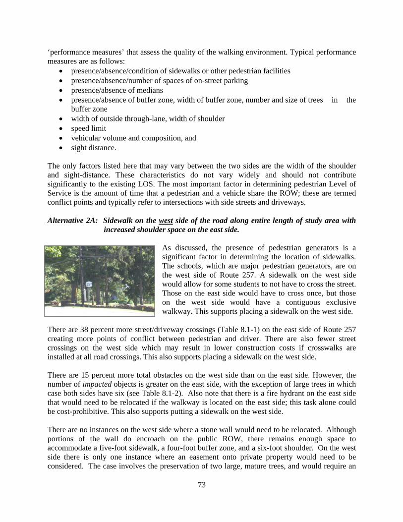
73
‘performance measures’ that assess the quality of the walking environment. Typical performance measures are as follows:
• presence/absence/condition of sidewalks or other pedestrian facilities • presence/absence/number of spaces of on-street parking • presence/absence of medians • presence/absence of buffer zone, width of buffer zone, number and size of trees in the
buffer zone • width of outside through-lane, width of shoulder • speed limit • vehicular volume and composition, and • sight distance.
The only factors listed here that may vary between the two sides are the width of the shoulder and sight-distance. These characteristics do not vary widely and should not contribute significantly to the existing LOS. The most important factor in determining pedestrian Level of Service is the amount of time that a pedestrian and a vehicle share the ROW; these are termed conflict points and typically refer to intersections with side streets and driveways. Alternative 2A: Sidewalk on the west side of the road along entire length of study area with
increased shoulder space on the east side.
As discussed, the presence of pedestrian generators is a significant factor in determining the location of sidewalks. The schools, which are major pedestrian generators, are on the west side of Route 257. A sidewalk on the west side would allow for some students to not have to cross the street. Those on the east side would have to cross once, but those on the west side would have a contiguous exclusive walkway. This supports placing a sidewalk on the west side.
There are 38 percent more street/driveway crossings (Table 8.1-1) on the east side of Route 257 creating more points of conflict between pedestrian and driver. There are also fewer street crossings on the west side which may result in lower construction costs if crosswalks are installed at all road crossings. This also supports placing a sidewalk on the west side. There are 15 percent more total obstacles on the west side than on the east side. However, the number of impacted objects is greater on the east side, with the exception of large trees in which case both sides have six (see Table 8.1-2). Also note that there is a fire hydrant on the east side that would need to be relocated if the walkway is located on the east side; this task alone could be cost-prohibitive. This also supports putting a sidewalk on the west side. There are no instances on the west side where a stone wall would need to be relocated. Although portions of the wall do encroach on the public ROW, there remains enough space to accommodate a five-foot sidewalk, a four-foot buffer zone, and a six-foot shoulder. On the west side there is only one instance where an easement onto private property would need to be considered. The case involves the preservation of two large, mature trees, and would require an
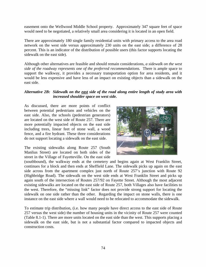
74
easement onto the Wellwood Middle School property. Approximately 347 square feet of space would need to be negotiated, a relatively small area considering it is located in an open field. There are approximately 180 single family residential units with primary access to the area road network on the west side versus approximately 230 units on the east side; a difference of 28 percent. This is an indicator of the distribution of possible users (this factor supports locating the sidewalk on the east side). Although other alternatives are feasible and should remain considerations, a sidewalk on the west side of the roadway represents one of the preferred recommendations. There is ample space to support the walkway, it provides a necessary transportation option for area residents, and it would be less expensive and have less of an impact on existing objects than a sidewalk on the east side. Alternative 2B: Sidewalk on the east side of the road along entire length of study area with
increased shoulder space on west side. As discussed, there are more points of conflict between potential pedestrians and vehicles on the east side. Also, the schools (pedestrian generators) are located on the west side of Route 257. There are more potentially impacted objects on the east side including trees, linear feet of stone wall, a wood fence, and a fire hydrant. These three considerations do not support locating a sidewalk on the east side. The existing sidewalks along Route 257 (South Manlius Street) are located on both sides of the street in the Village of Fayetteville. On the east side (southbound), the walkway ends at the cemetery and begins again at West Franklin Street, continues for a block and then ends at Sheffield Lane. The sidewalk picks up again on the east side across from the apartment complex just north of Route 257’s junction with Route 92 (Highbridge Road). The sidewalk on the west side ends at West Franklin Street and picks up again south of the intersection of Routes 257/92 on Fayette Street. Although the most adjacent existing sidewalks are located on the east side of Route 257, both Villages also have facilities to the west. Therefore, the “missing link” factor does not provide strong support for locating the sidewalk on one side rather than the other. Regarding the impact on stone walls, there is one instance on the east side where a wall would need to be relocated to accommodate the sidewalk. To estimate trip distribution, (i.e. how many people have direct access to the east side of Route 257 versus the west side) the number of housing units in the vicinity of Route 257 were counted (Table 8.1-1). There are more units located on the east side than the west. This supports placing a sidewalk on the east side, but is not a substantial factor compared to impacted objects and construction costs.

75
Locating a sidewalk on the west side of Route 257 is recommended over putting it on the east side, but is not as safe as having sidewalks on both sides. AASHTO and the New York State Highway Design Manual both agree that the primary concern with having sidewalks on only one side of an arterial is that it creates a situation where pedestrians may have to cross the street unnecessarily and without adequate facilities. A sidewalk on the west side would force fewer people to cross Route 257 than one on the east side, making it the next safest option behind sidewalks on both sides. Regardless of the location of the proposed sidewalk, crosswalks should be considered at all intersections. Intersections are the physical space in which all modes of transportation share the ROW. All traffic should be carefully managed at intersections to maximize safety. Crosswalks alone (without other enhancements, such as a pedestrian signal or a crossing guard) may or may not provide a safer crossing zone, depending on roadway classification and vehicular volumes. In this case (a 2-lane roadway with a speed limit less than or equal to 40 mph and volumes less than 9,000 ADT), marked crosswalks without enhancements should be adequate. This recommendation should be re-evaluated in the context of a Safe Routes to School Program. In addition, if any of the alternatives that would add a pedestrian facility to Route 257 are pursued by the Town, the potential need for additional marked crosswalks would have to be further examined via an engineering study so that the crosswalks and pedestrian facility adhere to the standards within the Manual on Uniform Traffic Devices (MUTCD). Considerations for Shoulder Width and Use (applies to Alternatives 2A and 2B) Increased shoulder width on the side opposite the sidewalk is not recommended. Currently, the shoulder is six feet wide, although it varies in specific locations due to pavement erosion. Six to eight feet is an adequate and recommended dimension for accommodating pedestrians and bicyclists. Although more space may add comfort to a pedestrian, widening the pavement excessively may actually decrease safety. Studies have shown that the majority of drivers adjust their speed according to visual cues as opposed to actual posted speed limits. If a roadway has wider than normal travel lanes and shoulders, and there are few objects immediately adjacent to the roadway, motorists tend to drive faster than the posted limit. To avoid this scenario, the shoulder should not be more than eight feet wide. If the roadway is relatively narrow, drivers tend to slow down. Where the shoulder is more than eight feet wide, it may need to be narrowed to six or eight feet. For example, if a stone wall pushes a proposed sidewalk closer to the roadway, the shoulder may need to be reduced. Where the shoulder has eroded to less than six feet, it is recommended to restore it to the proper width. The shoulder on the same side of the road as a sidewalk is intended to serve bicyclists. Younger or inexperienced cyclists may choose to use the sidewalk, but New York State law allows for and encourages the use of the roadway rather than the sidewalk as the proper place for cyclists (see next section for further discussion).

76
Alternative 3: Shared use path on both or one sides of Route 257 along entire length of corridor.
A shared use path is an off-road facility dedicated to non-motorist transportation. Shared use paths are designed to accommodate two-way pedestrian and bicycle traffic. AASHTO recommends a minimum width of 10 feet but a width of 12 feet is suggested in areas of high pedestrian traffic. Considering the proximity of the schools and the villages, a 12-foot wide path would be more appropriate along Route 257. Additionally, two feet of grading on both sides of the path is necessary, resulting in a total width of 16 feet. On average, the space between the edge of the shoulder and the ROW boundary is 16 feet along Route 257. If a shared use path is installed on either side of the road, there would be little to no buffer zone. Dozens of trees would need to be removed and utility pole placement would be very problematic. Design guidelines suggest if the lateral separation between the shared use facility and the edge of the shoulder is less than five feet, physical barriers such as bollards may be used to create the perception of safety for non-motorist travelers as well as alert drivers to the presence of walkers and bikers. The presence of a shared use path immediately adjacent to a roadway also presents concerns regarding bicyclists. Numerous studies have concluded that it is safer for bicyclists to ride in the roadway than on a sidewalk or other separate facility, provided they ride properly and are able-bodied. Young children, elderly, and inexperienced bicyclists are exceptions to this conclusion. New York State Vehicle Traffic Law, Article 34, declares that bicyclists are “granted all of the rights and shall be subject to all of the duties applicable to the driver of a vehicle”. National and state design manuals strongly caution against developing shared use pathways immediately adjacent to roadways. The AASHTO Guide for the Development of Bicycle Facilities provides numerous reasons for recommending against such facilities, the majority of which are related to safety. For example, bicycles on sidewalks or pathways encounter multiple conflict points with each driveway and street crossing, forcing riders and drivers to make frequent, split second right-of-way decisions. Based on safety, regulations, and physical space limitations, this alternative is not recommended. Alternative 4: Stone dust path on both or one side of Route 257 along entire length of
corridor. Construction of a stone dust path is a common alternative to a concrete or asphalt sidewalk. It is sometimes used for aesthetic reasons, as it has a more rural or rustic appearance. Similar to sidewalks, a stone dust path designed to accommodate two-way pedestrian traffic should be five feet wide or seven feet wide in school zones. ADA-compliant stone dust would have to be

77
utilized should this alternative become pursued by the Town. Per the analysis presented in Alternatives 1, 2A and 2B, a stone dust path on both sides of the road would be the safest and would accommodate the most users. If it were necessary to choose one side or the other, installation on the west side of Route 257 would be less expensive and have fewer impacted objects than the east side. Stone dust paths in general require regular maintenance as the surface material is subject to erosion and greater wear and tear than a standard sidewalk. Stone dust paths are essentially just as safe as sidewalks. This alternative is recommended for further consideration, although cost and regular maintenance may prove to offset any aesthetic advantages. The additional investment provides limited advantages over sidewalks in the context of Route 257. Alternative 5: Increased shoulder space on both sides of Route 257. The width of the shoulder along this segment of Route 257 is approximately six feet with slight variations. Although it is possible to use shoulders as pedestrian facilities, it is not recommended. “Wide shoulders on both sides of a road are the minimum requirement for providing at least a possible place for people to walk. They are not as safe as paths or sidewalks, but they are better than not providing any accommodation. Shoulders are also beneficial for motorists and bicyclists, and future sidewalks or paths should be created in addition to, not to replace the shoulders.”28 A six to eight foot shoulder is more than adequate for use as a bicycle facility (AASHTO recommends a minimum width of four feet). In areas where the shoulder is more than eight feet it should be decreased in width to six or eight feet to provide more buffer space between the roadway and the sidewalk, and in areas where the shoulder is less than six feet, it should be widened. Appropriate grading is necessary to prevent bicyclists from falling off the shoulder. The shoulder should also be clearly marked with “Bike Route” and/or “Share the Road” markings. This alternative is not recommended except in cases where the shoulder is less than six feet or requires rehabilitation. 8.2 Recommendations Oftentimes, municipal budgets require officials to develop creative solutions that meet the needs and desires of the community. In this case, in this community there is a need to safely accommodate pedestrians and bicyclists wishing to travel between the Villages of Fayetteville
28 PEDSAFE: Pedestrian Safety Guide and Countermeasure Selection System, Recommended Guidelines/Priorities for Sidewalks and Walkways, U.S. Department of Transportation Federal Highway Administration (FHWA-RD-01-102, March 2002). <http://www.walkinginfo.org/pedsafe/moreinfo_sidewalks.cfm>.
78
and Manlius. There is also a strong desire in this community to maintain the historic character of the area with its stately homes and stone walls. Compromising alternatives include a sidewalk on one side only, or a stone dust path on one side only. Alternative 0, the null alternative, and Alternative 5, widening the shoulder on both sides, do not enhance pedestrian safety and mobility; these are not recommended. A best-case scenario with respect to pedestrian safety is clearly Alternative 1 or Alternative 4 (both sides) - a sidewalk or stone dust path on the west side of Route 257. Either alternative gives a safe walkway to the largest number of people and provides safe crossings to its users. However, this option does not satisfy all the concerns set forth by the community. It will impact many more objects in the ROW compared to a sidewalk or stone dust path on only one side, and it will be nearly twice as expensive. Therefore, the compromising alternatives include those with a sidewalk or stone dust path on just one side of Route 257. A detailed analysis was conducted to examine the impact of locating a pedestrian facility on the east side of Route 257 versus the west side. Based on safety, location of pedestrian generators, and potential impacts on trees and the stone wall, if a pedestrian facility is to be located on one side of the road, the west side of Route 257 is recommended. Of the seven alternatives identified, three are recommended to the Town of Manlius for further consideration (1, 2A, and 4 both sides/west side). Brief summaries and cost estimates are provided for each of the recommended alternatives in the following section. Cross sections and maps that show the potential locations of the facilities are included at the end of this chapter.

79
8.2.1 Alternatives Recommended for Further Consideration Alternative 1: Sidewalks on both sides of the road along entire length of study area. This alternative addresses pedestrian safety by creating a comfortable buffer from vehicular traffic. Therefore placing sidewalks on both sides of Route 257 is seen as a feasible and prudent option, as well as the safest option. It also provides ample access for people walking to residences, businesses, and other pedestrian generators. A field survey and GIS analysis revealed that there is ample room for a sidewalk within the ROW throughout the corridor. A certain number of objects will be impacted, and this would have to be weighed against the benefits of having the pedestrian facility on both sides of Route 257 to serve the community. There was only one instance where an easement onto private property would need to be considered. The case involves the preservation of two large, mature trees, and would require an easement onto the Wellwood Middle School property. Approximately 347 square feet of space would need to be negotiated, a relatively small area considering it is located in an open field. Additionally, it was determined that there is only one instance where a stone wall would need to be reset out of the public ROW to accommodate the sidewalk. Approximately 125 feet of the wall would need to be moved. Cost Estimate: The total estimated project cost for placing sidewalks on both sides of Route 257 is $869,069.50. Details of the breakdown of this cost can be found in Appendix E. Sidewalk Maintenance Cost Estimate: Assuming 50 days per year for snow removal at $75 a day, the annual cost for sidewalk maintenance would be $3,750. Annual sidewalk repairs would cost approximately $1,500. Right-of-Way Acquisition Fees (for Wellwood School property): The only portion of the corridor that would potentially require the negotiation of ROW acquisition is located in front of the school property (on the west side of Route 257) across the street from Sheffield Lane. Approximately 347 square feet would need to be acquired from the school in order to build a seven-foot wide sidewalk around two large mature trees (see Map S-01). There are no structures on this part of the school property, as it is part of the front lawn that is often used as a recreational space for the schools. Land values in the Town of Manlius and the Villages of Fayetteville and Manlius typically range from $10,000 to $75,000 per acre. Conversations with local realtors indicated that a more precise range is $30,000 to $60,000. This range is based on properties that have sold recently, properties that are for sale, and the professional experience of the realtors. For the purposes of estimating ROW acquisition fees in the Route 257 corridor, a median figure of $45,000 per acre was used. This translates to $1.03 per square foot. Based on a rate of $1.03 per square foot, the 347 square feet of school property would be priced at about $358. A more conservative estimate would round that figure to $400.

80
Alternative 2A: Sidewalk on the west side of the road along entire length of study area with increased shoulder space on the east side.
Although other alternatives are feasible and should remain considerations, a sidewalk on the west side of the roadway represents the preferred recommendation. There is ample space to support the walkway, it provides a necessary transportation option for area residents, and it would be less expensive and have less of an impact on existing objects than a sidewalk on the east side. Also, increased shoulder width on the side opposite the sidewalk is not recommended. There is one instance where an easement onto private property would need to be considered. The case involves the preservation of two large, mature trees, and would require an easement onto the Wellwood Middle School property. Approximately 347 square feet of space would need to be negotiated, a relatively small area considering it is located in an open field. Cost Estimate: The total estimated project cost for placing sidewalks on the west side of Route 257 is $424,082.75. Details of the breakdown of this cost can be found in Appendix E. Sidewalk Maintenance Cost Estimate: Assuming 50 days per year for snow removal at $75 a day, the annual cost for sidewalk maintenance would be $3,750. Annual sidewalk repairs would cost approximately $1,500. Right-of-Way Acquisition Fees (for Wellwood School property): See narrative under same heading for Alternative 1 in Section 8.2.1. Alternative 4: Stone dust path on both or the west side of Route 257 along entire length of
corridor. Construction of a stone dust path is a common alternative to a concrete or asphalt sidewalk. It is sometimes used for aesthetic reasons, as it has a more rural or rustic appearance. Similar to sidewalks, a stone dust path designed to accommodate two-way pedestrian traffic should be five feet wide or seven feet wide in school zones. Per the analysis presented in Alternatives 1, 2A and 2B, a stone dust path on both sides of the road would be the safest and would accommodate the most users. If it were necessary to choose one side or the other, installation on the west side of Route 257 would be less expensive and have fewer impacted objects than the east side. Stone dust paths in general require regular maintenance as the surface material is subject to erosion and greater wear and tear than a standard sidewalk. This alternative is recommended for further consideration, although cost and regular maintenance may prove to offset any aesthetic advantages. The additional investment provides limited advantages over sidewalks in the context of Route 257. Cost Estimate (both sides): The total estimated project cost for placing a stone dust path on the both sides of Route 257 is $448,033.27. This figure includes ADA-compliant stone dust. Cost Estimate (west side): The total estimated project cost for placing a stone dust path on the west side of Route 257 is $199,321.67. This figure includes ADA-compliant stone dust.

81
Details of the breakdown of the costs for a stone dust path can be found in Appendix E. Stone Dust Maintenance Cost Estimate: Assuming approximately 5% of stone dust material would need replacement/rehabilitation every year, maintenance costs would be $20,678.46 per year. Some savings can be achieved by performing maintenance every 3-4 years vs. every year. Snow removal is not typically done on stone dust paths, hence this path would become seasonal if the Town decided to install a stone dust path. Each of these aforementioned alternatives identifies either a sidewalk or stone dust path on one or both sides of Route 257. The potential locations for each of the four alternatives for further consideration can be found on the next pages (Maps S-01, S-02 and S-03), following the sheet index map. Cross sections of two specific locations show more detail for these potential alternatives following the maps. Right-of-Way Acquisition Fees (for Wellwood School property): See narrative under same heading for Alternative 1 in Section 8.2.1.

82
Illustration I (Sheet Index Map)

8' SIDEWALK
5'S
IDE
WA
LKW.FRANKLINST
VILLAGE OFFAYETTEVILLE
WELLWOODMIDDLE SCHOOL& FAYETTEVILLE
ELEMENTARYSCHOOL
TOWN OFMANLIUS
APP
RO
X.B
OU
ND
AR
Y
VILLAGE OFFAYETTEVILLE
TOWN OFMANLIUS
AP
PR
OX
. BO
UN
DA
RY
GRANITECURBS
LIGHTPOLE
WHEELER
AVE
HENSCHKEDR
MA
TC
HTO
BE
LO
W
4' SIDEWALK
E.FRANKLINST
HEAVYBRUSH
12"
24"
SC
HO
OL
M.M
.
SC
HO
OL
Lion
sIn
tern
atio
nal
60"36"
36"
36"
12"
SC
HO
OL
TransportationD
ept.
2' HIGH STONE WALL 2' HIGH STONE WALL
M.M
.
24" 24" 24"
36"
OLDFARMRD
24"TREE
CLUMP 24"36"TREE
CLUMP
STONE WALL (HEIGHT VARIES)
36"
48"
12"
36"
M.M
.
36" 36"
STONEPEDESTAL
TR
EE
LIN
E
Do
NotD
riveO
nS
houlder
2' HIGH STONE WALL
2' HIGH STONE WALL
HOAGRD
M.M
.
HEAVY BRUSH
2' HIGH STONE WALL2' HIGH STONE WALL LINED WITH TREES
STONEPEDESTALS
6"4"4"
24"
MA
TC
HTO
S-02
TO
P
MA
TC
HTO
AB
OV
E
Deciduous Tree(w/ approx. trunk radius)
Coniferous Tree(w/ approx. trunk radius)
Shrub/Hedge
MiscellaneousLandscaping
Utility Pole
Fire Hydrant
Sign Post(w/ Sign Type)
36"
24"
Mailbox Design Professionals186 North Water St
Rochester, NY 14604
011050.00
S-01
PROJECT NUMBER
DRAWING NUMBER
LE
GE
ND
TYPICAL DIMENSIONS
16'
6'
22'
6'
16'
66'
M.M
.
Building
Existing Sidewalk
Crosswalk
StopLineStreet Name
SignCENTRO Bus Stop
Mile MarkerSign
DrivewayPost
(Shoulder Width Varies)
MA
TC
HL
INE
SYRACUSE METROPOLITAN
TRANSPORTATION COUNCIL
ROUTE 257 PEDESTRIAN ACCOMMODATION STUDY
TOWNOF MANLIUS, NEW YORK
NO SIDEWALKON EAST SIDE OFNY257 BETWEEN
FRANKLIN STAND CLINTON ST
SIDEWALKSTO SCHOOL
20%GRADE
10% GRADE
HEAVY BRUSH
4' HIGHBERM WITH
HEAVY BRUSH48"
24" 24"
24" 24"
24"
24"
TREECLUMP
TR
EE
LIN
E
SHEFFIELDLA
0 100 200 300 400 50050Feet
Cross Section A
Vill
age
ofF
aye
ttevi
lle18
44
Cross Section B
Mun
icip
alB
ound
ary
Right of Way
Road Centerline
Lane Stripe
Lane StripeEdge of Pavement
LINE TYPES
Right of Way
Edge of Pavement
Proposed Sidewalk
Granite Curb
Fence
Stone WallRelocatedStone Wall
Recommend
installing sidewalk
(outside scope
of project)
Connect school
sidewalk to
public sidewalk
(10' wide)
Install
crosswalk
Easement required to
accommodate sidewalk
(approx. 347 sq. ft.)
Remove
hedge row
& small tree Move
utility pole
Install
retaining
wall
Remove
small tree
Recommend 7' wide
sidewalk in school zone
Remove
large treeRemove
large tree
Install
crosswalk,
move stop bar
Install
crosswalks,
move stop bar
Install
crosswalk
Move
utility pole
Install
crosswalk,
move stop bar
Move
utility pole
Remove
small tree
Remove
large treeRemove
large tree
Reset stone wall
(approx. 125') Remove
large tree
Move
utility pole
LINED WITH HEAVY BRUSH
Move
utility poleRemove
stone
pedestal
Move
utility pole
Reduce shoulder
width to 6' to ensure
a 4' tree lawn
Install
crosswalk,
move stop bar
Move
fire hydrant
LINED WITH HEAVY BRUSH
Remove
small trees
Install
crosswalk

MA
TC
HTO
BE
LO
WM
AT
CH
TOS
-03
TO
P
MA
TC
HTO
AB
OV
E
SYRACUSE METROPOLITAN
TRANSPORTATION COUNCIL Deciduous Tree(w/ approx. trunk radius)
Coniferous Tree(w/ approx. trunk radius)
Shrub/Hedge
MiscellaneousLandscaping
Utility Pole
Fire Hydrant
Sign Post(w/ Sign Type)
36"
24"
Mailbox Design Professionals186 North Water St
Rochester, NY 14604
LE
GE
ND
TYPICAL DIMENSIONS
16'
6'
22'
6'
16'
66'
M.M
.
Crosswalk
StopLineStreet Name
SignCENTRO Bus Stop
Mile MarkerSign
DrivewayPost
(Shoulder Width Varies)
MA
TC
HL
INE
ROUTE 257 PEDESTRIAN ACCOMMODATION STUDY
TOWNOF MANLIUS, NEW YORK
011050.00
S-02
PROJECT NUMBER
DRAWING NUMBER
MA
TC
HTO
S-0
1B
OT
TO
M
HUNTLA
2'H
IGH
STO
NE
WA
LL
36"36"
WOOD FENCE
2' HIGH STONE WALL
M.M
.
12"
WO
OD
FEN
CE
2' HIGH STONE WALL
2' HIGH STONE WALL
2' HIGH STONE WALL
36"
Do
Not
Dri
veO
nS
houl
der
2' HIGH STONE WALL
36"
36"(POOR HEALTH)
24" 24"
2' HIGH STONE WALL
2'H
IGH
STO
NE
WA
LL
24"
4"
36" 36" 36"
M.M
.
48"(POOR HEALTH)
48"
4" 4"4" 4"
STONEHEDGELA
2'HIG
HSTO
NEW
ALL
WO
OD
FEN
CE
WOODFENCE
2' HIGH STONE WALL
36"2' HIGH STONE WALL
2' HIGH STONE WALL
36"
24" 24"
STONEPEDESTAL
WOOD FENCE BURLINGTONDR
BURLINGTONDR
MARANGALERD
4"
36"WOOD FENCE
SHERBROOKRD
36"36"
12" 6"
M.M
.
BERKSHIREDR
DE
AF
PE
RS
ON
AR
EA
DE
AF
PE
RS
ON
AR
EA
MISC.LANDSCAPING
6" SHRUB
BR
US
H&
TR
EE
S
BRUSH &TREES
4" 4" 3"
BU
SIN
ES
SS
IGN 48"
HEAVYBRUSH
6"
60"
36"WOOD FENCE
24"
SHRUBHEAVYBRUSH
M.M
.
MCDERMOTTDR
3' HIGHLANDSCAPED
MOUND BR
US
H&
TRE
ES
36"
BRUSH
&TR
EES
24"24"
12" 12"
8"
4'SID
EWALK
0 100 200 300 400 50050Feet
Building
Mun
icip
alB
ound
ary
Right of Way
Road Centerline
Lane Stripe
Lane StripeEdge of Pavement
LINE TYPES
Right of Way
Edge of PavementGranite Curb
Fence
Stone WallRelocatedStone Wall
Existing Sidewalk Proposed Sidewalk
Move
utility poles
Install
crosswalk,
move stop bar Remove
large treeRemove
large tree
Install
crosswalk,
move stop bar
Move
utility pole
Remove
large trees
2' HIGH STONE WALL
Remove
small trees
Install
crosswalks,
move stop barsInstall
crosswalk,
move stop bar
Remove
small tree
Remove
small tree
Install
crosswalk,
move stop bar
Remove
small trees
Remove
shrub
Install
crosswalk,
move stop bar
Remove
large tree

MA
TC
HTO
BE
LO
W
MA
TC
HTO
AB
OV
E
MA
TCH
TOS
-02B
OTTO
M
LAN
DSC
APED
PON
D
VILLA
GE
OF
MA
NLIU
S
1813
M.M
.
60"
HEAVY BRUSH WOOD FENCE
WOOD FENCE
WO
OD
FE
NC
E
2"
TREE LINE
VILLA
GE
OF
MA
NL
IUS
(MIS
C.R
EG
UL
AT
ION
S)
PO
LICE
KELLYDR
Do
Not
Dri
veO
nS
houl
der
24" SHRUBSHRUB
6"
WOOD FENCE 24"24"
M.M
.
4"
VILLAGE OFMANLIUS
TOWN OFMANLIUS APPROX. BOUNDARY
VILLAGE OFMANLIUS
TOWN OFMANLIUS
APPROX. BOUNDARY
APARTMENT COMPLEX PARKING
APARTMENTCOMPLEX
BANK
BANKPARKING
VILLAGE OF
MANLIUS
TOWN OF
MANLIUS
APPROX.BOUNDARY
FIR
EH
OU
SE
LIGHTPOLE
36"36"
6"
GATEWAYLANDSCAPING
& SIGN
6"
STICKLEYDR
2.5' WIDEASPHALT
SIDEWALK4' SIDEWALK
SYRACUSE METROPOLITANTRANSPORTATION COUNCIL Deciduous Tree
(w/ approx. trunk radius)
Coniferous Tree(w/ approx. trunk radius)
Shrub/Hedge
MiscellaneousLandscaping
Utility Pole
Fire Hydrant
Sign Post(w/ Sign Type)
36"
24"
Mailbox Design Professionals186 North Water St
Rochester, NY 14604
LE
GE
ND
TYPICAL DIMENSIONS
16'
6'
22'
6'
16'
66'
M.M
.
Crosswalk
StopLineStreet Name
SignCENTRO Bus Stop
Mile MarkerSign
DrivewayPost
(Shoulder Width Varies)
ROUTE 257 PEDESTRIAN ACCOMMODATION STUDY
TOWNOF MANLIUS, NEW YORK
011050.00
S-03
PROJECT NUMBER
DRAWING NUMBER
MA
TC
HL
INE
GRANITE CURB
GRANITE CURB
0 100 200 300 400 50050Feet
GRANITE CURB
GRANITE CURB
GRANITE CURB
GR
AN
ITEC
UR
B
4' SIDEWALK
4' SIDEWALK
4' SIDEWALK
HIGHBRIDGERD
FAYETTE ST
2.5' WIDEASPHALT
SIDEWALK
PARKINGLOT
GRANITE CURB
Building
Existing Sidewalk
Mun
icip
alB
ound
ary
Right of Way
Road Centerline
Lane Stripe
Lane StripeEdge of Pavement
LINE TYPES
Right of Way
Edge of Pavement
Proposed Sidewalk
Granite Curb
Fence
Stone WallRelocatedStone Wall
Remove hedge row,move wood fence
Removesmall tree
Removehedge row
Installcrosswalk,move stop bar
Removesmall tree
Removelarge tree
Moveutility pole
Moveutility pole
Recommendwideningsidewalk to 5'
Installcrosswalks,move stop bars

86
CROSS SECTION LOCATIONS
Location B, showing sidewalks/stone dust path on both sides
Location A, showing sidewalks/stone dust path on both sides

87
Location A, Cross Section 2 - Alternative 1 & Alternative 4 (both sides)
Location A, Cross Section 1 - Existing Conditions
CROSS SECTIONS (see cross section locations identified on previous page)

88
CROSS SECTIONS (cont’d)
Location A, Cross Section 4 - Alternative 2B (east side) & Alternative 4 (east side)
Location A, Cross Section 3 - Alternative 2A (west side) & Alternative 4 (west side)
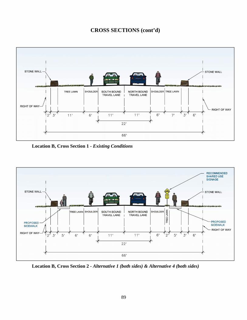
89
Location B, Cross Section 1 - Existing Conditions
Location B, Cross Section 2 - Alternative 1 (both sides) & Alternative 4 (both sides)
CROSS SECTIONS (cont’d)

90
Location B, Cross Section 3 - Alternative 2A (west side) & Alternative 4 (west side)
Location B, Cross Section 4 - Alternative 2B (east side) & Alternative 4 (east side)
CROSS SECTIONS (cont’d)

91
Chapter 9 – Preliminary Implementation Plan
Alternative pedestrian options recommended from Chapter 8 are included on the next pages in a tabular format including some corridor wide improvements based on the issues noted within Chapter 7 as well as public input. This preliminary implementation plan of the study’s recommendations includes potential time frames (i.e., short and medium/long term) for completion, potential range of costs and potential responsible agencies. Table 9-1 presents a preliminary plan of implementation for recommended improvements discussed in Chapter 8, as well as for improvements relating to issues identified in Chapter 7. Programmed short-term actions (0-5 years) would include additional planning, community education, and enforcement activities along the corridor, as well as lower cost capital projects to improve mobility and access along Route 257. Medium/long-term actions (5-10 years and beyond), if determined to be financially feasible, would focus on installation of a pedestrian accommodation and associated upgrades/maintenance efforts. A range of recommendations was developed for addressing the various items identified. Where applicable and appropriate, these recommendations are grouped/classified according to the associated level of effort and/or capital investment necessary for implementation, as follows:
• Low, meaning items primarily associated with management, enforcement, or procedures; • Medium, indicating a middle range of effort, such as larger measures of management or
enforcement, possible further examination through more detailed or focused future studies, and/or lower cost capital investments; and
• High, indicating a major change of policy, regulations, and/or high level of capital investment and time for approvals/funding.

92
Table 9-1 Preliminary Implementation Plan
Action
Range of Costs
Potential Responsible Agencies
Short-Term (0 to 5 years)
Refresh corridor-wide pavement markings (Route 257 and side streets)
Low NYSDOT, Town of Manlius
Replace existing school pedestrian signage with bright yellow green fluorescent signs to improve visibility
Low NYSDOT
Improve existing pavement, sidewalks, and the ramp that are in fair condition
Low NYSDOT, Town of Manlius
Establish a priority list of potential projects for Safe Routes to Schools funding and/or establish a Safe Routes to School Program
Low Town of Manlius, F-M School District
Consider establishing a school Transportation Safety Committee to work on transportation issues/concerns of students and their parents
Low F-M School District
Continued monitoring of speed and education of motorists relative to speeding, especially during school year
Low Town of Manlius Police Department
Examine the possibility of constructing lead walks & shelters at key locations
Medium CNYRTA
Examine possibility of consolidation of transit stops Medium CNYRTA Consider installation of Deer Warning signs (over half of the reported accidents were vehicle/deer collisions)
Low NYSDOT
Consider installation of sign at Wheeler Ave./Route 257 pointing children to school crosswalk/crossing guard at intersection of Franklin St./Route 257
Low NYSDOT
Replace Bike Route signs with Share the Road signs along the corridor
Low NYSDOT
Replacement of sewer grates so that the grooves run perpendicular to bicycle travel
Low NYSDOT
Conduct a study to examine the traffic flow during school arrival/dismissal times (queued traffic is created along Franklin Street and extends onto Route 257 by parents/guardians trying to access the school parking lot to pick up their children at Wellwood Middle School)
Medium F-M School District, Town of Manlius, NYSDOT, SMTC
Medium/Long Term (5 to 10 years and beyond) Thoroughly examine drainage implications to any potential construction projects completed within corridor
Medium NYSDOT
Maintain and upgrade pedestrian facilities as necessary
Low-Medium NYSDOT, Town of Manlius
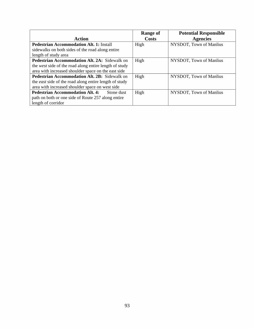
93
Action
Range of Costs
Potential Responsible Agencies
Pedestrian Accommodation Alt. 1: Install sidewalks on both sides of the road along entire length of study area
High NYSDOT, Town of Manlius
Pedestrian Accommodation Alt. 2A: Sidewalk on the west side of the road along entire length of study area with increased shoulder space on the east side
High NYSDOT, Town of Manlius
Pedestrian Accommodation Alt. 2B: Sidewalk on the east side of the road along entire length of study area with increased shoulder space on west side
High NYSDOT, Town of Manlius
Pedestrian Accommodation Alt. 4: Stone dust path on both or one side of Route 257 along entire length of corridor
High NYSDOT, Town of Manlius
94
Chapter 10 – General Funding Opportunities
Various monetary resources for assisting a community with the development of a pedestrian accommodation are briefly mentioned. Further research by the Town may show that other funding sources beyond those highlighted below are available for pedestrian related projects, such as community development grants and other state or federal grants. Transportation Improvement Program
The Transportation Improvement Program (TIP) is the agreed-upon list of specific projects for which federal funds are anticipated. Required by federal law, the TIP represents the transportation improvement priorities of the Syracuse Metropolitan Area. The list of projects is multimodal and includes highway and public transit projects, as well as bicycle, pedestrian, and freight-related projects.
The TIP also represents the translation of recommendations from the SMTC’s Long-Range Transportation Plan (LRTP) and Unified Planning Work Program (UPWP) into a short-term program of tangible transportation improvements. All TIP projects are evaluated to assure consistency with the community goals and objectives established in the LRTP. The majority of projects in the TIP are aimed at increasing the efficiency and safety of the existing transportation system, rather than construction of new facilities (adding capacity). In addition, all TIP projects must be in conformance with air quality requirements. Representing the culmination of the transportation planning process, the TIP signifies regional agreement on the priority of the project, and establishes eligibility for federal funding.
Transportation Enhancement Program
The Transportation Enhancement Programs was first established in the Intermodal Surface Transportation Efficiency Act of 1991 (ISTEA), then carried over in the Transportation Equity Act for the 21st Century and (TEA-21) and most recently continued in the latest transportation legislation, the Safe, Accountable, Flexible, Efficient Transportation Equity Act: A Legacy for Users (SAFETEA-LU).
Through the TEP, innovative opportunities to improve the transportation system through the implementation of a specific list of activities intended to benefit the traveling public, increase transportation choices and access, enhance the built and natural environment, and provide a sense of place. Transportation enhancement activities offer communities funding opportunities to help expand transportation choices such as safe bicycle and pedestrian facilities, scenic routes, beautification and other investment that increase recreation, accessibility, and safety for everyone beyond traditional highway programs.29 For more information on the TEP for New York State, please visit: http://www.enhancements.org/profile_search.asp.
29 Transportation Enhancements Program Guidebook for Applicants and Sponsors, New York State Department of Transportation, Rev 4/2006, pg.1.

95
For the latest transportation enhancement cycle, three projects within the SMTC MPA have been selected to receive federal funding. The projects include:
1. Oneida River Lighthouse Park – This project is sponsored by the Town of Hastings, and will receive $188,000 in SAFETEA-LU transportation enhancement funds. The project will “provide for a public area/park around the Canal lighthouse, one of only three lighthouses on the entire NYS Canal System”.30
2. Nine Mile Creek Aqueduct Restoration Project – This project is sponsored by the Town
of Camillus, and will receive $1 million in SAFETEA-LU transportation enhancement funds. The project involves the “restoration of Nine Mile Creek Aqueduct to an operable condition and upgrading the condition of approximately one mile of canal bed between Warners Road and the aqueduct structure”.31
3. Erie Canal Museum Interpretive Center – This project is sponsored by the Onondaga
County Department of Transportation on behalf of the Erie Canal Museum in Syracuse, NY. The project will receive $1.2 million in SAFETEA-LU transportation enhancement funds. The enhancement allocation will be utilized for Phase 1 of the project; purchase of a vacant building and make “interior renovations in preparation for installation of new leading edge exhibitions”.32
In the last Transportation Enhancement cycle three municipalities in the SMTC MPO area received federal Transportation Enhancement funding to begin work on constructing trails in their jurisdictions. The Town of Lysander plans to being work on constructing a trail by fall 2007/spring 2008 that will begin at the Village of Baldwinsville’s North Shore Trail and Village Center Walk, connect through Town neighborhoods along the Seneca River, and tie to the Onondaga Lake Trail at Long Branch Park. The Village of Baldwinsville and Village of Marcellus also each received Transportation Enhancement funding that will be used to complete similar trails in their jurisdictions. The South Shore East Trail project in the Village of Baldwinsville is moving forward as the Village has been working on putting easements together. As an aside, Baldwinsville’s north Shore East portion of the trail was recently completed. The Village of Marcellus’s Nine Mile Creek Walk is making progress as the Village is now going back to the architect for the final Creek Walk drawings. These trails could also eventually connect to the larger Canalway Trail. Safe Routes to School The Safe Routes to School Program (SRTS) is a Federal-Aid program of the U.S. Department of Transportation's Federal Highway Administration (FHWA). The Program was created by Section 1404 of SAFETEA-LU. The SRTS Program is funded at $612 million over five Federal fiscal years (FY 2005-2009) and is to be administered by State Departments of Transportation (DOTs).
The Program provides funds to the States to substantially improve the ability of primary and middle school students to walk and bicycle to school safely. The purposes of the program are: 30 Project Application for Oneida River Lighthouse Park. Town of Hastings. Pg. 6. June 30, 2006. 31 Nine Mile Creek Aqueduct Restoration Project. Town of Camillus. Pg. 6. June 2006. 32 Erie Canal Museum Interpretive Center Project Application. Erie Canal Museum. Pg. 4. June 2006.
96
1. to enable and encourage children, including those with disabilities, to walk and bicycle to school;
2. to make bicycling and walking to school a safer and more appealing transportation alternative, thereby encouraging a healthy and active lifestyle from an early age; and
3. to facilitate the planning, development, and implementation of projects and activities that will improve safety and reduce traffic, fuel consumption, and air pollution in the vicinity (approximately 2 miles) of primary and middle schools (Grades K-8).33
NYSDOT is just beginning to develop an application for municipalities to apply for this funding. There is $32 Million ($612 M nationwide) available for NYS between 2005 and 2009. At the time of printing of this document, NYSDOT plans to have just one round of applications so that larger projects can be accomplished. Currently the plan is to distribute the $32 Million money to each of the eleven NYSDOT Regions based on a pro-rated share of the K-8 student population, as well as on individual project needs. Municipalities that apply will have to front the money but will be reimbursed should their project be chosen.
The SRTS program in New York State will consist of both infrastructure and non-infrastructure project types. Infrastructure projects could range from sidewalks, crosswalk installation, and shared use paths among others. Non-infrastructure projects relate to educational opportunities and enforcement. For further details on the SRTS program, please refer to the web site listed at the bottom of the page and the NYSDOT program guidance once it becomes available.
As noted above in the program purposes, the funds may only be utilized on projects within a two mile radius of a primary or middle school. The federal guidelines also state that any school which houses grades K-12 or 7-12 are also eligible for project submittal. If SRTS funds were sought after around Wellwood Elementary and Fayetteville Middle School the entire Route 257 study area could conceivably implement projects. We highly recommend that the Town, in cooperation with the F-M School District, look into this program Locally Funded The Town of Manlius could also choose to utilize Town funds (via taxes, a sidewalk district or some other local funding mechanism) to build a pedestrian facility along Route 257. This decision would clearly need to be made at the Town level. As noted in this Chapter, there are several funding mechanisms available to the Town of Manlius should the decision to construct a pedestrian facility along Route 257 between the Villages of Fayetteville and Manlius be made.
33 Federal Highway Administration, Safe Routes to School Overview, <http://safety.fhwa.dot.gov/saferoutes/overview.htm> (8/2006).
Related Documents