1 | Page FAROOK COLLEGE (AUTONOMOUS) P.O FAROOK COLLEGE, KOZHIKODE Regulations, Scheme of Evaluation, Course Structure and Syllabus for M.Sc. Integrated Programme in Geology (Core) with Chemistry and Physics (Allied Cores) (2020 Admission onwards) For Postgraduate (Integrated 5 years programme) Curriculum 2020-21 (FCCBCSS INT-PG -2020-21) Board of Studies in Geology Farook College (Autonomous), Kozhikode March 2021

Welcome message from author
This document is posted to help you gain knowledge. Please leave a comment to let me know what you think about it! Share it to your friends and learn new things together.
Transcript
1 | P a g e
FAROOK COLLEGE (AUTONOMOUS)
P.O FAROOK COLLEGE, KOZHIKODE
Regulations, Scheme of Evaluation, Course Structure and Syllabus for
M.Sc. Integrated Programme
in
Geology (Core)
with
Chemistry and Physics (Allied Cores)
(2020 Admission onwards)
For Postgraduate (Integrated 5 years programme) Curriculum 2020-21
(FCCBCSS INT-PG -2020-21)
Board of Studies in Geology
Farook College (Autonomous), Kozhikode
March 2021
CERTIFICATE
Thereby certify that the documents attached are the bona fide copies of the syllabus of
M.Sc. (Integrated) Geology Programme to be effective from the academic year 2020-
21 onwards.
SE.AU CALICUT 673 632 FARBUCEOELEGE
FAROOK COLLEGE (AUTONOMOUS)
Farook College. P. O.(Calicut) 0.F
Date
Place: Farook College (Autonomous), Kozhikode
21 Page
3 | P a g e
Farook College (Autonomous), Kozhikode Scheme of Postgraduate (M.Sc. Integrated, 5 years) Programme in Geology
Rules, Regulations, and Syllabus
1. TITLE
These regulations shall be called “Farook College (Autonomous), Kozhikode”
Regulations for Postgraduate (Integrated 5 years programme) Curriculum 2020-21
(FCCBCSS INT-PG-2020-21).
2. SCOPE, APPLICATION & COMMENCEMENT
The regulations provided herein shall apply to M.Sc. Integrated course in Geology at
Farook College Autonomous under Faculty of Science conducted by the Farook
College autonomous for the admissions commencing from 2021, with effect from the
academic year 2020-2021. Every programme conducted under the Choice Based Credit
and Semester System in the College shall be monitored by the College Council.
3. ADMISSION
Registration and admission to the M.Sc. Integrated programme in Geology will be as
per the rules and regulations of the University of Calicut. Minimum qualification for
the admission is a pass in higher secondary degree (10+2 Science scheme/ equivalent)
or qualifications announced by the University from time to time.
The applicants for M.Sc. Integrated Course will be ranked as follows:
Total marks obtained for Part III Optional at the Higher Secondary or equivalent level
plus highest marks scored for any one of the subsidiaries among Physics/
Chemistry/Computer Science/Mathematics/Geology/Biology. In the case of a tie,
preference shall be given as per the following order:
1) Candidates with Geology as optional subject
2) Marks for Geology
3) Marks for Chemistry
4) Marks for Physics
5) Marks for Mathematics
6) Marks for Computer Science
7) Alphabetical Order of the applicants
(U.O No. GAI/JI/4440/99(2) Dated 13-05-2004)
4. PROGRAMME STRUCTURE
Duration of the programme shall be ten semesters distributed in a period of five years.
Each semester consists of a minimum of 18 weeks, (16 instructional weeks and two
weeks for examination). The odd (1, 3, 5,7,9) semesters shall be from June to October
and even (2, 4, 6,8,10) semesters shall be from November to March.
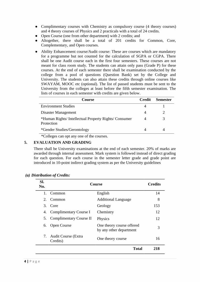
The programme shall include five types of courses, viz, Common Courses (Code A),
Core courses (Code B), Complimentary courses (Code C), Open Course (Code D) and
Audit courses (Code E).
● Common Courses (4 theory) with 22 credits (14 for common English courses + 8
for common languages other than English)
● Core courses (25 Theory, 11 Practical, 7 Elective theory, and 2 Projects and 2 Field
Training and a field mapping camp) with a total credits of 153.
4 | P a g e
● Complimentary courses with Chemistry as compulsory course (4 theory courses)
and 4 theory courses of Physics and 2 practicals with a total of 24 credits.
● Open Course (one from other department) with 2 credits; and
● Altogether, there shall be a total of 201 credits for Common, Core,
Complementary, and Open courses.
● Ability Enhancement course/Audit course: These are courses which are mandatory
for a programme but not counted for the calculation of SGPA or CGPA. There
shall be one Audit course each in the first four semesters. These courses are not
meant for class room study. The students can attain only pass (Grade P) for these
courses. At the end of each semester there shall be examination conducted by the
college from a pool of questions (Question Bank) set by the College and
University. The students can also attain these credits through online courses like
SWAYAM, MOOC etc (optional). The list of passed students must be sent to the
University from the colleges at least before the fifth semester examination. The
lists of courses in each semester with credits are given below.
Course Credit Semester
Environment Studies 4 1
Disaster Management 4 2
*Human Rights/ Intellectual Property Rights/ Consumer
Protection
4 3
*Gender Studies/Gerontology 4 4
*Colleges can opt any one of the courses.
5. EVALUATION AND GRADING
There shall be University examinations at the end of each semester. 20% of marks are
awarded through internal assessment. Mark system is followed instead of direct grading
for each question. For each course in the semester letter grade and grade point are
introduced in 10-point indirect grading system as per the University guidelines
(a) Distribution of Credits:
Sl.
No. Course Credits
1. Common English 14
2. Common Additional Language 8
3. Core Geology 153
4. Complimentary Course I Chemistry 12
5. Complimentary Course II Physics 12
6. Open Course One theory course offered
by any other department 3
7. Audit Course (Extra
Credits) One theory course 16
Total 218
5 | P a g e
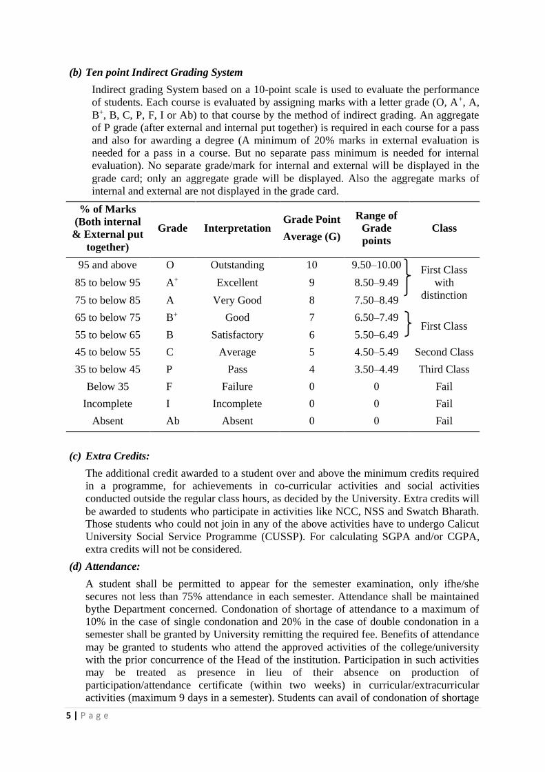
(b) Ten point Indirect Grading System
Indirect grading System based on a 10-point scale is used to evaluate the performance
of students. Each course is evaluated by assigning marks with a letter grade (O, A+, A,
B+, B, C, P, F, I or Ab) to that course by the method of indirect grading. An aggregate
of P grade (after external and internal put together) is required in each course for a pass
and also for awarding a degree (A minimum of 20% marks in external evaluation is
needed for a pass in a course. But no separate pass minimum is needed for internal
evaluation). No separate grade/mark for internal and external will be displayed in the
grade card; only an aggregate grade will be displayed. Also the aggregate marks of
internal and external are not displayed in the grade card.
% of Marks
(Both internal
& External put
together)
Grade Interpretation Grade Point
Average (G)
Range of
Grade
points
Class
95 and above O Outstanding 10 9.50–10.00 First Class
with
distinction
85 to below 95 A+ Excellent 9 8.50–9.49
75 to below 85 A Very Good 8 7.50–8.49
65 to below 75 B+ Good 7 6.50–7.49 First Class
55 to below 65 B Satisfactory 6 5.50–6.49
45 to below 55 C Average 5 4.50–5.49 Second Class
35 to below 45 P Pass 4 3.50–4.49 Third Class
Below 35 F Failure 0 0 Fail
Incomplete I Incomplete 0 0 Fail
Absent Ab Absent 0 0 Fail
(c) Extra Credits:
The additional credit awarded to a student over and above the minimum credits required
in a programme, for achievements in co-curricular activities and social activities
conducted outside the regular class hours, as decided by the University. Extra credits will
be awarded to students who participate in activities like NCC, NSS and Swatch Bharath.
Those students who could not join in any of the above activities have to undergo Calicut
University Social Service Programme (CUSSP). For calculating SGPA and/or CGPA,
extra credits will not be considered.
(d) Attendance:
A student shall be permitted to appear for the semester examination, only ifhe/she
secures not less than 75% attendance in each semester. Attendance shall be maintained
bythe Department concerned. Condonation of shortage of attendance to a maximum of
10% in the case of single condonation and 20% in the case of double condonation in a
semester shall be granted by University remitting the required fee. Benefits of attendance
may be granted to students who attend the approved activities of the college/university
with the prior concurrence of the Head of the institution. Participation in such activities
may be treated as presence in lieu of their absence on production of
participation/attendance certificate (within two weeks) in curricular/extracurricular
activities (maximum 9 days in a semester). Students can avail of condonation of shortage
6 | P a g e
of attendance in a maximum of four semesters during the entire programme (Either four
single condonations or one double condonation and two single condonations during the
entire programme). If a student fails to get 65% attendance, he/she can move to the next
semester only if he/she acquires 50% attendance. In that case, a provisional registration
is needed. Such students can appear for supplementary examination for such semesters
after the completion of the programme. Less than 50% attendance requires Readmission.
Readmission is permitted only once during the entire programme.
(e) Grace Marks:
Grace marks may be awarded to a student for meritorious achievements in co-curricular
activities (in Sports/Arts/NSS/NCC/Student Entrepreneurship) carried out besides the
regular hours. Such a benefit is applicable and limited to a maximum of 8 courses in an
academic year spreading over two semesters. In addition, maximum of 6 marks per
semester can be awarded to the students of UG Programmes, for participating in the
College Fitness Education Programme (COFE).
(f) Improvement course:
Improvement of a particular semester can be done only once. The student shall avail of
the improvement chance in the succeeding year after the successful completion of the
semester concerned. The students can improve a maximum of two courses in a
particular semester. The internal marks already obtained will be carried forward to
determine the new grade/mark in the improvement examination. If the candidate fails to
appear for the improvement examination after registration, or if there is no change in
the results of the improved examination, the mark/grade obtained in the first appearance
will be retained. Improvement and supplementary examinations cannot be done
simultaneously.
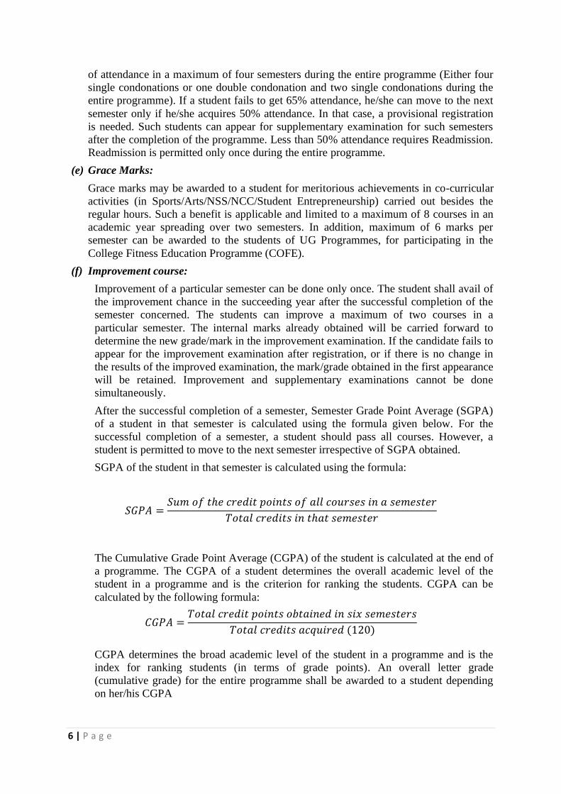
After the successful completion of a semester, Semester Grade Point Average (SGPA)
of a student in that semester is calculated using the formula given below. For the
successful completion of a semester, a student should pass all courses. However, a
student is permitted to move to the next semester irrespective of SGPA obtained.
SGPA of the student in that semester is calculated using the formula:
𝑆𝐺𝑃𝐴 =𝑆𝑢𝑚 𝑜𝑓 𝑡ℎ𝑒 𝑐𝑟𝑒𝑑𝑖𝑡 𝑝𝑜𝑖𝑛𝑡𝑠 𝑜𝑓 𝑎𝑙𝑙 𝑐𝑜𝑢𝑟𝑠𝑒𝑠 𝑖𝑛 𝑎 𝑠𝑒𝑚𝑒𝑠𝑡𝑒𝑟
𝑇𝑜𝑡𝑎𝑙 𝑐𝑟𝑒𝑑𝑖𝑡𝑠 𝑖𝑛 𝑡ℎ𝑎𝑡 𝑠𝑒𝑚𝑒𝑠𝑡𝑒𝑟
The Cumulative Grade Point Average (CGPA) of the student is calculated at the end of
a programme. The CGPA of a student determines the overall academic level of the
student in a programme and is the criterion for ranking the students. CGPA can be
calculated by the following formula:
𝐶𝐺𝑃𝐴 =𝑇𝑜𝑡𝑎𝑙 𝑐𝑟𝑒𝑑𝑖𝑡 𝑝𝑜𝑖𝑛𝑡𝑠 𝑜𝑏𝑡𝑎𝑖𝑛𝑒𝑑 𝑖𝑛 𝑠𝑖𝑥 𝑠𝑒𝑚𝑒𝑠𝑡𝑒𝑟𝑠
𝑇𝑜𝑡𝑎𝑙 𝑐𝑟𝑒𝑑𝑖𝑡𝑠 𝑎𝑐𝑞𝑢𝑖𝑟𝑒𝑑 (120)
CGPA determines the broad academic level of the student in a programme and is the
index for ranking students (in terms of grade points). An overall letter grade
(cumulative grade) for the entire programme shall be awarded to a student depending
on her/his CGPA
7 | P a g e
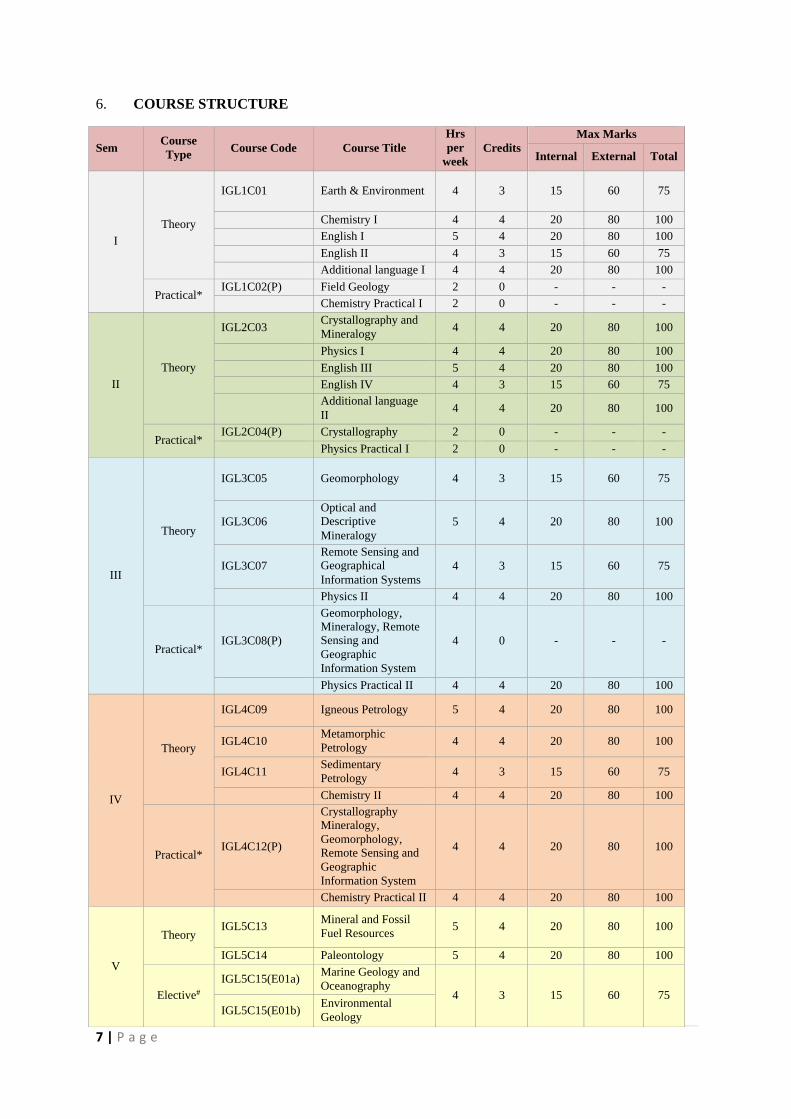
6. COURSE STRUCTURE
Sem Course
Type Course Code Course Title
Hrs
per
week
Credits
Max Marks
Internal External Total
I
Theory
IGL1C01 Earth & Environment 4 3 15 60 75
Chemistry I 4 4 20 80 100
English I 5 4 20 80 100
English II 4 3 15 60 75
Additional language I 4 4 20 80 100
Practical* IGL1C02(P) Field Geology 2 0 - - -
Chemistry Practical I 2 0 - - -
II
Theory
IGL2C03 Crystallography and
Mineralogy 4 4 20 80 100
Physics I 4 4 20 80 100
English III 5 4 20 80 100
English IV 4 3 15 60 75
Additional language
II 4 4 20 80 100
Practical* IGL2C04(P) Crystallography 2 0 - - -
Physics Practical I 2 0 - - -
III
Theory
IGL3C05 Geomorphology 4 3 15 60 75
IGL3C06
Optical and
Descriptive
Mineralogy
5 4 20 80 100
IGL3C07
Remote Sensing and
Geographical
Information Systems
4 3 15 60 75
Physics II 4 4 20 80 100
Practical* IGL3C08(P)
Geomorphology,
Mineralogy, Remote
Sensing and
Geographic
Information System
4 0 - - -
Physics Practical II 4 4 20 80 100
IV
Theory
IGL4C09 Igneous Petrology 5 4 20 80 100
IGL4C10 Metamorphic
Petrology 4 4 20 80 100
IGL4C11 Sedimentary
Petrology 4 3 15 60 75
Chemistry II 4 4 20 80 100
Practical* IGL4C12(P)
Crystallography
Mineralogy,
Geomorphology,
Remote Sensing and
Geographic
Information System
4 4 20 80 100
Chemistry Practical II 4 4 20 80 100
V
Theory IGL5C13
Mineral and Fossil
Fuel Resources 5 4 20 80 100
IGL5C14 Paleontology 5 4 20 80 100
Elective#
IGL5C15(E01a) Marine Geology and
Oceanography 4 3 15 60 75
IGL5C15(E01b) Environmental
Geology
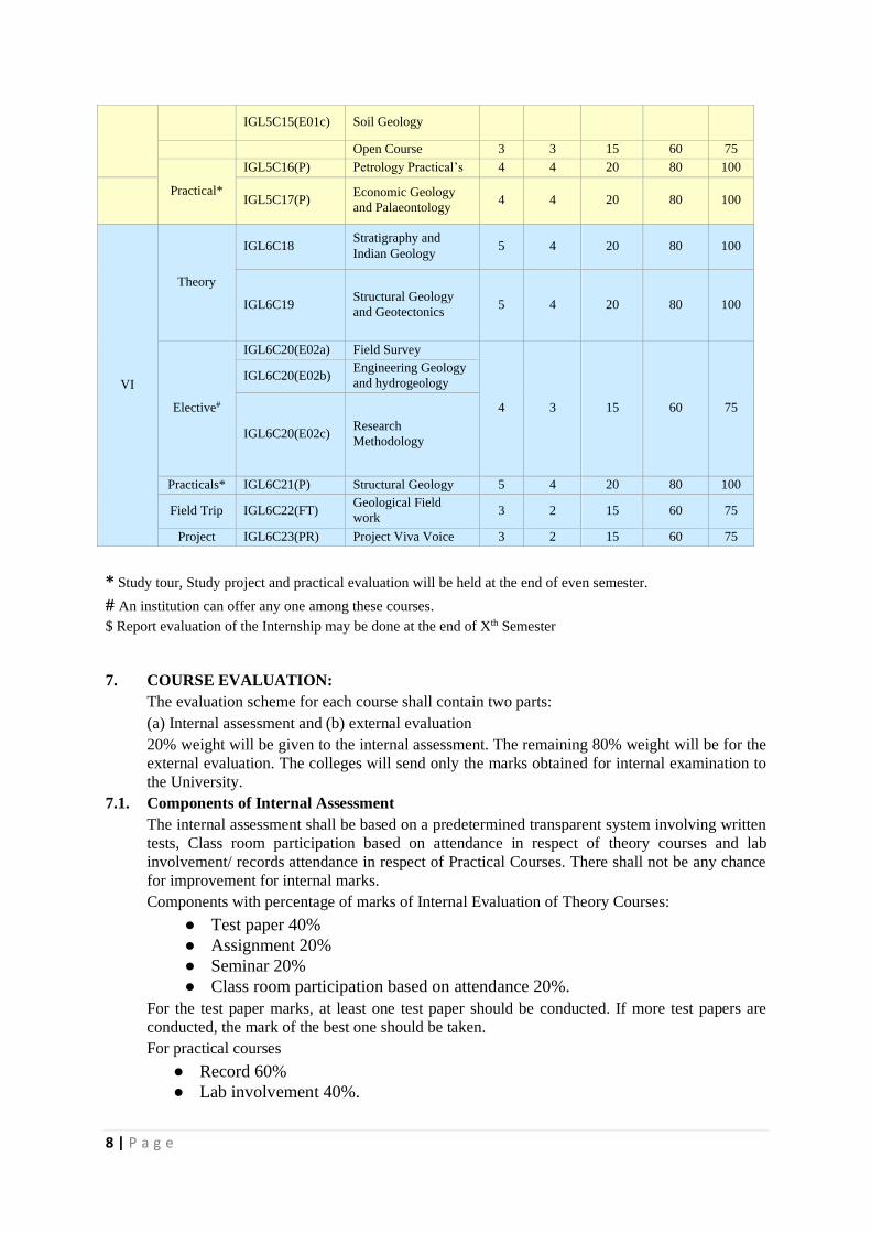
8 | P a g e
* Study tour, Study project and practical evaluation will be held at the end of even semester.
# An institution can offer any one among these courses.
$ Report evaluation of the Internship may be done at the end of Xth Semester
7. COURSE EVALUATION:
The evaluation scheme for each course shall contain two parts:
(a) Internal assessment and (b) external evaluation
20% weight will be given to the internal assessment. The remaining 80% weight will be for the
external evaluation. The colleges will send only the marks obtained for internal examination to
the University.
7.1. Components of Internal Assessment
The internal assessment shall be based on a predetermined transparent system involving written
tests, Class room participation based on attendance in respect of theory courses and lab
involvement/ records attendance in respect of Practical Courses. There shall not be any chance
for improvement for internal marks.
Components with percentage of marks of Internal Evaluation of Theory Courses:
● Test paper 40%
● Assignment 20%
● Seminar 20%
● Class room participation based on attendance 20%.
For the test paper marks, at least one test paper should be conducted. If more test papers are
conducted, the mark of the best one should be taken.
For practical courses
● Record 60%
● Lab involvement 40%.
IGL5C15(E01c) Soil Geology
Open Course 3 3 15 60 75
Practical*
IGL5C16(P) Petrology Practical’s 4 4 20 80 100
IGL5C17(P) Economic Geology
and Palaeontology 4 4 20 80 100
VI
Theory
IGL6C18 Stratigraphy and
Indian Geology 5 4 20 80 100
IGL6C19 Structural Geology
and Geotectonics 5 4 20 80 100
Elective#
IGL6C20(E02a) Field Survey
4 3 15 60 75
IGL6C20(E02b) Engineering Geology
and hydrogeology
IGL6C20(E02c) Research
Methodology
Practicals* IGL6C21(P) Structural Geology 5 4 20 80 100
Field Trip IGL6C22(FT) Geological Field
work 3 2 15 60 75
Project IGL6C23(PR) Project Viva Voice 3 2 15 60 75
9 | P a g e
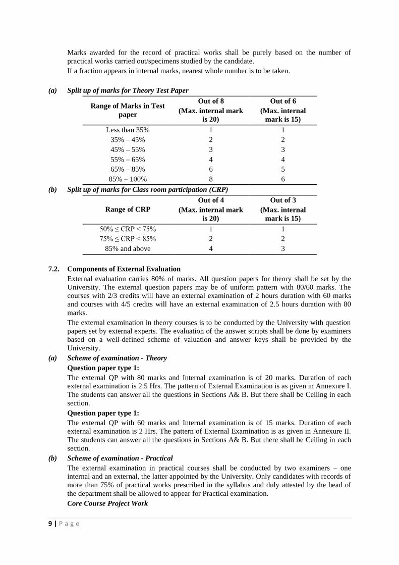
Marks awarded for the record of practical works shall be purely based on the number of
practical works carried out/specimens studied by the candidate.
If a fraction appears in internal marks, nearest whole number is to be taken.
(a) Split up of marks for Theory Test Paper
Range of Marks in Test
paper
Out of 8
(Max. internal mark
is 20)
Out of 6
(Max. internal
mark is 15)
Less than 35% 1 1
35% – 45% 2 2
45% – 55% 3 3
55% – 65% 4 4
65% – 85% 6 5
85% – 100% 8 6
(b) Split up of marks for Class room participation (CRP)
Range of CRP
Out of 4
(Max. internal mark
is 20)
Out of 3
(Max. internal
mark is 15)
50% ≤ CRP < 75% 1 1
75% ≤ CRP < 85% 2 2
85% and above 4 3
7.2. Components of External Evaluation
External evaluation carries 80% of marks. All question papers for theory shall be set by the
University. The external question papers may be of uniform pattern with 80/60 marks. The
courses with 2/3 credits will have an external examination of 2 hours duration with 60 marks
and courses with 4/5 credits will have an external examination of 2.5 hours duration with 80
marks.
The external examination in theory courses is to be conducted by the University with question
papers set by external experts. The evaluation of the answer scripts shall be done by examiners
based on a well-defined scheme of valuation and answer keys shall be provided by the
University.
(a) Scheme of examination - Theory
Question paper type 1:
The external QP with 80 marks and Internal examination is of 20 marks. Duration of each
external examination is 2.5 Hrs. The pattern of External Examination is as given in Annexure I.
The students can answer all the questions in Sections A& B. But there shall be Ceiling in each
section.
Question paper type 1:
The external QP with 60 marks and Internal examination is of 15 marks. Duration of each
external examination is 2 Hrs. The pattern of External Examination is as given in Annexure II.
The students can answer all the questions in Sections A& B. But there shall be Ceiling in each
section.
(b) Scheme of examination - Practical
The external examination in practical courses shall be conducted by two examiners – one
internal and an external, the latter appointed by the University. Only candidates with records of
more than 75% of practical works prescribed in the syllabus and duly attested by the head of
the department shall be allowed to appear for Practical examination.
Core Course Project Work
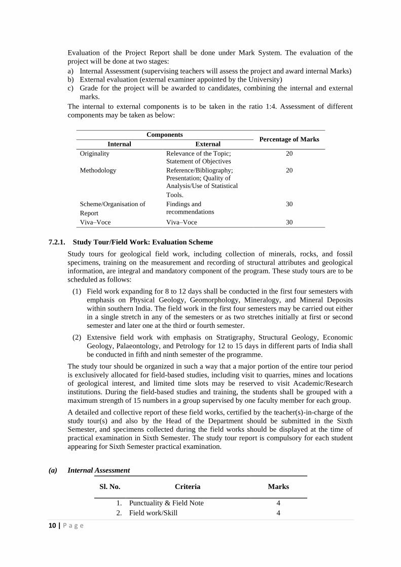
10 | P a g e
Evaluation of the Project Report shall be done under Mark System. The evaluation of the
project will be done at two stages:
a) Internal Assessment (supervising teachers will assess the project and award internal Marks)
b) External evaluation (external examiner appointed by the University)
c) Grade for the project will be awarded to candidates, combining the internal and external
marks.
The internal to external components is to be taken in the ratio 1:4. Assessment of different
components may be taken as below:
Components Percentage of Marks
Internal External
Originality Relevance of the Topic;
Statement of Objectives
20
Methodology Reference/Bibliography;
Presentation; Quality of
Analysis/Use of Statistical
Tools.
20
Scheme/Organisation of
Report
Findings and
recommendations
30
Viva–Voce Viva–Voce 30
7.2.1. Study Tour/Field Work: Evaluation Scheme
Study tours for geological field work, including collection of minerals, rocks, and fossil
specimens, training on the measurement and recording of structural attributes and geological
information, are integral and mandatory component of the program. These study tours are to be
scheduled as follows:
(1) Field work expanding for 8 to 12 days shall be conducted in the first four semesters with
emphasis on Physical Geology, Geomorphology, Mineralogy, and Mineral Deposits
within southern India. The field work in the first four semesters may be carried out either
in a single stretch in any of the semesters or as two stretches initially at first or second
semester and later one at the third or fourth semester.
(2) Extensive field work with emphasis on Stratigraphy, Structural Geology, Economic
Geology, Palaeontology, and Petrology for 12 to 15 days in different parts of India shall
be conducted in fifth and ninth semester of the programme.
The study tour should be organized in such a way that a major portion of the entire tour period
is exclusively allocated for field-based studies, including visit to quarries, mines and locations
of geological interest, and limited time slots may be reserved to visit Academic/Research
institutions. During the field-based studies and training, the students shall be grouped with a
maximum strength of 15 numbers in a group supervised by one faculty member for each group.
A detailed and collective report of these field works, certified by the teacher(s)-in-charge of the
study tour(s) and also by the Head of the Department should be submitted in the Sixth
Semester, and specimens collected during the field works should be displayed at the time of
practical examination in Sixth Semester. The study tour report is compulsory for each student
appearing for Sixth Semester practical examination.
(a) Internal Assessment
Sl. No. Criteria Marks
1. Punctuality & Field Note 4
2. Field work/Skill 4

11 | P a g e
3. Specimen collection 6
4. Viva-Voce 6
Total 20
(b) External Evaluation
Sl. No. Criteria Marks
1. Study Tour Report 20
2. Specimen Display 20
3. Presentation/Viva-Voce 40
Total 80
12 | P a g e
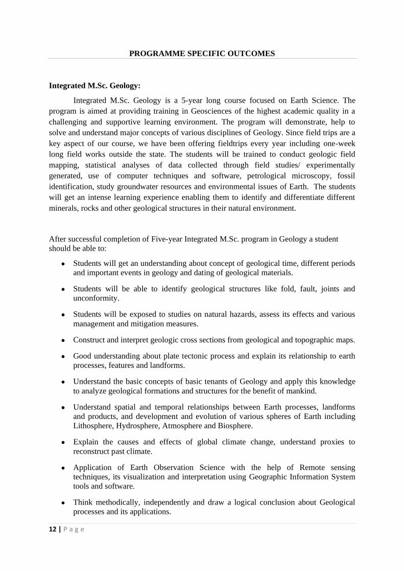
PROGRAMME SPECIFIC OUTCOMES
Integrated M.Sc. Geology:
Integrated M.Sc. Geology is a 5-year long course focused on Earth Science. The
program is aimed at providing training in Geosciences of the highest academic quality in a
challenging and supportive learning environment. The program will demonstrate, help to
solve and understand major concepts of various disciplines of Geology. Since field trips are a
key aspect of our course, we have been offering fieldtrips every year including one-week
long field works outside the state. The students will be trained to conduct geologic field
mapping, statistical analyses of data collected through field studies/ experimentally
generated, use of computer techniques and software, petrological microscopy, fossil
identification, study groundwater resources and environmental issues of Earth. The students
will get an intense learning experience enabling them to identify and differentiate different
minerals, rocks and other geological structures in their natural environment.
After successful completion of Five-year Integrated M.Sc. program in Geology a student
should be able to:
● Students will get an understanding about concept of geological time, different periods
and important events in geology and dating of geological materials.
● Students will be able to identify geological structures like fold, fault, joints and
unconformity.
● Students will be exposed to studies on natural hazards, assess its effects and various
management and mitigation measures.
● Construct and interpret geologic cross sections from geological and topographic maps.
● Good understanding about plate tectonic process and explain its relationship to earth
processes, features and landforms.
● Understand the basic concepts of basic tenants of Geology and apply this knowledge
to analyze geological formations and structures for the benefit of mankind.
● Understand spatial and temporal relationships between Earth processes, landforms
and products, and development and evolution of various spheres of Earth including
Lithosphere, Hydrosphere, Atmosphere and Biosphere.
● Explain the causes and effects of global climate change, understand proxies to
reconstruct past climate.
● Application of Earth Observation Science with the help of Remote sensing
techniques, its visualization and interpretation using Geographic Information System
tools and software.
● Think methodically, independently and draw a logical conclusion about Geological
processes and its applications.
13 | P a g e
● Employ critical thinking and the scientific knowledge in solving geological issues by
carrying out field studies, record field observations, design and use of laboratory
analyses, interpret results and prepare scientific/ technical reports and its presentation.
● Lead the team to create awareness about the importance of Geoscience on the
environment and society, importance of conservation and sustainability of its
resources.
14 | P a g e
CORE COURSE: GEOLOGY
(THEORY)
15 | P a g e
IGL1C01 –EARTH AND ENVIRONMENT
Credit: 3 Total Hours: 64
Course Outcome
Students will be able to understand about
CO1: Basic knowledge about the subject and Planet Earth
CO2: Basic knowledge about minerals and Rocks
CO3: Basic knowledge about structural features
CO4: Basic knowledge about Natural Hazards
CO5: Knowledge about earthquakes and Volcanoes
Unit 1
● Geology and its perspective
● Origin of Planets- Nebular hypothesis, Planetesimal hypothesis, Gaseous-Tidal
Hypothesis; Binary star
● Earth in relation to solar system, size, shape, mass, density and its development.
● Age of the Earth – Determination of Earth’s age, - Radioactive methods and Non-
radioactive methods.
● Plate Tectonics: The Discovery of Plate Tectonics, The Mosaic of Plates, Rates and
History of Plate Motions, The Grand Reconstruction, The Engine of Plate Tectonics.
● Geological Time scale: Eons; Eras; Periods; and Epochs
Unit 2
● Minerals: A brief introduction to minerals, The Atomic Structure of Minerals. Rock-
Forming Minerals, Physical properties of Minerals.
● Rocks: Types of rocks - brief introduction to Igneous, sedimentary and metamorphic
rocks; Concept of rock cycle, Rock and Fossil Record
Unit 3
● Brief Introduction about Folds, Faults, and other Records of Rock Deformation,
Evolution of the Continents
● Elementary ideas about outcrops, dip, strike, outlier, inlier and overlap
Unit 4
● Natural Hazards: Volcanism, Earthquakes, Tsunamis, Landslide Issues relating to
prediction, protection and mitigation. Landscape - Tectonic and Climate Interaction
Unit 5
● Volcanoes – Classification based on Lava Types; Styles of Eruptions – Products -
Global Distribution; Causes; Effects; Prediction
● Classification of mountains, Isostasy – Airy Theory, Pratt Theory, Heiskanen’s Theory
● Earthquakes – Properties of seismic waves; Magnitude and Intensity – Ritcher and
Mercalli’s Scales; Seismogram and Seismograph. Origin, distribution and prediction of
earthquakes. Tsunami – Origin and effects.

16 | P a g e
Reference:-
1. Frank Press Raymond Siever: Understanding Earth (3rd ed). W.H. Freeman and Company.
New York. 2000
2. Skinner B. J. and Porter S.C: The Dynamic Earth – An Introduction to Physical Geology
3rd edition. John Wiley & Sons, New York. 1995
3. P. McL. D. Duff : Holme’s Principles of Physical Geology (4th ed). Chapman & Hall.
London. 1996
4. Cox A. & Hart R.B.: Plate Tectonics How it works. Blackwell Scientific Publ. Co. Boston.
1986.
5. Philip A. Allen.: Earth Surface Processes Blackwell Sciences Ltd, Oxford. 1997
6. Murck B.W., Skinner B.J & Porter S.C.: Dangerous Earth – An Introduction to Geologic
Hazards John Wiley & Sons New York. 1996
7. Condie, K.C.: Earth as an Evolving Planetary System, 3rd Edition, Academic Press, USA.
2015
8. Marshak, S.: Earth: Portrait of a Planet. W.W. Norton & Co., Inc., USA. 2001
9. Tarbuck, E.J. and Lutgens, F.K.: Earth: An Introduction to Physical Geology. 9th Edition,
Pearson Education, Inc., New Jersey, USA. 2008
10. Wicander, R. and Monroe, J.: Essentials of Geology. 4th Edition, Thomson Learning Inc.,
USA. 2006
17 | P a g e
IGL2C02-CRYSTALLOGRAPHY AND MINERALOGY
Credit: 4 Total Hours: 64
Course outcome:
Students will be able to understand
CO1: Basics of mineralogy and crystallography helps in building the overall knowledge in
Geology .
CO2: Identify face, form, Axis, symmetry and laws of crystallography.
CO3: To recognize and calculate Miller indices of crystallographic planes & directions.
CO4: Describe different symmetry class and morphological forms present in particular
symmetry class.
CO5: Define mineral and describe physical properties and optical properties of given
minerals.
CO6: Describe physical and optical properties of a given mineral group.
CO7: Polymorphism, pseudomorphism, isomorphism and solid solution.
Unit 1:
● Crystallography – A brief introduction to scope and its applications.
● Nature of crystals; crystalline and amorphous materials; polycrystalline materials; a
brief introduction to Crystal systems.
● Morphological characters of crystal – faces, forms, edges solid angles Interfacial
angle
● Symmetry elements – crystallographic axes, crystal notation, parameter
system of Weiss and Miller indices, axial ratio.
● Laws of crystallography – law of constancy of symmetry, law of constancy
of interfacial angles, law of rational indices.
● Classification of crystals into systems and classes – Holohedral, Hemihedral,
Hemimorphic and Enantiomorphic forms in crystals.
Unit 2:
● Study of the symmetry elements and forms of the Normal, pyritohedral,
tetrahedral and plagiohedral classes of cubic system with special reference to
well-developed crystals of Galena, Spinel, Garnet, Flourite, Diamond,
Pyrite, Tetrahedrite, Boracite and cuprite.
● Study of symmetry elements and forms of Normal, Hemimorphic,
Tripyramidal, Sphenoidal and Trapezphedral classes of Tetragonal system.
● Study of the symmetry elements and forms of Normal, Hemimorphic,
Tripyramidal, Trapezohedral, Rhombohedral, Rhombohedral Hemimorphic
and Trapezohedral classes of Hexagonal system.
Unit 3:
● Study of the symmetry elements and forms of the Normal and Sphenoidal
18 | P a g e
classes of the Orthorhombic system.
● Study of the symmetry elements and forms of the Normal classes of the
Monoclinic and Triclinic systems.
● Twin crystals – Definitions – Effects of Twinning – laws of twinning –
composition plane, twinning plane and twinning axis, indices of twins –
simple and repeated (polysynthetic twins), contact and penetration twins:
secondary twins.
Unit 4:
● Definition of Mineral and Mineraloid – Scope and aim of Mineralogy.
● Crystal Coordination - the making of minerals
● Classification and structural diversity of silicate minerals
Unit 5:
● Compositional variation and coupled ionic substitution, Isomorphism,
Polymorphism, Pseudomorphism, solid solution and ex- solution in
minerals.
● Physical properties of minerals Form, colour, streak, luster, Hardness,
Cleavage, Fracture, Specific Gravity, Tenacity, transparency, Electrical and
Magnetic properties- pyro and piezo electricity, Ferri-, Para-, and
Diamagnetism.
Reference:-
1. Borchardt-Ott, W: Crystallography– An Introduction. Springer Heidelberg, 355p,
2011
2. Dana F.S: A Text Book of Mineralogy. Asia publishing House, Wiley, 1955
3. Klen C., Hurlbut C.S.: Manual of Minerology, John Wiley & Sons, 1985.
4. Perkins D.:Mineralogy. Pearson Education (3Ed), 568 p,2015.
19 | P a g e
IGL3C05- GEOMORPHOLOGY
Credit: 3 Total Hours: 64
Unit–1:
• Introduction: Fundamental concepts; Cycle of erosion; Base level.
• Weathering: Factors influencing weathering Types - Physical: Expansion, crystal
growth, thermal expansion, organic activity, colloidal plucking. Chemical: Hydration,
hydrolysis, oxidation, carbonation and solution.
• Products of Weathering, Soil and Soil Profile
• Mass wasting: Conditions favouring mass wasting: lithology, stratigraphy, structure,
topography, climate, organism etc. Slow flowage: creep, solifluction Rapid flowage:
Earthflow, Mudflow, Debris avalanche Landslides: slump, slide, fall.
Unit-2:
• Running water as a geological agent: Development of a typical stream-Drainage
system consequent and subsequent streams - Drainage basin- Drainage Pattern-
Geological work of stream, erosional and depositional fluvial landforms, Concept of
base level, Peneplanation, Monadnocks, Stream terrace, Rejuvenation, Knick Point,
Entrenched meanders.
• Geological work of wind. Erosional and depositional landforms. Loess, types of dunes,
Pedi planation, playas and inselbergs. Formation of deserts.
Unit-3:
• Glaciers- Formation of glaciers- Types- Movements-Erosional and depositional
landforms, Glacier landforms, glacial ages.
• Underground water: occurrence, zone of aeration & saturation, Water table, Perched
water table, porosity, permeability, Aquifers- confined and unconfined, aquicludes,
aquitard and aquifuge. Artesian wells, Geyser and springs. Erosional and depositional
landscapes produced by action of ground water.
• Origin of limestone caverns-Stalactite and stalagmites. Karst topography: Terra rosa,
lapies, sinkholes, blind valley, caverns, stalactites and stalagmites, natural bridge,
tunnel.
Unit 4
• Oceans and Seas: Waves, tides and currents. Geological work of oceans. Classification
of shore line and Coast, Shore line types, description of continental margins,
Continental Shelf-Continental slope submarine canyons- sea mount-Guyots, midocean
ridges, trenches.
• Coral reefs – types and origin.
• Lakes and its types
Unit 5
• Field methodologies in Geology– Topographic Maps and its uses – Instruments –
Clinometer, Brunton compass, Map Symbols, Toposheets, GPS, Aerial Photographs,
Satellite imageries
20 | P a g e
References: -
1. Thornbury W.D. 1984, Principles of Geomorphology, First Willey Eastern Reprint, New
Delhi.
2. Frank Press and Raymond Siever 1998, Earth (4th Edition) W.H. Freeman & Co., San
Francisco.
3. Avery T. E and Berlin G. L, 1992, Fundamentals of remote sensing and Air photo
interpretation. McMillion Publishing Co., New York.
4. Pitty A.F., 1971, Introduction to geomorphology, Methuen, London.
5. PandeyS. N. 1987 Principles and Applications of Photogeology, Wiley Eastern
6. Lo, C.P. and Yeung, A.K.W., 2007. Concepts and Techniques in Geographic Information
Systems.
7. Tarbuck, E.J. and Lutgens, F.K., 2008. Earth: An Introduction to Physical Geology. 9th
Edition, Pearson Education, Inc., New Jersey, USA.
8. Wicander, R. and Monroe, J., 2006. Essentials of Geology. 4th Edition, Thomson Learning
Inc., USA.
21 | P a g e
IGL3C06-OPTICAL AND DESCRIPTIVE MINERALOGY
Credit: 4 Total Hours: 80
Course outcome :
Students will be able to understand
CO1: The physics of how light interacts with minerals.
CO2: Petrological microscope, isotropic and anisotropic minerals;
CO3: Uniaxial and biaxial indicatrices;
CO4: Optical properties in relation to indicatrices absorption and pleochroism, extinction,
birefringence; Interference figures
Unit 1:
● Nature of light – Ordinary and polarized light; Refraction and reflection;
Refractive index, Critical angle and Total internal reflection.
● Double refraction – Plane Polarization by Reflection; Plane polarization by
Refraction; Nicol Prism; Plane polarization by absorption.
● Petrological microscope and its parts
● Isotropic and anisotropic minerals - Optical properties.
Unit 2:
● Characters of Uniaxial and biaxial minerals – Optic axis and optic axial
angle; Acute and Obtuse Bisectrix; Optic sign of Uniaxial and Biaxial
minerals; Uniaxial and Biaxial Indicatrix; Sign of elongation.
● Extinction – Types, angles, determination, and applications in mineral
identification.
● Optical accessories and uses – Quartz wedge (Determination of order of
Interference Colour), Gypsum plate and Mica plate (Determination of Fast
and Slow vibration directions).
Unit 3:
● Structure, Chemistry, Optical and Physical properties, Modes of occurrence
and uses of the following groups of minerals: Olivine, Garnet, Epidote ,
Aluminium silicates, Pyroxene, and Amphibole.
Unit 4:
● Structure, Chemistry, Optical and Physical properties, Modes of occurrence
and uses of the following groups of minerals: Mica, Chlorite, Polymorph
and varieties of Quartz, Feldspars, Feldspathoids and Spinel.
Unit 5:
● Chemistry, Optical and Physical properties, Modes of occurrences and
industrial uses of the following minerals: Scapolite, Cordierite, Talc,
Serpentine, Steatite, Calcite, Dolomite, Topaz, Staurolite, Beryl,
Tourmaline, Fluorite, Apatite, Zircon, Rutile, Sphene, Zeolites and
Corundum.
22 | P a g e
Reference :-
1. Dyar M.D., Gunter, M.E.:Mineralogy and Optical Mineralogy. Min. Soc.
America, 705p, 2007.
2. Nesse W.D.: Introduction to Optical Mineralogy. Oxford University Press; 4
edition, 384p, 2012.
3. Pichler H., Riegraf C.S.: Rock-forming Minerals in Thin Section. Springer, 220 p,
2011.
4. Deer W.A., Howie R.A., Zussman J.: Introduction to the Rock-forming
Minerals. Mineralogical Society of Great Britain & Ireland,510p, 2013
23 | P a g e
IGL3C07-REMOTE SENSING AND GEOGRAPHIC INFORMATION
SYSTEM
Credit: 3 Total Hours: 64
Unit 1
● History and development of Remote Sensing. Basic concepts and principles of Remote
Sensing.
● Introduction to electromagnetic radiation and electromagnetic spectrum. Interaction of
EMR with objects and Atmosphere.
● Passive and Active remote sensing. Platforms and Sensors. Different resolutions
concepts, pixel size and scale.
Unit 2
● Introduction to the basics of aerial photography and photogrammetry
● Introduction to GPS, Orbit elements, Types of orbits, Motions of planets and satellites
● Satellites and their characteristics, Sun synchronous and geo-synchronous satellites,
basics of visual interpretation of satellite images and their keys.
Unit 3
● Brief history of GIS; Introduction to GIS – definition, concepts and components of
GIS,Geospatial data type
● GIS system, GIS science and GIS applications; Definition of map, different types of
thematic maps, scale
● Geographic coordinate system, Datum; Types of map projections; Commonly used
map projections; Projected Coordinate System.
Unit 4
● Visualization of geographical data, Basic ideas about data visualization, Geo-
referencing, Maps and cartographic communication.
● Digital representation of geographic data: Data structure, spatial data model, raster and
vector models. Comparison of raster and Vector data.
Unit 5
● GIS Data Management: GIS File Data Formats-Vector Data File Formats and Raster
Data File Formats
● Database design - editing and topology creation in GIS, linkage between spatial and
non-spatial data
● Database Management System, Types of data management system;
24 | P a g e
Reference Books:
1. Drury S.A. 1987. Image interpretation in Geology. Chapman and Hall.
2. Gupta R.P. 1991 Remote Sensing Geology. Springer-Verlag.
3. Lillisand, T. M. and Keifer, R. W., 2007 : Remote sensing and image interpretation John
Willey and Sons, USA
4.Chang.T.K. 2002: Geographic Information Systems. Tata McGrawHill
5. Heywood.I, Cornelius S and CrverSteve. 2003: An Introduction to Geographical
Information Systems. Pearson Education
6. Wise S.2002: GIS Basics. Taylor Publications
7.ESRI Map book: GIS the Language of Geography by ESRI-USA ESRI-2004
25 | P a g e
IGL4C09-IGNEOUS PETROLOGY
Credit: 4 Total Hours: 80
Course outcome:
Students will be able to understand about
CO1: Important structures and textures of igneous rocks.
CO2: Different classifications of igneous rocks.
CO3: Reasons for diversity in igneous rocks.
CO4: Crystallization behaviour and petrogenetic significance of magmas.
CO5: Different rock types their Mineralogy, classification and occurrence
Unit 1
• Composition and constitution of magmas – Primary and Parental Magmas.
• Forms of Intrusive igneous rocks: Concordant forms - Sill, Laccolith, Lopolith
and Phacolith, Discordant forms - Dykes, Cone Sheets, Volcanic neck, Ring
dyke, Batholiths, Stocks, Bosses and bysmaliths.
• Forms of Extrusive igneous rocks: Lava flows, Pyroclastic deposits -
Agglomerate, Lapilli, volcanic ash and volcanic froth.
Unit 2
• Structures: vesicular and Amygdaloidal structures – block lava – Ropy lava –
pillow structure – flow structure – sheet joints- mural jointing – columnar
jointing – rift and grain.
• Textures: Definition and description - crystallinity: crystallites and microlites –
Devitrification – Granularity – shapes of crystals, mutual relations –
Equigranular textures: allotriomorphic hypidiomorphic, Panidiomorphic.
inequigranular Textures: porphyritic and Intergrowth texture – Trachytic
texture – Intergrowth texture structures orbicular structure Spherulitic structure
– Perlitic fracture. , Directive textures, Overgrowth textures, Reaction textures -
Micro Structures
Unit 3
• Classification: bases of classification – Genetic classification – classification
based on colour index – based on the proportion of Alkali to plagioclase
feldspars-based on silica saturation – based on alumina saturation –
• A short account of CIPW classification , Normative minerals, salic and femic
groups – Merits and defects of CIPW classification
• Tyrrel’s tabular classification- IUGS classification.
Unit 4
• Crystallization of Unicomponent magma
• Crystallization and petrogenetic significance of Binary magmas: Diopside –
Anorthite Eutectic system, Albite – Anorthite Solid-Solution system, Forsterite
– Silica incongruent melting system and Ab- Or system.
• Reaction principle and Bowen’s reaction series - Causes for the diversity of
Igneous rocks – Magmatic Differentiation: Fractional Crystallization, Liquid
immiscibility, Assimilation
26 | P a g e
Unit 5
• Study of Texture, Mineralogy, Classification, and Modes of occurrence of
Granite, Granodiorite, Syenite, Diorite, Gabbro with their hypabyssal and
volcanic equivalents.
• Petrographic characters and origin of Pegmatites, Lamprophyres, Alkaline
rocks, Dunite, Peridotite and Anorthosites
Reference :-
● Frost, B.R., Frost, C.D., 2014. Essentials of Igneous and Metamorphic
Petrology. Cambridge University Pres. 318 p.
● Raymond, L.A., 2002. Petrology: The Study of Igneous, Sedimentary and
Metamorphic Rocks, 720p.
● Winter, J.D., 2009. Principles of Igneous and Metamorphic Petrology. Pearson, 720 p.
27 | P a g e
IGL4C10-METAMORPHIC PETROLOGY
Credit: 4 Total Hours: 64
Course outcome:
Students will be able to understand about
CO1: Identify and define basic concept, factors and types of metamorphism
CO2: Identify different structures and textures of metamorphic rocks
CO3: Different metamorphic grades and facies
CO4: Apprehend petrography and origin of various metamorphic rocks
Unit 1:
• Metamorphism – Definition; limits of metamorphism (low and high T/P limits and
influence of water and bulk compositions on metamorphic limits).
• Variables of metamorphism – temperature, lithostatic pressure, deviatoric stress,
fluids.
• Types of metamorphism – classification based on the principal agents (thermal,
dynamic, dynamo-thermal, hydrothermal); based on geological setting – contact,
shock, high-strain, regional (burial, ocean-ridge, orogenic); based on plate tectonic
setting – metamorphism at convergent, divergent, and transform plate margins.
• Fault-zone and impact metamorphism
Unit 2:
• Classification of metamorphic rocks: foliated and lineated; non-foliated and non-
lineated; specific rock groups (Quartzite, Greenstone, Amphibolite, Serpentinite, Calc-
silicate, Skarn)
• Metamorphic structures – fabric, layer, foliation, schistosity, cleavage, gneissosity,
lineations.
• Metamorphic textures – augen, cataclastic, corona, decussate, epitaxial, flaser,
granoblastic, lepidoblastic, megacrystic, nematoblastic, poikiloblastic,
porphyroblastic, strain shadow, symplectite, and relict textures.
• Equilibrium mineral assemblages; Introduction to chemographic diagrams: ACF, AKF
Diagrams
Unit 3:
• Metamorphic grades and isograds; mineral zones and Barrowian sequence;
• Metamorphic facies – zeolite, prehnite-pumpellyite, greenschist, epidote-amphibolite,
amphibolite, granulite, blueschist, eclogite, and contact metamorphic facies
• Facies series and plate tectonics – paired metamorphic belts.
Unit 4:
• Metamorphic effects on – argillaceous (medium P-T Barrovian); calcareous (contact
metamorphism); basic igneous (regional metamorphism) rocks
• Petrography and origin of slate, phyllite, chlorite schist, kyanite schist, biotite schist,
biotite gneiss, hornblende gneiss, amphibolite, marble, charnockite, eclogite, and
mylonite
Unit 5:
• Prograde and retrograde metamorphism
28 | P a g e
• Nature of metamorphic fluids and metasomatism
• Anatexis and migmatites; metamorphic differentiation
References:
● Barker, A.J., 1990. Introduction to Metamorphic Textures and Microstructures.
Blackie, 162p.
● Bucher, K. and Grapes, R., 2011. Petrogenesis of Metamorphic Rocks. Springer-
Verlag, Berlin-Heidelberg, 428p.
● Frost, C.D., Frost, B.R, 2013. Essentials of Igneous and Metamorphic Petrology,
Cambridge University Press, 336p.
● Kretz, R., 1994. Metamorphic Crystallization. John Wiley & Sons, 507p.
● Miyashiro, A., 1978. Metamorphism and Metamorphic Belts. 3rd
Edition. George
Allen & Unwin, London, 492p.
● Vernon, R.H. and Clarke, G.L., 2008. Principles of Metamorphic Petrology.
Cambridge University Press, 446p.
1. Winter, J.D., 2011. Principles of Igneous and Metamorphic Petrology, Prentice-
Hall, 728p.
29 | P a g e
IGL4C11-SEDIMENTARY PETROLOGY
Credit: 3 Total Hours: 64
Course outcome:
Students will be able to understand about
CO1: Broad classification of sedimentary rocks.
CO2: Sedimentary structures and textures.
CO3: Different rock types their Mineralogy, classification and origin
Unit 1
● Origin of sediments
● Weathering and sedimentary flux: Physical and chemical weathering,
● Soils and paleosols.
Unit 2:
● Sediment granulometry, Grain size scale, particle size distribution, Environmental
connotation; particle shape and fabric
Unit 3:
● Sedimentary textures, structures and environment Fluid flow, sediment transport and
sedimentary structures:
● Types of fluids, Laminar vs. turbulent flow, Particle entrainment, transport and
deposition.
● Paleocurrent analysis- Paleocurrents for different sedimentary environments
Sedimentary structure- Primary and syn-sedimentary structures
Unit 4:
● Varieties of sedimentary rocks
● Siliciclastic rocks: Conglomerates, sandstones and its classification, mudrocks.
● Carbonate rocks, controls of carbonate deposition, components and classification of
limestone, dolomite and dolomitisation
Unit 5:
● Diagenesis Concepts of diagenesis Stages of diagenesis Compaction and cementation.
References
1. Prothero, D. R., & Schwab, F. 2004. Sedimentary geology. Macmillan.
2. Tucker, M. E. 2006 Sedimenary Petrology, Blackwell Publishing.
3. Collinson, J. D. & Thompson, D. B. 1988 Sedimentary structures, Unwin- Hyman, London.
4. Nichols, G. 2009. Sedimentology and Stratigraphy Second Edition. Wiley Blackwell
30 | P a g e
IGL5C13- MINERAL AND FOSSIL FUEL RESOURCES
Credit: 4 Total Hours:80
Course outcome:
Students will be able to understand about
CO1 - Classification of different mineral deposits in earth.
CO2 - How prevailing geological features controls ore deposition and also serve as tools to
find hidden treasure
CO3 – Formation of mineral deposits.
CO4 - Mineral deposits of India
CO5 - The formation and different aspects related to Coal, crude oil and natural gas
Unit 1
● Historical development of economic Geology.
● Geochemical distribution of elements.
● Materials of mineral deposits – ore minerals, gangue minerals, tenor and grade of ores,
ore shoots and bonanzas.
● Classification of mineral deposits. Outline of Lindgren’s and Bateman’s classification-
Syngenetic and epigenetic deposits.
● Controls of ore localization – structural, stratigraphic, physical and chemical.
● Brief study of metallogenic epochs and provinces – geologic thermometers.
Unit 2
● Magmatic processes. – mode of formation – Early magmatic processes and deposits,
disseminations, segregations and injections – Late magmatic processes and deposits –
Residual liquid segregation and injection – immiscible liquid segregation and injection
– sublimation.
● Contact Metasomatic processes – the process and effects – resulting mineral deposits.
● Hydrothermal processes – principles – Factors affecting deposition – wall rock
alteration – minerals sequence – cavity filling deposits Fissure veins, shear – zone,
stock-work, saddle reef, ladder vein, fold cracks, breccia filling, solution cavities, pore
space and vesicular filling – replacement deposits- process and deposits – criteria of
replacement.
Unit 3
● Sedimentary processes and cycles – principles involved in sedimentation – cycles of
Iron and manganese
● Weathering processes – principles- Residual concentration process and deposits –
mechanical concentration principles – eluvial, alluvial, beach and eolian placers.
● Oxidation and supergene sulphide enrichment – solution and deposition in the zone of
oxidation – secondary sulphide enrichments – Gossans and capping.
● Metamorphic processes – Formation of Graphite, Asbestos, Talc, Soapstone and
31 | P a g e
Sillimanite group of minerals.
Unit 4
● Diagnostic physical properties, chemical composition, uses, modes of occurrence and
distribution in India of the following:
1) Economic Minerals- Gold, Silver, Copper, Lead, Zinc, Iron, Manganese, Chromium, Tin,
Aluminium
2) Radioactive metals - Thorium, Uranium, Titanium.
3) Industrial Minerals- Asbestos, Barite, Graphite, Gypsum and Mica.
4) Abrasives- Diamond, Corundum, Emery garnet, Abrasive sand, Tripoli, Pumice, Sand
feldspar, Limestone, Clay, Talc etc.
5) Refractories- fireclay, graphite, Dolomite and sillimanite group of minerals, diaspore,
pyrophillite, zircon etc
6) Ceramic minerals- Clay, Feldspar, Wollastonite,
7) Gemstones.
UNIT 5
● Fossil fuels – coal and lignite – uses, classification, constitution, origin and
distribution in India.
● Petroleum- composition, uses, theories of origin, oil traps, and important oil fields of
India.
● A brief account of mineral deposits in Kerala.
● Significance of minerals in the National Economy. Strategic, critical and essential
minerals.
References:
1. Gokhale and Rao. 1973. Ore deposits of India. Thomson Press (India), Publication
Division, Delhi
2. Mead. L.Jensen and Alan M.Bateman. 1981. Economic Mineral Deposits. John Wiley and
Sons, New York
3. Krishnaswamy, S. 1972. Indian Mineral Resources. Oxford & IBH Pub. Co. New Delhi
4. Park C. F and Macdiarmid. 1964. Ore deposits. W.H. Freeman and CO
6. Umeshwar Prasad. 2006. Economic geology. CBS Publishers, New Delhi
32 | P a g e
IGL5C14– PALAEONTOLOGY
Credit: 4 Total Hours: 80
Course outcome:
Students will be able to understand about
CO1: Different methods of fossil preservation and uses of fossils
CO2: Morphology, classification and importance of foraminifera
CO3: Morphology, classification of different Phylum – Coelenterate, Hemichordata,
Mollusca, Gastropoda, Cephalopoda, Brachiopoda, Echinodermta and Arthropoda
CO4: Different plant fossils in India.
Unit 1
● An outline of life through ages, its evolution and distribution
● Definition of Palaeontology – organic world – classification of animals– Habitats and
habits of animals - Flora and Fauna – vertebrates and invertebrates
● Definition of fossils – nature and modes of preservation of fossils: Unaltered hard
parts: Altered hard parts : Petrifaction, permineralisation, carbonisation,
recrystallisation, silicification , mould, casts, tracks , trails, borings,
● Uses of fossils – stratigraphic indicators – climatic indicators- indicators of
palaeogeography – indicators of evolution and migration of life forms – indicators of
new deposits of coal and petroleum
Unit 2
● Phylum protozoa – Order: Foraminifera: General morphology – chitinous test – septa,
arrangement of chambers, suture, aperture, dimorphism – classification, geological
history and stratigraphic importance.
● Phylum coelenterata – class Anthozoa – zoological features – General morphology:
corallum, corallite , theca , chambers, septa, fossula, columella, septal developments,
classification – tabulate corals – Rugose corals evolution geological distribution –
stratigraphic importance.
● Sub phylum Hemichordata – class Graptozoa: order Dendroidea and Graptoloidea –
general morphology , rhabdosome, stipe , theca , common canal , nema , virgula ,
sicula , angle of divergence, central disc, uniserial, biserial, classification, geological
distribution and stratigraphic importance
Unit 3
● Phylum mollusca: Class Pelecypoda:- General characters – umbo, Hinge line –
ligament – lunule and escutcheon – adductor impressions, pallial line, pallial sinus,
dental patterns, ornamentation, classification, geological history
● Class Gastropoda:- General morphology, shell forms, whorl, spire, spiral angle, suture,
aperture, columella, umbilicus , peristome , aperture , (Holostomatus and
siphonostomatus ) – types of coiling – Dextral and sinistral – ornamentation ,
classification and geological history
● Class Cephalopoda:- General morphology , siphuncle, septa, septal necks, connecting
ringes, chambers, suture lines, (Nautilitic , Goniotitic , Ceratitic and Ammonitic) –
shell forms – ornamentation – classification evolution, geological history- morphology
33 | P a g e
of a Belemnite shell.
Unit 4
● Phylum Brachiopoda:- General morphology, umbo, hinge line , pedicle opening,
delthyrium, deltidium pseudo deltidium – Brachial skeleton – morphometric details,
ornamentation , classification , geological history.
● Phylum Echinodermata: - Class Echinoidea:- General morphology, periproct, apical
system (Anus, ocular plates, Genetal plates, madriporic plates), corona (Ambulacra ,
inter ambulacra) – peristome – Regular and irregular echinoids – classification –
geologicial history. Class crinoidea:- General morphology , calyx , dorsal cup,
(Radicals , basals, intrabasals), arms, stem, classification, geological history. Class
Blastoidea: - General morphology – calyx, dorsal cup (Basals, radials, deltoids,
ambulacra). Brachioles, cicatrix, geological history
Unit 5
● Phylum Arthropoda:- Class – Trilobita- General morphology : Cephalon: glabella,
facial suture, free cheek, fixed cheek, genal angle , genal spine , cranadium; thorax –
pygidium – classification – geological history.
● Brief account of Siwalik vertebrate fossils
● General classification of plant kingdom – plant fossils from India – A brief account of
the following plant fossils :- Glossopteris , Gangamopteris , Ptilophyllum , Calamites ,
Lepididendron and Sigillaria
References:
1. Henry woods : Invertebrate palaeontolgy – Cambridge.
2. Romer , A.S.: Vertebrate palaeontology, Chicago press.
3. Arnold, C.A., An introduction to Palaeobotany., MC-Graw Hill.
4. B.U. Haq and A. Boersma (1978) Introduction to marine Micropalaeontology. Elsevier,
Netherlands
5. Raup, D.M. and Stanely, M.S.: Principles of Palaeontology, CBS Publishers.
6. Moore , R.C., Laliker , C.G.& Fishcher, A.G.: Invertebrate Fossils , Harper brothers
7. Shrock. R.R. and Twenhofel , W.H – 1953 : Principles of invertebrate Palaeontology,
Amold publication
34 | P a g e
IGL6C18-STRATIGRAPHY AND INDIAN GEOLOGY
Credit: 4 Total Hours: 80
Course outcome:
Students will be able to understand about
CO1: Various stratigraphic laws & physical and biological criteria of correlation
CO2- Students can able to understand different stratigraphic distribution of Indian.
CO3- Students will get a detailed understanding of stratigraphy and geology of Kerala
Unit 1
● Scope of the subject, its relationship with other disciplines.
● Principles of stratigraphy.
● Indian Time Scale
● Correlation, facies and unconformities.
Unit 2
● Facies and facial changes-litho and bio facies- break in stratigraphic records -
diastems.
● Stratigraphic classification. Walters law
● BiostratigraphIc classification- Biozones, biohorizon, index fossil.
● Range zone- Taxon range zone concurrent range zone, interval zone, assemblage zone,
Acme zone.
● Lithostratigraphic classification Group, Formation, Member, Bed.
● Chronostratigraphic classification- Eonothem, erathem, system, series, stage.
Unit 3
● Early Precambrian Stratigraphy: concept of craton, mobile belt, shield area, Sargur
supracrustals; Tectonic frame work of south India; Dharwar Supergroup; Aravalli
Supergroup
● Late Precambrian Stratigraphy: Delhi Supergroup, Cudappah Supergroup, Vindhyan
Super group. Brief study of Singhbhum craton, Sausar and Sakoli group
Unit 4
● Cambrain of Salt Range and Paleozoic rocks of Kashmir Valley, Spiti Valley and
Pensinsular India
● Gondwana Supergroup – their classification, lithology, fossils and distribution in
India.
● Brief knowledge on distribution, lithology, fossil content and classification of Triassic
of Spiti, Jurassic of Kutch and Cretaceous of Tiruchirappali.
Unit 5
● Deccan Traps – Intra and Inter trapeans – Origin, composition, distribution.
● Stratigraphy of Siwalik system, fauna and flora of Siwaliks
● Tertiary rocks of Assam, Karewa formation
● Tertiary rocks of Tamil Nadu
35 | P a g e
● Stratigraphy and Geology of Kerala
Reference:-
1. Lemon,R.R .1990. Principles of stratigraphy.. Merrill Publ. New York
2. Boggs,S.1987. Principles of Sedimentology and Stratigraphy, Merrill, New York.
3. Krishnan, M.S. 1982. Geology of India and Burma. CBS publishers, New Delhi
4. Vaidyanathan R and Ramakrishnan M. 2008. Geology of India, GSI Publications.
5. Soman,K.(1997): Geology of Kerala, Geological society of India publications
36 | P a g e
IGL6C19-STRUCTURAL GEOLOGY AND GEOTECTONICS
Credit: 4 Total Hours: 80
Course outcome:
Students will be able to understand about
CO1: Different types of rock deformation, associated pressure temperature conditions, stages
of deformation. CO2: Geometric and genetic classification of types of different structures and associated
deformation mechanism. CO3: Different tectonic deformation structures in Earth surface
Unit 1
● Concept of force and stress. Normal stress and shear Stress. Stress components.
Hydrostatic and deviatoric stresses.
● Concept of strain. Nature of strain. Pure shear and simple shear. Concept of strain
ellipsoid. Behaviour of materials under stress.
● Concept of deformation. Elastic and plastic behaviour of rocks. Brittle and ductile
deformation.
Unit 2
● Folds: Basic fold geometry, nomenclature and definitions.
● Classification of folds. Describing folds. Interference and superposition of folds. Folds
and ductile deformation.
● Unconformity: Concept of unconformity, types of unconformity, criteria of
recognition, significance of unconformity
Unit 3
● Faults: Fault geometry, nomenclature and definitions,
● Classification of faults, Features associated with fault plane, criteria for recognizing
fault in field. Faulting and earthquakes.
● Concept of Shear zone.
Unit 4
● Joints: Nomenclature and definitions related to joints and the structures related to
joints. Classification of joints.
● Linear structures: Lineations, cleavages and foliations. Morphology and description of
lineations and cleavages, cleavages on different scales.
● Significance of linear structures.
Unit 5
● Introduction to plate-tectonics, Historical development of the concept of plate-
tectonics
● Continental drift, Sea-floor spreading; Concept of lithosphere and lithospheric plates.
37 | P a g e
Nature of plate boundaries. Hot-spots and mantle plumes.
● Geological structures associated with different plate boundaries, Continents and
Oceans, Mountain ranges, Oceanic ridges and trenches, Stable and unstable tectonic
zones.
● Tectonics of Indian plate. Brief study of origin of Himalayas.
References:
1. Billings M P, Structural Geology, Pearson Education, 624pp
2. Davis, G.H., Reynolds, S.J., 1996, Structural geology of rocks and regions, 2nd
Edition, John Wiley & sons.
3. Hamblin, W.K., Christiansen, E.H. 2003, Earth Dynamic Systems, 10th Edition,
Prentice Hall.
4. Turcotte, D.L., & Schubert, G., 2001, Geodynamics 2nd Edition, Cambridge
University Press
5. Pollard, D.D. & Fletcher, R.C. 2005, Fundamentals of Structural Geology,
CambridgeUniversity Press
6. Park, R. G., 1983, Foundations of structural Geology, Blackie Academic and
Professional
7. Ramsay, J.G. & Huber, M.I. 1984, The Techniques of Modern Structural
Geology, Vol 1: Strain Analysis, Academic Press
8. Ramsay, J.G. & Huber, M.I. 1987, The Techniques of Modern Structural
Geology, Vol 2: Folds and Fractures, Academic Press.
9. Moores, E.M., Twiss, R.J. 1995, Tectonics,W.H. Freeman
10. Ragan, D. M. (2009) Structural Geology: an introduction to geometrical techniques
(4th Ed). Cambridge University Press (For Practical)
38 | P a g e
CORE COURSE: GEOLOGY
(PRACTICALS)
39 | P a g e
IGL1C02(P) - FIELD GEOLOGY
Credit: 0 Total Hours: 32
Course outcome:
Students will be able to
CO1: Read a Survey of India Toposheet
CO2: Decipher Different information’s in the Toposheet
CO3: Identify Structural features in the Toposheets
CO4: Understand different Geological Instruments and their use in Field
● Description of features in Survey of India toposheet.
● Study of marginal information.
● Interpretation of intramarginal and extramarginal information.
● Study of geological conventional signs, symbols, physical and socio-cultural features.
● Instructional training on uses of Clinometer, Brunton compass and GPS.
40 | P a g e
IGL2C04(P) - CRYSTALLOGRAPHY
Credit: 0 Total Hours: 32
Course outcome:
Students will be able to
CO1: Identify the axial disposition, axial relationship and axial analysis of crystal systems
CO2: Identification and description of crystal models in normal class.
CO3: Identification and description of simple twin models
● Study of axial disposition, axial relationship and axial analysis of crystal systems.
● Classification of normal classes of all systems by studying the symmetry elements.
● Identification and description of the following crystal models in normal classes only.
● Isometric system: Galena, garnet, Fluorite, Magnetite.
● Tetragonal System: Zircon, Cassiterite, Rutile, Octahedrite, Apophyllite.
● Hexagonal: Beryl, Calcite.
● Orthorhombic: Olivine, Topaz, Barite.
● Monoclinic: Gypsum, Orthoclase, Augite, Amphibole.
● Triclinic: Axinite, Albite, Kyanite.
● Study of simple twin models.
● Galena-Flourite-Pyrite-rutile-calcite-quartz-staurolite-Gypsum-augite-orthoclase-
albite-Calamine
● Study of axial disposition, axial relationship and axial analysis of crystal systems.
41 | P a g e
IGL3C08(P) - GEOMORPHOLOGY, MINERALOGY, REMOTE
SENSING AND GEOGRAPHIC INFORMATION SYSTEM
Credit: 0 Total Hours: 48
Course outcome:
Students will be able to
CO1: Witness natural examples which are studied in the theory classes
CO2: Geomorphology of the adjacent areas
CO4: Identification of mineral specimens based on physical properties.
CO5: Identification of mineral thin sections.
CO6: The new software tools to the geology
CO7: More operation using GIS
Geomorphlogy
● Field trip to understand the geomorphology and topography of an adjacent locality.
● Report preparation on field trip
Crystallography
● Study of axial disposition, axial relationship and axial analysis of crystal systems.
● Classification of normal classes of all systems by studying the symmetry elements.
● Identification and description of the following crystal models in normal classes only.
● Isometric system: Galena, garnet, Fluorite, Magnetite.
● Tetragonal System: Zircon, Cassiterite, Rutile, Octahedrite, Apophyllite.
● Hexagonal: Beryl, Calcite.
● Orthorhombic: Olivine, Topaz, Barite.
● Monoclinic: Gypsum, Orthoclase, Augite, Amphibole.
● Triclinic: Axinite, Albite, Kyanite.
● Study of simple twin models.
● Galena-Flourite-Pyrite-rutile-calcite-quartz-staurolite-Gypsum-augite-orthoclase-
albite-Calamine
● Study of axial disposition, axial relationship and axial analysis of crystal systems.
Mineralogy
Megascopic identification:
Megascopic identification and description of the following: Quartz, smoky quartz, milky
Quartz, Rosy quartz, Amethyst, Chalcedony, Agate, Flint, Jasper, Chert, Opal, Orthoclase,
Microcline, Albite, Oligoclase, Labradorite, Nepheline, Leucite, Sodalite, Enstatite, Bronzite,
Hypersthene, Diopside, Augite, Spodumene, Acmite, Rhodonite, Wollastonite,
Anthophyllite, Tremolite, Actinolite, Hornblende, Olivine, Serpentine, Muscovite, Biotite,
Vermiculite, Phlogpite, Chlorite, Epidote, Garnet, Natrolite, Stilbite, Apophyllite, Talc,
Steatite, Andalusite, Kyanite, Sillimanite, Staurolite, Cordierite, Apatite, Beryl, Topaz,
Calcite, Dolomite, Tourmaline, Zircon, Fluorite.
42 | P a g e
Microscopic identification:
Microscopic identification and description of the following: Quartz, smoky quartz, milky
Quartz, Rosy quartz, Amethyst, Chalcedony, Agate, Flint, Jasper, Chert, Opal, Orthoclase,
Microcline, Albite, Oligoclase, Labradorite, Nepheline, Leucite, Sodalite, Enstatite, Bronzite,
Hypersthene, Diopside, Augite, Spodumene, Acmite, Rhodonite, Wollastonite,
Anthophyllite, Tremolite, Actinolite, Hornblende, Olivine, Serpentine, Muscovite, Biotite,
Vermiculite, Phlogpite, Chlorite, Epidote, Garnet, Natrolite, Stilbite, Apophyllite, Talc,
Steatite, Andalusite, Kyanite, Sillimanite, Staurolite, Cordierite, Apatite, Beryl, Topaz,
Calcite, Dolomite, Tourmaline, Zircon, Fluorite.
Remote Sensing and GIS
● Toposheet search, UTM Zones, Coordinates
● Latitude and Longitude converter
● Georeferencing
● Digitisation of Point, Line and Polygon features
● Calculation of length and area
● Making of map layout
43 | P a g e
IGL4C12(P) - CRYSTALLOGRAPHY, MINERALOGY REMOTE
SENSING AND GEOGRAPHIC INFORMATION SYSTEM
Credit: 4 Total Hours: 64
*This course will include the practical component of the courses IGL1C02(P) – IGL3C08(P)
Field Geology, Crystallography, Geomorphology, Minerology, Remote sensing and GIS
44 | P a g e
IGL5C16(P) - PETROLOGY
Credit: 4 Total Hours: 64
Course outcome:
Students will be able to
CO1: Identify and describe important igneous rock specimens in hand and thin section.
CO2: Identify and describe important Metamorphic rock specimens in hand and thin section.
CO3: Identify and describe important Sedimentary rock specimens in hand and thin section.
CO4: Identify different structures and textures of igneous rocks
CO5: Identify different structures and textures of metamorphic rocks
CO6: Identify different structures and textures of sedimentary rocks
Megascopic identification and description of the following rocks:
• Granite, Graphic granite, Pegmatite, Aplite, Granite Porphyry, Syenite, Syenite
porphyry, Diorite, Gabbro, Anorthosite, Dunite, Pyroxenite, Dolerite, Basalt,
Rhyolite, Felsites, Obsidian, Pumice, Scoria.
• Slate, Phyllite, Schists, Gneisses, Quartzite, Marble, Amphibolite, Eclogite, Leptynite,
Charnockite, Khondalite, Schorl rock, Banded Magnetite Quartzite
• Conglomerate, Breccia, Sandstone, Arkose, Shale, Limestone, Laterite, Chert, Grit,
Lignite.
Microscopic identification and description of the following rocks:
• Mica Granite, Hornblende Granite, Graphic Granite, Syenite, Nepheline Syenite,
Diorite, Gabbro, Dunite, Peridotite, Granite porphyry, Diorite, Dolerite, Anorthosite,
Basalt.
• Slate, Chlorite schist, Mica schist, Kyanite schist, Charnockite, Eclogite, Amphibolite,
Khondalite, Augen Gneiss, Garnet Biotite Gneiss,
• Conglomerate, Breccia, Sandstone, Arkose, Shell limestone.
45 | P a g e
IGL5C17(P) - ECONOMIC GEOLOGY AND PALEONTOLOGY
Credit: 4 Total Hours: 64
Course outcome:
Students will be able to
CO1: Identify the Common Economically important minerals in Hand Specimen
CO2: Identify megascopic fossils based on their morphological characters.
Economic Geology
Megascopic identification and description of Indian occurrences & uses of the following
ore and industrial Minerals: -
● Sulphides: Realgar, Orpiment, Stibnite, Molybdenite, Galena, Sphalerite,
Chalcophyrite, Pyrite, Arsenopyrite, Marcasite.
● Sulphates: Barite, Celestite, Gypsum,
● Oxides: Cuprite, Corundum, Hematite, Ilmenite, Magnetite, Chromite, Cassiterite,
Rutile, Pyrolusite, Psilomelane, Goethite, Limonite, Bauxite,
● Carbonates: Calcite, Dolomite, Magnesite, Siderite, Aragonite, Witherite, Strontianite,
Cerussite, Azurite, Malachite.
● Industrial Minerals: Halite, Fluorite, Phosphatic Nodule, Monazite, Graphite, Coal
and its varities, Asbestos.
Paleontology
Megascopic identification and description of the following fossils with neat diagrams:-
● Anthozoa: Calceola, Zaphrentis, Lithostrotion, Favosites, Halysites, Montlivaltia,
Isastrea, Thecosmilia;
● Brachiopoda: Sprifer, Productus, Terebratula, Rhynchonella, Athyris, Orthis, Lingula
● Echinoderma: Cidaris, Hemicidaris, Micraster, Holaster, Hemiaster, Pentremites,
● Mollusca-Lamellibranchia: Arca, Cardium, Cardita, Pecten, Trigonia, Megaladon,
● Spondylus, Gryphaea, Exogyra, Ostrea, Inoceramus, Alectryonia, Hippurities, Venus
● Mollusca-Gastropoda: Natica, Turbo, Trochus, Turritella, Cerithium, Conus, Murex,
Fusus, Physa, Bellerophon,
● Mollusca-Cepalopoda: Nautilus, Goniatites, Ceratites, Acanthoceras, Phylloceras,
Scaphites, Baculites, Turrilites and Belemnites,
● Trilobites: Paradoxides, Calymene, Phacops, Olenus, Olenellus.
● Graptolites: Phyllograptus, Tetragraptus, Didymographtus, Diplograptus,
Monograptus,
● Plant fossils: Glossopteris, Gangamopteris, Ptillophylum, Lepidodendron, Sigillaria,
Calamites, Elatocladus, Vertibraria.
46 | P a g e
IGL6C21(P) – STRUCTURAL GEOLOGY
Credit: 4 Total Hours: 64
Course outcome:
Students will be able to
CO1: Identify and explain different types of geological structures in the field, their
geometries and types, and relate them to distinct deformation regime.
CO2: Draw, interpret geological maps, construct geological cross sections, read topographic
maps.
CO3: Determine the thickness, width of an outcrop, attitude of a formation both by
construction and calculation methods.
CO4: Identify different types of geological structures in the map (horizontal bed, inclined
bed, fold, fault, unconformity.
Illustration with the help of neat diagrams of the following:
Attitude of beds, true and apparent dip, strike and dip symbols, rules of ‘V’, types of Folds,
Faults, Joints and Unconformities. Maps with suitable sections and geological descriptions
● Simple horizontal beds – two maps.
● Study of effect of relief on ‘V’ of outcrops – four maps.
● Simple dipping beds – three maps.
● Simple dipping beds with intrusions – three maps.
● Tracing the outcrops –with three point problems- Three maps.
● Problems involving bore hole data, thickness, dip and apparent dip –three maps.
● Simple dipping beds with unconformity – five maps.
● Folded beds – five maps.
● Maps with different types of faults –five numbers.
● Combination of intrusions, unconformity, folds and faults –six maps.
Structural problems:
• Problems involving true and apparent dip, true vertical thickness and width of
outcrops. Three-point problems.
47 | P a g e
CORE COURSE: ELECTIVE
(THEORY)
48 | P a g e
IGL5C15(E01a)- MARINE GEOLOGY AND OCEANOGRAPHY
Credit: 3 Total Hours:48
Course Outcome:
Students will be able to understand
CO1: Ocean bottom topography
CO2: Physical and Chemical properties of seawater
CO3: Distribution and classification of marine sediments
CO4: Major Surface currents in world ocean
CO5: Atmospheric disturbances – El Nino and LaNina
CO6: Coastal geomorphology and processes
Unit 1
● History of Marine geological studies contribution of Challenger Expedition JOIDES
resolution.
● Hypsometry-Sea bottom topography, Submarine canyons, trenches, volcanoes,
midoceanic ridges and abyssal plains.
● Marine Mineral resources: Controlling factors and distribution
● Eustatic changes of sea level: evidences
Unit 2
● Physical properties of seawater: distribution of temperature, pressure and density-
Thermocline, Pycnocline, halocline.
● Chemical properties of seawater elements and dissolved gases present in sea water.
● Salinity and distribution of salinity.
● Marine sediments: Distribution and classification, CCD, Oxygen Minimum layer in
Ocean
Unit 3
● Coriolis effect, Circulation: general circulation of the atmosphere boundaries - major
surface currents of the world oceans, Ekman spiral, geostrophic currents, upwelling and
sinking, diverging and converging surface water
● Thermohaline circulation
Unit 4
● Coupled ocean atmosphere system.
● EL Nino southern oscillation (ENSO), LaNina,
● General weather systems of India, Monsoon system
● Cyclone and anticyclone, Jet stream.
Unit 5
• Coastal processes: waves, currents and tides.
• Coastal geomorphology, classification of coasts; Coastal erosion. Coastal protection
49 | P a g e
structures seawalls, jetties, groins.
• Coastal Regulatory zone (CRZ) Continental margin: features of continental shelf,
continental slope and continental rise.
References
1. Tom Garrison – Essentials of Oceanography
2. Trujillo and Thurman – Essentials of Oceanography
3. John Marshall, R Alan Plumb – Atmosphere, Ocean and Climate Dynamics- An
introductory Text
4. Robert H Stewart – Introduction to physical Oceanography
5. Yasso, W. E., Oceanography
6. Trask, P. D., Recent Marine sediments, Dover publications, 1939
7. Weisberg, J., and Parish, R, Introductory Oceanography. .McGraw Hill, 1974Text
Books
8. J.P.Kennet (1982) Marine geology. Printice Hall Inc., New Jersy, 813p.
9. E. Seibold & W.H.Berger (1982) The sea floor. Springer-Verlag, Berlin.
10. J.Weisberg & H. Parish (1974). Introductory Oceanograpghy. McGraw Hill.
11. B.W.Pipkin, D.S.Gorslin, R.E.Casey & D.E. Hammord (1972). Laboratory exercises in
oceanography. W.H.Freeman & Co., San Francisco, 255p.
50 | P a g e
IGL5C15(E01b) - ENVIRONMENTAL GEOLOGY
Credit: 3 Total Hours: 48
Course Outcome:
Students will be able to understand
CO1: Various biosphere- geosphere interactions
CO2: How earth processes create hazards to life and property
CO3: The occurrence and formation of earth resources and significant environmental effects
caused by their extraction, processing, and use.
CO4: The major sources of water pollution and methods for their management
CO5: Methods of solid and radioactive waste management
CO6: Various aspects of environmental regulations in India
Unit 1
● Introduction: Earth, man and environment: Basic environmental problems. Geoscience
factors in environmental planning. Environmental Geosciences-fundamental concepts.
● The Earth Systems and Biosphere: Conservation of matter in various geospheres -
lithosphere, hydrosphere, atmosphere and biosphere. Concepts of ecology / Ecosystems.
Biogeographical zonations of earth. The earth's major ecosystems-terrestrial and aquatic.
Unit 2
● Earth’s Processes and Geological Hazards Earth’s Processes and Geological Hazard:
Earth's processes; Concept of residence time and rates of natural cycles.
● Catastophic geological hazards. Study of floods, landslides, earthquakes, volcanism and
avalanche, with a view to assess the magnitude of the problem, prediction and perception
of the hazards.
Unit 3
● MINERAL RESOURCES AND ENVIRONMENT: Resource and Reserves.
Environmental impact of exploitation, processing and smelting of minerals.
● ENERGY RESOURCES AND ENVIRONMENT: Environmental effects associated with
each types of energy resource, viz. Petroleum, natural gas, hydropower, nuclear, coal,
solar and wind energy.
Unit 4
● WATER RESOURCE AND ENVIRONMENT: Global Water Balance. Ice Sheets and
fluctuations of sea levels. Origin and composition of sea water. Resources of oceans.
Ocean pollution by toxic wastes. Human Use of Surface and Ground Waters. Ground
Water Pollution.
Unit 5
● WASTE DISPOSAL: Solid waste disposal - geology in planning and siting of land fills.
Radioactive waste management.
● ENVIRONMENTAL LAW: Environmental legistation in India.

51 | P a g e
Reference
1. Keller, E.A.: Environmental Geology: CBS Publisher, New Delhi.
2. Valdiya, K.S. : Environmental Geology-Indian Context. Tata McGraw Hill Publ. Co.,
Bombay.
3. Coates, D.R: Geology and Society. Chapman & Hall,New York.
4. Bryant, E.: Natural Hazard. Camb. Univ. Press.
52 | P a g e
IGL5C15(E01c) - SOIL GEOLOGY
Credit: 3 Total Hours: 48
Course Outcome:
Students will be able to understand
CO1: Soil formation process and classification of soils
CO2: Concepts of Fabric and structure analysis of soil
CO3: Primary, secondary and Tertiary structures
Unit 1
● Concept of soil, components of soil, soil profile
● Process of soil formation, pedogenic processes
● Classification of soil, mineral and chemical composition of soils, mineral stability during
weathering; Soil organic matter form and function
● A brief introduction to methods of soil conservation.
Unit 2
● Fabric analysis - size and shape, concepts of size and shape, grade scale, methods of
analysis, presentation of data, analysis and field grading
● Concepts of structure fabric: Soil fabric, soil structure, soil texture and field grading units;
Unit 3
● Peds and pedalilty, size and shape of peds, pedality, primary, secondary and tertiary
structures and their interpretation; Voids - concepts, size, shape, arrangement and
morphological classification.
Unit 4
● Paleosols - Field recognition, description, origin and causes
● Paleosol in stratigraphic records; Significance of paleosol study; Paleosols and human
evolution.
Unit 5
● Calcrete - definition, classification, calcrete formation, pedogenic calcrete soil profile,
macro features in calcretes, micromorphology (petrography), calcretes from Quaternary
and ancient sedimentary sequences; significance of calcretes
● Laterite - characteristics, genesis, Indian occurrences.
References
1. Braddy, N.C: Nature and properties of soils.
2. Gerrard, A.J.J. : Soil and Land forms
3. Govinda Rajan, S.V. & Gopala Rao, kH.G.: Studies of Soils of India.
4. Gurrison, S. (1989): The Chemistry of Soils, Oxford University Press.
5. Hunt,C.B.: Geology of Soils
6. Jeffe, J.S.: The A.B.C. of soils
53 | P a g e
7. Terzaghi, K. & Pock,R.G.: Soil Mechanics in Engineering
8. Tayler, D.W.: Fundamentals of Soil Mechanics
9. Wright; V. Paul (Ejditer) j: Paleosols: their recognition and interpretation, Blackwell
Scientific Publication.
10. Wright; V. Paul and Tucker, M.E. (1991) Calcretes. Blackwell Scientific Publicaton.
54 | P a g e
IGL6C20(E02a) - FIELD SURVEY
Credit: 3 Total Hours: 48
Course Outcome:
Students will be able to understand
CO1: Fundamentals and classification of surveys
CO2: Working principle and use of different survey Instruments
CO3: In details about contouring methods
Unit 1
● Surveying: Fundamental Concepts and principles
● Primary division and classification of surveys.
● Common methods of surveying: Reconnaissance survey, Offsetting, Radiation, and
triangulation
● Open and closed traversing
● Leveling. Accuracy and errors in surveying
● Basic elements of map preparation and map reading.
Unit 2
● Working principles and use of different Surveying Instruments- Chain: Definition –
Principles – Classification
● Plane Table Surveying: Plane table instruments and accessories – merits and demerits
methods, Prismatic Compass, Dumpy level.
Unit 3
● Level line – Horizontal line Levels and Staves – Spirit level – sensitiveness – Bench
marks. Temporary and Permanent adjustments.
● Fly and check levelling – Booking – Reduction. Curvature and Refraction.
● Reciprocal levelling – Longitudinal and Cross sections – Plotting;
Unit 4
● Theodolite Surveying – Vernier and Microptic – Description and uses. Temporary and
Permanent adjustments of vernier transit , Horizontal angles – Heights and Distances –
Traversing ,Closing error and distribution Trigonometric levelling . Total Station
● Concept of Global Positioning System (GPS) .
Unit 5
● Contouring – Methods – Characteristics and uses of contours ,
● Plotting – Calculation of areas and volumes ,
● Measurement of slope heights, aspects and gradients; Use of abney level, pedometer.
55 | P a g e
References
1. Kanetkar .T.P,”Surveying and Levelling,” Vols. I and II, United Book Corporation,
Pune,2007
2. Punmia .B.C,”Surveying,” Vols. I ,Laxmi Publications,Seventeenth edition,2016.
3. Chandra .A.M, “Plane Surveying and Higher Surveying”, New Age International (P)
Limited, Publishers, Chennai, 3rd Edition 2015.
4. James M. Anderson and Edward M. Mikhail, “Introduction to Surveying”, McGraw Hill
Book Company, Third Edition, 2001.
5. Clark.D, “Plane and Geodetic Surveying”, Vols. I and II, C.B.S. Publishers and
Distributors, Delhi, Seventh Edition, 2002.
6. Arora .K.P, “Surveying”, Volume 3, Standard Book House, 11th edition, 2013.
56 | P a g e
IGL6C20(E02b) - ENGINEERING GEOLOGY AND HYDROGEOLOGY
Credit: 3 Total Hours: 48
Course Outcome:
Students will be able to understand
CO1: Basic information regarding groundwater geology
CO2: Different Surface and subsurface methods of groundwater explorations
CO3: Preliminary information’s about engineering geology
Unit 1.
● Hydrologic cycle and its components.
● Origin, occurrence, accumulation and migration of water
● Introduction to Hydrological properties of rocks
Unit 2
● Groundwater geology: Aquifer systems, Type and properties.
● Natural and Artificial Recharge of Ground Water
● Ground Water flow: Head distribution, Darcy’s Law
Unit 3
● Surface and Subsurface method of Ground water Exploration
● Physical and Chemical Quality of Ground Water.
● Ground water provinces of India
Engineering Geology
Unit 4.
● Introduction to Role of Geology in civil construction.
● Stages of Geological site Investigations for selection of site for engineering structures:
Desk study: Analysis of Remote sensing data, Geological maps, cross sections and
written reports.
● Subsurface site characterization: Coring, logging, introduction to application of
geophysical methods. Emphasis on preconstruction geological analysis to recognize
potential hazards and problems.
Unit 5
● Physical and Mechanical properties of rocks: Concepts of stress, strain, Mohr circle and
failure theories.
● Strength, deformation, hydraulic aspects, geostresses, Weathering and Discontinuities in
rock masses. Engineering classification of Rocks. Construction materials
57 | P a g e
References:
1. K.R Karanth, 1989. Hydrogeology, Tata McGraw Hill
2. Bell, F.G. 1983. Fundamentals of engineering geology, Butterworths
3. D.K. Todd, 1980.Groundwater Hydrology, John Wiley and Sons.
4. C.F. Tolman, 1937.Groundwater, McGraw Hill, New York.
5. H.M. Raghunath, 1987Groundwater, Wiley Eastern. Calcutta.
6. Beavis, F.C. 1985. Engineering geology.
7. Krynine, D.P. Judd, W.P. 1957, Principles of Engineering Geology, McGraw Hill,
8. Davis, S.N. & De Wiest, R.J.N. 1966. Hydrogeology. John Wiley & Sons, New York.
9. Krynine, D.P. & Judd, W.R. 1957. Principles of engineering geology and geotechnique.
McGraw Hill, New Yprk.
9. Goodman, R.E. 1980. Introduction to rock mechanics.
10. Schuster, R.L. & Krizek, R.J. 1978. Landslide analysis and control. National Academy of
Science, Washington DC.
58 | P a g e
IGL6C20(E02c) - RESEARCH METHODOLOGY
Credit: 3 Total Hours: 48
Course Outcome:
Students will be able to understand
CO1: Concept of Research
CO2: Concept of Plagiarism
CO3: How to write a scientific report, project proposal and thesis
CO4: Ethics in research
Unit 1
● Concept and definition of Research: academic research, basic and fundamental research,
applied research, theoretical, conventional and experimental research. Concepts and needs
of research hypothesis.
● Research proposal and concepts; developing research proposal in the field of geosciences;
research approach and identifying gap areas from literature review; problem formulation
and statement of research objective
Unit 2
● Literature survey and review, use of digital library, online resource; necessity of review
of literatures. Problem formulation and statement of research objective
● Developing of bibliography.
● Concepts on plagiarism
● ISSN and ISBN numbers
● Impact factors and citation index of research articles and assessing the quality of research
articles.
Unit 3
● Structure and components of Scientific Reports – types of Report – Technical Reports
and Thesis – Significance
● Different steps in the preparation – Layout, structure and Language of typical reports -
Illustrations and tables – Bibliography, Referencing and foot notes –Importance of
Effective Communication.
● Preparing Research papers for journals, Seminars and Conferences – Design of paper
using TEMPLATE, Calculations of Impact factor of a journal, citation Index.
● Preparation of Project Proposal - Title, Abstract, Introduction – Rationale, Objectives,
Methodology – Time frame and work plan – Budget and Justification – References
● Documentation and scientific writing Results and Conclusions,
● Preparation of manuscript for Publication of Research paper,
● Presenting a paper in scientific seminar,
● Thesis writing. Structure and Components of Research Report, Types of Report: research
papers, thesis, Research Project Reports, Pictures and Graphs, citation styles, writing a
review of paper, Bibliography
59 | P a g e
Unit 4
● Types of data: primary and secondary data, Source and authenticity of secondary data,
● Introduction on the techniques of data representation, documentation and representation
tools, basic presentation structures, writing a scientific paper, abstract and summary
writing and organizing thesis, project reports;
● Integrative approach in geology.
Unit 5
● Ethical Issues – Ethical Committees – Commercialization – copy right – royalty –
Intellectual Property rights and patent law – Track Related aspects of intellectual property
Rights – Reproduction of published material – Plagiarism – Citation and
Acknowledgement – Reproducibility and accountability
References
1. Qualitative Research Methods for Social Sciences by Bruce, L. B. 2001, Allyn and
Bacon, Boston.
2. Research Design: Qualitative, Quantitative and Mixed Methods Approaches by John,
W. C., 2011, Sage Publications, Thousand Oaks.
3. Principles of Writing Research Papers by Lester, James, D. and Lester Jr. J. D., 2007,
Longman, New York.
4. Silicate rock analysis by P. J. Potts, 1997.
5. Handbook of Instrumental Techniques for Analytical Chemistry by Frank A. Settle,
1997, Prentice Hall, Upper Saddle River, NJ.
6. An introduction to Research Methodology, Garg.B.L., Karadia, R., Agarwal,F. and
Agarwal, U.K., 2002. RBSA Publishers.
7. Research Methodology: Methods and Techniques. Second Edition. Kothari,
C.R.(2008). New Age International Publishers, New Delhi.
8. Research Methodology, Sinha, S.C. and Dhiman, A.K., 2002. Ess Ess Publications. 2
volumes.
9. Statistical Methods. 37 th ed. Gupta S.P. (2008).,(Rev)Sultan Chand and Sons. New
Delhi. 1470 p.
10. Internet for everyone, Leon & Leon (2202). Vikas Publishing House.
11. Law relating to patents, trade marks, copyright designs and geographical indications.
Wadehra, B.L.2000, Universal Law Publishing.
12. Research Methodology Dr P M Bulakh,Dr P. S. Patki and Dr A S Chodhary 2010
Published by Expert Trading Corporation Dahisar West, Mumbai 400068
Related Documents