Fair Oaks Junction Sense of Place Plan Pedestrian, Bicycle Circulation and Sense of Place Improvements Adopted by the City Council on October 2, 2012

Welcome message from author
This document is posted to help you gain knowledge. Please leave a comment to let me know what you think about it! Share it to your friends and learn new things together.
Transcript
Fair Oaks
Junction
Sense of Place Plan
Pedestrian, Bicycle
Circulation and Sense of Place Improvements
Adopted by the City Council on October 2, 2012
Planning Division
Community Development Department
City of Sunnyvale
(408) 730-7444
Engineering Division
Department of Public Works
City of Sunnyvale
(408 730-7415
P.O. Box 3707
Sunnyvale CA 94088-3707

TABLE OF CONTENTS
CHAPTER I - INTRODUCTION ......................................................................................................................... 1
Location ...................................................................................................................................................... 1
Background ............................................................................................................................................... 1
Existing Conditions ..................................................................................................................................... 1
Pedestrian & Bicycle Goals ..................................................................................................................... 5
Overview .................................................................................................................................................... 5
CHAPTER II - CIRCULATION IMPROVEMENTS .............................................................................................. 6
Public street improvements ..................................................................................................................... 9
Private development improvements ................................................................................................... 10
Sidewalks .................................................................................................................................................. 10
Bicycle Lanes and Trails .......................................................................................................................... 10
Public Paths .............................................................................................................................................. 11
CHAPTER III – MULTI-MODAL DESIGN GUIDELINES ................................................................................... 13
Sidewalk and Streetscape ..................................................................................................................... 13
Intersections ............................................................................................................................................. 16
Site Layout ................................................................................................................................................ 16
CHAPTER IV – RELATION TO EXISTING POLICIES ....................................................................................... 18
Land Use and Transportation Element (LUTE) ..................................................................................... 18
VTA ............................................................................................................................................................ 18
City-wide design guidelines .................................................................................................................. 19
CHAPTER V - GRANT FUNDING/INCENTIVE OPPORTUNITIES ................................................................... 20
Metropolitan Transportation Commission ........................................................................................... 20
Transportation Development Act ......................................................................................................... 21
Bay Area Air Quality Management District ......................................................................................... 21
Valley Transportation Authority ............................................................................................................. 22
CHAPTER VI - IMPLEMENTATION ................................................................................................................. 23

City of Sunnyvale
P a g e | 1
CHAPTER I - INTRODUCTION
LOCATION
The Fair Oaks Junction Sense of Place Plan generally pertains to ―Futures Area 6,‖ which is
generally bound by Wolfe Road to the north, N Fair Oaks Avenue to the west, Arques
Avenue to the south and Britton Avenue to the east. Future Area 6 is one of several sites in
Sunnyvale that were zoned to transition from Industrial to Residential (ITR) uses. Figure 1
illustrates the Futures Area ITR 6 boundary, Zoning Designations in the immediate area and
the proposed plan area boundary.
BACKGROUND
In July 1993 a General Plan Amendment was executed by the City Council designating the
parcels in this area to allow up to 27 dwelling units per acre. Since the original General Plan
and subsequent Zoning Changes, the area has been slow to transition to residential uses. By
2012 several parcels were redeveloped to residential uses which initiated the creation of a
residential neighborhood. In 2011, the City Council ranked a Study Issue to study the
pedestrian and bicycle circulation and sense of place in the area. The Fair Oaks/Wolfe
neighborhood is small and lacks a cohesive network for pedestrians and bicyclists.
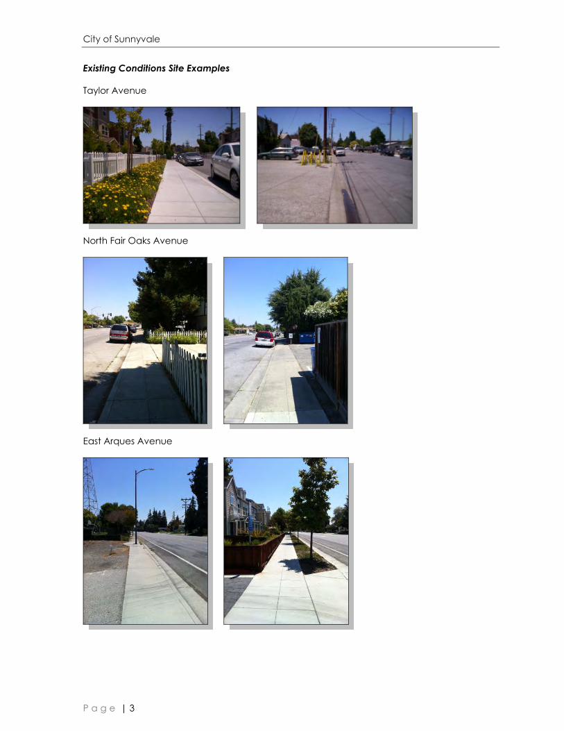
EXISTING CONDITIONS
The general area is bounded by three major arterial roadways (Wolfe Road, Arques, Fair
Oaks Avenue), and the Santa Clara Valley Water District (SCVWD) East Channel (for
drainage) to the east. Redevelopment of former industrial sites has occurred slowly and as of
2012 124 units were constructed in the area. This has resulted in partial sidewalk construction
on Taylor and Arques Avenues without a pedestrian plan in place. Sidewalks in the area are
sporadic and vary in style and condition. The area also has locations of a grade differential
greater than three feet, which will require additional grading and possibly retaining walls for
sidewalk installation. The north half of Britton Avenue is public right of way and currently
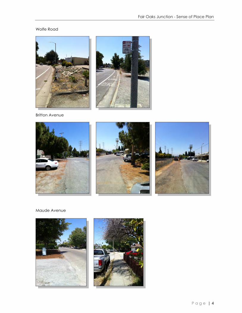
provides secondary access to Taylor Avenue from Wolfe Road. Existing conditions photos are
provided on pages three through four. The southern half of Britton Ave was abandoned in
1982 and is split between the adjacent private property owners and SCVWD.

Fair Oaks Junction - Sense of Place Plan
P a g e | 2
Figure 1: Zoning: ITR 6 Area, Zoning Vicinity and Plan Boundary
City of Sunnyvale
P a g e | 3
Existing Conditions Site Examples
Taylor Avenue
North Fair Oaks Avenue
East Arques Avenue
Fair Oaks Junction - Sense of Place Plan
P a g e | 4
Wolfe Road
Britton Avenue
Maude Avenue
City of Sunnyvale
P a g e | 5
PEDESTRIAN & BICYCLE GOALS
The goals of the Fair Oaks Junction Sense of Place Plan are to:
1. Enhance quality of life for residents within North Fair Oaks and Wolfe area (Futures Area
6) and vicinity through improved pedestrian access to parks and open space, schools,
retail amenities, and public transportation.
2. Encourage increased pedestrian, bicycle, and transit use through streetscape
improvements, land use planning, and architectural design.
3. Aim at establishing complete street designs that accommodate movements of all modes
of transportation including bicycle, pedestrian, and transit traffic.
OVERVIEW
The guidelines are presented in two main sections. Section II, Pedestrian/Bicycle Circulation
Improvements, discusses circulation improvements throughout the plan area, as well as
improvements to access destinations within and outside of the plan area. Many of these
improvements pertain to the public right of way. However, access through and between
private properties is also discussed. Section III, Design Guidelines, discusses design guidelines
and streetscape standards that apply to the plan area. These guidelines and standards
relate directly to the creation of an improved pedestrian/bicycle experience.
The Plan does not contain any new City policies. All proposed improvements and guidelines
are pursuant to existing policies, which are discussed in Section IV. There are also grant
funding opportunities that could be used to implement some of the improvements discussed
in the Plan. These programs are described in Section V. A strategy for implementation of the
Plan goals is described in the last section.

Fair Oaks Junction - Sense of Place Plan
P a g e | 6
CHAPTER II - CIRCULATION IMPROVEMENTS
Currently, the Fair Oaks Junction area is occupied by industrial and residential uses. At the
time the area was originally developed, the City did not foresee a demand for pedestrian
access and therefore very little consideration was given to the development of pedestrian
amenities. However, with the area designated for residential development and
redevelopment occurring, pedestrian needs are becoming more apparent. The area has
been designated a Medium-Density Residential district. This allows for use and occupancy of
up to 24 dwelling units per acre (and there are High Density Residential Development
adjacent). The area is centrally located with nearby open space amenities,
commercial/retail and places of assembly. Figure 2 displays the existing land uses and
development patterns in the area.
Bicycle access to transit and other services are also an important aspect of the
transportation characteristics of the Plan area. The improvements discussed in this section
pertain to both pedestrian circulation and bicycle circulation, amenities and facilities which
will be provided through the City’s development review and approval process. Through this
process, the City ensures that residential and commercial developments comply with the
VTA Bicycle Technical Guidelines. It should also be noted that all proposed public paths and
trails are multi-use facilities for pedestrians and cyclists. In addition, City practice is to provide
bicycle detection at traffic signals, maintenance of bikeways, bikeway-related signs, and
other bike facilities.
The goal of many of the circulation improvements described in this section pertain directly to
improved circulation and connectivity to existing pedestrian and bicycle systems. However,
secondary circulation goals include access to schools, parks and open space, as well as
access to future retail/commercial sites. Circulation improvements extend outside of the
plan area in order to ensure connectivity throughout the community including the East
Sunnyvale area. Figure 3 identifies key pedestrian destinations within the plan area, as well as
important pedestrian routes. Pedestrian destinations within the area include Fair Oaks Park,
existing commercial sites, grocery stores and connections to the developing SCVWD East
Channel Trail.

City of Sunnyvale
P a g e | 7
Figure 2: ITR Area Existing Land
\Uses

Fair Oaks Junction - Sense of Place Plan
P a g e | 8
Figure 3: Destinations
City of Sunnyvale
P a g e | 9
The following improvements will be considered as parcels within the plan area develop
and/or as funding becomes available to assure that the goals of increased pedestrian and
bicycle activities and access to public transportation and other destinations are adequately
met. City staff will seek funding for these improvements through the various funding
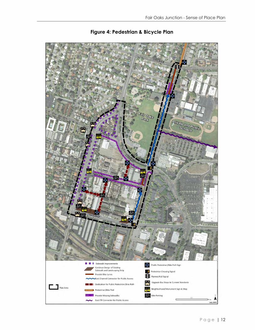
opportunities (as applicable) described in Chapter V. Figure 4 indicates locations of the
proposed improvements to the pedestrian and bicycle network. The proposed
Improvements will incorporate the techniques described below:
PUBLIC STREET IMPROVEMENTS
1. Improve the streetscape.
New sidewalks
Increased sidewalk widths
Increased buffers between pedestrians and vehicles
Enhanced pedestrian-scaled street lighting
Improved visibility at driveways
Closure of sidewalk gaps
Improve public transit stops and associated amenities such as furniture, bus shelters,
lighting and bicycle parking.
2. Connections for pedestrian and bicycle access along the SCVWD East Channel.
3. Improve pedestrian safety and comfort through enhanced intersection treatments.
Improve crossings of wide and busy streets through feasible measures of the following:
Curb extensions that are visible to bicyclists may be used in areas that can
accommodate the additional space and do not result in bicycle lane bottle-necks.
Refuge islands
Pedestrian Crossing Signals
Enhanced crosswalks
High visibility approach signs
Lighted crosswalks
Narrow corner radii at intersections with right-turning vehicles
4. Create a sense-of-place for the area.
Information and pathfinder cues that inform people how to find transit facilities and
pedestrian connections
Fair Oaks Junction - Sense of Place Plan
P a g e | 10
Neighborhood monument signs that will enhance the area’s character as well as act
as kiosks for transportation related information and maps.
5. Implement traffic calming and street design practices to moderate traffic speeds and
volumes, if necessary such as pedestrian bulb-outs, speed bumps on Taylor and raised
crosswalks.
PRIVATE DEVELOPMENT IMPROVEMENTS
1. Provide midblock pedestrian/bicycle connections between Arques and Taylor and Wolfe
Road to Taylor.
2. Private streets and driveways within developments need to be designed for pedestrian
use with walkways that connect to the adjacent public street.
3. Quality exterior paving materials are required to highlight key pedestrian crossings within
the site or to delineate boundaries between public and private development.
4. Retail and Residential uses are required to provide bicycle and pedestrian facilities,
including bicycle racks and pedestrian access from the street.
5. Land dedications to accommodate the provision of public pedestrian and bicycle paths
along the property lines as illustrated on Figure 4.
6. Provision unique area signs and bicycle parking at key locations.
SIDEWALKS
Sidewalks provide access for pedestrians throughout the area. Sidewalks may be simple in
design, such as a monolithic sidewalk or more lavish such as a meandering sidewalk with
planters and other pedestrian oriented elements. Sidewalks also provide links connect to the
trails and roadway crossings. For pedestrian comfort, a planting element (parkway strip)
may be required with sidewalks to provide a buffer between pedestrian roadway and
vehicular traffic. The appropriate planting element will be based on the level of traffic on the
adjacent street in addition to improvements that have been installed in the area.
Appropriate treatment and sizing of the sidewalk will affect how the pedestrians’ sense of
safety and ultimately the extent of pedestrians’ usage. The Design Guideline section
identifies the appropriate type of sidewalk depending on the roadway classification and
existing improvements.
BICYCLE LANES AND TRAILS
The City of Sunnyvale has an extensive network of bicycle lanes throughout the City. In
addition to on-street lanes, additional bike/pedestrian trails are being developed along
easements and rights-of-way. For example, the SCVWD East Channel between US 101 and
Tasman Drive has been identified, and funded, for pedestrian and bicyclist improvements,
which will provide connections to the pedestrian/bicycle bridge overcrossing US 101, the J.
W. John Christian Greenbelt and the light rail service along Tasman Drive. The proposed
bicycle connection along the former Britton Ave right-of-way will allow additional north south
connections for future improvements along the East Channel.
City of Sunnyvale
P a g e | 11
PUBLIC PATHS
Where feasible, public paths along East Channel easement areas shall be provided as part
of the adjacent development or as funding becomes available. These paths will serve as
alternate connections free of automobile traffic. Visibility and safety through these areas
should be a main consideration in the design process.
Fair Oaks Junction - Sense of Place Plan
P a g e | 12
Figure 4: Pedestrian & Bicycle Plan
Sidewalk Improvements

City of Sunnyvale
P a g e | 13
CHAPTER III – MULTI-MODAL DESIGN GUIDELINES
SIDEWALK AND STREETSCAPE
The sidewalks and streetscape elements throughout the Plan area are required to be
consistent with the guidelines below.
1. Taylor and Britton Avenues
a. Sidewalks: 5-7 feet in width along minor streets
(speed limit below 35 mph) with an increased
landscape buffer between the edge of sidewalk
and private property to delineate private and
public space.
2. North Fair Oaks and Wolfe Road
a. Sidewalks: 7-10 feet in width along major streets
(speed limit 35 mph and higher). The sidewalk
area will include tree wells, street tree and
planters (instead of tree-grates) adjacent to the
roadway. In some cases, variations of this
standard may be permitted in order to preserve
existing street trees or to match recent sidewalk
upgrades. (Variation on detail 9C). Variations
may also take place based on availability of
right-of-way.
3. Arques Avenue
a. Sidewalks: 5-7 feet in width along Arques Avenue
and a minimum 4 foot planter strip adjacent to
the roadway to match existing redeveloped
residential sites.
4. Sidewalk Installation and Timing
a. As abutting properties redevelop.
b. Temporary sidewalk gap closures may be
installed and required for safety reasons where
no redevelopment occurs (remaining industrial
sites or along Britton Avenue). Temporary
sidewalk gap closures may utilize asphalt paving
material.
Taylor & Britton Example
Fair Oaks & Wolfe Example
Arques Example

Fair Oaks Junction - Sense of Place Plan
P a g e | 14
5. Midblock and Trail Connections
a. These connections will provide a pedestrian/bicycle path with a width of 10-12 feet.
The pathway may be constructed of pavement or decomposed granite with high
compaction (as approved by the Public Works Department).
b. The connection on Britton Ave between Arques Avenue and Wolfe Road will require
further analysis to ensure safety and coordination at the proposed pedestrian
crossing at Wolfe Road. Future analysis will evaluate the feasibility of maintaining a
combined bike and pedestrian path on Britton north of Taylor leading to Wolfe Road.
c. Midblock and Trail connections will be designed in a manner that is open, safe and
inviting for pedestrians and bicyclists.
6. Curb Ramps & Driveway Approaches
a. Curb ramps shall be installed at all intersections,
one ramp perpendicular to each crossing
direction.
b. Curb ramps in the center of the curb radius will
not be permitted. (Detail 13C-1) except where
physical roadway elements and/or design
limitations exist.
c. Driveway approaches shall be updated to
current City standards.
7. Street Trees
a. Street tree wells shall be placed towards the face of curb to act as a buffer between
pedestrians and motor vehicles on North Fair Oaks, Wolfe Road, and East Arques
Avenue and Britton. Trees will be placed at back of sidewalk along Taylor Avenue.
b. Tree Plantings will be consistent with the following identified street trees:
Taylor Avenue
Deciduous Evergreen
Chinese Tallow
(Sapium sebiferum)
Southern Live Oak
(Quercus virginiana)
Britton Ave/ SCVWD East Channel
Deciduous Evergreen
Species to be determined Species to be determined
Wolfe Road
Address: 465
Deciduous Evergreen
Pyramidal European Hornbeam Sweetbay
Curb Ramp Example

City of Sunnyvale
P a g e | 15
(Carpinus Betulus 'Fastigiata') (Laurus Noblis)
Address Range: 430-461
Deciduous Evergreen
London Plane
(Platanus Acerifolia)
Deodar Cedar
(Cedrus Deodorus)
North Fair Oaks
Address Range: 300-398
Deciduous Evergreen
European Hackberry
(Celtis Australis)
Deodar Cedar
(Cedrus Deodorus)
Address Range: 400-498
Deciduous Evergreen
Heritage Birch
(Betula Nigra)
Canary Island Pine
(Pinus Cananiensis)
c. Trees must be 24‖ box minimum size and placed 35 to 40 feet apart and staked per
City standards in all cases and will be reviewed during the development review
process. (Detail variation on detail DT 1). Deviations may be allowed to
accommodate existing trees to be retained.
8. Street Lighting
a. Pedestrian scale street lighting shall be placed
towards the face of curb. The lights shall be
placed 20-30 feet apart (and the tree spacing is
40 feet, please refer to the Downtown Streetscape
Standard Details and Specifications). (Detail DT 1
and DT 11).
9. Bikeways
a. Bikeways will be maintained (Class II) on all arterial
and collector streets.
b. A new bikeway connection on Britton Avenue
between Arques Avenue Wolfe Road along the
SCVWD East Channel will be provided, subject to coordination with the Wolfe Road
pedestrian crossing and further analysis.
c. Bike racks are required to be placed where appropriate, specifically in the vicinity of
transit stops and retail/commercial sites as noted in the Figure 4. (DT 16)
Bike Rack Example

Fair Oaks Junction - Sense of Place Plan
P a g e | 16
10. Street Furniture
a. Other street furniture such as monuments,
benches, bus shelters and bike racks shall be
located as indicated in the plan and located
in a manner that does not result in pedestrian
conflicts.
11. Safety
a. The City may consider the installation of a
small (4’) high fence in the existing landscape
median on Wolfe Road (between Fair Oaks
and Britton) if midblock crossing becomes an
issue due to the limited visibility and curvature
of the street.
INTERSECTIONS
Intersection treatments listed in this section will be considered in order to enhance
pedestrian crossings within the plan area. Other intersection treatments that meet the intent
of this document, but are not listed, may also be considered.
1. Enhanced crosswalk striping is required at all signalized intersections. Crosswalk striping at
un-signalized intersections will be installed as appropriate.
2. Intersection crossings will be made as pedestrian friendly as possible; this can include the
addition of pedestrian refuge median islands and curb bulb-outs to make crossing
distances more manageable. Curb bulb-outs will be made visible to bicyclists and
implemented where on-street parking exists or as determined by the Public Works
Department.
3. Narrow the corner radius at intersections where vehicles may make right turns during the
red light period (when pedestrians may be crossing within the vehicle’s path of travel) to
slow vehicles.
4. The addition of two pedestrian crossing signals at the intersections of Arques
Avenue/Britton path and Wolfe Road/Britton Avenue that will be increasingly needed
with the implementation of the plan. This is in addition to the full signal currently under
design to serve vehicular and pedestrian traffic including school students at the
intersection of Duane Avenue/Britton Avenue.
SITE LAYOUT
1. Private streets and driveways within developments are required to be designed for
pedestrian use with walkways allowing direct access from the site’s interior to the public
right of way.
2. Design and locate a project’s internal pedestrian circulation pattern for maximum ease
of use by pedestrians; this may be achieved by providing walkways along pedestrian
desired lines.
Monument Sign & Streetlight Example

City of Sunnyvale
P a g e | 17
3. Discourage the creation of isolated/walled complexes. When a wall is unavoidable
along a public path, additional landscape buffers will be required to deter graffiti and
ensure safety and use of the path.
4. The street frontage of residential development should be dominated by a residential
appearance with units facing the street. Below grade parking facilities are encouraged,
on larger lots, as a method to provide a residential front to the project.
5. Use quality exterior paving materials such as architecturally enhanced concrete and
natural materials to highlight key pedestrian crossings or to delineate boundaries
between public and private development.
6. Create public, semi-private and private realms (spaces) within the street frontage of
residential units.
7. Link on-site walkways to the public sidewalk system outside the project for ease of
pedestrian access, as well as provide public paths along property limits that connect
with public streets and transit stop locations
8. Provide pedestrian and bicycle links between residential developments and nearby
employment and shopping centers, schools and parks to encourage pedestrian and
bicycle activities.
9. Ensure adequate visibility for pedestrians and motorists at driveway entrances.

Fair Oaks Junction - Sense of Place Plan
P a g e | 18
CHAPTER IV – RELATION TO EXISTING POLICIES
LAND USE AND TRANSPORTATION ELEMENT (LUTE)
This document is directly related to a number of existing City policies contained in the Land
Use and Transportation Element of the General Plan. These policies pertain directly to land
use development and transportation and are listed below.
Policy LT-1.3 Promote integrated coordinated local land use and transportation
planning
Policy LT-1.9 Support flexible and appropriate alternative transportation modes and
transportation system management measures that reduce reliance on the automobile
and serve changing regional and City-wide land use and transportation needs.
Policy LT-1.10 Support land use planning that complements the regional transportation
system.
Policy LT-2.1 Recognize that the City is composed of residential, industrial and
commercial neighborhoods, each with its own individual character; and allow change
consistent with reinforcing positive neighborhood values.
Policy LT-4.1 Protect the integrity of the City’s neighborhoods; whether residential,
industrial or commercial.
Policy LT-4.2 Require new development to be compatible with the neighborhood,
adjacent land uses, and the transportation system.
Policy LT-4.4 Preserve and enhance the high quality character of residential
neighborhoods.
Policy LT-4.5 Support a roadway system that protects internal residential areas from
City-wide and regional traffic.
Policy LT-5.2 Integrate the use of land and the transportation system.
Policy LT-5.5 Support a variety of transportation modes.
Policy LT-5.7 Pursue local, state and federal transportation funding sources to finance
City transportation capital improvement projects consistent with City priorities.
Policy LT-5.8 Provide a safe and comfortable system of pedestrian and bicycle
pathways.
VTA
On September 30, 2003 the Sunnyvale City Council officially endorsed the Santa Clara Valley
Transportation Authority (VTA) Community Design and Transportation (CDT) Program. This is
the VTA’s primary program for integrating transportation and land use. The program is
intended to build a stronger and more dynamic working relationship between VTA and its
Member Agencies. The program provides a framework to pursue mutually beneficial

City of Sunnyvale
P a g e | 19
projects, to enhance transportation and land use integration efforts already underway, and
to create new opportunities for cities to plan and fund capital projects that enhance
community livability, vitality and sustain-ability. The Fair Oaks/Wolfe Road Area Pedestrian
and Bicycle Circulation Plan is consistent with the intent of the City’s endorsement and
directly implements a number of facets of the VTA CDT Program.
The endorsement conveys the City’s concurrence with the following CDT principals:
1. Target growth in cores, corridors and station areas.
2. Design for pedestrians — comfortable, easy access to buildings, transit, wide sidewalks
and pedestrian amenities.
3. Design in context — create unique place identities via materials, design details,
architectural styles, walks, streets and spaces.
4. Focus on existing areas — infill versus outlying development, maintenance of existing
communities.
5. Create a multi-modal transportation system — balance walking, biking, and transit with
vehicle movement.
6. Establish streets as places — de-emphasize arterial network, provide wide sidewalks and
landscaping.
7. Integrate transit — locate transit stations within community cores, integrate transit stops
and features into site designs.
8. Manage parking — do not let parking dominate mode choice decisions, provide TDM
programs to heighten attractiveness of other modes.
The City of Sunnyvale was firmly invested in these principles well before the program’s
inception. The CDT principles are integrated into the full spectrum of the City’s land use and
transportation activities, and in this regard, the two are mutually supportive.
CITY-WIDE DESIGN GUIDELINES
The City-Wide Design Guidelines were adopted by the City Council in June 1992 in order to
implement the Community Design Sub-Element goals and policies and provide detailed
direction on site and building design issues. They mainly address development projects on
private properties and are intended to: enhance the overall image of the City, protect and
preserve the existing character of the community, communicate the image the community
desires, and achieve a higher design quality.
All site layout and building design guidelines provided in this Plan are consistent with existing
City-Wide Design Guidelines.

Fair Oaks Junction - Sense of Place Plan
P a g e | 20
CHAPTER V - GRANT FUNDING/INCENTIVE OPPORTUNITIES
Small-scale transportation investments can sometimes make a big difference in a
community’s vitality and identity. Streetscape improvements, transit-, pedestrian- and
bicycle-oriented developments, and related strategies can bring a new vibrancy to
downtown areas, commercial cores and neighborhoods, enhancing their amenities and
ambience and making them places where people want to live and visit.
METROPOLITAN TRANSPORTATION COMMISSION
The Metropolitan Transportation Commission (MTC) is presently in the process of carrying out
changes to the grants funding programs. MTC’s framework for programming 2013-2016
Surface Transportation Program (STP), Congestion Mitigation and Air Quality (CMAQ) and
Transportation Enhancements (TE) funds are being amalgamated into one funding program,
which is now called the ―One Bay Area Grant‖ Program (OBAG). The OBAG program will
provide $87.3 million for Santa Clara County which is the largest amount that has been
made available by MTC for county-level decision making since the enactment of the
Intermodal Surface Transportation Enhancement Act (ISTEA) in 1991.
Due to the complexity of the program, VTA staff is developing the local OBAG programming
framework with the advice of its regional Technical Advisory Committee and Capital
Improvements Program Sub-committee. Funding of the OBAG program is expected to be in
the form of guaranteed funds to all cities within Santa Clara county, as well as competitive
funds. The equation and criteria for allocating the different funding categories will be
considered by the VTA Board of Supervisors later on this year.
As presently recommended for VTA’s Board consideration, the guaranteed funds will
constitute 30% of the total grant funds of $87.3 million that will be utilized in Non-Priority
Development Areas (PDAs). These guaranteed funds are recommended to dedicate $15.42
million to road rehabilitation projects in the different cities, and $10.77 million to complete
streets projects such as bicycle and pedestrian facilities, safe routes to school projects, and
traffic signal systems. The distribution formula for the guaranteed funds is based on: 50% on
population, 12.5% on all housing units production from 1999 to 2006, 12.5% on low income
housing production 1999-2006, 12.5% on all units regional housing needs allocation, and
12.5% on low income regional housing needs allocation. City of Sunnyvale guaranteed
funds are expected to be in the amount of $1,359,527 million for complete streets projects in
Non-PDA areas and road rehabilitation projects.
The competitive (not guaranteed) OBAG program funds in the amount of $16 million STP
funds and $45.1 million CMAQ/TE funds are expected to fund CMA planning projects ($6.0
million), San Tomas Expressway improvements ($10 million), and competitive complete
streets projects located in PDAs ($45.1 million). The competitive process will be based on
scoring of projects based on their merits and scoring criteria. Santa Clara County and the
different cities within the county will have the right to compete for the non-guaranteed
complete streets funds.

City of Sunnyvale
P a g e | 21
Since the Fair Oaks Junction area (ITR 6) is not located in a Priority Development Area (PDA),
it can only qualify for the guaranteed complete streets funds.
Other than the aforementioned OBAG grant funds program, other funds that will remain are
the Transportation Development Act (TDA) – Article 3 funds, and the Transportation Funds for
Clean Air (TFCA) funds.
TRANSPORTATION DEVELOPMENT ACT
In November 2000, the voters in Santa Clara County approved Measure A, a 30-year half
cent sales tax devoted to specified public transit capital improvement projects and
operations. These funds are dedicated to planning/studies, construction and programs. As
a part of the VTA biennial budget process, the VTA Board approves a two-year capital
program for the Measure A program including development and implementation activities
in the two-year budget cycle and its related estimates of expenses.
It should be noted that the TDA funds are intended for larger scale projects and transit hubs.
Thus it would not be applicable for the bus stop improvements identified in the Fair Oaks
Junction Sense of Place Plan area, and these summary TDA notes are just provided for
information and disclosure purposes.
BAY AREA AIR QUALITY MANAGEMENT DISTRICT
Transportation Fund for Clean Air
The Transportation Fund for Clean Air (TFCA) is a grant program funded by a $4 surcharge on
motor vehicles registered in the Bay Area. This generates approximately $20 million per year
in revenue. TFCA’s goal is to implement the most cost-effective projects in the Bay Area that
will decrease motor vehicle emissions, and therefore improve air quality. Projects must be
consistent with the 1988 California Clean Air Act and the Bay Area Clean Air Plan.
The fund covers a wide range of project types, including purchase or lease of clean fuel
buses; purchase of clean air vehicles; shuttle and feeder bus service to train stations;
ridesharing programs to encourage carpool and transit use; bicycle facility improvements
such as bike lanes, bicycle racks, and lockers; arterial management improvements to speed
traffic flow on major arterials; smart growth; and transit information projects to enhance the
availability of transit information.
The bicycle facilities and smart growth/traffic calming project types are most relevant to the
possible projects included in this Plan which are expected to result in the achievement of
motor vehicle emission reductions. TFCA funds are subject to the following conditions: a) the
development project and the physical improvements must be identified in an approved
area-specific plan, redevelopment plan, general plan, bicycle plan, pedestrian plan, traffic-
calming plan, or other similar plan; and b) the project must implement one or more
transportation control measures (TCMs) in the applicable Bay Area Clean Air Plan or Bay
Area 2001 Ozone Attainment Plan. Projects that implement TCM 19 (pedestrian
improvements) or TCM 20 (traffic calming) are encouraged. Projects that would implement
other TCMs will also be considered for funding.

Fair Oaks Junction - Sense of Place Plan
P a g e | 22
VALLEY TRANSPORTATION AUTHORITY
Community Design & Transportation Program
In 2002, the Valley Transportation Authority (VTA) adopted the Community Design and
Transportation (CDT) Program. This program is designed to provide information, tools, and
planning, technical and design assistance to the cities, towns, and county of Santa Clara to
proactively influence the planning and development process. This document will continue to
guide the different governmental agencies within the county and is likely to be updated
within the next year to better reflect the complete streets concepts.
City of Sunnyvale
P a g e | 23
CHAPTER VI - IMPLEMENTATION
The goals in the Fair Oaks Junction Sense of Place Plan shall be implemented primarily
through a combination of the private development approval process and grant funded
public improvement projects.
Primarily, improvements will be funded and constructed by developers as part of the
development approval process. When development applications are submitted for projects
within the plan area, City staff will review the proposal and assure that it is consistent with the
access improvements and design guidelines described in this document. City staff will then
recommend that Conditions of Approval, consistent with the Plan, be applied to the
approval of Planning Applications and Building Permits.
The City of Sunnyvale will also compete in the grant funding programs listed in the Grant
Funding Opportunities section of the Plan, and others as appropriate, in order to fund
improvements in the public right of way. Grant application priority will be given to
intersection and streetscape projects where no pedestrian access currently exists or where
pedestrian safety issues are present. Priority should be given to those elements that enhance
safety if it does not resulting in funding conflicts. In addition, a Sense of Place fee will be
applied to redevelopment projects on a per unit basis. These funds will be used for common
improvements such as pedestrian crossings, markers and other elements identified in the
plan. Implementation of other plan elements such as the pedestrian signals may be funded
by gas tax funds and other transportation mitigation funds.
Related Documents