1 23 Environmental Earth Sciences ISSN 1866-6280 Environ Earth Sci DOI 10.1007/s12665-014-3725-4 Failure mechanisms in weathered meta- sedimentary rocks J. I. Nkpadobi, J. K. Raj & T. F. Ng

Welcome message from author
This document is posted to help you gain knowledge. Please leave a comment to let me know what you think about it! Share it to your friends and learn new things together.
Transcript
1 23
Environmental Earth Sciences ISSN 1866-6280 Environ Earth SciDOI 10.1007/s12665-014-3725-4
Failure mechanisms in weathered meta-sedimentary rocks
J. I. Nkpadobi, J. K. Raj & T. F. Ng

1 23
Your article is protected by copyright and
all rights are held exclusively by Springer-
Verlag Berlin Heidelberg. This e-offprint is
for personal use only and shall not be self-
archived in electronic repositories. If you wish
to self-archive your article, please use the
accepted manuscript version for posting on
your own website. You may further deposit
the accepted manuscript version in any
repository, provided it is only made publicly
available 12 months after official publication
or later and provided acknowledgement is
given to the original source of publication
and a link is inserted to the published article
on Springer's website. The link must be
accompanied by the following text: "The final
publication is available at link.springer.com”.
ORIGINAL ARTICLE
Failure mechanisms in weathered meta-sedimentary rocks
J. I. Nkpadobi • J. K. Raj • T. F. Ng
Received: 10 April 2014 / Accepted: 18 September 2014
� Springer-Verlag Berlin Heidelberg 2014
Abstract The weathering profile of the extended cut
slope within the quartz mica schist along Pos Selim
Highway in Perak State, Malaysia shows three broad
morphological zones; bedrock zone, intermediate zone, and
residual soil zone. Further thinner horizons within these
broad morphological zones were differentiated based on
differences particularly in textures and structures of origi-
nal bedrock and degree of preservation of the constituent
minerals. Both large and small scale discontinuities
observed in the schist provide slip surfaces for failures, and
field investigation showed evidence of failures in this
extended cut slope. The implications of the micro-struc-
tures revealed through petrography showed shearing com-
ponents along planes of weakness. From the determined
index properties of the weathered profile, the quartz mica
schist is not suitable for structural support. This is also
evidenced by the high values of sand over silt and clay
deduced from the sieve analysis. In the bedrock zone,
weathering manifests itself by opening up of discontinu-
ities within the rock mass rather than weakening of the
material itself. From the kinematic analyses carried out on
the rock cuts, there are possibilities of wedge, planar and
toppling failures across this extended cut slope.
Keywords Slope failure � Kinematic analysis � Rock
index properties � Weathering profile � Petrography �Micro-structures
Introduction
Weathering plays a major role in the failure of earth
materials especially in the soil zone and the rock zones
involving ravelling of the rock blocks. According to Arikan
and Aydin (2012), both chemical and mechanical processes
work together to break down rocks and minerals to smaller
fragments or to minerals more stable near the earth’s sur-
face. The effects of weathering on schist have been studied
by Raj (2000), Yamasaki and Chigira (2006), and Wells
et al. (2008), considering various weathering agents and
outlining the relationships between the weathering and
failures. There is little or no publication on the engineering
properties and weathering profiles over the schist formation
along Pos Selim Highway, which is a vast extent of the cut
slopes. Apart from broadened studies on weathering in
Peninsular Malaysia, published data on weathering and
weathering processes in this investigated area were carried
out by Omar et al. (2009) who rather researched on the
degree of weathering in the granite unit.
In this study, significant understanding on the impact of
weathering and weathering processes on the quartz mica
schist was gained through intermittent fieldworks. Dis-
continuities increase the surface area available for attack by
weathering agents such as water. With the developed
structures and micro-structures observed during field
investigations and laboratory analyses, respectively, this
paper aims to analyze the attitudes and implications of
these structures and micro-structures as planes of weak-
ness. Petrographic descriptions in this work started with
J. I. Nkpadobi (&) � J. K. Raj � T. F. Ng
Department of Geology, Faculty of Science,
University of Malaya, 50603 Kuala Lumpur, Malaysia
e-mail: [email protected];
J. K. Raj
e-mail: [email protected]
URL: http://www.researcherid.com/rid/B-8716-2010
T. F. Ng
e-mail: [email protected]
URL: http://www.researcherid.com/rid/B-9234-2010
123
Environ Earth Sci
DOI 10.1007/s12665-014-3725-4
Author's personal copy

field notes at the outcrop and include megascopic
description of hand specimens, down to preparation of thin
sections and the use of polarized microscope. Also, to
identify the effects of weathering on the stability of the cut
slopes, and to determine the failure mechanisms, consid-
erable efforts were made through field and laboratory
investigations.
Geological setting of the investigated area
The study area is located in Perak state, Malaysia along Pos
Selim Highway. Mapping of this investigated area was
carried out using Garmin GPS, and Fig. 1 shows the
location and geological setting. Coverage of these cut
slopes extends to 17.7 km beginning at latitude 4�3304400
and longitude 101�1808600 traversing through Titiwangsa
main range mountainous terrain, reaching an elevation of
1587 m above sea level at Gunung Pass and terminating at
latitude 4�3509500 and longitude 101�2008000 whi ch stood at
1420 m above sea at Perak/Pahang boarder. Although this
study focused on schist, the study area traversed through
two different major geological formations; granite which
covers about 60 % of the area and schist covering about
40 %. Tajul (2003) reported that the schist, which gener-
ally occurred as roof pendant to the granite, might probably
be of Upper Palaeozoic age and was intruded by the
younger main range granite. The color variations and relict
Fig. 1 Geological setting of the
investigated area
Environ Earth Sci
123
Author's personal copy

discontinuities in the schist indicate that the material is
heterogeneous and highly variable over a small area. The
variable relief observed in the field is a result of varying
degrees of resistance to weathering and erosion of the
underlying bedrock.
Different outcrops of this road cuts are designated as
locations. In order of abundance the schist consists of
quartz mica schist, and the graphitic schist, with the
thick quartzite layers which occur both within the
quartz mica schist and the graphitic schist. The quartz
mica schist is characterized by conspicuous coarse
texture. It is well foliated, heavily jointed, locally
faulted and sheared. Nkpadobi (2009) described folia-
tions as those structures that develop within a rock as a
consequence of the alignment of crystals and minerals
during metamorphism and the intrusion of igneous
bodies. The foliated graphitic schist and the non-foli-
ated quartzite occur mostly within the fault zones and
show little lateral continuity. Stringers of fine-grained
sulphides prominently mark the well-preserved sedi-
mentary laminations in the graphitic schist and it
exhibits a shiny but highly contorted foliation. The
quartzite exhibits a crystalline character and color
ranging from white to slightly gray, appearing as thick
layers and also as thin lens and intercalations in various
locations.
Recent failures at cut slopes
Major identified failure types across the investigated area
include planar sliding, wedge failure, and complex failures
characterized by slump and earth flow which occurred
along the Gunung Pass axis. Planar sliding occurred at
locations 006, 007 and 010 within moderately weathered
morphological zones. These zones possess relief forces that
provide insignificant resistance to sliding. On 29th October,
2013, it was observed that combination of earlier investi-
gated closely spaced shallow slips at location 007 gave rise
to defined planar failures (Fig. 2a). Planar sliding at these
locations has a common trend whereby the failure planes
are sub-parallel to the slope face, and the rock mass slides
down along a relatively planar failure surface. The
observed failure surfaces are overlain by highly to com-
pletely weathered rock. The wedge failure occurred at
location 004 (Fig. 2b). Field observations show strong
evidence that ground movement and exposure to atmo-
spheric attack are prevalent and having adverse effects on
the bedrock. This continuing ground movement initiates
the cracking and further mechanical breakdown of the rock
materials, therefore inducing the opening up of disconti-
nuities by slip, extension, and rotation.
Slump and earth flow characterize the complex failures
at locations 012, 013, 014 and 016; and these four cuts
Fig. 2 Some of the failed slopes
Environ Earth Sci
123
Author's personal copy

constitute the Gunung Pass. These cuts bear similar min-
eralogical composition and weathering profile, but differ in
degree of deformation. The exposed rock masses have been
subjected to intense chemical weathering, reducing the
rocks into very weak soil-like materials. The slopes are
actively unstable and deteriorations occur continually,
destroying the designed berms, cascade drain, and shot-
crete (Fig. 2c). The failed rock materials from the com-
pletely weathered morphological zones as well as the
pedological soil slump downwards, sometimes as coherent
mass or silty sands and remain on the slope. Some of the
movements noticed occurred after short and prolonged
intense rainfall, saturating the pedological soil and the
weathered morphological zones of the outcrops, thereby
inducing flow (Fig. 2d). The summary of the field observed
failures is presented in Table 1.
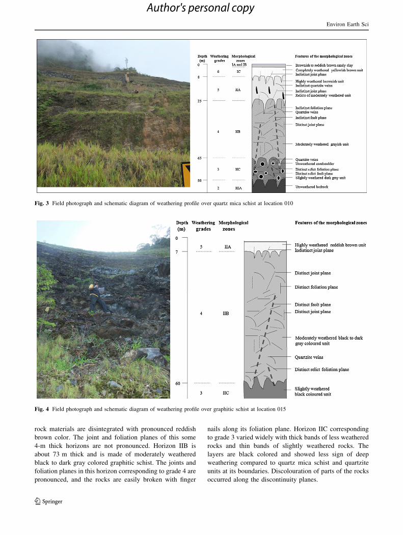
Weathering profile developed over quartz mica schist
In the actual climatic conditions of the earth, prolonged
weathering in the hot and humid tropics and subtropics
produce thick weathered profiles which may be up to
100 m or more in thickness. In turn, weathering profile is a
vertical assemblage of weathering zones (subsurface zones
of alteration differing physically, chemically, or mineral-
ogically from adjacent zones) from the surface soil to the
unaltered bedrock (Pinti 2011). Considering the heteroge-
neity of some rock masses, Raj (1983) defined weathering
profile as the vertical profile that illustrates the transition
from fresh and unweathered bedrock at depth to the thor-
oughly weathered material at the ground surface. Deter-
mination of morphological zonation of weathering profile
of rocks of Peninsular Malaysia has been carried out
notably by Eswaran and Wong (1978), Raj (1983, 1985,
1993, 1998, 2010), Zauyah (1986), and Zauyah and Stoops
(1990). Though slightly varying in nomenclature and
thickness, all these published schemes have clear differ-
entiation of uppermost zone that constitutes the layer of
active soil formation which comprises completely weath-
ered bedrock materials with indistinct relict bedrock tex-
ture, which have been subjected to pedological processes.
Field investigations revealed occurrence of failures in
the weathered quartz mica schist extending through the
entire weathered horizons. A distinct weathering profile of
this quartz mica schist is exposed at chainage 21,000
(location 010), and the investigation was based on BSI
(1981) standard. By identifying the lateral changes in color,
texture, hardness and consistency of material composition,
the weathering profile is differentiated into three major
zones: bedrock zone, intermediate zone and residual soil
zone. Based on differences particularly in textures and
structures of original bedrock as well as degree of preser-
vation of the constituent minerals, these three broad zones
are further differentiated into thinner horizons. Both field
photograph and schematic diagram of this weathering
profile are presented in Fig. 3, and broadly divided into
zones I, II, and III. Zone I is the residual soil zone with
thickness of less than 8 m and is mainly sandy clay, cor-
responding to grade 6. It is further sub-divided into IA, IB,
and IC. Horizons IA and IB are brownish to reddish brown
pedological soil whereby IA, which is less than 1 m, is
friable sandy clay, whereas IB, which is less than 2 m, is
firm sandy clay. Horizon IC is completely weathered, stiff
yellowish brown sandy clay and devoid of any distinct
discontinuity plane.
Greater attention was focused on the intermediary zone
II because of its extensive thickness, complexity, and easy
accessibility. It encompasses slightly, moderately, and
highly weathered units. With thickness measuring up to
72 m, this zone II comprises about 24 % higher horizon
IIA (corresponding to grade 5) of highly weathered
brownish unit devoid of distinct discontinuity plane, but
with intercalations of relicts of moderately weathered units.
The lower horizon IIB is about 55 % of the entire zone II,
comprising moderately weathered gray colored quartz mica
schist and corresponding to grade 4. It exhibits conspicuous
quartzite veins, joint and foliation planes, but indistinct
fault plane. Horizon IIC is the lowest horizon of zone II,
and it corresponds to grade 3. With thickness of about
21 % of the entire zone II, this slightly weathered dark gray
unit comprises distinct relict discontinuity planes and
unweathered core boulders which are very prominent.
The bedrock zone III which is schematically represented
only by morphological zone IIIA as the only exposed unit
is unweathered bedrock which experiences the effect of
weathering only along and between structural discontinuity
planes. The thickness of this particular zone III encom-
passes grades 2 and 1 corresponding to IIIA and IIIB
horizons, respectively, although IIIB is not shown in the
schematic diagram as it is not exposed in the field.
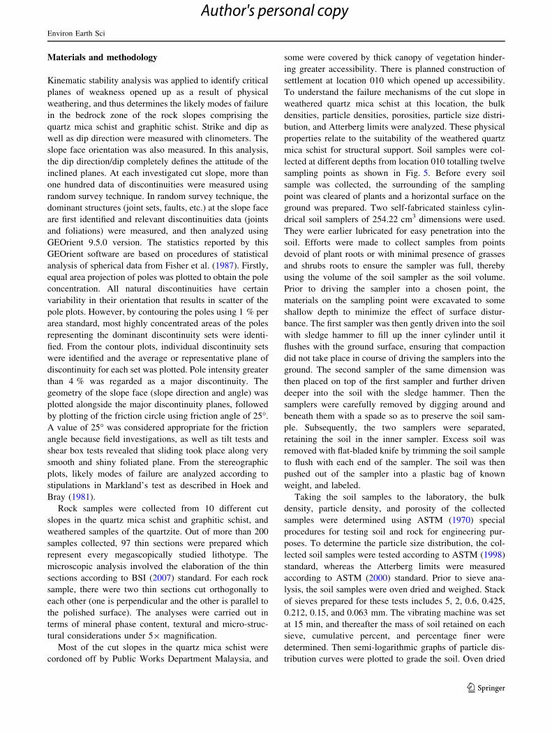
Weathering profile developed over graphitic schist
Although the graphitic schist at location 015 is easily
broken with fingers along foliation planes, there was no
failure observed, and the cut slope looks relatively stable.
This outcrop towering about 80 m is finely inter-layered
with lens and intercalations of micaceous quartzite which
could be traced for only a few meters. Employing field
investigative standard of BSI (1981), this cut slope exposes
a weathering profile of only one broad morphological zone
(Fig. 4). Considering the morphological features, it is
designated zone II, and is summed up into highly, mod-
erately, and slightly weathered units, which corresponds to
thinner horizons IIA, IIB, and IIC, respectively. In horizon
IIA, which corresponds to grade 5, more than half of the
Environ Earth Sci
123
Author's personal copy

Table 1 Summary of the orientations of slope locations, major discontinuities, and failure types
Cut slopes Slope
height
(m)
Failure type Summary of the investigated discontinuities Slope face
orientation
Discontinuity
data
Dip (�) Dip direction
(�)
Discontinuity
set
Intensity
(%)
Remark Slope
angle (�)
Slope
direction
(�)
Location 004 35 Wedge failure 115 32 110 J1 [8 Foliation 63 236
60 192 J2 [8 Joint
78 182 J3 [4 Joint
Location 005 20 None 120 50 98 J1 [8 Foliation 63 246
60 210 J2 [8 Joint
36 306 J3 [4 Joint
85 352 J4 [4 Joint
46 270 J5 [4 Joint
Location 006 80 Planar failure 119 40 100 J1 [8 Foliation 63 110
62 232 J2 [8 Joint
78 210 J3 [8 Joint
66 332 J4 [4 Joint
48 310 J5 [4 Joint
Location 007 35 Planar failure 120 40 100 J1 [8 Foliation 63 100
44 260 J2 [4 Joint
80 328 J3 [4 Joint
58 322 J4 [4 Joint
Location 008 80 None 110 40 102 J1 [8 Foliation 63 98
74 260 J2 [8 Joint
80 334 J3 [4 Joint
64 320 J4 [4 Joint
Location 009 70 None 105 56 260 J1 [8 Joint 63 250
20 190 J2 [4 Foliation
66 295 J3 [4 Joint
Location 010 100 Planar failure 117 86 308 J1 [8 Joint 68 60
86 130 J2 [8 Joint
88 230 J3 [4 Joint
80 340 J4 [4 Joint
66 260 J5 [4 Joint
Location 011 80 None 120 20 228 J1 [8 Foliation 70 250
78 36 J2 [8 Joint
66 312 J3 [4 Joint
78 190 J4 [4 Joint
Location 014 60 Complex failure 102 82 145 J1 [8 Joint 63 250
18 335 J2 [8 Foliation
67 180 J3 [8 Joint
88 240 J4 [8 Joint
40 20 J5 [4 Joint
Location 015 80 None 101 80 147 J1 [8 Joint 70 250
20 337 J2 [8 Foliation
86 238 J3 [8 Joint
38 18 J4 [4 Joint
Environ Earth Sci
123
Author's personal copy
rock materials are disintegrated with pronounced reddish
brown color. The joint and foliation planes of this some
4-m thick horizons are not pronounced. Horizon IIB is
about 73 m thick and is made of moderately weathered
black to dark gray colored graphitic schist. The joints and
foliation planes in this horizon corresponding to grade 4 are
pronounced, and the rocks are easily broken with finger
nails along its foliation plane. Horizon IIC corresponding
to grade 3 varied widely with thick bands of less weathered
rocks and thin bands of slightly weathered rocks. The
layers are black colored and showed less sign of deep
weathering compared to quartz mica schist and quartzite
units at its boundaries. Discolouration of parts of the rocks
occurred along the discontinuity planes.
Fig. 3 Field photograph and schematic diagram of weathering profile over quartz mica schist at location 010
Fig. 4 Field photograph and schematic diagram of weathering profile over graphitic schist at location 015
Environ Earth Sci
123
Author's personal copy
Materials and methodology
Kinematic stability analysis was applied to identify critical
planes of weakness opened up as a result of physical
weathering, and thus determines the likely modes of failure
in the bedrock zone of the rock slopes comprising the
quartz mica schist and graphitic schist. Strike and dip as
well as dip direction were measured with clinometers. The
slope face orientation was also measured. In this analysis,
the dip direction/dip completely defines the attitude of the
inclined planes. At each investigated cut slope, more than
one hundred data of discontinuities were measured using
random survey technique. In random survey technique, the
dominant structures (joint sets, faults, etc.) at the slope face
are first identified and relevant discontinuities data (joints
and foliations) were measured, and then analyzed using
GEOrient 9.5.0 version. The statistics reported by this
GEOrient software are based on procedures of statistical
analysis of spherical data from Fisher et al. (1987). Firstly,
equal area projection of poles was plotted to obtain the pole
concentration. All natural discontinuities have certain
variability in their orientation that results in scatter of the
pole plots. However, by contouring the poles using 1 % per
area standard, most highly concentrated areas of the poles
representing the dominant discontinuity sets were identi-
fied. From the contour plots, individual discontinuity sets
were identified and the average or representative plane of
discontinuity for each set was plotted. Pole intensity greater
than 4 % was regarded as a major discontinuity. The
geometry of the slope face (slope direction and angle) was
plotted alongside the major discontinuity planes, followed
by plotting of the friction circle using friction angle of 25�.
A value of 25� was considered appropriate for the friction
angle because field investigations, as well as tilt tests and
shear box tests revealed that sliding took place along very
smooth and shiny foliated plane. From the stereographic
plots, likely modes of failure are analyzed according to
stipulations in Markland’s test as described in Hoek and
Bray (1981).
Rock samples were collected from 10 different cut
slopes in the quartz mica schist and graphitic schist, and
weathered samples of the quartzite. Out of more than 200
samples collected, 97 thin sections were prepared which
represent every megascopically studied lithotype. The
microscopic analysis involved the elaboration of the thin
sections according to BSI (2007) standard. For each rock
sample, there were two thin sections cut orthogonally to
each other (one is perpendicular and the other is parallel to
the polished surface). The analyses were carried out in
terms of mineral phase content, textural and micro-struc-
tural considerations under 59 magnification.
Most of the cut slopes in the quartz mica schist were
cordoned off by Public Works Department Malaysia, and
some were covered by thick canopy of vegetation hinder-
ing greater accessibility. There is planned construction of
settlement at location 010 which opened up accessibility.
To understand the failure mechanisms of the cut slope in
weathered quartz mica schist at this location, the bulk
densities, particle densities, porosities, particle size distri-
bution, and Atterberg limits were analyzed. These physical
properties relate to the suitability of the weathered quartz
mica schist for structural support. Soil samples were col-
lected at different depths from location 010 totalling twelve
sampling points as shown in Fig. 5. Before every soil
sample was collected, the surrounding of the sampling
point was cleared of plants and a horizontal surface on the
ground was prepared. Two self-fabricated stainless cylin-
drical soil samplers of 254.22 cm3 dimensions were used.
They were earlier lubricated for easy penetration into the
soil. Efforts were made to collect samples from points
devoid of plant roots or with minimal presence of grasses
and shrubs roots to ensure the sampler was full, thereby
using the volume of the soil sampler as the soil volume.
Prior to driving the sampler into a chosen point, the
materials on the sampling point were excavated to some
shallow depth to minimize the effect of surface distur-
bance. The first sampler was then gently driven into the soil
with sledge hammer to fill up the inner cylinder until it
flushes with the ground surface, ensuring that compaction
did not take place in course of driving the samplers into the
ground. The second sampler of the same dimension was
then placed on top of the first sampler and further driven
deeper into the soil with the sledge hammer. Then the
samplers were carefully removed by digging around and
beneath them with a spade so as to preserve the soil sam-
ple. Subsequently, the two samplers were separated,
retaining the soil in the inner sampler. Excess soil was
removed with flat-bladed knife by trimming the soil sample
to flush with each end of the sampler. The soil was then
pushed out of the sampler into a plastic bag of known
weight, and labeled.
Taking the soil samples to the laboratory, the bulk
density, particle density, and porosity of the collected
samples were determined using ASTM (1970) special
procedures for testing soil and rock for engineering pur-
poses. To determine the particle size distribution, the col-
lected soil samples were tested according to ASTM (1998)
standard, whereas the Atterberg limits were measured
according to ASTM (2000) standard. Prior to sieve ana-
lysis, the soil samples were oven dried and weighed. Stack
of sieves prepared for these tests includes 5, 2, 0.6, 0.425,
0.212, 0.15, and 0.063 mm. The vibrating machine was set
at 15 min, and thereafter the mass of soil retained on each
sieve, cumulative percent, and percentage finer were
determined. Then semi-logarithmic graphs of particle dis-
tribution curves were plotted to grade the soil. Oven dried
Environ Earth Sci
123
Author's personal copy

samples that passed through sieve number 40 (0.425 mm)
were used to determine liquid limit, plastic limit, and
plasticity index. The Casagrande liquid limit device was
used to determine the liquid limit. Four tests were per-
formed with each soil sample, then flow curves were
plotted and moisture content at 25 blows was determined.
To determine the plastic limit, the remaining parts of the
soil samples that passed through sieve number 40 were
used. Three tests were performed for each sample and the
average of the moisture contents was calculated to deter-
mine the plastic limit. The plasticity index was calculated
as the difference between liquid limit and plastic limit.
Applications
The kinematic analyses were carried out on nine outcrops
within the quartz mica schist and one outcrop within the
graphitic schist. Critical sets of discontinuities and the
likely modes of failures were determined through stereo-
graphic plots. Summary of the orientations of the slope
locations and major discontinuities are presented in
Table 1. Analysis of every slope shows one or more
intersection of the discontinuities within the critical zone.
As represented in Fig. 6, considering the modes of failures,
there are possibilities of wedge, planar and toppling fail-
ures. There is possibility of both wedge and planar failures
at locations 005, 006, 007, and 009, while location 008
shows possibility of wedge, planar and toppling failures.
The analyses show possibility of only wedge failures at
locations 004, 010, 011, 014, and 015. Likely modes of
failures are analyzed according to stipulations in Hoek and
Bray (1981).
At location 004, analysis shows intersection of J2 and J3
along 267�/27� line orientation. Four intersections within
the critical zone were recorded at location 005; J2 and J3
intersected along 280�/34� line orientation, J3 and J4
intersected along 265�/30� line orientation, J2 and J4
intersected along 266�/46�, and J3 and J5 intersected along
136�/54� line orientation. Location 006 recorded three
intersections; J1 and J4 intersected having orientation of
line of intersection as 49�/29�, J1 and J3 intersected along
128�/37�, while J1 and J2 intersected along 155�/27�. At
location 007, only one intersection between J1 and J3 along
53�/31� was recorded. The same single intersection was
also recorded at location 008 between J1 and J3 along 58�/
32�. J1 and J3 intersected along 242�/54� at location 009.
There was also only one intersection between J2 and J4 at
location 010 along 48�/65�. J3 and J4 only intersected
along 262�/56� at location 011, while J1 and J3 intersected
along 222�/61� at location 014. Analysis on the graphitic
schist at location 015 yielded only one intersection between
J3 and J4 having orientation of 326�/28� line of
intersection.
Clasts of mylonites, folds, and foliations are distinctive
micro-structures found in the representative thin sections
Fig. 5 Soil sampling points and
morphological zones within the
weathered quartz mica schist at
location 010
Environ Earth Sci
123
Author's personal copy

using LEICA DM LB microscope. Millimeter scale
microscopic analyses confirm that most of the quartz mica
schists are mylonitized. In general, the representative
samples of quartz mica schists are marked by a consistent
mineralogical composition having abundance of quartz
(40–60 %), mica (30–50 %), plagioclase (1–15 %), and
Fig. 6 Stereographic plots defining likely wedge, planar, and toppling failure modes
Environ Earth Sci
123
Author's personal copy

associated with varied percentage of clay mostly in
weathered samples. The light brown quartz mica schist
varieties (whereby biotite is replaced by chlorite and
muscovite) are retrogressively altered than the mylonitized
and dark brown varieties.
Mylonitized quartz mica schist was found in rock sam-
ples from locations 007 and 008 with different associated
micro-structures. Representative photomicrographs of
mylonitized quartz mica schist taken under cross-polarized
light as presented in Fig. 7a exhibit similar mineral con-
tent. There are few individual quartz crystals within the
aligned matrix of alternating muscovite and fine-grained
quartz. Muscovite is the dominant silicate mineral; hence,
considering the mineral content of rock samples, they are
better termed quartz muscovite schist.
Non-mylonitized quartz mica schist was collected from
locations 004, 006, 007, 010, 011, and 014. Samples col-
lected from these locations exhibit mineralogical and tex-
tural similarities. They show composite quartz grains
viewed under cross-polarized light, in which the crystal
boundaries within an aligned matrix of fine-grained quartz
and muscovite are sutured and are also elongated in a
preferred direction. These are sheared quartz grains with
biotite appearing as small flakes. Slight mineralogical dif-
ference observed is that in highly weathered samples, the
individual quartz grains are embedded in matrix of
muscovite, quartz, including kaolinite which evidently
formed from biotite, and chlorite which formed as product
of chemical weathering of other silicate minerals.
Micro-folding was observed within quartz mica schist
sample collected from location 005 (Fig. 7b). This quartz
mica schist attests to the fact that metamorphic rocks can
always undergo several deformation episodes. In this
sample, both biotite and muscovite are almost of equal
percentage. This sample is also rich in subhedral plagio-
clase, which is seen interlocking with the anhedral and
granular quartz. Its distinctive structure is crenulation
cleavage which is a special kind of cleavage that forms as a
result of shortening at a low angle to a pre-existing
cleavage.
Microscopically, the graphitic schist is locally folded.
The thin section reveals an anticline-syncline with well-
developed axial-plane crenulation cleavage (Fig. 7c). Fur-
ther implication of this flexural folding is the formation of
extrusive wedged-shaped domains as a result of inhom-
ogenous shortening which in turn implies minor shearing
components along the cleavage planes (Hobbs et al. 1982;
Williams 1990; Price and Cosgrove 1990). Another dis-
tinctive feature is its crystallinity which increases with
increase in grade of metamorphism and remains unaffected
during retrogression, and provides degree of graphitization,
and temperature of graphite formation (Rawat and Sharma
2011). The photomicrograph shows graphite and biotite
associated with variable amount of quartz and plagioclase.
Fig. 7 Photomicrographs of representative samples
Environ Earth Sci
123
Author's personal copy
The biotite is intergrown with graphite and plagioclase. It
is observed that the biotite aligned along the cleavage
planes which are parallel to the axial planes of the fold. The
graphite which exhibited both anhedral and euhedral
shapes form minute flakes, and the fine-grained anhedral
quartz which concentrated in laminations along the
cleavage.
The micaceous quartzite covers a very small fraction of
the study area. Under cross-polarized light, the represen-
tative photomicrograph (Fig. 7d) revealed uniform miner-
alogy among different outcrops in locations 004, 007, 008,
and 010, whereby they consist of a mosaic of irregular
shaped quartz grains with very little amount of biotite. This
photomicrograph of the quartzite in location 006 shows the
presence of muscovite within and at the grain boundaries of
the annealed quartz, with some interstitial plagioclase, and
few recognized fine-grained detrital zircon which predates
most of the minerals in this rock. Quartzite encountered in
most locations is often white or gray but the photomicro-
graph of quartzite found at the graphite boundary at loca-
tion 015 has yellow and orange-colored quartz grains, and
this might be due to certain elemental impurities.
As earlier revealed by the weathering profile of quartz
mica schist shown in Fig. 3, the result of index properties
of the weathered quartz mica schist to a depth of 38.5 m,
presented in Table 2 shows vertical variations of earth
materials. Determined bulk densities of the soil samples
from different elevations ranging from 1 to 1.5 g/cm3 fall
within Brady (1990) range of typical bulk density thresh-
olds for clay (\1.1 g/cm3), silt (\1.4 g/cm3), and sand
(\1.6 g/cm3). These determined bulk density values, which
are ideal for plant growth, confirm field observation of
dense vegetation cover in the weathered zones which
protect the soil from harmful effects of rain drops and
erosion. As expected, the value of the particle density
ranging from 2.10 to 2.72 g/cm3 was far greater than bulk
density, indicating the presence of pore spaces. Porosities
of the soil samples ranging from 30 to 63 % were deter-
mined. Differences in the volume of pore spaces of the
sampled soil covering a vertical depth of 38.5 m are
indicative of the pockets of failures observed in the quartz
mica schist. It is noted that bulk density and porosity are
inversely associated, whereby porosity increases with
decrease in density.
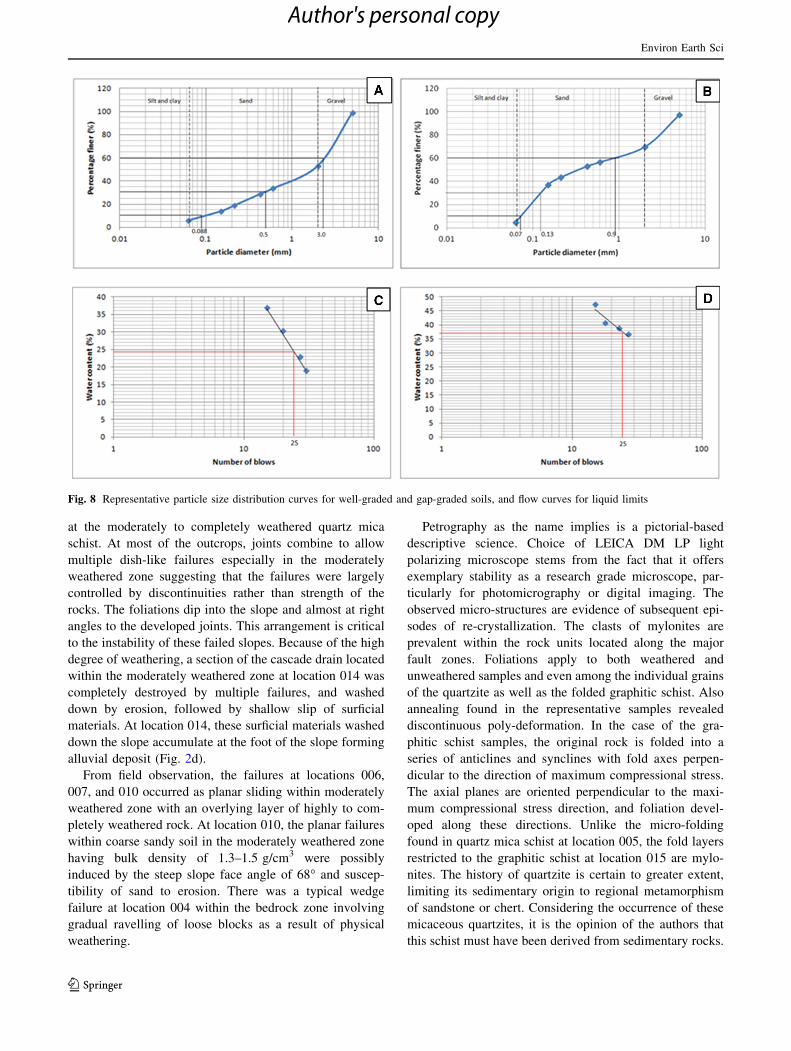
Representative particle size distribution curves for well-
graded soil at depth of 17.5 m and gap-graded soil at
31.5 m depth are shown in Fig. 8a and b, respectively.
From the result of sieve analyses of the twelve soil sam-
ples, eight are gap-graded and four are well graded. The
liquid limit tests produced low values from 21 to 47 % and
the plastic limits fell below non-critical value of 40 %.
Representative flow curves for the liquid limits from depths
of 7 and 10.5 m are shown in Fig. 8c and d, respectively.
Considering the average of the entire values of the deter-
mined plasticity index which range from 1 to 21, the
weathered profile can be regarded as low plastic (Gopal
and Rao 2007). Therefore, in view of the analyses of the
tested soil samples, the weathered zone is not suitable for
structural support.
Discussion and conclusion
Gunung Pass stretches from locations 012–016 and is
actively unstable except location 015 which is graphitic
schist outcrop that looks stable. When the weathered
schistose materials were exposed due to excavations in
course of constructing the berm slopes, they experienced
physical changes, thereby became disaggregated and fria-
ble. Slips, slumps and earth flows characterize the failures
Table 2 Summary of index
properties of the weathering
profile at location 010
Sampling
elevation
from top of
slope (m)
Bulk
density
(g/cm3)
Particle
density
(g/cm3)
Porosity
(%)
Liquid
limit (%)
Plastic
limit (%)
Plasticity
index
Silt and
clay (%)
Sand
(%)
Gravel
(%)
0 1.2 2.29 49 47 26 21 44 53 2
3.5 1 2.43 59 40 34 6 37 59 4
7 1 2.45 59 24 19 5 33 64 3
10.5 1 2.42 63 37 36 1 26 69 5
14 1 2.48 58 39 22 7 27 68 5
17.5 1.3 2.14 41 32 31 1 13 85 1
21 1.3 2.25 44 33 30 3 15 82 2
24.5 1.4 2.25 38 32 29 3 12 83 4
28 1.5 2.23 35 38 21 17 21 76 3
31.5 1.1 2.10 48 21 18 3 36 60 3
35 1.2 2.10 42 22 21 1 10 86 4
38.5 1.2 2.10 43 33 29 4 9 86 5
Environ Earth Sci
123
Author's personal copy
at the moderately to completely weathered quartz mica
schist. At most of the outcrops, joints combine to allow
multiple dish-like failures especially in the moderately
weathered zone suggesting that the failures were largely
controlled by discontinuities rather than strength of the
rocks. The foliations dip into the slope and almost at right
angles to the developed joints. This arrangement is critical
to the instability of these failed slopes. Because of the high
degree of weathering, a section of the cascade drain located
within the moderately weathered zone at location 014 was
completely destroyed by multiple failures, and washed
down by erosion, followed by shallow slip of surficial
materials. At location 014, these surficial materials washed
down the slope accumulate at the foot of the slope forming
alluvial deposit (Fig. 2d).
From field observation, the failures at locations 006,
007, and 010 occurred as planar sliding within moderately
weathered zone with an overlying layer of highly to com-
pletely weathered rock. At location 010, the planar failures
within coarse sandy soil in the moderately weathered zone
having bulk density of 1.3–1.5 g/cm3 were possibly
induced by the steep slope face angle of 68� and suscep-
tibility of sand to erosion. There was a typical wedge
failure at location 004 within the bedrock zone involving
gradual ravelling of loose blocks as a result of physical
weathering.
Petrography as the name implies is a pictorial-based
descriptive science. Choice of LEICA DM LP light
polarizing microscope stems from the fact that it offers
exemplary stability as a research grade microscope, par-
ticularly for photomicrography or digital imaging. The
observed micro-structures are evidence of subsequent epi-
sodes of re-crystallization. The clasts of mylonites are
prevalent within the rock units located along the major
fault zones. Foliations apply to both weathered and
unweathered samples and even among the individual grains
of the quartzite as well as the folded graphitic schist. Also
annealing found in the representative samples revealed
discontinuous poly-deformation. In the case of the gra-
phitic schist samples, the original rock is folded into a
series of anticlines and synclines with fold axes perpen-
dicular to the direction of maximum compressional stress.
The axial planes are oriented perpendicular to the maxi-
mum compressional stress direction, and foliation devel-
oped along these directions. Unlike the micro-folding
found in quartz mica schist at location 005, the fold layers
restricted to the graphitic schist at location 015 are mylo-
nites. The history of quartzite is certain to greater extent,
limiting its sedimentary origin to regional metamorphism
of sandstone or chert. Considering the occurrence of these
micaceous quartzites, it is the opinion of the authors that
this schist must have been derived from sedimentary rocks.
Fig. 8 Representative particle size distribution curves for well-graded and gap-graded soils, and flow curves for liquid limits
Environ Earth Sci
123
Author's personal copy

From the percentage of grading of the soil as presented
in Table 2, it is shown that sand has greater percentages
than gravel, silt and clay. Greater percentages of silt and
clay decreased down the slope and increased at sampling
point 31.5 m elevation which fall within the moderately
weathered zone where pockets of planar failures were
observed. Increase in the percentages of silt and clay in this
zone might also be attributed to failed residual soil and
materials from completely weathered zone which slump
downwards and remain on the slope within the moderately
and slightly weathered zones. These higher values of silt
and clay from this sampling point reflected significantly on
the reduced value of its determined bulk density. From the
particle size distribution analysis, total of four soil samples
were well graded, and eight samples were gap graded.
Although it is accepted that gap-graded soils have better
drainage and also allow root penetration even when com-
pacted, they pose compaction problems in most engineer-
ing structures. On the other hand, well-graded soil is easily
compacted and suitable for most structural support. Con-
sidering the dominant gap-graded soil samples compared to
well-graded samples, this cut slope at location 010 is not
suitable for structural support. The low values of liquid
limits as a result of cohesion and adhesion characteristics
of the tested soil samples revealed the presence of organic
materials, suggesting that short intense rainfall can easily
induce debris flow and slump in the weathered zone.
Although the determined plastic limits fell below non-
critical value of 40, the variations in the plastic limit of the
different soil samples collected at varied elevations reflect
the pockets of failures within these weathered zones. The
low plasticity index which reflects the abundance of sand,
predicts the possibility of failures even on gentler slopes.
In view of the failure mechanisms studied in this
extended cut slope within the quartz mica schist, charac-
teristics of weathering and engineering applications are
essential, and should be integrated in the guidelines for
application of mitigation measures to varied failure prog-
nosis. Further studies should construct a model of
groundwater flow regime within these failed slopes from
results of observations of water pressure and water flows to
carry out wider investigations and ensure better under-
standing of the behavior of the recorded failures.
Acknowledgments Special thanks to University of Malaya for
sponsoring this research through Postgraduate Research Fund, Grant
number: PS362/2010B.
References
Arikan F, Aydin N (2012) Influence of weathering on the engineering
properties of dacites in Northeastern Turkey. ISRN Soil Sci
2012:15. doi:10.5402/2012/218527
ASTM (American Society for Testing and Materials) (1970) Special
procedures for testing soil and rock for engineering purposes,
5th edn. ASTM Special Technical Publication 479,
Philadelphia
ASTM (American Society for Testing and Materials) (2000) Test
method for liquid limit, plastic limit, and plasticity index of soils,
vol 04.08. Annual Book of ASTM Standards, Philadelphia,
pp 546–558
ASTM (American Society of Testing and Materials) (1998) Standard
test method for particle-size analysis of soils, vol 3. ASTM D
422–98, Annual Book of ASTM Standards 14, Philadelphia,
pp 10–17
Brady NC (1990) The nature and properties of soils. Macmillan, New
York
BSI (British Standards Institution) (1981) Code of practice for site
investigations. BS 5930:1981, BSI, London
BSI (British Standards Institution) (2007) Natural stone test methods–
petrographic examination. EN 12407:2007, BSI, London
Eswaran H, Wong CB (1978) A study of a deep weathering profile on
granite in Peninsular Malaysia: physico-chemical and micro-
morphological properties. Soil Sci Soc Am J 42(1):144–149
Fisher NI, Lewis T, Embleton BJJ (1987) Statistical analysis of
spherical data. Cambridge University Press, UK
Gopal R, Rao ASR (2007) Basic and applied soil mechanics
(illustrated edition). New Age International, New Delhi
Hobbs BE, Means WD, Williams PF (1982) The relationship between
foliation and strain: an experimental investigation. J Struct Geol
4:411–428
Hoek E, Bray JW (1981) Rock slope engineering. The Institute of
Mining and Metallurgy, London
Nkpadobi JI (2009) Stability of slope cuts in the dinding schist of the
Ukay Perdana area, Selangor Darul Ehsan, Malaysia. M.Sc.
thesis, University of Malaya
Omar H, Mohd Pauzi NI, Abu Shariah M, Md Yusof Z, Maail S
(2009) Microcracks pattern and the degree of weathering in
granite. Electron J Geotech Eng, 14: Bundle F, EJGE paper
2008-0955. http://www.ejge.com/2009/Ppr0955/Abs0955.htm
Pinti D (2011) Weathering profile. In: Gargaud M (ed) Encyclopedia
of astrobiology. Springer, Berlin (ISBN 978-3-642-11274-4)
Price NJ, Cosgrove JW (1990) Analysis of geological structures.
Cambridge University Press, UK
Raj JK (1983) A study of residual soils and their cut slope stability in
selected areas of Peninsular Malaysia. PhD thesis, University of
Malaya
Raj JK (1985) Characterisation of the weathering profile developed
over a porphyritic biotite granite bedrock in Peninsular Malaysia.
Bull Int Assoc Eng Geol 32:121–128
Raj JK (1993) Clay minerals in the weathering profile of a quartz-
muscovite schist in the Seremban Area, Negeri Sembilan.
Pertanika J Trop Agri Sci 16(2):129–136
Raj JK (1998) The failure of a slope cut into the weathering profile
developed over a porphyritic biotite granite. J Asian Earth Sci
16(4):419–427
Raj JK (2000) Weathering and weathering profiles; short course on
Eng Geol. The Institution of Engineers, Malaysia, pp 2–3
Raj JK (2010) Soil-moisture retention characteristics of earth
materials in the weathering profile over a porphyritic biotite
granite. Am J Geosci 1:12–20. doi:10.3844/ajgsp.2010.12.20
Rawat R, Sharma R (2011) Features and characterization of graphite
in Almora crystallines and their implication for the graphite
formation in lesser Himalaya. India J Asian Earth Sci
42(1–2):51–64
Tajul A (2003) Engineering geological assessment and slope failures
along the Pos Selim-Cameron Highland Highway. In: Seminar
Penyelidikan Jangka Pendek (Vot F), 11th–12th March 2003,
University of Malaya
Environ Earth Sci
123
Author's personal copy
Wells T, Willgoose GR, Hancock GR (2008) Modeling weathering
pathways and processes of the fragmentation of salt weathered
quartz-chlorite schist. J Geophys Res 113:F01014. doi:10.1029/
2006JF000714
Williams PF (1990) Differentiated layering in metamorphic rocks.
Earth Sci Rev 29:267–281
Yamasaki S, Chigira M (2006) Weathering processes and mecha-
nisms of pelitic schist, providing basic conditions for landslides.
Disaster mitigation of debris flows, slope failures and landslides,
pp 393–401
Zauyah S (1986) Characterisation of some weathering profiles on
metamorphic rocks in Peninsular Malaysia. Doctorate thesis,
Univ. Gent, p 388
Zauyah S, Stoops G (1990) A study of the ferrallitic weathering of an
amphibole schist in Peninsular Malaysia. Pertanika J Trop Agri
Sci 13(1):85–93
Environ Earth Sci
123
Author's personal copy
Related Documents